Florida BCR 27
26
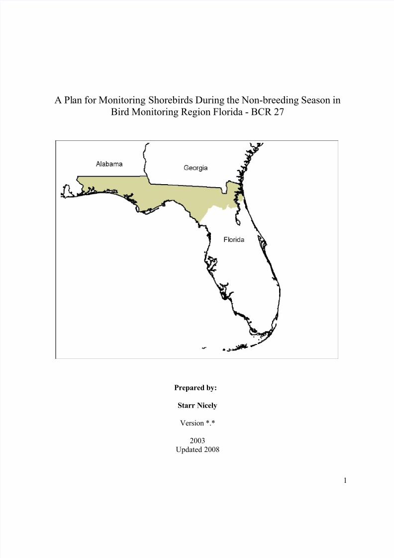
A Pl an for Monitoring Shorebirds During the Non-breeding Season in Bird Monitoring Region Florida - BCR 27 Prepared by: Starr Nicely Version *.* 2003 Updated 2008 1
Transcript of Florida BCR 27
8/14/2019 Florida BCR 27
http://slidepdf.com/reader/full/florida-bcr-27 1/26
A Plan for Monitoring Shorebirds During the Non-breeding Season inBird Monitoring Region Florida - BCR 27
Prepared by:
Starr Nicely
Version *.*
2003
Updated 2008
1

8/14/2019 Florida BCR 27
http://slidepdf.com/reader/full/florida-bcr-27 2/26
Table of Contents
Introduction .....................................................................................................................................3Methods ............................................................................................................................................5
Site Descriptions ........................................................................................................................10
Talbot Islands State Parks .....................................................................................................10Site 1: Amelia Island State Park ............................................................................................11
Site 2: Little Talbot Island State Park ...................................................................................11
Huguenot Memorial Park .......................................................................................................13St. Marks National Wildlife Refuge ......................................................................................16
Lanark Reef ............................................................................................................................18
Dog Island ..............................................................................................................................20St. George Island State Park ..................................................................................................22
St. Vincent National Wildlife Refuge ...................................................................................24
References ..................................................................................................................................26
2

8/14/2019 Florida BCR 27
http://slidepdf.com/reader/full/florida-bcr-27 3/26
Introduction
The bird conservation initiatives - waterbirds, waterfowl, shorebirds and landbirds - arecooperating to design a comprehensive “integrated bird monitoring” (IBM) program for Canada
and the United States. The conceptual framework for IBM (Fig. 1) includes strong emphasis on
detecting species at risk and helping to protect them. These broad goals are achieved byestimating population trends and defining requirements for viable populations. These objectives
in turn are accomplished by population modeling based on population levels, demographic rates
and habitat information. Population trends are estimated by surveying breeding populationswhenever possible, and by surveying the species for which this is not feasible at other times of
year. Surveys of all species are made throughout the year to help identify and monitor use of
suitable habitat.
Figure 1. Conceptual framework for integrated bird monitoring.
3

8/14/2019 Florida BCR 27
http://slidepdf.com/reader/full/florida-bcr-27 4/26
Most surveys in upland habitats are designed at a large spatial scale (e.g., southern
Canada and the United States) and do not require detailed information at the local level. Surveys
of wetland habitats, in contrast, must be carefully designed to insure that the habitat is wellcovered, and different methods may be needed in different environments. A series of “regional
assessments” is thus being prepared to help design the wetland surveys. Regions were formed by
intersecting a Bird Conservation Region (BCR) map with a Province and State map, deletingsmall polygons and smoothing the borders (Fig. 2). The resulting “Bird Monitoring Regions” can
be used to scale up results to either BCRs or Provinces and States.
Figure 2. Shorebird Planning and Bird Conservation Regions in Canada and the United States.
Adapted from: USFWS-U.S. Shorebird Plan and CWS-Canadian Shorebird Conservation Plan
The regional assessments summarize current information about wetland bird distribution,
abundance, habitat relationships and timing of use within the Region and identify informationneeded to design reliable monitoring programs. These “needed pilot studies” are then prioritized
by people concerned with monitoring birds in the region and a plan is developed to carry out the
work. Carrying out the pilot studies is expected to take 1-3 years. Long-term surveys will then beimplemented. Additional details are provided in “Managers Monitoring Manual” available at
http://www.pwrc.usgs.gov/monmanual/techniques/shorebirdsnonbreedingsites.htm. More
information on regional progress can be found at the U.S. Shorebird Plan’s Regional
Conservation Plan website (http://www.fws.gov/shorebirdplan/RegionalShorebird.htm).
4

8/14/2019 Florida BCR 27
http://slidepdf.com/reader/full/florida-bcr-27 5/26
Methods
Focal wetland species of shorebirds were first identified. The initial list included allwetland species of shorebirds that are common or abundant at any time of year within the
Region, according to Brian Harrington and based largely upon data from the International
Shorebird Surveys (ISS). Sites in which any of the focal species are common or abundant at anytime of year were then identified using a list prepared for this project and supplemented by
information provided by birding guides, ornithologists and birders knowledgeable of the Region.
Most sites were single areas, such as a National Wildlife Refuge, but dispersed sites, such as“lakes >10 ha”, could also be identified.
Figure 3. PRISM sites in BCR 13, 14, 30, 27, and 31.
5

8/14/2019 Florida BCR 27
http://slidepdf.com/reader/full/florida-bcr-27 6/26
6

8/14/2019 Florida BCR 27
http://slidepdf.com/reader/full/florida-bcr-27 7/26
The International Shorebird Survey (ISS) provided species numbers for some of the
identified sites. The ISS is a volunteer based survey initiated in 1974 by Brian Harrington.Volunteers select their survey sites and are given guidelines on census frequency and data
collection for spring and fall migration. The ISS guidelines ask volunteers to survey once every
10 days from April 1st to June 10th for spring migration, and once every 10 days from July 11thto October 31st for fall migration. ISS records provided the maximum counts recorded for
species where the identified site is also an ISS site.
Survey methods for sites include appropriate tide levels for surveys, if that information is
available. Tide levels for surveys are based on the advice of biologists and birders with
knowledge about the sites. Due to the different geography of the sites, different tide levels
are recommended to concentrate the birds for a survey. While high tide at one site may bring in birds that are spread out over an expansive area at low tide, high tide at another site may
completely cover the habitat or food resources and scatter the birds elsewhere. Therefore,
different tide levels may be recommended for different sites.
Additional site information may also include information about visibility. Excellent/good
visibility simply means that the birds can be seen without obstruction clearly enough to identifyto species, either by physically getting close enough or with a good scope or binoculars.
Maps showing land ownership, roads and wetlands were prepared for the region. Maps of
each site were also prepared and information useful in designing surveys for the focal specieswas presented. The survey objective was assumed to be estimating the average number of birds
of each focal species present within the site during a specified interval. Up to three types of
habitat were described for each focal species: Type 1 habitat, outlined in purple on the maps,included regularly-used areas that should be sampled using a well-defined sampling plan. Type 2
habitat, which was outlined in red, included areas used sparingly by the focal species. Type 2
habitat is not surveyed as often or with rigorously defined methods, but is surveyed less formallyevery few years to document continued low use by the focal species. Type 3 habitat receives
virtually no use by the focal species during the study period and is not surveyed as part of the
monitoring program. Requests, however, are circulated for any records of the focal speciesoccurring in substantial numbers in these areas.
A description of each site was prepared with the following headings:
Boundaries and ownership
Focal species using the site and timing of use
Location of type 1 and 2 habitat within the siteAccess to the type 1 and 2 habitat and visibility of the birds
Past and current surveys
Potential survey methodsDescription
Selection bias
Measurement error and bias
Needed pilot studies
7

8/14/2019 Florida BCR 27
http://slidepdf.com/reader/full/florida-bcr-27 8/26
We assume for any survey that the study area and study period (within years) have been
defined. The goal of the survey was assumed to be estimating the trend, across several years, inthe average number of birds present during the study period. Bias means a long-term trend in the
ratio (number recorded)/(average number present). Selection bias ensues when some portion of
Type 1 habitat has zero chance of being surveyed, usually due to access problems, and there is along-term trend in the proportion of birds using the non-sampled portion. Exclusion of some
Type 1 habitat does not necessarily cause selection bias because trends in the sampled areas
might be the same as trends in the non-sampled areas. Anytime some portion of Type 1 habitatcould not be included in the sampled areas, the potential for selection bias and ways to reduce it
were discussed. Measurement error means not detecting all birds present in the surveyed area at
the time of the survey. Measurement bias is a long term trend in the proportion of birds present at
the time of the survey that are detected on the survey. Measurement error does not necessarilycause measurement bias because the proportion of birds detected might not change through time.
Anytime measurement error was probable, its magnitude and probable stability through time
were discussed along with ways to reduce the proportion of birds missed on the surveys.
Results - Shorebirds
Table 1. Focal shorebird species for BCR 27
CODE SPECIES
BBPL Black-bellied Plover
SNPL Snowy Plover
WIPL Wilson’s Plover
SEPL Semipalmated Plover
PIPL Piping Plover
KILL Killdeer
AMOY American Oystercatcher GRYE Greater Yellowlegs
LEYE Lesser Yellowlegs
SOSA Solitary Sandpiper
WILL Willet
SPSA Spotted Sandpiper
WHIM Whimbrel
LBCU Long-billed Curlew
MAGO Marbled Godwit
RUTU Ruddy Turnstone
REKN Red Knot
SAND Sanderling
SESA Semipalmated Sandpiper
LESA Least Sandpiper
DUNL Dunlin
SBDO Short-billed Dowitcher
COSN Common Snipe
8

8/14/2019 Florida BCR 27
http://slidepdf.com/reader/full/florida-bcr-27 9/26
9

8/14/2019 Florida BCR 27
http://slidepdf.com/reader/full/florida-bcr-27 10/26
Site Descriptions
Talbot Islands State Parks
10

8/14/2019 Florida BCR 27
http://slidepdf.com/reader/full/florida-bcr-27 11/26
Description: The Talbot Islands State Park system, which stretches from St. Marys River to St.
Johns River in northeastern Florida, includes Fort George Island Cultural State Park, Little
Talbot Island State Park, Big Talbot Island State Park and Amelia Island State Park.
Site 1: Amelia Island State Park
Description: Amelia Island State Park is 230 acres on the southern tip of Amelia Island, a sea
island located seven miles north of Little Talbot Island State Park. The physical geography of the
beach at Amelia Island is somewhat inconsistent with that of other barrier islands owing to theerosion control structures on the island, periodic addition of beach fill material and development
of the coast north of Amelia Island State Park boundaries. The effects of wind and wave energy
continually alter the shape of the island’s shoreline. Beach dune and the adjacent upland
communities have plant life typical of a barrier island. The backside of the island is mainly saltmarsh. Type 1 habitat is located on the sandy beach at the southern tip of Amelia Island.
Amelia Island is accessible by vehicle and a parking lot is available. From there, you can walk
from the sound side out to the shore. The Florida Division of Recreation and Parks managesAmelia Island State Park and the rest of the island is privately owned. The Florida Department of
Environmental Protection conducts nesting surveys at Amelia Island every three weeks in thesummer. A volunteer-based monitoring program has been surveying Amelia Island State Park
once a week year round (except March and September) since the summer of 2003.
Survey Method: Surveys should be conducted in the early morning or late evening duringsummer; at low or near low tide during the winter. Visibility is excellent with binoculars and/or a
spotting scope.
Selection Bias: Not applicable as all areas are accessible.
Measurement error: *
Measurement bias: *
Pilot Studies: None needed.
Local Contacts: Kristin Ebersol, Environmental Specialist I, Talbot Islands State Parks.
Site 2: Little Talbot Island State Park
Description: Little Talbot Island State Park is located twenty miles north of Jacksonville,
Florida. The park encompasses all of Little Talbot Island, which is a barrier island between
Nassau Sound and the St. Johns River, about 1 mile wide and 5 miles long. Except for StateRoad A1A, which bisects the island, most habitats are largely undisturbed. The 2,500-acre island
has more than four miles of white sandy beaches, salt marshes and vegetated dunes. Maritime
forests, desert-like dunes and undisturbed salt marshes are located on the inland or western side
of the island. The southern tip of Little Talbot Island has been receding dramatically and the
11

8/14/2019 Florida BCR 27
http://slidepdf.com/reader/full/florida-bcr-27 12/26
sediment along the shoreline changes seasonally. Type 1 habitat is located at the northern and
southern tips of Little Talbot Island: the northern tip is made up of sandy beach with salt marsh
and mud flats occurring along the back side; the southern tip supports a sand bar. The sand spiton the northeastern tip of Little Talbot Island continues to grow, creating large sand flats and
inter-tidal salt marsh.
In addition to these locations, a series of sand islands in Nassau Sound off the northeastern tip of
Little Talbot Island provides a great deal of important shorebird habitat. According to Doris and
Pat Leary, who have reported on shorebirds in this area, the sand islands do not show up on mostmaps as they are highly dynamic and ephemeral (see aerial photo below showing the extent of
the sand islands and shoals not apparent on the map).
The Florida Division of Recreation and Parks manages Little Talbot Island State Park, which is
accessible by vehicle with two parking areas. Boardwalks offer easy access to the beach. Drivingon the beach is prohibited. A volunteer-based monitoring program has been surveying Little
Talbot Island once a week year round (except March and September) since the summer of 2002.
The most numerous species based on maximum counts from the International Shorebird Surveysare: BBPL (26), SEPL (40), KILL 26), WILL (22), SAND (280), DUNL (60). Kristin Ebersol
sees REKN pass through very quickly in large numbers during the spring.
Selection Bias: All areas on Little Talbot are accessible, but the sand islands in Nassau Soundmay not be as easily accessible by surveyors. Currently, many of the Leary’s recent data reports
are associated with these sites and they will continue to survey these areas for the ISS.
Measurement error: *
Measurement bias: *
Pilot Studies: None needed.
Local Contacts: Kristin Ebersol, Environmental Specialist I, Talbot Islands State Parks; Doris
and Pat Leary, Fernandina Beach, FL.
12
8/14/2019 Florida BCR 27
http://slidepdf.com/reader/full/florida-bcr-27 13/26
Huguenot Memorial Park
Description: Huguenot Memorial Park is located in Duval County on Fort George Island, whichis on the north shore of the mouth of the St. Johns River. The park consists of 169 acres bounded
by ocean, inlet and river. A couple of miles of beach expand both in length and width at low tide.
The dune fields are extensive, tall and heavily vegetated. Huguenot Memorial Park is jointlyowned by the State of Florida and the U.S. Army Corps of Engineers and leased to the City of
Jacksonville. It is not officially declared a state park. Huguenot Memorial Park can be accessed
by vehicle. Shorebirds are accustomed to vehicles on the beach.
13
8/14/2019 Florida BCR 27
http://slidepdf.com/reader/full/florida-bcr-27 14/26
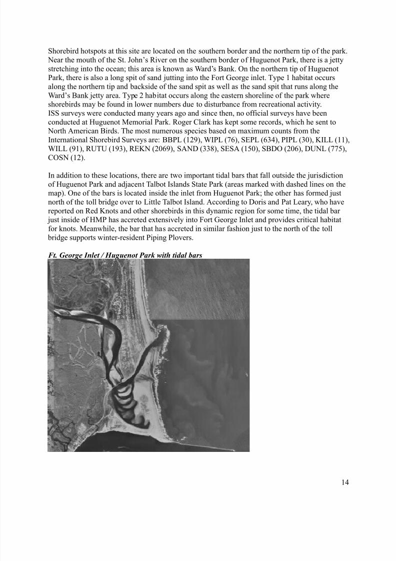
Shorebird hotspots at this site are located on the southern border and the northern tip of the park.
Near the mouth of the St. John’s River on the southern border of Huguenot Park, there is a jetty
stretching into the ocean; this area is known as Ward’s Bank. On the northern tip of HuguenotPark, there is also a long spit of sand jutting into the Fort George inlet. Type 1 habitat occurs
along the northern tip and backside of the sand spit as well as the sand spit that runs along the
Ward’s Bank jetty area. Type 2 habitat occurs along the eastern shoreline of the park whereshorebirds may be found in lower numbers due to disturbance from recreational activity.
ISS surveys were conducted many years ago and since then, no official surveys have been
conducted at Huguenot Memorial Park. Roger Clark has kept some records, which he sent to North American Birds. The most numerous species based on maximum counts from the
International Shorebird Surveys are: BBPL (129), WIPL (76), SEPL (634), PIPL (30), KILL (11),
WILL (91), RUTU (193), REKN (2069), SAND (338), SESA (150), SBDO (206), DUNL (775),
COSN (12).
In addition to these locations, there are two important tidal bars that fall outside the jurisdiction
of Huguenot Park and adjacent Talbot Islands State Park (areas marked with dashed lines on the
map). One of the bars is located inside the inlet from Huguenot Park; the other has formed justnorth of the toll bridge over to Little Talbot Island. According to Doris and Pat Leary, who have
reported on Red Knots and other shorebirds in this dynamic region for some time, the tidal bar just inside of HMP has accreted extensively into Fort George Inlet and provides critical habitat
for knots. Meanwhile, the bar that has accreted in similar fashion just to the north of the toll
bridge supports winter-resident Piping Plovers.
Ft. George Inlet / Huguenot Park with tidal bars
14

8/14/2019 Florida BCR 27
http://slidepdf.com/reader/full/florida-bcr-27 15/26
The tidal bars do not show up on most maps as the coastal environment here is highly dynamic
and in continuous flux with erosion (see aerial of Ft. George Inlet / Huguenot Park with tidal
bars). According to Doris and Pat Leary, the area supports an abundance of inlet, marsh, ocean beach and bay habitats with winter-resident and migrant shorebird populations dispersing across
a multiplicity of roosting and foraging sites.
Survey Method: For Huguenot Park: Ground surveys of the entire park should be conducted at
falling tide when shorebirds are closer in and feeding. A 4WD vehicle is recommended to save
time. At falling tide, the sand is hardened for better driving conditions. Another option is to park and survey by foot. Visibility is good with the exception of the backside of sandbars, which are
not visible from the mainland. A bridge on State Road A1A provides a good overview of the area
as well as the sandbars that may be difficult to view from the shore.
Selection Bias: All areas within Huguenot Park are accessible. However, the tidal bars in Fort
George Inlet and north of the toll bridge are located outside the park and may not be easily
accessible by surveyors. Currently, many of the Leary’s recent data reports are associated with
these sites and they will continue to survey these areas for the ISS.
Measurement error: *
Measurement bias: *
Pilot Studies: None needed.
Local Contacts: Peggy Powell, Duval Audubon Society; Doris and Pat Leary, Fernandina
Beach, FL.
15

8/14/2019 Florida BCR 27
http://slidepdf.com/reader/full/florida-bcr-27 16/26
St. Marks National Wildlife Refuge
Description: St. Marks National Wildlife Refuge encompasses 68,000 acres spread out between
Wakulla, Jefferson and Taylor counties along the Gulf Coast of northwest Florida. The wetlandsof St. Marks National Wildlife Refuge comprise about 70% of the refuge's total acreage. The
refuge includes fresh and brackish water marshes, islands and tidal flats, as well as seven rivers
and numerous creeks that traverse the refuge and drain southward through marshes into theApalachee Bay estuary. In addition to these natural wetlands, the refuge utilizes man-made
impoundments, which attract migratory shorebirds. A seven-mile drive winds its way from the
visitor center through fresh and brackish water impoundments and ends at the foot of theApalachee Bay.
Although the refuge manipulates the water levels of 1600 acres of impoundments, the water source for the impoundments is rainfall. Therefore, the water level of the impoundments is
highly influenced by weather conditions. During a drought the impoundments will become dry
and more attractive to shorebirds. The schedule of water level management for the majority of impoundments is not suitable for shorebirds, but a 20-acre impoundment is managed specifically
for shorebirds and offers more flexibility for managing the water levels because of its small size.
Contact the refuge for the exact location of this impoundment and the current conditions of the
other impoundments.
16

8/14/2019 Florida BCR 27
http://slidepdf.com/reader/full/florida-bcr-27 17/26
Shorebirds also use the low energy coastline of the refuge, which consists of tidal marsh and sea
grass beds with little beach and shallow water. The shorebirds feed on the exposed tidal flats
during low tide. This coastline extends from Live Oak Island to Gamble Point, which includesthe Wakulla Unit and St. Marks Unit of the refuge. The coastline to the west of these units is
more developed and not completely within the refuge’s Panacea unit and thus privately owned.
The U.S. Fish and Wildlife Service owns and manages St. Marks NWR. The State of Florida
owns submerged land below mean high water level. The refuge has done surveys on an irregular
basis to obtain estimated counts of birds that use the impoundments. Little information isavailable for shorebird use on the coastline, which the refuge has not surveyed. Jeff Gore has
done some surveying on the coastline. The most numerous species based on maximum counts
from the International Shorebird Surveys are: BBPL (27-61), SEPL (20), GRYE (28), WILL
(120-385), RUTU (45-77), SESA (38), LESA (26-43), SBDO (120-595), DUNL (149-1283),MAGO (25).
Survey Method: After obtaining a permit from St. Marks NWR, surveys of the impoundments
should be conducted at high tide by driving around the dikes, which are not open to publicvehicle use. Visibility is good with a spotting scope. The best time to survey the tidal marsh
coastline is during high tide when the shorebirds concentrate on the salt barren and the water level enables boat access.
Selection Bias: Visibility along the coastline is limited due to vegetation that will make
shorebirds difficult to see from a boat during high tide.
Measurement error: *
Measurement bias: *
Pilot Studies: An aerial survey along the coastline of St. Marks NWR is necessary to determinethe location of Type 1 shorebird habitat. Then a survey plan can to be established for the
coastline.
Local Contacts: David Moody, Volunteer Coordinator, St. Marks NWR
Jeff Gore, Florida Fish and Wildlife Conservation Commission
17

8/14/2019 Florida BCR 27
http://slidepdf.com/reader/full/florida-bcr-27 18/26
Lanark Reef
Description: Lanark Reef lies in the Gulf of Mexico roughly 0.7 miles offshore of Lanark
Village in Franklin County. The reef stretches for approximately 6 miles parallel to the coast and
contains both submerged and emerged areas. The submerged lands comprise the majority of thereef extending for almost five miles and are rich in sea grasses. The emerged areas are a series of
“islands” that stretch for approximately one mile of the reef with a total area of about four acres.
The eastern emerged section is heavily vegetated with grasses and shrubs. The western emergedarea, which is Type 1 shorebird habitat, is a low, ephemeral sand dune ridge directly offshore of
Lanark Village. All islands have spits at the ends. Lanark Reef comprises mostly sand flats, with
mud flats occurring at the eastern and western ends during low tide. Most of Lanark Reef is
submerged during high tide with only a few grassy areas above water.
The submerged lands are owned by the State of Florida, and the emerged areas are in part
privately owned. All portions of the reef are separate from the mainland and lie in very shallow
water and are thus accessible only by boat at high tide. The Florida Fish and WildlifeConservation Commission has conducted breeding and wintering surveys at Lanark Reef. The
most numerous species on Lanark Island based on maximum counts from the InternationalShorebird Surveys are: BBPL (153), PIPL (96), AMOY (110), WILL (704), RUTU (78), REKN
(212), SAND (323), SBDO (401), DUNL (965) and MAGO (254).
Survey Method: Ground survey on foot at mid to high tide because the birds are too spread out
over a large area at low tide. Visibility is good with a spotting scope.
18

8/14/2019 Florida BCR 27
http://slidepdf.com/reader/full/florida-bcr-27 19/26
Selection Bias: The reef is difficult to access at low tide. The surveyor needs a boat to access the
reef.
Measurement error: *
Measurement bias: *
Pilot Studies: Explore all islands to ensure that all Type 1 shorebird habitat is identified.
Local Contacts: Karen Lamonte, Regional Biologist, Florida Fish & Wildlife Conservation
Commission
19

8/14/2019 Florida BCR 27
http://slidepdf.com/reader/full/florida-bcr-27 20/26
Dog Island
Description: Dog Island is a 1,842-acre island located about four miles south of Carrabelle in
Franklin County. Dog Island is more than six miles long and nearly one mile wide at its widest point. Type 1 habitat is located on the narrow portions of western Dog Island, which consists of
beaches and dune vegetation. These narrow areas are flooded occasionally. Some of the ponds
may have good shorebird habitat.
The Nature Conservancy in cooperation with the Barrier Island Trust manages about sixty
percent of Dog Island as the Jeff Lewis Wilderness Preserve. The remainder of the island is in private ownership in small tracts. Dog Island is only accessible by boat or ferry service. Only
breeding surveys are conducted at Dog Island. The most numerous species based on maximum
counts from the International Shorebird Surveys are: BBPL (28), SEPL (25), GRYE (6), RUTU(3), SAND (80), DUNL (12), SBDO (8).
Survey Method: Ground survey by foot. The tidal flux is almost insignificant in relation to
when the shorebirds use the island. Visibility is excellent with a spotting scope.
Selection Bias: The island is difficult to access at low tide or during inclement weather, and
portions of the island may be inaccessible due to lack of permission from private landowners.
Measurement error: *
Measurement bias: *
20

8/14/2019 Florida BCR 27
http://slidepdf.com/reader/full/florida-bcr-27 21/26
Pilot Studies: This site was recommended as a good shorebird migration site despite low ISS
counts. If possible, survey the entire island to locate all Type 1 habitats.
Local Contacts: John Blancher, Jeff Lewis Wilderness Preserve, The Nature Conservancy
21

8/14/2019 Florida BCR 27
http://slidepdf.com/reader/full/florida-bcr-27 22/26
St. George Island State Park
Description: St. George Island State Park is located along the last 9 miles of east St. GeorgeIsland in Apalachicola Bay. The island has fine sandy beach and vegetated dunes along the
southern shore, and the backside of the island is marsh with emergent mud flats. The natural
features of the park include extensive beaches and dunes, forests of slash pines and live oak hammocks. Shorebirds are scattered throughout the park with no particular area of concentration.Type 1 habitat may be along the mud flats of the marsh on the back side of the island, but this
area is difficult to access. Type 1 habitat may also be located along the sandy beaches on the tip,
which has little disturbance.
St. George Island is accessible by vehicle via a 4-mile bridge from the mainland. The public can
access 4 miles of beach along the parks main drive, but the last 4 miles of beach is accessibleonly by foot. St. George Island State Park is owned by the State of Florida, and the western
section of St. George Island is privately owned.
Melody Sapp surveys twice a month during the early morning all year but focuses counts on theLETE, SNPL, PIPL, AMOY, and skimmers, but may also count other shorebirds occasionally.
The most numerous species based on maximum counts from the International Shorebird Surveys
are: BBPL (25), WILL (35), RUTU (45), REKN (80), SAND (100), LESA (30), SBDO (45),DUNL (200).
Survey Method: Ground survey by ATV, which will save time due to the large area. Begin atthe beach side at the western boundary of the park and continue to the tip of the island. Only a
22

8/14/2019 Florida BCR 27
http://slidepdf.com/reader/full/florida-bcr-27 23/26
small amount of the backside can be surveyed by ATV before the marsh begins. This survey
route takes about two hours. Low tide may be the best time to survey. The marsh may be
surveyed by wading or with a kayak.
Selection Bias: The marsh on the backside of the island is difficult to access and may contain
Type 1 habitat.
Measurement error: *
Measurement bias: *
Pilot Studies: This site was recommended as a good shorebird migration site despite low ISS
counts. The marsh should be surveyed for potential Type 1 habitat.
Local Contacts: Barry Birch and Barbara Garrison, Park Managers, St. George Island State Park
Melody Sapp, Biologist, St. George Island State Park
23

8/14/2019 Florida BCR 27
http://slidepdf.com/reader/full/florida-bcr-27 24/26
St. Vincent National Wildlife Refuge
Description St. Vincent National Wildlife Refuge encompasses all of St. Vincent Island, a
12,358-acre undeveloped barrier island located just offshore from the mouth of the Apalachicola
River in Franklin and Gulf Counties and 22 miles southwest of Apalachicola, FL. Four mileswide at the east end and nine miles long, this triangular island is larger and wider than most of
the northern Gulf Coast barrier islands. The interdune areas vary from freshwater lakes and
sloughs on the east end to dry upland pine forests on the western end of the island.
Type 2 habitat can be found along the 14 miles of beaches along the south and east shores of St.
Vincent Island. Type 1 habitat occurs at the three corners of St. Vincent Island: St. Vincent Point
in the northeastern corner; the southern beaches along West Pass; the point at Indian Pass in thenorthwestern corner, which is permanently closed year round for nesting and wintering birds.
Type 1 habitat is also located along the exposed mudflats of Sheepshead Bayou, a shallow tidal
flat area in northeastern St. Vincent Island with some shell substrate. Oyster Pond is a 112-acrelake located at the south end of the island. The water levels of Oyster Pond are allowed to
fluctuate naturally, so when the water level is low, mudflats are exposed and extensively used by
shorebirds. Lakes 1-5 are located to the east of Oyster Pond, and the lakes are linked by a canal
but managed as two separate impoundments. Lakes 1-3 are managed for migratory shorebirds,and the refuge attempts to manage the water levels to coincide with migration. The lack of
pumping capabilities makes water level management difficult when competing with the tides.
24

8/14/2019 Florida BCR 27
http://slidepdf.com/reader/full/florida-bcr-27 25/26
Lakes 4 and 5 are managed as a freshwater impoundment for fisheries, so the water level remains
at a high level and receives little shorebird use.
U.S. Fish and Wildlife Service owns St. Vincent NWR, which is only accessible by boat. A
public boat ramp is located at the terminus of Florida Road C30B at Indian Pass. Oyster Pond
can be reached by entering the pond’s outlet channel on the island’s southern shoreline threemiles west of West Pass. Oyster Pond may be difficult to access if the water level is low. The
Outlet Channel near West Pass may be used for access to Lakes 1-5. The St. Vincent Creek
structure may be open and low water levels may make the lakes difficult to access difficultduring that time period. The point at Indian Pass cannot be accessed directly but can be viewed
successfully from the opposite side of Indian Pass on Indian Peninsula.
Barbara Stedman surveys the beaches in May for nesting birds and simultaneously conducts anISS survey. Tom Lewis and a skilled volunteer have surveyed the impoundments for waterbirds
since 1993 usually once every month year round, and since 1992 they have conducted
intermittent shorebird surveys along the beach. They also do nesting and fall shorebird surveys
every year with emphasis on listed species. The most numerous species based on maximumcounts from the International Shorebird Surveys are: BBPL (42), AMOY (37), WILL (115),
RUTU (29), REKN (75), SAND (68), SESA (40).
St. Vincent NWR will issue a special use permit if PRISM sends an abstract proposal for
conducting shorebird migration surveys at the refuge. St. Vincent NWR will work with us to
provide the transportation necessary to conduct the surveys.
Survey Method: Survey the beaches using an ATV or 4WD vehicle shortly after or before high
tide when the shorebirds that forage on the flats will go further inland to roost on the beach. Theshorebirds will be too spread out at low tide. Survey the point at Indian Pass from Indian
Peninsula. Sheepshead Bayou should be surveyed at low tide when the mud flats are exposed.
Drive to the nearest point of the bayou, and then walk about one-eighth of a mile to the bayou toan oyster shell spit in Apalachicola Bay, which provides a good view of the bayou. Survey the
impoundments by boat at the time of day that is best to see shorebirds because tidal influence is
insignificant. Visibility is excellent with a spotting scope at most of these sites.
Selection Bias: Big Bayou has potential Type 1 habitat, but is very difficult to access due to
extremely shallow water at low tide when the mudflats are exposed and the shorebirds feed. The
shorebirds are not present during high tide.
Measurement error: * Measurement bias: *
Pilot Studies: A method for surveying Big Bayou at low tide should be determined. The area is
difficult to access even in an airboat at low tide, so an aerial survey may be the best option for an
initial survey of Big Bayou. Several lakes located in southern St. Vincent Island are also potentialshorebird habitat when the conditions favor lower water levels.
Local Contacts: Tom Lewis, Biologist, St. Vincent NWR
25

8/14/2019 Florida BCR 27
http://slidepdf.com/reader/full/florida-bcr-27 26/26
References
Canadian Wildlife Service. Canadian Shorebird Conservation Plan. Accessed August 2008.
http://www.cws-scf.ec.gc.ca/mbc-com/default.asp?lang=en&n=D1610AB7 .
Florida State Parks Online Park Guide. http://www.floridastateparks.org/
-Amelia Island State Park.-Little Talbot Island State Park.
-St. George Island State Park
Lanark Reef Statement of Resource Values, provided by Florida Fish and Wildlife ConservationCommission.
Pranty, Bill. The Important Bird Areas of Florida: 2000-2002. Submitted transcript.
St. Marks National Wildlife Refuge. U.S. Fish and Wildlife Service.
-http://saintmarks.fws.gov/-Area Map: http://saintmarks.fws.gov/areamap.html
St. Vincent National Wildlife Refuge. U.S. Fish and Wildlife Service.
-General Brochure: http://library.fws.gov/refuges/st_vincent02.pdf -Fishing Regulations: http://southeast.fws.gov/pubs/svnfsh.pdf
U. S. Fish and Wildlife Service. U.S. Shorebird Plan. Accessed August 2008.http://www.fws.gov/shorebirdplan/RegionalShorebird/RegionsMap.asp