Texas A&M University-Central Texas Math 5376: Introduction ...
FLORA OF NORTH CENTRAL TEXASFLORA OF NORTH CENTRAL TEXAS
GEORGE M. DIGGS, JR. BARNEY L. LIPSCOMB ROBERT J. O’KENNONGEORGE M. DIGGS, JR. BARNEY L. LIPSCOMB ROBERT J. O’KENNON
SHINNERS & MAHLER’S
1
2
3
4
5
6
7
8
9
10
PINEYWOODS
GULF PRAIRIES AND MARSHEsPOST OAK SAVANNAH
BLACKLAND PRAIRIES
CROSS TIMBERS AND PRAIRIES
SOUTH TEXAS PLAINS
EDWARDS PLATEAU
ROLLING PLAINS
HIGH PLAINS
TRANS-PECOS, MOUNTAINS AND BASINS
MODIFIED FROM CHECKLIST OF THE VASCULAR PLANTS OF TEXAS
(HATCH ET AL. 1990). NEARLY IDENTICAL MAPS HAVE BEEN USED IN
NUMEROUS WORKS ON TEXAS INCLUDING GOULD (1962) AND CORRELL
AND JOHNSTON (1970).
VEGETATIONAL AREAS OF TEXAS
DD
VEGETATIONAL AREAS OF NORTH CENTRAL TEXAS
DD

D
D
DD
D
D
D
D
D
D
D
D
D
D
D
D
D
D
D
D
D
D
D
D
D
D
D
D
D
D
D
D
D
D
D
D
D
D
D
D
D
D
D
D
D
D
D
D
D
D
D
D
D
D
D
D
D
D
D
D
D
D
D
D
D
D
D
D
D
D
D
D
D
D
D
D
D
D
D
D
SHINNERS & MAHLER’S
ILLUSTRATED
FLORA OF
NORTH CENTRAL
TEXAS
Shinners & Mahler’sILLUSTRATED FLORA OF NORTH CENTRAL TEXAS
IS PUBLISHED WITH THE SUPPORT OF:MAJOR BENEFACTORS:
NEW DOROTHEA L. LEONHARDT FOUNDATION (ANDREA C. HARKINS)BASS FOUNDATION
ROBERT J. O’KENNON
RUTH ANDERSSON MAY
MARY G. PALKO
AMON G. CARTER FOUNDATION
MARGRET M. RIMMER
MIKE AND EVA SANDLIN
INSTITUTIONAL SUPPORT:
AUSTIN COLLEGE
BOTANICAL RESEARCH INSTITUTE OF TEXAS
SID RICHARDSON CAREER DEVELOPMENT FUND OF AUSTIN COLLEGE
OTHER CONTRIBUTORS:PEG AND BEN KEITH
FRIENDS OF HAGERMAN NATIONAL WILDLIFE REFUGE
SUMMERLEE FOUNDATION
JOHN D. AND BETH A. MITCHELL
WALDO E. STEWART
DORA SYLVESTER
FOUNDERS GARDEN CLUB OF DALLAS
LORINE GIBSON
SUE PASCHALL
JOHN AND BARBARA G. PASCHALL
DD
Shinners & Mahler’s
ILLUSTRATED FLORA OFNORTH CENTRAL TEXAS
GEORGE M. DIGGS, JR. / BARNEY L. LIPSCOMB / ROBERT J. O’KENNON
1999
SIDA, BOTANICAL MISCELLANYBOTANICAL RESEARCH INSTITUTE OF TEXAS, INC. 16
CENTER FOR ENVIRONMENTAL STUDIES ANDDEPARTMENT OF BIOLOGY, AUSTIN COLLEGESHERMAN,TEXAS
BOTANICAL RESEARCH INSTITUTE OF TEXAS (BRIT)FORT WORTH,TEXAS
ISSN 0833-1475
ISBN 1-889878-01-4
SIDA, BOTANICAL MISCELLANY, NO. 16
FOUNDED BY WM. F. MAHLER AND BARNEY L. LIPSCOMB, 1987
EDITOR: BARNEY L. LIPSCOMB
DESIGN CONSULTANT: LINNY HEAGY
BOTANICAL RESEARCH INSTITUTE OF TEXAS
509 PECAN STREET
FORT WORTH, TEXAS 76102-4060 USA
COVER DESIGN/ILLUSTRATION: LINNY HEAGY
DATABASE MANAGEMENT AND ILLUSTRATIONS COORDINATION: SAMUEL BURKETT
PUBLICATION ASSISTANT: AMBERLY ZIJEWSKI
DISTRIBUTION OF COPIES BY:
BOTANICAL RESEARCH INSTITUTE OF TEXAS
509 PECAN STREET
FORT WORTH, TEXAS 76102-4060 USA
TELEPHONE: 817/ 332-4441
FAX: 817/ 332-4112
E-MAIL: [email protected]
SIDA, BOTANICAL MISCELLANY, NO. 16
© COPYRIGHT 1999 BY
BOTANICAL RESEARCH INSTITUTE OF TEXAS AND AUSTIN COLLEGE
PRINTED IN THE UNITED STATES OF AMERICA
B R I T
ILLUSTRATED TEXAS FLORASPROJECT
A COLLABORATIVE PROJECT OF THE
AUSTIN COLLEGE CENTER FOR ENVIRONMENTAL STUDIES
AND THE
BOTANICAL RESEARCH INSTITUTE OF TEXAS
TO PRODUCE ILLUSTRATED FLORISTIC TREATMENTS
DESIGNED TO BE USEFUL TO BOTH BOTANICAL SPECIALISTS
AND A MORE GENERAL AUDIENCE.
Shinners & Mahler’sILLUSTRATED FLORA OF NORTH CENTRAL TEXAS
IS THE FIRST PUBLICATION OF THE

“I CAN SIT ON THE PORCH
BEFORE MY DOOR AND SEE
MILES OF THE MOST D
BEAUTIFUL PRAIRIE INTER-WOVEN WITH GROVES OF
TIMBER, SURPASSING, IN MY
IDEA, THE BEAUTIES OF THE
SEA. THINK OF SEEING A
TRACT D OF LAND ON A
SLIGHT INCLINE COVERED
WITH FLOWERS AND RICH
MEADOW GRASS FOR 12 TO
20 MILES. . . . ”
AJOHN BROOKE, EARLY SETTLER IN GRAYSON CO., TEXAS, 1849
To
Lloyd H. Shinners
and
William F. Mahler
for their contributions to
Texas botany
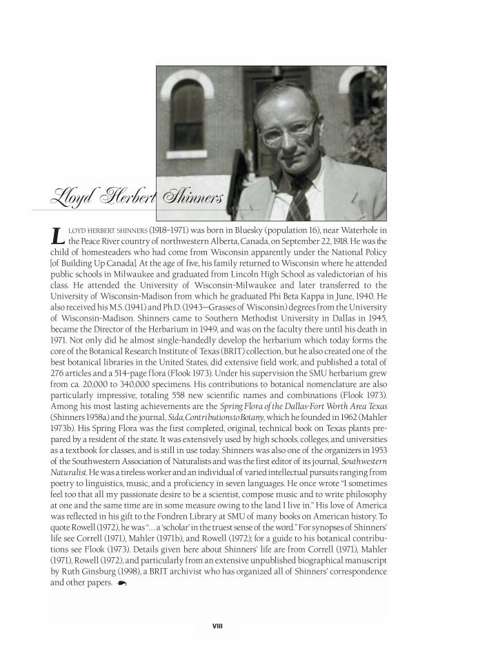
LOYD HERBERT SHINNERS (1918–1971) was born in Bluesky (population 16), near Waterhole inthe Peace River country of northwestern Alberta, Canada, on September 22, 1918. He was the
child of homesteaders who had come from Wisconsin apparently under the National Policy[of Building Up Canada]. At the age of five, his family returned to Wisconsin where he attendedpublic schools in Milwaukee and graduated from Lincoln High School as valedictorian of hisclass. He attended the University of Wisconsin-Milwaukee and later transferred to theUniversity of Wisconsin-Madison from which he graduated Phi Beta Kappa in June, 1940. Healso received his M.S. (1941) and Ph.D. (1943—Grasses of Wisconsin) degrees from the Universityof Wisconsin-Madison. Shinners came to Southern Methodist University in Dallas in 1945,became the Director of the Herbarium in 1949, and was on the faculty there until his death in1971. Not only did he almost single-handedly develop the herbarium which today forms thecore of the Botanical Research Institute of Texas (BRIT) collection, but he also created one of thebest botanical libraries in the United States, did extensive field work, and published a total of276 articles and a 514-page flora (Flook 1973). Under his supervision the SMU herbarium grewfrom ca. 20,000 to 340,000 specimens. His contributions to botanical nomenclature are alsoparticularly impressive, totaling 558 new scientific names and combinations (Flook 1973).Among his most lasting achievements are the Spring Flora of the Dallas-Fort Worth Area Texas(Shinners 1958a) and the journal, Sida, Contributions to Botany, which he founded in 1962 (Mahler1973b). His Spring Flora was the first completed, original, technical book on Texas plants pre-pared by a resident of the state. It was extensively used by high schools, colleges, and universitiesas a textbook for classes, and is still in use today. Shinners was also one of the organizers in 1953of the Southwestern Association of Naturalists and was the first editor of its journal, SouthwesternNaturalist. He was a tireless worker and an individual of varied intellectual pursuits ranging frompoetry to linguistics, music, and a proficiency in seven languages. He once wrote “I sometimesfeel too that all my passionate desire to be a scientist, compose music and to write philosophyat one and the same time are in some measure owing to the land I live in.” His love of Americawas reflected in his gift to the Fondren Library at SMU of many books on American history. Toquote Rowell (1972), he was “. . . a ‘scholar’ in the truest sense of the word.” For synopses of Shinners’life see Correll (1971), Mahler (1971b), and Rowell (1972); for a guide to his botanical contribu-tions see Flook (1973). Details given here about Shinners’ life are from Correll (1971), Mahler(1971), Rowell (1972), and particularly from an extensive unpublished biographical manuscriptby Ruth Ginsburg (1998), a BRIT archivist who has organized all of Shinners’ correspondenceand other papers.
VIII
Lloyd Herbert Shinners
L
A
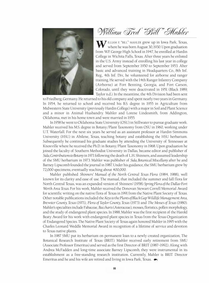
ILLIAM F. “BILL” MAHLER grew up in Iowa Park, Texas,where he was born August 30, 1930. Upon graduation
from W.F. George High School in 1947, he enrolled at HardinCollege in Wichita Falls, Texas. After three years he enlistedin the U.S. Army instead of enrolling his last year in collegeand served from September 1950 to September 1953. Afterbasic and advanced training in Headquarters Co., 8th Inf.Reg., 4th Inf. Div., he volunteered for airborne and rangertraining. He served with the 14th Ranger Infantry Company(Airborne) at Fort Benning, Georgia, and Fort Carson,Colorado, until they were deactivated in 1951 (Black 1989;Taylor n.d.). In the meantime, the 4th Division had been sent
to Friedberg, Germany. He returned to his old company and spent nearly two years in Germany.In 1954, he returned to school and received his B.S. degree in 1955 in Agriculture fromMidwestern State University (previously Hardin College) with a major in Soil and Plant Scienceand a minor in Animal Husbandry. Mahler and Lorene Lindesmith, from Addington,Oklahoma, met in his home town and were married in 1955.
In 1958 he went to Oklahoma State University (OSU) in Stillwater to pursue graduate work.Mahler received his M.S. degree in Botany/Plant Taxonomy from OSU in 1960, working underU.T. Waterfall. For the next six years he served as an assistant professor at Hardin-SimmonsUniversity (HSU) in Abilene, Texas, teaching botany and establishing the HSU herbarium.Subsequently he continued his graduate studies by attending the University of Tennessee atKnoxville where he received the Ph.D. in Botany/Plant Taxonomy in 1968. Upon graduation hejoined the faculty of Southern Methodist University in Dallas, became editor and publisher ofSida, Contributions to Botany in 1971 following the death of L.H. Shinners, and assumed leadershipof the SMU herbarium in 1973. Mahler was publisher of Sida, Botanical Miscellany after he andBarney Lipscomb founded the journal in 1987. Under his guidance, the SMU herbarium grew by72,000 specimens, eventually reaching about 400,000.
Mahler published Shinners’ Manual of the North Central Texas Flora (1984, 1988), wellknown for its clarity and ease of use. The manual, that included the summer and fall flora forNorth Central Texas, was an expanded version of Shinners’ (1958) Spring Flora of the Dallas-FortWorth Area Texas. For his work, Mahler received the Donovan Stewart Correll Memorial Awardfor scientific writing on the native flora of Texas in 1991 from the Native Plant Society of Texas.Other notable publications included the Keys to the Plants of Black Gap Wildlife Management Area,Brewster County, Texas (1971), Flora of Taylor County, Texas (1973) and The Mosses of Texas (1980).Mahler’s specialties include Fabaceae, Baccharis (Asteraceae), mosses, floristics, pollen morphology,and the study of endangered plant species. In 1988, Mahler was the first recipient of the HaroldBeaty Award for his work with endangered plant species in Texas from the Texas Organizationof Endangered Species. The Native Plant Society of Texas again honored Mahler in 1995 with theCharles Leonard Weddle Memorial Award in recognition of a lifetime of service and devotionto Texas native plants.
In 1987 SMU put its herbarium on permanent loan to a newly created organization, TheBotanical Research Institute of Texas (BRIT). Mahler received early retirement from SMU(Associate Professor Emeritus) and served as the first Director of BRIT (1987–1992). Along withAndrea McFadden and long-time associate Barney Lipscomb, they were instrumental in itsestablishment as a free-standing research institution. Currently, Mahler is BRIT DirectorEmeritus and he and his wife are retired and living in Iowa Park, Texas.
IX
WWilliam Fred “Bill” Mahler
A

ABSTRACT/RESUMEN 1
OVERVIEW OF THE BOOK 2
GEOGRAPHIC AREA COVERED 3
INFORMATION HELPFUL IN USING THE FLORA 7
PLANTS TREATED 7
ARRANGEMENT OF TAXA AND GENERAL METHODS 8
DESCRIPTIONS 8
KEYS 9
SOURCES OF INFORMATION 10
NOMENCLATURE 10
GEOGRAPHIC DISTRIBUTIONS 11
INFORMATION ON TOXIC/POISONOUS PLANTS 12
INFORMATION ON ENDANGERED AND THREATENED TAXA 12
INFORMATION ON ILLUSTRATIONS AND PHOTOGRAPHS 13
INFORMATION ON THE GLOSSARY 13
INFORMATION ON REFERENCES AND LITERATURE CITED 13
ABBREVIATIONS AND SYMBOLS 14
SUMMARY DATA ON THE FLORA 16
NEW COMBINATIONS MADE IN THIS BOOK 16
ACKNOWLEDGMENTS 17
AUTHORS’ NOTE 19
INTRODUCTION TO NORTH CENTRAL TEXAS 20
OVERVIEW 20
GENERAL GEOLOGY OF NORTH CENTRAL TEXAS 20
SOILS OF NORTH CENTRAL TEXAS 23
CLIMATE OF NORTH CENTRAL TEXAS 28
THE BLACKLAND PRAIRIE 32
OCCURRENCE OF THE BLACKLAND PRAIRIE 32
PRESETTLEMENT AND EARLY SETTLEMENT CONDITIONSON THE BLACKLAND PRAIRIE 34
GEOLOGY OF THE BLACKLAND PRAIRIE 38
VEGETATION OF THE BLACKLAND PRAIRIE 39
CROSS TIMBERS AND PRAIRIES 42
OCCURRENCE OF THE CROSS TIMBERS AND PRAIRIES 42
PRESETTLEMENT AND EARLY SETTLEMENT CONDITIONSIN THE CROSS TIMBERS 43
GEOLOGY OF THE EAST CROSS TIMBERS 45
GEOLOGY OF THE WEST CROSS TIMBERS 45
VEGETATION OF THE CROSS TIMBERS 46
PRESETTLEMENT AND EARLY SETTLEMENT CONDITIONSIN THE GRAND PRAIRIE (FORT WORTH PRAIRIE ANDLAMPASAS CUT PLAIN) 48
TABLE OF CONTENTS/ PAGE
SHINNERS & MAHLER’S
ILLUSTRATED
FLORA OF
NORTH CENTRAL
TEXAS
X
CROSS TIMBERS AND PRAIRIES (CONTINUED)
GEOLOGY OF THE GRAND PRAIRIE 50
VEGETATION OF THE FORT WORTH PRAIRIE 52
VEGETATION OF THE LAMPASAS CUT PLAIN 53
RED RIVER AREA (AREA ADJACENT TO THE RED RIVER) 54
ORIGIN OF THE NORTH CENTRAL TEXAS FLORA 56
CONSERVATION IN NORTH CENTRAL TEXAS 62
A SKETCH OF THE HISTORY OF BOTANY IN TEXASWITH EMPHASIS ON NORTH CENTRAL TEXAS 63
COLOR PHOTOGRAPHS 77
GENERAL KEYS 109
TAXONOMIC TREATMENTS 173
LYCOPODIOPHYTA (CLUBMOSSES) 173
EQUISETOPHYTA (HORSETAILS) 176
POLYPODIOPHYTA (FERNS) 178
PINOPHYTA (CONIFERS) 201
GNETOPHYTA (JOINT-FIRS AND RELATIVES) 207
MAGNOLIOPHYTA (FLOWERING PLANTS) 208
CLASS DICOTYLEDONAE (DICOTS) 210
CLASS MONOCOTYLEDONAE (MONOCOTS) 1077
APPENDICES
APPENDIX ONE (PHYLOGENY/CLASSIFICATION OF FAMILIES) 1353
APPENDIX TWO (GRASS PHYLOGENY/CLASSIFICATION) 1357
APPENDIX THREE (LIST OF TEXAS ENDEMIC SPECIES OCCURRING IN NORTH CENTRAL TEXAS) 1358
APPENDIX FOUR (ILLUSTRATION SOURCES) 1360
APPENDIX FIVE (LIST OF SELECTED BOTANICALLY RELATED INTERNET ADDRESSES) 1367
APPENDIX SIX (TAXONOMY, CLASSIFICATION, AND THE DEBATE ABOUT CLADISTICS) 1372
APPENDIX SEVEN (CHANGES IN THE SCIENTIFIC NAMES OF PLANTS) 1381
APPENDIX EIGHT (COLLECTING HERBARIUM SPECIMENS) 1382
APPENDIX NINE (LIST OF CONSERVATION ORGANIZATIONS) 1389
APPENDIX TEN (LARVAL HOST PLANTS OF LEPIDOPTERA OF NORTH CENTRAL TEXAS) 1394
APPENDIX ELEVEN (BOOKS FOR THE STUDY OF TEXAS NATIVE PLANTS) 1404
APPENDIX TWELVE (LIST OF NATIVE PLANTS SUGGESTED FOR USE AS ORNAMENTALS) 1409
APPENDIX THIRTEEN (LIST OF SOURCES FOR NATIVE PLANTS) 1415
APPENDIX FOURTEEN (STATE BOTANICAL SYMBOLS FOR TEXAS AND OKLAHOMA) 1418
APPENDIX FIFTEEN (SPECIAL RECOGNITION—BENNY J. SIMPSON) 1419
GLOSSARY/ILLUSTRATED GLOSSARY 1421
LITERATURE CITED 1457
INDEX 1525
COLOPHON 1623
INFORMATION ON AUTHORS AND PARTICIPATING INSTITUTIONS 1624
TABLE OF CONTENTS/ PAGE
XI
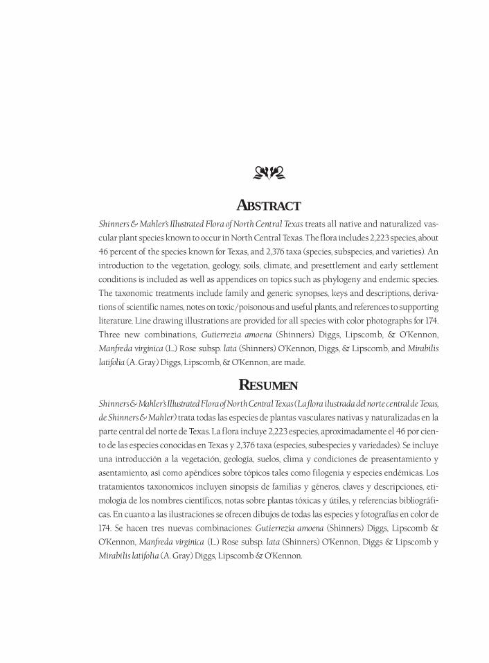
ABSTRACTShinners & Mahler’s Illustrated Flora of North Central Texas treats all native and naturalized vas-
cular plant species known to occur in North Central Texas. The flora includes 2,223 species, about
46 percent of the species known for Texas, and 2,376 taxa (species, subspecies, and varieties). An
introduction to the vegetation, geology, soils, climate, and presettlement and early settlement
conditions is included as well as appendices on topics such as phylogeny and endemic species.
The taxonomic treatments include family and generic synopses, keys and descriptions, deriva-
tions of scientific names, notes on toxic/poisonous and useful plants, and references to supporting
literature. Line drawing illustrations are provided for all species with color photographs for 174.
Three new combinations, Gutierrezia amoena (Shinners) Diggs, Lipscomb, & O’Kennon,
Manfreda virginica (L.) Rose subsp. lata (Shinners) O’Kennon, Diggs, & Lipscomb, and Mirabilis
latifolia (A. Gray) Diggs, Lipscomb, & O’Kennon, are made.
RESUMENShinners & Mahler’s Illustrated Flora of North Central Texas (La flora ilustrada del norte central de Texas,
de Shinners & Mahler) trata todas las especies de plantas vasculares nativas y naturalizadas en la
parte central del norte de Texas. La flora incluye 2,223 especies, aproximadamente el 46 por cien-
to de las especies conocidas en Texas y 2,376 taxa (especies, subespecies y variedades). Se incluye
una introducción a la vegetación, geología, suelos, clima y condiciones de preasentamiento y
asentamiento, así como apéndices sobre tópicos tales como filogenia y especies endémicas. Los
tratamientos taxonomicos incluyen sinopsis de familias y géneros, claves y descripciones, eti-
mología de los nombres científicos, notas sobre plantas tóxicas y útiles, y referencias bibliográfi-
cas. En cuanto a las ilustraciones se ofrecen dibujos de todas las especies y fotografías en color de
174. Se hacen tres nuevas combinaciones: Gutierrezia amoena (Shinners) Diggs, Lipscomb &
O’Kennon, Manfreda virginica (L.) Rose subsp. lata (Shinners) O’Kennon, Diggs & Lipscomb y
Mirabilis latifolia (A. Gray) Diggs, Lipscomb & O’Kennon.
DD
SHINNERS & MAHLER’S
ILLUSTRATED FLORA OFNORTH CENTRAL TEXAS
OVERVIEW OF THE BOOKShinners & Mahler’s Illustrated Flora of North Central Texas is a floristic treatment of all native andnaturalized vascular plant species known to occur in North Central Texas. The flora includes2,223 species, about 46 percent of the species known for Texas, and a total of 2,376 taxa (species,subspecies, and varieties). Representatives of 168 families and 854 genera are included. It is acontinuation in the tradition of Lloyd Shinners’ Spring Flora of the Dallas-Fort Worth Area Texas(1958a) and William Mahler’s Shinners’ Manual of the North Central Texas Flora (1988). It differsfrom Mahler’s (1988) work in the following ways: the total number of taxa is expanded fromabout 1,550 to 2,376; in addition to flowering plants, all ferns and similar plants (pteridophytes)and gymnosperms are included; it is fully illustrated; an introduction and appendices are pro-vided; the taxonomic treatments have been expanded, including the addition of references tosupporting literature; families, genera, and species are listed in alphabetical order within themajor groups of plants; and a literature section with references pertinent to the plants of NorthCentral Texas is provided.
A number of features have been incorporated to make the book more useful to non-specialists.Line drawings are provided for all species, making it the first fully illustrated flora for any regionof Texas or the adjacent states. Color photographs are provided for 174 taxa. An introduction,covering general aspects of the vegetation, geology, soils, climate, and presettlement and earlysettlement conditions, has been included to provide background and context concerning NorthCentral Texas. Further, the taxonomic treatments include brief synopses about each family andgenus, derivations of generic names and specific epithets, characters helpful in family recogni-tion in the field, notes on useful and toxic plants (ethnobotanical information), and references tosupporting literature. Finally, appendices are provided on phylogeny (evolutionary relationships)at the family level, grass phylogeny, endemics, illustration sources, botanically related internetaddresses, cladistics (a current controversy/approach in taxonomy), changes in scientific names,collecting herbarium specimens, conservation organizations, lepidopteran (butterfly and moth)host plant information, books for the study of native plants, suggested native ornamentals,sources for native plants, and state botanical symbols. When possible and practical, we haveattempted to conform to the suggestions in Schmid’s (1997) article on suggestions to make florasmore user friendly.
DD
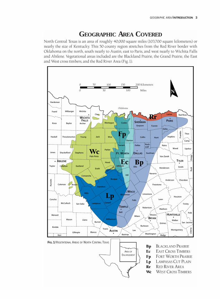
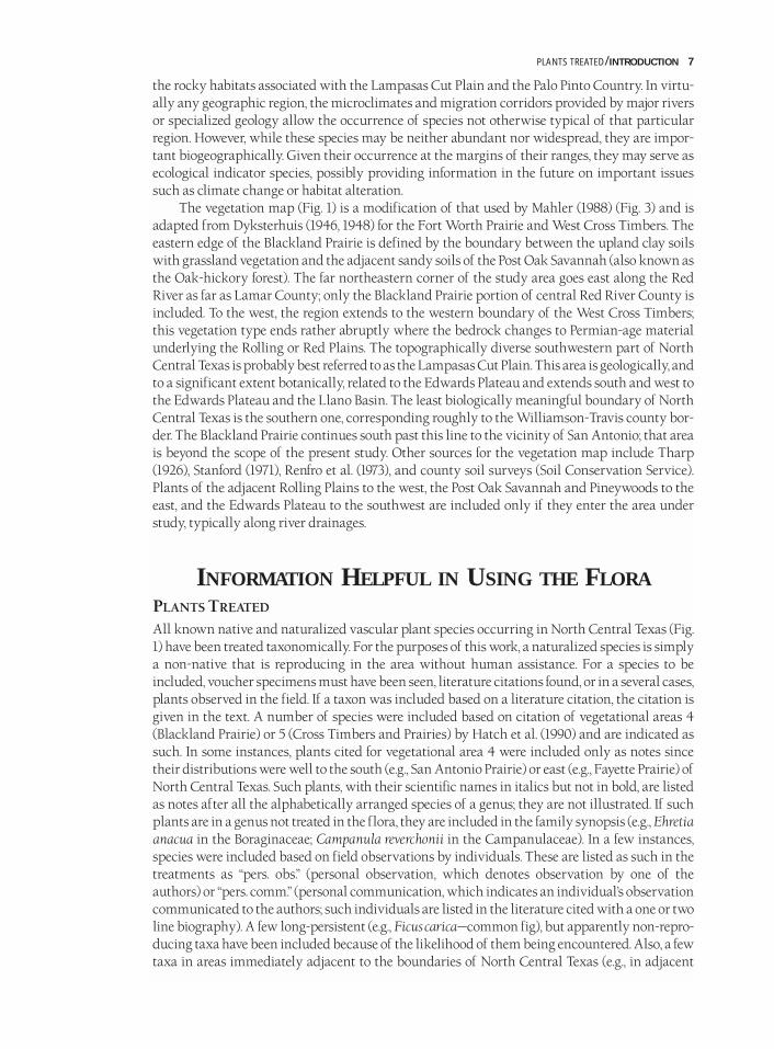
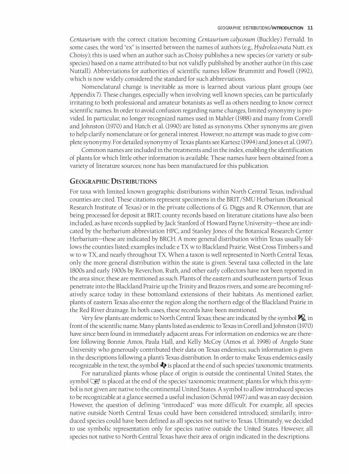
GEOGRAPHIC AREA COVEREDNorth Central Texas is an area of roughly 40,000 square miles (103,700 square kilometers) ornearly the size of Kentucky. This 50 county region stretches from the Red River border withOklahoma on the north, south nearly to Austin, east to Paris, and west nearly to Wichita Fallsand Abilene. Vegetational areas included are the Blackland Prairie, the Grand Prairie, the Eastand West cross timbers, and the Red River Area (Fig. 1).
GEOGRAPHIC AREA/INTRODUCTION 3
FIG. 1/VEGETATIONAL AREAS OF NORTH CENTRAL TEXAS
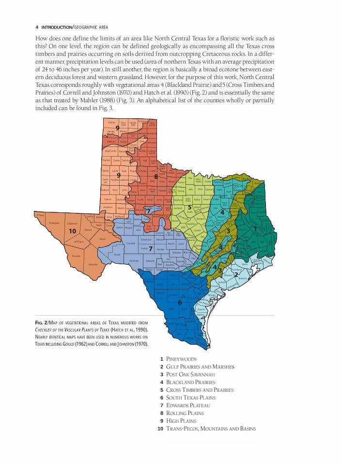
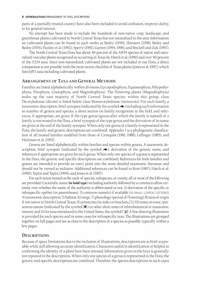
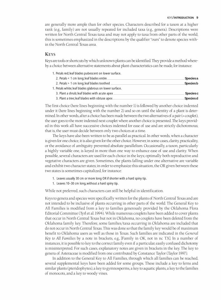
How does one define the limits of an area like North Central Texas for a floristic work such asthis? On one level, the region can be defined geologically as encompassing all the Texas crosstimbers and prairies occurring on soils derived from outcropping Cretaceous rocks. In a differ-ent manner, precipitation levels can be used (area of northern Texas with an average precipitationof 24 to 46 inches per year). In still another, the region is basically a broad ecotone between east-ern deciduous forest and western grassland. However, for the purpose of this work, North CentralTexas corresponds roughly with vegetational areas 4 (Blackland Prairie) and5 (Cross Timbers andPrairies) of Correll and Johnston (1970) and Hatch et al. (1990) (Fig. 2) and is essentially the sameas that treated by Mahler (1988) (Fig. 3). An alphabetical list of the counties wholly or partiallyincluded can be found in Fig. 3.
4 INTRODUCTION/GEOGRAPHIC AREA
1
2
3
4
5
6
7
8
9
10
PINEYWOODS
GULF PRAIRIES AND MARSHEsPOST OAK SAVANNAH
BLACKLAND PRAIRIES
CROSS TIMBERS AND PRAIRIES
SOUTH TEXAS PLAINS
EDWARDS PLATEAU
ROLLING PLAINS
HIGH PLAINS
TRANS-PECOS, MOUNTAINS AND BASINS
FIG. 2/MAP OF VEGETATIONAL AREAS OF TEXAS MODIFIED FROM
CHECKLIST OF THE VASCULAR PLANTS OF TEXAS (HATCH ET AL. 1990).
NEARLY IDENTICAL MAPS HAVE BEEN USED IN NUMEROUS WORKS ON
TEXAS INCLUDING GOULD (1962) AND CORRELL AND JOHNSTON (1970).
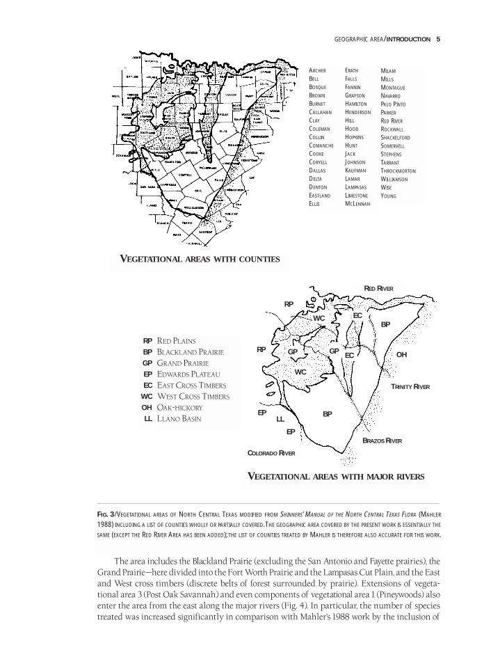
The area includes the Blackland Prairie (excluding the San Antonio and Fayette prairies), theGrand Prairie—here divided into the Fort Worth Prairie and the Lampasas Cut Plain, and the Eastand West cross timbers (discrete belts of forest surrounded by prairie). Extensions of vegeta-tional area 3 (Post Oak Savannah) and even components of vegetational area 1 (Pineywoods) alsoenter the area from the east along the major rivers (Fig. 4). In particular, the number of speciestreated was increased significantly in comparison with Mahler’s 1988 work by the inclusion of
GEOGRAPHIC AREA/INTRODUCTION 5
FIG. 3/VEGETATIONAL AREAS OF NORTH CENTRAL TEXAS MODIFIED FROM SHINNERS’ MANUAL OF THE NORTH CENTRAL TEXAS FLORA (MAHLER
1988) INCLUDING A LIST OF COUNTIES WHOLLY OR PARTIALLY COVERED.THE GEOGRAPHIC AREA COVERED BY THE PRESENT WORK IS ESSENTIALLY THE
SAME (EXCEPT THE RED RIVER AREA HAS BEEN ADDED); THE LIST OF COUNTIES TREATED BY MAHLER IS THEREFORE ALSO ACCURATE FOR THIS WORK.
ARCHER
BELL
BOSQUE
BROWN
BURNET
CALLAHAN
CLAY
COLEMAN
COLLIN
COMANCHE
COOKE
CORYELL
DALLAS
DELTA
DENTON
EASTLAND
ELLIS
ERATH
FALLS
FANNIN
GRAYSON
HAMILTON
HENDERSON
HILL
HOOD
HOPKINS
HUNT
JACK
JOHNSON
KAUFMAN
LAMAR
LAMPASAS
LIMESTONE
MCLENNAN
MILAM
MILLS
MONTAGUE
NAVARRO
PALO PINTO
PARKER
RED RIVER
ROCKWALL
SHACKELFORD
SOMERVELL
STEPHENS
TARRANT
THROCKMORTON
WILLIAMSON
WISE
YOUNG
VEGETATIONAL AREAS WITH COUNTIES
VEGETATIONAL AREAS WITH MAJOR RIVERS
RP
BP
GP
EP
EC
WC
OH
LL
RED PLAINS
BLACKLAND PRAIRIE
GRAND PRAIRIE
EDWARDS PLATEAU
EAST CROSS TIMBERS
WEST CROSS TIMBERS
OAK-HICKORY
LLANO BASIN
RED RIVER
TRINITY RIVER
BRAZOS RIVER
COLORADO RIVER
EP
EP
RP
RP
LLBP
WC
GP GPEC
ECWCBP
OH
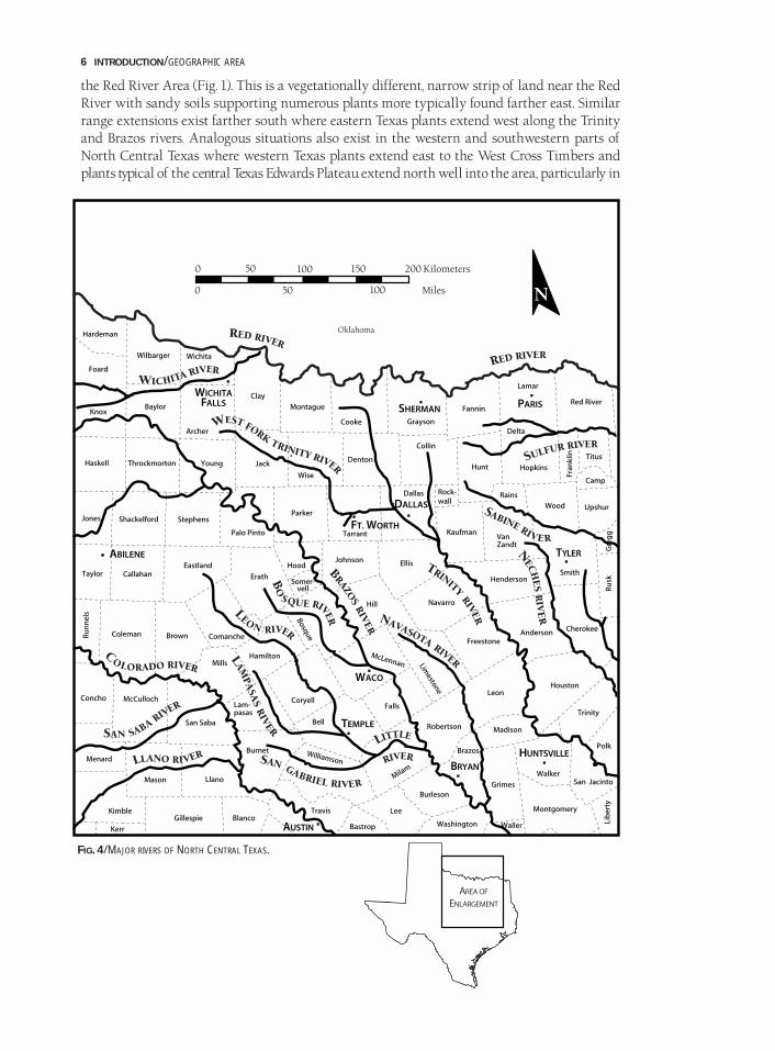
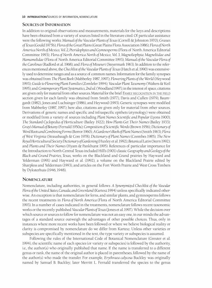
the Red River Area (Fig. 1). This is a vegetationally different, narrow strip of land near the RedRiver with sandy soils supporting numerous plants more typically found farther east. Similarrange extensions exist farther south where eastern Texas plants extend west along the Trinityand Brazos rivers. Analogous situations also exist in the western and southwestern parts ofNorth Central Texas where western Texas plants extend east to the West Cross Timbers andplants typical of the central Texas Edwards Plateau extend north well into the area, particularly in
6 INTRODUCTION/GEOGRAPHIC AREA
FIG. 4/MAJOR RIVERS OF NORTH CENTRAL TEXAS.
the rocky habitats associated with the Lampasas Cut Plain and the Palo Pinto Country. In virtu-ally any geographic region, the microclimates and migration corridors provided by major riversor specialized geology allow the occurrence of species not otherwise typical of that particularregion. However, while these species may be neither abundant nor widespread, they are impor-tant biogeographically. Given their occurrence at the margins of their ranges, they may serve asecological indicator species, possibly providing information in the future on important issuessuch as climate change or habitat alteration.
The vegetation map (Fig. 1) is a modification of that used by Mahler (1988) (Fig. 3) and isadapted from Dyksterhuis (1946, 1948) for the Fort Worth Prairie and West Cross Timbers. Theeastern edge of the Blackland Prairie is defined by the boundary between the upland clay soilswith grassland vegetation and the adjacent sandy soils of the Post Oak Savannah (also known asthe Oak-hickory forest). The far northeastern corner of the study area goes east along the RedRiver as far as Lamar County; only the Blackland Prairie portion of central Red River County isincluded. To the west, the region extends to the western boundary of the West Cross Timbers;this vegetation type ends rather abruptly where the bedrock changes to Permian-age materialunderlying the Rolling or Red Plains. The topographically diverse southwestern part of NorthCentral Texas is probably best referred to as the Lampasas Cut Plain. This area is geologically, andto a significant extent botanically, related to the Edwards Plateau and extends south and west tothe Edwards Plateau and the Llano Basin. The least biologically meaningful boundary of NorthCentral Texas is the southern one, corresponding roughly to the Williamson-Travis county bor-der. The Blackland Prairie continues south past this line to the vicinity of San Antonio; that areais beyond the scope of the present study. Other sources for the vegetation map include Tharp(1926), Stanford (1971), Renfro et al. (1973), and county soil surveys (Soil Conservation Service).Plants of the adjacent Rolling Plains to the west, the Post Oak Savannah and Pineywoods to theeast, and the Edwards Plateau to the southwest are included only if they enter the area understudy, typically along river drainages.
INFORMATION HELPFUL IN USING THE FLORAPLANTS TREATED
All known native and naturalized vascular plant species occurring in North Central Texas (Fig.1) have been treated taxonomically. For the purposes of this work, a naturalized species is simplya non-native that is reproducing in the area without human assistance. For a species to beincluded, voucher specimens must have been seen, literature citations found, or in a several cases,plants observed in the field. If a taxon was included based on a literature citation, the citation isgiven in the text. A number of species were included based on citation of vegetational areas 4(Blackland Prairie) or 5 (Cross Timbers and Prairies) by Hatch et al. (1990) and are indicated assuch. In some instances, plants cited for vegetational area 4 were included only as notes sincetheir distributions were well to the south (e.g., San Antonio Prairie) or east (e.g., Fayette Prairie) ofNorth Central Texas. Such plants, with their scientific names in italics but not in bold, are listedas notes after all the alphabetically arranged species of a genus; they are not illustrated. If suchplants are in a genus not treated in the flora, they are included in the family synopsis (e.g., Ehretiaanacua in the Boraginaceae; Campanula reverchonii in the Campanulaceae). In a few instances,species were included based on field observations by individuals. These are listed as such in thetreatments as “pers. obs.” (personal observation, which denotes observation by one of theauthors) or “pers. comm.” (personal communication, which indicates an individual’s observationcommunicated to the authors; such individuals are listed in the literature cited with a one or twoline biography). A few long-persistent (e.g., Ficus carica—common fig), but apparently non-repro-ducing taxa have been included because of the likelihood of them being encountered. Also, a fewtaxa in areas immediately adjacent to the boundaries of North Central Texas (e.g., in adjacent
PLANTS TREATED/INTRODUCTION 7
parts of a partially treated county) have also been included to avoid confusion, improve clarity,or for general interest.
No attempt has been made to include the hundreds of non-native crop, landscape, andgreenhouse plants cultivated in North Central Texas but not naturalized in the area. Informationon cultivated plants can be found in such works as Bailey (1949), Shinners (1958), Bailey andBailey (1976), Huxley et al. (1992), Sperry (1991), Garrett (1994, 1996), and Brickell and Zuk (1997).
The North Central Texas flora has about 46 percent of the 4,834 species of native and natu-ralized vascular plants recognized as occurring in Texas by Hatch et al. (1990) and over 40 percentof the 5,524 taxa. Since non-naturalized, cultivated plants are not included in our flora, a directcomparison is not possible with the most recent checklist of Texas plants (Jones et al. 1997), whichlists 6,871 taxa including cultivated plants.
ARRANGEMENT OF TAXA AND GENERAL METHODS
Families are listed alphabetically within divisions (Lycopodiophyta, Equisetophyta, Polypodio-phyta, Pinophyta, Gnetophyta, and Magnoliophyta). The flowering plants (Magnoliophyta)make up the vast majority of North Central Texas species; within this group, classDicotyledonae (dicots) is listed before class Monocotyledonae (monocots). For each family ataxonomic description, brief synopsis (indicated by the symbol A) including such informationas number of genera and species, a short section on family recognition in the field, and refer-ences, if appropriate, are given. If the type genus (genus after which the family is named) of afamily is not treated in the flora, a brief synopsis of the type genus and the derivation of its nameare given at the end of the family synopsis. When only one genus of a family is represented in theflora, the family and generic descriptions are combined. Appendix 1 is a phylogenetic classifica-tion of all treated families modified from those of Cronquist (1981, 1988), Lellinger (1985), andHickman et al. (1993).
Genera are listed alphabetically within families and species within genera. A taxonomic de-scription, brief synopsis (indicated by the symbol A), derivation of the generic name, and references if appropriate are given for each genus. When only one species of a genus is representedin the flora, the generic and specific descriptions are combined. References for both families andgenera are intended to provide an entry point into the more detailed taxonomic literature andshould not be viewed as inclusive. Additional references can be found in Kent (1967), Hatch et al.(1990), Taylor and Taylor (1994), and Jones et al. (1997).
For each taxon treated at the rank of species, subspecies, or variety, all or most of the followingare provided: 1) scientific name (in bold type) including authority followed by a comma to allow cer-tainty over whether the name of the authority is abbreviated or not; 2) derivation of the specific orinfraspecific epithet (in parentheses); 3) common name(s) if available (IN SMALL CAPITAL LETTERS);4) taxonomic description; 5) habitat; 6) range; 7) phenology (period of flowering); 8) area of originif not native to North Central Texas; 9) synonyms (in italics in brackets, [ ] ); 10) notes on toxic/poi-sonous nature (indicated by the symbol �) or other short notes of ethnobotanical or taxonomicinterest; and 11) for taxa introduced to the United States, the symbol I. A line drawing illustrationis provided for each species and in some cases for infraspecific taxa. The illustrations are groupedtogether on full pages and are as close to the description of a species as possible, typically within afew pages.
DESCRIPTIONS
Because of space limitations due to the inclusion of illustrations, descriptions are as brief as pos-sible while still allowing accurate identification. Characters useful in identification or helpful inconfirming the identity of a plant have been stressed. Information given in the keys is generallynot repeated in the descriptions. When only one species of a genus is represented in the flora, thegeneric and specific descriptions are combined. Therefore, the species descriptions in such cases
8 INTRODUCTION/ARRANGEMENT OF TAXA, DESCRIPTIONS
are generally more ample than for other species. Characters described for a taxon at a higherrank (e.g., family) are not usually repeated for included taxa (e.g., genera). Descriptions werewritten for North Central Texas taxa and may not apply to taxa from other parts of the world;this is sometimes emphasized in the descriptions by the qualifier “ours” to denote species with-in the North Central Texas area.
KEYS
Keys are tools or shortcuts by which unknown plants can be identified. They provide a method where-by a choice between alternative statements about plant characteristics can be made, for instance:
1. Petals red; leaf blades pubescent on lower surface.
2. Petals < 1 cm long; leaf blades entire Species a
2. Petals > 1 cm long; leaf blades toothed Species b
1. Petals white; leaf blades glabrous on lower surface.
3. Plant a shrub; leaf blades with acute apex Species c
3. Plant a tree; leaf blades with obtuse apex Species d
The first choice (here lines beginning with the number 1) is followed by another choice indentedunder it (here lines beginning with the number 2) and so on until the identity of a plant is deter-mined. In other words, after a choice has been made between the two alternatives of a pair (= couplet),the user goes to the more indented next couplet where another choice is presented. The keys provid-ed in this work all have successive choices indented for ease of use and are strictly dichotomous;that is, the user must decide between only two choices at a time.
The keys have also been written to be as parallel as practical. In other words, when a characteris given for one choice, it is also given for the other choice. However, in some cases, clarity, practicality,or the avoidance of ambiguity prevented absolute parallelism. Occasionally, a taxon, particularlya highly variable one, is keyed in more than one way to enhance ease of use and clarity. Whenpossible, several characters are used for each choice in the keys; optimally both reproductive andvegetative characters are given. Sometimes, the plants falling under one alternative are variableand exhibit two character states; in order to emphasize this situation, the OR given between thesetwo states is sometimes capitalized, for instance:
1. Leaves usually 30 cm or more long OR if shorter with a hard spiny tip.
1. Leaves 10–30 cm long, without a hard spiny tip.
While not preferred, such characters can still be helpful in identification.
Keys to genera and species were specifically written for the plants of North Central Texas and arenot intended to be inclusive of plants occurring in other parts of the world. The General Key toAll Families is modified from a key to families generously provided by the Oklahoma FloraEditorial Committee (Tyrl et al. 1994). While numerous couplets have been added to cover plantsthat occur in North Central Texas but not in Oklahoma, no couplets have been deleted from theOklahoma family key. Therefore, some families/taxa occurring in Oklahoma are included thatdo not occur in North Central Texas. This was done so that the family key would be of maximumbenefit to Oklahoma users as well as those in Texas. Such families are indicated in the GeneralKey to All Families by a note in brackets, e.g., [Family in OK, not in nc TX]. In a number ofinstances, it is possible to key to the correct family even if a particular, easily confused dichotomyis misinterpreted. For such cases, explanatory notes are given in brackets in the key. The key togenera of Asteraceae is modified from one contributed by Constance Taylor (Taylor 1997).
In addition to the General Key to All Families, through which all families can be reached,several supplemental keys have been added for some groups. These include a key to ferns andsimilar plants (pteridophytes), a key to gymnosperms, a key to aquatic plants, a key to the familiesof monocots, and a key to woody vines.
KEYS/INTRODUCTION 9
SOURCES OF INFORMATION
In addition to original observations and measurements, materials for the keys and descriptionshave been obtained from a variety of sources listed in the literature cited. Of particular assistancewere the following works: Manual of the Vascular Plants of Texas (Correll & Johnston 1970); Grassesof Texas (Gould 1975b); Flora of the Great Plains (Great Plains Flora Association 1986); Flora of NorthAmerica North of Mexico, Vol. 2, Pteridophytes and Gymnosperms (Flora of North America EditorialCommittee 1993); Flora of North America North of Mexico, Vol. 3, Magnoliophyta: Magnoliidae andHamamelidae (Flora of North America Editorial Committee 1993); Manual of the Vascular Flora ofthe Carolinas (Radford et al. 1968); and Flora of Missouri (Steyermark 1963). In addition to the refer-ences mentioned above, the Checklist of the Vascular Plants of Texas (Hatch et al. 1990) was extensive-ly used to determine ranges and as a source of common names. Information for the family synopseswas obtained from The Plant Book (Mabberley 1987, 1997); Flowering Plants of theWorld (Heywood1993); Guide to Flowering Plant Families (Zomlefer 1994); Vascular Plant Taxonomy (Walters & Keil1995); and Contemporary Plant Systematics, 2nd ed. (Woodland 1997); in the interest of space, citationsare given only for material from other sources. Material for the brief FAMILY RECOGNITION IN THE FIELD
section given for each family was obtained from Smith (1977), Davis and Cullen (1979), Baum-gardt (1982), Jones and Luchsinger (1986), and Heywood (1993). Generic synopses were modifiedfrom Mabberley (1987, 1997); here also, citations are given only for material from other sources.Derivations of generic names and specific and infraspecific epithets (etymology) were obtainedor modified from a variety of sources including Plant Names Scientific and Popular (Lyons 1900);The Standard Cyclopedia of Horticulture (Bailey 1922); How Plants Get Their Names (Bailey 1933);Gray’s Manual of Botany (Fernald 1950a); Composition of Scientific Words (Brown 1956); Dictionary ofWord Roots and Combining Forms (Borror 1960); A Gardener’s Book of Plant Names(Smith 1963); Floraof West Virginia (Strausbaugh & Core 1978); Dictionary of Plant Names (Coombes 1985); The NewRoyal Horticultural Society Dictionary of Gardening (Huxley et al. 1992); Botanical Latin (Stern 1992);and Plants and Their Names (Hyam & Pankhurst 1995). References of particular importance forthe Introduction to North Central Texas included Hill’s (1901) classic Geography and Geology of theBlack and Grand Prairies, Texas, works on the Blackland and Grand prairies by Hayward andYelderman (1991) and Hayward et al. (1992), a volume on the Blackland Prairie edited bySharpless and Yelderman (1993), and articles on the Fort Worth Prairie and West Cross Timbersby Dyksterhuis (1946, 1948).
NOMENCLATURE
Nomenclature, including authorities, in general follows A Synonymized Checklist of the VascularFlora of the United States, Canada, and Greenland (Kartesz 1994) unless specifically indicated other-wise. An exception is that nomenclature for ferns, and similar plants, and gymnosperms followsthe recent treatments in Flora of North America (Flora of North America Editorial Committee1993). In a number of cases indicated in the treatments, nomenclature follows recent taxonomicworks or the recently published Vascular Plants of Texas (Jones et al. 1997). While the decision overwhich source or sources to follow for nomenclature was not an easy one, in our minds the advan-tages of a standard source outweigh the advantages of other possible choices. Thus, only ininstances where more recent works have been followed or where we believe biological reality orclarity is compromised by nomenclature do we differ from Kartesz. Unless other varieties orsubspecies are specifically mentioned in the text, the type variety or subspecies is assumed.
Following the rules of the International Code of Botanical Nomenclature (Greuter et al.1994), the scientific name of each species (or variety or subspecies) is followed by the authority,i.e., the author(s) who originally published that name. If the name is transferred to a differentgenus or rank, the name of the original author is placed in parentheses, followed by the name ofthe author(s) who made the transfer. For example, Erythraea calycosa Buckley was originallynamed by Samuel B. Buckley; later Merritt L. Fernald transferred the species to the genus
10 INTRODUCTION/SOURCES OF INFORMATION, NOMENCLATURE
Centaurium with the correct citation becoming Centaurium calycosum (Buckley) Fernald. Insome cases, the word “ex” is inserted between the names of authors (e.g., Hydrolea ovata Nutt. exChoisy); this is used when an author such as Choisy publishes a new species (or variety or sub-species) based on a name attributed to but not validly published by another author (in this caseNuttall). Abbreviations for authorities of scientific names follow Brummitt and Powell (1992),which is now widely considered the standard for such abbreviations.
Nomenclatural change is inevitable as more is learned about various plant groups (seeAppendix 7). These changes, especially when involving well known species, can be particularlyirritating to both professional and amateur botanists as well as others needing to know correctscientific names. In order to avoid confusion regarding name changes, limited synonymy is pro-vided. In particular, no longer recognized names used in Mahler (1988) and many from Correlland Johnston (1970) and Hatch et al. (1990) are listed as synonyms. Other synonyms are givento help clarify nomenclature or for general interest. However, no attempt was made to give com-plete synonymy. For detailed synonymy of Texas plants see Kartesz (1994) and Jones et al. (1997).
Common names are included in the treatments and in the index, enabling the identificationof plants for which little other information is available. These names have been obtained from avariety of literature sources; none has been manufactured for this publication.
GEOGRAPHIC DISTRIBUTIONS
For taxa with limited known geographic distributions within North Central Texas, individualcounties are cited. These citations represent specimens in the BRIT/SMU Herbarium (BotanicalResearch Institute of Texas) or in the private collections of G. Diggs and R. O’Kennon, that arebeing processed for deposit at BRIT; county records based on literature citations have also beenincluded, as have records supplied by Jack Stanford of Howard Payne University—these are indi-cated by the herbarium abbreviation HPC, and Stanley Jones of the Botanical Research CenterHerbarium—these are indicated by BRCH. A more general distribution within Texas usually fol-lows the counties listed; examples include: e TX w to Blackland Prairie, West Cross Timbers s andw to w TX, and nearly throughout TX. When a taxon is well represented in North Central Texas,only the more general distribution within the state is given. Several taxa collected in the late1800s and early 1900s by Reverchon, Ruth, and other early collectors have not been reported inthe area since; these are mentioned as such. Plants of the eastern and southeastern parts of Texaspenetrate into the Blackland Prairie up the Trinity and Brazos rivers, and some are becoming rel-atively scarce today in these bottomland extensions of their habitats. As mentioned earlier,plants of eastern Texas also enter the region along the northern edge of the Blackland Prairie inthe Red River drainage. In both cases, these records have been mentioned.
Very few plants are endemic to North Central Texas; these are indicated by the symbol D infront of the scientific name. Many plants listed as endemic to Texas in Correll and Johnston (1970)have since been found in immediately adjacent areas. For information on endemics we are there-fore following Bonnie Amos, Paula Hall, and Kelly McCoy (Amos et al. 1998) of Angelo StateUniversity who generously contributed their data on Texas endemics; such information is givenin the descriptions following a plant’s Texas distribution. In order to make Texas endemics easilyrecognizable in the text, the symbol E is placed at the end of such species’ taxonomic treatments.
For naturalized plants whose place of origin is outside the continental United States, thesymbol I is placed at the end of the species’ taxonomic treatment; plants for which this sym-bol is not given are native to the continental United States. A symbol to allow introduced speciesto be recognizable at a glance seemed a useful inclusion (Schmid 1997) and was an easy decision.However, the question of defining “introduced” was more difficult. For example, all speciesnative outside North Central Texas could have been considered introduced; similarily, intro-duced species could have been defined as all species not native to Texas. Ultimately, we decidedto use symbolic representation only for species native outside the United States. However, allspecies not native to North Central Texas have their area of origin indicated in the descriptions.
GEOGRAPHIC DISTRIBUTIONS/INTRODUCTION 11
INFORMATION ON TOXIC/POISONOUS PLANTS
Notes on toxic/poisonous properties (indicated by the symbol �) are given in the synopses andat the end of the treatments of various taxa. This information has been obtained from a varietyof cited sources. However, lack of information about toxicity does not indicate that a plant is safeand no plant material should be eaten unless one is sure of its safety. Indeed, most plants have notbeen tested for toxicity and all should be considered potentially dangerous unless known other-wise. Technically, a poison is a substance that in suitable quantities has properties harmful orfatal to an organism when it is brought into contact with or absorbed by the organism. Toxin, a morespecific term, is any of various poisonous substances that are specific products of the metabolicactivities of living organisms (Gove 1993). In referring to such material in plants, the terms havebeen used synonymously in the text.
In case of toxicity/poisoning by plant material or any other source, the TEXAS POISON CENTER
NETWORK can be reached at 1-800-POISON-1 (1-800-764-7661) or indirectly via the emergency number9-1-1. This is a state-wide 800 service available 24 hours a day.
INFORMATION ON ENDANGERED AND THREATENED TAXA
Taxa listed by the Texas Organization for Endangered Species (TOES 1993) are indicated by having(TOES 1993: Roman numeral) at the end of their treatment. The Roman numeral signifies the categoryas indicated by TOES:
CATEGORY I:Endangered species—legally protected.
CATEGORY II:Threatened species—legally protected. Likely to become endangered
CATEGORY III:Texas endangered—listed species. Endangered in Texas portion of range
CATEGORY IV:Texas Threatened—listed species. Likely to become endangered in Texas portion of range
CATEGORY V: Watch List—listed species. Either with low population numbers or restricted range in Texas
Such species are also signified by having the symbol � placed at the end of their taxonomic treatments.
12 INTRODUCTION/INFORMATION ON TOXIC PLANTS, ENDANGERED TAXA
INFORMATION ON ILLUSTRATIONS AND PHOTOGRAPHS
The more than 2,300 line-drawing illustrations have been obtained from a variety of sources inthe botanical literature dating back to the 1500s (Fuchs 1542). We thank the appropriate individ-uals or organizations for allowing their use. Three hundred twenty-six illustrations are publishedhere for the first time. These include many drawings of Cyperaceae done by Brenda Mahler andJessica Procter as part of B. Lipscomb’s research on that family. A significant number of the never-before-published drawings were done decades ago by the late Eula Whitehouse, Pat Mueller, andunknown SMU students. These illustrations were made for Lloyd Shinners, whose untimely deathprevented publication of a flora for North Central Texas. The drawings were in the archives atBRIT. Finally, Linny Heagy has produced 226 original drawings for all those North Central Texasspecies either not previously illustrated or for which suitable illustrations could not be found.
Beneath each illustration is the scientific name of the plant represented. The name is followedby a code in parentheses indicating the source of the illustration. A list of illustration sources withcodes is given in Appendix 4. Because all species are illustrated, reference to illustrations is notmade in the text. Illustrations are as close to the taxonomic descriptions as possible and in generalfollow the taxonomic descriptions.
The 174 color photographs are arranged alphabetically by genus and are grouped togetherin plates. Following the common name of each species and the page number of its description,a three letter code in brackets is given to designate the photographer: [JAC] = J. Andrew Crosthwaite,[GMD] = George M. Diggs, Matthew A. Kosnik [MAK], and [RJO] = Robert J. O’Kennon. The symbolm/80 at the end of a species description indicates a color photograph is provided on page 80.
INFORMATION ON THE GLOSSARY
The Glossary is modified from those of Shinners (1958a) and Mahler (1988), with additionalentries obtained or modified from a variety of sources including Lawrence (1951), Featherly(1954), Correll (1956), Gleason and Cronquist (1963, 1991), Radford et al. (1968), Correll andJohnston (1970), Gould (1975b), Lewis and Elvin-Lewis (1977), Benson (1979), Smutz andHamilton (1979), Fuller and McClintock (1986), Jones and Luchsinger (1986), Schofield (1986),Gandhi and Thomas (1989), Blackwell (1990), Isely (1990), Harris and Harris (1994), Spjut (1994),and Hickey and King (1997). The glossary is rather extensive and includes terms not otherwisefound in the book. This was done so that when using this work in conjunction with other taxo-nomic treatments, the meaning of obscure terms can be readily found.
INFORMATION ON REFERENCES AND LITERATURE CITED
The Literature Cited section contains bibliographic citations for all sources cited including thoselisted immediately following family and generic synopses (e.g., REFERENCES: Wood 1958; Kral1997). Originally, we had not intended to include such references. However, during preparation ofthe taxonomic treatments, we needed to refer repeatedly to the supporting literature; having ref-erences readily available in the developing manuscript proved helpful. We hope their inclusionwill be useful to users of the treatments. While an attempt was made to be as thorough as possi-ble, the magnitude of the botanical literature makes complete coverage impossible; the referencesgiven are intended to provide an entry point into the more detailed taxonomic literature andshould not be viewed as inclusive. Abbreviations for periodicals follow Botanico-Periodicum-Huntianum (B-P-H) (Lawrence et al. 1968) and Botanico-Periodicum-Huntianum/Supplementum(B-P-H/S) (Bridson & Smith 1991). For each individual cited in the text as having personallycommunicated unpublished information to the authors (indicated by the abbreviation, pers.comm.), a short biographical entry is given in the Literature Cited section.
INFORMATION ON ILLUSTRATIONS, PHOTOGRAPHS, GLOSSARY, REFERENCES AND LITERATURE CITED/INTRODUCTION 13
ABBREVIATIONS AND SYMBOLS
ABBREVIATIONS/SYMBOLS MEANING
endemic to North Central Texas
endemic to Texas
family or generic synopsis
introduced species, subspecies, or variety
endangered or threatened taxa; a TOES rating is also given for such taxa
toxic/poisonous plant
color photograph provided; page number follows symbol
less than
less than or equal to
more than
more than or equal to
more or less
or more (e.g., small tree 2–5+ m tall)
times or to indicate hybridization
auctorum = author
herbarium abbreviation for Baylor University Herbarium, Waco,TX.
before present
herbarium abbreviation for Botanical Research Center Herbarium, Bryan,TX
herbarium abbreviation for Botanical Research Institute of Texas, Fort Worth
central
circa (about)
centimeter
Latin: combinatio nova, new combination of name and epithet
diameter
decimeter
herbarium abbreviation for Southeastern Oklahoma State University, Durant, OK
east
Latin: exempli gratia, for example
see preceding section on nomenclature for detailed explanation
Latin: filius, son; e.g., L. f. indicates the younger Linnaeus
herbarium abbreviation for Howard Payne University, Brownwood,TX
Latin: id est, that is
meter
14 INTRODUCTION/ABBREVIATIONS, SYMBOLS
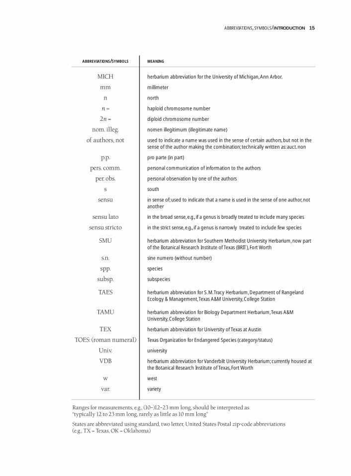
ABBREVIATIONS/SYMBOLS MEANING
MICH herbarium abbreviation for the University of Michigan, Ann Arbor.
mm millimeter
n north
n = haploid chromosome number
2n = diploid chromosome number
nom. illeg. nomen illegitimum (illegitimate name)
of authors, not used to indicate a name was used in the sense of certain authors, but not in the sense of the author making the combination; technically written as: auct. non
p.p. pro parte (in part)
pers. comm. personal communication of information to the authors
per. obs. personal observation by one of the authors
s south
sensu in sense of; used to indicate that a name is used in the sense of one author, not another
sensu lato in the broad sense, e.g., if a genus is broadly treated to include many species
sensu stricto in the strict sense, e.g., if a genus is narrowly treated to include few species
SMU herbarium abbreviation for Southern Methodist University Herbarium, now partof the Botanical Research Institute of Texas (BRIT), Fort Worth
s.n. sine numero (without number)
spp. species
subsp. subspecies
TAES herbarium abbreviation for S. M.Tracy Herbarium, Department of Rangeland Ecology & Management,Texas A&M University, College Station
TAMU herbarium abbreviation for Biology Department Herbarium,Texas A&M University, College Station
TEX herbarium abbreviation for University of Texas at Austin
TOES: (roman numeral) Texas Organization for Endangered Species (category/status)
Univ. university
VDB herbarium abbreviation for Vanderbilt University Herbarium; currently housed atthe Botanical Research Institute of Texas, Fort Worth
w west
var. variety
Ranges for measurements, e.g., (10–)12–23 mm long, should be interpreted as “typically 12 to 23 mm long, rarely as little as 10 mm long”
States are abbreviated using standard, two letter, United States Postal zip-code abbreviations (e.g., TX = Texas, OK = Oklahoma)
ABBREVIATIONS, SYMBOLS/INTRODUCTION 15
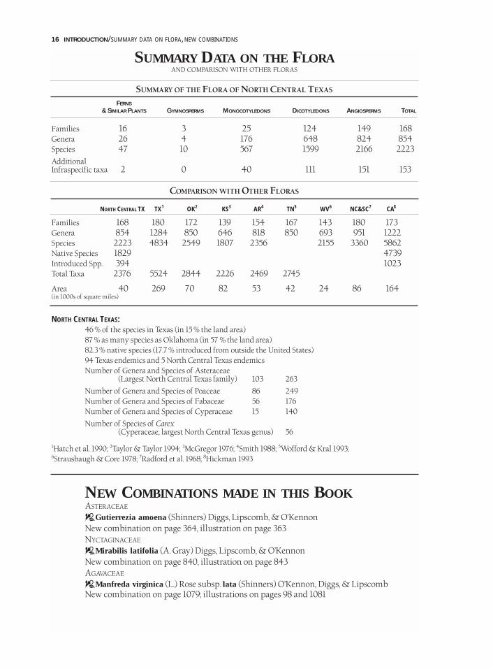
SUMMARY DATA ON THE FLORAAND COMPARISON WITH OTHER FLORAS
SUMMARY OF THE FLORA OF NORTH CENTRAL TEXAS
FERNS
& SIMILAR PLANTS GYMNOSPERMS MONOCOTYLEDONS DICOTYLEDONS ANGIOSPERMS TOTAL
Families 16 3 25 124 149 168Genera 26 4 176 648 824 854Species 47 10 567 1599 2166 2223AdditionalInfraspecific taxa 2 0 40 111 151 153
COMPARISON WITH OTHER FLORAS
NORTH CENTRAL TX TX1 OK2 KS3 AR4 TN5 WV6 NC&SC7 CA8
Families 168 180 172 139 154 167 143 180 173Genera 854 1284 850 646 818 850 693 951 1222Species 2223 4834 2549 1807 2356 2155 3360 5862Native Species 1829 4739Introduced Spp. 394 1023Total Taxa 2376 5524 2844 2226 2469 2745
Area 40 269 70 82 53 42 24 86 164(in 1000s of square miles)
NORTH CENTRAL TEXAS:46 % of the species in Texas (in 15 % the land area)87 % as many species as Oklahoma (in 57 % the land area)82.3 % native species (17.7 % introduced from outside the United States)94 Texas endemics and 5 North Central Texas endemicsNumber of Genera and Species of Asteraceae
(Largest North Central Texas family) 103 263
Number of Genera and Species of Poaceae 86 249Number of Genera and Species of Fabaceae 56 176Number of Genera and Species of Cyperaceae 15 140
Number of Species of Carex(Cyperaceae, largest North Central Texas genus) 56
1Hatch et al. 1990; 2Taylor & Taylor 1994; 3McGregor 1976; 4Smith 1988; 5Wofford & Kral 1993;6Strausbaugh & Core 1978; 7Radford et al. 1968; 8Hickman 1993
NEW COMBINATIONS MADE IN THIS BOOKASTERACEAE
DGutierrezia amoena (Shinners) Diggs, Lipscomb, & O’KennonNew combination on page 364, illustration on page 363NYCTAGINACEAE
DMirabilis latifolia (A. Gray) Diggs, Lipscomb, & O’KennonNew combination on page 840, illustration on page 843AGAVACEAE
DManfreda virginica (L.) Rose subsp. lata (Shinners) O’Kennon, Diggs, & LipscombNew combination on page 1079; illustrations on pages 98 and 1081
16 INTRODUCTION/SUMMARY DATA ON FLORA, NEW COMBINATIONS
ACKNOWLEDGMENTSContributions to an understanding of the flora of North Central Texas by the late LloydShinners and the very lively William (Bill) Mahler deserve special recognition; this volume isdedicated to them. For a synopsis of Shinners’ life see Mahler (1971b); for a guide to his botanicalcontributions see Flook (1973). This book is published as a volume of Sida, Botanical Miscellany,associated with the botanical journal Sida, Contributions to Botany, founded by Shinners in 1962(Mahler 1973b).
Three individuals were indispensible members of the team that produced this work. Specialthanks to Linny Heagy, for designing and illustrating the cover and dust jacket, giving creativedirection/art direction throughout the whole project, and creating 226 original botanical linedrawings; Samuel Burkett, for scanning the more than 2,300 line drawings, laying out the illustra-tion pages and visual glossary pages, coordinating copyright issues, and managing the projectdatabases; and Amberly Zijewski, an Austin College student, for work on derivation of scientificnames, authorities of scientific names, literature research, and assistance with layout of illustrations.
Several sections of the manuscript were generously contributed by other authors. Thanksto Stanley Jones of the Botanical Research Center Herbarium for contributing the treatment ofthe genus Carex (Cyperaceae), Connie Taylor of Southeastern Oklahoma State University for thekey to genera of Asteraceae, and the Oklahoma Flora Editorial Committee (Ronald J. Tyrl, SusanC. Barber, Paul Buck, James R. Estes, Patricia Folley, Lawrence K. Magrath, Constance E.S. Taylor,and Rahmona A. Thompson—Tyrl et al. 1994) for allowing us to modify their key to families; weare especially indebted to our Oklahoma colleagues for the use of their fine key which repre-sents many years of hard work. Thanks also to Bonnie Amos, Paula Hall, and Kelly McCoy(Amos et al. 1998) of Angelo State University who generously contributed data on plantsendemic to Texas.
We are also particularly indebted to three other colleagues for major contributions: JackStanford of Howard Payne University reviewed the entire manuscript, made many helpfulsuggestions, and contributed plant distributional data on the southwestern part of NorthCentral Texas; John Thieret of Northern Kentucky University reviewed large segments of themanuscript and provided valuable constructive criticism; and Ruth Andersson May of Dallasproofread the entire manuscript.
A number of specialists generously reviewed taxonomic treatments. These include: DanielAustin, John Bacon, Harvey Ballard, Theodore Barkley, Karen Clary, Robert Faden, Paul Fryxell,Gustav Hall, Ronald Hartman, Stephan Hatch, Robert Haynes, William Hess, Gloria Hoggard,Ron Hoggard, Stanley Jones, Carl Keener, Robert Kral, Lawrence Magrath, Mark Mayfield,Edward McWilliams, Nancy Morin, Michael Nee, Guy Nesom, James Phipps, James Pringle,Richard Rabeler, Roger Sanders, Richard Spellenberg, Jack Stanford, Connie Taylor, John Thieret,Warren Wagner, Donna Ware, Sherry Whitmore, Justin Williams, and Lindsay Woodruff.
Several individuals deserve special recognition for their contributions. Special thanks go toRob Maushardt and Travis Plummer for computer consultation and design of the project data-base; Rebecca Horn for page layout and production; Matthew Kosnik, an Austin College student,for extensive work on graphics for the introduction and appendices including creation of the colorvegetation map; Cathy Stewart for typing portions of the manuscript and providing invaluableassistance at many steps; Yonie Hudson for interlibrary loan coordination; Glenda Ricketson foroffice assistance; Juliana Lobrecht, an Austin College student, for word processing and assistingwith the glossary; Millet the Printer for publication consultation and an excellent printing job;and colleagues and staff at Austin College and the Botanical Research Institute of Texas for sup-port and assistance. Numerous other Austin College students have contributed in various ways;they include Allison Ball, Carrie Beach, Blake Boling, Ricky Boyd, Rhome Hughes, Nichole Knesek,Chris Munns, Matthew Nevitt, Mary Paggi, Kristin Randall, Carla Schwartz, and Laura Wright.
ACKNOWLEDGMENTS/INTRODUCTION 17
In addition, the following individuals were of particular assistance: Paul Baldon, JamesBeach, Susan Barber, Bruce Benz, Andy Buckner, Narcadean Buckner, William Carr, Wayne Clark,Karen Clary, Andrew Crosthwaite, Sally Crosthwaite, Carol Daeley, Arnold Davis, Gary Dick,Laurence Dorr, James Eidson, Barbara Ertter, Richard Francaviglia, Kancheepuram Gandhi,Hugh Garnett, Howard Garrett, Jane Gates, Ruth Ginsburg, Steven Goldsmith, Alan Graham,Marcia Hackett, Clyde Hall, Gus Hall, Karl Haller, Neil Harriman, Larry Hartman, MichaelImhoff, Joe Hennen, Jim Hunt, Michael Imhoff, James Johnson, Joann Karges, John Kartesz, JoeKuban, Jody Lee, Ted Len, Félix Llamas, Peter Loos, Shirley Lusk, William Martin, JamesMatthews, Howard McCarley, Marion McCarley, Larry McCart, David Montgomery, Jerry Niefoff,Fiona Norris, Richard Norris, Martha O’Kennon, Chetta Owens, John Pipoly, Georgia Prakash,Jeff Quayle, Peggy Redshaw, David Riskind, Laura Sanchez, Rudolf Schmid, Lee Schmitt, DanielSchores, Peter Schulze, Chuck Sexton, Benny Simpson, Beryl Simpson, Michael Smart, CalvinSmith, Galen Smith, David Stahle, Geoffrey Stanford, John Steele, John Strother, Ronald Stuckey,Dora Sylvester, Eskew Talbot, Lloyd Talbot, John Taylor, Dorothy Thetford, Rahmona Thompson,Dana Tucker, Ron Tyrl, Susan Urshel, Kevin Walker, Sally Wasowski, Grady Webster, JimWilliams, Joseph Wipff, Lindsay Woodruff, and Joe Yelderman.
Thanks go also to all those individuals who have collected specimens in the North CentralTexas region for well over one hundred years. Early collections housed in herbaria such asBRIT/SMU, TAES, TAMU, TEX, and represent irreplaceable windows to a time before the vege-tation of this area was radically altered. While not all collectors can be recognized here, speci-mens collected by the following have been of particular importance in allowing the completionof this work: M.D. (Bud) Bryant, William Carr, Donovan Correll, Victor Cory, Sally Crosthwaite,Delzie Demaree, George Diggs, Harold Gentry, Joe Hennen, Barney Lipscomb, Shirley Lusk,Cyrus Lundell, William Mahler, William McCart, Robert O’Kennon, Jeff Quayle, JulienReverchon, Albert Ruth, Lloyd Shinners, Jack Stanford, Dora Sylvester, Connie Taylor, JohnTaylor, Billy Turner, Eula Whitehouse, and numerous students at colleges and universities in thearea including Austin College, Baylor University, Howard Payne University, SoutheasternOklahoma State University, Texas Christian University, and Southern Methodist University.Geiser (1948) gave historical information on a number of the early collectors.
The frontispiece and dust jacket were created by Linny Heagy. Color photographs are byAndrew Crosthwaite, George Diggs, Matthew Kosnik, and Robert O’Kennon; in the color pho-tographs, following the name of each species, a three letter code in brackets is given to designatethe photographer.
An important debt of gratitude is owed to innumerable landowners who kindly allowedaccess to their property. Thanks also to the Texas Parks and Wildlife Department, the U.S.Department of the Interior, the U.S. Army Corps of Engineers, The Nature Conservancy, AustinCollege, the Fort Worth Nature Center and Refuge, and the U.S. Army for allowing access to theproperty under their stewardship.
Additional individuals who contributed to Shinners’ Manual of the North Central Texas Flora(Mahler 1988), the precursor of the present volume, should also be recognized. These includeGeyata Ajilvsgi, Gerald Arp, Barry Comeaux, Charlotte Daugirda, Victor Engel, Kathie Parker,Andrea McFadden, Jane Molpus, Ann Nurre, Tami Sanger, Harriet Schools, Geoffrey Stanford, andnumerous students who have used earlier versions of either Shinners’ or Mahler’s works.
This project is part of the ongoing collaboration between the Austin College Center forEnvironmental Studies and the Botanical Research Institute of Texas. Without the support ofboth institutions it would not have been possible. Thanks to Austin College, its president, OscarPage, Michael Imhoff, Director of the Center for Environmental Studies, and the Austin CollegeBoard of Trustees. We are also grateful to the Botanical Research Institute of Texas, its director,S.H. Sohmer, and the BRIT Board of Trustees. We also wish to express our thanks to the
18 INTRODUCTION/ACKNOWLEDGMENTS
founding organizations of BRIT: Dallas Arboretum and Botanical Gardens, Inc.; Fort WorthBotanical Society; Fort Worth Garden Club; Fort Worth Park and Recreation Department;Southern Methodist University; and Texas Garden Club, Inc.
Financial support for this work has come from a number of sources. Major support hasbeen provided by the New Dorothea L. Leonhardt Foundation (Andrea C. Harkins), the BassFoundation, Robert J. O’Kennon, Ruth Andersson May, Mary G. Palko, the Amon G. CarterFoundation, Margret M. Rimmer, and Mike and Eva Sandlin. Other supporters include AustinCollege, the Botanical Research Institute of Texas, the Sid Richardson Career DevelopmentFund of Austin College, Peg and Ben Keith, the Friends of Hagerman National WildlifeRefuge, the Summerlee Foundation, John D. and Beth A. Mitchell, Waldo E. Stewart, DoraSylvester, Founders Garden Club of Dallas, Lorine Gibson, Sue Paschall John, and Barbara G.Paschall.
We would like to thank those individuals who gave us our taxonomic training, includingGary Breckon, Mickey Cooper, Gustav Hall, Hugh Iltis, Marshall Johnston, Robert Kowal,William Mahler, James Phipps, Benny Simpson, Edwin Smith, John Thomson, Donna Ware,Barton Warnock, and Robert Ziegler.
Finally, thanks to our parents, Helen and Minor Diggs, Jack and Christa Lipscomb, andRobert and Elizabeth O’Kennon.
AUTHORS’ NOTEIn a work such as this, it is inevitable for omissions and errors, both large and small, to escapeattention. Because of the possibility of future editions, we would appreciate corrections, sugges-tions, or additions from individuals using the book. Also, as part of the Illustrated Texas FlorasProject (a collaborative project between BRIT and the Austin College Center for EnvironmentalStudies), we are currently working on a companion volume, to be titled the Illustrated Flora ofEast Texas, projected to be published in the year 2004. Because there is substantial overlapbetween the plants of North Central and East Texas, corrections and suggestions on the presentvolume would be very helpful for the next work. Such information can be sent to:
George M. Diggs, Jr. Barney L. Lipscomb Robert J. O’[email protected] [email protected] [email protected].
Also, we hope that this book will spur additional interest in, and collecting of, plants in the area.Plant specimens, particularly county, regional, or state records would be much appreciated andcan be deposited at the:
BOTANICAL RESEARCH INSTITUTE OF TEXAS HERBARIUM (BRIT)509 PECAN STREET, FORT WORTH, TX 76102PHONE: 817/332-4441
Such specimens will be important scientific contributions, will have permanent protection, andwill be important resources for the future.
In order to provide a service for fellow educators and scientists, figures 1, 2, 4, 37, and 44 arespecifically released from copyright.
AUTHORS’ NOTE/INTRODUCTION 19
INTRODUCTION TO NORTH CENTRAL TEXAS
OVERVIEWNorth Central Texas is an area of roughly 40,000 square miles, bound on the north by the RedRiver and extending south nearly to Austin. While small by Texas standards (260,000 squaremiles), it is about the size of Kentucky. It includes the Blackland Prairie, the Grand Prairie (FortWorth Prairie and Lampasas Cut Plain), the East and West cross timbers, and the Red River Area(Fig. 1). The flora includes 2,223 species, about 46 percent of the species known for Texas (Hatchet al. 1990), and a total of 2,376 taxa (species, subspecies, and varieties). This biological diversityis the result of numerous factors, including the region’s geologic and climatic variation and itslocation in the ecotone or transition zone between the eastern deciduous forests and the centralNorth American grasslands. North Central Texas is a mixing ground for plants from the east andwest, with different microhabitats even within the same county having radically different plantcommunities. For the past two centuries, humans have had, and are continuing to have, a tremen-dous impact on the plants and animals of the region. Presettlement and early settlement condi-tions were radically different from those found today; the current generation may be the lastwith the opportunity to preserve even small remnants of the once extensive natural ecosystems.
GENERAL GEOLOGY OF NORTH CENTRAL TEXASThe geology of North Central Texas is muchmore interesting and complex than indicatedby the gently rolling topography. If one beginsabout 300 million years ago, during thePennsylvanian Period (320–286 million yearsago), what is now North Central Texas was onthe southern edge of a North American conti-nent shaped very differently than it is today.As a result of plate tectonic movements, NorthAmerica collided with Africa and SouthAmerica to become part of the supercontinentPangaea. The outcome of this collision was theuplift and formation of an extensive mountainsystem including the ancient Appalachians,Wichitas, and Ouachitas. The Ouachita Moun-tains formed in a line roughly following thewestern edge of the current Blackland Prairieand farther south, the Balcones Escarpment.They extended across much of Texas, in a linefrom near Sherman to Dallas to Austin andbeyond (Fig. 5). The ancient Ouachita moun-
tain belt also continued to the northeast; the eroded Ouachitas seen today in southeasternOklahoma and southwestern Arkansas are remnants of this once much more extensive range. Inwestern Texas, to the west of the ancient Ouachita Mountains, crustal areas sagged and lowbasins formed. Shallow inland seas invaded these low areas, and during the Pennsylvanian, andlater the Permian, western Texas served as a collection basin for the sediments that eroded fromthe Ouachita Mountains to the east. These deep sediments are world-famous for their oil-bearinglayers. They are also the source of the bright red, iron-rich (hematite) Permian layers that easilyerode and give the modern Red River its name. Over tens of millions of years the OuachitaMountains gradually eroded, until today all that is left over most of Texas are their roots, deeplyburied under thousands of feet of sediments (Spearing 1991).
20 INTRODUCTION/OVERVIEW, GENERAL GEOLOGY
FIG. 5/ANCIENT OUACHITA MOUNTAINS (PART OF THE APPALACHIAN-
OUACHITA-MARATHON MOUNTAIN SYSTEM). THIS BELT CUT NORTH-SOUTH
ACROSS TEXAS IN A LINE ROUGHLY FROM SHERMAN TO DALLAS, WACO,
AUSTIN,AND BEYOND.THIS RANGE ROSE APPROXIMATELY 300 MILLION YEARS
AGO AS A RESULT OF A PLATE TECTONIC COLLISION (ADAPTED FROM SPEARING
1991 WITH PERMISSION OF MOUNTAIN PRESS PUBLISHING CO.; ©1991).
During the Triassic (245–208 million years ago) and Jurassic (208–145 million years ago)periods and continuing into the Cretaceous Period (145–65 million years ago), Pangaea eventu-ally split apart into separate continents. The North Central Texas region once again became veryactive geologically with the zone of weakness where the Ouachitas had originally formed serv-ing as the site of continental rifting or breakup between North and South America. It was here,where the continents pulled apart, that huge shallow seas, eventually retreating to become thepresent-day Gulf of Mexico, began to form (Fig. 6). Into these seas, thick layers of sediment weredeposited during much of the Cretaceous Period, the material coming in part from erosion of theRocky Mountains rising to the west. The shallow seas repeatedly advanced and retreated overmuch of Texas. In fact, these seas extended to the Big Bend area and at times even connected allthe way from the Gulf of Mexico north to the Arctic Ocean. As a result of the varying waterdepths and other conditions, a number of different layers of Cretaceous sediments were laiddown across the state. Fossil-bearing limestones, so common in North Central Texas, weredeposited in the shallow seas. Near the ancient coasts, where muds and sands were laid down,dinosaur tracks were sometimes preserved. Excellent examples of these can be seen in DinosaurValley State Park near Glen Rose in Somervell County, and others have been found in the Glen RoseLimestone in Comanche and Hamilton counties (Shuler 1935, 1937; Albritton 1942; Spearing 1991).
As a result of the depositional processesdescribed above and subsequent erosion ofoverlying material, nearly all surface rocks ofmodern North Central Texas are Cretaceous inorigin (Renfro et al. 1973; McGowen et al. 1991)(Fig.7). An exception is the more recent, stream-deposited sediment along some of the drainages.As indicated above, all these Cretaceous layerswere laid down near the margin of an ocean thatcan be thought of as a greatly expanded Gulfof Mexico. After the Cretaceous Period, as theGulf retreated farther to the southeast, sedimentscontinued to be deposited on eastern Texas dur-ing much of the Tertiary Period (65–2 millionyears ago). The youngest of these sedimentsare therefore found near the present-day GulfCoast (Bullard 1931). During the Tertiary, themajor geologic factor shaping North CentralTexas was the removal of material by erosion(Sellards et al. 1932; Baker 1960), revealing layersthat were once buried. This process can be clear-ly seen as one travels west across the region. Theeastern Blackland Prairie at the eastern margin
of the area is developed on relatively young Upper (= Late) Cretaceous layers. Farther west, athigher elevations subject to greater erosion, more and more Cretaceous material was strippedaway and progressively older rocks exposed. The only significant non-Cretaceous rocks found inNorth Central Texas are the older Pennsylvanian-age rocks uncovered by extensive erosion inthe Palo Pinto Country in the extreme western portion of the region (Hill 1901; Sellards et al.1932) (Figs. 7, 8). Here, all Cretaceous layers have been removed, and the much older,Pennsylvanian-age rocks are exposed at the surface.
As indicated above, North Central Texas was near the edge of the ocean during much of theCretaceous, and as sea levels rose and fell, shallow seas repeatedly covered and then retreated frommuch of Texas (Sellards et al. 1932; Spearing 1991). Numerous layers of limestone, marl (chalky orlimey clays), shale, and sand (Bullard 1931; Baker 1960) were deposited over the area, the type oflayer depending on water depth, distance from shore, and other factors. According to Hill (1901),
GENERAL GEOLOGY/INTRODUCTION 21
FIG. 6/FIGURE SHOWING AN EXAMPLE OF HOW TEXAS WAS COVERED BY
AN INLAND SEA AT VARIOUS TIMES DURING THE CRETACEOUS. ONE RESULT
IS THAT CRETACEOUS SEDIMENTS FORM MOST OF THE SURFACE ROCKS IN
NORTH CENTRAL TEXAS (ADAPTED FROM SPEARING 1991 WITH PERMIS-
SION OF MOUNTAIN PRESS PUBLISHING CO.; ©1991).

Canadian Breaks
Osage Plains
Callahan Divide
Palo
Pinto
Co
ma
nch
eP
late
au
Lampasas
Cut
Plain
Llano Basin
Bla
ck
lan
dB
elt
Gulf Coastal Plains
Balcones Escarpm
en
t
Edwards Plateau
Toyah Basin
Ba
sin
san
dR
an
ge
s
Rio Grande
Embayment
0
0 50
50
100 Kilometers
100 Miles
10 9
11
8
7 5
4
3
2
6
12
1
C
ap
Ro
ck
Llano
Estacado
0
0 50
50
100 Kilometers
100 Miles
Es
ca
rp
me
nt
22 INTRODUCTION/GENERAL GEOLOGY
123456789
101112
FIG.8/PHYSIOGRAPHIC REGIONS OF TEXAS (FROM STEPHENS & HOLMES 1989, HISTORICAL
ATLAS OF TEXAS, WITH PERMISSION OF UNIV. OF OKLAHOMA PRESS; ©1989).
00 50
50
100 Kilometers
100 Miles
56
13
6
5
4
7
8
9
10
11
11
10
9
8
17
2A
14
12
3
4
PRECAMBRIAN OF THE LLANO REGION
OLDER PALEOZOICS OF THE LLANO REGION
MARATHON BASIN
MISSISSIPPIAN AND ORDOVICIAN OF THE LLANO BASIN
PENNSYLVANIAN OF THE PALO PINTO SECTION
PERMIAN OF THE OSAGE PLAIN
TRIASSIC AND JURASSIC OF THE CAP ROCK ESCARPMENT
LOWER CRETACEOUS OF THE EDWARDS PLATEAU,LAMPASAS CUT PLAIN, AND COMANCHE PLATEAU
UPPER CRETACEOUS OF THE BLACKLAND BELT
OLDER TERTIARY OF THE GULF COASTAL PLAIN
LATER TERTIARY OF THE GULF COASTAL PLAIN
PLEISTOCENE OF THE GULF COASTAL PLAIN
QUARTERNARY OF THE PECOS VALLEY
LATE CENOZOIC ALLUVIUM OF THE HIGH PLAINS
TRANS-PECOS BASIN AND RANGES
FIG.7/GEOLOGIC AGE OF SURFACE MATERIALS OF TEXAS (FROM STEPHENS & HOLMES 1989,
HISTORICAL ATLAS OF TEXAS, WITH PERMISSION OF UNIV. OF OKLAHOMA PRESS; ©1989).
12
2A
34567
89
1011121314
GUADALUPE MTS.DELAWARE AND APACHE MTS.DAVIS MTS.MARATHON BASIN
SANTIAGO, CHALK, AND CHRISTMAS MTS.CHISOS MTS.CHINATI MTS. AND SIERRA VIEJA
QUITMAN AND FINLAY MTS.HUECO MTS.FRANKLIN MTS.HUECO BASIN
GLASS MTS.
In general the sands are near-shore deposits, such as are seen to-day on most ocean beaches. The finersands were carried a little further seaward than the coarse material. The clays are the lighter débris ofthe land, which were laid down a little farther from the land border; and so on through the various gra-dations to the chalky limestones, which largely represent oceanic sediments deposited in relativelypurer waters farthest away from the land. The limestones are not all chalky. Some are agglomerates ofshells of animals which inhabited the sandy or muddy bottoms; others are old beach wash. The vastnumbers of sea shells occurring upon the mountains and prairies of Texas have not been transported,as some people believe. Save that they have been subjected to general regional uplift whereby the seabottom was converted into land, they are now in the exact locality where they lived and flourished, andthe clays and limestones in which they were buried were once the muds of the old ocean bottom.
Because all these layers are ocean sediments, many have excellent fossils of marine organisms.Some of the most obvious include oyster-like bivalve mollusks, sharks teeth, a type of echinodermknown as heart urchins, and ammonites, the large, extinct, coiled-shell relatives of the octopusand squid. In fact, some North Central Texas rock layers are composed almost completely of fos-silized animal remains and the area is well known among fossil hunters.
To the southwest of North Central Texas occurs a rugged area which includes granite andother Precambrian outcrops, variously known as the Burnet Country, Central Mineral Region, orLlano Basin; it has been exposed by the extensive erosion of overlying sediments. To the west ofthe West Cross Timbers, and thus like the Central Mineral Region outside of North CentralTexas, lies the vast area known as the Rolling Plains, underlain by the famous Permian Red Beds.This region at least in part is sometimes referred to as the Red Plains. The strikingly colored, ironoxide-rich, erosional products of these Permian layers give the Red River (originating far to thewest) its name. The salinity of the Red River (and thus of Lake Texoma) is also the result of ero-sion from salt-rich Permian-age evaporation flats through which the river passes on its courseeast from the Texas Panhandle (Spearing 1991).
SOILS OF NORTH CENTRAL TEXASSoils in North Central Texas vary dramatically, ranging from the characteristic black soil of theBlackland Prairie to the easily erodible sands underlying the West Cross Timbers.
The “black waxy” soils of the Blackland Prairie are derived from Upper Cretaceous rocks,which are sometimes strikingly white in color (e.g., Austin Chalk); through the process ofweathering there is a dramatic change in color (Fig. 9). In the words of Hill (1901),
The Black Prairie owes its name to the deep regolith of black calcareous clay soils which cover it. Whenwet these assume an excessively plastic and tenacious character, which is locally called “black waxy.”These soils are the residue of the underlying marls and chalks, or local surficial deposits derived fromthem, and hence are rich in lime. Complicated chemical changes, probably due to humic acid actingupon vegetable roots, are believed to cause the black color. The region is exceedingly productive, andnearly every foot of its area is susceptible to high cultivation. In fact, the prairies are the richest andlargest body of agricultural land in Texas, constituting a practically continuous area of soil extendingfrom Red River to the Comal. . . .
More specifically, the Blackland Prairie (also referred to as the Blacklands) has three dominantsoil orders: Vertisols, Mollisols, and Alfisols (Fig. 10). The Vertisols develop mainly on the EagleFord shale and rocks of the Taylor Group and are characterized by abundant smectitic (= shrink-swell) clays (Hallmark 1993). Upon wetting and drying, these soils often undergo dramaticchanges in volume, which can result in significant soil movements. Swelling and shrinkingcauses cracks up to 50 centimeters or more deep and as much as 10 centimeters wide at the sur-face (Hallmark 1993). Stories of golf balls or even baseballs or other objects disappearing in deepcracks are not uncommon from longtime residents of Blackland soil areas. The associated soilmovements can have dramatic effects on human activities, resulting in uneven or cracked roadways,
SOILS/INTRODUCTION 23
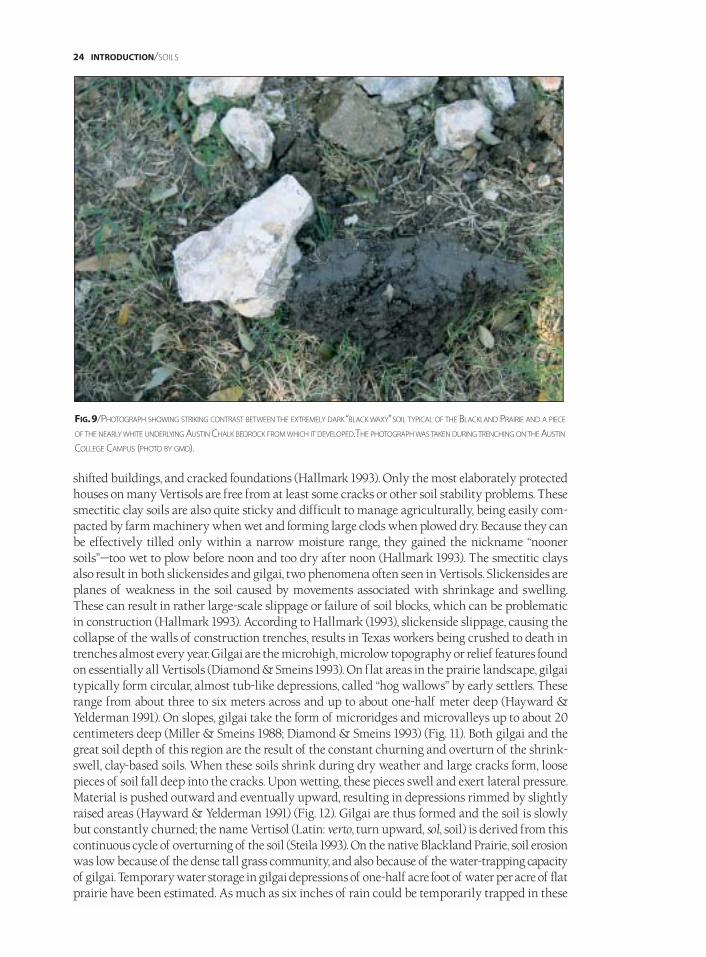
shifted buildings, and cracked foundations (Hallmark 1993). Only the most elaborately protectedhouses on many Vertisols are free from at least some cracks or other soil stability problems. Thesesmectitic clay soils are also quite sticky and difficult to manage agriculturally, being easily com-pacted by farm machinery when wet and forming large clods when plowed dry. Because they canbe effectively tilled only within a narrow moisture range, they gained the nickname “noonersoils”—too wet to plow before noon and too dry after noon (Hallmark 1993). The smectitic claysalso result in both slickensides and gilgai, two phenomena often seen in Vertisols. Slickensides areplanes of weakness in the soil caused by movements associated with shrinkage and swelling.These can result in rather large-scale slippage or failure of soil blocks, which can be problematicin construction (Hallmark 1993). According to Hallmark (1993), slickenside slippage, causing thecollapse of the walls of construction trenches, results in Texas workers being crushed to death intrenches almost every year. Gilgai are the microhigh, microlow topography or relief features foundon essentially all Vertisols (Diamond & Smeins 1993). On flat areas in the prairie landscape, gilgaitypically form circular, almost tub-like depressions, called “hog wallows” by early settlers. Theserange from about three to six meters across and up to about one-half meter deep (Hayward &Yelderman 1991). On slopes, gilgai take the form of microridges and microvalleys up to about 20centimeters deep (Miller & Smeins 1988; Diamond & Smeins 1993) (Fig. 11). Both gilgai and thegreat soil depth of this region are the result of the constant churning and overturn of the shrink-swell, clay-based soils. When these soils shrink during dry weather and large cracks form, loosepieces of soil fall deep into the cracks. Upon wetting, these pieces swell and exert lateral pressure.Material is pushed outward and eventually upward, resulting in depressions rimmed by slightlyraised areas (Hayward & Yelderman 1991) (Fig. 12). Gilgai are thus formed and the soil is slowlybut constantly churned; the name Vertisol (Latin: verto, turn upward, sol, soil) is derived from thiscontinuous cycle of overturning of the soil (Steila 1993). On the native Blackland Prairie, soil erosionwas low because of the dense tall grass community, and also because of the water-trapping capacityof gilgai. Temporary water storage in gilgai depressions of one-half acre foot of water per acre of flatprairie have been estimated. As much as six inches of rain could be temporarily trapped in these
24 INTRODUCTION/SOILS
FIG.9/PHOTOGRAPH SHOWING STRIKING CONTRAST BETWEEN THE EXTREMELY DARK “BLACK WAXY”SOIL TYPICAL OF THE BLACKLAND PRAIRIE AND A PIECE
OF THE NEARLY WHITE UNDERLYING AUSTIN CHALK BEDROCK FROM WHICH IT DEVELOPED.THE PHOTOGRAPH WAS TAKEN DURING TRENCHING ON THE AUSTIN
COLLEGE CAMPUS (PHOTO BY GMD).
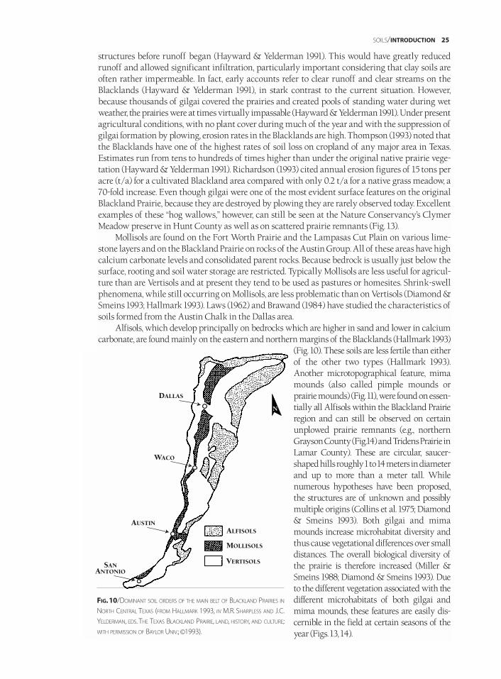
SOILS/INTRODUCTION 25
structures before runoff began (Hayward & Yelderman 1991). This would have greatly reducedrunoff and allowed significant infiltration, particularly important considering that clay soils areoften rather impermeable. In fact, early accounts refer to clear runoff and clear streams on theBlacklands (Hayward & Yelderman 1991), in stark contrast to the current situation. However,because thousands of gilgai covered the prairies and created pools of standing water during wetweather, the prairies were at times virtually impassable (Hayward & Yelderman 1991). Under presentagricultural conditions, with no plant cover during much of the year and with the suppression ofgilgai formation by plowing, erosion rates in the Blacklands are high. Thompson (1993) noted thatthe Blacklands have one of the highest rates of soil loss on cropland of any major area in Texas.Estimates run from tens to hundreds of times higher than under the original native prairie vege-tation (Hayward & Yelderman 1991). Richardson (1993) cited annual erosion figures of 15 tons peracre (t/a) for a cultivated Blackland area compared with only 0.2 t/a for a native grass meadow, a70-fold increase. Even though gilgai were one of the most evident surface features on the originalBlackland Prairie, because they are destroyed by plowing they are rarely observed today. Excellentexamples of these “hog wallows,” however, can still be seen at the Nature Conservancy’s ClymerMeadow preserve in Hunt County as well as on scattered prairie remnants (Fig. 13).
Mollisols are found on the Fort Worth Prairie and the Lampasas Cut Plain on various lime-stone layers and on the Blackland Prairie on rocks of the Austin Group. All of these areas have highcalcium carbonate levels and consolidated parent rocks. Because bedrock is usually just below thesurface, rooting and soil water storage are restricted. Typically Mollisols are less useful for agricul-ture than are Vertisols and at present they tend to be used as pastures or homesites. Shrink-swellphenomena, while still occurring on Mollisols, are less problematic than on Vertisols (Diamond &Smeins 1993; Hallmark 1993). Laws (1962) and Brawand (1984) have studied the characteristics ofsoils formed from the Austin Chalk in the Dallas area.
Alfisols, which develop principally on bedrocks which are higher in sand and lower in calciumcarbonate, are found mainly on the eastern and northern margins of the Blacklands (Hallmark 1993)
(Fig. 10). These soils are less fertile than eitherof the other two types (Hallmark 1993).Another microtopographical feature, mimamounds (also called pimple mounds orprairie mounds) (Fig. 11), were found on essen-tially all Alfisols within the Blackland Prairieregion and can still be observed on certainunplowed prairie remnants (e.g., northernGrayson County (Fig.14) and Tridens Prairie inLamar County). These are circular, saucer-shaped hills roughly 1 to 14 meters in diameterand up to more than a meter tall. Whilenumerous hypotheses have been proposed,the structures are of unknown and possiblymultiple origins (Collins et al. 1975; Diamond& Smeins 1993). Both gilgai and mimamounds increase microhabitat diversity andthus cause vegetational differences over smalldistances. The overall biological diversity ofthe prairie is therefore increased (Miller &Smeins 1988; Diamond & Smeins 1993). Dueto the different vegetation associated with thedifferent microhabitats of both gilgai andmima mounds, these features are easily dis-cernible in the field at certain seasons of theyear (Figs. 13, 14).
N
DALLAS
WACO
AUSTINALFISOLS
MOLLISOLS
VERTISOLSSANANTONIO
FIG.10/DOMINANT SOIL ORDERS OF THE MAIN BELT OF BLACKLAND PRAIRIES IN
NORTH CENTRAL TEXAS (FROM HALLMARK 1993, IN M.R. SHARPLESS AND J.C.
YELDERMAN, EDS. THE TEXAS BLACKLAND PRAIRIE, LAND, HISTORY, AND CULTURE;
WITH PERMISSION OF BAYLOR UNIV.; ©1993).
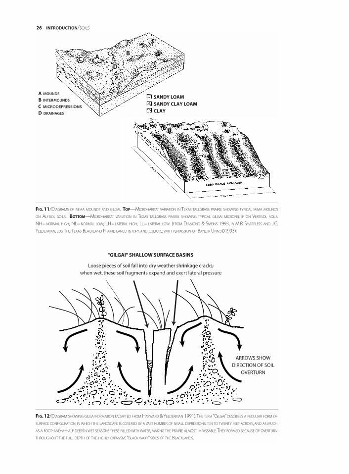
26 INTRODUCTION/SOILS
C A
D
B
CLAY
SANDY CLAY LOAM
SANDY LOAMB INTERMOUNDS
C MICRODEPRESSIONS
D DRAINAGES
A MOUNDS
FIG.12/DIAGRAM SHOWING GILGAI FORMATION (ADAPTED FROM HAYWARD & YELDERMAN 1991).THE TERM “GILGAI”DESCRIBES A PECULIAR FORM OF
SURFACE CONFIGURATION, IN WHICH THE LANDSCAPE IS COVERED BY A VAST NUMBER OF SMALL DEPRESSIONS,TEN TO TWENTY FEET ACROSS, AND AS MUCH
AS A FOOT-AND-A-HALF DEEP. IN WET SEASONS THESE FILLED WITH WATER,MAKING THE PRAIRIE ALMOST IMPASSABLE.THEY FORMED BECAUSE OF OVERTURN
THROUGHOUT THE FULL DEPTH OF THE HIGHLY EXPANSIVE “BLACK WAXY”SOILS OF THE BLACKLANDS.
FIG.11/DIAGRAMS OF MIMA MOUNDS AND GILGAI. TOP—MICROHABITAT VARIATION IN TEXAS TALLGRASS PRAIRIE SHOWING TYPICAL MIMA MOUNDS
ON ALFISOL SOILS. BOTTOM—MICROHABITAT VARIATION IN TEXAS TALLGRASS PRAIRIE SHOWING TYPICAL GILGAI MICRORELIEF ON VERTISOL SOILS.
NH= NORMAL HIGH; NL= NORMAL LOW; LH=LATERAL HIGH; LL= LATERAL LOW. (FROM DIAMOND & SMEINS 1993, IN M.R. SHARPLESS AND J.C.
YELDERMAN, EDS.THE TEXAS BLACKLAND PRAIRIE, LAND, HISTORY, AND CULTURE; WITH PERMISSION OF BAYLOR UNIV.; ©1993).
ARROWS SHOW
DIRECTION OF SOIL
OVERTURN
Loose pieces of soil fall into dry weather shrinkage cracks;
when wet, these soil fragments expand and exert lateral pressure
"GILGAI" SHALLOW SURFACE BASINS
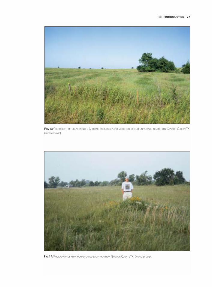
SOILS/INTRODUCTION 27
FIG.14/PHOTOGRAPH OF MIMA MOUND ON ALFISOL IN NORTHERN GRAYSON COUNTY,TX (PHOTO BY GMD).
FIG.13/PHOTOGRAPH OF GILGAI ON SLOPE (SHOWING MICROVALLEY AND MICRORIDGE EFFECT) ON VERTISOL IN NORTHERN GRAYSON COUNTY, TX
(PHOTO BY GMD).
The soils of the East and West cross timbers are mainly developed on sandy CretaceousWoodbine and Trinity strata. An exception are the soils in the western portion of the West CrossTimbers which are developed on gravelly and rocky Pennsylvanian strata. While somewhatvariable (due to areas of clay in the Woodbine or Trinity Group sands and the complex nature ofthe Pennsylvanian strata), in general the soils of the cross timbers are rather loose, often deepsands. In fact, the sandy soils in some areas of the West Cross Timbers were so deep that earlywagon travel was difficult because wagon wheels would sink in (Hill 1901). The loose nature ofthese soils also makes them extremely susceptible to erosion. Dyksterhuis (1948) discussed thattremendous gullies formed due to inappropriate cultivation and wind and water erosion, result-ing in the subsequent abandonment of fields and even whole farms. However, it is because ofthese sandy soils, which are much more conducive to the growth of woody vegetation than theheavier clay soils typical of the Blackland and Grand prairies, that the cross timbers vegetationis found in this region.
CLIMATE OF NORTH CENTRAL TEXASNorth Central Texas is located in a zone of dramatic transition between regional climates. Thestriking vegetational change from the East Texas deciduous forests on the eastern margin ofNorth Central Texas to the grasslands of the Great Plains just to the west is a vivid reflection ofthis climatic transition (Stahle & Cleaveland 1995). The climate of North Central Texas is oftenconsidered subtropical (Yelderman 1993; Norwine et al. 1995; Peterson 1995), but a wide range ofextremes can be found. Like the rest of the state, the area can be referred to climatically as a “landof contrasts” (Bomar 1983). There is ample reason why locals say, “If you don’t like the weather,just wait a few minutes.” “Blue northers,” cold fronts swinging down from the north and accom-panied by rapid drops in temperature of dozens of degrees, are not uncommon (Bomar 1983).Mean annual temperature varies from about 68°F (20° C) in the south (Williamson County) toabout 64° F (18° C) in the north and west (Griffiths & Orton 1968) (Fig. 15), but temperatures of0° F (-18° C) and 110° F (43° C) are not unknown for winter and summer respectively (Tharp 1926),with even more extreme readings observed on occasion. In the heat wave of 1980, temperaturesclimbed to 113° F (45°C) in Dallas-Fort Worth, and there were 69 days with a temperature of 100°F(38° C) or above (Bomar 1983). The highest reading, 119° F (48° C), was recorded for Weatherfordin Parker County in 1980 (Bomar 1983). In the extreme cold spell of December 1983, temperatureswere below freezing in Dallas-Fort Worth for 12 straight days (Bomar 1983). The coldest tempera-tures recorded in North Central Texas include minus 8° F (-13° C) (Dallas-Fort Worth) and minus13° F (11° C) (Paris), both in the unusually cold winter of 1899 (Bomar 1983). Native vegetation hasevolved with, and is adapted to, such recurrent extremes. A good example of the different effectsof the climate on native versus non-native plants was the extensive damage to introduced landscapeplants during the winter of 1983, while most native plants were not adversely affected. The meanlength of the frost-free period in the area is given in Figure 16.
While native plants are in general adapted to local weather conditions, they can be damagedunder exceptional circumstances. An example was the unseasonably late freeze on the night of11–12 April 1997. Following a period of relatively warm weather, temperatures dropped substan-tially below freezing over a large part of North Central Texas. For example, a low of 22° F (-6° C) wasrecorded for a native habitat (Garnett Preserve) in Montague County (H. Garnett, pers. comm.). Theresult was substantial damage to the young foliage of many native species and in some cases nearlycomplete defoliation. Some of the species significantly damaged in Grayson County includeBerchemia scandens (supple-jack), Cercis canadensis (redbud), Diospyros virginiana (common per-simmon), Fraxinus americana (white ash), Gleditsia triacanthos (common honey-locust), Morusrubra (red mulberry), Platanus occidentalis (sycamore), Quercus macrocarpa (bur oak), Quercusmarilandica (blackjack oak), Quercus muhlenbergii (chestnut oak), Quercus shumardii (Shumard’s
28 INTRODUCTION/CLIMATE

red oak), Quercus stellata (post oak), and Rhus glabra (smooth sumac). Effects on post and blackjackoaks in areas of Cross Timbers vegetation at Hagerman National Wildlife Area (Grayson County)were serious enough that leaf damage was still obvious at a glance in late May. This event is a goodexample of a false spring weather anomaly. As discussed by Stahle (1990) and Stahle andCleaveland (1995), a false spring episode includes late winter warmth followed by the movementof polar or arctic air into southern regions. The resulting intense subfreezing temperatures follow-ing a warm spell cause widespread damage to cultivated crops as well as native plant specieswhich were advanced in their development by the unusually mild winter temperatures. Forty-four such false spring episodes have been documented in Texas between A.D. 1650 and 1980(Stahle & Cleaveland 1995). This detailed information can be obtained because frost-damagedcambial tissues leave a permanent record in the annual growth rings of trees and these can bedated dendrochronologically (tree-ring dating) to the exact year of their formation. While therehas been a notable decline in the frequency and intensity of false spring episodes in Texas in thelast 100 years, the cause of this decrease is not clear (Stahle & Cleaveland 1995).
In terms of precipitation, there is a steep east-west gradient across North Central Texas.Mean annual precipitation ranges from about 46 inches in the northeastern corner of the area inLamar County to about 24 inches in the westernmost portion of the West Cross Timbers(Dyksterhuis 1948; Griffiths & Orton 1968 ) (Fig. 17). In general, mean annual precipitationdecreases about one inch for each 15 miles across Texas from east to west (Bomar 1983), in part asa result of the decreasing influence of moist air from the Gulf of Mexico. Thus there is a rainfalldifference of more than 20 inches between the eastern and western boundaries of North CentralTexas. This region, like much of the state, is prone to drought, while at other times it receives toomuch rain in a short time (Sharpless & Yelderman 1993). Severe storms and some of the largestrainfalls in the United States have occurred in this area. According to Hayward et al. (1992), allthe point rainfall records for North America are held within a belt 50 miles east and west of aline from Dallas through Waco, Austin, and San Antonio. The town of Thrall, in WilliamsonCounty on the eastern edge of the Blacklands, had one of the largest recorded United States rain-falls on 9–10 September 1921, receiving 38.2 inches in 24 hours (Yelderman 1993). In 1978,Albany, in Shackelford County on the western edge of North Central Texas, received 29.05 inch-es in one day as a result of Hurricane Amelia. The yearly precipitation record for Texas, 109.38inches, is also from this region. It occurred in 1873 at Clarksville in Red River County near theextreme northeastern tip of the Blackland Prairie (Bomar 1983).
In years past, the incredibly sticky “black waxy” soil of the Blackland Prairie was particularlyproblematic during wet weather. Personal accounts (e.g., Mosely in Yelderman 1993) describedthat under wet conditions the dirt roads were virtually impassable and families actually wenthungry until the ground dried enough for people to get to town to obtain food. Drought, however,has been more of a problem, with the lack of water probably always being a limiting factor forhumans in the area. The impermeable clay soils, the lack of dependable shallow water-bearinglayers, and the scarcity and transitory nature of surface streams made the early Blacklands a par-ticularly inhospitable environment for humans. This is exemplified by early accounts such asthe one by D.P. Smythe (1852) who described a trip across the Blacklands:
The soil improves now at every step becoming more level, and uniformly of a dark rich color, but thewater is very bad and scarce, drying up entirely during the heat of the summer. . . . During the forenoonof today we must have traveled some twenty miles without passing over a spot of thin soil; beingchiefly the black stiff ‘hog wallow’ prairie, rolling just enough to drain itself, but entirely destitute ofwater during the summer. . . .
Josiah Gregg, another early explorer, indicated that in addition to droughts, the lack of springs ordependable water was “one of the greatest defects of this country” (Fulton 1941).
The concentration of rainfall in spring and fall, coupled with hot dry summers, makes thewater problem even more acute (Yelderman 1993). The severe drought of the mid-1950s exempli-fies water difficulties in the area. City water supplies were alarmingly low (e.g., Lake Dallas at 11%
CLIMATE/INTRODUCTION 29
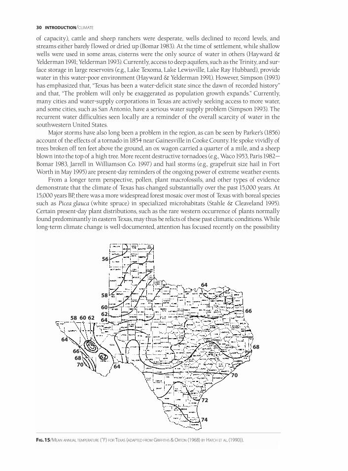
of capacity), cattle and sheep ranchers were desperate, wells declined to record levels, andstreams either barely flowed or dried up (Bomar 1983). At the time of settlement, while shallowwells were used in some areas, cisterns were the only source of water in others (Hayward &Yelderman 1991; Yelderman 1993). Currently, access to deep aquifers, such as the Trinity, and sur-face storage in large reservoirs (e.g., Lake Texoma, Lake Lewisville, Lake Ray Hubbard), providewater in this water-poor environment (Hayward & Yelderman 1991). However, Simpson (1993)has emphasized that, “Texas has been a water-deficit state since the dawn of recorded history”and that, “The problem will only be exaggerated as population growth expands.” Currently,many cities and water-supply corporations in Texas are actively seeking access to more water,and some cities, such as San Antonio, have a serious water supply problem (Simpson 1993). Therecurrent water difficulties seen locally are a reminder of the overall scarcity of water in thesouthwestern United States.
Major storms have also long been a problem in the region, as can be seen by Parker’s (1856)account of the effects of a tornado in 1854 near Gainesville in Cooke County. He spoke vividly oftrees broken off ten feet above the ground, an ox wagon carried a quarter of a mile, and a sheepblown into the top of a high tree. More recent destructive tornadoes (e.g., Waco 1953, Paris 1982—Bomar 1983, Jarrell in Williamson Co. 1997) and hail storms (e.g., grapefruit size hail in FortWorth in May 1995) are present-day reminders of the ongoing power of extreme weather events.
From a longer term perspective, pollen, plant macrofossils, and other types of evidencedemonstrate that the climate of Texas has changed substantially over the past 15,000 years. At15,000 years BP, there was a more widespread forest mosaic over most of Texas with boreal speciessuch as Picea glauca (white spruce) in specialized microhabitats (Stahle & Cleaveland 1995).Certain present-day plant distributions, such as the rare western occurrence of plants normallyfound predominantly in eastern Texas, may thus be relicts of these past climatic conditions. Whilelong-term climate change is well-documented, attention has focused recently on the possibility
30 INTRODUCTION/CLIMATE
56
58
58
62
60
6260 64
64
64
74
72
70
70
68
66
64
62
6668
FIG.15/MEAN ANNUAL TEMPERATURE (˚F) FOR TEXAS (ADAPTED FROM GRIFFITHS & ORTON (1968) BY HATCH ET AL. (1990)).
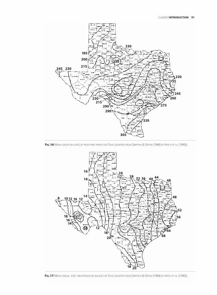
CLIMATE/INTRODUCTION 31
185
200
215
215
230
230
230
230
230
245
245
290
305
290
320
275
260
FIG.16/MEAN LENGTH (IN DAYS) OF FROST-FREE PERIOD FOR TEXAS (ADAPTED FROM GRIFFITHS & ORTON (1968) BY HATCH ET AL. (1990)).
FIG.17/MEAN ANNUAL TOTAL PRECIPITATION (IN INCHES) FOR TEXAS (ADAPTED FROM GRIFFITHS & ORTON (1968) BY HATCH ET AL. (1990)).
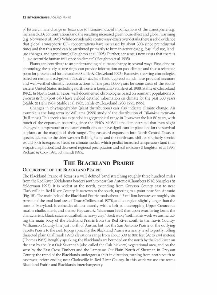
of future climate change in Texas due to human-induced modifications of the atmosphere (e.g.,increased CO2 concentrations) and the resulting increased greenhouse effect and global warming(e.g., Norwine et al. 1995). While considerable controversy exists over details, there is solid evidencethat global atmospheric CO2 concentrations have increased by about 30% since preindustrialtimes and that this trend can be attributed primarily to human activities (e.g., fossil fuel use, land-use changes, and agriculture) (Houghton et al. 1995). Further, consensus now exists that there is “. . . a discernible human influence on climate” (Houghton et al. 1995).
Plants can contribute to an understanding of climate change in several ways. First, dendro-chronology, the study of tree rings, can provide information on past climate and thus a referencepoint for present and future studies (Stahle & Cleaveland 1992). Extensive tree-ring chronologiesbased on remnant old-growth Taxodium disticum (bald cypress) stands have provided accurateand well-verified climatic reconstructions for the past 1,000 years for some areas of the south-eastern United States, including northwestern Louisiana (Stahle et al. 1988; Stahle & Cleaveland1992). In North Central Texas, well-documented chronologies based on remnant populations ofQuercus stellata (post oak) have yielded detailed information on climate for the past 300 years(Stahle & Hehr 1984; Stahle et al. 1985; Stahle & Cleaveland 1988; 1993; 1995).
Changes in phytogeography (plant distributions) can also indicate climate change. Anexample is the long-term McWilliams (1995) study of the distribution of Tillandsia recurvata(ball-moss). This species has expanded its geographical range in Texas over the last 80 years, withmuch of the expansion occurring since the 1940s. McWilliams demonstrated that even slightchanges in temperature or moisture conditions can have significant implications for the survivalof plants at the margins of their ranges. The eastward expansion into North Central Texas ofspecies adapted to the drier western Rolling Plains and the northward shift of southerly specieswould both be expected based on climate models which predict increased temperature (and thusevapotranspiration) and decreased regional precipitation and soil moisture (Houghton et al. 1990;Packard & Cook 1995; Schmandt 1995).
THE BLACKLAND PRAIRIEOCCURRENCE OF THE BLACKLAND PRAIRIE
The Blackland Prairie of Texas is a well-defined band stretching roughly three hundred milesfrom the Red River (Oklahoma border) south to near San Antonio (Chambers 1948; Sharpless &Yelderman 1993). It is widest at the north, extending from Grayson County east to nearClarksville in Red River County. It narrows to the south, tapering to a point near San Antonio(Fig. 18). The main belt of the Blackland Prairie totals about 4.3 million hectares or roughly sixpercent of the total land area of Texas (Collins et al. 1975), and is a region slightly larger than thestate of Maryland. It coincides almost exactly with a belt of outcropping Upper Cretaceousmarine chalks, marls, and shales (Hayward & Yelderman 1991) that upon weathering forms thecharacteristic black, calcareous, alkaline, heavy clay, “black waxy” soil. In this work we are includ-ing the main body of the Blackland Prairie from the Red River south to the Travis County-Williamson County line just north of Austin, but not the San Antonio Prairie or the outlyingFayette Prairie to the east. Topographically, the Blackland Prairie is a nearly level to gently rollingdissected plain (Hallmark 1993); elevations range from about 300 to 800 feet (92 to 244 meters)(Thomas 1962). Roughly speaking, the Blacklands are bounded on the north by the Red River, onthe east by the Post Oak Savannah (also called the Oak-hickory) vegetational area, and on thewest by the East Cross Timbers and the Lampasas Cut Plain. North of Sherman in GraysonCounty, the trend of the Blacklands undergoes a shift in direction, turning from north-south toeast-west, before ending near Clarksville in Red River County. In this work we use the termsBlackland Prairie and Blacklands interchangeably.
32 INTRODUCTION/BLACKLAND PRAIRIE
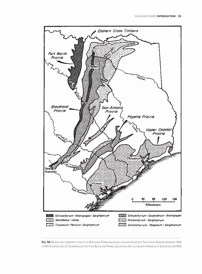
BLACKLAND PRAIRIE/INTRODUCTION 33
FIG.18/MAJOR PLANT COMMUNITY TYPES OF THE BLACKLAND PRAIRIE AND RELATED TALLGRASS REGIONS OF TEXAS (FROM DIAMOND & SMEINS 1993,
I N M.R.SHARPLESS AND J.C.YELDERMAN,EDS.THE TEXAS BLACKLAND PRAIRIE, LAND,HISTORY,AND CULTURE;WITH PERMISSION OF BAYLOR UNIV.;©1993).
PRESETTLEMENT AND EARLYSETTLEMENT CONDITIONS ON THE BLACKLAND PRAIRIE
Conditions on the presettlement Blackland Prairie were strikingly different from those foundtoday. Probably the most conspicuous difference was the presence of vast expanses of tall grassprairie. In the words of Parker (1856), traveling with the 1854 Marcy expedition, “After leavingPreston [northern Grayson County], we entered upon the vast plains. . . .” Dr. John Brooke, whoemigrated from England in 1848, stated on arriving at the edge of the Blackland Prairie, “It wasthe finest sight I ever saw; immense meadows 2 or 3 feet deep of fine grass & flowers. Such beauti-ful colours I never saw. . . .” (Brooke 1848). In describing the area where he settled near Dorchesterin south central Grayson County, Brooke (1849) said,
I can sit on the porch before my door and can see miles of the most beautiful Prairie interwoven withgroves of timber, surpassing, in my idea, the beauties of the sea. Think of seeing a tract of land on aslight incline covered with flowers and rich meadow grass for 12 to 20 miles. . . .
Hill (1901), speaking of the Blacklands in general, said,
The surfaces of the prairies are ordinarily clad with thick mantles of grass, liberally sprinkled withmany-colored flowers, broken here and there by low growths of mesquite trees, or in exceptional placesby ‘mottes’ or clumps of live oaks on uplands, pecan, bois d’arc, walnut and oaks in the stream bottoms;juniper and sumac where stony slopes exist, and post oak and black-jack in the sandy belts.
Smythe (1852) described the eastern edge of the Blackland Prairie as having
. . . a view of almost boundless Prairie stretching to the north, as far as the eye could reach. . . .
He further referred to it as
. . . a boundless plain scarcely broken by a single slope or valley, and nearly destitute of trees; (themesquite appearing but seldom.) Several times during the forenoon not a single shrub or tree couldbe seen in any direction. . . . The grazing has reached its climax, it would be impossible for naturalpasturage to excell [excel] this.
Kendall (1845) described the southern part of the Blackland Prairie as “beautiful rolling prairies,the land rich, and susceptible of cultivation.” Roemer’s (1849) descriptions of the same regionincluded “open prairie,” “extensive prairies” with mesquite trees and scattered oak groves, “undu-lating prairie extending. . . an immeasurable distance,” and “gently rolling, almost treeless plain.”Indeed, on the Blackland Prairie, trees were often rare except as riverine forests along streams oras occasional scattered groves or mottes “such as the one near Kentuckytown that gave PilotGrove [in southeastern Grayson County] its name, the trees being a major landmark in a feature-less terrain.” (McLeRoy 1993). The riverine forests along Big Mineral Creek [Grayson County]were described by Parker (1856) as “a rich bottom, thickly grown up with large cotton wood,honey locust, overcup [bur oak], and other heavy timber, besides plenty of the bois d’arc.” Roemer(1849) described a trading post he visited in Falls County as “on a hill covered with oak trees, twomiles distant from the Brazos, above the broad forested bottom of Tohawacony Creek.” He furtherdescribed the wooded bottomland as having “high, dense trees.”
Fire was probably an important factor in maintenance of the original prairie vegetation andhad a major impact on community structure (Anderson 1990; Collins & Gibson 1990; Strickland& Fox 1993). Tall grass prairie fires, intensely hot, would have been stopped only by the lack ofdry fuel or a change in topography. Even streambank vegetation was susceptible during dryyears. The end result was that trees were rare even along some stream banks, and prairie marginsprobably extended somewhat beyond the limits of the soil types usually associated with prairie(Hayward & Yelderman 1991). Roemer (1849) wrote of a prairie fire as follows:
. . .we, ourselves, were entertained before going to sleep by the spectacle of a prairie fire. Like a sparklingdiamond necklace, the strip of flame, a mile long, raced along over hill and dale, now moving slowly,now faster, now flickering brightly, now growing dim. We could the more enjoy this spectacle undis-turbed, since the direction of the wind kept it from approaching us. My companion was of the opinionthat Indians had without doubt started the fire, since they do this often to drive the game in a certain
34 INTRODUCTION/BLACKLAND PRAIRIE
BLACKLAND PRAIRIE/INTRODUCTION 35
direction, and also to expedite the growth of the grass by burning off the dry grass.
While lightning was an important source of naturally started fires, Native Americans were longpresent in the region and their use of fire is considered by some to be equally important in havingmaintained North American grasslands (Bragg 1995).
In summary, the original Blackland Prairie seems to have been predominantly tall grass prairiewith trees along watercourses, sometimes scattered on the prairie or concentrated in certain areas(e.g., Pilot Grove) possibly as the result of locally favorable soil conditions or topography.
It is interesting to note that early (back to the 1830s) surveyor records of mesquite as themost common tree in presettlement upland prairies in Navarro County suggest “. . .the legendaryspread of mesquite into North Texas by longhorn cattle may be an errant concept” (Jurney 1987).Roemer’s (1849) mention of “extensive prairies covered with mesquite trees” also points tomesquite as a natural component of the vegetation. However, mesquite has increased in manyareas and the observations mentioned above are not so early as to preclude mesquite havingalready been spread to some extent by land use changes.
While some question the degree to which mesquite was spread by longhorns, animals havehad profound impacts on the vegetation since long before settlement. These range from the obviouseffects of the bison or beaver to the more subtle but essential roles of pollination and seed dispersal.Present animal life is much different and some species reduced compared to presettlement days.In addition to relatively large present-day species such as the white-tailed deer, coyote, fox, andbobcat, a number of other large or interesting species occurred. According to Brooke (1848) writingof Grayson County, black bears were quite common ("I. . .have never tasted any meat I like better.")as were deer; panthers [mountain lions] and wolves were also present. In Brooke’s (1848) words, “Ihave been out a-shooting Deer and Turkeys alone, and when going up the branches of the RiversI often come across either bear or wolf. . . .” Strecker (1926a) (based on early fur-trader records)indicated that next to the skins of deer, “those of the black bear were of the most value to theIndians of McLennan County.” Strecker (1926a) also reported that gray wolves occurred as fareast as McLennan County. He indicated that they
. . . may never have been very common permanent residents of McLennan County, but in late fall andwinter, small packs followed the great herds of buffalo and deer from northwestern Texas and remainedhere for several months. It was probably only a minority that remained throughout the year. Old settlersrefer to packs of from five to eight wolves which they considered small family groups.
Another predator, the ocelot, is thought to have ranged as far north as the Red River (Hall &Kelson 1959). Strecker (1924), for example, reported that ocelot occurred in the bottoms of theBrazos River near Waco in McLennan County. Even jaguar are believed to have ranged north tothe Red River; the last jaguar record from North Central Texas was a large male killed in MillsCounty (Lampasas Cut Plain) in 1903 (Bailey 1905). Mountain lions probably occurred through-out North Central Texas (Schmidly 1983), with Strecker (1926a) indicating they were common inMcLennan County in the middle of the 1800s. However, they were rare by the beginning of the20th century (Bailey 1905) and since that time have been eliminated over most of the region(Schmidly 1983). The collared peccary or javelina, a small wild pig, was also originally present inthe southern portion of the area, north to at least the Brazos River valley in McLennan Countynear Waco (Strecker 1926a; Schmidly 1983; Davis & Schmidly 1994). Other noteworthy largemammals that previously occurred in appropriate habitats of the Blackland Prairie as well asthroughout the rest of North Central Texas include river otter, ringtail, and badger (Schmidly1983; Davis & Schmidly 1994).
The occurrence of bison was documented by Judge John Simpson of Bonham (FanninCounty). Simpson, describing a bison hunt in 1833, reported that hunters found “an immenseherd” “on the prairie around Whitewright [Grayson County]” (McLeRoy 1993). Parker (1856), inhis 1854 journal, stated, “But eight years since, herds roamed around the City of Austin, and werefrequently seen in the streets; now there are but few to be found south of Red River.” Roemer(1849) described bison on the southern Blackland Prairie as follows:
When on the following morning at daybreak we entered the prairie on which mesquite trees grewscatteringly, the first object that met our view was a buffalo herd, quietly grazing near us. . . . The wholeprairie was covered with countless buffalo trails, crossing in all directions, reminding one of aEuropean grazing ground.
On a different day, Roemer (1849) indicated,
They covered the grassy prairie separated into small groups and far distant on the horizon they werevisible as black specks. The number of those clearly seen must have been not less than a thousand.
Pronghorn antelope were also native, occurring at least as far east as Fannin County (Hall &Kelson 1959). Smythe (1852) described a small herd on the eastern edge of the Blacklands, Roemer(1849) mentioned sighting pronghorn antelopes near where the Blackland Prairie and LampasasCut Plain come together, and Major G.B. Erath, a pioneer of Waco, indicated that antelope werecommon in what is now McLennan County in the early to middle 1800s (Schmidly 1983). Erathalso reported that small herds penetrated as far east as Milam County on the eastern edge of theBlackland Prairie (Strecker 1926a).
While not native, wild horses, descended from those escaped from the Spanish, were by theearly 1800s extremely common in Texas and were probably having a significant impact on thevegetation. Ikin (1841), speaking of Texas as a whole, indicated,
The wild horse which now roams every prairie, sometimes alone, sometimes in herds of more than athousand, is not native, but the progeny of those which escaped from the early conquerors of Mexico.He is usually a small bony animal about fourteen hands high, with remarkably clean legs, and othersigns indicative of good blood. When congregated in bodies of a thousand, these horses form the mostimposing spectacle which the prairies present.
Strecker (1926a) also reported the wild horse as abundant throughout the Brazos Valley ofMcLennan County at the time of arrival of the first American settlers. He further indicated thatearly settlers sometimes shot the wild horses to prevent interference with their domesticatedstock.
The bird, reptile, and fish faunas were also conspicuously different in significant ways fromthose today. Brooke (1848), writing about early Grayson County, mentioned both turkeys andprairie chickens, and Smythe (1852) spoke of hunting “Prairie Hens” in what is now LimestoneCounty on the eastern edge of the Blackland Prairie. According to Pulich (1988), both greater andlesser prairie chickens were common in North Central Texas until the 1880s; these two specieswere locally extinct by the early 1900s. Oberholser (1974) mentioned a specimen record for thegreater prairie chicken from Dallas County with a number of other North Central Texas recordswest of the Blackland Prairie in Clay, Cooke, Denton, and Navarro counties. There is a question-able record for the lesser prairie chicken from Dallas and also records for this species from Cookeand Young counties to the west of the Blacklands (Oberholser 1974). The extinct passengerpigeon is also well documented for the Blackland Prairie. These birds, known as “wild pigeons”by early settlers, were recorded from Collin, Fannin, and Henderson counties, with a number ofrecords even farther west in the Grand Prairie, Lampasas Cut Plain, and West Cross Timbers(Oberholser 1974; Pulich 1988). This once very numerous species rapidly became extinct inNorth Central Texas, with 1896 being the last record in the area (Oberholser 1974; Pulich 1988).The ivory-billed, one of the world’s largest woodpecker species, was also present in bottomlandforests in the Blacklands. Oberholser (1974) listed records for Cooke, Dallas, Fannin, andKaufman counties with sightings as late as the early 1900s (Pulich 1988). Another extinctspecies, the Carolina parakeet, was known from eastern Texas (Greenway 1958) and was proba-bly also present in the riverine forests of the Blackland Prairie (Goodwin 1983), especially alongthe Red and Trinity rivers. Even more surprising, alligators were abundant in places, withKendall (1845) describing them along the San Gabriel in the southern Blackland Prairie as “tooplentiful for any useful purposes.” This large reptile occurred in appropriate habitats throughoutmost of the Blackland Prairie, west to Grayson, Dallas, McLennan, and Williamson counties
36 INTRODUCTION/BLACKLAND PRAIRIE

(Brown 1950; Hibbard 1960; Dixon 1987), and are still known to occur in Dallas County. Kendall(1845) further indicated concerning the San Gabriel that “The stream abounds with trout, perch,and catfish, as do nearly all the watercourses in this section of Texas.”
During the Pleistocene, an even more extensive megafauna occurred in the area (Smeins1988), as shown by the excavation of a mammoth from near Flowing Wells (Grayson County) byDr. Daniel Schores and a student team from Austin College (D. Schores, pers. comm.). Further, fossilsof at least three elephant species, including mammoth and mastodon, are known from the Dallasarea (Shuler 1934). An even more impressive site containing a large (20+) mammoth herd wasfound near Waco in a Brazos River terrace dated around 28,000 years BP (Fox et al. 1992; C. Smith,pers. comm.). Several woody plants found in the Blackland Prairie region seem to have adapta-tions that are difficult to explain based on interactions with the present fauna. Bois d’arc (Maclurapomifera), honey-locust (Gleditsia triacanthos), and mesquite (Prosopis glandulosa) all have fruitsthat are adapted for dispersal by large animals (megafauna) and seem to fit Janzen and Martin’s(1982) hypothesis that large, now extinct animals were involved in the evolution of certain“anachronistic” plant characteristics we see today. Another such possible characteristic is theprotective armature displayed by honey-locust. The long, stout, branched thorns, up to a foot ormore long, would seem perfectly reasonable in Africa where there are abundant large herbivores,but rather out of place in northern Texas where currently no large native browsers exist.
In general, the animals of the Blacklands have faunal affinities with the eastern woodlands,the Great Plains, and the southwestern United States (Schmidly et al. 1993). A recent, now veryabundant, southern addition to the fauna is the nine-banded armadillo. This species is originallynative to South America, and as recently as the 1870s to 1880 was found only at the southern tipof Texas (Strecker 1926b; Phelan 1976). Since that time it has spread extensively and is now foundhundreds of miles north of Texas (Hall & Kelson 1959). Armadillos were at least sporadic as farnorth as the Red River by the early 1930s, but did not become common there until the 1950s (H.McCarley, pers. comm.).
The earliest use of the Blackland Prairie by settlers was as grazing areas for herds of cattle orhorses. According to Hayward and Yelderman (1991) “. . . the Blackland Prairie supported some ofthe earliest of large-scale ranching efforts in Texas, complete with pre-Civil War cattle drives toSt. Louis and Chicago.” Brooke (1848 ) stated that, “. . . the cattle and horses feed on the prairies allwinter; no need of laying up winter food.” Parker (1856) wrote of a herd of 1,200 wild cattle beingdriven north across the Red River at Preston (Grayson County).
While limited “sod plowing” occurred quite early (Smythe 1852), it wasn’t until the 1870sand 1880s, with the coming of the railroads and the development of special plows and favorableeconomic conditions, that extensive “breaking of the prairie” and exploitation of its agriculturalpotential finally occurred (Hayward & Yelderman 1991). Once farming on the Blacklands waspossible, widespread cultivation of the rich soils, perhaps as rich as any in the nation (Hayward& Yelderman 1991), was inevitable and farming quickly replaced ranching. Cotton soon becamean important crop and thus began the era referred to as the Cotton Kingdom. According toSharpless and Yelderman (1993), for seventy years more cotton was grown on the BlacklandPrairie than any other region of the world. Hill (1901) said, “In fact these calcareous soils . . . of theBlack Prairies are the most fertile of the whole trans-Mississippi region.” Others (e.g., Sharplessand Yelderman 1993) have said the soil is arguably the most fertile west of the Mississippi River.Within a very short time, most of the accessible and desirable land was put into cultivation, andaccording to Burleson (1993), by 1915 the human population on the Blacklands was greater thanon any other United States area of comparable size west of the Mississippi. The result was the vir-tually complete destruction of native Blackland Prairie communities. With the exception ofsmall or inaccessible areas and a relatively few hay meadows valued for their native grasses,almost nothing remains of the tall grass prairies that were once so abundant. Estimates of thedestruction of this ecosystem range from 98% (Hatch et al. 1990) or 99% (Riskind & Collins 1975)to more than 99.9 % (Burleson 1993).
BLACKLAND PRAIRIE/INTRODUCTION 37
GEOLOGY OF THE BLACKLAND PRAIRIE
The Blackland Prairie is on an erosional landscape developed from easily erodible Cretaceousshales, marls, and limestones that dip gently to the east (Hayward & Yelderman 1991). It origi-nally consisted of four somewhat different parallel north-south bands of vegetation: the EagleFord Prairie, the Whiterock Prairie, the Taylor Black Prairie, and the Eastern Transitional Prairie.These all correspond to underlying geologic layers (Hayward & Yelderman 1991).
The westernmost and geologically oldest portion of the Blackland Prairie, known as theEagle Ford Prairie, is developed on the Eagle Ford Shale, Upper Cretaceous material depositedabout 92 to 90 million years ago (Hayward & Yelderman 1991). This layer crops out just east ofthe Woodbine Sand, on which the East Cross Timbers are found. While variable, the Eagle FordShale is principally a dark bluish-gray to nearly black shaly clay (Bullard 1931) that weathers toform black vertisol soils supporting prairie vegetation.
Cropping out to the east of the Eagle Ford Shale is the slightly younger Austin Chalk,deposited about 90 to 85 million years ago. This layer, which supports the Whiterock Prairie,forms the elevated backbone or “axis” of the Blacklands (Hayward & Yelderman 1991). It is astrikingly white, very fine-grained limestone, called chalk, made primarily of millions of calci-um carbonate cell walls of tiny marine algae. Similar deposits make up the famous white cliffsof Dover in southern England and are used commercially as writing chalk. The Austin Chalk isa relatively resistant hard layer (Dallas Petroleum Geologists 1941) compared to the surroundingshales, and because of this hardness, it forms a rather conspicuous escarpment from Sherman toDallas and south to Austin. This topographic feature is sometimes referred to as the “white rockescarpment,” “white rock scarp,” (Hill 1901) or “white rock cuesta,” and although it never exceeds200 feet in elevational difference from the surrounding terrain (usually much less), it is the mostconspicuous topographic feature in the Texas Blacklands (Hill 1901; Montgomery 1993). It typi-cally crops out as a west-facing bluff or escarpment overlooking a prairie formed on the lessresistant Eagle Ford Shale (Bullard 1931). In striking contrast to the Grand Prairie with itsnumerous resistant layers, the Austin Chalk is the only resistant, escarpment-forming layerunderlying the entire Blackland Prairie. As a result, most of the Blackland Prairie is gentlyrolling, in contrast to the sharper, more angular topography of the Grand Prairie (Hill 1901).Surprisingly, the extremely white Austin Chalk weathers to form a sticky black soil, typicallythinner than, but similar to that derived from the Eagle Ford Shale (Bullard 1931) (Fig. 9). Wherethis soil is eroded away, as on stream banks, a distinctive flora can be found on the exposedchalky limestone (see description under vegetation). Despite their biological diversity, theseexposed chalky areas are of little commercial value and are thus often destroyed by contouringor other types of “remediation.”
The layers that crop out to the east of the Austin Chalk are the Taylor marls and sandy marls,laid down about 79 to 72 million years ago. The Taylor Blacklands, the largest of the fourBlackland Prairie belts, occurs on the soils derived from these rocks (Hill 1901; Hayward &Yelderman 1991). In fact, Taylor sediments underlie about two-thirds of the total BlacklandPrairie (Hill 1901). The soils developed on Taylor rocks are the classic deep, rich, calcareous, “blackwaxy” soils that were formerly so valuable for cotton production.
Finally, the easternmost and youngest Cretaceous rocks supporting Blackland Prairie arethose of the Navarro group, deposited about 72 to 68 million years ago (Hayward & Yelderman1991). These deposits crop out from Red River County in the north, through Kaufman and Navarrocounties, south to Williamson County on the southeastern margin of North Central Texas. Theybreak down into a soil with a somewhat higher sand content than the Blackland soils farther west,and support the easternmost of the Blackland Prairies, the Eastern Transitional or MarginalPrairie (Hill 1901; Hayward & Yelderman 1991). While easier to till, these soils are poorer in nutri-ents and thus not as valuable for farming (Hayward & Yelderman 1991). Immediately to the eastof the Navarro Group and east of North Central Texas, on younger sandy deposits of Tertiary-age,the Post Oak Savannah begins, marking the western edge of the eastern deciduous forest.
38 INTRODUCTION/BLACKLAND PRAIRIE
VEGETATION OF THE BLACKLAND PRAIRIE
According to Gould and Shaw (1983), the Blackland Prairie (and in fact all of North CentralTexas) is part of the True Prairie grassland association, extending from Texas to southernManitoba. This is one of the seven grassland associations of North America recognized in the classi-fication system of Gould (1968a) and Gould and Shaw (1983) (Fig. 19). Based on location, climate,and vegetational characteristics, the tall grass prairies of the Texas Blacklands can be consideredpart of either the True Prairie or Coastal Prairie associations (Collins et al. 1975). They lie at thevery southern end of the True Prairie association, but are also connected to the Texas CoastalPrairie. Rainfall values are intermediate and the Blackland Prairies have most of the vegetationaldominants of both these areas. According to Collins et al. (1975), adequate data are not currentlyavailable for a clear determination. Many authorities, however, recognize the tall grass prairies ofthe Blacklands as an extension of the True Prairie with little bluestem (Schizachyrium scoparium)as a climax dominant (Allred & Mitchell 1955; Thomas 1962; Correll 1972; Gould & Shaw 1983;Simpson & Pease 1995).
Seven different specific grassland communities occurring on three main soil associationsare recognized by Collins et al. (1975) as occurring in the Blackland Prairie. Diamond and Smeins(1993), however, recognized five major tall grass communities in the main body of the Blacklands(Fig. 18). Three of these types, the Schizachyrium-Andropogon-Sorghastrum (little bluestem-bigbluestem-Indian grass), Schizachyrium-Sorghastrum-Andropogon (little bluestem-Indian grass-big bluestem) and Schizachyrium-Sorghastrum (little bluestem-Indian grass), are relatively similar,have little bluestem as the prevailing dominant, and occur over the majority of the Blacklands(Diamond & Smeins 1993). Associated species include Bouteloua curtipendula (side-oats grama),Carex microdonta (small-toothed caric sedge), Sporobolus compositus (tall dropseed), Nassella leu-cotricha (Texas winter grass), Acacia angustissima var. hirta (prairie acacia), Bifora americana(prairie-bishop), Hedyotis nigricans (prairie bluets), and Hymenopappus scabiosaeus (old-plains-man) (Diamond & Smeins 1985). The microtopographical features known as “hog wallows” orgilgai are often found on prairies of these types and provide important microhabitat variationbased on differences in water, nutrient relations, and frequency of disturbance (Diamond &Smeins 1993). Vegetational differences associated with the microhighs and microlows are easilyobserved.
The other two Blackland communities are quite different vegetationally and are relativelylimited in occurrence. The Tripsacum-Panicum-Sorghastrum (eastern gamma grass-switch grass-Indian grass) community is “. . . found over poorly drained Vertisols in uplands of the northernBlackland Prairie and in lowlands throughout the Texas tallgrass prairie region” (Diamond &Smeins 1993). Examples can be found in Grayson and Fannin counties. Additional commonspecies include Bouteloua curtipendula (side-oats grama), Carex microdonta (small-toothed caricsedge), Paspalum floridanum (Florida paspalum), Sporobolus compositus (tall dropseed), Acacia an-gustissima var. hirta (prairie acacia), Aster ericoides (heath aster), Bifora americana (prairie-bishop),Hedyotis nigricans (prairie bluet), Rudbeckia hirta (black-eyed susan), and Ruellia humilis (prairie-petunia) (Diamond & Smeins 1985). The Sporobolus-Carex (silveanus dropseed-mead sedge) com-munity, dominated by Sporobolus silveanus (Silveus’ dropseed) and Carex meadii (Mead’s caricsedge), is found in the northern Blackland Prairie on low pH Alfisols in areas of relatively highprecipitation (Diamond & Smeins 1993). An example can be seen on the Nature Conservancy’sTridens Prairie in Lamar County. Other common species found in this community type includePanicum oligosanthes (Scribner’s rosette grass), Fimbristylis puberula, Coelorachis cylindrica(Carolina joint-tail), Panicum virgatum (switch grass), Paspalum floridanum (Florida paspalum),Sporobolus compositus (tall dropseed), Aster pratensis (silky aster), Linum medium (Texas flax), andNeptunia lutea (yellow-puff) (Diamond & Smeins 1985). The microtopographical feature knownas mima mounds is commonly associated with this community. Like gilgai, mima mounds pro-vide microhabitat variation, increasing the overall biological diversity of the prairie ecosystem(Diamond & Smeins 1985).
BLACKLAND PRAIRIE/INTRODUCTION 39
Also worth mention is the special assemblage of herbaceous plants often seen on areas ofvery thin soil and especially on exposed outcrops of the Austin Chalk (Stanford 1995). Speciesseen in this type of setting in the northern Blackland Prairie (Grayson County) include Baptisiaaustralis (wild blue-indigo), Callirhoe pedata (finger poppy-mallow), Eriogonum longifolium(long-leaf wild buckwheat), Grindelia lanceolata (gulf gumweed), Ipomopsis rubra (standing-cypress), Linum pratense (meadow flax), Marshallia caespitosa (Barbara’s-buttons), Oenotheramacrocarpa (Missouri primrose), Paronychia jamesii (James’ nailwort), and Thelesperma filifolium(greenthread). At some seasons, these outcrops have the aspect of barren eroded rock; in thespring, however, they are covered with spectacular displays of color.
As can be seen above, there is considerable variation in the tall grass prairie communities ofthe Blacklands (Diamond & Smeins 1993), and disagreement about specific community types(Simpson & Pease 1995). However, common dominant grasses of this tall grass prairie ecosysteminclude Schizachyrium scoparium (little bluestem), Andropogon gerardii (big bluestem), Sorgastrumnutans (Indian grass), Panicum virgatum (switch grass), Tripsacum dactyloides (eastern gammagrass), Sporobolus compositus (tall dropseed), Eriochloa sericea (Texas cup grass), Paspalum flori-danum (Florida paspalum), and Tridens strictus (long-spike tridens) (Collins et al. 1975). Despitesimilarities in general aspect and even the occurrence of certain species over broad areas, the par-ticular community present and the dominants observed can vary considerably even over shortdistances, primarily on the basis of differences in soil. Localized patches of a community typewell beyond its main zone of occurrence are common, based on soil or other factors. Thereforemost of the Blackland Prairie is a complex mosaic of tall grass communities; an example of thiscan be seen in northern Grayson County where four of the community types discussed abovecan be seen within a few miles.
Although prairie predominated, some wooded areas were also natural components of theBlackland Prairie region at the time of settlement. Examples include bottomland forests andwooded ravines along the larger rivers and streams, mottes or clumps in protected areas or oncertain soils, scarp woodlands on slopes at the contact zones with the Edwards Plateau andLampasas Cut Plain, and scattered upland oak woodlands similar to the Cross Timbers(Gehlbach 1988; Nixon et al. 1990; Diamond & Smeins 1993). In areas such as Dallas, where theAustin Chalk forms a conspicuous escarpment or bluff, a characteristic woody vegetation is alsofound in the varied microhabitats associated with this topographic feature. Kennemer (1987)indicated that Fraxinus texensis (Texas ash), Quercus sinuata var. breviloba (shin oak), and Ulmuscrassifolia (cedar elm) are dominant. Other noteworthy woody plants of the escarpment includeCercis canadensis var. texensis (Texas redbud), Juniperus ashei (Ashe juniper), Morus microphylla(Texas mulberry), and Ungnadia speciosa (Texas buckeye). Farther south, in Bell, Hill, andMcLennan counties, the Austin Chalk scarp vegetation is similar. Depending on slope and moistureconditions, characteristic species include Celtis laevigata (sugarberry), Diospyros texana (Texaspersimmon), Forestiera pubescens (elbow-bush), Fraxinus texensis, Ilex decidua (deciduous holly),Juniperus ashei, Juniperus virginiana (eastern red-cedar), Ptelea trifoliata(hoptree), Quercus buckleyi(Texas red oak), Quercus fusiformis (Plateau live oak), Quercus sinuata var. breviloba, and Ulmuscrassifolia (Gehlbach 1988).
As indicated earlier, with the exception of preserves, small remnants, or native hay meadows,almost nothing remains of the original Blackland Prairie communities. According to Diamondet al. (1987), all of the tall grass community types of the Blackland Prairie are “. . .endangered orthreatened, primarily due to conversion of these types to row crops.” Three specific Blacklandcommunities are considered “threatened natural communities” by the Texas Organization forEndangered Species (TOES 1992). Conversion of the Blackland Prairie for agriculture was themost important cause of the destruction of this ecosystem, with only marginal, often steeplysloped land not rapidly brought under cultivation. High prices for cotton and grains eventuallyresulted in the cultivation of even these marginal areas, “. . .with disastrous effects. Blacklandsoils on steep slopes, stripped of their protective grass, eroded rapidly. Gullying was everywhere,
40 INTRODUCTION/BLACKLAND PRAIRIE
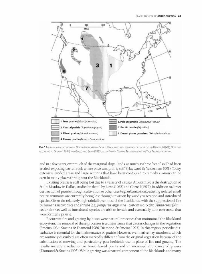
and in a few years, over much of the marginal slope-lands, as much as three feet of soil had beeneroded, exposing barren rock where once was prairie soil” (Hayward & Yelderman 1991). Today,extensive eroded areas and large sections that have been contoured to remedy erosion can beseen in many places throughout the Blacklands.
Existing prairie is still being lost due to a variety of causes. An example is the destruction ofStults Meadow in Dallas, studied in detail by Laws (1962) and Correll (1972). In addition to directdestruction of prairie through cultivation or other uses (e.g., urbanization), existing isolated smallprairie remnants are currently being lost through invasion by woody vegetation and introducedspecies. Given the relatively high rainfall over most of the Blacklands, with the suppression of fireby humans, native trees and shrubs (e.g., Juniperus virginiana—eastern red-cedar, Ulmus crassifolia—cedar elm) as well as introduced species are able to invade and eventually take over areas thatwere formerly prairie.
Recurrent fire and grazing by bison were natural processes that maintained the Blacklandecosystem; the removal of these processes is a disturbance that causes changes in the vegetation(Smeins 1984; Smeins & Diamond 1986; Diamond & Smeins 1993). In this region, periodic dis-turbance is essential for the maintenance of prairie. However, even native hay meadows, whichare routinely disturbed, are often markedly different from the original vegetation because of thesubstitution of mowing and particularly past herbicide use in place of fire and grazing. Theresults include a reduction in broad-leaved plants and an increased abundance of grasses(Diamond & Smeins 1993). While grazing was a natural component of the Blacklands and many
BLACKLAND PRAIRIE/INTRODUCTION 41
FIG.19/GRASSLAND ASSOCIATIONS IN NORTH AMERICA (FROM GOULD 1968A;USED WITH PERMISSION OF LUCILE GOULD BRIDGES;©1968).NOTE THAT
ACCORDING TO GOULD (1968A) AND GOULD AND SHAW (1983), ALL OF NORTH CENTRAL TEXAS IS PART OF THE TRUE PRAIRIE ASSOCIATION.
1. True prairie (Stipa-Sporobolus)
2. Coastal prairie (Stipa-Andropogon)
3. Mixed prairie (Stipa-Bouteloua)
4. Fescue prairie (Festuca Consociation)
5. Palouse prairie (Agropyron-Festuca)
6. Pacific prairie (Stipa-Poa)
7. Desert plains grassland (Aristida-Bouteloua)
other Texas ecosystems, overstocking and thus overgrazing by domesticated animals has alsocaused a dramatic decline and even near elimination of numerous plants from many areas (Cory1949). The cumulative effect of all these human-induced changes is that the Blackland Prairiecommunities have been largely destroyed. Large areas that were once tall grass prairie are nowcovered by crops or other introduced and now naturalized species such as Bothriochloaischaemum (King Ranch bluestem), Cynodon dactylon (Bermuda grass), and Sorghum halepense(Johnson grass). Roadsides and pastures are particularly obvious examples; in many cases hardlyany native grasses can be found. In these areas there has also been an accompanying dramaticreduction in native forb diversity.
In striking contrast to the terrestrial communities of the Blackland Prairie is the tremendousincrease in aquatic habitats. Most native wetlands, including prairie “pothole-like” wetlands, havebeen lost. However, with the construction of numerous reservoirs, lakes, ponds, and tanks, thereis vastly more habitat for aquatic vegetation than in presettlement days. With the exception ofoxbow lakes along some of the larger streams, the only permanent surface water prior to humanintervention was in rivers, streams, swampy or marshy areas, beaver ponds, and springs.Introduced, as well as native, aquatic plants are now widespread and in some cases so abundantas to be problematic weeds. Many aquatic plants probably have populations several orders ofmagnitude greater than in the relatively recent past. This same pattern holds not just for theBlackland Prairie, but for all vegetational areas within North Central Texas.
CROSS TIMBERS AND PRAIRIESOCCURRENCE OF THE CROSS TIMBERS AND PRAIRIES
The Cross Timbers and Prairies (vegetational area 5 of Hatch et al. 1990), an area of about 26,000square miles (about the size of West Virginia), occupies the region south of the Red River betweenthe Blackland Prairie to the east, the Rolling Plains to the west, and the Llano Basin (CentralMineral Region) and Edwards Plateau to the southwest and south. Vegetationally it is quitediverse and includes the East and West cross timbers, the Fort Worth Prairie, and the LampasasCut Plain (Fig. 1). Notable physiographic features included are the Comanche Plateau, the PaloPinto Country (sometimes referred to as the Palo Pinto Mountains), the mesa and butte countryof the Lampasas Cut Plain, and the eastern portion of the Callahan Divide (Fig. 8).
The Cross Timbers, which stretch from Texas north through Oklahoma to Kansas (Marriott1943; Dyksterhuis 1948; Kuchler 1974), are found in Texas from the Red River south for about 150miles. They are actually two discrete belts of forest divided by the enclosed Grand Prairie(Dyksterhuis 1948). Surrounded by prairie on both sides (Blackland Prairie to the east, RollingPlains to the west), they represent a final disjunct western extension of woody components of theeastern deciduous forest before the vegetation changes into the vast expanse of central U.S. grass-lands known as the Great Plains. The two separate belts are the East Cross Timbers and the WestCross Timbers, sometimes referred to as the Lower Cross Timbers and Upper Cross Timbersrespectively. According to Hill (1887), these names developed because the West or Upper CrossTimbers is at a greater altitude and in a more upstream position relative to the flow of rivers inthe area. The East Cross Timbers is a narrow strip (roughly along the 97th meridian) extendingfrom the Red River, in eastern Cooke and western Grayson counties, south to near Waco whereit merges with the riverine forests of the Brazos River (Hayward & Yelderman 1991). This south-ernmost portion of the East Cross Timbers, developed on the sandy terraces of the Brazos River,is sometimes referred to as the “false” East Cross Timbers to distinguish it from the upland or“true” East Cross Timbers farther north. The two areas are continuous but can be distinguishedby topography—flat on the river terraces and gently rolling in the uplands (Hayward et al. 1992).The somewhat wider West Cross Timbers stretches west from the Grand Prairie to the beginningof the Rolling Plains and includes the rather rugged Palo Pinto Country (in Eastland, Jack, PaloPinto, Stephens, and Young counties).
42 INTRODUCTION/CROSS TIMBERS AND PRAIRIES
The Fort Worth Prairie portion of the Grand Prairie extends as a continuous body of opengrasslands, roughly 10 to 30 miles wide, from near the Red River in the north, south about 110miles to where it ends in the wooded area along the Brazos River near the Johnson County-HillCounty line (Dyksterhuis 1946) (Fig. 1).
The Lampasas Cut Plain, the largest portion of the Grand Prairie, is highly dissected butteand mesa country with extensive lowlands, and can in some ways be considered a northernextension of the Texas Hill Country and Edwards Plateau. It has strong geologic and floristiclinks with the Edwards Plateau as discussed in the sections below on the geology of the GrandPrairie and the vegetation of the Lampasas Cut Plain. It is, in fact, considered a part of theEdwards Plateau by some authorities (e.g., Riskind & Diamond 1988). The Lampasas Cut Plainextends from the Fort Worth Prairie south and west to the Llano Basin (also called the CentralMineral Region or Burnet Country) and the Colorado River (Figs. 1, 8).
PRESETTLEMENT AND EARLY SETTLEMENT CONDITIONS IN THE CROSS TIMBERS
As has been noted by historical geographer Richard Francaviglia, the natural and cultural historiesof the Cross Timbers are inseparable, for human populations have had an impact on the region forthousands of years—first through the Native Americans’ use of fire, then in the 19th centurythrough the European Americans’ agricultural and grazing practices, and more recently in theform of urbanization, suburbanization, and conservation activities (Francaviglia, forthcoming).Francaviglia notes that the Texas Cross Timbers has become what geographers call a “vernacularregion” in the late 20th century, but that the term was used as early as the 1820s to characterize itsdistinctive vegetation. The exact origin of the term Cross Timbers is not known, but Dyksterhuis(1948) stated that the name
. . . presumably alludes either to the fact that this forest extends north and south across, rather thanalong, the major streams all of which flow eastward; or to the fact that early westward travelers who hadleft the main body of the great eastern forest and entered upon open prairie found it necessary to crossyet another body of forest before entering upon the grasslands that extended to the Rocky Mountains.
The abrupt appearance of the East Cross Timbers was quite striking for westbound travelers whohad just crossed the extensive open Blackland Prairie. This conspicuous change in the vegetationserved as a landmark recognized by almost all early travelers, was a principal marker on earlymaps (e.g., Holley 1836; Ikin 1941; Gregg 1844; Kendall 1845), and was discussed in many immi-grant guides and early explorer accounts (e.g., Marryat 1843; Roemer 1849; Parker 1856). Kennedy(1841), based on accounts of local residents, wrote of the Cross Timbers [not distinguishing Eastand West],
This belt of timber varies in width from five to fifty miles. Between the Trinity and Red Rivers it isgenerally from five to nine miles wide, and is so remarkably straight and regular, that it appears to bea work of art. When viewed from the adjoining prairies on the east or west, it appears in the distanceas an immense wall of woods stretching from south to north in a straight line, the extremities ofwhich are lost in the horizon.
Regarding their use as a landmark, he further stated,
As might naturally be supposed, the Cross Timber forms the great landmark of the western prairies;and the Indians and hunters, when describing their routes across the country, in their various expedi-tions, refer to the Cross Timber, as the navigators of Europe refer to the meridian of Greenwich. If theywish to furnish a sketch of the route taken in any expedition, they first draw a line representing theCross Timber, and another representing the route taken, intersecting the former.
Together with the west-east rivers such as the Red and farther south, the Trinity, they formed akind of navigational grid in an otherwise rather featureless landscape (Phelan 1976). Parker(1856) noted that “the long stretches of prairie, although undulating, present no object so promi-nent as the belt of timber which bounds them.” He further described the East Cross Timbers as
CROSS TIMBERS AND PRAIRIES/INTRODUCTION 43
. . . a very singular growth. The one we had now entered is called the Lower Cross Timbers, and is aboutsix miles wide. . . . The timber is a short, stunted oak, not growing in a continuous forest, but interspersedwith open glades, plateaus, and vistas of prairie scenery, which give a very picturesque and pleasingvariety.
Marcy (1853, 1866), based on extensive travel in the area, said,
At six different points where I have passed through it [Cross Timbers], I have found it characterized bythe same peculiarities; the trees, consisting principally of post-oak and black-jack, standing at suchintervals that wagons can without difficulty pass between them in any direction. The soil is thin, sandy,and poorly watered.
This statement agrees with numerous early settler accounts (Dyksterhuis 1948). Other early ref-erences, however, such as that by Kendall (1845) with the Texan Santa Fe Expedition in 1841,referred to the Cross Timbers in places as “almost impenetrable” and “full of deep and almostimpassable gullies.” Kendall (1845) further stated,
The ground was covered with a heavy undergrowth of briers and thorn-bushes, impenetrable even bymules, and these, with the black jacks and post oaks which thickly studded the broken surface, had tobe cut away, their removal only showing, in bolder relief, the rough and jagged surface of the soil whichhad given them existence and nourishment.
Some other early travelers also considered the Cross Timbers difficult to cross and an obstacle totravel because of the vegetation and topography (Dyksterhuis 1948). Gregg (1844), for example,wrote of them as follows:
Most of the timber appears to be kept small by the continual inroads of the ‘burning prairies;’ for,being killed almost annually, it is constantly replaced by scions of undergrowth; so that it becomesmore and more dense every reproduction. In some places, however, the oaks are of considerable size,and able to withstand the conflagrations. The underwood is so matted in many places with grape-vines, green-briars, etc., as to form almost impenetrable ‘roughs’. . . .
Another example is Smythe (1852), who referred to the “Lower Cross Timbers” as
. . . chiefly low scrubby Post Oak groves, extremely tangled and thick, with millions of green briers, . . .making it truly a difficult task to make your way without serious damage to your skin, and clothes.
Marryat (1843) described the Cross Timbers in similar fashion:
During two or three days we followed the edge of the wood, every attempt to penetrate into the interiorproving quite useless, so thick were the bushes and thorny briers.
The Cross Timbers vegetation at the time of contact by Europeans thus probably exhibited consid-erable variation. The boundaries in particular were probably variable and at least in places werenot completely distinct. Parker (1856) described the area just west of the East Cross Timbers buteast of what he referred to as the Grand Prairie (east of Gainesville in Cooke County) as follows:
. . . soon leaving the timber, we entered upon a broken country, consisting of ridges of sand and lime-stone, interspersed with small prairies and small strips of timber, principally black j ack, until weemerged upon and crossed Elm Fork of the Trinity, where, on account of the intense heat, CaptainMarcy determined to halt and encamp, thereafter, intending to march by moonlight, until we reachedthe Grand Prairie.
The variable nature of the Cross Timbers is also reflected in the following description fromKendall (1845):
The growth of timber is principally small, gnarled, post oaks and black jacks, and in many places thetraveller will find an almost impenetrable undergrowth of brier and other thorny bushes. Here andthere he will also find a small valley where timber is large and the land rich and fertile, and occasion-ally a small prairie intervenes; but the general face of the country is broken and hilly, and the soil thin.
In at least some areas the timber was extensive. An example is Jordan’s (1973) assertion thatForestburg, a small community in southeastern Montague County, boasted six sawmills by 1895.
44 INTRODUCTION/CROSS TIMBERS AND PRAIRIES
The animal life of the Cross Timbers was probably similar to that described earlier for theBlackland Prairie. Because of the lower human population size and more native vegetation,slightly more animal life probably survives in the Cross Timbers. A recent (spring 1996) mountainlion sighting in Lake Mineral Wells State Park is an example.
GEOLOGY OF THE EAST CROSS TIMBERS
The narrow band of woody vegetation between the Blackland Prairie and the Grand Prairie,known as the East Cross Timbers, occurs largely on sandy soil derived from rocks of theWoodbine formation (Hill 1901), which were deposited about 96 to 92 million years ago(Hayward & Yelderman 1991). According to Hill (1901), the formation is “largely made up of fer-ruginous [iron containing], argillaceous sands, characterized by intense brownish discolorationin places, which are accompanied by bituminous laminated clays.” Like the Trinity Group sandsunderlying the West Cross Timbers, the Woodbine sands are often unconsolidated and ratherloose, but differ in having more iron and other minerals. The post oak-blackjack oak vegetationtypical of the East Cross Timbers does well on the deep loose soils developed from these uncon-solidated layers. In some instances, however, the iron minerals consolidate the sand layers intodark-brown siliceous iron ore (Hill 1901). These iron deposits are so abundant in places that theycap low, wooded, erosion-resistant hills and isolated knobs known as “iron-ore knobs.” These arefound from Hill County north through Johnson, Tarrant, Denton, and Cooke counties and eastinto Grayson County (Hill 1901) where the Woodbine formation swings east along the PrestonAnticline (a buckle in the strata exposing deeper older layers). The bed of the Red River followsthe outcrop of the Woodbine from Grayson County east along the northern boundary of NorthCentral Texas all the way to Red River County in far northeastern Texas (Hill 1901). In general,the Woodbine formation forms a layer of loose brownish sand cropping out just west of the EagleFord Shale. Economically the Woodbine is important because its sands contain significantamounts of water and it serves as one of the main aquifers for some areas (Baker 1960).
GEOLOGY OF THE WEST CROSS TIMBERS
In general, west of the Fort Worth Prairie and north of the Lampasas Cut Plain lies an area of easilyerodible sandy soils developed from the Trinity Group (Paluxy, Antlers, and Twin Mountain-Travis Peak sands), the oldest of the Cretaceous layers in North Central Texas (Hill 1901; Renfroet al. 1973). These sands, which represent shallow-water or near-shore sea deposits, are finegrained and so loose that they are “. . .readily cut with pick and spade.” They are therefore locallyknown as “pack-sands” (Hill 1901). The West Cross Timbers has developed in part on the sandysoils derived from such strata. These permeable layers are also important as a source of groundwater (Baker 1960), which is still used today by many North Central Texas communities.Because of the rather irregular pattern of outcropping and numerous remnant areas of thesesands (Hill 1901), the West Cross Timbers is not an easily delineated region. Further, the sedimen-tary layers from which the soils of the West Cross Timbers formed are not homogeneous; insteadthese mainly sandy strata have substantial sections of clay and sandy clay. Therefore, numerousglade-like prairies formed on soils derived from these clayey outcrops can be found scatteredthrough this mostly timbered region (Hayward et al. 1992). The area is further complicated bytopographic extensions of the Lampasas Cut Plain that extend north into the West CrossTimbers in areas including Erath and Hood counties. Comanche Peak, a noted landmark inHood County (Hill 1901), is a good example of such an extension.
North of the easternmost part of the Callahan Divide mesa country, and forming the north-western portion of the West Cross Timbers, is an area known as the Palo Pinto Country (Fig. 8).This rather rugged region is underlain by the oldest rocks exposed in North Central Texas, depositedduring the Pennsylvanian Period (Fig. 7) (the Pennsylvanian extends from 320 to 286 millionyears ago). According to Hill (1901) the Pennsylvanian (Carboniferous in his terminology) is
CROSS TIMBERS AND PRAIRIES/INTRODUCTION 45
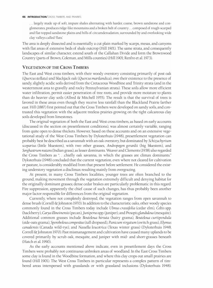
. . . largely made up of soft, impure shales alternating with harder, coarse, brown sandstone and con-glomerates, produces ridge-like mountains and a broken belt of country . . . composed of rough-scarpedand flat-topped sandstone plains and hills of circumdenudation, surrounded by and overlooking wideclay valleys called ‘flats.’
The area is deeply dissected and is essentially a cut plain marked by scarps, mesas, and canyonswith flat areas of extensive beds of shale outcrop (Hill 1901). The same strata, and consequentlylandscapes of similar character, extend south of the Callahan Divide and form the BrownwoodCountry (parts of Brown, Coleman, and Mills counties) (Hill 1901; Renfro et al. 1973).
VEGETATION OF THE CROSS TIMBERS
The East and West cross timbers, with their woody overstory consisting primarily of post oak(Quercus stellata) and blackjack oak (Quercus marilandica), owe their existence to the presence ofsandy, slightly acidic soils derived from the Cretaceous Woodbine and Trinity strata (and in thewesternmost area to gravelly and rocky Pennsylvanian strata). These soils allow more efficientwater infiltration, permit easier penetration of tree roots, and provide more moisture to plantsthan do heavier clay soils (Allred & Mitchell 1955). The result is that the survival of trees isfavored in these areas even though they receive less rainfall than the Blackland Prairie farthereast. Hill (1887) first pointed out that the Cross Timbers were developed on sandy soils, and con-trasted this vegetation with the adjacent treeless prairies growing on the tight calcareous claysoils developed from limestones.
The original vegetation of both the East and West cross timbers, as based on early accounts(discussed in the section on presettlement conditions), was almost certainly variable, rangingfrom quite open to dense thickets. However, based on these accounts and on an extensive vege-tational study of the West Cross Timbers by Dyksterhuis (1948), presettlement vegetation canprobably best be described as a savannah with an oak overstory, but dominated by Schizachyriumscoparius (little bluestem), with two other grasses, Andropogon gerardii (big bluestem), andSorghastrum nutans (Indian grass), as lesser dominants. Weaver and Clements (1938) also regardedthe Cross Timbers as “. . .chiefly oak savanna, in which the grasses are climax dominants.”Dyksterhuis (1948) concluded that the current vegetation, even where not cleared for cultivationor pasture, is considerably modified from that present before settlement. He considered the exist-ing understory vegetation a disclimax resulting mainly from overgrazing.
At present, in many Cross Timbers localities, younger trees are often branched to theground, making movement through the vegetation extremely difficult and denying habitat forthe originally dominant grasses; dense cedar brakes are particularly problematic in this regard.Fire suppression, apparently the chief cause of such changes, has thus probably been anothermajor factor responsible for differences from the original vegetation.
Currently, where not completely destroyed, the vegetation ranges from open savannah todense brush (Correll & Johnston 1970). In addition to the characteristic oaks, other woody speciescommonly found in the Cross Timbers today include Ulmus crassifolia (cedar elm), Celtis spp.(hackberry), Carya illinoinensis (pecan), Juniperus spp. (juniper), and Prosopis glandulosa (mesquite).Additional common grasses include Bouteloua hirsuta (hairy grama), Bouteloua curtipendula(side-oats grama), Sporobolous compositus (tall dropseed), Panicum virgatum (switch grass), Elymuscanadensis (Canada wild-rye), and Nassella leucotrica (Texas winter grass) (Dyksterhuis 1948;Correll & Johnston 1970). Past mismanagement and cultivation have caused many uplands to becovered primarily by scrub oak, mesquite, and juniper with mid- and short-grasses beneath(Hatch et al. 1990).
As the early accounts mentioned above indicate, even in presettlement days the CrossTimbers were probably not continuous unbroken areas of woodland. In the East Cross Timberssome clay is found in the Woodbine formation, and where this clay crops out small prairies arefound (Hill 1901). The West Cross Timbers in particular represents a complex pattern of tim-bered areas interspersed with grasslands or with grassland inclusions (Dyksterhuis 1948).
46 INTRODUCTION/CROSS TIMBERS AND PRAIRIES
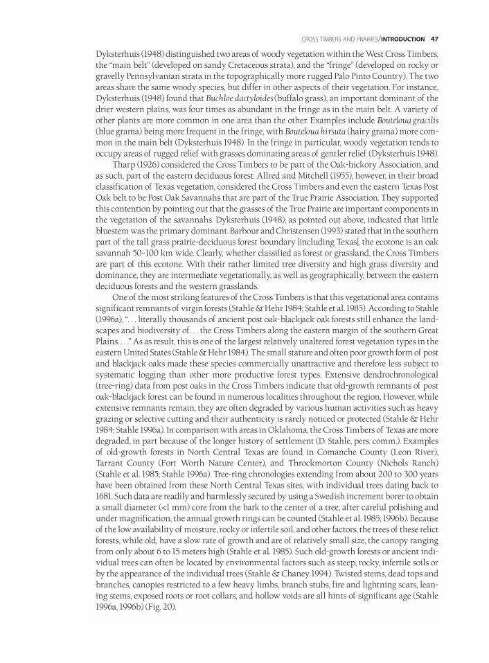
Dyksterhuis (1948) distinguished two areas of woody vegetation within the West Cross Timbers,the “main belt” (developed on sandy Cretaceous strata), and the “fringe” (developed on rocky orgravelly Pennsylvanian strata in the topographically more rugged Palo Pinto Country). The twoareas share the same woody species, but differ in other aspects of their vegetation. For instance,Dyksterhuis (1948) found that Buchloe dactyloides (buffalo grass), an important dominant of thedrier western plains, was four times as abundant in the fringe as in the main belt. A variety ofother plants are more common in one area than the other. Examples include Bouteloua gracilis(blue grama) being more frequent in the fringe, with Bouteloua hirsuta (hairy grama) more com-mon in the main belt (Dyksterhuis 1948). In the fringe in particular, woody vegetation tends tooccupy areas of rugged relief with grasses dominating areas of gentler relief (Dyksterhuis 1948).
Tharp (1926) considered the Cross Timbers to be part of the Oak-hickory Association, andas such, part of the eastern deciduous forest. Allred and Mitchell (1955), however, in their broadclassification of Texas vegetation, considered the Cross Timbers and even the eastern Texas PostOak belt to be Post Oak Savannahs that are part of the True Prairie Association. They supportedthis contention by pointing out that the grasses of the True Prairie are important components inthe vegetation of the savannahs. Dyksterhuis (1948), as pointed out above, indicated that littlebluestem was the primary dominant. Barbour and Christensen (1993) stated that in the southernpart of the tall grass prairie-deciduous forest boundary [including Texas], the ecotone is an oaksavannah 50–100 km wide. Clearly, whether classified as forest or grassland, the Cross Timbersare part of this ecotone. With their rather limited tree diversity and high grass diversity anddominance, they are intermediate vegetationally, as well as geographically, between the easterndeciduous forests and the western grasslands.
One of the most striking features of the Cross Timbers is that this vegetational area containssignificant remnants of virgin forests (Stahle & Hehr 1984; Stahle et al. 1985). According to Stahle(1996a), “. . . literally thousands of ancient post oak-blackjack oak forests still enhance the land-scapes and biodiversity of. . . the Cross Timbers along the eastern margin of the southern GreatPlains. . . .” As as result, this is one of the largest relatively unaltered forest vegetation types in theeastern United States (Stahle & Hehr 1984). The small stature and often poor growth form of postand blackjack oaks made these species commercially unattractive and therefore less subject tosystematic logging than other more productive forest types. Extensive dendrochronological(tree-ring) data from post oaks in the Cross Timbers indicate that old-growth remnants of postoak-blackjack forest can be found in numerous localities throughout the region. However, whileextensive remnants remain, they are often degraded by various human activities such as heavygrazing or selective cutting and their authenticity is rarely noticed or protected (Stahle & Hehr1984; Stahle 1996a). In comparison with areas in Oklahoma, the Cross Timbers of Texas are moredegraded, in part because of the longer history of settlement (D. Stahle, pers. comm.). Examplesof old-growth forests in North Central Texas are found in Comanche County (Leon River),Tarrant County (Fort Worth Nature Center), and Throckmorton County (Nichols Ranch)(Stahle et al. 1985; Stahle 1996a). Tree-ring chronologies extending from about 200 to 300 yearshave been obtained from these North Central Texas sites, with individual trees dating back to1681. Such data are readily and harmlessly secured by using a Swedish increment borer to obtaina small diameter (<1 mm) core from the bark to the center of a tree; after careful polishing andunder magnification, the annual growth rings can be counted (Stahle et al. 1985; 1996b). Becauseof the low availability of moisture, rocky or infertile soil, and other factors, the trees of these relictforests, while old, have a slow rate of growth and are of relatively small size, the canopy rangingfrom only about 6 to 15 meters high (Stahle et al. 1985). Such old-growth forests or ancient indi-vidual trees can often be located by environmental factors such as steep, rocky, infertile soils orby the appearance of the individual trees (Stahle & Chaney 1994). Twisted stems, dead tops andbranches, canopies restricted to a few heavy limbs, branch stubs, fire and lightning scars, lean-ing stems, exposed roots or root collars, and hollow voids are all hints of significant age (Stahle1996a, 1996b) (Fig. 20).
CROSS TIMBERS AND PRAIRIES/INTRODUCTION 47
The centuries-long tree-ring chronologies obtained from these relict forests are a valuablesource of information about past climate and are particularly important at a time when climatechange is a topic of national and global concern. These forests also represent an irreplaceableresource and an unparalleled living record about the North Central Texas area prior to the timeof European settlement. Further, because they are relatively unaltered, these remnants may repre-sent areas of significant remaining biodiversity in an otherwise highly altered and reduceddiversity environment. Finally, they provide a unique conservation opportunity to preservesome of the last remaining virgin North American forests.
PRESETTLEMENT AND EARLY SETTLEMENT CONDITIONS IN THE GRAND PRAIRIE
(FORT WORTH PRAIRIE AND LAMPASAS CUT PLAIN)Like the Blackland Prairie, the presettlement Grand Prairie was largely a vast grassland, withwoody vegetation generally limited to areas along the larger watercourses, as scattered mottes onhilltops, or associated with mesas and buttes. Hill (1887) summarized the Grand Prairie as “a prairie region, utterly destitute of timber” and Kendall (1845) described the area as follows:
To the east, for miles, the prairie gently sloped, hardly presenting a bush to relieve the eye. In the dis-tance, the green skirting of woods, which fringed either border of a large stream, softened down theview. . . .To the west . . . the immediate vicinity was even more desolate, but the fertile bottoms of theBrazos, with their luxuriant growth of timber, were still visible, and the Camanche [Comanche] Peak,rising high above the other hills, gave grandeur and sublimity to a scene which would otherwise havebeen far from monotonous.
Referring to another Grand Prairie locality, Kendall (1845) said, “As far as the eye could reach . . .,nothing could be seen but a succession of smooth, gently-undulating prairies." In reference to theBrazos River valley where it cuts through the Lampasas Cut Plain, Kendall (1845) said,
The valley of the Brazos at this place abounded with every species of timber known in Texas; grapes,plums, and other fruit were found in profusion; honey could be obtained in almost every hollow tree;trout and other fish were plentiful in the small creeks in the neighborhood, and the woods and prairiesabout us not only afforded excellent grazing for our cattle and horses, but teemed with every species ofgame—elk, deer, bears, wild turkeys, and, at the proper season, buffalo and mustang.
Greer (1935), in describing the Grand Prairie in the period 1850–1890, wrote of an “. . . indescribablybeautiful prairie where lush grass swept my mount’s sides. . . .” An early settler account (HattieRichards Sparks in Pool 1964) of Bosque County describes it as follows:
It was a beautiful prairie country, with sage grass as tall as your head. . . . It was a common occurrencefor prairie chickens to fly into the house. I shall never forget when one flew in during our noonday mealand lit in a bowl of soft butter. . . . Wolves were plentiful and I will always remember their howlingaround our house at night. It was a mournful sound in that open prairie country.
Hill (1887) described this region between the two bands of Cross Timbers as “utterly destitute oftimber.” However, while Smythe (1852) mentioned “immense fields, with the greatest profusionof delicately painted flowers” and “grassy prairies only bounded by the horizon,” he also spokeof “prairie, with an occasional strip of woodland,” “beautiful groves of Live Oak . . . crowningevery hill . . .,” and areas with “densely tangled cedar ravines.” The Grand Prairie vegetation thusshowed considerable variability.
Based on the similarity of vegetation and climate, and on early traveler and settler reports,the original animal life was probably quite similar to that of the Blackland Prairie described ear-lier. From Kendall’s (1845) observations, bison were apparently particularly common:
. . . I have stood upon a high roll of the prairie, with neither tree nor bush to obstruct the vision in anydirection, and seen these animals grazing upon the plain and darkening it at every point. . . . In thedistance, as far as the eye could reach, they were seen quietly feeding upon the short prairie grass. . . .
48 INTRODUCTION/CROSS TIMBERS AND PRAIRIES
Kendall (1845) also described seeing many pronghorn antelope on the Upper Brazos. There iseven a record of the American alligator as far west as Hamilton County in the central part of theLampasas Cut Plain (Dixon 1987). Other noteworthy species recorded from the Grand Prairie,but not present there for many decades, include jaguar (Bailey 1905), greater prairie chicken, andpassenger pigeon (Oberholser 1974).
In some areas animal populations were apparently reduced early on. Kendall (1845), speak-ing of another part of the Grand Prairie, said,
Occasionally a deer would jump suddenly from his noonday rest, and scamper off across the prairie,but other than this no game was seen. The few deer we saw were exceedingly wild, from the fact of therebeing so many Indians in the vicinity; while the buffalo had evidently all been driven to the south.
Native American influence had thus in some areas already modified the fauna, and probably thevegetation as well. Roemer (1849), for example, discussed a Caddo village near the Hill County-Bosque County line as having about one thousand horses and cultivated maize and watermelons.
CROSS TIMBERS AND PRAIRIES/INTRODUCTION 49
FIG.20/AN ANCIENT QUERCUS STELLATA FOREST DRAWN BY RICHARD P. GUYETTE; USED WITH PERMISSION. TWISTED STEMS, DEAD TOPS AND BRANCHES,
CANOPIES RESTRICTED TO A FEW HEAVY LIMBS, BRANCH STUBS, FIRE AND LIGHTNING SCARS, LEANING STEMS, EXPOSED ROOTS OR ROOT COLLARS, AND HOL-
LOW VOIDS ARE ALL HINTS OF SIGNIFICANT AGE (STAHLE 1996A,1996B).WHILE THE DRAWING IS FROM THE OZARK PLATEAU, SUCH TREES, SOME OF WHICH
ARE MORE THAN 300 YEARS OLD, CAN BE FOUND IN NORTH CENTRAL TEXAS.
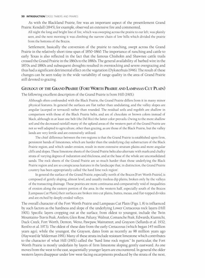
As with the Blackland Prairie, fire was an important aspect of the presettlement GrandPrairie. Kendall (1845), for example, observed an extensive fire and commented,
All night the long and bright line of fire, which was sweeping across the prairie to our left, was plainlyseen, and the next morning it was climbing the narrow chain of low hills which divided the prairiefrom the bottoms of the Brazos.
Settlement, basically the conversion of the prairie to ranching, swept across the GrandPrairie in the relatively short time span of 1850–1860. The importance of ranching and cattle toearly Texas is also reflected in the fact that the famous Chisholm and Shawnee cattle trailscrossed the Grand Prairie in the 1860s to the 1880s. The general availability of barbed wire in the1870s and 1880s and subsequent droughts resulted in overstocking and severe overgrazing andthus had a significant detrimental effect on the vegetation (Dyksterhuis 1946). The result of thesechanges can be seen today in the wide variability of range quality in the area of Grand Prairiestill devoted to grazing.
GEOLOGY OF THE GRAND PRAIRIE (FORTWORTH PRAIRIE AND LAMPASAS CUT PLAIN)The following excellent description of the Grand Prairie is from Hill (1901):
Although often confounded with the Black Prairie, the Grand Prairie differs from it in many minorphysical features. In general the surfaces are flat rather than undulating, and the valley slopes areangular (scarped or terraced) rather than rounded. The residual soils and regolith are shallow incomparison with those of the Black Prairie belts, and are of chocolate or brown colors instead ofblack, although in at least one belt (the Del Rio) the latter color prevails. Owing to the more shallowsoil and the decreased rainfall many of the upland areas of the western part of the Grand Prairie arenot so well adapted to agriculture, other than grazing, as are those of the Black Prairie, but the valleylands are very fertile and are extensively utilized.
The chief difference between the two regions is that the Grand Prairie is established upon firm,persistent bands of limestones, which are harder than the underlying clay substructure of the BlackPrairie region, and which under erosion, result in more extensive stratum plains and more angularcliffs and slopes. These limestone sheets of the Grand Prairie belts also alternate with marls and chalkystrata of varying degrees of induration and thickness, and at the base of the whole are unconsolidatedsands. The rock sheets of the Grand Prairie are so much harder than those underlying the BlackPrairie region and are so conspicuous features in the landscape that, in distinction, the Grand Prairiecountry has been appropriately called ‘the hard lime rock region’.
In general the surface of the Grand Prairie, especially north of the Brazos [Fort Worth Prairie], iscomposed of gently sloping, almost level, and usually treeless dip plains, broken only by the valleysof the transecting drainage. These prairies are more continuous and comparatively void of inequalitiesof erosion along the eastern portion of the area. In the western half, especially south of the Brazos[Lampasas Cut Plain], their surfaces are broken into cut plains, buttes, mesas, and flat-topped dividesand are etched by deeply eroded valleys.
The overall character of the Fort Worth Prairie and Lampasas Cut Plain (Figs. 1, 8) is influencedby such factors as the hardness and slope of the underlying Lower Cretaceous rock layers (Hill1901). Specific layers cropping out at the surface, from oldest to youngest, include the TwinMountains-Travis Peak, Antlers, Glen Rose, Paluxy, Walnut, Comanche Peak, Edwards, Kiamichi,Duck Creek, Fort Worth, Denton, Weno, Pawpaw, Mainstreet, and Grayson (Sellards et al. 1932;Renfro et al. 1973). The oldest of these date from the early Cretaceous (which began 145 millionyears ago), while the youngest, the Grayson, dates from as recently as 98 million years ago(Hayward & Yelderman 1991). Many of these strata include resistant limestone which contributesto the character of what Hill (1901) called the “hard lime rock region.” In particular, the FortWorth Prairie is mostly underlain by layers of firm limestone sloping gently eastward. As onemoves from the west to the east, sequentially younger layers are encountered. In general the olderwestern layers disappear under low west-facing escarpments produced by the strata of the next,
50 INTRODUCTION/CROSS TIMBERS AND PRAIRIES
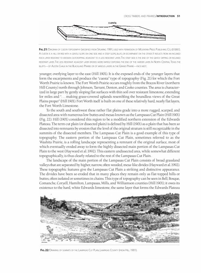
younger, overlying layer to the east (Hill 1901). It is the exposed ends of the younger layers thatform the escarpments and produce the “cuesta” type of topography (Fig. 21) for which the FortWorth Prairie is known. The Fort Worth Prairie occurs roughly from the Brazos River (northernHill County) north through Johnson, Tarrant, Denton, and Cooke counties. The area is character-ized in large part by gently sloping flat surfaces with thin soil over resistant limestone, extendingfor miles and “. . . making grass-covered uplands resembling the boundless views of the GreatPlains proper” (Hill 1901). Fort Worth itself is built on one of these relatively hard, nearly flatlayers,the Fort Worth Limestone.
To the south and southwest these rather flat plains grade into a more rugged, scarped, anddissected area with numerous low buttes and mesas known as the Lampasas Cut Plain (Hill 1901)(Fig. 22). Hill (1901) considered this region to be a modified northern extension of the EdwardsPlateau. The term cut plain (or dissected plain) is defined by Hill (1901) as a plain that has been sodissected into remnants by erosion that the level of the original stratum is still recognizable in thesummits of the dissected members. The Lampasas Cut Plain is a good example of this type oftopography. The eastern portion of the Lampasas Cut Plain, sometimes referred to as theWashita Prairie, is a rolling landscape representing a remnant of the original surface, most ofwhich eventually eroded away to form the highly dissected main portion of the Lampasas CutPlain to the west (Hayward et al. 1992). This eastern undissected area, while somewhat differenttopographically, is thus clearly related to the rest of the Lampasas Cut Plain.
The landscape of the main portion of the Lampasas Cut Plain consists of broad grasslandvalleys that are separated by higher, narrow, often wooded, mesa-like divides (Hayward et al. 1992).These topographic features give the Lampasas Cut Plain a striking and distinctive appearance.The divides have been so eroded that in many places they remain only as flat-topped hills orbuttes, often isolated or sometimes in chains. This type of topography can be seen in Bell, Bosque,Comanche, Coryell, Hamilton, Lampasas, Mills, and Williamson counties (Hill 1901); it owes itsexistence to the hard, white Edwards limestone, the same layer that forms the Edwards Plateau
CROSS TIMBERS AND PRAIRIES/INTRODUCTION 51
FIG.21/DIAGRAM OF CUESTA TOPOGRAPHY (MODIFIED FROM SPEARING 1991; USED WITH PERMISSION OF MOUNTAIN PRESS PUBLISHING CO.; ©1991).
A CUESTA IS A HILL OR RISE WITH A GENTLE SLOPE ON ONE SIDE AND A STEEP SLOPE, BLUFF, OR ESCARPMENT ON THE OTHER. IT RESULTS FROM AN INCLINED
ROCK LAYER RESISTANT TO EROSION OUTCROPPING ADJACENT TO A LESS RESISTANT LAYER.THE STEEP SIDE IS THE END OF THE GENTLY DIPPING OR INCLINED
RESISTANT LAYER.THE LESS RESISTANT ADJACENT LAYER ERODES MORE RAPIDLY EXPOSING THE END OF THE HARDER LAYER. IN NORTH CENTRAL TEXAS THE
BLUFFS—OF AUSTIN CHALK IN THE BLACKLAND PRAIRIE OR OF VARIOUS LAYERS IN THE GRAND PRAIRIE—FACE WEST.
FIG.22/DRAWING OF SUMMITS OF THE LAMPASAS CUT PLAIN, LAMPASAS COUNTY (FROM HILL 1901).
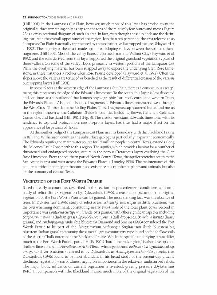
(Hill 1901). In the Lampasas Cut Plain, however, much more of this layer has eroded away, theoriginal surface remaining only as caps on the tops of the relatively few buttes and mesas. Figure23 is a cross-sectional diagram of such an area. In fact, even though these uplands are the defin-ing feature in the overall appearance of the region, less than ten percent of the area referred to asLampasas Cut Plain is actually represented by these distinctive flat-topped features (Hayward etal. 1992). The majority of the area is made up of broad sloping valleys between the isolated uplandfragments (Hill 1901). Most of the valley floors are formed from the Walnut Clay (Hayward et al.1992) and the soils derived from this layer supported the original grassland vegetation typical ofthese valleys. On some of the valley floors, primarily in western portions of the Lampasas CutPlain, the overlying material has been stripped away to expose the underlying Glen Rose Lime-stone; in these instances a rockier Glen Rose Prairie developed (Hayward et al. 1992). Often theslopes above the valleys are terraced or benched as the result of differential erosion of the variousoutcropping layers (Hill 1901).
In some places at the western edge of the Lampasas Cut Plain there is a conspicuous escarp-ment; this represents the edge of the Edwards limestone. To the south, this layer is less dissectedand continues as the surface of that famous physiographic feature of central and western Texas,the Edwards Plateau. Also, some isolated fragments of Edwards limestone extend west throughthe West Cross Timbers into the Rolling Plains. These fragments cap scattered buttes and mesasin the region known as the Callahan Divide in counties including Brown, Callahan, Coleman,Comanche, and Eastland (Hill 1901) (Fig. 8). The erosion-resistant Edwards limestone, with itstendency to cap and protect more erosion-prone layers, has thus had a major effect on theappearance of large areas of Texas.
At the southern edge of the Lampasas Cut Plain near its boundary with the Blackland Prairiein Bell and Williamson counties, the subsurface geology is particularly important economically.The Edwards Aquifer, the main water source for 1.5 million people in central Texas, extends alongthe Balcones Fault Zone north to this region. The aquifer, which provides habitat for a number ofthreatened and endangered species, occurs in the porous Cretaceous layers overlying the GlenRose Limestone. From the southern part of North Central Texas, the aquifer stretches south to theSan Antonio area and west across the Edwards Plateau (Longley 1996). The maintenance of thisaquifer is critical not only for the continued existence of a number of plants and animals, but alsofor the economy of central Texas.
VEGETATION OF THE FORT WORTH PRAIRIE
Based on early accounts as described in the section on presettlement conditions, and on astudy of relict climax vegetation by Dyksterhuis (1946), a reasonable picture of the originalvegetation of the Fort Worth Prairie can be gained. The most striking fact was the absence oftrees. In Dyksterhuis’ (1946) study of relict areas, Schizachyrium scoparius (little bluestem) wasthe overwhelming dominant, constituting nearly two-thirds of the total plant cover. Second inimportance was Bouteloua curtipendula (side-oats grama), with other significant species includingSorghastrum nutans (Indian grass), Sporobolus compositus (tall dropseed), Bouteloua hirsuta (hairygrama), and Andropogon gerardii (big bluestem). Diamond and Smeins (1993) considered the FortWorth Prairie to be part of the Schizachyrium-Andropogon-Sorghastrum (little bluestem-bigbluestem-Indian grass) community, the same tall grass community type found on the shallow soilsof the Austin Chalk outcrop in the Blackland Prairie. While the specific underlying strata differ,much of the Fort Worth Prairie, part of Hill’s (1901) “hard lime rock region,” is also developed onshallow limestone soils. Nassella leucotricha (Texas winter grass) and Bothriochloa laguroides subsp.torreyana (silver bluestem) [referred to by Dyksterhuis as Andropogon saccharoides], species thatDyksterhuis (1946) found to be most abundant in his broad study of the present-day grazingdisclimax vegetation, were of almost negligible importance in the relatively undisturbed relicts.The major biotic influence on current vegetation is livestock grazing pressure (Dyksterhuis1946). In comparison with the Blackland Prairie, much more of the original vegetation of the
52 INTRODUCTION/CROSS TIMBERS AND PRAIRIES

Fort Worth Prairie has survived, in large part due to the extensive areas of shallow untillablesoils that are still used primarily for grazing. Fire suppression and the consequent invasion ofwoody species has also had an important impact on the vegetation of many areas of the FortWorth Prairie.
VEGETATION OF THE LAMPASAS CUT PLAIN
The vegetation of the Lampasas Cut Plain is more variable than that of the other vegetationalareas considered here because of its greater topographic diversity. Depending on the particularconditions present, the vegetation ranges from prairie similar to that found on the Fort WorthPrairie or even the Blackland Prairie, to post oak-blackj ack oak woodland similar to the CrossTimbers, to vegetation resembling that of the Edwards Plateau. For example, the easternmost partof the Lampasas Cut Plain, sometimes referred to as the Washita Prairie, is a gently rolling land-scape of prairie with scattered oaks on hilltops. This area is characterized in places by rather deepsoils with tall grass prairie vegetation similar to the Blackland Prairie, and in other places by shal-low soils over hard limestone, with vegetation more closely resembling that of the Fort WorthPrairie (Hayward et al. 1992). To the west, in the more typical butte and mesa country of the mainpart of the Lampasas Cut Plain, oaks, including Quercus buckleyi (Texas red oak), Quercusfusiformis (live oak), and Quercus sinuata var. breviloba (shin oak), may be found on the rockyEdwards limestone summits of the smaller divides. On the larger divides, areas of deeper soilremain and support westward extensions of the Washita Prairie (Hayward et al. 1992). On thechalky nearly soil-less slopes derived from the underlying Comanche Peak limestone, Quercussinuata var. breviloba (shin oak), Rhus species (sumac), and Juniperus species (juniper) may be seen;these dry rocky areas have a distinctly desert-like microclimate (Hayward et al. 1992) and thussupport plants with xerophytic adaptations. Below these slopes, on benches in valleys or on thesummits of uplands lacking caprock, extensive areas of prairie can be found on the clay soilsderived from the Walnut formation where it is exposed. The basal Trinity Group sands (Paluxy,Antlers, Twin Mountains-Travis Peak) underlying the Walnut formation develop Cross Timbersvegetation with Quercus stellata (post oak) and Quercus marilandica (blackjack oak) (Hill 1901). Inparts of the western Lampasas Cut Plain, in areas where the overlying strata have been removedto expose the Glen Rose limestone (occurring between layers of the Trinity sands), short-grassprairie, oak-savannah, and woodlands with abundant junipers are found on the thin-soiled,rough, rocky, stair-stepped landscape (Hill 1901; Hayward et al. 1992).
CROSS TIMBERS AND PRAIRIES/INTRODUCTION 53
FIG.23/DIAGRAM OF A DIVIDE OF THE LAMPASAS CUT PLAIN (FROM HILL 1901).
“Diagrammatic representation of a divide of the Lampasas Cut Plain,showing relation of agriculture, forestry, topography,and under-
ground water to the geology. e2, Caprina limestone; summit divide of Lampasas Cut Plain; soilless except in large areas; growth of
scrub oak, live oak,and post oak. e1,Comanche Peak limestone;chalky,soilless slopes;growth of shin oak. f,Walnut formation,Walnut
Prairie; rich, fertile land in many places. p, Paluxy sand; Eastern and Western Cross Timbers, forested with post oak and black-jack; fair
cotton and good fruit land; water bearing. r2, Barren limestone slopes with growth of juniper, live oak, and sumac; occasional fertile
soils from interbedded marly layers; water bearing. t2, Trinity sands;Western Cross timbers; same forest growth as p. r1, small prairie
spots; good soil. t1,Trinity sands;Western Cross Timbers; same forest growth as p.”
e2
e1
fp
r2
t2r1
t1
The topographic diversity and deeply cut streams found in various parts of the LampasasCut Plain provide important microhabitat variation. In particular, the diverse microhabitatsallow the northward extension of many species otherwise found primarily on the EdwardsPlateau to the south and southwest. Plants traditionally considered Edwards Plateau endemics(e.g., Amos & Rowell 1988) but found in the Lampasas Cut Plain include Acer grandidentatumNutt. var. sinuosum (Plateau big-tooth maple), Agalinis edwardsiana (Plateau gerardia),Argythamnia aphoroides (Hill Country wild mercury), Astragalus wrightii (Wright’s milk-vetch),Chamaesaracha edwardsiana (Plateau false nightshade), Clematis texensis (scarlet clematis),Garrya ovata var. lindheimeri (Lindheimer’s silktassel), Matelea edwardsensis, (Plateau milkvine),Muhlenbergia lindheimeri (Lindheimer’s muhly), Nolina lindheimeriana, (devil’s-shoestring),Onosmodium helleri (Heller’s marbleseed), Perityle lindheimeri (Lindheimer’s rock daisy), Prunusserotina var. eximia (escarpment blackcherry), Styrax platanifolius (sycamore-leaf styrax),Pediomelum cyphocalyx (turnip-root scrufpea), Tradescantia edwardsiana (Plateau spiderwort),Triodanis coloradoensis (Colorado Venus’-looking-glass), Verbesina lindheimeri (Lindheimer’scrownbeard), and Yucca rupicola (twisted-leaf yucca). When considering vegetation, soils, geolog-ic layers, and general aspects of the landscape, some parts of the Lampasas Cut Plain (e.g., FortHood—Bell and Coryell cos.; Meridian State Park—Bosque Co.; bluffs in southern Johnson Co.overlooking the Brazos River) are remarkably similar to the Edwards Plateau; in fact, it could beargued that the Lampasas Cut Plain is simply a northern extension of the Edwards Plateau. Anumber of plants widely known from the Edwards Plateau also occur not only in the LampasasCut Plain, but also in the topographically complex Palo Pinto Country to the north and north-west. Examples include a number of fern species unusual in North Central Texas such asAstrolepis integerrima (star-scaled cloak fern), Cheilanthes eatonii (Eaton’s lip fern), Cheilanthes feei(slender lip fern), Cheilanthes horridula (rough lip fern), Pellaea ovata (cliff-brake), and Pellaeawrightiana (Wright’s cliff-brake).
Currently in many places in the Lampasas Cut Plain, as well as in the Cross Timbers, junipers(Juniperus spp.) are a conspicuous component of the vegetation, often crowding out other nativespecies. Because of the control of fire, overgrazing, and other human-caused changes, juniper hasbecome much more common during the last century (Hayward et al. 1992). In fact, juniper is cur-rently one of the most problematic species invading and eliminating native grassland. Fonteynet al. (1988) emphasized fire suppression as causing a similar transformation from relativelyopen savannah to shrubland or woodland (in large part due to invasion by Juniperus ashei) onsome parts of the Edwards plateau. Mesquite (Prosopis glandulosa), historically much less abundantthan at present, shows the same pattern. Originally limited by fire, it has increased greatly inabundance as the result of fire suppression, overgrazing, and the plowing and other disturbancesassociated with agriculture (Hayward et al. 1992). In general, with the suppression of fire, woodyvegetation is currently increasing at the expense of grassland throughout North Central Texas.
RED RIVER AREAAREA ADJACENT TO THE RED RIVER
The narrow band of vegetation found on the primarily sandy soils adjacent to the Red River inthe northeastern portion of North Central Texas, specifically in the northern parts of Lamar,Fannin, and Grayson counties, is quite different from the vegetation of the rest of North CentralTexas. At least part of this band, which we refer to as the Red River Area (Fig. 1), is often classifiedas part of vegetational area 3 (Post Oak Savannah) (Correll & Johnston 1970; Hatch et al. 1990).Such a classification is justified because a significant component of the vegetation more typicallyassociated with eastern or southeastern Texas extends west along the Red River in microhabitatswith special soil or moisture conditions. Even components of vegetational area 1 (Pineywoods),characteristic of extreme eastern Texas, can be found in this area. In northern Lamar County, theaspect of the vegetation is definitely similar to the eastern deciduous forest. Tall stands of Quercus
54 INTRODUCTION/RED RIVER AREA
falcata (southern red oak), abundant Liquidambar styraciflua (sweetgum), Pinus taeda (loblollypine), Acer rubrum (red maple), Betula nigra (river birch), Carpinus caroliniana (American horn-beam), Crataegus marshallii (parsley hawthorn), bottomland brakes of Arundinaria gigantea(giant cane), Calycocarpum lyonii (cupseed), Osmunda cinnamomea (cinnamon fern),Trachelospermum difforme (climbing dogbane), and herbs such as Lysimachia lanceolata (lance-leaf loosestrife), Monotropa hypopithys (American pinesap), Polygala sanguinea (blood milkwort),Porteranthus stipulatus (Indian-physic), Saccharum contortum (bent-awn plume grass), Sacciolepisstriata (American cupscale), Saururus cernuus (lizard’s-tail), Stachys tenuifolia (slender-leafbetony), and Veronicastrum virginicum (culver’s-physic), are just a few examples of eastern plantsfound in Lamar County. Even farther west in Fannin County, there are still isolated pockets ofeastern Texas vegetation (e.g., Talbot property). Species reaching their known western limits thereinclude Quercus falcata (southern red oak), Quercus nigra (water oak), Quercus phellos (willow oak),Nyssa sylvatica (black-gum), Sassafras albidum (sassafras), Chasmanthium laxum var. sessiliflorum(narrow-leaf wood-oats), Cirsium horridulum (bull thistle), Erechtites hieraciifolia (Americanburnweed), Impatiens capensis (spotted touch-me-not), Luzula bulbosa (bulb woodrush),Monotropa uniflora (Indian-pipe), Pedicularis canadensis (common lousewort), Pycnanthemumalbescens (white-leaf mountain-mint), Sorghastrum elliottii (slender Indian grass), and Woodwardiaareolata (narrow-leaved chain fern). Grayson County, the next county to the west, does not haveareas dominated by eastern Texas plants as do Lamar and Fannin counties, but there is a significanteastern Texas component to the vegetation. Numerous plant species reach their western limits inGrayson County including Agrimonia rostellata (woodland groovebur), Asimina triloba (pawpaw),Desmodium glutinosum (tick-clover), Liatris aspera (tall gayfeather), Monarda lindheimeri(Lindheimer’s beebalm), Podophyllum peltatum (may-apple), Polygonatum biflorum (Solomon’s-seal), Quercus velutina (black oak), Thalictrum arkansanum (meadowrue), Triosteum angustifolium(yellow-flowered horse-gentian), and Vaccinium arboreum (farkleberry). A few typically easternplants extend even farther west into Cooke and Montague counties and beyond.
The area adjacent to the Red River in Grayson County is further complicated by the presenceof the Preston Anticline, a post-Cretaceous (Bradfield 1957) fold in the sedimentary strata thatbrought deeper layers to the surface (Bullard 1931). In places the river valley is two hundred feetbelow the surrounding area and creeks have cut deep canyon-like valleys. The overall topographynear the Red River is thus very rugged (Bullard 1931). Parker (1856) in an early account describedthe Texas shore of the Red River as “very bold, presenting a stratification of red clay and whitesand, giving a striking and very peculiar appearance in the distance, like chalk cliffs.” This differ-ent topography and the appearance at the surface of deeper strata otherwise only found far tothe west in areas such as the Grand Prairie and West Cross Timbers (e.g., Goodland limestone,Duck Creek limestone, Trinity Group sands) makes the vegetational picture of the area morecomplex. Many microhabitats, and thus increased biological diversity, result from the croppingout of these deeper strata in the county. For example, in a number of places along the Red River(e.g., Eisenhower State Park, Preston Peninsula, Delaware Bend), the Goodland Limestone formsflat limestone outcrops at the top of rugged cliffs. These areas of very thin soil over flat rock andadjacent slopes and ravines have numerous interesting plant species found nowhere else inGrayson County including Coryphantha missouriensis (plains nipple cactus), Minuartiamichauxii var. texana (rock sandwort), Talinum calycinum (rock-pink), Dodecatheon meadia(common shooting-star), and Melica nitens (tall melic).
The proximity of sandy and clayey soils, as well as some intermediate type soils, in thecounties adjacent to the Red River, also allows species normally separated ecologically to occurtogether; this sometimes results in hybridization. An excellent example can be seen in Fanninand Grayson counties where three species of Baptisia (wild indigo) and all three possible hybridsare found in close proximity (Kosnik et al. 1996). These occur either in what early settlers locallycalled “mixed soil” or in the area of the Preston Anticline where radically different soil types arefound over quite small distances.
RED RIVER AREA/INTRODUCTION 55
The basic pattern of the Red River Area is thus one of the eastern Texas forests gradinggradually into the much less diverse and more xeric woodlands usually referred to as the CrossTimbers. From an even broader perspective, as discussed in the overview, the whole NorthCentral Texas region is in an ecotone or ecological transition zone between two extensive ecosys-tems, the eastern North American deciduous forest and the central North American grasslandor prairie. In virtually any ecotone, significant areas of vegetational interdigitation are seen;rarely is there a clearcut boundary. One type of vegetation extends deep into another alongstreams, in-pockets are found in protected areas, and special soil conditions often result in apatchwork pattern of vegetation that at the strictly local level seems confusing. The East and Westcross timbers, the enclosed Grand Prairie, and the Red River Area are all excellent examples ofthese phenomena.
ORIGIN OF THE NORTH CENTRAL TEXAS FLORAThe flora of North Central Texas, like that of any relatively large region, has a complex and variedorigin. Ultimately, it is the result of the evolutionary and distributional history of each of the com-ponent species. However, several influences can be observed which together allow at least a broadunderstanding of how the present flora originated. North Central Texas contains components offour major floristic provinces as defined by Thorne (1993a): the Appalachian Province, theAtlantic and Gulf Coastal Plain Province, the North American Prairies Province, and the SonoranProvince. There are also considerable numbers of Texas endemics. In addition, the modern floracontains 17.7 percent introduced species, these coming from various parts of the world.
INFLUENCE OF THE EASTERN DECIDUOUS FOREST
Plants from the first two of these floristic provinces, the Appalachian Province and the Atlanticand Gulf Coastal Plain Province, represent the influence of the eastern deciduous forest. Thiscomponent of the flora is particularly important in the Red River drainage in the northeasternpart of North Central Texas, but eastern deciduous forest elements occur across all of NorthCentral Texas, and even make up an important component of the flora of the Edwards Plateauto the south and west of the region studied here (Amos & Rowell 1988). The vast deciduous forestbiome of eastern North America is composed of a number of plant communities, and theforests/savannahs of North Central Texas represent Quercus-Carya or Quercus communities onthe relatively dry western fringe of the eastern deciduous forest (Thorne 1993a).
From the phytogeographical standpoint, eastern deciduous forest elements are one of themost fascinating components of the North Central Texas flora. In the geologic past, dispersalbetween the Eurasian and North American continents was possible, and the combined area isconsidered a single “Holarctic” biogeographic region. The fossil record shows that many plantshad distributions across the Northern Hemisphere—temperate forests, for example, occurredvery broadly and reached their maximum extension in the mid-Tertiary (the Tertiary extendedfrom 65 to 5 million years ago). This flora has been referred to as the Arcto-Tertiary flora or theTertiaro-mesophytic flora. Geohistorical events from the mid-Tertiary to the present have includ-ed alterations in the shapes of the northern land masses, fluctuations in sea levels, mountainbuilding, and profound changes in the climate. As a result, there have been great changes in boththe composition and the disposition of the flora.
A number of species of the once widespread Arcto-Tertiary flora have survived in one ormore of four widely separated Tertiary relict areas—1) eastern Asia; 2) eastern North America; 3)southeastern Europe; and 4) western North America (Li 1952b; Little 1970; Wood 1970; Graham1972a, 1972b; Boufford & Spongberg 1983; Hamilton 1983; Hsü 1983; Wu 1983; Ying 1983; Cox &Moore 1993; Graham 1993). Examples of North Central Texas genera found in all four of theseareas include Aesculus, Cercis, Erythronium, Juglans, Ostrya, Philadelphus, and Platanus (Wood1970). Wood (1970) and Thorne (1993a) emphasized the strong floristic relationships betweenthe eastern United States and western North America, and indicated that about 65% of the genera
56 INTRODUCTION/ORIGIN OF THE FLORA

of southern Appalachian seed plants also occur in western North America. Examples of NorthTexas genera with such western North American connections include Ceanothus, Oxypolis,Pycnanthemum, and Trichostema (Wood 1970).
A significant number of species, however, have survived in only two very distant Tertiaryrelict areas, eastern Asia and eastern North America, and this striking distribution pattern haslong been of interest to botanists (e.g., Gray 1846, 1859) and continues to be so today (e.g., Li &Adair 1994, 1997). The genus Carya is such an example (Fig. 24); other North Central Texasexamples include Campsis, Menispermum, Penthorum, Phryma, Sassafras, Saururus, Triadenum,Triosteum, and Veronicastrum (Li 1952b; Little 1970; Boufford & Spongberg 1983; Hamilton 1983;Hsü 1983; Wu 1983; Ying 1983; Cox & Moore 1993; Graham 1993). In the words of Graham (1993),“It is well known that the broad-leaved deciduous forests of eastern North America and easternAsia are floristically related. . . . It results from the maximum extension of the temperate deciduousforest in the mid-Tertiary and its disruption in western North America during the Pliocene andin western Europe during the Quaternary.” This is one of the most ancient components of theNorth Central Texas flora. By at least the early Tertiary period (Eocene epoch—54.9–38 millionyears ago) deciduous vegetation was present across the middle of the North American continent(familiar genera include Acer, Celtis, Liquidambar, Populus, and Rhus) (Graham 1993). Dilcher(1998) indicated that different routes between the Old and New worlds have been open at differ-ent times in the past and that the shared vegetational elements between Asia and the UnitedStates are possibly derived from multiple introductions.
A related floristic relationship is the similarity seen between some forests in the mountainsof Mexico and those in the eastern United States. Numerous North Central Texas genera (e.g.,Carpinus, Crataegus, Cornus, Liquidambar, Myrica, Nyssa, Pedicularis, Quercus, Smilax, andVaccinium) and even species (e.g., Liquidambar styraciflua) occur broadly across the easternUnited States as far west as Texas and then reappear in the Mexican highlands and in some caseseven in Guatemala (Miranda & Sharp 1950; Martin & Harrell 1957; Thorne 1993a). This relationshiprepresents a middle to late Miocene (Miocene epoch—24.6–5.1 million years ago) extension ofdeciduous forest and associated fauna (particularly amphibians) into Mexico during a period ofclimatic cooling. Subsequently, during the Pliocene (Pliocene epoch—5.1–2 million years ago)and later times as the climate warmed and dried, these deciduous forests became disjunct, survivingin Mexico only in isolated pockets of appropriate microclimate in the highlands (Miranda &Sharp 1950; Graham 1993).
ORIGIN OF THE FLORA/INTRODUCTION 57
FIG.24/WORLDWIDE DISTRIBUTION MAP OF CARYA (JUGLANDACEAE) SHOWING ITS DISJUNCT OCCURRENCE IN EASTERN ASIA AND EASTERN NORTH
AMERICA (FROM WU 1983).
Geohistorical events in Tertiary and post-Tertiary times brought tropical elements into thepresent eastern deciduous forests, including North Central Texas. According to Graham (1993),“In the southeastern U.S., tropical forests reached their maximum northern expansion (to about50°–60°N) in the Eocene [Eocene epoch—54.9–38 million years ago] with Annonaceae, Lauraceae,and Menispermaceae known from western Kentucky and Tennessee.” A few North CentralTexas species such as Asimina triloba may be a reflection of such an influence.
INFLUENCE OF THE NORTH AMERICAN PRAIRIES PROVINCE
The second major floristic component of North Central Texas is derived from the North AmericanPrairies Province. Grassland vegetation historically covered much of the area currently referred toas North Central Texas, but human activities, particularly the conversion to cropland and thesuppression of fire, have greatly reduced the amount of grassland. Allred and Mitchell (1955)viewed virtually all of North Central Texas to be prairie. In their broad classification of Texasvegetation, they considered the Cross Timbers and even the eastern Texas Post Oak belt to be PostOak Savannahs that are part of the True Prairie Association. They supported this contention bypointing out that the grasses of the True Prairie are important components in the vegetation ofthe Post Oak Savannahs. Barbour and Christensen (1993) stated that in the southern part of thetall grass prairie-deciduous forest boundary (including Texas), the ecotone is an oak savannah50–100 km wide. Since there are clearly components of both prairie and deciduous forest, viewingthe region as an ecotone seems the most reasonable approach.
Axelrod (1985) argued that North American grasslands are geologically recent and that therise of extensive grasslands probably dates to the Miocene-Pliocene transition (about 7–5 millionyears ago), the driest part of the Tertiary. Fossil evidence shows the Great Plains were largelyforested from the middle Miocene into the early Pliocene. As the climate dried at the end of theMiocene, forests were more restricted and grasslands were able to spread rapidly. According toGraham (1993), the widespread late Miocene-Pliocene appearance of prairie vegetation in the mid-dle of the North American continent was part of the first major disruption of the vast temperatedeciduous forest (the above-noted Arcto-Tertiary flora) that had extended across north temperatelatitudes since the late Eocene. During the Pleistocene (the Pleistocene epoch began 2 millionyears ago), again based on fossil evidence, there was great fluctuation in grassland versus forestvegetation associated with glaciation. From 15,000 to 12,000 years B.P. (before present), areas nowcovered with grassland vegetation (e.g., Texas panhandle) supported forest. The widespreadcentral North American grasslands (including those of North Central Texas) present at the timeof European settlement, probably date to post-glacial times only 12,000 to 10,000 years B.P.(Axelrod 1985). Axelrod (1985) supported his view of the grassland as a young biome with thefollowing evidence: 1) there are few endemic taxa, with most of the grassland species being presentin adjacent forests; 2) populations of trees scattered over the region are readily interpreted asrelicts of a once more widely distributed forest; and 3) fossil evidence of forests in the recent pastoccurs over much of the present grasslands. According to Axelrod (1985), “That grasslandsspread following the last glacial is apparent from data provided by bogs at Boriack, Gause andSoefje, central Texas (Bryant, 1977). During late glacial time, central Texas was covered with anopen deciduous forest with some conifers and an understory of mixed grasses and shrubs. Withretreating glaciers, warmer and/or drier climates developed over central Texas. Forests wererestricted, leaving parkland vegetation dominated by grasses, shrubs, and herbs, but includingtrees in protected sites. During post-glacial time many mesic trees disappeared from the pollenrecord. It was the continual increase in non-arboreal taxa, and especially grasses, throughoutpost-glacial time that led to the establishment of the present post oak-grassland vegetation ofcentral Texas (Bryant, 1977).” Thorne (1993a) also considered the grasslands of the PrairiesProvince to be “. . . mostly recent and adventive. . . .”
58 INTRODUCTION/ORIGIN OF THE FLORA
INFLUENCE OF THE NORTH AMERICAN SONORAN PROVINCE
A third floristic component of North Central Texas is derived from the Sonoran Province (south-western United States and northwestern Mexico). According to Thorne (1993a), this province ispart of the broader Madrean Region which has an exceedingly diverse and distinctive flora thatis mostly locally derived and rich in endemics. He further indicated that the xerophytic flora ofthe Sonoran Province is subtropical and largely Madro-Tertiary in origin. In North Central Texassuch Sonoran elements (e.g., Aloysia (Verbenaceae), Colubrina, Condalia (Rhamnaceae), Garrya(Garryaceae), Karwinskia (Rhamnaceae), and Nolina (Agavaceae)) are found mostly in the driersouthern and southwestern parts of the region, but others (e.g., some Acacia (Fabaceae), Opuntia(Cactaceae), and Yucca (Agavaceae) species) occur more broadly. Cylindropuntias and Yuccaspecies, for example, are the commonest tall plants in some parts of the Sonoran Province(Thorne 1993a) and a strong connection is seen to North Central Texas which has four species ofcylindropuntias and seven species ofYucca (two of these are endemic to North Central Texas).Thorne indicated that the plants of the Sonoran Province “. . . seem to have originated as the aridareas of North America expanded through the Tertiary—for the past 65 million years, and espe-cially in the last 15 million years.” Families in the North Central Texas flora that he emphasizedas examples of this diversification include Agavaceae, Cactaceae, Menispermaceae, Nyctagin-aceae, Rafflesiaceae, and Sapotaceae. While some desert species are quite old, this emphasis onthe last 15 million years seems to mesh with the prevailing opinion that the modern NorthAmerican deserts and their floras are relatively recent geologically (Axelrod 1950, 1979; Barbour& Christensen 1993).
Thorne (1993a) indicated that there are other minor components of the North Americanflora which have very different origins. North Central Texas genera such as Menodora (Oleaceae),Prosopis (Fabaceae), and Nicotiana (Solanaceae) seem to have strong links with South America,while Thamnosma (Rutaceae) and Selinocarpus (Nyctaginaceae) are related to African taxa.
ENDEMICS
North Central Texas itself has only five endemic taxa (Yucca necopina, Y. pallida (Agavaceae),Evonymus atropurpurea var. cheatumii (Celastraceae), Croton alabamensis var. texensis (Euphorbi-aceae), Dalea reverchonii (Fabaceae)) presumably because of the lack of geographic and climaticisolation and the ecotonal nature of the area. However, 94 Texas endemics range into NorthCentral Texas (see Appendix 3), with many endemics that were once thought to be restricted tothe Edwards Plateau now known from the Lampasas Cut Plain in the southern part of NorthCentral Texas (Amos & Rowell 1988). The explanation for the endemism seen in the EdwardsPlateau and adjacent areas, while unclear, may be the result of the climatic history of the last twomillion years. During the Quaternary period (beginning 2 million years ago) there was significantclimatic variability and at least 20 glacial-interglacial cycles. Widespread changes in vegetationwere associated with these climatic fluctuations (Delcourt & Delcourt 1993); for example, duringthe last full-glacial interval (20,000–15,000 years B.P.), across the unglaciated parts of south-western North America, there was a cool, moist “pluvial” climate (Delcourt & Delcourt 1993)with forest species presumably expanding their ranges. Indeed, Bryant’s data (1977) showed anopen deciduous forest in central Texas during the last full-glacial interval. The climate moderatedfrom 15,000–10,000 years B.P., with interglacial conditions (i.e., warmer and drier) for the last10,000 years (Delcourt & Delcourt 1993). The Edwards Plateau and Lampasas Cut Plain endemicsare typically found in moist areas such as canyons along wooded streams and have presumablysurvived in the favorable microclimatic pockets as the overall climate of the area has warmedand/or dried. Many of these species have affinities with eastern taxa and may be relicts of a morewidespread flora that became restricted as the result of climatic or geologic changes (Palmer1920; Amos & Rowell 1988).
ORIGIN OF THE FLORA/INTRODUCTION 59
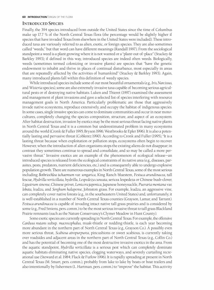
INTRODUCED SPECIES
Finally, the 394 species introduced from outside the United States since the time of Columbusmake up 17.7 % of the North Central Texas flora (the percentage would be slightly higher ifspecies that have invaded Texas from elsewhere in the United States were included). These intro-duced taxa are variously referred to as alien, exotic, or foreign species. They are also sometimescalled “weeds,” but that word can have different meanings (Randall 1997). From the sociologicalstandpoint a weed is a plant growing where it is not wanted or a “plant-out-of-place” (Stuckey &Barkley 1993); if defined in this way, introduced species are indeed often weeds. Biologically,weeds (sometimes termed colonizing or invasive plants) are species that “have the geneticendowment to inhabit and thrive in places of continual disturbance, most especially in areasthat are repeatedly affected by the activities of humankind” (Stuckey & Barkley 1993). Again,many introduced plants fall within this definition of weedy species.
While introduced species include some of our most beautiful ornamentals (e.g., Iris, Narcissus,and Wisteria species), some are also extremely invasive taxa capable of becoming serious agricul-tural pests or of destroying native habitats. Luken and Thieret (1997) examined the assessmentand management of plant invasions and gave a selected list of species interfering with resourcemanagement goals in North America. Particularly problematic are those that aggressivelyinvade native ecosystems, reproduce extensively, and occupy the habitat of indigenous species.In some cases, single invasive species can come to dominate communities and occur in near mono-cultures, completely changing the species composition, structure, and aspect of an ecosystem.After habitat destruction, invasion by exotics may be the most serious threat facing native plantsin North Central Texas and it is a common but underestimated problem in many ecosystemsaround the world (Cronk & Fuller 1995; Bryson 1996; Westbrooks & Epler 1996). It is also a poten-tially lasting and pervasive threat (Coblentz 1990). According to Cronk and Fuller (1995), “It is alasting threat because when exploitation or pollution stops, ecosystems often begin to recover.However, when the introduction of alien organisms stops the existing aliens do not disappear; incontrast they sometimes continue to spread and consolidate, and so may be called a more per-vasive threat.” Invasive exotics are an example of the phenomenon of ecological release—anintroduced species is released from the ecological constraints of its native area (e.g., diseases, par-asites, pests, predators, nutrient deficiencies, etc.) and is consequently able to undergo explosivepopulation growth. There are numerous examples in North Central Texas, some of the most seriousincluding Bothriochloa ischaemum var. songarica, King Ranch bluestem, Festuca arundinacea, tallfescue, Hydrilla verticillata, hydrilla, Lespedeza cuneata, sericea lespedeza or Chinese bush-clover,Ligustrum sinense, Chinese privet, Lonicera japonica, Japanese honeysuckle, Pueraria montana var.lobata, kudzu, and Sorghum halapense, Johnston grass. For example, kudzu, an aggressive vine,can completely cover native forests (e.g., in the southeastern United States) and, unfortunately, itis well-established in a number of North Central Texas counties (Grayson, Lamar, and Tarrant).Festuca arundinacea is capable of invading intact native tall grass prairies and is considered bysome (e.g., Fred Smiens, pers. comm.) to be the most serious invasive threat to tall grass BlacklandPrairie remnants (such as the Nature Conservancy’s Clymer Meadow in Hunt County).
Some exotic species are currently spreading in North Central Texas. For example, the offensiveCarduus nutans subsp. macrocephalus, musk-thistle or nodding-thistle, is each year becomingmore abundant in the northern part of North Central Texas (e.g., Grayson Co.). A possibly evenmore serious threat, Scabiosa atropurpurea, pincushions or sweet scabious, is currently takingover roadsides and adjacent areas in the northern part of North Central Texas (e.g., Collin Co.)and has the potential of becoming one of the most destructive invasive exotics in the area. Fromthe aquatic standpoint, Hydrilla verticillata is a serious pest which can completely dominateaquatic habitats eliminating native species, clogging waterways, and severely curtailing recre-ational use (Steward et al. 1984; Flack & Furlow 1996). It is rapidly spreading at present in NorthCentral Texas (M. Smart, pers. comm.), probably from lake to lake by boats or boat trailers andalso intentionally by fishermen (L. Hartman, pers. comm.) to “improve” the habitat. This activity
60 INTRODUCTION/ORIGIN OF THE FLORA
is both illegal and ill-advised since it ultimately degrades the fishery. In fact, because of theirpotential as problematic invaders, five aquatic species that occur in North Central Texas,Alternanthera philoxeroides, alligator-weed (Amaranthaceae), Eichhornia crassipes, commonwater-hyacinth (Pontederiaceae), Hydrilla verticillata (Hydrocharitaceae), Myriophyllum spicatum,Eurasian water-milfoil (Haloragaceae), and Pistia stratiotes, water-lettuce (Araceae), are considered“harmful or potentially harmful exotic plants” and it is illegal to release, import, sell, purchase,propagate, or possess them in the state (Harvey 1998).
These alien taxa are from nearly all parts of the world (e.g., Bromus catharticus, rescue grass,from South America; Chenopodium pumilo, ridged goosefoot, from Australia; Eragrostis curvula,weeping love grass, from Africa; Bothriochloa ischaemum var. songarica, King Ranch bluestem,from Asia; Stellaria media, common chickweed, from Europe) and have gotten to North CentralTexas in assorted ways. However, most introduced weeds in eastern North America, includingmany in North Central Texas, are from central and western Europe. It is thought that manyweedy colonizing species evolved in Europe over thousands of years as humans disturbed andmodified the environment for agricultural purposes; these same species do well in the disturbedhabitats of the eastern United States (Stuckey & Barkley 1993). Numerous such European speciesentered North America at seaport cities along the Atlantic coast and spread westward across thecontinent (Stuckey & Barkley 1993). An excellent example of this phenomenon can be seen withChaenorrhinum minus, dwarf snapdragon, which was first observed growing in North Americain New Jersey in 1874 (Martindale 1876) and has since spread to over 30 states and nine Canadianprovinces (Widrlechner 1983). In some cases, seeds were introduced with soil, sand, or rocks beingused as ballast in seagoing ships; Mühlenbach (1979) discussed the role of maritime commerce indispersal. Other currently problematic taxa were intentionally introduced as ornamentals (e.g.,Ligustrum species, privets), as windbreaks (e.g., Tamarix species, saltcedars), or in misguidedattempts at habitat improvement, erosion control, soil stabilization, etc. In yet other cases, exoticsare thought to have been accidentally introduced with crop seeds (e.g., Myagrum perfoliatum), hay(e.g., Carduus nutans subsp. macrocephalus), cotton or wool, or are associated with livestock yards(e.g., Onopordum acanthium, Scotch-thistle). Still others are transported by trains (e.g.,Chaenorrhinum minus—Widrlechner 1983); Mühlenbach (1979) discussed the importance ofrailroads as a means of dispersal. A particularly unusual dispersal mechanism is suspected forSoliva pterosperma, lawn burweed or stickers, which is thought to have been introduced into NorthCentral Texas at a soccer field by the spinulose achenes sticking in athletic shoes.
The percentage of exotics in the North Central Texas flora—17.7% as stated above—isapproximately what would be expected based on data from other parts of the United States.Elias (1977) estimated the level of exotics at 22% in the northeastern United States and morerecently Stuckey and Barkley (1993) indicated that in northeastern states the percentage of foreignspecies ranged from 20% to over 30%. Their data, compiled from a number of sources, showedthat there are higher percentages of foreign species in those states that have been occupied thelongest by non-native inhabitants and in those that have been most extensively involved in agri-culture. Some northern and western states, with less human influence and disturbance, have figuresbelow 20%. While rather recently colonized by European settlers, North Central Texas, particu-larly the Blackland Prairie portion, has been extensively cultivated and numerous exotic specieshave arrived and become naturalized. Comparable percentages of foreign species are seen in thefloras of California (17.5%) (Rejmánek & Randall 1994), Colorado (16%), Iowa (22.3%), Kansas(17.4%), and North Dakota (15%) (Stuckey & Barkley 1993).
Several introduced species have only recently been reported in North Central Texas, includingChaenorrhinum minus, dwarf snapdragon (Diggs et al. 1997), Cerastium pumilum, dwarf mouse-earchickweed, and Stellaria pallida, lesser chickweed (Rabeler & Reznicek 1997). As this book wasnearing completion, another European species, Agrostemma githago, corn-cockle, was discoveredin the area (O’Kennon s.n., Parker Co.) as were two exotics new to Texas, Cerastium brachypetalum
ORIGIN OF THE FLORA/INTRODUCTION 61
(Rabeler 1333, Red River Co.), gray chickweed, and Plantago coronopus (O’Kennon 14221, Tarrant Co.),buck-horn plantago (O’Kennon et al. 1998). Additional exotics can be expected to become part of theNorth Central Texas flora in the future, many with serious negative consequences to the remnantnative flora.
CONSERVATION IN NORTH CENTRAL TEXASHuman activities have profoundly altered the biological picture of North Central Texas. Onlysmall remnants of the original habitats have survived to the present day. However, numerousconservation efforts are currently underway in the region. Addresses and telephone numbers ofthe organizations mentioned below are provided in Appendix 9.
Substantial areas of land are controlled by the federal government including HagermanNational Wildlife Refuge (an 11,000-acre tract in Grayson County), Balcones CanyonlandsNational Wildlife Refuge in Burnet, Travis, and Williamson counties, protected areas in FortHood in Bell and Coryell counties, U.S. Army Corps of Engineers land around numerousimpoundments, and the Caddo and Lyndon B. Johnson National Grasslands in Fannin and Wisecounties. The Texas Department of Parks and Wildlife is also protecting, and in some casesattempting restoration on, numerous tracts in state parks and state wildlife management areasthroughout North Central Texas. Examples of state land include Bonham State Park in FanninCounty, Cedar Hill State Park in Dallas County, Cleburne State Park in Johnson County, CooperLake State Park in Delta and Hopkins counties, Dinosaur Valley State Park in Somervell County,Eisenhower State Park in Grayson County, Lake Brownwood State Park in Brown County, LakeMineral Wells Park in Parker County, Lake Whitney State Park in Hill County, Meridian StatePark in Bosque County, Mother Neff State Park in Coryell County, Possum Kingdom State Park inPalo Pinto County, and Pat Mayse State Wildlife Management Area in Lamar County. A numberof far-sighted local governments are also protecting natural habitats. Examples of these includethe Dallas Nature Center, the 3,000-acre Fort Worth Nature Center and Refuge, the GambillWildlife Refuge in Lamar County, which is maintained by the City of Paris, Harry S. Moss Parkin Dallas, Parkhill Prairie Preserve in Collin County, River Legacy Living Science Center inArlington, and Tandy Hills Park in Fort Worth.
Non-governmental organizations such as the Nature Conservancy and the Natural AreaPreservation Association protect particularly critical pieces of habitat. Two well-known examplesare the Nature Conservancy’s Clymer Meadow in Hunt County and Tridens Prairie in Lamar County.The Heard Natural Science Museum and Wildlife Sanctuary, a 287-acre protected area in CollinCounty, has numerous conservation activities including a raptor rehabilitation program and a tallgrass prairie restoration project (e.g., Steigman & Ovenden 1988). Austin College and its Center forEnvironmental Studies protects three field laboratories and preserves totaling nearly 300 acres inGrayson County. Other organizations, such as the Native Plant Society of Texas, the Native PrairiesAssociation of Texas, the Texas Committee on Natural Resources, and the Thompson Foundationare actively engaged in educating the public and promoting the importance of plants, natural areas,and conservation. The Lady Bird Johnson Wildflower Center, located in Travis County just south ofNorth Central Texas, is dedicated to the study, preservation, and reestablishment of North Americannative plants in planned landscapes; it has had an important impact throughout Texas and beyond.The Texas Organization for Endangered Species (TOES) monitors and regularly publishes informa-tion about endangered and threatened species and natural communities in North Central Texas aswell as throughout the state. The Botanical Research Institute of Texas, in addition to its researchactivities, has an environmental education program, providing appropriate publications andeducational opportunities for school children in the North Central Texas area.
Finally, many individual landowners are also making significant contributions by managingtheir properties in ways that preserve the natural diversity of the area. Enlightened grazing reg-imens, setting aside particularly fragile or erosion-prone parcels, or simply purchasing areas toprotect are some of the strategies being undertaken by landowners throughout the North Central
62 INTRODUCTION/CONSERVATION
Texas region. Other individuals such as Rosa Finsley, Howard Garrett, the late Lynn Lowrey, the lateBenny Simpson, and Sally Wasowski have also made large contributions by bringing attention tothe superiority of native plants in landscapes and other environmentally sensitive strategies.
All of these efforts are critical because given the rate at which remaining areas of natural habi-tat are disappearing, unless action is taken by those living today, the opportunity to provide futuregenerations with the chance to experience natural areas in North Central Texas will soon be lost.
A SKETCH OF THE HISTORY OF BOTANY IN TEXASWITH EMPHASIS ON NORTH CENTRAL TEXAS
BOTANY IN TEXAS
PRIOR TO THE REPUBLIC OF TEXAS / BEFORE 1836Much of the earliest natural history work inTexas was botanical in nature (McCarley 1986).According to Winkler (1915), “The study ofTexas plants . . . is as old as the state itself. Priorto her annexation to the Union, and even beforethe period of the Republic of Texas, Texas hadbecome an interesting field of observation andresearch for botanists and naturalists.” The firstknown collection of plants from what is nowthe state was made by Edwin James in August1820 in the Texas Panhandle as part of MajorS.H. Long’s expedition to the Rocky Mountains(Shinners 1949h). Details of the expedition’sroute are provided by Goodman and Lawson(1995). However, the first person to make moreextensive collections in the area that wouldbecome Texas was Jean Louis Berlandier(1805–1851), a French (or Swiss if today’s bordersare accepted) botanist. Berlandier collected inTexas during the years 1828 to 1834 with theearliest of his collections being made in 1828between Laredo and San Antonio while on aMexican Boundary Commission expedition to
explore the area along the proposed United States-Mexico border (Winkler 1915; Geiser 1948;Berlandier 1980). His name is recognized in many scientific binomials including the genusBerlandiera, greeneyes, a composite group of four species native to the southern United Statesand Mexico. Berlandier apparently made the first collection of Lupinus texensis, one of the sixLupinus species which are the state flowers of Texas (Andrews 1986; Turner & Andrews 1986). Atwo volume translation of his journal has been published (Berlandier 1980).
Another early plant collector was Thomas Drummond (1780–1835), a Scottish botanist andnaturalist who came to Texas in 1833 (Fig. 25). While in the area for only a brief period(1833–1834), he made important collections in southeast Texas and stimulated such later collec-tors as Lindheimer and Wright (discussed below). Drummond’s were the first Texas collections “. . . that were extensively distributed among the museums and scientific institutions of theworld” (Geiser 1948). While many Texas plants are named for him, perhaps none is better known
HISTORY OF BOTANY IN TEXAS/INTRODUCTION 63
DD
FIG.25/ THOMAS DRUMMOND, 1780–1835. REDRAWN FROM
A PORTRAIT IN POPULAR SCIENCE MONTHLY 74:49. 1909.

than Phlox drummondii, commonly known as Drummond’s phlox or pride-of-Texas. Also ofnote is that it was from several of Drummond’s collections that Sir William Jackson Hookerdescribed both Lupinus subcarnosus and Lupinus texensis (Hooker 1836; Turner & Andrews 1986).
DURING REPUBLIC OF TEXAS TIMES AND EARLY STATEHOOD / 1836–1865
While not chronologically the first collector in thestate, Ferdinand Jacob Lindheimer (1801–1879), aGerman-born collector, is often referred to as the“father of Texas botany” because of his importantbotanical contributions, particularly on the centralTexas flora (Fig. 26). Lindheimer’s botanical workin the state, supported in part by GeorgeEngelmann and Asa Gray (the pre-eminentHarvard botanist), stretched from 1836 to 1879(Geiser 1948). Lindheimer’s collections were widelydistributed by Englemann and Gray under thetitle “Flora Texana Exsiccata” (Blankinship 1907)and numerous new species were described in thewell known Plantae Lindheimerianae (Engelmann& Gray 1845). Many Texas plants includingLindheimera texana, Texas-star, yellow Texas-star,or Lindheimer’s daisy, and Gaura lindheimeri,white gaura, are named after him. Details abouthis life and botanical contributions can be foundin Blankinship (1907) and Geiser (1948).Lindheimer’s letters to Engelmann have been edit-ed, translated, and discussed by Goyne (1991).
A friend and sometimes collecting companionof Lindheimer was another German, Ferdinand Roemer (1818–1891), who spent the years 1845to 1847 in Texas (Geiser 1948). While a geologist, sometimes referred to as the “father of the geologyof Texas,” he is probably best known for his book, Texas with Particular Reference to GermanImmigration and the Physical Appearance of the Country (Roemer 1849). Roemer, however, also col-lected plants (Winkler 1915) and his botanical contributions are recognized in such names asPhlox roemeriana, gold-eye phlox, and Salvia roemeriana, cedar sage.
A further early Texas collector was Charles Wright (1811–1885), whose collections for AsaGray spanned the years 1837 to 1852 (Geiser 1948). Much of his collecting in western Texas wasconducted while accompanying troops to that part of the state, an example being his 1849 expedi-tion across the unexplored region between San Antonio and El Paso. This expedition is of specialinterest because the Smithsonian’s $150 contribution to defray Wright’s expenses was, accordingto some, one of the early steps taken by that institution toward the formation of a nationalherbarium (Winkler 1915). Wright is commemorated by such plants as Datura wrightii, angel-trumpet, and Ipomoea wrightii, Wright’s morning-glory. Further information on Wright’s Texastravels can be found in Shaw (1987).
Another German-born naturalist was Louis Cachand Ervendberg (1809–1863), active in Texasfrom 1839 to 1855. He corresponded with and collected plants for Asa Gray in Comal County andlater in Veracruz, Mexico (Geiser 1948).
John Leonard Riddell (1807–1865), a botanist and geologist, visited Texas briefly in 1839 andcontributed to early knowledge about the plants of the state. His name can be seen inAphanostephus riddellii, Riddell’s lazy daisy. Detailed information about his travels in Texas aregiven in Breeden (1994).
64 INTRODUCTION/HISTORY OF BOTANY IN TEXAS
FIG.26/ FERDINAND JACOB LINDHEIMER, 1801–1879.
USED WITH PERMISSION OF SOPHIENBURG MUSEUM & ARCHIVES,
NEW BRAUNFELS,TX.

Another student of Texas natural history was Gideon Lincecum (1793-1874), a Georgia-born frontier naturalist and pioneer physician who lived and worked in Texas and later Mexicofrom 1848 to 1874 (Fig. 27). During his career he corresponded with such eminent scientists asCharles Darwin, Spencer Baird, and Joseph Henry. Though self-taught, he published at leasttwo dozen scientific articles and was elected a corresponding member of the Philadelphia
Academy of Natural Sciences. Lincecum sentbotanical specimens to such prestigious museumsas the Academy of Natural Sciences of Phila-delphia, the British Museum, and the SmithsonianInstitution. Not only did Lincecum make plantcollections but he also became an authority onTexas grasses. Additionally, he made extensiveobservations of the Texas agricultural (harvester)ant. His work with ants was eventually read byDarwin before the Linnaean Society in Londonand published in the Society’s journal in 1862(Lincecum 1861, 1862; Geiser 1948; Burkhalter1965; Lincecum & Phillips 1994; Lincecum et al.1997). His name is remembered in Vitis aestivalisvar. lincecumii, the pinewoods grape, of East Texas.Detailed information and much of his correspon-dence can be found in Lincecum and Phillips (1994)and Lincecum et al. (1997).
Important Texas collections were also made in1849–1850 by the French botanist Auguste AdolphLucien Trécul (1818–1896). According to Geiser(1948) he “. . . visited Texas on his scientific missionto North America to study and collect farinaceous-rooted plants used for food by the Indians.”
Stillingia treculeana, Trecul’s stillingia, and Yucca treculeana, Trecul’s yucca or Spanish-dagger, areboth named in his honor. McKelvey (1955, 1991) gave detailed information about Trécul’s travelsin southern and central Texas including an outline of his route and some collection numbers.Further information on Trécul can be found in Jovet and Willmann (1957).
In 1852, Captain R.B. Marcy’s expedition to explore the Red River to its source (Marcy 1853)resulted in the collection by George G. Shumard (1825–1867), surgeon of the expedition, of 200plant species (Winkler 1915). This expedition also yielded a published list of species by Torrey(1853) with 20 excellent illustrations, some of which are reprinted in the present volume.
Another interesting early contributor to Texas botany was Samuel Botsford Buckley(1809–1884). He first came to Texas in 1859, twice served as State Geologist of Texas, and collectedplants in various parts of the state. According to L. Dorr (pers. comm.), “. . . it should be noted thatBuckley was the first botanist to collect in Texas who then described new taxa from his owncollections. Asa Gray took great exception to this infringement upon his virtual monopoly onpublishing on Texas plants and Gray published several scathing reviews of Buckley’s work.Buckley published in excess of 100 taxa of Texas plants, a number of which are recognizedtoday.” Among his scientific papers, several were published in the Proceedings of the Academy ofNatural Sciences of Philadelphia (e.g., Buckley 1861 [1862]) including his rebuttal to Gray’s criticisms(Buckley 1870). One of the best known species described by Buckley is Quercus shumardii,Shumard’s red oak, which he named for B.F. Shumard, a geologist under whose direction he at onetime worked. Buckley’s name is remembered in Quercus buckleyi, Texas red oak (Dorr & Nixon1985). Detailed information about Buckley’s life and work can be found in Dorr and Nixon (1985)and Dorr (1997).
HISTORY OF BOTANY IN TEXAS/INTRODUCTION 65
FIG.27/ GIDEON LINCECUM, 1793–1874.
USED WITH PERMISSION OF THE CENTER FOR AMERICAN HISTORY,
THE UNIVERSITY OF TEXAS AT AUSTIN.
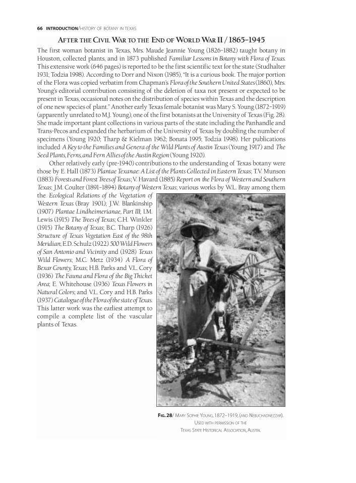
AFTER THE CIVIL WAR TO THE END OF WORLD WAR II / 1865–1945The first woman botanist in Texas, Mrs. Maude Jeannie Young (1826–1882) taught botany inHouston, collected plants, and in 1873 published Familiar Lessons in Botany with Flora of Texas.This extensive work (646 pages) is reported to be the first scientific text for the state (Studhalter1931; Todzia 1998). According to Dorr and Nixon (1985), “It is a curious book. The major portionof the Flora was copied verbatim from Chapman’s Flora of the Southern United States (1860), Mrs.Young’s editorial contribution consisting of the deletion of taxa not present or expected to bepresent in Texas, occasional notes on the distribution of species within Texas and the descriptionof one new species of plant.” Another early Texas female botanist was Mary S. Young (1872–1919)(apparently unrelated to M.J. Young), one of the first botanists at the University of Texas (Fig. 28).She made important plant collections in various parts of the state including the Panhandle andTrans-Pecos and expanded the herbarium of the University of Texas by doubling the number ofspecimens (Young 1920; Tharp & Kielman 1962; Bonata 1995; Todzia 1998). Her publicationsincluded A Key to the Families and Genera of the Wild Plants of Austin Texas (Young 1917) and TheSeed Plants, Ferns, and Fern Allies of the Austin Region (Young 1920).
Other relatively early (pre-1940) contributions to the understanding of Texas botany werethose by E. Hall (1873) Plantae Texanae: A List of the Plants Collected in Eastern Texas; T.V. Munson(1883) Forests and Forest Trees of Texas ;V. Havard (1885) Report on the Flora of Western and SouthernTexas; J.M. Coulter (1891–1894) Botany of Western Texas; various works by W.L. Bray among themthe Ecological Relations of the Vegetation ofWestern Texas (Bray 1901); J.W. Blankinship(1907) Plantae Lindheimerianae, Part III; I.M.Lewis (1915) The Trees of Texas; C.H. Winkler(1915) The Botany of Texas; B.C. Tharp (1926)Structure of Texas Vegetation East of the 98thMeridian; E.D. Schulz (1922) 500 Wild Flowersof San Antonio and Vicinity and (1928) TexasWild Flowers; M.C. Metz (1934) A Flora ofBexar County, Texas; H.B. Parks and V.L. Cory(1936) The Fauna and Flora of the Big ThicketArea; E. Whitehouse (1936) Texas Flowers inNatural Colors; and V.L. Cory and H.B. Parks(1937) Catalogue of the Flora of the state of Texas.This latter work was the earliest attempt tocompile a complete list of the vascularplants of Texas.
66 INTRODUCTION/HISTORY OF BOTANY IN TEXAS
FIG.28/ MARY SOPHIE YOUNG, 1872–1919, (AND NEBUCHADNEZZAR).
USED WITH PERMISSION OF THE
TEXAS STATE HISTORICAL ASSOCIATION, AUSTIN.

POST WORLD WAR II TO THE PRESENT / 1945–1998Following Cory and Parks’ (1937) first list, a number of subsequent checklists have been producedby botanists associated with or trained at Texas A&M University, one of the centers of researchon Texas botany. These include Texas Plants—A Checklist and Ecological Summary (Gould 1962,1969, 1975a), Checklist of the Vascular Plants of Texas (Hatch et al. 1990), and Vascular Plants of Texas:A Comprehensive Checklist including Synonymy, Bibliography, and Index (Jones et al. 1997). Otherlarge scale taxonomic works covering the entire state are Ferns and Fern Allies of Texas (Correll1956), The Legumes of Texas (Turner 1959), and The Grasses of Texas (Gould 1975b). The second of
these was one of the numerous contributions byBillie Lee Turner of the University of Texas atAustin, who has published extensively on theplants of Texas with particular emphasis on theAsteraceae. Turner was one of the individualsresponsible for developing the Botany Departmentat the University of Texas at Austin into one of thebest known and most respected departments inthe United States. The extensive work by FrankGould on grasses (e.g., 1968a, 1975b) at Texas A&MUniversity received national and even internation-al recognition, and his book on Texas grasses is oneof the best treatments in the country for a large tax-onomic group at the state level.
The first attempt at a comprehensive state-wideflora was the three volume Flora of Texas (3 vols.) byC.L. Lundell (1961, 1966, 1969). While never completed,this project of the Texas Research Foundation atRenner (near Dallas) was a valuable contribution tothe knowledge of Texas plants. The Texas ResearchFoundation subsequently published the Manual ofthe Vascular Plants of Texas (Correll & Johnston1970), which after nearly four decades is still the
only comprehensive source of information about the flora of the entire state. This work wasauthored by Donovan Stewart Correll (1908–1983) (Fig. 29) and Marshall Conring Johnston(1930–). After service at Harvard University and the United States Department of Agriculture,Correll, who was born in North Carolina and trained at Duke, in 1956 came to the Texas ResearchFoundation where he directed the Manual project. His research specialties included potatoes(Solanum), ferns, the Orchidaceae, and economic botany (Schubert 1984). With his wife, Helen B.Correll, he authored the influential and still widely used Aquatic and Wetland Plants of South-western United States (1972). Marshall Johnston, the second author of the Manual and a nativeTexan reared in the brush country of the Rio Grande delta, spent his career in the BotanyDepartment at the University of Texas at Austin. His research specialties include theEuphorbiaceae, Rhamnaceae, and floristics of Texas and Mexico. Subsequent to the publicationof the Manual, Johnston published two lists updating that work (Johnston 1988, 1990).
Floras are also available for various regions of the state including South Central Texas (Reeves& Bain 1947), the Big Bend (McDougall & Sperry 1951), North Central Texas (Shinners 1958a;Mahler 1984, 1988), the Texas Coastal Bend (Jones et al. 1961; Jones 1975, 1977, 1982), Central Texas(Reeves 1972, 1977), and the Edwards Plateau (Stanford 1976). More specialized works (e.g.,treatments of trees and shrubs or grasses) are available for some regions of the state (e.g., Austinand the Hill Country—Lynch 1981; East Texas—Nixon 1985; Trans-Pecos—Powell 1988, 1994, 1998).
HISTORY OF BOTANY IN TEXAS/INTRODUCTION 67
FIG.29/ DONOVAN STEWART CORRELL, 1908–1983.
USED WITH PERMISSION OF THE
NEW YORK BOTANICAL GARDEN, BRONX.
At present there are several long-term flora projects ongoing in Texas. These are a revisionof the Manual being undertaken by David Lemke of Southwest Texas State University in SanMarcos, and the new Flora of Texas Project, conceived by the Botanical Research Institute ofTexas (BRIT), with founding members including BRIT, Southwest Texas State University, TexasA&M University, and the University of Texas at Austin. The goal of this latter project is to createan electronic database of information about the approximately 6,000 taxa of native and natural-ized vascular plants of Texas, to make these data accessible via the internet, and to use theinformation to support botanical studies including the production of floras. At a more localscale, the Illustrated Texas Floras Project, a collaboration between BRIT and the Austin CollegeCenter for Environmental Studies, is attempting to produce illustrated floras for various parts ofthe state. This volume is the first in that series and is the first fully illustrated flora to be publishedfor any region of Texas or surrounding states. Currently BRIT is an active center of plant researchwith one of the largest concentrations of professional taxonomic botanists in the southwesternUnited States. Five nationally prominent scientists have located at BRIT to continue their re-search. These are Theodore Barkley (formerly of Kansas State University), Robert Kral (formerlyof Vanderbilt University), Joe Hennen (formerly of Purdue University), Henri Alain Liogier(formerly of the Botany Garden of the University of Puerto Rico-San Juan), and Richard Norris(formerly of the University of Washington and the University of California-Berkeley). Otherprofessional biologists or research associates in residence at BRIT are Bruce Benz, CharlotteBryant, George Diggs, Harold Keller, Barney Lipscomb, Fiona Norris, Robert O’Kennon, JohnPipoly, Roger Sanders, S.H. Sohmer, Dora Sylvester, and Lindsay Woodruff.
While a great deal of work was conducted in the 1800s on Texas plants, most of the researchwas accomplished by non-residents or was funded by outside sources. The result was that fewof the early collections remained in the state. According to Shinners (1949h),
Pioneer collectors [in Texas] were either sent from Europe, or were patronized by botanists in theolder parts of the United States. Not until the late 1890s did a Texas institution begin serious studyof the flora of the state. Just fifty years ago [now about 100 years ago], W.L. Bray made collectionsmore or less incidentally to ecological studies of the vegetation. These were the earliest collections toremain permanently in Texas and were the beginning of what is now the largest herbarium in thestate, that of the University of Texas [at Austin].
Over the past century this situation has changed greatly. As a result of various state andlocal floristic projects and the collecting efforts of numerous individuals, currently well overtwo million herbarium specimens are kept in Texas. About 27 herbaria are active in the state, thethree largest are the Plant Resources Center at the University of Texas at Austin (about 1,100,000specimens including the University of Texas and Lundell Herbaria), the Botanical ResearchInstitute of Texas in Fort Worth (860,000 specimens including the Southern MethodistUniversity and Vanderbilt University collections), and the S.M. Tracy Herbarium of the RangeScience Department of Texas A&M University (over 217,000 specimens) (Simpson 1996). A sub-stantial number of very early Texas collections have returned to the state through the efforts ofLloyd Shinners and exchanges with the Milwaukee Public Museum and the Missouri BotanicalGarden. For example, slightly less than 1,400 early Texas specimens (dating back to 1839) collectedby Ferdinand Lindheimer, Julien Reverchon, Charles Wright, and others are now in the collectionat the Botanical Research Institute of Texas (Shinners 1949h).
Further information on the history of botany in Texas can be obtained from Winkler (1915),Geiser (1945, 1948), (Shinners 1949h, 1958a), and McKelvey (1955, 1991).
68 INTRODUCTION/HISTORY OF BOTANY IN TEXAS
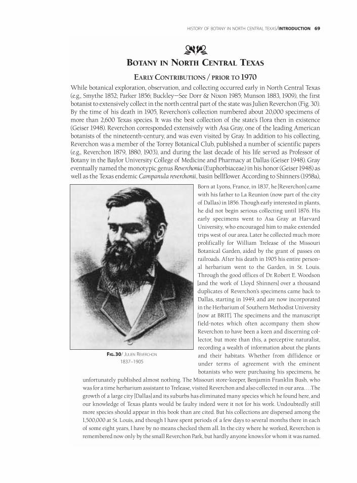
BOTANY IN NORTH CENTRAL TEXAS
EARLY CONTRIBUTIONS / PRIOR TO 1970While botanical exploration, observation, and collecting occurred early in North Central Texas(e.g., Smythe 1852; Parker 1856; Buckley—See Dorr & Nixon 1985; Munson 1883, 1909), the firstbotanist to extensively collect in the north central part of the state was Julien Reverchon (Fig. 30).By the time of his death in 1905, Reverchon’s collection numbered about 20,000 specimens ofmore than 2,600 Texas species. It was the best collection of the state’s flora then in existence(Geiser 1948). Reverchon corresponded extensively with Asa Gray, one of the leading Americanbotanists of the nineteenth-century, and was even visited by Gray. In addition to his collecting,Reverchon was a member of the Torrey Botanical Club, published a number of scientific papers(e.g., Reverchon 1879, 1880, 1903), and during the last decade of his life served as Professor ofBotany in the Baylor University College of Medicine and Pharmacy at Dallas (Geiser 1948). Grayeventually named the monotypic genus Reverchonia (Euphorbiaceae) in his honor (Geiser 1948) aswell as the Texas endemic Campanula reverchonii, basin bellflower. According to Shinners (1958a),
Born at Lyons, France, in 1837, he [Reverchon] camewith his father to La Reunion (now part of the cityof Dallas) in 1856. Though early interested in plants,he did not begin serious collecting until 1876. Hisearly specimens went to Asa Gray at HarvardUniversity, who encouraged him to make extendedtrips west of our area. Later he collected much moreprolifically for William Trelease of the MissouriBotanical Garden, aided by the grant of passes onrailroads. After his death in 1905 his entire person-al herbarium went to the Garden, in St. Louis.Through the good offices of Dr. Robert E. Woodson[and the work of Lloyd Shinners] over a thousandduplicates of Reverchon’s specimens came back toDallas, starting in 1949, and are now incorporatedin the Herbarium of Southern Methodist University[now at BRIT]. The specimens and the manuscriptfield-notes which often accompany them showReverchon to have been a keen and discerning col-lector, but more than this, a perceptive naturalist,recording a wealth of information about the plantsand their habitats. Whether from diffidence orunder terms of agreement with the eminentbotanists who were purchasing his specimens, he
unfortunately published almost nothing. The Missouri store-keeper, Benjamin Franklin Bush, whowas for a time herbarium assistant to Trelease, visited Reverchon and also collected in our area. . . .Thegrowth of a large city [Dallas] and its suburbs has eliminated many species which he found here, andour knowledge of Texas plants would be faulty indeed were it not for his work. Undoubtedly stillmore species should appear in this book than are cited. But his collections are dispersed among the1,500,000 at St. Louis, and though I have spent periods of a few days to several months there in eachof some eight years, I have by no means checked them all. In the city where he worked, Reverchon isremembered now only by the small Reverchon Park, but hardly anyone knows for whom it was named.
HISTORY OF BOTANY IN NORTH CENTRAL TEXAS/INTRODUCTION 69
DD
FIG.30/ JULIEN REVERCHON
1837–1905
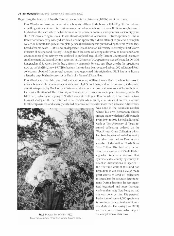
Regarding the history of North Central Texas botany, Shinners (1958a) went on to say,
Fort Worth can boast our next resident botanist, Albert Ruth, born in 1844 [Fig. 31]. Forced intounwilling retirement from his position as superintendent of schools in Knoxville, Tennessee, he turnedhis back on the state where he had been an active amateur botanist and spent his last twenty years(1912–1932) collecting in Texas. He was almost as prolific as Reverchon . . . . Ruth’s specimens (unlikeReverchon’s) were very widely distributed, and he apparently did not attempt to preserve a completecollection himself. His quite incomplete personal herbarium was purchased by the Fort Worth ParkBoard after his death . . . . It is now on deposit at Texas Christian University [currently at Fort WorthMuseum of Science and History]. Though Ruth did some collecting as far away as Bexar and Garzacounties, most of his activity was confined to our local area, chiefly Tarrant County, and to a muchsmaller extent Dallas and Denton counties. In 1929 a set of 300 specimens was collected for Dr. W.M.Longnecker of Southern Methodist University, primarily for class use. These are the first specimensnow part of the [SMU, now BRIT] Herbarium there to have been acquired. About 500 additional Ruthcollections, obtained from several sources, have augmented this original set. [BRIT has in its librarya lengthy unpublished typescript by Ruth of a Manual of Texas Flora.]
Fort Worth can also claim our third resident botanist, William Larrey McCart, whose interests inscience began while he was a student at Central High School there, and were continued, with specialattention to plants, by Mrs. Hortense Winton under whom he took freshman work at Texas ChristianUniversity. He attended The University of Texas briefly, to take a course in plant taxonomy under Dr.B.C. Tharp, subsequently going to North Texas State College in Denton, where in due course he tookhis master’s degree. He then returned to Fort Worth, where family affairs made it necessary for himto take employment, and severely curtailed botanical activities for more than a decade. A little work
was done at the Botanical Garden,where his own herbarium sharedstorage space with that of Albert Ruth.From 1954 to 1957 he took additionalwork at The University of Texas, re-sumed collecting, ordered up theW.A. Silveus Grass Collection whichhad been bequeathed to the University,and then returned to Denton as amember of the staff of North TexasState College. His chief early periodof activity was from 1937 to 1940, dur-ing which time he set out to collectsystematically, county by county, toestablish distributions of species —the first time work of this kind hadbeen done in our area. He also madegreat efforts to send off collections to specialists for accurate determina-tions. During that time, the best organ-ised [organized] and most thoroughwork on the state’s flora being carriedout was done by him. His personalherbarium of some 4,000 specimensis now incorporated in that of South-ern Methodist University [now BRIT],and has been an invaluable help inthe completion of this book.
70 INTRODUCTION/HISTORY OF BOTANY IN NORTH CENTRAL TEXAS
FIG.31/ ALBERT RUTH (1844–1932).
FROM THE COLLECTION OF THE FORT WORTH PUBLIC LIBRARY.
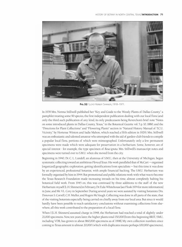
In 1939 Mrs. Norma Stillwell published her “Key and Guide to the Woody Plants of Dallas County,” apamphlet treating some 90 species, the first independent publication dealing with our local flora (andonly the third such publication of any kind, its only predecessors being Reverchon’s brief note “Noteson some introduced plants in Dallas County, Texas,” in the Botanical Gazette vol. 5 p. 10, 1880; and the“Directions for Plant Collections” and “Flowering Plants” section in “Natural History Manual of T.C.U.Vicinity,” by Hortense Winton and Sadie Mahon, which reached a fifth edition in 1929). Mrs. Stillwellwas an enthusiastic and talented amateur who attempted with the aid of garden-club friends to compilea popular local flora, portions of which were mimeographed. Unfortunately only a few permanentspecimens were made which were adequate for preservation in a herbarium. Some, however, are ofspecial interest - for example, the type specimen of Rosa ignota. Mrs. Stillwell’s manuscript notes andspecimens were turned over to S.M.U. when she moved from the city.
Beginning in 1940, Dr. C. L. Lundell, an alumnus of S.M.U., then at the University of Michigan, begansystematic collecting toward an ambitious Flora of Texas. His work paralleled that of McCart — organised[organized] geographic exploration, getting identifications from specialists — but this time it was doneby an experienced, professional botanist, with ample financial backing. The S.M.U. Herbarium wasformally organised by him in 1944. But promotional and public relations work with what was to becomethe Texas Research Foundation made increasing inroads on his time, almost completely halting hisbotanical field work. From 1945 on, this was continued by three additions to the staff of the newHerbarium: myself [L.H. Shinners] in February, Dr. Eula Whitehouse [see Flook 1974 for more information]in June, and Mr. V.L. Cory in September. During several years we were assisted by visiting botanists: Drs.Donovan S. Correll, C.H. Muller, and Rogers McVaugh. Collecting was done in all parts of the state, thatof the visiting botanists especially being carried on chiefly away from our local area. But since it wouldhardly have been possible to reach satisfactory conclusions without examining collections from else-where, all this work contributed to the preparation of a local flora.
When I [L.H. Shinners] assumed charge in 1948, the Herbarium had reached a total of slightly under21,000 specimens. Now, ten years later, the higher plants total 150,000 [from this beginning BRIT/SMU,including VDB, has grown to about 860,000 specimens as of 1998]. My own collection numbers sincecoming to Texas amount to almost 20,000 (which with duplicates means perhaps 100,000 specimens),
HISTORY OF BOTANY IN NORTH CENTRAL TEXAS/INTRODUCTION 71
FIG.32/ LLOYD HERBERT SHINNERS, 1918–1971.
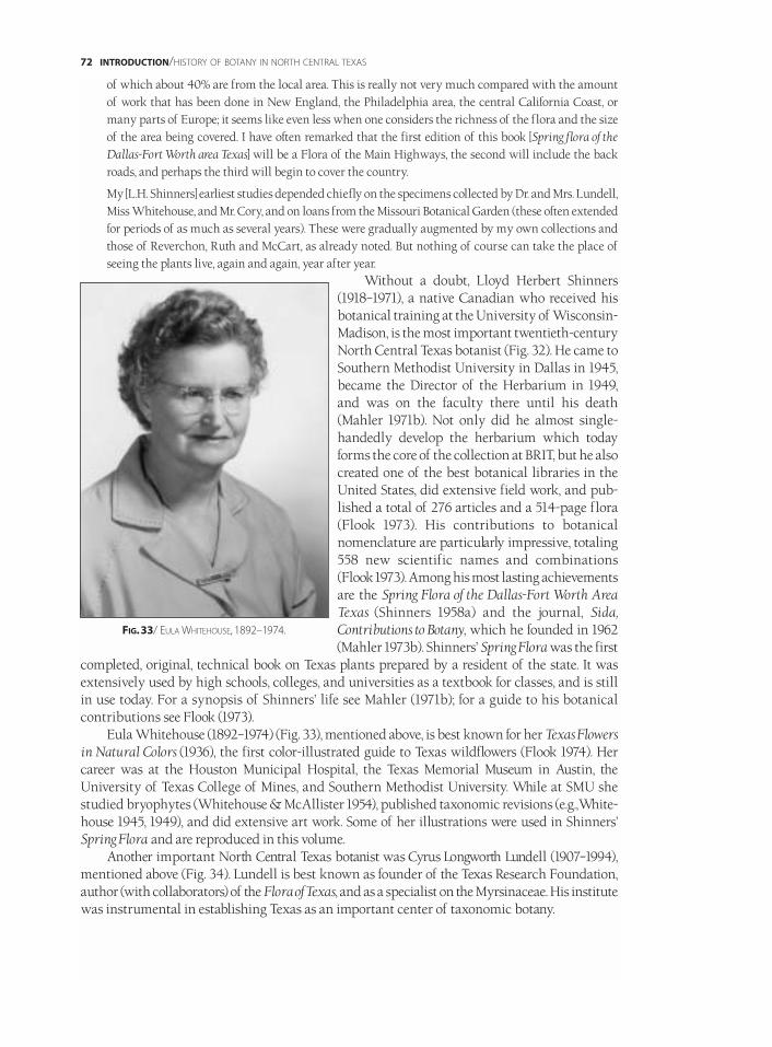
of which about 40% are from the local area. This is really not very much compared with the amountof work that has been done in New England, the Philadelphia area, the central California Coast, ormany parts of Europe; it seems like even less when one considers the richness of the flora and the sizeof the area being covered. I have often remarked that the first edition of this book [Spring flora of theDallas-Fort Worth area Texas] will be a Flora of the Main Highways, the second will include the backroads, and perhaps the third will begin to cover the country.
My [L.H. Shinners] earliest studies depended chiefly on the specimens collected by Dr. and Mrs. Lundell,Miss Whitehouse, and Mr. Cory, and on loans from the Missouri Botanical Garden (these often extendedfor periods of as much as several years). These were gradually augmented by my own collections andthose of Reverchon, Ruth and McCart, as already noted. But nothing of course can take the place ofseeing the plants live, again and again, year after year.
Without a doubt, Lloyd Herbert Shinners(1918–1971), a native Canadian who received hisbotanical training at the University of Wisconsin-Madison, is the most important twentieth-centuryNorth Central Texas botanist (Fig. 32). He came toSouthern Methodist University in Dallas in 1945,became the Director of the Herbarium in 1949,and was on the faculty there until his death(Mahler 1971b). Not only did he almost single-handedly develop the herbarium which todayforms the core of the collection at BRIT, but he alsocreated one of the best botanical libraries in theUnited States, did extensive field work, and pub-lished a total of 276 articles and a 514-page flora(Flook 1973). His contributions to botanicalnomenclature are particularly impressive, totaling558 new scientific names and combinations(Flook 1973). Among his most lasting achievementsare the Spring Flora of the Dallas-Fort Worth AreaTexas (Shinners 1958a) and the journal, Sida,Contributions to Botany, which he founded in 1962(Mahler 1973b). Shinners’ Spring Flora was the first
completed, original, technical book on Texas plants prepared by a resident of the state. It wasextensively used by high schools, colleges, and universities as a textbook for classes, and is stillin use today. For a synopsis of Shinners’ life see Mahler (1971b); for a guide to his botanicalcontributions see Flook (1973).
Eula Whitehouse (1892–1974) (Fig. 33), mentioned above, is best known for her Texas Flowersin Natural Colors (1936), the first color-illustrated guide to Texas wildflowers (Flook 1974). Hercareer was at the Houston Municipal Hospital, the Texas Memorial Museum in Austin, theUniversity of Texas College of Mines, and Southern Methodist University. While at SMU shestudied bryophytes (Whitehouse & McAllister 1954), published taxonomic revisions (e.g.,White-house 1945, 1949), and did extensive art work. Some of her illustrations were used in Shinners’Spring Flora and are reproduced in this volume.
Another important North Central Texas botanist was Cyrus Longworth Lundell (1907–1994),mentioned above (Fig. 34). Lundell is best known as founder of the Texas Research Foundation,author (with collaborators) of the Flora of Texas, and as a specialist on the Myrsinaceae. His institutewas instrumental in establishing Texas as an important center of taxonomic botany.
72 INTRODUCTION/HISTORY OF BOTANY IN NORTH CENTRAL TEXAS
FIG.33/ EULA WHITEHOUSE, 1892–1974.

RECENT CONTRIBUTIONS / 1970–1998
More recently,Wm. F. “Bill” Mahler (1930–) (Fig. 35), Director Emeritus of BRIT, had an extensive rolein the botany of the north central part of the state. After receiving his Ph.D. from the Universityof Tennessee at Knoxville, he joined the faculty of Southern Methodist University in 1968, becameeditor of Sida in 1971, and assumed leadership of the herbarium in 1973. Mahler is probably bestknown for his Shinners’ Manual of the North Central Texas Flora (1984, 1988), well known for itsclarity and ease of use. This manual was an expanded version of Shinners’ (1958) Spring Flora ofthe Dallas-Fort Worth Area Texas that also included the summer and fall flora for North CentralTexas. Other notable publications by Mahler were the Keys to the Plants of Black Gap WildlifeManagement Area, Brewster County, Texas (1971a), Flora of Taylor County, Texas (1973a) and The Mossesof Texas (1980), an elaboration upon Eula Whitehouse’s research on the mosses of Texas. Mahler’sspecialties included Fabaceae, Baccharis (Asteraceae), mosses, floristics, and the study of en-dangered species. He served as the first Director of the Botanical Research Institute of Texas(1987–1992) and along with Barney Lipscomb and Andrea McFadden, was instrumental in itsestablishment as a free-standing research institution.
Jack Stanford (1935–), of Howard Payne University in Brownwood on the very southwestmargin of North Central Texas, also made an important contribution to the knowledge of Texasbotany with his publication in 1976 of Keys to the Vascular Plants of the Texas Edwards Plateau andAdjacent Areas. This work covered portions of the Lampasas Cut Plain, which is included in thecurrent delineation of North Central Texas. Stanford has also done extensive collecting in theLampasas Cut Plain and Edwards Plateau and has found many important distributional records(e.g., Stanford & Diggs 1998).
Another important figure in the history of botany in North Central Texas and the state as awhole is Benny Simpson (1928–1996) (see Appendix 15). Serving for many years with the TexasResearch Foundation and later with the Texas A&M Research and Extension Center at Dallas,
HISTORY OF BOTANY IN NORTH CENTRAL TEXAS/INTRODUCTION 73
FIG.34/ CYRUS LONGWORTH LUNDELL, 1907–1994.WORKING IN FRONT OF HIS THATCHED HUT HEADQUARTERS AT TIKAL, GUATEMALA.
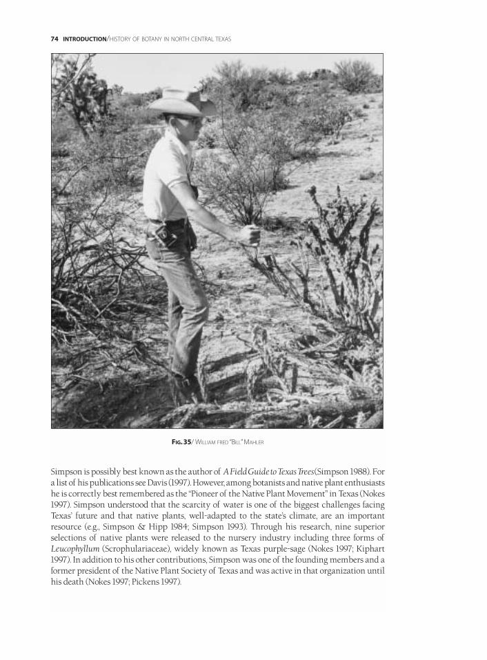
Simpson is possibly best known as the author of A Field Guide to Texas Trees(Simpson 1988). Fora list of his publications see Davis (1997). However, among botanists and native plant enthusiastshe is correctly best remembered as the “Pioneer of the Native Plant Movement” in Texas (Nokes1997). Simpson understood that the scarcity of water is one of the biggest challenges facingTexas’ future and that native plants, well-adapted to the state’s climate, are an importantresource (e.g., Simpson & Hipp 1984; Simpson 1993). Through his research, nine superiorselections of native plants were released to the nursery industry including three forms ofLeucophyllum (Scrophulariaceae), widely known as Texas purple-sage (Nokes 1997; Kiphart1997). In addition to his other contributions, Simpson was one of the founding members and aformer president of the Native Plant Society of Texas and was active in that organization untilhis death (Nokes 1997; Pickens 1997).
74 INTRODUCTION/HISTORY OF BOTANY IN NORTH CENTRAL TEXAS
FIG.35/ WILLIAM FRED “BILL”MAHLER
Other notable contributors to the botany of North Central Texas include Robert Adams(Baylor University), Geyata Ajilvsgi (Austin), John Bacon (University of Texas at Arlington),Lewis Bragg (University of Texas at Arlington), M.D. “Bud” Bryant (Austin College), William Carr(The Nature Conservancy of Texas), Wayne Clark (Fort Worth Nature Center), Sally Crosthwaite(Austin College), Arnold Davis (Native Prairies Association of Texas), Charles Finsley (DallasMuseum of Natural History), Hugh Garnett (Austin College), Harold Gentry (Grayson County),Glenn Kroh (Texas Christian University), Fred Gelbach (Baylor University), Joe Hennen (BRIT),George High (Austin), Walter Holmes (Baylor University), Harold Keller (Central Missouri StateUniversity), Joe Kuban (Nolan High School, Fort Worth), Shirley Lusk (Gainesville), DavidMontgomery (Paris Junior College), Jeff Quayle (Fort Worth), Elray Nixon (Las Vegas, Nevada),Donald Smith (University of North Texas), John Steele (BRIT), Connie and John Taylor (South-eastern Oklahoma State University), Dora Sylvester (Fort Worth Nature Center & BRIT),Geoffrey Stanford (Dallas Nature Center), Jerry Vertrees (Texas Wesleyan University), and SallyWasowski (Taos, New Mexico).
As noted above, with Lundell’s (1961, 1966, 1969) unfinished but important Flora of Texas andthe Manual of the Vascular Plants of Texas (Correll & Johnston 1970), both published in the Dallas-Fort Worth Metroplex, North Central Texas has been one of the centers of research on the state’sflora. The publications by Lloyd Shinners (1958a) Spring Flora of the Dallas-Fort Worth Area Texas,Jack Stanford (1976) Keys to the Vascular Plants of the Texas Edwards Plateau and Adjacent Areas, andWilliam Mahler (1984, 1988) Shinners’ Manual of the North Central Texas Flora have beenextremely valuable and useful guides to the region’s flora. In addition to such books, a numberof scientific journals originated in North Central Texas including Field & Laboratory; Wrightia;Sida, Contributions to Botany; and Sida, Botanical Miscellany. The Southwest Naturalist, a prominent,regional, natural history journal also has close ties to North Central Texas, with Lloyd Shinnersserving as its first editor. Most of the botanical work in North Central Texas has been completedat private institutions, a tradition which continues today. Until the 1970s and 1980s respectively,the Texas Research Foundation and Southern Methodist University were leaders in the field. Inrecent years, Austin College, Baylor University, the Botanical Research Institute of Texas, andHoward Payne University have all been actively engaged in botanical research. A number ofpublic colleges and universities in the area also have taxonomic botanists. Among these are ParisJunior College, Tarleton State University, Texas Christian University, Texas Wesleyan University,the University of North Texas, and the University of Texas at Arlington.
HISTORY OF BOTANY IN NORTH CENTRAL TEXAS/INTRODUCTION 75
DD


ILLUSTRATED FLORA OF NORTH CENTRAL TEXAS/COLOR PHOTOGRAPHS 77
ABRONIA AMELIAE / AMELIA’S SAND-VERBENA / P. 836 / [RJO]
AESCULUS PAVIA VAR. PAVIA / RED BUCKEYE / P. 738 / [RJO]
AGALINIS HOMALANTHA / FLAT-FLOWER GERARDIA / P. 993 / [GMD]
ALETRIS AUREA / YELLOW STAR-GRASS / P. 1194 / [RJO]
ALOPHIA DRUMMONDII / PURPLE PLEAT-LEAF / P. 1173 / [RJO]
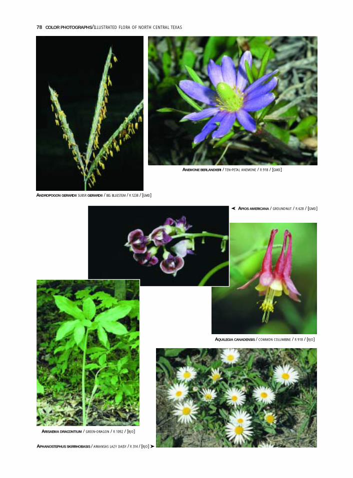
78 COLOR PHOTOGRAPHS/ILLUSTRATED FLORA OF NORTH CENTRAL TEXAS
ANEMONE BERLANDIERI / TEN-PETAL ANEMONE / P. 918 / [GMD]
AQUILEGIA CANADENSIS / COMMON COLUMBINE / P. 918 / [RJO]
APHANOSTEPHUS SKIRRHOBASIS / ARKANSAS LAZY DAISY / P. 314 / [RJO] ➤
ARISAEMA DRACONTIUM / GREEN-DRAGON / P. 1092 / [RJO]
ANDROPOGON GERARDII SUBSP. GERARDII / BIG BLUESTEM / P. 1238 / [GMD]
APIOS AMERICANA / GROUNDNUT / P. 628 / [GMD]➤
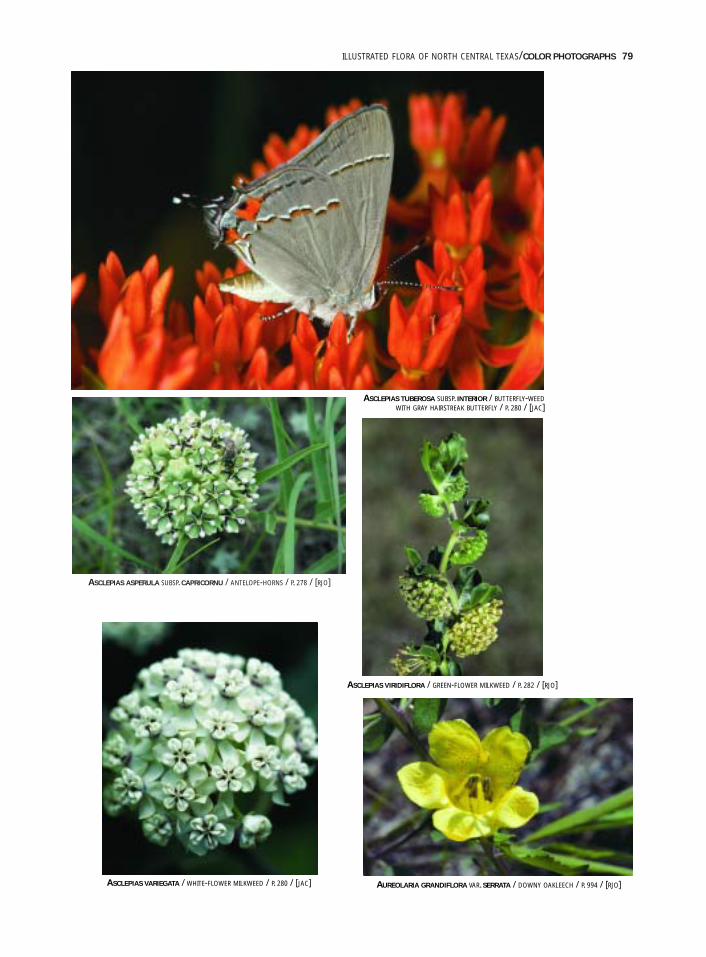
ILLUSTRATED FLORA OF NORTH CENTRAL TEXAS/COLOR PHOTOGRAPHS 79
ASCLEPIAS ASPERULA SUBSP. CAPRICORNU / ANTELOPE-HORNS / P. 278 / [RJO]
ASCLEPIAS TUBEROSA SUBSP. INTERIOR / BUTTERFLY-WEEDWITH GRAY HAIRSTREAK BUTTERFLY / P. 280 / [JAC]
AUREOLARIA GRANDIFLORA VAR. SERRATA / DOWNY OAKLEECH / P. 994 / [RJO]
ASCLEPIAS VIRIDIFLORA / GREEN-FLOWER MILKWEED / P. 282 / [RJO]
ASCLEPIAS VARIEGATA / WHITE-FLOWER MILKWEED / P. 280 / [JAC]
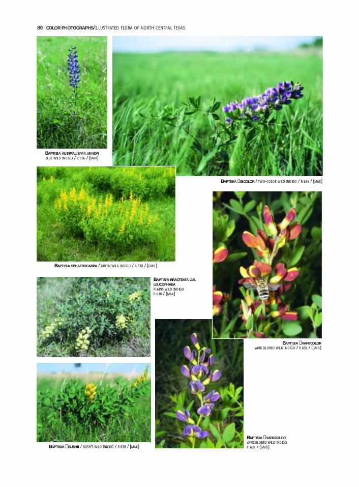
80 COLOR PHOTOGRAPHS/ILLUSTRATED FLORA OF NORTH CENTRAL TEXAS
BAPTISIA ×BICOLOR / TWO-COLOR WILD INDIGO / P. 636 / [MAK]
BAPTISIA ×BUSHII / BUSH’S WILD INDIGO / P. 638 / [MAK]
BAPTISIA ×VARIICOLORVARICOLORED WILD INDIGOP. 638 / [GMD]
BAPTISIA ×VARIICOLORVARICOLORED WILD INDIGO / P. 638 / [GMD]
BAPTISIA SPHAEROCARPA / GREEN WILD INDIGO / P. 638 / [GMD]
BAPTISIA AUSTRALIS VAR. MINORBLUE WILD INDIGO / P. 636 / [MAK]
BAPTISIA BRACTEATA VAR.LEUCOPHAEAPLAINS WILD INDIGOP. 638 / [MAK]
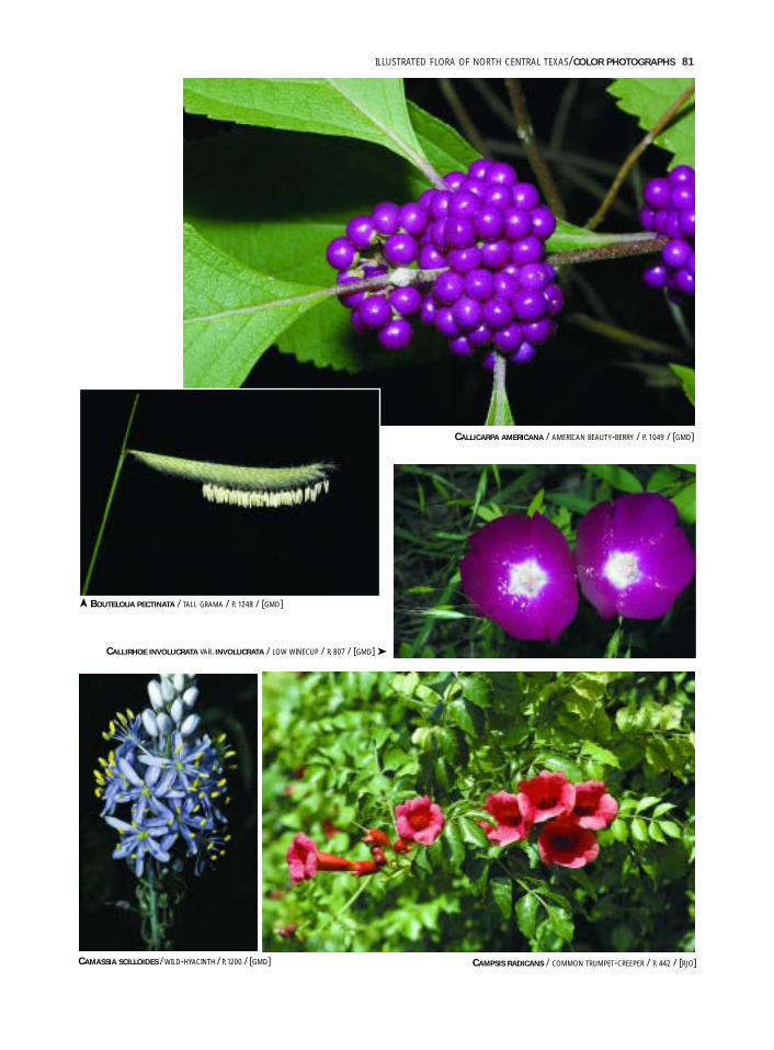
ILLUSTRATED FLORA OF NORTH CENTRAL TEXAS/COLOR PHOTOGRAPHS 81
CALLICARPA AMERICANA / AMERICAN BEAUTY-BERRY / P. 1049 / [GMD]
BOUTELOUA PECTINATA / TALL GRAMA / P. 1248 / [GMD]
CALLIRHOE INVOLUCRATA VAR. INVOLUCRATA / LOW WINECUP / P. 807 / [GMD] ➤
CAMASSIA SCILLOIDES / WILD-HYACINTH / P. 1200 / [GMD] CAMPSIS RADICANS / COMMON TRUMPET-CREEPER / P. 442 / [RJO]
➤
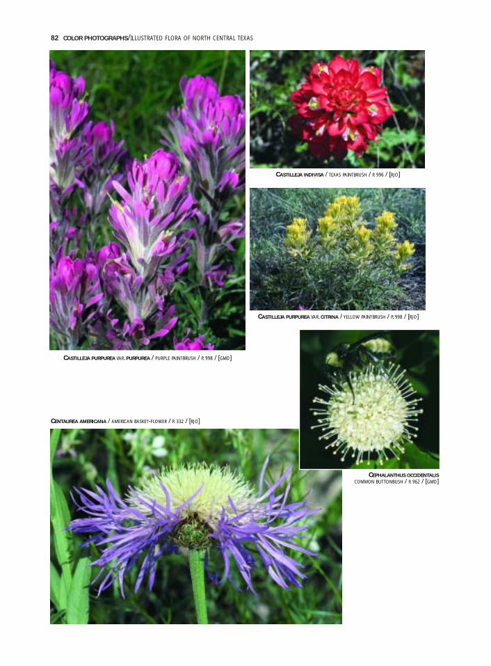
82 COLOR PHOTOGRAPHS/ILLUSTRATED FLORA OF NORTH CENTRAL TEXAS
CASTILLEJA INDIVISA / TEXAS PAINTBRUSH / P. 996 / [RJO]
CASTILLEJA PURPUREA VAR. CITRINA / YELLOW PAINTBRUSH / P. 998 / [RJO]
CENTAUREA AMERICANA / AMERICAN BASKET-FLOWER / P. 332 / [RJO]
CEPHALANTHUS OCCIDENTALISCOMMON BUTTONBUSH / P. 962 / [GMD]
CASTILLEJA PURPUREA VAR. PURPUREA / PURPLE PAINTBRUSH / P. 998 / [GMD]
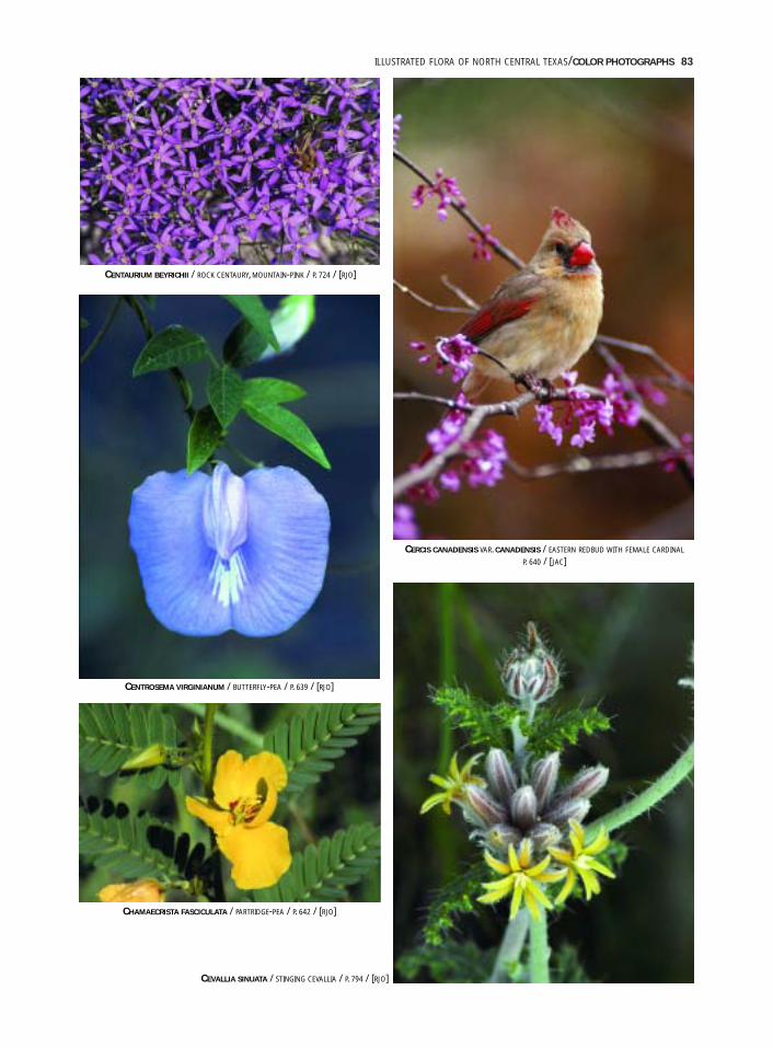
ILLUSTRATED FLORA OF NORTH CENTRAL TEXAS/COLOR PHOTOGRAPHS 83
CENTAURIUM BEYRICHII / ROCK CENTAURY, MOUNTAIN-PINK / P. 724 / [RJO]
CENTROSEMA VIRGINIANUM / BUTTERFLY-PEA / P. 639 / [RJO]
CHAMAECRISTA FASCICULATA / PARTRIDGE-PEA / P. 642 / [RJO]
CEVALLIA SINUATA / STINGING CEVALLIA / P. 794 / [RJO]
CERCIS CANADENSIS VAR. CANADENSIS / EASTERN REDBUD WITH FEMALE CARDINAL
P. 640 / [JAC]
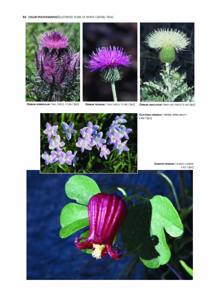
84 COLOR PHOTOGRAPHS/ILLUSTRATED FLORA OF NORTH CENTRAL TEXAS
CLAYTONIA VIRGINICA / VIRGINIA SPRING-BEAUTY
P. 908 / [RJO]
CLEMATIS TEXENSIS / SCARLET CLEMATIS
P. 922 / [RJO]
CIRSIUM TEXANUM / TEXAS THISTLE / P. 340 / [RJO]CIRSIUM HORRIDULUM / BULL THISTLE / P. 340 / [RJO] CIRSIUM UNDULATUM / WAVY-LEAF THISTLE / P. 340 / [RJO]

ILLUSTRATED FLORA OF NORTH CENTRAL TEXAS/COLOR PHOTOGRAPHS 85
COREOPSIS TINCTORIA / PLAINS COREOPSIS / P. 342 / [GMD]
COOPERIA PEDUNCULATA / GIANT RAIN-LILY / P. 1200 / [RJO]
CORYPHANTHA SULCATA / PINEAPPLE CACTUS / P. 485 / [RJO]
COMMELINA ERECTA VAR. ERECTA / ERECT DAYFLOWER / P. 1100 / [RJO]
CNIDOSCOLUS TEXANUS / TEXAS BULL-NETTLE
P. 596 / [GMD]
➤
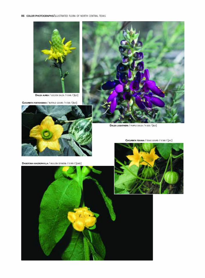
86 COLOR PHOTOGRAPHS/ILLUSTRATED FLORA OF NORTH CENTRAL TEXAS
DALEA AUREA / GOLDEN DALEA / P. 646 / [RJO]
DALEA LASIATHERA / PURPLE DALEA / P. 650 / [RJO]
CUCURBITA FOETIDISSIMA / BUFFALO GOURD / P. 568 / [RJO]
CUCURBITA TEXANA / TEXAS GOURD / P. 568 / [JAC]
DASISTOMA MACROPHYLLA / MULLEIN SEYMERIA / P. 999 / [GMD]
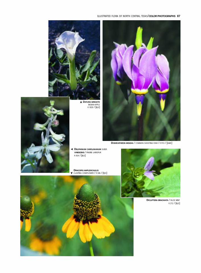
ILLUSTRATED FLORA OF NORTH CENTRAL TEXAS/COLOR PHOTOGRAPHS 87
DICLIPTERA BRACHIATA / FALSE MINT
P. 212 / [RJO]
DATURA WRIGHTIIINDIAN-APPLE
P. 1020 / [RJO]
DELPHINIUM CAROLINIANUM SUBSP.VIRESCENS / PRAIRIE LARKSPUR
P. 924 / [RJO]
DRACOPIS AMPLEXICAULISCLASPING CONEFLOWER / P. 346 / [RJO]
DODECATHEON MEADIA / COMMON SHOOTING-STAR / P. 913 / [GMD]
➤
➤
➤
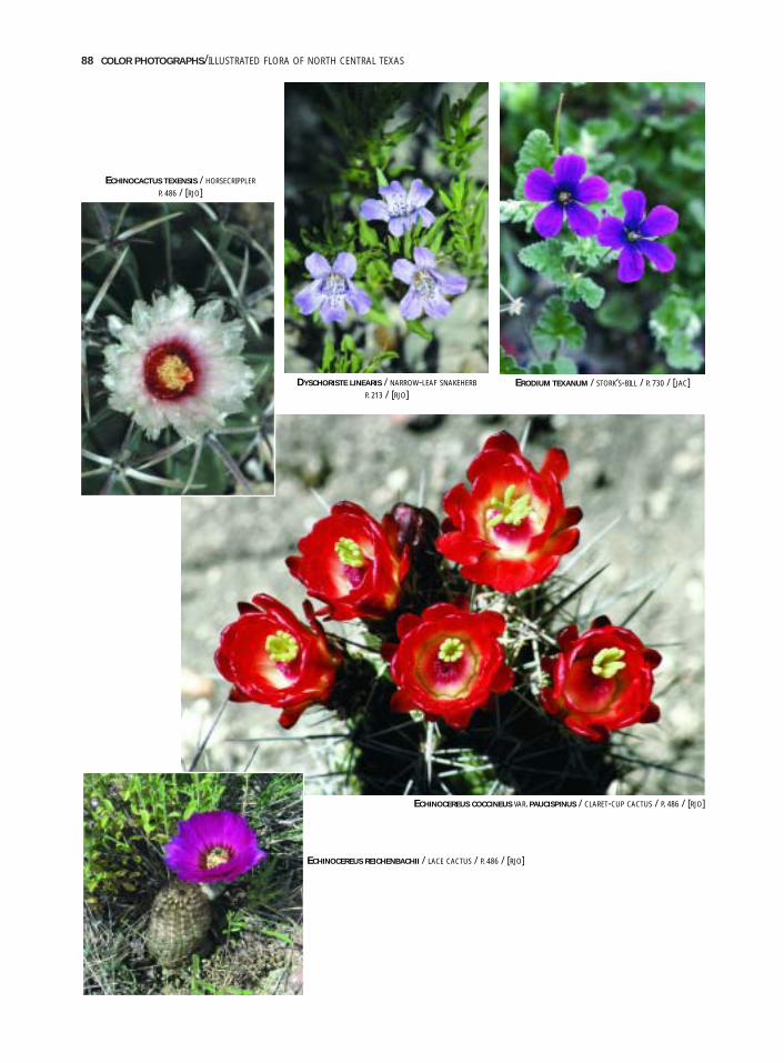
88 COLOR PHOTOGRAPHS/ILLUSTRATED FLORA OF NORTH CENTRAL TEXAS
ECHINOCEREUS COCCINEUS VAR. PAUCISPINUS / CLARET-CUP CACTUS / P. 486 / [RJO]
DYSCHORISTE LINEARIS / NARROW-LEAF SNAKEHERB
P. 213 / [RJO]
ECHINOCEREUS REICHENBACHII / LACE CACTUS / P. 486 / [RJO]
ECHINOCACTUS TEXENSIS / HORSECRIPPLER
P. 486 / [RJO]
ERODIUM TEXANUM / STORK‘S-BILL / P. 730 / [JAC]
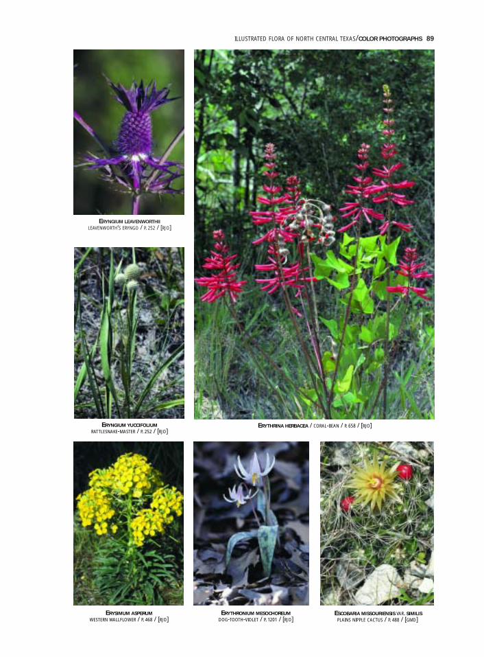
ILLUSTRATED FLORA OF NORTH CENTRAL TEXAS/COLOR PHOTOGRAPHS 89
ERYNGIUM LEAVENWORTHIILEAVENWORTH‘S ERYNGO / P. 252 / [RJO]
ERYTHRINA HERBACEA / CORAL-BEAN / P. 658 / [RJO]ERYNGIUM YUCCIFOLIUMRATTLESNAKE-MASTER / P. 252 / [RJO]
ERYSIMUM ASPERUMWESTERN WALLFLOWER / P. 468 / [RJO]
ERYTHRONIUM MESOCHOREUMDOG-TOOTH-VIOLET / P. 1201 / [RJO]
ESCOBARIA MISSOURIENSIS VAR. SIMILISPLAINS NIPPLE CACTUS / P. 488 / [GMD]
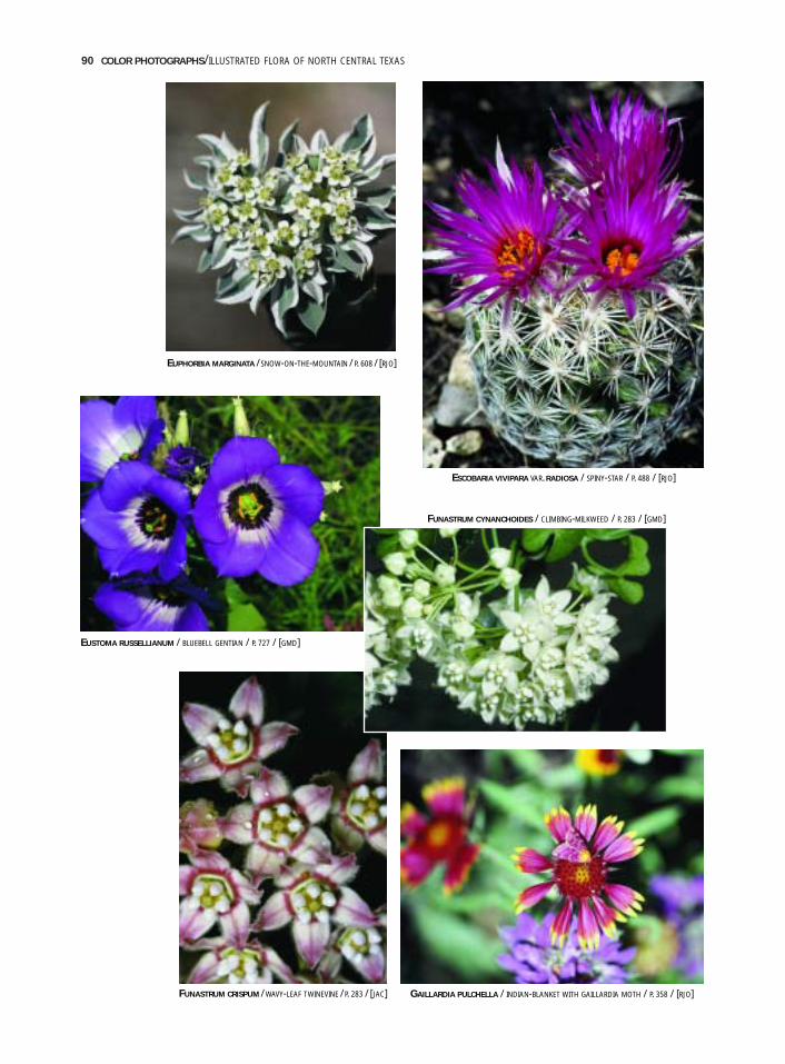
90 COLOR PHOTOGRAPHS/ILLUSTRATED FLORA OF NORTH CENTRAL TEXAS
EUSTOMA RUSSELLIANUM / BLUEBELL GENTIAN / P. 727 / [GMD]
GAILLARDIA PULCHELLA / INDIAN-BLANKET WITH GAILLARDIA MOTH / P. 358 / [RJO]
FUNASTRUM CYNANCHOIDES / CLIMBING-MILKWEED / P. 283 / [GMD]
FUNASTRUM CRISPUM / WAVY-LEAF TWINEVINE /P. 283 / [JAC]
EUPHORBIA MARGINATA /SNOW-ON-THE-MOUNTAIN / P. 608 / [RJO]
ESCOBARIA VIVIPARA VAR. RADIOSA / SPINY-STAR / P. 488 / [RJO]
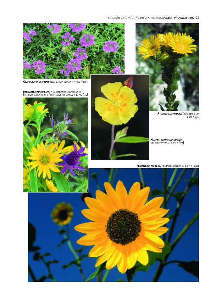
ILLUSTRATED FLORA OF NORTH CENTRAL TEXAS/COLOR PHOTOGRAPHS 91
GLANDULARIA BIPINNATIFIDA / DAKOTA VERVAIN / P. 1050 / [RJO]
HELIANTHUS MAXIMILIANI / MAXIMILIAN SUNFLOWER WITHERYNGIUM LEAVENWORTHII / LEAVENWORTH’S ERYNGO / P. 370 / [JAC]
GRINDELIA PAPPOSA / SAW-LEAF DAISY
P. 362 / [RJO]
HELIANTHEMUM GEORGIANUMGEORGIA SUN-ROSE / P. 543 / [RJO]
HELIANTHUS ANNUUS / COMMON SUNFLOWER / P. 369 / [GMD]
➤

92 COLOR PHOTOGRAPHS/ILLUSTRATED FLORA OF NORTH CENTRAL TEXAS
HERBERTIA LAHUE SUBSP. CAERULEAHERBERTIA / P. 1173 / [RJO]
HESPERALOE PARVIFLORA / RED-FLOWERED-YUCCA / P. 1079 / [RJO]HEXALECTRIS NITIDA / SHINING HEXALECTRISP. 1216 / [RJO]
HEXALECTRIS WARNOCKII / TEXAS PURPLE-SPIKEP. 1218 / [RJO]
HIBISCUS LAEVIS / HALBERD-LEAF ROSE-MALLOWP. 810 / [RJO]
HIBISCUS TRIONUM / FLOWER-OF-AN-HOURP. 812 / [RJO]
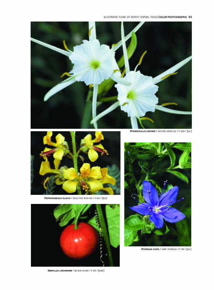
ILLUSTRATED FLORA OF NORTH CENTRAL TEXAS/COLOR PHOTOGRAPHS 93
HYMENOCALLIS LIRIOSME / WESTERN SPIDER-LILY / P. 1204 / [JAC]
HOFFMANSEGGIA GLAUCA / SICKLE-POD RUSH-PEA / P. 663 / [RJO]
IBERVILLEA LINDHEIMERI / BALSAM GOURD / P. 569 / [GMD]
HYDROLEA OVATA / HAIRY HYDROLEA / P. 740 / [JAC]
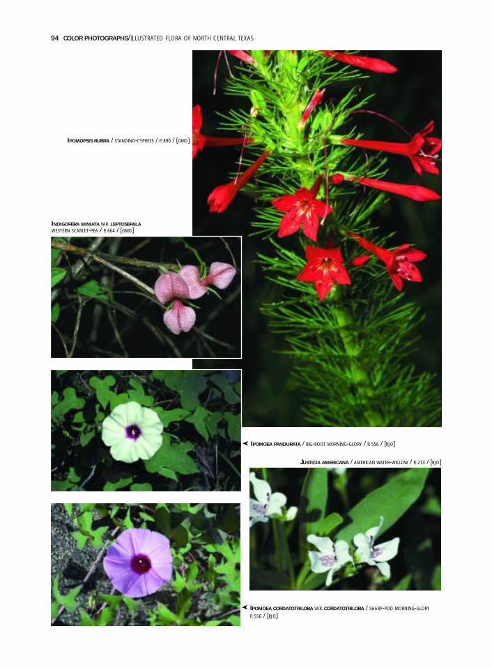
94 COLOR PHOTOGRAPHS/ILLUSTRATED FLORA OF NORTH CENTRAL TEXAS
INDIGOFERA MINIATA VAR. LEPTOSEPALAWESTERN SCARLET-PEA / P. 664 / [GMD]
IPOMOEA PANDURATA / BIG-ROOT MORNING-GLORY / P. 556 / [RJO]
JUSTICIA AMERICANA / AMERICAN WATER-WILLOW / P. 213 / [RJO]
IPOMOEA CORDATOTRILOBA VAR. CORDATOTRILOBA / SHARP-POD MORNING-GLORY
P. 556 / [RJO]
IPOMOPSIS RUBRA / STANDING-CYPRESS / P. 890 / [GMD]
➤
➤
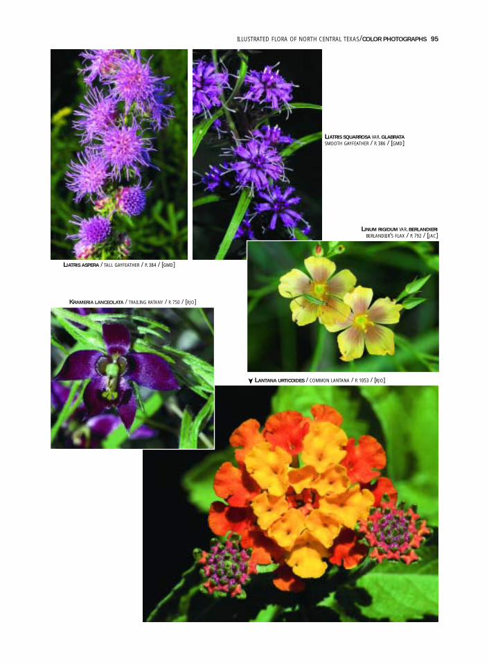
ILLUSTRATED FLORA OF NORTH CENTRAL TEXAS/COLOR PHOTOGRAPHS 95
KRAMERIA LANCEOLATA / TRAILING RATANY / P. 750 / [RJO]
LIATRIS ASPERA / TALL GAYFEATHER / P. 384 / [GMD]
LIATRIS SQUARROSA VAR. GLABRATASMOOTH GAYFEATHER / P. 386 / [GMD]
LINUM RIGIDUM VAR. BERLANDIERIBERLANDIER’S FLAX / P. 792 / [JAC]
LANTANA URTICOIDES / COMMON LANTANA / P. 1053 / [RJO]
➤
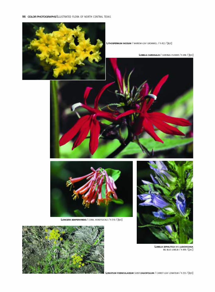
96 COLOR PHOTOGRAPHS/ILLUSTRATED FLORA OF NORTH CENTRAL TEXAS
LITHOSPERMUM INCISUM / NARROW-LEAF GROMWELL / P. 452 / [RJO]
LONICERA SEMPERVIRENS / CORAL HONEYSUCKLE / P. 510 / [RJO]
LOBELIA CARDINALIS / CARDINAL-FLOWER / P. 498 / [RJO]
LOMATIUM FOENICULACEUM SUBSP. DAUCIFOLIUM / CARROT-LEAF LOMATIUM / P. 255 / [RJO]
LOBELIA SIPHILITICA VAR. LUDOVICIANABIG BLUE LOBELIA / P. 498 / [JAC]
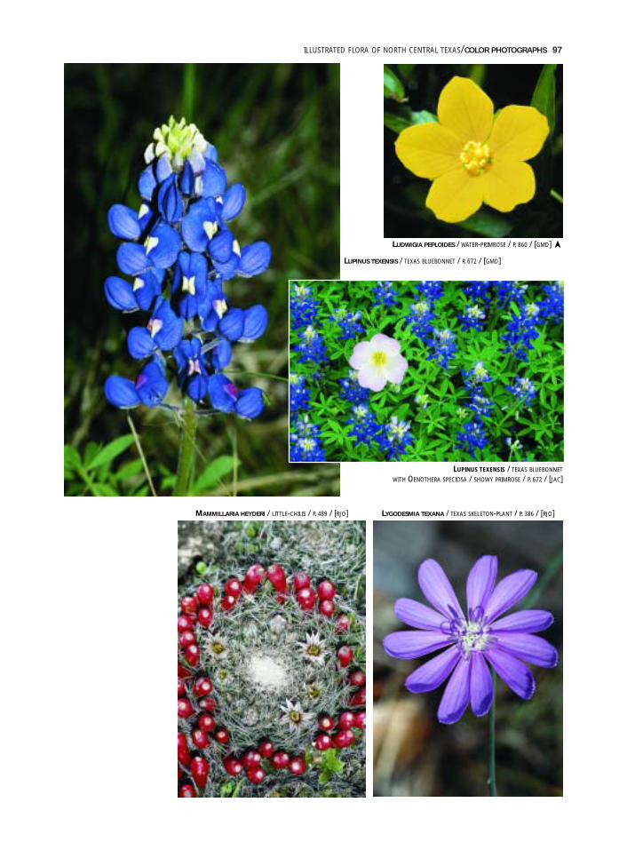
ILLUSTRATED FLORA OF NORTH CENTRAL TEXAS/COLOR PHOTOGRAPHS 97
LUDWIGIA PEPLOIDES / WATER-PRIMROSE / P. 860 / [GMD]
LUPINUS TEXENSIS / TEXAS BLUEBONNET / P. 672 / [GMD]
LUPINUS TEXENSIS / TEXAS BLUEBONNET
WITH OENOTHERA SPECIOSA / SHOWY PRIMROSE / P. 672 / [JAC]
MAMMILLARIA HEYDERI / LITTLE-CHILIS / P. 489 / [RJO] LYGODESMIA TEXANA / TEXAS SKELETON-PLANT / P. 386 / [RJO]
➤
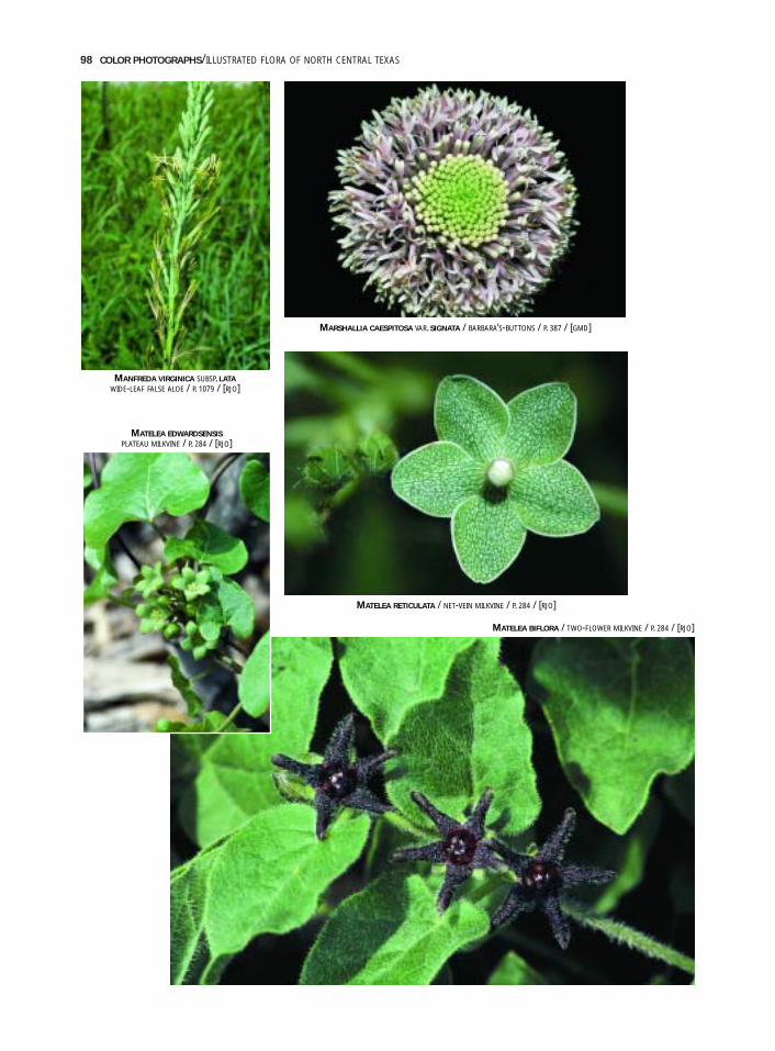
98 COLOR PHOTOGRAPHS/ILLUSTRATED FLORA OF NORTH CENTRAL TEXAS
MARSHALLIA CAESPITOSA VAR. SIGNATA / BARBARA’S-BUTTONS / P. 387 / [GMD]
MANFREDA VIRGINICA SUBSP. LATAWIDE-LEAF FALSE ALOE / P. 1079 / [RJO]
MATELEA EDWARDSENSISPLATEAU MILKVINE / P. 284 / [RJO]
MATELEA RETICULATA / NET-VEIN MILKVINE / P. 284 / [RJO]
MATELEA BIFLORA / TWO-FLOWER MILKVINE / P. 284 / [RJO]
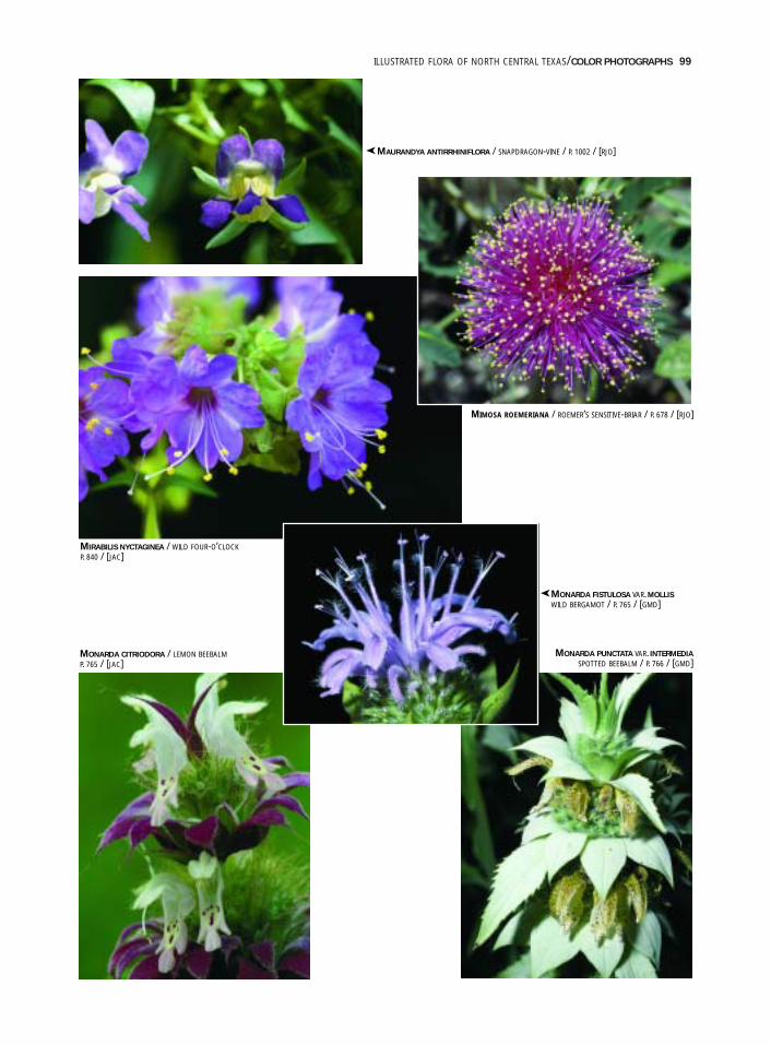
ILLUSTRATED FLORA OF NORTH CENTRAL TEXAS/COLOR PHOTOGRAPHS 99
MAURANDYA ANTIRRHINIFLORA / SNAPDRAGON-VINE / P. 1002 / [RJO]
MIMOSA ROEMERIANA / ROEMER’S SENSITIVE-BRIAR / P. 678 / [RJO]
MIRABILIS NYCTAGINEA / WILD FOUR-O’CLOCKP. 840 / [JAC]
MONARDA CITRIODORA / LEMON BEEBALMP. 765 / [JAC]
MONARDA PUNCTATA VAR. INTERMEDIASPOTTED BEEBALM / P. 766 / [GMD]
MONARDA FISTULOSA VAR. MOLLISWILD BERGAMOT / P. 765 / [GMD]
➤
➤
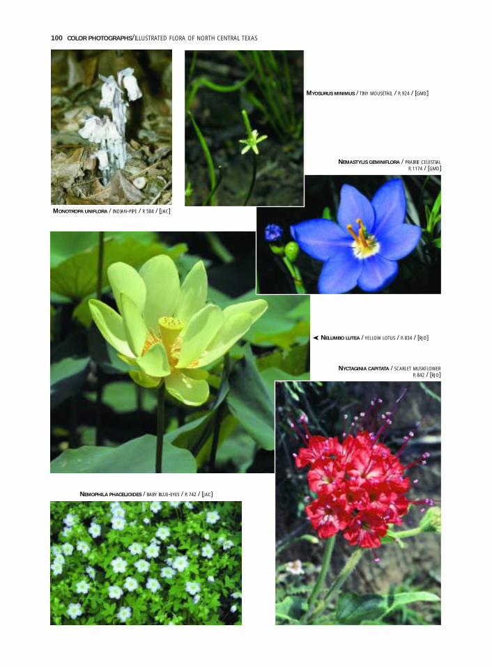
100 COLOR PHOTOGRAPHS/ILLUSTRATED FLORA OF NORTH CENTRAL TEXAS
MYOSURUS MINIMUS / TINY MOUSETAIL / P. 924 / [GMD]
NEMASTYLIS GEMINIFLORA / PRAIRIE CELESTIALP. 1174 / [GMD]
MONOTROPA UNIFLORA / INDIAN-PIPE / P. 584 / [JAC]
NELUMBO LUTEA / YELLOW LOTUS / P. 834 / [RJO]
NYCTAGINIA CAPITATA / SCARLET MUSKFLOWERP. 842 / [RJO]
NEMOPHILA PHACELIOIDES / BABY BLUE-EYES / P. 742 / [JAC]
➤
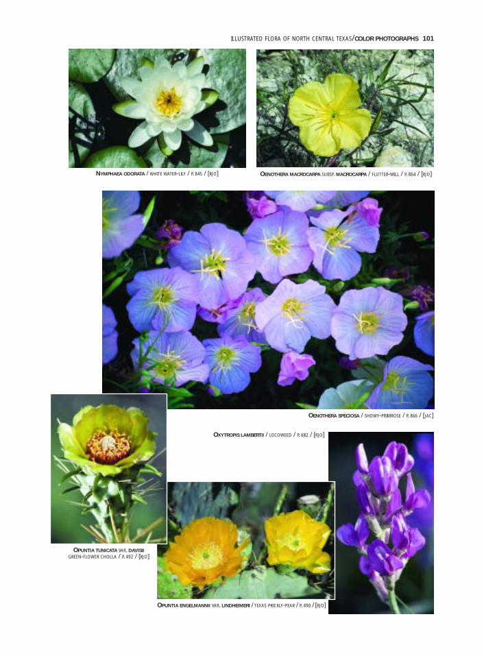
ILLUSTRATED FLORA OF NORTH CENTRAL TEXAS/COLOR PHOTOGRAPHS 101
OENOTHERA SPECIOSA / SHOWY-PRIMROSE / P. 866 / [JAC]
OPUNTIA ENGELMANNII VAR. LINDHEIMERI / TEXAS PRICKLY-PEAR / P. 490 / [RJO]
NYMPHAEA ODORATA / WHITE WATER-LILY / P. 845 / [RJO] OENOTHERA MACROCARPA SUBSP. MACROCARPA / FLUTTER-MILL / P. 864 / [RJO]
OPUNTIA TUNICATA VAR. DAVISIIGREEN-FLOWER CHOLLA / P. 492 / [RJO]
OXYTROPIS LAMBERTII / LOCOWEED / P. 682 / [RJO]
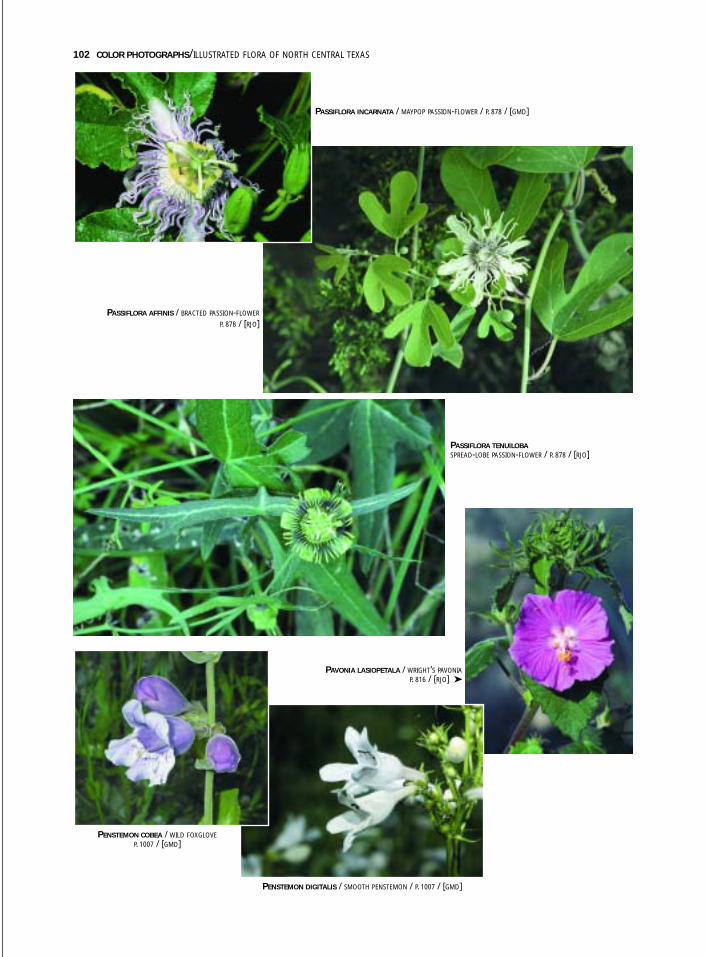
102 COLOR PHOTOGRAPHS/ILLUSTRATED FLORA OF NORTH CENTRAL TEXAS
PASSIFLORA AFFINIS / BRACTED PASSION-FLOWER
P. 878 / [RJO]
PASSIFLORA INCARNATA / MAYPOP PASSION-FLOWER / P. 878 / [GMD]
PASSIFLORA TENUILOBASPREAD-LOBE PASSION-FLOWER / P. 878 / [RJO]
PENSTEMON COBEA / WILD FOXGLOVEP. 1007 / [GMD]
PENSTEMON DIGITALIS / SMOOTH PENSTEMON / P. 1007 / [GMD]
PAVONIA LASIOPETALA / WRIGHT’S PAVONIAP. 816 / [RJO] ➤
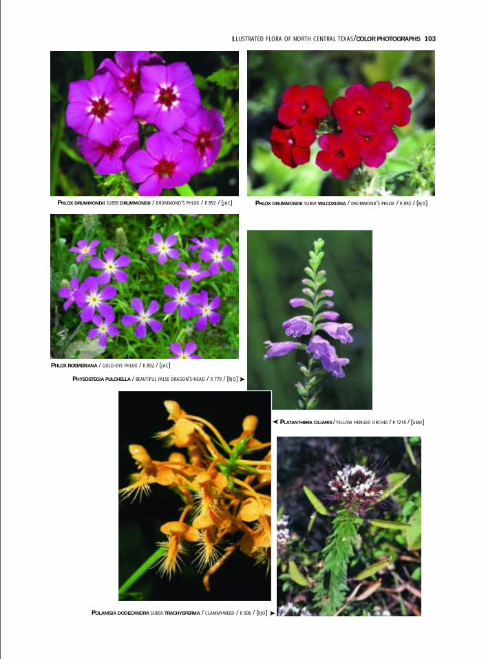
ILLUSTRATED FLORA OF NORTH CENTRAL TEXAS/COLOR PHOTOGRAPHS 103
PHLOX DRUMMONDII SUBSP. DRUMMONDII / DRUMMOND’S PHLOX / P. 892 / [JAC] PHLOX DRUMMONDII SUBSP. WILCOXIANA / DRUMMOND’S PHLOX / P. 892 / [RJO]
PHLOX ROEMERIANA / GOLD-EYE PHLOX / P. 892 / [JAC]
PHYSOSTEGIA PULCHELLA / BEAUTIFUL FALSE DRAGON’S-HEAD / P. 770 / [RJO]
PLATANTHERA CILIARIS / YELLOW FRINGED ORCHID / P. 1218 / [GMD]
POLANISIA DODECANDRA SUBSP. TRACHYSPERMA / CLAMMYWEED / P. 506 / [RJO]
➤
➤
➤
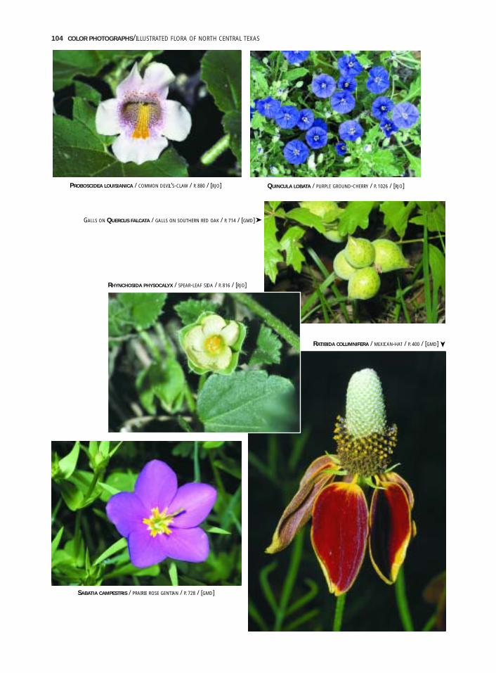
104 COLOR PHOTOGRAPHS/ILLUSTRATED FLORA OF NORTH CENTRAL TEXAS
QUINCULA LOBATA / PURPLE GROUND-CHERRY / P. 1026 / [RJO]
GALLS ON QUERCUS FALCATA / GALLS ON SOUTHERN RED OAK / P. 714 / [GMD]
RHYNCHOSIDA PHYSOCALYX / SPEAR-LEAF SIDA / P. 816 / [RJO]
RATIBIDA COLUMNIFERA / MEXICAN-HAT / P. 400 / [GMD]
SABATIA CAMPESTRIS / PRAIRIE ROSE GENTIAN / P. 728 / [GMD]
PROBOSCIDEA LOUISIANICA / COMMON DEVIL’S-CLAW / P. 880 / [RJO]
➤
➤
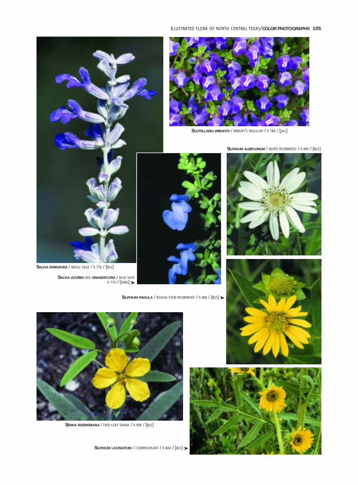
ILLUSTRATED FLORA OF NORTH CENTRAL TEXAS/COLOR PHOTOGRAPHS 105
SALVIA AZUREA VAR. GRANDIFLORA / BLUE SAGEP. 774 / [GMD] ➤
SCUTELLARIA WRIGHTII / WRIGHT’S SKULLCAP / P. 780 / [JAC]
SILPHIUM LACINIATUM / COMPASSPLANT / P. 404 / [RJO] ➤
SALVIA FARINACEA / MEALY SAGE / P. 776 / [RJO]
SENNA ROEMERIANA / TWO-LEAF SENNA / P. 696 / [RJO]
SILPHIUM ALBIFLORUM / WHITE ROSINWEED / P. 404 / [RJO]
SILPHIUM RADULA / ROUGH-STEM ROSINWEED / P. 406 / [RJO] ➤

SOLANUM CITRULLIFOLIUM / MELON-LEAF NIGHTSHADE / P. 1028 / [RJO] SOLANUM DIMIDIATUM / WESTERN HORSE-NETTLE / P. 1028 / [GMD]
SPHAERALCEA ANGUSTIFOLIA SUBSP. CUSPIDATANARROW-LEAF GLOBE-MALLOW / P. 820 / [RJO]
106 COLOR PHOTOGRAPHS/ILLUSTRATED FLORA OF NORTH CENTRAL TEXAS
SISYRINCHIUM PRUINOSUM / DOTTED BLUE-EYED-GRASS / P. 1178 / [GMD]
SOPHORA AFFINIS / EVE’S-NECKLACE / P. 697 / [GMD]

ILLUSTRATED FLORA OF NORTH CENTRAL TEXAS/COLOR PHOTOGRAPHS 107
TALINUM AURANTIACUM / ORANGE FLAMEFLOWER / P. 911 / [RJO]
SPIRANTHES LACERA VAR. GRACILIS / SLENDER LADIES’-TRESSES / P. 1220 / [GMD]
TALINUM CALYCINUM / ROCK-PINK / P. 911 / [GMD]
TEUCRIUM LACINIATUM / CUT-LEAF GERMANDER / P. 783 / [RJO]
TINANTIA ANOMALA / FALSE DAYFLOWER / P. 1101 / [RJO]
➤
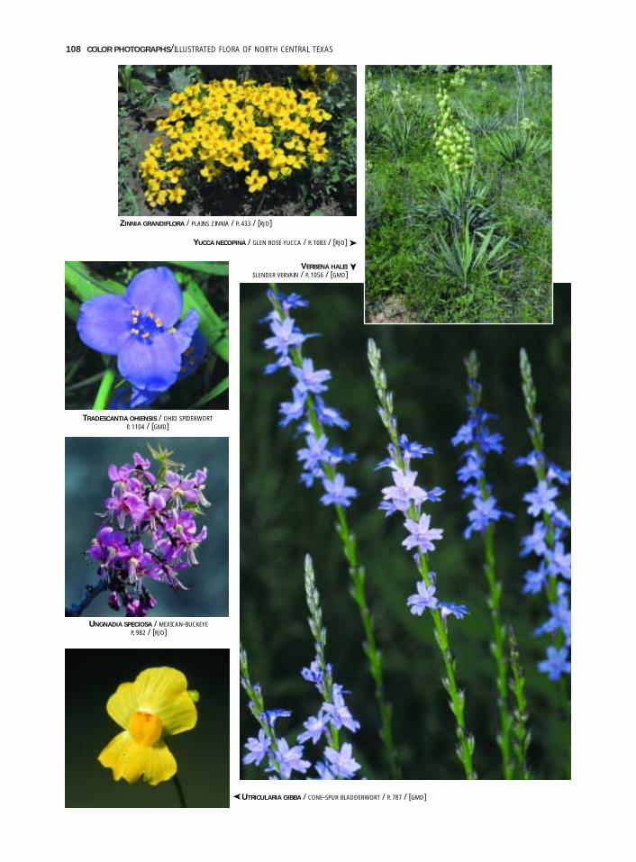
108 COLOR PHOTOGRAPHS/ILLUSTRATED FLORA OF NORTH CENTRAL TEXAS
ZINNIA GRANDIFLORA / PLAINS ZINNIA / P. 433 / [RJO]
YUCCA NECOPINA / GLEN ROSE YUCCA / P. 1083 / [RJO] ➤
VERBENA HALEISLENDER VERVAIN / P. 1056 / [GMD]
UTRICULARIA GIBBA / CONE-SPUR BLADDERWORT / P. 787 / [GMD]
UNGNADIA SPECIOSA / MEXICAN-BUCKEYEP. 982 / [RJO]
TRADESCANTIA OHIENSIS / OHIO SPIDERWORTP. 1104 / [GMD]
➤
➤