Flood risk analysis and assessment: Case Study Gleisdorf · Modul 2a Risk analysis and assessment...
50
1 Modul 2a Risk analysis and assessment for the city Gleisdorf, Styria Flood risk analysis and assessment: Case Study Gleisdorf H.P. Nachtnebel River room agenda Alpenraum
Transcript of Flood risk analysis and assessment: Case Study Gleisdorf · Modul 2a Risk analysis and assessment...
1Modul 2a Risk analysis and assessment for the city Gleisdorf, Styria
Flood risk analysis and assessment: Case Study
Gleisdorf
H.P. Nachtnebel
River room agenda
Alpenraum

2Modul 2a Risk analysis and assessment for the city Gleisdorf, Styria
Integrated Flood Risk Managament
Analysis of load Technical Technical Information Measures Measures Warning systems
Analysis of pot. Nontechnical Nontechnicaldamages- Measures Measures Evacuation
Risk Analysis Rescue Measures
Risk Assessment Increaseof Resistance
Reduction of Losses
Prepardness and Awareness
Implementation:Communication with the Public
Design AlternativesAcceptance (Social and Environmental Compatibility)
Construction Works
3Modul 2a Risk analysis and assessment for the city Gleisdorf, Styria
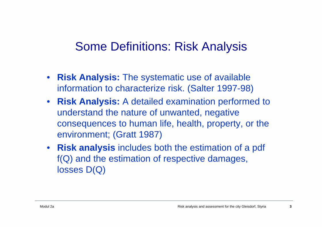
Some Definitions: Risk Analysis
• Risk Analysis: The systematic use of available information to characterize risk. (Salter 1997-98)
• Risk Analysis: A detailed examination performed to understand the nature of unwanted, negative consequences to human life, health, property, or the environment; (Gratt 1987)
• Risk analysis includes both the estimation of a pdf f(Q) and the estimation of respective damages, losses D(Q)
4Modul 2a Risk analysis and assessment for the city Gleisdorf, Styria
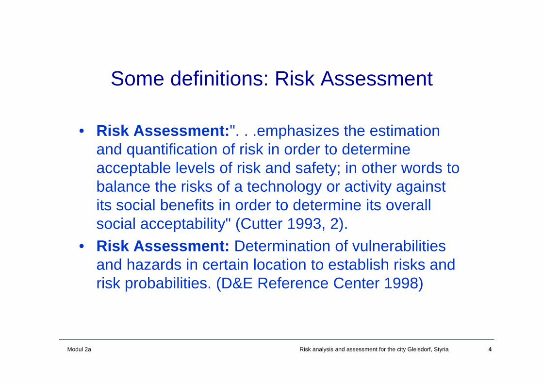
Some definitions: Risk Assessment
• Risk Assessment:". . .emphasizes the estimation and quantification of risk in order to determine acceptable levels of risk and safety; in other words to balance the risks of a technology or activity against its social benefits in order to determine its overall social acceptability" (Cutter 1993, 2).
• Risk Assessment: Determination of vulnerabilities and hazards in certain location to establish risks and risk probabilities. (D&E Reference Center 1998)
5Modul 2a Risk analysis and assessment for the city Gleisdorf, Styria
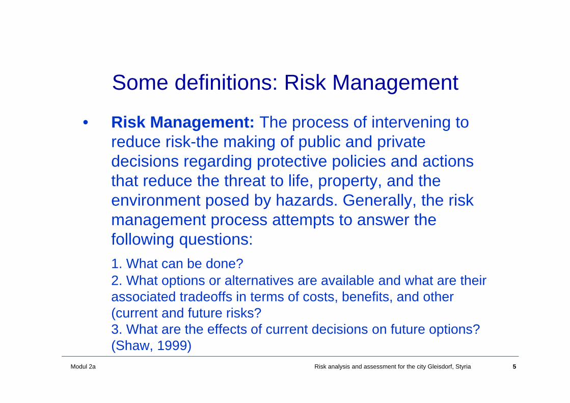
Some definitions: Risk Management
• Risk Management: The process of intervening to reduce risk-the making of public and private decisions regarding protective policies and actions that reduce the threat to life, property, and the environment posed by hazards. Generally, the risk management process attempts to answer the following questions:1. What can be done?2. What options or alternatives are available and what are their associated tradeoffs in terms of costs, benefits, and other (current and future risks?3. What are the effects of current decisions on future options? (Shaw, 1999)
6Modul 2a Risk analysis and assessment for the city Gleisdorf, Styria
Flood risk analysis and assessmentThe city of Gleisdorf (regional scale)
• Description of the area• Possible scenarios• Risk analysis• Measures• Conclusions
7Modul 2a Risk analysis and assessment for the city Gleisdorf, Styria
Methodology
• Analysis of flood risk in the city of Gleisdorfanalysis of previous floods (ex post analysis)
• Simulation of possible floods by using a rainfall-runoff model (ex ante analysis)
• Analysis of possible failure cases in the area• 2 D hydraulic model• Damage analysis and assessment• Possible measures for the diminution of the
damages
8Modul 2a Risk analysis and assessment for the city Gleisdorf, Styria
Impact Assessment
• Establishing a DTM• Generation of an incoming flood (hydrology)• Hydraulic model to calculate propagation of
flood in the project area• Calculation of inundated area, water depth
and flow velocity• Overlay with cadastre map• Identification of exposed objects• Classification of objects
9Modul 2a Risk analysis and assessment for the city Gleisdorf, Styria
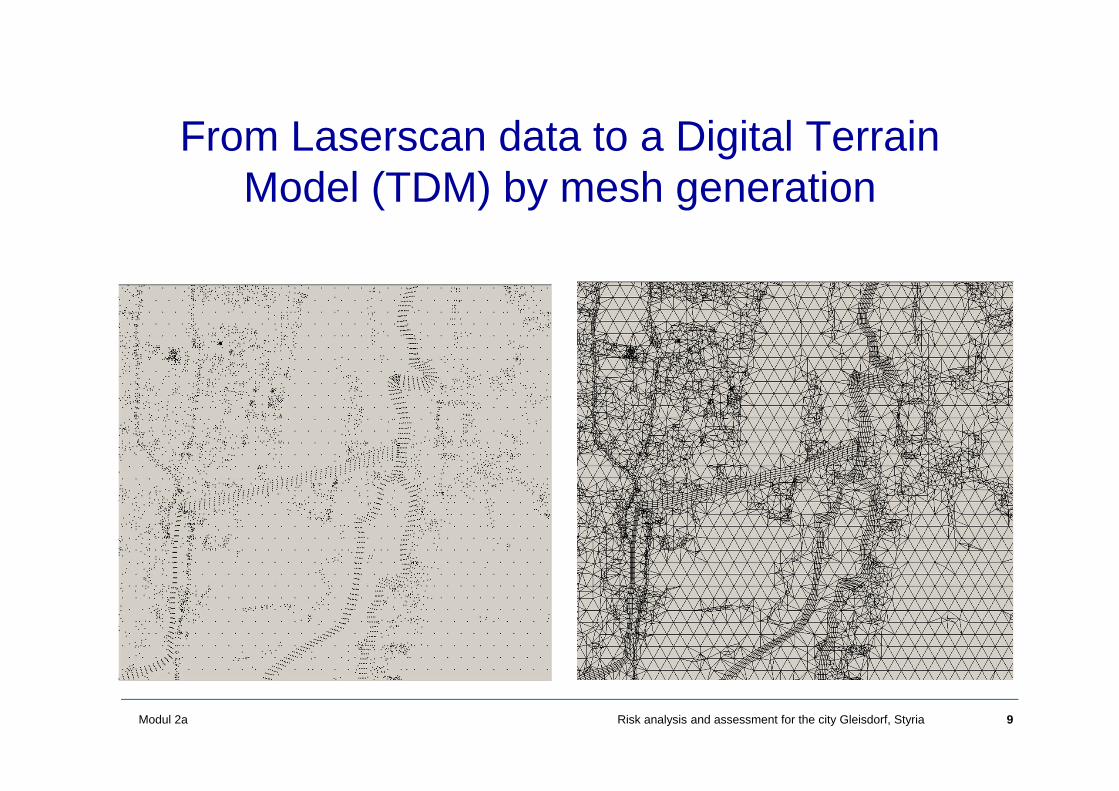
From Laserscan data to a Digital Terrain Model (TDM) by mesh generation
10Modul 2a Risk analysis and assessment for the city Gleisdorf, Styria
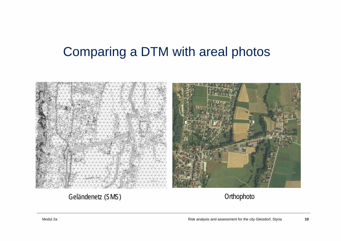
Comparing a DTM with areal photos
Geländenetz (SMS) Orthophoto
11Modul 2a Risk analysis and assessment for the city Gleisdorf, Styria
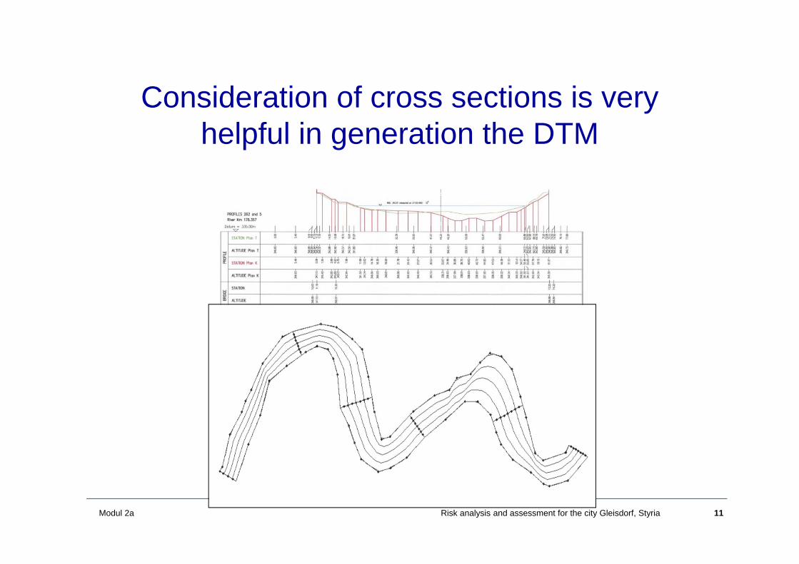
Consideration of cross sections is very helpful in generation the DTM

12Modul 2a Risk analysis and assessment for the city Gleisdorf, Styria
Initial and boundary conditions
• Initial conditions: water depth and flow velocity at t=0 an every location
• Boundary conditions: Inflow hydrograph
• Model parameters: roughness coefficients for each element

13Modul 2a Risk analysis and assessment for the city Gleisdorf, Styria
Results from the hydraulic model
• Water depth and flow velocity at each location (gridelement)
• Delineation of inundated areas and boundaries ofinundation
• Which scenarios (discharges) ?EU Flood risk directive
a frequent flood HQ30a HQ100an extreme event HQ300

14Modul 2a Risk analysis and assessment for the city Gleisdorf, Styria
Spatial distribution of water depth for a given time slice (0,1-2m)
15Modul 2a Risk analysis and assessment for the city Gleisdorf, Styria
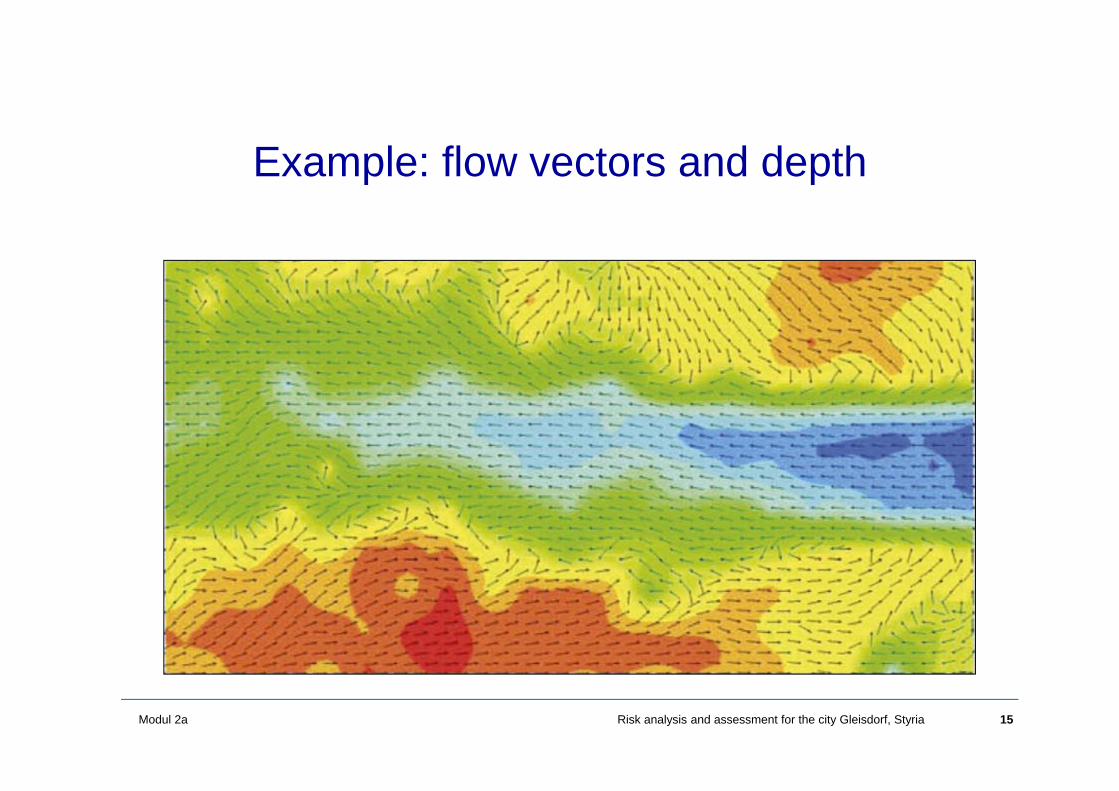
Example: flow vectors and depth
16Modul 2a Risk analysis and assessment for the city Gleisdorf, Styria
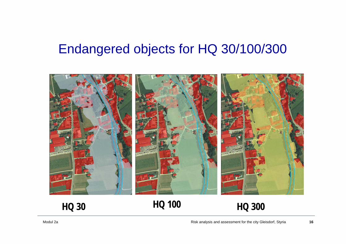
Endangered objects for HQ 30/100/300
HQ 30 HQ 100 HQ 300
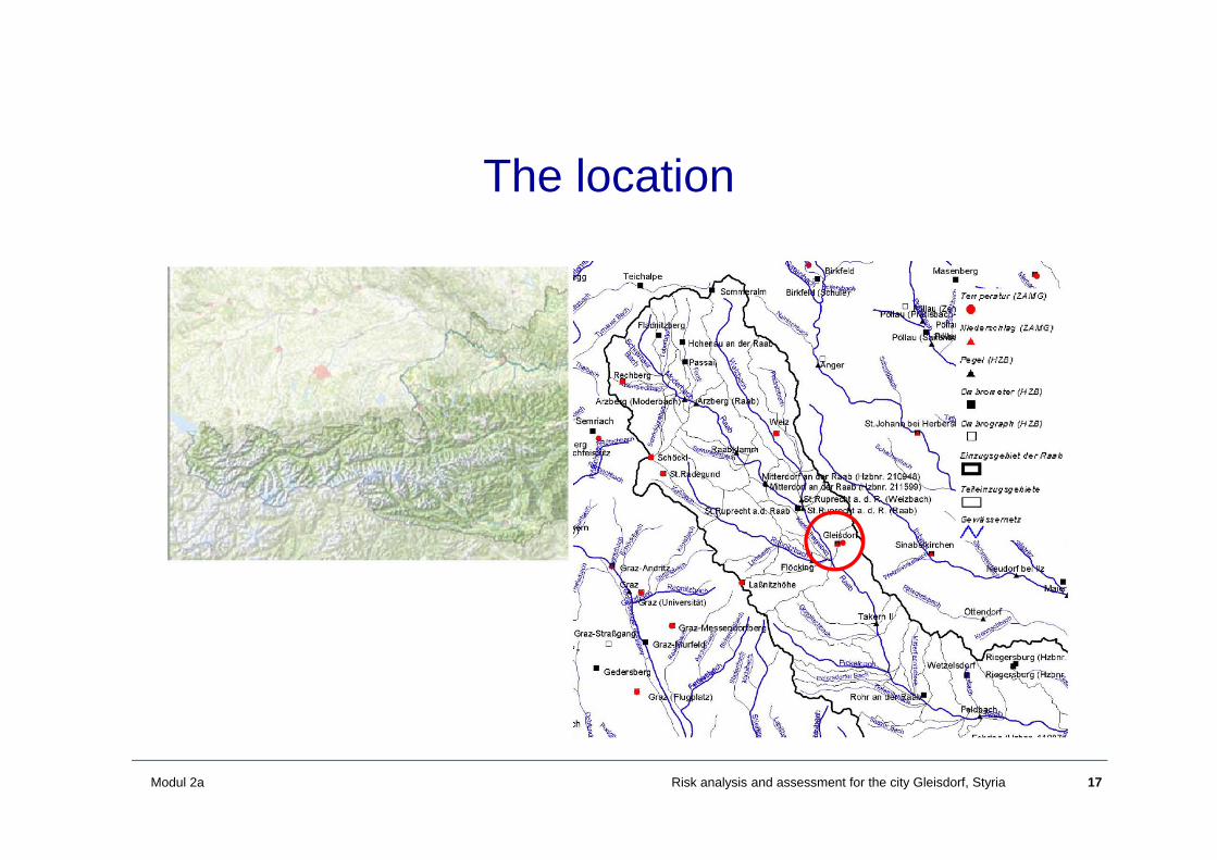
17Modul 2a Risk analysis and assessment for the city Gleisdorf, Styria
The location
18Modul 2a Risk analysis and assessment for the city Gleisdorf, Styria
Analysis of the younger history
• Hydrology• Urban development

19Modul 2a Risk analysis and assessment for the city Gleisdorf, Styria
Analysis of the Flood Series
Flood series Feldbach
0
50
100
150
200
250
1951 1956 1961 1966 1971 1976 1981 1986 1991 1996 2001
Annu
al m
axim
a of
the
drai
n Q
[ m
3 /s
]
HQ Trend straight
3

20Modul 2a Risk analysis and assessment for the city Gleisdorf, Styria
Analysis of the Flood Series
Flood series Feldbach
Flood series Takern
0
50
100
150
200
250
1951 1956 1961 1966 1971 1976 1981 1986 1991 1996 2001
Annu
al m
axim
a of
the
drai
n Q
[ m
3 /s
]
HQ Trend straight
0
20
40
60
80
100
120
140
160
1968 1974 1979 1984 1989 1994 1999 2004
Annu
al m
axim
a of
the
drai
n Q
[ m
3 /s
]
HQ Trend straight
21Modul 2a Risk analysis and assessment for the city Gleisdorf, Styria
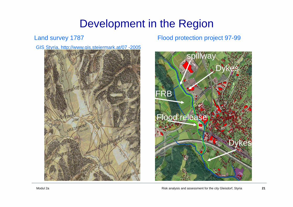
Development in the RegionLand survey 1787GIS Styria, http://www.gis.steiermark.at/07 -2005
Dykes
FRB
spillway
Dykes
Flood protection project 97-99
Flood release

22Modul 2a Risk analysis and assessment for the city Gleisdorf, Styria
• The goal was a protection level of HQ100
• Protection of 233 objects and 130 hectares
Inundation area before 1999
Raab: Qmax = 200 m3/sRabnitz: Qmax = 40 m3/s
Newly developed firms
23Modul 2a Risk analysis and assessment for the city Gleisdorf, Styria
Development within the last few years
• After implementation of the flood protection scheme an intensive development in the valley started
• Construction of some industrial plants• Valley is crossed by several traffic lines: pedestrian,
road, highway, and railway bridge

24Modul 2a Risk analysis and assessment for the city Gleisdorf, Styria
Scenarios
What would be the situation without any flood protection?What is it like today?Log-jams at bridgesHQ300 floodHQ1000 floodHQ5000 (comparable to the flood in 2002)
25Modul 2a Risk analysis and assessment for the city Gleisdorf, Styria
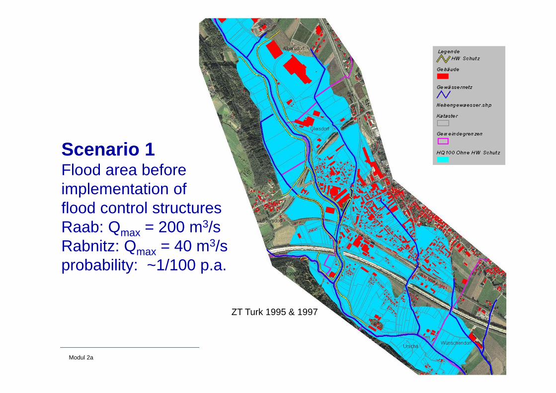
Scenario 1Flood area before implementation of flood control structuresRaab: Qmax = 200 m3/sRabnitz: Qmax = 40 m3/sprobability: ~1/100 p.a.
ZT Turk 1995 & 1997

26Modul 2a Risk analysis and assessment for the city Gleisdorf, Styria
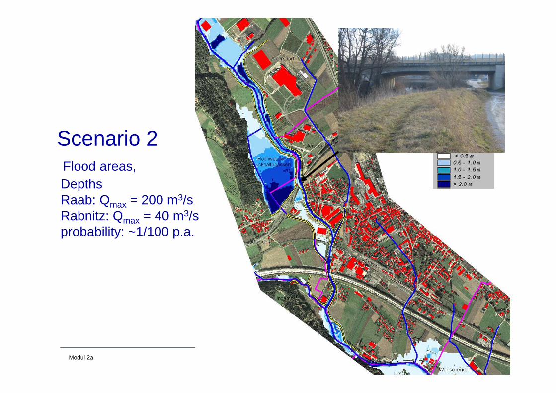
Scenario 2Flood areas,DepthsRaab: Qmax = 200 m3/sRabnitz: Qmax = 40 m3/sprobability: ~1/100 p.a.
27Modul 2a Risk analysis and assessment for the city Gleisdorf, Styria
Scenario 2Flood areas,DepthsRaab: Qmax = 200 m3/sRabnitz: Qmax = 40 m3/sprobability: ~1/100 p.a.
28Modul 2a Risk analysis and assessment for the city Gleisdorf, Styria
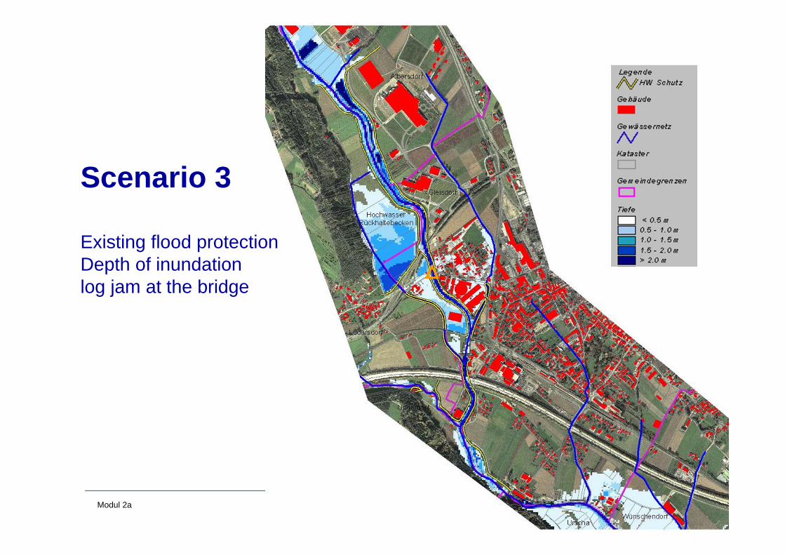
Scenario 3
Existing flood protectionDepth of inundationlog jam at the bridge
29Modul 2a Risk analysis and assessment for the city Gleisdorf, Styria
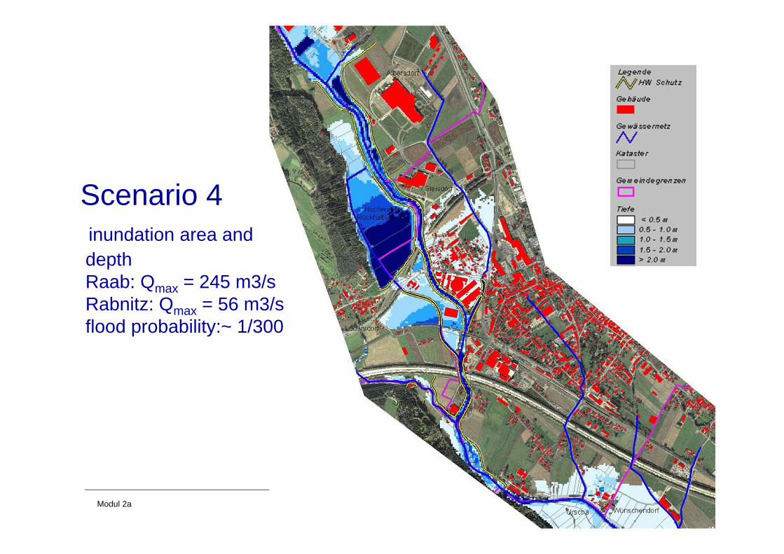
Scenario 4inundation area anddepthRaab: Qmax = 245 m3/sRabnitz: Qmax = 56 m3/sflood probability:~ 1/300
30Modul 2a Risk analysis and assessment for the city Gleisdorf, Styria
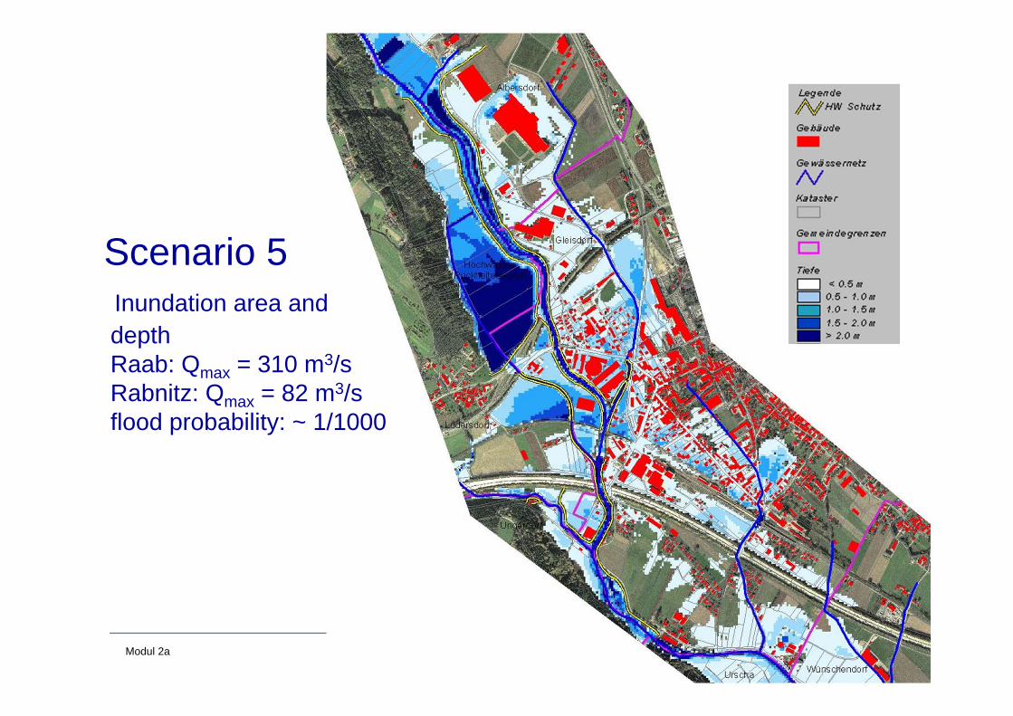
Scenario 5Inundation area and depth Raab: Qmax = 310 m3/sRabnitz: Qmax = 82 m3/sflood probability: ~ 1/1000
31Modul 2a Risk analysis and assessment for the city Gleisdorf, Styria
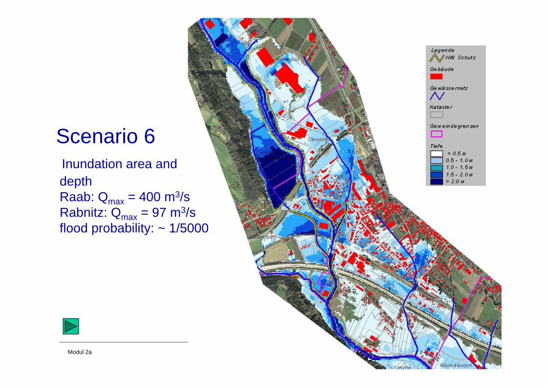
Scenario 6Inundation area anddepthRaab: Qmax = 400 m3/sRabnitz: Qmax = 97 m3/sflood probability: ~ 1/5000
32Modul 2a Risk analysis and assessment for the city Gleisdorf, Styria
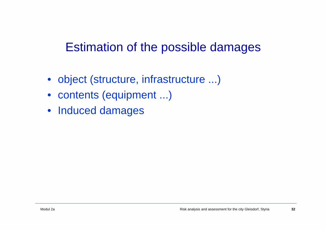
Estimation of the possible damages
• object (structure, infrastructure ...)• contents (equipment ...)• Induced damages
33Modul 2a Risk analysis and assessment for the city Gleisdorf, Styria
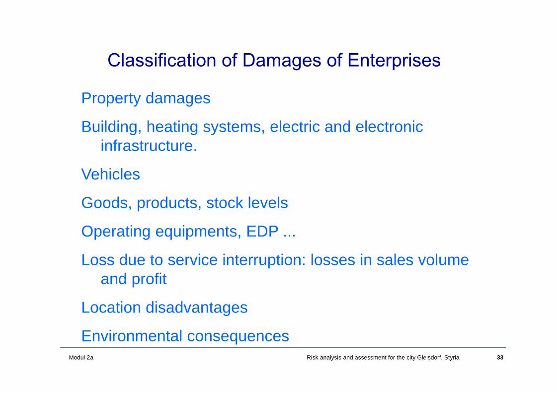
Property damages
Building, heating systems, electric and electronic infrastructure.
Vehicles
Goods, products, stock levels
Operating equipments, EDP ...
Loss due to service interruption: losses in sales volume and profit
Location disadvantages
Environmental consequences
Classification of Damages of Enterprises
34Modul 2a Risk analysis and assessment for the city Gleisdorf, Styria
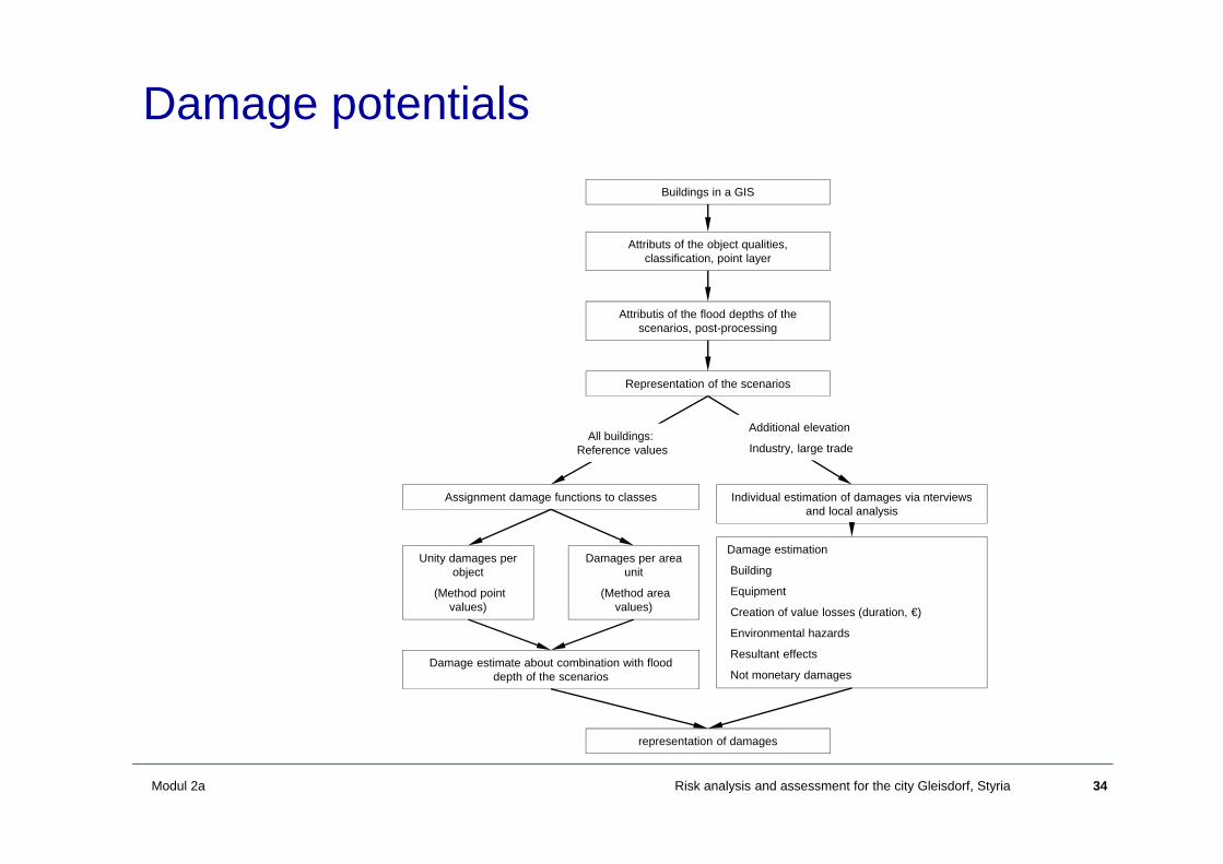
Damage potentialsBuildings in a GIS
Representation of the scenarios
Assignment damage functions to classes Individual estimation of damages via nterviews and local analysis
Damage estimation
Building
Equipment
Creation of value losses (duration, €)
Environmental hazards
Resultant effects
Not monetary damages Damage estimate about combination with flood
depth of the scenarios
Unity damages per object
(Method point values)
representation of damages
Additional elevation
Industry, large trade All buildings:
Reference values
Attributs of the object qualities, classification, point layer
Damages per area unit
(Method area values)
Attributis of the flood depths of the scenarios, post-processing
35Modul 2a Risk analysis and assessment for the city Gleisdorf, Styria
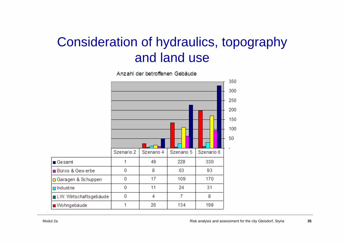
Consideration of hydraulics, topography and land use
36Modul 2a Risk analysis and assessment for the city Gleisdorf, Styria
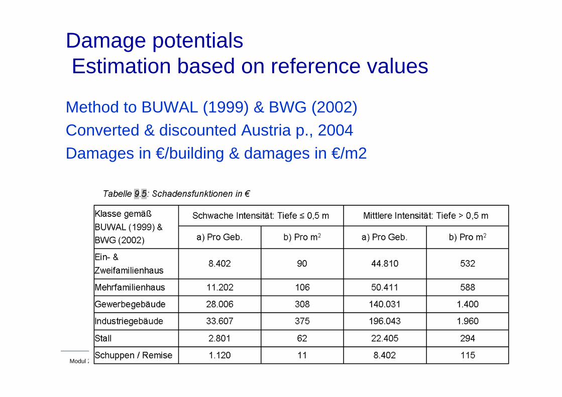
Damage potentialsEstimation based on reference values
Method to BUWAL (1999) & BWG (2002)Converted & discounted Austria p., 2004Damages in €/building & damages in €/m2
37Modul 2a Risk analysis and assessment for the city Gleisdorf, Styria
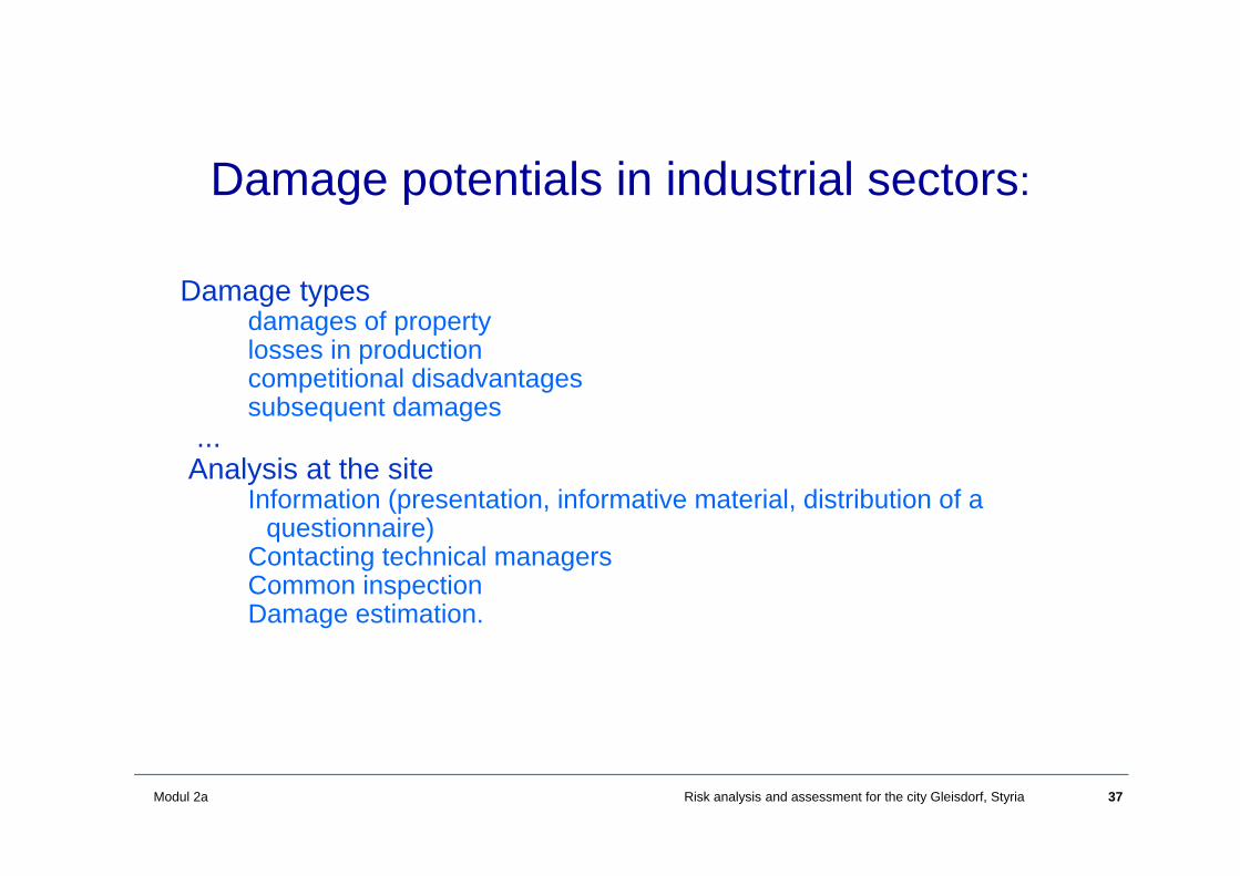
Damage potentials in industrial sectors:
Damage typesdamages of propertylosses in productioncompetitional disadvantagessubsequent damages
...Analysis at the site
Information (presentation, informative material, distribution of a questionnaire)
Contacting technical managersCommon inspectionDamage estimation.

38Modul 2a Risk analysis and assessment for the city Gleisdorf, Styria
Estimation of damage potentials
Questionnaire
1st what can happen?
2nd description in monetary units
3rd mitigation
39Modul 2a Risk analysis and assessment for the city Gleisdorf, Styria
Damage potential in the industrial sector:Results from interviews
10 companies respondedamong them the 4 largest ones:
Management and insurance companies are interested one company: internal mitigation measuressome of them have an insurance: property and losses in productionsensible topic (losses when the companies vulnerability would be identified from outside)difficult to get reliable response from the companies

40Modul 2a Risk analysis and assessment for the city Gleisdorf, Styria
Measures to reduce losses:
• Protection of objects (houses)• Protection of companies (internally organised)• Information, raising the awarness• insurance• Reduction of sensible points in the region• Dikes should be redesigned (inundable) and
consideration of runoff in the Hinterland
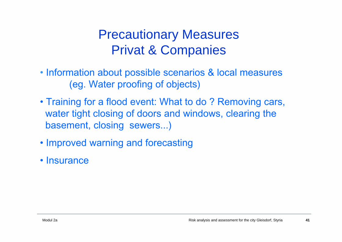
41Modul 2a Risk analysis and assessment for the city Gleisdorf, Styria
• Information about possible scenarios & local measures (eg. Water proofing of objects)
• Training for a flood event: What to do ? Removing cars, water tight closing of doors and windows, clearing the basement, closing sewers...)
• Improved warning and forecasting
• Insurance
Precautionary Measures Privat & Companies
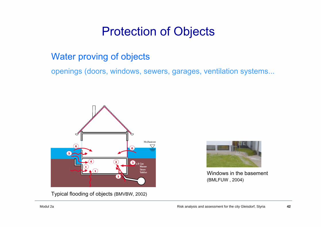
42Modul 2a Risk analysis and assessment for the city Gleisdorf, Styria
Water proving of objectsopenings (doors, windows, sewers, garages, ventilation systems...
Protection of Objects
Typical flooding of objects (BMVBW, 2002)
Windows in the basement (BMLFUW , 2004)
43Modul 2a Risk analysis and assessment for the city Gleisdorf, Styria
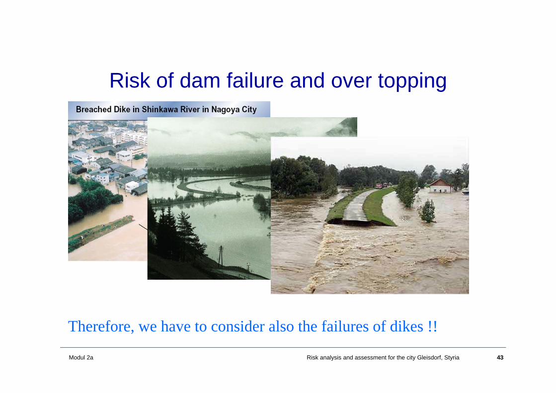
Risk of dam failure and over topping
Therefore, we have to consider also the failures of dikes !!
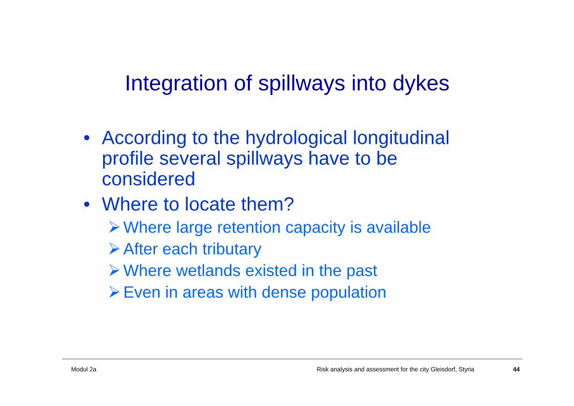
44Modul 2a Risk analysis and assessment for the city Gleisdorf, Styria
Integration of spillways into dykes
• According to the hydrological longitudinal profile several spillways have to beconsidered
• Where to locate them?Where large retention capacity is availableAfter each tributaryWhere wetlands existed in the pastEven in areas with dense population
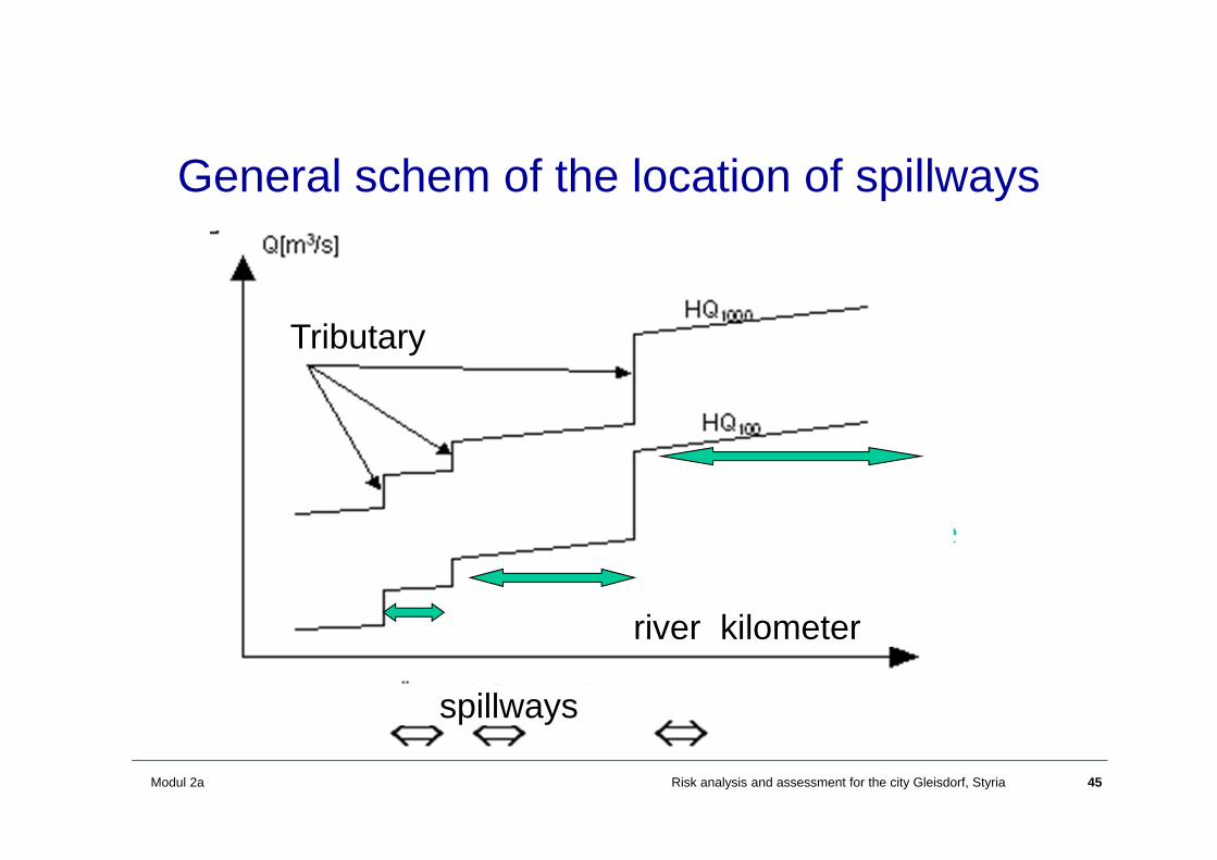
45Modul 2a Risk analysis and assessment for the city Gleisdorf, Styria
General schem of the location of spillways
Wirkungsbereiche
spillways
river kilometer
Tributary
46Modul 2a Risk analysis and assessment for the city Gleisdorf, Styria
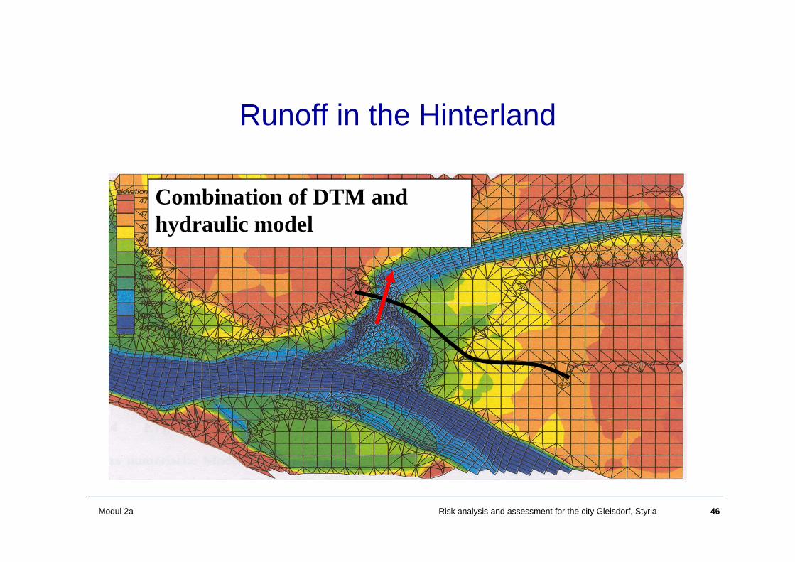
Runoff in the Hinterland
Combination of DTM and hydraulic model

47Modul 2a Risk analysis and assessment for the city Gleisdorf, Styria
Spillways for Dikes
• If possible, simple spillways over a fixed dam crest
• Reduces the uncertainty in g(X*), inundation starts slowly, we know where and when and what happens in the Hinterland, and therefore lower damages will result
X*Flood water table
Dam crest
48Modul 2a Risk analysis and assessment for the city Gleisdorf, Styria
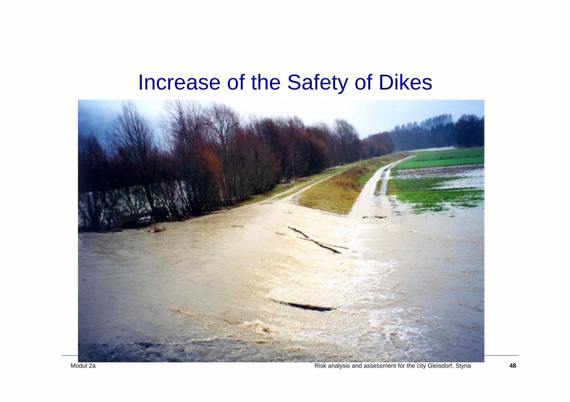
Increase of the Safety of Dikes
• Hochwasserschutz an der Gail• Überströmstrecken bei Rückstaudeichen an
der Donau (Wallsee, Altenwörth, Greifenstein..
49Modul 2a Risk analysis and assessment for the city Gleisdorf, Styria
Summary and Conclusions
• Flood risk analysis• Flood risk assessment methodology for the village of
Gleisdorf• Generation of scenarios• A methodology for the assessment of damages
(consideration of national and international documents)• Information of the public is also required
50Modul 2a Risk analysis and assessment for the city Gleisdorf, Styria
Thank you for your attention !!