
Flood Protection Works Inspection Guide - British Columbia · 1948 Fraser Matsqui bridge collapse,...
44
Flood Protection Works Inspection Guide Public Safety Section Water Management Branch Province of British Columbia Ministry of Environment Lands and Parks March 2000
Transcript of Flood Protection Works Inspection Guide - British Columbia · 1948 Fraser Matsqui bridge collapse,...

FloodProtectionWorksInspectionGuide
Public Safety Section
Water Management Branch
Province of British Columbia
Ministry of Environment Lands and Parks
March 2000

Canadian Cataloguing in Publication Data
Main entry under title:
Flood protection works inspection guide
Includes bibliographical references: p.44
ISBN 0-7726-4183-8
1. Dikes (Engineering) - Inspection - British Columbia. I.
British Columbia. Water Management Branch. Public Safety Section.
TC337.F56 2000 627’.42’0288 C00-960101-5

Contents
1. Introduction . . . . . . . . . . . . . . . . . . . . . . . . . . . . . . . . . . . . 11.1 Historical Dike Failures in British Columbia . . . . . . . . . . . . . . . . . . . . . . 2
2. Scheduling Inspections . . . . . . . . . . . . . . . . . . . . . . . . . . . . . 32.1 Regular Inspections . . . . . . . . . . . . . . . . . . . . . . . . . . . . . . . . . . . 3
2.1.1 Annual Inspections . . . . . . . . . . . . . . . . . . . . . . . . . . . . . . . . . 3
2.1.2 Low Water Inspections . . . . . . . . . . . . . . . . . . . . . . . . . . . . . . . 3
2.2 Special Inspections . . . . . . . . . . . . . . . . . . . . . . . . . . . . . . . . . . . 3
2.2.1 High Water Patrol Inspections . . . . . . . . . . . . . . . . . . . . . . . . . . . 3
2.2.2 Post-Flood Inspections and Evaluations . . . . . . . . . . . . . . . . . . . . . . 3
2.2.3 Post-Earthquake Inspections . . . . . . . . . . . . . . . . . . . . . . . . . . . . 4
3. Inspection Methods. . . . . . . . . . . . . . . . . . . . . . . . . . . . . . . . 43.1 Inspection of the Dike Fill . . . . . . . . . . . . . . . . . . . . . . . . . . . . . . . . 4
3.2 Erosion Protection Works . . . . . . . . . . . . . . . . . . . . . . . . . . . . . . . . 4
3.3 Appurtenant Structures . . . . . . . . . . . . . . . . . . . . . . . . . . . . . . . . . 4
4. Pre-Inspection Activities . . . . . . . . . . . . . . . . . . . . . . . . . . . . . 54.1 Planning . . . . . . . . . . . . . . . . . . . . . . . . . . . . . . . . . . . . . . . . . 5
4.2 Equipment . . . . . . . . . . . . . . . . . . . . . . . . . . . . . . . . . . . . . . . . 5
4.3 Personal safety. . . . . . . . . . . . . . . . . . . . . . . . . . . . . . . . . . . . . . 6
5. Record Keeping. . . . . . . . . . . . . . . . . . . . . . . . . . . . . . . . . . 65.1 Flood Protection Inspection Report . . . . . . . . . . . . . . . . . . . . . . . . . . . 7
5.2 High Water Patrol Log . . . . . . . . . . . . . . . . . . . . . . . . . . . . . . . . . . 7
6. Field Guides for Inspection and Reporting . . . . . . . . . . . . . . . . . . . 86.1 Flood Protection Works Basic Inspection Checklist . . . . . . . . . . . . . . . . . . 8
6.2 Guide for Identifying Problems in Dike Fill . . . . . . . . . . . . . . . . . . . . . . 10
6.2 Guide for Identifying Problems in Erosion Protection Works . . . . . . . . . . . . 13
6.4 Guide for Identifying Problems in Appurtenant Works . . . . . . . . . . . . . . . . 16
6.5 Post-Earthquake Problems. . . . . . . . . . . . . . . . . . . . . . . . . . . . . . . 18
6.6 Flood Protection Inspection Report . . . . . . . . . . . . . . . . . . . . . . . . . . 19
6.7 High Water Patrol Log . . . . . . . . . . . . . . . . . . . . . . . . . . . . . . . . . 21
7. Further Information . . . . . . . . . . . . . . . . . . . . . . . . . . . . . . . 227.1 Contacts - Regional Deputy Inspectors of Dikes . . . . . . . . . . . . . . . . . . . 22
7.2 References . . . . . . . . . . . . . . . . . . . . . . . . . . . . . . . . . . . . . . . 23

Appendices
Appendix 1: Terminology . . . . . . . . . . . . . . . . . . . . . . . . . . . . . . . . . . . 24
Appendix 2: Discussion of Typical Issues Affecting Flood Protection Works . . . . . . . 28
Loss of Freeboard/Overtopping . . . . . . . . . . . . . . . . . . . . . . . . . . . . . . 28
Settlement/Depressions . . . . . . . . . . . . . . . . . . . . . . . . . . . . . . . . . . 29
Seepage/Piping. . . . . . . . . . . . . . . . . . . . . . . . . . . . . . . . . . . . . . . 30
Cracking . . . . . . . . . . . . . . . . . . . . . . . . . . . . . . . . . . . . . . . . . . 30
Slope Instability. . . . . . . . . . . . . . . . . . . . . . . . . . . . . . . . . . . . . . . 32
Slides . . . . . . . . . . . . . . . . . . . . . . . . . . . . . . . . . . . . . . . . . . . 32
Uncontrolled Vegetative Growth . . . . . . . . . . . . . . . . . . . . . . . . . . . . . . 33
Animals/Rodent Activity . . . . . . . . . . . . . . . . . . . . . . . . . . . . . . . . . . 33
Toe Scour. . . . . . . . . . . . . . . . . . . . . . . . . . . . . . . . . . . . . . . . . . 34
Changing river flow patterns . . . . . . . . . . . . . . . . . . . . . . . . . . . . . . . . 34
Outflanking . . . . . . . . . . . . . . . . . . . . . . . . . . . . . . . . . . . . . . . . . 35
Ice and Floating Logs (Trees) . . . . . . . . . . . . . . . . . . . . . . . . . . . . . . . 35
Degrading (Weathering) . . . . . . . . . . . . . . . . . . . . . . . . . . . . . . . . . . 35
Floodboxes . . . . . . . . . . . . . . . . . . . . . . . . . . . . . . . . . . . . . . . . . 36
Pumps and Pumping Stations . . . . . . . . . . . . . . . . . . . . . . . . . . . . . . . 37
Relief Wells . . . . . . . . . . . . . . . . . . . . . . . . . . . . . . . . . . . . . . . . . 37
Concrete Deterioration . . . . . . . . . . . . . . . . . . . . . . . . . . . . . . . . . . . 37
Possible Effects of Earthquakes . . . . . . . . . . . . . . . . . . . . . . . . . . . . . . 38
Inspecting a Floodbox

1. Introduction
The purpose of this guide is to assist in the inspection
of dikes and related flood control structures. A regular
program of dike inspection can identify potentially
critical conditions and facilitate maintenance in
advance of high water periods. Routine observations,
recording and reporting, followed by repairs will
ensure that flood protection structures operate
effectively and safely.
This guide focuses on field identification of conditions
that might jeopardize the safety of the dike. It also
provides information on scheduling inspections,
inspection methods and tips, and record keeping
methods that assist with ongoing monitoring of
changing conditions and with maintenance scheduling
and tracking. Depending on the
nature of the problem, it may be
necessary to initiate regular
maintenance and repairs,
monitoring, immediate interim
measures or additional
investigation. While there are a
number of possible actions
outlined in Appendix 2 that could
be considered to remedy critical
conditions, the focus is to help
inspectors identify and record
visual indicators of potential problems as opposed to
providing diagnoses or specific solutions. In many
cases, expert advice may be required to fully assess the
condition and recommend the appropriate action.
The Guide is organized according to the following
format:
Inspection Scheduling and Methods
Field Guides and Report Forms
Contact and Reference Information
Appendix 2 provides a more detaileddiscussion of typical dike issues.
Flood Protection Works Inspection Guide 1
Riverside Toe
Water Level
Freeboard Dike(Embankement)
Fill
Landside Slope
Dike Height
Original Ground Line
Landside Toe
Landside Shoulder
Dike Crest
Riverside Shoulder

1.1 Historical Dike Failures inBritish Columbia
Dike inspections are aimed at identifying developing
problems in advance allowing time for appropriate
action. Examining conditions that contributed to past
dike failures can help inspectors identify potential
future problems. The table below lists reasons for dike
failure in British Columbia from as early as 1894. As
can be inferred from looking at the causes, many
failures could have been prevented; routine inspections
and accompanying maintenance programs are a key
component in prevention. Typical dike issues are
discussed further in Appendix 2.
2 BC Ministry of Environment, Lands and Parks – Water Management Branch
Date Stream Place Cause
1894 Fraser numerous overtopping, erosion, seepage
1935 Sumas Nooksack ice jam
1935 Nicomekl/ Serpentine ice storm
May 28, 1948 Fraser Nicomen Island seepage (tree?)
June 3, 1948 Fraser Hatzic seepage
1948 Fraser Sumas seepage
1948 Alouette Pitt Meadows bank beaver
1948 Alouette Pitt Meadows bank beaver
1948 Pitt Pitt Meadows bank beaver
1948 Fraser Matsqui bridge collapse, erosion
1948 Fraser Chilliwack trees, lack of access
1948 Sumas Prairie tree collapse
June 7, 1948 Kootenay R. Reclamation DD unknown
June 7, 1948 Kootenay R. Creston DD collapse
Winter, 1948 Fraser Westham Island high tides, winds
1955 Coquitlam Colony Farm east overtopping, erosion
1960 Fraser Kent floodbox washed out
1968 Bella Coola Airport dike breach
1972 N. Thompson Oak Hills piping
Nov. 21, 1972 Nicomekl nr. Crescent Beach animal holes/piping?
Dec. 1973 Koksilah Dinsdale Farm overtopping
Dec. 1975? Vedder Yarrow overtopping
1980 Stawamus Squamish unknown
March 19, 1980 Pitt R. Coquitlam DD collapse/pipe seepage
Dec. 16, 1982 Serpentine surge/tide overtopping
Dec. 16, 1982 Mud Bay surge/tide overtopping
Dec. 16, 1982 Georgia Strait Westham Island surge/tide overtopping
Dec. 16, 1982 Boundary Bay Crescent Beach surge/tide overtopping
1984 Lillooet/ Miller Pemberton overtopping
Nov. 1990 Sumas overflows from Nooksack
Nov. 1990 Vedder Railway collapse: overflow structure
Aug. 1991 Green Pemberton erosion/slumping
Aug. 1991 Cheakamus Outdoor School overtopping
June 1995 Coal Fernie erosion, tree/debris battering
June 1995 Michel Sparwood erosion, bridge collapse
Dec. 1995 Tulameen Princeton overtopping
Dec. 1995 Mission Kelowna ice-jam overtopping

2. Scheduling Inspections
Inspections are critical for identifying problems and
planning corrective actions. A dike is an active
structure, constructed of materials that are subject to
various stresses that may lead to deterioration and risk
of failure. An inspection program to observe, record
and report on the flood protection system should start
during construction and continue on a regular basis
throughout its operation. Effective management of a
dike system involves inspections at several times of the
year, coinciding with water events. The program is
usually described in the Operation and Maintenance
Manual for the flood protection works. Inspection
scheduling, methods, preparation, and record keeping
are discussed below.
2.1 Regular Inspections
2.1.1 Annual Inspections
At least once a year the entire diking system should be
inspected in detail by the Diking Authority for routine
maintenance purposes. This inspection should be
scheduled prior to the high flow season, and early
enough to allow adequate time for any required work
to be completed prior to possible flood events. In some
northern interior regions, this inspection may have to
be carried out in the previous summer or fall as snow
conditions in spring may make it impossible to inspect
the system just prior to the flood period. The
inspection should note and record any conditions that
might affect the performance of the flood protection
system.
2.1.2 Low Water Inspections
This inspection should be undertaken each year when
the river water levels or ocean tides reach their lowest
annual levels. During this period, areas of the dike fill,
bank protection and some of the appurtenant structures
(pump intake chambers, floodboxes, gates, conduit
interiors, etc.) that are normally under water, are
exposed making inspection much easier.
2.2 Special InspectionsSpecial inspections may be needed at other times of
the year to monitor and react to particular situations
such as storms, ice jamming, reports of vandalism, or
construction activity on or near the dike. Construction
activity should be observed to confirm that accepted
engineering practices are being followed (compaction,
placement of cut-off walls, etc.). A record should be
kept of what was done, by whom, and the cost. This
information may be needed to provide evidence should
structural failures occur in the future.
2.2.1 High Water Patrol Inspections
Patrol inspections should be carried out during high
water events to monitor the performance of the flood
control works and emphasize early detection of
problems resulting from increased hydraulic pressure
(seepage, boils, etc.), increased potential for erosion of
materials, and increased chance of reduced freeboard
(observed from gauge readings). During high water
events, local water level gauges should be monitored
regularly and the readings recorded to assess changing
conditions and for future reference. Dike patrol
frequency should increase as flow and/or water levels
approach critical conditions, and should be continuous
while the level is within about 1.0 m of the dike crest.
The patrol crews are to observe, mark, record and
submit reports similar to the High Water Patrol Log in
Section 6.7 (to the Diking Authority) for any
conditions or occurrences that could signal a
weakening or malfunction of any component of the
flood control system. Refer to the Operation and
Maintenance Manual and the Flood Planning and
Response Guide for BC for further information.
2.2.2 Post-Flood Inspections andEvaluations
Inspection of the protective works should be
undertaken after flood events. A complete high water
profile along the dike should be obtained after
significant flow events to assess the dike crest level
and the amount of freeboard. Changes in the river
channel should be noted not only for the reach adjacent
Flood Protection Works Inspection Guide 3

to the flood protection works but for areas both
upstream and downstream such as any new locations
of log jams, streambed aggradation (gravel
accumulation) and degradation (gravel scour) areas,
weakened or damaged areas, and the condition of all
appurtenant works.
2.2.3 Post-Earthquake Inspections
This type of inspection should be integrated with local
emergency plans. A rapid initial overall assessment of
the entire flood protection system should be
undertaken to determine what level of protection it still
offers and if there is an immediate danger of secondary
damage (i.e. next high tide could overtop, causing
widespread flooding). When the immediate threat is
determined and addressed, a detailed inspection should
be undertaken of the entire dike, erosion protection and
appurtenant works. The functionality of individual
structures should be checked in detail as follow up. A
detailed inspection and evaluation of the system by a
suitably qualified professional engineer may be
advisable because damage may not be readily visible.
Identification of areas prone to earthquake damage in
advance will aid assessment after an event.
3. Inspection Methods
Inspections should emphasize complete examination of
all aspects of the works.
A flood protection system is only as good as its
weakest link.
3.1 Inspection of the Dike FillThe usual method of inspecting the dike fill is to walk
along both crest edges (shoulders) and the landside toe,
in order to see the entire surface area clearly. Details
can usually be seen for a distance of 3 to 10 metres
depending on the roughness of the surface, vegetation,
or other surface conditions. The riverside toe is
inspected in the same manner as the landside toe for
set-back dikes, however for riverside dikes without
erosion protection, walking along the slope just above
the current water level can prove challenging and may
be more efficiently done from a boat.
3.2 Erosion Protection WorksThe structure of most types of erosion protection
works makes walking over them difficult and
somewhat hazardous. It may be easier to identify
problems from across the river using binoculars or
from a boat when closer observations are necessary.
3.3 Appurtenant StructuresSince many appurtenant works are mechanical in
nature, they usually require hands-on inspection.
Checking that locks work, pumps run properly,
floodbox gates open fully and easily are a few
examples of this aspect of inspection. Structures such
as pumpstation chambers and floodbox conduits
should be viewed internally for defects and
deterioration.
Look for gradual deterioration as well as recent
damages. One method of noting the location of a
deficiency is to bring a reduced set of the as-built
drawings and mark the exact location of the deficiency
on the drawings. Another way is to use a Ground
Positioning System (GPS) if the as-built plan is
digitized and has a corresponding grid reference.
Photographs are recommended as they provide visual
proof that is often needed to obtain repair funds. If
photos are taken from the same place over time they
can show changes that may be too gradual to detect
during inspections.
Note: All references to left or right banks of the river
are described viewing in a downstream direction.
4 BC Ministry of Environment, Lands and Parks – Water Management Branch
Flow Flow
Left Right Right left�
�

4. Pre-Inspection Activities
Depending on the size of the flood protection works,
some preparation for the inspection may be necessary.
This involves planning, equipment preparation and
personal safety considerations.
4.1 PlanningA review of notes from previous inspections,
photographs and “as-constructed” drawings, if
available, should precede the actual field inspection.
This allows comparison of the present condition to the
“as-constructed”, and also at the time of the previous
inspection.
Pre-arranging meeting times with key land owners if
access is required may save time, and these contacts
can prove to be a valuable source of information.
4.2 EquipmentEquipment requirements vary depending on the type of
inspection and conditions expected on site. Equipment
requirements may include the following:
Flood Protection Works Inspection Guide 5
Type Purpose
Hand level Checking elevations and heights (approximate)
Inclinometer Measuring the degree of slope
Measuring tapes Measuring dimensions of features or abnormalities
Hip chain Measuring longer distances
Rock Hammer Sounding concrete or rock to check quality and checking for pipe corrosion
Shovel Minor clearing, taking soil samples
Lights (flashlights) Looking into floodboxes or other darkened areas
Probe (steel rod) Probing wet, soft areas, sinkholes, and voids
Bucket and timer Measuring seepage and other flow rates
Machete or sandvick Minor brush clearing
Sounding lines or tapes Measuring water depths
Binoculars Cross river inspection of erosion protection
Camera Making photographic records
Water sample containers Obtaining water samples
Sample bags Obtaining soil or rock samples
Level, rod and tripod Obtaining accurate elevations and heights
Clipboard and
record keeping material Recording inspection observations
G.P.S. Measuring position of the object

4.3 Personal safetyFor safety reasons it is always a good idea to inform
appropriate co-workers, prior to departure, of the basic
five “W’s”
Who is going and with whom are they meeting?
What is going to be inspected?
When is the departure, arrival and estimated time of
return?
Where is the location of the inspection?
Why is the inspection being carried out - reported
problems or routine inspection?
A personal safety plan should be in place for all
personnel inspecting any or all components of a flood
protection system. This plan should include:
� Supplying and using all personal safety equipment
required by the Workers’ Compensation Board of
British Columbia.
� Providing appropriate communication devices
� Ensuring that a check-in procedure is in place and
is being used
� Supplying and updating all necessary vehicle safety
equipment
Ideally, inspection personnel should work in teams of
two when in the field, particularly when doing high
water or post-earthquake inspections, or at night in
severe weather conditions. All safety requirements
must be organized according to the applicable
requirements of the Occupational, Health and Safety
Regulations (WCB).
5. Record Keeping
All inspections are carried out by or for the Diking
Authority and inspection reports should be retained for
future reference or examination under the Dike
Maintenance Act. Examples of inspection forms are
provided in Section 6, and more dike information is
available on the internet at:
www.elp.gov.ca/wat/flood/floodmgt.html.
Major repairs and some maintenance work will require
written approval from the regional Deputy Inspector of
Dikes (DIOD), and may also require the approval of
other agencies. Activities around dikes are regulated
under the Dike Maintenance Act which requires
written approval for works in and about flood
protection dikes including:
� Anything that may lower or decrease the size
and/or integrity of the cross-section of a dike;
� Installations of floodboxes, culverts, pipes or any
structure within or under the dike fill;
� Construction of works over or on a dike right of
way; and
� Alterations to the foreshore adjacent to a dike.
For further information, refer to the Guidelines for
Management of Flood Protection Works in British
Columbia.
Use the SMPL (pronounced Simple) rule for all
inspection reporting:
S Sketch the deficiency and note its important
characteristics
M Measure the deficiency
P Photograph the deficiency or describe its
characteristics in writing
L Locate the deficiency relative to some standard
point
The Flood Protection Works Basic Inspection
Checklist in Section 6.1 provides a guide to conducting
most inspections.
6 BC Ministry of Environment, Lands and Parks – Water Management Branch

5.1 Flood Protection InspectionReport
A written report on the results of the annual inspection
should be prepared on a copy of the Flood Protection
Inspection Report, see Section 6.6. Field notes may be
prepared using the form or one similar which clearly
identifies the three main failure groups (Dike, Erosion
Protection Works and Appurtenant Structures), their
condition and the work required to correct any noted
deficiencies.
5.2 High Water Patrol LogDuring flooding events, frequent dike patrols are
essential for the early observation and correction of
deficiencies which could, if left undetected, lead to
dike failures. High Water Patrol Logs should be used
by the Diking Authority to record all such inspections
and actions taken, and also to serve as part of the
performance records for floodboxes, pumps and other
appurtenant works. A sample of the High Water Patrol
Log form is provided in Section 6.7. For more
information refer to the Operation and Maintenance
Manual for the dike and the Flood Planning and
Response Guide for BC.
For a complete list of all the records that should be
kept by the Diking Authority please refer to the
publication entitled Guidelines for Management of
Flood Protection Works in British Columbia, available
from the regional DIOD.
Flood Protection Works Inspection Guide 7
Inspecting the Landside Toe

8 BC Ministry of Environment, Lands and Parks – Water Management Branch
Item� Yes No
A) Pre-inspection activities
1. Review all safety requirements . . . . . . . . . . . . . . . . . . . . . . . . . . . . . . . . . . . . . � �
2. Ensure all necessary safety equipment is in place for the inspection . . . . . . . . . . . . . . . . . � �
3. Ensure safety check-in procedures are in place . . . . . . . . . . . . . . . . . . . . . . . . . . . . � �
4. Review pertinent office materials such as plans, reports, previous inspections etc. . . . . . . . . . . � �
5. Inform all necessary contacts (e.g. adjacent landowners) about when the inspection
will take place and to ensure access . . . . . . . . . . . . . . . . . . . . . . . . . . . . . . . . . . � �
B) Inspection of the dike
Walk along both shoulders of the crest and record details and mark location of any of the following deficiencies:
1. Check for loss of freeboard, recent high water marks and their relationship to the crest elevation . . � �
2. Check for signs of settlement/depressions/sinkholes . . . . . . . . . . . . . . . . . . . . . . . . . . � �
3. Check for signs of seepage/piping/boils . . . . . . . . . . . . . . . . . . . . . . . . . . . . . . . . � �
4. Check for cracking . . . . . . . . . . . . . . . . . . . . . . . . . . . . . . . . . . . . . . . . . . . � �
5. Check for slides, sloughs, scarps and bulges . . . . . . . . . . . . . . . . . . . . . . . . . . . . . . � �
6. Check for surface erosion (rutting, scars, tracks, water pools) . . . . . . . . . . . . . . . . . . . . . � �
7. Check for signs of unauthorized activity (construction, excavation, vandalism) . . . . . . . . . . . � �
8. Check for areas where vegetation hampers inspection . . . . . . . . . . . . . . . . . . . . . . . . . � �
9. Check for signs of rodent/beaver activity . . . . . . . . . . . . . . . . . . . . . . . . . . . . . . . � �
Walk along the landside toe and where possible the riverside toe and record details and marklocation of any of the following deficiencies:
11. Check for changes in the river flow pattern, existence of log jams, gravel build up or scour holes . . � �
12. Check for signs of seepage/ piping / boils . . . . . . . . . . . . . . . . . . . . . . . . . . . . . . . � �
13. Check for signs of toe bulges . . . . . . . . . . . . . . . . . . . . . . . . . . . . . . . . . . . . . . � �
6. Field Guides for Inspection and Reporting
6.1 Flood Protection Works Basic Inspection Checklist

Flood Protection Works Inspection Guide 9
Item Yes No
C) Inspection of erosion protection works
Choose the most efficient and safe method of inspection, i.e. vantage points, boator from across the river using binoculars
1. Look for evidence of toe scour . . . . . . . . . . . . . . . . . . . . . . . . . . . . . . . . . . . . . � �
2. Check for signs of weakness in the protective cover, i.e. riprap loss,
unusually steep slopes, beaching, scarping . . . . . . . . . . . . . . . . . . . . . . . . . . . . . . . � �
3. Check for riprap material degrading (weathering) . . . . . . . . . . . . . . . . . . . . . . . . . . . � �
4. Check for bed degradation (e.g. riprap perched on a ledge) . . . . . . . . . . . . . . . . . . . . . . � �
5. Check for indications of outflanking at the upstream end of the erosion protection works . . . . . . � �
6. Check for changes in river flow patterns (log jams, gravel bars, and imminent problems etc.) . . . . � �
7. Check for rock displacement due to ice, logs etc. . . . . . . . . . . . . . . . . . . . . . . . . . . . � �
8. Check for areas of reduced overbank - unprotected bank erosion . . . . . . . . . . . . . . . . . . . � �
9. Check for areas where vegetation hampers inspection . . . . . . . . . . . . . . . . . . . . . . . . . � �
10. Check for signs of rodent / beaver activity . . . . . . . . . . . . . . . . . . . . . . . . . . . . . . . � �
D) Inspection of appurtenant works
1. Check condition of access roads . . . . . . . . . . . . . . . . . . . . . . . . . . . . . . . . . . . . � �
2. Check water level gauges for damage, elevation change, readability . . . . . . . . . . . . . . . . . � �
3. Check condition of floodboxes, operation of control gates, intakes and outlets . . . . . . . . . . . . � �
4. Check for seepage at all interfaces between structures and dike fills . . . . . . . . . . . . . . . . . � �
5. Check pump station building for signs of deterioration, settlement, or vandalism. . . . . . . . . . . � �
6. Check maintenance records of pumps . . . . . . . . . . . . . . . . . . . . . . . . . . . . . . . . . � �
7. Check condition of pump intake and outlets areas including trash racks for debris buildup, etc. . . . � �
8. Check condition of pump power source (fuel tanks, electrical transmission lines, etc.) . . . . . . . � �
9. Run pump(s) - check for excessive vibration, etc. . . . . . . . . . . . . . . . . . . . . . . . . . . . � �
10. Check condition of relief wells . . . . . . . . . . . . . . . . . . . . . . . . . . . . . . . . . . . . . � �
11. Check all concrete structures for signs of deterioration and/or settlement . . . . . . . . . . . . . . . � �
12. Check for areas where vegetation hampers inspection . . . . . . . . . . . . . . . . . . . . . . . . . � �
13. Check for signs of beaver activity at intakes to floodboxes and pump station . . . . . . . . . . . . � �
14. Test switching . . . . . . . . . . . . . . . . . . . . . . . . . . . . . . . . . . . . . . . . . . . . . � �
15. Check alignment of floats and sensors . . . . . . . . . . . . . . . . . . . . . . . . . . . . . . . . . � �
16. Test operation of gates . . . . . . . . . . . . . . . . . . . . . . . . . . . . . . . . . . . . . . . . . � �

10 BC Ministry of Environment, Lands and Parks – Water Management Branch
6.2 Guide for Identifying Problems in Dike Fill
Loss of Freeboard/Overtopping
Sinkholes
Seepage/Piping (Wet Areas)
Loss of Freeboard/Overtopping
Observation:
• High water surface profile is within the freeboard allowance
• Evidence of slumps, sinkholes, slides
Causes:
• Aggradation of the channel bed
• Channel blockages; logs, ice, etc.
• Settlement of dike
Concerns:
• Reduced freeboard creating a potential for overtopping
Settlement
Observation:
• Uneven surface of the crest or slopes
• Depressions with gently sloping bowl-like sides
Causes:
• Internal erosion of the embankment material
• Prolonged erosion from wind or water
• Poor construction practices, poorly compacted fill, organic material
in fill
• Foundation consolidation
Concerns:
• Creates areas of structural weakness
• Loss of freeboard from settling can create the potential for
overtopping
Sinkholes
Observation:
• Hole in the dike surface
• Depression with steep bucket-like sides
Causes:
• Animal burrows
• Internal erosion from seepage piping or a hole in a floodbox conduit
• Foundation problems such as rotting stumps or other wood debris
Concerns:
• Weakens the dike fill by decreasing the length of the seepage path
• Provides an entrance point for surface water
• Can pose a danger to vehicular and pedestrian traffic
• May signal collapse and/or instability
Seepage/Piping (Wet Areas)
Observation:
• Turbid (dirty) or cloudy seepage water
• Water or wet areas near the toe or on dike slope
• Localized or lush vegetation on dike slopes or adjacent to the dike
• Increase in seepage flow rates different from past patterns
Causes:
• Excessive flow of water through the dike fill or through the
foundation material
• Surface water entering through cracks, sinkholes, animal burrows,
along the outside surface of conduits
Concerns:
• May cause slope instability which can lead to failure
• Turbid (dirty) seepage water is an indication that piping may be
occurring and may result in a piping failure of the foundation and
ultimately the embankment
Settlement

Flood Protection Works Inspection Guide 11
Boils
Observation:
• Water upwelling on landside of dike, near toe or further away
• Upwelling may form cone-shaped ‘volcanoes’
Causes:
• A weak layer of sand or gravel in the foundation material is being
charged by hydraulic pressure produced during high water
conditions
• A concentrated seepage path or pipe has developed through the
foundation
Concern:
• May be an early sign of piping
Dessication/Drying Crack
Observation:
• Random, honeycomb pattern of cracks along the embankment
Causes:
• Embankment material expands and contracts with alternating wet
and dry weather
• Embankment fill with high fines content and/or inadequate
compaction
Concerns:
• Provides an entrance point for surface water which can saturate the
crest material
• May affect durability of the crest in wet weather
Transverse Cracking
Observation:
• Cracks extend across the crest perpendicular to the dike length
Causes:
• Uneven movement between two adjacent segments of the
embankment
• Instability of the embankment or foundation material
• Differential settlement
Concerns:
• Provides an entry point for surface water
• Creates an area of structural weakness which could result in further
movements or failure
• May create a seepage path and/or a potential piping failure
Longitudinal Cracking
Observation:
• Cracks extend roughly parallel to the length of dike
Causes:
• Uneven settlement within the foundation or embankment
• Initial stage of a slope failure or embankment slide
Concerns:
• Possible instability
• Can lead to future movements or failure (breach)
• Provides an entry point for surface water which can promote
movement
• Often reduces the effective crest width
Boils
Dessication /Drying Crack
Transverse Cracking
Longitudinal Cracking
12 BC Ministry of Environment, Lands and Parks – Water Management Branch
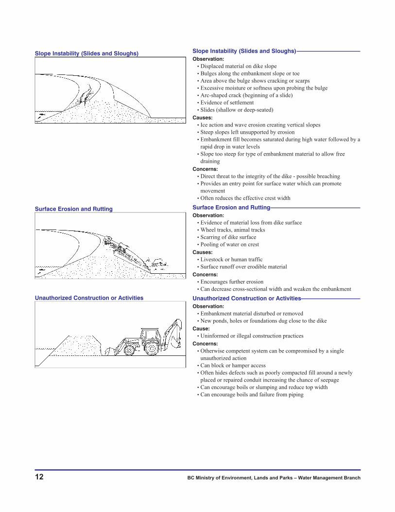
Slope Instability (Slides and Sloughs)
Observation:
• Displaced material on dike slope
• Bulges along the embankment slope or toe
• Area above the bulge shows cracking or scarps
• Excessive moisture or softness upon probing the bulge
• Arc-shaped crack (beginning of a slide)
• Evidence of settlement
• Slides (shallow or deep-seated)
Causes:
• Ice action and wave erosion creating vertical slopes
• Steep slopes left unsupported by erosion
• Embankment fill becomes saturated during high water followed by a
rapid drop in water levels
• Slope too steep for type of embankment material to allow free
draining
Concerns:
• Direct threat to the integrity of the dike - possible breaching
• Provides an entry point for surface water which can promote
movement
• Often reduces the effective crest width
Surface Erosion and Rutting
Observation:
• Evidence of material loss from dike surface
• Wheel tracks, animal tracks
• Scarring of dike surface
• Pooling of water on crest
Causes:
• Livestock or human traffic
• Surface runoff over erodible material
Concerns:
• Encourages further erosion
• Can decrease cross-sectional width and weaken the embankment
Unauthorized Construction or Activities
Observation:
• Embankment material disturbed or removed
• New ponds, holes or foundations dug close to the dike
Cause:
• Uninformed or illegal construction practices
Concerns:
• Otherwise competent system can be compromised by a single
unauthorized action
• Can block or hamper access
• Often hides defects such as poorly compacted fill around a newly
placed or repaired conduit increasing the chance of seepage
• Can encourage boils or slumping and reduce top width
• Can encourage boils and failure from piping
Unauthorized Construction or Activities
Surface Erosion and Rutting
Slope Instability (Slides and Sloughs)

Flood Protection Works Inspection Guide 13
Uncontrolled Vegetative Growth
Observation:
• Vegetation obscures ability to detect cracks, seepage or other
problems
Causes:
• Lack of maintenance
Concerns:
• Root systems can provide seepage conduits
• Rotting root systems weaken the embankment
• May prevent emergency access
• Provides a habitat for unwanted burrowing animals
• Windthrow or uprooting of trees can create holes and weakness
Animals/Rodent Activity
Observation:
• Rodent holes, burrows and tunnels
• Animal trails
• Fallen trees (beaver activity)
Causes:
• Burrowing animals including bank beavers
Concerns:
• Can weaken the embankment - cause sinkholes and piping
• Potential vehicle access restrictions if unchecked
Toe Scour
Observation:
• Loss of riprap from dike slope
• Loss of riprap starting at the toe
• Undermining of the dike slope
• Eddying at the dike toe
Causes:
• Inadequate riprap toe design/material size
• Shift in flow impact angle due to formation of log jams, ice jams,
shifting river bed materials or man made obstacles
Concern:
• Loss of erosion protection material leaving the embankment
materials vulnerable to erosion and possible breaching
Beaching
Observation:
• Riprap on dike slope slumping and forming a horizontal beach near
the water level
Cause:
• Wave action removing a portion of the riprap slope and depositing it
further down the slope
• Insufficient riprap rock size
Concern:
• Loss of erosion protection material leaving the embankment
materials vulnerable to erosion and possible breaching
Beaching
Toe Scour
Animals/Rodent Activity
Uncontrolled Vegetative Growth
6.3 Guide for Identifying Problems in Erosion Protection Works

14 BC Ministry of Environment, Lands and Parks – Water Management Branch
Scarping
Observation:
• Riprap undermined and sliding down the slope
• Cracking, spalling of riprap material
• Oversteepened riprap slope
Cause:
• The removal of bedding material (filter material) from beneath
riprap due to ice, wave action, internal erosion or local settlement
Concern:
• Riprap slides to lower part of the slope causing scarps to form which
could reduce the cross-sectional width of the dike
Changing River Flow Patterns
Observation:
• Dramatically altered flow pattern of the river
• Areas of impingement on the dike altered
• Channel obstructions in the vicinity
Cause:
• Landslides
• Ice and log jams
• Gravel accumulations
• Man made obstructions
• Natural meander progression and/or formation of cutoffs
Concern:
• Additional erosive forces applied against existing bank protection
works increasing the chance of its failure
• Direct flow against sections of the flood protection system not
previously subjected to erosion . If not already armoured, could lead
to rapid loss of embankment fill
• Outflanking of existing works at upstream end
Bed Degradation
Observation:
• River channel scouring adjacent and roughly parallel to the erosion
protection
• Riprap perched on a ledge
Cause:
• Changing river currents and high water levels
• Deepening of the riverbed in the reach near the dike
• Insufficient toe protection design or construction
Concern:
• The erosion protection material is vulnerable to undermining and
collapse exposing the bank
Outflanking
Observation:
• River erosion upstream of hardpoint or key trench
Cause:
• Erosion protection not extending far enough upstream
• Erosion protection not extended to a hardpoint at the upstream end
• Weak upstream key (poor design)
• Sudden change in river flow pattern
Concerns:
• Rapid loss of erosion protection material leaving the embankment
fill vulnerable to erosion
• Exposure of unprotected fill to erosive forces
Outflanking
Bed Degradation
Changing River Flow Patterns
Scarping

Flood Protection Works Inspection Guide 15
Overbank Erosion
Observation:
• Reduced riverbank area
• Progressive erosion
Cause:
• Reduced distance from the dike fill to the river channel due to
changing river currents
• Natural meander progression
• Lack of erosion protection on set-back area
Concerns:
• Threat to embankment stability
• Undermining of embankment
Ice and Floating Logs
Observation:
• Dislodged riprap pieces on riverside slope, holes in riprap
• Riprap damaged
• Impingement on dike of uprooted trees
Cause:
• Loss of erosion protection due to forces exerted by flowing ice and
floating logs (trees)
• Moving ice grinding or displacing riprap
Concern:
• Weakening or complete loss of erosion protection material
Degrading (Weathering)
Observation:
• Disintegration of riprap material
• Cracks, spalling, crumbling of riprap material
• Hollow sound on rock hammer testing
Cause:
• Chemical or mechanical deterioration of the erosion protection
material often accelerated by wave action and ice flows and freeze
and thaw cycle
Concern:
• Widespread weakening of erosion protection material leaving the
embankment fill more susceptible to erosion
Uncontrolled Vegetative Growth
Observation:
• Vegetation obscuring inspection
• Large vegetation and trees on fill
• Tree uprooting on riprap
• Tree blowdown across dike
Cause:
• Lack of regular vegetation management
• Poor maintenance procedures
Concerns:
• Can obscure serious problems which may exist
• Tall trees with large root systems can displace large amounts of
erosion protection material when forced over by wind, ice flows or
high water
• Provides a habitat for unwanted burrowing animals
Uncontrolled Vegetative Growth
Degrading (Weathering)
Ice and Floating Logs
Overbank Erosion

16 BC Ministry of Environment, Lands and Parks – Water Management Branch
Access Roads
Observation:
• Poor road conditions
• Blocked access
Causes:
• Lack of proper gates and controlled access
• Poor construction practices
• Poor maintenance
• Jurisdictional problems regarding access and maintenance of access
Concerns:
• Blocked access during emergencies
• Unnecessary delays
Water Level Gauges
Observation:
• Gauge is broken, bent or missing
• Gauge is unreadable (paint gone)
• Gauge is obscured from view
Causes:
• Ice, high water, floating debris, vegetation growth
• Poor installation
• Vandalism
• Deterioration due to weathering
Concerns:
• Loss of a vital information tool for operation, maintenance and flood
fighting activities
• Unnoticed elevation change resulting in incorrect reading
Floodboxes
Observation:
• Cracks/holes/joint separation
• Concrete deterioration
• Gates not opening easily
• Gates blocked (woody debris, slumping, siltation)
• Evidence of rusting at culvert joints
Causes:
• Poor construction practices
• Internal settlement, separation
• Corrosion
• Lack of maintenance
• Beaver activity
• Damage from ice, floating debris, etc. to the gate and its supports
(guides)
• Vandalism
Concerns:
• Internal flooding from debris blockage or improperly or partially
closed gates
• Seepage along outside of conduit resulting in piping and ultimately
embankment failure
6.4 Guide for Identifying Problems in Appurtenant Works
Floodboxes
Water Level Gauges
Access Roads

Flood Protection Works Inspection Guide 17
Pumps and Pumping Stations
Observation:
• Pumps not working to specifications
• Rust on pipes or pumps
• Power source not operative
• Switching devices not working to specifications
• Walls, doors, gates, etc. out of alignment
• Scouring or undermining near the footing or foundation of the
structure
Causes:
• Lack of a proper maintenance schedule
• Power outages
• Vandalism
Concern:
• Failure causing internal flooding
Relief Wells
Observation:
• Turbid water in wells
• Concrete deterioration
Causes:
• Piping of foundation materials
Concerns:
• Piping leading to weakening of embankment
Concrete Deterioration
Observation:
• Cracking, spalling, disintegration
• Evidence of rust
• Hollow sound on rock hammer test
Causes:
• Poor construction practices
• Corrosion of reinforced steel from salt content
• Forces of erosion and weathering
Concern:
• Loss of ability to carry out the designed functions of the appurtenant
works
Beaver Activity
Observation:
• Beaver dam and/or wood debris blocking intakes
Cause:
• A favourable habitat
Concern:
• Beaver activity may block intakes to floodboxes and pump stations
causing internal flooding
Beaver Activity
Concrete Deterioration
Relief Wells
Pumps and Pumping Station

18 BC Ministry of Environment, Lands and Parks – Water Management Branch
Observation:
• Slumping of the fill
• Bulges at lower elevations on the dike
• Liquefaction of ground
• Collapse of fills
• Cracking in the embankment
• Damage to appurtenant works
Cause:
• Seismic activity
Concerns:
• Widespread damage to the flood protection system is possible
• If widespread, complete repair might not be possible before high
water conditions
• Areas affected by tides are of special concern
• Functionality of pumps, gates and structures
• Damages may not be visible immediately
6.5 Post-Earthquake Problems
Inspections by Boat

Flood Protection Works Inspection Guide 19
Sheet No.
File No.
Dike Length:
DIKE:
REACH:
DATE INSPECTED: Signed:
The condition of the flood protection works is as reported below:
1. DIKES: (access, gates, locks, vegetation growth, gravel surface, height, slopes, erosion, animal burrows,
seepage, trash, berms, relief wells)
2. BANK PROTECTION: (loss of rock, settlement, slumping)
3. FLOODBOXES/PUMP STATIONS: (inlet and outlet channels, gate operation, trash racks, debris, erosion,
corrosion, structure, discharge structure, electrical and mechanical components)
6.6 Flood Protection Inspection Report

20 BC Ministry of Environment, Lands and Parks – Water Management Branch
4. WORK REQUIRED:
5. ADDITIONAL INFORMATION (see below) (sketch, photos, etc.)
6. WORK COMPLETED: Date: Signed:

Flood Protection Works Inspection Guide 21
6.7 High Water Patrol Log
Date: Inspector:
Time Commenced: Time Completed:
1. Gauges Height Design WL Time Water Level
Gauge
Gauge
2. Landside Seepage Comments/Location
Boils Yes � No � Clear: Dirty: Piping:
Ponding Yes � No �
3. Landside Slope
Cracking Yes � No �
Sloughing Yes � No �
Seepage Yes � No �
4. Dike Crest
Accessible Yes � No �
Cracking Yes � No �
Settlement Yes � No � Sinkholes:
Freeboard Yes � No �
5. Riverside Slope
Erosion Yes � No � Dike Fill: Riprap:
Instability Yes � No �
Underwater Yes � No �
6. Floodboxes
Gates Yes � No � Leakage: Flow Estimate:
7. PumpsInlet/Outlet Open: Obstructed:
Operating Yes � No � Flow Estimate:
8. Required Action:
Notification: To Whom: Time:______
Refer to System Operation & Maintenance Manual

7. Further Information
22 BC Ministry of Environment, Lands and Parks – Water Management Branch
7.1 Contacts - Regional Deputy Inspectors of DikesIn the following regional offices:
Vancouver Island Region
2080 Labieux Road,
Nanaimo BC V9T 6E9
Phone (250) 751-3100
Fax (250) 751-3103
Omineca / Peace Region
3rd Floor 1011 Fourth Avenue,
Prince George BC V2L3H9
Phone (250) 565-6135
Fax (250) 565-6629
Lower Mainland Region
10470 - 152 Street,
Surrey BC V3R 0R3
Phone (604) 582-5200
Fax (604) 930-7119
Okanagan Region
201 - 3547 Skaha Lake Rd.,
Penticton, BC V2A 7K2
Phone (250) 490-8200
Fax (250) 492-1314
Southern Interior Region
1259 Dalhousie Drive,
Kamloops BC V2C 5Z5
Phone (250) 371-6200
Fax (250) 828-4000
Skeena Region
Bag 5000, 3726 Alfred Avenue,
Smithers BC V0J 2N0
Phone (250) 847-7260
Fax (250) 847-7591
Kootenay Region
401-333 Victoria Street,
Nelson BC V1L 4K3
Phone (250) 354-6333
Fax (250) 354-6332
Inspector of Dikes Office
10470 - 152 Street,
Surrey BC V3R 0R3
Phone (604) 582-5200
Fax (604) 930-7119
EMERGENCIES
In emergencies contact the local office of the Provincial Emergency Program and/or the
Provincial Emergency Program Emergency Reporting at:
1-800-663-3456
MELP WEB SITE (FOR DIKES) http://wlapwww.gov.bc/wat/flood/structural.html

7.2 ReferencesThe following publications are referred to in this Guide
and can be obtained by contacting the regional Deputy
Inspector of Dikes:
� Environmental Guidelines for Vegetation
Management on Flood Protection Works to Protect
Public Safety and the Environment. BC Ministry of
Environment Lands and Parks and the Department
of Fisheries and Oceans Canada. March 1999.
� Guidelines for Management of Flood Protection
Works in British Columbia. Public Safety Section,
Water Management Branch, Ministry of
Environment Lands and Parks. March 1999.
Additional references:
� Flood Planning and Response Guide for British
Columbia. Public Safety Section, Water
Management Branch, Ministry of Environment
Lands and Parks and the Provincial Emergency
Program, Ministry of Attorney General. March
1999.
� Riprap Design and Construction Guide. Public
Safety Section, Water Management Branch,
Ministry of Environment, Lands and Parks. March
2000.
Flood Protection Works Inspection Guide 23
Barrowtown Pump Station

24 BC Ministry of Environment, Lands and Parks – Water Management Branch
Aggradation the long-term hydraulic process by which streambeds and floodplains are
raised in elevation by the deposition of materials such as sand and gravel.
It is the opposite of degradation.
Appurtenant
Structures
structures and equipment other than the embankment and the erosion
protection works that contribute to the overall function of the flood
protection works
Bank failure the collapse of a mass of bank material into a stream channel
Bank protection or
Erosion Protection
treatment of slopes of dikes and banks of streams, lakes and other water
bodies by placement of riprap (an engineered layer of graded broken rock
pieces) or other forms of protection to prevent erosion by surface runoff,
stream flows and/or wave action
Boil a disturbance in the surface layer of soil caused by water escaping under
pressure from behind a water-retaining dike structure. The boil may be
accompanied by deposition of soil particles in the form of a conical-shaped
mound (miniature “volcano”) around the area where the water escapes.
Caving the collapse of a streambank by undercutting due to wearing away of the
toe or an erodible soil layer above the toe
Channel a natural waterway that periodically or continuously contains moving
water. It has a definite bed and banks that confine the water.
Channel scour
and fill
erosion and sedimentation that occurs during relatively short periods of
time. Degradation and aggradation apply to similar processes that occur
over a longer period of time.
Channel stability a relative measure of the resistance of a stream or river to erosion. Stable
reaches do not change markedly in appearance year to year.
Clay an extremely fine grained sediment. Individual particles are not visible to
the unaided eye. If moist, clay can be molded into a ball that will not
crumble.
Cross Section (1) a section of a stream channel or structure that provides a side view,
(2) a transect taken at right angles to the flow direction
Culvert one or more pipes, pipe arches, or other conduit structures designed to
transfer water through an embankment
Current the flow of water moving in a particular direction. See also velocity.
Cut bank the steep or overhanging slope on the outside of a meander curve, typically
produced by lateral erosion of the stream
Appendices
Appendix 1: Terminology

Flood Protection Works Inspection Guide 25
Cut off collar a vertical barrier surrounding a culvert designed to increase the length of
the seepage path
Degradation the long-term hydraulic process by which stream and river beds lower in
elevation, through removal of material such as sand and gravel
Deposition the settlement of material out of the water column and onto the streambed
or floodplain. Occurs when the flowing water is unable to transport the
sediment load.
Deputy Inspector
of Dikes
(DIOD) - an official of the Ministry of Environment, Lands and Parks as
defined under the Dike Maintenance Act of British Columbia. See
Inspector of Dikes.
Dike an embankment, berm, wall, piling or fill constructed to control flooding
of land. For the purposes of this manual, the term “dike” usually refers to
an embankment fill.
Dike crest elevation of the uppermost surface of a dike proper, not taking into
account any camber allowed for settlement, curbs, guard rails or other
structures that are not part of the main body of the flood protection
structure
Dike height the vertical distance from the dike crest level to natural ground as
measured at the landside toe of a dike
Dike shoulder the point of intersection of the dike crest and the side slope of the dike
Dike toe the point at the bottom of a dike slope where it intersects the original
ground
Diking Authority (1) the commissioners of a district to which Part 2 of the Drainage, Ditch
and Dike Act applies,
(2) a person owning or controlling a dike other than a private dike,
(3) a public authority designated by the minister as having any
responsibility for maintenance of a dike other than a private dike, or
(4) a regional district, a municipality or an improvement district
Embankment dike any dike constructed of natural excavated materials placed without
addition of binding materials other than those inherent in the natural
material
Erosion means the wearing away, by water, of the banks or of the bed of a stream
or of the materials used in any flood protection works
Filter layer layer of fabric, sand, gravel, or graded rock placed between the erosion
protection material (usually riprap) and the underlying soils. Its purpose is
to prevent the soil from being removed by the action of water. Also called
filter blanket.
Flood protection
works
all works needed to prevent or control floods

26 BC Ministry of Environment, Lands and Parks – Water Management Branch
Floodbox a culvert through the dike that allows the normal passage of water (by
gravity) from internal drainage systems to the river/ocean. It has a valve or
gate that can close during highwater conditions preventing backflow from
the river/ocean to the land protected by the dike.
Freeboard (1) a vertical distance added to the designed flood water level to allow for
hydraulic uncertainty, wave run-up, surges, ice jams, debris
accumulations, obstructions of bridge openings and floodways, the effects
of urbanization on the hydrology of the watershed, loss of flood storage
acres due to development and the aggradation of a river or streambed and
other open water conditions, as a factor of safety,
(2) also at a given time, the vertical distance between the design water
level and the top of the structure
Freshet a seasonal rise, usually in spring, in river discharge and level caused by
heavy rains or melting snow
Gabion a galvanized wire basket with a hinged top, intended to be filled with
stones and used to stabilize banks or channel beds, to control erosion, and
to prevent bed materials from shifting
Gravel sediment particles larger than sand and ranging up to 8 cm (3 inches) in
diameter
Hardpoint a river erosion resistant feature such as exposed bedrock by which the
upstream end of erosion protection works connects to prevent outflanking
High water mark
(HWM)
a trace of any kind left by a flood on the banks, obstacles or floodplain. It
may be used to determine the highest level attained by the water surface
during a particular flood.
Inspector of Dikes an official of the Ministry of the Environment, Lands and Parks as defined
under the Dike Maintenance Act of British Columbia. See Deputy
Inspector of Dikes (DIOD).
Landside slope slope of the embankment from the shoulder to the toe located on the land
side
Left bank the river or stream bank that is on the left hand side when looking
downstream
Natural
streambank
the bank of the stream, formed naturally and not part of the dike fill,
located below the dike height on the river side
Overbank the area of land between the waterside toe of a setback dike and the top of
the natural streambank
Overbank flow water flowing over the top of the natural streambank
Permeability means the capacity or property of material such as rocks and soil to allow
the passage of water or other fluids
Piping flow of water through subsurface conduits transporting fine materials

Flood Protection Works Inspection Guide 27
Private dike a dike built on private property without public funds to protect only the
property of the person owning the private dike
Pumping station a structure housing pumping machinery used to reduce internal water
levels by transporting this water from the land side of a dike to the river
Reach a length of stream that has generally similar physical characteristics and
defined starting and ending points
Riprap a layer, facing, or protective mound, generally of quarried rock, placed to
prevent erosion, scour, or sloughing of a structure or embankment
Right bank the river or stream bank that is on the right hand side when looking
downstream
Riverside dike a dike located adjacent to a stream (i.e. directly on a streambank).
Riverside dikes may be with or without bank protection.
Riverside slope slope from the riverside shoulder of the embankment to the toe
Setback dike a dike that is set back from the ordinary high water mark of a river creating
an overbank strip of natural ground between the dike fill and the
streambank
Silt slightly cohesive to noncohesive soil composed of particles that are finer
than sand but coarser than clay. Silt will crumble when rolled into a ball
Sliding or Sloughing the downward slipping of a mass of soil, moving as a unit usually with
backward rotation, down a bank into the channel. Also called sloughing
off or slumping.
Trashracks a grid usually constructed of wood or metal that helps to prevent large
floating debris from entering culverts, floodboxes or pumping chambers. It
also has the advantage of preventing unauthorized human access to these
structures.
Tsunami a rise in water level caused by tectonic or volcanic activity
Upstream key a constructed hardpoint, often a riprap filled trench extending inland from
the river bank at roughly a 45 degree angle to the river bank
Water level gauges a measuring device to obtain water level and/or discharge records
Weathering physical disintegration or chemical decomposition of a substance (such as
riprap) or a structure due to wind, rain, heat, freezing, thawing or chemical
reaction

Inspection observations may result in the need for
immediate emergency actions on an interim basis,
further investigation, monitoring, or scheduled repairs.
A general list of possible actions is as follows:
� Refer to the Operation and Maintenance Manual
� Undertake further investigation
� Monitor and compare records for evidence of
changing patterns
� Initiate emergency response as required in the
interim
� Undertake routine maintenance
� In many cases, consultation with a suitably
qualified Professional Engineer will be advisable
The following provides a brief description of typical
dike issues that might be encountered, visual
indicators, and some possible actions that may be
undertaken in addition to those listed above.
Loss of Freeboard/Overtopping
Overtopping is a form of dike failure where water
flows over the crest of the dike due to the erosive
action of waves or uncontrolled flow of water. Once
erosion has begun during overtopping, it is almost
impossible to stop as equipment and materials can not
be transported along the crest of the dike. It is
extremely hazardous for both equipment and operators
to be in this location during overtopping. Overtopping
of a dike can be caused by:
� design parameters exceeded
� extreme flood flows that exceed the embankment
design
� loss of design freeboard (due to settlement, erosion,
constant vehicle traffic on the embankment or
grading)
� sudden flood flow disruptions such as ice and or
log jams
� tsunamis in coastal areas
� wave action during high water conditions
� shifts in the position and amount of stream bed
materials
� surges, floodwaves caused by temporary stream
blockages
Dike fills are usually not designed to withstand
overtopping and therefore are particularly susceptible
to erosion when it occurs.
Possible Actions
� If loss of freeboard seems to be occurring, a
verification survey of the crest elevation should be
conducted.
� If changes in the crest elevation are identified
corrective action must be completed well in
advance of the next potential flood season.
28 BC Ministry of Environment, Lands and Parks – Water Management Branch
Appendix 2: Discussion of Typical Issues Affecting Flood Protection Works

Settlement/Depressions
Settlement is a common sign of the internal erosion of
embankment material. Excessive settlement of the dike
or foundation materials can reduce freeboard and
create the potential for overtopping. Settlement can be
caused by:
� poor foundation conditions (loose, unconsolidated
foundation soil is being loaded by the weight of the
overlying embankment)
� poor construction practices such as inadequate or
inconsistent compaction, or leaving large amounts
of organic material (wood waste, vegetation) in the
foundation or embankment
� use of poor quality fill in embankment construction
� prolonged erosion from wind or water
� animal burrows
Settlement can be observed in two types of
depressions:
� Minor Depressions
� Sinkholes
Depressions and sinkholes may be a sign of concerns
such as internal erosion from seepage or a hole in a
floodbox conduit. These are potentially serious causes
for failure which could compromise the ability of the
dike to operate successfully in a flood event.
Minor Depressions
Minor Depressions are characterized by having gently
sloping, bowl like sides and are caused by the same
factors as mentioned for settlement only at a much
smaller scale. These depressions may be difficult to
observe unless there is adequate management and
maintenance of vegetation on the crest and slopes of
the dike.
Sinkholes
Sinkholes usually have steep, bucket-like sides and are
a more serious type of depression. Depressions and
sinkholes weaken the dike by decreasing the length of
the normal path of water seepage through the dike.
Sinkholes also provide an entrance point for surface
water into the
embankment and,
depending on the
size and depth of
the sinkhole, may
lead to dike
failure. In
addition sinkholes
can pose a danger
to vehicular and
pedestrian traffic.
Animal burrows
and decaying
vegetation, e.g.
rotting stumps,
embedded within
or under the dike
fill are common
causes of
sinkholes. During inspection look for settlement in the
both the crest and slopes of the embankment.
Flood Protection Works Inspection Guide 29

Possible Action
� If changes in the crest elevation or sinkholes are
identified corrective action must be completed well
in advance of the next high water period.
Seepage/Piping
During high water conditions, most dikes have a
certain amount of seepage resulting from water
percolating slowly through the dike and its foundation.
Seepage occurs in all dikes and is considered normal
as long as the water remains clear and the flow is not
concentrated or changes dramatically in velocity and
quantity.
However, if the seepage water is turbid (cloudy), this
is an indication that soil particles, or the fines (sand
and silt content of gravel) are suspended in the water
and are being transported out of the embankment. If
uncontrolled, seepage can progressively mine soil from
the embankment or its foundation, which could create
instability and result in rapid failure of the dike. In this
situation, erosion of the soil begins on the landside of
the embankment, either in the dike itself or its
foundation, and progressively works toward the
waterside, eventually developing a direct conduit for
water flow through the dike called a ‘pipe’.
Boil
A boil is an upwelling of water on the land side of the
dike, near the toe or farther away. Piping through weak
areas of foundation materials can result in a boil due to
hydraulic pressure during high water conditions. Boils
can occur anywhere from the landside dike fill toe to a
considerable distance inland. Boils are an indication
that a concentrated pipe has developed through a weak
layer of material in the foundation of the dike.
Localized lush vegetation on the slopes of the
embankment or on the land adjacent to the dike is
often an indicator of an area where seepage is
occurring. While it is assumed that embankments built
of gravel will be less susceptible to piping, gravels
generally contain a certain amount of fines (sand, silt)
that may be washed through the embankment with
seepage. When the fines of the gravel are removed,
voids are created and the gravel may become unstable.
During high water any changes in seepage flow rate,
water clarity or location, which are different from past
seepage history, are cause for concern. Any new
upwellings of water on the landside of the dike at the
toe or in its general vicinity indicate a possible boil.
Possible Action
� The boil should be monitored for changes in size
and relationship to ocean/river water levels.
� Construction of a temporary sandbag ring to reduce
seepage flows may be necessary until permanent
repairs can be carried out.
Cracking
Cracks are splits in the crest or the slopes of the dike.
Cracking is categorized as:
1. Desiccation Cracking
2. Transverse Cracking
3. Longitudinal Cracking
1. Desiccation Cracking
Desiccation Cracking usually occurs in highly plastic
soil, such as clay, which expands and contracts with
alternating wet and dry weather. Desiccation cracks
usually develop in a random, honeycomb pattern along
the surface of the embankment. Such cracks provide an
entrance point for surface water which can saturate the
dike and cause slope failures. In severe cases
30 BC Ministry of Environment, Lands and Parks – Water Management Branch

desiccation cracks can concentrate surface runoff,
eventually forming gullies and causing surface erosion.
Possible Action
� Where dike inspections identify desiccation cracks
the dike surface in that area is to be re-graded and
compacted and groundcover resowed. The area
should continue to be monitored.
2. Transverse Cracking
Transverse Cracking forms in a direction roughly
perpendicular to the length of the dike, that is, across
the dike from the waterside to the landside. The
presence of transverse cracking may indicate
differential settlement within the dike material or the
underlying foundation soils, usually between two
adjacent portions within the dike indicating instability
of the dike or foundation material.
Transverse cracking may be a serious concern for dike
management as:
� these cracks provide an entry point for water into
the dike which could create a seepage path and/or a
potential piping failure
� water flowing across the dike fill at a lower
elevation in the crack can result in rapid erosion of
the dike material
Possible Action
� Transverse cracks should be excavated and
back-filled with compacted material to prevent
seepage. The area should be monitored for future
movement.
� Where the transverse crack has extended
completely across the crest of the dike, or there is a
difference in elevation between the sides of the
crack, the dike must be repaired before the next
high water period.
3. Longitudinal Cracking
Longitudinal Cracking forms in a direction roughly
parallel to the length of the dike. This form of cracking
is an indication of either uneven fill settlement within
the dike or the initial stage of a slope failure or slide.
Longitudinal cracking is a serious concern for dike
management as:
� these cracks provide an entry point for water into
the embankment
� they result in an area along the crest that has high
instability and therefore can not be used to move
equipment or emergency vehicles
� these cracks reduce the effective crest width
� slope stability failure is accelerated
Flood Protection Works Inspection Guide 31

Possible Action
� Given the serious potential for slope failure
longitudinal cracks need to be closely monitored
and repairs made before the next high water period.
Slope Instability
Instability of the dike is very serious concern as it is a
direct threat to the integrity of the dike and possible
breaching. Instabilities such as slides or bulging of the
slopes can compromise crest elevation or increase the
occurrence of erosion, seeping or piping. Slope
instability occurs in situations where:
� the dike fill material is saturated from an extended
flood event followed by a rapid drop in water levels
� the dike has been constructed with steep side slopes
which cannot be sustained when the embankment
material is saturated
� ice action or wave erosion have created vertical
slopes on the riverside of the dike
� previous erosion has left dike slopes steep and
unsupported
Visual clues of instability may appear as:
� slides (shallow or deep-seated)
� bulges
Slides
Slides (sometimes known as sloughs) are displaced
material in the dike slope. Shallow Slides are often the
result of a rapid drop in river water levels. This can
lead to localized problems such as the obstruction
(blockage) of water conveyance structures. In addition,
these slides may also indicate a loss of strength in the
embankment material as a result of saturation of the
slope from either seepage or surface runoff.
Deep-Seated Slides are serious threats to the safety of
the dike and are characterized by:
� Scarp. A scarp is a relatively flat area with a steep
back slope
� Toe Bulge. A toe bulge is usually associated with
the spreading of the dike fill or with slides and is
accompanied by settlement
� Arc-Shaped Cracks. Arc-shaped cracks in the slope
are indications that a slide is beginning. This type
of crack may develop into a large scarp in the slope
located at the top of the slide
32 BC Ministry of Environment, Lands and Parks – Water Management Branch
Development of a Slope Failure fromLongitudinal Cracking

Bulges often appear along the embankment slope
indicating the start of a slide or slough. The area above
the bulge may show evidence of cracks and scarps. If
the bulge material is excessively moist or soft, this
indicates that seepage may be occurring.
Possible Action
� Where there is evidence of slope instability the dike
must be repaired before the next high water period.
Uncontrolled Vegetative Growth
Uncontrolled vegetation growth is one of the most
common problems encountered on dikes in British
Columbia. Uncontrolled vegetation growth is harmful
to the integrity of the dike in the following ways:
� it can obscure the view of the embankment and
prevent a thorough inspection for possible cracks,
seepage or other evidence of problems along the
dike
� it can slow the response time of emergency
vehicles and equipment
� large trees could be uprooted during a storm and
the resulting large hole left by the sudden
movement of the roots system could lead to
breaching of the dike
� root systems can decay and rot, providing a conduit
for water to pass through
� root systems can cause the uplift of concrete slabs
or structures
� weeds can discourage the growth of desirable
grasses and ground cover
� provides a habitat for, and encourages, burrowing
animals
Possible Action
� Remove cuttings and other wood debris from the
embankment area.
� The embankment should be seeded with an
appropriate grass.
� Uncontrolled vegetation growth must be removed
in accordance with vegetation management
guidelines.
� Prevent or remove re-occurring growth as part of a
regular maintenance program.
� A vegetation management plan should be submitted
to the federal and provincial agencies if habitat
removal is planned.
Animals/Rodent Activity
Regular livestock traffic crossing the dike can
seriously displace embankment material possibly
reducing the crest elevation and/or the cross-sectional
width and will contribute to erosion on the dike slopes.
Rodents, notably beavers, may locate on dikes when
there is uncontrolled vegetation growth. These rodents
can cause a variety of different types of damage to a
flood protection system, including:
� burrows and tunnels within the embankment which
can lead to sinkholes and piping
� block culverts and floodgates with wood debris and
cause internal flooding
� fall trees across the dike fill preventing vehicle
access
Flood Protection Works Inspection Guide 33
Mowing dike slopes.

� Note: beavers will burrow from a calm body of
water for several metres to reach drier dike
embankment material
Possible Action
� Livestock access to the embankment should be
discouraged. Where damage is noted grading of the
surface and re-sowing of ground cover to prevent
erosion is recommended.
� Rodent control is best achieved through the
management of vegetation of the embankment
surfaces to ensure that habitat conducive to rodents
is not established. Where rodents have become
established it is imperative to remove the rodents
and habitat.
� Rodent burrows need to be excavated and re-filled
with compacted fill material similar to the original
fill of the embankment. In extreme cases “wire”
mesh can be placed over the embankment slope to
discourage rodent activity.
� Removal of beaver dams, trapping of beavers for
re-location of the beaver colony.
Toe Scour
Toe scour is the deepening of the river bed by the
removal of material adjacent and below the toe of the
riprap. Since riprap is very expensive to produce and
install, it is usually only placed where there is the
greatest possibility of active erosion taking place (such
as the outside bends in rivers). Inherently, these areas
often have the highest water velocities. This fact
makes toe scour a very real possibility. Once
undermined by the actions of the river the toe portion
of the riprap may sink into these holes causing the
upper rock to be displaced, resulting in a much steeper
slope or complete loss the rock protective layer. If the
riprap or erosion protection is displaced or lost the
embankment fill becomes vulnerable to erosion and
possible breaching. Toe scour can occur rapidly if
there is a sudden change to the normal flow of the river
due to the formation of log jams, ice jams, shifting
river bed materials or man made obstacles. Some toe
scour may occur after placing riprap on previously
unprotected slopes.
Annual visual inspection of the riprap surface at low
water, either walking at water level or from a boat is
required. The riprap surface and alignment should be
continuous and relatively smooth so that the
floodwaters, floating debris and backeddies do not
remove rocks from the riprap. If the riprap surface
appears to be slumping down into the water it is an
indication that toe scour may be initiating.
Possible Action
� If inspection indicates the possible presence of toe
scour, repair as soon as physical conditions (easier
to do during low water) and regulations allow.
Often early recognition and repair prevents more
widespread damage.
Changing river flow patterns
The natural tendency of rivers to meander can change
areas of direct impingement (areas that are subject to
erosion) however this is usually a relatively slow
process. When it does occur quickly, it is usually as a
result of:
� Ice jams
� Log jams
� Landslides
� Man made alterations
� Erosion (mid-stream bars)
� Gravel bars/deposition
34 BC Ministry of Environment, Lands and Parks – Water Management Branch

These additional erosive forces applied against existing
bank protection works or unprotected areas can
increase the chance of dike failure.
Possible Action
� If there is an immediate and direct threat to the
integrity of the flood protection system and such
failure would lead to widespread flooding , then the
local emergency plan must be activated and
emergency repairs made.
� If only minor erosion takes place, steps should be
taken to either reinforce the new impingement area
or correct the in-stream obstruction.
� As the flow pattern change may be a slow process,
monitor areas of impingement.
Outflanking
Outflanking is the loss of the riprap’s supporting
(underlying) material at or near its upstream extremity.
This can cause rapid loss of not only the remaining
downstream riprap but the now exposed dike as well.
This can be caused by:
� not connecting erosion protection material to a
hardpoint
� not extending the riprap upstream far enough (well
past area subject to erosion at time of construction)
� improperly constructed upstream key
� sudden and unexpected change in the river flow
pattern causing erosion of the bank material
upstream of the existing bank protection works
The most vulnerable time for outflanking to occur is
during high water conditions. The upstream extremity
of all erosion protection works should be constantly
checked at this time.
Possible Action
Early detection and reinforcement of the upstream key
is by far the best way to combat outflanking once it has
started.
Ice and Floating Logs (Trees)
Moving ice can exert extremely powerful forces which
can grind down and/or displace large sections of
riprap. The result is weakening or complete loss of
erosion protection.
During high water conditions, upstream logs are
floated and mobilized by the current as are uprooted
trees. If the current takes them near riprap they can
displace rock by simply scraping along it or by
ramming into the rock then swinging around in a
downstream direction, prying the rock loose in a lever
like action.
Possible Action
� Monitor erosion rates and do necessary reinforcing
if needed.
Degrading (Weathering)
Degrading is the chemical or mechanical disintegration
of rock used in the riprap surface. Degradation can
significantly affect the engineering properties of the
rock and the rock mass, reducing its effectiveness as an
erosion protection barrier. Certain types of rock are
Flood Protection Works Inspection Guide 35

more susceptible to degrading and it is therefore
critical to consider this factor in the selection of
material for the erosion protection or when
maintaining the riprap.
Degradation can be caused by severe temperature
changes (freeze and thaw cycle), sun, wind, rain,
abrasion, plant and animal activity, and chemical
action. The effects of weathering of the rock generally
decrease with depth of the erosion protection.
However, the actions of waves and ice-flows on the
erosion protection may accelerate the degradation of
the riprap.
Riprap should be inspected annually for degradation
by walking along the protected surface of the
embankment to observe the condition of the riprap.
Riprap that is fracturing or crumbling is evidence of
degradation. Look for cracks, spalls and use a rock
hammer to test for soundness.
Possible Action
� Monitor the erosion protection material for any
sudden changes. Degradation may increase with
age of the material. Where concerns are noted it
may be appropriate to have the erosion protection
material tested in an engineering laboratory.
� Where identified, initiate immediate repairs as soon
as physical conditions and regulations allow. This
may involve the removal of degraded material and
replacement with appropriate materials.
� Photograph and mark the areas for later inspection.
Floodboxes
A floodbox is a culvert through the dike that allows the
normal passage of water (by gravity) from internal
drainage systems to the river/ocean. It has a valve or
gate that can close during highwater conditions
preventing backflow from the river/ocean to the land
protected by the dike. Debris blockage or improperly
or partially closed gates can cause internal flooding.
The floodbox can sustain damage as a result of:
� Internal or differential settlement, separation
� Corrosion
� Lack of maintenance
� Ice damage
� Damage by floating logs and debris
� Gravel and sand deposition
� Concrete deterioration
� Vandalism
� Beaver (rodent) activity
Floating debris from the internal drainage system can
also become lodged in the culvert. Trash racks or
floating debris catchers are often placed at or near the
culvert intake. They too can become clogged.
Since the outside surface of the culvert is relatively
smooth, it presents a possible avenue for a seepage
path. Cutoff collars which increase the seepage path
are routinely placed around the culvert pipe during
installation. However, older dikes may not have been
fitted in this way. All joints within the culvert itself are
susceptible to leakage, settlement and/or corrosion.
36 BC Ministry of Environment, Lands and Parks – Water Management Branch
Blocked floodbox outlet.

Ensure that inspection is done both internally and
externally and when installed, including looking up the
barrel or culvert with a flashlight. Check the freedom
of the gate to move; difficulty may indicate corrosion
or blockages.
Possible Action
� Reduce effects of floating debris by the installation
of trashracks or floating booms.
� Clean out intake and outlet areas regularly.
� Install protective guards at the outlet.
� Use corrosive resistant paints on metal surfaces.
Pumps and Pumping Stations
In areas where the closing of the floodbox gate would
cause serious internal flooding, pumps are employed to
carry the water over the dike and discharge it into the
river/ocean. Permanently mounted pumps contained
within a building are called pumping stations. If a
pump fails, internal flooding can result.
As with any mechanical/electrical device, a
pump/pump station has certain potential problems such
as:
� Weather damage (e.g. electrical supply lines)
� Corrosion
� Lack of maintenance
� Inlet and outlet debris blockages
� Gate leakage
� Ice damage
� Motor or engine malfunction
� Blocked access
� Vandalism
� Damaged fuel storage or electrical feed
installations
� Damaged control units
Regular maintenance and working knowledge about
pumps is essential to prevent and repair any problems.
Inspection should include running the pumps, checking
to ensure pumps are operating according to
specifications, checking switching devices and
ensuring power sources are operative.
Possible Actions
� Emphasize testing, maintenance and repair.
� Ensure a copy of all operating and maintenance
procedures are located in the pumping station.
� Train operating personnel.
� Place guards, locks, warning signs etc. to combat
vandalism.
Relief Wells
Relief wells may be installed near the land side toe of
the dike to reduce potentially damaging uplift pressure
from foundation seepage. Uplift pressure from
excessive seepage during high water can cause internal
erosion of foundation material or embankment
instability.
Properly installed relief wells aid in controlling the
location and quantity of seepage under a dike. Turbid
water in the well may indicate piping in the foundation
materials.
Possible Action
� Build a sandbag ring around the well.
� Check wells periodically for silt buildup and flush
wells clear of fine material when necessary.
Concrete Deterioration
Concrete is used in flood control structures such as
floodbox headwalls, certain types of erosion control,
weirs, drop structures, footbridges and pumpstations.
There are a number of ways that concrete can
deteriorate that causes it to lose strength, separate or
break apart. This deterioration can weaken the design
strength of a concrete structure and even cause it to
fail. It can also result in distortion of a structure such
as a slide gate, causing binding.
Flood Protection Works Inspection Guide 37

The types of concrete deterioration are:
Cracking - usually caused by poor foundations
(settlement), weathering, excessive stress, poor
workmanship or inadequate concrete mix design. The
five basic cracking patterns are longitudinal
(horizontal), transverse (vertical), diagonal, random
and pattern.
Disintegration - crumbling into small particle
Spalling - loss of small pieces of concrete especially at
edges
Efflorescence - leaching of calcium compounds from
within the concrete and deposition on the surface
Drummy Concrete - weakness beneath the surface
detected by a hollow sound when struck with a hammer
Popouts - small portion of the concrete surface that
breaks away due to internal pressure
Pitting - small cavities in the concrete surface.
Scaling - peeling away of a concrete surface
Faulty concrete mixes - poor strength
Chemical attack - by sulfates, acids, or an
alkali-aggregate reaction
Metal corrosion of the reinforcing steel - by the
formation of iron oxide (rust) often caused by salt
contact
Erosion - by fast moving water containing abrasive
material such as sand and gravel, debris and ice
Cavitation - caused when water flowing at high
velocity suddenly changes direction causing areas of
low pressure sufficiently strong enough to pluck out
individual pieces of aggregate. This sometimes occurs
near pump intakes.
Possible Actions
� Monitor routinely.
� Repair minor external damages.
� Major problems affecting the performance and/or
safety of the appurtenant works require expert
advice.
Possible Effects of Earthquakes
Large earthquakes have the potential to severely
damage flood protection works in British Columbia.
The most pronounced effect of a severe earthquake on
dike fill is likely to be settlement and lateral spreading
(resulting in loss of crest elevation). A severe
earthquake could result in widespread damage to the
flood protection system which could not be completely
repaired before high water conditions occur, especially
in tidal areas.
The effects of an earthquake on dikes could be
intensified by the liquefaction of the foundation
material during an earthquake. Liquefaction is more
likely to occur in saturated foundations and
embankments comprised of loosely compacted,
non-plastic soils such as sand and silts. These soils,
when subjected to earthquake shaking, may become
“quick” and may flow resulting in deformation or
failure of the dike. Some cracking and structural faults
in the embankment may be difficult to detect, because
of overlying structures or vegetation.
Possible Action
� Follow the guidelines in the local emergency plan,
and when safe, make a rapid surveillance
inspection of the entire flood protection system.
� A detailed examination of the works may be
advisable to locate hidden problems.
38 BC Ministry of Environment, Lands and Parks – Water Management Branch

Flood Protection Works Inspection Guide 39
Uncontrolled Vegetation Growth on Erosion Protection Works.


![THE FACTORIES ACT, 1948 - dgms.gov.indgms.gov.in/writereaddata/UploadFile/The_Factories_Act-1948.pdf · THE FACTORIES ACT, 1948 ACT NO. 63 OF 19481 [23rd September, 1948.] An Act](https://static.fdocuments.in/doc/165x107/5e1b97b4234b685756734d0d/the-factories-act-1948-dgmsgov-the-factories-act-1948-act-no-63-of-19481.jpg)

![Factories Act, 1948 - Jharkhandshramadhan.jharkhand.gov.in/ftp/WebAdmin/documents/... · THE FACTORIES ACT, 1948 ACT NO. 63 OF 1948 1* [23rd September, 1948.] An Act to consolidate](https://static.fdocuments.in/doc/165x107/5ebaa0b53dd9ea6e29246951/factories-act-1948-the-factories-act-1948-act-no-63-of-1948-1-23rd-september.jpg)


![EMPLOYEES’ STATE INSURANCE ACT, 1948 - …nclcil.in/infobank/act/TheESIAct1948.pdfEMPLOYEES’ STATE INSURANCE ACT, 1948 [Act No. 34 of Year 1948, dated 19th. April, 1948] An Act](https://static.fdocuments.in/doc/165x107/5af5f79b7f8b9a9e598ec43d/employees-state-insurance-act-1948-state-insurance-act-1948-act-no.jpg)