Flight information that keeps pilots a step ahead....Integrated FlIght InFormatIon system Flight...
8
Integrated FlIght InFormatIon system Flight information that keeps pilots a step ahead. At Rockwell Collins, we’re ushering in the era of the truly paperless flight deck while providing a higher level of operational efficiency and convenience. The result – a more intuitive technology with a highly integrated flight system that puts all the information pilots need at their fingertips. Information is a pilot’s best ally in planning a safe and comfortable flight. At Rockwell Collins, we’ve developed an invaluable tool to help pilots collect and interpret the critical information they need. Our Integrated Flight Information System (IFIS) sets the industry standard for system integration, quantity and quality of information presented while enhancing situational awareness, reducing pilot workload and improving overall flight deck efficiency.
Transcript of Flight information that keeps pilots a step ahead....Integrated FlIght InFormatIon system Flight...

Integrated FlIght InFormatIon system
Flight information that keeps pilots a step ahead.
At Rockwell Collins, we’re ushering in the era of the truly paperless flight deck while providing a higher level of operational efficiency and convenience. The result – a more intuitive technology with a highly integrated flight system that puts all the information pilots need at their fingertips.
Information is a pilot’s best ally in planning a safe and comfortable flight. At Rockwell Collins, we’ve developed an invaluable tool to help pilots collect and interpret the critical information they need. Our Integrated Flight Information System (IFIS) sets the industry standard for system integration, quantity and quality of information presented while enhancing situational awareness, reducing pilot workload and improving overall flight deck efficiency.

access critical flight information at a moments notice
The ability to access critical flight information at a moments notice is essential in any situation. With our IFIS, pilots have real-time access to a virtually endless array of information in easy-to-understand formats. Now, information that would otherwise only be shown on multiple sources – or even in printed books – can be presented on an aircraft’s Multifunction Displays (MFDs).
Information that redefines functionalityAt the heart of our IFIS system is the Rockwell Collins File Server Unit (FSU), utilizing a high-bandwidth Ethernet network to interface with our Pro Line 21 MFDs. This nearly limitless flexibility allows IFIS to deliver information in ways never before possible. But it’s not just more information; it’s better information – information that’s timely, specific and useful. It’s this kind of knowledge that empowers the flight crew to make better decisions.
With the push of a button, pilots instantly access graphical weather, winds aloft, icing, turbulence and strategic information that may affect the flight. For improved flight deck organization and situational awareness, electronic charts provide approach
plates, airport diagrams, chart NOTAMs and procedures, such as Instrument Departure Procedures (DPs) and Standard Terminal Arrival Routes (STARs). Flight Management System (FMS) maps are enhanced by adding geopolitical features, restricted and controlled airspace, and high- and low-altitude airways.
When integrated with the aircraft’s FMS, information such as georeferenced aircraft position is overlaid on the system’s electronic charts and airport diagrams, allowing flight crews to monitor actual aircraft position. As a result, operating in low visibility conditions at night or at unfamiliar airports becomes much easier and intuitive.
To take it one step further, we pioneered Chartlink™, an application that automatically updates and reconfigures chart information. Chartlink automatically loads the needed charts and links FMS flight plans with IFIS for the planned flight. For example, if weather causes a last-minute flight plan change, instead of requiring flight crews to manually search through chart binders, Chartlink provides an updated set of charts at the touch of a button.

IFIS electronic charts
Rockwell Collins IFIS replaces heavy and bulky printed charts with
large-format, high-resolution electronic charts. Now, critical
departure, arrival, approach and airport information is instantly
available to the flight crew.
Easy to read and interpret
Enhanced functionality is now available on the flight deck.
Instantly zoom in or out on charts. Display georeferenced
approach and airport charts with aircraft location with worldwide
coverage. Selectable day or night mode operation is available for
easier viewing.
Know your position on the airport diagram
Enhance your peace of mind on the airport surface with a clear,
easy-to-interpret display of all runways and taxiways.
make printed charts a thing of the past

Controlled airspace information
Significantly improve your situational awareness by
simplifying routine tasks, such as establishing visual contact
with the airport, or approaching speed or altitude constraints,
by relating aircraft position to ground features presented on
the charts.
Restricted airspace information
Know your aircraft’s exact position as it relates to restricted
airspace and have the information needed to make informed
decisions when flight plan deviations may be necessary due to
weather or traffic.
High- and low-level airways
The system’s enhanced mapping capabilities eliminate the
need to continually refer to paper charts. In response to Air
Traffic Control (ATC) changes, flight crews can locate new
airway assignments and waypoint identifiers faster and easier
than ever before.
enhanced maps improve situational awareness

enhanced graphical capabilities
Xm weather option
get the big weather pictureWith IFIS, pilots have a powerful new tool to help them make more strategic decisions about their flight plans. By combining strategic weather information provided by IFIS with Rockwell Collins airborne weather radar, pilots can look at the big weather picture prior to each flight and during the flight as weather develops. As a result, pilots can choose the most efficient flight path around hazardous weather.
Rockwell Collins IFIS offers two distinct weather service options, XM Satellite Weather and Universal Weather services. XM Satellite Weather is a continuous broadcast weather service offered in the Continental United States (CONUS) only. Universal Weather is a data link service offered worldwide.
Universal Weather service is a request-reply system that offers comprehensive weather information and products such as NEXRAD WX Radar (CONUS only) and echo tops/movements. Other capabilities and features include worldwide graphical METARS, turbulence, icing, weather depiction and winds aloft.
For international operators, Universal Weather offers the weather products through IFIS that allow for strategic weather decisions worldwide.
XM Satellite Weather offers CONUS aircraft operators a strategic view of weather conditions in a single affordable, yet highly capable system. IFIS displays NEXRAD, METAR, echo tops/movements, SIGMETs, lightning, satellite imagery and winds aloft. Textual TAF, METARS, SIGMETS and AIRMETS reports are available to the user. TFRs are overlaid on the map. With high bandwidth data rates, XM offers unmatched graphics and color to display strategic weather information.
By knowing the exact location and movement of severe weather, pilots can fly with greater peace of mind. With the ability to animate the NEXRAD WX Radar to study trends in severe weather, pilots can respond more appropriately to the weather long before it becomes a factor, rather than react to it.
Graphical weather – U.S.
XM graphical weather features allow the pilot
to view weather conditions more strategically.
This format shows NEXRAD, graphical METARs
and NEXRAD coverage area.
Graphical weather – regional
With the click of a button, zoom in 4x normal
levels to get a better view of a particular
region. This display shows NEXRAD information
with METARs, SIGMETS and echo tops.
Graphical weather – local
The 16x zoom level gives the pilot a
view of the weather in a specific area.

Lightning
This display depicts the most recent cloud-to-
ground strikes providing users with additional
weather data that is not dependent on range
or affected by noise to improve weather
awareness while in flight.
Satellite
The infrared composite image shows cloud layers
from 5,000 ft to 40,000 ft in 5,000 ft increments.
Individual layers can be removed from the
composite image starting at 5,000 ft to show
high altitude cloud tops normally associated
with violent weather. High resolution NEXRAD
can be displayed to show areas of various levels
of precipitation. The composite image provides
the user with an around-the-clock tool to assess
the flight conditions day and night to avoid
turbulent weather.
Winds aloft
Winds aloft features wind speed and direction
from the surface to 42,000 ft at 3,000 ft
increments. It provides data to help select the
optimized operating altitude based on users
flight objectives.
Temporary Flight Restriction
The on-board Temporary Flight Restriction (TFR)
graphical and textual information provides
the user with a more complete picture of the
airspace environment which can change on a
moments notice.
Xm weather option (cont.)
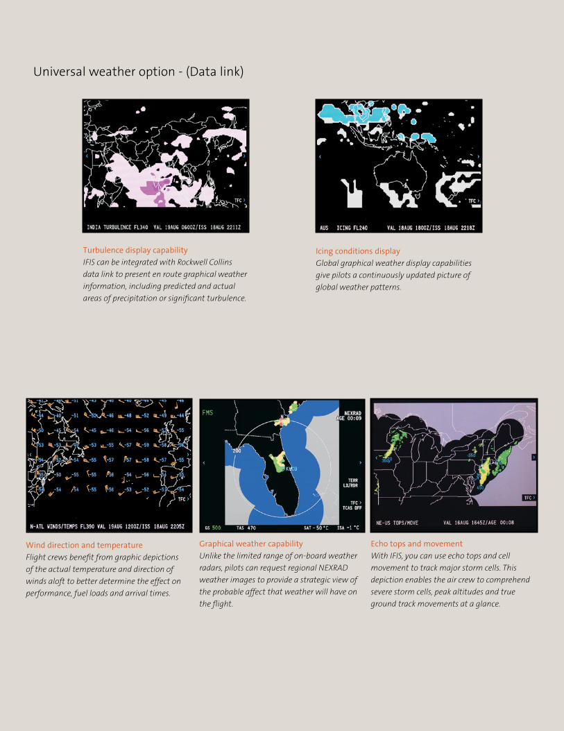
Graphical weather capability
Unlike the limited range of on-board weather
radars, pilots can request regional NEXRAD
weather images to provide a strategic view of
the probable affect that weather will have on
the flight.
Echo tops and movement
With IFIS, you can use echo tops and cell
movement to track major storm cells. This
depiction enables the air crew to comprehend
severe storm cells, peak altitudes and true
ground track movements at a glance.
Turbulence display capability
IFIS can be integrated with Rockwell Collins
data link to present en route graphical weather
information, including predicted and actual
areas of precipitation or significant turbulence.
Icing conditions display
Global graphical weather display capabilities
give pilots a continuously updated picture of
global weather patterns.
Wind direction and temperature
Flight crews benefit from graphic depictions
of the actual temperature and direction of
winds aloft to better determine the effect on
performance, fuel loads and arrival times.
Universal weather option - (data link)

For more information contact:
Rockwell Collins400 Collins Road NECedar Rapids, Iowa 52498319.295.4085
email: [email protected]
Building trust every day.
Rockwell Collins delivers smart communication and aviation electronics solutions to customers worldwide. Backed by a global network of service and support, we stand committed to putting technology and practical innovation to work for you whenever and wherever you need us. In this way, working together, we build trust. Every day.
147-0595-001-CS 4/07 5M BUS © Copyright 2007, Rockwell Collins, Inc. All rights reserved. Printed in the USA.All logos, trademarks or service marks used herein are the property of their respective owners.
Chart © Jeppesen Sanderson, Inc. 1999, 2002.Chart is for illustration purposes and not to be used for navigation.Chart data reproduced with permission of Jeppesen Sanderson, Inc.
room for growth
Information is a pilot’s best ally when it comes to planning a safe and comfortable flight. With Rockwell Collins IFIS, you get an intuitive technology that improves your situational awareness with the utmost efficiency and convenience. As an enhancement to Rockwell Collins Pro Line 21 system, IFIS’ flexible architecture allows for future improvements such as en route charts, document viewer and many others. With many new features to come, IFIS offers a robust platform that can continue to increase situational awareness and enhance safety.
service wherever, whenever.
Total service solutions you can count on. From initial delivery and throughout your aircraft’s life cycle, we are here with comprehensive service and support solutions. Backed by our worldwide support network, we offer customized solutions from options that include performance-based maintenance and repairs, engineered solutions, provisioning, rental exchange, training and simulation solutions, all backed by the best turnaround times in the industry. Rockwell Collins delivers reliable solutions, anywhere, anytime – every time.