FLIGHT INFORMATION SERVICES FOR SOMALIA … SUP NO.6 to 32 of 2017... · page 1 of 29 flight...
29
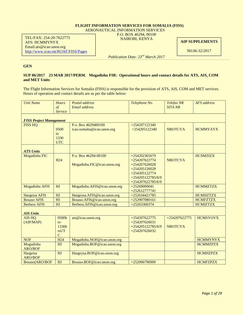
Page 1 of 29 FLIGHT INFORMATION SERVICES FOR SOMALIA (FISS) AERONAUTICAL INFORMATION SERVICES P.O. BOX 46294, 00100 NAIROBI, KENYA Publication Date: 23 rd March 2017 GEN SUP 06/2017 23 MAR 2017/PERM. Mogadishu FIR: Operational hours and contact details for ATS, AIS, COM and MET Units The Flight Information Services for Somalia (FISS) is responsible for the provision of ATS, AIS, COM and MET services. Hours of operation and contact details are as per the table below: Unit Name Hours of Service Postal address Email address Telephone No. Telefax NR SITA NR AFS address FISS Project Management FISS HQ 0500 to 1330 UTC P.o. Box 4629400100 [email protected] +254207122340 +254205122340 NBOTCYA HCMMYAYX ATS Units Mogadishu FIC H24 P.o. Box 46294-00100 [email protected] +254202365679 +254207622774 +254207626028 +254205126028 +254205122774 +254205122785/6/9 +254207622785/6/9 NBOTCYA HCSMZIZX Mogadishu AFIS HJ [email protected] +25269000041 +252612777741 HCMMZTZX Hargeisa AFIS HJ [email protected] +252634421785 HCMHZTZX Bosaso AFIS HJ [email protected] +252907080161 HCMFZTZX Berbera AFIS HJ [email protected] +25263360374 HCMIZTZX AIS Units AIS HQ (AIP/MAP) 0500h rs- 1330h rsUT C [email protected] +254207622775 +254207626031 +254205122785/6/9 +254207626032 +254207622775 NBOTCYA HCMSYOYX NOF H24 [email protected] HCMMYNYX Mogadishu ARO/BOF HJ [email protected] HCMMZPZX Hargeisa ARO/BOF HJ [email protected] HCMHZPZX Bosaso(ARO/BOF HJ [email protected] +252906796900 HCMFZPZX TEL/FAX: 254-20-7622775 AFS: HCMMYNYX Email:[email protected] http://www.icao.int/ROAF/FISS/Pages AIP SUPPLEMENTS N0.06-32/2017
Transcript of FLIGHT INFORMATION SERVICES FOR SOMALIA … SUP NO.6 to 32 of 2017... · page 1 of 29 flight...
Page 1 of 29
FLIGHT INFORMATION SERVICES FOR SOMALIA (FISS)
AERONAUTICAL INFORMATION SERVICES P.O. BOX 46294, 00100
NAIROBI, KENYA
Publication Date: 23rd
March 2017
GEN
SUP 06/2017 23 MAR 2017/PERM. Mogadishu FIR: Operational hours and contact details for ATS, AIS, COM
and MET Units
The Flight Information Services for Somalia (FISS) is responsible for the provision of ATS, AIS, COM and MET services.
Hours of operation and contact details are as per the table below:
Unit Name Hours
of
Service
Postal address
Email address
Telephone No. Telefax NR
SITA NR
AFS address
FISS Project Management
FISS HQ
0500
to
1330
UTC
P.o. Box 4629400100
+254207122340
+254205122340
NBOTCYA
HCMMYAYX
ATS Units
Mogadishu FIC
H24
P.o. Box 46294-00100
+254202365679
+254207622774
+254207626028
+254205126028
+254205122774
+254205122785/6/9
+254207622785/6/9
NBOTCYA
HCSMZIZX
Mogadishu AFIS HJ [email protected] +25269000041
+252612777741
HCMMZTZX
Hargeisa AFIS HJ [email protected] +252634421785 HCMHZTZX
Bosaso AFIS HJ [email protected] +252907080161 HCMFZTZX
Berbera AFIS HJ [email protected] +25263360374 HCMIZTZX
AIS Units
AIS HQ
(AIP/MAP)
0500h
rs-
1330h
rsUT
C
[email protected] +254207622775
+254207626031
+254205122785/6/9
+254207626032
+254207622775
NBOTCYA
HCMSYOYX
NOF H24 [email protected] HCMMYNYX
Mogadishu
ARO/BOF
HJ [email protected] HCMMZPZX
Hargeisa
ARO/BOF
HJ [email protected] HCMHZPZX
Bosaso(ARO/BOF HJ [email protected] +252906796900 HCMFZPZX
TEL/FAX: 254-20-7622775
AFS: HCMMYNYX
Email:[email protected]
http://www.icao.int/ROAF/FISS/Pages
AIP SUPPLEMENTS
N0.06-32/2017

Page 2 of 29
Aeronautical COM Unit
COM Centre H24 [email protected] +2542076226033
+2542051226033
+254205122785/6/9
+254207622785/6/9
NBOTCYA HCMMYFYX
Aeronautical met
MET HQ DLY
0415UTC
TO
1545UTC
[email protected] +2542076226035
+2542076226036
+254205126035
+254205126036
+254205122785/6/9
+254207622785/6/9
NBOTCYA HCMMYMYX
Mogadishu HJ [email protected] +252699771262 HCMMYMYX
Hargeisa HJ [email protected] +252634421785 HCMHYMYX
Bosaso HJ [email protected] +252907080161 HCMFYMYX
Berbera HJ [email protected] +252633603744 HCMIYMYX
NOTAM A0018/15 has been incorporated in this AIP Sup and is consequently cancelled
GEN
SUP 07/2017 23 MAR 2017/PERM. Meteorological Watch Office
Name of station
Time of Forecast Types of MET reports Observation
system &site(s)
Hours of
operation
Climato
logical
informa
tion
Mogadishu Met Watch Office 0000 to 0000
1200 to 12000
24hrs forecast update
Area Forecast
-upper wind
Upper Temp
Significant Chart
DLY
0415UTC
TO
1545UTC
NIL
Satellite Images
Warning Reports.
All significant
weather
SUP 08/2017 23 MAR 2017/PERM. Meteorological Field Stations, Observations and Reports
Name of station
Time of Report Types of MET reports Hours of
operation
Mogadishu Observatory
Hourly Observations,
METAR,
SPECI, 3HR
Synoptic report
DLY
0330UT
C to
1500UT
C
Hargeisa Observatory
Bosaso Observatory
Berbera Observatory
NOTAM A0031/14 has been incorporated in this AIP Sup and is consequently cancelled
Page 3 of 29
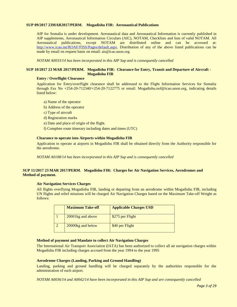
SUP 09/2017 23MAR2017/PERM. Mogadishu FIR: Aeronautical Publications
AIP for Somalia is under development. Aeronautical data and Aeronautical Information is currently published in
AIP supplements, Aeronautical Information Circulars (AIC), NOTAM, Checklists and lists of valid NOTAM. All
Aeronautical publications, except NOTAM are distributed online and can be accessed at:
http://www.icao.int/ROAF/FISS/Pages/default.aspx. Distribution of any of the above listed publications can be
made by email on request basis on email: [email protected].
NOTAM A0033/14 has been incorporated in this AIP Sup and is consequently cancelled
SUP 10/2017 23 MAR 2017/PERM. Mogadishu FIR: Clearance for Entry, Transit and Departure of Aircraft -
Mogadishu FIR
Entry / Overflight Clearance
Application for Entry/overflight clearance shall be addressed to the Flight Information Services for Somalia
through Fax No +254-20-712340/+254-20-7122775 or email: [email protected], indicating details
listed below:
a) Name of the operator
b) Address of the operator
c) Type of aircraft
d) Registration marks
e) Date and place of origin of the flight.
f) Complete route itinerary including dates and times (UTC)
Clearance to operate into Airports within Mogadishu FIR
Application to operate at airports in Mogadishu FIR shall be obtained directly from the Authority responsible for
the aerodrome.
NOTAM A0108/14 has been incorporated in this AIP Sup and is consequently cancelled
SUP 11/2017 23 MAR 2017/PERM. Mogadishu FIR: Charges for Air Navigation Services, Aerodromes and
Method of payment.
Air Navigation Services Charges
All flights overflying Mogadishu FIR, landing or departing from an aerodrome within Mogadishu FIR, including
UN flights and relief missions will be charged Air Navigation Charges based on the Maximum Take-off Weight as
follows:
Maximum Take-off Applicable Charges USD
1 20001kg and above $275 per Flight
2 20000kg and below $40 per Flight
Method of payment and Mandate to collect Air Navigation Charges
The International Air Transport Association (IATA) has been authorized to collect all air navigation charges within
Mogadishu FIR including charges accrued from the year 1994 to the year 1995
Aerodrome Charges (Landing, Parking and Ground Handling)
Landing, parking and ground handling will be charged separately by the authorities responsible for the
administration of each airport.
NOTAM A0036/14 and A0042/14 have been incorporated in this AIP Sup and are consequently cancelled

Page 4 of 29
SUP 12/2017 23 MAR 2017/PERM. Mogadishu FIR: NAFISAT VSAT Charges and Mode of Payment
A charge of USD $10.00 per FIR crossing for International flights operating over Mogadishu FIR (crossing,
terminating, exiting or departing) is payable to the International Air Transport Association (IATA) effective 21st
April 2008
.
Payments for the NAFISAT VSAT Charges and related queries shall be addressed to:
International Air Transport Association (IATA)
Route de l'Aéroport33,
P.O. BOX 416,
ch-1215 Geneva 15 airport,
Switzerland
Fax: +41(22)799-2678,
AFTN: LSGGIATA,
SITA: GVALDXB,
TELEX: 415586
NOTAM A0047/14 has been incorporated in this AIP Sup and is consequently cancelled
SUP 13/2017 23 MAR 2017/PERM. Mogadishu FIR: Requirement to carry HF radio on board aircraft
All aircraft operating within Mogadishu Flight Information Region (FIR) is required to carry serviceable High
Frequency (HF) Radio and maintain contact with Mogadishu Flight Information Centre (FIC) on the approved
frequencies. A notification to the State of Registry for flights not complying with this regulation will be made for
necessary action
NOTAM A0038/14 has been incorporated in this AIP Sup and is consequently cancelled
SUP 14/2017 23 MAR 2017/PERM. Mogadishu FIR: Unauthorized use of Aviation Frequency bands
Aircraft operators /pilots are advised to note that there are unauthorized stations operating aviation Frequency
within the aviation bands in Somalia. ICAO authorized stations to operate on approved Aviation Frequencies in
Somalia are: Berbera, Boroma, Bosaso, Hargeisa and Kalabeyed.
NOTAM A0032/14 has been incorporated in this AIP Sup and is consequently cancelled
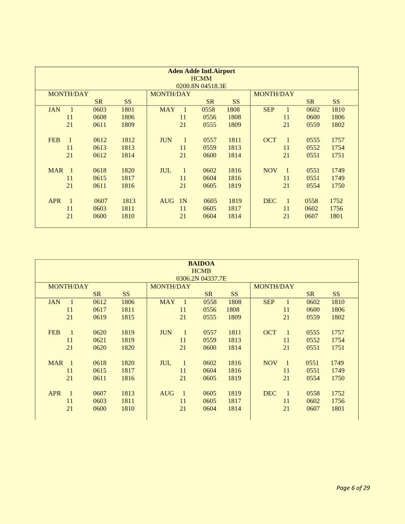
SUP 15/2017 23 MAR 2017/DEC 2017. Mogadishu FIR: Sunrise/Sunset Tables
The following sunrise/sunset tables have been prepared by Aeronautical Met and are produced here with their
permission. The times in the tables are given in UTC for sunrise (SR) and sunset (SS) for the year 2017.

Page 5 of 29
SUNRISE - SUNSET TABLES -TIMES (UTC)
EGAL Intl.Airport
HCMH
0930.7N 04404.9E
MONTH/DAY
SR SS
MONTH/DAY
SR SS
MONTH/DAY
SR SS
JAN 1 0621 1753
11 0625 1759
21 0627 1803
FEB 1 0627 1807
11 0626 1810
21 0623 1813
MAR 1 0620 1814
11 0616 1812
21 0609 1814
APR 1 0603 1813
11 0558 1813
21 0554 1812
MAY 1 0549 1814
11 0546 1814
21 0544 1816
JUN 1 0544 1820
11 0546 1822
21 0548 1824
JUL 1 0549 1826
11 0551 1827
21 0554 1826
AUG 1 0556 1824
11 0557 1821
21 0557 1818
SEP 1 0557 1812
11 0556 1806
21 0554 1800
OCT 1 0554 1754
11 0554 1749
21 0554 1744
NOV 1 0556 1740
11 0557 1738
21 0602 1738
DEC 1 0605 1740
11 0611 1743
21 0616 1748
KISMAYU
HCMK
002.6S 04228.3E
MONTH/DAY
SR SS
MONTH/DAY
SR SS
MONTH/DAY
SR SS
JAN 1 0610 1816
11 0615 1820
21 0618 1824
FEB 1 0620 1826
11 0621 1827
21 0621 1827
MAR 1 0620 1826
11 0618 1823
21 0615 1820
APR 1 0611 1816
11 0609 1814
21 0606 1812
MAY 1 0604 1810
11 0603 1810
21 0603 1809
JUN 1 0605 1810
11 0606 1812
21 0608 1814
JUL 1 0610 1816
11 0612 1818
21 0613 1819
AUG 1 0615 1819
11 0612 1818
21 0610 1816
SEP 1 0557 1812
11 0556 1806
21 0554 1800
OCT 1 0559 1803
11 0554 1800
21 0552 1757
NOV 1 0551 1756
11 0552 1757
21 0553 1758
DEC 1 0557 1802
11 0601 1806
21 0605 1811
Page 6 of 29
Aden Adde Intl.Airport
HCMM
0200.8N 04518.3E
MONTH/DAY
SR SS
MONTH/DAY
SR SS
MONTH/DAY
SR SS
JAN 1 0603 1801
11 0608 1806
21 0611 1809
FEB 1 0612 1812
11 0613 1813
21 0612 1814
MAR 1 0618 1820
11 0615 1817
21 0611 1816
APR 1 0607 1813
11 0603 1811
21 0600 1810
MAY 1 0558 1808
11 0556 1808
21 0555 1809
JUN 1 0557 1811
11 0559 1813
21 0600 1814
JUL 1 0602 1816
11 0604 1816
21 0605 1819
AUG 1N 0605 1819
11 0605 1817
21 0604 1814
SEP 1 0602 1810
11 0600 1806
21 0559 1802
OCT 1 0555 1757
11 0552 1754
21 0551 1751
NOV 1 0551 1749
11 0551 1749
21 0554 1750
DEC 1 0558 1752
11 0602 1756
21 0607 1801
BAIDOA
HCMB
0306.2N 04337.7E
MONTH/DAY
SR SS
MONTH/DAY
SR SS
MONTH/DAY
SR SS
JAN 1 0612 1806
11 0617 1811
21 0619 1815
FEB 1 0620 1819
11 0621 1819
21 0620 1820
MAR 1 0618 1820
11 0615 1817
21 0611 1816
APR 1 0607 1813
11 0603 1811
21 0600 1810
MAY 1 0558 1808
11 0556 1808
21 0555 1809
JUN 1 0557 1811
11 0559 1813
21 0600 1814
JUL 1 0602 1816
11 0604 1816
21 0605 1819
AUG 1 0605 1819
11 0605 1817
21 0604 1814
SEP 1 0602 1810
11 0600 1806
21 0559 1802
OCT 1 0555 1757
11 0552 1754
21 0551 1751
NOV 1 0551 1749
11 0551 1749
21 0554 1750
DEC 1 0558 1752
11 0602 1756
21 0607 1801

Page 7 of 29
GALCAIO
HCMR
0646N 04726E
MONTH/DAY
SR SS
MONTH/DAY
SR SS
MONTH/DAY
SR SS
JAN 1 0602 1744
11 0607 1749
21 0609 1753
FEB 1 0610 1756
11 0609 1759
21 0607 1801
MAR 1 0604 1802
11 0559 1801
21 0555 1800
APR 1 0549 1759
11 0545 1757
21 0541 1758
MAY 1 0538 1756
11 0535 1757
21 0533 1759
JUN 1 0534 1802
11 0535 1805
21 0536 1806
JUL 1 0538 1808
11 0542 1808
21 0543 1809
AUG 1 0545 1807
11 0545 1805
21 0544 1802
SEP 1 0544 1756
11 0542 1752
21 0540 1746
OCT 1 0539 1741
11 0538 1736
21 0538 1732
NOV 1 0539 1729
11 0541 1727
21 0544 1728
DEC 1 0548 1730
11 0552 1734
21 0558 1738
BOSASO
HCMF
1116.4N 04909.6E
MONTH/DAY
SR SS
MONTH/DAY
SR SS
MONTH/DAY
SR SS
JAN 1 0603 1729
11 0607 1735
12 0609 1739
FEB 1 0608 1744
11 0606 1747
21 0603 1751
MAR 1 0559 1753
11 0556 1750
21 0548 1753
APR 1 0549 1759
11 0536 1751
21 0532 1751
MAY 1 0526 1754
11 0522 1755
21 0521 1757
JUN 1 0520 1802
11 0522 1804
21 0522 1806
JUL 1 0525 1806
11 0528 1809
21 0530 1807
AUG 1 0532 1805
11 0532 1802
21 0534 1758
SEP 1 0534 1751
11 0534 1746
21 0533 1739
OCT 1 0533 1733
11 0533 1726
21 0534 1722
NOV 1 0536 1718
11 0538 1716
21 0543 1714
DEC 1 0547 1718
11 0553 1719
21 0558 1724
Page 8 of 29
ENR
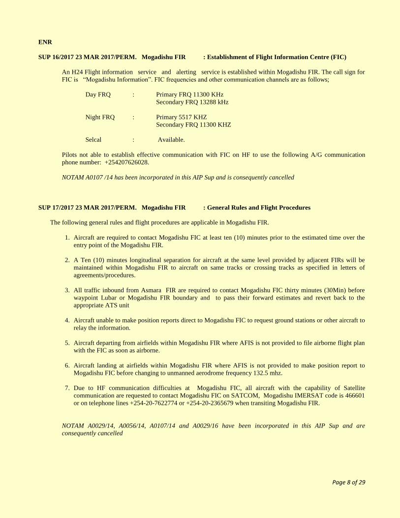
SUP 16/2017 23 MAR 2017/PERM. Mogadishu FIR : Establishment of Flight Information Centre (FIC)
An H24 Flight information service and alerting service is established within Mogadishu FIR. The call sign for
FIC is “Mogadishu Information”. FIC frequencies and other communication channels are as follows;
Day FRQ : Primary FRQ 11300 KHz
Secondary FRQ 13288 kHz
Night FRQ : Primary 5517 KHZ
Secondary FRQ 11300 KHZ
Selcal : Available.
Pilots not able to establish effective communication with FIC on HF to use the following A/G communication
phone number: +254207626028.
NOTAM A0107 /14 has been incorporated in this AIP Sup and is consequently cancelled
SUP 17/2017 23 MAR 2017/PERM. Mogadishu FIR : General Rules and Flight Procedures
The following general rules and flight procedures are applicable in Mogadishu FIR.
1. Aircraft are required to contact Mogadishu FIC at least ten (10) minutes prior to the estimated time over the
entry point of the Mogadishu FIR.
2. A Ten (10) minutes longitudinal separation for aircraft at the same level provided by adjacent FIRs will be
maintained within Mogadishu FIR to aircraft on same tracks or crossing tracks as specified in letters of
agreements/procedures.
3. All traffic inbound from Asmara FIR are required to contact Mogadishu FIC thirty minutes (30Min) before
waypoint Lubar or Mogadishu FIR boundary and to pass their forward estimates and revert back to the
appropriate ATS unit
4. Aircraft unable to make position reports direct to Mogadishu FIC to request ground stations or other aircraft to
relay the information.
5. Aircraft departing from airfields within Mogadishu FIR where AFIS is not provided to file airborne flight plan
with the FIC as soon as airborne.
6. Aircraft landing at airfields within Mogadishu FIR where AFIS is not provided to make position report to
Mogadishu FIC before changing to unmanned aerodrome frequency 132.5 mhz.
7. Due to HF communication difficulties at Mogadishu FIC, all aircraft with the capability of Satellite
communication are requested to contact Mogadishu FIC on SATCOM, Mogadishu IMERSAT code is 466601
or on telephone lines +254-20-7622774 or +254-20-2365679 when transiting Mogadishu FIR.
NOTAM A0029/14, A0056/14, A0107/14 and A0029/16 have been incorporated in this AIP Sup and are
consequently cancelled

Page 9 of 29
ENR
SUP 18/2017 23 MAR 2017/PERM. Mogadishu FIR : RVSM Airspace
Except for state Aircraft as defined in Article 2 to the Chicago Convention, only RVSM approved aircraft shall be
permitted to operate in AFI RVSM airspace within Mogadishu FIR between FL290 and FL410. In addition, caution
is advised that Mogadishu FIR is Class G Airspace, where only flight information services (FIS) is provided, hence
pilots are required to maintain a high level of alertness when operating in Mogadishu FIR RVSM airspace and take
appropriate action to ensure safety of flight by maintaining contact with Mogadishu FIC for traffic information and
continuous listening watch on VHF emergency frequency 121.5 MHz and IFBP frequency 126.9 MHz at all times.
NOTAM A0048/14 and A0055/16 have been incorporated in this AIP Sup and are consequently cancelled
SUP 19/2017 23 MAR 2017/PERM. Mogadishu FIR : Procedures for the submission and transmission of a
Flight Plans:
Due to lack of AFTN terminals at aerodromes in Mogadishu FIR, all international flights operating in Mogadishu
FIR (Overflights, Arrival and Departure) are required to submit copies of their filled flight plans for both
journeys (inbound and outbound) to Mogadishu FIC in Nairobi on AFS address HCSMZIZX or SITA
NR.NBOTCYA.
A0082/14 has been incorporated in this AIP Sup and is consequently cancelled
SUP 20/2017 23 MAR 2017/PERM. Mogadishu FIR : FIR Lateral and Vertical limits
Name and
Lateral limits
Unit
providing
service
Radio call sign
(language) and
frequencies
Frequency/
purpose
Remarks
1 2 3 4 5
MOGADISHU FIR
114000N, 0432000E-
Clockwise along the northern Coast
line including Somali
Territorial waters to 105400N
0440200E then along the eastern
boundary of Djibouti TMA to
114500N 0441100E, 121100N
0504600E, 120000N 0513500E,
120000N 0600000E, 104200N
0600000E, 020000S 0440000E,
020000S 0420000E then along the
border between Somalia and Kenya,
Somalia and Ethiopia, Somalia and
Djibouti to
114000N 0432000E.
UNL
GND
CLASS OF AIRSPACE : G
Mogadishu
FIC
“Mogadishu
Information”.
EN
H24
11300 KHZ (day primary)
13288KHZ (day secondary)
5517KHZ (Night primary)
11300 KHZ
(Night secondary)
NOTAM A0107/14 has been incorporated in this AIP Sup and is consequently cancelled

Page 10 of 29
SUP 21/2017 23 MAR 2017/PERM. Mogadishu FIR: Lower ATS Routes (R775G, W885G)
Route designator
Name of significant
points Coordinates
Track
MAG(GEO)
VOR RDL
DIST(COP)
Upper limits
Lower limits
Airspace
Classification
Lateral
limits
NM
Directions of
cruising levels
Remarks
controlling
unit
frequency
Odd Even
1 2 3 4 5 6
R775G
▲ APKAK
112200N0431054E
▲ LUBAR
103300N0433600E
▲ HARGA
093121N0440530E
▲ ALNAB
085507N0441302E
▲ SOLUL
050509N0450802E
▲ BELETUEN
044400N0451100E
▲ MOGDU
020024N0451736E
▲ APMIR
002957N0452256E
▲ UNPAR
004921S0452731E
1550
3340
55NM
FL245
FL100
G
ADDIS ACC
TRANSFER
POINT
1550
3340
68 NM
MOGADISHU
FIC
11300 KHZ (day primary)
13288KHZ
(day secondary)
5517KHZ
(Night primary)
11300 KHZ
(night secondary)
MOGADISHU FIC
11300 KHZ
(day primary) 13288KHZ
(day
secondary) 5517KHZ
(Night
primary) 11300 KHZ
(night
secondary)
1670
3470
37NM
1680
3480
236 NM
1720
3530
21 NM
1780
3580
162 NM
1770
90NM
1770
79NM
SEYCHELLES ACC
TRANSFER
POINT

Page 11 of 29
Route designator
Name of significant
points Coordinates
Track
MAG(GEO)
VOR RDL
DIST(COP)
Upper limits
Lower limits
Airspace
Classification
Lateral
limits
NM
Directions of
cruising levels
Remarks
controlling
unit frequency
Odd Even
1 2 3 4 5 6
▲ W885G HARGA
093121N0440530E
▲ ARSHI
093304N0432421E
Mogadishu
11300 KHZ
13288 KHZ
5527 KHZ
2750
0950
41 NM
FL245
FL120
G
ADDIS ACC
TRANSFER
POINT
M651G
▲ OKTOB
114730N0444348E
▲ IMVEB
112638N0443753E
▲ HARGA
093121N0440530E
SANAA ACC
TRANSFER
POINT
1940
0140
22 NM
FL245
FL100
G
119 NM
MOGADISHU
FIC
11300 KHZ
(day primary)
13288KHZ
(day
secondary)
5517KHZ
(Night
primary)
11300 KHZ
(night
secondary)

Page 12 of 29
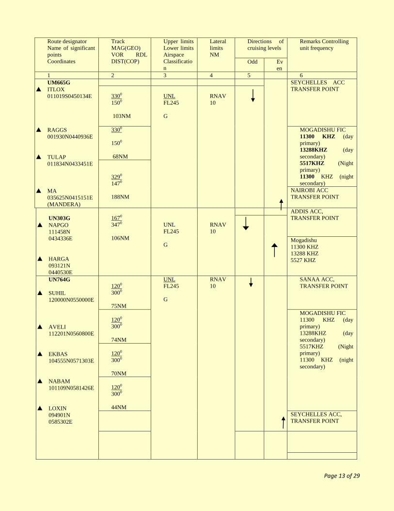
22/2017 Mogadishu FIR: Area Navigation (RNAV) Routes (UM216, UM634G, UM651G, UM665G, UN303G,
UN764G, UT253, UT382, UT383, UT 384, and UT386)
Route designator
Name of significant points
Coordinates
Track MAG(GEO)
VOR RDL
DIST(COP)
Upper limits
Lower limits
Airspace Classification
Lateral
limits
NM
Directions of cruising
levels
Remarks Controlling
unit frequency
Odd
Even
1 2 3 4 5 6
UM216
▲ HARGA 093121N0440530E
▲ AXAPO
091510N0434513E
MOGADISHU FIC
11300 KHZ (day primary)
13288KHZ (day
secondary) 5517KHZ (Night
primary)
11300 KHZ (night secondary)
2310 0500
26NM
UNL FL245
G
RNAV 10
ADDIS ACC,
TRANSFER POINT
UM634G
▲ DAROT 091120N0472112E
▲ IMTIS 112506N 0502858E
▲ VEDET
120134N0512420E
0540
2340
229NM
UNL
FL245
G
RNAV 10
MOGADISHU FIC
11300 KHZ (day
primary) 13288KHZ (day
secondary)
5517KHZ (Night primary)
11300 KHZ (night
secondary)
0540
2340
65NM
SANAA ACC,
TRANSFER POINT
UM651G
▲ ESTOK 024241N0495011E
▲ KATHY
041148N0483924E
▲ BUBEM
053924N0472909E
▲ KUSUB
064114N0464002E
▲ MURAL 084550N0444521E
▲ HARGA
093121N0440530E
▲ IMVEB
112638N0443753E
▲ OKTOB 114730N0444348E
3230
1410
113NM
UNL
FL245
G
RNAV 10 SEYCHELLES ACC
TRANSFER POINT
3210 1410
112NM
MOGADISHU FIC
11300 KHZ (day primary)
13288KHZ (day
secondary) 5517KHZ (Night
primary)
11300 KHZ (night secondary)
3220
1410
79NM
3180
1380
60NM
MOGADISHU FIC 11300 KHZ (day
primary)
13288KHZ (day secondary)
5517KHZ (Night
primary) 11300 KHZ (night
secondary)
0140
1940
119NM
0140
1940
22NM
SANAA ACC
TRANSFER POINT
Page 13 of 29
Route designator
Name of significant
points
Coordinates
Track
MAG(GEO)
VOR RDL
DIST(COP)
Upper limits
Lower limits
Airspace
Classificatio
n
Lateral
limits
NM
Directions of
cruising levels
Remarks Controlling
unit frequency
Odd Ev
en
1 2 3 4 5 6
UM665G
▲ ITLOX
011019S0450134E
▲ RAGGS
001930N0440936E
▲ TULAP
011834N0433451E
▲ MA
035625N0415151E
(MANDERA)
SEYCHELLES ACC
TRANSFER POINT
3300
1500
103NM
UNL
FL245
G
RNAV
10
3300
1500
68NM
MOGADISHU FIC
11300 KHZ (day
primary)
13288KHZ (day
secondary)
5517KHZ (Night
primary)
11300 KHZ (night
secondary)
3290
1470
188NM
NAIROBI ACC
TRANSFER POINT
UN303G
▲ NAPGO
111458N
0434336E
▲ HARGA
093121N
0440530E
1670
3470
106NM
UNL
FL245
G
RNAV
10
ADDIS ACC,
TRANSFER POINT
Mogadishu
11300 KHZ
13288 KHZ
5527 KHZ
UN764G
▲ SUHIL
120000N0550000E
▲ AVELI
112201N0560800E
▲ EKBAS
104555N0571303E
▲ NABAM
101109N0581426E
▲ LOXIN
094901N
0585302E
1200
3000
75NM
UNL
FL245
G
RNAV
10
SANAA ACC,
TRANSFER POINT
1200
3000
74NM
MOGADISHU FIC
11300 KHZ (day
primary)
13288KHZ (day
secondary)
5517KHZ (Night
primary)
11300 KHZ (night
secondary)
1200
3000
70NM
1200
3000
44NM
SEYCHELLES ACC,
TRANSFER POINT

Page 14 of 29
Route designator
Name of significant
points Coordinates
Track MAG(GEO)
VOR RDL
DIST(COP)
Upper limits
Lower
limits
Airspace Classificatio
n
Lateral
limits
NM
Directions of
cruising levels
Remarks
controlling unit
frequency
Odd Eve
n
1 2 3 4 5 6
UT253
▲ KESOM
000748N0410006E
▲ TULAP
011834N0433451E
▲ MOGDU
020024N0451736E
▲ ESTOK
0660
2460
170NM
UNL
FL245
G
RNAV
10
NAIROBI ACC
TRANSFER
POINT
0680
2480
111NM
MOGADISHU FIC
11300 KHZ (day
primary) 13288KHZ (day
secondary)
5517KHZ (Night primary)
11300 KHZ (night
secondary)
0820
2630
276NM
0160
1960
183NM
UNL
FL 245
G
RNAV
10
UT382
▲ HARGA
093121N0440530E
▲ DAROT
091120N0472112E
▲ AVEDA
091330N0494006E
▲ EVEBU 101957N0550000E
▲ EKBAS 104555N0571303E
▲ ORLID 111812N0600000E
0940
2750
194NM
UNL
FL245
G
RNAV
10
MOGADISHU FIC
11300 KHZ (day primary)
13288KHZ (day
secondary) 5517KHZ (Night
primary) 11300 KHZ (night
secondary)
0880
2690
137NM
0780
2590
323NM
0790 2600
134NM
0800 2610
167NM
MUMBAI ACC TRANSFER
POINT
UT383
▲ HARGA 093121N0440530E
▲ DAROT
091120N0472121E
▲ AVEDA
091330N0494006E
▲ EPSIV 091500N0550000E
▲ EGNIP
091429N0564248E
▲ UNRED
091343N0580435E
0940
2750
194NM
UNL
FL245
G
RNAV
10
MOGADISHU FIC
11300 KHZ (day
primary)
13288KHZ (day
secondary)
5517KHZ (Night
primary)
11300 KHZ (night
secondary)
0880
2690
137NM
0890 2710
316NM
MOGADISHU FIC
11300 KHZ (day
primary)
13288KHZ (day
secondary)
5517KHZ (Night
primary)
11300 KHZ (night
secondary)
0920 2720
102NM
0920
2720
81NM
SEYCHELLES
ACC,TRANSFER POINT
Page 15 of 29
Route designator
Name of significant
points Coordinates
Track MAG(GEO)
VOR RDL
DIST(COP)
Upper limits
Lower limits
Airspace
Classification
Lateral
limits
NM
Directions of
cruising levels
Remarks
controlling unit
frequency
Odd Even
1 2 3 4 5 6
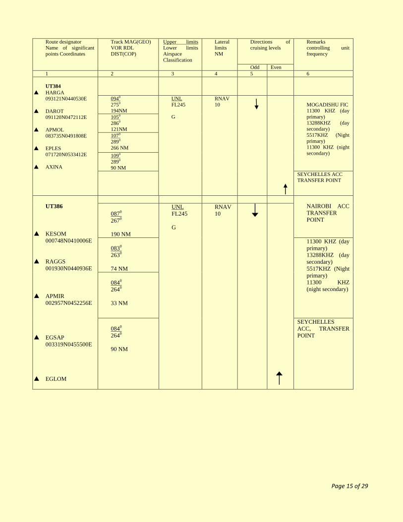
UT384
▲ HARGA
093121N0440530E
▲ DAROT
091120N0472112E
▲ APMOL
083735N0491808E
▲ EPLES
071720N0533412E
▲ AXINA
0940
2750 194NM
UNL
FL245
G
RNAV
10
MOGADISHU FIC 11300 KHZ (day
primary)
13288KHZ (day secondary)
5517KHZ (Night
primary)
11300 KHZ (night
secondary)
1050
2860 121NM
1070
2890
266 NM
1090 2890
90 NM
SEYCHELLES ACC TRANSFER POINT
UT386
▲ KESOM
000748N0410006E
▲ RAGGS
001930N0440936E
▲ APMIR
002957N0452256E
▲ EGSAP
003319N0455500E
▲ EGLOM
NAIROBI ACC
TRANSFER
POINT
0870
2670
190 NM
UNL
FL245
G
RNAV
10
0830
2630
74 NM
11300 KHZ (day
primary)
13288KHZ (day
secondary)
5517KHZ (Night
primary)
11300 KHZ
(night secondary)
0840
2640
33 NM
0840
2640
90 NM
SEYCHELLES
ACC, TRANSFER
POINT

Page 16 of 29
SUP 23/2017: 23MAR2017/PERM. Mogadishu FIR: Upper ATS routes
(UB312,UB400G,UR401G,UB403G,UB404G,UA405G,UB413,UG450G.UG657,UR775,UR780G,UB885G
Route designator
Name of significant
points Coordinates
Track
MAG(GEO)
VOR RDL
DIST(COP)
Upper limits
Lower limits
airspace
classification
Lateral
limits
NM
Directions of
cruising levels
Remarks controlling
unit frequency
Odd Even
1 2 3 4 5 6
UB312G
▲ HARGA
093121N 0440530E
▲ EGROV
112042N 0455900E
▲ PAKER
115500N 0463500E
0440
2250
156NM
UNL
FL245
G
1NAV
10
MOGADISHU FIC
11300 KHZ (day
primary)
13288KHZ (day
secondary)
5517KHZ (Night
primary)
11300 KHZ (night
secondary)
0440
2250
49NM
SANAA ACC
TRANSFER POINT
UB400G
▲ ITMAR
020009S0423504E
▲ RAGGS
001930N0440936E
▲ MOGDU
020024N0451736E
▲ BUBEM
053924N0472909E
▲ EGTUL
072037N0483122E
▲ APMOL
083735N0491808E
▲ AVEDA
091330N0494006E
▲ EVAKA
112356N0510042E
▲ VEDET
120134N0512420E
0350
2150
168NM
UNL
FL245
G
RNAV
10
NAIROBI ACC,
TRANSFER POINT
0350
2150
121NM
MOGADISHU FIC
11300 KHZ (day
primary)
13288KHZ (day
secondary)
5517KHZ (Night
primary)
11300 KHZ (night
secondary)
0310
2110
255NM
0310
2110
119NM
0310
2110
89NM
MOGADISHU FIC
11300 KHZ (day
primary)
13288KHZ (day
secondary)
5517KHZ (Night
primary)
11300 KHZ (night
secondary)
0310
2110
40NM
0310
2110
152NM
0310
2110
43NM
SANAA ACC,
TRANSFER POINT

Page 17 of 29
Route designator
Name of significant
points Coordinates
Track
MAG(GEO)
VOR RDL
DIST(COP)
Upper limits
Lower limits
airspace
classification
Lateral
limits
NM
Directions of
cruising levels
Remarks controlling
unit frequency
Odd Even
1 2 3 4 5 6
UR401G
▲ AXINA
064947N0550000E
▲ AMPEX
080957N0550000E
▲ EPSIV
091500N0550000E
▲ EVEBU
101957N0550000E
▲ EKBEL
112256N0550000E
▲ SUHIL
120000N0550000E
0010
1810
80NM
UNL
FL245
G
SEYCHELLES ACC
TRANSFER POINT
0010
1810
65NM
MOGADISHU FIC
11300 KHZ (day
primary)
13288KHZ (day
secondary)
5517KHZ (Night
primary)
11300 KHZ (night
secondary)
0010
1810
65NM
0010
1810
64NM
0010
1810
38NM
Mogadishu
11300 KHZ
13288 KHZ
5527 KHZ
SANAA ACC
TRANSFER POINT
UB403G
▲ BOMIX
121002N 0502757E
▲ AXIKU
112332N 0493519E
▲ DAROT
091120N 0472112E
▲ MUSBI
081300N 0462000E
2260
0450
66NM
UNL
FL245
G
RNAV
10
ADDIS ACC
TRANSFER POINT
2260
0450
189NM
MOGADISHU FIC
11300 KHZ (day
primary) 13288KHZ
(day secondary)
5517KHZ (Night
primary) 11300 KHZ
(night secondary)
2260
0450
83NM
ADDIS ACC
TRANSFER POINT

Page 18 of 29
Route designator
Name of significant
points Coordinates
Track
MAG(GEO)
VOR RDL
DIST(COP)
Upper limits
Lower
limits
airspace
classificatio
n
Lateral
limits
NM
Directions of
cruising levels
Remarks
controlling unit
frequency
Odd Even
1 2 3 4 5 6
UB404G
▲ HARGA
093121N0440530E
▲ MERMI
104806N0461948E
▲ ESTIK
112206N0471854E
▲ DEMGO
120258N0483040E
0590
2390
153NM
UNL
FL245
G
MOGADISHU
FIC
11300 KHZ (day
primary)
13288KHZ (day
secondary)
5517KHZ (Night
primary)
11300 KHZ (night
secondary)
0590
2390
67NM
0590
2390
87NM
SANAA ACC
TRANSFER
POINT
UA405G
▲ ASKEN
090544N 0435544E
▲ HARGA
093121N 0440530E
0200
2000
27NM
UNL
FL245
G
RNAV
10
ADDIS ACC
TRANSFER
POINT
MOGADISHU
FIC
11300 KHZ (day
primary)
13288KHZ (day
secondary)
5517KHZ (Night
primary)
11300 KHZ (night
secondary)

Page 19 of 29
Route designator
Name of significant
points Coordinates
Track
MAG(GEO)
VOR RDL
DIST(COP)
Upper limits
Lower limits
airspace
classification
Lateral
limits
NM
Directions of
cruising levels
Remarks
controlling unit
frequency
Odd Even
1 2 3 4 5 6
UB413G
▲ ZIZAN
115136N 0455900E
▲ EGROV
112042N 0455900E
▲ MERMI
104806N 0461948E
▲ DAROT
091120N 0472112E
▲ EGTUL
072037N 0483122E
▲ EMALU
050158N 0495700E
▲ AVIMO
033252N 0505239E
1470
3270
36NM
UNL
FL245
G
RNAV
10
SANAA ACC,
TRANSFER
POINT
1470
3270
38NM
MOGADISHU
FIC
11300 KHZ (day
primary)
13288KHZ (day
secondary)
5517KHZ (Night
primary)
11300 KHZ
(night secondary)
1470
3270
114NM
1480
3280
130NM
MOGADISHU
FIC
11300 KHZ (day
primary)
13288KHZ (day
secondary)
5517KHZ (Night
primary)
11300 KHZ
(night secondary)
1480
3290
162NM
SEYCHELLES
ACC,
TRANSFER
POINT

Page 20 of 29
Route designator
Name of significant
points Coordinates
Track
MAG(GEO)
VOR RDL
DIST(COP)
Upper
limits
Lower
limits
airspace
classificati
on
Lateral
limits
NM
Directions of
cruising levels
Remarks
controlling unit
frequency
Odd Even
1 2 3 4 5 6
UG450G
▲ KESOM
000748N0410006E
▲ TULAP
011834N0433451E
▲ MOGDU
020024N 0451736E
▲ KATHY
041148N 0483924E
▲ EMALU
050158N 0495700E
▲ EPLES
071720N 0533412E
▲ AMPEX
080957N 0550000E
▲ EGNIP
091429N 0564248E
▲ NABAM
101109N 0581426E
▲ ORLID
111812N 0600000E
0660
2460
176NM
UNL
FL245
G
RNAV 10 NAIROBI
ACC
TRANSFER
POINT
0670
2470
111NM
MOGADISHU
FIC
11300 KHZ
(day primary)
13288KHZ
(day
secondary)
5517KHZ
(Night
primary)
11300 KHZ
(night
secondary)
0570
2380
240NM
0580
2380
92 NM
0590
2390
255NM
MOGADISHU
FIC
11300 KHZ
(day primary)
13288KHZ
(day
secondary)
5517KHZ
(Night
primary)
11300 KHZ
(night
secondary)
0580
2380
100NM
0590
2390
120NM
0590
2390
107NM
0590
2390
123NM
MUMBAI
ACC
TRANSFER
POINT

Page 21 of 29
Route designator
Name of significant
points Coordinates
Track
MAG(GEO)
VOR RDL
DIST(COP)
Upper limits
Lower limits
airspace
classification
Lateral
limits
NM
Directions of
cruising levels
Remarks
controlling unit
frequency
Odd Even
1 2 3 4 5 6
UG657
▲ ENABO
005948N0410006E
▲ MAV
035624N0415151E
0160
1960
183NM
UNL
FL 245
G
RNAV
10
NAIROBI ACC
TRANSFER
POINT
UR775G
▲ APKAK
112200N0431054E
▲ LUBAR
103300N0433600E
▲ HARGA
093121N0440530E
▲ ALNAB
085507N0441302E
▲ SOLUL
050509N0450802E
▲ BELETUEN
044400N0451100E
▲ MOGDU
020024N0451736E
▲ APMIR
002957N0452256E
▲ UNPAR
004921S0452731E
1550
3340
55NM
UNL
FL245
G
RNAV
10
ADDIS ACC,
TRANSFER
POINT
1550
3340
68 NM
MOGADISHU FIC
11300 KHZ
13288 KHZ
5527 KHZ
1670
3470
37NM
ADDIS ACC,
TRANSFER
POINT
1680
3480
236 NM
ADDIS ACC,
TRANSFER
POINT
1720
3530
21 NM
MOGADISHU
FIC
11300 KHZ
(day primary)
13288KHZ (day
secondary)
5517KHZ
(Night primary)
11300 KHZ
(night
secondary)
1780
3580
162 NM
1770
3580
92NM
1770
3580
77NM
SEYCHELLES
ACC, TRANSFER
POINT

Page 22 of 29
Route designator
Name of significant
points Coordinates
Track
MAG(GEO)
VOR RDL
DIST(COP)
Upper limits
Lower limits
airspace
classification
Lateral
limits
NM
Directions of
cruising levels
Remarks controlling
unit frequency
Odd Even
1 2 3 4 5 6
UR780G
▲ AVUSI
045509N0440002E
▲ MOGDU
020024N0451736E
▲ EGSAP
003319N 0455500E
▲ APKAK
001120S 0461433E
ADDIS ACC
TRANSFER POINT
1560
3370
191NM
UNL
FL245
G
RNAV
10
1570
3380
95 NM
MOGADISHU FIC
11300 KHZ (day
primary)
13288KHZ (day
secondary)
5517KHZ (Night
primary)
11300 KHZ (night
secondary)
1570
3380
49 NM
SEYCHELLES ACC,
TRANSFER POINT
UW885G
▲ HARGA
093121N0440530E
▲ ARSHI
093304N0432421E
2750
0950
41NM
UNL
FL245
G
RNAV
10
Mogadishu
11300 KHZ
13288 KHZ
5527 KHZ
ADDIS ACC
TRANSFER POINT

Page 23 of 29
AD
SUP 24/2017 23 MAR 2017/PERM. Mogadishu FIR: Operations at Unmanned Airfields
All flights operating to and from airfields in Mogadishu FIR where AFIS is not provided are required to transmit
blind their position on 132.5 MHz before landing and taking off. NOTAM A0025 /14 has been incorporated in this AIP Sup and is consequently cancelled
SUP 25/2017 23 MAR 2017/PERM. Mogadishu FIR: Closure of Aerodromes
With an exception of aerodromes in, Somaliland, Puntland, Beletuen, Dussa, Mareb, Adado and Guryael, all
other airports in Mogadishu FIR are closed for flights operations except for aircrafts on Humanitarian mission
only.
All Humanitarian flights intending to operate to such Airports other than those mentioned above must obtain
clearance from Somalia Civil Aviation and Meteorology Authority (SCAMA) at least 48 hours prior to the date
of operation on Tel: +2525960123,+2525929070, Telefax +2525930002 or Email: [email protected]. The
request for clearance should include the following;
i) Aircraft Type
ii) Call sign
iii) Aircraft Registration
iv) Purpose of Flight
v) Date of Operation
vi) Route
vii) Operator
Aircraft contravening these procedures risk impounding and or prosecution under existing laws.
NOTAM A0055/14 has been incorporated in this AIP Sup and is consequently cancelled
SUP 26/2017 23 MAR 2017/PERM. Mogadishu FIR: Status of Airfields in Somalia
All operators intending to operate to any airfield in Somalia are advised to verify the status of the airfield to
which they intend to operate from local authorities or Flight Information Services for Somalia Tel: 254-20-
7622774 0r 7622785/6/9 Tel/Fax: 254-20-7622775.
NOTAM A0109/14 has been incorporated in this AIP Sup and is consequently cancelled

Page 24 of 29
AD
SUP 27/2017 23 MAR 2017/PERM. HCMM: Aerodrome Data/Information- ADEN ADDE International Airport
Aerodrome Name,
ARP coordinates
AD Elevation
Transition Altitude(TA)
Runway Physical Characteristics
Hours of
Operations
Available Services
Remarks
Aden Adde Intl. Airport
ARP :020050.25N
0451814.50E
ELEV:28FT
TA:3000FT AMSL
RWY Data
Designation : RWY 05/23
True Bearing : 050°/239°
Dimensions : 3184m * 45m
Surface : Asphalt
THR 05
Coord : 020017.15N0451734.83E
Elev : 13FT
GUND : To be notified
THR 23
Coord : 020123.36N0451854.18E
Elev : 28FT
GUND : To be notified
0315 to
1500 (UTC)
AFIS, AIS, MET,
Fueling Services,
Customs,
Immigration,
Ground Handling and
Hotels
1. Operators should exercise extreme
caution and fully assess the potential for
risks to flight safety and security when
planning or conducting operations into
Mogadishu airport due to possible
occurrence of armed conflict and the
lack of adequate aeronautical data and
Aeronautical information.
2. Authority Supervising the Aerodrome is
Somalia Civil Aviation and Meteorology
Authority (SCAMA).
3. Operators are required to apply for
clearance to operate at Aden Adde Intl.
Airport from SCAMA at least 48 hours
prior to the date of operation on
Tel:+2525960123,+2525929070,
Telefax +2525930002 or Email:
NOTAM A0107/14, A0005/17, and A0018/17 have been incorporated in this AIP Sup and are consequently cancelled.
Page 25 of 29
AD
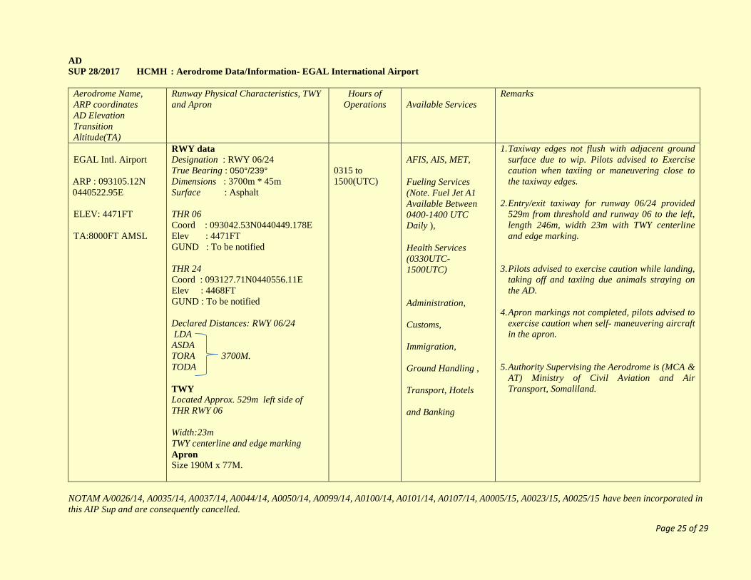
SUP 28/2017 HCMH : Aerodrome Data/Information- EGAL International Airport
Aerodrome Name,
ARP coordinates
AD Elevation
Transition
Altitude(TA)
Runway Physical Characteristics, TWY
and Apron
Hours of
Operations
Available Services
Remarks
EGAL Intl. Airport
ARP : 093105.12N
0440522.95E
ELEV: 4471FT
TA:8000FT AMSL
RWY data
Designation : RWY 06/24
True Bearing : 050°/239°
Dimensions : 3700m * 45m
Surface : Asphalt
THR 06
Coord : 093042.53N0440449.178E
Elev : 4471FT
GUND : To be notified
THR 24
Coord : 093127.71N0440556.11E
Elev : 4468FT
GUND : To be notified
Declared Distances: RWY 06/24
LDA
ASDA
TORA 3700M.
TODA
TWY
Located Approx. 529m left side of
THR RWY 06
Width:23m
TWY centerline and edge marking
Apron Size 190M x 77M.
0315 to
1500(UTC)
AFIS, AIS, MET,
Fueling Services
(Note. Fuel Jet A1
Available Between
0400-1400 UTC
Daily ),
Health Services
(0330UTC-
1500UTC)
Administration,
Customs,
Immigration,
Ground Handling ,
Transport, Hotels
and Banking
1. Taxiway edges not flush with adjacent ground
surface due to wip. Pilots advised to Exercise
caution when taxiing or maneuvering close to
the taxiway edges.
2. Entry/exit taxiway for runway 06/24 provided
529m from threshold and runway 06 to the left,
length 246m, width 23m with TWY centerline
and edge marking.
3. Pilots advised to exercise caution while landing,
taking off and taxiing due animals straying on
the AD.
4. Apron markings not completed, pilots advised to
exercise caution when self- maneuvering aircraft
in the apron.
5. Authority Supervising the Aerodrome is (MCA &
AT) Ministry of Civil Aviation and Air
Transport, Somaliland.
NOTAM A/0026/14, A0035/14, A0037/14, A0044/14, A0050/14, A0099/14, A0100/14, A0101/14, A0107/14, A0005/15, A0023/15, A0025/15 have been incorporated in
this AIP Sup and are consequently cancelled.

Page 26 of 29
AD
SUP 29/2017 23 MAR 2017/PERM. HCMI : Aerodrome Data/Information- BERBERA International Airport
Aerodrome Name,
ARP coordinates
AD Elevation
Transition Altitude(TA)
Runway Physical Characteristics
Hours
of Operations
Available
Services
Remarks
Berbera Intl. Airport
ARP : 102324N0445530E
ELEV:TBN
TA: 3000FT AMSL
Designation : RWY 05/23
Dimensions : 4140m * 50m
Declared Distances: RWY 05/23
LDA
ASDA
TORA 4140M.
TODA
0330-1430
UTC Daily
AFIS, MET,
Administration,
Customs and
Immigration
1. Pilots are advised to exercise caution while
landing, taking off and taxiing due to
presence of large birds, animals and
people straying within the aerodrome.
2. Pilots are advised to exercise caution while
landing and taking off due to disabled
aircraft AN12 1100m from threshold 23
and 7m from runway edge to the right of
runway 23.
3. Authority Supervising the Aerodrome is
(MCA & AT) Ministry of Civil Aviation
and Air transport, Somaliland.
NOTAM A0027/14, A0028/14, A0039/14, A0046/14, A0051/14, and A0107/1415 have been incorporated in this AIP Sup and are consequently cancelled.

Page 27 of 29
AD
SUP 30/2017 23 MAR 2017/PERM. HCMF : Aerodrome Data/Information- BOSASO International Airport
Aerodrome Name,
ARP coordinates
AD Elevation
Transition Altitude(TA)
Runway Physical Characteristics, TWY
and Apron
Hours
of Operations
Available Services Remarks
Bosaso Intl. Airport
ARP :
102324N0445530E
ELEV:TBN
TA: 3000 FT AMSL
Runway Data
RWY Designation : RWY 09/27
True Bearing : 089°/269°
RWY Dimensions : 2400M * 45M
RWY Surface : Asphalt
Declared Distances: RWY 09/27
LDA
ASDA
TORA 2400M.
TODA
TWY Data
Located Approx. 1400m left side of THR
RWY 09
TWY Width: 23M
Shoulder width 44M
Apron Data
Size :150M x138M
Apron Marking provided
0330-1430
UTC Daily
AFIS, AIS, MET
Ground Handling
1. Basic handling services available at Bosaso
airport with the following charges
Aircraft weight
i)up to 20,000kg 50 USD
ii) 20,001 to 25000kg 140 USD
iii) 25,001 and above 500 USD
2. Pilots are advised to exercise caution while
landing and taking off due to presence of large
birds abeam THR RWY 09 and THR RWY 27
3. Caution is advised that Taxiway shoulders not
flush with adjacent ground.
4. Authority Supervising the Aerodrome is Civil
Aviation and Airports, Puntland
NOTAM A0043/14, A0045/14, A0104/14, A0107/14 A0006/16, A0008/16 and A0027/16 have been incorporated in this AIP Sup and are consequently cancelled

Page 28 of 29
AD
SUP 31/2017 23 MAR 2017/PERM. HCMV : Aerodrome Data/Information- BURAO International Airport
Aerodrome Name,
ARP coordinates
AD Elevation
Transition Altitude(TA)
Runway Physical Characteristics and
TWY
Hours
of Operations
Available Services Remarks
BURAO Intl. Airport
ARP : 093000N
0453400E
ELEV: 3410FT
TA: 7000 FT AMSL
RWY Designation : RWY 05/23
RWY Dimensions : 1600m * 30m
RWY Surface : Gravel
RWY Strength : RWY recommended for
ACFT up to AN24 and AN26
Declared Distances: RWY 05/23
LDA
ASDA
TORA 1600M.
TODA
TWY Width: 33M
0330-1430
UTC Daily
AD Administration
Customs,
Immigration, Health,
Sanitation, Security,
Ground Handling,
Transportation and
Banking.
1. Pilots are advised to exercise caution while
landing and taking off due to floods 400m FM
THR RWY 05 during rainy season.
2. Authority Supervising the Aerodrome is (MCA
& AT) Ministry of Civil Aviation and Air
transport, Somaliland.
NOTAM A0030/14, A0087/14, A0107/1416 have been incorporated in this AIP Sup and are consequently cancelled
Page 29 of 29
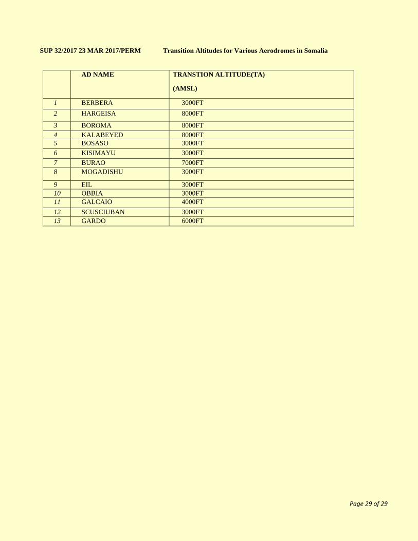
SUP 32/2017 23 MAR 2017/PERM Transition Altitudes for Various Aerodromes in Somalia
AD NAME TRANSTION ALTITUDE(TA)
(AMSL)
1 BERBERA 3000FT
2 HARGEISA 8000FT
3 BOROMA 8000FT
4 KALABEYED 8000FT
5 BOSASO 3000FT
6 KISIMAYU 3000FT
7 BURAO 7000FT
8 MOGADISHU 3000FT
9 EIL 3000FT
10 OBBIA 3000FT
11 GALCAIO 4000FT
12 SCUSCIUBAN 3000FT
13 GARDO 6000FT