FIVE-YEAR REVIEW - WELDON SPRINGS FORMER ARMY ORDNANCE ... · with the U.S. Army Corps of Engineers...
39
y^!S USB) ^mtfrt- UNITED STATES ENVIRONMENTAL PROTECTION AGENCY ^ - y Q r REGION VII >^ M rrr- t &r™T' Brcak:„^:.J2 t ^thcr: -<^> MEMORANDUM 901 NORTH 5TH STREET KANSAS CITY, KANSAS 66101 Af^ SUBJECT: Concurrence on the Weldon Spring Ordnance Works - Operable Unit 1 FROM: THRU: TO: Tom Lorenz, Remedial Project Manager Federal Facilities/Special Emphasis Branch GeneGunn, Chief /i**-«—*-" Federal Facilities/Special Emphasis Branch Cecilia Tapia, Director ^ ^ ^ D 1^- SuperrundDivision ^C~<vrr\^ \ ICX—> & $ * The U.S. Army Corps of Engineers, Kansas City District (USACE) conducted its five- year review of the Former Weldon Spring Ordnance Works, Operable Unit 1: Soil and Pipeline. The Draft Final Five-Year Review Report is attached. The Environmental Protection Agency provided comments on the first draft which have been adequately addressed in this version. Attachment 40200760 SUPERFUND RECORDS RECYCLE <g
Transcript of FIVE-YEAR REVIEW - WELDON SPRINGS FORMER ARMY ORDNANCE ... · with the U.S. Army Corps of Engineers...

y^!S
USB) ^mtfrt-
UNITED STATES ENVIRONMENTAL PROTECTION AGENCY ^ - y Qr
REGION VII >^Mrrr- t&r™T'
Brcak:„^:.J2 t ^thcr: -<^>
MEMORANDUM
901 NORTH 5TH STREET KANSAS CITY, KANSAS 66101
A f ^
SUBJECT: Concurrence on the Weldon Spring Ordnance Works - Operable Unit 1
FROM:
THRU:
TO:
Tom Lorenz, Remedial Project Manager Federal Facilities/Special Emphasis Branch
GeneGunn, Chief /i**-«—*-" Federal Facilities/Special Emphasis Branch
Cecilia Tapia, Director ^ ^ ^ D 1 ^ -SuperrundDivision ^C~<vrr\^ \ ICX—>
& $ *
The U.S. Army Corps of Engineers, Kansas City District (USACE) conducted its five-
year review of the Former Weldon Spring Ordnance Works, Operable Unit 1: Soil and Pipeline.
The Draft Final Five-Year Review Report is attached. The Environmental Protection Agency
provided comments on the first draft which have been adequately addressed in this version.
Attachment
40200760
SUPERFUND RECORDS
RECYCLE < g

US Army Corps of Engineers® Kansas City District
FINAL
Five-Year Review Report
1st Five-Year Review Report for the
Former Weldon Spring Ordnance Works Operable Unit 1: Soil and Pipeline
Weldon Spring, Missouri
March 2005
Prepared by: United States Army Corps of Engineers - Kansas City District
Kansas City, Missouri
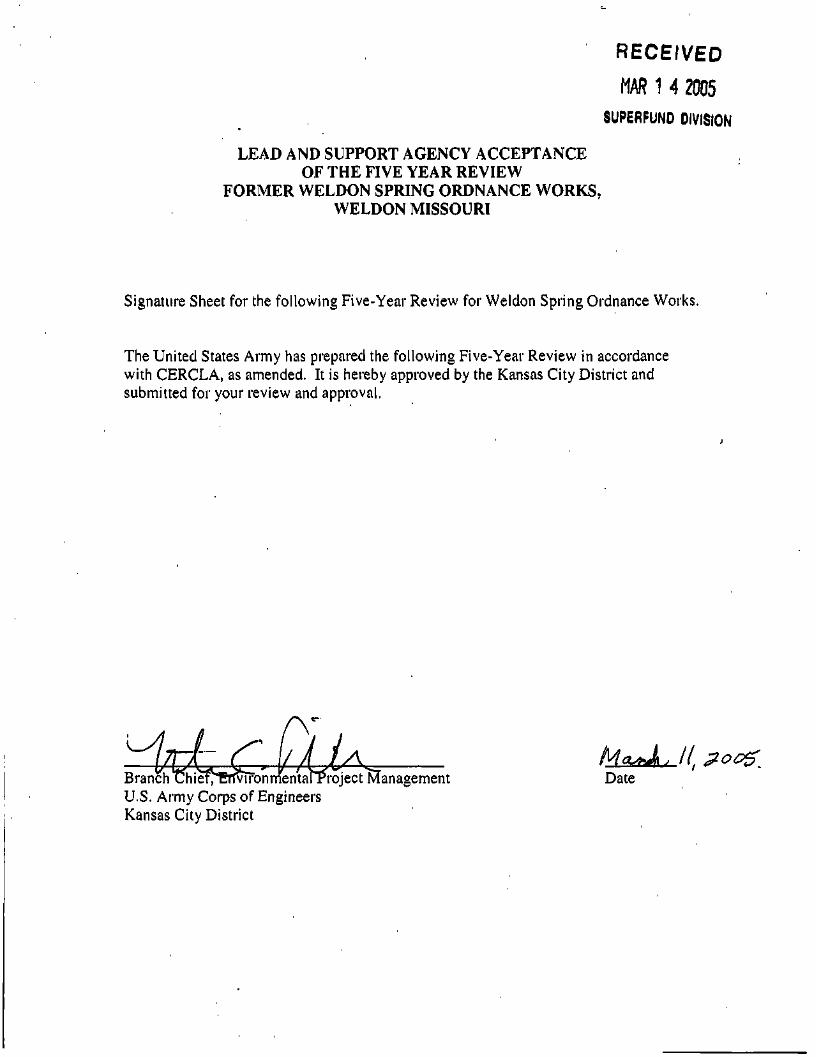
RECEIVED
MAR 1 4 2005
SUPERFUNO DIVISION
LEAD AND SUPPORT AGENCY ACCEPTANCE OF THE FIVE YEAR REVIEW
FORMER WELDON SPRING ORDNANCE WORKS, WELDON MISSOURI
Signature Sheet for the following Five-Year Review for Weldon Spring Ordnance Works.
The United States Army has prepared the following Five-Year Review in accordance with CERCLA, as amended. It is hereby approved by the Kansas City District and submitted for your review and approval,
Mo^ , / / ZOOZ Branch ChievErimonmentarProject Management Date U.S. Army Corps of Engineers Kansas City District
Acronym List
ARARS Applicable or Relevant and Appropriate Requirements Atlas Atlas Powder Company BLRA Baseline Risk Assessment CERCLA Comprehensive Environmental Response, Compensation and Liability Act CERCLIS Comprehensive Environmental Response, Compensation, and Liability Information
System COC(s) Chemicals of Concern COPC(s) Chemicals of Potential Concern cPAH Carcinogenic Polyaromatic Hydrocarbons DNT Dinitrotoluene DOE Department of Energy ESD Explanation of Significant Differences EPA Environmental Protection Agency FLW Fort Leonard Wood HQ Hazard Quotient MDNR Missouri Department of Natural Resources MDOC Missouri Department of Conservation NPL National Priorities List OSWER Office of Solid Waste and Emergency Response OU1 Operable Unit 1: Soil and Pipeline OU2 Operable Unit 2: Groundwater PAH Polyaromatic HydrocarbonsPCB Polychlorinated Biphenyls RA Remedial Action RfD Reference Dose RI Remedial Investigation ROD Record of Decision Site Weldon Spring Ordnance Works TBC To Be Considered TCLP Toxicity Characteristic Leachate Procedure TEF Toxic Equivalency Factor TIS Transportable Incineration System TNT Trinitrotoluene USACE United States Army Corps of Engineers WSOW Weldon Spring Ordnance Works WSSRAP Weldon Spring Site Remedial Action Project WSTA Weldon Spring Training Area

Five-Year Review Summary FormSITE IDENTIFICATION
Site name (from WasteLAN): Former Weldon Spring Ordnance WorksEPA ID (from WasteLAN): MO5210021288Region: 7 [State: MO [City/County: Weldon Spring/St. Charles
m^ i ^^^^^^^^^^^^m^^^^^^^^^^^QNPL status: 0 Final D Deleted D Other (specify)Remediation status (chooseMultiple OUs?* D YES
all that apply)0 NO
: DUnder Construction DOperating 0 Complete[Construction Completion Date NA
Has site been put into reuse? 0 YES D NOREVIEW STATUS
Lead agency: D EPA D State D Tribe 0 Other Federal Agency (USAGE)Author name: US Army Corps of Engineers; Kansas City DistrictAuthor title: USAGE [Author Affiliation: Lead AgencyReview period:** 01/05/1998 to 01/05/2003Date(s) of site inspection; 11/07/2002 and 06/26/2003Type of Review:
Review number:
DDD
0 1 (first) D
Post-SARA D Pre-SARA D NPL-Removal onlyNon-NPL Remedial Action Site D NPL State/Tribe-leadRegional Discretion D Policy HStatutory
2 (second) D 3 (third) D Other (specify)Triggering action:D Actual RA Onsite Construction at OU# 0 Actual RA Start at OU#1D Construction Completion D Previous Five-Year Review ReportD Other (specify)Triggering action date (from WasteLAN): 01/05/1998Due date (five years after triggering action date): 01/05/2003
* ["OU" refers to operable unit.] [Although this site has multiple OUs, only OU1 is covered by this review.]** [Review period should correspond to the actual start and end dates of the Five-Year Review in WasteLAN.]
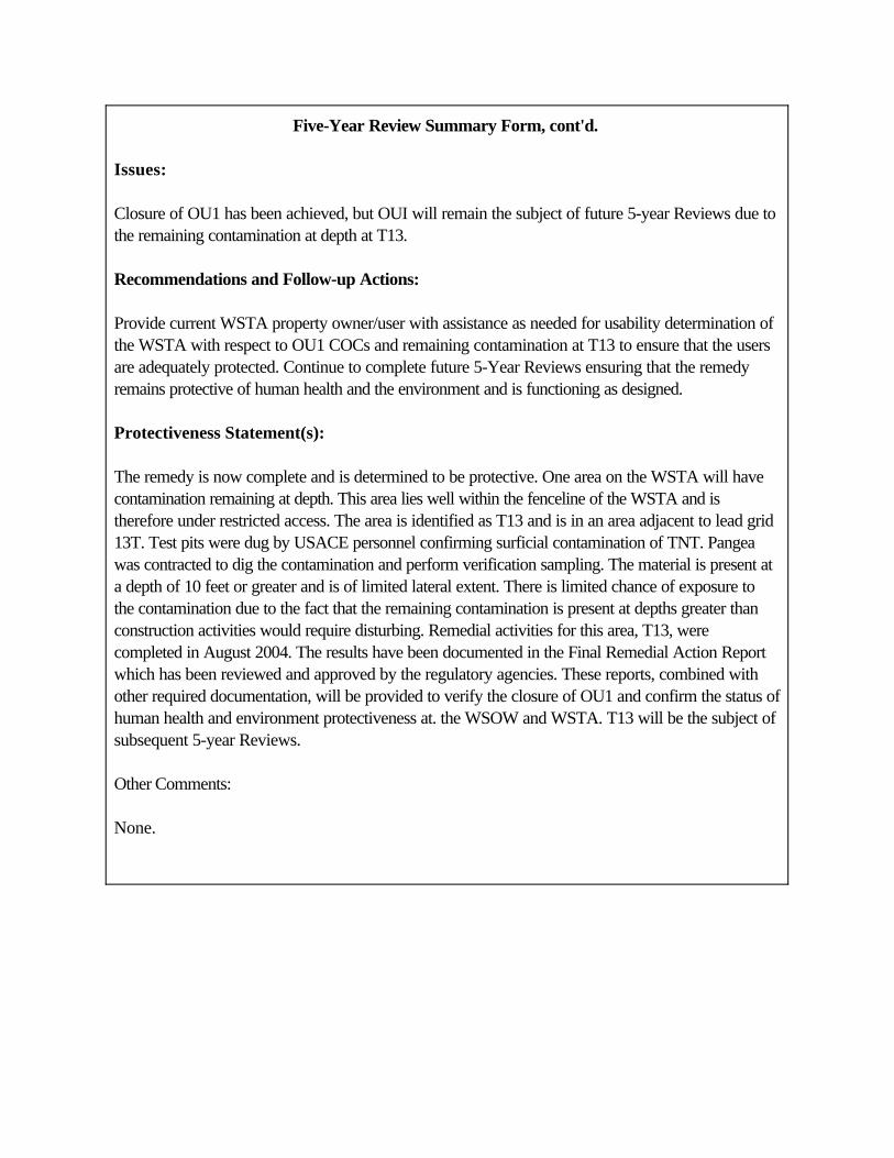
Five-Year Review Summary Form, cont'd.
Issues:
Closure of OU1 has been achieved, but OUI will remain the subject of future 5-year Reviews due tothe remaining contamination at depth at T13.
Recommendations and Follow-up Actions:
Provide current WSTA property owner/user with assistance as needed for usability determination ofthe WSTA with respect to OU1 COCs and remaining contamination at T13 to ensure that the usersare adequately protected. Continue to complete future 5-Year Reviews ensuring that the remedyremains protective of human health and the environment and is functioning as designed.
Protectiveness Statement(s):
The remedy is now complete and is determined to be protective. One area on the WSTA will have contamination remaining at depth. This area lies well within the fenceline of the WSTA and istherefore under restricted access. The area is identified as T13 and is in an area adjacent to lead grid13T. Test pits were dug by USACE personnel confirming surficial contamination of TNT. Pangeawas contracted to dig the contamination and perform verification sampling. The material is present ata depth of 10 feet or greater and is of limited lateral extent. There is limited chance of exposure tothe contamination due to the fact that the remaining contamination is present at depths greater thanconstruction activities would require disturbing. Remedial activities for this area, T13, werecompleted in August 2004. The results have been documented in the Final Remedial Action Reportwhich has been reviewed and approved by the regulatory agencies. These reports, combined withother required documentation, will be provided to verify the closure of OU1 and confirm the status ofhuman health and environment protectiveness at. the WSOW and WSTA. T13 will be the subject ofsubsequent 5-year Reviews.
Other Comments:
None.
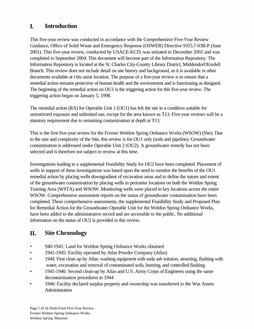
I. Introduction
This five-year review was conducted in accordance with the Comprehensive Five-Year ReviewGuidance, Office of Solid Waste and Emergency Response (OSWER) Directive 9355.7-03B-P (June2001). This five-year review, conducted by USACE-KCD, was initiated in December 2002 and wascompleted in September 2004. This document will become part of the Information Repository. TheInformation Repository is located at the St. Charles City-County Library District, Middendorf/KredellBranch. This review does not include detail on site history and background, as it is available in otherdocuments available at t his same location. The purpose of a five-year review is to ensure that aremedial action remains protective of human health and the environment and is functioning as designed.The beginning of the remedial action on OU1 is the triggering action for this five-year review. Thetriggering action began on January 5, 1998.
The remedial action (RA) for Operable Unit 1 (OU1) has left the site in a condition suitable forunrestricted exposure and unlimited use, except for the area known as T13. Five-year reviews will be astatutory requirement due to remaining contamination at depth at T13.
This is the first five-year review for the Former Weldon Spring Ordnance Works (WSOW) (Site). Dueto the size and complexity of the Site, this review is for OU1 only (soils and pipeline). Groundwatercontamination is addressed under Operable Unit 2 (OU2). A groundwater remedy has not beenselected and is therefore not subject to review at this time.
Investigations leading to a supplemental Feasibility Study for OU2 have been completed. Placement ofwells in support of these investigations was based upon the need to monitor the benefits of the OU1remedial action by placing wells downgradient of excavation areas and to define the nature and extentof the groundwater contamination by placing wells in perimeter locations on both the Weldon SpringTraining Area (WSTA) and WSOW. Monitoring wells were placed in key locations across the entireWSOW. Comprehensive assessment reports on the status of groundwater contamination have beencompleted. These comprehensive assessments, the supplemental Feasibility Study and Proposed Planfor Remedial Action for the Groundwater Operable Unit for the Weldon Spring Ordnance Works,have been added to the administrative record and are accessible to the public. No additionalinformation on the status of OU2 is provided in this review.
II. Site Chronology
• 940-1941: Land for Weldon Spring Ordnance Works obtained • 1941-1945: Facility operated by Atlas Powder Company (Atlas) • 1944: First clean up by Atlas: washing equipment with soda ash solution, steaming, flushing with
water, excavation and removal of contaminated soils, burning, and controlled flashing. • 1945-1946: Second clean-up by Atlas and U.S. Army Corps of Engineers using the same
decontamination procedures in 1944 • 1946: Facility declared surplus property and ownership was transferred to the War Assets
Administration
Page 1 of 16 Draft-Final Five-Year Review Former Weldon Spring Ordnance Works Weldon Spring. Missouri

• 1949: War Assets Administration distributed a bulk of the acres to state and local jurisdictions (leaving only the current WSTA and the U.S. Atomic Energy Commission's former UraniumFeed Material Plant site under Federal Ownership; the Uranium Feed Material Plant iscommonly referred to as the Chemical Plant Area).
• 1950-1956: Third clean up is actually a group of three efforts that took place during the 1950s.General Services Administration (successor to the War Assets Administration) regraded andhauled soils from the TNT (Trinitrotoluene) lines and removed scrap materials. The 226 acrestransferred to the Atomic Energy Commission were decontaminated in 1955 (removal of28,250 cubic yards of contaminated soil and 21,500 linear feet of buried TNT wastewaterpipeline from the area that had been TNT plants 1, 2, 3, and 4; 59 buildings were burned andeight more structures were razed). Late in 1956, 136 buildings were burned and 20 weredismantled and/or sold in a clean-up effort called Cox's Program.
• 1962-1963: Fourth clean-up by the U.S. Army Support Center in St. Louis who coordinatedwith the U.S. Army Corps of Engineers and ordnance experts for removal of equipment fromand demolishing of 23 buildings.
• 1965-1967: Fifth clean up involved the dismantling and shipping of the wastewater incinerationplants to another TNT facility. Also, transformers, utility poles, and electrical andcommunications cables were removed and 70 buildings were demolished.
• 1967: Seven miles of railroad track were removed and shipped to other installations. • 1988: The Army initiated a comprehensive Remedial Investigation (RI) of the WSTA portion of
the Site. • 1990: Site placed on the National Priorities List (NPL) . • 1990-1991: A companion RI was completed for the remainder of the WSOW (outside the
WSTA) after the entire site was placed on the NPL. • 1992-1993: Baseline Risk Assessment • 1993: Feasibility Study for OU1 • 1993: Army released the Proposed Plan for the former WSOW OU1: Soils and Pipeline • 1996: Record of Decision for OU1 • 1997: Site mobilization on December 15, 1997 • 1998: Remedial action for OU1 initiated on January 5, 1998 (Weston) (as listed in CERCLIS) • 1999: Remedial action for OU1 suspended (Weston) • 2000: Draft Remedial Action Report for OU1 submitted (Weston) • 2000: Remedial action for OU1 resumed (Pangea) • 2001: Remedial action for OU1 completed (Pangea) • 2001: Draft Close-Out Report for OU1 submitted (Pangea) • 2002: Draft-Final Remedial Action Report for OU1 submitted to regulators (Weston) • 2002: Draft-Final Close-Out Report for OU1 submitted to regulators (Pangea) • 2002: Additional Contamination discovered (USACE/DOE) • 2003: Follow-up remedial action for OU1 initiated at T13 (Pangea) • 2004: Remedial action for OU1 at T13 completed (Pangea) • 2004: Draft; Final Remedial Action Report for OU1 submitted (Pangea) • 2004: Draft-Final; Final Remedial Action Report for OU1 submitted to regulators (Pangea) • 2004: Explanation of Significant Difference to the 1996 ROD (Record of Decision) submitted
for signature
Page 2 of 16 Draft-Final Five-Year Review Former Weldon Spring Ordnance Works Weldon Spring. Missouri
• 2004: Explanation of Significant Difference signed by USACE, FLW, and EPA • 2004: Final Remedial Action Report for OU1 finalized; OU1 closure given by EPA
III. Background
Physical Characteristics
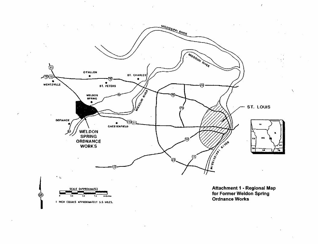
The Former WSOW site is located in St. Charles County, Missouri about 30 miles west of St. Louisand about 14 miles southwest of the City of St. Charles. It is bisected by State Highway 94, boundedon much of the north by U.S. Highway 40-61, and bounded on much of the south by the MissouriRiver. The area of the Ordnance Works site during production was 17,232 acres.
Topography of the site is hilly, varying from gently rolling in the north to rugged in the south. Thelocation of the site is shown on Attachment 1 (Regional Map for Former Weldon Spring OrdnanceWorks).
Geology/Hydrogeology
The northern half of the site drains northeastward through a series of creeks and man-made lakes toDardenne Creek, which is a tributary of the Mississippi River. The southern portion of the site is moresteeply sloped and heavily wooded, and drains southeastward into Little Femme Osage Creek and theMissouri River.
Three aquifers have been identified in the site area. They are the sand and gravel alluvium of theMississippi and Missouri Rivers and their tributaries, the shallow bedrock aquifer (Burlington-Keokukand adjacent lower formations), and the deeper bedrock aquifer (St. Peter Formation), which isseparated from the shallow bedrock aquifer by an aquitard. The shallow bedrock aquifer consists of theBurlington-Keokuk Formation (weathered and unweathered), the Fern Glen Formation, and theChouteau Group. The principal recharge to this aquifer is through precipitation infiltration from theoverburden, from losing stream drainages, or from surface water impoundments. The aquitard consistsof the Hannibal Formation, Sulphur Springs Group, Kimmswick Formation, Decorah Group, PlattinFormation, and Joachim Formation. The deeper bedrock aquifer is the St. Peter Formation. Rechargeinto the deep bedrock aquifer occurs where the bedrock units are near the surface or by leakage fromthe overlying shallow bedrock aquifer. However, the thickness of the confining unit and the low verticalflow velocities associated with the overlying shallow aquifer would likely mitigate any significantcontaminant migration to the deeper aquifer on site.
Land and Resource Use
The Former-WSOW NPL site encompasses the WSTA, Busch Conservation Area, the WeldonSpring Conservation Area, a Missouri Department of Transportation Depot, Francis Howell HighSchool, Weldon Spring Heights, Former Chemical Plant Area, and the Missouri Research Park. TheFormer Chemical Plant Area is a separate NPL site known as the Weldon Spring Site Remedial Action Project and is being addressed by the United States Department of Energy. The remaining areas are
Page 3 of 16 Draft-Final Five-Year Review Former Weldon Spring Ordnance Works Weldon Spring. Missouri
addressed as part of the Former WSOW NPL site. Attachment 2 (Site Map for Former WeldonSpring Ordnance Works) shows the location of these properties.
The land in the immediate vicinity of the site is currently undeveloped. Yet, the area to the northeast israpidly being developed into single-family and multi-family residential areas. There have been dramaticincreases in population in recent years in nearby incorporated areas such as O'Fallon, St. Peters, andCottleville. Although there are no residential properties on the land parcels where plant operationsoccurred on the Former-WSOW NPL site, based on current land use, cleanup goals were set toprotect potential future residents. Office buildings have been built in Missouri Research Park. TheBusch Wildlife and Weldon Spring Conservation Areas attract over 1,000,000 visitors per year forfishing, hunting, and nature studies. Natural resources include several heavily wooded areas, the mostdiversified flora of any part of the state, migratory bird refuge areas, 37 lakes, and numerous fishingponds.
The WSTA is currently under ownership by Ft. Leonard Wood and is in use by the Army 89thRegional Readiness Command as a training area. The WSTA's firing range is also used by local andfederal law enforcement officials.
History of Contamination
The Former WSOW site was an explosives production facility that manufactured trinitrotoluene (TNT)and dinitrotoluene (DNT) for use in World War II. The facility was placed on standby in 1944. Whilein standby, onsite contamination was discovered. There were several clean-up actions taken andinvestigations completed prior to the site being listed on the NPL.
Initial Response
There were several actions taken to reduce the extent of contamination prior to the placement of thesite on the National Priorities List (NPL) in 1990. These events are identified in Section II, SiteChronology. These events are not related to the process established by CERCLA (ComprehensiveEnvironmental Response Compensation and Liability Act) but significantly reduced the potential forexposure to nitroaromatic contamination prior to the initiation of the remedial action in OU1. Additionaldetail on these activities is provided as part of the Site Background in the Final Remedial Investigation -Weldon Spring Training Area - Volume I (IT Corporation).
A Remedial Investigation was initiated in 1988. Before the investigation was completed, the site wasplaced on the NPL. Remedial action for the soil and pipeline began in 1998.
Basis for Taking Action
Two Remedial Investigations (RI) were conducted by U.S. Army Corps of Engineers (USACE), onefor the WSTA was initiated in 1988 and the other in 1993 for the rest of the WSOW. These two RIswere used to identify the types, quantities, and locations of contaminants in different media throughoutthe entire Former WSOW area.
Page 4 of 16 Draft-Final Five-Year Review Former Weldon Spring Ordnance Works Weldon Spring. Missouri
Chemicals that posed potentially unacceptable risks were designated as Chemicals of Concern(COCs), and Remediation Goals were identified for these COCs. Soils with concentrations of TNTand DNT (Dinitrotoluene) that exceeded the risk based Remediation Goals required remediation:
2,4,6-TNT 5.7 ppm (10-6 risk, residential exposure) 2,4- and 2,6-DNT 2.5 ppm (10-6 risk, residential exposure)
Soils contaminated by polychlorinated biphenyls (PCB) and polycyclic aromatic hydrocarbons (PAH)also exceeded Remediation Goals and required remediation:
Total PCBs 10 ppm (EPA PCB Spill Cleanup Policy) Total carcinogenic PAHs 10 ppm (10-6 risk on the WSTA)
It was determined that the pipeline only presented a safety-related risk and not a health-related risk.The pipeline was removed and incinerated based on the non-quantified safety risk.
Lead was not found to pose a hazard to human health and the environment (See section 2.6 of theROD). However, it was found at many locations in the soils at the WSTA and in the ConservationAreas in concentrations above those established to be protective for Superfund sites. The cleanup oflead at WSOW was based upon the EPA (Environmental Protection Agency) Interim Guidance onEstablishing Soil Lead Cleanup Levels at Superfund Sites. This was included as To Be Considered(TBC) material (guidance rather than regulation) during determination of Applicable or Relevant andAppropriate Requirements (ARARs) for the site:
Lead 500 ppm (EPA Superfund Site Lead Policy)
The RI also included a groundwater investigation. This investigation showed that the groundwater wascontaminated with TNT and DNT. The Baseline Risk Assessment (BLRA) evaluated the groundwatercontamination. The Army, EPA, and MDNR (Missouri Department of Natural Resources) agreed thatthe soil and groundwater would be addressed on separate schedules to permit accelerated clean up ofthe soil.
IV. Remedial Actions
Remedy Selection
On September 26, 1996, a ROD was signed to address OU1 (soils and pipeline). The selected remedywas Rotary Kiln Incineration. The selected remedy involved excavation and thermal destruction ofnitroaromatic-contaminated soils and wooden pipeline. The remedy also provided for the excavationand stabilization of the lead-contaminated soils that did not meet lead Toxicity Characteristic LeachateProcedure (TCLP) requirements. After stabilization, the lead-contaminated soils and constructiondebris were to be placed in an on-site landfill. Section 2.11 of the ROD (Documentation of SignificantChanges), states that the Army will use the DOE WSSRAP storage cell rather than a separatelyconstructed and maintained facility at WSOW for all specified landfill disposal. Because WSOW
Page 5 of 16 Draft-Final Five-Year Review Former Weldon Spring Ordnance Works Weldon Spring. Missouri
completely surrounds the DOE NPL site, use of this disposal cell is considered on-site disposal forpurposes of CERCLA requirements. This cell is part of the Weldon Spring Site Remedial ActionProject (WSSRAP) and is therefore subject to its own five-year review and will not be covered in thisreport. An Explanation of Significant Differences (ESD) was signed in 2004. This ESD addressedevents that occurred during the remedial action which were deemed significantly different, but did notfundamentally alter the remedy.
This remedial action incorporated both treatment and containment technologies for remediation of soiland pipeline media at the Site. The remedy included incineration of nitroaromatics-contaminated soilsand wooden pipeline, stabilization and on-site landfill of lead-contaminated soils, and landfill ofconstruction debris separated from contaminated soils. The remedy also included the disposal of PAHand PCB (<500 ppm) contaminated soil in the DOE WSSRAP storage cell. The DOE WSSRAPstorage cell was selected rather than a separately constructed on-site landfill. These technologies wereselected to substantially reduce risks associated with the contaminated materials that represented theprincipal threat at the site, and provided for permanent destruction of the nitroaromatics contamination.Also, since the cleanup goals were set to protect for residential exposures, no institutional controls wererequired. The actions of this remedy addressed the direct threat to human health and the environmentby remediating the contaminated soil and pipeline across the Site. Although not the primary goal ofOU1, the selected remedy also eliminated a source of nitroaromatics to the groundwater.
Remedy Implementation
OU1 - Soil and Pipeline
In 1997, USACE awarded a contract for remedial action to Roy F. Weston, Inc. (Weston). Atransportable incineration system (TIS) was selected for the remediation of WSOW OU1. Theremediation involved excavation and incineration of TNT/DNT contaminated pipelines and soils.Remediation also involved the stabilization of lead contaminated soils that failed the TCLP and disposalof construction debris, separated from the contaminated soils, in the on-site landfill. Restoration of theaffected areas was also included in the contract (backfill, regrading, seeding, etc.).
• Weston excavated 41,790 cubic yards of TNT/DNT-contaminated soils. • A total of 71,836 tons of pipeline material and associated TNT/DNT and lead co-
contaminated soils and debris were thermally treated. • Weston backfilled the excavations with 39,121 tons of treated ash, 2,500 cubic yards
of borrow soils, and 15,588 tons of top soil. • Approximately 3,000 linear feet of abandoned toluene pipelines were removed. • Weston also excavated a total of 10,325 cubic yards of lead-contaminated soils from
WSTA areas and Burning Ground 1. (Burning Ground 1 is southeast of the WSTA, butwithin the boundaries of the original WSOW property.)
Weston's contractual obligations were fulfilled in 1999 and a second contractor was hired to completethe remaining tasks associated with the OU1 remedial action. Pangea Group, Inc. (Pangea) wascontracted to remove waste stockpiled by Weston and perform additional excavation as needed. This
Page 6 of 16 Draft-Final Five-Year Review Former Weldon Spring Ordnance Works Weldon Spring. Missouri
waste was disposed of in the adjacent DOE WSSRAP storage cell. In 2000, Pangea was contractedto complete the Former WSOW project closure activities.
• Approximately 23,756 cubic yards of the previously treated waste, contaminated soil,and miscellaneous debris were transported from the Former WSOW to the DOEWSSRAP storage cell.
• Pangea completed additional excavation and confirmation sampling activities at Burning Ground 1 (approximately 2000 cubic yards).
• Approximately 10,086 cubic yards (post treatment volume) of soil containing levels of DNT and/or lead required chemical stabilization. After stabilization, the soil wastransported to the DOE WSSRAP storage cell.
• In total, the quantity of material that was transported by Pangea to the DOE WSSRAP storage cell was approximately 33,842 cubic yards.
In March 2003, the investigation of two remaining areas of possible contamination was initiated byUSACE. Pangea Group, Inc. was contracted once again to complete the investigation of two areasnamed T14 and T13. Throughout 2003 and 2004 Pangea completed the remaining remedial activitiesfor closure of OU1.
• Pangea investigated and confirmed that contamination did not remain at T14. • Contamination was found to remain at T13 and during subsequent removals a clay tile
pipe impacted with off-spec TNT was discovered. • Approximately 1350 cubic yards of TNT and DNT contaminated soil was removed
from the T13 main excavation and disposed of at Peoria Disposal Company in Peoria,IL.
• 189 pounds of TNT were removed from the 64-foot long clay tile pipe. The TNT was transported to and incinerated at the Onyx Facility in Sauget, IL.
• Soil contamination did exist under the clay tile pipe and 184 cubic yards of TNT andDNT contaminated soil was removed from the pipeline excavation and disposed of atPeoria Disposal Company.
• Contamination does remain at depth at both the main excavation and pipelineexcavation locations. Attachment 3 (Plan Diagrams of TNT/DNT Exceedances ofRemediation Goals at T13) depicts the areas of remaining contamination.
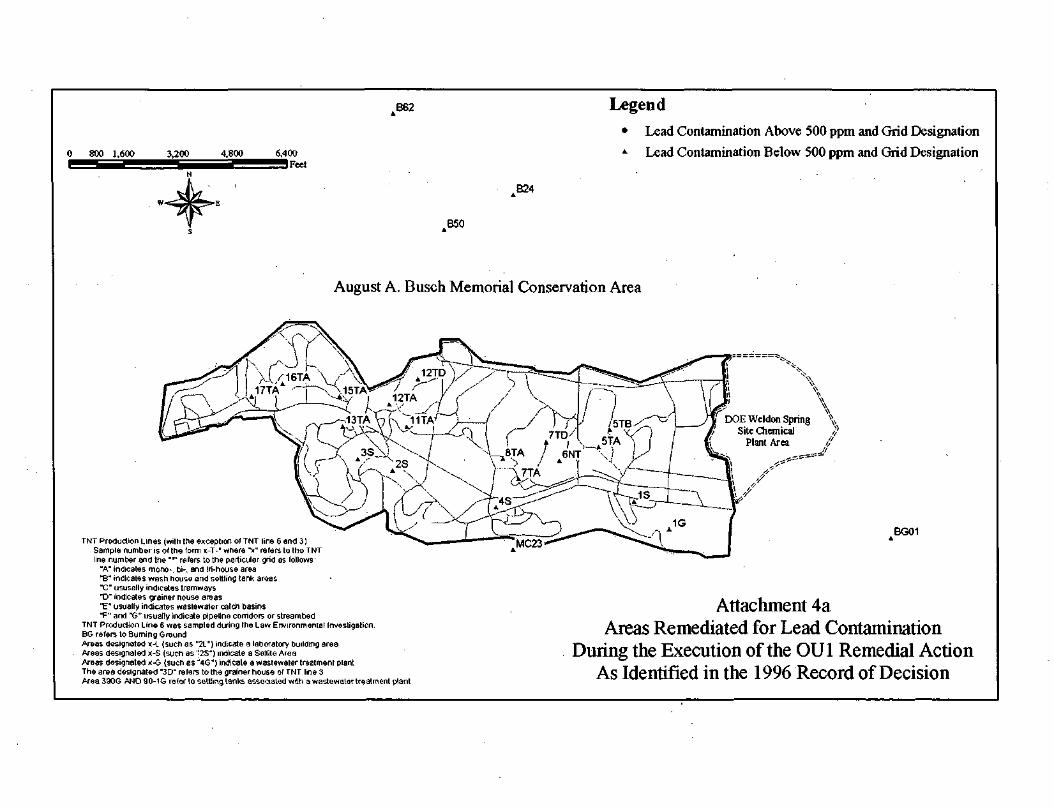
• Attachments 4, 4a, and 4b depict areas where remedial actions occurred and illustratewhere contamination has been left in place and those areas, which were remediatedsuccessfully.
V. Progress Since the Last Five-Year Review
This is the first five-year review for the Former WSOW.
Page 7 of 16 Draft-Final Five-Year Review Former Weldon Spring Ordnance Works Weldon Spring. Missouri

VI. Five-Year Review Process
Administrative Components
The five-year review team members included USACE, the Army Reserves, the United StatesEnvironmental Protection Agency (EPA), the Missouri Department of Natural Resources (MDNR), theMissouri Department of Conservation (MDOC), and members of the Weldon Spring community. Thisteam was generated to provide a comprehensive evaluation of the WSOW OU1 remedial action.Preliminary research and investigation was completed by USACE. Other team members were added tofacilitate completion of the review.
Document Review
• Remedial Investigation Report for Weldon Spring Ordnance Works, IT Corporation, November 1992
• Remedial Investigation Report for Weldon Spring Training Area, IT Corporation,March 1993
• Baseline Risk Assessment Weldon Spring Ordnance Works, IT Corporation, May1993
• Feasibility Study Weldon Spring Ordnance Works, IT Corporation, July 1993 • Record of Decision, USACE, September 1996 • Feasibility Study for Operational Unit-2, Argonne National Laboratory, December
1998 • Final Remedial Action Report, Roy F. Weston Inc., February 2000 (rev. April 2002) • Final Operable Unit 1 Project Closure Closeout Report, Pangea Group Inc.,
September 2001 (rev. April 2002) • Final Remedial Action Report, Pangea Group Inc., September 2004 (rev. 4).
Data Review
Weston
Weston performed the soil excavation and the pipeline removal and incineration. Nearly 41,790 cubicyards of contaminated soil was excavated and 71,836 tons of soils and debris were thermally treated.Remediation Goals were developed to be protective of potential future residential site use, based on a30-year adult exposure via the soil ingestion exposure route.
The Remediation Goals for the excavation of contaminated soil were:
• 57 milligrams per kilogram (mg/kg) for TNT, • 2.5 mg/kg for 2,4- and 2,6-DNT, • 500 mg/kg for total lead, • 10 mg/kg for PCBs, and • 10 mg/kg for PAHs.
Page 8 of 16 Draft-Final Five-Year Review Former Weldon Spring Ordnance Works Weldon Spring. Missouri
The incineration Remediation Goals were:
• 57mg/kg for TNT, • 2.5 mg/kg for 2,4- and 2,6-DNT, and • 5 milligrams per liter (mg/L) for leachable lead, TCLP.
If the concentration of leachable lead exceeded 5 mg/L, stabilization of the material was required.Verification the Remediation Goals were met is documented in the Final RA report provided byWeston.
Pangea
After Weston demobilized, Pangea continued the remaining scoped work at the Site by performing thenecessary soil stabilization and disposal of approved materials (soil and debris) in the DOE WSSRAPstorage cell. Approximately 10,086 cubic yards of soil required stabilization. The Remediation Goalsfor the stabilization, by TCLP analysis are:
• 0.130 mg/L for leachable 2,4-DNT and • 5 mg/L for leachable lead.
Verification that the Remediation Goals were met is documented in the Final Closeout Report submittedby Pangea. The Final Remedial Action Report documents the area (T13) where contamination hasbeen left in place at depth. Attachment 2 and 4 through 4b show the remedial efforts that have metremediation goals and those where contamination above remediation goals has been left in place.
Site Inspection
A site inspection was conducted on November 6, 2002. The site inspection was conducted by DaveNelson and Bill Empson, a Process Engineer and Civil Engineer with the USACE. It was determinedthat there have been no changes in the physical conditions of the site that would affect theprotectiveness of the remedy. The site had been restored (backfilled, graded, seeded, etc.) as part ofthe closeout activities of remedial action. The site was well vegetated with areas of dense trees andundergrowth. At the time of this inspection, construction activities associated with OU1 had beencomplete for approximately seventeen months. The areas identified in an August 2002 site visit were theonly remaining areas that required additional investigation.
A follow-up site inspection was completed on June 26, 2003. The entire review team (representativesfrom the USACE, Army Reserves, Restoration Advisory Board, MDNR, EPA, and the St. CharlesCounty Department of Environmental Services) performed the inspection. In the meeting, interviewswere conducted to determine an overall impression of team members on the status of the site. Tenlocations on the WSTA and WSOW were selected for visual inspection, based on input from therepresentatives of the review team. The status of the three sites 4W, 14W, and T13 identified in anAugust 2002 site visit was also verified. The rationale for the selection of 4W relates to DOE boringactivities during which TNT stained soil was encountered. This soil was containerized. Test pits were
Page 9 of 16 Draft-Final Five-Year Review Former Weldon Spring Ordnance Works Weldon Spring. Missouri
dug around the monitoring well area and visually screened for the presence of TNT. All soils from thetest pits and borings were containerized in 55-gallon drums. These drums were transported to theWSTA and stored at T13. They were later disposed of in an off-site landfill. 14W was a previouslyremediated area on the WSTA. Weston performed a substantial grid dig in the area. To the side of theexcavation is a drainage ditch. A representative from MDNR recalled seeing red stained soil in thisdrainage area. Two test trenches in the area of concern were dug and field-tested using Webster'sReagent. No further soil contamination was found. The trenches were backfilled and the area closed.T13 is in an area adjacent to lead grid 13T. Test pits were dug by USACE personnel confirmingsurficial contamination of TNT. Pangea was contracted to dig the contamination and performverification sampling. This dig advanced well beyond surficial contamination. The main excavation atT13 was advanced to a terminal depth of 22 feet. Approximately 1534 cubic yards of TNT and DNTcontaminated soil was removed and disposed of at an off-site subtitle C landfill. DNT contaminationdoes remain at depth in the excavation. During the excavation a clay tile pipe impacted with fibrousTNT was discovered. The TNT was removed and incinerated at an off-site facility. The pipeline wasremoved, decontaminated and disposed of at the same subtitle C landfill as the soil. Soil contaminationwas encountered under the pipeline and a pipeline excavation was advanced to remove the soilcontamination. The pipeline excavation was advanced in two sections. The first section had a terminaldepth of 16 feet and the second a terminal depth of 10 feet. TNT and DNT contamination does remainat depth in one sidewall of the 16-foot section of excavation. Refer to Attachment 3.
Work at these three sites has been completed. The trip report for the site visit conducted in August2002 can be found at the back of this report as attachment 5.
The stabilized lead soils and other material that did not meet the requirements for on-site backfill wereplaced in the DOE WSSRAP storage cell as is indicated in the Section 2.11 of the ROD(Documentation of Significant Changes). Construction on the DOE WSSRAP storage cell wascompleted prior to the inspection. DOE has recently completed a five-year review that includes theDOE WSSRAP storage cell. The DOE WSSRAP storage cell is not part of this five-year review.
Interviews
An interview was conducted on December 19, 2002 with Bill Empson who was Civil Engineer for theUSACE on the project during the remedial action of OU1. Mr. Empson provided a description of thesite before, during, and after the current stage of the OU1 remedial action. He also gave a descriptionof the operations during the OU1 remedial action. To date, several significant issues associated withactivities at the site have been identified and addressed. These issues are being documented in the BSD.Predicted site conditions and contamination based upon earlier investigations at the Site differed fromthose encountered during actual remediation activities. As a result, an increase in quantity and avariance in form of contamination from what was identified in the ROD was remediated. The Armyconsiders the differences to be significant, but not fundamental to the remedy selected in the ROD,None of these issues has affected the protectiveness of the remedy.
The June 26th, 2003 Five-Year Review Meeting was structured to provide the review team anopportunity to discuss the status of OU1 and develop a site inspection plan. The overall consensus of
Page 10 of 16 Draft-Final Five-Year Review Former Weldon Spring Ordnance Works Weldon Spring. Missouri

the team was that the project continues to move forward with good progress and that recent increasesin the level of communication between all stakeholders has increased the awareness of each stakeholderto the status of OU1.
Further reporting or execution of interviews is not necessary. Sufficient information was collected duringthe review of documents, site visits, and stakeholder meetings to provide an accurate report on thestatus of OU1.
Community Involvement
An ad was printed in the St. Peters Journal on Sunday, August 17th, 2003 and Wednesday, August20th, 2003 (Attachment 6). The ad was placed in the paper to notify the community that a five-yearreview was in progress. The notice identified the contaminants of concern at the site and updated the.community on the status of the Remedial Action. The community was encouraged to contribute to thereview process. Two USACE contacts were provided:
Mitchell Frazier, USACE Kansas City District Public Affairs Officer, 816-983-3486 William McFarland, WSOW Project Manager, 816-983-3360
Three radio stations were also contacted and asked to add an announcement of the five-year review totheir announcement binder (Attachment 7). KMOX (1120 am, The Voice of St. Louis), KTRS (550am, Talk Radio St. Louis), and KWMU (90.7 fm, In-Depth News & Intelligent Talk) were providedwith an announcement. The radio stations could not guarantee or record the date and time of theannouncements.
Upon final approval of this five-year review, an ad will be printed in the St. Peters Journal that willannounce that the five-year review for the Former Weldon Spring Ordnance Works is complete. Thead will also provide information on the location of the Information Repository where a copy of thereview will be filed.
VII. Technical Assessment
(The following questions are taken from EPA's Comprehensive Five-Year Review Guidance, OSWER 9355.7-03B-P (June 2001))
Question A: Is the remedy functioning as intended by the decision documents?
Yes, the remedy is functioning as intended by the decision documents. The 1996-ROD called for theremoval and incineration of TNT/DNT contaminated soil and pipeline. This remedial actionincorporated both treatment and containment technologies for remediation of soil and pipeline media atthe Site. The remedy included incineration of contaminated soils and wooden pipeline. The remedy alsoincluded stabilization and disposal in the DOE WSSRAP storage cell of lead-contaminated soils, PAHand PCB contaminated soils, and construction debris separated from contaminated soils. Thesetechnologies were selected to substantially reduce risks associated with the contaminated materials that
Page 11 of 16 Draft-Final Five-Year Review Former Weldon Spring Ordnance Works Weldon Spring. Missouri

represented the principal threat at the site, and provided for permanent destruction of thenitroaromatics, PAH, and PCB contamination. The actions of this remedy addressed the direct threat tohuman health and the environment by remediating the contaminated soil and pipeline across the Site.
Less than one half of one percent of the total volume of soil that exceeded the Remediation Goals, perthe ROD, remains. The remaining material is at depths of 10 feet or greater and is located within thefenceline of the WSTA (Attachment 2 and 3).
An ESD has recently been signed and addresses actions that were determined to be significantlydifferent from the ROD. These differences include cost, project duration, quantity of material, use of theDOE WSSRAP storage cell for material that met the requirements for incineration but was remediatedafter operation of the incinerator had been discontinued, and off-site disposal of small quantities ofwaste at permitted facilities.
Question B: Are the exposure assumptions, toxicity data, clean-up levels, and remedialaction objectives used at the time of the remedy still valid?
Yes. The exposure assumptions, toxicity data, clean-up levels, and remedial action objectives used atthe time of the remedy are still valid. The BLRA considered only recreational and occupationalexposures to soils at the site and addressed residential exposure only for groundwater. However, theRemediation Goals selected in the ROD were based on a residential scenario to allow futureunrestricted use of the site. Risk-based Remediation Goals for 2,4,6-trinitrotoluene and 2,4- and2,6-dinitrotoluene were developed for the ROD based on a 1x10⁻⁶ cancer risk to each chemical for anadult ingesting 100 mg of soil 350 days per year for 30 years. Dermal and inhalation exposures wereconsidered to be insignificant, and the effects of exposure during childhood in increasing carcinogenicrisks were not considered. This basis for calculating cleanup levels was, however, a reasonablystandard choice at the time the Remediation Goals were developed.
Current risk assessment practice would call for the resident to be considered as a child for 6 years ofthe 30-year exposure and as an adult for the remaining 24 years. As a child, the resident would have alower body weight of 15 kg rather than the adult weight of 70 kg and would be assumed to ingest 200mg of soil per day. Furthermore, both the child and adult resident would be assumed to have dermalabsorption of the chemicals and inhalation from fugitive dust.
Using current exposure factors in common use (USEPA, 2003), the risks associated with the2,4,6-TNT and 2,4- and 2,6-DNT Remediation Goals for a potential future resident are about 3.5x10⁻⁶
per chemical. Although these risk levels exceed the 1x10⁻⁶ "normal point of departure" in settingrisk-based cleanup levels, these risk levels for the chemicals individually and for the total risk posed byall the chemicals on the site still lie well within the 10-6 to 10-4 acceptable risk range.
Furthermore, there are at this time no residents on the site (WSTA). Comparing the Remediation Goalswith risk-based goals developed for an on-site worker (USEPA, 2003), the risk to workers, whowould be the most exposed individuals on site, from 2,4,6-TNT is 1x10⁻⁶ while a mixture of 2,4- and
Page 12 of 16 Draft-Final Five-Year Review Former Weldon Spring Ordnance Works Weldon Spring. Missouri
2,6-DNT, both present at their Remediation Goals, would pose a cancer risk to workers of 1x10⁻⁶ per chemical.
Thus, although risk assessment methodology has changed, the Remediation Goals for 2,4,6-trinitrotoluene and 2,4- and 2,6-dinitrotoluene do provide adequate protection for workers and otherreceptors currently on the site and would continue to provide an acceptable level of protection even ifthe land use of the site changed to residential or unrestricted use.
The Remediation Goal for PCBs was set using a cleanup level of 10 mg/kg for unrestricted access fromthe EPA Spill Cleanup Policy as an ARAR. This standard has not been changed and is consideredadequately protective.
The Remediation Goal for lead was set at 500 mg/kg using the "EPA Interim Guidance for EstablishingSoil Lead Cleanup Levels at Superfund Sites" (OSWER Directive #9355.4-02) as a TBC. Thisguidance did not set 500 mg/kg as a firm level to be achieved, but recommended it as a screening levelto consider the development of a cleanup level. Since it was anticipated that modeled cleanup levelshigher than 500 mg/kg would have a degree of uncertainty that might make acceptance difficult, it wascommon practice at the time of the ROD to set lead cleanup levels at the recommended 500 mg/kglevel. Since that time, the recommended level to begin screening has been lowered to 400 mg/kg. Itshould be noted that these screening levels were developed with protection of an exposed residentialchild as the goal. Also, in lead risk assessment practice both the 500 and 400 mg/kg concentrationswere intended to represent average concentrations over the site rather than maximum concentrationspermitted at a single point.
The evaluation of lead toxicity is rather difficult, and risk decisions are based on models that relate thedistribution of blood lead concentrations to the level of lead in soil and other media rather than directlyon the occurrence of toxic effects. The criterion for protection is based on a blood lead concentrationof 10 micrograms per deciliter (µg/dL) set by the Centers for Disease Control. Because the modelsassume a geometric distribution of blood lead levels, a fraction of people exposed to lead in soil at anylevel will be modeled as having blood leads in exceedance of 10 µg/dL. The goal of the modeling is todetermine a level that will be protective of approximately 95 percent of the people exposed. Thedifference between exposures to average concentrations of 400 and 500 mg/kg in soil is that while aslightly larger fraction of children exposed may have blood lead levels higher than 10 µg/dL mostexposed children will still be adequately protected. When modeling is conducted for adults, such as theworkers currently expected to be present on site, concentrations higher than 500 mg/kg are obtainedwhich are adequately protective.
Also, rather than treating the 500 mg/kg as an average soil lead concentration to be achieved duringremediation, soils containing 500 mg/kg or more of lead were removed. Lead contamination in soils atWSOW tended to occur in "hot spots" surrounded by soil with lead at lower levels. With the removalof these elevated leads, the average concentration of lead in soils remaining has been reduced to lessthan 400 mg/kg, providing adequate protection for unrestricted use..
The Remediation Goal for PAHs was based on an assumption in use at the time of the ROD that all
Page 13 of 16 Draft-Final Five-Year Review Former Weldon Spring Ordnance Works Weldon Spring. Missouri

carcinogenic PAHs were equipotent with benzo(a) pyrene. A significant difference in cancer risk methodology is a result of the introduction of the Toxic Equivalency Factor (TEF) approach for PAHs.This decreases cancer risks due to most of the PAHs that were previously considered equal incarcinogenic potency to benzo(a) pyrene. One PAH, benzo(g, h, i) perylene, has been reclassified toClass D - Not Classifiable as to Carcinogenicity. Since risks from cPAHs other than benzo(a) pyrenewere thus overestimated by one or more orders of magnitude, cleanups based on the total cPAHconcentrations should still be adequately protective.
Toxicity values for several of the chemicals of concern have been changed since the ROD was signed.The effects of these changes in toxicity values in COCs have been examined to determine their effectson the protectiveness of the remedy. These changes are summarized in Table 1 (Effects of Changes inToxicity Factors).
TABLE 1 EFFECTS OF CHANGES IN TOXICITY FACTORS
ORAL REFERENCE DOSES - NONCARCINOGENIC EFFECTS
Chemical Previous
Value mg/kg/day
Current Value mg/kg/day Reference
Increased Chemical Toxicity?
Increased Potential
Risk?
PCB Aroclor 1016 NL 7.00E-05 IRIS 2003 Yes No1
PCB Aroclor 1254 NL 2.00E-05 IRIS 2003 Yes No1
ORAL SLOPE FACTORS - CARCINOGENIC EFFECTS
Chemical Previous
Value mg/kg/day-1
Current Value mg/kg/day-1
Reference Increased Chemical Toxicity?
Increased Potential
Risk?
Benzo (a) anthracene 7.3 0.73 TEF 1993 No No
Benzo (b) fluoranthene 7.3 0.73 TEF 1993 No No
Benzo (k) fluoranthene 7.3 0.073 TEF 1993 No No
Benzo (g, h, i) perylene 7.3 Reclassified as D IRIS 2003 No No
Chrysene 7.3 0.0073 TEF 1993 No No
Indeno (l, 2,3-c,d) pyrene 7.3 0.73 TEF 1993 No No 1 Since PCB-contaminated soils with levels up to 10 mg/kg are covered with clean fill to prevent long-term contact considered for this Reference Dose, adverse non-cancer health effects are still unlikely. mg/kg/day = milligrams of substance consumed per kilogram of body weight per day PCB = polychlorinated biphenyl NL = not listed IRIS = Integrated Risk Information System (mg/kg/day)-1 = milligrams of substance consumed per kilogram of body weight per day D = not classifiable as to human carcinogenicity TEF = Toxicity Equivalency Factor Reference Doses for non-carcinogenic effects of the PCB products Aroclor 1016 and Aroclor 1254 have beenapproved for IRIS since the ROD was signed. Although the Hazard Quotients for PCBs would exceed 1 for directcontact with PCBs at the cleanup level specified in the ROD, the remediation included coverage of any remainingPCB-contaminated soil with a sufficient layer of clean fill to prevent direct contact.
Page 14 of 16 Draft-Final Five-Year Review Former Weldon Spring Ordnance Works Weldon Spring. Missouri

As discussed earlier, the assessment of the cPAHs, considered COCs in the ROD, has significantlychanged with the introduction of the Toxic Equivalency Factor (TEF) approach. Cancer risk estimatesfor many of the cPAHs that were previously considered equal in carcinogenic potency to benzo(a)pyrene have been decreased. One PAH, benzo(g, h, i) perylene, has been re-classified to Class D -Not Classifiable as to Carcinogenicity.
Land use has not changed since the ROD, but the Remediation Goals identified in the ROD were basedon residential land use, which is the most conservative use.
Prior to the incineration of soil on-site, a site-specific risk assessment was performed to ensure that anytoxic by-products produced by that operation would not pose unacceptable risks to surroundingpopulations. No other components of the remedy are considered to have the potential to. generate toxicby-products. .
Thus, the past risk evaluation still appears to be valid for current . industrial and recreational land usesand continues to meet the Remedial Action Objectives set forth in the ROD. The past risk evaluation isstill protective for nitroaromatics, PAHs, lead and PCBs for unrestricted use.
Question C: Has any other information come to light that could call into question the protectiveness of the remedy?
No.
Technical Assessment Summary
According to the data reviewed, the site inspection, and the, interviews, it has been determined that theremedy is functioning as intended by the ROD.
VIII. Issues
Issue#
Issue Affects Protectiveness (Y/N)
Current Future
1 An area of contamination remains at T13 N Y
Page 15 of 16 Draft-Final Five-Year Review Former Weldon Spring Ordnance Works Weldon Spring. Missouri
IX. Recommendations and Follow-Up Actions
Issue#*
Recommendations/Follow-up Actions
PartyResponsible
OversightAgency
Milestone Date
AffectsProtectiveness
(Y/N)
Current Future
1 Provide currentWSTA propertyowner/user withupdates on remedialactivities and provideassistance as neededfor usability of theWSTA with respect toOU1 COCs
USACE/ArmyReserves
NoneRequired
Ongoing N Y
* Issue number refers to the table in Section VIII (Issues),
X. Protectiveness Statement
The remedy is now complete and is determined to be protective. One area on the WSTA will havecontamination remaining at depth. This area lies well within the fenceline of the WSTA and is thereforeunder restricted access. The area is identified as T13 and is in an area adjacent to lead grid 13T. Testpits were dug by USACE personnel confirming surficial contamination of TNT. Pangea was contractedto dig the contamination and perform verification sampling. The material is present at a depth of 10 feetor greater and is of limited lateral extent. There is limited chance of exposure to the contamination dueto the fact that the remaining contamination is present at depths greater than construction activitieswould require disturbing. Remedial Activities for this area, T13, were completed in August 2004. Theresults have been documented in the Final Remedial Action Report, which has been reviewed andapproved by the regulatory agencies. These reports, combined with other required documentation, willbe provided to verify the closure of OU1 and confirm the status of human health and environmentprotectiveness at the WSOW and WSTA. T13 will be the subject of subsequent 5-year Reviews.
XI. Next Review
As a matter of policy, the next five-year review will occur no later than five years following the date ofthe signed EPA concurrence letter to this five-year. Although, the OU1 remedy is now complete, OU15-Year Reviews will be continued due to contamination left in place at depth at T13. 5-Year Reviewswill continue to evaluate the effectiveness of the remedy as it pertains to the land use of T13.
Page 16 of 16 Draft-Final Five-Year Review Former Weldon Spring Ordnance Works Weldon Spring. Missouri
CODo
Q.
n>S C
D_ c
ro -c5 Q
..2 co
c i-
0) 0)
0)
Unscanned Items
A map or maps that could not be scanned exist with this document or as a document
To view the maps, please contact the Superfund Records Center

>ICD
253'OQ3o>O
H|
HW
CDa.
oCDO
fD
i&5'r-fo'
Oo
£U)
Exceedance Legend
| | Excavation Perimeter (No sidewall or floor excsedance)
Floor Exceedance (FS - @)
•Sidewall Exceedance (SW- Appro.ximatc Location of Clay-TilePipe before Remediation(Sec Phase 2 of 2 10 Ihc right)
Phase I of 2 - General Excavation Approximate Scale: 1 inch equals 10 Ted
Approximate Scale: 1 inch equals 7000 feel
Weldon Spring Training Area
Approximate Scale: I inch equals 30 feel
S\V - D
Phase 2 of 2 - Clay-tile Pipe Excavation
LocationFS-AIKS - A2K S - BFS-C
SW- ASW-BSW-CS W - D
GUIRemediation
Goal
Depth22'22'\<f221
If.' -22'KV-22'16' - 22'U)'- I61
-
Sample Result in nig/kgTNT
159.62
2.XX
4.53.07
7.724.2
57
2,4-DNT
3.33.62
ix.y1
4.02
13746.1
10.6
2.5
2,6-DNT
26.3
O.SI
5.58
9.85
3.5X
7.17
14.4
1.22
2.5
Scales provided are approximate and are to be used for general reference only. The U.S. Army Corps of Engineers is not responsible for the misuseof the information provided in these figures. All other sampling points from excavation sidewall and excavation floor met Remediation Goals.
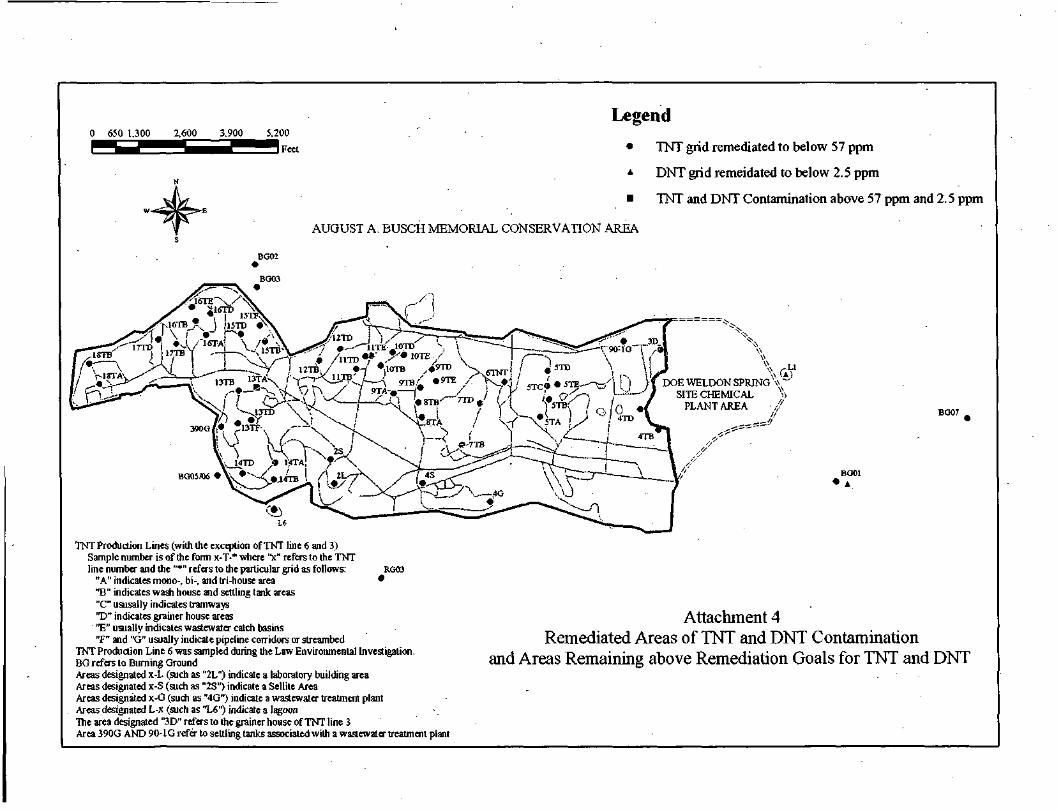
Legend
• TNT grid remediated to below 57 ppm
• DNT grid remeidated to below 2.5 ppm
• TNT and DNT Contamination above 57 ppm and 2.5 ppm
AUGUST A. BUSCH MEMORIAL CONSERVATION AREA
BG02
BG03
DOE WELDON SPRJNG\\ ~SITE CHEMICAL
PLANT AREABO07
BG01• A
TNT Production Lines (with the exception of TNT line 6 and 3)Sample number is of the form x-T-* where 'V refers to the TNTline number and the "*" refers to the particular grid as follows: RGOS
"A" indicates mono-, bi-, and tri-house area *"B" indicates wash house and settling tank areas"C" ususally indicates tramways"D" indicates grainer house areas"E" usually indicates wastewater catch basins"F" and "G" usually indicate pipeline corridors or streambed
TNT Production Line 6 was sampled during the Law Environmental Investigation.BG refers to Burning GroundAreas designated x-L (such as "2L") indicate a laboratory building areaAreas designated x-S (such as "2S") indicate a Sellite AreaAreas designated x-G (such as "4G") indicate a wastewater treatment plantAreas designated L-x (such as "L6") indicate a lagoonThe area designated "3D" refers to the grainer house of TNT line 3Area 390G AND 90-1G refer to settling tanks associated with a wastewater treatment plant
Attachment 4Remediated Areas of TNT and DNT Contamination
and Areas Remaining above Remediation Goals for TNT and DNT
.B62
0 800 1,600 3.200 4,800 6,400iFeet
Legend• Lead Contamination Above 500 ppm and Grid Designation
*• Lead Contamination Below 500 ppm and Grid Designation
B24
B50
August A. Busch Memorial Conservation Area
BG01TNT Production Lines (with the exception of TNT line 6 and 3}
Sample number is of the form x-T-'where 'V refers to the TNTline number and the ""' refers to the particular grid as follows:
"A" indicates mono-, bi-. and tri-house area"B" indicates wash house and settling tank areas"C" ususally indicates tramways"D" indicates grainer house areas"E" usually indicates wastewater catch basins"F" and "G" usually indicate pipeline corridors or streambed
TNT Production Line 6 was sampled during the Law Environmental Investigation.BG refers to Burning GroundAreas designated x-L (such as "2L") indicate a laboratory building areaAreas designated x-S (such as "2S") indicate a Sellite AreaAreas designated x-G (such as "4G") indicate a wastewater treatment plantThe area designated "3D" refers to the grainer house of TNT line 3Area 390G AND 90-1G refer to settling tanks associated with a wastewater treatment plant
Attachment 4aAreas Remediated for Lead Contamination
During the Execution of the OU1 Remedial ActionAs Identified in the 1996 Record of Decision
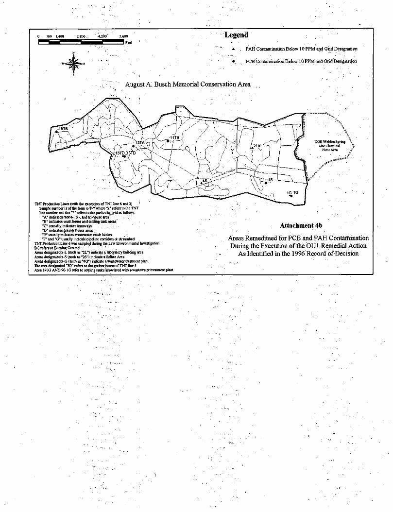
Legend
*, . PAH Contamination Below 10 PPM and Grid Designation
• PCB Contamination Below 10 PPM and Grid Designation
August A. Busch Memorial Conservation Area
DOE Wcldon Spring \, Site Chemical .%
Plant Area /,"
TNT Production Lines (with the exception of TNT line 6 and 3) :
Sample number i s of the form x-T-* where "x" refers to the TNTline number and the """ refers to the particular grid as follows:
"A" indicates mono-, bi-, and tri-house area'13" indicates wash house and settling tank areas"C"ususally indicates tramways . . . ' • ,"D" indicates grainer house areas"E" usually indicates wastcwaler catch basins. _ >T" and "G" usually indicate pipeline corridors or streambed
TNT Production Line 6 was sampled during trie Law Environmental Investigation.BG refers to Burning Ground ' ,-,Areas designated x-L (such as "2L") indicate a laboratory building areaAreas designated x-S (such as "2S") indicate a Sellite AreaAreas designated x-G (such as "4G") indicate a wastewatcr treatment plantThe area designated "3D" refers to the grainer house of TNT line 3Area 390G AND 90- 1G refer to settling tanks'associated with a wastewater treatment plant
y Attachment 4b
Areas Remeditaed for PCB and PAH ContaminationDuring the Execution of the OU1 Remedial Action
As Identified in the 1996 Record of Decision

Attachment 5
Pages 2 & 3
Attachment 5
Trip Report: Former Weldon Spring Ordnance Works, Weldon Spring, MO. Date: August 14-16, 2002 RE: Delineation of TNT Soils and Observation of Monitoring Well Installation Activities Weather Conditions: Moderate to high temperatures (High 60's to low 90's/ Fahrenheit)
Personnel In Attendance At Trenching Activities
Brad Vann - USACE-NWK (Geologist) Stefanie Voss - USACE-NWK (Geologic Engineer - Intern) Jason L'Ecuyer - USACE-NWK (Chemical Engineer - Intern) Tom Lorenz - USEPA Region VII (Remedial Project Manager) Jim Harris - Missouri Department of Natural Resources (OSC) Dan Marquis - USACE-NWK (Driller and Equipment Operator) Mike Cooney - USACE-NWK (Driller and Equipment Operator) Tony Cherry - USACE-NWK (Driller Helper) Coen Bauders - USACE-NWK (Field Geologist)
Day Two - August 15, 2002
07:57 hrs: Moved to the T13 area (suspected TNT soils location near MWS16) (Map 1). Set upsampling points on a grid-based system. The grid consisted of one N-S line 60' feet long intersected bythree W-E lines 40' feet long (Figure 1). Each line was broken down into 5-feet increments for samplecollection. Sampling was performed with a simple spade shovel since the contaminated soil horizon was between 2-4" inches below grade. Personnel hand dug all test pits (approximately 2' x 2' x 6") andqualitatively evaluated field soils using the Webster's Solution Test (see attached Photograph Log forvisual details).
Equipment used for Webster's Solution Test: • 2 Eye dropper bottles labeled (one for Sodium Hydroxide (NaOH) and the other for
solvent - 15-30ml each) • One package of cone-shaped water cooler cups or plastic sample trays • One heavy-duty stainless-steel spoon • Distilled water and soap solution for decontamination • Plastic Bag for containing used cups and gloves
Directions for Webster's Solution Test: • Collect approximately one-quarter teaspoon of suspect soil and put in bottom of cup • Add a few drops of solvent to the cup (acetone works well, but methanol or ethanol will
also work - for this event we used methanol). This action makes the nitrotoluene compound miscible in water.
• Mix completely by swirling the material in the cup • Add a few drops of NaOH • Watch and record the reaction1
This report is an update/modification of the original report submitted by Mr. Brad Vann. Information not relevant toTl 3 has been removed. Although this report does not reflect the entire effort of these trips, all of the information
related toT13 has been retained.
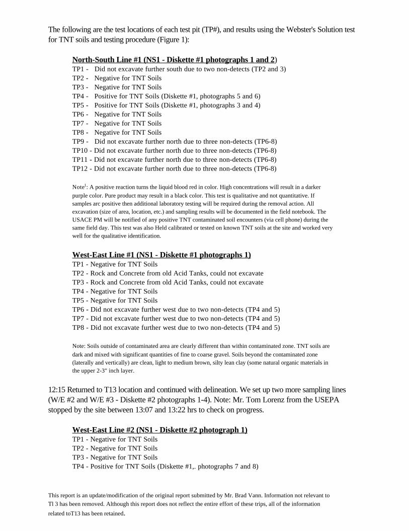
The following are the test locations of each test pit (TP#), and results using the Webster's Solution testfor TNT soils and testing procedure (Figure 1):
North-South Line #1 (NS1 - Diskette #1 photographs 1 and 2) TP1 - Did not excavate further south due to two non-detects (TP2 and 3) TP2 - Negative for TNT Soils TP3 - Negative for TNT Soils TP4 - Positive for TNT Soils (Diskette #1, photographs 5 and 6) TP5 - Positive for TNT Soils (Diskette #1, photographs 3 and 4) TP6 - Negative for TNT Soils TP7 - Negative for TNT Soils TP8 - Negative for TNT Soils TP9 - Did not excavate further north due to three non-detects (TP6-8) TP10 - Did not excavate further north due to three non-detects (TP6-8) TP11 - Did not excavate further north due to three non-detects (TP6-8) TP12 - Did not excavate further north due to three non-detects (TP6-8)
Note1: A positive reaction turns the liquid blood red in color. High concentrations will result in a darkerpurple color. Pure product may result in a black color. This test is qualitative and not quantitative. Ifsamples arc positive then additional laboratory testing will be required during the removal action. Allexcavation (size of area, location, etc.) and sampling results will be documented in the field notebook. TheUSACE PM will be notified of any positive TNT contaminated soil encounters (via cell phone) during thesame field day. This test was also Held calibrated or tested on known TNT soils at the site and worked verywell for the qualitative identification.
West-East Line #1 (NS1 - Diskette #1 photographs 1)TP1 - Negative for TNT Soils TP2 - Rock and Concrete from old Acid Tanks, could not excavate TP3 - Rock and Concrete from old Acid Tanks, could not excavate TP4 - Negative for TNT Soils TP5 - Negative for TNT Soils TP6 - Did not excavate further west due to two non-detects (TP4 and 5) TP7 - Did not excavate further west due to two non-detects (TP4 and 5) TP8 - Did not excavate further west due to two non-detects (TP4 and 5)
Note: Soils outside of contaminated area are clearly different than within contaminated zone. TNT soils aredark and mixed with significant quantities of fine to coarse gravel. Soils beyond the contaminated zone(laterally and vertically) are clean, light to medium brown, silty lean clay (some natural organic materials inthe upper 2-3" inch layer.
12:15 Returned to T13 location and continued with delineation. We set up two more sampling lines(W/E #2 and W/E #3 - Diskette #2 photographs 1-4). Note: Mr. Tom Lorenz from the USEPAstopped by the site between 13:07 and 13:22 hrs to check on progress.
West-East Line #2 (NS1 - Diskette #2 photograph 1)TP1 - Negative for TNT Soils TP2 - Negative for TNT Soils TP3 - Negative for TNT Soils TP4 - Positive for TNT Soils (Diskette #1,. photographs 7 and 8)
This report is an update/modification of the original report submitted by Mr. Brad Vann. Information not relevant toTl 3 has been removed. Although this report does not reflect the entire effort of these trips, all of the information
related toT13 has been retained.
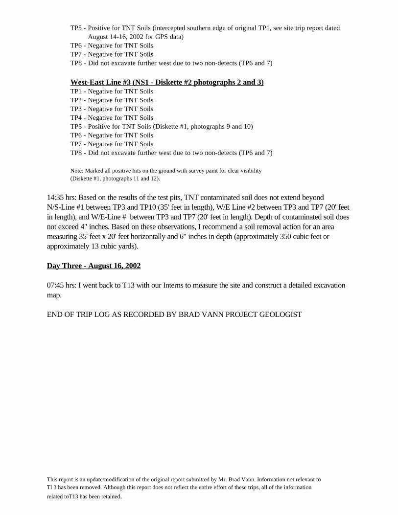
TP5 - Positive for TNT Soils (intercepted southern edge of original TP1, see site trip report dated August 14-16, 2002 for GPS data) TP6 - Negative for TNT Soils TP7 - Negative for TNT Soils TP8 - Did not excavate further west due to two non-detects (TP6 and 7)
West-East Line #3 (NS1 - Diskette #2 photographs 2 and 3) TP1 - Negative for TNT Soils TP2 - Negative for TNT Soils TP3 - Negative for TNT Soils TP4 - Negative for TNT Soils TP5 - Positive for TNT Soils (Diskette #1, photographs 9 and 10) TP6 - Negative for TNT Soils TP7 - Negative for TNT Soils TP8 - Did not excavate further west due to two non-detects (TP6 and 7)
Note: Marked all positive hits on the ground with survey paint for clear visibility (Diskette #1, photographs 11 and 12).
14:35 hrs: Based on the results of the test pits, TNT contaminated soil does not extend beyondN/S-Line #1 between TP3 and TP10 (35' feet in length), W/E Line #2 between TP3 and TP7 (20' feetin length), and W/E-Line # between TP3 and TP7 (20' feet in length). Depth of contaminated soil doesnot exceed 4" inches. Based on these observations, I recommend a soil removal action for an areameasuring 35' feet x 20' feet horizontally and 6" inches in depth (approximately 350 cubic feet orapproximately 13 cubic yards).
Day Three - August 16, 2002
07:45 hrs: I went back to T13 with our Interns to measure the site and construct a detailed excavationmap.
END OF TRIP LOG AS RECORDED BY BRAD VANN PROJECT GEOLOGIST
This report is an update/modification of the original report submitted by Mr. Brad Vann. Information not relevant toTl 3 has been removed. Although this report does not reflect the entire effort of these trips, all of the information
related toT13 has been retained.

PHOTOGRAPH LOG:
Diskette One - T13 Excavation Area
Photograph one (Facing West): W/E Line #1. Flag pins areset every five feet and N/S Line #1 can be seen just behind the55-eallon drum.
jt*Sqa :.-* ^'.^ <f i^V. 'i' 'W^Jy'' *M*,:i-te;^&&»f,&tm
Photograph two (Facing North): N/S Line #1. Flag pins areset every five feet and W/E Line #1 can be seen just behindthe 55-gallon drum.
Photograph three: TNT contaminated soils showing a positive(red color) reaction using the Webster's Solution field test.Reddish soils are also clearly visible on the ground sample andin the excavation of N/S Line #1 TP5*.
Photograph four: Details of reddish soils that are clearlyvisible in the excavation of N/S Line #1 TP5. TNT soilhorizon lies between 2-4 inches below ground surface. Note:the gravel mixed in with the soil, which is typical for eachpositive area.
This report is an update/modification of the original report submitted by Mr. Brad Vann. Information not relevant to TI3 has been removed. Although this report doesnot reflect the entire effort of these trips, all of the information related to T13 has been retained.

Photograph five: TNT contaminated soils showing a positive(red color) reaction using the Webster's Solution field test.Reddish soils are also clearly visible on the ground sample andin the excavation of N/S Line #1 TP4.
Photograph seven: TNT contaminated soils showing apositive (red color) reaction using the Webster's Solution fieldtest. Reddish soils are also clearly visible on the groundsample and in the excavation of W/E Line #2 TP4.
Photograph six: Details of reddish soils that are clearly visiblein the excavation of N/S Line #1 TP4. TNT soil horizon liesbetween 2-4 inches below ground surface.
Photograph eight: Details of reddish soils that are clearlyvisible in the excavation of W/E Line #2 TP4. TNT soilhorizon lies between 2-4 inches below ground surface.
This report is an update/modification of the original report submitted by Mr. Brad Vann. Information not relevant to Tl 3 has been removed. Although this report doesnot reflect the entire effort of these trips, all of the information related to T13 has been retained.
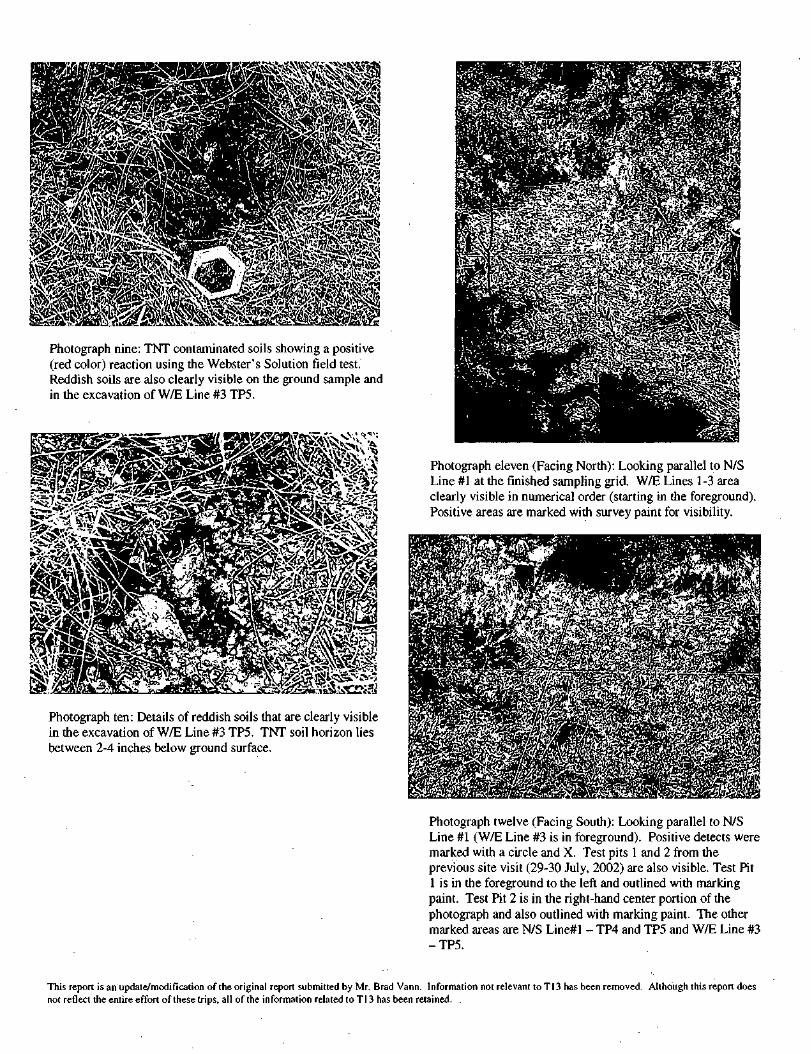
Photograph nine: TNT contaminated soils showing a positive(red color) reaction using the Webster's Solution field test.Reddish soils are also clearly visible on the ground sample andin the excavation of W/E Line #3 TP5.
j"^n<f W.IA-*'utt-m' r.j*»*v*^-<CT'»'-^
Photograph ten: Details of reddish soils that are clearly visiblein the excavation of W/E Line #3 TP5. TNT soil horizon liesbetween 2-4 inches below ground surface.
Photograph eleven (Facing North): Looking parallel to N/SLine #1 at the finished sampling grid. W/E Lines 1-3 areaclearly visible in numerical order (starting in the foreground).Positive areas are marked with survey paint for visibility.
Photograph twelve (Facing South): Looking parallel to N/SLine #1 (W/E Line #3 is in foreground). Positive detects weremarked with a circle and X. Test pits 1 and 2 from theprevious site visit (29-30 July, 2002) are also visible. Test Pit1 is in the foreground to the left and outlined with markingpaint. Test Pit 2 is in the right-hand center portion of thephotograph and also outlined with marking paint. The othermarked areas are N/S Line#l - TP4 and TP5 and W/E Line #3-TP5.
This report is an update/modification of the original report submitted by Mr. Brad Vann. Information not relevant toT13 has been removed. Although this report doesnot reflect the entire effort of these trips, all of the information related to T13 has been retained. ,

Diskette Two - Excavation Area on West End ofWeldon Spring (T13)
Photograph one (Facing East): Looking parallel to W/E Line#2. Test Pit 1, from the July site visit, is in the foreground tothe left and outlined with marking paint. The other markedareas are N/S Line#l - TP5 and W/E Line #2 - TP4.
Photograph two (Facing East): Looking parallel to W/E Line#3. Test Pit 1, from the July site visit, is in just after the lineintersection and outlined with marking paint. The othermarked area is W/E Line #3 - TP5.
Photograph three (Facing West): Looking parallel to W/ELines 1-3 (terminate at survey lathes). Both concretefoundations are clearly visible in the vegetation.
Photograph four (Facing North): Parallel to the southern mostconcrete foundation (covered by vegetation). W/E Line #1 atTP3 in also pictured.
END OF PHOTOGRAPH LOG
This report is an update/modification of the original report submitted by Mr. Brad Vann. Information not relevant t o T I 3 has been removed. Although this report doesnot reflect the entire effort of these trips, all of the information related to T13 has been retained.
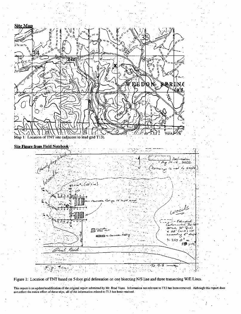
Site Map
Map 1: Location of TNT site (adjacent to lead grid T13)
Site Fieure from Field Notebook -•' ' ' ' '
Figure 1: Location of TNT based on 5:foot grid delineation on one bisecting N/S line and three transecting W/E Lines.
This report is an update/modification of the original report submitted by Mr. Brad Vann. Information not relevant to Tl 3 has been removed. Although this report doesnot reflect the entire effort of these trips, all of the information related to T13 has been retained.
ATTACHMENT 6
U.S. ARMY CORPS OF ENGINEERS FORMER WELDON SPRING ORDNANCE WORKS
ST. CHARLES COUNTY, MO
PUBLIC NOTICE 5 Year Review in Progress
The U.S. Army Corps of Engineers, Kansas City District, is currently conducting a 5-year review of theon going efforts to clean-up the soils at the Operational Unit 1 site of the Former Weldon SpringOrdnance Works. The purpose of a five-year review is to ensure that a remedial action remainsprotective of public health and the environment and that it is also continuing to function as designed. TheRecord of Decision called for the removal and incineration of TNT/DNT contaminated soil and pipelineand the stabilization of lead contaminated soil. . The goals have been met and verified for thecontaminants lead, PCBs and PAHs. The Remedial Action for TNT and DNT should be completed bythe autumn of 2003.
The scheduled completion date for the 5-year review is September 30th, 2003.
The community is encouraged to contribute to the review process by contacting the Public AffairsOfficer, Mitchell Frazier, at 816-983-3486 or the Project Manager, William McFarland, at816-983-3360.

ATTACHMENT 7
U.S. ARMY CORPS OF ENGINEERS FORMER WELDON SPRING ORDNANCE WORKS
ST. CHARLES COUNTY, MO
PUBLIC NOTICE 5 Year Review in Progress
The U.S. Army Corps of Engineers, Kansas City District, is currently conducting a 5-year review of theon going efforts to clean-up the soils at the Operational Unit 1 site of the Former Weldon SpringOrdnance Works. The purpose of a five-year review is to ensure that a remedial action remainsprotective of public health and the environment and that it is also continuing to function as it wasdesigned.
The community is encouraged to contribute to the review process by contacting the Public AffairsOfficer, Mitchell Frazier, at 816-983-3486 or the Project Manager, William McFarland, at816-983-3360.


![ARMY EXPLOSIVE ORDNANCE DISPOSAL AND ARMY …EOD [Explosive Ordnance Disposal] and other supporting elements. EOD supports the national security strategy during peacetime, conflicts,](https://static.fdocuments.in/doc/165x107/5ea7b7dac2ec200cbb1e45b4/army-explosive-ordnance-disposal-and-army-eod-explosive-ordnance-disposal-and.jpg)