FISH TRAPS IN THE SOUTH-WEST OF WESTERN …museum.wa.gov.au/sites/default/files/FISH TRAPS IN...
19
Rec. West. Aust. Mus., 1976,4 (2) FISH TRAPS IN THE SOUTH-WEST OF WESTERN AUSTRALIA W.C. DIX* and SARA J. MEAGHERt [Received 8 August 1975. Accepted 12 November 1975. Published 30 September 1976.] INTRODUCTION Among the Aboriginal artifacts noted by the first European visitors to the south-west coast of Western Australia were stone structures which they concluded were used for catching fish. For example, accounts by Vancouver 1791, the Baudin expedition in 1803, and King in 1818, of their visits to King George Sound prior to settlement include descriptions of 'fish traps' (Vancouver 1798, vol. 1, p.38; Peron 1816, vol. 2, pp. 149-151; King 1827, vol. 1, p.16). Today the remains of such structures are known at Harbour and Kalgan River near Albany (King George Sound), Wilson Inlet near Denmark and Broke Inlet at the mouth of the Shannon River (fig. Hammond (1933, 1936) and Paters on (1896) later described fish traps made from brushwood on the Serpentine River, and a photograph in the W.h. Museum (Plate 1), which was taken about 1900, shows what are believed to be the remains of a brushwood fish trap on the Murray River. However no evidence of these structures appears to have survived.! "'Deputy Principal, Australian Institute of Aboriginal Studies, Canberra. (Formerly Registrar of Aboriginal Sites, W.A. Museum.) tWestern Australian Museum, Francis Street, Perth. 1. Since this paper was written, we have been informed that the remains of a wooden fish trap have been discovered at Windy Harbour, about 45 km west of Broke Inlet. These are to be described by C.E. Dortch and G. Gardner (pers. comm. Dortch). 171
Transcript of FISH TRAPS IN THE SOUTH-WEST OF WESTERN …museum.wa.gov.au/sites/default/files/FISH TRAPS IN...

Rec. West. Aust. Mus., 1976,4 (2)
FISH TRAPS IN THE SOUTH-WEST OF WESTERN AUSTRALIA
W.C. DIX*
and
SARA J. MEAGHERt
[Received 8 August 1975. Accepted 12 November 1975. Published 30 September 1976.]
INTRODUCTION
Among the Aboriginal artifacts noted by the first European visitors to thesouth-west coast of Western Australia were stone structures which theyconcluded were used for catching fish. For example, accounts by Vancouver1791, the Baudin expedition in 1803, and King in 1818, of their visits toKing George Sound prior to settlement include descriptions of 'fish traps'(Vancouver 1798, vol. 1, p.38; Peron 1816, vol. 2, pp. 149-151; King 1827,vol. 1, p.16).
Today the remains of such structures are known at Harbour andKalgan River near Albany (King George Sound), Wilson Inlet near Denmarkand Broke Inlet at the mouth of the Shannon River (fig.
Hammond (1933, 1936) and Paterson (1896) later described fish trapsmade from brushwood on the Serpentine River, and a photograph in theW.h. Museum (Plate 1), which was taken about 1900, shows what arebelieved to be the remains of a brushwood fish trap on the Murray River.However no evidence of these structures appears to have survived.!
"'Deputy Principal, Australian Institute of Aboriginal Studies, Canberra. (FormerlyRegistrar of Aboriginal Sites, W.A. Museum.)
tWestern Australian Museum, Francis Street, Perth.
1. Since this paper was written, we have been informed that the remains of a woodenfish trap have been discovered at Windy Harbour, about 45 km west of Broke Inlet.These are to be described by C.E. Dortch and G. Gardner (pers. comm. Dortch).
171

STRUcrURES AT OYSTER HARBOUR
The Oyster Harbour traps were first recorded by Vancouver (1798, vol.1,p.38) when he visited King George Sound in October 1791. He describedthem as follows:
On the sides of this stream, as well as on the shores of OysterHarbour, were seen the remains of several fish wears, about eightto nine inches high, evidently the sorry contrivance of thewretched inhabitants of the country; some of these wereconstructed with loose stones, others with sticks, and stumpsof wood; . ..
Menzies (1791, MS.). who accompanied Vancouver, included furtherdetails in his account of them:
. . . as we walked along the beach towards it [?Kalgan River] wesaw rude fish wares which did not bespeak much ingenuity inthe contrivers; - they consisted of a row of small boughs oftrees struck close together in the sand about two or three footand kept close at the top by cross sticks along both sidesfastened together with small withies and along their bottom somestones to prevent the fish escaping.
14'S+1\4'E
Cape Leeuw,n
·.,MNJIMUP
Fig. la: Locations of stone structures believed to be fish traps in the south-west ofWestern Australia.1- Broke Inlet, 2 - Wilson Inlet, 3 - Oyster Harbour, Albany," - Kalgan River.
172

Plate 1: Structure of brushwood believed to be a fish trap, Murray River,Western Australia, circa 1900. Photographer not known.
On his visit to King George Sound in 1818 King (1827, vol. 1, p.16) noted:
The mouths of all the creeks and inlets were planted with weirs,which the natives had constructed for the purpose of catchingfish. Mr Roe, on his excursion round the harbour, counted elevenof these weirs on the flats and shoals between the two rivers, oneof which was a hundred yards long, and projected forty yards, ina crescent shape, towards the sea; they were formed by stonesplaced so close to each other as to prevent the escape, as the tideebbed, of such fish as had passed over at high water.
Neither Vancouver nor Menzies nor King saw the traps in use, and it is notknown whether King's account, which specifies that their use was dependentupon tidal movement, is based upon speculation or on information givento him by others.
Nind, who was Medical Officer at Albany from 1826 to 1830,described how Aborigines herded fish into pens made from bushes(-see p.174). It is unclear from his description whether these pens wereformed in association with the stone structures in the area. However
173

if they were it might explain the structures described by Menzies(see p.172).
In the autumn, when the smaller species of fish approach theshores in large shoals, they [the Aborigines] surround them, andkeep them in shallow water upon the flats until the tide falls andleaves them, when they are easily speared, and very few escape.For this purpose they use a very small spear, without a barb, andthrow it by hand; should it so happen that the tide does notsufficiently fall to enable them to take the {ish, they gatherbushes,· and plant them round so thickly, as to enclose them,when they are speared at leisure. (Nind, 1831, p.33.)
The remains of fish traps at Oyster Harbour, east of Albany (plates 2-4),which were reported by King and Vancouver (op.cit.), today consist ofeight semi-circles of low loose stone walls lying along the shore which isbacked by a Steep hill. There are also various smaller rings of stonesassociated with them (fig. 1c)l. The well defined medium-sized stonesemi-circles, Le. traps 3 and 4, are approximately 47 m long and 27 m wide,and 62 m by 29 m respectiv~ly. The diagram (fig. 2) based on a plane tablesurvey illustrates traps 3 and 4.
The walls of the traps are wedge-shaped in section; four or five stoneshave been placed on the bottom, then two or three stones, with another oneor two on top. Today in some places the walls have collapsed and the stonesare spread out on the sand. The walls of trap 7 are the most complete, andin some parts, reach a height of about 40 cm. The configuration of thistrap differs form the others in that it has a deeply indented 'entrance' or gap.The stones used to build the walls are irregularly sized and shaped but aregenerally about 15 cm in the smallest dimension. A small number arelarger (labelled 'boulder' in the diagram); many smaller stones are scatteredthroughout.
Some walls appear to have collapsed; in places they are represented by ascatter of stones. The stones are more widely scattered in the shallowsnearer the shore, compared with the denser lines of up to three or fourstones in height which occur near the gap; this may reflect a pattern ofconstruction related to water depth.
All the stones in the traps are of a dark, almost black, lateritic materialfound naturally in fair abundance on the strand, particularly west of trap 6.There are also quite anomalous heaps of granite stones within the reef tothe south-west. They are of material not available in the immediate vicinity;they are evenly sized, very much like stones once carried for ballast insailing vessels, but only a dinghy could have come so close to shore at this
174

OYSTER HARBOUR
1 km
N
i
....,
Fig. lb: Oyster Harbour showing the location in which stone structures occur(X·Y), and the mouths of the King and Kalgan Rivers.
"8
II
IIx
N
I)
--~----
/5
lOOm
Fig. lc: Diagram showing the arrangement of stone structures in the areaindicated in X-Y in Fig. lb.
175

location to have discarded them. They do not appear to have any connectionwith the stone structures.
The reef in the south-west does not seem to have been part of thestructure of trap 4; however, a similar reef in the south-east forms one endof trap 3 (fig. 2). Trap 2 (fig. le) almost entirely consists of natural reef, andit is reasonable to suppose that the presence of a natural trap formed by thereef may have initiated the construction of the remainder. Similar 'naturaltraps' have been noticed by one of us (Dix) at sites in the West Kimberleyof Western Australia (see p.185).
No early observers (see above) mention the breaches or gaps in the lines,which occur in traps 1,2, 3,4 and 7. A number of other features apparently
Plate 2: Oblique aerial photograph from X-Y (see legend to Fig. le). Photographby courtesy of D.A.P. West.
176

associated with the traps remain unexplained, namely circles of stonesoutside traps 4 (plate 5) and 6 and within trap 6, lines of stones withintraps 1 and 3, and heaps of stones within trap 3 east of the large boulders.
We have not found any remains of wooden extensions to the stone wallswhich were mentioned by Menzies (see p.172).
Oyster Harbour is open to the sea in King George Sound through achannel at Emu Point 5.7 km south of the site. Although the channel isnarrow, it is deep enough to permit a flow of tidal water causing appreciablehigh and low tides at the site. The estuary is shallow, and has shelteredwater, whereas the Southern Ocean outside is notably rough.
King George Sound has a Mediterranean climate with cool summers.The flow of water in the rivers and through the estuary reduces to a tricklein the summer even though there are modest falls of rain during that season;however, water moves over the structures as a result of the tides. Duringspring tides in summer the stones are quite dry at low tide but covered athigh tide. Neap tides do not leave the site quite dry.
TRAP 3
TIDAL FLATSo 5 10
METRES
N
TIDAL FLATS
STONE STR UCTURES IN OTHER ESTUARIES
Structures similar to those at Oyster Harbour have been found at twoother sites, Wilson Inlet near Denmark, and Broke Inlet near Walpole.
'-1/G!-t ~ "'-..
1 r W,<J""~1y "'-..~" X t\1,<Jb. .!-..!::-_::....-.:..-=-=------ J. 'T!r
:':.- J.
Fig. 2: Diagram of Oyster Harbour structures 3 and 4 (see Fig. 1c). Based uponplane table survey by w.e. Dix.
177

Plate 3: Photograph of trap 3 taken at low tide across the eastern edge of trap 4.
Plate 4: Trap 4 showing opening in wall and the reef beyond.
178

Although no direct reference to their existence appears in any publishedliterature, Neill (1845, p.426) noted that during the winter the Aboriginesfrom neighbouring areas gathered at Wilson Inlet to catch mullet, which wasplentiful there at that time.
We have not made detailed surveys of these sites, but, on inspection, theydo not appear to be functionally different from the structures at OysterHarbour. At these other localities each structure forms an enclosure,resulting from a barrier of stones placed between upper and lower tidelimits. Breaches in the lines of stone occur at both locations, but theapparently non-functional features characteristic of the Oyster Harbourstructures (such as placed heaps of stones, lines, or circles of stones) havenot been found by us at these other sites.
At Wilson Inlet the site consisting of several ill-defined enclosures(plate 6) is located on a promontory, backed by a steep hill as at OysterHarbour. The inlet is sealed from the ocean by a sand-bar in summer,but it is opened in winter thr0l:lgh the combined effect of flood waterfrom the river and winter storms on the coast. During the time the inletis open to the ocean the stones are exposed at low tide and covered at
Plate 5: Circle of stones outside trap 4 with line of stones within trap 3 beyond it.
179
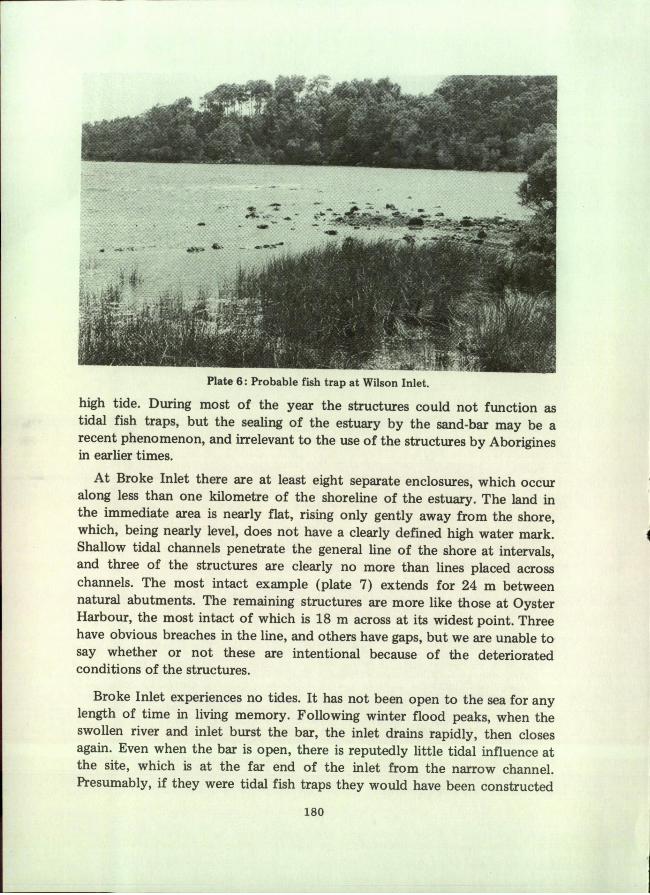
Plate 6: Probable fish trap at Wilson Inlet.
high tide. During most of the year the structures could not function astidal fish traps, but the sealing of the estuary by the sand-bar may be arecent phenomenon, and irrelevant to the use of the structures by Aboriginesin earlier times.
At Broke Inlet there are at least eight separate enclosures, which occuralong less than one kilometre of the shoreline of the estuary. The land inthe immediate area is nearly flat, rising only gently away from the shore,which, being nearly level, does not have a clearly defined high water mark.Shallow tidal channels penetrate the general line of the shore at intervals,and three of the structures are clearly no more than lines placed acrosschannels. The most intact example (plate 7) extends for 24 m betweennatural abutments. The remaining structures are more like those at OysterHarbour, the most intact of which is 18 m across at its widest point. Threehave obvious breaches in the line, and others have gaps, but we are unable tosay whether or not these are intentional because of the deterioratedconditions of the structures.
Broke Inlet experiences no tides. It has not been open to the sea for anylength of time in living memory. Following winter flood peaks, when theswollen river and inlet burst the bar, the inlet drains rapidly, then closesagain. Even when the bar is open, there is reputedly little tidal influence atthe site, which is at the far end of the inlet from the narrow channel.Presumably, if they were tidal fish traps they would have been constructed
180

associated with the traps remain unexplained, namely circles of stonesoutside traps 4 (plate 5) and 6 and within trap 6, lines of stones withintraps 1 and 3, and heaps of stones within trap 3 east of the large boulders.
We have not found any remains of wooden extensions to the stone wallswhich were mentioned by Menzies (see p.172).
Oyster Harbour is open to the sea in King George Sound through achannel at Emu Point 5.7 km south of the site. Although the channel isnarrow, it is deep enough to permit a flow of tidal water causing appreciablehigh and low tides at the site. The estuary is shallow, and has shelteredwater, whereas the Southern Ocean outside is notably rough.
King George Sound has a Mediterranean climate with cool summers.The flow of water in the rivers and through the estuary reduces to a tricklein the summer even though there are modest falls of rain during that season;however, water moves over the structures as a result of the tides. Duringspring tides in summer the stones are quite dry at low tide but covered athigh tide. Neap tides do not leave the site quite dry.
STONE STRUCTURES IN OTHER ESTUARIES
Structures similar to those at Oyster Harbour have been found at twoother sites, Wilson Inlet near Denmark, and Broke Inlet near Walpole.
TRAP 3
TIDAL FLATS
N
REEDSf_ L
TIDAL FLATS
Fig. 2: Diagram of Oyster Harbour structures 3 and 4 (see Fig. lc). Based uponplane table survey by w.e. Dix.
177

Plate 3: Photograph of trap 3 taken at low tide across the eastern edge of trap 4.
Plate 4: Trap 4 showing opening in wall and the reef beyond.
178

when the inlet was open to the sea regularly, at least, if not permanently;there is no apparent way of gauging how long ago that may have been orwhether it occurred. People who frequented the inlet about fifty years agoreport to Dix that at that time the inlet was also sealed but there wereabundant schools of fish in the waters.
Plate 7: Probable fish trap at Broke Inlet.
ESTUARINE STRUCTURES MADE OF BRUSHWOOD
As has been stated above, we have been unable to find any accountsdescribing Aboriginal use of estuarine fish traps made from stones. Howeverthe post-settlement accounts contain descriptions of the use of traps orenclosures made from bushes. Collie (Anon. [Collie] 1834) said that whena shoal of fish was sighted a watch was kept on it from the shore, or it wasshepherded by a few Aborigines, while the other members of the group, menand women, gathered bushes to construct an enclosure, which was builtout from the shore in either a semi-circle or a rectangle. The only indicationof the size of one of these enclosures is that given by Collie (op.cit. p.335),"about 12 yards wide and about 20 yards long". The enclosure was eitherbuilt around the shoal of fish, or the fish were herded into it through a gapleft during its construction. Once the fish had been enclosed they wereeither speared or taken by hand. Descriptions of such operations indicatethat from ten to fifty people were engaged on any occasion. This method
181

of taking fish was used mainly during summer and autumn. (Anon. [Collie]1834, p.335; Browne 1856, pp.492-3; Chauncy 1878, p.248; Nind 1831,p.33.)
It is uncertain whether nets were used in conjunction with fish traps.Although some of the post-settlement accounts mention" the use of nets(Grey 1841, vo1.2, p.276;" Hackett 1886, p.343; Paterson 1896, p.288),other accounts indicate that nets were not used before European settlement(Armstrong 1871, p.27; Nind 1831, p.27; Roth 1903, p.47).
RIVERINE STRUCTURES
In 1803 Faure found a series of stone structures (plate 8a)1 built acrossthe Kalgan Riv.er. The following is a translation of an account of themrecorded by Peron (1816, vo1.2, p.151):
Two dykes solidly built in dry stone joined from left and righta little island situated in the middle of the river and presented anobstacle for our boat; at intervals this wall had openings, placedmostly below the level of low tide; the openings on the sea-sidewere very wide while the openings facing the interior of thecountry were much narrower. By this means the fish, which athigh tide ascended the river, could easily pass the dyke but thentheir escape being almost impossible, they remained in the reservoirwhere it was easy for the fishermen to catch them . . . withinless than a third of a mile they counted six of these.
The same structures were described by Dumont d'Urville (1835, vo1.2,p.276), but neither of the descriptions includes an account by a witness oftheir use. The location described by Faure has been identified; one of thestructures remains today between a small island and the north bank of theKalgan River (plate 8b). On the southern side of the island and at twoother places the probable remains of structures also occur; some are said tohave been destroyed by explosives just before the turn of the century topermit the passage of river craft. That part of the river in which the structuresoccur is tidal.
The remaining structure lies across a channel of some 10 m at thenarrowest, and comprises a series of curved lines or loops of placed stoneslinking natural rocks, which create five or six enclosures adjacent to oneanother. The stones are fully covered at high tide, and exposed at low tide.
We know of no descriptions, either pre-settlement or post-settlement, ofAborigines using riverine fish traps made from stones. Post-settlement
182

Plate 8a: Illustration from Dumont d'Urville illustrating the structure in theKalgan River described by Faull~.
'IPlate 8b: Photograph of stone structure in the Kalgan River believed to be thatdescribed by Faure.
183
accounts of the use of riverine traps, which include descriptions of theirconstruction, say that they were made from bushes or sticks (Armstrong1871, p.27; Hammond 1933, p.46; Nind 1831, p.32; Paterson 1896,p.288; Roth 1903, p.47). Other post-settlement accounts of Aboriginescatching fish in riverine traps do not say from what, or. how, they weremade (Anon. [Collie] 183-:t, p.331; Bunbury 1930, pp.69, 87; Grey 1841,vo1.2, p.275; Ilberry 1927, p.25; Irwin 1835, p.23).
Riverine fish traps were called by the Aborigines manga (Bunbury 1930,p.69; Irwin 1835, p.25), mungo (Paterson 1896, p.288), or mungur(Hammond 1933, p.46). They were built and used at the beginning ofwinter (Anon. [Collie] 1834, p.331; Bunbury 1930, p.87; Hammond 1933,p.46; Paterson 1896, p.288).
The most detailed description of the construction and use of a riverinetrap is the following given by Hammond (1933, p.46) of one built in anarrow section of the Serpentine River:
A wicker fence was built across the stream, completely enclosingit from bank to bank, except in the centre, where a small openingwas left. Through this opening a race was constructed by drivingtwo parallel rows of stakes in the river bed. The bottom of thisrace was filled with bushes, until there was only about eightinches of clear water above the bushes for the fish to swimthrough. On either side of this race was built a platform, abouttwo feet six inches below the top of the water. On these platformsthe natives stood to catch the fish as they swam through therace. The fish were caught by hand as they passed over the bushesand were thrown to natives who were waiting on the bank toreceive them.
According to Hammond the trap was constructed in the same place on theriver every year. Hammond also noted (p.25) that this type of trap wasliable to be washed away by floods.
Another description of a similar trap built in the Serpentine Riveris given by Paterson (1896, p.288):
. . . they used to build these weirs, called Mungo by them, wherethe water narrowed . .. These Mungos were very carefullyconstructed of long fine sticks of spearwood (a kind of titree)laid at the bottom as smooth as a carpet, and ending in narrowopenings. Near these the blacks would watch, catching the fishas they were coming over the smooth sticks, and nick them at theback of the head with their teeth, before flinging them on to theland. Or a net would be set at the end below the narrows.
184

Sometimes very large catches would be made in this way,particularly at the beginning of the winter, when, with theincreased rains, the fish returned from the spawning placesupstream. At this time the blacks would watch day and nightfor the fish to come, relieving each other.
A photograph in the Western Australian Museum taken about 1900 showsthe remains of a fish trap made from sticks on the Murray River (plate 1).There are no accounts or further reports of this fish trap, and it is mostunlikely that it still exists.
DISCUSSION AND SUMMARY
If the estuarine structures described in this paper depended, for their useas fish traps, on a daily tidal flow, then their construction at Wilson andBroke Inlets predated the more-or-less permanent closure of the estuariesby sand-bars, which is the present condition. The descriptions by Nind(1831) and Anon. [Collie] (1834) of the use of brushwood traps suggestsan alternative use for them (Le. that they may have been pens into whichfish were driven); such traps could have functioned in closed estuaries.
In the case of the riverine traps in the Serpentine River described byPaterson (1896) and Hammond (1933, 1936) their use seems to havedepended upon seasonal movement of fish in the river. At the KalganRiver site the tide may have played some part in the functioning of theseas well as the movement of fish.
One of us (Dix) studied stone fish traps near La Grange, south ofBroome, where they were still in use. Aborigines visited these traps regularlyafter high tide to gather fish. At intervals a group of men also operatedthem actively; this group would partly block the 'gate', or breach, in thewall during tidal outflow. Fish were either taken by hand or speared whilethey tried to escape through the reduced gap. We are cautious in ascribingeither of these methods employed in the Kimberley to the south-west ofWestern Australia because of the great differences in tidal conditions in thetwo places.
Despite the fact that the information on the function, as fish traps, of thestone structures described in this paper is very limited, we have little doubtthat they were used by the Aborigines to catch fisn. However, we do notknow whether or not they were in use at the time of European settlement.There are no reliable accounts which either describe them in use or revealthe manner in which they were used. It is possible that the estuarine trapsdepended upon tidal flow to function but they may have been pens intowhich fish were driven. They may have been used in both ways. Similar
185

traps near Broome employed the outgoing tide, and either stranded fishor concentrated them so that they might be more easily taken.
ACKNOWLEDGEMENTS
The authors gratefully acknowledge the assistance of Mr D.A.P. West,who first showed them the structures in Oyster Harbour and the KalganRiver, Mr B. Proctor ap.d Mr D.A.P. West who showed them the structuresat Wilson Inlet, and Mr R.F. Needs who reported the structures at BrokeInlet: Misses El.H. Cunningham, P. McWaters, B.D. Peirce, and Mrs G.Handley in the preparation of the paper; Mrs V. Novak in the preparation ofthe figures; and Mrs A. Neumann for the translation of the extract fromPeron, and also sections of Dumoilt d'Urville. Finally the authors wish tothank Dr W.D.L. 'Ride for his interest in the paper, and the encouragementand assistance which he has given to us both.
REFERENCES
ANON. [COLLIE] (1834)-Anecdotes and remarks relative to the Aborigines at KingGeorge's Sound. The Perth Gazette and Western Journal, pp. 331,335.
ARMSTRONG, F.F. (1871)-Information respecting the habits and customs of theAboriginal inhabitants of Western Australia compiled from various sources. Votesand Proceedings of the Legislative Council during the second session of 1871.Paper no.2: 27-28.
BROWNE, J. (1856)-The Aborigines of Australia. Nautical Magazine and NavalChronicle, pp. 485-493, 534-543.
BUNBURY, W.H. (1930)-Early days in Western Australia. London: Oxford UniversitYPress.
CHAUNCY, P. (1878)-Notes and anecdotes of the Aborigines of Australia. In: Smyth,R. Brough The Aborigines of Victoria . .., 2: 221-284.
CURR, E.M. ed. (1886)-The Australian race: its origin, languages, customs, place oflanding in Australia, and the routes by which, it spread itself over that continent.Melbourne: Govt Print.
DUMONT D'URVILLE, J.S.C. (1835)-Voyage pittoresque autour ,du monde. Resumegeneral des voyages. Paris: L. Tenre. 2 vols.
EYRE, E.J. (1845)-Journals of expeditions of discovery into Central Australia. " andoverland from Adelaide to King George's Sound, in the years 1840-1. London:Boone.
186

r[
GREY, G. (1841)-Journals of two expeditions of discovery in north-west and westernAustralia, during the years 1837, 38 and 39. London: Boone.·
HACKETT, D.E. (1886)-York district. Ballardong or Ballerdokking tribe. No. 21 inCurr, E.M. ed., The Australian race . .., 1: 342-345. .
HAMMOND, J.E. (1933)-Winjan's people. Perth: Imperial Printing.
ILBERRY, E.S. (1927}-'l'he battle of Pinjarra, 1834. l.-'l'he passing of the Bibbulmun.J. Proc. West. Aust. hist. Soc. 1: 24-30.
IRWIN, F.C. (1835)-The state and position of Western Australia; commonly called theSwan-River Settlement. London: Simpkin, Marshall.
KING, P.P. (1827)-Narrative of a survey of the intertropical and western coasts ofAustralia. Performed between the years 1818 and 1822. London: Murray.
MEAGHER, S.J. (1974}-'l'he food resources of the Aborigines of the south-west ofWestern Australia. Rec. West. Aus. Mus. 3: 14-65.
MENZIES, A. (1791)-Journal of a visit to King George's Sound, pp.71-73. Copy 405A - in Battye Library, Perth.
NEILL, J. (1845)-Catalogue of reptiles and fish, found at King George's Sound. InEyre, E.J. Journals of expeditions of discovery into Central Australia . .., 1: 412-431.
NIND, S. (1831)-Description of the natives of King George's Sound (Swan RiverColony) and adjoining country. Geogrl J. 1: 21-51.
PATERSON, C.A. (1896)-Notes about the tribes inhabiting the coastal district fromGeraldton to Albany, and those of territories nearest adjoining them. Trans. R. Soc.S. Aust. 16: 288-291.
PERON, F. (1808)-A voyage of discovery to the southern hemisphere performed byorder of the Emperor Napoleon, 1801-4. [Translated from the French by RichardPhillips.] London: Richard Phillips.
PERON,. F. (1816)-Voyage de decouvertes aux terres australes. Paris: ImprimerieImperial.
ROTH, W.E. (1903)-Notes of savage life in the early days of West Australian settlement.Proc. R. Soc. Qd 17: 45-69.
SMYTH, R. BROUGH (1878)-The Aborigines of Victoria: with notes relating to thehabits of the natives of other parts ofAustralia and Tasmania. Melbourne: Govt Print.
VANCOUVER, G. (1798)-A voyage of discovery to the north Pacific Ocean, and roundthe world; ... in the years 1790, 1791, 1792, 1793, 1794 and 1795 ... London:G.G. and J. Robinson and J. Edwards.
187