Fish assemblages and their habitat usage in the …1 Regional Operational Plan SF.3F.2013.02 Fish...
24
1 Regional Operational Plan SF.3F.2013.02 Fish Assemblages and their Habitat Usage in the Alatna and Koyukuk River Drainages in the Vicinity of the Proposed Ambler Road Crossing by Klaus Wuttig And Matt Albert April 2013 Alaska Department of Fish and Game Divisions of Sport Fish and Commercial Fisheries
Transcript of Fish assemblages and their habitat usage in the …1 Regional Operational Plan SF.3F.2013.02 Fish...

1
Regional Operational Plan SF.3F.2013.02
Fish Assemblages and their Habitat Usage in the Alatna and Koyukuk River Drainages in the Vicinity of the Proposed Ambler Road Crossing
by
Klaus Wuttig
And
Matt Albert
April 2013
Alaska Department of Fish and Game Divisions of Sport Fish and Commercial Fisheries

Symbols and Abbreviations The following symbols and abbreviations, and others approved for the Système International d'Unités (SI), are used without definition in the following reports by the Divisions of Sport Fish and of Commercial Fisheries: Fishery Manuscripts, Fishery Data Series Reports, Fishery Management Reports, and Special Publications. All others, including deviations from definitions listed below, are noted in the text at first mention, as well as in the titles or footnotes of tables, and in figure or figure captions. Weights and measures (metric) centimeter cm deciliter dL gram g hectare ha kilogram kg kilometer km liter L meter m milliliter mL millimeter mm Weights and measures (English) cubic feet per second ft3/s foot ft gallon gal inch in mile mi nautical mile nmi ounce oz pound lb quart qt yard yd Time and temperature day d degrees Celsius °C degrees Fahrenheit °F degrees kelvin K hour h minute min second s Physics and chemistry all atomic symbols alternating current AC ampere A calorie cal direct current DC hertz Hz horsepower hp hydrogen ion activity pH (negative log of) parts per million ppm parts per thousand ppt, ‰ volts V watts W
General Alaska Administrative Code AAC all commonly accepted abbreviations e.g., Mr., Mrs.,
AM, PM, etc. all commonly accepted professional titles e.g., Dr., Ph.D., R.N., etc. at @ compass directions:
east E north N south S west W
copyright corporate suffixes:
Company Co. Corporation Corp. Incorporated Inc. Limited Ltd.
District of Columbia D.C. et alii (and others) et al. et cetera (and so forth) etc. exempli gratia (for example) e.g. Federal Information Code FIC id est (that is) i.e. latitude or longitude lat. or long. monetary symbols (U.S.) $, ¢ months (tables and figures): first three letters Jan,...,Dec registered trademark trademark United States (adjective) U.S. United States of America (noun) USA U.S.C. United States
Code U.S. state use two-letter
abbreviations (e.g., AK, WA)
Mathematics, statistics all standard mathematical signs, symbols and abbreviations alternate hypothesis HA base of natural logarithm e catch per unit effort CPUE coefficient of variation CV common test statistics (F, t, χ2, etc.) confidence interval CI correlation coefficient (multiple) R correlation coefficient (simple) r covariance cov degree (angular ) ° degrees of freedom df expected value E greater than > greater than or equal to ≥ harvest per unit effort HPUE less than < less than or equal to ≤ logarithm (natural) ln logarithm (base 10) log logarithm (specify base) log2, etc. minute (angular) ' not significant NS null hypothesis HO percent % probability P probability of a type I error (rejection of the null hypothesis when true) α probability of a type II error (acceptance of the null hypothesis when false) β second (angular) " standard deviation SD standard error SE variance population Var sample var

REGIONAL OPERATIONAL PLAN SF.3F.2013.02
FISH ASSEMBLAGES AND THEIR HABITAT USAGE IN THE ALATNA AND KOYUKUK RIVER DRAINAGES IN THE VICINTIY OF THE
PROPOSED AMBLER ROAD CROSSING
by
Klaus Wuttig and Matt Albert
Alaska Department of Fish and Game, Sport Fish, Fairbanks
Alaska Department of Fish and Game Sport Fish
April 2013

25
The Regional Operational Plan Series was established in 2012 to archive and provide public access to operational plans for fisheries projects of the Divisions of Commercial Fisheries and Sport Fish, as per joint-divisional Operational Planning Policy. Documents in this series are planning documents that may contain raw data, preliminary data analyses and results, and describe operational aspects of fisheries projects that may not actually be implemented. All documents in this series are subject to a technical review process and receive varying degrees of regional, divisional, and biometric approval, but do not generally receive editorial review. Results from the implementation of the operational plan described in this series may be subsequently finalized and published in a different department reporting series or in the formal literature. Please contact the author if you have any questions regarding the information provided in this plan. Regional Operational Plans are available on the Internet at: http://www.adfg.alaska.gov/sf/publications/
Klaus Wuttig and Matt Albert, Alaska Department of Fish and Game, Division,
1300 College Road Fairbanks, AK 99701
This document should be cited as: Klaus Wuttig and Matt Albert. 2013. Fish assemblages and their habitat usage in the Alatna and Koyukuk River
drainages in the vicinity of the proposed Ambler Road Crossing. Alaska Department of Fish and Game, Regional Operational Plan.SF.3F.2013-02, Fairbanks.
The Alaska Department of Fish and Game (ADF&G) administers all programs and activities free from discrimination based on race, color, national origin, age, sex, religion, marital status, pregnancy, parenthood, or disability. The department administers all programs and activities in compliance with Title VI of the Civil Rights Act of 1964, Section 504 of the Rehabilitation Act of 1973, Title II of the Americans with Disabilities Act (ADA) of 1990, the Age Discrimination Act of 1975, and Title IX of the Education Amendments of 1972.
If you believe you have been discriminated against in any program, activity, or facility please write: ADF&G ADA Coordinator, P.O. Box 115526, Juneau, AK 99811-5526
U.S. Fish and Wildlife Service, 4401 N. Fairfax Drive, MS 2042, Arlington, VA 22203 Office of Equal Opportunity, U.S. Department of the Interior, 1849 C Street NW MS 5230, Washington DC 20240
The department’s ADA Coordinator can be reached via phone at the following numbers: (VOICE) 907-465-6077, (Statewide Telecommunication Device for the Deaf) 1-800-478-3648,
(Juneau TDD) 907-465-3646, or (FAX) 907-465-6078 For information on alternative formats and questions on this publication, please contact:
ADF&G, Division of Sport Fish, Research and Technical Services, 333 Raspberry Rd, Anchorage AK 99518 (907) 267-2375

i

ii
TABLE OF CONTENTS Page
LIST OF FIGURES ....................................................................................................................................................... ii
LIST OF TABLES......................................................................................................................................................... ii
LIST OF APPENDICES ............................................................................................................................................... ii
PURPOSE...................................................................................................................................................................... 1
BACKGROUND ........................................................................................................................................................... 1
OBJECTIVES ................................................................................................................................................................ 3
METHODS .................................................................................................................................................................... 4
Description of Alatna River Study Areas ...................................................................................................................... 4 Mainstem Alatna – fish assemblages ........................................................................................................................ 4 Alatna River tributaries–Arctic grayling telemetry................................................................................................... 4
Sampling of Fish Assemblages–Mainstem Alatna ........................................................................................................ 4 Data collection–fish assemblages ............................................................................................................................. 8
Radiotelemerty .............................................................................................................................................................. 9 Data collection–Radiotelemetry ............................................................................................................................. 11
Data Analysis ............................................................................................................................................................... 11 Fish assembles ........................................................................................................................................................ 11 Radiotelemetry ........................................................................................................................................................ 11
SCHEDULE AND DELIVERABLES ........................................................................................................................ 12
RESPONSIBILITIES .................................................................................................................................................. 13
REFERENCE CITED .................................................................................................................................................. 14
APPENDIX A ............................................................................................................................................................. 15
LIST OF FIGURES Figure Page
1 Koyukuk and Alatna river drainages. Road corridor depicted by dashed line ............................................... 2 2 Alatna River study area depicting the mainstem sampling sections highlighted in grey including the
Malamute Fork ................................................................................................................................................ 5 3 Alatna River depicting tributary streams and preliminary distribution of Arctic grayling .............................. 6 4 Example of a mainstem sampling section (section C) divided into 10 subsections ........................................ 7
LIST OF TABLES Table Page
1 Timeline of major project activities .............................................................................................................. 12 2 Approximate allocation of radio tags in the Alatna and Koyukuk Study Area, 2013–2014 ......................... 10
LIST OF APPENDICES Appendix Page
A1 Boat electrofishing data collection form ....................................................................................................... 16 A2 Alatna River sampling data form 2013. This form includes fish not radiotagged .......................................................... 17 A3 Data form for radiotagged fish .............................................................................................................................................. 18

1
PURPOSE This plan outlines a study to be conducted by the Alaska Department of Fish and Game, Division of Sport Fish, designed to provide information on resident species fish assemblages and their habitat usage relative to those portions of the Alatna and Koyukuk drainages intersecting the proposed Ambler Road to Resources Corridor (Figure 1). This information will be used by the Division of Habitat to support the pre-development design and provide for appropriate environmental and mitigation planning for the corridor. In addition, it will provide baseline information on seasonal distributions and life history characteristics of game fishes in the area that will aid in management of the sport fisheries should the road increase access and use of the area.
BACKGROUND Information on fishes inhabiting these waters is minimal because of its remote geography and relatively small consumptive uses by sport, commercial, and subsistence fishers. Data collected to date relates primarily to anadromous salmon and is based on a relatively small number of sampling locations conducted at only a single point of time.
This proposal is primarily directed at freshwater fishes with an emphasis on Arctic grayling Thymallus arcticus. This species was selected because they are likely to be the most widespread and prevalent of all freshwater species in these drainages, can be readily sampled, and commonly require a wide range of habitat types. For example, an Arctic grayling may easily travel 70 km over the course of a year by spawning in a small tundra stream during spring, feeding in a first-order mountainous creek during summer, and overwintering in large rivers. Other species of interest include northern pike Esox lucius, sheefish Stenodus leucicthyes, burbot Lota lota, Dolly Varden Salvelinus malma, whitefish species such as broad Coregonus nasus and humpback Coregonus pidschian, and juvenile pacific salmon.
To date, no rigorous life history studies on Arctic grayling or other fish species have been conducted in the Alatna and Koyukuk drainages, and spatial information on variables such as range distances, habitat preferences, and residency times in selected seasonal habitats (e.g. overwintering areas) are lacking. To identify seasonal habitat requirements for the defined study areas within the Alatna and Koyukuk drainages, radio tags will be deployed in Arctic grayling and other prevalent fish species, and monitored over a 14-month period. A boat electrofisher, as well as other sampling gear (beach seines, gill nets, and baited hoop traps) will be used in the mainstem portions of the Alatna and Koyukuk drainages to provide information on fish assembles present. Deployment of radio tags and electrofishing will occur in the Alatna River study area during midsummer and fall of 2013, and during the summer and fall of 2014 for the Koyukuk River study area.
Although not covered in this operational plan, additional sampling will occur to support the efforts of Division of Habitat, which will have a crew working parallel to this study. For example, additional sampling will include collecting otoliths for aging, examining stomach contents or gonads, or taking water chemistry samples for later analysis.
The objectives of this operational plan relate to all three years of the study, however, the methods only describe work that will be conducted in 2013 in the Alatna River study area. The methods
2
Figure 1.–Koyukuk and Alatna river drainages. Road corridor is depicted by dashed line.
3
for the field work in 2014 in the Koyukuk study area will be addressed in a separate operational plan that will be written in spring 2014. This will permit reconnaissance of the Koyukuk study area in 2013, which is considerably larger, and allow us to apply what was learned in the Alatna River during 2013.
OBJECTIVES This study focuses on two primary drainages, the Alatna and Koyukuk, in the vicinity of the proposed road crossings (Figure 1). All objectives will relate to five study areas, the boundaries of which will require minor modifications based on observed fish distributions as sampling progresses and boat accessibility. The 5 proposed primary study areas include:
1) Mainstem Alatna: ~80-km reach of the mainstem Alatna River overlapping the proposed road crossing(s) including connected slough habitats and creek mouths.
2) Alatna River tributaries: Waters include tributaries such as Takahula, Malamute, and Helpmejack creeks that intersect along the ~80-km, mainstem reach.
3) Mainstem Koyukuk: ~80-km reach of the mainstem Koyukuk River overlapping the proposed Ambler road crossing including connected slough habitats and creek mouths.
4) Koyukuk tributaries: waters include the lower portions (i.e. 10–20 km) of the John, Wild, and North Fork Koyukuk rivers as well as tributary streams such as Jack White, Jane, Malamute, Timber, and Twelvemile creeks along the ~80-km, mainstem reach.
5) Southfork Koyukuk: ~30-km reach of the South Fork Koyukuk River centered on the proposed road crossing.
The study objectives will be to:
1. Document and characterize the fish assemblages present in the mainstem Alatna River and its tributaries (Study Areas 1 and 2) during midsummer and early fall 2013, and in the mainstem Koyukuk River, Koyukuk tributaries and South Fork Koyukuk River (Study Areas 3–5) during midsummer and early fall 2014.
2. Use radiotelemetry to document seasonal locations of mature-sized Arctic grayling (≥330 mm FL) captured in the mainstem Alatna River and its tributaries (Study Areas 1 and 2) during midsummer and early fall 2013, and in the mainstem Koyukuk River, Koyukuk tributaries and South Fork Koyukuk River (Study Area 3–5) during midsummer and early fall 2014 with an emphasis on documenting overwintering and spawning areas.
3. Use radiotelemetry to document seasonal locations of other fish species that may be prevalent (northern pike, sheefish, burbot, or whitefish spp.) in the mainstem Alatna River during 2013 and in the mainstem Koyukuk River during 2014 with an emphasis on documenting overwintering and spawning areas.
4. Document the presence of anadromous juvenile salmon in tributaries during Arctic grayling radiotagging effort using baited minnow traps.
4
METHODS For both the Alatna and Koyukuk drainages, there will be two interrelated components to the field work: sampling fish assemblages in the mainstem portions, and deploying radio tags in both the mainstem and tributaries (See Schedule and Deliverables). The generalized schedule for the Alatna River Study Area in 2013 will consist of:
1) July 10–22, sample mainstem Alatna fish assembleges and radiotag resident fishes; Aug 7–13, deploy Arctic grayling radio tags and set baited minnow traps in Alatna River tributaries; and,
2) Aug 26–Sept 10, repeat sampling in the mainstem Alatna and deploy radio tags in resident fishes.
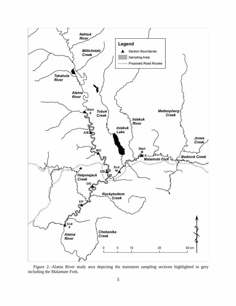
DESCRIPTION OF ALATNA RIVER STUDY AREAS Mainstem Alatna – fish assemblages The Alatna River study area encompasses an ~85 km reach of the mainstem Alatna River extending downstream from Takahula Creek, and a 15-km portion of the Malamute Fork Alatna River. The area is composed of 7 sections of equal length: 6 along the Alatna mainstem and 1 in the Malamute Fork (Figure 2). Each section is equally divided into 10 subsections, each of ~1.5 km (Figure 3). Every other subsection within a section will be sampled, beginning at the uppermost subsection (Figure 3). This division of the sampling area will help ensure that a large geographic area is sampled, that the section of river (i.e. 5 subsections) can be reasonably sampled in a given day, and that all habitat types are encountered and sampled. Time permitting, additional subsections will be sampled if there appears to be productive habitats available, such as a large slough complex.
Alatna River tributaries–Arctic grayling telemetry Using aerial images, 12 tributary streams were identified for the deployment of radio tags in Arctic grayling during August (Figure 4). These areas were selected based on their proximity to the proposed road and detecting a broad range of possible movements. For example, Arctic grayling within the Malamute Fork Alatna River may reside there year round displaying little seasonal movements. In contrast, Arctic grayling summering in Takahula Creek may display a large range of movements by using the mainstem Alatna River for overwintering and the Malamute River for spawning.
SAMPLING OF FISH ASSEMBLAGES–MAINSTEM ALATNA Sampling of fish assemblages in the mainstem Alatna River will be conducted during two distinct periods, midsummer and fall because it is anticipated that the composition of species present will differ. For example, during fall spawning sheefish, coho salmon Oncorhynchus kisutch or humpback whitefish may be present.
Within each section, a combination of gear will be used and should reliably capture all prevalent fish species, juvenile and adult. Gear will consist of an electrofishing boat, 5 large-mesh hoop traps, 5 small-mesh hoop traps, 10 minnow traps, and 1 beach seine. A gillnet (25-mm mesh, 2 m deep, and 30 m long) and hook-and-line will be used opportunistically; for example, at creek mouths, at slough entrances, or in backwater eddies. The large mesh (25 mm) hoop traps are
5
Figure 2.–Alatna River study area depicting the mainstem sampling sections highlighted in grey
including the Malamute Fork.

6
Figure 3.–Alatna River depicting tributary streams and preliminary distribution of Arctic grayling radio tags in 2013.

7
Figure 4.–Example of a mainstem sampling section (section C) divided into 10 subsections.
8
3.05 m long, have with seven 6.35 mm steel hoops and taper from 0.61 m at the entrance to 0.46 m at the cod end. These will be baited with cut Pacific herring Clupea harengus placed in perforated plastic containers. The smaller meshed hoop trap (9 mm) is approximately 1.2 m long with 100 mm throats. The minnow traps are made 6-mm galvanized steel wire mesh, are 44 cm long, and 23 cm in diameter. The smaller hoop traps and minnow traps will be baited with cured salmon eggs. The beach seine is ~15 m long, 1.2 m deep, and has a 9-mm mesh.
A crew of three persons will operate the 20-ft electrofishing river boat in the mainstem Alatana River as described by (Fleming 1994). This gear will reliably capture most non-juvenile species (i.e. ≥150 mm FL) if they are present in any appreciable numbers with the exception of Arctic lamprey Lethenteron japonicum. The boat will fish downstream focusing on the river margins, mouths of tributaries, slack water areas, and slough mouths. The boat will be operated until the sampling tote is full or the end of a 1.5-km subsection is reached.
A second crew of two persons will operate an 18-ft jet powered skiff and will fish the remainder of the gear. Within each subsection, 1 large hoop trap, 1 small hoop trap,s and 2 minnow traps will be set and fished overnight, and a minimum of 2 seine hauls will be completed. The placement of this gear will be left to the discretion of the crew. Waters more likely to hold fish, such as creek mouths and slough entrances (if present), will be targeted to maximize detection of species present. The hoop traps will primarily catch burbot and longnose sucker Catostomus catostomus and will be set overnight before being moved and reset the following day. Similarly, the minnow traps will be fished overnight, but will target juvenile fish, presumably Dolly Varden and salmon species. The beach seine will target juvenile fishes along the stream margins. Sampling efforts with the gill net and angling will be more opportunistic and will be conducted when time and water conditions allow. One or two gillnets will be fished each day and the duration of the set will vary, but will not be fished overnight. Typically, these will be set near the beginning of the day and pulled when returning to camp.
Data collection–fish assemblages As appropriate for each gear type, data collected will include: GPS location (decimal degrees, NAD83 datum), date, time set, time pulled, duration fished, general description of habitat type, and number of fish captured by species.
1. Examples of general habitat type include: main channel, side channel, side slough (side channel not connected on upstream side), backwater, clearwater tributary mouth.
2. Additional habitat descriptors could include, inside gravel bar, outside cut bank, beaver dam complex, and point bar.
For electrofishing, GPS locations for the start and end point of all runs will be recorded, regardless of duration.
All data will be collected on a gear-specific field data sheet or in Rite-in-the-RainTM notebooks (Appendix A), which will be entered into an Excel spreadsheet.
For each fish captured, data collected will include: species, measurement of fish length, location (river-kilometer, name of water body, section, subsection, and GPS coordinate), gear type and date.

9
RADIOTELEMERTY
A total of 460 radio tags will be deployed across both drainages (the Alatna and Koyukuk over the course of two seasons (Table 2). Within the Alatna study area, three groups of fish will be targeted: 1) prevalent resident species in the mainstem during mid-to-late July; 2) Arctic grayling in the tributaries to the Alatna River; and, 3) prevalent resident species in the mainstem during early fall (Table 2).
In the mainstem Alatna, the exact allocation of radio tags by section and species cannot be firmly apportioned prior to sampling because little is known about the area. The intent is to focus on those areas where fish appear to be most abundant and to target fish that have a reasonable probability of inhabiting waters near the proposed road crossing at some point during their annual cycle; therefore, Arctic grayling will be the primary species sampled. The decision to radiotag a fish species other than Arctic grayling will be made as sampling progresses. For example, if catches of burbot and northern pike are relatively high, 3 of each will be radiotagged in a section on a given day. At least 25% of the tags will be withheld toward the end of the sampling effort so that crew(s) can return to a section and radiotag species that may have been underrepresented. Fish of a mature size will be targeted because they will be large enough to bear a radio tag (i.e. ≥ 330 mm FL) and potential spawning areas can be identified. To maximize our ability to radio tag multiple species, all radio tags will be of the same size and weight and will accommodate any species ≥330 mm FL.
For Arctic grayling in tributary streams, a preliminary distribution map of radio tags was developed by examining likely habitat from aerial images (Figure 4). This apportionment will likely require minor refinement after initial field inspections and as sampling progresses. The tributary tags will be deployed during August 7–13 using two or three 2-person crews and sites will be accessed by helicopter based out of Bettles. There are a total of 23 sites, which will require 3–4 days of favorable weather and water conditions. Hook-and-line gear will be used to capture fish. At least three photos of the sampling location with surrounding riparian vegetation will be taken.
Standardized telemetry practices will be employed. For all fish species a radio tag will be surgically implanted following the basic surgical methods detailed by Brown (2006) and Morris (2003). The transmitters selected for this project are Lotek™ coded tags with motion sensors and will operate for ~14 months. Radio tags will operate on 4 frequencies between 149.500 and 149.999 MHz with individual transmitters digitally coded for identification.
Tracking flights will be conducted using a fixed wing aircraft and a Lotek SRX 600 receiver with an internal GPS that will record time and location data. Each year, a minimum of 6 surveys will be conducted and the timing of the flights will coincide with periods before and after major movements to spawning, overwintering, and summer feeding areas. For a given drainage, the flights will occur in late September, mid-November, early March, late May, early June, and early August.
Relative to Objective 4, baited minnow traps will be fished while deploying tributary radio tags to assist in detecting the presence of anadromous juvenile salmon species. Based on the department’s anadromous waters catalog, many of the tributaries have not been sampled. Therefore, 2–3 minnow traps baited with cured salmon roe will be set in the stream near the landing zone upon arrival and checked before leaving the area, which will result in

10
Table 2.–Approximate allocation of radio tags in the Alatna and Koyukuk Study Area, 2013–2014. Drainage Period Study Area Species ~ number of tags
Alatna Midsummer Mainstem Alatna Arctic grayling 10
Other species 35
Alatna Tributaries Arctic Grayling 80
Early Fall Mainstem Alatna Arctic grayling 20
Other species 35
Subtotal 180
Koyukuk Midsummer Mainstem Koyukuk Arctic grayling 20
Lower John River 20
Lower Wild river 15
Tributary mouths 30
Other species 40
Midsummer Koyukuk tributaries Arctic grayling 100
Early fall Mainstem Koyukuk Arctic grayling 25
Other species 30
Subtotal 280
11
approximately 2–4 hours of fishing time. Although the minnow traps will not prove absence, any catches of juvenile will be used to document an anadromous water. If any adult salmon are observed, photos of adult salmon will be taken as evidence as well.
Data collection–Radiotelemetry For those fish receiving a radio tag, additional data will include their radio tag frequency and code. During each aerial survey, data collected for each fish will include frequency, code, latitude, longitude, and a general description of its location (e.g. approximately 1 km upstream from Malamute Creek).
DATA ANALYSIS Fish assembles Catch data (number of fish and length information) will be summarized by section, subsection, gear type, and species. All attendant data, including photos of tributary sampling sites, will be catalogued in the Alaska Freshwater Fish Inventory or Anadromous Waters’s database as appropriate: http://gis.sf.adfg.state.ak.us/FlexMaps/fishresourcemonitor.html?mode=awccataloging system
Radiotelemetry Descriptions of seasonal distributions of fish will be presented and summarized by plotting coordinates of all located fish deemed to be alive at the time of the survey onto a digitized map of the drainage using the program ArcGIS®. Variables to be measured include:
1. net distance traveled between tracking events; 2. direction traveled between tracking events; 3. maximum distances traveled between seasonal habitats (i.e. range); and, 4. number of radiotagged fish within 0.5, 1.0, and 2.0 kilometers.
Patterns in transmitter locations will be used to infer fish behavior and habitat use, and aggregations of fish will be used to characterize significant spawning and overwintering habitats. For example, an aggregation of two or more fish, which were tagged in the mainstem Alatna River within a 2-kilometer radius in Helpmejack Creek during late May would signify a potential spawning habitat.

12
SCHEDULE AND DELIVERABLES Table 1.–Timeline of major project activities.
Date(s) Sampling Activity
Alatna River
February 1, 2013 Detailed operational plan completed
April 1–June 15, 2013 Logistical preparations
Mid-July, 2013 Sample fish assembles and deploy radio tags (all species) in mainstem Alatna study section
Early August, 2013 Deploy Arctic grayling radio tags in Alatna tributary section
Late August–mid-September Sample fish assembles and deploy radio tags (all species) in mainstem Alatna study section
Nov. 2013–Feb. 2014 Aerial tracking surveys of Alatna River fish
Koyukuk River
April 1–June 15, 2014 Logistical preparations
Mid-July, 2014 Sample fish assembles and deploy radio tags (all species) in mainstem Koyukuk study section
Early August, 2014 Deploy Arctic grayling radio tags in Koyukuk tributary section
Late August–mid-September, 2014
Sample fish assembles and deploy radio tags (all species) in mainstem Koyukuk study section
Nov. 2014–Feb. 2015 Aerial tracking surveys of Koyukuk River fish
December 1, 2015 Data analysis completed
April 1, 2016 Final report completed
13
RESPONSIBILITIES Matt Albert: Fisheries Biologist I, serve as project leader, coordinate logistics, data
collection, data analysis, draft report.
Klaus Wuttig Fishery Biologist III; write operational plan, supervise and assist with field preparations, data analysis, and review of final report.
Jiaqi Huang: Biometrician II; review operational plan.
Brian Collyard: Fish and Wildlife Technician III, assist with field preparations, serve as crew leader during data collection, assist with aerial surveys.
Matt Robinson: Fish and Wildlife Technician II, assist with field operations.
Rick Queen: Fish and Wildlife Technician II, assist with field operations.
Jesse Dunshie: Fish and Wildlife Technician II, assist with field operations.
John Burr: Fisheries Biologist III– Area manager, assist with field operations.
Matt Evenson: Research Supervisor, review operational plan

14
REFERENCE CITED Brown, R. J. 2000. Migratory patterns of Yukon River inconnu as determined with otolith microchemistry and
radio telemetry. Master's Thesis, University of Alaska Fairbanks.
Fleming, D. F. 1994. Stock assessment and relative age validation of humpback whitefish and least cisco in the Chatanika River during 1993. Alaska Department of Fish and Game, Fishery Data Series No. 94-4, Anchorage.
Morris, W. 2003. Seasonal movements and habitat use of Arctic grayling (Thymallus arcticus), burbot (Lota lota), and broad whitefish (Coregonus nasus) within the Fish Creek drainage of the National Petroleum Reserve-Alaska, 2001-2002. Technical Report No. 03-02, Alaska Department of Natural Resources, Fairbanks.

15
APPENDIX A

16
Appendix A1.–Boat electrofishing data collection form.
2013
Mainstem Alatna
Electrofishing Form
Date: Crew: Page #:
Section: Subsection: Run #:
GPS run start: GPS run end:
# Species Length Comment # Species Length Comment 1 31
2 32
3 34
4 34
5 35
6 36
7 37
8 38
9 39
10 40
11 41
12 42
13 43
14 44
15 45
16 46
17 47
18 48
19 49
20 50
21 51
22 52
23 53
24 54
25 55
26 56
27 57
28 58
29 59
30 60
17
Appendix A2.–Alatna River sampling data form 2013. This form includes fish not radiotagged.
2013 Alatna River Sampling form: Crew
Gear: River/section/Subsection
__________________
Lat./Long. Date/ time set:
Date/time pulled:
Species Length Species Length Species Length Species Length
Gear: River/section/Subsection
__________________
Lat./Long. Date/ time set:
Date/time pulled:
Gear: River/section/Subsection
__________________
Lat./Long. Date/ time set:
Date/time pulled:

18
Appendix A3–Data form for radiotagged fish. Alatna Radiotagging form 2013 Date ________ Page #:___________
Fish # Section/tributary Sub
section Lat. Long. Length (FL) Freq / code Comments
1
2
3
4
5
6
7
8
9
10
11
12
13
14
15
16
17
18
19
20
21
22
23
24
25
26
27
28
29
30