First chapter ANCIENT EGYPT_ History in an Hour - Anthony Holmes
6
Ancient Egyptian Civilization ‘Egypt is the gift of the Nile’ wrote the Greek historian Herodotus in c. 400 BC. The River Nile was much more than a reliable source of water; the annual inundation resulting from melting snow and the rainfall in the highlands of Ethiopia brought with it the life-giving silt and nutrients that created the fertile strip of land along its banks. The Nile was the magnet that drew disparate tribes from the surrounding areas and, with its abundance of fish and water fowl, was also the reason for the consolidation of fragmented tribes into the nation called Egypt. From c. 4000 BC to the present day, the inhabited regions of Egypt have been restricted to areas of arable land plus some coastal towns and isolated oases in the Sahara Desert. The populated land is divided into two main areas. The first is the triangular delta region to the north where the Nile splits into branches and eventually flows into the Mediterranean Sea. The second area is the region to the south of the delta along the Nile to Egypt’s southern border with Sudan. The Nile flows from south to north. To journey ‘upstream’ means to travel south, consequently the delta region to the north was called Lower Egypt. The region to the south, along the upper reaches of the Nile, was called Upper Egypt. In our modern convention of drawing maps with north at the top of the page, these names might seem back to front.
-
Upload
historyinanhour -
Category
Documents
-
view
215 -
download
1
description
First chapter of Ancient Egypt In An Hour, part of the History In An Hour ebook series - history for busy people.
Transcript of First chapter ANCIENT EGYPT_ History in an Hour - Anthony Holmes

Ancient Egyptian Civilization
‘Egypt is the gift of the Nile’ wrote the Greek historianHerodotus in c.400 BC. The River Nile was much morethan a reliable source of water; the annual inundationresulting from melting snow and the rainfall in the highlandsof Ethiopia brought with it the life-giving silt and nutrientsthat created the fertile strip of land along its banks. The Nilewas the magnet that drew disparate tribes from thesurrounding areas and, with its abundance of fish and waterfowl, was also the reason for the consolidation offragmented tribes into the nation called Egypt.
F rom c.4000 BC to the present day, the inhabitedregions of Egypt have been restricted to areas of arableland plus some coastal towns and isolated oases in theSahara Desert. The populated land is divided into two mainareas. The first is the triangular delta region to the northwhere the Nile splits into branches and eventually flows intothe Mediterranean Sea. The second area is the region tothe south of the delta along the Nile to Egypt’s southernborder with Sudan.
The Nile flows from south to north. To journey ‘upstream’means to travel south, consequently the delta region to thenorth was called Lower Egypt. The region to the south,along the upper reaches of the Nile, was called UpperEgypt. In our modern convention of drawing maps with northat the top of the page, these names might seem back tofront.

Once a society was established along its banks, theEgyptians used the Nile as their main artery for transport.Ships used the river’s strong current to voyage from southto north. On the return voyage, they hoisted a sail to capturethe prevailing wind from the north and augmented theirprogress with oars to propel the vessels upstream to thesouth.
Egypt was not always as dry as it is now. Archaeologicalevidence revealed the existence of human habitation insouth-west Egypt as early as c.8000 BC. During thatperiod, the Egyptian climate was far wetter than it is today.Dramatic climate change around 8000 BC saw the gradualdesertification of the grasslands and the formation of theSahara Desert.
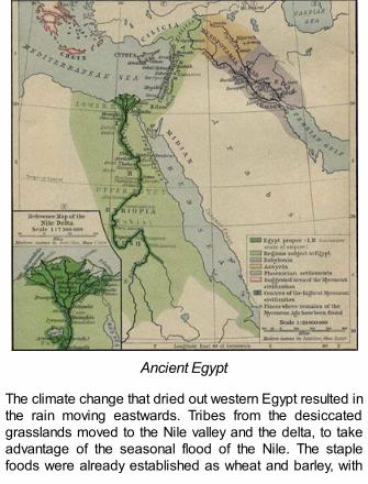
Ancient Egypt
The climate change that dried out western Egypt resulted inthe rain moving eastwards. Tribes from the desiccatedgrasslands moved to the Nile valley and the delta, to takeadvantage of the seasonal flood of the Nile. The staplefoods were already established as wheat and barley, with

flax providing the raw material for fabric and ropeproduction.
By c.6000 BC, Egyptians in the south-west were herdingcattle and constructing buildings. Permanent settlementsexisted in c.5500 BC, when inhabitants focused on cerealgrowing and animal herding. Archaeologists haveunearthed burial goods such as metal items, wovenbaskets, tanned animal hides, hunting tools and wovenfabrics dated to c.5000 BC. The dead were buried facingwest towards Libya, perhaps looking to their originalhomeland, and the concept that the western bank of theNile was the realm of the dead was to remain a feature ofEgyptian culture and was a belief that gave rise in moderntimes to the phrase ‘gone west’.

Naqada pottery
Artefacts from the period 5200 BC to 4000 BC discoveredat Fayoum Oasis included stone axes, dolerite maceheads, arrowheads, stone palettes, pots, cups and stonebeads. Furniture, tableware, decorated pots, combs madefrom bone and figurines all appeared around this time.

Foreign artefacts relating to this period indicate contactsas distant as Lebanon and Syria.
The Naqada culture, named after the town of Nubt,meaning ‘city of gold’, commenced c.4000 BC andcontinued to c.3200 BC, a left pottery decorated withrecognizable human and animal shapes. Potters mademodels of houses which were included in burial goods.Designs on pottery depicting humans and animals becamemore realistic by c.4000 BC, and techniques of stoneworkwere developed. Tomb building, including the constructionof underground storerooms, appeared in the second phaseof the Naqada. The burial practices are recognizable as theearly Osiris cult of ancient Egypt, and the decorations onthe pottery resembled hieroglyphs.


![HOLMES,GEORGE · Holmes Spear, dec ], and George Holmes, heirs of Oliver Holmes subsequent to his death. I always understood that Oliver Holmes got the lot from Kamehameha 1. Holmes](https://static.fdocuments.in/doc/165x107/60677df317bc235d9b7d2724/holmesgeorge-holmes-spear-dec-and-george-holmes-heirs-of-oliver-holmes-subsequent.jpg)