Fire Management Strategy · NATIONAL PARKS AND WILDLIFE SERVICE – NSW . Fire Management Strategy...
86
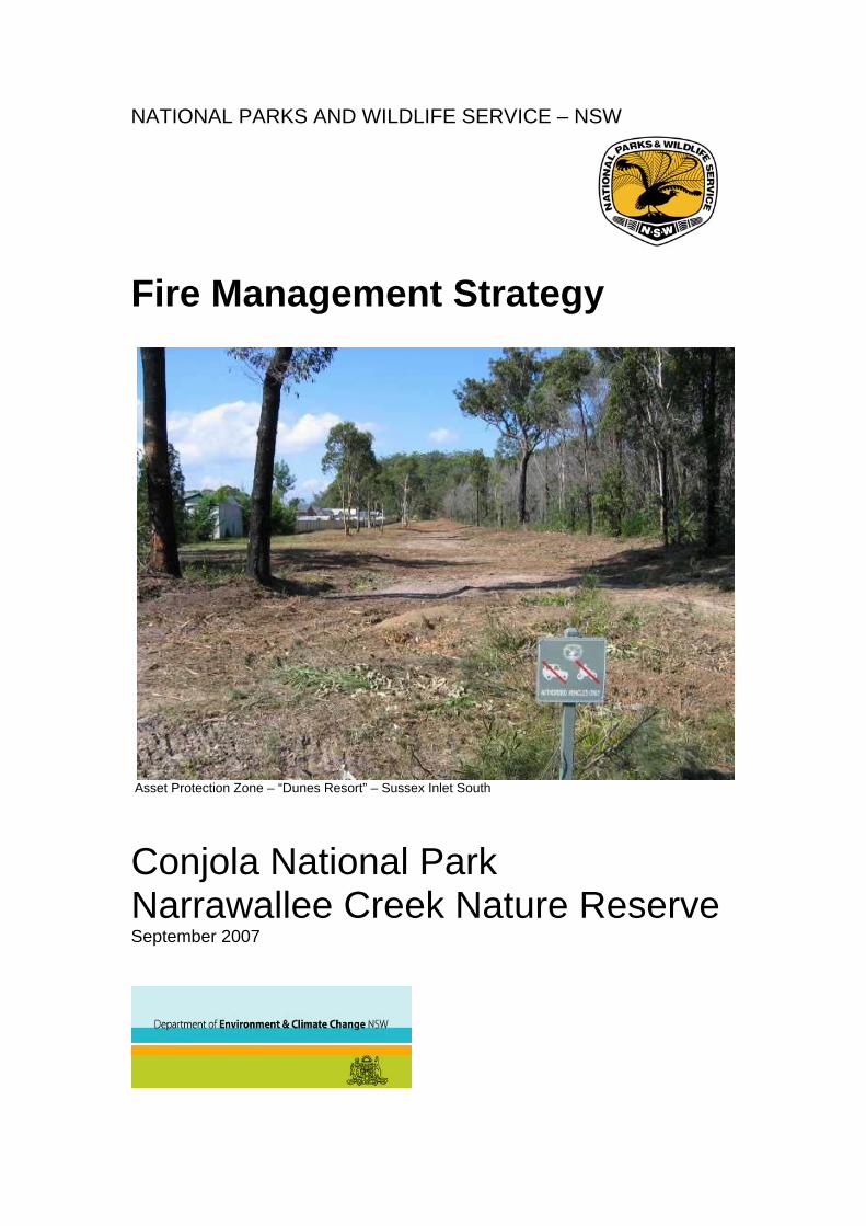
NATIONAL PARKS AND WILDLIFE SERVICE – NSW Fire Management Strategy Asset Protection Zone – “Dunes Resort” – Sussex Inlet South Conjola National Park Narrawallee Creek Nature Reserve September 2007
Transcript of Fire Management Strategy · NATIONAL PARKS AND WILDLIFE SERVICE – NSW . Fire Management Strategy...
NATIONAL PARKS AND WILDLIFE SERVICE – NSW
Fire Management Strategy
Asset Protection Zone – “Dunes Resort” – Sussex Inlet South
Conjola National Park Narrawallee Creek Nature Reserve September 2007

Fire Management Strategy for
Conjola National Park and
Narrawallee Creek Nature Reserve This Fire Management Strategy has been placed on public exhibition, and members of the public, either individually, or as representatives of community interest groups, and government authorities have commented on it. Enquiries concerning this Fire Management Strategy may be forwarded to: The Fire Management Officer NSW - National Parks and Wildlife Service PO Box 707 Nowra NSW 2541 or e-mail – [email protected] Regional Manager South Coast Region NSW National Parks and Wildlife Service
__________________________________________________________ Fire Management Strategy - September 2007 Conjola National Park and Narrawallee Creek Nature Reserve 2

Fire Management Strategy for Conjola National Park And Narrawallee Creek Nature Reserve South Coast Region NSW National Parks and Wildlife Service September 2007 ______________________________________________________________ This publication is copyright. Apart from any fair dealing for the purposes of private study, research, criticism or review, as permitted under the Copyright Act, no part may be reproduced by any process without written permission. Enquiries should be addressed to the NSW National Parks and Wildlife Service Published by the NSW National Parks and Wildlife Service, South Coast Region, September 2007 (PO Box 707, Nowra NSW 2541.) ISBN 978 1 74122 681 2 DECC 2007/580
__________________________________________________________ Fire Management Strategy - September 2007 Conjola National Park and Narrawallee Creek Nature Reserve 3

__________________________________________________________ Fire Management Strategy - September 2007 Conjola National Park and Narrawallee Creek Nature Reserve 4

TABLE OF CONTENTS 1. INTRODUCTION ................................................................................................................... 7
1.1 Scope and purpose of this fire management strategy ..................................................... 7 1.2 Fire Management Objectives........................................................................................... 7 1.3 Description of the Reserve............................................................................................... 8
1.3.1 Location and Terrain ................................................................................................. 8 1.3.2 Fire Weather and History .......................................................................................... 8 1.3.3 Natural and Cultural Heritage.................................................................................... 9 1.3.4 Infrastructure, assets, and economic values........................................................... 10 1.3.5 Recreational Use and Facilities............................................................................... 11 1.3.6 Summary of Key Fire Issues ................................................................................... 11 Map 1 –Map and Location of Reserves ........................................................................... 13
2. BUSHFIRE RISKS............................................................................................................... 15 2.1 Introduction .................................................................................................................... 15
Map 2 – Potential Bush Fire Behaviour map.................................................................... 17 2.2 Life and Property............................................................................................................ 19
Table 1a. - Sites near Conjola National Park and Narrawallee Creek Nature Reserve identified at higher risk from bush fire. ............................................................................. 19 Table 1b, Locations near Conjola National Park and Narrawallee Creek Nature Reserve where detailed cooperative planning for asset protection will be required. ..................... 19 Table 1c, - Community Infrastructure within or near the reserves vulnerable to fire ....... 20
2.3 Cultural Heritage ............................................................................................................ 21 Table 2 – Cultural sites considered at higher risk from bush fire ..................................... 22
2.4 Natural Heritage............................................................................................................. 23 Table 3. Biodiversity at threat within the reserves........................................................... 25
3. BUSH FIRE RISK MANAGEMENT STRATEGIES ............................................................. 27 3.1 Introduction .................................................................................................................... 27 3.2 Fire Management Zones................................................................................................ 27
Map 3. Fire Management Zones – Conjola National Park & Narrawallee Creek Nature Reserve ............................................................................................................................ 29 Map 4 –Detailed Fire Management Zone Maps - Key Map ............................................ 30 Map 4a – Detailed Bush Fire Management Zone Map - Sussex Inlet area ..................... 31 Map 4b – Detailed Bush Fire Management Zone Map – Berrara & Cudmirrah............... 32 Map 4c – Detailed Bush Fire Management Zone Map – Conjola / Narrawallee.............. 33 Map 4d – Detailed Bush Fire Management Zone Map – Bendalong............................... 34
3.2.1 Asset Protection Zones (APZs) ................................................................................. 35 Table 4. The specific fire management objectives and strategies to be applied in each of the Asset Protection Zones (Maps 3 -4)........................................................................... 35
3.2.2 Strategic Fire Advantage Zones (SFAZs)................................................................... 44 Table 5. The specific fire management objectives and strategies for each of the Strategic Fire Advantage Zones (Maps 3-4) ................................................................................... 45
3.2.3 Heritage Management Zones (HMZs) ........................................................................ 63 Table 6. Fire regimes to be applied to vegetation in Heritage Management Zones in order to sustain biodiversity. ...................................................................................................... 65 Table 7. Threatened Species – specific fire management strategies to be applied in the reserve.............................................................................................................................. 68 Table 8. Cultural Heritage strategies for fire management to be applied in the reserves 73 Table 9. Heritage Management Zones – area, fire regimes and fire management strategies. ......................................................................................................................... 74
3.3 Strategic fuel management areas – Slashed Breaks .................................................... 75 Table 10. Strategic fuel management zones – Slashed Breaks (SB)’s– specifications and objectives.......................................................................................................................... 76
3.4 Fire management access – Tracks and Roads ............................................................. 78 Table 11. The Tracks and Roads that will be maintained for fire management within Conjola National Park and Narrawallee Creek Nature Reserve ...................................... 80
3.5 Information, Cooperation, and Enforcement.................................................................. 81 3.6 Research and Monitoring............................................................................................... 82 3.7 Fire Management Works Schedule ............................................................................... 83
Contact details NPWS South Coast Region .................................................................... 84 4. REFERENCES .................................................................................................................... 85 __________________________________________________________ Fire Management Strategy - September 2007 Conjola National Park and Narrawallee Creek Nature Reserve 5

__________________________________________________________ Fire Management Strategy - September 2007 Conjola National Park and Narrawallee Creek Nature Reserve 6

1. INTRODUCTION
1.1 Scope and purpose of this fire management strategy This plan describes the strategies that the National Parks and Wildlife Service (NPWS) will apply to meet fire management obligations under the Rural Fires Act 1997, National Parks and Wildlife Act 1974 and Threatened Species Conservation Act 1995 in both Conjola National Park and Narrawallee Creek Nature Reserve between July 2005 and June 2010 This strategy has been prepared in accordance with policies and procedures set out in the NPWS Fire Management Manual (NPWS, 2001 and as revised), the NPWS Strategy for Fire Management (NPWS, August 2003), Draft Plan of Management for Conjola National Park (Draft Oct 2005) and Plan of Management for Narrawallee Creek Nature Reserve (July 2006) This strategy is supported by: • Regional Fire Management Works Schedules which are revised annually and list the fire
management activities and works proposed for each financial year (July ,one year to June the next year)
• Bush Fire Operational Maps which identify fire suppression advantages, nearby assets and sites of natural, cultural and community values to be protected. These maps are reviewed periodically.
• NPWS South Coast Region – Regional Incident Procedures, which detail bush fire preparedness and response procedures. These are revised annually.
This Strategy is also supported by reference maps, Geographic Information System (GIS) and other databases maintained at the NPWS South Coast Region office at Nowra. This plan is to be integrated with the Bush Fire Risk Management Plan prepared by the Bush Fire Management Committee (BFMC) for the Shoalhaven Fire District. The NPWS is an active member of this BFMC and seeks to work cooperatively with fellow committee members and the community to achieve coordinated fire management and suppression across the Shoalhaven. The NPWS South Coast region would like to acknowledge the extensive and valuable input provided by the community, neighbours, RFS members and other agencies during the consultation, compilation and review for this plan.
1.2 Fire Management Objectives Consistent with the statutory obligations and policies described in the NPWS Strategy for Fire Management the fire management objectives for Conjola National Park and Narrawallee Creek Nature Reserve are: • Reduce the occurrence in the reserve of unplanned fire caused by people, • Contain, and where achievable, suppress unplanned fires occurring in the reserve, • Minimise the potential for the spread of bushfires from the reserve, • Limit the potential spread of fires into the reserve, • Protect people and property in, or immediately adjacent to, the reserves from bushfires
occurring in the reserve, • Manage fire regimes to sustain all species and processes known to occur naturally within
the reserve and thereby avoid possible extinction or unnatural change, • Protect from damage by bushfire all Aboriginal sites, historic places, and culturally
significant features which are known to exist within the reserve, • Promote awareness of the reserves natural and cultural values that may be under threat
from inappropriate fire regimes or suppression activities.
__________________________________________________________ Fire Management Strategy - September 2007 Conjola National Park and Narrawallee Creek Nature Reserve 7

1.3 Description of the Reserve
1.3.1 Location and Terrain This strategy applies to the following reserves: Conjola National Park, and Narrawallee Creek Nature Reserve. The reserves are some 130km from Sydney on the NSW South Coast. They lie between the Princes Highway and the coastline some 30km south of Nowra and adjoin the settled areas of Sussex Inlet, Swanhaven, Berrara, Bendalong and Lake Conjola. (see Map 1) Conjola National Park includes the catchments of Swan Lake and Berrara Creek. Also included are parts of the catchments of Tullarwalla Lagoon / St. Georges Basin to the north and Lake Conjola to the south. Narrawallee Creek Nature Reserve adjoins the estuarine reaches of Narrawallee Creek and Inlet as well as the smaller catchment of Pattimores Lagoon just to the south of Lake Conjola village. In addition to the 11,982 hectares within the reserves, this plan also considers bush fire fuels, assets, and fire control advantages that are outside but are continuous with, or adjacent to, those in the reserve. Topography within the reserve varies from coastal dunes, wetlands and estuaries rising to steep sided gullies to flatter sandstone or shale ridgetops of generally low elevation.
1.3.2 Fire Weather and History The climate predominant over Conjola National Park and Narrawallee Creek Nature Reserve is temperate including a strong maritime influence that interacts with the continental weather patterns. Whilst the latter overall trends are more predictably forecast, the variability of the more localised effects such as the summers coastal ‘nor-easters’ and ‘southerly busters’ and their characteristic sudden wind changes can present difficulties for fire suppression. Similarly, the deteriorating fire weather conditions associated with hot dry continental winds usually preceding the passage of frontal systems may be exacerbated over the reserves by the downstream turbulence caused by prominent sandstone escarpments just to the west. This again may lead to sudden change in wind speed and fire behaviour. Regional rainfall is variable both annually and seasonally with a recorded average of approximately 1250mm. This rainfall is summer dominant and often results from thunderstorm activity. As such the rainfall can be quite variable across the landscape. This variability needs to be monitored when prescribing ‘burning off’ conditions or considered when using regionally based fire weather indexes. The summer storms can also present dangerous fire weather conditions for firefighting crews. The area is subject to periodic drought both regionally and as part of larger trends such as ‘El Nĩno’. These trends can result in drying out the soils and vegetation making more fine fire fuel available than usual as well as promoting intense fire behaviour as observed in the prolonged drought and exceptional summers of 2001/2002 and 2003/2004. Under such conditions, fire behaviour makes control very difficult and can easily compromise the usually sufficient protection measures. Most recorded wildfire arises from suspected deliberate ignition or escaped fire with the only identified “natural” cause being occasional lightning strikes. Fire caused by electrical arcing and pole cross-arm ignition is also considered locally significant along supply easements. Most of the suspected deliberate events originate from access routes and adjacent to settled areas. Recorded major fire runs across the reserve are west to east either originating near or crossing the Princes Highway from the west.
__________________________________________________________ Fire Management Strategy - September 2007 Conjola National Park and Narrawallee Creek Nature Reserve 8

Fire history records for the reserves are maintained by the NPWS. For the period before establishment of the reserves, records are collated from former land management and fire suppression organisations, research findings and historical records. The period and detail of these records are limited but can provide basic information on causes of ignition extent and frequency. Though limited, this history is also sufficient to assess indications for biodiversity conservation and some aspects of fire mitigation over the life of the Fire Management Strategy. Fire history and related information is available to managers via Geographic Information Systems and organisational records. Fire history for a period up to ten years prior to the publication of the Fire Management Strategy is mapped on the supporting Operational Maps as an aid to assessing possible fire behaviour and developing suppression tactics. This fire history presentation is updated annually on operational maps to be used by managers and shared with other emergency authorities. This FMS does not include a presentation of fire history as it is anticipated the FMS will cover a period of at least five years and therefore may not reflect a current appraisal of prescribed burning and wildfires. From the available records it appears that large areas of Conjola National Park and Narrawallee Creek Nature Reserve have been burnt more frequently than is indicated for the maintenance of biodiversity. This could have resulted in the promotion of more fire prone vegetation. This fire history presents challenges for the maintenance of the reserves’ biodiversity, protection of adjacent assets and community understanding of fire management options and decisions.
1.3.3 Natural and Cultural Heritage The vegetation of the reserves is both diverse and fire-prone. This diversity includes taller forests on elevated shale areas and sheltered drainage lines north of the Bendalong Road, significant blackbutt forests on ancient dune landforms near Sussex Inlet, drier open forest fand heaths along ridgetops and important littoral and dune vegetation along estuaries and foreshores. The reserves include a number of rare and threatened plant species such as Galium australe, Pultenea villifera, and Cryptostylis hunteriana. The reserves also contain a number of Endangered Ecological Communities (EECs) such as Bangalay sand forest and Swamp Oak floodplain forest. Particular management strategies to protect Threatened plant species or Endangered Ecological Communities are outlined in Table 7. The landforms and vegetation of the reserves include the habitats of a diverse range of fauna. Of particular note are the populations of arboreal mammals as well as shorebirds and waders using the foreshore and estuarine areas. Over a dozen threatened species have been recorded in and around the reserves. These include the Masked Owl - Tyto novaehollandiae, Green and Golden Bell Frog - Litoria aurea, Grey Headed Flying Fox - Pteropus poliocephalus, Osprey - Pandion haliateus - Yellow Bellied Glider - Petaurus australis, Squirrel Glider- Petaurus norfolcensis, Sooty Owl - Tyto tenebricosa, Powerful Owl - Ninox strenua, Large -footed Myotis - Myotis adversus and Common Bentwing Bat - Miniopterus schreibersii. A number of these species may be considered at threat if inappropriate fire regimes prevail or unsuitable fire management strategies or control options are applied. Such species include the Glossy Black Cockatoo -Calyptorhynchus lathami. Specific fire management strategies for affected threatened fauna species are outlined in Table 7. The evidence of Aboriginal use and sites of cultural significance are found across the reserves with concentrations of recorded occupation sites along creeklines and foreshores. As with remnants of early historic use, few of these are vulnerable to further fire but may be vulnerable to fire suppression activities such as the use of earthmoving machinery. The most prominent historic site is a monument to the ‘Walter Hood’ shipwreck north of Bendalong and the silica mining tramway formation at Narrawallee Creek. Protection measures and suppression options for these assets are detailed in Table 8.
__________________________________________________________ Fire Management Strategy - September 2007 Conjola National Park and Narrawallee Creek Nature Reserve 9

The reserves have been the site of considerable mining and forestry activity including the legacy of a complex vehicle access network that is undergoing assessment of suitability and maintenance for public use, fire management and rehabilitation. Whilst all access routes may have some usefulness for fire management, only those tracks primarily maintained by the NPWS for fire suppression are specifically listed in this strategy and shown on operational maps.
1.3.4 Infrastructure, assets, and economic values There are few community infrastructure assets or NPWS developed areas within the reserves. Major assets include the aerial power supply feeder lines to the communities of Sussex Inlet, Berrara, Bendalong, Manyana, and further down the south coast. These routes traverse extensive bushland including the reserves and may be vulnerable to intense fire. The consequent effects of loss of service on communication, water and sewerage services can pose a significant problem. The reserves virtually surround the villages of Sussex Inlet, Swanhaven, Berrara, Bendalong, Cudmirrah and Lake Conjola. The predominant uses of these settlements are holiday and residential accommodation including supporting commercial areas and service industries. The seasonal fluctuation of population and absentee ownership presents particular problems for community information, preparedness and neighbour interaction with regard to bush fire. A longstanding concern to the community is the singular vehicular access routes to these settlements that may be readily compromised by bush fire. Apart from reserve appreciation and enjoyment, a few vehicle access routes across the reserves are regularly used for commuting by local communities. These routes also raise concerns about public safety during fire outbreaks and possible source of illegal ignitions e.g. Blackbutt Road. A number of community service infrastructure facilities are located within the reserve. These include a communications tower located at 12-Mile Peg (Cudmirrah Trig) near the Princes Highway and another co-located with a water reservoir on Shoalhaven City Council managed land near Fishermans Paradise. There are numerous underground telephone cables including fibre optic routes as well as water pipelines, water pumping station at Fishermans Rock and a sewerage pipeline. A number of rural subdivisions adjoin the reserves with many containing a large proportion of natural vegetation. Most of the portions within these subdivisions are of sufficient size to accommodate measures to protect existing dwellings - without the demand to modify adjacent reserve lands. The scattered placement and access to these assets presents particular challenges for fire suppression and protection. There are also considerable areas adjoining the reserves that have the potential for further subdivision or development. At present some of these areas are naturally vegetated and are included in planning for fire management zones and strategies especially where they adjoin built up areas. Current legislation and guidelines include the need to address the risk from bush fire in design and approval processes. This should lessen the expectation and consequent effect of further demands for fire protection to take place within the reserves. Whilst the NPWS will undertake its responsibilities to reasonably limit the possible spread of bush fire from adjacent lands, it cannot be expected that fire management regimes and conservation outcomes on existing reserves will be altered to accommodate future adjacent development. Consistent with planning requirements of the Rural Fires Act, development options for these lands will need to recognise the inherent risk from bush fire in such landscapes and continue to include sufficient protective design options.
__________________________________________________________ Fire Management Strategy - September 2007 Conjola National Park and Narrawallee Creek Nature Reserve 10

1.3.5 Recreational Use and Facilities Most of the reserves recreational use is focussed on the coastal fringe and along public access routes through or adjacent to the reserve. This use is highly seasonal over summer and holiday periods and largely emanates from the adjacent settlements of Sussex Inlet, Swanhaven, Berrara, Lake Conjola and Bendalong. These towns and villages are often swelled with visitors or non-permanent residents unfamiliar with the locality and the associated fire risks. Recreation uses of the reserve include foreshore and waterway use for beach activities, fishing, vehicle based touring and informal bushwalking. Visitor use facilities are located north of Bendalong at the Walter Hood shipwreck memorial, the Haven, and a number of other trackheads and carparks e.g. Conjola Beach. Visitor use is spread across these tracks and along the foreshores and beaches of the reserves. There are several implications for fire management from this dispersed and seasonal use. These include • the primary need to consider visitor safety in fire suppression response, • Communication of risks and appropriate response for casual visitors, • Preparedness information and preparation for adjacent neighbours and communities, and • Opportunities for unplanned ignition from the dispersed use and access network.
1.3.6 Summary of Key Fire Issues There are a number of key fire management issues across areas including these reserves. Of note are: • The fragmented nature of neighbouring urban settlement throughout fire-prone bushland
to the north and east of the reserves. Associated with this is the complex mix of land ownership and management along the urban / bushland interface.
• The ‘single-road-in-and-out’ vehicle / emergency access to these communities. • The vulnerability of key infrastructure and routes across bushland to these urban areas.
e.g. power supply, water supply, communications. • The dispersed arrangement of access and dwellings in rural subdivision areas, e.g.
Sussex Inlet Road and various isolated properties. • The planning for and development of bushland areas adjacent to the reserves and nearby
settlements having regard to bush fire risk. • The considerable biodiversity found in these areas that may be at risk from inappropriate
fire regimes, i.e. too frequent fire. • The need to encourage greater community understanding of the implications of fire
management for biodiversity and the limits of achievable fire protection under certain fire weather conditions
• The high incidence of ‘unplanned fire’ arising from arson or careless use of fire.
__________________________________________________________ Fire Management Strategy - September 2007 Conjola National Park and Narrawallee Creek Nature Reserve 11

__________________________________________________________ Fire Management Strategy - September 2007 Conjola National Park and Narrawallee Creek Nature Reserve 12

Map 1 –Map and Location of Reserves
__________________________________________________________ Fire Management Strategy - September 2007 Conjola National Park and Narrawallee Creek Nature Reserve 13

__________________________________________________________ Fire Management Strategy - September 2007 Conjola National Park and Narrawallee Creek Nature Reserve 14

2. BUSHFIRE RISKS
2.1 Introduction The large number and complexity of assets of all types in and around the reserves means it is not realistically possible to implement active fire management strategies to protect all assets that could be damaged by extreme wildfire events or inappropriate fire regimes. Bush fire risk analysis has been undertaken to identify those assets most at risk from fire of higher intensity and therefore most in need of the application of active fire management strategies. For the purpose of this strategy, bush fire risk is defined as the chance of a bush fire or inappropriate fire regime occurring and causing damage to assets within or adjacent to the reserve. ‘Assets’ include life and property, cultural heritage – such as historic or aboriginal sites, and natural heritage – such as flora, fauna and natural ecosystems. The method of grading the bush fire behaviour potential and consequent risk of damage is described in the NPWS Approach to Fire Management Planning (NPWS Aug 2003). Whilst these methods are based on available climatic, vegetation and terrain data, it is again stressed that periods of extreme fire weather and prolonged drought will considerably increase the potential behaviour and damage from bush fire. Under these exceptional conditions the potential risk to the community’s property, natural and cultural assets will therefore increase significantly. This risk assessment method has been applied to the area within and adjacent to Conjola National Park and Narrawallee Creek Nature Reserve. Life and property, natural and cultural assets within these areas have been sorted into one of the following fire potential / risk classes - higher, moderate, or lower. This strategy will focus on all assets within or adjacent to the reserves where identified in areas of higher bush fire potential. These assets within areas of higher potential for bushfire impact have been illustrated in Map 2 and identified in the following sections.
__________________________________________________________ Fire Management Strategy - September 2007 Conjola National Park and Narrawallee Creek Nature Reserve 15

__________________________________________________________ Fire Management Strategy - September 2007 Conjola National Park and Narrawallee Creek Nature Reserve 16

Map 2 – Potential Bush Fire Behaviour map
__________________________________________________________ Fire Management Strategy - September 2007 Conjola National Park and Narrawallee Creek Nature Reserve 17

__________________________________________________________ Fire Management Strategy - September 2007 Conjola National Park and Narrawallee Creek Nature Reserve 18

2.2 Life and Property Based on the criteria set out in the NPWS Approach to fire Management Planning (NPWS 2003), there are few specific locations within Conjola National Park and Narrawallee Creek Nature Reserve where life and property are identified within areas at ‘higher’ risk from bush fire. Nevertheless, as has been demonstrated in events of extreme fire weather coupled with prolonged drought, there can be exceptional fire behaviour that can readily breach commonly accepted fire mitigation measures. (e.g. Sussex Inlet – January 2002). Under such circumstances, bush fire fuels not normally available such as in swampy areas may carry intense fire whilst the incidence of spot fires can increase at considerable distances. The risk of life and property damage is exacerbated where there is a concentration of people and assets such as the interface between built-up areas and adjoining bushland. Similarly, key community infrastructure located within fire prone areas is also vulnerable and damage to such facilities may have significant effects on wide areas not directly concerned with fire events. Such sites in and around Conjola National Park and Narrawallee Creek Nature Reserve have been identified within Tables 1a, 1b &1c. (see Map 2 & Tables 1a, 1b, 1c. and Operations Map)
Table 1a. - Sites near Conjola National Park and Narrawallee Creek Nature Reserve identified at higher risk from bush fire. (using criteria for fire risk factors in NPWS Strategy for Fire Management 2003)
Map ID
Feature / Location Tenure
T 92 Dwellings – Wayfarer Drive – Sussex Inlet Private T 83 Dwellings - Sussex Inlet Private T 82 Dwellings – Sussex Inlet Holiday Resort – Sussex Inlet Private T 10 Dwelling – east of Mella Mella Bay – Conjola Lake Private T 168 Dwelling – west of Princes Hwy -12 Mile Peg – near
Wandandian Creek Private
Though many assets do not directly adjoin the reserves, in places there is a continuum of bushland from the reserves to areas near the assets. In such areas the NPWS will support the cooperative approach to managing bush fire risk currently being promoted by the Shoalhaven Bush Fire Management Committee of which the NPWS is a member. Such sites include areas listed in Table 1b:
Table 1b, Locations near Conjola National Park and Narrawallee Creek Nature Reserve where detailed cooperative planning for asset protection will be required.
Feature ID
Feature / Location Tenure
T108 Urban / bushland interface -Medlyn Avenue subdivision, -Sussex Inlet
Private
T92 Urban / bushland interface – Wayfarer Drive – Sussex Inlet Private T104 Urban / bushland interface – northern Swanhaven Private T114 Urban / bushland interface – west Cudmirrah Private T120 Urban / bushland interface – west Berrara Private T2 Urban / bushland interface – North Bendalong Private T124 Urban / bushland interface - Bendalong Private T17 Urban / bushland interface – Lake Conjola Private T183, T64
Dwellings on rural residential allotments south of Sussex Inlet Road
Private
T139 Dwellings isolated within in-holdings in the reserves Private
There are also a number of community infrastructure assets within or near the reserves that may be vulnerable to fire.
__________________________________________________________ Fire Management Strategy - September 2007 Conjola National Park and Narrawallee Creek Nature Reserve 19

Such sites include:
Table 1c, - Community Infrastructure within or near the reserves vulnerable to fire
Feature ID
Feature / Location Tenure
T66 Communications Tower – 12 Mile Peg (Cudmirrah Trig) – Mondayong Road
Nat. Parks & Wildlife Service
T78 Communications Tower – west Conjola Lake – Fishermans Paradise (on Shoalhaven City Council managed land but surrounded by the reserve)
Private and Shoalhaven City Council
T191 Water Pumping Station and electricity supply – Fishermans Rock - Berrara
Shoalhaven City Council
T5 Sewage Treatment Plant – Medlyn Avenue – Sussex Inlet Shoalhaven City Council
T192 Communications Tower – Medlyn Avenue – Sussex Inlet Telstra U277,U3
95, U487, U246
Electricity supply feeder lines – south of and parallel to Sussex Inlet Road, east of and parallel to the Princes Highway, Sussex Inlet – Berrara – Bendalong route,
Integral Energy,
Visitor Facilities within the reserves Nat. Parks & Wildlife Service
Sewerage Treatment Plant – Lake Conjola Shoalhaven City Council
Sewerage Treatment Plant, Bendalong Shoalhaven City Council
__________________________________________________________ Fire Management Strategy - September 2007 Conjola National Park and Narrawallee Creek Nature Reserve 20
2.3 Cultural Heritage Although there are a large number of aboriginal cultural sites within Conjola National Park and Narrawallee Creek Nature Reserve not all sites are at risk from bush fire. Based on the criteria set out in the NPWS Approach to fire Management Planning (NPWS 2003), an assessment of the type and location of recorded Aboriginal and Historic cultural sites was undertaken. A variety of sites have been recorded in the reserves including stone tool scatters, axe grinding grooves, middens and scarred trees, indicating widespread use of the landscape. No recorded sites were assessed as being directly vulnerable from the effects of bush fire in areas of higher fire potential within Conjola National Park or Narrawallee Creek Nature Reserve. However, a significant threat to sites in all areas can arise from fire protection works or fire suppression operations such as disturbance created by vehicles, earthmoving plant, cutting down trees and creation of hand tool lines. To limit the risk of this disturbance a number of areas including cultural sites that could be vulnerable to pre-season or fire control operations have been identified on Operational Maps. Operational guidelines for firefighters and planners aimed at avoiding such disturbance are also included. The types of site are not indicated but all sites that are indicated on maps are considered at risk from usual methods of creating control lines. The operational maps have been referred to relevant interests and the information is provided with permission. (These maps are not for wider circulation to non-operational personnel.) NB - Not all cultural sites can be indicated due to respect for the site sensitivity or non-fire protection priorities. Where operations are planned, - especially in areas near indicated sites or along routes not previously used, - then planning and operational staff should allow time and resources for preliminary assessment by suitably knowledgeable personnel. It is stressed that the indicated site locations may only be approximate. Where there may be limited options for control routes in areas that may compromise an indicated site, then field personnel should seek appropriate guidance from skilled and relevant personnel. During fire protection works or suppression operations in proximity to the indicated sites, or when sites may have been discovered, these concerns should be promptly relayed to the relevant supervisor, Divisional Commander and Incident Management Team. Where disturbance is likely, alternative methods or firefighting tactics should be considered or - where possible - works delayed until appropriate assessment is completed. It is recognised that there will at times be circumstances where quick action is required under certain conditions to implement control measures. Where possible and if safer success of control is likely, then unnecessary disturbance should be avoided and control options less likely to disturb sites should be employed e.g. the use of hose lays and wetlines as opposed to earthmoving machinery at a particular site. Where likely strategic control options are identified beforehand then these should be assessed and mapped as time and resources allow in non-operational periods. These options are to be recorded in databases available to incident planning teams and where suitable marked on operational map upgrades. Similarly, those historic cultural assets at risk from control operations may be identified on operational fire maps and strategy options identified. There is also a risk of disturbance to such cultural assets as a result of routine maintenance of the fire management features proposed in this strategy. Each zone will be assessed for the effects of maintenance activities on both cultural and natural values as part the preparation of the Fire Management Works Schedule (Sect. 3.7)
__________________________________________________________ Fire Management Strategy - September 2007 Conjola National Park and Narrawallee Creek Nature Reserve 21

If there is any doubt as to the appropriate measures to be taken or should further cultural assets be identified then avoid all disturbance where possible and contact a NPWS representative or office.
Table 2 – Cultural sites considered at higher risk from bush fire NB No specific sites have been identified at higher risk from bush fire potential – Table 2 is reserved for possible sites identified during ongoing operations and maintenance works assessments, sites survey and evaluation in the reserves. The sites included here are considered particularly vulnerable to fire suppression activities.
Feature / Location Tenure Fishermans Rock and environs – near Berrara NPWS Silica tramway and remnant artefacts NPWS Washerwomans Creek Scarred Tree NPWS Charcoal Pits - Bendalong Rd NPWS
__________________________________________________________ Fire Management Strategy - September 2007 Conjola National Park and Narrawallee Creek Nature Reserve 22

2.4 Natural Heritage Based on the criteria set out in the NPWS Approach to fire Management Planning (NPWS 2003), there are many vegetation communities in Conjola National Park at higher risk from inappropriate fire regimes. (see Table 3) Given the recent extensive fire events across Conjola National Park including the single large wildfire event of December/January, (2001-2002) where 92% of the park was burnt, many of the complex and diverse vegetation communities found within the reserve are at risk from being burned too frequently (overburned). Therefore longer-term biodiversity values may be at risk. Conversely there are a few communities in both reserves where the time since fire exceeds the indicated thresholds and may require fire to be introduced in order to conserve biodiversity (underburnt). Given the widespread nature of the recent wildfires (2001-2002) most of the vegetation community types contain recently burned areas that although within the desirable thresholds, are vulnerable to being ‘overburned’ if fire is introduced too soon after the recent events. Most of these biodiversity concerns related to fire frequency are addressed in the strategies to manage fire within the Heritage Management Zones (HMZs) where a range of ‘times-since-fire’ can be managed for. To better identify appropriate and site-specific fire regimes within the reserves, eight fire monitoring plots have recently been established a variety of vegetation types including a focus on rare or threatened plant species. Within Strategic Fire Advantage Zones (SFAZs) where a closer watch may be kept on bush fire fuel conditions, fire may be introduced towards the lower end of the required thresholds. In Asset Protection Zones (APZs) fuel conditions are most closely monitored and provided there are not specific identified communities, habitats or species at risk, lower thresholds may be exceeded where fire is considered the best way to manage fuel conditions. In summary, as at January2005 - and considering the total area of both reserves - over 85% of the vegetation had been recently burned within the past six years. Approximately 15% of these burnt areas have been ‘overburned’ i.e. subject to fire too soon since the last event. A further 25% of the vegetation within these burnt areas may be vulnerable if fire is applied again within the next two to three years. Of the areas not recently burnt, 6% of the reserve vegetation may require the application of fire to conserve biodiversity and just 5% is left both unaffected by overburning and not vulnerable to the risk of new fire (that is, if fire was to occur, or not to occur, within the next few years, the vegetation would remain within appropriate fire regime or ‘time-since-fire’ limits). Importantly, the whole of some of the reserve vegetation communities have been overburned. By way of further explanation, although a vegetation community may currently be within the recommended biodiversity thresholds for time since fire, or outside those thresholds – either burned too frequently or infrequently enough - it may also be considered ‘vulnerable’ if subject to fire again within the next five years. Alternatively a vegetation community currently within the thresholds may become vulnerable within the next five years where not burned - as the time-since-fire exceeds the upper thresholds. Table 3 identifies those vegetation communities in the reserves and their area. It also lists the percentage of that area that has been over or underburned, i.e. where biodiversity is at risk from inappropriate fire regimes. The table broadly shows that due to large-scale fire events in the past decade, the application of fire with prescribed burning or the spread of wildfire will need to be monitored closely.
__________________________________________________________ Fire Management Strategy - September 2007 Conjola National Park and Narrawallee Creek Nature Reserve 23

This information will be reviewed annually in light of the past seasons fire history – both wildfire and prescribed burning. The upper and lower biodiversity thresholds for time since fire for each vegetation community within the reserve are then considered and the areas where fire should be excluded or avoided and areas where fire may need to be introduced to maintain biodiversity are determined. Managers are aided in this complex assessment by the use of computer based Geographic Information Systems, field survey and ongoing research into fire regimes and management. Apart from asset protection areas where vegetation may be directly modified by slashing or subject to repeated fire in order to limit available bush fire fuel, the aim is to maintain a range of age classes (times-since-fire) across all the vegetation communities within the reserves. Similar concepts are now applied within environmental assessments for burning proposals in bushland areas outside reserves.
__________________________________________________________ Fire Management Strategy - September 2007 Conjola National Park and Narrawallee Creek Nature Reserve 24

Table 3. Biodiversity at threat within the reserves. Vegetation Communities within the reserves affected by inappropriate fire regimes
Total Area affected (ha.)
% Affected by in-appropriate fire
regimes*
paperbark shrubland 113.50 100 moist forest tending to dry 0.06 100 bangalay open forest/swamp oak forest/woodland+rushland/forbland
0.31 100
Ruppia forbland 0.94 100 blackbutt open forest 1.06 100 southern coastal hind dune/headland scrub 13.31 91 blackbutt-bloodwood open forest 91.00 86 bangalay open forest 1.19 83 banksia-teatree closed shrubland 4.50 71 blackbutt-turpentine tall open forest 17.25 68 paperbark shrubland (swampland)/swamp oak forest/woodland+rushland
0.19 60
blackbutt open forest-ironwood closed forest 80.25 56 ecotonal coastal swamp forest - Casuarina glauca - Eucalyptus botryoides
0.38 50
scribbly gum-casuarina open forest 0.06 50 blackbutt-turpentine open forest/tall open forest 1.31 45 paperbark shrubland (swampland) 2.81 31 blackbutt-turpentine tall open forest/blue gum tall open forest
44.50 23
bangalay open forest/closed forest (rainforest) 196.94 19 swamp oak forest/woodland+rushland (& saltmarsh) 387.19 18 coastal lowland sub tropical/littoral rainforest 0.25 16 blue gum tall open forest 52.81 13 woollybutt-paperbark woodland ^ 1.88 100 coastal headland heathlands 3.19 - swamp oak forest/woodland+rushland/forbland (saltmarsh)
2.56 -
bloodwood-peppermint open forest/woodland 7.94 - dry forest dominant./moist forest 0.25 -
* Percentage of vegetation community currently affected by inappropriate fire regime i.e. burned too frequently or infrequently enough to sustain biodiversity. NB: Given recent fire history, most of these vegetation communities indicated are affected by too frequent fire. This indicates that the interval between fires has been insufficient. (As at Nov 2005) ^ This is an example where all the limited area of this vegetation community observed within the reserves (only 1.88 ha) has been burned at too frequent intervals (i.e. 100% affected by inappropriate fire regimes), and all of this community is at risk of not being able to sustain itself if fire is applied within the next 2-3 years
__________________________________________________________ Fire Management Strategy - September 2007 Conjola National Park and Narrawallee Creek Nature Reserve 25

__________________________________________________________ Fire Management Strategy - September 2007 Conjola National Park and Narrawallee Creek Nature Reserve 26

3. BUSH FIRE RISK MANAGEMENT STRATEGIES
3.1 Introduction The fire management strategies identified and illustrated in maps 3 to 4 in this plan will be implemented over the life of this plan and have been designed to reduce the bush fire risk to assets within and adjacent to the reserves (as outlined in section 2 of this strategy) A Fire Management Works Schedule for works to apply these strategies is prepared and reviewed annually. (see section 3.7 of this strategy)
3.2 Fire Management Zones Conjola National Park and Narrawallee Creek Nature Reserve - and in some cases the adjoining areas - have been divided into fire management zones according to the zoning system described in the NPWS Approach to fire Management Planning (NPWS 2003). These zone types are Asset Protection Zones (APZ), Strategic Fire Advantage Zones (SFAZ) and Heritage Management Zones (HMZ). Where possible the boundaries of fire management zones have been defined by fire control ‘advantages’ or useful operational boundaries. e.g. roads, water, or areas of low bush fire behaviour potential. It should be noted that the width of Asset Protection Zones – APZs as described may vary according to specific site conditions and the consideration of setbacks for existing dwellings (at July 2003) as outlined in the guidelines Planning for Bushfire Protection (2001) (or as revised.) Operational and asset protection planning may sometimes indicate that logical fire management zone boundaries should extend beyond the reserve onto other land tenures. The strategies proposed in this plan are limited to the reserve only and do not imply appropriate fire management directions for other land tenures or adjacent bushland. It should be noted that the preparation of these NPWS strategies also considers fire management activities undertaken on adjacent lands. For example, where there is a continuum of bushland from the reserve to nearby dwellings, slashed breaks put in place adjacent to those assets are more effective than a break along the reserve boundary some distance away. Current planning legislation requires that proposals for new developments in bush fire prone areas consider bush fire hazard in appropriate building standards and layout of subdivisions. To aid community understanding of cooperative bush fire risk management in these areas adjoining the reserve, this strategy may show these fire protection works by other agencies where known at the time. These works may vary according to fire management and seasonal requirements. The enclosed maps may also identify who manages bushland areas adjacent to the reserve to assist neighbours to seek information on bush fire mitigation activities being undertaken. If unsure as to ownership of adjacent lands, neighbours should enquire with the Shoalhaven City Council. Enquiries about bush fire risk on lands adjacent to the reserve should be directed to owner/manager of the property or the Rural Fire Service. During the life of this strategy, the NPWS will endeavour to seek agreement, compromise, or consistent definition of strategies in these overlap areas so that a common understanding of fire management expectations may be understood by the community, neighbours, land managers and firefighters alike. The NPWS or neighbours may seek the assistance of the Shoalhaven Bush Fire Risk Management sub-committee – (SBFMC) - to facilitate these matters.
__________________________________________________________ Fire Management Strategy - September 2007 Conjola National Park and Narrawallee Creek Nature Reserve 27

As the same zoning system is used, the NPWS South Coast Region will be submitting this fire management plan, these zones and their applied strategies for inclusion as part of the Shoalhaven Bush Fire Risk Management Plan. This planning contribution and works commitment by the NPWS becomes part of the overall strategy for the Shoalhaven community to better understand and live with the risks associated with bush fires in this region. It should be noted that Heritage Management Zones – (HMZs) used by the NPWS are the equivalent of Land Management Zones (LMZs) used in the 2000 Bush Fire Risk Management Plan for the Shoalhaven. This Bush Fire Risk Management Plan will be reviewed in the near future. The “advantage”, referred to in Strategic Fire advantage Zones (SFAZs) is the advantage to fire managers and firefighters if fire is managed in these zones according to the strategies suggested. In a similar way, this plan refers to the number of “slashed breaks” that the NPWS maintains. (see Table 10). These may also serve the function of a “Radiation Zone” mentioned in the NPWS Approach to fire Management Planning (NPWS 2003) but are more easily identified locally as “slashed breaks”.
__________________________________________________________ Fire Management Strategy - September 2007 Conjola National Park and Narrawallee Creek Nature Reserve 28

Map 3. Fire Management Zones – Conjola National Park & Narrawallee Creek Nature Reserve
__________________________________________________________ Fire Management Strategy - September 2007 Conjola National Park and Narrawallee Creek Nature Reserve 29

Map 4 –Detailed Fire Management Zone Maps - Key Map
__________________________________________________________ Fire Management Strategy - September 2007 Conjola National Park and Narrawallee Creek Nature Reserve 30

Map 4a – Detailed Bush Fire Management Zone Map - Sussex Inlet area
__________________________________________________________ Fire Management Strategy - September 2007 Conjola National Park and Narrawallee Creek Nature Reserve 31

Map 4b – Detailed Bush Fire Management Zone Map – Berrara & Cudmirrah
__________________________________________________________ Fire Management Strategy - September 2007 Conjola National Park and Narrawallee Creek Nature Reserve 32

Map 4c – Detailed Bush Fire Management Zone Map – Conjola / Narrawallee
__________________________________________________________ Fire Management Strategy - September 2007 Conjola National Park and Narrawallee Creek Nature Reserve 33

__________________________________________________________ Fire Management Strategy - September 2007 Conjola National Park and Narrawallee Creek Nature Reserve 34
Map 4d – Detailed Bush Fire Management Zone Map – Bendalong

3.2.1 Asset Protection Zones (APZs) Twelve asset protection zones have been identified within and around Conjola National Park and Narrawallee Creek Nature Reserve. (see Maps 3 to 4) The primary fire management objective for asset protection zones is the protection of life and property that may be achieved by applying the strategies as outlined in Table 4 below. Note that the slashed breaks described in Table 10 also contribute to the protection of life and property.
Table 4. The specific fire management objectives and strategies to be applied in each of the Asset Protection Zones (Maps 3 -4) Conjola National Park APZs
Zone Area (ha) Zone ID
Map/s APZ Name in reserve
outside reserve
Specific Objectives Strategies
CN A1
4a
Medlyn Avenue APZ - NPWS section
1.28
• To aid in the protection of dwellings
and occupants adjoining the bushland surrounding the Medlyn Avenue subdivision – (NW of Swanhaven) from the threat of bushfires.
• To aid firefighters in the protection of life and property in these adjoining areas. • To provide a fuel reduced area
from which firefighters can undertake fuel management in adjoining bushland.
• To provide an operational boundary for fuel management burning in the adjacent Swan Lake North SFAZ
• Maintenance of a slashed break in that part
of Conjola National Park that is within 30 metres of the existing residences (2003) along the western, southern and eastern boundaries of Medlyn Avenue subdivision.
• Enable clear access for firefighters and limit available fire fuels by clearing rubbish, gardening debris and removal of property from the APZ.
• Seek cooperation of local RFS brigades in the monitoring of APZ fuel conditions, and the assistance of neighbours in watching for unauthorised use that may lead to arson, rubbish dumping or compromise emergency vehicle access.
• Annual bush fire fuel and slashed break assessment for maintenance and fuel management works required prior to October
- adjoining Crown Lands
• For information on fire management on adjoining Crown Lands please contact Dept. of Crown Lands
__________________________________________________________ Fire Management Strategy - September 2007 Conjola National Park and Narrawallee Creek Nature Reserve 35

Conjola NP – APZs continued Zone Area (ha) Zone ID Map/
s APZ Name
in reserve
outside reserve
Specific Objectives Strategies
CN A2
4a
Snappy Gums APZ - NPWS Section
1.52
• To aid in the protection of adjoining
dwellings and occupants of the Snappy Gums Caravan Park - Swanhaven - from the threat of bushfires.
• To aid firefighters in the protection of life and property in these adjoining areas.
• To provide a fuel reduced area from which firefighters can undertake fuel management in adjoining bushland.
• Where feasible, maintain a slashed
break or fuel reduced area along the eastern and northern boundary in that part of Conjola National Park that is within 30 m of the existing residences (2003) in the Snappy Gums Caravan Park.
• Enable clear access for firefighters and limit available fire fuels by clearing rubbish, gardening debris and removal of property from the APZ.
• Annual bush fire fuel and slashed break assessment for maintenance and fuel management works required.
• Site within reserve is on steep relict sand dunes and extent of works will need to be limited to avoid instability and erosion.
• Seek cooperation of local RFS brigades in the monitoring of APZ fuel conditions, and the assistance of facility occupants and management in watching for unauthorised use that may lead to arson, rubbish dumping or compromise emergency vehicle access.
- adjoining Private Property areas
• For contact details of Private Property owners/managers – enquire at Shoalhaven City Council
__________________________________________________________ Fire Management Strategy - September 2007 Conjola National Park and Narrawallee Creek Nature Reserve 36

Conjola NP – APZs continued Zone Area (ha) Zone
ID Map/s APZ Name
in reserve
outside reserve
Specific Objectives Strategies
CN A3
4a
Dunes APZ - NPWS section
1.54
• To aid in the protection of adjoining
dwellings and occupants on the southern side of the Dunes Resort – south of Sussex Inlet - from the threat of bushfires.
• To aid firefighters in the protection of life and property in these adjoining areas.
• To provide a fuel reduced area from which firefighters can undertake fuel management in adjoining bushland.
• Maintenance of a slashed break
adjacent to the Dunes Resort in that part of Conjola National Park that is within 30m of the existing residences (2003) in the resort.
• Annual bush fire fuel and slashed break assessment for maintenance and fuel management works required prior to October • Seek the assistance of RFS in
monitoring of APZ fuel conditions
- adjoining Crown Lands
• For information on fire management on adjoining Crown Lands please contact Dept. of Crown Lands
__________________________________________________________ Fire Management Strategy - September 2007 Conjola National Park and Narrawallee Creek Nature Reserve 37
Conjola NP – APZs continued Zone Area (ha) Zone
ID Map/
s APZ Name
in reserve
outside reserve
Specific Objectives Strategies
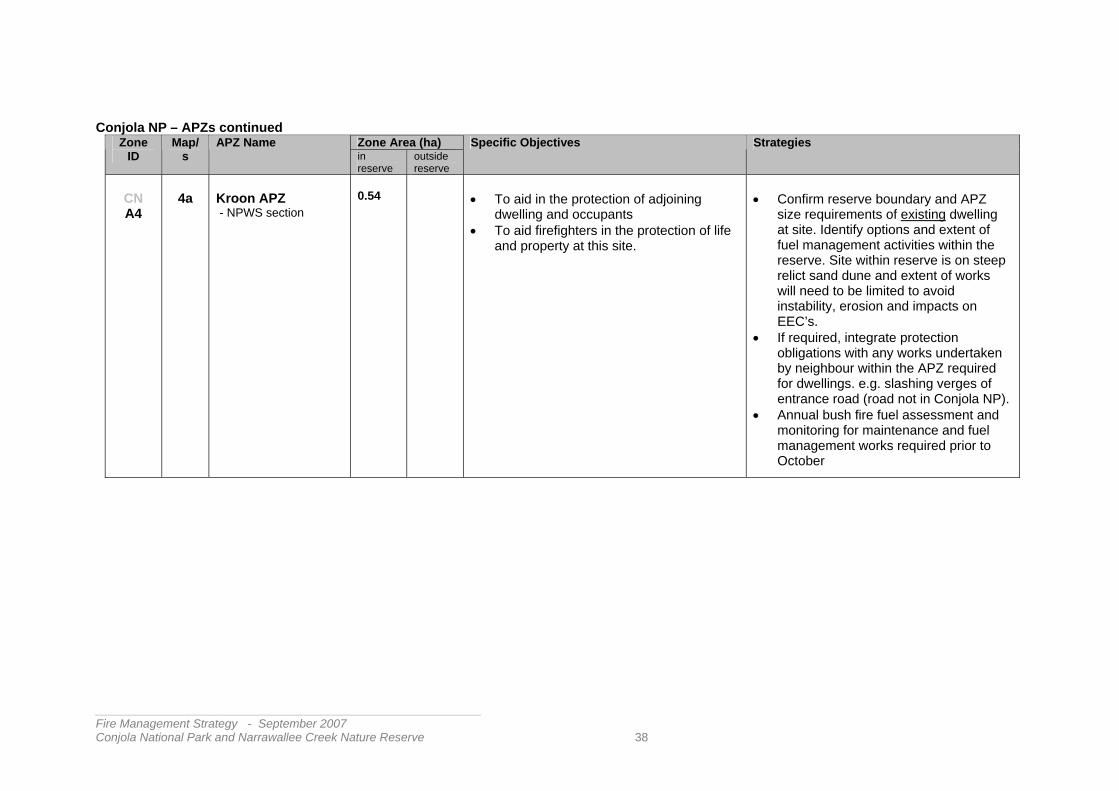
CN A4
4a
Kroon APZ - NPWS section
0.54
• To aid in the protection of adjoining
dwelling and occupants • To aid firefighters in the protection of life
and property at this site.
• Confirm reserve boundary and APZ
size requirements of existing dwelling at site. Identify options and extent of fuel management activities within the reserve. Site within reserve is on steep relict sand dune and extent of works will need to be limited to avoid instability, erosion and impacts on EEC’s.
• If required, integrate protection obligations with any works undertaken by neighbour within the APZ required for dwellings. e.g. slashing verges of entrance road (road not in Conjola NP).
• Annual bush fire fuel assessment and monitoring for maintenance and fuel management works required prior to October
__________________________________________________________ Fire Management Strategy - September 2007 Conjola National Park and Narrawallee Creek Nature Reserve 38

Conjola NP – APZs continued Zone Area (ha) Zone
ID Map/
s APZ Name
in reserve
outside reserve
Specific Objectives Strategies
CN A5
4a
Haven APZ - NPWS section
1.89
• To aid in the protection of adjoining
dwellings and occupants of the Sussex Inlet Holiday resort – The Haven - from the threat of bushfires.
• To aid firefighters in the protection of life and property at this site.
• To provide a fuel reduced area from which firefighters can undertake fuel management in adjoining bushland
• Maintenance of slashed break along
southern side of resort access road within Inner Protection Area of APZ.
• Determine location of park boundary and assess requirements for any APZ works within reserve to complement works on private property
• Seek cooperation of local RFS brigades in the monitoring of APZ fuel hazard.
• Zone is sited in parts on steep relict sand dunes and extent of works will need to be limited to avoid instability, erosion and impacts on EEC’s.
__________________________________________________________ Fire Management Strategy - September 2007 Conjola National Park and Narrawallee Creek Nature Reserve 39

Conjola NP – APZs continued Zone Area (ha) Zone
ID Map/s APZ Name
in reserve
outside reserve
Specific Objectives Strategies
CN A6
4b
Berrara Village APZ - NPWS section
1.74
• To aid in the protection of adjoining
dwellings and occupants on the northern and western side of Berrara from the threat of bushfires.
• To aid firefighters in the protection of life and property in these adjoining areas.
• To provide a fuel reduced area from which firefighters can undertake fuel management in adjoining bushland.
• To provide an operational boundary for fuel management burning in the adjacent Berrara/Cudmirrah SFAZ
• Maintenance of a slashed break in that
part of Conjola National Park that is within 30m of the existing residences (2003) along Lakeway Avenue, Sundowner Avenue and Berrara Rd.
• Enable clear access for firefighters and limit available fire fuels by clearing rubbish, gardening debris and removal of property from the APZ.
• Seek cooperation of local RFS brigades in the monitoring of APZ fuel conditions, and the assistance of neighbours in watching for unauthorised use that may lead to arson, rubbish dumping or compromise emergency vehicle access.
• Annual bush fire fuel and slashed break assessment for maintenance and fuel management works required by October.
- adjoining Crown Lands
• For information on fire management on adjoining Crown Lands please contact Dept. of Crown Lands
__________________________________________________________ Fire Management Strategy - September 2007 Conjola National Park and Narrawallee Creek Nature Reserve 40

Conjola NP – APZs continued Zone Area (ha) Zone
ID Map/s APZ Name
in reserve
outside reserve
Specific Objectives Strategies
CN A7
4b
Rustic APZ - NPWS section
0.51
• To aid in the protection of adjoining
dwellings and occupants of the Rustic Caravan Park from the threat of bushfires.
• To aid firefighters in the protection of life and property at this isolated site.
• To provide a fuel reduced area from which firefighters can undertake fuel management in adjoining bushland.
• To limit the spread of fire onto adjacent lands.
• Maintenance of a slashed break in
that part of Conjola National Park that is within 30m of the existing residences (2003) within this establishment.
• Annual bush fire fuel and slashed break assessment for maintenance and fuel management works required.
• Avoid disturbance to margins of Lake Berringer.
CN A8
4d
Mella Mella APZ - NPWS section
0.12
0.27
• To aid in the protection of adjoining
dwellings and occupants on an inholding within Conjola NP at the eastern end of Mella Mella Bay- Conjola Lake from the threat of bushfires.
• To aid firefighters in the protection of life and property at these isolated sites.
• Confirm reserve boundary and
APZ requirements of existing dwellings at sites adjacent to reserve boundary. If required, integrate any protection obligations with neighbour who has already undertaken extensive works on site.
• Annual bush fire fuel and slashed break assessment for maintenance and fuel management works required.
• Consider enabling a maintenance agreement with neighbour to permit limited contiguous work on reserve.
__________________________________________________________ Fire Management Strategy - September 2007 Conjola National Park and Narrawallee Creek Nature Reserve 41

Conjola NP – APZs continued Zone Area (ha) Zone
ID Map/s APZ Name
in reserve
outside reserve
Specific Objectives Strategies
CN A9
4c
Stewart Place APZ - NPWS
0.25
• To aid in the protection of adjoining
dwelling at No. 2 Stewart Street - Conjola Lake - from the threat of bushfires.
• To aid firefighters in the protection of life and property at this site adjoining bushland in Conjola NP
• To provide an operational boundary for fuel management burning in the adjacent Havilland SFAZ
• Maintenance of a slashed break
and /or fuel managed zone to the south east of dwelling.
• Annual bush fire fuel and slashed break assessment for maintenance and fuel management works required.
• Consider enabling a maintenance agreement to permit limited APZ work by neighbour on reserve
.
__________________________________________________________ Fire Management Strategy - September 2007 Conjola National Park and Narrawallee Creek Nature Reserve 42

Conjola NP – APZs continued Zone Area (ha) Zone
ID Map/s APZ Name
in reserve
outside reserve
Specific Objectives Strategies
Infrastructure APZs,
CN A10
4
Fishermans Paradise Reservoir APZ - NPWS to coordinate
0.73
• To aid in the protection of adjoining
assets and infrastructure – Water supply and communications infrastructure - from the threat of bushfires.
• Assess strategies for inholding/infrastructure owners to implement asset protection works as a condition of access permission to the site across the surrounding Conjola National Park. (Shoalhaven City, Vodaphone, Optus)
• Assess such protection measures that may affect the reserve as per ‘Planning for Bush Fire Protection 2003’or as revised.
CN A11
4
12 Mile Peg APZ - NPWS to coordinate
0.35
• To aid in the protection of adjoining
assets and infrastructure – i.e. communications infrastructure - from the threat of bushfires.
• Confirm site management responsibilities and assess strategies for inholding/infrastructure owner to implement asset protection works as a condition of access/occupancy within Conjola National Park.
CN A12
4b
Fishermans Rock Pump Station APZ - NPWS to coordinate
0.12
• To aid in the protection of adjoining
assets and infrastructure – water supply - from the threat of bushfires.
• Assess protection works and strategies with infrastructure owners to implement appropriate asset protection works.
• Enable these works by conditional permit or fees for services as required within the surrounding Conjola National Park. (Shoalhaven Water, Integral Energy)
• Assess such protection measures that may affect the reserve.
__________________________________________________________ Fire Management Strategy - September 2007 Conjola National Park and Narrawallee Creek Nature Reserve 43

3.2.2 Strategic Fire Advantage Zones (SFAZs) Seventeen Strategic Fire Advantage Zones have been defined within the reserves (Maps 3 to 4). Primary fire management objectives in Strategic Fire Advantage Zones are to reduce the occurrence of human caused unplanned fires in the reserves and to limit the spread of fire within, from and into the reserves. Strategic Fire Advantage Zones also contribute to limiting the possibility of extinction of species which are known to occur naturally within the reserves i.e. - conserving biodiversity. This may be achieved by affording some measure of control over the spread of unplanned fires that might otherwise result in fire regimes that can lead to the extinction of species. This will be achieved by implementing the strategies prescribed in Table 5 in each SFAZ. Note that the slashed breaks described in Table 10 and the tracks and roads maintained for fire management purposes – Table 11- also serve an important role in preventing the spread of wildfire within, from, and into the reserves. There are also zones within adjacent reserves that may complement the fire management planning in these reserves. An example here is the decision to not put an SFAZ on the eastern side of the Princes Highway within Conjola National Park. For operational utility it is better to manage fuels on the western side of this corridor, so appropriate zoning and fuel management strategies will be described in the fire planning for the adjacent Morton National Park. The Shoalhaven Bush Fire Risk Management Plan may complement this strategy where private lands are identified. The ownership/management of bushland areas adjoining the reserve areas may be indicated on maps of the zones. Enquiries about fire management activities on these areas should be directed to the owners or concerns passed on to the Rural Fire Service. Strategic Fire Advantage Zones (SFAZs) are similar in purpose to Strategic Fire Advantage Zones (SFAZs) used in the Shoalhaven Bush Fire Risk Management Plan. The SFAZs described in this Fire Management Strategy for Conjola National Park and Narrawallee Creek Nature Reserve will be proposed for inclusion as SFAZs within that plan. The following tables identify each Strategic Fire Advantage Zone and outline the objectives and strategies to be applied in that zone. Maps 3 to 4 show the location and extent of these zones.
__________________________________________________________ Fire Management Strategy - September 2007 Conjola National Park and Narrawallee Creek Nature Reserve 44
Table 5. The specific fire management objectives and strategies for each of the Strategic Fire Advantage Zones (Maps 3-4) • Conjola Nat. Park SFAZs
Zone Area (ha) Zone ID
Map/s SFAZ Name in reserve
outside reserve
Specific Objectives Strategies
CN S1
4
Tullarwalla SFAZ NPWS section
41.54
• To assist in the
strategic control and containment of bush fires between Sussex Inlet Road and north to join Tullarwalla Lagoon
• To restrict the movement of fires between neighbouring lands and NPWS managed areas
• Undertake burning under prescribed conditions where
required within the reserve as indicated by fire hazard assessments and biodiversity maintenance requirements. This will focus on sequential burning of non-adjacent areas to the east of the cleared north-south powerline easement in order to provide a fuel reduced area joining the upper reaches of St Georges Basin across Sussex Inlet Road and linking with SFAZs south of properties along Sussex Inlet Road. The effectiveness of this strategy relies on cooperative works with adjoining land managers to the north and east.
• Review annual fire management works program following a post-season assessment of bush fire fuel, fire history, biodiversity thresholds and the condition of fire control advantages within the zone such as fire access tracks, slashed areas, gates , information signs, identified water points, etc.
Crown Land and Private property adjoining
• Contact Department of Lands or private property owners for details of fire management activities
__________________________________________________________ Fire Management Strategy - September 2007 Conjola National Park and Narrawallee Creek Nature Reserve 45

Conjola Nat. Park SFAZs continued Zone Area (ha) Zone
ID Map/s SFAZ Name
in reserve
outside reserve
Specific Objectives Strategies
CN S2
4
Corramy Timber SFAZ NPWS
15.56
• To reduce fire
intensity and spotting distance and to assist in the strategic control and containment of bush fires to the west of properties near the Princes Highway southwest of the Wandandian Creek bridge.
• To complement asset protection and bush fire fuel management works undertaken on adjoining properties
• To restrict the movement of fires between neighbouring lands and NPWS managed areas.
• Undertake burning under prescribed conditions where
required within the SFAZ as indicated by fire hazard assessments and biodiversity maintenance requirements. As there is a considerable area of riparian vegetation in this area these activities will focus on strip burning west off property boundaries and the west side of the Princes Highway south to the Sussex Inlet Road.
• Review annual fire management works program following a post-season assessment of bush fire fuel, fire history, biodiversity thresholds and the condition of boundary slashed breaks where required for prescribed burning. advantages within the zone such as fire access tracks, slashed areas, gates, information signs, identified water points, helipads etc.
• Seek cooperation of local RFS brigades in the monitoring of SFAZ fuel and access conditions.
• Maintain cooperative management and communication with adjoining landholders so that effective risk management is maintained across the SFAZ and adjoining lands and along the west side of the Princes Highway.
__________________________________________________________ Fire Management Strategy - September 2007 Conjola National Park and Narrawallee Creek Nature Reserve 46

Conjola Nat. Park SFAZs continued Zone Area (ha) Zone
ID Map/s SFAZ Name
in reserve
outside reserve
Specific Objectives Strategies
CN S3
4
Cow Creek SFAZ NPWS
234.67
• To reduce fire
intensity and spotting distance and to assist in the strategic control and containment of bush fires to the south of properties along Sussex Inlet Road and west of Old Berrara Road
• To complement asset protection and bush fire fuel management works undertaken on adjoining properties
• To restrict the movement of fires between neighbouring lands and NPWS managed areas.
• Undertake bush fire fuel management where required within the SFAZ as indicated by fire hazard assessments and biodiversity maintenance requirements - by burning under prescribed conditions
• Maintain identified fire access routes and slashed breaks within the SFAZ and adjoining properties for use under appropriate conditions - see Tables 10 & 11.
• Seek improvement for the protection of essential infrastructure within the SFAZ i.e. Slashing along powerline routes and around power-poles - Wandandian to Sussex Inlet – (Integral Energy) Enable these activities by conditional permit where required within the reserve.
• Restrict unauthorised vehicle access along identified closed access routes in order to help limit arson, rubbish dumping, and avoid damage to tracks that may prevent ready access by emergency vehicles. Undertake a pre-season review of key fire access tracks and other advantages with advice on conditions to local and regional fire emergency agencies.
• Review annual fire management works program following a post-season assessment of bush fire fuel, fire history, biodiversity thresholds and the condition of fire control advantages within the zone such as fire access tracks, slashed areas, gates , information signs, identified water points, helipads etc.
• Seek cooperation of local RFS brigades in the monitoring of SFAZ fuel and access conditions and. the assistance of neighbours in reporting unauthorised use that may lead to arson, rubbish dumping or compromise emergency vehicle access. • Maintain cooperative management and communication with
adjoining land owners so that effective bush fire risk management is maintained across the SFAZ and adjoining lands and along the section of Old Berrara Road adjoining the SFAZ (Shoalhaven City)
__________________________________________________________ Fire Management Strategy - September 2007 Conjola National Park and Narrawallee Creek Nature Reserve 47

Conjola Nat. Park SFAZs continued Zone Area (ha) Zone
ID Map/s SFAZ Name
in reserve
outside reserve
Specific Objectives Strategies
CN S4
4
Tea Tree Creek SFAZ - NPWS
240.19
• To reduce fire
intensity and spotting distance and to assist in the strategic control and containment of bush fires to the south of properties along Sussex Inlet Road.
• To complement asset protection and bush fire fuel management works undertaken on adjoining properties.
• To restrict the movement of fires between neighbouring lands and NPWS managed areas.
• To avoid damage arising from fire management operations and maintenance to drainage line and estuarine vegetation within zone
• Undertake burning under prescribed conditions where required
within the SFAZ as indicated by fire hazard assessments and biodiversity maintenance requirements. Constraints include the protection of the estuarine vegetation along the Tea Tree creek corridor.
• Maintain identified fire access routes and slashed breaks within the SFAZ and adjoining properties for use under appropriate conditions e.g. Kubota Track see Tables 10 & 11.
• Seek improvement for the protection of essential infrastructure within the SFAZ i.e. Slashing along powerline routes and around power-poles – south of Sussex inlet Rd– (Integral Energy) Enable these activities by conditional permit where required within the reserve.
• Restrict unauthorised vehicle access along identified closed fire access routes in order to help limit arson, rubbish dumping, and avoid damage to tracks that may prevent ready access by emergency vehicles. i.e. maintain gates where installed. • Undertake a pre-season review of key fire access tracks
and other advantages with advice on conditions to local and regional fire emergency agencies.
• Review annual fire management works program following a post-season assessment of bush fire fuel, fire history, biodiversity thresholds and the condition of fire control advantages within the zone such as fire access tracks, slashed areas, gates, information signs, identified water points, helipads etc.
Continued /…
__________________________________________________________ Fire Management Strategy - September 2007 Conjola National Park and Narrawallee Creek Nature Reserve 48

Conjola Nat. Park SFAZs continued Zone Area (ha) Zone
ID Map/s SFAZ Name
in reserve
outside reserve
Specific Objectives Strategies
• Tea Tree Creek SFAZ continued
CN S4
4
• Seek cooperation of local RFS brigades in the monitoring of SFAZ fuel and access conditions and the assistance of neighbours in reporting unauthorised use that may lead to arson, rubbish dumping or compromise emergency vehicle access.
• Maintain cooperative management and communication with adjoining land owners so that effective risk management is maintained across the SFAZ and adjoining lands and along the Old Berrara Road (Shoalhaven City)
__________________________________________________________ Fire Management Strategy - September 2007 Conjola National Park and Narrawallee Creek Nature Reserve 49

Conjola Nat. Park SFAZs continued Zone Area (ha) Zone
ID Map/s SFAZ Name
in reserve
outside reserve
Specific Objectives Strategies
CN S5
4
Verons SFAZ - NPWS
275.18
• To reduce fire
intensity and spotting distance and to assist in the strategic control and containment of bush fires to the south of properties along Sussex Inlet Road and west of Verons Estate subdivision.
• To complement asset protection and bush fire fuel management works undertaken on adjoining properties.
• To restrict the movement of fires between neighbouring lands and NPWS managed areas.
• Undertake burning under prescribed conditions where required
within the SFAZ as indicated by fire hazard assessments and biodiversity maintenance requirements. Constraints include identified areas zoned for environmental protection (under LEP) and the estuarine vegetation of Tea Tree Creek.
• Maintain identified fire access routes and slashed breaks within the SFAZ and adjoining properties for use under appropriate conditions e.g. Kubota Track see Tables 10 & 11. In this area the break cannot be located along property boundaries due to terrain and environmental constraints. Liaison re access and breaks to be maintained with neighbours.
• Seek improvement for the protection of essential infrastructure within the SFAZ i.e. Slashing along powerline routes and around power-poles – south of Sussex inlet Rd– (Integral Energy) Enable these activities by conditional permit where required within the reserve.
• Restrict unauthorised vehicle access along identified closed fire access routes in order to help limit arson, rubbish dumping, and avoid damage to tracks.
• Undertake a pre-season review of key fire access tracks and advise conditions to emergency agencies via BFMC.
Continued/…
__________________________________________________________ Fire Management Strategy - September 2007 Conjola National Park and Narrawallee Creek Nature Reserve 50

Conjola Nat. Park SFAZs continued Zone
ID Map/s SFAZ Name Zone Area (ha) Specific Objectives Strategies
• Verons SFAZ continued
CN S5
4
Verons SFAZ - NPWS
275.18
• Review annual fire management works program following a
post-season assessment of bush fire fuel, fire history, biodiversity thresholds and the condition of fire control advantages within the zone such as fire access tracks, slashed areas, gates, information signs, identified water points etc.
• Seek cooperation of local RFS brigades in the monitoring of SFAZ fuel and access conditions and the assistance of neighbours in reporting unauthorised use that may lead to arson, rubbish dumping or compromise emergency vehicle access. • Maintain cooperative management and communication with
adjoining land owners so that effective risk management is maintained across the SFAZ and adjoining lands and along the Old Berrara Road (Shoalhaven City) and Verons Estate
__________________________________________________________ Fire Management Strategy - September 2007 Conjola National Park and Narrawallee Creek Nature Reserve 51

Conjola Nat. Park SFAZs continued Zone Area (ha) Zone
ID Map/s SFAZ Name
in reserve
outside reserve
Specific Objectives Strategies
CN S6
4
Mondayong SFAZ - NPWS
20.49
• To reduce fire
intensity and spotting distance and to assist in the strategic control and containment of bush fires between Mondayong private properties and fire access routes to the north, south and west of the inholdings.
• To complement asset protection works within the Mondayong properties.
• Undertake bush fire fuel management where required within
the SFAZ as indicated by fire hazard assessments and biodiversity maintenance requirements - by burning under prescribed conditions
• Prepare a slashed break (min. 3m wide) adjacent to the property fence line when required as a boundary to fuel management burning within the reserve. This slashed line extends west from Mondayong Road on the northern boundary to the west, south, and then east to Slatybox Road on the southern boundary. (See Table 10)
• Review annual fire management works program following post season assessment of bush fire fuel, fire history, biodiversity thresholds and the condition of fire control advantages around the zone such as slashed areas, information signs, fire access routes etc.
• Maintain cooperative management and communication with inholding landowners / occupiers so that effective risk management is maintained across the SFAZ and adjoining lands i.e. Mondayong private properties.
__________________________________________________________ Fire Management Strategy - September 2007 Conjola National Park and Narrawallee Creek Nature Reserve 52

Conjola Nat. Park SFAZs continued Zone Area (ha) Zone
ID Map/s SFAZ Name
in reserve
outside reserve
Specific Objectives Strategies
CN S7
4,4a
Swan Lake North SFAZ - NPWS
367.85
• To reduce fire
intensity and spotting distance and to assist in the strategic control and containment of bush fires
• To complement asset protection zones and works in the vicinity of Medlyn Avenue and on Verons Estate properties.
• To restrict the movement of fires between NPWS and neighbouring lands and vice versa.
• To avoid disturbance from fire management operations to estuarine vegetation.
• Undertake bush fire fuel management where required within
the SFAZ as indicated by fuel hazard assessments and biodiversity maintenance requirements - by burning under prescribed conditions. Fuel management burning will be limited to areas along access routes and possibly limited use of aerial incendiary ignition in order to prevent damage to areas of Wet Heath vegetation and the estuarine vegetation of Swan Lake, and Teatree Creek where fire should be excluded.
• Maintain identified fire access routes and slashed breaks within the SFAZ for use under appropriate conditions e.g. east - west track and slashed break along reserve boundary south of Verons estate - see Tables 10 & 11.
• Restrict unauthorised vehicle access along identified closed fire access routes in order to maintain their effective condition.
• Undertake a pre-season review of key fire access tracks and advise conditions to fire emergency agencies.
• Review annual fire management works program following a post season assessment of bush fire fuel, fire history, biodiversity thresholds and the condition of fire access tracks, slashed areas, gates, information signs etc.
• Seek the cooperation of local RFS brigades in the monitoring of SFAZ fuel and access conditions and the assistance of neighbours in watching for unauthorised use that may lead to arson, dumping or compromise emergency vehicle access.
• Maintain cooperative management and communication with adjoining neighbours and land managers to enable effective risk management across the SFAZ and adjoining lands – Private, DoCL and Shoalhaven Water.
__________________________________________________________ Fire Management Strategy - September 2007 Conjola National Park and Narrawallee Creek Nature Reserve 53

Conjola Nat. Park SFAZs continued Zone Area (ha) Zone
ID Map/s SFAZ Name
in reserve
outside reserve
Specific Objectives Strategies
CN S8
4,4a
Medlyn SFAZ - NPWS sections (southwest to Swan Lake, southeast to Springs Rd.)
58.58
• To reduce fire
intensity and spotting distance and to assist in the strategic control and containment of bush fires
• To complement asset protection zones surrounding Medlyn Avenue properties and north Swanhaven.
• To restrict the movement of fires between neighbouring lands and NPWS managed areas i.e. the vacant Crown Land north of the Justfield Drive properties
• Undertake bush fire fuel management where required within
the SFAZ as indicated by fuel hazard assessments and biodiversity maintenance requirements - by burning under prescribed conditions Constraints include the estuarine vegetation and margins of Swan Lake.
• Maintain identified fire access routes and slashed breaks within the SFAZ for use under appropriate conditions e.g. north-south slashed break along reserve boundary north from Medlyn Ave - see Tables 10 & 11.
• Seek improvement for the protection of essential infrastructure within the SFAZ i.e. Slashing along powerline routes and around power poles. – (Integral Energy) Enable these activities by conditional permit where required within the reserve.
• Restrict unauthorised vehicle access along identified closed fire access routes in order to help limit arson, rubbish dumping, and avoid damage to tracks that may prevent ready access by emergency vehicles • Undertake a pre-season review of fire access tracks and
other advantages with advice on conditions to local and regional fire emergency agencies.
Continued /….
__________________________________________________________ Fire Management Strategy - September 2007 Conjola National Park and Narrawallee Creek Nature Reserve 54

Conjola Nat. Park SFAZs continued Zone Area (ha) Zone
ID Map/s SFAZ Name
in reserve
outside reserve
Specific Objectives Strategies
• Medlyn SFAZ continued
CN S8
4,4a
Medlyn SFAZ - NPWS sections (southwest to Swan Lake, southeast to Springs Rd.)
58.58
• Review annual fire management works program following a
post season assessment of bush fire fuel, fire history, biodiversity thresholds and the condition of fire control advantages within the zone such as fire access tracks, slashed areas, gates, information signs etc.
• Seek the cooperation of local RFS brigades in the monitoring of SFAZ fuel and access conditions and the assistance of neighbours in watching for unauthorised use that may lead to arson, rubbish dumping or compromise emergency vehicle access. • Maintain cooperative management and communication
with adjoining land tenures so that effective risk management is maintained across the SFAZ and adjoining lands – Dept of Crown Lands and Shoalhaven Water
__________________________________________________________ Fire Management Strategy - September 2007 Conjola National Park and Narrawallee Creek Nature Reserve 55

Conjola Nat. Park SFAZs continued Zone Area (ha) Zone
ID Map/s SFAZ Name
in reserve
outside reserve
Specific Objectives Strategies
CN S9
4b
Berrara – Cudmirrah SFAZ - NPWS section (west of Berrara & Cudmirrah between Swan Lake and Berrara Creek - within Conjola Nat. Park)
108.42
• To reduce fire
intensity and spotting distance and to assist in the strategic control and containment of bush fires
• To complement asset protection zones to the north west of Berrara & Cudmirrah
• To restrict the movement of fires between neighbouring lands and NPWS managed areas i.e. the Crown Land west of Cudmirrah.
• Undertake bush fire fuel management where required within the SFAZ as indicated by fire hazard assessments and biodiversity maintenance requirements - by burning under prescribed conditions. Constraints include the estuarine vegetation of Berrara Creek where fire should be excluded, aboriginal sites near Fishermans Rock and nearby visitor sites.
• Improve the protection of essential infrastructure within the SFAZ i.e. Slashing along powerline routes and around power-poles Berrara / Bendalong – (Integral Energy). Enable these activities by conditional permit where required within the reserve.
• Within this SFAZ, maintain fire access routes (as identified in table 11) for use under appropriate conditions. Where required, restrict unauthorised vehicle access along identified and closed fire access routes to help limit arson, rubbish dumping, and to maintain access conditions for emergency vehicles.
• Undertake a pre-season review of fire access tracks and other advantages with advice on conditions to local and regional fire emergency agencies.
• Review annual fire management works program following post-season assessment of bush fire fuel, fire history, biodiversity thresholds and the condition of fire control advantages within the zone such as fire access tracks, slashed areas, gates , information signs, identified water points, helipads etc.
• Seek the cooperation of local RFS brigades in the monitoring of SFAZ fuel and access conditions and the assistance of neighbours in watching for unauthorised use that may lead to arson, rubbish dumping or compromise emergency vehicle access.
• Maintain cooperative management and communication with adjoining land tenures so that effective risk management is maintained across the SFAZ and adjoining lands
__________________________________________________________ Fire Management Strategy - September 2007 Conjola National Park and Narrawallee Creek Nature Reserve 56

Conjola Nat. Park SFAZs continued Zone Area (ha) Zone
ID Map/s SFAZ Name
in reserve
outside reserve
Specific Objectives Strategies
CN S10
4d
Bendalong SFAZ NPWS section (north, west and south of the Crown Lands surrounding North Bendalong Village - west to Boundary Road and north of Bendalong Road - within Conjola National Park)
252.02
• To reduce fire
intensity and spotting distance and to assist in the strategic control and containment of bush fires
• To complement asset protection zones - North Bendalong village.
• To restrict the movement of fires between neighbouring lands e.g. Crown Land and adjacent Conjola National Park
• Undertake bush fire fuel management where required within the SFAZ as indicated by fire hazard assessments and biodiversity maintenance requirements - by burning under prescribed conditions. Constraints include the estuarine vegetation of Nerrindillah and Washerwomans Creeks
• Improve the protection of essential infrastructure within the SFAZ i.e. Slashing along powerline routes and around power poles Berrara / Bendalong – (Integral Energy) Enable these activities by conditional permit where required within the reserve.
• Maintain identified fire access routes within the SFAZ for use under appropriate conditions - see Table 11.
• Restriction of unauthorised vehicle access along identified closed fire access routes to help limit arson, rubbish dumping, and to maintain access conditions for emergency vehicles
• Undertake a pre-season review of fire access tracks and other advantages with advice on conditions to local and regional fire emergency agencies.
• Review annual fire management works program following post season assessment of bush fire fuel, fire history, biodiversity thresholds and the condition of fire control advantages within the zone such as fire access tracks, slashed areas, gates, information signs, identified water points, helipads etc.
• Seek the cooperation of local RFS brigades in the monitoring of SFAZ fuel and access conditions and the assistance of neighbours in watching for unauthorised use that may lead to arson, rubbish dumping or compromise emergency vehicle access.
• Maintain cooperative management and communication with adjoining land tenures so that effective risk management is maintained across the SFAZ and adjoining lands i.e. DoCL and adjacent APZs.
__________________________________________________________ Fire Management Strategy - September 2007 Conjola National Park and Narrawallee Creek Nature Reserve 57

Conjola Nat. Park SFAZs continued Zone Area (ha) Zone
ID Map/s SFAZ Name
in reserve
outside reserve
Specific Objectives Strategies
CN S11
4d
Rustic SFAZ - NPWS sections (west of entrance road off Bendalong Road to creek) (east of entrance road and south of Bendalong Road) -within Conjola National Park
89.16
• To reduce fire
intensity and spotting distance and to assist in the strategic control and containment of bush fires between Bendalong Road and Lake Berringer
• To complement asset protection zones near the Rustic Caravan Park and adjacent property.
• Undertake bush fire fuel management where required within
the SFAZ as indicated by fire hazard assessments and biodiversity maintenance requirements - by burning under prescribed conditions. Constraints include the estuarine vegetation along margins of Berringer Lake.
• Maintain lower fuel levels adjacent to access road to improve its usefulness as a strategic fire suppression advantage and safer use under appropriate conditions.
• Review annual fire management works program following post season assessment of bush fire fuel, fire history, biodiversity thresholds and the condition of fire control advantages within the zone such as fuel reduced zone either side of the access track, slashed areas, information signs, identified water points etc.
• Seek the cooperation of local RFS brigades in the monitoring of SFAZ fuel and access conditions and the assistance of neighbours in watching for unauthorised use that may lead to arson, rubbish dumping or compromise emergency vehicle access.
• Maintain cooperative management and communication with adjoining land tenures so that effective risk management is maintained across the SFAZ and adjoining lands i.e. Crown Land to east of access road and immediately west of the caravan park entrance.
__________________________________________________________ Fire Management Strategy - September 2007 Conjola National Park and Narrawallee Creek Nature Reserve 58

Conjola Nat. Park SFAZs continued Zone Area (ha) Zone
ID Map/s SFAZ Name
in reserve
outside reserve
Specific Objectives Strategies
CN S12
4c
Evans SFAZ - NPWS section (– west of Evans and Prior Streets to Sandy Point)
32.92
• To reduce fire
intensity and spotting distance and to assist in the strategic control and containment of bush fires north of the Lake Conjola entrance road and west of Evans St.
• To complement adjacent APZs
• To restrict the movement of fires between neighbouring lands and NPWS managed areas
• To avoid disturbance to estuarine areas arising from fire management activities
• Undertake bush fire fuel management where required within
the SFAZ as indicated by fire hazard assessments and biodiversity maintenance requirements - by burning under prescribed conditions. Care to be taken to avoid the introduction of fire into estuarine vegetation near Conjola Lake.
• Review annual fire management works program following post season assessment of bush fire fuel, fire history, biodiversity thresholds and the condition of fire control advantages within the zone such as fire access tracks, slashed areas, gates , information signs, identified water points, helipads etc.
• Seek the cooperation of local RFS brigades in the monitoring of SFAZ fuel and access conditions and the assistance of neighbours in watching for unauthorised use that may lead to arson, rubbish dumping or compromise emergency vehicle access.
• Maintain cooperative management and communication with adjoining neighbours so that effective risk management is maintained across the SFAZ and adjoining lands i.e. Evans – Prior APZ - (Neighbours and Shoalhaven City)
__________________________________________________________ Fire Management Strategy - September 2007 Conjola National Park and Narrawallee Creek Nature Reserve 59

Conjola Nat. Park SFAZs continued Zone Area (ha) Zone
ID Map/s SFAZ Name
in reserve
outside reserve
Specific Objectives Strategies
CN S13
4c
Havilland SFAZ - NPWS section Conjola National Park west of Sandy Point to boundary and adjoining Stewart and Havilland Streets – Conjola Park)
27.88
• To reduce fire
intensity and spotting distance and to assist in the strategic control and containment of bush fires.
• To complement adjacent APZs
• To restrict the movement of fires between neighbouring lands and NPWS managed areas
• Undertake bush fire fuel management where required within
the SFAZ as indicated by fire hazard assessments and biodiversity maintenance requirements - by burning under prescribed conditions. Care to be taken to avoid the introduction of fire into estuarine vegetation near Conjola Lake.
• Review annual fire management works program following post season assessment of bush fire fuel, fire history, biodiversity thresholds and the condition of fire control advantages within the zone such as slashed areas, information signs, identified water points, etc.
• Seek the cooperation of local RFS brigades in the monitoring of SFAZ fuel and access conditions and the assistance of neighbours in watching for unauthorised use that may lead to arson, rubbish dumping or compromise emergency vehicle access.
• Maintain cooperative management and communication with adjoining neighbours so that effective risk management is maintained across the SFAZ and adjoining (Neighbours and Shoalhaven City)
Shoalhaven City section (east of Havilland Ave. and boat ramp access road –-Conjola Park)
• Contact Shoalhaven City Council for details on fire management activities in this area
__________________________________________________________ Fire Management Strategy - September 2007 Conjola National Park and Narrawallee Creek Nature Reserve 60

Conjola Nat. Park SFAZs continued Zone Area (ha) Zone
ID Map/s SFAZ Name
in reserve
outside reserve
Specific Objectives Strategies
“Strip” SFAZs
CN S14
CN S15
CN S16
4
Mondayong Road (west) SFAZ Blackbutt Road SFAZ Red Head SFAZ
22.44 38.25 52.00
• To improve the
usefulness of Mondayong Road (west), Blackbutt fire access track and Bendalong Road as strategic fire suppression advantages and provide for safer fire suppression operations under appropriate conditions.
• Undertake bush fire fuel management adjacent to
Mondayong Road (west), Blackbutt Road and Read Head Road for a depth of approximately 100m by a pattern of strip burning non-adjacent sections following an assessment of fire hazard and biodiversity maintenance requirements.
• Review annual fire management works program following post season assessment of bush fire fuel, fire history, biodiversity thresholds and the condition of fire control advantages within the zone such as fire access tracks, information signs, identified water points, etc.
__________________________________________________________ Fire Management Strategy - September 2007 Conjola National Park and Narrawallee Creek Nature Reserve 61

_______________________________________________________ gement Strategy - September 2007
ola National Park and Narrawallee Creek Nature Reserve 62
Narrawallee Creek Nature Reserve SFAZs Zone Area (ha) Zone
ID Map/s SFAZ name
in reserve
outside reserve
Specific Objectives Strategies
CN S17
4c
Pattimores SFAZ NPWS section ( - south of Waste Transfer station east to Pattimores Lagoon)
137.95
• To reduce fire
intensity and spotting distance and to assist in the strategic control and containment of bush fires south of Lake Conjola Village near residences and Services Club.
• To protect the fragile wetlands associated with Pattimores Lagoon
• Undertake bush fire fuel management where required within
the SFAZ as indicated by fire hazard assessments and biodiversity maintenance requirements (within reserve) - by burning under prescribed conditions.
• Review annual fire management works program following post season assessment of bush fire fuel, fire history, biodiversity thresholds and the condition of fire control advantages within the zone such as slashed areas, information signs, identified water points, etc.
• Careful application of fire is required to protect the estuarine vegetation and identified wetlands of Pattimores Lagoon.
• Seek the cooperation of local RFS brigades in the monitoring of SFAZ fuel and access conditions and the assistance of neighbours in watching for unauthorised use that may lead to arson, rubbish dumping or compromise emergency vehicle access.
• Maintain cooperative management and communication with adjoining neighbours so that effective risk management is maintained across the SFAZ, adjoining bushland and APZ (Shoalhaven City)
___Fire ManaConj

3.2.3 Heritage Management Zones (HMZs) Twelve heritage management zones have been defined within and around the reserves. (Maps 3 to 4) The primary management objectives in heritage management zones are to prevent the extinction of all species which are known to occur naturally within the reserves – i.e. conserve biodiversity – and to protect Aboriginal and historic heritage sites. Except where noted otherwise, these objectives will be achieved by: • Containing and where achievable, suppressing bushfires. and where necessary,
conducting prescribed burns to maintain fire regimes within biodiversity thresholds specified in Table 6.
• Implementing the threatened species and cultural heritage management guidelines
specified in Table 7 and 8 in locations where threatened species and cultural heritage sites are known or likely to occur
When manipulating fire regimes (by suppressing fires and conducting prescribed burns) to conserve biodiversity within these heritage management zones, managers will take account of the status of fire regimes across all fire management zones in the reserves. This should ensure regard for the maintenance of biodiversity within the reserves and particularly applies to Asset Protection and Strategic Fire Advantage Zones where fire is more likely to be deliberately introduced. Due to the emphasis on fire protection aspects in these zones, fire frequency and other strategies prescribed for these areas may see the possibility of an adverse impact on biodiversity within these zones. As can be seen from Table 6 the vegetation types and communities within these reserves are both diverse and complex. The information on vegetation types comes from a number of sources over a number of surveys as land has been added to the reserves. One of the important objectives for reserve management will be to reassess these vegetation classification systems to provide a uniform appreciation of vegetation complexity across the reserves. This work is currently in progress. From records, the only observed “natural” cause of fires is occasional lightning. Within HMZs - after careful consideration of potential fire weather and behaviour, safety and protection issues, biodiversity maintenance requirements or cultural assets and values at risk, - it may be possible to prevent unnecessary damage or disturbance arising from suppression operations on a “naturally” caused fire by using existing containment lines and features. The decision making process for such consideration is described within section 4.6 of the NPWS Fire Management Manual - Natural Area Fire Management. (www.nationalparks.nsw.gov.au) Further explanation of the purpose and function of Heritage Management Zones is detailed in the NPWS / DECC Strategy for Fire Management (2003) available via the NPWS / DECC website. (www.nationalparks.nsw.gov.au)
__________________________________________________________ Fire Management Strategy - September 2007 Conjola National Park and Narrawallee Creek Nature Reserve 63

__________________________________________________________ Fire Management Strategy - September 2007 Conjola National Park and Narrawallee Creek Nature Reserve 64
.

Table 6. Fire regimes to be applied to vegetation in Heritage Management Zones in order to sustain biodiversity. These regimes are time and frequency thresholds in which fire events may not compromise biodiversity within the listed vegetation types. (Adapted from Bradstock et al, 1995, and Keith, 1996.) Fire regimes outside these thresholds - e.g. too frequent fire - are predicted to cause significant declines in species populations especially if they prevail over more than 50% of the vegetation type in the area.
Biodiversity Thresholds – Fire Frequency Veg’n. Class ID
Vegetation communities Approx. area in reserves
Minimum Fire interval
Maximum Fire interval
Notes
Bloodwood-peppermint open forest/woodland 1 Coastal complex disturbed 3 Coastal complex woodland 85
a
Sedgeland (swampland) 27
7 30
Scribbly gum-Allocasuarina open forest 47 Scribbly gum-Teatree – open woodland/open shrubland 19 Severely disturbed forest 98
b
Woollybutt-paperbark woodland 2
5 40
Bangalay open forest 26 Bangalay open forest/Swamp oak forest/woodland+rushland/forbland (edge saltmarsh)
11
Blackbutt open forest 80 Blackbutt open forest-Ironbark closed forest 4 Blackbutt-Bloodwood open forest 1 Blackbutt-Peppermint tall open forest 2 Blackbutt-Turpentine open forest/tall open forest 6 Blackbutt-Turpentine – tall open forest 12 Blackbutt-Turpentine – tall open forest/Blue Gum – tall open forest
7
Bluegum tall open forest 8
e
Coastal lowlands – cycad dry shrub dry forest – Corymbia maculata
1075
7 30
.
__________________________________________________________ Fire Management Strategy - September 2007 Conjola National Park and Narrawallee Creek Nature Reserve 65

Table 6. - Fire regimes to be applied to vegetation in Heritage Management Zones - continued Biodiversity Thresholds – Fire Frequency Veg’n.
Class ID Vegetation communities Approx.
area in reserves
Minimum Fire interval
Maximum Fire interval
Notes
Coastal sands shrub/fern forest - Eucalyptus botryoides / Banksia serrata
246
Dry forest 936 Dry forest dominant./woodland 181 Lowland dry shrub forest - Corymbia gummifera / Syncarpia glomulifera
5634
Northern coastal hinterland heath shrub dry forest - Corymbia gummifera.
4561
Northern coastal sands shrub/fern forest – Eucalyptus pilularis / Banksia serrata
2925
Northern hinterland shrub dry forest - Syncarpia glomulifera
5
Scribbly gum-Bloodwood - woodland/heathland 22 Southern coastal hind dune/headland scrub & southern coastal dune scrub
103
southern hinterland shrub/herb/grass riparian forest - Angophora floribunda
48
e
Spotted gum tall open forest
1
7 30
Coastal wet heath swamp forest - Casuarina glauca / Melaleuca ericifolia
588
Dry forest dominant/moist forest
163
Ecotonal coastal swamp forest - Casuarina glauca / Eucalyptus botryoides
64
northern coastal lowlands swamp forest - Eucalyptus robusta
20
f
Paperbark shrubland (intermittent swampland)
3
7 35 Crown fires should be avoided in the lower end of the interval range
__________________________________________________________ Fire Management Strategy - September 2007 Conjola National Park and Narrawallee Creek Nature Reserve 66

Table 6. - Fire regimes to be applied to vegetation in Heritage Management Zones - continued Biodiversity Thresholds – Fire Frequency Veg’n. Class
ID Vegetation communities Approx.
area in reserves
Minimum Fire interval
Maximum Fire interval
Notes
Paperbark shrubland (swampland)/swamp oak forest/woodland+rushland
9
Riparian acacia shrub/grass/herb forest - 21 South coast swamp forest complex - Casuarina glauca 661 Swamp oak forest/woodland+rushland (edge saltmarsh) 5
f (cont.)
Swamp oak forest/woodland+rushland/forbland (edge saltmarsh)
3
7 35 Crown fires should be avoided in the lower end of the interval range
Banksia-Teatree closed shrubland 26 Banksia-Teatree closed shrubland/coast wattle open shrubland / spinifex grassland
1
Coast wattle open shrubland/spinifex grassland 17 Coastal headland heathlands 7 Northern coast and hinterland moist heath 15 Northern coastal tall wet heath 574 Paperbark shrubland 0
g
Southern coastal dune scrub complex & coastal dune herb/grassland
354
8 30
Moist forest 90 Moist forest tending to dry 97
h
Northern foothills moist shrub forest - Corymbia maculata / Eucalyptus pilularis
3973
25 200 Crown fires should be avoided in the lower end of the interval range
Bangalay open forest/closed forest (rainforest) 3 Coastal hinterland ecotonal gully rainforest 184 Coastal lowland sub tropical/littoral rainforest 146 Lilly-pilly closed forest (warm temperate rainforest) 0 Mangrove estuarine low forest # 123 Mudflats/saltmarshes # 83
i
Ruppia forbland # 69
n/a n/a Fire should be avoided (# - Whilst these communities are definitely not considered fire prone, they are included as part of the overall statistical appreciation of the reserves vegetation communities as an indication to managers of their proportional extent)
__________________________________________________________ Fire Management Strategy - September 2007 Conjola National Park and Narrawallee Creek Nature Reserve 67

Table 7. Threatened Species – specific fire management strategies to be applied in the reserve. NB these observations are not all the Threatened Species identified within the reserves. These are the threatened species considered at risk from inappropriate fire regimes or unplanned fire management and suppression activities. These strategies are derived from NPWS (1999), (2000a), 2000b), and Hunter and Alexander (2002) and may be updated periodically by NPWS / DECC and published on the Rural Fire Service website.
Map ID Strategies Species Species status (1,2,3) Flora FL 1 FL-A Avoid earthmoving disturbance Cryptostylis hunteriana, Vulnerable 1 (1)
FL 2 FL-B Avoid fire, No slashing, trittering or tree removal Pultenaea villifera Rare 3 (3RC) (1) FL 3 FL-A Avoid earthmoving disturbance Galium australe, Endangered1 (3) FL 4 FL-C Avoid fire, No slashing, trittering or tree removal Wilsonia rotundifolia Endangered1 (1)(3) FL 5 FL-C Avoid fire, No slashing, trittering or tree removal Syzygium paniculatum Vulnerable 3 (1) 3Vci (2) FL 6 FL-C Avoid fire, No slashing, trittering or tree removal Wilsonia backhousei Vulnerable (3) FL 9 FL-C Avoid fire, No slashing, trittering or tree removal Pultenaea villifera var.
villifera Rare 3 (1) 3RC (2)
Other Threatened species – Flora – listed within the reserve – no specific fire management indications as yet FL 5 Grevillea macleayana Rare 3 (1) 3RC (2)
(1) as per Threatened Species Conservation Act 1995 (2) as per ROTAP classification 1995 (3) as per Environment Protection and Biodiversity Conservation Act 1999 (Aust. Government)
__________________________________________________________ Fire Management Strategy - September 2007 Conjola National Park and Narrawallee Creek Nature Reserve 68

Table 7. Threatened Species – specific fire management strategies to be applied in the reserve. - continued
Map ID Strategies Species Species status
(1,2) Fauna FA 1 FA-A Avoid the use of firefighting foams near watercourses and wetlands Litoria aurea Green and
Gold Bell Frog Endangered1
FA 2 FA-B When introducing fire for biodiversity maintenance or bush fire fuel management, use a lower intensity mosaic pattern for ignition and final planned extent. Avoid ignition of Allocasuarina thickets
Calyptorhynchus lathami
Glossy Black Cockatoo
Vulnerable (1)
FA 3 FA-C Avoid introduction of fire or disturbance to roost sites – these may be seasonal in various locations as feeding patterns change. There is a preference to moister sheltered gullies and rainforest sites. Sites evident by noise, smell, and flight patterns at dusk. Report sightings so that operational strategies may limit disturbance.
Pteropus poliocephalus
Grey-headed Flying Fox
Vulnerable (1)
FA 4 FA-D Avoid introduction of fire or to possible roost sites incl. ‘habitat’ trees – e.g. by extinguishing, avoid felling, clear around or not backburning older or dead trees with hollowed trunks and openings along the sides of control lines - where possible and practicable. No slashing or trittering.
Miniopterus schreibersii oceanensis
Eastern Bent-wing Bat (small, insectivorous)
Vulnerable 1
FA-5 FA-D Avoid introduction of fire or to possible roost sites incl. ‘habitat’ trees – e.g. by extinguishing, avoid felling, clear around or not backburning older or dead trees with hollowed trunks and openings along the sides of control lines - where possible and practicable. No slashing or trittering.
Falsistrellus tasmaniensis
Eastern False Pipistrelle
Vulnerable (1)
FA-6 FA-D Avoid introduction of fire or to possible roost sites incl. ‘habitat’ trees – e.g. by extinguishing, avoid felling, clear around or not backburning older or dead trees with hollowed trunks and openings along the sides of control lines - where possible and practicable. No slashing or trittering.
Mormopterus norfolkensis
Eastern Freetail-bat
Vulnerable (1)
(1) as per Threatened Species Conservation Act 1995 (3) as per Environment Protection and Biodiversity Conservation Act 1999 (Aust. Government)
__________________________________________________________ Fire Management Strategy - September 2007 Conjola National Park and Narrawallee Creek Nature Reserve 69

Table 7. Threatened Species – specific fire management strategies to be applied in the reserve. - continued
Map ID Strategies Species Species status
(1,2) FA-7 FA-E No slashing. trittering or tree removal Petaurus
norfolcensis Squirrel Glider Vulnerable (1)
FA-8 FA-E No slashing. trittering or tree removal Petroica rodinogaster
Pink Robin Vulnerable (1)
FA-9 FA-E No slashing. trittering or tree removal Potorous tridactylus
Long-nosed Potoroo
Vulnerable (1)
FA-10 FA-E No slashing. trittering or tree removal Climacteris picumnus
Brown Treecreeper
Vulnerable (1)
FA-11 FA-F No fire around known roost sites, No removal of trees Myotis adversus Large-footed Myotis
Vulnerable (1)
FA-12 FA-G No burning around known nesting sites at any time. No slashing. trittering or tree removal
Ninox connivens Barking Owl Vulnerable (1)
FA-13 FA-G No burning around known nesting sites at any time. No slashing. trittering or tree removal
Ninox strenua Powerful Owl Vulnerable (1)
FA-14 FA-G No burning around known nesting sites at any time. No slashing. trittering or tree removal
Tyto novaehollandiae
Masked Owl Vulnerable (1)
FA-15 FA-G No burning around known nesting sites at any time. No slashing. trittering or tree removal
Tyto tenebricosa Sooty Owl Vulnerable (1)
FA-16 FA-H Avoid fire, No slashing. trittering or tree removal Ixobrychus flavicollis
Black Bittern Vulnerable (1)
(1) as per Threatened Species Conservation Act 1995 (3) as per Environment Protection and Biodiversity Conservation Act 1999 (Aust. Government)
__________________________________________________________ Fire Management Strategy - September 2007 Conjola National Park and Narrawallee Creek Nature Reserve 70

Table 7. Threatened Species – specific fire management strategies to be applied in the reserve. - continued
Map ID Strategies Species Species status
(1,2) Other Threatened species – Fauna – listed within the reserve – no specific fire management indications as yet FA-30 Dasyurus maculatus Spotted-tailed Quoll Vulnerable (1) FA-31 Haematopus fuliginosus Sooty Oystercatcher Vulnerable (1) FA-32 Haematopus longirostris Pied Oystercatcher Vulnerable (1) FA-33 Isoodon obesulus obesulus Southern Brown Bandicoot
(eastern) Endangered (1)
FA-34 Lathamus discolor Swift Parrot Endangered (1) FA-35 Lophoictinia isura Square-tailed Kite Vulnerable (1) FA-36 Neophema pulchella Turquoise Parrot Vulnerable (1) FA-37 Pandion haliaetus Osprey Vulnerable (1) FA-38 Petaurus australis Yellow-bellied Glider Vulnerable (1) FA-39 Scoteanax rueppellii Greater Broad-nosed Bat Vulnerable (1) FA-40 Sminthopsis leucopus White-footed Dunnart Vulnerable (1) FA-41 Sterna albifrons Little Tern Endangered (1) FA-42 Thalassarche melanophris Black-browed Albatross Vulnerable (1) FA-43 Thinornis rubricollis Hooded Plover Endangered (1) FA-44 Xanthomyza phrygia Regent Honeyeater Endangered (1) FA-45 Callocephalon fimbriatum Gang-gang Cockatoo Vulnerable (1)
(1) as per Threatened Species Conservation Act 1995 (3) as per Environment Protection and Biodiversity Conservation Act 1999 (Aust. Government)
__________________________________________________________ Fire Management Strategy - September 2007 Conjola National Park and Narrawallee Creek Nature Reserve 71
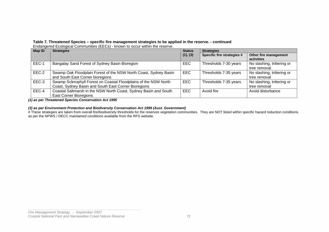
_______________________________________________________ ire Management Strategy - September 2007
ola National Park and Narrawallee Creek Nature Reserve 72
Table 7. Threatened Species – specific fire management strategies to be applied in the reserve. - continued Endangered Ecological Communities (EECs) - known to occur within the reserve.
Strategies Map ID Strategies Status (1), (3) Specific fire strategies # Other fire management
activities EEC-1 Bangalay Sand Forest of Sydney Basin Bioregion EEC Thresholds 7-30 years No slashing, trittering or
tree removal EEC-2 Swamp Oak Floodplain Forest of the NSW North Coast, Sydney Basin
and South East Corner bioregions EEC Thresholds 7-35 years No slashing, trittering or
tree removal EEC-3 Swamp Sclerophyll Forest on Coastal Floodplains of the NSW North
Coast, Sydney Basin and South East Corner Bioregions EEC Thresholds 7-35 years No slashing, trittering or
tree removal EEC-4 Coastal Saltmarsh in the NSW North Coast, Sydney Basin and South
East Corner Bioregions EEC Avoid fire Avoid disturbance
(1) as per Threatened Species Conservation Act 1995 (3) as per Environment Protection and Biodiversity Conservation Act 1999 (Aust. Government) # These strategies are taken from overall fire/biodiversity thresholds for the reserves vegetation communities. They are NOT listed within specific hazard reduction conditions as per the NPWS / DECC maintained conditions available from the RFS website.
___FConj

__________________________________________________________ Fire Management Strategy - September 2007 Conjola National Park and Narrawallee Creek Nature Reserve 73
Table 8. Cultural Heritage strategies for fire management to be applied in the reserves As detailed in section 2.3 there were no cultural sites in the reserves at risk within areas of higher fire potential. Nevertheless most known sites are vulnerable to fire suppression and management operations. Below are the strategies relevant to sites identified within the reserves. In all cases a precautionary approach should be adopted where activities are undertaken away from formed tracks or roads. Skilled assistance should be sought in guiding these operations.
Site ID
Fire Management Strategies Site Types
Aboriginal Heritage Sites AH-A • As far as possible – protect site from fire
• Do not cut down trees • Use of foams, wetting agents and retardants is acceptable
Sites affected by fire itself e.g. possible artefacts of flammable materials such as scarred or carved trees.
AH-B • As far as possible – protect site from fire • Avoid all ground disturbance including the use of
earthmoving machinery, handline construction and driving over sites.
• Avoid water bombing, which may cause ground disturbance.
Sites less affected by fire but prone to disturbance by suppression operations e.g. - stone arrangements, ceremonial rings, rock engravings, rock art, grinding grooves.
AH-C • Avoid all ground disturbance including the use of earthmoving machinery, handline construction and driving over sites.
• Avoid water bombing, which may cause ground disturbance.
• Site may be burned by bushfire, backburn or prescribed burn without damage
Sites least affected by fire itself but still prone to disturbance by fire suppression operations. e.g. - burial sites, artefact scatters, middens.
Historic Heritage Sites NB. There is only one known site of recorded historic significance in Conjola Nat. Park i.e. the Walter Hood Monument north of Bendalong. This feature and site is not considered at threat from fire and requires no specific fire management strategy. In Narrawallee Creek Nature Reserve the formation and remnant sleepers of the silica tramway south to Bannister Head need to be protected from possible disturbance by fire and firefighting operations. Should other sites be confirmed, the following strategies may be applied depending on the site vulnerability to fire and suppression effects. Site type HH-A
• As far as possible – protect site from fire • Avoid all ground disturbance including the use of
earthmoving machinery, handline construction and driving over sites.
• Avoid water bombing, which may cause ground disturbance.
• Use of foams, wetting agents and retardants is acceptable
Flammable but structurally unsound sites including buildings with low structural integrity
HH-B
• As far as possible – protect site from fire • Avoid all ground disturbance including the use of
earthmoving machinery, handline construction and driving over sites.
• Water bombing, use of foams, wetting agents and retardants is acceptable
Flammable and structurally sound sites including buildings, wooden fences, signs, stock rails, etc e.g. silica tramway formation, tree stumps from former logging operations – Narrawallee Ck. NR
HH-C
• Avoid all ground disturbance including the use of earthmoving machinery, handline construction and driving over sites.
• Avoid water bombing.
Sites which are not flammable but are structurally unsound including dry stone walls e.g. charcoal pits off Bendalong Rd. – Conjola NP

As outlined in section 3.7, survey work to uniformly assess the vegetation classes across these reserves was being undertaken as this strategy was in preparation. Once completed, the fire regimes appropriate to the revised classifications will be reassessed and applied to the zones below. Extensive tables and mapping tools are available to managers indicating the vegetation types to be found in each zone, the status and area of each type with regard to fire history, biodiversity thresholds and current vulnerability. These are used to determine which areas should be protected from wildfire or subject to prescribed fire in order to maintain biodiversity.
_______________________________________________________ ire Management Strategy - September 2007
ola National Park and Narrawallee Creek Nature Reserve 74
Table 9. Heritage Management Zones – area, fire regimes and fire management strategies.
Zone Area Area each Biodiversity Threshold class ( see Table 6)
Threatened Species Guide- lines (Table 7)
Cultural Asset Guide- lines (Table 8)
Overall Strategies Zone ID
Map/s
Zone Name
inside reserve
outside reserve
a b e f g h i
CN L1 4 Corramy HMZ 249.3 226 10 13 0.3 CN L2 4 Highway HMZ 579.4 429 16.4 134 CN L3 4 Mondayong
HMZ 3655.06 0.31 2.25 2692 22.5 289 533 116
CN L4 4a Dunes HMZ 135.81 0.61 133 1.31 0.84 0.05 CN L5 4,4b Swan Lake HMZ 810.3 1 7.5 606 189 2.8 2.6 1.4 FA-B, CN L6 4 Twelve Mile Peg
HMZ 746. 500 4.2 8.3 227 6.5 FL-A,
CN L7 4,4b Berrara Creek HMZ
821.53 0.1 0.13 678 88 48 7.3 FL-B,
CN L8 4,4d Nerrindillah HMZ
1935.9 1436 1.2 20.8 415 62.9 FL-B, FA-A,
CN L9 4,4d Bendalong HMZ 613 483 21 2 103 4.0 CN L10 4,4c
4d Conjola Lake HMZ
1020.12 486 22 0.12 495 17 FL-A, FL-B
CN L11 4,4c Silica Ridge HMZ
465.68 0.25 404 39 22 0.43 FA-A, HH-B
CN L12 4,4c Narrawallee Creek HMZ
354.03 0.23 95 76.5 169 13.3 FA-C, FA-D HH-B
• Suppress bushfires and implement prescribed burning as appropriate to maintain fire regimes within the biodiversity thresholds as specified in Table 6.
• Implement threatened species fire management strategies as specified in Table 7.
• Implement cultural asset protection strategies as specified in Table 8
NB Within some zone areas, biodiversity thresholds are not assigned e.g. estuarine areas within the zone.
___FConj

__________________________________________________________ Fire Management Strategy - September 2007 Conjola National Park and Narrawallee Creek Nature Reserve 75
3.3 Strategic fuel management areas – Slashed Breaks Table 10 lists the specifications for slashed breaks to be maintained during the life of this plan. Slashed Breaks provide an area of modified vegetation that may reduce fire intensity and enable fire control operations under suitable conditions. Generally slashed breaks are a feature of Asset Protection Zones, aid in the protection of boundary fencing and infrastructure, or supplement the effectiveness of certain key fire trails or access routes. Slashed breaks will be maintained where indicated within individual APZ notes (section 3.2.1) and as mapped. This includes periodic inspection as to bush fire fuel state and condition of identified fire access routes. Inspection will be undertaken at the end of the fire season to determine works required. Additionally, inspection will be undertaken prior to the fire season to confirm conditions and identify any contingent works required. The NPWS will be progressively reviewing the slashed breaks listed and mapping their extent and access conditions as an aid to fire operations and maintenance. This information will be made readily available via the Shoalhaven Bush Fire Management Committee. Generally, slashed breaks will keep understorey vegetation mostly below knee height. Selective regrowth of overstorey species may be permitted to maintain effective cover and reduce wind speed across the zone. Smaller separated patches of regrowth may be designed for site-specific habitat management values. Wetlands, rainforests or margins of creeklines will be avoided in the preparation of slashed breaks. The maintenance of slashed breaks not forming part of an identified APZ within this strategy nor adjacent to existing dwellings (@ July 2003) cannot be guaranteed to meet similar APZ standards. Therefore these slashed breaks cannot be relied on to form part of any future APZ considerations for new developments adjacent to the reserve. As stated in zoning descriptions the minimum extent for slashed breaks as part of Asset Protection Zones will be derived from Planning for Bush Fire Protection 2001 (and as revised). NB This refers to dwellings in place prior to the introduction of supporting legislation in July 2003. Since that time each development proposal within identified bush fire prone areas must be individually assessed for bush fire protection measures including areas within the property. Otherwise the NPWS will maintain the width as indicated in the slashed break tables. Enquiries as to slashed break maintenance within Conjola National Park and Narrawallee Nature Reserve should be directed to the local NPWS Area office at Ulladulla.

Table 10. Strategic fuel management zones – Slashed Breaks (SB)’s– specifications and objectives Slash-ed Break ID
Map/s Fuel Management Area / Slashed Break Name / Location
Specifications
Zone Tenure Fire management Objectives
Existing Slashed Breaks – fuel management areas to be maintained by NPWS / DECC U73 Map 4
& Ops, Map
Cow Creek SB - south Sussex Inlet Rd.
10-15m SFAZ NPWS Protect adjacent property - Forms slashed break on property boundaries west of Old Berrrara Rd, - fence protection – boundary for adjacent fuel management zone – broken at creek crossings – upgrade progressively
U84 Map 4 & Ops, Map
Kubota Trail SB – south Sussex Inlet Rd.
10-15m SFAZ NPWS Protect adjacent property - Forms slashed break on western/southern boundary of "Verons" estate, fence protection and boundary for fuel management zone
U264 Map 4a & Ops, Map
Sewage Treatment Plant Boundary SB – West Sussex Inlet
10-15m SFAZ NPWS Forms slashed break on perimeter of Sussex Inlet Sewage Treatment Plant & south/eastern sections of "Verons" estate, - provides fence protection and boundary for fuel management zone
U717 Map 4 & Ops, Map
Mondayong boundary Slashed Break
3-10m SFAZ NPWS Protect adjacent property - Forms slashed break on property boundaries north, west and south of Mondayong property, - fence protection. Refreshed when fuel management is undertaken in adjacent SFAZ.
U86 Map 4a & Ops, Map
Medlyn Ave SB - Swanhaven 20-25m APZ NPWS Protect adjacent property - Forms SFAZ Boundary - Village protection
U254 Map 4a & Ops, Map
Snappy Gums SB - Swanhaven 10-15m APZ NPWS Protect adjacent property - APZ Boundary - Adjoins Caravan Park
__________________________________________________________ Fire Management Strategy - September 2007 Conjola National Park and Narrawallee Creek Nature Reserve 76

_______________________________________________________ ire Management Strategy - September 2007
ola National Park and Narrawallee Creek Nature Reserve 77
Table 10 continued. Slash-ed Break ID
Map/s Fuel Management Area / Slashed Break Name / Location
Specifications Zone Tenure Fire management Objectives
U253 Map 3a & Ops, Map
Dunes South SB – Sussex Inlet 20m APZ NPWS Protect adjacent property - APZ Boundary - adjoins Caravan Park
U518 Map 4b & Ops, Map
Sundowner Ave SB - Berrara 20-25m APZ NPWS Protect adjacent property - APZ Boundary - Village protection
U66 Map 4b & Ops, Map
Lakeway Ave SB - Berrara 20-25m APZ NPWS Protect adjacent property - APZ Boundary - Village protection
U74 Map 4b & Ops, Map
Park Boundary SB - Cudmirrah 20-25m SFAZ NPWS Forms western boundary to Dept of Crown Lands section of West Cudmirrah SFAZ.
N249 Map 4 & Ops, Map
Northern Boundary Fence SB – Tullarwalla Lagoon
10-15m SFAZ NPWS Protect adjacent property – along reserve boundary – to west of Tullarwalla Lagoon
- Map 4d & Ops, Map
Rustic SB – west of Manyana 10-15m APZ NPWS Protect adjacent property - APZ Boundary - adjoins Caravan Park
___FConj

3.4 Fire management access – Tracks and Roads Tracks and roads provide access for firefighting vehicles and may be used to contain lower intensity fires or enable lower intensity backburning to contain larger wildfires or prescribed burns. The network of tracks and roads in both these reserves are a result of historic use and past land management practices. Suitability of tracks for fire management or suppression alone is not considered in this strategy. Existing tracks have been accepted and assessed for their advantage to fire suppression based on their current condition and position. Over time, the strategic and operational assessment of this network may identify options for fire access that better reflect local fire patterns, changes in adjacent land use and fire management objectives as set out in this plan. Such assessment will need to be part of a landscape-wide approach to these issues such as the current Bush Fire Risk Management planning being undertaken for the Shoalhaven. Where changes may be necessary to the network as committed to in this strategy, then a formal community advice, consultation and revision process is undertaken. Not all tracks or roads are maintained as ‘fire trails’, though most vehicle access routes may provide some fire suppression advantage depending on the terrain, track status, crew competency, equipment, fire behaviour, weather conditions, and the task for which the route is to be used. These and other factors need to be considered by fire crews and planning teams prior to the use of a route for fire operations. Following this assessment, some routes will require works to prepare them to a sufficient standard for the proposed operation. The time and resources required to undertake this preparation also need to be considered within operational planning. Not all routes or tracks can or will be maintained to all weather 2wd standard for fire suppression operations at all times. The economic, resource, and environmental consequences for this are presently unacceptable. As a member of the Shoalhaven Bush Fire Management Committee the NPWS has identified those routes of higher strategic significance for fire operations for which the NPWS is responsible. Along with the maintenance of slashed breaks in asset protection zones, the NPWS will give priority to those tracks and roads of higher strategic significance in the preparation of works programs and commitment of available resources. Table 11 lists the tracks and routes that will be maintained primarily for fire management purposes during the life of the strategy. i.e. ‘fire trails’ Roads and tracks classified as Category 1 will be maintained to a standard sufficient to allow the passage of Category 1 fire tankers (4WD Heavy Tanker up to a 3500 litre capacity), Roads and tracks classified as Category 9 will be maintained to a standard sufficient to allow the passage of a Category 9 fire tanker (4WD Ute/Cab-chassis up to 400 litre capacity). Where tracks have been identified in this strategy as Fire Trails (primarily retained for fire management purposes) they will be signposted at entrances and important junctions with the track name. The NPWS is committed to maintaining these identified routes at the nominated capacity wherever resources and conditions allow. The NPWS will inspect these routes as part of land management operations and report on their condition to the Shoalhaven Bush Fire Management Committee prior to each bush fire danger period. Additionally, where conditions may limit or close the route for the intended capacity, the NPWS will advise other fire authorities as soon as conditions are reported to and confirmed by the NPWS. The NPWS looks to other authorised users and fire authorities to advise the NPWS when intending to use the restricted network and to report on track conditions.
__________________________________________________________ Fire Management Strategy - September 2007 Conjola National Park and Narrawallee Creek Nature Reserve 78

__________________________________________________________ Fire Management Strategy - September 2007 Conjola National Park and Narrawallee Creek Nature Reserve 79
NB. Whilst the NPWS makes the above commitments to maintaining fire fighting vehicle capacity on listed fire trails – ALL tracks should be assessed prior to their use as to their suitability and safety for the intended fire operation. Other tracks and roads shown on maps within the reserves are not primarily maintained for fire purposes but may have usefulness in fire management or suppression operations. Access to these tracks however may be limited at times during the life of the strategy as priority will be given to maintenance of the tracks identified in Table 11. The fire vehicle categories for these tracks are as assessed when the strategy was compiled. Tracks made or upgraded beyond routine standard as a result of fire suppression operations will be stabilised and rehabilitated as soon as practicable after the fire and may not be listed or marked on future maps. Where strategically useful these routes may be indicated on operational maps or recorded as possible control options for future operations. Some of the roads and tracks listed in Table 11 and illustrated on Map 3 are used for management purposes only and are not open for public use by vehicle. The NPWS makes keys for access to such tracks available via the RFS to be kept in Shoalhaven RFS fire tankers and other emergency service vehicles. Many of the tracks within Conjola National Park and Narrawallee Creek Nature Reserve whilst primarily designated for fire management purposes are currently available for vehicle access by visitors (@ March 2007). Whilst this unrestricted use of the fire management tracks may be considered sustainable under current levels of use and climatic conditions, if such use compromises the routes usefulness as a fire access track at the identified standard then general vehicle use by the public may need to be limited. There is a formal process for advising the community and consulting relevant interests if this is required. Otherwise, routes that may be used for vehicle access by visitors are described in the final and Draft Plans of Management for the reserves. NB. Not all tracks within or around the reserve depicted on published topographic or guide maps may exist, not all are located where marked, or may be accessible in the indicated condition. The NPWS will seek more accurate depiction of these features in subsequent map editions. The Fire Trails listed in Table 11 are depicted on Map 3 – Fire Management Zones, detailed maps in section 4 within this strategy and on the supporting Operations Map that may be viewed at the NPWS Ulladulla Area office.

___FConj
Table 11. The Tracks and Roads that will be maintained for fire management within Conjola National Park and Narrawallee Creek Nature Reserve
_______________________________________________________ ire Management Strategy - September 2007
ola National Park and Narrawallee Creek Nature Reserve 80
i.e. “Fire Trails” under the Bush Fire Coordinating Committee guidelines Map ID
on Map/s
Road / Track “Fire Trail” Name Firefighting Vehicle Category Tenure Comments
Existing Roads / Tracks / Routes – U484 3, Ops Mondayong Road West Cat 1/2 NPWS U67 3, Ops Blackbutt Road Cat 1/2 NPWS U71 3, Ops Cedar Rd Cat 1/2 NPWS U81 3,
Ops,4b Goonawarra Drive Cat 1/2 NPWS
U88 3, Ops,4d
Nerringillah Rd Cat 1/2 NPWS
U2 Ops,4c Buckley's Point Track Cat 7/9 NPWS U1 3,
Ops,4c Conjola Beach Rd Cat 7/9 NPWS
‘Ops’ refers to Operational Maps supporting this plan that are made available to local RFS brigades, Emergency Control Centres and land management agencies. .

3.5 Information, Cooperation, and Enforcement The NPWS will undertake the following during the life of this strategy: • Participate within the Shoalhaven Bush Fire Management Committee (BFMC) and its
sub-groups and functions to better provide an integrated and cooperative approach to fire management and suppression in the reserves and surrounding communities.
• Support the Shoalhaven BFMC, the RFS, Shoalhaven City Council and other agencies to
increase the awareness of fire, to improve property and personal preparedness in the surrounding communities and encourage residents and visitors to report fire outbreaks or arson.
• Participate and maintain communications with RFS Brigades adjacent to the reserves in
order to improve shared operations, training, community liaison and the monitoring and reporting of fire management access, bush fire fuel conditions and other fire management issues of concern to the community.
These RFS brigades and communities include: Sussex Inlet Bendalong Berrara / Cudmirrah Lake Conjola Wandandian Cunjurong Point
Milton Fishermans Paradise • Assist landholders /occupiers and other agencies to undertake prescribed burns on
private property and public lands adjacent to the reserves where this burning will help protect assets on neighbouring property from bush fires that may exit the reserves or may assist in limiting fires entering the reserves from adjacent lands. These cooperative works should be undertaken where resources allow and do not conflict with essential fire management activities being undertaken at the same time within the reserves
• Develop a cooperative approach to the maintenance and monitoring of slashed breaks
and fire management tracks especially where they link with breaks and access managed by other agencies, occupants and property owners. Where appropriate, to describe this approach within Memorandums of Understanding for all jointly managed and maintained breaks and access routes.
• Investigate all fires within the reserves that appear to have been deliberately lit and
actively pursue this investigation and legal action in cooperation with other agencies against those responsible where evidence permits.
• Assess visitor or access sites and where considered appropriate erect signs to advise
reserve visitors of restrictions on use of fire, bush fire danger, fire reporting, or where required, actions that may need to be taken in the event of fire.
• Advise visitor centres and appropriate media outlets of the status of current fires or visitor
restrictions within the reserves.
__________________________________________________________ Fire Management Strategy - September 2007 Conjola National Park and Narrawallee Creek Nature Reserve 81

__________________________________________________________ Fire Management Strategy - September 2007 Conjola National Park and Narrawallee Creek Nature Reserve 82
3.6 Research and Monitoring At the time of preparation of the draft strategy a comprehensive review of the vegetation mapping for the reserves was being undertaken. Some of this data has already been used to better define the appropriate fire regimes. The revised information will also be used to indicate where fire may need to be applied or where fire should be avoided in order to conserve biodiversity. This survey will also define which communities in the reserves may be the site of vegetation monitoring plots that will contribute to the knowledge of vegetation response to fire and the accumulation of bush fire fuels. There are a number of these sites across the South Coast Region. As Species Recovery Plans are prepared for threatened species identified within the reserve, implications for fire management will be incorporated in site and species management strategies in Table 7. The effect of fire regimes on the promotion and extent of weed populations within the reserve will need to be monitored. This is especially relevant where areas may be subject to repeated fire outside recommended biodiversity thresholds i.e. APZs, or areas where fire is normally excluded e.g. dune formations. Other sites that may require monitoring are areas disturbed by fire risk management activities e.g. slashed breaks along the urban/bushland interface. Fire suppression operations or areas undergoing post-fire rehabilitation may also require specific attention. This monitoring will be part of the pest species management strategies for the reserve. Within the relatively minor areas committed to Asset Protection Zones there will necessarily be considerable change to the structure and floristics of vegetation as a result of repeated slashing or burning outside biodiversity thresholds. These activities can also adversely affect soil stability or cultural values. Where these activities may result in adverse effects on nearby threatened species, endangered ecological communities or cultural values, site specific monitoring may need to be implemented and alternative practice to limit bush fire hazard recommended. Consideration may also need to be given to monitoring the effects of changed access and use of the reserve as a result of clearing APZs.

__________________________________________________________ Fire Management Strategy - September 2007 Conjola National Park and Narrawallee Creek Nature Reserve 83
3.7 Fire Management Works Schedule From all the above strategies a priority list of fire management works has been assembled and is reviewed annually. These works programs are advised to the Shoalhaven District Bush Fire Management Committee annually as part of the NPWS contribution to cooperative bush fire risk management across the community. The fire management works schedule for all agencies for the current financial year may be viewed during business hours at the Shoalhaven RFS office at the Shoalhaven Emergency Management Centre – Albatross Road Nowra, the NPWS South Coast Region Office - Nowra or at NPWS Area offices at Flat Rock Rd. - West Nowra, Coller Rd. – Ulladulla, and Fitzroy Falls. To discuss works proposals for areas of concern it is best to contact your local NPWS Area office that will be managing the program. The fire management works schedule indicates the works proposed in the present financial year and the indicated tasks over the following four years. The works for the present financial year indicate those activities that the NPWS has budgeted for and committed to its overall works programs along with other management tasks. Each year this program is reviewed with consideration of the following factors: • seasonal conditions, • available resources, • the achievements of the past works year • fire history of the previous season, • biodiversity and risk management indications, and • the indicated program over the next four years Some of the tasks require appropriate conditions in order to be completed eg prescribed burning. Opportunities for suitable conditions are limited and highly variable according to seasonal weather patterns and drought cycles. Similarly the limited opportunities for prescribed burning may be used by higher priority works of the same type eg burning in asset protection zones may displace biodiversity burning in remoter areas where timing is less critical. In all cases the NPWS provides explanation to the district Bush Fire Management Committee where works cannot be achieved or where works may need to be deleted, eg where a summer wildfire overtakes a prescribed burning proposal. In most cases, works not completed are automatically carried forward into next years program. It should be noted that much of the works indicated within the zone strategies for Conjola National Park and Narrawallee Creek Nature Reserve– especially those related to asset protection and along the urban-bushland interface - have been implemented and improved since 2001. This is part of the NPWS commitment to assess and initiate appropriate fire strategies and works across its reserves and within cooperative fire management frameworks. This applies especially to newer reserves transferred to the NPWS as part of the Southern Regional Forest Agreement.

__________________________________________________________ Fire Management Strategy - September 2007 Conjola National Park and Narrawallee Creek Nature Reserve 84
Contact details NPWS South Coast Region for Conjola National Park and Narrawallee Creek Nature Reserve Ulladulla Area Coller Rd Ulladulla Ph. 02 4454 9500 Fax 02 4454 4921 Other NPWS sites in the South Coast Region: Nowra Area Highlands Area Flat Rock Rd. Nowra Road West Nowra Fitzroy Falls Ph 02 4428 6300 Fax 4428 6399 Ph 02 4887 7274 Fax 02 4887 7372 South Coast Region Office 55 Graham St PO Box 707 Nowra Nowra NSW 2541 Ph. O2 4423 2170 Fax 02 4423 3122

__________________________________________________________ Fire Management Strategy - September 2007 Conjola National Park and Narrawallee Creek Nature Reserve 85
4. REFERENCES Bradstock, R.A., Keith, D. A., and Auld T.D., (1995) Fire and Conservation, Imperatives and
Constraints on Managing for Biodiversity. In Conserving Biodiversity: Threats and Solutions (eds. R.A. Bradstock, T.D. Auld, D.A. Keith, R. Kingsford D. Lunney and D. Sivertsen. Surrey Beatty, Sydney. 323-333.
Briggs, J.D., and Leigh, J.H.,(1995) Rare or Threatened Australian Plants, CSIRO,
Collingwood.
GAIA Research, (1998) Fauna Assessment, Cudmirrah and Conjola Region, Shoalhaven City, NPWS Nowra
Keith, D. (1996) Fire-driven Extinction of Plant Populations: A Synthesis of Theory and
Review of Evidence from Australian Vegetation. Proceedings from the Linnaean Society of NSW, 116, 37-38.
McCarthy, G. (2003) Overall Fuel Hazard Guide – Sydney Basin, NPWS edition. NSW
National Parks and Wildlife Service - Sydney. Mills, K. (1995) The Vegetation Cudmirrah National Park, Conjola National Park, Cudmirrah
Nature Reserve, City of Shoalhaven Vol1 & 2 NPWS, Nowra. NGH Environmental, (2004) Report for mapping of Forest Ecosystems of Narrawallee Creek
Nature Reserve, NPWS Ulladulla NGH Environmental, (2004) Report for mapping of Forest Ecosystems of Conjola National
Park and adjoining extension of Morton National Park, NPWS Ulladulla NSW National Parks and Wildlife Service. (2003) Fire Management Manual. NSW National
Parks and Wildlife Service, Sydney. 2nd rev. NSW National Parks and Wildlife Service. (2003) NPWS Approach to fire Management
Planning, NSW National Parks and Wildlife Service, Sydney. NSW National Parks and Wildlife Service and Shoalhaven Catchment Management
Committee, (2000) Threatened Fauna of the Shoalhaven. NSW National Parks and Wildlife Service, Queanbeyan.
NSW National Parks and Wildlife Service. (2005) Draft Plan of Management - Conjola National Park, NSW National Parks and Wildlife Service, Sydney.
NSW National Parks and Wildlife Service (2006) Plan of Management - Narrawallee Creek
Nature Reserve, NSW National Parks and Wildlife Service, Sydney. NSW Rural Fire Service, (2001 and as revised) Planning for Bushfire Protection: A guide for Councils, Planners, Fire Authorities, Developers and Home Owners. NSW Rural Fire
Service in collaboration with Planning NSW. Sydney. NSW Rural Fire Service, (2003) Guidelines for Asset Protection Zones. NSW Rural Fire
Service. Sydney. NSW Rural Fire Service (2004&revised) Threatened Species Hazard Reduction List for the
Bush Fire Environmental Code, NSW Rural Fire Service. Sydney.

Department of Environment and Climate Change
National Parks and Wildlife Service Head Office - 43 Bridge Street Hurstville
South Coast Region Office – 55 Graham Street Nowra Nowra Area – Flat Rock Road – West Nowra
Ulladulla Area – Coller Road – Ulladulla Highlands Area – off Moss Vale Road – Fitzroy Falls