Fire ECV Requirements NASA White paper ESA Climate Change ...
29
Fire ECV Requirements NASA White paper ESA Climate Change Initiative Olivier Arino Frascati 26/03/2010
Transcript of Fire ECV Requirements NASA White paper ESA Climate Change ...

Fire ECVRequirements
NASA White paperESA Climate Change Initiative
Olivier ArinoFrascati 26/03/2010

Two climate action paths
CEOS response 2006GCOS-107 in 2006GCOS-92 in 2004GCOS-82 in 2003
CEOS IP f GEOSS i 2007GEOSS 10 l i 2005 CEOS IP for GEOSS in 2007GEOSS 10-year plan in 2005

GCOS 107 requirements
GCOS Objectives Current Statusj• Accuracy: 5% error in omission/commission Unknown, high regional variation• Spatial resolution: 250m 1 km• Temporal resolution: daily monthly with Day of Detection• Stability: 5% Unknown, high regional variation
Cl ifi ti 95 %Classification accuracy: 95 %Resolution: 250 metersResolution: 250 meters

GTOS T13

GTOS T13

GTOS T13
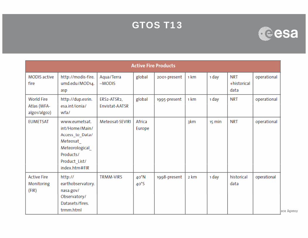
GTOS T13
NASA white paper
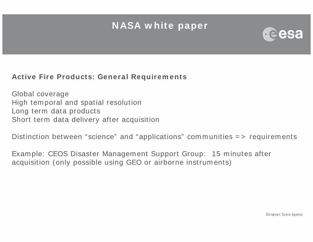
Active Fire Products: General RequirementsActive Fire Products: General Requirements
Global coverageHigh temporal and spatial resolutiong p pLong term data productsShort term data delivery after acquisition
Distinction between “science” and “applications” communities => requirementsDistinction between science and applications communities => requirements
Example: CEOS Disaster Management Support Group: 15 minutes after acquisition (only possible using GEO or airborne instruments)

NASA white paper
NASA Fire ESDR “science” uses
(i) i di t f d il l d i t l i bilit i fi (i) as an indicator of daily, seasonal and inter-annual variability in fire activity regionally and globally, and trends associated with climate and climate change
(ii) as part of the validation process for fire affected (burned) area( ) p p ( )(iii) as a way to determine more precisely the timing of burning for burned
area products generated periodically during the burning season (iv) as an integral part of some burned area mapping algorithms(v) to estimate FRP which has been shown to correlate with instantaneous (v) to estimate FRP, which has been shown to correlate with instantaneous
rate of combustion and emission rates
NASA white paper
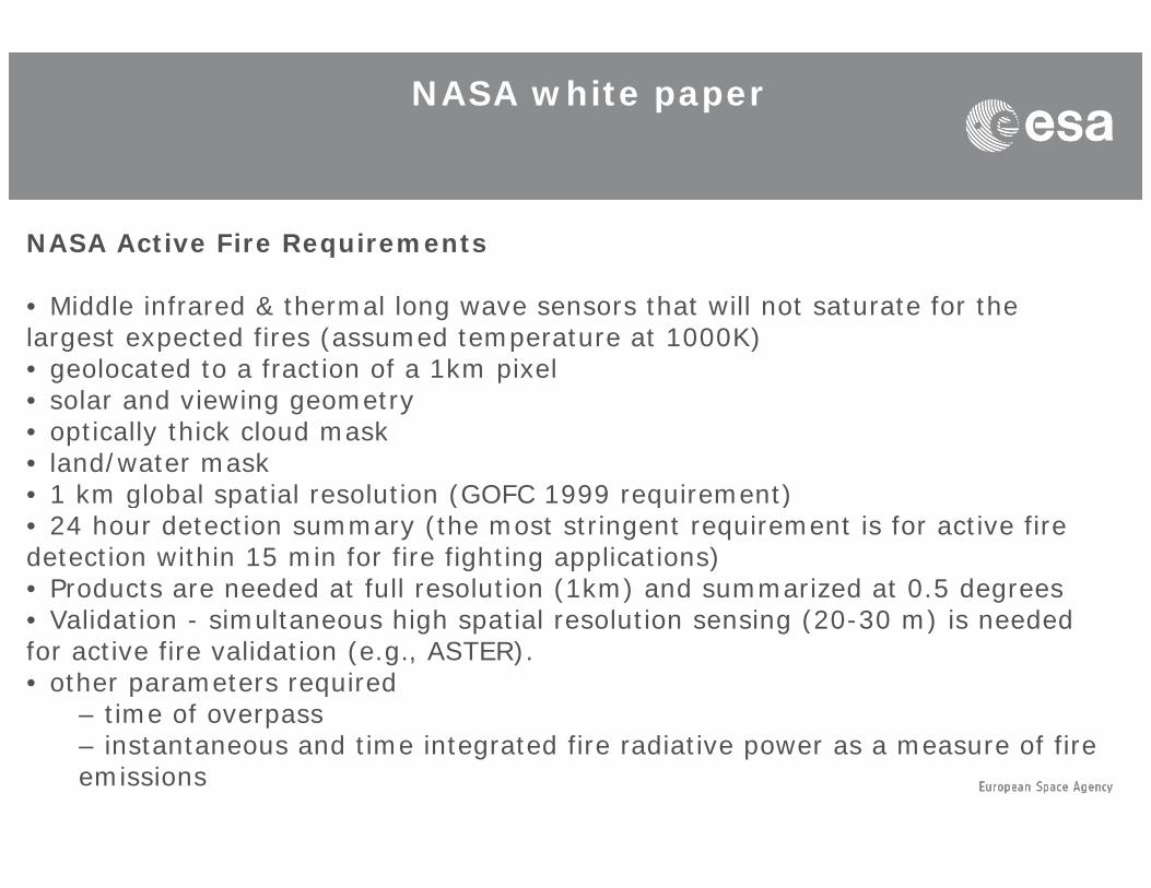
NASA Active Fire Requirements
• Middle infrared & thermal long wave sensors that will not saturate for the largest expected fires (assumed temperature at 1000K) • geolocated to a fraction of a 1km pixel • solar and viewing geometry • optically thick cloud mask • land/water mask • 1 km global spatial resolution (GOFC 1999 requirement) 1 km global spatial resolution (GOFC 1999 requirement) • 24 hour detection summary (the most stringent requirement is for active fire detection within 15 min for fire fighting applications) • Products are needed at full resolution (1km) and summarized at 0.5 degrees V lid ti i lt hi h ti l l ti i (20 30 ) i d d • Validation - simultaneous high spatial resolution sensing (20-30 m) is needed
for active fire validation (e.g., ASTER). • other parameters required
– time of overpass p– instantaneous and time integrated fire radiative power as a measure of fire emissions

NASA white paper
NASA Burned Area RequirementsNASA Burned Area Requirements
• atmospherically corrected reflectance, visible to short wave infrared, thermal • geolocated to a fraction of a 500m pixel l d i i t • solar and viewing geometry
• optically thick cloud mask • 500 m globally (GOFC 1999 requirement)• 30 m for regional and local mapping – (the most stringent requirement is for g pp g ( g qhigh resolution data within 2-3 days for rapid post-fire assessment) • Monthly product as inputs to emission models recognizing the seasonality of fuel moisture, emission factors, and combustion completeness • Products to be provided at full resolution and summarized at 0 5 degrees • Products to be provided at full resolution and summarized at 0.5 degrees • Validation – high resolution imagery (20-30 m) to be acquired one month apart

NASA white paper
NASA sources for the Active Fire ESDRNASA sources for the Active Fire ESDR•AVHRR•METOP•ATSROLS•OLS
•MODIS•VIIRS
NASA sources for the Burned Area•AVHRR•SPOT-VEGETATION•ATSR•ATSR•MODIS

NASA white paper
NASA Relationships to other products and programs
NOAA ill b th id f t llit d t t th i ili li ti NOAA will be the provider of satellite data to the civilian applications user community in the NPOESS era.Web Fire Mapper developed with NASA support to provide fire data to a wide range of users in a Web GIS format is currently being transitioned to g y gthe UN FAO supported by the NASA Applications program.
Inter-comparison will be needed between the Collection 5 MODIS burned area product and the ESA GLOBSCAR/GLOBCARBON products following area product and the ESA GLOBSCAR/GLOBCARBON products, following the procedures developed by Boschetti et al. (2004).
Fire data products are envisioned as part of the GEOSS and as inputs to the UN FCCC. The Fire ESDRs would meet the requirements of these organizations.
International coordination of fire monitoring associated with the ESDR International coordination of fire monitoring associated with the ESDR should be conducted in the framework of GOFC/GOLD Fire

ESA Climate Change Initiative
The International Partners:
• UNFCCC which coordinates the interests and decisions of its Parties on Climate Policy,UNFCCC which coordinates the interests and decisions of its Parties on Climate Policy,
• GCOS which represents the scientific and technical requirements of the Global Climate ObservingSystem on behalf of UNFCCC,
• International Research Programmes, which represent the collective interests and priorities of the worldwide climate research community (e.g WCRP but also IGBP, IHDP, Diversitas…)
• Committee on Earth Observation Systems (CEOS), which serves as a focal point for EarthCommittee on Earth Observation Systems (CEOS), which serves as a focal point for EarthObservation activities of Space Agencies
• Individual Partner Space Agencies with whom ESA cooperates bilaterally ( e.g. Eumetsat, NOAA,NASA JAXA CNES )NASA, JAXA, CNES…..)
• EC and National Research Programmes which establish research priorities and provide resourcesfor climate research community within Europe (eg EC Framework Programme)

ESA Climate Change Initiative
The climate information systemThe climate information system(from K. Trenberth: Observational needs for climate prediction and adaptation, WMO Bulletin 57(1), January 2008) showing the locus of the ESA climate changeinitiative within it.

ESA Climate Change Initiative
Re processing ex archiveRe-processing ex archive(e.g. calibration) FEEDBACK LOOP:
“Gather”
ECV generation(e.g. validation & bias)
“Deliver”
ECV assimilation& assessment OUTPUT TO
“E l it” International Climate ProgrammesEC & MS R&D Programmes
IPCC Process, UNFCCC
“Exploit”
Education & Awareness“Show”

Advice from Climate Science Community (CSAB)(CSAB)
critical objectives, scientific challenges, major undertakings, key milestones of international climate research programmes
potential impact & relative importance for climate research & modelling programmes, of the satellite-based ECV data
mechanisms by which the feedback loops necessary to achieve GCOS objectives can be implemented & improved via CCI products & FCDRs
mechanisms by which this programme can further enhance interactions between EO data communities & climate research communities
how to facilitate use of the programme results within IPCC process
ensuring the scientific integrity of climate-related information for general public & d i i kdecision makers

Overall Schedule
Invitation To Tender closing 5 March 2010 Project (3 years) KO planned May 2010 Project (3 years) KO planned May 2010

Climate Change Initiative
The Essential Climate Variables addressed in the CCI
ECV
Ocean Sea IceOceanSea Level
Sea Surface Temperature
Ocean ColourOcean Colour
Terrestrial Glaciers
Land Cover
Fire DisturbanceFire Disturbance
Atmosphere Cloud properties
Ozone
Aerosol
Greenhouse Gases

GlobCarbon products & Validation1998-2007 from VGT and ATSR, Plummer et al., 2006Validation report on web, Tansey et al., 2008
Brazil
6000
7000
8000
9000
40000
50000
60000
mat
es
0
1000
2000
3000
4000
5000
J F M A M J J A S ON D J F M A M J J A S ON D J F M A M J J A SO N D J FM AM J J A SO N D J FM AM J J A SO N D J F M A M J J A S ON D J F M A M J J A S ON D J F M A M J J A SO N D J FM AM J J A SO N D J FM AM J J A SO N D
Hot
Spo
ts
0
10000
20000
30000
Bur
ned
Are
a Es
tim
1998 1999 2000 2001 2002 2003 2004 2005 2006 2007
ATSR WFA GlobCarbon Burned Area Estimate
JanFebMarAprAprMayJunJulAugSSepOctNovDec
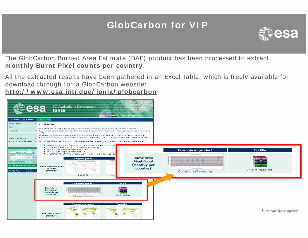
GlobCarbon for VIP
The GlobCarbon Burned Area Estimate (BAE) product has been processed to extract monthly Burnt Pixel counts per country.
All the extracted results have been gathered in an Excel Table, which is freely available for download through Ionia GlobCarbon website: http://www.esa.int/due/ionia/globcarbon

1991-Now1991 NowArino and Casadio, 2009Validation by IGBP, Arino et al 2001Arino et al., 2001
ATSR-WFA ALGO1 hot spots
80000
100000
120000
140000
0
20000
40000
60000
199619971998199920002001200220032004200520062007200820092010
Time
#
Papers related to ATSR-WFA
20
25
30
35
e
0
5
10
15
1997 1998 1999 2000 2001 2002 2003 2004 2005 2006 2007 2008 2009
Time
-
www.esa.int/due/ionia/wfa/

ATSR WFA RUSSIA Algo 1 and Algo3

ATSR WFA India Algo 1 and Algo3

DataFire Disturbance
ESA
Instrument 1991 1992 1993 1994 1995 1996 1997 1998 1999 2000 2001 2002 2003 2004 2005 2006 2007 2008 2009 2010 2011 2012 2013 2014 2015ATSR, C-SAR
ATSR-2, C-SARAATSR, MERIS, ASAR
VEGETATION-3C-SAR
OLCI, SLSTR
Europe
World
,VEGETATION
VEGETATION-2AVHRR-3
AVHRR, -2, -3MODISMODISVIIRS
Burned AreaDuration
1998-2007
GLOBCARBON
VEGETATION ATSR 2 AATSR
ProjectsVIIRS
Duration2000 Time series
2000
GLOBSCAR
ATSR-2
VEGETATION, ATSR-2, AATSR
1991 201520091995 2002 2012
Current Project Users Key Partners
Users
Total Different Users: 130 MPI-Meteorology, LSCE, CTCD, PIK, GCP
Total Different Users: >4000 ECMWF, MPI, ATM Community
GLOBCARBON
WFA
j y

Fire Disturbance
GCOS Objectives Current Status• Accuracy: 5% error in omission/commission Unknown high regional variation• Accuracy: 5% error in omission/commission Unknown, high regional variation• Spatial resolution: 250m 1 km• Temporal resolution: daily monthly with Day of Detection• Stability: 5% Unknown, high regional variation
– Baseline data requirement– Data processed to a universal level and in standard format– Consistency in calibration, sub-pixel geolocation, cloud, snow and cloud shadow screening and
atmospheric correction– Linked projects/datasets
– L3JRC ‘daily’ burned area from VEGETATION– MODIS burned area– GlobCarbon burned area– JRC AVHRR GAC burned areaJRC AVHRR GAC burned area– Regional databases e.g. Canada Large Fire Database, Brazilian Amazon Fire Database
– Key Science Bodies– GOFC-GOLD– GTOS
I t ti l R h P (IGBP (AIMES) WCRP ESSP Gl b l C b P j t)– International Research Programmes (IGBP (AIMES), WCRP, ESSP esp Global Carbon Project)– Key Users
– Atmospheric Transport Modellers– Dynamic Global Vegetation Modellers
Fire Disturbance
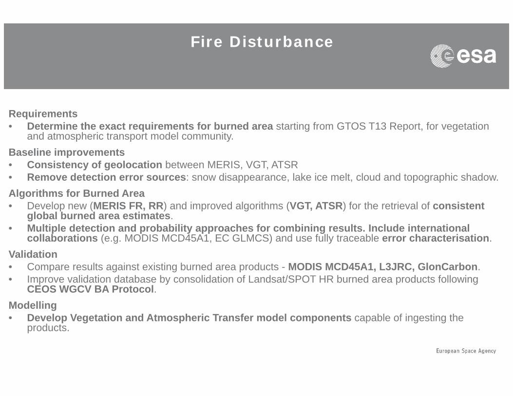
RequirementsD t i th t i t f b d t ti f GTOS T13 R t f t ti• Determine the exact requirements for burned area starting from GTOS T13 Report, for vegetation and atmospheric transport model community.
Baseline improvements• Consistency of geolocation between MERIS, VGT, ATSR• Remove detection error sources: snow disappearance, lake ice melt, cloud and topographic shadow.Algorithms for Burned Area• Develop new (MERIS FR, RR) and improved algorithms (VGT, ATSR) for the retrieval of consistent
global burned area estimates.• Multiple detection and probability approaches for combining results. Include international
collaborations (e.g. MODIS MCD45A1, EC GLMCS) and use fully traceable error characterisation. Validation• Compare results against existing burned area products - MODIS MCD45A1, L3JRC, GlonCarbon.• Improve validation database by consolidation of Landsat/SPOT HR burned area products following
CEOS WGCV BA Protocol.Modelling• Develop Vegetation and Atmospheric Transfer model components capable of ingesting the p g p p p g g
products.

Fire Disturbance

Seed questions
– Who is entitle to specify the requirements?
Seed questions
– Are the today requirements feasible?
– How far can we extend the Fire ECV back in time and in f ?future?
– How do you use the Fire ECV? (modellers, trendies, VIP)
– How do you validate the Fire ECV with available archive?
– How to bridge between 500m/1km (MODIS, VGT and ATSR) 10 /30 (L d /S i l 2)?ATSR) to 10m/30m (Landsat/Sentinel-2)?
– What about MERIS FR at 300m?
http://www.esa.int tp://www.esa.int [email protected]
– What about use of active sensor (ASAR, PALSAR)?
– BAE by vegetation type?