FINAL SITE INSPECTION WORK PLAN - Camp Withycombe SI … · · 2013-05-20FINAL SITE INSPECTION...
86
FINAL SITE INSPECTION WORK PLAN WITH-002-R-01: East Munitions Response Site Camp Withycombe, Clackamas, Oregon Prepared for: Army National Guard Directorate 111 S. George Mason Drive Arlington, Virginia 22202 Prepared by: AMEC Earth & Environmental, Inc. 7376 SW Durham Road Portland, Oregon 97224 (503) 639-3400 July 2011 Contract No. W9133L-10-F-0193
Transcript of FINAL SITE INSPECTION WORK PLAN - Camp Withycombe SI … · · 2013-05-20FINAL SITE INSPECTION...

FINAL SITE INSPECTION WORK PLAN WITH-002-R-01: East Munitions Response Site
Camp Withycombe, Clackamas, Oregon Prepared for:
Army National Guard Directorate 111 S. George Mason Drive Arlington, Virginia 22202 Prepared by:
AMEC Earth & Environmental, Inc. 7376 SW Durham Road Portland, Oregon 97224 (503) 639-3400 July 2011 Contract No. W9133L-10-F-0193

AMEC Earth & Environmental, Inc. 7376 SW Durham Road Portland, Oregon USA 97224 Tel+1 (503) 639-3400 Fax+1 (503) 620-7892 www.amec.com K:\GSA Contract\321060179 Camp Withycombe RI SI\SI WP\Final SI WP\Final SI WP.docx
27 July 2011
321060179.0002
Ms. Kim Harriz MMRP Program Manager Army National Guard Directorate 111 S. George Mason Drive Arlington, VA 22201
Dear Ms. Harriz:
Re: Final Site Inspection Work Plan Camp Withycombe MMRP 10101 SE Clackamas Road, Clackamas, Oregon
AMEC Earth & Environmental, Inc. (AMEC) is pleased to submit this Final Site Inspection (SI) Work Plan to the Army National Guard (ARNG) Directorate for the Camp Withycombe Military Munitions Response Program (MMRP) Project in Clackamas, Oregon. The SI Work Plan describes methods to determine the presence or absence of munitions and explosive of concern, munitions constituents, and waste constituents in the East Munitions Response Site (MRS) at Camp Withycombe. The SI Work Plan was completed to fulfill the requirements of the ARNG Directorate MMRP for former military training areas. The work is being conducted under U.S. General Services Administration (GSA) Contract W9133L-10-F-0193.
Please contact the undersigned at (503) 639-3400 if you have any questions regarding this SI Work Plan.
Sincerely, AMEC Earth & Environmental, Inc. Stephanie Syring Scott Kranz, RG Engineering Staff Senior Project Manager Attachments SS/cw c: Mr. Jim Arnold, Oregon Military Department Mr. Marc Anderson, U.S. Army Corps of Engineers Mr. Robert Williams, Oregon Department of Environmental Quality

Army National Guard Directorate, Camp Withycombe, Clackamas, Oregon Final Site Investigation Work Plan
AMEC Earth & Environmental, Inc. Contract No. W9133L-10-F-0193 i K:\GSA Contract\321060179 Camp Withycombe RI SI\SI WP\Final SI WP\Final SI WP.docx
TABLE OF CONTENTS
Page
LIST OF ABBREVIATIONS AND ACRONYMS ...........................................................................v
GLOSSARY OF TERMS ............................................................................................................ ix
1.0 INTRODUCTION ......................................................................................................... 1-1 1.1 Project Objectives ............................................................................................ 1-1 1.2 Work Plan Organization ................................................................................... 1-2
2.0 PROJECT BACKGROUND.......................................................................................... 2-1 2.1 Previous Investigations .................................................................................... 2-1
2.1.1 Soil and Groundwater Investigation, Small Arms Firing Ranges, 1991 . 2-2 2.1.2 Soil Investigation, Small Arms Firing Ranges, 1994 .............................. 2-3 2.1.3 Investigation and Small Arms Firing Ranges Treatability Study, 1995 .. 2-3 2.1.4 Additional Small Arms Firing Ranges Characterization, 1996 ............... 2-4 2.1.5 Remedial Action, Camp Withycombe Landfill, 1996 .............................. 2-5 2.1.6 Site Characterization Clackamas County Parcel, 1997 - 1998 .............. 2-6 2.1.7 Remedial Investigation and Feasibility Study, Small Arms Firing Ranges,
2006 through 2008................................................................................ 2-7 2.1.8 Remedial Action, Small Arms Firing Ranges, 2010 ............................. 2-10 2.1.9 Site Summary for Region 10 Superfund: Northwest Pipe and Casing
Company - Hall Process Company ..................................................... 2-12 2.1.10 TEMCO .............................................................................................. 2-12 2.1.11 Preliminary Assessment ..................................................................... 2-13 2.1.12 Cultural Resources Investigations ...................................................... 2-14
3.0 HISTORICAL RECORDS REVIEW .............................................................................. 3-1 3.1 Information Resources ..................................................................................... 3-1
3.1.1 Archival Research ................................................................................ 3-1 3.1.2 Aerial Photographs ............................................................................... 3-4 3.1.3 Personnel Interviews ............................................................................ 3-6
4.0 INSTALLATION HISTORY AND MRS DESCRIPTION ................................................ 4-1 4.1 Installation History ............................................................................................ 4-1
4.1.1 Small Arms Range Complex ................................................................. 4-2 4.1.2 Equipment Maintenance and Storage ................................................... 4-4 4.1.3 Waste Disposal..................................................................................... 4-4 4.1.4 Civilian Access ..................................................................................... 4-4 4.1.5 Demographic Profile ............................................................................. 4-5
4.2 East MRS (WITH-002-R-01) ............................................................................. 4-5 4.2.1 MRS Description and History ................................................................ 4-5 4.2.2 MRS Characteristics ............................................................................. 4-5
5.0 CONCEPTUAL SITE MODEL ...................................................................................... 5-1 5.1 Sources of MEC, MC and Waste Constituents ................................................. 5-1
5.1.1 Munitions Constituents ......................................................................... 5-1 5.1.2 Anticipated Type, Density, and Distribution of MEC .............................. 5-2
5.2 Release and Transport Profile .......................................................................... 5-3 5.2.1 Corrosion .............................................................................................. 5-4 5.2.2 Frost Heave .......................................................................................... 5-4

Army National Guard Directorate, Camp Withycombe, Clackamas, Oregon Final Site Investigation Work Plan
AMEC Earth & Environmental, Inc. ii Contract No.W9133L-10-F-0193 K:\GSA Contract\321060179 Camp Withycombe RI SI\SI WP\Final SI WP\Final SI WP.docx
5.2.3 Erosion ................................................................................................. 5-4 5.2.4 Soil Disturbance ................................................................................... 5-4 5.2.5 Hydrologic Effects ................................................................................. 5-4 5.2.6 Chemical Decomposition ...................................................................... 5-5 5.2.7 Uptake .................................................................................................. 5-5
5.3 Receptors ......................................................................................................... 5-5 5.4 Exposure Profile ............................................................................................... 5-6
5.4.1 Exposure Pathways .............................................................................. 5-6
6.0 SCOPE OF WORK ...................................................................................................... 6-1 6.1 Data Quality Objectives .................................................................................... 6-1 6.2 Rationale and Design ....................................................................................... 6-2
6.2.1 Records Review ................................................................................... 6-2 6.2.2 Analog Instrument-Assisted Visual Survey ........................................... 6-2 6.2.3 MC and Waste Constituent Sampling ................................................... 6-3
6.3 East MRS Records Review .............................................................................. 6-4 6.4 Field Activities .................................................................................................. 6-5
6.4.1 Analog Instrument-Assisted Visual Survey Field Activities .................... 6-5 6.4.2 MC and Waste Constituent Field Activities ......................................... 6-11
7.0 PROJECT MANAGEMENT.......................................................................................... 7-1 7.1 Project Schedule .............................................................................................. 7-1 7.2 Key Project Personnel ...................................................................................... 7-1
7.2.1 Army National Guard Directorate .......................................................... 7-4 7.2.2 Oregon Military Department .................................................................. 7-4 7.2.3 United States Army Corps of Engineers-Omaha District ....................... 7-5 7.2.4 Roles and Responsibilities .................................................................... 7-5
7.3 Deliverables ..................................................................................................... 7-6
8.0 REFERENCES ............................................................................................................ 8-1

Army National Guard Directorate, Camp Withycombe, Clackamas, Oregon Final Site Investigation Work Plan
AMEC Earth & Environmental, Inc. Contract No. W9133L-10-F-0193 iii K:\GSA Contract\321060179 Camp Withycombe RI SI\SI WP\Final SI WP\Final SI WP.docx
TABLES
Table 2.1: Previous Investigations at Camp Withycombe ................................................................ 2-2
Table 2.1.8.1: MEC Encountered During Former Small Arms Firing Ranges Restoration Project .. 2-11
Table 2.1.8.2: Types of MD Encountered During Former Small Arms Firing Ranges Restoration Project ..................................................................................................................... 2-12
Table 3.1.1: Archival Information Summary ..................................................................................... 3-2
Table 3.1.2: Aerial Photograph Review ........................................................................................... 3-5
Table 3.1.3: Interviews Regarding Historic Use of Camp Withycombe ............................................ 3-6
Table 4.1.1: Approximate Extents of the Former Small Arms Firing Ranges .................................... 4-2
Table 5.1.1: Munitions Constituents of Potential Concern ................................................................ 5-2
Table 5.3: Potential East MRS Receptors........................................................................................ 5-5
Table 6.4.1.3: Contact Notification List .......................................................................................... 6-10
Table 6.4.2.4: MC and Waste Constituent Sample Analysis .......................................................... 6-13
Table 7.2: Project Personnel ........................................................................................................... 7-1
Table 7.2.4: Project Team Roles and Responsibilities ..................................................................... 7-5
FIGURES
Figure 1 Project Area
Figure 2 MRS Location Map
Figure 3 East MRS
Figure 4 East MRS MEC Exposure Pathway Analysis
Figure 5 East MRS MC and Contaminants Exposure Pathway Analysis
Figure 7.2: Project Organizational Structure ........................................................................... 7-4

Army National Guard Directorate, Camp Withycombe, Clackamas, Oregon Final Site Investigation Work Plan
AMEC Earth & Environmental, Inc. iv Contract No.W9133L-10-F-0193 K:\GSA Contract\321060179 Camp Withycombe RI SI\SI WP\Final SI WP\Final SI WP.docx
APPENDICES
Appendix A Historical Records
A-1 Evaluations of Select Historical Resources at Two Oregon Army National Guard Facilities
A-2 History of the Clackamas Armory and Building Complex
A-3 Remedial Action Report, Camp Withycombe Landfill
A-4 Clackamas County Historical Society Records
A-5 Oregon Historical Society Records
A-6 Oregon State Archive Records
A-7 Historical Aerial Photographs
A-8 1956 Quitclaim Deed
A-9 1953 Hand drawn Map of Oregon State Rifle Range
A-10 1945 USACE Inspection Report
Appendix B Interview Forms
Appendix C Information Paper
Appendix D Former Small Arms Ranges Location Map, MEC and MD Location Map, a Former Small Arms Ranges Remedial Action Areas, and Related Debris Table
Appendix E Field Sampling Plan
E-1 SOP - Soil Sampling Methodology
E-2 SOP - Groundwater Sampling Methodology
E-3 SOP - Decontamination Procedure
E-4 Sampling Forms
Appendix F Uniform Federal Policy - Quality Assurance Project Plan
F-1 Laboratory Standard Operating Procedures and Limits
Appendix G Site Safety and Health Plan
Appendix H Field Form

Army National Guard Directorate, Camp Withycombe, Clackamas, Oregon Final Site Investigation Work Plan
AMEC Earth & Environmental, Inc. Contract No. W9133L-10-F-0193 v K:\GSA Contract\321060179 Camp Withycombe RI SI\SI WP\Final SI WP\Final SI WP.docx
LIST OF ABBREVIATIONS AND ACRONYMS
AAR Applied Archeological Research AEDB-R Army Environmental Database - Restoration Module AFRC Armed Forces Reserve Center AGI-DIR Adjunct General’s Installations Division, Director AMEC AMEC Earth & Environmental, Inc. ARNG Army National Guard AVS Analog Instrument-Assisted Visual Survey BIP Blow-in-place bgs Below Ground Surface BWUD Beneficial Water Use Determination CC Compliance Clean-Up CERCLA Comprehensive Environmental Response, Compensation, and Liability Act CHMM Certified Hazardous Materials Manager COPC Constituents of Potential Concern COR Contracting Officer’s Representative CQA Certified Quality Auditor CQM Certified Quality Manager CSM Conceptual Site Model DA Department of the Army DCSOPS Deputy Chief of Staff for Operations and Plans DEQ Oregon Department of Environmental Quality DGPS Differential Global Positioning System DMM Discarded Military Munitions DNT dinitrotoluene DoD Department of Defense DQO Data Quality Objective EOD Explosive Ordnance Disposal EM Engineer Manual EP Engineer Pamphlet EPA United States Environmental Protection Agency ERA Ecological Risk Assessment ESP Explosives Site Plan

Army National Guard Directorate, Camp Withycombe, Clackamas, Oregon Final Site Investigation Work Plan
AMEC Earth & Environmental, Inc. vi Contract No.W9133L-10-F-0193 K:\GSA Contract\321060179 Camp Withycombe RI SI\SI WP\Final SI WP\Final SI WP.docx
ºF Degrees Fahrenheit FBI Federal Bureau of Investigation FFE Free From Explosives FS Feasibility Study FFS Focused Feasibility Study FSP Field Sampling Plan GIS Geographic Information System GPS Global Positioning System GSA United States General Services Administration HASP Health and Safety Plan HE High Explosive HHRA Human Health Risk Assessment HMX High Melting Explosive, octahydro-1,3,5,7-tetranitro-1,3,5,7-tetrazocine HRR Historical Records Review HTRW Hazardous, Toxic, and Radioactive Waste ID Identification ISO Industry Standard Objects KD Known Distance KO Contracting Officer LAW Light Anti-Tank Weapon LIDAR Light Detection and Ranging MC Munitions Constituents MCL Maximum Contaminant Levels MD Munitions Debris MEC Munitions and Explosives of Concern mg/kg milligrams per kilogram mg/L milligrams per liter µg/kg micrograms per kilogram µg/L micrograms per liter mm millimeter MMRP Military Munitions Response Program MOA Memorandum of Agreement

Army National Guard Directorate, Camp Withycombe, Clackamas, Oregon Final Site Investigation Work Plan
AMEC Earth & Environmental, Inc. Contract No. W9133L-10-F-0193 vii K:\GSA Contract\321060179 Camp Withycombe RI SI\SI WP\Final SI WP\Final SI WP.docx
MPPEH Material Potentially Presenting an Explosive Hazard MRS Munitions Response Site MRSPP Munitions Response Site Prioritization Protocol msl mean sea level NAD83 Horizontal North American Datum of 1983 NAVD88 North American Vertical Datum of 1988 NCP National Oil and Hazardous Substances Contingency Plan ND Non-Detect NDNODS Non-Department of Defense Owned Non-Operational Defense Sites NRA National Rifle Association NFA No Further Action NRHP National Register of Historic Places NTU Nephelometric Turbidity Units OAR Oregon Administrative Rule ODOT Oregon Department of Transportation OE Ordnance and Explosives OESS Ordnance and Explosives Safety Specialist OMD Oregon Military Department ONHIC Oregon Natural Heritage Information Center ORARNG Oregon Army National Guard ORNG Oregon National Guard PA Preliminary Assessment PAH Polycyclic Aromatic Hydrocarbons PANGB Portland Air National Guard Base PAO Public Affairs Officer PCB Polychlorinated Biphenyl PETN Pentaerythritol Tetranitrate PG Professional Geologist PM Project Manager POC Point of Contact PRG Preliminary Remediation Goal QA Quality Assurance QC Quality Control RBC Risk-Based Concentration

Army National Guard Directorate, Camp Withycombe, Clackamas, Oregon Final Site Investigation Work Plan
AMEC Earth & Environmental, Inc. viii Contract No.W9133L-10-F-0193 K:\GSA Contract\321060179 Camp Withycombe RI SI\SI WP\Final SI WP\Final SI WP.docx
RDX Research Development Explosive, hexahydro-1,3,5-trinitro-1,3,5-triazine RG Oregon Registered Geologist RI Remedial Investigation ROD Record of Decision RSL Regional Screening Level RTK Real Time Kinematic
SARA Superfund Amendments and Reauthorization Act SD Short Distance SDZ Surface Danger Zone SHPO State Historic Preservation Office SI Site Inspection SSHP Site Safety and Health Plan SUXOS Senior Unexploded Ordinance Supervisor TAG The Adjunct General TCE tricloroethene TCLP Toxicity Characteristic Leaching Procedure TNT 2,4,6-trinitrotoluene TPH Total Petroleum Hydrocarbon TSS Total Suspended Solids U.S. United States UFP - QAPP Uniform Federal Policy - Quality Assurance Project Plan USACE United States Army Corps of Engineers USAESCH United States Army Engineering Support Center, Huntsville USPFO United States Property and Fiscal Officer UTM Universal Transverse Mercator UXO Unexploded Ordnance UXOSO UXO Safety Officer UXOQCS UXO Quality Control Supervisor VOC Volatile Organic Compound

Army National Guard Directorate, Camp Withycombe, Clackamas, Oregon Final Site Investigation Work Plan
AMEC Earth & Environmental, Inc. Contract No. W9133L-10-F-0193 ix K:\GSA Contract\321060179 Camp Withycombe RI SI\SI WP\Final SI WP\Final SI WP.docx
GLOSSARY OF TERMS
Closed Range: A military range that has been taken out of service as a range and that either has been put to new uses that are incompatible with range activities or is not considered by the military to be a potential range area. A closed range is still under the control of a Department of Defense (DoD) component.
Cultural Debris (CD): Debris found on operation ranges or munitions response sites, which may be removed to facilitate a range clearance or munitions response that is not related to munitions or range operations. Such debris includes, but is not limited to: rebar household items (refrigerators, washing machines etc.), automobile parts and automobiles that were not associated with range targets, fence posts, and fence wire.
Defense Site: All locations that are or were owned by, leased to, or otherwise possessed or used by the DoD. The term does not include any operational range, operating storage or manufacturing facility, or facility that is used or was permitted for the treatment or disposal of military munitions.
Discarded Military Munitions (DMM): Military munitions that have been abandoned without proper disposal or removed from storage in a military magazine or other storage area for the purpose of disposal. The term does not include unexploded ordnance, military munitions that are being held for future use or planned disposal, or military munitions that have been properly disposed of consistent with applicable environmental laws and regulations.
Explosive Ordnance Disposal (EOD): The detection, identification, on-site evaluation, rendering safe, recovery, and final disposal of unexploded explosive ordnance. It may also include explosive ordnance that has become hazardous by damage or deterioration.
Explosives Safety: A condition where operational capability and readiness, personnel, property, and the environment are protected from the unacceptable effects of an ammunition or explosives mishap.
Formerly Used Defense Site (FUDS): A DoD program that focuses on compliance and cleanup efforts at sites that were formerly used by the DoD. A FUDS property is eligible for the Military Munitions Response Program if the release occurred prior to October 17, 1986; the property was transferred from DoD control prior to October 17, 1986; and the property or project meets other FUDS eligibility criteria.
Munitions and Explosives of Concern (MEC): This term, which distinguishes specific categories of military munitions that may pose unique explosives safety risks, means unexploded ordnance, DMM, or munitions constituents (e.g., Trinitrotoluene {TNT}, Cyclotrimethylenetrinitramine {RDX}) present in high enough concentrations to pose an explosive hazard.
Munitions Constituents (MC): Any materials originating from unexploded ordnance, DMM, or other military munitions, including explosive and non-explosive materials, and emission, degradation, or breakdown elements of such ordnance or munitions.
Munitions Debris (MD): A military munition or components thereof that does not contain explosives or pyrotechnics. Includes practice munitions without spotting charges, inert training munitions, expended ejection munitions, and fragments of exploded/destroyed military munitions that do not contain explosives or pyrotechnics.

Army National Guard Directorate, Camp Withycombe, Clackamas, Oregon Final Site Investigation Work Plan
AMEC Earth & Environmental, Inc. x Contract No.W9133L-10-F-0193 K:\GSA Contract\321060179 Camp Withycombe RI SI\SI WP\Final SI WP\Final SI WP.docx
Note: Munitions debris is considered MPPEH until technically qualified personnel have done the following:
● Inspected, verified, and certified that it does not present an explosive hazard, and is consequently safe for the general public to receive; or
● Inspect, verify, and certify it as to explosive hazards it may present to a qualified receiver.
Military Munitions: All ammunition products and components produced for or used by the armed forces for national defense and security, including ammunition products or components under the control of the DoD, the U.S. Coast Guard, the U.S. Department of Energy, and the National Guard. The term includes confined gaseous, liquid, and solid propellants, explosives, pyrotechnics, chemical and riot control agents, smokes, and incendiaries, including bulk explosives, and chemical warfare agents, chemical munitions, rockets, guided and ballistic missiles, bombs, warheads, mortar rounds, artillery ammunition, small arms ammunition, grenades, mines, torpedoes, depth charges, cluster munitions and dispensers, demolition charges, and devices and components of the above. The term does not include wholly inert items, improvised explosive devices, and nuclear weapons, nuclear devices, and nuclear components, other than non-nuclear components of nuclear devices that are managed under the nuclear weapons program of the Department of Energy after all required sanitization operations under the Atomic Energy Act of 1954 have been completed.
Material Potentially Presenting an Explosive Hazard (MPPEH): Material potentially containing explosives or munitions (e.g., munitions containers and packaging material; munitions debris remaining after munitions use, demilitarization, or disposal; and munitions debris); or material potentially contaminated with a sufficient concentration of explosives, such that the material constitutes an explosive hazard (e.g., equipment, drainage systems, holding tanks, piping and ventilation ducts) associated with munitions production, demilitarization, or disposal operations. Excluded from MPPEH are munitions within a DoD-established management system and other items that may present explosion hazards (e.g., gasoline cans or compressed gas cylinders) that are not munitions and are not intended for use as munitions.
Munitions Response (MR): Response actions, including investigation, removal, and remedial actions to address explosive safety, human health, or environmental risks presented by UXO, DMM, or munitions constituents (MC).
Military Response Area (MRA): Any area on a defense site that is known or suspected to contain UXO, DMM, or MC. Examples include former ranges and munitions burial areas. A munitions area comprises one or more munitions response sites.
Munitions Response Site (MRS): A discrete location within an MRA that is known to require a munitions response.
Operational Range: A range that is under the jurisdiction, custody, or control of the Secretary of Defense and that is used for range activities or, although not currently being used for range activities, that is still considered by the Secretary of Defense to be a range and has not been put to a new use that is incompatible with range activities.
Other than Operational Range: Encompasses closed, transferred, and transferring ranges.

Army National Guard Directorate, Camp Withycombe, Clackamas, Oregon Final Site Investigation Work Plan
AMEC Earth & Environmental, Inc. Contract No. W9133L-10-F-0193 xi K:\GSA Contract\321060179 Camp Withycombe RI SI\SI WP\Final SI WP\Final SI WP.docx
Range: A designated land or water area set aside, managed, and used for range activities of the DoD. Ranges include firing lines and positions, maneuver areas, firing lanes, test pads, detonation pits, impact areas, electronic scoring sites, buffer zones with restricted access and exclusionary areas, and airspace areas designated for military use in accordance with regulations and procedures prescribed by the Administrator of the Federal Aviation Administration.
Range Related Debris: Debris other than munitions debris, collected from operational ranges or from former ranges (e.g., targets).
Safety Danger Zone (SDZ): The ground and airspace designated within the training complex (to include associated safety areas) for vertical and lateral containment of projectiles, fragments, debris, and components resulting from the firing, launching, or detonation of weapon systems to include explosives and demolitions.
Transferred Range: A range that is no longer under military control and had been leased by the DoD, transferred, or returned from the DoD to another entity, including federal entities. This includes a military range that is no longer under military control, but that was used under the terms of an executive order, special-use permit or authorization, right-of-way, public land order, or other instrument issued by the federal land manager. Additionally, property that was previously used by the military as a range, but did not have a formal use agreement, also qualifies as a transferred range.
Transferring Range: A range that is proposed to be leased, transferred, or returned from the DoD to another entity, including federal entities. This includes a military range that was under the terms of a withdrawal, executive order, special-use permit or authorization, right-of-way, public land order, or other instrument issued by the federal land manager or property owner. An active range will not be considered a transferring range until the transfer is imminent (generally defined as the transfer date is within 12 months and a receiving entity has been notified).
Target Impact Area: A point on the range at which the munitions are fired.
Unexploded Ordnance (UXO): Military munitions that have been primed, fused, armed, or otherwise prepared for action; have been fired, dropped, launched, projected, or placed in such a manner as to constitute a hazard to operations, installations, personnel, or material; and remain unexploded either by malfunction, design, or any other cause.
Source: Draft Munitions and Explosives of Concern Hazard Assessment Methodology, January 2008

Army National Guard Directorate, Camp Withycombe, Clackamas, Oregon Final Site Investigation Work Plan
AMEC Earth & Environmental, Inc. Contract No. W9133L-10-F-0193 1-1 K:\GSA Contract\321060179 Camp Withycombe RI SI\SI WP\Final SI WP\Final SI WP.docx
FINAL SITE INSPECTION WORK PLAN WITH-002-R-01: East Munitions Response Site
Camp Withycombe, Clackamas, Oregon
1.0 INTRODUCTION
AMEC Earth & Environmental, Inc. (AMEC) has prepared this Final Site Inspection (SI) Work Plan on behalf of the Army National Guard (ARNG) Directorate for the Camp Withycombe Military Munitions Response Program (MMRP). Camp Withycombe is located in Clackamas, Oregon (Figure 1), and is operated by the Oregon Military Department (OMD) / Oregon Army National Guard (ORARNG).
The objective of the SI is to evaluate the presence or absence of munitions and explosives of concern (MEC), munitions constituents (MC), and waste constituents at WITH-002-R-01, the East Munitions Response Site (MRS). This SI Work Plan presents background information, data quality objectives, and the approach for completing the SI at Camp Withycombe. The SI will support the ARNG Directorate in determining whether no further action (NFA), additional investigation or a removal action is necessary, as defined by the Department of Defense (DoD) MMRP.
This SI Work Plan was prepared by AMEC, under terms of United States (U.S.) General Services Administration (GSA) contract number W9133L-10-F-0193 and pursuant to the following federal statutes: the Comprehensive Environmental Response, Compensation, and Liability Act (CERCLA) as amended by the Superfund Amendments and Reauthorization Act (SARA), the National Oil and Hazardous Substances Contingency Plan (NCP), and applicable Oregon Department of Environmental Quality (DEQ) and local agency regulatory requirements. The lead agency for this project is the ARNG Directorate, with support from the Omaha District of the United States Army Corps of Engineers (USACE).
1.1 PROJECT OBJECTIVES
The purpose of the SI is to evaluate the presence or absence of MEC, MC, and waste constituents in the East MRS. The results of the SI will be used to determine if a Remedial Investigation (RI), a removal action, or a NFA determination is appropriate, and to complete the Munitions Response Site Prioritization Protocol (MRSPP). In order to achieve the project objective, the following activities will be conducted:
● Additional historical records research and interviews

Army National Guard Directorate, Camp Withycombe, Clackamas, Oregon Final Site Investigation Work Plan
AMEC Earth & Environmental, Inc. 1-2 Contract No. W9133L-10-F-0193 K:\GSA Contract\321060179 Camp Withycombe RI SI\SI WP\Final SI WP\Final SI WP.docx
● Analog, instrument-assisted, visual surveys (AVS) to quantify surface MEC and disposal areas within the East MRS, and confirm the location of the East MRS boundary
● Soil and groundwater samples to determine if MC and waste constituents are present
In accordance with the CERCLA process, if MEC, MC, and/or waste constituents are present at levels exceeding screening criteria, or pose an explosives hazard, a RI designed to delineate the nature and extent of MC and MEC will be conducted. If an immediate threat to human health is discovered, a removal action will be conducted.
1.2 WORK PLAN ORGANIZATION
The SI Work Plan provides a detailed description of past and present MRS conditions, a description of the Data Quality Objectives (DQOs), and a description of the methods and procedures to be used for SI activities. The work plan has been organized as follows:
● Section 1: Introduction - describes the project objectives and work plan organization.
● Section 2: Project Background - discusses the development of the Camp Withycombe MMRP.
● Section 3: Historical Records Review (HRR) - describes the review of historical records pertaining to training and waste disposal practices at Camp Withycombe.
● Section 4: Installation History and MRS Descriptions - provides a detailed description of Camp Withycombe and the SI area.
● Section 5: Conceptual Site Model (CSM) - discusses potential sources, release mechanisms, affected media, land use scenarios, potential receptors, and potential exposure pathways.
● Section 6: Scope of Work - discusses the SI activities to be conducted.
● Section 7: Project Management - provides the project schedule and project personnel for the SI.
● Section 8: References - lists references used to prepare the SI Work Plan.
● Appendix A: Historical Records - records collected during the historical records review, discussed in Section 3.0.
● Appendix B: Interview Forms - records from interviews conducted during the historical records review, discussed in Section 3.1.3.
● Appendix C: Information Paper - references and information collected during the historical records review.

Army National Guard Directorate, Camp Withycombe, Clackamas, Oregon Final Site Investigation Work Plan
AMEC Earth & Environmental, Inc. Contract No. W9133L-10-F-0193 1-3 K:\GSA Contract\321060179 Camp Withycombe RI SI\SI WP\Final SI WP\Final SI WP.docx
● Appendix D: Former Small Arms Ranges Location Map, MEC and munitions debris (MD) Location Map, Former Small Arms Ranges Remedial Action Areas, and Related Debris Table - shows locations of the formation small arms ranges relative to MRS locations and shows and lists the MEC and MD discovered during the small arms firing range restoration project.
● Appendix E: Field Sampling Plan (FSP) - discusses detailed sampling procedures required to complete the scope of work.
● Appendix F: Uniform Federal Policy - Quality Assurance Project Plan (UFP-QAPP) - provides details of the analytical and sampling procedures and quality assurance protocols that will be conducted to complete the scope of work.
● Appendix G: Site Safety and Health Plan (SSHP) - provides specific guidelines and protocols for the protection of personnel performing the scope of work.
● Appendix H: Form - contains a form for tracking observations during the AVS that will be conducted in the MRS.

Army National Guard Directorate, Camp Withycombe, Clackamas, Oregon Final Site Investigation Work Plan
AMEC Earth & Environmental, Inc. Contract No. W9133L-10-F-0193 2-1 K:\GSA Contract\321060179 Camp Withycombe RI SI\SI WP\Final SI WP\Final SI WP.docx
2.0 PROJECT BACKGROUND
The project area at Camp Withycombe was identified as a potential MRS after MEC and MD were encountered during the investigation and remedial action of several former small arms firing ranges at Camp Withycombe. The former small arms firing ranges restoration project was conducted under the ARNG Directorate Compliance Clean-up (CC) Program. To further evaluate the presence of potential MRSs and determine their eligibility for inclusion in the MMRP, the OMD completed a Preliminary Assessment (PA) of Camp Withycombe in December 2009 (OMD, 2009). The PA identified two MRSs at Camp Withycombe, WITH-001-R-01 (West MRS), and WITH-002-R-01 (East MRS [Figure 2]). The West MRS encompasses approximately 137 acres, including 56 acres of Oregon Department of Transportation (ODOT) owned land proposed for highway development in 2013. The West MRS is currently undergoing a RI. The East MRS encompasses approximately 100 acres of forested hillside on the eastern and northern portion of the installation owned by the ODOT, and includes the former target area for mortar, artillery, and small arms training at Camp Withycombe. The East MRS is the focus of the SI.
Historical research was conducted in 2009 to identify known and potential sources of MEC and MC located on the East MRS resulting from former military training activities, to define the boundary of the MRS, and to compile information to be used in a preliminary CSM. The following sources of information were utilized for the historical research: 1) archival records; 2) aerial photos; 3) personnel interviews; and 4) previous investigations.
The HRR is presented in detail in Section 3.0. The HRR identified former training and waste disposal activities at Camp Withycombe and concluded the East MRS contains several undocumented waste disposal areas and was used for practice and live-fire of small, medium, and large caliber munitions. The results indicate undocumented waste disposal areas may contain discarded military munitions (DMM), MC, and other contaminants. MEC and MD, including 40 millimeter (mm) smoke grenades, rifle grenades, 60mm mortar rounds, 35mm sub-caliber rockets, 3.5-inch practice rockets, and 37mm projectiles have been found in surface and subsurface soil during previous investigations within the East MRS Figure D-2 (Appendix D).
2.1 PREVIOUS INVESTIGATIONS
Initial investigations of Camp Withycombe were initiated on behalf of ODOT due to the proposed transfer of 157 acres of OMD-owned land at Camp Withycombe for inclusion in the Sunrise Corridor Project. The transferred property included the firing positions and target areas of the former small arms firing ranges. Subsequent investigations were initiated by OMD after elevated concentrations of lead were determined to be present in the soil. OMD entered into a Voluntary

Army National Guard Directorate, Camp Withycombe, Clackamas, Oregon Final Site Investigation Work Plan
AMEC Earth & Environmental, Inc. 2-2 Contract No. W9133L-10-F-0193 K:\GSA Contract\321060179 Camp Withycombe RI SI\SI WP\Final SI WP\Final SI WP.docx
Cleanup Agreement with DEQ on 2 March 1995. OMD agreed to investigate and/or clean contaminated property and hazardous substances under the review and oversight of the DEQ. Previous investigations conducted at Camp Withycombe are listed in Table 2.1 and summarized in the sections below.
Table 2.1: Previous Investigations at Camp Withycombe
Report Title Report Date Author
Limited 1991 Dames & Moore
Soil Investigation Report 1994 Century West Engineering, Inc.
Investigation and Firing Ranges Treatability Study Reports 1995 Hart Crowser, Inc.
Additional Firing Ranges Characterization Report 1996 Hart Crowser, Inc.
Remedial Action Report, Camp Withycombe Landfill 1996 Hart Crowser, Inc.
Clackamas County Parcel Limited Soil Sampling Report 1997 AGRA Earth & Environmental, Inc
Clackamas County Parcel Groundwater Sampling Report 1998 AGRA Earth & Environmental, Inc
Data Summary Report 2003 AMEC Earth & Environmental, Inc.
Revised Data Summary Report 2004 AMEC Earth & Environmental, Inc.
Remedial Investigation Report 2006 AMEC Earth & Environmental, Inc.
Feasibility Study Report 2006 AMEC Earth & Environmental, Inc.
Remedial Investigation Addendum Report 2008 AMEC Earth & Environmental, Inc.
Focused Feasibility Study Report 2008 AMEC Earth & Environmental, Inc.
Final Corrective Action Plan 2008 AMEC Earth & Environmental, Inc.
Preliminary Assessment 2009 OMD
Construction Summary Report 2010 AMEC Earth & Environmental, Inc.
Off-Site Reports
Site Summary for Region 10 Superfund: Northwest Pipe & Casing Co. - Hall Process Co.
2010 U.S. Environmental Protection Agency
2.1.1 Soil and Groundwater Investigation, Small Arms Firing Ranges, 1991
In 1991, site characterization began with soil and groundwater investigations of the former Known Distance (KD) and Short Distance (SD) Firing Ranges (Dames & Moore, 1991). Soil samples were collected at the post-impact target area in what is now the East MRS and near the target line in the

Army National Guard Directorate, Camp Withycombe, Clackamas, Oregon Final Site Investigation Work Plan
AMEC Earth & Environmental, Inc. Contract No. W9133L-10-F-0193 2-3 K:\GSA Contract\321060179 Camp Withycombe RI SI\SI WP\Final SI WP\Final SI WP.docx
West MRS, from four depth intervals: 0 to 0.5, 1 to 1.5, 2 to 2.5, and 3 to 3.5 feet below ground surface (bgs). In addition, groundwater grab samples were collected from soil borings down gradient (west) of the KD and SD ranges. The soil samples were analyzed for total lead and leachable lead using the toxicity characteristic leaching procedure (TCLP). Select soil samples from the SD Firing Range also were analyzed for nitrate, nitrite, and nitroglycerine. Lead concentrations in shallow soil samples collected at 0 to 1 feet bgs ranged from 6,200 milligrams per kilogram (mg/kg) to 99,000 mg/kg. The analytical results indicated the soil lead concentration quickly decreased with depth. The two soil samples with highest total lead concentrations yielded leachable lead concentrations of 660 and 2,000 milligrams per liter (mg/L). Nitrate and nitrite in soil concentrations ranged from 1.2 to 2.5 mg/kg. Nitroglycerine was detected at 9.86 mg/kg in the soil sample with the greatest nitrate and nitrite concentration. Groundwater samples were collected with a peristaltic pump from a temporary stainless steel well point. The groundwater samples were field filtered and analyzed for dissolved lead. Dissolved lead was not detected above the laboratory method detection limit in the groundwater samples.
2.1.2 Soil Investigation, Small Arms Firing Ranges, 1994
In 1993, a soil investigation was conducted to assess the lateral and vertical extent of lead-impacted soil at the small arms firing ranges (Century West Engineering Corporation, 1994). Soil samples were collected from the pre-target impact areas, target lines, and post-target impact areas at depths of 0.5, 1.0, and 2.0 feet bgs. The samples were analyzed for total lead and TCLP lead. Total lead concentrations in the upper 0.5 feet of soil ranged from 10.9 mg/kg to 180,000 mg/kg. The results of the soil sampling investigation were used to estimate the total volume of lead-impacted soil, which equaled 11,425 cubic yards.
2.1.3 Investigation and Small Arms Firing Ranges Treatability Study, 1995
In 1995, six soil borings were completed near the post-target impact and impact areas in the East MRS, at the KD, SD, and Federal Bureau of Investigation (FBI) Ranges to obtain shallow groundwater samples. Each boring was advanced to refusal in gravel or cobbles at approximately 10 feet bgs; however, no groundwater was encountered (Hart Crowser, Inc., 1995a). Surface water samples were collected for analysis from ponded water at the base of the hillside in the impact area of the KD Firing Range and from water flowing in a drainage area in the post-target impact area of the FBI Range. The water samples were analyzed for total and dissolved lead. Total lead concentrations ranged from 0.003 to 1.67 mg/L in surface water samples.
Also in 1995, a treatability study was conducted to assess whether the volume of lead-impacted soil requiring remediation could be reduced (Hart Crowser, Inc., 1995b). Composite soil samples were collected from the three small arms firing ranges from three depth intervals (0 to 0.75, 0.75 to

Army National Guard Directorate, Camp Withycombe, Clackamas, Oregon Final Site Investigation Work Plan
AMEC Earth & Environmental, Inc. 2-4 Contract No. W9133L-10-F-0193 K:\GSA Contract\321060179 Camp Withycombe RI SI\SI WP\Final SI WP\Final SI WP.docx
1.5, and 1.5 to 2.5 feet bgs). Soil samples were separated by particle size using wet and dry sieve methods. Visible bullet fragments were removed manually and weighed separately. The retained soil was tested for total lead. The results of the sieve-size analytical results indicated lead was detected above the DEQ industrial maximum allowable soil concentration in most size fractions. The treatability study results suggested that volume reduction and separation techniques were economically feasible and could result in large reductions in remedial costs for the site.
2.1.4 Additional Small Arms Firing Ranges Characterization, 1996
In 1996, additional characterization was completed, consisting of collecting surface soil samples (between 0 to 0.5 feet bgs) at the KD, SD, and FBI Ranges, installing four monitoring wells (MW-1 through MW-4) near the firing ranges, collecting groundwater samples from the monitoring wells, and analyzing the soil and groundwater samples (Hart Crowser, Inc., 1996a). The soil samples were tested for priority pollutant metals (antimony, arsenic, beryllium, cadmium, chromium, copper, lead, mercury, nickel, selenium, silver, thallium, and zinc) and for leachable arsenic, copper, and lead using TCLP methods. In addition, select soil samples from the firing lines and target lines of the three small arms firing ranges were tested for explosives, including but not limited to 2,4,6-trinitrotoluene (TNT), octahydro-1,3,5,7-tetranitro-1,3,5,7-tetrazocine (HMX), and hexahydro-1,3,5-trinitro-1,3,5-triazine (RDX), by U.S. Environmental Protection Agency (EPA) Method 8330A and for nitroglycerine by EPA Method 8332. The soil samples also were analyzed for TNT and RDX using EnSys RDX Soil Test System field screening kits.
Elevated concentrations of total lead were identified at the post-target impact areas of the KD and SD Ranges and at the target area of the FBI Range. The results of the TCLP analysis indicated leachable lead concentrations ranged from 0.37 mg/L to 920 mg/L. The highest TCLP concentration was detected in a discrete surface soil sampling location in the vicinity of the target line. Arsenic also was detected in soil, at concentrations greater than the DEQ industrial maximum allowable soil concentration of 3 mg/kg. Leachable arsenic concentrations analyzed by TCLP methods were not detected above the laboratory method detection limit.
Concentrations of RDX were identified using the EnSys field screening kit; however the concentrations identified during field screening did not correlate with the laboratory analytical results for RDX. The laboratory analytical results for explosives indicate RDX was not detected above the laboratory detection limit. A nitrate clean-up kit was used during the field screening to remove possible interferences with nitrates. However, concentrations of nitroglycerine identified by the laboratory analysis likely caused additional interference in the EnSys field screen for RDX. For this reason, the EnSys field screening results for RDX were considered anomalous.

Army National Guard Directorate, Camp Withycombe, Clackamas, Oregon Final Site Investigation Work Plan
AMEC Earth & Environmental, Inc. Contract No. W9133L-10-F-0193 2-5 K:\GSA Contract\321060179 Camp Withycombe RI SI\SI WP\Final SI WP\Final SI WP.docx
Concentrations of 2,4-dinitrotoluene (DNT) were detected in four of the samples analyzed at the KD and FBI Firing Ranges, but at concentrations below screening criteria. An estimated concentration of 0.59 mg/kg TNT was identified at the KD Firing Range discrete shallow soil sampling location, K-04, using the EnSys Field Screening Kit. TNT was not detected by the EnSys field screening method at the FBI or SD Ranges.
Groundwater samples were collected for total and dissolved metals analysis, using EPA Method 6020. Total lead was detected at concentrations ranging from 0.065 to 0.60 mg/L. Total suspended solid (TSS) concentrations were determined using EPA Method 160.2 and concentrations ranged from 1,000 to 71,000 mg/L. The most elevated concentrations of total lead correspond closely with the most elevated TSS concentrations. The correlation between total lead and TSS concentrations indicated the total lead detected was associated with the sediment in the groundwater and not groundwater. The analytical results indicated dissolved lead was not detected above the laboratory method detection limit.
2.1.5 Remedial Action, Camp Withycombe Landfill, 1996
Remedial action of the former Camp Withycombe Landfill was conducted in 1996 under the Installation Restoration Program. The landfill was located at the northeast corner of the hillside at Camp Withycombe (Hart Crowser, 1996b) within the current boundary of the East MRS. The landfill covered approximately 0.25 acres, and approximately 3,300 tons of soil and debris were excavated from the former landfill. Reportedly, the landfill was used from approximately 1952 until 1979 for disposal of construction debris and general trash generated from facilities maintenance activities at Camp Withycombe. Soil and excavated debris were transported to the Hillsboro Landfill for disposal.
After excavation activities were completed, confirmation soil samples and one surface water sample were obtained to verify removal of landfill material. Sample data is provided in Tables 1 through 3 in Appendix A-3 and sample locations are provided in Figures 2 through 4 in Appendix A-3. Confirmation samples were analyzed for total petroleum hydrocarbons (TPH) and total and leachable lead and selenium. TPH was detected in three samples from the landfill excavation area ranging from 24 to 47 mg/kg. The samples with TPH detections were analyzed for polynuclear aromatic hydrocarbons (PAHs). The following PAHs were detected in two of the three samples: benzo(a)anthracene, benzo(a)pyrene, chrysene, and pyrene at 13, 79, 35, and 38 micrograms per kilogram (µg/kg), respectively. Total lead was detected in all samples collected from the landfill excavation area and leachable lead was detected in one sample. The maximum total lead concentration was 600 mg/kg and the leachable lead concentration was 1.8 mg/L. The remaining total lead concentrations ranged from 11 to 110 mg/kg. Neither total nor leachable

Army National Guard Directorate, Camp Withycombe, Clackamas, Oregon Final Site Investigation Work Plan
AMEC Earth & Environmental, Inc. 2-6 Contract No. W9133L-10-F-0193 K:\GSA Contract\321060179 Camp Withycombe RI SI\SI WP\Final SI WP\Final SI WP.docx
selenium was detected in any of the landfill excavation confirmation samples. Samples from temporary stockpile locations next to the former landfill were analyzed for TPH; all samples were non-detect for TPH. Total lead was detected at 22 micrograms per liter (µg/L) in the excavation runoff samples; all other constituents (cadmium, chromium, mercury, selenium, benzene, ethylbenzene, toluene, xylene, and TPH) were not detected. After review of the Remedial Action Report, the DEQ provided a NFA determination for the former landfill.
2.1.6 Site Characterization Clackamas County Parcel, 1997 - 1998
In 1997, surface (0 - 1.5 feet bgs) soil samples were collected at the proposed Clackamas County Parcel to evaluate whether soil was impacted by metals associated with the nearby firing ranges (AGRA, 1997a). The proposed Clackamas County Parcel was located between the KD and FBI Firing Ranges within the ODOT property in the Sunrise Corridor and was not an impact area for any of the small arms firing ranges at Camp Withycombe. The soil samples were submitted for total metals (antimony, arsenic, beryllium, cadmium, chromium, copper, lead, mercury, nickel, selenium, silver, thallium, and zinc). The five soil samples having the greatest total lead concentrations also were tested for leachable lead. All soil samples were screened for explosives, including TNT and RDX, using EnSys field screening methods. Five soil samples were submitted for analysis of nitroaromatics and nitroamines. Total lead was detected at the Clackamas County Parcel at concentrations ranging from 17.5 to 89.7 mg/kg. Nitroaromatics and nitroamines were detected at two locations at the method detection limit of 0.4 mg/kg.
A groundwater sampling investigation was performed at the Clackamas County Parcel in 1996 (AGRA, 1997b). Groundwater samples were collected from monitoring wells MW-1 through MW-4. Micro-purge groundwater sampling techniques were used to reduce TSS in the groundwater samples. Turbidity was measured in each of the monitoring wells and ranged from 6.90 (MW-4) to 19.9 (MW-3) nephelometric turbidity units (NTUs). The samples were tested for total and dissolved priority pollutant metals. The total and dissolved metals analyzed were not detected at concentrations greater than EPA Maximum Contaminant Levels (MCLs) established by the Safe Drinking Water Act.
In 1998, additional groundwater samples were collected from monitoring wells MW-1 through MW-4 to assess whether total lead concentrations detected in previous groundwater samples were associated with elevated TSS (AGRA, 1998). Low-flow groundwater sampling techniques were used to reduce turbidity during sampling. The samples were tested for total and dissolved priority pollutant metals, TSS, nitroaromatics, nitroamines, and nitroglycerin. The analytical results from groundwater samples indicated TSS were significantly reduced by monitoring well redevelopment and by using low flow sampling methods. As an example, total lead was not detected at monitoring

Army National Guard Directorate, Camp Withycombe, Clackamas, Oregon Final Site Investigation Work Plan
AMEC Earth & Environmental, Inc. Contract No. W9133L-10-F-0193 2-7 K:\GSA Contract\321060179 Camp Withycombe RI SI\SI WP\Final SI WP\Final SI WP.docx
well MW-3 in June 1998, with no detected TSS, compared to the total lead concentration of 0.35 mg/L detected in 1996, with a TSS concentration of 71,000 mg/L. A similar trend is evident for the other monitoring wells sampled. The analytical results from groundwater samples collected in June 1998 indicated total lead concentrations were strongly related to the TSS concentrations. Total and dissolved metals, with the exception of total chromium, were not detected above the laboratory method detection limits in June 1998 groundwater samples.
2.1.7 Remedial Investigation and Feasibility Study, Small Arms Firing Ranges, 2006 through 2008
A RI and feasibility study (FS) of the former small arms firing ranges were conducted from 2006 through 2008. An initial RI was completed for the KD Firing Range, FBI Firing Range, and the SD Firing Range in 2006 (AMEC, 2006a). The RI consisted of an evaluation of the results of soil and groundwater investigations performed at the former small arms firing ranges from 1991 through 1998 (see Sections 2.3.1 through 2.3.5 above), and one groundwater sampling event conducted in January 2006. Additionally, a Human Health Risk Assessment (HHRA), Level I Screening Ecological Risk Assessment (ERA), and a beneficial water and land use determination (BWUD) were conducted.
The DEQ requested a Level II and Level III ERA and a hot spot assessment, requiring additional soil sampling to further delineate the extent of lead and nitroglycerine at the former small arms firing ranges, which was conducted August through November 2007. In addition, three additional small arms firing ranges were identified during the review of historical aerial photographs, the Circa 1900, Small Bore, and National Rifle Association (NRA) Ranges. 130 soil samples were collected from 0 to 1 foot, 1 to 2 foot, and 2 to 3 foot investigation intervals and analyzed for total lead using EPA Method 6010. Select soil samples from 0 to 1 foot at the Circa 1900 and Small Bore Ranges were also analyzed for antimony, arsenic, and copper using EPA Method 6010. Twenty-seven soil samples were collected from the firing lines at the KD, FBI, and SD Firing Ranges and analyzed for explosives using EPA Method 8330A. Three explosives samples were also collected in the location where detonation of detonation cord was suspected at the KD range. The approximate location of the detonation cord was identified by Camp Withycombe personnel. The NRA range was not sampled because a small earthen berm with visible bullets was identified and the entire berm was expected to require remedial action.
2.1.7.1 Soil Analytical Results
A summary of soil analytical results from investigations conducted from 1991 through 1998 are included in Sections 2.1.1 through 2.1.6 above. Soil analytical results from the additional sampling conducted in 2007 are discussed by range below.

Army National Guard Directorate, Camp Withycombe, Clackamas, Oregon Final Site Investigation Work Plan
AMEC Earth & Environmental, Inc. 2-8 Contract No. W9133L-10-F-0193 K:\GSA Contract\321060179 Camp Withycombe RI SI\SI WP\Final SI WP\Final SI WP.docx
KD Firing Range
Soil lead concentrations ranged from non-detect (ND) to 5,140 mg/kg. Lead concentrations were greatest from 0 to 1 foot bgs but decreased to naturally occurring concentrations by 2 to 3 feet bgs. Nitroglycerine was detected in soil samples, but at concentrations below screening levels
FBI Firing Range
Soil lead concentrations ranged from ND to 2,370 mg/kg. Lead concentrations were greatest from 0 to 1 ft bgs, decreasing to naturally occurring concentrations by 2 to 3 ft bgs. Concentrations of antimony and arsenic exceeded applicable screening criteria. Nitroglycerine was detected in one sample, but at a concentration below screening levels.
SD Firing Range
Soil lead concentrations ranged from ND to 2,920 mg/kg. Lead concentrations were greatest from 0 to 1 ft bgs and decreased to naturally occurring concentrations by 2 to 3 ft bgs. Nitroglycerine was detected in three samples at concentrations below screening criteria.
Circa 1900 Range
Soil lead concentrations ranged from 30.8 to 24,700 mg/kg. Lead concentrations exceeded screening criteria in the samples collected from 0 to 1 ft bgs, but decreased to naturally occurring concentrations by 1 to 2 ft bgs. Antimony exceeded screening criteria in one sample at a concentration of 14.5 mg/kg. Arsenic concentrations ranged from 1.7 to 5.3 mg/kg which exceeds screening criteria. Copper was detected, but at concentrations below screening levels.
Small Bore Range
Lead concentrations exceeded screening criteria in one sample collected from 0 to 1 ft bgs. Arsenic concentrations ranged from 2.5 to 4.2 mg/kg. Copper was detected at concentrations below applicable screening levels.
2.1.7.2 Summary of Groundwater Sampling Results (2006)
The 2006 groundwater sampling indicated total lead ranged from 0.00227 to 0.00647 mg/L and dissolved lead ranged from 0.00143 to 0.00273 mg/L. Dissolved antimony, chromium, copper, and zinc were detected above laboratory method detection limits, but did not exceed screening levels.

Army National Guard Directorate, Camp Withycombe, Clackamas, Oregon Final Site Investigation Work Plan
AMEC Earth & Environmental, Inc. Contract No. W9133L-10-F-0193 2-9 K:\GSA Contract\321060179 Camp Withycombe RI SI\SI WP\Final SI WP\Final SI WP.docx
2.1.7.3 Human Health Risk Assessment
A HHRA was conducted in accordance with DEQ’s Guidance for Conduct of Deterministic Human Health Risk Assessments (DEQ, 2000). The purpose of the HHRA was to evaluate whether current site conditions meet appropriate risk based concentrations (RBCs). The results of the HHRA indicated that complete exposure pathways existed for direct contact of soil through dermal absorption and ingestion. Indirect exposure pathways were also considered complete for inhalation of indoor and outdoor air. The pathway for human exposure to groundwater was not considered complete because groundwater is not used as a potable water source or irrigation source.
DEQ guidance recommends EPA Regional Screening Levels ([RSLs] formerly Region 9 Preliminary Remediation Goals [PRGs]) for residential soil be used as the screening criteria. Maximum soil concentrations for nitroglycerine, antimony, arsenic, copper, and lead exceeded the screening criteria. These analytes were selected as constituents of potential concern (COPC).
2.1.7.4 Ecological Risk Assessment
Level I, II, and III ERA were conducted in 2006 in accordance with the ODEQ Guidance for Ecological Risk Assessment (ODEQ, 2001). The objectives of the ERA were to make a determination of whether ecological receptors and/or exposure pathways are present or potentially present in the site or vicinity, screen COPCs against screening levels, and make a determination whether the planned remedial action would be protective of ecological receptors at the site.
The ERA indicated the only COPC was lead and the ecological receptor with the lowest RBC for lead was the American robin (Turdus migratorius). The most conservative applicable ecological RBC for the American robin was calculated to be 548 mg/kg.
2.1.7.5 Hot Spot Assessment
Hot spots were defined as areas where soil concentrations for lead were above a human exposure screening level of 4,000 mg/kg (10 times the EPA RSL for lead in residential soil). Hot spots are identified at the KD, FBI, and SD, Firing Ranges and the Small Bore Range on Figure D-3.
2.1.7.6 Beneficial Water Use Determination
The results of the BWUD indicated that contamination associated with soil had not migrated to groundwater or local surface water and was not expected to have the potential for off-site migration or to affect any beneficial water usage.

Army National Guard Directorate, Camp Withycombe, Clackamas, Oregon Final Site Investigation Work Plan
AMEC Earth & Environmental, Inc. 2-10 Contract No. W9133L-10-F-0193 K:\GSA Contract\321060179 Camp Withycombe RI SI\SI WP\Final SI WP\Final SI WP.docx
2.1.7.7 Feasibility Study
A FS and focused feasibility study (FFS) were conducted in 2006 and 2008, respectively, to evaluate remedial action alternatives for addressing COPCs at the KD, SD, and FBI Firing Ranges. The FS was conducted in accordance with DEQ Guidance for Conducting Feasibility Studies (DEQ, 1998) and Guidance for Conducting Remedial Investigations and Feasibility Studies Under CERCLA (EPA, 1998).
The results of the FS and FFS indicated the preferred remedial action alternative was excavation with ex-situ soil treatment using a soil screening and density separation soil treatment process. The preferred alternative achieved reduction in contaminant exposure for human or ecological receptors through a combination of mass reduction, stabilization, and off-site disposal.
2.1.7.8 Record of Decision
In accordance with Oregon Revised Statutes 465.200 et. seq, the DEQ signed a Record of Decision (ROD) for the former small arms firing ranges on 17 July 2008. The DEQ selected excavation with ex-situ soil treatment using soil washing and on-site re-use as the final remedy. The final remedy required no further action for groundwater because soil contamination at the former small arms firing ranges did not result in impacts to groundwater that posed an unacceptable risk to human health or the environment, or adversely affect current of future beneficial use of groundwater.
2.1.8 Remedial Action, Small Arms Firing Ranges, 2010
A remedial action was conducted at the former small arms firing ranges from April 2008 through July 2009, in accordance with the Corrective Action Plan completed in 2008 (AMEC, 2008), and the ROD signed on 17 July 2008. Specific remedial action activities included planning and permitting; site preparation; soil excavation; soil treatment using particle size and density separation; sampling and analysis; material recycling, reuse, and disposal; and site restoration (AMEC, 2010b).
A total of 28,223 tons of soil were excavated from the former small arms firing ranges as part of the remedial action to remove bullets and soil with a lead concentration greater than 400 mg/kg, generally to a depth of less than 2 feet bgs. After soil washing and treatment, 154 tons were determined to be hazardous waste. The remaining volume of soil was determined to be suitable for residential fill (7,145 tons), industrial fill (4,348 tons), or non-hazardous waste (16,576 tons). More than 270 tons of lead bullets were recovered for recycling during the particle size and density separation process.

Army National Guard Directorate, Camp Withycombe, Clackamas, Oregon Final Site Investigation Work Plan
AMEC Earth & Environmental, Inc. Contract No. W9133L-10-F-0193 2-11 K:\GSA Contract\321060179 Camp Withycombe RI SI\SI WP\Final SI WP\Final SI WP.docx
Final confirmation sampling was performed throughout excavated areas to demonstrate cleanup goals were met. Confirmation samples were collected from 757 locations at the former small arms firing ranges. All samples were analyzed for total lead, with an average concentration of 68.3 mg/kg. Forty-two confirmation samples were analyzed for arsenic, with an average concentration of 4.45 mg/kg. Forty confirmation samples were analyzed for antimony; antimony was detected in 18 of the samples at an average concentration of 2.98 mg/kg. Thirty-nine confirmation samples were analyzed for copper, with an average concentration of 43.5 mg/kg. Thirty-nine confirmation samples were also analyzed for leachable lead and arsenic using TCLP methodologies; with lead detected in four samples at an average concentration of 0.085 mg/L and no arsenic detections. Confirmation samples indicated soil contamination was affectively remediated by the selected alternative. In order to ensure long term effectiveness of the soil remedial action, quarterly monitoring of restored areas and groundwater was included as part of the remedy.
2.1.8.1 Munitions of Explosive Concern and Munitions Debris
The former small arms restoration project area was identified as a low probability site for MEC. However, on-call unexploded ordinance (UXO) Construction support was utilized for the duration of the project. A total of 36 MEC and 325 MD were encountered during restoration activities on the small arms firing ranges. MEC were guarded until disposal by detonation. Demolition operations occurred on 18 July 2008, 1 August 2008, 8 August 2008, and 30 October 2008. MD, range-related debris and cultural debris were removed from the range on a daily basis and locked in an enclosed container at the end of the day
All MD were inspected prior to removal from the site. A four-step visual inspection and certification/verification process conducted by the UXO Technicians, UXO Team Leaders, UXO Safety Officer / Quality Control Supervisor (UXOSO/QCS), and Senior UXO Supervisor (SUXOS) confirmed all items were free from explosive (FFE) hazards. A total of 3,075 pounds of MD were shipped off-site in six, 55 gallon drums by Bonetti Explosives, LLC to their disposal facility in Columbus Texas for demilitarization by shredding and smelting. A summary of the type and quantity of munitions are summarized in the tables below. The location of the items is provided on Figure D-2 (Appendix D).
Table 2.1.8.1: MEC Encountered During Former Small Arms Firing Ranges Restoration Project
Munitions Type Condition Quantity
Grenade, 40mm TP, M407A1 Fired smoke grenade with live fuze 3
Grenade, Rifle, Anti-Tank, M9A1 Fired, high explosive (HE) 1
Mortar Round, 60mm, M49A2 Fired HE (with and without fuzing) 8

Army National Guard Directorate, Camp Withycombe, Clackamas, Oregon Final Site Investigation Work Plan
AMEC Earth & Environmental, Inc. 2-12 Contract No. W9133L-10-F-0193 K:\GSA Contract\321060179 Camp Withycombe RI SI\SI WP\Final SI WP\Final SI WP.docx
Rocket, Sub-Caliber, 35mm, M73 Active Spotting Charge 4
Rocket, Practice, 3.5-Inch, M29A2 Active Base Fuze 2
Projectile, 37mm, M63 TP HE (black powder) 18
TOTAL MEC DISPOSED 36
Table 2.1.8.2: Types of MD Encountered During Former Small Arms Firing Ranges Restoration Project
Originating Munitions Debris Type Quantity
Rocket, Practice, 3.5-Inch Expended rocket motors, windshields, shape charge cones, etc. 227
Mortar Rounds, Practice, 3-Inch Stokes Sand filled practice rounds 6
Grenades, 40mm, Practice, M781 Plastic with some dye residue, expended grenade bodies 71
Mortar Rounds, 60mm M49A2 Tail booms/fins 3
Rocket, Sub-Caliber, 35mm, M73 Rocket bodies with fins assembly 9
Landmines, Practice, Type Unknown Landmine bodies with practice fuzing 9
TOTAL MD DISPOSED 325
2.1.9 Site Summary for Region 10 Superfund: Northwest Pipe and Casing Company - Hall Process Company
Northwest Pipe and Casing in Clackamas, Oregon was the location of pipe manufacturing and coating operations from 1956 to 1985. This facility was located north and adjacent to Camp Withycombe. Waste from the former facility contaminated soil and groundwater with solvents, primers, coal tar, coal-tar residues, polychlorinated biphenyls (PCBs), and oils (EPA, 2010).
The site was added to EPA’s National Priorities List in 1992. The following year, the buildings were demolished and a fence was constructed to restrict access to the site. In 1998, two underground fuel tanks were decommissioned and removed from the site. In 1999, security patrols were started to keep trespassers off the site. Following a comprehensive study, the EPA issued a groundwater cleanup plan in 2001 and a soil cleanup plan in 2000.
2.1.10 TEMCO
TEMCO, Inc. in Clackamas Oregon has been operating a metal manufacturing company for approximately 30 years. The facility is located just north of Camp Withycombe between the Camp

Army National Guard Directorate, Camp Withycombe, Clackamas, Oregon Final Site Investigation Work Plan
AMEC Earth & Environmental, Inc. Contract No. W9133L-10-F-0193 2-13 K:\GSA Contract\321060179 Camp Withycombe RI SI\SI WP\Final SI WP\Final SI WP.docx
Withycombe boundary and SE Mather Road. Soil, groundwater, and surface water on the property are contaminated with TCE, PCE, and breakdown products from releases that occurred prior to 1990 (DEQ, 2011).
A groundwater sampling event was conducted in May 2008 to investigate potential up-gradient sources of trichloroethene (TCE) at the TEMCO site. Monitoring well MW-4 on Camp Withycombe was sampled as part of the groundwater investigation. The analytical results from the groundwater sampling event completed in May 2008 indicate TCE was detected in a groundwater sample collected from monitoring well MW-4 at a concentration of 0.55 µg/L, below the RBC of 160 µg/L for construction/excavation worker exposure to groundwater in an excavation. Monitoring well MW-4 is located near the former KD Firing Range at the base of the hill slope on the East MRS boundary (Figure 3), which is approximately cross-gradient of the TEMCO property. The sample was taken from MW-4 to investigate a potential upgradient source of TCE at Camp Withycombe.
2.1.11 Preliminary Assessment
A PA was recommended for Camp Withycombe after MEC was encountered during the former small arms firing ranges restoration project and other construction activities at Camp Withycombe. The PA was conducted by ORARNG in December 2009 to determine if Camp Withycombe was eligible for inclusion in the MMRP and if further investigation was warranted. The PA identified past practices at the former range complexes at Camp Withycombe to include military marksmanship training and annual rifle competitions. The range complex consisted of as many as 75 firing points and a series of firing lines extending from 100 to 1000 yards, and was in operation from 1909 to approximately 1990.
The PA identified two MRSs at Camp Withycombe (Figure 2), the West MRS (Army Environmental Database-Restoration [AEDB-R] Number WITH-001-R-01) and the East MRS (AEDB-R Number WITH-002-R-01. Although there is no historical documentation of the use medium to large caliber munitions, medium to large caliber training did occur based on visual observance during multiple planning site visits. According to the PA, UXO, DMM, and/or MC were known or suspected to be in the surface, subsurface, and impaled in trees in the East MRS. The following munitions were known or suspected to have been used:
Direct Fire Weapons
● M29A2 3.5-inch Rocket
● M72 Light Antitank Weapon (LAW)
● M1902/M1905 Sub-caliber projectiles

Army National Guard Directorate, Camp Withycombe, Clackamas, Oregon Final Site Investigation Work Plan
AMEC Earth & Environmental, Inc. 2-14 Contract No. W9133L-10-F-0193 K:\GSA Contract\321060179 Camp Withycombe RI SI\SI WP\Final SI WP\Final SI WP.docx
Mortars
● 3-inch Stokes Mortars
● M49A2 60-mm HE Mortars
● 81-mm Mortars
● 4.2-inch Mortars
Grenades
● M79 40-mm Practice Grenades
● M407A1 40-mm Smoke Grenades
● M-9 Rifle-Fired Grenades
Artillery
● 37-mm HE Projectiles
● 75-mm Projectiles
● 3-inch Projectiles
● 105-mm Projectiles
● 155-mm Projectiles
The East MRS was identified as having grass on flat areas and dense trees and brush on steep slopes. The entire East MRS area was identified to contain military munitions. Based on the information provided in the PA, the East MRS met the MMRP eligibility requirements and was recommended for further investigation.
2.1.12 Cultural Resources Investigations
Two previous investigations indicate cultural and historical resources are present on the East MRS. The results of these investigations are summarized as follows:
2.1.12.1 Evaluations of Select Historical Resources at Two ORANG Facilities: Camp Rilea and Camp Withycombe
Applied Archeological Research (AAR) conducted a survey of the former small arms firing ranges at Camp Withycombe to evaluate potential for inclusion on the National Register of Historic Places (NRHP), and recommended the Small Bore Range, the KD Range, and the SD Range (Military

Army National Guard Directorate, Camp Withycombe, Clackamas, Oregon Final Site Investigation Work Plan
AMEC Earth & Environmental, Inc. Contract No. W9133L-10-F-0193 2-15 K:\GSA Contract\321060179 Camp Withycombe RI SI\SI WP\Final SI WP\Final SI WP.docx
Pistol Range & Machine Gun Range) for inclusion on the NRHP. The Oregon State Historic Preservation Office (SHPO) issued a letter of concurrence for the recommendation on 13 July 2001.
A Memorandum of Agreement (MOA) was issued in 2008 between the ARNG, the ORARNG, and the Oregon SHPO for the Camp Withycombe Armed Forces Reserve Center (AFRC) Construction Project, including the remedial action at the former small arms firing ranges. The MOA stipulated the ORARNG would perform mitigation for adverse effects to cultural and historical resources that resulted from the Camp Withycombe ARFC project. During construction activities, mitigation measures included the implementation of inadvertent discovery procedures as described in Standard Operating Procedure Number 6 of the ORARNG Integrated Cultural Resources Management Plan (OMD, 2007). Inadvertent discovery procedures include securing the area and notifying the Facility Manger of the discovery, who will confer with the OMD Cultural Resources Manager. The OMD Cultural Resources Manager will make the final determination on how to proceed with the discovery.
2.1.12.2 Results of a Cultural Resource Field Investigation
A cultural resources field investigation was conducted on 20 September 2007, to determine the potential for impact to cultural resources resulting from the small arms firing ranges restoration project. The study area included the base, ridgeline, and upland portion of the hillside within the East MRS. Two former military sites, both likely associated with the former small arms firing ranges, were identified during the field investigation. Neither site was determined to be eligible for inclusion on the NRHP.

Army National Guard Directorate, Camp Withycombe, Clackamas, Oregon Final Site Investigation Work Plan
AMEC Earth & Environmental, Inc. Contract No. W9133L-10-F-0193 3-1 K:\GSA Contract\321060179 Camp Withycombe RI SI\SI WP\Final SI WP\Final SI WP.docx
3.0 HISTORICAL RECORDS REVIEW
The HRR for Camp Withycombe consisted of a comprehensive records search to document historical and other known information pertaining to historic training activities and disposal practices. The intent of the HRR was to identify historical installation uses that may have resulted in the presence of MEC, MC, and/or waste constituents at Camp Withycombe. The primary components of the HRR included:
● Records Review: Historical resources were reviewed to evaluate past MRS uses with regards to types of weapons and munitions used at the MRS and evaluate munitions handling and disposal practices.
● Interviews: Interviews were conducted with civilian and military personnel familiar with historical operations and range uses. Interviews included conversations with retired personnel.
● CSM and Exposure Profile: A CSM was developed for each potential MRS that will be used to guide the SI at the East MRS. Further discussion of the CSM is included in Section 5.0.
3.1 INFORMATION RESOURCES
Several sources of information were used to conduct the HRR for Camp Withycombe. The sources of information and a summary of the information collected are provided in the sections below, with the complete documentation provided in the specified appendices. The information resources include:
● Archival Research
● Aerial Photographs
● Site Visits
● Personnel Interviews
● Previous MEC Remedial Action
● Previous MEC Investigations
3.1.1 Archival Research
Archival resources were reviewed to evaluate past MRS use with regards to types of weapons and munitions used at Camp Withycombe and evaluate munitions handling and disposal practices at Camp Withycombe. Archival research sources included local, State, and Federal (both military and

Army National Guard Directorate, Camp Withycombe, Clackamas, Oregon Final Site Investigation Work Plan
AMEC Earth & Environmental, Inc. 3-2 Contract No. W9133L-10-F-0193 K:\GSA Contract\321060179 Camp Withycombe RI SI\SI WP\Final SI WP\Final SI WP.docx
non-military) records, and internet sources. The results of the archival research are summarized in Table 3.1.1 and are included in detail in Appendix A. The results of a National Archives data collection search were included in a Non-Department of Defense Owned Non-Operational Defense Sites (NDNODS) Inventory conducted in 2008 (EA Engineering, Science, and Technology, Inc., 2008).
Table 3.1.1: Archival Information Summary
Archival Information Source/Author Relevant Findings
Camp Withycombe Documents
Evaluations of Select Historical Resources at Two Oregon Army National Guard Facilities
Applied Archeological Associates, 2001
The original 1,000-yard Rifle Range was constructed in 1909 in an easterly direction, and was realigned in 1912 towards the northeast, in order to utilize the East MRS as a backstop. See Appendix A.
History of the Clackamas Armory and Building Complex
Colonel Warren W. Aney, 2004
The East MRS is described as a significant backstop for the rifle ranges constructed in 1909. See Appendix A.
Remedial Action Report, Camp Withycombe Landfill
Hart Crowser, Inc., 1996
A 0.25-acre former landfill at the northeast corner of the East MRS, used from 1952 to 1979, was cleaned up and received a NFA determination from the DEQ. See Appendix A.
Phase I Environmental Baseline Study Shaw, 2008 None
Local and State Agency Sources
Biennial Reports of the Adjutant General of the ORARNG (1909-1950)
OMD Small arms ranges discussed.
Clackamas County Historical Society Records
Clackamas County Historical Society,
Oregon City, Oregon
Former activities at Camp Withycombe included repair of ordnance material, engine rebuilding, and repair of signal and communication equipment. Camp Withycombe also housed maintenance facilities for aviation equipment. See Appendix A.
Oregon Historical Society Records
Oregon Historical Society, Portland,
Oregon
Photographs of small arms practice and firing competition were obtained. See Appendix A.
Oregon State Archive Records
Oregon State Archives, Salem, Oregon See below and Appendix A.
1912 Inspection Report Small arms training and range expansion was conducted in 1912.
1931 Target Range Data Report
The Clackamas Rifle Range was described in 1931 as comprising 237 acres, with 35 rifle targets, 4 machine gun targets, and 10 pistol targets.
1934 Target Range Report Small arms training and rifle range use was described at Camp Withycombe in 1934. The backstop of the range(s) was described as being covered with second-growth timber.

Army National Guard Directorate, Camp Withycombe, Clackamas, Oregon Final Site Investigation Work Plan
AMEC Earth & Environmental, Inc. Contract No. W9133L-10-F-0193 3-3 K:\GSA Contract\321060179 Camp Withycombe RI SI\SI WP\Final SI WP\Final SI WP.docx
Archival Information Source/Author Relevant Findings
Survey of Target Ranges used by Civilian Components
Describes the small arms firing ranges and makes reference to farms located beyond the East MRS in 1934.
1924 Hand-Drafted Map
The 1924 map demarcates the KD Firing Range, which extends from the far south-west corner of Camp Withycombe to the East MRS hillside. Two additional ranges were shown to the southeast of the KD Firing Range.
1937 Topographic Map, revised 1953, 1955, 1956 OMD None
1953 Hand-Drafted Map OMD The 1953 map depicts the KD Firing Range, a Pistol Range (SD Firing Range), and a Small Bore Range.
Federal Sources
Historical aerial photographs
USACE Portland District office
Aerial photographs from 1936 to 1998 were obtained. See Table 3.1.2 and Appendix A.
1945 Inspection Report USACE General site information about Camp Withycombe.
Library of Congress, Geography and Map, Prints and Photographs Divisions
Library of Congress www.loc.gov
Two companion bills in the House (1990) and Senate (1989) were introduced to exchange federal revisionary interest in Camp Withycombe for a contingent interest in Camp Rilea. See Appendix A.
Quitclaim Deed Quitclaim Deed, 1956
A Quitclaim Deed was executed between the United States through the Secretary of the Army and the State of Oregon on 9 November 1956. Camp Withycombe was conveyed to the State of Oregon. See Appendix A.
Adjacent Properties
NW Pipe and Casing EPA
www.epa.gov
A pipe manufacturing and coating facility operated just north of Camp Withycombe from 1956 to 1985. Soil and groundwater was contaminated with solvents, primers, coal tar, coal tar residues, PCBs, and oils.
TEMCO, Inc. DEQ
www.oregon.gov/DEQ
A metal manufacturing company has been located just north of Camp Withycombe for approximately 30 years. Soil, groundwater, and surface water on the property are contaminated with TCE, PCE, and breakdown products from releases that occurred prior to 1990. A groundwater sample collected at MW-4 in 2008 indicated that TCE was present at a concentration of 0.55 µg/L.
Internet Sources
Defense Environmental Network & Information Exchange
www.denix.osd.mil None
DERP FUDS www.irb.usace.army.mil None
DoD Publications Archive www.defenselink.mil None
Defense Supply Center Richmond www.dscr.dla.mil None

Army National Guard Directorate, Camp Withycombe, Clackamas, Oregon Final Site Investigation Work Plan
AMEC Earth & Environmental, Inc. 3-4 Contract No. W9133L-10-F-0193 K:\GSA Contract\321060179 Camp Withycombe RI SI\SI WP\Final SI WP\Final SI WP.docx
Archival Information Source/Author Relevant Findings
Defense Technical Information Center www.dtic.mil None
Defense Visual Information Center www.dodmedia.osd.mil None
Library of Congress Memory Project www.memory.loc.gov None
United States Army www.army.mil None
U.S. Army Center for Health Promotion of Preventive Medicine, Aberdeen Proving Ground, Maryland
http://chppm-www.apgea.army.mil None
U.S. Army Center of Military History, Fort McNair, Washington
www.army.mil None
USACE District Offices www.asace.army.mil None
U.S. Army Environmental Command aec.army.mil None
Communications and Directives Directorate, Directives and Records Division
http://www.dtic.mil/whs/directives None
DoD Office of the Deputy Under Secretary of Defense
http://www.acq.osd.mil/ens
None
American Legion http://www.legion.org None
Historical Web Museum: United States of America
http://www.glocom.ac.jp/arc/hwa None
Veterans of Foreign Wars http://www.vfw.or None
Global Security http://www.globalsecurity.org
Information retrieved regarding use of Circa 1900 Range for rifle practice and competition.
3.1.2 Aerial Photographs
Historical aerial photographs on file at the USACE Portland District office were reviewed to identify previous land uses at Camp Withycombe. The results of the review are summarized in Table 3.1.2. Copies of each aerial photograph are provided in Appendix A. Aerial photographs showed use of the small arms firing ranges from 1936 through at least 1990. Evidence for use of artillery was not readily defined on the aerial photographs.

Army National Guard Directorate, Camp Withycombe, Clackamas, Oregon Final Site Investigation Work Plan
AMEC Earth & Environmental, Inc. Contract No. W9133L-10-F-0193 3-5 K:\GSA Contract\321060179 Camp Withycombe RI SI\SI WP\Final SI WP\Final SI WP.docx
Table 3.1.2: Aerial Photograph Review
Aerial Photograph Date Observations
1936
Camp Withycombe consists of approximately 8 large buildings and several smaller, ancillary structures situated along the southern border of the installation. At least three ranges (KD, SD, and Small Bore) are visible. Firing lines are visible on the ranges. Target locations are visible along the base of the East MRS. The East MRS is a wooded hillside comprising approximately one quarter of the total land area of the Camp Withycombe installation. The majority of the hillside is heavily wooded, with the exception of an approximate quarter acre cleared area. No activity is visible in the East MRS, and unimproved dirt roads are located around the perimeter of the East MRS.
1944 and 1945
Active use of Camp Withycombe is visible, with small arms firing ranges as described previously. Visually obvious ranges include the KD, SD and Small Bore Ranges with some other apparent range activity in the vicinity of the mortar firing area on the southeast portion of Camp Withycombe. Roads are visible in the East MRS in both the 1944 and 1945 photographs.
1948
Groomed ranges are visible. Roads are visible in the East MRS. In addition to the quarter-acre cleared area previously mentioned, two other cleared areas are visible: one in the northwest portion of the East MRS and one at the northeast corner of the East MRS, adjacent to the northern site boundary.
1956
Continued range use is visible, with the addition of a linear feature on the southeast corner of the facility. The linear feature appears to be located between the Small Bore Range and the SD Firing Range. Firing positions are clearly visible on the KD Firing Range. Roads are visible in the East MRS.
1963
Roads are clearly visible in the East MRS, including a lower road, a central road, and an upper road that extends around the northern perimeter of Camp Withycombe. Cleared areas identified previously remained visible in this photograph. An area just off-post to the east of Camp Withycombe appeared to be in the configuration of a range. It is unclear from the photograph whether this area represented a range; however the area consists of a shed-like structure at the south end with linear features extending north to what appears to be targets.
1971
The previously identified ranges earlier identified appeared to be active. The area just off-post to the east of Camp Withycombe remains visible in the 1971 photograph; however, the linear features are less prominent. The shed-like structure remains.
1980 Ranges appear to have been improved with upgraded targets and separating walls or berms. The area around the facility structures appeared to have been paved. Roads are still visible on the hillside.
1990 The ranges appeared to be in use. The East MRS appears to be relatively unchanged.
1998
A residential housing development has been constructed along the northern boundary of Camp Withycombe, which has remained relatively unchanged. Several large structures have been constructed on the developed portion of Camp Withycombe and have encroached onto the KD Firing Range.

Army National Guard Directorate, Camp Withycombe, Clackamas, Oregon Final Site Investigation Work Plan
AMEC Earth & Environmental, Inc. 3-6 Contract No. W9133L-10-F-0193 K:\GSA Contract\321060179 Camp Withycombe RI SI\SI WP\Final SI WP\Final SI WP.docx
3.1.3 Personnel Interviews
Personnel interviews were conducted with nine current and former Camp Withycombe military and civilian personnel with knowledge of past training activities, range practices, and facilities operations. The individuals were interviewed by telephone and through scheduled meetings. In addition, interviews were conducted during the annual holiday party at Camp Withycombe on 12 December 2008, where Camp Withycombe retirees are invited. Completed interview forms are included in Appendix B and the interviews are summarized in Table 3.1.3.
Interviews have established that past practices at Camp Withycombe included the use of practice and live-fire medium and large caliber munitions. During interviews, current and former military and civilian Camp Withycombe personnel identified several potential historic mortar and artillery firing positions and impact areas. One interviewee indicated he heard either 105mm or 155mm Howitzer guns were fired north from Camp Withycombe, potentially towards Mount Talbert located about one mile north of Camp Withycombe. The interviewee made this observation as a youth and the information remains unverified by any other source. The types of military munitions identified during interviews are generally consistent with those found during the former small arms firing range restoration project.
The information provided during interviews was used to identify multiple suspected disposal areas at the East MRS, which may contain DMM. Four of the interviewees were escorted to the East MRS, where they identified potential mortar and artillery impact areas, training areas, and approximate locations and size of disposal areas. Specific information provided by the interviewees regarding use of the former ranges and training activities at Camp Withycombe is included in Table 3.1.3
Table 3.1.3: Interviews Regarding Historic Use of Camp Withycombe
Contact Years Statement of Knowledge
Dan Boyer 1984 - 2000 • Recalled burn pit located in northeast corner of Camp Withycombe, at the East
MRS.
• Recalled disposal pits at several locations just off the road in the East MRS.
Henry Bradbury
1960s • Recalled two or three disposal areas in the East MRS.
• Aware of burning materials in the East MRS disposal areas until 1995 when
material disposal in the East MRS was ceased.

Army National Guard Directorate, Camp Withycombe, Clackamas, Oregon Final Site Investigation Work Plan
AMEC Earth & Environmental, Inc. Contract No. W9133L-10-F-0193 3-7 K:\GSA Contract\321060179 Camp Withycombe RI SI\SI WP\Final SI WP\Final SI WP.docx
Contact Years Statement of Knowledge
Bob Hamilton
1960s • Was a member of the 218th Field Artillery that used Camp Withycombe as a
training area, firing at East MRS.
• Recalled using 22-caliber blank trainers mounted to 105mm Howitzers in the
East MRS.
• Recalled training with smoke grenades, tear gas, and flash-bang canisters in the
East MRS.
• Recalled munitions fired at the East MRS included 60mm mortars, 3-inch Stokes
mortars, 81mm mortars, and LAW rockets.
• Many tons of garbage were burned in the East MRS, including shop waste,
batteries, parts, chemicals, and DMM.
Larry Kane 1987 - 1994 • Recalled weapons training had been conducted at Camp Withycombe and that
firing of munitions ceased around 1995.
• Stated that 4.2-inch mortar training occurred at Camp Withycombe.
Robert Lenneville
WWII Veteran
• Recalled visiting Camp Withycombe on Sundays to watch his father’s unit (the 218th Field Artillery) fire 155mm rounds into the side of Mount Talbert, circa 1930.
COL (Ret) Warren Aney
• Found documentation which stated the 218th Field Artillery unit converted from 75mm guns to 155mm Howitzers in 1929. He referenced a 218th, 1939 "Yearbook" page 151.
Ron Tuel 1951 - 1993 • Recalled 4.2-inch mortar training occurred at Camp Withycombe.
CW4(Ret) Dave Webster
1965 - 2007 • Was on the mortar crews trained using 81mm mortars, firing at the hillside.
• Recalled 81mm mortars were fired from the south eastern portion of Camp
Withycombe, near the current forestry center and access road.
• Smoke rounds were often fired about 300 yards into the trees and used as a
target for training.
• Training using live LAW M72 rockets was conducted within the East MRS, using
the hillside as a target.
• Recalled some rockets did not detonate.
• Recalled extra munitions were discarded in disposal areas in the East MRS.
• Recalled crews were not allowed to go into the East MRS.
• Mr. Webster stated he was aware that his grandfather had fired HE on the KD
Range.
• Recalled difficulties with munitions and equipment turn in, which may have
resulted in items being discarded along the eastern fence line in the East MRS.
• A truck may have been buried in the East MRS.
• Recalled three or four disposal areas in the East MRS.
• Did not recall 105mm or 155mm being fired at Camp Withycombe.
Rick Rozzell 1975 - 1981 • Aware of burning materials in the East MRS.

Army National Guard Directorate, Camp Withycombe, Clackamas, Oregon Final Site Investigation Work Plan
AMEC Earth & Environmental, Inc. 3-8 Contract No. W9133L-10-F-0193 K:\GSA Contract\321060179 Camp Withycombe RI SI\SI WP\Final SI WP\Final SI WP.docx
Contact Years Statement of Knowledge
MSG Steve Courtain
1960-1980s • Recalled active burial of excess maintenance equipment and support materials
in the East MRS.
• Burn pit was located in the extreme northeast corner of the East MRS. A small
tracked dozer was stationed permanently in the East MRS to cover materials.
• Recalled materials being disposed at the steep bank of the central road
traversing the East MRS. On occasion, munitions would be buried in the East
MRS.
On 22 October 2008, OMD and AMEC personnel met with Tracy Thoennes, curator for the Oregon Military Museum at Camp Withycombe, to discuss past range practices and to identify available maps, photographs, or other records that could document training and site activities during the time the ranges were operational. She discussed the types of munitions used at the facility and provided a tour of some of the equipment repaired and munitions that may have been fired at the facility during training operations. Besides small arms, typical equipment stored, maintained, and potentially fired at Camp Withycombe included 40mm grenades, 60mm and 4.2-inch mortars, 3-inch field guns, 37mm, 75mm, 105mm, and 155mm guns. Ms. Thoennes indicated the museum had no maps of Camp Withycombe with respect to the range layouts or maps showing past military training activities.

Army National Guard Directorate, Camp Withycombe, Clackamas, Oregon Final Site Investigation Work Plan
AMEC Earth & Environmental, Inc. Contract No. W9133L-10-F-0193 4-1 K:\GSA Contract\321060179 Camp Withycombe RI SI\SI WP\Final SI WP\Final SI WP.docx
4.0 INSTALLATION HISTORY AND MRS DESCRIPTION
Camp Withycombe is located east of Interstate 205 and north of Oregon Highway 212 at 10101 SE Clackamas Road, Clackamas, Oregon (Figure 1). Camp Withycombe has been an active training site since approximately 1909 and comprises 234 acres. The OMD transferred ownership of 156 acres of the property to the ODOT for inclusion in the proposed Sunrise Corridor right-of-way in 1989. However, the OMD maintains administrative control of the entire 234 acres under a lease agreement with ODOT. The Site has been divided into two MRSs (Figure 2), the West MRS (AEDB-R Number WITH-001-R-01) and the East MRS (AEDB-R Number WITH-002-R-01), which is the focus of this SI.
4.1 INSTALLATION HISTORY
Camp Withycombe, originally known as the Clackamas Firing Range consisted of 100 acres, leased by the federal government in 1909 and purchased in 1910 on behalf of the Oregon National Guard “for the purposes of constructing a rifle range thereon and for the use of a camp ground (Aney, 2004)”. At the time of the acquisition, the War Department initiated action to lease the property to the State for use of the militia, but a lease was never arranged. By 1915, the federal government purchased seven parcels of the leased property, totaling 237 acres. By 1934, the Clackamas Rifle Range was designated a federal military reservation and named Camp Withycombe after James Withycombe, the governor of Oregon from 1915 to 1919, during World War I.
Beginning in September 1940, the Oregon National Guard mobilized for federal service. During World War II, the U.S. Army 309th Ordnance Medium Maintenance Company out of Fort Hood, Texas, occupied the post. During this time it has been reported that Camp Withycombe was known as a U.S. Army barracks and received extensive use by all military components (Aney, 2004). In 1945, a USACE Military Inspection Report (USACE, 1945) indicated Camp Withycombe was comprised of 237.81 acres and operated under jurisdiction of the Chief, NGB and administered by the Adjutant General, State of Oregon. It was noted that the ranges were “well utilized by the U.S. Army, the U.S. Marine Corps, the FBI, police, and civilians.”
Camp Withycombe was DoD property until 9 November 1956, when the land was transferred to the OMD by a quitclaim deed. The quitclaim deed was executed between the U.S. through the Secretary of the Army and the State of Oregon, on 9 November 1956 (Appendix A-8). The U.S. conveyed the Camp Withycombe property to the State of Oregon, which was referenced in the document simply as “a firing range and storage depot” used by the ORARNG. The quitclaim deed required that the property continue to be used for military purposes only and that in the event that

Army National Guard Directorate, Camp Withycombe, Clackamas, Oregon Final Site Investigation Work Plan
AMEC Earth & Environmental, Inc. 4-2 Contract No. W9133L-10-F-0193 K:\GSA Contract\321060179 Camp Withycombe RI SI\SI WP\Final SI WP\Final SI WP.docx
the property would not be used for military purposes, the title to the property immediately would revert to the U.S. Further, whenever the U.S. Congress declared a state of war or other national emergency the property conveyed could be used as necessary by the U.S. without payment. The Department of Army (DA) released reversionary interest in the 156 acre ODOT property through the U.S. Congress in 1989. The Department of Army maintains reversionary interest in the OMD Property.
Historic use of Camp Withycombe included use as the State Rifle Range and mobilization camp, as well as a supply depot. From 1909 until the 1980’s, the ORARNG conducted marksmanship training and annual rifle competitions at the Clackamas Range. The range complex consisted of as many as 75 firing points and a series of firing lines extending from 100 to 1000 yards. Camp Withycombe served as a mobilization point for the Oregon National Guard (ORNG) for federal service in World War I and II and other federal operations. In addition to uses for training, Camp Withycombe had an important supply mission. As early as 1910, a battery barn was constructed for field artillery horses and equipment. In 1934, with building construction financed by the Public Works Administration and Works Progress Administration, Camp Withycombe’s role as a military supply warehouse and disbursement center expanded. In 1949, additional new facilities were built in support of the Camp Withycombe’s supply function and role as an ordnance center.
4.1.1 Small Arms Range Complex
The former small arms firing ranges are located in the north-central portion of the former Camp Withycombe property. The former small arms firing ranges consist of a firing shed or firing line, a pre-target area, a pre-target impact area, a target line, and a post-target impact area. The approximate extent of the former small arms firing ranges at Camp Withycombe are presented on Figure D-2 (Appendix D), and in Table 4.1.1 below. The total approximate area of the former small arms firing ranges is 50 acres.
Table 4.1.1: Approximate Extents of the Former Small Arms Firing Ranges
Range
Firing Line, Pre-Target and Target Impact Areas
Post-Target Impact Area
Length (feet) Width (feet) Length (feet)
Width (feet)
KD Firing Range 1700 350 400 350
Secondary Range 750 200 --- ---
FBI Firing Range 150 500 400 500
SD Firing Range 100 450 300 450
Circa 1900 Range 3000 250 150 250

Army National Guard Directorate, Camp Withycombe, Clackamas, Oregon Final Site Investigation Work Plan
AMEC Earth & Environmental, Inc. Contract No. W9133L-10-F-0193 4-3 K:\GSA Contract\321060179 Camp Withycombe RI SI\SI WP\Final SI WP\Final SI WP.docx
Range
Firing Line, Pre-Target and Target Impact Areas
Post-Target Impact Area
Length (feet) Width (feet) Length (feet)
Width (feet)
Small Bore Range 350 350 200 350
NRA Range 300 50 --- ---
Information about past use of the former small arms firing ranges was obtained through archival research, review of aerial photographs, and personnel interviews. From 1909 until approximately 1987, the small arms firing ranges were used for marksmanship training and annual rifle competitions. A Target Range Data Report from 1931 indicated the Clackamas Rifle Range contained 35 rifle targets, 4 machine gun targets, and 10 pistol targets. The maximum range available for rifle firing was 1,000 yards. In the History of the Clackamas Armory and Building Complex 6410-6410A-6415 (Aney, 2004), it is noted the firing ranges consisted of 55 firing points and firing lines extending from 100 to 1,500 yards, although it does not distinguish the location of the different ranges.
An archaeological survey of the former small arms firing ranges was conducted in 2000 by Applied Archaeological Research (AAR, 2000). According to research conducted as part of the survey, the KD Firing Range was originally called the 1,000 Yard Range. The KD range was constructed in 1909 and was oriented in an easterly direction (Circa 1900 Firing Range). Seventeen (17) long range practice targets and 10 short range practice targets were located on the range (Biennial Report of the Adjunct General [BRAG], 1909-1910). Purchase of additional land in 1912 allowed the firing range to be reconfigured towards the northeast (AAR, 2000). Twenty-four (24) permanent steel frame targets mounted on concrete butts were installed between 1913 and 1914 (BRAG, 1913-1914).
In 1937 the KD Firing Range was leveled, drained, and modified for use at 1,000 yards, 200 yards or both (BRAG, 1937-1938). The firing points at 200, 300, and 600 yards were built into low berms (BRAG, 1937-1938). In 1938, a 42-target, 50 and 100 yard, .22 caliber Small Bore Rifle Range, and a 20-target, military pistol range (SD Firing Range) were constructed (BRAG, 1937-1938). In 1940, a 500-inch machine gun range was constructed (BRAG, 1939-1940). The firing ranges were opened for limited public use in the 1950s to raise money for Camp Withycombe operations and maintenance. In addition, the ARNG, the NRA, the FBI, and the Treasury Department also used the ranges during this time frame (BRAG 1953-1954). At some point after 1971 the Small Bore Firing Range was split, and a new pistol range was created for use by non-military groups (AAR, 2000). Operations on the small arms firing ranges ceased in the late 1990s due to safety

Army National Guard Directorate, Camp Withycombe, Clackamas, Oregon Final Site Investigation Work Plan
AMEC Earth & Environmental, Inc. 4-4 Contract No. W9133L-10-F-0193 K:\GSA Contract\321060179 Camp Withycombe RI SI\SI WP\Final SI WP\Final SI WP.docx
concerns with encroaching residential and industrial development outside of the installation (AAR, 2000; Aney, 2004).
4.1.2 Equipment Maintenance and Storage
Historically, the Camp Withycombe supply facilities were described as covering “everything from the smallest screw for an army carbine to a heavy armored vehicle”. The facilities included the repair of intricate ordnance material, engine rebuilding, and vehicle body repairs. Other daily activities included the maintenance and repair of all signal and communicative equipment in use by the ARNG Directorate as well as a complete facility for repairing clothing and canvas products. Camp Withycombe also housed the field maintenance facilities for all aviation equipment assigned to the ORARNG (Lynch, 1973).
4.1.3 Waste Disposal
The East MRS was utilized for the disposal of waste generated at Camp Withycombe from beginning of operations until about 1995, when municipal trash service became available. Waste, including shop waste, batteries, parts, chemicals, and DMM was disposed in disposal areas and often was burned.
Disposal areas included an approximate 0.25 acre landfill, which was operated in the northeastern corner of Camp Withycombe from approximately 1952 to 1979. The landfill material consisted of trash and construction debris generated from base maintenance activities. In August 1995, 3,300 tons of soil and debris was excavated from the landfill area and disposed at the Hillsboro Landfill (Hart Crowser, 1996).
4.1.4 Civilian Access
Various civilian uses have occurred at Camp Withycombe, including the use of rifle and pistol ranges by civilian gun clubs and law enforcement firearms training. The Clackamas School District conducts outdoor forestry education programs for local high school students. Access to the East MRS has been restricted and signs posted after MEC was discovered during the former small arms firing ranges restoration project. The Oregon Military Museum, located at Camp Withycombe, is open to the public.

Army National Guard Directorate, Camp Withycombe, Clackamas, Oregon Final Site Investigation Work Plan
AMEC Earth & Environmental, Inc. Contract No. W9133L-10-F-0193 4-5 K:\GSA Contract\321060179 Camp Withycombe RI SI\SI WP\Final SI WP\Final SI WP.docx
4.1.5 Demographic Profile
Land use at Camp Withycombe and the surrounding area is mixed, with adjacent residential and industrial land uses. Some residential housing is available at Camp Withycombe, and local land use zoning indicates portions of the East MRS can be used for residential purposes in the future.
4.2 EAST MRS (WITH-002-R-01)
The HRR completed for Camp Withycombe indicates former training and waste disposal activities resulted in the presence of MEC and potentially MC and other waste constituents in the East MRS. MEC was confirmed to be present at the East MRS during the former small arms firing ranges restoration project.
A ROD stipulating corrective action methodology for the former small arms firing ranges at Camp Withycombe was issued by the DEQ in July 2008. The former Camp Withycombe small arms ranges were closed by a remedial action completed in December 2008 (AMEC, 2010b). Therefore, the former small arms ranges will not be addressed by the Camp Withycombe MMRP and metals associated with small arms training are not COPCs.
4.2.1 MRS Description and History
The East MRS is approximately 97 acres, owned by the ODOT, and administratively controlled by the OMD (Figure 2). The East MRS is a forested hillside and was the target area for mortar and artillery training at Camp Withycombe.
The East MRS is a remnant of a Boring Lava volcanic vent and is heavily forested and undeveloped. The East MRS contains access roads, disposal areas, mortar and artillery impact areas, and military training areas. The East MRS also contains several undocumented disposal areas, which are suspected to contain DMM and solid waste. The presence of MEC was confirmed along the southwest and south (base of hillside) margins of the East MRS during the small arms firing ranges restoration project (AMEC, 2010). MC may have been released in conjunction with MEC and DMM. The East MRS boundary is considered a data gap and is discussed in Section 6.2.1.
4.2.2 MRS Characteristics
The East MRS consists of undeveloped forested hillside. The physical environmental setting of Camp Withycombe is detailed in sections below.

Army National Guard Directorate, Camp Withycombe, Clackamas, Oregon Final Site Investigation Work Plan
AMEC Earth & Environmental, Inc. 4-6 Contract No. W9133L-10-F-0193 K:\GSA Contract\321060179 Camp Withycombe RI SI\SI WP\Final SI WP\Final SI WP.docx
4.2.2.1 Climate
Camp Withycombe is located in Clackamas County in northwest Oregon, and is within Climate Division 2 (Willamette Valley) established by the National Climatic Data Center. The climate of the Willamette Valley is relatively mild throughout the year and is characterized by cool, wet winters and warm, dry summers. According to the Oregon Climate Service (Oregon Climate Service, 2009), the mean climatic conditions for the area are as follows:
● Mean temperature in the area is 55.0 degrees Fahrenheit (° F).
● Mean maximum temperature is 64.8° F.
● Mean minimum temperature is 45.1° F.
● Mean annual precipitation is 46.05 inches.
● Typical distribution of precipitation includes about 50 percent of the annual total from December through February, lesser amounts in the spring and fall, and very little during the summer.
● Wind speeds average 5 miles per hour west.
4.2.2.2 Topography
The East MRS increases sharply in elevation from the relatively flat area at the boundary of the West MRS to a peak of approximately 300 feet above mean sea level (msl) at the eastern edge of the MRS (United States Geological Survey, 1984).
4.2.2.3 Geology
Mount Talbert and the hillside at the East MRS are volcanic remnants of the Boring Lavas, which erupted in the late Tertiary and early Quaternary time periods throughout the Portland area. These features consist of basaltic flows and pyroclastic rocks of local origin, mostly near source vents. In the case of Mount Talbert, the eruptions took place on a sloping Troutdale Formation surface. The Boring Lava is characteristically a light gray olivine basalt that has been weathered to depths of 25 feet or more bgs. From 1 to 15 feet bgs, the weathered basalt consists of a brown clayey soil that retains none of the original character of the parent rock material (USGS, 2009).
4.2.2.4 Hydrogeology
The hydrogeology at Mount Talbert and the East MRS is likely limited to the weathered and fractured basalt of the Boring Lava, which dominates its geology. Shallow surface water pools in areas of translational slumping on the southwestern slopes of Mount Talbert and the East MRS,

Army National Guard Directorate, Camp Withycombe, Clackamas, Oregon Final Site Investigation Work Plan
AMEC Earth & Environmental, Inc. Contract No. W9133L-10-F-0193 4-7 K:\GSA Contract\321060179 Camp Withycombe RI SI\SI WP\Final SI WP\Final SI WP.docx
and in places forms small areas of ponded water. Groundwater is estimated to generally flow to the south and west from the hilltop at Camp Withycombe.
The major aquifer zone beneath the MRS vicinity is the Troutdale Formation, which has been divided into subunits by the U.S. Geological Survey. The aquifer subunit beneath the East MRS is the Troutdale Gravel Aquifer, which is further divided into the Upper and Lower Aquifer Units (Morgan and McFarland, 1996). The Upper Aquifer consists of poorly sorted fine to coarse gravels and sand and underlies the upper silt/fill/debris units. The Upper Aquifer extends to depths of 87 to 103 ft bgs and groundwater generally flows towards the north and northwest. The Lower Aquifer is a gravel unit and a confined aquifer.
Shallow groundwater at the East MRS occurs in near surface gravels of the Upper Aquifer, and in overlying alluvium and colluviums deposits. The most recent groundwater sampling event conducted at MRS monitoring wells (MW-1 through MW-8) on 7 December 2010, indicate depth to groundwater ranges from 2.18 feet below top of casing in MW-7 to 14.36 feet (below top of casing) in MW-4 (Figure 3). Groundwater flow is generally towards the northwest. Groundwater levels fluctuate more than 5 feet seasonally.
4.2.2.5 Soil
The Soil Survey of Clackamas County, Oregon (Natural Resources Conservation Service, 2007) indicates three soil types are present at Camp Withycombe, including Cascade silt loam 3 to 25% slopes, Xerochrepts and Haploxerolls complex, and Cascade silt loam 3 to 8% slopes. This soil typically consists of dark brown silt loams at the surface underlain by silt or clay loam subsoil. The substrata consist of loam hardpan or clay loam. This soil tends to be somewhat poorly drained to well-drained.
4.2.2.6 Hydrology
Camp Withycombe occupies a subtle surface water divide between Mount Scott Creek located 5,000 feet towards the northwest and the Clackamas River 2,500 feet to the south. The nearest surface water features are an intermittent stream 2,000 feet to the northwest and another intermittent stream 1,500 feet to the south of Camp Withycombe. These streams convey water towards the northwest and southwest, respectively, following the surface water divide. Mount Scott Creek drains westward to the Willamette River (Figure 1).
Several wetland areas are located at Camp Withycombe, including palustrine forested wetlands and palustrine emergent wetlands (Figure 2). During the rainy season months of October through

Army National Guard Directorate, Camp Withycombe, Clackamas, Oregon Final Site Investigation Work Plan
AMEC Earth & Environmental, Inc. 4-8 Contract No. W9133L-10-F-0193 K:\GSA Contract\321060179 Camp Withycombe RI SI\SI WP\Final SI WP\Final SI WP.docx
May, storm water runoff is captured by drainages that discharge to wetland areas or to the Camp Withycombe storm sewer system.
4.2.2.7 Natural Resources
The ecological profile for Camp Withycombe was developed from the Level I ERA presented in the 2006 RI Report (AMEC, 2006a). Habitat types at Camp Withycombe include terrestrial-wooded habitat, terrestrial-ruderal habitat, and wetland habitat. Wetland areas have been identified at the East MRS, shown in Figure 2.
Sensitive Plant and Animal Species
As part of the ERA process, existing information, such as regional maps and aerial photographs were reviewed to identify sensitive wildlife environments and receptors as defined in Oregon Administrative Rule (OAR) 340-122-115(50). No threatened or endangered species were identified at Camp Withycombe.
To determine possible presence of sensitive receptors, information was requested from the Oregon Natural Heritage Information Center (ONHIC) regarding the known or suspected presence of threatened and/or endangered species or their habitats in the vicinity of Camp Withycombe. Two sensitive species were determined to have the potential to be present at Camp Withycombe: the Oregon slender salamander (Batrachoseps wrightorum) and the white rock larkspur (Delphinium leucophaeum).
4.2.2.8 Cultural and Historical Resources
Previous investigations indicate cultural and historical resources are present on Camp Withycombe. The results of these investigations are summarized as follows:
Results of an Above-Ground Cultural Resources Survey at Camp Withycombe
AAR conducted a historic architecture inventory in 1997. Seventeen (17) buildings were recommended for inclusion on the NRHP. The SHPO concurred with the eligibility status of 13 of the buildings.
Results of an Archaeological Survey of Camp Withycombe
AAR reviewed available site information and surveyed 94 acres of flat, open land at Camp Withycombe. The survey area corresponds to the approximate boundaries of the West MRS. The results of the pedestrian survey and shovel test pits conducted as part of the 1999/2000 survey

Army National Guard Directorate, Camp Withycombe, Clackamas, Oregon Final Site Investigation Work Plan
AMEC Earth & Environmental, Inc. Contract No. W9133L-10-F-0193 4-9 K:\GSA Contract\321060179 Camp Withycombe RI SI\SI WP\Final SI WP\Final SI WP.docx
indicated historic/prehistoric sites and/or other historic artifacts were not present. AAR concluded the following:
● Camp Withycombe has a low potential to contain archaeological deposits.
● The 1,000-yard Range (KD Firing Range) was recommended for further survey.
● Anecdotal evidence indicates a historic privy is located near Building 6525. Cultural monitoring was recommended for ground disturbance activities conducted in the area near Building 6525.
Evaluations of Select Historical Resources at Two ORANG Facilities: Camp Rilea and Camp Withycombe
AAR conducted a survey of the former small arms firing ranges at Camp Withycombe to evaluate potential for inclusion on the NRHP, and recommended the Small Bore Range, the KD Range, and the SD Range (Military Pistol Range & Machine Gun Range) for inclusion on the NRHP. The Oregon SHPO issued a letter of concurrence for the recommendation on 13 July 2001.
A MOA was issued in 2008 between the ARNG, the ORARNG, and the Oregon SHPO for the Camp Withycombe AFRC Construction Project, including the remedial action at the former small arms firing ranges. The MOA stipulated the ORARNG would perform mitigation for adverse effects to cultural and historical resources that resulted from the Camp Withycombe ARFC project. Mitigation measures included the implementation of inadvertent discovery procedures during construction activities.
Results of a Cultural Resource Field Investigation
A cultural resources field investigation was conducted on 20 September 2007, to determine the potential for impact to cultural resources resulting from the small arms firing ranges restoration project. The study area included the base, ridgeline, and upland portion of the hillside within the East MRS. Two former military sites, both likely associated with the former small arms firing ranges, were identified during the field investigation. Neither site was determined to be eligible for inclusion on the NRHP.
4.2.2.9 Security, Structures, and Utilities
Camp Withycombe is secured with a perimeter fence and security guard at the main gate 24 hours a day. There are no structures or known utilities within the East MRS. The East MRS is lined with residential houses on the north and east boundaries and no structures are present along the south and west boundaries.

Army National Guard Directorate, Camp Withycombe, Clackamas, Oregon Final Site Investigation Work Plan
AMEC Earth & Environmental, Inc. 4-10 Contract No. W9133L-10-F-0193 K:\GSA Contract\321060179 Camp Withycombe RI SI\SI WP\Final SI WP\Final SI WP.docx
4.2.2.10 Land Use
The East MRS is currently an undeveloped forested hillside. Access to the East MRS is restricted and only minimal activities occur on the existing unimproved roads. Current land use at the East MRS is zoned as low-density single-family housing. According to Clackamas County zoning designation, current land uses in the area surrounding the East MRS are light industrial, single family residential, and multi-family residential. The ODOT plans to transfer the East MRS to the Portland Metro Greenspaces program for future development as a park.

Army National Guard Directorate, Camp Withycombe, Clackamas, Oregon Final Site Investigation Work Plan
AMEC Earth & Environmental, Inc. Contract No. W9133L-10-F-0193 5-1 K:\GSA Contract\321060179 Camp Withycombe RI SI\SI WP\Final SI WP\Final SI WP.docx
5.0 CONCEPTUAL SITE MODEL
A generalized CSM was developed for the East MRS in accordance with guidance presented in Engineer Manual (EM) 1110-1-1200, Conceptual Site Models for Ordnance and Explosives (OE), and Hazardous, Toxic, and Radioactive Waste (HTRW) Projects (USACE, 2003). Potential sources, release mechanisms, affected media, land use scenarios, potential receptors, and potential exposure pathways were identified, and are summarized in the following sections.
5.1 SOURCES OF MEC, MC AND WASTE CONSTITUENTS
Written records of munitions training, other than small arms, have not been identified for the East MRS. The MEC profile for the East MRS was developed using information regarding MEC/MD encountered during the former small arms firing ranges restoration project and AFRC construction project, and from information collected during historical research and personnel interviews (Section 3.0).
The primary sources for MEC and MC are weapons training and DMM in disposal areas. Weapons training areas in the East MRS are limited to target and impact areas. The potential for encountering MEC is dependent on the type of weapon and surface danger zone (SDZ) for specific weapons. SDZs for 60mm HE mortars and suspected locations of the disposal areas at the East MRS are shown in Figure 3. Additionally, waste constituents are suspected in disposal areas. Personnel interviews indicated the source of the waste constituents is primarily shop waste including parts, batteries, and chemicals that were reportedly buried in disposal areas.
5.1.1 Munitions Constituents
MC contamination is a direct result of the chemical composition of MEC and its release into the environment following its use. Explosive munitions that undergo a low-order detonation can scatter pulverized explosive constituents in the soil; MEC exposed to the environment degrades over time and can leach MC into soil and water; and disposal activities result in MC and waste contamination around disposal areas.
Table 5.1.1 lists the MC associated with ordnance fired at the East MRS. No archival records indicate chemical warfare materials were used at Camp Withycombe. Further, there are no records indicating munitions bearing radiological components, such as depleted uranium, were used at Camp Withycombe. Waste constituents that may be present include volatile organic compounds (VOCs), and PAHs.

Army National Guard Directorate, Camp Withycombe, Clackamas, Oregon Final Site Investigation Work Plan
AMEC Earth & Environmental, Inc. 5-2 Contract No. W9133L-10-F-0193 K:\GSA Contract\321060179 Camp Withycombe RI SI\SI WP\Final SI WP\Final SI WP.docx
Table 5.1.1: Munitions Constituents of Potential Concern
Munitions Type Explosives Metals
3.5-inch rocket M29A2 Nitrocellulose, Nitroglycerine, Perchlorate
Cadmium, Chromium, Copper, Iron, Manganese, Lead, Nickel, Silver, Vanadium, Zinc
Grenade, Rifle, Anti-Tank, M9A1 TNT Aluminum, , Cadmium, Copper,
Lead, Magnesium, Zinc Mortar Round, 60mm, M49A2
Nitrocellulose, nitroglycerine, TNT, Tetryl, lead azide
Antimony, Cadmium, Copper, Iron Lead, Magnesium,
Rocket, Sub-Caliber, 35mm, M73
Nitrocellulose, nitroglycerine, perchlorate, tetrazene
Antimony, Aluminum, Barium, Cadmium, Chromium, Cobalt, Copper, Iron, Lead, Magnesium, Manganese, Nickel, Vanadium, Zinc
Projectile, 37mm, M63 TP TNT, Tetryl, strontium nitrate, lead azide, RDX,
Aluminum , Antimony, Beryllium, Chromium, Cobalt, Copper, Iron, Lead, Magnesium, Manganese, Nickel, Zinc
Grenade, 40mm TP, M407A1
Nitrocellulose, nitroglycerine, RDX, tetrazene,
Antimony, Barium, Aluminum, Cadmium, Chromium, Cobalt, Copper, Lead, Nickel, Magnesium
3.5-inch Stokes Mortar (sand filled) Mercury Fulminate Copper, Zinc, Iron
66mm HE LAW, M72A5 Pentaerythitol tetranitrate (PETN)
Aluminum, Chromium, Copper, Lead, Manganese, Zinc
75mm HE projectile Nitrocellulose, TNT, Aluminum, Antimony, Cadmium, Chromium, Copper, Lead, manganese, Zinc,
81mm mortar Nitrocellulose, Nitroglycerine Antimony, Copper, Lead, Mercury, Zinc,
105mm HE projectile Nitrocellulose, DNT, RDX, Tetryl, TNT,
Aluminum, Antimony, Cadmium, Chromium, Cobalt, Copper, Lead, Manganese, Nickel, Silver, Vanadium, Zinc
155mm HE projectile TNT Aluminum, Chromium, Cobalt, Copper, Lead, Manganese, Nickel, Vanadium, Zinc
3-inch projectile Not applicable Chromium, Copper, Lead, Iron, Manganese, Zinc
4.2-inch mortar Nitrocellulose, tetrazene Antimony, Barium, Cadmium, Copper, Iron, Manganese, Lead, Zinc
5.1.2 Anticipated Type, Density, and Distribution of MEC
The MEC profile for Camp Withycombe was developed using information regarding MEC and MD encountered during the former small arms firing ranges restoration project, and from information

Army National Guard Directorate, Camp Withycombe, Clackamas, Oregon Final Site Investigation Work Plan
AMEC Earth & Environmental, Inc. Contract No. W9133L-10-F-0193 5-3 K:\GSA Contract\321060179 Camp Withycombe RI SI\SI WP\Final SI WP\Final SI WP.docx
collected from personnel interviews. Written records of artillery training at Camp Withycombe have not been identified.
5.1.2.1 Anticipated Type of Munitions
Munitions known or suspected at the East MRS are listed in Table 5.1.1 above.
5.1.2.2 Anticipated Depth
The anticipated depth of MEC and MC at impact areas was estimated using the penetration depth of munitions recovered at Camp Withycombe. Debris from 3-inch Stokes mortars, M49A2 60mm HE mortars, 40mm grenades, M29A2 3.5-inch practice rockets, and M72 66mm LAW was recovered during the small arms firing ranges restoration project at Camp Withycombe. Surface soil at Camp Withycombe consists of silt loams (Section 4.2.2.5). The anticipated penetration depth of munitions recovered at Camp Withycombe into surface soil ranges from approximately 0 to 2 feet bgs (USACE, 2000). The East MRS also contains suspected disposal areas, as shown in Figure 3. The anticipated depth of MEC and MC that may have been disposed in these areas is unknown.
5.1.2.3 Density and Distribution
The distribution of MEC, suspected firing positions, and suspected burial of DMM was used to estimate the boundary of the MRS associated with training at Camp Withycombe, which consists of the entirety of the former Camp Withycombe. MEC and MD finds were concentrated at the base of the hillside on the East MRS during the former small arms firing ranges restoration project (Figure D-2, Appendix D). A high density of MEC is also suspected in the disposal areas of the East MRS.
5.2 RELEASE AND TRANSPORT PROFILE
MEC and MC may be released and transported in the environment through multiple intentional and unintentional mechanisms. The types of release and transport mechanisms affect the potential for encountering MEC/MC by receptors.
Potential release and transport mechanisms for MEC include physical processes resulting in movement or relocation of MEC following its original placement. The potential release mechanisms for MEC include frost heave, erosion, soil disturbance, hydrologic effects, mishandling or burial, and low order detonations. MC contamination is a direct result of the chemical composition of MEC and its release into the environment following its use. Explosive munitions

Army National Guard Directorate, Camp Withycombe, Clackamas, Oregon Final Site Investigation Work Plan
AMEC Earth & Environmental, Inc. 5-4 Contract No. W9133L-10-F-0193 K:\GSA Contract\321060179 Camp Withycombe RI SI\SI WP\Final SI WP\Final SI WP.docx
that undergo a low-order detonation can scatter pulverized explosive constituents in the soil; MEC exposed to the environment degrades over time and can leach MC into soil and water; and disposal activities result in MC contamination around burial locations. Waste constituents can also be released into the environment through chemical and physical decomposition of solid waste in disposal areas in the East MRS. Soil disturbance, hydrologic effects, chemical decomposition, and biological uptake may transport MC in the environment. Release and transport mechanisms are summarized below.
5.2.1 Corrosion
The corrosion of munitions casings may allow the casings to be breached, exposing HE filler to the environment. Solid waste containers, such as drums, can also be corroded, exposing waste constituents to the environment. The potential for corrosion varies depending on the casing material and construction method, and site-specific physical, chemical, and biological factors.
5.2.2 Frost Heave
Frost heave occurs when ice forms below the soil surface during freezing conditions. Frost heave can work subsurface MEC and/or MC and waste constituents up to the ground surface over time.
5.2.3 Erosion
Erosion of soil on steep banks or hillsides may expose buried MEC, MC, and waste constituents over time. Erosion may also be a factor on the hillside where objects and/or contaminated soil could be carried down slope from higher elevations. Wind can also transport soil contaminated with MC and waste constituents
5.2.4 Soil Disturbance
Surface and subsurface disturbances can lead to transport and migration of MEC and MC and/or waste constituents from one environmental media to another (soil to surface or groundwater or both) through surface run-off and erosion. These disturbances may include manmade excavations associated with construction activity, or subsurface environmental investigations.
5.2.5 Hydrologic Effects
There are no significant flowing streams or natural surface water features at Camp Withycombe. Storm water flow and infiltration is significant in the East MRS. The potential for MEC and/or MC to migrate from one environmental media to another (surface to subsurface soil to groundwater) exists.

Army National Guard Directorate, Camp Withycombe, Clackamas, Oregon Final Site Investigation Work Plan
AMEC Earth & Environmental, Inc. Contract No. W9133L-10-F-0193 5-5 K:\GSA Contract\321060179 Camp Withycombe RI SI\SI WP\Final SI WP\Final SI WP.docx
5.2.6 Chemical Decomposition
Chemical decomposition or degradation may occur under exposure to environmental conditions, including heat, humidity, or exposure to acidic or basic conditions. MC and/or waste constituents may be released through chemical decomposition.
5.2.7 Uptake
MC and/or waste constituents may be transported through uptake by plants or wildlife. MC and/or waste constituents can then enter the biological food chain.
5.3 RECEPTORS
Access to the hillside area in the East MRS is currently restricted; however, there is evidence that trespassers have gained access. Potential receptors include humans and biota with current or future access for the activities described in Section 5.4 below. Potential receptors with access to the East MRS are described in Table 5.3.
Table 5.3: Potential East MRS Receptors
Receptor Access
Residential receptors that reside at the East MRS No Access
Construction worker receptors potentially conducting ground disturbance activities Access
Occupational receptors, including military, civilian, and utility workers with administrative and maintenance duties Access
Recreational receptors that use the East MRS for outdoor activities Access
Trespasser receptors that access the East MRS without permission Access
Biota receptors, including vegetation and wildlife that exist at the East MRS. Access
Human exposure is most likely to occur through direct contact with MEC, MC, or waste constituents while pursuing outdoor recreational, occupational, or construction activities. Ground disturbance related to construction activities increases the likelihood of human receptors encountering buried MEC, MC, or waste contaminants.
Biota exposure is most likely to occur through biological uptake of MC or waste constituents and the introduction of these constituents into the food chain. These chemicals can cause acute

Army National Guard Directorate, Camp Withycombe, Clackamas, Oregon Final Site Investigation Work Plan
AMEC Earth & Environmental, Inc. 5-6 Contract No. W9133L-10-F-0193 K:\GSA Contract\321060179 Camp Withycombe RI SI\SI WP\Final SI WP\Final SI WP.docx
(immediate) or chronic (prolonged) effects to organisms within the exposure pathway. Some examples of MC chemicals that can produce adverse effects include RDX and TNT residuals, organic solvents, and metals.
5.4 EXPOSURE PROFILE
The East MRS is approximately 97 acres and consists of the narrow flat area at the base of the Target Area hillside and the forested slopes and hill top within Camp Withycombe, including the access roads, disposal areas, mortar and artillery impact areas, and military training areas. The East MRS contains several undocumented disposal areas, which are suspected to contain DMM and hazardous waste. The East MRS also includes the area at the base of the hill where artillery and mortars falling short of targets would have landed.
Current land use at the East MRS is zoned as low-density single family housing (two units per acre). According to Clackamas County zoning designations, current land uses in the area surrounding the East MRS are light industrial, single family residential and multi-family residential. The East MRS is primarily forest. Minimal activities historically occurred on the existing unimproved roads. Currently, access is restricted to the hill slope portion of the East MRS; however there is evidence that trespassers have gained access through the northern and eastern boundaries of the East MRS. Until recently, the Clackamas School District provided outdoor instruction on the forested hill side of the East MRS to local high school students involved in forestry education. However, access to the East MRS was restricted after MEC was discovered.
Future land use at the East MRS is expected to consist of development of a public nature park. Development of the nature park may result in construction worker, occupational and recreational receptor access.
5.4.1 Exposure Pathways
Exposure pathway analyses diagrams, included as Figures 4 and 5, illustrate potential pathways for receptors to contact MEC and MC. There are no residential receptors in the East MRS; therefore, the pathway for residents to encounter MEC or MC is incomplete.
5.4.1.1 MEC Exposure Pathway Analysis
The results of the MEC exposure pathway analysis for the East MRS, presented in Figure 4, demonstrate there is a potential for a human receptor to encounter surface and subsurface MEC at the East MRS. The primary exposure pathway for construction worker, occupational, recreational and trespasser receptors is handle/tread underfoot of surface MEC. Factors such as erosion, frost

Army National Guard Directorate, Camp Withycombe, Clackamas, Oregon Final Site Investigation Work Plan
AMEC Earth & Environmental, Inc. Contract No. W9133L-10-F-0193 5-7 K:\GSA Contract\321060179 Camp Withycombe RI SI\SI WP\Final SI WP\Final SI WP.docx
heave, soil disturbance, and hydrologic effects may expose subsurface MEC to the surface. A potentially complete pathway exists for construction worker receptors to encounter subsurface MEC while conducting ground disturbance activities.
5.4.1.2 MC Exposure Pathway Analysis
The results of the MC exposure pathway analysis for the East MRS, presented in Figure 5, demonstrate there is potential for human and biota receptors to encounter MC in sediment, surface and subsurface soil, groundwater, surface water, and vegetation at the East MRS. Hydrologic effects, including infiltration and stormwater runoff, may increase the risk for human and biota receptors to be exposed to MC.
Food Chain
Human receptors may be exposed to MC, which are transported through uptake by plants (e.g., through the ingestion of wild berries). In addition, biota may ingest vegetation or prey contaminated by MC. Therefore, the pathway for human receptors and biota to be exposed to MC through ingestion of vegetation, and for biota to be exposed through ingestion of prey are potentially complete. Domestic farm animals, gardens, or hunting activities are not known to be associated within the East MRS, and these pathways are incomplete.
Surface Water/Sediment
Surface water is present in wetlands and surface depressions on the East MRS. Human receptors and biota may be exposed to MC through incidental ingestion or dermal contact with surface water and sediment. The pathway for all receptors to be exposed to MC in surface water and sediment is potentially complete.
Groundwater
Groundwater is present at the MRS at approximately 5 to 10 ft bgs. Construction workers and occupational receptors (environmental staff; site maintenance) may be exposed to MC in groundwater through dermal contact or inhalation of vapors (from volatile constituents) during ground disturbance or monitoring well activities. The pathway for human receptors to be exposed to groundwater through ingestion is incomplete because groundwater is not used as a source of drinking water. Biota could contact groundwater through seeps in wetland areas; therefore the exposure pathways for biota are potentially complete.

Army National Guard Directorate, Camp Withycombe, Clackamas, Oregon Final Site Investigation Work Plan
AMEC Earth & Environmental, Inc. 5-8 Contract No. W9133L-10-F-0193 K:\GSA Contract\321060179 Camp Withycombe RI SI\SI WP\Final SI WP\Final SI WP.docx
Surface Soil
MC may be present in surface soil. Human receptors and biota may be exposed to MC in surface soil through ingestion/uptake, dermal contact, or inhalation of dust. The pathway for all receptors to be exposed to MC in surface soil is potentially complete.
Subsurface Soil
Construction workers may potentially be exposed through incidental ingestion of, dermal contact with, and dust inhalation of subsurface soils during ground disturbance activities. Biota, trespassers, recreational users, and occupational workers (administrative or maintenance) do not conduct activities that would disturb soils greater than 2 feet in depth; therefore the exposure pathways are incomplete.

Army National Guard Directorate, Camp Withycombe, Clackamas, Oregon Final Site Investigation Work Plan
AMEC Earth & Environmental, Inc. Contract No. W9133L-10-F-0193 6-1 K:\GSA Contract\321060179 Camp Withycombe RI SI\SI WP\Final SI WP\Final SI WP.docx
6.0 SCOPE OF WORK
The SI scope of work includes a records review and field activities to evaluate the presence or absence of MEC, MC, and waste constituents. The following data gaps have been identified.
● Personnel interviews indicated weapons were fired outside the property boundaries; however, written records have not been identified.
● Personnel interviews and records indicate the East MRS hill slope was used as a backstop for small arms, mortar, and artillery training; however, investigations have not been conducted for MEC and MC in the East MRS.
● Personnel interviews indicate disposal areas in the East MRS were used for waste disposal, including DMM and chemicals; however, no physical or chemical data has been collected.
The following activities will be conducted to fill data gaps and satisfy project objectives.
● Additional historical records research and interviews to confirm the location of the East MRS boundary.
● AVS to identify surface MEC and burial areas within the East MRS.
● Soil and groundwater samples to assess the presence MC and waste constituents.
6.1 DATA QUALITY OBJECTIVES
The objective of the SI is to determine the presence or absence of MEC, MC, and/or waste constituents in the East MRS, which may remain from historical training and disposal activities, and to determine if there is a potential risk to human health and the environment. The primary goal of the MMRP SI is to collect the appropriate amount of information necessary to support one of the following decisions:
● Whether an RI is necessary;
● Whether an immediate response is required; or
● Whether the MRS qualifies for a NFA determination.
DQOs for the SI were developed in accordance with the procedures outlined in the EPA Data Quality Objectives Process for Hazardous Waste Site Investigations (EPA, 2000).

Army National Guard Directorate, Camp Withycombe, Clackamas, Oregon Final Site Investigation Work Plan
AMEC Earth & Environmental, Inc. 6-2 Contract No. W9133L-10-F-0193 K:\GSA Contract\321060179 Camp Withycombe RI SI\SI WP\Final SI WP\Final SI WP.docx
The DQOs for the scope of work include:
● Verify East MRS boundaries based on historical documentation or first-hand accounts of training activities.
● Identify surface MEC and electromagnetic anomalies, which may indicate the presence of subsurface MEC
● Identify and document physical indications of potential impact areas (e.g. craters) along East MRS transects.
● Identify and document physical indications of solid waste (e.g. soil staining, odors, cultural debris, and drums or other containers) in suspected disposal areas.
● Collect soil and groundwater samples to determine if MC and waste constituents are present at concentrations above background levels, and/or risk screening levels.
To meet the DQOs, the SI approach will include:
● An AVS and MC soil sampling for the East MRS; and
● An AVS and MC and waste constituent soil and groundwater sampling of disposal areas in the East MRS.
6.2 RATIONALE AND DESIGN
The scope of work was developed based on the findings of the HRR and CSM. The rationale for the SI approach is provided by activity in the sections below.
6.2.1 Records Review
Reports from interviewees during the HRR indicate munitions may have been fired outside of the East MRS boundaries. No records or physical evidence have been discovered to substantiate these reports. Additional review of historical records will be conducted to determine if other sources can validate interviewee reports and indicate the potential presence of MEC outside of the current East MRS boundary.
6.2.2 Analog Instrument-Assisted Visual Survey
An AVS will be conducted to evaluate the presence or absence of MEC in the East MRS. MEC and MD have been discovered in the East MRS during previous investigations, and personnel interviews and records indicate the East MRS hillslope was used as a backstop for small arms, mortar, and artillery training.

Army National Guard Directorate, Camp Withycombe, Clackamas, Oregon Final Site Investigation Work Plan
AMEC Earth & Environmental, Inc. Contract No. W9133L-10-F-0193 6-3 K:\GSA Contract\321060179 Camp Withycombe RI SI\SI WP\Final SI WP\Final SI WP.docx
Visual observations (e.g. surface MEC, craters) and metallic anomaly detection using analog metal detectors will be conducted as part of the AVS to identify the extent of MEC and MD throughout the East MRS. AVS will be conducted along eight 10-foot wide, roughly north-south trending meandering transects. The separation distance between each meandering transect will be approximately 300 feet, which will be sufficient to determine if impact and target areas are present in the East MRS based on the hazard fragmentation distances of known and suspected munitions on the East MRS.
AVS will also be used to determine the approximate locations and boundaries of suspected disposal areas in the East MRS. Personnel interviews indicate disposal areas in the East MRS were used for waste disposal, including DMM and chemicals, and the presence of disposal areas was confirmed during site reconnaissance in the East MRS. AVS will be conducted on approximately 40, 10-foot wide meandering transects oriented roughly perpendicular to roads located next to the suspected disposal areas. The separation distance between each meandering transect will be approximately 100 feet, which will be sufficient to identify areas of relatively high anomaly density expected for a disposal area.
6.2.3 MC and Waste Constituent Sampling
Soil and groundwater in the East MRS will be sampled to evaluate the presence or absence of MC and waste constituents related to past munitions use and disposal practices. One composite sample will be collected from each of the eight transects, in an area where MEC and/or MD are encountered, and analyzed for selective explosives and metals. Only MC associated with munitions identified at the MRS during the AVS, as summarized on Table 5.1.1, will be selected for analysis.
Ten soil samples will be collected from trenches located at the suspected disposal areas. The trenches will be located along AVS transects, in portions of the transects where the results suggest a high density of anomalies and/or surficial observations suggest the presence of extensive waste materials. The trenches will be excavated to the base of the fill material encountered or to the limit of the excavation equipment, a minimum of 8 feet. Soil samples will be collected from soil below the fill material, manually using a shovel or from an excavator bucket. If the limit of the waste is not reached due to limitations of the excavation equipment, observations of waste, including soil staining or odors, will be used to guide soil sampling locations. Soil samples will be analyzed for explosives and metals related to DMM suspected in the disposal areas, metals, PAHs, TPH-diesel range, and VOCs related to shop waste (including batteries, parts, and chemicals) identified by interviewed personnel.

Army National Guard Directorate, Camp Withycombe, Clackamas, Oregon Final Site Investigation Work Plan
AMEC Earth & Environmental, Inc. 6-4 Contract No. W9133L-10-F-0193 K:\GSA Contract\321060179 Camp Withycombe RI SI\SI WP\Final SI WP\Final SI WP.docx
Groundwater samples will be collected at existing monitoring wells down gradient of the disposal areas to determine if waste constituents have migrated to groundwater. Samples will be analyzed for VOCs, explosives, perchlorate, and TPH. Explosives and perchlorate analysis will determine the presence or absence of MC in groundwater. The VOC and TPH analysis will determine the presence or absence of waste constituents in groundwater. Currently, quarterly groundwater sampling for metals (lead and other bullet related metals) analysis is conducted at the monitoring wells on the East MRS, as part of the remedial action of the former small arms firing ranges. Groundwater data from the quarterly sampling events will be used to assess the presence of metals potentially associated with munitions and wastes in groundwater.
6.3 EAST MRS RECORDS REVIEW
Additional historical records review will be conducted to address data gaps associated with determination of the East MRS boundary and the potential for MEC outside of the Camp Withycombe property boundary. Information obtained from the records review will be used to support the development of the boundaries of the East MRS.
Information obtained from a personnel interview conducted during the HRR indicated 105mm and 155mm Howitzer guns were potentially fired north towards Mount Talbert, located approximately 1 mile north of Camp Withycombe, outside of the East MRS boundary (Figure 2). Additional information to substantiate this report was not identified during the HRR and this issue is considered a data gap in development of the East MRS boundary. Additional personnel interviews indicated 60mm HE mortars were fired towards the hillside area of the East MRS from the approximate firing positions shown with SDZs on Figure 3. Additionally, 60mm mortars were found and detonated on the hillslope during the small arms firing range restoration project (Appendix D). SDZs estimated for the 60mm HE mortar extend beyond the boundary of the East MRS. The potential for MEC and MC associated with this reported firing practice to be located outside Camp Withycombe is considered a data gap in development of the East MRS boundary. Further historical records research will be conducted during the SI to confirm the East MRS boundary.
Research activities are expected to include:
● Re-interview the HRR interviewee who reported firing practice towards Mount Talbert;
● Research/interviews regarding the construction and development of residential areas outside the Camp Withycombe property boundaries;
● Additional personnel interviews, as necessary;
● Additional Oregon Military Museum archives research;

Army National Guard Directorate, Camp Withycombe, Clackamas, Oregon Final Site Investigation Work Plan
AMEC Earth & Environmental, Inc. Contract No. W9133L-10-F-0193 6-5 K:\GSA Contract\321060179 Camp Withycombe RI SI\SI WP\Final SI WP\Final SI WP.docx
● Review of historical aerial photographs of Mount Talbert to evaluate whether evidence of impact or disturbance exists at the reported target area;
● Review of historical aerial photographs to evaluate whether evidence of impact or disturbance exists at areas outside the Camp Withycombe property boundaries;
● Review of Light Detection and Ranging (LIDAR) data for Mount Talbert, if available, to determine if craters are present on the hillside of Mount Talbert; and
● Review recently scanned historical The Adjutant General (TAG) Reports.
6.4 FIELD ACTIVITIES
SI field activities will be performed to collect sufficient data to confirm the presence or absence of MEC, MC, and waste constituents at the East MRS. Field activities will consist of the following two components.
● MEC field activities, including AVS along directed meandering transects, to identify surface MEC and other physical indicators of munitions use within the East MRS, if present. A portion of the survey transects will be focused in areas reported to contain undocumented disposal areas to determine locations and approximate boundaries of the disposal areas.
● MC and waste constituent investigation activities will include soil sample collection in areas along transects with elevated MEC and/or subsurface anomaly densities as identified during the MEC activities and/or areas where evidence of contamination is observed.
6.4.1 Analog Instrument-Assisted Visual Survey Field Activities
AVSs will be conducted in the East MRS to identify areas containing surface MEC, MD, and elevated subsurface electromagnetic anomaly densities. AVS also will be conducted to locate and estimate the boundaries of suspected disposal areas. To ensure the safety of all field personnel, the surveys will be conducted following UXO avoidance and safety procedures outlined in the UXO Health and Safety Plan (HASP), which is provided as an attachment to the SSHP in Appendix G, and Engineer Pamphlet (EP) 75-1-2, MEC Support During Hazardous, Toxic, and Radioactive Waste and Construction Activities (USACE, 2004). Vegetation clearing and area preparation, engineering controls, intrusive investigation of subsurface anomalies, and MEC disposal activities are not required as part of the scope of work. If MEC or materials potentially presenting an explosive risk (MPPEH) are discovered when conducting the scope of work, the procedures of the Demolition Operational Contingency Plan identified in Section 6.4.1.3 will be followed.

Army National Guard Directorate, Camp Withycombe, Clackamas, Oregon Final Site Investigation Work Plan
AMEC Earth & Environmental, Inc. 6-6 Contract No. W9133L-10-F-0193 K:\GSA Contract\321060179 Camp Withycombe RI SI\SI WP\Final SI WP\Final SI WP.docx
6.4.1.1 Analog Instrument-Assisted Visual Survey Methodology
AVS will be conducted along approximately 48 directed meandering transects of various lengths (Figure 3). Prior to commencing field activities, Geographic Information System (GIS) or similar software will be used to determine the azimuth directions and coordinates of the origins for all of the meandering transects in the East MRS. Transect origins will be marked in the field in advance of the field investigation teams and the azimuth direction and transect origin coordinates provided to the investigation team prior to entering the East MRS. UXO avoidance methods will be followed during meandering transect marking activities.
Qualified UXO Technicians will conduct the AVS investigation in teams of two. At least one member of the team will be a UXO Technician Level III; the remaining team member may be either Level I or II UXO Technician. One member of the team will follow a compass bearing to lead the meandering transect. Each of the two UXO Technicians will conduct AVSs using an electromagnetic detector (e.g., White’s, Foerster) in an approximate side-by-side formation in order to investigate an approximate 10-foot-wide swath along the marked transect path.
Real time kinematic-global positioning system (RTK-GPS) has been found to be ineffective beneath the dense vegetative canopy found throughout the East MRS. Therefore, meandering-transect locations will be mapped using hand-held GPS units. Each team member will have a GPS unit set to continuously record their position. The data from the GPS units will be imported into GIS or similar mapping software at the end of each day. Although the accuracy of the GPS unit will be decreased beneath the dense tree cover in the East MRS, the data from the GPS units should show a clear trend indicating the location of the meandering-transects. This method of mapping is expected to adequately define the locations of all meandering-transects with a 25-foot margin of error within the East MRS.
A hand-held GPS or differential GPS (DGPS) system will be used to record the approximate locations of identified MEC, MD, and subsurface anomalies. Due to the decreased precision and accuracy of GPS under dense tree cover, a minimum of 15 positions will be recorded and averaged for each measured location. Additionally, the approximate distance of the item from the transect origin will be recorded in the logbook or field form.
The following activities are required for the AVSs:
● A daily health and safety meeting will be conducted and documented prior to beginning field work. The health and safety meeting must cover ordnance avoidance procedures, procedures for encountering MEC, emergency procedures (including

Army National Guard Directorate, Camp Withycombe, Clackamas, Oregon Final Site Investigation Work Plan
AMEC Earth & Environmental, Inc. Contract No. W9133L-10-F-0193 6-7 K:\GSA Contract\321060179 Camp Withycombe RI SI\SI WP\Final SI WP\Final SI WP.docx
hospital route and emergency contact numbers), and specific weather conditions and hazards that may be encountered during the day.
● All non-qualified UXO personnel in the area of investigation must be escorted by a UXO Technician II or higher. The UXO Technician will perform an AVS to locate and identify potential MEC (including UXO, DMM, OE fragments, and MD) in advance of all non-UXO qualified personnel. Non-UXO qualified personnel will follow the path of the UXO Technician.
● The locations of all observed evidence (indicators) of potential impact areas will be photographed, and a description will be included in the daily logbook or field form. Indicator features include: pits, craters, and holes.
● All MD and MEC discovered by the investigation team will be recorded in the daily field logbook or appropriate field form. Required information includes: MEC description, size, color of markings, distinguishing features, and condition. Each item will be digitally photographed at least once and the photo identification (ID) number will be logged with the MEC description. The approximate distance of the MEC from the transect origin will be recorded. AMEC will follow the procedures outlined in the Demolition Operational Contingency Plan in Section 6.3.1.5, which includes immediate notification of the AMEC Project Manager (PM) and OMD Point of Contact (POC).
● All identified subsurface anomalies, locations of areas containing MD, or locations of MEC will be clearly marked in the field for the protection of subsequent quality control (QC) or soil sampling field teams.
● All subsurface anomalies identified with the electromagnetic detector will be counted and the count will be recorded in the daily log book and on the appropriate field form (Appendix H).
In areas where concentrated anomalies are expected or observed (e.g. disposal areas, impact areas), the field procedure will be modified as stated below.
● The investigation team will only record and document the locations of MEC.
● The investigation team will estimate the number of surface contacts (non-munitions debris, MD, and subsurface anomalies) at 25-foot intervals along transects if the number of observed items for each group are too numerous to distinguish individually.
● The investigation team will record a generalized description of the surface contacts with the estimated number of contacts.

Army National Guard Directorate, Camp Withycombe, Clackamas, Oregon Final Site Investigation Work Plan
AMEC Earth & Environmental, Inc. 6-8 Contract No. W9133L-10-F-0193 K:\GSA Contract\321060179 Camp Withycombe RI SI\SI WP\Final SI WP\Final SI WP.docx
East MRS
AMEC will collect MEC, MD, and subsurface anomaly data in the 97 acre East MRS, along eight roughly north-south trending meandering transects labeled T1 in the west through T8 in the east (Figure 3). The separation distance between each 10-foot wide meandering transect will be approximately 300 feet but will increase or decrease as the transect paths meander. Transects will range from roughly 850 to 1,900 feet in length, totaling approximately 13,200 linear feet. The AVS will cover approximately 3.03 acres of the East MRS, resulting in approximately 3 percent coverage. All transects will be traversed on foot but may not be continuous due to the presence of cliffs or other impassible terrain features.
East MRS Disposal Areas
AMEC will collect additional MEC, MD, and subsurface anomaly data in the East MRS to estimate disposal area boundaries at the six suspected disposal areas (Figure 3). AVSs will be conducted along approximately 40 meandering transects oriented roughly perpendicular to roads located next to the disposal areas being investigated. The separation distance between each 10-foot wide meandering transect will be approximately 100 feet but will vary with the shape and orientation of the disposal area. Transects will be uniquely indentified with a disposal area identifier and transect number (i.e.: DAW01 = Disposal Area West, Transect 1). Disposal area transect numbers will, in general, increase from west to east or south to north. See Figure 3 for the approximate locations of suspected disposal areas and approximate locations of proposed meandering transects.
Transects will originate at the edge of the road that runs along each suspected disposal area, with the exception of DAE (Disposal Area East) transects, which will originate at the property boundary. Transects will range from roughly 100 to 300 feet in length totaling approximately 6,890 linear feet. The AVS of the disposal areas will cover approximately 1.58 acres, or 16.6 percent of the 9.54 acre area with suspected disposal areas. Transects may not be continuous due to the presence of cliffs or other impassible terrain features. The number and length of transects may increase or decrease upon review of field data.
In addition to the AVS methodology and activities described in Section 6.4.1.1, additional activities listed below will be conducted to evaluate potential contamination from solid waste and to delineate the approximate disposal area boundaries.
● The investigation team will record the location indicators of potential contamination from waste constituents. The indictors will be photographed and described in the daily logbook or appropriate field forms. Indicators of contamination include: soil

Army National Guard Directorate, Camp Withycombe, Clackamas, Oregon Final Site Investigation Work Plan
AMEC Earth & Environmental, Inc. Contract No. W9133L-10-F-0193 6-9 K:\GSA Contract\321060179 Camp Withycombe RI SI\SI WP\Final SI WP\Final SI WP.docx
staining, chemical odors, non-munitions debris, and drums or other chemical containers.
● The investigation team will continue along the bearing of each transect until the number of surface contacts and subsurface anomalies drops to the background levels established during the East MRS MEC investigation.
● The investigation team will continue 20 feet beyond the point that background levels are reached to ensure they are beyond the boundaries of the disposal area. Once the approximate location of the disposal area boundary is confirmed, the investigation team will record the approximate distance from the transect origin and record the coordinates using a hand-held GPS or DGPS unit. At least 15 measurements will be collected for each measured location.
6.4.1.2 Equipment Function Checks
AMEC will ensure that all field equipment is functioning within manufacturer tolerances and project specific requirements each day a piece of equipment is used. Equipment checks will be documented on appropriate field forms. Each equipment operator will adhere to the following equipment function check procedures.
● Each equipment operator will verify their designated handheld analog metal detector is functioning properly by “sweeping” a test lane seeded with industry standard objects (ISO) at known locations. Equipment generating false-positives, false-negatives, variable or inconsistent responses will be serviced or replaced and re-tested prior to being used in UXO avoidance or AVS activities.
● Each equipment operator or a designated equipment manager will verify that each hand-held GPS or DGPS unit is functioning properly and set to the correct coordinate system prior to use each day. The horizontal North American Datum of 1983 (NAD83), the North American Vertical Datum of 1988 (NAVD88), and the coordinate system Universal Transverse Mercator (UTM) Zone 10 North, units meters, will be used. Each instrument will be tested at a known survey control point location to verify accuracy and precision. A minimum of 15 measurements will be collected from above a known location or survey monument and compared to the known coordinates. Hand-held GPS positions should be within 10 feet of the known location, and DGPS should be within 3 feet of the known location.
● All compasses will be set to the proper declination of 16° east at the beginning of the project and verified on a daily basis prior to use.
All equipment checks will be observed and documented by the UXOQCS and/or the field geophysicist. Function test results will be reviewed for each instrument prior to field use.
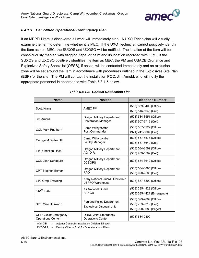
Army National Guard Directorate, Camp Withycombe, Clackamas, Oregon Final Site Investigation Work Plan
AMEC Earth & Environmental, Inc. 6-10 Contract No. W9133L-10-F-0193 K:\GSA Contract\321060179 Camp Withycombe RI SI\SI WP\Final SI WP\Final SI WP.docx
6.4.1.3 Demolition Operational Contingency Plan
If an MPPEH item is discovered all work will immediately stop. A UXO Technician will visually examine the item to determine whether it is MEC. If the UXO Technician cannot positively identify the item as non-MEC, the SUXOS and UXOSO will be notified. The location of the item will be conspicuously marked with flagging, tape, or paint and its location recorded with GPS. If the SUXOS and UXOSO positively identifies the item as MEC, the PM and USACE Ordnance and Explosives Safety Specialist (OESS), if onsite, will be contacted immediately and an exclusion zone will be set around the item in accordance with procedures outlined in the Explosives Site Plan (ESP) for the site. The PM will contact the installation POC, Jim Arnold, who will notify the appropriate personnel in accordance with Table 6.3.1.5 below.
Table 6.4.1.3: Contact Notification List
Name Position Telephone Number
Scott Kranz AMEC PM (503) 639-3400 (Office) (503) 816-6643 (Cell)
Jim Arnold Oregon Military Department Restoration Manager
(503) 584-3551 (Office) (503) 507-9719 (Cell)
COL Mark Rathburn Camp Withycombe Post Commander
(503) 557-5222 (Office) (971) 241-5007 (Cell)
George M. Wilson III Camp Withycombe Facility Manager
(503) 557-5373 (Office) (503) 887-8640 (Cell)
LTC Christian Rees Oregon Military Department AGI-DIR
(503) 584-3592 (Office) (503) 709-5599 (Cell)
COL Leah Sundquist Oregon Military Department DCSOPS (503) 584-3612 (Office)
CPT Stephen Bomar Oregon Military Department PAO
(503) 584-3885 (Office) (503) 990-9508 (Cell)
LTC Greg Browning Army National Guard DirectorateUSPFO Warehouse (503) 557-5300 (Office)
142nd EOD Air National Guard PANGB
(503) 335-4829 (Office) (503) 335-4421 (Emergency)
SGT Mike Unsworth Portland Police Department Explosives Disposal Unit
(503) 823-2089 (Office) (503) 793-9319 (Cell) (503) 920-3080 (Pager)
ORNG Joint Emergency Operations Center
ORNG Joint Emergency Operations Center (503) 584-2800
AGI-DIR - Adjunct General’s Installation Division, Director DCSOPS - Deputy Chief of Staff for Operations and Plans

Army National Guard Directorate, Camp Withycombe, Clackamas, Oregon Final Site Investigation Work Plan
AMEC Earth & Environmental, Inc. Contract No. W9133L-10-F-0193 6-11 K:\GSA Contract\321060179 Camp Withycombe RI SI\SI WP\Final SI WP\Final SI WP.docx
PAO - Public Affairs Office USPFO - U.S. Property and Fiscal Officer EOD - Explosive Ordinance Disposal PANGB - Portland Air National Guard Base ORNG - Oregon National Guard
If a MEC item is fuzed, blow-in-place (BIP) procedures will be followed. Engineering controls consisting of sandbag mitigation, as described in HNC-ED-CS-S-98-7, Use of Sandbags for Mitigation of Fragmentation and Blast Effects due to Intentional Detonation of Munitions (USACE, 1998) will be used for disposal of single munitions to reduce the exclusion zone area to 200 feet. A demolition briefing and schedule will be set with the SUXOS, PM, installation POC, and Post Commander. The MEC subcontractor will provide the blasting caps, donor explosive charges, blasting machine, and license for demolition. The demolition shot will be set up by the MEC subcontractor. After the demolition has been conducted, the area will be inspected by the SUXOS. The SUXOS will provide the “all clear” when appropriate.
If a MEC item is unfuzed and determined safe to move by the SUXOS and UXOSO, the item will moved to a collection point for a consolidated shot following procedures outlined in the MRS’s ESP, and U.S. Army Engineering Support Center, Huntsville (USAESCH) Procedures for Demolition of Multiple Rounds (Consolidated Shots) on OE Sites (USACE, 1998 updated 2000). All explosive operations will be in accordance with the ESP and DoD 6055.9-STD (DoD, 2004).
6.4.2 MC and Waste Constituent Field Activities
The objective of the MC and waste constituent field activities is to obtain sufficient data to evaluate whether the East MRS has been impacted by MC and whether the East MRS disposal areas have been impacted by MC and/or waste constituents. Sample locations will be selected based on the results for the AVE field activities described in Section 6.4.1. Detailed field sampling collection and analysis procedures are described in the FSP (Appendix E) and the UFP-QAPP (Appendix F).
6.4.2.1 East MRS MC Investigation
One 5-point composite soil sample will be collected from each of the eight East MRS MEC investigation meandering transects (T1 - T8) identified on Figure 3. The samples will be analyzed for select explosives and metals by EPA Methods 8330A and 6010/6020, respectively, to evaluate whether the soil has been impacted by MEC.
The results of the AVS of the East MRS (Section 6.4.1.) will be used to identify soil sampling locations. MEC, MD, and subsurface anomaly density data collected from each of the meandering transects will be evaluated to identify one 300-foot segment per transect with the highest potential

Army National Guard Directorate, Camp Withycombe, Clackamas, Oregon Final Site Investigation Work Plan
AMEC Earth & Environmental, Inc. 6-12 Contract No. W9133L-10-F-0193 K:\GSA Contract\321060179 Camp Withycombe RI SI\SI WP\Final SI WP\Final SI WP.docx
concentration of MEC. Visual observation indicating impact areas also will be considered when selecting soil sampling locations. Composite sub-sample locations will be collected at roughly equal intervals (approximately every 60 to 70 feet) along the 300-foot transect segment at a depth not to exceed 12 inches bgs.
6.4.2.2 Disposal Area Investigation
Ten soil samples will be collected from trenches located at the suspected disposal areas. The trenches will be located along AVS transects, in portions of the transects where the results suggest a high density of anomalies and/or surficial observations suggest the presence of extensive waste materials. The trenches will be excavated to the base of the fill material encountered or to the limit of the excavation equipment, a minimum of 8 feet. Soil samples will be collected from soil below the fill material, manually using a shovel or from an excavator bucket. If the limit of the waste is not reached due to limitations of the excavation equipment, observations of waste, including soil staining or odors, will be used to guide soil sampling locations. The soil samples will be used to evaluate whether the soil has been impacted by DMM and/or solid waste, and will be analyzed for the following:
● Metals by EPA Method 6010/6020/7471B
● PAHs by EPA Method 8270C
● VOCs by EPA Method 8260B
● TPH, diesel range, by Method NWTPH-Dx
● Explosives by EPA Method 8330A
6.4.2.3 Groundwater Sampling
One groundwater sample will be collected from each of the eight existing monitoring wells (MW-1 through MW-8). The monitoring wells are located at the base of the East MRS hillside near the south and southwest boundaries (Figure 3) and are screened across the water table. Samples collected from the monitoring wells will be analyzed for the following:
● VOCs by EPA Method 8260B
● TPH by NWTPH-HCID (Hydrocarbon Identification Method);
● Explosives by EPA Method 8330A; and
● Perchlorate by EPA Method 6860.

Army National Guard Directorate, Camp Withycombe, Clackamas, Oregon Final Site Investigation Work Plan
AMEC Earth & Environmental, Inc. Contract No. W9133L-10-F-0193 6-13 K:\GSA Contract\321060179 Camp Withycombe RI SI\SI WP\Final SI WP\Final SI WP.docx
Samples will be used to assess whether groundwater has been impacted by the waste disposed in the disposal areas in the East MRS, which are located up gradient of the monitoring wells.
6.4.2.4 Laboratory Analysis
Soil and groundwater samples collected in the East MRS will be analyzed for MC and waste constituents identified in Table 6.4.2.4. Laboratory requirements for the analytical methods are provided in the UFP-QAPP (Appendix F). The FSP and UFP-QAPP describe the processes and procedures that will be used to ensure that project DQOs will be met.
Table 6.4.2.4: MC and Waste Constituent Sample Analysis
Sample Analytical Method
East MRS Soil Samples
East MRS Disposal areas
Soil Samples
East MRS Disposal areas
Groundwater Samples
Metals EPA Method 6010/6020/7471B X X
Explosives EPA Method 8330A X X X
Perchlorate EPA Method 6860 X
PAHs EPA Method 8270C X
VOCs EPA Method 8260B X X
TPH Diesel NWTPH-Dx X
TPH NWTPH-HCID X

Army National Guard Directorate, Camp Withycombe, Clackamas, Oregon Final Site Investigation Work Plan
AMEC Earth & Environmental, Inc. Contract No. W9133L-10-F-0193 7-1 K:\GSA Contract\321060179 Camp Withycombe RI SI\SI WP\Final SI WP\Final SI WP.docx
7.0 PROJECT MANAGEMENT
7.1 PROJECT SCHEDULE
The tentative schedule for SI field and reporting activities is outlined below.
● SI Field Investigation : 01 August 2011 to 12 August 2011
● Draft SI Report Submission: 26 September 2011
● Final SI Report Submission: 09 January 2012
7.2 KEY PROJECT PERSONNEL
The Camp Withycombe MMRP team consists of stakeholders with direct project involvement and AMEC project personnel. AMEC management personnel will coordinate all project work with the primary stakeholders to achieve the project objectives. The primary POC information for the project team is shown in Table 7.2
Table 7.2: Project Personnel
Role Name Contact Information
Contracting Officer (KO) Pauline Gholson Army National Guard Directorate 1411 Jefferson Davis Hwy Suite 8100 Arlington, VA 22202-3231 (703) 607-1266 [email protected]
ARNG Directorate MMRP Program Manager, Contracting Officer’s Representative (COR)
Kim Harriz Army National Guard Directorate 111 S. George Mason Drive Arlington, VA 22202 (703) 607-7991 [email protected]
OMD Restoration Manager Jim Arnold OMD Joint Force Headquarters OMD Environmental Branch (AGI-E) 1776 Militia Way SE Salem, OR 97309 (503) 584-3551 [email protected]

Army National Guard Directorate, Camp Withycombe, Clackamas, Oregon Final Site Investigation Work Plan
AMEC Earth & Environmental, Inc. 7-2 Contract No. W9133L-10-F-0193 K:\GSA Contract\321060179 Camp Withycombe RI SI\SI WP\Final SI WP\Final SI WP.docx
Role Name Contact Information
DEQ Project Manager Bob Williams Oregon Department of Environmental Quality 2020 SW Fourth Avenue, Suite 400 Portland, OR 97201 (503) 229-5696 [email protected]
AMEC Project Manager Scott Kranz, RG AMEC Earth & Environmental, Inc. 7376 SW Durham Road Portland, OR 97224 (503) 639-3400 [email protected]
AMEC MMRP Technical Review Paula Bond AMEC Earth & Environmental, Inc. 10239 Technology Drive Knoxville, TN 37932 (865) 671-6774 [email protected]
AMEC Senior Scientists Charles Esler, CHMM Leonard Farr, RG
AMEC Earth & Environmental, Inc. 7376 SW Durham Road Portland, OR 97224 (503) 639-3400 [email protected] [email protected]
AMEC Associate Data Quality Managers
Ann Bernhardt Mary Schneider, CQM, CQA
AMEC Earth & Environmental, Inc. 7376 SW Durham Road Portland, OR 97224 (503) 639-3400 [email protected] [email protected]
AMEC SI Coordinator Maya Taylor AMEC Earth & Environmental, Inc. 7376 SW Durham Road Portland, OR 97224 (503) 639-3400 [email protected]
AMEC Senior Geophysicist Raye Lahti, PG AMEC Earth & Environmental, Inc. 47300 Triangle Drive Cable, WI 54821 (715) 794-2889 [email protected]

Army National Guard Directorate, Camp Withycombe, Clackamas, Oregon Final Site Investigation Work Plan
AMEC Earth & Environmental, Inc. Contract No. W9133L-10-F-0193 7-3 K:\GSA Contract\321060179 Camp Withycombe RI SI\SI WP\Final SI WP\Final SI WP.docx
Role Name Contact Information
AMEC SUXOS Scott Sigler AMEC Earth & Environmental, Inc. Midwest Plaza Building, Suite 1200 Minneapolis, MN 55402 (318) 586-3137 [email protected]
AMEC UXOSO AMEC UXOQCS
Rex Andreason AMEC Earth & Environmental, Inc. Midwest Plaza Building, Suite 1200 Minneapolis, MN 55402 (253) 905-4832
AMEC Community Relations Specialist
Mandy Putney EnviroIssues 1515 SW Fifth Avenue, Suite 1022 Portland, OR 97201 (503) 248-9500 [email protected]
The project organizational structure is shown as Figure 7.2.

Army National Guard Directorate, Camp Withycombe, Clackamas, Oregon Final Site Investigation Work Plan
AMEC Earth & Environmental, Inc. 7-4 Contract No. W9133L-10-F-0193 K:\GSA Contract\321060179 Camp Withycombe RI SI\SI WP\Final SI WP\Final SI WP.docx
Figure 7.2: Project Organizational Structure
7.2.1 Army National Guard Directorate
The ARNG Directorate is the lead agency for contracting and execution of the Camp Withycombe MMRP. Ms. Kim Harriz, ARNG Directorate MMRP Program Manager, is the COR and is responsible for providing project scope and direction, review of draft and draft final documents, and coordinating with the USACE Omaha District for review of select documents, as needed.
7.2.2 Oregon Military Department
The OMD is the local installation POC agency. Jim Arnold, OMD Restoration Manager, is the primary POC and is responsible for review of draft and draft final deliverables, coordination with the PAO, and coordination with the ODOT and agency stakeholders.

Army National Guard Directorate, Camp Withycombe, Clackamas, Oregon Final Site Investigation Work Plan
AMEC Earth & Environmental, Inc. Contract No. W9133L-10-F-0193 7-5 K:\GSA Contract\321060179 Camp Withycombe RI SI\SI WP\Final SI WP\Final SI WP.docx
7.2.3 United States Army Corps of Engineers-Omaha District
The USACE-Omaha will provide quality assurance (QA) support for the SI.
7.2.4 Roles and Responsibilities
Roles and responsibilities for each member of the project team are described in Table 7.2.4.
Table 7.2.4: Project Team Roles and Responsibilities
Role Responsibility
KO • Contract administrative authority
COR • Provide project scope and direction
• Review draft and draft final documents
• Coordinate with the USACE Omaha District for review of select documents
OMD Restoration Manager • Primary POC
• Review draft and draft final documents
• Coordinate with the PAO
• Coordinate with ODOT
• Coordinate with project stakeholders
DEQ Project Manager • Regulatory review of SI
AMEC Project Manager • AMEC POC
• Execute project in accordance with budget, schedule, safety, and QA/QC goals
• Manage and submit all project deliverables, project reports, and invoices
• Direct AMEC project team
AMEC MMRP Technical Review • Provides independent technical review of documents
• Reviews QA/QC procedures and project documentation to verify compliance
• Verifies project is completed within MMRP guidance
AMEC Senior Scientist • Provide senior technical guidance and review throughout SI
• Review findings and conclusions of SI
AMEC Associate Data Quality Manager • Review analytical plans and data to ensure data is properly collected, processed, and validated

Army National Guard Directorate, Camp Withycombe, Clackamas, Oregon Final Site Investigation Work Plan
AMEC Earth & Environmental, Inc. 7-6 Contract No. W9133L-10-F-0193 K:\GSA Contract\321060179 Camp Withycombe RI SI\SI WP\Final SI WP\Final SI WP.docx
Role Responsibility
AMEC SI Coordinator • Coordinate project deliverables and team assignments
Senior Geophysicist • Confirm identification/evaluation of items during geophysical clearance activities
• QA/QC of field operations and data
• Select appropriate technologies and tools for use during field investigation
AMEC Senior UXO Supervisor • Execute project in accordance with budget, schedule, safety, and QA/QC goals
AMEC UXOSO/UXOQCS • Ensure compliance with QC plans, SSHP, UXO HASP, UFP-QAPP, and applicable federal, state and local statutes
• Lead daily tailgate meetings
• Enforce staff limits and safety exclusion zones for MEC operation
• Conduct quality control inspections on all UXO and explosives operations
• Directs and approve corrective actions to ensure all OE related work complies with contractual requirements
AMEC Community Relations Specialist • Manage the community relations outreach program
• Facilitates Restoration Advisory Board, if required
7.3 DELIVERABLES
At the conclusion of field activities, an SI Report will be prepared and will include a description of field activities, sampling rationales, analytical results, and AVS results. The SI report will include a discussion of the project objectives, field procedures, and methods of accomplishment, QA/QC, a qualitative description of the number of subsurface anomalies identified, a summary of the MC and waste constituents detected, and a comparison of MC and waste constituents to background and risk-based screening levels.
The SI report will include sufficient information to determine whether a RI or removal action is necessary and to complete the MRSPP.

Army National Guard Directorate, Camp Withycombe, Clackamas, Oregon Final Site Investigation Work Plan
AMEC Earth & Environmental, Inc. Contract No. W9133L-10-F-0193 8-1 K:\GSA Contract\321060179 Camp Withycombe RI SI\SI WP\Final SI WP\Final SI WP.docx
8.0 REFERENCES
AGRA Earth & Environmental, Inc., 1997a. Letter re: Letter Report, Limited Soil Sampling, Clackamas County Parcel, Camp Withycombe, Clackamas, Oregon, dated March 5, 1997.
-----, 1997b. Letter re: Letter Report, Monitoring Well Sampling Event, Camp Withycombe, Clackamas, Oregon, dated May 20, 1997.
-----, 1998. Letter re: Letter Report, June 1998 Monitoring Well Sampling Event, Camp Withycombe, Clackamas, Oregon, dated July 28, 1998.
AMEC Earth & Environmental, Inc. (AMEC), 2004. Revised Data Summary: Camp Withycombe Firing Ranges, Clackamas, Oregon. 29 July 2004.
---- 2006a. Remedial Investigation Report: Camp Withycombe Firing Ranges, Clackamas, Oregon. April 2006.
---- 2006b. Feasibility Study: Camp Withycombe Firing Ranges, Clackamas, Oregon. August 2006.
---- 2006c. Camp Withycombe Former Small Arms Firing Ranges Remedial Investigation Addendum Soil Sampling, Sampling and Analysis Plan. August 2006.
---- 2007. Interim Remedial Action Work Plan, Former Small Arms Firing Ranges Camp Withycombe. November 2007.
---- 2008a. Remedial Investigation Report Addendum: Camp Withycombe Firing Ranges, Clackamas, Oregon. January 2008.
---- 2008b. Focused Feasibility Study: Camp Withycombe Firing Ranges, Clackamas, Oregon. February 2008.
---- 2008d. Wetland Determination and Delineation Report, Camp Withycombe, 10101 SE Clackamas Drive, Clackamas, Oregon. September 2007 and February 2008.
---- 2010. DRAFT Construction Summary Report: Camp Withycombe Former Small Arms Firing Ranges, Clackamas, Oregon. March 2010.

Army National Guard Directorate, Camp Withycombe, Clackamas, Oregon Final Site Investigation Work Plan
AMEC Earth & Environmental, Inc. 8-2 Contract No. W9133L-10-F-0193 K:\GSA Contract\321060179 Camp Withycombe RI SI\SI WP\Final SI WP\Final SI WP.docx
Applied Archeological Research (AAR), 2000. Evaluations of Select Historical Resources at Two Oregon Army National Guard Facilities: The Delaura Beach Road Complex, Camp Rilea, Clatstop County, and The Firing Ranges, Camp Withycombe, Clackamas County. 30 November 2000.
Century West Engineering Corporation, 1994. Remedial Action Plan, Camp Withycombe Firing Ranges, Clackamas, Oregon. 31 January 1994.
Dames & Moore, 1991. Limited Site Investigation, Camp Withycombe, Clackamas, Oregon. 12 July 1991.
Department of Defense (DoD), 2004. DOD 6055.9-STD, DOD Ammunition and Explosives Safety Standards. 5 October 2004.
EA Engineering, Science, and Technology, Inc., 2008. DRAFT State/Territory Inventory report: National Guard Bureau Non-Department of Defense Owned Non-Operational Defense Sites Inventory: Oregon. December 2008.
Hart Crowser, 1995a. Site Investigation, Camp Withycombe Firing Ranges, Clackamas, Oregon. 30 August 1995.
---- 1995b. Firing Ranges Treatability Study, Camp Withycombe, Clackamas, Oregon. 17 November 1995.
---- 1996a. Remedial Action Report, Camp Withycombe Landfill, Clackamas. 28 February 1996.
---- 1996b. Additional Site Characterization Report, Camp Withycombe Firing Ranges Clackamas, Oregon, prepared for ODOT and OMD. 28 June 1996.
Heramb, R.M. and B.R. McCord, 2002. The Manufacture of Smokeless Powders and their Forensic Analysis: A Brief Review. Forensic Science Communications, April 2002, Volume 4 Number 2.
Morgan, D.S., and McFarland, W.D., 1996. U.S. Geological Survey Water-Supply Paper 2470-B: Simulation analysis of the ground-water flow system in the Portland Basin, Oregon and Washington, 83 p.
National Resource Conservation Service (NRCS), U.S. Department of Agriculture, 2007. Pacific Northwest Soil Survey Data. Oregon Soil Survey Data. Website queried for Clackamas Soil Survey accessed at website http://www.or.nrcs.usda.gov/pnw_soil/or_data.html

Army National Guard Directorate, Camp Withycombe, Clackamas, Oregon Final Site Investigation Work Plan
AMEC Earth & Environmental, Inc. Contract No. W9133L-10-F-0193 8-3 K:\GSA Contract\321060179 Camp Withycombe RI SI\SI WP\Final SI WP\Final SI WP.docx
Oregon Climate Service, 2009; www.ocs.orst.edu.
Oregon Department of Environmental Quality (DEQ), 2011. Environmental Cleanup Site Information (ECSI) Database, Temco Metal Products Co., Site ID 1148. Accessed July 2011.
Oregon State Rifle Range, 1953. Hand -drafted map available from Oregon State Archives.
Oregon Military Department (OMD), 2004. History of the Clackamas Armory and Building Complex 6410-6410A-6415 at Camp Withycombe and the Occupying National Guard Unit. April 2004.
---- 2007. Integrated Cultural Resources Management Plan For the Oregon Army National Guard. 15 March 2007.
---- 2009. Preliminary Assessment, Oregon Army National Guard, Camp Withycombe. December 2009.
Oregon National Guard, office of the Commanding General, Salem. Report on Target Range Data. 27 January 1931.
Oregon National Guard, office of the Commanding General, Salem. Report on Target Range Data. 26 February 1934
Oregon State Archives, 1924. Unnamed map, 1924 by Major Leo J.W.Pironi. 1924.
Oregon State Archives, 1953. Hand-drafted map. 1953.
Oregon State Archives, 1956. Quitclaim Deed. 1956.
Oregon State University, 2006. Guide to Reforestation in Oregon. 2006.
Report on Target Range Data, 1931; available from Oregon State Archives.
Report on Target Range Data, 1934; available from Oregon State Archives.
Swanson, R.D., W.D. McFarland, J.B., Gonthier, and J.M Wilkinson, 1993. A Description of Hydrologic Units in the Portland Basin, Oregon and Washington, U.S. Geological Survey, Water-Resources Investigation Report 90-4196.

Army National Guard Directorate, Camp Withycombe, Clackamas, Oregon Final Site Investigation Work Plan
AMEC Earth & Environmental, Inc. 8-4 Contract No. W9133L-10-F-0193 K:\GSA Contract\321060179 Camp Withycombe RI SI\SI WP\Final SI WP\Final SI WP.docx
U.S. Army Corps of Engineers (USACE), 1998. HNC-ED-CS-S-98-7, Use of Sandbags for Mitigation of Fragmentation and Blast Effects due to Intentional Detonation of Munitions, August 1998
---- 2000. Engineer Manual 1110-1-4009 Engineering and Design: Ordnance and Explosives Response. 23 June 2000.
---- 2003. Engineering Manual 1110-1-1200, Conceptual Site Models for Ordnance and Explosives, and Hazardous, Toxic, and Radioactive Waste Projects.
---- 2004. EP 75-1-2, MEC Support During Hazardous, Toxic, and Radioactive Waste and Construction Activities.
United States Army Engineering Support Center, Huntsville (USAESCH), 1998. Procedures for Demolition of Multiple Rounds (Consolidated Shots) on OE Sites, August 1998 (updated 2000).
U.S. Environmental Protection Agency (EPA), 2000. Data Quality Objectives Process for Hazardous Waste Site Investigations. EPA QA/G-4HW. EPA Office of Environmental Information. EPA/600/R-00/007, January 2000.
---- 2010. data accessed for Northwest Pipe and Casing Company at website http://yosemite.epa.gov/r10/cleanup.nsf/7780249be8f251538825650f0070bd8b/9e54c11c1b2099828825651a005f5539!OpenDocument
United States Geological Survey, 1984. 7.5 Minute Quadrangle, Gladstone, Oregon.
United States Geological Survey (USGS), 2000

FIGURES

PROJECT AREA
7376 SW Durham RoadPortland, OR, U.S.A. 97224
AMEC Earth & Environmental
1 inch = 2,000 feet
TITLE:
PROJECT:
DWN BY:
CHK'D BY:
PROJECTION: SCALE:
REV. NO.:
DATUM: DATE:
PROJECT NO.:
FIGURE No.:
PM
SS
WGS84
UTM ZONE 10N
PROJECT AREA JULY 2011
321060179.00021
1
CAMP WITHYCOMBE10101 SE CLACKAMAS ROAD
CLACKAMAS, OREGON
CLIENT:
0 2,000 4,0001,000
Feet I
K:\GSA Contract\321060179 Camp Withycombe RI SI\dwg\_SI\Figure 1 - Project Area_SI.mxd
FINALNo warranty is made by the State/Territory/National GuardBureauas to the accuracy, reliability, or completeness ofthese data for individual use or aggregate use with otherdata. This map is a"living document", in that it is intended tochange as new data become available and is incorporatedinto the Enterprise GIS database.
ARMY NATIONALGUARD DIRECTORATE

MOUNTTALBERT
WEST MRSCAMP WITHYCOMBE
AREA
WEST MRS SUNRISE HIGHWAY CORRIDOR AREA
EAST MRS
7376 SW Durham RoadPortland, OR, U.S.A. 97224
AMEC Earth & Environmental
1 inch = 1,000 feet
TITLE:
PROJECT:
DWN BY:
CHK'D BY:
PROJECTION: SCALE:
REV. NO.:
DATUM: DATE:
PROJECT NO.:
FIGURE No.:
PM
SS
WGS84
UTM ZONE 10N
MRS LOCATION MAP JULY 2011
321060179.00021
2
CAMP WITHYCOMBE10101 SE CLACKAMAS ROAD
CLACKAMAS, OREGON
CLIENT:
0 1,000 2,000500
Feet I
K:\GSA Contract\321060179 Camp Withycombe RI SI\dwg\_SI\Figure 2 - MRS Location Map_SI.mxd
FINAL
No warranty is made by the State/Territory/National GuardBureauas to the accuracy, reliability, or completeness ofthese data for individual use or aggregate use with otherdata. This map is a"living document", in that it is intended tochange as new data become available and is incorporatedinto the Enterprise GIS database.
ARMY NATIONALGUARD DIRECTORATE
LEGENDWetland

!!
!!
!!
!!
!!
!!
!!
!!
!!
!!
!!
!!
!!
!!
!!
!!
!!
!!
!!
!!
!!
!!
!!
!!
!!
!!
!!
!!
!!
!!
!!
!
!!
!!
!!
!!
!!
!!
!!
!
!!
!!
!!
!!
!!
!!
!!
!!
!!
!!
!!
!!
!!
!!
!!
!!
!
+U
+U +U
+U
+U
+U
+U
+U
WEST MRSSUNRISE HIGHWAYCORRIDOR AREA
EAST MRS
T1 T2 T8T3 T4 T6 T7T5
DAS02
DAW02
DACB02DACB01
DAN02
DAS03
DAS01
DAW03
DAE05DAE06
DAW04
DAS04
DAE02
DAW07
DAE13
DAW08
DAE07
DAW01
DAW11DAW09
DAW10
DACA02
DAW12DAW06
DAW13
DAE03
DAN03
DAW05
DAE04
DAE12
DAE08
DAE01
DAE11
DACB03
DAE09
DAE10
DAE14
DAN01
DACA03
DACA01MW-6
MW-8
MW-5
MW-7
MW-4
MW-1MW-2MW-3
7376 SW Durham RoadPortland, OR, U.S.A. 97224
AMEC Earth & Environmental
1 inch = 600 feet
TITLE:
PROJECT:
DWN BY:
CHK'D BY:
PROJECTION: SCALE:
REV. NO.:
DATUM: DATE:
PROJECT NO.:
FIGURE No.:
PM/SD
SS
WGS84
UTM ZONE 10N
EAST MRS JULY 2011
321060179.00021
3
CAMP WITHYCOMBE10101 SE CLACKAMAS ROAD
CLACKAMAS, OREGON
CLIENT:
0 600 1,200300
Feet I
K:\GSA Contract\321060179 Camp Withycombe RI SI\dwg\_SI\Figure 3 - East MRS_SI.mxd
FINAL
No warranty is made by the State/Territory/National GuardBureauas to the accuracy, reliability, or completeness ofthese data for individual use or aggregate use with otherdata. This map is a"living document", in that it is intended tochange as new data become available and is incorporatedinto the Enterprise GIS database.
LEGEND! !
Approximate Location of Meandering Transect(300' spacing)
East MRS Meandering Transect Number
Approximate Location of Meandering Transect(100' spacing)
Suspect Disposal Areas (9.54 acres)
Disposal Area Meandering Transect Number
East MRS Roads
+U Monitoring Well
! Monitoring Well ID
M49A2 60mm HE MortarSurface Danger Zone
T1 DAW01 MW-1
ARMY NATIONALGUARD DIRECTORATE

Source Area Access MEC Location/Release Mechanisms Activity Receptors
East MRS
Access Available
No Access1
MEC at Surface
Frost HeaveErosion
Soil DisturbanceHydrologic Effects
Recreational Trespassers
Complete Pathway
Incomplete Pathway
Potentially Complete Pathway
Not Applicable
East MRS Conceptual Site ModelMEC Exposure Pathway Analysis Figure 4
K:\GSA Contract\321060179 Camp Withycombe RI SI\dwg\_SI
MEC inSubsurface
Intrusive
Handle/TreadUnderfoot
Occupational
X
NA NA
X
X
NA
NA
1All areas determined to be accessible
ConstructionWorker
NA
X

Source Area Source Media ReleaseMechanisms
ExposureMedia
ExposureRoutes Receptors
East MRS Soil
Hydrologic EffectsRunoff
Hydrologic EffectsInfiltration
Food Chain
Surface Water/Sediment
Groundwater
Surface Soil(0-2 Feet)
Subsurface Soil(>2 Feet)
VegetationDomestic AnimalsGame/Fish/Prey
Ingestion/UptakeDermal ContactInhalation (Vapor)
Recreational
Ingestion/UptakeDermal ContactInhalation (Dust)
Ingestion/UptakeDermal ContactInhalation (Dust)
Trespassers Biota
Complete Pathway
Incomplete Pathway
Potentially Complete Pathway
East MRS Conceptual Site Model MC and Waste Constituent Exposure Pathway Analysis Figure 5
Occupational
K:\GSA Contract\321060179 Camp Withycombe RI SI\dwg\_SI
Ingestion/UptakeDermal Contact
X
XX
XX
X X
XX
XXX
X
XX
X
X
X
XX
XX X
X
ConstructionWorker
XX
X
XXX


![Civil 20procedure 20final Pals[1]](https://static.fdocuments.in/doc/165x107/55cf8ccb5503462b138fbd25/civil-20procedure-20final-pals1.jpg)