Final report RS 2016:07e - · PDF file1.9 Route planning ... Final report RS 2016:07e ......
47
Final report RS 2016:07e VICTORIA – Running aground at Fladen, Halland County, den 19 September 2015 File no. S-172/15 02/09/2016
-
Upload
nguyenthien -
Category
Documents
-
view
225 -
download
4
Transcript of Final report RS 2016:07e - · PDF file1.9 Route planning ... Final report RS 2016:07e ......
Final report RS 2016:07e
VICTORIA – Running aground at Fladen,
Halland County, den 19 September 2015
File no. S-172/15
02/09/2016

RS 2016:07e
Postadress/Postal address Besöksadress/Visitors Telefon/Phone Fax/Facsimile E-post/E-mail Internet
P.O. Box 12538 Sveavägen 151 +46 8 508 862 00 +46 8 508 862 90 [email protected] www.havkom.se
SE-102 29 Stockholm Stockholm
Sweden
SHK investigates accidents and incidents from a safety perspective. Its in-
vestigations are aimed at preventing a similar event from occurring again, or
limiting the effects of such an event. However, it is not the purpose of SHK
investigations to apportion blame or liability, whether criminal, civil or ad-
ministrative.
The report is also available on our website: www.havkom.se
ISSN 1400-5735
This document is a translation of the original Swedish report. In case of
discrepancies between this translation and the Swedish original text, the
Swedish text shall prevail in the interpretation of the report.
Illustrations in SHK's reports are protected by copyright. Unless otherwise
stated, SHK is the copyright owner.
With the exception of the SHK logo and figures, images or maps to which a
third party owns copyright, reports are made available under the Creative
Commons Attribution 2.5 Sweden licence. This means that reports may be
copied, redistributed and adapted, provided that the work is attributed to
SHK. This may, for example, be done in the following way: “Source: The
Swedish Accident Investigation Authority”.
Where it is noted next to diagrams, images, maps or other material in the
report that the copyright holder is another party, that party's permission is
required for re-use of the material.
Cover image three – Photo: Anders Sjödén/Swedish Armed Forces.

RS 2016:07e
Contents
General observations ...................................................................................................... 5
The investigation ............................................................................................................ 5
SUMMARY ....................................................................................................... 8
1. FACTUAL INFORMATION .......................................................................... 10
1.1 Course of Events .............................................................................................. 10 1.1.1 Conditions ............................................................................................ 10 1.1.2 The voyage .......................................................................................... 11 1.1.3 Measures carried out after running aground ........................................ 16
1.2 Injuries to persons ............................................................................................ 17 1.3 Oil spillage ....................................................................................................... 17 1.4 Damage to the vessel ....................................................................................... 17 1.5 The vessel ........................................................................................................ 18
1.5.1 General ................................................................................................ 18 1.5.2 The bridge ............................................................................................ 18 1.5.3 VDR ..................................................................................................... 19
1.6 Crew ................................................................................................................. 19 1.6.1 General ................................................................................................ 19
1.7 The fairway ...................................................................................................... 20 1.7.1 General ................................................................................................ 20 1.7.2 Accident site ........................................................................................ 22 1.7.3 VTS areas ............................................................................................ 23
1.8 Safety management for the vessel and shipping company............................... 25 1.8.1 General ................................................................................................ 25 1.8.2 Safety of navigation instructions ......................................................... 25 1.8.3 Emergency preparedness ..................................................................... 27
1.9 Route planning ................................................................................................. 27 1.10 Meteorological information ............................................................................. 28 1.11 Rescue operation .............................................................................................. 29 1.12 Regulations and supervision ............................................................................ 32
1.12.1 Route planning ..................................................................................... 32 1.12.2 Watchkeeping ...................................................................................... 32 1.12.3 International Regulations for Preventing Collisions at Sea ................. 33 1.12.4 VDR ..................................................................................................... 33 1.12.5 Reporting of incidents and accidents at sea ......................................... 33 1.12.6 Regulations for hours of work and rest at sea...................................... 34
1.13 Company organisation and management ......................................................... 35 1.14 Fatigue ............................................................................................................. 35
1.14.1 Assessment of fatigue .......................................................................... 36 1.15 Distraction ........................................................................................................ 36
2. ANALYSIS ...................................................................................................... 38
2.1 Navigation in connection with running aground .............................................. 38 2.2 Why did the vessels deviation from the planned course go unnoticed? .......... 39 2.3 Management ..................................................................................................... 40 2.4 Route planning ................................................................................................. 41
2.4.1 General ................................................................................................ 41 2.4.2 Pilot...................................................................................................... 42 2.4.3 The route .............................................................................................. 42 2.4.4 Speed, etc. ............................................................................................ 42
RS 2016:07e
4 (47)
2.4.5 Overall assessment .............................................................................. 43 2.5 Bridge equipment ............................................................................................ 43 2.6 Emergency management ................................................................................. 43
3. CONCLUSIONS ............................................................................................. 44
3.1 Findings of the investigation ........................................................................... 44 3.2 Causes .............................................................................................................. 45
4. MEASURES TAKEN ..................................................................................... 45
4.1 Venturi Fleet Management .............................................................................. 45 4.2 The Danish Maritime Authority ...................................................................... 45 4.3 The Swedish Maritime Administration ........................................................... 46
5. SAFETY RECOMMENDATIONS ................................................................ 47

RS 2016:07e
5 (47)
General observations
The Swedish Accident Investigation Authority (Statens haverikommission –
SHK) is a state authority with the task of investigating accidents and incidents
with the aim of improving safety. SHK accident investigations are intended to
clarify, as far as possible, the sequence of events and their causes, as well as
damages and other consequences. The results of an investigation shall provide
the basis for decisions aiming at preventing a similar event from occurring in
the future, or limiting the effects of such an event. The investigation shall also
provide a basis for assessment of the performance of rescue services and, when
appropriate, for improvements to these rescue services.
SHK accident investigations thus aim at answering three questions: What hap-
pened? Why did it happen? How can a similar event be avoided in the future?
SHK does not have any supervisory role and its investigations do not deal with
issues of guilt, blame or liability for damages. Therefore, accidents and inci-
dents are neither investigated nor described in the report from any such per-
spective. These issues are, when appropriate, dealt with by judicial authorities
or e.g. by insurance companies.
The task of SHK also does not include investigating how persons affected by
an accident or incident have been cared for by hospital services, once an emer-
gency operation has been concluded. Measures in support of such individuals
by the social services, for example in the form of post crisis management, also
are not the subject of the investigation.
The investigation
SHK was informed on 20 September 2015 that a serious marine casualty
involving VICTORIA with registration D5IK5, IMO 9129029, had occurred at
Fladen, 19 September 2015 at 18:15.
The accident has been investigated by SHK represented by Mr. Mikael Karani-
kas, Chairperson, Mr. Rikard Sahl, Investigator in Charge, Mr. Dennis Dahl-
berg, Operations Investigator and Mr. Alexander Hurtig, investigator with
specialisation in behavioural sciences.
Mr. Patrik Jönsson has participated as coordinator for The Swedish Transport
Agency and Mr. Ulf Holmgren as coordinator for the Swedish Maritime
Administration.
Investigation material
Interviews have been conducted with the crew aboard VICTORIA, DPA (Des-
ignated Person Ashore) at Venturi Fleet Management, the pilot of VICTORIA
at the time it departed Rostock and the pilot who assisted VICTORIA from the
site where it ran aground to Halmstad.
Documentation has been obtained from the vessel and the shipping company.
RS 2016:07e
6 (47)
A meeting with the interested parties was held on 12 May 2016. At the meeting
SHK presented the facts discovered during the investigation, available at the
time.
Limitations
SHK has noted that the European Maritime Safety Agency (EMSA) has since
2006 investigated, among other things, quality assurance of schools in the Phil-
ippines that provide STCW1 training and the course content for training at
”management level”. During the investigations, certain shortcomings have
been noted, including the introduction of audit plans and follow-up measures,
as well as course content for “management level”. The European Commission
has notified the Philippines about these shortcomings and has continuously
conducted discussions on plans to implement measures and also followed these
up. EMSA has carried out five follow-up audits and plans to return early 2017.
In this investigation, SHK has found no reason to further investigate whether
the quality of the crew members’ training carried out in the Philippines has
been a contributory factor to the event.
1 STCW - International Convention on Standards of Training, Certification and Watchkeeping for Seafar-
ers.
RS 2016:07e
7 (47)
Final report RS 2016:07e
Vessel data
Flag state/Register of Shipping Liberia
Identity VICTORIA
IMO number/call sign 9129029 / D5IK5
Vessel data
Type of vessel Bulk carrier
Port/year of construction Daedong Shipbuilding, 1997
Registered tonnage 27,792
Length overall 190 metres
Breadth 32 metres
Draught, max 11.62 metres
Deadweight at max draught 46,931 tons
Main engine, output Hyundai-MAN B&W 6S50MC MK6, 8561
kW
Propulsion system Fixed propeller
Bowthruster No
Rudder system Conventional
Service speed 14 knots
Ownership and management Lasting Asset Limited , owner / Venturi Fleet
Management
Classification society Bureau Veritas
Information on the voyage Ports of call Rostock, Germany – Conakry, Guinea
Type of journey International
Cargo information 35,852 tons of wheat
Crew 23
Information on marine casualty Type of marine casualty Grounding
Date and time 2015-09-19 18:15 local time
Position of the marine casualty 57˚10,78N 011˚44,44E
Weather Wind: V 7-10m/s
Consequences
Injuries to persons None
Environment None known
Vessel Hull damage, lost rudder
RS 2016:07e
8 (47)
SUMMARY
The bulk carrier VICTORIA departed Rostock 18 September, 2015 at 22:48
local time, loaded with a total of 35,852 tons of wheat. The vessel had a
draught of 10.1 meters at the time of departure. The master had decided that the
able seaman on duty would hand-steer the vessel until it had passed Skagen.
The planned route went from Rostock via the Route T further via the Route H
in the Great Belt and then the Route T back through the Great Belt and the
Kattegat.
On September 19, 2015 around 18:15, the vessel ran aground at Fladen and
received extensive hull damage. No persons were injured and there was no
damage to the environment.
The investigation has shown that the vessel, after passing the buoy 6 in the
Route T, deviated from its intended course, which was not noticed by the
officer on watch. The officer on watch had eight hours of rest divided into two
four-hour periods the last 24-hour period before the grounding. The officer on
watch also monitored the crew that was foaming the hatches on the cargo deck
while he alone was responsible for watch keeping on the bridge. Just before the
grounding the master, chief engineer and electrician came up to the bridge to
discuss trial run of the ship's cranes with the responsible officer on watch.
The grounding occurred due to a lack of adequate attention to navigational
tasks, which in turn was due to distractions caused by other duties, likely in
combination with fatigue, which meant that the vessels course and position
were not followed.
An underlying cause was inadequate resource planning in terms of the deck
officers duties over the first 24 hours after departure from Rostock.
During the investigation it was also noted that the vessel passed near a 10.4
meter reef in the Route H which was not marked with buoys, and that there
have been shortcomings in the route planning.
The company has after the accident, inter alia, decided to equip the company´s
vessels with ECDIS and to revise and supplement the ISM manual and its
safety management system (SMS).
The Swedish Maritime Administration has after the accident, placed a light
buoy west of Fladen.
SHK recommends the Danish Maritime Authority to consider and evaluate the
buoyage along Route H.
RS 2016:07e
9 (47)
Safety recommendations
In light of the measures taken by Venturi Fleet Management and the Swedish
Maritime Administration, SHK has decided not to issue recommendations to
these operators.
The Danish Maritime Authority is recommended to:
Consider and evaluate the buoyage along Route H with this report in
mind. See section: 2.4.3. (RS 2016:07 R1)
RS 2016:07e
10 (47)
1. FACTUAL INFORMATION
1.1 Course of Events
1.1.1 Conditions
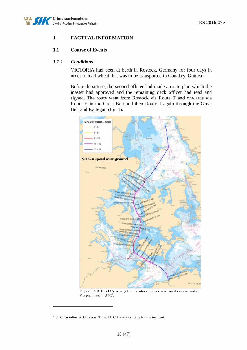
VICTORIA had been at berth in Rostock, Germany for four days in
order to load wheat that was to be transported to Conakry, Guinea.
Before departure, the second officer had made a route plan which the
master had approved and the remaining deck officer had read and
signed. The route went from Rostock via Route T and onwards via
Route H in the Great Belt and then Route T again through the Great
Belt and Kattegatt (fig. 1).
Figure 1. VICTORIA’s voyage from Rostock to the site where it ran aground at
Fladen, times in UTC2.
2 UTC Coordinated Universal Time. UTC + 2 = local time for the incident.
SOG = speed over ground
RS 2016:07e
11 (47)
1.1.2 The voyage
The vessel left Rostock on 18 September at 22:48 local time, loaded
with a total 35,852 tons of wheat. The vessel had a draught of 10.1
metres at the time of departure. The master had decided that the able
seaman on duty would hand-steer the vessel until it had passed
Skagen. The master thus planned for the vessel to be operated without
a dedicated lookout on the bridge in the relatively difficult to navigate
and heavily trafficked route between Rostock and Skagen.
According to the pilot on board VICTORIA when it departed Rostock,
all equipment on the bridge was in good condition. Rudder and engine
manoeuvring was also functioning satisfactorily.
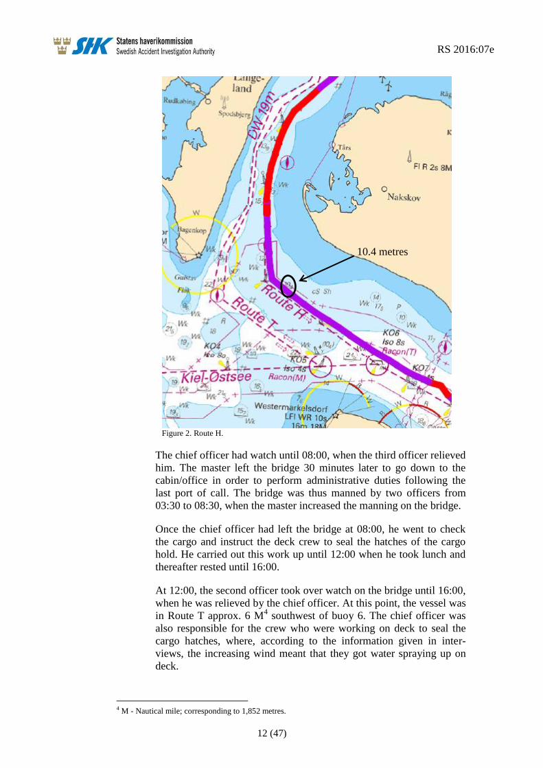
Two hours before the vessel arrived at the pilot boarding position
north of buoy 7 in Route H (fig. 2), the master contacted DanPilot3
and requested a pilot through the Great Belt and further up to Skagen
as the master believed the passage through the Great Belt entailed
compulsory pilotage for VICTORIA. There was however no pilot
available at the time. During the conversation, however, the master
was informed that pilotage was not compulsory and the master thus
decided to continue the voyage without a pilot.
The pilot from Rostock left VICTORIA at 00:12.
Soon thereafter, the master also left the bridge and the second officer
took over duty. Three hours later, the master returned to the bridge to
assist the second officer. At 04:00, bridge watch changed watch and
the chief officer took over the bridge watch from the second officer.
Approximately 10 minutes later, just before buoy 7 in Route H,
VICTORIA passed close to a 10.4-metre unmarked reef (fig. 2).
3 DanPilot – Denmark's pilots. They provide pilotage through the Great Belt.
RS 2016:07e
12 (47)
Figure 2. Route H.
The chief officer had watch until 08:00, when the third officer relieved
him. The master left the bridge 30 minutes later to go down to the
cabin/office in order to perform administrative duties following the
last port of call. The bridge was thus manned by two officers from
03:30 to 08:30, when the master increased the manning on the bridge.
Once the chief officer had left the bridge at 08:00, he went to check
the cargo and instruct the deck crew to seal the hatches of the cargo
hold. He carried out this work up until 12:00 when he took lunch and
thereafter rested until 16:00.
At 12:00, the second officer took over watch on the bridge until 16:00,
when he was relieved by the chief officer. At this point, the vessel was
in Route T approx. 6 M4 southwest of buoy 6. The chief officer was
also responsible for the crew who were working on deck to seal the
cargo hatches, where, according to the information given in inter-
views, the increasing wind meant that they got water spraying up on
deck.
4 M - Nautical mile; corresponding to 1,852 metres.
10.4 metres
RS 2016:07e
13 (47)
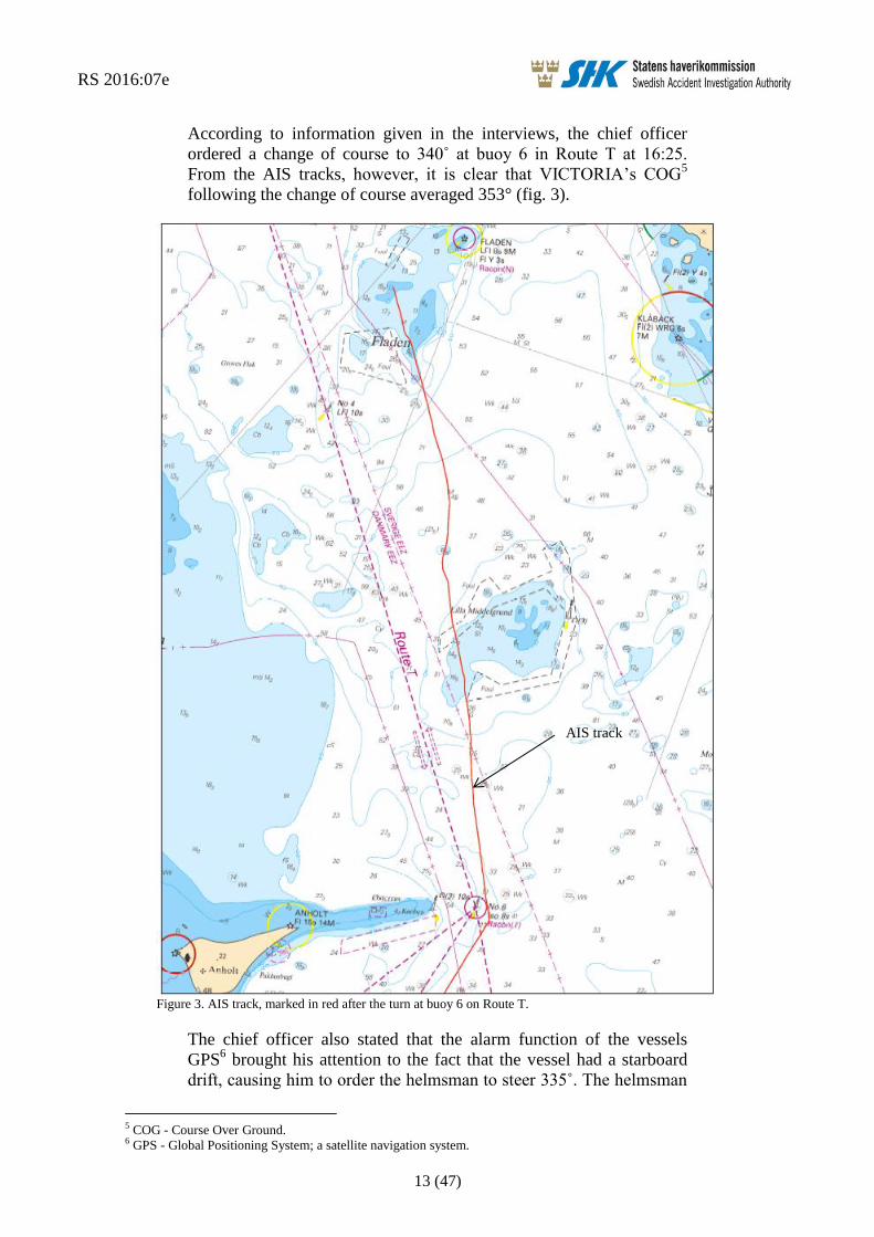
According to information given in the interviews, the chief officer
ordered a change of course to 340˚ at buoy 6 in Route T at 16:25.
From the AIS tracks, however, it is clear that VICTORIA’s COG5
following the change of course averaged 353° (fig. 3).
Figure 3. AIS track, marked in red after the turn at buoy 6 on Route T.
The chief officer also stated that the alarm function of the vessels
GPS6 brought his attention to the fact that the vessel had a starboard
drift, causing him to order the helmsman to steer 335˚. The helmsman
5 COG - Course Over Ground. 6 GPS - Global Positioning System; a satellite navigation system.
AIS track

RS 2016:07e
14 (47)
has stated that he was ordered to steer 330° due to strong currents in
the area. It was this course that the helmsman steered throughout his
entire time on the bridge. According to the chief officer, he checked
the vessels position at 17:00 and marked the position on the naviga-
tional chart (fig. 4). According to the crew, the radar was not useful as
an aid to navigation due to the distance from land and clutter7. The
navigational instrument that he relied on was the vessels GPS.
The chief officer has stated that he did not check the course steered by
the helmsman on the gyrocompass.
Figure 4. VICTORIA’s navigational chart for the voyage with fixed positions, indicated by the blue rings.
The position fix at 18:00 was made after the accident. The arrow shows the average AIS track (fig. 3).
Thereafter, the third officer and an able seaman came to the bridge to
relieve the chief officer and the helmsman so that they could eat their
dinner. At this point, the chief officer stated that the vessel was to
steer 335° due to starboard drift. After just over 20 minutes’ break, the
chief officer and the helmsman returned to the bridge, having eaten
dinner. The third officer informed the chief officer that the drift had
increased but that he had not changed course or marked a position on
7 Clutter is a term used for unwanted echoes, particularly in radar systems, caused by reflections from
waves on the water’s surface, rain, etc. Clutter can cause serious performance problems in radar sys-
tems.
17:00
18:00
18:00
AIS track
RS 2016:07e
15 (47)
the navigational chart. The third officer has also stated that he did not
check the course steered by the helmsman on the gyrocompass.
From the AIS track (fig. 3), it is clear that the vessel performed a
change of course to port by approx. 10° around 10 minutes after the
chief officer had taken over bridge watch following his dinner break.
Just a few minutes thereafter, there was a drastic change of course to
starboard by approx. 25°. The vessel held this course for around 10
minutes, to then steer to starboard yet again, now changing course by
approx. 20° in a slower turn which ended on a course of 345°; a
course which the vessel essentially held until it ran aground.
Shortly after the chief officer had returned to the bridge, the master,
the chief engineer and the electrician came up to the bridge to discuss
with the chief officer the matter of performing a test run of the vessels
cranes before arrival at Conakry, Guinea some 12 days later. How-
ever, the master did not participate in the navigation during the time
he was on the bridge.
The chief officer has stated that he neither saw the buoys in Route T
nor the Fladen lighthouse on the radar. At around 18:15, severe shak-
ing and vibrations were felt on board VICTORIA. The chief officer
began immediately to check the vessels position, but before he
obtained a fixed position, VICTORIA ran hard aground at a speed of
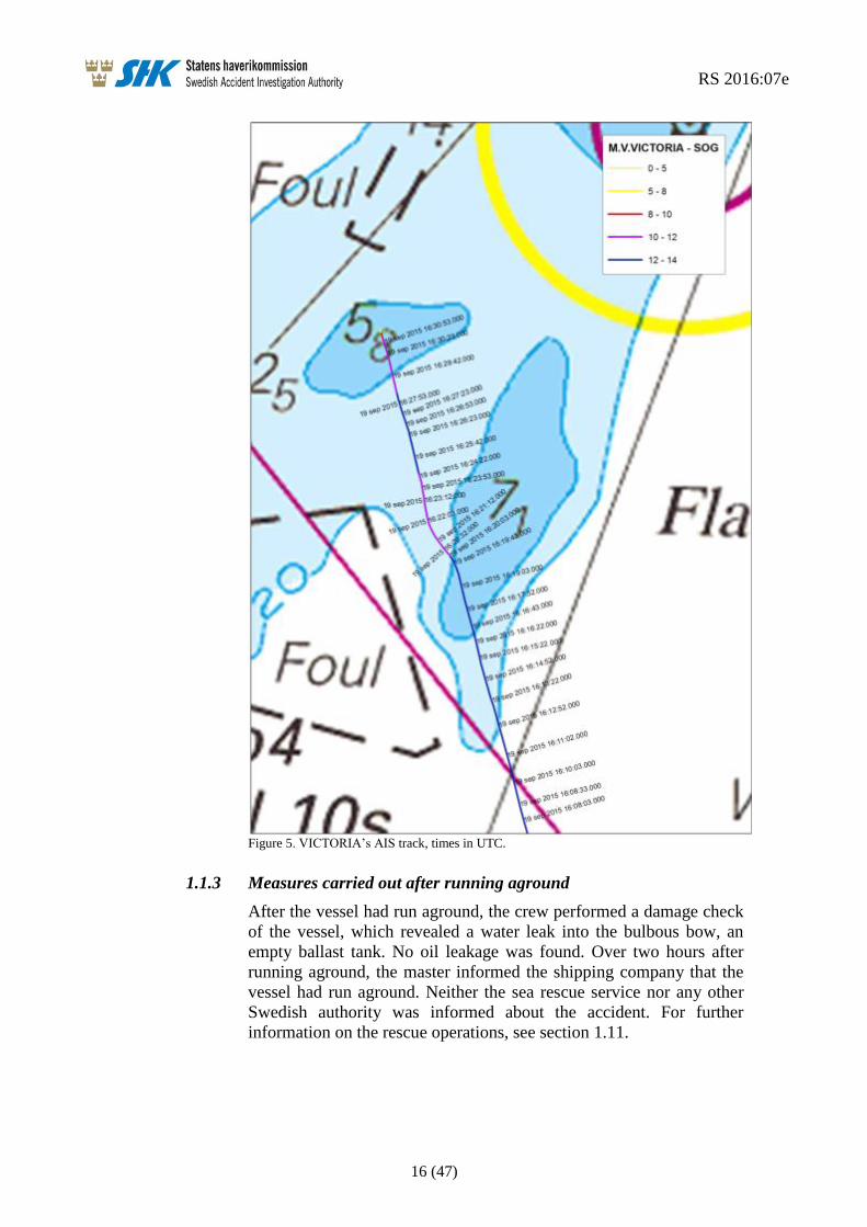
12.2 kts (fig. 5), with the chief officer, helmsman, master, chief engi-
neer and electrician still on the bridge.
RS 2016:07e
16 (47)
Figure 5. VICTORIA’s AIS track, times in UTC.
1.1.3 Measures carried out after running aground
After the vessel had run aground, the crew performed a damage check
of the vessel, which revealed a water leak into the bulbous bow, an
empty ballast tank. No oil leakage was found. Over two hours after
running aground, the master informed the shipping company that the
vessel had run aground. Neither the sea rescue service nor any other
Swedish authority was informed about the accident. For further
information on the rescue operations, see section 1.11.
RS 2016:07e
17 (47)
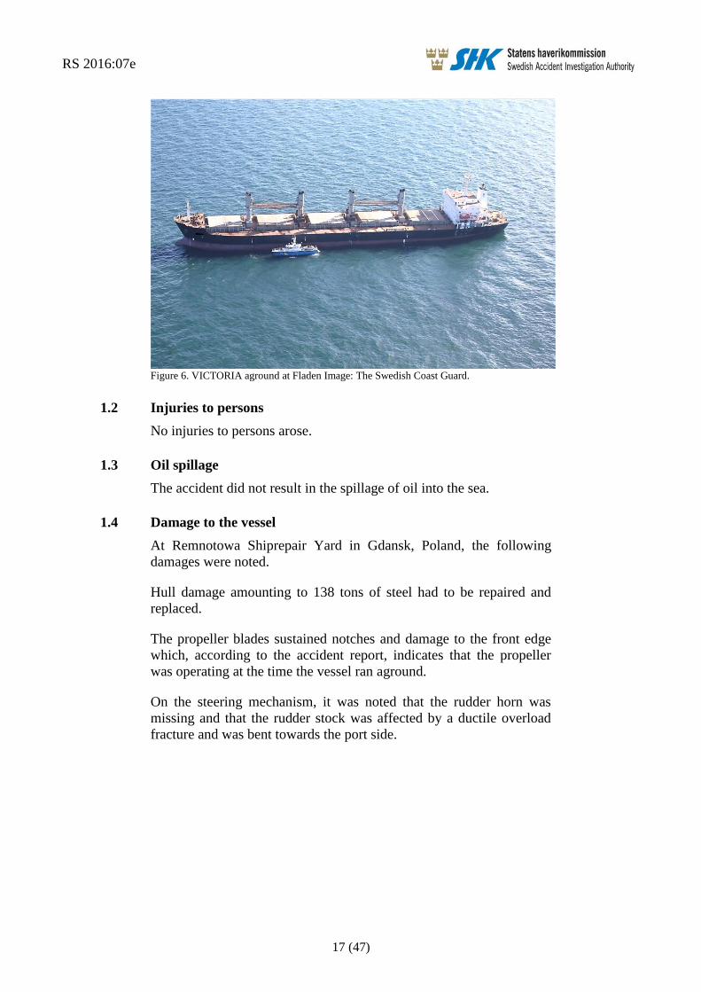
Figure 6. VICTORIA aground at Fladen Image: The Swedish Coast Guard.
1.2 Injuries to persons
No injuries to persons arose.
1.3 Oil spillage
The accident did not result in the spillage of oil into the sea.
1.4 Damage to the vessel
At Remnotowa Shiprepair Yard in Gdansk, Poland, the following
damages were noted.
Hull damage amounting to 138 tons of steel had to be repaired and
replaced.
The propeller blades sustained notches and damage to the front edge
which, according to the accident report, indicates that the propeller
was operating at the time the vessel ran aground.
On the steering mechanism, it was noted that the rudder horn was
missing and that the rudder stock was affected by a ductile overload
fracture and was bent towards the port side.

RS 2016:07e
18 (47)
1.5 The vessel
1.5.1 General
The bulk carrier VICTORIA was built in South Korea in 1997. The
vessel has five cargo holds with a total capacity of 58,740 m3. On
deck, the vessel is equipped with four loading cranes. The bridge,
engine room and living quarters are all situated in the vessel aft part.
The main engine is a Hyundai-MAN B&W with an output of 8561
kW.
VICTORIA is equipped with a conventional rudder and the vessels
propulsion consists of a propeller with fixed blades. The vessel was
inspected by the classification society during the latest shipyard visit
which lasted from 4 June to 16 July 2015 in Romania. The vessels
gyrocompass was serviced on 12 July 2015 during the shipyard visit.
1.5.2 The bridge
The bridge is constructed with a console with Yokogawa autopilot and
manual steering in the middle of the bridge and radar on both star-
board and port sides of the console (fig. 7). The rudder indicator is
located in the ceiling approx. 1.5 metres starboard of the vessels
centre line, which means that the helmsman had a parallax error of
approx. 2-3 degrees to take into account when steering manually.
Figure 7. The bridge of VICTORIA.
RS 2016:07e
19 (47)
The navigational equipment consists of two JRC radar sets - one of
which with an ARPA function8 - GPS and DGPS
9, and GMDSS
10 with
a number of VHF stations. There was no electronic navigational chart
on board of either type ECDIS11
or ECS12
.
1.5.3 VDR13
The vessel was equipped with a VDR-S14
. The recording function was
however not in operation at the time when the vessel ran aground.
When SHK attempted to extract data from the unit, it was discovered
that the last recorded data was from 22 July 2015.
The vessels VDR-S was last subjected to functional checks by NOVA
Electronics on 12 July 2015, and was approved.
1.6 Crew
1.6.1 General
The master had worked at sea since 1993, beginning by working as a
cadet combined with officer training in the Philippines. After comple-
tion of his training, he served as an officer on board various vessels,
and had served as a master on board bulk carriers since 2012. He had
served on VICTORIA since 8 August 2015. The master had been in
the area a number of times previously, though never as a master.
The chief officer had worked at sea since 2005 as a cadet whilst
undergoing officer training in the Philippines. After completion of his
education, he served as an officer on board various vessels, and had
served as a chief officer since 2012. He had served on VICTORIA for
4.5 months. This was the first time he had operated a vessel in the
area.
The second officer had served in his position since 2005. This was the
first time he had operated a vessel in the area.
8 ARPA -= Automatic Radar Plotting Aid (calculation of the echo's movements). 9 DGPS - Differential Global Positioning System; a system of relative GPS measurements. This enables
greater accuracy. 10GMDSS - Global Maritime Distress and Safety System. 11 ECDIS - Electronic chart display and information system; can be used as a replacement for paper
charts. 12 ECS - Electronic Charting System; cannot be used as a replacement for paper charts. 13 VDR - Voyage Data Recorder. 14 VDR-S –Voyage Data Recorder Simplified; records data from fewer units on board compared with
VDR.

RS 2016:07e
20 (47)
1.7 The fairway
1.7.1 General
Route T runs from a position 5 M north-east of Skagen to approx. 25
M west of Cape Arkona. Route T is marked with buoys, light buoys
and mid-channel light buoys (fig. 8). There are two routes running
through Langeland Belt; Route T, which is marked here as a deep
water route with an established depth of 19 meters (DW 19) and
Route H with an established depth of 12 metres and which, according
to Admiralty Sailing Directions and Danish navigational chart 103
(INT 1303), vessels with a draught of 10 metres or less must follow.
The IMO Ships’ Routeing stated however that ships with a draft of 10
meters or less should choose the nationally recommended Route H.
Route H only has marking in the form of mid-channel buoys with
lights. At buoy 7 there is a severe turn to starboard, northbound. Just
before buoy 7 there is a shoal at a depth specified in the navigational
chart as 10.4 metres, which VICTORIA passed close by. At buoy 7
(where the vessel changed course), there is another shoal at a depth of
10.6 metres. Both shoals are without marking (fig. 2).

RS 2016:07e
21 (47)
Figure 8 Route T (black) and Route H (red).
The Admiralty Sailing Directions also specify that the marked deep-
water route must be avoided by vessels with a draught which allows
them to navigate outside the deep water route; changes in depth due to
meteorological and other effects must however be taken into account.
The Maritime Safety Committee, a working group within the IMO15
,
has provided the following information and recommendations16
regarding Route T.
15 IMO – International Maritime Organisation.
Route T – black line
Route H – red line

RS 2016:07e
22 (47)
The effect of sea level variations caused by a combination of
tide and metrological conditions together with unknown
obstructions on the sea bottom and sand migration could
decrease the depth with as much as 2 metres.
Ships with a draught of 11 metres or more should use pilotage
services for the passage.
Shipowners and masters should consider the full potential of
new and improved navigation equipment introduced in the
SOLAS chapter V, including Electronic Chart Display and
Information System (ECDIS) when navigating in these
narrow waters.
The Baltic Pilotage Authorities Commission strongly recommends
masters of vessels that seldom operate in the area to use a transit pilot
for the voyage to and from harbours in the Baltic Sea.
The request for a transit pilot from DanPilot must be made at least 18
hours before the vessel is in the boarding position.
1.7.2 Accident site
Fladen lighthouse is in the north-east part of the bank, but at the time
there was no stick or buoy to mark the west part of the bank. The deep
water channel that separates Fladen from Groves Flak is marked with
a mid-channel buoy (buoy 4). Lilla Middelgrund, which lies south of
Fladen, is marked by a light buoy east of the shoal, but there is no
marking west of the shoal, (fig. 9).
16 IMO recommendation SN.1/Circ.263 of 23 October 2007.

RS 2016:07e
23 (47)
Figure 9. Navigational Chart, Kattegat, Image: Swedish Maritime Administration no.: 10-01518.
1.7.3 VTS areas
A VTS17
area is an established area of special interest for maritime
safety and the environment, where one or more types of maritime traf-
fic information services are provided. Maritime traffic information is a
service for monitoring, organisation, information and assistance to
shipping traffic in order to improve its safety and to protect the
environment within an established VTS area (traffic area).
In order to help vessels passing the Great Belt Bridge and the Hatter
Barn area, there is a VTS known as BELTREP which is run by the
Great Belt VTS. Reporting to BELTREP is obligatory for all vessels
with a gross tonnage18
of 50 and over and vessels with an air draught19
of 15 metres or more.
17 VTS (Vessel Traffic Service). 18 Gross tonnage – nonlinear measure of a vessels overall internal volume.
RS 2016:07e
24 (47)
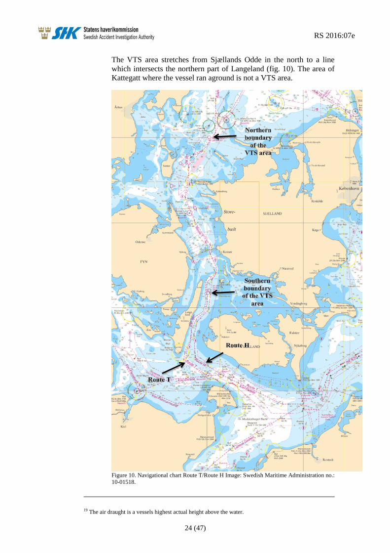
The VTS area stretches from Sjællands Odde in the north to a line
which intersects the northern part of Langeland (fig. 10). The area of
Kattegatt where the vessel ran aground is not a VTS area.
Figure 10. Navigational chart Route T/Route H Image: Swedish Maritime Administration no.:
10-01518.
19 The air draught is a vessels highest actual height above the water.

RS 2016:07e
25 (47)
1.8 Safety management for the vessel and shipping company
1.8.1 General
The International Management Code for the Safe Operation of vessels
and for Pollution Prevention (the ISM Code) provides guidance for
shipping company management and the operation of its fleets, and is
intended to promote the development of maritime safety and the
prevention of pollution within the shipping industry. Since 1 July
2002, all merchant vessels in international traffic which are covered
by IMO’s maritime safety convention SOLAS20
must follow the code.
The only exception is the smallest of vessel. The code has been
implemented within the European Union via Regulation (EC) No
336/2006 of the European Parliament and of the Council on the
implementation of the International Safety Management Code within
the Community and repealing Council Regulation (EC) No 3051/951.
The ISM Code means that all vessels covered by it must have a Safety
Management System (SMS), i.e., a structured and documented system
which enables the shipping company’s personnel to effectively
implement the company’s safety and environmental protection policy.
The system shall include instructions and procedures which ensure
safe operation of the vessel and protection of the environment. It shall
also include a plan of action for emergency situations.
VICTORIA had a valid certificate and documentation of approved
safety management. In the following section, relevant parts of the
safety management system are presented.
1.8.2 Safety of navigation instructions
Passage plan
The planning procedure, as described, consists of four phases: an
initial appraisal phase in which all available and relevant facts are
assessed, a planning phase which is based on the initial assessment, an
execution phase, and finally a monitoring phase.
Where the planning phase is concerned, it is emphasised that safe
operation must be observed, taking into account the draught and the
possibility of squat21
with the resulting reduction of the under keel
clearance.
The execution phase is the formulation of the tactics which are inten-
ded in order to carry the plan through. According to the instructions,
the reliability of the vessels equipment shall be taken into account, as
20 SOLAS - International Convention for the Safety of Life at Sea. 21 The squat effect is a phenomenon which occurs when a vessel is passing through shallow waters or
fairways and in channels, and causes the vessel to have a greater draught. Squat occurs as a result of the
speed of the water flow and irregular pressure against the hull as the vessel passes through the water.
The water particles increase in speed when passing along the hull, which leads to an increase in the dy-
namic water pressure around the hull. According to Bernoulli’s principle, the static water pressure de-
creases and the vessel is drawn towards the seabed.

RS 2016:07e
26 (47)
well as the estimated time of arrival towards critical points, to allow a
more detailed assessment, especially where the matter of under keel
clearance is concerned.
Regarding the monitoring phase, it is emphasised that monitoring of
the vessels equipment is a prerequisite for the total control of the safe
movement of the vessel and, consequently, for the assurance of safe
navigational practice.
A checklist has been produced for passage planning – “Voyage Plan-
ning Check List”.
Bridge watch
The purpose of the bridge watch instructions is to determine the pro-
cedures of taking over and performing a bridge watch, bearing in mind
that the officer on watch is the master’s representative and is primarily
responsible at all times for the safe navigation of the ship. Therefore
the master is bound to ensure that watch keeping arrangement are
adequate for maintaining a safe bridge watch.
Apart from the duty to ensure the sufficiency of the bridge watch, the
master is also responsible to ensure adequate rest time for the officer
on watch so that they will be fit for duty in an efficient and safe way.
Regarding the matter of a lookout on the bridge, a thorough lookout
should be constantly maintained, and the lookout themselves may not
carry out other tasks which may interfere with lookout duty. It is also
stated that the helmsman cannot simultaneously be tasked with look-
out duty.
When deciding the manning of the watch on the bridge, the following,
inter alia, shall be taken into account:
Any unusual demands on the bridge watch that may arise as a
result of special operational circumstances.
Use and operational condition of navigation aids such as radar
or electronic positioning equipment.
Proximity of navigational hazards which may make it neces-
sary for the officer in charge of the watch to carry out addi-
tional navigational duties, e.g., the combination of an area
which is difficult to navigate and a high traffic density.
When an officer takes over watch, they must personally ensure them-
selves regarding the vessels position, course, speed and draught.
The officer on watch on the bridge must check the course steered,
position and speed at sufficiently frequent intervals, using any availa-
ble navigation aids necessary in order to ensure that the vessel follows
the planned course. In addition, the officer on watch shall not be
assigned or undertake any duties which would interfere with the safe
navigation of the ship.
RS 2016:07e
27 (47)
1.8.3 Emergency preparedness
The vessels SMS specifies which measures should be taken in the
event the vessel runs aground. Immediate measures regarding e.g.,
checking damage to the vessel and injuries to the crew are listed first.
When the immediate measures have been taken, the shipping company
must be contacted and the measures taken noted in the vessels log
book. Contact with the coastal state or sea rescue authorities is not
mentioned.
1.9 Route planning
The vessels route planning was ready 24 hours before departure. The
second officer had first planned to take Route T all the way, but the
master changed the route plan so that the vessel would take Route H
through the Great Belt. The second officer had set out waypoints,
course lines, courses and “no go areas” on the navigational chart. He
also entered all waypoints into the vessels GPS, where there was an
alarm which would be triggered if the vessel deviated from the course.
An inspection of the route planning has revealed the following.
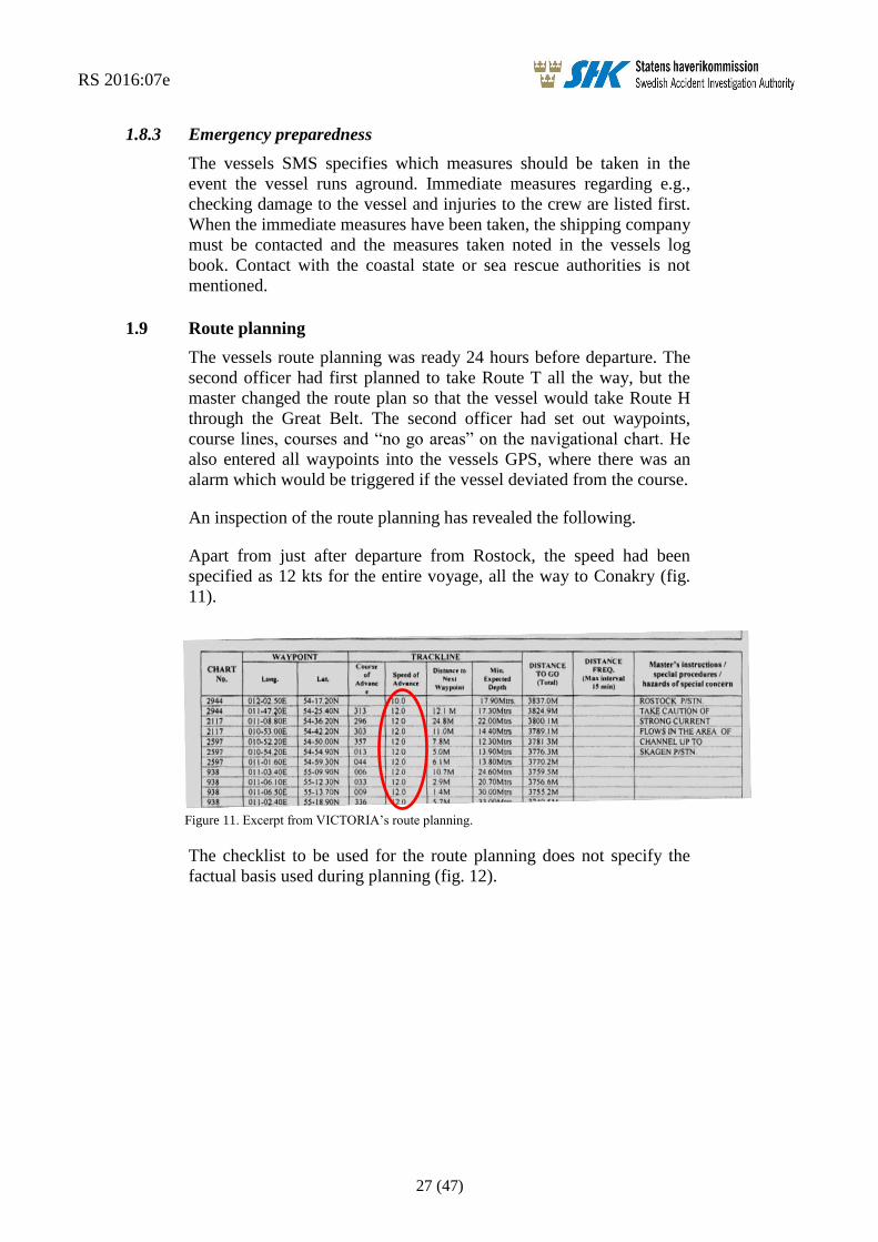
Apart from just after departure from Rostock, the speed had been
specified as 12 kts for the entire voyage, all the way to Conakry (fig.
11).
Figure 11. Excerpt from VICTORIA’s route planning.
The checklist to be used for the route planning does not specify the
factual basis used during planning (fig. 12).

RS 2016:07e
28 (47)
Figure 12 Excerpt from the checklist used for the route planning.
On the route plan in question, VICTORIA’s draught is not specified.
There is however a calculation of the squat effect, in which the
draught is a parameter (fig. 13), though the formula for Squat – Deep
Water is incorrect as the speed (V) should be squared. The crew has
however used the correct formula in the calculation. In the squat effect
calculation, the crew has factored in a speed of 7 kts and thus received
a result of 38.22 cm in deep water and 76.44 cm in shallow water.
SHK has calculated the squat based on the speed specified in the route
planning for passage of the Great Belt; i.e., 12 kts. The result of this
calculation is 112.32 cm in deep water and 224.64 cm in shallow
water.
Figure 13. Squat calculation from the route plan checklist.
The route planning states that the vessel shall call the pilots in
Conakry on VHF channel 16 or 14 approx. 25 M from boarding
position. There is however no mention of routines for ordering pilots
in Denmark or any information concerning the Great Belt VTS.
1.10 Meteorological information
SHK has had SMHI make a summary of the weather conditions and
wave formation at the Fladen lighthouse during the afternoon and
evening of 19 September 2015.
The wind was around West 7-10 m/s. It was clear to half-clear with a
visibility of over 10 M. The air temperature was 16 degrees and the
temperature in the water was 15 degrees. The significant wave height
RS 2016:07e
29 (47)
(SWH)22
was 0.7 metres bearing 260°; i.e., roughly the same direction
as the wind.
The currents in the area were almost non-existent during the afternoon
and evening (0.08-0.03 kts).
The water level in the Great Belt at the time of the vessels passage
was between +6 and +8 cm. The water level at Fladen was +16 cm at
the time the vessel ran aground.
1.11 Rescue operation
According to the Civil Protection Act (2003:778), the term “rescue
services” denotes the rescue operations for which central government
or municipalities shall be responsible in the event of accidents in order
to prevent and limit injury to persons and damage to property and the
environment.
At 23:37 on 19 September, JRCC23
received information from a vessel
passing Fladen that “a vessel seems to have run aground there”. JRCC
attempted to call VICTORIA on VHF channel 16 a number of times
but received no response.
At 23:58, JRCC contacted the Swedish Coast Guard to notify them of
a vessel which was presumed grounded at Fladen.
JRCC sent a digital selective call (DSC) via VHF to VICTORIA at
00:03 but received no immediate response. At 00:13, VICTORIA
called JRCC via VHF to inform that the vessel had run aground.
Immediately thereafter, JRCC contacted the Swedish Coast Guard to
notify of the contact made with VICTORIA and that the master on
board had confirmed that the vessel was grounded, that there were no
personal injuries and that they were checking all tanks.
The coast guard’s vessel KBV 312 left Ringhals at 00:15 to head
towards Fladen. At 01:02, KVB 001 also left Gothenburg, and soon
thereafter KBV 034 also left Malmö to head towards Fladen.
KBV 312 arrived at the scene of VICTORIA’s grounding at 01:48 and
circled the vessel to check the area. There were no signs of environ-
mental emissions from the vessel. The vessel had 10-metre draught
astern and 7.5 metres draught forward, which led the coast guard to
assess that the vessel was firmly aground.
At 06:14, the Swedish Transport Agency’s inspector boarded
VICTORIA. The inspector checked the scope of damages and the ves-
sels stability and requested a salvage plan from the shipping company.
22 The wave height is generally given in terms of the significant wave height (SWH), i.e., the mean value
in wave height within the top third of the waves. The highest waves are 1.6 to 1.8 times the SWH.
Sometimes a few isolated waves can reach double the height. 23 JRCC – Joint Rescue Coordination Centre.
RS 2016:07e
30 (47)
The coast guard's divers began diving to inspect VICTORIA at 11:03.
The underwater inspection revealed that the vessel was hard aground
in its middle section, where the fuel tanks are located. The stern of the
vessel and the bulb were free in the water. There was a tear three
metres long in the forward part of the vessel and water was entering
the vessels ballast tanks.
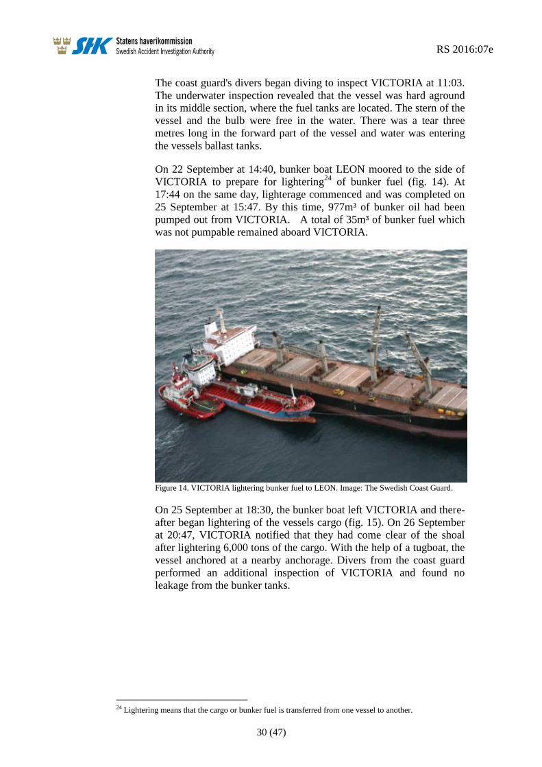
On 22 September at 14:40, bunker boat LEON moored to the side of
VICTORIA to prepare for lightering24
of bunker fuel (fig. 14). At
17:44 on the same day, lighterage commenced and was completed on
25 September at 15:47. By this time, 977m³ of bunker oil had been
pumped out from VICTORIA. A total of 35m³ of bunker fuel which
was not pumpable remained aboard VICTORIA.
Figure 14. VICTORIA lightering bunker fuel to LEON. Image: The Swedish Coast Guard.
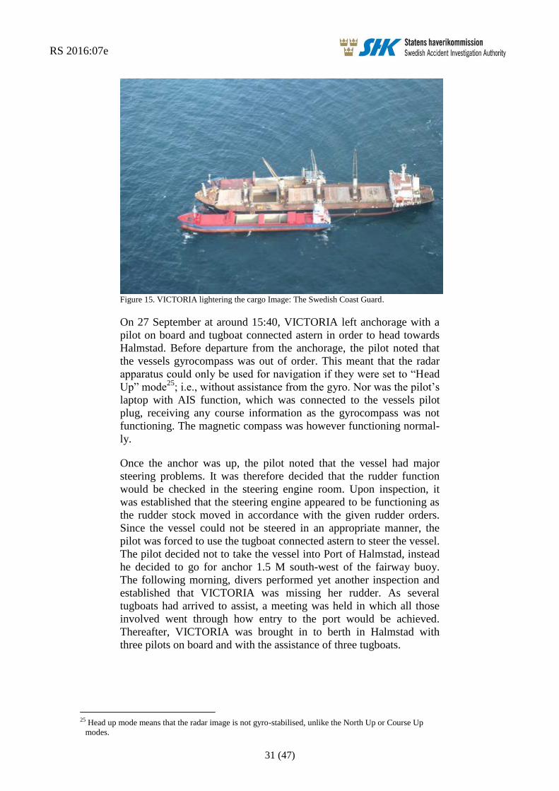
On 25 September at 18:30, the bunker boat left VICTORIA and there-
after began lightering of the vessels cargo (fig. 15). On 26 September
at 20:47, VICTORIA notified that they had come clear of the shoal
after lightering 6,000 tons of the cargo. With the help of a tugboat, the
vessel anchored at a nearby anchorage. Divers from the coast guard
performed an additional inspection of VICTORIA and found no
leakage from the bunker tanks.
24 Lightering means that the cargo or bunker fuel is transferred from one vessel to another.
RS 2016:07e
31 (47)
Figure 15. VICTORIA lightering the cargo Image: The Swedish Coast Guard.
On 27 September at around 15:40, VICTORIA left anchorage with a
pilot on board and tugboat connected astern in order to head towards
Halmstad. Before departure from the anchorage, the pilot noted that
the vessels gyrocompass was out of order. This meant that the radar
apparatus could only be used for navigation if they were set to “Head
Up” mode25
; i.e., without assistance from the gyro. Nor was the pilot’s
laptop with AIS function, which was connected to the vessels pilot
plug, receiving any course information as the gyrocompass was not
functioning. The magnetic compass was however functioning normal-
ly.
Once the anchor was up, the pilot noted that the vessel had major
steering problems. It was therefore decided that the rudder function
would be checked in the steering engine room. Upon inspection, it
was established that the steering engine appeared to be functioning as
the rudder stock moved in accordance with the given rudder orders.
Since the vessel could not be steered in an appropriate manner, the
pilot was forced to use the tugboat connected astern to steer the vessel.
The pilot decided not to take the vessel into Port of Halmstad, instead
he decided to go for anchor 1.5 M south-west of the fairway buoy.
The following morning, divers performed yet another inspection and
established that VICTORIA was missing her rudder. As several
tugboats had arrived to assist, a meeting was held in which all those
involved went through how entry to the port would be achieved.
Thereafter, VICTORIA was brought in to berth in Halmstad with
three pilots on board and with the assistance of three tugboats.
25 Head up mode means that the radar image is not gyro-stabilised, unlike the North Up or Course Up
modes.
RS 2016:07e
32 (47)
1.12 Regulations and supervision
1.12.1 Route planning
The international requirements for voyage planning applicable to the
event are regulated in the international regulatory framework SOLAS,
chapter V, regulation 34. It is stated here that the master must make
sure to check that the planning has been done with the help of a rele-
vant navigational chart and nautical publications, and that IMO’s
guidelines and recommendations have been observed. The guidelines
referred to are primarily Resolution A.893 (21) IMO Guidelines for
Voyage Planning. The requirements in SOLAS regarding voyage
planning have been implemented in Sweden via Chapter 2 of the
Swedish Transport Agency’s regulations and general advice (TSFS
2011:2) on navigational safety and navigational equipment.
In accordance with IMO Guidelines for voyage planning A.893 (21),
the vessels route must be plotted on the navigational chart along with
courses, hazardous areas and report points. The route planning must
also contain but not be limited to:
Safe speed, having regard to the proximity of navigational
hazards along the intended route or track, the manoeuvring
characteristics of the vessel and its draught in relation to the
available water depth; (3.2.2.1).
Necessary speed alterations en route, e.g., where there may be
limitations because of night passage, tidal restrictions, or
allowance for the increase of draught due to squat and heel
effect when turning; (3.2.2.2).
Minimum clearance required under the keel in critical areas
with restricted water depth; (3.2.2.3).
The method and frequency of position fixing, (3.2.2.6).
Report points and VTS areas (3.2.2.7).
1.12.2 Watchkeeping
In chapter VIII STCW26
, there are international requirements regard-
ing watch keeping (cf. the Swedish Transport Agency’s regulations
[TSFS 2012:6] regarding watch duty). STCW stipulates that an officer
on watch must:
keep the watch on the bridge, in no circumstances leave the
bridge until properly relieved ensure that a proper of lookout
is always maintained,
continue to be responsible for safe navigation of the vessel,
despite of the presence of the master on the bridge, until
26 STCW - International Convention on Standards of Training, Certification and Watchkeeping for Sea-
farers.
RS 2016:07e
33 (47)
master explicitly announces that he or she has taken over this
responsibility and this is mutually understood, and
notify the master when any doubts regarding safety.
It is also stated that during watch, the steered course, position and
speed must be checked at frequent intervals by using all available aids
to navigation necessary to ensure the vessel is following the intended
course.
The officer on watch on the bridge may not be assigned or undertake
any duties which may interfere with safe navigation of the vessel.
1.12.3 International Regulations for Preventing Collisions at Sea
Regulation 5 of the International Regulations for Preventing Colli-
sions at Sea (Colregs)27
states that “Every vessel shall at all times
maintain a proper look-out by sight and hearing as well as by all
available means appropriate in the prevailing circumstances and
conditions so as to make a full appraisal of the situation and of the risk
of collision.”
1.12.4 VDR
SOLAS Chapter V, regulation 18.828
states that VDR and VDR-S,
including all sensors, are to be inspected annually. The inspection is to
encompass the accuracy and persistence of the recorded data and the
possibility to gain access to the recorded data. The inspection must
also encompass the state of the protective covering and devices for
localisation. A copy of the inspection certificate must be kept on
board, together with the vessels other certificates.
Guidelines for testing VDR equipment and the formulation of the
inspection report can be found in IMO circular MSC.1/Circ.1222
Guidelines on annual testing of Voyage Data Recorders (VDR) and
simplified Voyage Data Recorders (S-VDR).
1.12.5 Reporting of incidents and accidents at sea
In accordance with Chapter 6, Section 14 of the Maritime Act
(1994:1008), the master of a foreign merchant vessel in Swedish terri-
tory must immediately report to the authority prescribed by the
Government in the event of the vessel running aground, for example.
Section 20 of the Accident Investigation Ordinance (1990:717) states
that such reports should be made to the Swedish Transport Agency.
Chapter 20, Section 10 of the Maritime Act states that a master is
sentenced to a fine if he neglects to provide such a report.
27 Colregs - Convention on the International Regulations for Preventing Collisions at Sea. 28 Cf. Chapter 4, Section 15 of the Swedish Transport Agency’s regulations and general advice (TSFS
2011:2) on navigational safety and navigational equipment.

RS 2016:07e
34 (47)
1.12.6 Regulations for hours of work and rest at sea
The MLC29
and the STCW Code define requirements and goals for a
crew member’s physical and mental wellbeing. They include require-
ments for hours of work and hours of rest and stipulate that each
member state must ensure that these hours are regulated30
. The STCW
Code looks especially at standards for watch keeping and defines the
exceptions that can be made. The flag state of vessel VICTORIA is
Liberia, which has ratified the MLC and is party to the STCW
Convention/Code.
Under point 1 in Standard A2.3 under regulation 2.3 of the MLC, the
terms hours of work and hours of rest are defined. Hours of work
“means time during which seafarers are required to do work on
account of the vessel”. Hours of rest “means time outside hours of
work; this term does not include short breaks”.
In accordance with the Maritime Labour Convention, work may not
exceed 14 hours in a 24-hour period or 72 hours in a seven-day period.
In accordance with the Maritime Labour Convention and the STCW
Code, hours of rest may not be less than ten hours in a 24-hour period
or 77 hours in a seven-day period.
According to the MLC, hours of rest may be divided up into a
maximum of two periods per 24-hour period, and one of these must be
a period of at least six hours. In addition, the time between these two
periods may not exceed 14 hours. The STCW Code, which deals
specifically with standards for watch keeping, allows certain
exceptions. Up to three periods of rest can be allowed, though one of
the periods within a 24-hour period must be at least six hours. The two
other periods of rest may not be shorter than one hour each and excep-
tions can be made for up to two 24-hour periods over a seven-day
period. The total hours of rest may not be less than 70 hours for a
seven-day period.
Both the MLC and the STCW Code state that if a crew member must
perform a task in order to ensure the immediate safety of the vessel,
persons on board or the cargo, the regulations shall not prevent this to
do so. In such cases, the master shall be permitted to make exceptions
to the regulations for a crew member, until normal operation is
restored. As soon as practically possible after the vessel has returned
to normal operation, the crew member who has worked during
scheduled hours of rest should be afforded the opportunity to take a
sufficient period of rest.
29 Maritime Labour Convention 2006. 30 Regulation 2.3 of the MLC and Chapter 8, Section A-VIII/1 of the STCW Code “Fitness for duty”.
RS 2016:07e
35 (47)
1.13 Company organisation and management
Venturi Fleet Management S.A. was formed in October 2014. In
December 2014, the company took over management of VICTORIA.
At the time of the accident, the company managed 10 bulk carriers
with a gross tonnage of between 20,000 and 32,000. VICTORIA is the
oldest vessel.
1.14 Fatigue
Fatigue can primarily be said to be a loss of wakefulness and can be
set to resistance compared to how alert a person is. Fatigue is not a
constant function in the sense that the impact on performance and
execution of duties remains the same over time; the scope of various
impairments of performance varies depending on the state a person is
in, but also their surroundings and the nature of these.
The first signs of fatigue can be slight cognitive changes which lead to
simple mistakes. Simple mistakes can be linked to the individual's
perception, understanding and analysis of their surroundings. Some-
times other cognitive impact may be in question, such as a decision
being somewhat delayed. Fatigue can for example lead to the need for
a certain amount of effort or reflection in order to remember
something. These negative effects are aggravated the more tired a
person becomes.
There are several factors which can have an additional impact on how
tired the individual feels. Working under stressful conditions, for
example, clearly has a positive effect on the perceived level of fatigue,
even if the individual is in fact exhausted.
The normal circadian rhythm for a person entails that we sleep during
the night and are awake during the day. A normal night’s sleep or
other main consecutive period of sleep for a person with a normal
circadian rhythm is between seven and nine hours. The need differs
from one person to the next, but lies within this time span. A main
consecutive period of sleep shorter than seven hours means a varying
degree of sleep deficit. Less than five hours’ consecutive sleep repre-
sents a critical deficit.
The regulations stipulate that one of the periods of rest shall be at least
seven hours long, which in itself may mean that the main consecutive
period of sleep of seven hours is not being achieved. A period of rest
of six hours together with other periods of rest may however be suffi-
cient for good recuperation.

RS 2016:07e
36 (47)
1.14.1 Assessment of fatigue
An assessment of the master and chief officer’s fatigue has been
performed with the purpose of establishing whether or not they had
received sufficient rest and sleep.
SHK has reviewed the crew’s hours of work and rest and this infor-
mation has been checked during interviews with the crew members
concerned. This combined information has provided a foundation for
the investigation.
The master
The information from the interviews has enabled us to produce a
comprehensive overview for the master. It has become apparent that
there have been several periods of rest over the span of 24 hours prior
to the event, but that these have been very limited in their scope. On
the basis of the collected information, our assessment is that the
master has only had a total of between three to five hours’ sleep and
rest in these 24 hours. These hours were divided into several periods,
and a long, consecutive period of rest was never taken. During the
interview, the master said that he did not feel tired at the time the
vessel ran aground.
The Chief officer
The chief officer had the 4-8 watch on the bridge when the vessel was
at sea, with the possibility of a main consecutive rest period of at most
eight hours, which was normally ample time for the chief officer to
get sufficient sleep.
The investigation has revealed that over the 24 hours prior to the
vessel running aground, the chief officer had eight hours’ rest, divided
into two separate periods; 00.00-04.00 and 12.00-16.00. Furthermore,
the chief officer ate his lunch during his period of rest in the after-
noon. In accordance with the records of seafarers’ daily hours of work
and rest, the two periods of rest were to be five hours each. Irrespec-
tive of the hours of rest recorded here or those actually taken, the chief
officer did not have at least six consecutive hours of rest and therefore
neither had a consecutive period of sleep of at least five hours. This
suggests that the chief officer was working with a sleep deficit before
and at the time of the vessel running aground. However, the period of
rest taken between 12.00 and 16.00 prevented the deficit from being
critical. During the interview, the chief officer said that he did not feel
tired at the time the vessel ran aground.
1.15 Distraction
Distraction, or the act of someone becoming distracted, is a common
phenomenon. It has different consequences in different situations,
depending on what the individual has done and what exactly it was
that interfered.

RS 2016:07e
37 (47)
The distraction can be something the individual sees, hears or comes
to think of that draws their attention from one thing to another. Per-
ception of time is for example an ability which is impaired when we
are distracted; i.e., time passes quicker than perceived.
Complex duties such as navigating a vessel are often subject to many
different sources of distraction. Education, training and experience
teach us when it is important to focus on a particular task or how to
prioritise between different duties in a certain situation. But if a task is
allotted a disproportionately large amount of attention, this can mean
it becomes distracting and other important details are overlooked. An
interference can also mean that it is difficult to identify a deterioration
which has occurred, i.e., that a person does not understand that there is
a problem as they are busy with too many duties at one time.
The expected difficulty and complexity of a task may affect the individu-
al’s resource allocation in terms of attention and alertness. In a very
complex situation, which is also understood as such, the individual is
naturally more alert and attentive to their duties. This allocation
process is largely unconscious. A change in duties - e.g., a very
complex duty becoming simpler in nature - can have a particularly
large impact on an individual’s alertness whilst carrying it out. This
could for example be a navigational duty which in some phases is
quite complex, to then become simpler due to changes in circumstanc-
es, such as the task at hand going from navigation of an archipelago to
navigation of open waters. If this situation is compared with that of a
distraction, such as attempting to perform an additional complex task in
parallel, this has consequences for overall performance. The duty subject
to change is then unconsciously demoted in priority and attention and
alertness are focused on the new task which is deemed more complex or
critical, whether consciously or unconsciously.
RS 2016:07e
38 (47)
2. ANALYSIS
2.1 Navigation in connection with running aground
Soon after VICTORIA changed course at buoy 6 in Route T, the chief
officer gave the order to the helmsman to steer 335°, according to
information provided in the interviews. It was also this order that the
third officer said was applicable during the short time he was on watch
on the bridge during the chief officer’s dinner break. The helmsman
has stated that during his time on the bridge he followed the chief
officer’s order which, according to him, was to steer a course of 330°.
The crew on the bridge has also stated that there were no changes with
regard to this, right up to the vessels running aground.
However, the AIS track gives an entirely different picture of how the
vessel was actually navigated. The course over ground (COG) held by
the vessel until around 17:35 was an average of approx. 353˚, accord-
ing to the AIS recorded data. Following this, there was a change of
course by 10° to port, likely in connection with the chief officer taking
over watch after dinner and the third officer pointing out the drift
when handing over. A few minutes later, a new change of course was
made; this time 25° to starboard. Yet another change of course was
made thereafter; this time, slowly back to port - 343° COG.
Each crew member has thus provided information which is incon-
sistent with that of the other crew members and indeed with the AIS
track. Taking into consideration the prevailing wind and current, the
drift does not explain the difference between the course stipulated in
the chief officer’s order and the COG. VICTORIA must thus have
actively steered a course which deviated from what the chief officer
and third officer had intended. If we assume that the more-or-less
consistent information provided by the bridge crew is correct and not
a reconstruction after the event, there must either have been a tech-
nical fault with the gyrocompass in connection with the turn at buoy 6
or the helmsman read the course incorrectly from the gyrocompass.
It seems unlikely the gyrocompass would have been read incorrectly
throughout the almost two-hour long sequence of events from the turn
at buoy 6 to running aground, especially seeing as the vessel carried
out a number of turns along the route. If that would be the case the
course has been read incorrectly during all turning operations; i.e., at
the times when the vessel had a COG of 353°, 343°, 368° and finally
343°.
It is just as unlikely that due to a technical fault the gyrocompass
suddenly began to display incorrect values in connection with turn. In
the event of a fault, the compass normally begins to “peregrinate”.
The idea that it should instead have “jumped” and made it necessary
to perform a turn in order to follow the course stipulated in the order is
therefore unlikely, and should also have caused reactions among the
crew.
RS 2016:07e
39 (47)
Indeed, after the grounding, the Swedish pilot that embarked the
vessel at the anchorage for pilotage towards Halmstad noticed that the
gyrocompass was not functioning. According to SHK, the most likely
explanation is that the compass was damaged and became unusable in
connection with the hard grounding.
In summary, it would appear that material information on what
occurred on the bridge during the sequence of events after the turn at
buoy 6 - information which could explain why the vessel was navi-
gated in the way it was - has not come up during the interviews. The
lack of VDR data has meant that it is not possible to bring clarity to
the matter. Nor has the investigation been able to establish circum-
stances which - contrary to the information provided by the
crew - could form the basis of a reasonable hypothesis as to why the
vessel deviated from the intended route. SHK shall therefore refrain
from speculation regarding misunderstanding or human error, for
example. There is however cause to perform a more in-depth analysis
of why the course deviation, regardless of how it arose, was not
noticed.
2.2 Why did the vessels deviation from the planned course go unno-
ticed?
Both the chief officer and the third officer have stated that the vessels
GPS brought their attention to the fact that the vessel was deviating
from the intended course and interpreted this as a drift due to currents
and wind. As shown in section 2.1, however, the wind and currents
cannot explain the drift. In reality, it seems that the vessel held a
course different to the intended one.
Neither the chief officer nor the third officer seem to have checked the
course that the vessel was actually steering, however, or the vessels
true course over ground. This may explain why the course deviation
was not noticed.
The investigation has shown that neither the chief officer nor the third
officer took a fixed position after the vessels turning at buoy 6; i.e., for
a period of nearly two hours and despite the GPS alert, which seems
difficult to explain. There are of course positions noted in the naviga-
tional chart at 17:00 and 17:30, but these are not consistent with the
vessels actual position in accordance with the AIS track. This suggests
that the position fixes at these times were not made with sufficient
accuracy, or that the positions in the navigational chart were noted
later. It should be mentioned at this point that the crew admitted that
the position in the navigational chart at 18:00 was noted after the
vessel ran aground, which occurred at 18:15.
The fact that the vessel was manually steered by an able seaman with-
out the latter being replaced by a lookout on the bridge also entailed
that the crew and the lookout on the bridge were insufficient for an
extended period and in a geographical area with a relatively high

RS 2016:07e
40 (47)
traffic volume. At the same time, however, it should be noted that as
there was a lack of marking on the west side of the shoal around
Fladen and Lilla Middelgrund, a lookout would not have been able to
identify the areas of shoal visually.
There are several factors which may explain why the situation on the
bridge developed as it did.
During bridge watch, the chief officer was mostly occupied with
monitoring the deck crew’s work to seal the cargo hatches. The chief
officer has explained that it was necessary to prioritise this work
because of the water spray coming up on deck. Taking into considera-
tion the weather conditions, as well as the vessels high freeboard, it
seems doubtful that waves should have been spraying up on deck at
the time. It is however quite likely that the risk of water spray on deck
would increase drastically once the vessel had passed Skagen. Regard-
less of what the actual situation was here, it is clear that the monitor-
ing of the work was a task carried out by the chief officer at the same
time as being the only officer on watch on the bridge.
In addition to this, the chief engineer, the master and the electrician
came up to the bridge to discuss with the chief officer the matter of
functional tests of the cranes prior to calling at Conakry. This meeting,
which thus took place during the chief officer’s bridge watch, likely
drew attention away from the task of navigation and, in SHK’s view,
constituted a distraction which could have been avoided. The next call
to port was not to be for another 12 full days later and the vessel was
in an area with a relatively high traffic density which should further-
more be deemed as difficult to navigate for the chief officer, who had
no previous experience in this area.
Another factor which has likely affected the chief officer’s ability to
keep watch and his attention to both the deck work and navigation is
the combination of fatigue and a heavy workload. The chief officer’s
hours of work and rest were not within permitted limits as he did not
have a consecutive period of rest of at least six hours in the 24 hours
prior to the incident. Fatigue in combination with the aforementioned
distractions likely affected the chief officer’s ability to handle the
navigation satisfactorily.
2.3 Management
The navigation of a vessel places high demands on the officer on
watch to remain certain of the vessels position at all times, whilst at
the same time the forward voyage requires constant planning. It is
because of this that both the STCW Convention and the vessels safety
management system stipulate requirements that the officer on watch is
not assigned nor carries out tasks which may interfere with the safe
navigation of the vessel.

RS 2016:07e
41 (47)
The regulations and routines established by the shipping company
within the scope of safety management also state clearly that estab-
lishing an adequate bridge watch is proactive work in which several
variables shall be taken into account. Among other things, it is stated
that it is necessary to take into account unusual demands on the bridge
watch which may occur as a result of special operational circumstanc-
es. In this case, management of the cargo was not entirely complete by
the time the vessel departed from Rostock; they were to be completed
whilst the vessel was underway. This meant that the chief officer, as
mentioned above, had additional duties to attend to. Furthermore, the
lack of available pilot for transit through the Great Belt necessitated
changes in relation to the planning.
Serving as master of a large merchant vessel places high demands on
continuous planning, follow-up and, where necessary, adjustment of
the plan in the event of changes in circumstances, all to ensure safe
operation of the vessel. The safety management also allows room for
the master to act in this way.
In the present case, however, the changes in circumstances which
arose seem to have primarily been resolved via ad hoc solutions
during the course of the voyage which did not adequately take into
consideration the consequences for bridge watch over the 24-hour
period following departure from Rostock.
Despite the masters intermittent presence on the bridge and awareness
of the chief officer’s responsibility for the deck work and the fact that
the officers had no previous experience of these relatively difficult to
navigate and heavily trafficked fairways, he did not check the naviga-
tion or take any other measures to facilitate the officers’ work.
In SHK’s view, there is cause for the shipping company to go through
safety management with its masters in order to ensure that they have
understood the importance of proactive management and the potential
for reorganisation of the work and the division of duties on board in a
flexible and safe manner and based on changes in circumstances, by
e.g., temporarily changing the bridge’s watch system and its manning.
2.4 Route planning
2.4.1 General
SHK has inspected the route plan drawn up before departure from
Rostock and has identified certain shortcomings which will be
described in greater detail below. These shortcomings have not
contributed directly to the vessel running aground, but there is cause
to report them so that the shipping company can take necessary
measures.

RS 2016:07e
42 (47)
2.4.2 Pilot
It is only a few hours’ voyage from Rostock to the boarding position
for a pilot through the Great Belt. As DanPilot requires 18 hours’ prior
notice when ordering a pilot, it is necessary on a voyage such as this
to order a pilot before the vessel leaves the berth. It is a shortcoming
that this had not been taken into account in the scope of the route
planning, despite the fact that the master clearly wished to have a pilot
on board and as this was also recommended by the Baltic Pilotage
Authorities (cf. 2.1.7.7 IMO Guidelines for Voyage Planning).
SHK has also noted that there was a lack of information regarding the
Great Belt VTS (cf. 3.2.1 IMO Guidelines for Voyage Planning).
2.4.3 The route
The fact that VICTORIA chose to take Route H through the Great
Belt is understandable as Admiralty Sailing Directions and sea charts,
state that Route T should be avoided by vessels with a draught which
enables them to navigate outside of these areas, and as vessels with a
draught of 10 metres or less must follow Route H. It may be noted that
the IMO Ships' Routeing states that the Route H should be followed
by ships with a draft of 10 meters or less.
Adjacent to Route H and less than one nautical mile from the
mid-channel buoys, however, are a number of reefs with a depth of
10.4 and 10.6 metres which are not marked with beacons such as light
buoys. Furthermore, one reef is located at a relatively sharp turn point.
In the present case, VICTORIA also came very close to one of these
shoals.
In SHK’s view, the requirement or to recommend for a vessel with a
draught of 10 metres to take Route H combined with the lack of mark-
ing for reefs constitutes a risk situation which must be rectified. In
order to reduce the risk of vessels running aground especially in the
area around buoy 7 in Route H, the Danish Maritime Authority should
consider increasing the number of light buoys along Route H. Further-
more, the discrepancy between the Admiralty Sailing Directions and
charts on the one hand and the IMO Ships' Routeing on the other hand
should be reviewed and addressed.
2.4.4 Speed, etc.
VICTORIA’S route planning contains a column for recommended
speed between the waypoints along the route. This seems to have been
filled in routinely with the same speed for almost all parts of the
voyage. This means that the purpose of filling in this column; i.e., to
draw the bridge officer’s attention to instances where a reduction in
speed is required - e.g., prior to passing through shallower waters -
comes to nothing (cf. 3.2.2.1 IMO Guidelines for Voyage Planning).
RS 2016:07e
43 (47)
It is also remarkable that the route planning gives one speed for the
entire voyage through the Great Belt (12 kts) whilst the squat calcula-
tion uses another (7 kts). As is clear from SHK’s calculations in
section 1.9, there is a great difference between the vessels draught in
shallow waters depending on whether the speed is 7 or 12 kts, which
can entail risks.
SHK has also noted that the UKC31
was missing from the route plan-
ning, despite the fact that the planning concerned areas - such as
Route H - with a limited water depth (cf. 3.2.2.3 IMO Guidelines for
Voyage Planning). Nor was there any mention of the material used for
the route planning (cf. 2.1 IMO Guidelines for Voyage Planning).
2.4.5 Overall assessment
It is clear from the aforementioned that there have been shortcomings
in the route planning, and that it did not follow IMO Guidelines for
voyage planning in all respects. The planning was approved by the
master and signed by the deck officers. This indicates that the estab-
lished safety management has not achieved full and proper dissemina-
tion on board VICTORIA.
In SHK’s view, there is therefore cause for the shipping company to
review how the route planning is implemented, in order to ensure that
established routines are followed and that all relevant information is
observed and, where appropriate, also noted in the route planning.
2.5 Bridge equipment
The fact that the crew were unable to identify the buoys on the vessels
radar may be partially explained by the prevailing weather conditions.
VICTORIA did not have ECDIS; nor did it have any other form of
electronic navigational chart (ECS) on the bridge. An ECS enables the
crew to quickly gain a visual overview of the vessels position in
relation to its surroundings. There although no requirements to have
ECDIS or an ECS installed, but it is in SHK’s view appropriate for a
vessel of VICTORIA’s size to invest in such equipment in order to
increase safety. This is also consistent with IMO’s recommendations
in SN.1/Circ.263 of 23 October 2007.
2.6 Emergency management
In Swedish territorial water, the master has a responsibility to contact
the Swedish Transport Agency immediately in the event of an
accident of a certain nature; running aground being of such a nature.
However, VICTORIA’s checklist does not include contacting the
coastal state. This can mean that the crew will assume that the
shipping company makes such contact. If the Swedish Transport
31 UKC - Under Keel Clearance; minimum distance between the vessel and the sea bed.

RS 2016:07e
44 (47)
Agency is not contacted immediately, the master risks being sentenced
to a fine.
The shipping company should review the checklist in order to ensure
the master has good support in the event of an accident and does not
risk omitting to take certain measures, which can result in penalties.
3. CONCLUSIONS
3.1 Findings of the investigation
No fixed position was made for almost two hours on the last leg of a)
the course before the grounding.
The chief officer prioritised other duties than navigating. b)
The master prioritised other duties than navigating. c)
The senior officers were holding a meeting on the bridge at the d)
time the vessel ran aground.
VICTORIA’s route planning did not follow IMO Guidelines for e)
voyage planning.
VICTORIA passed through the Great Belt and Kattegatt without a f)
pilot on board.
VICTORIA was close to running aground in Route H in the area g)
around buoy 7.
Route H is obligatory for vessels with a draught of 10 metres or h)
less according to Admiralty Sailing Directions and the sea charts.
Route H is recommended for vessels of 10 meters or less in depth i)
according to IMO Ships’ Routeing.
There were a number of shoal heads without light buoys in the j)
immediate vicinity of Route H.
There was nothing to mark the west side of the shoal around k)
Fladen.
There was nothing to mark the west side of the shoal around Lilla l)
Middelgrund.
There was no VTS in Kattegatt. m)
VICTORIA was not equipped with ECDIS. n)
VICTORIA was not equipped with ECS as an aid to navigation. o)
The checklist for running aground did not include an item for the p)
vessel to contact the coastal state.
Current VDR data was not available. q)
RS 2016:07e
45 (47)
3.2 Causes
The grounding occurred due to a lack of adequate attention to naviga-
tional tasks, which in turn was due to distractions caused by other
duties, likely in combination with fatigue, which meant that the
vessels course and position were not followed.
An underlying cause was inadequate resource planning in terms of the
deck officers duties over the first 24 hours after departure from
Rostock.
4. MEASURES TAKEN
4.1 Venturi Fleet Management
Venturi Fleet Management has stated that it shall equip all vessels
with ECDIS and encourage the use of the parallel indexing method
when navigating narrow fairways.
In addition, the ISM manual and its safety management system (SMS)
shall be reviewed and supplemented, for example where route plan-
ning and the checklist for running aground are concerned. It must also
be ensured that distractions are eliminated when navigating in narrow
fairways and that there is a greater focus on position fixes in narrow
fairways.
4.2 The Danish Maritime Authority
The Danish Maritime Authority has in connection with draft of this
report made contact with charts authority in Denmark to discuss a
change in the information in the Danish charts with the intention of
information becomes in accordance with IMO`s Ships routeing.
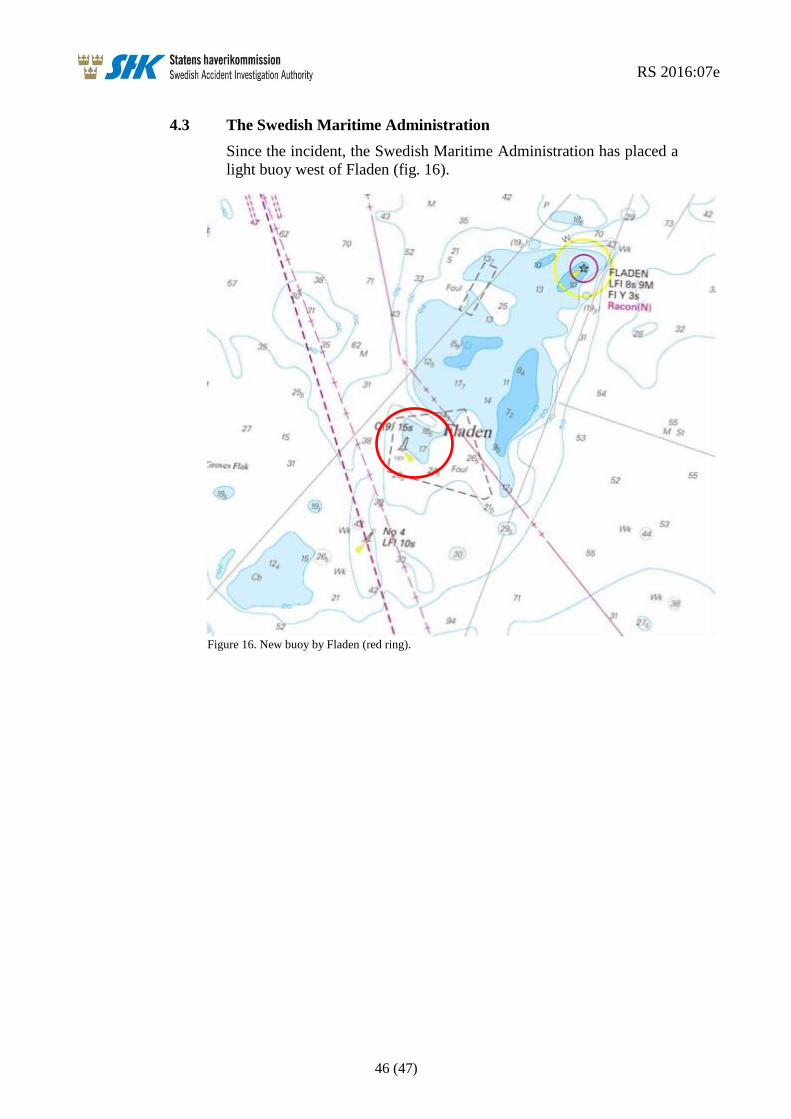
RS 2016:07e
46 (47)
4.3 The Swedish Maritime Administration
Since the incident, the Swedish Maritime Administration has placed a
light buoy west of Fladen (fig. 16).
Figure 16. New buoy by Fladen (red ring).
RS 2016:07e
47 (47)
5. SAFETY RECOMMENDATIONS
In light of the measures taken by Venturi Fleet Management and the
Swedish Maritime Administration, SHK has decided not to issue
recommendations to these operators.
The Danish Maritime Authority is recommended to:
Consider and evaluate the buoyage along Route H with this
report in mind. See section: 2.4.3. (RS 2016:07 R1)
The Swedish Accident Investigation Authority respectfully requests to receive,
by 5 December 2016 at the latest, information regarding measures taken in
response to the recommendations included in this report.
On behalf of the Swedish Accident Investigation Authority,
Mikael Karanikas Rikard Sahl