Final Report Collision Bahuga Jaya vs Norgas Cathinka
39
FINAL REPORT KNKT-12-09-03-03 NATIONAL TRANSPORTATION SAFETY COMMITTEE Investigation Into the Collision Between Indonesia Registered Ro-ro Passenger Ferry MV “Bahuga Jaya” and Singapore Registered MT “Norgas Cathinka” at Sunda Strait (4 Nautical miles east of Rimau Balak Island), Indonesia 26 September 2012 NATIONAL TRANSPORTATION SAFETY COMMITTEE MINISTRY OF TRANSPORTATION REPUBLIC OF INDONESIA 2013
Transcript of Final Report Collision Bahuga Jaya vs Norgas Cathinka

FINAL REPORT KNKT-12-09-03-03
NATIONAL TRANSPORTATION SAFETY COMMITTEE
Investigation Into the Collision Between Indonesia Registered Ro-ro Passenger Ferry MV “Bahuga Jaya”
and Singapore Registered MT “Norgas Cathinka”
at Sunda Strait (4 Nautical miles east of Rimau Balak Island), Indonesia
26 September 2012
NATIONAL TRANSPORTATION SAFETY COMMITTEE MINISTRY OF TRANSPORTATION REPUBLIC OF INDONESIA 2013


NATIONAL TRANSPORTATION SAFETY COMMITTEE
Bahuga Jaya – Norgas Cathinka, 26 September 2012, Sunda Strait, Indonesia
i
The report is based upon the investigation carried out by the NTSC in accordance with IMO Resolution MSC. 255 (84) and Indonesian Shipping Act (UU
No.17/2008).
Readers are advised that the NTSC investigates for the sole purpose of enhancing Transport safety. Consequently, NTSC reports are confined to matters of safety
significance and may be misleading if used for any other purpose.
As NTSC believes that safety information is of greatest value if it is passed on for the use of others, readers are encouraged to copy or reprint for further
distribution, acknowledging NTSC as the source.
When the NTSC makes recommendations as a result of its investigations or research, safety is its primary consideration.
However, the NTSC fully recognizes that the implementation of recommendations arising from its investigations will in some cases incur a cost to the industry.
Readers should note that the information in NTSC reports and recommendations is provided to promote transport safety. In no case it is intended to imply blame
or liability.
The report is published by the National Transportation Safety Committee (NTSC), Transportation Building 3rd Fl, Ministry of Transportation, Jln. Medan Merdeka Timur No. 5, JKT 10110, Indonesia, in 2013.


NATIONAL TRANSPORTATION SAFETY COMMITTEE
Bahuga Jaya – Norgas Cathinka, 26 September 2012, Sunda Strait, Indonesia
iii
CONTENT CONTENT ................................................................................................................................................................ iii
SUMMARY ............................................................................................................................................................... v
I. FACTUAL INFORMATION .............................................................................................................................. 1
I.1. BAHUGA JAYA EX TRI STAR 8 ............................................................................................................ 1
I.1.1. Machinery and Propulsion System ................................................................................... 1
I.1.2. Navigational and Telecommunication Equipment ........................................................... 2
I.1.3. Life Saving Appliances ...................................................................................................... 2
I.1.4. Cargo and Passenger Manifest ......................................................................................... 2
I.1.5. The Crew .......................................................................................................................... 3
I.2. NORGAS CATHINKA ........................................................................................................................... 3
I.2.1. Machinery and Propulsion System ................................................................................... 4
I.2.2. Navigational and Telecommunication Equipment ........................................................... 4
I.2.3. Cargo Information ............................................................................................................ 4
I.2.4. Passage Plan ..................................................................................................................... 4
I.2.5. The Crew .......................................................................................................................... 5
I.3. INDONESIAN INNOCENT PASSAGE AND MERAK BAKAUHENI FERRY-ROUTE ................................... 6
I.4. THE COLLISION .................................................................................................................................. 7
I.5. ACCIDENT RESULT ........................................................................................................................... 11
I.5.1. Norgas Cathinka ............................................................................................................. 11
I.5.2. Bahuga Jaya ................................................................................................................... 12
II. ANALYSIS .................................................................................................................................................... 15
II.1. NTSC INVESTIGATION ...................................................................................................................... 15
II.2. ACTION TO AVOID COLLISION ON 26 SEPTEMBER .......................................................................... 15
II.3. PASSAGE PLANNING AND BRIDGE RESOURCE MANAGEMENT ...................................................... 18
II.4. SHIP TO SHIP COMMUNICATION .................................................................................................... 20
II.5. ACTION TAKEN AFTER COLLISION ................................................................................................... 21
II.6. EVENTS AFTER COLLISION ............................................................................................................... 21
II.7. FERRY TRAFFIC MANAGEMENT ....................................................................................................... 22
III. FINDINGS .................................................................................................................................................... 25
III.1. MAIN CAUSAL FACTOR .................................................................................................................... 25
III.2. CONTRIBUTING FACTORS ................................................................................................................ 25
III.3. OTHER SAFETY FACTORS ................................................................................................................. 25
IV. RECOMMENDATION ................................................................................................................................... 27
IV.1. DIRECTORATE GENERAL OF SEA TRANSPORTATION ....................................................................... 27
IV.2. DIRECTORATE GENERAL OF LAND TRANSPORTATION AND FERRY SERVICES ................................. 27
IV.3. VESSEL’S OPERATOR ....................................................................................................................... 27

NATIONAL TRANSPORTATION SAFETY COMMITTEE
Bahuga Jaya – Norgas Cathinka, 26 September 2012, Sunda Strait, Indonesia
iv
EVENT – CONDITION TIME LINE ............................................................................................................................ 29
SOURCE OF INFORMATION .................................................................................................................................... 31

NATIONAL TRANSPORTATION SAFETY COMMITTEE
Bahuga Jaya – Norgas Cathinka, 26 September 2012, Sunda Strait, Indonesia
v
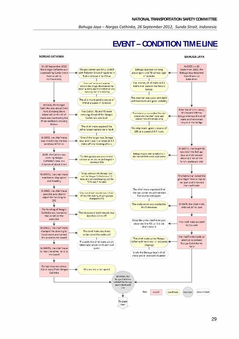
SUMMARY At 03051 on 26 September 2012, Bahuga Jaya sailed from Merak bound for Bakauheni. The ferry was on a scheduled, regular, westbound crossing of Sunda strait. The passage would be made at its usual speed of about 10 knots2 and would take about 2 hours. The master, the chief mate and a helmsman were on the ferry’s bridge. After the vessel was full away, the master left the bridge. Meanwhile, Norgas Cathinka was approaching Sunda strait from the south on a northeasterly course. The chief mate and a helmsman were on the bridge.
At 0420, Norgas Cathinka was on a heading of 049 True (T) and a speed of about 12 knots. At the time, three eastbound radar targets on Norgas Cathinka’s port bow were detected. Following that, two more vessels on west-northwest courses were also detected. These two vessels were later identified as Bahuga Jaya and Gelis Rauh.
At 0436, the last of the eastbound vessel, identified as MV Caitlyn crossed Norgas Cathinka’s bow at a distance of about 1 nautical mile (Nm)3. Bahuga Jaya was still on a collision course with Norgas Cathinka on a bearing of about 074 (T).
At about 0440, Norgas Cathinka’s chief mate decided to take action to avoid collision. Using the autopilot, he adjusted the heading order to 050 (T). At about the same time, Bahuga Jaya’s chief mate also decided to take action to avoid collision. He ordered port 20 and the helmsman executed his order.
At 0441, Norgas Cathinka’s heading was 055 (T) and turning to 060 (T) as set on the autopilot.
At about 0442½, Bahuga Jaya’s chief mate ordered hard to port. Norgas Cathinka was less than half a mile ahead. By this time, Norgas Cathinka’s chief mate had changed to hand steering mode and turned the wheel to starboard to alter course more quickly.
At 0443, Norgas Cathinka’s heading was 066 (T) and turning to starboard i.e. towards the east. Bahuga Jaya was 3 cables directly ahead of the vessel and turning quickly to port, towards the east. The two vessels were closing rapidly at a speed where they would meet in about 1 minute.
At 0443¼, Bahuga Jaya’s chief mate made an attempt to contact Norgas Cathinka on VHF radio channel 16. He called the vessel’s name three times, using ‘Bahasa4’, but did not receive any response.
Norgas Cathinka’s chief mate was still at the steering stand and he did not understand the radio call. At 0443¾, with Bahuga Jaya about 100 m away, he turned the wheel hard over to starboard.
1 All times referred to in the report are local time, indonesian western time, (UTC+7). The time being kept onboard Norgas Cathinka was UTC+8 and so all times referring to this ship has been corrected as necessary 2 1 knot is equivalent to 1 Nm per hour 3 1 Nm is equivalent to 1,852 m 4 Indonesian national language

NATIONAL TRANSPORTATION SAFETY COMMITTEE
Bahuga Jaya – Norgas Cathinka, 26 September 2012, Sunda Strait, Indonesia
vi
At 0444¼, Norgas Cathinka’s heading was 135 (T) and turning quickly to starboard. A few seconds later, the Norgas Cathinka’s port bow collided with Bahuga Jaya’s starboard side, aft of the bridge. At 0444½, aware of the collision, Gelis Rauh made a distress (Mayday) call on VHF radio channel 16.
At 05.25, the AIS of Bahuga Jaya no longer appeared in Norgas Cathinka’s radar display. The vessel sank in position 05 52.764 S/105 51.108 E, in water about 79 m deep.
At 05.30, after moving 5 Nm from the collision position, Norgas Cathinka returned to the collision position and soon dropped its anchor in the area.
The collision resulted Bahuga Jaya heel to port and then continuing until it capsized. There were 10 ferries approaching the collision site and assisting the survivors. Later Search and Rescue operation found 206 survivors and 7 fatalities. Norgas Cathinka suffered minor damage to her bow structure.
Investigation report identifies that assumption were made on both vessels. Bahuga Jaya assumed that no course alteration was made by Norgas Cathinka. Hence the chief mate took action by turning to port i.e. towards Norgas Cathinka. This is not consistent with the regulations for preventions of collision at sea (COLREGs).
Prior to the incident, Norgas Cathinka was involved in close quarters situations with several east bound vessels. In compliance with COLREGs, Norgas Cathinka maintained course and speed i.e. for stand-on vessel. However, after passed the last east bound vessel (Caitlyn), the chief mate made succession of small alterations of course which was not apparent to Bahuga Jaya, thus the assumption that Norgas Cathinka was maintaining its heading.
NTSC identified several safety issues that had contributed to the accident and gave safety recommendations to prevent similar occurrence in future.

NATIONAL TRANSPORTATION SAFETY COMMITTEE
Bahuga Jaya – Norgas Cathinka, 26 September 2012, Sunda Strait, Indonesia
1
I. FACTUAL INFORMATION
I.1. BAHUGA JAYA EX TRI STAR 8
FigureI-1: Bahuga Jaya (courtesy of van Rhijn of Marinetraffic.com)
Bahuga Jaya5 (IMO No. 7206392/Call sign YEBA) was an Indonesian registered Ro-Ro Passenger Ferry. The vessel was of steel construction and it was built in 1972 by Ulstein Mek. Verksted AS at their Ulsteinvik Yard in Norway. It had an overall length of 92.30 m, a moulded breadth of 16.20 m, a moulded depth of 5.23 m and a deadweight of 765 tonnes at its summer draft of 5.23 m.
Bahuga Jaya was owned and operated by PT. Atosim Lampung Pelayaran and had been operating on the Merak – Bakauheni ferry route since 2007. The vessel was classed with Biro Klasifikasi Indonesia.
The vessel had two car decks and one passenger accommodation deck. The car decks had a capacity of 200 vehicles of various types and the accommodation deck could carry 351 passengers.
I.1.1. Machinery and Propulsion System
Bahuga Jaya was fitted with two four stroke, single acting, Stork Werkspoor 8TM410 diesel engines, each with a maximum continuous rating of 3,235 kW at 530 RPM. Each engine was clutched into a reduction gearbox which, in turn, drove a controllable pitch propeller. Together the two engines gave the vessel a service speed of about 19 knots. The vessel was also fitted with a bow thruster.
5 Previously known as Tri Star 8 and before that Blessed Mother.

NATIONAL TRANSPORTATION SAFETY COMMITTEE
Bahuga Jaya – Norgas Cathinka, 26 September 2012, Sunda Strait, Indonesia
2
I.1.2. Navigational and Telecommunication Equipment
Bahuga Jaya was equipped with navigational equipment consistent with the Indonesian Safety standard, with detail as follows:
Table I-1: Bahuga Jaya Navigational equipment list Equipment Type Radio Facilities VHF: Encoder DSC, DSC with Receiver, Radio Telefony;
MF: Radio telefoni; Secondary Means of Alerting; Navtex Receiver; COSPAS SARSAT; Radar transponder
Navigational system & equipment
Standard Magnetic Compass & Spare; Means of Correcting headings & Barring; Nautical Chart & Nautical Publication; Global Navigation Satellite system Receiver AIS; Radar 9 GHz and secondary; Electronic Plotting Aid; Emergency Telephone; International Code of Signals
I.1.3. Life Saving Appliances
Bahuga Jaya was equipped with list of life saving appliances consistent with the Indonesian safety standard for passenger vessels:
Table I-2: Life saving appliances equipped on board Bahuga Jaya Items No Capacity Total Capacity Location
Life boat 7 5 @ 114 Persons 2 @ 54 Persons 678 Persons Boat Deck
Life raft 3 2 @ 55 Persons 1 @ 50 Persons 160 Persons Boat Deck
Lifebuoy 30 - - Life Jacket adults 900 - - Life Jacket infant 80 - -
I.1.4. Cargo and Passenger Manifest
At the time of accident, Bahuga Jaya was carrying passengers and 78 various types of vehicles. According to the passenger list, there were 12 self-ticketed passengers6 while the others were passengers onboard the vehicles (buses, cars, etc).
6 Self-ticketed passenger: passenger who buy passenger ticket. Meanwhile, other passengers which are on the vehicle was included in the vehicle ticket and considered as vehicle passenger.

NATIONAL TRANSPORTATION SAFETY COMMITTEE
Bahuga Jaya – Norgas Cathinka, 26 September 2012, Sunda Strait, Indonesia
3
Table I-3: Type of vehicles loaded in Bahuga Jaya Type Amount Position
Motor Cycle 10 Upper car deck Small Car 22 Upper car deck Truck 11 Upper car deck Medium Size Lorries 17 Lower car deck Heavy lorries 18 Lower car deck
Total 78 Unit
I.1.5. The Crew
Bahuga Jaya had a complement of 40 Indonesian nationals. This consisted of an operating crew of 30 and 10 catering staff.
The master held a class-3 deck officer certificate, which was endorsed in 2008 in Indonesia. He had 7 years of experience sailing on the Merak – Bakauheni ferry route and had been Bahuga Jaya’s master for about 1 year.
The chief mate, the officer on watch at the time of the accident, held a class-4 deck officer certificate, which was endorsed in 3 October 2007 in Indonesia. He joined Bahuga Jaya about 3 days before the incident and had extensive experience sailing between Merak – Bakauheni ferry route.
The lookout on duty at the time of the accident held a watchkeeping certificate. He had about 5 years of experience sailing on ferries which operate on the Merak – Bakauheni ferry route.
I.2. NORGAS CATHINKA
FigureI-2: The Norgas Chatinka while anchor at Suralaya, Banten

NATIONAL TRANSPORTATION SAFETY COMMITTEE
Bahuga Jaya – Norgas Cathinka, 26 September 2012, Sunda Strait, Indonesia
4
Norgas Cathinka (IMO No. 9370654) is a Singapore registered gas carrier. The vessel is of steel construction and was built in 2009 by Taizhou Wuzhou Shipbuilding Industry Co Ltd at their Taizhou ZJ Yard, China. It has an overall length of 109.5 m, a moulded beam of 21.0 m a draught of 8.0 m and a displacement of 14,781 tonnes
At the time of accident, Norgas Cathinka was owned by Taizhou Hull No. WZL0502 L.L.C and chartered by I.M. Skaugen Marine Services Pte, Ltd, Norway. It was classed with Germanicher Lloyd (GL).
The vessel’s bridge and accommodation were located aft. The cargo tank comprises of four cylinder type ‘C’7 cargo tanks with a total capacity of 9,626 m3.
I.2.1. Machinery and Propulsion System
Propulsive power was provided by two four stroke, single acting, Daihatsu 8DKM-28 diesel engines each with a maximum continuous rating of 2,500 kW at 750 RPM. Each engine was clutched into a reduction gearbox which, in turn, drove a fixed pitch propeller. The vessel had a service speed of 13.5 knots at a shaft rotation speed of 190 RPM.
I.2.2. Navigational and Telecommunication Equipment
The navigation bridge was equipped with navigational equipment consistent with SOLAS Requirement. This included a gyro auto pilot, ARPA equipped radars, GPS plotter, echo-sounder, AIS, ECDIS, VHF radios, satellite telephone and a Furuno VR-3000 voyage data recorder (VDR).
I.2.3. Cargo Information
At the time of the accident, Norgas Cathinka was carrying Polymer Grade Propylene in Bulk with total of 3.045 t. The cargo was loaded in Brazil and will be transported to China.
The cargo containment system on board includes a refrigeration plant that maintained the cargo (propylene) in a liquid state i.e. by maintaining the cargo temperature below minus 45o Celsius.
I.2.4. Passage Plan
Norgas Cathinka’s voyage plan from Brazil to China was divided into 3 passages i.e. Brazil to Durban, South Africa (1st bunkering port), Durban to Singapore (2nd bunkering port) and Singapore to China.
The passage plan from Durban to Singapore prepared on the 6 September 2012 was approved by the master. The passage plan indicated that Norgas Cathinka would transit Sunda strait between way point 6 and 7.
7 Type 'C' tanks are cylindrical pressure tanks mounted horizontally on two or more cradle-shaped foundations. These tanks were fitted longitudinally above and below deck
NATIONAL TRANSPORTATION SAFETY COMMITTEE
Bahuga Jaya – Norgas Cathinka, 26 September 2012, Sunda Strait, Indonesia
5
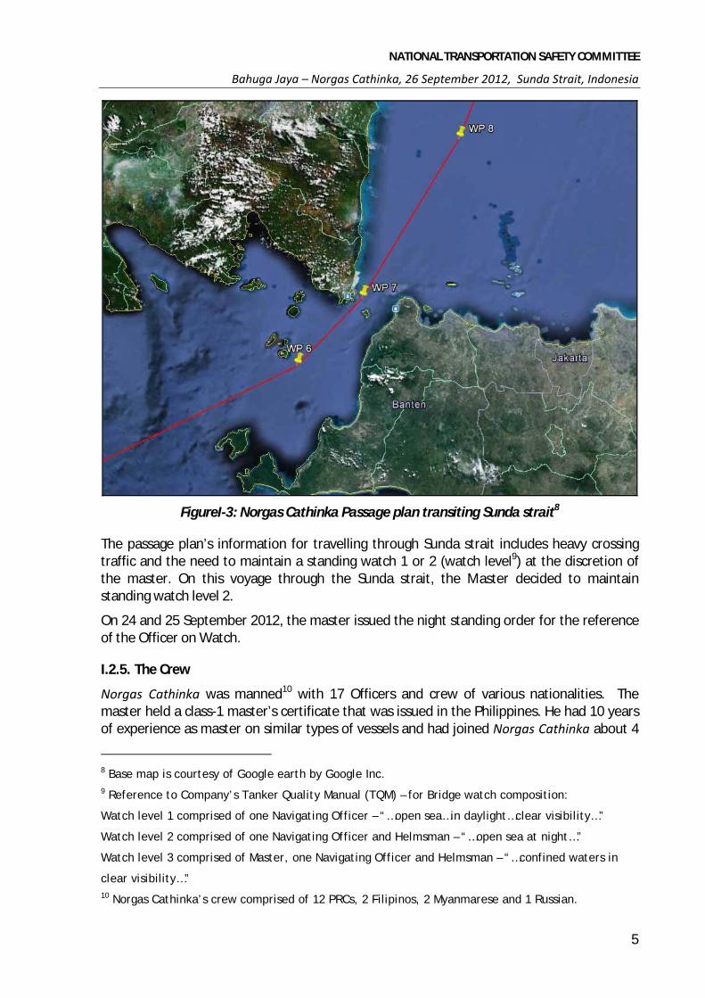
FigureI-3: Norgas Cathinka Passage plan transiting Sunda strait8
The passage plan’s information for travelling through Sunda strait includes heavy crossing traffic and the need to maintain a standing watch 1 or 2 (watch level9) at the discretion of the master. On this voyage through the Sunda strait, the Master decided to maintain standing watch level 2.
On 24 and 25 September 2012, the master issued the night standing order for the reference of the Officer on Watch.
I.2.5. The Crew
Norgas Cathinka was manned10 with 17 Officers and crew of various nationalities. The master held a class-1 master’s certificate that was issued in the Philippines. He had 10 years of experience as master on similar types of vessels and had joined Norgas Cathinka about 4
8 Base map is courtesy of Google earth by Google Inc. 9 Reference to Company’s Tanker Quality Manual (TQM) – for Bridge watch composition:
Watch level 1 comprised of one Navigating Officer – “…open sea…in daylight…clear visibility…”
Watch level 2 comprised of one Navigating Officer and Helmsman – “…open sea at night…”
Watch level 3 comprised of Master, one Navigating Officer and Helmsman – “…confined waters in
clear visibility…” 10 Norgas Cathinka’s crew comprised of 12 PRCs, 2 Filipinos, 2 Myanmarese and 1 Russian.
NATIONAL TRANSPORTATION SAFETY COMMITTEE
Bahuga Jaya – Norgas Cathinka, 26 September 2012, Sunda Strait, Indonesia
6
months before the accident. The master has been, for several times, crossing or operating near to the Sunda strait.
The chief mate, the officer on watch at the time of the accident, held a chief mate’s certificate that had been issued in China. He had 9 years of seagoing experience, 17 months of which was as chief mate. He joined Norgas Cathinka 20 days before the incident and has been, for several times, crossing or operating near to the Sunda strait.
The lookout on duty at the time of the accident held a watch-support certificate that was issued in the Philippines. He had 9 months of experience as an able seaman and joined the vessel 2 months before the accident.
I.3. INDONESIAN INNOCENT PASSAGE AND MERAK BAKAUHENI FERRY-ROUTE
The Merak – Bakauheni ferry route, crossing the Sunda strait between the islands of Jawa and Sumatera, is Indonesia’s busiest passenger/vehicle ferry route. As a result, the British Admiralty navigational chart 2056 covering the Sunda strait and its approaches contains the following warning ‘Mariners are warned that ferries cross selat Sunda [Sunda strait] between Bakauheni (5°52'S/105°45'E) in Sumatera and ports on the north coast of Java. The route is about 15 Nm in length and ferries normally complete the journey in about 2 to 3 hours.
According to the statistics data issued by the Ministry of Transportation, there were 26,291 ferry trips from Merak – Bakauheni in 2011. This translates to about 76 trips per day or about 7 vessels crossing every hour. According to the statistical data, 1,400,986 people and 1,773,672 vehicles were transported by the various ferries operating on this route. Ferry port authority 2012 data indicates that in average, 26 to 28 ferries was servicing the route daily.
The Sunda strait also sees the passage of large numbers of domestic and international trading vessels as the strait is part of one of three designated Indonesian Archipelagic Sea Lanes (ALKI). The strait are used by north/south bound vessels when transiting through Indonesian waters and as such “crossing situation” encounters between these vessels and the ferries are not uncommon.
Although the Ferry Port authority provides a Ship Traffic Controller (STC) with radar, AIS and communication system, however, its main function was only to regulate, supervise and record the arrival and departure of ferries at the ports.
There is no traffic separation scheme (TSS) or specific local regulation governing the traffic flow in the Sunda Strait.

NATIONAL TRANSPORTATION SAFETY COMMITTEE
Bahuga Jaya – Norgas Cathinka, 26 September 2012, Sunda Strait, Indonesia
7
FigureI-4: Indonesian Innocent Passage
I.4. THE COLLISION
At 0305 on 26 September 2012, Bahuga Jaya sailed from Merak bound for Bakauheni. The ferry was on a scheduled, regular, westbound crossing of Sunda strait. The passage would be made at its usual speed of about 10 knots and would take about 2 hours. The bridge team comprised the master, chief mate and one helmsman.
The weather was fine with light to moderate winds and good visibility. The strait current was 034 (T) at about 1.1 knot. After Bahuga Jaya’s engine was full away, the master handed over con of the vessel to the chief mate and left the bridge soon after.
Meanwhile, Norgas Cathinka was approaching Sunda strait from the south on a northeasterly course. The chief mate and a seaman were on the bridge.The chief mate was using the ARPA radar on a north-up, relative motion display on the 6 Nm range scale. The centre of the display had been offset to enable the chief mate to see further in the ahead direction. The radar’s trails function (blue trail behind yellow object) was being used by the chief mate to continuously monitor the relative movement of targets. The traffic was also being monitored either as an ARPA or an AIS target.
At 0420, Norgas Cathinka was on a heading of 049 (T) and a speed of about 12 knots. The vessel was about 2 Nm from Kandang Balak Island when the chief mate observed 3 eastbound radar targets, identified as 98, 99 and 100 (Caitlyn), on Norgas Cathinka’s port bow. These vessels about 1 to 311 points on Norgas Cathinka’s port bow at 3 to 4 Nm away, were on east-south-easterly courses.
At about the same time, the chief mate noted about 6 Nm away, 2 westbound targets had just started to appear on the radar display.
11 One point equals 11.25 degrees

NATIONAL TRANSPORTATION SAFETY COMMITTEE
Bahuga Jaya – Norgas Cathinka, 26 September 2012, Sunda Strait, Indonesia
8
FigureI-5: Norgas Cathinka (red line) approached the strait at 0400 (red line)
At 0426, one of the eastbound targets (ARPA target 98 in FigureI-6) crossed Norgas Cathinka’s bow more than 3 Nm off. The other eastbound targets were also acquired (targets 99 and the ferry Caitlyn).
FigureI-6: Norgas Cathinka’s radar captured image at 0426
Caitlyn
Norgas Cathinka
Ship #98
Ship #99 Bahuga Jaya
Geulis Rauh

NATIONAL TRANSPORTATION SAFETY COMMITTEE
Bahuga Jaya – Norgas Cathinka, 26 September 2012, Sunda Strait, Indonesia
9
At 0429, target 99 crossed Norgas Cathinka’s bow at a distance of more than 1.5 Nm. The ARPA was indicating that Caitlyn would also cross ahead and clear of Norgas Cathinka.
At about 0432, Norgas Cathinka’s chief mate used the radar’s electronic bearing line (EBL) to check the bearing of the first westbound targets (closest to Norgas Cathinka’s heading). The target with a bearing of 075 (T) indicated that it would pass close to Norgas Cathinka.
The chief mate, using the ARPA and AIS, identified the target as Bahuga Jaya at 3.3 Nm away and making good a course of 285 (T) at a speed of 9.7 knots. The chief mate noted that Bahuga Jaya closest point of approach (CPA) as nearly zero after about 11 minutes indicating that Bahuga Jaya was on a collision course with Norgas Cathinka.
Onboard Bahuga Jaya the helmsman was steering the vessel while the chief mate was keeping lookout and visually monitoring the traffic from the bridge wing. Soon after, the helmsman noted a green light from a vessel on his port side and informed the chief mate accordingly. At 0434, Norgas Cathinka’s chief mate, using the ARPA acquired the second westbound target. The AIS identified the target as Gelis Rauh with the ARPA indicated it would pass about a mile astern.
At 0436, the last of the eastbound targets, ferry Caitlyn crossed Norgas Cathinka’s bow at a distance of about 1 Nm. Target 99 was nearly abeam to starboard and passing clear while target 98 was well clear. Bahuga Jaya was still on a collision course on a bearing of about 074 (T).
FigureI-7: All vessels position at 0439
Caitlyn
98
99

NATIONAL TRANSPORTATION SAFETY COMMITTEE
Bahuga Jaya – Norgas Cathinka, 26 September 2012, Sunda Strait, Indonesia
10
At 0437½, Norgas Cathinka’s radar showed that the eastbound Caitlyn was 0.8 Nm off, on a bearing of 074 (T). Bahuga Jaya was 1.9 Nm off on the same bearing with a time to CPA of 7 minutes. Target 98 was near the Bahuga Jaya, having passed about 0.3 Nm on the ferry’s starboard side. Gelis Rauh had maintained its course and speed and would pass astern of Norgas Cathinka.
At 0439½, Norgas Cathinka was in position 5o 53.1’ S/ 105o 49.6’ E, just past alteration course to 031 (T) course as per its passage plan. The vessel was still on a heading of 049 (T) and Bahuga Jaya was 1.3 Nm off. There had not been any appreciable change to its bearing which were 072 (T). The ARPA predicted a CPA of 0.1 of a mile (i.e. a close quarters situation and risk of collision) after 5 minutes.
At about 0440, Norgas Cathinka’s chief mate using the autopilot adjusted the heading order to 050 (T). At about the same time, Bahuga Jaya’s chief mate decided to take action to avoid collision. He ordered port 20 and the helmsman executed his order.
At 0440½, Norgas Cathinka’s heading was 050 (T). The chief mate adjusted the heading further to starboard on the autopilot. At about the same time, Bahuga Jaya’s course changes to port i.e. towards Norgas Cathinka.
By 0441, Norgas Cathinka’s heading was 055 (T) and turning to 060 (T) as set on the autopilot. The helmsman was standing near the steering stand and could see Bahuga Jaya’s change of course to port. The ferry was now less than a mile off.
At 0442, Norgas Cathinka’s heading was 060 (T) and Bahuga Jaya was less than 0.7 of a mile and nearly ahead. Norgas Cathinka’s chief mate saw that the ferry was still turning to port.
At about 0442½, Bahuga Jaya’s chief mate ordered hard to port i.e. towards east. Norgas Cathinka was less than half a mile ahead. By this time, Norgas Cathinka's chief mate had changed to hand steering mode and turned the wheel to starboard also towards the east.
At 0443, Norgas Cathinka’s heading was 066 (T) and turning to starboard. Bahuga Jaya was 0.3 of a mile directly ahead of the vessel and turning quickly to port. The two vessels were closing rapidly at a speed which they would meet in about 1 minute.
Gelis Rauh, the other ferry, was half a mile away from the close quarter’s situation. It had altered course towards the south to keep clear of both vessels and pass further astern of Norgas Cathinka.
At 0443¼, Bahuga Jaya’s chief mate made an attempt to contact Norgas Cathinka on VHF radio channel 16. He called the vessel’s name three times, stating in ‘bahasa’:
”…Norgas Cathinka...Bahuga Jaya panggil (Panggil: Calling)..”, but did not receive any response.
Norgas Cathinka’s chief mate was still at the steering stand and he did not understand the radio call. At 0443¾, with Bahuga Jaya about 100 m away, he turned the wheel hard over to starboard.
At 0444¼, Norgas Cathinka’s heading was 135 (T) and turning quickly to starboard. A few seconds later, the port bow of the vessel collided with Bahuga Jaya’s starboard side, aft of the bridge.

NATIONAL TRANSPORTATION SAFETY COMMITTEE
Bahuga Jaya – Norgas Cathinka, 26 September 2012, Sunda Strait, Indonesia
11
At 0444½, aware of the collision, Gelis Rauh made a distress (Mayday) call on VHF radio channel 16.
At about 0445, Norgas Cathinka was heading 161 at 7 knot and maintaining its heading and speed. Bahuga Jaya started to list to port. The master of Bahuga Jaya went to the bridge to see what was wrong. After assessing the situation, the master requested the assistance of the Ship Traffic Controller station of Bakauheni Port. About 10 Ferries together with the Navy and the Marine Police vessels approached Bahuga Jaya position to provide assistance.
FigureI-8: All vessels position at 0444 ¼
Bahuga Jaya continued to list. The master ordered abandon ship and asked the crew to provide assistance to the passengers.
At 05.25, AIS of Bahuga Jaya no longer appears at Norgas Cathinka’s radar display. The vessel fully sank at 05o 52.764’ S/105o 51.108’E at 79 m deep.
At 05.30, after moving 5 Nm from the collision position, Norgas Cathinka returns to the collision position and was instructed by the Marine Police to drop anchor.
I.5. ACCIDENT RESULT
I.5.1. Norgas Cathinka
None of the Norgas Cathinka’s crew sustains any Injury.
According to the Class survey, Norgas Cathinka sustained damages as follows:
Port bulwark top section bulwark plate and its stanchion were buckled inward;
The 250 kg SWL manual crane next to the forecastle hatch was collapsed;
Port foremost fair ladder and its bracket connection to the deck found buckled;
Starboard bulwark top plate at in way of fair ladder buckled inward;
An open crack of 300 mm long sighted;
Shallow indentations found on forward stem plating in way of breasthook area, 1 frame found distorted.

NATIONAL TRANSPORTATION SAFETY COMMITTEE
Bahuga Jaya – Norgas Cathinka, 26 September 2012, Sunda Strait, Indonesia
12
FigureI-9: Collision mark at the bow and ruptured port forecastle’s bulwark
FigureI-10: Bukled forecastle structure of the Norgas Cathinka
I.5.2. Bahuga Jaya
After Bahuga Jaya was collided by Norgas Cathinka at the forward starboard side wall structure, Bahuga Jaya began to develop a port list which subsequently increased until the vessel finally sinks.

NATIONAL TRANSPORTATION SAFETY COMMITTEE
Bahuga Jaya – Norgas Cathinka, 26 September 2012, Sunda Strait, Indonesia
13
The Search and Rescue (SAR) operations involved 10 ferries which were crossing the strait at the time of the accident, Indonesian Navy Boat, Local Marine Police, Search and Rescue Agency. The SAR operations rescued 206 survivors and recovered 7 bodies – the chief mate of Bahuga Jaya was one of the fatalities.
Out of the 206 survivors, 10 were admitted to hospital for medical treatment while the remaining survivors received an outpatient treatment. The Search and Rescue results are as follows:
Tabel I-1: Casualty data of Bahuga Jaya
Description Fatality Serious Injury Minor Survivors Total
Crew 1 0 0 39 40 Passenger 6 10 0 157 173
Total 7 10 0 196 213

.

NATIONAL TRANSPORTATION SAFETY COMMITTEE
Bahuga Jaya – Norgas Cathinka, 26 September 2012, Sunda Strait, Indonesia
15
II. ANALYSIS
II.1. NTSC INVESTIGATION
On 26 September 2012, NTSC had received notification of the occurrence. Subsequently, NTSC dispatched an investigation team to collect information to the directly involved parties. Bahuga Jaya master, chief engineer, helmsman on duty and passengers were interviewed. The shore management of Bahuga Jaya was also interviewed. NTSC investigator received copies of relevant document including the company’s safety management system, maintenance report, passenger and cargo manifest, crew list and other vessel’s certificates.
On 27 September 2012, NTSC Investigators attended the Norgas Cathinka while the vessel was anchored near to Suralaya Port, Banten. As the master, chief mate and helmsman on duty were being interviewed by local Authority on shore, NTSC Investigators were interviewing the remaining crews on board Norgas Cathinka.
Copies of relevant documents obtained included the vessel’s log book, course recorder, master’s night order, and company’s procedure. With assistance from manufacturer’s technician, the VDR data was successfully retrieved.
Additional information was also provided by the Merak Ferry Port Authority to obtain the STC’s ferry activities log data prior to the accident and PT. Biro Klasifikasi Indonesia for Bahuga Jaya’s data and its latest inspection report.
NTSC Investigators attended Gelis Rauh to interview the master who witnessed the collision.
On 1 October 2012, NTSC conducted a joint investigation with Maritime and Port Authority of Singapore (MPA), as Norgas Cathinka’s flag State. NTSC iinvestigators and one MPA Investigator attended Norgas Cathinka to interview the master, chief mate and helmsman on duty. This joint investigation is in compliance with IMO Resolution MSC. 255 (84) and also based on the bilateral agreement of both Republic of Indonesia and Republic of Singapore.
On 1 – 4 January 2013, NTSC conducted survey to 25 vessels that servicing Merak – Bakauheni Ferry Route. The survey was aimed to identify the likelihood of ferries manoeuvre when in a crossing situation with the other vessel.
II.2. ACTION TO AVOID COLLISION ON 26 SEPTEMBER
At 0420 on 26 September 2012, Norgas Cathinka was approaching the part of Sunda strait where ferries frequently cross the strait in an east-west direction between Merak and Bakauheni. Shortly thereafter, the vessel encountered the crossing traffic that could be expected there from both directions.
Rule 15 of the COLREGs (Crossing situation) states:
When two power-driven vessels are crossing so as to involve risk of collision, the vessel which has the other on her own starboard side shall keep out of the way and shall, if the circumstances of the case admit, avoid crossing ahead of the other vessel.

NATIONAL TRANSPORTATION SAFETY COMMITTEE
Bahuga Jaya – Norgas Cathinka, 26 September 2012, Sunda Strait, Indonesia
16
In this crossing situation, the northbound Norgas Cathinka was required to keep out of the way of the westbound Bahuga Jaya, on its starboard side.
On 26 September 2012, Norgas Cathinka encountered five crossing vessels, three eastbound and two westbound. All the eastbound vessels crossed ahead of the vessel, the closest crossing about 1 Nm from its bow. Given the area, traffic, weather and the size, type and speed of the vessels involved, it was not considered that risk of collision existed, and no avoiding action was necessary.
Rule 16 of the COLREGs (Action by give-way vessel) states:
Every vessel which is directed to keep out of the way of another vessel shall, so far as possible, take early and substantial action to keep well clear.
This meant that Norgas Cathinka was required to take appropriate action if a risk of collision was involved with either of the two westbound vessels. A developing situation involving a risk of collision with either vessel could have been identified as early as about 0420, shortly after they appeared on the radar display. Over the next 10 minutes, the risk of collision could have been determined and avoiding action taken. The first vessel, Bahuga Jaya, remained on a nearly steady compass bearing indicating risk of collision. The slightly opening bearing of the other vessel, Gelis Rauh, indicated that it would pass astern of the vessel but would still need to be closely watched.
Rule 17 of the COLREGs (Action by stand-on vessel) states:
(a)(i) Where one of two vessels is to keep out of the way the other shall keep her course and speed.
(a)(ii) The latter vessel may however take action by her manoeuvre alone, as soon as it becomes apparent to her that the vessel required to keep out of the way is not taking appropriate action in compliance with these Rules.
(b) When from any cause, the vessel required to keep her course and speed finds herself so close that collision cannot be avoided by the action of the give-way vessel alone, she shall take such action as will best aid to avoid collision.
(c) A power-driven vessel which takes action in a crossing situation in accordance with sub-paragraph (a)(ii) of this Rule to avoid collision with another power-driven vessel shall, if the circumstances of the case admit, not alter course to port for a vessel on her own port side.
(d) This Rule does not relieve the give-way vessel of her obligation to keep out of the way.
From about 0420, Norgas Cathinka’s chief mate monitored the eastbound crossing vessels. It was not until 0432 that he checked the compass bearing of Bahuga Jaya and acquired it as a target followed, 2 minutes later, by acquiring the other target, Gelis Rauh. This indicates that there was significant delay in determining risk of collision with the westbound vessels, and with Bahuga Jaya in particular. The last of the three vessels crossed Norgas Cathinka’s bow at 0436.
While no action had been taken with respect to the westbound vessels, Norgas Cathinka’s chief mate could have initiated action at 0436, when the eastbound vessel crossed the

NATIONAL TRANSPORTATION SAFETY COMMITTEE
Bahuga Jaya – Norgas Cathinka, 26 September 2012, Sunda Strait, Indonesia
17
vessel’s bow. However, even at 0437½, when the eastbound vessel was well clear and on the same bearing as Bahuga Jaya, no action had been taken on board Norgas Cathinka.
It was not until after 0440, that Norgas Cathinka’s course was altered to starboard. In the circumstances, this action was neither early nor substantial and, hence, was not appropriate. After more than 2 minutes, the further action taken to alter course quickly was probably taken in confusion and panic because the collision was imminent. Bahuga Jaya’s chief mate took action to avoid collision at about 0440, the same time as Norgas Cathinka’s course alteration was started. However, Bahuga Jaya’s course was altered to port and this was not consistent with Rule 17c – “...not alter course to port for a vessel on her own port side”.
Evidence obtained by the NTSC through a wide-ranging survey revealed that ferry masters and mates regularly encounter foreign vessels (on north or southbound transit of Sunda strait) that make no alteration of course and/or speed to avoid crossing ferries. Many of the ferry masters and mates indicated that to avoid close quarters situations with a transiting vessel, “...they often alter course to pass astern of the vessel”.
They believe that ferries are better equipped to manoeuvre, including making rapid reductions of speed. Therefore, it is not uncommon for ferries to take collision avoidance action by their manoeuvre alone instead of relying on action by the other vessels.
Based on the evidence, it is almost certain that Bahuga Jaya’s experienced chief mate had in the past taken action to avoid a transiting vessel if he concluded that the vessel would not take action as a give way vessel. The chief mate had probably encountered situations similar to those that he encountered with Norgas Cathinka, and he assumed that the vessel would not take action. The fact that the vessel did not take any action until very late would have reinforced the chief mate’s assumption.
Other than Bahuga Jaya’s chief mate’s brief attempt to contact Norgas Cathinka about a minute before the collision, there was no communication between the vessels. Rule 34 of the COLREGs requires that whistle signals, which may be supplemented by light signals, be used by vessels when taking action to avoid collision. Neither Norgas Cathinka nor Bahuga Jaya made any whistle or light signals.
In this incident, had Norgas Cathinka or Bahuga Jaya, made the appropriate light and sound signals to indicate their intention or when in doubt or failed to understand the intention of the others, both vessels could have been warned accordingly and the collision could have been avoided.
As a give-way vessel, Norgas Cathinka had a number of options available for taking action by altering its course and/or speed. At 0420, the chief mate could have reduced the vessel’s speed to allow more time to assess the situation while at the same time allowing the crossing traffic to pass ahead of it. Alternatively, Norgas Cathinka could have been turned around to a reciprocal course for a short time. This could have been done by turning to starboard in ample time (to avoid confusing the three eastbound crossing vessels on the port side).
However, the lack of early assessment and action resulted in Norgas Cathinka’s chief mate finding himself in a complicated traffic situation. Within a period of less than 20 minutes, five crossing vessels would pass close to the vessel and the situation was further complicated when Bahuga Jaya’s course was altered to port towards Norgas Cathinka.

NATIONAL TRANSPORTATION SAFETY COMMITTEE
Bahuga Jaya – Norgas Cathinka, 26 September 2012, Sunda Strait, Indonesia
18
While the collision was the direct result of actions on both vessels that were inappropriate or inconsistent with the COLREGs, a number of underlying factors influenced those actions.
Bahuga Jaya’s SMS included navigation and bridge procedures consistent with the COLREGs and the ordinary good practice of seamanship. The ship’s procedures and COLREGs provided the chief mate with sufficient guidance with regard to determining risk of collision and action to avoid collision. However, he did not take a number of actions that he could and should have. Significant amongst these was the use of radar, AIS and aldis lamp. It is also unclear if the chief mate checked the compass bearing of Norgas Cathinka to determine the risk of collision in sufficient time. He could also have considered using the main engine and/or calling the master. Finally, his action to avoid collision by altering course to port was contrary to the COLREGs.
II.3. PASSAGE PLANNING AND BRIDGE RESOURCE MANAGEMENT
Norgas Cathinka’s sailed from Durban, South Africa, about 10 days before its transit of Sunda strait. The vessel would therefore be making landfall after a long ocean passage and would transit a narrow passage where the charted hazards include rocks and shoals. In addition, crossing traffic can be expected in Sunda strait.
A notation on the chart (BA 2056) in the centre of Sunda strait states ‘FERRIES (see Note)’. The note on the chart states the following:
SELAT SUNDA – FERRIES
Mariners are warned that ferries cross Selat Sunda between Bakauheni (5⁰52’S 105⁰45’E) in Sumatera and ports on the north coast of Jawa.
The Admiralty Sailing Directions (Indonesia Pilot, Volume 1) provides further information and guidance for transiting Sunda strait. Under the title ‘Hazards’, it states:
Ferries ply on a regular basis at the E end of Selat Sunda between Merak (5⁰56.00’S 105⁰59.70’E), Jawa and Panjang (5⁰38.03’S 105⁰18.99’E), Sumatera; also between Bakauheni (5⁰52.30’S 105⁰45.30’E), Sumatera, and ports on the N coast of Jawa.
Therefore, there is sufficient guidance for transiting vessels with regard to crossing traffic in Sunda strait. A vessel’s passage plan should take into account this guidance and the master must have preparations in place for encountering crossing traffic and other hazards that can always be expected.
Norgas Cathinka had been provided with all the necessary nautical publications, including those referred to above. The vessel’s passage plan contained the following information for the course leg through Sunda strait.
Normal sea watch. Follow COLREGs. Primary fixing method - radar, secondary - GPS. Plot vessel’s position every 30 minutes. Keep sharp look-out. Vessel’s squat 0.5 m. PI=1.3’ to P. Panjurit. Heavy traffic crossing course. Standing watch 1 or 2.
‘Standing watch 1 or 2’ for a ‘normal sea watch’ meant having an officer of the watch at all times and, at night, a duty seaman. There was no further planning for transiting the Sunda strait.

NATIONAL TRANSPORTATION SAFETY COMMITTEE
Bahuga Jaya – Norgas Cathinka, 26 September 2012, Sunda Strait, Indonesia
19
The master had transited Sunda strait several times and hence should have been sufficiently aware of the crossing traffic that could be expected. However, his night orders on 25 September 2012 were similar to the previous nights with no specific guidance for traffic in Sunda strait. In fact, the only additional items to the previous night’s orders related to security (anti-piracy precautions such as locking accommodation doors and looking out for small boats), and were documented as ‘particular instructions’.
The master’s night orders on 25 September 2012 made no mention of crossing traffic in Sunda strait. With regard to traffic, the orders were restricted to ones that he typically issued and were listed as follows:
In all cases follow to COLREGs, sharp lookout is required always.
Both radars to be ON.
Any verbal VHF agreements with other vessels which can violate COLREG are strictly prohibited.
In case of any abnormality or any hesitation call me immediately.
Minimum CPA 2 Nm/TCPA 15 min.
However, keeping a minimum CPA of 2 Nm from traffic may be appropriate in open seas but unrealistic in Sunda strait. And if this was the master’s expectation, having the main engines ready for immediate manoeuvre and for the master to join the bridge team for the transit would have been far more helpful than the written orders.
Furthermore, some of the night orders such as taking celestial observations for position fixing when available were irrelevant and inappropriate for Sunda strait. Nevertheless, the third, second and chief mates had signed the orders and no one, including the chief mate, expressed any concern or called the master about doubts in the time leading to the collision. This indicates that the orders were neither helpful nor effective, suggesting poor implementation of procedures.
The master did not intend to be present on the bridge for the transit. There was no mark on the chart indicating that the master required to be called at any particular place or time. This suggests that he did not consider that the transit in general or traffic in particular warranted his presence on the bridge. While the main engine was on bridge control, there was no plan for engine to be on standby, the engine room to be manned, the master’s intention to be on the bridge or to include guidance in this regard in his night orders. Such planning on his part could have ensured that there was no doubt in the mind of the officer of the watch with regard to the possible use of engines or calling the master.
Norgas Cathinka’s safety management system procedures for passage planning provided guidance which, used with the charts and Admiralty Sailing Directions, could have been used to plan and execute a safe transit of Sunda strait. While the procedures did permit the master to generally use his discretion, they were sufficiently specific in many respects. For example, watch level 5 (the highest level) required the vessel’s bridge team to comprise the master, two mates and two seamen. While levels 3, 4 and 5 were generally to be used for port arrival or departure, a Sunda strait transit warranted a higher level than level 2. Level 3 and above required the master to be part of the bridge team, whereas levels 1 and 2 left this to the master’s discretion.

NATIONAL TRANSPORTATION SAFETY COMMITTEE
Bahuga Jaya – Norgas Cathinka, 26 September 2012, Sunda Strait, Indonesia
20
The passage planning procedures specifically referred to the Bridge Procedures Guide and Bridge Team Management, internationally recognised publications. Current editions of both publications on board were to be used for passage planning. Had the guidance in these publications been considered, a number of measures including those discussed above would have been in place for a safe transit of Sunda strait. For example, the Bridge Procedures Guide checklist for navigation in coastal waters includes several checks including ones for traffic and using the vessel’s engines.
Therefore, the vessel’s procedures and publications on board provided adequate guidance for appropriate passage planning and management of bridge resources. The ordinary practice of good seamanship, the experience of the master and the mates and compliance with the vessel’s procedures and the COLREGs should have resulted in safe transit. However, poor planning and inadequate bridge resource management left the chief mate to transit Sunda strait, in a difficult situation.
In summary, the passage planning procedures had not been effectively implemented on board Norgas Cathinka’s. This effectively allowed a number of conditions to exist that contributed to the collision.
II.4. SHIP TO SHIP COMMUNICATION
The COLREGs do not require vessels to use verbal communications for collision avoidance. Vessels are required to use whistle signals and light signals when taking action to avoid collision as discussed in section II.2. Radio communications by VHF are neither recommended nor are they generally considered appropriate because they can confuse the situation because of language and other difficulties. Nor are they necessary if vessels comply with the COLREGs.
Evidence from the NTSC’s survey indicated that ferries in Sunda strait tend to use VHF radio to arrange a safe passing with other ferries and transiting vessels. This fact explains the calls that Bahuga Jaya’s chief mate made about a minute before the collision. Not only did these calls serve no purpose, they had the potential to cause confusion and increase workload. In any case, Norgas Cathinka’s chief mate did not understand the calls from the ferry. The master’s orders also required that VHF radio not be used for collision avoidance.
When Bahuga Jaya’s chief mate calling the Norgas Cathinka, not only the communication was made at the time collision was imminent but also the language used was a typical local ferry to ferry communication. This indicate that the chief mate most likely was in a stressed situation and did not properly expressed his intention. In this regard, had he been observing the Norgas Cathinka before collision, he would have been aware that Norgas Cathinka is a foreign vessel.
Had the appropriate actions taken were in accordance with the COLREGs on board Norgas Cathinka and Bahuga Jaya, there would have been no reason to resort to VHF radio communication as a last resort to prevent collision. The use of the VHF radio after the collision, however, was appropriate to enhance the safety of life i.e. during the rescue operations.

NATIONAL TRANSPORTATION SAFETY COMMITTEE
Bahuga Jaya – Norgas Cathinka, 26 September 2012, Sunda Strait, Indonesia
21
II.5. ACTION TAKEN AFTER COLLISION
Article 98 of the United Nations Convention on the Law of the Sea (UNCLOS) outlines the responsibility of a vessel’s master following a collision at sea. In part 1.c of the article states that:
“Every state shall require the master of a ship flying its flag, in so far as he can do so without serious danger to the ship, the crew or the passenger, after a collision, to render assistance to the other ship, its crew and its passengers and, where possible, to inform the other ship of the name of his own ship, its port of registry and the nearest port at which it will call.”
After the collision, Norgas Cathinka’s master came to the bridge. The Norgas Cathinka reduced its speed of 7 knots and was now south bound. After sailing south for about 5 Nm, the vessel turned around to head back towards the collision site.
Mayday call were broadcasted by the Gelis Rauh pertaining the condition of the Bahuga Jaya through channel 16. Soon after, some communication in ‘Bahasa’ was also started, stressing the emergency situation of Bahuga Jaya.
The Norgas Cathinka’s radar indicated that a number of vessels, which was later identified as ferries, gathered at the collision site.
At about 0524, the master of Norgas Cathinka carried out inspection and noted that there was no injury or pollution as a result of the incident However, the master not knowing the condition of the onboard cargo had maintained a safe distance away from the collision site. Soon after, the Indonesian Marine Police and Indonesian Navy boat instructed Norgas Cathinka to stop.
The master, when queried by the Authority, admitted that the vessel was moving at safe distance away from the collision site (congested with other vessels), as he was concerned that the vessel was carrying flammable propylene and explosive in nature.
II.6. EVENTS AFTER COLLISION
Event reconstruction based on the VDR data, physical mark evidence and vessel particular showed that the Norgas Cathinka and Bahuga Jaya collided twice. First collision was when Norgas Cathinka’s port bow collided with Bahuga Jaya forward starboard side wall structure. 2nd collision impact appeared to occur along Norgas Cathinka’s port quarter and Bahuga Jaya’s starboard quarter.
Bahuga Jaya car decks were loaded with 78 units of vehicular. The 1st car deck was loaded with heavy Lorries, medium size Lorries and truck with total of 46 units. The 2nd car deck was loaded with small car and motor cycle with a total of 38 units. None of all vehicles in the 1st and 2nd car deck were lashed.
Collided by a vessel of 14.721 displacement tonnes at a speed of 11 knots, most likely had result Bahuga Jaya started to heel to port and the momentum could have caused the vehicles in the cardeck to shift – to the lower side i.e. towards the port side. When a vessel’s cargo started to shift, the vessel’s central of gravity would also shift to the direction where the cargo were shifted. This condition could have caused Bahuga Jaya’s stability condition to

NATIONAL TRANSPORTATION SAFETY COMMITTEE
Bahuga Jaya – Norgas Cathinka, 26 September 2012, Sunda Strait, Indonesia
22
deteriorate.The shifted vehicles on the 2nd car deck had resulted the ferry’s heeling moment to be greater than its uprighting moment, hence Bahuga Jaya continued to list further to port.
The increased port list could have caused Bahuga Jaya’s side wall openings to come closer to the water level. As the list increased, it inadvertently caused the side wall openings to reach and submerged below water level. As the openings submerged, sea water began to enter and flooded the car deck. These deteriorating conditions continue due to progressive flooding until Bahuga Jaya finally capsized and sank.
It had been a common practice by local ferries to not secured or lashed the vehicle during their voyage. There is no any regulation to require the Merak – Bakauheni ferries to do so. When the vessel was in a high risk operation as the weather turn worst, the ferries tend to stop operation and take shelter rather than securing the cargo and continue voyage.
II.7. FERRY TRAFFIC MANAGEMENT
According to the ferry traffic data, the number of ferry servicing the Merak – Bakauheni Route has been increasing. In 2011, the route was serviced by 33 vessels comprising 22 vessels which were operational and 11 others scheduled for routine maintenance or annual inspection. The ferry operation data of 2012 shows that the route was serviced by 41 vessels comprising 26 – 28 vessels operational and the others for routine maintenance and annual inspection. The trip productivity also indicates an increment. In 2006, the total number of ferry trips in the particular route was 42.700 trips in a year (average 117 trips per day). The number had increased in 2011 with a total of 57.248 trips in a year (average 156 trips per day) were produced. Local Ferry Port Authority has established a Ship Traffic Controller (STC) with the main objective to control and monitoring the ferry’s operation in the port area. Concerning that the ferry service at Merak Port is supported by 5 piers meanwhile Bakauheni Port supported by 4 pier, hence, there were 20 – 22 vessels crossing the strait in every hour.
Other than ferry services, there were also numbers of facilities in the area near of Sunda strait which relies on the sea transport e.g.: a steam generated power plant Suralaya which relies on a coal supply carried by barges, Indah Kiat pulp and paper Factory and many other factories. On the other hand, as an innocent passage, ALKI 1 would always be transited by international voyage.
The ferries service speed and cargo capacity was vary. The NTSC’s survey identified that a ferry’s was operated at about 5 knots meanwhile another ferry was indicated could have an operational speed at about 12 knots.
The ferry schedule was developed based on the readiness of the vessel to service the route. The schedule was not concerning the vessel operational parameter i.e.: speed and cargo capacity. In some circumstances, following the various ferry’s operational speed, number of vessels would positioned closed to each other in the ferry route. This situation could increase the risk of collision.

NATIONAL TRANSPORTATION SAFETY COMMITTEE
Bahuga Jaya – Norgas Cathinka, 26 September 2012, Sunda Strait, Indonesia
23
Figure II-1: Merak – Bakauheni ferry manoeuvring pattern based on NTSC survey (red line:
ferry to Merak, White Line: ferry to Bakauheni)
There was also no specific line for the ferry to transit the route. The figure above shows the typical manoeuvring pattern of Merak – Bakauheni ferries. The manoeuvring line was generated based on the vessel’s position recorded during the survey. The pattern indicates that the ferries moved irregularly for both destination of Merak and Bakauheni. During interview to the Ferry’s Officer, the manoeuvring pattern was influenced by state of the strait current, action to avoid collision with the other vessel/s and daily normal ferry deck officer’s seamanship.
The conditions of irregular manoeuvre might made confusion for other vessel that crossing the Sunda strait. To maintain a safe passage in the area and to avoid similar dangerous ‘near-missed’ accident there should be a traffic separation scheme within both destinations Merak and Bakauheni. It is intended that in the cruise ferries routes could be clearly specified so that particularly looks safety and in order.
On the other aspect, the only traffic controller STC had small coverage to monitor all ferry traffic at Sunda strait and solely established for ferry operation. To maintain the safe passage in the area, the local authorities should have a system to monitor and inform the vessels about the situation and to control vessel movement.

.

NATIONAL TRANSPORTATION SAFETY COMMITTEE
Bahuga Jaya – Norgas Cathinka, 26 September 2012, Sunda Strait, Indonesia
25
III. FINDINGS
III.1. MAIN CAUSAL FACTOR
The evidence indicates that the main contributing factor to the collision was that neither of the two vessels that collided took action in accordance with and consistent with the COLREGs.
The following describe individual actions and issues associated with the factor above.
III.2. CONTRIBUTING FACTORS
After ferry Caitlyn passed clear ahead of Norgas Cathinka, the chief mate of Norgas Cathinka did not sufficiently utilise the time available to take a clear and substantial action to avoid collision with Bahuga Jaya. The course alteration was too slow and too small to indicate the vessel’s movements to the other vessel;
The Bahuga Jaya's chief mate had made an assumption based on scanty information that there was no significant course alteration made by Norgas Cathinka. Hence, he took action to alter Bahuga Jaya to port to avoid collision;
Bahuga Jaya's action to alter its course to port was not consistent with the collision avoidance regulations;
The Norgas Cathinka’s master through his night orders did not provide sufficient guidance to the chief mate to safely transit the route. The night order did not sufficiently adopt the risk notification provided in the chart;
The Norgas Cathinka master's discretion to maintain watch standing level 1 or 2 in a heavy traffic ferry route was not consistent with the vessel's procedures;
Passage planning and bridge resource management on board Norgas Cathinka for the transit of Sunda strait was poor. In this respect, the vessel's safety management system procedures had not been effectively implemented; [Safety issue]
Communication made from Bahuga Jaya was not taken at appropriate time and insufficiently broadcast.
III.3. OTHER SAFETY FACTORS
Ferry’s deck officer tend use VHF radio communication to arrange safe passage with other vessel instead of implemented COLREGs sufficiently; [safety issue]
Based on Ferry vessels survey conducted by NTSC, it appeared to be common practice i.e. when communication failed to determine the safe passing, the ferry vessel tends to avoid collision by altering towards the stern of the other vessel. In certain occasion it will confuse other vessel as it might not be consistent with COLREGs;
Ferry traffic operation had resulted in both vessels in risk of collision.

.

NATIONAL TRANSPORTATION SAFETY COMMITTEE
Bahuga Jaya – Norgas Cathinka, 26 September 2012, Sunda Strait, Indonesia
27
IV. RECOMMENDATION The National Transportation Safety Committee issued the following recommendations to the involved parties with the aim solely to prevent a recurrence in the future.
NTSC encourages all the following parties to take safety action. These actions have been carried out or were planned to be carried out in relations to each safety issue relevant to their organisation.
IV.1. DIRECTORATE GENERAL OF SEA TRANSPORTATION
To recommend ferry route between Merak – Bakauheni i.e. separating the eastbound lane to the westbound lane by a buffer zone.
IV.2. DIRECTORATE GENERAL OF LAND TRANSPORTATION AND FERRY SERVICES
To sufficiently manage ferry operation schedule following the vessel’s speed parameter to avoid dense traffic in a certain area.
To set up a guidance of traffic separation for ferry operation in the strait.
IV.3. VESSEL’S OPERATOR
Ferry operator
To enhance their crews capability to communicate with other vessel using proper navigational language;
To ensure their ship’s officer to sufficiently implement the COLREGs;
To ensure the deck officer on watch enhance his lookout mainly when the ferry approaches the ALKI.
Norgas Carrier Pte Ltd
To take safety action ensuring the vessel to comply company’s procedure of bridge composition and standing watch procedure;
To ensure compliance with COLREGs in particular to crossing situation.

.
NATIONAL TRANSPORTATION SAFETY COMMITTEE
Bahuga Jaya – Norgas Cathinka, 26 September 2012, Sunda Strait, Indonesia
29
EVENT – CONDITION TIME LINE

NATIONAL TRANSPORTATION SAFETY COMMITTEE
Bahuga Jaya – Norgas Cathinka, 26 September 2012, Sunda Strait, Indonesia
30
At 0445, the heading of Norgas Cathinka was 161
at a speed 7 of knot
From page one
At 0444½, Gelis Rauh made a Mayday call on
VHF radio
Bahuga Jaya started to list to port side
The master requested the assistance of STC Bakauheni
At 0525, the Bahuga Jaya position was not longer
appeared on radar The master ordered abandon ship and asked the crew to provide the assistance for the passengers
Bahuga Jaya continuosly listed
2nd
collision impact along Norgas Cathinka port
quarter and Bahuga Jaya starboard
quarter
In the meantime the sea water started to enter all car decks through the ship’s openings
None of all vehicles in car decks were lashed
At 0530, after moving 5 nm from the collision
position, Norgas Cathinka turned back to
the collision position then soon dropped her
anchor in that area
Bahuga Jaya fully sank at position of 05° 52.764’ S/
105° 51.108 E at 79 m deep
About 10 Ferries approachedthe Bahuga Jaya position to
provide assistance
The momentum had resulting the vehicle in the cardeck shifted to port
side
This condition could have caused Bahuga Jaya’s stability
condition was deteriorated
NATIONAL TRANSPORTATION SAFETY COMMITTEE
Bahuga Jaya – Norgas Cathinka, 26 September 2012, Sunda Strait, Indonesia
31
SOURCE OF INFORMATION Crews of Bahuga Jaya;
Crews of Norgas Cathinka;
PT. Atosim Lampung Pelayaran;
Norgas Carrier Pte Ltd;
Merak Port Administration Office, Banten;
Bakauheni Port Administration office, Lampung;
Merak Ferry Port Authorities;
PT. Indonesian Ferry, Merak Branch;
BASARNAS, Indonesia National Search and Rescue Agency;
Indonesian Meteorology, Climatology and Geophysical Agency;
PT. Biro Klasifikasi Indonesia (Persero);
Maritime and Port Authority of Singapore (MPA);
Germanischer Lloyd;
Indonesian Ferry Operator Association (GAPASDAF), branch Merak and branch Bakauheni;
Passengers of Bahuga Jaya;
Convention on the International Regulations for Preventing Collisions at Sea, 1972 (COLREGs);
IMO Resolution MSC.255 (84) Code For The Investigation Of Marine Casualties And Incidents;
The Admiralty Sailing Directions (Indonesia Pilot, Volume 1), UKHO.