FINAL PHASE I DAMAGE ASSESSMENT PLAN FOR SOUTHEAST
84
FINAL PHASE I DAMAGE ASSESSMENT PLAN FOR SOUTHEAST MISSOURI LEAD MINING DISTRICT: BIG RIVER MINE TAILINGS SUPERFUND SITE, ST. FRANCOIS COUNTY AND VIBURNUM TREND SITES, REYNOLDS, CRAWFORD, WASHINGTON, AND IRON COUNTIES January 2009 Prepared for: State of Missouri Missouri Department of Natural Resources U.S. Fish and Wildlife Service U.S. Department of the Interior Prepared by: David E. Mosby and John S. Weber U.S. Fish and Wildlife Service U.S. Department of the Interior Columbia, MO 65203 Frances Klahr Missouri Department of Natural Resources Jefferson City, MO 65102
Transcript of FINAL PHASE I DAMAGE ASSESSMENT PLAN FOR SOUTHEAST

FINAL PHASE I DAMAGE ASSESSMENT
PLAN FOR SOUTHEAST MISSOURI LEAD
MINING DISTRICT: BIG RIVER MINE
TAILINGS SUPERFUND SITE, ST. FRANCOIS
COUNTY AND VIBURNUM TREND SITES,
REYNOLDS, CRAWFORD, WASHINGTON, AND IRON COUNTIES January 2009
Prepared for: State of Missouri Missouri Department of Natural Resources U.S. Fish and Wildlife Service U.S. Department of the Interior Prepared by: David E. Mosby and John S. Weber U.S. Fish and Wildlife Service U.S. Department of the Interior Columbia, MO 65203 Frances Klahr Missouri Department of Natural Resources Jefferson City, MO 65102
FINAL PHASE 1 DAMAGE ASSESSMENT PLAN FOR THE SOUTHEASTMISSOURI LEAD MINE DISTRICT: BIG RIVER MINE TAILINGSSUPERFUND SITE, ST.FRANCOIS COUNTY, AND VIBURNUM TREND SITES,REYNOLDS AND IRON COUNTIES
MISSOURI DEPARTMENT OF NATURAL RESOURCES
u.S. DEPARTMENT OF THE INTERIOR
Tom Melius, DirectorRegion 3U.S. Fish and Wildlife ServiceU.S. Department of the Interior
Date
Date

FINAL PHASE I DAMAGE ASSESSMENT PLAN FOR THE SOUTHEASTMISSOURI LEAD MINE DISTRICT: BIG RIVER MINE TAILINGS
SUPERFUND SITE, ST. FRANCOIS COUNTY, AND VIBURNUM TRENDSITES, REYNOLDS AND IRON COUNTIES
CONCURRENCE
For the U.S. Department of Interior:
,··~o.~~Tom Melius, DirectorRegion 3, U.S. Fish and Wildlife ServiceAuthorized Official for the Department of Interior
For the Missouri Department of Natural Resources:
Joseph P. Bindbeutel, Acting Director
~v.. . ;1'3 ,100'1D te
Date

TABLE OF CONTENTS EXECUTIVE SUMMARY 7 CHAPTER 1 INTRODUCTION 11 1.1 Big River Mine Tailings (St. Francois County) Superfund Site Description 13
1.1.1 Response Activities at the Big River Mine Tailings Superfund Site 15
Big River (Desloge) Pile 16
Elvins/Rivermines Pile 16
Bonne Terre Pile 16
Leadwood Pile 16
National Pile 17
Federal Tailings Pile 17
1.2 Viburnum Trend Site Description 17
1.2.1 Sweetwater Mine/Mill Complex 17
1.2.2 West Fork Mine/Mill Complex 18
1.2.3 Glover Lead Smelter and Refinery 19
1.3 Natural Resource Damage Assessment Activities at SEMOLMD Sites 23
CHAPTER 2 AFFECTED NATURAL RESOURCES IN THE SOUTHEAST MISSOURI LEAD MINING DISTRICT 2 4
2.1 Surface Water Resources: Rivers and Streams 24
2.1.1 Big River Surface Water 24
2.1.2 Viburnum Trend Sites Surface Water 26
Sweetwater Surface Water 26
West Fork Surface Water 27
Glover Smelter Surface Water 27
2.2 Geologic Resources 34
2.2.1 BRMT Site 34
2.2.2 Sweetwater Mine/Mill Complex 35
2.2.3 West Fork Mine/Mill Complex 36
2.2.4 Glover Smelter 36 2.3 Ground Water 37
2.4 Biotic Resources 38
2.4.1 Threatened and Endangered Species 39
2.4.2 Vegetation 40
2.4.3 Aquatic and Amphibious Species 43
2

2.4.4 Birds 43
2.4.5 Mammals 44
2.5 Hazardous Substances 44 2.5.1 Cadmium 45
2.5.2 Lead 45
2.5.3 Zinc 46
2.6 Confirmation of Exposure 46 2.6.1 Surface Water 47 2.6.2 Geologic Resources 47 2.6.3 Ground Water 47 2.6.4 Biotic Resources 47 2.7 Preliminary Determination of Recovery Period 47
CHAPTER 3 ROLE OF TRUSTEES 49 3.1 Trustee Authority 49 3.2 Overview of NRDAR 50 3.2.1 Determination to Pursue a Type B Assessment 50
3.2.2 Phases in the NRDAR Process 51
Preassessment Phase 51
Assessment Plan Phase 51
Assessment 52 Injury Determination 52
Injury Quantification 53 Damage Determination 53 3.2.3 Coordination with Other Governmental Agencies, the Public, and PRPs 53
Coordination with Other Governmental Agencies 53
Importance of Public Participation 54
Potentially Responsible Parties (PRPs) 54
CHAPTER 4 ASSESSMENT OF NATURAL RESOURCES AT SELECTED SITES OF THE SOUTHEAST MISSOURI LEAD MINING DISTRICT 5 6 4.1. Surface Water Resources 57
4.1.1 Surface Water: Exceedances of Regulatory Standards and Literature-Based Impact
Thresholds 58
4.1.2 Surface Water Sediments: Exceedances of Regulatory Standards and Literature-Based
Impact Thresholds 58
4.2 Aquatic Organisms 59
4.2.1 Fish, Shellfish, and Other Aquatic Macroinvertebrates 59
4.2.2 Aquatic Injury Studies 59
4.2.3 Waterfowl 60
3

4. 3 Terrestrial Organisms 61
4.3.1 Small Mammals 61
4.3.2 Other Terrestrial Fauna 61
4.3.3 Vegetative Communities: Impacts at Current and Former Mine Waste Pile Locations 62
4. 4 Ground Water Resources 62
4.4.1 Ground Water: Exceedances of Regulatory Standards 63
4.5 Geologic Resources 63
4.5.1 Soils: Exceedances of Literature-Based Impact Thresholds 63
4.6 Pathway Determination 64
4.7 Damage Determination 64
4.7.1 Primary Restoration 65 Aquatic Restoration 65 Terrestrial Restoration 65 4.7.2 Compensatory Restoration 66 Loss of Ecological Services 66 Loss of Recreational Services 66 4.7.3 Groundwater Damage Determination 66 CHAPTER 5 QUALITY ASSURANCE MANAGEMENT 6 8 5.1 Project Management 69 5.2 Data Generation and Acquisition 70 5.3 Assessment and Oversight 71 5.4 Data Validation and Usability 72
REFERENCES 7 3 Threatened and Endangered Species of the Southeast Missouri Lead Mining District APPENDIX A Migratory Birds of the Southeast Missouri Lead Mining District APPENDIX B Study Specif ic Work Plans APPENDIX C
4

LIST OF EXHIBITS Exhibit ES-1 Currently planned and in process Southeast Missouri Lead mining district NRDA Studies 9
Exhibit 1 Map of Southeast Missouri Lead Mine District 12
Exhibit 2 Tailings and Chat Distribution at the Big River Mine Tailings Site 14
Exhibit 3 Panoramic View Big River Mine Tailings (Desloge) Pile and Big River 20
Exhibit 4 Panoramic View Federal Tailings Pile From Dam 20
Exhibit 5 Panoramic View Sweetwater Mine/Mill Complex 21 Exhibit 6 Aerial View of the West Fork Tailings Impoundment 21
Exhibit 7 Aerial View of Glover Smelter Facility 22
Exhibit 8 Potentially impacted water bodies in SEMOLMD 28 Exhibit 9 Water Quality Criteria determined from samples in Selected SEMOLMD Streams 29 Exhibit 10 Percentage of Surface Water Samples in Selected Waterbodies in the SEMOLMD that Exceed Cadmium, Lead, and Zinc Ambient Water Quality Criteria 29-30 Exhibit 11 Aquatic Natural Resources in SEMOLMD 31-32 Exhibit 12 Average Concentrations of Metals in Sediments, 1981-2007 33 Exhibit 13 USEPA’s Ecological Soil Screening Levels 34
Exhibit 14 Cadmium, Lead, and Zinc in BRMT Site Mill Wastes 35 Exhibit 15 Selected Viburnum Trend mine waste and contaminated land areas 37 Exhibit 16 Selected Zinc Phytotoxicity SQV’s 41-42
5

Exhibit 17 Selected Lead Phytotoxicity SQV’s 42-43 Exhibit 18 Overview of Phase I Studies 57 Exhibit 19 Project Quality Assurance Organization 70
6

EXECUTIVE SUMMARY Mining and smelting sites within St. Francois, Reynolds, and Iron Counties in Missouri are located within the Southeast Missouri Lead Mining District (SEMOLMD), an area that was mined extensively for lead and zinc for more than a century. As a result of this mining and related activities, large amounts of metals including cadmium, lead, zinc, and nickel were released and are continuing to be released into Missouri's environment. Cadmium, lead, zinc, and other metals associated with mining are potentially toxic to a wide variety of plants and animals. Under the Comprehensive Environmental Response, Compensation, and Liability Act, and implementing regulations, the Director of the Department of Natural Resources (MDNR) and the U.S. Department of the Interior (DOI) are Trustees for natural resources in the SEMOLMD. Natural resources over which MDNR and DOI exercise trusteeship include surface waters (rivers, lakes, streams, etc.), ground water, soils, air, plants, and animals. As Trustees, the State of Missouri and DOI serve as stewards for these resources within the SEMOLMD and have the authority to assess whether the resources and their services have been injured as a result of release(s) of hazardous substances. Injuries to natural resources can occur if the resources are exposed to concentrations of hazardous substances that are high enough to cause specific adverse effects. For example, injuries can occur if lead and/or zinc concentrations in surface waters are so high that relevant water quality criteria are exceeded. Plants and animals are injured if they die, cannot reproduce normally, become sick or are otherwise negatively affected as defined under relevant laws and regulations. If the Trustees determine that release(s) of hazardous substances have injured natural resources, the Trustees may pursue compensation (damages) to restore, rehabilitate, replace, or acquire the equivalent of the injured natural resources and their services. The Trustees collect compensation from the party or parties determined to be legally responsible for the releases. The Trustees then use the compensation recovered to restore, replace or acquire the equivalent of the injured natural resources. The processes through which the Trustees evaluate injuries to natural resources associated with the release(s) of hazardous substances and determine appropriate compensation for those injuries is called natural resource damage assessment and restoration (NRDAR). DOI promulgated and published NRDAR regulations in the Federal Register (43 C.F.R. Part 11.). These regulations provide procedures by which trustees can identify natural resource injuries, quantify those injuries, determine appropriate damages for the injured resources and the services they provide, and restore those injured resources. The NRDAR process includes a number of different phases, specifically:
Pre-assessment Assessment planning Assessment Post-Assessment Planning and Implementation
7

The Fish and Wildlife Service (FWS), on behalf of DOI, and the State of Missouri have begun a NRDAR for portions of the SEMOLMD. In July 2008, the Trustees completed the Pre-Assessment Phase for the Big River Mine Tailings Superfund Site and Surrounding Area in the St. Francois County portion of SEMOLMD and three sites within the Viburnum Trend portion of SEMOLMD: Sweetwater Mine and Mill Complex, West Fork Mine and Mill Complex, and Glover Smelter, which culminated in two Pre-Assessment Screens (PAS) and Determinations (MDNR and DOI 2008). In the PASs, in accordance with applicable regulations, the Trustees concluded that further investigation and assessment of natural resource injuries and damages were warranted at the Sites described above. (43 C.F.R §§11.24 and 11.25.). The Trustees are in the assessment planning phase of NRDAR. (43 C.F.R §§ 11.30 – 11.38.). The purpose of an Assessment Plan “is to ensure that the [natural resource damages] assessment is performed in a planned and systematic manner and that methodologies selected for the Injury Determination, Quantification, and Damage Determination phases, can be conducted at a reasonable cost.” (43 C.F.R. § 11.30.) This Phases I Natural Resource Damages Assessment Plan (Assessment Plan or Plan) describes activities and studies that the Trustees intend to pursue as the first phase of the SEMOLMD NRDAR. At this time, the Assessment Plan only addresses the injury determination and quantification sub-phases of NRDAR for those portions of the SEMOLMD described earlier (Exhibit ES-1). The Plan is a living document. It continually will be developed and refined as the NRDAR progresses and additional information becomes available.1 Potential changes to this Plan may include the addition of new studies and/or the modification of the planned studies identified in this document as well as other documents prepared by the Trustees during the NRDAR process, such as a Restoration Compensation and Determination Plan. At this time, the Trustees’ assessment activities are focused on four resources: surface water, geological, groundwater, and biotic resources. Assessment activities will include comparing site specific data collected from previous investigations to literature benchmarks such as aquatic life criteria, sediment quality guidelines, ecological toxicological benchmarks for soil, maximum contaminant levels for drinking water, in order to determine if there are exceedances constituting injury. In addition, the Trustees plan to conduct site specific studies. Specific studies planned to date include mussel population analysis, mussel toxicology, crayfish population, and prey fish population analyses in the Big River, and floristic quality index to assess terrestrial habitat injuries throughout SEMOLMD. During the NRDAR process, the Trustees create a number of key documents, such as this Plan and revisions and supplements to this Assessment Plan, which are released to the public for review and comment. Comments on this Plan may be submitted in writing to the address below.
1 The DOI regulations allow an Assessment Plan to “be modified at any stage of the assessment as new information becomes available” 43 CFR §11.32(e).
8

Ms. Frances Hayes Klahr Missouri Department of Natural Resources
Division of Environmental Quality P.O. Box 176
Jefferson City, MO 65102-0176 The public can learn more about the SEMOLMD NRDAR by visiting the website:
http://www.dnr.mo.gov/env/hwp/sfund/nrda.htm and/or
http://www.fws.gov/midwest/semonrda
EXHIBIT ES-1 CURRENTLY PLANNED AND IN PROCESS SOUTHEAST MISSOURI LEAD MINING DISTRICT NRDAR STUDIES
NATURAL
RESOURCE(S) STUDY STATUS
INJURY DETERMINATION AND QUANTIFICATION
Surface Water Exceedances of Regulatory Standards and Literature-Based Impact Thresholds
Substantially complete/
ongoing
Surface Water Sediments
Exceedances of Regulatory Standards and Literature-Based Impact Thresholds
Substantially complete/
ongoing
Aquatic Biota Fish, Shellfish, and other Aquatic Macroinvertebrates In process
Aquatic Biota Waterfowl Planned
Terrestrial Biota Small Mammals Planned
Terrestrial Biota Other Terrestrial Fauna Planned
Terrestrial Biota Vegetative Communities, Impacts at Current and Former Mine Waste Pile Locations
In process
Ground Water Exceedances of Regulatory Standards Planned
Geologic Resources Exceedances of Literature-Based Impact Thresholds In process
PATHWAY DETERMINATION
All Fate and Transport Substantially complete/ ongoing
9

DAMAGE DETERMINATION
Aquatic Habitat Primary Restoration Estimate In process Terrestrial Habitat Primary Restoration Estimate In process Aquatic Habitat Habitat Equivalency Analysis Planned Terrestrial Habitat Habitat Equivalency Analysis In process Ground Water Replacement Cost Estimation Planned
10
CHAPTER 1 INTRODUCTION
The Southeast Missouri Lead Mining District (SEMOLMD) is a large area of historic and current lead and other heavy metal mining that is comprised of two main subdistricts: the Old Lead Belt and the Viburnum Trend (also known as the New Lead Belt). (See Exhibit 1 for a map of SEMOLMD.) This Phase I Natural Resource Damage Assessment Plan (Assessment Plan or Plan) describes proposed natural resource damage assessment activities within the SEMOLMD. More specifically, this Assessment Plan focuses on four sites within the SEMOLMD: Big River Mine Tailings Superfund site, Sweetwater Mine/Mill Complex, West Fork Mine/Mill Complex, and the Glover Smelter (hereinafter referred to as “SEMOLMD Sites”). The SEMOLMD Sites are described in more detail in Sections 1.1 and 1.2. St. Francois County in Southeast Missouri was the center of what has become known as the Old Lead Belt. The Old Lead Belt is located approximately 60 miles south – southwest of St. Louis and includes, in addition to St. Francois County, parts of Jefferson, Franklin, Washington, Madison, Perry, and St. Genevieve Counties. The Old Lead Belt lies on the eastern edge of the Ozark Uplift, characterized by rolling hills dissected by narrow floodplain, creek, and river valleys. The Viburnum Trend (VT) or New Lead Belt, located 50 miles west of the Old Lead Belt forms the western boundary of the SEMOLMD and comprised of parts of six Missouri counties including Crawford, Dent, Iron, Reynolds, Shannon and Washington counties. The VT was identified in 1955, and ore production was ongoing by the early 1960’s. The Sweetwater and West Fork Mine/Mill Complexes are two of ten major mines in the area. The Glover Smelter and Refinery (Glover Smelter) was established near the VT to smelt ore from these mines. Collectively the two mining belts make up the SEMOLMD, which is known as the largest lead mining district in the country, and for certain time- periods, the largest world-wide. According to the U.S. Geological Survey (USGS, 1998), the VT and the Old Lead Belt ranked Number 1 (11,200 103 metric ton) and Number 2 (7,700 103 metric ton), respectively, for historic lead production within the United States. The VT ranked Number 10 for historic zinc production (1,400 103 metric ton). USGS (1998) identified the VT as the Number1 lead reserve for the United States with an estimated 28,500 103 metric ton of ore available (about two times the Number 2 known reserve, Red Dog deposit, Alaska). The VT is also identified as the Number 9 United States reserve for zinc (1,400 103 metric ton). ASARCO LLC Bankruptcy The foundation for this Plan is expedited work and analysis the Trustees performed in preparation for filing a claim for natural resource damages in the ASARCO, LLC bankruptcy. The bankruptcy schedule compelled the Trustees to gather and evaluate existing data related to SEMOLMD natural resources in a short timeframe to determine whether there were injuries to natural resources and, if so, determine damages to compensate the public for those injuries. Many of the components of the bankruptcy data evaluation are incorporated into this Assessment Plan and informed the Trustees’ pursuit of the assessment studies identified in this Phase I Plan.
11

EXHIBIT 1. MAP OF THE SOUTHEAST MISSOURI LEAD MINING DISTRICT
12

Since the bankruptcy claim was developed prior to the initiation of the NRDAR for the SEMOLMD Sites, it is important to keep in mind that the ASARCO LLC bankruptcy analysis and claim only form a foundation for the SEMOLMD NRDAR. Through the NRDAR process, the Trustees will conduct assessment studies the results of which will better inform the Trustees about injuries in SEMOLMD and alter the Trustees’ determination of damages. The Trustees’ relied upon several key documents to develop this Phase I Assessment Plan, including the Big River Mine Tailings and Viburnum Trend Pre-Assessment Screens (MDNR and USFWS, 2008), the Southeast Missouri Lead Mining District Preliminary Aquatic and Terrestrial Injury Determination and Partial Restoration (IEc 2007), and the Phase 1 Damage Assessment Plan for Jasper and Newton Counties Missouri (IEc, 2008). NRDAR, as set forth in the U.S. Department of Interior’s NRDAR regulations, (43 C.F.R. Part 11) is designed to be an iterative process, meaning data is collected and evaluated and the plans for additional assessment activities can be added to or revised over time. Likewise, an assessment plan is a living document, and as previously mentioned, may be modified or amended as the extent of injury is evaluated and new NRDAR needs identified. Chapter 3 provides an overview of the NRDAR process. 1.1 BIG RIVER MINE TAILINGS (ST. FRANCOIS COUNTY) SITE DESCRIPTION The Big River Mine Tailings Site is the official name of the Superfund Site describing one of six major tailings impoundments created to store waste from lead ore milled from area mines at Desloge, St. Francois County, Missouri. The “Big River Mine Tailings (BRMT) Site” is also used to describe the greater Superfund Site, which includes five other major mine waste sites in St. Francois County, other contaminated areas associated with these waste piles, and downstream sediment contamination in the Big River. The BRMT Site is used in this document to include all major mine waste piles and contaminated areas within the Superfund site and all downstream sediment contamination in the Big River, which may include, or is known to include Jefferson, Washington, and St. Louis Counties, in addition to St. Francois County. The St. Joe Minerals Corporation used approximately 600 acres near Desloge, Missouri, bordered on three sides by the Big River to dispose of lead, cadmium, and zinc-rich mine tailings from 1929 to 1958. The U.S. Environmental Protection Agency (EPA) first became aware of the Desloge Pile when an estimated 50,000 to 75,000 cubic yards of tailings slumped into the Big River during a severe storm event in 1977 (EPA 2006a). Beginning in the late 1980s, the EPA and Missouri Department of Natural Resources (MDNR) began to evaluate threats posed to human health and the environment by mining-related releases of hazardous substances, particularly metals, associated with the Desloge Pile. Based on this evaluation, the EPA placed the BRMT Superfund Site on the National Priorities List (NPL) in 1992.2 Today, the BRMT Superfund Site is composed of six major piles, including Desloge
2 The NPL is a list of heavily contaminated sites that have been identified by EPA. The list is primarily an information resource that identifies sites that warrant cleanup. The NPL is operated under the auspices of EPA’s Superfund Program, the Federal government’s CERCLA-authorized program to clean up the nation's hazardous sites.
13

(a.k.a. the Big River Pile), Bonne Terre, Elvins (a.k.a. Rivermines), National, Leadwood, and Federal Piles; smaller operations at Doe Run and Hayden Creek; and downstream contamination in the Big River and its tributaries. For purposes of NRDAR, this document refers to all the major and minor tailings piles and all downstream sediment contamination in the Big River and potentially the Meramec River, which may include, or is known to include Jefferson, Washington, and St. Louis Counties, in addition to St. Francois County, as the BRMT site. The BRMT site covers an area of approximately 110 square miles within the center of the Old Lead Belt. The principal drainage system for St. Francois County is the north flowing Big River and its tributaries. The south flowing St. Francois River and its tributaries comprise a second drainage system within St. Francois County. There exist over 2,800 acres of chat, tailings, vegetated chat and transition zone soils contaminated primarily with lead in and around the six (6) major piles of the BRMT site. The number of impacted acres is based on a review of topographical maps and aerial photography and may change over the course of the NRDAR. Soils contaminated by runoff from tailings, chat, and vegetated chat represent a transition area around the piles. The transition zone soils vary in width from 50 to 2,800 feet from the piles (EPA 2006a). The quantity of the chat in the six major piles of the BRMT site was estimated in 1954: National 9,000,000 tons Leadwood 3,500,000 tons Desloge 3,500,000 tons Federal 3,500,000 tons Elvins/Rivermines 6,600,000 tons Bonne Terre 3,600,000 tons The above estimates are solely for the chat piles, and do not reflect the quantity of material discharged to tailings impoundments (McHenry, 2006). The tailings impoundments in the BRMT site account for millions of tons of additional material beyond those listed above. Most of the mountainous piles of material in St. Francois County are composed of chat, whereas the tailings at the various sites are retained behind berms and dams, most notably in the valley-fill manner seen at St. Joe State Park. Exhibit 2 taken from Newfields “Focused Remedial Investigation for Mined Areas in St. Francois County”, (2006) provides a more recent volume estimate of chat and tailings still in place at the site: EXHIBIT 2. TAILINGS AND CHAT DISTRIBUTION IN THE BRMT SITE
Site Estimated Tailings Acreage
Estimated Chat Acreage
Estimated Volume (cy)
Desloge 1 275 95 6,500,000
National 1 108 44 6,400,000
Leadwood 1 528 35 5,100,000
Elvins/Rivermines1 77 72 10,400,000
14

Bonne Terre 1 306 39 5,700,000
Federal 1,2 1130 32 5,200,000
Doe Run 1 0 9 NA
Hayden Creek 1 8 0 NA
Source: 1 (Newfields, 2006), 2 (USFWS and MDNR, 2007) Due to the construction of the mines and mills in riparian or near riparian areas and the constant discharge of waste products from uncontrolled piles, releases from mine waste areas have been continuing since mining activities began in the 18th century. The largest releases were initiated with the advent of industrial scale milling in the late 19th century. The first mills relied upon crushing and gravity to separate lead from its host rock, whereas the milling process after 1930 employed crushing and various chemical floatation techniques, resulting in massive quantities of tailings or “slime” (McHenry, 2006). Additionally, the St. Joseph Lead Company re-milled many of the existing chat piles following the introduction of floatation technology to recover lead that was previously discarded in chat piles. Floatation milling techniques were employed at all six of the major BRMT site locations; thus fine grained tailings are also found at these locations (USFWS, 2008). Due to the steep angle of repose of chat, releases of hazardous substances from chat piles have been occurring since the day the material was deposited. Similarly, releases from the tailings impoundments are a common occurrence in the area, as dams built to retain the material were often hastily constructed of tailings, chat, development rock, and other mine wastes. Davis Creek, now known as Shaw Branch, was impounded in 1947 to create an additional tailings storage area at the Federal Mill Number 3. Shortly thereafter, the dam failed, releasing thousands of tons of tailings into Davis Creek, Flat River Creek, and eventually the Big River (Medine, 2007). According to Swenty, “an estimated 390,000 cubic yards of tailings had been eroded from the impoundment since the commencement of operations” (Swenty 1995, as cited in NewFields 2006), and "there are an estimated 10,000 to 30,000 cubic yards of tailings in Shaw Branch in the reach between the reconstructed dams and the confluence with Flat River Creek." As discussed above, an estimated 50,000 to 75,000 cubic yards of tailings were released directly into the Big River as a result of the 1977 tailings slump from the Desloge Pile (EPA 2006a). Tailings from these releases and others continue to move downstream in the Big River; tailings can be observed in the Big River for most of its 93 mile course below the Leadwood Site to the confluence with the Meramec River in Jefferson County. The 2007 Total Maximum Daily Load (TMDL) for Big River and Flat River Creek and sediment and mussel sampling by the U.S. Fish and Wildlife Service (FWS) indicated contamination from the BRMT site extends downstream into Jefferson, Washington, and St. Louis County. 1.1.1 Response Activities at the BRMT Superfund Site To date, the primary actions taken at the BRMT Superfund Site by the EPA, under agreements with potentially responsible parties (PRPs), have been under its removal authority under the Comprehensive Environmental Response, Compensation, and Liability Act (CERCLA) 42
15

U.S.C. §9601, et seq. The removal actions focus on stabilizing tailings and/or chat piles and excavating contaminated residential yards. The removal action plans and evaluation of alternatives are captured in an Engineering Evaluation/Cost Analysis (EE/CA) document. Thousands of residential yards are potentially contaminated from mill waste transport and erosion within the Site. There is also an area-wide remedial investigation that is characterizing the nature and extent of contamination on and away from the piles. An area-wide ecological risk assessment was prepared as part of this remedial investigation (EPA 2006a).
1.1.1.1. Big River (Desloge) Pile EPA prioritized removal actions for the six piles within the BRMT Superfund Site based on a number of factors. The Desloge Pile was the highest priority due to its location in an oxbow of the Big River, past releases of a large volume of tailings, and the high potential for continuing releases into the river. The removal action began in 1994, including completion of an EE/CA, and is nearing completion. The removal action consisted of re-grading steep slopes of the tailings pile, stabilizing slopes with rip rap, constructing sedimentation structures, and re-vegetating the top of the pile. The Doe Run Company has implemented the removal action under an Administrative Order on Consent (AOC) with EPA. A picture from the top of the Desloge Pile is included as Exhibit 3. A similar approach implemented at the Desloge Pile is or will be followed at the remaining five major piles.
1.1.1.2. Elvins/Rivermines Pile At this time, the removal action for the Elvins/Rivermines Pile is approximately 95% complete. The pile is being stabilized in a similar manner as the Desloge Pile with the exception of a treatment wetland being constructed to treat metal-contaminated seepage from the pile. The Elvins/Rivermines Pile drains to Flat River Creek.
1.1.1.3. Bonne Terre Pile In the town of Bonne Terre there are two contiguous areas of mine waste: the chat pile and the tailings impoundment. The chat pile has been stabilized by cutting back the slopes and placing rip rap. The top of the pile has been capped with soil and will be used as recreational fields by the City of Bonne Terre. The tailings impoundment is mostly being developed for commercial/industrial purposes. The pile and impoundment drain to Turkey Creek.
1.1.1.4. Leadwood Pile
The Leadwood Pile is currently being stabilized by a removal action under an AOC between EPA and Doe Run. The removal action started in October 2006. Slopes will be cut back, rip rap placed on final slopes, a settling basin/treatment wetland system will be constructed, and final re-
16

vegetation is planned for the flat areas. The Leadwood Pile drains to the Big River via a small ephemeral stream known as Eaton Branch.
1.1.1.5. National Pile The EE/CA for the National Pile is complete. Stabilization of the pile started in April 2008, with the height of the pile being reduced by approximately 30 feet on top and the footprint for the removal action established. The design of the stabilization has proven difficult due to the existence of slimes (unstable, wet fine tailings) at the base of the chat pile. The National Pile is located adjacent to Flat River Creek.
1.1.1.6. Federal Tailings Pile The Federal Pile (a.k.a. Federal Mine and Mill Site) is contained within the boundaries of St. Joe State Park and the Missouri Mines Historic Site, which are owned and managed by the Missouri Department of Natural Resources, Division of State Parks. Some of the former mine equipment and mill facilities are still intact and displayed at the Missouri Mines Historic Site. The Federal Tailings Pile was formed from an impoundment of Shaw Branch (formerly known as Davis Branch), a tributary to Flat River Creek. As described above, the dam that impounded Davis Branch failed, releasing thousands of tons of tailings into Davis Creek, Flat River Creek, and eventually the Big River (Medine, 2007). A draft EE/CA has been prepared for the pile. Off-road vehicle-use at St. Joe State Park is a complicating factor in the removal action design. Despite the lack of a final EE/CA, several reclamation measures have been conducted at the Federal Pile. Check-dams have been constructed across the tailings pile to reduce erosion. The tailings dam has undergone major construction to improve stability. Wastewater treatment sludge (biosolids) and fertilizer have been applied to the tailings, and native seed has been planted in an effort to re-vegetate the tailings.
A view from the dam at the Federal Tailings Pile is included as Exhibit 4. 1.2 VIBURNUM TREND SITES DESCRIPTION Less is known about the nature and extent of natural resource injuries and contamination in the Viburnum Trend. The Sweetwater Mine/Mill Complex is the only site in the VT that has had a CERCLA investigation conducted, and it does qualify for NPL listing. CERCLA investigations have not been conducted at the West Fork Mine/Mill Complex or Glover Smelter. Past corrective actions pursuant to the Resource Conservation and Recovery Act have occurred at the Glover Smelter.
1.1.2. Sweetwater Mine/Mill Complex The Sweetwater Mine/Mill Complex includes the Sweetwater Mine Tailings Pond Site and Sweetwater Mill Site (hereinafter referred to as “Sweetwater”) and is located in southwest Reynolds County, Missouri at the southern end of the Viburnum Trend. The Sweetwater Mine Tailings Pond was formed by impounding Adair Creek, a perennial stream. Sweetwater is an
17

active mining and milling operation. (See Exhibit 5 for an aerial view of Sweetwater Mine/Mill Complex.) Mining at Sweetwater began in 1968. In 1986, Asarco Incorporated purchased the Ozark Lead Company from the Kennecott Corporation and renamed the facility Sweetwater Mine. Asarco operated the Sweetwater Mine until 1998 when the mine was sold to The Doe Run Company with ASARCO retaining a royalty interest (MDNR, 1992b). The Doe Run Company currently leases portions of the site from Mr. And Mrs. Leo A. and Kay K. Drey and Mr. W. Arl. The Dreys granted approval for a mineral lease to Ozark Lead Company in 1969. Since that time, the mineral lease has transferred to the mining companies that have operated on their property. The Sweetwater Site is approximately 7,700 acres in size including a tailings pond and acreage that has ongoing mining and milling. The tailings pond is 592 acres, and mining and milling operations are conducted on 60 acres. In June 2003, a Pre-CERCLIS sampling event was conducted at Sutterfield Farm, located below the Site to determine if a release of hazardous substances had occurred from the Sweetwater Mine tailings pond. The sampling documented elevated levels of lead, cadmium, and zinc in sediment and surface water samples collected in Adair Creek downstream of the Sweetwater Mine tailings impoundment. Levels of lead in the surface water were found to be two orders of magnitude above the Missouri Water Quality Standards for protection of aquatic life. Sediment lead levels were one order of magnitude above the EPA Preliminary Remediation Goals for residential soil and the EPA Ecotoxicity Threshold for freshwater sediment. Based on the surface water and sediment contamination documented during the Sutterfield Farm Superfund Site investigation, the Site was placed into CERCLIS as the Sweetwater Mine Tailings Pond Site in February 2004 and recommended for further investigation under CERCLA authority. In April, 2004 the MDNR, through a cooperative agreement with the EPA, conducted a Preliminary Assessment and Site Investigation at Sweetwater. The purpose of this activity was to collect sufficient information and determine if conditions at the Site posed a threat to human health and the environment. Based on this investigation, the Site would qualify for placement on the NPL, and further CERCLA action was warranted. The mine and mill currently operates under a State Operating Permit and has a Missouri Metallic Minerals Waste Management permit for closure purposes. At this time, EPA is not addressing this Site under CERCLA.
1.2.2 West Fork Mine/Mill Complex The West Fork Mine/Mill Complex is located in western Reynolds County near the center of the VT and was formerly owned and operated by Asarco. The West Fork Mine/Mill Complex contains a lead mine and mill facility, including a tailings impoundment created by a valley-filled dam. The West Fork tailings pond was formed by impounding a tributary to the West Fork of the Black River. Mining activities were suspended at the West Fork Mine/Mill Complex in the late 1990s. (See Exhibit 6 for an aerial view of the West Fork Mine/Mill Complex). Asarco discovered lead ore at the West Fork Mine in the late 1960s. The company began limited production in 1985 and increased to full production in 1988. The Doe Run Company acquired
18

the West Fork mine assets in 1998, but ASARCO retained a royalty interest in the mine. The West Fork Mine/Mill Complex is permitted for 264 acres under a Metallic Minerals Act Permit (MDNR, 1992b). Based on a 2004 aerial photo, it is estimated that 167 acres are currently covered with tailings. No remedial actions have been conducted at the Site.
1.2.3 Glover Lead Smelter and Refinery The Glover Lead Smelter and Refinery (hereinafter Glover Smelter) is located in Iron County, approximately 20 miles east of the Viburnum Trend. The smelter is situated in a largely wooded valley with steep slopes. (See Exhibit 7 for an aerial view of the Glover Smelter). Asarco Incorporated opened the plant in 1968, processing ore concentrates from the Sweetwater and eventually West Fork mines. The operation included sintering of lead ore concentrates to lower sulfur content; direct blast furnace smelting, which produces rough-dross bullion and slag; and refining where copper and silver impurities are removed. Approximately 125,000 tons of lead bullion per year was produced. Asarco sold the plant to Doe Run in 1998, but retained a royalty interest in the mine and environmental liability for corrective action under a Consent Decree entered into with MDNR. Doe Run suspended operation of the smelter in 2002. ASARCO entered into a Consent Decree with the state of Missouri in 1993 to implement corrective action and characterize hazardous waste releases under the state’s Hazardous Waste Management Law. ASARCO implemented only part of the work required in the decree, involving characterization of the site. None of the closure activities were implemented by ASARCO prior to bankruptcy. ASARCO has conducted limited corrective actions at the site. None of these actions address ecological risks to date and NRDAR was not included in this decree. In 1987, the state of Missouri recorded violations of the lead air standard two miles from the Glover Smelter. These findings prompted EPA to request additional air monitoring closer to the smelter. Additional violations were identified in 1988, 1989 and 1990. Effective January 6, 1992, the townships of Liberty and Arcadia, which surround the smelter, were designated as a National Ambient Air Quality Standard (NAAQS) non-attainment zone for lead under the federal Clean Air Act. The EPA and MDNR documented releases of lead to soil as a result of emissions fallout from several smelters nation-wide, including those in Missouri. The fact that the Glover Smelter caused exceedances of the NAAQS standard indicates that it is likely that soil on the Site has also been impacted. Scroggins Branch, a small perennial stream, drains through the middle of the Glover Smelter facility into Big Creek. Big Creek drains into the St. Francis River approximately 20 miles below the site.
19
EXHIBIT 3 PANORAMIC VIEW DESLOGE PILE AND BIG RIVER
EXHIBIT 4 PANORAMIC VIEW FEDERAL TAILINGS PILE FROM
DAM
20

EXHIBIT 5 AERIAL VIEW OF SWEETWATER MINE/MILL COMPLEX
EXHIBIT 6 AERIAL VIEW OF WEST FORK MINE/MILL COMPLEX
21
EXHIBIT 7 AERIAL VIEW OF GLOVER SMELTER FACILITY
22

1.3 NATURAL RESOURCE DAMAGE ASSESSMENT ACTIVITIES AT SEMOLMD SITES The Trustees have completed the Pre-Assessment Phase for the SEMOLMD NRDAR. The main products of the pre-assessment phase are the Big River Mine Tailings Site PAS and Viburnum Trend PAS, which were issued in 2008.3 In the PASs, the Trustees confirmed the following:
(a) Heavy metals have been and are being released into the environment; (b) Natural resources have been adversely affected by these releases; (c) Contaminant concentrations are sufficient to injure natural resources; (d) The data needed to conduct NRDAR are available or can be obtained at a reasonable
cost; and (e) Completed or planned response actions would neither completely restore the injured
natural resources nor compensate the public for the injuries.
Based on these criteria, the Trustees decided to pursue additional NRDAR activities. To that end, the Trustees have begun the assessment planning phase, developing a Phase I Assessment Plan (Assessment Plan or Plan). This Plan describes activities that will collect and generate information for determining the nature and extent of natural resources injuries and contaminant pathways. The remainder of this Plan is organized in the following manner:
• Chapter 2 (Background) discusses the SEMOLMD’s natural resources; identifies the primary hazardous substances of concern; and describes the processes that resulted in the releases of the hazardous substances to the sites and surrounding areas.
• Chapter 3 (Role of Trustees) identifies the Trustees, describes the nature of their trusteeship, and provides an overview of the NRDAR process that the Trustees plan to follow.
• Chapter 4 (The Southeast Missouri Lead Mining District NRDAR) provides an overview of currently proposed studies.
• Chapter 5 (Quality Assurance Management) establishes the general procedures used in developing project-specific quality assurance plans.
3 The PAS’s are available at: http://www.dnr.mo.gov/env/hwp/sfund/nrda.html and http://www.fws.gov/midwest/semonrda
23

CHAPTER 2 AFFECTED NATURAL RESOURCES IN THE SOUTHEAST MISSOURI LEAD MINING DISTRICT
The SEMOLMD supports a variety of natural resources potentially affected by mining-related contamination, including rivers and lakes, ground water, and geologic/terrestrial resources. These habitats support a wide variety of fish, birds, and other wildlife. A number of species present in the area are included on state or federal threatened and endangered species lists or are otherwise of special concern (see Appendix A). The following paragraphs briefly summarize key features of the assessment area's natural resources, including what makes the area unique and the threat posed to these resources by mining-related contamination. 2.1. SURFACE WATER RESOURCES: RIVERS AND STREAMS Surface water resources are defined as “the waters of the United States, including the sediments suspended in water or lying on the bank, bed, or shoreline” (43 C.F.R. §11.14(pp)). Exhibits 8 through 12 and the following paragraphs summarize key information about the area's surface water resources, including a brief description of each river or creek, biota supported by each waterway, and potential contamination. The SEMOLMD contains numerous Ozark streams. Ozark-type streams are typically characterized as clear, with good water quality, high hardness, moderate gradient, gravel and bed-rock dominated, with riffle-pool complexes. Higher order Ozark streams are typically spring-fed and are dominated by groundwater recharge at low flow. 2.1.1 Big River Surface Water Surface water resources in the BRMT site include the Big River and its tributaries, including Flat River Creek, Eaton Branch, Turkey Creek, and Hayden Creek. The Big River flows over 120 miles from northern Iron County in the Mark Twain National Forest to its confluence with the Meramec River at the border of Jefferson and St. Louis Counties. Much of the Big River, relative to other Ozark streams, has a low gradient with shallow riffles followed by long pools. Downstream portions of the river have longer pools and lower gradients than upstream stretches. The upper Big River above Leadwood is known as a high-quality small-mouth bass fishery. Smaller-order streams, including Flat River Creek, Eaton Branch, Turkey Creek, and Hayden Creek, are perennial in nature, gravel or bedrock bottom with higher gradient, more riffles, and fewer pools than the Big River.
The most recent surface water sampling from the Big River and its tributaries was conducted by the EPA in 2006. Maximum concentrations of lead (52 µg/l) in Flat River Creek at the National Pile and zinc (575 µg/L) in Flat River Creek above the Shaw Branch exceeded the chronic National Ambient Water Quality Criteria (NAWQC) for lead (2.5 µg/l) and zinc (120 µg/l), respectively. No surface water samples exceeded the cadmium NAWQC (0.00025 µg/l) at any sampling location. Lead concentrations exceeded the screening value in 94 percent of the samples analyzed, and zinc concentrations exceeded the screening value in 31 percent of samples analyzed. The EPA concluded that lead contamination in surface water is, “widespread and likely to be a source of chronic stress on aquatic communities throughout the site” (EPA 2006).
24
Sediment samples collected in 2007 by the FWS in the Big River and its tributaries exceeded the MacDonald Consensus-Based Sediment Quality Guidelines Threshold Effects Concentration (TEC) and/or Probable Effects Concentration (PEC) for lead and/or zinc for approximately 75 miles from the Leadwood Site to the confluence with the Meramec River in Jefferson County. MacDonald et al (2000) identified consensus-based PECs for sediment of 128, 459, and 4.98 mg/kg for lead, zinc and cadmium, respectively. The maximum concentrations found in the Big River by the FWS were 927 mg/kg for lead at Highway K and 952 mg/kg for zinc at Highway 67 in St. Francois County. Sediment samples collected by the EPA in 2006 had maximum concentrations of cadmium at 227 mg/kg, lead at 6,259 mg/kg, and zinc at 6,259 mg/kg. The EPA found the highest concentrations of cadmium and lead in sediment at the Desloge Pile and the highest concentrations of zinc in Flat River Creek near the Elvins Pile and the Federal Pile (EPA 2006). Additionally, the MDNR listed 93 miles of the Big River and 5 miles of Flat River Creek, a tributary of the Big River that flows through mine impacted areas, on the state’s list of impaired waters (Section 303(d) of the Clean Water Act). Ninety-three miles of the Big River, from the Leadwood Pile to the confluence with the Meramec River, are listed because of dissolved lead and non-volatile suspended solids (NVSS). Five miles of Flat River Creek, from the Elvins/Rivermines Pile to the confluence with the Big River, are listed because of dissolved lead, dissolved zinc, and NVSS. In listing the above segments, the MDNR calculated a hardness value for the Big River watershed at the 25th percentile of 262 hardness records taken within the basin, or 200 mg/L. Using 200 mg/L hardness, the following impairment criteria were calculated:
Lead: 136 and 5 μg/L for acute and chronic respectively. Zinc: 211 and 193 μg/L for acute and chronic respectively.
The Missouri standards for NVSS are found in the general criteria section of the Water Quality Standards, 10 CSR 20-7.031(3)(A), (C) and (G) and state:
A. Waters shall be free from substances in sufficient amounts to cause the formation of putrescent, unsightly or harmful bottom deposits or prevent full maintenance of beneficial uses.
C. Waters shall be free from substances in sufficient amounts to cause unsightly color or turbidity, offensive odor or prevent full maintenance of beneficial uses.
G. Waters shall be free from physical, chemical or hydrologic changes that would impair the natural biological community. (MDNR, 2007)
Thus, 93 miles of the Big River and 5 miles of Flat River Creek exceed either the acute or chronic criteria for lead, and zinc, as well as the qualitative standards for impairment from NVSS. Similarly, 93 miles of the Big River and 6 miles of Flat River Creek remain on the 2008 Missouri Department of Health and Senior Services (DHSS) Fish Consumption Advisory list. The advisory warns against the consumption of any amount of sunfish, carp, redhorse and all other sucker species in the Big River and Flat River Creek by any person due to high concentrations of lead found in the tissue, organs, bone, and skin of the fish (DHSS, 2008).
25

Similar advisories for these two waterways have been issued continuously by the DHSS since 1985, representing a significant and ongoing loss of natural resources and recreational services to the surrounding communities.
2.1.2 Viburnum Trend Sites Surface Water The VT Sites are located in the Black River and St. Francis River watersheds. Both systems are considered Ozark streams, with atypical aspects in certain stretches. The Sweetwater and West Fork Mine/Mill Complexes drain through tributaries into the Black River. The Black River is known as having very clear water and has more sand and less cherty gravel in the middle reaches than most Ozark streams. The Glover Smelter drains through a tributary to Big Creek, which in turn flows into the St. Francis River. Big Creek and the St. Francis River flow through erosion resistant precambrian granites and rhyolites that form shut-ins or enclosed rapids areas surrounded by rocks. Both streams flow into Missouri’s Bootheel region and Arkansas, where they change character into slow-moving, diverted, lowland streams prior to discharging ultimately into the Mississippi River.
2.1.2.1 Sweetwater Surface Water The Sweetwater tailings impoundment was formed by building a dam, constructed with chat (coarse mill waste), across Adair Creek. Tailings were then slurried in behind the dam filling the valley. Adair Creek flows into Logan Creek a little over a mile below the tailings dam. A portion of Logan Creek is a losing stream below the confluence with Adair Creek. A losing stream is a term applied to a flowing surface water body that loses part or all of its flow to groundwater due to karst (solution voids or fractures in carbonate rock) features. This has generated concerns due to the hydrologic connection between Logan Creek and Blue Spring on the Current River. The Current River is located in the next watershed to the southwest and managed in part as the Ozark National Scenic Riverway. Despite heavy metal contamination in Logan Creek, no contamination has been discovered in Blue Spring. There are also discharges from the mine/mill complex into an adjacent drainage to the west, which is Sweetwater Creek. Sediment samples for cadmium, lead, and zinc in Adair Creek below the mine were as high as 24 mg/kg, 3420 mg/kg, and 3390 mg/kg, respectively. These values significantly exceed the PEC of 4.98 mg/kg for cadmium, 128 mg/kg for lead, and 459 mg/kg for zinc. Lead concentrations in the water were as high as 91.9 ug/l, which is significantly above the chronic Aquatic Life Criteria, which ranges from 9 – 23 ug/l, depending on water hardness. Allert et al (2007) and Besser et al (2007), demonstrated impacts to aquatic organisms and sediment at sampling locations 1.25 miles below the mine/mill complex in Sweetwater Creek; 1.75 miles below the mine/mill complex in Adair Creek, and 1.0 mile below the mine/mill complex in Logan Creek. Besser et al (2007) also collected sediment samples from Clearwater Lake, which is a reservoir formed by the impoundment of the Black River. Samples collected in the arm of the reservoir that contains the main stem of the Black River have lead and zinc concentrations that exceed both the McDonald TEC and the geometric mean of the TEC and PEC for lead. Cores of sediment were collected that profiled metal concentrations with depth. The cores demonstrate
26

that lead concentrations are below the TEC at a depth greater than 1.5 feet, then rise above the TEC at 1.5 feet and then increase dramatically at a depth of one foot. Both the Sweetwater and West Fork Sites contribute sediment loads to the Black River and Clearwater Lake. 2.1.2.2 West Fork Surface Water The West Fork mill tailings impoundment was formed by building a dam, constructed with chat (coarse mill waste), across Sutterfield Hollow. As described above, tailings are then slurried in behind the dam filling the valley. The tailings dam was built just above the confluence of the unnamed tributary draining Sutterfield Hollow and the West Fork of the Black River. The West Fork of the Black River is one of three major tributaries to the mainstem of the Black River.
The mine and mill operations currently operate under a State Operating Permit for wastewater and stormwater discharges. The mine/mill complex also has a Missouri Metallic Minerals Waste Management permit. The MDNR has records of discharges that violate the State Operating Permit and Aquatic Life Criteria exceedances for lead, zinc, and cadmium in the West Fork of the Black River from the West Fork Mine.
Besser et al. (2008) documented concentrations of lead in sediment 1.4 miles downstream of the West Fork mine in the West Fork of the Black River that exceeded the PEC. These elevated sediment concentrations and impacted biota have been found 1.2 and 3.9 miles downstream of the West Fork Mine/Mill Site. The impacts to the stream ecosystem represent injuries to migratory birds that rely on stream habitat for feeding, through either direct toxicity or loss of prey base.
2.1.2.3 Glover Surface Water Scoggins Branch bisects the Glover Smelter property and receives general runoff from the plant and from two slag piles. Scoggins Branch is a small order stream that drains into Big Creek. Substrate in Big Creek near the facility is dominated by large cobble reflecting high gradient. Big Creek flows into the St. Francis River approximately 20 miles from the site at Sam A. Baker State Park. The lower stretch of Big Creek within the state park is designated as a State Outstanding Resource Waterway. According to the TMDL (MDNR 2005) analysis, the smelter contributes significant quantities of heavy metals to Big Creek and Scoggins Branch. The USGS found elevated levels of cadmium in fish in Big Creek, with the smelter being the only significant source of cadmium in the watershed (Schmitt et al. 1993). Water quality monitoring detected large amounts of zinc in Scoggins Branch as well as documented potential toxicity to aquatic life in Big Creek. The monitoring data also shows lead to be a concern. An aquatic invertebrate study (MDNR 2002 and 2003) conducted in Big Creek in the vicinity of the smelter showed impairment of the aquatic invertebrate community. Fish and benthic macroinvertebrate populations measured in Big Creek show a reduction in density and diversity of those populations down stream of the Scoggins confluence. Scoggins Branch has by far the highest sediment metals concentrations (lead - 9148 ppm; zinc – 8682 ppm). Sediment contamination above toxicity benchmarks
27
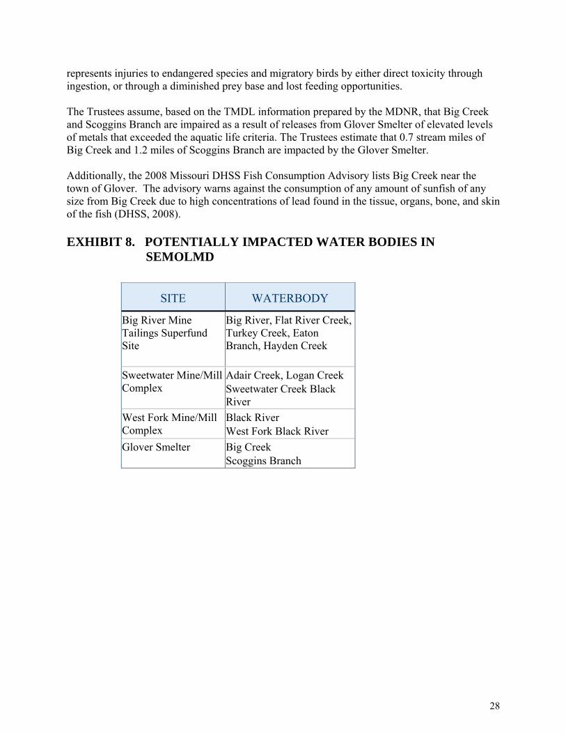
represents injuries to endangered species and migratory birds by either direct toxicity through ingestion, or through a diminished prey base and lost feeding opportunities. The Trustees assume, based on the TMDL information prepared by the MDNR, that Big Creek and Scoggins Branch are impaired as a result of releases from Glover Smelter of elevated levels of metals that exceeded the aquatic life criteria. The Trustees estimate that 0.7 stream miles of Big Creek and 1.2 miles of Scoggins Branch are impacted by the Glover Smelter. Additionally, the 2008 Missouri DHSS Fish Consumption Advisory lists Big Creek near the town of Glover. The advisory warns against the consumption of any amount of sunfish of any size from Big Creek due to high concentrations of lead found in the tissue, organs, bone, and skin of the fish (DHSS, 2008).
EXHIBIT 8. POTENTIALLY IMPACTED WATER BODIES IN
SEMOLMD
SITE WATERBODY
Big River Mine Tailings Superfund Site
Big River, Flat River Creek, Turkey Creek, Eaton Branch, Hayden Creek
Sweetwater Mine/Mill Complex
Adair Creek, Logan Creek Sweetwater Creek Black River
West Fork Mine/Mill Complex
Black River West Fork Black River
Glover Smelter Big Creek Scoggins Branch
28

EXHIBIT 9. WATER QUALITY CRITERIA DETERMINED FROM SAMPLES IN SELECTED SEMOLMD STREAMS
AMBIENT WATER
QUALITY CRITERION
MEAN HARDNESS
(PPM)
NUMBER OF
SAMPLES CADMIUM
(PPB) LEAD (PPB)
ZINC (PPB)
Dissolved Freshwater CCC 0.4 4.5 186.1
Dissolved Freshwater CMC 3.4 115.2 184.6
Total Freshwater CCC 0.4 6.3 188.8
Total Freshwater CMC
171 443
3.7 161.6 188.8
Notes: CCC = Criteria Continuous Concentration (chronic exposure threshold); CMC = Criteria Maximum Concentration (acute exposure threshold) (EPA 2002a). Sources: Gale et al. (2004), EPA (2006a), Newfields, Inc. (2006), EPA STORET (2006b), USGS (2007).
EXHIBIT 10. PERCENTAGE OF SURFACE WATER SAMPLES IN SELECTED WATERBODIES IN THE SEMOLMD THAT EXCEED CADMIUM, LEAD, AND ZINC AMBIENT WATER QUALITY CRITERIA, 1981-2005 (IEC, 2008)
PERCENTAGE OF SAMPLES EXCEEDING
THE CMC
PERCENTAGE OF SAMPLES EXCEEDING
THE CCC
WATERBODY CADMIUM LEAD ZINC CADMIUM LEAD ZINC
Adair Creek 0% 20% 0% 0% 80% 0%
Big Creek 43% 0% 6% 77% 71% 6%
Big River (Downstream of Flat River Confluence) 0% 0% 0% 0% 78% 0%
Black River 0% 0% 0% 13% 37% 0%
Flat River 3% 0% 23% 5% 89% 23%
Logan Creek 0% 17% 0% 0% 50% 0%
Scoggins Branch 38% 0% 62% 54% 31% 62%
29
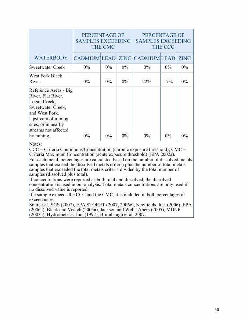
30
PERCENTAGE OF SAMPLES EXCEEDING
THE CMC
PERCENTAGE OF SAMPLES EXCEEDING
THE CCC
WATERBODY CADMIUM LEAD ZINC CADMIUM LEAD ZINC
Sweetwater Creek 0% 0% 0% 0% 0% 0%
West Fork Black River 0% 0% 0% 22% 17% 0%
Reference Areas - Big River, Flat River, Logan Creek, Sweetwater Creek, and West Fork. Upstream of mining sites, or in nearby streams not affected by mining. 0% 0% 0% 0% 0% 0%
Notes: CCC = Criteria Continuous Concentration (chronic exposure threshold); CMC = Criteria Maximum Concentration (acute exposure threshold) (EPA 2002a). For each metal, percentages are calculated based on the number of dissolved metals samples that exceed the dissolved metals criteria plus the number of total metals samples that exceeded the total metals criteria divided by the total number of samples (dissolved plus total). If concentrations were reported as both total and dissolved, the dissolved concentration is used in our analysis. Total metals concentrations are only used if no dissolved value is reported. If a sample exceeds the CCC and the CMC, it is included in both percentages of exceedances. Sources: USGS (2007), EPA STORET (2007, 2006c), Newfields, Inc. (2006), EPA (2006a), Black and Veatch (2005a), Jackson and Wells-Abers (2005), MDNR (2003a), Hydrometrics, Inc. (1997), Brumbaugh et al. 2007.
DRAFT
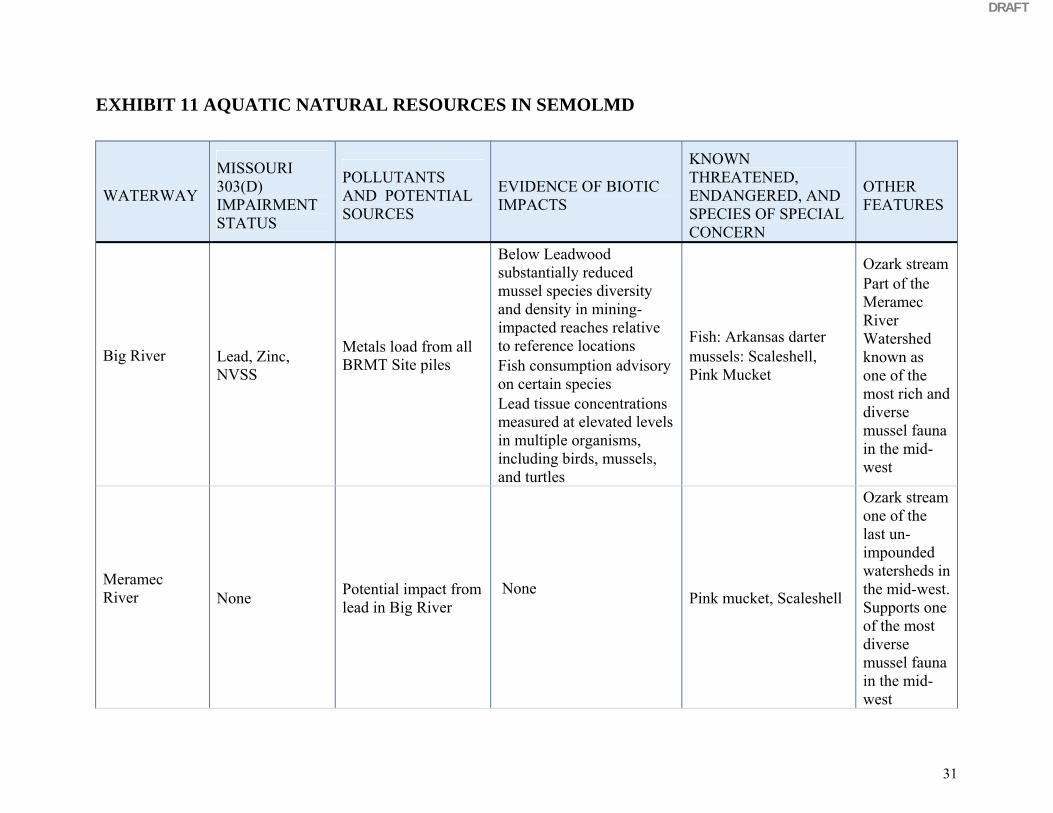
EXHIBIT 11 AQUATIC NATURAL RESOURCES IN SEMOLMD
WATERWAY
MISSOURI 303(D) IMPAIRMENT STATUS
POLLUTANTS AND POTENTIAL SOURCES
EVIDENCE OF BIOTIC IMPACTS
KNOWN THREATENED, ENDANGERED, AND SPECIES OF SPECIAL CONCERN
OTHER FEATURES
Big River
Lead, Zinc, NVSS
Metals load from all BRMT Site piles
Below Leadwood substantially reduced mussel species diversity and density in mining-impacted reaches relative to reference locations Fish consumption advisory on certain species Lead tissue concentrations measured at elevated levels in multiple organisms, including birds, mussels, and turtles
Fish: Arkansas darter mussels: Scaleshell, Pink Mucket
Ozark stream Part of the Meramec River Watershed known as one of the most rich and diverse mussel fauna in the mid-west
Meramec River
None Potential impact from lead in Big River
None Pink mucket, Scaleshell
Ozark stream one of the last un-impounded watersheds in the mid-west. Supports one of the most diverse mussel fauna in the mid-west
31

DRAFT
32
WATERWAY
MISSOURI 303(D) IMPAIRMENT STATUS
POLLUTANTS AND POTENTIAL SOURCES
EVIDENCE OF BIOTIC IMPACTS
KNOWN THREATENED, ENDANGERED, AND SPECIES OF SPECIAL CONCERN
OTHER FEATURES
Flat River Creek
Zinc Lead, Cadmium
Metals load from Federal Pile, National Pile, and Elvins/Rivermines Pile
Tributary water toxic to water fleas and fathead minnows Reduced macroinvertebrate diversity compared with high quality habitat.
Unknown Ozark stream, in urban area
Turkey Creek Zinc Cadmium
Metals load from Bonne Terre Pile Unknown Unknown Ozark stream
Eaton Branch None Metals load from Leadwood Pile Unknown Unknown Intermittent
Ozark stream
Hayden Creek None
Potential metals load from minor site: Hayden Creek mine tailings
Unknown Unknown Intermittent Ozark stream
Persaud and Jaagumag (1996) calculated sediment concentrations that resulted in severe impairment of aquatic life for the Ontario Ministry of the Environment (OMOE-Severe). The percentage of samples exceeding the TEC, PEC, and OMOE-Severe sediment quality guidelines are presented in Exhibit 12 to represent the relative scale of injury from moderate (concentrations exceeding the TEC) to extremely high (concentrations exceeding the OMOE-Severe).
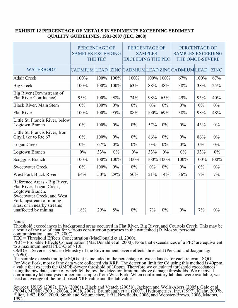
EXHIBIT 12 PERCENTAGE OF METALS IN SEDIMENTS EXCEEDING SEDIMENT QUALITY GUIDELINES, 1981-2007 (IEC, 2008)
PERCENTAGE OF SAMPLES EXCEEDING
THE TEC
PERCENTAGE OF SAMPLES
EXCEEDING THE PEC
PERCENTAGE OF SAMPLES EXCEEDING
THE OMOE-SEVERE
WATERBODY CADMIUM LEAD ZINC CADMIUM LEAD ZINC CADMIUM LEAD ZINC
Adair Creek 100% 100% 100% 100% 100% 100% 67% 100% 67% Big Creek 100% 100% 100% 63% 88% 38% 38% 38% 25% Big River (Downstream of Flat River Confluence) 95% 100% 98% 74% 98% 65% 49% 95% 40% Black River, Main Stem 0% 100% 0% 0% 0% 0% 0% 0% 0% Flat River 100% 100% 95% 88% 100% 69% 38% 98% 48% Little St. Francis River, below Logtown Branch 0% 100% 0% 0% 57% 0% 0% 43% 0% Little St. Francis River, from City Lake to Rte 67 0% 100% 0% 0% 86% 0% 0% 86% 0% Logan Creek 0% 67% 0% 0% 0% 0% 0% 0% 0% Logtown Branch 0% 33% 0% 0% 33% 0% 0% 33% 0% Scoggins Branch 100% 100% 100% 100% 100% 100% 100% 100% 100% Sweetwater Creek 0% 100% 0% 0% 0% 0% 0% 0% 0% West Fork Black River 64% 50% 29% 50% 21% 14% 36% 7% 7% Reference Areas - Big River, Flat River, Logan Creek, Logtown Branch, Sweetwater Creek, and West Fork, upstream of mining sites, or in nearby streams unaffected by mining. 18% 29% 8% 0% 7% 0% 0% 7% 0%
Notes: Threshold exceedances in background areas occurred in Flat River, Big River, and Courtois Creek. This may be a result of the use of chat for various construction purposes in the watershed (D. Mosby, personal communication. June 27, 2007). TEC = Threshold Effects Concentration (MacDonald et al. 2000). PEC = Probable Effects Concentration (MacDonald et al. 2000). Note that exceedances of a PEC are equivalent to a maximum metal PEC-Q of >1.0. OMOE – Severe = Ontario Ministry of the Environment severe effects threshold (Persaud and Jaagumagi (1996)). If a sample exceeds multiple SQGs, it is included in the percentage of exceedances for each relevant SQG. For West Fork, most of the data were collected via XRF. The detection limit for Cd using this method is 40ppm, a value that exceeds the OMOE-Severe threshold of 10ppm. Therefore we calculated threshold exceedances using the raw data, some of which fell below the detection limit but above damage thresholds. We received confirmatory lab analysis for certain samples from West Fork. When confirmatory lab data were available, we used an average of the field-based XRF value and the lab value. Sources: USGS (2007), EPA (2006a), Black and Veatch (2005b), Jackson and Wells-Abers (2005), Gale et al. (2004), MDNR (2001, 2003a, 2003b, 2007), Brumbaugh et al. (2007), Hydrometrics, Inc. (1997), Klahr, 2007b, Elliot, 1982, ESC, 2000, Smith and Schumacher, 1991, Newfields, 2006, and Wooster-Brown, 2006, Madras, 1992.
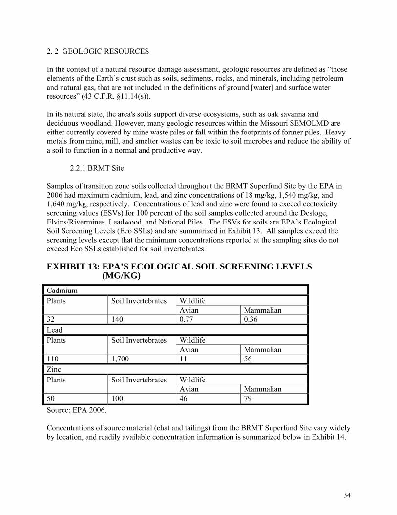
2. 2 GEOLOGIC RESOURCES In the context of a natural resource damage assessment, geologic resources are defined as “those elements of the Earth’s crust such as soils, sediments, rocks, and minerals, including petroleum and natural gas, that are not included in the definitions of ground [water] and surface water resources” (43 C.F.R. §11.14(s)). In its natural state, the area's soils support diverse ecosystems, such as oak savanna and deciduous woodland. However, many geologic resources within the Missouri SEMOLMD are either currently covered by mine waste piles or fall within the footprints of former piles. Heavy metals from mine, mill, and smelter wastes can be toxic to soil microbes and reduce the ability of a soil to function in a normal and productive way. 2.2.1 BRMT Site Samples of transition zone soils collected throughout the BRMT Superfund Site by the EPA in 2006 had maximum cadmium, lead, and zinc concentrations of 18 mg/kg, 1,540 mg/kg, and 1,640 mg/kg, respectively. Concentrations of lead and zinc were found to exceed ecotoxicity screening values (ESVs) for 100 percent of the soil samples collected around the Desloge, Elvins/Rivermines, Leadwood, and National Piles. The ESVs for soils are EPA’s Ecological Soil Screening Levels (Eco SSLs) and are summarized in Exhibit 13. All samples exceed the screening levels except that the minimum concentrations reported at the sampling sites do not exceed Eco SSLs established for soil invertebrates. EXHIBIT 13: EPA’S ECOLOGICAL SOIL SCREENING LEVELS
(MG/KG) Cadmium
Wildlife Plants Soil Invertebrates Avian Mammalian
32 140 0.77 0.36 Lead
Wildlife Plants Soil Invertebrates Avian Mammalian
110 1,700 11 56 Zinc
Wildlife Plants Soil Invertebrates Avian Mammalian
50 100 46 79 Source: EPA 2006. Concentrations of source material (chat and tailings) from the BRMT Superfund Site vary widely by location, and readily available concentration information is summarized below in Exhibit 14.
34

EXHIBIT 14. CADMIUM, LEAD, AND ZINC IN BRMT SITE MILL WASTES
Site
Number of Samples
Minimum mg/kg
Maximum mg/kg
Average
Lead
All Sites 531 349 17,000 2,818
Leadwood 108 597 17,000 2,382Desloge 74 826 6,200 2,105National 96 1,100 9,283 3,661
Elvins/Rivermines 92 851 11,600 4,440Bonne Terre 88 660 7,610 2,945
Federal 69 349 4,638 885Cadmium
All Sites 526 0.88 1,870 77
Leadwood 107 9.3 1,870 250Desloge 74 6.8 78.6 26.3National 96 2.0 87.0 7.9
Elvins/Rivermines 92 19.8 202 105Bonne Terre 88 3.0 29.5 12.0Federal 69 0.88 18.2 6.5
Zinc
All Sites 531 34 25,800 2,285Leadwood 107 400 25,800 4,691
Desloge 74 233 3,990 1,243National 96 34 5,055 417Elvins/Rivermines 93 108 11,900 5,541
Bonne Terre 88 51 1,470 457Federal 69 43 1,057 293Source: (Newfields, 2006) 2.2.2 Sweetwater Mine/Mill Complex Three mill waste pile/source samples collected from selected areas around the 592 acre tailings pond indicated lead in the tailings at concentrations up to 4,260 mg/kg. Elevated levels of arsenic, cadmium, chromium, and lead were found in the surface soil along the mine and mill access road and immediately east of the scale house. Maximum lead concentrations were
35
108,657 mg/kg from the scale house. At this time, the Trustees estimate that mining and milling operations at the Sweetwater Mine/Mill Complex Site have resulted in 652 acres of injured land based on heavy metals concentrations that exceed toxicological bench marks for one or more of these contaminants. 2.2.3 West Fork Mine/Mill Complex Based on a 2004 aerial photo, 167 acres are currently covered with tailings (including the dam next to Route KK, which has exposed tailings), and another 27 acres is disturbed (Doe Run is not mining at West Fork) as well as a wetland that discharges to the Black River (personal communication, Larry Hopkins, Department of Natural Resources, Land Reclamation Program). The Trustees currently estimate that a total of 194 acres has been contaminated in excess of concentrations that would cause injuries to migratory birds and terrestrial endangered species. 2.2.4 Glover Smelter Based on the Site Assessment and Investigation Report, Glover Lead Facility, Glover, Missouri (November 1998), Doe Run submitted to MDNR pursuant to the Consent Decree, surface soils from on-facility and areas immediately adjacent to the plant (emission sample areas) had elevated concentrations of lead, cadmium and zinc. The highest lead, cadmium and zinc concentrations are at on-facility locations near the ore unloading areas, the rail ore transport, and slag pile areas. According to concentrations found in the Site Assessment and Investigation Report, the Trustees estimate that 607 terrestrial acres have been injured by releases of heavy metals, with two slag piles covering 10 of those acres. Smelters have the potential for widespread terrestrial contamination through aerial releases and subsequent deposition. There is the potential for a larger area to be impacted depending on the results of the emissions fallout sampling. The impacted area for Glover is based on the emission and on-facility sample boundary delineated in Hydrometrics, Inc. (2001). Emission fallout samples within this area demonstrate the presence of lead contamination at high levels, as do samples taken closer to the locations of on-site activities. Concentrations of source material (chat and tailings) from the VT Sites vary by location, and readily available concentration information is summarized below in Exhibit 15.
36
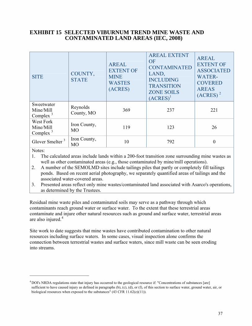
EXHIBIT 15 SELECTED VIBURNUM TREND MINE WASTE AND CONTAMINATED LAND AREAS (IEC, 2008)
SITE COUNTY, STATE
AREAL EXTENT OF MINE WASTES (ACRES)
AREAL EXTENT OF CONTAMINATED LAND, INCLUDING TRANSITION ZONE SOILS (ACRES)1
AREAL EXTENT OF ASSOCIATED WATER-COVERED AREAS (ACRES) 2
Sweetwater Mine/Mill Complex 3
Reynolds County, MO 369 237 221
West Fork Mine/Mill Complex 3
Iron County, MO 119 123 26
Glover Smelter 3 Iron County, MO 10 792 0
Notes: 1. The calculated areas include lands within a 200-foot transition zone surrounding mine wastes as
well as other contaminated areas (e.g., those contaminated by mine/mill operations). 2. A number of the SEMOLMD sites include tailings piles that partly or completely fill tailings
ponds. Based on recent aerial photography, we separately quantified areas of tailings and the associated water-covered areas.
3. Presented areas reflect only mine wastes/contaminated land associated with Asarco's operations, as determined by the Trustees.
Residual mine waste piles and contaminated soils may serve as a pathway through which contaminants reach ground water or surface water. To the extent that these terrestrial areas contaminate and injure other natural resources such as ground and surface water, terrestrial areas are also injured.4 Site work to date suggests that mine wastes have contributed contamination to other natural resources including surface waters. In some cases, visual inspection alone confirms the connection between terrestrial wastes and surface waters, since mill waste can be seen eroding into streams.
4 DOI's NRDA regulations state that injury has occurred to the geological resource if: "Concentrations of substances [are] sufficient to have caused injury as defined in paragraphs (b), (c), (d), or (f), of this section to surface water, ground water, air, or biological resources when exposed to the substances" (43 CFR 11.62(e)(11)).
37

2.3 GROUND WATER The shallow Ozark Aquifer is comprised of Ordovician and Cambrian dolomites and sandstones and is bounded underneath by granites. The ground water flow is to the west, off the Ozark dome located just west of the VT. Recharge occurs through precipitation falling on rock outcroppings. The deep St. Francois Aquifer is mostly composed of Cambrian sandstone in the LaMotte Formation. Mining occurs in the Viburnum Trend in this formation. Rain water percolating through the mine waste piles can leach hazardous substances into the soil beneath the waste pile. Groundwater can also be affected as it flows through underground mine workings and comes into contact with exposed ore bodies. Groundwater contamination may be of limited scope at the BRMT site due to the high pH of the ore’s dolomitic host rock. Additionally, groundwater can be injured from contaminated losing streams within the watershed. (BRMT PAS 2008) Within the Viburnum Trend, residences in the area are dependent on groundwater from the Ozark Aquifer. Within a four-mile radius of the Sweetwater Mine/Mill Complex, drinking water is provided by private domestic wells and one Non-Transient Non-Community (NTNC) Public Drinking Water well. Within four miles of the tailings pond, the Division of Geology and Land Survey database contains records for one industrial high capacity well, 14 domestic wells, and no records of Community or Non-Community public wells. The one industrial high capacity serves approximately 70 employees of the Sweetwater Mine/Mill Complex as well as provides process water for mine and mill operations. The nearest private well lies approximately 1.5 miles to the east of the site. Based on area hydrology, in addition to well construction data for private domestic drinking water wells in the area, the nearest private drinking water well is presumed to draw from the Ozark Aquifer at a depth of less than 200 feet. In addition, three monitoring wells surround the tailings pond. These wells are drilled to depths comparable to private domestic drinking water wells within four miles. It is estimated that approximately 126 to 172 people are served by a combination of the NTNC PDW well and private domestic wells within a four mile radius of the tailings pond. The Preliminary Assessment/Site Investigation (MDNR 2005) documented a release to groundwater in the Ozark Aquifer beneath and downgradient of the tailings pond. Elevated levels of lead are present in monitoring wells SW-1 and SW-2, which are drilled to a depth of 36.5 feet and 137 feet respectively. There are 14 known wells within four miles of the site, including two private domestic wells discovered during a previous investigation. All of these wells are known to draw from the Ozark Aquifer. The Sweetwater Mine NTNC PDW well was non-detect for all metals analyzed. The two closest private wells, located 1.5 miles east of the site, were also non-detect for all metals analyzed, except zinc. Both of the private domestic wells and the NTNC PDW wells are located downgradient of the tailings pond, either through alluvial or Ozark Aquifer hydrology. The 700 foot depth of the NTNC PDW well makes it less likely to be impacted by infiltrating contaminants. The domestic wells are not presently contaminated with lead. However, the domestic wells are presumed to be drilled to a similar depth as the monitoring wells, which are contaminated. Based on this information, the domestic wells are at risk for future contamination.
38

2. 4 BIOTIC RESOURCES 2.4.1 Threatened and Endangered Species Congress delegated responsibility to the FWS for the conservation, including recovery of federally listed endangered or threatened species, except for marine mammals. The Endangered Species Act and associated federal regulations establish the FWS’ authorities for endangered species programs. Several federally threatened and endangered species occur in or near the mine and mine related Sites within Missouri as follows and as found in Appendix A. The federally listed endangered gray bat (Myotis grisescens) occupies a limited geographic range in limestone karst areas of the southeastern United States. With rare exception, the gray bat roosts in caves year-round. Most gray bats migrate seasonally between hibernating and maternity caves. Gray bats are active at night, foraging for insects over water or along shorelines, and they need a corridor of forest riparian cover between roosting caves and foraging areas. They can travel as much as 20 kilometers (12 miles) from their roost caves to forage. The SEMOLMD sites have the potential to impact the gray bat . The Indiana bat (Myotis sodalis), federally listed as endangered, historically occupied much of the eastern half of the United States. The bat hibernates in caves, but during warmer seasons roosts principally under the bark of trees. Maternity colonies are formed mostly in riparian and floodplain forests associated with small to medium-sized streams. They have also been found along tree-lined drainage ditches. Indiana bats are active at night foraging for aquatic insects and Lepidoptera at a height of 2 to 30 meters over water and under riparian and floodplain trees. The SEMOLMD sites have the potential to impact the Indiana bat. Habitat requirements for the endangered American burying beetle (Nicrophorus americanus), particularly reproductive habitat requirements, are not fully understood at this time. The American burying beetle has been found in various types of habitat, including oak-pine woodlands, open fields, oak-hickory forest, open grasslands, and edge habitat. The SEMOLMD sites have the potential to impact the American burying beetle.
Listed as endangered, the Hine’s emerald dragonfly (Somatochlora hineana) occupies marshes and sedge meadows fed by groundwater seepage and underlain by dolomite bedrock or calcareous limestone. These areas are characterized by slowly flowing water and nearby or adjacent forest edges. Hine’s emerald dragonfly larvae are opportunistic predators feeding on oligochaetes, larval mayflies, larval caddisflies, isopods, other larval dragonflies, mosquito larvae, small fish and snails. Adult dragonflies are general predators and feed primarily on insects. Changes in surface and sub-surface hydrology could be detrimental to the dragonfly. The dragonfly requires high quality water. The SEMOLMD sites, particularly the VT sites, have the potential to impact the Hine’s emerald dragonfly.
Habitat requirements for the endangered plant, running buffalo clover (Trifolium stoloniferum), includes mesic areas of partial to filtered sunlight where a prolonged pattern of moderate periodic disturbance occurs. It is often found in regions underlain with limestone or other
39

calcareous bedrock. It has been reported in a variety of habitats, including mesic woodlands, savannahs, floodplains, stream banks, sandbars, grazed woodlots, mowed paths, old logging roads, jeep trails, skidder trails, mowed wildlife openings within mature forest, and steep ravines. Sites within the SEMOLMD have the potential to impact running buffalo clover. Several federally listed freshwater mussel species occur in the vicinity of SEMOLMD sites. Freshwater mussels are bivalved mollusks that are relatively immobile, spending their entire lives partially or completely buried in the stream bottom. They are suspension feeders, using their gills to remove suspended particles in the water column. These animals have a complex life cycle that includes a brief, obligatory parasitic stage on fish. Host fish specificity vary among mussels. While some mussel species appear to require a single host species, others can complete their life cycle on several fish species. The nation-wide decline of mussels has been attributed to habitat destruction and degradation from impoundments, water pollution, mining, sedimentation, channelization, and dredging. The Meramec River (below the Big River) supports some of the largest remaining populations of the federally endangered pink mucket (Lampsilis orbiculata) and scaleshell (Leptodea leptodon) and the federal candidates’ sheepnose (Plethobasus cyphyus) and spectaclecase (Cumberlandia monodonta). The pink mucket also is found in the Black River watershed. The Curtis pearly mussel (Epioblasma florentina curtisi) was found in the Black River watershed. State listed species also include the western fanshell (Cyprogenia aberti) found in the Big Creek watershed. The BRMT and VT sites have the potential to impact these mussels.
The pink mucket, scaleshell, Curtis pearly mussel, and western fanshell occupy similar habitat in streams. They are typically found in stable riffles and runs where a diversity of other mussel species are concentrated (i.e. mussel bed). These areas of suitable habitat naturally occur in relatively small patches separated by longer reaches of unsuitable habitat. While the spectaclecase can occur in the habitat described above, they are a habitat-specialist, relative to other mussel species, occurring outside river bends below bluff lines. They occur in a variety of substrates and are found in aggregations, particularly under slab boulders or bedrock shelves where they are protected from the current. The cerulean warbler (Dendroica cerulea), a candidate species, is a small migratory songbird that breeds in the forests of the central and eastern United States. They nest in large tracts of deciduous hardwood forests that have tall large diameter trees with an open understory. Nesting areas include uplands, wet bottomlands, moist slopes and mountains more than 30 to less than 1000 meters in elevation. The warbler eats mostly insects from the foliage of many plant species. The SEMOLMD Sites have the potential to impact the cerulean warbler.
2.4.2 Vegetation In SEMOLMD croplands, woodlands, urban areas, and grasslands are interspersed with mine-impacted lands. This variety of habitat types allows many kinds of plant to grow. Open areas such as cropland, pasture, meadows, and overgrown areas produce grain and seed crops, grasses and legumes, and wild herbaceous plants.
40

The majority of the SEMOLMD is forested. These woodlands cover hillsides and riparian corridors. Native forests are characterized by a variety of oak species (Quercus spp.), black walnut (Juglans nigra), pecan and other hickory species (Carya spp.), and associated shrubs, grasses, legumes, and wild herbaceous plants. The SEMOLMD is also the northern extent of short-leafed pine, which was extensively logged in the 19th century. Short-leafed pine still occurs in upland areas of the SEMOLMD.
Chat piles and tailings impoundments in the SEMOLMD do not support normal succession of terrestrial vegetation (for example, see Exhibits 3 and 4). Unremediated mine waste piles tend to be barren or sparsely vegetated. Acres of barren and vegetated mine waste piles have been identified and measured as part of Superfund site investigation activities, and many are readily apparent in aerial photographs.
The loss of vegetation, resulting from phytotoxicity, is an injury under DOI's NRDAR regulations. While plant productivity and changes in plant species composition in mine waste areas can be affected by mine waste characteristics unrelated to the presence of contaminants (e.g., the wastes' water retention ability and/or organic content), available evidence suggests that contamination in some areas affected by mine wastes is sufficiently toxic to cause decreases in plant productivity, changes in species diversity, and/or changes in species composition. Exhibits 16 and 17 present soil quality values (SQVs) for zinc and lead, respectively, for use in evaluating potential injury to the plant communities. EXHIBIT 16 SELECTED ZINC PHYTOTOXICITY SQVS
LIKELY SEVERITY OF
EFFECTS
ZINC RANGE
(PPM DW) SOURCEa RATIONALE
None (possible zinc deficiency symptoms at lower end of range; phytotoxicity highly unlikely)
0 - 60 Dames & Moore (1993a)
Authors' selected minimum TRV. State background soil concentrations are typically similar to or less than this value. (ORNL's stated confidence in its plant value was low; there is no Eco-SSL value for zinc.)
Low (some adverse effects possible especially for sensitive species)
60 - 500
Dames & Moore (1993a), Kloke et al. (1984), CH2M Hill et al. (1987)
Encompasses range at which sensitive plants may begin to experience effects, according to several sources.
41

Moderate (adverse effects are likely for an increased number of species)
500 - 2,000
CH2M Hill et al. (1987), Pierzynski and Schwab (1993)
Represents moderate exceedances of highest non-site specific thresholds identified in the literature. Zinc phytotoxicity seen in soybeans grown in Cherokee County soil in this range.
High (adverse effects across more species, and/or more severe effects, are expected)
>2,000
Pierzynski and Fink (2007)
Represents greater exceedances of the highest non-site-specific thresholds identified in the literature. Also, a site-specific study found impacts to native species at 2,000 ppm and higher.
Note: a. Dr. Lawrence Kapustka has reviewed these categories and contributed to their development.
42
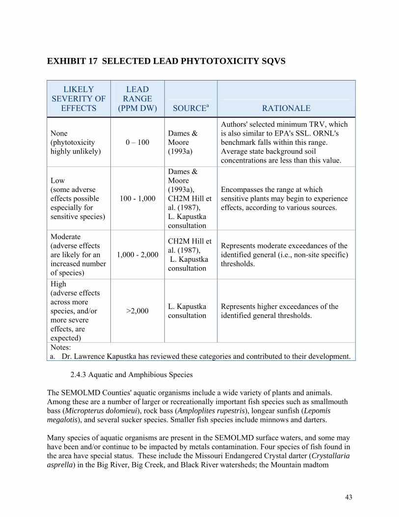
EXHIBIT 17 SELECTED LEAD PHYTOTOXICITY SQVS
LIKELY SEVERITY OF
EFFECTS
LEAD RANGE
(PPM DW) SOURCEa RATIONALE
None (phytotoxicity highly unlikely)
0 – 100 Dames & Moore (1993a)
Authors' selected minimum TRV, which is also similar to EPA's SSL. ORNL's benchmark falls within this range. Average state background soil concentrations are less than this value.
Low (some adverse effects possible especially for sensitive species)
100 - 1,000
Dames & Moore (1993a), CH2M Hill et al. (1987), L. Kapustka consultation
Encompasses the range at which sensitive plants may begin to experience effects, according to various sources.
Moderate (adverse effects are likely for an increased number of species)
1,000 - 2,000
CH2M Hill et al. (1987), L. Kapustka consultation
Represents moderate exceedances of the identified general (i.e., non-site specific) thresholds.
High (adverse effects across more species, and/or more severe effects, are expected)
>2,000 L. Kapustka consultation
Represents higher exceedances of the identified general thresholds.
Notes: a. Dr. Lawrence Kapustka has reviewed these categories and contributed to their development.
2.4.3 Aquatic and Amphibious Species The SEMOLMD Counties' aquatic organisms include a wide variety of plants and animals. Among these are a number of larger or recreationally important fish species such as smallmouth bass (Micropterus dolomieui), rock bass (Amploplites rupestris), longear sunfish (Lepomis megalotis), and several sucker species. Smaller fish species include minnows and darters. Many species of aquatic organisms are present in the SEMOLMD surface waters, and some may have been and/or continue to be impacted by metals contamination. Four species of fish found in the area have special status. These include the Missouri Endangered Crystal darter (Crystallaria asprella) in the Big River, Big Creek, and Black River watersheds; the Mountain madtom
43

(Noturus eleutherus) and the Longnose darter (Percina nasuta) in the Big Creek and Black River; and the Goldstripe darter (Etheostoma parvipinne) found in the Black River watershed. As mentioned in section 2.4.1 above, freshwater mussels occur in the Meramec River, Black River and St. Francis River basins. These streams are important refuges for mussel species of concern. Based on a screening level study by the FWS (2008), mussel densities and diversity drop precipitously in the Big River below the Leadwood Pile. Mussels appear to be absent in some reaches nearest the influence of tailings impoundments. Based on historical work in the Big River and Meramec River Basin by Bruenderman et al. (1999) and Buchanan (1979), it appears that mussel populations are declining in the lower Big River, possibly as a result of migration of heavy-metal contaminated sediment downstream. The FWS (2008) found a negative correlation with diversity and population and heavy metal concentrations. Elevated heavy metal concentrations have been documented in a variety of biological tissues at the BRMT Site. Fish, macrobenthic invertebrates, earthworms, plants, and small rodent tissues have been found with elevated metal concentrations (EPA, 2005). Fish in the Big River have shown elevated concentrations of lead and the biochemical effects of lead downstream of the Site (Schmitt et al., 1993). Besser et al. (2008) documented toxicity to Hyalella azteca using sediment pore water collected below the Sweetwater Mine, and Allert et al (submitted to journal) documented impacts to aquatic community structure (absence of important species such as crayfish, sculpins, and snails) downstream of the Sweetwater and West Fork Mine/Mill Complexes. 2.4.4 Birds Major flyways for migratory birds include large portions of the sites. The sites serve as either breeding areas or wintering grounds for numerous species of migratory birds, including waterfowl, shorebirds, raptors and neotropical migrants (Appendix A). Birds make use of both aquatic and terrestrial habitat in the SEMOLMD. These areas generally fall within the Ozark Upland physiographic area, in which over 100 bird species breed (Fitzgerald et al. 2000). A list of the SEMOLMD migratory bird species is included as Appendix B. Special-status avian species occurring in the SEMOLMD include the federal candidate and Missouri listed rare Henslow's sparrow (Ammodramus henslowii), the state endangered barn owl (Tyto alba), and others (Appendices A and B). In recent years, populations of special-status species such as the northern harrier (Circus cyaneus), Swainson's hawk (Buteo swainsoni), and cerulean warbler (Dendroica cerulean) have declined. (Fitzgerald et al. 2000). Bald eagles (Haliaetus leucocephalus) have been observed nesting near the Sweetwater Mine/Mill Complex and may be exposed to lead through ingestion of contaminated fish. Beyer et al (2004) and Sileo et al (2003) documented exposure and toxic effects to migratory birds resulting from releases of mining-related heavy metals into sediments and terrestrial environments in the Tri-State Mining District. These studies are applicable to and the same results are expected to occur at the SEMOLMD. Concentrations of lead, zinc, and/or cadmium
44

in SEMOLMD mill waste are comparable to concentrations in mill waste and sediment found to cause a toxic effect to migratory birds in the Beyer and Sileo studies. The BRMT Superfund Site draft ecological risk assessment concluded there was unacceptable risk to several model organisms representing a variety of ecological niches or feeding guilds (EPA 2006a). The screening level risk assessment concluded that there was unacceptable risk from exposure to lead, zinc, and/or cadmium to herpivores (frog-eaters), namely the great blue heron and piscivores (fish-eaters), the belted kingfisher. The SEMOLMD Site birds may also have been impacted by mining-related habitat losses (see "Vegetation" section above). Less vegetative cover and lower quality vegetative habitat mean fewer insects, fruits, and seeds for smaller birds to consume. Plants also provide food for small mammals, which in turn are the prey of larger birds. In fact, raptor abundance in tallgrass prairies has been shown to be positively related to "aboveground net primary productivity," a measure of plant growth (Reed et al. 2004). Mining-related impacts to plants therefore represent a loss of habitat that can reverberate through the food web to the highest-level predators. 2.4.5 Mammals The SEMOLMD mammals rely on both aquatic and terrestrial habitats. Mammals within the SEMOLMD Sites include raccoon (Procyon lotor), coyote (Canis latrans), striped skunk (Mephitis mephitis), bobcat (Lynx rufus), black bear (Ursus americanus) whitetail deer (Odocoileus virginianus), red fox (Vulpes vulpes), mice, shrews, voles and various other small rodents. Special-status mammals include the Missouri-endangered plains spotted skunk (Spilogale putorius interrupta), and the federally-endangered gray bat (Myotis grisescens). Lack of vegetation in barren chat mining areas limits habitat and food resources for mammals. Small mammals may also be experiencing direct toxic effects from exposure to metals in the mining wastes. 2.5 HAZARDOUS SUBSTANCES For assessment planning purposes, the Trustees will focus on cadmium (Cd), lead (Pb), and zinc (Zn), hazardous substances that have significant potential for toxicity to many different natural resources. Based on existing relevant data, the Trustees know that these metals are commonly found at elevated levels in soils, sediments, and surface waters throughout the SEMOLMD. The Trustees recognize that other contaminants and conditions may adversely affect natural resources in the SEMOLMD. After reviewing Phase 1 assessment results, the Trustees will consider additional hazardous substances, including but not limited to nickel, cobalt, manganese, and copper, if warranted. The following paragraphs, however, focus on the primary hazardous substances, their toxicology, and associated environmental hazards.
45

2.5.1 Cadmium Cadmium (Cd) is not biologically essential or beneficial to any known living organism and is toxic to all known forms of life (Eisler 2000). Freshwater5 animals tend to be most heavily impacted by cadmium contamination (WHO 1992). Impacts to freshwater animals include death, reduced growth, and inhibited reproduction (Eisler 2000). In freshwater systems, the lethal effects of cadmium can be reduced by limiting exposure time and increasing water hardness6 (Eisler 2000). Sublethal effects of cadmium in freshwater organisms include decreases in plant standing crop, decreases in growth, inhibition of reproduction, immobilizaand population alterations (Eisler 2000). Mammals and birds are comparatively resistant to toxic
tion, the
7 effects of cadmium, though exposure to high levels can be fatal (Eisler 2000). Animals can be exposed to environmental cadmium through inhalation or ingestion. Cadmium is a known carcinogen, a known teratogen, and a probable mutagen (Eisler 2000; ATSDR 1999a). Studies investigating carcinogenicity have focused on mammals. Cadmium has been shown to cause tumors in the prostate, testes, and hematopoietic (blood-related) systems in rats (ATSDR 1999c). Based on studies in mice and bacteria, cadmium may be mutagenic (Ferm and Layton 1981, as cited in Eisler 2000). When present, cadmium is detected in particularly high concentrations in the leaves of plants and the livers and kidneys of vertebrates (ATSDR 1999c; Scheuhammer 1987, as cited in Eisler 2000). 2.5.2 Lead Lead is not biologically essential or beneficial to any known living organism (Eisler 2000). It can be incorporated into the bodies of individual organisms by inhalation, ingestion, absorption through the skin, and (in mammals), placental transfer from the mother to the fetus (Eisler 2000). Toxic in most chemical forms, lead negatively affects survival, growth, reproduction, development, and metabolism of most animals under controlled conditions, but its effects are substantially modified by numerous physical, chemical, and biological variables. Younger, immature organisms tend to be more susceptible to lead toxicity (Eisler 2000). When absorbed in excessive amounts, lead has carcinogenic or co-carcinogenic properties (Eisler 2000). In large amounts, it is also a mutagen and a teratogen (Eisler 2000). It has been demonstrated that aquatic animals experience adverse effects such as reduced survival, impaired reproduction, and reduced growth (Eisler 2000). As with cadmium, increased water hardness decreases lead bioavailability to aquatic animals (Wong et al. 1978 and NRCC 1973, both as cited in Eisler 2000). Early research suggested that birds are unlikely to show adverse effects from environmental lead (except when lead objects such as shot are directly ingested); however, there is now a growing body of evidence linking waterfowl poisoning with ingestion of lead-contaminated sediments, especially in the Coeur d'Alene area of Idaho (Chupp
5 Freshwater refers to waters that are not saline (salty). 6 Water hardness is a measure of the content of certain naturally-occurring elements in water, especially calcium and magnesium. 7 Toxins cause direct injury to an organism as a result of physiochemical interaction. Carcinogens cause cancer (for example, tumors, sarcomas, leukemia). Mutagens cause permanent genetic change. Teratogens cause abnormalities during embryonic growth and development.
46

and Dalke 1964, Blus et al. 1991, Beyer et al. 1998, Heinz et al. 1999, all as cited in Eisler 2000). There are few data regarding the effect of environmental lead on mammalian wildlife (Eisler 2000). Lead also can harm plant species. Generally, large amounts must be present in soils before terrestrial plants are affected, although sensitivity varies widely among species (Demayo et al. 1982). Effects of lead toxicity in plants include reduced plant growth, photosynthesis, mitosis, and water absorption (Demayo et al. 1982). 2.5.3 Zinc Zinc (Zn) is an essential trace element for all living organisms, and zinc deficiency in animals can cause a variety of adverse effects (Eisler 2000; ATSDR 1995). Zinc is also toxic at high concentrations, although its toxicity depends on its chemical form and other environmental parameters (Eisler 2000). Zinc is not carcinogenic, although in certain chemical forms, zinc can be mutagenic (Thompson et al. 1989, as cited in Eisler 2000). Zinc is teratogenic to frog and fish embryos, but there is no conclusive evidence of teratogenicity in mammals (Dawson et al. 1988 and Fort et al. 1989, both as cited in Eisler 2000). Environmental effects of excess zinc can be significant at relatively low concentrations (Eisler 2000). Terrestrial plants can die from excess zinc in the soil (Eisler 2000). Freshwater animals can also experience adverse effects, including reduced growth, reproduction, and survival (Eisler 2000). Ducks experience pancreatic degeneration and death when fed diets containing high concentrations of zinc (Eisler 2000). Mammals can generally tolerate greater than 100 times their minimum daily zinc requirement (NAS 1979, Wentink et al. 1985, Goyer 1986, Leonard and Gerber 1989, all as cited in Eisler 2000), but levels that are too high affect their survival, metabolism, and well-being (Eisler 2000). 2.6. CONFIRMATION OF EXPOSURE8 The result of mining, milling and smelting activities is past and ongoing exposure of natural resources−land, water, plants and animals−to metals, potentially causing injuries to these resources and the services they provide to humans and the environment. The Trustees intend to investigate and document these losses through the studies set forth in this Assessment Plan. A substantial body of information is already available demonstrating past and ongoing exposure of the SEMOLMD natural resources to hazardous substances as evidenced below. 2.6.1 Surface Water Metal concentrations, particularly those of zinc and lead, have exceeded the ambient water quality criteria (AWQC) in Big River, Big Creek, and Flat River Creek. Sediment
8 The DOI’s NRDA regulations require that exposure of at least one of the natural resources identified as potentially injured “has in fact been exposed to the released substances” (43 CFR §11.37(a)). This Plan confirms that a variety of potentially-injured resources have been exposed to hazardous substances, including cadmium, lead, and zinc.
47

concentrations of metals in waterways of the BRMT and the VT sites exceed published toxicity benchmarks for the protection of aquatic life (MacDonald, 2000; Black and Veatch, 2005b, USFWS, 2008); 2.6.2 Geologic Resources During the course of EPA’s work on the BRMT Superfund Site data collected, documented high concentrations of contaminants in mine wastes and nearby soils at levels that exceed both national average soil concentrations and concentrations toxic to vegetation (EPA 2006). 2.6.3 Groundwater Various studies have found concentrations of metals in the shallow aquifer that are higher than background concentrations by up to an order of magnitude and that exceed ground water criteria (MDNR 2005). 2.6.4 Biotic Resources Researchers have found evidence of lead poisoning in songbirds, waterfowl, fish, mussels, frogs, and snapping turtles in the SEMOLMD (Niethammer et al. 1985, Schmitt et al. 1987, EPA 2006a, Overmann and Krajicek 1995). Altogether, these data confirm that natural resources in the SEMOLMD have been, and continue to be, exposed to elevated levels of metals resulting in injuries to natural resources.. 2.7 PRELIMINARY DETERMINATION OF RECOVERY PERIOD9 Recovery period is defined under 43 C.F.R. §11.14(gg) as "either the longest length of time required to return the services of the injured resource to their baseline condition, or a lesser period of time selected by the authorized official and documented in the Assessment Plan." Several factors can influence estimates of recovery time, including ecological succession patterns, growth or reproductive patterns, life cycles, ecological requirements of plants and animals (including their reaction or tolerance to the hazardous substances involved), biological recruitment potential, the bioaccumulation and extent of hazardous substances in the food web and the chemical, physical and biological removal rates of the hazardous substances. As noted in previous sections of this Plan, substantial mining activities in the SEMOLMD were undertaken for more than a century, and measurements of metals in the environment demonstrate that these contaminants have been present at levels associated with adverse impacts to natural resources for decades. Data from similar sites in other locations, and research presented in the technical literature, suggest a recovery period on the order of at least decades in the absence of active remediation or
9 The DOI NRDA regulations require than an assessment plan include a preliminary estimate of the time needed for injured resources to recover (43 CFR §11.31(a)(2)).
48

restoration efforts beyond those already implemented or planned. Metals are elements and may change their chemical form or become dispersed in the environment, but they do not break down or degrade. Elevated levels of metals have been and continue to be present in a wide variety of natural resources within the SEMOLMD. Available information suggests that natural processes will take a very long time to remove the contamination or render it biologically unavailable, given the amounts present and the environmental processes involved. The Trustees recognize that implemented or planned actions through Superfund or other programs may hasten the recovery of some resources, at some locations. However, information currently available to the Trustees indicates that planned or implemented actions are not sufficient in scope or design to change the preliminary finding that adverse mining-related impacts to natural resources in the SEMOLMD are likely to persist for decades or longer.
49

CHAPTER 3 ROLE OF TRUSTEES This chapter provides information about the Trustees, their jurisdiction, and the NRDAR process that the Trustees plan to follow. It also addresses a number of regulatory issues, as required by the DOI’s NRDA regulations (43 C.F.R. §11.10 et. seq.). 3.1 TRUSTEE AUTHORITY
Trustees are responsible for managing natural resources for the public. The DOI and the MDNR are Trustees for natural resources in the State of Missouri and have developed a state-wide Memorandum of Understanding (MOU) forming a Trustee Council. This Trustee Council is charged with pursuing NRDAR activities for trust natural resources within the SEMOLMD. CERCLA, as amended (42 U.S.C. 9601 et. seq.), the Oil Pollution Act of 1990 (OPA), 33 U.S.C. 2701 et. seq., and the Federal Water Pollution Control Act (the "Clean Water Act" (CWA)), as amended (33 U.S.C. 1251 et. seq.), authorize the Federal government, states, and Indian tribes to recover, on behalf of the public, damages for injuries to, destruction of, or loss of natural resources belonging to, managed by, appertaining to, or otherwise controlled by them (42 C.F.R. §9607(f)(1) and 9601(16)). Under the National Oil and Hazardous Substances Pollution Contingency Plan (NCP), when there is injury to, destruction of, loss of, or threat to the supporting ecosystems of natural resources, the Trustees are also authorized to act (40 C.F.R. § 300.600). In accordance with 42 U.S.C. 9607(f)(2)(B) and the NCP (40 C.F.R. § 300.600), the Governor of the State of Missouri, has designated the Director of MDNR as the natural resource trustee for the State of Missouri. MDNR acts on behalf of the public, as a trustee for natural resources, including their supporting ecosystems, within the boundaries of Missouri, or belonging to, managed by, controlled by, or appertaining to Missouri. MDNR is the Lead Administrative Trustee for this NRDAR. The state authorities under which the State of Missouri may act include, but are not limited to the Missouri Constitution, 1945, Art. IV, Sections 40(a)-47; Chapter 252, RSMo, Department of Conservation – Fish & Game; Chapter 254, RSMo, State Forestry Law; Chapter 644, RSMo – Missouri Clean Water Law; Sections 260.350-260.434, RSMo; Missouri Hazardous Waste Management Law; Sections 260.500, et seq., RSMo, Missouri Hazardous Waste Clean Up Law; and the regulations duly promulgated under the statutes set out above. The MDNR and Missouri Department of Conservation (MDC) entered into a Memorandum of Agreement whereby the two state agencies agreed to work together to assess injuries to natural resources and obtain damages for those injuries. MDC also serves as an expert on the flora and fauna of the state for the MDNR. In accordance with 42 U.S.C. 9607(f)(2)(A) and the NCP, 40 C.F.R. §300.600, the President has designated the Secretary of the DOI to act on behalf of the public as trustee for those natural resources and their supporting ecosystems that are managed or controlled by the DOI. The authorities under which the DOI may act include, but are not limited to: Endangered Species Act,
50

as amended, 16 U.S.C. 1531 et. seq.; and the Migratory Bird Treaty Act, as amended, 16 U.S.C. 701 et. seq. The official authorized to act on behalf of the Secretary for the SEMOLMD sites is the U.S. Fish and Wildlife Service Regional Director Region 3. 3.2 OVERVIEW OF NRDAR NRDAR efforts are intended to restore natural resources to their baseline condition-that is, the condition of the resources had the releases not occurred (43 C.F.R. § 11.14(e))). The DOI NRDAR regulations also allow Trustees to seek compensation for the interim loss of public resources and the services that would have provided if not for the injury(ies) caused by the contamination (43 C.F.R. § 11.15 and § 11.83). Under CERCLA, DOI promulgated regulations to guide Trustees in their evaluation of injuries to natural resources resulting from the release of hazardous substances. These regulations describe methods for the Trustees to use when:
a. Making the decision to pursue a NRDAR; b. Determining whether natural resources have been injured; c. Determining the quantity of injured natural resources; d. Determining the amount of restoration or other compensation required to fix or replace
the injured natural resources and to compensate the public for the interim service losses; and
e. Planning/construction projects designed to implement the selected restoration options.
Assessment procedures outlined in the DOI’s regulations are not mandatory and do not preclude the use of alternate methods. However, DOI methods provide a useful framework for assessing injury and evaluating the need for, type and scale of restoration and/or compensation. 3.2.1 Determination to Pursue a Type B Assessment10 The DOI regulations specify that NRDAR may fall into one of two broad categories: Type A and Type B. Type A assessments are focused on marine and/or Great Lakes’ environments and are intended for smaller sites impacted by minor releases of relatively short duration. Type B assessments usually comprise a more comprehensive set of studies and analyses, and this type of assessment is warranted when a Type A assessment is not. The SEMOLMD Sites are large and inland. The discharges or releases occurred, and are continuing to occur, over a period of decades. The magnitude of these discharges are not minor, and the spatial and temporal extent and heterogeneity of exposure conditions and potentially affected natural resources are not suitable for application of the simplifying assumptions and averaged data and conditions contained in Type A procedures. Suitable Type A procedures are not available for these circumstances, thus, the Trustees determined that a Type B assessment is required. 10 The DOI NRDAR regulations require that an assessment plan identify whether Type A or Type B procedures, or a combination, will be used during the course of the assessment (43 C.F.R. §11.31(b)).
51

3.2.2 Phases in the NRDAR Process The DOI NRDAR regulations identify four phases of the NRDAR process: (1) Pre-Assessment; (2) Assessment Planning; (3) Assessment; and (4) Post-Assessment. (43 C.F.R. § 11.13). The Assessment Phase is divided into three sub-phases: (i) Injury Determination; (ii) Injury Quantification; and (iii) Damage Determination. The following paragraphs describe these phases in more detail.
3.2.2.1 Preassessment Phase During the pre-assessment phase, readily available data were collected and assessed to determine whether to proceed with an injury assessment. The results of these efforts are summarized in two Pre-assessment Screen documents for the BRMT and Viburnum Trend Sites (MDNR and DOI 2008). The PASs are available at:http://www.dnr.mo.gov/env/hwp/index.html, http://www.dnr.mo.gov/env/hwp/sfund/nrda.html, and http://www.fws.gov/midwest/semonrda In the PAS’s, the Trustees concluded that:
a. Releases of hazardous substances occurred; b. Natural resources for which the Trustees can assert Trusteeship are, and/or likely have
been, adversely impacted as a consequence of the releases; c. The quantity and concentration of the released substances are sufficient to potentially
cause injury to natural resources; d. The data necessary to pursue a NRDAR are readily available or can be obtained at a
reasonable cost; and, e. Currently completed or planned response actions are insufficient to completely
compensate the public for past and ongoing injuries to natural resources.
In addition, as part of this phase, the Trustees sent the identified potentially responsible parties (PRPs) for the BRMT and VT sites a Notice of Intent to Perform an Assessment, dated July 8, 2008. Based on the above criteria, the Trustees determined there is a reasonable probability of making a successful natural resource damages claim and that an assessment plan is warranted.
3.2.2.2 Assessment Plan Phase The assessment planning phase is intended to ensure that the assessment of affected natural resources occurs in a systematic and planned manner and at reasonable cost. It culminates in the production of a final assessment plan which is incorporated into the Trustees’ Report of Assessment. The Trustees developed this Phase I Assessment Plan to describe potential studies to confirm exposure of trust resources. The Trustees consider this a living document and will continue to develop and refine it as the NRDAR process progresses, incorporating additional information as it becomes available.11 Potential changes to this Assessment Plan may include the addition of 11 The DOI NRDA regulations allow an assessment plan to be modified at any stage of the assessment as new information becomes available (43 C.F.R. § 11.32(e)(1)).
52

new studies and/or the modification of planned studies identified in this document. To determine and quantify injuries to natural resources, the Trustees may rely on existing data and studies. If significant changes occur, the revised Assessment Plan will be made available for review by the public. In addition to confirming exposure of natural resources to hazardous substances, this phase includes the development of a preliminary estimate of damages (PED) (43 C.F.R. §11.38(a)). The PED estimates the approximate costs of restoration, rehabilitation, replacement, and/or acquisition of equivalent resources required to compensate the public for injured resources. The PED may also include an estimate of the compensable value of the injured natural resources and/or their services. The purpose of the PED is to help ensure that the costs of studies and methodologies set forth in the Plan are reasonable (43 C.F.R. § 11.38(d)(2)). The PED will be developed later in the assessment process. The Trustees believe that the estimated costs of the assessment studies described in this Phase I Plan are reasonable; the additional assessment costs incurred to conduct these studies are less than the anticipated damage amount. The Trustees will consider focus, design, scale and associated costs of additional, potential assessment activities (if any) in light of the results and preliminary evaluations of restoration and compensation needs identified through studies described in this Plan. The results of such analyses will be presented at the conclusion of the assessment process in the Report of Assessment prepared by Trustees. (43 C.F.R. § 11.90)
3.2.2.3 Assessment
In this phase, the Trustees undertake investigations to determine and quantify the extent of injuries to natural resources resulting from releases of hazardous substances and determine the monetary value of the injuries.
3.2.2.3.1 Injury Determination
Injury determination entails evaluating whether injuries have occurred as a result of hazardous substances releases. There are a number of ways in which resources can be injured. Examples include, but are not limited to, the following:
• Concentrations of hazardous substances exceeding relevant federal or state regulatory standards (e.g., water quality standards);
• Environmental media such as waters or sediments containing concentrations of hazardous substances sufficiently high to result in toxic effects to biota including plants, fish, shellfish, amphibians/reptiles, birds, and/or mammals;12
• Contaminant-induced changes in the community structure of plants and animals (changes in species composition);
• Contaminant-induced impairments in reproduction; • Death, disease/deformities/malformations, and other kinds of adverse effects; and
12 Exposure of biota to hazardous substances may occur either via direct contact with the substances or via indirect means (for example, bioconcentration, bioaccumulation, and/or biomagnification through food chains).
53
• Losses of services to humans (e.g., impaired drinking water or irrigation water, loss of fishing/hunting opportunities, loss of wildlife viewing opportunities).
3.2.2.2 Injury Quantification
During this sub-phase, the Trustees quantify the identified injuries by documenting the amount, severity and duration of adverse effects in terms of changes from baseline conditions (43 CFR § 11.71(b)(2)). The result is an estimate of the total extent of natural resources and their services that needs to be restored, replaced or otherwise compensated.
3.2.2.3 Damage Determination The third sub-phase in the Assessment Phase is determining the monetary value (damages) of the injuries to natural resources resulting from releases of hazardous substances. A variety of economic and other methodologies exist that the Trustees may utilize to determine the compensation amount. For example, establishing the value of the injured natural resources and the services they provide, or by calculating the cost of projects that will restore or replace the injured resources and their services. A key document in this sub-phase of the NRDAR process is the Restoration and Compensation Determination Plan (RCDP) in which the Trustees evaluate several alternatives for restoration, rehabilitation, replacement and/or acquisition of equivalent resources and related services. The Trustees then select a preferred alternative by taking into account a number of factors identified in the NRDAR regulations (43 C.F.R. § 11.82(d)) and an estimate of the cost of the preferred alternative. Upon its completion, the RCDP will be released to the public for review and comment. 3.2.3 Coordination with Other Governmental Agencies, The Public, and Potential Responsible Parties (PRPS)
3.2.3.1 Coordination with Other Governmental Agencies
In accordance with the DOI NRDAR regulations (43 C.F.R. § 11.31(a)(3)), the Trustees are carefully coordinating assessment activities with current remedial investigations being pursued by the EPA and the State of Missouri. As discussed in Section 1.1, the EPA placed the BRMT Site on the NPL in 1992 and since that time has, selected and implemented specific cleanup projects for parts of the site. The EPA and NRDAR activities are coordinated to the extent possible to avoid duplication of effort and ensure efficiency of limited governmental resources. The Trustees meet with EPA periodically to enhance communication and coordination of related efforts. Further, Trustee assessment activities proposed in this Plan make use of data generated through the Superfund process, as well as research undertaken through other processes or efforts. The Trustees also work closely with other government agencies on the state and local level. Outside of the realm of CERCLA and NRDAR, the Missouri Department of Conservation (MDC) has constitutional authority for fish, forestry and wildlife within the state of Missouri. The Trustees closely coordinate assessment activities with MDC to the extent that MDC
54
personnel may conduct studies that will be part of the NRDAR. (See Section 4 below). Local governments (e.g., St. Francois and Reynolds Counties) as well as the general public will be solicited to review the Plan and provide comments.
3.2.3.2 Importance of Public Participation As stewards for the SEMOLMD natural resources, the Trustees represent the interests of the public. The opinions, suggestions, and other input of the public are therefore important factors that the Trustees consider when making decisions during the course of a NRDAR. A number of documents produced during the course of the NRDAR will be released to the public for review and comment. Specific anticipated opportunities for public involvement include commenting on this Plan, assessment workplans and any restoration plans. Each public comment period will last for at least 30 days. Comments may be submitted in writing to the address below.
Ms. Frances Hayes Klahr Missouri Department of Natural Resources
Division of Environmental Quality P.O. Box 176
Jefferson City, MO 65102-0176 The Trustees also recognize the special interests of St. Francois, Jefferson, Reynolds, Washington, and Iron County landowners. Much of the land in the SEMOLMD counties is privately held and conducting some of the assessment projects described in this Plan will require access to private properties. The Trustees understand that this access is dependent upon the permission of the landowners and will work with landowners to secure the needed permissions before beginning any fieldwork activities.
3.2.3.3 Potentially Responsible Parties (PRPs) The complete list of companies that mined at the SEMOLMD Sites over the years is extensive; some no longer exist due to bankruptcy, dissolution, buyouts, mergers or similar corporate events. A partial list of companies that engaged in mining and/or mining-related activities releasing hazardous substances into the SEMOLMD environment, or activities that exacerbated the situation include: ASARCO Inc., NL Industries Inc., The Doe Run Resource Corporation d/b/a as The Doe Run Company, BP America, Inc. and MDNR, Division of State Parks. The Trustees may identify other PRPs in the course of pursuing this NRDAR. In accordance with the NRDAR regulations, in July, 2008, the Trustees sent the identified PRPs a Notice of the Intent to Perform an Assessment, along with copies of the appropriate PAS(s), and invited them to participate in a cooperative assessment (43 C.F.R. § 11.32(a)(2)(iii)(A)). If the Trustees reach an agreement with any or all of the identified PRPs to conduct a cooperative assessment, the Assessment Plan will be updated to reflect that relationship and describe any updates or modification in assessment activities. The revised Assessment Plan will be made available for public comment and review. As the SEMOLMD NRDAR progresses, the Trustees
55
retain the right to participate in cooperative assessment activities with one or more PRPs at any time. The DOI’s NRDAR regulations provide for the identified PRPs to request from the Trustees split samples13 and results of assessment-related analyses (43 C.F.R. §11.3-1(a)(4)). PRP requests for data and split sampling shall be submitted in writing to Mr. David Mosby, U.S. Fish and Wildlife Service, at the address below. All such requests shall identify the specific data desired and provide contact information for the PRP in case of any questions. Any request for split samples must be received at least ten (10) working days prior to planned field studies to ensure that the necessary equipment and procedures are available.
Mr. David Mosby U.S. Fish and Wildlife Service
Ecological Services Field Office 101 Park DeVille Dr., Suite A
Columbia, MO 65203 The Trustees retain the right, subject to public review and comment, to settle some or all of their natural resource damages claims.
13 Split samples consist of taking a single sample and dividing it into two parts, so that each party can conduct its own analysis.
56

CHAPTER 4 ASSESSMENT OF NATURAL RESOURCES AT THE SOUTHEAST MISSOURI LEAD MINING DISTRICT SITES
The purpose of this Phase I Assessment Plan is to set forth near-term assessment studies the Trustees intend to pursue as part of the SEMOLMD NRDAR. This document focuses primarily on studies relating to the first two sub-phases of Assessment: injury determination (including pathway determination) and injury quantification. (See Exhibit 18). During the Assessment Planning Phase, the Trustees analyzed existing data to help identify the nature and extent of natural resource injuries. This analysis, combined with the expedited early assessment level activities conducted by the Trustees for claim preparation in the ASARCO bankruptcy, informed the Trustees’ selection of the Phase I assessment studies described in this Plan. The DOI’s NRDAR regulations provide a variety of definitions of natural resource injury, including exceedances of various regulatory criteria, adverse physiological responses, malformations, reproductive impairment, disease, and death (43 C.F.R. § 11.62). As part of the injury determination, the Trustees also investigate exposure pathway of the natural resources to the hazardous substances of concern in the SEMOLMD. (43 C.F.R. § 11.63) During the injury quantification sub-phase the Trustees quantify the effects of the release(s) of hazardous substances on the injured natural resources. For purposes of NRDAR, the Trustees measure the extent of the injury, estimate the baseline condition and/or baseline services of the injured natural resource, determine the recoverability of the injured natural resource and estimate the reduction in services that resulted from the release(s) of hazardous substances. (43 C.F.R. § 11.70) For example, an injury can be quantified in terms of percent of ecological service lost, acres of habitat or stream miles. For purposes of this NRDAR, the Trustees have determined that further assessment is required for the following natural resources:
• Surface water resources, including water and sediments; • Geologic resources; • Ground water resources; • Biotic Resources including: • Aquatic biota, including fish, shellfish, aquatic macroinvertebrates, and aquatic-dependent
birds; and • Terrestrial biota, including mammals, birds, and vegetative communities.
The Trustees intend to concentrate their initial efforts on the above natural resources because existing data indicates contaminant exposure and/or injuries to these natural resources and the availability of information on the sensitivity of the natural resources to the hazardous substances released from mining-related operations in the SEMOLMD. If the Phase I assessment studies indicate that other natural resources may have been injured as a consequence of exposure to mining-related hazardous substances, the Trustees may pursue additional investigations in a later phase of this assessment. Assessment studies may be added, revised, or removed from consideration based on public comments and the acquisition of additional information.
57

Some of the detailed study plans for Phase I already have been developed by principle investigator(s) responsible for the proposed study and are included in the appendices to this Assessment Plan. Detailed assessment studies developed in the future also will be appended to the Plan. The Trustees and/or principle investigators will compile existing information and results from studies into Injury Reports.
EXHIBIT 18 OVERVIEW OF PHASE I STUDIES (IEC, 2008)
Injury Determination & Quantification
The remainder of this chapter briefly describes those NRDAR studies that the Trustees intend to pursue in the near term.
Pathway Determination
Damage DeterminationNot addressed in the Phase I plan
Surface Water Resources
Ground Water Resources
Geologic Resources
Terrestrial Organisms
Aquatic Organisms
Preliminary Contamination Allocation
Water: Exceedances of Regulatory Standards and Literature-Based Impact Thresholds
Sediments: Exceedances of Regulatory Standards and Literature-Based Impact Thresholds
Fish, Shellfish, and Other Aquatic Macroinvertebrates
Waterfowl
Small Mammals
Other Terrestrial Fauna
Vegetative Communities
Exceedances of Regulatory Standards
Soils: Exceedances of Literature-Based Impact Thresholds
ANTICIPATED STUDIESANTICIPATED STUDIESNRDA PHASENRDA PHASE
58

4.1. SURFACE WATER RESOURCES
In addition to providing recreational opportunities, surface waters support a wide variety of aquatic animals, including a number of threatened and endangered species. The Trustees believe that mining activities have impacted−and continue to impact−the surface water resources in the SEMOLMD. The following studies are aimed at evaluating the nature and extent of these injuries.
4.1.1 Surface Water: Exceedances of Regulatory Standards and Literature-Based Impact Thresholds
The Trustees have documented injuries to surface water resources across space and time based on comparisons of measured and/or modeled concentrations of lead, zinc and cadmium to regulatory standards and literature-based thresholds for impacts to aquatic animals. . The Trustees will continue to identify relevant water quality standards for comparison to available surface water metals contamination data from the SEMOLMD. In the initial review, the Trustees determined that a number of relevant water quality standards exist for the primary hazardous substances. These standards include: ambient water quality criteria as promulgated under the federal Clean Water Act and the state Clean Water Law; criteria promulgated under the Safe Drinking Water Act and state Safe Drinking Water Law; and State of Missouri aquatic life criteria. The Trustees will review relevant technical literature to identify surface water contamination thresholds for lead, zinc and cadmium at which fish and other aquatic species may experience adverse effects. The Trustees have identified existing data from various studies along the Big River, Flat River Creek, and other St. Francois County streams. These data include the BRMT Superfund Site Ecological Risk Assessment, MDNR sampling reports, and a TMDL for the Big River and Flat River Creek. Many of these data are summarized in the Trustees 2007 Asarco, LLC proof of claim. In the Viburnum Trend, the Trustees relied on data gathered by USGS and MDNR Preliminary Assessment/Site Investigation of Sweetwater Mine/Mill Complex (2005), and ASARCO documents evaluating impacts from the Glover Smelter to Big Creek. After compiling available existing water quality data, the Trustees may determine that additional sampling is necessary to better quantify the extent of the natural resource injury. In that event, the Trustees may engage in additional targeted data-collection activities. These activities may focus on contaminant levels at various locations (for instance, in additional Big River tributaries, upstream and downstream of tributaries or other potential input sources), different flow conditions, and/or different seasons.
4.1.2 Surface Water Sediments: Exceedances Of Regulatory Standards And Literature-
Based Impact Thresholds
Under the DOI’s NRDAR regulations, the bed, bank, and shoreline sediments, including suspended sediments, are part of the surface water resource. Bed and bank sediments are key components of aquatic ecosystems, supporting benthic fauna and potentially serving as a source
59

of contaminants to the aquatic foodweb, as sediments are ingested by many faunal species, either as the species’ primary source of sustenance or incidentally during foraging. The Trustees intend to evaluate the concentrations of metals in sediments to assess the degree to which these substances may be causing adverse effects to exposed aquatic species. The Trustees have documented injuries to sediment resources across space and time based on comparisons of measured and/or modeled sediment concentrations of metals, especially lead, cadmium, and zinc to regulatory standards and literature-based thresholds for impacts to aquatic animals. The Big River and Flat River Creek have significant portions of the stream (93 and 6 miles, respectively) listed on the 303d list due to lead and zinc contaminated sediment and NVSS. Despite the existence of various sediment chemistry data sets, the Trustees may engage in targeted sediment contamination data-collection activities to fill in data gaps. 4.2 AQUATIC ORGANISMS
Biologic resources, including aquatic organisms, are a key component of this assessment plan. As part of Phase I assessment activities, the Trustees will use existing data to evaluate potential injuries to fish, shellfish, and benthic communities. The Trustees may also collect new field data to assist with the evaluation of the health of the SEMOLMD aquatic biota .
4.2.1 Fish, Shellfish, and Other Aquatic Macroinvertebrates Mussels are good indicators of the ecological health of surface water communities. Their immobile nature as adults helps ensure that their status reflects local environmental parameters. In addition, mussels require suitable host fish for parts of their life cycle. The ability of mussels to thrive in a particular area, therefore, provides an indirect indication of the status of the host fish community as well. Benthic fauna are also an important part of freshwater ecosystems. In addition to their function as an indicator of the suitability of sediments to support aquatic life, they are also part of the food chain for higher trophic-level organisms, including certain fish species. Due to threats posed by lead contamination, consumption advisories have been issued by the State of Missouri for longear sunfish, redhorse, and suckers in the Big River; smallmouth bass in the middle fork of the Black River in Reynolds County; and sunfish species in Big Creek near the Glover Smelter. Under the DOI regulations, a fish advisory constitutes an injury. Future injury analyses for aquatic species will therefore focus on the injury definition that addresses health advisories due to fish consumption. 43 CFR §11.62(f)(1)(iii)) defines injury as tissue concentrations exceeding levels for which an appropriate state health agency has issued directives to limit or ban consumption of such organism. In all cases, the Trustees will maximize use of existing datasets and established, ongoing sampling or monitoring programs.
60
4.2.2 Aquatic Injury Studies The Trustees identified classes of aquatic organisms that represent a range of ecological services or guilds in a stream ecosystem. Contaminated sediment is expected to be the primary source of aquatic exposure in the SEMOLMD. Freshwater mussels are sediment dependent organisms that are of special regulatory concern due to certain species listed as federally-endangered presence in the SEMOLMD. Crayfish are largely sediment dependent organisms that are important in energy transfer in riverine systems. Crayfish are important to nutrient cycling and are an important prey base for sport fish and migratory birds. Small fish such as madtom, darters and sculpin are closely tied to sediment, eating sediment-dwelling macro-invertebrates and are themselves often prey species for sport fish and migratory birds. Finally sport fish are important as predators in aquatic ecosystems and as larger prey items for mammals, such as mink and otters, and migratory birds, such as eagles, herons, and osprey. Sport fish in the SEMOLMD include a variety of bass and also bottom-feeding species such as suckers, redhorse, and catfish. The Trustees will undertake field population studies of species representing a range of ecological niches or feeding guilds discussed above. These studies will focus on a range of sediment concentrations to assess whether heavy-metal concentrations in sediment result in measurable effects as measured by abundance, diversity, frequency, density, and/or species richness. For more information about sample frequency, specific measurements, and study objectives, see Appendix C, which contains the work plans for crayfish and riffle-dwelling fish studies. The Trustees will undertake laboratory toxicological analyses on contaminated sediment to assess at what concentrations of heavy metals cause a toxicological effect in a controlled setting. These toxicology tests will utilize freshwater mussel juveniles, crayfish, and/or other standard sediment-dwelling test organisms to provide a reference species supported by a robust database. Toxicity testing with sediment may be used to calibrate consensus-based PECs used to define the extent of aquatic injury. 4.2.3 Waterfowl The Trustees are concerned that the SEMOLMD birds, including waterfowl, may be suffering from adverse effects as a consequence of exposure to cadmium, lead, and/or zinc. As part of Phase I assessment activities, the Trustees will use existing data to evaluate potential injuries to these species. The Trustees may collect new field data to assist with the evaluation of the health of the SEMOLMD birds. To document the extent of adverse metals contamination-related impacts to bird species present in the SEMOLMD the Trustees will review other effects-based data sources and compare them to the existing SEMOLMD bird tissue data (Niethammer et al, 1984). This review will be broad in scope, potentially including information on species abundance and habitat use; metals concentrations and sensitivity to metals exposure; and other types of information. The Trustees may select one or more species to evaluate and develop a bird collection and evaluation study plan. Although specific endpoints have not been determined, the Trustees’ efforts will likely
61

include (but would not be limited to) measurements of metals in bird tissues, measures of erythrocyte delta-aminolevulinic acid dehydratasee (ALAD) inhibition, and histopathological characterization. Birds from suitable reference areas will be evaluated. The Trustees are planning studies that will indicate indirect injury to migratory birds. As mentioned above crayfish are an important food source to aquatic-dependent birds. Impacts to the abundance of crayfish and other prey species would be expected to have indirect impacts or cause injury to aquatic-dependent birds. 4.3 TERRESTRIAL ORGANISMS
Biologic resources, including terrestrial organisms, are an important part of this assessment plan. The Trustees will use existing data to evaluate the potential exposure of terrestrial birds and/or mammals to hazardous substances. The Trustees will gather available data on potential injuries to these species groups and may collect additional field data to assist with these efforts. 4.3.1 Small Mammals
Small mammals fill an important niche in terrestrial ecosystems by feeding on seeds, nuts, insects, and other items, and in turn, serving as prey to mammalian and avian predators. The Trustees intend to gather preliminary information about contaminant concentrations in small mammals, in part to evaluate potential injuries to these species, but with a focus on determining the extent to which these species might serve as pathways through which other, higher trophic-level species may be exposed to hazardous substances. This study would have elements of both injury determination and pathway determination. To document the extent of adverse, metals contamination-related impacts to small mammal species present in the SEMOLMD, and to evaluate the extent to which small mammals may be serving as a pathway of the hazardous substances to other biological receptors, the Trustees will compile and review existing data on small mammals in the SEMOLMD (e.g., EPA 2006a). The Trustees anticipate that relatively little information exists on the extent of exposure of the SEMOLMD small mammals to hazardous substances. The Trustees, therefore, may choose to select one or more species to evaluate and may design a small mammal collection and evaluation study plan. 4.3.2 Other Terrestrial Fauna
The SEMOLMD supports a wide variety of terrestrial species, including, larger mammals, a variety of bird species, reptiles, and other species. The Trustees will use existing data to evaluate potential injuries to these species. The Trustees may also collect new field data to assist with the evaluation of the potential injuries to these groups of terrestrial species. To document injuries to terrestrial animals across space and time, the Trustees will maximize use of existing datasets and ongoing sampling or monitoring programs. Initial steps will include the compilation and review of existing data and evaluation of the utility of these data. The methods used to evaluate existing data and the specific injuries assessed will be dependent on the types
62

and quality of available data. If needed, the Trustees may engage in additional data-generating activities.
4.3.3 Vegetative Communities: Impacts at Current and Former Mine/Mill Waste Pile Locations
Preliminary Trustee evaluations of available data suggest that soils and mill waste at or near current and former piles contain concentrations of heavy metals that are phytotoxic to the vegetative community. The health of plant communities is important to the Trustees because these communities provide valuable habitat for terrestrial fauna, including mammals, local birds, and migratory birds. To evaluate the potential injuries to the plant communities at these sites in comparison to suitable reference locations, the Trustees will measure the occurrence, composition, and density of plant cover at (and near) a number of current or former mine/mill waste sites and in reference areas. This plant community analysis will be quantified by a method called Floristic Quality Assessment (FQA). The FQA is a standardized tool used to estimate the overall ecological quality of a site based on the presence of vascular plants growing there (Freeman and Morse 2002, Swink and Wilhelm 1994, Taft et al.1997). The FQA evaluates the species composition of a measured habitat and assigns values based on the degree of conservatism of the species represented mathematically as a Floristic Quality Index or FQI. Plant species have been assigned a coefficient of conservatism (CoC) from 0 to 10 by a panel of expert Missouri plant ecologists. The collective CoC from an area is used to derive the FQI. Similar to the aquatic injury assessment, the Trustees will pair field studies with controlled laboratory tests to measure concentrations of heavy metals that are causing toxicological effects. A FQI is currently in process for the SEMOLMD. The work plan for this study is included in Appendix C. 4. 4 GROUND WATER RESOURCES
The phrase “ground water resources” means “water in a saturated zone or stratum beneath the surface of land or water and the rocks or sediments through which ground water moves. It includes ground water resources that meet the definition of drinking water supplies” (43 CFR §11.14(t)). Ground water and surface waters may be interconnected. Ground water may discharge to surface water through streambeds, sometimes providing a significant part of the base flow levels of streams or creeks. Ground water can be replenished (recharged) by surface water flows from streambeds and by precipitation. There are two major aquifers that underlie the sites within the SEMOLMD – the St. Francois Aquifer and the Ozark Aquifer. Lead contaminated groundwater may be limited at the BRMT site due to the high pH of the ore’s dolomitic host rock. However, concentrations of nickel, cobalt and zinc can reach levels many times higher than background (Schumacher 2007). The primary aquifer for the Viburnum Trend is the Ozark Aquifer. The Ozark Aquifer is the most heavily used groundwater source in southern Missouri, and nearly all domestic and public water supplies are drawn from the Ozark Aquifer.
63

4.4.1 Ground Water: Exceedances of Regulatory Standards Injury Definition: The DOI’s NRDAR regulations define injury to ground water resources in several ways. In general, ground water is injured when:
• At least two ground water samples are collected from the same hydrologic unit, separated by a distance of at least 100 feet (43 CFR §11.62(c)(2));
• Concentrations and duration of hazardous substances exceed certain standards set by the state or Federal government (for example, drinking water standards promulgated under the Safe Drinking Water Act or water quality criteria established under the Clean Water Act);
• The ground water met the standards or criteria, or was potable, prior to the release, or • The ground water has a “committed use” as a public or domestic water supply (43 CFR
§11.62(c)(1)(i) through (iii)).
Alternately, ground water resources are injured when concentrations of substances are sufficient to have caused injury to other resources when these resources are exposed to ground water (43 CFR §11.62(c)(1)(iv)).
To document exceedance-based injuries to ground water resources across space and time, the Trustees will compare site-related groundwater concentrations to relevant Federal and State of Missouri water quality standards, the exceedance of which would constitute an injury. During the course of this analysis, the Trustees may determine that additional sampling is necessary to better quantify the extent of the injury. In that event, the Trustees may engage in additional targeted data-collection activities.
Ground water contribution to injuries of other resources is an important consideration. If ground water is identified as a significant metal-loading source, the Trustees may undertake additional studies to evaluate this pathway. 4.5 GEOLOGIC RESOURCES
The SEMOLMD’s geologic resources are a high priority for Trustees because they support key terrestrial habitats such as native forests, and these habitats are in turn, important to terrestrial plants and animals, including a number of Federal and state-listed threatened and endangered species (Appendix A). The Trustees believe that the release of hazardous substances as a consequence of mining activities injuries geologic resources in the SEMOLMD. The following study is aimed at evaluating the nature and extent of these injuries. 4.5.1 Soils: Exceedances of Literature-Based Impact Thresholds To document the concentrations of heavy metals included in soils and assess the potential for injury to terrestrial organisms, the Trustees have identified soil thresholds (i.e., concentrations of contaminants in soils) from the technical literature, exceedances of which result in adverse
64
impacts to soil invertebrates such as insects or earthworms and/or plants (Kaputska, 2007). Preliminary Trustee review suggests that a number of potentially relevant thresholds exist for the hazardous substances at issue. The Trustees may collect and evaluate soil data from areas impacted by mining activities, including the soil and mine waste analytical chemical data collected during the course of EPA’s Superfund activities. Data will be gathered and/or evaluated for purposes of determining the soils’ baseline condition (i.e., the condition that would have existed if not for the releases of hazardous substances). Co-located soil contamination data will be a key component of other SEMOLMD NRDAR studies. To maximize the efficiency of the data collection and to ensure comparability of analytical results, collection of any soil data will be undertaken in close coordination with assessment efforts required as part of other NRDAR studies. 4.6 PATHWAY DETERMINATION Pathway studies identify the source(s) of hazardous substances and trace the fate and transportation of these substances through the environment (for instance, through air, ground water, surface water, sediments, soils, and food webs). A pathway “may be determined by either demonstrating the presence of the … hazardous substance in sufficient concentrations in the pathway resource, or by using a model” 43 CFR §11.63(a)(2). Elements of pathway determination can also be inherent in certain injury studies. For example, the small mammal study will be designed to determine the degree to which small mammals may serve as a pathway to their predators. Furthermore, surface water is considered injured if “[c]oncentrations and duration of substances sufficient to have caused injury … to ground water, air, geologic, or biological resources, when exposed to surface water, suspended sediments, or bed, bank, or shoreline sediments” are present. 43 CFR §11.62(b)(v). In the event that it is determined that injury to a resource such as fish has occurred or is occurring, and exposure to surface water was sufficient to have caused the injury, then the pathway has been established for fish. Pathway issues in the SEMOLMD are complex. Past mining operations have caused the release of metals directly and indirectly into the SEMOLMD environment. The Trustees may conduct additional pathway studies, pending results of currently-planned, biotic-resource specific studies. 4.7 DAMAGE DETERMINATION The purpose of this sub-phase is to “establish the amount of money to be sought in compensation for injuries to natural resources.” (43 C.F.R. § 11.80(b)). The DOI regulations define two measures of compensation: the cost of restoration (i.e., restoration, rehabilitation, replacement, and/or acquisition of the equivalent), and the monetary value ( the “compensable value”) of the interim loss. (43 C.F.R. §11.80(b) and § 11.82(b)). As discussed previously, implementation of the damage determination phase is dependent upon completion of an RCDP. The RCDP lists a range of restoration or other compensation alternatives. Using the ten factors identified in the regulations, the Trustees select one alternative as appropriate to pursue for each injury (43 C.F.R. §11.82(d)). The RCDP also identifies the
65

methodologies that the Trustees will use to determine the cost of the selected alternative as well as the compensable value of the interim loss (43 C.F.R. § 11.81). At this time, the Trustees have not fully developed comprehensive restoration alternatives for the assessment area, and therefore, the RCDP is not included in this Phase I Assessment Plan. Rather, the Trustees will prepare an RCDP after the injury determination and quantification sub-phases. Upon its completion, the Trustees will make the RCDP available for public review and comment in accordance with the DOI regulations (43 C.F.R. § 11.81(d)(2)). However, the Trustees can provide the following brief overview of the types of activities that might be appropriate for addressing two key elements in the injury equation: (1) the sediments of the Big River and its tributaries as well as waterways in the VT; and (2) terrestrial habitat. 4.7.1 Primary Restoration The Trustees are investigating primary restoration techniques as a method to estimate damages. The cost of the primary restoration of injured habitat would constitute a portion of the damage calculation for the site. Primary restoration has advantages to the Trustees in part due to the scope of injury at the site. For example, it would be difficult to compensate for 90 miles of injured stream by purchasing or preserving equivalent stream miles elsewhere. Therefore, it becomes more attractive to restore the benthic community in the injured stream than to attempt to preserve or rehabilitate a stream elsewhere. 4.7.1.1 Aquatic Restoration Removal of contaminated sediment from streams in conjunction with enhancement of the riparian corridor and stabilization of the banks is the basis of the Trustees’ aquatic restoration in the SEMOLMD. The Trustees have identified various techniques for restoring the aquatic ecosystems by addressing contaminated habitat and reduced populations of aquatic organisms. At this time, the techniques under investigation include various methods of removing contaminated sediment from the stream in the least disruptive manner. Damages are likely to be estimated from some combination of techniques that would remove sufficient volumes of contaminated sediment necessary to have a healthy benthic stream community. After sediment restoration is complete, various fish and mussel species may be re-introduced. The cost of species re-introduction would be part of the primary restoration-based damage claim.
4.7.1.2. Terrestrial Restoration The Trustees’ preliminary approach to terrestrial restoration in the SEMOLMD consists of stabilizing heavy metals in the soil or mill waste to provide an ecologically safe growing media and then planting restored soil with native species that provide habitat for Trust natural resources. The Trustees are investigating various soil and/or mill waste restoration techniques, including application of soil additives which would bind or neutralize the metals in the soil, thereby preventing the metals from further injuring trust resources.
66
The cost of soil and mill-waste stabilization and re-vegetation together would constitute part of the terrestrial damage calculation. 4.7.2 Compensatory Restoration In the case where primary restoration is not practical or does not fully compensate the public for natural resource services lost as a result of the release of hazardous substances, the Trustees may seek compensatory restoration for those lost services. There are a variety of lost services (e.g., recreational services) from injured natural resources. Lost ecological and recreational services are considered by the Trustees in this assessment plan.
4.7.2.1 Loss of Ecological Services The fundamental concept of compensatory restoration is that compensation for lost ecological services can be provided by restoration projects that provide comparable services. There are a variety of ways to determine compensatory restoration, such as a Habitat Equivalency Analysis (HEA) or a Resource Equivalency Analysis (REA). A HEA is a restoration-based approach to natural resource valuation that can account for changes in the baseline condition while estimating the amount of future interim losses (i.e., losses to the public while the resources are unavailable). An HEA involves three basic steps: 1) assess the present value of lost ecological services; 2) select appropriate compensatory restoration projects; and 3) identify the size of the project (scaling) that will equal the total quantity of lost services. The selected projects are then scaled so that the quantity of replacement services equals the quantity of lost services in terms of present value. In the end, responsible parties usually pay for (or implement) restoration projects that are sufficient to cover the public’s interim losses. The Trustees are pursuing compensatory restoration in the SEMOLMD and will develop a restoration-based valuation. The Trustees plan to develop an aquatic HEA for habitat loss; a terrestrial HEA for habitat loss; and other HEAs as deemed appropriate during the process.
4.7.2.2. Loss of Recreational Services An economic model can be used to calculate compensation for the loss of recreational opportunities. Demographic, economic, survey, and/or other census data can be used to calculate the reduction in recreational services caused by injured natural resources. For example, a benefit transfer approach is a method where available information is transferred from already completed studies in one location to another location such as values for recreational fishing from another location to the SEMOLMD. The Trustees will investigate various methods to determine the appropriate method for valuing lost recreational services associated with the injured natural resources in the SEMOLMD.
4.7.3 Groundwater Damage Determination
The Trustees could use a number of different approaches to restore contaminated groundwater such as primary restoration, a replacement cost approach or other approaches deemed appropriate. Primary restoration may involve closing boreholes to reduce the oxidizing environment, while replacement costs represent the cost of undertaking one or more projects that
67

would result in the production of an equivalent quantity of water, in present value terms, compared to the groundwater lost because of the contamination. Damages could be estimated from some combination of these approaches and others.
68
CHAPTER 5 QUALITY ASSURANCE MANAGEMENT The DOI NRDAR regulations require that the Trustees develop a Quality Assurance Plan (QAP) that “satisfies the requirements listed in the NCP and applicable EPA guidance for quality control and quality assurance plans.” 43 CFR §11.31(c)(2). A QAP is needed to ensure the validity of data collected as part of the NRDAR and to provide a solid foundation for the Trustees’ subsequent decisions. Also relevant to this effort are the FWS guidelines developed under the Information Quality Act of 2001. All information developed in this NRDAR will be in compliance with these guidelines. In Appendix C, the Plan includes studies that evaluate existing datasets as well as studies that generate new information. Different quality assurance/quality control approaches are appropriate for these different types of information. With respect to the evaluation of existing data, the study’s principal investigator (PI) will carefully document the source of all data, available information about quality assurance/quality control procedures used by the original investigator and any data qualifiers or other information restricting application of the data. This approach will also be applied to new data and analyses developed by federal and state agencies, academics, and information developed under the auspices of other activities or programs. For substantial new studies that are specifically undertaken to support the NRDAR process, appropriate study-specific QAPs will be developed according to the general principles described below. A number of the new studies contemplated in this Plan potentially include the collection and chemical analysis of environmental samples such as sediments, soils, water samples, or organisms. The PI will prepare study plans, including a QAP, and submit them to the Trustees. The Trustees will designate a Quality Assurance (QA) Coordinator to review the QAP. If, during the course of this assessment, the Trustees identify cross-study QA issues for which a cross-study QAP would help ensure data quality, a cross study QAP will also be developed. This would be done to ensure that data is comparable from one study to another. As noted by EPA (2001), QAPs will “vary according to the nature of the work being performed and the intended use of the data” and as such, need to be tailored to match the specific data-gathering needs of a particular project. The NRDAR effort for the SEMOLMD will entail a variety of widely-different data-gathering efforts; therefore, it is expected that site specific QAPs will be prepared. In addition, a general QAP prepared by the MDNR covers state Trustee sampling and analytical activities. The Trustees will ensure that individual study plans adequately address project-specific quality assurance issues. The discussion in this document therefore focuses on the required elements of an acceptable study plan. In general, a study plan must provide sufficient detail to demonstrate that:
• the project technical and quality objectives are identified and agreed upon;
69

• the intended measurements, data generation, or data acquisition methods are appropriate for achieving project objectives;
• assessment procedures are sufficient for confirming that data of the type and quality needed and expected are obtained; and
• any limitations on the use of the data can be identified and documented (EPA 2001).
Accordingly, specific study plans developed in conjunction with this assessment plan will include the four elements required by EPA:
• Project Management − documents that the project has a defined goal(s), that the participants understand the goal(s) and the approach to be used, and that the planning outputs have been documented;
• Data Generation and Acquisition − ensures that all aspects of project design and implementation, including methods for sampling, measurement and analysis, data collection or generation, data compiling/handling, and quality control (QC) activities, are documented and employed;
• Assessment and Oversight − assesses the effectiveness of the implementation of the project and associated QA and QC activities; and,
• Data Validation and Usability − addresses the QA activities that occur after the data collection or generation phase of the project is completed.
5.1 PROJECT MANAGEMENT Effective implementation of projects’ objectives requires clear project organization, which includes carefully defining the roles and responsibilities of each project participant. Unambiguous personnel structures help ensure that each individual is aware of his or her specific areas of responsibility, as well as clarifying internal lines of communication and authority, which is important for decision-making purposes as projects progress. Individuals’ and organizations’ roles and responsibilities may vary by study or task, but each person’s role and responsibility should be clearly described in the project’s study plan. Exhibit 19 below presents one potential personnel plan for an NRDAR project.
70

EXHIBIT 19 QUALITY ASSURANCE ORGANIZATION
In this example, the Assessment Manager is the designated Trustee representative (from the FWS or MDNR) with responsibility for the review and acceptance of the project-specific study plan. This individual is responsible for ensuring that the project’s goals and design will meet the broader requirements of this NRDAR. The Assessment Manager coordinates efforts with the QA Coordinator and oversees the Study PI. The QA Coordinator oversees the overall conduct of the quality system. Appointed by the Trustees, this individual’s responsibilities include, but are not limited to: conducting audits and ensuring implementation of both project-specific and overall plans; archiving documentation supporting the data in a secure and accessible form; and reporting to the Trustees. To ensure independence, the person serving as QA Coordinator will not serve as either the Assessment Manager or as a PI for any of the SEMOLMD NRDAR studies. Study-specific PIs oversee the design and implementation of particular NRDAR studies. Each PI is responsible for ensuring that all health, safety, and relevant QA requirements are met. If deviations from the study plan occur, the PI (or his/her designee) will document these deviations and report them to the Assessment Manager and the QA Coordinator. The Field Team Leader (FTL) supervises day-to-day field investigations, including sample collection, field observations and field measurements. The FTL generally is responsible for ensuring compliance with all field quality assurance procedures defined in the study plan. Similarly, the Laboratory Project Manager is responsible for monitoring and documenting the quality of laboratory work. The Health & Safety Officer (who may also be the Field Team Leader) is responsible for ensuring adherence to specified safety protocols in the field.
71

5.2 DATA GENERATION AND ACQUISITION The study plan, including the study-specific QAP, will describe in detail the anticipated data generation and acquisition activities. At a minimum, each study plan should describe and/or include the following:
• Project objectives; • Rationale for generating or acquiring the data; • Proposed method(s) for generating or acquiring the data, including descriptions of (or
references to) standard operating procedures (SOPs) for all sampling or data-generating methods and analytical methods;
• Types and numbers of samples required; • Analyses to be performed; • Sampling locations and frequencies; • Sample handling and storage procedures; • Chain-of-custody procedures; • Data quality requirements (for instance, with respect to precision, accuracy, completeness,
representativeness, comparability, and sensitivity); • Description of the procedures to be used in determining if the data meet these
requirements; and • Description of the interpretation techniques to be used, including statistical analyses.
In addition, to the extent practicable, laboratories will be required to comply with Good Laboratory Practices (GLPs). This includes descriptions of maintenance, inspections of instruments, and acceptance testing of instruments, equipment, and their components, as well as the calibration of such equipment and the maintenance of all records relating to these exercises. Documentation to be included with the final report(s) from each study will include field logs for the collection or generation of the samples, chain of custody records, and other QA/QC documentation as applicable. 5.3 ASSESSMENT AND OVERSIGHT Each study’s QAP shall include provisions for appropriate assessment and oversight of the study while it is on-going. Such assessment and oversight may include provisions for checking the accuracy with which data are recorded and transferred between media (e.g. between notebooks and electronic spreadsheets), ensuring adherence to standard operating procedures, ensuring the accuracy of sample labeling, or other measures as appropriate to the study. Although the study’s PI will have assessment and oversight responsibilities, it is also anticipated that the QA Coordinator or designee will audit studies. Audits will include technical system audits (for instance, evaluations of operations) as well as scrutinizing data and reports (for instance, evaluations of data quality and adequacy of documentation). If, in the professional opinion of the QA Coordinator, the results of an audit indicate the quality of the collection, generation, analysis, or interpretation of the data is compromised, the QA Coordinator has the authority to stop work by oral direction. Within two working days of this
72

directive, the QA Coordinator will submit to the Trustee Council a written report describing the reason for this directive. The Trustee Council will review the findings of the QA Coordinator and render its own determination. 5.4 DATA VALIDATION AND USABILITY In addition to the assessment and oversight activities described previously, a study’s QAP may provide for the validation of analytical data by an independent third party. Prompt validation of analytical data can assist the analyst or analytical facility in developing data that meet the requirements for precision and accuracy. If undertaken, it is expected that data validation will use the project-specific study plans and EPA Guidance on Environmental Verification and Validation (EPA 2002b).
73
REFERENCES
Allert, A.L., J.F. Fairchild, C.J. Schmitt, J.M. Besser, B.C. Poulton, W.G. Brumbaugh, and R.J. DiStefano. Submitted to journal. Longitudinal characterization of stream communities downstream of lead mining in the Missouri Ozarks. U.S. Geological Survey poster. Besser, J.M., W.G. Brunbaugh, T.M. May, and C.J. Schmitt. 2007. Biomonitoring of Lead, Zinc, and Cadmium in Streams Draining Lead-Mining and Non-mining Areas, Southeast Missouri, USA. Environmental Monitoring and Assessment. 129:227-241. Besser, J.M., W.G., Brumbaugh, A.L. Allert, B.C. Poulton, C.J. Schmitt, C. Ingersoll. In press 2008. Ecological impacts of lead mining on Ozark streams: toxicity of sediment and pore water. Accepted for publication in Ecotoxicology and Environmental Safety.
Beyer, W.N., J. Dalgarn, S. Dudding, J.B. French, R. Mateo, J. Miesner, L. Sileo, and J. Spann. 2004. Zinc and lead poisoning in wild birds in the Tri-State Mining District (Oklahoma, Kansas, and Missouri). Archives of Environmental Contamination and Toxicology: 48(1)108-117. Black & Veatch. 2005a. Draft site description report: Big River Mine Tailings Site, St. Francois Count Missouri. Work Assignment No. 093-RICO-07CR. Black & Veatch Project No. 046139.01.01 April 2005 Revision 1. Prepared for the U.S. EPA, Region VII. Black & Veatch. 2005b. Draft Site Inspection Report. Big River Mine Tailings Site. Prepared for USEPA, Region VII. Brumbaugh, WG, T.W. May, J.M. Besser, A.L. Allert, and C.J. Schmitt. 2007. Assessment of Elemental Concentrations in Streams of the New Lead Belt in Southeastern Missouri, 2002-2005. USGS Scientific Investigations Report 2007-5057. DHSS (Missouri Department of Heath and Senior Services). 2008. 2008 Fish Advisory. http://www.dhss.mo.gov/NewsAndPublicNotices/08FishAdvisory.pdf EPA. 2002a. National Recommended Water Quality Criteria: 2002. EPA-882-R-02-047. November. EPA 2002b. Guidance on Environmental Data Verification and Data Validation. EPA QA/G-8. November. EPA. 2006a. Ecological risk assessment, Big River Mine Tailings Site, St. Francois County, Missouri, July 2006. EPA. 2006b. STORET Legacy Data Center Database. Online. Acessed June 2008. http://www.epa.gov/storet/dbtop.html. Maintainted by United States Environmental Protection Agency.
74

Fitzgerald, J., and D.N. Pashley. 2000. Partners in Flight Bird Conservation Plan for The Ozark/Ouachitas (Physiographic Area 19). Version 1.0. Viewed 4-22-08 at http://www.blm.gov/wildlife/pl_19sum.htm Freeman, C. C., and C. A. Morse. 2002. Kansas floristic quality assessment: coefficients of conservatism. Unpublished report of the R. L. McGregor Herbarium and Kansas Biological Survey, University of Kansas. Lawrence. Gale, N.L., C.D. Adams, B.G. Wixson, K.A. Loftin, and Y. Huang. 2004. Lead, zinc, copper, and cadmium in fish and sediments from the Big River and Flat River Creek of Missouri's Old Lead Belt. Environmental Geochemistry and Health 26:37-49. Hydrometrics, Inc. 1997. Site Assessment and Investigation Report, ASARCO Glover Lead Facility, Glover, Missouri. Report prepared for ASARCO, Inc. Helena, Montana. May. Hydrometrics, Inc. 2001. Figure 3-1-1 from: Remedy Work Plan for Glover Lead Facility, Glover, Missouri. Prepared for Mr. Vincent Wildman, Bridgeview Management Company, Inc., Asarco, Inc. February. Jackson, S. and R. Wells-Abers. 2005. Sweetwater Mine Site Preliminary Assessment/Site Investigation (PA/SI). Missouri Department of Natural Resources. EPA ID # MON000704656. Kaputska, L. A. Technical Memorandum - Expert Opinion Regarding Phytotoxicity Due to metals in the soils of the Tri-State and Eastern Missouri Lands Owned or Operated by Asarco, Inc. and the subject of US Department of Justice Case 05-21207. July 2007. Klahr, F. 2007b. XRF data for the West Fork mining area (multiple spreadsheets). Received electronically on May 16, 2007. (Original data source: Greg Bach, Missouri Department of Natural Resources). Kloke, A., D.R. Sauerbeck, and H. Vetter. 1984. The contamination of plants and soils with heavy metals and the transport of metals in terrestrial food chains. In: Changing Metal Cycles and Human Health. J.L. Nrigau (ed.). Dahlem Konferenzen, Berling, Heidelberg, New York, Tokyo: Springer-Verlag. MacDonald, D.D., C.G. Ingersoll, and T.A. Berger. 2000. Development and Evaluation of Consensus-Based Sediment Quality guidelines for Freshwater Ecosystems. Archives of Environmental Contamination and Toxicology 39(1):20-31. Missouri Department of Natural Resources (MDNR). 2001. Biological Assessment and Sediment Study, Flat River (Flat River Creek), St. Francois County. MDNR Air and Land Protection Division, Environmental Services Program, Water Quality Monitoring Section. Missouri Department of Natural Resources (MDNR). 2003a. Biological Assessment and Fine Sediment Study, Big River (lower); Irondale to Washington State Park, St. Francois,
75
Washington, and Jefferson Counties, Missouri, 2002 – 2003. MDNR Air and Land Protection Division, Environmental Services Program, Water Quality Monitoring Section. Missouri Department of Natural Resources (MDNR). 2003b. Pre-CERCLIS Site Screening Report. Sutterfield Farm Reynolds County, Missouri. September 25. Missouri Department of Natural Resources (MDNR). 2003c. Pre-CERCLIS Site Screening Report. Viburnum Trend Lead Haul Roads. Dent, Iron, and Reynolds Counties, Missouri. Missouri Department of Natural Resources (MDNR). 2003d. Removal Assessment Report. Viburnum Trend Lead Haul Roads Site Segment 11 - Route B South of Corridon. Reynolds County, Missouri. May 7, 2003. Missouri Department of Natural Resources (MDNR). 2004a. Biological Assessment and Fine Sediment Study. Eaton Branch, St. Francois County, Missouri, 2003-2004. Prepared by MDNR Air and Land Resources Division for MDNR Water Protection and Soil Conservation Division. Missouri Department of Natural Resources (MDNR). 2004b. Preliminary Assessment/Site Inspection Sampling Report. Sweetwater Mine Tailings Pond Site. Corridon, Missouri, Reynolds County. May 17. Missouri Department of Natural Resources (MDNR). 2006a. Total Maximum Daily Load Information Sheet. Big Creek. February. Missouri Department of Natural Resources (MDNR). 2006b. Total Maximum Daily Load Information Sheet. Big River and Flat River Creek. December. Missouri Department of Natural Resources (MDNR). 2006c. Total Maximum Daily Load Information Sheet. Shaw Branch. December. Mosby, D. Personal Communication. June 27, 2007. U.S. Fish.and Wildlife Service. NewFields, Inc. 2006. Focused Remedial Investigation for Mined Areas in St. Francois County, Missouri. Prepared on behalf of The Doe Run Company, in fulfillment of one of the requirements of Administrative Order of Consent Docket number VII-97-F-0002. Niethammer, K.R., R.D. Atkinson, T.S. Baskett, and F.B. Samson. 1985. Metals in riparian wildlife of the lead mining district of Southeastern Missouri. Archives of Environmental Contamination and Toxicology 14:213-223 (1985). Overmann, S.R. and J.J. Krajicek, 1995. Snapping turtles (Chelydra serperntina) as biomonitors of lead contamination of the Big River in Missouri's Old Lead Belt. Environmental Toxicology and Chemistry, 14(4):689-695.
76

77
Persaud, D. and R. Jaagumagi. 1996. Guidelines for the Protection and Management of Aquatic Sediment Quality in Ontario. Report for the Ontario Ministry of the Environment ISBN 0-7778-9248-7. Ontario, Canada. January. Schmitt, C.J., S.E. Finger, T.W. May, and M.S. Kaiser. 1987. Bioavailability of lead and cadmium from mine tailings to the Pocketbook Mussel (Lampsilis ventricosa). Proceedings of the Workshop on Die-Offs of Freshwater Mussels in the United States. R. Neves, editor. U.S. Fish and Wildlife Service. Schmitt, C.J. M.L Wildhaber, J.B. Hunn, T. Nash, M.N. Tieger, and B.L. Steadman. 1993. Biomonitoring of lead-contaminated Missouri streams with an assay for erythrocyte delta-aminolevulinic acid dehydratasee (ALA-D) activity in fish blood. Archives of Environmental Contamination and Toxicology 25:464-475. Swink, F. and G. Wilhelm. 1994. Plants of the Chicago Region, 4th ed., Indiana Academy of Science, Indianapolis, 921 pp. Taft, J. B., G. Wilhelm, D. M. Ladd, and L. A. Masters. 1997. Floristic quality assessment for Illinois. Erigenia. 15:1. U.S. Geological Survey (USGS). 1998. Circular 1158 Lead and zinc concentrations in water, bed sediment, and fish or clam tissue from mining and background areas of the Ozark Plateaus, on line at <URL: http://water.usgs.gov/pubs/circ1158>, updated April 3, 1998 United States Geological Survey (USGS). 2006-2007. USGS Water-Quality Data for the Nation. Online. Accessed June 2008. http://waterdata.usgs.gov/nwis
APPENDIX A
THREATENED AND ENDANGERED SPECIES OF THE SOUTHEAST MISSOURI LEAD MINING DISTRICT

APPENDIX B
MIGRATORY BIRDS OF THE SOUTHEAST MISSOURI LEAD MINING DISTRICT


APPENDIX C
STUDY SPECIFIC WORK PLANS