Final Expanded Engineering Evaluation and Cost Analysis...
175
TEM-0111 (11/19/2008 – Rev. 0) RPT-5007 Rev. 0 (Final) Final Expanded Engineering Evaluation and Cost Analysis Report for the Broken Hill Mine Site, Sanders County, Montana Applicability: BHMS Effective Date: 3/31/11 Owner: Alan Dreesbach For most recent revision or additional information: https://sharepoint.portageinc.com/default.aspx Signature:
-
Upload
trinhtuyen -
Category
Documents
-
view
213 -
download
0
Transcript of Final Expanded Engineering Evaluation and Cost Analysis...
TEM-0111 (11/19/2008 – Rev. 0)
RPT-5007 Rev. 0 (Final)
Final Expanded Engineering Evaluation and Cost Analysis Report for the Broken Hill Mine Site, Sanders County, Montana
Applicability: BHMS Effective Date: 3/31/11 Owner: Alan Dreesbach
For most recent revision or additional information: https://sharepoint.portageinc.com/default.aspx
Signature:
DRAFT EEE/CA REPORT
FOR THE BROKEN HILL MINE SITE, SANDERS COUNTY, MONTANA
Identifier: Revision: Page:
RPT-5007 0 (Final) 2 of 136
History of Revisions
Revision Issue Date Action Description
New Document

EEE/CA REPORT
FOR THE BROKEN HILL MINE SITE, SANDERS COUNTY, MONTANA
Identifier: Revision: Page:
RPT-5007 0 (Final) 3 of 136
Table of Contents
1. INTRODUCTION ............................................................................................................................ 11
2. BACKGROUND .............................................................................................................................. 13
2.1 Mining History .................................................................................................................... 14
2.2 Climate ................................................................................................................................ 15
2.3 Geology, Hydrogeology, and Hydrology ............................................................................ 15
2.3.1 Local and Regional Geology ............................................................................. 15 2.3.2 Soils ................................................................................................................... 16 2.3.3 Hydrogeology .................................................................................................... 16 2.3.4 Surface Water Hydrology .................................................................................. 16
2.4 Current Site Setting ............................................................................................................. 16
2.4.1 Location and Topography ................................................................................. 16 2.4.2 Vegetation and Wildlife .................................................................................... 17 2.4.3 Historic or Archaeologically Significant Features ............................................ 19 2.4.4 Land Use and Population .................................................................................. 19 2.4.5 Land Ownership ................................................................................................ 19
3. WASTE CHARACTERISTICS AND SUMMARY OF RECLAMATION INVESTIGATION .... 20
3.1 Background Sampling ......................................................................................................... 20
3.2 Mine Waste Characterization .............................................................................................. 23
3.3 Surface Water Characterization ........................................................................................... 30
3.4 Assessment of Airborne Particulate Emissions ................................................................... 35
3.5 Assessment of Physical Hazards ......................................................................................... 35
3.6 Potential Repository Site Investigation ............................................................................... 35
3.6.1 Road Bench Site #1 ........................................................................................... 36 3.6.2 Road Bench Site #2 ........................................................................................... 38 3.6.3 Fatman Saddle ................................................................................................... 39 3.6.4 Blue Creek Bench ............................................................................................. 40 3.6.5 Repository Site Investigation Summary ............................................................ 41
4. RISK ASSESSMENT ...................................................................................................................... 42

EEE/CA REPORT
FOR THE BROKEN HILL MINE SITE, SANDERS COUNTY, MONTANA
Identifier: Revision: Page:
RPT-5007 0 (Final) 4 of 136
4.1 Baseline Human Health Risk Assessment ........................................................................... 42
4.1.1 Hazard Identification ......................................................................................... 42 4.1.2 Exposure Scenarios ........................................................................................... 42 4.1.3 Toxicity Assessment ......................................................................................... 43 4.1.4 Risk Characterization ........................................................................................ 44
4.2 Ecological Risk Assessment ................................................................................................ 47
4.2.1 Contaminants of Concern .................................................................................. 48 4.2.2 Ecological Receptors of Concern ...................................................................... 49 4.2.3 Exposure Assessment ........................................................................................ 49 4.2.4 Ecological Effects Assessment .......................................................................... 50 4.2.5 Risk Characterization ........................................................................................ 52 4.2.6 Ecological Risk Characterization Summary...................................................... 53
5. SUMMARY OF APPLICABLE OR RELEVANT AND APPROPRIATE REQUIREMENTS (ARARS) .......................................................................................................................................... 53
6. RECLAMATION OBJECTIVES AND GOALS ............................................................................. 61
6.1 ARAR Based Reclamation Goals ........................................................................................ 61
6.1.1 Groundwater ...................................................................................................... 61 6.1.2 Surface Water .................................................................................................... 62 6.1.3 Soil .................................................................................................................... 62
6.2 Risk-Based Cleanup Goals .................................................................................................. 63
7. DEVELOPMENT AND SCREENING OF RECLAMATION ALTERNATIVES ......................... 63
7.1 Identification and Screening of Reclamation Technologies ................................................ 63
7.1.1 No Action .......................................................................................................... 64 7.1.2 Institutional Controls ......................................................................................... 68 7.1.3 Engineering Controls ........................................................................................ 68 7.1.4 Excavation and Treatment ................................................................................. 70 7.1.5 In Situ Treatment – Stabilization ...................................................................... 71 7.1.6 Water Treatment (Adit Discharge) .................................................................... 71
7.2 Identification and Evaluation of Alternatives ...................................................................... 73
7.2.1 Adit Discharge .................................................................................................. 74 7.2.2 Waste Rock ....................................................................................................... 75
7.3 Alternatives Screening Summary ........................................................................................ 85
EEE/CA REPORT
FOR THE BROKEN HILL MINE SITE, SANDERS COUNTY, MONTANA
Identifier: Revision: Page:
RPT-5007 0 (Final) 5 of 136
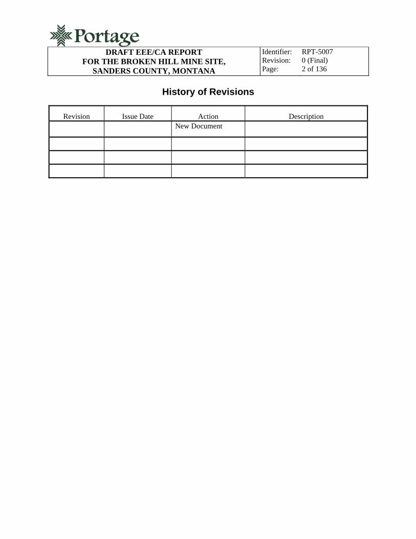
8. DETAILED ANALYSIS OF RECLAMATION ALTERNATIVES ............................................... 86
8.1 Quantitative Evaluation of Threshold Criteria .................................................................... 92
8.2 Alternative 1: No Action ..................................................................................................... 92
8.2.1 Overall Protection of Human Health and the Environment .............................. 92 8.2.2 Compliance with ARARS ................................................................................. 93 8.2.3 Long-Term Effectiveness and Permanence ....................................................... 93 8.2.4 Reduction of Toxicity, Mobility, or Volume through Treatment ...................... 93 8.2.5 Short-Term Effectiveness .................................................................................. 93 8.2.6 Implementability ............................................................................................... 94 8.2.7 Costs .................................................................................................................. 94
8.3 Alternative 5a: Disposal in a Constructed Repository at Road Bench Site #1 .................... 94
8.3.1 Overall Protection of Human Health and the Environment .............................. 95 8.3.2 Compliance with ARARS ................................................................................. 99 8.3.3 Long-Term Effectiveness and Permanence ..................................................... 100 8.3.4 Reduction of Toxicity, Mobility, or Volume through Treatment .................... 100 8.3.5 Short-Term Effectiveness ................................................................................ 100 8.3.6 Implementability ............................................................................................. 101 8.3.7 Costs ................................................................................................................ 101
8.4 Alternative 5b: Disposal in a Constructed Repository at Road Bench Site #2 .................. 104
8.4.1 Overall Protection of Human Health and the Environment ............................ 104 8.4.2 Compliance with ARARS ............................................................................... 105 8.4.3 Long-Term Effectiveness and Permanence ..................................................... 106 8.4.4 Reduction of Toxicity, Mobility, or Volume through Treatment .................... 106 8.4.5 Short-Term Effectiveness ................................................................................ 106 8.4.6 Implementability ............................................................................................. 107 8.4.7 Costs ................................................................................................................ 107
8.5 Alternative 5c: Disposal in a Constructed Repository at Blue Creek Bench ..................... 109
8.5.1 Overall Protection of Human Health and the Environment ............................ 110 8.5.2 Compliance with ARARS ............................................................................... 111 8.5.3 Long-Term Effectiveness and Permanence ..................................................... 111 8.5.4 Reduction of Toxicity, Mobility, or Volume through Treatment .................... 111 8.5.5 Short-Term Effectiveness ................................................................................ 112 8.5.6 Implementability ............................................................................................. 112 8.5.7 Costs ................................................................................................................ 112
8.6 Alternative 5d: Disposal in a Constructed Repository at Fatman Saddle .......................... 115
8.6.1 Overall Protection of Human Health and the Environment ............................ 115

EEE/CA REPORT
FOR THE BROKEN HILL MINE SITE, SANDERS COUNTY, MONTANA
Identifier: Revision: Page:
RPT-5007 0 (Final) 6 of 136
8.6.2 Compliance with ARARS ............................................................................... 116 8.6.3 Long-Term Effectiveness and Permanence ..................................................... 117 8.6.4 Reduction of Toxicity, Mobility, or Volume through Treatment .................... 117 8.6.5 Short-Term Effectiveness ................................................................................ 117 8.6.6 Implementability ............................................................................................. 118 8.6.7 Costs ................................................................................................................ 118
8.7 Alternative 6: Offsite Disposal in Permitted Solid Waste Disposal Facility ..................... 121
8.7.1 Overall Protection of Human Health and the Environment ............................ 121 8.7.2 Compliance with ARARS ............................................................................... 122 8.7.3 Long-Term Effectiveness and Permanence ..................................................... 123 8.7.4 Reduction of Toxicity, Mobility, or Volume through Treatment .................... 123 8.7.5 Short-Term Effectiveness ................................................................................ 123 8.7.6 Implementability ............................................................................................. 123 8.7.7 Costs ................................................................................................................ 124
9. COMPARATIVE ANALYSIS OF RECLAMATION ALTERNATIVES .................................... 126
9.1 Threshold Criteria .............................................................................................................. 126
9.2 Primary Balancing Criteria ................................................................................................ 131
10. PREFFERED ALTERNATIVE ..................................................................................................... 131
11. REFERENCES ............................................................................................................................... 133
APPENDIX A DESCRIPTION OF FEDERAL AND STATE ARARs ...................................................... 1
Figures
1. The BHMS within Montana ............................................................................................................. 18 2. BHMS RI sample locations .............................................................................................................. 22 3. Potential repository site locations. .................................................................................................... 37 4. Plan view of conceptual repository .................................................................................................. 96 5. Typical repository cross section with clay cap ................................................................................. 97 6. Typical repository cross section with geosynthetic cap ................................................................... 98
Tables
Table 1. Sensitive species. .......................................................................................................................... 19 Table 2. BHMS background soil concentrations (ppm) compared to EPA RSLs. ..................................... 20 Table 3. BHMS background soil concentrations (ppm) compared to MDEQ RBCGs. .............................. 21 Table 4. BHMS solid matrix total metals analytical results (ppm) compared to EPA RSLs. ..................... 24 Table 5. BHMS solid matrix total metals analytical results (ppm) compared to MDEQ RBCGs. ............. 26 Table 6. BHMS solid matrix total metals analytical results (ppm) compared to mean background. .......... 28

EEE/CA REPORT
FOR THE BROKEN HILL MINE SITE, SANDERS COUNTY, MONTANA
Identifier: Revision: Page:
RPT-5007 0 (Final) 7 of 136
Table 7. BHMS laboratory SPLP total metals analytical results (ppm). ..................................................... 29 Table 8. BHMS water dissolved metals (ppb) vs. MDEQ RBCG. ............................................................. 31 Table 9. BHMS water dissolved metals (ppb) vs. “Montana Numeric Water Quality Standards.” ............ 32 Table 10. BHMS water total metals (ppb) vs. MDEQ RBCGs. ................................................................. 33 Table 11. BHMS water total metals (ppb) vs. “Montana Numeric Water Quality Standards.” .................. 34 Table 12. Water quality parameter analytical results (ppm) for the BHMS. .............................................. 35 Table 13. Exposure point concentrations for the BHMS, total metals. ....................................................... 43 Table 14. Adult gold panner/rock hound hazard summary for the BHMS. ................................................ 45 Table 15. Child gold panner/rock hound hazard summary for the BHMS. ................................................ 46 Table 16. Gold panner/rock hound risk summary for the BHMS. .............................................................. 46 Table 17. Summary of tolerable and phytotoxic soil concentrations at the BHMS. ................................... 51 Table 18. Mammalian toxicological data for inorganic metals at the BHMS. ............................................ 51 Table 19. Montana surface water quality aquatic life standards.a ............................................................... 52 Table 20. Ecological impact quotients for the BHMS. ............................................................................... 52 Table 21. Summary of applicable or relevant and appropriate requirements. ............................................ 55 Table 22. ARAR based reclamation goals for groundwater. ...................................................................... 61 Table 23. ARAR based reclamation goals for surface water. ..................................................................... 62 Table 24. Recreational user risk-based cleanup goals for the BHMS. ........................................................ 63 Table 26. Preliminary reclamation alternatives. ......................................................................................... 73 Table 27. Alternative 2 cost estimate. ......................................................................................................... 77 Table 29. Alternative 4 cost estimate. ......................................................................................................... 81 Table 30. Alternative 5 cost estimate. ......................................................................................................... 83 Table 31. Alternative 6 cost estimate. ......................................................................................................... 84 Table 32. Alternatives screening summary. ................................................................................................ 85 Table 33. Summary of reclamation alternative evaluation criteria. ............................................................ 90 Table 34. Risk reduction achievement matrix for Alternative 1. ................................................................ 92 Table 34. (continued) .................................................................................................................................. 93 Table 35. Risk reduction achievement matrix for Alternative 5a. .............................................................. 99 Table 36. Alternative 5a costs. .................................................................................................................. 102 Table 37. Risk reduction achievement matrix for Alternative 5b. ............................................................ 105 Table 38. Alternative 5b costs................................................................................................................... 107 Table 39. Risk reduction achievement matrix for Alternative 5c. ............................................................ 110 Table 40. Alternative 5c costs. .................................................................................................................. 112 Table 41. Risk reduction achievement matrix for Alternative 5d. ............................................................ 116 Table 42. Alternative 5d costs................................................................................................................... 118 Table 43. Risk reduction achievement matrix for Alternative 6. .............................................................. 121 Table 43. (continued) ................................................................................................................................ 122 Table 44. Alternative 6 costs..................................................................................................................... 124 Table 45. Comparative analysis of reclamation alternatives. ................................................................... 128
Appendix A: Description of Federal and State ARARs
Appendix B: Electronic Copy

EEE/CA REPORT
FOR THE BROKEN HILL MINE SITE, SANDERS COUNTY, MONTANA
Identifier: Revision: Page:
RPT-5007 0 (Final) 8 of 136
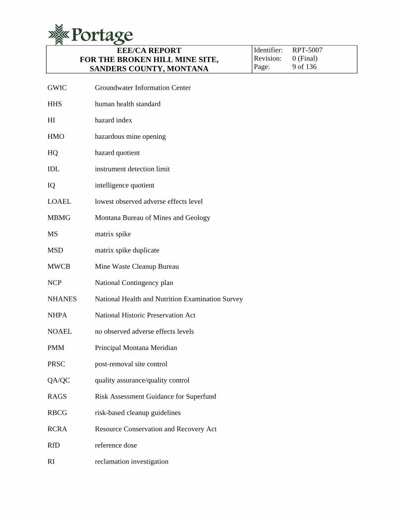
ACRONYMS
ABA acid base accounting
AM action memorandum
amsl above mean sea level
AIMSS Abandoned and Inactive Mines Scoring System
ALAD aminolevulinic acid dehydrase
ARAR applicable or relevant and appropriate requirements
ATSDR Agency for Toxic Substances and Disease Registry
bgs below ground surface
BHMS Broken Hill Mine Site
BMP best management practice
BRHS British Regional Heart Study
CEC cation exchange capacity
CERCLA Comprehensive Environmental Response, Compensation, and Liability Act
COC contaminant of concern
COPC contaminant of potential concern
MDEQ Montana Department of Environmental Quality
EEE/CA expanded engineering evaluation and cost analysis
ELCR estimated lifetime cancer risk
EPA U.S. Environmental Protection Agency
EPC exposure point concentration
ESA Endangered Species Act
EQ ecological impact quotient
FR forest road
EEE/CA REPORT
FOR THE BROKEN HILL MINE SITE, SANDERS COUNTY, MONTANA
Identifier: Revision: Page:
RPT-5007 0 (Final) 9 of 136
GWIC Groundwater Information Center
HHS human health standard
HI hazard index
HMO hazardous mine opening
HQ hazard quotient
IDL instrument detection limit
IQ intelligence quotient
LOAEL lowest observed adverse effects level
MBMG Montana Bureau of Mines and Geology
MS matrix spike
MSD matrix spike duplicate
MWCB Mine Waste Cleanup Bureau
NCP National Contingency plan
NHANES National Health and Nutrition Examination Survey
NHPA National Historic Preservation Act
NOAEL no observed adverse effects levels
PMM Principal Montana Meridian
PRSC post-removal site control
QA/QC quality assurance/quality control
RAGS Risk Assessment Guidance for Superfund
RBCG risk-based cleanup guidelines
RCRA Resource Conservation and Recovery Act
RfD reference dose
RI reclamation investigation

EEE/CA REPORT
FOR THE BROKEN HILL MINE SITE, SANDERS COUNTY, MONTANA
Identifier: Revision: Page:
RPT-5007 0 (Final) 10 of 136
RPD relative percent difference
RSL regional screening level
SMCRA Surface Mining Control and Reclamation Act
SPLP synthetic precipitation leaching procedure
s.u. standard units
TAL target analyte list
TDS total dissolved solids
TCLP toxicity characteristic leaching procedure
UCL upper confidence limit
USFS United States Forest Service
EEE/CA REPORT
FOR THE BROKEN HILL MINE SITE, SANDERS COUNTY, MONTANA
Identifier: Revision: Page:
RPT-5007 0 (Final) 11 of 136
1. INTRODUCTION
This expanded engineering evaluation/cost evaluation (EEE/CA) report analyzes reclamation alternatives for waste rock associated with the Broken Hill Mine Site (BHMS) located in northwestern Montana. Reclamation activities at the BHMS are designed to comply with the requirements of the National Oil and Hazardous Substances Pollution Contingency Plan, more commonly called the National Contingency Plan (NCP), are considered removal actions, and are not considered the final reclamation remedies or alternatives. Per the NCP, an analysis of applicable or relevant and appropriate requirements (ARARs) related to environmental media and the removal action at the BHMS has been prepared in support of this EEE/CA. The reclamation alternatives presented in this EEE/CA are applicable to the solid media only; no reclamation alternatives were developed for treatment of surface water or groundwater. ARARs presented for surface water and groundwater environmental media are for informational purposes only.
This report was prepared by Portage, Inc., (Portage) for the Montana Department of Environmental Quality (MDEQ) Mine Waste Cleanup Bureau (MWCB). This report satisfies the provisions of Portage Task Order #8, Task 2, DEQ Contract No. 407025. Previously completed tasks on this project have included:
Task Order #7, Task 1: Preparation of a reclamation work plan (April 2009)
Task Order #7, Task 2: Completion of the onsite reclamation investigation (July 2009)
Task Order #7, Task 3: Completion of the reclamation investigation report (January 2010)
Task Order #8, Task 1: Completion of repository site investigations and report (September 2010).
Portage Task Order #8, Task 2 required the completion of data review, analysis, and alternatives evaluation sufficient to prepare an EEE/CA report. The elements of this EEE/CA report include this introduction; background; a description of previous investigations; a summary of waste characterization results; a human health and ecological risk assessment summary; an analysis of ARARs; a statement of reclamation objectives and goals; development and screening of reclamation alternatives; detailed analysis of reclamation alternatives; comparative analysis of the reclamation alternatives; and a statement of the preferred reclamation alternative.
Sections 2 through 5 present the background data and the results of previous analysis. Section 6 is the statement of the reclamation objectives and goals. Section 7 presents reclamation technologies and the development and screening of reclamation alternatives. Alternatives that were considered but not included for detailed evaluation are screened in this section. Section 8 is the detailed evaluation of reclamation alternatives that passed the screening process. In the detailed evaluation, each alternative is evaluated against seven evaluation criteria:
Overall protection of human health and the environment
Compliance with ARARs

EEE/CA REPORT
FOR THE BROKEN HILL MINE SITE, SANDERS COUNTY, MONTANA
Identifier: Revision: Page:
RPT-5007 0 (Final) 12 of 136
Long-term effectiveness and permanence
Reduction of toxicity, mobility, or volume through treatment
Short-term effectiveness
Implementability
Cost.
The comparative analysis of reclamation alternatives in Section 9 provides the basis of the preferred alternative selection in Section 10.
View of Cabinet Gorge from the Broken Hill Mine
EEE/CA REPORT
FOR THE BROKEN HILL MINE SITE, SANDERS COUNTY, MONTANA
Identifier: Revision: Page:
RPT-5007 0 (Final) 13 of 136
2. BACKGROUND
The BHMS is an abandoned hard rock mine located in Sanders County, Montana. The BHMS produced silver, lead, and zinc. The significant features remaining on the mine property include two waste rock dumps, two collapsed adits (and associated seasonal/intermittent lower adit discharge), and roadways. Previous investigation by Pioneer Technical Services, Inc., (Pioneer) in 1993 indicated elevated arsenic, cadmium, copper, iron, mercury, lead, antimony, and zinc in onsite waste rock and elevated arsenic and lead in the adit discharge. In July of 2009, Portage performed a reclamation investigation (RI) to further characterize the nature and extent of contamination at the BHMS. The Reclamation Investigation Report for the Broken Hill Mine Site, Sanders County, Montana (Portage 2010a) was completed in January of 2010.
During the RI, samples were collected to support site characterization and risk assessment. The sampling included material from the upper and lower waste rock dumps, background soil sampling, and sampling of adit discharge water. The following summarizes the findings related to BHMS sampling in 2009:
Elevated metals concentrations were noted in background soil samples, consistent with mineralization occurring in the mining district
Lead exceeded the U.S. Environmental Protection Agency (EPA) regional screening levels (RSLs) for soils in both waste rock dumps and in adjacent soils
Lead exceeded the MDEQ risk-based cleanup guidelines (RBCG) in both waste rock piles and in soils adjacent to the upper waste rock dump
Arsenic exceeded the EPA RSL for arsenic in both waste rock piles and in soils adjacent to the lower waste rock dump
Arsenic exceeded the MDEQ RBCG in both waste rock samples
The EPA RSLs for antimony, iron, and mercury were exceeded in the upper waste dump only
Antimony, arsenic, cadmium, chromium, copper, iron, lead, mercury, nickel, and zinc concentrations in the upper waste rock dump exceeded background concentrations; and antimony, arsenic, cadmium, copper, iron, lead, mercury, nickel, and zinc concentrations in the lower waste rock dump exceeded background concentrations.
Antimony, arsenic, cadmium, copper, iron, lead, mercury, and zinc concentrations in both the upper and lower waste rock dumps exceeded background concentrations by a factor of three or more and are considered elevated.
The lead concentration resulting from synthetic precipitation leaching procedure (SPLP) extract testing of the waste rock exceeded the human health standard for water and the acute aquatic life standard as found in the “Montana Numeric Water Quality Standards” (MDEQ 2010).

EEE/CA REPORT
FOR THE BROKEN HILL MINE SITE, SANDERS COUNTY, MONTANA
Identifier: Revision: Page:
RPT-5007 0 (Final) 14 of 136
Arsenic and lead exceed human health standards for water; and cadmium, lead, and zinc exceeded both chronic and acute aquatic life standards as found in the “Montana Numeric Water Quality Standards” (MDEQ 2010).
Risk assessment of the data indicated both potential human exposure and ecological impacts exceeding what EPA establishes as healthy benchmarks. The human cancer risk factor of 1 × 10⁻⁶ is exceeded and the noncancer hazard index (HI) of 1 is exceeded. Ecological impact quotients (EQs) are also exceeded for plant phytotoxicity and for deer. The RI results demonstrated the need for site reclamation that is protective of human health and the environment. The purpose of this EEE/CA report is to identify a preferred alternative for site reclamation that achieves reclamation objectives and risk-based cleanup goals for the BHMS.
Waste rock dump at the Broken Hill Mine
2.1 Mining History
The early history of the Broken Hill Mine includes conflicting accounts. Early mine inspector reports state the first period of significance for the Broken Hill Mine was in 1906, when there was intermittent small-scale production. However, later sources put the development of the mine in the early

EEE/CA REPORT
FOR THE BROKEN HILL MINE SITE, SANDERS COUNTY, MONTANA
Identifier: Revision: Page:
RPT-5007 0 (Final) 15 of 136
1920s, which is consistent with the original patent filing in 1920 (FHC 2002). The mine was worked by varying owners and operators until 1930, when it became inactive.
The 1920 patent survey recorded two tunnels, seven drifts, two crosscuts, and a raise. The mine was worked through the series of tunnels and drifts. The ore was oxide of iron carrying as much as 80% excess iron, which made it desirable for fluxing. The Montana Bureau of Mines and Geology (MBMG) reports that the Federal Bureau of Mining production records indicate 273 tons of ore were produced from 1925 to 1927, from which 942 oz of silver, 53,057 lb of lead, and 176,632 lb of zinc were extracted. The Federal Bureau of Mining reported two adits: one adit tunnel being 350 ft long and another 108 ft long with a raise connecting the two tunnels (MBMG 1963).
The mine remained closed until 1965, when other owners and operators had renewed interest in mining at the Broken Hill Mine. Approximately 94 tons of ore were mined in 1966. Road improvements, tunnel repair, and ore removal were performed; however, in 1973, the mine was inactive again and remains so today. Fewer than 400 tons of ore were recorded as being shipped from the Broken Hill Mine since its original discovery (RTI 2002). The cultural resource inventory for the BHMS, indicates that all ore was shipped off site for processing and no milling or amalgamating equipment was noted at the BHMS (FHC 2002).
2.2 Climate
The climate of the BHMS is based on the nearest climate station at Heron, Montana. Average monthly temperatures ranges from an average high of 82.9F in July to an average low of 18.4F in January. The average annual high temperature is 56.4F and the average annual low temperature is 32F. Average annual total precipitation is 33.57 in. per year, with the majority of precipitation occurring as snow between the months of November and April. Average annual snowfall is 85.7 in. (WRCC 2010). The BHMS is located in mountainous terrain at an elevation approximately 1,000 ft higher than Heron, which may increase total annual precipitation and total precipitation as snowfall.
2.3 Geology, Hydrogeology, and Hydrology
The following sections present a summary of site geology, hydrogeology, and surface water hydrology.
2.3.1 Local and Regional Geology
During the Proterozoic Era, a shallow subsiding marine basin formed in northwestern Montana where great thicknesses of homogeneous sand, silt, clay, and carbonate sediments accumulated. Low-grade regional metamorphism later indurated these sediments into a mixture of resistant quartzites, siltites, argillites, and limestones; this thick sequence of fine-grained, quartzite-rich calcareous and noncalcareous rocks is the Belt Series. The Belt Series is subdivided into four general groups in ascending order: Lower Belt or Pre-Ravalli, Ravalli, Middle Belt Carbonate, and Missoula Groups (Montana Agricultural Experiment Station and USDA 1980). The BHMS is in the Ravalli Group. The MBMG reported that selected dump samples at the BHMS contained pyrite, pyrrhotite, sphalerite, galena, chalcopyrite, and arsenopyrite. They are present in a gangue of quartz, tourmaline, and tremolite.

EEE/CA REPORT
FOR THE BROKEN HILL MINE SITE, SANDERS COUNTY, MONTANA
Identifier: Revision: Page:
RPT-5007 0 (Final) 16 of 136
2.3.2 Soils
Hard, fine-grained Belt Series rocks typically weather to fine sandy or loamy soils with high percentages of coarse fragments. Most soils are weakly developed. These Sharrott series soils consist of shallow residual or colluvial soils developed on the moderately sloping to steep ridges and mountain slopes of hard thinly-bedded argillite at an elevation of 3,000 to 4,500 ft. They are well-drained soils with medium run-off and moderate permeability ranging from 0.6 to 2.0 in./hour. Depth to bedrock is typically 4 to 20 in., and coarse fragment content is 50 to 80%. Clay content is usually 5 to 20%. They are slightly sticky (after pressure, soil adheres to both thumb and finger and tends to stretch somewhat before pulling apart) to slightly plastic (moderate pressure is required to deform soil mass) when wet. Soils may be classified as a loamy-skeletal, mixed Lithic Ustocrept (Montana Agricultural Experiment Station and USDA 1980).
2.3.3 Hydrogeology
The MBMG Groundwater Information Center (GWIC) database lists one well log within a 1-mile radius of the BHMS. The well is located 1 mile to the northwest in Section 2 of Township 27 North and Range 34 West. The well has a static water level of 92 ft below ground surface (bgs) and a yield of 5 gal per minute and is used for domestic purposes (GWIC 2008). There are no lithologic details available for this well. The GWIC database lists 35 well logs within a 4-mile radius of the BHMS.
2.3.4 Surface Water Hydrology
The BHMS is located within the watershed of an unnamed, ephemeral tributary to the East Fork of Blue Creek. The unnamed tributary lies 100 ft to the north of the BHMS and reaches its confluence with the East Fork of Blue Creek approximately 0.75 mile downstream from the BHMS. The unnamed tributary begins approximately 4,000 ft upstream from the BHMS (USGS 1997).
The East Fork of Blue Creek reaches its confluence with Blue Creek 2 miles from its confluence with the unnamed tributary. Blue Creek empties into Cabinet Gorge Reservoir of the Clark Fork River 0.5 miles from the confluence of the East Fork with Blue Creek proper.
As described further in Section 3.3, there is an intermittent adit discharge associated with the lower waste rock dump. The discharge has been observed as seasonal and low volume.
2.4 Current Site Setting
The following sections describe the current physical setting of the BHMS in addition to current land use and ownership.
2.4.1 Location and Topography
The BHMS is located approximately 4 miles north of Heron, Montana, (Figure 1) and north of U.S. Highway 200 in Sanders County. The BHMS falls within the Blue Creek Mining District, which is bordered to the west by the Clark Fork Mining District, to the south by the Clark Fork River, and on the northeast by the drainage of Blue Creek. The BHMS is situated in the East Fork of Blue Creek at an elevation of approximately 4,200 ft above mean sea level (amsl) in Section 10, Township 27 North,

EEE/CA REPORT
FOR THE BROKEN HILL MINE SITE, SANDERS COUNTY, MONTANA
Identifier: Revision: Page:
RPT-5007 0 (Final) 17 of 136
Range 34 West, Principal Montana Meridian (PMM). The latitude and longitude are North 48 07’ 15” and West 115 58’ 06”. The BHMS features comprise approximately 1.5 acres of land that has been impacted by historic metal mining.
The surrounding area consists of moderately steep to steep mountain slopes and hillsides. Site topography is characterized by steep mountainous terrain rising from a narrow valley floor draining the East Fork of Blue Creek. Forest Road (FR) 2290 begins at an elevation of 2,625 ft amsl at its junction with FR 409 and terminates at an elevation of approximately 3,320 ft amsl near the BHMS. Billiard Table Mountain is a prominent peak northeast of the BHMS at an elevation of 6,622 ft amsl.
2.4.2 Vegetation and Wildlife
The BHMS is characterized by native plants growing on undisturbed areas around the site; little or no vegetation is currently growing on the waste rock piles. Dominant trees onsite include Douglas fir (Pseudotsuga menziesii), Engelmann spruce (Picea engelmannii), and Sitka alder. Shrubs and other vegetative species include thimbleberry (MNHP 2008). Other trees, shrubs, and forbs are found across and around the site in lower densities. There is regrowth of the forest in some mining-impacted areas, particularly on the lower haul road used for mining operations. Knapweed is widespread in all areas of relatively recent disturbance, with the exception of the waste rock dumps.
The habitat surrounding the BHMS supports a variety of wildlife including deer, elk, bobcat, black bear, potentially lynx and wolverine, and miscellaneous smaller mammals such as rabbits, squirrels, mice, and voles (MNHP 2008). Many species of birds are found around the site throughout the year, including various songbirds, owls, and raptors.
Mixed shrubs and coniferous forest at the BHMS

EEE/CA REPORT
FOR THE BROKEN HILL MINE SITE, SANDERS COUNTY, MONTANA
Identifier: Revision: Page:
RPT-5007 0 (Final) 18 of 136
Figure 1. The BHMS within Montana.
EEE/CA REPORT
FOR THE BROKEN HILL MINE SITE, SANDERS COUNTY, MONTANA
Identifier: Revision: Page:
RPT-5007 0 (Final) 19 of 136
The Montana Natural Heritage Program lists several species of concern that may exist within the area surrounding the BHMS. Table 1 lists the species of concern and their current federal status.
Table 1. Sensitive species.
Common Name Scientific Name USFWS Federal Status
Peregrine falcon Falco peregrinus Recovered, delisted, and being monitored
Westslope cutthroat trout Oncorhynchus clarkii lewisia -
Gray wolf Canis lupus Listed Endangered
Grizzly bear Ursus arctos horribilis Listed Threatened
Fisher Martes pennantia -
Wolverine Gulo guloa -
Canadian lynx Lynx canadensis Listed Threatened
USFWS = US Fish and Wildlife Service
a. - No current federal designation
The BHMS lies within a habitat protection area for grizzly bear administered by the Kootenai National Forest. Access to the area is restricted seasonally.
2.4.3 Historic or Archaeologically Significant Features
A cultural inventory and assessment of the BHMS conducted in 2002 concluded that the site has greatly diminished integrity both as an individual site and as a historic landscape and would not be eligible for the National Register of Historic Places (FHC 2002). Also, it was determined that because there were no habitable features at the site, there is likely no archeological significance. The conclusion was based on the near total degradation of site adits and the general degradation of site features. Further, the site was not recommended to be eligible as a national historic mining landscape.
2.4.4 Land Use and Population
The BHMS is located on private land and on the Kootenai National Forest. The primary land use in the vicinity of the site is commercial (logging) and recreational. The population in Sanders County is 11,096 people, with approximately four persons per square mile (USCB 2009).
2.4.5 Land Ownership
The BHMS land ownership is divided into two parcels (RTI 2002). The upper adit and waste rock dump are located on the patented Broken Hill claim (Mineral Survey #10572.) The Broken Hill claim is currently owned by a private company, Sanders Mtn. Development, LLC of Kalispell, Montana. The lower adit and the majority of the lower waste rock dump are located on the unpatented Tuesday Lode (Mineral Survey #10572.) The Tuesday Lode and surrounding lands are administered by the Kootenai National Forest.

EEE/CA REPORT
FOR THE BROKEN HILL MINE SITE, SANDERS COUNTY, MONTANA
Identifier: Revision: Page:
RPT-5007 0 (Final) 20 of 136
3. WASTE CHARACTERISTICS AND SUMMARY OF RECLAMATION INVESTIGATION
The following sections summarize the results of the waste characterization performed in support of the 2009 RI.
3.1 Background Sampling
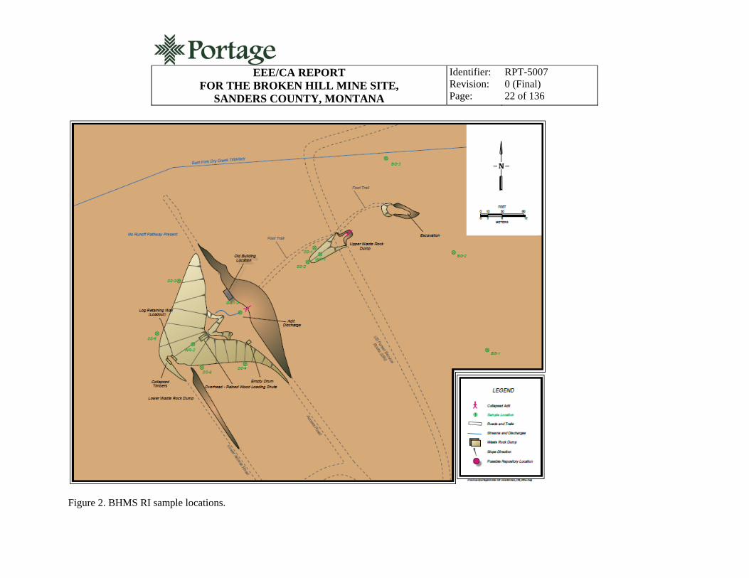
Three background soil samples were collected during the RI (BHMS-BG-1, BHMS-BG-2, and BHMS-BG-3) above the upper waste rock dump and its associated adit in naturally occurring soil as shown in Figure 2. Each sample was composed of dark-brown loam with course materials. Site preparation (pre-sampling) included scraping off duff/decomposing plant material from the surface to expose actual soil. All of the background samples contained approximately 10% coarse fragments and 90% loamy soil. Each background sample was submitted for target analyte list (TAL) metals, texture, cation exchange capacity (CEC), acid base accounting (ABA), and agricultural analyses.
The background sampling analytical results are presented in Tables 2 and 3. Table 2 presents the metals concentrations compared to EPA Region 9 RSLs for residential soil (EPA 2010a), and Table 3 presents the metals concentrations compared to MDEQ RBCGs (MDEQ 1996). The results highlighted in bold exceed RSLs and RBCGs, respectively.
Based on the analytical results, metals in background soils are below the MDEQ RBCGs. The arsenic value in soil sample BHMS-BG-2 (67 ppm) exceeds the EPA RSL (0.39 ppm) and the MDEQ soil screening value (40 ppm). The mean arsenic concentration for background soils (44 ppm) also exceeds the EPA RSL and MDEQ soil screening value. Lead in BHMS-BG-3 (1,020 ppm) exceeds the EPA RSL (400 ppm). The mean lead concentration (560 ppm) also exceeds the EPA RSL.
Table 2. BHMS background soil concentrations (ppm) compared to EPA RSLs.
Analyte EPA RSLa Mean
Background BHMS-BG-1 BHMS-BG-2 BHMS-BG-3
Antimony 310 12 5UJ 5UJ 12J
Arsenic 0.39 (40)b 44 28 67 36
Barium 15,000 241 304J 199J 220J
Cadmium 70 1 1U 1U 1U
Chromium 280 6 7 5 6
Copper 3,100 13 12 14 24
Iron 55,000 14,833 13,300 13,300 17,900
Lead 400 560 350 309 1,020
Manganese Not applicable 1,720 2,510 1,430 1,220
Mercury 6.7 0.50U 0.50U 0.50U 0.50U
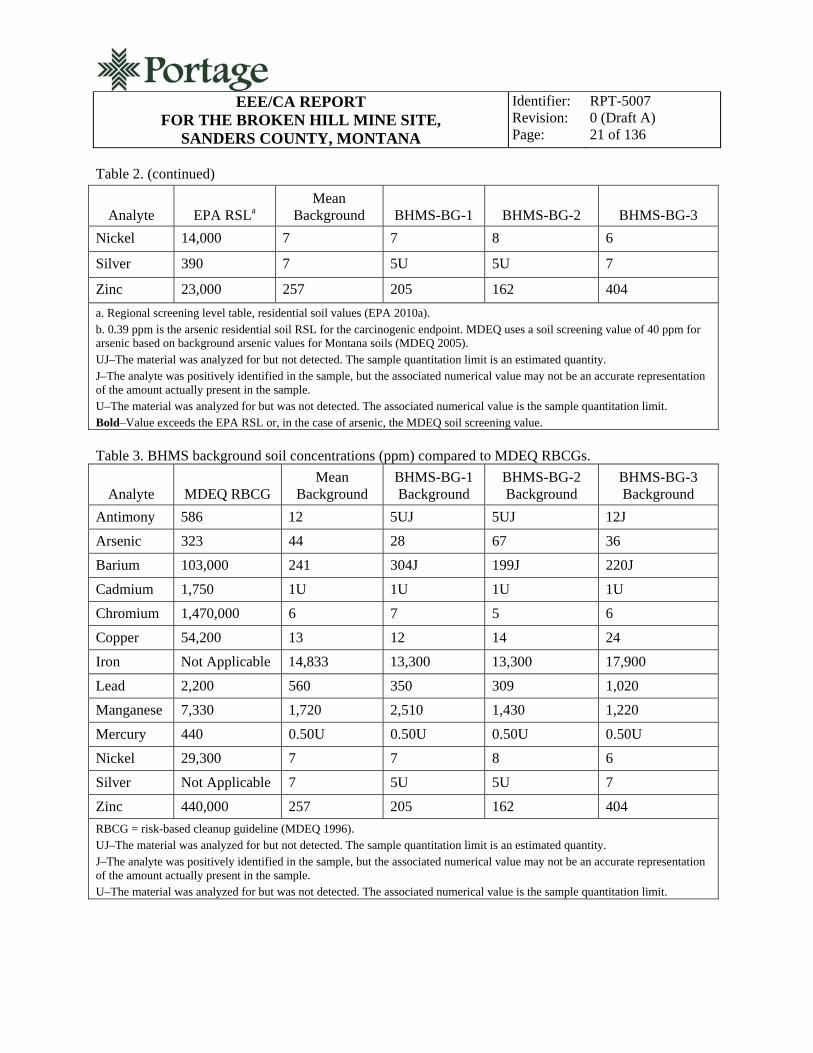
EEE/CA REPORT
FOR THE BROKEN HILL MINE SITE, SANDERS COUNTY, MONTANA
Identifier: Revision: Page:
RPT-5007 0 (Draft A) 21 of 136
Table 2. (continued)
Analyte EPA RSLa Mean
Background BHMS-BG-1 BHMS-BG-2 BHMS-BG-3
Nickel 14,000 7 7 8 6
Silver 390 7 5U 5U 7
Zinc 23,000 257 205 162 404
a. Regional screening level table, residential soil values (EPA 2010a). b. 0.39 ppm is the arsenic residential soil RSL for the carcinogenic endpoint. MDEQ uses a soil screening value of 40 ppm for arsenic based on background arsenic values for Montana soils (MDEQ 2005). UJ–The material was analyzed for but not detected. The sample quantitation limit is an estimated quantity. J–The analyte was positively identified in the sample, but the associated numerical value may not be an accurate representation of the amount actually present in the sample. U–The material was analyzed for but was not detected. The associated numerical value is the sample quantitation limit. Bold–Value exceeds the EPA RSL or, in the case of arsenic, the MDEQ soil screening value.
Table 3. BHMS background soil concentrations (ppm) compared to MDEQ RBCGs.
Analyte MDEQ RBCG Mean
Background BHMS-BG-1 Background
BHMS-BG-2 Background
BHMS-BG-3 Background
Antimony 586 12 5UJ 5UJ 12J
Arsenic 323 44 28 67 36
Barium 103,000 241 304J 199J 220J
Cadmium 1,750 1U 1U 1U 1U
Chromium 1,470,000 6 7 5 6
Copper 54,200 13 12 14 24
Iron Not Applicable 14,833 13,300 13,300 17,900
Lead 2,200 560 350 309 1,020
Manganese 7,330 1,720 2,510 1,430 1,220
Mercury 440 0.50U 0.50U 0.50U 0.50U
Nickel 29,300 7 7 8 6
Silver Not Applicable 7 5U 5U 7
Zinc 440,000 257 205 162 404
RBCG = risk-based cleanup guideline (MDEQ 1996). UJ–The material was analyzed for but not detected. The sample quantitation limit is an estimated quantity. J–The analyte was positively identified in the sample, but the associated numerical value may not be an accurate representation of the amount actually present in the sample. U–The material was analyzed for but was not detected. The associated numerical value is the sample quantitation limit.
EEE/CA REPORT FOR THE BROKEN HILL MINE SITE,
SANDERS COUNTY, MONTANA
Identifier: Revision: Page:
RPT-5007 0 (Final) 22 of 136
Figure 2. BHMS RI sample locations.

EEE/CA REPORT FOR THE BROKEN HILL MINE SITE,
SANDERS COUNTY, MONTANA
Identifier: Revision: Page:
RPT-5007 0 (Final) 23 of 136
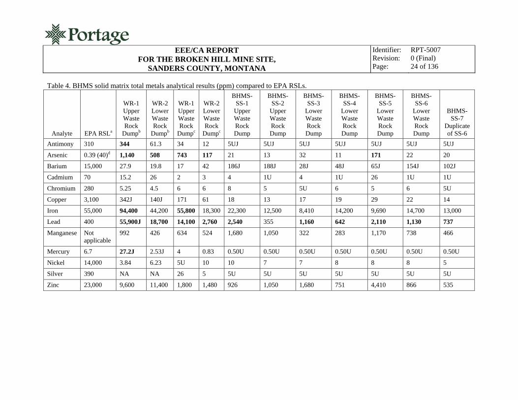
3.2 Mine Waste Characterization
The two waste rock piles contain the mining waste associated with the BHMS. During the 2009 RI, six soil samples (two from the upper and four from the lower waste rock dump areas) were collected from the periphery of the waste rock dumps to establish the spatial boundaries of contamination around each dump. To better understand how the waste rock might release metals over time, waste rock samples from each of the dumps were collected to evaluate the mobility of metals they contain under environmental conditions. To support this effort, one waste rock sample was collected from each dump and submitted for SPLP extraction. Each SPLP extraction was analyzed for total metals. Also during the 2009 RI, a composite sample of waste rock from each dump was collected and analyzed for total metals to confirm the results of previous investigations which characterized total metals concentrations in waste rock (Pioneer 1993).
Analytical results for the soil and waste rock samples are presented in Tables 4, 5, and 6. In Table 4, the metals concentrations are compared to EPA Region 9 RSLs for residential soil. In Table 5, the metals are compared to MDEQ RBCGs. In Table 6, the metals concentrations are compared to mean background values. Metals concentrations which exceed mean background by a factor of three or more are considered elevated for the purpose of characterization. Results highlighted in bold indicate exceedance of RSLs, RBCGs, and/or mean background. The following summarizes these comparisons:
Lead exceeded the EPA RSLs in all samples except BHMS-SS-2 (adjacent to upper waste rock dump)
Lead exceeded the MDEQ RBCG in both waste rock samples and BHMS-SS-1 (adjacent to the upper waste rock dump)
Arsenic exceeded the EPA RSL in both waste rock samples and BHMS-SS-5 (lower waste rock dump)
Arsenic exceeded the MDEQ RBCG in both waste rock samples
The EPA RSL for antimony, iron, and mercury was exceeded in the upper waste dump only
Lead exceeded background concentrations in eight of ten samples by a factor of three or more
Copper exceeded background concentrations in four of ten samples by a factor of three or more
Cadmium exceeded background concentrations in six of ten samples by a factor of three or more
Antimony, arsenic, iron and mercury exceeded background concentrations in three of ten samples by a factor of three or more
Zinc exceeded background concentrations in nine of ten samples by a factor of three or more.
EEE/CA REPORT
FOR THE BROKEN HILL MINE SITE, SANDERS COUNTY, MONTANA
Identifier: Revision: Page:
RPT-5007 0 (Final) 24 of 136
Table 4. BHMS solid matrix total metals analytical results (ppm) compared to EPA RSLs.
Analyte EPA RSLa
WR-1 Upper Waste Rock
Dumpb
WR-2 Lower Waste Rock
Dumpb
WR-1 Upper Waste Rock
Dumpc
WR-2 Lower Waste Rock
Dumpc
BHMS-SS-1
Upper Waste Rock Dump
BHMS-SS-2
Upper Waste Rock Dump
BHMS-SS-3
Lower Waste Rock Dump
BHMS- SS-4
Lower Waste Rock Dump
BHMS- SS-5
Lower Waste Rock Dump
BHMS- SS-6
Lower Waste Rock Dump
BHMS-SS-7
Duplicate of SS-6
Antimony 310 344 61.3 34 12 5UJ 5UJ 5UJ 5UJ 5UJ 5UJ 5UJ
Arsenic 0.39 (40)d 1,140 508 743 117 21 13 32 11 171 22 20
Barium 15,000 27.9 19.8 17 42 186J 188J 28J 48J 65J 154J 102J
Cadmium 70 15.2 26 2 3 4 1U 4 1U 26 1U 1U
Chromium 280 5.25 4.5 6 6 8 5 5U 6 5 6 5U
Copper 3,100 342J 140J 171 61 18 13 17 19 29 22 14
Iron 55,000 94,400 44,200 55,800 18,300 22,300 12,500 8,410 14,200 9,690 14,700 13,000
Lead 400 55,900J 18,700 14,100 2,760 2,540 355 1,160 642 2,110 1,130 737
Manganese Not applicable
992 426 634 524 1,680 1,050 322 283 1,170 738 466
Mercury 6.7 27.2J 2.53J 4 0.83 0.50U 0.50U 0.50U 0.50U 0.50U 0.50U 0.50U
Nickel 14,000 3.84 6.23 5U 10 10 7 7 8 8 8 5
Silver 390 NA NA 26 5 5U 5U 5U 5U 5U 5U 5U
Zinc 23,000 9,600 11,400 1,800 1,480 926 1,050 1,680 751 4,410 866 535

EEE/CA REPORT
FOR THE BROKEN HILL MINE SITE, SANDERS COUNTY, MONTANA
Identifier: Revision: Page:
RPT-5007 0 (Final) 25 of 136
Table 4. (continued)
a. EPA RSL table, residential soil values (EPA 2010a). b. Total metals analytical results from 1993 AMRB Hazardous Materials Inventory (Pioneer 1993). c. Total metals analytical results from additional 2009 solid matrix samples (Portage, 2010a). d. 0.39 ppm is the arsenic residential soil RSL for the carcinogenic endpoint. The MDEQ uses a soil screening value of 40 ppm for arsenic based on background arsenic values for Montana soils (MDEQ 2005). UJ–The material was analyzed for but not detected. The sample quantitation limit is an estimated quantity. J–The analyte was positively identified in the sample, but the associated numerical value may not be an accurate representation of the amount actually present in the sample. U–The material was analyzed for but was not detected. The associated numerical value is the sample quantitation limit. Bold– Value exceeds the EPA RSL or, for arsenic, the MDEQ soil screening value. NA = Not analyzed.

EEE/CA REPORT
FOR THE BROKEN HILL MINE SITE, SANDERS COUNTY, MONTANA
Identifier: Revision: Page:
RPT-5007 0 (Final) 26 of 136
Table 5. BHMS solid matrix total metals analytical results (ppm) compared to MDEQ RBCGs.
Analyte MDEQ RBCGa
WR-1 Upper Waste Rock
Dumpb
WR-2 Lower Waste Rock
Dumpb
WR-1 Upper Waste Rock
Dumpc
WR-2 Lower Waste Rock
Dumpc
BHMS-SS-1
Upper Waste Rock Dump
BHMS-SS-2
Upper Waste Rock Dump
BHMS-SS-3
Lower Waste Rock Dump
BHMS-SS-4
Lower Waste Rock Dump
BHMS-SS-5
Lower Waste Rock Dump
BHMS-SS-6
Lower Waste Rock Dump
BHMS- SS-7
Duplicate of SS-6
Antimony 586 344 61.3 34 12 5UJ 5UJ 5UJ 5UJ 5UJ 5UJ 5UJ
Arsenic 323 1,140 508 743 117 21 13 32 11 171 22 20
Barium 103,000 27.9 19.8 17 42 186J 188J 28J 48J 65J 154J 102J
Cadmium 1,750 15.2 26 2 3 4 1U 4 1U 26 1U 1U
Chromium 1,470,000 5.25 4.5 6 6 8 5 5U 6 5 6 5U
Copper 54,200 342J 140J 171 61 18 13 17 19 29 22 14
Iron Not applicable
94,400 44,200 55,800 18,300 22,300 12,500 8,410 14,200 9,690 14,700 13,000
Lead 2,200 55,900J 18,700 14,100 2,760 2,540 355 1,160 642 2,110 1,130 737
Manganese 7,330 992 426 634 524 1,680 1,050 322 283 1,170 738 466
Mercury 440 27.2J 2.53J 4 0.83 0.50U 0.50U 0.50U 0.50U 0.50U 0.50U 0.50U
Nickel 29,300 3.84 6.23 5U 10 10 7 7 8 8 8 5
Silver Not applicable
NA NA 26 5 5U 5U 5U 5U 5U 5U 5U
Zinc 440,000 9,600 11,400 1,800 1,480 926 1,050 1,680 751 4,410 866 535

EEE/CA REPORT
FOR THE BROKEN HILL MINE SITE, SANDERS COUNTY, MONTANA
Identifier: Revision: Page:
RPT-5007 0 (Final) 27 of 136
Table 5. (continued)
a. MDEQ risk-based cleanup guideline (MDEQ 1996). b. Total metals analytical results from 1993 AMRB Hazardous Materials Inventory (Pioneer 1993). c. Total metals analytical results from additional 2009 solid matrix samples (Portage, 2010a). UJ–The material was analyzed for but not detected. The sample quantitation limit is an estimated quantity. J– The analyte was positively identified in the sample, but the associated numerical value may not be an accurate representation of the amount actually present in the sample. U– The material was analyzed for but was not detected. The associated numerical value is the sample quantitation limit. Bold–Value exceeds the MDEQ RBCG. NA–Not analyzed.

EEE/CA REPORT
FOR THE BROKEN HILL MINE SITE, SANDERS COUNTY, MONTANA
Identifier: Revision: Page:
RPT-5007 0 (Final) 28 of 136
Table 6. BHMS solid matrix total metals analytical results (ppm) compared to mean background.
Analyte Mean
Background
WR-1 Upper Waste Rock
Dumpa
WR-2 Lower Waste Rock
Dumpa
WR-1 Upper Waste Rock
Dumpb
WR-2 Lower Waste Rock
Dumpb
BHMS-SS-1
Upper Waste Rock Dump
BHMS-SS-2
Upper Waste Rock Dump
BHMS-SS-3
Lower Waste Rock Dump
BHMS-SS-4
Lower Waste Rock Dump
BHMS-SS-5
Lower Waste Rock Dump
BHMS-SS-6
Lower Waste Rock Dump
BHMS- SS-7
Duplicate of SS-6
Antimony 12J 344 61.3 34 12 5UJ 5UJ 5UJ 5UJ 5UJ 5UJ 5UJ
Arsenic 44 1,140 508 743 117 21 13 32 11 171 22 20
Barium 241 27.9 19.8 17 42 186J 188J 28J 48J 65J 154J 102J
Cadmium 1U 15.2 26 2 3 4 1U 4 1U 26 1U 1U
Chromium 6 5.25 4.5 6 6 8 5 5U 6 5 6 5U
Copper 17 342J 140J 171 61 18 13 17 19 29 22 14
Iron 14,833 94,400 44,200 55,800 18,300 22,300 12,500 8,410 14,200 9,690 14,700 13,000
Lead 560 55,900J 18,700 14,100 2,760 2,540 355 1,160 642 2,110 1,130 737
Manganese 1,720 992 426 634 524 1,680 1,050 322 283 1,170 738 466
Mercury 0.5U 27.2J 2.53J 4 0.83 0.50U 0.50U 0.50U 0.50U 0.50U 0.50U 0.50U
Nickel 7 3.84 6.23 5U 10 10 7 7 8 8 8 5
Silver 7 NA NA 26 5 5U 5U 5U 5U 5U 5U 5U
Zinc 257 9,600 11,400 1,800 1,480 926 1,050 1,680 751 4,410 866 535
a. Total metals analytical results from 1993 AMRB Hazardous Materials Inventory (Pioneer 1993). b. Total metals analytical results from additional 2009 solid matrix samples (Portage, 2010a). UJ–The material was analyzed for but not detected. The sample quantitation limit is an estimated quantity. J–The analyte was positively identified in the sample, but the associated numerical value may not be an accurate representation of the amount actually present in the sample. U–The material was analyzed for but was not detected. The associated numerical value is the sample quantitation limit. Bold–Value exceeds the mean background level by factor of three or more. NA = Not analyzed.

EEE/CA REPORT
FOR THE BROKEN HILL MINE SITE, SANDERS COUNTY, MONTANA
Identifier: Revision: Page:
RPT-5007 0 (Final) 29 of 136
As noted, two waste rock samples underwent SPLP extraction and total metals analysis. This method determines the total metals that would be leached under simulated environmental conditions. The leaching is performed with a dilute acid extraction fluid to reflect the pH of the acidic precipitation in the geographic region, to evaluate environmental mobility of metals. The SPLP results are presented in Table 7.
Table 7. BHMS laboratory SPLP total metals analytical results (ppm).
Sb Cu Fe Hg Mn Ni Zn As Ba Cd Cr Pb Ag
WR-1 Upper Waste Rock Dump
0.5U 0.5U 1UJ .02U 0.5U 0.5U 1U 0.5U 10U 0.1U 0.5U 9.0 0.5U
WR-2 Lower Waste Rock Dump
0.5U 0.5U 1UJ .02U 0.5U 0.5U 1U 0.5U 10U 0.1U 0.5U 0.5U 0.5U
UJ–The material was analyzed for but not detected. The sample quantitation limit is an estimated quantity. U–The material was analyzed for but was not detected. The associated numerical value is the sample quantitation limit.
With the exception of lead in the upper waste rock dump, none of the samples showed detectable
levels of target metals, indicating limited mobility of these metals in the environment. This is a reasonable outcome, considering the overwhelming majority of the mine waste is rock, with very little fines found at the site (i.e., no milling/size reduction took place at the site). The metals being bound in the natural rock of the region limits their contact with surface waters and reduces the amount of metals available for leaching. The rock form also significantly reduces the risk of large sedimentation events due to contact with surface water.
The SPLP extract for lead in sample BHMS-WR-1 (upper waste rock dump) was measured at 9 ppm (9,000 ppb). The human health standard for lead in water from the “Montana Numeric Water Quality Standards” is 15 ppb (MDEQ 2010). The acute aquatic life standard from the “Montana Numeric Water Quality Standards” is 13.98 ppb (MDEQ 2010).
At the request of MDEQ, Portage personnel traveled to the BHMS in November 2009 to acquire waste rock samples from both the upper and lower dumps. The data were collected to confirm 1993 results and to ensure that no significant changes had occurred since the previous sampling effort. To support this effort, one composite waste rock sample was collected from each of the waste rock dumps (upper and lower) and analyzed for total metals. The November 2009 waste rock total metals data are also presented in Tables 5 and 6.
The 1993 waste rock data were generated by collecting multiple subsamples from individual areas within each dump and combining subsamples from that dump into a single composite sample (e.g., WR-1 subsamples combined with other WR-1 subsamples). The stakes/markers used to identify where 1993 subsamples were collected were not evident in 2009. As a result, the supplemental samples collected in November of 2009 are not from these locations. However, the 2009 composite samples were collected from multiple locations at each dump, similar to prior sampling.
In comparing the results of the two sampling efforts, it is clear that the waste rock has a relatively high degree of heterogeneity. Relative percent differences (RPDs) between the 1993 and 2009 results

EEE/CA REPORT
FOR THE BROKEN HILL MINE SITE, SANDERS COUNTY, MONTANA
Identifier: Revision: Page:
RPT-5007 0 (Final) 30 of 136
were rather high (>35%). However, field duplicates collected during 2009 showed similar variability, indicating the spread in the data has more to do with the sample matrix than sampling precision. In general, the results from the 1993 sampling were higher for the majority of constituents. In particular, the primary contaminant of potential concern (arsenic) was higher. Results for metals with lesser human and/or ecological toxicity were slightly higher in the 2009 data. These included chromium in WR-1 and barium and manganese in WR-2. For purposes of examining site conditions, the 1993 data were retained for assessment, because the results generally represent the maximum concentrations found at the site and, therefore, their use is more protective of human health and the environment.
3.3 Surface Water Characterization
Water at the BHMS originates from the collapsed adit that divides the upper and lower waste rock dumps (Figure 2). Although it has not been measured, the volume of this seepage has been observed to be very low. To better understand the composition of the discharge, three water samples were collected. The first was an unfiltered sample collected for total metals and water quality parameters and to confirm the results of the 1993 sampling effort. The other two samples were filtered and preserved to determine whether the metals found in the 1993 unfiltered samples reflect natural conditions or sediment loading led to the elevated concentrations observed in the water. The data are presented in a series of tables that follow to provide context to the results. The following describes the data presentation:
Table 8 presents the water-dissolved metals and a comparison to the MDEQ RBCGs
Table 9 presents the water dissolved metals and a comparison to the “Montana Numeric Water Quality Standards” (MDEQ 2010) for aquatic life (acute values), aquatic life (chronic levels), and the human health values (surface water) for reference
Table 10 presents the water total metals data and a comparison to the MDEQ RBCGs
Table 11 presents the water total metals data compared to the “Montana Numeric Water Quality Standards” for aquatic life (acute levels), aquatic life (chronic levels), and human health values (surface water) for referencea
Table 12 presents the water quality parameter data.
a. The adit discharge results from 1993 are also included in Tables 11 and 12.

EEE/CA REPORT
FOR THE BROKEN HILL MINE SITE, SANDERS COUNTY, MONTANA
Identifier: Revision: Page:
RPT-5007 0 (Final) 31 of 136
Table 8. BHMS water dissolved metals (ppb) vs. MDEQ RBCG.
MDEQ RBCGa BHMS-GW-2 BHMS-GW-3
Duplicate of GW-2
Antimony 204 5U 5U
Arsenic 153 31 31
Barium 35,800 100U 100U
Cadmium 256 1 1
Calcium None 9,000 9,000
Chromium 511,000 (as Cr III) 10U 10U
Copper 18,900 10U 10U
Iron None 30U 30U
Lead 220 10U 10U
Magnesium None 1,000U 1,000U
Manganese 2,560 10U 10U
Mercury 153 1U 1U
Nickel 10,200 10U 10U
Silver None 4U 5U
Zinc 153,000 420 480
ppb = parts per billion. a. MDEQ risk-based recreational cleanup guidelines (MDEQ 1996). U–The material was analyzed for but was not detected. The associated numerical value is the sample quantitation limit.

EEE/CA REPORT
FOR THE BROKEN HILL MINE SITE, SANDERS COUNTY, MONTANA
Identifier: Revision: Page:
RPT-5007 0 (Final) 32 of 136
Table 9. BHMS water dissolved metals (ppb) vs. “Montana Numeric Water Quality Standards.”
Human Health
Standarda Acute Aquatic Life Standard
Chronic Aquatic Life Standard BHMS-GW-2
BHMS-GW-3 Duplicate of GW-2
Antimony 5.6b None None 5U 5U
Arsenic 10b 340 b 150b 31 31
Barium 1,000c None None 100U 100U
Cadmium 5d 0.52 @ 25 ppm hardness
0.097 @ 25 ppm hardness
1 1
Calcium None None None 9,000 9,000
Chromium 100d None None 10U 10U
Copper 1,300b 3.79 @ 25 ppm hardness
2.85 @ 25 ppm hardness
10U 10U
Iron 300e None 1,000b 30U 30U
Lead 15b 13.98 @ 25ppm hardness
0.545 @ 25ppm hardness
10U 10U
Magnesium None None None 1,000U 1,000U
Manganese 50e None None 10U 10U
Mercury 0.05b 1.7b 0.91b 1U 1U
Nickel 100f 145 @ 25 ppm hardness
16.1 @ 25 ppm hardness
10U 10U
Silver 100f 0.374 @ 25 ppm hardness
None 5U 5U
Zinc 2,000f 37 @ 25 ppm hardness
37 @ 25 ppm hardness
420 480
ppb = parts per billion. a. Human health standards for surface water, Circular DEQ-7, “Montana Numeric Water Quality Standards” (MDEQ 2010). b. Priority pollutant (MDEQ 2010). c. Non priority pollutant (MDEQ 2010). d. Maximum contaminant level (MDEQ 2010). e. Secondary maximum contaminant level based on aesthetic properties (MDEQ 2010). f. Health advisory (MDEQ 2010). U–The material was analyzed for but was not detected. The associated numerical value is the sample quantitation limit. Bold–Value exceeds the human health standard or Montana acute aquatic life standard.
The comparison of dissolved metals values from the BHMS adit discharge to MDEQ RBCGs
reveals metals in the adit discharge do not exceed associated recreational cleanup guidelines. Arsenic exceeded the human health standard (HHS) and both cadmium and zinc exceeded the aquatic life standards listed in the “Montana Numeric Water Quality Standards” (MDEQ 2010).

EEE/CA REPORT
FOR THE BROKEN HILL MINE SITE, SANDERS COUNTY, MONTANA
Identifier: Revision: Page:
RPT-5007 0 (Final) 33 of 136
Table 10. BHMS water total metals (ppb) vs. MDEQ RBCGs.
MDEQ RBCGa BHMS-GW-1 GW-1
1993 Levelb
Antimony 204 5U 30.7U
Arsenic 153 31 30.4
Barium 35,800 100U 2.01U
Cadmium 256 2 2.57U
Calcium None 9,000 NA
Chromium 511,000 (as Cr III) 10U 6.83U
Copper 18,900 10U 2.97
Iron None 30U 69.6
Lead 220 20 107
Magnesium None 1,000U NA
Manganese 2,560 10U 15.2
Mercury 153 1U 0.044J
Nickel 10,200 10U 12.7U
Silver None 5U Not analyzed
Zinc 153,000 580 867
ppb = parts per billion. a. MDEQ risk-based recreational cleanup guidelines (MDEQ 1996). b. Analytical results from 1993 AMRB Hazardous Materials Inventory (Pioneer 1993). U–The material was analyzed for but was not detected. The associated numerical value is the sample quantitation limit. NA–Not analyzed.

EEE/CA REPORT
FOR THE BROKEN HILL MINE SITE, SANDERS COUNTY, MONTANA
Identifier: Revision: Page:
RPT-5007 0 (Final) 34 of 136
Table 11. BHMS water total metals (ppb) vs. “Montana Numeric Water Quality Standards.”
Human Health
Standarda Acute Aquatic Life Standard
Chronic Aquatic Life Standard BHMS-GW-1
GW-1 1993 Levelb
Antimony 5.6c None None 5U 30.7U
Arsenic 10c 340 c 150c 31 30.4
Barium 1,000d None None 100U 2.01U
Cadmium 5e 0.52 @ 25 ppm hardness
0.097 @ 25 ppm hardness
2 2.57U
Chromium 100e None None 10U 6.83U
Copper 1,300c 3.79 @ 25 ppm hardness
2.85@ 25 ppm hardness
10U 2.97
Iron 300f None 1,000 c 30U 69.6
Lead 15c 13.98 @ 25 ppm hardness
0.545 @ 25 ppm hardness
20 107
Manganese 50f None None 10U 15.2
Mercury 0.05c 1.7c 0.91c 1U 0.044J
Nickel 100g 145 @ 25 ppm hardness
16.1 @ 25 ppm hardness
10U 12.7U
Silver 100g 0.374 @ 25 ppm hardness
None 5U Not analyzed
Zinc 2,000g 37 @ 25 ppm hardness
37 @ 25 ppm hardness
580 867
ppb = parts per billion. a. Human health standards for surface water, Circular DEQ-7, “Montana Numeric Water Quality Standards” (MDEQ 2010). b. Analytical results from 1993 AMRB Hazardous Materials Inventory (Pioneer 1993). c. Non priority pollutant (MDEQ 2010). d. Priority Pollutant, Circular DEQ-7, “Montana Numeric Water Quality Standards” (MDEQ 2010). e. Maximum contaminant level (MDEQ 2008). f. Secondary maximum contaminant level based on aesthetic properties (MDEQ 2008). g. Health advisory (MDEQ 2008). U–The material was analyzed for but was not detected. The associated numerical value is the sample quantitation limit. Bold–Values exceed either the HHS and/or the Aquatic Life Standard.

EEE/CA REPORT
FOR THE BROKEN HILL MINE SITE, SANDERS COUNTY, MONTANA
Identifier: Revision: Page:
RPT-5007 0 (Final) 35 of 136
As the results show, none of the total metals in the adit discharge exceeded their associated RBCG. The HHS for arsenic and lead were exceeded. Cadmium, copper, lead, and zinc all exceed aquatic life standards from the “Montana Numeric Water Quality Standards.”
Table 12. Water quality parameter analytical results (ppm) for the BHMS.
Chloride Carbonate
as CO 3 Sulfate Hardness Nitrate/ Nitrite
Alkalinity as CaCO3
Total Acidity
as CaCO3 TDS Bicarbonate
as HCO3
BHMS-GW-1
1U 4U 3 25 0.11 24 4U 42 29
GW-2 NA NA NA 25 NA NA NA NA NA
GW-3 NA NA NA 25 NA NA NA NA NA
TDS = total dissolved solids.
U–The material was analyzed for but was not detected. The associated numerical value is the sample quantitation limit.
NA = Not analyzed.
The water quality parameters indicate limited nutrient loading in the adit discharge. This result is
consistent with observed conditions, as the discharge emerges from underground mine working without contacting a large area at the site before seeping back into the lower waste rock dump and disappearing from the surface. The water clarity at the discharge is high, with no observable loading in the water or staining on the gravel at the discharge point.
3.4 Assessment of Airborne Particulate Emissions
No assessment of airborne particulate emissions was performed. Because the wastes associated with the BHMS are primarily rock and coarse fragments, it is unlikely that inhalation of contaminated airborne particulate matter is a significant human exposure pathway. Also, the risk of ecological exposure from aerial deposition of contaminated particulate matter is considered to be negligible.
3.5 Assessment of Physical Hazards
The primary physical hazard present at the BHMS consists of steep slopes associated with the waste rock dumps and two hazardous mine openings (HMOs) (two collapsed adits). The dumps consist of loose rock and granular material at the angle of repose. The waste rock piles appear stable as no surface indications of slope instability were noted during site inspection (overhanging material, extreme erosion, cracking, fissuring, etc.). A partially collapsed adit located above the upper waste rock dump is a significant fall hazard. The opening is approximately 8 ft deep. The mine adits are currently collapsed, and underground mine workings are not immediately accessible. An attempt was made to find mine maps, but none were identified and the condition of underground workings at the BHMS is unknown.
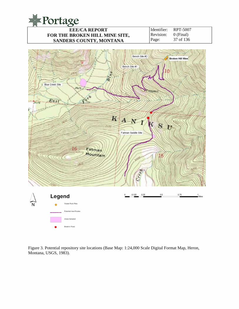
3.6 Potential Repository Site Investigation
An investigation of potential repository sites was performed in May of 2010 (Portage 2010b). The investigation focused on the suitability and subsurface characteristics of four potential repository sites located on Kootenai National Forest land near the BHMS. The sites were located in cooperation with MDEQ and Kootenai National Forest staff as potential environmentally and geographically suitable sites.

EEE/CA REPORT
FOR THE BROKEN HILL MINE SITE, SANDERS COUNTY, MONTANA
Identifier: Revision: Page:
RPT-5007 0 (Final) 36 of 136
Figure 3 shows the potential repository site locations in relation to the BHMS. Each site investigated has adequate surface area available for repository construction based on the following estimate:
The BHMS waste rock volume is approximately 4,100 yd3 (approximately 500 yd3 in the upper dump and 3,600 yd3 in the lower dump)
The average burial depth of waste in the repository is 5 to 6 ft
Based on the average burial depth, the repository footprint would be approximately ½ acre
Based on the average burial depth, the site disturbance footprint (not including additional access roadway development) would be approximately ¾ acres.
The investigation determined that the subgrade at all sites has sufficient bearing capacity and shear strength for repository construction. Settlement after construction would likely be imperceptible. No adverse geotechnical conditions were observed (exposed or excessively shallow bedrock, seeps, slumps, boggy areas, peat, unstable areas, or excessive erosion) at any of the sites investigated. Also, there was no evidence of shallow groundwater at any of the sites investigated. All test pits were excavated to the bedrock surface (as deep as 19 feet) with no evidence of groundwater indicated in any test pit. Sufficient material is available at each site for growth media and general fill for shaping and buttressing the repository. Material suitable for hydrologic barriers was not found. Repository hydrologic barrier construction will require construction of a geosynthetic liner system, importation of low-permeability soils, or amendment of onsite soils. The results of the geotechnical investigation are detailed in the Repository Investigation Report for the Broken Hill Mine Site, Sanders County, Montana (Portage 2010b) and are summarized in the following sections.
3.6.1 Road Bench Site #1
Road Bench Site #1 is located on an unnamed ridge near the BHMS in the SE1/4 of the NW1/4 of Section 15, Township 27N, Range 34W, PMM, Sanders County, Montana. Bench Site 1 is located adjacent to FR 2290 approximately 0.75 miles south of the BHMS at an elevation of approximately 3,740 ft amsl. As the second smallest of the four sites investigated, it still has adequate acreage available for repository construction. Because the ridge is moderately sloped, a constructed repository could be contoured to existing site topography creating a more natural appearing landform. At approximately 0.64 miles, the site offers the second shortest haul distance from the BHMS.
The subsurface at Road Bench Site #1 consists of ½ to 1½ ft of topsoil and then consists of angular rock and silt to the bedrock surface. Topsoil is present in sufficient quantities for a supply of repository cover material. Bedrock was encountered at between 3 and 9 ft bgs. The results of geotechnical testing do not indicate adverse subsurface conditions, and excavated site material could be used as general fill for repository construction.
EEE/CA REPORT
FOR THE BROKEN HILL MINE SITE, SANDERS COUNTY, MONTANA
Identifier: Revision: Page:
RPT-5007 0 (Final) 37 of 136
Figure 3. Potential repository site locations (Base Map: 1:24,000 Scale Digital Format Map, Heron, Montana, USGS, 1983).
EEE/CA REPORT
FOR THE BROKEN HILL MINE SITE, SANDERS COUNTY, MONTANA
Identifier: Revision: Page:
RPT-5007 0 (Final) 38 of 136
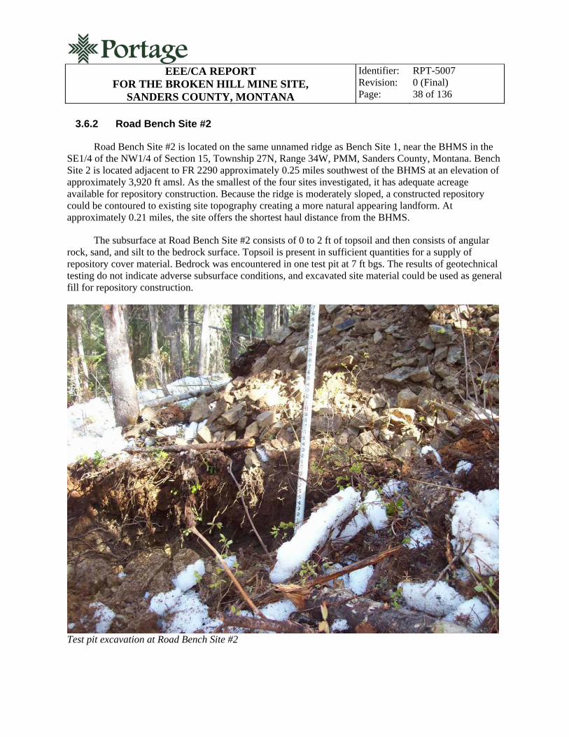
3.6.2 Road Bench Site #2
Road Bench Site #2 is located on the same unnamed ridge as Bench Site 1, near the BHMS in the SE1/4 of the NW1/4 of Section 15, Township 27N, Range 34W, PMM, Sanders County, Montana. Bench Site 2 is located adjacent to FR 2290 approximately 0.25 miles southwest of the BHMS at an elevation of approximately 3,920 ft amsl. As the smallest of the four sites investigated, it has adequate acreage available for repository construction. Because the ridge is moderately sloped, a constructed repository could be contoured to existing site topography creating a more natural appearing landform. At approximately 0.21 miles, the site offers the shortest haul distance from the BHMS.
The subsurface at Road Bench Site #2 consists of 0 to 2 ft of topsoil and then consists of angular rock, sand, and silt to the bedrock surface. Topsoil is present in sufficient quantities for a supply of repository cover material. Bedrock was encountered in one test pit at 7 ft bgs. The results of geotechnical testing do not indicate adverse subsurface conditions, and excavated site material could be used as general fill for repository construction.
Test pit excavation at Road Bench Site #2

EEE/CA REPORT
FOR THE BROKEN HILL MINE SITE, SANDERS COUNTY, MONTANA
Identifier: Revision: Page:
RPT-5007 0 (Final) 39 of 136
3.6.3 Fatman Saddle
Fatman Saddle in the SE1/4 of the NW1/4 of Section 15, Township 27N, Range 34W, PMM, Sanders County, Montana. Fatman Saddle is a prominent saddle off the northeastern flank of Fatman Mountain approximately 1 mile south of the BHMS at an elevation of approximately 3,480 ft amsl. The Fatman Saddle site was the second largest site investigated, and it has adequate acreage available for repository construction. Mildly sloping terrain at the site would be used to create a natural appearing landform during repository construction, but final contouring would result in a more mounded appearance when compared to either road bench site. The haul from the BHMS to Fatman Saddle is complicated by a break in FR 2290 in steep, rocky terrain. Significant road improvements would be required to complete this haul route.
The subsurface at the Fatman Saddle site consists of 0 to 2 ft of topsoil and then consists of angular rock, sand, and silt to the bedrock surface. Topsoil is present in sufficient quantities for a supply of repository cover material. Bedrock was encountered at between 5 and 19 ft bgs. The results of geotechnical testing do not indicate adverse subsurface conditions, and excavated site material could be used as general fill for repository construction.
Fatman Saddle

EEE/CA REPORT
FOR THE BROKEN HILL MINE SITE, SANDERS COUNTY, MONTANA
Identifier: Revision: Page:
RPT-5007 0 (Final) 40 of 136
3.6.4 Blue Creek Bench
The Blue Creek Bench site is located in the NW1/4 of the SE1/4 of Section 9, Township 27N, Range 34W, PMM, Sanders County, Montana. The bench is located in the valley floor approximately 1 mile southwest of the BHMS at an elevation of approximately 2,660 ft amsl. This site was the largest site investigated, and it has adequate acreage available for repository construction. The topography of the Blue Creek Bench site is generally level, and a constructed repository using a balanced cut and fill would appear as a mounded landform. The haul from the BHMS would be on steep sections of FR 2290 over approximately 2.25 miles. Also, the Blue Creek Bench site is located near the East Fork of Blue Creek and is the potential repository site nearest a significant body of surface water.
The subsurface at the Blue Creek Bench site consists of 0 to 2 ft of topsoil and then consists of sub-rounded rock, sand, and silt to the bedrock surface. Topsoil is present in sufficient quantities for a supply of repository cover material. Bedrock or large rock was encountered at between 8 and 12 ft bgs. The results of geotechnical testing do not indicate adverse subsurface conditions, and excavated site material could be used as general fill for repository construction
Blue Creek

EEE/CA REPORT
FOR THE BROKEN HILL MINE SITE, SANDERS COUNTY, MONTANA
Identifier: Revision: Page:
RPT-5007 0 (Final) 41 of 136
3.6.5 Repository Site Investigation Summary
In consideration of the geotechnical observations and data, each of the four sites was determined to be suitable for constructing a waste rock repository. From a geotechnical engineering perspective, the soil types and subsurface conditions were not significantly different among the four sites investigated. The main exception to this is that the rocks found at the Blue Creek Bench site were alluvial and therefore more rounded than the angular (residual or colluvial) rocks found at the other sites.
Bedrock depths are generally great enough to accommodate the engineering design of balanced cut/fill earthwork, with cut materials utilized as general fill for shaping the repository and surroundings. A sufficient quantity of topsoil is available at each site to cover and reclaim the surface upon completion.
A hydrogeologic investigation was not conducted as part of the geotechnical investigation, but, as noted, no groundwater was encountered during test pit excavation and no seasonal groundwater influence was evident at the point of excavator refusal (bedrock).
The topography of Road Bench Sites #1 and #2 provides the most opportunity for creation of a naturally appearing land feature for repository construction. This is because each of these sites is located on a sloping ridge into which the repository cut and fill can be contoured into the slope. At the Blue Creek Bench site and to a lesser extent the Fatman Saddle site, the repository would be a mounded landform.
Haul distance is the least to Road Bench Site #2 (approximately 0.5 miles) and potentially farthest to the Fatman Saddle Site. FR 2290, which could potentially connect the BHMS to Fatman Saddle, is discontinuous because of rock outcroppings and steep terrain. Significant road improvements would be required to use FR 2290 as a haul route. Steep grades and switchbacks on FR 2290 also create a challenging haul to the Blue Creek Bench Site.
Each site has sufficient area for repository construction (at least ¾ acres) with Road Bench Site #2 having the least usable acreage and the Blue Creek Bench Site having the most useable acreage. Potential geotechnical concerns such as exposed or excessively shallow bedrock, seeps, slumps, boggy areas, peat, unstable areas, or excessive erosion were not encountered during investigations at any of the sites.
Because no one site has an advantage over another based on geotechnical considerations, the choice of a preferred repository site is based on factors that affect cost (haul distance), environmental concerns, visual impact, and others. These factors will be fully analyzed Sections 7 and 8 of this EEE/CA for each repository site. Based on the results of the investigation, however, Portage recommended Road Bench Site #2 as the preferred repository site. This recommendation is supported by the following:
Road Bench Site #2 is nearest the BHMS and will involve the shortest haul, reducing project construction costs and environmental impacts from truck traffic
Road Bench Site #2 is likely to be more hydrologically isolated than either the Blue Creek Bench or Fatman Saddle sites, because it is higher in elevation and farther away from surface water
EEE/CA REPORT
FOR THE BROKEN HILL MINE SITE, SANDERS COUNTY, MONTANA
Identifier: Revision: Page:
RPT-5007 0 (Final) 42 of 136
Road Bench Site #2 will have less visual impact than other sites because the repository can be shaped into the topography of the bench, the site will require the least clearing and grubbing, and the site will require minimal road improvements.
4. RISK ASSESSMENT
Site characterization results were used to conduct a screening level human health risk analysis. The analysis was conducted using current guidance set forth in the following:
Risk-Based Cleanup Guidelines for Abandoned Mine Sites: Final Report (TetraTech 1996)
Risk Assessment Guidance for Superfund, Volume I, Human Health Evaluation Manual (Interim Final) (RAGS) (EPA 1989a).
The following sections summarize the results of the risk assessment. The detailed information and calculations used to develop the human health risk analysis are provided in Appendix F of the Reclamation Investigation Report for the Broken Hill Mine Site, Sanders County, Montana (Portage 2009).
4.1 Baseline Human Health Risk Assessment
The risk assessment involved five steps: (1) hazard identification, (2) exposure assessment, (3) toxicity assessment, (4) risk characterization, and (5) calculation of risk-based cleanup goals.
4.1.1 Hazard Identification
Hazard identification is conducted to identify contaminants of potential concern (COPCs). Each COPC must meet four criteria established by the EPA (EPA 1989a): (1) the constituent is present at the site, (2) the concentrations of the constituent are significantly above background concentrations (generally 3 times), (3) 20% of the concentrations must be above the method detection limit, and (4) the analytical results for each constituent must meet quality assurance/quality control (QA/QC) criteria outlined by the Contract Laboratory Program National Functional Guidelines for Inorganic Data Review (EPA 1994).
COPC determination also includes screening against MDEQ/MWCB RBCGs for the gold panner/rock hound scenario. The basis for choosing this exposure scenario is discussed further in Section 5.1.2. All metals identified as COPCs, either by meeting the EPA criteria and/or exceeding the MDEQ/MWCB recreational cleanup guidelines, were used to conduct the exposure assessment and determine human health risk through recreational use of the site.
4.1.2 Exposure Scenarios
The exposure assessment identifies potential human receptors, exposure routes through which receptors may come into contact with COPCs, and the parameters used to quantify the exposure to COPCs. The gold panner/rock hound scenario was selected as the exposure scenario for this assessment, because the gold panner/rock hound has the most conservative exposure parameters and therefore bounds the other exposure scenarios presented in the Risk-Based Cleanup Guidelines for Abandoned Mine Sites:

EEE/CA REPORT
FOR THE BROKEN HILL MINE SITE, SANDERS COUNTY, MONTANA
Identifier: Revision: Page:
RPT-5007 0 (Final) 43 of 136
Final Report (TetraTech 1996). The de minimus risk and hazard values are exceeded using the gold panner/rock hound exposure parameters.
In examining the site data, a determination of “moderate” was made, using the Abandoned and Inactive Mines Scoring System (AIMSS) for potential recreational use. This determination is based on limited site access (the site is accessible by a United States Forest Service [USFS] road with a locked gate at the base year-round) and lack of significant surface water resources. The AIMSS ranking is used to determine the exposure frequency used in risk and hazard calculations. A moderate ranking corresponds to an exposure frequency of 25 days per year for the gold panner/rock hound scenario. The exposure frequency is supported by relatively restrictive land-use requirements, remote location, and small size of the nearby population.
Exposure point concentrations (EPCs) for use in risk and hazard calculations are generally either (a) the 95% upper confidence limit (UCL) generated from the data set or (b) the maximum concentration for each COPC. Both EPA’s risk assessment guidance for Superfund (EPA 1989a) and TetraTech’s risk-based cleanup guidelines for abandoned mine sites (TetraTech 1996) recommend using the 95% UCL as the EPC for a sufficiently large number of samples. Because insufficient samples were available to compute 95% UCLs, the maximum concentration for each COPC was used as the EPC in all cases. Table 13 presents the EPCs used in the risk and hazard calculations.
Table 13. Exposure point concentrations for the BHMS, total metals. Exposure
Media Antimony Arsenic Cadmium Copper Iron Lead Manganese Mercury Zinc
Solid (mg/kg)
344 1,140 26 342 94,400 55,900 NA 27.2 11,400
Water (µg/L)
NA 31 2.57 2.97 69.6 107 15.2 0.044 867
Notes: mg/kg = Milligrams per kilogram. µg/L = Micrograms per liter. NA = Not included as a COPC for the media shown; metal did not meet EPA COPC criteria.
4.1.3 Toxicity Assessment
The toxicity assessment summarizes the potential for each COPC to cause adverse effects in exposed populations. These effects can be categorized as carcinogenic or noncarcinogenic and are measured in terms of cancer risk and HI. Arsenic and lead exhibited either hazard levels greater than 1.0 or risk levels greater than 1 × 10⁻⁶ individually; these COPCs are the major contributors to risk and hazard levels at the BHMS. The other COPCs do not pose a significant risk to potential human receptors, so their toxicological profiles were excluded.
Chronic arsenic exposure affects in humans include weakness, general debility and lassitude, loss of appetite and energy, loss of hair, hoarseness of voice, loss of weight, and mental disorders. Primary target organs are the skin (hyperpigmentation and hyperkeratosis), nervous system (peripheral neuropathy), and vascular system. Epidemiological studies have revealed an association between arsenic concentrations in drinking water and increased incidences of skin cancers (including squamous cell carcinomas and multiple basal cell carcinomas) and cancers of the liver, bladder, and respiratory and

EEE/CA REPORT
FOR THE BROKEN HILL MINE SITE, SANDERS COUNTY, MONTANA
Identifier: Revision: Page:
RPT-5007 0 (Final) 44 of 136
gastrointestinal tracts. Occupational exposure studies have shown a clear correlation between exposure to arsenic and lung cancer mortality.
The arsenic reference dose (RfD) for chronic oral exposures, 3.00 × 10⁻⁴ mg/kg/day, is based on a no-observed-effects level of 0.0008 mg/kg/day and a lowest-observed-adverse-effects level of 0.014 mg/kg/day for dermal hyperpigmentation and keratosis, and possible vascular complications in a human population consuming arsenic-contaminated drinking water. The dermal RfD of 3.00 × 10⁻⁴ is equivalent to the oral RfD.
Lead is a multitargeted toxicant, causing effects in the gastrointestinal tract, hematopoietic system, cardiovascular system, central and peripheral nervous systems, kidneys, immune system, and reproductive system. Overt symptoms of subencephalopathic central nervous system effects and peripheral nerve damage occur at blood lead levels of 40 to 60 µg/dL, and nonovert symptoms, such as peripheral nerve dysfunction, occur at levels of 30 to 50 µg/dL.
Guidance from MDEQ/MWCB uses back-calculation methods to derive lead RfDs using the EPA residential soil screening level of 400 mg/kg, the EPA drinking water action level of 15 µg/L, and the National Ambient Air Quality Standard of 1.5 µg/m3. The RfDs calculated using this approach are 1.5 × 10⁻³ for soil ingestion and 4.3 × 10⁻⁴ for water ingestion and inhalation (TetraTech 1996).
4.1.4 Risk Characterization
Risk characterization combines the evaluations in the exposure and toxicity assessments to calculate quantitative carcinogenic risk and noncarcinogenic hazards for the gold panner/rock hound recreational exposure scenario. The following sections detail the quantitative human health risk assessment.
4.1.4.1 Risk Calculations. The risks and hazards to potential human receptors from the COPCs were calculated for the BHMS. Data from the BHMS were evaluated using the gold panner/rock hound exposure scenario for both an adult and child recreational user. Complete soil/waste rock exposure pathways for the gold panner/rock hound scenario evaluated in risk and hazard calculations are as follows:
Incidental ingestion
Dermal contact
Particulates inhalation.
Complete adit water exposure pathways for the gold panner/rock hound scenario included:
Incidental ingestion
Dermal contact.
The inhalation pathway was not included in risk and hazard calculations for adit water, because the COPCs identified for this site are not volatile, making it an incomplete exposure pathway. Pathway-specific formulas used for calculating chronic daily intake values and default values used in these
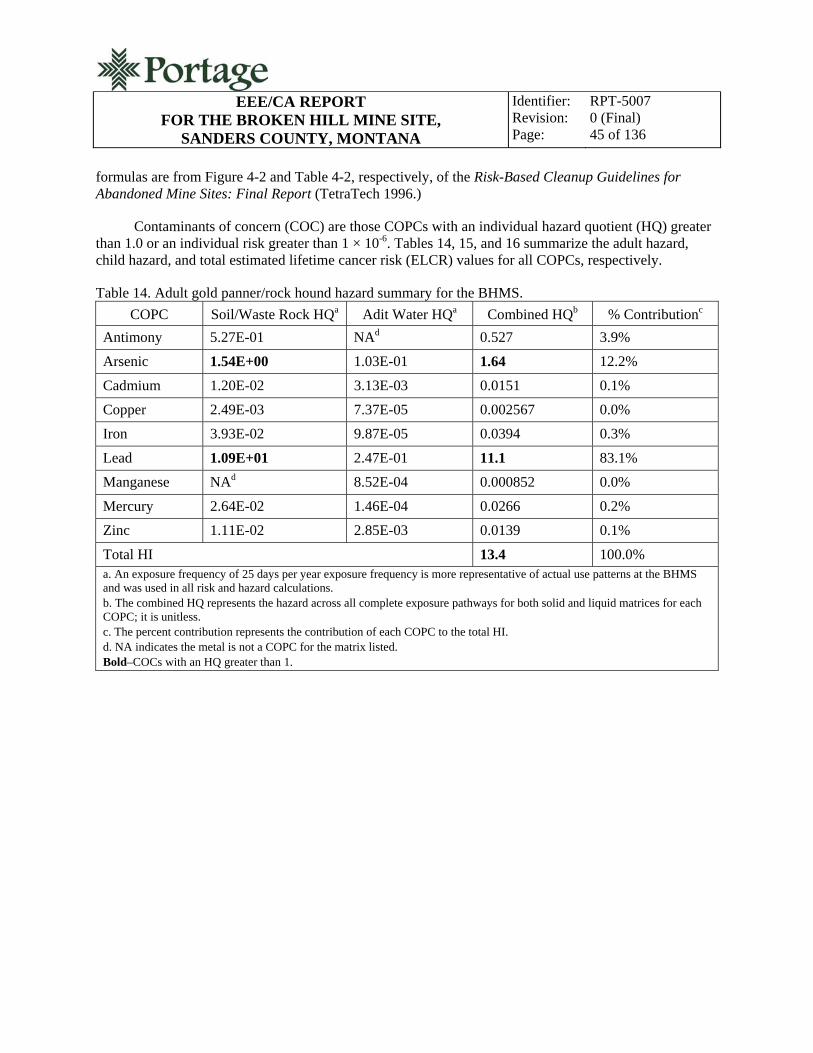
EEE/CA REPORT
FOR THE BROKEN HILL MINE SITE, SANDERS COUNTY, MONTANA
Identifier: Revision: Page:
RPT-5007 0 (Final) 45 of 136
formulas are from Figure 4-2 and Table 4-2, respectively, of the Risk-Based Cleanup Guidelines for Abandoned Mine Sites: Final Report (TetraTech 1996.)
Contaminants of concern (COC) are those COPCs with an individual hazard quotient (HQ) greater than 1.0 or an individual risk greater than 1 × 10⁻⁶. Tables 14, 15, and 16 summarize the adult hazard, child hazard, and total estimated lifetime cancer risk (ELCR) values for all COPCs, respectively.
Table 14. Adult gold panner/rock hound hazard summary for the BHMS.
COPC Soil/Waste Rock HQa Adit Water HQa Combined HQb % Contributionc
Antimony 5.27E-01 NAd 0.527 3.9%
Arsenic 1.54E+00 1.03E-01 1.64 12.2%
Cadmium 1.20E-02 3.13E-03 0.0151 0.1%
Copper 2.49E-03 7.37E-05 0.002567 0.0%
Iron 3.93E-02 9.87E-05 0.0394 0.3%
Lead 1.09E+01 2.47E-01 11.1 83.1%
Manganese NAd 8.52E-04 0.000852 0.0%
Mercury 2.64E-02 1.46E-04 0.0266 0.2%
Zinc 1.11E-02 2.85E-03 0.0139 0.1%
Total HI 13.4 100.0% a. An exposure frequency of 25 days per year exposure frequency is more representative of actual use patterns at the BHMS and was used in all risk and hazard calculations. b. The combined HQ represents the hazard across all complete exposure pathways for both solid and liquid matrices for each COPC; it is unitless. c. The percent contribution represents the contribution of each COPC to the total HI. d. NA indicates the metal is not a COPC for the matrix listed. Bold–COCs with an HQ greater than 1.

EEE/CA REPORT
FOR THE BROKEN HILL MINE SITE, SANDERS COUNTY, MONTANA
Identifier: Revision: Page:
RPT-5007 0 (Final) 46 of 136
Table 15. Child gold panner/rock hound hazard summary for the BHMS.
COPC Soil/Waste Rock HQa Adit Water HQa Combined HQb % Contributionc
Antimony 8.64E-01 NAd 0.864 3.4%
Arsenic 2.67E+00 4.74E-01 3.15 12.4%
Cadmium 2.04E-02 1.08E-02 0.0312 0.1%
Copper 4.61E-03 3.41E-04 0.00495 0.0%
Iron 7.27E-02 4.56E-04 0.0731 0.3%
Lead 2.01E+01 1.14E+00 21.2 83.5%
Manganese NAd 3.22E-03 0.00322 0.0%
Mercury 4.89E-02 6.73E-04 0.0495 0.2%
Zinc 2.05E-02 1.32E-02 0.0337 0.1%
Total HI 25.4 100.0% a. An exposure frequency of 25 days per year exposure frequency is more representative of actual use patterns at the BHMS and was used in all risk and hazard calculations. b. The combined HQ represents the hazard across all complete exposure pathways for both solid and liquid matrices for each COPC; it is unitless. c. The percent contribution represents the contribution of each COPC to the total HI. d. NA indicates the metal is not a COPC for the matrix listed. Bold–COCs with an HQ greater than 1.
Table 16. Gold panner/rock hound risk summary for the BHMS.
COPC Soil ELCRa Water ELCRa Combined ELCRb % Contributionc
Arsenic 2.74E-04 3.41E-05 3.08E-04 100.0%
Cadmium 3.62E-10 NAc 3.62E-10 0.0%
Total ELCR 3E-04
a. An exposure frequency of 25 days per year exposure frequency is more representative of actual use patterns at the BHMS and was used in all risk and hazard calculations. b. The combined adult and child ELCR represents the risk across all complete exposure pathways for both solid and liquid matrices for each COPC; it is unitless. c. The percent contribution represents the contribution of each COPC to the total ELCR. Bold–COCs with an ELCR greater than 1 × 10⁻⁶.
As noted, EPA-established benchmarks for evaluating the need for a remedy are 1 × 10⁻⁶ for
carcinogenic risk and 1.0 for noncarcinogenic hazards. As shown in the above tables, the gold panner/rock hound exposure scenario resulted in a total ELCR of 3 × 10⁻⁴ and HIs for the adult and child recreational user of 13.4 and 25.4, respectively. These values are well above EPA benchmark values. Arsenic accounts for all of the cancer risk at the site and approximately 20% of the hazard for both the child and adult exposure scenarios. Lead is responsible for the majority of the exposure hazard at the site (74% of total each for an adult and a child).

EEE/CA REPORT
FOR THE BROKEN HILL MINE SITE, SANDERS COUNTY, MONTANA
Identifier: Revision: Page:
RPT-5007 0 (Final) 47 of 136
4.1.4.2 Uncertainty Assessment. A degree of uncertainty always exists when performing risk assessments. Elements of uncertainty associated with the assessment of potential human health risks and hazards associated with recreational use of the BHMS include the size and comparability of the sample population; uncertainty associated with RfD development and HI values for lead; and in choosing exposure point concentrations (Portage 2010a).
4.1.4.3 Human Health Risk Characterization Summary. The risk values summarized for the BHMS in Tables 15 and 16 indicate the site poses a potential risk to recreational users with both noncarcinogenic and carcinogenic endpoints. Arsenic accounts for all of the carcinogenic risk for the 25-day gold panner exposure frequency. The ELCR for this site (3 × 10⁻⁴) exceeds the EPA threshold cancer risk value of 1 × 10⁻⁶.
The HIs for both the adult (13.4) and child (25.4) gold panner/rock hound also exceed de minimus levels, with both computed to be above the EPA threshold level of 1.0. These risk and hazard values indicate that contaminants at the BHMS are present at concentrations that could potentially cause adverse human health effects for a recreational user.
4.2 Ecological Risk Assessment
An ecological risk assessment was conducted for the BHMS and considers terrestrial plant communities, aquatic life communities, and terrestrial wildlife exposure scenarios using contaminant concentrations measured during the RI. The assessment involved initial identification of COCs, development of an exposure assessment, an ecological effects assessment, and a risk characterization. The BHMS ecological risk assessment methodology was based on key federal guidance documents, including:
Risk Assessment Guidance for Superfund, Volume II, Environmental Evaluation Manual (Interim Final) (EPA 1989b)
Framework for Ecological Risk Assessment, Risk Assessment Forum (EPA 1992)
Wildlife Exposure Factors Handbook (EPA 1993)
EPA’s RAGS: Process for Designing and Conducting Ecological Risk Assessment (Interim Final) (EPA 1997).
The ecological risk assessment estimates the effects of the no-action alternative and involves four steps: (1) identification of COCs, ecological receptors, and ecological effects of concern; (2) exposure assessment; (3) ecological effects assessment; and (4) risk characterization. These four tasks were accomplished by evaluating data and selecting contaminants, receptors, and exposure routes of concern; estimating EPCs from the data; assessing the ecological toxicity of each COC; and characterizing the overall risk by integrating the results of the toxicity and exposure assessments.
Environmental contaminants at the BHMS potentially affecting ecological receptors include high concentrations of metals in soil, waste rock, and metals found in adit discharge water. The waste materials and vegetation in the area are easily accessible to wildlife and could result in significant ecological effects. The ecological evaluation is intended to be a qualitative screening-level ecological risk assessment because of limited available site data. The detailed information and calculations used to

EEE/CA REPORT
FOR THE BROKEN HILL MINE SITE, SANDERS COUNTY, MONTANA
Identifier: Revision: Page:
RPT-5007 0 (Final) 48 of 136
develop the ecological risk analysis are provided in Appendix G of the Reclamation Investigation Report for the Broken Hill Mine Site (Portage 2010a).
4.2.1 Contaminants of Concern
The screening for ecological COCs is based on the following: (1) the constituent is present at the site, (2) the analytical results for each constituent must meet QA/QC criteria outlined by the Contract Laboratory Program National Functional Guidelines for Inorganic Data Review (EPA 1994), and (3) the concentrations of the constituent are above background concentrations. The seven metals that met these criteria in solid (soil and waste rock) samples were antimony, arsenic, cadmium, iron, lead, mercury, and zinc. Eight metals that met the COC criteria for the ecological risk assessment were detected in adit water: arsenic, cadmium, copper, iron, lead, manganese, mercury, and zinc.
Ecological toxicity data are not available for several of these contaminants to evaluate potential effects. The following toxicological data are from EPA’s Region 5 ecological toxicity profile (EPA 2010b) and pertain to the primary COCs identified for the ecological risk assessment (arsenic, cadmium, copper, lead, and zinc) (BLM 2002).
4.2.1.1 Arsenic. Arsenic is a carcinogen, teratogen, and possible mutagen in mammals (ATSDR 1993). In plants, arsenic has been shown to cause wilting, chlorosis, browning, dehydration, mortality, and inhibition of light activation (Eisler 1988a). In mammals, chronic exposure can result in fatigue, gastrointestinal distress, anemia, neuropathy, and skin lesions that can develop into skin cancer in mammals. Cancer-causing and genetic mutation-causing effects occur in aquatic organisms, with those effects including behavioral impairments, growth reduction, appetite loss, and metabolic failure. In birds, tolerance to arsenic varies among species, but effects include destruction of gut blood vessels, blood-cell damage, muscular incoordination, debility, slowness, jerkiness, falling, hyperactivity, fluffed feathers, drooped eyelids, immobility, seizures, and systemic growth, behavioral, and reproductive problems (Stanley et al. 1994; Whitworth et al. 1991; Camardese et al. 1990).
4.2.1.2 Cadmium. Cadmium is highly toxic to most wildlife; it is cancer-causing, teratogenic, and potentially mutation-causing, with severe sublethal and lethal effects at low environmental concentrations (Eisler 1985). Cadmium is associated with increased mortality, and it affects respiratory functions, enzyme levels, muscle contractions, growth rates, and reproduction. Cadmium can be toxic to plants at lower soil concentrations than other heavy metals and is more readily taken up than other metals (EPA 1981).
4.2.1.3 Copper. Copper is a micronutrient and toxin. Toxicity in mammals includes effects, such as liver cirrhosis, necrosis in kidneys and the brain, gastrointestinal distress, lesions, low blood pressure, and fetal mortality (ATSDR 1990; Kabata-Pendias and Pendias 1992; Ware 1983; Vymazal 1995). Copper is highly toxic in aquatic environments and causes effects in fish, invertebrates, and amphibians (Horne and Dunson 1995; Owen 1981). There is a moderate potential for bioaccumulation in plants. Toxic effects in birds include reduced growth rates, lowered egg production, and developmental abnormalities.
4.2.1.4 Lead. Lead is cancer-causing and adversely affects reproduction, liver and thyroid function, and disease resistance (Eisler 1988b). Lead adversely affects algae, invertebrates, and fish. There are also limited adverse effects in amphibians, including loss of sodium, reduced learning capacity, and developmental problems (Horne and Dunson 1995). Fish exposed to high levels of lead exhibit a wide range of effects, including muscular and neurological degeneration and destruction, growth inhibition,

EEE/CA REPORT
FOR THE BROKEN HILL MINE SITE, SANDERS COUNTY, MONTANA
Identifier: Revision: Page:
RPT-5007 0 (Final) 49 of 136
mortality, reproductive problems, and paralysis (Eisler 1988b; EPA 1976). At elevated levels in plants, lead can cause reduced growth, photosynthesis, mitosis, and water absorption (Eisler 1988b). Birds and mammals suffer effects such as damage to the nervous system, kidneys, and liver; sterility; growth inhibition; developmental retardation; and detrimental effects in blood (Eisler 1988b; Amdur et al. 1991).
4.2.1.5 Zinc. In many types of aquatic plants and animals, growth, survival, and reproduction can all be adversely affected by elevated zinc levels (Eisler 1993). Elevated zinc levels can cause a wide range of problems in mammals, including cardiovascular, developmental, immunological, liver and kidney, neurological, hematological, pancreatic, and reproductive problems (Eisler 1993; Domingo 1994). Zinc is also toxic to plants at elevated levels, causing adverse effects on growth, survival, and reproduction (Eisler 1993). Terrestrial invertebrates show sensitivity to elevated zinc levels, with reduced survival, growth, and reproduction. Elevated zinc levels can cause mortality, pancreatic degradation, reduced growth, and decreased weight gain in birds (Eisler 1993; NAS 1980).
4.2.2 Ecological Receptors of Concern
A variety of plants, birds, amphibians, and mammals are part of the general food web at the BHMS. This assessment has identified three groups of receptors potentially affected by metal contamination at the BHMS. The first group of potential receptors is the terrestrial plant communities. Native plants are growing on undisturbed areas around the site, but little or no vegetation is currently growing on the waste rock piles (Portage 2010a). This may be caused by toxic and inhibitory levels of metals in the plant root zone, along with other detrimental physical and chemical properties of the soil. Plant communities are a concern, because they represent the first trophic level in the food chain and are consumed by many higher trophic level animals.
The second group of potential ecological receptors is the terrestrial wildlife, including elk and mule deer that may use the area as part of a home range. Grazing by wildlife species at this site is a concern because of the potential to consume contaminated vegetation, soil, and evaporative salts. The only terrestrial wildlife receptors evaluated quantitatively in this assessment are deer, because they are assumed to represent the highest level of exposure to site contamination, and the effects on deer are representative of other potential receptors.
The third group of potential receptors is the aquatic life communities. Although only ephemeral adit water is present at the BHMS, it is located within the watershed of an unnamed, ephemeral tributary to the East Fork of Blue Creek. The tributary lies 100 ft north of the BHMS and reaches its confluence with the East Fork of Blue Creek approximately 0.75 miles downstream from the site. The East Fork of Blue Creek provides suitable habitat for aquatic life.
4.2.3 Exposure Assessment
The exposure assessment evaluates the risk to the identified ecological receptors of concern identified above using various contaminant concentrations from samples collected at the site. The risk to terrestrial plant communities was evaluated using the EPCs for the recreational user identified in Table 13 for both solids and water. The EPCs are the maximum concentrations for each of the COCs evaluated.
4.2.3.1 Terrestrial Plant – Phytotoxicity Scenario. This scenario involves the limited ability of various plant species to grow in soils or waste with high concentrations of arsenic, cadmium, copper, lead, and zinc. Plant sensitivity to certain arsenic compounds is so great that these compounds were used as

EEE/CA REPORT
FOR THE BROKEN HILL MINE SITE, SANDERS COUNTY, MONTANA
Identifier: Revision: Page:
RPT-5007 0 (Final) 50 of 136
herbicides for many years. Phytotoxic criteria reported in the literature for total arsenic in soils ranged from 15 to 50 mg/kg. Cadmium is toxic to plants at concentrations greater than 8 mg/kg. Lead is also considered toxic to plants. Numerous phytotoxic lead concentrations are reported in the literature and generally range from 100 to 1,000 mg/kg (Kabata-Pendias and Pendias 1992; CH2M Hill 1987). A moderate concentration of 400 mg/kg was chosen for the ecological risk analysis. Zinc is only moderately toxic to plants at concentrations more than 300 mg/kg (Kabata-Pendias and Pendias 1992). The upper end of the range for zinc (400 mg/kg) was used in the ecological risk analysis.
4.2.3.2 Terrestrial Wildlife – Ingestion by Deer Scenario. Estimates of total intake dosage for deer are based on reported literature values and the following assumptions: (a) the currently unvegetated areas do not provide habitat for deer, (b) native vegetation is growing across most areas of the site and would be available to deer that graze in the area, and (c) the average weight of an individual adult deer is 68.04 kg (150 lb).
The daily salt uptake for deer is based on data in Elk of North America, which reported an average of 6 lb in one month for an average sized herd of 63 elk.b Assuming deer require 50% of the salt intake of an elk, a median salt intake exposure approach would equate to an average of 3 lb per month. Using the average herd size of 63, the average individual salt uptake would equal 0.0016 lb per day (0.00072 kg/day). Beyer et al. (1994) estimated that soil ingestion accounts for less than 2% of the average Wyoming mule deer’s diet of 1.39 kg/day of vegetation, which equals 0.0278 kg/day of soil.
The maximum values for metal COCs from surface soil and waste rock were used for both the salt and soil levels to calculate ecological risks to terrestrial wildlife. No vegetation samples were collected for analysis during this investigation. The concentration for copper was estimated based on data from the Kabata-Pendias and Pendias study (1992); the remaining metal concentrations were based on tolerable levels in vegetation (the lowest phytotoxic tissue levels) from an assessment performed in East Helena, Montana (CH2M Hill 1987). Approximately 1.5 acres at the BHMS are impacted by metal mining; this would represent 0.4% of an average mule deer’s home range of 345 acres (i.e., 90 to 600 acres) (Beyer et al. 1994).
4.2.3.3 Aquatic Life Scenario. This scenario involves the limited ability of aquatic organisms to survive in waters contaminated with metals. Toxicity of metals to aquatic organisms depends on the concentration in the surface water and sediment as well as other conditions such as water hardness, temperature, and pH. Surface-water criteria for the ecological risk assessment were derived from the Montana DEQ-7 acute aquatic life standards (MDEQ 2008).
4.2.4 Ecological Effects Assessment
Site-specific toxicity tests were not performed to support this risk assessment. Instead, only existing and proposed toxicity-based criteria and standards were used for this assessment. The following sections detail the specific standards and data used for comparison to the analytical results of the field sampling investigation.
4.2.4.1 Terrestrial Plant – Phytotoxicity Scenario. A summary of the phytotoxicity for the primary COCs is provided in Table 17. These concentrations were used for comparison to concentrations
b. Personal communication with USFS, Helena National Forest personnel. Salt ingestion data taken from Elk of North America.
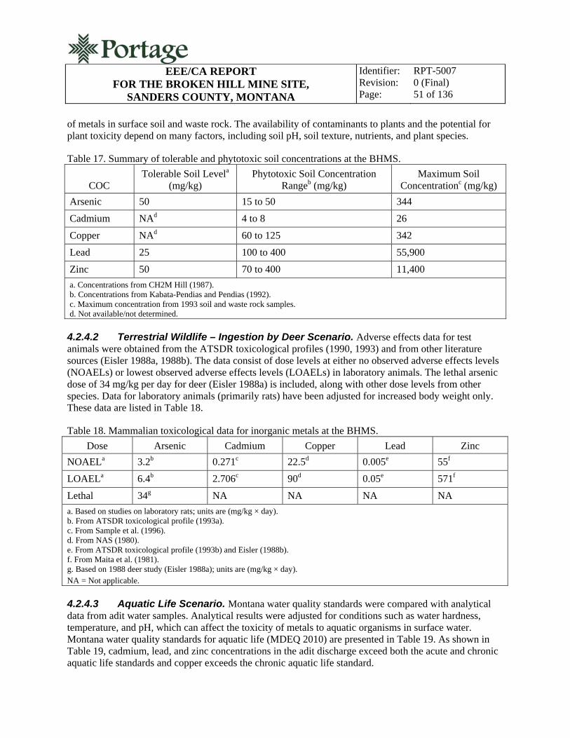
EEE/CA REPORT
FOR THE BROKEN HILL MINE SITE, SANDERS COUNTY, MONTANA
Identifier: Revision: Page:
RPT-5007 0 (Final) 51 of 136
of metals in surface soil and waste rock. The availability of contaminants to plants and the potential for plant toxicity depend on many factors, including soil pH, soil texture, nutrients, and plant species.
Table 17. Summary of tolerable and phytotoxic soil concentrations at the BHMS.
COC Tolerable Soil Levela
(mg/kg) Phytotoxic Soil Concentration
Rangeb (mg/kg) Maximum Soil
Concentrationc (mg/kg)
Arsenic 50 15 to 50 344
Cadmium NAd 4 to 8 26
Copper NAd 60 to 125 342
Lead 25 100 to 400 55,900
Zinc 50 70 to 400 11,400
a. Concentrations from CH2M Hill (1987). b. Concentrations from Kabata-Pendias and Pendias (1992). c. Maximum concentration from 1993 soil and waste rock samples. d. Not available/not determined.
4.2.4.2 Terrestrial Wildlife – Ingestion by Deer Scenario. Adverse effects data for test animals were obtained from the ATSDR toxicological profiles (1990, 1993) and from other literature sources (Eisler 1988a, 1988b). The data consist of dose levels at either no observed adverse effects levels (NOAELs) or lowest observed adverse effects levels (LOAELs) in laboratory animals. The lethal arsenic dose of 34 mg/kg per day for deer (Eisler 1988a) is included, along with other dose levels from other species. Data for laboratory animals (primarily rats) have been adjusted for increased body weight only. These data are listed in Table 18.
Table 18. Mammalian toxicological data for inorganic metals at the BHMS.
Dose Arsenic Cadmium Copper Lead Zinc
NOAELa 3.2b 0.271c 22.5d 0.005e 55f
LOAELa 6.4b 2.706c 90d 0.05e 571f
Lethal 34g NA NA NA NA
a. Based on studies on laboratory rats; units are (mg/kg × day). b. From ATSDR toxicological profile (1993a). c. From Sample et al. (1996). d. From NAS (1980). e. From ATSDR toxicological profile (1993b) and Eisler (1988b). f. From Maita et al. (1981). g. Based on 1988 deer study (Eisler 1988a); units are (mg/kg × day). NA = Not applicable.
4.2.4.3 Aquatic Life Scenario. Montana water quality standards were compared with analytical data from adit water samples. Analytical results were adjusted for conditions such as water hardness, temperature, and pH, which can affect the toxicity of metals to aquatic organisms in surface water. Montana water quality standards for aquatic life (MDEQ 2010) are presented in Table 19. As shown in Table 19, cadmium, lead, and zinc concentrations in the adit discharge exceed both the acute and chronic aquatic life standards and copper exceeds the chronic aquatic life standard.

EEE/CA REPORT
FOR THE BROKEN HILL MINE SITE, SANDERS COUNTY, MONTANA
Identifier: Revision: Page:
RPT-5007 0 (Final) 52 of 136
Table 19. Montana surface water quality aquatic life standards.a
Metal Acute Toxicity Chronic Toxicity Broken Hill Adit Water
Concentrationb
Arsenic 340 150 31c
Cadmium 0.52d 0.097d 2c
Copper 3.79d 2.85d 2.97
Iron NAe 1,000 69.6
Lead 13.98d 0.545d 107
Manganese NAe NAe 15.2
Mercury 1.7 0.91 0.044
Zinc 37d 37d 867 a. Toxicity values are from DEQ-7 (MDEQ 2010); all concentrations are in units of µg/L. b. Maximum adit water concentration. Unless otherwise noted, concentrations are from 1993 sampling event. c. Result is from the 2009 sampling event. d. Concentration at hardness of 25 mg/L. e. Standard currently not available. Bold–Values exceed Aquatic Life Standard.
4.2.5 Risk Characterization
This section combines the ecological exposure estimates and concentrations presented in preceding sections and the ecological effects data presented in Section 5.2.4 to provide a screening level estimate of potential adverse ecological impacts. This estimate was achieved by generating ecological impact quotients (EQs) analogous to the HQs calculated for human exposure to noncarcinogenic metals. EQs were calculated for each COC by exposure scenario or receptor type and are summarized in Table 20; they were generated by dividing the specific intake estimate by available ecological effect values. As with HIs, adverse ecological impacts are expected if the EQs are greater than 1.0.
Table 20. Ecological impact quotients for the BHMS.
Receptor Arsenic Cadmium Copper Lead Zinc Total EQ by
Receptor
Plant Phytotoxicity 22.8 3.25 0 140 28.5 194
Deer Ingestion 0.0035 0.0003 0.0168 181 0.0005 181
Aquatic Life – Surface Water 0.0912 3.84 18.4 1.09 23.4 46.8
Total EQ by COC 22.9 7.09 18.4 322 51.9 —
4.2.5.1 Terrestrial Plant – Phytotoxicity Scenario. Maximum concentrations of metals collected from the BHMS were compared with maximum values of the plant phytotoxicity ranges listed in Table 21. One limitation of this comparison is that the phytotoxicity ranges are not species specific and may not represent toxicity to species at this site. Additionally, other physical characteristics of the waste materials may create microenvironments that limit growth and survival of terrestrial plants directly or in combination with substrate toxicity. Concentrations of metals are likely to be elevated in waste material at the site. Further, organic content is low, nutrients are limited, and the materials may harden enough to resist root penetration.
EEE/CA REPORT
FOR THE BROKEN HILL MINE SITE, SANDERS COUNTY, MONTANA
Identifier: Revision: Page:
RPT-5007 0 (Final) 53 of 136
EQs for this exposure scenario were greater than 1.0 for arsenic, cadmium, lead, and zinc. The nonconservative assumption of using the high end of the phytotoxicity range to derive the EQs may underestimate the potential phytotoxic effects to some plant communities. However, several other factors combine to adversely affect plant establishment and successful reestablishment on waste materials. In addition, the maximum metals concentrations from soil and waste rock samples were used as the plant dosage value in the EQ calculation, which adds conservatism to the EQ value.
4.2.5.2 Terrestrial Wildlife – Ingestion by Deer Scenario. Estimated deer ingestion doses were compared with LOAELs discussed earlier. This comparison is limited because of the use of effects data from rat studies that were adjusted only for increased body weight. Extrapolating these effects from rats to deer introduces some uncertainty, because each metal may be metabolized differently between these two species, making one more or less susceptible to effects than the other. The EQs for this scenario exceeded 1.0 for lead and indicate a potential risk to deer and other wildlife as a result of lead in surface soils and waste rock.
4.2.5.3 Aquatic Life Scenario. Maximum concentrations in adit water collected at the BHMS were compared with acute aquatic quality criteria and other toxicity standards derived from Long and Morgan (1991). Acute aquatic water quality criteria were more appropriate than chronic criteria for use in this scenario because of the limited data set.
The results of the EQ calculations for the aquatic life scenario indicate potential for adverse ecological impacts from adit water. The acute EQs for this scenario exceeded 1.0 for cadmium, copper, lead, and zinc.
4.2.6 Ecological Risk Characterization Summary
The calculated EQs can be used to evaluate whether ecological receptors are potentially exposed to toxic doses of site-related metals contamination via the three ecological scenarios evaluated. The EQs calculated for the BHMS indicate that lead is the primary driver for ecological risk (EQ = 322 or 76% of the overall ecological risk). The risk from lead is split among plant phytotoxicity (EQ = 140), deer ingestion (EQ = 181), and aquatic life (EQ = 1.09); lead contributes 100% of the risk to the deer ingestion scenario and 72% of the risk to plants. The primary drivers for aquatic life risks are copper and zinc (39 and 50%, respectively). The overall EQ for all COCs over all pathways is 419, indicating that contaminants at the site constitute probable adverse ecological effects for plants, terrestrial wildlife, and aquatic life.
5. SUMMARY OF APPLICABLE OR RELEVANT AND APPROPRIATE REQUIREMENTS (ARARS)
The State of Montana has the authority, delegated by the U.S. Office of Surface Mining, Reclamation and Enforcement, to administer the Abandoned Mines Reclamation Program in accordance with the State of Montana’s Reclamation Plan. In the 1995 State of Montana Reclamation Plan, the NCP was adopted by the Abandoned Mined Land Reclamation Program. MDEQ practice has been to identify ARARs for reclamation projects and use ARARs in the evaluation of reclamation alternatives in the EEE/CA step of pre-construction activity. The method used in this evaluation is that contained in 40 CFR 333.430, which evaluates alternatives according to 9 criteria, which are divided into three categories:

EEE/CA REPORT
FOR THE BROKEN HILL MINE SITE, SANDERS COUNTY, MONTANA
Identifier: Revision: Page:
RPT-5007 0 (Final) 54 of 136
threshold, primary balancing, and modifying. This is discussed in more detail in Section 8 of this EEE/CA.
ARARs are categorized as contaminant-specific requirements that define acceptable exposure limits, location-specific requirements that may set restrictions on activities within a specific location, or action-specific requirements that may set controls or restrictions for a particular treatment or disposal activity for the proposed response. ARARs assist in the development and selection of reclamation remedies.
ARARs are either applicable or relevant and appropriate. Applicable requirements address a specific hazardous substance, pollutant, or contaminant; remedial action; location; or other circumstance. Relevant and appropriate requirements address problems or situations sufficiently similar to those encountered at another site. The MDEQ/MWCB has developed a summary of federal and state ARARs for reclamation projects (MDEQ 2010). Table 21 is a list of these ARARs and indicates whether the ARAR is likely to be applicable or relevant and appropriate to the BHMS. ARARs that pertain to the BHMS reclamation and environmental media are discussed in Sections 8 and 9 of this EEE/CA. A complete description of federal and state ARARS is found in Appendix A.
Each reclamation alternative presented in Section 8 and 9 is classified as an interim or removal action and is not considered a complete remedial action. The reclamation alternatives evaluated in detail are applicable to the contaminated solid media, and no reclamation alternatives for groundwater or surface water treatment are analyzed in detail. Contaminant-specific ARARs presented for groundwater and surface water are for informational purposes only.
As noted in Section 3.2 of this EEE/CA, arsenic and lead exceed the HHS and cadmium, copper, lead, and zinc exceed the aquatic life standards listed in the “Montana Numeric Water Quality Standards” (MDEQ 2010) in surface water discharging intermittently from the lower waste rock dump adit. Also, the screening level risk assessment for the BHMS demonstrates elevated ecological risk from contaminants in the adit discharge. A screening analysis of adit discharge treatment technologies is presented in Section 7 of this EEE/CA. Treatment alternatives for surface water were ultimately rejected for reasons of feasibility and implementability. Disposal of the adit discharge in a subsurface infiltration trench in combination with removal of the contaminated waste rock was identified as an implementable alternative which would prevent humans and wildlife from contacting contamination in the adit discharge. Although this alternative does not achieve contaminant-specific ARARs for surface water, it is considered to be environmentally protective because contaminant source material (waste rock) is removed and the discharge is isolated from contact with environmental receptors.

EEE/CA REPORT
FOR THE BROKEN HILL MINE SITE, SANDERS COUNTY, MONTANA
Identifier: Revision: Page:
RPT-5007 0 (Final) 55 of 136
Table 21. Summary of applicable or relevant and appropriate requirements.
Standard, Requirement, Criteria, or Limitation Citation Description ARAR Status Federal Contaminant-Specific ARARs
Safe Drinking Water Act 42 USC §§ 300f
National Primary Drinking Water Standards 40 CFR Part 141 Establishes numeric standards for public water supply
Relevant and appropriate
National Secondary Drinking Water Standards 40 CFR Part 143 Establishes numeric standards for public water supply
Relevant and appropriate
Clean Water Act 33 USC § 1251
Surface Water Quality Standards 40 CFR Part 131 Water quality standards based on ecological toxicity and human health
Applicable
Clean Air Act
National Ambient Air Quality Standards
42 USC § 6901
40 CFR Part 50
Standards for air quality
Applicable
Federal Location-Specific ARARs
National Historic Preservation Act 16 USC § 470
36 CFR Parts 63, 65, and 800
Requirements for historically significant features
Applicable
Archeological and Historic Preservation Act 16 USC § 469
40 CFR Part 6.301(c)
Requirements for preservation of archeological and historical artifacts
Applicable
Historic Sites Act of 1935 16 USC § 461
40 CFR Part 6.310(a)
Requirements for historically significant features
Applicable
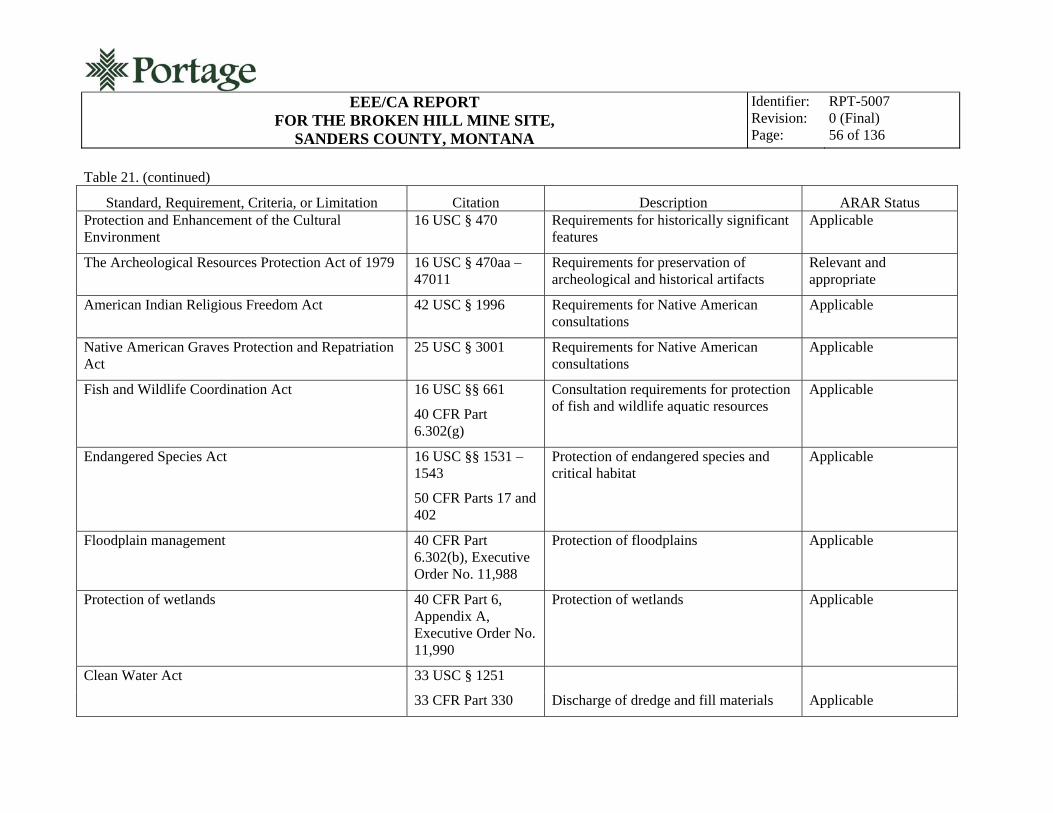
EEE/CA REPORT
FOR THE BROKEN HILL MINE SITE, SANDERS COUNTY, MONTANA
Identifier: Revision: Page:
RPT-5007 0 (Final) 56 of 136
Table 21. (continued)
Standard, Requirement, Criteria, or Limitation Citation Description ARAR Status Protection and Enhancement of the Cultural Environment
16 USC § 470 Requirements for historically significant features
Applicable
The Archeological Resources Protection Act of 1979 16 USC § 470aa – 47011
Requirements for preservation of archeological and historical artifacts
Relevant and appropriate
American Indian Religious Freedom Act 42 USC § 1996 Requirements for Native American consultations
Applicable
Native American Graves Protection and Repatriation Act
25 USC § 3001 Requirements for Native American consultations
Applicable
Fish and Wildlife Coordination Act 16 USC §§ 661
40 CFR Part 6.302(g)
Consultation requirements for protection of fish and wildlife aquatic resources
Applicable
Endangered Species Act 16 USC §§ 1531 – 1543
50 CFR Parts 17 and 402
Protection of endangered species and critical habitat
Applicable
Floodplain management 40 CFR Part 6.302(b), Executive Order No. 11,988
Protection of floodplains Applicable
Protection of wetlands 40 CFR Part 6, Appendix A, Executive Order No. 11,990
Protection of wetlands Applicable
Clean Water Act 33 USC § 1251
33 CFR Part 330 Discharge of dredge and fill materials Applicable

EEE/CA REPORT
FOR THE BROKEN HILL MINE SITE, SANDERS COUNTY, MONTANA
Identifier: Revision: Page:
RPT-5007 0 (Final) 57 of 136
Table 21. (continued)
Standard, Requirement, Criteria, or Limitation Citation Description ARAR Status Migratory Bird Treaty Act 16 USC §§ 703 Protection of migratory birds Applicable
Bald Eagle Protection Act 16 USC §§ 668 Protection of Bald and Golden Eagles Applicable
Resource Conservation and Recovery Act 40 CFR Parts 264.18(a) and (b)
Seismic and floodplain restrictions for location of waste management units
Relevant and appropriate
Federal Action-Specific ARARs
Clean Water Act
Point Source Discharge Requirements
33 USC § 1342
40 CFR Part 122
Permits for stormwater discharge (applicable portions only)
Applicable
Resource Conservation and Recovery Act 42 USC § 6921
Subtitle C Requirements
Subpart D Requirements
40 CFR Part 264, Subpart F
40 CFR Part 257
Subtitle C waste disposal facility requirements
Subtitle D requirements for waste disposal facilities
Relevant and appropriate
Applicable
Surface Mining Control and Reclamation Act 30 USC §§ 1201 – 1326
40 CFR Parts 784 and 816
Surface mining reclamation standards
Relevant and appropriate
Hazardous Materials Transportation Regulations 49 USC §§ 5101 – 5105
Standards for the transportation of hazardous wastes
Relevant and appropriate
Occupational Safety and Health Act
Hazardous Waste Operations and Emergency Response
29 USC § 655
40 CFR Part 1910.120
Standards for worker safety, hazardous waste operations, and emergency response
Applicable

EEE/CA REPORT
FOR THE BROKEN HILL MINE SITE, SANDERS COUNTY, MONTANA
Identifier: Revision: Page:
RPT-5007 0 (Final) 58 of 136
Table 21. (continued)
Standard, Requirement, Criteria, or Limitation Citation Description ARAR Status State Contaminant-Specific ARARs
Montana Groundwater Protection Regulations ARM 17.30.1005
ARM 17.30.1006
ARM 17.30.1011
Basis and applicability
Groundwater classifications
Nondegredation of groundwater
Applicable
Applicable
Applicable
Montana Water Quality Act MCA 75-5-101
ARM 17.30.637
Surface water protection regulations
Applicable
Montana Ambient Air Quality Regulations ARM 17.8.206
ARM 17.8.220, 221
ARM 17.8.222
ARM 17.8.222
Sampling, data collection, and analytical requirements
Ambient air quality standards for particulate matter
Ambient air quality standard for lead
Ambient air quality standard for PM10
Applicable
Applicable
Applicable
Applicable
Occupational Health Act of Montana MCA 50-70-101 Protection of worker health and safety Applicable
Occupational air contaminants requirements ARM 17.74.102 Contaminant concentration limits in air Applicable
Occupational noise requirements ARM 17.74.101 Occupational noise standards Applicable
State Location-Specific ARARs
Montana Antiquities Act MCA 22-3-421 Consultation, registration, permits for antiquities properties
Relevant and appropriate
Montana Human Skeletal Remains and Burial Site Protection Act
MCA 22-3-801 Protection of skeletal remains and burial sites
Applicable
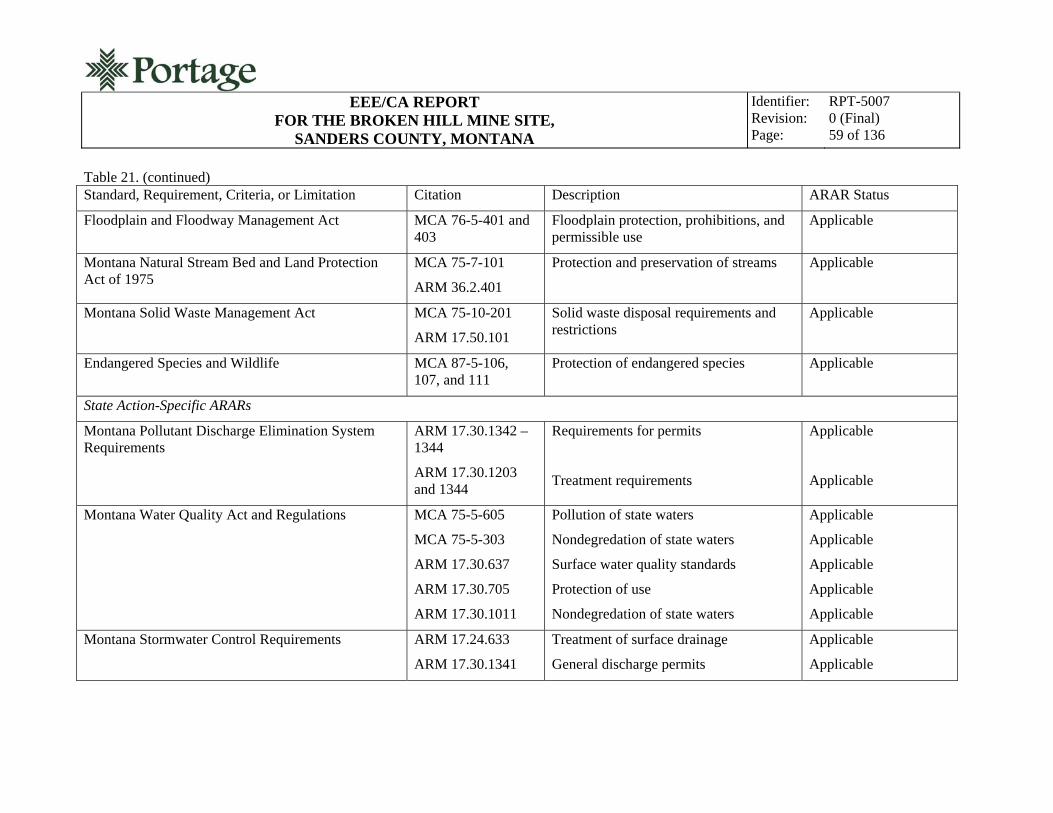
EEE/CA REPORT
FOR THE BROKEN HILL MINE SITE, SANDERS COUNTY, MONTANA
Identifier: Revision: Page:
RPT-5007 0 (Final) 59 of 136
Table 21. (continued) Standard, Requirement, Criteria, or Limitation Citation Description ARAR Status
Floodplain and Floodway Management Act MCA 76-5-401 and 403
Floodplain protection, prohibitions, and permissible use
Applicable
Montana Natural Stream Bed and Land Protection Act of 1975
MCA 75-7-101
ARM 36.2.401
Protection and preservation of streams Applicable
Montana Solid Waste Management Act MCA 75-10-201
ARM 17.50.101
Solid waste disposal requirements and restrictions
Applicable
Endangered Species and Wildlife MCA 87-5-106, 107, and 111
Protection of endangered species Applicable
State Action-Specific ARARs
Montana Pollutant Discharge Elimination System Requirements
ARM 17.30.1342 – 1344
ARM 17.30.1203 and 1344
Requirements for permits
Treatment requirements
Applicable
Applicable
Montana Water Quality Act and Regulations MCA 75-5-605
MCA 75-5-303
ARM 17.30.637
ARM 17.30.705
ARM 17.30.1011
Pollution of state waters
Nondegredation of state waters
Surface water quality standards
Protection of use
Nondegredation of state waters
Applicable
Applicable
Applicable
Applicable
Applicable
Montana Stormwater Control Requirements ARM 17.24.633
ARM 17.30.1341
Treatment of surface drainage
General discharge permits
Applicable
Applicable

EEE/CA REPORT
FOR THE BROKEN HILL MINE SITE, SANDERS COUNTY, MONTANA
Identifier: Revision: Page:
RPT-5007 0 (Final) 60 of 136
Table 21. (continued)
Standard, Requirement, Criteria, or Limitation Citation Description ARAR Status Montana Solid Waste Requirements ARM 17.50.505(1)
and (2)
ARM 17.50.506
ARM 17.50.511
ARM 17.50.53
ARM 17.50.530
ARM 17.50.531
MCA-75-10-206
Standards for solid waste disposal sites
Design requirements for landfills
Operation and maintenance requirements for solid waste management facilities
Solid waste transportation requirements
Final cover system requirements
Post closure care requirements
Variances from requirements
Applicable
Applicable
Applicable
Applicable
Applicable
Applicable
Applicable
Montana Strip and Underground Mine Reclamation Act
MCA 82-4-201 Requirements for reclamation Relevant and appropriate
Montana Metals Mining Act MCA 82-4-301 Requirements for reclamation Relevant and appropriate
Montana Air Quality Regulations ARM 17.8.308(1), (2), and (3); and ARM 17.8.304(2)
ARM 17.8.604
ARM 17.24.761
Standards for visible emissions
Open burning rules
Fugitive dust control
Applicable
Applicable
Relevant and appropriate
Montana Noxious Weed Requirements MCA 7-22-2101(8)(a)
Noxious weed management and control Applicable
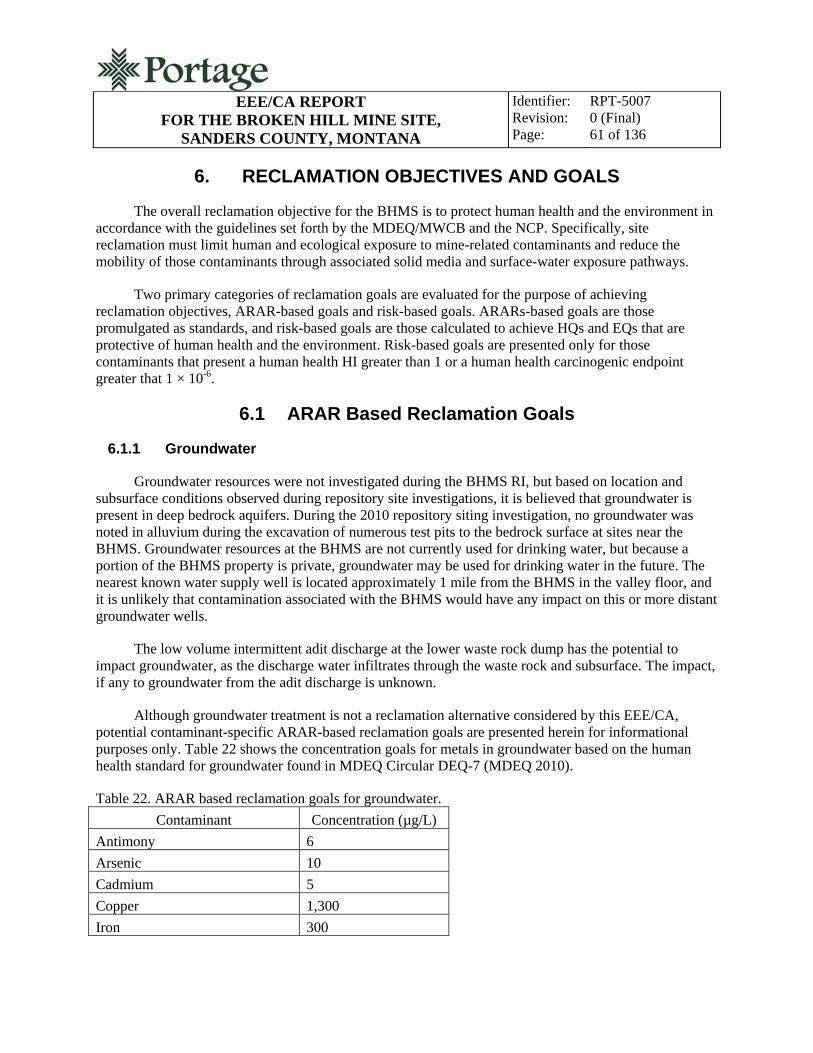
EEE/CA REPORT
FOR THE BROKEN HILL MINE SITE, SANDERS COUNTY, MONTANA
Identifier: Revision: Page:
RPT-5007 0 (Final) 61 of 136
6. RECLAMATION OBJECTIVES AND GOALS
The overall reclamation objective for the BHMS is to protect human health and the environment in accordance with the guidelines set forth by the MDEQ/MWCB and the NCP. Specifically, site reclamation must limit human and ecological exposure to mine-related contaminants and reduce the mobility of those contaminants through associated solid media and surface-water exposure pathways.
Two primary categories of reclamation goals are evaluated for the purpose of achieving reclamation objectives, ARAR-based goals and risk-based goals. ARARs-based goals are those promulgated as standards, and risk-based goals are those calculated to achieve HQs and EQs that are protective of human health and the environment. Risk-based goals are presented only for those contaminants that present a human health HI greater than 1 or a human health carcinogenic endpoint greater that 1 × 10⁻⁶.
6.1 ARAR Based Reclamation Goals
6.1.1 Groundwater
Groundwater resources were not investigated during the BHMS RI, but based on location and subsurface conditions observed during repository site investigations, it is believed that groundwater is present in deep bedrock aquifers. During the 2010 repository siting investigation, no groundwater was noted in alluvium during the excavation of numerous test pits to the bedrock surface at sites near the BHMS. Groundwater resources at the BHMS are not currently used for drinking water, but because a portion of the BHMS property is private, groundwater may be used for drinking water in the future. The nearest known water supply well is located approximately 1 mile from the BHMS in the valley floor, and it is unlikely that contamination associated with the BHMS would have any impact on this or more distant groundwater wells.
The low volume intermittent adit discharge at the lower waste rock dump has the potential to impact groundwater, as the discharge water infiltrates through the waste rock and subsurface. The impact, if any to groundwater from the adit discharge is unknown.
Although groundwater treatment is not a reclamation alternative considered by this EEE/CA, potential contaminant-specific ARAR-based reclamation goals are presented herein for informational purposes only. Table 22 shows the concentration goals for metals in groundwater based on the human health standard for groundwater found in MDEQ Circular DEQ-7 (MDEQ 2010).
Table 22. ARAR based reclamation goals for groundwater.
Contaminant Concentration (µg/L)
Antimony 6
Arsenic 10
Cadmium 5
Copper 1,300
Iron 300
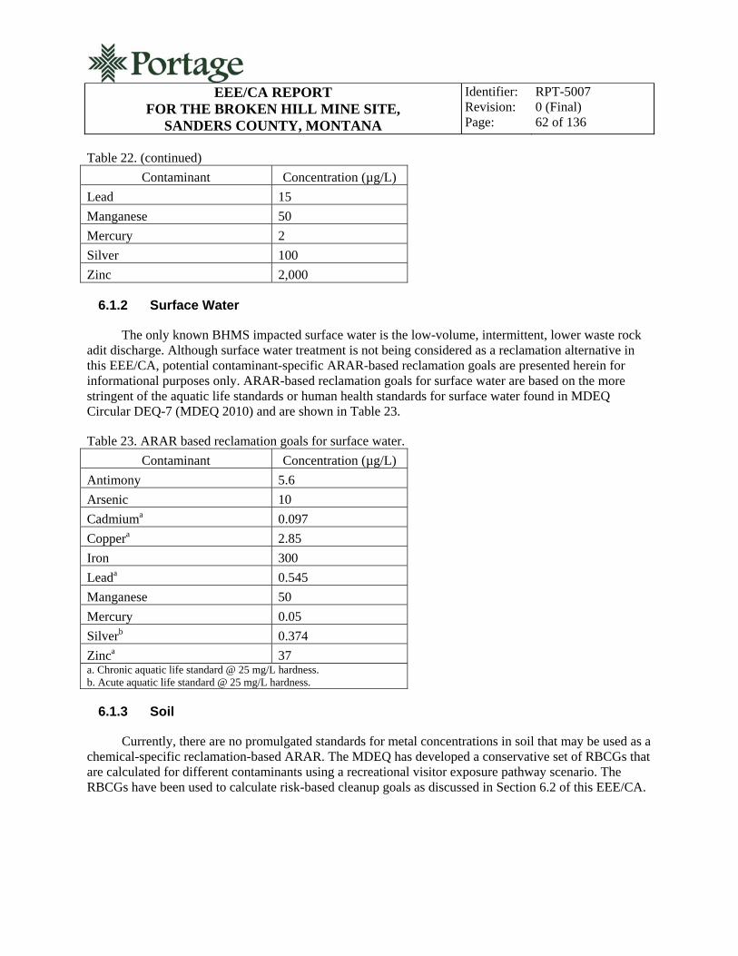
EEE/CA REPORT
FOR THE BROKEN HILL MINE SITE, SANDERS COUNTY, MONTANA
Identifier: Revision: Page:
RPT-5007 0 (Final) 62 of 136
Table 22. (continued)
Contaminant Concentration (µg/L)
Lead 15
Manganese 50
Mercury 2
Silver 100
Zinc 2,000
6.1.2 Surface Water
The only known BHMS impacted surface water is the low-volume, intermittent, lower waste rock adit discharge. Although surface water treatment is not being considered as a reclamation alternative in this EEE/CA, potential contaminant-specific ARAR-based reclamation goals are presented herein for informational purposes only. ARAR-based reclamation goals for surface water are based on the more stringent of the aquatic life standards or human health standards for surface water found in MDEQ Circular DEQ-7 (MDEQ 2010) and are shown in Table 23.
Table 23. ARAR based reclamation goals for surface water.
Contaminant Concentration (µg/L)
Antimony 5.6
Arsenic 10
Cadmiuma 0.097
Coppera 2.85
Iron 300
Leada 0.545
Manganese 50
Mercury 0.05
Silverb 0.374
Zinca 37 a. Chronic aquatic life standard @ 25 mg/L hardness. b. Acute aquatic life standard @ 25 mg/L hardness.
6.1.3 Soil
Currently, there are no promulgated standards for metal concentrations in soil that may be used as a chemical-specific reclamation-based ARAR. The MDEQ has developed a conservative set of RBCGs that are calculated for different contaminants using a recreational visitor exposure pathway scenario. The RBCGs have been used to calculate risk-based cleanup goals as discussed in Section 6.2 of this EEE/CA.

EEE/CA REPORT
FOR THE BROKEN HILL MINE SITE, SANDERS COUNTY, MONTANA
Identifier: Revision: Page:
RPT-5007 0 (Final) 63 of 136
6.2 Risk-Based Cleanup Goals
Risk-based cleanup goals for the BHMS have been determined based on RBCGs and risk calculations for the recreational user. Arsenic and lead are the COCs that exceed a calculated HI of one for both the adult and child recreational user. Arsenic also exceeds the EPA cancer risk threshold of 1 × 10⁻⁶. Table 24 lists the cleanup goals for soil and water based on the gold panner/rock hound recreational user scenario. Because reclamation/treatment of water resources is beyond the scope of this EEE/CA, the risk based cleanup goals for water are shown for informational purposes only. These cleanup goals are taken from Table 7-1 of the Risk-Based Cleanup Guidelines for Abandoned Mine Sites: Final Report (TetraTech 1996), with the exposure frequency adjusted from 50 days/year to 25 days/year to be consistent with the moderate use ranking and site-specific use factors for the BHMS. An exception is arsenic in soil. Background sampling conducted during the RI showed that arsenic concentration in undisturbed surface soils near the BHMS exceeds the calculated risk-based carcinogenic endpoint. Therefore, the risk-based reclamation goal for arsenic in soil will default to the mean background arsenic concentration for area soils.
Table 24. Recreational user risk-based cleanup goals for the BHMS.
COC Soil (mg/kg)a Water (µg/L)b
Arsenicc 44 1.32
Lead 4,400 440 a. Soil cleanup goals include both ingestion and dermal contact pathways. b. Water cleanup goals shown are for water ingestion, because they are more conservative than dermal contact values. c. The cleanup goal for arsenic in soil is the mean arsenic background concentration for area soils.
7. DEVELOPMENT AND SCREENING OF RECLAMATION ALTERNATIVES
This section provides a process for identification and screening of reclamation alternatives for the BHMS. While not inclusive of every potential technological option and alternative, the process analyzes a reasonable array of potential reclamation solutions based on effectiveness, implementability, and cost. Reclamation alternatives that meet effectiveness, implementability, and cost screening criteria are retained for detailed analysis in Section 8 of this EEE/CA. The no-action alternative assumes that no reclamation is performed and that site conditions remain unchanged. The no-action alternative provides the baseline against which other alternatives are evaluated.
7.1 Identification and Screening of Reclamation Technologies
The purpose of identification and screening of reclamation technologies options is to assess reclamation technology feasibility. Each technology identified has been implemented effectively at sites with contamination and reclamation issues similar to the BHMS. The number of technologies considered is not exhaustive because many are unproven, cost prohibitive, and/or require extensive study. The following subsections discuss each reclamation technology considered for reclamation of the BHMS waste rock and adit discharge, and Table 25 provides a summary of the reclamation technology screening process. Reclamation technologies that are not feasible and have been eliminated from further analysis

EEE/CA REPORT
FOR THE BROKEN HILL MINE SITE, SANDERS COUNTY, MONTANA
Identifier: Revision: Page:
RPT-5007 0 (Final) 64 of 136
are shaded in Table 25. Reclamation technologies retained for initial screening are presented in Table 26 and discussed in Section 7.2 of this EEE/CA.
7.1.1 No Action
The no-action alternative is the basis against which other reclamation alternatives are compared. Under this alternative, no additional reclamation, treatment, controls, or assessment would be required at the BHMS. The waste rock dumps would remain in place, and site contamination would continue to be a source of ecological and human health risk. The risk-based site cleanup goals presented in Section 6.2 of this EEE/CA are not achieved under the no-action alternative.

EEE/CA REPORT FOR THE BROKEN HILL MINE SITE,
SANDERS COUNTY, MONTANA
Identifier: Revision: Page:
RPT-5007 0 (Final) 65 of 136
Table 25. Reclamation technology screening summary.
General Response Action
Remedial Technology Process Option Description Screening Comment
No Action None Not applicable No action Baseline alternative for comparison purposes
Institutional Controls
Restrict land use Land-use restrictions
Legal restrictions to control current and future land use (development, access, etc.)
Private land ownership issues. Does not achieve reclamation objective.
Access control Fencing, signs Install fencing and post signs at contaminated areas and HMOs.
Private land ownership issues. Does not achieve reclamation objective. May be effective in combination with other alternatives.
Engineering Controls
Containment Waste capping, disposal in repository
Cap in place or excavate and dispose of in a repository with multilayer cap.
Moderate to good effectiveness. Private land ownership issues with cap in place alternative. Readily implementable.
Surface controls Grading, shaping, stormwater management, waste consolidation, revegetation
Grade site features to prevent surface water run-on and erosion; construct stormwater run-off controls to prevent offsite contaminant transport; consolidate waste into single area; and revegetate disturbed areas to reduce surface-water infiltration.
Does not achieve reclamation objective as a stand-alone response. Effective when used in combination with other alternatives. Readily implementable.
Disposal at the BHMS
Disposal in repository
Complete excavation of waste and disposal in a repository constructed onsite.
Private land ownership issues. Access issues.
Disposal on USFS lands
Disposal in repository
Complete excavation of waste and disposal in a repository constructed on nearby USFS property.
Effective and readily implementable.
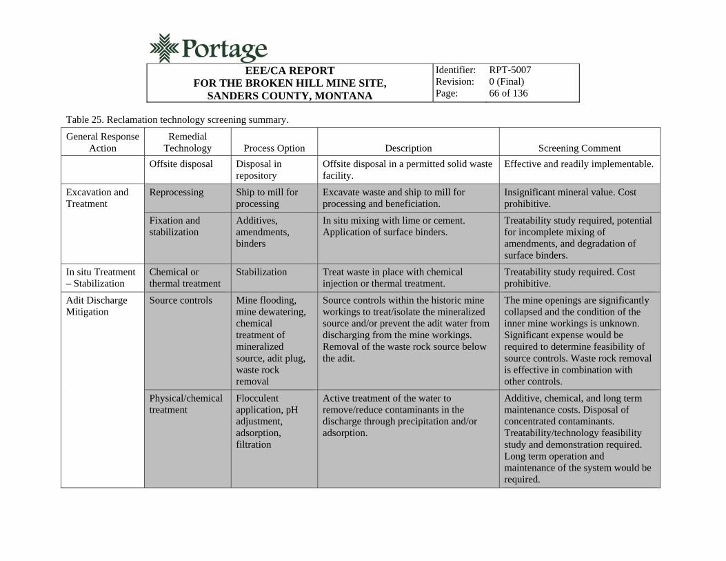
EEE/CA REPORT FOR THE BROKEN HILL MINE SITE,
SANDERS COUNTY, MONTANA
Identifier: Revision: Page:
RPT-5007 0 (Final) 66 of 136
Table 25. Reclamation technology screening summary.
General Response Action
Remedial Technology Process Option Description Screening Comment
Offsite disposal Disposal in repository
Offsite disposal in a permitted solid waste facility.
Effective and readily implementable.
Excavation and Treatment
Reprocessing Ship to mill for processing
Excavate waste and ship to mill for processing and beneficiation.
Insignificant mineral value. Cost prohibitive.
Fixation and stabilization
Additives, amendments, binders
In situ mixing with lime or cement. Application of surface binders.
Treatability study required, potential for incomplete mixing of amendments, and degradation of surface binders.
In situ Treatment – Stabilization
Chemical or thermal treatment
Stabilization Treat waste in place with chemical injection or thermal treatment.
Treatability study required. Cost prohibitive.
Adit Discharge Mitigation
Source controls Mine flooding, mine dewatering, chemical treatment of mineralized source, adit plug, waste rock removal
Source controls within the historic mine workings to treat/isolate the mineralized source and/or prevent the adit water from discharging from the mine workings. Removal of the waste rock source below the adit.
The mine openings are significantly collapsed and the condition of the inner mine workings is unknown. Significant expense would be required to determine feasibility of source controls. Waste rock removal is effective in combination with other controls.
Physical/chemical treatment
Flocculent application, pH adjustment, adsorption, filtration
Active treatment of the water to remove/reduce contaminants in the discharge through precipitation and/or adsorption.
Additive, chemical, and long term maintenance costs. Disposal of concentrated contaminants. Treatability/technology feasibility study and demonstration required. Long term operation and maintenance of the system would be required.

EEE/CA REPORT FOR THE BROKEN HILL MINE SITE,
SANDERS COUNTY, MONTANA
Identifier: Revision: Page:
RPT-5007 0 (Final) 67 of 136
Table 25. Reclamation technology screening summary.
General Response Action
Remedial Technology Process Option Description Screening Comment
Wetlands treatment
Artificial wetlands construction, treatment through natural processes
Treatment of the adit discharge water through natural media in a constructed wetland.
Lack of suitable land space for construction. Winter climate limits effectiveness. Eventual disposal of contaminants required. Eventual replacement required.
Subsurface disposal
Subsurface disposal in infiltration trench without active treatment
Rout water to the subsurface in a constructed infiltration trench. Limited passive treatment.
Effective in combination with waste rock removal. Eliminates direct contact with humans and wildlife.

EEE/CA REPORT
FOR THE BROKEN HILL MINE SITE, SANDERS COUNTY, MONTANA
Identifier: Revision: Page:
RPT-5007 0 (Final) 68 of 136
7.1.2 Institutional Controls
Institutional controls are controls that restrict site use, restrict site access, or otherwise restrict human and/or ecological exposure to site wastes through legal and/or administrative means. As a stand-alone alternative for BHMS reclamation, institutional controls do not achieve the risk-based site cleanup goals presented in Section 6.2 of this EEE/CA and would not be protective of the environment. Existing contaminant transport mechanisms and pathways would remain unaffected, and the potential for unacceptable human and ecological exposure would remain.
7.1.2.1 Restrict Land Use. Land use restrictions include land-use and development restriction through deed restriction or other legal means. As a stand-alone alternative for BHMS reclamation, land use control does not achieve risk-based site cleanup goals presented in Section 6.2 of this EEE/CA and would not be protective of the environment. Existing contaminant transport mechanisms and pathways would remain unaffected, and the potential for unacceptable human and ecological exposure would remain. The primary applicability of site access controls is to complement administrative controls or other onsite engineering controls (i.e., onsite disposal). Because portions of the BHMS are located on private land, land use restriction would also impact present and future owners of the private parcel.
7.1.2.2 Access Control. Site access control alternatives include posting signs warning the public of site health risks and fencing. As a stand-alone alternative for BHMS reclamation, access control does not achieve risk-based site cleanup goals presented in Section 6.2 of this EEE/CA and would not be protective of the environment. Existing contaminant transport mechanisms and pathways would remain unaffected, and the potential for unacceptable human and ecological exposure would remain. The primary applicability of site access controls is to complement administrative controls or other onsite engineering controls (i.e., onsite disposal).
7.1.3 Engineering Controls
Engineering controls are controls that isolate and reduce the mobility of contamination through physical solutions. The complexity of engineering solutions applicable to the BHMS ranges from posting signs and site fencing, limiting site access, and constructing a waste repository for waste disposal. Several subcategories or engineering controls are detailed in the following subsections.
7.1.3.1 Containment. Containment technologies are designed to limit the mobility of contamination and to limit human and ecological receptor contact with contamination. Containment options appropriate to the BHMS may include the following:
Cap in place
Removal and placement of waste in a repository constructed within the BHMS property boundary
Removal and placement of waste in a repository constructed on nearby USFS land.
Waste containment alternatives vary greatly in complexity. They can be as simple as a vegetated soil cover and as complex as a multilayer top and bottom geosynthetic lining system with leachate collection. All are designed to provide a positive gradient for surface water run-off, limit surface water

EEE/CA REPORT
FOR THE BROKEN HILL MINE SITE, SANDERS COUNTY, MONTANA
Identifier: Revision: Page:
RPT-5007 0 (Final) 69 of 136
run-on and infiltration, and eliminate direct contact with waste. Contaminant mobility is reduced, because contaminants may no longer be entrained by wind, eroded by surface water, or leached by surface water.
The degree of complexity of a capping system is determined by location, waste characteristics, and the severity of associated hazards. Suitable repository sites near the BHMS exist that are relatively isolated from the public. The investigation of potential repository sites also showed that groundwater is not present in alluvial and colluvial overburden. Groundwater is likely found in deeper bedrock faulting and it is unlikely that a waste rock repository would have any significant impact on local groundwater. There are no groundwater wells in the immediate vicinity of potential repository sites and groundwater near the BHMS is unlikely to be used as a significant potable water resource in the future. Testing of the BHMS waste rock has shown that metals in the waste are not easily mobilized by contact with water and that the waste rock is not acid generating. Although metals contamination in the waste rock poses a significant direct contact risk to human and the environment, laboratory analysis has shown that it is unlikely that the waste would be characteristic of a hazardous waste under the Resource Conservation and Recovery Act (RCRA) (42 USC 6901).
Performance standards for RCRA landfills include top and bottom liner systems with leachate collection. Long term monitoring of the leachate collection sump is required. Because disposal of the BHMS waste rock at the potential repository sites identified would likely not have a significant impact on groundwater, and because waste rock characterization has demonstrated that the waste rock is relatively unsusceptible to leaching and contaminant disassociation, achieving RCRA performance standards for waste containment would add unnecessary expense for construction, inspection, maintenance and long term monitoring. A top cover containment system consisting of a low permeability earthen layer or geosynthetic lining system, and a top layer of growth medium would be environmentally protective and cost effective. Capping of mine/mill wastes is a common and effective reclamation practice that utilizes standard engineering design and construction practices.
7.1.3.2 Surface Controls. Surface controls are engineering controls designed to control contaminant entrainment by wind and surface water. These controls, by themselves or in combination, may include waste consolidation, site grading, revegetation, and stormwater controls. The primary applicability of surface controls is to complement other onsite engineering controls (i.e., onsite containment and disposal). As a standalone alternative, surface controls do not achieve risk-based site cleanup goals presented in Section 6.2 of this EEE/CA.
As applicable to the BHMS, waste consolidation would involve combining the upper and lower waste rock dumps into one pile. Consolidation may be beneficial if one waste rock dump is more susceptible to contaminant transport, is more accessible to the public, is unstable, or supports another engineering control (i.e., containment).
Site grading is used to create positive drainage in areas of surface water ponding and to flatten steep slopes that may be susceptible to erosion by surface water run-off. Site grading may also be used to reduce the overall surface area of land impacted by site wastes.
Revegetation is the process of establishing vegetation on areas where little or no vegetation exists because of the impacts of site wastes. Revegetation helps to mitigate surface water erosion and infiltration by slowing the velocity of surface water run-off, increasing the water holding capacity of soils, decreasing

EEE/CA REPORT
FOR THE BROKEN HILL MINE SITE, SANDERS COUNTY, MONTANA
Identifier: Revision: Page:
RPT-5007 0 (Final) 70 of 136
the surface area of bare soil available for wind and surface water erosion, and minimizing infiltration of surface water through the process of evapotranspiration (plant root uptake).
Stormwater controls are engineering controls designed to exclude stormwater run-on onto the contaminated waste and to control stormwater run-off from the contaminated waste. These controls are often used in combination and may complement other engineering controls (i.e., surface controls). Stormwater controls are also common requirements during construction. They include silt fencing; straw mat and bales; riprap or armoring; sedimentation basins; and channels, french drains, or other stormwater drainage controls.
7.1.3.3 Disposal Within the BHMS Property Boundary. This disposal alternative consists of excavation of contaminated materials and placement of those materials in a repository constructed within the BHMS private property boundary. The engineered complexity of the repository would be based on the waste characteristics and the severity of associated hazards. The BHMS waste is not a hazardous waste as defined by RCRA (42 USC 6901), because the waste falls under the RCRA exemption of solid waste associated with the beneficiation of ores and minerals [40 CFR 261.4(b)(7)]. Laboratory analysis also shows that the BHMS waste would not be characteristic of a hazardous waste, and therefore the construction and performance standards for RCRA hazardous waste landfills are not applicable. Laboratory analysis of the BHMS waste does, however, show that contamination is present at levels which pose an unacceptable risk to human health and the environment. A repository cover system would be engineered and constructed to be sufficiently protective and to achieve the project reclamation objective presented in Section 6.2 of this EEE/CA. As applicable to the BHMS, the repository cover system would consist of a low permeability earthen material layer or geosynthetic lining system, overlain by an earthen cap for growth medium.
7.1.3.4 Disposal on USFS Property. This disposal alternative includes excavation of contaminated materials and placement of those materials in a nearby constructed repository on USFS lands. Similar to the alternative for disposal on the BHMS property, the engineered complexity of the repository would be based on the waste characteristics and the severity of associated hazards. A repository liner system and cap would be engineered and constructed to be sufficiently protective and to achieve the project reclamation objective presented in Section 6.2 of this EEE/CA. As applicable to the BHMS, the repository cover system would consist of a low permeability earthen material layer or geosynthetic lining system, overlain by an earthen cap for growth medium.
7.1.3.5 Offsite Disposal. Because the BHMS waste rock is not a listed or characteristic hazardous waste as defined by RCRA, offsite disposal may include excavation of contaminated material and transport of the material for disposal in an existing permitted solid waste landfill. Prior to offsite disposal in a solid waste landfill, the toxicity characteristic leaching procedure (TCLP) analysis would be performed on representative waste rock samples to insure the waste is not characteristic of a hazardous waste under RCRA. Based on the concentrations of total metals in the waste rock and on SPLP analysis results, it is unlikely that the BHMS waste rock would fail TCLP standards.
7.1.4 Excavation and Treatment
Excavation and treatment alternatives involve removal of the waste and either onsite or offsite waste treatment through chemical, physical, or thermal treatment. The objective of treatment is to reduce toxicity by removal of toxic constituents or by reducing the mobility of toxic constituents in the

EEE/CA REPORT
FOR THE BROKEN HILL MINE SITE, SANDERS COUNTY, MONTANA
Identifier: Revision: Page:
RPT-5007 0 (Final) 71 of 136
environment. Excavation and treatment alternatives include reprocessing and fixation/stabilization technologies as described in the following subsections.
7.1.4.1 Reprocessing. Reprocessing involves using milling and/or leaching technologies to liberate and concentrate toxic metals from the host rock. These technologies encompass many mineral processing technologies, including acid leaching, cyanide leaching, roasting, floatation, and concentration. Reprocessing technologies are normally only utilized if the residual metals value in the waste is high enough to significantly offset the cost of reprocessing. In the case of the BHMS waste rock, the residual value of recoverable minerals is insignificant, and reprocessing would be a very high-cost treatment alternative.
7.1.4.2 Fixation/Stabilization. Fixation technologies are treatment processes that chemically alter the waste to reduce toxicity and/or contaminant mobility. These technologies are often used in combination with stabilization or the process of physically encapsulating the waste. Amending mine waste rock with lime or cement are examples of fixation/stabilization technologies. The effectiveness of fixation/stabilization technologies is dependent on the chemical makeup of the waste and resultant chemical mobility and on options for final waste disposal. Fixation/stabilization technologies are often used in conjunction with containment or other remedies.
Stabilization technologies that simply limit contaminant mobility include application of surface binders or surfactants. These applications are generally temporary and require repeated applications to maintain effectiveness. Also, even minor disturbance of the waste (i.e., foot traffic) can degrade the effectiveness of surface stabilization technologies.
7.1.5 In Situ Treatment – Stabilization
In situ treatment and stabilization is the in-place treatment of waste to reduce toxicity and/or contaminant mobility. These technologies vary in complexity and effectiveness and as applied to the BHMS may include in-place soil mixing with lime, cement or other chemical additives to stabilize waste rock contaminants. In situ treatment may be used in combination with in-place containment. In situ treatment and stabilization are generally considered to be less effective for contaminant fixation and stabilization when compared to waste removal and fixation/stabilization because of incomplete additive mixing.
7.1.6 Water Treatment (Adit Discharge)
As previously discussed in this EEE/CA, treatment of surface water is not considered under the reclamation alternatives analyzed for the BHMS and is beyond the scope of the removal action. However, the lower waste rock dump adit discharge does represent elevated risk to the environment. Contaminant-specific ARARs are applicable to the environmental medium (surface water). This section presents technologies and controls which have been successfully employed to reduce the risk posed by mining related contamination in surface water. The controls and technologies are then screened in Section 7.2 to determine if a cost effective and implementable means of mitigating the adit discharge environmental risk may be used to complement the removal action.
7.1.6.1 Source Controls As applicable to the BHMS, source controls would limit the contact of groundwater and surface water with ore and mine waste rock. The purpose of source controls is to limit

EEE/CA REPORT
FOR THE BROKEN HILL MINE SITE, SANDERS COUNTY, MONTANA
Identifier: Revision: Page:
RPT-5007 0 (Final) 72 of 136
the mobilization of contaminants in site waters through oxidation of the rock and the subsequent dissolution of contaminants in the water. The groundwater within the mine workings presumably contacts the rocks (ore) within the workings that were once disturbed by mining operations. It is unknown if the origin of the groundwater is infiltration of precipitation and snowmelt through the mine workings above the lower waste rock dump adit, groundwater existing within undisturbed bedrock faults which seeps into the historic mine workings, or both. The adit discharge has been observed to be low volume and intermittent. Once the groundwater emerges from the adit as surface water is percolates through the lower waste rock dump and does not reappear at the surface.
Source controls may include controls within the mine workings including: bulkhead construction and the intentional flooding of mine workings; adit plugging; chemical and/or physical treatment of exposed mineralization; and, mine pool drawdown. Source control of the mine waste rock may include waste rock removal; rerouting the adit discharge in a lined trench or pipe away from the mine waste rock; and, disposal of the adit discharge in the subsurface.
Because the lower waste rock dump adit (and all other mine openings noted in site history reports) are at least partially collapsed, the inner mine workings are not accessible and their condition is unknown. The condition of the mine openings makes source control options within the mine workings impracticable since significant cost would be expended simply to determine if the mine could be reopened and what rehabilitation of the inner workings would be required for safe implementation of the controls.
Adit plugging may be an effective control for stopping or reducing the seepage but, the lower waste rock dump adit is presently collapsed and extensive excavation/rehabilitation of the opening would be required before the feasibility of adit plugging could be determined. The success of adit plugs is generally based on extensive knowledge of site specific mine geology, hydrogeology, and rock mechanics. Relatively little is known about the inner workings of the BHMS and the work required to prove the feasibility of adit plugging as a control technology appropriate to the BHMS would likely be cost prohibitive.
Routing the adit discharge away from the waste rock would effectively isolate the water from contaminants present within the waste but, the contaminated discharge would still be available for contact with humans and wildlife as surface water. As a standalone control, this would not achieve risk-based site cleanup goals presented in Section 6.2 of this EEE/CA and would not be protective of the environment.
As discussed previously in Section 7.1, removal and disposal of the waste rock is an effective control when combined with other reclamation technologies. In the context of the adit discharge, removal of the waste rock would eliminate adit discharge contact with the major contaminant source present at the BHMS. However, the issue of risk associated with direct human and ecological contact with the adit discharge would remain after waste rock removal unless additional controls are implemented. Because technologies for source control within the mine workings are impractical, technologies evaluated for controlling the adit discharge external to the mine include physical/chemical treatment, wetlands treatment, and subsurface disposal.
7.1.6.2 Physical/Chemical Treatment Physical and chemical treatments are used to remove contaminants from water media and to stabilize them. Physical treatment processes include flocculation and adsorption to remove contaminants from the water and to concentrate those contaminants into reduced volumes for disposal or further treatment. Chemical treatment is used to adjust water pH to

EEE/CA REPORT
FOR THE BROKEN HILL MINE SITE, SANDERS COUNTY, MONTANA
Identifier: Revision: Page:
RPT-5007 0 (Final) 73 of 136
promote contaminant precipitation. Chemical treatment is often used in combination with physical treatment to bind and collect precipitates. These treatments may include flocculent addition; pH adjustment with sodium hydroxide, lime, or another chemical agent; carbon adsorption; and iron filtration. These treatment systems often require extensive infrastructure and maintenance. Additional costs include the cost of chemicals or treatment additives and the cost of concentrated contaminant disposal.
7.1.6.3 Wetland Treatment As applicable to the BHMS, wetland treatment of the adit discharge would involve routing the discharge to a constructed artificial wetland where the water would be treated through natural processes. Wetlands may remove contaminants from water through precipitation, settling, and adsorption. This is accomplished by designing a wetland with a large retention time during which water infiltrating through a oxygen reducing environment of decaying organic matter allows for precipitate formation, settlement, and adsorption within the organic matter. The effectiveness of wetland treatment would be limited during the cold winter months at the BHMS. Also, wetlands have a design life and eventually require replacement. During replacement, the metals laden sediments and organic matter in the wetland would require disposal. A limiting factor for wetlands treatment at the BHMS is the limited amount of relatively flat land space available for wetlands construction.
7.1.6.4 Subsurface Disposal Subsurface disposal would involve routing the BHMS adit discharge to a constructed infiltration trench in which the water would be allowed to drain through the vadose zone. Although there is no direct treatment associated with this control, passive treatment may occur as contaminants are absorbed in organic matter in vadose zone soils and through the process of evapotranspiration (plant root uptake) once vegetation was reestablished in the infiltration trench area. This control would effectively remove the adit discharge as a direct source of contaminant contact with humans and wildlife. This control could be readily implemented in combination with removal of the waste rock contaminant source and would require minimal long term maintenance.
7.2 Identification and Evaluation of Alternatives
This section presents the initial screening of reclamation alternatives for the BHMS. The alternatives are based on the technologies presented in Section 7.1 and are presented in Table 26. The objective of initial screening is to define preliminary reclamation alternatives and to determine which preliminary alternatives will be retained for detailed analysis. For the purpose of achieving this objective, each preliminary alternative is evaluated on the basis of effectiveness, implementability, and cost.
Table 26. Preliminary reclamation alternatives. ADIT DISCHARGE
Alternative 1 Subsurface Disposal
WASTE ROCK
Alternative 1 No action
Alternative 2 Administrative controls and site fencing
Alternative 3 Stabilize waste in-place

EEE/CA REPORT
FOR THE BROKEN HILL MINE SITE, SANDERS COUNTY, MONTANA
Identifier: Revision: Page:
RPT-5007 0 (Final) 74 of 136
Table 26. (continued) WASTE ROCK
Alternative 4 Disposal in a constructed repository within the BHMS property boundary
Alternative 5 Disposal in a constructed repository on nearby USFS land
Alternative 6 Offsite disposal in a permitted solid waste disposal facility
Effectiveness is a measure of how completely the alternative achieves the reclamation objective and cleanup goals in both the short and long terms. To be effective, an alternative must be protective of human health and the environment and must comply with ARARs. Site-specific factors, contaminant toxicity reduction, contaminant mobility reduction, waste volume minimization, and permanence are considerations in determining the effectiveness of an alternative.
Implementability is the feasibility of an alternative based on technical and administrative issues. Technical considerations that may affect the implementability of an alternative include geology, topography, or other site specific factors; the availability of resources to complete the alternative; and alternative maintenance and reliability considerations. Administrative issues which may affect the implementability of an alternative include logistics, schedule, and land ownership issues.
Each alternative is screened for cost by developing engineer’s estimates for design, construction, operation, and maintenance of the alternative. The estimates are based on the engineer’s experience with costs incurred for similar projects, unit cost data from RSMeans® or other standardized sources, and material quotes from local suppliers. Administrative costs and contingencies are included in each estimate. For the purpose of directly comparing the cost of alternatives which may have differing implementation schedules, all costs are presented in present value. The engineer’s estimates are for planning purposes and should be considered “order of magnitude” costs.
7.2.1 Adit Discharge
As discussed in Section 7.1.5 of this EEE/CA the adit discharge poses an environmental risk and will be mitigated to complement the waste rock removal action. Many of the conventional technologies applicable to mine adit water discharges are not practicable to implement at the BHMS. Only one adit discharge alternative was retained from the screening of reclamation alternatives for additional initial screening and evaluation. With the exception of the no-action alternative, this alternative will be presented as a common element of all BHMS waste rock alternatives discussed in Section 7.2.2 and all BHMS waste rock alternatives retained for detailed analysis in Section 8.0 of this EEE/CA.
7.2.1.1 Alternative 1: Subsuface Disposal
Alternative 1 includes the subsurface disposal of the adit discharge. This adit discharge alternative in combination with removal of the waste rock is an effective control that would be protective of both human health and the environment. This alternative may be implemented with standard construction techniques at reasonable cost. The discharge will be routed to a constructed infiltration trench and buried so that there is no surface expression of the water. Construction of the infiltration trench will provide an effective human and wildlife contact barrier with the adit discharge. Removal of the waste rock will
EEE/CA REPORT
FOR THE BROKEN HILL MINE SITE, SANDERS COUNTY, MONTANA
Identifier: Revision: Page:
RPT-5007 0 (Final) 75 of 136
eliminate waste rock contaminant contact with the adit discharge and subsequent contaminant mobility. Passive treatment/removal of contaminants in the adit discharge (contaminants mobilized from mineralization found in rock in the inner mine workings) would likely occur through adsorption in the vadose zone sediments and through the process of evapotranspiration.
Impacts to groundwater from the adit discharge are unknown but are considered to be insignificant. The adit discharge is low volume and intermittent. Geotechnical investigation of subsurface conditions in the area of the BHMS has shown that there is no significant alluvial aquifer present near the BHMS and that groundwater is likely found in deep bedrock fractures. Because there are no wells or other data regarding groundwater in the vicinity of the BHMS, the quantity and quality of site groundwater is unknown. Treatment of groundwater would require additional investigation and is not being considered by this EEE/CA.
Effectiveness. Alternative 1 provides protection of human health by eliminating the adit discharge as a direct source of exposure through dermal contact and/or ingestion. It would also be protective of large wildlife species (deer), which may otherwise come into direct contact with the adit discharge. The reclamation goals and risk-based site cleanup goals presented in Section 6.2 of this EEE/CA would be achieved through implementation of this alternative.
Implementability. Alternative 1 may be implemented with a minimum of technical and administrative considerations. No site features would eliminate subsurface disposal as an option for addressing the adit discharge, and resources and materials are readily available to implement the alternative. Reliability would be good and the alternative would require minimal maintenance.
Cost. The total present worth cost of alternative 1 when implemented in conjunction with waste rock disposal alternatives is $2,469.
Screening Summary. Alternative 1 is a low cost, effective means of eliminating the human health and ecological risks associated with contamination in the adit discharge. Alternative 1 is a common element of all waste rock restoration alternatives with the exception of the no-action alternative.
7.2.2 Waste Rock
HMO mitigation and elimination of the lower waste rock dump adit discharge are common element of all BHMS waste rock restoration alternatives with the exception of the no-action alternative. Two HMOs are present at the BHMS: the collapsed adit above the lower waste rock dump and the collapsed adit above the upper waste rock dump. These features would be filled, graded, and/or contoured as appropriate.
7.2.2.1 Alternative 1: No Action
The no-action alternative is the basis against which other reclamation alternatives are compared. Under this alternative no additional reclamation, treatment, controls, or assessment would be required at the BHMS. The waste rock dumps would remain in place, and site contamination would continue to be a source of ecological and human health risk.

EEE/CA REPORT
FOR THE BROKEN HILL MINE SITE, SANDERS COUNTY, MONTANA
Identifier: Revision: Page:
RPT-5007 0 (Final) 76 of 136
Effectiveness. Toxicity, mobility, and/or volume of contaminants would not be reduced under the no-action alternative. The no-action alternative would not protect against the human health and ecological risks associated with metals in the BHMS waste rock. The reclamation goal and risk-based site cleanup goals presented in Section 6.2 of this EEE/CA are not achieved under the no-action alternative.
Implementability. Because the no-action alternative does not change the current status of the BHMS, technical and administrative feasibility considerations do not apply.
Cost. Because the no-action alternative does not change the current status of the BHMS, no capital or operating costs would be incurred under the no-action alternative. The future costs of no action (environmental, human health, and ecological impacts from contamination) are unknown.
Screening Summary. the no-action alternative is the basis against which other reclamation alternatives are compared. The no-action alternative is therefore retained for detailed evaluation in Section 8 of this EEE/CA.
7.2.2.2 Alternative 2: Administrative Controls and Site Fencing
Alternative 2 includes land-use restrictions to prevent development in the area of the two BHMS waste rock dumps and permanently fencing the area around each waste rock dump. The two BHMS HMOs would be closed by filling them with general fill and regrading the surrounding areas to blend them into the local topography. The intermittent seep from the lower waste rock dump adit would be eliminated so that there is no surface expression of the water by the filling and recontouring of the adit and by routing the discharge into a constructed infiltration trench. Reclaimed areas would be revegetated with a blend of native shrubs and grasses to stabilize site soils.
Effectiveness. Alternative 2 provides protection of human health by limiting future site development and by creating a barrier around site wastes. It would also be protective of large wildlife species (deer), which may otherwise come into direct contact with site wastes. However, with the exception of surface water, Alternative 2 does not reduce toxicity, mobility, and/or volume of contaminants, and it does not achieve the project cleanup goals. Furthermore, the potential for direct human contact with site wastes cannot be adequately eliminated with this alternative. Fencing may be vandalized or degraded by natural events over time. Maintaining site fencing and signage would be a long-term cost.
Implementability. Alternative 2 engineering controls (adit closure and fencing) can be readily implemented with a minimum of technical and administrative considerations. No site features would eliminate fencing as an option, and resources and materials are readily available to implement the alternative. Reliability would be good, but fencing would require long-term maintenance. Fencing and land-use restrictions do pose administrative challenges because of the divided ownership status of the property on which the waste is located. The entire upper waste rock dump, a portion of the lower waste rock dump, and site HMOs are located on private property. Current and future land owners would likely oppose restrictions on use of the private parcel.
Cost. Table 27 presents the engineer’s cost estimate for Alternative 2. The total estimated present worth cost of this alternative is $34,815. The costs of Alternative 2 are low compared to the other
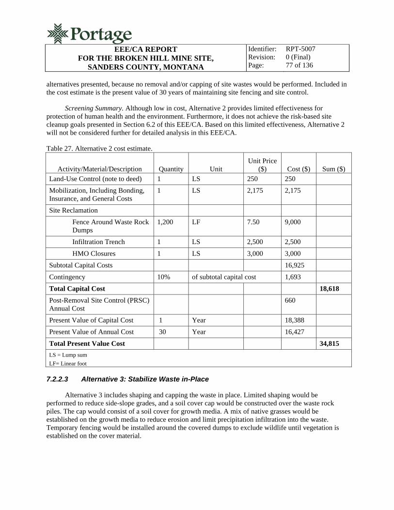
EEE/CA REPORT
FOR THE BROKEN HILL MINE SITE, SANDERS COUNTY, MONTANA
Identifier: Revision: Page:
RPT-5007 0 (Final) 77 of 136
alternatives presented, because no removal and/or capping of site wastes would be performed. Included in the cost estimate is the present value of 30 years of maintaining site fencing and site control.
Screening Summary. Although low in cost, Alternative 2 provides limited effectiveness for protection of human health and the environment. Furthermore, it does not achieve the risk-based site cleanup goals presented in Section 6.2 of this EEE/CA. Based on this limited effectiveness, Alternative 2 will not be considered further for detailed analysis in this EEE/CA.
Table 27. Alternative 2 cost estimate.
Activity/Material/Description Quantity Unit Unit Price
($) Cost ($) Sum ($)
Land-Use Control (note to deed) 1 LS 250 250
Mobilization, Including Bonding, Insurance, and General Costs
1 LS 2,175 2,175
Site Reclamation
Fence Around Waste Rock Dumps
1,200 LF 7.50 9,000
Infiltration Trench 1 LS 2,500 2,500
HMO Closures 1 LS 3,000 3,000
Subtotal Capital Costs 16,925
Contingency 10% of subtotal capital cost 1,693
Total Capital Cost 18,618
Post-Removal Site Control (PRSC) Annual Cost
660
Present Value of Capital Cost 1 Year 18,388
Present Value of Annual Cost 30 Year 16,427
Total Present Value Cost 34,815
LS = Lump sum
LF= Linear foot
7.2.2.3 Alternative 3: Stabilize Waste in-Place
Alternative 3 includes shaping and capping the waste in place. Limited shaping would be performed to reduce side-slope grades, and a soil cover cap would be constructed over the waste rock piles. The cap would consist of a soil cover for growth media. A mix of native grasses would be established on the growth media to reduce erosion and limit precipitation infiltration into the waste. Temporary fencing would be installed around the covered dumps to exclude wildlife until vegetation is established on the cover material.
EEE/CA REPORT
FOR THE BROKEN HILL MINE SITE, SANDERS COUNTY, MONTANA
Identifier: Revision: Page:
RPT-5007 0 (Final) 78 of 136
The two BHMS HMOs would be closed by filling them with general fill and regrading the surrounding areas to blend them into the local topography. The intermittent seep from the lower waste rock dump adit would be eliminated so that there is no surface expression of the water by the filling and recontouring of the adit, and by routing the discharge into a constructed infiltration trench. These areas would also be revegetated with a blend of native shrubs and grasses. Best management practices (BMPs) for stormwater control and erosion control would be required at all reclaimed areas to ensure soil stability and to promote revegetation.
Effectiveness. Alternative 3 provides some protection of human health and the environment by isolating site wastes under an earthen cap. It is unlikely, however, that a soil cover alone will eliminate contaminant transport pathways at the BHMS. Annual precipitation at the BHMS is relatively high for Montana, and it is unlikely that evaporation and evapotranspiration would be sufficient to stop infiltration of precipitation through the waste. Animals could easily burrow in the soil cover and create preferential pathways for water infiltration. Also, Alternative 3 would still require administrative controls to ensure that a portion of the reclaimed lower waste rock dump and the entire upper waste rock dump are not disturbed by future site development and use. Current and future land owners would likely oppose restrictions on use of the private parcel. Also, access agreements for performing the work and for performing monitoring/maintenance of the reclamation would be required. In addition, Alternative 3 would be less effective than other alternatives that involve waste capping, because the waste material will not be consolidated in a single repository under this alternative. Multiple reclamation features will require additional post-construction monitoring and maintenance.
Implementability. The construction components of Alternative 3 can be readily implemented with standard construction techniques. No site features would eliminate Alternative 3 as an option, and resources and materials are readily available to implement the alternative. Land-use restrictions do, however, pose administrative challenges to implementing this alternative because of the divided ownership status of the property on which the waste is located. The entire upper waste rock dump and a portion of the lower waste rock dump are located on private property. Current and future land owners would likely oppose restrictions on use of the private parcel. Access agreements for performing the work and for performing monitoring/maintenance of the reclamation would be required.
Cost. Table 28 presents the engineer’s cost estimate for Alternative 3. The total estimated present worth cost of this alternative is $185,278. The costs of Alternative 3 are less than other alternatives presented that involve waste capping, because the cap would only consist of soil cover. In addition to the present worth of capital costs, the estimate assumes 30 years of performance monitoring of the covered dumps.
Screening Summary. Alternative 3 would not be fully protective of human health and the environment, and it is less implementable than other alternatives because of the divided land ownership at the BHMS. Based on this limited effectiveness and implementability, Alternative 3 will not be considered further in the detailed analysis of reclamation alternatives.

EEE/CA REPORT
FOR THE BROKEN HILL MINE SITE, SANDERS COUNTY, MONTANA
Identifier: Revision: Page:
RPT-5007 0 (Final) 79 of 136
Table 28. Alternative 3 cost estimate.
Activity/Material/Description Quantity Unit Unit
Price ($) Cost ($) Sum ($)
Land-Use Control (note to deed) 1 LS 250 250
Mobilization, Including Bonding, Insurance, and General Costs
1 LS 14,098 14,323
Roads, Access, and Site Preparation 1 LS 10,520 10,520
Excavation and Earthwork (soil cover) 1 LS 62,420 62,420
Site Reclamation
Final Grading 1 LS 5,547 5,547
Seeding, Fertilizer, Mulch on All Disturbed Areas
2 AC 4,000 8,000
Infiltration trench 1 LS 2,500 2,500
HMO Closures 1 LS 3,000 3,000
Temporary Fence Around Dumps 1200 LF 2 3,000
Gate 1 LS 500 500
Subtotal Capital Costs 110,060
Contingency 10% of subtotal capital cost
11,006
Total Capital Cost 121,066
PRSC Annual Cost 2,640
Present Value of Capital Cost 1 Year 119,571
Present Value of Annual Cost 30 Year 65,707
Total Present Value Cost 185,278
AC = Acre
LF = Linear feet
LS = Lump sum
7.2.2.4 Alternative 4: Disposal in a Constructed Repository within the BHMS Property Boundary
Alternative 4 includes complete removal of waste rock from the upper and lower waste rock dumps, construction of a repository at the BHMS, and disposal of the waste in the repository. The repository would likely be located on the bench between the two waste rock dumps or within an existing roadway cut. Overexcavation of the waste rock dump areas would be performed to ensure that the risk-based cleanup goals presented in Section 6.2 of this EEE/CA are achieved.

EEE/CA REPORT
FOR THE BROKEN HILL MINE SITE, SANDERS COUNTY, MONTANA
Identifier: Revision: Page:
RPT-5007 0 (Final) 80 of 136
The waste rock dump areas would be reclaimed and revegetated after waste rock removal. The two BHMS HMOs would be closed by filling them with general fill and regrading the surrounding areas to blend them into the local topography. The intermittent seep from the lower waste rock dump adit would be eliminated so that there is no surface expression of the water by filling and recontouring of the adit and by routing the water to a constructed subsurface infiltration trench. These areas would also be revegetated with a blend of native shrubs and grasses.
The engineered repository would consist of a balanced cut-and-fill, belowgrade impoundment with a low-permeability cap. The cap would consist of either a geosynthetic liner system or a low-permeability earthen material overlain by growth media. A mix of native grasses would be established on the growth media to reduce erosion and limit precipitation infiltration into the cap. Temporary fencing would be installed around the new repository to exclude wildlife until vegetation is established. BMPs for stormwater control and erosion control would be required at all reclaimed areas and at the repository to ensure cover stability, reduce erosion, and promote revegetation.
Effectiveness. Alternative 4 provides protection of human health and the environment by isolating site wastes from human and ecological contact. It would effectively mitigate the risks that site wastes pose to human health and the environment. However, Alternative 4 would still require administrative controls to ensure that the onsite repository is not disturbed by future site development and use. Current and future land owners would likely oppose restrictions on use of the private parcel. Also, access agreements for performing the work and for performing monitoring/maintenance of the reclamation and repository would be required.
Implementability. The construction components of Alternative 4 can be readily implemented with standard construction techniques. No site features would eliminate Alternative 4 as an option, and resources and materials are readily available to implement the alternative. Land-use restrictions do, however, pose administrative challenges to implementing this alternative, because the repository would be located on private property. Current and future land owners would likely oppose restrictions on use of the private parcel. In addition, access agreements for performing the work and for performing monitoring/maintenance of the reclamation would be required.
Cost. Table 29 presents the engineer’s cost estimate for Alternative 4. The total estimated present worth cost of this alternative is $246,867. The costs of Alternative 4 are estimated to be slightly higher than those associated with disposal in a constructed repository on USFS land because it is anticipated that topsoil would need to be imported for Alternative 4 construction. In addition to the present worth of the capital cost, the estimate includes the present worth of 30 years of performance monitoring for the repository.
Screening Summary. Although Alternative 4 would be protective of human health and the environment, it is less implementable than other alternatives, because of the requirement for land-use controls on private property. Based on this limited implementability, Alternative 4 will not be considered further in the detailed analysis of reclamation alternatives.

EEE/CA REPORT
FOR THE BROKEN HILL MINE SITE, SANDERS COUNTY, MONTANA
Identifier: Revision: Page:
RPT-5007 0 (Final) 81 of 136
Table 29. Alternative 4 cost estimate.
Activity/Material/Description Quantity Unit Unit
Price ($) Cost ($) Sum ($)
Land-Use Control (note to deed) 1 LS 250 250
Mobilization, Including Bonding, Insurance, and General Costs
1 LS 21,717 21,717
Roads, Access, and Site Preparation 1 LS 11,220 11,220
General Excavation and Earthwork 1 LS 10,583 10,583
Waste Haul and Disposal 1 LS 38,524 38,524
Repository Cover (assume geosynthetic ) 1 LS 39,898 39,898
Site Reclamation
Final Earthwork and Grading 1 LS 25,058 25,058
Seeding, Fertilizer, Mulch on All Disturbed Areas
3 AC 4,000.00 12,000
Infiltration trench 1 LS 2,500.00 2,500
HMO Closures 1 LS 3,000.00 3,000
Temporary Fence Around Repository
600 LF 2.50 1,500
Gate 1 LS 500.00 500
Subtotal of Capital Costs 166,750
Contingency 10% of subtotal capital cost
16,675
Total Capital Cost 183,425
PRSC Annual Cost 2,640
Present Value of Capital Cost 111,160
Present Value of Annual Cost 65,707
Total Present Value Cost 246,867
AC = Acre LF = Linear feet LS = Lump sum
7.2.2.5 Alternative 5: Disposal in a Constructed Repository on USFS Lands
Alternative 5 includes complete removal of waste rock from the upper and lower waste rock dumps, construction of a repository on USFS land, and disposal of the waste in the repository. Over-excavation of the waste rock dump areas would be performed to ensure that the risk-based cleanup goals presented in Section 6.2 of this EEE/CA are achieved.
EEE/CA REPORT
FOR THE BROKEN HILL MINE SITE, SANDERS COUNTY, MONTANA
Identifier: Revision: Page:
RPT-5007 0 (Final) 82 of 136
The waste rock dump areas would be reclaimed and revegetated after waste rock removal. The two BHMS HMOs would be closed by filling them with general fill and regrading the surrounding areas to blend them into the local topography. The intermittent seep from the lower waste rock dump adit would be eliminated so that there is no surface expression of the water by the filling and recontouring of the adit, and a subsurface infiltration trench would be constructed. These areas would be revegetated with a blend of native shrubs and grasses to stabilize reclaimed surfaces.
The engineered repository would consist of a balanced cut-and-fill, belowgrade impoundment with a low-permeability multilayer cap. The cap would consist of a geosynthetic liner system or a low-permeability earthen material overlain by growth media. A mix of native grasses would be established on the growth media to reduce erosion and limit precipitation infiltration into the cap. Temporary fencing would be installed around the new repository to exclude wildlife until vegetation is established. BMPs for stormwater control and erosion control would be required at all reclaimed areas and at the repository to ensure cover stability, reduce erosion, and promote revegetation.
Effectiveness. Alternative 5 provides protection of human health and the environment by isolating site wastes from contact with human and ecological receptors. It would effectively mitigate the risks that site wastes pose to human health and the environment. Alternative 5 would also eliminate long-term administrative issues with associated with waste disposal on private land. Future management of the repository would be under the control of the USFS and MDEQ.
Implementability. The construction components of Alternative 5 can be readily implemented with standard construction techniques. No site features would eliminate Alternative 5 as an option, and resources and materials are readily available to implement the alternative. Several sites nearby the BHMS on USFS lands are suitable for repository construction and are readily accessible by construction equipment. The suitability of these sites is detailed in the Repository Investigation Report for the Broken Hill Mine Site, Sanders County, Montana (Portage 2010a).
Cost. Table 30 presents the engineer’s cost estimate for Alternative 5. The total estimated present worth cost of this alternative is $245,507. The costs of Alternative 5 are estimated to be less than onsite disposal in a constructed repository, because there would be no costs associated with legally enforceable land-use controls. The estimate assumes construction of a repository at a nearby site located entirely on land controlled by the USFS. A load and haul operation with conventional equipment would transport waste from the BHMS to the repository. The estimate includes 30 years of repository performance monitoring.
Screening Summary. Alternative 5 would be protective of human health and the environment and may be readily implemented with standard construction techniques. Administrative controls would not be required to implement Alternative 5. Based on effectiveness and implementability, Alternative 5 will be retained for further consideration and detailed analysis.

EEE/CA REPORT
FOR THE BROKEN HILL MINE SITE, SANDERS COUNTY, MONTANA
Identifier: Revision: Page:
RPT-5007 0 (Final) 83 of 136
Table 30. Alternative 5 cost estimate.
Activity/Material/Description Quantity Unit Unit Price
($) Cost ($) Sum ($)
Mobilization, Including Bonding, Insurance, and General Costs
1 LS 21,586 21,587
Roads, Access, and Site Preparation 1 LS 15,920 15,920
Excavation and Earthwork 1 LS 12,163 12,163
Waste Handling, Haul and Disposal 1 LS 43,302 43,302
Repository Cover (assume geosynthetic) 1 LS 43,093 43,093
Site Reclamation
Final Earthwork and Grading 1 LS 21,933 21,933
Infiltration Trench 1 LS 2,500.00 2,500
HMO Closures 1 LS 3,000.00 3,000
Temporary Fence Around Repository
600 LF 2.50 1,500
Gate 1 LS 500.00 500
Subtotal of Capital Costs 165,498
Contingency 10% of subtotal capital cost
16,550
Total Capital Cost 182,048
PRSC Annual Cost 2,640
Present Value of Capital Cost 1 179,800
Present Value of Annual Cost 30 65,707
Total Present Value Cost 245,507
LF = Linear feet
LS = Lump sum 7.2.2.6 Alternative 6: Offsite Disposal in a Permitted Solid Waste Disposal Facility
Alternative 6 includes complete removal of waste rock from the upper and lower waste rock dumps and disposal of the waste in an offsite permitted solid waste disposal facility. Over-excavation of the waste rock dump areas would be performed to ensure that the risk-based cleanup goals presented in Section 6.2 of this EEE/CA are achieved. Contaminated materials would be loaded into dump trucks and hauled to a nearby permitted solid waste disposal facility, where the waste would be disposed of under the provisions of the Montana Solid Waste Management Act at MCA 75-10-201.
The waste rock dump areas would be reclaimed and revegetated after waste rock removal. The two BHMS HMOs would be closed by filling them with general fill and regrading the surrounding areas to

EEE/CA REPORT
FOR THE BROKEN HILL MINE SITE, SANDERS COUNTY, MONTANA
Identifier: Revision: Page:
RPT-5007 0 (Final) 84 of 136
blend them into the local topography. The intermittent seep from the lower waste rock dump adit would be eliminated so that there is no surface expression of the water by filling and recontouring of the adit, and by routing the discharge to a constructed infiltration trench. These areas would also be revegetated with a blend of native shrubs and grasses to stabilize the reclamation.
Effectiveness. Alternative 6 provides protection of human health and the environment by isolating site wastes from human and ecological contact. It would effectively mitigate the risks that site wastes pose to human health and the environment. Alternative 6 would also eliminate long-term administrative issues associated with disposal of the waste on private land.
Implementability. The construction components of Alternative 6 can be readily implemented with standard construction techniques. No site features would eliminate Alternative 6 as an option, and resources and materials are readily available to implement the alternative.
Cost. Table 31 presents the engineer’s cost estimate for Alternative 6. The total estimated present worth cost of this alternative is $645,769. The estimate assumes a conventional load-and-haul operation performed with an excavator, bulldozer, loader, and dump trucks. The capital costs of Alternative 6 are high compared to the other alternatives presented. This is because of the high cost of trucking the waste to a municipal landfill and waste disposal tipping fees (charged per ton of waste) associated with the municipal landfill. The present value of cost annual monitoring is less than other alternatives, because only 3 years of reclamation monitoring is assumed (versus 30 years of performance monitoring for waste capping alternatives).
Screening Summary. Alternative 6 would be protective of human health and the environment and may be readily implemented with standard construction techniques. Administrative controls would not be required to implement Alternative 6. Based on effectiveness and implementability, Alternative 6 will be retained for further consideration and detailed analysis.
Table 31. Alternative 6 cost estimate.
Activity/Material/Description Quantity Unit Unit
Price ($) Cost ($) Sum ($)
Mobilization, Including Bonding, Insurance, and General Costs
1 LS 77,221 77,221
Roads, Access, and Site Preparation 1 LS 6,260 6,260
Excavation and Earthwork 1 LS 3,580 3,580
Waste Handling, Haul and Disposal 1 LS 485,923 485,923
Site Reclamation
Final Earthwork and Grading 1 LS 5,547 5,547
Seeding, Fertilizer, Mulch on All Disturbed Areas
2 AC 4,000 8,000
Infiltration Trench 1 LS 2,500 2,500
HMO Closures 1 LS 3,000 3,000

EEE/CA REPORT
FOR THE BROKEN HILL MINE SITE, SANDERS COUNTY, MONTANA
Identifier: Revision: Page:
RPT-5007 0 (Draft A) 85 of 136
Table 31. (continued)
Activity/Material/Description Quantity Unit Unit
Price ($) Cost ($) Sum ($)
Subtotal of Capital Costs 592,031
Contingency 10% of subtotal capital cost
59,203
Total Capital Cost 651,234
PRSC Annual Cost 1 LS $880 880
Present Value of Capital Cost 1 Year 643,194
Present Value of Annual Cost 3 Year 2,575
Total Present Value Cost 645,769
AC = Acre
LS = Lump sum
7.3 Alternatives Screening Summary
Table 32 summarizes the results of the BHMS reclamation alternatives screening process. As shown in Table 32, the alternatives were ranked according to their effectiveness and implementability. The costs shown in Table 32 include the present worth value of construction, monitoring, and maintenance. Monitoring and maintenance are assumed for a 30-year period except for Alternative 6, which assumes 3 years. The cost estimates are engineer’s estimates generated for planning and alternative comparison purposes and are considered “order of magnitude” estimates.
As a result of the screening process, three alternatives have been retained for detailed analysis in Chapter 8 of this EEE/CA:
Alternative 1 – No-Action Alternative
Alternative 5 – Disposal in a Constructed Repository on USFS Land
Alternative 6 – Offsite Disposal at a Permitted Solid Waste Disposal Facility.
Table 32. Alternatives screening summary.
Alternative Effectiveness Implementability Cost ($) Retained for
Detailed Analysis
1. No Action NA NA 0 Yes
2. Administrative Controls and Site Fencing
Low Low 34,815 No
3. Stabilize Waste In-Place Medium Low 185,278 No
4. Disposal in a Constructed Repository Within the
High Low 246,867 No
EEE/CA REPORT
FOR THE BROKEN HILL MINE SITE, SANDERS COUNTY, MONTANA
Identifier: Revision: Page:
RPT-2007 0 86 of 122
Table 32. (continued)
Alternative Effectiveness Implementability Cost ($) Retained for
Detailed Analysis BHMS Property Boundary
5. Disposal in a Constructed Repository on USFS Land
High High 245,507 Yes
6. Offsite Disposal at a Permitted Solid Waste Disposal Facility
High High 645,769 Yes
NA = Not applicable
Alternative 5 will be further parsed into four sub-alternatives based on the results of the BHMS repository siting investigation performed in 2010 (Portage 2010b):
Alternative 5a – Disposal in a Constructed Repository at Road Bench Site #1
Alternative 5b – Disposal in a Constructed Repository at Road Bench Site #2
Alternative 5c – Disposal in a Constructed Repository at Blue Creek Bench
Alternative 5d – Disposal in a Constructed Repository at Fatman Saddle.
Alternatives 2, 3, and 4 will not be considered further, because they are ineffective, are not reasonably implementable, or do not achieve the project reclamation objective.
8. DETAILED ANALYSIS OF RECLAMATION ALTERNATIVES
The purpose of the detailed analysis of reclamation alternatives is to examine the relative effectiveness, implementability, and cost of each alternative not eliminated from further consideration by the screening analysis. For reference clarity, the alternatives retained for detailed analysis are identified by the same numbering system used in Section 7.3 of this EEE/CA.
Each reclamation alternative currently being considered for implementation at the BHMS is classified as an interim or removal action and is not considered a complete remedial action. The reclamation alternatives evaluated in detail are applicable to the contaminated solid media, and no reclamation alternatives for groundwater or surface water are analyzed in detail. The rationale for not directly developing reclamation alternatives for these environmental media is based primarily on the presumption that reclaiming the contaminant source will subsequently reduce or eliminate issues associated with groundwater and surface water at a significantly reduced cost. As discussed in Section 7, surface water discharging from the lower waste rock dump adit will be routed to a constructed subsurface infiltration trench for the purpose of eliminating it as a source of direct human and ecological contaminant exposure.
Per the NCP, each reclamation alternative retained after initial screening must be evaluated against the following criteria:

EEE/CA REPORT
FOR THE BROKEN HILL MINE SITE, SANDERS COUNTY, MONTANA
Identifier: Revision: Page:
RPT-2007 0 (Final) 87 of 136
Overall protection of human health and the environment
Compliance with ARARs
Long-term effectiveness and permanence
Reduction of toxicity, mobility, or volume through treatment
Short-term effectiveness
Implementability
Cost
Agency acceptance
Community acceptance.
Agency acceptance and community acceptance are modifying criteria that will be evaluated after the MDEQ and the public have reviewed and commented on the EEE/CA. The criteria address requirements and considerations (EPA 1988) and are further categorized into three groups, each with distinctive functions in selecting the preferred alternative:
Threshold criteria – overall protection of human health and the environment and compliance with ARARs
Primary balancing criteria – long-term effectiveness and permanence; reduction of toxicity, mobility, or volume through treatment; short-term effectiveness; implementability; and cost
Modifying criteria – agency and community acceptance.
Overall protection of human health and the environment and compliance with ARARs are threshold criteria that must be satisfied for an alternative to be eligible for selection as the preferred alternative. Long-term effectiveness and permanence; reduction of toxicity, mobility, or volume through treatment; short-term effectiveness; implementability; and cost are the primary balancing factors used to weigh major advantages and disadvantages between reclamation alternatives. Threshold and primary balancing criteria are the basis of the detailed analysis and selection of the preferred reclamation alternative. Agency and community acceptance are modifying considerations that are formally considered after public comment is received on the proposed plan (Federal Register, No 245, 51394-50509, December 1988). Each criterion is briefly described in the following paragraphs.
Overall Protection of Human Health and the Environment. This criterion evaluates how the alternative as a whole protects and maintains human health and the environment. The overall assessment of protection is based on a combination of factors assessed under other evaluation criteria, especially long-term effectiveness and permanence, short-term effectiveness, and compliance with ARARs.
EEE/CA REPORT
FOR THE BROKEN HILL MINE SITE, SANDERS COUNTY, MONTANA
Identifier: Revision: Page:
RPT-2007 0 (Final) 88 of 136
Compliance with ARARs. This criterion assesses how each alternative complies with applicable or relevant and appropriate standards, criteria, advisories, or other guidelines. Waivers are identified if necessary. Factors that will be addressed for each alternative during the detailed analysis of ARARs are shown in Table 33.
A comprehensive list of federal and state ARARs has been developed for the BHMS, is summarized in Section 4 of this EEE/CA, and is presented in detail in Appendix A. The ARARs are divided into contaminant-specific, location-specific, and action-specific requirements. Contaminant-specific ARARs are waste-related requirements which effect how a waste must be managed, treated, and/or disposed depending on classification of the waste material. Location-specific ARARs specify how the remedial activities must take place depending on where the wastes are physically located (i.e., in a stream or floodplain, wilderness area, sensitive environment, etc.) or where the wastes may be treated and or disposed of and what authorizations (permits) may be required. Action-specific ARARs do not determine the preferred reclamation alternative but indicate how the selected alternative must be achieved (protection of site workers, etc.).
Long-Term Effectiveness and Permanence. This criterion evaluates the alternatives effectiveness in protecting human health and the environment after the reclamation objectives have been achieved. Factors that will be addressed for each alternative during the detailed analysis of long-term effectiveness and permanence are shown in Table 33.
Reduction of Toxicity, Mobility, or Volume through Treatment. This criterion evaluates anticipated performance of specific treatment technologies. Factors that will be addressed for each alternative during the detailed analysis of reduction of toxicity, mobility, or volume through treatment and permanence are shown in Table 33.
Short-Term Effectiveness. This criterion evaluates alternative effectiveness in protecting human health and the environment during the construction and implementation period of the reclamation alternative. Factors that will be addressed for each alternative during the detailed analysis of short-term effectiveness are shown in Table 33.
Implementability. This criterion evaluates the technical and administrative feasibility of alternatives and the availability of required resources. Factors that will be addressed for each alternative during the detailed analysis of implementability are shown in Table 33.
Cost. This criterion evaluates the estimated capital, operation, and maintenance costs of each reclamation alternative. Factors that will be addressed for each alternative during the detailed analysis of cost are shown in Table 33.
Agency Acceptance. This criterion evaluates the technical and administrative issues and concerns of the MDEQ in relation to the preferred reclamation alternative. The evaluation focuses on factors shown in Table 33 that will be addressed for each alternative during the detailed analysis of agency acceptance. The evaluation of agency acceptance is considered after agency and public comment on the proposed plan.
Community Acceptance. This criterion evaluates public concerns with the reclamation alternatives with an emphasis on the preferred alternative. The evaluation focuses on factors shown in Table 33 that
EEE/CA REPORT
FOR THE BROKEN HILL MINE SITE, SANDERS COUNTY, MONTANA
Identifier: Revision: Page:
RPT-2007 0 (Final) 89 of 136
will be addressed for each alternative during the detailed analysis of community acceptance. The evaluation of community acceptance is considered after agency and public comment on the proposed plan.
The final step of the detailed analysis is to conduct a comparative analysis of the alternatives. The analysis will include a discussion of each reclamation alternatives relative strengths and weaknesses with respect to each of the evaluation criteria and how reasonable key uncertainties could change expectations of their relative performance.
Once completed, the detailed evaluation of reclamation alternatives will be used to select the preferred alternative. A public meeting will be held to present the preferred and other reclamation alternatives evaluated by this EEE/CA. Oral and written public comments will be addressed in writing by MDEQ before the Final Draft EEE/CA and the Action Memorandum (AM) are issued. The selection of the preferred alternative will be documented in an AM by MDEQ.

EEE/CA REPORT FOR THE BROKEN HILL MINE SITE,
SANDERS COUNTY, MONTANA
Identifier: Revision: Page:
RPT-2007 0 (Final) 90 of 136
Table 33. Summary of reclamation alternative evaluation criteria.
Threshold Criteria
Overall Protection of Human Health and the Environment
How the alternative as a whole protects human health and the environment
Compliance with ARARs
Compliance with chemical-specific ARARs
Compliance with action-specific ARARs
Compliance with location-specific ARARs
Compliance with appropriate criteria, advisories, and guidelines
Primary Balancing Criteria
Long-Term Effectiveness and Permanence
Magnitude of residual risk
Adequacy of controls
Reliability of controls
Reduction of Toxicity, Mobility, or Volume through
Treatment
Treatment process used and materials tested
Amount of hazardous materials destroyed or treated
Degree of expected reductions in toxicity, mobility, and volume
Degree to which treatment is irreversible
Type and quantity of residuals remaining after treatment
Short-Term Effectiveness
Human health impacts during implementation
Environmental impacts during construction
Time until reclamation objective is achieved
Implementability
Technical feasibility
Administrative feasibility
Cost
Capital cost
Operation and maintenance cost
Current worth of all costs

EEE/CA REPORT FOR THE BROKEN HILL MINE SITE,
SANDERS COUNTY, MONTANA
Identifier: Revision: Page:
RPT-2007 0 (Final) 91 of 136
Table 33. (continued)
Modifying Criteriaa
Supporting Agency Acceptance Community Acceptance
Features of the alternative that are supported by the MDEQ
Features of the alternative that the MDEQ question
Features of the alternative that the MDEQ oppose
Features of the alternative that are supported by the community
Features of the alternative that the community questions
Features of the alternative that the community opposes a. These criteria are assessed after public and agency comment on the EEE/CA

EEE/CA REPORT
FOR THE BROKEN HILL MINE SITE, SANDERS COUNTY, MONTANA
Identifier: Revision: Page:
RPT-2007 0 (Final) 92 of 136
8.1 Quantitative Evaluation of Threshold Criteria
With the exception of the no-action alternative, each reclamation alternative selected for detailed evaluation is designed to achieve the risk reduction required to meet the reclamation objective and risk-based cleanup goals. No additional calculation or modeling of relative risk reduction between the reclamation alternatives will be performed in this evaluation.
8.2 Alternative 1: No Action
Evaluation of the no-action alternative is required by the NCP and is used to provide the baseline against which all other alternatives are compared. Under the no-action alternative, no reclamation would be performed and the BHMS conditions would remain unchanged. Consequently, the site contamination would continue to pose an unacceptable risk to human health and the environment and site reclamation objectives would not be achieved.
8.2.1 Overall Protection of Human Health and the Environment
The no-action alternative provides no control of site wastes and contaminant transport and therefore it is not protective of human health and the environment. Under the no-action alternative, the human recreational user would continue to be exposed to arsenic and lead through the ingestion and dermal exposure pathways. Terrestrial wildlife would continue to be exposed to contaminants in site wastes through dermal contact and ingestion, and plant phytotoxicity due to arsenic, cadmium, lead, and zinc would continue. Table 34 presents a risk reduction achievement matrix for the exposure pathways and contaminants identified in the baseline human health risk assessment and the ecological risk assessment for the BHMS. Only contaminants with an EQ or HI greater than 1 are evaluated in the matrix.
Table 34. Risk reduction achievement matrix for Alternative 1.
Arsenic Cadmium Copper Lead Zinc
Human health exposure pathway: recreational user soil ingestion None NA NA None NA
Human health exposure pathway: recreational user surface water ingestion
None NA NA None NA
Ecological exposure pathway: deer ingestion
NA NA NA None NA
Ecological exposure pathway: aquatic life
NA None None None None
Ecological exposure pathway: plant phytotoxicity
None None NA None None
EEE/CA REPORT
FOR THE BROKEN HILL MINE SITE, SANDERS COUNTY, MONTANA
Identifier: Revision: Page:
RPT-2007 0 (Final) 93 of 136
Table 34. (continued)
Arsenic Cadmium Copper Lead Zinc None = No risk reduction achieved
Yes = Risk reduction achieved
NA = Not applicable; risk reduction not required
8.2.2 Compliance with ARARS
Under the no-action alternative, no contaminated materials would be treated, removed, or actively managed. Consequently, the no-action alternative would not satisfy any federal or state contaminant-specific ARARs. Contaminant-specific ARARs are applicable to surface and groundwater quality at the BHMS. The BHMS surface water (adit discharge) exceeds contaminant-specific ARARs for the following:
Human health standards for arsenic
Chronic aquatic life standards for cadmium, lead, and zinc
Acute aquatic life standards for cadmium, lead, and zinc.
The status of contaminant-specific ARARs for groundwater is unknown, because groundwater was not characterized during the BHMS RI. It is believed that groundwater at the BHMS is found in fractures in the deep bedrock aquifer. Multiple test pits excavated to the bedrock surface at potential repository sites near the BHMS (Portage 2010b) showed no evidence of an alluvial groundwater system.
8.2.3 Long-Term Effectiveness and Permanence
No administrative or engineering controls would be implemented as a result of the no-action alternative. Protection of human health and the environment would not be achieved, and site risks would remain to the human recreational user and to biota as described in the baseline risk assessments. Therefore, the alternative does not offer long-term effectiveness or permanence.
8.2.4 Reduction of Toxicity, Mobility, or Volume through Treatment
The no-action alternative will not achieve any reduction of toxicity, mobility, or volume of contaminants through treatment.
8.2.5 Short-Term Effectiveness
No administrative or engineering controls would be implemented as a result of the no-action alternative. Protection of human health and the environment would not be achieved, and site risks would remain to the human recreational user and to wildlife as described in the baseline risk assessments. Therefore, the alternative does not offer short-term effectiveness.

EEE/CA REPORT
FOR THE BROKEN HILL MINE SITE, SANDERS COUNTY, MONTANA
Identifier: Revision: Page:
RPT-2007 0 (Final) 94 of 136
8.2.6 Implementability
Because no action is taken and site conditions remain unchanged under this alternative, there are no technical or administrative feasibility criteria that apply.
8.2.7 Costs
Because no action is taken and site conditions remain unchanged under this alternative, no capital, operating, or monitoring costs are incurred. The future costs of no action (environmental, human health, and ecological impacts from contamination) are unknown.
8.3 Alternative 5a: Disposal in a Constructed Repository at Road Bench Site #1
Alternative 5a involves complete removal and disposal of waste rock from the upper and lower waste rock dumps and disposal of the waste in a constructed repository at Road Bench Site #1. Figure 3 shows Road Bench Site #1 in relation to the BHMS. Reclamation work at the BHMS would consist of overexcavation of mine waste rock; closure of two HMOs; elimination of the intermittent surface water discharge from the adit opening at the lower waste rock dump; regrading and recontouring of reclaimed features; site revegetation; BMP implementation to reduce surface erosion on reclaimed features; and temporary fencing.
The engineered repository at Road Bench Site #1 would consist of a balanced cut-and-fill, belowgrade impoundment with a low-permeability multilayer cap. The cap would consist of a geosynthetic liner system or low-permeability earthen material overlain by growth media. Figure 4 shows a conceptual plan view (Road Bench Site #2 shown on plan), and Figures 5 and 6 show cross sections of a generic constructed repository. The plan view is conceptual, and the actual repository cap would be curved and rounded in appearance, blending with original topography. The cap would be revegetated with a mix of native grasses to reduce erosion and limit precipitation infiltration into the cap. Temporary fencing would be installed around the new repository to exclude wildlife until vegetation is established. BMPs for stormwater control and erosion control would be implemented to ensure cover stability, reduce erosion, and promote revegetation.
The intermittent seep discharging from the lower waste rock dump adit would be eliminated by constructing a shallow infiltration trench where the adit discharge would infiltrate into the alluvium. The infiltration trench would be buried with clean fill, effectively eliminating any surface expression of the adit discharge.
The volume of waste to be disposed of is approximately 4,100 yd3, requiring at least ¾ acres of useable surface area for repository construction. Although it has the second smallest useable acreage of the four potential repository sites, there is adequate area for repository construction. Road Bench Site #1 is located on a sloping ridge accessed by FR 2290 approximately ¾ miles from the BHMS at an elevation of approximately 3,740 ft amsl. The topography of the ridge provides sufficient useable surface area for repository construction and provides opportunity to contour the repository into the ridge side slope. This would help create a naturally appearing landform.

EEE/CA REPORT
FOR THE BROKEN HILL MINE SITE, SANDERS COUNTY, MONTANA
Identifier: Revision: Page:
RPT-2007 0 (Final) 95 of 136
8.3.1 Overall Protection of Human Health and the Environment
Alternative 5a provides control of site wastes and contaminant transport by the complete removal and encapsulation of BHMS waste rock in a constructed repository. Exposure by ingestion, dermal contact, and/or plant uptake to the adit discharge would be eliminated by the constructed infiltration trench. Under Alternative 5a, the human recreational user would be protected from arsenic and lead exposure in site waste rock and surface water through the ingestion and dermal exposure pathways. Terrestrial wildlife would also be protected from contaminant exposure by dermal contact and ingestion. Plant phytotoxicity due to arsenic, cadmium, lead, and zinc would be mitigated by removing the contaminant source material. Table 35 presents the Alternative 5a risk reduction achievement matrix for the exposure pathways and contaminants identified in the BHMS baseline human health risk assessment and the ecological risk assessment. Only contaminants with an EQ or HI greater than 1 are evaluated in the matrix.

EEE/CA REPORT
FOR THE BROKEN HILL MINE SITE, SANDERS COUNTY, MONTANA
Identifier: Revision: Page:
RPT-2007 0 (Final) 96 of 136
Figure 4. Plan view of conceptual repository.

EEE/CA REPORT
FOR THE BROKEN HILL MINE SITE, SANDERS COUNTY, MONTANA
Identifier: Revision: Page:
RPT-2007 0 (Final) 97 of 136
Figure 5. Typical repository cross section with clay cap.

EEE/CA REPORT
FOR THE BROKEN HILL MINE SITE, SANDERS COUNTY, MONTANA
Identifier: Revision: Page:
RPT-2007 0 (Final) 98 of 136
Figure 6. Typical repository cross section with geosynthetic cap.

EEE/CA REPORT
FOR THE BROKEN HILL MINE SITE, SANDERS COUNTY, MONTANA
Identifier: Revision: Page:
RPT-2007 0 (Final) 99 of 136
Table 35. Risk reduction achievement matrix for Alternative 5a.
Arsenic Cadmium Copper Lead Zinc
Human health exposure pathway: recreational user soil ingestion Yes NA NA Yes NA
Human health exposure pathway: recreational user surface water ingestion
Yes NA NA Yes NA
Ecological exposure pathway: deer ingestion
NA NA NA Yes NA
Ecological exposure pathway: aquatic life
NA Yes Yes Yes Yes
Ecological exposure pathway: plant phytotoxicity
None Yes NA Yes Yes None = No risk reduction achieved
Yes = Risk reduction achieved
NA = Not applicable; risk reduction not required
8.3.2 Compliance with ARARS
Implementation of Alternative 5a would meet all location and action-specific ARARs including:
Evaluation of culturally and historically significant site features has been performed by MDEQ and documented to satisfy the requirements of the National Historic Preservation Act (NHPA), the Montana Antiquities Act, and other historic preservation laws; the USFS will be responsible for final cultural clearance of historic features located on USFS property
The alternative complies with the Surface Mining Control and Reclamation Act (SMCRA) requirements for revegetation and soil cover protection requirements
Consultation will be performed by MDEQ and documented to comply with the Endangered Species Act (ESA), and administrative controls designed to be protective of threatened and endangered species are enforced by the USFS
Occupational Safety and Health Administration (OSHA) requirements for appropriate training, certification, personal protective equipment, and site safety controls will be met by requiring the contractors to comply will all 29 CFR 1910.120 requirements during all construction phases at the BHMS.
Contaminant-specific ARARs are applicable to air quality, surface water, and groundwater quality at the BHMS. State and federal numeric air quality standards would be met by controlling construction-generated dust. Under this alternative, the adit discharge at the lower waste rock dump will be routed to an infiltration trench, effectively eliminating the surface water as an exposure source. This will eliminate

EEE/CA REPORT
FOR THE BROKEN HILL MINE SITE, SANDERS COUNTY, MONTANA
Identifier: Revision: Page:
RPT-2007 0 (Final) 100 of 136
the direct-contact exposure pathway for human recreational users and wildlife. As discussed in the no-action alternative, the status of contaminant-specific ARARs for groundwater is unknown, because groundwater was not characterized during the RI. It is believed that groundwater at the BHMS is found in fractures in the deep bedrock aquifer. Multiple test pits excavated to the bedrock surface at potential repository sites near the BHMS (Portage 2010b) showed no evidence of an alluvial groundwater system.
8.3.3 Long-Term Effectiveness and Permanence
The long-term effectiveness and permanence of Alternative 5a would be ensured by proper design and construction of the repository. The repository would be shaped to promote surface water run-off and to eliminate surface water run-on. The waste would be placed and compacted to minimize settlement over time. The multilayer low-permeability cap would be designed to minimize surface water infiltration and degradation of the cap by root penetration and/or burrowing animals. The soil cover would be designed to promote revegetation of native plant species, further stabilizing the cap and inhibiting surface water infiltration. After the site reclamation is fully vegetated, minimal long-term site monitoring and maintenance will be required
8.3.4 Reduction of Toxicity, Mobility, or Volume through Treatment
Alternative 5a would achieve a major reduction in contaminant mobility by removing the source of contamination and by placing the waste in an engineered repository. The waste would no longer be susceptible to the mobilization of contaminants through the processes of surface water leaching; surface water erosion and contaminant transport; wind erosion and contaminant entrainment; and human disturbance. Waste volume would not be significantly reduced by this alternative and no waste treatment would occur. The toxicity of the waste would not be affected, but the waste would be effectively isolated from the human environment.
8.3.5 Short-Term Effectiveness
Alternative 5a would be implemented in less than 1 year. Implementation steps would include final engineering and preparation of a construction bid package; construction bidding and contracting; construction; and, performance monitoring. Construction would be accomplished in one summer/fall field season. Construction would utilize standard techniques with readily available human, equipment, and material resources.
Short-term environmental impacts from construction would include air-quality and surface-water impacts. These impacts would be effectively mitigated by using water spray for dust suppression during construction and by constructing BMPs for stormwater control. BMPs applicable to Alternative 5a include installing silt fencing; temporary ditch and sedimentation pond construction; utilizing straw bales; installing erosion control matting; construction of berms and other surface water run-on/run-off controls; minimizing reclamation slopes; and, revegetation of disturbed areas.
The BHMS is located in a remote, low-population area and implementation of Alternative 5a would involve a relatively small, short duration construction project. Short-term impacts to the local population are expected to be contained to a slight increase in local vehicle traffic on public roadways and associated public safety impacts; and a slight increase in local economic activity from providing goods and services to construction workers.

EEE/CA REPORT
FOR THE BROKEN HILL MINE SITE, SANDERS COUNTY, MONTANA
Identifier: Revision: Page:
RPT-2007 0 (Final) 101 of 136
8.3.6 Implementability
Alternative 5a is both technically and administratively feasible. The construction methods used to remove the waste, construct a repository, and reclaim site disturbance are considered conventional. Design methods and specifications are well documented and have been implemented successfully at similar sites. Materials, equipment, and human resources are readily available to implement the alternative.
8.3.7 Costs
The total present worth cost of implementing Alternative 5a is estimated to be $250,078. Table 36 presents the details of this estimate. The present worth value of 30 years of annual maintenance and monitoring costs are included in addition to capital costs. The major components of the work on which the costs are based include:
Contractor mobilization, bonding and insurance
Repository site clearing, grubbing, excavation, and preparation
Load and haul waste to the constructed repository
Place, compact, and shape waste in the constructed repository
Construct multilayer cap and soil cover (assumes geosynthetic)
Fill, shape, and regrade HMOs and waste rock excavation areas
Construct subsurface infiltration trench for adit discharge
Reseed and mulch final reclaimed areas
Install temporary fencing around repository perimeter (four strand wire and t-posts)
Annual inspection and maintenance (30 years).

EEE/CA REPORT
FOR THE BROKEN HILL MINE SITE, SANDERS COUNTY, MONTANA
Identifier: Revision: Page:
RPT-2007 0 (Final) 102 of 136
Table 36. Alternative 5a costs.Activity/Material/Description Quantity Unit Unit Price ($) Cost ($) Sum
Contractor Mobilization Costs $22,135 Mobilization, Including Bonding, Insurance, and General Administrative
1 LS 22,135.00 22,135
Roads, Access, and Site Preparation
$14,420
Stormwater/Sediment BMPs (Straw Bales or Silt Fence)
1 LS 1,000.00 1,000
Run-on/Run-off Control Ditches and Berms
250 LF 6.00 1,500
Clearing and Grubbing Mine Waste Areas
2 AC 1,500.00 3,000
Road and Access Improvements at Mine Site
200 LF 8.00 1,600
Clearing and Grubbing Repository Site
1 AC 5,000.00 5,000
General Earthwork (medium bulldozer or excavator)
16 HR 145.00 2,320
Excavation and Earthwork $12,163 Remove, Salvage, and Stockpile Topsoil (6 in. at mine site)
1,613 CY 1.50 2,420
Remove, Salvage, and Stockpile Topsoil (12 in. at repository)
1,613 CY 1.50 2,420
Excavate Repository 2,465 CY 2.50 6,163 General Earthwork (medium bulldozer or excavator)
8 HR 145.00 1,160
Waste Handling, Haul and Disposal
$48,461
Excavate and Load Waste on Haul Trucks
4,127 CY 1.50 6,191
Special Waste Handling: Timbers and Debris
1 LS 1,000.00 1,000
Haul Waste to Repository 4,127 CY 4.00 16,508 Place and Compact Waste Materials
4,127 CY 6.00 24,762
Repository Cover $43,093 Furnish and Haul Select 495 CY 15.00 7,422

EEE/CA REPORT
FOR THE BROKEN HILL MINE SITE, SANDERS COUNTY, MONTANA
Identifier: Revision: Page:
RPT-5007 0 (Final) 103 of 136
Table 36. (continued)
Activity/Material/Description Quantity Unit Unit Price ($) Cost ($) Sum Fill and Drain Rock Place, Grade, and Compact Select Fill Over Waste
247 CY 6.00 1,484
Furnish and Install Geosynthetic Liner
13,360 SF 1.20 16,032
Place and Grade Drainage Layer Above Geosynthetic Liner
247 CY 4.00 990
Furnish and Install Geotextile Separation Layer
13,360 SF 0.40 5,344
Place and Compact General Fill Soil
1,970 CY 6.00 11,821
Site Reclamation $29,433 Replace and Grade Topsoil
3,227 CY 2.00 6,453
Seeding, Fertilizer, Mulch on All Disturbed Areas
3 AC 4,000.00 12,000
Final Earthwork and Grading (medium bulldozer or excavator)
24 HR 145.00 3,480
Infiltration Trench 1 LS 2,500.00 2,500 HMO Closures 1 LS 3,000.00 3,000 Temporary Fence Around Repository
600 LF 2.50 1,500
Gate 1 LS 500.00 500 Subtotal of Capital Costs $169,705 Contingency 10% of subtotal capital cost
$16,971
TOTAL CAPITAL COST $186,676 PRSC Annual Cost $2,640
Administration and Inspection
1 LS 500.00 500
Signs and Site Security 1 LS 100.00 100 Weed Management 1 LS 300.00 300 Erosion Prevention and Maintenance
1 LS 1,500.00 1,500
Contingency 10% of 2,400.00 240 Present Value Analysis (2010 Dollars)
Time Before Start of 1 Year

EEE/CA REPORT
FOR THE BROKEN HILL MINE SITE, SANDERS COUNTY, MONTANA
Identifier: Revision: Page:
RPT-5007 0 (Final) 104 of 136
Table 36. (continued)
Activity/Material/Description Quantity Unit Unit Price ($) Cost ($) Sum Construction Annual Discount Rate 1.25% APR (Based on OMB Circular No. A-94, Appendix C) Single Payment Present Worth Factor, (P/F, i, n)
0.9877
Annual PRSC Duration 30 Year Uniform Series Present Worth Factor, (P/A, i, n)
24.8889
Present Value of Capital Cost 184,371 Present Value of Annual Cost 65,707 TOTAL PRESENT VALUE COST
$250,078
AC = Acre CY = Calendar year HR = Hour LF = Linear feet LS = Lump sum SF = Square foot
8.4 Alternative 5b: Disposal in a Constructed Repository at Road
Bench Site #2
Alternative 5b involves complete removal and disposal of waste rock from the upper and lower waste rock dumps and disposal of the waste in a constructed repository at Road Bench Site #2. Figure 3 shows Road Bench Site #2 in relation to the BHMS. The reclamation work scope for Alternative 5b would be identical to that of Alternative 5a, except that the waste repository would be constructed at Road Bench Site #2. The predicted volume of waste is the same, HMO mitigation would be performed, and the intermittent seep associated with the lower waste rock dump adit would be eliminated in a subsurface infiltration trench.
Road Bench Site #2 is located on a sloping ridge accessed by FR 2290 and, at approximately ¼ mile, is the nearest potential repository site to the BHMS. Although it has the smallest useable acreage of the four potential repository sites, there is adequate area for repository construction. At an elevation of approximately 3,920 ft amsl, Road Bench Site #2 is the potential repository site with the highest elevation and it is likely the most hydrologically isolated. The topography of the ridge provides sufficient useable surface area for repository construction and provides the opportunity to contour the repository into the ridge side slope. This would help create a naturally appearing landform.
8.4.1 Overall Protection of Human Health and the Environment
Alternative 5b provides control of site wastes and contaminant transport by the complete removal and encapsulation of BHMS waste rock in a constructed repository. Exposure by ingestion, dermal contact, and/or plant uptake to the adit discharge would be eliminated by the constructed infiltration trench. Under Alternative 5b, the human recreational user would be protected from arsenic and lead

EEE/CA REPORT
FOR THE BROKEN HILL MINE SITE, SANDERS COUNTY, MONTANA
Identifier: Revision: Page:
RPT-5007 0 (Final) 105 of 136
exposure in site waste rock and surface water through the ingestion and dermal exposure pathways. Terrestrial wildlife would also be protected from contaminant exposure by dermal contact and ingestion. Plant phytotoxicity due to arsenic, cadmium, lead, and zinc would be mitigated by removing the contaminant source material. Table 37 presents the Alternative 5b risk reduction achievement matrix for the exposure pathways and contaminants identified in the BHMS baseline human health risk assessment and the ecological risk assessment. Only contaminants with an EQ or HI greater than 1 are evaluated in the matrix.
Table 37. Risk reduction achievement matrix for Alternative 5b.
Arsenic Cadmium Copper Lead Zinc
Human health exposure pathway: recreational user soil ingestionYes NA NA Yes NA
Human health exposure pathway: recreational user surface water ingestion
Yes NA NA Yes NA
Ecological exposure pathway: Deer ingestion
NA NA NA Yes NA
Ecological exposure pathway: Aquatic life
NA Yes Yes Yes Yes
Ecological exposure pathway: Plant phytotoxicity
None Yes NA Yes Yes None = No risk reduction achieved
Yes = Risk reduction achieved
NA = Not applicable; risk reduction not required
8.4.2 Compliance with ARARS
Implementation of Alternative 5b would meet all location and action-specific ARARs including:
Evaluation of culturally and historically significant site features has been performed by MDEQ and documented to satisfy the requirements of the NHPA, the Montana Antiquities Act, and other historic preservation laws; the USFS will be responsible for final cultural clearance of historic features located on USFS property
The alternative complies with the SMCRA requirements for revegetation and soil cover protection requirements
Consultation will be performed by MDEQ and documented to comply with the ESA, and administrative controls designed to be protective of threatened and endangered species are enforced by the USFS

EEE/CA REPORT
FOR THE BROKEN HILL MINE SITE, SANDERS COUNTY, MONTANA
Identifier: Revision: Page:
RPT-5007 0 (Final) 106 of 136
OSHA requirements for appropriate training, certification, personal protective equipment, and site safety controls will be met by requiring the contractors to comply will all 29 CFR 1910.120 requirements during all construction phases at the BHMS.
Contaminant-specific ARARs are applicable to air quality, surface water, and groundwater quality at the BHMS. State and federal numeric air quality standards would be met by controlling construction-generated dust. Under this alternative, the adit discharge at the lower waste rock dump will be routed to an infiltration trench, effectively eliminating the surface water. This will eliminate the direct-contact exposure pathway for human recreational users and wildlife. As discussed in the no-action alternative, the status of contaminant specific ARARs for groundwater is unknown because groundwater was not characterized during the RI. It is believed that groundwater at the BHMS is found in fractures in the deep bedrock aquifer. Multiple test pits excavated to the bedrock surface at potential repository sites near the BHMS (Portage 2010b) showed no evidence of an alluvial groundwater system.
8.4.3 Long-Term Effectiveness and Permanence
The long-term effectiveness and permanence of Alternative 5b would be ensured by proper design and construction of the repository. The repository would be shaped to promote surface water run-off and to eliminate surface water run-on. The waste would be placed and compacted to minimize settlement over time. The multilayer low-permeability cap would be designed to minimize surface water infiltration and degradation of the cap by root penetration and/or burrowing animals. The soil cover would be designed to promote revegetation of native plant species, further stabilizing the cap and inhibiting surface water infiltration. After the site reclamation is fully vegetated, minimal long-term site monitoring and maintenance will be required
8.4.4 Reduction of Toxicity, Mobility, or Volume through Treatment
Alternative 5b would achieve a major reduction in contaminant mobility by removing the source of contamination and by placing the waste in an engineered repository. The waste would no longer be susceptible to the mobilization of contaminants through the processes of surface water leaching; surface water erosion and transport; wind erosion and entrainment; and human disturbance. Waste volume would not be significantly reduced by this alternative, and no waste treatment would occur. The toxicity of the waste would not be affected, but the waste would be effectively isolated from the human environment.
8.4.5 Short-Term Effectiveness
Alternative 5b would be implemented in less than 1 year. Implementation steps would include final engineering and preparation of a construction bid package; construction bidding and contracting; construction; and performance monitoring. Construction would be accomplished in one summer/fall field season. Construction would utilize standard techniques with readily available human, equipment, and material resources.
Short-term environmental impacts from construction would include air-quality and surface-water impacts. These impacts would be effectively mitigated by using water spray for dust suppression during construction and by constructing BMPs for stormwater control. BMPs applicable to Alternative 5b include installing silt fencing; temporary ditch and sedimentation pond construction; utilizing straw bales;

EEE/CA REPORT
FOR THE BROKEN HILL MINE SITE, SANDERS COUNTY, MONTANA
Identifier: Revision: Page:
RPT-5007 0 (Final) 107 of 136
installing erosion control matting; construction of berms and other surface water run-on/run-off controls; minimizing reclamation slopes; and revegetation of disturbed areas.
The BHMS is located in a remote, low-population area, and implementation of Alternative 5b would involve a relatively small, short-duration construction project. Short-term impacts to the local population are expected to be contained to a slight increase in local vehicle traffic on public roadways and associated public safety impacts and a slight increase in local economic activity from providing goods and services to construction workers.
8.4.6 Implementability
Alternative 5b is both technically and administratively feasible. The construction methods used to remove the waste, construct a repository, and reclaim site disturbance are considered conventional. Design methods and specifications are well documented and have been implemented successfully at similar sites. Materials, equipment, and human resources are readily available to implement the alternative.
8.4.7 Costs
The total present worth cost of implementing Alternative 5b is estimated to be $245,507. Table 38 presents the details of this estimate. The present worth value of 30 years of annual maintenance and monitoring costs are included in addition to capital costs. The major components of the work on which the costs are based are identical to Alternative 5a. Alternative 5b costs are less than those of Alternative 5a because of the shorter distance required for waste hauling to the newly constructed repository.
Table 38. Alternative 5b costs.Activity/Material/Description Quantity Unit Unit Price ($) Cost ($) Sum
Contractor Mobilization Costs $21,587 Mobilization, Including Bonding, Insurance, and General Administration Costs
1 LS 21,587.00 21,587
Roads, Access, and Site Preparation $15,920 Stormwater/Sediment BMPs (Straw Bales or Silt Fence)
1 LS 1,000.00 1,000
Run-on/Run-off Control Ditches and Berms
100 LF 6.00 600
Clearing and Grubbing Mine Waste Areas
2 AC 1,500.00 3,000
Road and Access Improvements at Mine Site
200 LF 8.00 1,600
Clearing and Grubbing Repository Site
1 AC 5,000.00 5,000
Re-align Existing Road at Repository Site
300 LF 8.00 2,400
General Earthwork (medium 16 HR 145.00 2,320

EEE/CA REPORT
FOR THE BROKEN HILL MINE SITE, SANDERS COUNTY, MONTANA
Identifier: Revision: Page:
RPT-5007 0 (Final) 108 of 136
Table 38. (continued)
Activity/Material/Description Quantity Unit Unit Price ($) Cost ($) Sum bulldozer or excavator)
Excavation and Earthwork $12,163 Remove, Salvage, and Stockpile Topsoil (6 in. at mine site)
1,613 CY 1.50 2,420
Remove, Salvage, and Stockpile Topsoil (12 in. at repository)
1,613 CY 1.50 2,420
Excavate Repository 2,465 CY 2.50 6,163 General Earthwork (medium bulldozer or excavator)
8 HR 145.00 1,160
Waste Handling, Haul and Disposal $43,302 Excavate and Load Waste on Haul Trucks
4,127 CY 1.50 6,191
Special Waste Handling: Timbers and Debris
1 LS 1,000.00 1,000
Haul Waste to Repository 4,127 CY 2.75 11,349 Place and Compact Waste Materials
4,127 CY 6.00 24,762
Repository Cover $43,093 Furnish and Haul Select Fill and Drain Rock
495 CY 15.00 7,422
Place, Grade, and Compact Select Fill Over Waste
247 CY 6.00 1,484
Furnish and Install Geosynthetic Liner
13,360 SF 1.20 16,032
Place and Grade Drainage Layer Above Geosynthetic Liner
247 CY 4.00 990
Furnish and Install Geotextile Separation Layer
13,360 SF 0.40 5,344
Place and Compact General Fill Soil
1,970 CY 6.00 11,821
Site Reclamation $29,433 Replace and Grade Topsoil 3,227 CY 2.00 6,453 Seeding, Fertilizer, Mulch on All Disturbed Areas
3 AC 4,000.00 12,000
Final Earthwork and Grading (medium bulldozer or excavator)
24 HR 145.00 3,480
Infiltration Trench 1 LS 2,500.00 2,500 HMO Closures 1 LS 3,000.00 3,000

EEE/CA REPORT
FOR THE BROKEN HILL MINE SITE, SANDERS COUNTY, MONTANA
Identifier: Revision: Page:
RPT-5007 0 (Final) 109 of 136
Table 38. (continued)
Activity/Material/Description Quantity Unit Unit Price ($) Cost ($) Sum Temporary Fence Around Repository
600 LF 2.50 1,500
Gate 1 LS 500.00 500 Subtotal of Capital Costs $165,498 Contingency 10% of subtotal capital cost $16,550 TOTAL CAPITAL COST $182,048 PRSC Annual Cost $2,640
Administration and Inspection
1 LS 500.00 500
Signs and Site Security 1 LS 100.00 100 Weed Management 1 LS 300.00 300 Erosion Prevention and Maintenance
1 LS 1,500.00 1,500
Contingency 10% Of 2,400.00 240 Present Value Analysis (2010 Dollars)
Time Before Start of Construction
1 Year
Annual Discount Rate 1.25% APR (Based on OMB Circular No. A-94, Appendix C)
Single Payment Present Worth Factor, (P/F, i, n)
0.9877
Annual PRSC Duration 30 Years Uniform Series Present Worth Factor, (P/A, i, n)
24.8889
Present Value of Capital Cost 179,800 Present Value of Annual Cost 65,707 TOTAL PRESENT VALUE COST $245,507
AC = Acre CY = Calendar year HR = Hour LF = Linear feet LS = Lump sum SF = Square foot
8.5 Alternative 5c: Disposal in a Constructed Repository at Blue Creek Bench
Alternative 5c involves complete removal and disposal of waste rock from the upper and lower waste rock dumps and disposal of the waste in a constructed repository at Blue Creek Bench. Figure 3 shows the Blue Creek Bench site in relation to the BHMS. The reclamation work scope for Alternative 5c would be identical to that of Alternative 5a, except that the waste repository would be constructed at Blue Creek Bench. The predicted volume of waste is the same, HMO mitigation would be performed, and

EEE/CA REPORT
FOR THE BROKEN HILL MINE SITE, SANDERS COUNTY, MONTANA
Identifier: Revision: Page:
RPT-5007 0 (Final) 110 of 136
the intermittent seep associated with the lower waste rock dump adit would be eliminated in a subsurface infiltration trench.
Blue Creek Bench is located in the valley floor approximately one mile southwest of the BHMS near the East Fork of Blue Creek. At an elevation of approximately 2,660 ft amsl, Blue Creek Bench is the potential repository site at the lowest elevation and the nearest to a significant surface water feature. The Blue Creek Bench site is the second farthest from the BHMS at approximately 1 mile from the BHMS. The topography of the bench is relatively flat, and a balanced cut-and-fill repository would appear as a mounded feature on the landscape. The Blue Creek Bench site has the most useable acreage of all the repository sites investigated.
8.5.1 Overall Protection of Human Health and the Environment
Alternative 5c provides control of site wastes and contaminant transport by the complete removal and encapsulation of BHMS waste rock in a constructed repository. Exposure by ingestion, dermal contact, and/or plant uptake to the adit discharge would be eliminated by the constructed infiltration trench. Under Alternative 5c, the human recreational user would be protected from arsenic and lead exposure in site waste rock and surface water through the ingestion and dermal exposure pathways. Terrestrial wildlife would also be protected from contaminant exposure by dermal contact and ingestion. Plant phytotoxicity due to arsenic, cadmium, lead, and zinc would be mitigated by removing the contaminant source material. Table 39 presents the Alternative 5c risk reduction achievement matrix for the exposure pathways and contaminants identified in the BHMS baseline human health risk assessment and the ecological risk assessment. Only contaminants with an EQ or HI greater than 1 are evaluated in the matrix.
Table 39. Risk reduction achievement matrix for Alternative 5c.
Arsenic Cadmium Copper Lead Zinc
Human health exposure pathway: recreational user soil ingestion Yes NA NA Yes NA
Human health exposure pathway: recreational user surface water ingestion
Yes NA NA Yes NA
Ecological exposure pathway: Deer ingestion
NA NA NA Yes NA
Ecological exposure pathway: Aquatic life
NA Yes Yes Yes Yes
Ecological exposure pathway: Plant phytotoxicity
None Yes NA Yes Yes None = No risk reduction achieved
Yes = Risk reduction achieved
NA = Not applicable; risk reduction not required

EEE/CA REPORT
FOR THE BROKEN HILL MINE SITE, SANDERS COUNTY, MONTANA
Identifier: Revision: Page:
RPT-5007 0 (Final) 111 of 136
8.5.2 Compliance with ARARS
Implementation of Alternative 5c would meet all location and action-specific ARARs including:
Evaluation of culturally and historically significant site features has been performed by MDEQ and documented to satisfy the requirements of the NHPA, the Montana Antiquities Act, and other historic preservation laws; the USFS will be responsible for final cultural clearance of historic features located on USFS property
The alternative complies with the SMCRA requirements for revegetation and soil cover protection requirements
Consultation will be performed by MDEQ and documented to comply with the ESA, and administrative controls designed to be protective of threatened and endangered species are enforced by the USFS
OSHA requirements for appropriate training, certification, personal protective equipment, and site safety controls will be met by requiring the contractors to comply will all 29 CFR 1910.120 requirements during all construction phases at the BHMS.
Contaminant-specific ARARs are applicable to air quality, surface-water quality, and groundwater quality at the BHMS. State and federal numeric air quality standards would be met by controlling construction-generated dust. Under this alternative, the adit discharge at the lower waste rock dump will be routed to an infiltration trench, effectively eliminating the surface water. This will eliminate the direct contact exposure pathway for human recreational users and wildlife. As discussed in the no-action alternative, the status of contaminant specific ARARs for groundwater is unknown, because groundwater was not characterized during the RI. It is believed that groundwater at the BHMS is found in fractures in the deep bedrock aquifer. Multiple test pits excavated to the bedrock surface at potential repository sites near the BHMS (Portage 2010a) showed no evidence of an alluvial groundwater system.
8.5.3 Long-Term Effectiveness and Permanence
The long-term effectiveness and permanence of Alternative 5c would be ensured by proper design and construction of the repository. The repository would be shaped to promote surface water run-off and to eliminate surface water run-on. The waste would be placed and compacted to minimize settlement over time. The multilayer low-permeability cap would be designed to minimize surface water infiltration and degradation of the cap by root penetration and/or burrowing animals. The soil cover would be designed to promote revegetation of native plant species, further stabilizing the cap and inhibiting surface water infiltration. After the site reclamation is fully vegetated, minimal long-term site monitoring and maintenance will be required
8.5.4 Reduction of Toxicity, Mobility, or Volume through Treatment
Alternative 5c would achieve a major reduction in contaminant mobility by removing the source of contamination and by placing the waste in an engineered repository. The waste would no longer be susceptible to the mobilization of contaminants through the processes of surface water leaching; surface water erosion and contaminant transport; wind erosion and contaminant entrainment; and human

EEE/CA REPORT
FOR THE BROKEN HILL MINE SITE, SANDERS COUNTY, MONTANA
Identifier: Revision: Page:
RPT-5007 0 (Final) 112 of 136
disturbance. Waste volume would not be significantly reduced by this alternative, and no waste treatment would occur. The toxicity of the waste would not be affected, but the waste would be effectively isolated from the human environment.
8.5.5 Short-Term Effectiveness
Alternative 5c would be implemented in less than 1 year. Implementation steps would include final engineering and preparation of a construction bid package; construction bidding and contracting; construction; and performance monitoring. Construction would be accomplished in one summer/fall field season. Construction would utilize standard techniques with readily available human, equipment, and material resources.
Short-term environmental impacts from construction would include air-quality and surface-water impacts. These impacts would be effectively mitigated by using water spray for dust suppression during construction and by constructing BMPs for stormwater control. BMPs applicable to Alternative 5c include installing silt fencing; temporary ditch and sedimentation pond construction; utilizing straw bales; installing erosion control matting; construction of berms and other surface water run-on/run-off controls; minimizing reclamation slopes; and revegetation of disturbed areas.
The BHMS is located in a remote, low-population area, and implementation of Alternative 5c would involve a relatively small, short-duration construction project. Short-term impacts to the local population are expected to be contained to a slight increase in local vehicle traffic on public roadways and associated public safety impacts and a slight increase in local economic activity from providing goods and services to construction workers.
8.5.6 Implementability
Alternative 5c is both technically and administratively feasible. The construction methods used to remove the waste, construct a repository, and reclaim site disturbance are considered conventional. Design methods and specifications are well documented and have been implemented successfully at similar sites. Materials, equipment, and human resources are readily available to implement the alternative.
8.5.7 Costs
The total present worth cost of implementing Alternative 5c is estimated to be $268,662. Table 40 presents the details of this estimate. The present worth value of 30 years of annual maintenance and monitoring costs are included in addition to capital costs. The major components of the work on which the costs are based are identical to Alternative 5a. Alternative 5c costs are more than those of Alternative 5a and 5b, because of the longer distance required for waste hauling to the newly constructed repository.
Table 40. Alternative 5c costs.Activity/Material/Description Quantity Unit Unit Price ($) Cost ($) Sum
Contractor Mobilization Costs $24,367 Mobilization, Including Bonding, Insurance, and
1 LS 24,366.66 24,367

EEE/CA REPORT
FOR THE BROKEN HILL MINE SITE, SANDERS COUNTY, MONTANA
Identifier: Revision: Page:
RPT-5007 0 (Final) 113 of 136
Table 40. (continued)
Activity/Material/Description Quantity Unit Unit Price ($) Cost ($) Sum General Administrative Costs
Roads, Access, and Site Preparation $15,320 Stormwater/Sediment BMPs (Straw Bales or Silt Fence)
1 LS 1,000.00 1,000
Run-on/Run-off Control Ditches and Berms
400 LF 6.00 2,400
Clearing and Grubbing Mine Waste Areas
2 AC 1,500.00 3,000
Road and Access Improvements at Mine Site
200 LF 8.00 1,600
Clearing and Grubbing Repository Site
1 AC 5,000.00 5,000
General Earthwork (medium bulldozer or excavator)
16 HR 145.00 2,320
Excavation and Earthwork $11,793 Remove, Salvage, and Stockpile Topsoil (6 in. at mine site)
1,613 CY 1.50 2,420
Remove, Salvage, and Stockpile Topsoil (12 in. at repository)
1,613 CY 1.50 2,420
Excavate Repository 2,317 CY 2.50 5,793 General Earthwork (medium bulldozer or excavator)
8 HR 145.00 1,160
Waste Handling, Haul and Disposal $66,000 Excavate and Load Waste on Haul Trucks
4,127 CY 1.50 6,191
Special Waste Handling: Timbers and Debris
1 LS 1,000.00 1,000
Haul Waste to Repository 4,127 CY 8.25 34,048 Place and Compact Waste Materials
4,127 CY 6.00 24,762

EEE/CA REPORT
FOR THE BROKEN HILL MINE SITE, SANDERS COUNTY, MONTANA
Identifier: Revision: Page:
RPT-5007 0 (Final) 114 of 136
Table 40. (continued)
Activity/Material/Description Quantity Unit Unit Price ($) Cost ($) Sum Repository Cover $39,898
Furnish and Haul Select Fill and Drain Rock
454 CY 15.00 6,817
Place, Grade, and Compact Select Fill Over Waste
227 CY 6.00 1,363
Furnish and Install Geosynthetic Liner
12,271 SF 1.20 14,725
Place and Grade Drainage Layer Above Geosynthetic Liner
227 CY 4.00 909
Furnish and Install Geotextile Separation Layer
12,271 SF 0.40 4,908
Place and Compact General Fill Soil
1,863 CY 6.00 11,175
Site Reclamation $29,433 Replace and Grade Topsoil 3,227 CY 2.00 6,453 Seeding, Fertilizer, Mulch on All Disturbed Areas
3 AC 4,000.00 12,000
Final Earthwork and Grading (medium bulldozer or excavator)
24 HR 145.00 3,480
Infiltration Trench 1 LS 2,500.00 2,500 HMO Closures 1 LS 3,000.00 3,000 Temporary Fence Around Repository
600 LF 2.50 1,500
Gate 1 LS 500.00 500 Subtotal of Capital Costs $186,811 Contingency 10% of subtotal capital cost $18,681 TOTAL CAPITAL COST $205,492 PRSC Annual Cost $2,640
Administration and Inspection
1 LS 500.00 500
Signs and Site Security 1 LS 100.00 100 Weed Management 1 LS 300.00 300 Erosion Prevention and Maintenance
1 LS 1,500.00 1,500
Contingency 10% of 2,400.00 240

EEE/CA REPORT
FOR THE BROKEN HILL MINE SITE, SANDERS COUNTY, MONTANA
Identifier: Revision: Page:
RPT-5007 0 (Final) 115 of 136
Table 40. (continued)
Activity/Material/Description Quantity Unit Unit Price ($) Cost ($) Sum Present Value Analysis (2010 Dollars)
Time Before Start of Construction
1 year
Annual Discount Rate 1.25% APR (Based on OMB Circular No. A-94, Appendix C)
Single Payment Present Worth Factor, (P/F, i, n)
0.9877
Annual PRSC Duration 30 Years Uniform Series Present Worth Factor, (P/A, i, n)
24.8889
Present Value of Capital Cost 202,995 Present Value of Annual Cost 65,707 TOTAL PRESENT VALUE COST
$268,662
AC = Acre CY = Calendar year HR = Hour LF = Linear feet LS = Lump sum SF = Square foot
8.6 Alternative 5d: Disposal in a Constructed Repository at Fatman Saddle
Alternative 5d involves complete removal and disposal of waste rock from the upper and lower waste rock dumps and disposal of the waste in a constructed repository at Fatman Saddle. Figure 3 shows the Fatman Saddle Site in relation to the BHMS. The reclamation work scope for Alternative 5d would be identical to that of Alternative 5a, except that the waste repository would be constructed at Fatman Saddle. The predicted volume of waste is the same, HMO mitigation would be performed, and the intermittent seep associated with the lower waste rock dump adit would be eliminated in a subsurface infiltration trench.
Fatman Saddle is a prominent saddle off the northeastern flank of Fatman Mountain approximately 1 mile south of the BHMS at an elevation of approximately 3,480 ft amsl. The Fatman Saddle site has the farthest haul distance from the BHMS, and significant road improvements would have to be performed for waste hauling to be feasible. The topography of the saddle is relatively flat, and a balanced cut-and-fill repository would appear as a somewhat mounded feature on the landscape.
8.6.1 Overall Protection of Human Health and the Environment
Alternative 5d provides control of site wastes and contaminant transport by the complete removal and encapsulation of BHMS waste rock in a constructed repository. Exposure by ingestion, dermal contact, and/or plant uptake to the adit discharge would be eliminated by the constructed infiltration

EEE/CA REPORT
FOR THE BROKEN HILL MINE SITE, SANDERS COUNTY, MONTANA
Identifier: Revision: Page:
RPT-5007 0 (Final) 116 of 136
trench. Under Alternative 5d, the human recreational user would be protected from arsenic and lead exposure in site waste rock and surface water through the ingestion and dermal exposure pathways. Terrestrial wildlife would also be protected from contaminant exposure by dermal contact and ingestion. Plant phytotoxicity due to arsenic, cadmium, lead, and zinc would be mitigated by removing the contaminant source material. Table 41 presents the Alternative 5d risk reduction achievement matrix for the exposure pathways and contaminants identified in the BHMS baseline human health risk assessment and the ecological risk assessment. Only contaminants with an EQ or HI greater than 1 are evaluated in the matrix.
Table 41. Risk reduction achievement matrix for Alternative 5d.
Arsenic Cadmium Copper Lead Zinc
Human health exposure pathway: recreational user soil ingestion Yes NA NA Yes NA
Human health exposure pathway: recreational user surface water ingestion
Yes NA NA Yes NA
Ecological exposure pathway: Deer ingestion
NA NA NA Yes NA
Ecological exposure pathway: Aquatic life
NA Yes Yes Yes Yes
Ecological exposure pathway: Plant phytotoxicity
None Yes NA Yes Yes None = No risk reduction achieved
Yes = Risk reduction achieved
NA = Not applicable; risk reduction not required
8.6.2 Compliance with ARARS
Implementation of Alternative 5d would meet all location and action-specific ARARs including:
Evaluation of culturally and historically significant site features has been performed by MDEQ and documented to satisfy the requirements of the NHPA, the Montana Antiquities Act, and other historic preservation laws; the USFS will be responsible for final cultural clearance of historic features located on USFS property
The alternative complies with the SMCRA requirements for revegetation and soil cover protection requirements
Consultation will be performed by MDEQ and documented to comply with the ESA, and administrative controls designed to be protective of threatened and endangered species are enforced by the USFS

EEE/CA REPORT
FOR THE BROKEN HILL MINE SITE, SANDERS COUNTY, MONTANA
Identifier: Revision: Page:
RPT-5007 0 (Final) 117 of 136
OSHA requirements for appropriate training, certification, personal protective equipment, and site safety controls will be met by requiring the contractors to comply will all 29 CFR 1910.120 requirements during all construction phases at the BHMS.
Contaminant-specific ARARs are applicable to air quality, surface-water quality, and groundwater quality at the BHMS. State and federal numeric air quality standards would be met by controlling construction-generated dust. Under this alternative the adit discharge at the lower waste rock dump will be routed to an infiltration trench, effectively eliminating the surface water. This will eliminate the direct exposure pathway for human recreational users and wildlife. As discussed in the no-action alternative, the status of contaminant-specific ARARs for groundwater is unknown, because groundwater was not characterized during the RI. It is believed that groundwater at the BHMS is found in fractures in the deep bedrock aquifer. Multiple test pits excavated to the bedrock surface at potential repository sites near the BHMS (Portage 2010b) showed no evidence of an alluvial groundwater system.
8.6.3 Long-Term Effectiveness and Permanence
The long-term effectiveness and permanence of Alternative 5d would be ensured by proper design and construction of the repository. The repository would be shaped to promote surface water run-off and to eliminate surface water run-on. The waste would be placed and compacted to minimize settlement over time. The multilayer low-permeability cap would be designed to minimize surface water infiltration and degradation of the cap by root penetration and/or burrowing animals. The soil cover would be designed to promote revegetation of native plant species, further stabilizing the cap and inhibiting surface water infiltration. After the site reclamation is fully vegetated, minimal long-term site monitoring and maintenance will be required.
8.6.4 Reduction of Toxicity, Mobility, or Volume through Treatment
Alternative 5d would achieve a major reduction in contaminant mobility by removing the source of contamination and by placing the waste in an engineered repository. The waste would no longer be susceptible to the mobilization of contaminants through the processes of surface water leaching; surface water erosion and contaminant transport; wind erosion and contaminant entrainment; and human disturbance. Waste volume would not be significantly reduced by this alternative and no waste treatment would occur. The toxicity of the waste would not be affected, but the waste would be effectively isolated from the human environment.
8.6.5 Short-Term Effectiveness
Alternative 5d would be implemented in less than 1 year. Implementation steps would include final engineering and preparation of a construction bid package; construction bidding and contracting; construction; and performance monitoring. Construction would be accomplished in one summer/fall field season. Construction would utilize standard techniques with readily available human, equipment, and material resources.
Short-term environmental impacts from construction would include air-quality and surface-water impacts. These impacts would be effectively mitigated by using water spray for dust suppression during construction and by constructing BMPs for stormwater control. BMPs applicable to Alternative 5d include installing silt fencing; temporary ditch and sedimentation pond construction; utilizing straw bales;

EEE/CA REPORT
FOR THE BROKEN HILL MINE SITE, SANDERS COUNTY, MONTANA
Identifier: Revision: Page:
RPT-5007 0 (Final) 118 of 136
installing erosion control matting; construction of berms and other surface water run-on/run-off controls; minimizing reclamation slopes; and revegetation of disturbed areas.
The BHMS is located in a remote, low-population area and implementation of Alternative 5d would involve a relatively small, short duration construction project. Short-term impacts to the local population are expected to be contained to a slight increase in local vehicle traffic on public roadways and associated public safety impacts and a slight increase in local economic activity from providing goods and services to construction workers.
8.6.6 Implementability
Alternative 5d is both technically and administratively feasible. The construction methods used to remove the waste, construct a repository, and reclaim site disturbance are considered conventional. Design methods and specifications are well documented and have been implemented successfully at similar sites. Materials, equipment, and human resources are readily available to implement the alternative.
8.6.7 Costs
The total present worth cost of implementing Alternative 5d is estimated to be $303,520. Table 42 presents the details of this estimate. The present worth value of 30 years of annual maintenance and monitoring costs are included in addition to capital costs. The major components of the work on which the costs are based are identical to Alternative 5a. Alternative 5d costs are the highest of all of the USFS land repository alternatives because of the required road improvements and the long waste hauling distance to the newly constructed repository.
Table 42. Alternative 5d costs.Activity/Material/Description Quantity Unit Unit Price ($) Cost($) Sum
Contractor Mobilization Costs $28,552 Mobilization, Including Bonding, Insurance, and General Administration Costs
1 LS 28,551.66 28,552
Roads, Access, and Site Preparation $43,220 Stormwater/Sediment BMPs (Straw Bales or Silt Fence)
1 LS 1,000.00 1,000
Run-on/Run-off Control Ditches and Berms
400 LF 6.00 2,400
Clearing and Grubbing Mine Waste Areas
2 AC 1,500.00 3,000
Road and Access Improvements at Mine Site
200 LF 8.00 1,600
Clearing and Grubbing Repository Site
1 AC 5,000.00 5,000
Restore Existing Road to Repository Site
6,300 LF 3.00 18,900

EEE/CA REPORT
FOR THE BROKEN HILL MINE SITE, SANDERS COUNTY, MONTANA
Identifier: Revision: Page:
RPT-5007 0 (Final) 119 of 136
Table 42. (continued)
Activity/Material/Description Quantity Unit Unit Price ($) Cost($) Sum Forest Road Completion (construction in rocky ground)
300 LF 30.00 9,000
General Earthwork (medium bulldozer or excavator)
16 HR 145.00 2,320
Excavation and Earthwork $11,793 Remove, Salvage, and Stockpile Topsoil (6 in. at mine site)
1,613 CY 1.50 2,420
Remove, Salvage, and Stockpile Topsoil (12 in. at repository)
1,613 CY 1.50 2,420
Excavate Repository 2,317 CY 2.50 5,793 General Earthwork (medium bulldozer or excavator)
8 HR 145.00 1,160
Waste Handling, Haul and Disposal
$66,000
Excavate and Load Waste on Haul Trucks
4,127 CY 1.50 6,191
Special Waste Handling: Timbers and Debris
1 LS 1,000.00 1,000
Haul Waste to Repository 4,127 CY 8.25 34,048 Place and Compact Waste Materials
4,127 CY 6.00 24,762
Repository Cover $39,898 Furnish and Haul Select Fill and Drain Rock
454 CY 15.00 6,817
Place, Grade, and Compact Select Fill Over Waste
227 CY 6.00 1,363
Furnish and Install Geosynthetic Liner
12,271 SF 1.20 14,725
Place and Grade Drainage Layer Above Geosynthetic Liner
227 CY 4.00 909
Furnish and Install Geotextile Separation Layer
12,271 SF 0.40 4,908
Place and Compact General Fill Soil
1,863 CY 6.00 11,175
Site Reclamation $29,433 Replace and Grade Topsoil 3,227 CY 2.00 6,453 Seeding, Fertilizer, Mulch on All Disturbed Areas
3 AC 4,000.00 12,000

EEE/CA REPORT
FOR THE BROKEN HILL MINE SITE, SANDERS COUNTY, MONTANA
Identifier: Revision: Page:
RPT-5007 0 (Final) 120 of 136
Table 42. (continued)
Activity/Material/Description Quantity Unit Unit Price ($) Cost($) Sum Final Earthwork and Grading (medium bulldozer or excavator)
24 HR 145.00 3,480
Infiltration Trench 1 LS 2,500.00 2,500 HMO Closures 1 LS 3,000.00 3,000 Temporary Fence Around Repository
600 LF 2.50 1,500
Gate 1 LS 500.00 500 Subtotal of Capital Costs $218,896
Contingency 10% of subtotal capital cost $21,890 TOTAL CAPITAL COST $240,786 PRSC Annual Cost $2,640
Administration and Inspection 1 LS 500.00 500 Signs and Site Security 1 LS 100.00 100 Weed Management 1 LS 300.00 300 Erosion Prevention and Maintenance
1 LS 1,500.00 1,500
Contingency 10% of 2,400.00 240 Present Value Analysis (2010 Dollars)
Time Before Start of Construction
1 Year
Annual Discount Rate 1.25% APR (Based on OMB Circular No. A-94, Appendix C)
Single Payment Present Worth Factor, (P/F, i, n)
0.9877
Annual PRSC Duration 30 Year Uniform Series Present Worth Factor, (P/A, i, n)
24.8889
Present Value of Capital Cost 237,813 Present Value of Annual Cost 65,707 TOTAL PRESENT VALUE COST $303,520
AC = Acre CY = Cubic yard HR = Hour LF = Linear feet LS = Lump sum SF = Square foot
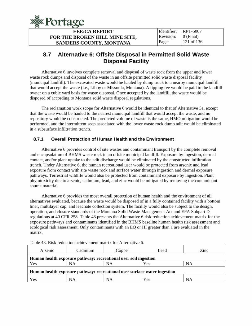
EEE/CA REPORT
FOR THE BROKEN HILL MINE SITE, SANDERS COUNTY, MONTANA
Identifier: Revision: Page:
RPT-5007 0 (Final) 121 of 136
8.7 Alternative 6: Offsite Disposal in Permitted Solid Waste Disposal Facility
Alternative 6 involves complete removal and disposal of waste rock from the upper and lower waste rock dumps and disposal of the waste in an offsite permitted solid waste disposal facility (municipal landfill). The excavated waste would be hauled by dump truck to a nearby municipal landfill that would accept the waste (i.e., Libby or Missoula, Montana). A tipping fee would be paid to the landfill owner on a cubic yard basis for waste disposal. Once accepted by the landfill, the waste would be disposed of according to Montana solid waste disposal regulations.
The reclamation work scope for Alternative 6 would be identical to that of Alternative 5a, except that the waste would be hauled to the nearest municipal landfill that would accept the waste, and no repository would be constructed. The predicted volume of waste is the same, HMO mitigation would be performed, and the intermittent seep associated with the lower waste rock dump adit would be eliminated in a subsurface infiltration trench.
8.7.1 Overall Protection of Human Health and the Environment
Alternative 6 provides control of site wastes and contaminant transport by the complete removal and encapsulation of BHMS waste rock in an offsite municipal landfill. Exposure by ingestion, dermal contact, and/or plant uptake to the adit discharge would be eliminated by the constructed infiltration trench. Under Alternative 6, the human recreational user would be protected from arsenic and lead exposure from contact with site waste rock and surface water through ingestion and dermal exposure pathways. Terrestrial wildlife would also be protected from contaminant exposure by ingestion. Plant phytotoxicity due to arsenic, cadmium, lead, and zinc would be mitigated by removing the contaminant source material.
Alternative 6 provides the most overall protection of human health and the environment of all alternatives evaluated, because the waste would be disposed of in a fully contained facility with a bottom liner, multilayer cap, and leachate collection system. The facility would also be subject to the design, operation, and closure standards of the Montana Solid Waste Management Act and EPA Subpart D regulations at 40 CFR 258. Table 43 presents the Alternative 6 risk reduction achievement matrix for the exposure pathways and contaminants identified in the BHMS baseline human health risk assessment and ecological risk assessment. Only contaminants with an EQ or HI greater than 1 are evaluated in the matrix.
Table 43. Risk reduction achievement matrix for Alternative 6.
Arsenic Cadmium Copper Lead Zinc
Human health exposure pathway: recreational user soil ingestion Yes NA NA Yes NA
Human health exposure pathway: recreational user surface water ingestion
Yes NA NA Yes NA

EEE/CA REPORT
FOR THE BROKEN HILL MINE SITE, SANDERS COUNTY, MONTANA
Identifier: Revision: Page:
RPT-5007 0 (Final) 122 of 136
Table 43. (continued)
Arsenic Cadmium Copper Lead Zinc
Ecological exposure pathway: deer ingestion
NA NA NA Yes NA
Ecological exposure pathway: aquatic life
NA Yes Yes Yes Yes
Ecological exposure pathway: plant phytotoxicity
None Yes NA Yes Yes None = No risk reduction achieved
Yes = Risk reduction achieved
NA = Not applicable, risk reduction not required
8.7.2 Compliance with ARARS
Implementation of Alternative 6 would meet all location and action-specific ARARs including:
Evaluation of culturally and historically significant site features has been performed by MDEQ and documented to satisfy the requirements of the NHPA, the Montana Antiquities Act, and other historic preservation laws; the USFS will be responsible for final cultural clearance of historic features located on USFS property
The alternative complies with the SMCRA requirements for revegetation and soil cover protection requirements
Consultation will be performed by MDEQ and documented to comply with the ESA, and administrative controls designed to be protective of threatened and endangered species are enforced by the USFS
OSHA requirements for appropriate training, certification, personal protective equipment, and site safety controls will be met by requiring the contractors to comply will all 29 CFR 1910.120 requirements during all construction phases at the BHMS.
Contaminant-specific ARARs are applicable to air quality, surface-water quality, and groundwater quality at the BHMS. State and federal numeric air quality standards would be met by controlling construction-generated dust. Under this alternative the adit discharge at the lower waste rock dump will be routed to an infiltration trench, effectively eliminating the surface water. This will eliminate the direct contamination exposure pathway for human recreational users and wildlife. As discussed in the no-action alternative, the status of contaminant-specific ARARs for groundwater is unknown, because groundwater was not characterized during the RI. It is believed that groundwater at the BHMS is found in fractures in the deep bedrock aquifer. Multiple test pits excavated to the bedrock surface at potential repository sites near the BHMS (Portage 2010a) showed no evidence of an alluvial groundwater system.
EEE/CA REPORT
FOR THE BROKEN HILL MINE SITE, SANDERS COUNTY, MONTANA
Identifier: Revision: Page:
RPT-5007 0 (Final) 123 of 136
8.7.3 Long-Term Effectiveness and Permanence
The long-term effectiveness and permanence of Alternative 6 would be ensured by the design, construction, operation, and closure standards of the Montana Solid Waste Management Act and EPA Subpart D regulations at 40 CFR 258 for municipal solid waste landfills. Reclaimed features at the BHMS would be revegetated, and once vegetative cover is established, minimal long-term site monitoring and maintenance will be required
8.7.4 Reduction of Toxicity, Mobility, or Volume through Treatment
Alternative 6 would achieve a major reduction in contaminant mobility by removing the source of contamination and by placing the waste in an offsite municipal landfill. The waste would no longer be susceptible to the mobilization of contaminants through the processes of surface water leaching; surface water erosion and contaminant transport; wind erosion and contaminant entrainment; and human disturbance. Waste volume would not be significantly reduced by this alternative, and no waste treatment would occur. The toxicity of the waste would not be affected, but the waste would be effectively isolated from the human environment.
8.7.5 Short-Term Effectiveness
Alternative 6 would be implemented in less than 1 year. Implementation steps would include final engineering and preparation of a construction bid package; construction bidding and contracting; construction; and performance monitoring. Construction would be accomplished in one summer/fall field season. Construction would utilize standard techniques with readily available human, equipment, and material resources.
Short-term environmental impacts from construction would include air-quality and surface-water impacts. These impacts would be effectively mitigated by using water spray for dust suppression during construction and by constructing BMPs for stormwater control. BMPs applicable to Alternative 6 include installing silt fencing; temporary ditch and sedimentation pond construction; utilizing straw bales; installing erosion control matting; construction of berms and other surface water run-on/run-off controls; minimizing reclamation slopes; and revegetation of disturbed areas.
The BHMS is located in a remote, low-population area, and implementation of Alternative 6 would involve a relatively small, short-duration construction project. Short-term impacts to the local population are expected to be contained to a slight increase in local vehicle traffic on public roadways and associated public safety impacts and a slight increase in local economic activity from providing goods and services to construction workers.
8.7.6 Implementability
Alternative 6 is both technically and administratively feasible. The construction methods used to remove the waste, transport the waste, and reclaim site disturbance are considered conventional. Design methods and specifications are well documented and have been implemented successfully at similar sites. Materials, equipment, and human resources are readily available to implement the alternative.

EEE/CA REPORT
FOR THE BROKEN HILL MINE SITE, SANDERS COUNTY, MONTANA
Identifier: Revision: Page:
RPT-5007 0 (Final) 124 of 136
8.7.7 Costs
The total present worth cost of implementing Alternative 6 is estimated to be $645,769. Table 44 presents the details of this estimate. The present worth value of 3 years of annual maintenance and monitoring costs are included in addition to capital costs. The major components of the work on which the costs are based are as follows:
Mobilization, bonding, and insurance
Load and haul waste to the offsite municipal landfill
Fill, shape, and regrade HMOs and waste rock excavation areas
Construct subsurface infiltration trench for adit discharge
Reseed and mulch final reclaimed areas
Annual inspection and maintenance (3 years).
Alternative 6 costs are the highest of all of the alternatives considered because of the long waste hauling distance and tipping fees at the municipal landfill.
Table 44. Alternative 6 costs.Activity/Material/Description Quantity Unit Unit Price ($) Cost($) Sum
Contractor Mobilization Costs $77,221 Mobilization, Including Bonding, Insurance, and General Administrative Costs
1 LS 38,840.28 38,840
Roads, Access, and Site Preparation $6,260 Stormwater/Sediment BMPs (Straw Bales or Silt Fence)
1 LS 500.00 500
Clearing and Grubbing Mine Waste Areas
2 AC 1,500.00 3,000
Road and Access Improvements at Mine Site
200 LF 8.00 1,600
General Earthwork (medium bulldozer or excavator)
8 HR 145.00 1,160
Excavation and Earthwork $3,580 Remove, Salvage, and Stockpile Topsoil (6 in. at mine site)
1,613 CY 1.50 2,420
General Earthwork (medium bulldozer or excavator)
8 HR 145.00 1,160
Waste Handling, Haul and Disposal $485,923 Excavate and Load Waste on 4,127 CY 1.50 6,191

EEE/CA REPORT
FOR THE BROKEN HILL MINE SITE, SANDERS COUNTY, MONTANA
Identifier: Revision: Page:
RPT-5007 0 (Final) 125 of 136
Table 44. (continued)
Activity/Material/Description Quantity Unit Unit Price ($) Cost($) Sum Haul Trucks Special Waste Handling: Timbers and Debris
1 LS 1,000.00 1,000
Haul Waste to Permitted Landfill
4,127 CY 81.00 334,287
Landfill Disposal Fee 4,127 CY 35.00 144,445 Site Reclamation $19,047
Replace and Grade Topsoil 1,613 CY 2.00 3,227 Seeding, Fertilizer, Mulch on All Disturbed Areas
2 AC 4,000.00 8,000
Infiltration Trench 1 LS 2,500.00 2,500 HMO Closures 1 LS 3,000.00 3,000 Final Earthwork and Grading (medium bulldozer or excavator)
16 HR 145.00 2,320
Subtotal of Capital Costs $592,031 Contingency 10% of subtotal capital cost $59,203 TOTAL CAPITAL COST $3651,234 PRSC Annual Cost $880
Administration and Inspection
1 LS 500.00 500
Signs and Site Security 1 LS 100.00 100 Weed Management 1 LS 200.00 200 Contingency 10% of 800.00 80
Present Value Analysis (2010 Dollars)
Time Before Start of Construction
1 Year
Annual Discount Rate 1.25% APR (Based on OMB Circular No. A-94, Appendix C)
Single Payment Present Worth Factor, (P/F, i, n)
0.9877
Annual PRSC Duration 3 Year Uniform Series Present Worth Factor, (P/A, i, n)
2.9265
Present Value of Capital Cost 643,194 Present Value of Annual Cost 2,575 TOTAL PRESENT VALUE COST
$645,769
AC = Acre CY = Cubic yard HR = Hour

EEE/CA REPORT
FOR THE BROKEN HILL MINE SITE, SANDERS COUNTY, MONTANA
Identifier: Revision: Page:
RPT-5007 0 (Final) 126 of 136
Table 44. (continued)
Activity/Material/Description Quantity Unit Unit Price ($) Cost($) Sum LF = Linear feet LS = Lump sum
9. COMPARATIVE ANALYSIS OF RECLAMATION ALTERNATIVES
The purpose of this section is to summarize the results of the detailed analysis of reclamation alternatives and to provide a direct comparison of the retained alternatives to the threshold and primary balancing criteria. The threshold criteria are (1) protectiveness of human health and the environment and (2) compliance with ARARs. The retained reclamation alternatives are:
Alternative 1 – no action
Alternative 5a – disposal in a constructed repository at Road Bench Site #1
Alternative 5b – disposal in a constructed repository at Road Bench Site #2
Alternative 5c – disposal in a constructed repository at Blue Creek Bench
Alternative 5d – disposal in a constructed repository at Fatman Saddle
Alternative 6 – offsite disposal at a permitted solid waste disposal facility.
Table 45 presents a summary of the alternatives with respect to the evaluation criteria.
9.1 Threshold Criteria
Alternative 1, the no-action alternative, would not be protective of human health and the environment nor would it achieve compliance with ARARs. The contaminant exposure pathways would remain and risks to human health, and ecological receptors would remain at unacceptable levels. Because there is no contaminant-specific ARARs applicable to the mine waste rock at the BHMS, the cleanup goal for site reclamation is of solid media is risk based. These risk-based goals would not be achieved under the no-action alternative.
Alternatives 5a through 5d, removal of waste rock and disposal of waste rock in a constructed repository on USFS lands, are almost identical in terms of the comparative analysis, since the primary difference between the alternatives is the location of the repository. Each of these alternatives is protective of human health and the environment, since they effectively isolate site waste rock from environmental receptors in an engineered repository with a multilayer low-permeability cap. The repository would have no bottom liner or leachate collection sump, but contaminant mobility would likely be completely eliminated, because the repository cap would prevent surface water infiltration through the waste rock and subsequent leaching of contaminants into the subsurface.

EEE/CA REPORT
FOR THE BROKEN HILL MINE SITE, SANDERS COUNTY, MONTANA
Identifier: Revision: Page:
RPT-5007 0 (Final) 127 of 136
Each of these alternatives is compliant with contaminant, location, and action-specific ARARs. Each alternative would protect human and ecological receptors from COCs in surface water associated with the lower waste rock dump adit seep. Each alternative is compliant with applicable historic preservation laws and regulations. The BHMS is located in a special management area for grizzly bears, a threatened species. During construction of an repository on USFS land alternative, compliance with management area administrative rules would be ensured through coordination with the USFS.
In the context of environmental protectiveness, Alternative 5d (the Blue Creek Bench Site) is the least desirable of these alternatives because of its proximity to a significant surface water feature (the East Fork of Blue Creek). The Blue Creek Bench site is also likely to be the one with the shallowest groundwater, because the site is located in the valley floor at the lowest elevation of the four sites considered. The distance to these environmental receptors makes the site less desirable than the others considered in the unlikely event that the repository integrity is degraded at some future time. Blue Creek Bench is also the potential repository site most easily accessed by recreational and other forest users, because motorized vehicle travel is permitted on the segment of FR 2290 adjacent to the Blue Creek Bench site. Motorized vehicle access to the other repository sites is restricted by the USFS.

EEE/CA REPORT FOR THE BROKEN HILL MINE SITE,
SANDERS COUNTY, MONTANA
Identifier: Revision: Page:
RPT-5007 0 (Final) 128 of 136
Table 45. Comparative analysis of reclamation alternatives.
Assessment Criteria Alternative 1. No Action Alternative 5a. Disposal at Road
Bench Site #1 Alternative 5b. Disposal at Road
Bench Site #2 Alternative 5c. Disposal at Blue
Creek Bench Site Alternative 5d. Disposal at Fatman
Saddle
Alternative 6. Offsite Disposal at Permitted Solid Waste Disposal
Facility
Threshold Criteria
Overall protection of human health
Not protective. No human health risk reduction
Protective. Achieves project reclamation objective and risk-based cleanup goals. Site access controlled by USFS
Protective. Achieves project reclamation objective and risk-based cleanup goals. Site access controlled by USFS
Protective. Achieves project reclamation objective and risk-based cleanup goals. Site easily accessed by public
Protective. Achieves project reclamation objective and risk-based cleanup goals. Site access controlled by USFS
Protective. Achieves project reclamation objective and risk-based cleanup goals. Most protective – waste isolated in fully contained facility
Overall protection of environment
Not protective. No ecological risk reduction
Protective. Achieves project reclamation objective and risk-based cleanup goals. Site isolated from groundwater and surface-water resources
Protective. Achieves project reclamation objective and risk-based cleanup goals. Site isolated from groundwater and surface-water resources
Protective. Achieves project reclamation objective and risk-based cleanup goals. Site is nearer groundwater and surface-water resources
Protective. Achieves project reclamation objective and risk-based cleanup goals
Protective. Achieves project reclamation objective and risk-based cleanup goals. Most protective – waste isolated in fully contained facility
Compliance with ARARs
Contaminant specific Does not comply with ARARs for surface water
Complies with ARARs for surface water
Complies with ARARs for surface water
Complies with ARARs for surface water
Complies with ARARs for surface water
Complies with ARARs for surface water
Location specific None apply Complies with applicable ARARs. Coordination with USFS to ensure compliance with administrative requirements within grizzly bear protection zone during construction
Complies with applicable ARARs. Coordination with USFS to ensure compliance with administrative requirements within grizzly bear protection zone during construction
Complies with applicable ARARs. Coordination with USFS to ensure compliance with administrative requirements within grizzly bear protection zone during construction
Complies with applicable ARARs. Coordination with USFS to ensure compliance with administrative requirements within grizzly bear protection zone during construction
Complies with applicable ARARs. Coordination with USFS to ensure compliance with administrative requirements within grizzly bear protection zone during construction
Action specific None apply Complies with applicable ARARs
Complies with applicable ARARs Complies with applicable ARARs
Complies with applicable ARARs Complies with applicable ARARs
Primary Balancing Criteria
Long-term effectiveness and permanence
Not effective. Exposure hazards, pathways, and transport mechanisms will continue to exist
Effective. High overall risk reduction. Site wastes will be reliably isolated from human and ecological receptors
Effective. High overall risk reduction. Site wastes will be reliably isolated from human and ecological receptors
Effective. High overall risk reduction. Site wastes will be reliably isolated from human and ecological receptors. Site most easily accessed and susceptible to human disturbance
Effective. High overall risk reduction. Site wastes will be reliably isolated from human and ecological receptors
Most effective. High overall risk reduction. Site wastes will be reliably isolated from human and ecological receptors in fully contained facility
Reduction of toxicity, mobility, and volume through treatment
No reduction of toxicity, mobility, and volume
No treatment. However, site waste will be consolidated and isolated from human and ecological receptors
No treatment. However, site waste will be consolidated and isolated from human and ecological receptors
No treatment. However, site waste will be consolidated and isolated from human and ecological receptors
No treatment. However, site waste will be consolidated and isolated from human and ecological receptors
No treatment. However, site waste will be consolidated and isolated from human and ecological receptors. Fully contained facility offers the most environmental isolation

EEE/CA REPORT FOR THE BROKEN HILL MINE SITE,
SANDERS COUNTY, MONTANA
Identifier: Revision: Page:
RPT-5007 0 (Final) 129 of 136
Table 45. (continued)
Assessment Criteria Alternative 1. No Action Alternative 5a. Disposal at Road
Bench Site #1 Alternative 5b. Disposal at Road
Bench Site #2 Alternative 5c. Disposal at Blue
Creek Bench Site Alternative 5d. Disposal at Fatman
Saddle
Alternative 6. Offsite Disposal at Permitted Solid Waste Disposal
Facility
Short-term effectiveness Not applicable Minimal impacts to community, environmental impacts from construction effectively mitigated by dust suppression and stormwater BMPs. Site workers to have appropriate training. Reclamation objective achieved in one construction season
Minimal impacts to community, environmental impacts from construction effectively mitigated by dust suppression and stormwater BMPs. Site nearest the BHMS; offers the minimum construction-related environmental impacts. Site workers to have appropriate training. Reclamation objective achieved in one construction season
Minimal impacts to community, environmental impacts from construction effectively mitigated by dust suppression and stormwater BMPs. Site workers to have appropriate training. Reclamation objective achieved in one construction season
Minimal impacts to community, environmental impacts from construction effectively mitigated by dust suppression and stormwater BMPs. Site farthest from the BHMS; results in the most construction-related environmental impacts. Site workers to have appropriate training. Reclamation objective achieved in one construction season
Minimal impacts to community, environmental impacts from construction effectively mitigated by dust suppression and stormwater BMPs. Site workers to have appropriate training. Highest increase in local truck traffic and associated hazards. Reclamation objective achieved in one construction season
Implementability Not applicable Implemented with standard construction techniques and equipment. Labor, equipment, and materials are readily and locally available.
Implemented with standard construction techniques and equipment. Labor, equipment, and materials are readily and locally available.
Implemented with standard construction techniques and equipment. Labor, equipment, and materials are readily and locally available.
Implemented with standard construction techniques and equipment. Labor, equipment, and materials are readily and locally available.
Implemented with standard construction techniques and equipment. Labor, equipment, and materials are readily and locally available.
Cost $0 $250,078 $245,507 $268,662 $303,520 $645,769
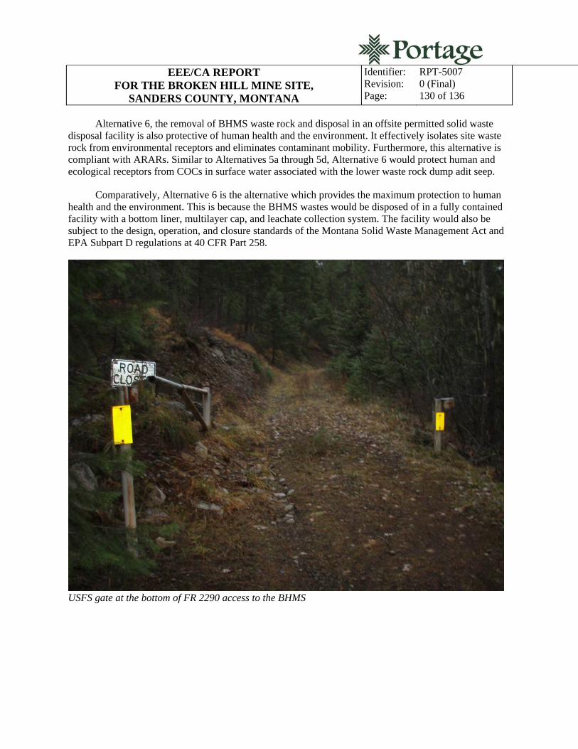
EEE/CA REPORT FOR THE BROKEN HILL MINE SITE,
SANDERS COUNTY, MONTANA
Identifier: Revision: Page:
RPT-5007 0 (Final) 130 of 136
Alternative 6, the removal of BHMS waste rock and disposal in an offsite permitted solid waste disposal facility is also protective of human health and the environment. It effectively isolates site waste rock from environmental receptors and eliminates contaminant mobility. Furthermore, this alternative is compliant with ARARs. Similar to Alternatives 5a through 5d, Alternative 6 would protect human and ecological receptors from COCs in surface water associated with the lower waste rock dump adit seep.
Comparatively, Alternative 6 is the alternative which provides the maximum protection to human health and the environment. This is because the BHMS wastes would be disposed of in a fully contained facility with a bottom liner, multilayer cap, and leachate collection system. The facility would also be subject to the design, operation, and closure standards of the Montana Solid Waste Management Act and EPA Subpart D regulations at 40 CFR Part 258.
USFS gate at the bottom of FR 2290 access to the BHMS

EEE/CA REPORT FOR THE BROKEN HILL MINE SITE,
SANDERS COUNTY, MONTANA
Identifier: Revision: Page:
RPT-5007 0 (Final) 131 of 136
9.2 Primary Balancing Criteria
Alternative 1, the no-action alternative, has no applicability to the primary balancing criteria because:
1. It has no long-term effectiveness or permanence
2. It does not achieve reduction of toxicity through mobility or reduction of volume through treatment
3. It has no short-term effectiveness
4. It would not be implemented
5. There would be no cost associated with it.
Alternatives 5a through 5d compare almost identically in terms of the primary balancing criteria with the exception of cost and minor differences in short-term effectiveness. Each has long-term effectiveness and permanence; achieves reduction of contaminant mobility; is effective short-term; and may be readily implemented with conventional construction techniques. The cost differential of implementing one of these alternatives is primarily driven by the cost of hauling waste rock from the BHMS to the repository. Because Road Bench Site #2 is the shortest haul distance, it is the least costly of the alternatives considered. Conversely, Fatman Saddle is the farthest haul distance, would require significant road improvements to implement, and would be the most costly to implement. Because Road Bench #2 is the shortest haul distance, it would also have the least amount of short-term environmental impact from construction-related fugitive dust and land disturbance. With the farthest haul distance, Fatman Saddle would have comparatively more short-term environmental impacts from construction-related fugitive dust and land disturbance. Worker safety can be ensured during construction for all alternatives through required training, dust suppression, protective clothing, and other appropriate site controls.
Alternative 6 is also effective long term; is permanent; achieves reduction of contaminant mobility; is effective short term; and may be readily implemented with conventional construction techniques. Alternative 6, however, is the most costly of all of the alternatives considered. The long haul and tipping fees at the municipal landfill elevate the costs of this alternative. Alternative 6 would also result in the highest increase in local truck traffic and associated hazards, because dump trucks would be hauling multiple loads of waste on local highways.
10. PREFFERED ALTERNATIVE
Reclamation of the BHMS will consist of complete removal and disposal of the two waste rock dumps; closing two HMOs; elimination of the intermittent surface water seep at the lower waste rock dump adit; site regrading and contouring; and site revegetation. These actions are designed to achieve the project reclamation objective of limiting human and ecological exposure to mine-related contaminants and reducing the mobility of those contaminants through associated solid media and surface water exposure pathways by:
Achieving risk-based cleanup goals for metals in site waste rock and surface water

EEE/CA REPORT FOR THE BROKEN HILL MINE SITE,
SANDERS COUNTY, MONTANA
Identifier: Revision: Page:
RPT-5007 0 (Final) 132 of 136
Eliminating the arsenic and lead ingestion and dermal contact contamination pathways to the recreational site user and wildlife through contact with site waste rock and surface water
Eliminating the contaminant transport pathways associated with site waste rock erosion and leaching and surface water transport.
Based on the detailed analysis of alternatives and on the conclusions of the comparative analysis of alternatives, each of the alternatives analyzed with the exception of the no-action alternative would achieve the project reclamation objective.
Alternative 6, offsite disposal in a permitted solid waste disposal facility, is the most protective of human health and the environment but only slightly more so than alternatives for disposal of waste in a constructed repository on USFS land. Alternative 6 however, is cost prohibitive in comparison to the other disposal alternatives. The long haul distance and tipping fees associated with waste disposal at a municipal landfill elevate the costs of Alternative 6.
Alternatives 5a through 5d, disposal in a constructed repository on USFS land, are protective of human health and the environment and are cost effective. The primary difference between these alternatives is the location of the repository on USFS lands. All of the potential repository sites are located on land entirely under the control of the USFS. Of these alternatives, Alternative 5b, disposal of waste in a constructed repository at Road Bench Site #2, is the lowest cost because of the short haul distance from the BHMS.
Road Bench Site #2 also offers environmental protection advantages over other sites analyzed. Because it offers the shortest haul distance from the BHMS, construction activities will generate less fugitive dust. Road Bench Site #2 is the highest elevation site and is potentially the most hydrologically isolated. The local topography of the site will allow for shaping the repository into the slope of the bench, creating a more naturally appearing landform. Road Bench Site #2 is also one of the least publicly accessible sites analyzed, because motor vehicle travel is limited to individuals authorized by the USFS.
Based on the comparative analysis summarized above, disposal of waste rock in a constructed repository at Road Bench Site #2 (Alternative 5b) is the preferred alternative for reclamation of the BHMS. This alternative is considered the most cost effective while providing an appropriate level of protection to human health and the environment. In summary, the BHMS reclamation work that would be performed under Alternative 5b includes complete removal of waste rock at the upper and lower waste rock dumps and disposal of the waste in a repository constructed at Road Bench Site #2; closure of two HMOs; routing the lower waste rock dump adit discharge to a constructed infiltration trench; site grading and contouring; and revegetation. The waste repository will consist of a below grade, balanced, cut-and-fill impoundment with a multilayer low-permeability cap and soil cover.

EEE/CA REPORT FOR THE BROKEN HILL MINE SITE,
SANDERS COUNTY, MONTANA
Identifier: Revision: Page:
RPT-5007 0 (Final) 133 of 136
11. REFERENCES
Amdur, M. O., J. Doull, and C. D. Klaassen, 1991, Casarett and Doull’s Toxicology: The Basic Science of Poisons, Fourth Edition, McGraw-Hill, Inc.: New York.
ATSDR, 1990, Toxicological Profile for Copper, U.S. Public Health Service, Agency for Toxic Substances and Disease Registry, Atlanta, Georgia.
ATSDR, 1993a, Toxicological Profile for Arsenic, U.S. Public Health Service, Agency for Toxic Substances and Disease Registry, Atlanta, Georgia.
ATSDR, 1993b, Toxicological Profile for Lead, U.S. Public Health Service, Agency for Toxic Substances and Disease Registry, Atlanta, Georgia.
Beyer, W. N., E. E. Connor, and S. Gerould, 1994, “Estimates of Soil Ingestion by Wildlife,” J. Wildlife Management, Volume 58 (Number 2): 375–382.
BLM, 2002, Natural Resource Injury Report on Riparian Areas of the Bureau of Land Management with the Clark Fork River Basin, Montana, Bureau of Land Management, based on reports prepared by the University of Montana and Montana State University under Cooperative Agreement 1200-99-007, Missoula, Montana, May 2002.
Camardese, M. B., D. J. Hoffman, L. J. LeCaptain, and G. W. Pendleton, 1990, “Effects of arsenate on growth and physiology in mallard ducks,” Environmental Toxicology and Chemistry, 9: 785-95.
CH2M Hill, 1987, “Assessment of the Toxicity of Arsenic, Cadmium, Lead and Zinc in Soil, Plants and Livestock in the Helena Valley of Montana,” prepared for the USEPA, Work Assignment No. 68-8L30.0.
Domingo, J. L., 1994, “Metal-induced developmental toxicity in mammals: a review,” Journal of Toxicology and Environmental Health, 42:123–141.
Eisler, R., 1985, Cadmium hazards to fish, wildlife, and invertebrates: a synoptic review, U.S. Fish and Wildlife Service Biological Report. 85 (1.2).
Eisler, R., 1988a, Arsenic hazards to fish, wildlife, and invertebrates: a synoptic review, U.S. Fish and Wildlife Service Biological Report 85 (1.12).
Eisler, R., 1988b, Lead hazards to fish, wildlife, and invertebrates: a synoptic review, U.S. Fish and Wildlife Service Biological Report 85 (1.14).
Eisler, R., 1993, Zinc hazards to fish, wildlife, and invertebrates: a synoptic review, U.S. Fish and Wildlife Service Biological Report 10.
EPA, 1976, Effects of exposure to heavy metals on selected fresh water fish: toxicity of copper, cadmium, chromium, and lead to eggs and fry of seven fish species, 600/3-76-105, U.S. Environmental

EEE/CA REPORT FOR THE BROKEN HILL MINE SITE,
SANDERS COUNTY, MONTANA
Identifier: Revision: Page:
RPT-5007 0 (Final) 134 of 136
Protection Agency, Office of Research and Development, Environmental Research Laboratory, Duluth, Minnesota.
EPA, 1981, Health assessment document for cadmium, EPA 60/8-81023, U.S. Environmental Protection Agency, Washington, D.C.
EPA, 1988, Guidance for Conduction Remedial Investigations and Feasibility Studies under CERCLA (Interim Final), U.S. Environmental Protection Agency, Office of Emergency and Remedial Response, Washington, D.C. EPA/540/1-89/001.
EPA, 1989a, Risk Assessment Guidance for Superfund, Volume I, Human Health Evaluation Manual (Interim Final), EPA/540/1-89/002, U.S. Environmental Protection Agency, Office of Emergency and Remedial Response, Washington D.C., December 1989.
EPA, 1989b, Risk Assessment Guidance for Superfund, Volume II, Environmental Evaluation Manual (Interim Final), EPA/540/1-89/01, U.S. Environmental Protection Agency, Office of Emergency and Remedial Response, Washington, D.C., March 1989.
EPA, 1992, Framework for Ecological Risk Assessment, Risk Assessment Forum, EPA/630/R-91/001, U.S. Environmental Protection Agency.
EPA, 1993, Wildlife Exposure Factors Handbook, Volumes 1 and 2, EPA/600/R-93/187a and b, U.S. Environmental Protection Agency, Washington, D.C.
EPA, 1994, Contract Laboratory Program National Functional Guidelines for Inorganic Data Review, EPA/540/R-94/013, U.S. Environmental Protection Agency, Office of Emergency and Remedial Response, Washington, D.C., February 1994.
EPA, 1997, Ecological Risk Assessment Guidance for Superfund: Process for Designing and Conducting Ecological Risk Assessment (Interim Final), EPA 540-R-97-006, .S. Environmental Protection Agency, June 1997.
EPA, 2010a, “Regional Screening Levels for Chemical Contaminants at Superfund Sites,” U.S. Environmental Protection Agency Region 9 Superfund Program, http://www.epa.gov/region09/waste/sfund/prg/index.html, Web page updated January 18, 2010, Web page visited January 18, 2010.
EPA, 2010b, “Region 5 Superfund Ecological Toxicity Information,” http://www.epa.gov/R5Super/ecology/html/toxprofiles.htm, U.S. Environmental Protection Agency, Region 5, Web page updated January 18, 2010, Web page visited January 18, 2010.
FHC, 2002, “Cultural Resource Inventory and Assessment for the Broken Hill Mine,” Frontier Historical Consultants, September 2002.
GWIC, 2008, “Well Log List in T8N, R6W, Section 15, with a 5-Mile Buffer,” Groundwater Information Center Resource Information System, http://maps2.nris.state.mt.us.

EEE/CA REPORT FOR THE BROKEN HILL MINE SITE,
SANDERS COUNTY, MONTANA
Identifier: Revision: Page:
RPT-5007 0 (Final) 135 of 136
Horne, M. T., and W. A. Dunson, 1995, “Effects of low pH, metals, and water hardness on larval amphibians,” Archives of Environmental Contamination and Toxicology, 29: 500–505.
Jamil, K., and S. Hussain, 1992, “Biotransfer of metals to the insect Neochetina eichhornae via aquatic plants,” Archives of Environmental Contamination and Toxicology, 22: 459–463.
Kabata-Pendias, A., and H. Pendias, 1992, Trace Elements in Soils and Plants, 2nd edition, Boca Raton: CRC Press, 365 p.
Long, E. R., and L. G. Morgan, 1991, The Potential for Biological Effects of Sediment-sorbed Contaminants Tested in the National Status and Trends Program, National Oceanic and Atmospheric Administration (NOAA) Technical Memorandum, NOS OMA 52, NOAA, Seattle, Washington.
Maita, K., et al., 1981, “Subacute Toxicity Studies with Zinc Sulfate in Mice and Rats,” Journal of Pesticide Science, 6: 327–336.
MBMG, 1963, “Mines and Mineral Deposits of Sanders County, Montana,” Bulletin 34, F.A. Crowley, Montana Bureau of Mines and Geology, May 1963.
MDEQ, 1996, “Risk-Based Cleanup Guidelines for Abandoned Mine Sites,” Montana Department of Environmental Quality, 1996.
MDEQ, 2005, “Action Level for Arsenic in Surface Soil, Montana Department of Environmental Quality Remediation Division,” http://www.deq.state.mt.us/StateSuperfund/PDFs/ArsenicPositionPaper.pdf, April 2005, Web page visited October 7, 2009.
MDEQ, 2010, “Montana Numeric Water Quality Standards,” Circular DEQ-7, Montana Department of Environmental Quality, August 2010.
MNHP, 2008, Montana Field Guide (http://fieldguide.mt.gov/) and TRACKER (http://nhp.nris.mt.gov/Tracker/NHTMap.aspx) Web pages, Montana Natural Heritage Program, Accessed from MNHP Web site: http://nhp.nris.mt.gov/.
Montana Agricultural Experiment Station and USDA, 1980, “Geologic Parent Materials of Montana Soils,” Bulletin 721, Montana Agricultural Experiment Station and U.S. Department of Agriculture, November 1980.
Montana Code 75-10-705 through 724, 1989, “Comprehensive Environmental Cleanup and Responsibility Act,” Montana Department of Environmental Quality, 1989.
Montana Department of State Lands, Abandoned Mine Reclamation Bureau, 1995, Montana Reclamation Plan, 1995 Plan Amendment.
NAS, 1980, Mineral tolerances of domestic animals, National Academy of Sciences, National Research Council, Washington, D. C.
EEE/CA REPORT FOR THE BROKEN HILL MINE SITE,
SANDERS COUNTY, MONTANA
Identifier: Revision: Page:
RPT-5007 0 (Final) 136 of 136
Owen, C. A, 1981, Copper deficiency and toxicity: acquired and inherited, in plants, animals, and man, New Jersey: Noyes Publications.
Pioneer, 1993, Montana Department of State Lands, Abandoned Mine Reclamation Bureau, Hazardous Materials Inventory, Pioneer Technical Services, Inc., September 1993.
Portage, 2009, Reclamation Work Plan for the Broken Hill Mine Site, Sanders County, Montana, PLN-5005, Portage, Inc., February 2009.
Portage, 2010a, Reclamation Investigation Report for the Broken Hill Mine Site, Sanders County, Montana, RPT-5002, Portage, Inc., January 2010.
Portage, 2010b, Repository Investigation Report for the Broken Hill Mine Site, Sanders County, Montana, RPT-5006, Portage, Inc., September 2010.
RTI, 2002, Past and Present Landownership/Mine Operators Investigation Phase I, Renewable Technologies, Inc., August 2002.
Sample, B. E., D. M. Opresko, and G. W. Suter II, 1996, Toxicological Benchmarks for Wildlife: 1996 Revision, ES/ER/TM-86/R3, Oak Ridge National Laboratory, Environmental Sciences Division, Oak Ridge, Tennessee.
Stanley, Jr., T. R., J. W. Spann, G. J. Smith, and R. Rosscoe, 1994, “Main and Interactive Effects of Arsenic and Selenium on Mallard Reproduction and Duckling Growth and Survival,” Archives of Environmental Contamination and Toxicology, 26: 444–51.
TetraTech, 1996, Risk-Based Cleanup Guidelines for Abandoned Mine Sites: Final Report, prepared for the Montana Department of Environmental Quality/Abandoned Site Reclamation Bureau, February 1996.
USGS, 1997, “Heron Quadrangle, Montana-Sanders County,” 7.5-minute series (topographic), U.S. Geologic Survey, 1997.
USCB, 2009, “2009 U.S. Census Estimate,” http://factfinder.census.gov/servlet/SAFFPopulation?_event=Search&_name=sanders&_state=04000US30&_county=sanders&_cityTown=sanders&_zip=&_sse=on&_lang=en&pctxt=fph, March 2011, Web site dated 2010, Web site visited March 14, 2010.
Vymazal, J., 1995, Algae and Element Cycling in Wetlands, Boca Raton: Lewis Publishers, 689 p.
Ware, G., 1983, Pesticides, Theory and Application, New York: W.H. Freeman, 308 p.
Whitworth, M. R., G. W. Pendleton, D. J. Hoffman, and M. B. Camardese, 1991, “Effects of dietary boron and arsenic on the behavior of mallard ducks,” Environmental Toxicology and Chemistry, 10: 911–16.

EEE/CA REPORT FOR THE BROKEN HILL MINE SITE,
SANDERS COUNTY, MONTANA
Identifier: Revision: Page:
RPT-5007 0 (Final) 137 of 136
WRCC, 2008, “Western Regional Climate Center,” http://www.wrcc.dri.edu, Web site dated 2008, Web site visited October, 7, 2009.

EEE/CA REPORT
FOR THE BROKEN HILL MINE SITE, SANDERS COUNTY, MONTANA
Identifier: Revision: Page:
RPT-5007 0 (Final) A-1
APPENDIX A DESCRIPTION OF FEDERAL AND STATE ARARs
(MDEQ 2010)

EEE/CA REPORT
FOR THE BROKEN HILL MINE SITE, SANDERS COUNTY, MONTANA
Identifier: Revision: Page: i
RPT-5007 0 (Final)
APPLICABLE OR RELEVANT AND APPROPRIATE REQUIREMENTS
(ARARS)
FOR
ABANDONED MINE LANDS RECLAMATION PROJECTS
EEE/CA REPORT
FOR THE BROKEN HILL MINE SITE, SANDERS COUNTY, MONTANA
Identifier: Revision: Page: ii
RPT-5007 0 (Final)
DECEMBER, 2010
Table of Contents SECTION PAGE 1.0 Introduction ....................................................................................................................... 1 2.0 Types of ARARs ................................................................................................................ 2 3.0 Contaminant-Specific ARARs ........................................................................................... 4 3.1 Federal .................................................................................................................. 4 3.1.1 Safe Drinking Water Act ............................................................................ 4 3.1.2 Clean Water Act......................................................................................... 5 3.1.3 National Ambient Air Quality Standards .................................................... 5 3.2 State ................................................................................................................... 5 3.2.1 Groundwater Protection ............................................................................. 5 3.2.2 Montana Water Quality Act ........................................................................ 7 3.2.3 Montana Ambient Air Quality Regulations ................................................. 8 4.0 Location-Specific ARARs .................................................................................................. 9 4.1 Federal .................................................................................................................. 9 4.1.1 National Historic Preservation Act ............................................................. 9 4.1.2 Archaeological and Historic Preservation Act ............................................ 9 4.1.3 Historic Sites Act of 1935 ........................................................................... 9 4.1.4 Protection and Enhancement of the Cultural Environment ........................ 9 4.1.5 The Archaeological Resources Protection Act of 1979 ............................. 9 4.1.6 American Indian Religious Freedom Act ................................................. 10 4.1.7 Native American Graves Protection and Repatriation Act ....................... 10 4.1.8 Fish and Wildlife Coordination Act ........................................................... 10 4.1.9 Endangered Species Act ......................................................................... 10 4.1.10 Floodplain Management Regulations ...................................................... 11 4.1.11 Protection of Wetlands Regulations ......................................................... 11 4.1.12 Clean Water Act....................................................................................... 11 4.1.13 Migratory Bird Treaty Act ......................................................................... 11 4.1.14 Bald Eagle Protection Act ........................................................................ 11 4.1.15 Resource Conservation and Recovery Act .............................................. 12 4.2 State 4.2.1 Montana Antiquities Act ........................................................................... 12 4.2.2 Montana Human Skeletal Remains and Burial Site Protection Act ......... 12 4.2.3 Montana Floodplain and Floodway Management Act .............................. 12 4.2.4 Montana Stream Protection Requirements .............................................. 15 4.2.5 Montana Solid Waste Management Act .................................................. 16 5.0 Action-Specific ARARs .................................................................................................... 18 5.1 Federal and State Water Protection Requirements ............................................. 18

EEE/CA REPORT
FOR THE BROKEN HILL MINE SITE, SANDERS COUNTY, MONTANA
Identifier: Revision: Page: iii
RPT-5007 0 (Final)
5.1.1 Clean Water Act....................................................................................... 18 5.1.2 Montana Pollutant Discharge Elimination System Requirements ............ 18 5.1.3 Montana Water Quality Act and Regulations ........................................... 19 5.1.4 Stormwater Runoff Control Requirements ............................................... 19 5.2 Federal and State RCRA Subtitle C Requirements ............................................. 20 5.3 Federal and State RCRA Subtitle D and Solid Waste Management Requirements ............................................................ 22 5.3.1 Federal Requirements ............................................................................. 22 5.3.2 State of Montana Solid Waste Requirements .......................................... 23 5.4 Federal and State Mine Reclamation Requirements ........................................... 24 5.4.1 Surface Mining Control and Reclamation Act .......................................... 24 5.4.2 Montana Statutory and Regulatory Requirements ................................... 25 5.5 Air Requirements ................................................................................................. 28 5.6 Noxious Weeds ................................................................................................... 29 6.0 To Be Considered (TBC) Documents ............................................................................. 30 7.0 Other Laws (Non-Exclusive List) ..................................................................................... 31 7.1 Other Federal Laws ............................................................................................. 31 7.2 Other State Laws ................................................................................................. 31

EEE/CA REPORT
FOR THE BROKEN HILL MINE SITE, SANDERS COUNTY, MONTANA
Identifier: Revision: Page: 1
RPT-5007 0 (Final)
ARARS FOR ABANDONED MINE LANDS RECLAMATION PROJECTS
1.0 INTRODUCTON- HISTORY OF ARARS AT ABANDONED MINE LANDS RECLAMATION SITES
After the enactment of the Federal Surface Mining Control and Reclamation Act in 1977 (“SMCRA”, 30 USC §§ 1201-1238), the State of Montana (State) was delegated the authority to implement the Abandoned Mine Lands Reclamation (“AMLR”) program and was granted funding for implementation of that program, by the Federal Office of Surface Mining, Reclamation, and Enforcement (“OSM”). The State enacted necessary legislation to implement the AMLR program according to State law and developed a plan (“Reclamation Plan”) to do so, which was approved by OSM. Delegation of exclusive authority for the program would follow. Montana passed necessary legislation for reclamation of coal mines (The Montana Strip and Underground Reclamation Act, 82-4-201, et seq., MCA), as well as legislation for reclamation of other types of mines (The Metal Mine Reclamation Act, 82-4-301, et seq., MCA and The Opencut Mining Act, 82-4-401, et seq., MCA). Satisfaction of the requirements of SMCRA by the State resulted in delegation by OSM to the State the exclusive authority to implement the Reclamation Plan on November 24, 1980. While the delegation of the program in 1980 was limited to abandoned coal mine reclamation, it was expanded by Montana’s showing it had reclaimed all eligible abandoned coal mines, whereupon OSM approved the 1995 amendments to the State’s Reclamation Plan to include non-coal abandoned mines. This approval resulted in additional delegation of authority to the State to implement reclamation of abandoned hardrock mines as well as quarries. In the 1995 Amendments to its Reclamation Plan, the State of Montana stated that the AMLR program would comply with the National Oil and Hazardous Substances Pollution Contingency Plan (“NCP”). 40 Code of Federal Regulations (CFR) Part 300 (1990). Among other things, the NCP provides a procedure for evaluating alternative cleanup methods for hazardous wastes. The NCP also establishes cleanup standards for hazardous wastes, referred to as Applicable or Relevant and Appropriate Requirements (“ARARs”). By requiring compliance with the NCP, the State adopted the NCP procedures for evaluation of alternatives in addressing AMLR Reclamation Projects, as well as ARARS. In addition, the evaluation of alternatives procedures found in the NCP satisfy the requirements of the National Environmental Policy Act (“NEPA”, 42 USC 4321 – 4370) to evaluate alternatives where actions undertaken could have a significant effect on the environment. AMLR, which is based upon SMCRA, is one of several legal authorities available in the State for cleanup of mine wastes, the others being the Federal Comprehensive Environmental Response, Compensation, and Liability Act (“CERCLA” or “Superfund”, 42 USC 9601 – 9675) and the State’s counterpart to the Federal Superfund law, the Comprehensive Environmental Cleanup and Responsibility Act (“CECRA,” §§ 75-10-701 - 752 MCA).

EEE/CA REPORT
FOR THE BROKEN HILL MINE SITE, SANDERS COUNTY, MONTANA
Identifier: Revision: Page: 2
RPT-5007 0 (Final)
The ARARs described below are, by necessity, generic because they are to be used as part of the evaluation process developed by the AMLR program for analysis of alternatives for AMLR Projects. This evaluation results in the Expanded Engineering Evaluation/Cost Analysis (“EEE/CA”) which precedes selection of a Reclamation alternative.
2.0 TYPES OF ARARS ARARs are either “applicable” or “relevant and appropriate.” Both types of requirements are mandatory under the NCP. Applicable requirements are those cleanup standards, standards of control, requirements, criteria, or limitations promulgated under federal or state environmental or facility siting laws that specifically address a hazardous substance, pollutant, or contaminant, remedial action, location or other circumstances found at a abandoned mine reclamation site. Relevant and appropriate requirements are those cleanup standards, standards of control, and other substantive requirements, criteria or limitations promulgated under federal environmental or state environmental or facility siting laws that, while not “applicable” to hazardous substances, pollutants, contaminants, remedial actions, locations, or other circumstances at a mining reclamation site, address problems or situations sufficiently similar to those found at the mining reclamations site that their use is well suited to the particular site. The determination that a requirement is relevant and appropriate is a two-step process: (1) determination if a requirement is relevant; and (2) determination if a requirement is appropriate. In general, this involves a comparison of a number of site-specific factors, including an examination of the purpose of the requirement and the purpose of the proposed CERCLA action; the medium and substances regulated by the requirement and the proposed requirement; the actions or activities regulated by the requirement and the remedial action; and the potential use of resources addressed in the requirement and the remedial action. When the analysis results in a determination that a requirement is both relevant and appropriate, such a requirement must be complied with to the same degree as if it were an applicable requirement. ARARs are divided into contaminant specific, location specific, or action specific requirements, as described in the NCP and EPA Guidance. Contaminant specific requirements address chemical or physical characteristics of compounds or substances on sites. These values establish acceptable amounts or concentrations of chemicals which may be found in or discharged to the ambient environment. Location specific requirements are restrictions placed upon the concentrations of hazardous substances or the conduct of cleanup activities because they are in specific locations. Location specific ARARs relate to the geographical or physical positions of sites, rather than to the nature of contaminants at sites. Action specific requirements are usually technology based or activity based requirements or limitations on actions taken with respect to hazardous substances, pollutants or contaminants. A given cleanup activity will trigger an action specific requirement. Such requirements do not themselves determine the cleanup alternative, but define how chosen cleanup methods should be performed.

EEE/CA REPORT
FOR THE BROKEN HILL MINE SITE, SANDERS COUNTY, MONTANA
Identifier: Revision: Page: 3
RPT-5007 0 (Final)
Each ARAR or group of related ARARs indentified herein is followed by a specific statutory or regulatory citation, a classification describing whether the ARAR is applicable or relevant and appropriate, and a description which summarizes the requirements. Many requirements listed as ARARs are promulgated as identical or nearly identical requirements in both federal and state law, usually pursuant to delegated environmental programs administered by both EPA and the states, such as many of the requirements of the federal Clean Water Act and the Montana Water Quality Act. The Preamble to the NCP states that such a situation results in citation to the state provision as the appropriate standard, but treatment of the provisions is a federal requirement. ARARs and other laws which are unique to state law are identified as state ARARs.
As noted previously, the 1995 Reclamation Plan provides that the NCP was adopted for Reclamation activities. Reclamation activities are directly analogous to “removal actions” under CERCLA. As stated in the NCP at 55 Federal Register (Fed. Reg.) 8695 (March 8, 1990):
The purpose of removal actions generally is to respond to a release…so as to prevent, minimize, or mitigate harm to human health and the environment. Although all removals must be protective…removals are distinct from remedial actions in that they may mitigate or stabilize the threat rather than comprehensively address all the threats at a site. Consequently, removal actions cannot be expected to attain all ARARs. Remedial actions, in contrast, must comply with all ARARs or obtain a waiver. (emphasis added).
Consequently, the NCP, at 40 CFR 300.410 provides that ARARS at removal actions:
…shall, to the extent practicable, considering the exigencies of the situation, attain…[ARARs]. In determining whether compliance with ARARs is practicable, the lead agency may consider appropriate factors, including:
a) the urgency of the situation; and b) the scope of the removal action to be conducted.
Therefore, based upon the NCP, after an ARAR has been identified for a Reclamation activity, the EEE/CA should evaluate how the alternatives will attain ARARs and select an alternative that complies with ARARs to the extent practicable. If an ARAR cannot be complied with, the EEE/CA should indicate why, utilizing the two part test set out above, attainment is not practicable.
3.0 CONTAMINANT-SPECIFIC ARARs 3.1 Federal

EEE/CA REPORT
FOR THE BROKEN HILL MINE SITE, SANDERS COUNTY, MONTANA
Identifier: Revision: Page: 4
RPT-5007 0 (Final)
3.1.1 Safe Drinking Water Act Safe Drinking Water Act, 42 U.S.C. ' 300f, et seq., National Primary and Secondary Drinking Water Regulations, 40 CFR Parts 141 and 142 (relevant and appropriate). The National Primary and Secondary Drinking Water Regulations (40 CFR Parts 141 and 143) establish maximum contaminant levels (MCL) for chemicals in drinking water distributed in public water systems. These are enforceable in Montana under the Public Water Supplies, Distribution, and Treatment Act and corresponding regulations, MCA ' 75-6-101, et seq., and ARM ' 17.38.203. Safe Drinking Water Act MCLs are relevant and appropriate for reclamation projects because the groundwater in a reclamation project area is a potential source of drinking water. The determination that the drinking water standards are relevant and appropriate for reclamation projects is supported by the regulations and guidance. The Preamble to the NCP clearly states that the MCLs are relevant and appropriate for ground or surface water that is a current or potential source of drinking water. See 55 Fed. Reg. 8750, March 8, 1990, and 40 CFR ' 300.430(e)(2)(I)(B). MCLs developed under the Safe Drinking Water Act generally are ARARs for current or potential drinking water sources. See EPA Guidance On Remedial Action For Contaminated Groundwater at Superfund Sites, OSWER Dir. #9283.1-2, December 1988. In addition, maximum contaminant level goals (MCLG) may also be relevant and appropriate. See 55 Fed. Reg. 8750-8752. MCLGs are health-based goals that are established at levels at which no known or anticipated adverse effects on the health of persons occur and which allow an adequate margin of safety. According to the NCP, MCLGs that are set at levels above zero must be attained for ground or surface waters that are current or potential sources of drinking water. Where the MCLG for a contaminant has been set at a level of zero, the MCL promulgated for that contaminant must be attained. The MCLs and MCLGs for contaminants of concern are:
Contaminant MCL (mg/L) MCLGa (mg/L) Antimony 0.006 0.006 Arsenic 0.01 NE Cadmium 0.005b 0.005b Copper 1.3c 1.3c Iron 0.3d NE Lead 0.015c 0 Manganese 0.05d NE Mercury 0.002b 0.002b Silver 0.10d NE Thallium 0.002b 0.0005 Zinc 5.0d NE
NE - Not Established

EEE/CA REPORT
FOR THE BROKEN HILL MINE SITE, SANDERS COUNTY, MONTANA
Identifier: Revision: Page: 5
RPT-5007 0 (Final)
a 40 CFR ' 141.51(b) b 40 CFR ' 141.62(c) c 40 CFR ' 141.80(c) B No MCL, but specifies BAT to be applied. d 40 CFR ' 143.3 B Secondary MCL
ARM 17.38.203 incorporates by reference into State law the MCLs for inorganic substances set forth in 40 CFR Part 141 (Primary Drinking Water Standards).
3.1.2 Clean Water Act Federal Surface Water Quality Requirements, Clean Water Act, 33 USC ' 1251, et seq. (applicable). As provided under Section 303 of the Clean Water Act, 33 U.S.C. ' 1313, the State of Montana has promulgated water quality standards. See the discussion concerning State surface water quality requirements. 3.1.3 National Ambient Air Quality Standards National Ambient Air Quality Standards, 40 CFR ' 50.6 (PM-10); 40 CFR ' 50.12 (lead) (applicable). These provisions establish standards for PM-10 and lead emissions to air. (Corresponding state standards are found at ARM ' 17.8.222 [lead] and ARM ' 17.8.223 [PM-10]. 3.2 State 3.2.1 Groundwater Protection Application of Groundwater Standards and Basis for Classificaitons, ARM 17.30.1005 (applicable). Explains the applicability and basis for the groundwater standards in ARM ' 17.30.1006, which establish the maximum allowable changes in groundwater quality and may limit discharges to groundwater. Classification, Beneficial Uses and Specific Standards for Groundwater, ARM 17.30.1006 (applicable). Provides that groundwater is classified into Classes I through IV based on its specific conductance and establishes the applicable groundwater quality standards with respect to each groundwater classification. Concentrations of dissolved substances in Class I or II groundwater may not exceed the human health standards listed in department Circular DEQ-7.3 These levels are listed below for the primary contaminants of concern.
3 Montana Department of Environmental Quality, Water Quality Division, Circular DEQ-7, Montana
Numeric Water Quality Standards (August 2010).

EEE/CA REPORT
FOR THE BROKEN HILL MINE SITE, SANDERS COUNTY, MONTANA
Identifier: Revision: Page: 6
RPT-5007 0 (Final)
Contaminant DEQ-7 Standard (µg/L)a
Antimony 6 Arsenic 10 Cadmium 5 Copper 1,300 Iron NEb Lead 15 Manganese NEb Mercury 2 Silver 100 Thallium 2 Zinc 2,000
NE- Not Established a DEQ-7 standards for metals and arsenic in ground water are based on the dissolved
portion of the sample (after filtration through a 0.45 m membrane filter). b Concentrations of iron and manganese must not reach values that interfere with the
uses specified in the surface and groundwater standards (ARM 17.30.601 et seq. and ARM 17.30.1001 et seq.). The secondary maximum contaminant levels of 300 g/L for iron and 50 g/L for manganesemay be considered guidance to determine levels that will interfere with the specified uses.
Reclamation activities must meet the DEQ-7 standards for all contaminants at a site. In addition, for Class I and Class II groundwater, no increase of a parameter may cause a violation of Section 75-5-303, MCA (nondegradation). ARM 17.30.1006 requires that concentrations of other dissolved or suspended substances must not exceed levels that render the waters harmful, detrimental or injurious to public health. Maximum allowable concentrations of these substances also must not exceed acute or chronic problem levels that would adversely affect existing or designated beneficial uses of groundwater of that classification. Nondegredation, ARM 17.30.1011 (applicable). Provides that any groundwater whose existing quality is higher than the standard for its classification must be maintained at that high quality in accordance with Section 75-5-303, MCA, and ARM Title 17, Chapter 30, Subchapter 7. An additional concern with respect to ARARs for groundwater is the impact of groundwater upon surface water. If significant loadings of contaminants from groundwater sources to any surface water within a Reclamation Project contribute to the inability of the stream to meet classification standards, then alternatives to alleviate such groundwater loading must be evaluated and, if appropriate, implemented. Groundwater in certain areas may have to be remediated to levels

EEE/CA REPORT
FOR THE BROKEN HILL MINE SITE, SANDERS COUNTY, MONTANA
Identifier: Revision: Page: 7
RPT-5007 0 (Final)
more stringent than the groundwater classification standards in order to achieve the standards for affected surface water. See Compliance with Federal Water Quality Criteria, OSWER Publication 9234.2-09/FS (June 1990) (AWhere the ground water flows naturally into the surface water, the ground-water remediation should be designed so that the receiving surface-water body will be able to meet any ambient water-quality standards [such as State WQSs or FWQC] that may be ARARs for the surface water.@) 3.2.2 Montana Water Quality Act State of Montana Surface Water Quality Requirements, Montana Water Quality Act, Section 75-5-101, et seq., MCA, and implementing regulations (applicable). The Clean Water Act, 33 U.S.C. ' 1251, et seq., provides the authority for each state to adopt water quality standards (40 CFR Part 131) designed to protect beneficial uses of each water body and requires each state to designate uses for each water body. The Montana Water Quality Act, 75-5-101, et seq., MCA, establishes requirements to protect, maintain and improve the quality of surface and groundwater. Montana's regulations classify State waters according to quality, place restrictions on the discharge of pollutants to State waters, and prohibit degradation of State waters. Pursuant to this authority and the criteria established by Montana surface water quality regulations, ARM ' 17.30.601, et seq., Montana has established the Water-Use Classification system. The classification for specific surface water bodies within the State are set for in ARM 17.30.607, et seq. The applicable standards for each classification are set forth in ARM 17.30.621 through ARM 17.30.629, inclusive. General Prohibitions, ARM 17.30.637 (applicable). Provides that surface waters must be free of substances attributable to industrial practices or other discharges that will: (a) settle to form objectionable sludge deposits or emulsions beneath the surface of the water or upon adjoining shorelines; (b) create floating debris, scum, a visible oil film (or be present in concentrations at or in excess of 10 milligrams per liter) or globules of grease or other floating materials; (c) produce odors, colors or other conditions which create a nuisance or render undesirable tastes to fish flesh or make fish inedible; (d) create concentrations or combinations of materials which are toxic or harmful to human, animal, plant or aquatic life; (e) create conditions which produce undesirable aquatic life. No waste may be discharged and no activities conducted which, either alone or in combination with other waste activities, will cause violation of surface water quality standards. Leaching pads, tailings ponds, or water or waste or product holding facilities must be located, constructed, operated and maintained in such a manner and of such materials to prevent any discharge, seepage, drainage, infiltration, or flow which may result in pollution of state waters, and a monitoring system may be required to ensure such compliance.

EEE/CA REPORT
FOR THE BROKEN HILL MINE SITE, SANDERS COUNTY, MONTANA
Identifier: Revision: Page: 8
RPT-5007 0 (Final)
Prohibited Activities, Section 75-5-605, MCA (applicable). Provides that it is unlawful to cause pollution of any state waters or to place or cause to be placed, any wastes where they will cause pollution of any state waters. Nondegredation Policy, Section 75-5-303, MCA (applicable). Provides that existing uses of state waters and the level of quality of state waters necessary to protect those uses must be maintained and protected. Nondegredation Policy – Applicability and Level of Protection, ARM 17.30.705 (applicable). For all state waters, existing and anticipated uses and water quality necessary to support those uses must be maintained and protected. 3.2.3 Montana Ambient Air Quality Regulations Montana Ambient Air Quality Regulations, ARM 17.8.206, -.220, -.221, -.222 and -.223 (applicable). The following provisions establish air quality standards:
Methods and Data, ARM 17.8.206 (applicable). Establishes sampling, data collection, and analytical requirements to ensure compliance with ambient air quality standards.
Settled Particulate Matter, ARM 17.8.220 (applicable). Settled particulate matter shall not exceed a thirty (30) day average of 10 grams per square meter. Visibility, ARM 17.8.221 (applicable). Concentrations of particulate matter in ambient air shall not exceed annual scattering coefficient particulate matter of 3 x 10⁻⁵ per meter. Lead, ARM 17.8.222 (applicable). Lead emissions to ambient air shall not exceed a ninety (90) day average of 1.5 micrograms per cubic meter of air.
PM-10, ARM 17.8.223 (applicable). PM-10 concentrations in ambient air shall not exceed a 24 hour average of 150 micrograms per cubic meter of air and an annual average of 50 micrograms per cubic meter of air.

EEE/CA REPORT
FOR THE BROKEN HILL MINE SITE, SANDERS COUNTY, MONTANA
Identifier: Revision: Page: 9
RPT-5007 0 (Final)
4.0 LOCATION-SPECIFIC ARARS
The statutes and regulations set forth below relate to solid waste, floodplains, floodways, streambeds, and the preservation of certain cultural, historic, natural or other national resources located in certain areas that may be adversely affected by Reclamation activities. 4.1 Federal 4.1.1 National Historic Preservation Act National Historic Preservation Act, 16 USC ' 470, 40 CFR ' 6.301(b), 36 CFR Part 63, Part 65, and Part 800 (NHPA) (applicable). This statute and implementing regulations require Federal agencies to take into account the effect of Reclamation activities upon any district, site, building, structure, or object that is included in or eligible for the Register of Historic Places. If the effect of Reclamation activities cannot be reasonably avoided, measures should be implemented to minimize or mitigate the potential effects of the activity. In addition, Indian cultural and historical resources must be evaluated and effects avoided, minimized or mitigated. 4.1.2 Archaeological and Historic Preservation Act Archaeological and Historic Preservation Act, 16 USC ' 469, 40 CFR 6.301(c) (applicable). This statute and implementing regulations establish requirements for the evaluation and preservation of historical and archaeological data, including Indian cultural and historic data, which may be destroyed through alteration of terrain as a result of a Federal program (such as AMLR). This requires the AMLR Program to survey the site for covered scientific, prehistoric or archaeological artifacts. If eligible scientific, prehistoric, or archeological data are encountered during Reclamation activities, they shall be preserved in accordance with these requirements. 4.1.3 Historic Sites Act of 1935 Historic Sites Act of 1935, 16 USC ' 461, et seq., 40 CFR 6.310(a) (applicable). This statute and implementing regulations require Reclamation activities to consider the existence and location of landmarks on the National Registry of National Landmarks and to avoid undesirable impacts on such landmarks. 4.1.4 Protection and Enhancement of the Cultural Environment Executive Order 11593 Protection and Enhancement of the Cultural Environment, 16 USC ' 470 (applicable). Directs federal agencies to institute procedures to ensure programs contribute to the preservation and enhancement of non-federally owned historic resources. Consultation with the Advisory Council on Historic Preservation is required if Reclamation activities should threaten cultural resources. 4.1.5 The Archaeological Resources Protection Act of 1979

EEE/CA REPORT
FOR THE BROKEN HILL MINE SITE, SANDERS COUNTY, MONTANA
Identifier: Revision: Page: 10
RPT-5007 0 (Final)
The Archaeological Resources Protection Act of 1979, 16 USC '' 470aa-47011 (relevant and appropriate). Requires a permit for any excavation or removal of archeological resources from public lands or Indian lands. Substantive portions of this act may be relevant and appropriate if archeological resources are encountered during Reclamation activities. 4.1.6 American Indian Religious Freedom Act American Indian Religious Freedom Act, 42 U.S.C. ' 1996, et seq. (applicable). This Act establishes a federal responsibility to protect and preserve the inherent right of American Indians to believe, express and exercise the traditional religions of American Indians. This right includes, but is not limited to, access to sites, use and possession of sacred objects, and the freedom to worship through ceremonials and traditional rites. The Act requires Reclamation activities to consider and protect Indian religious freedom by refraining from interfering with access, possession and use of religious objects, and by consulting with Indian organizations regarding proposed Reclamation activities affecting their religious freedom. 4.1.7 Native American Graves Protection and Repatriation Act Native American Graves Protection and Repatriation Act, 25 U.S.C. ' 3001, et seq. (applicable). The Act prioritizes ownership or control over Native American cultural items, including human remains, funerary objects and sacred objects, excavated or discovered on Federal or tribal lands. Federal agencies and museums that have possession or control over Native American human remains and associated funerary objects are required under the Act to compile an inventory of such items and, to the extent possible, identify their geographical and cultural affiliation. Once the cultural affiliation of such objects is established, the Federal agency or museum must expeditiously return such items, upon request by a lineal descendent of the individual Native American or tribe identified. 4.1.8 Fish and Wildlife Coordination Act Fish and Wildlife Coordination Act, 16 USC ' 661, 40 CFR 6.302 (applicable). This statute and implementing regulations require that Federal agencies or federally funded projects ensure that any modification of any stream or other water body affected by any action authorized or funded by the Federal agency provide for adequate protection of fish and wildlife resources. This ARAR requires consultation with the U.S. Fish and Wildlife Service and the Montana Department of Fish, Wildlife, and Parks. Further consultation will occur during Reclamation design and construction. 4.1.9 Endangered Species Act Endangered Species Act, 16 USC ' 1531, 50 CFR Parts 17 and 402 (applicable). This statute and implementing regulations provide that Reclamation activities not jeopardize the continued existence of any threatened or endangered species. This ARAR will be achieved

EEE/CA REPORT
FOR THE BROKEN HILL MINE SITE, SANDERS COUNTY, MONTANA
Identifier: Revision: Page: 11
RPT-5007 0 (Final)
through consultation with the U.S. Fish and Wildlife Service and the Montana Department of Fish, Wildlife and Parks during Reclamation design and construction activities. Specific avoidance or other mitigation measures identified shall be incorporated into the Reclamation design and implemented as part of construction. 4.1.10 Floodplain Management Regulations Floodplain Management Regulations, Executive Order No. 11988 and 40 CFR ' 6.302(b) (applicable). These require that actions be taken to avoid, to the extent possible, adverse effects associated with direct or indirect development of a floodplain, or to minimize adverse impacts if no practicable alternative exists. 4.1.11 Protection of Wetlands Regulations Protection of Wetlands Regulations, 40 CFR Part 6, Appendix A, and Executive Order No. 11990 (applicable). Steps will be taken to avoid or mitigate the adverse impacts associated with the destruction or loss of wetlands to the extent possible and avoidance of new construction in wetlands if a practicable alternative exists. Wetlands are defined as those areas that are inundated or saturated by groundwater or surface water at a frequency and duration sufficient to support, and that under normal circumstances do support, a prevalence of vegetation typically adapted for life in saturated soil conditions. Compliance with this ARAR will be achieved through consultation with the U.S. Fish and Wildlife Service and the U.S. Army Corps of Engineers, to determine the existence and category of wetlands present at the site, and any avoidance or mitigation and replacement which may be necessary. 4.1.12 Clean Water Act Section 404, Clean Water Act, 33 USC '' 1251 et seq., 33 CFR Part 330 (applicable). Regulates discharge of dredged or fill materials into waters of the United States. Substantive requirements of portions of Nationwide Permit No. 38 (General and Specific Conditions) are applicable to Reclamation activities conducted within waters of the United States within the Reclamation Project area. 4.1.13 Migratory Bird Treaty Act Migratory Bird Treaty Act, 16 USC ' 703, et seq. (applicable). This requirement establishes a federal responsibility for the protection of the international migratory bird resource and requires continued consultation with the USFWS during Reclamation design and construction to ensure that Reclamation activities at the site does not unnecessarily impact migratory birds. 4.1.14 Bald Eagle Protection Act

EEE/CA REPORT
FOR THE BROKEN HILL MINE SITE, SANDERS COUNTY, MONTANA
Identifier: Revision: Page: 12
RPT-5007 0 (Final)
Bald Eagle Protection Act, 16 USC ' 668, et seq. (applicable). This requirement establishes a federal responsibility for protection of bald and golden eagles, and requires continued consultation with the U.S. Fish and Wildlife Service during Reclamation design and construction to ensure that Reclamation activities at the site do not unnecessarily adversely affect bald and golden eagles.

EEE/CA REPORT
FOR THE BROKEN HILL MINE SITE, SANDERS COUNTY, MONTANA
Identifier: Revision: Page: 13
RPT-5007 0 (Final)
4.1.15 Resource Conservation and Recovery Act Resource Conservation and Recovery Act and regulations, 40 CFR ' 264.18 (a) and (b) (relevant and appropriate). These regulations provide seismic and floodplain restrictions on the location of a waste management unit. 4.2 State 4.2.1 Montana Antiquities Act Montana Antiquities Act, Section 22-3-421, et seq., MCA (relevant and appropriate). The Montana Antiquities Act addresses the responsibilities of State agencies regarding historic and prehistoric sites including buildings, structures, paleontological sites, archaeological sites on state owned lands. The Montana Antiquities Act requires avoidance or mitigation of impacts to heritage property or paleontological remains. Each State agency is responsible for establishing rules regarding historic resources under their jurisdiction which address National Register eligibility, appropriate permitting procedures and other historic preservation goals. The State Historic Preservation Office maintains information related to the responsibilities of State Agencies under the Antiquities Act. 4.2.2 Montana Human Skeletal Remains and Burial Site Protection Act Montana Human Skeletal Remains and Burial Site Protection Act (1991), Section 22-3-801, et seq. MCA (applicable). The Human Skeletal Remains and Burial Site Protection Act is the result of years of work by Montana Tribes, State agencies and organizations interested in ensuring that all graves within the State of Montana are adequately protected. The Human Skeletal Remains and Burial Site Protection Act prohibits purposefully or knowingly disturbing or destroying human skeletal remains or burial sites. If human skeletal remains or burial sites are encountered during Reclamation activities, then requirements will be applicable. 4.2.3 Montana Floodplain and Floodway Management Act Montana Floodplain and Floodway Management Act and Regulations, Section 76-5-101, et seq., MCA, ARM 36.15.601, et seq. (applicable). The Floodplain and Floodway Management Act and regulations specify types of uses and structures that are allowed or prohibited in the designated 100-year floodway4 and floodplain.5 If a Reclamation Project 4 The "floodway" is the channel of a watercourse or drainway and those portions of the floodplain
adjoining the channel that are reasonably required to carry and discharge the floodwater of the watercourse or drainway. ARM 36.15.101(13).
5 The "floodplain" is the area adjoining the watercourse or drainway which would be covered by the floodwater of a base (100-year) flood except for sheetflood areas that receive less than one foot of water per occurrence. The floodplain consists of the floodway and flood fringe. ARM 36.15.101(11).

EEE/CA REPORT
FOR THE BROKEN HILL MINE SITE, SANDERS COUNTY, MONTANA
Identifier: Revision: Page: 14
RPT-5007 0 (Final)
contains streams or creeks capable of flooding or may impact such areas, these standards are applicable to all Reclamation activities within these floodplains.
A. Prohibited uses. Uses prohibited anywhere in either the floodway or the floodplain are:
P solid and hazardous waste disposal; and P storage of toxic, flammable, hazardous, or explosive materials.
ARM 36.15.605(2) and 36.15.703 (Applicable); see also ARM 36.15.602(5)(b) (Applicable). These provisions effectively prohibit the placement of mine waste repositories within the 100-year floodplain and require mine wastes addressed by Reclamation activities to be removed from the floodplain.
In the floodway, additional prohibitions apply, including prohibition of:
P a building for living purposes or place of assembly or permanent use by
human beings;
P any structure or excavation that will cause water to be diverted from the established floodway, cause erosion, obstruct the natural flow of water, or reduce the carrying capacity of the floodway; and
P the construction or permanent storage of an object subject to flotation or
movement during flood level periods.
Section 76-5-403, MCA (applicable).
B. Applicable considerations in use of floodplain or floodway. Applicable regulations also specify factors that must be considered in allowing diversions of the stream, changes in place of diversion of the stream, flood control works, new construction or alteration of artificial obstructions, or any other nonconforming use within the floodplain or floodway. Many of these requirements are set forth as factors that must be considered in determining whether a permit can be issued for certain obstructions or uses. While permit requirements are not directly applicable to Reclamation activities conducted entirely on site, the substantive criteria used to determine whether a proposed obstruction or use is permissible within the floodway or floodplain are applicable standards. Factors which must be considered in addressing any obstruction or use within the floodway or floodplain include:
P the danger to life and property from backwater or diverted flow caused by
the obstruction or use;
P the danger that the obstruction or use will be swept downstream to the injury of others;
EEE/CA REPORT
FOR THE BROKEN HILL MINE SITE, SANDERS COUNTY, MONTANA
Identifier: Revision: Page: 15
RPT-5007 0 (Final)
P the availability of alternate locations; P the construction or alteration of the obstruction or use in such a manner as
to lessen the danger; P the permanence of the obstruction or use; and P the anticipated development in the foreseeable future of the area which may
be affected by the obstruction or use.
See Section 76-5-406, MCA; ARM 36.15.216 (applicable, substantive provisions only). Conditions or restrictions that generally apply to specific activities within the floodway or floodplain are:
P the proposed activity, construction, or use cannot increase the upstream
elevation of the 100-year flood a significant amount (2 foot or as otherwise determined by the permit issuing authority) or significantly increase flood velocities, ARM 36.15.604 (applicable, substantive provisions only); and
P the proposed activity, construction, or use must be designed and
constructed to minimize potential erosion and may not reduce the carrying capacity of the floodway. See ARM 36.15.605.
For the substantive conditions and restrictions applicable to specific obstructions or uses, see the following applicable regulations:
Excavation of material from pits or pools - ARM 36.15.602(1).
Water diversions or changes in place of diversion - ARM 36.15.603.
Flood control works (levees, floodwalls, and riprap must comply with specified safety
standards) - ARM 36.15.606.
Roads, streets, highways and rail lines (must be designed to minimize increases in flood heights) - ARM 36.15.701(3)(c).
Structures and facilities for liquid or solid waste treatment and disposal (must be
floodproofed to ensure that no pollutants enter flood waters and may be allowed and approved only in accordance with Montana Department of Environmental Quality (DEQ) regulations, which include certain additional prohibitions on such disposal) - ARM 36.15.701(3)(d).
Residential structures – ARM 36.15.702(1)

EEE/CA REPORT
FOR THE BROKEN HILL MINE SITE, SANDERS COUNTY, MONTANA
Identifier: Revision: Page: 16
RPT-5007 0 (Final)
Commercial or industrial structures – ARM 36.15.702(1). 4.2.4 Montana Stream Protection Requirements Montana Natural Streambed and Land Preservation Act of 1975 and Regulations, Section 75-7-101, et seq., MCA, and ARM 36.2.401, et seq., (applicable). Applicable if Reclamation activities alter or affect a streambed or its banks. The adverse effects of any such action must be minimized.
Standards and Guidelines, ARM 36.2.410 (applicable). Establishes minimum standards which would be applicable if Reclamation activities alter or affect a streambed, including any channel change, new diversion, riprap or other streambank protection project, jetty, new dam or reservoir or other commercial, industrial or residential development. Reclamation Projects must be designed and constructed using methods that minimize adverse impacts to the stream (both upstream and downstream) and future disturbances to the stream. All disturbed areas must be managed during construction and reclaimed after construction to minimize erosion. Temporary structures used during construction must be designed to handle high flows reasonably anticipated during the construction period. Temporary structures must be completely removed from the stream channel at the conclusion of construction, and the area must be restored to a natural or stable condition. Channel alterations must be designed to retain original stream length or otherwise provide hydrologic stability. Streambank vegetation must be protected except where removal of such vegetation is necessary for the completion of the Reclamation activities. When removal of vegetation is necessary, it must be kept to a minimum. Riprap, rock, and other material used in a project must be of adequate size, shape, and density and must be properly placed to protect the streambank from erosion. The placement of road fill material in a stream, the placement of debris or other materials in a stream where it can erode or float into the stream, reclamation activities that permanently prevent fish migration, operation of construction equipment in a stream, and excavation of streambed gravels are prohibited unless specifically authorized by the district. Reclamation activities must also protect the use of water for any useful or beneficial purpose. See Section 75-7-102, MCA.
Sections 87-5-502 and 504, MCA (applicable -- substantive provisions only). Provide that a state agency or subdivision shall not construct, modify, operate, maintain or fail to maintain any construction project or hydraulic project which may or will obstruct, damage, diminish, destroy, change, modify, or vary the natural existing shape and form of any stream or its banks or tributaries in a manner that will adversely affect any fish or game habitat.
While the administrative/ procedural requirements, including the consent and approval requirements set forth in these statutes and regulations are not ARARs, consultation with the Montana Department of Fish, Wildlife and Parks, and any conservation district or board of county commissioners (or consolidated city/county government) is
EEE/CA REPORT
FOR THE BROKEN HILL MINE SITE, SANDERS COUNTY, MONTANA
Identifier: Revision: Page: 17
RPT-5007 0 (Final)
encouraged during the design and implementation of Reclamation activities to assist in the evaluation of the factors discussed above.
4.2.5 Montana Solid Waste Management Act Montana Solid Waste Management Act and regulations, Section 75-10-201, et seq., MCA, ARM 17.50.101, et seq. (applicable) . Provides that solid waste management systems must protect the public health and safety and conserve natural resources wherever possible. These standards apply to any solid waste facility for the treatment, storage, or disposal of mine wastes, including, for example, any mine waste repository, tailing deposit, or waste rock pile that is actively managed as part of a response action.
Floodplains, ARM 17.50.1004 (applicable). A solid waste facility located within the 100-year floodplain may not restrict the flow of the 100-year flood, reduce the temporary water storage capacity of the floodplain, or result in washout of solid waste that poses a hazard to human health or the environment. See also ARM 17.50.1009(1)(h) (applicable).
Wetlands, ARM 17.50.1005 (applicable). A solid waste facility may not be located in a wetland, unless there is no demonstrable practicable alternative. Fault Areas, ARM 17.50.1006 (applicable). A solid waste facility cannot be located within 200 feet (60 meters) of a fault that has had displacement in Holocene time without demonstration that an alternative setback will prevent damage to the structural integrity of the solid waste facility and will be protective of human health and the environment. Seismic Areas, ARM 17.50.1007 (applicable). A solid waste facility may not be located in a seismic impact zone without demonstration, by a Montana licensed engineer, that the solid waste structure is designed to resist the maximum horizontal acceleration in lithified earth material for the site. Unstable Areas, ARM 17.50.1008 (applicable). A solid waste facility may not be located in an unstable area (determined by consideration of local soil conditions, local geographic or geomorphologic features, and local artificial features or events, both surface and subsurface) without demonstration, by a Montana licensed engineer, that the solid waste facility is designed to ensure that the integrity of the structural components will not be disrupted.
Location Restrictions, ARM 17.50.1009 (applicable). Sets forth general requirements applying to the location of any solid waste facility. Among other things, the location must have sufficient acreage, including adequate separation of wastes from underlying groundwater or adjacent surface water, must be located so as to prevent pollution of

EEE/CA REPORT
FOR THE BROKEN HILL MINE SITE, SANDERS COUNTY, MONTANA
Identifier: Revision: Page: 18
RPT-5007 0 (Final)
ground, surface, and private and public water supply systems, and must allow for reclamation of the land. Under ARM 17.50.1009, a facility for the treatment, storage or disposal of solid wastes:
1. must be located where a sufficient acreage of land is suitable for solid waste management, including adequate separation of wastes from underlying ground water or adjacent surface water;6
2. must be located where local roads are capable of providing access in all weather conditions and local bridges are capable of supporting vehicles with maximum rated loads;
3. must be located in a manner that does not allow the discharge of pollutants in
excess of state standards for the protection of state waters, public water supply systems, or private water supply systems;
4. drainage structures must be installed where necessary to prevent surface runoff
from entering waste management areas; and
5. must be located to allow for closure, post-closure, and planned uses of the land. Section 75-10-212, MCA (applicable). For solid wastes, prohibits dumping or leaving any debris or refuse upon or within 200 yards of any highway, road, street, or alley of the State or other public property, or on privately owned property where hunting, fishing, or other recreation is permitted.
4.2.6 Endangered Species and Wildlife Sections 87-5-106, 107 and 111, MCA (applicable). Endangered species should also be protected in order to maintain and to the extent possible, enhance their numbers. These Sections list endangered species, prohibited acts, and penalties. Section 87-5-201, MCA (applicable) concerns protection of wild birds, nests and eggs and under ARM 12.5.201 certain activities are prohibited with respect to specified endangered species.
6 The extent of separation shall be established on a case-by-case basis, considering terrain and the type of underlying soil formations, and facility design.
EEE/CA REPORT
FOR THE BROKEN HILL MINE SITE, SANDERS COUNTY, MONTANA
Identifier: Revision: Page: 19
RPT-5007 0 (Final)
5.0 ACTION-SPECIFIC ARARS 5.1 Federal and State Water Protection Requirements 5.1.1 Clean Water Act Clean Water Act, Point Source Discharges Requirements, 33 USC ' 1342 (applicable, substantive provisions only). Section 402 of the Clean Water Act, 33 USC ' 1342, et seq., authorizes the issuance of permits for the Adischarge@ of any Apollutant.@ This includes storm water discharges associated with Aindustrial activity.@ See, 40 CFR ' 122.1(b)(2)(iv). AIndustrial activity includes inactive mining operations that discharge storm water contaminated by contact with or that has come into contact with any overburden, raw material, intermediate products, finished products, byproducts or waste products located on the site of such operations, see, 40 CFR ' 122.26(b)(14)(iii); landfills, land application sites, and open dumps that receive or have received any industrial wastes including those subject to regulation under RCRA subtitle D, see, 40 CFR ' 122.26(b)(14)(v); and construction activity including clearing, grading, and excavation activities, see, 40 CFR ' 122.26(b)(14)(x). Because the State of Montana has been delegated the authority to implement the Clean Water Act, these requirements are enforced in Montana through the Montana Pollutant Discharge Elimination System (MPDES). The MPDES requirements are set forth below. 5.1.2 Montana Pollutant Discharge Elimination System Requirements
Substantive MPDES Permit Requirements, ARM 17.30.1342-1344 (applicable). These regulations set forth the substantive requirements applicable to all MPDES and National Pollutant Discharge Elimination System (NPDES) permits. The substantive requirements, including the requirement to properly operate and maintain all facilities and systems of treatment and control, are applicable requirements for a repository containing mine waste.
Technology-Based Treatment, ARM 17.30.1203 and 1344 (applicable). Provisions of 40 CFR Part 125 for criteria and standards for the imposition of technology-based treatment requirements are adopted and incorporated in MPDES permits. Although the permit requirement would not apply to on-site discharges, the substantive requirements of Part 125 are applicable, i.e., for toxic and nonconventional pollutants treatment must apply the best available technology economically achievable (BAT); for conventional pollutants, application of the best conventional pollutant control technology (BCT) is required. Where effluent limitations are not specified for the particular industry or industrial category at issue, BCT/BAT technology-based treatment requirements are determined on a case by case basis using best professional judgment (BPJ). See CERCLA Compliance with Other Laws Manual, Vol. I, August 1988, p. 3-4 and 3-7.
EEE/CA REPORT
FOR THE BROKEN HILL MINE SITE, SANDERS COUNTY, MONTANA
Identifier: Revision: Page: 20
RPT-5007 0 (Final)
5.1.3 Montana Water Quality Act and Regulations
Causing of Pollution, Section 75-5-605, MCA (applicable). This section of the Montana Water Quality Act prohibits causing pollution of any state waters. Pollution is defined as contamination or other alteration of physical, chemical, or biological properties of state waters which exceeds that permitted by the water quality standards or the discharge, seepage, or drainage of any substances into state water that will likely create a nuisance or render the water harmful, detrimental or injurious to public health, recreation, safety, or welfare, or to livestock or wild animals. Also, it is unlawful to place or caused to be placed any wastes where they will cause pollution of any state waters.
Nondegradation, Section 75-5-303, MCA (applicable). This provision states that existing uses of state waters and the level of water quality necessary to protect the uses must be maintained and protected. Section 75-5-317, MCA, provides an exemption from nondegradation requirements which allows changes of existing water quality resulting from an emergency or Reclamation that is designed to protect the public health or the environment and that is approved, authorized, or required by the department. Degradation meeting these requirements may be considered nonsignificant.
Surface Water, ARM 17.30.637 (applicable). Prohibits discharges containing substances that will: (a) settle to form objectionable sludge deposits or emulsions beneath the surface of the water or upon adjoining shorelines; (b) create floating debris, scum, a visible oil film (or be present in concentrations at or in excess of 10 milligrams per liter) or globules of grease or other floating materials; (c) produce odors, colors or other conditions which create a nuisance or render undesirable tastes to fish flesh or make fish inedible; (d) create concentrations or combinations of materials which are toxic or harmful to human, animal, plant or aquatic life; or (e) create conditions which produce undesirable aquatic life.
Nondegradation Policy – Application and Level of Protection, ARM 17.30.705 (applicable). This provides that for all state waters, existing and anticipated uses and the water quality necessary to protect these uses must be maintained and protected unless degradation is allowed under the nondegradation rules at ARM 17.30.708. Nondegradation, ARM 17.30.1011 (applicable). Provides that any groundwarer whose existing quality is higher than the standard for its classification mist be maintained at that high quality unless degradation may be allowed under the principles established in Section 75-5-303, MCA and the nondegradation rules at ARM 17.30.701, et seq.
5.1.4 Stormwater Runoff Control Requirements
Water Quality Performance Standards, ARM 17.24.633 (applicable). All surface drainage from a disturbed area must be treated by the best technology currently available (BTCA). Sediment control through BTCA must be maintained until the

EEE/CA REPORT
FOR THE BROKEN HILL MINE SITE, SANDERS COUNTY, MONTANA
Identifier: Revision: Page: 21
RPT-5007 0 (Final)
disturbed area has been reclaimed, the revegetation requirements have been met, and the area meets state and federal requirements for the receiving stream.
General Permits, ARM 17.30.1341 (applicable). DEQ issues general storm water permits for certain activities. The substantive requirements of the following permit is applicable for the following activity: for construction activities B General Permit for Storm Water Discharge Associated with Construction Activity, Permit No. MTR100000 (April 16, 2007). Generally, the permits require the permittee to implement best management practices (BMPs) and to take all reasonable steps to minimize or prevent any discharge which has a reasonable likelihood of adversely affecting human health or the environment. However, if there is evidence indicating potential or realized impacts on water quality due to any storm water discharge associated with the activity, an individual MPDES permit or alternative general permit may be required.
5.2 Federal and State RCRA Subtitle C Requirements
Federal and State RCRA Subtitle C Requirements, 42 U.S.C. Section 6921, et seq. (relevant and appropriate for solid wastes, applicable for hazardous wastes). The presentation of RCRA Subtitle C requirements in this section assumes that there will be solid wastes left in place in Awaste management areas@ (i.e., a repository) as a result of Reclamation activities. Because of the similarity of this waste management area to the RCRA Awaste management unit,@ certain discrete portions of the RCRA Subtitle C implementing regulations will be relevant and appropriate for Reclamation activities. RCRA Subtitle C and implementing regulations are designated as applicable for any hazardous wastes that are actively Agenerated@ as part of this Remedial activity or that were Aplaced@ or Adisposed@ after 1980. Also, should hazardous wastes be discovered as part of any Reclamation activity, RCRA Subtitle C requirements will be provided in more detail at a later date. All federal RCRA Subtitle C requirements set forth below are incorporated by reference as State of Montana requirements as provided for under ARM 17.53.105(2) unless mentioned otherwise below. 40 CFR Part 264 Subpart F, (relevant and appropriate). General Facility Standards. These are potentially relevant and appropriate for solid wastes at Reclamation sites. Any waste management unit or similar area would be required to comply with the following requirements.
40 CFR ' 264.92, .93. and .94( relevant and appropriate). Prescribes groundwater protection standards.
40 CFR ' 264.97 (relevant and appropriate). Prescribes general groundwater monitoring requirements.

EEE/CA REPORT
FOR THE BROKEN HILL MINE SITE, SANDERS COUNTY, MONTANA
Identifier: Revision: Page: 22
RPT-5007 0 (Final)
40 CFR ' 264.98 (relevant and appropriate). Prescribes requirements for monitoring and detecting indicator parameters.
Closure requirements. 40 CFR ' 264.111 (relevant and appropriate). Provides that the owner or operator of a hazardous waste management facility must close the facility in a way that minimizes the need for further maintenance, and controls or eliminates the leaching or escape of hazardous waste or its constituents, leachate, or runoff to the extent necessary to protect human health and the environment.
40 CFR ' 264.117 (relevant and appropriate). Incorporates monitoring requirements in Part 264, including those mentioned at Part 264.97 and Part 264.303. It governs the length of the post-closure care period, permits a lengthened security period, and prohibits any use of the property which would disturb the integrity of the management facility.
40 CFR ' 264.310(relevant and appropriate). Specifies requirements for caps, maintenance, and monitoring after closure.
40 CFR ' 264.301 (relevant and appropriate). Prescribes design and operating requirements for landfills. 40 CFR ' 264.301(a) (relevant and appropriate). Provides for a single liner and leachate collection and removal system.
40 CFR ' 264.301(f) (relevant and appropriate). Requires a run-on control system.
40 CFR ' 264.301(g) (relevant and appropriate). Requires a run-off management system.
40 CFR ' 264.301(h) (relevant and appropriate). Requires prudent management of facilities for collection and holding of run-on and run-off.
40 CFR ' 264.301(i) (relevant and appropriate). Requires that wind dispersal of particulate matter be controlled.
5.3 Federal and State RCRA Subtitle D and Solid Waste Management Requirements 40 CFR Part 257 establishes criteria under Subtitle D of the Resource Conservation and Recovery Act for use in determining which solid waste disposal facilities and practices pose a reasonable probability of adverse effects on health or the environment. See 40 CFR ' 257.1(a). This part comes into play whenever there is a Adisposal@ of any solid or hazardous waste from
EEE/CA REPORT
FOR THE BROKEN HILL MINE SITE, SANDERS COUNTY, MONTANA
Identifier: Revision: Page: 23
RPT-5007 0 (Final)
a Afacility.@ ADisposal@ is defined as Athe discharge, deposit, injection, dumping, spilling, leaking, or placing of any solid waste or hazardous waste into or on any land or water so that such solid waste or hazardous waste or any constituent thereof may enter the environment or be emitted into the air or discharged into any waters, including ground waters.@ See 40 CFR ' 257.2. AFacility@ means Aany land and appurtenances thereto used for the disposal of solid wastes.@ Solid waste requirements are either applicable to mine wastes as solid waste or are relevant and appropriate for the management, handling, storage, monitoring and disposal of the mine wastes to be addressed in a Reclamation Project. 5.3.1. Federal Requirements
40 CFR ' 257 (applicable). Establishes Criteria for Classification of Solid Waste Disposal Facilities and Practices. Reclamation activities must comply with the following requirements:
40 CFR ' 257.3-1 (applicable).. Washout of solid waste in solid waste facilities in a floodplain posing a hazard to human life, wildlife, or land or water resources shall not occur.
40 CFR ' 257.3-2 (applicable).. Solid waste facilities shall not contribute to the taking of endangered species or the endangering of critical habitat of endangered species.
40 CFR ' 257.3-3 (applicable). A solid waste facility shall not cause a discharge of pollutants, dredged or fill material, into waters of the United States in violation of Sections 402 and 404 of the Clean Water Act, as amended, and shall not cause non-point source pollution, in violation of applicable legal requirements implementing an area wide or statewide water quality management plan that has been approved by the Administrator under Section 208 of the Clean Water Act, as amended.
40 CFR ' 257.3-4 (applicable). A solid waste facility shall not contaminate an underground source of drinking water beyond the solid waste boundary or beyond an alternative boundary specified in accordance with this section.
40 CFR ' 257.3-8(d) (applicable). Access to a solid waste facility shall be controlled so as to prevent exposure of the public to potential health and safety hazards at the site.
5.3.2. State of Montana Solid Waste Requirements. The Montana Solid Waste Management Act, Section 75-10-201 et seq., MCA, and regulations (applicable). Control the management and disposal of all solid wastes, including mine wastes at sites that are not currently subject to operating permit requirements.

EEE/CA REPORT
FOR THE BROKEN HILL MINE SITE, SANDERS COUNTY, MONTANA
Identifier: Revision: Page: 24
RPT-5007 0 (Final)
Transportation, ARM 17.50.523 (applicable). Specifies that solid waste must be transported in such a manner as to prevent its discharge, dumping, spilling or leaking from the transport vehicle. Location Restrictions, ARM 17.50.1009(1)(c) (applicable). Requires that solid waste facilities not discharge pollutants in excess of state standards. A solid waste facility must contain a leachate collection system unless there is no potential for migration of a constituent in Appendix I or II to 40 CFR 258.
Design Requirements, ARM 17.50.1204 (applicable). Solid waste facilities must either be designed to ensure that MCLs are not exceeded or the solid waste facility must contain a composite liner and leachate collection system that complies with specified criteria. Access Requirements, ARM 17.50.1108 (applicable). Requires that the owner or operator of a solid waste facility use barriers to control public access. Run-On and Run-Off Control Systems, ARM 17.50.1109 (applicable). Requires that owners or operators of solid waste facilities design, construct and maintain a run-on control system to prevent flow onto the active portion of the solid waste facility during the peak discharge from a 25-year storm and a run-off control system from the active portion of the solid waste facility to collect and control at least the water volume result from a 24-hour, 25-year storm. Surface Water Requirements, ARM 17.50.1110 (applicable). Prohibits any discharge of a pollutant from a solid waste facility to state waters, including wetlands, that violates any requirement of the Montana Water Quality Act. Prohibits any discharge from a solid waste facility of a nonpoint source of pollution to waters of the United States, including wetlands, that violates any requirement of an area-wide or statewide water quality management plan approved under the Federal Clean Water Act. Liquid Restrictions, ARM 17.50.1111 (applicable). Prohibits placement of bulk or noncharacterized waste into a solid waste facility, unless the waste is household waste other than septic liquid waste or leachate derived from and placed back into a facility with a composite liner and leachate collection and removal system. Operating Criteria, ARM 17.50.1116, (applicable). Sets forth requirements for operation of a solid waste facility, including: that solid waste facilities be created and maintained with supervision, fencing and signage; that owners or operators of solid waste facilities take effective measures to control litter and prevent the public from salvaging materials at the facility; and that the facility be designed to control litter, insects, rodents, odor, residues, waste water and air pollutants.
Closure Criteria, ARM 17.50.1403 (applicable). Sets forth closure requirements for solid waste facilities. Solid waste facilities must meet the following criteria: (1) install a

EEE/CA REPORT
FOR THE BROKEN HILL MINE SITE, SANDERS COUNTY, MONTANA
Identifier: Revision: Page: 25
RPT-5007 0 (Final)
final cover that is designed to minimize infiltration and erosion; (2) design and construct the final cover system to minimize infiltration through the closed unit by the use of an infiltration layer that contains a minimum 18 inches of earthen material and has a permeability less than or equal to the permeability of any bottom liner, barrier layer, or natural subsoils or a permeability no greater than 1 X 10⁻⁵ cm/sec, whichever is less; and (3) minimize erosion of the final cover by the use of a seed bed layer that contains a minimum of six inches of earthen material that is capable of sustaining native plant growth.
Post-Closure Criteria, ARM 17.50.1404 (applicable). Sets forth post-closure care requirements for solid waste facilities. Post-closure care must be conducted for a period sufficient to protect human health and the environment. Post-closure care requires maintenance of the integrity and effectiveness of any final cover, including making repairs to the cover as necessary to correct the effects of settlement, subsidence, erosion, or other events, and preventing run-on and run-off from eroding or otherwise damaging the cover and comply with the groundwater monitoring requirements found at ARM Title 17, chapter 50, subchapter 7.
Section 75-10-206, MCA,(applicable). Allows variances to be granted from solid waste regulations if failure to comply with the rules does not result in a danger to public health or safety or compliance with specific rules would produce hardship without producing benefits to the health and safety of the public that outweigh the hardship.
5.4 Federal and State Mine Reclamation Requirements 5.4.1 Surface Mining Control and Reclamation Act Surface Mining Control and Reclamation Act, 30 USC '' 1201-1326 (relevant and appropriate). This Act and implementing regulations found at 30 CFR Parts 784 and 816 establish provisions designed to protect the environment from the effects of surface coal mining operations, and to a lesser extent non-coal mining. These requirements are relevant and appropriate to the covering of discrete areas of contamination. The regulations require that revegetation be used to stabilize soil covers over reclaimed areas. They also require that revegetation be done according to a plan which specifies schedules, species which are diverse and effective, planting methods, mulching techniques, irrigation if appropriate, and appropriate soil testing. Reclamation performance standards are currently relevant and appropriate to mining waste sites. 5.4.2 Montana Statutory and Regulatory Requirements Montana Strip and Underground Mine Reclamation Act, Section 82-4-201, et seq., MCA (relevant and appropriate) and Montana Metal Mining Act, Section 82-4-301, et seq., MCA (relevant and appropriate). The specified portions of the following statutory or regulatory provisions, as identified below, are relevant and appropriate requirements.

EEE/CA REPORT
FOR THE BROKEN HILL MINE SITE, SANDERS COUNTY, MONTANA
Identifier: Revision: Page: 26
RPT-5007 0 (Final)
Section 82-4-231, MCA (relevant and appropriate). Requires operators to reclaim and revegetate affected lands using most modern technology available. Operators must grade, backfill, topsoil, reduce high walls, stabilize subsidence, control water, minimize erosion, subsidence, land slides, and water pollution.
Section 82-4-233, MCA (relevant and appropriate). Operators must plant vegetation that will yield a diverse, effective, and permanent vegetative cover of the same seasonal variety native to the area and capable of self-regeneration.
Section 82-4-336, MCA (relevant and appropriate). Disturbed areas must be reclaimed to utility and stability comparable to adjacent areas.
General Backfilling and Grading Requirements, ARM 17.24.501 (relevant and appropriate). Provides general backfilling and grading requirements. Backfill must be placed so as to minimize sedimentation, erosion, and leaching of acid or toxic materials into waters, unless otherwise approved. Final grading must be to the approximate original contour of the land.
Monitoring for Settlement, ARM 17.24.519 (relevant and appropriate). Requires monitoring of settling of regraded areas.
General Hydrology Requirements, ARM 17.24.631(1), (2), (3)(a) and (b) (relevant and appropriate). Requires minimization of disturbances to the prevailing hydrologic balance. Changes in water quality and quantity, in the depth to groundwater and in the location of surface water drainage channels should be minimized. Other pollution minimization devices must be used if appropriate, including stabilizing disturbed areas through land shaping, diverting runoff, planting quickly germinating and growing stands of temporary vegetation, regulating channel velocity of water, lining drainage channels with rock or vegetation, mulching, and control of acid-forming, and toxic-forming waste materials.
Water Quality Performance Standards, ARM 17.24.633 (relevant and appropriate). Surface drainage from a disturbed area must be treated by the best technology currently available (BTCA). Treatment must continue until the area is stabilized.
Reclamation of Drainage Basins, ARM 17.24.634 (relevant and appropriate). Requires disturbed drainages be restored to the approximate pre-disturbance configuration. Drainage design must emphasize channel and floodplain dimensions that approximate the pre-mining configuration and that will blend with the undisturbed drainage above and below the area to be reclaimed. The average stream gradient must be maintained with a concave longitudinal profile. This regulation provides specific requirements for designing the reclaimed drainage to: (1) approximate an appropriate geomorphic habit or characteristic pattern; (2) remain in dynamic equilibrium with the system without the use of artificial structural controls; (3) improve unstable premining

EEE/CA REPORT
FOR THE BROKEN HILL MINE SITE, SANDERS COUNTY, MONTANA
Identifier: Revision: Page: 27
RPT-5007 0 (Final)
conditions; (4) provide for floods and for the long-term stability of the landscape; and (5) establish a premining diversity of aquatic habitats and riparian vegetation.
Diversions, ARM 17.24.635 through 17.24.637 (relevant and appropriate). Set forth requirements for temporary and permanent diversions.
Sediment Control Measures, ARM 17.24.638 (relevant and appropriate). Sediment control measures must be implemented during operations.
Sedimentation Ponds and other Treatment Facilities, ARM 17.24.639 (relevant and appropriate). Sets forth requirements for construction and maintenance of sedimentation ponds, including that sedimentation ponds be located as near as possible to the disturbed area and out of any major stream courses.
Discharge Structures, ARM 17.24.640 (relevant and appropriate). Requires discharges from sedimentation ponds, permanent and temporary impoundments, and diversions be controlled to reduce erosion, deepening, or enlargement of stream channels, and to minimize disturbance of the hydrologic balance.
Acid- and Toxic-Forming Spoils, ARM 17.24.641 (relevant and appropriate). Requires drainage from acid- and toxic-forming spoil into ground and surface water be avoided and establishes practices to avoid such drainage.
Groundwater, ARM 17.24.643 through 17.24.646 (relevant and appropriate). Sets forth provisions for groundwater protection, groundwater recharge protection, and groundwater and surface water monitoring.
Soil, ARM 17.24.701 and 17.24.702 (relevant and appropriate). Sets forth requirements for redistributing and stockpiling of soil for reclamation. Also, outlines practices to prevent compaction, slippage, erosion, and deterioration of biological properties of soil.
Substitute Materials, ARM 17.24.703 (relevant and appropriate). When using materials other than, or along with, soil for final surfacing in reclamation, the operator must demonstrate that the material (1) is at least as capable as the soil of supporting the approved vegetation and subsequent land use, and (2) the medium must be the best available in the area to support vegetation. Such substitutes must be used in a manner consistent with the requirements for redistribution of soil in ARM 17.24.701 and 17.24.702.
Establishment of Vegetation, ARM 17.24.711 (relevant and appropriate). Requires that a diverse, effective, and permanent vegetative cover of the same seasonal variety native to the area of land to be affected shall be established except on road surfaces and below the low-water line of permanent impoundments. See also Section 82-4-233,

EEE/CA REPORT
FOR THE BROKEN HILL MINE SITE, SANDERS COUNTY, MONTANA
Identifier: Revision: Page: 28
RPT-5007 0 (Final)
MCA (relevant and appropriate). Vegetative cover is considered of the same seasonal variety if it consists of a mixture of species of equal or superior utility when compared with the natural vegetation during each season of the year. This requirement may not be appropriate where other cover is more suitable for the particular land use or another cover is requested by the landowner.
Timing of Seeding and Planting, ARM 17.24.713 (relevant and appropriate). Requires seeding and planting of disturbed areas must be conducted during the first appropriate period favorable for planting after final seedbed preparation.
Soil Stabilizing Practices, ARM 17.24.714 (relevant and appropriate). Requires mulch or cover crop or both must be used until adequate permanent cover can be established.
Method of Revegetation, ARM 17.24.716 (relevant and appropriate). Requires revegetation be carried out in a manner that encourages prompt vegetation establishment, such as by drill or broadcast seeding, by seedling transplants or by established sod plugs, and in a manner that avoids the establishment of noxious weeds. Seeding must be done on the contour, wherever possible. Seed mixes should be frtee of weedy or other undesirable species. Noxious weeds mist be controlled in accordance with the Noxious Weed Management Act, 7-22-2101, et seq.,MCA.
Planting of Trees and Shrubs, ARM 17.24.717 (relevant and appropriate). Relates to the planting of trees and other woody species if necessary, as provided in Section 82-4-233, MCA, to establish a diverse, effective, and permanent vegetative cover of the same seasonal variety native to the affected area and capable of self-regeneration and plant succession at least equal to the natural vegetation of the area, except that introduced species may be used in the revegetation process where desirable and necessary to achieve the approved land use plan.
Soil Amendments, ARM 17.24.718 (relevant and appropriate). Requires soil amendments, irrigation, management, fencing, or other measures, if necessary to establish a diverse and permanent vegetative cover.
Eradication of Rills and Gullies, ARM 17.24.721 (relevant and appropriate). Specifies that rills or gullies in reclaimed areas must be filled, graded or otherwise stabilized and the area reseeded or replanted if the rills and gullies are disrupting the reestablishment of the vegetative cover or causing or contributing to a violation of water quality standards for a receiving stream. Monitoring, ARM 17.24.723 (relevant and appropriate). Requires operators conduct approved periodic measurements of vegetation, soils, water, and wildlife, and if data indicate that corrective measures are necessary, propose and implement such measures.

EEE/CA REPORT
FOR THE BROKEN HILL MINE SITE, SANDERS COUNTY, MONTANA
Identifier: Revision: Page: 29
RPT-5007 0 (Final)
Revegetation Success Criteria, ARM 17.24.724 (relevant and appropriate). Specifies that revegetation success must be measured against approved technical standards or unmined reference areas. Reference areas and standards must be representative of vegetation and related site characteristics occurring on lands exhibiting good ecological integrity. Sets forth required management for reference areas.
Vegetation Measurements, ARM 17.24.726 (relevant and appropriate). Requires standard and consistent field and laboratory methods to obtain and evaluate revegetated area data with reference area data and/or technical standards and sets forth the required methods for measuring productivity.
Analysis for Toxicity, ARM 17.24.731 (relevant and appropriate). If toxicity to plants or animals on the revegetated area or the reference area is suspected due to the effects of the disturbance, comparative chemical analyses may be required.
Protection and Enhancement of Fish and Wildlife, ARM 17.24.751 (relevant and appropriate). Sets forth requirements to protect and enhance fish and wildlife habitat.
EEE/CA REPORT
FOR THE BROKEN HILL MINE SITE, SANDERS COUNTY, MONTANA
Identifier: Revision: Page: 30
RPT-5007 0 (Final)
5.5 Air Requirements Reclamation activities will comply with the Montana Ambient Air Quality Regulations (above) and with the following requirements to ensure that existing air quality will not be adversely affected:
Airborne Particulate Matter, ARM 17.8.308(1), (2) and (3) (applicable). There shall be no production, handling, transportation, or storage of any material, use of any street, road, or parking lot, or operation of a construction site or demolition project unless reasonable precautions are taken to control emissions of airborne particles. Emissions shall not exhibit an opacity exceeding 20% or greater averaged over 6 consecutive minutes.
Visible Air Contaminants, ARM 17.8.304(2) (applicable). Emissions into the outdoor atmosphere shall not exhibit an opacity of 20% or greater averaged over 6 consecutive minutes.
Materials Prohibited from Open Burning, ARM 17.8.604 (applicable). Lists certain wastes that may not be disposed of by open burning, including oil or petroleum products, RCRA hazardous wastes, chemicals, and wood and wood byproducts that have been coated, painted, stained, treated or contaminated by a foreign material. Any waste which is moved from the site where it was generated and any trade waste (material resulting from construction or operation of any business, trade, industry, or demolition project) may be open burned only in accordance with the substantive requirements of ARM 17.8.611 or 17.8.612.
Fugitive Dust Emissions, ARM 17.24.761 (relevant and appropriate). Specifies a range of measures for controlling fugitive dust emissions during mining and reclamation activities. Some of these measures could be considered relevant and appropriate to control fugitive dust emissions in connection with excavation, earth moving and transportation activities conducted as part of Reclamation at the site. Such measures include, for example, paving, watering, chemically stabilizing, or frequently compacting and scraping roads, promptly removing rock, soil or other dust-forming debris from roads, restricting vehicle speeds, revegetating, mulching, or otherwise stabilizing the surface of areas adjoining roads, restricting unauthorized vehicle travel, minimizing the area of disturbed land, and promptly revegetating regraded lands.
5.6 Noxious Weeds Noxious Weeds, Section 7-22-2101(8)(a), MCA. Defines "noxious weeds" as any exotic plant species established or that may be introduced in the state which may render land unfit for agriculture, forestry, livestock, wildlife, or other beneficial uses or that may harm native plant communities and that is designated: (I) as a statewide noxious weed by rule of the department; or (ii) as a district noxious weed by a board, following public notice of intent and a public hearing. Designated noxious weeds are listed in ARM 4.5.201 through 4.5.204 and must be managed consistent with weed management criteria developed under Section 7-22-2109(2)(b), MCA.

EEE/CA REPORT
FOR THE BROKEN HILL MINE SITE, SANDERS COUNTY, MONTANA
Identifier: Revision: Page: 31
RPT-5007 0 (Final)
6.0 TO BE CONSIDERED (TBC) DOCUMENTS A list of TBC documents is included in the Preamble to the NCP, 55 Fed. Reg. 8765 (March 8, 1990). Those documents, plus any additional similar or related documents issued since that time, should be considered during the conduct of the Reclamation design and construction.
7.0 OTHER LAWS (NON-EXCLUSIVE LIST) CERCLA defines as ARARs only federal environmental and state environmental and siting laws. Reclamation activities, inclduing design, implementation, and operation and maintenance must comply with other applicable laws, except as may be provided in SMCRA. The following Aother laws@ are included here to provide a reminder of other legal requirements for Reclamation activity. They are not an exhaustive list of such requirements, but are included because they set out matters that must be addressed and, in some cases, may require advance planning. They are not included as ARARs because they are not Aenvironmental or facility siting laws.@ Because they are not ARARs, they are not subject to ARAR waiver provisions. 7.1 Other Federal Laws Occupational Safety and Health Regulations. The federal Occupational Safety and Health Act regulations found at 29 CFR Part 1910 and Part 1926 are applicable to worker protection during the conduct of Reclamation . 7.2 Other State Laws A. Groundwater Act The Groundwater Act, ' 85-2-501, et seq., MCA, and implementing regulations, ARM 17.30.601, et seq. govern uses of groundwater and provide measures to protect groundwater from depletion or contamination. The regulations also set requirements for water wells. Section 85-2-505, MCA, precludes the wasting of groundwater. Any well producing waters that contaminate other waters must be plugged or capped, and wells must be constructed and maintained so as to prevent waste, contamination, or pollution of groundwater.
Section 85-2-516, MCA, states that within 60 days after any well is completed a well log report must be filed by the driller with the DNRC and the appropriate county clerk and recorder.
B. Public Water Supply Regulations

EEE/CA REPORT
FOR THE BROKEN HILL MINE SITE, SANDERS COUNTY, MONTANA
Identifier: Revision: Page: 32
RPT-5007 0 (Final)
If Reclamation activities at the site require any reconstruction or modification of any public water supply line or sewer line, the construction standards specified in ARM 17.38.101(4) (applicable) must be observed. C. Water Rights Section 85-2-101, MCA, declares that all waters within the state are the state's property, and may be appropriated for beneficial uses. The wise use of water resources is encouraged for the maximum benefit to the people and with minimum degradation of natural aquatic ecosystems. Parts 3 and 4 of Title 85, Chapter 2, MCA, set out requirements for obtaining water rights and appropriating and utilizing water. All requirements of these parts are laws which must be complied with in any action using or affecting waters of the State. Some of the specific requirements are set forth below. Section 85-2-301, MCA, provides that a person may only appropriate water for a beneficial use. Section 85-2-302, MCA, specifies that a person may not appropriate water or commence construction of diversion, impoundment, withdrawal or distribution works therefore except by applying for and receiving a permit from the Montana Department of Natural Resources and Conservation (DNRC). While the permit itself may not be required under federal law, appropriate notification and submission of an application should be performed and a permit should be applied for in order to establish a priority date in the prior appropriation system. Section 85-2-306, MCA, specifies the conditions on which groundwater may be appropriated, and, at a minimum, requires notice of completion and appropriation within 60 days of well completion. Section 85-2-311, MCA, specifies the criteria that must be met in order to appropriate water and includes requirements that:
1. there are unappropriated waters in the source of supply; 2 the proposed use of water is a beneficial use; and 3. the proposed use will not interfere unreasonably with other planned uses or
developments. Section 85-2-402, MCA, specifies that an appropriator may not change an appropriated right except as provided in this section with the approval of the DNRC. Section 85-2-412, MCA, provides that, where a person has diverted all of the water of a stream by virtue of prior appropriation and there is a surplus of water over and above what is actually and necessarily used, such surplus must be returned to the stream. D. Controlled Groundwater Areas
EEE/CA REPORT
FOR THE BROKEN HILL MINE SITE, SANDERS COUNTY, MONTANA
Identifier: Revision: Page: 33
RPT-5007 0 (Final)
Pursuant to Section 85-2-507, MCA, DNRC may grant either a permanent or a temporary controlled groundwater area. The maximum allowable time for a temporary area is two years, with a possible two-year extension. Pursuant to Section 85-2-506, MCA, designation of a controlled groundwater area may be proposed if: (i) excessive groundwater withdrawals would cause contaminant migration; (ii) groundwater withdrawals adversely affecting groundwater quality within the groundwater area are occurring or are likely to occur; or (iii) groundwater quality within the groundwater area is not suited for a specific beneficial use. E. Occupational Health Act, Section 50-70-101, et seq., MCA. ARM 17.74.101 addresses occupational noise. In accordance with this section, no worker shall be exposed to noise levels in excess of the levels specified in this regulation. This rule is applicable only to limited categories of workers and for most workers the similar federal standard in 29 CFR § 1910.95 applies. ARM 17.74.102 addresses occupational air contaminants. The purpose of this rule is to establish maximum threshold limit values for air contaminants under which it is believed that nearly all workers may be repeatedly exposed day after day without adverse health effects. In accordance with this rule, no worker shall be exposed to air contaminant levels in excess of the threshold limit values listed in the rule. This rule is applicable only to limited categories of workers and for most workers the similar federal standard in 29 CFR § 1910.1000 applies. F. Montana Safety Act
Sections 50-71-201, 202 and 203, MCA, state that every employer must provide and maintain a safe place of employment, provide and require use of safety devices and safeguards, and ensure that operations and processes are reasonably adequate to render the place of employment safe. The employer must also do every other thing reasonably necessary to protect the life and safety of its employees. Employees are prohibited from refusing to use or interfering with the use of safety devices. G. Employee and Community Hazardous Chemical Information Sections 50-78-201, 202, and 204, MCA, state that each employer must post notice of employee rights, maintain at the work place a list of chemical names of each chemical in the work place, and indicate the work area where the chemical is stored or used. Employees must be informed of the chemicals at the work place and trained in the proper handling of the chemicals.

EEE/CA REPORT
FOR THE BROKEN HILL MINE SITE, SANDERS COUNTY, MONTANA
Identifier: Revision: Page: i
RPT-5007 0 (Final)
APPENDIX B ELECTRONIC COPY


![Welcome! [deq.mt.gov]deq.mt.gov/Portals/112/Air/AirQuality/Documents... · Report Requirements Hoby Rash. Context - 2019: Receive and process ... Confirm average annual emissions](https://static.fdocuments.in/doc/165x107/602411a8e94eef66963be6ee/welcome-deqmtgovdeqmtgovportals112airairqualitydocuments-report.jpg)


