Final Environmental Assessment - North Tahoe Fire ... · Final Environmental Assessment North Tahoe...
55
Final Environmental Assessment North Tahoe Fire Hazardous Fuels Reduction and Defensible Space Project North Lake Tahoe Fire Protection District PJ19/FEMA#019 September 2016 Federal Emergency Management Agency U.S. Department of Homeland Security 1111 Broadway, Suite 1200 Oakland, CA 94607 North Tahoe Fire Hazardous Fuels Reduction and Defensible Space Project –Environmental Assessment, September 2016 1
Transcript of Final Environmental Assessment - North Tahoe Fire ... · Final Environmental Assessment North Tahoe...

Final Environmental Assessment North Tahoe Fire Hazardous Fuels Reduction and Defensible Space Project
North Lake Tahoe Fire Protection District
PJ19FEMA019
September 2016
Federal Emergency Management Agency US Department of Homeland Security 1111 Broadway Suite 1200 Oakland CA 94607
North Tahoe Fire Hazardous Fuels Reduction and Defensible Space Project ndashEnvironmental Assessment September 2016
1
North Tahoe Fire Hazardous Fuels Reduction and Defensible Space Project ndashEnvironmental Assessment September 2016
2
This document was prepared by the California Tahoe Conservancy
TABLE OF CONTENTS
ACRONYMS AND ABBREVIATIONS 5
FORESTRY DEFINITIONS 7
EXECUTIVE SUMMARY 9
10 INTRODUCTION 10
11 Purpose and Need for Action 10
20 DESCRIPTION OF PROPOSED ACTION AND ALTERNATIVES 12
21 Proposed ActionPreferred Alternative 12
22 Justification for Proposed Action 15
23 No Action Alternative 15
24 Alternatives Considered but Eliminated from Further Discussion 15
30 AFFECTED ENVIRONMENT AND ENVIRONMENTAL CONSEQUENCES 17
31 Physical Resources 17
311 Geology Soils and Seismicity 18
312 Air Quality 19
313 Climate ChangeGreenhouse Gas Emissions 23
32 Water Resources 25
33 Biological Resources 29
331 Threatened and Endangered Plant Species and Critical Habitat 29
332 Wildlife and Fish 30
333 Vegetation helliphelliphelliphelliphelliphelliphelliphelliphelliphelliphelliphelliphelliphelliphelliphelliphelliphelliphelliphelliphelliphelliphelliphelliphelliphelliphelliphelliphelliphelliphelliphelliphelliphelliphelliphelliphelliphelliphellip34
34 Cultural Resources 36
341 Archaeological and Historic Resources 36
35 Socioeconomic Resources 38
351 Land Use 38
352 Noise 39
353 TransportationTraffic 40
354 Hazardous Materials 40
355 Public Health and Safety 42
356 Socioeconomics and Environmental Justice 43
357 Recreation Resources 46
358 Visual Resources 46
40 CUMULATIVE IMPACTS 48
50 SUMMARY OF IMPACTS AND MITIGATION 49
North Tahoe Fire Hazardous Fuels Reduction and Defensible Space Project ndashEnvironmental Assessment September 2016
3
North Tahoe Fire Hazardous Fuels Reduction and Defensible Space Project ndashEnvironmental Assessment September 2016
4
60 PUBLIC PARTICIPATION AND AGENCY COORDINATION 52
70 LIST OF PREPARERS 54
80 REFERENCES 55
List of Appendices
Appendix A Project Maps
Project Vicinity Map
Phase 1 ndash Kings Beach
Phase 1 ndash Tahoe Vista
Phase 1 ndash Agate Bay
Phase 2 ndash Cedar Flat
Phase 2 ndash Lake Forest
Phase 3 ndash Tahoe City
Phase 3 ndash Talmont
Phase 3 ndash Timberland
Phase 3 ‐ Tahoe Pines
Phase 3 ndash Homewood
Phase 3 ‐McKinney
Appendix B Operations and Maintenance Plan and Conservancy Forestry Guidelines
Appendix C Operations and Maintenance Plan Update Letter CA Tahoe Conservancy to CA Emergency Management Agency (2010)
Appendix D US Fish and Wildlife Service Consultation Response Letter
Appendix E FEMACalifornia State Historic Preservation Office Consultation Letters
Appendix F Tribal Consultation Documentation
Appendix G Existing Land Use Map
Appendix H TRPA Tree Removal Permit
Appendix I Noise Sensitive Land Uses Maps
Appendix J Fuels Strategy Treatment Map
Appendix K Known Interested Parties
Appendix L Comments on Draft Environmental Assessment
ACRONYMS AND ABBREVIATIONS
APE Area of Potential Effects
BMP Best Management Practices
CalFire California Department of Forestry and Fire Protection
CARB California Air Resources Board
CEQ Presidentrsquos Council on Environmental Quality
CFR Code of Federal Regulations
CNEL Community Noise Equivalent Level
CTC California Tahoe Conservancy
CWPP Community Wildfire Protection Plans
EA Environmental Assessment
EHP The Environmental Planning and Historic Preservation
EIP Environmental Improvement Program
EIS Environmental Impact Statement
EO Executive Order
ESA Endangered Species Act of 1973
FEMA Federal Emergency Management Agency
FI Forest Improvement
FONSI Finding of No Significant Impact
FI Forest Improvement
GHG Greenhouse Gases
GWP Global Warming Potential
HMGP Hazard Mitigation Grant Program
MAC Multi Agency Coordinating Group
MBTA Migratory Bird Treaty Act
NAAQS National Ambient Air Quality Standards
North Tahoe Fire Hazardous Fuels Reduction and Defensible Space Project ndashEnvironmental Assessment September 2016
5
North Tahoe Fire Hazardous Fuels Reduction and Defensible Space Project ndashEnvironmental Assessment September 2016
6
NEPA National Environmental Policy Act of 1969
NHPA National Historic Preservation Act
NTFPD North Tahoe Fire Protection District
OPR Office of Planning and Research
SEZ Stream Environment Zone
SHPO State Historic Preservation Officer
TFFT Tahoe Fire and Fuels Team
TMDL Lake Tahoe Total Maximum Daily Load
TRPA Tahoe Regional Planning Agency
TYC Tahoe Yellow Cress
USC United States Code
USFWS United States Fish and Wildlife Service
North Tahoe Fire Hazardous Fuels Reduction and Defensible Space Project ndashEnvironmental Assessment September 2016
7
FORESTRY DEFINITIONS Basal Area A common forest stocking indicator that give the average amount of an area occupied by tree trunksstems In this document it is the total cross‐sectional area of all tree stems in a stand measured at breast height and expressed as square feet per acre
Chipping Mechanically cutting trees and brush materials into small chips with a chipper
Defense Zone The area that includes the at‐risk community extending into the wildland for at least 025 mile beyond the community All areas within the defense zone are a priority for fuels reduction specifically fuels reduction in wildland areas and defensible space within the built areas
Diameter at Breast Height (DBH) The standard measurement of a trees diameter taken at 4 frac12 feet above the ground on the uphill side of the tree
Down Logs A fallen tree or limb After trees fall they go through recognizable stages of deterioration One system for classifying the stages of log decay is a five‐class scheme based on easily recognized physical characteristics Depending on weather conditions and species of the log decomposition occurs at different rates With moisture and the various organisms that feed on the wood of the log during different stages of its decomposition it converts back into minerals Dead and down woody material in the form of stumps root wads bark limbs and logs in various stages of decay occurs in most forest ecosystems Not only is this material important in mineral cycling nutrient mobilization and natural forest regeneration but it also creates a structure and diversity of habitats that are valuable to a great many wildlife species terrestrial and aquatic See also Woody Debris
Hazard Tree Tree hazards include dead or dying trees dead parts of live trees or unstable live trees (due to structural defects disease or other factors) that are within striking distance from people (eg roads or trails) or property creating a likelihood of personal injury or property damage from its failure Thus ldquohazardrdquo incorporates not just the condition of the tree but also requires a potential target It is common practice to refer to such trees that have the potential to cause injury or death or property damage should they fail as ldquohazard treesrdquo
Slash Coarse and fine woody debris generated during logging operations or through wind snow or other natural forest disturbances
Snag Standing dead trees sometimes described by their decomposition class
Threat Zone An extension of the defense zone with the distinction that not every area within the threat zone may be a priority for treatment Area treatments within the threat zone are designed to reduce fuels in target areas where fires are known to start where a fire start is likely to grow and threaten communities
Values at Risk An estimate of the worth of resources (eg watershed wildlife habitat etc) or property exposed to a chance of loss or damage from a wildfire
Wildland‐Urban Interface (WUI) As defined in the Lake Tahoe Restoration Act a WUI is an area within or adjacent to an at‐risk community that is identified in recommendations to the Secretary of Agriculture in a Community Wildfire Protection Plan Communities identified as ldquoat‐riskrdquo (most of the Basin communities are identified) are identified in Federal Register 66(160) 43384‐43435 The wildland‐urban interface includes both the defense zone as well as the threat zone
North Tahoe Fire Hazardous Fuels Reduction and Defensible Space Project ndashEnvironmental Assessment September 2016
8
Woody Debris or Material Woody debris can be defined as any dead woody plant material including logs branches standing dead trees and root wads Woody debris is an important part of forest and stream ecosystems because it has a role in carbon budgets and nutrient cycling is a source of energy for aquatic ecosystems provides habitat for terrestrial and aquatic organisms and contributes to structure and roughness thereby influencing water flows and sediment transport See also Down Log
North Tahoe Fire Hazardous Fuels Reduction and Defensible Space Project ndashEnvironmental Assessment September 2016
9
EXECUTIVE SUMMARY
Final Environmental Assessment North Tahoe Fire Hazardous Fuels Reduction and Defensible Space Project
Responsible Agency US Department of Homeland Security Federal Emergency Management Agency (FEMA) Proposed Action Provide funding under the Pre‐Disaster Mitigation Program to the North Tahoe Fire Protection District to implement a fuels reduction project on California Tahoe Conservancy parcels located within and adjacent to subdivisions on the north and west shores of Lake Tahoe in Placer County California For more information contact FEMA Region IX Environmental and Historic Preservation Office 1111 Broadway Suite 1200 Oakland California 94607 fema‐rix‐ehp‐documentsfemadhsgov (510) 627‐7027 Report Designation Final Environmental Assessment (EA) Abstract FEMA has prepared this EA to assess the potential environmental effects that would result from awarding Pre‐Disaster Mitigation Program funding to the North Tahoe Fire Protection District to conduct a fuels reduction project on up to 1013 California Tahoe Conservancy‐owned ldquourban lotrdquo parcels totaling up to 238 acres within and adjacent to subdivisions within their District boundary Proposed fuels reduction measures would be implemented to reduce wildfire hazards for several communities on the north and west shores of Lake Tahoe in Placer County California The project would be accomplished using a ldquothin from belowrdquo method where smaller trees and brush are targeted for thinning and removal and larger trees are generally retained The fuels reduction treatments would involve reducing hazardous densities and patterns of vegetation in designated wildland‐urban interface areas to mitigate the spread of wildfire toward homes and communities Treatments would be implemented by hand crews supervised by the North Tahoe Fire Protection District and ongoing maintenance would be performed by the California Tahoe Conservancy consistent with the Operations and Maintenance Plan for the North Tahoe Fire Hazardous Fuels Reduction and Defensible Space Project
North Tahoe Fire Hazardous Fuels Reduction and Defensible Space Project ndashEnvironmental Assessment September 2016
10
10 INTRODUCTION
The North Tahoe Fire Protection District (NTFPD) has applied to the US Department of Homeland Securityrsquos
Federal Emergency Management Agency (FEMA) for funding under the Pre‐Disaster Mitigation (PDM) Program
to implement defensible space and hazardous fuels reduction measures in the wildland‐urban interface on up to
238 acres of State of California California Tahoe Conservancy‐owned (Conservancy‐owned) public lands within
its District boundaries The project is proposed in order to protect neighborhoods by reducing hazardous
vegetative fuel for wildfires and improving wildfire suppression capabilities by providing a treated zone from
which firefighters can better protect structures These proposed measures would be implemented to reduce
wildfire hazards for several communities on the west and north shores of Lake Tahoe in Placer County and are
collectively referred to as the Proposed Action for the purposes of this Environmental Assessment (EA)
Pursuant to the requirements of the National Environmental Policy Act of 1969 (NEPA) the Presidentrsquos Council
on Environmental Quality (CEQ) regulations for implementing NEPA (Title 40 of the Code of Federal Regulations
[CFR] Parts 1500‐1508) and FEMA Instruction 108‐1‐1 FEMA is required to consider the potential impacts of a
project before funding or approving an action The purpose of this EA is to evaluate the potential impacts of the
NTFPDrsquos proposed project and to make that information available to the public as part of the Federal decision‐
making process If no significant impacts associated with the proposed project are found in the environmental
analysis FEMA would issue a Finding of No Significant Impact (FONSI) and proceed with the project funding
process If the anticipated impacts from implementing the project are found to be significant based on criteria
established in 40 CFR sect 150827 a Notice of Intent would be published and an Environmental Impact Statement
(EIS) would be prepared before any decision is made to fund implementation of the project
11 Purpose and Need
Under the authority of Section 203 of the Robert T Stafford Disaster Relief and Emergency Assistance Act Title
42 of United States Code Part 5133 as amended by Section 102 of the Disaster Mitigation Act of 2000 (Public
Law 106‐390 114 Statutes 1552) FEMA provides PDM grants to assist states and communities with
implementation of sustained pre‐disaster natural‐hazard mitigation programs with the objective of reduction
to overall risk to the population and structures while reducing reliance on funding from actual disaster
declarations The purpose of this action is to provide PDM funding to the NTFPD to reduce wildfire hazards and
improve wildfire suppression capabilities in several unincorporated communities on State‐owned parcels
managed by the Conservancy on the north and west shores of the Lake Tahoe Basin in Placer County
Wildfire risk represents an extreme hazard in the Lake Tahoe Basin and the portion of Placer County within the
lakersquos watershed that comprises the thirty‐one square miles served by the NTFPD is no exception There are
fourteen recognized communities in the districtrsquos boundary none of which are incorporated municipalities
Structural ignitability factors in all of these communities have been rated as ldquohighrdquo or ldquoextremerdquo by the
Community Wildfire Protection Plan (P251 of the California Portion of the Tahoe Basin)
North Tahoe Fire Hazardous Fuels Reduction and Defensible Space Project ndashEnvironmental Assessment September 2016
11
The vegetative conditions in the Tahoe Basin have been modified from their historic forest structure and species
composition due to fire suppression and from human activities including logging and settlement that began
with the Comstock era mining of the 1870s Previously frequent fires (burning every five to 20 years on average)
shaped the Lake Tahoe Basin forest Such fires consumed small trees limbs needles cones forest debris and
brush and burned the lower limbs of live trees to 15‐20 feet off the ground These lower intensity fires helped
create a complex mosaic pattern of towering old‐growth conifers and diverse under story plants This forest
stand was resistant to a crown fire because it separated the ground fuels from the tree limbs
Over the past 140 years the shift in forest composition due to fire suppression and historic logging has created a
forest no longer dominated by openly‐spaced large‐diameter pines Instead smaller diameter pine and fir trees
at higher densities characterize the landscape and surface fuel loading has increased The accumulation of
surface and ldquoladderrdquo fuels especially the growth of dense small‐diameter suppressed trees contributes to
todayrsquos increased propensity for destructive crown fires The increased amount and height of the vegetation on
the ground and reduced space between the fuels and the tree limbs increases the potential for wildfire ignition
Current wildland fuel conditions in the Lake Tahoe Basin could support high‐intensity wildfires that are difficult
to suppress Most communities in the Basin as part of the National Fire Plan (2001) were designated as high
risk to damage from wildfire In addition values uniquely associated with the Basin are at risk These include
homes commercial and public infrastructure the clarity and beauty of Lake Tahoe and its scenic landscapes its
tourism‐based economy and the ecological values of its surrounding forests These attributes that make the
Tahoe Basin a special place are at an unacceptably high risk of loss from wildfires and common feedback at
public forums is that something urgently needs to be done to reduce that risk
The forests around Lake Tahoersquos urban communities experience seven fire ignitions per 1000 acres annually
During a typical fire season there are over fifty fire ignitions in the Tahoe Basin primarily human‐caused The
regionrsquos overall fuel conditions and the resultant fire behavior those conditions produce increase the risk of a
severe wildfire event such as a running crown fire or a stand‐replacing fire Wildfires under these conditions are
a threat to human life and property as well as Lake Tahoersquos famed clarity water quality and environs All of the
modern fires in the Lake Tahoe Basin had the potential to cause serious property and resource damage For
example the 2007 Angora Fire burned over 3000 acres spread four miles in three hours and burned more than
250 structures on 231 acres of private property Most of the acres within the fire perimeter involved forest lands
surrounding subdivisions however about 300 ldquourban lotrdquo parcels administered by public agencies also burned
Conservation objectives included in the updated Lake Tahoe Basin Multi‐Jurisdictional Fuel Reduction and
Wildfire Prevention Strategy (Fuels Strategy) identify fire threat mitigation as a high priority In 2007 the
Regionrsquos Fuels Strategy combined all existing fire plans that had been developed within the Tahoe Basin
including the 2004 Community Wildfire Protection Plan for the California Portion of the Lake Tahoe Basin
Sixteen local state and federal agencies collaboratively plan and implement fuels reduction treatments to
protect Lake Tahoersquos California and Nevada communities and environment The Fuels Strategy was updated in
August 2014 Continued action is needed to reduce the risk and severity of wildfires on the north and west
shores of Lake Tahoe
North Tahoe Fire Hazardous Fuels Reduction and Defensible Space Project ndashEnvironmental Assessment September 2016
12
20 DESCRIPTION OF PROPOSED ACTION AND ALTERNATIVES
21 Proposed ActionPreferred Alternative
The Proposed Action is for FEMA to provide funding to the NTFPD to conduct hand thinning and other fuels reduction activities within an analysis area of up to 881 Conservancy‐owned ldquourban lotrdquo parcels (see maps Appendix A) within Placer County California on the north and west shores of Lake Tahoe The average parcel size is approximately 024 acres These parcels are located within the wildland urban interface targeted for fuel reduction in this case within residential subdivisions and adjacent to private homes within the jurisdictional boundary of the NTFPD All treatments would be located within one mile of developed structures Up to 238 acres comprised predominately of conifer forest will be treated (The number of parcels originally proposed for treatment was 1013 parcels it was reduced by 132 parcels which could not be treated with the methods described in this section) In response to the purpose and need the Project proposes to conduct vegetation and fuels treatments to reduce forest and brush densities in order to improve forest health reduce hazardous fuels to modify potential wildfire behavior and enhance defensible space efforts initiated by nearby private landowners Fuels reduction activities include tree salvage and thinning brush treatment and removal and removal of downed logs and other woody materials where the quantity creates a hazard These activities would remove dead and dying trees as well as smaller live trees which grow in the understory and sometimes larger trees as necessary to achieve tree spacing goals In addition remove diseased trees would be removed Following Project implementation the treated parcels would reflect historic forest conditions with a stocking range thatrsquos typically between 50 and 150 square feet of basal area per acre (target density 135 square feet per acre) Today typical basal areas on forested sites are approximately 175 square feet per acre Following treatment roughly half of the understory vegetation (brush) is removed as well The general treatment methodology for each parcel would remove dead and dying trees as well as live smaller trees and brush that act as ladder fuels as well as thin live trees to reduce forest canopy continuity Creating these ldquobreaksrdquo in fuel continuity would slow the spread of a wildfire and reduce the risk of a more damaging stand‐replacing crown fire This work would be accomplished using a ldquothin from belowrdquo approach where the smaller trees and brush are targeted first for removal and larger healthy trees retained Tree removal would be by hand crews not mechanical equipment Spacing between remaining trees would increase from pre‐project conditions to better mimic historic conditions balancing age and species diversity Diseased trees and trees threatened or impacted by insects would also be removed as well as ldquohazard treesrdquo that pose an unacceptable safety hazard to structures or other targets (eg they are dead dying or mechanically defective) A healthy well‐spaced forest will remain All brush located within the drip line of retained trees and within three feet of standing dead trees or down logs that would remain would be cut and either chipped or removed Other brush treatments would leave a live mosaic brush pattern of irregular shapes and sizes on the landscape in islands no larger than 18 acre in size Within six feet of any property line bordering a private residence one hundred percent of brush would be cleared Proposed forest fuels reduction activities would have the added benefit of meeting neighborhood defensible space objectives in order to reduce potential wildfire intensity spread as well as to enable firefighters to have a better opportunity to protect human life and property On average the project is expected to reduce fuels by 30 tons per acre removing a total of 6087 tons of biomass
North Tahoe Fire Hazardous Fuels Reduction and Defensible Space Project ndashEnvironmental Assessment September 2016
13
Hand crews with chainsaws would conduct all salvage and thinning of trees brushwork and treatment of down woody materials Noise producing operations would be limited to the hours of 0800‐1830 (800 am to 630 pm) Stumps would be cut with typical height of no more than six inches measured from the uphill side of the stump where practical For example it would be impractical to lower the stump height where an adjacent boulder would create a safety hazard to the chainsaw operator Stumps created by cutting of live fir and pine trees ten inches in diameter or greater would be treated with an Environmental Protection Agency‐registered borate compound within four hours after cutting to prevent the spread of annosus root disease No herbicides or pesticides would be used Fallers would use falling wedges and techniques to directionally fall trees away from sensitive targets such as stream channels Stream Environment Zones (SEZs) residences and utility lines
Per Lake Tahoe Basin regulations the normal operating period for ground disturbing projects in the Lake Tahoe Basin is May 1 through October 15 Forestry operations by hand crews are not considered ground disturbing activities Consequently project operations can potentially occur at any time of the year as long as environmental conditions are suitable to prevent erosion sediment delivery to water bodies and soil compaction that would impact soil productivity or soil hydrologic function Certain parcels would be the subject of Limited Operating Periods (LOPs) for wildlife reasons Migratory bird species have the potential to nest throughout the project area Pre‐treatment nesting bird surveys would be conducted during the nesting season (May 1 to August 15) and treatments would be postponed in areas near active bird nests Additionally LOPs restrict vegetation clearing in SEZ parcels with riparian habitat between April 1 and August 1 Mapped ldquono disturbance zonesrdquo for northern goshawk and osprey would also prohibit fuels reduction work from February 15 to September 15 and March 1 to August 15 respectively
Tree removal would be accomplished in a manner that does not damage the remaining trees Because no mechanical logging systems would be employed no log landings would be constructed and no skidding would occur Existing neighborhood streets would provide access to the project area for the work crews and their vehicles and chipping equipment Crews would park their vehicles on neighborhood streets and road shoulders and gain access to the treatment areas on foot All properties that cannot be accessed by foot directly from paved neighborhood streets were eliminated from the project area No temporary or permanent roads or stream crossings would be constructed No water source development or drafting from any water sources is required or proposed
The Project would remove most existing downed and post‐treatment material from the site retaining only that material necessary for soil stabilization and wildlife needs which does not create a fire hazard Most of these post‐treatment materials (logs) would be removed through public fuelwood collection while the remaining limbs cull and other slash would be modified through chipping or be ldquolopped and scatteredrdquo on site Free public fuelwood collection is accomplished where hand crews cut logs into firewood sized pieces (rounds) that are typically brought to the road edge and then removed by hand by the public after crews have departed from the work site The public would not cut wood drive onto or otherwise disturb the parcels If after two years any large wood accumulations from the available public fuelwood remain on site it would be hauled to the dump Where chipping would be used for limbs cull wood and other materials unsuitable as firewood a dump truckchipper combo would be parked on the road and crews would drag the felled materials to a chipper for processing and removal or for redistribution back onto the parcel as mulch (less than four inches deep on average and no place deeper than six inches) Redistribution of chipped material onsite would only be done in upland areas (outside of SEZ) and not directly adjacent to a structure Some slash would be lopped and scattered on site where the residual fuel load would be acceptable avoiding distribution onto existing roads and trails to preserve the publicrsquos ability to continue accessing the forest No burning of any type ndash such as pile burning jackpot burning or broadcast underburning ndash would occur either for slash disposal or for maintenance
14
North Tahoe Fire Hazardous Fuels Reduction and Defensible Space Project ndashEnvironmental Assessment September 2016
treatments (see Appendices B and C) All parcels where post‐project fuels could not be treated with methods other than burning were eliminated from the project area
A small percentage of the fuels reduction work would be done within SEZs an environmentally sensitive land classification for areas that owe their biological and physical characteristics to the presence of surface or ground water (The lands mapped as SEZ are identified through application of criteria set forth in TRPArsquos Water Quality Management Plan for the Lake Tahoe Region Volume III SEZ Protection and Restoration Program dated November 1988) Approximately 15 percent of the project analysis area parcels or 167 parcels contain at some percentage of SEZ The approximate area of SEZs within those parcels are 15 acres or six percent of the total acreage of the project Since all treatments for the Project are proposed to be conducted using hand crews which is the most environmentally sensitive type of treatment possible the treatment measures within the SEZs are similar to the techniques proposed throughout the Project However there are some differences SEZ lands that contain riparian vegetation would be subjected to LOPs as previously described In SEZ preference would be given to retention of riparian vegetation (willows alders and aspens) tree
and brush removal would focus on encroaching conifers and flammable chaparral This treatment is normally considered riparian habitat restoration but in this case it also has the added benefit of reducing forest fuels since riparian vegetation is less flammable
Within SEZs and 100 year floodplains all existing downed trees would be left in place unless removal is necessary to achieve project fuel load reduction objectives
All stream bank trees would be retained unless necessary to meet project objectives or if they pose an unacceptable safety hazard to adjacent structures or other targets
Because these urban open space parcels provide habitat for the arearsquos wildlife an average of two of the largest diameter non‐hazardous standing dead trees (also called ldquosnagsrdquo) per acre will remain following treatment In evaluating snags for retention all snags greater than 30rdquo in diameter at breast height (DBH) and all those greater than 24rdquo DBH in decay Class 6 or higher would be retained unless they become so numerous that the forestry or fire professionals marking the property determine that they pose an unacceptable fire hazard or evaluate them to be a hazard tree In order to protect life and property all hazard trees would be removed around homes roads and trails even when the above‐described snag retention standard cannot otherwise be met on a parcel In addition at least three to five of the largest logs per acre in would be retained All previously‐treated properties that are not past the maintenance period of the previous project were eliminated from the project area
All parcels treated by this project would receive maintenance activities if necessary based upon site conditions to ensure that they continue to provide defensible space for the neighborhood Such maintenance activities would continue for eleven years after treatment as described in the Projectrsquos Operations and Maintenance Plan (Appendix B) No prescribed burning of any type would be used as part of maintenance treatments during this time period
Following Project implementation the treated parcels would reflect historic forest conditions with a stocking range thatrsquos typically between 50 and 150 square feet of basal area per acre Forest stands treated within the ldquoDefense Zonesrdquo defined by the Tahoe Regionrsquos Fire and Fuels Team would be characterized by a more open condition with increased distance between trees and dominated primarily by larger fire tolerant tree species (Jeffrey pine incense cedar and sugar pine in lower to mid‐elevation stands with larger red fir western white pine and incense cedar at mid‐ to higher elevations) Surface and ladder fuel conditions would decrease the likelihood of crown fire ignition and crown fuels would be more open and discontinuous (both horizontally and vertically) lessening the probability of a sustained crown fire Overall surface fuel loads would be reduced
North Tahoe Fire Hazardous Fuels Reduction and Defensible Space Project ndashEnvironmental Assessment September 2016
15
resulting in forest conditions that allow wildfires to burn at lower intensities and slower rates of spread compared to untreated areas thereby contributing to more effective fire suppression capabilities and fewer acres burned at high severity Post‐treatment conditions would improve the speed and ability that firefighters could construct fire lines in the event of a wildfire 22 Justification for Proposed Action
The measures included in the Proposed Action were identified based upon the recommendations presented in
the recently‐updated (2014) Fuels Strategy for the Lake Tahoe Region Since its inception and due in large part
to the availability of Federal funding responsible agencies increased wildfire hazard reductionprevention
projects The Fuels Strategy comprehensively combined existing wildfire hazard reduction plans prepared by the
agencies including fire protection districts It incorporated all of the Community Wildfire Protection Plans
(CWPP) within the Lake Tahoe Basin which outlined the prioritized schedule of fuel treatments near
communities It also provided a framework for participating agencies to identify priority areas and a strategy to
work collaboratively on accomplishing those priorities with Basin‐wide oversight and implementation groups
working together to guide fuels reduction planning efforts
23 No Action Alternative
The No Action Alternative is defined as FEMA not funding implementation of the Proposed Action It represents
the existing and projected future condition against which the Proposed Action is compared In this case the
status quo described in the Affected Environment sections of this document for each resource area is
maintained including the continuation of the existing wildfire hazard and its associated potential for health and
safety hazards to people and damage to property and natural resources It provides a baseline for comparison
of the impacts associated with the Proposed Action In this case the No Action Alternative assumes that the
management activities described in the Proposed Action will not proceed if FEMA funding is not secured
however this does not preclude acquisition of other sources of funding for ongoing activities in this or other
areas or similar management proposals for the area at some time in the future No maps are presented for the
No Action Alternative
24 Alternatives Considered but Eliminated from Further Discussion
NTFPD and partners considered other ways to meet the Projectrsquos Purpose and Need The following alternative
was considered but eliminated from detailed discussion due to its high cost and because it does not address the
potential for increasingly intense larger fires due to the forest conditions
Increased Fire Suppression in Lieu of Forest Treatment
This alternative would propose build‐up of fire suppression resources needed to fight wildland fires The
current state of the suppression force is inadequate to fully extinguish all potential vegetation fires within a
short period of time given the existing fuel condition in the wildland urban interface and inter‐urban lots
Response time is over ten minutes in some areas To improve response times multiple new fire stations
would need to be constructed and staffing increased to meet the current demand More fire equipment
including engines would need to be purchased and there would be a commensurate increase in the support
North Tahoe Fire Hazardous Fuels Reduction and Defensible Space Project ndashEnvironmental Assessment September 2016
16
mechanisms to maintain these apparatuses Increased costs include approximately $10000000 per station
as well as a yearly cost of $1000000 to staff and outfit each one Additionally over $150000000 would be
required to retrofit the existing sixteen established water systems in the NTFPD to meet fire code
regulations of 1000 gallons per minute increase water storage capacity and tie together all systems This
combined effort would help suppress any fires that start but it would not address the legacy issue of the
hazard of overly dense forest composition due to years of fire suppression and its potential for increasingly
intense fires
One additional alternative was considered but similarly eliminated from detailed discussion In this case while the cost of project implementation was likely lower than the Proposed Action treatment activities conducted using heavy equipment were determined inappropriate for these small parcels located within subdivisions
Fuel Reduction Using Heavy Equipment
This alternative would propose use of heavy mechanical equipment such as masticators and feller bunchers
to accomplish the treatment needs of the Proposed Action The Conservancyrsquos Forest Improvement
Guidelines clarify that mechanical treatments have the greatest utility within the wildland‐urban interface
and on larger parcels where the slopes do not exceed 30 percent and soil conditions permit On small
parcels within the urban area such as this project area and on steeper slopes hand crews are more
typically utilized While the Conservancy recognizes that the cost per acre for hand treatment may be up to
twice that of mechanical treatment the agency prefers to act with the most conservative and highly
sensitive forest treatment methods when working within urban subdivisions to reduce potential noise and
other effects on adjacent residences
North Tahoe Fire Hazardous Fuels Reduction and Defensible Space Project ndashEnvironmental Assessment September 2016
17
30 AFFECTED ENVIRONMENT AND ENVIRONMENTAL CONSEQUENCES
It is FEMAs Environmental Planning and Historic Preservation (EHP) Programrsquos policy to act with care to ensure
that its mitigation and preparedness responsibilities are carried out in a manner that is consistent with all Federal
environmental and historic preservation policies and laws FEMA uses all practical means and measures to protect
restore and enhance the quality of the environment to avoid or minimize adverse impacts to the environment
and to attain the objectives of
1 Making use of the environment without degradation or undesirable and unintended consequences
2 Preserving historic cultural and natural aspects of national heritage and maintaining wherever
possible an environment that supports diversity and variety of individual choice
3 Balancing resource use and development within the sustained carrying capacity of the ecosystem
involved and
4 Enhancing the quality of renewable resources and working toward the maximum attainable recycling of
resources
FEMArsquos EHP effort integrates the stewardship of environmental historic and cultural resources into FEMAs
mission programs and activities It helps ensure that FEMAs activities and programs related to disaster
response and recovery hazard mitigation and disaster preparedness comply with federal environmental and
historic preservation laws and executive orders It also provides environmental and historic preservation
technical assistance to FEMA staff local State and Federal partners and grantees and sub grantees
The following sections describe the affected environment and potential consequences (long‐ and short‐term
environmental effects) best management practices and mitigation measures of the Proposed Action and the
No Action Alternative It also describes the applicable regulations and project‐specific measures that would be
implemented to avoid or minimize potential impacts
Relevant resource issues were determined according to Federal law and relative impacts to the natural
environment or quality of human life The information presented below was gathered from site visits
interviews existing documentation and correspondence and reports prepared by Federal State and local
agencies
31 Physical Resources
The projectrsquos analysis area is situated on the northwest side of the Lake Tahoe Basin extending west from the
CaliforniaNevada state line on the north shore to the El Dorado County‐Placer County line on the west shore in
Tahoma Elevations range between 6225 and approximately 8000 feet The analysis area consists of
approximately 238 acres of forested land located within and adjacent to developed subdivisions
North Tahoe Fire Hazardous Fuels Reduction and Defensible Space Project ndashEnvironmental Assessment September 2016
18
311 Geology Soils and Seismicity
Affected Environment Environmental Setting
The Lake Tahoe Basin was formed over two million years ago by a combination of faulting and volcanism
resulting in a diversity of rock types granitic metamorphic volcanic and sedimentary Glaciers moved through
the region further transforming the environment in combination with erosion deposition and subsequent
cementation of rock debris The geology of the North Shore of Lake Tahoe is characterized by extinct volcanoes
as weathered volcanic rock has created its fine‐grained soils The project area is located primarily on Pleistocene
(18 million years before present and younger) floodplain deposits and some Holocene alluvium
Two faults trending north to south traverse the Lake Tahoe Basin The faults approximately parallel the west
and east shores of Lake Tahoe passing through the Tahoe City and Incline Village areas in the north and
converging at the southern end of the basin in the Upper Truckee River watershed
Environmental Consequences
PROPOSED ACTION The proposed project would not alter the geology or earthquake potential in the Lake
Tahoe Basin Soil erosion would be controlled by keeping project vehicles on paved subdivision streets and
utilizing hand crews rather than mechanized logging equipment The foot traffic and slash dragging of the work
crews would cause minimal soil disturbance No road or trail building is proposed as part of this project
Rootballs of cut trees and brush would be left in place Consequently the minimal ground disturbance that
could occur would be the result of foot traffic from hand crews dragging slash to the roadside for chipping
Chippers would be limited to the access roads in this case paved subdivision streets Chipping ndash produces
materials that are removed or rebroadcast on site depending upon the physical qualities of the land being
treated Chips are removed from the site when existing fuel loads on the forest floor are too heavy to support
additional materials The chipperrsquos chute can also rebroadcast chips on site where needed to maintain a layer of
surface litter duff and coarse woody debris in an adequate amount (typically 3‐4rdquo deep) to maintain organic
matter reserves and recycle nutrients Standards would be incorporated into contracting documents for the
project requiring rebroadcast materials to be applied less than four inches deep on average and in no place
deeper than six inches Neither long‐ nor short‐term environmental effects on soils are anticipated avoiding
potential for impact to the arearsquos geology The Proposed Action would not expose structures to additional
hazards associated with the known earthquake faults strong seismic ground shaking or seismic‐related ground
failure (eg liquefaction) There would be no construction or modification of structures
NO ACTION ALTERNATIVE Under this alternative vegetation clearing would not take place There would be no
direct effects to geologic or soil resources from Project implementation However there would also be no
reduction in the fuel loads in the project area Therefore if an intense wildfire were to burn through indirect
effects could occur including soil damage such as loss of infiltration capacity loss of topsoil and loss of soil
productivity The No Action Alternative would not expose structures to additional hazards associated with the
known earthquake faults strong seismic ground shaking or seismic‐related ground failure (eg liquefaction)
North Tahoe Fire Hazardous Fuels Reduction and Defensible Space Project ndashEnvironmental Assessment September 2016
19
312 Air Quality
Affected Environment Environmental Setting
The primary factors influencing the Lake Tahoe Air Basinrsquos (LTABrsquos) air quality are motor vehicle emissions
wildfire residential wood smoke pollutants transported from outside of the area and vehicle entrainment of
road dust Air quality conditions at Lake Tahoe can affect human health visibility forest health and lake water
quality Lake water clarity is affected by air quality because atmospheric deposition contributes to pollutant
loading in the regionrsquos lakes
Federal State and regional standards apply to protect air quality within the LTAB The air quality management
agencies in the Lake Tahoe portion of Placer County include the US Environmental Protection Agency (USEPA)
California Air Resources Board (CARB) Placer County Air Pollution Control District (PCAPCD) and TRPA The
USEPA establishes National Ambient Air Quality Standards (NAAQS) for which the CARB and PCAPCD have
primary implementation responsibility Under authority granted by the CARB the PCAPCD manages air quality
within Placer County ensuring that California Ambient Air Quality Standards (CAAQS) are met
The LTAB is considered in non‐attainment status for ozone and particulate matter less than or equal to 10
microns in diameter (PM10)
Three air quality monitoring stations are located in the Analysis Area vicinity two in the Tahoe Basin (South Lake
Tahoe Airport and in South Lake Tahoe at 3337 Sandy Way) and in the Mountain Counties Air Basin in Truckee
(10046 Donner Pass Road) Monitoring results report occasional violations of the 8‐hour ozone and particulate
matter less than 25 microns in diameter (PM25) ambient air quality standards during a three‐year period from
2006‐2008 the most recent and available data representation of existing air quality conditions within the Lake
Tahoe Air Basin Ozone and NO2 (an ozone precursor) are considered regional pollutants because they affect air
quality on a regional scale oxides of nitrogen (NOX) including NO2 react photochemically with reactive organic
gases (ROG) to form ozone some distance downwind of the source of pollutants Pollutants such as CO PM10
and PM25 are local pollutants because they tend to disperse rapidly with distance from the source PM10 and
PM25 are regional pollutants that travel and impact downwind areas
Key Regulatory Requirements and Standards
Clean Air Act of 1970 The Clean Air Act (CAA) of 1970 regulates air emissions from area stationary and mobile
sources See 42 USC sectsect 7401‐7661 It authorizes the Environmental Protection Agency to establish NAAQS to
protect public health and the environment In response to the CAA federal and state governments have
established ambient air quality standards for certain ldquocriteria pollutantsrdquo ozone carbon monoxide (CO)
nitrogen dioxide (NO2) sulfur dioxide (SO2) PM10 PM25 and lead (Pb) Air quality regulations focus on these
criteria pollutants because these are the most prevalent air pollutants known to be deleterious to human health
Federal Conformity Requirement The Environmental Protection Agencyrsquos General Conformity Rule (GCR)
ensures that federally funded or supported actions taken by federal agencies and departments including FEMA
conform to national standards for air quality in federal nonattainment and maintenance areas See 40 CFR sect
51853 Under the Federal Clean Air Act any area that violates national ambient air quality standards for any of
North Tahoe Fire Hazardous Fuels Reduction and Defensible Space Project ndashEnvironmental Assessment September 2016
20
the six criteria pollutants is designated as a ldquononattainment areardquo A ldquomaintenance areardquo is any formerly noncompliant area that has been re-designated to attainment status and may require special measures to maintain that status
Activities that emit significant levels of criteria pollutants in a nonattainment or maintenance area are subject to the conformity rule Thus FEMA must demonstrate that their action will not impede the State Implementation Plans (SIP) to attain or maintain the ambient air quality standard Fuels treatment projects likely to have a significant impact on air quality including prescribed fire and harvest activities may require a conformity review However review is not required when the total direct and indirect emissions from the projectactions are below the de minimis levels specified by EPA and included below
Pollutant Area Type Tons Year Serious nonattainment 50
Ozone (VOC or NOx) Severe nonattainment 25 Extreme nonattainment 10 Other areas outside an ozone transport region 100
Ozone (NOx) Marginal and moderate nonattainment inside an ozone transport region
100
Maintenance 100
Ozone (VOC)
Marginal and moderate nonattainment inside an ozone transport region
50
Maintenance within an ozone transport region 50 Maintenance outside an ozone transport region 100
Carbon monoxide SO2 and NO2 All nonattainment amp maintenance 100
PM-10 Serious nonattainment 70 Moderate nonattainment and maintenance 100
PM25 Direct emissions SO2 NOx (unless determined not to be a significant precursor) VOC or ammonia (if determined to be significant precursors)
All nonattainment amp maintenance 100
Lead (Pb) All nonattainment amp maintenance
Local and Regional Regulations Placer County has issued a regulation that applies to the Project County Ordinance Chapter 18 District Rule 228 which establishes standards for assessment of air quality impacts of Fugitive Dust Under this ordinance fugitive dust generated by construction and grading activities and by other
North Tahoe Fire Hazardous Fuels Reduction and Defensible Space Project ndashEnvironmental Assessment September 2016
21
land use practices including recreational uses must meet established standards that apply to vehicle use on
unpaved areas (including minimization and clean up requirements of bulk materials and debris from paved
public roadways) to soil stockpiles and untraveled disturbed soilsground disturbance in order to prevent
fugitive dust from traveling outside of the project area boundary including shut down of activities if wind
conditions could transport the dust to transport of excavated soils and actions needed for site stabilization to
minimize wind‐driven dust from inactive disturbed surface areas Specific requirements apply to earth disturbing
activities which do not apply to forestry activities as they are not considered ground disturbing
Locally TRPA implements its own set of air quality standards and ordinances found in TRPA Code Chapter 65
including eight air quality standards and indicators adopted to protect air quality in the Lake Tahoe Air Basin
Regulations establish air quality control requirements to aid in the implementation of TRPA air quality goals and
policies for the purpose of attaining and maintaining applicable federal and state air quality standards and TRPA
thresholds Given the unique climatic conditions within the Lake Tahoe Air Basin the TRPA has established a
standard for 8‐hour CO which is more stringent than both state and national regulations
Environmental Consequences
PROPOSED ACTION The Proposed Action eliminated all parcels where post‐project fuels could not be treated
with methods other than burning Therefore no prescribed fire activity is considered in either the action or no
action alternative The Proposed Action includes the following key Air Quality‐related element as part of its
Project description
1 No prescribed fire activities including pile burning would be conducted on any parcel that receives
treatment under this Project including during the eleven‐year post‐treatment Project maintenance
period (Appendix C)
Pursuant to the requirements of the Chapter 65 of the TRPA Code and the conformity rule and because the
LTAB is a nonattainment area for PM10 and ozone analysis for this fuels reduction project requires assessing
whether project implementation would emit significant levels of criteria pollutants which would contribute
substantially to an existing air quality violation
All mechanical equipment produces exhaust that contains greenhouse gases including CO2 NO2 and PM As the
Proposed Action is a hand treatment project there would be no large scale mechanical harvest equipment (eg
masticator or feller buncher) used thus negligible equipment emissions would be produced There would be no
off‐road vehicle travel with all crew transportation occurring on paved subdivision streets and roads The small
amount of motorized equipment to be used (eg crew transport vehicles chainsaws chippers and chip vans or
other chip removal vehicle) would not result in short‐ or long‐term emissions of PM10 above the de minimis
threshold requirements for a Conformity Determination For all other applicable regulated pollutants
substantially less than 100 tons per year per pollutant would be generated Therefore the project qualifies as a
GCR exemption and has received a TRPA Permit (Appendix H) that contains no additional Air Quality‐related
requirements
North Tahoe Fire Hazardous Fuels Reduction and Defensible Space Project ndashEnvironmental Assessment September 2016
22
These conclusions were drawn without preparation of an emission study for the Proposed Action based upon an
analysis of more complex fuels reduction projects conducted by Federal agencies in the Lake Tahoe Basin that
conducted activities (prescribed burning) and use of mechanical equipment over substantially larger acreages
without triggering the requirements of a Conformity Determination Specifically the US Forest Service Lake
Tahoe Basin Management Unitrsquos South Shore Fuel Reduction and Healthy Forest Restoration projectrsquos
Environmental Impact Statement (Record of Decision January 2012) did not require a Conformity
Determination That more than 10000‐acre project anticipated an eight‐year period for implementation of
thinning activities by handcrews with chain saws use of tracked and rubber‐tired equipment and substantial
acreages of prescribed fire
That environmental analysis for the South Shore project determined it to be in compliance with NAAQS and
determined that generation of fugitive dust could result from the thinning operations due to log skidding
loading hauling and use of unpaved roads none of which would occur under the Proposed Action The amount
of mechanical equipment used for road maintenance and reconstruction water trucks for dust abatement and
trucks that transport biomass in any form occur on the South Shore projects at levels that are much greater and
generate more emissions than the Proposed Action Finally the South Shore project incorporates extensive
prescribed fire elements
Because the Project proposes no off‐road vehicle travel with all crew transportation occurring on paved
subdivision streets and roads and because hand crew forestry projects are not considered ground disturbing
activities the majority of District Rule 228 is inapplicable to this project However because chippers are located
on public streets the minimization and clean up requirements of bulk materials and debris from paved public
roadways of the rule are applicable to the Project Standard operating procedures for chipping in neighborhoods
entails such clean up which satisfies the requirement found in District Rule 228
The Project would have negligible short‐term impacts on air quality and it would not exceed any air quality
standards for criteria pollutants nor would it violate local or regional Air Quality standards or requirements
Implementation of this project would not impede the SIPrsquos ability to attain or maintain any ambient air quality
standards
NO ACTION ALTERNATIVE Under this alternative no mechanical equipment would be used and no equipment
emissions would occur There would be no short‐term project‐related air quality effects However the wildfire
hazard would remain unaddressed The No Action Alternative has the potential for indirect short‐ and long‐
term adverse effects to air quality if a wildfire occurs in the project area
The No Action Alternative does not alter the fuels condition and would not reduce the potential for a
catastrophic wildland fire and its detrimental effects or modify fuels and fire behavior Existing stand conditions
would not be changed and they could still result in high wildland fire intensity conditions and large‐scale crown
fires A wildfire would increase levels of most criteria pollutants contribute relatively large amounts of
greenhouse gasses including CO2 and both PM10 and PM25 to the atmosphere and increase other hazardous
air pollutants far beyond the relatively minor deleterious effects of the treatment measures Air quality
North Tahoe Fire Hazardous Fuels Reduction and Defensible Space Project ndashEnvironmental Assessment September 2016
23
standards would not be met for the duration of a wildfire and exposure of soils after a wildfire event could also
increase particulate emissions and wind‐driven fugitive dust potential In addition associated smoke from
intense severe wildfires would create both a nuisance and health concerns for adjacent communities for days or
weeks
313 Climate ChangeGreenhouse Gas Emissions
Affected Environment Environmental Setting
Climate change refers to long‐term fluctuations in temperature precipitation wind and other elements of Earthrsquos
climate system Natural processes such as solar‐irradiance variations variations in Earthrsquos orbital parameters and
volcanic activity can produce variations in climate The climate system can also be influenced by changes in the
concentration of various gases in the atmosphere such as greenhouse gases (GHG) which affect the earthrsquos
absorption of radiation GHGs are chemical compounds which trap heat in the atmosphere affecting the earthrsquos
temperature
California law defines GHGs to include carbon dioxide (CO2) methane (CH4) nitrous oxide (N2O)
hydrofluorocarbons perfluorocarbons and sulfur hexafluoride (Health and Safety Code Section 38505(g)) The
most common GHG that results from human activity is carbon dioxide followed by methane and nitrous oxide
As described in the California Natural Resources Agencyrsquos (CNRArsquos) Final ldquoSafeguarding California and Reducing
Climate Riskrdquo document Californiarsquos forests help absorb carbon dioxide and counteract the greenhouse gas
emissions that cause climate change In this report the CNRA recommends that these forests receive protective
actions to prepare them to withstand mounting climate threats such as increasing temperatures drought
increasing risk of pest infestations and increasing risk of severe wildfires In describing these forested lands the
CNRA notes that they provide many other benefits besides absorbing carbon dioxide which will assist with
climate problems For instance trees and forests help anchor soil and absorb rain and snowmelt so flooding and
landslides are less severe Forests also help regulate the timing and magnitude of water runoff and water flows
and they have highly beneficial impacts on water quality because they provide a filtering function that prevents
impurities from entering streams lakes and groundwater The report notes ldquoEfforts to improve forest health not
only make forests more capable of withstanding climate impacts (and avoids the negative impacts associated with
forest losses) but those efforts will also increase the long‐term carbon storage capacity of forests and aid in
fighting climate changerdquo
North Tahoe Fire Hazardous Fuels Reduction and Defensible Space Project ndashEnvironmental Assessment September 2016
24
Key Regulatory Requirements and Standards
Global Warming Solutions Act of 2006 (AB 32) The Global Warming Solutions Act codifies Californiarsquos goal of
reducing statewide emissions of GHGs to 1990 levels by 2020 This reduction will be accomplished through an
enforceable statewide cap on GHG emissions
Draft NEPA Guidance on Consideration of the Effects of Climate Change and Greenhouse Gas Emissions (Council
on Environmental Quality 2010) This document provides guidance to Federal agencies in considering climate
change in their decision making processes It advises that the agencies address the GHG effects of a proposed
action stating that ldquoif a proposed action would be reasonably anticipated to cause direct emissions of 25000
metric tons or more of carbon dioxide‐equivalent GHG emissions on an annual basis the agency should consider
it an indicator that a quantitative and qualitative assessment may be meaningful to decision makers and the
publicrdquo (CEQ 2010)
Environmental Consequences
PROPOSED ACTION GHG emissions and carbon sequestration effects from the Proposed Action are negligible
both directly and indirectly The carbon released from activities in the Proposed Action is much less than the
amount of carbon sequestered regionally and nationally on forested lands
The Proposed Action would be implemented through handwork which is a manner that would result in the
fewest potential environmental effects Project implementation would directly generate minimal temporary
and one‐time GHG emissions mainly from the short‐term use of equipment and vehicles (eg diesel‐powered
chippers and crew vehicles and gasoline‐powered chainsaws) during Project implementation and to a lesser
extent during the maintenance period GHG emitted during the combustion of these fuels would consist mainly
of carbon dioxide along with small amounts of methane and nitrous oxide Emissions would be intermittent
and short‐term GHG emissions as a result of the Proposed Project would be well below the 25000 metric ton
threshold described by the CEQ Over the long‐term these temporary emissions would be offset by new more
vigorous vegetation growth made possible by removal of overly dense vegetation as well as by the benefit of a
healthy forest condition that would better influence wildfire behavior As treatment areas cycle through
regrowth and additional maintenance treatment there is potential for future carbon sequestration rates in the
project area to meet or exceed the current sequestration rate
The Project would have minor short‐term impacts to GHG emissions with a negligible contribution to long‐term
global climate change
NO ACTION ALTERNATIVE The No Action Alternative would have no direct impact on climate change and GHG
emissions because no direct project activities resulting in air emissions would occur However under this
alternative since no fuel reduction would occur the hazard of wildfire would remain high A wildfire would
result in the release of carbon dioxide into the atmosphere from burning vegetative fuels Even under this
scenario the No Action Alternative could only result in minor short‐ and long‐term indirect effects on climate
change and GHG emissions due to the relatively small total acreage involved
32 Water Resources
North Tahoe Fire Hazardous Fuels Reduction and Defensible Space Project ndashEnvironmental Assessment September 2016
25
Affected Environment Environmental Setting
The projectrsquos analysis area is located within the Lake Tahoe watershed The treatment activities being
considered for implementation would occur in the lower to middle urban portions of the watershed rather than
the upper watershed that is generally comprised of roaded and unroaded National Forest System and State
lands A Total Maximum Daily Load (TMDL) was finalized for Lake Tahoe in 2010 TMDL is a regulatory term in
the US Clean Water Act describing a value of the maximum amount of a pollutant that a body of water can
receive while still meeting water quality standards Alternatively TMDL can also be considered an allocation of
that water pollutant deemed acceptable to the subject receiving waters Lake Tahoersquos TMDL identifies various
pollutant sources and their importance for the lakersquos clarity Some of the sources identified include urban
development unpaved roads particulates in the air from fires road sanding in the winter and stream bank
erosion
Because of the prized clarity of Lake Tahoe and the Regionrsquos other environmental resources numerous water
quality regulations have been implemented for the Lake Tahoe Basin Discharge limitations apply to water
discharges entering any surface water feature In addition the regionrsquos water quality regulations apply specific
protections for SEZ which are defined generally as an area that owes its biological and physical characteristics to
the presence of surface or seasonal high ground water table SEZs exhibit the ability to rapidly incorporate
nutrients into the usually dense vegetation and moist to saturated soils A SEZ is delineated by the presence of
drainage ways and floodplains including adjacent marshes meadows and riparian areas Consequently all
wetlands and Waters of the United States fall within the definition of SEZ some areas of floodplain do not but
most are included in the definition The more detailed delineation criteria for identifying SEZs includes indicators
of vegetation hydrology andor soil type TRPA maintains the Regional Plan elements that establish and map
SEZ as a sensitive natural community protected by specific standards and regulations Lahontan also maintains
standards in its Basin Plan related to activities in SEZ
SEZs are important because they make up a natural system of runoff conveyance provide wildlife habitat and
can filter and treat (through soils and vegetative complexes) spring snowmelt stormwater runoff and other
forms of surface runoff before discharge to Lake Tahoe
Lake Tahoe has been listed as an impaired water body under Section 303(d) of the Clean Water Act for sediment
and nutrients Efforts to eliminate or minimize delivery of sediment to surface waters that flow into Lake Tahoe
through floodplains and SEZs are critical to protect water quality
The SEZs in this project area often contain riparian elements and include both coniferous and deciduous
vegetation Like the upland area SEZs in the defense and threat zones have fuel loads that exceed the desired
condition for fire protection The two primary contributors to the high fuel loading are conifer species
encroaching in meadows and riparian areas and the arearsquos history of fire suppression
This project falls within coverage of the ldquoLahontan 2014 Timber Waiverrdquo as directed by the Lahontan Regional
Water Quality Control Board This project falls within Category 1 and 2 of this timber waiver which does not
require notification application or monitoring
North Tahoe Fire Hazardous Fuels Reduction and Defensible Space Project ndashEnvironmental Assessment September 2016
26
North Tahoe Fire Hazardous Fuels Reduction and Defensible Space Project ndashEnvironmental Assessment September 2016
27
Key Regulatory Requirements and Standards
Floodplain Management Requirements () Floodplains defined by Executive Order (EO) 11988 as ldquo the lowland
and relatively flat areas adjoining inland and coastal waters include flood prone areas of offshore islands
including at a minimum that area subject to a one percent [100‐year recurrence] or greater chance of flooding
in any one yearrdquo This EO requires federal agencies to avoid to the extent possible the long and short‐term
adverse impacts associated with the occupancy and modification of floodplains and to avoid direct and indirect
support of floodplain development wherever there is a practicable alternative FEMArsquos regulations for complying
with EO 11988 are contained in 44 CFR Part 9
Protection of Wetlands () Wetlands are defined by Executive Order (EO) 11990 as ldquoareas inundated by surface
or ground water with a frequency sufficient to support and under normal circumstances does or will support a
prevalence of vegetative or aquatic life that requires saturated or seasonally saturated soil conditions for growth
and reproduction Wetlands generally include swamps marshes bogs and similar areas such as sloughs
potholes wet meadows river overflows mud flats and natural pondsrdquo This executive order requires agencies
to avoid the adverse impacts associated with the destruction or modification of wetlands FEMArsquos regulations
for complying with EO 11990 are also contained in 44 CFR Part 9
Clean Water Act The Clean Water Act (CWA) applies to waters of the United States Under the provisions of
Section 404 of the CWA the Army Corps of Engineers (Corps) has primary federal responsibility for reviewing
projects that may have impacts on these waters including wetlands Corps regulations require that a permit be
obtained if a project proposes placing structures within over or under navigable waters andor discharging
dredged or fill material into waters of the US below the ordinary high‐water mark in non‐tidal waters or into a
jurisdictional feature Permits may be issued on a case‐by‐case basis (individual permit) or at a program level
(general permit) such as a Nationwide Permit which covers specific activities that generally have minimal
environmental effects The USACE Permanent discharges that exceed 01 acre require review under the
provisions of the applicable Nationwide Permit Discharges over 05 acres require consideration under the
provisions of an Individual Permit
Environmental Consequences
PROPOSED ACTION The Proposed Action includes the following Water Quality‐related elements as part of the
Project description in order to best protect aquatic resources
1 Fallers would use falling wedgestechniques to directionally fall trees away from stream channels and
SEZ
2 In SEZ preference would be given to retention of riparian vegetation (eg willows alders and aspens)
tree and brush removal would focus on encroaching conifers and flammable chaparral
3 Within SEZs and 100 year floodplains the bole of all existing down trees would be left in place with
limbs removed
4 All stream bank trees greater than 14rdquo DBH would be retained unless determined to be a safety hazard
to adjacent structures or other targets
North Tahoe Fire Hazardous Fuels Reduction and Defensible Space Project ndashEnvironmental Assessment September 2016
28
The table below shows the number of parcels proposed for treatment under the Proposed Action that at least
partially overlaps the 100 year floodplains andor SEZs that have been mapped by TRPA No additional wetland
delineation activities were performed to further determine whether the small portions of SEZs in the project
area met the criteria for designation as no structures or discharges are proposed as part of any project activities
in the action alternative In many cases only small portions of these parcels fall within SEZs or 100 year
floodplains
Phase Total Parcels Parcels with 100 of parcels with 100 Parcels of parcels year floodplains year floodplains with SEZ with SEZ
Phase 1 306 14 46 21 69 Phase 2 185 60 324 59 319 Phase 3 390 4 1 7 18 Total 881 78 89 87 99
Of the 881 parcels included for treatment 87 (10) include areas mapped as SEZs These 87 parcels account for
a total of 10 acres of the selected treatment area and only a small portion of that 10 acres is located within
mapped SEZs
There would be no occupancy or modification of floodplains nor direct or indirect development of floodplains
associated with implementation of the Proposed Action and no destruction or adverse modification of SEZs
(including wetlands) as the only modification proposed is riparian enhancement For this project travel by
wheeled mechanized equipment (crew trucks and chippers) would be limited to paved subdivision streets
eliminating any potential for sedimentation caused by vehicle travel All off‐pavement work would be completed
by hand crews the most environmentally benign removal method for the targeted forest management work
within SEZ which includes riparian vegetation and floodplains to accomplish the necessary for fuels hazard
reduction The forest practices with the greatest potential for causing erosion and sedimentation are road
construction and intensive site preparation neither of which were considered for this project As described in
Chapter 2 there are no practicable alternatives to the Proposed Action As described above in this section the
Proposed Action was developed to minimize adverse impacts to SEZs and hence floodplains and wetlands
Finally FEMA and the North Tahoe Fire Protection District would notify the public of their intent to take action
which impacts floodplains and wetlands Thus the project would comply with EO 11988 EO 11990 and 44 CFR
Part 9
The hand crew treatments being considered would best protect existing groundcover and would not displace or
compact soil which would best protect water resources while also accomplishing riparian habitat restoration as
preference would be given to retention of riparian vegetation (eg willows alders and aspens) Riparian habitat
restoration enhances the ability of SEZs to rapidly incorporate nutrients into the usually dense vegetation and
moist‐to‐saturated soils so important to the protection of water quality Additionally riparian vegetation is less
flammable than non‐riparian vegetation enabling the treatment best protect water quality in the long‐term by
best protecting the special riparian resource Tree removal in SEZs would focus on encroaching conifers and
brush removal would focus on flammable vegetation such as chaparral
North Tahoe Fire Hazardous Fuels Reduction and Defensible Space Project ndashEnvironmental Assessment September 2016
29
The vegetation management prescriptions within SEZs would improve stand conditions in the short‐term and
promote the long‐term health of riparian vegetation or mixed conifer type vegetation depending on the
location thus benefiting water quality over the long‐term The proposed treatments would reduce fuel loading
within SEZs effectively reducing the likelihood of a high intensity wildfire SEZs floodplains and stream channel
corridors would meet the fuels treatment objectives of the project and the condition of these riparian areas
would be improved following Project completion as hazardous fuels and live conifers encroaching into SEZs
would be removed In addition removing conifer vegetation along riparian area floodplains and meadows
would help restore a more natural timing variability and duration of floodplain inundation and increase water
table elevations due to the associated decrease in water uptake and transpiration This would improve the
growing conditions in these areas for these important riparian species over the long‐term
NO ACTION ALTERNATIVE The No Action Alternative would have no immediate impact on water quality
floodplains and stream environment zones However under this alternative no fuel reduction would occur
and the hazard of wildfire would remain high A wildfire would result in a loss of ground cover (vegetation duff
and mulch) that protects against soil erosion Accelerated soil erosion would adversely impact water quality
floodplains and SEZs Fire profoundly affects plant communities and soils when plants and litter are burned
increasing susceptibility to nutrient loss through erosion increased sedimentation and the effects of direct loss
of canopy cover
33 Biological Resources
331 Threatened and Endangered Plant Species and Critical Habitat
Affected Environment Environmental Setting
The Preliminary Biological Resources Review (January 2012) completed by AECOM for this Project identified
Tahoe yellow‐cress (Rorippa subumbellata Roll TYC) as the only federal special‐status plant species that is
known to occur within the analysis area Tahoe yellow cress is a flowering perennial plant in the mustard family
that grows on Lake Tahoersquos sandy shorelines in California and Nevada and nowhere else in the world The
species is listed as endangered by the State of California and as critically endangered in Nevada The US Fish
and Wildlife Service identified Tahoe yellow cress as a candidate species for listing in 1999 under the
Endangered Species Act of 1973 as amended however in October 2015 the agency announced its decision to
remove the plant from the Endangered Species Act candidate list The decision followed an extensive review
that found previously identified habitat threats no longer pose significant risk to the health and persistence of
the species Collaborative conservation efforts are successfully protecting Tahoe yellow cress and have allowed
the US Fish and Wildlife Service to determine that the plant does not require additional protections under the
federal Endangered Species Act The Tahoe Regional Planning Agency also protects this species under its Code of
Ordinances and Goals and Policies
Although no critical habitat is designated for TYC its habitat is very limited lake margins sandy substrates silty
soils among boulders near stream mouths in organically enriched dune slacks and in back‐beach depressions in
naturally dynamic environments One parcel in Phase 3 of the Analysis Area (near Idylwild) is located near a TYC
population that is located on an adjacent non‐Conservancy parcel Suitable habitat occurs near but not
North Tahoe Fire Hazardous Fuels Reduction and Defensible Space Project ndashEnvironmental Assessment September 2016
30
adjacent to several other parcels considered in the Analysis Area near to Lake Tahoersquos northern shore Because
of the concern regarding the long‐term survival of Tahoe yellow cress in the Lake Tahoe shore zone
conservation efforts have been undertaken to recover the species and ensure that it is protected A strategy was
originally completed in 2003 (and updated in 2013) that identifies goals and objectives to meet the conservation
and management needs of the species The strategy includes an experimental program monitoring component
and an adaptive management process which assists land and resource managers in making informed practical
decisions by filling in data gaps and providing an ever‐increasing knowledge base
Regulatory Requirements and Standards
Endangered Species Act of 1973 (ESA) as amended (16 USC sectsect 1531ndash1544) The ESA protects threatened or
endangered species and the ecosystems they need to survive Endangered species are in danger of extinction
throughout all or a significant portion of their range Threatened species are those which are likely to become
endangered within the foreseeable future
Environmental Consequences
PROPOSED ACTION The US Fish and Wildlife Service (USFWS) has concurred with FEMArsquos determination that
the Project may affect but is unlikely to adversely affect TYC (see Appendix D) No habitat is located on the
parcels being considered for treatment and no fuels reduction treatment would occur on the sandy beaches that
are habitat as recognized by the USFWS concurrence
NO ACTION ALTERNATIVE The No Action Alternative would have no impact on threatened and endangered plant species or critical habitat
332 Wildlife and Fish
Affected Environment Environmental Setting
The Sierran mixed conifer habitat in the projectrsquos Analysis Area is dominated by Jeffrey pine sugar pine incense
cedar white fir red fir and lodgepole pine Canopy cover varies from nearly 100 to more open stands on the
typically quarter‐acre urban lots being considered for fuels treatment Montane riparian habitat type such as
aspen stands are scattered in the Analysis Area and not usually associated with a stream channel An
herbaceous understory is typically evident and the habitat varies in structure and species composition This
habitat occurs to a lesser extent within the analysis area in isolated patches Conifers are encroaching upon
aspen stands which can reduce its wildlife habitat suitability
Dead wood both standing and down serves as important wildlife habitat Standing dead and dying trees called
ldquosnagsrdquo or ldquowildlife treesrdquo and downed woody material are recognized for their value to vertebrate wildlife
insects and fungi and for their role in the cycling of nutrients and organic matter in the forest Birds small
mammals and other wildlife use snags for nests nurseries storage areas foraging roosting and perching All
snag sizes provide value but large cavity trees (greater than 16 inches) are required by certain species such as
barred owl and typically last longer than small snags The value of downed woody material also increases with
size
North Tahoe Fire Hazardous Fuels Reduction and Defensible Space Project ndashEnvironmental Assessment September 2016
31
Birds such as woodpeckers forage on insects living in snags and then excavate cavities in the trees for nesting
Later these cavities are used by other birds and mammals for nesting and shelter Raptors such as hawks may
also use snags as perches from which they can prey on voles or other mammals
A snag habitat begins to form when a large tree dies and forms a Hard Snagrdquo As this hard snag decays it
gradually becomes a Soft Snagrdquo A partially or recently dead tree is a hard snag Hard snags tend to have their
bark intact while the heartwood (the non‐living inner core) and sapwood (the younger softer growing wood
between the bark and heartwood) are still firm These kinds of snags are good for cavity excavating birds A soft
snag has considerable decay in its heart and sapwood Fungi infiltrate the heartwood and the tree becomes soft
or hollow in the center A soft snag rarely has limbs and its top may be missing Over the years a soft snag gets
shorter as weather and animal activity weakens it Eventually it falls over and continues to provide important
food and shelter on the ground as fallen trees become infested with fungi and insects As the down logs
decompose nutrients are recycled into the soil and a microhabitat favorable for the growth of new tree
seedlings is often created Further insects snakes rodents seek refuge in rotting logs providing easy food
sources for larger mammals and birds
The analysis area ndash small parcels located within and immediately adjacent to residential neighborhoods ndash
contains habitat of low suitability for many wildlife species due to high existing human presence and use
Nevertheless a variety of common species utilize the urban habitat such as Stellarrsquos jay (Cyanocitta stelleri)
mountain chickadee (Poecile gambeli) northern flicker (Colaptes auratus) Douglas squirrel (Tamiasciurus
douglasii) coyote (Canis latrans) black bear (Ursus americanus) and western fence lizard (Sceloporus
occidentalis)
A preliminary biological resources review (January 2012) was prepared by AECOM for this Project Lahontan
cutthroat trout (Oncorhynchus clarkii henshawi LCT) is the only federally listed special‐status species (listed as
Threatened) with the potential to occur within the Project area although no critical habitat is designated in this
area LCT are the only trout native to the Lake Tahoe Basin and Lake Tahoe itself once provided an extensive
recreational and commercial fishery however this Lake Tahoe population was extirpated in the 1930s LCT
evolved in the absence of other trout species and because they do not compete well for food or habitat the
introduction of additional fish to the waters of Lake Tahoe and other water bodies in the region led to the
speciesrsquo demise LCT is still found in a variety of cold‐water habitats including large terminal alkaline lakes (eg
Pyramid and Walker lakes) alpine lakes (eg Independence Lake) slow meandering rivers (eg Humboldt
River) mountain rivers (eg Carson Truckee Walker and Marys Rivers) and small headwater tributary streams
(eg Donner and Prosser Creeks) Female sexual maturity is reached between the ages of three and four while
males mature at two to three years of age Consecutive repeat spawning is rare LCT is a stream spawner
spawning between February and July Spawning depends upon stream flow elevation and water temperature
Generally Lahontan cutthroat trout occur in cool flowing water with available cover of well‐vegetated and
stable stream banks in areas where there are stream velocity breaks and in relatively silt free rocky riffle‐run
areas
Early (1980s) Forest Service reintroduction efforts in the headwaters of the Upper Truckee River and more
recent efforts including the work of the Lake Tahoe Recovery Implementation Team (2007) and Plan (2010)
North Tahoe Fire Hazardous Fuels Reduction and Defensible Space Project ndashEnvironmental Assessment September 2016
32
combined with years of research stocking and adaptive management have resulted in the successful
reintroduction of LCT in portions of the Tahoe Basin including Lake Tahoe
There are no threatened endangered or proposed terrestrial wildlife species listed for this portion of the Tahoe
Basin No critical habitat for federally‐listed endangered threatened proposed or candidate species has been
designated Habitats designated for wildlife and fisheries threshold standards as designated by the Tahoe
Regional Planning Agency (TRPA) were also considered
In addition to this federally‐listed species two other non‐federal special status species northern goshawk
(Accipiter gentilis) and osprey (Pandion haliaetus) have habitatprotection zones in the Analysis Area
Northern goshawk a California Species of Special Concern occupies habitat within and in the vicinity of
coniferous forests This large bird reuses its old nests and maintains alternate sites It often nests on north
slopes near water in mature trees While no goshawk nests are located in the project area the TRPA Code
(Section 624) requires mapping of a 05‐mile radius ldquono disturbancerdquo zone around any nest site This limits fuel
reduction activities to only marking during the period between February 15 and September 15 annually Certain
parcels being considered for treatment under the Project are located within mapped protected no disturbance
zones as delineated on the Project maps (Appendix A)
Phase 1 ndash Agate Bay 1 parcel
Phase 2 ndash Cedar Flat 4 parcels
Phase 3 ndash Timberland 13 parcels
Phase 3 ndash Tahoe Pines 22 parcels
Osprey a California Species of Special Concern and a TRPA Sensitive Species inhabits areas associated with
rivers lakes and coastlines Osprey build their nests adjacent to water bodies While no osprey nests are located
in the project area the TRPA Code (Section 624) requires mapping of a 025‐mile radius ldquono disturbancerdquo zone
around any nest site This limits fuel reduction activities to only marking during the period between March 1 and
August 15 annually Certain parcels being considered for treatment under the Project are located within
mapped protected disturbance zones as delineated on the Project maps (Appendix A)
Phase 1 ndash Tahoe Vista 1 parcel
Phase 2 ndash Lake Forest 5 parcels
Regulatory Requirements and Standards
Endangered Species Act of 1973 (ESA) as amended (16 USC sectsect 1531ndash1544) Federally listed species are managed under the authority of the ESA The ESA requires federal agencies to ensure that all actions are not likely to jeopardize the continued existence of any federally listed species
Migratory Bird Treaty Act (MBTA 16 USC sect 701‐12) MBTA was first enacted in 1918 to implement four international treaties aimed at protecting migratory birds The Act makes it unlawful by any means or in any manner to take or attempt to take any of approximately 800 species of migratory birds including most common birds other than pigeons and starlings Regulations promulgated under the Act further define the term
North Tahoe Fire Hazardous Fuels Reduction and Defensible Space Project ndashEnvironmental Assessment September 2016
33
take as to pursue hunt shoot wound kill trap capture or collect any such birds Almost all bird species in the US are addressed by the MBTA
Environmental Consequences
PROPOSED ACTION The Proposed Action incorporates the following wildlife protection elements as part of the Project description
1 An average of two of the largest diameter non‐hazardous standing dead trees (also called ldquosnagsrdquo) per
acre will remain following treatment In evaluating snags for retention all snags greater than 30rdquo DBH
and all those greater than 24rdquo DBH in decay Class 6 or higher would be retained unless they become so
numerous that the forestry or fire professionals marking the property determine that they pose an
unacceptable fire hazard or evaluate them to be a hazard tree In order to protect life and property all
hazard trees would be removed around homes roads and trails even when the above‐described snag
retention standard cannot otherwise be met on a parcel
2 At least three to five of the largest logs per acre would remain
3 Certain parcels would be subjected to Limited Operating Periods (LOPs) for wildlife reasons Specifically
no fuels reduction activities that cause vegetation disturbance would occur in SEZ parcels with riparian
habitat between May 1 and August 15 Mapped ldquono disturbance zonesrdquo for northern goshawk and
osprey would also prohibit vegetation removal from February 15 to September 15 and March 1 to
August 15 respectively
4 Since migratory bird species have the potential to nest throughout the project area pre‐treatment
nesting bird surveys would be conducted during the nesting season (May 1 to August 15) and
treatments would be postponed in areas near active bird nests
Since no in‐water work is proposed and standard practices for water quality and erosion control are included in
the Project FEMA has determined that the project may affect but is not likely to adversely affect the
threatened LCT USFWS has concurred with FEMArsquos determination (see Appendix D)
Even small‐scale fuels reduction projects have the potential to affect components of wildlife habitat After
project implementation the same habitat types would continue to exist at their current locations in the project
area although the density of vegetation in forest and shrub habitats would be reduced Conifer encroachments
in riparian habitat would also be reduced enhancing riparian hardwood communities
With the incorporation of survey requirements and requirements for postponement of treatments if active
nesting is discovered as part of the Proposed Action the Project would comply with the MBTA
Coarse woody debris and snags are beneficial for soil replenishment and for numerous animals and plants that
live in Lake Tahoe forests Once a tree dies and decomposes in the form of a snag or downed woody debris it
creates a unique opportunity for feeding nesting and other functions that create the diverse food chain cycle
necessary for wildlife to thrive Within the wildland‐urban interface this natural cycle can create a fire andor
safety hazard to adjacent residential and commercial structures To reduce these hazards to an acceptable level
a balanced approach is necessary in which excess fuels and hazard trees are removed for fire prevention and
North Tahoe Fire Hazardous Fuels Reduction and Defensible Space Project ndashEnvironmental Assessment September 2016
34
safety while coarse woody debris and snags are retained where structures arenrsquot threatened No short‐ or long‐
term adverse wildlife impacts are anticipated related to Project implementation
NO ACTION ALTERNATIVE Under the No Action Alternative there would be no fuel reduction and no direct
effects to wildlife and fish would occur However a wildfire in the project area could result in an indirect impact
to these and other biological resources A wildfire could destroy terrestrial habitat and individual animals could
be affected Adverse impacts could also affect aquatic resources because fire residue and eroded soil could be
washed into streams If stream courses are directly burned stream temperature could be affected due to loss of
stream shading These effects could continue until vegetation is reestablished which would take time under an
intense wildfire scenario Short and long‐term adverse indirect effects could occur to wildlife and fish if a
wildfire occurs in the project area
333 Vegetation Resource
Affected Environment Environmental Setting
Conifer tree species in the analysis area are typically described as Sierra Nevada mixed conifer with Jeffrey pine
lodgepole pine and white fir as the predominant overstory tree species The forest also includes a smaller
component of Sierra juniper red fir sugar pine western white pine and incense cedar Canopy cover varies
from nearly 100 to more open stands Shrubs such as greenleaf manzanita and huckleberry oak mountain
whitethorn Mahala mat tobacco brush chinquapin current gooseberry serviceberry twinberry and
bitterbrush are common understory associates Montane riparian habitat type such as aspen stands with an
herbaceous understory are scattered geographically and not usually associated with a stream channel This
habitat occurs to a lesser extent within the analysis area in isolated patches Conifers often encroach upon
these aspen stands
Beginning in the 1870s nearly 70 of the Lake Tahoe watershed was logged to provide fuel and timber for
Comstock silver mining During this same time period large numbers of livestock removed herbaceous
vegetation and fires deliberately set at the end of the summer grazing season probably killed tree seedlings that
were regenerating in some of the clear‐cut areas Additionally fire intensities were low and there was little
mortality of mature trees Current vegetation conditions have been modified from their historic forest structure
and species composition due to fire suppression which has prevented the lower‐intensity fires that used to
regularly burn small trees surface and ladder fuels and brush
Tahoersquos forests today differ from pre‐European settlement forests in tree species composition and density they
have four times the density the relative frequency of white fir and incense cedar are two to three times higher
and the occurrence of Jeffrey pine is 50 less The forests within Tahoersquos urban areas have developed into
denser stands where fire suppression ability near ldquovalues at riskrdquo ndash primarily homes ‐‐ is now impeded and may
in fact be impossible during extreme fire weather High rates of tree mortality particularly white fir have
increased the fuel load of standing dead trees and downed logs Combined with the lack of frequent low
intensity fires these accumulations of fuels and increased size density and continuity of understory shrubs
have increased fire severity and the rate of fire spread
North Tahoe Fire Hazardous Fuels Reduction and Defensible Space Project ndashEnvironmental Assessment September 2016
35
Today high stand densities are characteristic of the Project area This unnaturally high density makes the forest
susceptible to most of the natural agents of disturbance (eg bark beetles disease and fire) found in the Lake
Tahoe Basin These degraded ecosystems ‐‐ like all ecosystems ‐‐ also face a growing threat from invasive
species which can replace native species alter natural balances and reduce habitat for other plant species as
invasive species are more competitive than native species
Key Regulatory Requirements and Standards
The Executive Order on Invasive Species (EO) 13112 (February 3 1999) aims to ldquoprevent the introduction of
invasive species and provide for their control and to minimize the economic ecological and human health
impacts that invasive species causerdquo To that end federal agencies are ordered ldquoto the extent practicable and
permitted by lawrdquo not to authorize fund or carry out actions that it believes are likely to cause or promote the
introduction or spread of invasive species unless the benefits of such actions outweigh the potential harm
Environmental Consequences
PROPOSED ACTION Fuels reduction would remove trees to achieve tree spacing goals and remove diseased
trees in order to allow larger healthier trees room to grow Following Project implementation the treated
parcels would reflect historic forest conditions with a stocking range thatrsquos typically between 50 and 150 square
feet of basal area per acre This is the primary long‐ and short‐term benefit of the project as thoroughly
described in the Projectrsquos Purpose and Need (Section 11 of this document)
Without the use of vehicles off pavement straw bales or other foreign materials being brought to the project
site there is little potential for the Proposed Project to contribute to the spread of invasive species Only chip
generated from the project area will be reapplied to the site Therefore Project implementation would comply
with EO 13112
NO ACTION ALTERNATIVE Under this alternative no vegetation treatments would take place There would be
no direct effects to vegetation or establishment (or treatment of) invasive species from Project implementation
However there would also be no reduction in the fuel loads in the project area The possibility of a crown‐
carried wildfire would not be reduced Conditions are ripe for a stand‐destroying wildfire spreading through the
tree crowns threatening forest stands and ecosystems
North Tahoe Fire Hazardous Fuels Reduction and Defensible Space Project ndashEnvironmental Assessment September 2016
36
34 Cultural Resources
341 Archaeological and Historic Resources
Affected Environment Environmental Setting
Historic properties are defined as any prehistoric or historic district site building structure or object included
in or eligible for listing for inclusion in the National Register of Historic Places FEMA in coordination with the
State Historic Preservation Officer (SHPO) Tribal Historic Preservation Officer (THPO) and other consulting
parties must identify historic properties that may be affected by any proposed project and assess adverse
effects of the actions To further this requirement AECOM completed a Final Historic Properties Inventory and
Evaluation Report for the Project in 2013 and SHPO consultation (see Appendix E) The report documents the
investigation that identified historic properties in the Projectrsquos Analysis Area and the Area of Potential Effects
(APE) and includes the methods and results of such investigation which consisted of consultation a records and
literature research archival research and an intensive pedestrian surveys by an archaeological field crew
In December of 2012 FEMA sent consultation letters (Appendix F) to Indian Tribes for whom the properties
might be religiously or culturally significant Letters were sent to the Washoe Tribe of Nevada and California the
Shingle Springs Band of Miwok Indians and the United Auburn Indian Community of the Auburn Rancheria of
California One response was received from the Shingle Springs Rancheria (included in Appendix F) which stated
that the Shingle Springs Band of Miwok Indians were not aware of any known cultural resources on the site The
Tribe requested continued consultation through project updates from FEMA in order to foster a greater
communication between the Tribe and the agency The Tribe made a similar request when commenting on the
Draft EA (see Appendix L) FEMA provided the requested consultation by notifying the Tribe of the Draft and
Final EA availability affording the Tribe an opportunity to review FEMArsquos cultural resources report and agreeing
to re‐consult with the Tribe in the event of an unanticipated discovery No tribal cultural resources (sites
features places cultural landscapes sacred places and objects with cultural value to a California Native
American tribe) have been identified through the records searches site surveys or tribal inquires conducted for
this project
Key Regulatory Requirements and Standards
National Historic Preservation Act of 1966 (NHPA 16 USC 470F as amended) and its implementing regulations
found at 36 CFR Part 800 and the 2005 First Amended Programmatic Agreement between FEMA and the State
Historic Preservation Officer (SHPO) and the Advisory Council on Historic Preservation NHPA and its
implementing regulations as well as the Programmatic Agreement require that FEMA take into account the
effects of any federally funded or assisted project on historic properties
Additionally Section 101(d)(6)(B) of NHPA recognizes the Federal governmentrsquos trust responsibilities to Tribes
under a government‐to‐government relationship and its obligation to ensure that the Tribesrsquo reserved rights are
protected Consultation with tribes helps insure that these trust responsibilities are met
Environmental Consequences
North Tahoe Fire Hazardous Fuels Reduction and Defensible Space Project ndashEnvironmental Assessment September 2016
37
PROPOSED ACTION All parcels in the Projectrsquos Analysis Area that contained potential historic resources were
removed from the Proposed Action Project area Consequently no historic properties are located within the APE
and no parcels with identified unevaluated historic resources are proposed for treatment under this Proposed
Action One resource (P‐31‐001889) was previously determined ineligible for listing in the National Register of
Historic Places in 1994 FEMA made a finding of no historic properties affected pursuant to the Programmatic
Agreement (see Appendix E)
With a full site survey and the elimination from the Project area of all parcels that contained unevaluated
historic resources the risk of damage to known historic resources is eliminated However there is the potential
to encounter previously undiscovered resources during Project implementation FEMA will condition the grant
to NLTFPD so that if any buried archaeological resources are discovered all ground disturbing activities would
cease at that location until a qualified archaeologist completes a determination of eligibility The Final Historic
Properties Inventory and Evaluation Report describes the following process in the event of such a discovery
If a discovery of an artifact andor human remains is made during the implementation of the Proposed
Project the operator will cease all activity within 100 feet (30 meters) and notify the Conservancy and
CalEMA immediately CalEMA will notify FEMA and ensure that all reasonable measures are taken to
avoid or minimize harm to the resource until FEMA completes additional consultation with the SHPO
and the appropriate tribes If human remains are found including disarticulated or cremated remains
the Conservancy will also contact the Placer County CoronerMedical Examiner and the local law
enforcement office Pursuant to the California Health and Safety Code if the CoronerMedical Examiner
determines that the human remains are or may be of Native American origin the discovery will be
treated in accordance with Section 509798 (a‐d) of the California Health and Safety Code At that point
the Conservancy would obtain a qualified archaeologist with Native American burial experience if
possible to conduct an investigation of the human remains All mitigation regarding the human remains
would be implemented prior to the resumption of ground‐disturbing activities within 100 feet of the
discovery site
The SHPO has no objection to FEMArsquos finding of No Historic Properties Affected for this undertaking as described
(see Appendix E) The project described in the Final Historic Properties Inventory and Evaluation Report
considered the potential for mechanical treatment (mastication) as well as hand treatment for vegetation
removal As the project evolved mechanical treatment was removed from consideration in the Proposed Action
leaving only hand treatments which is within the scope of the project described to the SHPO
NO ACTION ALTERNATIVE Under the No Action Alternative no direct impacts to historic properties would occur
because no forest treatment would occur The No Action Alternative could result in indirect effects to historic
properties in the event of a wildfire that damaged historic properties in or adjacent to the project area
North Tahoe Fire Hazardous Fuels Reduction and Defensible Space Project ndashEnvironmental Assessment September 2016
38
35 Socioeconomic Resources
351 Land Use
Affected Environment Environmental Setting
The project area contains scattered Conservancy‐owned urban lots within the unincorporated Placer County
portion of the Lake Tahoe Region within the zoning found in the Tahoe Regional Planning Agencyrsquos (TRPArsquos) Plan
Area Statements and Community Plan areas Nearby land uses include single family and some multifamily
homes undeveloped public and private areas recreational areas and schools and some retailcommercial
areas
The TRPA Regional Plan guides land use decision making Twenty‐five Plan Area Statements (PAS) and
Community Plans govern the geographic area encompassed by this project Each Plan Area Statement or
Community Plan provides a description of the land use for a planning area (mapped in Appendix G) identifies
area‐specific planning issues and establishes specific direction for planning to meet the policy direction of the
Regional Plan Goals and Policies document These plan area statements and any adopted community plans or
area plans that superseded the plan area statements where applicable provide detailed planning and land use
policies for the specific geographic areas over which they provide zoning Placer County has also adopted the
PAS and Community Plans in lieu of traditional zoning All projects and activities must be consistent with the
provisions of their applicable plan area statement
Land use regulatory authority for a fuels reduction project in this area rests with the TRPA The forestry‐related
Permissible Uses in the various PAS and Community Plans provide TRPA the authority to authorize fuel reduction
activities TRPA and the Tahoe Conservancy have an existing Memorandum of Understanding (MOU 1999) that
allows for vegetation management activities
Environmental Consequences
PROPOSED ACTION TRPA has issued a Tree Removal Permit (Appendix H) for the 881 properties being
considered for treatment under the Proposed Action that clarifies the Conservancyrsquos ability to move forward
with the project under the authority of the 1988 MOU No zoning or other Regional Plan changes were required
or requested in order to authorize this permit which authorizes Project activities consistent with the Resource
Management Permissible Uses found in the applicable PASCommunity Plans The project is consistent with all
applicable permissible land uses land use plans policies and regulations for agencies with jurisdiction over the
activities
NO ACTION ALTERNATIVE Under this alternative no vegetation removal would occur and no land use permits
would be required
North Tahoe Fire Hazardous Fuels Reduction and Defensible Space Project ndashEnvironmental Assessment September 2016
39
352 Noise
Affected Environment Environmental Setting
The Project is located on parcels within next to and near residential areas In addition to single‐ and multi‐
family homes additional potentially ldquosensitive receptorsrdquo ndash land uses where there is a reasonable degree of
sensitivity to noise such as hospitals schools churches rest homes cemeteries and libraries per the Placer
County Noise Ordinance (Ordinance 5280‐B) ‐‐ exist within the Project area These noise sensitive land uses
(mapped in Appendix I) are particularly adversely affected by noisy activities
The main source of noise is from vehicular traffic along roadways with secondary sources being aircraft
overflight transitory recreationist and more typical neighborhood sounds (eg lawn mowers home
construction sounds music children chainsaws log splitters and barking dogs) With the current emphasis on
creation of defensible space on private land the sound of chainsaws and chippers more commonplace
The TRPA has established an environmental standard for noise called the Community Noise Equivalent level
(CNEL) The TRPA CNEL for high density residential and urban outdoor recreation areas is 55 dBA and low
density residential areas is 50 dBA The CNEL value is an average sound level for a specific time interval with a
weight factor incorporated to penalize sounds which occur during evening or nighttime hours This is done to
reflect the intrusive effects noise sources have during nighttime hours Noise levels occurring between 700 am
and 700 pm are not normally weighted
Environmental Consequences
PROPOSED ACTION Noise producing mechanized equipment that would be used to implement the Proposed
Action would be limited to chainsaws chippers and crew vehicles all of which are commonly used in
neighborhood settings by tree service companies doing work for private landowners Short‐term noise effects
are anticipated during Project activities and occasional maintenance activities resulting in a temporary increase
in the ambient noise levels Because the project treats small urban lots the effect of project noise on area
residents would be transitory louder when work is done on nearby parcels quieter as the work progresses
down the street and elsewhere in the neighborhood This is because sound attenuates based upon distance
from the source However since the duration of impact at any one parcel would be very brief (typically less than
one day) and since the impact would occur during less sensitive daytime hours the impact from construction‐
related ground borne noise would not be substantial Project implementation may result in a temporary and
periodic exposure to noise levels in excess of the established standards as is allowable under local and Regional
ordinances Long‐term there are no new noise sources or changes to ambient noise levels resulting from the
project
Because 69 of the homes in the Placer County portion of the Tahoe Basin are second homes it is likely that the
occupants of many the houses in the Project vicinity will vary over the duration of project implementation No
specific neighbor notifications are proposed
The exemption to noise limitations Section 238 of the TRPA Code would apply to fuel reduction operations
associated with the Project This section permits approved projects to exceed the noise limitations between the
North Tahoe Fire Hazardous Fuels Reduction and Defensible Space Project ndashEnvironmental Assessment September 2016
40
hours of 800 am and 630 pm Similarly Placer Countyrsquos noise ordinance provides an exemption to its noise
ordinance (Article 936030 of the Placer County Code) for activities that take place between 600 am and 800
pm Monday through Friday and 800 am and 800 pm Saturday and Sunday The Project would comply with
the most restrictive of these limitations
NO ACTION ALTERNATIVE Under this alternative no vegetation clearing would take place There would be no
noise effects due to Project implementation
353 TransportationTraffic
Affected Environment Environmental Setting
The project area includes scattered urban parcels throughout the North and West shore areas The
transportation system serving these parcels is characterized by a street network of neighborhood roads
accessed by arterial streets and connected by State Routes 89 and 28 This system experiences low traffic
volumes along neighborhood streets that is well within acceptable design capacity Near the developed
commercial centers along the state highways traffic volumes during peak tourist visitation periods often
produce congestion
Environmental Consequences
PROPOSED ACTION Project activities would generate very low parking needs and low trip generation The
project would require access on neighborhood streets for crew vehicles and a mechanical chipper to be parked
near the urban parcels receiving treatment Site access would be on foot with no temporary roads constructed
as part of this project and no unpaved forest roads used Felled trees would be cut into firewood length pieces
(rounds) by the crews and left for hand removal by the public for firewood In limited cases crews may move
rounds to the edge of the street to prevent soil erosion The street system easily accommodates the limited
parking needs for project in additional to normal neighborhood use Locations for staging of rounds for public
fuelwood collection would be carefully selected to avoid causing or increasing traffic congestion or hazardous
traffic conditions In addition because the urban parcels are scattered over a large area additional trips tofrom
any one part of the project site are likely to be negligible
NO ACTION ALTERNATIVE No change to the transportation system or traffic volume or patterns would occur
with the No Action Alternative
354 Hazardous Materials
Affected Environment Environmental Setting
The term ldquohazardous substancerdquo refers to both hazardous materials and hazardous wastes including explosives
A material is defined as hazardous if it appears on a list of hazardous materials prepared by a federal state or
local regulatory agency or if it has characteristics defined as hazardous by such an agency The California
Environmental Protection Agencyrsquos (CalEPArsquos) Department of Toxic Substances Control (DTSC) defines hazardous
waste as a substance whose ldquoquantity concentration or physical chemical or infections characteristics (1)
cause or significantly contribute to an increase in mortality or an increase in serious irreversible or
North Tahoe Fire Hazardous Fuels Reduction and Defensible Space Project ndashEnvironmental Assessment September 2016
41
incapacitating reversible illness (2) pose a substantial present or potential hazard to human health or the
environment due to factors including but not limited to carcinogenicity acute toxicity chronic toxicity
bioaccumulative properties or persistence in the environment when improperly treated stored transported
or disposed of or otherwise managedrdquo See California Health and Safety Code sect25141(b) The CalEPA and the
State Board establish rules governing the use of hazardous materials and the management of hazardous waste
If a release of a hazardous substance is detected in the project area the NTFPD responds to evaluate conditions
and determine if additional emergency services will be required
Given that the project area is largely undeveloped land located away from industrial or heavy commercial sites
it has a low risk for hazardous materials contamination Known leaking and non‐leaking underground storage
tanks in this portion of Placer County are largely concentrated in the commercial areas along the highways
outside of the urban lots considered for treatment by this project Project construction or operation affected or
otherwise disturb these sites
Naturally occurring asbestos (NOA) is known to be present in Placer County To help identify areas in the county
that may contain NOA the California Department of Conservation California Geological Survey (CGS) has
prepared a 1100000‐scale map of relative likelihood for the presence of naturally occurring asbestos in Placer
County The project area is not located near any of the areas identified as containing Ultramafic Rocks and is
mapped as an Area Least Likely to Contain NOA
Environmental Consequences
PROPOSED ACTION Gasoline and diesel fuels oils and the like are hazardous materials that would be used to
power the mechanized equipment needed to complete the project (eg chainsaws and chippers) These are
hazardous materials that could impact natural resources such as water soils plants and animals if
unintentionally released into the environment Standard best management practices would be routinely
incorporated into Conservancy forestry operations including the Proposed Action to protect the environment
from the risk of Hazardous Materials spills resulting from land management activities Such best management
practices include the following
1 Vehicles and chippers would only be fueled at an offsite permitted fuel station and vehicle
maintenance including washing would also occur off site at an existing commercial facility
2 Small mobile equipment (eg chain saws) would be fueled and lubricated during operations typically
within the paved or vegetation‐free portions of a county road However chainsaw service and fuel
storage (in approved UL or DOT containers) would occasionally occur within more remote portions of
the project area but only in areas that are free of flammable materials for a radius of at least fifteen
feet Remote refueling and lubricating of small equipment would be restricted to upland areas at least
100 feet away from the edge of any streams wetlands ditches and other waterbodies and 150 feet
from water supply wells Dispensing of fuel would only occur at least 10 feet away from any sources of
ignition smoking is prohibited during fueling Chainsaws would not be started or operated within ten
feet of a refueling point or otherwise near stored fuel
3 Crews would be supplied with absorbent and barrier materials to contain and recover accidental spills of
fuels and lubricants (spill kit) The liquid recovery capacity of the spill kit would be equal to or greater
North Tahoe Fire Hazardous Fuels Reduction and Defensible Space Project ndashEnvironmental Assessment September 2016
42
than the maximum total volume of fuel plus lubricant for the equipment being used The spill kit would
be available in close proximity to areas where chemicals are stored or refueling would occur to enable
prompt response and clean‐up of spills or other discharges of hazardous substances Employees would
be briefed at weekly ldquotailgate sessionsrdquo with the location and contents of all spill kits and the procedures
to be followed in the event of a leak or spill
4 Any leaks drips and other spills would be cleaned up immediately to avoid soil or groundwater
contamination Cleanup of a spill on soil would include the removal of contaminated soil Any
contaminated soil and disposable gear used to clean up a hazardous materials spill would be properly
disposed of following State and Federal hazardous material disposal regulations Spills would be
immediately reported to the Conservancy
5 Major maintenance activities and repairs to equipment would occur off site at an approved facility
With implementation of these standard operating procedures the risk of Project implementation resulting in an
unintended hazardous material release is reduced to a level of nonsignificance
NO ACTION ALTERNATIVE The no action alternative would not use any gasoline diesel fuels or oils in the
project area eliminating any potential for contamination
355 Public Health and Safety
Affected Environment Environmental Setting
The general public utilizes the project area for community open space neighborhood pedestrian ldquocut throughsrdquo
and recreation access points to larger public lands Because these lands are proximate to residences the
possibility of a wildfire igniting on the public property is the primary public health and safety concern
Environmental Consequences
PROPOSED ACTION Standard best management practices that would be routinely incorporated into
Conservancy forestry operations including the Proposed Action protect Public Health and Safety from the
possibility of a fire ignition resulting from land management activities These best management practices
include
All chainsaws and chippers would be equipped with spark arrestors
For emergency use in the event of a fire vehicles would be typically equipped with one shovel one ax or
Pulaski and a fully charged fire extinguisher Additionally a ldquofire tool boxrdquo would be located within each
active operating area typically containing a five gallon backpack pump filled with water two axes or
Pulaski two McLeods one chainsaw (35 horsepower or greater) with a twenty inch or longer cutting
blade and one shovel for each employee at the operation
Employee smoking would not be permitted during the fire season except on the paved streets
With these standard operating procedures the risk of the project resulting in an unintended wildfire ignition is
reduced to a level of nonsignificance
North Tahoe Fire Hazardous Fuels Reduction and Defensible Space Project ndashEnvironmental Assessment September 2016
43
Community 2000 Population 2010 Population Percent Change Dollar Point 1539 1215 ‐211 Kings Beach 4037 3796 ‐60
Sunnyside 1761 1557 ‐116 Tahoe Vista 1668 1433 ‐141 Carnelian Bay na 524 na Tahoma na 1101 na
Other 3153 na na Total 12158 9716 ‐201
NO ACTION ALTERNATIVE Under this alternative vegetation treatment would not take place There would be
no direct risks to public health and safety from Project implementation There would also be no reduction in the
fuel loads in the project area Therefore the possibility of a wildfire ignition would not be reduced challenging
the ability to suppress a fire due to forest conditions in the area
356 Socioeconomics and Environmental Justice
Affected Environment Environmental Setting
The projectrsquos analysis area is situated on the northwest side of the Lake Tahoe Basin extending west from the
CaliforniaNevada state line on the north shore to the El Dorado County‐Placer County line on the west shore in
Tahoma The analysis area consists of approximately 238 acres of forested land located within and adjacent to
larger developed subdivisions and unincorporated communities located within the NTFPD (eg Carnelian Bay
Cedar Flat Dollar Point Highlands Lake Forest Homewood McKinney Tahoma Kings Beach Tahoe City Tahoe
Park Talmont Tahoe Vista and Agate Bay) The NTFPD serves the various communities within its approximately
34‐square mile boundary The area served has a permanent population of an estimated 10000 residents with a
seasonal fluctuation visitors that dramatically increases population especially on holiday weekends The
economy is primarily tourist‐based with governmental agencies and ski resorts as the major employers
Population Trends in the Project Area
Source Placer County Socio‐Economic Plan for Tahoe Basin Community Update (20002010 US Census)
The table above uses US Census data to demonstrate that the permanent population in the Project Area dropped by more than 20 percent between 2000 and 2010 Loss of employment opportunities coupled with quickly escalating housing prices drove some residents to relocate often do to lack of housing affordability or in other cases to capitalize on the sale of their homes for high prices Many of the residences sold to second homeowners who reside outside the Tahoe Basin and use their homes for vacations and recreation and sometimes as vacation rentals Others serve as long‐term rentals however todayrsquos higher selling prices often lead to increased rent being charged TRPArsquos parcel data base (2010) reports that 397 of Placer Countyrsquos homes are primary residences while 692 are second homes
Relative to most other regions in the United States all four counties in the Lake Tahoe Basin have a high percentage of housing that is vacant except during the summer The 2010 Census reports total housing units for the Tahoe Basin portion of Placer County as 12106 Estimates prepared for the TRPA indicate that Placer County has the greatest percentage (over 69) of second‐home ownership in the Basin Most second home occupancy occurs between the 4th of July and Labor Day which corresponds with the arearsquos peak fire season
North Tahoe Fire Hazardous Fuels Reduction and Defensible Space Project ndashEnvironmental Assessment September 2016
44
Housing Occupancy in the Project Area Community Total Units Vacant
(Typically) Percent Vacant
Vacant Used for Seasonal Use
Percent Vacant used for Seasonal Use
Carnelian Bay 947 691 730 654 946 Dollar Point 1822 1251 687 1178 942 Kings Beach 2372 1010 426 807 799
SunnysideTahoe City 2119 1375 649 1239 901 Tahoe Vista 1446 818 566 735 899 Tahoma 2058 1505 731 1428 949
Source Placer County Socio‐Economic Plan for Tahoe Basin Community Update (20002010 US Census)
According to the 2010 Census data most of the full time residents in the Project Area are White (69) One Placer County community in the project area Kings Beach has a higher percentage of Hispanic or Latino residents (56) Many of these residents earn less than the statewide average In 2010 the annual median household income for Kings Beach was $37348 while statewide it was $61094 Accordingly Kings Beach is classified as a disadvantaged community by the California Department of Water Resources A disadvantaged community is a community with a median household income less than 80 percent of the statewide average None of the other communities within the Project Area are classified as disadvantaged communities
2010 Census Data Placer County Race and Ethnicity Generally at Lake Tahoe
White (Non Hispanic Latino)
African American
American Indian
Asian Pacific Islander
Hispanic or Latino
Other or Multi‐Racial
Total
Total of Placer County
246267 4751 3011 21213 44710 28480 48432
Lake Tahoe portion of Placer County
6705 48 51 117 2720 807 10 448
Source US Census Bureau 2010 Census (Hispanic or Latino and Race)
Race and Ethnicity in the Project Communities Community White Hispanic or
Latino American Indian
Asian Black or African American
Other
Dollar Point 1090 83 6 19 4 13 Kings Beach 1620 2115 13 14 3 31
SunnysideTahoe City 1431 84 2 15 3 22 Tahoe Vista 1025 352 5 21 3 27 Carnelian Bay 482 13 4 14 1 10
Tahoma 1090 51 10 14 6 20 Total 6738 2698 40 97 20 123
Average 693 278 4 10 2 13 Source Placer County Socio‐Economic Plan for Tahoe Basin Community Update (2010 US Census)
Housing density in the Tahoe Basin is low when compared with other Placer County communities The Forest Service and the State both have had environmentally sensitive land acquisition programs that have purchased undeveloped urban lot parcels within developed subdivisions such as the parcels being considered for treatment with this Project When combined with regional growth control ordinances these public land acquisitions contribute to the low densities in these rural communities In the Project Area the Carnelian Bay community has the lowest housing density and Kings Beach has the highest
North Tahoe Fire Hazardous Fuels Reduction and Defensible Space Project ndashEnvironmental Assessment September 2016
45
Housing Density in the Project Area Community Total Units Acres by Corresponding Census Tract Units Per Acre Carnelian Bay 947 7037 013 Dollar Point 1822 5812 031 Kings Beach 2372 1850 128
SunnysideTahoe City 2119 5954 036 Tahoe Vista 1446 5563 026 Tahoma 2058 7027 029
Source Placer County Socio‐Economic Plan for Tahoe Basin Community Update (20002010 US Census)
Environmental justice is the fair treatment and meaningful involvement of all people regardless of race color
national origin or income with respect to the development implementation and enforcement of
environmental laws regulations and policies It would be achieved when everyone enjoys the same degree of
protection from environmental and health hazards equal access to the decision‐making process and the
opportunity to have a healthy environment in which to live learn and work
Regulatory Requirements and Standards
Environmental Justice in Minority Populations and Low‐Income Populations EO 12898 This Presidential
Executive Order directs federal agencies to ensure that their programs policies and activities do not have a
disproportionately high and adverse human health and environmental effect on minority or low‐income
populations It requires that all federal actions consider potentially disproportionate effects on minority and
low‐income communities especially if adverse effects to environmental or human health conditions are
identified It also tasks federal agencies with ensuring that public notifications regarding environmental issues
are concise understandable and readily accessible
Environmental Consequences
PROPOSED ACTION Factors considered in determining whether the Proposed Action would affect
environmental justice included the extent or degree to which its implementation would change any social
economic physical environmental or health conditions so as to disproportionately and adversely affect any
particular low‐income or minority group
Conditions created by the Proposed Action would not affect any minority or low‐income neighborhood
disproportionately The activities found in the Proposed Action were based solely on the existing and desired
condition of the vegetation sensitivity of the environment and practical treatment access in response to the
identified Project Purpose and Need In no case was the treatment prescription design based on the
demographic makeup occupancy property value income level or any other criteria reflecting the status of
adjacent non‐federal land The prescription to be applied to the forest treatment activities are consistent
between the communities The Conservancyrsquos State owned lands proposed for treatment are distributed
throughout the project area and are intermixed with non‐State lands The project would not affect land in any
way that would impact minority or low‐income neighborhoods disproportionately There is no evidence that any
individual group or portion of the community would benefit unequally from this decision
North Tahoe Fire Hazardous Fuels Reduction and Defensible Space Project ndashEnvironmental Assessment September 2016
46
NO ACTION ALTERNATIVE Under the No Action Alternative there are no socioeconomic or environmental
justice impacts This Alternative would not create conditions that could have potentially disproportionate effects
on minority and low‐income communities including those related to environmental or human health conditions
357 Recreation Resources
Affected Environment Environmental Setting
As urban lots in developed subdivisions the parcels within the Project Area are not part of the Tahoe Regionrsquos
system of destination developed recreation sites (Appendix I Recreation Infrastructure and Improvements
maps) However some parcels within the project area contain user‐created trails which provide access for
dispersed non‐motorized recreational opportunities such as walking mountain biking and cross‐country skiing
These trails often provide through access to other desired destinations including larger public land parcels
Motorized vehicles are generally not allowed on Conservancy properties
Environmental Consequences
PROPOSED ACTION Public recreation use could be impacted by debris from project activities Treatment
activities could pose a threat to public safety during tree felling from crews working with noise‐generating
equipment and from flying debris In addition to creating a public safety hazard noise from equipment could
also affect recreational users in the vicinity by adversely impacting the recreational experience
To protect public safety and Consistent with the Conservancyrsquos adopted Forestry Guidelines (Appendix B) prior
to implementation of forestry projects greater than three acres in size the Conservancy notifies adjacent
property owners by mail In addition notices regarding individual or groups of Conservancy properties may be
posted by the operator to redirect public use while fuels reduction activities are actively taking place At no time
would all California Tahoe Conservancy‐owned parcels proposed for treatment be posted to redirect use at the
same time Because of the small size of the parcels being treated implementation activities minimize the time
that each parcel or group of parcels is inaccessible and use is redirected around work sites User created trails
impacted by the project would be returned to a condition that is as similar as possible to their pre‐project
condition to restore existing public access patterns Public access would be restored as quickly as possible
following the completion of work in any given area within the Project
NO ACTION ALTERNATIVE The No Action Alternative would not have any immediate consequences for
recreational resources within the project area However long‐term adverse effects are likely from increasing
fuel loads Hazard trees could fall and impede passage through the project area presenting a safety hazard for
recreationists Overgrown brush may also compromise access to and through the project area
358 Visual Resources
Affected Environment Environmental Setting
Scenic quality in the Lake Tahoe Region is recognized as a primary resource of national significance The
combination of a stunning lake in a forested mountain setting creates this iconic landscape Within the Region
the undeveloped forests of the North Shore create the backdrop for a high diversity of lake and landscape views
North Tahoe Fire Hazardous Fuels Reduction and Defensible Space Project ndashEnvironmental Assessment September 2016
47
Scattered urban parcels included in the project area contribute to that backdrop and also provide a local
forested setting for residential and dispersed recreation development
The lands within the project area are well‐vegetated with cone‐bearing trees such as pines and firs deciduous
species such as aspens alders and willows shrubs such as manzanita gooseberry and bitterbrush and a variety
of forbs and grasses Many parcels contain downed woody material The visual character of the parcels in the
project area is dense vegetation with a diversity of colors and textures limited light penetration and areas of
substantial clutter from downed woody material The vegetation complex is considerably denser than historic
conditions when the forest character included a more open visually penetrable and mature‐tree dominated
landscape
In some cases the project area lands are visible from TRPA‐designated scenic corridors where they combine
with other undeveloped land to form the forested backdrop critical to attaining and maintaining visual
standards The TRPA adopted scenic threshold standards in 1984 that establish minimum visual and scenic
quality ratings for eight roadway eight shoreline and nine recreation area and bike trail scenic corridors in the
project vicinity
Environmental Consequences
PROPOSED ACTION Project activities would alter both the view of the subject parcels themselves and the
extent to which the vegetation on the parcels screens views of existing development On individual parcels fuel
reduction activities that have visual implications include removal of existing downed woody material and tree
and brush thinning These actions create a more sparsely vegetated site dominated by mature trees a condition
that is more consistent with historical conditions Visual effects include increased sunlight decreased clutter
from existing downed material and greater sight distances Retention of smaller tree and shrub islands (where
fuel reduction objectives can still be met) would serve to limit potential adverse effects of these changes as
would requiring stumps to be cut less than six inches in height (where possible) Increasing sunlight allows
diverse flower and shrub species to become established
Project activities would alter the visual environment for viewers close to the project lands Tree and shrub
removal would create an ldquoopen feelrdquo and a less dense forest and increase sight distance through each parcel In
some locations this would increase view of surrounding development typical in residential communities
including houses roads and trails Retaining areas of shrub and small diameter trees consistent with fuel
reduction goals would retain some screening value for surrounding land uses These smaller trees to be
retained and shrub ldquoislandsrdquo of irregular shapes and sizes would provide a more natural‐appearing mosaic in
the landscape as viewed from homes roads and trails As viewed from farther away and along scenic corridors
project activities would reduce the density of forest cover potentially increasing the view of existing
development within the forest backdrop While this is true the thinning prescription would retain substantial
numbers of mature trees on each parcel As viewed from a distance these mature trees would retain substantial
screening value and would maintain the visual continuity of the forested backdrop This would limit the effect on
TRPA designated scenic corridors and avoid threatening threshold attainment
North Tahoe Fire Hazardous Fuels Reduction and Defensible Space Project ndashEnvironmental Assessment September 2016
48
40
Project activities would produce a landscape with more historically accurate visual features The short‐term
effects of the project activities would create visual change on subject parcels yet project elements focused on
creating a healthy forest and mosaic of shrubs would limit the adverse effects of that change Long‐term effects
would be primarily beneficial because of the park‐like setting that will remain
NO ACTION ALTERNATIVE
The no action alternative would not have immediate consequences for the visual resources of the project area
Over time vegetation density would increase and further diminish sight distance through the forested parcels
Overstocked forests also have a higher likelihood of being impacted by diseases or pests which may increase
tree mortality Dead trees would degrade the visual character of the landscape as standing snags or fallen logs
Increased risk of wildfire inherent in the no action alternative would also increases the risk of significant visual
degradation resulting from fire
CUMULATIVE IMPACTS
NEPA defines a cumulative impact as an ldquoimpact on the environment which results from the incremental impact
of the action when added to other past present and reasonably foreseeable future actions regardless of what
agency (Federal or non‐Federal) or person undertakes such other actionsrdquo (40 CFR sect 15087) Cumulative
impacts can result from individually minor but collectively significant actions taking place over a period of time
PROPOSED ACTION The cumulative effect of the Proposed Action in combination with other existing and
proposed vegetation and fuel treatments by other agencies and the private sector would increase the overall
effectiveness of fuel reduction and improve forest health on the landscape scale The fuel treatments under the
Proposed Action would combine with existing treatments by other entities to create a relatively open forest
structure where fuel amounts and arrangements have been altered to change potential fire behavior in the
event of a wildfire keeping the burn low to the ground and out of the tree crowns
North Tahoe Fire Hazardous Fuels Reduction and Defensible Space Project ndashEnvironmental Assessment September 2016
49
50 SUMMARY OF IMPACTS AND MITIGATION
Mitigation measures are actions that have been identified to avoid or minimize environmental impacts of
project implementation on social cultural and natural environmental resources The environmental
consequences analysis for this Project has not identified any significant impacts requiring mitigation due largely
in part to the specific elements of the Proposed Action that protect specific natural and cultural resources
through avoidance and minimization of potential impact These measures for minimizing impacts are
summarized here
Air Quality
1 No prescribed fire activities including pile burning would be conducted on any parcel that receives
treatment under this Project including during the eleven‐year post‐treatment Project maintenance
period (Appendix C)
Water Quality
1 Fallers would use falling wedgestechniques to directionally fall trees away from stream channels and SEZ
2 In SEZ preference would be given to retention of riparian vegetation (eg willows alders and aspens)
tree and brush removal would focus on encroaching conifers and flammable chaparral
3 Within SEZs and 100 year floodplains the bole of all existing down trees would be left in place with limbs
removed
4 All stream bank trees greater than 14rdquo DBH would be retained unless determined to be a safety hazard to
adjacent structures or other targets
Wildlife
1 An average of two of the largest diameter non‐hazardous standing dead trees (also called ldquosnagsrdquo) per
acre will remain following treatment In evaluating snags for retention all snags greater than 30rdquo DBH and
all those greater than 24rdquo DBH in decay Class 6 or higher would be retained unless they become so
numerous that the forestry or fire professionals marking the property determine that they pose an
unacceptable fire hazard or evaluate them to be a hazard tree In order to protect life and property all
hazard trees would be removed around homes roads and trails even when the above‐described snag
retention standard cannot otherwise be met on a parcel
2 At least three to five of the largest logs per acre would remain
3 Certain parcels would be subjected to Limited Operating Periods (LOPs) for wildlife reasons Specifically
no fuels reduction activities that cause vegetation disturbance would occur in SEZ parcels with riparian
habitat between May 1 and August 15 Mapped ldquono disturbance zonesrdquo for northern goshawk and osprey
would also prohibit vegetation removal from February 15 to September 15 and March 1 to August 15
respectively
North Tahoe Fire Hazardous Fuels Reduction and Defensible Space Project ndashEnvironmental Assessment September 2016
50
4 Since migratory bird species have the potential to nest throughout the project area pre‐treatment nesting
bird surveys would be conducted during the nesting season (May 1 to August 15) and treatments would
be postponed in areas near active bird nests
Cultural Resources
1 If a discovery of an artifact andor human remains is made during the implementation of the Proposed
Project the operator will cease all activity within 100 feet (30 meters) and notify the Conservancy and
CalEMA immediately CalEMA will notify FEMA and ensure that all reasonable measures are taken to
avoid or minimize harm to the resource until FEMA completes additional consultation with the SHPO
and the appropriate tribes If human remains are found including disarticulated or cremated remains
the Conservancy will also contact the Placer County CoronerMedical Examiner and the local law
enforcement office Pursuant to the California Health and Safety Code if the CoronerMedical
Examiner determines that the human remains are or may be of Native American origin the discovery
will be treated in accordance with Section 509798 (a‐d) of the California Health and Safety Code At
that point the Conservancy would obtain a qualified archaeologist with Native American burial
experience if possible to conduct an investigation of the human remains All mitigation regarding the
human remains would be implemented prior to the resumption of ground‐disturbing activities within
100 feet of the discovery site
Noise
1 The exemption to noise limitations Section 238 of the TRPA Code would apply to fuel reduction
operations associated with the Project This section permits approved projects to exceed the noise
limitations between the hours of 800 am and 630 pm Similarly Placer Countyrsquos noise ordinance
provides an exemption to its noise ordinance (Article 936030 of the Placer County Code) for activities
that take place between 600 am and 800 pm Monday through Friday and 800 am and 800 pm
Saturday and Sunday The Project would comply with the most restrictive of these limitations
Hazardous Materials
1 Vehicles and chippers would only be fueled at an offsite permitted fuel station and vehicle maintenance
including washing would also occur off site at an existing commercial facility
2 Small mobile equipment (eg chain saws) would be fueled and lubricated during operations typically
within the paved or vegetation‐free portions of a county road However chainsaw service and fuel storage
(in approved UL or DOT containers) within more remote portions of the project area would occasionally
occur and would be free of flammable materials for a radius of at least fifteen feet Remote refueling and
lubricating of small equipment would be restricted to upland areas at least 100 feet away from the edge of
any streams wetlands ditches and other waterbodies and 150 feet from water supply wells Dispensing
of fuel would only occur at least 10 feet away from any sources of ignition smoking is prohibited during
fueling Chainsaws would not be started or operated within ten feet of a refueling point or otherwise near
stored fuel
North Tahoe Fire Hazardous Fuels Reduction and Defensible Space Project ndashEnvironmental Assessment September 2016
51
3 Crews would be supplied with absorbent and barrier materials to contain and recover accidental spills of
fuels and lubricants (spill kit) The liquid recovery capacity of the spill kit would be equal to or greater than
the maximum total volume of fuel plus lubricant for the equipment being used The spill kit would be
available in close proximity to areas where chemicals are stored or refueling would occur to enable
prompt response and clean‐up of spills or other discharges of hazardous substances Employees would be
briefed at ldquotailgate sessionsrdquo with the location and contents of all spill kits and the procedures to be
followed in the event of a leak or spill
4 Any leaks drips and other spills would be cleaned up immediately to avoid soil or groundwater
contamination Cleanup of a spill on soil would include the removal of contaminated soil Any
contaminated soil and disposable gear used to clean up a hazardous materials spill would be properly
disposed of following State and Federal hazardous material disposal regulations Spills would be
immediately reported to the Conservancy
5 Major maintenance activities and repairs to equipment would occur off site at an approved facility
Public Health and Safety
1 All chainsaws and chippers would be equipped with spark arrestors
2 For emergency use in the event of a fire vehicles would be typically equipped with one shovel one ax or
Pulaski and a fully charged fire extinguisher Additionally a ldquofire tool boxrdquo would be located within each
active operating area typically containing a five gallon backpack pump filled with water two axes or
Pulaski two McLeods one chainsaw (35 horsepower or greater) with a twenty inch or longer cutting
blade and one shovel for each employee at the operation
3 Employee smoking would not be permitted during the fire season except on the paved streets
Recreation
1 Notices regarding individual or groups of Conservancy properties may be posted by the operator to
redirect public use while fuels reduction activities are actively taking place
2 At no time would all California Tahoe Conservancy‐owned parcels proposed for treatment be posted to
redirect use at the same time
3 User created trails impacted by the project would be returned to a condition that is as similar as possible
to their pre‐project condition to restore existing public access patterns
Visual Resources
1 Where possible require stumps to be cut less than six inches in height
North Tahoe Fire Hazardous Fuels Reduction and Defensible Space Project ndashEnvironmental Assessment September 2016
52
60 PUBLIC PARTICIPATION AND AGENCY COORDINATION
Following the Angora Fire of 2007 the governors of Nevada and California created the California‐Nevada Tahoe
Basin Fire Commission (Commission) to examine regulatory and social environments that influence fuels
reduction in the Lake Tahoe Basin In their final report (May 2008) the Commission recognized the necessity of
multi‐jurisdictional collaboration to accomplish fuels reduction projects obtain and manage funding and to plan
and implement projects consistent with the Fuels Strategy or identified in geographically based community
wildfire protection plans The Tahoe Fire and Fuels Team (TFFT) implements the Fuels Strategy for the Lake
Tahoe Basin The original Strategy was updated and endorsed by the executives of TFFT member agencies in
August 2014
The TFFT allows partner agencies to collaborate plan and implement fuels reduction and other wildfire threat
reduction programs consistent with the Fuels Strategy and Community Wildfire Protection Plans throughout the
Tahoe Basin Final project locations are planned by the foresters for the fire district or state agency Members
include CAL FIRE California State Parks the Conservancy Fire Protection DistrictsDepartments in the Lake
Tahoe Basin Nevada Division of Forestry Nevada Division of State Lands Tahoe Regional Planning Agency and
the US Forest Service Supporting agencies include California Water Boards ndash Lahontan Region Tahoe
Resource Conservation District University of Nevada Cooperative Extension and the University of California
Cooperative Extension
An oversight body for the Fuels Strategy composed of the chief executive officers of the federal and state land
management agencies and the local fire agencies is called the Multi‐Agency Coordinating Group (MAC) It is the
principal group that monitors the Fuels Strategyrsquos implementation MAC members are charged with strategic
management of fuels reduction at Lake Tahoe They concur that the Proposed Action is a priority project under
the Fuels Strategy
The Conservancyrsquos Forest Improvement Program is responsible for managing the agencyrsquos forest resources
consistent with the Lake Tahoe Basinrsquos Environmental Improvement Program the Fuels Strategy and Community
Wildfire Protection Plan (CWPP) and California Government Code Section 6690710 which states ldquoThe
Conservancy may improve or develop lands for the purpose of protecting the natural environment or otherwise
meeting the objectives of this titlerdquo This Proposed Action was designed to treat priority areas based on the
Fuels Strategy and CWPP The Conservancy and the NTFPD have collaborated to refine the proposed treatment
areas for fuel reduction activities based upon these priorities
FEMA is the federal agency responsible for conducting the NEPA compliance process for the proposed project It
is FEMArsquos responsibility to expedite the preparation and review of NEPA documents in a way that is responsive to
the needs of the public while meeting the spirit and intent of NEPA and complying with all NEPA provisions
The proposed project is based on the work conducted in support of the NTFPDrsquos plan which involved a variety
of community organizations federal agencies state agencies regional and local agencies and educational
institutions in the process of identifying measures to reduce wildfire risk as described above
North Tahoe Fire Hazardous Fuels Reduction and Defensible Space Project ndashEnvironmental Assessment September 2016
53
FEMA and NTFPD circulated the Draft EA for a 30‐day public review and comment period beginning July 22 2016
The document was made available at FEMArsquos website (wwwfemagovmedia‐libraryassetsdocuments117686)
the California Tahoe Conservancyrsquos website (tahoecagov) the NTFPD website (wwwntfirenet) and in
hardcopies at local libraries (Tahoe City and Kings Beach) Notification of the Draft EArsquos availability was made via
direct mailing to known interested parties (Appendix K) FEMArsquos website and one‐time publication in the local
newspapers (Sierra Sun and North Lake Tahoe Bonanza) During the public comment period FEMA accepted
written comments on the Draft EA addressed to
FEMA Region IX
Environmental and Historic Preservation Office
Attn Draft EA for PDMC‐2010 CA‐019
1111 Broadway Suite 1200
Oakland California 94607
Email fema‐rix‐ehp‐documentsdhsgov
FEMA received three comment letters during the public review and comment period for the Draft EA These letters
are included in Appendix L At the end of the public review and comment period FEMA reviewed all public
comments and prepared this Final EA specifically to address those comments as part of the decision‐making
process This Final EA will be made available to all parties notified of the Draft EA (as listed in Appendix K) and the
individual who submitted the comment letters its availability will also be advertised in the Sierra Sun and North
Lake Tahoe Bonanza
North Tahoe Fire Hazardous Fuels Reduction and Defensible Space Project ndashEnvironmental Assessment September 2016
54
70 LIST OF PREPARERS
Federal Emergency Management Agency Region IX
Morgan Griffin
California Tahoe Conservancy
Whitney Brennan
Scott Cecchi
Brian Hirt
Sue Rae Irelan
Chris Jones‐Roberts
Lisa OrsquoDaly
Juan Carlos Urizar
North Tahoe Fire Hazardous Fuels Reduction and Defensible Space Project ndashEnvironmental Assessment September 2016
55
80 REFERENCES
Community Wildfire Protection Plan (P251 of the California Portion of the Tahoe Basin) 10‐year Plan C
G Celio amp Sons Co Steve Holl Consulting Wildland Rx November 20 2004
o httpwwwtrpaorgwp‐contentuploadsCWPP_CA_Basinpdf
Draft NEPA Guidance on Consideration of the Effects of Climate Change and Greenhouse Gas Emissions
The White House Council on Environmental Quality February 18 2010
o httpwwwwhitehousegovadministrationeopceqinitiativesnepaghg‐guidance
National Fire Plan Department of the Interior US Fish and Wildlife Service Number 15674 Catalog of
Federal Domestic Assistance
o httpswwwcfdagovindexs=programampmode=formamptab=coreampid=702d1ff743fd0d5f7b3860c
bf07ddeec
Lake Tahoe Basin Multi‐Jurisdictional Fuel Reduction and Wildfire Prevention Strategy US Forest
Service Dave Fournier August 2014
o httpwwwfsusdagovdetailltbmuhomecid=stelprdb5309771
National Cohesive Wildland Fire Management Strategy
o httpwwwforestsandrangelandsgovstrategy
Lake Tahoe Total Maximum Daily Load November 2010
o httpwwwwaterboardscagovlahontanwater_issuesprogramstmdllake_tahoe
Safeguarding California Reducing Climate Risk Natural Resources Agency July 2014
o httpresourcescagovdocsclimateFinal_Safeguarding_CA_Plan_July_31_2014pdf
Climate Change Guidelines for Forest Managers Food and Agriculture Organization of the United
Nations Rome 2013
o httpwwwfaoorgdocrep018i3383ei3383epdf
Lahontan Basin Plan Lahontan Regional Water Quality Control Board December 2005
o httpwwwwaterboardscagovrwqcb6water_issuesprogramsbasin_planindexshtml
TRPA Code of Ordinances December 12 2012 effective February 9 2013
o httpwwwtrpaorgregional‐plancode‐of‐ordinances
- Structure Bookmarks
-
North Tahoe Fire Hazardous Fuels Reduction and Defensible Space Project ndashEnvironmental Assessment September 2016
2
This document was prepared by the California Tahoe Conservancy
TABLE OF CONTENTS
ACRONYMS AND ABBREVIATIONS 5
FORESTRY DEFINITIONS 7
EXECUTIVE SUMMARY 9
10 INTRODUCTION 10
11 Purpose and Need for Action 10
20 DESCRIPTION OF PROPOSED ACTION AND ALTERNATIVES 12
21 Proposed ActionPreferred Alternative 12
22 Justification for Proposed Action 15
23 No Action Alternative 15
24 Alternatives Considered but Eliminated from Further Discussion 15
30 AFFECTED ENVIRONMENT AND ENVIRONMENTAL CONSEQUENCES 17
31 Physical Resources 17
311 Geology Soils and Seismicity 18
312 Air Quality 19
313 Climate ChangeGreenhouse Gas Emissions 23
32 Water Resources 25
33 Biological Resources 29
331 Threatened and Endangered Plant Species and Critical Habitat 29
332 Wildlife and Fish 30
333 Vegetation helliphelliphelliphelliphelliphelliphelliphelliphelliphelliphelliphelliphelliphelliphelliphelliphelliphelliphelliphelliphelliphelliphelliphelliphelliphelliphelliphelliphelliphelliphelliphelliphelliphelliphelliphelliphelliphelliphellip34
34 Cultural Resources 36
341 Archaeological and Historic Resources 36
35 Socioeconomic Resources 38
351 Land Use 38
352 Noise 39
353 TransportationTraffic 40
354 Hazardous Materials 40
355 Public Health and Safety 42
356 Socioeconomics and Environmental Justice 43
357 Recreation Resources 46
358 Visual Resources 46
40 CUMULATIVE IMPACTS 48
50 SUMMARY OF IMPACTS AND MITIGATION 49
North Tahoe Fire Hazardous Fuels Reduction and Defensible Space Project ndashEnvironmental Assessment September 2016
3
North Tahoe Fire Hazardous Fuels Reduction and Defensible Space Project ndashEnvironmental Assessment September 2016
4
60 PUBLIC PARTICIPATION AND AGENCY COORDINATION 52
70 LIST OF PREPARERS 54
80 REFERENCES 55
List of Appendices
Appendix A Project Maps
Project Vicinity Map
Phase 1 ndash Kings Beach
Phase 1 ndash Tahoe Vista
Phase 1 ndash Agate Bay
Phase 2 ndash Cedar Flat
Phase 2 ndash Lake Forest
Phase 3 ndash Tahoe City
Phase 3 ndash Talmont
Phase 3 ndash Timberland
Phase 3 ‐ Tahoe Pines
Phase 3 ndash Homewood
Phase 3 ‐McKinney
Appendix B Operations and Maintenance Plan and Conservancy Forestry Guidelines
Appendix C Operations and Maintenance Plan Update Letter CA Tahoe Conservancy to CA Emergency Management Agency (2010)
Appendix D US Fish and Wildlife Service Consultation Response Letter
Appendix E FEMACalifornia State Historic Preservation Office Consultation Letters
Appendix F Tribal Consultation Documentation
Appendix G Existing Land Use Map
Appendix H TRPA Tree Removal Permit
Appendix I Noise Sensitive Land Uses Maps
Appendix J Fuels Strategy Treatment Map
Appendix K Known Interested Parties
Appendix L Comments on Draft Environmental Assessment
ACRONYMS AND ABBREVIATIONS
APE Area of Potential Effects
BMP Best Management Practices
CalFire California Department of Forestry and Fire Protection
CARB California Air Resources Board
CEQ Presidentrsquos Council on Environmental Quality
CFR Code of Federal Regulations
CNEL Community Noise Equivalent Level
CTC California Tahoe Conservancy
CWPP Community Wildfire Protection Plans
EA Environmental Assessment
EHP The Environmental Planning and Historic Preservation
EIP Environmental Improvement Program
EIS Environmental Impact Statement
EO Executive Order
ESA Endangered Species Act of 1973
FEMA Federal Emergency Management Agency
FI Forest Improvement
FONSI Finding of No Significant Impact
FI Forest Improvement
GHG Greenhouse Gases
GWP Global Warming Potential
HMGP Hazard Mitigation Grant Program
MAC Multi Agency Coordinating Group
MBTA Migratory Bird Treaty Act
NAAQS National Ambient Air Quality Standards
North Tahoe Fire Hazardous Fuels Reduction and Defensible Space Project ndashEnvironmental Assessment September 2016
5
North Tahoe Fire Hazardous Fuels Reduction and Defensible Space Project ndashEnvironmental Assessment September 2016
6
NEPA National Environmental Policy Act of 1969
NHPA National Historic Preservation Act
NTFPD North Tahoe Fire Protection District
OPR Office of Planning and Research
SEZ Stream Environment Zone
SHPO State Historic Preservation Officer
TFFT Tahoe Fire and Fuels Team
TMDL Lake Tahoe Total Maximum Daily Load
TRPA Tahoe Regional Planning Agency
TYC Tahoe Yellow Cress
USC United States Code
USFWS United States Fish and Wildlife Service
North Tahoe Fire Hazardous Fuels Reduction and Defensible Space Project ndashEnvironmental Assessment September 2016
7
FORESTRY DEFINITIONS Basal Area A common forest stocking indicator that give the average amount of an area occupied by tree trunksstems In this document it is the total cross‐sectional area of all tree stems in a stand measured at breast height and expressed as square feet per acre
Chipping Mechanically cutting trees and brush materials into small chips with a chipper
Defense Zone The area that includes the at‐risk community extending into the wildland for at least 025 mile beyond the community All areas within the defense zone are a priority for fuels reduction specifically fuels reduction in wildland areas and defensible space within the built areas
Diameter at Breast Height (DBH) The standard measurement of a trees diameter taken at 4 frac12 feet above the ground on the uphill side of the tree
Down Logs A fallen tree or limb After trees fall they go through recognizable stages of deterioration One system for classifying the stages of log decay is a five‐class scheme based on easily recognized physical characteristics Depending on weather conditions and species of the log decomposition occurs at different rates With moisture and the various organisms that feed on the wood of the log during different stages of its decomposition it converts back into minerals Dead and down woody material in the form of stumps root wads bark limbs and logs in various stages of decay occurs in most forest ecosystems Not only is this material important in mineral cycling nutrient mobilization and natural forest regeneration but it also creates a structure and diversity of habitats that are valuable to a great many wildlife species terrestrial and aquatic See also Woody Debris
Hazard Tree Tree hazards include dead or dying trees dead parts of live trees or unstable live trees (due to structural defects disease or other factors) that are within striking distance from people (eg roads or trails) or property creating a likelihood of personal injury or property damage from its failure Thus ldquohazardrdquo incorporates not just the condition of the tree but also requires a potential target It is common practice to refer to such trees that have the potential to cause injury or death or property damage should they fail as ldquohazard treesrdquo
Slash Coarse and fine woody debris generated during logging operations or through wind snow or other natural forest disturbances
Snag Standing dead trees sometimes described by their decomposition class
Threat Zone An extension of the defense zone with the distinction that not every area within the threat zone may be a priority for treatment Area treatments within the threat zone are designed to reduce fuels in target areas where fires are known to start where a fire start is likely to grow and threaten communities
Values at Risk An estimate of the worth of resources (eg watershed wildlife habitat etc) or property exposed to a chance of loss or damage from a wildfire
Wildland‐Urban Interface (WUI) As defined in the Lake Tahoe Restoration Act a WUI is an area within or adjacent to an at‐risk community that is identified in recommendations to the Secretary of Agriculture in a Community Wildfire Protection Plan Communities identified as ldquoat‐riskrdquo (most of the Basin communities are identified) are identified in Federal Register 66(160) 43384‐43435 The wildland‐urban interface includes both the defense zone as well as the threat zone
North Tahoe Fire Hazardous Fuels Reduction and Defensible Space Project ndashEnvironmental Assessment September 2016
8
Woody Debris or Material Woody debris can be defined as any dead woody plant material including logs branches standing dead trees and root wads Woody debris is an important part of forest and stream ecosystems because it has a role in carbon budgets and nutrient cycling is a source of energy for aquatic ecosystems provides habitat for terrestrial and aquatic organisms and contributes to structure and roughness thereby influencing water flows and sediment transport See also Down Log
North Tahoe Fire Hazardous Fuels Reduction and Defensible Space Project ndashEnvironmental Assessment September 2016
9
EXECUTIVE SUMMARY
Final Environmental Assessment North Tahoe Fire Hazardous Fuels Reduction and Defensible Space Project
Responsible Agency US Department of Homeland Security Federal Emergency Management Agency (FEMA) Proposed Action Provide funding under the Pre‐Disaster Mitigation Program to the North Tahoe Fire Protection District to implement a fuels reduction project on California Tahoe Conservancy parcels located within and adjacent to subdivisions on the north and west shores of Lake Tahoe in Placer County California For more information contact FEMA Region IX Environmental and Historic Preservation Office 1111 Broadway Suite 1200 Oakland California 94607 fema‐rix‐ehp‐documentsfemadhsgov (510) 627‐7027 Report Designation Final Environmental Assessment (EA) Abstract FEMA has prepared this EA to assess the potential environmental effects that would result from awarding Pre‐Disaster Mitigation Program funding to the North Tahoe Fire Protection District to conduct a fuels reduction project on up to 1013 California Tahoe Conservancy‐owned ldquourban lotrdquo parcels totaling up to 238 acres within and adjacent to subdivisions within their District boundary Proposed fuels reduction measures would be implemented to reduce wildfire hazards for several communities on the north and west shores of Lake Tahoe in Placer County California The project would be accomplished using a ldquothin from belowrdquo method where smaller trees and brush are targeted for thinning and removal and larger trees are generally retained The fuels reduction treatments would involve reducing hazardous densities and patterns of vegetation in designated wildland‐urban interface areas to mitigate the spread of wildfire toward homes and communities Treatments would be implemented by hand crews supervised by the North Tahoe Fire Protection District and ongoing maintenance would be performed by the California Tahoe Conservancy consistent with the Operations and Maintenance Plan for the North Tahoe Fire Hazardous Fuels Reduction and Defensible Space Project
North Tahoe Fire Hazardous Fuels Reduction and Defensible Space Project ndashEnvironmental Assessment September 2016
10
10 INTRODUCTION
The North Tahoe Fire Protection District (NTFPD) has applied to the US Department of Homeland Securityrsquos
Federal Emergency Management Agency (FEMA) for funding under the Pre‐Disaster Mitigation (PDM) Program
to implement defensible space and hazardous fuels reduction measures in the wildland‐urban interface on up to
238 acres of State of California California Tahoe Conservancy‐owned (Conservancy‐owned) public lands within
its District boundaries The project is proposed in order to protect neighborhoods by reducing hazardous
vegetative fuel for wildfires and improving wildfire suppression capabilities by providing a treated zone from
which firefighters can better protect structures These proposed measures would be implemented to reduce
wildfire hazards for several communities on the west and north shores of Lake Tahoe in Placer County and are
collectively referred to as the Proposed Action for the purposes of this Environmental Assessment (EA)
Pursuant to the requirements of the National Environmental Policy Act of 1969 (NEPA) the Presidentrsquos Council
on Environmental Quality (CEQ) regulations for implementing NEPA (Title 40 of the Code of Federal Regulations
[CFR] Parts 1500‐1508) and FEMA Instruction 108‐1‐1 FEMA is required to consider the potential impacts of a
project before funding or approving an action The purpose of this EA is to evaluate the potential impacts of the
NTFPDrsquos proposed project and to make that information available to the public as part of the Federal decision‐
making process If no significant impacts associated with the proposed project are found in the environmental
analysis FEMA would issue a Finding of No Significant Impact (FONSI) and proceed with the project funding
process If the anticipated impacts from implementing the project are found to be significant based on criteria
established in 40 CFR sect 150827 a Notice of Intent would be published and an Environmental Impact Statement
(EIS) would be prepared before any decision is made to fund implementation of the project
11 Purpose and Need
Under the authority of Section 203 of the Robert T Stafford Disaster Relief and Emergency Assistance Act Title
42 of United States Code Part 5133 as amended by Section 102 of the Disaster Mitigation Act of 2000 (Public
Law 106‐390 114 Statutes 1552) FEMA provides PDM grants to assist states and communities with
implementation of sustained pre‐disaster natural‐hazard mitigation programs with the objective of reduction
to overall risk to the population and structures while reducing reliance on funding from actual disaster
declarations The purpose of this action is to provide PDM funding to the NTFPD to reduce wildfire hazards and
improve wildfire suppression capabilities in several unincorporated communities on State‐owned parcels
managed by the Conservancy on the north and west shores of the Lake Tahoe Basin in Placer County
Wildfire risk represents an extreme hazard in the Lake Tahoe Basin and the portion of Placer County within the
lakersquos watershed that comprises the thirty‐one square miles served by the NTFPD is no exception There are
fourteen recognized communities in the districtrsquos boundary none of which are incorporated municipalities
Structural ignitability factors in all of these communities have been rated as ldquohighrdquo or ldquoextremerdquo by the
Community Wildfire Protection Plan (P251 of the California Portion of the Tahoe Basin)
North Tahoe Fire Hazardous Fuels Reduction and Defensible Space Project ndashEnvironmental Assessment September 2016
11
The vegetative conditions in the Tahoe Basin have been modified from their historic forest structure and species
composition due to fire suppression and from human activities including logging and settlement that began
with the Comstock era mining of the 1870s Previously frequent fires (burning every five to 20 years on average)
shaped the Lake Tahoe Basin forest Such fires consumed small trees limbs needles cones forest debris and
brush and burned the lower limbs of live trees to 15‐20 feet off the ground These lower intensity fires helped
create a complex mosaic pattern of towering old‐growth conifers and diverse under story plants This forest
stand was resistant to a crown fire because it separated the ground fuels from the tree limbs
Over the past 140 years the shift in forest composition due to fire suppression and historic logging has created a
forest no longer dominated by openly‐spaced large‐diameter pines Instead smaller diameter pine and fir trees
at higher densities characterize the landscape and surface fuel loading has increased The accumulation of
surface and ldquoladderrdquo fuels especially the growth of dense small‐diameter suppressed trees contributes to
todayrsquos increased propensity for destructive crown fires The increased amount and height of the vegetation on
the ground and reduced space between the fuels and the tree limbs increases the potential for wildfire ignition
Current wildland fuel conditions in the Lake Tahoe Basin could support high‐intensity wildfires that are difficult
to suppress Most communities in the Basin as part of the National Fire Plan (2001) were designated as high
risk to damage from wildfire In addition values uniquely associated with the Basin are at risk These include
homes commercial and public infrastructure the clarity and beauty of Lake Tahoe and its scenic landscapes its
tourism‐based economy and the ecological values of its surrounding forests These attributes that make the
Tahoe Basin a special place are at an unacceptably high risk of loss from wildfires and common feedback at
public forums is that something urgently needs to be done to reduce that risk
The forests around Lake Tahoersquos urban communities experience seven fire ignitions per 1000 acres annually
During a typical fire season there are over fifty fire ignitions in the Tahoe Basin primarily human‐caused The
regionrsquos overall fuel conditions and the resultant fire behavior those conditions produce increase the risk of a
severe wildfire event such as a running crown fire or a stand‐replacing fire Wildfires under these conditions are
a threat to human life and property as well as Lake Tahoersquos famed clarity water quality and environs All of the
modern fires in the Lake Tahoe Basin had the potential to cause serious property and resource damage For
example the 2007 Angora Fire burned over 3000 acres spread four miles in three hours and burned more than
250 structures on 231 acres of private property Most of the acres within the fire perimeter involved forest lands
surrounding subdivisions however about 300 ldquourban lotrdquo parcels administered by public agencies also burned
Conservation objectives included in the updated Lake Tahoe Basin Multi‐Jurisdictional Fuel Reduction and
Wildfire Prevention Strategy (Fuels Strategy) identify fire threat mitigation as a high priority In 2007 the
Regionrsquos Fuels Strategy combined all existing fire plans that had been developed within the Tahoe Basin
including the 2004 Community Wildfire Protection Plan for the California Portion of the Lake Tahoe Basin
Sixteen local state and federal agencies collaboratively plan and implement fuels reduction treatments to
protect Lake Tahoersquos California and Nevada communities and environment The Fuels Strategy was updated in
August 2014 Continued action is needed to reduce the risk and severity of wildfires on the north and west
shores of Lake Tahoe
North Tahoe Fire Hazardous Fuels Reduction and Defensible Space Project ndashEnvironmental Assessment September 2016
12
20 DESCRIPTION OF PROPOSED ACTION AND ALTERNATIVES
21 Proposed ActionPreferred Alternative
The Proposed Action is for FEMA to provide funding to the NTFPD to conduct hand thinning and other fuels reduction activities within an analysis area of up to 881 Conservancy‐owned ldquourban lotrdquo parcels (see maps Appendix A) within Placer County California on the north and west shores of Lake Tahoe The average parcel size is approximately 024 acres These parcels are located within the wildland urban interface targeted for fuel reduction in this case within residential subdivisions and adjacent to private homes within the jurisdictional boundary of the NTFPD All treatments would be located within one mile of developed structures Up to 238 acres comprised predominately of conifer forest will be treated (The number of parcels originally proposed for treatment was 1013 parcels it was reduced by 132 parcels which could not be treated with the methods described in this section) In response to the purpose and need the Project proposes to conduct vegetation and fuels treatments to reduce forest and brush densities in order to improve forest health reduce hazardous fuels to modify potential wildfire behavior and enhance defensible space efforts initiated by nearby private landowners Fuels reduction activities include tree salvage and thinning brush treatment and removal and removal of downed logs and other woody materials where the quantity creates a hazard These activities would remove dead and dying trees as well as smaller live trees which grow in the understory and sometimes larger trees as necessary to achieve tree spacing goals In addition remove diseased trees would be removed Following Project implementation the treated parcels would reflect historic forest conditions with a stocking range thatrsquos typically between 50 and 150 square feet of basal area per acre (target density 135 square feet per acre) Today typical basal areas on forested sites are approximately 175 square feet per acre Following treatment roughly half of the understory vegetation (brush) is removed as well The general treatment methodology for each parcel would remove dead and dying trees as well as live smaller trees and brush that act as ladder fuels as well as thin live trees to reduce forest canopy continuity Creating these ldquobreaksrdquo in fuel continuity would slow the spread of a wildfire and reduce the risk of a more damaging stand‐replacing crown fire This work would be accomplished using a ldquothin from belowrdquo approach where the smaller trees and brush are targeted first for removal and larger healthy trees retained Tree removal would be by hand crews not mechanical equipment Spacing between remaining trees would increase from pre‐project conditions to better mimic historic conditions balancing age and species diversity Diseased trees and trees threatened or impacted by insects would also be removed as well as ldquohazard treesrdquo that pose an unacceptable safety hazard to structures or other targets (eg they are dead dying or mechanically defective) A healthy well‐spaced forest will remain All brush located within the drip line of retained trees and within three feet of standing dead trees or down logs that would remain would be cut and either chipped or removed Other brush treatments would leave a live mosaic brush pattern of irregular shapes and sizes on the landscape in islands no larger than 18 acre in size Within six feet of any property line bordering a private residence one hundred percent of brush would be cleared Proposed forest fuels reduction activities would have the added benefit of meeting neighborhood defensible space objectives in order to reduce potential wildfire intensity spread as well as to enable firefighters to have a better opportunity to protect human life and property On average the project is expected to reduce fuels by 30 tons per acre removing a total of 6087 tons of biomass
North Tahoe Fire Hazardous Fuels Reduction and Defensible Space Project ndashEnvironmental Assessment September 2016
13
Hand crews with chainsaws would conduct all salvage and thinning of trees brushwork and treatment of down woody materials Noise producing operations would be limited to the hours of 0800‐1830 (800 am to 630 pm) Stumps would be cut with typical height of no more than six inches measured from the uphill side of the stump where practical For example it would be impractical to lower the stump height where an adjacent boulder would create a safety hazard to the chainsaw operator Stumps created by cutting of live fir and pine trees ten inches in diameter or greater would be treated with an Environmental Protection Agency‐registered borate compound within four hours after cutting to prevent the spread of annosus root disease No herbicides or pesticides would be used Fallers would use falling wedges and techniques to directionally fall trees away from sensitive targets such as stream channels Stream Environment Zones (SEZs) residences and utility lines
Per Lake Tahoe Basin regulations the normal operating period for ground disturbing projects in the Lake Tahoe Basin is May 1 through October 15 Forestry operations by hand crews are not considered ground disturbing activities Consequently project operations can potentially occur at any time of the year as long as environmental conditions are suitable to prevent erosion sediment delivery to water bodies and soil compaction that would impact soil productivity or soil hydrologic function Certain parcels would be the subject of Limited Operating Periods (LOPs) for wildlife reasons Migratory bird species have the potential to nest throughout the project area Pre‐treatment nesting bird surveys would be conducted during the nesting season (May 1 to August 15) and treatments would be postponed in areas near active bird nests Additionally LOPs restrict vegetation clearing in SEZ parcels with riparian habitat between April 1 and August 1 Mapped ldquono disturbance zonesrdquo for northern goshawk and osprey would also prohibit fuels reduction work from February 15 to September 15 and March 1 to August 15 respectively
Tree removal would be accomplished in a manner that does not damage the remaining trees Because no mechanical logging systems would be employed no log landings would be constructed and no skidding would occur Existing neighborhood streets would provide access to the project area for the work crews and their vehicles and chipping equipment Crews would park their vehicles on neighborhood streets and road shoulders and gain access to the treatment areas on foot All properties that cannot be accessed by foot directly from paved neighborhood streets were eliminated from the project area No temporary or permanent roads or stream crossings would be constructed No water source development or drafting from any water sources is required or proposed
The Project would remove most existing downed and post‐treatment material from the site retaining only that material necessary for soil stabilization and wildlife needs which does not create a fire hazard Most of these post‐treatment materials (logs) would be removed through public fuelwood collection while the remaining limbs cull and other slash would be modified through chipping or be ldquolopped and scatteredrdquo on site Free public fuelwood collection is accomplished where hand crews cut logs into firewood sized pieces (rounds) that are typically brought to the road edge and then removed by hand by the public after crews have departed from the work site The public would not cut wood drive onto or otherwise disturb the parcels If after two years any large wood accumulations from the available public fuelwood remain on site it would be hauled to the dump Where chipping would be used for limbs cull wood and other materials unsuitable as firewood a dump truckchipper combo would be parked on the road and crews would drag the felled materials to a chipper for processing and removal or for redistribution back onto the parcel as mulch (less than four inches deep on average and no place deeper than six inches) Redistribution of chipped material onsite would only be done in upland areas (outside of SEZ) and not directly adjacent to a structure Some slash would be lopped and scattered on site where the residual fuel load would be acceptable avoiding distribution onto existing roads and trails to preserve the publicrsquos ability to continue accessing the forest No burning of any type ndash such as pile burning jackpot burning or broadcast underburning ndash would occur either for slash disposal or for maintenance
14
North Tahoe Fire Hazardous Fuels Reduction and Defensible Space Project ndashEnvironmental Assessment September 2016
treatments (see Appendices B and C) All parcels where post‐project fuels could not be treated with methods other than burning were eliminated from the project area
A small percentage of the fuels reduction work would be done within SEZs an environmentally sensitive land classification for areas that owe their biological and physical characteristics to the presence of surface or ground water (The lands mapped as SEZ are identified through application of criteria set forth in TRPArsquos Water Quality Management Plan for the Lake Tahoe Region Volume III SEZ Protection and Restoration Program dated November 1988) Approximately 15 percent of the project analysis area parcels or 167 parcels contain at some percentage of SEZ The approximate area of SEZs within those parcels are 15 acres or six percent of the total acreage of the project Since all treatments for the Project are proposed to be conducted using hand crews which is the most environmentally sensitive type of treatment possible the treatment measures within the SEZs are similar to the techniques proposed throughout the Project However there are some differences SEZ lands that contain riparian vegetation would be subjected to LOPs as previously described In SEZ preference would be given to retention of riparian vegetation (willows alders and aspens) tree
and brush removal would focus on encroaching conifers and flammable chaparral This treatment is normally considered riparian habitat restoration but in this case it also has the added benefit of reducing forest fuels since riparian vegetation is less flammable
Within SEZs and 100 year floodplains all existing downed trees would be left in place unless removal is necessary to achieve project fuel load reduction objectives
All stream bank trees would be retained unless necessary to meet project objectives or if they pose an unacceptable safety hazard to adjacent structures or other targets
Because these urban open space parcels provide habitat for the arearsquos wildlife an average of two of the largest diameter non‐hazardous standing dead trees (also called ldquosnagsrdquo) per acre will remain following treatment In evaluating snags for retention all snags greater than 30rdquo in diameter at breast height (DBH) and all those greater than 24rdquo DBH in decay Class 6 or higher would be retained unless they become so numerous that the forestry or fire professionals marking the property determine that they pose an unacceptable fire hazard or evaluate them to be a hazard tree In order to protect life and property all hazard trees would be removed around homes roads and trails even when the above‐described snag retention standard cannot otherwise be met on a parcel In addition at least three to five of the largest logs per acre in would be retained All previously‐treated properties that are not past the maintenance period of the previous project were eliminated from the project area
All parcels treated by this project would receive maintenance activities if necessary based upon site conditions to ensure that they continue to provide defensible space for the neighborhood Such maintenance activities would continue for eleven years after treatment as described in the Projectrsquos Operations and Maintenance Plan (Appendix B) No prescribed burning of any type would be used as part of maintenance treatments during this time period
Following Project implementation the treated parcels would reflect historic forest conditions with a stocking range thatrsquos typically between 50 and 150 square feet of basal area per acre Forest stands treated within the ldquoDefense Zonesrdquo defined by the Tahoe Regionrsquos Fire and Fuels Team would be characterized by a more open condition with increased distance between trees and dominated primarily by larger fire tolerant tree species (Jeffrey pine incense cedar and sugar pine in lower to mid‐elevation stands with larger red fir western white pine and incense cedar at mid‐ to higher elevations) Surface and ladder fuel conditions would decrease the likelihood of crown fire ignition and crown fuels would be more open and discontinuous (both horizontally and vertically) lessening the probability of a sustained crown fire Overall surface fuel loads would be reduced
North Tahoe Fire Hazardous Fuels Reduction and Defensible Space Project ndashEnvironmental Assessment September 2016
15
resulting in forest conditions that allow wildfires to burn at lower intensities and slower rates of spread compared to untreated areas thereby contributing to more effective fire suppression capabilities and fewer acres burned at high severity Post‐treatment conditions would improve the speed and ability that firefighters could construct fire lines in the event of a wildfire 22 Justification for Proposed Action
The measures included in the Proposed Action were identified based upon the recommendations presented in
the recently‐updated (2014) Fuels Strategy for the Lake Tahoe Region Since its inception and due in large part
to the availability of Federal funding responsible agencies increased wildfire hazard reductionprevention
projects The Fuels Strategy comprehensively combined existing wildfire hazard reduction plans prepared by the
agencies including fire protection districts It incorporated all of the Community Wildfire Protection Plans
(CWPP) within the Lake Tahoe Basin which outlined the prioritized schedule of fuel treatments near
communities It also provided a framework for participating agencies to identify priority areas and a strategy to
work collaboratively on accomplishing those priorities with Basin‐wide oversight and implementation groups
working together to guide fuels reduction planning efforts
23 No Action Alternative
The No Action Alternative is defined as FEMA not funding implementation of the Proposed Action It represents
the existing and projected future condition against which the Proposed Action is compared In this case the
status quo described in the Affected Environment sections of this document for each resource area is
maintained including the continuation of the existing wildfire hazard and its associated potential for health and
safety hazards to people and damage to property and natural resources It provides a baseline for comparison
of the impacts associated with the Proposed Action In this case the No Action Alternative assumes that the
management activities described in the Proposed Action will not proceed if FEMA funding is not secured
however this does not preclude acquisition of other sources of funding for ongoing activities in this or other
areas or similar management proposals for the area at some time in the future No maps are presented for the
No Action Alternative
24 Alternatives Considered but Eliminated from Further Discussion
NTFPD and partners considered other ways to meet the Projectrsquos Purpose and Need The following alternative
was considered but eliminated from detailed discussion due to its high cost and because it does not address the
potential for increasingly intense larger fires due to the forest conditions
Increased Fire Suppression in Lieu of Forest Treatment
This alternative would propose build‐up of fire suppression resources needed to fight wildland fires The
current state of the suppression force is inadequate to fully extinguish all potential vegetation fires within a
short period of time given the existing fuel condition in the wildland urban interface and inter‐urban lots
Response time is over ten minutes in some areas To improve response times multiple new fire stations
would need to be constructed and staffing increased to meet the current demand More fire equipment
including engines would need to be purchased and there would be a commensurate increase in the support
North Tahoe Fire Hazardous Fuels Reduction and Defensible Space Project ndashEnvironmental Assessment September 2016
16
mechanisms to maintain these apparatuses Increased costs include approximately $10000000 per station
as well as a yearly cost of $1000000 to staff and outfit each one Additionally over $150000000 would be
required to retrofit the existing sixteen established water systems in the NTFPD to meet fire code
regulations of 1000 gallons per minute increase water storage capacity and tie together all systems This
combined effort would help suppress any fires that start but it would not address the legacy issue of the
hazard of overly dense forest composition due to years of fire suppression and its potential for increasingly
intense fires
One additional alternative was considered but similarly eliminated from detailed discussion In this case while the cost of project implementation was likely lower than the Proposed Action treatment activities conducted using heavy equipment were determined inappropriate for these small parcels located within subdivisions
Fuel Reduction Using Heavy Equipment
This alternative would propose use of heavy mechanical equipment such as masticators and feller bunchers
to accomplish the treatment needs of the Proposed Action The Conservancyrsquos Forest Improvement
Guidelines clarify that mechanical treatments have the greatest utility within the wildland‐urban interface
and on larger parcels where the slopes do not exceed 30 percent and soil conditions permit On small
parcels within the urban area such as this project area and on steeper slopes hand crews are more
typically utilized While the Conservancy recognizes that the cost per acre for hand treatment may be up to
twice that of mechanical treatment the agency prefers to act with the most conservative and highly
sensitive forest treatment methods when working within urban subdivisions to reduce potential noise and
other effects on adjacent residences
North Tahoe Fire Hazardous Fuels Reduction and Defensible Space Project ndashEnvironmental Assessment September 2016
17
30 AFFECTED ENVIRONMENT AND ENVIRONMENTAL CONSEQUENCES
It is FEMAs Environmental Planning and Historic Preservation (EHP) Programrsquos policy to act with care to ensure
that its mitigation and preparedness responsibilities are carried out in a manner that is consistent with all Federal
environmental and historic preservation policies and laws FEMA uses all practical means and measures to protect
restore and enhance the quality of the environment to avoid or minimize adverse impacts to the environment
and to attain the objectives of
1 Making use of the environment without degradation or undesirable and unintended consequences
2 Preserving historic cultural and natural aspects of national heritage and maintaining wherever
possible an environment that supports diversity and variety of individual choice
3 Balancing resource use and development within the sustained carrying capacity of the ecosystem
involved and
4 Enhancing the quality of renewable resources and working toward the maximum attainable recycling of
resources
FEMArsquos EHP effort integrates the stewardship of environmental historic and cultural resources into FEMAs
mission programs and activities It helps ensure that FEMAs activities and programs related to disaster
response and recovery hazard mitigation and disaster preparedness comply with federal environmental and
historic preservation laws and executive orders It also provides environmental and historic preservation
technical assistance to FEMA staff local State and Federal partners and grantees and sub grantees
The following sections describe the affected environment and potential consequences (long‐ and short‐term
environmental effects) best management practices and mitigation measures of the Proposed Action and the
No Action Alternative It also describes the applicable regulations and project‐specific measures that would be
implemented to avoid or minimize potential impacts
Relevant resource issues were determined according to Federal law and relative impacts to the natural
environment or quality of human life The information presented below was gathered from site visits
interviews existing documentation and correspondence and reports prepared by Federal State and local
agencies
31 Physical Resources
The projectrsquos analysis area is situated on the northwest side of the Lake Tahoe Basin extending west from the
CaliforniaNevada state line on the north shore to the El Dorado County‐Placer County line on the west shore in
Tahoma Elevations range between 6225 and approximately 8000 feet The analysis area consists of
approximately 238 acres of forested land located within and adjacent to developed subdivisions
North Tahoe Fire Hazardous Fuels Reduction and Defensible Space Project ndashEnvironmental Assessment September 2016
18
311 Geology Soils and Seismicity
Affected Environment Environmental Setting
The Lake Tahoe Basin was formed over two million years ago by a combination of faulting and volcanism
resulting in a diversity of rock types granitic metamorphic volcanic and sedimentary Glaciers moved through
the region further transforming the environment in combination with erosion deposition and subsequent
cementation of rock debris The geology of the North Shore of Lake Tahoe is characterized by extinct volcanoes
as weathered volcanic rock has created its fine‐grained soils The project area is located primarily on Pleistocene
(18 million years before present and younger) floodplain deposits and some Holocene alluvium
Two faults trending north to south traverse the Lake Tahoe Basin The faults approximately parallel the west
and east shores of Lake Tahoe passing through the Tahoe City and Incline Village areas in the north and
converging at the southern end of the basin in the Upper Truckee River watershed
Environmental Consequences
PROPOSED ACTION The proposed project would not alter the geology or earthquake potential in the Lake
Tahoe Basin Soil erosion would be controlled by keeping project vehicles on paved subdivision streets and
utilizing hand crews rather than mechanized logging equipment The foot traffic and slash dragging of the work
crews would cause minimal soil disturbance No road or trail building is proposed as part of this project
Rootballs of cut trees and brush would be left in place Consequently the minimal ground disturbance that
could occur would be the result of foot traffic from hand crews dragging slash to the roadside for chipping
Chippers would be limited to the access roads in this case paved subdivision streets Chipping ndash produces
materials that are removed or rebroadcast on site depending upon the physical qualities of the land being
treated Chips are removed from the site when existing fuel loads on the forest floor are too heavy to support
additional materials The chipperrsquos chute can also rebroadcast chips on site where needed to maintain a layer of
surface litter duff and coarse woody debris in an adequate amount (typically 3‐4rdquo deep) to maintain organic
matter reserves and recycle nutrients Standards would be incorporated into contracting documents for the
project requiring rebroadcast materials to be applied less than four inches deep on average and in no place
deeper than six inches Neither long‐ nor short‐term environmental effects on soils are anticipated avoiding
potential for impact to the arearsquos geology The Proposed Action would not expose structures to additional
hazards associated with the known earthquake faults strong seismic ground shaking or seismic‐related ground
failure (eg liquefaction) There would be no construction or modification of structures
NO ACTION ALTERNATIVE Under this alternative vegetation clearing would not take place There would be no
direct effects to geologic or soil resources from Project implementation However there would also be no
reduction in the fuel loads in the project area Therefore if an intense wildfire were to burn through indirect
effects could occur including soil damage such as loss of infiltration capacity loss of topsoil and loss of soil
productivity The No Action Alternative would not expose structures to additional hazards associated with the
known earthquake faults strong seismic ground shaking or seismic‐related ground failure (eg liquefaction)
North Tahoe Fire Hazardous Fuels Reduction and Defensible Space Project ndashEnvironmental Assessment September 2016
19
312 Air Quality
Affected Environment Environmental Setting
The primary factors influencing the Lake Tahoe Air Basinrsquos (LTABrsquos) air quality are motor vehicle emissions
wildfire residential wood smoke pollutants transported from outside of the area and vehicle entrainment of
road dust Air quality conditions at Lake Tahoe can affect human health visibility forest health and lake water
quality Lake water clarity is affected by air quality because atmospheric deposition contributes to pollutant
loading in the regionrsquos lakes
Federal State and regional standards apply to protect air quality within the LTAB The air quality management
agencies in the Lake Tahoe portion of Placer County include the US Environmental Protection Agency (USEPA)
California Air Resources Board (CARB) Placer County Air Pollution Control District (PCAPCD) and TRPA The
USEPA establishes National Ambient Air Quality Standards (NAAQS) for which the CARB and PCAPCD have
primary implementation responsibility Under authority granted by the CARB the PCAPCD manages air quality
within Placer County ensuring that California Ambient Air Quality Standards (CAAQS) are met
The LTAB is considered in non‐attainment status for ozone and particulate matter less than or equal to 10
microns in diameter (PM10)
Three air quality monitoring stations are located in the Analysis Area vicinity two in the Tahoe Basin (South Lake
Tahoe Airport and in South Lake Tahoe at 3337 Sandy Way) and in the Mountain Counties Air Basin in Truckee
(10046 Donner Pass Road) Monitoring results report occasional violations of the 8‐hour ozone and particulate
matter less than 25 microns in diameter (PM25) ambient air quality standards during a three‐year period from
2006‐2008 the most recent and available data representation of existing air quality conditions within the Lake
Tahoe Air Basin Ozone and NO2 (an ozone precursor) are considered regional pollutants because they affect air
quality on a regional scale oxides of nitrogen (NOX) including NO2 react photochemically with reactive organic
gases (ROG) to form ozone some distance downwind of the source of pollutants Pollutants such as CO PM10
and PM25 are local pollutants because they tend to disperse rapidly with distance from the source PM10 and
PM25 are regional pollutants that travel and impact downwind areas
Key Regulatory Requirements and Standards
Clean Air Act of 1970 The Clean Air Act (CAA) of 1970 regulates air emissions from area stationary and mobile
sources See 42 USC sectsect 7401‐7661 It authorizes the Environmental Protection Agency to establish NAAQS to
protect public health and the environment In response to the CAA federal and state governments have
established ambient air quality standards for certain ldquocriteria pollutantsrdquo ozone carbon monoxide (CO)
nitrogen dioxide (NO2) sulfur dioxide (SO2) PM10 PM25 and lead (Pb) Air quality regulations focus on these
criteria pollutants because these are the most prevalent air pollutants known to be deleterious to human health
Federal Conformity Requirement The Environmental Protection Agencyrsquos General Conformity Rule (GCR)
ensures that federally funded or supported actions taken by federal agencies and departments including FEMA
conform to national standards for air quality in federal nonattainment and maintenance areas See 40 CFR sect
51853 Under the Federal Clean Air Act any area that violates national ambient air quality standards for any of
North Tahoe Fire Hazardous Fuels Reduction and Defensible Space Project ndashEnvironmental Assessment September 2016
20
the six criteria pollutants is designated as a ldquononattainment areardquo A ldquomaintenance areardquo is any formerly noncompliant area that has been re-designated to attainment status and may require special measures to maintain that status
Activities that emit significant levels of criteria pollutants in a nonattainment or maintenance area are subject to the conformity rule Thus FEMA must demonstrate that their action will not impede the State Implementation Plans (SIP) to attain or maintain the ambient air quality standard Fuels treatment projects likely to have a significant impact on air quality including prescribed fire and harvest activities may require a conformity review However review is not required when the total direct and indirect emissions from the projectactions are below the de minimis levels specified by EPA and included below
Pollutant Area Type Tons Year Serious nonattainment 50
Ozone (VOC or NOx) Severe nonattainment 25 Extreme nonattainment 10 Other areas outside an ozone transport region 100
Ozone (NOx) Marginal and moderate nonattainment inside an ozone transport region
100
Maintenance 100
Ozone (VOC)
Marginal and moderate nonattainment inside an ozone transport region
50
Maintenance within an ozone transport region 50 Maintenance outside an ozone transport region 100
Carbon monoxide SO2 and NO2 All nonattainment amp maintenance 100
PM-10 Serious nonattainment 70 Moderate nonattainment and maintenance 100
PM25 Direct emissions SO2 NOx (unless determined not to be a significant precursor) VOC or ammonia (if determined to be significant precursors)
All nonattainment amp maintenance 100
Lead (Pb) All nonattainment amp maintenance
Local and Regional Regulations Placer County has issued a regulation that applies to the Project County Ordinance Chapter 18 District Rule 228 which establishes standards for assessment of air quality impacts of Fugitive Dust Under this ordinance fugitive dust generated by construction and grading activities and by other
North Tahoe Fire Hazardous Fuels Reduction and Defensible Space Project ndashEnvironmental Assessment September 2016
21
land use practices including recreational uses must meet established standards that apply to vehicle use on
unpaved areas (including minimization and clean up requirements of bulk materials and debris from paved
public roadways) to soil stockpiles and untraveled disturbed soilsground disturbance in order to prevent
fugitive dust from traveling outside of the project area boundary including shut down of activities if wind
conditions could transport the dust to transport of excavated soils and actions needed for site stabilization to
minimize wind‐driven dust from inactive disturbed surface areas Specific requirements apply to earth disturbing
activities which do not apply to forestry activities as they are not considered ground disturbing
Locally TRPA implements its own set of air quality standards and ordinances found in TRPA Code Chapter 65
including eight air quality standards and indicators adopted to protect air quality in the Lake Tahoe Air Basin
Regulations establish air quality control requirements to aid in the implementation of TRPA air quality goals and
policies for the purpose of attaining and maintaining applicable federal and state air quality standards and TRPA
thresholds Given the unique climatic conditions within the Lake Tahoe Air Basin the TRPA has established a
standard for 8‐hour CO which is more stringent than both state and national regulations
Environmental Consequences
PROPOSED ACTION The Proposed Action eliminated all parcels where post‐project fuels could not be treated
with methods other than burning Therefore no prescribed fire activity is considered in either the action or no
action alternative The Proposed Action includes the following key Air Quality‐related element as part of its
Project description
1 No prescribed fire activities including pile burning would be conducted on any parcel that receives
treatment under this Project including during the eleven‐year post‐treatment Project maintenance
period (Appendix C)
Pursuant to the requirements of the Chapter 65 of the TRPA Code and the conformity rule and because the
LTAB is a nonattainment area for PM10 and ozone analysis for this fuels reduction project requires assessing
whether project implementation would emit significant levels of criteria pollutants which would contribute
substantially to an existing air quality violation
All mechanical equipment produces exhaust that contains greenhouse gases including CO2 NO2 and PM As the
Proposed Action is a hand treatment project there would be no large scale mechanical harvest equipment (eg
masticator or feller buncher) used thus negligible equipment emissions would be produced There would be no
off‐road vehicle travel with all crew transportation occurring on paved subdivision streets and roads The small
amount of motorized equipment to be used (eg crew transport vehicles chainsaws chippers and chip vans or
other chip removal vehicle) would not result in short‐ or long‐term emissions of PM10 above the de minimis
threshold requirements for a Conformity Determination For all other applicable regulated pollutants
substantially less than 100 tons per year per pollutant would be generated Therefore the project qualifies as a
GCR exemption and has received a TRPA Permit (Appendix H) that contains no additional Air Quality‐related
requirements
North Tahoe Fire Hazardous Fuels Reduction and Defensible Space Project ndashEnvironmental Assessment September 2016
22
These conclusions were drawn without preparation of an emission study for the Proposed Action based upon an
analysis of more complex fuels reduction projects conducted by Federal agencies in the Lake Tahoe Basin that
conducted activities (prescribed burning) and use of mechanical equipment over substantially larger acreages
without triggering the requirements of a Conformity Determination Specifically the US Forest Service Lake
Tahoe Basin Management Unitrsquos South Shore Fuel Reduction and Healthy Forest Restoration projectrsquos
Environmental Impact Statement (Record of Decision January 2012) did not require a Conformity
Determination That more than 10000‐acre project anticipated an eight‐year period for implementation of
thinning activities by handcrews with chain saws use of tracked and rubber‐tired equipment and substantial
acreages of prescribed fire
That environmental analysis for the South Shore project determined it to be in compliance with NAAQS and
determined that generation of fugitive dust could result from the thinning operations due to log skidding
loading hauling and use of unpaved roads none of which would occur under the Proposed Action The amount
of mechanical equipment used for road maintenance and reconstruction water trucks for dust abatement and
trucks that transport biomass in any form occur on the South Shore projects at levels that are much greater and
generate more emissions than the Proposed Action Finally the South Shore project incorporates extensive
prescribed fire elements
Because the Project proposes no off‐road vehicle travel with all crew transportation occurring on paved
subdivision streets and roads and because hand crew forestry projects are not considered ground disturbing
activities the majority of District Rule 228 is inapplicable to this project However because chippers are located
on public streets the minimization and clean up requirements of bulk materials and debris from paved public
roadways of the rule are applicable to the Project Standard operating procedures for chipping in neighborhoods
entails such clean up which satisfies the requirement found in District Rule 228
The Project would have negligible short‐term impacts on air quality and it would not exceed any air quality
standards for criteria pollutants nor would it violate local or regional Air Quality standards or requirements
Implementation of this project would not impede the SIPrsquos ability to attain or maintain any ambient air quality
standards
NO ACTION ALTERNATIVE Under this alternative no mechanical equipment would be used and no equipment
emissions would occur There would be no short‐term project‐related air quality effects However the wildfire
hazard would remain unaddressed The No Action Alternative has the potential for indirect short‐ and long‐
term adverse effects to air quality if a wildfire occurs in the project area
The No Action Alternative does not alter the fuels condition and would not reduce the potential for a
catastrophic wildland fire and its detrimental effects or modify fuels and fire behavior Existing stand conditions
would not be changed and they could still result in high wildland fire intensity conditions and large‐scale crown
fires A wildfire would increase levels of most criteria pollutants contribute relatively large amounts of
greenhouse gasses including CO2 and both PM10 and PM25 to the atmosphere and increase other hazardous
air pollutants far beyond the relatively minor deleterious effects of the treatment measures Air quality
North Tahoe Fire Hazardous Fuels Reduction and Defensible Space Project ndashEnvironmental Assessment September 2016
23
standards would not be met for the duration of a wildfire and exposure of soils after a wildfire event could also
increase particulate emissions and wind‐driven fugitive dust potential In addition associated smoke from
intense severe wildfires would create both a nuisance and health concerns for adjacent communities for days or
weeks
313 Climate ChangeGreenhouse Gas Emissions
Affected Environment Environmental Setting
Climate change refers to long‐term fluctuations in temperature precipitation wind and other elements of Earthrsquos
climate system Natural processes such as solar‐irradiance variations variations in Earthrsquos orbital parameters and
volcanic activity can produce variations in climate The climate system can also be influenced by changes in the
concentration of various gases in the atmosphere such as greenhouse gases (GHG) which affect the earthrsquos
absorption of radiation GHGs are chemical compounds which trap heat in the atmosphere affecting the earthrsquos
temperature
California law defines GHGs to include carbon dioxide (CO2) methane (CH4) nitrous oxide (N2O)
hydrofluorocarbons perfluorocarbons and sulfur hexafluoride (Health and Safety Code Section 38505(g)) The
most common GHG that results from human activity is carbon dioxide followed by methane and nitrous oxide
As described in the California Natural Resources Agencyrsquos (CNRArsquos) Final ldquoSafeguarding California and Reducing
Climate Riskrdquo document Californiarsquos forests help absorb carbon dioxide and counteract the greenhouse gas
emissions that cause climate change In this report the CNRA recommends that these forests receive protective
actions to prepare them to withstand mounting climate threats such as increasing temperatures drought
increasing risk of pest infestations and increasing risk of severe wildfires In describing these forested lands the
CNRA notes that they provide many other benefits besides absorbing carbon dioxide which will assist with
climate problems For instance trees and forests help anchor soil and absorb rain and snowmelt so flooding and
landslides are less severe Forests also help regulate the timing and magnitude of water runoff and water flows
and they have highly beneficial impacts on water quality because they provide a filtering function that prevents
impurities from entering streams lakes and groundwater The report notes ldquoEfforts to improve forest health not
only make forests more capable of withstanding climate impacts (and avoids the negative impacts associated with
forest losses) but those efforts will also increase the long‐term carbon storage capacity of forests and aid in
fighting climate changerdquo
North Tahoe Fire Hazardous Fuels Reduction and Defensible Space Project ndashEnvironmental Assessment September 2016
24
Key Regulatory Requirements and Standards
Global Warming Solutions Act of 2006 (AB 32) The Global Warming Solutions Act codifies Californiarsquos goal of
reducing statewide emissions of GHGs to 1990 levels by 2020 This reduction will be accomplished through an
enforceable statewide cap on GHG emissions
Draft NEPA Guidance on Consideration of the Effects of Climate Change and Greenhouse Gas Emissions (Council
on Environmental Quality 2010) This document provides guidance to Federal agencies in considering climate
change in their decision making processes It advises that the agencies address the GHG effects of a proposed
action stating that ldquoif a proposed action would be reasonably anticipated to cause direct emissions of 25000
metric tons or more of carbon dioxide‐equivalent GHG emissions on an annual basis the agency should consider
it an indicator that a quantitative and qualitative assessment may be meaningful to decision makers and the
publicrdquo (CEQ 2010)
Environmental Consequences
PROPOSED ACTION GHG emissions and carbon sequestration effects from the Proposed Action are negligible
both directly and indirectly The carbon released from activities in the Proposed Action is much less than the
amount of carbon sequestered regionally and nationally on forested lands
The Proposed Action would be implemented through handwork which is a manner that would result in the
fewest potential environmental effects Project implementation would directly generate minimal temporary
and one‐time GHG emissions mainly from the short‐term use of equipment and vehicles (eg diesel‐powered
chippers and crew vehicles and gasoline‐powered chainsaws) during Project implementation and to a lesser
extent during the maintenance period GHG emitted during the combustion of these fuels would consist mainly
of carbon dioxide along with small amounts of methane and nitrous oxide Emissions would be intermittent
and short‐term GHG emissions as a result of the Proposed Project would be well below the 25000 metric ton
threshold described by the CEQ Over the long‐term these temporary emissions would be offset by new more
vigorous vegetation growth made possible by removal of overly dense vegetation as well as by the benefit of a
healthy forest condition that would better influence wildfire behavior As treatment areas cycle through
regrowth and additional maintenance treatment there is potential for future carbon sequestration rates in the
project area to meet or exceed the current sequestration rate
The Project would have minor short‐term impacts to GHG emissions with a negligible contribution to long‐term
global climate change
NO ACTION ALTERNATIVE The No Action Alternative would have no direct impact on climate change and GHG
emissions because no direct project activities resulting in air emissions would occur However under this
alternative since no fuel reduction would occur the hazard of wildfire would remain high A wildfire would
result in the release of carbon dioxide into the atmosphere from burning vegetative fuels Even under this
scenario the No Action Alternative could only result in minor short‐ and long‐term indirect effects on climate
change and GHG emissions due to the relatively small total acreage involved
32 Water Resources
North Tahoe Fire Hazardous Fuels Reduction and Defensible Space Project ndashEnvironmental Assessment September 2016
25
Affected Environment Environmental Setting
The projectrsquos analysis area is located within the Lake Tahoe watershed The treatment activities being
considered for implementation would occur in the lower to middle urban portions of the watershed rather than
the upper watershed that is generally comprised of roaded and unroaded National Forest System and State
lands A Total Maximum Daily Load (TMDL) was finalized for Lake Tahoe in 2010 TMDL is a regulatory term in
the US Clean Water Act describing a value of the maximum amount of a pollutant that a body of water can
receive while still meeting water quality standards Alternatively TMDL can also be considered an allocation of
that water pollutant deemed acceptable to the subject receiving waters Lake Tahoersquos TMDL identifies various
pollutant sources and their importance for the lakersquos clarity Some of the sources identified include urban
development unpaved roads particulates in the air from fires road sanding in the winter and stream bank
erosion
Because of the prized clarity of Lake Tahoe and the Regionrsquos other environmental resources numerous water
quality regulations have been implemented for the Lake Tahoe Basin Discharge limitations apply to water
discharges entering any surface water feature In addition the regionrsquos water quality regulations apply specific
protections for SEZ which are defined generally as an area that owes its biological and physical characteristics to
the presence of surface or seasonal high ground water table SEZs exhibit the ability to rapidly incorporate
nutrients into the usually dense vegetation and moist to saturated soils A SEZ is delineated by the presence of
drainage ways and floodplains including adjacent marshes meadows and riparian areas Consequently all
wetlands and Waters of the United States fall within the definition of SEZ some areas of floodplain do not but
most are included in the definition The more detailed delineation criteria for identifying SEZs includes indicators
of vegetation hydrology andor soil type TRPA maintains the Regional Plan elements that establish and map
SEZ as a sensitive natural community protected by specific standards and regulations Lahontan also maintains
standards in its Basin Plan related to activities in SEZ
SEZs are important because they make up a natural system of runoff conveyance provide wildlife habitat and
can filter and treat (through soils and vegetative complexes) spring snowmelt stormwater runoff and other
forms of surface runoff before discharge to Lake Tahoe
Lake Tahoe has been listed as an impaired water body under Section 303(d) of the Clean Water Act for sediment
and nutrients Efforts to eliminate or minimize delivery of sediment to surface waters that flow into Lake Tahoe
through floodplains and SEZs are critical to protect water quality
The SEZs in this project area often contain riparian elements and include both coniferous and deciduous
vegetation Like the upland area SEZs in the defense and threat zones have fuel loads that exceed the desired
condition for fire protection The two primary contributors to the high fuel loading are conifer species
encroaching in meadows and riparian areas and the arearsquos history of fire suppression
This project falls within coverage of the ldquoLahontan 2014 Timber Waiverrdquo as directed by the Lahontan Regional
Water Quality Control Board This project falls within Category 1 and 2 of this timber waiver which does not
require notification application or monitoring
North Tahoe Fire Hazardous Fuels Reduction and Defensible Space Project ndashEnvironmental Assessment September 2016
26
North Tahoe Fire Hazardous Fuels Reduction and Defensible Space Project ndashEnvironmental Assessment September 2016
27
Key Regulatory Requirements and Standards
Floodplain Management Requirements () Floodplains defined by Executive Order (EO) 11988 as ldquo the lowland
and relatively flat areas adjoining inland and coastal waters include flood prone areas of offshore islands
including at a minimum that area subject to a one percent [100‐year recurrence] or greater chance of flooding
in any one yearrdquo This EO requires federal agencies to avoid to the extent possible the long and short‐term
adverse impacts associated with the occupancy and modification of floodplains and to avoid direct and indirect
support of floodplain development wherever there is a practicable alternative FEMArsquos regulations for complying
with EO 11988 are contained in 44 CFR Part 9
Protection of Wetlands () Wetlands are defined by Executive Order (EO) 11990 as ldquoareas inundated by surface
or ground water with a frequency sufficient to support and under normal circumstances does or will support a
prevalence of vegetative or aquatic life that requires saturated or seasonally saturated soil conditions for growth
and reproduction Wetlands generally include swamps marshes bogs and similar areas such as sloughs
potholes wet meadows river overflows mud flats and natural pondsrdquo This executive order requires agencies
to avoid the adverse impacts associated with the destruction or modification of wetlands FEMArsquos regulations
for complying with EO 11990 are also contained in 44 CFR Part 9
Clean Water Act The Clean Water Act (CWA) applies to waters of the United States Under the provisions of
Section 404 of the CWA the Army Corps of Engineers (Corps) has primary federal responsibility for reviewing
projects that may have impacts on these waters including wetlands Corps regulations require that a permit be
obtained if a project proposes placing structures within over or under navigable waters andor discharging
dredged or fill material into waters of the US below the ordinary high‐water mark in non‐tidal waters or into a
jurisdictional feature Permits may be issued on a case‐by‐case basis (individual permit) or at a program level
(general permit) such as a Nationwide Permit which covers specific activities that generally have minimal
environmental effects The USACE Permanent discharges that exceed 01 acre require review under the
provisions of the applicable Nationwide Permit Discharges over 05 acres require consideration under the
provisions of an Individual Permit
Environmental Consequences
PROPOSED ACTION The Proposed Action includes the following Water Quality‐related elements as part of the
Project description in order to best protect aquatic resources
1 Fallers would use falling wedgestechniques to directionally fall trees away from stream channels and
SEZ
2 In SEZ preference would be given to retention of riparian vegetation (eg willows alders and aspens)
tree and brush removal would focus on encroaching conifers and flammable chaparral
3 Within SEZs and 100 year floodplains the bole of all existing down trees would be left in place with
limbs removed
4 All stream bank trees greater than 14rdquo DBH would be retained unless determined to be a safety hazard
to adjacent structures or other targets
North Tahoe Fire Hazardous Fuels Reduction and Defensible Space Project ndashEnvironmental Assessment September 2016
28
The table below shows the number of parcels proposed for treatment under the Proposed Action that at least
partially overlaps the 100 year floodplains andor SEZs that have been mapped by TRPA No additional wetland
delineation activities were performed to further determine whether the small portions of SEZs in the project
area met the criteria for designation as no structures or discharges are proposed as part of any project activities
in the action alternative In many cases only small portions of these parcels fall within SEZs or 100 year
floodplains
Phase Total Parcels Parcels with 100 of parcels with 100 Parcels of parcels year floodplains year floodplains with SEZ with SEZ
Phase 1 306 14 46 21 69 Phase 2 185 60 324 59 319 Phase 3 390 4 1 7 18 Total 881 78 89 87 99
Of the 881 parcels included for treatment 87 (10) include areas mapped as SEZs These 87 parcels account for
a total of 10 acres of the selected treatment area and only a small portion of that 10 acres is located within
mapped SEZs
There would be no occupancy or modification of floodplains nor direct or indirect development of floodplains
associated with implementation of the Proposed Action and no destruction or adverse modification of SEZs
(including wetlands) as the only modification proposed is riparian enhancement For this project travel by
wheeled mechanized equipment (crew trucks and chippers) would be limited to paved subdivision streets
eliminating any potential for sedimentation caused by vehicle travel All off‐pavement work would be completed
by hand crews the most environmentally benign removal method for the targeted forest management work
within SEZ which includes riparian vegetation and floodplains to accomplish the necessary for fuels hazard
reduction The forest practices with the greatest potential for causing erosion and sedimentation are road
construction and intensive site preparation neither of which were considered for this project As described in
Chapter 2 there are no practicable alternatives to the Proposed Action As described above in this section the
Proposed Action was developed to minimize adverse impacts to SEZs and hence floodplains and wetlands
Finally FEMA and the North Tahoe Fire Protection District would notify the public of their intent to take action
which impacts floodplains and wetlands Thus the project would comply with EO 11988 EO 11990 and 44 CFR
Part 9
The hand crew treatments being considered would best protect existing groundcover and would not displace or
compact soil which would best protect water resources while also accomplishing riparian habitat restoration as
preference would be given to retention of riparian vegetation (eg willows alders and aspens) Riparian habitat
restoration enhances the ability of SEZs to rapidly incorporate nutrients into the usually dense vegetation and
moist‐to‐saturated soils so important to the protection of water quality Additionally riparian vegetation is less
flammable than non‐riparian vegetation enabling the treatment best protect water quality in the long‐term by
best protecting the special riparian resource Tree removal in SEZs would focus on encroaching conifers and
brush removal would focus on flammable vegetation such as chaparral
North Tahoe Fire Hazardous Fuels Reduction and Defensible Space Project ndashEnvironmental Assessment September 2016
29
The vegetation management prescriptions within SEZs would improve stand conditions in the short‐term and
promote the long‐term health of riparian vegetation or mixed conifer type vegetation depending on the
location thus benefiting water quality over the long‐term The proposed treatments would reduce fuel loading
within SEZs effectively reducing the likelihood of a high intensity wildfire SEZs floodplains and stream channel
corridors would meet the fuels treatment objectives of the project and the condition of these riparian areas
would be improved following Project completion as hazardous fuels and live conifers encroaching into SEZs
would be removed In addition removing conifer vegetation along riparian area floodplains and meadows
would help restore a more natural timing variability and duration of floodplain inundation and increase water
table elevations due to the associated decrease in water uptake and transpiration This would improve the
growing conditions in these areas for these important riparian species over the long‐term
NO ACTION ALTERNATIVE The No Action Alternative would have no immediate impact on water quality
floodplains and stream environment zones However under this alternative no fuel reduction would occur
and the hazard of wildfire would remain high A wildfire would result in a loss of ground cover (vegetation duff
and mulch) that protects against soil erosion Accelerated soil erosion would adversely impact water quality
floodplains and SEZs Fire profoundly affects plant communities and soils when plants and litter are burned
increasing susceptibility to nutrient loss through erosion increased sedimentation and the effects of direct loss
of canopy cover
33 Biological Resources
331 Threatened and Endangered Plant Species and Critical Habitat
Affected Environment Environmental Setting
The Preliminary Biological Resources Review (January 2012) completed by AECOM for this Project identified
Tahoe yellow‐cress (Rorippa subumbellata Roll TYC) as the only federal special‐status plant species that is
known to occur within the analysis area Tahoe yellow cress is a flowering perennial plant in the mustard family
that grows on Lake Tahoersquos sandy shorelines in California and Nevada and nowhere else in the world The
species is listed as endangered by the State of California and as critically endangered in Nevada The US Fish
and Wildlife Service identified Tahoe yellow cress as a candidate species for listing in 1999 under the
Endangered Species Act of 1973 as amended however in October 2015 the agency announced its decision to
remove the plant from the Endangered Species Act candidate list The decision followed an extensive review
that found previously identified habitat threats no longer pose significant risk to the health and persistence of
the species Collaborative conservation efforts are successfully protecting Tahoe yellow cress and have allowed
the US Fish and Wildlife Service to determine that the plant does not require additional protections under the
federal Endangered Species Act The Tahoe Regional Planning Agency also protects this species under its Code of
Ordinances and Goals and Policies
Although no critical habitat is designated for TYC its habitat is very limited lake margins sandy substrates silty
soils among boulders near stream mouths in organically enriched dune slacks and in back‐beach depressions in
naturally dynamic environments One parcel in Phase 3 of the Analysis Area (near Idylwild) is located near a TYC
population that is located on an adjacent non‐Conservancy parcel Suitable habitat occurs near but not
North Tahoe Fire Hazardous Fuels Reduction and Defensible Space Project ndashEnvironmental Assessment September 2016
30
adjacent to several other parcels considered in the Analysis Area near to Lake Tahoersquos northern shore Because
of the concern regarding the long‐term survival of Tahoe yellow cress in the Lake Tahoe shore zone
conservation efforts have been undertaken to recover the species and ensure that it is protected A strategy was
originally completed in 2003 (and updated in 2013) that identifies goals and objectives to meet the conservation
and management needs of the species The strategy includes an experimental program monitoring component
and an adaptive management process which assists land and resource managers in making informed practical
decisions by filling in data gaps and providing an ever‐increasing knowledge base
Regulatory Requirements and Standards
Endangered Species Act of 1973 (ESA) as amended (16 USC sectsect 1531ndash1544) The ESA protects threatened or
endangered species and the ecosystems they need to survive Endangered species are in danger of extinction
throughout all or a significant portion of their range Threatened species are those which are likely to become
endangered within the foreseeable future
Environmental Consequences
PROPOSED ACTION The US Fish and Wildlife Service (USFWS) has concurred with FEMArsquos determination that
the Project may affect but is unlikely to adversely affect TYC (see Appendix D) No habitat is located on the
parcels being considered for treatment and no fuels reduction treatment would occur on the sandy beaches that
are habitat as recognized by the USFWS concurrence
NO ACTION ALTERNATIVE The No Action Alternative would have no impact on threatened and endangered plant species or critical habitat
332 Wildlife and Fish
Affected Environment Environmental Setting
The Sierran mixed conifer habitat in the projectrsquos Analysis Area is dominated by Jeffrey pine sugar pine incense
cedar white fir red fir and lodgepole pine Canopy cover varies from nearly 100 to more open stands on the
typically quarter‐acre urban lots being considered for fuels treatment Montane riparian habitat type such as
aspen stands are scattered in the Analysis Area and not usually associated with a stream channel An
herbaceous understory is typically evident and the habitat varies in structure and species composition This
habitat occurs to a lesser extent within the analysis area in isolated patches Conifers are encroaching upon
aspen stands which can reduce its wildlife habitat suitability
Dead wood both standing and down serves as important wildlife habitat Standing dead and dying trees called
ldquosnagsrdquo or ldquowildlife treesrdquo and downed woody material are recognized for their value to vertebrate wildlife
insects and fungi and for their role in the cycling of nutrients and organic matter in the forest Birds small
mammals and other wildlife use snags for nests nurseries storage areas foraging roosting and perching All
snag sizes provide value but large cavity trees (greater than 16 inches) are required by certain species such as
barred owl and typically last longer than small snags The value of downed woody material also increases with
size
North Tahoe Fire Hazardous Fuels Reduction and Defensible Space Project ndashEnvironmental Assessment September 2016
31
Birds such as woodpeckers forage on insects living in snags and then excavate cavities in the trees for nesting
Later these cavities are used by other birds and mammals for nesting and shelter Raptors such as hawks may
also use snags as perches from which they can prey on voles or other mammals
A snag habitat begins to form when a large tree dies and forms a Hard Snagrdquo As this hard snag decays it
gradually becomes a Soft Snagrdquo A partially or recently dead tree is a hard snag Hard snags tend to have their
bark intact while the heartwood (the non‐living inner core) and sapwood (the younger softer growing wood
between the bark and heartwood) are still firm These kinds of snags are good for cavity excavating birds A soft
snag has considerable decay in its heart and sapwood Fungi infiltrate the heartwood and the tree becomes soft
or hollow in the center A soft snag rarely has limbs and its top may be missing Over the years a soft snag gets
shorter as weather and animal activity weakens it Eventually it falls over and continues to provide important
food and shelter on the ground as fallen trees become infested with fungi and insects As the down logs
decompose nutrients are recycled into the soil and a microhabitat favorable for the growth of new tree
seedlings is often created Further insects snakes rodents seek refuge in rotting logs providing easy food
sources for larger mammals and birds
The analysis area ndash small parcels located within and immediately adjacent to residential neighborhoods ndash
contains habitat of low suitability for many wildlife species due to high existing human presence and use
Nevertheless a variety of common species utilize the urban habitat such as Stellarrsquos jay (Cyanocitta stelleri)
mountain chickadee (Poecile gambeli) northern flicker (Colaptes auratus) Douglas squirrel (Tamiasciurus
douglasii) coyote (Canis latrans) black bear (Ursus americanus) and western fence lizard (Sceloporus
occidentalis)
A preliminary biological resources review (January 2012) was prepared by AECOM for this Project Lahontan
cutthroat trout (Oncorhynchus clarkii henshawi LCT) is the only federally listed special‐status species (listed as
Threatened) with the potential to occur within the Project area although no critical habitat is designated in this
area LCT are the only trout native to the Lake Tahoe Basin and Lake Tahoe itself once provided an extensive
recreational and commercial fishery however this Lake Tahoe population was extirpated in the 1930s LCT
evolved in the absence of other trout species and because they do not compete well for food or habitat the
introduction of additional fish to the waters of Lake Tahoe and other water bodies in the region led to the
speciesrsquo demise LCT is still found in a variety of cold‐water habitats including large terminal alkaline lakes (eg
Pyramid and Walker lakes) alpine lakes (eg Independence Lake) slow meandering rivers (eg Humboldt
River) mountain rivers (eg Carson Truckee Walker and Marys Rivers) and small headwater tributary streams
(eg Donner and Prosser Creeks) Female sexual maturity is reached between the ages of three and four while
males mature at two to three years of age Consecutive repeat spawning is rare LCT is a stream spawner
spawning between February and July Spawning depends upon stream flow elevation and water temperature
Generally Lahontan cutthroat trout occur in cool flowing water with available cover of well‐vegetated and
stable stream banks in areas where there are stream velocity breaks and in relatively silt free rocky riffle‐run
areas
Early (1980s) Forest Service reintroduction efforts in the headwaters of the Upper Truckee River and more
recent efforts including the work of the Lake Tahoe Recovery Implementation Team (2007) and Plan (2010)
North Tahoe Fire Hazardous Fuels Reduction and Defensible Space Project ndashEnvironmental Assessment September 2016
32
combined with years of research stocking and adaptive management have resulted in the successful
reintroduction of LCT in portions of the Tahoe Basin including Lake Tahoe
There are no threatened endangered or proposed terrestrial wildlife species listed for this portion of the Tahoe
Basin No critical habitat for federally‐listed endangered threatened proposed or candidate species has been
designated Habitats designated for wildlife and fisheries threshold standards as designated by the Tahoe
Regional Planning Agency (TRPA) were also considered
In addition to this federally‐listed species two other non‐federal special status species northern goshawk
(Accipiter gentilis) and osprey (Pandion haliaetus) have habitatprotection zones in the Analysis Area
Northern goshawk a California Species of Special Concern occupies habitat within and in the vicinity of
coniferous forests This large bird reuses its old nests and maintains alternate sites It often nests on north
slopes near water in mature trees While no goshawk nests are located in the project area the TRPA Code
(Section 624) requires mapping of a 05‐mile radius ldquono disturbancerdquo zone around any nest site This limits fuel
reduction activities to only marking during the period between February 15 and September 15 annually Certain
parcels being considered for treatment under the Project are located within mapped protected no disturbance
zones as delineated on the Project maps (Appendix A)
Phase 1 ndash Agate Bay 1 parcel
Phase 2 ndash Cedar Flat 4 parcels
Phase 3 ndash Timberland 13 parcels
Phase 3 ndash Tahoe Pines 22 parcels
Osprey a California Species of Special Concern and a TRPA Sensitive Species inhabits areas associated with
rivers lakes and coastlines Osprey build their nests adjacent to water bodies While no osprey nests are located
in the project area the TRPA Code (Section 624) requires mapping of a 025‐mile radius ldquono disturbancerdquo zone
around any nest site This limits fuel reduction activities to only marking during the period between March 1 and
August 15 annually Certain parcels being considered for treatment under the Project are located within
mapped protected disturbance zones as delineated on the Project maps (Appendix A)
Phase 1 ndash Tahoe Vista 1 parcel
Phase 2 ndash Lake Forest 5 parcels
Regulatory Requirements and Standards
Endangered Species Act of 1973 (ESA) as amended (16 USC sectsect 1531ndash1544) Federally listed species are managed under the authority of the ESA The ESA requires federal agencies to ensure that all actions are not likely to jeopardize the continued existence of any federally listed species
Migratory Bird Treaty Act (MBTA 16 USC sect 701‐12) MBTA was first enacted in 1918 to implement four international treaties aimed at protecting migratory birds The Act makes it unlawful by any means or in any manner to take or attempt to take any of approximately 800 species of migratory birds including most common birds other than pigeons and starlings Regulations promulgated under the Act further define the term
North Tahoe Fire Hazardous Fuels Reduction and Defensible Space Project ndashEnvironmental Assessment September 2016
33
take as to pursue hunt shoot wound kill trap capture or collect any such birds Almost all bird species in the US are addressed by the MBTA
Environmental Consequences
PROPOSED ACTION The Proposed Action incorporates the following wildlife protection elements as part of the Project description
1 An average of two of the largest diameter non‐hazardous standing dead trees (also called ldquosnagsrdquo) per
acre will remain following treatment In evaluating snags for retention all snags greater than 30rdquo DBH
and all those greater than 24rdquo DBH in decay Class 6 or higher would be retained unless they become so
numerous that the forestry or fire professionals marking the property determine that they pose an
unacceptable fire hazard or evaluate them to be a hazard tree In order to protect life and property all
hazard trees would be removed around homes roads and trails even when the above‐described snag
retention standard cannot otherwise be met on a parcel
2 At least three to five of the largest logs per acre would remain
3 Certain parcels would be subjected to Limited Operating Periods (LOPs) for wildlife reasons Specifically
no fuels reduction activities that cause vegetation disturbance would occur in SEZ parcels with riparian
habitat between May 1 and August 15 Mapped ldquono disturbance zonesrdquo for northern goshawk and
osprey would also prohibit vegetation removal from February 15 to September 15 and March 1 to
August 15 respectively
4 Since migratory bird species have the potential to nest throughout the project area pre‐treatment
nesting bird surveys would be conducted during the nesting season (May 1 to August 15) and
treatments would be postponed in areas near active bird nests
Since no in‐water work is proposed and standard practices for water quality and erosion control are included in
the Project FEMA has determined that the project may affect but is not likely to adversely affect the
threatened LCT USFWS has concurred with FEMArsquos determination (see Appendix D)
Even small‐scale fuels reduction projects have the potential to affect components of wildlife habitat After
project implementation the same habitat types would continue to exist at their current locations in the project
area although the density of vegetation in forest and shrub habitats would be reduced Conifer encroachments
in riparian habitat would also be reduced enhancing riparian hardwood communities
With the incorporation of survey requirements and requirements for postponement of treatments if active
nesting is discovered as part of the Proposed Action the Project would comply with the MBTA
Coarse woody debris and snags are beneficial for soil replenishment and for numerous animals and plants that
live in Lake Tahoe forests Once a tree dies and decomposes in the form of a snag or downed woody debris it
creates a unique opportunity for feeding nesting and other functions that create the diverse food chain cycle
necessary for wildlife to thrive Within the wildland‐urban interface this natural cycle can create a fire andor
safety hazard to adjacent residential and commercial structures To reduce these hazards to an acceptable level
a balanced approach is necessary in which excess fuels and hazard trees are removed for fire prevention and
North Tahoe Fire Hazardous Fuels Reduction and Defensible Space Project ndashEnvironmental Assessment September 2016
34
safety while coarse woody debris and snags are retained where structures arenrsquot threatened No short‐ or long‐
term adverse wildlife impacts are anticipated related to Project implementation
NO ACTION ALTERNATIVE Under the No Action Alternative there would be no fuel reduction and no direct
effects to wildlife and fish would occur However a wildfire in the project area could result in an indirect impact
to these and other biological resources A wildfire could destroy terrestrial habitat and individual animals could
be affected Adverse impacts could also affect aquatic resources because fire residue and eroded soil could be
washed into streams If stream courses are directly burned stream temperature could be affected due to loss of
stream shading These effects could continue until vegetation is reestablished which would take time under an
intense wildfire scenario Short and long‐term adverse indirect effects could occur to wildlife and fish if a
wildfire occurs in the project area
333 Vegetation Resource
Affected Environment Environmental Setting
Conifer tree species in the analysis area are typically described as Sierra Nevada mixed conifer with Jeffrey pine
lodgepole pine and white fir as the predominant overstory tree species The forest also includes a smaller
component of Sierra juniper red fir sugar pine western white pine and incense cedar Canopy cover varies
from nearly 100 to more open stands Shrubs such as greenleaf manzanita and huckleberry oak mountain
whitethorn Mahala mat tobacco brush chinquapin current gooseberry serviceberry twinberry and
bitterbrush are common understory associates Montane riparian habitat type such as aspen stands with an
herbaceous understory are scattered geographically and not usually associated with a stream channel This
habitat occurs to a lesser extent within the analysis area in isolated patches Conifers often encroach upon
these aspen stands
Beginning in the 1870s nearly 70 of the Lake Tahoe watershed was logged to provide fuel and timber for
Comstock silver mining During this same time period large numbers of livestock removed herbaceous
vegetation and fires deliberately set at the end of the summer grazing season probably killed tree seedlings that
were regenerating in some of the clear‐cut areas Additionally fire intensities were low and there was little
mortality of mature trees Current vegetation conditions have been modified from their historic forest structure
and species composition due to fire suppression which has prevented the lower‐intensity fires that used to
regularly burn small trees surface and ladder fuels and brush
Tahoersquos forests today differ from pre‐European settlement forests in tree species composition and density they
have four times the density the relative frequency of white fir and incense cedar are two to three times higher
and the occurrence of Jeffrey pine is 50 less The forests within Tahoersquos urban areas have developed into
denser stands where fire suppression ability near ldquovalues at riskrdquo ndash primarily homes ‐‐ is now impeded and may
in fact be impossible during extreme fire weather High rates of tree mortality particularly white fir have
increased the fuel load of standing dead trees and downed logs Combined with the lack of frequent low
intensity fires these accumulations of fuels and increased size density and continuity of understory shrubs
have increased fire severity and the rate of fire spread
North Tahoe Fire Hazardous Fuels Reduction and Defensible Space Project ndashEnvironmental Assessment September 2016
35
Today high stand densities are characteristic of the Project area This unnaturally high density makes the forest
susceptible to most of the natural agents of disturbance (eg bark beetles disease and fire) found in the Lake
Tahoe Basin These degraded ecosystems ‐‐ like all ecosystems ‐‐ also face a growing threat from invasive
species which can replace native species alter natural balances and reduce habitat for other plant species as
invasive species are more competitive than native species
Key Regulatory Requirements and Standards
The Executive Order on Invasive Species (EO) 13112 (February 3 1999) aims to ldquoprevent the introduction of
invasive species and provide for their control and to minimize the economic ecological and human health
impacts that invasive species causerdquo To that end federal agencies are ordered ldquoto the extent practicable and
permitted by lawrdquo not to authorize fund or carry out actions that it believes are likely to cause or promote the
introduction or spread of invasive species unless the benefits of such actions outweigh the potential harm
Environmental Consequences
PROPOSED ACTION Fuels reduction would remove trees to achieve tree spacing goals and remove diseased
trees in order to allow larger healthier trees room to grow Following Project implementation the treated
parcels would reflect historic forest conditions with a stocking range thatrsquos typically between 50 and 150 square
feet of basal area per acre This is the primary long‐ and short‐term benefit of the project as thoroughly
described in the Projectrsquos Purpose and Need (Section 11 of this document)
Without the use of vehicles off pavement straw bales or other foreign materials being brought to the project
site there is little potential for the Proposed Project to contribute to the spread of invasive species Only chip
generated from the project area will be reapplied to the site Therefore Project implementation would comply
with EO 13112
NO ACTION ALTERNATIVE Under this alternative no vegetation treatments would take place There would be
no direct effects to vegetation or establishment (or treatment of) invasive species from Project implementation
However there would also be no reduction in the fuel loads in the project area The possibility of a crown‐
carried wildfire would not be reduced Conditions are ripe for a stand‐destroying wildfire spreading through the
tree crowns threatening forest stands and ecosystems
North Tahoe Fire Hazardous Fuels Reduction and Defensible Space Project ndashEnvironmental Assessment September 2016
36
34 Cultural Resources
341 Archaeological and Historic Resources
Affected Environment Environmental Setting
Historic properties are defined as any prehistoric or historic district site building structure or object included
in or eligible for listing for inclusion in the National Register of Historic Places FEMA in coordination with the
State Historic Preservation Officer (SHPO) Tribal Historic Preservation Officer (THPO) and other consulting
parties must identify historic properties that may be affected by any proposed project and assess adverse
effects of the actions To further this requirement AECOM completed a Final Historic Properties Inventory and
Evaluation Report for the Project in 2013 and SHPO consultation (see Appendix E) The report documents the
investigation that identified historic properties in the Projectrsquos Analysis Area and the Area of Potential Effects
(APE) and includes the methods and results of such investigation which consisted of consultation a records and
literature research archival research and an intensive pedestrian surveys by an archaeological field crew
In December of 2012 FEMA sent consultation letters (Appendix F) to Indian Tribes for whom the properties
might be religiously or culturally significant Letters were sent to the Washoe Tribe of Nevada and California the
Shingle Springs Band of Miwok Indians and the United Auburn Indian Community of the Auburn Rancheria of
California One response was received from the Shingle Springs Rancheria (included in Appendix F) which stated
that the Shingle Springs Band of Miwok Indians were not aware of any known cultural resources on the site The
Tribe requested continued consultation through project updates from FEMA in order to foster a greater
communication between the Tribe and the agency The Tribe made a similar request when commenting on the
Draft EA (see Appendix L) FEMA provided the requested consultation by notifying the Tribe of the Draft and
Final EA availability affording the Tribe an opportunity to review FEMArsquos cultural resources report and agreeing
to re‐consult with the Tribe in the event of an unanticipated discovery No tribal cultural resources (sites
features places cultural landscapes sacred places and objects with cultural value to a California Native
American tribe) have been identified through the records searches site surveys or tribal inquires conducted for
this project
Key Regulatory Requirements and Standards
National Historic Preservation Act of 1966 (NHPA 16 USC 470F as amended) and its implementing regulations
found at 36 CFR Part 800 and the 2005 First Amended Programmatic Agreement between FEMA and the State
Historic Preservation Officer (SHPO) and the Advisory Council on Historic Preservation NHPA and its
implementing regulations as well as the Programmatic Agreement require that FEMA take into account the
effects of any federally funded or assisted project on historic properties
Additionally Section 101(d)(6)(B) of NHPA recognizes the Federal governmentrsquos trust responsibilities to Tribes
under a government‐to‐government relationship and its obligation to ensure that the Tribesrsquo reserved rights are
protected Consultation with tribes helps insure that these trust responsibilities are met
Environmental Consequences
North Tahoe Fire Hazardous Fuels Reduction and Defensible Space Project ndashEnvironmental Assessment September 2016
37
PROPOSED ACTION All parcels in the Projectrsquos Analysis Area that contained potential historic resources were
removed from the Proposed Action Project area Consequently no historic properties are located within the APE
and no parcels with identified unevaluated historic resources are proposed for treatment under this Proposed
Action One resource (P‐31‐001889) was previously determined ineligible for listing in the National Register of
Historic Places in 1994 FEMA made a finding of no historic properties affected pursuant to the Programmatic
Agreement (see Appendix E)
With a full site survey and the elimination from the Project area of all parcels that contained unevaluated
historic resources the risk of damage to known historic resources is eliminated However there is the potential
to encounter previously undiscovered resources during Project implementation FEMA will condition the grant
to NLTFPD so that if any buried archaeological resources are discovered all ground disturbing activities would
cease at that location until a qualified archaeologist completes a determination of eligibility The Final Historic
Properties Inventory and Evaluation Report describes the following process in the event of such a discovery
If a discovery of an artifact andor human remains is made during the implementation of the Proposed
Project the operator will cease all activity within 100 feet (30 meters) and notify the Conservancy and
CalEMA immediately CalEMA will notify FEMA and ensure that all reasonable measures are taken to
avoid or minimize harm to the resource until FEMA completes additional consultation with the SHPO
and the appropriate tribes If human remains are found including disarticulated or cremated remains
the Conservancy will also contact the Placer County CoronerMedical Examiner and the local law
enforcement office Pursuant to the California Health and Safety Code if the CoronerMedical Examiner
determines that the human remains are or may be of Native American origin the discovery will be
treated in accordance with Section 509798 (a‐d) of the California Health and Safety Code At that point
the Conservancy would obtain a qualified archaeologist with Native American burial experience if
possible to conduct an investigation of the human remains All mitigation regarding the human remains
would be implemented prior to the resumption of ground‐disturbing activities within 100 feet of the
discovery site
The SHPO has no objection to FEMArsquos finding of No Historic Properties Affected for this undertaking as described
(see Appendix E) The project described in the Final Historic Properties Inventory and Evaluation Report
considered the potential for mechanical treatment (mastication) as well as hand treatment for vegetation
removal As the project evolved mechanical treatment was removed from consideration in the Proposed Action
leaving only hand treatments which is within the scope of the project described to the SHPO
NO ACTION ALTERNATIVE Under the No Action Alternative no direct impacts to historic properties would occur
because no forest treatment would occur The No Action Alternative could result in indirect effects to historic
properties in the event of a wildfire that damaged historic properties in or adjacent to the project area
North Tahoe Fire Hazardous Fuels Reduction and Defensible Space Project ndashEnvironmental Assessment September 2016
38
35 Socioeconomic Resources
351 Land Use
Affected Environment Environmental Setting
The project area contains scattered Conservancy‐owned urban lots within the unincorporated Placer County
portion of the Lake Tahoe Region within the zoning found in the Tahoe Regional Planning Agencyrsquos (TRPArsquos) Plan
Area Statements and Community Plan areas Nearby land uses include single family and some multifamily
homes undeveloped public and private areas recreational areas and schools and some retailcommercial
areas
The TRPA Regional Plan guides land use decision making Twenty‐five Plan Area Statements (PAS) and
Community Plans govern the geographic area encompassed by this project Each Plan Area Statement or
Community Plan provides a description of the land use for a planning area (mapped in Appendix G) identifies
area‐specific planning issues and establishes specific direction for planning to meet the policy direction of the
Regional Plan Goals and Policies document These plan area statements and any adopted community plans or
area plans that superseded the plan area statements where applicable provide detailed planning and land use
policies for the specific geographic areas over which they provide zoning Placer County has also adopted the
PAS and Community Plans in lieu of traditional zoning All projects and activities must be consistent with the
provisions of their applicable plan area statement
Land use regulatory authority for a fuels reduction project in this area rests with the TRPA The forestry‐related
Permissible Uses in the various PAS and Community Plans provide TRPA the authority to authorize fuel reduction
activities TRPA and the Tahoe Conservancy have an existing Memorandum of Understanding (MOU 1999) that
allows for vegetation management activities
Environmental Consequences
PROPOSED ACTION TRPA has issued a Tree Removal Permit (Appendix H) for the 881 properties being
considered for treatment under the Proposed Action that clarifies the Conservancyrsquos ability to move forward
with the project under the authority of the 1988 MOU No zoning or other Regional Plan changes were required
or requested in order to authorize this permit which authorizes Project activities consistent with the Resource
Management Permissible Uses found in the applicable PASCommunity Plans The project is consistent with all
applicable permissible land uses land use plans policies and regulations for agencies with jurisdiction over the
activities
NO ACTION ALTERNATIVE Under this alternative no vegetation removal would occur and no land use permits
would be required
North Tahoe Fire Hazardous Fuels Reduction and Defensible Space Project ndashEnvironmental Assessment September 2016
39
352 Noise
Affected Environment Environmental Setting
The Project is located on parcels within next to and near residential areas In addition to single‐ and multi‐
family homes additional potentially ldquosensitive receptorsrdquo ndash land uses where there is a reasonable degree of
sensitivity to noise such as hospitals schools churches rest homes cemeteries and libraries per the Placer
County Noise Ordinance (Ordinance 5280‐B) ‐‐ exist within the Project area These noise sensitive land uses
(mapped in Appendix I) are particularly adversely affected by noisy activities
The main source of noise is from vehicular traffic along roadways with secondary sources being aircraft
overflight transitory recreationist and more typical neighborhood sounds (eg lawn mowers home
construction sounds music children chainsaws log splitters and barking dogs) With the current emphasis on
creation of defensible space on private land the sound of chainsaws and chippers more commonplace
The TRPA has established an environmental standard for noise called the Community Noise Equivalent level
(CNEL) The TRPA CNEL for high density residential and urban outdoor recreation areas is 55 dBA and low
density residential areas is 50 dBA The CNEL value is an average sound level for a specific time interval with a
weight factor incorporated to penalize sounds which occur during evening or nighttime hours This is done to
reflect the intrusive effects noise sources have during nighttime hours Noise levels occurring between 700 am
and 700 pm are not normally weighted
Environmental Consequences
PROPOSED ACTION Noise producing mechanized equipment that would be used to implement the Proposed
Action would be limited to chainsaws chippers and crew vehicles all of which are commonly used in
neighborhood settings by tree service companies doing work for private landowners Short‐term noise effects
are anticipated during Project activities and occasional maintenance activities resulting in a temporary increase
in the ambient noise levels Because the project treats small urban lots the effect of project noise on area
residents would be transitory louder when work is done on nearby parcels quieter as the work progresses
down the street and elsewhere in the neighborhood This is because sound attenuates based upon distance
from the source However since the duration of impact at any one parcel would be very brief (typically less than
one day) and since the impact would occur during less sensitive daytime hours the impact from construction‐
related ground borne noise would not be substantial Project implementation may result in a temporary and
periodic exposure to noise levels in excess of the established standards as is allowable under local and Regional
ordinances Long‐term there are no new noise sources or changes to ambient noise levels resulting from the
project
Because 69 of the homes in the Placer County portion of the Tahoe Basin are second homes it is likely that the
occupants of many the houses in the Project vicinity will vary over the duration of project implementation No
specific neighbor notifications are proposed
The exemption to noise limitations Section 238 of the TRPA Code would apply to fuel reduction operations
associated with the Project This section permits approved projects to exceed the noise limitations between the
North Tahoe Fire Hazardous Fuels Reduction and Defensible Space Project ndashEnvironmental Assessment September 2016
40
hours of 800 am and 630 pm Similarly Placer Countyrsquos noise ordinance provides an exemption to its noise
ordinance (Article 936030 of the Placer County Code) for activities that take place between 600 am and 800
pm Monday through Friday and 800 am and 800 pm Saturday and Sunday The Project would comply with
the most restrictive of these limitations
NO ACTION ALTERNATIVE Under this alternative no vegetation clearing would take place There would be no
noise effects due to Project implementation
353 TransportationTraffic
Affected Environment Environmental Setting
The project area includes scattered urban parcels throughout the North and West shore areas The
transportation system serving these parcels is characterized by a street network of neighborhood roads
accessed by arterial streets and connected by State Routes 89 and 28 This system experiences low traffic
volumes along neighborhood streets that is well within acceptable design capacity Near the developed
commercial centers along the state highways traffic volumes during peak tourist visitation periods often
produce congestion
Environmental Consequences
PROPOSED ACTION Project activities would generate very low parking needs and low trip generation The
project would require access on neighborhood streets for crew vehicles and a mechanical chipper to be parked
near the urban parcels receiving treatment Site access would be on foot with no temporary roads constructed
as part of this project and no unpaved forest roads used Felled trees would be cut into firewood length pieces
(rounds) by the crews and left for hand removal by the public for firewood In limited cases crews may move
rounds to the edge of the street to prevent soil erosion The street system easily accommodates the limited
parking needs for project in additional to normal neighborhood use Locations for staging of rounds for public
fuelwood collection would be carefully selected to avoid causing or increasing traffic congestion or hazardous
traffic conditions In addition because the urban parcels are scattered over a large area additional trips tofrom
any one part of the project site are likely to be negligible
NO ACTION ALTERNATIVE No change to the transportation system or traffic volume or patterns would occur
with the No Action Alternative
354 Hazardous Materials
Affected Environment Environmental Setting
The term ldquohazardous substancerdquo refers to both hazardous materials and hazardous wastes including explosives
A material is defined as hazardous if it appears on a list of hazardous materials prepared by a federal state or
local regulatory agency or if it has characteristics defined as hazardous by such an agency The California
Environmental Protection Agencyrsquos (CalEPArsquos) Department of Toxic Substances Control (DTSC) defines hazardous
waste as a substance whose ldquoquantity concentration or physical chemical or infections characteristics (1)
cause or significantly contribute to an increase in mortality or an increase in serious irreversible or
North Tahoe Fire Hazardous Fuels Reduction and Defensible Space Project ndashEnvironmental Assessment September 2016
41
incapacitating reversible illness (2) pose a substantial present or potential hazard to human health or the
environment due to factors including but not limited to carcinogenicity acute toxicity chronic toxicity
bioaccumulative properties or persistence in the environment when improperly treated stored transported
or disposed of or otherwise managedrdquo See California Health and Safety Code sect25141(b) The CalEPA and the
State Board establish rules governing the use of hazardous materials and the management of hazardous waste
If a release of a hazardous substance is detected in the project area the NTFPD responds to evaluate conditions
and determine if additional emergency services will be required
Given that the project area is largely undeveloped land located away from industrial or heavy commercial sites
it has a low risk for hazardous materials contamination Known leaking and non‐leaking underground storage
tanks in this portion of Placer County are largely concentrated in the commercial areas along the highways
outside of the urban lots considered for treatment by this project Project construction or operation affected or
otherwise disturb these sites
Naturally occurring asbestos (NOA) is known to be present in Placer County To help identify areas in the county
that may contain NOA the California Department of Conservation California Geological Survey (CGS) has
prepared a 1100000‐scale map of relative likelihood for the presence of naturally occurring asbestos in Placer
County The project area is not located near any of the areas identified as containing Ultramafic Rocks and is
mapped as an Area Least Likely to Contain NOA
Environmental Consequences
PROPOSED ACTION Gasoline and diesel fuels oils and the like are hazardous materials that would be used to
power the mechanized equipment needed to complete the project (eg chainsaws and chippers) These are
hazardous materials that could impact natural resources such as water soils plants and animals if
unintentionally released into the environment Standard best management practices would be routinely
incorporated into Conservancy forestry operations including the Proposed Action to protect the environment
from the risk of Hazardous Materials spills resulting from land management activities Such best management
practices include the following
1 Vehicles and chippers would only be fueled at an offsite permitted fuel station and vehicle
maintenance including washing would also occur off site at an existing commercial facility
2 Small mobile equipment (eg chain saws) would be fueled and lubricated during operations typically
within the paved or vegetation‐free portions of a county road However chainsaw service and fuel
storage (in approved UL or DOT containers) would occasionally occur within more remote portions of
the project area but only in areas that are free of flammable materials for a radius of at least fifteen
feet Remote refueling and lubricating of small equipment would be restricted to upland areas at least
100 feet away from the edge of any streams wetlands ditches and other waterbodies and 150 feet
from water supply wells Dispensing of fuel would only occur at least 10 feet away from any sources of
ignition smoking is prohibited during fueling Chainsaws would not be started or operated within ten
feet of a refueling point or otherwise near stored fuel
3 Crews would be supplied with absorbent and barrier materials to contain and recover accidental spills of
fuels and lubricants (spill kit) The liquid recovery capacity of the spill kit would be equal to or greater
North Tahoe Fire Hazardous Fuels Reduction and Defensible Space Project ndashEnvironmental Assessment September 2016
42
than the maximum total volume of fuel plus lubricant for the equipment being used The spill kit would
be available in close proximity to areas where chemicals are stored or refueling would occur to enable
prompt response and clean‐up of spills or other discharges of hazardous substances Employees would
be briefed at weekly ldquotailgate sessionsrdquo with the location and contents of all spill kits and the procedures
to be followed in the event of a leak or spill
4 Any leaks drips and other spills would be cleaned up immediately to avoid soil or groundwater
contamination Cleanup of a spill on soil would include the removal of contaminated soil Any
contaminated soil and disposable gear used to clean up a hazardous materials spill would be properly
disposed of following State and Federal hazardous material disposal regulations Spills would be
immediately reported to the Conservancy
5 Major maintenance activities and repairs to equipment would occur off site at an approved facility
With implementation of these standard operating procedures the risk of Project implementation resulting in an
unintended hazardous material release is reduced to a level of nonsignificance
NO ACTION ALTERNATIVE The no action alternative would not use any gasoline diesel fuels or oils in the
project area eliminating any potential for contamination
355 Public Health and Safety
Affected Environment Environmental Setting
The general public utilizes the project area for community open space neighborhood pedestrian ldquocut throughsrdquo
and recreation access points to larger public lands Because these lands are proximate to residences the
possibility of a wildfire igniting on the public property is the primary public health and safety concern
Environmental Consequences
PROPOSED ACTION Standard best management practices that would be routinely incorporated into
Conservancy forestry operations including the Proposed Action protect Public Health and Safety from the
possibility of a fire ignition resulting from land management activities These best management practices
include
All chainsaws and chippers would be equipped with spark arrestors
For emergency use in the event of a fire vehicles would be typically equipped with one shovel one ax or
Pulaski and a fully charged fire extinguisher Additionally a ldquofire tool boxrdquo would be located within each
active operating area typically containing a five gallon backpack pump filled with water two axes or
Pulaski two McLeods one chainsaw (35 horsepower or greater) with a twenty inch or longer cutting
blade and one shovel for each employee at the operation
Employee smoking would not be permitted during the fire season except on the paved streets
With these standard operating procedures the risk of the project resulting in an unintended wildfire ignition is
reduced to a level of nonsignificance
North Tahoe Fire Hazardous Fuels Reduction and Defensible Space Project ndashEnvironmental Assessment September 2016
43
Community 2000 Population 2010 Population Percent Change Dollar Point 1539 1215 ‐211 Kings Beach 4037 3796 ‐60
Sunnyside 1761 1557 ‐116 Tahoe Vista 1668 1433 ‐141 Carnelian Bay na 524 na Tahoma na 1101 na
Other 3153 na na Total 12158 9716 ‐201
NO ACTION ALTERNATIVE Under this alternative vegetation treatment would not take place There would be
no direct risks to public health and safety from Project implementation There would also be no reduction in the
fuel loads in the project area Therefore the possibility of a wildfire ignition would not be reduced challenging
the ability to suppress a fire due to forest conditions in the area
356 Socioeconomics and Environmental Justice
Affected Environment Environmental Setting
The projectrsquos analysis area is situated on the northwest side of the Lake Tahoe Basin extending west from the
CaliforniaNevada state line on the north shore to the El Dorado County‐Placer County line on the west shore in
Tahoma The analysis area consists of approximately 238 acres of forested land located within and adjacent to
larger developed subdivisions and unincorporated communities located within the NTFPD (eg Carnelian Bay
Cedar Flat Dollar Point Highlands Lake Forest Homewood McKinney Tahoma Kings Beach Tahoe City Tahoe
Park Talmont Tahoe Vista and Agate Bay) The NTFPD serves the various communities within its approximately
34‐square mile boundary The area served has a permanent population of an estimated 10000 residents with a
seasonal fluctuation visitors that dramatically increases population especially on holiday weekends The
economy is primarily tourist‐based with governmental agencies and ski resorts as the major employers
Population Trends in the Project Area
Source Placer County Socio‐Economic Plan for Tahoe Basin Community Update (20002010 US Census)
The table above uses US Census data to demonstrate that the permanent population in the Project Area dropped by more than 20 percent between 2000 and 2010 Loss of employment opportunities coupled with quickly escalating housing prices drove some residents to relocate often do to lack of housing affordability or in other cases to capitalize on the sale of their homes for high prices Many of the residences sold to second homeowners who reside outside the Tahoe Basin and use their homes for vacations and recreation and sometimes as vacation rentals Others serve as long‐term rentals however todayrsquos higher selling prices often lead to increased rent being charged TRPArsquos parcel data base (2010) reports that 397 of Placer Countyrsquos homes are primary residences while 692 are second homes
Relative to most other regions in the United States all four counties in the Lake Tahoe Basin have a high percentage of housing that is vacant except during the summer The 2010 Census reports total housing units for the Tahoe Basin portion of Placer County as 12106 Estimates prepared for the TRPA indicate that Placer County has the greatest percentage (over 69) of second‐home ownership in the Basin Most second home occupancy occurs between the 4th of July and Labor Day which corresponds with the arearsquos peak fire season
North Tahoe Fire Hazardous Fuels Reduction and Defensible Space Project ndashEnvironmental Assessment September 2016
44
Housing Occupancy in the Project Area Community Total Units Vacant
(Typically) Percent Vacant
Vacant Used for Seasonal Use
Percent Vacant used for Seasonal Use
Carnelian Bay 947 691 730 654 946 Dollar Point 1822 1251 687 1178 942 Kings Beach 2372 1010 426 807 799
SunnysideTahoe City 2119 1375 649 1239 901 Tahoe Vista 1446 818 566 735 899 Tahoma 2058 1505 731 1428 949
Source Placer County Socio‐Economic Plan for Tahoe Basin Community Update (20002010 US Census)
According to the 2010 Census data most of the full time residents in the Project Area are White (69) One Placer County community in the project area Kings Beach has a higher percentage of Hispanic or Latino residents (56) Many of these residents earn less than the statewide average In 2010 the annual median household income for Kings Beach was $37348 while statewide it was $61094 Accordingly Kings Beach is classified as a disadvantaged community by the California Department of Water Resources A disadvantaged community is a community with a median household income less than 80 percent of the statewide average None of the other communities within the Project Area are classified as disadvantaged communities
2010 Census Data Placer County Race and Ethnicity Generally at Lake Tahoe
White (Non Hispanic Latino)
African American
American Indian
Asian Pacific Islander
Hispanic or Latino
Other or Multi‐Racial
Total
Total of Placer County
246267 4751 3011 21213 44710 28480 48432
Lake Tahoe portion of Placer County
6705 48 51 117 2720 807 10 448
Source US Census Bureau 2010 Census (Hispanic or Latino and Race)
Race and Ethnicity in the Project Communities Community White Hispanic or
Latino American Indian
Asian Black or African American
Other
Dollar Point 1090 83 6 19 4 13 Kings Beach 1620 2115 13 14 3 31
SunnysideTahoe City 1431 84 2 15 3 22 Tahoe Vista 1025 352 5 21 3 27 Carnelian Bay 482 13 4 14 1 10
Tahoma 1090 51 10 14 6 20 Total 6738 2698 40 97 20 123
Average 693 278 4 10 2 13 Source Placer County Socio‐Economic Plan for Tahoe Basin Community Update (2010 US Census)
Housing density in the Tahoe Basin is low when compared with other Placer County communities The Forest Service and the State both have had environmentally sensitive land acquisition programs that have purchased undeveloped urban lot parcels within developed subdivisions such as the parcels being considered for treatment with this Project When combined with regional growth control ordinances these public land acquisitions contribute to the low densities in these rural communities In the Project Area the Carnelian Bay community has the lowest housing density and Kings Beach has the highest
North Tahoe Fire Hazardous Fuels Reduction and Defensible Space Project ndashEnvironmental Assessment September 2016
45
Housing Density in the Project Area Community Total Units Acres by Corresponding Census Tract Units Per Acre Carnelian Bay 947 7037 013 Dollar Point 1822 5812 031 Kings Beach 2372 1850 128
SunnysideTahoe City 2119 5954 036 Tahoe Vista 1446 5563 026 Tahoma 2058 7027 029
Source Placer County Socio‐Economic Plan for Tahoe Basin Community Update (20002010 US Census)
Environmental justice is the fair treatment and meaningful involvement of all people regardless of race color
national origin or income with respect to the development implementation and enforcement of
environmental laws regulations and policies It would be achieved when everyone enjoys the same degree of
protection from environmental and health hazards equal access to the decision‐making process and the
opportunity to have a healthy environment in which to live learn and work
Regulatory Requirements and Standards
Environmental Justice in Minority Populations and Low‐Income Populations EO 12898 This Presidential
Executive Order directs federal agencies to ensure that their programs policies and activities do not have a
disproportionately high and adverse human health and environmental effect on minority or low‐income
populations It requires that all federal actions consider potentially disproportionate effects on minority and
low‐income communities especially if adverse effects to environmental or human health conditions are
identified It also tasks federal agencies with ensuring that public notifications regarding environmental issues
are concise understandable and readily accessible
Environmental Consequences
PROPOSED ACTION Factors considered in determining whether the Proposed Action would affect
environmental justice included the extent or degree to which its implementation would change any social
economic physical environmental or health conditions so as to disproportionately and adversely affect any
particular low‐income or minority group
Conditions created by the Proposed Action would not affect any minority or low‐income neighborhood
disproportionately The activities found in the Proposed Action were based solely on the existing and desired
condition of the vegetation sensitivity of the environment and practical treatment access in response to the
identified Project Purpose and Need In no case was the treatment prescription design based on the
demographic makeup occupancy property value income level or any other criteria reflecting the status of
adjacent non‐federal land The prescription to be applied to the forest treatment activities are consistent
between the communities The Conservancyrsquos State owned lands proposed for treatment are distributed
throughout the project area and are intermixed with non‐State lands The project would not affect land in any
way that would impact minority or low‐income neighborhoods disproportionately There is no evidence that any
individual group or portion of the community would benefit unequally from this decision
North Tahoe Fire Hazardous Fuels Reduction and Defensible Space Project ndashEnvironmental Assessment September 2016
46
NO ACTION ALTERNATIVE Under the No Action Alternative there are no socioeconomic or environmental
justice impacts This Alternative would not create conditions that could have potentially disproportionate effects
on minority and low‐income communities including those related to environmental or human health conditions
357 Recreation Resources
Affected Environment Environmental Setting
As urban lots in developed subdivisions the parcels within the Project Area are not part of the Tahoe Regionrsquos
system of destination developed recreation sites (Appendix I Recreation Infrastructure and Improvements
maps) However some parcels within the project area contain user‐created trails which provide access for
dispersed non‐motorized recreational opportunities such as walking mountain biking and cross‐country skiing
These trails often provide through access to other desired destinations including larger public land parcels
Motorized vehicles are generally not allowed on Conservancy properties
Environmental Consequences
PROPOSED ACTION Public recreation use could be impacted by debris from project activities Treatment
activities could pose a threat to public safety during tree felling from crews working with noise‐generating
equipment and from flying debris In addition to creating a public safety hazard noise from equipment could
also affect recreational users in the vicinity by adversely impacting the recreational experience
To protect public safety and Consistent with the Conservancyrsquos adopted Forestry Guidelines (Appendix B) prior
to implementation of forestry projects greater than three acres in size the Conservancy notifies adjacent
property owners by mail In addition notices regarding individual or groups of Conservancy properties may be
posted by the operator to redirect public use while fuels reduction activities are actively taking place At no time
would all California Tahoe Conservancy‐owned parcels proposed for treatment be posted to redirect use at the
same time Because of the small size of the parcels being treated implementation activities minimize the time
that each parcel or group of parcels is inaccessible and use is redirected around work sites User created trails
impacted by the project would be returned to a condition that is as similar as possible to their pre‐project
condition to restore existing public access patterns Public access would be restored as quickly as possible
following the completion of work in any given area within the Project
NO ACTION ALTERNATIVE The No Action Alternative would not have any immediate consequences for
recreational resources within the project area However long‐term adverse effects are likely from increasing
fuel loads Hazard trees could fall and impede passage through the project area presenting a safety hazard for
recreationists Overgrown brush may also compromise access to and through the project area
358 Visual Resources
Affected Environment Environmental Setting
Scenic quality in the Lake Tahoe Region is recognized as a primary resource of national significance The
combination of a stunning lake in a forested mountain setting creates this iconic landscape Within the Region
the undeveloped forests of the North Shore create the backdrop for a high diversity of lake and landscape views
North Tahoe Fire Hazardous Fuels Reduction and Defensible Space Project ndashEnvironmental Assessment September 2016
47
Scattered urban parcels included in the project area contribute to that backdrop and also provide a local
forested setting for residential and dispersed recreation development
The lands within the project area are well‐vegetated with cone‐bearing trees such as pines and firs deciduous
species such as aspens alders and willows shrubs such as manzanita gooseberry and bitterbrush and a variety
of forbs and grasses Many parcels contain downed woody material The visual character of the parcels in the
project area is dense vegetation with a diversity of colors and textures limited light penetration and areas of
substantial clutter from downed woody material The vegetation complex is considerably denser than historic
conditions when the forest character included a more open visually penetrable and mature‐tree dominated
landscape
In some cases the project area lands are visible from TRPA‐designated scenic corridors where they combine
with other undeveloped land to form the forested backdrop critical to attaining and maintaining visual
standards The TRPA adopted scenic threshold standards in 1984 that establish minimum visual and scenic
quality ratings for eight roadway eight shoreline and nine recreation area and bike trail scenic corridors in the
project vicinity
Environmental Consequences
PROPOSED ACTION Project activities would alter both the view of the subject parcels themselves and the
extent to which the vegetation on the parcels screens views of existing development On individual parcels fuel
reduction activities that have visual implications include removal of existing downed woody material and tree
and brush thinning These actions create a more sparsely vegetated site dominated by mature trees a condition
that is more consistent with historical conditions Visual effects include increased sunlight decreased clutter
from existing downed material and greater sight distances Retention of smaller tree and shrub islands (where
fuel reduction objectives can still be met) would serve to limit potential adverse effects of these changes as
would requiring stumps to be cut less than six inches in height (where possible) Increasing sunlight allows
diverse flower and shrub species to become established
Project activities would alter the visual environment for viewers close to the project lands Tree and shrub
removal would create an ldquoopen feelrdquo and a less dense forest and increase sight distance through each parcel In
some locations this would increase view of surrounding development typical in residential communities
including houses roads and trails Retaining areas of shrub and small diameter trees consistent with fuel
reduction goals would retain some screening value for surrounding land uses These smaller trees to be
retained and shrub ldquoislandsrdquo of irregular shapes and sizes would provide a more natural‐appearing mosaic in
the landscape as viewed from homes roads and trails As viewed from farther away and along scenic corridors
project activities would reduce the density of forest cover potentially increasing the view of existing
development within the forest backdrop While this is true the thinning prescription would retain substantial
numbers of mature trees on each parcel As viewed from a distance these mature trees would retain substantial
screening value and would maintain the visual continuity of the forested backdrop This would limit the effect on
TRPA designated scenic corridors and avoid threatening threshold attainment
North Tahoe Fire Hazardous Fuels Reduction and Defensible Space Project ndashEnvironmental Assessment September 2016
48
40
Project activities would produce a landscape with more historically accurate visual features The short‐term
effects of the project activities would create visual change on subject parcels yet project elements focused on
creating a healthy forest and mosaic of shrubs would limit the adverse effects of that change Long‐term effects
would be primarily beneficial because of the park‐like setting that will remain
NO ACTION ALTERNATIVE
The no action alternative would not have immediate consequences for the visual resources of the project area
Over time vegetation density would increase and further diminish sight distance through the forested parcels
Overstocked forests also have a higher likelihood of being impacted by diseases or pests which may increase
tree mortality Dead trees would degrade the visual character of the landscape as standing snags or fallen logs
Increased risk of wildfire inherent in the no action alternative would also increases the risk of significant visual
degradation resulting from fire
CUMULATIVE IMPACTS
NEPA defines a cumulative impact as an ldquoimpact on the environment which results from the incremental impact
of the action when added to other past present and reasonably foreseeable future actions regardless of what
agency (Federal or non‐Federal) or person undertakes such other actionsrdquo (40 CFR sect 15087) Cumulative
impacts can result from individually minor but collectively significant actions taking place over a period of time
PROPOSED ACTION The cumulative effect of the Proposed Action in combination with other existing and
proposed vegetation and fuel treatments by other agencies and the private sector would increase the overall
effectiveness of fuel reduction and improve forest health on the landscape scale The fuel treatments under the
Proposed Action would combine with existing treatments by other entities to create a relatively open forest
structure where fuel amounts and arrangements have been altered to change potential fire behavior in the
event of a wildfire keeping the burn low to the ground and out of the tree crowns
North Tahoe Fire Hazardous Fuels Reduction and Defensible Space Project ndashEnvironmental Assessment September 2016
49
50 SUMMARY OF IMPACTS AND MITIGATION
Mitigation measures are actions that have been identified to avoid or minimize environmental impacts of
project implementation on social cultural and natural environmental resources The environmental
consequences analysis for this Project has not identified any significant impacts requiring mitigation due largely
in part to the specific elements of the Proposed Action that protect specific natural and cultural resources
through avoidance and minimization of potential impact These measures for minimizing impacts are
summarized here
Air Quality
1 No prescribed fire activities including pile burning would be conducted on any parcel that receives
treatment under this Project including during the eleven‐year post‐treatment Project maintenance
period (Appendix C)
Water Quality
1 Fallers would use falling wedgestechniques to directionally fall trees away from stream channels and SEZ
2 In SEZ preference would be given to retention of riparian vegetation (eg willows alders and aspens)
tree and brush removal would focus on encroaching conifers and flammable chaparral
3 Within SEZs and 100 year floodplains the bole of all existing down trees would be left in place with limbs
removed
4 All stream bank trees greater than 14rdquo DBH would be retained unless determined to be a safety hazard to
adjacent structures or other targets
Wildlife
1 An average of two of the largest diameter non‐hazardous standing dead trees (also called ldquosnagsrdquo) per
acre will remain following treatment In evaluating snags for retention all snags greater than 30rdquo DBH and
all those greater than 24rdquo DBH in decay Class 6 or higher would be retained unless they become so
numerous that the forestry or fire professionals marking the property determine that they pose an
unacceptable fire hazard or evaluate them to be a hazard tree In order to protect life and property all
hazard trees would be removed around homes roads and trails even when the above‐described snag
retention standard cannot otherwise be met on a parcel
2 At least three to five of the largest logs per acre would remain
3 Certain parcels would be subjected to Limited Operating Periods (LOPs) for wildlife reasons Specifically
no fuels reduction activities that cause vegetation disturbance would occur in SEZ parcels with riparian
habitat between May 1 and August 15 Mapped ldquono disturbance zonesrdquo for northern goshawk and osprey
would also prohibit vegetation removal from February 15 to September 15 and March 1 to August 15
respectively
North Tahoe Fire Hazardous Fuels Reduction and Defensible Space Project ndashEnvironmental Assessment September 2016
50
4 Since migratory bird species have the potential to nest throughout the project area pre‐treatment nesting
bird surveys would be conducted during the nesting season (May 1 to August 15) and treatments would
be postponed in areas near active bird nests
Cultural Resources
1 If a discovery of an artifact andor human remains is made during the implementation of the Proposed
Project the operator will cease all activity within 100 feet (30 meters) and notify the Conservancy and
CalEMA immediately CalEMA will notify FEMA and ensure that all reasonable measures are taken to
avoid or minimize harm to the resource until FEMA completes additional consultation with the SHPO
and the appropriate tribes If human remains are found including disarticulated or cremated remains
the Conservancy will also contact the Placer County CoronerMedical Examiner and the local law
enforcement office Pursuant to the California Health and Safety Code if the CoronerMedical
Examiner determines that the human remains are or may be of Native American origin the discovery
will be treated in accordance with Section 509798 (a‐d) of the California Health and Safety Code At
that point the Conservancy would obtain a qualified archaeologist with Native American burial
experience if possible to conduct an investigation of the human remains All mitigation regarding the
human remains would be implemented prior to the resumption of ground‐disturbing activities within
100 feet of the discovery site
Noise
1 The exemption to noise limitations Section 238 of the TRPA Code would apply to fuel reduction
operations associated with the Project This section permits approved projects to exceed the noise
limitations between the hours of 800 am and 630 pm Similarly Placer Countyrsquos noise ordinance
provides an exemption to its noise ordinance (Article 936030 of the Placer County Code) for activities
that take place between 600 am and 800 pm Monday through Friday and 800 am and 800 pm
Saturday and Sunday The Project would comply with the most restrictive of these limitations
Hazardous Materials
1 Vehicles and chippers would only be fueled at an offsite permitted fuel station and vehicle maintenance
including washing would also occur off site at an existing commercial facility
2 Small mobile equipment (eg chain saws) would be fueled and lubricated during operations typically
within the paved or vegetation‐free portions of a county road However chainsaw service and fuel storage
(in approved UL or DOT containers) within more remote portions of the project area would occasionally
occur and would be free of flammable materials for a radius of at least fifteen feet Remote refueling and
lubricating of small equipment would be restricted to upland areas at least 100 feet away from the edge of
any streams wetlands ditches and other waterbodies and 150 feet from water supply wells Dispensing
of fuel would only occur at least 10 feet away from any sources of ignition smoking is prohibited during
fueling Chainsaws would not be started or operated within ten feet of a refueling point or otherwise near
stored fuel
North Tahoe Fire Hazardous Fuels Reduction and Defensible Space Project ndashEnvironmental Assessment September 2016
51
3 Crews would be supplied with absorbent and barrier materials to contain and recover accidental spills of
fuels and lubricants (spill kit) The liquid recovery capacity of the spill kit would be equal to or greater than
the maximum total volume of fuel plus lubricant for the equipment being used The spill kit would be
available in close proximity to areas where chemicals are stored or refueling would occur to enable
prompt response and clean‐up of spills or other discharges of hazardous substances Employees would be
briefed at ldquotailgate sessionsrdquo with the location and contents of all spill kits and the procedures to be
followed in the event of a leak or spill
4 Any leaks drips and other spills would be cleaned up immediately to avoid soil or groundwater
contamination Cleanup of a spill on soil would include the removal of contaminated soil Any
contaminated soil and disposable gear used to clean up a hazardous materials spill would be properly
disposed of following State and Federal hazardous material disposal regulations Spills would be
immediately reported to the Conservancy
5 Major maintenance activities and repairs to equipment would occur off site at an approved facility
Public Health and Safety
1 All chainsaws and chippers would be equipped with spark arrestors
2 For emergency use in the event of a fire vehicles would be typically equipped with one shovel one ax or
Pulaski and a fully charged fire extinguisher Additionally a ldquofire tool boxrdquo would be located within each
active operating area typically containing a five gallon backpack pump filled with water two axes or
Pulaski two McLeods one chainsaw (35 horsepower or greater) with a twenty inch or longer cutting
blade and one shovel for each employee at the operation
3 Employee smoking would not be permitted during the fire season except on the paved streets
Recreation
1 Notices regarding individual or groups of Conservancy properties may be posted by the operator to
redirect public use while fuels reduction activities are actively taking place
2 At no time would all California Tahoe Conservancy‐owned parcels proposed for treatment be posted to
redirect use at the same time
3 User created trails impacted by the project would be returned to a condition that is as similar as possible
to their pre‐project condition to restore existing public access patterns
Visual Resources
1 Where possible require stumps to be cut less than six inches in height
North Tahoe Fire Hazardous Fuels Reduction and Defensible Space Project ndashEnvironmental Assessment September 2016
52
60 PUBLIC PARTICIPATION AND AGENCY COORDINATION
Following the Angora Fire of 2007 the governors of Nevada and California created the California‐Nevada Tahoe
Basin Fire Commission (Commission) to examine regulatory and social environments that influence fuels
reduction in the Lake Tahoe Basin In their final report (May 2008) the Commission recognized the necessity of
multi‐jurisdictional collaboration to accomplish fuels reduction projects obtain and manage funding and to plan
and implement projects consistent with the Fuels Strategy or identified in geographically based community
wildfire protection plans The Tahoe Fire and Fuels Team (TFFT) implements the Fuels Strategy for the Lake
Tahoe Basin The original Strategy was updated and endorsed by the executives of TFFT member agencies in
August 2014
The TFFT allows partner agencies to collaborate plan and implement fuels reduction and other wildfire threat
reduction programs consistent with the Fuels Strategy and Community Wildfire Protection Plans throughout the
Tahoe Basin Final project locations are planned by the foresters for the fire district or state agency Members
include CAL FIRE California State Parks the Conservancy Fire Protection DistrictsDepartments in the Lake
Tahoe Basin Nevada Division of Forestry Nevada Division of State Lands Tahoe Regional Planning Agency and
the US Forest Service Supporting agencies include California Water Boards ndash Lahontan Region Tahoe
Resource Conservation District University of Nevada Cooperative Extension and the University of California
Cooperative Extension
An oversight body for the Fuels Strategy composed of the chief executive officers of the federal and state land
management agencies and the local fire agencies is called the Multi‐Agency Coordinating Group (MAC) It is the
principal group that monitors the Fuels Strategyrsquos implementation MAC members are charged with strategic
management of fuels reduction at Lake Tahoe They concur that the Proposed Action is a priority project under
the Fuels Strategy
The Conservancyrsquos Forest Improvement Program is responsible for managing the agencyrsquos forest resources
consistent with the Lake Tahoe Basinrsquos Environmental Improvement Program the Fuels Strategy and Community
Wildfire Protection Plan (CWPP) and California Government Code Section 6690710 which states ldquoThe
Conservancy may improve or develop lands for the purpose of protecting the natural environment or otherwise
meeting the objectives of this titlerdquo This Proposed Action was designed to treat priority areas based on the
Fuels Strategy and CWPP The Conservancy and the NTFPD have collaborated to refine the proposed treatment
areas for fuel reduction activities based upon these priorities
FEMA is the federal agency responsible for conducting the NEPA compliance process for the proposed project It
is FEMArsquos responsibility to expedite the preparation and review of NEPA documents in a way that is responsive to
the needs of the public while meeting the spirit and intent of NEPA and complying with all NEPA provisions
The proposed project is based on the work conducted in support of the NTFPDrsquos plan which involved a variety
of community organizations federal agencies state agencies regional and local agencies and educational
institutions in the process of identifying measures to reduce wildfire risk as described above
North Tahoe Fire Hazardous Fuels Reduction and Defensible Space Project ndashEnvironmental Assessment September 2016
53
FEMA and NTFPD circulated the Draft EA for a 30‐day public review and comment period beginning July 22 2016
The document was made available at FEMArsquos website (wwwfemagovmedia‐libraryassetsdocuments117686)
the California Tahoe Conservancyrsquos website (tahoecagov) the NTFPD website (wwwntfirenet) and in
hardcopies at local libraries (Tahoe City and Kings Beach) Notification of the Draft EArsquos availability was made via
direct mailing to known interested parties (Appendix K) FEMArsquos website and one‐time publication in the local
newspapers (Sierra Sun and North Lake Tahoe Bonanza) During the public comment period FEMA accepted
written comments on the Draft EA addressed to
FEMA Region IX
Environmental and Historic Preservation Office
Attn Draft EA for PDMC‐2010 CA‐019
1111 Broadway Suite 1200
Oakland California 94607
Email fema‐rix‐ehp‐documentsdhsgov
FEMA received three comment letters during the public review and comment period for the Draft EA These letters
are included in Appendix L At the end of the public review and comment period FEMA reviewed all public
comments and prepared this Final EA specifically to address those comments as part of the decision‐making
process This Final EA will be made available to all parties notified of the Draft EA (as listed in Appendix K) and the
individual who submitted the comment letters its availability will also be advertised in the Sierra Sun and North
Lake Tahoe Bonanza
North Tahoe Fire Hazardous Fuels Reduction and Defensible Space Project ndashEnvironmental Assessment September 2016
54
70 LIST OF PREPARERS
Federal Emergency Management Agency Region IX
Morgan Griffin
California Tahoe Conservancy
Whitney Brennan
Scott Cecchi
Brian Hirt
Sue Rae Irelan
Chris Jones‐Roberts
Lisa OrsquoDaly
Juan Carlos Urizar
North Tahoe Fire Hazardous Fuels Reduction and Defensible Space Project ndashEnvironmental Assessment September 2016
55
80 REFERENCES
Community Wildfire Protection Plan (P251 of the California Portion of the Tahoe Basin) 10‐year Plan C
G Celio amp Sons Co Steve Holl Consulting Wildland Rx November 20 2004
o httpwwwtrpaorgwp‐contentuploadsCWPP_CA_Basinpdf
Draft NEPA Guidance on Consideration of the Effects of Climate Change and Greenhouse Gas Emissions
The White House Council on Environmental Quality February 18 2010
o httpwwwwhitehousegovadministrationeopceqinitiativesnepaghg‐guidance
National Fire Plan Department of the Interior US Fish and Wildlife Service Number 15674 Catalog of
Federal Domestic Assistance
o httpswwwcfdagovindexs=programampmode=formamptab=coreampid=702d1ff743fd0d5f7b3860c
bf07ddeec
Lake Tahoe Basin Multi‐Jurisdictional Fuel Reduction and Wildfire Prevention Strategy US Forest
Service Dave Fournier August 2014
o httpwwwfsusdagovdetailltbmuhomecid=stelprdb5309771
National Cohesive Wildland Fire Management Strategy
o httpwwwforestsandrangelandsgovstrategy
Lake Tahoe Total Maximum Daily Load November 2010
o httpwwwwaterboardscagovlahontanwater_issuesprogramstmdllake_tahoe
Safeguarding California Reducing Climate Risk Natural Resources Agency July 2014
o httpresourcescagovdocsclimateFinal_Safeguarding_CA_Plan_July_31_2014pdf
Climate Change Guidelines for Forest Managers Food and Agriculture Organization of the United
Nations Rome 2013
o httpwwwfaoorgdocrep018i3383ei3383epdf
Lahontan Basin Plan Lahontan Regional Water Quality Control Board December 2005
o httpwwwwaterboardscagovrwqcb6water_issuesprogramsbasin_planindexshtml
TRPA Code of Ordinances December 12 2012 effective February 9 2013
o httpwwwtrpaorgregional‐plancode‐of‐ordinances
- Structure Bookmarks
-

North Tahoe Fire Hazardous Fuels Reduction and Defensible Space Project ndashEnvironmental Assessment September 2016
4
60 PUBLIC PARTICIPATION AND AGENCY COORDINATION 52
70 LIST OF PREPARERS 54
80 REFERENCES 55
List of Appendices
Appendix A Project Maps
Project Vicinity Map
Phase 1 ndash Kings Beach
Phase 1 ndash Tahoe Vista
Phase 1 ndash Agate Bay
Phase 2 ndash Cedar Flat
Phase 2 ndash Lake Forest
Phase 3 ndash Tahoe City
Phase 3 ndash Talmont
Phase 3 ndash Timberland
Phase 3 ‐ Tahoe Pines
Phase 3 ndash Homewood
Phase 3 ‐McKinney
Appendix B Operations and Maintenance Plan and Conservancy Forestry Guidelines
Appendix C Operations and Maintenance Plan Update Letter CA Tahoe Conservancy to CA Emergency Management Agency (2010)
Appendix D US Fish and Wildlife Service Consultation Response Letter
Appendix E FEMACalifornia State Historic Preservation Office Consultation Letters
Appendix F Tribal Consultation Documentation
Appendix G Existing Land Use Map
Appendix H TRPA Tree Removal Permit
Appendix I Noise Sensitive Land Uses Maps
Appendix J Fuels Strategy Treatment Map
Appendix K Known Interested Parties
Appendix L Comments on Draft Environmental Assessment
ACRONYMS AND ABBREVIATIONS
APE Area of Potential Effects
BMP Best Management Practices
CalFire California Department of Forestry and Fire Protection
CARB California Air Resources Board
CEQ Presidentrsquos Council on Environmental Quality
CFR Code of Federal Regulations
CNEL Community Noise Equivalent Level
CTC California Tahoe Conservancy
CWPP Community Wildfire Protection Plans
EA Environmental Assessment
EHP The Environmental Planning and Historic Preservation
EIP Environmental Improvement Program
EIS Environmental Impact Statement
EO Executive Order
ESA Endangered Species Act of 1973
FEMA Federal Emergency Management Agency
FI Forest Improvement
FONSI Finding of No Significant Impact
FI Forest Improvement
GHG Greenhouse Gases
GWP Global Warming Potential
HMGP Hazard Mitigation Grant Program
MAC Multi Agency Coordinating Group
MBTA Migratory Bird Treaty Act
NAAQS National Ambient Air Quality Standards
North Tahoe Fire Hazardous Fuels Reduction and Defensible Space Project ndashEnvironmental Assessment September 2016
5
North Tahoe Fire Hazardous Fuels Reduction and Defensible Space Project ndashEnvironmental Assessment September 2016
6
NEPA National Environmental Policy Act of 1969
NHPA National Historic Preservation Act
NTFPD North Tahoe Fire Protection District
OPR Office of Planning and Research
SEZ Stream Environment Zone
SHPO State Historic Preservation Officer
TFFT Tahoe Fire and Fuels Team
TMDL Lake Tahoe Total Maximum Daily Load
TRPA Tahoe Regional Planning Agency
TYC Tahoe Yellow Cress
USC United States Code
USFWS United States Fish and Wildlife Service
North Tahoe Fire Hazardous Fuels Reduction and Defensible Space Project ndashEnvironmental Assessment September 2016
7
FORESTRY DEFINITIONS Basal Area A common forest stocking indicator that give the average amount of an area occupied by tree trunksstems In this document it is the total cross‐sectional area of all tree stems in a stand measured at breast height and expressed as square feet per acre
Chipping Mechanically cutting trees and brush materials into small chips with a chipper
Defense Zone The area that includes the at‐risk community extending into the wildland for at least 025 mile beyond the community All areas within the defense zone are a priority for fuels reduction specifically fuels reduction in wildland areas and defensible space within the built areas
Diameter at Breast Height (DBH) The standard measurement of a trees diameter taken at 4 frac12 feet above the ground on the uphill side of the tree
Down Logs A fallen tree or limb After trees fall they go through recognizable stages of deterioration One system for classifying the stages of log decay is a five‐class scheme based on easily recognized physical characteristics Depending on weather conditions and species of the log decomposition occurs at different rates With moisture and the various organisms that feed on the wood of the log during different stages of its decomposition it converts back into minerals Dead and down woody material in the form of stumps root wads bark limbs and logs in various stages of decay occurs in most forest ecosystems Not only is this material important in mineral cycling nutrient mobilization and natural forest regeneration but it also creates a structure and diversity of habitats that are valuable to a great many wildlife species terrestrial and aquatic See also Woody Debris
Hazard Tree Tree hazards include dead or dying trees dead parts of live trees or unstable live trees (due to structural defects disease or other factors) that are within striking distance from people (eg roads or trails) or property creating a likelihood of personal injury or property damage from its failure Thus ldquohazardrdquo incorporates not just the condition of the tree but also requires a potential target It is common practice to refer to such trees that have the potential to cause injury or death or property damage should they fail as ldquohazard treesrdquo
Slash Coarse and fine woody debris generated during logging operations or through wind snow or other natural forest disturbances
Snag Standing dead trees sometimes described by their decomposition class
Threat Zone An extension of the defense zone with the distinction that not every area within the threat zone may be a priority for treatment Area treatments within the threat zone are designed to reduce fuels in target areas where fires are known to start where a fire start is likely to grow and threaten communities
Values at Risk An estimate of the worth of resources (eg watershed wildlife habitat etc) or property exposed to a chance of loss or damage from a wildfire
Wildland‐Urban Interface (WUI) As defined in the Lake Tahoe Restoration Act a WUI is an area within or adjacent to an at‐risk community that is identified in recommendations to the Secretary of Agriculture in a Community Wildfire Protection Plan Communities identified as ldquoat‐riskrdquo (most of the Basin communities are identified) are identified in Federal Register 66(160) 43384‐43435 The wildland‐urban interface includes both the defense zone as well as the threat zone
North Tahoe Fire Hazardous Fuels Reduction and Defensible Space Project ndashEnvironmental Assessment September 2016
8
Woody Debris or Material Woody debris can be defined as any dead woody plant material including logs branches standing dead trees and root wads Woody debris is an important part of forest and stream ecosystems because it has a role in carbon budgets and nutrient cycling is a source of energy for aquatic ecosystems provides habitat for terrestrial and aquatic organisms and contributes to structure and roughness thereby influencing water flows and sediment transport See also Down Log
North Tahoe Fire Hazardous Fuels Reduction and Defensible Space Project ndashEnvironmental Assessment September 2016
9
EXECUTIVE SUMMARY
Final Environmental Assessment North Tahoe Fire Hazardous Fuels Reduction and Defensible Space Project
Responsible Agency US Department of Homeland Security Federal Emergency Management Agency (FEMA) Proposed Action Provide funding under the Pre‐Disaster Mitigation Program to the North Tahoe Fire Protection District to implement a fuels reduction project on California Tahoe Conservancy parcels located within and adjacent to subdivisions on the north and west shores of Lake Tahoe in Placer County California For more information contact FEMA Region IX Environmental and Historic Preservation Office 1111 Broadway Suite 1200 Oakland California 94607 fema‐rix‐ehp‐documentsfemadhsgov (510) 627‐7027 Report Designation Final Environmental Assessment (EA) Abstract FEMA has prepared this EA to assess the potential environmental effects that would result from awarding Pre‐Disaster Mitigation Program funding to the North Tahoe Fire Protection District to conduct a fuels reduction project on up to 1013 California Tahoe Conservancy‐owned ldquourban lotrdquo parcels totaling up to 238 acres within and adjacent to subdivisions within their District boundary Proposed fuels reduction measures would be implemented to reduce wildfire hazards for several communities on the north and west shores of Lake Tahoe in Placer County California The project would be accomplished using a ldquothin from belowrdquo method where smaller trees and brush are targeted for thinning and removal and larger trees are generally retained The fuels reduction treatments would involve reducing hazardous densities and patterns of vegetation in designated wildland‐urban interface areas to mitigate the spread of wildfire toward homes and communities Treatments would be implemented by hand crews supervised by the North Tahoe Fire Protection District and ongoing maintenance would be performed by the California Tahoe Conservancy consistent with the Operations and Maintenance Plan for the North Tahoe Fire Hazardous Fuels Reduction and Defensible Space Project
North Tahoe Fire Hazardous Fuels Reduction and Defensible Space Project ndashEnvironmental Assessment September 2016
10
10 INTRODUCTION
The North Tahoe Fire Protection District (NTFPD) has applied to the US Department of Homeland Securityrsquos
Federal Emergency Management Agency (FEMA) for funding under the Pre‐Disaster Mitigation (PDM) Program
to implement defensible space and hazardous fuels reduction measures in the wildland‐urban interface on up to
238 acres of State of California California Tahoe Conservancy‐owned (Conservancy‐owned) public lands within
its District boundaries The project is proposed in order to protect neighborhoods by reducing hazardous
vegetative fuel for wildfires and improving wildfire suppression capabilities by providing a treated zone from
which firefighters can better protect structures These proposed measures would be implemented to reduce
wildfire hazards for several communities on the west and north shores of Lake Tahoe in Placer County and are
collectively referred to as the Proposed Action for the purposes of this Environmental Assessment (EA)
Pursuant to the requirements of the National Environmental Policy Act of 1969 (NEPA) the Presidentrsquos Council
on Environmental Quality (CEQ) regulations for implementing NEPA (Title 40 of the Code of Federal Regulations
[CFR] Parts 1500‐1508) and FEMA Instruction 108‐1‐1 FEMA is required to consider the potential impacts of a
project before funding or approving an action The purpose of this EA is to evaluate the potential impacts of the
NTFPDrsquos proposed project and to make that information available to the public as part of the Federal decision‐
making process If no significant impacts associated with the proposed project are found in the environmental
analysis FEMA would issue a Finding of No Significant Impact (FONSI) and proceed with the project funding
process If the anticipated impacts from implementing the project are found to be significant based on criteria
established in 40 CFR sect 150827 a Notice of Intent would be published and an Environmental Impact Statement
(EIS) would be prepared before any decision is made to fund implementation of the project
11 Purpose and Need
Under the authority of Section 203 of the Robert T Stafford Disaster Relief and Emergency Assistance Act Title
42 of United States Code Part 5133 as amended by Section 102 of the Disaster Mitigation Act of 2000 (Public
Law 106‐390 114 Statutes 1552) FEMA provides PDM grants to assist states and communities with
implementation of sustained pre‐disaster natural‐hazard mitigation programs with the objective of reduction
to overall risk to the population and structures while reducing reliance on funding from actual disaster
declarations The purpose of this action is to provide PDM funding to the NTFPD to reduce wildfire hazards and
improve wildfire suppression capabilities in several unincorporated communities on State‐owned parcels
managed by the Conservancy on the north and west shores of the Lake Tahoe Basin in Placer County
Wildfire risk represents an extreme hazard in the Lake Tahoe Basin and the portion of Placer County within the
lakersquos watershed that comprises the thirty‐one square miles served by the NTFPD is no exception There are
fourteen recognized communities in the districtrsquos boundary none of which are incorporated municipalities
Structural ignitability factors in all of these communities have been rated as ldquohighrdquo or ldquoextremerdquo by the
Community Wildfire Protection Plan (P251 of the California Portion of the Tahoe Basin)
North Tahoe Fire Hazardous Fuels Reduction and Defensible Space Project ndashEnvironmental Assessment September 2016
11
The vegetative conditions in the Tahoe Basin have been modified from their historic forest structure and species
composition due to fire suppression and from human activities including logging and settlement that began
with the Comstock era mining of the 1870s Previously frequent fires (burning every five to 20 years on average)
shaped the Lake Tahoe Basin forest Such fires consumed small trees limbs needles cones forest debris and
brush and burned the lower limbs of live trees to 15‐20 feet off the ground These lower intensity fires helped
create a complex mosaic pattern of towering old‐growth conifers and diverse under story plants This forest
stand was resistant to a crown fire because it separated the ground fuels from the tree limbs
Over the past 140 years the shift in forest composition due to fire suppression and historic logging has created a
forest no longer dominated by openly‐spaced large‐diameter pines Instead smaller diameter pine and fir trees
at higher densities characterize the landscape and surface fuel loading has increased The accumulation of
surface and ldquoladderrdquo fuels especially the growth of dense small‐diameter suppressed trees contributes to
todayrsquos increased propensity for destructive crown fires The increased amount and height of the vegetation on
the ground and reduced space between the fuels and the tree limbs increases the potential for wildfire ignition
Current wildland fuel conditions in the Lake Tahoe Basin could support high‐intensity wildfires that are difficult
to suppress Most communities in the Basin as part of the National Fire Plan (2001) were designated as high
risk to damage from wildfire In addition values uniquely associated with the Basin are at risk These include
homes commercial and public infrastructure the clarity and beauty of Lake Tahoe and its scenic landscapes its
tourism‐based economy and the ecological values of its surrounding forests These attributes that make the
Tahoe Basin a special place are at an unacceptably high risk of loss from wildfires and common feedback at
public forums is that something urgently needs to be done to reduce that risk
The forests around Lake Tahoersquos urban communities experience seven fire ignitions per 1000 acres annually
During a typical fire season there are over fifty fire ignitions in the Tahoe Basin primarily human‐caused The
regionrsquos overall fuel conditions and the resultant fire behavior those conditions produce increase the risk of a
severe wildfire event such as a running crown fire or a stand‐replacing fire Wildfires under these conditions are
a threat to human life and property as well as Lake Tahoersquos famed clarity water quality and environs All of the
modern fires in the Lake Tahoe Basin had the potential to cause serious property and resource damage For
example the 2007 Angora Fire burned over 3000 acres spread four miles in three hours and burned more than
250 structures on 231 acres of private property Most of the acres within the fire perimeter involved forest lands
surrounding subdivisions however about 300 ldquourban lotrdquo parcels administered by public agencies also burned
Conservation objectives included in the updated Lake Tahoe Basin Multi‐Jurisdictional Fuel Reduction and
Wildfire Prevention Strategy (Fuels Strategy) identify fire threat mitigation as a high priority In 2007 the
Regionrsquos Fuels Strategy combined all existing fire plans that had been developed within the Tahoe Basin
including the 2004 Community Wildfire Protection Plan for the California Portion of the Lake Tahoe Basin
Sixteen local state and federal agencies collaboratively plan and implement fuels reduction treatments to
protect Lake Tahoersquos California and Nevada communities and environment The Fuels Strategy was updated in
August 2014 Continued action is needed to reduce the risk and severity of wildfires on the north and west
shores of Lake Tahoe
North Tahoe Fire Hazardous Fuels Reduction and Defensible Space Project ndashEnvironmental Assessment September 2016
12
20 DESCRIPTION OF PROPOSED ACTION AND ALTERNATIVES
21 Proposed ActionPreferred Alternative
The Proposed Action is for FEMA to provide funding to the NTFPD to conduct hand thinning and other fuels reduction activities within an analysis area of up to 881 Conservancy‐owned ldquourban lotrdquo parcels (see maps Appendix A) within Placer County California on the north and west shores of Lake Tahoe The average parcel size is approximately 024 acres These parcels are located within the wildland urban interface targeted for fuel reduction in this case within residential subdivisions and adjacent to private homes within the jurisdictional boundary of the NTFPD All treatments would be located within one mile of developed structures Up to 238 acres comprised predominately of conifer forest will be treated (The number of parcels originally proposed for treatment was 1013 parcels it was reduced by 132 parcels which could not be treated with the methods described in this section) In response to the purpose and need the Project proposes to conduct vegetation and fuels treatments to reduce forest and brush densities in order to improve forest health reduce hazardous fuels to modify potential wildfire behavior and enhance defensible space efforts initiated by nearby private landowners Fuels reduction activities include tree salvage and thinning brush treatment and removal and removal of downed logs and other woody materials where the quantity creates a hazard These activities would remove dead and dying trees as well as smaller live trees which grow in the understory and sometimes larger trees as necessary to achieve tree spacing goals In addition remove diseased trees would be removed Following Project implementation the treated parcels would reflect historic forest conditions with a stocking range thatrsquos typically between 50 and 150 square feet of basal area per acre (target density 135 square feet per acre) Today typical basal areas on forested sites are approximately 175 square feet per acre Following treatment roughly half of the understory vegetation (brush) is removed as well The general treatment methodology for each parcel would remove dead and dying trees as well as live smaller trees and brush that act as ladder fuels as well as thin live trees to reduce forest canopy continuity Creating these ldquobreaksrdquo in fuel continuity would slow the spread of a wildfire and reduce the risk of a more damaging stand‐replacing crown fire This work would be accomplished using a ldquothin from belowrdquo approach where the smaller trees and brush are targeted first for removal and larger healthy trees retained Tree removal would be by hand crews not mechanical equipment Spacing between remaining trees would increase from pre‐project conditions to better mimic historic conditions balancing age and species diversity Diseased trees and trees threatened or impacted by insects would also be removed as well as ldquohazard treesrdquo that pose an unacceptable safety hazard to structures or other targets (eg they are dead dying or mechanically defective) A healthy well‐spaced forest will remain All brush located within the drip line of retained trees and within three feet of standing dead trees or down logs that would remain would be cut and either chipped or removed Other brush treatments would leave a live mosaic brush pattern of irregular shapes and sizes on the landscape in islands no larger than 18 acre in size Within six feet of any property line bordering a private residence one hundred percent of brush would be cleared Proposed forest fuels reduction activities would have the added benefit of meeting neighborhood defensible space objectives in order to reduce potential wildfire intensity spread as well as to enable firefighters to have a better opportunity to protect human life and property On average the project is expected to reduce fuels by 30 tons per acre removing a total of 6087 tons of biomass
North Tahoe Fire Hazardous Fuels Reduction and Defensible Space Project ndashEnvironmental Assessment September 2016
13
Hand crews with chainsaws would conduct all salvage and thinning of trees brushwork and treatment of down woody materials Noise producing operations would be limited to the hours of 0800‐1830 (800 am to 630 pm) Stumps would be cut with typical height of no more than six inches measured from the uphill side of the stump where practical For example it would be impractical to lower the stump height where an adjacent boulder would create a safety hazard to the chainsaw operator Stumps created by cutting of live fir and pine trees ten inches in diameter or greater would be treated with an Environmental Protection Agency‐registered borate compound within four hours after cutting to prevent the spread of annosus root disease No herbicides or pesticides would be used Fallers would use falling wedges and techniques to directionally fall trees away from sensitive targets such as stream channels Stream Environment Zones (SEZs) residences and utility lines
Per Lake Tahoe Basin regulations the normal operating period for ground disturbing projects in the Lake Tahoe Basin is May 1 through October 15 Forestry operations by hand crews are not considered ground disturbing activities Consequently project operations can potentially occur at any time of the year as long as environmental conditions are suitable to prevent erosion sediment delivery to water bodies and soil compaction that would impact soil productivity or soil hydrologic function Certain parcels would be the subject of Limited Operating Periods (LOPs) for wildlife reasons Migratory bird species have the potential to nest throughout the project area Pre‐treatment nesting bird surveys would be conducted during the nesting season (May 1 to August 15) and treatments would be postponed in areas near active bird nests Additionally LOPs restrict vegetation clearing in SEZ parcels with riparian habitat between April 1 and August 1 Mapped ldquono disturbance zonesrdquo for northern goshawk and osprey would also prohibit fuels reduction work from February 15 to September 15 and March 1 to August 15 respectively
Tree removal would be accomplished in a manner that does not damage the remaining trees Because no mechanical logging systems would be employed no log landings would be constructed and no skidding would occur Existing neighborhood streets would provide access to the project area for the work crews and their vehicles and chipping equipment Crews would park their vehicles on neighborhood streets and road shoulders and gain access to the treatment areas on foot All properties that cannot be accessed by foot directly from paved neighborhood streets were eliminated from the project area No temporary or permanent roads or stream crossings would be constructed No water source development or drafting from any water sources is required or proposed
The Project would remove most existing downed and post‐treatment material from the site retaining only that material necessary for soil stabilization and wildlife needs which does not create a fire hazard Most of these post‐treatment materials (logs) would be removed through public fuelwood collection while the remaining limbs cull and other slash would be modified through chipping or be ldquolopped and scatteredrdquo on site Free public fuelwood collection is accomplished where hand crews cut logs into firewood sized pieces (rounds) that are typically brought to the road edge and then removed by hand by the public after crews have departed from the work site The public would not cut wood drive onto or otherwise disturb the parcels If after two years any large wood accumulations from the available public fuelwood remain on site it would be hauled to the dump Where chipping would be used for limbs cull wood and other materials unsuitable as firewood a dump truckchipper combo would be parked on the road and crews would drag the felled materials to a chipper for processing and removal or for redistribution back onto the parcel as mulch (less than four inches deep on average and no place deeper than six inches) Redistribution of chipped material onsite would only be done in upland areas (outside of SEZ) and not directly adjacent to a structure Some slash would be lopped and scattered on site where the residual fuel load would be acceptable avoiding distribution onto existing roads and trails to preserve the publicrsquos ability to continue accessing the forest No burning of any type ndash such as pile burning jackpot burning or broadcast underburning ndash would occur either for slash disposal or for maintenance
14
North Tahoe Fire Hazardous Fuels Reduction and Defensible Space Project ndashEnvironmental Assessment September 2016
treatments (see Appendices B and C) All parcels where post‐project fuels could not be treated with methods other than burning were eliminated from the project area
A small percentage of the fuels reduction work would be done within SEZs an environmentally sensitive land classification for areas that owe their biological and physical characteristics to the presence of surface or ground water (The lands mapped as SEZ are identified through application of criteria set forth in TRPArsquos Water Quality Management Plan for the Lake Tahoe Region Volume III SEZ Protection and Restoration Program dated November 1988) Approximately 15 percent of the project analysis area parcels or 167 parcels contain at some percentage of SEZ The approximate area of SEZs within those parcels are 15 acres or six percent of the total acreage of the project Since all treatments for the Project are proposed to be conducted using hand crews which is the most environmentally sensitive type of treatment possible the treatment measures within the SEZs are similar to the techniques proposed throughout the Project However there are some differences SEZ lands that contain riparian vegetation would be subjected to LOPs as previously described In SEZ preference would be given to retention of riparian vegetation (willows alders and aspens) tree
and brush removal would focus on encroaching conifers and flammable chaparral This treatment is normally considered riparian habitat restoration but in this case it also has the added benefit of reducing forest fuels since riparian vegetation is less flammable
Within SEZs and 100 year floodplains all existing downed trees would be left in place unless removal is necessary to achieve project fuel load reduction objectives
All stream bank trees would be retained unless necessary to meet project objectives or if they pose an unacceptable safety hazard to adjacent structures or other targets
Because these urban open space parcels provide habitat for the arearsquos wildlife an average of two of the largest diameter non‐hazardous standing dead trees (also called ldquosnagsrdquo) per acre will remain following treatment In evaluating snags for retention all snags greater than 30rdquo in diameter at breast height (DBH) and all those greater than 24rdquo DBH in decay Class 6 or higher would be retained unless they become so numerous that the forestry or fire professionals marking the property determine that they pose an unacceptable fire hazard or evaluate them to be a hazard tree In order to protect life and property all hazard trees would be removed around homes roads and trails even when the above‐described snag retention standard cannot otherwise be met on a parcel In addition at least three to five of the largest logs per acre in would be retained All previously‐treated properties that are not past the maintenance period of the previous project were eliminated from the project area
All parcels treated by this project would receive maintenance activities if necessary based upon site conditions to ensure that they continue to provide defensible space for the neighborhood Such maintenance activities would continue for eleven years after treatment as described in the Projectrsquos Operations and Maintenance Plan (Appendix B) No prescribed burning of any type would be used as part of maintenance treatments during this time period
Following Project implementation the treated parcels would reflect historic forest conditions with a stocking range thatrsquos typically between 50 and 150 square feet of basal area per acre Forest stands treated within the ldquoDefense Zonesrdquo defined by the Tahoe Regionrsquos Fire and Fuels Team would be characterized by a more open condition with increased distance between trees and dominated primarily by larger fire tolerant tree species (Jeffrey pine incense cedar and sugar pine in lower to mid‐elevation stands with larger red fir western white pine and incense cedar at mid‐ to higher elevations) Surface and ladder fuel conditions would decrease the likelihood of crown fire ignition and crown fuels would be more open and discontinuous (both horizontally and vertically) lessening the probability of a sustained crown fire Overall surface fuel loads would be reduced
North Tahoe Fire Hazardous Fuels Reduction and Defensible Space Project ndashEnvironmental Assessment September 2016
15
resulting in forest conditions that allow wildfires to burn at lower intensities and slower rates of spread compared to untreated areas thereby contributing to more effective fire suppression capabilities and fewer acres burned at high severity Post‐treatment conditions would improve the speed and ability that firefighters could construct fire lines in the event of a wildfire 22 Justification for Proposed Action
The measures included in the Proposed Action were identified based upon the recommendations presented in
the recently‐updated (2014) Fuels Strategy for the Lake Tahoe Region Since its inception and due in large part
to the availability of Federal funding responsible agencies increased wildfire hazard reductionprevention
projects The Fuels Strategy comprehensively combined existing wildfire hazard reduction plans prepared by the
agencies including fire protection districts It incorporated all of the Community Wildfire Protection Plans
(CWPP) within the Lake Tahoe Basin which outlined the prioritized schedule of fuel treatments near
communities It also provided a framework for participating agencies to identify priority areas and a strategy to
work collaboratively on accomplishing those priorities with Basin‐wide oversight and implementation groups
working together to guide fuels reduction planning efforts
23 No Action Alternative
The No Action Alternative is defined as FEMA not funding implementation of the Proposed Action It represents
the existing and projected future condition against which the Proposed Action is compared In this case the
status quo described in the Affected Environment sections of this document for each resource area is
maintained including the continuation of the existing wildfire hazard and its associated potential for health and
safety hazards to people and damage to property and natural resources It provides a baseline for comparison
of the impacts associated with the Proposed Action In this case the No Action Alternative assumes that the
management activities described in the Proposed Action will not proceed if FEMA funding is not secured
however this does not preclude acquisition of other sources of funding for ongoing activities in this or other
areas or similar management proposals for the area at some time in the future No maps are presented for the
No Action Alternative
24 Alternatives Considered but Eliminated from Further Discussion
NTFPD and partners considered other ways to meet the Projectrsquos Purpose and Need The following alternative
was considered but eliminated from detailed discussion due to its high cost and because it does not address the
potential for increasingly intense larger fires due to the forest conditions
Increased Fire Suppression in Lieu of Forest Treatment
This alternative would propose build‐up of fire suppression resources needed to fight wildland fires The
current state of the suppression force is inadequate to fully extinguish all potential vegetation fires within a
short period of time given the existing fuel condition in the wildland urban interface and inter‐urban lots
Response time is over ten minutes in some areas To improve response times multiple new fire stations
would need to be constructed and staffing increased to meet the current demand More fire equipment
including engines would need to be purchased and there would be a commensurate increase in the support
North Tahoe Fire Hazardous Fuels Reduction and Defensible Space Project ndashEnvironmental Assessment September 2016
16
mechanisms to maintain these apparatuses Increased costs include approximately $10000000 per station
as well as a yearly cost of $1000000 to staff and outfit each one Additionally over $150000000 would be
required to retrofit the existing sixteen established water systems in the NTFPD to meet fire code
regulations of 1000 gallons per minute increase water storage capacity and tie together all systems This
combined effort would help suppress any fires that start but it would not address the legacy issue of the
hazard of overly dense forest composition due to years of fire suppression and its potential for increasingly
intense fires
One additional alternative was considered but similarly eliminated from detailed discussion In this case while the cost of project implementation was likely lower than the Proposed Action treatment activities conducted using heavy equipment were determined inappropriate for these small parcels located within subdivisions
Fuel Reduction Using Heavy Equipment
This alternative would propose use of heavy mechanical equipment such as masticators and feller bunchers
to accomplish the treatment needs of the Proposed Action The Conservancyrsquos Forest Improvement
Guidelines clarify that mechanical treatments have the greatest utility within the wildland‐urban interface
and on larger parcels where the slopes do not exceed 30 percent and soil conditions permit On small
parcels within the urban area such as this project area and on steeper slopes hand crews are more
typically utilized While the Conservancy recognizes that the cost per acre for hand treatment may be up to
twice that of mechanical treatment the agency prefers to act with the most conservative and highly
sensitive forest treatment methods when working within urban subdivisions to reduce potential noise and
other effects on adjacent residences
North Tahoe Fire Hazardous Fuels Reduction and Defensible Space Project ndashEnvironmental Assessment September 2016
17
30 AFFECTED ENVIRONMENT AND ENVIRONMENTAL CONSEQUENCES
It is FEMAs Environmental Planning and Historic Preservation (EHP) Programrsquos policy to act with care to ensure
that its mitigation and preparedness responsibilities are carried out in a manner that is consistent with all Federal
environmental and historic preservation policies and laws FEMA uses all practical means and measures to protect
restore and enhance the quality of the environment to avoid or minimize adverse impacts to the environment
and to attain the objectives of
1 Making use of the environment without degradation or undesirable and unintended consequences
2 Preserving historic cultural and natural aspects of national heritage and maintaining wherever
possible an environment that supports diversity and variety of individual choice
3 Balancing resource use and development within the sustained carrying capacity of the ecosystem
involved and
4 Enhancing the quality of renewable resources and working toward the maximum attainable recycling of
resources
FEMArsquos EHP effort integrates the stewardship of environmental historic and cultural resources into FEMAs
mission programs and activities It helps ensure that FEMAs activities and programs related to disaster
response and recovery hazard mitigation and disaster preparedness comply with federal environmental and
historic preservation laws and executive orders It also provides environmental and historic preservation
technical assistance to FEMA staff local State and Federal partners and grantees and sub grantees
The following sections describe the affected environment and potential consequences (long‐ and short‐term
environmental effects) best management practices and mitigation measures of the Proposed Action and the
No Action Alternative It also describes the applicable regulations and project‐specific measures that would be
implemented to avoid or minimize potential impacts
Relevant resource issues were determined according to Federal law and relative impacts to the natural
environment or quality of human life The information presented below was gathered from site visits
interviews existing documentation and correspondence and reports prepared by Federal State and local
agencies
31 Physical Resources
The projectrsquos analysis area is situated on the northwest side of the Lake Tahoe Basin extending west from the
CaliforniaNevada state line on the north shore to the El Dorado County‐Placer County line on the west shore in
Tahoma Elevations range between 6225 and approximately 8000 feet The analysis area consists of
approximately 238 acres of forested land located within and adjacent to developed subdivisions
North Tahoe Fire Hazardous Fuels Reduction and Defensible Space Project ndashEnvironmental Assessment September 2016
18
311 Geology Soils and Seismicity
Affected Environment Environmental Setting
The Lake Tahoe Basin was formed over two million years ago by a combination of faulting and volcanism
resulting in a diversity of rock types granitic metamorphic volcanic and sedimentary Glaciers moved through
the region further transforming the environment in combination with erosion deposition and subsequent
cementation of rock debris The geology of the North Shore of Lake Tahoe is characterized by extinct volcanoes
as weathered volcanic rock has created its fine‐grained soils The project area is located primarily on Pleistocene
(18 million years before present and younger) floodplain deposits and some Holocene alluvium
Two faults trending north to south traverse the Lake Tahoe Basin The faults approximately parallel the west
and east shores of Lake Tahoe passing through the Tahoe City and Incline Village areas in the north and
converging at the southern end of the basin in the Upper Truckee River watershed
Environmental Consequences
PROPOSED ACTION The proposed project would not alter the geology or earthquake potential in the Lake
Tahoe Basin Soil erosion would be controlled by keeping project vehicles on paved subdivision streets and
utilizing hand crews rather than mechanized logging equipment The foot traffic and slash dragging of the work
crews would cause minimal soil disturbance No road or trail building is proposed as part of this project
Rootballs of cut trees and brush would be left in place Consequently the minimal ground disturbance that
could occur would be the result of foot traffic from hand crews dragging slash to the roadside for chipping
Chippers would be limited to the access roads in this case paved subdivision streets Chipping ndash produces
materials that are removed or rebroadcast on site depending upon the physical qualities of the land being
treated Chips are removed from the site when existing fuel loads on the forest floor are too heavy to support
additional materials The chipperrsquos chute can also rebroadcast chips on site where needed to maintain a layer of
surface litter duff and coarse woody debris in an adequate amount (typically 3‐4rdquo deep) to maintain organic
matter reserves and recycle nutrients Standards would be incorporated into contracting documents for the
project requiring rebroadcast materials to be applied less than four inches deep on average and in no place
deeper than six inches Neither long‐ nor short‐term environmental effects on soils are anticipated avoiding
potential for impact to the arearsquos geology The Proposed Action would not expose structures to additional
hazards associated with the known earthquake faults strong seismic ground shaking or seismic‐related ground
failure (eg liquefaction) There would be no construction or modification of structures
NO ACTION ALTERNATIVE Under this alternative vegetation clearing would not take place There would be no
direct effects to geologic or soil resources from Project implementation However there would also be no
reduction in the fuel loads in the project area Therefore if an intense wildfire were to burn through indirect
effects could occur including soil damage such as loss of infiltration capacity loss of topsoil and loss of soil
productivity The No Action Alternative would not expose structures to additional hazards associated with the
known earthquake faults strong seismic ground shaking or seismic‐related ground failure (eg liquefaction)
North Tahoe Fire Hazardous Fuels Reduction and Defensible Space Project ndashEnvironmental Assessment September 2016
19
312 Air Quality
Affected Environment Environmental Setting
The primary factors influencing the Lake Tahoe Air Basinrsquos (LTABrsquos) air quality are motor vehicle emissions
wildfire residential wood smoke pollutants transported from outside of the area and vehicle entrainment of
road dust Air quality conditions at Lake Tahoe can affect human health visibility forest health and lake water
quality Lake water clarity is affected by air quality because atmospheric deposition contributes to pollutant
loading in the regionrsquos lakes
Federal State and regional standards apply to protect air quality within the LTAB The air quality management
agencies in the Lake Tahoe portion of Placer County include the US Environmental Protection Agency (USEPA)
California Air Resources Board (CARB) Placer County Air Pollution Control District (PCAPCD) and TRPA The
USEPA establishes National Ambient Air Quality Standards (NAAQS) for which the CARB and PCAPCD have
primary implementation responsibility Under authority granted by the CARB the PCAPCD manages air quality
within Placer County ensuring that California Ambient Air Quality Standards (CAAQS) are met
The LTAB is considered in non‐attainment status for ozone and particulate matter less than or equal to 10
microns in diameter (PM10)
Three air quality monitoring stations are located in the Analysis Area vicinity two in the Tahoe Basin (South Lake
Tahoe Airport and in South Lake Tahoe at 3337 Sandy Way) and in the Mountain Counties Air Basin in Truckee
(10046 Donner Pass Road) Monitoring results report occasional violations of the 8‐hour ozone and particulate
matter less than 25 microns in diameter (PM25) ambient air quality standards during a three‐year period from
2006‐2008 the most recent and available data representation of existing air quality conditions within the Lake
Tahoe Air Basin Ozone and NO2 (an ozone precursor) are considered regional pollutants because they affect air
quality on a regional scale oxides of nitrogen (NOX) including NO2 react photochemically with reactive organic
gases (ROG) to form ozone some distance downwind of the source of pollutants Pollutants such as CO PM10
and PM25 are local pollutants because they tend to disperse rapidly with distance from the source PM10 and
PM25 are regional pollutants that travel and impact downwind areas
Key Regulatory Requirements and Standards
Clean Air Act of 1970 The Clean Air Act (CAA) of 1970 regulates air emissions from area stationary and mobile
sources See 42 USC sectsect 7401‐7661 It authorizes the Environmental Protection Agency to establish NAAQS to
protect public health and the environment In response to the CAA federal and state governments have
established ambient air quality standards for certain ldquocriteria pollutantsrdquo ozone carbon monoxide (CO)
nitrogen dioxide (NO2) sulfur dioxide (SO2) PM10 PM25 and lead (Pb) Air quality regulations focus on these
criteria pollutants because these are the most prevalent air pollutants known to be deleterious to human health
Federal Conformity Requirement The Environmental Protection Agencyrsquos General Conformity Rule (GCR)
ensures that federally funded or supported actions taken by federal agencies and departments including FEMA
conform to national standards for air quality in federal nonattainment and maintenance areas See 40 CFR sect
51853 Under the Federal Clean Air Act any area that violates national ambient air quality standards for any of
North Tahoe Fire Hazardous Fuels Reduction and Defensible Space Project ndashEnvironmental Assessment September 2016
20
the six criteria pollutants is designated as a ldquononattainment areardquo A ldquomaintenance areardquo is any formerly noncompliant area that has been re-designated to attainment status and may require special measures to maintain that status
Activities that emit significant levels of criteria pollutants in a nonattainment or maintenance area are subject to the conformity rule Thus FEMA must demonstrate that their action will not impede the State Implementation Plans (SIP) to attain or maintain the ambient air quality standard Fuels treatment projects likely to have a significant impact on air quality including prescribed fire and harvest activities may require a conformity review However review is not required when the total direct and indirect emissions from the projectactions are below the de minimis levels specified by EPA and included below
Pollutant Area Type Tons Year Serious nonattainment 50
Ozone (VOC or NOx) Severe nonattainment 25 Extreme nonattainment 10 Other areas outside an ozone transport region 100
Ozone (NOx) Marginal and moderate nonattainment inside an ozone transport region
100
Maintenance 100
Ozone (VOC)
Marginal and moderate nonattainment inside an ozone transport region
50
Maintenance within an ozone transport region 50 Maintenance outside an ozone transport region 100
Carbon monoxide SO2 and NO2 All nonattainment amp maintenance 100
PM-10 Serious nonattainment 70 Moderate nonattainment and maintenance 100
PM25 Direct emissions SO2 NOx (unless determined not to be a significant precursor) VOC or ammonia (if determined to be significant precursors)
All nonattainment amp maintenance 100
Lead (Pb) All nonattainment amp maintenance
Local and Regional Regulations Placer County has issued a regulation that applies to the Project County Ordinance Chapter 18 District Rule 228 which establishes standards for assessment of air quality impacts of Fugitive Dust Under this ordinance fugitive dust generated by construction and grading activities and by other
North Tahoe Fire Hazardous Fuels Reduction and Defensible Space Project ndashEnvironmental Assessment September 2016
21
land use practices including recreational uses must meet established standards that apply to vehicle use on
unpaved areas (including minimization and clean up requirements of bulk materials and debris from paved
public roadways) to soil stockpiles and untraveled disturbed soilsground disturbance in order to prevent
fugitive dust from traveling outside of the project area boundary including shut down of activities if wind
conditions could transport the dust to transport of excavated soils and actions needed for site stabilization to
minimize wind‐driven dust from inactive disturbed surface areas Specific requirements apply to earth disturbing
activities which do not apply to forestry activities as they are not considered ground disturbing
Locally TRPA implements its own set of air quality standards and ordinances found in TRPA Code Chapter 65
including eight air quality standards and indicators adopted to protect air quality in the Lake Tahoe Air Basin
Regulations establish air quality control requirements to aid in the implementation of TRPA air quality goals and
policies for the purpose of attaining and maintaining applicable federal and state air quality standards and TRPA
thresholds Given the unique climatic conditions within the Lake Tahoe Air Basin the TRPA has established a
standard for 8‐hour CO which is more stringent than both state and national regulations
Environmental Consequences
PROPOSED ACTION The Proposed Action eliminated all parcels where post‐project fuels could not be treated
with methods other than burning Therefore no prescribed fire activity is considered in either the action or no
action alternative The Proposed Action includes the following key Air Quality‐related element as part of its
Project description
1 No prescribed fire activities including pile burning would be conducted on any parcel that receives
treatment under this Project including during the eleven‐year post‐treatment Project maintenance
period (Appendix C)
Pursuant to the requirements of the Chapter 65 of the TRPA Code and the conformity rule and because the
LTAB is a nonattainment area for PM10 and ozone analysis for this fuels reduction project requires assessing
whether project implementation would emit significant levels of criteria pollutants which would contribute
substantially to an existing air quality violation
All mechanical equipment produces exhaust that contains greenhouse gases including CO2 NO2 and PM As the
Proposed Action is a hand treatment project there would be no large scale mechanical harvest equipment (eg
masticator or feller buncher) used thus negligible equipment emissions would be produced There would be no
off‐road vehicle travel with all crew transportation occurring on paved subdivision streets and roads The small
amount of motorized equipment to be used (eg crew transport vehicles chainsaws chippers and chip vans or
other chip removal vehicle) would not result in short‐ or long‐term emissions of PM10 above the de minimis
threshold requirements for a Conformity Determination For all other applicable regulated pollutants
substantially less than 100 tons per year per pollutant would be generated Therefore the project qualifies as a
GCR exemption and has received a TRPA Permit (Appendix H) that contains no additional Air Quality‐related
requirements
North Tahoe Fire Hazardous Fuels Reduction and Defensible Space Project ndashEnvironmental Assessment September 2016
22
These conclusions were drawn without preparation of an emission study for the Proposed Action based upon an
analysis of more complex fuels reduction projects conducted by Federal agencies in the Lake Tahoe Basin that
conducted activities (prescribed burning) and use of mechanical equipment over substantially larger acreages
without triggering the requirements of a Conformity Determination Specifically the US Forest Service Lake
Tahoe Basin Management Unitrsquos South Shore Fuel Reduction and Healthy Forest Restoration projectrsquos
Environmental Impact Statement (Record of Decision January 2012) did not require a Conformity
Determination That more than 10000‐acre project anticipated an eight‐year period for implementation of
thinning activities by handcrews with chain saws use of tracked and rubber‐tired equipment and substantial
acreages of prescribed fire
That environmental analysis for the South Shore project determined it to be in compliance with NAAQS and
determined that generation of fugitive dust could result from the thinning operations due to log skidding
loading hauling and use of unpaved roads none of which would occur under the Proposed Action The amount
of mechanical equipment used for road maintenance and reconstruction water trucks for dust abatement and
trucks that transport biomass in any form occur on the South Shore projects at levels that are much greater and
generate more emissions than the Proposed Action Finally the South Shore project incorporates extensive
prescribed fire elements
Because the Project proposes no off‐road vehicle travel with all crew transportation occurring on paved
subdivision streets and roads and because hand crew forestry projects are not considered ground disturbing
activities the majority of District Rule 228 is inapplicable to this project However because chippers are located
on public streets the minimization and clean up requirements of bulk materials and debris from paved public
roadways of the rule are applicable to the Project Standard operating procedures for chipping in neighborhoods
entails such clean up which satisfies the requirement found in District Rule 228
The Project would have negligible short‐term impacts on air quality and it would not exceed any air quality
standards for criteria pollutants nor would it violate local or regional Air Quality standards or requirements
Implementation of this project would not impede the SIPrsquos ability to attain or maintain any ambient air quality
standards
NO ACTION ALTERNATIVE Under this alternative no mechanical equipment would be used and no equipment
emissions would occur There would be no short‐term project‐related air quality effects However the wildfire
hazard would remain unaddressed The No Action Alternative has the potential for indirect short‐ and long‐
term adverse effects to air quality if a wildfire occurs in the project area
The No Action Alternative does not alter the fuels condition and would not reduce the potential for a
catastrophic wildland fire and its detrimental effects or modify fuels and fire behavior Existing stand conditions
would not be changed and they could still result in high wildland fire intensity conditions and large‐scale crown
fires A wildfire would increase levels of most criteria pollutants contribute relatively large amounts of
greenhouse gasses including CO2 and both PM10 and PM25 to the atmosphere and increase other hazardous
air pollutants far beyond the relatively minor deleterious effects of the treatment measures Air quality
North Tahoe Fire Hazardous Fuels Reduction and Defensible Space Project ndashEnvironmental Assessment September 2016
23
standards would not be met for the duration of a wildfire and exposure of soils after a wildfire event could also
increase particulate emissions and wind‐driven fugitive dust potential In addition associated smoke from
intense severe wildfires would create both a nuisance and health concerns for adjacent communities for days or
weeks
313 Climate ChangeGreenhouse Gas Emissions
Affected Environment Environmental Setting
Climate change refers to long‐term fluctuations in temperature precipitation wind and other elements of Earthrsquos
climate system Natural processes such as solar‐irradiance variations variations in Earthrsquos orbital parameters and
volcanic activity can produce variations in climate The climate system can also be influenced by changes in the
concentration of various gases in the atmosphere such as greenhouse gases (GHG) which affect the earthrsquos
absorption of radiation GHGs are chemical compounds which trap heat in the atmosphere affecting the earthrsquos
temperature
California law defines GHGs to include carbon dioxide (CO2) methane (CH4) nitrous oxide (N2O)
hydrofluorocarbons perfluorocarbons and sulfur hexafluoride (Health and Safety Code Section 38505(g)) The
most common GHG that results from human activity is carbon dioxide followed by methane and nitrous oxide
As described in the California Natural Resources Agencyrsquos (CNRArsquos) Final ldquoSafeguarding California and Reducing
Climate Riskrdquo document Californiarsquos forests help absorb carbon dioxide and counteract the greenhouse gas
emissions that cause climate change In this report the CNRA recommends that these forests receive protective
actions to prepare them to withstand mounting climate threats such as increasing temperatures drought
increasing risk of pest infestations and increasing risk of severe wildfires In describing these forested lands the
CNRA notes that they provide many other benefits besides absorbing carbon dioxide which will assist with
climate problems For instance trees and forests help anchor soil and absorb rain and snowmelt so flooding and
landslides are less severe Forests also help regulate the timing and magnitude of water runoff and water flows
and they have highly beneficial impacts on water quality because they provide a filtering function that prevents
impurities from entering streams lakes and groundwater The report notes ldquoEfforts to improve forest health not
only make forests more capable of withstanding climate impacts (and avoids the negative impacts associated with
forest losses) but those efforts will also increase the long‐term carbon storage capacity of forests and aid in
fighting climate changerdquo
North Tahoe Fire Hazardous Fuels Reduction and Defensible Space Project ndashEnvironmental Assessment September 2016
24
Key Regulatory Requirements and Standards
Global Warming Solutions Act of 2006 (AB 32) The Global Warming Solutions Act codifies Californiarsquos goal of
reducing statewide emissions of GHGs to 1990 levels by 2020 This reduction will be accomplished through an
enforceable statewide cap on GHG emissions
Draft NEPA Guidance on Consideration of the Effects of Climate Change and Greenhouse Gas Emissions (Council
on Environmental Quality 2010) This document provides guidance to Federal agencies in considering climate
change in their decision making processes It advises that the agencies address the GHG effects of a proposed
action stating that ldquoif a proposed action would be reasonably anticipated to cause direct emissions of 25000
metric tons or more of carbon dioxide‐equivalent GHG emissions on an annual basis the agency should consider
it an indicator that a quantitative and qualitative assessment may be meaningful to decision makers and the
publicrdquo (CEQ 2010)
Environmental Consequences
PROPOSED ACTION GHG emissions and carbon sequestration effects from the Proposed Action are negligible
both directly and indirectly The carbon released from activities in the Proposed Action is much less than the
amount of carbon sequestered regionally and nationally on forested lands
The Proposed Action would be implemented through handwork which is a manner that would result in the
fewest potential environmental effects Project implementation would directly generate minimal temporary
and one‐time GHG emissions mainly from the short‐term use of equipment and vehicles (eg diesel‐powered
chippers and crew vehicles and gasoline‐powered chainsaws) during Project implementation and to a lesser
extent during the maintenance period GHG emitted during the combustion of these fuels would consist mainly
of carbon dioxide along with small amounts of methane and nitrous oxide Emissions would be intermittent
and short‐term GHG emissions as a result of the Proposed Project would be well below the 25000 metric ton
threshold described by the CEQ Over the long‐term these temporary emissions would be offset by new more
vigorous vegetation growth made possible by removal of overly dense vegetation as well as by the benefit of a
healthy forest condition that would better influence wildfire behavior As treatment areas cycle through
regrowth and additional maintenance treatment there is potential for future carbon sequestration rates in the
project area to meet or exceed the current sequestration rate
The Project would have minor short‐term impacts to GHG emissions with a negligible contribution to long‐term
global climate change
NO ACTION ALTERNATIVE The No Action Alternative would have no direct impact on climate change and GHG
emissions because no direct project activities resulting in air emissions would occur However under this
alternative since no fuel reduction would occur the hazard of wildfire would remain high A wildfire would
result in the release of carbon dioxide into the atmosphere from burning vegetative fuels Even under this
scenario the No Action Alternative could only result in minor short‐ and long‐term indirect effects on climate
change and GHG emissions due to the relatively small total acreage involved
32 Water Resources
North Tahoe Fire Hazardous Fuels Reduction and Defensible Space Project ndashEnvironmental Assessment September 2016
25
Affected Environment Environmental Setting
The projectrsquos analysis area is located within the Lake Tahoe watershed The treatment activities being
considered for implementation would occur in the lower to middle urban portions of the watershed rather than
the upper watershed that is generally comprised of roaded and unroaded National Forest System and State
lands A Total Maximum Daily Load (TMDL) was finalized for Lake Tahoe in 2010 TMDL is a regulatory term in
the US Clean Water Act describing a value of the maximum amount of a pollutant that a body of water can
receive while still meeting water quality standards Alternatively TMDL can also be considered an allocation of
that water pollutant deemed acceptable to the subject receiving waters Lake Tahoersquos TMDL identifies various
pollutant sources and their importance for the lakersquos clarity Some of the sources identified include urban
development unpaved roads particulates in the air from fires road sanding in the winter and stream bank
erosion
Because of the prized clarity of Lake Tahoe and the Regionrsquos other environmental resources numerous water
quality regulations have been implemented for the Lake Tahoe Basin Discharge limitations apply to water
discharges entering any surface water feature In addition the regionrsquos water quality regulations apply specific
protections for SEZ which are defined generally as an area that owes its biological and physical characteristics to
the presence of surface or seasonal high ground water table SEZs exhibit the ability to rapidly incorporate
nutrients into the usually dense vegetation and moist to saturated soils A SEZ is delineated by the presence of
drainage ways and floodplains including adjacent marshes meadows and riparian areas Consequently all
wetlands and Waters of the United States fall within the definition of SEZ some areas of floodplain do not but
most are included in the definition The more detailed delineation criteria for identifying SEZs includes indicators
of vegetation hydrology andor soil type TRPA maintains the Regional Plan elements that establish and map
SEZ as a sensitive natural community protected by specific standards and regulations Lahontan also maintains
standards in its Basin Plan related to activities in SEZ
SEZs are important because they make up a natural system of runoff conveyance provide wildlife habitat and
can filter and treat (through soils and vegetative complexes) spring snowmelt stormwater runoff and other
forms of surface runoff before discharge to Lake Tahoe
Lake Tahoe has been listed as an impaired water body under Section 303(d) of the Clean Water Act for sediment
and nutrients Efforts to eliminate or minimize delivery of sediment to surface waters that flow into Lake Tahoe
through floodplains and SEZs are critical to protect water quality
The SEZs in this project area often contain riparian elements and include both coniferous and deciduous
vegetation Like the upland area SEZs in the defense and threat zones have fuel loads that exceed the desired
condition for fire protection The two primary contributors to the high fuel loading are conifer species
encroaching in meadows and riparian areas and the arearsquos history of fire suppression
This project falls within coverage of the ldquoLahontan 2014 Timber Waiverrdquo as directed by the Lahontan Regional
Water Quality Control Board This project falls within Category 1 and 2 of this timber waiver which does not
require notification application or monitoring
North Tahoe Fire Hazardous Fuels Reduction and Defensible Space Project ndashEnvironmental Assessment September 2016
26
North Tahoe Fire Hazardous Fuels Reduction and Defensible Space Project ndashEnvironmental Assessment September 2016
27
Key Regulatory Requirements and Standards
Floodplain Management Requirements () Floodplains defined by Executive Order (EO) 11988 as ldquo the lowland
and relatively flat areas adjoining inland and coastal waters include flood prone areas of offshore islands
including at a minimum that area subject to a one percent [100‐year recurrence] or greater chance of flooding
in any one yearrdquo This EO requires federal agencies to avoid to the extent possible the long and short‐term
adverse impacts associated with the occupancy and modification of floodplains and to avoid direct and indirect
support of floodplain development wherever there is a practicable alternative FEMArsquos regulations for complying
with EO 11988 are contained in 44 CFR Part 9
Protection of Wetlands () Wetlands are defined by Executive Order (EO) 11990 as ldquoareas inundated by surface
or ground water with a frequency sufficient to support and under normal circumstances does or will support a
prevalence of vegetative or aquatic life that requires saturated or seasonally saturated soil conditions for growth
and reproduction Wetlands generally include swamps marshes bogs and similar areas such as sloughs
potholes wet meadows river overflows mud flats and natural pondsrdquo This executive order requires agencies
to avoid the adverse impacts associated with the destruction or modification of wetlands FEMArsquos regulations
for complying with EO 11990 are also contained in 44 CFR Part 9
Clean Water Act The Clean Water Act (CWA) applies to waters of the United States Under the provisions of
Section 404 of the CWA the Army Corps of Engineers (Corps) has primary federal responsibility for reviewing
projects that may have impacts on these waters including wetlands Corps regulations require that a permit be
obtained if a project proposes placing structures within over or under navigable waters andor discharging
dredged or fill material into waters of the US below the ordinary high‐water mark in non‐tidal waters or into a
jurisdictional feature Permits may be issued on a case‐by‐case basis (individual permit) or at a program level
(general permit) such as a Nationwide Permit which covers specific activities that generally have minimal
environmental effects The USACE Permanent discharges that exceed 01 acre require review under the
provisions of the applicable Nationwide Permit Discharges over 05 acres require consideration under the
provisions of an Individual Permit
Environmental Consequences
PROPOSED ACTION The Proposed Action includes the following Water Quality‐related elements as part of the
Project description in order to best protect aquatic resources
1 Fallers would use falling wedgestechniques to directionally fall trees away from stream channels and
SEZ
2 In SEZ preference would be given to retention of riparian vegetation (eg willows alders and aspens)
tree and brush removal would focus on encroaching conifers and flammable chaparral
3 Within SEZs and 100 year floodplains the bole of all existing down trees would be left in place with
limbs removed
4 All stream bank trees greater than 14rdquo DBH would be retained unless determined to be a safety hazard
to adjacent structures or other targets
North Tahoe Fire Hazardous Fuels Reduction and Defensible Space Project ndashEnvironmental Assessment September 2016
28
The table below shows the number of parcels proposed for treatment under the Proposed Action that at least
partially overlaps the 100 year floodplains andor SEZs that have been mapped by TRPA No additional wetland
delineation activities were performed to further determine whether the small portions of SEZs in the project
area met the criteria for designation as no structures or discharges are proposed as part of any project activities
in the action alternative In many cases only small portions of these parcels fall within SEZs or 100 year
floodplains
Phase Total Parcels Parcels with 100 of parcels with 100 Parcels of parcels year floodplains year floodplains with SEZ with SEZ
Phase 1 306 14 46 21 69 Phase 2 185 60 324 59 319 Phase 3 390 4 1 7 18 Total 881 78 89 87 99
Of the 881 parcels included for treatment 87 (10) include areas mapped as SEZs These 87 parcels account for
a total of 10 acres of the selected treatment area and only a small portion of that 10 acres is located within
mapped SEZs
There would be no occupancy or modification of floodplains nor direct or indirect development of floodplains
associated with implementation of the Proposed Action and no destruction or adverse modification of SEZs
(including wetlands) as the only modification proposed is riparian enhancement For this project travel by
wheeled mechanized equipment (crew trucks and chippers) would be limited to paved subdivision streets
eliminating any potential for sedimentation caused by vehicle travel All off‐pavement work would be completed
by hand crews the most environmentally benign removal method for the targeted forest management work
within SEZ which includes riparian vegetation and floodplains to accomplish the necessary for fuels hazard
reduction The forest practices with the greatest potential for causing erosion and sedimentation are road
construction and intensive site preparation neither of which were considered for this project As described in
Chapter 2 there are no practicable alternatives to the Proposed Action As described above in this section the
Proposed Action was developed to minimize adverse impacts to SEZs and hence floodplains and wetlands
Finally FEMA and the North Tahoe Fire Protection District would notify the public of their intent to take action
which impacts floodplains and wetlands Thus the project would comply with EO 11988 EO 11990 and 44 CFR
Part 9
The hand crew treatments being considered would best protect existing groundcover and would not displace or
compact soil which would best protect water resources while also accomplishing riparian habitat restoration as
preference would be given to retention of riparian vegetation (eg willows alders and aspens) Riparian habitat
restoration enhances the ability of SEZs to rapidly incorporate nutrients into the usually dense vegetation and
moist‐to‐saturated soils so important to the protection of water quality Additionally riparian vegetation is less
flammable than non‐riparian vegetation enabling the treatment best protect water quality in the long‐term by
best protecting the special riparian resource Tree removal in SEZs would focus on encroaching conifers and
brush removal would focus on flammable vegetation such as chaparral
North Tahoe Fire Hazardous Fuels Reduction and Defensible Space Project ndashEnvironmental Assessment September 2016
29
The vegetation management prescriptions within SEZs would improve stand conditions in the short‐term and
promote the long‐term health of riparian vegetation or mixed conifer type vegetation depending on the
location thus benefiting water quality over the long‐term The proposed treatments would reduce fuel loading
within SEZs effectively reducing the likelihood of a high intensity wildfire SEZs floodplains and stream channel
corridors would meet the fuels treatment objectives of the project and the condition of these riparian areas
would be improved following Project completion as hazardous fuels and live conifers encroaching into SEZs
would be removed In addition removing conifer vegetation along riparian area floodplains and meadows
would help restore a more natural timing variability and duration of floodplain inundation and increase water
table elevations due to the associated decrease in water uptake and transpiration This would improve the
growing conditions in these areas for these important riparian species over the long‐term
NO ACTION ALTERNATIVE The No Action Alternative would have no immediate impact on water quality
floodplains and stream environment zones However under this alternative no fuel reduction would occur
and the hazard of wildfire would remain high A wildfire would result in a loss of ground cover (vegetation duff
and mulch) that protects against soil erosion Accelerated soil erosion would adversely impact water quality
floodplains and SEZs Fire profoundly affects plant communities and soils when plants and litter are burned
increasing susceptibility to nutrient loss through erosion increased sedimentation and the effects of direct loss
of canopy cover
33 Biological Resources
331 Threatened and Endangered Plant Species and Critical Habitat
Affected Environment Environmental Setting
The Preliminary Biological Resources Review (January 2012) completed by AECOM for this Project identified
Tahoe yellow‐cress (Rorippa subumbellata Roll TYC) as the only federal special‐status plant species that is
known to occur within the analysis area Tahoe yellow cress is a flowering perennial plant in the mustard family
that grows on Lake Tahoersquos sandy shorelines in California and Nevada and nowhere else in the world The
species is listed as endangered by the State of California and as critically endangered in Nevada The US Fish
and Wildlife Service identified Tahoe yellow cress as a candidate species for listing in 1999 under the
Endangered Species Act of 1973 as amended however in October 2015 the agency announced its decision to
remove the plant from the Endangered Species Act candidate list The decision followed an extensive review
that found previously identified habitat threats no longer pose significant risk to the health and persistence of
the species Collaborative conservation efforts are successfully protecting Tahoe yellow cress and have allowed
the US Fish and Wildlife Service to determine that the plant does not require additional protections under the
federal Endangered Species Act The Tahoe Regional Planning Agency also protects this species under its Code of
Ordinances and Goals and Policies
Although no critical habitat is designated for TYC its habitat is very limited lake margins sandy substrates silty
soils among boulders near stream mouths in organically enriched dune slacks and in back‐beach depressions in
naturally dynamic environments One parcel in Phase 3 of the Analysis Area (near Idylwild) is located near a TYC
population that is located on an adjacent non‐Conservancy parcel Suitable habitat occurs near but not
North Tahoe Fire Hazardous Fuels Reduction and Defensible Space Project ndashEnvironmental Assessment September 2016
30
adjacent to several other parcels considered in the Analysis Area near to Lake Tahoersquos northern shore Because
of the concern regarding the long‐term survival of Tahoe yellow cress in the Lake Tahoe shore zone
conservation efforts have been undertaken to recover the species and ensure that it is protected A strategy was
originally completed in 2003 (and updated in 2013) that identifies goals and objectives to meet the conservation
and management needs of the species The strategy includes an experimental program monitoring component
and an adaptive management process which assists land and resource managers in making informed practical
decisions by filling in data gaps and providing an ever‐increasing knowledge base
Regulatory Requirements and Standards
Endangered Species Act of 1973 (ESA) as amended (16 USC sectsect 1531ndash1544) The ESA protects threatened or
endangered species and the ecosystems they need to survive Endangered species are in danger of extinction
throughout all or a significant portion of their range Threatened species are those which are likely to become
endangered within the foreseeable future
Environmental Consequences
PROPOSED ACTION The US Fish and Wildlife Service (USFWS) has concurred with FEMArsquos determination that
the Project may affect but is unlikely to adversely affect TYC (see Appendix D) No habitat is located on the
parcels being considered for treatment and no fuels reduction treatment would occur on the sandy beaches that
are habitat as recognized by the USFWS concurrence
NO ACTION ALTERNATIVE The No Action Alternative would have no impact on threatened and endangered plant species or critical habitat
332 Wildlife and Fish
Affected Environment Environmental Setting
The Sierran mixed conifer habitat in the projectrsquos Analysis Area is dominated by Jeffrey pine sugar pine incense
cedar white fir red fir and lodgepole pine Canopy cover varies from nearly 100 to more open stands on the
typically quarter‐acre urban lots being considered for fuels treatment Montane riparian habitat type such as
aspen stands are scattered in the Analysis Area and not usually associated with a stream channel An
herbaceous understory is typically evident and the habitat varies in structure and species composition This
habitat occurs to a lesser extent within the analysis area in isolated patches Conifers are encroaching upon
aspen stands which can reduce its wildlife habitat suitability
Dead wood both standing and down serves as important wildlife habitat Standing dead and dying trees called
ldquosnagsrdquo or ldquowildlife treesrdquo and downed woody material are recognized for their value to vertebrate wildlife
insects and fungi and for their role in the cycling of nutrients and organic matter in the forest Birds small
mammals and other wildlife use snags for nests nurseries storage areas foraging roosting and perching All
snag sizes provide value but large cavity trees (greater than 16 inches) are required by certain species such as
barred owl and typically last longer than small snags The value of downed woody material also increases with
size
North Tahoe Fire Hazardous Fuels Reduction and Defensible Space Project ndashEnvironmental Assessment September 2016
31
Birds such as woodpeckers forage on insects living in snags and then excavate cavities in the trees for nesting
Later these cavities are used by other birds and mammals for nesting and shelter Raptors such as hawks may
also use snags as perches from which they can prey on voles or other mammals
A snag habitat begins to form when a large tree dies and forms a Hard Snagrdquo As this hard snag decays it
gradually becomes a Soft Snagrdquo A partially or recently dead tree is a hard snag Hard snags tend to have their
bark intact while the heartwood (the non‐living inner core) and sapwood (the younger softer growing wood
between the bark and heartwood) are still firm These kinds of snags are good for cavity excavating birds A soft
snag has considerable decay in its heart and sapwood Fungi infiltrate the heartwood and the tree becomes soft
or hollow in the center A soft snag rarely has limbs and its top may be missing Over the years a soft snag gets
shorter as weather and animal activity weakens it Eventually it falls over and continues to provide important
food and shelter on the ground as fallen trees become infested with fungi and insects As the down logs
decompose nutrients are recycled into the soil and a microhabitat favorable for the growth of new tree
seedlings is often created Further insects snakes rodents seek refuge in rotting logs providing easy food
sources for larger mammals and birds
The analysis area ndash small parcels located within and immediately adjacent to residential neighborhoods ndash
contains habitat of low suitability for many wildlife species due to high existing human presence and use
Nevertheless a variety of common species utilize the urban habitat such as Stellarrsquos jay (Cyanocitta stelleri)
mountain chickadee (Poecile gambeli) northern flicker (Colaptes auratus) Douglas squirrel (Tamiasciurus
douglasii) coyote (Canis latrans) black bear (Ursus americanus) and western fence lizard (Sceloporus
occidentalis)
A preliminary biological resources review (January 2012) was prepared by AECOM for this Project Lahontan
cutthroat trout (Oncorhynchus clarkii henshawi LCT) is the only federally listed special‐status species (listed as
Threatened) with the potential to occur within the Project area although no critical habitat is designated in this
area LCT are the only trout native to the Lake Tahoe Basin and Lake Tahoe itself once provided an extensive
recreational and commercial fishery however this Lake Tahoe population was extirpated in the 1930s LCT
evolved in the absence of other trout species and because they do not compete well for food or habitat the
introduction of additional fish to the waters of Lake Tahoe and other water bodies in the region led to the
speciesrsquo demise LCT is still found in a variety of cold‐water habitats including large terminal alkaline lakes (eg
Pyramid and Walker lakes) alpine lakes (eg Independence Lake) slow meandering rivers (eg Humboldt
River) mountain rivers (eg Carson Truckee Walker and Marys Rivers) and small headwater tributary streams
(eg Donner and Prosser Creeks) Female sexual maturity is reached between the ages of three and four while
males mature at two to three years of age Consecutive repeat spawning is rare LCT is a stream spawner
spawning between February and July Spawning depends upon stream flow elevation and water temperature
Generally Lahontan cutthroat trout occur in cool flowing water with available cover of well‐vegetated and
stable stream banks in areas where there are stream velocity breaks and in relatively silt free rocky riffle‐run
areas
Early (1980s) Forest Service reintroduction efforts in the headwaters of the Upper Truckee River and more
recent efforts including the work of the Lake Tahoe Recovery Implementation Team (2007) and Plan (2010)
North Tahoe Fire Hazardous Fuels Reduction and Defensible Space Project ndashEnvironmental Assessment September 2016
32
combined with years of research stocking and adaptive management have resulted in the successful
reintroduction of LCT in portions of the Tahoe Basin including Lake Tahoe
There are no threatened endangered or proposed terrestrial wildlife species listed for this portion of the Tahoe
Basin No critical habitat for federally‐listed endangered threatened proposed or candidate species has been
designated Habitats designated for wildlife and fisheries threshold standards as designated by the Tahoe
Regional Planning Agency (TRPA) were also considered
In addition to this federally‐listed species two other non‐federal special status species northern goshawk
(Accipiter gentilis) and osprey (Pandion haliaetus) have habitatprotection zones in the Analysis Area
Northern goshawk a California Species of Special Concern occupies habitat within and in the vicinity of
coniferous forests This large bird reuses its old nests and maintains alternate sites It often nests on north
slopes near water in mature trees While no goshawk nests are located in the project area the TRPA Code
(Section 624) requires mapping of a 05‐mile radius ldquono disturbancerdquo zone around any nest site This limits fuel
reduction activities to only marking during the period between February 15 and September 15 annually Certain
parcels being considered for treatment under the Project are located within mapped protected no disturbance
zones as delineated on the Project maps (Appendix A)
Phase 1 ndash Agate Bay 1 parcel
Phase 2 ndash Cedar Flat 4 parcels
Phase 3 ndash Timberland 13 parcels
Phase 3 ndash Tahoe Pines 22 parcels
Osprey a California Species of Special Concern and a TRPA Sensitive Species inhabits areas associated with
rivers lakes and coastlines Osprey build their nests adjacent to water bodies While no osprey nests are located
in the project area the TRPA Code (Section 624) requires mapping of a 025‐mile radius ldquono disturbancerdquo zone
around any nest site This limits fuel reduction activities to only marking during the period between March 1 and
August 15 annually Certain parcels being considered for treatment under the Project are located within
mapped protected disturbance zones as delineated on the Project maps (Appendix A)
Phase 1 ndash Tahoe Vista 1 parcel
Phase 2 ndash Lake Forest 5 parcels
Regulatory Requirements and Standards
Endangered Species Act of 1973 (ESA) as amended (16 USC sectsect 1531ndash1544) Federally listed species are managed under the authority of the ESA The ESA requires federal agencies to ensure that all actions are not likely to jeopardize the continued existence of any federally listed species
Migratory Bird Treaty Act (MBTA 16 USC sect 701‐12) MBTA was first enacted in 1918 to implement four international treaties aimed at protecting migratory birds The Act makes it unlawful by any means or in any manner to take or attempt to take any of approximately 800 species of migratory birds including most common birds other than pigeons and starlings Regulations promulgated under the Act further define the term
North Tahoe Fire Hazardous Fuels Reduction and Defensible Space Project ndashEnvironmental Assessment September 2016
33
take as to pursue hunt shoot wound kill trap capture or collect any such birds Almost all bird species in the US are addressed by the MBTA
Environmental Consequences
PROPOSED ACTION The Proposed Action incorporates the following wildlife protection elements as part of the Project description
1 An average of two of the largest diameter non‐hazardous standing dead trees (also called ldquosnagsrdquo) per
acre will remain following treatment In evaluating snags for retention all snags greater than 30rdquo DBH
and all those greater than 24rdquo DBH in decay Class 6 or higher would be retained unless they become so
numerous that the forestry or fire professionals marking the property determine that they pose an
unacceptable fire hazard or evaluate them to be a hazard tree In order to protect life and property all
hazard trees would be removed around homes roads and trails even when the above‐described snag
retention standard cannot otherwise be met on a parcel
2 At least three to five of the largest logs per acre would remain
3 Certain parcels would be subjected to Limited Operating Periods (LOPs) for wildlife reasons Specifically
no fuels reduction activities that cause vegetation disturbance would occur in SEZ parcels with riparian
habitat between May 1 and August 15 Mapped ldquono disturbance zonesrdquo for northern goshawk and
osprey would also prohibit vegetation removal from February 15 to September 15 and March 1 to
August 15 respectively
4 Since migratory bird species have the potential to nest throughout the project area pre‐treatment
nesting bird surveys would be conducted during the nesting season (May 1 to August 15) and
treatments would be postponed in areas near active bird nests
Since no in‐water work is proposed and standard practices for water quality and erosion control are included in
the Project FEMA has determined that the project may affect but is not likely to adversely affect the
threatened LCT USFWS has concurred with FEMArsquos determination (see Appendix D)
Even small‐scale fuels reduction projects have the potential to affect components of wildlife habitat After
project implementation the same habitat types would continue to exist at their current locations in the project
area although the density of vegetation in forest and shrub habitats would be reduced Conifer encroachments
in riparian habitat would also be reduced enhancing riparian hardwood communities
With the incorporation of survey requirements and requirements for postponement of treatments if active
nesting is discovered as part of the Proposed Action the Project would comply with the MBTA
Coarse woody debris and snags are beneficial for soil replenishment and for numerous animals and plants that
live in Lake Tahoe forests Once a tree dies and decomposes in the form of a snag or downed woody debris it
creates a unique opportunity for feeding nesting and other functions that create the diverse food chain cycle
necessary for wildlife to thrive Within the wildland‐urban interface this natural cycle can create a fire andor
safety hazard to adjacent residential and commercial structures To reduce these hazards to an acceptable level
a balanced approach is necessary in which excess fuels and hazard trees are removed for fire prevention and
North Tahoe Fire Hazardous Fuels Reduction and Defensible Space Project ndashEnvironmental Assessment September 2016
34
safety while coarse woody debris and snags are retained where structures arenrsquot threatened No short‐ or long‐
term adverse wildlife impacts are anticipated related to Project implementation
NO ACTION ALTERNATIVE Under the No Action Alternative there would be no fuel reduction and no direct
effects to wildlife and fish would occur However a wildfire in the project area could result in an indirect impact
to these and other biological resources A wildfire could destroy terrestrial habitat and individual animals could
be affected Adverse impacts could also affect aquatic resources because fire residue and eroded soil could be
washed into streams If stream courses are directly burned stream temperature could be affected due to loss of
stream shading These effects could continue until vegetation is reestablished which would take time under an
intense wildfire scenario Short and long‐term adverse indirect effects could occur to wildlife and fish if a
wildfire occurs in the project area
333 Vegetation Resource
Affected Environment Environmental Setting
Conifer tree species in the analysis area are typically described as Sierra Nevada mixed conifer with Jeffrey pine
lodgepole pine and white fir as the predominant overstory tree species The forest also includes a smaller
component of Sierra juniper red fir sugar pine western white pine and incense cedar Canopy cover varies
from nearly 100 to more open stands Shrubs such as greenleaf manzanita and huckleberry oak mountain
whitethorn Mahala mat tobacco brush chinquapin current gooseberry serviceberry twinberry and
bitterbrush are common understory associates Montane riparian habitat type such as aspen stands with an
herbaceous understory are scattered geographically and not usually associated with a stream channel This
habitat occurs to a lesser extent within the analysis area in isolated patches Conifers often encroach upon
these aspen stands
Beginning in the 1870s nearly 70 of the Lake Tahoe watershed was logged to provide fuel and timber for
Comstock silver mining During this same time period large numbers of livestock removed herbaceous
vegetation and fires deliberately set at the end of the summer grazing season probably killed tree seedlings that
were regenerating in some of the clear‐cut areas Additionally fire intensities were low and there was little
mortality of mature trees Current vegetation conditions have been modified from their historic forest structure
and species composition due to fire suppression which has prevented the lower‐intensity fires that used to
regularly burn small trees surface and ladder fuels and brush
Tahoersquos forests today differ from pre‐European settlement forests in tree species composition and density they
have four times the density the relative frequency of white fir and incense cedar are two to three times higher
and the occurrence of Jeffrey pine is 50 less The forests within Tahoersquos urban areas have developed into
denser stands where fire suppression ability near ldquovalues at riskrdquo ndash primarily homes ‐‐ is now impeded and may
in fact be impossible during extreme fire weather High rates of tree mortality particularly white fir have
increased the fuel load of standing dead trees and downed logs Combined with the lack of frequent low
intensity fires these accumulations of fuels and increased size density and continuity of understory shrubs
have increased fire severity and the rate of fire spread
North Tahoe Fire Hazardous Fuels Reduction and Defensible Space Project ndashEnvironmental Assessment September 2016
35
Today high stand densities are characteristic of the Project area This unnaturally high density makes the forest
susceptible to most of the natural agents of disturbance (eg bark beetles disease and fire) found in the Lake
Tahoe Basin These degraded ecosystems ‐‐ like all ecosystems ‐‐ also face a growing threat from invasive
species which can replace native species alter natural balances and reduce habitat for other plant species as
invasive species are more competitive than native species
Key Regulatory Requirements and Standards
The Executive Order on Invasive Species (EO) 13112 (February 3 1999) aims to ldquoprevent the introduction of
invasive species and provide for their control and to minimize the economic ecological and human health
impacts that invasive species causerdquo To that end federal agencies are ordered ldquoto the extent practicable and
permitted by lawrdquo not to authorize fund or carry out actions that it believes are likely to cause or promote the
introduction or spread of invasive species unless the benefits of such actions outweigh the potential harm
Environmental Consequences
PROPOSED ACTION Fuels reduction would remove trees to achieve tree spacing goals and remove diseased
trees in order to allow larger healthier trees room to grow Following Project implementation the treated
parcels would reflect historic forest conditions with a stocking range thatrsquos typically between 50 and 150 square
feet of basal area per acre This is the primary long‐ and short‐term benefit of the project as thoroughly
described in the Projectrsquos Purpose and Need (Section 11 of this document)
Without the use of vehicles off pavement straw bales or other foreign materials being brought to the project
site there is little potential for the Proposed Project to contribute to the spread of invasive species Only chip
generated from the project area will be reapplied to the site Therefore Project implementation would comply
with EO 13112
NO ACTION ALTERNATIVE Under this alternative no vegetation treatments would take place There would be
no direct effects to vegetation or establishment (or treatment of) invasive species from Project implementation
However there would also be no reduction in the fuel loads in the project area The possibility of a crown‐
carried wildfire would not be reduced Conditions are ripe for a stand‐destroying wildfire spreading through the
tree crowns threatening forest stands and ecosystems
North Tahoe Fire Hazardous Fuels Reduction and Defensible Space Project ndashEnvironmental Assessment September 2016
36
34 Cultural Resources
341 Archaeological and Historic Resources
Affected Environment Environmental Setting
Historic properties are defined as any prehistoric or historic district site building structure or object included
in or eligible for listing for inclusion in the National Register of Historic Places FEMA in coordination with the
State Historic Preservation Officer (SHPO) Tribal Historic Preservation Officer (THPO) and other consulting
parties must identify historic properties that may be affected by any proposed project and assess adverse
effects of the actions To further this requirement AECOM completed a Final Historic Properties Inventory and
Evaluation Report for the Project in 2013 and SHPO consultation (see Appendix E) The report documents the
investigation that identified historic properties in the Projectrsquos Analysis Area and the Area of Potential Effects
(APE) and includes the methods and results of such investigation which consisted of consultation a records and
literature research archival research and an intensive pedestrian surveys by an archaeological field crew
In December of 2012 FEMA sent consultation letters (Appendix F) to Indian Tribes for whom the properties
might be religiously or culturally significant Letters were sent to the Washoe Tribe of Nevada and California the
Shingle Springs Band of Miwok Indians and the United Auburn Indian Community of the Auburn Rancheria of
California One response was received from the Shingle Springs Rancheria (included in Appendix F) which stated
that the Shingle Springs Band of Miwok Indians were not aware of any known cultural resources on the site The
Tribe requested continued consultation through project updates from FEMA in order to foster a greater
communication between the Tribe and the agency The Tribe made a similar request when commenting on the
Draft EA (see Appendix L) FEMA provided the requested consultation by notifying the Tribe of the Draft and
Final EA availability affording the Tribe an opportunity to review FEMArsquos cultural resources report and agreeing
to re‐consult with the Tribe in the event of an unanticipated discovery No tribal cultural resources (sites
features places cultural landscapes sacred places and objects with cultural value to a California Native
American tribe) have been identified through the records searches site surveys or tribal inquires conducted for
this project
Key Regulatory Requirements and Standards
National Historic Preservation Act of 1966 (NHPA 16 USC 470F as amended) and its implementing regulations
found at 36 CFR Part 800 and the 2005 First Amended Programmatic Agreement between FEMA and the State
Historic Preservation Officer (SHPO) and the Advisory Council on Historic Preservation NHPA and its
implementing regulations as well as the Programmatic Agreement require that FEMA take into account the
effects of any federally funded or assisted project on historic properties
Additionally Section 101(d)(6)(B) of NHPA recognizes the Federal governmentrsquos trust responsibilities to Tribes
under a government‐to‐government relationship and its obligation to ensure that the Tribesrsquo reserved rights are
protected Consultation with tribes helps insure that these trust responsibilities are met
Environmental Consequences
North Tahoe Fire Hazardous Fuels Reduction and Defensible Space Project ndashEnvironmental Assessment September 2016
37
PROPOSED ACTION All parcels in the Projectrsquos Analysis Area that contained potential historic resources were
removed from the Proposed Action Project area Consequently no historic properties are located within the APE
and no parcels with identified unevaluated historic resources are proposed for treatment under this Proposed
Action One resource (P‐31‐001889) was previously determined ineligible for listing in the National Register of
Historic Places in 1994 FEMA made a finding of no historic properties affected pursuant to the Programmatic
Agreement (see Appendix E)
With a full site survey and the elimination from the Project area of all parcels that contained unevaluated
historic resources the risk of damage to known historic resources is eliminated However there is the potential
to encounter previously undiscovered resources during Project implementation FEMA will condition the grant
to NLTFPD so that if any buried archaeological resources are discovered all ground disturbing activities would
cease at that location until a qualified archaeologist completes a determination of eligibility The Final Historic
Properties Inventory and Evaluation Report describes the following process in the event of such a discovery
If a discovery of an artifact andor human remains is made during the implementation of the Proposed
Project the operator will cease all activity within 100 feet (30 meters) and notify the Conservancy and
CalEMA immediately CalEMA will notify FEMA and ensure that all reasonable measures are taken to
avoid or minimize harm to the resource until FEMA completes additional consultation with the SHPO
and the appropriate tribes If human remains are found including disarticulated or cremated remains
the Conservancy will also contact the Placer County CoronerMedical Examiner and the local law
enforcement office Pursuant to the California Health and Safety Code if the CoronerMedical Examiner
determines that the human remains are or may be of Native American origin the discovery will be
treated in accordance with Section 509798 (a‐d) of the California Health and Safety Code At that point
the Conservancy would obtain a qualified archaeologist with Native American burial experience if
possible to conduct an investigation of the human remains All mitigation regarding the human remains
would be implemented prior to the resumption of ground‐disturbing activities within 100 feet of the
discovery site
The SHPO has no objection to FEMArsquos finding of No Historic Properties Affected for this undertaking as described
(see Appendix E) The project described in the Final Historic Properties Inventory and Evaluation Report
considered the potential for mechanical treatment (mastication) as well as hand treatment for vegetation
removal As the project evolved mechanical treatment was removed from consideration in the Proposed Action
leaving only hand treatments which is within the scope of the project described to the SHPO
NO ACTION ALTERNATIVE Under the No Action Alternative no direct impacts to historic properties would occur
because no forest treatment would occur The No Action Alternative could result in indirect effects to historic
properties in the event of a wildfire that damaged historic properties in or adjacent to the project area
North Tahoe Fire Hazardous Fuels Reduction and Defensible Space Project ndashEnvironmental Assessment September 2016
38
35 Socioeconomic Resources
351 Land Use
Affected Environment Environmental Setting
The project area contains scattered Conservancy‐owned urban lots within the unincorporated Placer County
portion of the Lake Tahoe Region within the zoning found in the Tahoe Regional Planning Agencyrsquos (TRPArsquos) Plan
Area Statements and Community Plan areas Nearby land uses include single family and some multifamily
homes undeveloped public and private areas recreational areas and schools and some retailcommercial
areas
The TRPA Regional Plan guides land use decision making Twenty‐five Plan Area Statements (PAS) and
Community Plans govern the geographic area encompassed by this project Each Plan Area Statement or
Community Plan provides a description of the land use for a planning area (mapped in Appendix G) identifies
area‐specific planning issues and establishes specific direction for planning to meet the policy direction of the
Regional Plan Goals and Policies document These plan area statements and any adopted community plans or
area plans that superseded the plan area statements where applicable provide detailed planning and land use
policies for the specific geographic areas over which they provide zoning Placer County has also adopted the
PAS and Community Plans in lieu of traditional zoning All projects and activities must be consistent with the
provisions of their applicable plan area statement
Land use regulatory authority for a fuels reduction project in this area rests with the TRPA The forestry‐related
Permissible Uses in the various PAS and Community Plans provide TRPA the authority to authorize fuel reduction
activities TRPA and the Tahoe Conservancy have an existing Memorandum of Understanding (MOU 1999) that
allows for vegetation management activities
Environmental Consequences
PROPOSED ACTION TRPA has issued a Tree Removal Permit (Appendix H) for the 881 properties being
considered for treatment under the Proposed Action that clarifies the Conservancyrsquos ability to move forward
with the project under the authority of the 1988 MOU No zoning or other Regional Plan changes were required
or requested in order to authorize this permit which authorizes Project activities consistent with the Resource
Management Permissible Uses found in the applicable PASCommunity Plans The project is consistent with all
applicable permissible land uses land use plans policies and regulations for agencies with jurisdiction over the
activities
NO ACTION ALTERNATIVE Under this alternative no vegetation removal would occur and no land use permits
would be required
North Tahoe Fire Hazardous Fuels Reduction and Defensible Space Project ndashEnvironmental Assessment September 2016
39
352 Noise
Affected Environment Environmental Setting
The Project is located on parcels within next to and near residential areas In addition to single‐ and multi‐
family homes additional potentially ldquosensitive receptorsrdquo ndash land uses where there is a reasonable degree of
sensitivity to noise such as hospitals schools churches rest homes cemeteries and libraries per the Placer
County Noise Ordinance (Ordinance 5280‐B) ‐‐ exist within the Project area These noise sensitive land uses
(mapped in Appendix I) are particularly adversely affected by noisy activities
The main source of noise is from vehicular traffic along roadways with secondary sources being aircraft
overflight transitory recreationist and more typical neighborhood sounds (eg lawn mowers home
construction sounds music children chainsaws log splitters and barking dogs) With the current emphasis on
creation of defensible space on private land the sound of chainsaws and chippers more commonplace
The TRPA has established an environmental standard for noise called the Community Noise Equivalent level
(CNEL) The TRPA CNEL for high density residential and urban outdoor recreation areas is 55 dBA and low
density residential areas is 50 dBA The CNEL value is an average sound level for a specific time interval with a
weight factor incorporated to penalize sounds which occur during evening or nighttime hours This is done to
reflect the intrusive effects noise sources have during nighttime hours Noise levels occurring between 700 am
and 700 pm are not normally weighted
Environmental Consequences
PROPOSED ACTION Noise producing mechanized equipment that would be used to implement the Proposed
Action would be limited to chainsaws chippers and crew vehicles all of which are commonly used in
neighborhood settings by tree service companies doing work for private landowners Short‐term noise effects
are anticipated during Project activities and occasional maintenance activities resulting in a temporary increase
in the ambient noise levels Because the project treats small urban lots the effect of project noise on area
residents would be transitory louder when work is done on nearby parcels quieter as the work progresses
down the street and elsewhere in the neighborhood This is because sound attenuates based upon distance
from the source However since the duration of impact at any one parcel would be very brief (typically less than
one day) and since the impact would occur during less sensitive daytime hours the impact from construction‐
related ground borne noise would not be substantial Project implementation may result in a temporary and
periodic exposure to noise levels in excess of the established standards as is allowable under local and Regional
ordinances Long‐term there are no new noise sources or changes to ambient noise levels resulting from the
project
Because 69 of the homes in the Placer County portion of the Tahoe Basin are second homes it is likely that the
occupants of many the houses in the Project vicinity will vary over the duration of project implementation No
specific neighbor notifications are proposed
The exemption to noise limitations Section 238 of the TRPA Code would apply to fuel reduction operations
associated with the Project This section permits approved projects to exceed the noise limitations between the
North Tahoe Fire Hazardous Fuels Reduction and Defensible Space Project ndashEnvironmental Assessment September 2016
40
hours of 800 am and 630 pm Similarly Placer Countyrsquos noise ordinance provides an exemption to its noise
ordinance (Article 936030 of the Placer County Code) for activities that take place between 600 am and 800
pm Monday through Friday and 800 am and 800 pm Saturday and Sunday The Project would comply with
the most restrictive of these limitations
NO ACTION ALTERNATIVE Under this alternative no vegetation clearing would take place There would be no
noise effects due to Project implementation
353 TransportationTraffic
Affected Environment Environmental Setting
The project area includes scattered urban parcels throughout the North and West shore areas The
transportation system serving these parcels is characterized by a street network of neighborhood roads
accessed by arterial streets and connected by State Routes 89 and 28 This system experiences low traffic
volumes along neighborhood streets that is well within acceptable design capacity Near the developed
commercial centers along the state highways traffic volumes during peak tourist visitation periods often
produce congestion
Environmental Consequences
PROPOSED ACTION Project activities would generate very low parking needs and low trip generation The
project would require access on neighborhood streets for crew vehicles and a mechanical chipper to be parked
near the urban parcels receiving treatment Site access would be on foot with no temporary roads constructed
as part of this project and no unpaved forest roads used Felled trees would be cut into firewood length pieces
(rounds) by the crews and left for hand removal by the public for firewood In limited cases crews may move
rounds to the edge of the street to prevent soil erosion The street system easily accommodates the limited
parking needs for project in additional to normal neighborhood use Locations for staging of rounds for public
fuelwood collection would be carefully selected to avoid causing or increasing traffic congestion or hazardous
traffic conditions In addition because the urban parcels are scattered over a large area additional trips tofrom
any one part of the project site are likely to be negligible
NO ACTION ALTERNATIVE No change to the transportation system or traffic volume or patterns would occur
with the No Action Alternative
354 Hazardous Materials
Affected Environment Environmental Setting
The term ldquohazardous substancerdquo refers to both hazardous materials and hazardous wastes including explosives
A material is defined as hazardous if it appears on a list of hazardous materials prepared by a federal state or
local regulatory agency or if it has characteristics defined as hazardous by such an agency The California
Environmental Protection Agencyrsquos (CalEPArsquos) Department of Toxic Substances Control (DTSC) defines hazardous
waste as a substance whose ldquoquantity concentration or physical chemical or infections characteristics (1)
cause or significantly contribute to an increase in mortality or an increase in serious irreversible or
North Tahoe Fire Hazardous Fuels Reduction and Defensible Space Project ndashEnvironmental Assessment September 2016
41
incapacitating reversible illness (2) pose a substantial present or potential hazard to human health or the
environment due to factors including but not limited to carcinogenicity acute toxicity chronic toxicity
bioaccumulative properties or persistence in the environment when improperly treated stored transported
or disposed of or otherwise managedrdquo See California Health and Safety Code sect25141(b) The CalEPA and the
State Board establish rules governing the use of hazardous materials and the management of hazardous waste
If a release of a hazardous substance is detected in the project area the NTFPD responds to evaluate conditions
and determine if additional emergency services will be required
Given that the project area is largely undeveloped land located away from industrial or heavy commercial sites
it has a low risk for hazardous materials contamination Known leaking and non‐leaking underground storage
tanks in this portion of Placer County are largely concentrated in the commercial areas along the highways
outside of the urban lots considered for treatment by this project Project construction or operation affected or
otherwise disturb these sites
Naturally occurring asbestos (NOA) is known to be present in Placer County To help identify areas in the county
that may contain NOA the California Department of Conservation California Geological Survey (CGS) has
prepared a 1100000‐scale map of relative likelihood for the presence of naturally occurring asbestos in Placer
County The project area is not located near any of the areas identified as containing Ultramafic Rocks and is
mapped as an Area Least Likely to Contain NOA
Environmental Consequences
PROPOSED ACTION Gasoline and diesel fuels oils and the like are hazardous materials that would be used to
power the mechanized equipment needed to complete the project (eg chainsaws and chippers) These are
hazardous materials that could impact natural resources such as water soils plants and animals if
unintentionally released into the environment Standard best management practices would be routinely
incorporated into Conservancy forestry operations including the Proposed Action to protect the environment
from the risk of Hazardous Materials spills resulting from land management activities Such best management
practices include the following
1 Vehicles and chippers would only be fueled at an offsite permitted fuel station and vehicle
maintenance including washing would also occur off site at an existing commercial facility
2 Small mobile equipment (eg chain saws) would be fueled and lubricated during operations typically
within the paved or vegetation‐free portions of a county road However chainsaw service and fuel
storage (in approved UL or DOT containers) would occasionally occur within more remote portions of
the project area but only in areas that are free of flammable materials for a radius of at least fifteen
feet Remote refueling and lubricating of small equipment would be restricted to upland areas at least
100 feet away from the edge of any streams wetlands ditches and other waterbodies and 150 feet
from water supply wells Dispensing of fuel would only occur at least 10 feet away from any sources of
ignition smoking is prohibited during fueling Chainsaws would not be started or operated within ten
feet of a refueling point or otherwise near stored fuel
3 Crews would be supplied with absorbent and barrier materials to contain and recover accidental spills of
fuels and lubricants (spill kit) The liquid recovery capacity of the spill kit would be equal to or greater
North Tahoe Fire Hazardous Fuels Reduction and Defensible Space Project ndashEnvironmental Assessment September 2016
42
than the maximum total volume of fuel plus lubricant for the equipment being used The spill kit would
be available in close proximity to areas where chemicals are stored or refueling would occur to enable
prompt response and clean‐up of spills or other discharges of hazardous substances Employees would
be briefed at weekly ldquotailgate sessionsrdquo with the location and contents of all spill kits and the procedures
to be followed in the event of a leak or spill
4 Any leaks drips and other spills would be cleaned up immediately to avoid soil or groundwater
contamination Cleanup of a spill on soil would include the removal of contaminated soil Any
contaminated soil and disposable gear used to clean up a hazardous materials spill would be properly
disposed of following State and Federal hazardous material disposal regulations Spills would be
immediately reported to the Conservancy
5 Major maintenance activities and repairs to equipment would occur off site at an approved facility
With implementation of these standard operating procedures the risk of Project implementation resulting in an
unintended hazardous material release is reduced to a level of nonsignificance
NO ACTION ALTERNATIVE The no action alternative would not use any gasoline diesel fuels or oils in the
project area eliminating any potential for contamination
355 Public Health and Safety
Affected Environment Environmental Setting
The general public utilizes the project area for community open space neighborhood pedestrian ldquocut throughsrdquo
and recreation access points to larger public lands Because these lands are proximate to residences the
possibility of a wildfire igniting on the public property is the primary public health and safety concern
Environmental Consequences
PROPOSED ACTION Standard best management practices that would be routinely incorporated into
Conservancy forestry operations including the Proposed Action protect Public Health and Safety from the
possibility of a fire ignition resulting from land management activities These best management practices
include
All chainsaws and chippers would be equipped with spark arrestors
For emergency use in the event of a fire vehicles would be typically equipped with one shovel one ax or
Pulaski and a fully charged fire extinguisher Additionally a ldquofire tool boxrdquo would be located within each
active operating area typically containing a five gallon backpack pump filled with water two axes or
Pulaski two McLeods one chainsaw (35 horsepower or greater) with a twenty inch or longer cutting
blade and one shovel for each employee at the operation
Employee smoking would not be permitted during the fire season except on the paved streets
With these standard operating procedures the risk of the project resulting in an unintended wildfire ignition is
reduced to a level of nonsignificance
North Tahoe Fire Hazardous Fuels Reduction and Defensible Space Project ndashEnvironmental Assessment September 2016
43
Community 2000 Population 2010 Population Percent Change Dollar Point 1539 1215 ‐211 Kings Beach 4037 3796 ‐60
Sunnyside 1761 1557 ‐116 Tahoe Vista 1668 1433 ‐141 Carnelian Bay na 524 na Tahoma na 1101 na
Other 3153 na na Total 12158 9716 ‐201
NO ACTION ALTERNATIVE Under this alternative vegetation treatment would not take place There would be
no direct risks to public health and safety from Project implementation There would also be no reduction in the
fuel loads in the project area Therefore the possibility of a wildfire ignition would not be reduced challenging
the ability to suppress a fire due to forest conditions in the area
356 Socioeconomics and Environmental Justice
Affected Environment Environmental Setting
The projectrsquos analysis area is situated on the northwest side of the Lake Tahoe Basin extending west from the
CaliforniaNevada state line on the north shore to the El Dorado County‐Placer County line on the west shore in
Tahoma The analysis area consists of approximately 238 acres of forested land located within and adjacent to
larger developed subdivisions and unincorporated communities located within the NTFPD (eg Carnelian Bay
Cedar Flat Dollar Point Highlands Lake Forest Homewood McKinney Tahoma Kings Beach Tahoe City Tahoe
Park Talmont Tahoe Vista and Agate Bay) The NTFPD serves the various communities within its approximately
34‐square mile boundary The area served has a permanent population of an estimated 10000 residents with a
seasonal fluctuation visitors that dramatically increases population especially on holiday weekends The
economy is primarily tourist‐based with governmental agencies and ski resorts as the major employers
Population Trends in the Project Area
Source Placer County Socio‐Economic Plan for Tahoe Basin Community Update (20002010 US Census)
The table above uses US Census data to demonstrate that the permanent population in the Project Area dropped by more than 20 percent between 2000 and 2010 Loss of employment opportunities coupled with quickly escalating housing prices drove some residents to relocate often do to lack of housing affordability or in other cases to capitalize on the sale of their homes for high prices Many of the residences sold to second homeowners who reside outside the Tahoe Basin and use their homes for vacations and recreation and sometimes as vacation rentals Others serve as long‐term rentals however todayrsquos higher selling prices often lead to increased rent being charged TRPArsquos parcel data base (2010) reports that 397 of Placer Countyrsquos homes are primary residences while 692 are second homes
Relative to most other regions in the United States all four counties in the Lake Tahoe Basin have a high percentage of housing that is vacant except during the summer The 2010 Census reports total housing units for the Tahoe Basin portion of Placer County as 12106 Estimates prepared for the TRPA indicate that Placer County has the greatest percentage (over 69) of second‐home ownership in the Basin Most second home occupancy occurs between the 4th of July and Labor Day which corresponds with the arearsquos peak fire season
North Tahoe Fire Hazardous Fuels Reduction and Defensible Space Project ndashEnvironmental Assessment September 2016
44
Housing Occupancy in the Project Area Community Total Units Vacant
(Typically) Percent Vacant
Vacant Used for Seasonal Use
Percent Vacant used for Seasonal Use
Carnelian Bay 947 691 730 654 946 Dollar Point 1822 1251 687 1178 942 Kings Beach 2372 1010 426 807 799
SunnysideTahoe City 2119 1375 649 1239 901 Tahoe Vista 1446 818 566 735 899 Tahoma 2058 1505 731 1428 949
Source Placer County Socio‐Economic Plan for Tahoe Basin Community Update (20002010 US Census)
According to the 2010 Census data most of the full time residents in the Project Area are White (69) One Placer County community in the project area Kings Beach has a higher percentage of Hispanic or Latino residents (56) Many of these residents earn less than the statewide average In 2010 the annual median household income for Kings Beach was $37348 while statewide it was $61094 Accordingly Kings Beach is classified as a disadvantaged community by the California Department of Water Resources A disadvantaged community is a community with a median household income less than 80 percent of the statewide average None of the other communities within the Project Area are classified as disadvantaged communities
2010 Census Data Placer County Race and Ethnicity Generally at Lake Tahoe
White (Non Hispanic Latino)
African American
American Indian
Asian Pacific Islander
Hispanic or Latino
Other or Multi‐Racial
Total
Total of Placer County
246267 4751 3011 21213 44710 28480 48432
Lake Tahoe portion of Placer County
6705 48 51 117 2720 807 10 448
Source US Census Bureau 2010 Census (Hispanic or Latino and Race)
Race and Ethnicity in the Project Communities Community White Hispanic or
Latino American Indian
Asian Black or African American
Other
Dollar Point 1090 83 6 19 4 13 Kings Beach 1620 2115 13 14 3 31
SunnysideTahoe City 1431 84 2 15 3 22 Tahoe Vista 1025 352 5 21 3 27 Carnelian Bay 482 13 4 14 1 10
Tahoma 1090 51 10 14 6 20 Total 6738 2698 40 97 20 123
Average 693 278 4 10 2 13 Source Placer County Socio‐Economic Plan for Tahoe Basin Community Update (2010 US Census)
Housing density in the Tahoe Basin is low when compared with other Placer County communities The Forest Service and the State both have had environmentally sensitive land acquisition programs that have purchased undeveloped urban lot parcels within developed subdivisions such as the parcels being considered for treatment with this Project When combined with regional growth control ordinances these public land acquisitions contribute to the low densities in these rural communities In the Project Area the Carnelian Bay community has the lowest housing density and Kings Beach has the highest
North Tahoe Fire Hazardous Fuels Reduction and Defensible Space Project ndashEnvironmental Assessment September 2016
45
Housing Density in the Project Area Community Total Units Acres by Corresponding Census Tract Units Per Acre Carnelian Bay 947 7037 013 Dollar Point 1822 5812 031 Kings Beach 2372 1850 128
SunnysideTahoe City 2119 5954 036 Tahoe Vista 1446 5563 026 Tahoma 2058 7027 029
Source Placer County Socio‐Economic Plan for Tahoe Basin Community Update (20002010 US Census)
Environmental justice is the fair treatment and meaningful involvement of all people regardless of race color
national origin or income with respect to the development implementation and enforcement of
environmental laws regulations and policies It would be achieved when everyone enjoys the same degree of
protection from environmental and health hazards equal access to the decision‐making process and the
opportunity to have a healthy environment in which to live learn and work
Regulatory Requirements and Standards
Environmental Justice in Minority Populations and Low‐Income Populations EO 12898 This Presidential
Executive Order directs federal agencies to ensure that their programs policies and activities do not have a
disproportionately high and adverse human health and environmental effect on minority or low‐income
populations It requires that all federal actions consider potentially disproportionate effects on minority and
low‐income communities especially if adverse effects to environmental or human health conditions are
identified It also tasks federal agencies with ensuring that public notifications regarding environmental issues
are concise understandable and readily accessible
Environmental Consequences
PROPOSED ACTION Factors considered in determining whether the Proposed Action would affect
environmental justice included the extent or degree to which its implementation would change any social
economic physical environmental or health conditions so as to disproportionately and adversely affect any
particular low‐income or minority group
Conditions created by the Proposed Action would not affect any minority or low‐income neighborhood
disproportionately The activities found in the Proposed Action were based solely on the existing and desired
condition of the vegetation sensitivity of the environment and practical treatment access in response to the
identified Project Purpose and Need In no case was the treatment prescription design based on the
demographic makeup occupancy property value income level or any other criteria reflecting the status of
adjacent non‐federal land The prescription to be applied to the forest treatment activities are consistent
between the communities The Conservancyrsquos State owned lands proposed for treatment are distributed
throughout the project area and are intermixed with non‐State lands The project would not affect land in any
way that would impact minority or low‐income neighborhoods disproportionately There is no evidence that any
individual group or portion of the community would benefit unequally from this decision
North Tahoe Fire Hazardous Fuels Reduction and Defensible Space Project ndashEnvironmental Assessment September 2016
46
NO ACTION ALTERNATIVE Under the No Action Alternative there are no socioeconomic or environmental
justice impacts This Alternative would not create conditions that could have potentially disproportionate effects
on minority and low‐income communities including those related to environmental or human health conditions
357 Recreation Resources
Affected Environment Environmental Setting
As urban lots in developed subdivisions the parcels within the Project Area are not part of the Tahoe Regionrsquos
system of destination developed recreation sites (Appendix I Recreation Infrastructure and Improvements
maps) However some parcels within the project area contain user‐created trails which provide access for
dispersed non‐motorized recreational opportunities such as walking mountain biking and cross‐country skiing
These trails often provide through access to other desired destinations including larger public land parcels
Motorized vehicles are generally not allowed on Conservancy properties
Environmental Consequences
PROPOSED ACTION Public recreation use could be impacted by debris from project activities Treatment
activities could pose a threat to public safety during tree felling from crews working with noise‐generating
equipment and from flying debris In addition to creating a public safety hazard noise from equipment could
also affect recreational users in the vicinity by adversely impacting the recreational experience
To protect public safety and Consistent with the Conservancyrsquos adopted Forestry Guidelines (Appendix B) prior
to implementation of forestry projects greater than three acres in size the Conservancy notifies adjacent
property owners by mail In addition notices regarding individual or groups of Conservancy properties may be
posted by the operator to redirect public use while fuels reduction activities are actively taking place At no time
would all California Tahoe Conservancy‐owned parcels proposed for treatment be posted to redirect use at the
same time Because of the small size of the parcels being treated implementation activities minimize the time
that each parcel or group of parcels is inaccessible and use is redirected around work sites User created trails
impacted by the project would be returned to a condition that is as similar as possible to their pre‐project
condition to restore existing public access patterns Public access would be restored as quickly as possible
following the completion of work in any given area within the Project
NO ACTION ALTERNATIVE The No Action Alternative would not have any immediate consequences for
recreational resources within the project area However long‐term adverse effects are likely from increasing
fuel loads Hazard trees could fall and impede passage through the project area presenting a safety hazard for
recreationists Overgrown brush may also compromise access to and through the project area
358 Visual Resources
Affected Environment Environmental Setting
Scenic quality in the Lake Tahoe Region is recognized as a primary resource of national significance The
combination of a stunning lake in a forested mountain setting creates this iconic landscape Within the Region
the undeveloped forests of the North Shore create the backdrop for a high diversity of lake and landscape views
North Tahoe Fire Hazardous Fuels Reduction and Defensible Space Project ndashEnvironmental Assessment September 2016
47
Scattered urban parcels included in the project area contribute to that backdrop and also provide a local
forested setting for residential and dispersed recreation development
The lands within the project area are well‐vegetated with cone‐bearing trees such as pines and firs deciduous
species such as aspens alders and willows shrubs such as manzanita gooseberry and bitterbrush and a variety
of forbs and grasses Many parcels contain downed woody material The visual character of the parcels in the
project area is dense vegetation with a diversity of colors and textures limited light penetration and areas of
substantial clutter from downed woody material The vegetation complex is considerably denser than historic
conditions when the forest character included a more open visually penetrable and mature‐tree dominated
landscape
In some cases the project area lands are visible from TRPA‐designated scenic corridors where they combine
with other undeveloped land to form the forested backdrop critical to attaining and maintaining visual
standards The TRPA adopted scenic threshold standards in 1984 that establish minimum visual and scenic
quality ratings for eight roadway eight shoreline and nine recreation area and bike trail scenic corridors in the
project vicinity
Environmental Consequences
PROPOSED ACTION Project activities would alter both the view of the subject parcels themselves and the
extent to which the vegetation on the parcels screens views of existing development On individual parcels fuel
reduction activities that have visual implications include removal of existing downed woody material and tree
and brush thinning These actions create a more sparsely vegetated site dominated by mature trees a condition
that is more consistent with historical conditions Visual effects include increased sunlight decreased clutter
from existing downed material and greater sight distances Retention of smaller tree and shrub islands (where
fuel reduction objectives can still be met) would serve to limit potential adverse effects of these changes as
would requiring stumps to be cut less than six inches in height (where possible) Increasing sunlight allows
diverse flower and shrub species to become established
Project activities would alter the visual environment for viewers close to the project lands Tree and shrub
removal would create an ldquoopen feelrdquo and a less dense forest and increase sight distance through each parcel In
some locations this would increase view of surrounding development typical in residential communities
including houses roads and trails Retaining areas of shrub and small diameter trees consistent with fuel
reduction goals would retain some screening value for surrounding land uses These smaller trees to be
retained and shrub ldquoislandsrdquo of irregular shapes and sizes would provide a more natural‐appearing mosaic in
the landscape as viewed from homes roads and trails As viewed from farther away and along scenic corridors
project activities would reduce the density of forest cover potentially increasing the view of existing
development within the forest backdrop While this is true the thinning prescription would retain substantial
numbers of mature trees on each parcel As viewed from a distance these mature trees would retain substantial
screening value and would maintain the visual continuity of the forested backdrop This would limit the effect on
TRPA designated scenic corridors and avoid threatening threshold attainment
North Tahoe Fire Hazardous Fuels Reduction and Defensible Space Project ndashEnvironmental Assessment September 2016
48
40
Project activities would produce a landscape with more historically accurate visual features The short‐term
effects of the project activities would create visual change on subject parcels yet project elements focused on
creating a healthy forest and mosaic of shrubs would limit the adverse effects of that change Long‐term effects
would be primarily beneficial because of the park‐like setting that will remain
NO ACTION ALTERNATIVE
The no action alternative would not have immediate consequences for the visual resources of the project area
Over time vegetation density would increase and further diminish sight distance through the forested parcels
Overstocked forests also have a higher likelihood of being impacted by diseases or pests which may increase
tree mortality Dead trees would degrade the visual character of the landscape as standing snags or fallen logs
Increased risk of wildfire inherent in the no action alternative would also increases the risk of significant visual
degradation resulting from fire
CUMULATIVE IMPACTS
NEPA defines a cumulative impact as an ldquoimpact on the environment which results from the incremental impact
of the action when added to other past present and reasonably foreseeable future actions regardless of what
agency (Federal or non‐Federal) or person undertakes such other actionsrdquo (40 CFR sect 15087) Cumulative
impacts can result from individually minor but collectively significant actions taking place over a period of time
PROPOSED ACTION The cumulative effect of the Proposed Action in combination with other existing and
proposed vegetation and fuel treatments by other agencies and the private sector would increase the overall
effectiveness of fuel reduction and improve forest health on the landscape scale The fuel treatments under the
Proposed Action would combine with existing treatments by other entities to create a relatively open forest
structure where fuel amounts and arrangements have been altered to change potential fire behavior in the
event of a wildfire keeping the burn low to the ground and out of the tree crowns
North Tahoe Fire Hazardous Fuels Reduction and Defensible Space Project ndashEnvironmental Assessment September 2016
49
50 SUMMARY OF IMPACTS AND MITIGATION
Mitigation measures are actions that have been identified to avoid or minimize environmental impacts of
project implementation on social cultural and natural environmental resources The environmental
consequences analysis for this Project has not identified any significant impacts requiring mitigation due largely
in part to the specific elements of the Proposed Action that protect specific natural and cultural resources
through avoidance and minimization of potential impact These measures for minimizing impacts are
summarized here
Air Quality
1 No prescribed fire activities including pile burning would be conducted on any parcel that receives
treatment under this Project including during the eleven‐year post‐treatment Project maintenance
period (Appendix C)
Water Quality
1 Fallers would use falling wedgestechniques to directionally fall trees away from stream channels and SEZ
2 In SEZ preference would be given to retention of riparian vegetation (eg willows alders and aspens)
tree and brush removal would focus on encroaching conifers and flammable chaparral
3 Within SEZs and 100 year floodplains the bole of all existing down trees would be left in place with limbs
removed
4 All stream bank trees greater than 14rdquo DBH would be retained unless determined to be a safety hazard to
adjacent structures or other targets
Wildlife
1 An average of two of the largest diameter non‐hazardous standing dead trees (also called ldquosnagsrdquo) per
acre will remain following treatment In evaluating snags for retention all snags greater than 30rdquo DBH and
all those greater than 24rdquo DBH in decay Class 6 or higher would be retained unless they become so
numerous that the forestry or fire professionals marking the property determine that they pose an
unacceptable fire hazard or evaluate them to be a hazard tree In order to protect life and property all
hazard trees would be removed around homes roads and trails even when the above‐described snag
retention standard cannot otherwise be met on a parcel
2 At least three to five of the largest logs per acre would remain
3 Certain parcels would be subjected to Limited Operating Periods (LOPs) for wildlife reasons Specifically
no fuels reduction activities that cause vegetation disturbance would occur in SEZ parcels with riparian
habitat between May 1 and August 15 Mapped ldquono disturbance zonesrdquo for northern goshawk and osprey
would also prohibit vegetation removal from February 15 to September 15 and March 1 to August 15
respectively
North Tahoe Fire Hazardous Fuels Reduction and Defensible Space Project ndashEnvironmental Assessment September 2016
50
4 Since migratory bird species have the potential to nest throughout the project area pre‐treatment nesting
bird surveys would be conducted during the nesting season (May 1 to August 15) and treatments would
be postponed in areas near active bird nests
Cultural Resources
1 If a discovery of an artifact andor human remains is made during the implementation of the Proposed
Project the operator will cease all activity within 100 feet (30 meters) and notify the Conservancy and
CalEMA immediately CalEMA will notify FEMA and ensure that all reasonable measures are taken to
avoid or minimize harm to the resource until FEMA completes additional consultation with the SHPO
and the appropriate tribes If human remains are found including disarticulated or cremated remains
the Conservancy will also contact the Placer County CoronerMedical Examiner and the local law
enforcement office Pursuant to the California Health and Safety Code if the CoronerMedical
Examiner determines that the human remains are or may be of Native American origin the discovery
will be treated in accordance with Section 509798 (a‐d) of the California Health and Safety Code At
that point the Conservancy would obtain a qualified archaeologist with Native American burial
experience if possible to conduct an investigation of the human remains All mitigation regarding the
human remains would be implemented prior to the resumption of ground‐disturbing activities within
100 feet of the discovery site
Noise
1 The exemption to noise limitations Section 238 of the TRPA Code would apply to fuel reduction
operations associated with the Project This section permits approved projects to exceed the noise
limitations between the hours of 800 am and 630 pm Similarly Placer Countyrsquos noise ordinance
provides an exemption to its noise ordinance (Article 936030 of the Placer County Code) for activities
that take place between 600 am and 800 pm Monday through Friday and 800 am and 800 pm
Saturday and Sunday The Project would comply with the most restrictive of these limitations
Hazardous Materials
1 Vehicles and chippers would only be fueled at an offsite permitted fuel station and vehicle maintenance
including washing would also occur off site at an existing commercial facility
2 Small mobile equipment (eg chain saws) would be fueled and lubricated during operations typically
within the paved or vegetation‐free portions of a county road However chainsaw service and fuel storage
(in approved UL or DOT containers) within more remote portions of the project area would occasionally
occur and would be free of flammable materials for a radius of at least fifteen feet Remote refueling and
lubricating of small equipment would be restricted to upland areas at least 100 feet away from the edge of
any streams wetlands ditches and other waterbodies and 150 feet from water supply wells Dispensing
of fuel would only occur at least 10 feet away from any sources of ignition smoking is prohibited during
fueling Chainsaws would not be started or operated within ten feet of a refueling point or otherwise near
stored fuel
North Tahoe Fire Hazardous Fuels Reduction and Defensible Space Project ndashEnvironmental Assessment September 2016
51
3 Crews would be supplied with absorbent and barrier materials to contain and recover accidental spills of
fuels and lubricants (spill kit) The liquid recovery capacity of the spill kit would be equal to or greater than
the maximum total volume of fuel plus lubricant for the equipment being used The spill kit would be
available in close proximity to areas where chemicals are stored or refueling would occur to enable
prompt response and clean‐up of spills or other discharges of hazardous substances Employees would be
briefed at ldquotailgate sessionsrdquo with the location and contents of all spill kits and the procedures to be
followed in the event of a leak or spill
4 Any leaks drips and other spills would be cleaned up immediately to avoid soil or groundwater
contamination Cleanup of a spill on soil would include the removal of contaminated soil Any
contaminated soil and disposable gear used to clean up a hazardous materials spill would be properly
disposed of following State and Federal hazardous material disposal regulations Spills would be
immediately reported to the Conservancy
5 Major maintenance activities and repairs to equipment would occur off site at an approved facility
Public Health and Safety
1 All chainsaws and chippers would be equipped with spark arrestors
2 For emergency use in the event of a fire vehicles would be typically equipped with one shovel one ax or
Pulaski and a fully charged fire extinguisher Additionally a ldquofire tool boxrdquo would be located within each
active operating area typically containing a five gallon backpack pump filled with water two axes or
Pulaski two McLeods one chainsaw (35 horsepower or greater) with a twenty inch or longer cutting
blade and one shovel for each employee at the operation
3 Employee smoking would not be permitted during the fire season except on the paved streets
Recreation
1 Notices regarding individual or groups of Conservancy properties may be posted by the operator to
redirect public use while fuels reduction activities are actively taking place
2 At no time would all California Tahoe Conservancy‐owned parcels proposed for treatment be posted to
redirect use at the same time
3 User created trails impacted by the project would be returned to a condition that is as similar as possible
to their pre‐project condition to restore existing public access patterns
Visual Resources
1 Where possible require stumps to be cut less than six inches in height
North Tahoe Fire Hazardous Fuels Reduction and Defensible Space Project ndashEnvironmental Assessment September 2016
52
60 PUBLIC PARTICIPATION AND AGENCY COORDINATION
Following the Angora Fire of 2007 the governors of Nevada and California created the California‐Nevada Tahoe
Basin Fire Commission (Commission) to examine regulatory and social environments that influence fuels
reduction in the Lake Tahoe Basin In their final report (May 2008) the Commission recognized the necessity of
multi‐jurisdictional collaboration to accomplish fuels reduction projects obtain and manage funding and to plan
and implement projects consistent with the Fuels Strategy or identified in geographically based community
wildfire protection plans The Tahoe Fire and Fuels Team (TFFT) implements the Fuels Strategy for the Lake
Tahoe Basin The original Strategy was updated and endorsed by the executives of TFFT member agencies in
August 2014
The TFFT allows partner agencies to collaborate plan and implement fuels reduction and other wildfire threat
reduction programs consistent with the Fuels Strategy and Community Wildfire Protection Plans throughout the
Tahoe Basin Final project locations are planned by the foresters for the fire district or state agency Members
include CAL FIRE California State Parks the Conservancy Fire Protection DistrictsDepartments in the Lake
Tahoe Basin Nevada Division of Forestry Nevada Division of State Lands Tahoe Regional Planning Agency and
the US Forest Service Supporting agencies include California Water Boards ndash Lahontan Region Tahoe
Resource Conservation District University of Nevada Cooperative Extension and the University of California
Cooperative Extension
An oversight body for the Fuels Strategy composed of the chief executive officers of the federal and state land
management agencies and the local fire agencies is called the Multi‐Agency Coordinating Group (MAC) It is the
principal group that monitors the Fuels Strategyrsquos implementation MAC members are charged with strategic
management of fuels reduction at Lake Tahoe They concur that the Proposed Action is a priority project under
the Fuels Strategy
The Conservancyrsquos Forest Improvement Program is responsible for managing the agencyrsquos forest resources
consistent with the Lake Tahoe Basinrsquos Environmental Improvement Program the Fuels Strategy and Community
Wildfire Protection Plan (CWPP) and California Government Code Section 6690710 which states ldquoThe
Conservancy may improve or develop lands for the purpose of protecting the natural environment or otherwise
meeting the objectives of this titlerdquo This Proposed Action was designed to treat priority areas based on the
Fuels Strategy and CWPP The Conservancy and the NTFPD have collaborated to refine the proposed treatment
areas for fuel reduction activities based upon these priorities
FEMA is the federal agency responsible for conducting the NEPA compliance process for the proposed project It
is FEMArsquos responsibility to expedite the preparation and review of NEPA documents in a way that is responsive to
the needs of the public while meeting the spirit and intent of NEPA and complying with all NEPA provisions
The proposed project is based on the work conducted in support of the NTFPDrsquos plan which involved a variety
of community organizations federal agencies state agencies regional and local agencies and educational
institutions in the process of identifying measures to reduce wildfire risk as described above
North Tahoe Fire Hazardous Fuels Reduction and Defensible Space Project ndashEnvironmental Assessment September 2016
53
FEMA and NTFPD circulated the Draft EA for a 30‐day public review and comment period beginning July 22 2016
The document was made available at FEMArsquos website (wwwfemagovmedia‐libraryassetsdocuments117686)
the California Tahoe Conservancyrsquos website (tahoecagov) the NTFPD website (wwwntfirenet) and in
hardcopies at local libraries (Tahoe City and Kings Beach) Notification of the Draft EArsquos availability was made via
direct mailing to known interested parties (Appendix K) FEMArsquos website and one‐time publication in the local
newspapers (Sierra Sun and North Lake Tahoe Bonanza) During the public comment period FEMA accepted
written comments on the Draft EA addressed to
FEMA Region IX
Environmental and Historic Preservation Office
Attn Draft EA for PDMC‐2010 CA‐019
1111 Broadway Suite 1200
Oakland California 94607
Email fema‐rix‐ehp‐documentsdhsgov
FEMA received three comment letters during the public review and comment period for the Draft EA These letters
are included in Appendix L At the end of the public review and comment period FEMA reviewed all public
comments and prepared this Final EA specifically to address those comments as part of the decision‐making
process This Final EA will be made available to all parties notified of the Draft EA (as listed in Appendix K) and the
individual who submitted the comment letters its availability will also be advertised in the Sierra Sun and North
Lake Tahoe Bonanza
North Tahoe Fire Hazardous Fuels Reduction and Defensible Space Project ndashEnvironmental Assessment September 2016
54
70 LIST OF PREPARERS
Federal Emergency Management Agency Region IX
Morgan Griffin
California Tahoe Conservancy
Whitney Brennan
Scott Cecchi
Brian Hirt
Sue Rae Irelan
Chris Jones‐Roberts
Lisa OrsquoDaly
Juan Carlos Urizar
North Tahoe Fire Hazardous Fuels Reduction and Defensible Space Project ndashEnvironmental Assessment September 2016
55
80 REFERENCES
Community Wildfire Protection Plan (P251 of the California Portion of the Tahoe Basin) 10‐year Plan C
G Celio amp Sons Co Steve Holl Consulting Wildland Rx November 20 2004
o httpwwwtrpaorgwp‐contentuploadsCWPP_CA_Basinpdf
Draft NEPA Guidance on Consideration of the Effects of Climate Change and Greenhouse Gas Emissions
The White House Council on Environmental Quality February 18 2010
o httpwwwwhitehousegovadministrationeopceqinitiativesnepaghg‐guidance
National Fire Plan Department of the Interior US Fish and Wildlife Service Number 15674 Catalog of
Federal Domestic Assistance
o httpswwwcfdagovindexs=programampmode=formamptab=coreampid=702d1ff743fd0d5f7b3860c
bf07ddeec
Lake Tahoe Basin Multi‐Jurisdictional Fuel Reduction and Wildfire Prevention Strategy US Forest
Service Dave Fournier August 2014
o httpwwwfsusdagovdetailltbmuhomecid=stelprdb5309771
National Cohesive Wildland Fire Management Strategy
o httpwwwforestsandrangelandsgovstrategy
Lake Tahoe Total Maximum Daily Load November 2010
o httpwwwwaterboardscagovlahontanwater_issuesprogramstmdllake_tahoe
Safeguarding California Reducing Climate Risk Natural Resources Agency July 2014
o httpresourcescagovdocsclimateFinal_Safeguarding_CA_Plan_July_31_2014pdf
Climate Change Guidelines for Forest Managers Food and Agriculture Organization of the United
Nations Rome 2013
o httpwwwfaoorgdocrep018i3383ei3383epdf
Lahontan Basin Plan Lahontan Regional Water Quality Control Board December 2005
o httpwwwwaterboardscagovrwqcb6water_issuesprogramsbasin_planindexshtml
TRPA Code of Ordinances December 12 2012 effective February 9 2013
o httpwwwtrpaorgregional‐plancode‐of‐ordinances
- Structure Bookmarks
-
North Tahoe Fire Hazardous Fuels Reduction and Defensible Space Project ndashEnvironmental Assessment September 2016
6
NEPA National Environmental Policy Act of 1969
NHPA National Historic Preservation Act
NTFPD North Tahoe Fire Protection District
OPR Office of Planning and Research
SEZ Stream Environment Zone
SHPO State Historic Preservation Officer
TFFT Tahoe Fire and Fuels Team
TMDL Lake Tahoe Total Maximum Daily Load
TRPA Tahoe Regional Planning Agency
TYC Tahoe Yellow Cress
USC United States Code
USFWS United States Fish and Wildlife Service
North Tahoe Fire Hazardous Fuels Reduction and Defensible Space Project ndashEnvironmental Assessment September 2016
7
FORESTRY DEFINITIONS Basal Area A common forest stocking indicator that give the average amount of an area occupied by tree trunksstems In this document it is the total cross‐sectional area of all tree stems in a stand measured at breast height and expressed as square feet per acre
Chipping Mechanically cutting trees and brush materials into small chips with a chipper
Defense Zone The area that includes the at‐risk community extending into the wildland for at least 025 mile beyond the community All areas within the defense zone are a priority for fuels reduction specifically fuels reduction in wildland areas and defensible space within the built areas
Diameter at Breast Height (DBH) The standard measurement of a trees diameter taken at 4 frac12 feet above the ground on the uphill side of the tree
Down Logs A fallen tree or limb After trees fall they go through recognizable stages of deterioration One system for classifying the stages of log decay is a five‐class scheme based on easily recognized physical characteristics Depending on weather conditions and species of the log decomposition occurs at different rates With moisture and the various organisms that feed on the wood of the log during different stages of its decomposition it converts back into minerals Dead and down woody material in the form of stumps root wads bark limbs and logs in various stages of decay occurs in most forest ecosystems Not only is this material important in mineral cycling nutrient mobilization and natural forest regeneration but it also creates a structure and diversity of habitats that are valuable to a great many wildlife species terrestrial and aquatic See also Woody Debris
Hazard Tree Tree hazards include dead or dying trees dead parts of live trees or unstable live trees (due to structural defects disease or other factors) that are within striking distance from people (eg roads or trails) or property creating a likelihood of personal injury or property damage from its failure Thus ldquohazardrdquo incorporates not just the condition of the tree but also requires a potential target It is common practice to refer to such trees that have the potential to cause injury or death or property damage should they fail as ldquohazard treesrdquo
Slash Coarse and fine woody debris generated during logging operations or through wind snow or other natural forest disturbances
Snag Standing dead trees sometimes described by their decomposition class
Threat Zone An extension of the defense zone with the distinction that not every area within the threat zone may be a priority for treatment Area treatments within the threat zone are designed to reduce fuels in target areas where fires are known to start where a fire start is likely to grow and threaten communities
Values at Risk An estimate of the worth of resources (eg watershed wildlife habitat etc) or property exposed to a chance of loss or damage from a wildfire
Wildland‐Urban Interface (WUI) As defined in the Lake Tahoe Restoration Act a WUI is an area within or adjacent to an at‐risk community that is identified in recommendations to the Secretary of Agriculture in a Community Wildfire Protection Plan Communities identified as ldquoat‐riskrdquo (most of the Basin communities are identified) are identified in Federal Register 66(160) 43384‐43435 The wildland‐urban interface includes both the defense zone as well as the threat zone
North Tahoe Fire Hazardous Fuels Reduction and Defensible Space Project ndashEnvironmental Assessment September 2016
8
Woody Debris or Material Woody debris can be defined as any dead woody plant material including logs branches standing dead trees and root wads Woody debris is an important part of forest and stream ecosystems because it has a role in carbon budgets and nutrient cycling is a source of energy for aquatic ecosystems provides habitat for terrestrial and aquatic organisms and contributes to structure and roughness thereby influencing water flows and sediment transport See also Down Log
North Tahoe Fire Hazardous Fuels Reduction and Defensible Space Project ndashEnvironmental Assessment September 2016
9
EXECUTIVE SUMMARY
Final Environmental Assessment North Tahoe Fire Hazardous Fuels Reduction and Defensible Space Project
Responsible Agency US Department of Homeland Security Federal Emergency Management Agency (FEMA) Proposed Action Provide funding under the Pre‐Disaster Mitigation Program to the North Tahoe Fire Protection District to implement a fuels reduction project on California Tahoe Conservancy parcels located within and adjacent to subdivisions on the north and west shores of Lake Tahoe in Placer County California For more information contact FEMA Region IX Environmental and Historic Preservation Office 1111 Broadway Suite 1200 Oakland California 94607 fema‐rix‐ehp‐documentsfemadhsgov (510) 627‐7027 Report Designation Final Environmental Assessment (EA) Abstract FEMA has prepared this EA to assess the potential environmental effects that would result from awarding Pre‐Disaster Mitigation Program funding to the North Tahoe Fire Protection District to conduct a fuels reduction project on up to 1013 California Tahoe Conservancy‐owned ldquourban lotrdquo parcels totaling up to 238 acres within and adjacent to subdivisions within their District boundary Proposed fuels reduction measures would be implemented to reduce wildfire hazards for several communities on the north and west shores of Lake Tahoe in Placer County California The project would be accomplished using a ldquothin from belowrdquo method where smaller trees and brush are targeted for thinning and removal and larger trees are generally retained The fuels reduction treatments would involve reducing hazardous densities and patterns of vegetation in designated wildland‐urban interface areas to mitigate the spread of wildfire toward homes and communities Treatments would be implemented by hand crews supervised by the North Tahoe Fire Protection District and ongoing maintenance would be performed by the California Tahoe Conservancy consistent with the Operations and Maintenance Plan for the North Tahoe Fire Hazardous Fuels Reduction and Defensible Space Project
North Tahoe Fire Hazardous Fuels Reduction and Defensible Space Project ndashEnvironmental Assessment September 2016
10
10 INTRODUCTION
The North Tahoe Fire Protection District (NTFPD) has applied to the US Department of Homeland Securityrsquos
Federal Emergency Management Agency (FEMA) for funding under the Pre‐Disaster Mitigation (PDM) Program
to implement defensible space and hazardous fuels reduction measures in the wildland‐urban interface on up to
238 acres of State of California California Tahoe Conservancy‐owned (Conservancy‐owned) public lands within
its District boundaries The project is proposed in order to protect neighborhoods by reducing hazardous
vegetative fuel for wildfires and improving wildfire suppression capabilities by providing a treated zone from
which firefighters can better protect structures These proposed measures would be implemented to reduce
wildfire hazards for several communities on the west and north shores of Lake Tahoe in Placer County and are
collectively referred to as the Proposed Action for the purposes of this Environmental Assessment (EA)
Pursuant to the requirements of the National Environmental Policy Act of 1969 (NEPA) the Presidentrsquos Council
on Environmental Quality (CEQ) regulations for implementing NEPA (Title 40 of the Code of Federal Regulations
[CFR] Parts 1500‐1508) and FEMA Instruction 108‐1‐1 FEMA is required to consider the potential impacts of a
project before funding or approving an action The purpose of this EA is to evaluate the potential impacts of the
NTFPDrsquos proposed project and to make that information available to the public as part of the Federal decision‐
making process If no significant impacts associated with the proposed project are found in the environmental
analysis FEMA would issue a Finding of No Significant Impact (FONSI) and proceed with the project funding
process If the anticipated impacts from implementing the project are found to be significant based on criteria
established in 40 CFR sect 150827 a Notice of Intent would be published and an Environmental Impact Statement
(EIS) would be prepared before any decision is made to fund implementation of the project
11 Purpose and Need
Under the authority of Section 203 of the Robert T Stafford Disaster Relief and Emergency Assistance Act Title
42 of United States Code Part 5133 as amended by Section 102 of the Disaster Mitigation Act of 2000 (Public
Law 106‐390 114 Statutes 1552) FEMA provides PDM grants to assist states and communities with
implementation of sustained pre‐disaster natural‐hazard mitigation programs with the objective of reduction
to overall risk to the population and structures while reducing reliance on funding from actual disaster
declarations The purpose of this action is to provide PDM funding to the NTFPD to reduce wildfire hazards and
improve wildfire suppression capabilities in several unincorporated communities on State‐owned parcels
managed by the Conservancy on the north and west shores of the Lake Tahoe Basin in Placer County
Wildfire risk represents an extreme hazard in the Lake Tahoe Basin and the portion of Placer County within the
lakersquos watershed that comprises the thirty‐one square miles served by the NTFPD is no exception There are
fourteen recognized communities in the districtrsquos boundary none of which are incorporated municipalities
Structural ignitability factors in all of these communities have been rated as ldquohighrdquo or ldquoextremerdquo by the
Community Wildfire Protection Plan (P251 of the California Portion of the Tahoe Basin)
North Tahoe Fire Hazardous Fuels Reduction and Defensible Space Project ndashEnvironmental Assessment September 2016
11
The vegetative conditions in the Tahoe Basin have been modified from their historic forest structure and species
composition due to fire suppression and from human activities including logging and settlement that began
with the Comstock era mining of the 1870s Previously frequent fires (burning every five to 20 years on average)
shaped the Lake Tahoe Basin forest Such fires consumed small trees limbs needles cones forest debris and
brush and burned the lower limbs of live trees to 15‐20 feet off the ground These lower intensity fires helped
create a complex mosaic pattern of towering old‐growth conifers and diverse under story plants This forest
stand was resistant to a crown fire because it separated the ground fuels from the tree limbs
Over the past 140 years the shift in forest composition due to fire suppression and historic logging has created a
forest no longer dominated by openly‐spaced large‐diameter pines Instead smaller diameter pine and fir trees
at higher densities characterize the landscape and surface fuel loading has increased The accumulation of
surface and ldquoladderrdquo fuels especially the growth of dense small‐diameter suppressed trees contributes to
todayrsquos increased propensity for destructive crown fires The increased amount and height of the vegetation on
the ground and reduced space between the fuels and the tree limbs increases the potential for wildfire ignition
Current wildland fuel conditions in the Lake Tahoe Basin could support high‐intensity wildfires that are difficult
to suppress Most communities in the Basin as part of the National Fire Plan (2001) were designated as high
risk to damage from wildfire In addition values uniquely associated with the Basin are at risk These include
homes commercial and public infrastructure the clarity and beauty of Lake Tahoe and its scenic landscapes its
tourism‐based economy and the ecological values of its surrounding forests These attributes that make the
Tahoe Basin a special place are at an unacceptably high risk of loss from wildfires and common feedback at
public forums is that something urgently needs to be done to reduce that risk
The forests around Lake Tahoersquos urban communities experience seven fire ignitions per 1000 acres annually
During a typical fire season there are over fifty fire ignitions in the Tahoe Basin primarily human‐caused The
regionrsquos overall fuel conditions and the resultant fire behavior those conditions produce increase the risk of a
severe wildfire event such as a running crown fire or a stand‐replacing fire Wildfires under these conditions are
a threat to human life and property as well as Lake Tahoersquos famed clarity water quality and environs All of the
modern fires in the Lake Tahoe Basin had the potential to cause serious property and resource damage For
example the 2007 Angora Fire burned over 3000 acres spread four miles in three hours and burned more than
250 structures on 231 acres of private property Most of the acres within the fire perimeter involved forest lands
surrounding subdivisions however about 300 ldquourban lotrdquo parcels administered by public agencies also burned
Conservation objectives included in the updated Lake Tahoe Basin Multi‐Jurisdictional Fuel Reduction and
Wildfire Prevention Strategy (Fuels Strategy) identify fire threat mitigation as a high priority In 2007 the
Regionrsquos Fuels Strategy combined all existing fire plans that had been developed within the Tahoe Basin
including the 2004 Community Wildfire Protection Plan for the California Portion of the Lake Tahoe Basin
Sixteen local state and federal agencies collaboratively plan and implement fuels reduction treatments to
protect Lake Tahoersquos California and Nevada communities and environment The Fuels Strategy was updated in
August 2014 Continued action is needed to reduce the risk and severity of wildfires on the north and west
shores of Lake Tahoe
North Tahoe Fire Hazardous Fuels Reduction and Defensible Space Project ndashEnvironmental Assessment September 2016
12
20 DESCRIPTION OF PROPOSED ACTION AND ALTERNATIVES
21 Proposed ActionPreferred Alternative
The Proposed Action is for FEMA to provide funding to the NTFPD to conduct hand thinning and other fuels reduction activities within an analysis area of up to 881 Conservancy‐owned ldquourban lotrdquo parcels (see maps Appendix A) within Placer County California on the north and west shores of Lake Tahoe The average parcel size is approximately 024 acres These parcels are located within the wildland urban interface targeted for fuel reduction in this case within residential subdivisions and adjacent to private homes within the jurisdictional boundary of the NTFPD All treatments would be located within one mile of developed structures Up to 238 acres comprised predominately of conifer forest will be treated (The number of parcels originally proposed for treatment was 1013 parcels it was reduced by 132 parcels which could not be treated with the methods described in this section) In response to the purpose and need the Project proposes to conduct vegetation and fuels treatments to reduce forest and brush densities in order to improve forest health reduce hazardous fuels to modify potential wildfire behavior and enhance defensible space efforts initiated by nearby private landowners Fuels reduction activities include tree salvage and thinning brush treatment and removal and removal of downed logs and other woody materials where the quantity creates a hazard These activities would remove dead and dying trees as well as smaller live trees which grow in the understory and sometimes larger trees as necessary to achieve tree spacing goals In addition remove diseased trees would be removed Following Project implementation the treated parcels would reflect historic forest conditions with a stocking range thatrsquos typically between 50 and 150 square feet of basal area per acre (target density 135 square feet per acre) Today typical basal areas on forested sites are approximately 175 square feet per acre Following treatment roughly half of the understory vegetation (brush) is removed as well The general treatment methodology for each parcel would remove dead and dying trees as well as live smaller trees and brush that act as ladder fuels as well as thin live trees to reduce forest canopy continuity Creating these ldquobreaksrdquo in fuel continuity would slow the spread of a wildfire and reduce the risk of a more damaging stand‐replacing crown fire This work would be accomplished using a ldquothin from belowrdquo approach where the smaller trees and brush are targeted first for removal and larger healthy trees retained Tree removal would be by hand crews not mechanical equipment Spacing between remaining trees would increase from pre‐project conditions to better mimic historic conditions balancing age and species diversity Diseased trees and trees threatened or impacted by insects would also be removed as well as ldquohazard treesrdquo that pose an unacceptable safety hazard to structures or other targets (eg they are dead dying or mechanically defective) A healthy well‐spaced forest will remain All brush located within the drip line of retained trees and within three feet of standing dead trees or down logs that would remain would be cut and either chipped or removed Other brush treatments would leave a live mosaic brush pattern of irregular shapes and sizes on the landscape in islands no larger than 18 acre in size Within six feet of any property line bordering a private residence one hundred percent of brush would be cleared Proposed forest fuels reduction activities would have the added benefit of meeting neighborhood defensible space objectives in order to reduce potential wildfire intensity spread as well as to enable firefighters to have a better opportunity to protect human life and property On average the project is expected to reduce fuels by 30 tons per acre removing a total of 6087 tons of biomass
North Tahoe Fire Hazardous Fuels Reduction and Defensible Space Project ndashEnvironmental Assessment September 2016
13
Hand crews with chainsaws would conduct all salvage and thinning of trees brushwork and treatment of down woody materials Noise producing operations would be limited to the hours of 0800‐1830 (800 am to 630 pm) Stumps would be cut with typical height of no more than six inches measured from the uphill side of the stump where practical For example it would be impractical to lower the stump height where an adjacent boulder would create a safety hazard to the chainsaw operator Stumps created by cutting of live fir and pine trees ten inches in diameter or greater would be treated with an Environmental Protection Agency‐registered borate compound within four hours after cutting to prevent the spread of annosus root disease No herbicides or pesticides would be used Fallers would use falling wedges and techniques to directionally fall trees away from sensitive targets such as stream channels Stream Environment Zones (SEZs) residences and utility lines
Per Lake Tahoe Basin regulations the normal operating period for ground disturbing projects in the Lake Tahoe Basin is May 1 through October 15 Forestry operations by hand crews are not considered ground disturbing activities Consequently project operations can potentially occur at any time of the year as long as environmental conditions are suitable to prevent erosion sediment delivery to water bodies and soil compaction that would impact soil productivity or soil hydrologic function Certain parcels would be the subject of Limited Operating Periods (LOPs) for wildlife reasons Migratory bird species have the potential to nest throughout the project area Pre‐treatment nesting bird surveys would be conducted during the nesting season (May 1 to August 15) and treatments would be postponed in areas near active bird nests Additionally LOPs restrict vegetation clearing in SEZ parcels with riparian habitat between April 1 and August 1 Mapped ldquono disturbance zonesrdquo for northern goshawk and osprey would also prohibit fuels reduction work from February 15 to September 15 and March 1 to August 15 respectively
Tree removal would be accomplished in a manner that does not damage the remaining trees Because no mechanical logging systems would be employed no log landings would be constructed and no skidding would occur Existing neighborhood streets would provide access to the project area for the work crews and their vehicles and chipping equipment Crews would park their vehicles on neighborhood streets and road shoulders and gain access to the treatment areas on foot All properties that cannot be accessed by foot directly from paved neighborhood streets were eliminated from the project area No temporary or permanent roads or stream crossings would be constructed No water source development or drafting from any water sources is required or proposed
The Project would remove most existing downed and post‐treatment material from the site retaining only that material necessary for soil stabilization and wildlife needs which does not create a fire hazard Most of these post‐treatment materials (logs) would be removed through public fuelwood collection while the remaining limbs cull and other slash would be modified through chipping or be ldquolopped and scatteredrdquo on site Free public fuelwood collection is accomplished where hand crews cut logs into firewood sized pieces (rounds) that are typically brought to the road edge and then removed by hand by the public after crews have departed from the work site The public would not cut wood drive onto or otherwise disturb the parcels If after two years any large wood accumulations from the available public fuelwood remain on site it would be hauled to the dump Where chipping would be used for limbs cull wood and other materials unsuitable as firewood a dump truckchipper combo would be parked on the road and crews would drag the felled materials to a chipper for processing and removal or for redistribution back onto the parcel as mulch (less than four inches deep on average and no place deeper than six inches) Redistribution of chipped material onsite would only be done in upland areas (outside of SEZ) and not directly adjacent to a structure Some slash would be lopped and scattered on site where the residual fuel load would be acceptable avoiding distribution onto existing roads and trails to preserve the publicrsquos ability to continue accessing the forest No burning of any type ndash such as pile burning jackpot burning or broadcast underburning ndash would occur either for slash disposal or for maintenance
14
North Tahoe Fire Hazardous Fuels Reduction and Defensible Space Project ndashEnvironmental Assessment September 2016
treatments (see Appendices B and C) All parcels where post‐project fuels could not be treated with methods other than burning were eliminated from the project area
A small percentage of the fuels reduction work would be done within SEZs an environmentally sensitive land classification for areas that owe their biological and physical characteristics to the presence of surface or ground water (The lands mapped as SEZ are identified through application of criteria set forth in TRPArsquos Water Quality Management Plan for the Lake Tahoe Region Volume III SEZ Protection and Restoration Program dated November 1988) Approximately 15 percent of the project analysis area parcels or 167 parcels contain at some percentage of SEZ The approximate area of SEZs within those parcels are 15 acres or six percent of the total acreage of the project Since all treatments for the Project are proposed to be conducted using hand crews which is the most environmentally sensitive type of treatment possible the treatment measures within the SEZs are similar to the techniques proposed throughout the Project However there are some differences SEZ lands that contain riparian vegetation would be subjected to LOPs as previously described In SEZ preference would be given to retention of riparian vegetation (willows alders and aspens) tree
and brush removal would focus on encroaching conifers and flammable chaparral This treatment is normally considered riparian habitat restoration but in this case it also has the added benefit of reducing forest fuels since riparian vegetation is less flammable
Within SEZs and 100 year floodplains all existing downed trees would be left in place unless removal is necessary to achieve project fuel load reduction objectives
All stream bank trees would be retained unless necessary to meet project objectives or if they pose an unacceptable safety hazard to adjacent structures or other targets
Because these urban open space parcels provide habitat for the arearsquos wildlife an average of two of the largest diameter non‐hazardous standing dead trees (also called ldquosnagsrdquo) per acre will remain following treatment In evaluating snags for retention all snags greater than 30rdquo in diameter at breast height (DBH) and all those greater than 24rdquo DBH in decay Class 6 or higher would be retained unless they become so numerous that the forestry or fire professionals marking the property determine that they pose an unacceptable fire hazard or evaluate them to be a hazard tree In order to protect life and property all hazard trees would be removed around homes roads and trails even when the above‐described snag retention standard cannot otherwise be met on a parcel In addition at least three to five of the largest logs per acre in would be retained All previously‐treated properties that are not past the maintenance period of the previous project were eliminated from the project area
All parcels treated by this project would receive maintenance activities if necessary based upon site conditions to ensure that they continue to provide defensible space for the neighborhood Such maintenance activities would continue for eleven years after treatment as described in the Projectrsquos Operations and Maintenance Plan (Appendix B) No prescribed burning of any type would be used as part of maintenance treatments during this time period
Following Project implementation the treated parcels would reflect historic forest conditions with a stocking range thatrsquos typically between 50 and 150 square feet of basal area per acre Forest stands treated within the ldquoDefense Zonesrdquo defined by the Tahoe Regionrsquos Fire and Fuels Team would be characterized by a more open condition with increased distance between trees and dominated primarily by larger fire tolerant tree species (Jeffrey pine incense cedar and sugar pine in lower to mid‐elevation stands with larger red fir western white pine and incense cedar at mid‐ to higher elevations) Surface and ladder fuel conditions would decrease the likelihood of crown fire ignition and crown fuels would be more open and discontinuous (both horizontally and vertically) lessening the probability of a sustained crown fire Overall surface fuel loads would be reduced
North Tahoe Fire Hazardous Fuels Reduction and Defensible Space Project ndashEnvironmental Assessment September 2016
15
resulting in forest conditions that allow wildfires to burn at lower intensities and slower rates of spread compared to untreated areas thereby contributing to more effective fire suppression capabilities and fewer acres burned at high severity Post‐treatment conditions would improve the speed and ability that firefighters could construct fire lines in the event of a wildfire 22 Justification for Proposed Action
The measures included in the Proposed Action were identified based upon the recommendations presented in
the recently‐updated (2014) Fuels Strategy for the Lake Tahoe Region Since its inception and due in large part
to the availability of Federal funding responsible agencies increased wildfire hazard reductionprevention
projects The Fuels Strategy comprehensively combined existing wildfire hazard reduction plans prepared by the
agencies including fire protection districts It incorporated all of the Community Wildfire Protection Plans
(CWPP) within the Lake Tahoe Basin which outlined the prioritized schedule of fuel treatments near
communities It also provided a framework for participating agencies to identify priority areas and a strategy to
work collaboratively on accomplishing those priorities with Basin‐wide oversight and implementation groups
working together to guide fuels reduction planning efforts
23 No Action Alternative
The No Action Alternative is defined as FEMA not funding implementation of the Proposed Action It represents
the existing and projected future condition against which the Proposed Action is compared In this case the
status quo described in the Affected Environment sections of this document for each resource area is
maintained including the continuation of the existing wildfire hazard and its associated potential for health and
safety hazards to people and damage to property and natural resources It provides a baseline for comparison
of the impacts associated with the Proposed Action In this case the No Action Alternative assumes that the
management activities described in the Proposed Action will not proceed if FEMA funding is not secured
however this does not preclude acquisition of other sources of funding for ongoing activities in this or other
areas or similar management proposals for the area at some time in the future No maps are presented for the
No Action Alternative
24 Alternatives Considered but Eliminated from Further Discussion
NTFPD and partners considered other ways to meet the Projectrsquos Purpose and Need The following alternative
was considered but eliminated from detailed discussion due to its high cost and because it does not address the
potential for increasingly intense larger fires due to the forest conditions
Increased Fire Suppression in Lieu of Forest Treatment
This alternative would propose build‐up of fire suppression resources needed to fight wildland fires The
current state of the suppression force is inadequate to fully extinguish all potential vegetation fires within a
short period of time given the existing fuel condition in the wildland urban interface and inter‐urban lots
Response time is over ten minutes in some areas To improve response times multiple new fire stations
would need to be constructed and staffing increased to meet the current demand More fire equipment
including engines would need to be purchased and there would be a commensurate increase in the support
North Tahoe Fire Hazardous Fuels Reduction and Defensible Space Project ndashEnvironmental Assessment September 2016
16
mechanisms to maintain these apparatuses Increased costs include approximately $10000000 per station
as well as a yearly cost of $1000000 to staff and outfit each one Additionally over $150000000 would be
required to retrofit the existing sixteen established water systems in the NTFPD to meet fire code
regulations of 1000 gallons per minute increase water storage capacity and tie together all systems This
combined effort would help suppress any fires that start but it would not address the legacy issue of the
hazard of overly dense forest composition due to years of fire suppression and its potential for increasingly
intense fires
One additional alternative was considered but similarly eliminated from detailed discussion In this case while the cost of project implementation was likely lower than the Proposed Action treatment activities conducted using heavy equipment were determined inappropriate for these small parcels located within subdivisions
Fuel Reduction Using Heavy Equipment
This alternative would propose use of heavy mechanical equipment such as masticators and feller bunchers
to accomplish the treatment needs of the Proposed Action The Conservancyrsquos Forest Improvement
Guidelines clarify that mechanical treatments have the greatest utility within the wildland‐urban interface
and on larger parcels where the slopes do not exceed 30 percent and soil conditions permit On small
parcels within the urban area such as this project area and on steeper slopes hand crews are more
typically utilized While the Conservancy recognizes that the cost per acre for hand treatment may be up to
twice that of mechanical treatment the agency prefers to act with the most conservative and highly
sensitive forest treatment methods when working within urban subdivisions to reduce potential noise and
other effects on adjacent residences
North Tahoe Fire Hazardous Fuels Reduction and Defensible Space Project ndashEnvironmental Assessment September 2016
17
30 AFFECTED ENVIRONMENT AND ENVIRONMENTAL CONSEQUENCES
It is FEMAs Environmental Planning and Historic Preservation (EHP) Programrsquos policy to act with care to ensure
that its mitigation and preparedness responsibilities are carried out in a manner that is consistent with all Federal
environmental and historic preservation policies and laws FEMA uses all practical means and measures to protect
restore and enhance the quality of the environment to avoid or minimize adverse impacts to the environment
and to attain the objectives of
1 Making use of the environment without degradation or undesirable and unintended consequences
2 Preserving historic cultural and natural aspects of national heritage and maintaining wherever
possible an environment that supports diversity and variety of individual choice
3 Balancing resource use and development within the sustained carrying capacity of the ecosystem
involved and
4 Enhancing the quality of renewable resources and working toward the maximum attainable recycling of
resources
FEMArsquos EHP effort integrates the stewardship of environmental historic and cultural resources into FEMAs
mission programs and activities It helps ensure that FEMAs activities and programs related to disaster
response and recovery hazard mitigation and disaster preparedness comply with federal environmental and
historic preservation laws and executive orders It also provides environmental and historic preservation
technical assistance to FEMA staff local State and Federal partners and grantees and sub grantees
The following sections describe the affected environment and potential consequences (long‐ and short‐term
environmental effects) best management practices and mitigation measures of the Proposed Action and the
No Action Alternative It also describes the applicable regulations and project‐specific measures that would be
implemented to avoid or minimize potential impacts
Relevant resource issues were determined according to Federal law and relative impacts to the natural
environment or quality of human life The information presented below was gathered from site visits
interviews existing documentation and correspondence and reports prepared by Federal State and local
agencies
31 Physical Resources
The projectrsquos analysis area is situated on the northwest side of the Lake Tahoe Basin extending west from the
CaliforniaNevada state line on the north shore to the El Dorado County‐Placer County line on the west shore in
Tahoma Elevations range between 6225 and approximately 8000 feet The analysis area consists of
approximately 238 acres of forested land located within and adjacent to developed subdivisions
North Tahoe Fire Hazardous Fuels Reduction and Defensible Space Project ndashEnvironmental Assessment September 2016
18
311 Geology Soils and Seismicity
Affected Environment Environmental Setting
The Lake Tahoe Basin was formed over two million years ago by a combination of faulting and volcanism
resulting in a diversity of rock types granitic metamorphic volcanic and sedimentary Glaciers moved through
the region further transforming the environment in combination with erosion deposition and subsequent
cementation of rock debris The geology of the North Shore of Lake Tahoe is characterized by extinct volcanoes
as weathered volcanic rock has created its fine‐grained soils The project area is located primarily on Pleistocene
(18 million years before present and younger) floodplain deposits and some Holocene alluvium
Two faults trending north to south traverse the Lake Tahoe Basin The faults approximately parallel the west
and east shores of Lake Tahoe passing through the Tahoe City and Incline Village areas in the north and
converging at the southern end of the basin in the Upper Truckee River watershed
Environmental Consequences
PROPOSED ACTION The proposed project would not alter the geology or earthquake potential in the Lake
Tahoe Basin Soil erosion would be controlled by keeping project vehicles on paved subdivision streets and
utilizing hand crews rather than mechanized logging equipment The foot traffic and slash dragging of the work
crews would cause minimal soil disturbance No road or trail building is proposed as part of this project
Rootballs of cut trees and brush would be left in place Consequently the minimal ground disturbance that
could occur would be the result of foot traffic from hand crews dragging slash to the roadside for chipping
Chippers would be limited to the access roads in this case paved subdivision streets Chipping ndash produces
materials that are removed or rebroadcast on site depending upon the physical qualities of the land being
treated Chips are removed from the site when existing fuel loads on the forest floor are too heavy to support
additional materials The chipperrsquos chute can also rebroadcast chips on site where needed to maintain a layer of
surface litter duff and coarse woody debris in an adequate amount (typically 3‐4rdquo deep) to maintain organic
matter reserves and recycle nutrients Standards would be incorporated into contracting documents for the
project requiring rebroadcast materials to be applied less than four inches deep on average and in no place
deeper than six inches Neither long‐ nor short‐term environmental effects on soils are anticipated avoiding
potential for impact to the arearsquos geology The Proposed Action would not expose structures to additional
hazards associated with the known earthquake faults strong seismic ground shaking or seismic‐related ground
failure (eg liquefaction) There would be no construction or modification of structures
NO ACTION ALTERNATIVE Under this alternative vegetation clearing would not take place There would be no
direct effects to geologic or soil resources from Project implementation However there would also be no
reduction in the fuel loads in the project area Therefore if an intense wildfire were to burn through indirect
effects could occur including soil damage such as loss of infiltration capacity loss of topsoil and loss of soil
productivity The No Action Alternative would not expose structures to additional hazards associated with the
known earthquake faults strong seismic ground shaking or seismic‐related ground failure (eg liquefaction)
North Tahoe Fire Hazardous Fuels Reduction and Defensible Space Project ndashEnvironmental Assessment September 2016
19
312 Air Quality
Affected Environment Environmental Setting
The primary factors influencing the Lake Tahoe Air Basinrsquos (LTABrsquos) air quality are motor vehicle emissions
wildfire residential wood smoke pollutants transported from outside of the area and vehicle entrainment of
road dust Air quality conditions at Lake Tahoe can affect human health visibility forest health and lake water
quality Lake water clarity is affected by air quality because atmospheric deposition contributes to pollutant
loading in the regionrsquos lakes
Federal State and regional standards apply to protect air quality within the LTAB The air quality management
agencies in the Lake Tahoe portion of Placer County include the US Environmental Protection Agency (USEPA)
California Air Resources Board (CARB) Placer County Air Pollution Control District (PCAPCD) and TRPA The
USEPA establishes National Ambient Air Quality Standards (NAAQS) for which the CARB and PCAPCD have
primary implementation responsibility Under authority granted by the CARB the PCAPCD manages air quality
within Placer County ensuring that California Ambient Air Quality Standards (CAAQS) are met
The LTAB is considered in non‐attainment status for ozone and particulate matter less than or equal to 10
microns in diameter (PM10)
Three air quality monitoring stations are located in the Analysis Area vicinity two in the Tahoe Basin (South Lake
Tahoe Airport and in South Lake Tahoe at 3337 Sandy Way) and in the Mountain Counties Air Basin in Truckee
(10046 Donner Pass Road) Monitoring results report occasional violations of the 8‐hour ozone and particulate
matter less than 25 microns in diameter (PM25) ambient air quality standards during a three‐year period from
2006‐2008 the most recent and available data representation of existing air quality conditions within the Lake
Tahoe Air Basin Ozone and NO2 (an ozone precursor) are considered regional pollutants because they affect air
quality on a regional scale oxides of nitrogen (NOX) including NO2 react photochemically with reactive organic
gases (ROG) to form ozone some distance downwind of the source of pollutants Pollutants such as CO PM10
and PM25 are local pollutants because they tend to disperse rapidly with distance from the source PM10 and
PM25 are regional pollutants that travel and impact downwind areas
Key Regulatory Requirements and Standards
Clean Air Act of 1970 The Clean Air Act (CAA) of 1970 regulates air emissions from area stationary and mobile
sources See 42 USC sectsect 7401‐7661 It authorizes the Environmental Protection Agency to establish NAAQS to
protect public health and the environment In response to the CAA federal and state governments have
established ambient air quality standards for certain ldquocriteria pollutantsrdquo ozone carbon monoxide (CO)
nitrogen dioxide (NO2) sulfur dioxide (SO2) PM10 PM25 and lead (Pb) Air quality regulations focus on these
criteria pollutants because these are the most prevalent air pollutants known to be deleterious to human health
Federal Conformity Requirement The Environmental Protection Agencyrsquos General Conformity Rule (GCR)
ensures that federally funded or supported actions taken by federal agencies and departments including FEMA
conform to national standards for air quality in federal nonattainment and maintenance areas See 40 CFR sect
51853 Under the Federal Clean Air Act any area that violates national ambient air quality standards for any of
North Tahoe Fire Hazardous Fuels Reduction and Defensible Space Project ndashEnvironmental Assessment September 2016
20
the six criteria pollutants is designated as a ldquononattainment areardquo A ldquomaintenance areardquo is any formerly noncompliant area that has been re-designated to attainment status and may require special measures to maintain that status
Activities that emit significant levels of criteria pollutants in a nonattainment or maintenance area are subject to the conformity rule Thus FEMA must demonstrate that their action will not impede the State Implementation Plans (SIP) to attain or maintain the ambient air quality standard Fuels treatment projects likely to have a significant impact on air quality including prescribed fire and harvest activities may require a conformity review However review is not required when the total direct and indirect emissions from the projectactions are below the de minimis levels specified by EPA and included below
Pollutant Area Type Tons Year Serious nonattainment 50
Ozone (VOC or NOx) Severe nonattainment 25 Extreme nonattainment 10 Other areas outside an ozone transport region 100
Ozone (NOx) Marginal and moderate nonattainment inside an ozone transport region
100
Maintenance 100
Ozone (VOC)
Marginal and moderate nonattainment inside an ozone transport region
50
Maintenance within an ozone transport region 50 Maintenance outside an ozone transport region 100
Carbon monoxide SO2 and NO2 All nonattainment amp maintenance 100
PM-10 Serious nonattainment 70 Moderate nonattainment and maintenance 100
PM25 Direct emissions SO2 NOx (unless determined not to be a significant precursor) VOC or ammonia (if determined to be significant precursors)
All nonattainment amp maintenance 100
Lead (Pb) All nonattainment amp maintenance
Local and Regional Regulations Placer County has issued a regulation that applies to the Project County Ordinance Chapter 18 District Rule 228 which establishes standards for assessment of air quality impacts of Fugitive Dust Under this ordinance fugitive dust generated by construction and grading activities and by other
North Tahoe Fire Hazardous Fuels Reduction and Defensible Space Project ndashEnvironmental Assessment September 2016
21
land use practices including recreational uses must meet established standards that apply to vehicle use on
unpaved areas (including minimization and clean up requirements of bulk materials and debris from paved
public roadways) to soil stockpiles and untraveled disturbed soilsground disturbance in order to prevent
fugitive dust from traveling outside of the project area boundary including shut down of activities if wind
conditions could transport the dust to transport of excavated soils and actions needed for site stabilization to
minimize wind‐driven dust from inactive disturbed surface areas Specific requirements apply to earth disturbing
activities which do not apply to forestry activities as they are not considered ground disturbing
Locally TRPA implements its own set of air quality standards and ordinances found in TRPA Code Chapter 65
including eight air quality standards and indicators adopted to protect air quality in the Lake Tahoe Air Basin
Regulations establish air quality control requirements to aid in the implementation of TRPA air quality goals and
policies for the purpose of attaining and maintaining applicable federal and state air quality standards and TRPA
thresholds Given the unique climatic conditions within the Lake Tahoe Air Basin the TRPA has established a
standard for 8‐hour CO which is more stringent than both state and national regulations
Environmental Consequences
PROPOSED ACTION The Proposed Action eliminated all parcels where post‐project fuels could not be treated
with methods other than burning Therefore no prescribed fire activity is considered in either the action or no
action alternative The Proposed Action includes the following key Air Quality‐related element as part of its
Project description
1 No prescribed fire activities including pile burning would be conducted on any parcel that receives
treatment under this Project including during the eleven‐year post‐treatment Project maintenance
period (Appendix C)
Pursuant to the requirements of the Chapter 65 of the TRPA Code and the conformity rule and because the
LTAB is a nonattainment area for PM10 and ozone analysis for this fuels reduction project requires assessing
whether project implementation would emit significant levels of criteria pollutants which would contribute
substantially to an existing air quality violation
All mechanical equipment produces exhaust that contains greenhouse gases including CO2 NO2 and PM As the
Proposed Action is a hand treatment project there would be no large scale mechanical harvest equipment (eg
masticator or feller buncher) used thus negligible equipment emissions would be produced There would be no
off‐road vehicle travel with all crew transportation occurring on paved subdivision streets and roads The small
amount of motorized equipment to be used (eg crew transport vehicles chainsaws chippers and chip vans or
other chip removal vehicle) would not result in short‐ or long‐term emissions of PM10 above the de minimis
threshold requirements for a Conformity Determination For all other applicable regulated pollutants
substantially less than 100 tons per year per pollutant would be generated Therefore the project qualifies as a
GCR exemption and has received a TRPA Permit (Appendix H) that contains no additional Air Quality‐related
requirements
North Tahoe Fire Hazardous Fuels Reduction and Defensible Space Project ndashEnvironmental Assessment September 2016
22
These conclusions were drawn without preparation of an emission study for the Proposed Action based upon an
analysis of more complex fuels reduction projects conducted by Federal agencies in the Lake Tahoe Basin that
conducted activities (prescribed burning) and use of mechanical equipment over substantially larger acreages
without triggering the requirements of a Conformity Determination Specifically the US Forest Service Lake
Tahoe Basin Management Unitrsquos South Shore Fuel Reduction and Healthy Forest Restoration projectrsquos
Environmental Impact Statement (Record of Decision January 2012) did not require a Conformity
Determination That more than 10000‐acre project anticipated an eight‐year period for implementation of
thinning activities by handcrews with chain saws use of tracked and rubber‐tired equipment and substantial
acreages of prescribed fire
That environmental analysis for the South Shore project determined it to be in compliance with NAAQS and
determined that generation of fugitive dust could result from the thinning operations due to log skidding
loading hauling and use of unpaved roads none of which would occur under the Proposed Action The amount
of mechanical equipment used for road maintenance and reconstruction water trucks for dust abatement and
trucks that transport biomass in any form occur on the South Shore projects at levels that are much greater and
generate more emissions than the Proposed Action Finally the South Shore project incorporates extensive
prescribed fire elements
Because the Project proposes no off‐road vehicle travel with all crew transportation occurring on paved
subdivision streets and roads and because hand crew forestry projects are not considered ground disturbing
activities the majority of District Rule 228 is inapplicable to this project However because chippers are located
on public streets the minimization and clean up requirements of bulk materials and debris from paved public
roadways of the rule are applicable to the Project Standard operating procedures for chipping in neighborhoods
entails such clean up which satisfies the requirement found in District Rule 228
The Project would have negligible short‐term impacts on air quality and it would not exceed any air quality
standards for criteria pollutants nor would it violate local or regional Air Quality standards or requirements
Implementation of this project would not impede the SIPrsquos ability to attain or maintain any ambient air quality
standards
NO ACTION ALTERNATIVE Under this alternative no mechanical equipment would be used and no equipment
emissions would occur There would be no short‐term project‐related air quality effects However the wildfire
hazard would remain unaddressed The No Action Alternative has the potential for indirect short‐ and long‐
term adverse effects to air quality if a wildfire occurs in the project area
The No Action Alternative does not alter the fuels condition and would not reduce the potential for a
catastrophic wildland fire and its detrimental effects or modify fuels and fire behavior Existing stand conditions
would not be changed and they could still result in high wildland fire intensity conditions and large‐scale crown
fires A wildfire would increase levels of most criteria pollutants contribute relatively large amounts of
greenhouse gasses including CO2 and both PM10 and PM25 to the atmosphere and increase other hazardous
air pollutants far beyond the relatively minor deleterious effects of the treatment measures Air quality
North Tahoe Fire Hazardous Fuels Reduction and Defensible Space Project ndashEnvironmental Assessment September 2016
23
standards would not be met for the duration of a wildfire and exposure of soils after a wildfire event could also
increase particulate emissions and wind‐driven fugitive dust potential In addition associated smoke from
intense severe wildfires would create both a nuisance and health concerns for adjacent communities for days or
weeks
313 Climate ChangeGreenhouse Gas Emissions
Affected Environment Environmental Setting
Climate change refers to long‐term fluctuations in temperature precipitation wind and other elements of Earthrsquos
climate system Natural processes such as solar‐irradiance variations variations in Earthrsquos orbital parameters and
volcanic activity can produce variations in climate The climate system can also be influenced by changes in the
concentration of various gases in the atmosphere such as greenhouse gases (GHG) which affect the earthrsquos
absorption of radiation GHGs are chemical compounds which trap heat in the atmosphere affecting the earthrsquos
temperature
California law defines GHGs to include carbon dioxide (CO2) methane (CH4) nitrous oxide (N2O)
hydrofluorocarbons perfluorocarbons and sulfur hexafluoride (Health and Safety Code Section 38505(g)) The
most common GHG that results from human activity is carbon dioxide followed by methane and nitrous oxide
As described in the California Natural Resources Agencyrsquos (CNRArsquos) Final ldquoSafeguarding California and Reducing
Climate Riskrdquo document Californiarsquos forests help absorb carbon dioxide and counteract the greenhouse gas
emissions that cause climate change In this report the CNRA recommends that these forests receive protective
actions to prepare them to withstand mounting climate threats such as increasing temperatures drought
increasing risk of pest infestations and increasing risk of severe wildfires In describing these forested lands the
CNRA notes that they provide many other benefits besides absorbing carbon dioxide which will assist with
climate problems For instance trees and forests help anchor soil and absorb rain and snowmelt so flooding and
landslides are less severe Forests also help regulate the timing and magnitude of water runoff and water flows
and they have highly beneficial impacts on water quality because they provide a filtering function that prevents
impurities from entering streams lakes and groundwater The report notes ldquoEfforts to improve forest health not
only make forests more capable of withstanding climate impacts (and avoids the negative impacts associated with
forest losses) but those efforts will also increase the long‐term carbon storage capacity of forests and aid in
fighting climate changerdquo
North Tahoe Fire Hazardous Fuels Reduction and Defensible Space Project ndashEnvironmental Assessment September 2016
24
Key Regulatory Requirements and Standards
Global Warming Solutions Act of 2006 (AB 32) The Global Warming Solutions Act codifies Californiarsquos goal of
reducing statewide emissions of GHGs to 1990 levels by 2020 This reduction will be accomplished through an
enforceable statewide cap on GHG emissions
Draft NEPA Guidance on Consideration of the Effects of Climate Change and Greenhouse Gas Emissions (Council
on Environmental Quality 2010) This document provides guidance to Federal agencies in considering climate
change in their decision making processes It advises that the agencies address the GHG effects of a proposed
action stating that ldquoif a proposed action would be reasonably anticipated to cause direct emissions of 25000
metric tons or more of carbon dioxide‐equivalent GHG emissions on an annual basis the agency should consider
it an indicator that a quantitative and qualitative assessment may be meaningful to decision makers and the
publicrdquo (CEQ 2010)
Environmental Consequences
PROPOSED ACTION GHG emissions and carbon sequestration effects from the Proposed Action are negligible
both directly and indirectly The carbon released from activities in the Proposed Action is much less than the
amount of carbon sequestered regionally and nationally on forested lands
The Proposed Action would be implemented through handwork which is a manner that would result in the
fewest potential environmental effects Project implementation would directly generate minimal temporary
and one‐time GHG emissions mainly from the short‐term use of equipment and vehicles (eg diesel‐powered
chippers and crew vehicles and gasoline‐powered chainsaws) during Project implementation and to a lesser
extent during the maintenance period GHG emitted during the combustion of these fuels would consist mainly
of carbon dioxide along with small amounts of methane and nitrous oxide Emissions would be intermittent
and short‐term GHG emissions as a result of the Proposed Project would be well below the 25000 metric ton
threshold described by the CEQ Over the long‐term these temporary emissions would be offset by new more
vigorous vegetation growth made possible by removal of overly dense vegetation as well as by the benefit of a
healthy forest condition that would better influence wildfire behavior As treatment areas cycle through
regrowth and additional maintenance treatment there is potential for future carbon sequestration rates in the
project area to meet or exceed the current sequestration rate
The Project would have minor short‐term impacts to GHG emissions with a negligible contribution to long‐term
global climate change
NO ACTION ALTERNATIVE The No Action Alternative would have no direct impact on climate change and GHG
emissions because no direct project activities resulting in air emissions would occur However under this
alternative since no fuel reduction would occur the hazard of wildfire would remain high A wildfire would
result in the release of carbon dioxide into the atmosphere from burning vegetative fuels Even under this
scenario the No Action Alternative could only result in minor short‐ and long‐term indirect effects on climate
change and GHG emissions due to the relatively small total acreage involved
32 Water Resources
North Tahoe Fire Hazardous Fuels Reduction and Defensible Space Project ndashEnvironmental Assessment September 2016
25
Affected Environment Environmental Setting
The projectrsquos analysis area is located within the Lake Tahoe watershed The treatment activities being
considered for implementation would occur in the lower to middle urban portions of the watershed rather than
the upper watershed that is generally comprised of roaded and unroaded National Forest System and State
lands A Total Maximum Daily Load (TMDL) was finalized for Lake Tahoe in 2010 TMDL is a regulatory term in
the US Clean Water Act describing a value of the maximum amount of a pollutant that a body of water can
receive while still meeting water quality standards Alternatively TMDL can also be considered an allocation of
that water pollutant deemed acceptable to the subject receiving waters Lake Tahoersquos TMDL identifies various
pollutant sources and their importance for the lakersquos clarity Some of the sources identified include urban
development unpaved roads particulates in the air from fires road sanding in the winter and stream bank
erosion
Because of the prized clarity of Lake Tahoe and the Regionrsquos other environmental resources numerous water
quality regulations have been implemented for the Lake Tahoe Basin Discharge limitations apply to water
discharges entering any surface water feature In addition the regionrsquos water quality regulations apply specific
protections for SEZ which are defined generally as an area that owes its biological and physical characteristics to
the presence of surface or seasonal high ground water table SEZs exhibit the ability to rapidly incorporate
nutrients into the usually dense vegetation and moist to saturated soils A SEZ is delineated by the presence of
drainage ways and floodplains including adjacent marshes meadows and riparian areas Consequently all
wetlands and Waters of the United States fall within the definition of SEZ some areas of floodplain do not but
most are included in the definition The more detailed delineation criteria for identifying SEZs includes indicators
of vegetation hydrology andor soil type TRPA maintains the Regional Plan elements that establish and map
SEZ as a sensitive natural community protected by specific standards and regulations Lahontan also maintains
standards in its Basin Plan related to activities in SEZ
SEZs are important because they make up a natural system of runoff conveyance provide wildlife habitat and
can filter and treat (through soils and vegetative complexes) spring snowmelt stormwater runoff and other
forms of surface runoff before discharge to Lake Tahoe
Lake Tahoe has been listed as an impaired water body under Section 303(d) of the Clean Water Act for sediment
and nutrients Efforts to eliminate or minimize delivery of sediment to surface waters that flow into Lake Tahoe
through floodplains and SEZs are critical to protect water quality
The SEZs in this project area often contain riparian elements and include both coniferous and deciduous
vegetation Like the upland area SEZs in the defense and threat zones have fuel loads that exceed the desired
condition for fire protection The two primary contributors to the high fuel loading are conifer species
encroaching in meadows and riparian areas and the arearsquos history of fire suppression
This project falls within coverage of the ldquoLahontan 2014 Timber Waiverrdquo as directed by the Lahontan Regional
Water Quality Control Board This project falls within Category 1 and 2 of this timber waiver which does not
require notification application or monitoring
North Tahoe Fire Hazardous Fuels Reduction and Defensible Space Project ndashEnvironmental Assessment September 2016
26
North Tahoe Fire Hazardous Fuels Reduction and Defensible Space Project ndashEnvironmental Assessment September 2016
27
Key Regulatory Requirements and Standards
Floodplain Management Requirements () Floodplains defined by Executive Order (EO) 11988 as ldquo the lowland
and relatively flat areas adjoining inland and coastal waters include flood prone areas of offshore islands
including at a minimum that area subject to a one percent [100‐year recurrence] or greater chance of flooding
in any one yearrdquo This EO requires federal agencies to avoid to the extent possible the long and short‐term
adverse impacts associated with the occupancy and modification of floodplains and to avoid direct and indirect
support of floodplain development wherever there is a practicable alternative FEMArsquos regulations for complying
with EO 11988 are contained in 44 CFR Part 9
Protection of Wetlands () Wetlands are defined by Executive Order (EO) 11990 as ldquoareas inundated by surface
or ground water with a frequency sufficient to support and under normal circumstances does or will support a
prevalence of vegetative or aquatic life that requires saturated or seasonally saturated soil conditions for growth
and reproduction Wetlands generally include swamps marshes bogs and similar areas such as sloughs
potholes wet meadows river overflows mud flats and natural pondsrdquo This executive order requires agencies
to avoid the adverse impacts associated with the destruction or modification of wetlands FEMArsquos regulations
for complying with EO 11990 are also contained in 44 CFR Part 9
Clean Water Act The Clean Water Act (CWA) applies to waters of the United States Under the provisions of
Section 404 of the CWA the Army Corps of Engineers (Corps) has primary federal responsibility for reviewing
projects that may have impacts on these waters including wetlands Corps regulations require that a permit be
obtained if a project proposes placing structures within over or under navigable waters andor discharging
dredged or fill material into waters of the US below the ordinary high‐water mark in non‐tidal waters or into a
jurisdictional feature Permits may be issued on a case‐by‐case basis (individual permit) or at a program level
(general permit) such as a Nationwide Permit which covers specific activities that generally have minimal
environmental effects The USACE Permanent discharges that exceed 01 acre require review under the
provisions of the applicable Nationwide Permit Discharges over 05 acres require consideration under the
provisions of an Individual Permit
Environmental Consequences
PROPOSED ACTION The Proposed Action includes the following Water Quality‐related elements as part of the
Project description in order to best protect aquatic resources
1 Fallers would use falling wedgestechniques to directionally fall trees away from stream channels and
SEZ
2 In SEZ preference would be given to retention of riparian vegetation (eg willows alders and aspens)
tree and brush removal would focus on encroaching conifers and flammable chaparral
3 Within SEZs and 100 year floodplains the bole of all existing down trees would be left in place with
limbs removed
4 All stream bank trees greater than 14rdquo DBH would be retained unless determined to be a safety hazard
to adjacent structures or other targets
North Tahoe Fire Hazardous Fuels Reduction and Defensible Space Project ndashEnvironmental Assessment September 2016
28
The table below shows the number of parcels proposed for treatment under the Proposed Action that at least
partially overlaps the 100 year floodplains andor SEZs that have been mapped by TRPA No additional wetland
delineation activities were performed to further determine whether the small portions of SEZs in the project
area met the criteria for designation as no structures or discharges are proposed as part of any project activities
in the action alternative In many cases only small portions of these parcels fall within SEZs or 100 year
floodplains
Phase Total Parcels Parcels with 100 of parcels with 100 Parcels of parcels year floodplains year floodplains with SEZ with SEZ
Phase 1 306 14 46 21 69 Phase 2 185 60 324 59 319 Phase 3 390 4 1 7 18 Total 881 78 89 87 99
Of the 881 parcels included for treatment 87 (10) include areas mapped as SEZs These 87 parcels account for
a total of 10 acres of the selected treatment area and only a small portion of that 10 acres is located within
mapped SEZs
There would be no occupancy or modification of floodplains nor direct or indirect development of floodplains
associated with implementation of the Proposed Action and no destruction or adverse modification of SEZs
(including wetlands) as the only modification proposed is riparian enhancement For this project travel by
wheeled mechanized equipment (crew trucks and chippers) would be limited to paved subdivision streets
eliminating any potential for sedimentation caused by vehicle travel All off‐pavement work would be completed
by hand crews the most environmentally benign removal method for the targeted forest management work
within SEZ which includes riparian vegetation and floodplains to accomplish the necessary for fuels hazard
reduction The forest practices with the greatest potential for causing erosion and sedimentation are road
construction and intensive site preparation neither of which were considered for this project As described in
Chapter 2 there are no practicable alternatives to the Proposed Action As described above in this section the
Proposed Action was developed to minimize adverse impacts to SEZs and hence floodplains and wetlands
Finally FEMA and the North Tahoe Fire Protection District would notify the public of their intent to take action
which impacts floodplains and wetlands Thus the project would comply with EO 11988 EO 11990 and 44 CFR
Part 9
The hand crew treatments being considered would best protect existing groundcover and would not displace or
compact soil which would best protect water resources while also accomplishing riparian habitat restoration as
preference would be given to retention of riparian vegetation (eg willows alders and aspens) Riparian habitat
restoration enhances the ability of SEZs to rapidly incorporate nutrients into the usually dense vegetation and
moist‐to‐saturated soils so important to the protection of water quality Additionally riparian vegetation is less
flammable than non‐riparian vegetation enabling the treatment best protect water quality in the long‐term by
best protecting the special riparian resource Tree removal in SEZs would focus on encroaching conifers and
brush removal would focus on flammable vegetation such as chaparral
North Tahoe Fire Hazardous Fuels Reduction and Defensible Space Project ndashEnvironmental Assessment September 2016
29
The vegetation management prescriptions within SEZs would improve stand conditions in the short‐term and
promote the long‐term health of riparian vegetation or mixed conifer type vegetation depending on the
location thus benefiting water quality over the long‐term The proposed treatments would reduce fuel loading
within SEZs effectively reducing the likelihood of a high intensity wildfire SEZs floodplains and stream channel
corridors would meet the fuels treatment objectives of the project and the condition of these riparian areas
would be improved following Project completion as hazardous fuels and live conifers encroaching into SEZs
would be removed In addition removing conifer vegetation along riparian area floodplains and meadows
would help restore a more natural timing variability and duration of floodplain inundation and increase water
table elevations due to the associated decrease in water uptake and transpiration This would improve the
growing conditions in these areas for these important riparian species over the long‐term
NO ACTION ALTERNATIVE The No Action Alternative would have no immediate impact on water quality
floodplains and stream environment zones However under this alternative no fuel reduction would occur
and the hazard of wildfire would remain high A wildfire would result in a loss of ground cover (vegetation duff
and mulch) that protects against soil erosion Accelerated soil erosion would adversely impact water quality
floodplains and SEZs Fire profoundly affects plant communities and soils when plants and litter are burned
increasing susceptibility to nutrient loss through erosion increased sedimentation and the effects of direct loss
of canopy cover
33 Biological Resources
331 Threatened and Endangered Plant Species and Critical Habitat
Affected Environment Environmental Setting
The Preliminary Biological Resources Review (January 2012) completed by AECOM for this Project identified
Tahoe yellow‐cress (Rorippa subumbellata Roll TYC) as the only federal special‐status plant species that is
known to occur within the analysis area Tahoe yellow cress is a flowering perennial plant in the mustard family
that grows on Lake Tahoersquos sandy shorelines in California and Nevada and nowhere else in the world The
species is listed as endangered by the State of California and as critically endangered in Nevada The US Fish
and Wildlife Service identified Tahoe yellow cress as a candidate species for listing in 1999 under the
Endangered Species Act of 1973 as amended however in October 2015 the agency announced its decision to
remove the plant from the Endangered Species Act candidate list The decision followed an extensive review
that found previously identified habitat threats no longer pose significant risk to the health and persistence of
the species Collaborative conservation efforts are successfully protecting Tahoe yellow cress and have allowed
the US Fish and Wildlife Service to determine that the plant does not require additional protections under the
federal Endangered Species Act The Tahoe Regional Planning Agency also protects this species under its Code of
Ordinances and Goals and Policies
Although no critical habitat is designated for TYC its habitat is very limited lake margins sandy substrates silty
soils among boulders near stream mouths in organically enriched dune slacks and in back‐beach depressions in
naturally dynamic environments One parcel in Phase 3 of the Analysis Area (near Idylwild) is located near a TYC
population that is located on an adjacent non‐Conservancy parcel Suitable habitat occurs near but not
North Tahoe Fire Hazardous Fuels Reduction and Defensible Space Project ndashEnvironmental Assessment September 2016
30
adjacent to several other parcels considered in the Analysis Area near to Lake Tahoersquos northern shore Because
of the concern regarding the long‐term survival of Tahoe yellow cress in the Lake Tahoe shore zone
conservation efforts have been undertaken to recover the species and ensure that it is protected A strategy was
originally completed in 2003 (and updated in 2013) that identifies goals and objectives to meet the conservation
and management needs of the species The strategy includes an experimental program monitoring component
and an adaptive management process which assists land and resource managers in making informed practical
decisions by filling in data gaps and providing an ever‐increasing knowledge base
Regulatory Requirements and Standards
Endangered Species Act of 1973 (ESA) as amended (16 USC sectsect 1531ndash1544) The ESA protects threatened or
endangered species and the ecosystems they need to survive Endangered species are in danger of extinction
throughout all or a significant portion of their range Threatened species are those which are likely to become
endangered within the foreseeable future
Environmental Consequences
PROPOSED ACTION The US Fish and Wildlife Service (USFWS) has concurred with FEMArsquos determination that
the Project may affect but is unlikely to adversely affect TYC (see Appendix D) No habitat is located on the
parcels being considered for treatment and no fuels reduction treatment would occur on the sandy beaches that
are habitat as recognized by the USFWS concurrence
NO ACTION ALTERNATIVE The No Action Alternative would have no impact on threatened and endangered plant species or critical habitat
332 Wildlife and Fish
Affected Environment Environmental Setting
The Sierran mixed conifer habitat in the projectrsquos Analysis Area is dominated by Jeffrey pine sugar pine incense
cedar white fir red fir and lodgepole pine Canopy cover varies from nearly 100 to more open stands on the
typically quarter‐acre urban lots being considered for fuels treatment Montane riparian habitat type such as
aspen stands are scattered in the Analysis Area and not usually associated with a stream channel An
herbaceous understory is typically evident and the habitat varies in structure and species composition This
habitat occurs to a lesser extent within the analysis area in isolated patches Conifers are encroaching upon
aspen stands which can reduce its wildlife habitat suitability
Dead wood both standing and down serves as important wildlife habitat Standing dead and dying trees called
ldquosnagsrdquo or ldquowildlife treesrdquo and downed woody material are recognized for their value to vertebrate wildlife
insects and fungi and for their role in the cycling of nutrients and organic matter in the forest Birds small
mammals and other wildlife use snags for nests nurseries storage areas foraging roosting and perching All
snag sizes provide value but large cavity trees (greater than 16 inches) are required by certain species such as
barred owl and typically last longer than small snags The value of downed woody material also increases with
size
North Tahoe Fire Hazardous Fuels Reduction and Defensible Space Project ndashEnvironmental Assessment September 2016
31
Birds such as woodpeckers forage on insects living in snags and then excavate cavities in the trees for nesting
Later these cavities are used by other birds and mammals for nesting and shelter Raptors such as hawks may
also use snags as perches from which they can prey on voles or other mammals
A snag habitat begins to form when a large tree dies and forms a Hard Snagrdquo As this hard snag decays it
gradually becomes a Soft Snagrdquo A partially or recently dead tree is a hard snag Hard snags tend to have their
bark intact while the heartwood (the non‐living inner core) and sapwood (the younger softer growing wood
between the bark and heartwood) are still firm These kinds of snags are good for cavity excavating birds A soft
snag has considerable decay in its heart and sapwood Fungi infiltrate the heartwood and the tree becomes soft
or hollow in the center A soft snag rarely has limbs and its top may be missing Over the years a soft snag gets
shorter as weather and animal activity weakens it Eventually it falls over and continues to provide important
food and shelter on the ground as fallen trees become infested with fungi and insects As the down logs
decompose nutrients are recycled into the soil and a microhabitat favorable for the growth of new tree
seedlings is often created Further insects snakes rodents seek refuge in rotting logs providing easy food
sources for larger mammals and birds
The analysis area ndash small parcels located within and immediately adjacent to residential neighborhoods ndash
contains habitat of low suitability for many wildlife species due to high existing human presence and use
Nevertheless a variety of common species utilize the urban habitat such as Stellarrsquos jay (Cyanocitta stelleri)
mountain chickadee (Poecile gambeli) northern flicker (Colaptes auratus) Douglas squirrel (Tamiasciurus
douglasii) coyote (Canis latrans) black bear (Ursus americanus) and western fence lizard (Sceloporus
occidentalis)
A preliminary biological resources review (January 2012) was prepared by AECOM for this Project Lahontan
cutthroat trout (Oncorhynchus clarkii henshawi LCT) is the only federally listed special‐status species (listed as
Threatened) with the potential to occur within the Project area although no critical habitat is designated in this
area LCT are the only trout native to the Lake Tahoe Basin and Lake Tahoe itself once provided an extensive
recreational and commercial fishery however this Lake Tahoe population was extirpated in the 1930s LCT
evolved in the absence of other trout species and because they do not compete well for food or habitat the
introduction of additional fish to the waters of Lake Tahoe and other water bodies in the region led to the
speciesrsquo demise LCT is still found in a variety of cold‐water habitats including large terminal alkaline lakes (eg
Pyramid and Walker lakes) alpine lakes (eg Independence Lake) slow meandering rivers (eg Humboldt
River) mountain rivers (eg Carson Truckee Walker and Marys Rivers) and small headwater tributary streams
(eg Donner and Prosser Creeks) Female sexual maturity is reached between the ages of three and four while
males mature at two to three years of age Consecutive repeat spawning is rare LCT is a stream spawner
spawning between February and July Spawning depends upon stream flow elevation and water temperature
Generally Lahontan cutthroat trout occur in cool flowing water with available cover of well‐vegetated and
stable stream banks in areas where there are stream velocity breaks and in relatively silt free rocky riffle‐run
areas
Early (1980s) Forest Service reintroduction efforts in the headwaters of the Upper Truckee River and more
recent efforts including the work of the Lake Tahoe Recovery Implementation Team (2007) and Plan (2010)
North Tahoe Fire Hazardous Fuels Reduction and Defensible Space Project ndashEnvironmental Assessment September 2016
32
combined with years of research stocking and adaptive management have resulted in the successful
reintroduction of LCT in portions of the Tahoe Basin including Lake Tahoe
There are no threatened endangered or proposed terrestrial wildlife species listed for this portion of the Tahoe
Basin No critical habitat for federally‐listed endangered threatened proposed or candidate species has been
designated Habitats designated for wildlife and fisheries threshold standards as designated by the Tahoe
Regional Planning Agency (TRPA) were also considered
In addition to this federally‐listed species two other non‐federal special status species northern goshawk
(Accipiter gentilis) and osprey (Pandion haliaetus) have habitatprotection zones in the Analysis Area
Northern goshawk a California Species of Special Concern occupies habitat within and in the vicinity of
coniferous forests This large bird reuses its old nests and maintains alternate sites It often nests on north
slopes near water in mature trees While no goshawk nests are located in the project area the TRPA Code
(Section 624) requires mapping of a 05‐mile radius ldquono disturbancerdquo zone around any nest site This limits fuel
reduction activities to only marking during the period between February 15 and September 15 annually Certain
parcels being considered for treatment under the Project are located within mapped protected no disturbance
zones as delineated on the Project maps (Appendix A)
Phase 1 ndash Agate Bay 1 parcel
Phase 2 ndash Cedar Flat 4 parcels
Phase 3 ndash Timberland 13 parcels
Phase 3 ndash Tahoe Pines 22 parcels
Osprey a California Species of Special Concern and a TRPA Sensitive Species inhabits areas associated with
rivers lakes and coastlines Osprey build their nests adjacent to water bodies While no osprey nests are located
in the project area the TRPA Code (Section 624) requires mapping of a 025‐mile radius ldquono disturbancerdquo zone
around any nest site This limits fuel reduction activities to only marking during the period between March 1 and
August 15 annually Certain parcels being considered for treatment under the Project are located within
mapped protected disturbance zones as delineated on the Project maps (Appendix A)
Phase 1 ndash Tahoe Vista 1 parcel
Phase 2 ndash Lake Forest 5 parcels
Regulatory Requirements and Standards
Endangered Species Act of 1973 (ESA) as amended (16 USC sectsect 1531ndash1544) Federally listed species are managed under the authority of the ESA The ESA requires federal agencies to ensure that all actions are not likely to jeopardize the continued existence of any federally listed species
Migratory Bird Treaty Act (MBTA 16 USC sect 701‐12) MBTA was first enacted in 1918 to implement four international treaties aimed at protecting migratory birds The Act makes it unlawful by any means or in any manner to take or attempt to take any of approximately 800 species of migratory birds including most common birds other than pigeons and starlings Regulations promulgated under the Act further define the term
North Tahoe Fire Hazardous Fuels Reduction and Defensible Space Project ndashEnvironmental Assessment September 2016
33
take as to pursue hunt shoot wound kill trap capture or collect any such birds Almost all bird species in the US are addressed by the MBTA
Environmental Consequences
PROPOSED ACTION The Proposed Action incorporates the following wildlife protection elements as part of the Project description
1 An average of two of the largest diameter non‐hazardous standing dead trees (also called ldquosnagsrdquo) per
acre will remain following treatment In evaluating snags for retention all snags greater than 30rdquo DBH
and all those greater than 24rdquo DBH in decay Class 6 or higher would be retained unless they become so
numerous that the forestry or fire professionals marking the property determine that they pose an
unacceptable fire hazard or evaluate them to be a hazard tree In order to protect life and property all
hazard trees would be removed around homes roads and trails even when the above‐described snag
retention standard cannot otherwise be met on a parcel
2 At least three to five of the largest logs per acre would remain
3 Certain parcels would be subjected to Limited Operating Periods (LOPs) for wildlife reasons Specifically
no fuels reduction activities that cause vegetation disturbance would occur in SEZ parcels with riparian
habitat between May 1 and August 15 Mapped ldquono disturbance zonesrdquo for northern goshawk and
osprey would also prohibit vegetation removal from February 15 to September 15 and March 1 to
August 15 respectively
4 Since migratory bird species have the potential to nest throughout the project area pre‐treatment
nesting bird surveys would be conducted during the nesting season (May 1 to August 15) and
treatments would be postponed in areas near active bird nests
Since no in‐water work is proposed and standard practices for water quality and erosion control are included in
the Project FEMA has determined that the project may affect but is not likely to adversely affect the
threatened LCT USFWS has concurred with FEMArsquos determination (see Appendix D)
Even small‐scale fuels reduction projects have the potential to affect components of wildlife habitat After
project implementation the same habitat types would continue to exist at their current locations in the project
area although the density of vegetation in forest and shrub habitats would be reduced Conifer encroachments
in riparian habitat would also be reduced enhancing riparian hardwood communities
With the incorporation of survey requirements and requirements for postponement of treatments if active
nesting is discovered as part of the Proposed Action the Project would comply with the MBTA
Coarse woody debris and snags are beneficial for soil replenishment and for numerous animals and plants that
live in Lake Tahoe forests Once a tree dies and decomposes in the form of a snag or downed woody debris it
creates a unique opportunity for feeding nesting and other functions that create the diverse food chain cycle
necessary for wildlife to thrive Within the wildland‐urban interface this natural cycle can create a fire andor
safety hazard to adjacent residential and commercial structures To reduce these hazards to an acceptable level
a balanced approach is necessary in which excess fuels and hazard trees are removed for fire prevention and
North Tahoe Fire Hazardous Fuels Reduction and Defensible Space Project ndashEnvironmental Assessment September 2016
34
safety while coarse woody debris and snags are retained where structures arenrsquot threatened No short‐ or long‐
term adverse wildlife impacts are anticipated related to Project implementation
NO ACTION ALTERNATIVE Under the No Action Alternative there would be no fuel reduction and no direct
effects to wildlife and fish would occur However a wildfire in the project area could result in an indirect impact
to these and other biological resources A wildfire could destroy terrestrial habitat and individual animals could
be affected Adverse impacts could also affect aquatic resources because fire residue and eroded soil could be
washed into streams If stream courses are directly burned stream temperature could be affected due to loss of
stream shading These effects could continue until vegetation is reestablished which would take time under an
intense wildfire scenario Short and long‐term adverse indirect effects could occur to wildlife and fish if a
wildfire occurs in the project area
333 Vegetation Resource
Affected Environment Environmental Setting
Conifer tree species in the analysis area are typically described as Sierra Nevada mixed conifer with Jeffrey pine
lodgepole pine and white fir as the predominant overstory tree species The forest also includes a smaller
component of Sierra juniper red fir sugar pine western white pine and incense cedar Canopy cover varies
from nearly 100 to more open stands Shrubs such as greenleaf manzanita and huckleberry oak mountain
whitethorn Mahala mat tobacco brush chinquapin current gooseberry serviceberry twinberry and
bitterbrush are common understory associates Montane riparian habitat type such as aspen stands with an
herbaceous understory are scattered geographically and not usually associated with a stream channel This
habitat occurs to a lesser extent within the analysis area in isolated patches Conifers often encroach upon
these aspen stands
Beginning in the 1870s nearly 70 of the Lake Tahoe watershed was logged to provide fuel and timber for
Comstock silver mining During this same time period large numbers of livestock removed herbaceous
vegetation and fires deliberately set at the end of the summer grazing season probably killed tree seedlings that
were regenerating in some of the clear‐cut areas Additionally fire intensities were low and there was little
mortality of mature trees Current vegetation conditions have been modified from their historic forest structure
and species composition due to fire suppression which has prevented the lower‐intensity fires that used to
regularly burn small trees surface and ladder fuels and brush
Tahoersquos forests today differ from pre‐European settlement forests in tree species composition and density they
have four times the density the relative frequency of white fir and incense cedar are two to three times higher
and the occurrence of Jeffrey pine is 50 less The forests within Tahoersquos urban areas have developed into
denser stands where fire suppression ability near ldquovalues at riskrdquo ndash primarily homes ‐‐ is now impeded and may
in fact be impossible during extreme fire weather High rates of tree mortality particularly white fir have
increased the fuel load of standing dead trees and downed logs Combined with the lack of frequent low
intensity fires these accumulations of fuels and increased size density and continuity of understory shrubs
have increased fire severity and the rate of fire spread
North Tahoe Fire Hazardous Fuels Reduction and Defensible Space Project ndashEnvironmental Assessment September 2016
35
Today high stand densities are characteristic of the Project area This unnaturally high density makes the forest
susceptible to most of the natural agents of disturbance (eg bark beetles disease and fire) found in the Lake
Tahoe Basin These degraded ecosystems ‐‐ like all ecosystems ‐‐ also face a growing threat from invasive
species which can replace native species alter natural balances and reduce habitat for other plant species as
invasive species are more competitive than native species
Key Regulatory Requirements and Standards
The Executive Order on Invasive Species (EO) 13112 (February 3 1999) aims to ldquoprevent the introduction of
invasive species and provide for their control and to minimize the economic ecological and human health
impacts that invasive species causerdquo To that end federal agencies are ordered ldquoto the extent practicable and
permitted by lawrdquo not to authorize fund or carry out actions that it believes are likely to cause or promote the
introduction or spread of invasive species unless the benefits of such actions outweigh the potential harm
Environmental Consequences
PROPOSED ACTION Fuels reduction would remove trees to achieve tree spacing goals and remove diseased
trees in order to allow larger healthier trees room to grow Following Project implementation the treated
parcels would reflect historic forest conditions with a stocking range thatrsquos typically between 50 and 150 square
feet of basal area per acre This is the primary long‐ and short‐term benefit of the project as thoroughly
described in the Projectrsquos Purpose and Need (Section 11 of this document)
Without the use of vehicles off pavement straw bales or other foreign materials being brought to the project
site there is little potential for the Proposed Project to contribute to the spread of invasive species Only chip
generated from the project area will be reapplied to the site Therefore Project implementation would comply
with EO 13112
NO ACTION ALTERNATIVE Under this alternative no vegetation treatments would take place There would be
no direct effects to vegetation or establishment (or treatment of) invasive species from Project implementation
However there would also be no reduction in the fuel loads in the project area The possibility of a crown‐
carried wildfire would not be reduced Conditions are ripe for a stand‐destroying wildfire spreading through the
tree crowns threatening forest stands and ecosystems
North Tahoe Fire Hazardous Fuels Reduction and Defensible Space Project ndashEnvironmental Assessment September 2016
36
34 Cultural Resources
341 Archaeological and Historic Resources
Affected Environment Environmental Setting
Historic properties are defined as any prehistoric or historic district site building structure or object included
in or eligible for listing for inclusion in the National Register of Historic Places FEMA in coordination with the
State Historic Preservation Officer (SHPO) Tribal Historic Preservation Officer (THPO) and other consulting
parties must identify historic properties that may be affected by any proposed project and assess adverse
effects of the actions To further this requirement AECOM completed a Final Historic Properties Inventory and
Evaluation Report for the Project in 2013 and SHPO consultation (see Appendix E) The report documents the
investigation that identified historic properties in the Projectrsquos Analysis Area and the Area of Potential Effects
(APE) and includes the methods and results of such investigation which consisted of consultation a records and
literature research archival research and an intensive pedestrian surveys by an archaeological field crew
In December of 2012 FEMA sent consultation letters (Appendix F) to Indian Tribes for whom the properties
might be religiously or culturally significant Letters were sent to the Washoe Tribe of Nevada and California the
Shingle Springs Band of Miwok Indians and the United Auburn Indian Community of the Auburn Rancheria of
California One response was received from the Shingle Springs Rancheria (included in Appendix F) which stated
that the Shingle Springs Band of Miwok Indians were not aware of any known cultural resources on the site The
Tribe requested continued consultation through project updates from FEMA in order to foster a greater
communication between the Tribe and the agency The Tribe made a similar request when commenting on the
Draft EA (see Appendix L) FEMA provided the requested consultation by notifying the Tribe of the Draft and
Final EA availability affording the Tribe an opportunity to review FEMArsquos cultural resources report and agreeing
to re‐consult with the Tribe in the event of an unanticipated discovery No tribal cultural resources (sites
features places cultural landscapes sacred places and objects with cultural value to a California Native
American tribe) have been identified through the records searches site surveys or tribal inquires conducted for
this project
Key Regulatory Requirements and Standards
National Historic Preservation Act of 1966 (NHPA 16 USC 470F as amended) and its implementing regulations
found at 36 CFR Part 800 and the 2005 First Amended Programmatic Agreement between FEMA and the State
Historic Preservation Officer (SHPO) and the Advisory Council on Historic Preservation NHPA and its
implementing regulations as well as the Programmatic Agreement require that FEMA take into account the
effects of any federally funded or assisted project on historic properties
Additionally Section 101(d)(6)(B) of NHPA recognizes the Federal governmentrsquos trust responsibilities to Tribes
under a government‐to‐government relationship and its obligation to ensure that the Tribesrsquo reserved rights are
protected Consultation with tribes helps insure that these trust responsibilities are met
Environmental Consequences
North Tahoe Fire Hazardous Fuels Reduction and Defensible Space Project ndashEnvironmental Assessment September 2016
37
PROPOSED ACTION All parcels in the Projectrsquos Analysis Area that contained potential historic resources were
removed from the Proposed Action Project area Consequently no historic properties are located within the APE
and no parcels with identified unevaluated historic resources are proposed for treatment under this Proposed
Action One resource (P‐31‐001889) was previously determined ineligible for listing in the National Register of
Historic Places in 1994 FEMA made a finding of no historic properties affected pursuant to the Programmatic
Agreement (see Appendix E)
With a full site survey and the elimination from the Project area of all parcels that contained unevaluated
historic resources the risk of damage to known historic resources is eliminated However there is the potential
to encounter previously undiscovered resources during Project implementation FEMA will condition the grant
to NLTFPD so that if any buried archaeological resources are discovered all ground disturbing activities would
cease at that location until a qualified archaeologist completes a determination of eligibility The Final Historic
Properties Inventory and Evaluation Report describes the following process in the event of such a discovery
If a discovery of an artifact andor human remains is made during the implementation of the Proposed
Project the operator will cease all activity within 100 feet (30 meters) and notify the Conservancy and
CalEMA immediately CalEMA will notify FEMA and ensure that all reasonable measures are taken to
avoid or minimize harm to the resource until FEMA completes additional consultation with the SHPO
and the appropriate tribes If human remains are found including disarticulated or cremated remains
the Conservancy will also contact the Placer County CoronerMedical Examiner and the local law
enforcement office Pursuant to the California Health and Safety Code if the CoronerMedical Examiner
determines that the human remains are or may be of Native American origin the discovery will be
treated in accordance with Section 509798 (a‐d) of the California Health and Safety Code At that point
the Conservancy would obtain a qualified archaeologist with Native American burial experience if
possible to conduct an investigation of the human remains All mitigation regarding the human remains
would be implemented prior to the resumption of ground‐disturbing activities within 100 feet of the
discovery site
The SHPO has no objection to FEMArsquos finding of No Historic Properties Affected for this undertaking as described
(see Appendix E) The project described in the Final Historic Properties Inventory and Evaluation Report
considered the potential for mechanical treatment (mastication) as well as hand treatment for vegetation
removal As the project evolved mechanical treatment was removed from consideration in the Proposed Action
leaving only hand treatments which is within the scope of the project described to the SHPO
NO ACTION ALTERNATIVE Under the No Action Alternative no direct impacts to historic properties would occur
because no forest treatment would occur The No Action Alternative could result in indirect effects to historic
properties in the event of a wildfire that damaged historic properties in or adjacent to the project area
North Tahoe Fire Hazardous Fuels Reduction and Defensible Space Project ndashEnvironmental Assessment September 2016
38
35 Socioeconomic Resources
351 Land Use
Affected Environment Environmental Setting
The project area contains scattered Conservancy‐owned urban lots within the unincorporated Placer County
portion of the Lake Tahoe Region within the zoning found in the Tahoe Regional Planning Agencyrsquos (TRPArsquos) Plan
Area Statements and Community Plan areas Nearby land uses include single family and some multifamily
homes undeveloped public and private areas recreational areas and schools and some retailcommercial
areas
The TRPA Regional Plan guides land use decision making Twenty‐five Plan Area Statements (PAS) and
Community Plans govern the geographic area encompassed by this project Each Plan Area Statement or
Community Plan provides a description of the land use for a planning area (mapped in Appendix G) identifies
area‐specific planning issues and establishes specific direction for planning to meet the policy direction of the
Regional Plan Goals and Policies document These plan area statements and any adopted community plans or
area plans that superseded the plan area statements where applicable provide detailed planning and land use
policies for the specific geographic areas over which they provide zoning Placer County has also adopted the
PAS and Community Plans in lieu of traditional zoning All projects and activities must be consistent with the
provisions of their applicable plan area statement
Land use regulatory authority for a fuels reduction project in this area rests with the TRPA The forestry‐related
Permissible Uses in the various PAS and Community Plans provide TRPA the authority to authorize fuel reduction
activities TRPA and the Tahoe Conservancy have an existing Memorandum of Understanding (MOU 1999) that
allows for vegetation management activities
Environmental Consequences
PROPOSED ACTION TRPA has issued a Tree Removal Permit (Appendix H) for the 881 properties being
considered for treatment under the Proposed Action that clarifies the Conservancyrsquos ability to move forward
with the project under the authority of the 1988 MOU No zoning or other Regional Plan changes were required
or requested in order to authorize this permit which authorizes Project activities consistent with the Resource
Management Permissible Uses found in the applicable PASCommunity Plans The project is consistent with all
applicable permissible land uses land use plans policies and regulations for agencies with jurisdiction over the
activities
NO ACTION ALTERNATIVE Under this alternative no vegetation removal would occur and no land use permits
would be required
North Tahoe Fire Hazardous Fuels Reduction and Defensible Space Project ndashEnvironmental Assessment September 2016
39
352 Noise
Affected Environment Environmental Setting
The Project is located on parcels within next to and near residential areas In addition to single‐ and multi‐
family homes additional potentially ldquosensitive receptorsrdquo ndash land uses where there is a reasonable degree of
sensitivity to noise such as hospitals schools churches rest homes cemeteries and libraries per the Placer
County Noise Ordinance (Ordinance 5280‐B) ‐‐ exist within the Project area These noise sensitive land uses
(mapped in Appendix I) are particularly adversely affected by noisy activities
The main source of noise is from vehicular traffic along roadways with secondary sources being aircraft
overflight transitory recreationist and more typical neighborhood sounds (eg lawn mowers home
construction sounds music children chainsaws log splitters and barking dogs) With the current emphasis on
creation of defensible space on private land the sound of chainsaws and chippers more commonplace
The TRPA has established an environmental standard for noise called the Community Noise Equivalent level
(CNEL) The TRPA CNEL for high density residential and urban outdoor recreation areas is 55 dBA and low
density residential areas is 50 dBA The CNEL value is an average sound level for a specific time interval with a
weight factor incorporated to penalize sounds which occur during evening or nighttime hours This is done to
reflect the intrusive effects noise sources have during nighttime hours Noise levels occurring between 700 am
and 700 pm are not normally weighted
Environmental Consequences
PROPOSED ACTION Noise producing mechanized equipment that would be used to implement the Proposed
Action would be limited to chainsaws chippers and crew vehicles all of which are commonly used in
neighborhood settings by tree service companies doing work for private landowners Short‐term noise effects
are anticipated during Project activities and occasional maintenance activities resulting in a temporary increase
in the ambient noise levels Because the project treats small urban lots the effect of project noise on area
residents would be transitory louder when work is done on nearby parcels quieter as the work progresses
down the street and elsewhere in the neighborhood This is because sound attenuates based upon distance
from the source However since the duration of impact at any one parcel would be very brief (typically less than
one day) and since the impact would occur during less sensitive daytime hours the impact from construction‐
related ground borne noise would not be substantial Project implementation may result in a temporary and
periodic exposure to noise levels in excess of the established standards as is allowable under local and Regional
ordinances Long‐term there are no new noise sources or changes to ambient noise levels resulting from the
project
Because 69 of the homes in the Placer County portion of the Tahoe Basin are second homes it is likely that the
occupants of many the houses in the Project vicinity will vary over the duration of project implementation No
specific neighbor notifications are proposed
The exemption to noise limitations Section 238 of the TRPA Code would apply to fuel reduction operations
associated with the Project This section permits approved projects to exceed the noise limitations between the
North Tahoe Fire Hazardous Fuels Reduction and Defensible Space Project ndashEnvironmental Assessment September 2016
40
hours of 800 am and 630 pm Similarly Placer Countyrsquos noise ordinance provides an exemption to its noise
ordinance (Article 936030 of the Placer County Code) for activities that take place between 600 am and 800
pm Monday through Friday and 800 am and 800 pm Saturday and Sunday The Project would comply with
the most restrictive of these limitations
NO ACTION ALTERNATIVE Under this alternative no vegetation clearing would take place There would be no
noise effects due to Project implementation
353 TransportationTraffic
Affected Environment Environmental Setting
The project area includes scattered urban parcels throughout the North and West shore areas The
transportation system serving these parcels is characterized by a street network of neighborhood roads
accessed by arterial streets and connected by State Routes 89 and 28 This system experiences low traffic
volumes along neighborhood streets that is well within acceptable design capacity Near the developed
commercial centers along the state highways traffic volumes during peak tourist visitation periods often
produce congestion
Environmental Consequences
PROPOSED ACTION Project activities would generate very low parking needs and low trip generation The
project would require access on neighborhood streets for crew vehicles and a mechanical chipper to be parked
near the urban parcels receiving treatment Site access would be on foot with no temporary roads constructed
as part of this project and no unpaved forest roads used Felled trees would be cut into firewood length pieces
(rounds) by the crews and left for hand removal by the public for firewood In limited cases crews may move
rounds to the edge of the street to prevent soil erosion The street system easily accommodates the limited
parking needs for project in additional to normal neighborhood use Locations for staging of rounds for public
fuelwood collection would be carefully selected to avoid causing or increasing traffic congestion or hazardous
traffic conditions In addition because the urban parcels are scattered over a large area additional trips tofrom
any one part of the project site are likely to be negligible
NO ACTION ALTERNATIVE No change to the transportation system or traffic volume or patterns would occur
with the No Action Alternative
354 Hazardous Materials
Affected Environment Environmental Setting
The term ldquohazardous substancerdquo refers to both hazardous materials and hazardous wastes including explosives
A material is defined as hazardous if it appears on a list of hazardous materials prepared by a federal state or
local regulatory agency or if it has characteristics defined as hazardous by such an agency The California
Environmental Protection Agencyrsquos (CalEPArsquos) Department of Toxic Substances Control (DTSC) defines hazardous
waste as a substance whose ldquoquantity concentration or physical chemical or infections characteristics (1)
cause or significantly contribute to an increase in mortality or an increase in serious irreversible or
North Tahoe Fire Hazardous Fuels Reduction and Defensible Space Project ndashEnvironmental Assessment September 2016
41
incapacitating reversible illness (2) pose a substantial present or potential hazard to human health or the
environment due to factors including but not limited to carcinogenicity acute toxicity chronic toxicity
bioaccumulative properties or persistence in the environment when improperly treated stored transported
or disposed of or otherwise managedrdquo See California Health and Safety Code sect25141(b) The CalEPA and the
State Board establish rules governing the use of hazardous materials and the management of hazardous waste
If a release of a hazardous substance is detected in the project area the NTFPD responds to evaluate conditions
and determine if additional emergency services will be required
Given that the project area is largely undeveloped land located away from industrial or heavy commercial sites
it has a low risk for hazardous materials contamination Known leaking and non‐leaking underground storage
tanks in this portion of Placer County are largely concentrated in the commercial areas along the highways
outside of the urban lots considered for treatment by this project Project construction or operation affected or
otherwise disturb these sites
Naturally occurring asbestos (NOA) is known to be present in Placer County To help identify areas in the county
that may contain NOA the California Department of Conservation California Geological Survey (CGS) has
prepared a 1100000‐scale map of relative likelihood for the presence of naturally occurring asbestos in Placer
County The project area is not located near any of the areas identified as containing Ultramafic Rocks and is
mapped as an Area Least Likely to Contain NOA
Environmental Consequences
PROPOSED ACTION Gasoline and diesel fuels oils and the like are hazardous materials that would be used to
power the mechanized equipment needed to complete the project (eg chainsaws and chippers) These are
hazardous materials that could impact natural resources such as water soils plants and animals if
unintentionally released into the environment Standard best management practices would be routinely
incorporated into Conservancy forestry operations including the Proposed Action to protect the environment
from the risk of Hazardous Materials spills resulting from land management activities Such best management
practices include the following
1 Vehicles and chippers would only be fueled at an offsite permitted fuel station and vehicle
maintenance including washing would also occur off site at an existing commercial facility
2 Small mobile equipment (eg chain saws) would be fueled and lubricated during operations typically
within the paved or vegetation‐free portions of a county road However chainsaw service and fuel
storage (in approved UL or DOT containers) would occasionally occur within more remote portions of
the project area but only in areas that are free of flammable materials for a radius of at least fifteen
feet Remote refueling and lubricating of small equipment would be restricted to upland areas at least
100 feet away from the edge of any streams wetlands ditches and other waterbodies and 150 feet
from water supply wells Dispensing of fuel would only occur at least 10 feet away from any sources of
ignition smoking is prohibited during fueling Chainsaws would not be started or operated within ten
feet of a refueling point or otherwise near stored fuel
3 Crews would be supplied with absorbent and barrier materials to contain and recover accidental spills of
fuels and lubricants (spill kit) The liquid recovery capacity of the spill kit would be equal to or greater
North Tahoe Fire Hazardous Fuels Reduction and Defensible Space Project ndashEnvironmental Assessment September 2016
42
than the maximum total volume of fuel plus lubricant for the equipment being used The spill kit would
be available in close proximity to areas where chemicals are stored or refueling would occur to enable
prompt response and clean‐up of spills or other discharges of hazardous substances Employees would
be briefed at weekly ldquotailgate sessionsrdquo with the location and contents of all spill kits and the procedures
to be followed in the event of a leak or spill
4 Any leaks drips and other spills would be cleaned up immediately to avoid soil or groundwater
contamination Cleanup of a spill on soil would include the removal of contaminated soil Any
contaminated soil and disposable gear used to clean up a hazardous materials spill would be properly
disposed of following State and Federal hazardous material disposal regulations Spills would be
immediately reported to the Conservancy
5 Major maintenance activities and repairs to equipment would occur off site at an approved facility
With implementation of these standard operating procedures the risk of Project implementation resulting in an
unintended hazardous material release is reduced to a level of nonsignificance
NO ACTION ALTERNATIVE The no action alternative would not use any gasoline diesel fuels or oils in the
project area eliminating any potential for contamination
355 Public Health and Safety
Affected Environment Environmental Setting
The general public utilizes the project area for community open space neighborhood pedestrian ldquocut throughsrdquo
and recreation access points to larger public lands Because these lands are proximate to residences the
possibility of a wildfire igniting on the public property is the primary public health and safety concern
Environmental Consequences
PROPOSED ACTION Standard best management practices that would be routinely incorporated into
Conservancy forestry operations including the Proposed Action protect Public Health and Safety from the
possibility of a fire ignition resulting from land management activities These best management practices
include
All chainsaws and chippers would be equipped with spark arrestors
For emergency use in the event of a fire vehicles would be typically equipped with one shovel one ax or
Pulaski and a fully charged fire extinguisher Additionally a ldquofire tool boxrdquo would be located within each
active operating area typically containing a five gallon backpack pump filled with water two axes or
Pulaski two McLeods one chainsaw (35 horsepower or greater) with a twenty inch or longer cutting
blade and one shovel for each employee at the operation
Employee smoking would not be permitted during the fire season except on the paved streets
With these standard operating procedures the risk of the project resulting in an unintended wildfire ignition is
reduced to a level of nonsignificance
North Tahoe Fire Hazardous Fuels Reduction and Defensible Space Project ndashEnvironmental Assessment September 2016
43
Community 2000 Population 2010 Population Percent Change Dollar Point 1539 1215 ‐211 Kings Beach 4037 3796 ‐60
Sunnyside 1761 1557 ‐116 Tahoe Vista 1668 1433 ‐141 Carnelian Bay na 524 na Tahoma na 1101 na
Other 3153 na na Total 12158 9716 ‐201
NO ACTION ALTERNATIVE Under this alternative vegetation treatment would not take place There would be
no direct risks to public health and safety from Project implementation There would also be no reduction in the
fuel loads in the project area Therefore the possibility of a wildfire ignition would not be reduced challenging
the ability to suppress a fire due to forest conditions in the area
356 Socioeconomics and Environmental Justice
Affected Environment Environmental Setting
The projectrsquos analysis area is situated on the northwest side of the Lake Tahoe Basin extending west from the
CaliforniaNevada state line on the north shore to the El Dorado County‐Placer County line on the west shore in
Tahoma The analysis area consists of approximately 238 acres of forested land located within and adjacent to
larger developed subdivisions and unincorporated communities located within the NTFPD (eg Carnelian Bay
Cedar Flat Dollar Point Highlands Lake Forest Homewood McKinney Tahoma Kings Beach Tahoe City Tahoe
Park Talmont Tahoe Vista and Agate Bay) The NTFPD serves the various communities within its approximately
34‐square mile boundary The area served has a permanent population of an estimated 10000 residents with a
seasonal fluctuation visitors that dramatically increases population especially on holiday weekends The
economy is primarily tourist‐based with governmental agencies and ski resorts as the major employers
Population Trends in the Project Area
Source Placer County Socio‐Economic Plan for Tahoe Basin Community Update (20002010 US Census)
The table above uses US Census data to demonstrate that the permanent population in the Project Area dropped by more than 20 percent between 2000 and 2010 Loss of employment opportunities coupled with quickly escalating housing prices drove some residents to relocate often do to lack of housing affordability or in other cases to capitalize on the sale of their homes for high prices Many of the residences sold to second homeowners who reside outside the Tahoe Basin and use their homes for vacations and recreation and sometimes as vacation rentals Others serve as long‐term rentals however todayrsquos higher selling prices often lead to increased rent being charged TRPArsquos parcel data base (2010) reports that 397 of Placer Countyrsquos homes are primary residences while 692 are second homes
Relative to most other regions in the United States all four counties in the Lake Tahoe Basin have a high percentage of housing that is vacant except during the summer The 2010 Census reports total housing units for the Tahoe Basin portion of Placer County as 12106 Estimates prepared for the TRPA indicate that Placer County has the greatest percentage (over 69) of second‐home ownership in the Basin Most second home occupancy occurs between the 4th of July and Labor Day which corresponds with the arearsquos peak fire season
North Tahoe Fire Hazardous Fuels Reduction and Defensible Space Project ndashEnvironmental Assessment September 2016
44
Housing Occupancy in the Project Area Community Total Units Vacant
(Typically) Percent Vacant
Vacant Used for Seasonal Use
Percent Vacant used for Seasonal Use
Carnelian Bay 947 691 730 654 946 Dollar Point 1822 1251 687 1178 942 Kings Beach 2372 1010 426 807 799
SunnysideTahoe City 2119 1375 649 1239 901 Tahoe Vista 1446 818 566 735 899 Tahoma 2058 1505 731 1428 949
Source Placer County Socio‐Economic Plan for Tahoe Basin Community Update (20002010 US Census)
According to the 2010 Census data most of the full time residents in the Project Area are White (69) One Placer County community in the project area Kings Beach has a higher percentage of Hispanic or Latino residents (56) Many of these residents earn less than the statewide average In 2010 the annual median household income for Kings Beach was $37348 while statewide it was $61094 Accordingly Kings Beach is classified as a disadvantaged community by the California Department of Water Resources A disadvantaged community is a community with a median household income less than 80 percent of the statewide average None of the other communities within the Project Area are classified as disadvantaged communities
2010 Census Data Placer County Race and Ethnicity Generally at Lake Tahoe
White (Non Hispanic Latino)
African American
American Indian
Asian Pacific Islander
Hispanic or Latino
Other or Multi‐Racial
Total
Total of Placer County
246267 4751 3011 21213 44710 28480 48432
Lake Tahoe portion of Placer County
6705 48 51 117 2720 807 10 448
Source US Census Bureau 2010 Census (Hispanic or Latino and Race)
Race and Ethnicity in the Project Communities Community White Hispanic or
Latino American Indian
Asian Black or African American
Other
Dollar Point 1090 83 6 19 4 13 Kings Beach 1620 2115 13 14 3 31
SunnysideTahoe City 1431 84 2 15 3 22 Tahoe Vista 1025 352 5 21 3 27 Carnelian Bay 482 13 4 14 1 10
Tahoma 1090 51 10 14 6 20 Total 6738 2698 40 97 20 123
Average 693 278 4 10 2 13 Source Placer County Socio‐Economic Plan for Tahoe Basin Community Update (2010 US Census)
Housing density in the Tahoe Basin is low when compared with other Placer County communities The Forest Service and the State both have had environmentally sensitive land acquisition programs that have purchased undeveloped urban lot parcels within developed subdivisions such as the parcels being considered for treatment with this Project When combined with regional growth control ordinances these public land acquisitions contribute to the low densities in these rural communities In the Project Area the Carnelian Bay community has the lowest housing density and Kings Beach has the highest
North Tahoe Fire Hazardous Fuels Reduction and Defensible Space Project ndashEnvironmental Assessment September 2016
45
Housing Density in the Project Area Community Total Units Acres by Corresponding Census Tract Units Per Acre Carnelian Bay 947 7037 013 Dollar Point 1822 5812 031 Kings Beach 2372 1850 128
SunnysideTahoe City 2119 5954 036 Tahoe Vista 1446 5563 026 Tahoma 2058 7027 029
Source Placer County Socio‐Economic Plan for Tahoe Basin Community Update (20002010 US Census)
Environmental justice is the fair treatment and meaningful involvement of all people regardless of race color
national origin or income with respect to the development implementation and enforcement of
environmental laws regulations and policies It would be achieved when everyone enjoys the same degree of
protection from environmental and health hazards equal access to the decision‐making process and the
opportunity to have a healthy environment in which to live learn and work
Regulatory Requirements and Standards
Environmental Justice in Minority Populations and Low‐Income Populations EO 12898 This Presidential
Executive Order directs federal agencies to ensure that their programs policies and activities do not have a
disproportionately high and adverse human health and environmental effect on minority or low‐income
populations It requires that all federal actions consider potentially disproportionate effects on minority and
low‐income communities especially if adverse effects to environmental or human health conditions are
identified It also tasks federal agencies with ensuring that public notifications regarding environmental issues
are concise understandable and readily accessible
Environmental Consequences
PROPOSED ACTION Factors considered in determining whether the Proposed Action would affect
environmental justice included the extent or degree to which its implementation would change any social
economic physical environmental or health conditions so as to disproportionately and adversely affect any
particular low‐income or minority group
Conditions created by the Proposed Action would not affect any minority or low‐income neighborhood
disproportionately The activities found in the Proposed Action were based solely on the existing and desired
condition of the vegetation sensitivity of the environment and practical treatment access in response to the
identified Project Purpose and Need In no case was the treatment prescription design based on the
demographic makeup occupancy property value income level or any other criteria reflecting the status of
adjacent non‐federal land The prescription to be applied to the forest treatment activities are consistent
between the communities The Conservancyrsquos State owned lands proposed for treatment are distributed
throughout the project area and are intermixed with non‐State lands The project would not affect land in any
way that would impact minority or low‐income neighborhoods disproportionately There is no evidence that any
individual group or portion of the community would benefit unequally from this decision
North Tahoe Fire Hazardous Fuels Reduction and Defensible Space Project ndashEnvironmental Assessment September 2016
46
NO ACTION ALTERNATIVE Under the No Action Alternative there are no socioeconomic or environmental
justice impacts This Alternative would not create conditions that could have potentially disproportionate effects
on minority and low‐income communities including those related to environmental or human health conditions
357 Recreation Resources
Affected Environment Environmental Setting
As urban lots in developed subdivisions the parcels within the Project Area are not part of the Tahoe Regionrsquos
system of destination developed recreation sites (Appendix I Recreation Infrastructure and Improvements
maps) However some parcels within the project area contain user‐created trails which provide access for
dispersed non‐motorized recreational opportunities such as walking mountain biking and cross‐country skiing
These trails often provide through access to other desired destinations including larger public land parcels
Motorized vehicles are generally not allowed on Conservancy properties
Environmental Consequences
PROPOSED ACTION Public recreation use could be impacted by debris from project activities Treatment
activities could pose a threat to public safety during tree felling from crews working with noise‐generating
equipment and from flying debris In addition to creating a public safety hazard noise from equipment could
also affect recreational users in the vicinity by adversely impacting the recreational experience
To protect public safety and Consistent with the Conservancyrsquos adopted Forestry Guidelines (Appendix B) prior
to implementation of forestry projects greater than three acres in size the Conservancy notifies adjacent
property owners by mail In addition notices regarding individual or groups of Conservancy properties may be
posted by the operator to redirect public use while fuels reduction activities are actively taking place At no time
would all California Tahoe Conservancy‐owned parcels proposed for treatment be posted to redirect use at the
same time Because of the small size of the parcels being treated implementation activities minimize the time
that each parcel or group of parcels is inaccessible and use is redirected around work sites User created trails
impacted by the project would be returned to a condition that is as similar as possible to their pre‐project
condition to restore existing public access patterns Public access would be restored as quickly as possible
following the completion of work in any given area within the Project
NO ACTION ALTERNATIVE The No Action Alternative would not have any immediate consequences for
recreational resources within the project area However long‐term adverse effects are likely from increasing
fuel loads Hazard trees could fall and impede passage through the project area presenting a safety hazard for
recreationists Overgrown brush may also compromise access to and through the project area
358 Visual Resources
Affected Environment Environmental Setting
Scenic quality in the Lake Tahoe Region is recognized as a primary resource of national significance The
combination of a stunning lake in a forested mountain setting creates this iconic landscape Within the Region
the undeveloped forests of the North Shore create the backdrop for a high diversity of lake and landscape views
North Tahoe Fire Hazardous Fuels Reduction and Defensible Space Project ndashEnvironmental Assessment September 2016
47
Scattered urban parcels included in the project area contribute to that backdrop and also provide a local
forested setting for residential and dispersed recreation development
The lands within the project area are well‐vegetated with cone‐bearing trees such as pines and firs deciduous
species such as aspens alders and willows shrubs such as manzanita gooseberry and bitterbrush and a variety
of forbs and grasses Many parcels contain downed woody material The visual character of the parcels in the
project area is dense vegetation with a diversity of colors and textures limited light penetration and areas of
substantial clutter from downed woody material The vegetation complex is considerably denser than historic
conditions when the forest character included a more open visually penetrable and mature‐tree dominated
landscape
In some cases the project area lands are visible from TRPA‐designated scenic corridors where they combine
with other undeveloped land to form the forested backdrop critical to attaining and maintaining visual
standards The TRPA adopted scenic threshold standards in 1984 that establish minimum visual and scenic
quality ratings for eight roadway eight shoreline and nine recreation area and bike trail scenic corridors in the
project vicinity
Environmental Consequences
PROPOSED ACTION Project activities would alter both the view of the subject parcels themselves and the
extent to which the vegetation on the parcels screens views of existing development On individual parcels fuel
reduction activities that have visual implications include removal of existing downed woody material and tree
and brush thinning These actions create a more sparsely vegetated site dominated by mature trees a condition
that is more consistent with historical conditions Visual effects include increased sunlight decreased clutter
from existing downed material and greater sight distances Retention of smaller tree and shrub islands (where
fuel reduction objectives can still be met) would serve to limit potential adverse effects of these changes as
would requiring stumps to be cut less than six inches in height (where possible) Increasing sunlight allows
diverse flower and shrub species to become established
Project activities would alter the visual environment for viewers close to the project lands Tree and shrub
removal would create an ldquoopen feelrdquo and a less dense forest and increase sight distance through each parcel In
some locations this would increase view of surrounding development typical in residential communities
including houses roads and trails Retaining areas of shrub and small diameter trees consistent with fuel
reduction goals would retain some screening value for surrounding land uses These smaller trees to be
retained and shrub ldquoislandsrdquo of irregular shapes and sizes would provide a more natural‐appearing mosaic in
the landscape as viewed from homes roads and trails As viewed from farther away and along scenic corridors
project activities would reduce the density of forest cover potentially increasing the view of existing
development within the forest backdrop While this is true the thinning prescription would retain substantial
numbers of mature trees on each parcel As viewed from a distance these mature trees would retain substantial
screening value and would maintain the visual continuity of the forested backdrop This would limit the effect on
TRPA designated scenic corridors and avoid threatening threshold attainment
North Tahoe Fire Hazardous Fuels Reduction and Defensible Space Project ndashEnvironmental Assessment September 2016
48
40
Project activities would produce a landscape with more historically accurate visual features The short‐term
effects of the project activities would create visual change on subject parcels yet project elements focused on
creating a healthy forest and mosaic of shrubs would limit the adverse effects of that change Long‐term effects
would be primarily beneficial because of the park‐like setting that will remain
NO ACTION ALTERNATIVE
The no action alternative would not have immediate consequences for the visual resources of the project area
Over time vegetation density would increase and further diminish sight distance through the forested parcels
Overstocked forests also have a higher likelihood of being impacted by diseases or pests which may increase
tree mortality Dead trees would degrade the visual character of the landscape as standing snags or fallen logs
Increased risk of wildfire inherent in the no action alternative would also increases the risk of significant visual
degradation resulting from fire
CUMULATIVE IMPACTS
NEPA defines a cumulative impact as an ldquoimpact on the environment which results from the incremental impact
of the action when added to other past present and reasonably foreseeable future actions regardless of what
agency (Federal or non‐Federal) or person undertakes such other actionsrdquo (40 CFR sect 15087) Cumulative
impacts can result from individually minor but collectively significant actions taking place over a period of time
PROPOSED ACTION The cumulative effect of the Proposed Action in combination with other existing and
proposed vegetation and fuel treatments by other agencies and the private sector would increase the overall
effectiveness of fuel reduction and improve forest health on the landscape scale The fuel treatments under the
Proposed Action would combine with existing treatments by other entities to create a relatively open forest
structure where fuel amounts and arrangements have been altered to change potential fire behavior in the
event of a wildfire keeping the burn low to the ground and out of the tree crowns
North Tahoe Fire Hazardous Fuels Reduction and Defensible Space Project ndashEnvironmental Assessment September 2016
49
50 SUMMARY OF IMPACTS AND MITIGATION
Mitigation measures are actions that have been identified to avoid or minimize environmental impacts of
project implementation on social cultural and natural environmental resources The environmental
consequences analysis for this Project has not identified any significant impacts requiring mitigation due largely
in part to the specific elements of the Proposed Action that protect specific natural and cultural resources
through avoidance and minimization of potential impact These measures for minimizing impacts are
summarized here
Air Quality
1 No prescribed fire activities including pile burning would be conducted on any parcel that receives
treatment under this Project including during the eleven‐year post‐treatment Project maintenance
period (Appendix C)
Water Quality
1 Fallers would use falling wedgestechniques to directionally fall trees away from stream channels and SEZ
2 In SEZ preference would be given to retention of riparian vegetation (eg willows alders and aspens)
tree and brush removal would focus on encroaching conifers and flammable chaparral
3 Within SEZs and 100 year floodplains the bole of all existing down trees would be left in place with limbs
removed
4 All stream bank trees greater than 14rdquo DBH would be retained unless determined to be a safety hazard to
adjacent structures or other targets
Wildlife
1 An average of two of the largest diameter non‐hazardous standing dead trees (also called ldquosnagsrdquo) per
acre will remain following treatment In evaluating snags for retention all snags greater than 30rdquo DBH and
all those greater than 24rdquo DBH in decay Class 6 or higher would be retained unless they become so
numerous that the forestry or fire professionals marking the property determine that they pose an
unacceptable fire hazard or evaluate them to be a hazard tree In order to protect life and property all
hazard trees would be removed around homes roads and trails even when the above‐described snag
retention standard cannot otherwise be met on a parcel
2 At least three to five of the largest logs per acre would remain
3 Certain parcels would be subjected to Limited Operating Periods (LOPs) for wildlife reasons Specifically
no fuels reduction activities that cause vegetation disturbance would occur in SEZ parcels with riparian
habitat between May 1 and August 15 Mapped ldquono disturbance zonesrdquo for northern goshawk and osprey
would also prohibit vegetation removal from February 15 to September 15 and March 1 to August 15
respectively
North Tahoe Fire Hazardous Fuels Reduction and Defensible Space Project ndashEnvironmental Assessment September 2016
50
4 Since migratory bird species have the potential to nest throughout the project area pre‐treatment nesting
bird surveys would be conducted during the nesting season (May 1 to August 15) and treatments would
be postponed in areas near active bird nests
Cultural Resources
1 If a discovery of an artifact andor human remains is made during the implementation of the Proposed
Project the operator will cease all activity within 100 feet (30 meters) and notify the Conservancy and
CalEMA immediately CalEMA will notify FEMA and ensure that all reasonable measures are taken to
avoid or minimize harm to the resource until FEMA completes additional consultation with the SHPO
and the appropriate tribes If human remains are found including disarticulated or cremated remains
the Conservancy will also contact the Placer County CoronerMedical Examiner and the local law
enforcement office Pursuant to the California Health and Safety Code if the CoronerMedical
Examiner determines that the human remains are or may be of Native American origin the discovery
will be treated in accordance with Section 509798 (a‐d) of the California Health and Safety Code At
that point the Conservancy would obtain a qualified archaeologist with Native American burial
experience if possible to conduct an investigation of the human remains All mitigation regarding the
human remains would be implemented prior to the resumption of ground‐disturbing activities within
100 feet of the discovery site
Noise
1 The exemption to noise limitations Section 238 of the TRPA Code would apply to fuel reduction
operations associated with the Project This section permits approved projects to exceed the noise
limitations between the hours of 800 am and 630 pm Similarly Placer Countyrsquos noise ordinance
provides an exemption to its noise ordinance (Article 936030 of the Placer County Code) for activities
that take place between 600 am and 800 pm Monday through Friday and 800 am and 800 pm
Saturday and Sunday The Project would comply with the most restrictive of these limitations
Hazardous Materials
1 Vehicles and chippers would only be fueled at an offsite permitted fuel station and vehicle maintenance
including washing would also occur off site at an existing commercial facility
2 Small mobile equipment (eg chain saws) would be fueled and lubricated during operations typically
within the paved or vegetation‐free portions of a county road However chainsaw service and fuel storage
(in approved UL or DOT containers) within more remote portions of the project area would occasionally
occur and would be free of flammable materials for a radius of at least fifteen feet Remote refueling and
lubricating of small equipment would be restricted to upland areas at least 100 feet away from the edge of
any streams wetlands ditches and other waterbodies and 150 feet from water supply wells Dispensing
of fuel would only occur at least 10 feet away from any sources of ignition smoking is prohibited during
fueling Chainsaws would not be started or operated within ten feet of a refueling point or otherwise near
stored fuel
North Tahoe Fire Hazardous Fuels Reduction and Defensible Space Project ndashEnvironmental Assessment September 2016
51
3 Crews would be supplied with absorbent and barrier materials to contain and recover accidental spills of
fuels and lubricants (spill kit) The liquid recovery capacity of the spill kit would be equal to or greater than
the maximum total volume of fuel plus lubricant for the equipment being used The spill kit would be
available in close proximity to areas where chemicals are stored or refueling would occur to enable
prompt response and clean‐up of spills or other discharges of hazardous substances Employees would be
briefed at ldquotailgate sessionsrdquo with the location and contents of all spill kits and the procedures to be
followed in the event of a leak or spill
4 Any leaks drips and other spills would be cleaned up immediately to avoid soil or groundwater
contamination Cleanup of a spill on soil would include the removal of contaminated soil Any
contaminated soil and disposable gear used to clean up a hazardous materials spill would be properly
disposed of following State and Federal hazardous material disposal regulations Spills would be
immediately reported to the Conservancy
5 Major maintenance activities and repairs to equipment would occur off site at an approved facility
Public Health and Safety
1 All chainsaws and chippers would be equipped with spark arrestors
2 For emergency use in the event of a fire vehicles would be typically equipped with one shovel one ax or
Pulaski and a fully charged fire extinguisher Additionally a ldquofire tool boxrdquo would be located within each
active operating area typically containing a five gallon backpack pump filled with water two axes or
Pulaski two McLeods one chainsaw (35 horsepower or greater) with a twenty inch or longer cutting
blade and one shovel for each employee at the operation
3 Employee smoking would not be permitted during the fire season except on the paved streets
Recreation
1 Notices regarding individual or groups of Conservancy properties may be posted by the operator to
redirect public use while fuels reduction activities are actively taking place
2 At no time would all California Tahoe Conservancy‐owned parcels proposed for treatment be posted to
redirect use at the same time
3 User created trails impacted by the project would be returned to a condition that is as similar as possible
to their pre‐project condition to restore existing public access patterns
Visual Resources
1 Where possible require stumps to be cut less than six inches in height
North Tahoe Fire Hazardous Fuels Reduction and Defensible Space Project ndashEnvironmental Assessment September 2016
52
60 PUBLIC PARTICIPATION AND AGENCY COORDINATION
Following the Angora Fire of 2007 the governors of Nevada and California created the California‐Nevada Tahoe
Basin Fire Commission (Commission) to examine regulatory and social environments that influence fuels
reduction in the Lake Tahoe Basin In their final report (May 2008) the Commission recognized the necessity of
multi‐jurisdictional collaboration to accomplish fuels reduction projects obtain and manage funding and to plan
and implement projects consistent with the Fuels Strategy or identified in geographically based community
wildfire protection plans The Tahoe Fire and Fuels Team (TFFT) implements the Fuels Strategy for the Lake
Tahoe Basin The original Strategy was updated and endorsed by the executives of TFFT member agencies in
August 2014
The TFFT allows partner agencies to collaborate plan and implement fuels reduction and other wildfire threat
reduction programs consistent with the Fuels Strategy and Community Wildfire Protection Plans throughout the
Tahoe Basin Final project locations are planned by the foresters for the fire district or state agency Members
include CAL FIRE California State Parks the Conservancy Fire Protection DistrictsDepartments in the Lake
Tahoe Basin Nevada Division of Forestry Nevada Division of State Lands Tahoe Regional Planning Agency and
the US Forest Service Supporting agencies include California Water Boards ndash Lahontan Region Tahoe
Resource Conservation District University of Nevada Cooperative Extension and the University of California
Cooperative Extension
An oversight body for the Fuels Strategy composed of the chief executive officers of the federal and state land
management agencies and the local fire agencies is called the Multi‐Agency Coordinating Group (MAC) It is the
principal group that monitors the Fuels Strategyrsquos implementation MAC members are charged with strategic
management of fuels reduction at Lake Tahoe They concur that the Proposed Action is a priority project under
the Fuels Strategy
The Conservancyrsquos Forest Improvement Program is responsible for managing the agencyrsquos forest resources
consistent with the Lake Tahoe Basinrsquos Environmental Improvement Program the Fuels Strategy and Community
Wildfire Protection Plan (CWPP) and California Government Code Section 6690710 which states ldquoThe
Conservancy may improve or develop lands for the purpose of protecting the natural environment or otherwise
meeting the objectives of this titlerdquo This Proposed Action was designed to treat priority areas based on the
Fuels Strategy and CWPP The Conservancy and the NTFPD have collaborated to refine the proposed treatment
areas for fuel reduction activities based upon these priorities
FEMA is the federal agency responsible for conducting the NEPA compliance process for the proposed project It
is FEMArsquos responsibility to expedite the preparation and review of NEPA documents in a way that is responsive to
the needs of the public while meeting the spirit and intent of NEPA and complying with all NEPA provisions
The proposed project is based on the work conducted in support of the NTFPDrsquos plan which involved a variety
of community organizations federal agencies state agencies regional and local agencies and educational
institutions in the process of identifying measures to reduce wildfire risk as described above
North Tahoe Fire Hazardous Fuels Reduction and Defensible Space Project ndashEnvironmental Assessment September 2016
53
FEMA and NTFPD circulated the Draft EA for a 30‐day public review and comment period beginning July 22 2016
The document was made available at FEMArsquos website (wwwfemagovmedia‐libraryassetsdocuments117686)
the California Tahoe Conservancyrsquos website (tahoecagov) the NTFPD website (wwwntfirenet) and in
hardcopies at local libraries (Tahoe City and Kings Beach) Notification of the Draft EArsquos availability was made via
direct mailing to known interested parties (Appendix K) FEMArsquos website and one‐time publication in the local
newspapers (Sierra Sun and North Lake Tahoe Bonanza) During the public comment period FEMA accepted
written comments on the Draft EA addressed to
FEMA Region IX
Environmental and Historic Preservation Office
Attn Draft EA for PDMC‐2010 CA‐019
1111 Broadway Suite 1200
Oakland California 94607
Email fema‐rix‐ehp‐documentsdhsgov
FEMA received three comment letters during the public review and comment period for the Draft EA These letters
are included in Appendix L At the end of the public review and comment period FEMA reviewed all public
comments and prepared this Final EA specifically to address those comments as part of the decision‐making
process This Final EA will be made available to all parties notified of the Draft EA (as listed in Appendix K) and the
individual who submitted the comment letters its availability will also be advertised in the Sierra Sun and North
Lake Tahoe Bonanza
North Tahoe Fire Hazardous Fuels Reduction and Defensible Space Project ndashEnvironmental Assessment September 2016
54
70 LIST OF PREPARERS
Federal Emergency Management Agency Region IX
Morgan Griffin
California Tahoe Conservancy
Whitney Brennan
Scott Cecchi
Brian Hirt
Sue Rae Irelan
Chris Jones‐Roberts
Lisa OrsquoDaly
Juan Carlos Urizar
North Tahoe Fire Hazardous Fuels Reduction and Defensible Space Project ndashEnvironmental Assessment September 2016
55
80 REFERENCES
Community Wildfire Protection Plan (P251 of the California Portion of the Tahoe Basin) 10‐year Plan C
G Celio amp Sons Co Steve Holl Consulting Wildland Rx November 20 2004
o httpwwwtrpaorgwp‐contentuploadsCWPP_CA_Basinpdf
Draft NEPA Guidance on Consideration of the Effects of Climate Change and Greenhouse Gas Emissions
The White House Council on Environmental Quality February 18 2010
o httpwwwwhitehousegovadministrationeopceqinitiativesnepaghg‐guidance
National Fire Plan Department of the Interior US Fish and Wildlife Service Number 15674 Catalog of
Federal Domestic Assistance
o httpswwwcfdagovindexs=programampmode=formamptab=coreampid=702d1ff743fd0d5f7b3860c
bf07ddeec
Lake Tahoe Basin Multi‐Jurisdictional Fuel Reduction and Wildfire Prevention Strategy US Forest
Service Dave Fournier August 2014
o httpwwwfsusdagovdetailltbmuhomecid=stelprdb5309771
National Cohesive Wildland Fire Management Strategy
o httpwwwforestsandrangelandsgovstrategy
Lake Tahoe Total Maximum Daily Load November 2010
o httpwwwwaterboardscagovlahontanwater_issuesprogramstmdllake_tahoe
Safeguarding California Reducing Climate Risk Natural Resources Agency July 2014
o httpresourcescagovdocsclimateFinal_Safeguarding_CA_Plan_July_31_2014pdf
Climate Change Guidelines for Forest Managers Food and Agriculture Organization of the United
Nations Rome 2013
o httpwwwfaoorgdocrep018i3383ei3383epdf
Lahontan Basin Plan Lahontan Regional Water Quality Control Board December 2005
o httpwwwwaterboardscagovrwqcb6water_issuesprogramsbasin_planindexshtml
TRPA Code of Ordinances December 12 2012 effective February 9 2013
o httpwwwtrpaorgregional‐plancode‐of‐ordinances
- Structure Bookmarks
-

North Tahoe Fire Hazardous Fuels Reduction and Defensible Space Project ndashEnvironmental Assessment September 2016
8
Woody Debris or Material Woody debris can be defined as any dead woody plant material including logs branches standing dead trees and root wads Woody debris is an important part of forest and stream ecosystems because it has a role in carbon budgets and nutrient cycling is a source of energy for aquatic ecosystems provides habitat for terrestrial and aquatic organisms and contributes to structure and roughness thereby influencing water flows and sediment transport See also Down Log
North Tahoe Fire Hazardous Fuels Reduction and Defensible Space Project ndashEnvironmental Assessment September 2016
9
EXECUTIVE SUMMARY
Final Environmental Assessment North Tahoe Fire Hazardous Fuels Reduction and Defensible Space Project
Responsible Agency US Department of Homeland Security Federal Emergency Management Agency (FEMA) Proposed Action Provide funding under the Pre‐Disaster Mitigation Program to the North Tahoe Fire Protection District to implement a fuels reduction project on California Tahoe Conservancy parcels located within and adjacent to subdivisions on the north and west shores of Lake Tahoe in Placer County California For more information contact FEMA Region IX Environmental and Historic Preservation Office 1111 Broadway Suite 1200 Oakland California 94607 fema‐rix‐ehp‐documentsfemadhsgov (510) 627‐7027 Report Designation Final Environmental Assessment (EA) Abstract FEMA has prepared this EA to assess the potential environmental effects that would result from awarding Pre‐Disaster Mitigation Program funding to the North Tahoe Fire Protection District to conduct a fuels reduction project on up to 1013 California Tahoe Conservancy‐owned ldquourban lotrdquo parcels totaling up to 238 acres within and adjacent to subdivisions within their District boundary Proposed fuels reduction measures would be implemented to reduce wildfire hazards for several communities on the north and west shores of Lake Tahoe in Placer County California The project would be accomplished using a ldquothin from belowrdquo method where smaller trees and brush are targeted for thinning and removal and larger trees are generally retained The fuels reduction treatments would involve reducing hazardous densities and patterns of vegetation in designated wildland‐urban interface areas to mitigate the spread of wildfire toward homes and communities Treatments would be implemented by hand crews supervised by the North Tahoe Fire Protection District and ongoing maintenance would be performed by the California Tahoe Conservancy consistent with the Operations and Maintenance Plan for the North Tahoe Fire Hazardous Fuels Reduction and Defensible Space Project
North Tahoe Fire Hazardous Fuels Reduction and Defensible Space Project ndashEnvironmental Assessment September 2016
10
10 INTRODUCTION
The North Tahoe Fire Protection District (NTFPD) has applied to the US Department of Homeland Securityrsquos
Federal Emergency Management Agency (FEMA) for funding under the Pre‐Disaster Mitigation (PDM) Program
to implement defensible space and hazardous fuels reduction measures in the wildland‐urban interface on up to
238 acres of State of California California Tahoe Conservancy‐owned (Conservancy‐owned) public lands within
its District boundaries The project is proposed in order to protect neighborhoods by reducing hazardous
vegetative fuel for wildfires and improving wildfire suppression capabilities by providing a treated zone from
which firefighters can better protect structures These proposed measures would be implemented to reduce
wildfire hazards for several communities on the west and north shores of Lake Tahoe in Placer County and are
collectively referred to as the Proposed Action for the purposes of this Environmental Assessment (EA)
Pursuant to the requirements of the National Environmental Policy Act of 1969 (NEPA) the Presidentrsquos Council
on Environmental Quality (CEQ) regulations for implementing NEPA (Title 40 of the Code of Federal Regulations
[CFR] Parts 1500‐1508) and FEMA Instruction 108‐1‐1 FEMA is required to consider the potential impacts of a
project before funding or approving an action The purpose of this EA is to evaluate the potential impacts of the
NTFPDrsquos proposed project and to make that information available to the public as part of the Federal decision‐
making process If no significant impacts associated with the proposed project are found in the environmental
analysis FEMA would issue a Finding of No Significant Impact (FONSI) and proceed with the project funding
process If the anticipated impacts from implementing the project are found to be significant based on criteria
established in 40 CFR sect 150827 a Notice of Intent would be published and an Environmental Impact Statement
(EIS) would be prepared before any decision is made to fund implementation of the project
11 Purpose and Need
Under the authority of Section 203 of the Robert T Stafford Disaster Relief and Emergency Assistance Act Title
42 of United States Code Part 5133 as amended by Section 102 of the Disaster Mitigation Act of 2000 (Public
Law 106‐390 114 Statutes 1552) FEMA provides PDM grants to assist states and communities with
implementation of sustained pre‐disaster natural‐hazard mitigation programs with the objective of reduction
to overall risk to the population and structures while reducing reliance on funding from actual disaster
declarations The purpose of this action is to provide PDM funding to the NTFPD to reduce wildfire hazards and
improve wildfire suppression capabilities in several unincorporated communities on State‐owned parcels
managed by the Conservancy on the north and west shores of the Lake Tahoe Basin in Placer County
Wildfire risk represents an extreme hazard in the Lake Tahoe Basin and the portion of Placer County within the
lakersquos watershed that comprises the thirty‐one square miles served by the NTFPD is no exception There are
fourteen recognized communities in the districtrsquos boundary none of which are incorporated municipalities
Structural ignitability factors in all of these communities have been rated as ldquohighrdquo or ldquoextremerdquo by the
Community Wildfire Protection Plan (P251 of the California Portion of the Tahoe Basin)
North Tahoe Fire Hazardous Fuels Reduction and Defensible Space Project ndashEnvironmental Assessment September 2016
11
The vegetative conditions in the Tahoe Basin have been modified from their historic forest structure and species
composition due to fire suppression and from human activities including logging and settlement that began
with the Comstock era mining of the 1870s Previously frequent fires (burning every five to 20 years on average)
shaped the Lake Tahoe Basin forest Such fires consumed small trees limbs needles cones forest debris and
brush and burned the lower limbs of live trees to 15‐20 feet off the ground These lower intensity fires helped
create a complex mosaic pattern of towering old‐growth conifers and diverse under story plants This forest
stand was resistant to a crown fire because it separated the ground fuels from the tree limbs
Over the past 140 years the shift in forest composition due to fire suppression and historic logging has created a
forest no longer dominated by openly‐spaced large‐diameter pines Instead smaller diameter pine and fir trees
at higher densities characterize the landscape and surface fuel loading has increased The accumulation of
surface and ldquoladderrdquo fuels especially the growth of dense small‐diameter suppressed trees contributes to
todayrsquos increased propensity for destructive crown fires The increased amount and height of the vegetation on
the ground and reduced space between the fuels and the tree limbs increases the potential for wildfire ignition
Current wildland fuel conditions in the Lake Tahoe Basin could support high‐intensity wildfires that are difficult
to suppress Most communities in the Basin as part of the National Fire Plan (2001) were designated as high
risk to damage from wildfire In addition values uniquely associated with the Basin are at risk These include
homes commercial and public infrastructure the clarity and beauty of Lake Tahoe and its scenic landscapes its
tourism‐based economy and the ecological values of its surrounding forests These attributes that make the
Tahoe Basin a special place are at an unacceptably high risk of loss from wildfires and common feedback at
public forums is that something urgently needs to be done to reduce that risk
The forests around Lake Tahoersquos urban communities experience seven fire ignitions per 1000 acres annually
During a typical fire season there are over fifty fire ignitions in the Tahoe Basin primarily human‐caused The
regionrsquos overall fuel conditions and the resultant fire behavior those conditions produce increase the risk of a
severe wildfire event such as a running crown fire or a stand‐replacing fire Wildfires under these conditions are
a threat to human life and property as well as Lake Tahoersquos famed clarity water quality and environs All of the
modern fires in the Lake Tahoe Basin had the potential to cause serious property and resource damage For
example the 2007 Angora Fire burned over 3000 acres spread four miles in three hours and burned more than
250 structures on 231 acres of private property Most of the acres within the fire perimeter involved forest lands
surrounding subdivisions however about 300 ldquourban lotrdquo parcels administered by public agencies also burned
Conservation objectives included in the updated Lake Tahoe Basin Multi‐Jurisdictional Fuel Reduction and
Wildfire Prevention Strategy (Fuels Strategy) identify fire threat mitigation as a high priority In 2007 the
Regionrsquos Fuels Strategy combined all existing fire plans that had been developed within the Tahoe Basin
including the 2004 Community Wildfire Protection Plan for the California Portion of the Lake Tahoe Basin
Sixteen local state and federal agencies collaboratively plan and implement fuels reduction treatments to
protect Lake Tahoersquos California and Nevada communities and environment The Fuels Strategy was updated in
August 2014 Continued action is needed to reduce the risk and severity of wildfires on the north and west
shores of Lake Tahoe
North Tahoe Fire Hazardous Fuels Reduction and Defensible Space Project ndashEnvironmental Assessment September 2016
12
20 DESCRIPTION OF PROPOSED ACTION AND ALTERNATIVES
21 Proposed ActionPreferred Alternative
The Proposed Action is for FEMA to provide funding to the NTFPD to conduct hand thinning and other fuels reduction activities within an analysis area of up to 881 Conservancy‐owned ldquourban lotrdquo parcels (see maps Appendix A) within Placer County California on the north and west shores of Lake Tahoe The average parcel size is approximately 024 acres These parcels are located within the wildland urban interface targeted for fuel reduction in this case within residential subdivisions and adjacent to private homes within the jurisdictional boundary of the NTFPD All treatments would be located within one mile of developed structures Up to 238 acres comprised predominately of conifer forest will be treated (The number of parcels originally proposed for treatment was 1013 parcels it was reduced by 132 parcels which could not be treated with the methods described in this section) In response to the purpose and need the Project proposes to conduct vegetation and fuels treatments to reduce forest and brush densities in order to improve forest health reduce hazardous fuels to modify potential wildfire behavior and enhance defensible space efforts initiated by nearby private landowners Fuels reduction activities include tree salvage and thinning brush treatment and removal and removal of downed logs and other woody materials where the quantity creates a hazard These activities would remove dead and dying trees as well as smaller live trees which grow in the understory and sometimes larger trees as necessary to achieve tree spacing goals In addition remove diseased trees would be removed Following Project implementation the treated parcels would reflect historic forest conditions with a stocking range thatrsquos typically between 50 and 150 square feet of basal area per acre (target density 135 square feet per acre) Today typical basal areas on forested sites are approximately 175 square feet per acre Following treatment roughly half of the understory vegetation (brush) is removed as well The general treatment methodology for each parcel would remove dead and dying trees as well as live smaller trees and brush that act as ladder fuels as well as thin live trees to reduce forest canopy continuity Creating these ldquobreaksrdquo in fuel continuity would slow the spread of a wildfire and reduce the risk of a more damaging stand‐replacing crown fire This work would be accomplished using a ldquothin from belowrdquo approach where the smaller trees and brush are targeted first for removal and larger healthy trees retained Tree removal would be by hand crews not mechanical equipment Spacing between remaining trees would increase from pre‐project conditions to better mimic historic conditions balancing age and species diversity Diseased trees and trees threatened or impacted by insects would also be removed as well as ldquohazard treesrdquo that pose an unacceptable safety hazard to structures or other targets (eg they are dead dying or mechanically defective) A healthy well‐spaced forest will remain All brush located within the drip line of retained trees and within three feet of standing dead trees or down logs that would remain would be cut and either chipped or removed Other brush treatments would leave a live mosaic brush pattern of irregular shapes and sizes on the landscape in islands no larger than 18 acre in size Within six feet of any property line bordering a private residence one hundred percent of brush would be cleared Proposed forest fuels reduction activities would have the added benefit of meeting neighborhood defensible space objectives in order to reduce potential wildfire intensity spread as well as to enable firefighters to have a better opportunity to protect human life and property On average the project is expected to reduce fuels by 30 tons per acre removing a total of 6087 tons of biomass
North Tahoe Fire Hazardous Fuels Reduction and Defensible Space Project ndashEnvironmental Assessment September 2016
13
Hand crews with chainsaws would conduct all salvage and thinning of trees brushwork and treatment of down woody materials Noise producing operations would be limited to the hours of 0800‐1830 (800 am to 630 pm) Stumps would be cut with typical height of no more than six inches measured from the uphill side of the stump where practical For example it would be impractical to lower the stump height where an adjacent boulder would create a safety hazard to the chainsaw operator Stumps created by cutting of live fir and pine trees ten inches in diameter or greater would be treated with an Environmental Protection Agency‐registered borate compound within four hours after cutting to prevent the spread of annosus root disease No herbicides or pesticides would be used Fallers would use falling wedges and techniques to directionally fall trees away from sensitive targets such as stream channels Stream Environment Zones (SEZs) residences and utility lines
Per Lake Tahoe Basin regulations the normal operating period for ground disturbing projects in the Lake Tahoe Basin is May 1 through October 15 Forestry operations by hand crews are not considered ground disturbing activities Consequently project operations can potentially occur at any time of the year as long as environmental conditions are suitable to prevent erosion sediment delivery to water bodies and soil compaction that would impact soil productivity or soil hydrologic function Certain parcels would be the subject of Limited Operating Periods (LOPs) for wildlife reasons Migratory bird species have the potential to nest throughout the project area Pre‐treatment nesting bird surveys would be conducted during the nesting season (May 1 to August 15) and treatments would be postponed in areas near active bird nests Additionally LOPs restrict vegetation clearing in SEZ parcels with riparian habitat between April 1 and August 1 Mapped ldquono disturbance zonesrdquo for northern goshawk and osprey would also prohibit fuels reduction work from February 15 to September 15 and March 1 to August 15 respectively
Tree removal would be accomplished in a manner that does not damage the remaining trees Because no mechanical logging systems would be employed no log landings would be constructed and no skidding would occur Existing neighborhood streets would provide access to the project area for the work crews and their vehicles and chipping equipment Crews would park their vehicles on neighborhood streets and road shoulders and gain access to the treatment areas on foot All properties that cannot be accessed by foot directly from paved neighborhood streets were eliminated from the project area No temporary or permanent roads or stream crossings would be constructed No water source development or drafting from any water sources is required or proposed
The Project would remove most existing downed and post‐treatment material from the site retaining only that material necessary for soil stabilization and wildlife needs which does not create a fire hazard Most of these post‐treatment materials (logs) would be removed through public fuelwood collection while the remaining limbs cull and other slash would be modified through chipping or be ldquolopped and scatteredrdquo on site Free public fuelwood collection is accomplished where hand crews cut logs into firewood sized pieces (rounds) that are typically brought to the road edge and then removed by hand by the public after crews have departed from the work site The public would not cut wood drive onto or otherwise disturb the parcels If after two years any large wood accumulations from the available public fuelwood remain on site it would be hauled to the dump Where chipping would be used for limbs cull wood and other materials unsuitable as firewood a dump truckchipper combo would be parked on the road and crews would drag the felled materials to a chipper for processing and removal or for redistribution back onto the parcel as mulch (less than four inches deep on average and no place deeper than six inches) Redistribution of chipped material onsite would only be done in upland areas (outside of SEZ) and not directly adjacent to a structure Some slash would be lopped and scattered on site where the residual fuel load would be acceptable avoiding distribution onto existing roads and trails to preserve the publicrsquos ability to continue accessing the forest No burning of any type ndash such as pile burning jackpot burning or broadcast underburning ndash would occur either for slash disposal or for maintenance
14
North Tahoe Fire Hazardous Fuels Reduction and Defensible Space Project ndashEnvironmental Assessment September 2016
treatments (see Appendices B and C) All parcels where post‐project fuels could not be treated with methods other than burning were eliminated from the project area
A small percentage of the fuels reduction work would be done within SEZs an environmentally sensitive land classification for areas that owe their biological and physical characteristics to the presence of surface or ground water (The lands mapped as SEZ are identified through application of criteria set forth in TRPArsquos Water Quality Management Plan for the Lake Tahoe Region Volume III SEZ Protection and Restoration Program dated November 1988) Approximately 15 percent of the project analysis area parcels or 167 parcels contain at some percentage of SEZ The approximate area of SEZs within those parcels are 15 acres or six percent of the total acreage of the project Since all treatments for the Project are proposed to be conducted using hand crews which is the most environmentally sensitive type of treatment possible the treatment measures within the SEZs are similar to the techniques proposed throughout the Project However there are some differences SEZ lands that contain riparian vegetation would be subjected to LOPs as previously described In SEZ preference would be given to retention of riparian vegetation (willows alders and aspens) tree
and brush removal would focus on encroaching conifers and flammable chaparral This treatment is normally considered riparian habitat restoration but in this case it also has the added benefit of reducing forest fuels since riparian vegetation is less flammable
Within SEZs and 100 year floodplains all existing downed trees would be left in place unless removal is necessary to achieve project fuel load reduction objectives
All stream bank trees would be retained unless necessary to meet project objectives or if they pose an unacceptable safety hazard to adjacent structures or other targets
Because these urban open space parcels provide habitat for the arearsquos wildlife an average of two of the largest diameter non‐hazardous standing dead trees (also called ldquosnagsrdquo) per acre will remain following treatment In evaluating snags for retention all snags greater than 30rdquo in diameter at breast height (DBH) and all those greater than 24rdquo DBH in decay Class 6 or higher would be retained unless they become so numerous that the forestry or fire professionals marking the property determine that they pose an unacceptable fire hazard or evaluate them to be a hazard tree In order to protect life and property all hazard trees would be removed around homes roads and trails even when the above‐described snag retention standard cannot otherwise be met on a parcel In addition at least three to five of the largest logs per acre in would be retained All previously‐treated properties that are not past the maintenance period of the previous project were eliminated from the project area
All parcels treated by this project would receive maintenance activities if necessary based upon site conditions to ensure that they continue to provide defensible space for the neighborhood Such maintenance activities would continue for eleven years after treatment as described in the Projectrsquos Operations and Maintenance Plan (Appendix B) No prescribed burning of any type would be used as part of maintenance treatments during this time period
Following Project implementation the treated parcels would reflect historic forest conditions with a stocking range thatrsquos typically between 50 and 150 square feet of basal area per acre Forest stands treated within the ldquoDefense Zonesrdquo defined by the Tahoe Regionrsquos Fire and Fuels Team would be characterized by a more open condition with increased distance between trees and dominated primarily by larger fire tolerant tree species (Jeffrey pine incense cedar and sugar pine in lower to mid‐elevation stands with larger red fir western white pine and incense cedar at mid‐ to higher elevations) Surface and ladder fuel conditions would decrease the likelihood of crown fire ignition and crown fuels would be more open and discontinuous (both horizontally and vertically) lessening the probability of a sustained crown fire Overall surface fuel loads would be reduced
North Tahoe Fire Hazardous Fuels Reduction and Defensible Space Project ndashEnvironmental Assessment September 2016
15
resulting in forest conditions that allow wildfires to burn at lower intensities and slower rates of spread compared to untreated areas thereby contributing to more effective fire suppression capabilities and fewer acres burned at high severity Post‐treatment conditions would improve the speed and ability that firefighters could construct fire lines in the event of a wildfire 22 Justification for Proposed Action
The measures included in the Proposed Action were identified based upon the recommendations presented in
the recently‐updated (2014) Fuels Strategy for the Lake Tahoe Region Since its inception and due in large part
to the availability of Federal funding responsible agencies increased wildfire hazard reductionprevention
projects The Fuels Strategy comprehensively combined existing wildfire hazard reduction plans prepared by the
agencies including fire protection districts It incorporated all of the Community Wildfire Protection Plans
(CWPP) within the Lake Tahoe Basin which outlined the prioritized schedule of fuel treatments near
communities It also provided a framework for participating agencies to identify priority areas and a strategy to
work collaboratively on accomplishing those priorities with Basin‐wide oversight and implementation groups
working together to guide fuels reduction planning efforts
23 No Action Alternative
The No Action Alternative is defined as FEMA not funding implementation of the Proposed Action It represents
the existing and projected future condition against which the Proposed Action is compared In this case the
status quo described in the Affected Environment sections of this document for each resource area is
maintained including the continuation of the existing wildfire hazard and its associated potential for health and
safety hazards to people and damage to property and natural resources It provides a baseline for comparison
of the impacts associated with the Proposed Action In this case the No Action Alternative assumes that the
management activities described in the Proposed Action will not proceed if FEMA funding is not secured
however this does not preclude acquisition of other sources of funding for ongoing activities in this or other
areas or similar management proposals for the area at some time in the future No maps are presented for the
No Action Alternative
24 Alternatives Considered but Eliminated from Further Discussion
NTFPD and partners considered other ways to meet the Projectrsquos Purpose and Need The following alternative
was considered but eliminated from detailed discussion due to its high cost and because it does not address the
potential for increasingly intense larger fires due to the forest conditions
Increased Fire Suppression in Lieu of Forest Treatment
This alternative would propose build‐up of fire suppression resources needed to fight wildland fires The
current state of the suppression force is inadequate to fully extinguish all potential vegetation fires within a
short period of time given the existing fuel condition in the wildland urban interface and inter‐urban lots
Response time is over ten minutes in some areas To improve response times multiple new fire stations
would need to be constructed and staffing increased to meet the current demand More fire equipment
including engines would need to be purchased and there would be a commensurate increase in the support
North Tahoe Fire Hazardous Fuels Reduction and Defensible Space Project ndashEnvironmental Assessment September 2016
16
mechanisms to maintain these apparatuses Increased costs include approximately $10000000 per station
as well as a yearly cost of $1000000 to staff and outfit each one Additionally over $150000000 would be
required to retrofit the existing sixteen established water systems in the NTFPD to meet fire code
regulations of 1000 gallons per minute increase water storage capacity and tie together all systems This
combined effort would help suppress any fires that start but it would not address the legacy issue of the
hazard of overly dense forest composition due to years of fire suppression and its potential for increasingly
intense fires
One additional alternative was considered but similarly eliminated from detailed discussion In this case while the cost of project implementation was likely lower than the Proposed Action treatment activities conducted using heavy equipment were determined inappropriate for these small parcels located within subdivisions
Fuel Reduction Using Heavy Equipment
This alternative would propose use of heavy mechanical equipment such as masticators and feller bunchers
to accomplish the treatment needs of the Proposed Action The Conservancyrsquos Forest Improvement
Guidelines clarify that mechanical treatments have the greatest utility within the wildland‐urban interface
and on larger parcels where the slopes do not exceed 30 percent and soil conditions permit On small
parcels within the urban area such as this project area and on steeper slopes hand crews are more
typically utilized While the Conservancy recognizes that the cost per acre for hand treatment may be up to
twice that of mechanical treatment the agency prefers to act with the most conservative and highly
sensitive forest treatment methods when working within urban subdivisions to reduce potential noise and
other effects on adjacent residences
North Tahoe Fire Hazardous Fuels Reduction and Defensible Space Project ndashEnvironmental Assessment September 2016
17
30 AFFECTED ENVIRONMENT AND ENVIRONMENTAL CONSEQUENCES
It is FEMAs Environmental Planning and Historic Preservation (EHP) Programrsquos policy to act with care to ensure
that its mitigation and preparedness responsibilities are carried out in a manner that is consistent with all Federal
environmental and historic preservation policies and laws FEMA uses all practical means and measures to protect
restore and enhance the quality of the environment to avoid or minimize adverse impacts to the environment
and to attain the objectives of
1 Making use of the environment without degradation or undesirable and unintended consequences
2 Preserving historic cultural and natural aspects of national heritage and maintaining wherever
possible an environment that supports diversity and variety of individual choice
3 Balancing resource use and development within the sustained carrying capacity of the ecosystem
involved and
4 Enhancing the quality of renewable resources and working toward the maximum attainable recycling of
resources
FEMArsquos EHP effort integrates the stewardship of environmental historic and cultural resources into FEMAs
mission programs and activities It helps ensure that FEMAs activities and programs related to disaster
response and recovery hazard mitigation and disaster preparedness comply with federal environmental and
historic preservation laws and executive orders It also provides environmental and historic preservation
technical assistance to FEMA staff local State and Federal partners and grantees and sub grantees
The following sections describe the affected environment and potential consequences (long‐ and short‐term
environmental effects) best management practices and mitigation measures of the Proposed Action and the
No Action Alternative It also describes the applicable regulations and project‐specific measures that would be
implemented to avoid or minimize potential impacts
Relevant resource issues were determined according to Federal law and relative impacts to the natural
environment or quality of human life The information presented below was gathered from site visits
interviews existing documentation and correspondence and reports prepared by Federal State and local
agencies
31 Physical Resources
The projectrsquos analysis area is situated on the northwest side of the Lake Tahoe Basin extending west from the
CaliforniaNevada state line on the north shore to the El Dorado County‐Placer County line on the west shore in
Tahoma Elevations range between 6225 and approximately 8000 feet The analysis area consists of
approximately 238 acres of forested land located within and adjacent to developed subdivisions
North Tahoe Fire Hazardous Fuels Reduction and Defensible Space Project ndashEnvironmental Assessment September 2016
18
311 Geology Soils and Seismicity
Affected Environment Environmental Setting
The Lake Tahoe Basin was formed over two million years ago by a combination of faulting and volcanism
resulting in a diversity of rock types granitic metamorphic volcanic and sedimentary Glaciers moved through
the region further transforming the environment in combination with erosion deposition and subsequent
cementation of rock debris The geology of the North Shore of Lake Tahoe is characterized by extinct volcanoes
as weathered volcanic rock has created its fine‐grained soils The project area is located primarily on Pleistocene
(18 million years before present and younger) floodplain deposits and some Holocene alluvium
Two faults trending north to south traverse the Lake Tahoe Basin The faults approximately parallel the west
and east shores of Lake Tahoe passing through the Tahoe City and Incline Village areas in the north and
converging at the southern end of the basin in the Upper Truckee River watershed
Environmental Consequences
PROPOSED ACTION The proposed project would not alter the geology or earthquake potential in the Lake
Tahoe Basin Soil erosion would be controlled by keeping project vehicles on paved subdivision streets and
utilizing hand crews rather than mechanized logging equipment The foot traffic and slash dragging of the work
crews would cause minimal soil disturbance No road or trail building is proposed as part of this project
Rootballs of cut trees and brush would be left in place Consequently the minimal ground disturbance that
could occur would be the result of foot traffic from hand crews dragging slash to the roadside for chipping
Chippers would be limited to the access roads in this case paved subdivision streets Chipping ndash produces
materials that are removed or rebroadcast on site depending upon the physical qualities of the land being
treated Chips are removed from the site when existing fuel loads on the forest floor are too heavy to support
additional materials The chipperrsquos chute can also rebroadcast chips on site where needed to maintain a layer of
surface litter duff and coarse woody debris in an adequate amount (typically 3‐4rdquo deep) to maintain organic
matter reserves and recycle nutrients Standards would be incorporated into contracting documents for the
project requiring rebroadcast materials to be applied less than four inches deep on average and in no place
deeper than six inches Neither long‐ nor short‐term environmental effects on soils are anticipated avoiding
potential for impact to the arearsquos geology The Proposed Action would not expose structures to additional
hazards associated with the known earthquake faults strong seismic ground shaking or seismic‐related ground
failure (eg liquefaction) There would be no construction or modification of structures
NO ACTION ALTERNATIVE Under this alternative vegetation clearing would not take place There would be no
direct effects to geologic or soil resources from Project implementation However there would also be no
reduction in the fuel loads in the project area Therefore if an intense wildfire were to burn through indirect
effects could occur including soil damage such as loss of infiltration capacity loss of topsoil and loss of soil
productivity The No Action Alternative would not expose structures to additional hazards associated with the
known earthquake faults strong seismic ground shaking or seismic‐related ground failure (eg liquefaction)
North Tahoe Fire Hazardous Fuels Reduction and Defensible Space Project ndashEnvironmental Assessment September 2016
19
312 Air Quality
Affected Environment Environmental Setting
The primary factors influencing the Lake Tahoe Air Basinrsquos (LTABrsquos) air quality are motor vehicle emissions
wildfire residential wood smoke pollutants transported from outside of the area and vehicle entrainment of
road dust Air quality conditions at Lake Tahoe can affect human health visibility forest health and lake water
quality Lake water clarity is affected by air quality because atmospheric deposition contributes to pollutant
loading in the regionrsquos lakes
Federal State and regional standards apply to protect air quality within the LTAB The air quality management
agencies in the Lake Tahoe portion of Placer County include the US Environmental Protection Agency (USEPA)
California Air Resources Board (CARB) Placer County Air Pollution Control District (PCAPCD) and TRPA The
USEPA establishes National Ambient Air Quality Standards (NAAQS) for which the CARB and PCAPCD have
primary implementation responsibility Under authority granted by the CARB the PCAPCD manages air quality
within Placer County ensuring that California Ambient Air Quality Standards (CAAQS) are met
The LTAB is considered in non‐attainment status for ozone and particulate matter less than or equal to 10
microns in diameter (PM10)
Three air quality monitoring stations are located in the Analysis Area vicinity two in the Tahoe Basin (South Lake
Tahoe Airport and in South Lake Tahoe at 3337 Sandy Way) and in the Mountain Counties Air Basin in Truckee
(10046 Donner Pass Road) Monitoring results report occasional violations of the 8‐hour ozone and particulate
matter less than 25 microns in diameter (PM25) ambient air quality standards during a three‐year period from
2006‐2008 the most recent and available data representation of existing air quality conditions within the Lake
Tahoe Air Basin Ozone and NO2 (an ozone precursor) are considered regional pollutants because they affect air
quality on a regional scale oxides of nitrogen (NOX) including NO2 react photochemically with reactive organic
gases (ROG) to form ozone some distance downwind of the source of pollutants Pollutants such as CO PM10
and PM25 are local pollutants because they tend to disperse rapidly with distance from the source PM10 and
PM25 are regional pollutants that travel and impact downwind areas
Key Regulatory Requirements and Standards
Clean Air Act of 1970 The Clean Air Act (CAA) of 1970 regulates air emissions from area stationary and mobile
sources See 42 USC sectsect 7401‐7661 It authorizes the Environmental Protection Agency to establish NAAQS to
protect public health and the environment In response to the CAA federal and state governments have
established ambient air quality standards for certain ldquocriteria pollutantsrdquo ozone carbon monoxide (CO)
nitrogen dioxide (NO2) sulfur dioxide (SO2) PM10 PM25 and lead (Pb) Air quality regulations focus on these
criteria pollutants because these are the most prevalent air pollutants known to be deleterious to human health
Federal Conformity Requirement The Environmental Protection Agencyrsquos General Conformity Rule (GCR)
ensures that federally funded or supported actions taken by federal agencies and departments including FEMA
conform to national standards for air quality in federal nonattainment and maintenance areas See 40 CFR sect
51853 Under the Federal Clean Air Act any area that violates national ambient air quality standards for any of
North Tahoe Fire Hazardous Fuels Reduction and Defensible Space Project ndashEnvironmental Assessment September 2016
20
the six criteria pollutants is designated as a ldquononattainment areardquo A ldquomaintenance areardquo is any formerly noncompliant area that has been re-designated to attainment status and may require special measures to maintain that status
Activities that emit significant levels of criteria pollutants in a nonattainment or maintenance area are subject to the conformity rule Thus FEMA must demonstrate that their action will not impede the State Implementation Plans (SIP) to attain or maintain the ambient air quality standard Fuels treatment projects likely to have a significant impact on air quality including prescribed fire and harvest activities may require a conformity review However review is not required when the total direct and indirect emissions from the projectactions are below the de minimis levels specified by EPA and included below
Pollutant Area Type Tons Year Serious nonattainment 50
Ozone (VOC or NOx) Severe nonattainment 25 Extreme nonattainment 10 Other areas outside an ozone transport region 100
Ozone (NOx) Marginal and moderate nonattainment inside an ozone transport region
100
Maintenance 100
Ozone (VOC)
Marginal and moderate nonattainment inside an ozone transport region
50
Maintenance within an ozone transport region 50 Maintenance outside an ozone transport region 100
Carbon monoxide SO2 and NO2 All nonattainment amp maintenance 100
PM-10 Serious nonattainment 70 Moderate nonattainment and maintenance 100
PM25 Direct emissions SO2 NOx (unless determined not to be a significant precursor) VOC or ammonia (if determined to be significant precursors)
All nonattainment amp maintenance 100
Lead (Pb) All nonattainment amp maintenance
Local and Regional Regulations Placer County has issued a regulation that applies to the Project County Ordinance Chapter 18 District Rule 228 which establishes standards for assessment of air quality impacts of Fugitive Dust Under this ordinance fugitive dust generated by construction and grading activities and by other
North Tahoe Fire Hazardous Fuels Reduction and Defensible Space Project ndashEnvironmental Assessment September 2016
21
land use practices including recreational uses must meet established standards that apply to vehicle use on
unpaved areas (including minimization and clean up requirements of bulk materials and debris from paved
public roadways) to soil stockpiles and untraveled disturbed soilsground disturbance in order to prevent
fugitive dust from traveling outside of the project area boundary including shut down of activities if wind
conditions could transport the dust to transport of excavated soils and actions needed for site stabilization to
minimize wind‐driven dust from inactive disturbed surface areas Specific requirements apply to earth disturbing
activities which do not apply to forestry activities as they are not considered ground disturbing
Locally TRPA implements its own set of air quality standards and ordinances found in TRPA Code Chapter 65
including eight air quality standards and indicators adopted to protect air quality in the Lake Tahoe Air Basin
Regulations establish air quality control requirements to aid in the implementation of TRPA air quality goals and
policies for the purpose of attaining and maintaining applicable federal and state air quality standards and TRPA
thresholds Given the unique climatic conditions within the Lake Tahoe Air Basin the TRPA has established a
standard for 8‐hour CO which is more stringent than both state and national regulations
Environmental Consequences
PROPOSED ACTION The Proposed Action eliminated all parcels where post‐project fuels could not be treated
with methods other than burning Therefore no prescribed fire activity is considered in either the action or no
action alternative The Proposed Action includes the following key Air Quality‐related element as part of its
Project description
1 No prescribed fire activities including pile burning would be conducted on any parcel that receives
treatment under this Project including during the eleven‐year post‐treatment Project maintenance
period (Appendix C)
Pursuant to the requirements of the Chapter 65 of the TRPA Code and the conformity rule and because the
LTAB is a nonattainment area for PM10 and ozone analysis for this fuels reduction project requires assessing
whether project implementation would emit significant levels of criteria pollutants which would contribute
substantially to an existing air quality violation
All mechanical equipment produces exhaust that contains greenhouse gases including CO2 NO2 and PM As the
Proposed Action is a hand treatment project there would be no large scale mechanical harvest equipment (eg
masticator or feller buncher) used thus negligible equipment emissions would be produced There would be no
off‐road vehicle travel with all crew transportation occurring on paved subdivision streets and roads The small
amount of motorized equipment to be used (eg crew transport vehicles chainsaws chippers and chip vans or
other chip removal vehicle) would not result in short‐ or long‐term emissions of PM10 above the de minimis
threshold requirements for a Conformity Determination For all other applicable regulated pollutants
substantially less than 100 tons per year per pollutant would be generated Therefore the project qualifies as a
GCR exemption and has received a TRPA Permit (Appendix H) that contains no additional Air Quality‐related
requirements
North Tahoe Fire Hazardous Fuels Reduction and Defensible Space Project ndashEnvironmental Assessment September 2016
22
These conclusions were drawn without preparation of an emission study for the Proposed Action based upon an
analysis of more complex fuels reduction projects conducted by Federal agencies in the Lake Tahoe Basin that
conducted activities (prescribed burning) and use of mechanical equipment over substantially larger acreages
without triggering the requirements of a Conformity Determination Specifically the US Forest Service Lake
Tahoe Basin Management Unitrsquos South Shore Fuel Reduction and Healthy Forest Restoration projectrsquos
Environmental Impact Statement (Record of Decision January 2012) did not require a Conformity
Determination That more than 10000‐acre project anticipated an eight‐year period for implementation of
thinning activities by handcrews with chain saws use of tracked and rubber‐tired equipment and substantial
acreages of prescribed fire
That environmental analysis for the South Shore project determined it to be in compliance with NAAQS and
determined that generation of fugitive dust could result from the thinning operations due to log skidding
loading hauling and use of unpaved roads none of which would occur under the Proposed Action The amount
of mechanical equipment used for road maintenance and reconstruction water trucks for dust abatement and
trucks that transport biomass in any form occur on the South Shore projects at levels that are much greater and
generate more emissions than the Proposed Action Finally the South Shore project incorporates extensive
prescribed fire elements
Because the Project proposes no off‐road vehicle travel with all crew transportation occurring on paved
subdivision streets and roads and because hand crew forestry projects are not considered ground disturbing
activities the majority of District Rule 228 is inapplicable to this project However because chippers are located
on public streets the minimization and clean up requirements of bulk materials and debris from paved public
roadways of the rule are applicable to the Project Standard operating procedures for chipping in neighborhoods
entails such clean up which satisfies the requirement found in District Rule 228
The Project would have negligible short‐term impacts on air quality and it would not exceed any air quality
standards for criteria pollutants nor would it violate local or regional Air Quality standards or requirements
Implementation of this project would not impede the SIPrsquos ability to attain or maintain any ambient air quality
standards
NO ACTION ALTERNATIVE Under this alternative no mechanical equipment would be used and no equipment
emissions would occur There would be no short‐term project‐related air quality effects However the wildfire
hazard would remain unaddressed The No Action Alternative has the potential for indirect short‐ and long‐
term adverse effects to air quality if a wildfire occurs in the project area
The No Action Alternative does not alter the fuels condition and would not reduce the potential for a
catastrophic wildland fire and its detrimental effects or modify fuels and fire behavior Existing stand conditions
would not be changed and they could still result in high wildland fire intensity conditions and large‐scale crown
fires A wildfire would increase levels of most criteria pollutants contribute relatively large amounts of
greenhouse gasses including CO2 and both PM10 and PM25 to the atmosphere and increase other hazardous
air pollutants far beyond the relatively minor deleterious effects of the treatment measures Air quality
North Tahoe Fire Hazardous Fuels Reduction and Defensible Space Project ndashEnvironmental Assessment September 2016
23
standards would not be met for the duration of a wildfire and exposure of soils after a wildfire event could also
increase particulate emissions and wind‐driven fugitive dust potential In addition associated smoke from
intense severe wildfires would create both a nuisance and health concerns for adjacent communities for days or
weeks
313 Climate ChangeGreenhouse Gas Emissions
Affected Environment Environmental Setting
Climate change refers to long‐term fluctuations in temperature precipitation wind and other elements of Earthrsquos
climate system Natural processes such as solar‐irradiance variations variations in Earthrsquos orbital parameters and
volcanic activity can produce variations in climate The climate system can also be influenced by changes in the
concentration of various gases in the atmosphere such as greenhouse gases (GHG) which affect the earthrsquos
absorption of radiation GHGs are chemical compounds which trap heat in the atmosphere affecting the earthrsquos
temperature
California law defines GHGs to include carbon dioxide (CO2) methane (CH4) nitrous oxide (N2O)
hydrofluorocarbons perfluorocarbons and sulfur hexafluoride (Health and Safety Code Section 38505(g)) The
most common GHG that results from human activity is carbon dioxide followed by methane and nitrous oxide
As described in the California Natural Resources Agencyrsquos (CNRArsquos) Final ldquoSafeguarding California and Reducing
Climate Riskrdquo document Californiarsquos forests help absorb carbon dioxide and counteract the greenhouse gas
emissions that cause climate change In this report the CNRA recommends that these forests receive protective
actions to prepare them to withstand mounting climate threats such as increasing temperatures drought
increasing risk of pest infestations and increasing risk of severe wildfires In describing these forested lands the
CNRA notes that they provide many other benefits besides absorbing carbon dioxide which will assist with
climate problems For instance trees and forests help anchor soil and absorb rain and snowmelt so flooding and
landslides are less severe Forests also help regulate the timing and magnitude of water runoff and water flows
and they have highly beneficial impacts on water quality because they provide a filtering function that prevents
impurities from entering streams lakes and groundwater The report notes ldquoEfforts to improve forest health not
only make forests more capable of withstanding climate impacts (and avoids the negative impacts associated with
forest losses) but those efforts will also increase the long‐term carbon storage capacity of forests and aid in
fighting climate changerdquo
North Tahoe Fire Hazardous Fuels Reduction and Defensible Space Project ndashEnvironmental Assessment September 2016
24
Key Regulatory Requirements and Standards
Global Warming Solutions Act of 2006 (AB 32) The Global Warming Solutions Act codifies Californiarsquos goal of
reducing statewide emissions of GHGs to 1990 levels by 2020 This reduction will be accomplished through an
enforceable statewide cap on GHG emissions
Draft NEPA Guidance on Consideration of the Effects of Climate Change and Greenhouse Gas Emissions (Council
on Environmental Quality 2010) This document provides guidance to Federal agencies in considering climate
change in their decision making processes It advises that the agencies address the GHG effects of a proposed
action stating that ldquoif a proposed action would be reasonably anticipated to cause direct emissions of 25000
metric tons or more of carbon dioxide‐equivalent GHG emissions on an annual basis the agency should consider
it an indicator that a quantitative and qualitative assessment may be meaningful to decision makers and the
publicrdquo (CEQ 2010)
Environmental Consequences
PROPOSED ACTION GHG emissions and carbon sequestration effects from the Proposed Action are negligible
both directly and indirectly The carbon released from activities in the Proposed Action is much less than the
amount of carbon sequestered regionally and nationally on forested lands
The Proposed Action would be implemented through handwork which is a manner that would result in the
fewest potential environmental effects Project implementation would directly generate minimal temporary
and one‐time GHG emissions mainly from the short‐term use of equipment and vehicles (eg diesel‐powered
chippers and crew vehicles and gasoline‐powered chainsaws) during Project implementation and to a lesser
extent during the maintenance period GHG emitted during the combustion of these fuels would consist mainly
of carbon dioxide along with small amounts of methane and nitrous oxide Emissions would be intermittent
and short‐term GHG emissions as a result of the Proposed Project would be well below the 25000 metric ton
threshold described by the CEQ Over the long‐term these temporary emissions would be offset by new more
vigorous vegetation growth made possible by removal of overly dense vegetation as well as by the benefit of a
healthy forest condition that would better influence wildfire behavior As treatment areas cycle through
regrowth and additional maintenance treatment there is potential for future carbon sequestration rates in the
project area to meet or exceed the current sequestration rate
The Project would have minor short‐term impacts to GHG emissions with a negligible contribution to long‐term
global climate change
NO ACTION ALTERNATIVE The No Action Alternative would have no direct impact on climate change and GHG
emissions because no direct project activities resulting in air emissions would occur However under this
alternative since no fuel reduction would occur the hazard of wildfire would remain high A wildfire would
result in the release of carbon dioxide into the atmosphere from burning vegetative fuels Even under this
scenario the No Action Alternative could only result in minor short‐ and long‐term indirect effects on climate
change and GHG emissions due to the relatively small total acreage involved
32 Water Resources
North Tahoe Fire Hazardous Fuels Reduction and Defensible Space Project ndashEnvironmental Assessment September 2016
25
Affected Environment Environmental Setting
The projectrsquos analysis area is located within the Lake Tahoe watershed The treatment activities being
considered for implementation would occur in the lower to middle urban portions of the watershed rather than
the upper watershed that is generally comprised of roaded and unroaded National Forest System and State
lands A Total Maximum Daily Load (TMDL) was finalized for Lake Tahoe in 2010 TMDL is a regulatory term in
the US Clean Water Act describing a value of the maximum amount of a pollutant that a body of water can
receive while still meeting water quality standards Alternatively TMDL can also be considered an allocation of
that water pollutant deemed acceptable to the subject receiving waters Lake Tahoersquos TMDL identifies various
pollutant sources and their importance for the lakersquos clarity Some of the sources identified include urban
development unpaved roads particulates in the air from fires road sanding in the winter and stream bank
erosion
Because of the prized clarity of Lake Tahoe and the Regionrsquos other environmental resources numerous water
quality regulations have been implemented for the Lake Tahoe Basin Discharge limitations apply to water
discharges entering any surface water feature In addition the regionrsquos water quality regulations apply specific
protections for SEZ which are defined generally as an area that owes its biological and physical characteristics to
the presence of surface or seasonal high ground water table SEZs exhibit the ability to rapidly incorporate
nutrients into the usually dense vegetation and moist to saturated soils A SEZ is delineated by the presence of
drainage ways and floodplains including adjacent marshes meadows and riparian areas Consequently all
wetlands and Waters of the United States fall within the definition of SEZ some areas of floodplain do not but
most are included in the definition The more detailed delineation criteria for identifying SEZs includes indicators
of vegetation hydrology andor soil type TRPA maintains the Regional Plan elements that establish and map
SEZ as a sensitive natural community protected by specific standards and regulations Lahontan also maintains
standards in its Basin Plan related to activities in SEZ
SEZs are important because they make up a natural system of runoff conveyance provide wildlife habitat and
can filter and treat (through soils and vegetative complexes) spring snowmelt stormwater runoff and other
forms of surface runoff before discharge to Lake Tahoe
Lake Tahoe has been listed as an impaired water body under Section 303(d) of the Clean Water Act for sediment
and nutrients Efforts to eliminate or minimize delivery of sediment to surface waters that flow into Lake Tahoe
through floodplains and SEZs are critical to protect water quality
The SEZs in this project area often contain riparian elements and include both coniferous and deciduous
vegetation Like the upland area SEZs in the defense and threat zones have fuel loads that exceed the desired
condition for fire protection The two primary contributors to the high fuel loading are conifer species
encroaching in meadows and riparian areas and the arearsquos history of fire suppression
This project falls within coverage of the ldquoLahontan 2014 Timber Waiverrdquo as directed by the Lahontan Regional
Water Quality Control Board This project falls within Category 1 and 2 of this timber waiver which does not
require notification application or monitoring
North Tahoe Fire Hazardous Fuels Reduction and Defensible Space Project ndashEnvironmental Assessment September 2016
26
North Tahoe Fire Hazardous Fuels Reduction and Defensible Space Project ndashEnvironmental Assessment September 2016
27
Key Regulatory Requirements and Standards
Floodplain Management Requirements () Floodplains defined by Executive Order (EO) 11988 as ldquo the lowland
and relatively flat areas adjoining inland and coastal waters include flood prone areas of offshore islands
including at a minimum that area subject to a one percent [100‐year recurrence] or greater chance of flooding
in any one yearrdquo This EO requires federal agencies to avoid to the extent possible the long and short‐term
adverse impacts associated with the occupancy and modification of floodplains and to avoid direct and indirect
support of floodplain development wherever there is a practicable alternative FEMArsquos regulations for complying
with EO 11988 are contained in 44 CFR Part 9
Protection of Wetlands () Wetlands are defined by Executive Order (EO) 11990 as ldquoareas inundated by surface
or ground water with a frequency sufficient to support and under normal circumstances does or will support a
prevalence of vegetative or aquatic life that requires saturated or seasonally saturated soil conditions for growth
and reproduction Wetlands generally include swamps marshes bogs and similar areas such as sloughs
potholes wet meadows river overflows mud flats and natural pondsrdquo This executive order requires agencies
to avoid the adverse impacts associated with the destruction or modification of wetlands FEMArsquos regulations
for complying with EO 11990 are also contained in 44 CFR Part 9
Clean Water Act The Clean Water Act (CWA) applies to waters of the United States Under the provisions of
Section 404 of the CWA the Army Corps of Engineers (Corps) has primary federal responsibility for reviewing
projects that may have impacts on these waters including wetlands Corps regulations require that a permit be
obtained if a project proposes placing structures within over or under navigable waters andor discharging
dredged or fill material into waters of the US below the ordinary high‐water mark in non‐tidal waters or into a
jurisdictional feature Permits may be issued on a case‐by‐case basis (individual permit) or at a program level
(general permit) such as a Nationwide Permit which covers specific activities that generally have minimal
environmental effects The USACE Permanent discharges that exceed 01 acre require review under the
provisions of the applicable Nationwide Permit Discharges over 05 acres require consideration under the
provisions of an Individual Permit
Environmental Consequences
PROPOSED ACTION The Proposed Action includes the following Water Quality‐related elements as part of the
Project description in order to best protect aquatic resources
1 Fallers would use falling wedgestechniques to directionally fall trees away from stream channels and
SEZ
2 In SEZ preference would be given to retention of riparian vegetation (eg willows alders and aspens)
tree and brush removal would focus on encroaching conifers and flammable chaparral
3 Within SEZs and 100 year floodplains the bole of all existing down trees would be left in place with
limbs removed
4 All stream bank trees greater than 14rdquo DBH would be retained unless determined to be a safety hazard
to adjacent structures or other targets
North Tahoe Fire Hazardous Fuels Reduction and Defensible Space Project ndashEnvironmental Assessment September 2016
28
The table below shows the number of parcels proposed for treatment under the Proposed Action that at least
partially overlaps the 100 year floodplains andor SEZs that have been mapped by TRPA No additional wetland
delineation activities were performed to further determine whether the small portions of SEZs in the project
area met the criteria for designation as no structures or discharges are proposed as part of any project activities
in the action alternative In many cases only small portions of these parcels fall within SEZs or 100 year
floodplains
Phase Total Parcels Parcels with 100 of parcels with 100 Parcels of parcels year floodplains year floodplains with SEZ with SEZ
Phase 1 306 14 46 21 69 Phase 2 185 60 324 59 319 Phase 3 390 4 1 7 18 Total 881 78 89 87 99
Of the 881 parcels included for treatment 87 (10) include areas mapped as SEZs These 87 parcels account for
a total of 10 acres of the selected treatment area and only a small portion of that 10 acres is located within
mapped SEZs
There would be no occupancy or modification of floodplains nor direct or indirect development of floodplains
associated with implementation of the Proposed Action and no destruction or adverse modification of SEZs
(including wetlands) as the only modification proposed is riparian enhancement For this project travel by
wheeled mechanized equipment (crew trucks and chippers) would be limited to paved subdivision streets
eliminating any potential for sedimentation caused by vehicle travel All off‐pavement work would be completed
by hand crews the most environmentally benign removal method for the targeted forest management work
within SEZ which includes riparian vegetation and floodplains to accomplish the necessary for fuels hazard
reduction The forest practices with the greatest potential for causing erosion and sedimentation are road
construction and intensive site preparation neither of which were considered for this project As described in
Chapter 2 there are no practicable alternatives to the Proposed Action As described above in this section the
Proposed Action was developed to minimize adverse impacts to SEZs and hence floodplains and wetlands
Finally FEMA and the North Tahoe Fire Protection District would notify the public of their intent to take action
which impacts floodplains and wetlands Thus the project would comply with EO 11988 EO 11990 and 44 CFR
Part 9
The hand crew treatments being considered would best protect existing groundcover and would not displace or
compact soil which would best protect water resources while also accomplishing riparian habitat restoration as
preference would be given to retention of riparian vegetation (eg willows alders and aspens) Riparian habitat
restoration enhances the ability of SEZs to rapidly incorporate nutrients into the usually dense vegetation and
moist‐to‐saturated soils so important to the protection of water quality Additionally riparian vegetation is less
flammable than non‐riparian vegetation enabling the treatment best protect water quality in the long‐term by
best protecting the special riparian resource Tree removal in SEZs would focus on encroaching conifers and
brush removal would focus on flammable vegetation such as chaparral
North Tahoe Fire Hazardous Fuels Reduction and Defensible Space Project ndashEnvironmental Assessment September 2016
29
The vegetation management prescriptions within SEZs would improve stand conditions in the short‐term and
promote the long‐term health of riparian vegetation or mixed conifer type vegetation depending on the
location thus benefiting water quality over the long‐term The proposed treatments would reduce fuel loading
within SEZs effectively reducing the likelihood of a high intensity wildfire SEZs floodplains and stream channel
corridors would meet the fuels treatment objectives of the project and the condition of these riparian areas
would be improved following Project completion as hazardous fuels and live conifers encroaching into SEZs
would be removed In addition removing conifer vegetation along riparian area floodplains and meadows
would help restore a more natural timing variability and duration of floodplain inundation and increase water
table elevations due to the associated decrease in water uptake and transpiration This would improve the
growing conditions in these areas for these important riparian species over the long‐term
NO ACTION ALTERNATIVE The No Action Alternative would have no immediate impact on water quality
floodplains and stream environment zones However under this alternative no fuel reduction would occur
and the hazard of wildfire would remain high A wildfire would result in a loss of ground cover (vegetation duff
and mulch) that protects against soil erosion Accelerated soil erosion would adversely impact water quality
floodplains and SEZs Fire profoundly affects plant communities and soils when plants and litter are burned
increasing susceptibility to nutrient loss through erosion increased sedimentation and the effects of direct loss
of canopy cover
33 Biological Resources
331 Threatened and Endangered Plant Species and Critical Habitat
Affected Environment Environmental Setting
The Preliminary Biological Resources Review (January 2012) completed by AECOM for this Project identified
Tahoe yellow‐cress (Rorippa subumbellata Roll TYC) as the only federal special‐status plant species that is
known to occur within the analysis area Tahoe yellow cress is a flowering perennial plant in the mustard family
that grows on Lake Tahoersquos sandy shorelines in California and Nevada and nowhere else in the world The
species is listed as endangered by the State of California and as critically endangered in Nevada The US Fish
and Wildlife Service identified Tahoe yellow cress as a candidate species for listing in 1999 under the
Endangered Species Act of 1973 as amended however in October 2015 the agency announced its decision to
remove the plant from the Endangered Species Act candidate list The decision followed an extensive review
that found previously identified habitat threats no longer pose significant risk to the health and persistence of
the species Collaborative conservation efforts are successfully protecting Tahoe yellow cress and have allowed
the US Fish and Wildlife Service to determine that the plant does not require additional protections under the
federal Endangered Species Act The Tahoe Regional Planning Agency also protects this species under its Code of
Ordinances and Goals and Policies
Although no critical habitat is designated for TYC its habitat is very limited lake margins sandy substrates silty
soils among boulders near stream mouths in organically enriched dune slacks and in back‐beach depressions in
naturally dynamic environments One parcel in Phase 3 of the Analysis Area (near Idylwild) is located near a TYC
population that is located on an adjacent non‐Conservancy parcel Suitable habitat occurs near but not
North Tahoe Fire Hazardous Fuels Reduction and Defensible Space Project ndashEnvironmental Assessment September 2016
30
adjacent to several other parcels considered in the Analysis Area near to Lake Tahoersquos northern shore Because
of the concern regarding the long‐term survival of Tahoe yellow cress in the Lake Tahoe shore zone
conservation efforts have been undertaken to recover the species and ensure that it is protected A strategy was
originally completed in 2003 (and updated in 2013) that identifies goals and objectives to meet the conservation
and management needs of the species The strategy includes an experimental program monitoring component
and an adaptive management process which assists land and resource managers in making informed practical
decisions by filling in data gaps and providing an ever‐increasing knowledge base
Regulatory Requirements and Standards
Endangered Species Act of 1973 (ESA) as amended (16 USC sectsect 1531ndash1544) The ESA protects threatened or
endangered species and the ecosystems they need to survive Endangered species are in danger of extinction
throughout all or a significant portion of their range Threatened species are those which are likely to become
endangered within the foreseeable future
Environmental Consequences
PROPOSED ACTION The US Fish and Wildlife Service (USFWS) has concurred with FEMArsquos determination that
the Project may affect but is unlikely to adversely affect TYC (see Appendix D) No habitat is located on the
parcels being considered for treatment and no fuels reduction treatment would occur on the sandy beaches that
are habitat as recognized by the USFWS concurrence
NO ACTION ALTERNATIVE The No Action Alternative would have no impact on threatened and endangered plant species or critical habitat
332 Wildlife and Fish
Affected Environment Environmental Setting
The Sierran mixed conifer habitat in the projectrsquos Analysis Area is dominated by Jeffrey pine sugar pine incense
cedar white fir red fir and lodgepole pine Canopy cover varies from nearly 100 to more open stands on the
typically quarter‐acre urban lots being considered for fuels treatment Montane riparian habitat type such as
aspen stands are scattered in the Analysis Area and not usually associated with a stream channel An
herbaceous understory is typically evident and the habitat varies in structure and species composition This
habitat occurs to a lesser extent within the analysis area in isolated patches Conifers are encroaching upon
aspen stands which can reduce its wildlife habitat suitability
Dead wood both standing and down serves as important wildlife habitat Standing dead and dying trees called
ldquosnagsrdquo or ldquowildlife treesrdquo and downed woody material are recognized for their value to vertebrate wildlife
insects and fungi and for their role in the cycling of nutrients and organic matter in the forest Birds small
mammals and other wildlife use snags for nests nurseries storage areas foraging roosting and perching All
snag sizes provide value but large cavity trees (greater than 16 inches) are required by certain species such as
barred owl and typically last longer than small snags The value of downed woody material also increases with
size
North Tahoe Fire Hazardous Fuels Reduction and Defensible Space Project ndashEnvironmental Assessment September 2016
31
Birds such as woodpeckers forage on insects living in snags and then excavate cavities in the trees for nesting
Later these cavities are used by other birds and mammals for nesting and shelter Raptors such as hawks may
also use snags as perches from which they can prey on voles or other mammals
A snag habitat begins to form when a large tree dies and forms a Hard Snagrdquo As this hard snag decays it
gradually becomes a Soft Snagrdquo A partially or recently dead tree is a hard snag Hard snags tend to have their
bark intact while the heartwood (the non‐living inner core) and sapwood (the younger softer growing wood
between the bark and heartwood) are still firm These kinds of snags are good for cavity excavating birds A soft
snag has considerable decay in its heart and sapwood Fungi infiltrate the heartwood and the tree becomes soft
or hollow in the center A soft snag rarely has limbs and its top may be missing Over the years a soft snag gets
shorter as weather and animal activity weakens it Eventually it falls over and continues to provide important
food and shelter on the ground as fallen trees become infested with fungi and insects As the down logs
decompose nutrients are recycled into the soil and a microhabitat favorable for the growth of new tree
seedlings is often created Further insects snakes rodents seek refuge in rotting logs providing easy food
sources for larger mammals and birds
The analysis area ndash small parcels located within and immediately adjacent to residential neighborhoods ndash
contains habitat of low suitability for many wildlife species due to high existing human presence and use
Nevertheless a variety of common species utilize the urban habitat such as Stellarrsquos jay (Cyanocitta stelleri)
mountain chickadee (Poecile gambeli) northern flicker (Colaptes auratus) Douglas squirrel (Tamiasciurus
douglasii) coyote (Canis latrans) black bear (Ursus americanus) and western fence lizard (Sceloporus
occidentalis)
A preliminary biological resources review (January 2012) was prepared by AECOM for this Project Lahontan
cutthroat trout (Oncorhynchus clarkii henshawi LCT) is the only federally listed special‐status species (listed as
Threatened) with the potential to occur within the Project area although no critical habitat is designated in this
area LCT are the only trout native to the Lake Tahoe Basin and Lake Tahoe itself once provided an extensive
recreational and commercial fishery however this Lake Tahoe population was extirpated in the 1930s LCT
evolved in the absence of other trout species and because they do not compete well for food or habitat the
introduction of additional fish to the waters of Lake Tahoe and other water bodies in the region led to the
speciesrsquo demise LCT is still found in a variety of cold‐water habitats including large terminal alkaline lakes (eg
Pyramid and Walker lakes) alpine lakes (eg Independence Lake) slow meandering rivers (eg Humboldt
River) mountain rivers (eg Carson Truckee Walker and Marys Rivers) and small headwater tributary streams
(eg Donner and Prosser Creeks) Female sexual maturity is reached between the ages of three and four while
males mature at two to three years of age Consecutive repeat spawning is rare LCT is a stream spawner
spawning between February and July Spawning depends upon stream flow elevation and water temperature
Generally Lahontan cutthroat trout occur in cool flowing water with available cover of well‐vegetated and
stable stream banks in areas where there are stream velocity breaks and in relatively silt free rocky riffle‐run
areas
Early (1980s) Forest Service reintroduction efforts in the headwaters of the Upper Truckee River and more
recent efforts including the work of the Lake Tahoe Recovery Implementation Team (2007) and Plan (2010)
North Tahoe Fire Hazardous Fuels Reduction and Defensible Space Project ndashEnvironmental Assessment September 2016
32
combined with years of research stocking and adaptive management have resulted in the successful
reintroduction of LCT in portions of the Tahoe Basin including Lake Tahoe
There are no threatened endangered or proposed terrestrial wildlife species listed for this portion of the Tahoe
Basin No critical habitat for federally‐listed endangered threatened proposed or candidate species has been
designated Habitats designated for wildlife and fisheries threshold standards as designated by the Tahoe
Regional Planning Agency (TRPA) were also considered
In addition to this federally‐listed species two other non‐federal special status species northern goshawk
(Accipiter gentilis) and osprey (Pandion haliaetus) have habitatprotection zones in the Analysis Area
Northern goshawk a California Species of Special Concern occupies habitat within and in the vicinity of
coniferous forests This large bird reuses its old nests and maintains alternate sites It often nests on north
slopes near water in mature trees While no goshawk nests are located in the project area the TRPA Code
(Section 624) requires mapping of a 05‐mile radius ldquono disturbancerdquo zone around any nest site This limits fuel
reduction activities to only marking during the period between February 15 and September 15 annually Certain
parcels being considered for treatment under the Project are located within mapped protected no disturbance
zones as delineated on the Project maps (Appendix A)
Phase 1 ndash Agate Bay 1 parcel
Phase 2 ndash Cedar Flat 4 parcels
Phase 3 ndash Timberland 13 parcels
Phase 3 ndash Tahoe Pines 22 parcels
Osprey a California Species of Special Concern and a TRPA Sensitive Species inhabits areas associated with
rivers lakes and coastlines Osprey build their nests adjacent to water bodies While no osprey nests are located
in the project area the TRPA Code (Section 624) requires mapping of a 025‐mile radius ldquono disturbancerdquo zone
around any nest site This limits fuel reduction activities to only marking during the period between March 1 and
August 15 annually Certain parcels being considered for treatment under the Project are located within
mapped protected disturbance zones as delineated on the Project maps (Appendix A)
Phase 1 ndash Tahoe Vista 1 parcel
Phase 2 ndash Lake Forest 5 parcels
Regulatory Requirements and Standards
Endangered Species Act of 1973 (ESA) as amended (16 USC sectsect 1531ndash1544) Federally listed species are managed under the authority of the ESA The ESA requires federal agencies to ensure that all actions are not likely to jeopardize the continued existence of any federally listed species
Migratory Bird Treaty Act (MBTA 16 USC sect 701‐12) MBTA was first enacted in 1918 to implement four international treaties aimed at protecting migratory birds The Act makes it unlawful by any means or in any manner to take or attempt to take any of approximately 800 species of migratory birds including most common birds other than pigeons and starlings Regulations promulgated under the Act further define the term
North Tahoe Fire Hazardous Fuels Reduction and Defensible Space Project ndashEnvironmental Assessment September 2016
33
take as to pursue hunt shoot wound kill trap capture or collect any such birds Almost all bird species in the US are addressed by the MBTA
Environmental Consequences
PROPOSED ACTION The Proposed Action incorporates the following wildlife protection elements as part of the Project description
1 An average of two of the largest diameter non‐hazardous standing dead trees (also called ldquosnagsrdquo) per
acre will remain following treatment In evaluating snags for retention all snags greater than 30rdquo DBH
and all those greater than 24rdquo DBH in decay Class 6 or higher would be retained unless they become so
numerous that the forestry or fire professionals marking the property determine that they pose an
unacceptable fire hazard or evaluate them to be a hazard tree In order to protect life and property all
hazard trees would be removed around homes roads and trails even when the above‐described snag
retention standard cannot otherwise be met on a parcel
2 At least three to five of the largest logs per acre would remain
3 Certain parcels would be subjected to Limited Operating Periods (LOPs) for wildlife reasons Specifically
no fuels reduction activities that cause vegetation disturbance would occur in SEZ parcels with riparian
habitat between May 1 and August 15 Mapped ldquono disturbance zonesrdquo for northern goshawk and
osprey would also prohibit vegetation removal from February 15 to September 15 and March 1 to
August 15 respectively
4 Since migratory bird species have the potential to nest throughout the project area pre‐treatment
nesting bird surveys would be conducted during the nesting season (May 1 to August 15) and
treatments would be postponed in areas near active bird nests
Since no in‐water work is proposed and standard practices for water quality and erosion control are included in
the Project FEMA has determined that the project may affect but is not likely to adversely affect the
threatened LCT USFWS has concurred with FEMArsquos determination (see Appendix D)
Even small‐scale fuels reduction projects have the potential to affect components of wildlife habitat After
project implementation the same habitat types would continue to exist at their current locations in the project
area although the density of vegetation in forest and shrub habitats would be reduced Conifer encroachments
in riparian habitat would also be reduced enhancing riparian hardwood communities
With the incorporation of survey requirements and requirements for postponement of treatments if active
nesting is discovered as part of the Proposed Action the Project would comply with the MBTA
Coarse woody debris and snags are beneficial for soil replenishment and for numerous animals and plants that
live in Lake Tahoe forests Once a tree dies and decomposes in the form of a snag or downed woody debris it
creates a unique opportunity for feeding nesting and other functions that create the diverse food chain cycle
necessary for wildlife to thrive Within the wildland‐urban interface this natural cycle can create a fire andor
safety hazard to adjacent residential and commercial structures To reduce these hazards to an acceptable level
a balanced approach is necessary in which excess fuels and hazard trees are removed for fire prevention and
North Tahoe Fire Hazardous Fuels Reduction and Defensible Space Project ndashEnvironmental Assessment September 2016
34
safety while coarse woody debris and snags are retained where structures arenrsquot threatened No short‐ or long‐
term adverse wildlife impacts are anticipated related to Project implementation
NO ACTION ALTERNATIVE Under the No Action Alternative there would be no fuel reduction and no direct
effects to wildlife and fish would occur However a wildfire in the project area could result in an indirect impact
to these and other biological resources A wildfire could destroy terrestrial habitat and individual animals could
be affected Adverse impacts could also affect aquatic resources because fire residue and eroded soil could be
washed into streams If stream courses are directly burned stream temperature could be affected due to loss of
stream shading These effects could continue until vegetation is reestablished which would take time under an
intense wildfire scenario Short and long‐term adverse indirect effects could occur to wildlife and fish if a
wildfire occurs in the project area
333 Vegetation Resource
Affected Environment Environmental Setting
Conifer tree species in the analysis area are typically described as Sierra Nevada mixed conifer with Jeffrey pine
lodgepole pine and white fir as the predominant overstory tree species The forest also includes a smaller
component of Sierra juniper red fir sugar pine western white pine and incense cedar Canopy cover varies
from nearly 100 to more open stands Shrubs such as greenleaf manzanita and huckleberry oak mountain
whitethorn Mahala mat tobacco brush chinquapin current gooseberry serviceberry twinberry and
bitterbrush are common understory associates Montane riparian habitat type such as aspen stands with an
herbaceous understory are scattered geographically and not usually associated with a stream channel This
habitat occurs to a lesser extent within the analysis area in isolated patches Conifers often encroach upon
these aspen stands
Beginning in the 1870s nearly 70 of the Lake Tahoe watershed was logged to provide fuel and timber for
Comstock silver mining During this same time period large numbers of livestock removed herbaceous
vegetation and fires deliberately set at the end of the summer grazing season probably killed tree seedlings that
were regenerating in some of the clear‐cut areas Additionally fire intensities were low and there was little
mortality of mature trees Current vegetation conditions have been modified from their historic forest structure
and species composition due to fire suppression which has prevented the lower‐intensity fires that used to
regularly burn small trees surface and ladder fuels and brush
Tahoersquos forests today differ from pre‐European settlement forests in tree species composition and density they
have four times the density the relative frequency of white fir and incense cedar are two to three times higher
and the occurrence of Jeffrey pine is 50 less The forests within Tahoersquos urban areas have developed into
denser stands where fire suppression ability near ldquovalues at riskrdquo ndash primarily homes ‐‐ is now impeded and may
in fact be impossible during extreme fire weather High rates of tree mortality particularly white fir have
increased the fuel load of standing dead trees and downed logs Combined with the lack of frequent low
intensity fires these accumulations of fuels and increased size density and continuity of understory shrubs
have increased fire severity and the rate of fire spread
North Tahoe Fire Hazardous Fuels Reduction and Defensible Space Project ndashEnvironmental Assessment September 2016
35
Today high stand densities are characteristic of the Project area This unnaturally high density makes the forest
susceptible to most of the natural agents of disturbance (eg bark beetles disease and fire) found in the Lake
Tahoe Basin These degraded ecosystems ‐‐ like all ecosystems ‐‐ also face a growing threat from invasive
species which can replace native species alter natural balances and reduce habitat for other plant species as
invasive species are more competitive than native species
Key Regulatory Requirements and Standards
The Executive Order on Invasive Species (EO) 13112 (February 3 1999) aims to ldquoprevent the introduction of
invasive species and provide for their control and to minimize the economic ecological and human health
impacts that invasive species causerdquo To that end federal agencies are ordered ldquoto the extent practicable and
permitted by lawrdquo not to authorize fund or carry out actions that it believes are likely to cause or promote the
introduction or spread of invasive species unless the benefits of such actions outweigh the potential harm
Environmental Consequences
PROPOSED ACTION Fuels reduction would remove trees to achieve tree spacing goals and remove diseased
trees in order to allow larger healthier trees room to grow Following Project implementation the treated
parcels would reflect historic forest conditions with a stocking range thatrsquos typically between 50 and 150 square
feet of basal area per acre This is the primary long‐ and short‐term benefit of the project as thoroughly
described in the Projectrsquos Purpose and Need (Section 11 of this document)
Without the use of vehicles off pavement straw bales or other foreign materials being brought to the project
site there is little potential for the Proposed Project to contribute to the spread of invasive species Only chip
generated from the project area will be reapplied to the site Therefore Project implementation would comply
with EO 13112
NO ACTION ALTERNATIVE Under this alternative no vegetation treatments would take place There would be
no direct effects to vegetation or establishment (or treatment of) invasive species from Project implementation
However there would also be no reduction in the fuel loads in the project area The possibility of a crown‐
carried wildfire would not be reduced Conditions are ripe for a stand‐destroying wildfire spreading through the
tree crowns threatening forest stands and ecosystems
North Tahoe Fire Hazardous Fuels Reduction and Defensible Space Project ndashEnvironmental Assessment September 2016
36
34 Cultural Resources
341 Archaeological and Historic Resources
Affected Environment Environmental Setting
Historic properties are defined as any prehistoric or historic district site building structure or object included
in or eligible for listing for inclusion in the National Register of Historic Places FEMA in coordination with the
State Historic Preservation Officer (SHPO) Tribal Historic Preservation Officer (THPO) and other consulting
parties must identify historic properties that may be affected by any proposed project and assess adverse
effects of the actions To further this requirement AECOM completed a Final Historic Properties Inventory and
Evaluation Report for the Project in 2013 and SHPO consultation (see Appendix E) The report documents the
investigation that identified historic properties in the Projectrsquos Analysis Area and the Area of Potential Effects
(APE) and includes the methods and results of such investigation which consisted of consultation a records and
literature research archival research and an intensive pedestrian surveys by an archaeological field crew
In December of 2012 FEMA sent consultation letters (Appendix F) to Indian Tribes for whom the properties
might be religiously or culturally significant Letters were sent to the Washoe Tribe of Nevada and California the
Shingle Springs Band of Miwok Indians and the United Auburn Indian Community of the Auburn Rancheria of
California One response was received from the Shingle Springs Rancheria (included in Appendix F) which stated
that the Shingle Springs Band of Miwok Indians were not aware of any known cultural resources on the site The
Tribe requested continued consultation through project updates from FEMA in order to foster a greater
communication between the Tribe and the agency The Tribe made a similar request when commenting on the
Draft EA (see Appendix L) FEMA provided the requested consultation by notifying the Tribe of the Draft and
Final EA availability affording the Tribe an opportunity to review FEMArsquos cultural resources report and agreeing
to re‐consult with the Tribe in the event of an unanticipated discovery No tribal cultural resources (sites
features places cultural landscapes sacred places and objects with cultural value to a California Native
American tribe) have been identified through the records searches site surveys or tribal inquires conducted for
this project
Key Regulatory Requirements and Standards
National Historic Preservation Act of 1966 (NHPA 16 USC 470F as amended) and its implementing regulations
found at 36 CFR Part 800 and the 2005 First Amended Programmatic Agreement between FEMA and the State
Historic Preservation Officer (SHPO) and the Advisory Council on Historic Preservation NHPA and its
implementing regulations as well as the Programmatic Agreement require that FEMA take into account the
effects of any federally funded or assisted project on historic properties
Additionally Section 101(d)(6)(B) of NHPA recognizes the Federal governmentrsquos trust responsibilities to Tribes
under a government‐to‐government relationship and its obligation to ensure that the Tribesrsquo reserved rights are
protected Consultation with tribes helps insure that these trust responsibilities are met
Environmental Consequences
North Tahoe Fire Hazardous Fuels Reduction and Defensible Space Project ndashEnvironmental Assessment September 2016
37
PROPOSED ACTION All parcels in the Projectrsquos Analysis Area that contained potential historic resources were
removed from the Proposed Action Project area Consequently no historic properties are located within the APE
and no parcels with identified unevaluated historic resources are proposed for treatment under this Proposed
Action One resource (P‐31‐001889) was previously determined ineligible for listing in the National Register of
Historic Places in 1994 FEMA made a finding of no historic properties affected pursuant to the Programmatic
Agreement (see Appendix E)
With a full site survey and the elimination from the Project area of all parcels that contained unevaluated
historic resources the risk of damage to known historic resources is eliminated However there is the potential
to encounter previously undiscovered resources during Project implementation FEMA will condition the grant
to NLTFPD so that if any buried archaeological resources are discovered all ground disturbing activities would
cease at that location until a qualified archaeologist completes a determination of eligibility The Final Historic
Properties Inventory and Evaluation Report describes the following process in the event of such a discovery
If a discovery of an artifact andor human remains is made during the implementation of the Proposed
Project the operator will cease all activity within 100 feet (30 meters) and notify the Conservancy and
CalEMA immediately CalEMA will notify FEMA and ensure that all reasonable measures are taken to
avoid or minimize harm to the resource until FEMA completes additional consultation with the SHPO
and the appropriate tribes If human remains are found including disarticulated or cremated remains
the Conservancy will also contact the Placer County CoronerMedical Examiner and the local law
enforcement office Pursuant to the California Health and Safety Code if the CoronerMedical Examiner
determines that the human remains are or may be of Native American origin the discovery will be
treated in accordance with Section 509798 (a‐d) of the California Health and Safety Code At that point
the Conservancy would obtain a qualified archaeologist with Native American burial experience if
possible to conduct an investigation of the human remains All mitigation regarding the human remains
would be implemented prior to the resumption of ground‐disturbing activities within 100 feet of the
discovery site
The SHPO has no objection to FEMArsquos finding of No Historic Properties Affected for this undertaking as described
(see Appendix E) The project described in the Final Historic Properties Inventory and Evaluation Report
considered the potential for mechanical treatment (mastication) as well as hand treatment for vegetation
removal As the project evolved mechanical treatment was removed from consideration in the Proposed Action
leaving only hand treatments which is within the scope of the project described to the SHPO
NO ACTION ALTERNATIVE Under the No Action Alternative no direct impacts to historic properties would occur
because no forest treatment would occur The No Action Alternative could result in indirect effects to historic
properties in the event of a wildfire that damaged historic properties in or adjacent to the project area
North Tahoe Fire Hazardous Fuels Reduction and Defensible Space Project ndashEnvironmental Assessment September 2016
38
35 Socioeconomic Resources
351 Land Use
Affected Environment Environmental Setting
The project area contains scattered Conservancy‐owned urban lots within the unincorporated Placer County
portion of the Lake Tahoe Region within the zoning found in the Tahoe Regional Planning Agencyrsquos (TRPArsquos) Plan
Area Statements and Community Plan areas Nearby land uses include single family and some multifamily
homes undeveloped public and private areas recreational areas and schools and some retailcommercial
areas
The TRPA Regional Plan guides land use decision making Twenty‐five Plan Area Statements (PAS) and
Community Plans govern the geographic area encompassed by this project Each Plan Area Statement or
Community Plan provides a description of the land use for a planning area (mapped in Appendix G) identifies
area‐specific planning issues and establishes specific direction for planning to meet the policy direction of the
Regional Plan Goals and Policies document These plan area statements and any adopted community plans or
area plans that superseded the plan area statements where applicable provide detailed planning and land use
policies for the specific geographic areas over which they provide zoning Placer County has also adopted the
PAS and Community Plans in lieu of traditional zoning All projects and activities must be consistent with the
provisions of their applicable plan area statement
Land use regulatory authority for a fuels reduction project in this area rests with the TRPA The forestry‐related
Permissible Uses in the various PAS and Community Plans provide TRPA the authority to authorize fuel reduction
activities TRPA and the Tahoe Conservancy have an existing Memorandum of Understanding (MOU 1999) that
allows for vegetation management activities
Environmental Consequences
PROPOSED ACTION TRPA has issued a Tree Removal Permit (Appendix H) for the 881 properties being
considered for treatment under the Proposed Action that clarifies the Conservancyrsquos ability to move forward
with the project under the authority of the 1988 MOU No zoning or other Regional Plan changes were required
or requested in order to authorize this permit which authorizes Project activities consistent with the Resource
Management Permissible Uses found in the applicable PASCommunity Plans The project is consistent with all
applicable permissible land uses land use plans policies and regulations for agencies with jurisdiction over the
activities
NO ACTION ALTERNATIVE Under this alternative no vegetation removal would occur and no land use permits
would be required
North Tahoe Fire Hazardous Fuels Reduction and Defensible Space Project ndashEnvironmental Assessment September 2016
39
352 Noise
Affected Environment Environmental Setting
The Project is located on parcels within next to and near residential areas In addition to single‐ and multi‐
family homes additional potentially ldquosensitive receptorsrdquo ndash land uses where there is a reasonable degree of
sensitivity to noise such as hospitals schools churches rest homes cemeteries and libraries per the Placer
County Noise Ordinance (Ordinance 5280‐B) ‐‐ exist within the Project area These noise sensitive land uses
(mapped in Appendix I) are particularly adversely affected by noisy activities
The main source of noise is from vehicular traffic along roadways with secondary sources being aircraft
overflight transitory recreationist and more typical neighborhood sounds (eg lawn mowers home
construction sounds music children chainsaws log splitters and barking dogs) With the current emphasis on
creation of defensible space on private land the sound of chainsaws and chippers more commonplace
The TRPA has established an environmental standard for noise called the Community Noise Equivalent level
(CNEL) The TRPA CNEL for high density residential and urban outdoor recreation areas is 55 dBA and low
density residential areas is 50 dBA The CNEL value is an average sound level for a specific time interval with a
weight factor incorporated to penalize sounds which occur during evening or nighttime hours This is done to
reflect the intrusive effects noise sources have during nighttime hours Noise levels occurring between 700 am
and 700 pm are not normally weighted
Environmental Consequences
PROPOSED ACTION Noise producing mechanized equipment that would be used to implement the Proposed
Action would be limited to chainsaws chippers and crew vehicles all of which are commonly used in
neighborhood settings by tree service companies doing work for private landowners Short‐term noise effects
are anticipated during Project activities and occasional maintenance activities resulting in a temporary increase
in the ambient noise levels Because the project treats small urban lots the effect of project noise on area
residents would be transitory louder when work is done on nearby parcels quieter as the work progresses
down the street and elsewhere in the neighborhood This is because sound attenuates based upon distance
from the source However since the duration of impact at any one parcel would be very brief (typically less than
one day) and since the impact would occur during less sensitive daytime hours the impact from construction‐
related ground borne noise would not be substantial Project implementation may result in a temporary and
periodic exposure to noise levels in excess of the established standards as is allowable under local and Regional
ordinances Long‐term there are no new noise sources or changes to ambient noise levels resulting from the
project
Because 69 of the homes in the Placer County portion of the Tahoe Basin are second homes it is likely that the
occupants of many the houses in the Project vicinity will vary over the duration of project implementation No
specific neighbor notifications are proposed
The exemption to noise limitations Section 238 of the TRPA Code would apply to fuel reduction operations
associated with the Project This section permits approved projects to exceed the noise limitations between the
North Tahoe Fire Hazardous Fuels Reduction and Defensible Space Project ndashEnvironmental Assessment September 2016
40
hours of 800 am and 630 pm Similarly Placer Countyrsquos noise ordinance provides an exemption to its noise
ordinance (Article 936030 of the Placer County Code) for activities that take place between 600 am and 800
pm Monday through Friday and 800 am and 800 pm Saturday and Sunday The Project would comply with
the most restrictive of these limitations
NO ACTION ALTERNATIVE Under this alternative no vegetation clearing would take place There would be no
noise effects due to Project implementation
353 TransportationTraffic
Affected Environment Environmental Setting
The project area includes scattered urban parcels throughout the North and West shore areas The
transportation system serving these parcels is characterized by a street network of neighborhood roads
accessed by arterial streets and connected by State Routes 89 and 28 This system experiences low traffic
volumes along neighborhood streets that is well within acceptable design capacity Near the developed
commercial centers along the state highways traffic volumes during peak tourist visitation periods often
produce congestion
Environmental Consequences
PROPOSED ACTION Project activities would generate very low parking needs and low trip generation The
project would require access on neighborhood streets for crew vehicles and a mechanical chipper to be parked
near the urban parcels receiving treatment Site access would be on foot with no temporary roads constructed
as part of this project and no unpaved forest roads used Felled trees would be cut into firewood length pieces
(rounds) by the crews and left for hand removal by the public for firewood In limited cases crews may move
rounds to the edge of the street to prevent soil erosion The street system easily accommodates the limited
parking needs for project in additional to normal neighborhood use Locations for staging of rounds for public
fuelwood collection would be carefully selected to avoid causing or increasing traffic congestion or hazardous
traffic conditions In addition because the urban parcels are scattered over a large area additional trips tofrom
any one part of the project site are likely to be negligible
NO ACTION ALTERNATIVE No change to the transportation system or traffic volume or patterns would occur
with the No Action Alternative
354 Hazardous Materials
Affected Environment Environmental Setting
The term ldquohazardous substancerdquo refers to both hazardous materials and hazardous wastes including explosives
A material is defined as hazardous if it appears on a list of hazardous materials prepared by a federal state or
local regulatory agency or if it has characteristics defined as hazardous by such an agency The California
Environmental Protection Agencyrsquos (CalEPArsquos) Department of Toxic Substances Control (DTSC) defines hazardous
waste as a substance whose ldquoquantity concentration or physical chemical or infections characteristics (1)
cause or significantly contribute to an increase in mortality or an increase in serious irreversible or
North Tahoe Fire Hazardous Fuels Reduction and Defensible Space Project ndashEnvironmental Assessment September 2016
41
incapacitating reversible illness (2) pose a substantial present or potential hazard to human health or the
environment due to factors including but not limited to carcinogenicity acute toxicity chronic toxicity
bioaccumulative properties or persistence in the environment when improperly treated stored transported
or disposed of or otherwise managedrdquo See California Health and Safety Code sect25141(b) The CalEPA and the
State Board establish rules governing the use of hazardous materials and the management of hazardous waste
If a release of a hazardous substance is detected in the project area the NTFPD responds to evaluate conditions
and determine if additional emergency services will be required
Given that the project area is largely undeveloped land located away from industrial or heavy commercial sites
it has a low risk for hazardous materials contamination Known leaking and non‐leaking underground storage
tanks in this portion of Placer County are largely concentrated in the commercial areas along the highways
outside of the urban lots considered for treatment by this project Project construction or operation affected or
otherwise disturb these sites
Naturally occurring asbestos (NOA) is known to be present in Placer County To help identify areas in the county
that may contain NOA the California Department of Conservation California Geological Survey (CGS) has
prepared a 1100000‐scale map of relative likelihood for the presence of naturally occurring asbestos in Placer
County The project area is not located near any of the areas identified as containing Ultramafic Rocks and is
mapped as an Area Least Likely to Contain NOA
Environmental Consequences
PROPOSED ACTION Gasoline and diesel fuels oils and the like are hazardous materials that would be used to
power the mechanized equipment needed to complete the project (eg chainsaws and chippers) These are
hazardous materials that could impact natural resources such as water soils plants and animals if
unintentionally released into the environment Standard best management practices would be routinely
incorporated into Conservancy forestry operations including the Proposed Action to protect the environment
from the risk of Hazardous Materials spills resulting from land management activities Such best management
practices include the following
1 Vehicles and chippers would only be fueled at an offsite permitted fuel station and vehicle
maintenance including washing would also occur off site at an existing commercial facility
2 Small mobile equipment (eg chain saws) would be fueled and lubricated during operations typically
within the paved or vegetation‐free portions of a county road However chainsaw service and fuel
storage (in approved UL or DOT containers) would occasionally occur within more remote portions of
the project area but only in areas that are free of flammable materials for a radius of at least fifteen
feet Remote refueling and lubricating of small equipment would be restricted to upland areas at least
100 feet away from the edge of any streams wetlands ditches and other waterbodies and 150 feet
from water supply wells Dispensing of fuel would only occur at least 10 feet away from any sources of
ignition smoking is prohibited during fueling Chainsaws would not be started or operated within ten
feet of a refueling point or otherwise near stored fuel
3 Crews would be supplied with absorbent and barrier materials to contain and recover accidental spills of
fuels and lubricants (spill kit) The liquid recovery capacity of the spill kit would be equal to or greater
North Tahoe Fire Hazardous Fuels Reduction and Defensible Space Project ndashEnvironmental Assessment September 2016
42
than the maximum total volume of fuel plus lubricant for the equipment being used The spill kit would
be available in close proximity to areas where chemicals are stored or refueling would occur to enable
prompt response and clean‐up of spills or other discharges of hazardous substances Employees would
be briefed at weekly ldquotailgate sessionsrdquo with the location and contents of all spill kits and the procedures
to be followed in the event of a leak or spill
4 Any leaks drips and other spills would be cleaned up immediately to avoid soil or groundwater
contamination Cleanup of a spill on soil would include the removal of contaminated soil Any
contaminated soil and disposable gear used to clean up a hazardous materials spill would be properly
disposed of following State and Federal hazardous material disposal regulations Spills would be
immediately reported to the Conservancy
5 Major maintenance activities and repairs to equipment would occur off site at an approved facility
With implementation of these standard operating procedures the risk of Project implementation resulting in an
unintended hazardous material release is reduced to a level of nonsignificance
NO ACTION ALTERNATIVE The no action alternative would not use any gasoline diesel fuels or oils in the
project area eliminating any potential for contamination
355 Public Health and Safety
Affected Environment Environmental Setting
The general public utilizes the project area for community open space neighborhood pedestrian ldquocut throughsrdquo
and recreation access points to larger public lands Because these lands are proximate to residences the
possibility of a wildfire igniting on the public property is the primary public health and safety concern
Environmental Consequences
PROPOSED ACTION Standard best management practices that would be routinely incorporated into
Conservancy forestry operations including the Proposed Action protect Public Health and Safety from the
possibility of a fire ignition resulting from land management activities These best management practices
include
All chainsaws and chippers would be equipped with spark arrestors
For emergency use in the event of a fire vehicles would be typically equipped with one shovel one ax or
Pulaski and a fully charged fire extinguisher Additionally a ldquofire tool boxrdquo would be located within each
active operating area typically containing a five gallon backpack pump filled with water two axes or
Pulaski two McLeods one chainsaw (35 horsepower or greater) with a twenty inch or longer cutting
blade and one shovel for each employee at the operation
Employee smoking would not be permitted during the fire season except on the paved streets
With these standard operating procedures the risk of the project resulting in an unintended wildfire ignition is
reduced to a level of nonsignificance
North Tahoe Fire Hazardous Fuels Reduction and Defensible Space Project ndashEnvironmental Assessment September 2016
43
Community 2000 Population 2010 Population Percent Change Dollar Point 1539 1215 ‐211 Kings Beach 4037 3796 ‐60
Sunnyside 1761 1557 ‐116 Tahoe Vista 1668 1433 ‐141 Carnelian Bay na 524 na Tahoma na 1101 na
Other 3153 na na Total 12158 9716 ‐201
NO ACTION ALTERNATIVE Under this alternative vegetation treatment would not take place There would be
no direct risks to public health and safety from Project implementation There would also be no reduction in the
fuel loads in the project area Therefore the possibility of a wildfire ignition would not be reduced challenging
the ability to suppress a fire due to forest conditions in the area
356 Socioeconomics and Environmental Justice
Affected Environment Environmental Setting
The projectrsquos analysis area is situated on the northwest side of the Lake Tahoe Basin extending west from the
CaliforniaNevada state line on the north shore to the El Dorado County‐Placer County line on the west shore in
Tahoma The analysis area consists of approximately 238 acres of forested land located within and adjacent to
larger developed subdivisions and unincorporated communities located within the NTFPD (eg Carnelian Bay
Cedar Flat Dollar Point Highlands Lake Forest Homewood McKinney Tahoma Kings Beach Tahoe City Tahoe
Park Talmont Tahoe Vista and Agate Bay) The NTFPD serves the various communities within its approximately
34‐square mile boundary The area served has a permanent population of an estimated 10000 residents with a
seasonal fluctuation visitors that dramatically increases population especially on holiday weekends The
economy is primarily tourist‐based with governmental agencies and ski resorts as the major employers
Population Trends in the Project Area
Source Placer County Socio‐Economic Plan for Tahoe Basin Community Update (20002010 US Census)
The table above uses US Census data to demonstrate that the permanent population in the Project Area dropped by more than 20 percent between 2000 and 2010 Loss of employment opportunities coupled with quickly escalating housing prices drove some residents to relocate often do to lack of housing affordability or in other cases to capitalize on the sale of their homes for high prices Many of the residences sold to second homeowners who reside outside the Tahoe Basin and use their homes for vacations and recreation and sometimes as vacation rentals Others serve as long‐term rentals however todayrsquos higher selling prices often lead to increased rent being charged TRPArsquos parcel data base (2010) reports that 397 of Placer Countyrsquos homes are primary residences while 692 are second homes
Relative to most other regions in the United States all four counties in the Lake Tahoe Basin have a high percentage of housing that is vacant except during the summer The 2010 Census reports total housing units for the Tahoe Basin portion of Placer County as 12106 Estimates prepared for the TRPA indicate that Placer County has the greatest percentage (over 69) of second‐home ownership in the Basin Most second home occupancy occurs between the 4th of July and Labor Day which corresponds with the arearsquos peak fire season
North Tahoe Fire Hazardous Fuels Reduction and Defensible Space Project ndashEnvironmental Assessment September 2016
44
Housing Occupancy in the Project Area Community Total Units Vacant
(Typically) Percent Vacant
Vacant Used for Seasonal Use
Percent Vacant used for Seasonal Use
Carnelian Bay 947 691 730 654 946 Dollar Point 1822 1251 687 1178 942 Kings Beach 2372 1010 426 807 799
SunnysideTahoe City 2119 1375 649 1239 901 Tahoe Vista 1446 818 566 735 899 Tahoma 2058 1505 731 1428 949
Source Placer County Socio‐Economic Plan for Tahoe Basin Community Update (20002010 US Census)
According to the 2010 Census data most of the full time residents in the Project Area are White (69) One Placer County community in the project area Kings Beach has a higher percentage of Hispanic or Latino residents (56) Many of these residents earn less than the statewide average In 2010 the annual median household income for Kings Beach was $37348 while statewide it was $61094 Accordingly Kings Beach is classified as a disadvantaged community by the California Department of Water Resources A disadvantaged community is a community with a median household income less than 80 percent of the statewide average None of the other communities within the Project Area are classified as disadvantaged communities
2010 Census Data Placer County Race and Ethnicity Generally at Lake Tahoe
White (Non Hispanic Latino)
African American
American Indian
Asian Pacific Islander
Hispanic or Latino
Other or Multi‐Racial
Total
Total of Placer County
246267 4751 3011 21213 44710 28480 48432
Lake Tahoe portion of Placer County
6705 48 51 117 2720 807 10 448
Source US Census Bureau 2010 Census (Hispanic or Latino and Race)
Race and Ethnicity in the Project Communities Community White Hispanic or
Latino American Indian
Asian Black or African American
Other
Dollar Point 1090 83 6 19 4 13 Kings Beach 1620 2115 13 14 3 31
SunnysideTahoe City 1431 84 2 15 3 22 Tahoe Vista 1025 352 5 21 3 27 Carnelian Bay 482 13 4 14 1 10
Tahoma 1090 51 10 14 6 20 Total 6738 2698 40 97 20 123
Average 693 278 4 10 2 13 Source Placer County Socio‐Economic Plan for Tahoe Basin Community Update (2010 US Census)
Housing density in the Tahoe Basin is low when compared with other Placer County communities The Forest Service and the State both have had environmentally sensitive land acquisition programs that have purchased undeveloped urban lot parcels within developed subdivisions such as the parcels being considered for treatment with this Project When combined with regional growth control ordinances these public land acquisitions contribute to the low densities in these rural communities In the Project Area the Carnelian Bay community has the lowest housing density and Kings Beach has the highest
North Tahoe Fire Hazardous Fuels Reduction and Defensible Space Project ndashEnvironmental Assessment September 2016
45
Housing Density in the Project Area Community Total Units Acres by Corresponding Census Tract Units Per Acre Carnelian Bay 947 7037 013 Dollar Point 1822 5812 031 Kings Beach 2372 1850 128
SunnysideTahoe City 2119 5954 036 Tahoe Vista 1446 5563 026 Tahoma 2058 7027 029
Source Placer County Socio‐Economic Plan for Tahoe Basin Community Update (20002010 US Census)
Environmental justice is the fair treatment and meaningful involvement of all people regardless of race color
national origin or income with respect to the development implementation and enforcement of
environmental laws regulations and policies It would be achieved when everyone enjoys the same degree of
protection from environmental and health hazards equal access to the decision‐making process and the
opportunity to have a healthy environment in which to live learn and work
Regulatory Requirements and Standards
Environmental Justice in Minority Populations and Low‐Income Populations EO 12898 This Presidential
Executive Order directs federal agencies to ensure that their programs policies and activities do not have a
disproportionately high and adverse human health and environmental effect on minority or low‐income
populations It requires that all federal actions consider potentially disproportionate effects on minority and
low‐income communities especially if adverse effects to environmental or human health conditions are
identified It also tasks federal agencies with ensuring that public notifications regarding environmental issues
are concise understandable and readily accessible
Environmental Consequences
PROPOSED ACTION Factors considered in determining whether the Proposed Action would affect
environmental justice included the extent or degree to which its implementation would change any social
economic physical environmental or health conditions so as to disproportionately and adversely affect any
particular low‐income or minority group
Conditions created by the Proposed Action would not affect any minority or low‐income neighborhood
disproportionately The activities found in the Proposed Action were based solely on the existing and desired
condition of the vegetation sensitivity of the environment and practical treatment access in response to the
identified Project Purpose and Need In no case was the treatment prescription design based on the
demographic makeup occupancy property value income level or any other criteria reflecting the status of
adjacent non‐federal land The prescription to be applied to the forest treatment activities are consistent
between the communities The Conservancyrsquos State owned lands proposed for treatment are distributed
throughout the project area and are intermixed with non‐State lands The project would not affect land in any
way that would impact minority or low‐income neighborhoods disproportionately There is no evidence that any
individual group or portion of the community would benefit unequally from this decision
North Tahoe Fire Hazardous Fuels Reduction and Defensible Space Project ndashEnvironmental Assessment September 2016
46
NO ACTION ALTERNATIVE Under the No Action Alternative there are no socioeconomic or environmental
justice impacts This Alternative would not create conditions that could have potentially disproportionate effects
on minority and low‐income communities including those related to environmental or human health conditions
357 Recreation Resources
Affected Environment Environmental Setting
As urban lots in developed subdivisions the parcels within the Project Area are not part of the Tahoe Regionrsquos
system of destination developed recreation sites (Appendix I Recreation Infrastructure and Improvements
maps) However some parcels within the project area contain user‐created trails which provide access for
dispersed non‐motorized recreational opportunities such as walking mountain biking and cross‐country skiing
These trails often provide through access to other desired destinations including larger public land parcels
Motorized vehicles are generally not allowed on Conservancy properties
Environmental Consequences
PROPOSED ACTION Public recreation use could be impacted by debris from project activities Treatment
activities could pose a threat to public safety during tree felling from crews working with noise‐generating
equipment and from flying debris In addition to creating a public safety hazard noise from equipment could
also affect recreational users in the vicinity by adversely impacting the recreational experience
To protect public safety and Consistent with the Conservancyrsquos adopted Forestry Guidelines (Appendix B) prior
to implementation of forestry projects greater than three acres in size the Conservancy notifies adjacent
property owners by mail In addition notices regarding individual or groups of Conservancy properties may be
posted by the operator to redirect public use while fuels reduction activities are actively taking place At no time
would all California Tahoe Conservancy‐owned parcels proposed for treatment be posted to redirect use at the
same time Because of the small size of the parcels being treated implementation activities minimize the time
that each parcel or group of parcels is inaccessible and use is redirected around work sites User created trails
impacted by the project would be returned to a condition that is as similar as possible to their pre‐project
condition to restore existing public access patterns Public access would be restored as quickly as possible
following the completion of work in any given area within the Project
NO ACTION ALTERNATIVE The No Action Alternative would not have any immediate consequences for
recreational resources within the project area However long‐term adverse effects are likely from increasing
fuel loads Hazard trees could fall and impede passage through the project area presenting a safety hazard for
recreationists Overgrown brush may also compromise access to and through the project area
358 Visual Resources
Affected Environment Environmental Setting
Scenic quality in the Lake Tahoe Region is recognized as a primary resource of national significance The
combination of a stunning lake in a forested mountain setting creates this iconic landscape Within the Region
the undeveloped forests of the North Shore create the backdrop for a high diversity of lake and landscape views
North Tahoe Fire Hazardous Fuels Reduction and Defensible Space Project ndashEnvironmental Assessment September 2016
47
Scattered urban parcels included in the project area contribute to that backdrop and also provide a local
forested setting for residential and dispersed recreation development
The lands within the project area are well‐vegetated with cone‐bearing trees such as pines and firs deciduous
species such as aspens alders and willows shrubs such as manzanita gooseberry and bitterbrush and a variety
of forbs and grasses Many parcels contain downed woody material The visual character of the parcels in the
project area is dense vegetation with a diversity of colors and textures limited light penetration and areas of
substantial clutter from downed woody material The vegetation complex is considerably denser than historic
conditions when the forest character included a more open visually penetrable and mature‐tree dominated
landscape
In some cases the project area lands are visible from TRPA‐designated scenic corridors where they combine
with other undeveloped land to form the forested backdrop critical to attaining and maintaining visual
standards The TRPA adopted scenic threshold standards in 1984 that establish minimum visual and scenic
quality ratings for eight roadway eight shoreline and nine recreation area and bike trail scenic corridors in the
project vicinity
Environmental Consequences
PROPOSED ACTION Project activities would alter both the view of the subject parcels themselves and the
extent to which the vegetation on the parcels screens views of existing development On individual parcels fuel
reduction activities that have visual implications include removal of existing downed woody material and tree
and brush thinning These actions create a more sparsely vegetated site dominated by mature trees a condition
that is more consistent with historical conditions Visual effects include increased sunlight decreased clutter
from existing downed material and greater sight distances Retention of smaller tree and shrub islands (where
fuel reduction objectives can still be met) would serve to limit potential adverse effects of these changes as
would requiring stumps to be cut less than six inches in height (where possible) Increasing sunlight allows
diverse flower and shrub species to become established
Project activities would alter the visual environment for viewers close to the project lands Tree and shrub
removal would create an ldquoopen feelrdquo and a less dense forest and increase sight distance through each parcel In
some locations this would increase view of surrounding development typical in residential communities
including houses roads and trails Retaining areas of shrub and small diameter trees consistent with fuel
reduction goals would retain some screening value for surrounding land uses These smaller trees to be
retained and shrub ldquoislandsrdquo of irregular shapes and sizes would provide a more natural‐appearing mosaic in
the landscape as viewed from homes roads and trails As viewed from farther away and along scenic corridors
project activities would reduce the density of forest cover potentially increasing the view of existing
development within the forest backdrop While this is true the thinning prescription would retain substantial
numbers of mature trees on each parcel As viewed from a distance these mature trees would retain substantial
screening value and would maintain the visual continuity of the forested backdrop This would limit the effect on
TRPA designated scenic corridors and avoid threatening threshold attainment
North Tahoe Fire Hazardous Fuels Reduction and Defensible Space Project ndashEnvironmental Assessment September 2016
48
40
Project activities would produce a landscape with more historically accurate visual features The short‐term
effects of the project activities would create visual change on subject parcels yet project elements focused on
creating a healthy forest and mosaic of shrubs would limit the adverse effects of that change Long‐term effects
would be primarily beneficial because of the park‐like setting that will remain
NO ACTION ALTERNATIVE
The no action alternative would not have immediate consequences for the visual resources of the project area
Over time vegetation density would increase and further diminish sight distance through the forested parcels
Overstocked forests also have a higher likelihood of being impacted by diseases or pests which may increase
tree mortality Dead trees would degrade the visual character of the landscape as standing snags or fallen logs
Increased risk of wildfire inherent in the no action alternative would also increases the risk of significant visual
degradation resulting from fire
CUMULATIVE IMPACTS
NEPA defines a cumulative impact as an ldquoimpact on the environment which results from the incremental impact
of the action when added to other past present and reasonably foreseeable future actions regardless of what
agency (Federal or non‐Federal) or person undertakes such other actionsrdquo (40 CFR sect 15087) Cumulative
impacts can result from individually minor but collectively significant actions taking place over a period of time
PROPOSED ACTION The cumulative effect of the Proposed Action in combination with other existing and
proposed vegetation and fuel treatments by other agencies and the private sector would increase the overall
effectiveness of fuel reduction and improve forest health on the landscape scale The fuel treatments under the
Proposed Action would combine with existing treatments by other entities to create a relatively open forest
structure where fuel amounts and arrangements have been altered to change potential fire behavior in the
event of a wildfire keeping the burn low to the ground and out of the tree crowns
North Tahoe Fire Hazardous Fuels Reduction and Defensible Space Project ndashEnvironmental Assessment September 2016
49
50 SUMMARY OF IMPACTS AND MITIGATION
Mitigation measures are actions that have been identified to avoid or minimize environmental impacts of
project implementation on social cultural and natural environmental resources The environmental
consequences analysis for this Project has not identified any significant impacts requiring mitigation due largely
in part to the specific elements of the Proposed Action that protect specific natural and cultural resources
through avoidance and minimization of potential impact These measures for minimizing impacts are
summarized here
Air Quality
1 No prescribed fire activities including pile burning would be conducted on any parcel that receives
treatment under this Project including during the eleven‐year post‐treatment Project maintenance
period (Appendix C)
Water Quality
1 Fallers would use falling wedgestechniques to directionally fall trees away from stream channels and SEZ
2 In SEZ preference would be given to retention of riparian vegetation (eg willows alders and aspens)
tree and brush removal would focus on encroaching conifers and flammable chaparral
3 Within SEZs and 100 year floodplains the bole of all existing down trees would be left in place with limbs
removed
4 All stream bank trees greater than 14rdquo DBH would be retained unless determined to be a safety hazard to
adjacent structures or other targets
Wildlife
1 An average of two of the largest diameter non‐hazardous standing dead trees (also called ldquosnagsrdquo) per
acre will remain following treatment In evaluating snags for retention all snags greater than 30rdquo DBH and
all those greater than 24rdquo DBH in decay Class 6 or higher would be retained unless they become so
numerous that the forestry or fire professionals marking the property determine that they pose an
unacceptable fire hazard or evaluate them to be a hazard tree In order to protect life and property all
hazard trees would be removed around homes roads and trails even when the above‐described snag
retention standard cannot otherwise be met on a parcel
2 At least three to five of the largest logs per acre would remain
3 Certain parcels would be subjected to Limited Operating Periods (LOPs) for wildlife reasons Specifically
no fuels reduction activities that cause vegetation disturbance would occur in SEZ parcels with riparian
habitat between May 1 and August 15 Mapped ldquono disturbance zonesrdquo for northern goshawk and osprey
would also prohibit vegetation removal from February 15 to September 15 and March 1 to August 15
respectively
North Tahoe Fire Hazardous Fuels Reduction and Defensible Space Project ndashEnvironmental Assessment September 2016
50
4 Since migratory bird species have the potential to nest throughout the project area pre‐treatment nesting
bird surveys would be conducted during the nesting season (May 1 to August 15) and treatments would
be postponed in areas near active bird nests
Cultural Resources
1 If a discovery of an artifact andor human remains is made during the implementation of the Proposed
Project the operator will cease all activity within 100 feet (30 meters) and notify the Conservancy and
CalEMA immediately CalEMA will notify FEMA and ensure that all reasonable measures are taken to
avoid or minimize harm to the resource until FEMA completes additional consultation with the SHPO
and the appropriate tribes If human remains are found including disarticulated or cremated remains
the Conservancy will also contact the Placer County CoronerMedical Examiner and the local law
enforcement office Pursuant to the California Health and Safety Code if the CoronerMedical
Examiner determines that the human remains are or may be of Native American origin the discovery
will be treated in accordance with Section 509798 (a‐d) of the California Health and Safety Code At
that point the Conservancy would obtain a qualified archaeologist with Native American burial
experience if possible to conduct an investigation of the human remains All mitigation regarding the
human remains would be implemented prior to the resumption of ground‐disturbing activities within
100 feet of the discovery site
Noise
1 The exemption to noise limitations Section 238 of the TRPA Code would apply to fuel reduction
operations associated with the Project This section permits approved projects to exceed the noise
limitations between the hours of 800 am and 630 pm Similarly Placer Countyrsquos noise ordinance
provides an exemption to its noise ordinance (Article 936030 of the Placer County Code) for activities
that take place between 600 am and 800 pm Monday through Friday and 800 am and 800 pm
Saturday and Sunday The Project would comply with the most restrictive of these limitations
Hazardous Materials
1 Vehicles and chippers would only be fueled at an offsite permitted fuel station and vehicle maintenance
including washing would also occur off site at an existing commercial facility
2 Small mobile equipment (eg chain saws) would be fueled and lubricated during operations typically
within the paved or vegetation‐free portions of a county road However chainsaw service and fuel storage
(in approved UL or DOT containers) within more remote portions of the project area would occasionally
occur and would be free of flammable materials for a radius of at least fifteen feet Remote refueling and
lubricating of small equipment would be restricted to upland areas at least 100 feet away from the edge of
any streams wetlands ditches and other waterbodies and 150 feet from water supply wells Dispensing
of fuel would only occur at least 10 feet away from any sources of ignition smoking is prohibited during
fueling Chainsaws would not be started or operated within ten feet of a refueling point or otherwise near
stored fuel
North Tahoe Fire Hazardous Fuels Reduction and Defensible Space Project ndashEnvironmental Assessment September 2016
51
3 Crews would be supplied with absorbent and barrier materials to contain and recover accidental spills of
fuels and lubricants (spill kit) The liquid recovery capacity of the spill kit would be equal to or greater than
the maximum total volume of fuel plus lubricant for the equipment being used The spill kit would be
available in close proximity to areas where chemicals are stored or refueling would occur to enable
prompt response and clean‐up of spills or other discharges of hazardous substances Employees would be
briefed at ldquotailgate sessionsrdquo with the location and contents of all spill kits and the procedures to be
followed in the event of a leak or spill
4 Any leaks drips and other spills would be cleaned up immediately to avoid soil or groundwater
contamination Cleanup of a spill on soil would include the removal of contaminated soil Any
contaminated soil and disposable gear used to clean up a hazardous materials spill would be properly
disposed of following State and Federal hazardous material disposal regulations Spills would be
immediately reported to the Conservancy
5 Major maintenance activities and repairs to equipment would occur off site at an approved facility
Public Health and Safety
1 All chainsaws and chippers would be equipped with spark arrestors
2 For emergency use in the event of a fire vehicles would be typically equipped with one shovel one ax or
Pulaski and a fully charged fire extinguisher Additionally a ldquofire tool boxrdquo would be located within each
active operating area typically containing a five gallon backpack pump filled with water two axes or
Pulaski two McLeods one chainsaw (35 horsepower or greater) with a twenty inch or longer cutting
blade and one shovel for each employee at the operation
3 Employee smoking would not be permitted during the fire season except on the paved streets
Recreation
1 Notices regarding individual or groups of Conservancy properties may be posted by the operator to
redirect public use while fuels reduction activities are actively taking place
2 At no time would all California Tahoe Conservancy‐owned parcels proposed for treatment be posted to
redirect use at the same time
3 User created trails impacted by the project would be returned to a condition that is as similar as possible
to their pre‐project condition to restore existing public access patterns
Visual Resources
1 Where possible require stumps to be cut less than six inches in height
North Tahoe Fire Hazardous Fuels Reduction and Defensible Space Project ndashEnvironmental Assessment September 2016
52
60 PUBLIC PARTICIPATION AND AGENCY COORDINATION
Following the Angora Fire of 2007 the governors of Nevada and California created the California‐Nevada Tahoe
Basin Fire Commission (Commission) to examine regulatory and social environments that influence fuels
reduction in the Lake Tahoe Basin In their final report (May 2008) the Commission recognized the necessity of
multi‐jurisdictional collaboration to accomplish fuels reduction projects obtain and manage funding and to plan
and implement projects consistent with the Fuels Strategy or identified in geographically based community
wildfire protection plans The Tahoe Fire and Fuels Team (TFFT) implements the Fuels Strategy for the Lake
Tahoe Basin The original Strategy was updated and endorsed by the executives of TFFT member agencies in
August 2014
The TFFT allows partner agencies to collaborate plan and implement fuels reduction and other wildfire threat
reduction programs consistent with the Fuels Strategy and Community Wildfire Protection Plans throughout the
Tahoe Basin Final project locations are planned by the foresters for the fire district or state agency Members
include CAL FIRE California State Parks the Conservancy Fire Protection DistrictsDepartments in the Lake
Tahoe Basin Nevada Division of Forestry Nevada Division of State Lands Tahoe Regional Planning Agency and
the US Forest Service Supporting agencies include California Water Boards ndash Lahontan Region Tahoe
Resource Conservation District University of Nevada Cooperative Extension and the University of California
Cooperative Extension
An oversight body for the Fuels Strategy composed of the chief executive officers of the federal and state land
management agencies and the local fire agencies is called the Multi‐Agency Coordinating Group (MAC) It is the
principal group that monitors the Fuels Strategyrsquos implementation MAC members are charged with strategic
management of fuels reduction at Lake Tahoe They concur that the Proposed Action is a priority project under
the Fuels Strategy
The Conservancyrsquos Forest Improvement Program is responsible for managing the agencyrsquos forest resources
consistent with the Lake Tahoe Basinrsquos Environmental Improvement Program the Fuels Strategy and Community
Wildfire Protection Plan (CWPP) and California Government Code Section 6690710 which states ldquoThe
Conservancy may improve or develop lands for the purpose of protecting the natural environment or otherwise
meeting the objectives of this titlerdquo This Proposed Action was designed to treat priority areas based on the
Fuels Strategy and CWPP The Conservancy and the NTFPD have collaborated to refine the proposed treatment
areas for fuel reduction activities based upon these priorities
FEMA is the federal agency responsible for conducting the NEPA compliance process for the proposed project It
is FEMArsquos responsibility to expedite the preparation and review of NEPA documents in a way that is responsive to
the needs of the public while meeting the spirit and intent of NEPA and complying with all NEPA provisions
The proposed project is based on the work conducted in support of the NTFPDrsquos plan which involved a variety
of community organizations federal agencies state agencies regional and local agencies and educational
institutions in the process of identifying measures to reduce wildfire risk as described above
North Tahoe Fire Hazardous Fuels Reduction and Defensible Space Project ndashEnvironmental Assessment September 2016
53
FEMA and NTFPD circulated the Draft EA for a 30‐day public review and comment period beginning July 22 2016
The document was made available at FEMArsquos website (wwwfemagovmedia‐libraryassetsdocuments117686)
the California Tahoe Conservancyrsquos website (tahoecagov) the NTFPD website (wwwntfirenet) and in
hardcopies at local libraries (Tahoe City and Kings Beach) Notification of the Draft EArsquos availability was made via
direct mailing to known interested parties (Appendix K) FEMArsquos website and one‐time publication in the local
newspapers (Sierra Sun and North Lake Tahoe Bonanza) During the public comment period FEMA accepted
written comments on the Draft EA addressed to
FEMA Region IX
Environmental and Historic Preservation Office
Attn Draft EA for PDMC‐2010 CA‐019
1111 Broadway Suite 1200
Oakland California 94607
Email fema‐rix‐ehp‐documentsdhsgov
FEMA received three comment letters during the public review and comment period for the Draft EA These letters
are included in Appendix L At the end of the public review and comment period FEMA reviewed all public
comments and prepared this Final EA specifically to address those comments as part of the decision‐making
process This Final EA will be made available to all parties notified of the Draft EA (as listed in Appendix K) and the
individual who submitted the comment letters its availability will also be advertised in the Sierra Sun and North
Lake Tahoe Bonanza
North Tahoe Fire Hazardous Fuels Reduction and Defensible Space Project ndashEnvironmental Assessment September 2016
54
70 LIST OF PREPARERS
Federal Emergency Management Agency Region IX
Morgan Griffin
California Tahoe Conservancy
Whitney Brennan
Scott Cecchi
Brian Hirt
Sue Rae Irelan
Chris Jones‐Roberts
Lisa OrsquoDaly
Juan Carlos Urizar
North Tahoe Fire Hazardous Fuels Reduction and Defensible Space Project ndashEnvironmental Assessment September 2016
55
80 REFERENCES
Community Wildfire Protection Plan (P251 of the California Portion of the Tahoe Basin) 10‐year Plan C
G Celio amp Sons Co Steve Holl Consulting Wildland Rx November 20 2004
o httpwwwtrpaorgwp‐contentuploadsCWPP_CA_Basinpdf
Draft NEPA Guidance on Consideration of the Effects of Climate Change and Greenhouse Gas Emissions
The White House Council on Environmental Quality February 18 2010
o httpwwwwhitehousegovadministrationeopceqinitiativesnepaghg‐guidance
National Fire Plan Department of the Interior US Fish and Wildlife Service Number 15674 Catalog of
Federal Domestic Assistance
o httpswwwcfdagovindexs=programampmode=formamptab=coreampid=702d1ff743fd0d5f7b3860c
bf07ddeec
Lake Tahoe Basin Multi‐Jurisdictional Fuel Reduction and Wildfire Prevention Strategy US Forest
Service Dave Fournier August 2014
o httpwwwfsusdagovdetailltbmuhomecid=stelprdb5309771
National Cohesive Wildland Fire Management Strategy
o httpwwwforestsandrangelandsgovstrategy
Lake Tahoe Total Maximum Daily Load November 2010
o httpwwwwaterboardscagovlahontanwater_issuesprogramstmdllake_tahoe
Safeguarding California Reducing Climate Risk Natural Resources Agency July 2014
o httpresourcescagovdocsclimateFinal_Safeguarding_CA_Plan_July_31_2014pdf
Climate Change Guidelines for Forest Managers Food and Agriculture Organization of the United
Nations Rome 2013
o httpwwwfaoorgdocrep018i3383ei3383epdf
Lahontan Basin Plan Lahontan Regional Water Quality Control Board December 2005
o httpwwwwaterboardscagovrwqcb6water_issuesprogramsbasin_planindexshtml
TRPA Code of Ordinances December 12 2012 effective February 9 2013
o httpwwwtrpaorgregional‐plancode‐of‐ordinances
- Structure Bookmarks
-
North Tahoe Fire Hazardous Fuels Reduction and Defensible Space Project ndashEnvironmental Assessment September 2016
10
10 INTRODUCTION
The North Tahoe Fire Protection District (NTFPD) has applied to the US Department of Homeland Securityrsquos
Federal Emergency Management Agency (FEMA) for funding under the Pre‐Disaster Mitigation (PDM) Program
to implement defensible space and hazardous fuels reduction measures in the wildland‐urban interface on up to
238 acres of State of California California Tahoe Conservancy‐owned (Conservancy‐owned) public lands within
its District boundaries The project is proposed in order to protect neighborhoods by reducing hazardous
vegetative fuel for wildfires and improving wildfire suppression capabilities by providing a treated zone from
which firefighters can better protect structures These proposed measures would be implemented to reduce
wildfire hazards for several communities on the west and north shores of Lake Tahoe in Placer County and are
collectively referred to as the Proposed Action for the purposes of this Environmental Assessment (EA)
Pursuant to the requirements of the National Environmental Policy Act of 1969 (NEPA) the Presidentrsquos Council
on Environmental Quality (CEQ) regulations for implementing NEPA (Title 40 of the Code of Federal Regulations
[CFR] Parts 1500‐1508) and FEMA Instruction 108‐1‐1 FEMA is required to consider the potential impacts of a
project before funding or approving an action The purpose of this EA is to evaluate the potential impacts of the
NTFPDrsquos proposed project and to make that information available to the public as part of the Federal decision‐
making process If no significant impacts associated with the proposed project are found in the environmental
analysis FEMA would issue a Finding of No Significant Impact (FONSI) and proceed with the project funding
process If the anticipated impacts from implementing the project are found to be significant based on criteria
established in 40 CFR sect 150827 a Notice of Intent would be published and an Environmental Impact Statement
(EIS) would be prepared before any decision is made to fund implementation of the project
11 Purpose and Need
Under the authority of Section 203 of the Robert T Stafford Disaster Relief and Emergency Assistance Act Title
42 of United States Code Part 5133 as amended by Section 102 of the Disaster Mitigation Act of 2000 (Public
Law 106‐390 114 Statutes 1552) FEMA provides PDM grants to assist states and communities with
implementation of sustained pre‐disaster natural‐hazard mitigation programs with the objective of reduction
to overall risk to the population and structures while reducing reliance on funding from actual disaster
declarations The purpose of this action is to provide PDM funding to the NTFPD to reduce wildfire hazards and
improve wildfire suppression capabilities in several unincorporated communities on State‐owned parcels
managed by the Conservancy on the north and west shores of the Lake Tahoe Basin in Placer County
Wildfire risk represents an extreme hazard in the Lake Tahoe Basin and the portion of Placer County within the
lakersquos watershed that comprises the thirty‐one square miles served by the NTFPD is no exception There are
fourteen recognized communities in the districtrsquos boundary none of which are incorporated municipalities
Structural ignitability factors in all of these communities have been rated as ldquohighrdquo or ldquoextremerdquo by the
Community Wildfire Protection Plan (P251 of the California Portion of the Tahoe Basin)
North Tahoe Fire Hazardous Fuels Reduction and Defensible Space Project ndashEnvironmental Assessment September 2016
11
The vegetative conditions in the Tahoe Basin have been modified from their historic forest structure and species
composition due to fire suppression and from human activities including logging and settlement that began
with the Comstock era mining of the 1870s Previously frequent fires (burning every five to 20 years on average)
shaped the Lake Tahoe Basin forest Such fires consumed small trees limbs needles cones forest debris and
brush and burned the lower limbs of live trees to 15‐20 feet off the ground These lower intensity fires helped
create a complex mosaic pattern of towering old‐growth conifers and diverse under story plants This forest
stand was resistant to a crown fire because it separated the ground fuels from the tree limbs
Over the past 140 years the shift in forest composition due to fire suppression and historic logging has created a
forest no longer dominated by openly‐spaced large‐diameter pines Instead smaller diameter pine and fir trees
at higher densities characterize the landscape and surface fuel loading has increased The accumulation of
surface and ldquoladderrdquo fuels especially the growth of dense small‐diameter suppressed trees contributes to
todayrsquos increased propensity for destructive crown fires The increased amount and height of the vegetation on
the ground and reduced space between the fuels and the tree limbs increases the potential for wildfire ignition
Current wildland fuel conditions in the Lake Tahoe Basin could support high‐intensity wildfires that are difficult
to suppress Most communities in the Basin as part of the National Fire Plan (2001) were designated as high
risk to damage from wildfire In addition values uniquely associated with the Basin are at risk These include
homes commercial and public infrastructure the clarity and beauty of Lake Tahoe and its scenic landscapes its
tourism‐based economy and the ecological values of its surrounding forests These attributes that make the
Tahoe Basin a special place are at an unacceptably high risk of loss from wildfires and common feedback at
public forums is that something urgently needs to be done to reduce that risk
The forests around Lake Tahoersquos urban communities experience seven fire ignitions per 1000 acres annually
During a typical fire season there are over fifty fire ignitions in the Tahoe Basin primarily human‐caused The
regionrsquos overall fuel conditions and the resultant fire behavior those conditions produce increase the risk of a
severe wildfire event such as a running crown fire or a stand‐replacing fire Wildfires under these conditions are
a threat to human life and property as well as Lake Tahoersquos famed clarity water quality and environs All of the
modern fires in the Lake Tahoe Basin had the potential to cause serious property and resource damage For
example the 2007 Angora Fire burned over 3000 acres spread four miles in three hours and burned more than
250 structures on 231 acres of private property Most of the acres within the fire perimeter involved forest lands
surrounding subdivisions however about 300 ldquourban lotrdquo parcels administered by public agencies also burned
Conservation objectives included in the updated Lake Tahoe Basin Multi‐Jurisdictional Fuel Reduction and
Wildfire Prevention Strategy (Fuels Strategy) identify fire threat mitigation as a high priority In 2007 the
Regionrsquos Fuels Strategy combined all existing fire plans that had been developed within the Tahoe Basin
including the 2004 Community Wildfire Protection Plan for the California Portion of the Lake Tahoe Basin
Sixteen local state and federal agencies collaboratively plan and implement fuels reduction treatments to
protect Lake Tahoersquos California and Nevada communities and environment The Fuels Strategy was updated in
August 2014 Continued action is needed to reduce the risk and severity of wildfires on the north and west
shores of Lake Tahoe
North Tahoe Fire Hazardous Fuels Reduction and Defensible Space Project ndashEnvironmental Assessment September 2016
12
20 DESCRIPTION OF PROPOSED ACTION AND ALTERNATIVES
21 Proposed ActionPreferred Alternative
The Proposed Action is for FEMA to provide funding to the NTFPD to conduct hand thinning and other fuels reduction activities within an analysis area of up to 881 Conservancy‐owned ldquourban lotrdquo parcels (see maps Appendix A) within Placer County California on the north and west shores of Lake Tahoe The average parcel size is approximately 024 acres These parcels are located within the wildland urban interface targeted for fuel reduction in this case within residential subdivisions and adjacent to private homes within the jurisdictional boundary of the NTFPD All treatments would be located within one mile of developed structures Up to 238 acres comprised predominately of conifer forest will be treated (The number of parcels originally proposed for treatment was 1013 parcels it was reduced by 132 parcels which could not be treated with the methods described in this section) In response to the purpose and need the Project proposes to conduct vegetation and fuels treatments to reduce forest and brush densities in order to improve forest health reduce hazardous fuels to modify potential wildfire behavior and enhance defensible space efforts initiated by nearby private landowners Fuels reduction activities include tree salvage and thinning brush treatment and removal and removal of downed logs and other woody materials where the quantity creates a hazard These activities would remove dead and dying trees as well as smaller live trees which grow in the understory and sometimes larger trees as necessary to achieve tree spacing goals In addition remove diseased trees would be removed Following Project implementation the treated parcels would reflect historic forest conditions with a stocking range thatrsquos typically between 50 and 150 square feet of basal area per acre (target density 135 square feet per acre) Today typical basal areas on forested sites are approximately 175 square feet per acre Following treatment roughly half of the understory vegetation (brush) is removed as well The general treatment methodology for each parcel would remove dead and dying trees as well as live smaller trees and brush that act as ladder fuels as well as thin live trees to reduce forest canopy continuity Creating these ldquobreaksrdquo in fuel continuity would slow the spread of a wildfire and reduce the risk of a more damaging stand‐replacing crown fire This work would be accomplished using a ldquothin from belowrdquo approach where the smaller trees and brush are targeted first for removal and larger healthy trees retained Tree removal would be by hand crews not mechanical equipment Spacing between remaining trees would increase from pre‐project conditions to better mimic historic conditions balancing age and species diversity Diseased trees and trees threatened or impacted by insects would also be removed as well as ldquohazard treesrdquo that pose an unacceptable safety hazard to structures or other targets (eg they are dead dying or mechanically defective) A healthy well‐spaced forest will remain All brush located within the drip line of retained trees and within three feet of standing dead trees or down logs that would remain would be cut and either chipped or removed Other brush treatments would leave a live mosaic brush pattern of irregular shapes and sizes on the landscape in islands no larger than 18 acre in size Within six feet of any property line bordering a private residence one hundred percent of brush would be cleared Proposed forest fuels reduction activities would have the added benefit of meeting neighborhood defensible space objectives in order to reduce potential wildfire intensity spread as well as to enable firefighters to have a better opportunity to protect human life and property On average the project is expected to reduce fuels by 30 tons per acre removing a total of 6087 tons of biomass
North Tahoe Fire Hazardous Fuels Reduction and Defensible Space Project ndashEnvironmental Assessment September 2016
13
Hand crews with chainsaws would conduct all salvage and thinning of trees brushwork and treatment of down woody materials Noise producing operations would be limited to the hours of 0800‐1830 (800 am to 630 pm) Stumps would be cut with typical height of no more than six inches measured from the uphill side of the stump where practical For example it would be impractical to lower the stump height where an adjacent boulder would create a safety hazard to the chainsaw operator Stumps created by cutting of live fir and pine trees ten inches in diameter or greater would be treated with an Environmental Protection Agency‐registered borate compound within four hours after cutting to prevent the spread of annosus root disease No herbicides or pesticides would be used Fallers would use falling wedges and techniques to directionally fall trees away from sensitive targets such as stream channels Stream Environment Zones (SEZs) residences and utility lines
Per Lake Tahoe Basin regulations the normal operating period for ground disturbing projects in the Lake Tahoe Basin is May 1 through October 15 Forestry operations by hand crews are not considered ground disturbing activities Consequently project operations can potentially occur at any time of the year as long as environmental conditions are suitable to prevent erosion sediment delivery to water bodies and soil compaction that would impact soil productivity or soil hydrologic function Certain parcels would be the subject of Limited Operating Periods (LOPs) for wildlife reasons Migratory bird species have the potential to nest throughout the project area Pre‐treatment nesting bird surveys would be conducted during the nesting season (May 1 to August 15) and treatments would be postponed in areas near active bird nests Additionally LOPs restrict vegetation clearing in SEZ parcels with riparian habitat between April 1 and August 1 Mapped ldquono disturbance zonesrdquo for northern goshawk and osprey would also prohibit fuels reduction work from February 15 to September 15 and March 1 to August 15 respectively
Tree removal would be accomplished in a manner that does not damage the remaining trees Because no mechanical logging systems would be employed no log landings would be constructed and no skidding would occur Existing neighborhood streets would provide access to the project area for the work crews and their vehicles and chipping equipment Crews would park their vehicles on neighborhood streets and road shoulders and gain access to the treatment areas on foot All properties that cannot be accessed by foot directly from paved neighborhood streets were eliminated from the project area No temporary or permanent roads or stream crossings would be constructed No water source development or drafting from any water sources is required or proposed
The Project would remove most existing downed and post‐treatment material from the site retaining only that material necessary for soil stabilization and wildlife needs which does not create a fire hazard Most of these post‐treatment materials (logs) would be removed through public fuelwood collection while the remaining limbs cull and other slash would be modified through chipping or be ldquolopped and scatteredrdquo on site Free public fuelwood collection is accomplished where hand crews cut logs into firewood sized pieces (rounds) that are typically brought to the road edge and then removed by hand by the public after crews have departed from the work site The public would not cut wood drive onto or otherwise disturb the parcels If after two years any large wood accumulations from the available public fuelwood remain on site it would be hauled to the dump Where chipping would be used for limbs cull wood and other materials unsuitable as firewood a dump truckchipper combo would be parked on the road and crews would drag the felled materials to a chipper for processing and removal or for redistribution back onto the parcel as mulch (less than four inches deep on average and no place deeper than six inches) Redistribution of chipped material onsite would only be done in upland areas (outside of SEZ) and not directly adjacent to a structure Some slash would be lopped and scattered on site where the residual fuel load would be acceptable avoiding distribution onto existing roads and trails to preserve the publicrsquos ability to continue accessing the forest No burning of any type ndash such as pile burning jackpot burning or broadcast underburning ndash would occur either for slash disposal or for maintenance
14
North Tahoe Fire Hazardous Fuels Reduction and Defensible Space Project ndashEnvironmental Assessment September 2016
treatments (see Appendices B and C) All parcels where post‐project fuels could not be treated with methods other than burning were eliminated from the project area
A small percentage of the fuels reduction work would be done within SEZs an environmentally sensitive land classification for areas that owe their biological and physical characteristics to the presence of surface or ground water (The lands mapped as SEZ are identified through application of criteria set forth in TRPArsquos Water Quality Management Plan for the Lake Tahoe Region Volume III SEZ Protection and Restoration Program dated November 1988) Approximately 15 percent of the project analysis area parcels or 167 parcels contain at some percentage of SEZ The approximate area of SEZs within those parcels are 15 acres or six percent of the total acreage of the project Since all treatments for the Project are proposed to be conducted using hand crews which is the most environmentally sensitive type of treatment possible the treatment measures within the SEZs are similar to the techniques proposed throughout the Project However there are some differences SEZ lands that contain riparian vegetation would be subjected to LOPs as previously described In SEZ preference would be given to retention of riparian vegetation (willows alders and aspens) tree
and brush removal would focus on encroaching conifers and flammable chaparral This treatment is normally considered riparian habitat restoration but in this case it also has the added benefit of reducing forest fuels since riparian vegetation is less flammable
Within SEZs and 100 year floodplains all existing downed trees would be left in place unless removal is necessary to achieve project fuel load reduction objectives
All stream bank trees would be retained unless necessary to meet project objectives or if they pose an unacceptable safety hazard to adjacent structures or other targets
Because these urban open space parcels provide habitat for the arearsquos wildlife an average of two of the largest diameter non‐hazardous standing dead trees (also called ldquosnagsrdquo) per acre will remain following treatment In evaluating snags for retention all snags greater than 30rdquo in diameter at breast height (DBH) and all those greater than 24rdquo DBH in decay Class 6 or higher would be retained unless they become so numerous that the forestry or fire professionals marking the property determine that they pose an unacceptable fire hazard or evaluate them to be a hazard tree In order to protect life and property all hazard trees would be removed around homes roads and trails even when the above‐described snag retention standard cannot otherwise be met on a parcel In addition at least three to five of the largest logs per acre in would be retained All previously‐treated properties that are not past the maintenance period of the previous project were eliminated from the project area
All parcels treated by this project would receive maintenance activities if necessary based upon site conditions to ensure that they continue to provide defensible space for the neighborhood Such maintenance activities would continue for eleven years after treatment as described in the Projectrsquos Operations and Maintenance Plan (Appendix B) No prescribed burning of any type would be used as part of maintenance treatments during this time period
Following Project implementation the treated parcels would reflect historic forest conditions with a stocking range thatrsquos typically between 50 and 150 square feet of basal area per acre Forest stands treated within the ldquoDefense Zonesrdquo defined by the Tahoe Regionrsquos Fire and Fuels Team would be characterized by a more open condition with increased distance between trees and dominated primarily by larger fire tolerant tree species (Jeffrey pine incense cedar and sugar pine in lower to mid‐elevation stands with larger red fir western white pine and incense cedar at mid‐ to higher elevations) Surface and ladder fuel conditions would decrease the likelihood of crown fire ignition and crown fuels would be more open and discontinuous (both horizontally and vertically) lessening the probability of a sustained crown fire Overall surface fuel loads would be reduced
North Tahoe Fire Hazardous Fuels Reduction and Defensible Space Project ndashEnvironmental Assessment September 2016
15
resulting in forest conditions that allow wildfires to burn at lower intensities and slower rates of spread compared to untreated areas thereby contributing to more effective fire suppression capabilities and fewer acres burned at high severity Post‐treatment conditions would improve the speed and ability that firefighters could construct fire lines in the event of a wildfire 22 Justification for Proposed Action
The measures included in the Proposed Action were identified based upon the recommendations presented in
the recently‐updated (2014) Fuels Strategy for the Lake Tahoe Region Since its inception and due in large part
to the availability of Federal funding responsible agencies increased wildfire hazard reductionprevention
projects The Fuels Strategy comprehensively combined existing wildfire hazard reduction plans prepared by the
agencies including fire protection districts It incorporated all of the Community Wildfire Protection Plans
(CWPP) within the Lake Tahoe Basin which outlined the prioritized schedule of fuel treatments near
communities It also provided a framework for participating agencies to identify priority areas and a strategy to
work collaboratively on accomplishing those priorities with Basin‐wide oversight and implementation groups
working together to guide fuels reduction planning efforts
23 No Action Alternative
The No Action Alternative is defined as FEMA not funding implementation of the Proposed Action It represents
the existing and projected future condition against which the Proposed Action is compared In this case the
status quo described in the Affected Environment sections of this document for each resource area is
maintained including the continuation of the existing wildfire hazard and its associated potential for health and
safety hazards to people and damage to property and natural resources It provides a baseline for comparison
of the impacts associated with the Proposed Action In this case the No Action Alternative assumes that the
management activities described in the Proposed Action will not proceed if FEMA funding is not secured
however this does not preclude acquisition of other sources of funding for ongoing activities in this or other
areas or similar management proposals for the area at some time in the future No maps are presented for the
No Action Alternative
24 Alternatives Considered but Eliminated from Further Discussion
NTFPD and partners considered other ways to meet the Projectrsquos Purpose and Need The following alternative
was considered but eliminated from detailed discussion due to its high cost and because it does not address the
potential for increasingly intense larger fires due to the forest conditions
Increased Fire Suppression in Lieu of Forest Treatment
This alternative would propose build‐up of fire suppression resources needed to fight wildland fires The
current state of the suppression force is inadequate to fully extinguish all potential vegetation fires within a
short period of time given the existing fuel condition in the wildland urban interface and inter‐urban lots
Response time is over ten minutes in some areas To improve response times multiple new fire stations
would need to be constructed and staffing increased to meet the current demand More fire equipment
including engines would need to be purchased and there would be a commensurate increase in the support
North Tahoe Fire Hazardous Fuels Reduction and Defensible Space Project ndashEnvironmental Assessment September 2016
16
mechanisms to maintain these apparatuses Increased costs include approximately $10000000 per station
as well as a yearly cost of $1000000 to staff and outfit each one Additionally over $150000000 would be
required to retrofit the existing sixteen established water systems in the NTFPD to meet fire code
regulations of 1000 gallons per minute increase water storage capacity and tie together all systems This
combined effort would help suppress any fires that start but it would not address the legacy issue of the
hazard of overly dense forest composition due to years of fire suppression and its potential for increasingly
intense fires
One additional alternative was considered but similarly eliminated from detailed discussion In this case while the cost of project implementation was likely lower than the Proposed Action treatment activities conducted using heavy equipment were determined inappropriate for these small parcels located within subdivisions
Fuel Reduction Using Heavy Equipment
This alternative would propose use of heavy mechanical equipment such as masticators and feller bunchers
to accomplish the treatment needs of the Proposed Action The Conservancyrsquos Forest Improvement
Guidelines clarify that mechanical treatments have the greatest utility within the wildland‐urban interface
and on larger parcels where the slopes do not exceed 30 percent and soil conditions permit On small
parcels within the urban area such as this project area and on steeper slopes hand crews are more
typically utilized While the Conservancy recognizes that the cost per acre for hand treatment may be up to
twice that of mechanical treatment the agency prefers to act with the most conservative and highly
sensitive forest treatment methods when working within urban subdivisions to reduce potential noise and
other effects on adjacent residences
North Tahoe Fire Hazardous Fuels Reduction and Defensible Space Project ndashEnvironmental Assessment September 2016
17
30 AFFECTED ENVIRONMENT AND ENVIRONMENTAL CONSEQUENCES
It is FEMAs Environmental Planning and Historic Preservation (EHP) Programrsquos policy to act with care to ensure
that its mitigation and preparedness responsibilities are carried out in a manner that is consistent with all Federal
environmental and historic preservation policies and laws FEMA uses all practical means and measures to protect
restore and enhance the quality of the environment to avoid or minimize adverse impacts to the environment
and to attain the objectives of
1 Making use of the environment without degradation or undesirable and unintended consequences
2 Preserving historic cultural and natural aspects of national heritage and maintaining wherever
possible an environment that supports diversity and variety of individual choice
3 Balancing resource use and development within the sustained carrying capacity of the ecosystem
involved and
4 Enhancing the quality of renewable resources and working toward the maximum attainable recycling of
resources
FEMArsquos EHP effort integrates the stewardship of environmental historic and cultural resources into FEMAs
mission programs and activities It helps ensure that FEMAs activities and programs related to disaster
response and recovery hazard mitigation and disaster preparedness comply with federal environmental and
historic preservation laws and executive orders It also provides environmental and historic preservation
technical assistance to FEMA staff local State and Federal partners and grantees and sub grantees
The following sections describe the affected environment and potential consequences (long‐ and short‐term
environmental effects) best management practices and mitigation measures of the Proposed Action and the
No Action Alternative It also describes the applicable regulations and project‐specific measures that would be
implemented to avoid or minimize potential impacts
Relevant resource issues were determined according to Federal law and relative impacts to the natural
environment or quality of human life The information presented below was gathered from site visits
interviews existing documentation and correspondence and reports prepared by Federal State and local
agencies
31 Physical Resources
The projectrsquos analysis area is situated on the northwest side of the Lake Tahoe Basin extending west from the
CaliforniaNevada state line on the north shore to the El Dorado County‐Placer County line on the west shore in
Tahoma Elevations range between 6225 and approximately 8000 feet The analysis area consists of
approximately 238 acres of forested land located within and adjacent to developed subdivisions
North Tahoe Fire Hazardous Fuels Reduction and Defensible Space Project ndashEnvironmental Assessment September 2016
18
311 Geology Soils and Seismicity
Affected Environment Environmental Setting
The Lake Tahoe Basin was formed over two million years ago by a combination of faulting and volcanism
resulting in a diversity of rock types granitic metamorphic volcanic and sedimentary Glaciers moved through
the region further transforming the environment in combination with erosion deposition and subsequent
cementation of rock debris The geology of the North Shore of Lake Tahoe is characterized by extinct volcanoes
as weathered volcanic rock has created its fine‐grained soils The project area is located primarily on Pleistocene
(18 million years before present and younger) floodplain deposits and some Holocene alluvium
Two faults trending north to south traverse the Lake Tahoe Basin The faults approximately parallel the west
and east shores of Lake Tahoe passing through the Tahoe City and Incline Village areas in the north and
converging at the southern end of the basin in the Upper Truckee River watershed
Environmental Consequences
PROPOSED ACTION The proposed project would not alter the geology or earthquake potential in the Lake
Tahoe Basin Soil erosion would be controlled by keeping project vehicles on paved subdivision streets and
utilizing hand crews rather than mechanized logging equipment The foot traffic and slash dragging of the work
crews would cause minimal soil disturbance No road or trail building is proposed as part of this project
Rootballs of cut trees and brush would be left in place Consequently the minimal ground disturbance that
could occur would be the result of foot traffic from hand crews dragging slash to the roadside for chipping
Chippers would be limited to the access roads in this case paved subdivision streets Chipping ndash produces
materials that are removed or rebroadcast on site depending upon the physical qualities of the land being
treated Chips are removed from the site when existing fuel loads on the forest floor are too heavy to support
additional materials The chipperrsquos chute can also rebroadcast chips on site where needed to maintain a layer of
surface litter duff and coarse woody debris in an adequate amount (typically 3‐4rdquo deep) to maintain organic
matter reserves and recycle nutrients Standards would be incorporated into contracting documents for the
project requiring rebroadcast materials to be applied less than four inches deep on average and in no place
deeper than six inches Neither long‐ nor short‐term environmental effects on soils are anticipated avoiding
potential for impact to the arearsquos geology The Proposed Action would not expose structures to additional
hazards associated with the known earthquake faults strong seismic ground shaking or seismic‐related ground
failure (eg liquefaction) There would be no construction or modification of structures
NO ACTION ALTERNATIVE Under this alternative vegetation clearing would not take place There would be no
direct effects to geologic or soil resources from Project implementation However there would also be no
reduction in the fuel loads in the project area Therefore if an intense wildfire were to burn through indirect
effects could occur including soil damage such as loss of infiltration capacity loss of topsoil and loss of soil
productivity The No Action Alternative would not expose structures to additional hazards associated with the
known earthquake faults strong seismic ground shaking or seismic‐related ground failure (eg liquefaction)
North Tahoe Fire Hazardous Fuels Reduction and Defensible Space Project ndashEnvironmental Assessment September 2016
19
312 Air Quality
Affected Environment Environmental Setting
The primary factors influencing the Lake Tahoe Air Basinrsquos (LTABrsquos) air quality are motor vehicle emissions
wildfire residential wood smoke pollutants transported from outside of the area and vehicle entrainment of
road dust Air quality conditions at Lake Tahoe can affect human health visibility forest health and lake water
quality Lake water clarity is affected by air quality because atmospheric deposition contributes to pollutant
loading in the regionrsquos lakes
Federal State and regional standards apply to protect air quality within the LTAB The air quality management
agencies in the Lake Tahoe portion of Placer County include the US Environmental Protection Agency (USEPA)
California Air Resources Board (CARB) Placer County Air Pollution Control District (PCAPCD) and TRPA The
USEPA establishes National Ambient Air Quality Standards (NAAQS) for which the CARB and PCAPCD have
primary implementation responsibility Under authority granted by the CARB the PCAPCD manages air quality
within Placer County ensuring that California Ambient Air Quality Standards (CAAQS) are met
The LTAB is considered in non‐attainment status for ozone and particulate matter less than or equal to 10
microns in diameter (PM10)
Three air quality monitoring stations are located in the Analysis Area vicinity two in the Tahoe Basin (South Lake
Tahoe Airport and in South Lake Tahoe at 3337 Sandy Way) and in the Mountain Counties Air Basin in Truckee
(10046 Donner Pass Road) Monitoring results report occasional violations of the 8‐hour ozone and particulate
matter less than 25 microns in diameter (PM25) ambient air quality standards during a three‐year period from
2006‐2008 the most recent and available data representation of existing air quality conditions within the Lake
Tahoe Air Basin Ozone and NO2 (an ozone precursor) are considered regional pollutants because they affect air
quality on a regional scale oxides of nitrogen (NOX) including NO2 react photochemically with reactive organic
gases (ROG) to form ozone some distance downwind of the source of pollutants Pollutants such as CO PM10
and PM25 are local pollutants because they tend to disperse rapidly with distance from the source PM10 and
PM25 are regional pollutants that travel and impact downwind areas
Key Regulatory Requirements and Standards
Clean Air Act of 1970 The Clean Air Act (CAA) of 1970 regulates air emissions from area stationary and mobile
sources See 42 USC sectsect 7401‐7661 It authorizes the Environmental Protection Agency to establish NAAQS to
protect public health and the environment In response to the CAA federal and state governments have
established ambient air quality standards for certain ldquocriteria pollutantsrdquo ozone carbon monoxide (CO)
nitrogen dioxide (NO2) sulfur dioxide (SO2) PM10 PM25 and lead (Pb) Air quality regulations focus on these
criteria pollutants because these are the most prevalent air pollutants known to be deleterious to human health
Federal Conformity Requirement The Environmental Protection Agencyrsquos General Conformity Rule (GCR)
ensures that federally funded or supported actions taken by federal agencies and departments including FEMA
conform to national standards for air quality in federal nonattainment and maintenance areas See 40 CFR sect
51853 Under the Federal Clean Air Act any area that violates national ambient air quality standards for any of
North Tahoe Fire Hazardous Fuels Reduction and Defensible Space Project ndashEnvironmental Assessment September 2016
20
the six criteria pollutants is designated as a ldquononattainment areardquo A ldquomaintenance areardquo is any formerly noncompliant area that has been re-designated to attainment status and may require special measures to maintain that status
Activities that emit significant levels of criteria pollutants in a nonattainment or maintenance area are subject to the conformity rule Thus FEMA must demonstrate that their action will not impede the State Implementation Plans (SIP) to attain or maintain the ambient air quality standard Fuels treatment projects likely to have a significant impact on air quality including prescribed fire and harvest activities may require a conformity review However review is not required when the total direct and indirect emissions from the projectactions are below the de minimis levels specified by EPA and included below
Pollutant Area Type Tons Year Serious nonattainment 50
Ozone (VOC or NOx) Severe nonattainment 25 Extreme nonattainment 10 Other areas outside an ozone transport region 100
Ozone (NOx) Marginal and moderate nonattainment inside an ozone transport region
100
Maintenance 100
Ozone (VOC)
Marginal and moderate nonattainment inside an ozone transport region
50
Maintenance within an ozone transport region 50 Maintenance outside an ozone transport region 100
Carbon monoxide SO2 and NO2 All nonattainment amp maintenance 100
PM-10 Serious nonattainment 70 Moderate nonattainment and maintenance 100
PM25 Direct emissions SO2 NOx (unless determined not to be a significant precursor) VOC or ammonia (if determined to be significant precursors)
All nonattainment amp maintenance 100
Lead (Pb) All nonattainment amp maintenance
Local and Regional Regulations Placer County has issued a regulation that applies to the Project County Ordinance Chapter 18 District Rule 228 which establishes standards for assessment of air quality impacts of Fugitive Dust Under this ordinance fugitive dust generated by construction and grading activities and by other
North Tahoe Fire Hazardous Fuels Reduction and Defensible Space Project ndashEnvironmental Assessment September 2016
21
land use practices including recreational uses must meet established standards that apply to vehicle use on
unpaved areas (including minimization and clean up requirements of bulk materials and debris from paved
public roadways) to soil stockpiles and untraveled disturbed soilsground disturbance in order to prevent
fugitive dust from traveling outside of the project area boundary including shut down of activities if wind
conditions could transport the dust to transport of excavated soils and actions needed for site stabilization to
minimize wind‐driven dust from inactive disturbed surface areas Specific requirements apply to earth disturbing
activities which do not apply to forestry activities as they are not considered ground disturbing
Locally TRPA implements its own set of air quality standards and ordinances found in TRPA Code Chapter 65
including eight air quality standards and indicators adopted to protect air quality in the Lake Tahoe Air Basin
Regulations establish air quality control requirements to aid in the implementation of TRPA air quality goals and
policies for the purpose of attaining and maintaining applicable federal and state air quality standards and TRPA
thresholds Given the unique climatic conditions within the Lake Tahoe Air Basin the TRPA has established a
standard for 8‐hour CO which is more stringent than both state and national regulations
Environmental Consequences
PROPOSED ACTION The Proposed Action eliminated all parcels where post‐project fuels could not be treated
with methods other than burning Therefore no prescribed fire activity is considered in either the action or no
action alternative The Proposed Action includes the following key Air Quality‐related element as part of its
Project description
1 No prescribed fire activities including pile burning would be conducted on any parcel that receives
treatment under this Project including during the eleven‐year post‐treatment Project maintenance
period (Appendix C)
Pursuant to the requirements of the Chapter 65 of the TRPA Code and the conformity rule and because the
LTAB is a nonattainment area for PM10 and ozone analysis for this fuels reduction project requires assessing
whether project implementation would emit significant levels of criteria pollutants which would contribute
substantially to an existing air quality violation
All mechanical equipment produces exhaust that contains greenhouse gases including CO2 NO2 and PM As the
Proposed Action is a hand treatment project there would be no large scale mechanical harvest equipment (eg
masticator or feller buncher) used thus negligible equipment emissions would be produced There would be no
off‐road vehicle travel with all crew transportation occurring on paved subdivision streets and roads The small
amount of motorized equipment to be used (eg crew transport vehicles chainsaws chippers and chip vans or
other chip removal vehicle) would not result in short‐ or long‐term emissions of PM10 above the de minimis
threshold requirements for a Conformity Determination For all other applicable regulated pollutants
substantially less than 100 tons per year per pollutant would be generated Therefore the project qualifies as a
GCR exemption and has received a TRPA Permit (Appendix H) that contains no additional Air Quality‐related
requirements
North Tahoe Fire Hazardous Fuels Reduction and Defensible Space Project ndashEnvironmental Assessment September 2016
22
These conclusions were drawn without preparation of an emission study for the Proposed Action based upon an
analysis of more complex fuels reduction projects conducted by Federal agencies in the Lake Tahoe Basin that
conducted activities (prescribed burning) and use of mechanical equipment over substantially larger acreages
without triggering the requirements of a Conformity Determination Specifically the US Forest Service Lake
Tahoe Basin Management Unitrsquos South Shore Fuel Reduction and Healthy Forest Restoration projectrsquos
Environmental Impact Statement (Record of Decision January 2012) did not require a Conformity
Determination That more than 10000‐acre project anticipated an eight‐year period for implementation of
thinning activities by handcrews with chain saws use of tracked and rubber‐tired equipment and substantial
acreages of prescribed fire
That environmental analysis for the South Shore project determined it to be in compliance with NAAQS and
determined that generation of fugitive dust could result from the thinning operations due to log skidding
loading hauling and use of unpaved roads none of which would occur under the Proposed Action The amount
of mechanical equipment used for road maintenance and reconstruction water trucks for dust abatement and
trucks that transport biomass in any form occur on the South Shore projects at levels that are much greater and
generate more emissions than the Proposed Action Finally the South Shore project incorporates extensive
prescribed fire elements
Because the Project proposes no off‐road vehicle travel with all crew transportation occurring on paved
subdivision streets and roads and because hand crew forestry projects are not considered ground disturbing
activities the majority of District Rule 228 is inapplicable to this project However because chippers are located
on public streets the minimization and clean up requirements of bulk materials and debris from paved public
roadways of the rule are applicable to the Project Standard operating procedures for chipping in neighborhoods
entails such clean up which satisfies the requirement found in District Rule 228
The Project would have negligible short‐term impacts on air quality and it would not exceed any air quality
standards for criteria pollutants nor would it violate local or regional Air Quality standards or requirements
Implementation of this project would not impede the SIPrsquos ability to attain or maintain any ambient air quality
standards
NO ACTION ALTERNATIVE Under this alternative no mechanical equipment would be used and no equipment
emissions would occur There would be no short‐term project‐related air quality effects However the wildfire
hazard would remain unaddressed The No Action Alternative has the potential for indirect short‐ and long‐
term adverse effects to air quality if a wildfire occurs in the project area
The No Action Alternative does not alter the fuels condition and would not reduce the potential for a
catastrophic wildland fire and its detrimental effects or modify fuels and fire behavior Existing stand conditions
would not be changed and they could still result in high wildland fire intensity conditions and large‐scale crown
fires A wildfire would increase levels of most criteria pollutants contribute relatively large amounts of
greenhouse gasses including CO2 and both PM10 and PM25 to the atmosphere and increase other hazardous
air pollutants far beyond the relatively minor deleterious effects of the treatment measures Air quality
North Tahoe Fire Hazardous Fuels Reduction and Defensible Space Project ndashEnvironmental Assessment September 2016
23
standards would not be met for the duration of a wildfire and exposure of soils after a wildfire event could also
increase particulate emissions and wind‐driven fugitive dust potential In addition associated smoke from
intense severe wildfires would create both a nuisance and health concerns for adjacent communities for days or
weeks
313 Climate ChangeGreenhouse Gas Emissions
Affected Environment Environmental Setting
Climate change refers to long‐term fluctuations in temperature precipitation wind and other elements of Earthrsquos
climate system Natural processes such as solar‐irradiance variations variations in Earthrsquos orbital parameters and
volcanic activity can produce variations in climate The climate system can also be influenced by changes in the
concentration of various gases in the atmosphere such as greenhouse gases (GHG) which affect the earthrsquos
absorption of radiation GHGs are chemical compounds which trap heat in the atmosphere affecting the earthrsquos
temperature
California law defines GHGs to include carbon dioxide (CO2) methane (CH4) nitrous oxide (N2O)
hydrofluorocarbons perfluorocarbons and sulfur hexafluoride (Health and Safety Code Section 38505(g)) The
most common GHG that results from human activity is carbon dioxide followed by methane and nitrous oxide
As described in the California Natural Resources Agencyrsquos (CNRArsquos) Final ldquoSafeguarding California and Reducing
Climate Riskrdquo document Californiarsquos forests help absorb carbon dioxide and counteract the greenhouse gas
emissions that cause climate change In this report the CNRA recommends that these forests receive protective
actions to prepare them to withstand mounting climate threats such as increasing temperatures drought
increasing risk of pest infestations and increasing risk of severe wildfires In describing these forested lands the
CNRA notes that they provide many other benefits besides absorbing carbon dioxide which will assist with
climate problems For instance trees and forests help anchor soil and absorb rain and snowmelt so flooding and
landslides are less severe Forests also help regulate the timing and magnitude of water runoff and water flows
and they have highly beneficial impacts on water quality because they provide a filtering function that prevents
impurities from entering streams lakes and groundwater The report notes ldquoEfforts to improve forest health not
only make forests more capable of withstanding climate impacts (and avoids the negative impacts associated with
forest losses) but those efforts will also increase the long‐term carbon storage capacity of forests and aid in
fighting climate changerdquo
North Tahoe Fire Hazardous Fuels Reduction and Defensible Space Project ndashEnvironmental Assessment September 2016
24
Key Regulatory Requirements and Standards
Global Warming Solutions Act of 2006 (AB 32) The Global Warming Solutions Act codifies Californiarsquos goal of
reducing statewide emissions of GHGs to 1990 levels by 2020 This reduction will be accomplished through an
enforceable statewide cap on GHG emissions
Draft NEPA Guidance on Consideration of the Effects of Climate Change and Greenhouse Gas Emissions (Council
on Environmental Quality 2010) This document provides guidance to Federal agencies in considering climate
change in their decision making processes It advises that the agencies address the GHG effects of a proposed
action stating that ldquoif a proposed action would be reasonably anticipated to cause direct emissions of 25000
metric tons or more of carbon dioxide‐equivalent GHG emissions on an annual basis the agency should consider
it an indicator that a quantitative and qualitative assessment may be meaningful to decision makers and the
publicrdquo (CEQ 2010)
Environmental Consequences
PROPOSED ACTION GHG emissions and carbon sequestration effects from the Proposed Action are negligible
both directly and indirectly The carbon released from activities in the Proposed Action is much less than the
amount of carbon sequestered regionally and nationally on forested lands
The Proposed Action would be implemented through handwork which is a manner that would result in the
fewest potential environmental effects Project implementation would directly generate minimal temporary
and one‐time GHG emissions mainly from the short‐term use of equipment and vehicles (eg diesel‐powered
chippers and crew vehicles and gasoline‐powered chainsaws) during Project implementation and to a lesser
extent during the maintenance period GHG emitted during the combustion of these fuels would consist mainly
of carbon dioxide along with small amounts of methane and nitrous oxide Emissions would be intermittent
and short‐term GHG emissions as a result of the Proposed Project would be well below the 25000 metric ton
threshold described by the CEQ Over the long‐term these temporary emissions would be offset by new more
vigorous vegetation growth made possible by removal of overly dense vegetation as well as by the benefit of a
healthy forest condition that would better influence wildfire behavior As treatment areas cycle through
regrowth and additional maintenance treatment there is potential for future carbon sequestration rates in the
project area to meet or exceed the current sequestration rate
The Project would have minor short‐term impacts to GHG emissions with a negligible contribution to long‐term
global climate change
NO ACTION ALTERNATIVE The No Action Alternative would have no direct impact on climate change and GHG
emissions because no direct project activities resulting in air emissions would occur However under this
alternative since no fuel reduction would occur the hazard of wildfire would remain high A wildfire would
result in the release of carbon dioxide into the atmosphere from burning vegetative fuels Even under this
scenario the No Action Alternative could only result in minor short‐ and long‐term indirect effects on climate
change and GHG emissions due to the relatively small total acreage involved
32 Water Resources
North Tahoe Fire Hazardous Fuels Reduction and Defensible Space Project ndashEnvironmental Assessment September 2016
25
Affected Environment Environmental Setting
The projectrsquos analysis area is located within the Lake Tahoe watershed The treatment activities being
considered for implementation would occur in the lower to middle urban portions of the watershed rather than
the upper watershed that is generally comprised of roaded and unroaded National Forest System and State
lands A Total Maximum Daily Load (TMDL) was finalized for Lake Tahoe in 2010 TMDL is a regulatory term in
the US Clean Water Act describing a value of the maximum amount of a pollutant that a body of water can
receive while still meeting water quality standards Alternatively TMDL can also be considered an allocation of
that water pollutant deemed acceptable to the subject receiving waters Lake Tahoersquos TMDL identifies various
pollutant sources and their importance for the lakersquos clarity Some of the sources identified include urban
development unpaved roads particulates in the air from fires road sanding in the winter and stream bank
erosion
Because of the prized clarity of Lake Tahoe and the Regionrsquos other environmental resources numerous water
quality regulations have been implemented for the Lake Tahoe Basin Discharge limitations apply to water
discharges entering any surface water feature In addition the regionrsquos water quality regulations apply specific
protections for SEZ which are defined generally as an area that owes its biological and physical characteristics to
the presence of surface or seasonal high ground water table SEZs exhibit the ability to rapidly incorporate
nutrients into the usually dense vegetation and moist to saturated soils A SEZ is delineated by the presence of
drainage ways and floodplains including adjacent marshes meadows and riparian areas Consequently all
wetlands and Waters of the United States fall within the definition of SEZ some areas of floodplain do not but
most are included in the definition The more detailed delineation criteria for identifying SEZs includes indicators
of vegetation hydrology andor soil type TRPA maintains the Regional Plan elements that establish and map
SEZ as a sensitive natural community protected by specific standards and regulations Lahontan also maintains
standards in its Basin Plan related to activities in SEZ
SEZs are important because they make up a natural system of runoff conveyance provide wildlife habitat and
can filter and treat (through soils and vegetative complexes) spring snowmelt stormwater runoff and other
forms of surface runoff before discharge to Lake Tahoe
Lake Tahoe has been listed as an impaired water body under Section 303(d) of the Clean Water Act for sediment
and nutrients Efforts to eliminate or minimize delivery of sediment to surface waters that flow into Lake Tahoe
through floodplains and SEZs are critical to protect water quality
The SEZs in this project area often contain riparian elements and include both coniferous and deciduous
vegetation Like the upland area SEZs in the defense and threat zones have fuel loads that exceed the desired
condition for fire protection The two primary contributors to the high fuel loading are conifer species
encroaching in meadows and riparian areas and the arearsquos history of fire suppression
This project falls within coverage of the ldquoLahontan 2014 Timber Waiverrdquo as directed by the Lahontan Regional
Water Quality Control Board This project falls within Category 1 and 2 of this timber waiver which does not
require notification application or monitoring
North Tahoe Fire Hazardous Fuels Reduction and Defensible Space Project ndashEnvironmental Assessment September 2016
26
North Tahoe Fire Hazardous Fuels Reduction and Defensible Space Project ndashEnvironmental Assessment September 2016
27
Key Regulatory Requirements and Standards
Floodplain Management Requirements () Floodplains defined by Executive Order (EO) 11988 as ldquo the lowland
and relatively flat areas adjoining inland and coastal waters include flood prone areas of offshore islands
including at a minimum that area subject to a one percent [100‐year recurrence] or greater chance of flooding
in any one yearrdquo This EO requires federal agencies to avoid to the extent possible the long and short‐term
adverse impacts associated with the occupancy and modification of floodplains and to avoid direct and indirect
support of floodplain development wherever there is a practicable alternative FEMArsquos regulations for complying
with EO 11988 are contained in 44 CFR Part 9
Protection of Wetlands () Wetlands are defined by Executive Order (EO) 11990 as ldquoareas inundated by surface
or ground water with a frequency sufficient to support and under normal circumstances does or will support a
prevalence of vegetative or aquatic life that requires saturated or seasonally saturated soil conditions for growth
and reproduction Wetlands generally include swamps marshes bogs and similar areas such as sloughs
potholes wet meadows river overflows mud flats and natural pondsrdquo This executive order requires agencies
to avoid the adverse impacts associated with the destruction or modification of wetlands FEMArsquos regulations
for complying with EO 11990 are also contained in 44 CFR Part 9
Clean Water Act The Clean Water Act (CWA) applies to waters of the United States Under the provisions of
Section 404 of the CWA the Army Corps of Engineers (Corps) has primary federal responsibility for reviewing
projects that may have impacts on these waters including wetlands Corps regulations require that a permit be
obtained if a project proposes placing structures within over or under navigable waters andor discharging
dredged or fill material into waters of the US below the ordinary high‐water mark in non‐tidal waters or into a
jurisdictional feature Permits may be issued on a case‐by‐case basis (individual permit) or at a program level
(general permit) such as a Nationwide Permit which covers specific activities that generally have minimal
environmental effects The USACE Permanent discharges that exceed 01 acre require review under the
provisions of the applicable Nationwide Permit Discharges over 05 acres require consideration under the
provisions of an Individual Permit
Environmental Consequences
PROPOSED ACTION The Proposed Action includes the following Water Quality‐related elements as part of the
Project description in order to best protect aquatic resources
1 Fallers would use falling wedgestechniques to directionally fall trees away from stream channels and
SEZ
2 In SEZ preference would be given to retention of riparian vegetation (eg willows alders and aspens)
tree and brush removal would focus on encroaching conifers and flammable chaparral
3 Within SEZs and 100 year floodplains the bole of all existing down trees would be left in place with
limbs removed
4 All stream bank trees greater than 14rdquo DBH would be retained unless determined to be a safety hazard
to adjacent structures or other targets
North Tahoe Fire Hazardous Fuels Reduction and Defensible Space Project ndashEnvironmental Assessment September 2016
28
The table below shows the number of parcels proposed for treatment under the Proposed Action that at least
partially overlaps the 100 year floodplains andor SEZs that have been mapped by TRPA No additional wetland
delineation activities were performed to further determine whether the small portions of SEZs in the project
area met the criteria for designation as no structures or discharges are proposed as part of any project activities
in the action alternative In many cases only small portions of these parcels fall within SEZs or 100 year
floodplains
Phase Total Parcels Parcels with 100 of parcels with 100 Parcels of parcels year floodplains year floodplains with SEZ with SEZ
Phase 1 306 14 46 21 69 Phase 2 185 60 324 59 319 Phase 3 390 4 1 7 18 Total 881 78 89 87 99
Of the 881 parcels included for treatment 87 (10) include areas mapped as SEZs These 87 parcels account for
a total of 10 acres of the selected treatment area and only a small portion of that 10 acres is located within
mapped SEZs
There would be no occupancy or modification of floodplains nor direct or indirect development of floodplains
associated with implementation of the Proposed Action and no destruction or adverse modification of SEZs
(including wetlands) as the only modification proposed is riparian enhancement For this project travel by
wheeled mechanized equipment (crew trucks and chippers) would be limited to paved subdivision streets
eliminating any potential for sedimentation caused by vehicle travel All off‐pavement work would be completed
by hand crews the most environmentally benign removal method for the targeted forest management work
within SEZ which includes riparian vegetation and floodplains to accomplish the necessary for fuels hazard
reduction The forest practices with the greatest potential for causing erosion and sedimentation are road
construction and intensive site preparation neither of which were considered for this project As described in
Chapter 2 there are no practicable alternatives to the Proposed Action As described above in this section the
Proposed Action was developed to minimize adverse impacts to SEZs and hence floodplains and wetlands
Finally FEMA and the North Tahoe Fire Protection District would notify the public of their intent to take action
which impacts floodplains and wetlands Thus the project would comply with EO 11988 EO 11990 and 44 CFR
Part 9
The hand crew treatments being considered would best protect existing groundcover and would not displace or
compact soil which would best protect water resources while also accomplishing riparian habitat restoration as
preference would be given to retention of riparian vegetation (eg willows alders and aspens) Riparian habitat
restoration enhances the ability of SEZs to rapidly incorporate nutrients into the usually dense vegetation and
moist‐to‐saturated soils so important to the protection of water quality Additionally riparian vegetation is less
flammable than non‐riparian vegetation enabling the treatment best protect water quality in the long‐term by
best protecting the special riparian resource Tree removal in SEZs would focus on encroaching conifers and
brush removal would focus on flammable vegetation such as chaparral
North Tahoe Fire Hazardous Fuels Reduction and Defensible Space Project ndashEnvironmental Assessment September 2016
29
The vegetation management prescriptions within SEZs would improve stand conditions in the short‐term and
promote the long‐term health of riparian vegetation or mixed conifer type vegetation depending on the
location thus benefiting water quality over the long‐term The proposed treatments would reduce fuel loading
within SEZs effectively reducing the likelihood of a high intensity wildfire SEZs floodplains and stream channel
corridors would meet the fuels treatment objectives of the project and the condition of these riparian areas
would be improved following Project completion as hazardous fuels and live conifers encroaching into SEZs
would be removed In addition removing conifer vegetation along riparian area floodplains and meadows
would help restore a more natural timing variability and duration of floodplain inundation and increase water
table elevations due to the associated decrease in water uptake and transpiration This would improve the
growing conditions in these areas for these important riparian species over the long‐term
NO ACTION ALTERNATIVE The No Action Alternative would have no immediate impact on water quality
floodplains and stream environment zones However under this alternative no fuel reduction would occur
and the hazard of wildfire would remain high A wildfire would result in a loss of ground cover (vegetation duff
and mulch) that protects against soil erosion Accelerated soil erosion would adversely impact water quality
floodplains and SEZs Fire profoundly affects plant communities and soils when plants and litter are burned
increasing susceptibility to nutrient loss through erosion increased sedimentation and the effects of direct loss
of canopy cover
33 Biological Resources
331 Threatened and Endangered Plant Species and Critical Habitat
Affected Environment Environmental Setting
The Preliminary Biological Resources Review (January 2012) completed by AECOM for this Project identified
Tahoe yellow‐cress (Rorippa subumbellata Roll TYC) as the only federal special‐status plant species that is
known to occur within the analysis area Tahoe yellow cress is a flowering perennial plant in the mustard family
that grows on Lake Tahoersquos sandy shorelines in California and Nevada and nowhere else in the world The
species is listed as endangered by the State of California and as critically endangered in Nevada The US Fish
and Wildlife Service identified Tahoe yellow cress as a candidate species for listing in 1999 under the
Endangered Species Act of 1973 as amended however in October 2015 the agency announced its decision to
remove the plant from the Endangered Species Act candidate list The decision followed an extensive review
that found previously identified habitat threats no longer pose significant risk to the health and persistence of
the species Collaborative conservation efforts are successfully protecting Tahoe yellow cress and have allowed
the US Fish and Wildlife Service to determine that the plant does not require additional protections under the
federal Endangered Species Act The Tahoe Regional Planning Agency also protects this species under its Code of
Ordinances and Goals and Policies
Although no critical habitat is designated for TYC its habitat is very limited lake margins sandy substrates silty
soils among boulders near stream mouths in organically enriched dune slacks and in back‐beach depressions in
naturally dynamic environments One parcel in Phase 3 of the Analysis Area (near Idylwild) is located near a TYC
population that is located on an adjacent non‐Conservancy parcel Suitable habitat occurs near but not
North Tahoe Fire Hazardous Fuels Reduction and Defensible Space Project ndashEnvironmental Assessment September 2016
30
adjacent to several other parcels considered in the Analysis Area near to Lake Tahoersquos northern shore Because
of the concern regarding the long‐term survival of Tahoe yellow cress in the Lake Tahoe shore zone
conservation efforts have been undertaken to recover the species and ensure that it is protected A strategy was
originally completed in 2003 (and updated in 2013) that identifies goals and objectives to meet the conservation
and management needs of the species The strategy includes an experimental program monitoring component
and an adaptive management process which assists land and resource managers in making informed practical
decisions by filling in data gaps and providing an ever‐increasing knowledge base
Regulatory Requirements and Standards
Endangered Species Act of 1973 (ESA) as amended (16 USC sectsect 1531ndash1544) The ESA protects threatened or
endangered species and the ecosystems they need to survive Endangered species are in danger of extinction
throughout all or a significant portion of their range Threatened species are those which are likely to become
endangered within the foreseeable future
Environmental Consequences
PROPOSED ACTION The US Fish and Wildlife Service (USFWS) has concurred with FEMArsquos determination that
the Project may affect but is unlikely to adversely affect TYC (see Appendix D) No habitat is located on the
parcels being considered for treatment and no fuels reduction treatment would occur on the sandy beaches that
are habitat as recognized by the USFWS concurrence
NO ACTION ALTERNATIVE The No Action Alternative would have no impact on threatened and endangered plant species or critical habitat
332 Wildlife and Fish
Affected Environment Environmental Setting
The Sierran mixed conifer habitat in the projectrsquos Analysis Area is dominated by Jeffrey pine sugar pine incense
cedar white fir red fir and lodgepole pine Canopy cover varies from nearly 100 to more open stands on the
typically quarter‐acre urban lots being considered for fuels treatment Montane riparian habitat type such as
aspen stands are scattered in the Analysis Area and not usually associated with a stream channel An
herbaceous understory is typically evident and the habitat varies in structure and species composition This
habitat occurs to a lesser extent within the analysis area in isolated patches Conifers are encroaching upon
aspen stands which can reduce its wildlife habitat suitability
Dead wood both standing and down serves as important wildlife habitat Standing dead and dying trees called
ldquosnagsrdquo or ldquowildlife treesrdquo and downed woody material are recognized for their value to vertebrate wildlife
insects and fungi and for their role in the cycling of nutrients and organic matter in the forest Birds small
mammals and other wildlife use snags for nests nurseries storage areas foraging roosting and perching All
snag sizes provide value but large cavity trees (greater than 16 inches) are required by certain species such as
barred owl and typically last longer than small snags The value of downed woody material also increases with
size
North Tahoe Fire Hazardous Fuels Reduction and Defensible Space Project ndashEnvironmental Assessment September 2016
31
Birds such as woodpeckers forage on insects living in snags and then excavate cavities in the trees for nesting
Later these cavities are used by other birds and mammals for nesting and shelter Raptors such as hawks may
also use snags as perches from which they can prey on voles or other mammals
A snag habitat begins to form when a large tree dies and forms a Hard Snagrdquo As this hard snag decays it
gradually becomes a Soft Snagrdquo A partially or recently dead tree is a hard snag Hard snags tend to have their
bark intact while the heartwood (the non‐living inner core) and sapwood (the younger softer growing wood
between the bark and heartwood) are still firm These kinds of snags are good for cavity excavating birds A soft
snag has considerable decay in its heart and sapwood Fungi infiltrate the heartwood and the tree becomes soft
or hollow in the center A soft snag rarely has limbs and its top may be missing Over the years a soft snag gets
shorter as weather and animal activity weakens it Eventually it falls over and continues to provide important
food and shelter on the ground as fallen trees become infested with fungi and insects As the down logs
decompose nutrients are recycled into the soil and a microhabitat favorable for the growth of new tree
seedlings is often created Further insects snakes rodents seek refuge in rotting logs providing easy food
sources for larger mammals and birds
The analysis area ndash small parcels located within and immediately adjacent to residential neighborhoods ndash
contains habitat of low suitability for many wildlife species due to high existing human presence and use
Nevertheless a variety of common species utilize the urban habitat such as Stellarrsquos jay (Cyanocitta stelleri)
mountain chickadee (Poecile gambeli) northern flicker (Colaptes auratus) Douglas squirrel (Tamiasciurus
douglasii) coyote (Canis latrans) black bear (Ursus americanus) and western fence lizard (Sceloporus
occidentalis)
A preliminary biological resources review (January 2012) was prepared by AECOM for this Project Lahontan
cutthroat trout (Oncorhynchus clarkii henshawi LCT) is the only federally listed special‐status species (listed as
Threatened) with the potential to occur within the Project area although no critical habitat is designated in this
area LCT are the only trout native to the Lake Tahoe Basin and Lake Tahoe itself once provided an extensive
recreational and commercial fishery however this Lake Tahoe population was extirpated in the 1930s LCT
evolved in the absence of other trout species and because they do not compete well for food or habitat the
introduction of additional fish to the waters of Lake Tahoe and other water bodies in the region led to the
speciesrsquo demise LCT is still found in a variety of cold‐water habitats including large terminal alkaline lakes (eg
Pyramid and Walker lakes) alpine lakes (eg Independence Lake) slow meandering rivers (eg Humboldt
River) mountain rivers (eg Carson Truckee Walker and Marys Rivers) and small headwater tributary streams
(eg Donner and Prosser Creeks) Female sexual maturity is reached between the ages of three and four while
males mature at two to three years of age Consecutive repeat spawning is rare LCT is a stream spawner
spawning between February and July Spawning depends upon stream flow elevation and water temperature
Generally Lahontan cutthroat trout occur in cool flowing water with available cover of well‐vegetated and
stable stream banks in areas where there are stream velocity breaks and in relatively silt free rocky riffle‐run
areas
Early (1980s) Forest Service reintroduction efforts in the headwaters of the Upper Truckee River and more
recent efforts including the work of the Lake Tahoe Recovery Implementation Team (2007) and Plan (2010)
North Tahoe Fire Hazardous Fuels Reduction and Defensible Space Project ndashEnvironmental Assessment September 2016
32
combined with years of research stocking and adaptive management have resulted in the successful
reintroduction of LCT in portions of the Tahoe Basin including Lake Tahoe
There are no threatened endangered or proposed terrestrial wildlife species listed for this portion of the Tahoe
Basin No critical habitat for federally‐listed endangered threatened proposed or candidate species has been
designated Habitats designated for wildlife and fisheries threshold standards as designated by the Tahoe
Regional Planning Agency (TRPA) were also considered
In addition to this federally‐listed species two other non‐federal special status species northern goshawk
(Accipiter gentilis) and osprey (Pandion haliaetus) have habitatprotection zones in the Analysis Area
Northern goshawk a California Species of Special Concern occupies habitat within and in the vicinity of
coniferous forests This large bird reuses its old nests and maintains alternate sites It often nests on north
slopes near water in mature trees While no goshawk nests are located in the project area the TRPA Code
(Section 624) requires mapping of a 05‐mile radius ldquono disturbancerdquo zone around any nest site This limits fuel
reduction activities to only marking during the period between February 15 and September 15 annually Certain
parcels being considered for treatment under the Project are located within mapped protected no disturbance
zones as delineated on the Project maps (Appendix A)
Phase 1 ndash Agate Bay 1 parcel
Phase 2 ndash Cedar Flat 4 parcels
Phase 3 ndash Timberland 13 parcels
Phase 3 ndash Tahoe Pines 22 parcels
Osprey a California Species of Special Concern and a TRPA Sensitive Species inhabits areas associated with
rivers lakes and coastlines Osprey build their nests adjacent to water bodies While no osprey nests are located
in the project area the TRPA Code (Section 624) requires mapping of a 025‐mile radius ldquono disturbancerdquo zone
around any nest site This limits fuel reduction activities to only marking during the period between March 1 and
August 15 annually Certain parcels being considered for treatment under the Project are located within
mapped protected disturbance zones as delineated on the Project maps (Appendix A)
Phase 1 ndash Tahoe Vista 1 parcel
Phase 2 ndash Lake Forest 5 parcels
Regulatory Requirements and Standards
Endangered Species Act of 1973 (ESA) as amended (16 USC sectsect 1531ndash1544) Federally listed species are managed under the authority of the ESA The ESA requires federal agencies to ensure that all actions are not likely to jeopardize the continued existence of any federally listed species
Migratory Bird Treaty Act (MBTA 16 USC sect 701‐12) MBTA was first enacted in 1918 to implement four international treaties aimed at protecting migratory birds The Act makes it unlawful by any means or in any manner to take or attempt to take any of approximately 800 species of migratory birds including most common birds other than pigeons and starlings Regulations promulgated under the Act further define the term
North Tahoe Fire Hazardous Fuels Reduction and Defensible Space Project ndashEnvironmental Assessment September 2016
33
take as to pursue hunt shoot wound kill trap capture or collect any such birds Almost all bird species in the US are addressed by the MBTA
Environmental Consequences
PROPOSED ACTION The Proposed Action incorporates the following wildlife protection elements as part of the Project description
1 An average of two of the largest diameter non‐hazardous standing dead trees (also called ldquosnagsrdquo) per
acre will remain following treatment In evaluating snags for retention all snags greater than 30rdquo DBH
and all those greater than 24rdquo DBH in decay Class 6 or higher would be retained unless they become so
numerous that the forestry or fire professionals marking the property determine that they pose an
unacceptable fire hazard or evaluate them to be a hazard tree In order to protect life and property all
hazard trees would be removed around homes roads and trails even when the above‐described snag
retention standard cannot otherwise be met on a parcel
2 At least three to five of the largest logs per acre would remain
3 Certain parcels would be subjected to Limited Operating Periods (LOPs) for wildlife reasons Specifically
no fuels reduction activities that cause vegetation disturbance would occur in SEZ parcels with riparian
habitat between May 1 and August 15 Mapped ldquono disturbance zonesrdquo for northern goshawk and
osprey would also prohibit vegetation removal from February 15 to September 15 and March 1 to
August 15 respectively
4 Since migratory bird species have the potential to nest throughout the project area pre‐treatment
nesting bird surveys would be conducted during the nesting season (May 1 to August 15) and
treatments would be postponed in areas near active bird nests
Since no in‐water work is proposed and standard practices for water quality and erosion control are included in
the Project FEMA has determined that the project may affect but is not likely to adversely affect the
threatened LCT USFWS has concurred with FEMArsquos determination (see Appendix D)
Even small‐scale fuels reduction projects have the potential to affect components of wildlife habitat After
project implementation the same habitat types would continue to exist at their current locations in the project
area although the density of vegetation in forest and shrub habitats would be reduced Conifer encroachments
in riparian habitat would also be reduced enhancing riparian hardwood communities
With the incorporation of survey requirements and requirements for postponement of treatments if active
nesting is discovered as part of the Proposed Action the Project would comply with the MBTA
Coarse woody debris and snags are beneficial for soil replenishment and for numerous animals and plants that
live in Lake Tahoe forests Once a tree dies and decomposes in the form of a snag or downed woody debris it
creates a unique opportunity for feeding nesting and other functions that create the diverse food chain cycle
necessary for wildlife to thrive Within the wildland‐urban interface this natural cycle can create a fire andor
safety hazard to adjacent residential and commercial structures To reduce these hazards to an acceptable level
a balanced approach is necessary in which excess fuels and hazard trees are removed for fire prevention and
North Tahoe Fire Hazardous Fuels Reduction and Defensible Space Project ndashEnvironmental Assessment September 2016
34
safety while coarse woody debris and snags are retained where structures arenrsquot threatened No short‐ or long‐
term adverse wildlife impacts are anticipated related to Project implementation
NO ACTION ALTERNATIVE Under the No Action Alternative there would be no fuel reduction and no direct
effects to wildlife and fish would occur However a wildfire in the project area could result in an indirect impact
to these and other biological resources A wildfire could destroy terrestrial habitat and individual animals could
be affected Adverse impacts could also affect aquatic resources because fire residue and eroded soil could be
washed into streams If stream courses are directly burned stream temperature could be affected due to loss of
stream shading These effects could continue until vegetation is reestablished which would take time under an
intense wildfire scenario Short and long‐term adverse indirect effects could occur to wildlife and fish if a
wildfire occurs in the project area
333 Vegetation Resource
Affected Environment Environmental Setting
Conifer tree species in the analysis area are typically described as Sierra Nevada mixed conifer with Jeffrey pine
lodgepole pine and white fir as the predominant overstory tree species The forest also includes a smaller
component of Sierra juniper red fir sugar pine western white pine and incense cedar Canopy cover varies
from nearly 100 to more open stands Shrubs such as greenleaf manzanita and huckleberry oak mountain
whitethorn Mahala mat tobacco brush chinquapin current gooseberry serviceberry twinberry and
bitterbrush are common understory associates Montane riparian habitat type such as aspen stands with an
herbaceous understory are scattered geographically and not usually associated with a stream channel This
habitat occurs to a lesser extent within the analysis area in isolated patches Conifers often encroach upon
these aspen stands
Beginning in the 1870s nearly 70 of the Lake Tahoe watershed was logged to provide fuel and timber for
Comstock silver mining During this same time period large numbers of livestock removed herbaceous
vegetation and fires deliberately set at the end of the summer grazing season probably killed tree seedlings that
were regenerating in some of the clear‐cut areas Additionally fire intensities were low and there was little
mortality of mature trees Current vegetation conditions have been modified from their historic forest structure
and species composition due to fire suppression which has prevented the lower‐intensity fires that used to
regularly burn small trees surface and ladder fuels and brush
Tahoersquos forests today differ from pre‐European settlement forests in tree species composition and density they
have four times the density the relative frequency of white fir and incense cedar are two to three times higher
and the occurrence of Jeffrey pine is 50 less The forests within Tahoersquos urban areas have developed into
denser stands where fire suppression ability near ldquovalues at riskrdquo ndash primarily homes ‐‐ is now impeded and may
in fact be impossible during extreme fire weather High rates of tree mortality particularly white fir have
increased the fuel load of standing dead trees and downed logs Combined with the lack of frequent low
intensity fires these accumulations of fuels and increased size density and continuity of understory shrubs
have increased fire severity and the rate of fire spread
North Tahoe Fire Hazardous Fuels Reduction and Defensible Space Project ndashEnvironmental Assessment September 2016
35
Today high stand densities are characteristic of the Project area This unnaturally high density makes the forest
susceptible to most of the natural agents of disturbance (eg bark beetles disease and fire) found in the Lake
Tahoe Basin These degraded ecosystems ‐‐ like all ecosystems ‐‐ also face a growing threat from invasive
species which can replace native species alter natural balances and reduce habitat for other plant species as
invasive species are more competitive than native species
Key Regulatory Requirements and Standards
The Executive Order on Invasive Species (EO) 13112 (February 3 1999) aims to ldquoprevent the introduction of
invasive species and provide for their control and to minimize the economic ecological and human health
impacts that invasive species causerdquo To that end federal agencies are ordered ldquoto the extent practicable and
permitted by lawrdquo not to authorize fund or carry out actions that it believes are likely to cause or promote the
introduction or spread of invasive species unless the benefits of such actions outweigh the potential harm
Environmental Consequences
PROPOSED ACTION Fuels reduction would remove trees to achieve tree spacing goals and remove diseased
trees in order to allow larger healthier trees room to grow Following Project implementation the treated
parcels would reflect historic forest conditions with a stocking range thatrsquos typically between 50 and 150 square
feet of basal area per acre This is the primary long‐ and short‐term benefit of the project as thoroughly
described in the Projectrsquos Purpose and Need (Section 11 of this document)
Without the use of vehicles off pavement straw bales or other foreign materials being brought to the project
site there is little potential for the Proposed Project to contribute to the spread of invasive species Only chip
generated from the project area will be reapplied to the site Therefore Project implementation would comply
with EO 13112
NO ACTION ALTERNATIVE Under this alternative no vegetation treatments would take place There would be
no direct effects to vegetation or establishment (or treatment of) invasive species from Project implementation
However there would also be no reduction in the fuel loads in the project area The possibility of a crown‐
carried wildfire would not be reduced Conditions are ripe for a stand‐destroying wildfire spreading through the
tree crowns threatening forest stands and ecosystems
North Tahoe Fire Hazardous Fuels Reduction and Defensible Space Project ndashEnvironmental Assessment September 2016
36
34 Cultural Resources
341 Archaeological and Historic Resources
Affected Environment Environmental Setting
Historic properties are defined as any prehistoric or historic district site building structure or object included
in or eligible for listing for inclusion in the National Register of Historic Places FEMA in coordination with the
State Historic Preservation Officer (SHPO) Tribal Historic Preservation Officer (THPO) and other consulting
parties must identify historic properties that may be affected by any proposed project and assess adverse
effects of the actions To further this requirement AECOM completed a Final Historic Properties Inventory and
Evaluation Report for the Project in 2013 and SHPO consultation (see Appendix E) The report documents the
investigation that identified historic properties in the Projectrsquos Analysis Area and the Area of Potential Effects
(APE) and includes the methods and results of such investigation which consisted of consultation a records and
literature research archival research and an intensive pedestrian surveys by an archaeological field crew
In December of 2012 FEMA sent consultation letters (Appendix F) to Indian Tribes for whom the properties
might be religiously or culturally significant Letters were sent to the Washoe Tribe of Nevada and California the
Shingle Springs Band of Miwok Indians and the United Auburn Indian Community of the Auburn Rancheria of
California One response was received from the Shingle Springs Rancheria (included in Appendix F) which stated
that the Shingle Springs Band of Miwok Indians were not aware of any known cultural resources on the site The
Tribe requested continued consultation through project updates from FEMA in order to foster a greater
communication between the Tribe and the agency The Tribe made a similar request when commenting on the
Draft EA (see Appendix L) FEMA provided the requested consultation by notifying the Tribe of the Draft and
Final EA availability affording the Tribe an opportunity to review FEMArsquos cultural resources report and agreeing
to re‐consult with the Tribe in the event of an unanticipated discovery No tribal cultural resources (sites
features places cultural landscapes sacred places and objects with cultural value to a California Native
American tribe) have been identified through the records searches site surveys or tribal inquires conducted for
this project
Key Regulatory Requirements and Standards
National Historic Preservation Act of 1966 (NHPA 16 USC 470F as amended) and its implementing regulations
found at 36 CFR Part 800 and the 2005 First Amended Programmatic Agreement between FEMA and the State
Historic Preservation Officer (SHPO) and the Advisory Council on Historic Preservation NHPA and its
implementing regulations as well as the Programmatic Agreement require that FEMA take into account the
effects of any federally funded or assisted project on historic properties
Additionally Section 101(d)(6)(B) of NHPA recognizes the Federal governmentrsquos trust responsibilities to Tribes
under a government‐to‐government relationship and its obligation to ensure that the Tribesrsquo reserved rights are
protected Consultation with tribes helps insure that these trust responsibilities are met
Environmental Consequences
North Tahoe Fire Hazardous Fuels Reduction and Defensible Space Project ndashEnvironmental Assessment September 2016
37
PROPOSED ACTION All parcels in the Projectrsquos Analysis Area that contained potential historic resources were
removed from the Proposed Action Project area Consequently no historic properties are located within the APE
and no parcels with identified unevaluated historic resources are proposed for treatment under this Proposed
Action One resource (P‐31‐001889) was previously determined ineligible for listing in the National Register of
Historic Places in 1994 FEMA made a finding of no historic properties affected pursuant to the Programmatic
Agreement (see Appendix E)
With a full site survey and the elimination from the Project area of all parcels that contained unevaluated
historic resources the risk of damage to known historic resources is eliminated However there is the potential
to encounter previously undiscovered resources during Project implementation FEMA will condition the grant
to NLTFPD so that if any buried archaeological resources are discovered all ground disturbing activities would
cease at that location until a qualified archaeologist completes a determination of eligibility The Final Historic
Properties Inventory and Evaluation Report describes the following process in the event of such a discovery
If a discovery of an artifact andor human remains is made during the implementation of the Proposed
Project the operator will cease all activity within 100 feet (30 meters) and notify the Conservancy and
CalEMA immediately CalEMA will notify FEMA and ensure that all reasonable measures are taken to
avoid or minimize harm to the resource until FEMA completes additional consultation with the SHPO
and the appropriate tribes If human remains are found including disarticulated or cremated remains
the Conservancy will also contact the Placer County CoronerMedical Examiner and the local law
enforcement office Pursuant to the California Health and Safety Code if the CoronerMedical Examiner
determines that the human remains are or may be of Native American origin the discovery will be
treated in accordance with Section 509798 (a‐d) of the California Health and Safety Code At that point
the Conservancy would obtain a qualified archaeologist with Native American burial experience if
possible to conduct an investigation of the human remains All mitigation regarding the human remains
would be implemented prior to the resumption of ground‐disturbing activities within 100 feet of the
discovery site
The SHPO has no objection to FEMArsquos finding of No Historic Properties Affected for this undertaking as described
(see Appendix E) The project described in the Final Historic Properties Inventory and Evaluation Report
considered the potential for mechanical treatment (mastication) as well as hand treatment for vegetation
removal As the project evolved mechanical treatment was removed from consideration in the Proposed Action
leaving only hand treatments which is within the scope of the project described to the SHPO
NO ACTION ALTERNATIVE Under the No Action Alternative no direct impacts to historic properties would occur
because no forest treatment would occur The No Action Alternative could result in indirect effects to historic
properties in the event of a wildfire that damaged historic properties in or adjacent to the project area
North Tahoe Fire Hazardous Fuels Reduction and Defensible Space Project ndashEnvironmental Assessment September 2016
38
35 Socioeconomic Resources
351 Land Use
Affected Environment Environmental Setting
The project area contains scattered Conservancy‐owned urban lots within the unincorporated Placer County
portion of the Lake Tahoe Region within the zoning found in the Tahoe Regional Planning Agencyrsquos (TRPArsquos) Plan
Area Statements and Community Plan areas Nearby land uses include single family and some multifamily
homes undeveloped public and private areas recreational areas and schools and some retailcommercial
areas
The TRPA Regional Plan guides land use decision making Twenty‐five Plan Area Statements (PAS) and
Community Plans govern the geographic area encompassed by this project Each Plan Area Statement or
Community Plan provides a description of the land use for a planning area (mapped in Appendix G) identifies
area‐specific planning issues and establishes specific direction for planning to meet the policy direction of the
Regional Plan Goals and Policies document These plan area statements and any adopted community plans or
area plans that superseded the plan area statements where applicable provide detailed planning and land use
policies for the specific geographic areas over which they provide zoning Placer County has also adopted the
PAS and Community Plans in lieu of traditional zoning All projects and activities must be consistent with the
provisions of their applicable plan area statement
Land use regulatory authority for a fuels reduction project in this area rests with the TRPA The forestry‐related
Permissible Uses in the various PAS and Community Plans provide TRPA the authority to authorize fuel reduction
activities TRPA and the Tahoe Conservancy have an existing Memorandum of Understanding (MOU 1999) that
allows for vegetation management activities
Environmental Consequences
PROPOSED ACTION TRPA has issued a Tree Removal Permit (Appendix H) for the 881 properties being
considered for treatment under the Proposed Action that clarifies the Conservancyrsquos ability to move forward
with the project under the authority of the 1988 MOU No zoning or other Regional Plan changes were required
or requested in order to authorize this permit which authorizes Project activities consistent with the Resource
Management Permissible Uses found in the applicable PASCommunity Plans The project is consistent with all
applicable permissible land uses land use plans policies and regulations for agencies with jurisdiction over the
activities
NO ACTION ALTERNATIVE Under this alternative no vegetation removal would occur and no land use permits
would be required
North Tahoe Fire Hazardous Fuels Reduction and Defensible Space Project ndashEnvironmental Assessment September 2016
39
352 Noise
Affected Environment Environmental Setting
The Project is located on parcels within next to and near residential areas In addition to single‐ and multi‐
family homes additional potentially ldquosensitive receptorsrdquo ndash land uses where there is a reasonable degree of
sensitivity to noise such as hospitals schools churches rest homes cemeteries and libraries per the Placer
County Noise Ordinance (Ordinance 5280‐B) ‐‐ exist within the Project area These noise sensitive land uses
(mapped in Appendix I) are particularly adversely affected by noisy activities
The main source of noise is from vehicular traffic along roadways with secondary sources being aircraft
overflight transitory recreationist and more typical neighborhood sounds (eg lawn mowers home
construction sounds music children chainsaws log splitters and barking dogs) With the current emphasis on
creation of defensible space on private land the sound of chainsaws and chippers more commonplace
The TRPA has established an environmental standard for noise called the Community Noise Equivalent level
(CNEL) The TRPA CNEL for high density residential and urban outdoor recreation areas is 55 dBA and low
density residential areas is 50 dBA The CNEL value is an average sound level for a specific time interval with a
weight factor incorporated to penalize sounds which occur during evening or nighttime hours This is done to
reflect the intrusive effects noise sources have during nighttime hours Noise levels occurring between 700 am
and 700 pm are not normally weighted
Environmental Consequences
PROPOSED ACTION Noise producing mechanized equipment that would be used to implement the Proposed
Action would be limited to chainsaws chippers and crew vehicles all of which are commonly used in
neighborhood settings by tree service companies doing work for private landowners Short‐term noise effects
are anticipated during Project activities and occasional maintenance activities resulting in a temporary increase
in the ambient noise levels Because the project treats small urban lots the effect of project noise on area
residents would be transitory louder when work is done on nearby parcels quieter as the work progresses
down the street and elsewhere in the neighborhood This is because sound attenuates based upon distance
from the source However since the duration of impact at any one parcel would be very brief (typically less than
one day) and since the impact would occur during less sensitive daytime hours the impact from construction‐
related ground borne noise would not be substantial Project implementation may result in a temporary and
periodic exposure to noise levels in excess of the established standards as is allowable under local and Regional
ordinances Long‐term there are no new noise sources or changes to ambient noise levels resulting from the
project
Because 69 of the homes in the Placer County portion of the Tahoe Basin are second homes it is likely that the
occupants of many the houses in the Project vicinity will vary over the duration of project implementation No
specific neighbor notifications are proposed
The exemption to noise limitations Section 238 of the TRPA Code would apply to fuel reduction operations
associated with the Project This section permits approved projects to exceed the noise limitations between the
North Tahoe Fire Hazardous Fuels Reduction and Defensible Space Project ndashEnvironmental Assessment September 2016
40
hours of 800 am and 630 pm Similarly Placer Countyrsquos noise ordinance provides an exemption to its noise
ordinance (Article 936030 of the Placer County Code) for activities that take place between 600 am and 800
pm Monday through Friday and 800 am and 800 pm Saturday and Sunday The Project would comply with
the most restrictive of these limitations
NO ACTION ALTERNATIVE Under this alternative no vegetation clearing would take place There would be no
noise effects due to Project implementation
353 TransportationTraffic
Affected Environment Environmental Setting
The project area includes scattered urban parcels throughout the North and West shore areas The
transportation system serving these parcels is characterized by a street network of neighborhood roads
accessed by arterial streets and connected by State Routes 89 and 28 This system experiences low traffic
volumes along neighborhood streets that is well within acceptable design capacity Near the developed
commercial centers along the state highways traffic volumes during peak tourist visitation periods often
produce congestion
Environmental Consequences
PROPOSED ACTION Project activities would generate very low parking needs and low trip generation The
project would require access on neighborhood streets for crew vehicles and a mechanical chipper to be parked
near the urban parcels receiving treatment Site access would be on foot with no temporary roads constructed
as part of this project and no unpaved forest roads used Felled trees would be cut into firewood length pieces
(rounds) by the crews and left for hand removal by the public for firewood In limited cases crews may move
rounds to the edge of the street to prevent soil erosion The street system easily accommodates the limited
parking needs for project in additional to normal neighborhood use Locations for staging of rounds for public
fuelwood collection would be carefully selected to avoid causing or increasing traffic congestion or hazardous
traffic conditions In addition because the urban parcels are scattered over a large area additional trips tofrom
any one part of the project site are likely to be negligible
NO ACTION ALTERNATIVE No change to the transportation system or traffic volume or patterns would occur
with the No Action Alternative
354 Hazardous Materials
Affected Environment Environmental Setting
The term ldquohazardous substancerdquo refers to both hazardous materials and hazardous wastes including explosives
A material is defined as hazardous if it appears on a list of hazardous materials prepared by a federal state or
local regulatory agency or if it has characteristics defined as hazardous by such an agency The California
Environmental Protection Agencyrsquos (CalEPArsquos) Department of Toxic Substances Control (DTSC) defines hazardous
waste as a substance whose ldquoquantity concentration or physical chemical or infections characteristics (1)
cause or significantly contribute to an increase in mortality or an increase in serious irreversible or
North Tahoe Fire Hazardous Fuels Reduction and Defensible Space Project ndashEnvironmental Assessment September 2016
41
incapacitating reversible illness (2) pose a substantial present or potential hazard to human health or the
environment due to factors including but not limited to carcinogenicity acute toxicity chronic toxicity
bioaccumulative properties or persistence in the environment when improperly treated stored transported
or disposed of or otherwise managedrdquo See California Health and Safety Code sect25141(b) The CalEPA and the
State Board establish rules governing the use of hazardous materials and the management of hazardous waste
If a release of a hazardous substance is detected in the project area the NTFPD responds to evaluate conditions
and determine if additional emergency services will be required
Given that the project area is largely undeveloped land located away from industrial or heavy commercial sites
it has a low risk for hazardous materials contamination Known leaking and non‐leaking underground storage
tanks in this portion of Placer County are largely concentrated in the commercial areas along the highways
outside of the urban lots considered for treatment by this project Project construction or operation affected or
otherwise disturb these sites
Naturally occurring asbestos (NOA) is known to be present in Placer County To help identify areas in the county
that may contain NOA the California Department of Conservation California Geological Survey (CGS) has
prepared a 1100000‐scale map of relative likelihood for the presence of naturally occurring asbestos in Placer
County The project area is not located near any of the areas identified as containing Ultramafic Rocks and is
mapped as an Area Least Likely to Contain NOA
Environmental Consequences
PROPOSED ACTION Gasoline and diesel fuels oils and the like are hazardous materials that would be used to
power the mechanized equipment needed to complete the project (eg chainsaws and chippers) These are
hazardous materials that could impact natural resources such as water soils plants and animals if
unintentionally released into the environment Standard best management practices would be routinely
incorporated into Conservancy forestry operations including the Proposed Action to protect the environment
from the risk of Hazardous Materials spills resulting from land management activities Such best management
practices include the following
1 Vehicles and chippers would only be fueled at an offsite permitted fuel station and vehicle
maintenance including washing would also occur off site at an existing commercial facility
2 Small mobile equipment (eg chain saws) would be fueled and lubricated during operations typically
within the paved or vegetation‐free portions of a county road However chainsaw service and fuel
storage (in approved UL or DOT containers) would occasionally occur within more remote portions of
the project area but only in areas that are free of flammable materials for a radius of at least fifteen
feet Remote refueling and lubricating of small equipment would be restricted to upland areas at least
100 feet away from the edge of any streams wetlands ditches and other waterbodies and 150 feet
from water supply wells Dispensing of fuel would only occur at least 10 feet away from any sources of
ignition smoking is prohibited during fueling Chainsaws would not be started or operated within ten
feet of a refueling point or otherwise near stored fuel
3 Crews would be supplied with absorbent and barrier materials to contain and recover accidental spills of
fuels and lubricants (spill kit) The liquid recovery capacity of the spill kit would be equal to or greater
North Tahoe Fire Hazardous Fuels Reduction and Defensible Space Project ndashEnvironmental Assessment September 2016
42
than the maximum total volume of fuel plus lubricant for the equipment being used The spill kit would
be available in close proximity to areas where chemicals are stored or refueling would occur to enable
prompt response and clean‐up of spills or other discharges of hazardous substances Employees would
be briefed at weekly ldquotailgate sessionsrdquo with the location and contents of all spill kits and the procedures
to be followed in the event of a leak or spill
4 Any leaks drips and other spills would be cleaned up immediately to avoid soil or groundwater
contamination Cleanup of a spill on soil would include the removal of contaminated soil Any
contaminated soil and disposable gear used to clean up a hazardous materials spill would be properly
disposed of following State and Federal hazardous material disposal regulations Spills would be
immediately reported to the Conservancy
5 Major maintenance activities and repairs to equipment would occur off site at an approved facility
With implementation of these standard operating procedures the risk of Project implementation resulting in an
unintended hazardous material release is reduced to a level of nonsignificance
NO ACTION ALTERNATIVE The no action alternative would not use any gasoline diesel fuels or oils in the
project area eliminating any potential for contamination
355 Public Health and Safety
Affected Environment Environmental Setting
The general public utilizes the project area for community open space neighborhood pedestrian ldquocut throughsrdquo
and recreation access points to larger public lands Because these lands are proximate to residences the
possibility of a wildfire igniting on the public property is the primary public health and safety concern
Environmental Consequences
PROPOSED ACTION Standard best management practices that would be routinely incorporated into
Conservancy forestry operations including the Proposed Action protect Public Health and Safety from the
possibility of a fire ignition resulting from land management activities These best management practices
include
All chainsaws and chippers would be equipped with spark arrestors
For emergency use in the event of a fire vehicles would be typically equipped with one shovel one ax or
Pulaski and a fully charged fire extinguisher Additionally a ldquofire tool boxrdquo would be located within each
active operating area typically containing a five gallon backpack pump filled with water two axes or
Pulaski two McLeods one chainsaw (35 horsepower or greater) with a twenty inch or longer cutting
blade and one shovel for each employee at the operation
Employee smoking would not be permitted during the fire season except on the paved streets
With these standard operating procedures the risk of the project resulting in an unintended wildfire ignition is
reduced to a level of nonsignificance
North Tahoe Fire Hazardous Fuels Reduction and Defensible Space Project ndashEnvironmental Assessment September 2016
43
Community 2000 Population 2010 Population Percent Change Dollar Point 1539 1215 ‐211 Kings Beach 4037 3796 ‐60
Sunnyside 1761 1557 ‐116 Tahoe Vista 1668 1433 ‐141 Carnelian Bay na 524 na Tahoma na 1101 na
Other 3153 na na Total 12158 9716 ‐201
NO ACTION ALTERNATIVE Under this alternative vegetation treatment would not take place There would be
no direct risks to public health and safety from Project implementation There would also be no reduction in the
fuel loads in the project area Therefore the possibility of a wildfire ignition would not be reduced challenging
the ability to suppress a fire due to forest conditions in the area
356 Socioeconomics and Environmental Justice
Affected Environment Environmental Setting
The projectrsquos analysis area is situated on the northwest side of the Lake Tahoe Basin extending west from the
CaliforniaNevada state line on the north shore to the El Dorado County‐Placer County line on the west shore in
Tahoma The analysis area consists of approximately 238 acres of forested land located within and adjacent to
larger developed subdivisions and unincorporated communities located within the NTFPD (eg Carnelian Bay
Cedar Flat Dollar Point Highlands Lake Forest Homewood McKinney Tahoma Kings Beach Tahoe City Tahoe
Park Talmont Tahoe Vista and Agate Bay) The NTFPD serves the various communities within its approximately
34‐square mile boundary The area served has a permanent population of an estimated 10000 residents with a
seasonal fluctuation visitors that dramatically increases population especially on holiday weekends The
economy is primarily tourist‐based with governmental agencies and ski resorts as the major employers
Population Trends in the Project Area
Source Placer County Socio‐Economic Plan for Tahoe Basin Community Update (20002010 US Census)
The table above uses US Census data to demonstrate that the permanent population in the Project Area dropped by more than 20 percent between 2000 and 2010 Loss of employment opportunities coupled with quickly escalating housing prices drove some residents to relocate often do to lack of housing affordability or in other cases to capitalize on the sale of their homes for high prices Many of the residences sold to second homeowners who reside outside the Tahoe Basin and use their homes for vacations and recreation and sometimes as vacation rentals Others serve as long‐term rentals however todayrsquos higher selling prices often lead to increased rent being charged TRPArsquos parcel data base (2010) reports that 397 of Placer Countyrsquos homes are primary residences while 692 are second homes
Relative to most other regions in the United States all four counties in the Lake Tahoe Basin have a high percentage of housing that is vacant except during the summer The 2010 Census reports total housing units for the Tahoe Basin portion of Placer County as 12106 Estimates prepared for the TRPA indicate that Placer County has the greatest percentage (over 69) of second‐home ownership in the Basin Most second home occupancy occurs between the 4th of July and Labor Day which corresponds with the arearsquos peak fire season
North Tahoe Fire Hazardous Fuels Reduction and Defensible Space Project ndashEnvironmental Assessment September 2016
44
Housing Occupancy in the Project Area Community Total Units Vacant
(Typically) Percent Vacant
Vacant Used for Seasonal Use
Percent Vacant used for Seasonal Use
Carnelian Bay 947 691 730 654 946 Dollar Point 1822 1251 687 1178 942 Kings Beach 2372 1010 426 807 799
SunnysideTahoe City 2119 1375 649 1239 901 Tahoe Vista 1446 818 566 735 899 Tahoma 2058 1505 731 1428 949
Source Placer County Socio‐Economic Plan for Tahoe Basin Community Update (20002010 US Census)
According to the 2010 Census data most of the full time residents in the Project Area are White (69) One Placer County community in the project area Kings Beach has a higher percentage of Hispanic or Latino residents (56) Many of these residents earn less than the statewide average In 2010 the annual median household income for Kings Beach was $37348 while statewide it was $61094 Accordingly Kings Beach is classified as a disadvantaged community by the California Department of Water Resources A disadvantaged community is a community with a median household income less than 80 percent of the statewide average None of the other communities within the Project Area are classified as disadvantaged communities
2010 Census Data Placer County Race and Ethnicity Generally at Lake Tahoe
White (Non Hispanic Latino)
African American
American Indian
Asian Pacific Islander
Hispanic or Latino
Other or Multi‐Racial
Total
Total of Placer County
246267 4751 3011 21213 44710 28480 48432
Lake Tahoe portion of Placer County
6705 48 51 117 2720 807 10 448
Source US Census Bureau 2010 Census (Hispanic or Latino and Race)
Race and Ethnicity in the Project Communities Community White Hispanic or
Latino American Indian
Asian Black or African American
Other
Dollar Point 1090 83 6 19 4 13 Kings Beach 1620 2115 13 14 3 31
SunnysideTahoe City 1431 84 2 15 3 22 Tahoe Vista 1025 352 5 21 3 27 Carnelian Bay 482 13 4 14 1 10
Tahoma 1090 51 10 14 6 20 Total 6738 2698 40 97 20 123
Average 693 278 4 10 2 13 Source Placer County Socio‐Economic Plan for Tahoe Basin Community Update (2010 US Census)
Housing density in the Tahoe Basin is low when compared with other Placer County communities The Forest Service and the State both have had environmentally sensitive land acquisition programs that have purchased undeveloped urban lot parcels within developed subdivisions such as the parcels being considered for treatment with this Project When combined with regional growth control ordinances these public land acquisitions contribute to the low densities in these rural communities In the Project Area the Carnelian Bay community has the lowest housing density and Kings Beach has the highest
North Tahoe Fire Hazardous Fuels Reduction and Defensible Space Project ndashEnvironmental Assessment September 2016
45
Housing Density in the Project Area Community Total Units Acres by Corresponding Census Tract Units Per Acre Carnelian Bay 947 7037 013 Dollar Point 1822 5812 031 Kings Beach 2372 1850 128
SunnysideTahoe City 2119 5954 036 Tahoe Vista 1446 5563 026 Tahoma 2058 7027 029
Source Placer County Socio‐Economic Plan for Tahoe Basin Community Update (20002010 US Census)
Environmental justice is the fair treatment and meaningful involvement of all people regardless of race color
national origin or income with respect to the development implementation and enforcement of
environmental laws regulations and policies It would be achieved when everyone enjoys the same degree of
protection from environmental and health hazards equal access to the decision‐making process and the
opportunity to have a healthy environment in which to live learn and work
Regulatory Requirements and Standards
Environmental Justice in Minority Populations and Low‐Income Populations EO 12898 This Presidential
Executive Order directs federal agencies to ensure that their programs policies and activities do not have a
disproportionately high and adverse human health and environmental effect on minority or low‐income
populations It requires that all federal actions consider potentially disproportionate effects on minority and
low‐income communities especially if adverse effects to environmental or human health conditions are
identified It also tasks federal agencies with ensuring that public notifications regarding environmental issues
are concise understandable and readily accessible
Environmental Consequences
PROPOSED ACTION Factors considered in determining whether the Proposed Action would affect
environmental justice included the extent or degree to which its implementation would change any social
economic physical environmental or health conditions so as to disproportionately and adversely affect any
particular low‐income or minority group
Conditions created by the Proposed Action would not affect any minority or low‐income neighborhood
disproportionately The activities found in the Proposed Action were based solely on the existing and desired
condition of the vegetation sensitivity of the environment and practical treatment access in response to the
identified Project Purpose and Need In no case was the treatment prescription design based on the
demographic makeup occupancy property value income level or any other criteria reflecting the status of
adjacent non‐federal land The prescription to be applied to the forest treatment activities are consistent
between the communities The Conservancyrsquos State owned lands proposed for treatment are distributed
throughout the project area and are intermixed with non‐State lands The project would not affect land in any
way that would impact minority or low‐income neighborhoods disproportionately There is no evidence that any
individual group or portion of the community would benefit unequally from this decision
North Tahoe Fire Hazardous Fuels Reduction and Defensible Space Project ndashEnvironmental Assessment September 2016
46
NO ACTION ALTERNATIVE Under the No Action Alternative there are no socioeconomic or environmental
justice impacts This Alternative would not create conditions that could have potentially disproportionate effects
on minority and low‐income communities including those related to environmental or human health conditions
357 Recreation Resources
Affected Environment Environmental Setting
As urban lots in developed subdivisions the parcels within the Project Area are not part of the Tahoe Regionrsquos
system of destination developed recreation sites (Appendix I Recreation Infrastructure and Improvements
maps) However some parcels within the project area contain user‐created trails which provide access for
dispersed non‐motorized recreational opportunities such as walking mountain biking and cross‐country skiing
These trails often provide through access to other desired destinations including larger public land parcels
Motorized vehicles are generally not allowed on Conservancy properties
Environmental Consequences
PROPOSED ACTION Public recreation use could be impacted by debris from project activities Treatment
activities could pose a threat to public safety during tree felling from crews working with noise‐generating
equipment and from flying debris In addition to creating a public safety hazard noise from equipment could
also affect recreational users in the vicinity by adversely impacting the recreational experience
To protect public safety and Consistent with the Conservancyrsquos adopted Forestry Guidelines (Appendix B) prior
to implementation of forestry projects greater than three acres in size the Conservancy notifies adjacent
property owners by mail In addition notices regarding individual or groups of Conservancy properties may be
posted by the operator to redirect public use while fuels reduction activities are actively taking place At no time
would all California Tahoe Conservancy‐owned parcels proposed for treatment be posted to redirect use at the
same time Because of the small size of the parcels being treated implementation activities minimize the time
that each parcel or group of parcels is inaccessible and use is redirected around work sites User created trails
impacted by the project would be returned to a condition that is as similar as possible to their pre‐project
condition to restore existing public access patterns Public access would be restored as quickly as possible
following the completion of work in any given area within the Project
NO ACTION ALTERNATIVE The No Action Alternative would not have any immediate consequences for
recreational resources within the project area However long‐term adverse effects are likely from increasing
fuel loads Hazard trees could fall and impede passage through the project area presenting a safety hazard for
recreationists Overgrown brush may also compromise access to and through the project area
358 Visual Resources
Affected Environment Environmental Setting
Scenic quality in the Lake Tahoe Region is recognized as a primary resource of national significance The
combination of a stunning lake in a forested mountain setting creates this iconic landscape Within the Region
the undeveloped forests of the North Shore create the backdrop for a high diversity of lake and landscape views
North Tahoe Fire Hazardous Fuels Reduction and Defensible Space Project ndashEnvironmental Assessment September 2016
47
Scattered urban parcels included in the project area contribute to that backdrop and also provide a local
forested setting for residential and dispersed recreation development
The lands within the project area are well‐vegetated with cone‐bearing trees such as pines and firs deciduous
species such as aspens alders and willows shrubs such as manzanita gooseberry and bitterbrush and a variety
of forbs and grasses Many parcels contain downed woody material The visual character of the parcels in the
project area is dense vegetation with a diversity of colors and textures limited light penetration and areas of
substantial clutter from downed woody material The vegetation complex is considerably denser than historic
conditions when the forest character included a more open visually penetrable and mature‐tree dominated
landscape
In some cases the project area lands are visible from TRPA‐designated scenic corridors where they combine
with other undeveloped land to form the forested backdrop critical to attaining and maintaining visual
standards The TRPA adopted scenic threshold standards in 1984 that establish minimum visual and scenic
quality ratings for eight roadway eight shoreline and nine recreation area and bike trail scenic corridors in the
project vicinity
Environmental Consequences
PROPOSED ACTION Project activities would alter both the view of the subject parcels themselves and the
extent to which the vegetation on the parcels screens views of existing development On individual parcels fuel
reduction activities that have visual implications include removal of existing downed woody material and tree
and brush thinning These actions create a more sparsely vegetated site dominated by mature trees a condition
that is more consistent with historical conditions Visual effects include increased sunlight decreased clutter
from existing downed material and greater sight distances Retention of smaller tree and shrub islands (where
fuel reduction objectives can still be met) would serve to limit potential adverse effects of these changes as
would requiring stumps to be cut less than six inches in height (where possible) Increasing sunlight allows
diverse flower and shrub species to become established
Project activities would alter the visual environment for viewers close to the project lands Tree and shrub
removal would create an ldquoopen feelrdquo and a less dense forest and increase sight distance through each parcel In
some locations this would increase view of surrounding development typical in residential communities
including houses roads and trails Retaining areas of shrub and small diameter trees consistent with fuel
reduction goals would retain some screening value for surrounding land uses These smaller trees to be
retained and shrub ldquoislandsrdquo of irregular shapes and sizes would provide a more natural‐appearing mosaic in
the landscape as viewed from homes roads and trails As viewed from farther away and along scenic corridors
project activities would reduce the density of forest cover potentially increasing the view of existing
development within the forest backdrop While this is true the thinning prescription would retain substantial
numbers of mature trees on each parcel As viewed from a distance these mature trees would retain substantial
screening value and would maintain the visual continuity of the forested backdrop This would limit the effect on
TRPA designated scenic corridors and avoid threatening threshold attainment
North Tahoe Fire Hazardous Fuels Reduction and Defensible Space Project ndashEnvironmental Assessment September 2016
48
40
Project activities would produce a landscape with more historically accurate visual features The short‐term
effects of the project activities would create visual change on subject parcels yet project elements focused on
creating a healthy forest and mosaic of shrubs would limit the adverse effects of that change Long‐term effects
would be primarily beneficial because of the park‐like setting that will remain
NO ACTION ALTERNATIVE
The no action alternative would not have immediate consequences for the visual resources of the project area
Over time vegetation density would increase and further diminish sight distance through the forested parcels
Overstocked forests also have a higher likelihood of being impacted by diseases or pests which may increase
tree mortality Dead trees would degrade the visual character of the landscape as standing snags or fallen logs
Increased risk of wildfire inherent in the no action alternative would also increases the risk of significant visual
degradation resulting from fire
CUMULATIVE IMPACTS
NEPA defines a cumulative impact as an ldquoimpact on the environment which results from the incremental impact
of the action when added to other past present and reasonably foreseeable future actions regardless of what
agency (Federal or non‐Federal) or person undertakes such other actionsrdquo (40 CFR sect 15087) Cumulative
impacts can result from individually minor but collectively significant actions taking place over a period of time
PROPOSED ACTION The cumulative effect of the Proposed Action in combination with other existing and
proposed vegetation and fuel treatments by other agencies and the private sector would increase the overall
effectiveness of fuel reduction and improve forest health on the landscape scale The fuel treatments under the
Proposed Action would combine with existing treatments by other entities to create a relatively open forest
structure where fuel amounts and arrangements have been altered to change potential fire behavior in the
event of a wildfire keeping the burn low to the ground and out of the tree crowns
North Tahoe Fire Hazardous Fuels Reduction and Defensible Space Project ndashEnvironmental Assessment September 2016
49
50 SUMMARY OF IMPACTS AND MITIGATION
Mitigation measures are actions that have been identified to avoid or minimize environmental impacts of
project implementation on social cultural and natural environmental resources The environmental
consequences analysis for this Project has not identified any significant impacts requiring mitigation due largely
in part to the specific elements of the Proposed Action that protect specific natural and cultural resources
through avoidance and minimization of potential impact These measures for minimizing impacts are
summarized here
Air Quality
1 No prescribed fire activities including pile burning would be conducted on any parcel that receives
treatment under this Project including during the eleven‐year post‐treatment Project maintenance
period (Appendix C)
Water Quality
1 Fallers would use falling wedgestechniques to directionally fall trees away from stream channels and SEZ
2 In SEZ preference would be given to retention of riparian vegetation (eg willows alders and aspens)
tree and brush removal would focus on encroaching conifers and flammable chaparral
3 Within SEZs and 100 year floodplains the bole of all existing down trees would be left in place with limbs
removed
4 All stream bank trees greater than 14rdquo DBH would be retained unless determined to be a safety hazard to
adjacent structures or other targets
Wildlife
1 An average of two of the largest diameter non‐hazardous standing dead trees (also called ldquosnagsrdquo) per
acre will remain following treatment In evaluating snags for retention all snags greater than 30rdquo DBH and
all those greater than 24rdquo DBH in decay Class 6 or higher would be retained unless they become so
numerous that the forestry or fire professionals marking the property determine that they pose an
unacceptable fire hazard or evaluate them to be a hazard tree In order to protect life and property all
hazard trees would be removed around homes roads and trails even when the above‐described snag
retention standard cannot otherwise be met on a parcel
2 At least three to five of the largest logs per acre would remain
3 Certain parcels would be subjected to Limited Operating Periods (LOPs) for wildlife reasons Specifically
no fuels reduction activities that cause vegetation disturbance would occur in SEZ parcels with riparian
habitat between May 1 and August 15 Mapped ldquono disturbance zonesrdquo for northern goshawk and osprey
would also prohibit vegetation removal from February 15 to September 15 and March 1 to August 15
respectively
North Tahoe Fire Hazardous Fuels Reduction and Defensible Space Project ndashEnvironmental Assessment September 2016
50
4 Since migratory bird species have the potential to nest throughout the project area pre‐treatment nesting
bird surveys would be conducted during the nesting season (May 1 to August 15) and treatments would
be postponed in areas near active bird nests
Cultural Resources
1 If a discovery of an artifact andor human remains is made during the implementation of the Proposed
Project the operator will cease all activity within 100 feet (30 meters) and notify the Conservancy and
CalEMA immediately CalEMA will notify FEMA and ensure that all reasonable measures are taken to
avoid or minimize harm to the resource until FEMA completes additional consultation with the SHPO
and the appropriate tribes If human remains are found including disarticulated or cremated remains
the Conservancy will also contact the Placer County CoronerMedical Examiner and the local law
enforcement office Pursuant to the California Health and Safety Code if the CoronerMedical
Examiner determines that the human remains are or may be of Native American origin the discovery
will be treated in accordance with Section 509798 (a‐d) of the California Health and Safety Code At
that point the Conservancy would obtain a qualified archaeologist with Native American burial
experience if possible to conduct an investigation of the human remains All mitigation regarding the
human remains would be implemented prior to the resumption of ground‐disturbing activities within
100 feet of the discovery site
Noise
1 The exemption to noise limitations Section 238 of the TRPA Code would apply to fuel reduction
operations associated with the Project This section permits approved projects to exceed the noise
limitations between the hours of 800 am and 630 pm Similarly Placer Countyrsquos noise ordinance
provides an exemption to its noise ordinance (Article 936030 of the Placer County Code) for activities
that take place between 600 am and 800 pm Monday through Friday and 800 am and 800 pm
Saturday and Sunday The Project would comply with the most restrictive of these limitations
Hazardous Materials
1 Vehicles and chippers would only be fueled at an offsite permitted fuel station and vehicle maintenance
including washing would also occur off site at an existing commercial facility
2 Small mobile equipment (eg chain saws) would be fueled and lubricated during operations typically
within the paved or vegetation‐free portions of a county road However chainsaw service and fuel storage
(in approved UL or DOT containers) within more remote portions of the project area would occasionally
occur and would be free of flammable materials for a radius of at least fifteen feet Remote refueling and
lubricating of small equipment would be restricted to upland areas at least 100 feet away from the edge of
any streams wetlands ditches and other waterbodies and 150 feet from water supply wells Dispensing
of fuel would only occur at least 10 feet away from any sources of ignition smoking is prohibited during
fueling Chainsaws would not be started or operated within ten feet of a refueling point or otherwise near
stored fuel
North Tahoe Fire Hazardous Fuels Reduction and Defensible Space Project ndashEnvironmental Assessment September 2016
51
3 Crews would be supplied with absorbent and barrier materials to contain and recover accidental spills of
fuels and lubricants (spill kit) The liquid recovery capacity of the spill kit would be equal to or greater than
the maximum total volume of fuel plus lubricant for the equipment being used The spill kit would be
available in close proximity to areas where chemicals are stored or refueling would occur to enable
prompt response and clean‐up of spills or other discharges of hazardous substances Employees would be
briefed at ldquotailgate sessionsrdquo with the location and contents of all spill kits and the procedures to be
followed in the event of a leak or spill
4 Any leaks drips and other spills would be cleaned up immediately to avoid soil or groundwater
contamination Cleanup of a spill on soil would include the removal of contaminated soil Any
contaminated soil and disposable gear used to clean up a hazardous materials spill would be properly
disposed of following State and Federal hazardous material disposal regulations Spills would be
immediately reported to the Conservancy
5 Major maintenance activities and repairs to equipment would occur off site at an approved facility
Public Health and Safety
1 All chainsaws and chippers would be equipped with spark arrestors
2 For emergency use in the event of a fire vehicles would be typically equipped with one shovel one ax or
Pulaski and a fully charged fire extinguisher Additionally a ldquofire tool boxrdquo would be located within each
active operating area typically containing a five gallon backpack pump filled with water two axes or
Pulaski two McLeods one chainsaw (35 horsepower or greater) with a twenty inch or longer cutting
blade and one shovel for each employee at the operation
3 Employee smoking would not be permitted during the fire season except on the paved streets
Recreation
1 Notices regarding individual or groups of Conservancy properties may be posted by the operator to
redirect public use while fuels reduction activities are actively taking place
2 At no time would all California Tahoe Conservancy‐owned parcels proposed for treatment be posted to
redirect use at the same time
3 User created trails impacted by the project would be returned to a condition that is as similar as possible
to their pre‐project condition to restore existing public access patterns
Visual Resources
1 Where possible require stumps to be cut less than six inches in height
North Tahoe Fire Hazardous Fuels Reduction and Defensible Space Project ndashEnvironmental Assessment September 2016
52
60 PUBLIC PARTICIPATION AND AGENCY COORDINATION
Following the Angora Fire of 2007 the governors of Nevada and California created the California‐Nevada Tahoe
Basin Fire Commission (Commission) to examine regulatory and social environments that influence fuels
reduction in the Lake Tahoe Basin In their final report (May 2008) the Commission recognized the necessity of
multi‐jurisdictional collaboration to accomplish fuels reduction projects obtain and manage funding and to plan
and implement projects consistent with the Fuels Strategy or identified in geographically based community
wildfire protection plans The Tahoe Fire and Fuels Team (TFFT) implements the Fuels Strategy for the Lake
Tahoe Basin The original Strategy was updated and endorsed by the executives of TFFT member agencies in
August 2014
The TFFT allows partner agencies to collaborate plan and implement fuels reduction and other wildfire threat
reduction programs consistent with the Fuels Strategy and Community Wildfire Protection Plans throughout the
Tahoe Basin Final project locations are planned by the foresters for the fire district or state agency Members
include CAL FIRE California State Parks the Conservancy Fire Protection DistrictsDepartments in the Lake
Tahoe Basin Nevada Division of Forestry Nevada Division of State Lands Tahoe Regional Planning Agency and
the US Forest Service Supporting agencies include California Water Boards ndash Lahontan Region Tahoe
Resource Conservation District University of Nevada Cooperative Extension and the University of California
Cooperative Extension
An oversight body for the Fuels Strategy composed of the chief executive officers of the federal and state land
management agencies and the local fire agencies is called the Multi‐Agency Coordinating Group (MAC) It is the
principal group that monitors the Fuels Strategyrsquos implementation MAC members are charged with strategic
management of fuels reduction at Lake Tahoe They concur that the Proposed Action is a priority project under
the Fuels Strategy
The Conservancyrsquos Forest Improvement Program is responsible for managing the agencyrsquos forest resources
consistent with the Lake Tahoe Basinrsquos Environmental Improvement Program the Fuels Strategy and Community
Wildfire Protection Plan (CWPP) and California Government Code Section 6690710 which states ldquoThe
Conservancy may improve or develop lands for the purpose of protecting the natural environment or otherwise
meeting the objectives of this titlerdquo This Proposed Action was designed to treat priority areas based on the
Fuels Strategy and CWPP The Conservancy and the NTFPD have collaborated to refine the proposed treatment
areas for fuel reduction activities based upon these priorities
FEMA is the federal agency responsible for conducting the NEPA compliance process for the proposed project It
is FEMArsquos responsibility to expedite the preparation and review of NEPA documents in a way that is responsive to
the needs of the public while meeting the spirit and intent of NEPA and complying with all NEPA provisions
The proposed project is based on the work conducted in support of the NTFPDrsquos plan which involved a variety
of community organizations federal agencies state agencies regional and local agencies and educational
institutions in the process of identifying measures to reduce wildfire risk as described above
North Tahoe Fire Hazardous Fuels Reduction and Defensible Space Project ndashEnvironmental Assessment September 2016
53
FEMA and NTFPD circulated the Draft EA for a 30‐day public review and comment period beginning July 22 2016
The document was made available at FEMArsquos website (wwwfemagovmedia‐libraryassetsdocuments117686)
the California Tahoe Conservancyrsquos website (tahoecagov) the NTFPD website (wwwntfirenet) and in
hardcopies at local libraries (Tahoe City and Kings Beach) Notification of the Draft EArsquos availability was made via
direct mailing to known interested parties (Appendix K) FEMArsquos website and one‐time publication in the local
newspapers (Sierra Sun and North Lake Tahoe Bonanza) During the public comment period FEMA accepted
written comments on the Draft EA addressed to
FEMA Region IX
Environmental and Historic Preservation Office
Attn Draft EA for PDMC‐2010 CA‐019
1111 Broadway Suite 1200
Oakland California 94607
Email fema‐rix‐ehp‐documentsdhsgov
FEMA received three comment letters during the public review and comment period for the Draft EA These letters
are included in Appendix L At the end of the public review and comment period FEMA reviewed all public
comments and prepared this Final EA specifically to address those comments as part of the decision‐making
process This Final EA will be made available to all parties notified of the Draft EA (as listed in Appendix K) and the
individual who submitted the comment letters its availability will also be advertised in the Sierra Sun and North
Lake Tahoe Bonanza
North Tahoe Fire Hazardous Fuels Reduction and Defensible Space Project ndashEnvironmental Assessment September 2016
54
70 LIST OF PREPARERS
Federal Emergency Management Agency Region IX
Morgan Griffin
California Tahoe Conservancy
Whitney Brennan
Scott Cecchi
Brian Hirt
Sue Rae Irelan
Chris Jones‐Roberts
Lisa OrsquoDaly
Juan Carlos Urizar
North Tahoe Fire Hazardous Fuels Reduction and Defensible Space Project ndashEnvironmental Assessment September 2016
55
80 REFERENCES
Community Wildfire Protection Plan (P251 of the California Portion of the Tahoe Basin) 10‐year Plan C
G Celio amp Sons Co Steve Holl Consulting Wildland Rx November 20 2004
o httpwwwtrpaorgwp‐contentuploadsCWPP_CA_Basinpdf
Draft NEPA Guidance on Consideration of the Effects of Climate Change and Greenhouse Gas Emissions
The White House Council on Environmental Quality February 18 2010
o httpwwwwhitehousegovadministrationeopceqinitiativesnepaghg‐guidance
National Fire Plan Department of the Interior US Fish and Wildlife Service Number 15674 Catalog of
Federal Domestic Assistance
o httpswwwcfdagovindexs=programampmode=formamptab=coreampid=702d1ff743fd0d5f7b3860c
bf07ddeec
Lake Tahoe Basin Multi‐Jurisdictional Fuel Reduction and Wildfire Prevention Strategy US Forest
Service Dave Fournier August 2014
o httpwwwfsusdagovdetailltbmuhomecid=stelprdb5309771
National Cohesive Wildland Fire Management Strategy
o httpwwwforestsandrangelandsgovstrategy
Lake Tahoe Total Maximum Daily Load November 2010
o httpwwwwaterboardscagovlahontanwater_issuesprogramstmdllake_tahoe
Safeguarding California Reducing Climate Risk Natural Resources Agency July 2014
o httpresourcescagovdocsclimateFinal_Safeguarding_CA_Plan_July_31_2014pdf
Climate Change Guidelines for Forest Managers Food and Agriculture Organization of the United
Nations Rome 2013
o httpwwwfaoorgdocrep018i3383ei3383epdf
Lahontan Basin Plan Lahontan Regional Water Quality Control Board December 2005
o httpwwwwaterboardscagovrwqcb6water_issuesprogramsbasin_planindexshtml
TRPA Code of Ordinances December 12 2012 effective February 9 2013
o httpwwwtrpaorgregional‐plancode‐of‐ordinances
- Structure Bookmarks
-

North Tahoe Fire Hazardous Fuels Reduction and Defensible Space Project ndashEnvironmental Assessment September 2016
11
The vegetative conditions in the Tahoe Basin have been modified from their historic forest structure and species
composition due to fire suppression and from human activities including logging and settlement that began
with the Comstock era mining of the 1870s Previously frequent fires (burning every five to 20 years on average)
shaped the Lake Tahoe Basin forest Such fires consumed small trees limbs needles cones forest debris and
brush and burned the lower limbs of live trees to 15‐20 feet off the ground These lower intensity fires helped
create a complex mosaic pattern of towering old‐growth conifers and diverse under story plants This forest
stand was resistant to a crown fire because it separated the ground fuels from the tree limbs
Over the past 140 years the shift in forest composition due to fire suppression and historic logging has created a
forest no longer dominated by openly‐spaced large‐diameter pines Instead smaller diameter pine and fir trees
at higher densities characterize the landscape and surface fuel loading has increased The accumulation of
surface and ldquoladderrdquo fuels especially the growth of dense small‐diameter suppressed trees contributes to
todayrsquos increased propensity for destructive crown fires The increased amount and height of the vegetation on
the ground and reduced space between the fuels and the tree limbs increases the potential for wildfire ignition
Current wildland fuel conditions in the Lake Tahoe Basin could support high‐intensity wildfires that are difficult
to suppress Most communities in the Basin as part of the National Fire Plan (2001) were designated as high
risk to damage from wildfire In addition values uniquely associated with the Basin are at risk These include
homes commercial and public infrastructure the clarity and beauty of Lake Tahoe and its scenic landscapes its
tourism‐based economy and the ecological values of its surrounding forests These attributes that make the
Tahoe Basin a special place are at an unacceptably high risk of loss from wildfires and common feedback at
public forums is that something urgently needs to be done to reduce that risk
The forests around Lake Tahoersquos urban communities experience seven fire ignitions per 1000 acres annually
During a typical fire season there are over fifty fire ignitions in the Tahoe Basin primarily human‐caused The
regionrsquos overall fuel conditions and the resultant fire behavior those conditions produce increase the risk of a
severe wildfire event such as a running crown fire or a stand‐replacing fire Wildfires under these conditions are
a threat to human life and property as well as Lake Tahoersquos famed clarity water quality and environs All of the
modern fires in the Lake Tahoe Basin had the potential to cause serious property and resource damage For
example the 2007 Angora Fire burned over 3000 acres spread four miles in three hours and burned more than
250 structures on 231 acres of private property Most of the acres within the fire perimeter involved forest lands
surrounding subdivisions however about 300 ldquourban lotrdquo parcels administered by public agencies also burned
Conservation objectives included in the updated Lake Tahoe Basin Multi‐Jurisdictional Fuel Reduction and
Wildfire Prevention Strategy (Fuels Strategy) identify fire threat mitigation as a high priority In 2007 the
Regionrsquos Fuels Strategy combined all existing fire plans that had been developed within the Tahoe Basin
including the 2004 Community Wildfire Protection Plan for the California Portion of the Lake Tahoe Basin
Sixteen local state and federal agencies collaboratively plan and implement fuels reduction treatments to
protect Lake Tahoersquos California and Nevada communities and environment The Fuels Strategy was updated in
August 2014 Continued action is needed to reduce the risk and severity of wildfires on the north and west
shores of Lake Tahoe
North Tahoe Fire Hazardous Fuels Reduction and Defensible Space Project ndashEnvironmental Assessment September 2016
12
20 DESCRIPTION OF PROPOSED ACTION AND ALTERNATIVES
21 Proposed ActionPreferred Alternative
The Proposed Action is for FEMA to provide funding to the NTFPD to conduct hand thinning and other fuels reduction activities within an analysis area of up to 881 Conservancy‐owned ldquourban lotrdquo parcels (see maps Appendix A) within Placer County California on the north and west shores of Lake Tahoe The average parcel size is approximately 024 acres These parcels are located within the wildland urban interface targeted for fuel reduction in this case within residential subdivisions and adjacent to private homes within the jurisdictional boundary of the NTFPD All treatments would be located within one mile of developed structures Up to 238 acres comprised predominately of conifer forest will be treated (The number of parcels originally proposed for treatment was 1013 parcels it was reduced by 132 parcels which could not be treated with the methods described in this section) In response to the purpose and need the Project proposes to conduct vegetation and fuels treatments to reduce forest and brush densities in order to improve forest health reduce hazardous fuels to modify potential wildfire behavior and enhance defensible space efforts initiated by nearby private landowners Fuels reduction activities include tree salvage and thinning brush treatment and removal and removal of downed logs and other woody materials where the quantity creates a hazard These activities would remove dead and dying trees as well as smaller live trees which grow in the understory and sometimes larger trees as necessary to achieve tree spacing goals In addition remove diseased trees would be removed Following Project implementation the treated parcels would reflect historic forest conditions with a stocking range thatrsquos typically between 50 and 150 square feet of basal area per acre (target density 135 square feet per acre) Today typical basal areas on forested sites are approximately 175 square feet per acre Following treatment roughly half of the understory vegetation (brush) is removed as well The general treatment methodology for each parcel would remove dead and dying trees as well as live smaller trees and brush that act as ladder fuels as well as thin live trees to reduce forest canopy continuity Creating these ldquobreaksrdquo in fuel continuity would slow the spread of a wildfire and reduce the risk of a more damaging stand‐replacing crown fire This work would be accomplished using a ldquothin from belowrdquo approach where the smaller trees and brush are targeted first for removal and larger healthy trees retained Tree removal would be by hand crews not mechanical equipment Spacing between remaining trees would increase from pre‐project conditions to better mimic historic conditions balancing age and species diversity Diseased trees and trees threatened or impacted by insects would also be removed as well as ldquohazard treesrdquo that pose an unacceptable safety hazard to structures or other targets (eg they are dead dying or mechanically defective) A healthy well‐spaced forest will remain All brush located within the drip line of retained trees and within three feet of standing dead trees or down logs that would remain would be cut and either chipped or removed Other brush treatments would leave a live mosaic brush pattern of irregular shapes and sizes on the landscape in islands no larger than 18 acre in size Within six feet of any property line bordering a private residence one hundred percent of brush would be cleared Proposed forest fuels reduction activities would have the added benefit of meeting neighborhood defensible space objectives in order to reduce potential wildfire intensity spread as well as to enable firefighters to have a better opportunity to protect human life and property On average the project is expected to reduce fuels by 30 tons per acre removing a total of 6087 tons of biomass
North Tahoe Fire Hazardous Fuels Reduction and Defensible Space Project ndashEnvironmental Assessment September 2016
13
Hand crews with chainsaws would conduct all salvage and thinning of trees brushwork and treatment of down woody materials Noise producing operations would be limited to the hours of 0800‐1830 (800 am to 630 pm) Stumps would be cut with typical height of no more than six inches measured from the uphill side of the stump where practical For example it would be impractical to lower the stump height where an adjacent boulder would create a safety hazard to the chainsaw operator Stumps created by cutting of live fir and pine trees ten inches in diameter or greater would be treated with an Environmental Protection Agency‐registered borate compound within four hours after cutting to prevent the spread of annosus root disease No herbicides or pesticides would be used Fallers would use falling wedges and techniques to directionally fall trees away from sensitive targets such as stream channels Stream Environment Zones (SEZs) residences and utility lines
Per Lake Tahoe Basin regulations the normal operating period for ground disturbing projects in the Lake Tahoe Basin is May 1 through October 15 Forestry operations by hand crews are not considered ground disturbing activities Consequently project operations can potentially occur at any time of the year as long as environmental conditions are suitable to prevent erosion sediment delivery to water bodies and soil compaction that would impact soil productivity or soil hydrologic function Certain parcels would be the subject of Limited Operating Periods (LOPs) for wildlife reasons Migratory bird species have the potential to nest throughout the project area Pre‐treatment nesting bird surveys would be conducted during the nesting season (May 1 to August 15) and treatments would be postponed in areas near active bird nests Additionally LOPs restrict vegetation clearing in SEZ parcels with riparian habitat between April 1 and August 1 Mapped ldquono disturbance zonesrdquo for northern goshawk and osprey would also prohibit fuels reduction work from February 15 to September 15 and March 1 to August 15 respectively
Tree removal would be accomplished in a manner that does not damage the remaining trees Because no mechanical logging systems would be employed no log landings would be constructed and no skidding would occur Existing neighborhood streets would provide access to the project area for the work crews and their vehicles and chipping equipment Crews would park their vehicles on neighborhood streets and road shoulders and gain access to the treatment areas on foot All properties that cannot be accessed by foot directly from paved neighborhood streets were eliminated from the project area No temporary or permanent roads or stream crossings would be constructed No water source development or drafting from any water sources is required or proposed
The Project would remove most existing downed and post‐treatment material from the site retaining only that material necessary for soil stabilization and wildlife needs which does not create a fire hazard Most of these post‐treatment materials (logs) would be removed through public fuelwood collection while the remaining limbs cull and other slash would be modified through chipping or be ldquolopped and scatteredrdquo on site Free public fuelwood collection is accomplished where hand crews cut logs into firewood sized pieces (rounds) that are typically brought to the road edge and then removed by hand by the public after crews have departed from the work site The public would not cut wood drive onto or otherwise disturb the parcels If after two years any large wood accumulations from the available public fuelwood remain on site it would be hauled to the dump Where chipping would be used for limbs cull wood and other materials unsuitable as firewood a dump truckchipper combo would be parked on the road and crews would drag the felled materials to a chipper for processing and removal or for redistribution back onto the parcel as mulch (less than four inches deep on average and no place deeper than six inches) Redistribution of chipped material onsite would only be done in upland areas (outside of SEZ) and not directly adjacent to a structure Some slash would be lopped and scattered on site where the residual fuel load would be acceptable avoiding distribution onto existing roads and trails to preserve the publicrsquos ability to continue accessing the forest No burning of any type ndash such as pile burning jackpot burning or broadcast underburning ndash would occur either for slash disposal or for maintenance
14
North Tahoe Fire Hazardous Fuels Reduction and Defensible Space Project ndashEnvironmental Assessment September 2016
treatments (see Appendices B and C) All parcels where post‐project fuels could not be treated with methods other than burning were eliminated from the project area
A small percentage of the fuels reduction work would be done within SEZs an environmentally sensitive land classification for areas that owe their biological and physical characteristics to the presence of surface or ground water (The lands mapped as SEZ are identified through application of criteria set forth in TRPArsquos Water Quality Management Plan for the Lake Tahoe Region Volume III SEZ Protection and Restoration Program dated November 1988) Approximately 15 percent of the project analysis area parcels or 167 parcels contain at some percentage of SEZ The approximate area of SEZs within those parcels are 15 acres or six percent of the total acreage of the project Since all treatments for the Project are proposed to be conducted using hand crews which is the most environmentally sensitive type of treatment possible the treatment measures within the SEZs are similar to the techniques proposed throughout the Project However there are some differences SEZ lands that contain riparian vegetation would be subjected to LOPs as previously described In SEZ preference would be given to retention of riparian vegetation (willows alders and aspens) tree
and brush removal would focus on encroaching conifers and flammable chaparral This treatment is normally considered riparian habitat restoration but in this case it also has the added benefit of reducing forest fuels since riparian vegetation is less flammable
Within SEZs and 100 year floodplains all existing downed trees would be left in place unless removal is necessary to achieve project fuel load reduction objectives
All stream bank trees would be retained unless necessary to meet project objectives or if they pose an unacceptable safety hazard to adjacent structures or other targets
Because these urban open space parcels provide habitat for the arearsquos wildlife an average of two of the largest diameter non‐hazardous standing dead trees (also called ldquosnagsrdquo) per acre will remain following treatment In evaluating snags for retention all snags greater than 30rdquo in diameter at breast height (DBH) and all those greater than 24rdquo DBH in decay Class 6 or higher would be retained unless they become so numerous that the forestry or fire professionals marking the property determine that they pose an unacceptable fire hazard or evaluate them to be a hazard tree In order to protect life and property all hazard trees would be removed around homes roads and trails even when the above‐described snag retention standard cannot otherwise be met on a parcel In addition at least three to five of the largest logs per acre in would be retained All previously‐treated properties that are not past the maintenance period of the previous project were eliminated from the project area
All parcels treated by this project would receive maintenance activities if necessary based upon site conditions to ensure that they continue to provide defensible space for the neighborhood Such maintenance activities would continue for eleven years after treatment as described in the Projectrsquos Operations and Maintenance Plan (Appendix B) No prescribed burning of any type would be used as part of maintenance treatments during this time period
Following Project implementation the treated parcels would reflect historic forest conditions with a stocking range thatrsquos typically between 50 and 150 square feet of basal area per acre Forest stands treated within the ldquoDefense Zonesrdquo defined by the Tahoe Regionrsquos Fire and Fuels Team would be characterized by a more open condition with increased distance between trees and dominated primarily by larger fire tolerant tree species (Jeffrey pine incense cedar and sugar pine in lower to mid‐elevation stands with larger red fir western white pine and incense cedar at mid‐ to higher elevations) Surface and ladder fuel conditions would decrease the likelihood of crown fire ignition and crown fuels would be more open and discontinuous (both horizontally and vertically) lessening the probability of a sustained crown fire Overall surface fuel loads would be reduced
North Tahoe Fire Hazardous Fuels Reduction and Defensible Space Project ndashEnvironmental Assessment September 2016
15
resulting in forest conditions that allow wildfires to burn at lower intensities and slower rates of spread compared to untreated areas thereby contributing to more effective fire suppression capabilities and fewer acres burned at high severity Post‐treatment conditions would improve the speed and ability that firefighters could construct fire lines in the event of a wildfire 22 Justification for Proposed Action
The measures included in the Proposed Action were identified based upon the recommendations presented in
the recently‐updated (2014) Fuels Strategy for the Lake Tahoe Region Since its inception and due in large part
to the availability of Federal funding responsible agencies increased wildfire hazard reductionprevention
projects The Fuels Strategy comprehensively combined existing wildfire hazard reduction plans prepared by the
agencies including fire protection districts It incorporated all of the Community Wildfire Protection Plans
(CWPP) within the Lake Tahoe Basin which outlined the prioritized schedule of fuel treatments near
communities It also provided a framework for participating agencies to identify priority areas and a strategy to
work collaboratively on accomplishing those priorities with Basin‐wide oversight and implementation groups
working together to guide fuels reduction planning efforts
23 No Action Alternative
The No Action Alternative is defined as FEMA not funding implementation of the Proposed Action It represents
the existing and projected future condition against which the Proposed Action is compared In this case the
status quo described in the Affected Environment sections of this document for each resource area is
maintained including the continuation of the existing wildfire hazard and its associated potential for health and
safety hazards to people and damage to property and natural resources It provides a baseline for comparison
of the impacts associated with the Proposed Action In this case the No Action Alternative assumes that the
management activities described in the Proposed Action will not proceed if FEMA funding is not secured
however this does not preclude acquisition of other sources of funding for ongoing activities in this or other
areas or similar management proposals for the area at some time in the future No maps are presented for the
No Action Alternative
24 Alternatives Considered but Eliminated from Further Discussion
NTFPD and partners considered other ways to meet the Projectrsquos Purpose and Need The following alternative
was considered but eliminated from detailed discussion due to its high cost and because it does not address the
potential for increasingly intense larger fires due to the forest conditions
Increased Fire Suppression in Lieu of Forest Treatment
This alternative would propose build‐up of fire suppression resources needed to fight wildland fires The
current state of the suppression force is inadequate to fully extinguish all potential vegetation fires within a
short period of time given the existing fuel condition in the wildland urban interface and inter‐urban lots
Response time is over ten minutes in some areas To improve response times multiple new fire stations
would need to be constructed and staffing increased to meet the current demand More fire equipment
including engines would need to be purchased and there would be a commensurate increase in the support
North Tahoe Fire Hazardous Fuels Reduction and Defensible Space Project ndashEnvironmental Assessment September 2016
16
mechanisms to maintain these apparatuses Increased costs include approximately $10000000 per station
as well as a yearly cost of $1000000 to staff and outfit each one Additionally over $150000000 would be
required to retrofit the existing sixteen established water systems in the NTFPD to meet fire code
regulations of 1000 gallons per minute increase water storage capacity and tie together all systems This
combined effort would help suppress any fires that start but it would not address the legacy issue of the
hazard of overly dense forest composition due to years of fire suppression and its potential for increasingly
intense fires
One additional alternative was considered but similarly eliminated from detailed discussion In this case while the cost of project implementation was likely lower than the Proposed Action treatment activities conducted using heavy equipment were determined inappropriate for these small parcels located within subdivisions
Fuel Reduction Using Heavy Equipment
This alternative would propose use of heavy mechanical equipment such as masticators and feller bunchers
to accomplish the treatment needs of the Proposed Action The Conservancyrsquos Forest Improvement
Guidelines clarify that mechanical treatments have the greatest utility within the wildland‐urban interface
and on larger parcels where the slopes do not exceed 30 percent and soil conditions permit On small
parcels within the urban area such as this project area and on steeper slopes hand crews are more
typically utilized While the Conservancy recognizes that the cost per acre for hand treatment may be up to
twice that of mechanical treatment the agency prefers to act with the most conservative and highly
sensitive forest treatment methods when working within urban subdivisions to reduce potential noise and
other effects on adjacent residences
North Tahoe Fire Hazardous Fuels Reduction and Defensible Space Project ndashEnvironmental Assessment September 2016
17
30 AFFECTED ENVIRONMENT AND ENVIRONMENTAL CONSEQUENCES
It is FEMAs Environmental Planning and Historic Preservation (EHP) Programrsquos policy to act with care to ensure
that its mitigation and preparedness responsibilities are carried out in a manner that is consistent with all Federal
environmental and historic preservation policies and laws FEMA uses all practical means and measures to protect
restore and enhance the quality of the environment to avoid or minimize adverse impacts to the environment
and to attain the objectives of
1 Making use of the environment without degradation or undesirable and unintended consequences
2 Preserving historic cultural and natural aspects of national heritage and maintaining wherever
possible an environment that supports diversity and variety of individual choice
3 Balancing resource use and development within the sustained carrying capacity of the ecosystem
involved and
4 Enhancing the quality of renewable resources and working toward the maximum attainable recycling of
resources
FEMArsquos EHP effort integrates the stewardship of environmental historic and cultural resources into FEMAs
mission programs and activities It helps ensure that FEMAs activities and programs related to disaster
response and recovery hazard mitigation and disaster preparedness comply with federal environmental and
historic preservation laws and executive orders It also provides environmental and historic preservation
technical assistance to FEMA staff local State and Federal partners and grantees and sub grantees
The following sections describe the affected environment and potential consequences (long‐ and short‐term
environmental effects) best management practices and mitigation measures of the Proposed Action and the
No Action Alternative It also describes the applicable regulations and project‐specific measures that would be
implemented to avoid or minimize potential impacts
Relevant resource issues were determined according to Federal law and relative impacts to the natural
environment or quality of human life The information presented below was gathered from site visits
interviews existing documentation and correspondence and reports prepared by Federal State and local
agencies
31 Physical Resources
The projectrsquos analysis area is situated on the northwest side of the Lake Tahoe Basin extending west from the
CaliforniaNevada state line on the north shore to the El Dorado County‐Placer County line on the west shore in
Tahoma Elevations range between 6225 and approximately 8000 feet The analysis area consists of
approximately 238 acres of forested land located within and adjacent to developed subdivisions
North Tahoe Fire Hazardous Fuels Reduction and Defensible Space Project ndashEnvironmental Assessment September 2016
18
311 Geology Soils and Seismicity
Affected Environment Environmental Setting
The Lake Tahoe Basin was formed over two million years ago by a combination of faulting and volcanism
resulting in a diversity of rock types granitic metamorphic volcanic and sedimentary Glaciers moved through
the region further transforming the environment in combination with erosion deposition and subsequent
cementation of rock debris The geology of the North Shore of Lake Tahoe is characterized by extinct volcanoes
as weathered volcanic rock has created its fine‐grained soils The project area is located primarily on Pleistocene
(18 million years before present and younger) floodplain deposits and some Holocene alluvium
Two faults trending north to south traverse the Lake Tahoe Basin The faults approximately parallel the west
and east shores of Lake Tahoe passing through the Tahoe City and Incline Village areas in the north and
converging at the southern end of the basin in the Upper Truckee River watershed
Environmental Consequences
PROPOSED ACTION The proposed project would not alter the geology or earthquake potential in the Lake
Tahoe Basin Soil erosion would be controlled by keeping project vehicles on paved subdivision streets and
utilizing hand crews rather than mechanized logging equipment The foot traffic and slash dragging of the work
crews would cause minimal soil disturbance No road or trail building is proposed as part of this project
Rootballs of cut trees and brush would be left in place Consequently the minimal ground disturbance that
could occur would be the result of foot traffic from hand crews dragging slash to the roadside for chipping
Chippers would be limited to the access roads in this case paved subdivision streets Chipping ndash produces
materials that are removed or rebroadcast on site depending upon the physical qualities of the land being
treated Chips are removed from the site when existing fuel loads on the forest floor are too heavy to support
additional materials The chipperrsquos chute can also rebroadcast chips on site where needed to maintain a layer of
surface litter duff and coarse woody debris in an adequate amount (typically 3‐4rdquo deep) to maintain organic
matter reserves and recycle nutrients Standards would be incorporated into contracting documents for the
project requiring rebroadcast materials to be applied less than four inches deep on average and in no place
deeper than six inches Neither long‐ nor short‐term environmental effects on soils are anticipated avoiding
potential for impact to the arearsquos geology The Proposed Action would not expose structures to additional
hazards associated with the known earthquake faults strong seismic ground shaking or seismic‐related ground
failure (eg liquefaction) There would be no construction or modification of structures
NO ACTION ALTERNATIVE Under this alternative vegetation clearing would not take place There would be no
direct effects to geologic or soil resources from Project implementation However there would also be no
reduction in the fuel loads in the project area Therefore if an intense wildfire were to burn through indirect
effects could occur including soil damage such as loss of infiltration capacity loss of topsoil and loss of soil
productivity The No Action Alternative would not expose structures to additional hazards associated with the
known earthquake faults strong seismic ground shaking or seismic‐related ground failure (eg liquefaction)
North Tahoe Fire Hazardous Fuels Reduction and Defensible Space Project ndashEnvironmental Assessment September 2016
19
312 Air Quality
Affected Environment Environmental Setting
The primary factors influencing the Lake Tahoe Air Basinrsquos (LTABrsquos) air quality are motor vehicle emissions
wildfire residential wood smoke pollutants transported from outside of the area and vehicle entrainment of
road dust Air quality conditions at Lake Tahoe can affect human health visibility forest health and lake water
quality Lake water clarity is affected by air quality because atmospheric deposition contributes to pollutant
loading in the regionrsquos lakes
Federal State and regional standards apply to protect air quality within the LTAB The air quality management
agencies in the Lake Tahoe portion of Placer County include the US Environmental Protection Agency (USEPA)
California Air Resources Board (CARB) Placer County Air Pollution Control District (PCAPCD) and TRPA The
USEPA establishes National Ambient Air Quality Standards (NAAQS) for which the CARB and PCAPCD have
primary implementation responsibility Under authority granted by the CARB the PCAPCD manages air quality
within Placer County ensuring that California Ambient Air Quality Standards (CAAQS) are met
The LTAB is considered in non‐attainment status for ozone and particulate matter less than or equal to 10
microns in diameter (PM10)
Three air quality monitoring stations are located in the Analysis Area vicinity two in the Tahoe Basin (South Lake
Tahoe Airport and in South Lake Tahoe at 3337 Sandy Way) and in the Mountain Counties Air Basin in Truckee
(10046 Donner Pass Road) Monitoring results report occasional violations of the 8‐hour ozone and particulate
matter less than 25 microns in diameter (PM25) ambient air quality standards during a three‐year period from
2006‐2008 the most recent and available data representation of existing air quality conditions within the Lake
Tahoe Air Basin Ozone and NO2 (an ozone precursor) are considered regional pollutants because they affect air
quality on a regional scale oxides of nitrogen (NOX) including NO2 react photochemically with reactive organic
gases (ROG) to form ozone some distance downwind of the source of pollutants Pollutants such as CO PM10
and PM25 are local pollutants because they tend to disperse rapidly with distance from the source PM10 and
PM25 are regional pollutants that travel and impact downwind areas
Key Regulatory Requirements and Standards
Clean Air Act of 1970 The Clean Air Act (CAA) of 1970 regulates air emissions from area stationary and mobile
sources See 42 USC sectsect 7401‐7661 It authorizes the Environmental Protection Agency to establish NAAQS to
protect public health and the environment In response to the CAA federal and state governments have
established ambient air quality standards for certain ldquocriteria pollutantsrdquo ozone carbon monoxide (CO)
nitrogen dioxide (NO2) sulfur dioxide (SO2) PM10 PM25 and lead (Pb) Air quality regulations focus on these
criteria pollutants because these are the most prevalent air pollutants known to be deleterious to human health
Federal Conformity Requirement The Environmental Protection Agencyrsquos General Conformity Rule (GCR)
ensures that federally funded or supported actions taken by federal agencies and departments including FEMA
conform to national standards for air quality in federal nonattainment and maintenance areas See 40 CFR sect
51853 Under the Federal Clean Air Act any area that violates national ambient air quality standards for any of
North Tahoe Fire Hazardous Fuels Reduction and Defensible Space Project ndashEnvironmental Assessment September 2016
20
the six criteria pollutants is designated as a ldquononattainment areardquo A ldquomaintenance areardquo is any formerly noncompliant area that has been re-designated to attainment status and may require special measures to maintain that status
Activities that emit significant levels of criteria pollutants in a nonattainment or maintenance area are subject to the conformity rule Thus FEMA must demonstrate that their action will not impede the State Implementation Plans (SIP) to attain or maintain the ambient air quality standard Fuels treatment projects likely to have a significant impact on air quality including prescribed fire and harvest activities may require a conformity review However review is not required when the total direct and indirect emissions from the projectactions are below the de minimis levels specified by EPA and included below
Pollutant Area Type Tons Year Serious nonattainment 50
Ozone (VOC or NOx) Severe nonattainment 25 Extreme nonattainment 10 Other areas outside an ozone transport region 100
Ozone (NOx) Marginal and moderate nonattainment inside an ozone transport region
100
Maintenance 100
Ozone (VOC)
Marginal and moderate nonattainment inside an ozone transport region
50
Maintenance within an ozone transport region 50 Maintenance outside an ozone transport region 100
Carbon monoxide SO2 and NO2 All nonattainment amp maintenance 100
PM-10 Serious nonattainment 70 Moderate nonattainment and maintenance 100
PM25 Direct emissions SO2 NOx (unless determined not to be a significant precursor) VOC or ammonia (if determined to be significant precursors)
All nonattainment amp maintenance 100
Lead (Pb) All nonattainment amp maintenance
Local and Regional Regulations Placer County has issued a regulation that applies to the Project County Ordinance Chapter 18 District Rule 228 which establishes standards for assessment of air quality impacts of Fugitive Dust Under this ordinance fugitive dust generated by construction and grading activities and by other
North Tahoe Fire Hazardous Fuels Reduction and Defensible Space Project ndashEnvironmental Assessment September 2016
21
land use practices including recreational uses must meet established standards that apply to vehicle use on
unpaved areas (including minimization and clean up requirements of bulk materials and debris from paved
public roadways) to soil stockpiles and untraveled disturbed soilsground disturbance in order to prevent
fugitive dust from traveling outside of the project area boundary including shut down of activities if wind
conditions could transport the dust to transport of excavated soils and actions needed for site stabilization to
minimize wind‐driven dust from inactive disturbed surface areas Specific requirements apply to earth disturbing
activities which do not apply to forestry activities as they are not considered ground disturbing
Locally TRPA implements its own set of air quality standards and ordinances found in TRPA Code Chapter 65
including eight air quality standards and indicators adopted to protect air quality in the Lake Tahoe Air Basin
Regulations establish air quality control requirements to aid in the implementation of TRPA air quality goals and
policies for the purpose of attaining and maintaining applicable federal and state air quality standards and TRPA
thresholds Given the unique climatic conditions within the Lake Tahoe Air Basin the TRPA has established a
standard for 8‐hour CO which is more stringent than both state and national regulations
Environmental Consequences
PROPOSED ACTION The Proposed Action eliminated all parcels where post‐project fuels could not be treated
with methods other than burning Therefore no prescribed fire activity is considered in either the action or no
action alternative The Proposed Action includes the following key Air Quality‐related element as part of its
Project description
1 No prescribed fire activities including pile burning would be conducted on any parcel that receives
treatment under this Project including during the eleven‐year post‐treatment Project maintenance
period (Appendix C)
Pursuant to the requirements of the Chapter 65 of the TRPA Code and the conformity rule and because the
LTAB is a nonattainment area for PM10 and ozone analysis for this fuels reduction project requires assessing
whether project implementation would emit significant levels of criteria pollutants which would contribute
substantially to an existing air quality violation
All mechanical equipment produces exhaust that contains greenhouse gases including CO2 NO2 and PM As the
Proposed Action is a hand treatment project there would be no large scale mechanical harvest equipment (eg
masticator or feller buncher) used thus negligible equipment emissions would be produced There would be no
off‐road vehicle travel with all crew transportation occurring on paved subdivision streets and roads The small
amount of motorized equipment to be used (eg crew transport vehicles chainsaws chippers and chip vans or
other chip removal vehicle) would not result in short‐ or long‐term emissions of PM10 above the de minimis
threshold requirements for a Conformity Determination For all other applicable regulated pollutants
substantially less than 100 tons per year per pollutant would be generated Therefore the project qualifies as a
GCR exemption and has received a TRPA Permit (Appendix H) that contains no additional Air Quality‐related
requirements
North Tahoe Fire Hazardous Fuels Reduction and Defensible Space Project ndashEnvironmental Assessment September 2016
22
These conclusions were drawn without preparation of an emission study for the Proposed Action based upon an
analysis of more complex fuels reduction projects conducted by Federal agencies in the Lake Tahoe Basin that
conducted activities (prescribed burning) and use of mechanical equipment over substantially larger acreages
without triggering the requirements of a Conformity Determination Specifically the US Forest Service Lake
Tahoe Basin Management Unitrsquos South Shore Fuel Reduction and Healthy Forest Restoration projectrsquos
Environmental Impact Statement (Record of Decision January 2012) did not require a Conformity
Determination That more than 10000‐acre project anticipated an eight‐year period for implementation of
thinning activities by handcrews with chain saws use of tracked and rubber‐tired equipment and substantial
acreages of prescribed fire
That environmental analysis for the South Shore project determined it to be in compliance with NAAQS and
determined that generation of fugitive dust could result from the thinning operations due to log skidding
loading hauling and use of unpaved roads none of which would occur under the Proposed Action The amount
of mechanical equipment used for road maintenance and reconstruction water trucks for dust abatement and
trucks that transport biomass in any form occur on the South Shore projects at levels that are much greater and
generate more emissions than the Proposed Action Finally the South Shore project incorporates extensive
prescribed fire elements
Because the Project proposes no off‐road vehicle travel with all crew transportation occurring on paved
subdivision streets and roads and because hand crew forestry projects are not considered ground disturbing
activities the majority of District Rule 228 is inapplicable to this project However because chippers are located
on public streets the minimization and clean up requirements of bulk materials and debris from paved public
roadways of the rule are applicable to the Project Standard operating procedures for chipping in neighborhoods
entails such clean up which satisfies the requirement found in District Rule 228
The Project would have negligible short‐term impacts on air quality and it would not exceed any air quality
standards for criteria pollutants nor would it violate local or regional Air Quality standards or requirements
Implementation of this project would not impede the SIPrsquos ability to attain or maintain any ambient air quality
standards
NO ACTION ALTERNATIVE Under this alternative no mechanical equipment would be used and no equipment
emissions would occur There would be no short‐term project‐related air quality effects However the wildfire
hazard would remain unaddressed The No Action Alternative has the potential for indirect short‐ and long‐
term adverse effects to air quality if a wildfire occurs in the project area
The No Action Alternative does not alter the fuels condition and would not reduce the potential for a
catastrophic wildland fire and its detrimental effects or modify fuels and fire behavior Existing stand conditions
would not be changed and they could still result in high wildland fire intensity conditions and large‐scale crown
fires A wildfire would increase levels of most criteria pollutants contribute relatively large amounts of
greenhouse gasses including CO2 and both PM10 and PM25 to the atmosphere and increase other hazardous
air pollutants far beyond the relatively minor deleterious effects of the treatment measures Air quality
North Tahoe Fire Hazardous Fuels Reduction and Defensible Space Project ndashEnvironmental Assessment September 2016
23
standards would not be met for the duration of a wildfire and exposure of soils after a wildfire event could also
increase particulate emissions and wind‐driven fugitive dust potential In addition associated smoke from
intense severe wildfires would create both a nuisance and health concerns for adjacent communities for days or
weeks
313 Climate ChangeGreenhouse Gas Emissions
Affected Environment Environmental Setting
Climate change refers to long‐term fluctuations in temperature precipitation wind and other elements of Earthrsquos
climate system Natural processes such as solar‐irradiance variations variations in Earthrsquos orbital parameters and
volcanic activity can produce variations in climate The climate system can also be influenced by changes in the
concentration of various gases in the atmosphere such as greenhouse gases (GHG) which affect the earthrsquos
absorption of radiation GHGs are chemical compounds which trap heat in the atmosphere affecting the earthrsquos
temperature
California law defines GHGs to include carbon dioxide (CO2) methane (CH4) nitrous oxide (N2O)
hydrofluorocarbons perfluorocarbons and sulfur hexafluoride (Health and Safety Code Section 38505(g)) The
most common GHG that results from human activity is carbon dioxide followed by methane and nitrous oxide
As described in the California Natural Resources Agencyrsquos (CNRArsquos) Final ldquoSafeguarding California and Reducing
Climate Riskrdquo document Californiarsquos forests help absorb carbon dioxide and counteract the greenhouse gas
emissions that cause climate change In this report the CNRA recommends that these forests receive protective
actions to prepare them to withstand mounting climate threats such as increasing temperatures drought
increasing risk of pest infestations and increasing risk of severe wildfires In describing these forested lands the
CNRA notes that they provide many other benefits besides absorbing carbon dioxide which will assist with
climate problems For instance trees and forests help anchor soil and absorb rain and snowmelt so flooding and
landslides are less severe Forests also help regulate the timing and magnitude of water runoff and water flows
and they have highly beneficial impacts on water quality because they provide a filtering function that prevents
impurities from entering streams lakes and groundwater The report notes ldquoEfforts to improve forest health not
only make forests more capable of withstanding climate impacts (and avoids the negative impacts associated with
forest losses) but those efforts will also increase the long‐term carbon storage capacity of forests and aid in
fighting climate changerdquo
North Tahoe Fire Hazardous Fuels Reduction and Defensible Space Project ndashEnvironmental Assessment September 2016
24
Key Regulatory Requirements and Standards
Global Warming Solutions Act of 2006 (AB 32) The Global Warming Solutions Act codifies Californiarsquos goal of
reducing statewide emissions of GHGs to 1990 levels by 2020 This reduction will be accomplished through an
enforceable statewide cap on GHG emissions
Draft NEPA Guidance on Consideration of the Effects of Climate Change and Greenhouse Gas Emissions (Council
on Environmental Quality 2010) This document provides guidance to Federal agencies in considering climate
change in their decision making processes It advises that the agencies address the GHG effects of a proposed
action stating that ldquoif a proposed action would be reasonably anticipated to cause direct emissions of 25000
metric tons or more of carbon dioxide‐equivalent GHG emissions on an annual basis the agency should consider
it an indicator that a quantitative and qualitative assessment may be meaningful to decision makers and the
publicrdquo (CEQ 2010)
Environmental Consequences
PROPOSED ACTION GHG emissions and carbon sequestration effects from the Proposed Action are negligible
both directly and indirectly The carbon released from activities in the Proposed Action is much less than the
amount of carbon sequestered regionally and nationally on forested lands
The Proposed Action would be implemented through handwork which is a manner that would result in the
fewest potential environmental effects Project implementation would directly generate minimal temporary
and one‐time GHG emissions mainly from the short‐term use of equipment and vehicles (eg diesel‐powered
chippers and crew vehicles and gasoline‐powered chainsaws) during Project implementation and to a lesser
extent during the maintenance period GHG emitted during the combustion of these fuels would consist mainly
of carbon dioxide along with small amounts of methane and nitrous oxide Emissions would be intermittent
and short‐term GHG emissions as a result of the Proposed Project would be well below the 25000 metric ton
threshold described by the CEQ Over the long‐term these temporary emissions would be offset by new more
vigorous vegetation growth made possible by removal of overly dense vegetation as well as by the benefit of a
healthy forest condition that would better influence wildfire behavior As treatment areas cycle through
regrowth and additional maintenance treatment there is potential for future carbon sequestration rates in the
project area to meet or exceed the current sequestration rate
The Project would have minor short‐term impacts to GHG emissions with a negligible contribution to long‐term
global climate change
NO ACTION ALTERNATIVE The No Action Alternative would have no direct impact on climate change and GHG
emissions because no direct project activities resulting in air emissions would occur However under this
alternative since no fuel reduction would occur the hazard of wildfire would remain high A wildfire would
result in the release of carbon dioxide into the atmosphere from burning vegetative fuels Even under this
scenario the No Action Alternative could only result in minor short‐ and long‐term indirect effects on climate
change and GHG emissions due to the relatively small total acreage involved
32 Water Resources
North Tahoe Fire Hazardous Fuels Reduction and Defensible Space Project ndashEnvironmental Assessment September 2016
25
Affected Environment Environmental Setting
The projectrsquos analysis area is located within the Lake Tahoe watershed The treatment activities being
considered for implementation would occur in the lower to middle urban portions of the watershed rather than
the upper watershed that is generally comprised of roaded and unroaded National Forest System and State
lands A Total Maximum Daily Load (TMDL) was finalized for Lake Tahoe in 2010 TMDL is a regulatory term in
the US Clean Water Act describing a value of the maximum amount of a pollutant that a body of water can
receive while still meeting water quality standards Alternatively TMDL can also be considered an allocation of
that water pollutant deemed acceptable to the subject receiving waters Lake Tahoersquos TMDL identifies various
pollutant sources and their importance for the lakersquos clarity Some of the sources identified include urban
development unpaved roads particulates in the air from fires road sanding in the winter and stream bank
erosion
Because of the prized clarity of Lake Tahoe and the Regionrsquos other environmental resources numerous water
quality regulations have been implemented for the Lake Tahoe Basin Discharge limitations apply to water
discharges entering any surface water feature In addition the regionrsquos water quality regulations apply specific
protections for SEZ which are defined generally as an area that owes its biological and physical characteristics to
the presence of surface or seasonal high ground water table SEZs exhibit the ability to rapidly incorporate
nutrients into the usually dense vegetation and moist to saturated soils A SEZ is delineated by the presence of
drainage ways and floodplains including adjacent marshes meadows and riparian areas Consequently all
wetlands and Waters of the United States fall within the definition of SEZ some areas of floodplain do not but
most are included in the definition The more detailed delineation criteria for identifying SEZs includes indicators
of vegetation hydrology andor soil type TRPA maintains the Regional Plan elements that establish and map
SEZ as a sensitive natural community protected by specific standards and regulations Lahontan also maintains
standards in its Basin Plan related to activities in SEZ
SEZs are important because they make up a natural system of runoff conveyance provide wildlife habitat and
can filter and treat (through soils and vegetative complexes) spring snowmelt stormwater runoff and other
forms of surface runoff before discharge to Lake Tahoe
Lake Tahoe has been listed as an impaired water body under Section 303(d) of the Clean Water Act for sediment
and nutrients Efforts to eliminate or minimize delivery of sediment to surface waters that flow into Lake Tahoe
through floodplains and SEZs are critical to protect water quality
The SEZs in this project area often contain riparian elements and include both coniferous and deciduous
vegetation Like the upland area SEZs in the defense and threat zones have fuel loads that exceed the desired
condition for fire protection The two primary contributors to the high fuel loading are conifer species
encroaching in meadows and riparian areas and the arearsquos history of fire suppression
This project falls within coverage of the ldquoLahontan 2014 Timber Waiverrdquo as directed by the Lahontan Regional
Water Quality Control Board This project falls within Category 1 and 2 of this timber waiver which does not
require notification application or monitoring
North Tahoe Fire Hazardous Fuels Reduction and Defensible Space Project ndashEnvironmental Assessment September 2016
26
North Tahoe Fire Hazardous Fuels Reduction and Defensible Space Project ndashEnvironmental Assessment September 2016
27
Key Regulatory Requirements and Standards
Floodplain Management Requirements () Floodplains defined by Executive Order (EO) 11988 as ldquo the lowland
and relatively flat areas adjoining inland and coastal waters include flood prone areas of offshore islands
including at a minimum that area subject to a one percent [100‐year recurrence] or greater chance of flooding
in any one yearrdquo This EO requires federal agencies to avoid to the extent possible the long and short‐term
adverse impacts associated with the occupancy and modification of floodplains and to avoid direct and indirect
support of floodplain development wherever there is a practicable alternative FEMArsquos regulations for complying
with EO 11988 are contained in 44 CFR Part 9
Protection of Wetlands () Wetlands are defined by Executive Order (EO) 11990 as ldquoareas inundated by surface
or ground water with a frequency sufficient to support and under normal circumstances does or will support a
prevalence of vegetative or aquatic life that requires saturated or seasonally saturated soil conditions for growth
and reproduction Wetlands generally include swamps marshes bogs and similar areas such as sloughs
potholes wet meadows river overflows mud flats and natural pondsrdquo This executive order requires agencies
to avoid the adverse impacts associated with the destruction or modification of wetlands FEMArsquos regulations
for complying with EO 11990 are also contained in 44 CFR Part 9
Clean Water Act The Clean Water Act (CWA) applies to waters of the United States Under the provisions of
Section 404 of the CWA the Army Corps of Engineers (Corps) has primary federal responsibility for reviewing
projects that may have impacts on these waters including wetlands Corps regulations require that a permit be
obtained if a project proposes placing structures within over or under navigable waters andor discharging
dredged or fill material into waters of the US below the ordinary high‐water mark in non‐tidal waters or into a
jurisdictional feature Permits may be issued on a case‐by‐case basis (individual permit) or at a program level
(general permit) such as a Nationwide Permit which covers specific activities that generally have minimal
environmental effects The USACE Permanent discharges that exceed 01 acre require review under the
provisions of the applicable Nationwide Permit Discharges over 05 acres require consideration under the
provisions of an Individual Permit
Environmental Consequences
PROPOSED ACTION The Proposed Action includes the following Water Quality‐related elements as part of the
Project description in order to best protect aquatic resources
1 Fallers would use falling wedgestechniques to directionally fall trees away from stream channels and
SEZ
2 In SEZ preference would be given to retention of riparian vegetation (eg willows alders and aspens)
tree and brush removal would focus on encroaching conifers and flammable chaparral
3 Within SEZs and 100 year floodplains the bole of all existing down trees would be left in place with
limbs removed
4 All stream bank trees greater than 14rdquo DBH would be retained unless determined to be a safety hazard
to adjacent structures or other targets
North Tahoe Fire Hazardous Fuels Reduction and Defensible Space Project ndashEnvironmental Assessment September 2016
28
The table below shows the number of parcels proposed for treatment under the Proposed Action that at least
partially overlaps the 100 year floodplains andor SEZs that have been mapped by TRPA No additional wetland
delineation activities were performed to further determine whether the small portions of SEZs in the project
area met the criteria for designation as no structures or discharges are proposed as part of any project activities
in the action alternative In many cases only small portions of these parcels fall within SEZs or 100 year
floodplains
Phase Total Parcels Parcels with 100 of parcels with 100 Parcels of parcels year floodplains year floodplains with SEZ with SEZ
Phase 1 306 14 46 21 69 Phase 2 185 60 324 59 319 Phase 3 390 4 1 7 18 Total 881 78 89 87 99
Of the 881 parcels included for treatment 87 (10) include areas mapped as SEZs These 87 parcels account for
a total of 10 acres of the selected treatment area and only a small portion of that 10 acres is located within
mapped SEZs
There would be no occupancy or modification of floodplains nor direct or indirect development of floodplains
associated with implementation of the Proposed Action and no destruction or adverse modification of SEZs
(including wetlands) as the only modification proposed is riparian enhancement For this project travel by
wheeled mechanized equipment (crew trucks and chippers) would be limited to paved subdivision streets
eliminating any potential for sedimentation caused by vehicle travel All off‐pavement work would be completed
by hand crews the most environmentally benign removal method for the targeted forest management work
within SEZ which includes riparian vegetation and floodplains to accomplish the necessary for fuels hazard
reduction The forest practices with the greatest potential for causing erosion and sedimentation are road
construction and intensive site preparation neither of which were considered for this project As described in
Chapter 2 there are no practicable alternatives to the Proposed Action As described above in this section the
Proposed Action was developed to minimize adverse impacts to SEZs and hence floodplains and wetlands
Finally FEMA and the North Tahoe Fire Protection District would notify the public of their intent to take action
which impacts floodplains and wetlands Thus the project would comply with EO 11988 EO 11990 and 44 CFR
Part 9
The hand crew treatments being considered would best protect existing groundcover and would not displace or
compact soil which would best protect water resources while also accomplishing riparian habitat restoration as
preference would be given to retention of riparian vegetation (eg willows alders and aspens) Riparian habitat
restoration enhances the ability of SEZs to rapidly incorporate nutrients into the usually dense vegetation and
moist‐to‐saturated soils so important to the protection of water quality Additionally riparian vegetation is less
flammable than non‐riparian vegetation enabling the treatment best protect water quality in the long‐term by
best protecting the special riparian resource Tree removal in SEZs would focus on encroaching conifers and
brush removal would focus on flammable vegetation such as chaparral
North Tahoe Fire Hazardous Fuels Reduction and Defensible Space Project ndashEnvironmental Assessment September 2016
29
The vegetation management prescriptions within SEZs would improve stand conditions in the short‐term and
promote the long‐term health of riparian vegetation or mixed conifer type vegetation depending on the
location thus benefiting water quality over the long‐term The proposed treatments would reduce fuel loading
within SEZs effectively reducing the likelihood of a high intensity wildfire SEZs floodplains and stream channel
corridors would meet the fuels treatment objectives of the project and the condition of these riparian areas
would be improved following Project completion as hazardous fuels and live conifers encroaching into SEZs
would be removed In addition removing conifer vegetation along riparian area floodplains and meadows
would help restore a more natural timing variability and duration of floodplain inundation and increase water
table elevations due to the associated decrease in water uptake and transpiration This would improve the
growing conditions in these areas for these important riparian species over the long‐term
NO ACTION ALTERNATIVE The No Action Alternative would have no immediate impact on water quality
floodplains and stream environment zones However under this alternative no fuel reduction would occur
and the hazard of wildfire would remain high A wildfire would result in a loss of ground cover (vegetation duff
and mulch) that protects against soil erosion Accelerated soil erosion would adversely impact water quality
floodplains and SEZs Fire profoundly affects plant communities and soils when plants and litter are burned
increasing susceptibility to nutrient loss through erosion increased sedimentation and the effects of direct loss
of canopy cover
33 Biological Resources
331 Threatened and Endangered Plant Species and Critical Habitat
Affected Environment Environmental Setting
The Preliminary Biological Resources Review (January 2012) completed by AECOM for this Project identified
Tahoe yellow‐cress (Rorippa subumbellata Roll TYC) as the only federal special‐status plant species that is
known to occur within the analysis area Tahoe yellow cress is a flowering perennial plant in the mustard family
that grows on Lake Tahoersquos sandy shorelines in California and Nevada and nowhere else in the world The
species is listed as endangered by the State of California and as critically endangered in Nevada The US Fish
and Wildlife Service identified Tahoe yellow cress as a candidate species for listing in 1999 under the
Endangered Species Act of 1973 as amended however in October 2015 the agency announced its decision to
remove the plant from the Endangered Species Act candidate list The decision followed an extensive review
that found previously identified habitat threats no longer pose significant risk to the health and persistence of
the species Collaborative conservation efforts are successfully protecting Tahoe yellow cress and have allowed
the US Fish and Wildlife Service to determine that the plant does not require additional protections under the
federal Endangered Species Act The Tahoe Regional Planning Agency also protects this species under its Code of
Ordinances and Goals and Policies
Although no critical habitat is designated for TYC its habitat is very limited lake margins sandy substrates silty
soils among boulders near stream mouths in organically enriched dune slacks and in back‐beach depressions in
naturally dynamic environments One parcel in Phase 3 of the Analysis Area (near Idylwild) is located near a TYC
population that is located on an adjacent non‐Conservancy parcel Suitable habitat occurs near but not
North Tahoe Fire Hazardous Fuels Reduction and Defensible Space Project ndashEnvironmental Assessment September 2016
30
adjacent to several other parcels considered in the Analysis Area near to Lake Tahoersquos northern shore Because
of the concern regarding the long‐term survival of Tahoe yellow cress in the Lake Tahoe shore zone
conservation efforts have been undertaken to recover the species and ensure that it is protected A strategy was
originally completed in 2003 (and updated in 2013) that identifies goals and objectives to meet the conservation
and management needs of the species The strategy includes an experimental program monitoring component
and an adaptive management process which assists land and resource managers in making informed practical
decisions by filling in data gaps and providing an ever‐increasing knowledge base
Regulatory Requirements and Standards
Endangered Species Act of 1973 (ESA) as amended (16 USC sectsect 1531ndash1544) The ESA protects threatened or
endangered species and the ecosystems they need to survive Endangered species are in danger of extinction
throughout all or a significant portion of their range Threatened species are those which are likely to become
endangered within the foreseeable future
Environmental Consequences
PROPOSED ACTION The US Fish and Wildlife Service (USFWS) has concurred with FEMArsquos determination that
the Project may affect but is unlikely to adversely affect TYC (see Appendix D) No habitat is located on the
parcels being considered for treatment and no fuels reduction treatment would occur on the sandy beaches that
are habitat as recognized by the USFWS concurrence
NO ACTION ALTERNATIVE The No Action Alternative would have no impact on threatened and endangered plant species or critical habitat
332 Wildlife and Fish
Affected Environment Environmental Setting
The Sierran mixed conifer habitat in the projectrsquos Analysis Area is dominated by Jeffrey pine sugar pine incense
cedar white fir red fir and lodgepole pine Canopy cover varies from nearly 100 to more open stands on the
typically quarter‐acre urban lots being considered for fuels treatment Montane riparian habitat type such as
aspen stands are scattered in the Analysis Area and not usually associated with a stream channel An
herbaceous understory is typically evident and the habitat varies in structure and species composition This
habitat occurs to a lesser extent within the analysis area in isolated patches Conifers are encroaching upon
aspen stands which can reduce its wildlife habitat suitability
Dead wood both standing and down serves as important wildlife habitat Standing dead and dying trees called
ldquosnagsrdquo or ldquowildlife treesrdquo and downed woody material are recognized for their value to vertebrate wildlife
insects and fungi and for their role in the cycling of nutrients and organic matter in the forest Birds small
mammals and other wildlife use snags for nests nurseries storage areas foraging roosting and perching All
snag sizes provide value but large cavity trees (greater than 16 inches) are required by certain species such as
barred owl and typically last longer than small snags The value of downed woody material also increases with
size
North Tahoe Fire Hazardous Fuels Reduction and Defensible Space Project ndashEnvironmental Assessment September 2016
31
Birds such as woodpeckers forage on insects living in snags and then excavate cavities in the trees for nesting
Later these cavities are used by other birds and mammals for nesting and shelter Raptors such as hawks may
also use snags as perches from which they can prey on voles or other mammals
A snag habitat begins to form when a large tree dies and forms a Hard Snagrdquo As this hard snag decays it
gradually becomes a Soft Snagrdquo A partially or recently dead tree is a hard snag Hard snags tend to have their
bark intact while the heartwood (the non‐living inner core) and sapwood (the younger softer growing wood
between the bark and heartwood) are still firm These kinds of snags are good for cavity excavating birds A soft
snag has considerable decay in its heart and sapwood Fungi infiltrate the heartwood and the tree becomes soft
or hollow in the center A soft snag rarely has limbs and its top may be missing Over the years a soft snag gets
shorter as weather and animal activity weakens it Eventually it falls over and continues to provide important
food and shelter on the ground as fallen trees become infested with fungi and insects As the down logs
decompose nutrients are recycled into the soil and a microhabitat favorable for the growth of new tree
seedlings is often created Further insects snakes rodents seek refuge in rotting logs providing easy food
sources for larger mammals and birds
The analysis area ndash small parcels located within and immediately adjacent to residential neighborhoods ndash
contains habitat of low suitability for many wildlife species due to high existing human presence and use
Nevertheless a variety of common species utilize the urban habitat such as Stellarrsquos jay (Cyanocitta stelleri)
mountain chickadee (Poecile gambeli) northern flicker (Colaptes auratus) Douglas squirrel (Tamiasciurus
douglasii) coyote (Canis latrans) black bear (Ursus americanus) and western fence lizard (Sceloporus
occidentalis)
A preliminary biological resources review (January 2012) was prepared by AECOM for this Project Lahontan
cutthroat trout (Oncorhynchus clarkii henshawi LCT) is the only federally listed special‐status species (listed as
Threatened) with the potential to occur within the Project area although no critical habitat is designated in this
area LCT are the only trout native to the Lake Tahoe Basin and Lake Tahoe itself once provided an extensive
recreational and commercial fishery however this Lake Tahoe population was extirpated in the 1930s LCT
evolved in the absence of other trout species and because they do not compete well for food or habitat the
introduction of additional fish to the waters of Lake Tahoe and other water bodies in the region led to the
speciesrsquo demise LCT is still found in a variety of cold‐water habitats including large terminal alkaline lakes (eg
Pyramid and Walker lakes) alpine lakes (eg Independence Lake) slow meandering rivers (eg Humboldt
River) mountain rivers (eg Carson Truckee Walker and Marys Rivers) and small headwater tributary streams
(eg Donner and Prosser Creeks) Female sexual maturity is reached between the ages of three and four while
males mature at two to three years of age Consecutive repeat spawning is rare LCT is a stream spawner
spawning between February and July Spawning depends upon stream flow elevation and water temperature
Generally Lahontan cutthroat trout occur in cool flowing water with available cover of well‐vegetated and
stable stream banks in areas where there are stream velocity breaks and in relatively silt free rocky riffle‐run
areas
Early (1980s) Forest Service reintroduction efforts in the headwaters of the Upper Truckee River and more
recent efforts including the work of the Lake Tahoe Recovery Implementation Team (2007) and Plan (2010)
North Tahoe Fire Hazardous Fuels Reduction and Defensible Space Project ndashEnvironmental Assessment September 2016
32
combined with years of research stocking and adaptive management have resulted in the successful
reintroduction of LCT in portions of the Tahoe Basin including Lake Tahoe
There are no threatened endangered or proposed terrestrial wildlife species listed for this portion of the Tahoe
Basin No critical habitat for federally‐listed endangered threatened proposed or candidate species has been
designated Habitats designated for wildlife and fisheries threshold standards as designated by the Tahoe
Regional Planning Agency (TRPA) were also considered
In addition to this federally‐listed species two other non‐federal special status species northern goshawk
(Accipiter gentilis) and osprey (Pandion haliaetus) have habitatprotection zones in the Analysis Area
Northern goshawk a California Species of Special Concern occupies habitat within and in the vicinity of
coniferous forests This large bird reuses its old nests and maintains alternate sites It often nests on north
slopes near water in mature trees While no goshawk nests are located in the project area the TRPA Code
(Section 624) requires mapping of a 05‐mile radius ldquono disturbancerdquo zone around any nest site This limits fuel
reduction activities to only marking during the period between February 15 and September 15 annually Certain
parcels being considered for treatment under the Project are located within mapped protected no disturbance
zones as delineated on the Project maps (Appendix A)
Phase 1 ndash Agate Bay 1 parcel
Phase 2 ndash Cedar Flat 4 parcels
Phase 3 ndash Timberland 13 parcels
Phase 3 ndash Tahoe Pines 22 parcels
Osprey a California Species of Special Concern and a TRPA Sensitive Species inhabits areas associated with
rivers lakes and coastlines Osprey build their nests adjacent to water bodies While no osprey nests are located
in the project area the TRPA Code (Section 624) requires mapping of a 025‐mile radius ldquono disturbancerdquo zone
around any nest site This limits fuel reduction activities to only marking during the period between March 1 and
August 15 annually Certain parcels being considered for treatment under the Project are located within
mapped protected disturbance zones as delineated on the Project maps (Appendix A)
Phase 1 ndash Tahoe Vista 1 parcel
Phase 2 ndash Lake Forest 5 parcels
Regulatory Requirements and Standards
Endangered Species Act of 1973 (ESA) as amended (16 USC sectsect 1531ndash1544) Federally listed species are managed under the authority of the ESA The ESA requires federal agencies to ensure that all actions are not likely to jeopardize the continued existence of any federally listed species
Migratory Bird Treaty Act (MBTA 16 USC sect 701‐12) MBTA was first enacted in 1918 to implement four international treaties aimed at protecting migratory birds The Act makes it unlawful by any means or in any manner to take or attempt to take any of approximately 800 species of migratory birds including most common birds other than pigeons and starlings Regulations promulgated under the Act further define the term
North Tahoe Fire Hazardous Fuels Reduction and Defensible Space Project ndashEnvironmental Assessment September 2016
33
take as to pursue hunt shoot wound kill trap capture or collect any such birds Almost all bird species in the US are addressed by the MBTA
Environmental Consequences
PROPOSED ACTION The Proposed Action incorporates the following wildlife protection elements as part of the Project description
1 An average of two of the largest diameter non‐hazardous standing dead trees (also called ldquosnagsrdquo) per
acre will remain following treatment In evaluating snags for retention all snags greater than 30rdquo DBH
and all those greater than 24rdquo DBH in decay Class 6 or higher would be retained unless they become so
numerous that the forestry or fire professionals marking the property determine that they pose an
unacceptable fire hazard or evaluate them to be a hazard tree In order to protect life and property all
hazard trees would be removed around homes roads and trails even when the above‐described snag
retention standard cannot otherwise be met on a parcel
2 At least three to five of the largest logs per acre would remain
3 Certain parcels would be subjected to Limited Operating Periods (LOPs) for wildlife reasons Specifically
no fuels reduction activities that cause vegetation disturbance would occur in SEZ parcels with riparian
habitat between May 1 and August 15 Mapped ldquono disturbance zonesrdquo for northern goshawk and
osprey would also prohibit vegetation removal from February 15 to September 15 and March 1 to
August 15 respectively
4 Since migratory bird species have the potential to nest throughout the project area pre‐treatment
nesting bird surveys would be conducted during the nesting season (May 1 to August 15) and
treatments would be postponed in areas near active bird nests
Since no in‐water work is proposed and standard practices for water quality and erosion control are included in
the Project FEMA has determined that the project may affect but is not likely to adversely affect the
threatened LCT USFWS has concurred with FEMArsquos determination (see Appendix D)
Even small‐scale fuels reduction projects have the potential to affect components of wildlife habitat After
project implementation the same habitat types would continue to exist at their current locations in the project
area although the density of vegetation in forest and shrub habitats would be reduced Conifer encroachments
in riparian habitat would also be reduced enhancing riparian hardwood communities
With the incorporation of survey requirements and requirements for postponement of treatments if active
nesting is discovered as part of the Proposed Action the Project would comply with the MBTA
Coarse woody debris and snags are beneficial for soil replenishment and for numerous animals and plants that
live in Lake Tahoe forests Once a tree dies and decomposes in the form of a snag or downed woody debris it
creates a unique opportunity for feeding nesting and other functions that create the diverse food chain cycle
necessary for wildlife to thrive Within the wildland‐urban interface this natural cycle can create a fire andor
safety hazard to adjacent residential and commercial structures To reduce these hazards to an acceptable level
a balanced approach is necessary in which excess fuels and hazard trees are removed for fire prevention and
North Tahoe Fire Hazardous Fuels Reduction and Defensible Space Project ndashEnvironmental Assessment September 2016
34
safety while coarse woody debris and snags are retained where structures arenrsquot threatened No short‐ or long‐
term adverse wildlife impacts are anticipated related to Project implementation
NO ACTION ALTERNATIVE Under the No Action Alternative there would be no fuel reduction and no direct
effects to wildlife and fish would occur However a wildfire in the project area could result in an indirect impact
to these and other biological resources A wildfire could destroy terrestrial habitat and individual animals could
be affected Adverse impacts could also affect aquatic resources because fire residue and eroded soil could be
washed into streams If stream courses are directly burned stream temperature could be affected due to loss of
stream shading These effects could continue until vegetation is reestablished which would take time under an
intense wildfire scenario Short and long‐term adverse indirect effects could occur to wildlife and fish if a
wildfire occurs in the project area
333 Vegetation Resource
Affected Environment Environmental Setting
Conifer tree species in the analysis area are typically described as Sierra Nevada mixed conifer with Jeffrey pine
lodgepole pine and white fir as the predominant overstory tree species The forest also includes a smaller
component of Sierra juniper red fir sugar pine western white pine and incense cedar Canopy cover varies
from nearly 100 to more open stands Shrubs such as greenleaf manzanita and huckleberry oak mountain
whitethorn Mahala mat tobacco brush chinquapin current gooseberry serviceberry twinberry and
bitterbrush are common understory associates Montane riparian habitat type such as aspen stands with an
herbaceous understory are scattered geographically and not usually associated with a stream channel This
habitat occurs to a lesser extent within the analysis area in isolated patches Conifers often encroach upon
these aspen stands
Beginning in the 1870s nearly 70 of the Lake Tahoe watershed was logged to provide fuel and timber for
Comstock silver mining During this same time period large numbers of livestock removed herbaceous
vegetation and fires deliberately set at the end of the summer grazing season probably killed tree seedlings that
were regenerating in some of the clear‐cut areas Additionally fire intensities were low and there was little
mortality of mature trees Current vegetation conditions have been modified from their historic forest structure
and species composition due to fire suppression which has prevented the lower‐intensity fires that used to
regularly burn small trees surface and ladder fuels and brush
Tahoersquos forests today differ from pre‐European settlement forests in tree species composition and density they
have four times the density the relative frequency of white fir and incense cedar are two to three times higher
and the occurrence of Jeffrey pine is 50 less The forests within Tahoersquos urban areas have developed into
denser stands where fire suppression ability near ldquovalues at riskrdquo ndash primarily homes ‐‐ is now impeded and may
in fact be impossible during extreme fire weather High rates of tree mortality particularly white fir have
increased the fuel load of standing dead trees and downed logs Combined with the lack of frequent low
intensity fires these accumulations of fuels and increased size density and continuity of understory shrubs
have increased fire severity and the rate of fire spread
North Tahoe Fire Hazardous Fuels Reduction and Defensible Space Project ndashEnvironmental Assessment September 2016
35
Today high stand densities are characteristic of the Project area This unnaturally high density makes the forest
susceptible to most of the natural agents of disturbance (eg bark beetles disease and fire) found in the Lake
Tahoe Basin These degraded ecosystems ‐‐ like all ecosystems ‐‐ also face a growing threat from invasive
species which can replace native species alter natural balances and reduce habitat for other plant species as
invasive species are more competitive than native species
Key Regulatory Requirements and Standards
The Executive Order on Invasive Species (EO) 13112 (February 3 1999) aims to ldquoprevent the introduction of
invasive species and provide for their control and to minimize the economic ecological and human health
impacts that invasive species causerdquo To that end federal agencies are ordered ldquoto the extent practicable and
permitted by lawrdquo not to authorize fund or carry out actions that it believes are likely to cause or promote the
introduction or spread of invasive species unless the benefits of such actions outweigh the potential harm
Environmental Consequences
PROPOSED ACTION Fuels reduction would remove trees to achieve tree spacing goals and remove diseased
trees in order to allow larger healthier trees room to grow Following Project implementation the treated
parcels would reflect historic forest conditions with a stocking range thatrsquos typically between 50 and 150 square
feet of basal area per acre This is the primary long‐ and short‐term benefit of the project as thoroughly
described in the Projectrsquos Purpose and Need (Section 11 of this document)
Without the use of vehicles off pavement straw bales or other foreign materials being brought to the project
site there is little potential for the Proposed Project to contribute to the spread of invasive species Only chip
generated from the project area will be reapplied to the site Therefore Project implementation would comply
with EO 13112
NO ACTION ALTERNATIVE Under this alternative no vegetation treatments would take place There would be
no direct effects to vegetation or establishment (or treatment of) invasive species from Project implementation
However there would also be no reduction in the fuel loads in the project area The possibility of a crown‐
carried wildfire would not be reduced Conditions are ripe for a stand‐destroying wildfire spreading through the
tree crowns threatening forest stands and ecosystems
North Tahoe Fire Hazardous Fuels Reduction and Defensible Space Project ndashEnvironmental Assessment September 2016
36
34 Cultural Resources
341 Archaeological and Historic Resources
Affected Environment Environmental Setting
Historic properties are defined as any prehistoric or historic district site building structure or object included
in or eligible for listing for inclusion in the National Register of Historic Places FEMA in coordination with the
State Historic Preservation Officer (SHPO) Tribal Historic Preservation Officer (THPO) and other consulting
parties must identify historic properties that may be affected by any proposed project and assess adverse
effects of the actions To further this requirement AECOM completed a Final Historic Properties Inventory and
Evaluation Report for the Project in 2013 and SHPO consultation (see Appendix E) The report documents the
investigation that identified historic properties in the Projectrsquos Analysis Area and the Area of Potential Effects
(APE) and includes the methods and results of such investigation which consisted of consultation a records and
literature research archival research and an intensive pedestrian surveys by an archaeological field crew
In December of 2012 FEMA sent consultation letters (Appendix F) to Indian Tribes for whom the properties
might be religiously or culturally significant Letters were sent to the Washoe Tribe of Nevada and California the
Shingle Springs Band of Miwok Indians and the United Auburn Indian Community of the Auburn Rancheria of
California One response was received from the Shingle Springs Rancheria (included in Appendix F) which stated
that the Shingle Springs Band of Miwok Indians were not aware of any known cultural resources on the site The
Tribe requested continued consultation through project updates from FEMA in order to foster a greater
communication between the Tribe and the agency The Tribe made a similar request when commenting on the
Draft EA (see Appendix L) FEMA provided the requested consultation by notifying the Tribe of the Draft and
Final EA availability affording the Tribe an opportunity to review FEMArsquos cultural resources report and agreeing
to re‐consult with the Tribe in the event of an unanticipated discovery No tribal cultural resources (sites
features places cultural landscapes sacred places and objects with cultural value to a California Native
American tribe) have been identified through the records searches site surveys or tribal inquires conducted for
this project
Key Regulatory Requirements and Standards
National Historic Preservation Act of 1966 (NHPA 16 USC 470F as amended) and its implementing regulations
found at 36 CFR Part 800 and the 2005 First Amended Programmatic Agreement between FEMA and the State
Historic Preservation Officer (SHPO) and the Advisory Council on Historic Preservation NHPA and its
implementing regulations as well as the Programmatic Agreement require that FEMA take into account the
effects of any federally funded or assisted project on historic properties
Additionally Section 101(d)(6)(B) of NHPA recognizes the Federal governmentrsquos trust responsibilities to Tribes
under a government‐to‐government relationship and its obligation to ensure that the Tribesrsquo reserved rights are
protected Consultation with tribes helps insure that these trust responsibilities are met
Environmental Consequences
North Tahoe Fire Hazardous Fuels Reduction and Defensible Space Project ndashEnvironmental Assessment September 2016
37
PROPOSED ACTION All parcels in the Projectrsquos Analysis Area that contained potential historic resources were
removed from the Proposed Action Project area Consequently no historic properties are located within the APE
and no parcels with identified unevaluated historic resources are proposed for treatment under this Proposed
Action One resource (P‐31‐001889) was previously determined ineligible for listing in the National Register of
Historic Places in 1994 FEMA made a finding of no historic properties affected pursuant to the Programmatic
Agreement (see Appendix E)
With a full site survey and the elimination from the Project area of all parcels that contained unevaluated
historic resources the risk of damage to known historic resources is eliminated However there is the potential
to encounter previously undiscovered resources during Project implementation FEMA will condition the grant
to NLTFPD so that if any buried archaeological resources are discovered all ground disturbing activities would
cease at that location until a qualified archaeologist completes a determination of eligibility The Final Historic
Properties Inventory and Evaluation Report describes the following process in the event of such a discovery
If a discovery of an artifact andor human remains is made during the implementation of the Proposed
Project the operator will cease all activity within 100 feet (30 meters) and notify the Conservancy and
CalEMA immediately CalEMA will notify FEMA and ensure that all reasonable measures are taken to
avoid or minimize harm to the resource until FEMA completes additional consultation with the SHPO
and the appropriate tribes If human remains are found including disarticulated or cremated remains
the Conservancy will also contact the Placer County CoronerMedical Examiner and the local law
enforcement office Pursuant to the California Health and Safety Code if the CoronerMedical Examiner
determines that the human remains are or may be of Native American origin the discovery will be
treated in accordance with Section 509798 (a‐d) of the California Health and Safety Code At that point
the Conservancy would obtain a qualified archaeologist with Native American burial experience if
possible to conduct an investigation of the human remains All mitigation regarding the human remains
would be implemented prior to the resumption of ground‐disturbing activities within 100 feet of the
discovery site
The SHPO has no objection to FEMArsquos finding of No Historic Properties Affected for this undertaking as described
(see Appendix E) The project described in the Final Historic Properties Inventory and Evaluation Report
considered the potential for mechanical treatment (mastication) as well as hand treatment for vegetation
removal As the project evolved mechanical treatment was removed from consideration in the Proposed Action
leaving only hand treatments which is within the scope of the project described to the SHPO
NO ACTION ALTERNATIVE Under the No Action Alternative no direct impacts to historic properties would occur
because no forest treatment would occur The No Action Alternative could result in indirect effects to historic
properties in the event of a wildfire that damaged historic properties in or adjacent to the project area
North Tahoe Fire Hazardous Fuels Reduction and Defensible Space Project ndashEnvironmental Assessment September 2016
38
35 Socioeconomic Resources
351 Land Use
Affected Environment Environmental Setting
The project area contains scattered Conservancy‐owned urban lots within the unincorporated Placer County
portion of the Lake Tahoe Region within the zoning found in the Tahoe Regional Planning Agencyrsquos (TRPArsquos) Plan
Area Statements and Community Plan areas Nearby land uses include single family and some multifamily
homes undeveloped public and private areas recreational areas and schools and some retailcommercial
areas
The TRPA Regional Plan guides land use decision making Twenty‐five Plan Area Statements (PAS) and
Community Plans govern the geographic area encompassed by this project Each Plan Area Statement or
Community Plan provides a description of the land use for a planning area (mapped in Appendix G) identifies
area‐specific planning issues and establishes specific direction for planning to meet the policy direction of the
Regional Plan Goals and Policies document These plan area statements and any adopted community plans or
area plans that superseded the plan area statements where applicable provide detailed planning and land use
policies for the specific geographic areas over which they provide zoning Placer County has also adopted the
PAS and Community Plans in lieu of traditional zoning All projects and activities must be consistent with the
provisions of their applicable plan area statement
Land use regulatory authority for a fuels reduction project in this area rests with the TRPA The forestry‐related
Permissible Uses in the various PAS and Community Plans provide TRPA the authority to authorize fuel reduction
activities TRPA and the Tahoe Conservancy have an existing Memorandum of Understanding (MOU 1999) that
allows for vegetation management activities
Environmental Consequences
PROPOSED ACTION TRPA has issued a Tree Removal Permit (Appendix H) for the 881 properties being
considered for treatment under the Proposed Action that clarifies the Conservancyrsquos ability to move forward
with the project under the authority of the 1988 MOU No zoning or other Regional Plan changes were required
or requested in order to authorize this permit which authorizes Project activities consistent with the Resource
Management Permissible Uses found in the applicable PASCommunity Plans The project is consistent with all
applicable permissible land uses land use plans policies and regulations for agencies with jurisdiction over the
activities
NO ACTION ALTERNATIVE Under this alternative no vegetation removal would occur and no land use permits
would be required
North Tahoe Fire Hazardous Fuels Reduction and Defensible Space Project ndashEnvironmental Assessment September 2016
39
352 Noise
Affected Environment Environmental Setting
The Project is located on parcels within next to and near residential areas In addition to single‐ and multi‐
family homes additional potentially ldquosensitive receptorsrdquo ndash land uses where there is a reasonable degree of
sensitivity to noise such as hospitals schools churches rest homes cemeteries and libraries per the Placer
County Noise Ordinance (Ordinance 5280‐B) ‐‐ exist within the Project area These noise sensitive land uses
(mapped in Appendix I) are particularly adversely affected by noisy activities
The main source of noise is from vehicular traffic along roadways with secondary sources being aircraft
overflight transitory recreationist and more typical neighborhood sounds (eg lawn mowers home
construction sounds music children chainsaws log splitters and barking dogs) With the current emphasis on
creation of defensible space on private land the sound of chainsaws and chippers more commonplace
The TRPA has established an environmental standard for noise called the Community Noise Equivalent level
(CNEL) The TRPA CNEL for high density residential and urban outdoor recreation areas is 55 dBA and low
density residential areas is 50 dBA The CNEL value is an average sound level for a specific time interval with a
weight factor incorporated to penalize sounds which occur during evening or nighttime hours This is done to
reflect the intrusive effects noise sources have during nighttime hours Noise levels occurring between 700 am
and 700 pm are not normally weighted
Environmental Consequences
PROPOSED ACTION Noise producing mechanized equipment that would be used to implement the Proposed
Action would be limited to chainsaws chippers and crew vehicles all of which are commonly used in
neighborhood settings by tree service companies doing work for private landowners Short‐term noise effects
are anticipated during Project activities and occasional maintenance activities resulting in a temporary increase
in the ambient noise levels Because the project treats small urban lots the effect of project noise on area
residents would be transitory louder when work is done on nearby parcels quieter as the work progresses
down the street and elsewhere in the neighborhood This is because sound attenuates based upon distance
from the source However since the duration of impact at any one parcel would be very brief (typically less than
one day) and since the impact would occur during less sensitive daytime hours the impact from construction‐
related ground borne noise would not be substantial Project implementation may result in a temporary and
periodic exposure to noise levels in excess of the established standards as is allowable under local and Regional
ordinances Long‐term there are no new noise sources or changes to ambient noise levels resulting from the
project
Because 69 of the homes in the Placer County portion of the Tahoe Basin are second homes it is likely that the
occupants of many the houses in the Project vicinity will vary over the duration of project implementation No
specific neighbor notifications are proposed
The exemption to noise limitations Section 238 of the TRPA Code would apply to fuel reduction operations
associated with the Project This section permits approved projects to exceed the noise limitations between the
North Tahoe Fire Hazardous Fuels Reduction and Defensible Space Project ndashEnvironmental Assessment September 2016
40
hours of 800 am and 630 pm Similarly Placer Countyrsquos noise ordinance provides an exemption to its noise
ordinance (Article 936030 of the Placer County Code) for activities that take place between 600 am and 800
pm Monday through Friday and 800 am and 800 pm Saturday and Sunday The Project would comply with
the most restrictive of these limitations
NO ACTION ALTERNATIVE Under this alternative no vegetation clearing would take place There would be no
noise effects due to Project implementation
353 TransportationTraffic
Affected Environment Environmental Setting
The project area includes scattered urban parcels throughout the North and West shore areas The
transportation system serving these parcels is characterized by a street network of neighborhood roads
accessed by arterial streets and connected by State Routes 89 and 28 This system experiences low traffic
volumes along neighborhood streets that is well within acceptable design capacity Near the developed
commercial centers along the state highways traffic volumes during peak tourist visitation periods often
produce congestion
Environmental Consequences
PROPOSED ACTION Project activities would generate very low parking needs and low trip generation The
project would require access on neighborhood streets for crew vehicles and a mechanical chipper to be parked
near the urban parcels receiving treatment Site access would be on foot with no temporary roads constructed
as part of this project and no unpaved forest roads used Felled trees would be cut into firewood length pieces
(rounds) by the crews and left for hand removal by the public for firewood In limited cases crews may move
rounds to the edge of the street to prevent soil erosion The street system easily accommodates the limited
parking needs for project in additional to normal neighborhood use Locations for staging of rounds for public
fuelwood collection would be carefully selected to avoid causing or increasing traffic congestion or hazardous
traffic conditions In addition because the urban parcels are scattered over a large area additional trips tofrom
any one part of the project site are likely to be negligible
NO ACTION ALTERNATIVE No change to the transportation system or traffic volume or patterns would occur
with the No Action Alternative
354 Hazardous Materials
Affected Environment Environmental Setting
The term ldquohazardous substancerdquo refers to both hazardous materials and hazardous wastes including explosives
A material is defined as hazardous if it appears on a list of hazardous materials prepared by a federal state or
local regulatory agency or if it has characteristics defined as hazardous by such an agency The California
Environmental Protection Agencyrsquos (CalEPArsquos) Department of Toxic Substances Control (DTSC) defines hazardous
waste as a substance whose ldquoquantity concentration or physical chemical or infections characteristics (1)
cause or significantly contribute to an increase in mortality or an increase in serious irreversible or
North Tahoe Fire Hazardous Fuels Reduction and Defensible Space Project ndashEnvironmental Assessment September 2016
41
incapacitating reversible illness (2) pose a substantial present or potential hazard to human health or the
environment due to factors including but not limited to carcinogenicity acute toxicity chronic toxicity
bioaccumulative properties or persistence in the environment when improperly treated stored transported
or disposed of or otherwise managedrdquo See California Health and Safety Code sect25141(b) The CalEPA and the
State Board establish rules governing the use of hazardous materials and the management of hazardous waste
If a release of a hazardous substance is detected in the project area the NTFPD responds to evaluate conditions
and determine if additional emergency services will be required
Given that the project area is largely undeveloped land located away from industrial or heavy commercial sites
it has a low risk for hazardous materials contamination Known leaking and non‐leaking underground storage
tanks in this portion of Placer County are largely concentrated in the commercial areas along the highways
outside of the urban lots considered for treatment by this project Project construction or operation affected or
otherwise disturb these sites
Naturally occurring asbestos (NOA) is known to be present in Placer County To help identify areas in the county
that may contain NOA the California Department of Conservation California Geological Survey (CGS) has
prepared a 1100000‐scale map of relative likelihood for the presence of naturally occurring asbestos in Placer
County The project area is not located near any of the areas identified as containing Ultramafic Rocks and is
mapped as an Area Least Likely to Contain NOA
Environmental Consequences
PROPOSED ACTION Gasoline and diesel fuels oils and the like are hazardous materials that would be used to
power the mechanized equipment needed to complete the project (eg chainsaws and chippers) These are
hazardous materials that could impact natural resources such as water soils plants and animals if
unintentionally released into the environment Standard best management practices would be routinely
incorporated into Conservancy forestry operations including the Proposed Action to protect the environment
from the risk of Hazardous Materials spills resulting from land management activities Such best management
practices include the following
1 Vehicles and chippers would only be fueled at an offsite permitted fuel station and vehicle
maintenance including washing would also occur off site at an existing commercial facility
2 Small mobile equipment (eg chain saws) would be fueled and lubricated during operations typically
within the paved or vegetation‐free portions of a county road However chainsaw service and fuel
storage (in approved UL or DOT containers) would occasionally occur within more remote portions of
the project area but only in areas that are free of flammable materials for a radius of at least fifteen
feet Remote refueling and lubricating of small equipment would be restricted to upland areas at least
100 feet away from the edge of any streams wetlands ditches and other waterbodies and 150 feet
from water supply wells Dispensing of fuel would only occur at least 10 feet away from any sources of
ignition smoking is prohibited during fueling Chainsaws would not be started or operated within ten
feet of a refueling point or otherwise near stored fuel
3 Crews would be supplied with absorbent and barrier materials to contain and recover accidental spills of
fuels and lubricants (spill kit) The liquid recovery capacity of the spill kit would be equal to or greater
North Tahoe Fire Hazardous Fuels Reduction and Defensible Space Project ndashEnvironmental Assessment September 2016
42
than the maximum total volume of fuel plus lubricant for the equipment being used The spill kit would
be available in close proximity to areas where chemicals are stored or refueling would occur to enable
prompt response and clean‐up of spills or other discharges of hazardous substances Employees would
be briefed at weekly ldquotailgate sessionsrdquo with the location and contents of all spill kits and the procedures
to be followed in the event of a leak or spill
4 Any leaks drips and other spills would be cleaned up immediately to avoid soil or groundwater
contamination Cleanup of a spill on soil would include the removal of contaminated soil Any
contaminated soil and disposable gear used to clean up a hazardous materials spill would be properly
disposed of following State and Federal hazardous material disposal regulations Spills would be
immediately reported to the Conservancy
5 Major maintenance activities and repairs to equipment would occur off site at an approved facility
With implementation of these standard operating procedures the risk of Project implementation resulting in an
unintended hazardous material release is reduced to a level of nonsignificance
NO ACTION ALTERNATIVE The no action alternative would not use any gasoline diesel fuels or oils in the
project area eliminating any potential for contamination
355 Public Health and Safety
Affected Environment Environmental Setting
The general public utilizes the project area for community open space neighborhood pedestrian ldquocut throughsrdquo
and recreation access points to larger public lands Because these lands are proximate to residences the
possibility of a wildfire igniting on the public property is the primary public health and safety concern
Environmental Consequences
PROPOSED ACTION Standard best management practices that would be routinely incorporated into
Conservancy forestry operations including the Proposed Action protect Public Health and Safety from the
possibility of a fire ignition resulting from land management activities These best management practices
include
All chainsaws and chippers would be equipped with spark arrestors
For emergency use in the event of a fire vehicles would be typically equipped with one shovel one ax or
Pulaski and a fully charged fire extinguisher Additionally a ldquofire tool boxrdquo would be located within each
active operating area typically containing a five gallon backpack pump filled with water two axes or
Pulaski two McLeods one chainsaw (35 horsepower or greater) with a twenty inch or longer cutting
blade and one shovel for each employee at the operation
Employee smoking would not be permitted during the fire season except on the paved streets
With these standard operating procedures the risk of the project resulting in an unintended wildfire ignition is
reduced to a level of nonsignificance
North Tahoe Fire Hazardous Fuels Reduction and Defensible Space Project ndashEnvironmental Assessment September 2016
43
Community 2000 Population 2010 Population Percent Change Dollar Point 1539 1215 ‐211 Kings Beach 4037 3796 ‐60
Sunnyside 1761 1557 ‐116 Tahoe Vista 1668 1433 ‐141 Carnelian Bay na 524 na Tahoma na 1101 na
Other 3153 na na Total 12158 9716 ‐201
NO ACTION ALTERNATIVE Under this alternative vegetation treatment would not take place There would be
no direct risks to public health and safety from Project implementation There would also be no reduction in the
fuel loads in the project area Therefore the possibility of a wildfire ignition would not be reduced challenging
the ability to suppress a fire due to forest conditions in the area
356 Socioeconomics and Environmental Justice
Affected Environment Environmental Setting
The projectrsquos analysis area is situated on the northwest side of the Lake Tahoe Basin extending west from the
CaliforniaNevada state line on the north shore to the El Dorado County‐Placer County line on the west shore in
Tahoma The analysis area consists of approximately 238 acres of forested land located within and adjacent to
larger developed subdivisions and unincorporated communities located within the NTFPD (eg Carnelian Bay
Cedar Flat Dollar Point Highlands Lake Forest Homewood McKinney Tahoma Kings Beach Tahoe City Tahoe
Park Talmont Tahoe Vista and Agate Bay) The NTFPD serves the various communities within its approximately
34‐square mile boundary The area served has a permanent population of an estimated 10000 residents with a
seasonal fluctuation visitors that dramatically increases population especially on holiday weekends The
economy is primarily tourist‐based with governmental agencies and ski resorts as the major employers
Population Trends in the Project Area
Source Placer County Socio‐Economic Plan for Tahoe Basin Community Update (20002010 US Census)
The table above uses US Census data to demonstrate that the permanent population in the Project Area dropped by more than 20 percent between 2000 and 2010 Loss of employment opportunities coupled with quickly escalating housing prices drove some residents to relocate often do to lack of housing affordability or in other cases to capitalize on the sale of their homes for high prices Many of the residences sold to second homeowners who reside outside the Tahoe Basin and use their homes for vacations and recreation and sometimes as vacation rentals Others serve as long‐term rentals however todayrsquos higher selling prices often lead to increased rent being charged TRPArsquos parcel data base (2010) reports that 397 of Placer Countyrsquos homes are primary residences while 692 are second homes
Relative to most other regions in the United States all four counties in the Lake Tahoe Basin have a high percentage of housing that is vacant except during the summer The 2010 Census reports total housing units for the Tahoe Basin portion of Placer County as 12106 Estimates prepared for the TRPA indicate that Placer County has the greatest percentage (over 69) of second‐home ownership in the Basin Most second home occupancy occurs between the 4th of July and Labor Day which corresponds with the arearsquos peak fire season
North Tahoe Fire Hazardous Fuels Reduction and Defensible Space Project ndashEnvironmental Assessment September 2016
44
Housing Occupancy in the Project Area Community Total Units Vacant
(Typically) Percent Vacant
Vacant Used for Seasonal Use
Percent Vacant used for Seasonal Use
Carnelian Bay 947 691 730 654 946 Dollar Point 1822 1251 687 1178 942 Kings Beach 2372 1010 426 807 799
SunnysideTahoe City 2119 1375 649 1239 901 Tahoe Vista 1446 818 566 735 899 Tahoma 2058 1505 731 1428 949
Source Placer County Socio‐Economic Plan for Tahoe Basin Community Update (20002010 US Census)
According to the 2010 Census data most of the full time residents in the Project Area are White (69) One Placer County community in the project area Kings Beach has a higher percentage of Hispanic or Latino residents (56) Many of these residents earn less than the statewide average In 2010 the annual median household income for Kings Beach was $37348 while statewide it was $61094 Accordingly Kings Beach is classified as a disadvantaged community by the California Department of Water Resources A disadvantaged community is a community with a median household income less than 80 percent of the statewide average None of the other communities within the Project Area are classified as disadvantaged communities
2010 Census Data Placer County Race and Ethnicity Generally at Lake Tahoe
White (Non Hispanic Latino)
African American
American Indian
Asian Pacific Islander
Hispanic or Latino
Other or Multi‐Racial
Total
Total of Placer County
246267 4751 3011 21213 44710 28480 48432
Lake Tahoe portion of Placer County
6705 48 51 117 2720 807 10 448
Source US Census Bureau 2010 Census (Hispanic or Latino and Race)
Race and Ethnicity in the Project Communities Community White Hispanic or
Latino American Indian
Asian Black or African American
Other
Dollar Point 1090 83 6 19 4 13 Kings Beach 1620 2115 13 14 3 31
SunnysideTahoe City 1431 84 2 15 3 22 Tahoe Vista 1025 352 5 21 3 27 Carnelian Bay 482 13 4 14 1 10
Tahoma 1090 51 10 14 6 20 Total 6738 2698 40 97 20 123
Average 693 278 4 10 2 13 Source Placer County Socio‐Economic Plan for Tahoe Basin Community Update (2010 US Census)
Housing density in the Tahoe Basin is low when compared with other Placer County communities The Forest Service and the State both have had environmentally sensitive land acquisition programs that have purchased undeveloped urban lot parcels within developed subdivisions such as the parcels being considered for treatment with this Project When combined with regional growth control ordinances these public land acquisitions contribute to the low densities in these rural communities In the Project Area the Carnelian Bay community has the lowest housing density and Kings Beach has the highest
North Tahoe Fire Hazardous Fuels Reduction and Defensible Space Project ndashEnvironmental Assessment September 2016
45
Housing Density in the Project Area Community Total Units Acres by Corresponding Census Tract Units Per Acre Carnelian Bay 947 7037 013 Dollar Point 1822 5812 031 Kings Beach 2372 1850 128
SunnysideTahoe City 2119 5954 036 Tahoe Vista 1446 5563 026 Tahoma 2058 7027 029
Source Placer County Socio‐Economic Plan for Tahoe Basin Community Update (20002010 US Census)
Environmental justice is the fair treatment and meaningful involvement of all people regardless of race color
national origin or income with respect to the development implementation and enforcement of
environmental laws regulations and policies It would be achieved when everyone enjoys the same degree of
protection from environmental and health hazards equal access to the decision‐making process and the
opportunity to have a healthy environment in which to live learn and work
Regulatory Requirements and Standards
Environmental Justice in Minority Populations and Low‐Income Populations EO 12898 This Presidential
Executive Order directs federal agencies to ensure that their programs policies and activities do not have a
disproportionately high and adverse human health and environmental effect on minority or low‐income
populations It requires that all federal actions consider potentially disproportionate effects on minority and
low‐income communities especially if adverse effects to environmental or human health conditions are
identified It also tasks federal agencies with ensuring that public notifications regarding environmental issues
are concise understandable and readily accessible
Environmental Consequences
PROPOSED ACTION Factors considered in determining whether the Proposed Action would affect
environmental justice included the extent or degree to which its implementation would change any social
economic physical environmental or health conditions so as to disproportionately and adversely affect any
particular low‐income or minority group
Conditions created by the Proposed Action would not affect any minority or low‐income neighborhood
disproportionately The activities found in the Proposed Action were based solely on the existing and desired
condition of the vegetation sensitivity of the environment and practical treatment access in response to the
identified Project Purpose and Need In no case was the treatment prescription design based on the
demographic makeup occupancy property value income level or any other criteria reflecting the status of
adjacent non‐federal land The prescription to be applied to the forest treatment activities are consistent
between the communities The Conservancyrsquos State owned lands proposed for treatment are distributed
throughout the project area and are intermixed with non‐State lands The project would not affect land in any
way that would impact minority or low‐income neighborhoods disproportionately There is no evidence that any
individual group or portion of the community would benefit unequally from this decision
North Tahoe Fire Hazardous Fuels Reduction and Defensible Space Project ndashEnvironmental Assessment September 2016
46
NO ACTION ALTERNATIVE Under the No Action Alternative there are no socioeconomic or environmental
justice impacts This Alternative would not create conditions that could have potentially disproportionate effects
on minority and low‐income communities including those related to environmental or human health conditions
357 Recreation Resources
Affected Environment Environmental Setting
As urban lots in developed subdivisions the parcels within the Project Area are not part of the Tahoe Regionrsquos
system of destination developed recreation sites (Appendix I Recreation Infrastructure and Improvements
maps) However some parcels within the project area contain user‐created trails which provide access for
dispersed non‐motorized recreational opportunities such as walking mountain biking and cross‐country skiing
These trails often provide through access to other desired destinations including larger public land parcels
Motorized vehicles are generally not allowed on Conservancy properties
Environmental Consequences
PROPOSED ACTION Public recreation use could be impacted by debris from project activities Treatment
activities could pose a threat to public safety during tree felling from crews working with noise‐generating
equipment and from flying debris In addition to creating a public safety hazard noise from equipment could
also affect recreational users in the vicinity by adversely impacting the recreational experience
To protect public safety and Consistent with the Conservancyrsquos adopted Forestry Guidelines (Appendix B) prior
to implementation of forestry projects greater than three acres in size the Conservancy notifies adjacent
property owners by mail In addition notices regarding individual or groups of Conservancy properties may be
posted by the operator to redirect public use while fuels reduction activities are actively taking place At no time
would all California Tahoe Conservancy‐owned parcels proposed for treatment be posted to redirect use at the
same time Because of the small size of the parcels being treated implementation activities minimize the time
that each parcel or group of parcels is inaccessible and use is redirected around work sites User created trails
impacted by the project would be returned to a condition that is as similar as possible to their pre‐project
condition to restore existing public access patterns Public access would be restored as quickly as possible
following the completion of work in any given area within the Project
NO ACTION ALTERNATIVE The No Action Alternative would not have any immediate consequences for
recreational resources within the project area However long‐term adverse effects are likely from increasing
fuel loads Hazard trees could fall and impede passage through the project area presenting a safety hazard for
recreationists Overgrown brush may also compromise access to and through the project area
358 Visual Resources
Affected Environment Environmental Setting
Scenic quality in the Lake Tahoe Region is recognized as a primary resource of national significance The
combination of a stunning lake in a forested mountain setting creates this iconic landscape Within the Region
the undeveloped forests of the North Shore create the backdrop for a high diversity of lake and landscape views
North Tahoe Fire Hazardous Fuels Reduction and Defensible Space Project ndashEnvironmental Assessment September 2016
47
Scattered urban parcels included in the project area contribute to that backdrop and also provide a local
forested setting for residential and dispersed recreation development
The lands within the project area are well‐vegetated with cone‐bearing trees such as pines and firs deciduous
species such as aspens alders and willows shrubs such as manzanita gooseberry and bitterbrush and a variety
of forbs and grasses Many parcels contain downed woody material The visual character of the parcels in the
project area is dense vegetation with a diversity of colors and textures limited light penetration and areas of
substantial clutter from downed woody material The vegetation complex is considerably denser than historic
conditions when the forest character included a more open visually penetrable and mature‐tree dominated
landscape
In some cases the project area lands are visible from TRPA‐designated scenic corridors where they combine
with other undeveloped land to form the forested backdrop critical to attaining and maintaining visual
standards The TRPA adopted scenic threshold standards in 1984 that establish minimum visual and scenic
quality ratings for eight roadway eight shoreline and nine recreation area and bike trail scenic corridors in the
project vicinity
Environmental Consequences
PROPOSED ACTION Project activities would alter both the view of the subject parcels themselves and the
extent to which the vegetation on the parcels screens views of existing development On individual parcels fuel
reduction activities that have visual implications include removal of existing downed woody material and tree
and brush thinning These actions create a more sparsely vegetated site dominated by mature trees a condition
that is more consistent with historical conditions Visual effects include increased sunlight decreased clutter
from existing downed material and greater sight distances Retention of smaller tree and shrub islands (where
fuel reduction objectives can still be met) would serve to limit potential adverse effects of these changes as
would requiring stumps to be cut less than six inches in height (where possible) Increasing sunlight allows
diverse flower and shrub species to become established
Project activities would alter the visual environment for viewers close to the project lands Tree and shrub
removal would create an ldquoopen feelrdquo and a less dense forest and increase sight distance through each parcel In
some locations this would increase view of surrounding development typical in residential communities
including houses roads and trails Retaining areas of shrub and small diameter trees consistent with fuel
reduction goals would retain some screening value for surrounding land uses These smaller trees to be
retained and shrub ldquoislandsrdquo of irregular shapes and sizes would provide a more natural‐appearing mosaic in
the landscape as viewed from homes roads and trails As viewed from farther away and along scenic corridors
project activities would reduce the density of forest cover potentially increasing the view of existing
development within the forest backdrop While this is true the thinning prescription would retain substantial
numbers of mature trees on each parcel As viewed from a distance these mature trees would retain substantial
screening value and would maintain the visual continuity of the forested backdrop This would limit the effect on
TRPA designated scenic corridors and avoid threatening threshold attainment
North Tahoe Fire Hazardous Fuels Reduction and Defensible Space Project ndashEnvironmental Assessment September 2016
48
40
Project activities would produce a landscape with more historically accurate visual features The short‐term
effects of the project activities would create visual change on subject parcels yet project elements focused on
creating a healthy forest and mosaic of shrubs would limit the adverse effects of that change Long‐term effects
would be primarily beneficial because of the park‐like setting that will remain
NO ACTION ALTERNATIVE
The no action alternative would not have immediate consequences for the visual resources of the project area
Over time vegetation density would increase and further diminish sight distance through the forested parcels
Overstocked forests also have a higher likelihood of being impacted by diseases or pests which may increase
tree mortality Dead trees would degrade the visual character of the landscape as standing snags or fallen logs
Increased risk of wildfire inherent in the no action alternative would also increases the risk of significant visual
degradation resulting from fire
CUMULATIVE IMPACTS
NEPA defines a cumulative impact as an ldquoimpact on the environment which results from the incremental impact
of the action when added to other past present and reasonably foreseeable future actions regardless of what
agency (Federal or non‐Federal) or person undertakes such other actionsrdquo (40 CFR sect 15087) Cumulative
impacts can result from individually minor but collectively significant actions taking place over a period of time
PROPOSED ACTION The cumulative effect of the Proposed Action in combination with other existing and
proposed vegetation and fuel treatments by other agencies and the private sector would increase the overall
effectiveness of fuel reduction and improve forest health on the landscape scale The fuel treatments under the
Proposed Action would combine with existing treatments by other entities to create a relatively open forest
structure where fuel amounts and arrangements have been altered to change potential fire behavior in the
event of a wildfire keeping the burn low to the ground and out of the tree crowns
North Tahoe Fire Hazardous Fuels Reduction and Defensible Space Project ndashEnvironmental Assessment September 2016
49
50 SUMMARY OF IMPACTS AND MITIGATION
Mitigation measures are actions that have been identified to avoid or minimize environmental impacts of
project implementation on social cultural and natural environmental resources The environmental
consequences analysis for this Project has not identified any significant impacts requiring mitigation due largely
in part to the specific elements of the Proposed Action that protect specific natural and cultural resources
through avoidance and minimization of potential impact These measures for minimizing impacts are
summarized here
Air Quality
1 No prescribed fire activities including pile burning would be conducted on any parcel that receives
treatment under this Project including during the eleven‐year post‐treatment Project maintenance
period (Appendix C)
Water Quality
1 Fallers would use falling wedgestechniques to directionally fall trees away from stream channels and SEZ
2 In SEZ preference would be given to retention of riparian vegetation (eg willows alders and aspens)
tree and brush removal would focus on encroaching conifers and flammable chaparral
3 Within SEZs and 100 year floodplains the bole of all existing down trees would be left in place with limbs
removed
4 All stream bank trees greater than 14rdquo DBH would be retained unless determined to be a safety hazard to
adjacent structures or other targets
Wildlife
1 An average of two of the largest diameter non‐hazardous standing dead trees (also called ldquosnagsrdquo) per
acre will remain following treatment In evaluating snags for retention all snags greater than 30rdquo DBH and
all those greater than 24rdquo DBH in decay Class 6 or higher would be retained unless they become so
numerous that the forestry or fire professionals marking the property determine that they pose an
unacceptable fire hazard or evaluate them to be a hazard tree In order to protect life and property all
hazard trees would be removed around homes roads and trails even when the above‐described snag
retention standard cannot otherwise be met on a parcel
2 At least three to five of the largest logs per acre would remain
3 Certain parcels would be subjected to Limited Operating Periods (LOPs) for wildlife reasons Specifically
no fuels reduction activities that cause vegetation disturbance would occur in SEZ parcels with riparian
habitat between May 1 and August 15 Mapped ldquono disturbance zonesrdquo for northern goshawk and osprey
would also prohibit vegetation removal from February 15 to September 15 and March 1 to August 15
respectively
North Tahoe Fire Hazardous Fuels Reduction and Defensible Space Project ndashEnvironmental Assessment September 2016
50
4 Since migratory bird species have the potential to nest throughout the project area pre‐treatment nesting
bird surveys would be conducted during the nesting season (May 1 to August 15) and treatments would
be postponed in areas near active bird nests
Cultural Resources
1 If a discovery of an artifact andor human remains is made during the implementation of the Proposed
Project the operator will cease all activity within 100 feet (30 meters) and notify the Conservancy and
CalEMA immediately CalEMA will notify FEMA and ensure that all reasonable measures are taken to
avoid or minimize harm to the resource until FEMA completes additional consultation with the SHPO
and the appropriate tribes If human remains are found including disarticulated or cremated remains
the Conservancy will also contact the Placer County CoronerMedical Examiner and the local law
enforcement office Pursuant to the California Health and Safety Code if the CoronerMedical
Examiner determines that the human remains are or may be of Native American origin the discovery
will be treated in accordance with Section 509798 (a‐d) of the California Health and Safety Code At
that point the Conservancy would obtain a qualified archaeologist with Native American burial
experience if possible to conduct an investigation of the human remains All mitigation regarding the
human remains would be implemented prior to the resumption of ground‐disturbing activities within
100 feet of the discovery site
Noise
1 The exemption to noise limitations Section 238 of the TRPA Code would apply to fuel reduction
operations associated with the Project This section permits approved projects to exceed the noise
limitations between the hours of 800 am and 630 pm Similarly Placer Countyrsquos noise ordinance
provides an exemption to its noise ordinance (Article 936030 of the Placer County Code) for activities
that take place between 600 am and 800 pm Monday through Friday and 800 am and 800 pm
Saturday and Sunday The Project would comply with the most restrictive of these limitations
Hazardous Materials
1 Vehicles and chippers would only be fueled at an offsite permitted fuel station and vehicle maintenance
including washing would also occur off site at an existing commercial facility
2 Small mobile equipment (eg chain saws) would be fueled and lubricated during operations typically
within the paved or vegetation‐free portions of a county road However chainsaw service and fuel storage
(in approved UL or DOT containers) within more remote portions of the project area would occasionally
occur and would be free of flammable materials for a radius of at least fifteen feet Remote refueling and
lubricating of small equipment would be restricted to upland areas at least 100 feet away from the edge of
any streams wetlands ditches and other waterbodies and 150 feet from water supply wells Dispensing
of fuel would only occur at least 10 feet away from any sources of ignition smoking is prohibited during
fueling Chainsaws would not be started or operated within ten feet of a refueling point or otherwise near
stored fuel
North Tahoe Fire Hazardous Fuels Reduction and Defensible Space Project ndashEnvironmental Assessment September 2016
51
3 Crews would be supplied with absorbent and barrier materials to contain and recover accidental spills of
fuels and lubricants (spill kit) The liquid recovery capacity of the spill kit would be equal to or greater than
the maximum total volume of fuel plus lubricant for the equipment being used The spill kit would be
available in close proximity to areas where chemicals are stored or refueling would occur to enable
prompt response and clean‐up of spills or other discharges of hazardous substances Employees would be
briefed at ldquotailgate sessionsrdquo with the location and contents of all spill kits and the procedures to be
followed in the event of a leak or spill
4 Any leaks drips and other spills would be cleaned up immediately to avoid soil or groundwater
contamination Cleanup of a spill on soil would include the removal of contaminated soil Any
contaminated soil and disposable gear used to clean up a hazardous materials spill would be properly
disposed of following State and Federal hazardous material disposal regulations Spills would be
immediately reported to the Conservancy
5 Major maintenance activities and repairs to equipment would occur off site at an approved facility
Public Health and Safety
1 All chainsaws and chippers would be equipped with spark arrestors
2 For emergency use in the event of a fire vehicles would be typically equipped with one shovel one ax or
Pulaski and a fully charged fire extinguisher Additionally a ldquofire tool boxrdquo would be located within each
active operating area typically containing a five gallon backpack pump filled with water two axes or
Pulaski two McLeods one chainsaw (35 horsepower or greater) with a twenty inch or longer cutting
blade and one shovel for each employee at the operation
3 Employee smoking would not be permitted during the fire season except on the paved streets
Recreation
1 Notices regarding individual or groups of Conservancy properties may be posted by the operator to
redirect public use while fuels reduction activities are actively taking place
2 At no time would all California Tahoe Conservancy‐owned parcels proposed for treatment be posted to
redirect use at the same time
3 User created trails impacted by the project would be returned to a condition that is as similar as possible
to their pre‐project condition to restore existing public access patterns
Visual Resources
1 Where possible require stumps to be cut less than six inches in height
North Tahoe Fire Hazardous Fuels Reduction and Defensible Space Project ndashEnvironmental Assessment September 2016
52
60 PUBLIC PARTICIPATION AND AGENCY COORDINATION
Following the Angora Fire of 2007 the governors of Nevada and California created the California‐Nevada Tahoe
Basin Fire Commission (Commission) to examine regulatory and social environments that influence fuels
reduction in the Lake Tahoe Basin In their final report (May 2008) the Commission recognized the necessity of
multi‐jurisdictional collaboration to accomplish fuels reduction projects obtain and manage funding and to plan
and implement projects consistent with the Fuels Strategy or identified in geographically based community
wildfire protection plans The Tahoe Fire and Fuels Team (TFFT) implements the Fuels Strategy for the Lake
Tahoe Basin The original Strategy was updated and endorsed by the executives of TFFT member agencies in
August 2014
The TFFT allows partner agencies to collaborate plan and implement fuels reduction and other wildfire threat
reduction programs consistent with the Fuels Strategy and Community Wildfire Protection Plans throughout the
Tahoe Basin Final project locations are planned by the foresters for the fire district or state agency Members
include CAL FIRE California State Parks the Conservancy Fire Protection DistrictsDepartments in the Lake
Tahoe Basin Nevada Division of Forestry Nevada Division of State Lands Tahoe Regional Planning Agency and
the US Forest Service Supporting agencies include California Water Boards ndash Lahontan Region Tahoe
Resource Conservation District University of Nevada Cooperative Extension and the University of California
Cooperative Extension
An oversight body for the Fuels Strategy composed of the chief executive officers of the federal and state land
management agencies and the local fire agencies is called the Multi‐Agency Coordinating Group (MAC) It is the
principal group that monitors the Fuels Strategyrsquos implementation MAC members are charged with strategic
management of fuels reduction at Lake Tahoe They concur that the Proposed Action is a priority project under
the Fuels Strategy
The Conservancyrsquos Forest Improvement Program is responsible for managing the agencyrsquos forest resources
consistent with the Lake Tahoe Basinrsquos Environmental Improvement Program the Fuels Strategy and Community
Wildfire Protection Plan (CWPP) and California Government Code Section 6690710 which states ldquoThe
Conservancy may improve or develop lands for the purpose of protecting the natural environment or otherwise
meeting the objectives of this titlerdquo This Proposed Action was designed to treat priority areas based on the
Fuels Strategy and CWPP The Conservancy and the NTFPD have collaborated to refine the proposed treatment
areas for fuel reduction activities based upon these priorities
FEMA is the federal agency responsible for conducting the NEPA compliance process for the proposed project It
is FEMArsquos responsibility to expedite the preparation and review of NEPA documents in a way that is responsive to
the needs of the public while meeting the spirit and intent of NEPA and complying with all NEPA provisions
The proposed project is based on the work conducted in support of the NTFPDrsquos plan which involved a variety
of community organizations federal agencies state agencies regional and local agencies and educational
institutions in the process of identifying measures to reduce wildfire risk as described above
North Tahoe Fire Hazardous Fuels Reduction and Defensible Space Project ndashEnvironmental Assessment September 2016
53
FEMA and NTFPD circulated the Draft EA for a 30‐day public review and comment period beginning July 22 2016
The document was made available at FEMArsquos website (wwwfemagovmedia‐libraryassetsdocuments117686)
the California Tahoe Conservancyrsquos website (tahoecagov) the NTFPD website (wwwntfirenet) and in
hardcopies at local libraries (Tahoe City and Kings Beach) Notification of the Draft EArsquos availability was made via
direct mailing to known interested parties (Appendix K) FEMArsquos website and one‐time publication in the local
newspapers (Sierra Sun and North Lake Tahoe Bonanza) During the public comment period FEMA accepted
written comments on the Draft EA addressed to
FEMA Region IX
Environmental and Historic Preservation Office
Attn Draft EA for PDMC‐2010 CA‐019
1111 Broadway Suite 1200
Oakland California 94607
Email fema‐rix‐ehp‐documentsdhsgov
FEMA received three comment letters during the public review and comment period for the Draft EA These letters
are included in Appendix L At the end of the public review and comment period FEMA reviewed all public
comments and prepared this Final EA specifically to address those comments as part of the decision‐making
process This Final EA will be made available to all parties notified of the Draft EA (as listed in Appendix K) and the
individual who submitted the comment letters its availability will also be advertised in the Sierra Sun and North
Lake Tahoe Bonanza
North Tahoe Fire Hazardous Fuels Reduction and Defensible Space Project ndashEnvironmental Assessment September 2016
54
70 LIST OF PREPARERS
Federal Emergency Management Agency Region IX
Morgan Griffin
California Tahoe Conservancy
Whitney Brennan
Scott Cecchi
Brian Hirt
Sue Rae Irelan
Chris Jones‐Roberts
Lisa OrsquoDaly
Juan Carlos Urizar
North Tahoe Fire Hazardous Fuels Reduction and Defensible Space Project ndashEnvironmental Assessment September 2016
55
80 REFERENCES
Community Wildfire Protection Plan (P251 of the California Portion of the Tahoe Basin) 10‐year Plan C
G Celio amp Sons Co Steve Holl Consulting Wildland Rx November 20 2004
o httpwwwtrpaorgwp‐contentuploadsCWPP_CA_Basinpdf
Draft NEPA Guidance on Consideration of the Effects of Climate Change and Greenhouse Gas Emissions
The White House Council on Environmental Quality February 18 2010
o httpwwwwhitehousegovadministrationeopceqinitiativesnepaghg‐guidance
National Fire Plan Department of the Interior US Fish and Wildlife Service Number 15674 Catalog of
Federal Domestic Assistance
o httpswwwcfdagovindexs=programampmode=formamptab=coreampid=702d1ff743fd0d5f7b3860c
bf07ddeec
Lake Tahoe Basin Multi‐Jurisdictional Fuel Reduction and Wildfire Prevention Strategy US Forest
Service Dave Fournier August 2014
o httpwwwfsusdagovdetailltbmuhomecid=stelprdb5309771
National Cohesive Wildland Fire Management Strategy
o httpwwwforestsandrangelandsgovstrategy
Lake Tahoe Total Maximum Daily Load November 2010
o httpwwwwaterboardscagovlahontanwater_issuesprogramstmdllake_tahoe
Safeguarding California Reducing Climate Risk Natural Resources Agency July 2014
o httpresourcescagovdocsclimateFinal_Safeguarding_CA_Plan_July_31_2014pdf
Climate Change Guidelines for Forest Managers Food and Agriculture Organization of the United
Nations Rome 2013
o httpwwwfaoorgdocrep018i3383ei3383epdf
Lahontan Basin Plan Lahontan Regional Water Quality Control Board December 2005
o httpwwwwaterboardscagovrwqcb6water_issuesprogramsbasin_planindexshtml
TRPA Code of Ordinances December 12 2012 effective February 9 2013
o httpwwwtrpaorgregional‐plancode‐of‐ordinances
- Structure Bookmarks
-
North Tahoe Fire Hazardous Fuels Reduction and Defensible Space Project ndashEnvironmental Assessment September 2016
12
20 DESCRIPTION OF PROPOSED ACTION AND ALTERNATIVES
21 Proposed ActionPreferred Alternative
The Proposed Action is for FEMA to provide funding to the NTFPD to conduct hand thinning and other fuels reduction activities within an analysis area of up to 881 Conservancy‐owned ldquourban lotrdquo parcels (see maps Appendix A) within Placer County California on the north and west shores of Lake Tahoe The average parcel size is approximately 024 acres These parcels are located within the wildland urban interface targeted for fuel reduction in this case within residential subdivisions and adjacent to private homes within the jurisdictional boundary of the NTFPD All treatments would be located within one mile of developed structures Up to 238 acres comprised predominately of conifer forest will be treated (The number of parcels originally proposed for treatment was 1013 parcels it was reduced by 132 parcels which could not be treated with the methods described in this section) In response to the purpose and need the Project proposes to conduct vegetation and fuels treatments to reduce forest and brush densities in order to improve forest health reduce hazardous fuels to modify potential wildfire behavior and enhance defensible space efforts initiated by nearby private landowners Fuels reduction activities include tree salvage and thinning brush treatment and removal and removal of downed logs and other woody materials where the quantity creates a hazard These activities would remove dead and dying trees as well as smaller live trees which grow in the understory and sometimes larger trees as necessary to achieve tree spacing goals In addition remove diseased trees would be removed Following Project implementation the treated parcels would reflect historic forest conditions with a stocking range thatrsquos typically between 50 and 150 square feet of basal area per acre (target density 135 square feet per acre) Today typical basal areas on forested sites are approximately 175 square feet per acre Following treatment roughly half of the understory vegetation (brush) is removed as well The general treatment methodology for each parcel would remove dead and dying trees as well as live smaller trees and brush that act as ladder fuels as well as thin live trees to reduce forest canopy continuity Creating these ldquobreaksrdquo in fuel continuity would slow the spread of a wildfire and reduce the risk of a more damaging stand‐replacing crown fire This work would be accomplished using a ldquothin from belowrdquo approach where the smaller trees and brush are targeted first for removal and larger healthy trees retained Tree removal would be by hand crews not mechanical equipment Spacing between remaining trees would increase from pre‐project conditions to better mimic historic conditions balancing age and species diversity Diseased trees and trees threatened or impacted by insects would also be removed as well as ldquohazard treesrdquo that pose an unacceptable safety hazard to structures or other targets (eg they are dead dying or mechanically defective) A healthy well‐spaced forest will remain All brush located within the drip line of retained trees and within three feet of standing dead trees or down logs that would remain would be cut and either chipped or removed Other brush treatments would leave a live mosaic brush pattern of irregular shapes and sizes on the landscape in islands no larger than 18 acre in size Within six feet of any property line bordering a private residence one hundred percent of brush would be cleared Proposed forest fuels reduction activities would have the added benefit of meeting neighborhood defensible space objectives in order to reduce potential wildfire intensity spread as well as to enable firefighters to have a better opportunity to protect human life and property On average the project is expected to reduce fuels by 30 tons per acre removing a total of 6087 tons of biomass
North Tahoe Fire Hazardous Fuels Reduction and Defensible Space Project ndashEnvironmental Assessment September 2016
13
Hand crews with chainsaws would conduct all salvage and thinning of trees brushwork and treatment of down woody materials Noise producing operations would be limited to the hours of 0800‐1830 (800 am to 630 pm) Stumps would be cut with typical height of no more than six inches measured from the uphill side of the stump where practical For example it would be impractical to lower the stump height where an adjacent boulder would create a safety hazard to the chainsaw operator Stumps created by cutting of live fir and pine trees ten inches in diameter or greater would be treated with an Environmental Protection Agency‐registered borate compound within four hours after cutting to prevent the spread of annosus root disease No herbicides or pesticides would be used Fallers would use falling wedges and techniques to directionally fall trees away from sensitive targets such as stream channels Stream Environment Zones (SEZs) residences and utility lines
Per Lake Tahoe Basin regulations the normal operating period for ground disturbing projects in the Lake Tahoe Basin is May 1 through October 15 Forestry operations by hand crews are not considered ground disturbing activities Consequently project operations can potentially occur at any time of the year as long as environmental conditions are suitable to prevent erosion sediment delivery to water bodies and soil compaction that would impact soil productivity or soil hydrologic function Certain parcels would be the subject of Limited Operating Periods (LOPs) for wildlife reasons Migratory bird species have the potential to nest throughout the project area Pre‐treatment nesting bird surveys would be conducted during the nesting season (May 1 to August 15) and treatments would be postponed in areas near active bird nests Additionally LOPs restrict vegetation clearing in SEZ parcels with riparian habitat between April 1 and August 1 Mapped ldquono disturbance zonesrdquo for northern goshawk and osprey would also prohibit fuels reduction work from February 15 to September 15 and March 1 to August 15 respectively
Tree removal would be accomplished in a manner that does not damage the remaining trees Because no mechanical logging systems would be employed no log landings would be constructed and no skidding would occur Existing neighborhood streets would provide access to the project area for the work crews and their vehicles and chipping equipment Crews would park their vehicles on neighborhood streets and road shoulders and gain access to the treatment areas on foot All properties that cannot be accessed by foot directly from paved neighborhood streets were eliminated from the project area No temporary or permanent roads or stream crossings would be constructed No water source development or drafting from any water sources is required or proposed
The Project would remove most existing downed and post‐treatment material from the site retaining only that material necessary for soil stabilization and wildlife needs which does not create a fire hazard Most of these post‐treatment materials (logs) would be removed through public fuelwood collection while the remaining limbs cull and other slash would be modified through chipping or be ldquolopped and scatteredrdquo on site Free public fuelwood collection is accomplished where hand crews cut logs into firewood sized pieces (rounds) that are typically brought to the road edge and then removed by hand by the public after crews have departed from the work site The public would not cut wood drive onto or otherwise disturb the parcels If after two years any large wood accumulations from the available public fuelwood remain on site it would be hauled to the dump Where chipping would be used for limbs cull wood and other materials unsuitable as firewood a dump truckchipper combo would be parked on the road and crews would drag the felled materials to a chipper for processing and removal or for redistribution back onto the parcel as mulch (less than four inches deep on average and no place deeper than six inches) Redistribution of chipped material onsite would only be done in upland areas (outside of SEZ) and not directly adjacent to a structure Some slash would be lopped and scattered on site where the residual fuel load would be acceptable avoiding distribution onto existing roads and trails to preserve the publicrsquos ability to continue accessing the forest No burning of any type ndash such as pile burning jackpot burning or broadcast underburning ndash would occur either for slash disposal or for maintenance
14
North Tahoe Fire Hazardous Fuels Reduction and Defensible Space Project ndashEnvironmental Assessment September 2016
treatments (see Appendices B and C) All parcels where post‐project fuels could not be treated with methods other than burning were eliminated from the project area
A small percentage of the fuels reduction work would be done within SEZs an environmentally sensitive land classification for areas that owe their biological and physical characteristics to the presence of surface or ground water (The lands mapped as SEZ are identified through application of criteria set forth in TRPArsquos Water Quality Management Plan for the Lake Tahoe Region Volume III SEZ Protection and Restoration Program dated November 1988) Approximately 15 percent of the project analysis area parcels or 167 parcels contain at some percentage of SEZ The approximate area of SEZs within those parcels are 15 acres or six percent of the total acreage of the project Since all treatments for the Project are proposed to be conducted using hand crews which is the most environmentally sensitive type of treatment possible the treatment measures within the SEZs are similar to the techniques proposed throughout the Project However there are some differences SEZ lands that contain riparian vegetation would be subjected to LOPs as previously described In SEZ preference would be given to retention of riparian vegetation (willows alders and aspens) tree
and brush removal would focus on encroaching conifers and flammable chaparral This treatment is normally considered riparian habitat restoration but in this case it also has the added benefit of reducing forest fuels since riparian vegetation is less flammable
Within SEZs and 100 year floodplains all existing downed trees would be left in place unless removal is necessary to achieve project fuel load reduction objectives
All stream bank trees would be retained unless necessary to meet project objectives or if they pose an unacceptable safety hazard to adjacent structures or other targets
Because these urban open space parcels provide habitat for the arearsquos wildlife an average of two of the largest diameter non‐hazardous standing dead trees (also called ldquosnagsrdquo) per acre will remain following treatment In evaluating snags for retention all snags greater than 30rdquo in diameter at breast height (DBH) and all those greater than 24rdquo DBH in decay Class 6 or higher would be retained unless they become so numerous that the forestry or fire professionals marking the property determine that they pose an unacceptable fire hazard or evaluate them to be a hazard tree In order to protect life and property all hazard trees would be removed around homes roads and trails even when the above‐described snag retention standard cannot otherwise be met on a parcel In addition at least three to five of the largest logs per acre in would be retained All previously‐treated properties that are not past the maintenance period of the previous project were eliminated from the project area
All parcels treated by this project would receive maintenance activities if necessary based upon site conditions to ensure that they continue to provide defensible space for the neighborhood Such maintenance activities would continue for eleven years after treatment as described in the Projectrsquos Operations and Maintenance Plan (Appendix B) No prescribed burning of any type would be used as part of maintenance treatments during this time period
Following Project implementation the treated parcels would reflect historic forest conditions with a stocking range thatrsquos typically between 50 and 150 square feet of basal area per acre Forest stands treated within the ldquoDefense Zonesrdquo defined by the Tahoe Regionrsquos Fire and Fuels Team would be characterized by a more open condition with increased distance between trees and dominated primarily by larger fire tolerant tree species (Jeffrey pine incense cedar and sugar pine in lower to mid‐elevation stands with larger red fir western white pine and incense cedar at mid‐ to higher elevations) Surface and ladder fuel conditions would decrease the likelihood of crown fire ignition and crown fuels would be more open and discontinuous (both horizontally and vertically) lessening the probability of a sustained crown fire Overall surface fuel loads would be reduced
North Tahoe Fire Hazardous Fuels Reduction and Defensible Space Project ndashEnvironmental Assessment September 2016
15
resulting in forest conditions that allow wildfires to burn at lower intensities and slower rates of spread compared to untreated areas thereby contributing to more effective fire suppression capabilities and fewer acres burned at high severity Post‐treatment conditions would improve the speed and ability that firefighters could construct fire lines in the event of a wildfire 22 Justification for Proposed Action
The measures included in the Proposed Action were identified based upon the recommendations presented in
the recently‐updated (2014) Fuels Strategy for the Lake Tahoe Region Since its inception and due in large part
to the availability of Federal funding responsible agencies increased wildfire hazard reductionprevention
projects The Fuels Strategy comprehensively combined existing wildfire hazard reduction plans prepared by the
agencies including fire protection districts It incorporated all of the Community Wildfire Protection Plans
(CWPP) within the Lake Tahoe Basin which outlined the prioritized schedule of fuel treatments near
communities It also provided a framework for participating agencies to identify priority areas and a strategy to
work collaboratively on accomplishing those priorities with Basin‐wide oversight and implementation groups
working together to guide fuels reduction planning efforts
23 No Action Alternative
The No Action Alternative is defined as FEMA not funding implementation of the Proposed Action It represents
the existing and projected future condition against which the Proposed Action is compared In this case the
status quo described in the Affected Environment sections of this document for each resource area is
maintained including the continuation of the existing wildfire hazard and its associated potential for health and
safety hazards to people and damage to property and natural resources It provides a baseline for comparison
of the impacts associated with the Proposed Action In this case the No Action Alternative assumes that the
management activities described in the Proposed Action will not proceed if FEMA funding is not secured
however this does not preclude acquisition of other sources of funding for ongoing activities in this or other
areas or similar management proposals for the area at some time in the future No maps are presented for the
No Action Alternative
24 Alternatives Considered but Eliminated from Further Discussion
NTFPD and partners considered other ways to meet the Projectrsquos Purpose and Need The following alternative
was considered but eliminated from detailed discussion due to its high cost and because it does not address the
potential for increasingly intense larger fires due to the forest conditions
Increased Fire Suppression in Lieu of Forest Treatment
This alternative would propose build‐up of fire suppression resources needed to fight wildland fires The
current state of the suppression force is inadequate to fully extinguish all potential vegetation fires within a
short period of time given the existing fuel condition in the wildland urban interface and inter‐urban lots
Response time is over ten minutes in some areas To improve response times multiple new fire stations
would need to be constructed and staffing increased to meet the current demand More fire equipment
including engines would need to be purchased and there would be a commensurate increase in the support
North Tahoe Fire Hazardous Fuels Reduction and Defensible Space Project ndashEnvironmental Assessment September 2016
16
mechanisms to maintain these apparatuses Increased costs include approximately $10000000 per station
as well as a yearly cost of $1000000 to staff and outfit each one Additionally over $150000000 would be
required to retrofit the existing sixteen established water systems in the NTFPD to meet fire code
regulations of 1000 gallons per minute increase water storage capacity and tie together all systems This
combined effort would help suppress any fires that start but it would not address the legacy issue of the
hazard of overly dense forest composition due to years of fire suppression and its potential for increasingly
intense fires
One additional alternative was considered but similarly eliminated from detailed discussion In this case while the cost of project implementation was likely lower than the Proposed Action treatment activities conducted using heavy equipment were determined inappropriate for these small parcels located within subdivisions
Fuel Reduction Using Heavy Equipment
This alternative would propose use of heavy mechanical equipment such as masticators and feller bunchers
to accomplish the treatment needs of the Proposed Action The Conservancyrsquos Forest Improvement
Guidelines clarify that mechanical treatments have the greatest utility within the wildland‐urban interface
and on larger parcels where the slopes do not exceed 30 percent and soil conditions permit On small
parcels within the urban area such as this project area and on steeper slopes hand crews are more
typically utilized While the Conservancy recognizes that the cost per acre for hand treatment may be up to
twice that of mechanical treatment the agency prefers to act with the most conservative and highly
sensitive forest treatment methods when working within urban subdivisions to reduce potential noise and
other effects on adjacent residences
North Tahoe Fire Hazardous Fuels Reduction and Defensible Space Project ndashEnvironmental Assessment September 2016
17
30 AFFECTED ENVIRONMENT AND ENVIRONMENTAL CONSEQUENCES
It is FEMAs Environmental Planning and Historic Preservation (EHP) Programrsquos policy to act with care to ensure
that its mitigation and preparedness responsibilities are carried out in a manner that is consistent with all Federal
environmental and historic preservation policies and laws FEMA uses all practical means and measures to protect
restore and enhance the quality of the environment to avoid or minimize adverse impacts to the environment
and to attain the objectives of
1 Making use of the environment without degradation or undesirable and unintended consequences
2 Preserving historic cultural and natural aspects of national heritage and maintaining wherever
possible an environment that supports diversity and variety of individual choice
3 Balancing resource use and development within the sustained carrying capacity of the ecosystem
involved and
4 Enhancing the quality of renewable resources and working toward the maximum attainable recycling of
resources
FEMArsquos EHP effort integrates the stewardship of environmental historic and cultural resources into FEMAs
mission programs and activities It helps ensure that FEMAs activities and programs related to disaster
response and recovery hazard mitigation and disaster preparedness comply with federal environmental and
historic preservation laws and executive orders It also provides environmental and historic preservation
technical assistance to FEMA staff local State and Federal partners and grantees and sub grantees
The following sections describe the affected environment and potential consequences (long‐ and short‐term
environmental effects) best management practices and mitigation measures of the Proposed Action and the
No Action Alternative It also describes the applicable regulations and project‐specific measures that would be
implemented to avoid or minimize potential impacts
Relevant resource issues were determined according to Federal law and relative impacts to the natural
environment or quality of human life The information presented below was gathered from site visits
interviews existing documentation and correspondence and reports prepared by Federal State and local
agencies
31 Physical Resources
The projectrsquos analysis area is situated on the northwest side of the Lake Tahoe Basin extending west from the
CaliforniaNevada state line on the north shore to the El Dorado County‐Placer County line on the west shore in
Tahoma Elevations range between 6225 and approximately 8000 feet The analysis area consists of
approximately 238 acres of forested land located within and adjacent to developed subdivisions
North Tahoe Fire Hazardous Fuels Reduction and Defensible Space Project ndashEnvironmental Assessment September 2016
18
311 Geology Soils and Seismicity
Affected Environment Environmental Setting
The Lake Tahoe Basin was formed over two million years ago by a combination of faulting and volcanism
resulting in a diversity of rock types granitic metamorphic volcanic and sedimentary Glaciers moved through
the region further transforming the environment in combination with erosion deposition and subsequent
cementation of rock debris The geology of the North Shore of Lake Tahoe is characterized by extinct volcanoes
as weathered volcanic rock has created its fine‐grained soils The project area is located primarily on Pleistocene
(18 million years before present and younger) floodplain deposits and some Holocene alluvium
Two faults trending north to south traverse the Lake Tahoe Basin The faults approximately parallel the west
and east shores of Lake Tahoe passing through the Tahoe City and Incline Village areas in the north and
converging at the southern end of the basin in the Upper Truckee River watershed
Environmental Consequences
PROPOSED ACTION The proposed project would not alter the geology or earthquake potential in the Lake
Tahoe Basin Soil erosion would be controlled by keeping project vehicles on paved subdivision streets and
utilizing hand crews rather than mechanized logging equipment The foot traffic and slash dragging of the work
crews would cause minimal soil disturbance No road or trail building is proposed as part of this project
Rootballs of cut trees and brush would be left in place Consequently the minimal ground disturbance that
could occur would be the result of foot traffic from hand crews dragging slash to the roadside for chipping
Chippers would be limited to the access roads in this case paved subdivision streets Chipping ndash produces
materials that are removed or rebroadcast on site depending upon the physical qualities of the land being
treated Chips are removed from the site when existing fuel loads on the forest floor are too heavy to support
additional materials The chipperrsquos chute can also rebroadcast chips on site where needed to maintain a layer of
surface litter duff and coarse woody debris in an adequate amount (typically 3‐4rdquo deep) to maintain organic
matter reserves and recycle nutrients Standards would be incorporated into contracting documents for the
project requiring rebroadcast materials to be applied less than four inches deep on average and in no place
deeper than six inches Neither long‐ nor short‐term environmental effects on soils are anticipated avoiding
potential for impact to the arearsquos geology The Proposed Action would not expose structures to additional
hazards associated with the known earthquake faults strong seismic ground shaking or seismic‐related ground
failure (eg liquefaction) There would be no construction or modification of structures
NO ACTION ALTERNATIVE Under this alternative vegetation clearing would not take place There would be no
direct effects to geologic or soil resources from Project implementation However there would also be no
reduction in the fuel loads in the project area Therefore if an intense wildfire were to burn through indirect
effects could occur including soil damage such as loss of infiltration capacity loss of topsoil and loss of soil
productivity The No Action Alternative would not expose structures to additional hazards associated with the
known earthquake faults strong seismic ground shaking or seismic‐related ground failure (eg liquefaction)
North Tahoe Fire Hazardous Fuels Reduction and Defensible Space Project ndashEnvironmental Assessment September 2016
19
312 Air Quality
Affected Environment Environmental Setting
The primary factors influencing the Lake Tahoe Air Basinrsquos (LTABrsquos) air quality are motor vehicle emissions
wildfire residential wood smoke pollutants transported from outside of the area and vehicle entrainment of
road dust Air quality conditions at Lake Tahoe can affect human health visibility forest health and lake water
quality Lake water clarity is affected by air quality because atmospheric deposition contributes to pollutant
loading in the regionrsquos lakes
Federal State and regional standards apply to protect air quality within the LTAB The air quality management
agencies in the Lake Tahoe portion of Placer County include the US Environmental Protection Agency (USEPA)
California Air Resources Board (CARB) Placer County Air Pollution Control District (PCAPCD) and TRPA The
USEPA establishes National Ambient Air Quality Standards (NAAQS) for which the CARB and PCAPCD have
primary implementation responsibility Under authority granted by the CARB the PCAPCD manages air quality
within Placer County ensuring that California Ambient Air Quality Standards (CAAQS) are met
The LTAB is considered in non‐attainment status for ozone and particulate matter less than or equal to 10
microns in diameter (PM10)
Three air quality monitoring stations are located in the Analysis Area vicinity two in the Tahoe Basin (South Lake
Tahoe Airport and in South Lake Tahoe at 3337 Sandy Way) and in the Mountain Counties Air Basin in Truckee
(10046 Donner Pass Road) Monitoring results report occasional violations of the 8‐hour ozone and particulate
matter less than 25 microns in diameter (PM25) ambient air quality standards during a three‐year period from
2006‐2008 the most recent and available data representation of existing air quality conditions within the Lake
Tahoe Air Basin Ozone and NO2 (an ozone precursor) are considered regional pollutants because they affect air
quality on a regional scale oxides of nitrogen (NOX) including NO2 react photochemically with reactive organic
gases (ROG) to form ozone some distance downwind of the source of pollutants Pollutants such as CO PM10
and PM25 are local pollutants because they tend to disperse rapidly with distance from the source PM10 and
PM25 are regional pollutants that travel and impact downwind areas
Key Regulatory Requirements and Standards
Clean Air Act of 1970 The Clean Air Act (CAA) of 1970 regulates air emissions from area stationary and mobile
sources See 42 USC sectsect 7401‐7661 It authorizes the Environmental Protection Agency to establish NAAQS to
protect public health and the environment In response to the CAA federal and state governments have
established ambient air quality standards for certain ldquocriteria pollutantsrdquo ozone carbon monoxide (CO)
nitrogen dioxide (NO2) sulfur dioxide (SO2) PM10 PM25 and lead (Pb) Air quality regulations focus on these
criteria pollutants because these are the most prevalent air pollutants known to be deleterious to human health
Federal Conformity Requirement The Environmental Protection Agencyrsquos General Conformity Rule (GCR)
ensures that federally funded or supported actions taken by federal agencies and departments including FEMA
conform to national standards for air quality in federal nonattainment and maintenance areas See 40 CFR sect
51853 Under the Federal Clean Air Act any area that violates national ambient air quality standards for any of
North Tahoe Fire Hazardous Fuels Reduction and Defensible Space Project ndashEnvironmental Assessment September 2016
20
the six criteria pollutants is designated as a ldquononattainment areardquo A ldquomaintenance areardquo is any formerly noncompliant area that has been re-designated to attainment status and may require special measures to maintain that status
Activities that emit significant levels of criteria pollutants in a nonattainment or maintenance area are subject to the conformity rule Thus FEMA must demonstrate that their action will not impede the State Implementation Plans (SIP) to attain or maintain the ambient air quality standard Fuels treatment projects likely to have a significant impact on air quality including prescribed fire and harvest activities may require a conformity review However review is not required when the total direct and indirect emissions from the projectactions are below the de minimis levels specified by EPA and included below
Pollutant Area Type Tons Year Serious nonattainment 50
Ozone (VOC or NOx) Severe nonattainment 25 Extreme nonattainment 10 Other areas outside an ozone transport region 100
Ozone (NOx) Marginal and moderate nonattainment inside an ozone transport region
100
Maintenance 100
Ozone (VOC)
Marginal and moderate nonattainment inside an ozone transport region
50
Maintenance within an ozone transport region 50 Maintenance outside an ozone transport region 100
Carbon monoxide SO2 and NO2 All nonattainment amp maintenance 100
PM-10 Serious nonattainment 70 Moderate nonattainment and maintenance 100
PM25 Direct emissions SO2 NOx (unless determined not to be a significant precursor) VOC or ammonia (if determined to be significant precursors)
All nonattainment amp maintenance 100
Lead (Pb) All nonattainment amp maintenance
Local and Regional Regulations Placer County has issued a regulation that applies to the Project County Ordinance Chapter 18 District Rule 228 which establishes standards for assessment of air quality impacts of Fugitive Dust Under this ordinance fugitive dust generated by construction and grading activities and by other
North Tahoe Fire Hazardous Fuels Reduction and Defensible Space Project ndashEnvironmental Assessment September 2016
21
land use practices including recreational uses must meet established standards that apply to vehicle use on
unpaved areas (including minimization and clean up requirements of bulk materials and debris from paved
public roadways) to soil stockpiles and untraveled disturbed soilsground disturbance in order to prevent
fugitive dust from traveling outside of the project area boundary including shut down of activities if wind
conditions could transport the dust to transport of excavated soils and actions needed for site stabilization to
minimize wind‐driven dust from inactive disturbed surface areas Specific requirements apply to earth disturbing
activities which do not apply to forestry activities as they are not considered ground disturbing
Locally TRPA implements its own set of air quality standards and ordinances found in TRPA Code Chapter 65
including eight air quality standards and indicators adopted to protect air quality in the Lake Tahoe Air Basin
Regulations establish air quality control requirements to aid in the implementation of TRPA air quality goals and
policies for the purpose of attaining and maintaining applicable federal and state air quality standards and TRPA
thresholds Given the unique climatic conditions within the Lake Tahoe Air Basin the TRPA has established a
standard for 8‐hour CO which is more stringent than both state and national regulations
Environmental Consequences
PROPOSED ACTION The Proposed Action eliminated all parcels where post‐project fuels could not be treated
with methods other than burning Therefore no prescribed fire activity is considered in either the action or no
action alternative The Proposed Action includes the following key Air Quality‐related element as part of its
Project description
1 No prescribed fire activities including pile burning would be conducted on any parcel that receives
treatment under this Project including during the eleven‐year post‐treatment Project maintenance
period (Appendix C)
Pursuant to the requirements of the Chapter 65 of the TRPA Code and the conformity rule and because the
LTAB is a nonattainment area for PM10 and ozone analysis for this fuels reduction project requires assessing
whether project implementation would emit significant levels of criteria pollutants which would contribute
substantially to an existing air quality violation
All mechanical equipment produces exhaust that contains greenhouse gases including CO2 NO2 and PM As the
Proposed Action is a hand treatment project there would be no large scale mechanical harvest equipment (eg
masticator or feller buncher) used thus negligible equipment emissions would be produced There would be no
off‐road vehicle travel with all crew transportation occurring on paved subdivision streets and roads The small
amount of motorized equipment to be used (eg crew transport vehicles chainsaws chippers and chip vans or
other chip removal vehicle) would not result in short‐ or long‐term emissions of PM10 above the de minimis
threshold requirements for a Conformity Determination For all other applicable regulated pollutants
substantially less than 100 tons per year per pollutant would be generated Therefore the project qualifies as a
GCR exemption and has received a TRPA Permit (Appendix H) that contains no additional Air Quality‐related
requirements
North Tahoe Fire Hazardous Fuels Reduction and Defensible Space Project ndashEnvironmental Assessment September 2016
22
These conclusions were drawn without preparation of an emission study for the Proposed Action based upon an
analysis of more complex fuels reduction projects conducted by Federal agencies in the Lake Tahoe Basin that
conducted activities (prescribed burning) and use of mechanical equipment over substantially larger acreages
without triggering the requirements of a Conformity Determination Specifically the US Forest Service Lake
Tahoe Basin Management Unitrsquos South Shore Fuel Reduction and Healthy Forest Restoration projectrsquos
Environmental Impact Statement (Record of Decision January 2012) did not require a Conformity
Determination That more than 10000‐acre project anticipated an eight‐year period for implementation of
thinning activities by handcrews with chain saws use of tracked and rubber‐tired equipment and substantial
acreages of prescribed fire
That environmental analysis for the South Shore project determined it to be in compliance with NAAQS and
determined that generation of fugitive dust could result from the thinning operations due to log skidding
loading hauling and use of unpaved roads none of which would occur under the Proposed Action The amount
of mechanical equipment used for road maintenance and reconstruction water trucks for dust abatement and
trucks that transport biomass in any form occur on the South Shore projects at levels that are much greater and
generate more emissions than the Proposed Action Finally the South Shore project incorporates extensive
prescribed fire elements
Because the Project proposes no off‐road vehicle travel with all crew transportation occurring on paved
subdivision streets and roads and because hand crew forestry projects are not considered ground disturbing
activities the majority of District Rule 228 is inapplicable to this project However because chippers are located
on public streets the minimization and clean up requirements of bulk materials and debris from paved public
roadways of the rule are applicable to the Project Standard operating procedures for chipping in neighborhoods
entails such clean up which satisfies the requirement found in District Rule 228
The Project would have negligible short‐term impacts on air quality and it would not exceed any air quality
standards for criteria pollutants nor would it violate local or regional Air Quality standards or requirements
Implementation of this project would not impede the SIPrsquos ability to attain or maintain any ambient air quality
standards
NO ACTION ALTERNATIVE Under this alternative no mechanical equipment would be used and no equipment
emissions would occur There would be no short‐term project‐related air quality effects However the wildfire
hazard would remain unaddressed The No Action Alternative has the potential for indirect short‐ and long‐
term adverse effects to air quality if a wildfire occurs in the project area
The No Action Alternative does not alter the fuels condition and would not reduce the potential for a
catastrophic wildland fire and its detrimental effects or modify fuels and fire behavior Existing stand conditions
would not be changed and they could still result in high wildland fire intensity conditions and large‐scale crown
fires A wildfire would increase levels of most criteria pollutants contribute relatively large amounts of
greenhouse gasses including CO2 and both PM10 and PM25 to the atmosphere and increase other hazardous
air pollutants far beyond the relatively minor deleterious effects of the treatment measures Air quality
North Tahoe Fire Hazardous Fuels Reduction and Defensible Space Project ndashEnvironmental Assessment September 2016
23
standards would not be met for the duration of a wildfire and exposure of soils after a wildfire event could also
increase particulate emissions and wind‐driven fugitive dust potential In addition associated smoke from
intense severe wildfires would create both a nuisance and health concerns for adjacent communities for days or
weeks
313 Climate ChangeGreenhouse Gas Emissions
Affected Environment Environmental Setting
Climate change refers to long‐term fluctuations in temperature precipitation wind and other elements of Earthrsquos
climate system Natural processes such as solar‐irradiance variations variations in Earthrsquos orbital parameters and
volcanic activity can produce variations in climate The climate system can also be influenced by changes in the
concentration of various gases in the atmosphere such as greenhouse gases (GHG) which affect the earthrsquos
absorption of radiation GHGs are chemical compounds which trap heat in the atmosphere affecting the earthrsquos
temperature
California law defines GHGs to include carbon dioxide (CO2) methane (CH4) nitrous oxide (N2O)
hydrofluorocarbons perfluorocarbons and sulfur hexafluoride (Health and Safety Code Section 38505(g)) The
most common GHG that results from human activity is carbon dioxide followed by methane and nitrous oxide
As described in the California Natural Resources Agencyrsquos (CNRArsquos) Final ldquoSafeguarding California and Reducing
Climate Riskrdquo document Californiarsquos forests help absorb carbon dioxide and counteract the greenhouse gas
emissions that cause climate change In this report the CNRA recommends that these forests receive protective
actions to prepare them to withstand mounting climate threats such as increasing temperatures drought
increasing risk of pest infestations and increasing risk of severe wildfires In describing these forested lands the
CNRA notes that they provide many other benefits besides absorbing carbon dioxide which will assist with
climate problems For instance trees and forests help anchor soil and absorb rain and snowmelt so flooding and
landslides are less severe Forests also help regulate the timing and magnitude of water runoff and water flows
and they have highly beneficial impacts on water quality because they provide a filtering function that prevents
impurities from entering streams lakes and groundwater The report notes ldquoEfforts to improve forest health not
only make forests more capable of withstanding climate impacts (and avoids the negative impacts associated with
forest losses) but those efforts will also increase the long‐term carbon storage capacity of forests and aid in
fighting climate changerdquo
North Tahoe Fire Hazardous Fuels Reduction and Defensible Space Project ndashEnvironmental Assessment September 2016
24
Key Regulatory Requirements and Standards
Global Warming Solutions Act of 2006 (AB 32) The Global Warming Solutions Act codifies Californiarsquos goal of
reducing statewide emissions of GHGs to 1990 levels by 2020 This reduction will be accomplished through an
enforceable statewide cap on GHG emissions
Draft NEPA Guidance on Consideration of the Effects of Climate Change and Greenhouse Gas Emissions (Council
on Environmental Quality 2010) This document provides guidance to Federal agencies in considering climate
change in their decision making processes It advises that the agencies address the GHG effects of a proposed
action stating that ldquoif a proposed action would be reasonably anticipated to cause direct emissions of 25000
metric tons or more of carbon dioxide‐equivalent GHG emissions on an annual basis the agency should consider
it an indicator that a quantitative and qualitative assessment may be meaningful to decision makers and the
publicrdquo (CEQ 2010)
Environmental Consequences
PROPOSED ACTION GHG emissions and carbon sequestration effects from the Proposed Action are negligible
both directly and indirectly The carbon released from activities in the Proposed Action is much less than the
amount of carbon sequestered regionally and nationally on forested lands
The Proposed Action would be implemented through handwork which is a manner that would result in the
fewest potential environmental effects Project implementation would directly generate minimal temporary
and one‐time GHG emissions mainly from the short‐term use of equipment and vehicles (eg diesel‐powered
chippers and crew vehicles and gasoline‐powered chainsaws) during Project implementation and to a lesser
extent during the maintenance period GHG emitted during the combustion of these fuels would consist mainly
of carbon dioxide along with small amounts of methane and nitrous oxide Emissions would be intermittent
and short‐term GHG emissions as a result of the Proposed Project would be well below the 25000 metric ton
threshold described by the CEQ Over the long‐term these temporary emissions would be offset by new more
vigorous vegetation growth made possible by removal of overly dense vegetation as well as by the benefit of a
healthy forest condition that would better influence wildfire behavior As treatment areas cycle through
regrowth and additional maintenance treatment there is potential for future carbon sequestration rates in the
project area to meet or exceed the current sequestration rate
The Project would have minor short‐term impacts to GHG emissions with a negligible contribution to long‐term
global climate change
NO ACTION ALTERNATIVE The No Action Alternative would have no direct impact on climate change and GHG
emissions because no direct project activities resulting in air emissions would occur However under this
alternative since no fuel reduction would occur the hazard of wildfire would remain high A wildfire would
result in the release of carbon dioxide into the atmosphere from burning vegetative fuels Even under this
scenario the No Action Alternative could only result in minor short‐ and long‐term indirect effects on climate
change and GHG emissions due to the relatively small total acreage involved
32 Water Resources
North Tahoe Fire Hazardous Fuels Reduction and Defensible Space Project ndashEnvironmental Assessment September 2016
25
Affected Environment Environmental Setting
The projectrsquos analysis area is located within the Lake Tahoe watershed The treatment activities being
considered for implementation would occur in the lower to middle urban portions of the watershed rather than
the upper watershed that is generally comprised of roaded and unroaded National Forest System and State
lands A Total Maximum Daily Load (TMDL) was finalized for Lake Tahoe in 2010 TMDL is a regulatory term in
the US Clean Water Act describing a value of the maximum amount of a pollutant that a body of water can
receive while still meeting water quality standards Alternatively TMDL can also be considered an allocation of
that water pollutant deemed acceptable to the subject receiving waters Lake Tahoersquos TMDL identifies various
pollutant sources and their importance for the lakersquos clarity Some of the sources identified include urban
development unpaved roads particulates in the air from fires road sanding in the winter and stream bank
erosion
Because of the prized clarity of Lake Tahoe and the Regionrsquos other environmental resources numerous water
quality regulations have been implemented for the Lake Tahoe Basin Discharge limitations apply to water
discharges entering any surface water feature In addition the regionrsquos water quality regulations apply specific
protections for SEZ which are defined generally as an area that owes its biological and physical characteristics to
the presence of surface or seasonal high ground water table SEZs exhibit the ability to rapidly incorporate
nutrients into the usually dense vegetation and moist to saturated soils A SEZ is delineated by the presence of
drainage ways and floodplains including adjacent marshes meadows and riparian areas Consequently all
wetlands and Waters of the United States fall within the definition of SEZ some areas of floodplain do not but
most are included in the definition The more detailed delineation criteria for identifying SEZs includes indicators
of vegetation hydrology andor soil type TRPA maintains the Regional Plan elements that establish and map
SEZ as a sensitive natural community protected by specific standards and regulations Lahontan also maintains
standards in its Basin Plan related to activities in SEZ
SEZs are important because they make up a natural system of runoff conveyance provide wildlife habitat and
can filter and treat (through soils and vegetative complexes) spring snowmelt stormwater runoff and other
forms of surface runoff before discharge to Lake Tahoe
Lake Tahoe has been listed as an impaired water body under Section 303(d) of the Clean Water Act for sediment
and nutrients Efforts to eliminate or minimize delivery of sediment to surface waters that flow into Lake Tahoe
through floodplains and SEZs are critical to protect water quality
The SEZs in this project area often contain riparian elements and include both coniferous and deciduous
vegetation Like the upland area SEZs in the defense and threat zones have fuel loads that exceed the desired
condition for fire protection The two primary contributors to the high fuel loading are conifer species
encroaching in meadows and riparian areas and the arearsquos history of fire suppression
This project falls within coverage of the ldquoLahontan 2014 Timber Waiverrdquo as directed by the Lahontan Regional
Water Quality Control Board This project falls within Category 1 and 2 of this timber waiver which does not
require notification application or monitoring
North Tahoe Fire Hazardous Fuels Reduction and Defensible Space Project ndashEnvironmental Assessment September 2016
26
North Tahoe Fire Hazardous Fuels Reduction and Defensible Space Project ndashEnvironmental Assessment September 2016
27
Key Regulatory Requirements and Standards
Floodplain Management Requirements () Floodplains defined by Executive Order (EO) 11988 as ldquo the lowland
and relatively flat areas adjoining inland and coastal waters include flood prone areas of offshore islands
including at a minimum that area subject to a one percent [100‐year recurrence] or greater chance of flooding
in any one yearrdquo This EO requires federal agencies to avoid to the extent possible the long and short‐term
adverse impacts associated with the occupancy and modification of floodplains and to avoid direct and indirect
support of floodplain development wherever there is a practicable alternative FEMArsquos regulations for complying
with EO 11988 are contained in 44 CFR Part 9
Protection of Wetlands () Wetlands are defined by Executive Order (EO) 11990 as ldquoareas inundated by surface
or ground water with a frequency sufficient to support and under normal circumstances does or will support a
prevalence of vegetative or aquatic life that requires saturated or seasonally saturated soil conditions for growth
and reproduction Wetlands generally include swamps marshes bogs and similar areas such as sloughs
potholes wet meadows river overflows mud flats and natural pondsrdquo This executive order requires agencies
to avoid the adverse impacts associated with the destruction or modification of wetlands FEMArsquos regulations
for complying with EO 11990 are also contained in 44 CFR Part 9
Clean Water Act The Clean Water Act (CWA) applies to waters of the United States Under the provisions of
Section 404 of the CWA the Army Corps of Engineers (Corps) has primary federal responsibility for reviewing
projects that may have impacts on these waters including wetlands Corps regulations require that a permit be
obtained if a project proposes placing structures within over or under navigable waters andor discharging
dredged or fill material into waters of the US below the ordinary high‐water mark in non‐tidal waters or into a
jurisdictional feature Permits may be issued on a case‐by‐case basis (individual permit) or at a program level
(general permit) such as a Nationwide Permit which covers specific activities that generally have minimal
environmental effects The USACE Permanent discharges that exceed 01 acre require review under the
provisions of the applicable Nationwide Permit Discharges over 05 acres require consideration under the
provisions of an Individual Permit
Environmental Consequences
PROPOSED ACTION The Proposed Action includes the following Water Quality‐related elements as part of the
Project description in order to best protect aquatic resources
1 Fallers would use falling wedgestechniques to directionally fall trees away from stream channels and
SEZ
2 In SEZ preference would be given to retention of riparian vegetation (eg willows alders and aspens)
tree and brush removal would focus on encroaching conifers and flammable chaparral
3 Within SEZs and 100 year floodplains the bole of all existing down trees would be left in place with
limbs removed
4 All stream bank trees greater than 14rdquo DBH would be retained unless determined to be a safety hazard
to adjacent structures or other targets
North Tahoe Fire Hazardous Fuels Reduction and Defensible Space Project ndashEnvironmental Assessment September 2016
28
The table below shows the number of parcels proposed for treatment under the Proposed Action that at least
partially overlaps the 100 year floodplains andor SEZs that have been mapped by TRPA No additional wetland
delineation activities were performed to further determine whether the small portions of SEZs in the project
area met the criteria for designation as no structures or discharges are proposed as part of any project activities
in the action alternative In many cases only small portions of these parcels fall within SEZs or 100 year
floodplains
Phase Total Parcels Parcels with 100 of parcels with 100 Parcels of parcels year floodplains year floodplains with SEZ with SEZ
Phase 1 306 14 46 21 69 Phase 2 185 60 324 59 319 Phase 3 390 4 1 7 18 Total 881 78 89 87 99
Of the 881 parcels included for treatment 87 (10) include areas mapped as SEZs These 87 parcels account for
a total of 10 acres of the selected treatment area and only a small portion of that 10 acres is located within
mapped SEZs
There would be no occupancy or modification of floodplains nor direct or indirect development of floodplains
associated with implementation of the Proposed Action and no destruction or adverse modification of SEZs
(including wetlands) as the only modification proposed is riparian enhancement For this project travel by
wheeled mechanized equipment (crew trucks and chippers) would be limited to paved subdivision streets
eliminating any potential for sedimentation caused by vehicle travel All off‐pavement work would be completed
by hand crews the most environmentally benign removal method for the targeted forest management work
within SEZ which includes riparian vegetation and floodplains to accomplish the necessary for fuels hazard
reduction The forest practices with the greatest potential for causing erosion and sedimentation are road
construction and intensive site preparation neither of which were considered for this project As described in
Chapter 2 there are no practicable alternatives to the Proposed Action As described above in this section the
Proposed Action was developed to minimize adverse impacts to SEZs and hence floodplains and wetlands
Finally FEMA and the North Tahoe Fire Protection District would notify the public of their intent to take action
which impacts floodplains and wetlands Thus the project would comply with EO 11988 EO 11990 and 44 CFR
Part 9
The hand crew treatments being considered would best protect existing groundcover and would not displace or
compact soil which would best protect water resources while also accomplishing riparian habitat restoration as
preference would be given to retention of riparian vegetation (eg willows alders and aspens) Riparian habitat
restoration enhances the ability of SEZs to rapidly incorporate nutrients into the usually dense vegetation and
moist‐to‐saturated soils so important to the protection of water quality Additionally riparian vegetation is less
flammable than non‐riparian vegetation enabling the treatment best protect water quality in the long‐term by
best protecting the special riparian resource Tree removal in SEZs would focus on encroaching conifers and
brush removal would focus on flammable vegetation such as chaparral
North Tahoe Fire Hazardous Fuels Reduction and Defensible Space Project ndashEnvironmental Assessment September 2016
29
The vegetation management prescriptions within SEZs would improve stand conditions in the short‐term and
promote the long‐term health of riparian vegetation or mixed conifer type vegetation depending on the
location thus benefiting water quality over the long‐term The proposed treatments would reduce fuel loading
within SEZs effectively reducing the likelihood of a high intensity wildfire SEZs floodplains and stream channel
corridors would meet the fuels treatment objectives of the project and the condition of these riparian areas
would be improved following Project completion as hazardous fuels and live conifers encroaching into SEZs
would be removed In addition removing conifer vegetation along riparian area floodplains and meadows
would help restore a more natural timing variability and duration of floodplain inundation and increase water
table elevations due to the associated decrease in water uptake and transpiration This would improve the
growing conditions in these areas for these important riparian species over the long‐term
NO ACTION ALTERNATIVE The No Action Alternative would have no immediate impact on water quality
floodplains and stream environment zones However under this alternative no fuel reduction would occur
and the hazard of wildfire would remain high A wildfire would result in a loss of ground cover (vegetation duff
and mulch) that protects against soil erosion Accelerated soil erosion would adversely impact water quality
floodplains and SEZs Fire profoundly affects plant communities and soils when plants and litter are burned
increasing susceptibility to nutrient loss through erosion increased sedimentation and the effects of direct loss
of canopy cover
33 Biological Resources
331 Threatened and Endangered Plant Species and Critical Habitat
Affected Environment Environmental Setting
The Preliminary Biological Resources Review (January 2012) completed by AECOM for this Project identified
Tahoe yellow‐cress (Rorippa subumbellata Roll TYC) as the only federal special‐status plant species that is
known to occur within the analysis area Tahoe yellow cress is a flowering perennial plant in the mustard family
that grows on Lake Tahoersquos sandy shorelines in California and Nevada and nowhere else in the world The
species is listed as endangered by the State of California and as critically endangered in Nevada The US Fish
and Wildlife Service identified Tahoe yellow cress as a candidate species for listing in 1999 under the
Endangered Species Act of 1973 as amended however in October 2015 the agency announced its decision to
remove the plant from the Endangered Species Act candidate list The decision followed an extensive review
that found previously identified habitat threats no longer pose significant risk to the health and persistence of
the species Collaborative conservation efforts are successfully protecting Tahoe yellow cress and have allowed
the US Fish and Wildlife Service to determine that the plant does not require additional protections under the
federal Endangered Species Act The Tahoe Regional Planning Agency also protects this species under its Code of
Ordinances and Goals and Policies
Although no critical habitat is designated for TYC its habitat is very limited lake margins sandy substrates silty
soils among boulders near stream mouths in organically enriched dune slacks and in back‐beach depressions in
naturally dynamic environments One parcel in Phase 3 of the Analysis Area (near Idylwild) is located near a TYC
population that is located on an adjacent non‐Conservancy parcel Suitable habitat occurs near but not
North Tahoe Fire Hazardous Fuels Reduction and Defensible Space Project ndashEnvironmental Assessment September 2016
30
adjacent to several other parcels considered in the Analysis Area near to Lake Tahoersquos northern shore Because
of the concern regarding the long‐term survival of Tahoe yellow cress in the Lake Tahoe shore zone
conservation efforts have been undertaken to recover the species and ensure that it is protected A strategy was
originally completed in 2003 (and updated in 2013) that identifies goals and objectives to meet the conservation
and management needs of the species The strategy includes an experimental program monitoring component
and an adaptive management process which assists land and resource managers in making informed practical
decisions by filling in data gaps and providing an ever‐increasing knowledge base
Regulatory Requirements and Standards
Endangered Species Act of 1973 (ESA) as amended (16 USC sectsect 1531ndash1544) The ESA protects threatened or
endangered species and the ecosystems they need to survive Endangered species are in danger of extinction
throughout all or a significant portion of their range Threatened species are those which are likely to become
endangered within the foreseeable future
Environmental Consequences
PROPOSED ACTION The US Fish and Wildlife Service (USFWS) has concurred with FEMArsquos determination that
the Project may affect but is unlikely to adversely affect TYC (see Appendix D) No habitat is located on the
parcels being considered for treatment and no fuels reduction treatment would occur on the sandy beaches that
are habitat as recognized by the USFWS concurrence
NO ACTION ALTERNATIVE The No Action Alternative would have no impact on threatened and endangered plant species or critical habitat
332 Wildlife and Fish
Affected Environment Environmental Setting
The Sierran mixed conifer habitat in the projectrsquos Analysis Area is dominated by Jeffrey pine sugar pine incense
cedar white fir red fir and lodgepole pine Canopy cover varies from nearly 100 to more open stands on the
typically quarter‐acre urban lots being considered for fuels treatment Montane riparian habitat type such as
aspen stands are scattered in the Analysis Area and not usually associated with a stream channel An
herbaceous understory is typically evident and the habitat varies in structure and species composition This
habitat occurs to a lesser extent within the analysis area in isolated patches Conifers are encroaching upon
aspen stands which can reduce its wildlife habitat suitability
Dead wood both standing and down serves as important wildlife habitat Standing dead and dying trees called
ldquosnagsrdquo or ldquowildlife treesrdquo and downed woody material are recognized for their value to vertebrate wildlife
insects and fungi and for their role in the cycling of nutrients and organic matter in the forest Birds small
mammals and other wildlife use snags for nests nurseries storage areas foraging roosting and perching All
snag sizes provide value but large cavity trees (greater than 16 inches) are required by certain species such as
barred owl and typically last longer than small snags The value of downed woody material also increases with
size
North Tahoe Fire Hazardous Fuels Reduction and Defensible Space Project ndashEnvironmental Assessment September 2016
31
Birds such as woodpeckers forage on insects living in snags and then excavate cavities in the trees for nesting
Later these cavities are used by other birds and mammals for nesting and shelter Raptors such as hawks may
also use snags as perches from which they can prey on voles or other mammals
A snag habitat begins to form when a large tree dies and forms a Hard Snagrdquo As this hard snag decays it
gradually becomes a Soft Snagrdquo A partially or recently dead tree is a hard snag Hard snags tend to have their
bark intact while the heartwood (the non‐living inner core) and sapwood (the younger softer growing wood
between the bark and heartwood) are still firm These kinds of snags are good for cavity excavating birds A soft
snag has considerable decay in its heart and sapwood Fungi infiltrate the heartwood and the tree becomes soft
or hollow in the center A soft snag rarely has limbs and its top may be missing Over the years a soft snag gets
shorter as weather and animal activity weakens it Eventually it falls over and continues to provide important
food and shelter on the ground as fallen trees become infested with fungi and insects As the down logs
decompose nutrients are recycled into the soil and a microhabitat favorable for the growth of new tree
seedlings is often created Further insects snakes rodents seek refuge in rotting logs providing easy food
sources for larger mammals and birds
The analysis area ndash small parcels located within and immediately adjacent to residential neighborhoods ndash
contains habitat of low suitability for many wildlife species due to high existing human presence and use
Nevertheless a variety of common species utilize the urban habitat such as Stellarrsquos jay (Cyanocitta stelleri)
mountain chickadee (Poecile gambeli) northern flicker (Colaptes auratus) Douglas squirrel (Tamiasciurus
douglasii) coyote (Canis latrans) black bear (Ursus americanus) and western fence lizard (Sceloporus
occidentalis)
A preliminary biological resources review (January 2012) was prepared by AECOM for this Project Lahontan
cutthroat trout (Oncorhynchus clarkii henshawi LCT) is the only federally listed special‐status species (listed as
Threatened) with the potential to occur within the Project area although no critical habitat is designated in this
area LCT are the only trout native to the Lake Tahoe Basin and Lake Tahoe itself once provided an extensive
recreational and commercial fishery however this Lake Tahoe population was extirpated in the 1930s LCT
evolved in the absence of other trout species and because they do not compete well for food or habitat the
introduction of additional fish to the waters of Lake Tahoe and other water bodies in the region led to the
speciesrsquo demise LCT is still found in a variety of cold‐water habitats including large terminal alkaline lakes (eg
Pyramid and Walker lakes) alpine lakes (eg Independence Lake) slow meandering rivers (eg Humboldt
River) mountain rivers (eg Carson Truckee Walker and Marys Rivers) and small headwater tributary streams
(eg Donner and Prosser Creeks) Female sexual maturity is reached between the ages of three and four while
males mature at two to three years of age Consecutive repeat spawning is rare LCT is a stream spawner
spawning between February and July Spawning depends upon stream flow elevation and water temperature
Generally Lahontan cutthroat trout occur in cool flowing water with available cover of well‐vegetated and
stable stream banks in areas where there are stream velocity breaks and in relatively silt free rocky riffle‐run
areas
Early (1980s) Forest Service reintroduction efforts in the headwaters of the Upper Truckee River and more
recent efforts including the work of the Lake Tahoe Recovery Implementation Team (2007) and Plan (2010)
North Tahoe Fire Hazardous Fuels Reduction and Defensible Space Project ndashEnvironmental Assessment September 2016
32
combined with years of research stocking and adaptive management have resulted in the successful
reintroduction of LCT in portions of the Tahoe Basin including Lake Tahoe
There are no threatened endangered or proposed terrestrial wildlife species listed for this portion of the Tahoe
Basin No critical habitat for federally‐listed endangered threatened proposed or candidate species has been
designated Habitats designated for wildlife and fisheries threshold standards as designated by the Tahoe
Regional Planning Agency (TRPA) were also considered
In addition to this federally‐listed species two other non‐federal special status species northern goshawk
(Accipiter gentilis) and osprey (Pandion haliaetus) have habitatprotection zones in the Analysis Area
Northern goshawk a California Species of Special Concern occupies habitat within and in the vicinity of
coniferous forests This large bird reuses its old nests and maintains alternate sites It often nests on north
slopes near water in mature trees While no goshawk nests are located in the project area the TRPA Code
(Section 624) requires mapping of a 05‐mile radius ldquono disturbancerdquo zone around any nest site This limits fuel
reduction activities to only marking during the period between February 15 and September 15 annually Certain
parcels being considered for treatment under the Project are located within mapped protected no disturbance
zones as delineated on the Project maps (Appendix A)
Phase 1 ndash Agate Bay 1 parcel
Phase 2 ndash Cedar Flat 4 parcels
Phase 3 ndash Timberland 13 parcels
Phase 3 ndash Tahoe Pines 22 parcels
Osprey a California Species of Special Concern and a TRPA Sensitive Species inhabits areas associated with
rivers lakes and coastlines Osprey build their nests adjacent to water bodies While no osprey nests are located
in the project area the TRPA Code (Section 624) requires mapping of a 025‐mile radius ldquono disturbancerdquo zone
around any nest site This limits fuel reduction activities to only marking during the period between March 1 and
August 15 annually Certain parcels being considered for treatment under the Project are located within
mapped protected disturbance zones as delineated on the Project maps (Appendix A)
Phase 1 ndash Tahoe Vista 1 parcel
Phase 2 ndash Lake Forest 5 parcels
Regulatory Requirements and Standards
Endangered Species Act of 1973 (ESA) as amended (16 USC sectsect 1531ndash1544) Federally listed species are managed under the authority of the ESA The ESA requires federal agencies to ensure that all actions are not likely to jeopardize the continued existence of any federally listed species
Migratory Bird Treaty Act (MBTA 16 USC sect 701‐12) MBTA was first enacted in 1918 to implement four international treaties aimed at protecting migratory birds The Act makes it unlawful by any means or in any manner to take or attempt to take any of approximately 800 species of migratory birds including most common birds other than pigeons and starlings Regulations promulgated under the Act further define the term
North Tahoe Fire Hazardous Fuels Reduction and Defensible Space Project ndashEnvironmental Assessment September 2016
33
take as to pursue hunt shoot wound kill trap capture or collect any such birds Almost all bird species in the US are addressed by the MBTA
Environmental Consequences
PROPOSED ACTION The Proposed Action incorporates the following wildlife protection elements as part of the Project description
1 An average of two of the largest diameter non‐hazardous standing dead trees (also called ldquosnagsrdquo) per
acre will remain following treatment In evaluating snags for retention all snags greater than 30rdquo DBH
and all those greater than 24rdquo DBH in decay Class 6 or higher would be retained unless they become so
numerous that the forestry or fire professionals marking the property determine that they pose an
unacceptable fire hazard or evaluate them to be a hazard tree In order to protect life and property all
hazard trees would be removed around homes roads and trails even when the above‐described snag
retention standard cannot otherwise be met on a parcel
2 At least three to five of the largest logs per acre would remain
3 Certain parcels would be subjected to Limited Operating Periods (LOPs) for wildlife reasons Specifically
no fuels reduction activities that cause vegetation disturbance would occur in SEZ parcels with riparian
habitat between May 1 and August 15 Mapped ldquono disturbance zonesrdquo for northern goshawk and
osprey would also prohibit vegetation removal from February 15 to September 15 and March 1 to
August 15 respectively
4 Since migratory bird species have the potential to nest throughout the project area pre‐treatment
nesting bird surveys would be conducted during the nesting season (May 1 to August 15) and
treatments would be postponed in areas near active bird nests
Since no in‐water work is proposed and standard practices for water quality and erosion control are included in
the Project FEMA has determined that the project may affect but is not likely to adversely affect the
threatened LCT USFWS has concurred with FEMArsquos determination (see Appendix D)
Even small‐scale fuels reduction projects have the potential to affect components of wildlife habitat After
project implementation the same habitat types would continue to exist at their current locations in the project
area although the density of vegetation in forest and shrub habitats would be reduced Conifer encroachments
in riparian habitat would also be reduced enhancing riparian hardwood communities
With the incorporation of survey requirements and requirements for postponement of treatments if active
nesting is discovered as part of the Proposed Action the Project would comply with the MBTA
Coarse woody debris and snags are beneficial for soil replenishment and for numerous animals and plants that
live in Lake Tahoe forests Once a tree dies and decomposes in the form of a snag or downed woody debris it
creates a unique opportunity for feeding nesting and other functions that create the diverse food chain cycle
necessary for wildlife to thrive Within the wildland‐urban interface this natural cycle can create a fire andor
safety hazard to adjacent residential and commercial structures To reduce these hazards to an acceptable level
a balanced approach is necessary in which excess fuels and hazard trees are removed for fire prevention and
North Tahoe Fire Hazardous Fuels Reduction and Defensible Space Project ndashEnvironmental Assessment September 2016
34
safety while coarse woody debris and snags are retained where structures arenrsquot threatened No short‐ or long‐
term adverse wildlife impacts are anticipated related to Project implementation
NO ACTION ALTERNATIVE Under the No Action Alternative there would be no fuel reduction and no direct
effects to wildlife and fish would occur However a wildfire in the project area could result in an indirect impact
to these and other biological resources A wildfire could destroy terrestrial habitat and individual animals could
be affected Adverse impacts could also affect aquatic resources because fire residue and eroded soil could be
washed into streams If stream courses are directly burned stream temperature could be affected due to loss of
stream shading These effects could continue until vegetation is reestablished which would take time under an
intense wildfire scenario Short and long‐term adverse indirect effects could occur to wildlife and fish if a
wildfire occurs in the project area
333 Vegetation Resource
Affected Environment Environmental Setting
Conifer tree species in the analysis area are typically described as Sierra Nevada mixed conifer with Jeffrey pine
lodgepole pine and white fir as the predominant overstory tree species The forest also includes a smaller
component of Sierra juniper red fir sugar pine western white pine and incense cedar Canopy cover varies
from nearly 100 to more open stands Shrubs such as greenleaf manzanita and huckleberry oak mountain
whitethorn Mahala mat tobacco brush chinquapin current gooseberry serviceberry twinberry and
bitterbrush are common understory associates Montane riparian habitat type such as aspen stands with an
herbaceous understory are scattered geographically and not usually associated with a stream channel This
habitat occurs to a lesser extent within the analysis area in isolated patches Conifers often encroach upon
these aspen stands
Beginning in the 1870s nearly 70 of the Lake Tahoe watershed was logged to provide fuel and timber for
Comstock silver mining During this same time period large numbers of livestock removed herbaceous
vegetation and fires deliberately set at the end of the summer grazing season probably killed tree seedlings that
were regenerating in some of the clear‐cut areas Additionally fire intensities were low and there was little
mortality of mature trees Current vegetation conditions have been modified from their historic forest structure
and species composition due to fire suppression which has prevented the lower‐intensity fires that used to
regularly burn small trees surface and ladder fuels and brush
Tahoersquos forests today differ from pre‐European settlement forests in tree species composition and density they
have four times the density the relative frequency of white fir and incense cedar are two to three times higher
and the occurrence of Jeffrey pine is 50 less The forests within Tahoersquos urban areas have developed into
denser stands where fire suppression ability near ldquovalues at riskrdquo ndash primarily homes ‐‐ is now impeded and may
in fact be impossible during extreme fire weather High rates of tree mortality particularly white fir have
increased the fuel load of standing dead trees and downed logs Combined with the lack of frequent low
intensity fires these accumulations of fuels and increased size density and continuity of understory shrubs
have increased fire severity and the rate of fire spread
North Tahoe Fire Hazardous Fuels Reduction and Defensible Space Project ndashEnvironmental Assessment September 2016
35
Today high stand densities are characteristic of the Project area This unnaturally high density makes the forest
susceptible to most of the natural agents of disturbance (eg bark beetles disease and fire) found in the Lake
Tahoe Basin These degraded ecosystems ‐‐ like all ecosystems ‐‐ also face a growing threat from invasive
species which can replace native species alter natural balances and reduce habitat for other plant species as
invasive species are more competitive than native species
Key Regulatory Requirements and Standards
The Executive Order on Invasive Species (EO) 13112 (February 3 1999) aims to ldquoprevent the introduction of
invasive species and provide for their control and to minimize the economic ecological and human health
impacts that invasive species causerdquo To that end federal agencies are ordered ldquoto the extent practicable and
permitted by lawrdquo not to authorize fund or carry out actions that it believes are likely to cause or promote the
introduction or spread of invasive species unless the benefits of such actions outweigh the potential harm
Environmental Consequences
PROPOSED ACTION Fuels reduction would remove trees to achieve tree spacing goals and remove diseased
trees in order to allow larger healthier trees room to grow Following Project implementation the treated
parcels would reflect historic forest conditions with a stocking range thatrsquos typically between 50 and 150 square
feet of basal area per acre This is the primary long‐ and short‐term benefit of the project as thoroughly
described in the Projectrsquos Purpose and Need (Section 11 of this document)
Without the use of vehicles off pavement straw bales or other foreign materials being brought to the project
site there is little potential for the Proposed Project to contribute to the spread of invasive species Only chip
generated from the project area will be reapplied to the site Therefore Project implementation would comply
with EO 13112
NO ACTION ALTERNATIVE Under this alternative no vegetation treatments would take place There would be
no direct effects to vegetation or establishment (or treatment of) invasive species from Project implementation
However there would also be no reduction in the fuel loads in the project area The possibility of a crown‐
carried wildfire would not be reduced Conditions are ripe for a stand‐destroying wildfire spreading through the
tree crowns threatening forest stands and ecosystems
North Tahoe Fire Hazardous Fuels Reduction and Defensible Space Project ndashEnvironmental Assessment September 2016
36
34 Cultural Resources
341 Archaeological and Historic Resources
Affected Environment Environmental Setting
Historic properties are defined as any prehistoric or historic district site building structure or object included
in or eligible for listing for inclusion in the National Register of Historic Places FEMA in coordination with the
State Historic Preservation Officer (SHPO) Tribal Historic Preservation Officer (THPO) and other consulting
parties must identify historic properties that may be affected by any proposed project and assess adverse
effects of the actions To further this requirement AECOM completed a Final Historic Properties Inventory and
Evaluation Report for the Project in 2013 and SHPO consultation (see Appendix E) The report documents the
investigation that identified historic properties in the Projectrsquos Analysis Area and the Area of Potential Effects
(APE) and includes the methods and results of such investigation which consisted of consultation a records and
literature research archival research and an intensive pedestrian surveys by an archaeological field crew
In December of 2012 FEMA sent consultation letters (Appendix F) to Indian Tribes for whom the properties
might be religiously or culturally significant Letters were sent to the Washoe Tribe of Nevada and California the
Shingle Springs Band of Miwok Indians and the United Auburn Indian Community of the Auburn Rancheria of
California One response was received from the Shingle Springs Rancheria (included in Appendix F) which stated
that the Shingle Springs Band of Miwok Indians were not aware of any known cultural resources on the site The
Tribe requested continued consultation through project updates from FEMA in order to foster a greater
communication between the Tribe and the agency The Tribe made a similar request when commenting on the
Draft EA (see Appendix L) FEMA provided the requested consultation by notifying the Tribe of the Draft and
Final EA availability affording the Tribe an opportunity to review FEMArsquos cultural resources report and agreeing
to re‐consult with the Tribe in the event of an unanticipated discovery No tribal cultural resources (sites
features places cultural landscapes sacred places and objects with cultural value to a California Native
American tribe) have been identified through the records searches site surveys or tribal inquires conducted for
this project
Key Regulatory Requirements and Standards
National Historic Preservation Act of 1966 (NHPA 16 USC 470F as amended) and its implementing regulations
found at 36 CFR Part 800 and the 2005 First Amended Programmatic Agreement between FEMA and the State
Historic Preservation Officer (SHPO) and the Advisory Council on Historic Preservation NHPA and its
implementing regulations as well as the Programmatic Agreement require that FEMA take into account the
effects of any federally funded or assisted project on historic properties
Additionally Section 101(d)(6)(B) of NHPA recognizes the Federal governmentrsquos trust responsibilities to Tribes
under a government‐to‐government relationship and its obligation to ensure that the Tribesrsquo reserved rights are
protected Consultation with tribes helps insure that these trust responsibilities are met
Environmental Consequences
North Tahoe Fire Hazardous Fuels Reduction and Defensible Space Project ndashEnvironmental Assessment September 2016
37
PROPOSED ACTION All parcels in the Projectrsquos Analysis Area that contained potential historic resources were
removed from the Proposed Action Project area Consequently no historic properties are located within the APE
and no parcels with identified unevaluated historic resources are proposed for treatment under this Proposed
Action One resource (P‐31‐001889) was previously determined ineligible for listing in the National Register of
Historic Places in 1994 FEMA made a finding of no historic properties affected pursuant to the Programmatic
Agreement (see Appendix E)
With a full site survey and the elimination from the Project area of all parcels that contained unevaluated
historic resources the risk of damage to known historic resources is eliminated However there is the potential
to encounter previously undiscovered resources during Project implementation FEMA will condition the grant
to NLTFPD so that if any buried archaeological resources are discovered all ground disturbing activities would
cease at that location until a qualified archaeologist completes a determination of eligibility The Final Historic
Properties Inventory and Evaluation Report describes the following process in the event of such a discovery
If a discovery of an artifact andor human remains is made during the implementation of the Proposed
Project the operator will cease all activity within 100 feet (30 meters) and notify the Conservancy and
CalEMA immediately CalEMA will notify FEMA and ensure that all reasonable measures are taken to
avoid or minimize harm to the resource until FEMA completes additional consultation with the SHPO
and the appropriate tribes If human remains are found including disarticulated or cremated remains
the Conservancy will also contact the Placer County CoronerMedical Examiner and the local law
enforcement office Pursuant to the California Health and Safety Code if the CoronerMedical Examiner
determines that the human remains are or may be of Native American origin the discovery will be
treated in accordance with Section 509798 (a‐d) of the California Health and Safety Code At that point
the Conservancy would obtain a qualified archaeologist with Native American burial experience if
possible to conduct an investigation of the human remains All mitigation regarding the human remains
would be implemented prior to the resumption of ground‐disturbing activities within 100 feet of the
discovery site
The SHPO has no objection to FEMArsquos finding of No Historic Properties Affected for this undertaking as described
(see Appendix E) The project described in the Final Historic Properties Inventory and Evaluation Report
considered the potential for mechanical treatment (mastication) as well as hand treatment for vegetation
removal As the project evolved mechanical treatment was removed from consideration in the Proposed Action
leaving only hand treatments which is within the scope of the project described to the SHPO
NO ACTION ALTERNATIVE Under the No Action Alternative no direct impacts to historic properties would occur
because no forest treatment would occur The No Action Alternative could result in indirect effects to historic
properties in the event of a wildfire that damaged historic properties in or adjacent to the project area
North Tahoe Fire Hazardous Fuels Reduction and Defensible Space Project ndashEnvironmental Assessment September 2016
38
35 Socioeconomic Resources
351 Land Use
Affected Environment Environmental Setting
The project area contains scattered Conservancy‐owned urban lots within the unincorporated Placer County
portion of the Lake Tahoe Region within the zoning found in the Tahoe Regional Planning Agencyrsquos (TRPArsquos) Plan
Area Statements and Community Plan areas Nearby land uses include single family and some multifamily
homes undeveloped public and private areas recreational areas and schools and some retailcommercial
areas
The TRPA Regional Plan guides land use decision making Twenty‐five Plan Area Statements (PAS) and
Community Plans govern the geographic area encompassed by this project Each Plan Area Statement or
Community Plan provides a description of the land use for a planning area (mapped in Appendix G) identifies
area‐specific planning issues and establishes specific direction for planning to meet the policy direction of the
Regional Plan Goals and Policies document These plan area statements and any adopted community plans or
area plans that superseded the plan area statements where applicable provide detailed planning and land use
policies for the specific geographic areas over which they provide zoning Placer County has also adopted the
PAS and Community Plans in lieu of traditional zoning All projects and activities must be consistent with the
provisions of their applicable plan area statement
Land use regulatory authority for a fuels reduction project in this area rests with the TRPA The forestry‐related
Permissible Uses in the various PAS and Community Plans provide TRPA the authority to authorize fuel reduction
activities TRPA and the Tahoe Conservancy have an existing Memorandum of Understanding (MOU 1999) that
allows for vegetation management activities
Environmental Consequences
PROPOSED ACTION TRPA has issued a Tree Removal Permit (Appendix H) for the 881 properties being
considered for treatment under the Proposed Action that clarifies the Conservancyrsquos ability to move forward
with the project under the authority of the 1988 MOU No zoning or other Regional Plan changes were required
or requested in order to authorize this permit which authorizes Project activities consistent with the Resource
Management Permissible Uses found in the applicable PASCommunity Plans The project is consistent with all
applicable permissible land uses land use plans policies and regulations for agencies with jurisdiction over the
activities
NO ACTION ALTERNATIVE Under this alternative no vegetation removal would occur and no land use permits
would be required
North Tahoe Fire Hazardous Fuels Reduction and Defensible Space Project ndashEnvironmental Assessment September 2016
39
352 Noise
Affected Environment Environmental Setting
The Project is located on parcels within next to and near residential areas In addition to single‐ and multi‐
family homes additional potentially ldquosensitive receptorsrdquo ndash land uses where there is a reasonable degree of
sensitivity to noise such as hospitals schools churches rest homes cemeteries and libraries per the Placer
County Noise Ordinance (Ordinance 5280‐B) ‐‐ exist within the Project area These noise sensitive land uses
(mapped in Appendix I) are particularly adversely affected by noisy activities
The main source of noise is from vehicular traffic along roadways with secondary sources being aircraft
overflight transitory recreationist and more typical neighborhood sounds (eg lawn mowers home
construction sounds music children chainsaws log splitters and barking dogs) With the current emphasis on
creation of defensible space on private land the sound of chainsaws and chippers more commonplace
The TRPA has established an environmental standard for noise called the Community Noise Equivalent level
(CNEL) The TRPA CNEL for high density residential and urban outdoor recreation areas is 55 dBA and low
density residential areas is 50 dBA The CNEL value is an average sound level for a specific time interval with a
weight factor incorporated to penalize sounds which occur during evening or nighttime hours This is done to
reflect the intrusive effects noise sources have during nighttime hours Noise levels occurring between 700 am
and 700 pm are not normally weighted
Environmental Consequences
PROPOSED ACTION Noise producing mechanized equipment that would be used to implement the Proposed
Action would be limited to chainsaws chippers and crew vehicles all of which are commonly used in
neighborhood settings by tree service companies doing work for private landowners Short‐term noise effects
are anticipated during Project activities and occasional maintenance activities resulting in a temporary increase
in the ambient noise levels Because the project treats small urban lots the effect of project noise on area
residents would be transitory louder when work is done on nearby parcels quieter as the work progresses
down the street and elsewhere in the neighborhood This is because sound attenuates based upon distance
from the source However since the duration of impact at any one parcel would be very brief (typically less than
one day) and since the impact would occur during less sensitive daytime hours the impact from construction‐
related ground borne noise would not be substantial Project implementation may result in a temporary and
periodic exposure to noise levels in excess of the established standards as is allowable under local and Regional
ordinances Long‐term there are no new noise sources or changes to ambient noise levels resulting from the
project
Because 69 of the homes in the Placer County portion of the Tahoe Basin are second homes it is likely that the
occupants of many the houses in the Project vicinity will vary over the duration of project implementation No
specific neighbor notifications are proposed
The exemption to noise limitations Section 238 of the TRPA Code would apply to fuel reduction operations
associated with the Project This section permits approved projects to exceed the noise limitations between the
North Tahoe Fire Hazardous Fuels Reduction and Defensible Space Project ndashEnvironmental Assessment September 2016
40
hours of 800 am and 630 pm Similarly Placer Countyrsquos noise ordinance provides an exemption to its noise
ordinance (Article 936030 of the Placer County Code) for activities that take place between 600 am and 800
pm Monday through Friday and 800 am and 800 pm Saturday and Sunday The Project would comply with
the most restrictive of these limitations
NO ACTION ALTERNATIVE Under this alternative no vegetation clearing would take place There would be no
noise effects due to Project implementation
353 TransportationTraffic
Affected Environment Environmental Setting
The project area includes scattered urban parcels throughout the North and West shore areas The
transportation system serving these parcels is characterized by a street network of neighborhood roads
accessed by arterial streets and connected by State Routes 89 and 28 This system experiences low traffic
volumes along neighborhood streets that is well within acceptable design capacity Near the developed
commercial centers along the state highways traffic volumes during peak tourist visitation periods often
produce congestion
Environmental Consequences
PROPOSED ACTION Project activities would generate very low parking needs and low trip generation The
project would require access on neighborhood streets for crew vehicles and a mechanical chipper to be parked
near the urban parcels receiving treatment Site access would be on foot with no temporary roads constructed
as part of this project and no unpaved forest roads used Felled trees would be cut into firewood length pieces
(rounds) by the crews and left for hand removal by the public for firewood In limited cases crews may move
rounds to the edge of the street to prevent soil erosion The street system easily accommodates the limited
parking needs for project in additional to normal neighborhood use Locations for staging of rounds for public
fuelwood collection would be carefully selected to avoid causing or increasing traffic congestion or hazardous
traffic conditions In addition because the urban parcels are scattered over a large area additional trips tofrom
any one part of the project site are likely to be negligible
NO ACTION ALTERNATIVE No change to the transportation system or traffic volume or patterns would occur
with the No Action Alternative
354 Hazardous Materials
Affected Environment Environmental Setting
The term ldquohazardous substancerdquo refers to both hazardous materials and hazardous wastes including explosives
A material is defined as hazardous if it appears on a list of hazardous materials prepared by a federal state or
local regulatory agency or if it has characteristics defined as hazardous by such an agency The California
Environmental Protection Agencyrsquos (CalEPArsquos) Department of Toxic Substances Control (DTSC) defines hazardous
waste as a substance whose ldquoquantity concentration or physical chemical or infections characteristics (1)
cause or significantly contribute to an increase in mortality or an increase in serious irreversible or
North Tahoe Fire Hazardous Fuels Reduction and Defensible Space Project ndashEnvironmental Assessment September 2016
41
incapacitating reversible illness (2) pose a substantial present or potential hazard to human health or the
environment due to factors including but not limited to carcinogenicity acute toxicity chronic toxicity
bioaccumulative properties or persistence in the environment when improperly treated stored transported
or disposed of or otherwise managedrdquo See California Health and Safety Code sect25141(b) The CalEPA and the
State Board establish rules governing the use of hazardous materials and the management of hazardous waste
If a release of a hazardous substance is detected in the project area the NTFPD responds to evaluate conditions
and determine if additional emergency services will be required
Given that the project area is largely undeveloped land located away from industrial or heavy commercial sites
it has a low risk for hazardous materials contamination Known leaking and non‐leaking underground storage
tanks in this portion of Placer County are largely concentrated in the commercial areas along the highways
outside of the urban lots considered for treatment by this project Project construction or operation affected or
otherwise disturb these sites
Naturally occurring asbestos (NOA) is known to be present in Placer County To help identify areas in the county
that may contain NOA the California Department of Conservation California Geological Survey (CGS) has
prepared a 1100000‐scale map of relative likelihood for the presence of naturally occurring asbestos in Placer
County The project area is not located near any of the areas identified as containing Ultramafic Rocks and is
mapped as an Area Least Likely to Contain NOA
Environmental Consequences
PROPOSED ACTION Gasoline and diesel fuels oils and the like are hazardous materials that would be used to
power the mechanized equipment needed to complete the project (eg chainsaws and chippers) These are
hazardous materials that could impact natural resources such as water soils plants and animals if
unintentionally released into the environment Standard best management practices would be routinely
incorporated into Conservancy forestry operations including the Proposed Action to protect the environment
from the risk of Hazardous Materials spills resulting from land management activities Such best management
practices include the following
1 Vehicles and chippers would only be fueled at an offsite permitted fuel station and vehicle
maintenance including washing would also occur off site at an existing commercial facility
2 Small mobile equipment (eg chain saws) would be fueled and lubricated during operations typically
within the paved or vegetation‐free portions of a county road However chainsaw service and fuel
storage (in approved UL or DOT containers) would occasionally occur within more remote portions of
the project area but only in areas that are free of flammable materials for a radius of at least fifteen
feet Remote refueling and lubricating of small equipment would be restricted to upland areas at least
100 feet away from the edge of any streams wetlands ditches and other waterbodies and 150 feet
from water supply wells Dispensing of fuel would only occur at least 10 feet away from any sources of
ignition smoking is prohibited during fueling Chainsaws would not be started or operated within ten
feet of a refueling point or otherwise near stored fuel
3 Crews would be supplied with absorbent and barrier materials to contain and recover accidental spills of
fuels and lubricants (spill kit) The liquid recovery capacity of the spill kit would be equal to or greater
North Tahoe Fire Hazardous Fuels Reduction and Defensible Space Project ndashEnvironmental Assessment September 2016
42
than the maximum total volume of fuel plus lubricant for the equipment being used The spill kit would
be available in close proximity to areas where chemicals are stored or refueling would occur to enable
prompt response and clean‐up of spills or other discharges of hazardous substances Employees would
be briefed at weekly ldquotailgate sessionsrdquo with the location and contents of all spill kits and the procedures
to be followed in the event of a leak or spill
4 Any leaks drips and other spills would be cleaned up immediately to avoid soil or groundwater
contamination Cleanup of a spill on soil would include the removal of contaminated soil Any
contaminated soil and disposable gear used to clean up a hazardous materials spill would be properly
disposed of following State and Federal hazardous material disposal regulations Spills would be
immediately reported to the Conservancy
5 Major maintenance activities and repairs to equipment would occur off site at an approved facility
With implementation of these standard operating procedures the risk of Project implementation resulting in an
unintended hazardous material release is reduced to a level of nonsignificance
NO ACTION ALTERNATIVE The no action alternative would not use any gasoline diesel fuels or oils in the
project area eliminating any potential for contamination
355 Public Health and Safety
Affected Environment Environmental Setting
The general public utilizes the project area for community open space neighborhood pedestrian ldquocut throughsrdquo
and recreation access points to larger public lands Because these lands are proximate to residences the
possibility of a wildfire igniting on the public property is the primary public health and safety concern
Environmental Consequences
PROPOSED ACTION Standard best management practices that would be routinely incorporated into
Conservancy forestry operations including the Proposed Action protect Public Health and Safety from the
possibility of a fire ignition resulting from land management activities These best management practices
include
All chainsaws and chippers would be equipped with spark arrestors
For emergency use in the event of a fire vehicles would be typically equipped with one shovel one ax or
Pulaski and a fully charged fire extinguisher Additionally a ldquofire tool boxrdquo would be located within each
active operating area typically containing a five gallon backpack pump filled with water two axes or
Pulaski two McLeods one chainsaw (35 horsepower or greater) with a twenty inch or longer cutting
blade and one shovel for each employee at the operation
Employee smoking would not be permitted during the fire season except on the paved streets
With these standard operating procedures the risk of the project resulting in an unintended wildfire ignition is
reduced to a level of nonsignificance
North Tahoe Fire Hazardous Fuels Reduction and Defensible Space Project ndashEnvironmental Assessment September 2016
43
Community 2000 Population 2010 Population Percent Change Dollar Point 1539 1215 ‐211 Kings Beach 4037 3796 ‐60
Sunnyside 1761 1557 ‐116 Tahoe Vista 1668 1433 ‐141 Carnelian Bay na 524 na Tahoma na 1101 na
Other 3153 na na Total 12158 9716 ‐201
NO ACTION ALTERNATIVE Under this alternative vegetation treatment would not take place There would be
no direct risks to public health and safety from Project implementation There would also be no reduction in the
fuel loads in the project area Therefore the possibility of a wildfire ignition would not be reduced challenging
the ability to suppress a fire due to forest conditions in the area
356 Socioeconomics and Environmental Justice
Affected Environment Environmental Setting
The projectrsquos analysis area is situated on the northwest side of the Lake Tahoe Basin extending west from the
CaliforniaNevada state line on the north shore to the El Dorado County‐Placer County line on the west shore in
Tahoma The analysis area consists of approximately 238 acres of forested land located within and adjacent to
larger developed subdivisions and unincorporated communities located within the NTFPD (eg Carnelian Bay
Cedar Flat Dollar Point Highlands Lake Forest Homewood McKinney Tahoma Kings Beach Tahoe City Tahoe
Park Talmont Tahoe Vista and Agate Bay) The NTFPD serves the various communities within its approximately
34‐square mile boundary The area served has a permanent population of an estimated 10000 residents with a
seasonal fluctuation visitors that dramatically increases population especially on holiday weekends The
economy is primarily tourist‐based with governmental agencies and ski resorts as the major employers
Population Trends in the Project Area
Source Placer County Socio‐Economic Plan for Tahoe Basin Community Update (20002010 US Census)
The table above uses US Census data to demonstrate that the permanent population in the Project Area dropped by more than 20 percent between 2000 and 2010 Loss of employment opportunities coupled with quickly escalating housing prices drove some residents to relocate often do to lack of housing affordability or in other cases to capitalize on the sale of their homes for high prices Many of the residences sold to second homeowners who reside outside the Tahoe Basin and use their homes for vacations and recreation and sometimes as vacation rentals Others serve as long‐term rentals however todayrsquos higher selling prices often lead to increased rent being charged TRPArsquos parcel data base (2010) reports that 397 of Placer Countyrsquos homes are primary residences while 692 are second homes
Relative to most other regions in the United States all four counties in the Lake Tahoe Basin have a high percentage of housing that is vacant except during the summer The 2010 Census reports total housing units for the Tahoe Basin portion of Placer County as 12106 Estimates prepared for the TRPA indicate that Placer County has the greatest percentage (over 69) of second‐home ownership in the Basin Most second home occupancy occurs between the 4th of July and Labor Day which corresponds with the arearsquos peak fire season
North Tahoe Fire Hazardous Fuels Reduction and Defensible Space Project ndashEnvironmental Assessment September 2016
44
Housing Occupancy in the Project Area Community Total Units Vacant
(Typically) Percent Vacant
Vacant Used for Seasonal Use
Percent Vacant used for Seasonal Use
Carnelian Bay 947 691 730 654 946 Dollar Point 1822 1251 687 1178 942 Kings Beach 2372 1010 426 807 799
SunnysideTahoe City 2119 1375 649 1239 901 Tahoe Vista 1446 818 566 735 899 Tahoma 2058 1505 731 1428 949
Source Placer County Socio‐Economic Plan for Tahoe Basin Community Update (20002010 US Census)
According to the 2010 Census data most of the full time residents in the Project Area are White (69) One Placer County community in the project area Kings Beach has a higher percentage of Hispanic or Latino residents (56) Many of these residents earn less than the statewide average In 2010 the annual median household income for Kings Beach was $37348 while statewide it was $61094 Accordingly Kings Beach is classified as a disadvantaged community by the California Department of Water Resources A disadvantaged community is a community with a median household income less than 80 percent of the statewide average None of the other communities within the Project Area are classified as disadvantaged communities
2010 Census Data Placer County Race and Ethnicity Generally at Lake Tahoe
White (Non Hispanic Latino)
African American
American Indian
Asian Pacific Islander
Hispanic or Latino
Other or Multi‐Racial
Total
Total of Placer County
246267 4751 3011 21213 44710 28480 48432
Lake Tahoe portion of Placer County
6705 48 51 117 2720 807 10 448
Source US Census Bureau 2010 Census (Hispanic or Latino and Race)
Race and Ethnicity in the Project Communities Community White Hispanic or
Latino American Indian
Asian Black or African American
Other
Dollar Point 1090 83 6 19 4 13 Kings Beach 1620 2115 13 14 3 31
SunnysideTahoe City 1431 84 2 15 3 22 Tahoe Vista 1025 352 5 21 3 27 Carnelian Bay 482 13 4 14 1 10
Tahoma 1090 51 10 14 6 20 Total 6738 2698 40 97 20 123
Average 693 278 4 10 2 13 Source Placer County Socio‐Economic Plan for Tahoe Basin Community Update (2010 US Census)
Housing density in the Tahoe Basin is low when compared with other Placer County communities The Forest Service and the State both have had environmentally sensitive land acquisition programs that have purchased undeveloped urban lot parcels within developed subdivisions such as the parcels being considered for treatment with this Project When combined with regional growth control ordinances these public land acquisitions contribute to the low densities in these rural communities In the Project Area the Carnelian Bay community has the lowest housing density and Kings Beach has the highest
North Tahoe Fire Hazardous Fuels Reduction and Defensible Space Project ndashEnvironmental Assessment September 2016
45
Housing Density in the Project Area Community Total Units Acres by Corresponding Census Tract Units Per Acre Carnelian Bay 947 7037 013 Dollar Point 1822 5812 031 Kings Beach 2372 1850 128
SunnysideTahoe City 2119 5954 036 Tahoe Vista 1446 5563 026 Tahoma 2058 7027 029
Source Placer County Socio‐Economic Plan for Tahoe Basin Community Update (20002010 US Census)
Environmental justice is the fair treatment and meaningful involvement of all people regardless of race color
national origin or income with respect to the development implementation and enforcement of
environmental laws regulations and policies It would be achieved when everyone enjoys the same degree of
protection from environmental and health hazards equal access to the decision‐making process and the
opportunity to have a healthy environment in which to live learn and work
Regulatory Requirements and Standards
Environmental Justice in Minority Populations and Low‐Income Populations EO 12898 This Presidential
Executive Order directs federal agencies to ensure that their programs policies and activities do not have a
disproportionately high and adverse human health and environmental effect on minority or low‐income
populations It requires that all federal actions consider potentially disproportionate effects on minority and
low‐income communities especially if adverse effects to environmental or human health conditions are
identified It also tasks federal agencies with ensuring that public notifications regarding environmental issues
are concise understandable and readily accessible
Environmental Consequences
PROPOSED ACTION Factors considered in determining whether the Proposed Action would affect
environmental justice included the extent or degree to which its implementation would change any social
economic physical environmental or health conditions so as to disproportionately and adversely affect any
particular low‐income or minority group
Conditions created by the Proposed Action would not affect any minority or low‐income neighborhood
disproportionately The activities found in the Proposed Action were based solely on the existing and desired
condition of the vegetation sensitivity of the environment and practical treatment access in response to the
identified Project Purpose and Need In no case was the treatment prescription design based on the
demographic makeup occupancy property value income level or any other criteria reflecting the status of
adjacent non‐federal land The prescription to be applied to the forest treatment activities are consistent
between the communities The Conservancyrsquos State owned lands proposed for treatment are distributed
throughout the project area and are intermixed with non‐State lands The project would not affect land in any
way that would impact minority or low‐income neighborhoods disproportionately There is no evidence that any
individual group or portion of the community would benefit unequally from this decision
North Tahoe Fire Hazardous Fuels Reduction and Defensible Space Project ndashEnvironmental Assessment September 2016
46
NO ACTION ALTERNATIVE Under the No Action Alternative there are no socioeconomic or environmental
justice impacts This Alternative would not create conditions that could have potentially disproportionate effects
on minority and low‐income communities including those related to environmental or human health conditions
357 Recreation Resources
Affected Environment Environmental Setting
As urban lots in developed subdivisions the parcels within the Project Area are not part of the Tahoe Regionrsquos
system of destination developed recreation sites (Appendix I Recreation Infrastructure and Improvements
maps) However some parcels within the project area contain user‐created trails which provide access for
dispersed non‐motorized recreational opportunities such as walking mountain biking and cross‐country skiing
These trails often provide through access to other desired destinations including larger public land parcels
Motorized vehicles are generally not allowed on Conservancy properties
Environmental Consequences
PROPOSED ACTION Public recreation use could be impacted by debris from project activities Treatment
activities could pose a threat to public safety during tree felling from crews working with noise‐generating
equipment and from flying debris In addition to creating a public safety hazard noise from equipment could
also affect recreational users in the vicinity by adversely impacting the recreational experience
To protect public safety and Consistent with the Conservancyrsquos adopted Forestry Guidelines (Appendix B) prior
to implementation of forestry projects greater than three acres in size the Conservancy notifies adjacent
property owners by mail In addition notices regarding individual or groups of Conservancy properties may be
posted by the operator to redirect public use while fuels reduction activities are actively taking place At no time
would all California Tahoe Conservancy‐owned parcels proposed for treatment be posted to redirect use at the
same time Because of the small size of the parcels being treated implementation activities minimize the time
that each parcel or group of parcels is inaccessible and use is redirected around work sites User created trails
impacted by the project would be returned to a condition that is as similar as possible to their pre‐project
condition to restore existing public access patterns Public access would be restored as quickly as possible
following the completion of work in any given area within the Project
NO ACTION ALTERNATIVE The No Action Alternative would not have any immediate consequences for
recreational resources within the project area However long‐term adverse effects are likely from increasing
fuel loads Hazard trees could fall and impede passage through the project area presenting a safety hazard for
recreationists Overgrown brush may also compromise access to and through the project area
358 Visual Resources
Affected Environment Environmental Setting
Scenic quality in the Lake Tahoe Region is recognized as a primary resource of national significance The
combination of a stunning lake in a forested mountain setting creates this iconic landscape Within the Region
the undeveloped forests of the North Shore create the backdrop for a high diversity of lake and landscape views
North Tahoe Fire Hazardous Fuels Reduction and Defensible Space Project ndashEnvironmental Assessment September 2016
47
Scattered urban parcels included in the project area contribute to that backdrop and also provide a local
forested setting for residential and dispersed recreation development
The lands within the project area are well‐vegetated with cone‐bearing trees such as pines and firs deciduous
species such as aspens alders and willows shrubs such as manzanita gooseberry and bitterbrush and a variety
of forbs and grasses Many parcels contain downed woody material The visual character of the parcels in the
project area is dense vegetation with a diversity of colors and textures limited light penetration and areas of
substantial clutter from downed woody material The vegetation complex is considerably denser than historic
conditions when the forest character included a more open visually penetrable and mature‐tree dominated
landscape
In some cases the project area lands are visible from TRPA‐designated scenic corridors where they combine
with other undeveloped land to form the forested backdrop critical to attaining and maintaining visual
standards The TRPA adopted scenic threshold standards in 1984 that establish minimum visual and scenic
quality ratings for eight roadway eight shoreline and nine recreation area and bike trail scenic corridors in the
project vicinity
Environmental Consequences
PROPOSED ACTION Project activities would alter both the view of the subject parcels themselves and the
extent to which the vegetation on the parcels screens views of existing development On individual parcels fuel
reduction activities that have visual implications include removal of existing downed woody material and tree
and brush thinning These actions create a more sparsely vegetated site dominated by mature trees a condition
that is more consistent with historical conditions Visual effects include increased sunlight decreased clutter
from existing downed material and greater sight distances Retention of smaller tree and shrub islands (where
fuel reduction objectives can still be met) would serve to limit potential adverse effects of these changes as
would requiring stumps to be cut less than six inches in height (where possible) Increasing sunlight allows
diverse flower and shrub species to become established
Project activities would alter the visual environment for viewers close to the project lands Tree and shrub
removal would create an ldquoopen feelrdquo and a less dense forest and increase sight distance through each parcel In
some locations this would increase view of surrounding development typical in residential communities
including houses roads and trails Retaining areas of shrub and small diameter trees consistent with fuel
reduction goals would retain some screening value for surrounding land uses These smaller trees to be
retained and shrub ldquoislandsrdquo of irregular shapes and sizes would provide a more natural‐appearing mosaic in
the landscape as viewed from homes roads and trails As viewed from farther away and along scenic corridors
project activities would reduce the density of forest cover potentially increasing the view of existing
development within the forest backdrop While this is true the thinning prescription would retain substantial
numbers of mature trees on each parcel As viewed from a distance these mature trees would retain substantial
screening value and would maintain the visual continuity of the forested backdrop This would limit the effect on
TRPA designated scenic corridors and avoid threatening threshold attainment
North Tahoe Fire Hazardous Fuels Reduction and Defensible Space Project ndashEnvironmental Assessment September 2016
48
40
Project activities would produce a landscape with more historically accurate visual features The short‐term
effects of the project activities would create visual change on subject parcels yet project elements focused on
creating a healthy forest and mosaic of shrubs would limit the adverse effects of that change Long‐term effects
would be primarily beneficial because of the park‐like setting that will remain
NO ACTION ALTERNATIVE
The no action alternative would not have immediate consequences for the visual resources of the project area
Over time vegetation density would increase and further diminish sight distance through the forested parcels
Overstocked forests also have a higher likelihood of being impacted by diseases or pests which may increase
tree mortality Dead trees would degrade the visual character of the landscape as standing snags or fallen logs
Increased risk of wildfire inherent in the no action alternative would also increases the risk of significant visual
degradation resulting from fire
CUMULATIVE IMPACTS
NEPA defines a cumulative impact as an ldquoimpact on the environment which results from the incremental impact
of the action when added to other past present and reasonably foreseeable future actions regardless of what
agency (Federal or non‐Federal) or person undertakes such other actionsrdquo (40 CFR sect 15087) Cumulative
impacts can result from individually minor but collectively significant actions taking place over a period of time
PROPOSED ACTION The cumulative effect of the Proposed Action in combination with other existing and
proposed vegetation and fuel treatments by other agencies and the private sector would increase the overall
effectiveness of fuel reduction and improve forest health on the landscape scale The fuel treatments under the
Proposed Action would combine with existing treatments by other entities to create a relatively open forest
structure where fuel amounts and arrangements have been altered to change potential fire behavior in the
event of a wildfire keeping the burn low to the ground and out of the tree crowns
North Tahoe Fire Hazardous Fuels Reduction and Defensible Space Project ndashEnvironmental Assessment September 2016
49
50 SUMMARY OF IMPACTS AND MITIGATION
Mitigation measures are actions that have been identified to avoid or minimize environmental impacts of
project implementation on social cultural and natural environmental resources The environmental
consequences analysis for this Project has not identified any significant impacts requiring mitigation due largely
in part to the specific elements of the Proposed Action that protect specific natural and cultural resources
through avoidance and minimization of potential impact These measures for minimizing impacts are
summarized here
Air Quality
1 No prescribed fire activities including pile burning would be conducted on any parcel that receives
treatment under this Project including during the eleven‐year post‐treatment Project maintenance
period (Appendix C)
Water Quality
1 Fallers would use falling wedgestechniques to directionally fall trees away from stream channels and SEZ
2 In SEZ preference would be given to retention of riparian vegetation (eg willows alders and aspens)
tree and brush removal would focus on encroaching conifers and flammable chaparral
3 Within SEZs and 100 year floodplains the bole of all existing down trees would be left in place with limbs
removed
4 All stream bank trees greater than 14rdquo DBH would be retained unless determined to be a safety hazard to
adjacent structures or other targets
Wildlife
1 An average of two of the largest diameter non‐hazardous standing dead trees (also called ldquosnagsrdquo) per
acre will remain following treatment In evaluating snags for retention all snags greater than 30rdquo DBH and
all those greater than 24rdquo DBH in decay Class 6 or higher would be retained unless they become so
numerous that the forestry or fire professionals marking the property determine that they pose an
unacceptable fire hazard or evaluate them to be a hazard tree In order to protect life and property all
hazard trees would be removed around homes roads and trails even when the above‐described snag
retention standard cannot otherwise be met on a parcel
2 At least three to five of the largest logs per acre would remain
3 Certain parcels would be subjected to Limited Operating Periods (LOPs) for wildlife reasons Specifically
no fuels reduction activities that cause vegetation disturbance would occur in SEZ parcels with riparian
habitat between May 1 and August 15 Mapped ldquono disturbance zonesrdquo for northern goshawk and osprey
would also prohibit vegetation removal from February 15 to September 15 and March 1 to August 15
respectively
North Tahoe Fire Hazardous Fuels Reduction and Defensible Space Project ndashEnvironmental Assessment September 2016
50
4 Since migratory bird species have the potential to nest throughout the project area pre‐treatment nesting
bird surveys would be conducted during the nesting season (May 1 to August 15) and treatments would
be postponed in areas near active bird nests
Cultural Resources
1 If a discovery of an artifact andor human remains is made during the implementation of the Proposed
Project the operator will cease all activity within 100 feet (30 meters) and notify the Conservancy and
CalEMA immediately CalEMA will notify FEMA and ensure that all reasonable measures are taken to
avoid or minimize harm to the resource until FEMA completes additional consultation with the SHPO
and the appropriate tribes If human remains are found including disarticulated or cremated remains
the Conservancy will also contact the Placer County CoronerMedical Examiner and the local law
enforcement office Pursuant to the California Health and Safety Code if the CoronerMedical
Examiner determines that the human remains are or may be of Native American origin the discovery
will be treated in accordance with Section 509798 (a‐d) of the California Health and Safety Code At
that point the Conservancy would obtain a qualified archaeologist with Native American burial
experience if possible to conduct an investigation of the human remains All mitigation regarding the
human remains would be implemented prior to the resumption of ground‐disturbing activities within
100 feet of the discovery site
Noise
1 The exemption to noise limitations Section 238 of the TRPA Code would apply to fuel reduction
operations associated with the Project This section permits approved projects to exceed the noise
limitations between the hours of 800 am and 630 pm Similarly Placer Countyrsquos noise ordinance
provides an exemption to its noise ordinance (Article 936030 of the Placer County Code) for activities
that take place between 600 am and 800 pm Monday through Friday and 800 am and 800 pm
Saturday and Sunday The Project would comply with the most restrictive of these limitations
Hazardous Materials
1 Vehicles and chippers would only be fueled at an offsite permitted fuel station and vehicle maintenance
including washing would also occur off site at an existing commercial facility
2 Small mobile equipment (eg chain saws) would be fueled and lubricated during operations typically
within the paved or vegetation‐free portions of a county road However chainsaw service and fuel storage
(in approved UL or DOT containers) within more remote portions of the project area would occasionally
occur and would be free of flammable materials for a radius of at least fifteen feet Remote refueling and
lubricating of small equipment would be restricted to upland areas at least 100 feet away from the edge of
any streams wetlands ditches and other waterbodies and 150 feet from water supply wells Dispensing
of fuel would only occur at least 10 feet away from any sources of ignition smoking is prohibited during
fueling Chainsaws would not be started or operated within ten feet of a refueling point or otherwise near
stored fuel
North Tahoe Fire Hazardous Fuels Reduction and Defensible Space Project ndashEnvironmental Assessment September 2016
51
3 Crews would be supplied with absorbent and barrier materials to contain and recover accidental spills of
fuels and lubricants (spill kit) The liquid recovery capacity of the spill kit would be equal to or greater than
the maximum total volume of fuel plus lubricant for the equipment being used The spill kit would be
available in close proximity to areas where chemicals are stored or refueling would occur to enable
prompt response and clean‐up of spills or other discharges of hazardous substances Employees would be
briefed at ldquotailgate sessionsrdquo with the location and contents of all spill kits and the procedures to be
followed in the event of a leak or spill
4 Any leaks drips and other spills would be cleaned up immediately to avoid soil or groundwater
contamination Cleanup of a spill on soil would include the removal of contaminated soil Any
contaminated soil and disposable gear used to clean up a hazardous materials spill would be properly
disposed of following State and Federal hazardous material disposal regulations Spills would be
immediately reported to the Conservancy
5 Major maintenance activities and repairs to equipment would occur off site at an approved facility
Public Health and Safety
1 All chainsaws and chippers would be equipped with spark arrestors
2 For emergency use in the event of a fire vehicles would be typically equipped with one shovel one ax or
Pulaski and a fully charged fire extinguisher Additionally a ldquofire tool boxrdquo would be located within each
active operating area typically containing a five gallon backpack pump filled with water two axes or
Pulaski two McLeods one chainsaw (35 horsepower or greater) with a twenty inch or longer cutting
blade and one shovel for each employee at the operation
3 Employee smoking would not be permitted during the fire season except on the paved streets
Recreation
1 Notices regarding individual or groups of Conservancy properties may be posted by the operator to
redirect public use while fuels reduction activities are actively taking place
2 At no time would all California Tahoe Conservancy‐owned parcels proposed for treatment be posted to
redirect use at the same time
3 User created trails impacted by the project would be returned to a condition that is as similar as possible
to their pre‐project condition to restore existing public access patterns
Visual Resources
1 Where possible require stumps to be cut less than six inches in height
North Tahoe Fire Hazardous Fuels Reduction and Defensible Space Project ndashEnvironmental Assessment September 2016
52
60 PUBLIC PARTICIPATION AND AGENCY COORDINATION
Following the Angora Fire of 2007 the governors of Nevada and California created the California‐Nevada Tahoe
Basin Fire Commission (Commission) to examine regulatory and social environments that influence fuels
reduction in the Lake Tahoe Basin In their final report (May 2008) the Commission recognized the necessity of
multi‐jurisdictional collaboration to accomplish fuels reduction projects obtain and manage funding and to plan
and implement projects consistent with the Fuels Strategy or identified in geographically based community
wildfire protection plans The Tahoe Fire and Fuels Team (TFFT) implements the Fuels Strategy for the Lake
Tahoe Basin The original Strategy was updated and endorsed by the executives of TFFT member agencies in
August 2014
The TFFT allows partner agencies to collaborate plan and implement fuels reduction and other wildfire threat
reduction programs consistent with the Fuels Strategy and Community Wildfire Protection Plans throughout the
Tahoe Basin Final project locations are planned by the foresters for the fire district or state agency Members
include CAL FIRE California State Parks the Conservancy Fire Protection DistrictsDepartments in the Lake
Tahoe Basin Nevada Division of Forestry Nevada Division of State Lands Tahoe Regional Planning Agency and
the US Forest Service Supporting agencies include California Water Boards ndash Lahontan Region Tahoe
Resource Conservation District University of Nevada Cooperative Extension and the University of California
Cooperative Extension
An oversight body for the Fuels Strategy composed of the chief executive officers of the federal and state land
management agencies and the local fire agencies is called the Multi‐Agency Coordinating Group (MAC) It is the
principal group that monitors the Fuels Strategyrsquos implementation MAC members are charged with strategic
management of fuels reduction at Lake Tahoe They concur that the Proposed Action is a priority project under
the Fuels Strategy
The Conservancyrsquos Forest Improvement Program is responsible for managing the agencyrsquos forest resources
consistent with the Lake Tahoe Basinrsquos Environmental Improvement Program the Fuels Strategy and Community
Wildfire Protection Plan (CWPP) and California Government Code Section 6690710 which states ldquoThe
Conservancy may improve or develop lands for the purpose of protecting the natural environment or otherwise
meeting the objectives of this titlerdquo This Proposed Action was designed to treat priority areas based on the
Fuels Strategy and CWPP The Conservancy and the NTFPD have collaborated to refine the proposed treatment
areas for fuel reduction activities based upon these priorities
FEMA is the federal agency responsible for conducting the NEPA compliance process for the proposed project It
is FEMArsquos responsibility to expedite the preparation and review of NEPA documents in a way that is responsive to
the needs of the public while meeting the spirit and intent of NEPA and complying with all NEPA provisions
The proposed project is based on the work conducted in support of the NTFPDrsquos plan which involved a variety
of community organizations federal agencies state agencies regional and local agencies and educational
institutions in the process of identifying measures to reduce wildfire risk as described above
North Tahoe Fire Hazardous Fuels Reduction and Defensible Space Project ndashEnvironmental Assessment September 2016
53
FEMA and NTFPD circulated the Draft EA for a 30‐day public review and comment period beginning July 22 2016
The document was made available at FEMArsquos website (wwwfemagovmedia‐libraryassetsdocuments117686)
the California Tahoe Conservancyrsquos website (tahoecagov) the NTFPD website (wwwntfirenet) and in
hardcopies at local libraries (Tahoe City and Kings Beach) Notification of the Draft EArsquos availability was made via
direct mailing to known interested parties (Appendix K) FEMArsquos website and one‐time publication in the local
newspapers (Sierra Sun and North Lake Tahoe Bonanza) During the public comment period FEMA accepted
written comments on the Draft EA addressed to
FEMA Region IX
Environmental and Historic Preservation Office
Attn Draft EA for PDMC‐2010 CA‐019
1111 Broadway Suite 1200
Oakland California 94607
Email fema‐rix‐ehp‐documentsdhsgov
FEMA received three comment letters during the public review and comment period for the Draft EA These letters
are included in Appendix L At the end of the public review and comment period FEMA reviewed all public
comments and prepared this Final EA specifically to address those comments as part of the decision‐making
process This Final EA will be made available to all parties notified of the Draft EA (as listed in Appendix K) and the
individual who submitted the comment letters its availability will also be advertised in the Sierra Sun and North
Lake Tahoe Bonanza
North Tahoe Fire Hazardous Fuels Reduction and Defensible Space Project ndashEnvironmental Assessment September 2016
54
70 LIST OF PREPARERS
Federal Emergency Management Agency Region IX
Morgan Griffin
California Tahoe Conservancy
Whitney Brennan
Scott Cecchi
Brian Hirt
Sue Rae Irelan
Chris Jones‐Roberts
Lisa OrsquoDaly
Juan Carlos Urizar
North Tahoe Fire Hazardous Fuels Reduction and Defensible Space Project ndashEnvironmental Assessment September 2016
55
80 REFERENCES
Community Wildfire Protection Plan (P251 of the California Portion of the Tahoe Basin) 10‐year Plan C
G Celio amp Sons Co Steve Holl Consulting Wildland Rx November 20 2004
o httpwwwtrpaorgwp‐contentuploadsCWPP_CA_Basinpdf
Draft NEPA Guidance on Consideration of the Effects of Climate Change and Greenhouse Gas Emissions
The White House Council on Environmental Quality February 18 2010
o httpwwwwhitehousegovadministrationeopceqinitiativesnepaghg‐guidance
National Fire Plan Department of the Interior US Fish and Wildlife Service Number 15674 Catalog of
Federal Domestic Assistance
o httpswwwcfdagovindexs=programampmode=formamptab=coreampid=702d1ff743fd0d5f7b3860c
bf07ddeec
Lake Tahoe Basin Multi‐Jurisdictional Fuel Reduction and Wildfire Prevention Strategy US Forest
Service Dave Fournier August 2014
o httpwwwfsusdagovdetailltbmuhomecid=stelprdb5309771
National Cohesive Wildland Fire Management Strategy
o httpwwwforestsandrangelandsgovstrategy
Lake Tahoe Total Maximum Daily Load November 2010
o httpwwwwaterboardscagovlahontanwater_issuesprogramstmdllake_tahoe
Safeguarding California Reducing Climate Risk Natural Resources Agency July 2014
o httpresourcescagovdocsclimateFinal_Safeguarding_CA_Plan_July_31_2014pdf
Climate Change Guidelines for Forest Managers Food and Agriculture Organization of the United
Nations Rome 2013
o httpwwwfaoorgdocrep018i3383ei3383epdf
Lahontan Basin Plan Lahontan Regional Water Quality Control Board December 2005
o httpwwwwaterboardscagovrwqcb6water_issuesprogramsbasin_planindexshtml
TRPA Code of Ordinances December 12 2012 effective February 9 2013
o httpwwwtrpaorgregional‐plancode‐of‐ordinances
- Structure Bookmarks
-

North Tahoe Fire Hazardous Fuels Reduction and Defensible Space Project ndashEnvironmental Assessment September 2016
13
Hand crews with chainsaws would conduct all salvage and thinning of trees brushwork and treatment of down woody materials Noise producing operations would be limited to the hours of 0800‐1830 (800 am to 630 pm) Stumps would be cut with typical height of no more than six inches measured from the uphill side of the stump where practical For example it would be impractical to lower the stump height where an adjacent boulder would create a safety hazard to the chainsaw operator Stumps created by cutting of live fir and pine trees ten inches in diameter or greater would be treated with an Environmental Protection Agency‐registered borate compound within four hours after cutting to prevent the spread of annosus root disease No herbicides or pesticides would be used Fallers would use falling wedges and techniques to directionally fall trees away from sensitive targets such as stream channels Stream Environment Zones (SEZs) residences and utility lines
Per Lake Tahoe Basin regulations the normal operating period for ground disturbing projects in the Lake Tahoe Basin is May 1 through October 15 Forestry operations by hand crews are not considered ground disturbing activities Consequently project operations can potentially occur at any time of the year as long as environmental conditions are suitable to prevent erosion sediment delivery to water bodies and soil compaction that would impact soil productivity or soil hydrologic function Certain parcels would be the subject of Limited Operating Periods (LOPs) for wildlife reasons Migratory bird species have the potential to nest throughout the project area Pre‐treatment nesting bird surveys would be conducted during the nesting season (May 1 to August 15) and treatments would be postponed in areas near active bird nests Additionally LOPs restrict vegetation clearing in SEZ parcels with riparian habitat between April 1 and August 1 Mapped ldquono disturbance zonesrdquo for northern goshawk and osprey would also prohibit fuels reduction work from February 15 to September 15 and March 1 to August 15 respectively
Tree removal would be accomplished in a manner that does not damage the remaining trees Because no mechanical logging systems would be employed no log landings would be constructed and no skidding would occur Existing neighborhood streets would provide access to the project area for the work crews and their vehicles and chipping equipment Crews would park their vehicles on neighborhood streets and road shoulders and gain access to the treatment areas on foot All properties that cannot be accessed by foot directly from paved neighborhood streets were eliminated from the project area No temporary or permanent roads or stream crossings would be constructed No water source development or drafting from any water sources is required or proposed
The Project would remove most existing downed and post‐treatment material from the site retaining only that material necessary for soil stabilization and wildlife needs which does not create a fire hazard Most of these post‐treatment materials (logs) would be removed through public fuelwood collection while the remaining limbs cull and other slash would be modified through chipping or be ldquolopped and scatteredrdquo on site Free public fuelwood collection is accomplished where hand crews cut logs into firewood sized pieces (rounds) that are typically brought to the road edge and then removed by hand by the public after crews have departed from the work site The public would not cut wood drive onto or otherwise disturb the parcels If after two years any large wood accumulations from the available public fuelwood remain on site it would be hauled to the dump Where chipping would be used for limbs cull wood and other materials unsuitable as firewood a dump truckchipper combo would be parked on the road and crews would drag the felled materials to a chipper for processing and removal or for redistribution back onto the parcel as mulch (less than four inches deep on average and no place deeper than six inches) Redistribution of chipped material onsite would only be done in upland areas (outside of SEZ) and not directly adjacent to a structure Some slash would be lopped and scattered on site where the residual fuel load would be acceptable avoiding distribution onto existing roads and trails to preserve the publicrsquos ability to continue accessing the forest No burning of any type ndash such as pile burning jackpot burning or broadcast underburning ndash would occur either for slash disposal or for maintenance
14
North Tahoe Fire Hazardous Fuels Reduction and Defensible Space Project ndashEnvironmental Assessment September 2016
treatments (see Appendices B and C) All parcels where post‐project fuels could not be treated with methods other than burning were eliminated from the project area
A small percentage of the fuels reduction work would be done within SEZs an environmentally sensitive land classification for areas that owe their biological and physical characteristics to the presence of surface or ground water (The lands mapped as SEZ are identified through application of criteria set forth in TRPArsquos Water Quality Management Plan for the Lake Tahoe Region Volume III SEZ Protection and Restoration Program dated November 1988) Approximately 15 percent of the project analysis area parcels or 167 parcels contain at some percentage of SEZ The approximate area of SEZs within those parcels are 15 acres or six percent of the total acreage of the project Since all treatments for the Project are proposed to be conducted using hand crews which is the most environmentally sensitive type of treatment possible the treatment measures within the SEZs are similar to the techniques proposed throughout the Project However there are some differences SEZ lands that contain riparian vegetation would be subjected to LOPs as previously described In SEZ preference would be given to retention of riparian vegetation (willows alders and aspens) tree
and brush removal would focus on encroaching conifers and flammable chaparral This treatment is normally considered riparian habitat restoration but in this case it also has the added benefit of reducing forest fuels since riparian vegetation is less flammable
Within SEZs and 100 year floodplains all existing downed trees would be left in place unless removal is necessary to achieve project fuel load reduction objectives
All stream bank trees would be retained unless necessary to meet project objectives or if they pose an unacceptable safety hazard to adjacent structures or other targets
Because these urban open space parcels provide habitat for the arearsquos wildlife an average of two of the largest diameter non‐hazardous standing dead trees (also called ldquosnagsrdquo) per acre will remain following treatment In evaluating snags for retention all snags greater than 30rdquo in diameter at breast height (DBH) and all those greater than 24rdquo DBH in decay Class 6 or higher would be retained unless they become so numerous that the forestry or fire professionals marking the property determine that they pose an unacceptable fire hazard or evaluate them to be a hazard tree In order to protect life and property all hazard trees would be removed around homes roads and trails even when the above‐described snag retention standard cannot otherwise be met on a parcel In addition at least three to five of the largest logs per acre in would be retained All previously‐treated properties that are not past the maintenance period of the previous project were eliminated from the project area
All parcels treated by this project would receive maintenance activities if necessary based upon site conditions to ensure that they continue to provide defensible space for the neighborhood Such maintenance activities would continue for eleven years after treatment as described in the Projectrsquos Operations and Maintenance Plan (Appendix B) No prescribed burning of any type would be used as part of maintenance treatments during this time period
Following Project implementation the treated parcels would reflect historic forest conditions with a stocking range thatrsquos typically between 50 and 150 square feet of basal area per acre Forest stands treated within the ldquoDefense Zonesrdquo defined by the Tahoe Regionrsquos Fire and Fuels Team would be characterized by a more open condition with increased distance between trees and dominated primarily by larger fire tolerant tree species (Jeffrey pine incense cedar and sugar pine in lower to mid‐elevation stands with larger red fir western white pine and incense cedar at mid‐ to higher elevations) Surface and ladder fuel conditions would decrease the likelihood of crown fire ignition and crown fuels would be more open and discontinuous (both horizontally and vertically) lessening the probability of a sustained crown fire Overall surface fuel loads would be reduced
North Tahoe Fire Hazardous Fuels Reduction and Defensible Space Project ndashEnvironmental Assessment September 2016
15
resulting in forest conditions that allow wildfires to burn at lower intensities and slower rates of spread compared to untreated areas thereby contributing to more effective fire suppression capabilities and fewer acres burned at high severity Post‐treatment conditions would improve the speed and ability that firefighters could construct fire lines in the event of a wildfire 22 Justification for Proposed Action
The measures included in the Proposed Action were identified based upon the recommendations presented in
the recently‐updated (2014) Fuels Strategy for the Lake Tahoe Region Since its inception and due in large part
to the availability of Federal funding responsible agencies increased wildfire hazard reductionprevention
projects The Fuels Strategy comprehensively combined existing wildfire hazard reduction plans prepared by the
agencies including fire protection districts It incorporated all of the Community Wildfire Protection Plans
(CWPP) within the Lake Tahoe Basin which outlined the prioritized schedule of fuel treatments near
communities It also provided a framework for participating agencies to identify priority areas and a strategy to
work collaboratively on accomplishing those priorities with Basin‐wide oversight and implementation groups
working together to guide fuels reduction planning efforts
23 No Action Alternative
The No Action Alternative is defined as FEMA not funding implementation of the Proposed Action It represents
the existing and projected future condition against which the Proposed Action is compared In this case the
status quo described in the Affected Environment sections of this document for each resource area is
maintained including the continuation of the existing wildfire hazard and its associated potential for health and
safety hazards to people and damage to property and natural resources It provides a baseline for comparison
of the impacts associated with the Proposed Action In this case the No Action Alternative assumes that the
management activities described in the Proposed Action will not proceed if FEMA funding is not secured
however this does not preclude acquisition of other sources of funding for ongoing activities in this or other
areas or similar management proposals for the area at some time in the future No maps are presented for the
No Action Alternative
24 Alternatives Considered but Eliminated from Further Discussion
NTFPD and partners considered other ways to meet the Projectrsquos Purpose and Need The following alternative
was considered but eliminated from detailed discussion due to its high cost and because it does not address the
potential for increasingly intense larger fires due to the forest conditions
Increased Fire Suppression in Lieu of Forest Treatment
This alternative would propose build‐up of fire suppression resources needed to fight wildland fires The
current state of the suppression force is inadequate to fully extinguish all potential vegetation fires within a
short period of time given the existing fuel condition in the wildland urban interface and inter‐urban lots
Response time is over ten minutes in some areas To improve response times multiple new fire stations
would need to be constructed and staffing increased to meet the current demand More fire equipment
including engines would need to be purchased and there would be a commensurate increase in the support
North Tahoe Fire Hazardous Fuels Reduction and Defensible Space Project ndashEnvironmental Assessment September 2016
16
mechanisms to maintain these apparatuses Increased costs include approximately $10000000 per station
as well as a yearly cost of $1000000 to staff and outfit each one Additionally over $150000000 would be
required to retrofit the existing sixteen established water systems in the NTFPD to meet fire code
regulations of 1000 gallons per minute increase water storage capacity and tie together all systems This
combined effort would help suppress any fires that start but it would not address the legacy issue of the
hazard of overly dense forest composition due to years of fire suppression and its potential for increasingly
intense fires
One additional alternative was considered but similarly eliminated from detailed discussion In this case while the cost of project implementation was likely lower than the Proposed Action treatment activities conducted using heavy equipment were determined inappropriate for these small parcels located within subdivisions
Fuel Reduction Using Heavy Equipment
This alternative would propose use of heavy mechanical equipment such as masticators and feller bunchers
to accomplish the treatment needs of the Proposed Action The Conservancyrsquos Forest Improvement
Guidelines clarify that mechanical treatments have the greatest utility within the wildland‐urban interface
and on larger parcels where the slopes do not exceed 30 percent and soil conditions permit On small
parcels within the urban area such as this project area and on steeper slopes hand crews are more
typically utilized While the Conservancy recognizes that the cost per acre for hand treatment may be up to
twice that of mechanical treatment the agency prefers to act with the most conservative and highly
sensitive forest treatment methods when working within urban subdivisions to reduce potential noise and
other effects on adjacent residences
North Tahoe Fire Hazardous Fuels Reduction and Defensible Space Project ndashEnvironmental Assessment September 2016
17
30 AFFECTED ENVIRONMENT AND ENVIRONMENTAL CONSEQUENCES
It is FEMAs Environmental Planning and Historic Preservation (EHP) Programrsquos policy to act with care to ensure
that its mitigation and preparedness responsibilities are carried out in a manner that is consistent with all Federal
environmental and historic preservation policies and laws FEMA uses all practical means and measures to protect
restore and enhance the quality of the environment to avoid or minimize adverse impacts to the environment
and to attain the objectives of
1 Making use of the environment without degradation or undesirable and unintended consequences
2 Preserving historic cultural and natural aspects of national heritage and maintaining wherever
possible an environment that supports diversity and variety of individual choice
3 Balancing resource use and development within the sustained carrying capacity of the ecosystem
involved and
4 Enhancing the quality of renewable resources and working toward the maximum attainable recycling of
resources
FEMArsquos EHP effort integrates the stewardship of environmental historic and cultural resources into FEMAs
mission programs and activities It helps ensure that FEMAs activities and programs related to disaster
response and recovery hazard mitigation and disaster preparedness comply with federal environmental and
historic preservation laws and executive orders It also provides environmental and historic preservation
technical assistance to FEMA staff local State and Federal partners and grantees and sub grantees
The following sections describe the affected environment and potential consequences (long‐ and short‐term
environmental effects) best management practices and mitigation measures of the Proposed Action and the
No Action Alternative It also describes the applicable regulations and project‐specific measures that would be
implemented to avoid or minimize potential impacts
Relevant resource issues were determined according to Federal law and relative impacts to the natural
environment or quality of human life The information presented below was gathered from site visits
interviews existing documentation and correspondence and reports prepared by Federal State and local
agencies
31 Physical Resources
The projectrsquos analysis area is situated on the northwest side of the Lake Tahoe Basin extending west from the
CaliforniaNevada state line on the north shore to the El Dorado County‐Placer County line on the west shore in
Tahoma Elevations range between 6225 and approximately 8000 feet The analysis area consists of
approximately 238 acres of forested land located within and adjacent to developed subdivisions
North Tahoe Fire Hazardous Fuels Reduction and Defensible Space Project ndashEnvironmental Assessment September 2016
18
311 Geology Soils and Seismicity
Affected Environment Environmental Setting
The Lake Tahoe Basin was formed over two million years ago by a combination of faulting and volcanism
resulting in a diversity of rock types granitic metamorphic volcanic and sedimentary Glaciers moved through
the region further transforming the environment in combination with erosion deposition and subsequent
cementation of rock debris The geology of the North Shore of Lake Tahoe is characterized by extinct volcanoes
as weathered volcanic rock has created its fine‐grained soils The project area is located primarily on Pleistocene
(18 million years before present and younger) floodplain deposits and some Holocene alluvium
Two faults trending north to south traverse the Lake Tahoe Basin The faults approximately parallel the west
and east shores of Lake Tahoe passing through the Tahoe City and Incline Village areas in the north and
converging at the southern end of the basin in the Upper Truckee River watershed
Environmental Consequences
PROPOSED ACTION The proposed project would not alter the geology or earthquake potential in the Lake
Tahoe Basin Soil erosion would be controlled by keeping project vehicles on paved subdivision streets and
utilizing hand crews rather than mechanized logging equipment The foot traffic and slash dragging of the work
crews would cause minimal soil disturbance No road or trail building is proposed as part of this project
Rootballs of cut trees and brush would be left in place Consequently the minimal ground disturbance that
could occur would be the result of foot traffic from hand crews dragging slash to the roadside for chipping
Chippers would be limited to the access roads in this case paved subdivision streets Chipping ndash produces
materials that are removed or rebroadcast on site depending upon the physical qualities of the land being
treated Chips are removed from the site when existing fuel loads on the forest floor are too heavy to support
additional materials The chipperrsquos chute can also rebroadcast chips on site where needed to maintain a layer of
surface litter duff and coarse woody debris in an adequate amount (typically 3‐4rdquo deep) to maintain organic
matter reserves and recycle nutrients Standards would be incorporated into contracting documents for the
project requiring rebroadcast materials to be applied less than four inches deep on average and in no place
deeper than six inches Neither long‐ nor short‐term environmental effects on soils are anticipated avoiding
potential for impact to the arearsquos geology The Proposed Action would not expose structures to additional
hazards associated with the known earthquake faults strong seismic ground shaking or seismic‐related ground
failure (eg liquefaction) There would be no construction or modification of structures
NO ACTION ALTERNATIVE Under this alternative vegetation clearing would not take place There would be no
direct effects to geologic or soil resources from Project implementation However there would also be no
reduction in the fuel loads in the project area Therefore if an intense wildfire were to burn through indirect
effects could occur including soil damage such as loss of infiltration capacity loss of topsoil and loss of soil
productivity The No Action Alternative would not expose structures to additional hazards associated with the
known earthquake faults strong seismic ground shaking or seismic‐related ground failure (eg liquefaction)
North Tahoe Fire Hazardous Fuels Reduction and Defensible Space Project ndashEnvironmental Assessment September 2016
19
312 Air Quality
Affected Environment Environmental Setting
The primary factors influencing the Lake Tahoe Air Basinrsquos (LTABrsquos) air quality are motor vehicle emissions
wildfire residential wood smoke pollutants transported from outside of the area and vehicle entrainment of
road dust Air quality conditions at Lake Tahoe can affect human health visibility forest health and lake water
quality Lake water clarity is affected by air quality because atmospheric deposition contributes to pollutant
loading in the regionrsquos lakes
Federal State and regional standards apply to protect air quality within the LTAB The air quality management
agencies in the Lake Tahoe portion of Placer County include the US Environmental Protection Agency (USEPA)
California Air Resources Board (CARB) Placer County Air Pollution Control District (PCAPCD) and TRPA The
USEPA establishes National Ambient Air Quality Standards (NAAQS) for which the CARB and PCAPCD have
primary implementation responsibility Under authority granted by the CARB the PCAPCD manages air quality
within Placer County ensuring that California Ambient Air Quality Standards (CAAQS) are met
The LTAB is considered in non‐attainment status for ozone and particulate matter less than or equal to 10
microns in diameter (PM10)
Three air quality monitoring stations are located in the Analysis Area vicinity two in the Tahoe Basin (South Lake
Tahoe Airport and in South Lake Tahoe at 3337 Sandy Way) and in the Mountain Counties Air Basin in Truckee
(10046 Donner Pass Road) Monitoring results report occasional violations of the 8‐hour ozone and particulate
matter less than 25 microns in diameter (PM25) ambient air quality standards during a three‐year period from
2006‐2008 the most recent and available data representation of existing air quality conditions within the Lake
Tahoe Air Basin Ozone and NO2 (an ozone precursor) are considered regional pollutants because they affect air
quality on a regional scale oxides of nitrogen (NOX) including NO2 react photochemically with reactive organic
gases (ROG) to form ozone some distance downwind of the source of pollutants Pollutants such as CO PM10
and PM25 are local pollutants because they tend to disperse rapidly with distance from the source PM10 and
PM25 are regional pollutants that travel and impact downwind areas
Key Regulatory Requirements and Standards
Clean Air Act of 1970 The Clean Air Act (CAA) of 1970 regulates air emissions from area stationary and mobile
sources See 42 USC sectsect 7401‐7661 It authorizes the Environmental Protection Agency to establish NAAQS to
protect public health and the environment In response to the CAA federal and state governments have
established ambient air quality standards for certain ldquocriteria pollutantsrdquo ozone carbon monoxide (CO)
nitrogen dioxide (NO2) sulfur dioxide (SO2) PM10 PM25 and lead (Pb) Air quality regulations focus on these
criteria pollutants because these are the most prevalent air pollutants known to be deleterious to human health
Federal Conformity Requirement The Environmental Protection Agencyrsquos General Conformity Rule (GCR)
ensures that federally funded or supported actions taken by federal agencies and departments including FEMA
conform to national standards for air quality in federal nonattainment and maintenance areas See 40 CFR sect
51853 Under the Federal Clean Air Act any area that violates national ambient air quality standards for any of
North Tahoe Fire Hazardous Fuels Reduction and Defensible Space Project ndashEnvironmental Assessment September 2016
20
the six criteria pollutants is designated as a ldquononattainment areardquo A ldquomaintenance areardquo is any formerly noncompliant area that has been re-designated to attainment status and may require special measures to maintain that status
Activities that emit significant levels of criteria pollutants in a nonattainment or maintenance area are subject to the conformity rule Thus FEMA must demonstrate that their action will not impede the State Implementation Plans (SIP) to attain or maintain the ambient air quality standard Fuels treatment projects likely to have a significant impact on air quality including prescribed fire and harvest activities may require a conformity review However review is not required when the total direct and indirect emissions from the projectactions are below the de minimis levels specified by EPA and included below
Pollutant Area Type Tons Year Serious nonattainment 50
Ozone (VOC or NOx) Severe nonattainment 25 Extreme nonattainment 10 Other areas outside an ozone transport region 100
Ozone (NOx) Marginal and moderate nonattainment inside an ozone transport region
100
Maintenance 100
Ozone (VOC)
Marginal and moderate nonattainment inside an ozone transport region
50
Maintenance within an ozone transport region 50 Maintenance outside an ozone transport region 100
Carbon monoxide SO2 and NO2 All nonattainment amp maintenance 100
PM-10 Serious nonattainment 70 Moderate nonattainment and maintenance 100
PM25 Direct emissions SO2 NOx (unless determined not to be a significant precursor) VOC or ammonia (if determined to be significant precursors)
All nonattainment amp maintenance 100
Lead (Pb) All nonattainment amp maintenance
Local and Regional Regulations Placer County has issued a regulation that applies to the Project County Ordinance Chapter 18 District Rule 228 which establishes standards for assessment of air quality impacts of Fugitive Dust Under this ordinance fugitive dust generated by construction and grading activities and by other
North Tahoe Fire Hazardous Fuels Reduction and Defensible Space Project ndashEnvironmental Assessment September 2016
21
land use practices including recreational uses must meet established standards that apply to vehicle use on
unpaved areas (including minimization and clean up requirements of bulk materials and debris from paved
public roadways) to soil stockpiles and untraveled disturbed soilsground disturbance in order to prevent
fugitive dust from traveling outside of the project area boundary including shut down of activities if wind
conditions could transport the dust to transport of excavated soils and actions needed for site stabilization to
minimize wind‐driven dust from inactive disturbed surface areas Specific requirements apply to earth disturbing
activities which do not apply to forestry activities as they are not considered ground disturbing
Locally TRPA implements its own set of air quality standards and ordinances found in TRPA Code Chapter 65
including eight air quality standards and indicators adopted to protect air quality in the Lake Tahoe Air Basin
Regulations establish air quality control requirements to aid in the implementation of TRPA air quality goals and
policies for the purpose of attaining and maintaining applicable federal and state air quality standards and TRPA
thresholds Given the unique climatic conditions within the Lake Tahoe Air Basin the TRPA has established a
standard for 8‐hour CO which is more stringent than both state and national regulations
Environmental Consequences
PROPOSED ACTION The Proposed Action eliminated all parcels where post‐project fuels could not be treated
with methods other than burning Therefore no prescribed fire activity is considered in either the action or no
action alternative The Proposed Action includes the following key Air Quality‐related element as part of its
Project description
1 No prescribed fire activities including pile burning would be conducted on any parcel that receives
treatment under this Project including during the eleven‐year post‐treatment Project maintenance
period (Appendix C)
Pursuant to the requirements of the Chapter 65 of the TRPA Code and the conformity rule and because the
LTAB is a nonattainment area for PM10 and ozone analysis for this fuels reduction project requires assessing
whether project implementation would emit significant levels of criteria pollutants which would contribute
substantially to an existing air quality violation
All mechanical equipment produces exhaust that contains greenhouse gases including CO2 NO2 and PM As the
Proposed Action is a hand treatment project there would be no large scale mechanical harvest equipment (eg
masticator or feller buncher) used thus negligible equipment emissions would be produced There would be no
off‐road vehicle travel with all crew transportation occurring on paved subdivision streets and roads The small
amount of motorized equipment to be used (eg crew transport vehicles chainsaws chippers and chip vans or
other chip removal vehicle) would not result in short‐ or long‐term emissions of PM10 above the de minimis
threshold requirements for a Conformity Determination For all other applicable regulated pollutants
substantially less than 100 tons per year per pollutant would be generated Therefore the project qualifies as a
GCR exemption and has received a TRPA Permit (Appendix H) that contains no additional Air Quality‐related
requirements
North Tahoe Fire Hazardous Fuels Reduction and Defensible Space Project ndashEnvironmental Assessment September 2016
22
These conclusions were drawn without preparation of an emission study for the Proposed Action based upon an
analysis of more complex fuels reduction projects conducted by Federal agencies in the Lake Tahoe Basin that
conducted activities (prescribed burning) and use of mechanical equipment over substantially larger acreages
without triggering the requirements of a Conformity Determination Specifically the US Forest Service Lake
Tahoe Basin Management Unitrsquos South Shore Fuel Reduction and Healthy Forest Restoration projectrsquos
Environmental Impact Statement (Record of Decision January 2012) did not require a Conformity
Determination That more than 10000‐acre project anticipated an eight‐year period for implementation of
thinning activities by handcrews with chain saws use of tracked and rubber‐tired equipment and substantial
acreages of prescribed fire
That environmental analysis for the South Shore project determined it to be in compliance with NAAQS and
determined that generation of fugitive dust could result from the thinning operations due to log skidding
loading hauling and use of unpaved roads none of which would occur under the Proposed Action The amount
of mechanical equipment used for road maintenance and reconstruction water trucks for dust abatement and
trucks that transport biomass in any form occur on the South Shore projects at levels that are much greater and
generate more emissions than the Proposed Action Finally the South Shore project incorporates extensive
prescribed fire elements
Because the Project proposes no off‐road vehicle travel with all crew transportation occurring on paved
subdivision streets and roads and because hand crew forestry projects are not considered ground disturbing
activities the majority of District Rule 228 is inapplicable to this project However because chippers are located
on public streets the minimization and clean up requirements of bulk materials and debris from paved public
roadways of the rule are applicable to the Project Standard operating procedures for chipping in neighborhoods
entails such clean up which satisfies the requirement found in District Rule 228
The Project would have negligible short‐term impacts on air quality and it would not exceed any air quality
standards for criteria pollutants nor would it violate local or regional Air Quality standards or requirements
Implementation of this project would not impede the SIPrsquos ability to attain or maintain any ambient air quality
standards
NO ACTION ALTERNATIVE Under this alternative no mechanical equipment would be used and no equipment
emissions would occur There would be no short‐term project‐related air quality effects However the wildfire
hazard would remain unaddressed The No Action Alternative has the potential for indirect short‐ and long‐
term adverse effects to air quality if a wildfire occurs in the project area
The No Action Alternative does not alter the fuels condition and would not reduce the potential for a
catastrophic wildland fire and its detrimental effects or modify fuels and fire behavior Existing stand conditions
would not be changed and they could still result in high wildland fire intensity conditions and large‐scale crown
fires A wildfire would increase levels of most criteria pollutants contribute relatively large amounts of
greenhouse gasses including CO2 and both PM10 and PM25 to the atmosphere and increase other hazardous
air pollutants far beyond the relatively minor deleterious effects of the treatment measures Air quality
North Tahoe Fire Hazardous Fuels Reduction and Defensible Space Project ndashEnvironmental Assessment September 2016
23
standards would not be met for the duration of a wildfire and exposure of soils after a wildfire event could also
increase particulate emissions and wind‐driven fugitive dust potential In addition associated smoke from
intense severe wildfires would create both a nuisance and health concerns for adjacent communities for days or
weeks
313 Climate ChangeGreenhouse Gas Emissions
Affected Environment Environmental Setting
Climate change refers to long‐term fluctuations in temperature precipitation wind and other elements of Earthrsquos
climate system Natural processes such as solar‐irradiance variations variations in Earthrsquos orbital parameters and
volcanic activity can produce variations in climate The climate system can also be influenced by changes in the
concentration of various gases in the atmosphere such as greenhouse gases (GHG) which affect the earthrsquos
absorption of radiation GHGs are chemical compounds which trap heat in the atmosphere affecting the earthrsquos
temperature
California law defines GHGs to include carbon dioxide (CO2) methane (CH4) nitrous oxide (N2O)
hydrofluorocarbons perfluorocarbons and sulfur hexafluoride (Health and Safety Code Section 38505(g)) The
most common GHG that results from human activity is carbon dioxide followed by methane and nitrous oxide
As described in the California Natural Resources Agencyrsquos (CNRArsquos) Final ldquoSafeguarding California and Reducing
Climate Riskrdquo document Californiarsquos forests help absorb carbon dioxide and counteract the greenhouse gas
emissions that cause climate change In this report the CNRA recommends that these forests receive protective
actions to prepare them to withstand mounting climate threats such as increasing temperatures drought
increasing risk of pest infestations and increasing risk of severe wildfires In describing these forested lands the
CNRA notes that they provide many other benefits besides absorbing carbon dioxide which will assist with
climate problems For instance trees and forests help anchor soil and absorb rain and snowmelt so flooding and
landslides are less severe Forests also help regulate the timing and magnitude of water runoff and water flows
and they have highly beneficial impacts on water quality because they provide a filtering function that prevents
impurities from entering streams lakes and groundwater The report notes ldquoEfforts to improve forest health not
only make forests more capable of withstanding climate impacts (and avoids the negative impacts associated with
forest losses) but those efforts will also increase the long‐term carbon storage capacity of forests and aid in
fighting climate changerdquo
North Tahoe Fire Hazardous Fuels Reduction and Defensible Space Project ndashEnvironmental Assessment September 2016
24
Key Regulatory Requirements and Standards
Global Warming Solutions Act of 2006 (AB 32) The Global Warming Solutions Act codifies Californiarsquos goal of
reducing statewide emissions of GHGs to 1990 levels by 2020 This reduction will be accomplished through an
enforceable statewide cap on GHG emissions
Draft NEPA Guidance on Consideration of the Effects of Climate Change and Greenhouse Gas Emissions (Council
on Environmental Quality 2010) This document provides guidance to Federal agencies in considering climate
change in their decision making processes It advises that the agencies address the GHG effects of a proposed
action stating that ldquoif a proposed action would be reasonably anticipated to cause direct emissions of 25000
metric tons or more of carbon dioxide‐equivalent GHG emissions on an annual basis the agency should consider
it an indicator that a quantitative and qualitative assessment may be meaningful to decision makers and the
publicrdquo (CEQ 2010)
Environmental Consequences
PROPOSED ACTION GHG emissions and carbon sequestration effects from the Proposed Action are negligible
both directly and indirectly The carbon released from activities in the Proposed Action is much less than the
amount of carbon sequestered regionally and nationally on forested lands
The Proposed Action would be implemented through handwork which is a manner that would result in the
fewest potential environmental effects Project implementation would directly generate minimal temporary
and one‐time GHG emissions mainly from the short‐term use of equipment and vehicles (eg diesel‐powered
chippers and crew vehicles and gasoline‐powered chainsaws) during Project implementation and to a lesser
extent during the maintenance period GHG emitted during the combustion of these fuels would consist mainly
of carbon dioxide along with small amounts of methane and nitrous oxide Emissions would be intermittent
and short‐term GHG emissions as a result of the Proposed Project would be well below the 25000 metric ton
threshold described by the CEQ Over the long‐term these temporary emissions would be offset by new more
vigorous vegetation growth made possible by removal of overly dense vegetation as well as by the benefit of a
healthy forest condition that would better influence wildfire behavior As treatment areas cycle through
regrowth and additional maintenance treatment there is potential for future carbon sequestration rates in the
project area to meet or exceed the current sequestration rate
The Project would have minor short‐term impacts to GHG emissions with a negligible contribution to long‐term
global climate change
NO ACTION ALTERNATIVE The No Action Alternative would have no direct impact on climate change and GHG
emissions because no direct project activities resulting in air emissions would occur However under this
alternative since no fuel reduction would occur the hazard of wildfire would remain high A wildfire would
result in the release of carbon dioxide into the atmosphere from burning vegetative fuels Even under this
scenario the No Action Alternative could only result in minor short‐ and long‐term indirect effects on climate
change and GHG emissions due to the relatively small total acreage involved
32 Water Resources
North Tahoe Fire Hazardous Fuels Reduction and Defensible Space Project ndashEnvironmental Assessment September 2016
25
Affected Environment Environmental Setting
The projectrsquos analysis area is located within the Lake Tahoe watershed The treatment activities being
considered for implementation would occur in the lower to middle urban portions of the watershed rather than
the upper watershed that is generally comprised of roaded and unroaded National Forest System and State
lands A Total Maximum Daily Load (TMDL) was finalized for Lake Tahoe in 2010 TMDL is a regulatory term in
the US Clean Water Act describing a value of the maximum amount of a pollutant that a body of water can
receive while still meeting water quality standards Alternatively TMDL can also be considered an allocation of
that water pollutant deemed acceptable to the subject receiving waters Lake Tahoersquos TMDL identifies various
pollutant sources and their importance for the lakersquos clarity Some of the sources identified include urban
development unpaved roads particulates in the air from fires road sanding in the winter and stream bank
erosion
Because of the prized clarity of Lake Tahoe and the Regionrsquos other environmental resources numerous water
quality regulations have been implemented for the Lake Tahoe Basin Discharge limitations apply to water
discharges entering any surface water feature In addition the regionrsquos water quality regulations apply specific
protections for SEZ which are defined generally as an area that owes its biological and physical characteristics to
the presence of surface or seasonal high ground water table SEZs exhibit the ability to rapidly incorporate
nutrients into the usually dense vegetation and moist to saturated soils A SEZ is delineated by the presence of
drainage ways and floodplains including adjacent marshes meadows and riparian areas Consequently all
wetlands and Waters of the United States fall within the definition of SEZ some areas of floodplain do not but
most are included in the definition The more detailed delineation criteria for identifying SEZs includes indicators
of vegetation hydrology andor soil type TRPA maintains the Regional Plan elements that establish and map
SEZ as a sensitive natural community protected by specific standards and regulations Lahontan also maintains
standards in its Basin Plan related to activities in SEZ
SEZs are important because they make up a natural system of runoff conveyance provide wildlife habitat and
can filter and treat (through soils and vegetative complexes) spring snowmelt stormwater runoff and other
forms of surface runoff before discharge to Lake Tahoe
Lake Tahoe has been listed as an impaired water body under Section 303(d) of the Clean Water Act for sediment
and nutrients Efforts to eliminate or minimize delivery of sediment to surface waters that flow into Lake Tahoe
through floodplains and SEZs are critical to protect water quality
The SEZs in this project area often contain riparian elements and include both coniferous and deciduous
vegetation Like the upland area SEZs in the defense and threat zones have fuel loads that exceed the desired
condition for fire protection The two primary contributors to the high fuel loading are conifer species
encroaching in meadows and riparian areas and the arearsquos history of fire suppression
This project falls within coverage of the ldquoLahontan 2014 Timber Waiverrdquo as directed by the Lahontan Regional
Water Quality Control Board This project falls within Category 1 and 2 of this timber waiver which does not
require notification application or monitoring
North Tahoe Fire Hazardous Fuels Reduction and Defensible Space Project ndashEnvironmental Assessment September 2016
26
North Tahoe Fire Hazardous Fuels Reduction and Defensible Space Project ndashEnvironmental Assessment September 2016
27
Key Regulatory Requirements and Standards
Floodplain Management Requirements () Floodplains defined by Executive Order (EO) 11988 as ldquo the lowland
and relatively flat areas adjoining inland and coastal waters include flood prone areas of offshore islands
including at a minimum that area subject to a one percent [100‐year recurrence] or greater chance of flooding
in any one yearrdquo This EO requires federal agencies to avoid to the extent possible the long and short‐term
adverse impacts associated with the occupancy and modification of floodplains and to avoid direct and indirect
support of floodplain development wherever there is a practicable alternative FEMArsquos regulations for complying
with EO 11988 are contained in 44 CFR Part 9
Protection of Wetlands () Wetlands are defined by Executive Order (EO) 11990 as ldquoareas inundated by surface
or ground water with a frequency sufficient to support and under normal circumstances does or will support a
prevalence of vegetative or aquatic life that requires saturated or seasonally saturated soil conditions for growth
and reproduction Wetlands generally include swamps marshes bogs and similar areas such as sloughs
potholes wet meadows river overflows mud flats and natural pondsrdquo This executive order requires agencies
to avoid the adverse impacts associated with the destruction or modification of wetlands FEMArsquos regulations
for complying with EO 11990 are also contained in 44 CFR Part 9
Clean Water Act The Clean Water Act (CWA) applies to waters of the United States Under the provisions of
Section 404 of the CWA the Army Corps of Engineers (Corps) has primary federal responsibility for reviewing
projects that may have impacts on these waters including wetlands Corps regulations require that a permit be
obtained if a project proposes placing structures within over or under navigable waters andor discharging
dredged or fill material into waters of the US below the ordinary high‐water mark in non‐tidal waters or into a
jurisdictional feature Permits may be issued on a case‐by‐case basis (individual permit) or at a program level
(general permit) such as a Nationwide Permit which covers specific activities that generally have minimal
environmental effects The USACE Permanent discharges that exceed 01 acre require review under the
provisions of the applicable Nationwide Permit Discharges over 05 acres require consideration under the
provisions of an Individual Permit
Environmental Consequences
PROPOSED ACTION The Proposed Action includes the following Water Quality‐related elements as part of the
Project description in order to best protect aquatic resources
1 Fallers would use falling wedgestechniques to directionally fall trees away from stream channels and
SEZ
2 In SEZ preference would be given to retention of riparian vegetation (eg willows alders and aspens)
tree and brush removal would focus on encroaching conifers and flammable chaparral
3 Within SEZs and 100 year floodplains the bole of all existing down trees would be left in place with
limbs removed
4 All stream bank trees greater than 14rdquo DBH would be retained unless determined to be a safety hazard
to adjacent structures or other targets
North Tahoe Fire Hazardous Fuels Reduction and Defensible Space Project ndashEnvironmental Assessment September 2016
28
The table below shows the number of parcels proposed for treatment under the Proposed Action that at least
partially overlaps the 100 year floodplains andor SEZs that have been mapped by TRPA No additional wetland
delineation activities were performed to further determine whether the small portions of SEZs in the project
area met the criteria for designation as no structures or discharges are proposed as part of any project activities
in the action alternative In many cases only small portions of these parcels fall within SEZs or 100 year
floodplains
Phase Total Parcels Parcels with 100 of parcels with 100 Parcels of parcels year floodplains year floodplains with SEZ with SEZ
Phase 1 306 14 46 21 69 Phase 2 185 60 324 59 319 Phase 3 390 4 1 7 18 Total 881 78 89 87 99
Of the 881 parcels included for treatment 87 (10) include areas mapped as SEZs These 87 parcels account for
a total of 10 acres of the selected treatment area and only a small portion of that 10 acres is located within
mapped SEZs
There would be no occupancy or modification of floodplains nor direct or indirect development of floodplains
associated with implementation of the Proposed Action and no destruction or adverse modification of SEZs
(including wetlands) as the only modification proposed is riparian enhancement For this project travel by
wheeled mechanized equipment (crew trucks and chippers) would be limited to paved subdivision streets
eliminating any potential for sedimentation caused by vehicle travel All off‐pavement work would be completed
by hand crews the most environmentally benign removal method for the targeted forest management work
within SEZ which includes riparian vegetation and floodplains to accomplish the necessary for fuels hazard
reduction The forest practices with the greatest potential for causing erosion and sedimentation are road
construction and intensive site preparation neither of which were considered for this project As described in
Chapter 2 there are no practicable alternatives to the Proposed Action As described above in this section the
Proposed Action was developed to minimize adverse impacts to SEZs and hence floodplains and wetlands
Finally FEMA and the North Tahoe Fire Protection District would notify the public of their intent to take action
which impacts floodplains and wetlands Thus the project would comply with EO 11988 EO 11990 and 44 CFR
Part 9
The hand crew treatments being considered would best protect existing groundcover and would not displace or
compact soil which would best protect water resources while also accomplishing riparian habitat restoration as
preference would be given to retention of riparian vegetation (eg willows alders and aspens) Riparian habitat
restoration enhances the ability of SEZs to rapidly incorporate nutrients into the usually dense vegetation and
moist‐to‐saturated soils so important to the protection of water quality Additionally riparian vegetation is less
flammable than non‐riparian vegetation enabling the treatment best protect water quality in the long‐term by
best protecting the special riparian resource Tree removal in SEZs would focus on encroaching conifers and
brush removal would focus on flammable vegetation such as chaparral
North Tahoe Fire Hazardous Fuels Reduction and Defensible Space Project ndashEnvironmental Assessment September 2016
29
The vegetation management prescriptions within SEZs would improve stand conditions in the short‐term and
promote the long‐term health of riparian vegetation or mixed conifer type vegetation depending on the
location thus benefiting water quality over the long‐term The proposed treatments would reduce fuel loading
within SEZs effectively reducing the likelihood of a high intensity wildfire SEZs floodplains and stream channel
corridors would meet the fuels treatment objectives of the project and the condition of these riparian areas
would be improved following Project completion as hazardous fuels and live conifers encroaching into SEZs
would be removed In addition removing conifer vegetation along riparian area floodplains and meadows
would help restore a more natural timing variability and duration of floodplain inundation and increase water
table elevations due to the associated decrease in water uptake and transpiration This would improve the
growing conditions in these areas for these important riparian species over the long‐term
NO ACTION ALTERNATIVE The No Action Alternative would have no immediate impact on water quality
floodplains and stream environment zones However under this alternative no fuel reduction would occur
and the hazard of wildfire would remain high A wildfire would result in a loss of ground cover (vegetation duff
and mulch) that protects against soil erosion Accelerated soil erosion would adversely impact water quality
floodplains and SEZs Fire profoundly affects plant communities and soils when plants and litter are burned
increasing susceptibility to nutrient loss through erosion increased sedimentation and the effects of direct loss
of canopy cover
33 Biological Resources
331 Threatened and Endangered Plant Species and Critical Habitat
Affected Environment Environmental Setting
The Preliminary Biological Resources Review (January 2012) completed by AECOM for this Project identified
Tahoe yellow‐cress (Rorippa subumbellata Roll TYC) as the only federal special‐status plant species that is
known to occur within the analysis area Tahoe yellow cress is a flowering perennial plant in the mustard family
that grows on Lake Tahoersquos sandy shorelines in California and Nevada and nowhere else in the world The
species is listed as endangered by the State of California and as critically endangered in Nevada The US Fish
and Wildlife Service identified Tahoe yellow cress as a candidate species for listing in 1999 under the
Endangered Species Act of 1973 as amended however in October 2015 the agency announced its decision to
remove the plant from the Endangered Species Act candidate list The decision followed an extensive review
that found previously identified habitat threats no longer pose significant risk to the health and persistence of
the species Collaborative conservation efforts are successfully protecting Tahoe yellow cress and have allowed
the US Fish and Wildlife Service to determine that the plant does not require additional protections under the
federal Endangered Species Act The Tahoe Regional Planning Agency also protects this species under its Code of
Ordinances and Goals and Policies
Although no critical habitat is designated for TYC its habitat is very limited lake margins sandy substrates silty
soils among boulders near stream mouths in organically enriched dune slacks and in back‐beach depressions in
naturally dynamic environments One parcel in Phase 3 of the Analysis Area (near Idylwild) is located near a TYC
population that is located on an adjacent non‐Conservancy parcel Suitable habitat occurs near but not
North Tahoe Fire Hazardous Fuels Reduction and Defensible Space Project ndashEnvironmental Assessment September 2016
30
adjacent to several other parcels considered in the Analysis Area near to Lake Tahoersquos northern shore Because
of the concern regarding the long‐term survival of Tahoe yellow cress in the Lake Tahoe shore zone
conservation efforts have been undertaken to recover the species and ensure that it is protected A strategy was
originally completed in 2003 (and updated in 2013) that identifies goals and objectives to meet the conservation
and management needs of the species The strategy includes an experimental program monitoring component
and an adaptive management process which assists land and resource managers in making informed practical
decisions by filling in data gaps and providing an ever‐increasing knowledge base
Regulatory Requirements and Standards
Endangered Species Act of 1973 (ESA) as amended (16 USC sectsect 1531ndash1544) The ESA protects threatened or
endangered species and the ecosystems they need to survive Endangered species are in danger of extinction
throughout all or a significant portion of their range Threatened species are those which are likely to become
endangered within the foreseeable future
Environmental Consequences
PROPOSED ACTION The US Fish and Wildlife Service (USFWS) has concurred with FEMArsquos determination that
the Project may affect but is unlikely to adversely affect TYC (see Appendix D) No habitat is located on the
parcels being considered for treatment and no fuels reduction treatment would occur on the sandy beaches that
are habitat as recognized by the USFWS concurrence
NO ACTION ALTERNATIVE The No Action Alternative would have no impact on threatened and endangered plant species or critical habitat
332 Wildlife and Fish
Affected Environment Environmental Setting
The Sierran mixed conifer habitat in the projectrsquos Analysis Area is dominated by Jeffrey pine sugar pine incense
cedar white fir red fir and lodgepole pine Canopy cover varies from nearly 100 to more open stands on the
typically quarter‐acre urban lots being considered for fuels treatment Montane riparian habitat type such as
aspen stands are scattered in the Analysis Area and not usually associated with a stream channel An
herbaceous understory is typically evident and the habitat varies in structure and species composition This
habitat occurs to a lesser extent within the analysis area in isolated patches Conifers are encroaching upon
aspen stands which can reduce its wildlife habitat suitability
Dead wood both standing and down serves as important wildlife habitat Standing dead and dying trees called
ldquosnagsrdquo or ldquowildlife treesrdquo and downed woody material are recognized for their value to vertebrate wildlife
insects and fungi and for their role in the cycling of nutrients and organic matter in the forest Birds small
mammals and other wildlife use snags for nests nurseries storage areas foraging roosting and perching All
snag sizes provide value but large cavity trees (greater than 16 inches) are required by certain species such as
barred owl and typically last longer than small snags The value of downed woody material also increases with
size
North Tahoe Fire Hazardous Fuels Reduction and Defensible Space Project ndashEnvironmental Assessment September 2016
31
Birds such as woodpeckers forage on insects living in snags and then excavate cavities in the trees for nesting
Later these cavities are used by other birds and mammals for nesting and shelter Raptors such as hawks may
also use snags as perches from which they can prey on voles or other mammals
A snag habitat begins to form when a large tree dies and forms a Hard Snagrdquo As this hard snag decays it
gradually becomes a Soft Snagrdquo A partially or recently dead tree is a hard snag Hard snags tend to have their
bark intact while the heartwood (the non‐living inner core) and sapwood (the younger softer growing wood
between the bark and heartwood) are still firm These kinds of snags are good for cavity excavating birds A soft
snag has considerable decay in its heart and sapwood Fungi infiltrate the heartwood and the tree becomes soft
or hollow in the center A soft snag rarely has limbs and its top may be missing Over the years a soft snag gets
shorter as weather and animal activity weakens it Eventually it falls over and continues to provide important
food and shelter on the ground as fallen trees become infested with fungi and insects As the down logs
decompose nutrients are recycled into the soil and a microhabitat favorable for the growth of new tree
seedlings is often created Further insects snakes rodents seek refuge in rotting logs providing easy food
sources for larger mammals and birds
The analysis area ndash small parcels located within and immediately adjacent to residential neighborhoods ndash
contains habitat of low suitability for many wildlife species due to high existing human presence and use
Nevertheless a variety of common species utilize the urban habitat such as Stellarrsquos jay (Cyanocitta stelleri)
mountain chickadee (Poecile gambeli) northern flicker (Colaptes auratus) Douglas squirrel (Tamiasciurus
douglasii) coyote (Canis latrans) black bear (Ursus americanus) and western fence lizard (Sceloporus
occidentalis)
A preliminary biological resources review (January 2012) was prepared by AECOM for this Project Lahontan
cutthroat trout (Oncorhynchus clarkii henshawi LCT) is the only federally listed special‐status species (listed as
Threatened) with the potential to occur within the Project area although no critical habitat is designated in this
area LCT are the only trout native to the Lake Tahoe Basin and Lake Tahoe itself once provided an extensive
recreational and commercial fishery however this Lake Tahoe population was extirpated in the 1930s LCT
evolved in the absence of other trout species and because they do not compete well for food or habitat the
introduction of additional fish to the waters of Lake Tahoe and other water bodies in the region led to the
speciesrsquo demise LCT is still found in a variety of cold‐water habitats including large terminal alkaline lakes (eg
Pyramid and Walker lakes) alpine lakes (eg Independence Lake) slow meandering rivers (eg Humboldt
River) mountain rivers (eg Carson Truckee Walker and Marys Rivers) and small headwater tributary streams
(eg Donner and Prosser Creeks) Female sexual maturity is reached between the ages of three and four while
males mature at two to three years of age Consecutive repeat spawning is rare LCT is a stream spawner
spawning between February and July Spawning depends upon stream flow elevation and water temperature
Generally Lahontan cutthroat trout occur in cool flowing water with available cover of well‐vegetated and
stable stream banks in areas where there are stream velocity breaks and in relatively silt free rocky riffle‐run
areas
Early (1980s) Forest Service reintroduction efforts in the headwaters of the Upper Truckee River and more
recent efforts including the work of the Lake Tahoe Recovery Implementation Team (2007) and Plan (2010)
North Tahoe Fire Hazardous Fuels Reduction and Defensible Space Project ndashEnvironmental Assessment September 2016
32
combined with years of research stocking and adaptive management have resulted in the successful
reintroduction of LCT in portions of the Tahoe Basin including Lake Tahoe
There are no threatened endangered or proposed terrestrial wildlife species listed for this portion of the Tahoe
Basin No critical habitat for federally‐listed endangered threatened proposed or candidate species has been
designated Habitats designated for wildlife and fisheries threshold standards as designated by the Tahoe
Regional Planning Agency (TRPA) were also considered
In addition to this federally‐listed species two other non‐federal special status species northern goshawk
(Accipiter gentilis) and osprey (Pandion haliaetus) have habitatprotection zones in the Analysis Area
Northern goshawk a California Species of Special Concern occupies habitat within and in the vicinity of
coniferous forests This large bird reuses its old nests and maintains alternate sites It often nests on north
slopes near water in mature trees While no goshawk nests are located in the project area the TRPA Code
(Section 624) requires mapping of a 05‐mile radius ldquono disturbancerdquo zone around any nest site This limits fuel
reduction activities to only marking during the period between February 15 and September 15 annually Certain
parcels being considered for treatment under the Project are located within mapped protected no disturbance
zones as delineated on the Project maps (Appendix A)
Phase 1 ndash Agate Bay 1 parcel
Phase 2 ndash Cedar Flat 4 parcels
Phase 3 ndash Timberland 13 parcels
Phase 3 ndash Tahoe Pines 22 parcels
Osprey a California Species of Special Concern and a TRPA Sensitive Species inhabits areas associated with
rivers lakes and coastlines Osprey build their nests adjacent to water bodies While no osprey nests are located
in the project area the TRPA Code (Section 624) requires mapping of a 025‐mile radius ldquono disturbancerdquo zone
around any nest site This limits fuel reduction activities to only marking during the period between March 1 and
August 15 annually Certain parcels being considered for treatment under the Project are located within
mapped protected disturbance zones as delineated on the Project maps (Appendix A)
Phase 1 ndash Tahoe Vista 1 parcel
Phase 2 ndash Lake Forest 5 parcels
Regulatory Requirements and Standards
Endangered Species Act of 1973 (ESA) as amended (16 USC sectsect 1531ndash1544) Federally listed species are managed under the authority of the ESA The ESA requires federal agencies to ensure that all actions are not likely to jeopardize the continued existence of any federally listed species
Migratory Bird Treaty Act (MBTA 16 USC sect 701‐12) MBTA was first enacted in 1918 to implement four international treaties aimed at protecting migratory birds The Act makes it unlawful by any means or in any manner to take or attempt to take any of approximately 800 species of migratory birds including most common birds other than pigeons and starlings Regulations promulgated under the Act further define the term
North Tahoe Fire Hazardous Fuels Reduction and Defensible Space Project ndashEnvironmental Assessment September 2016
33
take as to pursue hunt shoot wound kill trap capture or collect any such birds Almost all bird species in the US are addressed by the MBTA
Environmental Consequences
PROPOSED ACTION The Proposed Action incorporates the following wildlife protection elements as part of the Project description
1 An average of two of the largest diameter non‐hazardous standing dead trees (also called ldquosnagsrdquo) per
acre will remain following treatment In evaluating snags for retention all snags greater than 30rdquo DBH
and all those greater than 24rdquo DBH in decay Class 6 or higher would be retained unless they become so
numerous that the forestry or fire professionals marking the property determine that they pose an
unacceptable fire hazard or evaluate them to be a hazard tree In order to protect life and property all
hazard trees would be removed around homes roads and trails even when the above‐described snag
retention standard cannot otherwise be met on a parcel
2 At least three to five of the largest logs per acre would remain
3 Certain parcels would be subjected to Limited Operating Periods (LOPs) for wildlife reasons Specifically
no fuels reduction activities that cause vegetation disturbance would occur in SEZ parcels with riparian
habitat between May 1 and August 15 Mapped ldquono disturbance zonesrdquo for northern goshawk and
osprey would also prohibit vegetation removal from February 15 to September 15 and March 1 to
August 15 respectively
4 Since migratory bird species have the potential to nest throughout the project area pre‐treatment
nesting bird surveys would be conducted during the nesting season (May 1 to August 15) and
treatments would be postponed in areas near active bird nests
Since no in‐water work is proposed and standard practices for water quality and erosion control are included in
the Project FEMA has determined that the project may affect but is not likely to adversely affect the
threatened LCT USFWS has concurred with FEMArsquos determination (see Appendix D)
Even small‐scale fuels reduction projects have the potential to affect components of wildlife habitat After
project implementation the same habitat types would continue to exist at their current locations in the project
area although the density of vegetation in forest and shrub habitats would be reduced Conifer encroachments
in riparian habitat would also be reduced enhancing riparian hardwood communities
With the incorporation of survey requirements and requirements for postponement of treatments if active
nesting is discovered as part of the Proposed Action the Project would comply with the MBTA
Coarse woody debris and snags are beneficial for soil replenishment and for numerous animals and plants that
live in Lake Tahoe forests Once a tree dies and decomposes in the form of a snag or downed woody debris it
creates a unique opportunity for feeding nesting and other functions that create the diverse food chain cycle
necessary for wildlife to thrive Within the wildland‐urban interface this natural cycle can create a fire andor
safety hazard to adjacent residential and commercial structures To reduce these hazards to an acceptable level
a balanced approach is necessary in which excess fuels and hazard trees are removed for fire prevention and
North Tahoe Fire Hazardous Fuels Reduction and Defensible Space Project ndashEnvironmental Assessment September 2016
34
safety while coarse woody debris and snags are retained where structures arenrsquot threatened No short‐ or long‐
term adverse wildlife impacts are anticipated related to Project implementation
NO ACTION ALTERNATIVE Under the No Action Alternative there would be no fuel reduction and no direct
effects to wildlife and fish would occur However a wildfire in the project area could result in an indirect impact
to these and other biological resources A wildfire could destroy terrestrial habitat and individual animals could
be affected Adverse impacts could also affect aquatic resources because fire residue and eroded soil could be
washed into streams If stream courses are directly burned stream temperature could be affected due to loss of
stream shading These effects could continue until vegetation is reestablished which would take time under an
intense wildfire scenario Short and long‐term adverse indirect effects could occur to wildlife and fish if a
wildfire occurs in the project area
333 Vegetation Resource
Affected Environment Environmental Setting
Conifer tree species in the analysis area are typically described as Sierra Nevada mixed conifer with Jeffrey pine
lodgepole pine and white fir as the predominant overstory tree species The forest also includes a smaller
component of Sierra juniper red fir sugar pine western white pine and incense cedar Canopy cover varies
from nearly 100 to more open stands Shrubs such as greenleaf manzanita and huckleberry oak mountain
whitethorn Mahala mat tobacco brush chinquapin current gooseberry serviceberry twinberry and
bitterbrush are common understory associates Montane riparian habitat type such as aspen stands with an
herbaceous understory are scattered geographically and not usually associated with a stream channel This
habitat occurs to a lesser extent within the analysis area in isolated patches Conifers often encroach upon
these aspen stands
Beginning in the 1870s nearly 70 of the Lake Tahoe watershed was logged to provide fuel and timber for
Comstock silver mining During this same time period large numbers of livestock removed herbaceous
vegetation and fires deliberately set at the end of the summer grazing season probably killed tree seedlings that
were regenerating in some of the clear‐cut areas Additionally fire intensities were low and there was little
mortality of mature trees Current vegetation conditions have been modified from their historic forest structure
and species composition due to fire suppression which has prevented the lower‐intensity fires that used to
regularly burn small trees surface and ladder fuels and brush
Tahoersquos forests today differ from pre‐European settlement forests in tree species composition and density they
have four times the density the relative frequency of white fir and incense cedar are two to three times higher
and the occurrence of Jeffrey pine is 50 less The forests within Tahoersquos urban areas have developed into
denser stands where fire suppression ability near ldquovalues at riskrdquo ndash primarily homes ‐‐ is now impeded and may
in fact be impossible during extreme fire weather High rates of tree mortality particularly white fir have
increased the fuel load of standing dead trees and downed logs Combined with the lack of frequent low
intensity fires these accumulations of fuels and increased size density and continuity of understory shrubs
have increased fire severity and the rate of fire spread
North Tahoe Fire Hazardous Fuels Reduction and Defensible Space Project ndashEnvironmental Assessment September 2016
35
Today high stand densities are characteristic of the Project area This unnaturally high density makes the forest
susceptible to most of the natural agents of disturbance (eg bark beetles disease and fire) found in the Lake
Tahoe Basin These degraded ecosystems ‐‐ like all ecosystems ‐‐ also face a growing threat from invasive
species which can replace native species alter natural balances and reduce habitat for other plant species as
invasive species are more competitive than native species
Key Regulatory Requirements and Standards
The Executive Order on Invasive Species (EO) 13112 (February 3 1999) aims to ldquoprevent the introduction of
invasive species and provide for their control and to minimize the economic ecological and human health
impacts that invasive species causerdquo To that end federal agencies are ordered ldquoto the extent practicable and
permitted by lawrdquo not to authorize fund or carry out actions that it believes are likely to cause or promote the
introduction or spread of invasive species unless the benefits of such actions outweigh the potential harm
Environmental Consequences
PROPOSED ACTION Fuels reduction would remove trees to achieve tree spacing goals and remove diseased
trees in order to allow larger healthier trees room to grow Following Project implementation the treated
parcels would reflect historic forest conditions with a stocking range thatrsquos typically between 50 and 150 square
feet of basal area per acre This is the primary long‐ and short‐term benefit of the project as thoroughly
described in the Projectrsquos Purpose and Need (Section 11 of this document)
Without the use of vehicles off pavement straw bales or other foreign materials being brought to the project
site there is little potential for the Proposed Project to contribute to the spread of invasive species Only chip
generated from the project area will be reapplied to the site Therefore Project implementation would comply
with EO 13112
NO ACTION ALTERNATIVE Under this alternative no vegetation treatments would take place There would be
no direct effects to vegetation or establishment (or treatment of) invasive species from Project implementation
However there would also be no reduction in the fuel loads in the project area The possibility of a crown‐
carried wildfire would not be reduced Conditions are ripe for a stand‐destroying wildfire spreading through the
tree crowns threatening forest stands and ecosystems
North Tahoe Fire Hazardous Fuels Reduction and Defensible Space Project ndashEnvironmental Assessment September 2016
36
34 Cultural Resources
341 Archaeological and Historic Resources
Affected Environment Environmental Setting
Historic properties are defined as any prehistoric or historic district site building structure or object included
in or eligible for listing for inclusion in the National Register of Historic Places FEMA in coordination with the
State Historic Preservation Officer (SHPO) Tribal Historic Preservation Officer (THPO) and other consulting
parties must identify historic properties that may be affected by any proposed project and assess adverse
effects of the actions To further this requirement AECOM completed a Final Historic Properties Inventory and
Evaluation Report for the Project in 2013 and SHPO consultation (see Appendix E) The report documents the
investigation that identified historic properties in the Projectrsquos Analysis Area and the Area of Potential Effects
(APE) and includes the methods and results of such investigation which consisted of consultation a records and
literature research archival research and an intensive pedestrian surveys by an archaeological field crew
In December of 2012 FEMA sent consultation letters (Appendix F) to Indian Tribes for whom the properties
might be religiously or culturally significant Letters were sent to the Washoe Tribe of Nevada and California the
Shingle Springs Band of Miwok Indians and the United Auburn Indian Community of the Auburn Rancheria of
California One response was received from the Shingle Springs Rancheria (included in Appendix F) which stated
that the Shingle Springs Band of Miwok Indians were not aware of any known cultural resources on the site The
Tribe requested continued consultation through project updates from FEMA in order to foster a greater
communication between the Tribe and the agency The Tribe made a similar request when commenting on the
Draft EA (see Appendix L) FEMA provided the requested consultation by notifying the Tribe of the Draft and
Final EA availability affording the Tribe an opportunity to review FEMArsquos cultural resources report and agreeing
to re‐consult with the Tribe in the event of an unanticipated discovery No tribal cultural resources (sites
features places cultural landscapes sacred places and objects with cultural value to a California Native
American tribe) have been identified through the records searches site surveys or tribal inquires conducted for
this project
Key Regulatory Requirements and Standards
National Historic Preservation Act of 1966 (NHPA 16 USC 470F as amended) and its implementing regulations
found at 36 CFR Part 800 and the 2005 First Amended Programmatic Agreement between FEMA and the State
Historic Preservation Officer (SHPO) and the Advisory Council on Historic Preservation NHPA and its
implementing regulations as well as the Programmatic Agreement require that FEMA take into account the
effects of any federally funded or assisted project on historic properties
Additionally Section 101(d)(6)(B) of NHPA recognizes the Federal governmentrsquos trust responsibilities to Tribes
under a government‐to‐government relationship and its obligation to ensure that the Tribesrsquo reserved rights are
protected Consultation with tribes helps insure that these trust responsibilities are met
Environmental Consequences
North Tahoe Fire Hazardous Fuels Reduction and Defensible Space Project ndashEnvironmental Assessment September 2016
37
PROPOSED ACTION All parcels in the Projectrsquos Analysis Area that contained potential historic resources were
removed from the Proposed Action Project area Consequently no historic properties are located within the APE
and no parcels with identified unevaluated historic resources are proposed for treatment under this Proposed
Action One resource (P‐31‐001889) was previously determined ineligible for listing in the National Register of
Historic Places in 1994 FEMA made a finding of no historic properties affected pursuant to the Programmatic
Agreement (see Appendix E)
With a full site survey and the elimination from the Project area of all parcels that contained unevaluated
historic resources the risk of damage to known historic resources is eliminated However there is the potential
to encounter previously undiscovered resources during Project implementation FEMA will condition the grant
to NLTFPD so that if any buried archaeological resources are discovered all ground disturbing activities would
cease at that location until a qualified archaeologist completes a determination of eligibility The Final Historic
Properties Inventory and Evaluation Report describes the following process in the event of such a discovery
If a discovery of an artifact andor human remains is made during the implementation of the Proposed
Project the operator will cease all activity within 100 feet (30 meters) and notify the Conservancy and
CalEMA immediately CalEMA will notify FEMA and ensure that all reasonable measures are taken to
avoid or minimize harm to the resource until FEMA completes additional consultation with the SHPO
and the appropriate tribes If human remains are found including disarticulated or cremated remains
the Conservancy will also contact the Placer County CoronerMedical Examiner and the local law
enforcement office Pursuant to the California Health and Safety Code if the CoronerMedical Examiner
determines that the human remains are or may be of Native American origin the discovery will be
treated in accordance with Section 509798 (a‐d) of the California Health and Safety Code At that point
the Conservancy would obtain a qualified archaeologist with Native American burial experience if
possible to conduct an investigation of the human remains All mitigation regarding the human remains
would be implemented prior to the resumption of ground‐disturbing activities within 100 feet of the
discovery site
The SHPO has no objection to FEMArsquos finding of No Historic Properties Affected for this undertaking as described
(see Appendix E) The project described in the Final Historic Properties Inventory and Evaluation Report
considered the potential for mechanical treatment (mastication) as well as hand treatment for vegetation
removal As the project evolved mechanical treatment was removed from consideration in the Proposed Action
leaving only hand treatments which is within the scope of the project described to the SHPO
NO ACTION ALTERNATIVE Under the No Action Alternative no direct impacts to historic properties would occur
because no forest treatment would occur The No Action Alternative could result in indirect effects to historic
properties in the event of a wildfire that damaged historic properties in or adjacent to the project area
North Tahoe Fire Hazardous Fuels Reduction and Defensible Space Project ndashEnvironmental Assessment September 2016
38
35 Socioeconomic Resources
351 Land Use
Affected Environment Environmental Setting
The project area contains scattered Conservancy‐owned urban lots within the unincorporated Placer County
portion of the Lake Tahoe Region within the zoning found in the Tahoe Regional Planning Agencyrsquos (TRPArsquos) Plan
Area Statements and Community Plan areas Nearby land uses include single family and some multifamily
homes undeveloped public and private areas recreational areas and schools and some retailcommercial
areas
The TRPA Regional Plan guides land use decision making Twenty‐five Plan Area Statements (PAS) and
Community Plans govern the geographic area encompassed by this project Each Plan Area Statement or
Community Plan provides a description of the land use for a planning area (mapped in Appendix G) identifies
area‐specific planning issues and establishes specific direction for planning to meet the policy direction of the
Regional Plan Goals and Policies document These plan area statements and any adopted community plans or
area plans that superseded the plan area statements where applicable provide detailed planning and land use
policies for the specific geographic areas over which they provide zoning Placer County has also adopted the
PAS and Community Plans in lieu of traditional zoning All projects and activities must be consistent with the
provisions of their applicable plan area statement
Land use regulatory authority for a fuels reduction project in this area rests with the TRPA The forestry‐related
Permissible Uses in the various PAS and Community Plans provide TRPA the authority to authorize fuel reduction
activities TRPA and the Tahoe Conservancy have an existing Memorandum of Understanding (MOU 1999) that
allows for vegetation management activities
Environmental Consequences
PROPOSED ACTION TRPA has issued a Tree Removal Permit (Appendix H) for the 881 properties being
considered for treatment under the Proposed Action that clarifies the Conservancyrsquos ability to move forward
with the project under the authority of the 1988 MOU No zoning or other Regional Plan changes were required
or requested in order to authorize this permit which authorizes Project activities consistent with the Resource
Management Permissible Uses found in the applicable PASCommunity Plans The project is consistent with all
applicable permissible land uses land use plans policies and regulations for agencies with jurisdiction over the
activities
NO ACTION ALTERNATIVE Under this alternative no vegetation removal would occur and no land use permits
would be required
North Tahoe Fire Hazardous Fuels Reduction and Defensible Space Project ndashEnvironmental Assessment September 2016
39
352 Noise
Affected Environment Environmental Setting
The Project is located on parcels within next to and near residential areas In addition to single‐ and multi‐
family homes additional potentially ldquosensitive receptorsrdquo ndash land uses where there is a reasonable degree of
sensitivity to noise such as hospitals schools churches rest homes cemeteries and libraries per the Placer
County Noise Ordinance (Ordinance 5280‐B) ‐‐ exist within the Project area These noise sensitive land uses
(mapped in Appendix I) are particularly adversely affected by noisy activities
The main source of noise is from vehicular traffic along roadways with secondary sources being aircraft
overflight transitory recreationist and more typical neighborhood sounds (eg lawn mowers home
construction sounds music children chainsaws log splitters and barking dogs) With the current emphasis on
creation of defensible space on private land the sound of chainsaws and chippers more commonplace
The TRPA has established an environmental standard for noise called the Community Noise Equivalent level
(CNEL) The TRPA CNEL for high density residential and urban outdoor recreation areas is 55 dBA and low
density residential areas is 50 dBA The CNEL value is an average sound level for a specific time interval with a
weight factor incorporated to penalize sounds which occur during evening or nighttime hours This is done to
reflect the intrusive effects noise sources have during nighttime hours Noise levels occurring between 700 am
and 700 pm are not normally weighted
Environmental Consequences
PROPOSED ACTION Noise producing mechanized equipment that would be used to implement the Proposed
Action would be limited to chainsaws chippers and crew vehicles all of which are commonly used in
neighborhood settings by tree service companies doing work for private landowners Short‐term noise effects
are anticipated during Project activities and occasional maintenance activities resulting in a temporary increase
in the ambient noise levels Because the project treats small urban lots the effect of project noise on area
residents would be transitory louder when work is done on nearby parcels quieter as the work progresses
down the street and elsewhere in the neighborhood This is because sound attenuates based upon distance
from the source However since the duration of impact at any one parcel would be very brief (typically less than
one day) and since the impact would occur during less sensitive daytime hours the impact from construction‐
related ground borne noise would not be substantial Project implementation may result in a temporary and
periodic exposure to noise levels in excess of the established standards as is allowable under local and Regional
ordinances Long‐term there are no new noise sources or changes to ambient noise levels resulting from the
project
Because 69 of the homes in the Placer County portion of the Tahoe Basin are second homes it is likely that the
occupants of many the houses in the Project vicinity will vary over the duration of project implementation No
specific neighbor notifications are proposed
The exemption to noise limitations Section 238 of the TRPA Code would apply to fuel reduction operations
associated with the Project This section permits approved projects to exceed the noise limitations between the
North Tahoe Fire Hazardous Fuels Reduction and Defensible Space Project ndashEnvironmental Assessment September 2016
40
hours of 800 am and 630 pm Similarly Placer Countyrsquos noise ordinance provides an exemption to its noise
ordinance (Article 936030 of the Placer County Code) for activities that take place between 600 am and 800
pm Monday through Friday and 800 am and 800 pm Saturday and Sunday The Project would comply with
the most restrictive of these limitations
NO ACTION ALTERNATIVE Under this alternative no vegetation clearing would take place There would be no
noise effects due to Project implementation
353 TransportationTraffic
Affected Environment Environmental Setting
The project area includes scattered urban parcels throughout the North and West shore areas The
transportation system serving these parcels is characterized by a street network of neighborhood roads
accessed by arterial streets and connected by State Routes 89 and 28 This system experiences low traffic
volumes along neighborhood streets that is well within acceptable design capacity Near the developed
commercial centers along the state highways traffic volumes during peak tourist visitation periods often
produce congestion
Environmental Consequences
PROPOSED ACTION Project activities would generate very low parking needs and low trip generation The
project would require access on neighborhood streets for crew vehicles and a mechanical chipper to be parked
near the urban parcels receiving treatment Site access would be on foot with no temporary roads constructed
as part of this project and no unpaved forest roads used Felled trees would be cut into firewood length pieces
(rounds) by the crews and left for hand removal by the public for firewood In limited cases crews may move
rounds to the edge of the street to prevent soil erosion The street system easily accommodates the limited
parking needs for project in additional to normal neighborhood use Locations for staging of rounds for public
fuelwood collection would be carefully selected to avoid causing or increasing traffic congestion or hazardous
traffic conditions In addition because the urban parcels are scattered over a large area additional trips tofrom
any one part of the project site are likely to be negligible
NO ACTION ALTERNATIVE No change to the transportation system or traffic volume or patterns would occur
with the No Action Alternative
354 Hazardous Materials
Affected Environment Environmental Setting
The term ldquohazardous substancerdquo refers to both hazardous materials and hazardous wastes including explosives
A material is defined as hazardous if it appears on a list of hazardous materials prepared by a federal state or
local regulatory agency or if it has characteristics defined as hazardous by such an agency The California
Environmental Protection Agencyrsquos (CalEPArsquos) Department of Toxic Substances Control (DTSC) defines hazardous
waste as a substance whose ldquoquantity concentration or physical chemical or infections characteristics (1)
cause or significantly contribute to an increase in mortality or an increase in serious irreversible or
North Tahoe Fire Hazardous Fuels Reduction and Defensible Space Project ndashEnvironmental Assessment September 2016
41
incapacitating reversible illness (2) pose a substantial present or potential hazard to human health or the
environment due to factors including but not limited to carcinogenicity acute toxicity chronic toxicity
bioaccumulative properties or persistence in the environment when improperly treated stored transported
or disposed of or otherwise managedrdquo See California Health and Safety Code sect25141(b) The CalEPA and the
State Board establish rules governing the use of hazardous materials and the management of hazardous waste
If a release of a hazardous substance is detected in the project area the NTFPD responds to evaluate conditions
and determine if additional emergency services will be required
Given that the project area is largely undeveloped land located away from industrial or heavy commercial sites
it has a low risk for hazardous materials contamination Known leaking and non‐leaking underground storage
tanks in this portion of Placer County are largely concentrated in the commercial areas along the highways
outside of the urban lots considered for treatment by this project Project construction or operation affected or
otherwise disturb these sites
Naturally occurring asbestos (NOA) is known to be present in Placer County To help identify areas in the county
that may contain NOA the California Department of Conservation California Geological Survey (CGS) has
prepared a 1100000‐scale map of relative likelihood for the presence of naturally occurring asbestos in Placer
County The project area is not located near any of the areas identified as containing Ultramafic Rocks and is
mapped as an Area Least Likely to Contain NOA
Environmental Consequences
PROPOSED ACTION Gasoline and diesel fuels oils and the like are hazardous materials that would be used to
power the mechanized equipment needed to complete the project (eg chainsaws and chippers) These are
hazardous materials that could impact natural resources such as water soils plants and animals if
unintentionally released into the environment Standard best management practices would be routinely
incorporated into Conservancy forestry operations including the Proposed Action to protect the environment
from the risk of Hazardous Materials spills resulting from land management activities Such best management
practices include the following
1 Vehicles and chippers would only be fueled at an offsite permitted fuel station and vehicle
maintenance including washing would also occur off site at an existing commercial facility
2 Small mobile equipment (eg chain saws) would be fueled and lubricated during operations typically
within the paved or vegetation‐free portions of a county road However chainsaw service and fuel
storage (in approved UL or DOT containers) would occasionally occur within more remote portions of
the project area but only in areas that are free of flammable materials for a radius of at least fifteen
feet Remote refueling and lubricating of small equipment would be restricted to upland areas at least
100 feet away from the edge of any streams wetlands ditches and other waterbodies and 150 feet
from water supply wells Dispensing of fuel would only occur at least 10 feet away from any sources of
ignition smoking is prohibited during fueling Chainsaws would not be started or operated within ten
feet of a refueling point or otherwise near stored fuel
3 Crews would be supplied with absorbent and barrier materials to contain and recover accidental spills of
fuels and lubricants (spill kit) The liquid recovery capacity of the spill kit would be equal to or greater
North Tahoe Fire Hazardous Fuels Reduction and Defensible Space Project ndashEnvironmental Assessment September 2016
42
than the maximum total volume of fuel plus lubricant for the equipment being used The spill kit would
be available in close proximity to areas where chemicals are stored or refueling would occur to enable
prompt response and clean‐up of spills or other discharges of hazardous substances Employees would
be briefed at weekly ldquotailgate sessionsrdquo with the location and contents of all spill kits and the procedures
to be followed in the event of a leak or spill
4 Any leaks drips and other spills would be cleaned up immediately to avoid soil or groundwater
contamination Cleanup of a spill on soil would include the removal of contaminated soil Any
contaminated soil and disposable gear used to clean up a hazardous materials spill would be properly
disposed of following State and Federal hazardous material disposal regulations Spills would be
immediately reported to the Conservancy
5 Major maintenance activities and repairs to equipment would occur off site at an approved facility
With implementation of these standard operating procedures the risk of Project implementation resulting in an
unintended hazardous material release is reduced to a level of nonsignificance
NO ACTION ALTERNATIVE The no action alternative would not use any gasoline diesel fuels or oils in the
project area eliminating any potential for contamination
355 Public Health and Safety
Affected Environment Environmental Setting
The general public utilizes the project area for community open space neighborhood pedestrian ldquocut throughsrdquo
and recreation access points to larger public lands Because these lands are proximate to residences the
possibility of a wildfire igniting on the public property is the primary public health and safety concern
Environmental Consequences
PROPOSED ACTION Standard best management practices that would be routinely incorporated into
Conservancy forestry operations including the Proposed Action protect Public Health and Safety from the
possibility of a fire ignition resulting from land management activities These best management practices
include
All chainsaws and chippers would be equipped with spark arrestors
For emergency use in the event of a fire vehicles would be typically equipped with one shovel one ax or
Pulaski and a fully charged fire extinguisher Additionally a ldquofire tool boxrdquo would be located within each
active operating area typically containing a five gallon backpack pump filled with water two axes or
Pulaski two McLeods one chainsaw (35 horsepower or greater) with a twenty inch or longer cutting
blade and one shovel for each employee at the operation
Employee smoking would not be permitted during the fire season except on the paved streets
With these standard operating procedures the risk of the project resulting in an unintended wildfire ignition is
reduced to a level of nonsignificance
North Tahoe Fire Hazardous Fuels Reduction and Defensible Space Project ndashEnvironmental Assessment September 2016
43
Community 2000 Population 2010 Population Percent Change Dollar Point 1539 1215 ‐211 Kings Beach 4037 3796 ‐60
Sunnyside 1761 1557 ‐116 Tahoe Vista 1668 1433 ‐141 Carnelian Bay na 524 na Tahoma na 1101 na
Other 3153 na na Total 12158 9716 ‐201
NO ACTION ALTERNATIVE Under this alternative vegetation treatment would not take place There would be
no direct risks to public health and safety from Project implementation There would also be no reduction in the
fuel loads in the project area Therefore the possibility of a wildfire ignition would not be reduced challenging
the ability to suppress a fire due to forest conditions in the area
356 Socioeconomics and Environmental Justice
Affected Environment Environmental Setting
The projectrsquos analysis area is situated on the northwest side of the Lake Tahoe Basin extending west from the
CaliforniaNevada state line on the north shore to the El Dorado County‐Placer County line on the west shore in
Tahoma The analysis area consists of approximately 238 acres of forested land located within and adjacent to
larger developed subdivisions and unincorporated communities located within the NTFPD (eg Carnelian Bay
Cedar Flat Dollar Point Highlands Lake Forest Homewood McKinney Tahoma Kings Beach Tahoe City Tahoe
Park Talmont Tahoe Vista and Agate Bay) The NTFPD serves the various communities within its approximately
34‐square mile boundary The area served has a permanent population of an estimated 10000 residents with a
seasonal fluctuation visitors that dramatically increases population especially on holiday weekends The
economy is primarily tourist‐based with governmental agencies and ski resorts as the major employers
Population Trends in the Project Area
Source Placer County Socio‐Economic Plan for Tahoe Basin Community Update (20002010 US Census)
The table above uses US Census data to demonstrate that the permanent population in the Project Area dropped by more than 20 percent between 2000 and 2010 Loss of employment opportunities coupled with quickly escalating housing prices drove some residents to relocate often do to lack of housing affordability or in other cases to capitalize on the sale of their homes for high prices Many of the residences sold to second homeowners who reside outside the Tahoe Basin and use their homes for vacations and recreation and sometimes as vacation rentals Others serve as long‐term rentals however todayrsquos higher selling prices often lead to increased rent being charged TRPArsquos parcel data base (2010) reports that 397 of Placer Countyrsquos homes are primary residences while 692 are second homes
Relative to most other regions in the United States all four counties in the Lake Tahoe Basin have a high percentage of housing that is vacant except during the summer The 2010 Census reports total housing units for the Tahoe Basin portion of Placer County as 12106 Estimates prepared for the TRPA indicate that Placer County has the greatest percentage (over 69) of second‐home ownership in the Basin Most second home occupancy occurs between the 4th of July and Labor Day which corresponds with the arearsquos peak fire season
North Tahoe Fire Hazardous Fuels Reduction and Defensible Space Project ndashEnvironmental Assessment September 2016
44
Housing Occupancy in the Project Area Community Total Units Vacant
(Typically) Percent Vacant
Vacant Used for Seasonal Use
Percent Vacant used for Seasonal Use
Carnelian Bay 947 691 730 654 946 Dollar Point 1822 1251 687 1178 942 Kings Beach 2372 1010 426 807 799
SunnysideTahoe City 2119 1375 649 1239 901 Tahoe Vista 1446 818 566 735 899 Tahoma 2058 1505 731 1428 949
Source Placer County Socio‐Economic Plan for Tahoe Basin Community Update (20002010 US Census)
According to the 2010 Census data most of the full time residents in the Project Area are White (69) One Placer County community in the project area Kings Beach has a higher percentage of Hispanic or Latino residents (56) Many of these residents earn less than the statewide average In 2010 the annual median household income for Kings Beach was $37348 while statewide it was $61094 Accordingly Kings Beach is classified as a disadvantaged community by the California Department of Water Resources A disadvantaged community is a community with a median household income less than 80 percent of the statewide average None of the other communities within the Project Area are classified as disadvantaged communities
2010 Census Data Placer County Race and Ethnicity Generally at Lake Tahoe
White (Non Hispanic Latino)
African American
American Indian
Asian Pacific Islander
Hispanic or Latino
Other or Multi‐Racial
Total
Total of Placer County
246267 4751 3011 21213 44710 28480 48432
Lake Tahoe portion of Placer County
6705 48 51 117 2720 807 10 448
Source US Census Bureau 2010 Census (Hispanic or Latino and Race)
Race and Ethnicity in the Project Communities Community White Hispanic or
Latino American Indian
Asian Black or African American
Other
Dollar Point 1090 83 6 19 4 13 Kings Beach 1620 2115 13 14 3 31
SunnysideTahoe City 1431 84 2 15 3 22 Tahoe Vista 1025 352 5 21 3 27 Carnelian Bay 482 13 4 14 1 10
Tahoma 1090 51 10 14 6 20 Total 6738 2698 40 97 20 123
Average 693 278 4 10 2 13 Source Placer County Socio‐Economic Plan for Tahoe Basin Community Update (2010 US Census)
Housing density in the Tahoe Basin is low when compared with other Placer County communities The Forest Service and the State both have had environmentally sensitive land acquisition programs that have purchased undeveloped urban lot parcels within developed subdivisions such as the parcels being considered for treatment with this Project When combined with regional growth control ordinances these public land acquisitions contribute to the low densities in these rural communities In the Project Area the Carnelian Bay community has the lowest housing density and Kings Beach has the highest
North Tahoe Fire Hazardous Fuels Reduction and Defensible Space Project ndashEnvironmental Assessment September 2016
45
Housing Density in the Project Area Community Total Units Acres by Corresponding Census Tract Units Per Acre Carnelian Bay 947 7037 013 Dollar Point 1822 5812 031 Kings Beach 2372 1850 128
SunnysideTahoe City 2119 5954 036 Tahoe Vista 1446 5563 026 Tahoma 2058 7027 029
Source Placer County Socio‐Economic Plan for Tahoe Basin Community Update (20002010 US Census)
Environmental justice is the fair treatment and meaningful involvement of all people regardless of race color
national origin or income with respect to the development implementation and enforcement of
environmental laws regulations and policies It would be achieved when everyone enjoys the same degree of
protection from environmental and health hazards equal access to the decision‐making process and the
opportunity to have a healthy environment in which to live learn and work
Regulatory Requirements and Standards
Environmental Justice in Minority Populations and Low‐Income Populations EO 12898 This Presidential
Executive Order directs federal agencies to ensure that their programs policies and activities do not have a
disproportionately high and adverse human health and environmental effect on minority or low‐income
populations It requires that all federal actions consider potentially disproportionate effects on minority and
low‐income communities especially if adverse effects to environmental or human health conditions are
identified It also tasks federal agencies with ensuring that public notifications regarding environmental issues
are concise understandable and readily accessible
Environmental Consequences
PROPOSED ACTION Factors considered in determining whether the Proposed Action would affect
environmental justice included the extent or degree to which its implementation would change any social
economic physical environmental or health conditions so as to disproportionately and adversely affect any
particular low‐income or minority group
Conditions created by the Proposed Action would not affect any minority or low‐income neighborhood
disproportionately The activities found in the Proposed Action were based solely on the existing and desired
condition of the vegetation sensitivity of the environment and practical treatment access in response to the
identified Project Purpose and Need In no case was the treatment prescription design based on the
demographic makeup occupancy property value income level or any other criteria reflecting the status of
adjacent non‐federal land The prescription to be applied to the forest treatment activities are consistent
between the communities The Conservancyrsquos State owned lands proposed for treatment are distributed
throughout the project area and are intermixed with non‐State lands The project would not affect land in any
way that would impact minority or low‐income neighborhoods disproportionately There is no evidence that any
individual group or portion of the community would benefit unequally from this decision
North Tahoe Fire Hazardous Fuels Reduction and Defensible Space Project ndashEnvironmental Assessment September 2016
46
NO ACTION ALTERNATIVE Under the No Action Alternative there are no socioeconomic or environmental
justice impacts This Alternative would not create conditions that could have potentially disproportionate effects
on minority and low‐income communities including those related to environmental or human health conditions
357 Recreation Resources
Affected Environment Environmental Setting
As urban lots in developed subdivisions the parcels within the Project Area are not part of the Tahoe Regionrsquos
system of destination developed recreation sites (Appendix I Recreation Infrastructure and Improvements
maps) However some parcels within the project area contain user‐created trails which provide access for
dispersed non‐motorized recreational opportunities such as walking mountain biking and cross‐country skiing
These trails often provide through access to other desired destinations including larger public land parcels
Motorized vehicles are generally not allowed on Conservancy properties
Environmental Consequences
PROPOSED ACTION Public recreation use could be impacted by debris from project activities Treatment
activities could pose a threat to public safety during tree felling from crews working with noise‐generating
equipment and from flying debris In addition to creating a public safety hazard noise from equipment could
also affect recreational users in the vicinity by adversely impacting the recreational experience
To protect public safety and Consistent with the Conservancyrsquos adopted Forestry Guidelines (Appendix B) prior
to implementation of forestry projects greater than three acres in size the Conservancy notifies adjacent
property owners by mail In addition notices regarding individual or groups of Conservancy properties may be
posted by the operator to redirect public use while fuels reduction activities are actively taking place At no time
would all California Tahoe Conservancy‐owned parcels proposed for treatment be posted to redirect use at the
same time Because of the small size of the parcels being treated implementation activities minimize the time
that each parcel or group of parcels is inaccessible and use is redirected around work sites User created trails
impacted by the project would be returned to a condition that is as similar as possible to their pre‐project
condition to restore existing public access patterns Public access would be restored as quickly as possible
following the completion of work in any given area within the Project
NO ACTION ALTERNATIVE The No Action Alternative would not have any immediate consequences for
recreational resources within the project area However long‐term adverse effects are likely from increasing
fuel loads Hazard trees could fall and impede passage through the project area presenting a safety hazard for
recreationists Overgrown brush may also compromise access to and through the project area
358 Visual Resources
Affected Environment Environmental Setting
Scenic quality in the Lake Tahoe Region is recognized as a primary resource of national significance The
combination of a stunning lake in a forested mountain setting creates this iconic landscape Within the Region
the undeveloped forests of the North Shore create the backdrop for a high diversity of lake and landscape views
North Tahoe Fire Hazardous Fuels Reduction and Defensible Space Project ndashEnvironmental Assessment September 2016
47
Scattered urban parcels included in the project area contribute to that backdrop and also provide a local
forested setting for residential and dispersed recreation development
The lands within the project area are well‐vegetated with cone‐bearing trees such as pines and firs deciduous
species such as aspens alders and willows shrubs such as manzanita gooseberry and bitterbrush and a variety
of forbs and grasses Many parcels contain downed woody material The visual character of the parcels in the
project area is dense vegetation with a diversity of colors and textures limited light penetration and areas of
substantial clutter from downed woody material The vegetation complex is considerably denser than historic
conditions when the forest character included a more open visually penetrable and mature‐tree dominated
landscape
In some cases the project area lands are visible from TRPA‐designated scenic corridors where they combine
with other undeveloped land to form the forested backdrop critical to attaining and maintaining visual
standards The TRPA adopted scenic threshold standards in 1984 that establish minimum visual and scenic
quality ratings for eight roadway eight shoreline and nine recreation area and bike trail scenic corridors in the
project vicinity
Environmental Consequences
PROPOSED ACTION Project activities would alter both the view of the subject parcels themselves and the
extent to which the vegetation on the parcels screens views of existing development On individual parcels fuel
reduction activities that have visual implications include removal of existing downed woody material and tree
and brush thinning These actions create a more sparsely vegetated site dominated by mature trees a condition
that is more consistent with historical conditions Visual effects include increased sunlight decreased clutter
from existing downed material and greater sight distances Retention of smaller tree and shrub islands (where
fuel reduction objectives can still be met) would serve to limit potential adverse effects of these changes as
would requiring stumps to be cut less than six inches in height (where possible) Increasing sunlight allows
diverse flower and shrub species to become established
Project activities would alter the visual environment for viewers close to the project lands Tree and shrub
removal would create an ldquoopen feelrdquo and a less dense forest and increase sight distance through each parcel In
some locations this would increase view of surrounding development typical in residential communities
including houses roads and trails Retaining areas of shrub and small diameter trees consistent with fuel
reduction goals would retain some screening value for surrounding land uses These smaller trees to be
retained and shrub ldquoislandsrdquo of irregular shapes and sizes would provide a more natural‐appearing mosaic in
the landscape as viewed from homes roads and trails As viewed from farther away and along scenic corridors
project activities would reduce the density of forest cover potentially increasing the view of existing
development within the forest backdrop While this is true the thinning prescription would retain substantial
numbers of mature trees on each parcel As viewed from a distance these mature trees would retain substantial
screening value and would maintain the visual continuity of the forested backdrop This would limit the effect on
TRPA designated scenic corridors and avoid threatening threshold attainment
North Tahoe Fire Hazardous Fuels Reduction and Defensible Space Project ndashEnvironmental Assessment September 2016
48
40
Project activities would produce a landscape with more historically accurate visual features The short‐term
effects of the project activities would create visual change on subject parcels yet project elements focused on
creating a healthy forest and mosaic of shrubs would limit the adverse effects of that change Long‐term effects
would be primarily beneficial because of the park‐like setting that will remain
NO ACTION ALTERNATIVE
The no action alternative would not have immediate consequences for the visual resources of the project area
Over time vegetation density would increase and further diminish sight distance through the forested parcels
Overstocked forests also have a higher likelihood of being impacted by diseases or pests which may increase
tree mortality Dead trees would degrade the visual character of the landscape as standing snags or fallen logs
Increased risk of wildfire inherent in the no action alternative would also increases the risk of significant visual
degradation resulting from fire
CUMULATIVE IMPACTS
NEPA defines a cumulative impact as an ldquoimpact on the environment which results from the incremental impact
of the action when added to other past present and reasonably foreseeable future actions regardless of what
agency (Federal or non‐Federal) or person undertakes such other actionsrdquo (40 CFR sect 15087) Cumulative
impacts can result from individually minor but collectively significant actions taking place over a period of time
PROPOSED ACTION The cumulative effect of the Proposed Action in combination with other existing and
proposed vegetation and fuel treatments by other agencies and the private sector would increase the overall
effectiveness of fuel reduction and improve forest health on the landscape scale The fuel treatments under the
Proposed Action would combine with existing treatments by other entities to create a relatively open forest
structure where fuel amounts and arrangements have been altered to change potential fire behavior in the
event of a wildfire keeping the burn low to the ground and out of the tree crowns
North Tahoe Fire Hazardous Fuels Reduction and Defensible Space Project ndashEnvironmental Assessment September 2016
49
50 SUMMARY OF IMPACTS AND MITIGATION
Mitigation measures are actions that have been identified to avoid or minimize environmental impacts of
project implementation on social cultural and natural environmental resources The environmental
consequences analysis for this Project has not identified any significant impacts requiring mitigation due largely
in part to the specific elements of the Proposed Action that protect specific natural and cultural resources
through avoidance and minimization of potential impact These measures for minimizing impacts are
summarized here
Air Quality
1 No prescribed fire activities including pile burning would be conducted on any parcel that receives
treatment under this Project including during the eleven‐year post‐treatment Project maintenance
period (Appendix C)
Water Quality
1 Fallers would use falling wedgestechniques to directionally fall trees away from stream channels and SEZ
2 In SEZ preference would be given to retention of riparian vegetation (eg willows alders and aspens)
tree and brush removal would focus on encroaching conifers and flammable chaparral
3 Within SEZs and 100 year floodplains the bole of all existing down trees would be left in place with limbs
removed
4 All stream bank trees greater than 14rdquo DBH would be retained unless determined to be a safety hazard to
adjacent structures or other targets
Wildlife
1 An average of two of the largest diameter non‐hazardous standing dead trees (also called ldquosnagsrdquo) per
acre will remain following treatment In evaluating snags for retention all snags greater than 30rdquo DBH and
all those greater than 24rdquo DBH in decay Class 6 or higher would be retained unless they become so
numerous that the forestry or fire professionals marking the property determine that they pose an
unacceptable fire hazard or evaluate them to be a hazard tree In order to protect life and property all
hazard trees would be removed around homes roads and trails even when the above‐described snag
retention standard cannot otherwise be met on a parcel
2 At least three to five of the largest logs per acre would remain
3 Certain parcels would be subjected to Limited Operating Periods (LOPs) for wildlife reasons Specifically
no fuels reduction activities that cause vegetation disturbance would occur in SEZ parcels with riparian
habitat between May 1 and August 15 Mapped ldquono disturbance zonesrdquo for northern goshawk and osprey
would also prohibit vegetation removal from February 15 to September 15 and March 1 to August 15
respectively
North Tahoe Fire Hazardous Fuels Reduction and Defensible Space Project ndashEnvironmental Assessment September 2016
50
4 Since migratory bird species have the potential to nest throughout the project area pre‐treatment nesting
bird surveys would be conducted during the nesting season (May 1 to August 15) and treatments would
be postponed in areas near active bird nests
Cultural Resources
1 If a discovery of an artifact andor human remains is made during the implementation of the Proposed
Project the operator will cease all activity within 100 feet (30 meters) and notify the Conservancy and
CalEMA immediately CalEMA will notify FEMA and ensure that all reasonable measures are taken to
avoid or minimize harm to the resource until FEMA completes additional consultation with the SHPO
and the appropriate tribes If human remains are found including disarticulated or cremated remains
the Conservancy will also contact the Placer County CoronerMedical Examiner and the local law
enforcement office Pursuant to the California Health and Safety Code if the CoronerMedical
Examiner determines that the human remains are or may be of Native American origin the discovery
will be treated in accordance with Section 509798 (a‐d) of the California Health and Safety Code At
that point the Conservancy would obtain a qualified archaeologist with Native American burial
experience if possible to conduct an investigation of the human remains All mitigation regarding the
human remains would be implemented prior to the resumption of ground‐disturbing activities within
100 feet of the discovery site
Noise
1 The exemption to noise limitations Section 238 of the TRPA Code would apply to fuel reduction
operations associated with the Project This section permits approved projects to exceed the noise
limitations between the hours of 800 am and 630 pm Similarly Placer Countyrsquos noise ordinance
provides an exemption to its noise ordinance (Article 936030 of the Placer County Code) for activities
that take place between 600 am and 800 pm Monday through Friday and 800 am and 800 pm
Saturday and Sunday The Project would comply with the most restrictive of these limitations
Hazardous Materials
1 Vehicles and chippers would only be fueled at an offsite permitted fuel station and vehicle maintenance
including washing would also occur off site at an existing commercial facility
2 Small mobile equipment (eg chain saws) would be fueled and lubricated during operations typically
within the paved or vegetation‐free portions of a county road However chainsaw service and fuel storage
(in approved UL or DOT containers) within more remote portions of the project area would occasionally
occur and would be free of flammable materials for a radius of at least fifteen feet Remote refueling and
lubricating of small equipment would be restricted to upland areas at least 100 feet away from the edge of
any streams wetlands ditches and other waterbodies and 150 feet from water supply wells Dispensing
of fuel would only occur at least 10 feet away from any sources of ignition smoking is prohibited during
fueling Chainsaws would not be started or operated within ten feet of a refueling point or otherwise near
stored fuel
North Tahoe Fire Hazardous Fuels Reduction and Defensible Space Project ndashEnvironmental Assessment September 2016
51
3 Crews would be supplied with absorbent and barrier materials to contain and recover accidental spills of
fuels and lubricants (spill kit) The liquid recovery capacity of the spill kit would be equal to or greater than
the maximum total volume of fuel plus lubricant for the equipment being used The spill kit would be
available in close proximity to areas where chemicals are stored or refueling would occur to enable
prompt response and clean‐up of spills or other discharges of hazardous substances Employees would be
briefed at ldquotailgate sessionsrdquo with the location and contents of all spill kits and the procedures to be
followed in the event of a leak or spill
4 Any leaks drips and other spills would be cleaned up immediately to avoid soil or groundwater
contamination Cleanup of a spill on soil would include the removal of contaminated soil Any
contaminated soil and disposable gear used to clean up a hazardous materials spill would be properly
disposed of following State and Federal hazardous material disposal regulations Spills would be
immediately reported to the Conservancy
5 Major maintenance activities and repairs to equipment would occur off site at an approved facility
Public Health and Safety
1 All chainsaws and chippers would be equipped with spark arrestors
2 For emergency use in the event of a fire vehicles would be typically equipped with one shovel one ax or
Pulaski and a fully charged fire extinguisher Additionally a ldquofire tool boxrdquo would be located within each
active operating area typically containing a five gallon backpack pump filled with water two axes or
Pulaski two McLeods one chainsaw (35 horsepower or greater) with a twenty inch or longer cutting
blade and one shovel for each employee at the operation
3 Employee smoking would not be permitted during the fire season except on the paved streets
Recreation
1 Notices regarding individual or groups of Conservancy properties may be posted by the operator to
redirect public use while fuels reduction activities are actively taking place
2 At no time would all California Tahoe Conservancy‐owned parcels proposed for treatment be posted to
redirect use at the same time
3 User created trails impacted by the project would be returned to a condition that is as similar as possible
to their pre‐project condition to restore existing public access patterns
Visual Resources
1 Where possible require stumps to be cut less than six inches in height
North Tahoe Fire Hazardous Fuels Reduction and Defensible Space Project ndashEnvironmental Assessment September 2016
52
60 PUBLIC PARTICIPATION AND AGENCY COORDINATION
Following the Angora Fire of 2007 the governors of Nevada and California created the California‐Nevada Tahoe
Basin Fire Commission (Commission) to examine regulatory and social environments that influence fuels
reduction in the Lake Tahoe Basin In their final report (May 2008) the Commission recognized the necessity of
multi‐jurisdictional collaboration to accomplish fuels reduction projects obtain and manage funding and to plan
and implement projects consistent with the Fuels Strategy or identified in geographically based community
wildfire protection plans The Tahoe Fire and Fuels Team (TFFT) implements the Fuels Strategy for the Lake
Tahoe Basin The original Strategy was updated and endorsed by the executives of TFFT member agencies in
August 2014
The TFFT allows partner agencies to collaborate plan and implement fuels reduction and other wildfire threat
reduction programs consistent with the Fuels Strategy and Community Wildfire Protection Plans throughout the
Tahoe Basin Final project locations are planned by the foresters for the fire district or state agency Members
include CAL FIRE California State Parks the Conservancy Fire Protection DistrictsDepartments in the Lake
Tahoe Basin Nevada Division of Forestry Nevada Division of State Lands Tahoe Regional Planning Agency and
the US Forest Service Supporting agencies include California Water Boards ndash Lahontan Region Tahoe
Resource Conservation District University of Nevada Cooperative Extension and the University of California
Cooperative Extension
An oversight body for the Fuels Strategy composed of the chief executive officers of the federal and state land
management agencies and the local fire agencies is called the Multi‐Agency Coordinating Group (MAC) It is the
principal group that monitors the Fuels Strategyrsquos implementation MAC members are charged with strategic
management of fuels reduction at Lake Tahoe They concur that the Proposed Action is a priority project under
the Fuels Strategy
The Conservancyrsquos Forest Improvement Program is responsible for managing the agencyrsquos forest resources
consistent with the Lake Tahoe Basinrsquos Environmental Improvement Program the Fuels Strategy and Community
Wildfire Protection Plan (CWPP) and California Government Code Section 6690710 which states ldquoThe
Conservancy may improve or develop lands for the purpose of protecting the natural environment or otherwise
meeting the objectives of this titlerdquo This Proposed Action was designed to treat priority areas based on the
Fuels Strategy and CWPP The Conservancy and the NTFPD have collaborated to refine the proposed treatment
areas for fuel reduction activities based upon these priorities
FEMA is the federal agency responsible for conducting the NEPA compliance process for the proposed project It
is FEMArsquos responsibility to expedite the preparation and review of NEPA documents in a way that is responsive to
the needs of the public while meeting the spirit and intent of NEPA and complying with all NEPA provisions
The proposed project is based on the work conducted in support of the NTFPDrsquos plan which involved a variety
of community organizations federal agencies state agencies regional and local agencies and educational
institutions in the process of identifying measures to reduce wildfire risk as described above
North Tahoe Fire Hazardous Fuels Reduction and Defensible Space Project ndashEnvironmental Assessment September 2016
53
FEMA and NTFPD circulated the Draft EA for a 30‐day public review and comment period beginning July 22 2016
The document was made available at FEMArsquos website (wwwfemagovmedia‐libraryassetsdocuments117686)
the California Tahoe Conservancyrsquos website (tahoecagov) the NTFPD website (wwwntfirenet) and in
hardcopies at local libraries (Tahoe City and Kings Beach) Notification of the Draft EArsquos availability was made via
direct mailing to known interested parties (Appendix K) FEMArsquos website and one‐time publication in the local
newspapers (Sierra Sun and North Lake Tahoe Bonanza) During the public comment period FEMA accepted
written comments on the Draft EA addressed to
FEMA Region IX
Environmental and Historic Preservation Office
Attn Draft EA for PDMC‐2010 CA‐019
1111 Broadway Suite 1200
Oakland California 94607
Email fema‐rix‐ehp‐documentsdhsgov
FEMA received three comment letters during the public review and comment period for the Draft EA These letters
are included in Appendix L At the end of the public review and comment period FEMA reviewed all public
comments and prepared this Final EA specifically to address those comments as part of the decision‐making
process This Final EA will be made available to all parties notified of the Draft EA (as listed in Appendix K) and the
individual who submitted the comment letters its availability will also be advertised in the Sierra Sun and North
Lake Tahoe Bonanza
North Tahoe Fire Hazardous Fuels Reduction and Defensible Space Project ndashEnvironmental Assessment September 2016
54
70 LIST OF PREPARERS
Federal Emergency Management Agency Region IX
Morgan Griffin
California Tahoe Conservancy
Whitney Brennan
Scott Cecchi
Brian Hirt
Sue Rae Irelan
Chris Jones‐Roberts
Lisa OrsquoDaly
Juan Carlos Urizar
North Tahoe Fire Hazardous Fuels Reduction and Defensible Space Project ndashEnvironmental Assessment September 2016
55
80 REFERENCES
Community Wildfire Protection Plan (P251 of the California Portion of the Tahoe Basin) 10‐year Plan C
G Celio amp Sons Co Steve Holl Consulting Wildland Rx November 20 2004
o httpwwwtrpaorgwp‐contentuploadsCWPP_CA_Basinpdf
Draft NEPA Guidance on Consideration of the Effects of Climate Change and Greenhouse Gas Emissions
The White House Council on Environmental Quality February 18 2010
o httpwwwwhitehousegovadministrationeopceqinitiativesnepaghg‐guidance
National Fire Plan Department of the Interior US Fish and Wildlife Service Number 15674 Catalog of
Federal Domestic Assistance
o httpswwwcfdagovindexs=programampmode=formamptab=coreampid=702d1ff743fd0d5f7b3860c
bf07ddeec
Lake Tahoe Basin Multi‐Jurisdictional Fuel Reduction and Wildfire Prevention Strategy US Forest
Service Dave Fournier August 2014
o httpwwwfsusdagovdetailltbmuhomecid=stelprdb5309771
National Cohesive Wildland Fire Management Strategy
o httpwwwforestsandrangelandsgovstrategy
Lake Tahoe Total Maximum Daily Load November 2010
o httpwwwwaterboardscagovlahontanwater_issuesprogramstmdllake_tahoe
Safeguarding California Reducing Climate Risk Natural Resources Agency July 2014
o httpresourcescagovdocsclimateFinal_Safeguarding_CA_Plan_July_31_2014pdf
Climate Change Guidelines for Forest Managers Food and Agriculture Organization of the United
Nations Rome 2013
o httpwwwfaoorgdocrep018i3383ei3383epdf
Lahontan Basin Plan Lahontan Regional Water Quality Control Board December 2005
o httpwwwwaterboardscagovrwqcb6water_issuesprogramsbasin_planindexshtml
TRPA Code of Ordinances December 12 2012 effective February 9 2013
o httpwwwtrpaorgregional‐plancode‐of‐ordinances
- Structure Bookmarks
-

North Tahoe Fire Hazardous Fuels Reduction and Defensible Space Project ndashEnvironmental Assessment September 2016
15
resulting in forest conditions that allow wildfires to burn at lower intensities and slower rates of spread compared to untreated areas thereby contributing to more effective fire suppression capabilities and fewer acres burned at high severity Post‐treatment conditions would improve the speed and ability that firefighters could construct fire lines in the event of a wildfire 22 Justification for Proposed Action
The measures included in the Proposed Action were identified based upon the recommendations presented in
the recently‐updated (2014) Fuels Strategy for the Lake Tahoe Region Since its inception and due in large part
to the availability of Federal funding responsible agencies increased wildfire hazard reductionprevention
projects The Fuels Strategy comprehensively combined existing wildfire hazard reduction plans prepared by the
agencies including fire protection districts It incorporated all of the Community Wildfire Protection Plans
(CWPP) within the Lake Tahoe Basin which outlined the prioritized schedule of fuel treatments near
communities It also provided a framework for participating agencies to identify priority areas and a strategy to
work collaboratively on accomplishing those priorities with Basin‐wide oversight and implementation groups
working together to guide fuels reduction planning efforts
23 No Action Alternative
The No Action Alternative is defined as FEMA not funding implementation of the Proposed Action It represents
the existing and projected future condition against which the Proposed Action is compared In this case the
status quo described in the Affected Environment sections of this document for each resource area is
maintained including the continuation of the existing wildfire hazard and its associated potential for health and
safety hazards to people and damage to property and natural resources It provides a baseline for comparison
of the impacts associated with the Proposed Action In this case the No Action Alternative assumes that the
management activities described in the Proposed Action will not proceed if FEMA funding is not secured
however this does not preclude acquisition of other sources of funding for ongoing activities in this or other
areas or similar management proposals for the area at some time in the future No maps are presented for the
No Action Alternative
24 Alternatives Considered but Eliminated from Further Discussion
NTFPD and partners considered other ways to meet the Projectrsquos Purpose and Need The following alternative
was considered but eliminated from detailed discussion due to its high cost and because it does not address the
potential for increasingly intense larger fires due to the forest conditions
Increased Fire Suppression in Lieu of Forest Treatment
This alternative would propose build‐up of fire suppression resources needed to fight wildland fires The
current state of the suppression force is inadequate to fully extinguish all potential vegetation fires within a
short period of time given the existing fuel condition in the wildland urban interface and inter‐urban lots
Response time is over ten minutes in some areas To improve response times multiple new fire stations
would need to be constructed and staffing increased to meet the current demand More fire equipment
including engines would need to be purchased and there would be a commensurate increase in the support
North Tahoe Fire Hazardous Fuels Reduction and Defensible Space Project ndashEnvironmental Assessment September 2016
16
mechanisms to maintain these apparatuses Increased costs include approximately $10000000 per station
as well as a yearly cost of $1000000 to staff and outfit each one Additionally over $150000000 would be
required to retrofit the existing sixteen established water systems in the NTFPD to meet fire code
regulations of 1000 gallons per minute increase water storage capacity and tie together all systems This
combined effort would help suppress any fires that start but it would not address the legacy issue of the
hazard of overly dense forest composition due to years of fire suppression and its potential for increasingly
intense fires
One additional alternative was considered but similarly eliminated from detailed discussion In this case while the cost of project implementation was likely lower than the Proposed Action treatment activities conducted using heavy equipment were determined inappropriate for these small parcels located within subdivisions
Fuel Reduction Using Heavy Equipment
This alternative would propose use of heavy mechanical equipment such as masticators and feller bunchers
to accomplish the treatment needs of the Proposed Action The Conservancyrsquos Forest Improvement
Guidelines clarify that mechanical treatments have the greatest utility within the wildland‐urban interface
and on larger parcels where the slopes do not exceed 30 percent and soil conditions permit On small
parcels within the urban area such as this project area and on steeper slopes hand crews are more
typically utilized While the Conservancy recognizes that the cost per acre for hand treatment may be up to
twice that of mechanical treatment the agency prefers to act with the most conservative and highly
sensitive forest treatment methods when working within urban subdivisions to reduce potential noise and
other effects on adjacent residences
North Tahoe Fire Hazardous Fuels Reduction and Defensible Space Project ndashEnvironmental Assessment September 2016
17
30 AFFECTED ENVIRONMENT AND ENVIRONMENTAL CONSEQUENCES
It is FEMAs Environmental Planning and Historic Preservation (EHP) Programrsquos policy to act with care to ensure
that its mitigation and preparedness responsibilities are carried out in a manner that is consistent with all Federal
environmental and historic preservation policies and laws FEMA uses all practical means and measures to protect
restore and enhance the quality of the environment to avoid or minimize adverse impacts to the environment
and to attain the objectives of
1 Making use of the environment without degradation or undesirable and unintended consequences
2 Preserving historic cultural and natural aspects of national heritage and maintaining wherever
possible an environment that supports diversity and variety of individual choice
3 Balancing resource use and development within the sustained carrying capacity of the ecosystem
involved and
4 Enhancing the quality of renewable resources and working toward the maximum attainable recycling of
resources
FEMArsquos EHP effort integrates the stewardship of environmental historic and cultural resources into FEMAs
mission programs and activities It helps ensure that FEMAs activities and programs related to disaster
response and recovery hazard mitigation and disaster preparedness comply with federal environmental and
historic preservation laws and executive orders It also provides environmental and historic preservation
technical assistance to FEMA staff local State and Federal partners and grantees and sub grantees
The following sections describe the affected environment and potential consequences (long‐ and short‐term
environmental effects) best management practices and mitigation measures of the Proposed Action and the
No Action Alternative It also describes the applicable regulations and project‐specific measures that would be
implemented to avoid or minimize potential impacts
Relevant resource issues were determined according to Federal law and relative impacts to the natural
environment or quality of human life The information presented below was gathered from site visits
interviews existing documentation and correspondence and reports prepared by Federal State and local
agencies
31 Physical Resources
The projectrsquos analysis area is situated on the northwest side of the Lake Tahoe Basin extending west from the
CaliforniaNevada state line on the north shore to the El Dorado County‐Placer County line on the west shore in
Tahoma Elevations range between 6225 and approximately 8000 feet The analysis area consists of
approximately 238 acres of forested land located within and adjacent to developed subdivisions
North Tahoe Fire Hazardous Fuels Reduction and Defensible Space Project ndashEnvironmental Assessment September 2016
18
311 Geology Soils and Seismicity
Affected Environment Environmental Setting
The Lake Tahoe Basin was formed over two million years ago by a combination of faulting and volcanism
resulting in a diversity of rock types granitic metamorphic volcanic and sedimentary Glaciers moved through
the region further transforming the environment in combination with erosion deposition and subsequent
cementation of rock debris The geology of the North Shore of Lake Tahoe is characterized by extinct volcanoes
as weathered volcanic rock has created its fine‐grained soils The project area is located primarily on Pleistocene
(18 million years before present and younger) floodplain deposits and some Holocene alluvium
Two faults trending north to south traverse the Lake Tahoe Basin The faults approximately parallel the west
and east shores of Lake Tahoe passing through the Tahoe City and Incline Village areas in the north and
converging at the southern end of the basin in the Upper Truckee River watershed
Environmental Consequences
PROPOSED ACTION The proposed project would not alter the geology or earthquake potential in the Lake
Tahoe Basin Soil erosion would be controlled by keeping project vehicles on paved subdivision streets and
utilizing hand crews rather than mechanized logging equipment The foot traffic and slash dragging of the work
crews would cause minimal soil disturbance No road or trail building is proposed as part of this project
Rootballs of cut trees and brush would be left in place Consequently the minimal ground disturbance that
could occur would be the result of foot traffic from hand crews dragging slash to the roadside for chipping
Chippers would be limited to the access roads in this case paved subdivision streets Chipping ndash produces
materials that are removed or rebroadcast on site depending upon the physical qualities of the land being
treated Chips are removed from the site when existing fuel loads on the forest floor are too heavy to support
additional materials The chipperrsquos chute can also rebroadcast chips on site where needed to maintain a layer of
surface litter duff and coarse woody debris in an adequate amount (typically 3‐4rdquo deep) to maintain organic
matter reserves and recycle nutrients Standards would be incorporated into contracting documents for the
project requiring rebroadcast materials to be applied less than four inches deep on average and in no place
deeper than six inches Neither long‐ nor short‐term environmental effects on soils are anticipated avoiding
potential for impact to the arearsquos geology The Proposed Action would not expose structures to additional
hazards associated with the known earthquake faults strong seismic ground shaking or seismic‐related ground
failure (eg liquefaction) There would be no construction or modification of structures
NO ACTION ALTERNATIVE Under this alternative vegetation clearing would not take place There would be no
direct effects to geologic or soil resources from Project implementation However there would also be no
reduction in the fuel loads in the project area Therefore if an intense wildfire were to burn through indirect
effects could occur including soil damage such as loss of infiltration capacity loss of topsoil and loss of soil
productivity The No Action Alternative would not expose structures to additional hazards associated with the
known earthquake faults strong seismic ground shaking or seismic‐related ground failure (eg liquefaction)
North Tahoe Fire Hazardous Fuels Reduction and Defensible Space Project ndashEnvironmental Assessment September 2016
19
312 Air Quality
Affected Environment Environmental Setting
The primary factors influencing the Lake Tahoe Air Basinrsquos (LTABrsquos) air quality are motor vehicle emissions
wildfire residential wood smoke pollutants transported from outside of the area and vehicle entrainment of
road dust Air quality conditions at Lake Tahoe can affect human health visibility forest health and lake water
quality Lake water clarity is affected by air quality because atmospheric deposition contributes to pollutant
loading in the regionrsquos lakes
Federal State and regional standards apply to protect air quality within the LTAB The air quality management
agencies in the Lake Tahoe portion of Placer County include the US Environmental Protection Agency (USEPA)
California Air Resources Board (CARB) Placer County Air Pollution Control District (PCAPCD) and TRPA The
USEPA establishes National Ambient Air Quality Standards (NAAQS) for which the CARB and PCAPCD have
primary implementation responsibility Under authority granted by the CARB the PCAPCD manages air quality
within Placer County ensuring that California Ambient Air Quality Standards (CAAQS) are met
The LTAB is considered in non‐attainment status for ozone and particulate matter less than or equal to 10
microns in diameter (PM10)
Three air quality monitoring stations are located in the Analysis Area vicinity two in the Tahoe Basin (South Lake
Tahoe Airport and in South Lake Tahoe at 3337 Sandy Way) and in the Mountain Counties Air Basin in Truckee
(10046 Donner Pass Road) Monitoring results report occasional violations of the 8‐hour ozone and particulate
matter less than 25 microns in diameter (PM25) ambient air quality standards during a three‐year period from
2006‐2008 the most recent and available data representation of existing air quality conditions within the Lake
Tahoe Air Basin Ozone and NO2 (an ozone precursor) are considered regional pollutants because they affect air
quality on a regional scale oxides of nitrogen (NOX) including NO2 react photochemically with reactive organic
gases (ROG) to form ozone some distance downwind of the source of pollutants Pollutants such as CO PM10
and PM25 are local pollutants because they tend to disperse rapidly with distance from the source PM10 and
PM25 are regional pollutants that travel and impact downwind areas
Key Regulatory Requirements and Standards
Clean Air Act of 1970 The Clean Air Act (CAA) of 1970 regulates air emissions from area stationary and mobile
sources See 42 USC sectsect 7401‐7661 It authorizes the Environmental Protection Agency to establish NAAQS to
protect public health and the environment In response to the CAA federal and state governments have
established ambient air quality standards for certain ldquocriteria pollutantsrdquo ozone carbon monoxide (CO)
nitrogen dioxide (NO2) sulfur dioxide (SO2) PM10 PM25 and lead (Pb) Air quality regulations focus on these
criteria pollutants because these are the most prevalent air pollutants known to be deleterious to human health
Federal Conformity Requirement The Environmental Protection Agencyrsquos General Conformity Rule (GCR)
ensures that federally funded or supported actions taken by federal agencies and departments including FEMA
conform to national standards for air quality in federal nonattainment and maintenance areas See 40 CFR sect
51853 Under the Federal Clean Air Act any area that violates national ambient air quality standards for any of
North Tahoe Fire Hazardous Fuels Reduction and Defensible Space Project ndashEnvironmental Assessment September 2016
20
the six criteria pollutants is designated as a ldquononattainment areardquo A ldquomaintenance areardquo is any formerly noncompliant area that has been re-designated to attainment status and may require special measures to maintain that status
Activities that emit significant levels of criteria pollutants in a nonattainment or maintenance area are subject to the conformity rule Thus FEMA must demonstrate that their action will not impede the State Implementation Plans (SIP) to attain or maintain the ambient air quality standard Fuels treatment projects likely to have a significant impact on air quality including prescribed fire and harvest activities may require a conformity review However review is not required when the total direct and indirect emissions from the projectactions are below the de minimis levels specified by EPA and included below
Pollutant Area Type Tons Year Serious nonattainment 50
Ozone (VOC or NOx) Severe nonattainment 25 Extreme nonattainment 10 Other areas outside an ozone transport region 100
Ozone (NOx) Marginal and moderate nonattainment inside an ozone transport region
100
Maintenance 100
Ozone (VOC)
Marginal and moderate nonattainment inside an ozone transport region
50
Maintenance within an ozone transport region 50 Maintenance outside an ozone transport region 100
Carbon monoxide SO2 and NO2 All nonattainment amp maintenance 100
PM-10 Serious nonattainment 70 Moderate nonattainment and maintenance 100
PM25 Direct emissions SO2 NOx (unless determined not to be a significant precursor) VOC or ammonia (if determined to be significant precursors)
All nonattainment amp maintenance 100
Lead (Pb) All nonattainment amp maintenance
Local and Regional Regulations Placer County has issued a regulation that applies to the Project County Ordinance Chapter 18 District Rule 228 which establishes standards for assessment of air quality impacts of Fugitive Dust Under this ordinance fugitive dust generated by construction and grading activities and by other
North Tahoe Fire Hazardous Fuels Reduction and Defensible Space Project ndashEnvironmental Assessment September 2016
21
land use practices including recreational uses must meet established standards that apply to vehicle use on
unpaved areas (including minimization and clean up requirements of bulk materials and debris from paved
public roadways) to soil stockpiles and untraveled disturbed soilsground disturbance in order to prevent
fugitive dust from traveling outside of the project area boundary including shut down of activities if wind
conditions could transport the dust to transport of excavated soils and actions needed for site stabilization to
minimize wind‐driven dust from inactive disturbed surface areas Specific requirements apply to earth disturbing
activities which do not apply to forestry activities as they are not considered ground disturbing
Locally TRPA implements its own set of air quality standards and ordinances found in TRPA Code Chapter 65
including eight air quality standards and indicators adopted to protect air quality in the Lake Tahoe Air Basin
Regulations establish air quality control requirements to aid in the implementation of TRPA air quality goals and
policies for the purpose of attaining and maintaining applicable federal and state air quality standards and TRPA
thresholds Given the unique climatic conditions within the Lake Tahoe Air Basin the TRPA has established a
standard for 8‐hour CO which is more stringent than both state and national regulations
Environmental Consequences
PROPOSED ACTION The Proposed Action eliminated all parcels where post‐project fuels could not be treated
with methods other than burning Therefore no prescribed fire activity is considered in either the action or no
action alternative The Proposed Action includes the following key Air Quality‐related element as part of its
Project description
1 No prescribed fire activities including pile burning would be conducted on any parcel that receives
treatment under this Project including during the eleven‐year post‐treatment Project maintenance
period (Appendix C)
Pursuant to the requirements of the Chapter 65 of the TRPA Code and the conformity rule and because the
LTAB is a nonattainment area for PM10 and ozone analysis for this fuels reduction project requires assessing
whether project implementation would emit significant levels of criteria pollutants which would contribute
substantially to an existing air quality violation
All mechanical equipment produces exhaust that contains greenhouse gases including CO2 NO2 and PM As the
Proposed Action is a hand treatment project there would be no large scale mechanical harvest equipment (eg
masticator or feller buncher) used thus negligible equipment emissions would be produced There would be no
off‐road vehicle travel with all crew transportation occurring on paved subdivision streets and roads The small
amount of motorized equipment to be used (eg crew transport vehicles chainsaws chippers and chip vans or
other chip removal vehicle) would not result in short‐ or long‐term emissions of PM10 above the de minimis
threshold requirements for a Conformity Determination For all other applicable regulated pollutants
substantially less than 100 tons per year per pollutant would be generated Therefore the project qualifies as a
GCR exemption and has received a TRPA Permit (Appendix H) that contains no additional Air Quality‐related
requirements
North Tahoe Fire Hazardous Fuels Reduction and Defensible Space Project ndashEnvironmental Assessment September 2016
22
These conclusions were drawn without preparation of an emission study for the Proposed Action based upon an
analysis of more complex fuels reduction projects conducted by Federal agencies in the Lake Tahoe Basin that
conducted activities (prescribed burning) and use of mechanical equipment over substantially larger acreages
without triggering the requirements of a Conformity Determination Specifically the US Forest Service Lake
Tahoe Basin Management Unitrsquos South Shore Fuel Reduction and Healthy Forest Restoration projectrsquos
Environmental Impact Statement (Record of Decision January 2012) did not require a Conformity
Determination That more than 10000‐acre project anticipated an eight‐year period for implementation of
thinning activities by handcrews with chain saws use of tracked and rubber‐tired equipment and substantial
acreages of prescribed fire
That environmental analysis for the South Shore project determined it to be in compliance with NAAQS and
determined that generation of fugitive dust could result from the thinning operations due to log skidding
loading hauling and use of unpaved roads none of which would occur under the Proposed Action The amount
of mechanical equipment used for road maintenance and reconstruction water trucks for dust abatement and
trucks that transport biomass in any form occur on the South Shore projects at levels that are much greater and
generate more emissions than the Proposed Action Finally the South Shore project incorporates extensive
prescribed fire elements
Because the Project proposes no off‐road vehicle travel with all crew transportation occurring on paved
subdivision streets and roads and because hand crew forestry projects are not considered ground disturbing
activities the majority of District Rule 228 is inapplicable to this project However because chippers are located
on public streets the minimization and clean up requirements of bulk materials and debris from paved public
roadways of the rule are applicable to the Project Standard operating procedures for chipping in neighborhoods
entails such clean up which satisfies the requirement found in District Rule 228
The Project would have negligible short‐term impacts on air quality and it would not exceed any air quality
standards for criteria pollutants nor would it violate local or regional Air Quality standards or requirements
Implementation of this project would not impede the SIPrsquos ability to attain or maintain any ambient air quality
standards
NO ACTION ALTERNATIVE Under this alternative no mechanical equipment would be used and no equipment
emissions would occur There would be no short‐term project‐related air quality effects However the wildfire
hazard would remain unaddressed The No Action Alternative has the potential for indirect short‐ and long‐
term adverse effects to air quality if a wildfire occurs in the project area
The No Action Alternative does not alter the fuels condition and would not reduce the potential for a
catastrophic wildland fire and its detrimental effects or modify fuels and fire behavior Existing stand conditions
would not be changed and they could still result in high wildland fire intensity conditions and large‐scale crown
fires A wildfire would increase levels of most criteria pollutants contribute relatively large amounts of
greenhouse gasses including CO2 and both PM10 and PM25 to the atmosphere and increase other hazardous
air pollutants far beyond the relatively minor deleterious effects of the treatment measures Air quality
North Tahoe Fire Hazardous Fuels Reduction and Defensible Space Project ndashEnvironmental Assessment September 2016
23
standards would not be met for the duration of a wildfire and exposure of soils after a wildfire event could also
increase particulate emissions and wind‐driven fugitive dust potential In addition associated smoke from
intense severe wildfires would create both a nuisance and health concerns for adjacent communities for days or
weeks
313 Climate ChangeGreenhouse Gas Emissions
Affected Environment Environmental Setting
Climate change refers to long‐term fluctuations in temperature precipitation wind and other elements of Earthrsquos
climate system Natural processes such as solar‐irradiance variations variations in Earthrsquos orbital parameters and
volcanic activity can produce variations in climate The climate system can also be influenced by changes in the
concentration of various gases in the atmosphere such as greenhouse gases (GHG) which affect the earthrsquos
absorption of radiation GHGs are chemical compounds which trap heat in the atmosphere affecting the earthrsquos
temperature
California law defines GHGs to include carbon dioxide (CO2) methane (CH4) nitrous oxide (N2O)
hydrofluorocarbons perfluorocarbons and sulfur hexafluoride (Health and Safety Code Section 38505(g)) The
most common GHG that results from human activity is carbon dioxide followed by methane and nitrous oxide
As described in the California Natural Resources Agencyrsquos (CNRArsquos) Final ldquoSafeguarding California and Reducing
Climate Riskrdquo document Californiarsquos forests help absorb carbon dioxide and counteract the greenhouse gas
emissions that cause climate change In this report the CNRA recommends that these forests receive protective
actions to prepare them to withstand mounting climate threats such as increasing temperatures drought
increasing risk of pest infestations and increasing risk of severe wildfires In describing these forested lands the
CNRA notes that they provide many other benefits besides absorbing carbon dioxide which will assist with
climate problems For instance trees and forests help anchor soil and absorb rain and snowmelt so flooding and
landslides are less severe Forests also help regulate the timing and magnitude of water runoff and water flows
and they have highly beneficial impacts on water quality because they provide a filtering function that prevents
impurities from entering streams lakes and groundwater The report notes ldquoEfforts to improve forest health not
only make forests more capable of withstanding climate impacts (and avoids the negative impacts associated with
forest losses) but those efforts will also increase the long‐term carbon storage capacity of forests and aid in
fighting climate changerdquo
North Tahoe Fire Hazardous Fuels Reduction and Defensible Space Project ndashEnvironmental Assessment September 2016
24
Key Regulatory Requirements and Standards
Global Warming Solutions Act of 2006 (AB 32) The Global Warming Solutions Act codifies Californiarsquos goal of
reducing statewide emissions of GHGs to 1990 levels by 2020 This reduction will be accomplished through an
enforceable statewide cap on GHG emissions
Draft NEPA Guidance on Consideration of the Effects of Climate Change and Greenhouse Gas Emissions (Council
on Environmental Quality 2010) This document provides guidance to Federal agencies in considering climate
change in their decision making processes It advises that the agencies address the GHG effects of a proposed
action stating that ldquoif a proposed action would be reasonably anticipated to cause direct emissions of 25000
metric tons or more of carbon dioxide‐equivalent GHG emissions on an annual basis the agency should consider
it an indicator that a quantitative and qualitative assessment may be meaningful to decision makers and the
publicrdquo (CEQ 2010)
Environmental Consequences
PROPOSED ACTION GHG emissions and carbon sequestration effects from the Proposed Action are negligible
both directly and indirectly The carbon released from activities in the Proposed Action is much less than the
amount of carbon sequestered regionally and nationally on forested lands
The Proposed Action would be implemented through handwork which is a manner that would result in the
fewest potential environmental effects Project implementation would directly generate minimal temporary
and one‐time GHG emissions mainly from the short‐term use of equipment and vehicles (eg diesel‐powered
chippers and crew vehicles and gasoline‐powered chainsaws) during Project implementation and to a lesser
extent during the maintenance period GHG emitted during the combustion of these fuels would consist mainly
of carbon dioxide along with small amounts of methane and nitrous oxide Emissions would be intermittent
and short‐term GHG emissions as a result of the Proposed Project would be well below the 25000 metric ton
threshold described by the CEQ Over the long‐term these temporary emissions would be offset by new more
vigorous vegetation growth made possible by removal of overly dense vegetation as well as by the benefit of a
healthy forest condition that would better influence wildfire behavior As treatment areas cycle through
regrowth and additional maintenance treatment there is potential for future carbon sequestration rates in the
project area to meet or exceed the current sequestration rate
The Project would have minor short‐term impacts to GHG emissions with a negligible contribution to long‐term
global climate change
NO ACTION ALTERNATIVE The No Action Alternative would have no direct impact on climate change and GHG
emissions because no direct project activities resulting in air emissions would occur However under this
alternative since no fuel reduction would occur the hazard of wildfire would remain high A wildfire would
result in the release of carbon dioxide into the atmosphere from burning vegetative fuels Even under this
scenario the No Action Alternative could only result in minor short‐ and long‐term indirect effects on climate
change and GHG emissions due to the relatively small total acreage involved
32 Water Resources
North Tahoe Fire Hazardous Fuels Reduction and Defensible Space Project ndashEnvironmental Assessment September 2016
25
Affected Environment Environmental Setting
The projectrsquos analysis area is located within the Lake Tahoe watershed The treatment activities being
considered for implementation would occur in the lower to middle urban portions of the watershed rather than
the upper watershed that is generally comprised of roaded and unroaded National Forest System and State
lands A Total Maximum Daily Load (TMDL) was finalized for Lake Tahoe in 2010 TMDL is a regulatory term in
the US Clean Water Act describing a value of the maximum amount of a pollutant that a body of water can
receive while still meeting water quality standards Alternatively TMDL can also be considered an allocation of
that water pollutant deemed acceptable to the subject receiving waters Lake Tahoersquos TMDL identifies various
pollutant sources and their importance for the lakersquos clarity Some of the sources identified include urban
development unpaved roads particulates in the air from fires road sanding in the winter and stream bank
erosion
Because of the prized clarity of Lake Tahoe and the Regionrsquos other environmental resources numerous water
quality regulations have been implemented for the Lake Tahoe Basin Discharge limitations apply to water
discharges entering any surface water feature In addition the regionrsquos water quality regulations apply specific
protections for SEZ which are defined generally as an area that owes its biological and physical characteristics to
the presence of surface or seasonal high ground water table SEZs exhibit the ability to rapidly incorporate
nutrients into the usually dense vegetation and moist to saturated soils A SEZ is delineated by the presence of
drainage ways and floodplains including adjacent marshes meadows and riparian areas Consequently all
wetlands and Waters of the United States fall within the definition of SEZ some areas of floodplain do not but
most are included in the definition The more detailed delineation criteria for identifying SEZs includes indicators
of vegetation hydrology andor soil type TRPA maintains the Regional Plan elements that establish and map
SEZ as a sensitive natural community protected by specific standards and regulations Lahontan also maintains
standards in its Basin Plan related to activities in SEZ
SEZs are important because they make up a natural system of runoff conveyance provide wildlife habitat and
can filter and treat (through soils and vegetative complexes) spring snowmelt stormwater runoff and other
forms of surface runoff before discharge to Lake Tahoe
Lake Tahoe has been listed as an impaired water body under Section 303(d) of the Clean Water Act for sediment
and nutrients Efforts to eliminate or minimize delivery of sediment to surface waters that flow into Lake Tahoe
through floodplains and SEZs are critical to protect water quality
The SEZs in this project area often contain riparian elements and include both coniferous and deciduous
vegetation Like the upland area SEZs in the defense and threat zones have fuel loads that exceed the desired
condition for fire protection The two primary contributors to the high fuel loading are conifer species
encroaching in meadows and riparian areas and the arearsquos history of fire suppression
This project falls within coverage of the ldquoLahontan 2014 Timber Waiverrdquo as directed by the Lahontan Regional
Water Quality Control Board This project falls within Category 1 and 2 of this timber waiver which does not
require notification application or monitoring
North Tahoe Fire Hazardous Fuels Reduction and Defensible Space Project ndashEnvironmental Assessment September 2016
26
North Tahoe Fire Hazardous Fuels Reduction and Defensible Space Project ndashEnvironmental Assessment September 2016
27
Key Regulatory Requirements and Standards
Floodplain Management Requirements () Floodplains defined by Executive Order (EO) 11988 as ldquo the lowland
and relatively flat areas adjoining inland and coastal waters include flood prone areas of offshore islands
including at a minimum that area subject to a one percent [100‐year recurrence] or greater chance of flooding
in any one yearrdquo This EO requires federal agencies to avoid to the extent possible the long and short‐term
adverse impacts associated with the occupancy and modification of floodplains and to avoid direct and indirect
support of floodplain development wherever there is a practicable alternative FEMArsquos regulations for complying
with EO 11988 are contained in 44 CFR Part 9
Protection of Wetlands () Wetlands are defined by Executive Order (EO) 11990 as ldquoareas inundated by surface
or ground water with a frequency sufficient to support and under normal circumstances does or will support a
prevalence of vegetative or aquatic life that requires saturated or seasonally saturated soil conditions for growth
and reproduction Wetlands generally include swamps marshes bogs and similar areas such as sloughs
potholes wet meadows river overflows mud flats and natural pondsrdquo This executive order requires agencies
to avoid the adverse impacts associated with the destruction or modification of wetlands FEMArsquos regulations
for complying with EO 11990 are also contained in 44 CFR Part 9
Clean Water Act The Clean Water Act (CWA) applies to waters of the United States Under the provisions of
Section 404 of the CWA the Army Corps of Engineers (Corps) has primary federal responsibility for reviewing
projects that may have impacts on these waters including wetlands Corps regulations require that a permit be
obtained if a project proposes placing structures within over or under navigable waters andor discharging
dredged or fill material into waters of the US below the ordinary high‐water mark in non‐tidal waters or into a
jurisdictional feature Permits may be issued on a case‐by‐case basis (individual permit) or at a program level
(general permit) such as a Nationwide Permit which covers specific activities that generally have minimal
environmental effects The USACE Permanent discharges that exceed 01 acre require review under the
provisions of the applicable Nationwide Permit Discharges over 05 acres require consideration under the
provisions of an Individual Permit
Environmental Consequences
PROPOSED ACTION The Proposed Action includes the following Water Quality‐related elements as part of the
Project description in order to best protect aquatic resources
1 Fallers would use falling wedgestechniques to directionally fall trees away from stream channels and
SEZ
2 In SEZ preference would be given to retention of riparian vegetation (eg willows alders and aspens)
tree and brush removal would focus on encroaching conifers and flammable chaparral
3 Within SEZs and 100 year floodplains the bole of all existing down trees would be left in place with
limbs removed
4 All stream bank trees greater than 14rdquo DBH would be retained unless determined to be a safety hazard
to adjacent structures or other targets
North Tahoe Fire Hazardous Fuels Reduction and Defensible Space Project ndashEnvironmental Assessment September 2016
28
The table below shows the number of parcels proposed for treatment under the Proposed Action that at least
partially overlaps the 100 year floodplains andor SEZs that have been mapped by TRPA No additional wetland
delineation activities were performed to further determine whether the small portions of SEZs in the project
area met the criteria for designation as no structures or discharges are proposed as part of any project activities
in the action alternative In many cases only small portions of these parcels fall within SEZs or 100 year
floodplains
Phase Total Parcels Parcels with 100 of parcels with 100 Parcels of parcels year floodplains year floodplains with SEZ with SEZ
Phase 1 306 14 46 21 69 Phase 2 185 60 324 59 319 Phase 3 390 4 1 7 18 Total 881 78 89 87 99
Of the 881 parcels included for treatment 87 (10) include areas mapped as SEZs These 87 parcels account for
a total of 10 acres of the selected treatment area and only a small portion of that 10 acres is located within
mapped SEZs
There would be no occupancy or modification of floodplains nor direct or indirect development of floodplains
associated with implementation of the Proposed Action and no destruction or adverse modification of SEZs
(including wetlands) as the only modification proposed is riparian enhancement For this project travel by
wheeled mechanized equipment (crew trucks and chippers) would be limited to paved subdivision streets
eliminating any potential for sedimentation caused by vehicle travel All off‐pavement work would be completed
by hand crews the most environmentally benign removal method for the targeted forest management work
within SEZ which includes riparian vegetation and floodplains to accomplish the necessary for fuels hazard
reduction The forest practices with the greatest potential for causing erosion and sedimentation are road
construction and intensive site preparation neither of which were considered for this project As described in
Chapter 2 there are no practicable alternatives to the Proposed Action As described above in this section the
Proposed Action was developed to minimize adverse impacts to SEZs and hence floodplains and wetlands
Finally FEMA and the North Tahoe Fire Protection District would notify the public of their intent to take action
which impacts floodplains and wetlands Thus the project would comply with EO 11988 EO 11990 and 44 CFR
Part 9
The hand crew treatments being considered would best protect existing groundcover and would not displace or
compact soil which would best protect water resources while also accomplishing riparian habitat restoration as
preference would be given to retention of riparian vegetation (eg willows alders and aspens) Riparian habitat
restoration enhances the ability of SEZs to rapidly incorporate nutrients into the usually dense vegetation and
moist‐to‐saturated soils so important to the protection of water quality Additionally riparian vegetation is less
flammable than non‐riparian vegetation enabling the treatment best protect water quality in the long‐term by
best protecting the special riparian resource Tree removal in SEZs would focus on encroaching conifers and
brush removal would focus on flammable vegetation such as chaparral
North Tahoe Fire Hazardous Fuels Reduction and Defensible Space Project ndashEnvironmental Assessment September 2016
29
The vegetation management prescriptions within SEZs would improve stand conditions in the short‐term and
promote the long‐term health of riparian vegetation or mixed conifer type vegetation depending on the
location thus benefiting water quality over the long‐term The proposed treatments would reduce fuel loading
within SEZs effectively reducing the likelihood of a high intensity wildfire SEZs floodplains and stream channel
corridors would meet the fuels treatment objectives of the project and the condition of these riparian areas
would be improved following Project completion as hazardous fuels and live conifers encroaching into SEZs
would be removed In addition removing conifer vegetation along riparian area floodplains and meadows
would help restore a more natural timing variability and duration of floodplain inundation and increase water
table elevations due to the associated decrease in water uptake and transpiration This would improve the
growing conditions in these areas for these important riparian species over the long‐term
NO ACTION ALTERNATIVE The No Action Alternative would have no immediate impact on water quality
floodplains and stream environment zones However under this alternative no fuel reduction would occur
and the hazard of wildfire would remain high A wildfire would result in a loss of ground cover (vegetation duff
and mulch) that protects against soil erosion Accelerated soil erosion would adversely impact water quality
floodplains and SEZs Fire profoundly affects plant communities and soils when plants and litter are burned
increasing susceptibility to nutrient loss through erosion increased sedimentation and the effects of direct loss
of canopy cover
33 Biological Resources
331 Threatened and Endangered Plant Species and Critical Habitat
Affected Environment Environmental Setting
The Preliminary Biological Resources Review (January 2012) completed by AECOM for this Project identified
Tahoe yellow‐cress (Rorippa subumbellata Roll TYC) as the only federal special‐status plant species that is
known to occur within the analysis area Tahoe yellow cress is a flowering perennial plant in the mustard family
that grows on Lake Tahoersquos sandy shorelines in California and Nevada and nowhere else in the world The
species is listed as endangered by the State of California and as critically endangered in Nevada The US Fish
and Wildlife Service identified Tahoe yellow cress as a candidate species for listing in 1999 under the
Endangered Species Act of 1973 as amended however in October 2015 the agency announced its decision to
remove the plant from the Endangered Species Act candidate list The decision followed an extensive review
that found previously identified habitat threats no longer pose significant risk to the health and persistence of
the species Collaborative conservation efforts are successfully protecting Tahoe yellow cress and have allowed
the US Fish and Wildlife Service to determine that the plant does not require additional protections under the
federal Endangered Species Act The Tahoe Regional Planning Agency also protects this species under its Code of
Ordinances and Goals and Policies
Although no critical habitat is designated for TYC its habitat is very limited lake margins sandy substrates silty
soils among boulders near stream mouths in organically enriched dune slacks and in back‐beach depressions in
naturally dynamic environments One parcel in Phase 3 of the Analysis Area (near Idylwild) is located near a TYC
population that is located on an adjacent non‐Conservancy parcel Suitable habitat occurs near but not
North Tahoe Fire Hazardous Fuels Reduction and Defensible Space Project ndashEnvironmental Assessment September 2016
30
adjacent to several other parcels considered in the Analysis Area near to Lake Tahoersquos northern shore Because
of the concern regarding the long‐term survival of Tahoe yellow cress in the Lake Tahoe shore zone
conservation efforts have been undertaken to recover the species and ensure that it is protected A strategy was
originally completed in 2003 (and updated in 2013) that identifies goals and objectives to meet the conservation
and management needs of the species The strategy includes an experimental program monitoring component
and an adaptive management process which assists land and resource managers in making informed practical
decisions by filling in data gaps and providing an ever‐increasing knowledge base
Regulatory Requirements and Standards
Endangered Species Act of 1973 (ESA) as amended (16 USC sectsect 1531ndash1544) The ESA protects threatened or
endangered species and the ecosystems they need to survive Endangered species are in danger of extinction
throughout all or a significant portion of their range Threatened species are those which are likely to become
endangered within the foreseeable future
Environmental Consequences
PROPOSED ACTION The US Fish and Wildlife Service (USFWS) has concurred with FEMArsquos determination that
the Project may affect but is unlikely to adversely affect TYC (see Appendix D) No habitat is located on the
parcels being considered for treatment and no fuels reduction treatment would occur on the sandy beaches that
are habitat as recognized by the USFWS concurrence
NO ACTION ALTERNATIVE The No Action Alternative would have no impact on threatened and endangered plant species or critical habitat
332 Wildlife and Fish
Affected Environment Environmental Setting
The Sierran mixed conifer habitat in the projectrsquos Analysis Area is dominated by Jeffrey pine sugar pine incense
cedar white fir red fir and lodgepole pine Canopy cover varies from nearly 100 to more open stands on the
typically quarter‐acre urban lots being considered for fuels treatment Montane riparian habitat type such as
aspen stands are scattered in the Analysis Area and not usually associated with a stream channel An
herbaceous understory is typically evident and the habitat varies in structure and species composition This
habitat occurs to a lesser extent within the analysis area in isolated patches Conifers are encroaching upon
aspen stands which can reduce its wildlife habitat suitability
Dead wood both standing and down serves as important wildlife habitat Standing dead and dying trees called
ldquosnagsrdquo or ldquowildlife treesrdquo and downed woody material are recognized for their value to vertebrate wildlife
insects and fungi and for their role in the cycling of nutrients and organic matter in the forest Birds small
mammals and other wildlife use snags for nests nurseries storage areas foraging roosting and perching All
snag sizes provide value but large cavity trees (greater than 16 inches) are required by certain species such as
barred owl and typically last longer than small snags The value of downed woody material also increases with
size
North Tahoe Fire Hazardous Fuels Reduction and Defensible Space Project ndashEnvironmental Assessment September 2016
31
Birds such as woodpeckers forage on insects living in snags and then excavate cavities in the trees for nesting
Later these cavities are used by other birds and mammals for nesting and shelter Raptors such as hawks may
also use snags as perches from which they can prey on voles or other mammals
A snag habitat begins to form when a large tree dies and forms a Hard Snagrdquo As this hard snag decays it
gradually becomes a Soft Snagrdquo A partially or recently dead tree is a hard snag Hard snags tend to have their
bark intact while the heartwood (the non‐living inner core) and sapwood (the younger softer growing wood
between the bark and heartwood) are still firm These kinds of snags are good for cavity excavating birds A soft
snag has considerable decay in its heart and sapwood Fungi infiltrate the heartwood and the tree becomes soft
or hollow in the center A soft snag rarely has limbs and its top may be missing Over the years a soft snag gets
shorter as weather and animal activity weakens it Eventually it falls over and continues to provide important
food and shelter on the ground as fallen trees become infested with fungi and insects As the down logs
decompose nutrients are recycled into the soil and a microhabitat favorable for the growth of new tree
seedlings is often created Further insects snakes rodents seek refuge in rotting logs providing easy food
sources for larger mammals and birds
The analysis area ndash small parcels located within and immediately adjacent to residential neighborhoods ndash
contains habitat of low suitability for many wildlife species due to high existing human presence and use
Nevertheless a variety of common species utilize the urban habitat such as Stellarrsquos jay (Cyanocitta stelleri)
mountain chickadee (Poecile gambeli) northern flicker (Colaptes auratus) Douglas squirrel (Tamiasciurus
douglasii) coyote (Canis latrans) black bear (Ursus americanus) and western fence lizard (Sceloporus
occidentalis)
A preliminary biological resources review (January 2012) was prepared by AECOM for this Project Lahontan
cutthroat trout (Oncorhynchus clarkii henshawi LCT) is the only federally listed special‐status species (listed as
Threatened) with the potential to occur within the Project area although no critical habitat is designated in this
area LCT are the only trout native to the Lake Tahoe Basin and Lake Tahoe itself once provided an extensive
recreational and commercial fishery however this Lake Tahoe population was extirpated in the 1930s LCT
evolved in the absence of other trout species and because they do not compete well for food or habitat the
introduction of additional fish to the waters of Lake Tahoe and other water bodies in the region led to the
speciesrsquo demise LCT is still found in a variety of cold‐water habitats including large terminal alkaline lakes (eg
Pyramid and Walker lakes) alpine lakes (eg Independence Lake) slow meandering rivers (eg Humboldt
River) mountain rivers (eg Carson Truckee Walker and Marys Rivers) and small headwater tributary streams
(eg Donner and Prosser Creeks) Female sexual maturity is reached between the ages of three and four while
males mature at two to three years of age Consecutive repeat spawning is rare LCT is a stream spawner
spawning between February and July Spawning depends upon stream flow elevation and water temperature
Generally Lahontan cutthroat trout occur in cool flowing water with available cover of well‐vegetated and
stable stream banks in areas where there are stream velocity breaks and in relatively silt free rocky riffle‐run
areas
Early (1980s) Forest Service reintroduction efforts in the headwaters of the Upper Truckee River and more
recent efforts including the work of the Lake Tahoe Recovery Implementation Team (2007) and Plan (2010)
North Tahoe Fire Hazardous Fuels Reduction and Defensible Space Project ndashEnvironmental Assessment September 2016
32
combined with years of research stocking and adaptive management have resulted in the successful
reintroduction of LCT in portions of the Tahoe Basin including Lake Tahoe
There are no threatened endangered or proposed terrestrial wildlife species listed for this portion of the Tahoe
Basin No critical habitat for federally‐listed endangered threatened proposed or candidate species has been
designated Habitats designated for wildlife and fisheries threshold standards as designated by the Tahoe
Regional Planning Agency (TRPA) were also considered
In addition to this federally‐listed species two other non‐federal special status species northern goshawk
(Accipiter gentilis) and osprey (Pandion haliaetus) have habitatprotection zones in the Analysis Area
Northern goshawk a California Species of Special Concern occupies habitat within and in the vicinity of
coniferous forests This large bird reuses its old nests and maintains alternate sites It often nests on north
slopes near water in mature trees While no goshawk nests are located in the project area the TRPA Code
(Section 624) requires mapping of a 05‐mile radius ldquono disturbancerdquo zone around any nest site This limits fuel
reduction activities to only marking during the period between February 15 and September 15 annually Certain
parcels being considered for treatment under the Project are located within mapped protected no disturbance
zones as delineated on the Project maps (Appendix A)
Phase 1 ndash Agate Bay 1 parcel
Phase 2 ndash Cedar Flat 4 parcels
Phase 3 ndash Timberland 13 parcels
Phase 3 ndash Tahoe Pines 22 parcels
Osprey a California Species of Special Concern and a TRPA Sensitive Species inhabits areas associated with
rivers lakes and coastlines Osprey build their nests adjacent to water bodies While no osprey nests are located
in the project area the TRPA Code (Section 624) requires mapping of a 025‐mile radius ldquono disturbancerdquo zone
around any nest site This limits fuel reduction activities to only marking during the period between March 1 and
August 15 annually Certain parcels being considered for treatment under the Project are located within
mapped protected disturbance zones as delineated on the Project maps (Appendix A)
Phase 1 ndash Tahoe Vista 1 parcel
Phase 2 ndash Lake Forest 5 parcels
Regulatory Requirements and Standards
Endangered Species Act of 1973 (ESA) as amended (16 USC sectsect 1531ndash1544) Federally listed species are managed under the authority of the ESA The ESA requires federal agencies to ensure that all actions are not likely to jeopardize the continued existence of any federally listed species
Migratory Bird Treaty Act (MBTA 16 USC sect 701‐12) MBTA was first enacted in 1918 to implement four international treaties aimed at protecting migratory birds The Act makes it unlawful by any means or in any manner to take or attempt to take any of approximately 800 species of migratory birds including most common birds other than pigeons and starlings Regulations promulgated under the Act further define the term
North Tahoe Fire Hazardous Fuels Reduction and Defensible Space Project ndashEnvironmental Assessment September 2016
33
take as to pursue hunt shoot wound kill trap capture or collect any such birds Almost all bird species in the US are addressed by the MBTA
Environmental Consequences
PROPOSED ACTION The Proposed Action incorporates the following wildlife protection elements as part of the Project description
1 An average of two of the largest diameter non‐hazardous standing dead trees (also called ldquosnagsrdquo) per
acre will remain following treatment In evaluating snags for retention all snags greater than 30rdquo DBH
and all those greater than 24rdquo DBH in decay Class 6 or higher would be retained unless they become so
numerous that the forestry or fire professionals marking the property determine that they pose an
unacceptable fire hazard or evaluate them to be a hazard tree In order to protect life and property all
hazard trees would be removed around homes roads and trails even when the above‐described snag
retention standard cannot otherwise be met on a parcel
2 At least three to five of the largest logs per acre would remain
3 Certain parcels would be subjected to Limited Operating Periods (LOPs) for wildlife reasons Specifically
no fuels reduction activities that cause vegetation disturbance would occur in SEZ parcels with riparian
habitat between May 1 and August 15 Mapped ldquono disturbance zonesrdquo for northern goshawk and
osprey would also prohibit vegetation removal from February 15 to September 15 and March 1 to
August 15 respectively
4 Since migratory bird species have the potential to nest throughout the project area pre‐treatment
nesting bird surveys would be conducted during the nesting season (May 1 to August 15) and
treatments would be postponed in areas near active bird nests
Since no in‐water work is proposed and standard practices for water quality and erosion control are included in
the Project FEMA has determined that the project may affect but is not likely to adversely affect the
threatened LCT USFWS has concurred with FEMArsquos determination (see Appendix D)
Even small‐scale fuels reduction projects have the potential to affect components of wildlife habitat After
project implementation the same habitat types would continue to exist at their current locations in the project
area although the density of vegetation in forest and shrub habitats would be reduced Conifer encroachments
in riparian habitat would also be reduced enhancing riparian hardwood communities
With the incorporation of survey requirements and requirements for postponement of treatments if active
nesting is discovered as part of the Proposed Action the Project would comply with the MBTA
Coarse woody debris and snags are beneficial for soil replenishment and for numerous animals and plants that
live in Lake Tahoe forests Once a tree dies and decomposes in the form of a snag or downed woody debris it
creates a unique opportunity for feeding nesting and other functions that create the diverse food chain cycle
necessary for wildlife to thrive Within the wildland‐urban interface this natural cycle can create a fire andor
safety hazard to adjacent residential and commercial structures To reduce these hazards to an acceptable level
a balanced approach is necessary in which excess fuels and hazard trees are removed for fire prevention and
North Tahoe Fire Hazardous Fuels Reduction and Defensible Space Project ndashEnvironmental Assessment September 2016
34
safety while coarse woody debris and snags are retained where structures arenrsquot threatened No short‐ or long‐
term adverse wildlife impacts are anticipated related to Project implementation
NO ACTION ALTERNATIVE Under the No Action Alternative there would be no fuel reduction and no direct
effects to wildlife and fish would occur However a wildfire in the project area could result in an indirect impact
to these and other biological resources A wildfire could destroy terrestrial habitat and individual animals could
be affected Adverse impacts could also affect aquatic resources because fire residue and eroded soil could be
washed into streams If stream courses are directly burned stream temperature could be affected due to loss of
stream shading These effects could continue until vegetation is reestablished which would take time under an
intense wildfire scenario Short and long‐term adverse indirect effects could occur to wildlife and fish if a
wildfire occurs in the project area
333 Vegetation Resource
Affected Environment Environmental Setting
Conifer tree species in the analysis area are typically described as Sierra Nevada mixed conifer with Jeffrey pine
lodgepole pine and white fir as the predominant overstory tree species The forest also includes a smaller
component of Sierra juniper red fir sugar pine western white pine and incense cedar Canopy cover varies
from nearly 100 to more open stands Shrubs such as greenleaf manzanita and huckleberry oak mountain
whitethorn Mahala mat tobacco brush chinquapin current gooseberry serviceberry twinberry and
bitterbrush are common understory associates Montane riparian habitat type such as aspen stands with an
herbaceous understory are scattered geographically and not usually associated with a stream channel This
habitat occurs to a lesser extent within the analysis area in isolated patches Conifers often encroach upon
these aspen stands
Beginning in the 1870s nearly 70 of the Lake Tahoe watershed was logged to provide fuel and timber for
Comstock silver mining During this same time period large numbers of livestock removed herbaceous
vegetation and fires deliberately set at the end of the summer grazing season probably killed tree seedlings that
were regenerating in some of the clear‐cut areas Additionally fire intensities were low and there was little
mortality of mature trees Current vegetation conditions have been modified from their historic forest structure
and species composition due to fire suppression which has prevented the lower‐intensity fires that used to
regularly burn small trees surface and ladder fuels and brush
Tahoersquos forests today differ from pre‐European settlement forests in tree species composition and density they
have four times the density the relative frequency of white fir and incense cedar are two to three times higher
and the occurrence of Jeffrey pine is 50 less The forests within Tahoersquos urban areas have developed into
denser stands where fire suppression ability near ldquovalues at riskrdquo ndash primarily homes ‐‐ is now impeded and may
in fact be impossible during extreme fire weather High rates of tree mortality particularly white fir have
increased the fuel load of standing dead trees and downed logs Combined with the lack of frequent low
intensity fires these accumulations of fuels and increased size density and continuity of understory shrubs
have increased fire severity and the rate of fire spread
North Tahoe Fire Hazardous Fuels Reduction and Defensible Space Project ndashEnvironmental Assessment September 2016
35
Today high stand densities are characteristic of the Project area This unnaturally high density makes the forest
susceptible to most of the natural agents of disturbance (eg bark beetles disease and fire) found in the Lake
Tahoe Basin These degraded ecosystems ‐‐ like all ecosystems ‐‐ also face a growing threat from invasive
species which can replace native species alter natural balances and reduce habitat for other plant species as
invasive species are more competitive than native species
Key Regulatory Requirements and Standards
The Executive Order on Invasive Species (EO) 13112 (February 3 1999) aims to ldquoprevent the introduction of
invasive species and provide for their control and to minimize the economic ecological and human health
impacts that invasive species causerdquo To that end federal agencies are ordered ldquoto the extent practicable and
permitted by lawrdquo not to authorize fund or carry out actions that it believes are likely to cause or promote the
introduction or spread of invasive species unless the benefits of such actions outweigh the potential harm
Environmental Consequences
PROPOSED ACTION Fuels reduction would remove trees to achieve tree spacing goals and remove diseased
trees in order to allow larger healthier trees room to grow Following Project implementation the treated
parcels would reflect historic forest conditions with a stocking range thatrsquos typically between 50 and 150 square
feet of basal area per acre This is the primary long‐ and short‐term benefit of the project as thoroughly
described in the Projectrsquos Purpose and Need (Section 11 of this document)
Without the use of vehicles off pavement straw bales or other foreign materials being brought to the project
site there is little potential for the Proposed Project to contribute to the spread of invasive species Only chip
generated from the project area will be reapplied to the site Therefore Project implementation would comply
with EO 13112
NO ACTION ALTERNATIVE Under this alternative no vegetation treatments would take place There would be
no direct effects to vegetation or establishment (or treatment of) invasive species from Project implementation
However there would also be no reduction in the fuel loads in the project area The possibility of a crown‐
carried wildfire would not be reduced Conditions are ripe for a stand‐destroying wildfire spreading through the
tree crowns threatening forest stands and ecosystems
North Tahoe Fire Hazardous Fuels Reduction and Defensible Space Project ndashEnvironmental Assessment September 2016
36
34 Cultural Resources
341 Archaeological and Historic Resources
Affected Environment Environmental Setting
Historic properties are defined as any prehistoric or historic district site building structure or object included
in or eligible for listing for inclusion in the National Register of Historic Places FEMA in coordination with the
State Historic Preservation Officer (SHPO) Tribal Historic Preservation Officer (THPO) and other consulting
parties must identify historic properties that may be affected by any proposed project and assess adverse
effects of the actions To further this requirement AECOM completed a Final Historic Properties Inventory and
Evaluation Report for the Project in 2013 and SHPO consultation (see Appendix E) The report documents the
investigation that identified historic properties in the Projectrsquos Analysis Area and the Area of Potential Effects
(APE) and includes the methods and results of such investigation which consisted of consultation a records and
literature research archival research and an intensive pedestrian surveys by an archaeological field crew
In December of 2012 FEMA sent consultation letters (Appendix F) to Indian Tribes for whom the properties
might be religiously or culturally significant Letters were sent to the Washoe Tribe of Nevada and California the
Shingle Springs Band of Miwok Indians and the United Auburn Indian Community of the Auburn Rancheria of
California One response was received from the Shingle Springs Rancheria (included in Appendix F) which stated
that the Shingle Springs Band of Miwok Indians were not aware of any known cultural resources on the site The
Tribe requested continued consultation through project updates from FEMA in order to foster a greater
communication between the Tribe and the agency The Tribe made a similar request when commenting on the
Draft EA (see Appendix L) FEMA provided the requested consultation by notifying the Tribe of the Draft and
Final EA availability affording the Tribe an opportunity to review FEMArsquos cultural resources report and agreeing
to re‐consult with the Tribe in the event of an unanticipated discovery No tribal cultural resources (sites
features places cultural landscapes sacred places and objects with cultural value to a California Native
American tribe) have been identified through the records searches site surveys or tribal inquires conducted for
this project
Key Regulatory Requirements and Standards
National Historic Preservation Act of 1966 (NHPA 16 USC 470F as amended) and its implementing regulations
found at 36 CFR Part 800 and the 2005 First Amended Programmatic Agreement between FEMA and the State
Historic Preservation Officer (SHPO) and the Advisory Council on Historic Preservation NHPA and its
implementing regulations as well as the Programmatic Agreement require that FEMA take into account the
effects of any federally funded or assisted project on historic properties
Additionally Section 101(d)(6)(B) of NHPA recognizes the Federal governmentrsquos trust responsibilities to Tribes
under a government‐to‐government relationship and its obligation to ensure that the Tribesrsquo reserved rights are
protected Consultation with tribes helps insure that these trust responsibilities are met
Environmental Consequences
North Tahoe Fire Hazardous Fuels Reduction and Defensible Space Project ndashEnvironmental Assessment September 2016
37
PROPOSED ACTION All parcels in the Projectrsquos Analysis Area that contained potential historic resources were
removed from the Proposed Action Project area Consequently no historic properties are located within the APE
and no parcels with identified unevaluated historic resources are proposed for treatment under this Proposed
Action One resource (P‐31‐001889) was previously determined ineligible for listing in the National Register of
Historic Places in 1994 FEMA made a finding of no historic properties affected pursuant to the Programmatic
Agreement (see Appendix E)
With a full site survey and the elimination from the Project area of all parcels that contained unevaluated
historic resources the risk of damage to known historic resources is eliminated However there is the potential
to encounter previously undiscovered resources during Project implementation FEMA will condition the grant
to NLTFPD so that if any buried archaeological resources are discovered all ground disturbing activities would
cease at that location until a qualified archaeologist completes a determination of eligibility The Final Historic
Properties Inventory and Evaluation Report describes the following process in the event of such a discovery
If a discovery of an artifact andor human remains is made during the implementation of the Proposed
Project the operator will cease all activity within 100 feet (30 meters) and notify the Conservancy and
CalEMA immediately CalEMA will notify FEMA and ensure that all reasonable measures are taken to
avoid or minimize harm to the resource until FEMA completes additional consultation with the SHPO
and the appropriate tribes If human remains are found including disarticulated or cremated remains
the Conservancy will also contact the Placer County CoronerMedical Examiner and the local law
enforcement office Pursuant to the California Health and Safety Code if the CoronerMedical Examiner
determines that the human remains are or may be of Native American origin the discovery will be
treated in accordance with Section 509798 (a‐d) of the California Health and Safety Code At that point
the Conservancy would obtain a qualified archaeologist with Native American burial experience if
possible to conduct an investigation of the human remains All mitigation regarding the human remains
would be implemented prior to the resumption of ground‐disturbing activities within 100 feet of the
discovery site
The SHPO has no objection to FEMArsquos finding of No Historic Properties Affected for this undertaking as described
(see Appendix E) The project described in the Final Historic Properties Inventory and Evaluation Report
considered the potential for mechanical treatment (mastication) as well as hand treatment for vegetation
removal As the project evolved mechanical treatment was removed from consideration in the Proposed Action
leaving only hand treatments which is within the scope of the project described to the SHPO
NO ACTION ALTERNATIVE Under the No Action Alternative no direct impacts to historic properties would occur
because no forest treatment would occur The No Action Alternative could result in indirect effects to historic
properties in the event of a wildfire that damaged historic properties in or adjacent to the project area
North Tahoe Fire Hazardous Fuels Reduction and Defensible Space Project ndashEnvironmental Assessment September 2016
38
35 Socioeconomic Resources
351 Land Use
Affected Environment Environmental Setting
The project area contains scattered Conservancy‐owned urban lots within the unincorporated Placer County
portion of the Lake Tahoe Region within the zoning found in the Tahoe Regional Planning Agencyrsquos (TRPArsquos) Plan
Area Statements and Community Plan areas Nearby land uses include single family and some multifamily
homes undeveloped public and private areas recreational areas and schools and some retailcommercial
areas
The TRPA Regional Plan guides land use decision making Twenty‐five Plan Area Statements (PAS) and
Community Plans govern the geographic area encompassed by this project Each Plan Area Statement or
Community Plan provides a description of the land use for a planning area (mapped in Appendix G) identifies
area‐specific planning issues and establishes specific direction for planning to meet the policy direction of the
Regional Plan Goals and Policies document These plan area statements and any adopted community plans or
area plans that superseded the plan area statements where applicable provide detailed planning and land use
policies for the specific geographic areas over which they provide zoning Placer County has also adopted the
PAS and Community Plans in lieu of traditional zoning All projects and activities must be consistent with the
provisions of their applicable plan area statement
Land use regulatory authority for a fuels reduction project in this area rests with the TRPA The forestry‐related
Permissible Uses in the various PAS and Community Plans provide TRPA the authority to authorize fuel reduction
activities TRPA and the Tahoe Conservancy have an existing Memorandum of Understanding (MOU 1999) that
allows for vegetation management activities
Environmental Consequences
PROPOSED ACTION TRPA has issued a Tree Removal Permit (Appendix H) for the 881 properties being
considered for treatment under the Proposed Action that clarifies the Conservancyrsquos ability to move forward
with the project under the authority of the 1988 MOU No zoning or other Regional Plan changes were required
or requested in order to authorize this permit which authorizes Project activities consistent with the Resource
Management Permissible Uses found in the applicable PASCommunity Plans The project is consistent with all
applicable permissible land uses land use plans policies and regulations for agencies with jurisdiction over the
activities
NO ACTION ALTERNATIVE Under this alternative no vegetation removal would occur and no land use permits
would be required
North Tahoe Fire Hazardous Fuels Reduction and Defensible Space Project ndashEnvironmental Assessment September 2016
39
352 Noise
Affected Environment Environmental Setting
The Project is located on parcels within next to and near residential areas In addition to single‐ and multi‐
family homes additional potentially ldquosensitive receptorsrdquo ndash land uses where there is a reasonable degree of
sensitivity to noise such as hospitals schools churches rest homes cemeteries and libraries per the Placer
County Noise Ordinance (Ordinance 5280‐B) ‐‐ exist within the Project area These noise sensitive land uses
(mapped in Appendix I) are particularly adversely affected by noisy activities
The main source of noise is from vehicular traffic along roadways with secondary sources being aircraft
overflight transitory recreationist and more typical neighborhood sounds (eg lawn mowers home
construction sounds music children chainsaws log splitters and barking dogs) With the current emphasis on
creation of defensible space on private land the sound of chainsaws and chippers more commonplace
The TRPA has established an environmental standard for noise called the Community Noise Equivalent level
(CNEL) The TRPA CNEL for high density residential and urban outdoor recreation areas is 55 dBA and low
density residential areas is 50 dBA The CNEL value is an average sound level for a specific time interval with a
weight factor incorporated to penalize sounds which occur during evening or nighttime hours This is done to
reflect the intrusive effects noise sources have during nighttime hours Noise levels occurring between 700 am
and 700 pm are not normally weighted
Environmental Consequences
PROPOSED ACTION Noise producing mechanized equipment that would be used to implement the Proposed
Action would be limited to chainsaws chippers and crew vehicles all of which are commonly used in
neighborhood settings by tree service companies doing work for private landowners Short‐term noise effects
are anticipated during Project activities and occasional maintenance activities resulting in a temporary increase
in the ambient noise levels Because the project treats small urban lots the effect of project noise on area
residents would be transitory louder when work is done on nearby parcels quieter as the work progresses
down the street and elsewhere in the neighborhood This is because sound attenuates based upon distance
from the source However since the duration of impact at any one parcel would be very brief (typically less than
one day) and since the impact would occur during less sensitive daytime hours the impact from construction‐
related ground borne noise would not be substantial Project implementation may result in a temporary and
periodic exposure to noise levels in excess of the established standards as is allowable under local and Regional
ordinances Long‐term there are no new noise sources or changes to ambient noise levels resulting from the
project
Because 69 of the homes in the Placer County portion of the Tahoe Basin are second homes it is likely that the
occupants of many the houses in the Project vicinity will vary over the duration of project implementation No
specific neighbor notifications are proposed
The exemption to noise limitations Section 238 of the TRPA Code would apply to fuel reduction operations
associated with the Project This section permits approved projects to exceed the noise limitations between the
North Tahoe Fire Hazardous Fuels Reduction and Defensible Space Project ndashEnvironmental Assessment September 2016
40
hours of 800 am and 630 pm Similarly Placer Countyrsquos noise ordinance provides an exemption to its noise
ordinance (Article 936030 of the Placer County Code) for activities that take place between 600 am and 800
pm Monday through Friday and 800 am and 800 pm Saturday and Sunday The Project would comply with
the most restrictive of these limitations
NO ACTION ALTERNATIVE Under this alternative no vegetation clearing would take place There would be no
noise effects due to Project implementation
353 TransportationTraffic
Affected Environment Environmental Setting
The project area includes scattered urban parcels throughout the North and West shore areas The
transportation system serving these parcels is characterized by a street network of neighborhood roads
accessed by arterial streets and connected by State Routes 89 and 28 This system experiences low traffic
volumes along neighborhood streets that is well within acceptable design capacity Near the developed
commercial centers along the state highways traffic volumes during peak tourist visitation periods often
produce congestion
Environmental Consequences
PROPOSED ACTION Project activities would generate very low parking needs and low trip generation The
project would require access on neighborhood streets for crew vehicles and a mechanical chipper to be parked
near the urban parcels receiving treatment Site access would be on foot with no temporary roads constructed
as part of this project and no unpaved forest roads used Felled trees would be cut into firewood length pieces
(rounds) by the crews and left for hand removal by the public for firewood In limited cases crews may move
rounds to the edge of the street to prevent soil erosion The street system easily accommodates the limited
parking needs for project in additional to normal neighborhood use Locations for staging of rounds for public
fuelwood collection would be carefully selected to avoid causing or increasing traffic congestion or hazardous
traffic conditions In addition because the urban parcels are scattered over a large area additional trips tofrom
any one part of the project site are likely to be negligible
NO ACTION ALTERNATIVE No change to the transportation system or traffic volume or patterns would occur
with the No Action Alternative
354 Hazardous Materials
Affected Environment Environmental Setting
The term ldquohazardous substancerdquo refers to both hazardous materials and hazardous wastes including explosives
A material is defined as hazardous if it appears on a list of hazardous materials prepared by a federal state or
local regulatory agency or if it has characteristics defined as hazardous by such an agency The California
Environmental Protection Agencyrsquos (CalEPArsquos) Department of Toxic Substances Control (DTSC) defines hazardous
waste as a substance whose ldquoquantity concentration or physical chemical or infections characteristics (1)
cause or significantly contribute to an increase in mortality or an increase in serious irreversible or
North Tahoe Fire Hazardous Fuels Reduction and Defensible Space Project ndashEnvironmental Assessment September 2016
41
incapacitating reversible illness (2) pose a substantial present or potential hazard to human health or the
environment due to factors including but not limited to carcinogenicity acute toxicity chronic toxicity
bioaccumulative properties or persistence in the environment when improperly treated stored transported
or disposed of or otherwise managedrdquo See California Health and Safety Code sect25141(b) The CalEPA and the
State Board establish rules governing the use of hazardous materials and the management of hazardous waste
If a release of a hazardous substance is detected in the project area the NTFPD responds to evaluate conditions
and determine if additional emergency services will be required
Given that the project area is largely undeveloped land located away from industrial or heavy commercial sites
it has a low risk for hazardous materials contamination Known leaking and non‐leaking underground storage
tanks in this portion of Placer County are largely concentrated in the commercial areas along the highways
outside of the urban lots considered for treatment by this project Project construction or operation affected or
otherwise disturb these sites
Naturally occurring asbestos (NOA) is known to be present in Placer County To help identify areas in the county
that may contain NOA the California Department of Conservation California Geological Survey (CGS) has
prepared a 1100000‐scale map of relative likelihood for the presence of naturally occurring asbestos in Placer
County The project area is not located near any of the areas identified as containing Ultramafic Rocks and is
mapped as an Area Least Likely to Contain NOA
Environmental Consequences
PROPOSED ACTION Gasoline and diesel fuels oils and the like are hazardous materials that would be used to
power the mechanized equipment needed to complete the project (eg chainsaws and chippers) These are
hazardous materials that could impact natural resources such as water soils plants and animals if
unintentionally released into the environment Standard best management practices would be routinely
incorporated into Conservancy forestry operations including the Proposed Action to protect the environment
from the risk of Hazardous Materials spills resulting from land management activities Such best management
practices include the following
1 Vehicles and chippers would only be fueled at an offsite permitted fuel station and vehicle
maintenance including washing would also occur off site at an existing commercial facility
2 Small mobile equipment (eg chain saws) would be fueled and lubricated during operations typically
within the paved or vegetation‐free portions of a county road However chainsaw service and fuel
storage (in approved UL or DOT containers) would occasionally occur within more remote portions of
the project area but only in areas that are free of flammable materials for a radius of at least fifteen
feet Remote refueling and lubricating of small equipment would be restricted to upland areas at least
100 feet away from the edge of any streams wetlands ditches and other waterbodies and 150 feet
from water supply wells Dispensing of fuel would only occur at least 10 feet away from any sources of
ignition smoking is prohibited during fueling Chainsaws would not be started or operated within ten
feet of a refueling point or otherwise near stored fuel
3 Crews would be supplied with absorbent and barrier materials to contain and recover accidental spills of
fuels and lubricants (spill kit) The liquid recovery capacity of the spill kit would be equal to or greater
North Tahoe Fire Hazardous Fuels Reduction and Defensible Space Project ndashEnvironmental Assessment September 2016
42
than the maximum total volume of fuel plus lubricant for the equipment being used The spill kit would
be available in close proximity to areas where chemicals are stored or refueling would occur to enable
prompt response and clean‐up of spills or other discharges of hazardous substances Employees would
be briefed at weekly ldquotailgate sessionsrdquo with the location and contents of all spill kits and the procedures
to be followed in the event of a leak or spill
4 Any leaks drips and other spills would be cleaned up immediately to avoid soil or groundwater
contamination Cleanup of a spill on soil would include the removal of contaminated soil Any
contaminated soil and disposable gear used to clean up a hazardous materials spill would be properly
disposed of following State and Federal hazardous material disposal regulations Spills would be
immediately reported to the Conservancy
5 Major maintenance activities and repairs to equipment would occur off site at an approved facility
With implementation of these standard operating procedures the risk of Project implementation resulting in an
unintended hazardous material release is reduced to a level of nonsignificance
NO ACTION ALTERNATIVE The no action alternative would not use any gasoline diesel fuels or oils in the
project area eliminating any potential for contamination
355 Public Health and Safety
Affected Environment Environmental Setting
The general public utilizes the project area for community open space neighborhood pedestrian ldquocut throughsrdquo
and recreation access points to larger public lands Because these lands are proximate to residences the
possibility of a wildfire igniting on the public property is the primary public health and safety concern
Environmental Consequences
PROPOSED ACTION Standard best management practices that would be routinely incorporated into
Conservancy forestry operations including the Proposed Action protect Public Health and Safety from the
possibility of a fire ignition resulting from land management activities These best management practices
include
All chainsaws and chippers would be equipped with spark arrestors
For emergency use in the event of a fire vehicles would be typically equipped with one shovel one ax or
Pulaski and a fully charged fire extinguisher Additionally a ldquofire tool boxrdquo would be located within each
active operating area typically containing a five gallon backpack pump filled with water two axes or
Pulaski two McLeods one chainsaw (35 horsepower or greater) with a twenty inch or longer cutting
blade and one shovel for each employee at the operation
Employee smoking would not be permitted during the fire season except on the paved streets
With these standard operating procedures the risk of the project resulting in an unintended wildfire ignition is
reduced to a level of nonsignificance
North Tahoe Fire Hazardous Fuels Reduction and Defensible Space Project ndashEnvironmental Assessment September 2016
43
Community 2000 Population 2010 Population Percent Change Dollar Point 1539 1215 ‐211 Kings Beach 4037 3796 ‐60
Sunnyside 1761 1557 ‐116 Tahoe Vista 1668 1433 ‐141 Carnelian Bay na 524 na Tahoma na 1101 na
Other 3153 na na Total 12158 9716 ‐201
NO ACTION ALTERNATIVE Under this alternative vegetation treatment would not take place There would be
no direct risks to public health and safety from Project implementation There would also be no reduction in the
fuel loads in the project area Therefore the possibility of a wildfire ignition would not be reduced challenging
the ability to suppress a fire due to forest conditions in the area
356 Socioeconomics and Environmental Justice
Affected Environment Environmental Setting
The projectrsquos analysis area is situated on the northwest side of the Lake Tahoe Basin extending west from the
CaliforniaNevada state line on the north shore to the El Dorado County‐Placer County line on the west shore in
Tahoma The analysis area consists of approximately 238 acres of forested land located within and adjacent to
larger developed subdivisions and unincorporated communities located within the NTFPD (eg Carnelian Bay
Cedar Flat Dollar Point Highlands Lake Forest Homewood McKinney Tahoma Kings Beach Tahoe City Tahoe
Park Talmont Tahoe Vista and Agate Bay) The NTFPD serves the various communities within its approximately
34‐square mile boundary The area served has a permanent population of an estimated 10000 residents with a
seasonal fluctuation visitors that dramatically increases population especially on holiday weekends The
economy is primarily tourist‐based with governmental agencies and ski resorts as the major employers
Population Trends in the Project Area
Source Placer County Socio‐Economic Plan for Tahoe Basin Community Update (20002010 US Census)
The table above uses US Census data to demonstrate that the permanent population in the Project Area dropped by more than 20 percent between 2000 and 2010 Loss of employment opportunities coupled with quickly escalating housing prices drove some residents to relocate often do to lack of housing affordability or in other cases to capitalize on the sale of their homes for high prices Many of the residences sold to second homeowners who reside outside the Tahoe Basin and use their homes for vacations and recreation and sometimes as vacation rentals Others serve as long‐term rentals however todayrsquos higher selling prices often lead to increased rent being charged TRPArsquos parcel data base (2010) reports that 397 of Placer Countyrsquos homes are primary residences while 692 are second homes
Relative to most other regions in the United States all four counties in the Lake Tahoe Basin have a high percentage of housing that is vacant except during the summer The 2010 Census reports total housing units for the Tahoe Basin portion of Placer County as 12106 Estimates prepared for the TRPA indicate that Placer County has the greatest percentage (over 69) of second‐home ownership in the Basin Most second home occupancy occurs between the 4th of July and Labor Day which corresponds with the arearsquos peak fire season
North Tahoe Fire Hazardous Fuels Reduction and Defensible Space Project ndashEnvironmental Assessment September 2016
44
Housing Occupancy in the Project Area Community Total Units Vacant
(Typically) Percent Vacant
Vacant Used for Seasonal Use
Percent Vacant used for Seasonal Use
Carnelian Bay 947 691 730 654 946 Dollar Point 1822 1251 687 1178 942 Kings Beach 2372 1010 426 807 799
SunnysideTahoe City 2119 1375 649 1239 901 Tahoe Vista 1446 818 566 735 899 Tahoma 2058 1505 731 1428 949
Source Placer County Socio‐Economic Plan for Tahoe Basin Community Update (20002010 US Census)
According to the 2010 Census data most of the full time residents in the Project Area are White (69) One Placer County community in the project area Kings Beach has a higher percentage of Hispanic or Latino residents (56) Many of these residents earn less than the statewide average In 2010 the annual median household income for Kings Beach was $37348 while statewide it was $61094 Accordingly Kings Beach is classified as a disadvantaged community by the California Department of Water Resources A disadvantaged community is a community with a median household income less than 80 percent of the statewide average None of the other communities within the Project Area are classified as disadvantaged communities
2010 Census Data Placer County Race and Ethnicity Generally at Lake Tahoe
White (Non Hispanic Latino)
African American
American Indian
Asian Pacific Islander
Hispanic or Latino
Other or Multi‐Racial
Total
Total of Placer County
246267 4751 3011 21213 44710 28480 48432
Lake Tahoe portion of Placer County
6705 48 51 117 2720 807 10 448
Source US Census Bureau 2010 Census (Hispanic or Latino and Race)
Race and Ethnicity in the Project Communities Community White Hispanic or
Latino American Indian
Asian Black or African American
Other
Dollar Point 1090 83 6 19 4 13 Kings Beach 1620 2115 13 14 3 31
SunnysideTahoe City 1431 84 2 15 3 22 Tahoe Vista 1025 352 5 21 3 27 Carnelian Bay 482 13 4 14 1 10
Tahoma 1090 51 10 14 6 20 Total 6738 2698 40 97 20 123
Average 693 278 4 10 2 13 Source Placer County Socio‐Economic Plan for Tahoe Basin Community Update (2010 US Census)
Housing density in the Tahoe Basin is low when compared with other Placer County communities The Forest Service and the State both have had environmentally sensitive land acquisition programs that have purchased undeveloped urban lot parcels within developed subdivisions such as the parcels being considered for treatment with this Project When combined with regional growth control ordinances these public land acquisitions contribute to the low densities in these rural communities In the Project Area the Carnelian Bay community has the lowest housing density and Kings Beach has the highest
North Tahoe Fire Hazardous Fuels Reduction and Defensible Space Project ndashEnvironmental Assessment September 2016
45
Housing Density in the Project Area Community Total Units Acres by Corresponding Census Tract Units Per Acre Carnelian Bay 947 7037 013 Dollar Point 1822 5812 031 Kings Beach 2372 1850 128
SunnysideTahoe City 2119 5954 036 Tahoe Vista 1446 5563 026 Tahoma 2058 7027 029
Source Placer County Socio‐Economic Plan for Tahoe Basin Community Update (20002010 US Census)
Environmental justice is the fair treatment and meaningful involvement of all people regardless of race color
national origin or income with respect to the development implementation and enforcement of
environmental laws regulations and policies It would be achieved when everyone enjoys the same degree of
protection from environmental and health hazards equal access to the decision‐making process and the
opportunity to have a healthy environment in which to live learn and work
Regulatory Requirements and Standards
Environmental Justice in Minority Populations and Low‐Income Populations EO 12898 This Presidential
Executive Order directs federal agencies to ensure that their programs policies and activities do not have a
disproportionately high and adverse human health and environmental effect on minority or low‐income
populations It requires that all federal actions consider potentially disproportionate effects on minority and
low‐income communities especially if adverse effects to environmental or human health conditions are
identified It also tasks federal agencies with ensuring that public notifications regarding environmental issues
are concise understandable and readily accessible
Environmental Consequences
PROPOSED ACTION Factors considered in determining whether the Proposed Action would affect
environmental justice included the extent or degree to which its implementation would change any social
economic physical environmental or health conditions so as to disproportionately and adversely affect any
particular low‐income or minority group
Conditions created by the Proposed Action would not affect any minority or low‐income neighborhood
disproportionately The activities found in the Proposed Action were based solely on the existing and desired
condition of the vegetation sensitivity of the environment and practical treatment access in response to the
identified Project Purpose and Need In no case was the treatment prescription design based on the
demographic makeup occupancy property value income level or any other criteria reflecting the status of
adjacent non‐federal land The prescription to be applied to the forest treatment activities are consistent
between the communities The Conservancyrsquos State owned lands proposed for treatment are distributed
throughout the project area and are intermixed with non‐State lands The project would not affect land in any
way that would impact minority or low‐income neighborhoods disproportionately There is no evidence that any
individual group or portion of the community would benefit unequally from this decision
North Tahoe Fire Hazardous Fuels Reduction and Defensible Space Project ndashEnvironmental Assessment September 2016
46
NO ACTION ALTERNATIVE Under the No Action Alternative there are no socioeconomic or environmental
justice impacts This Alternative would not create conditions that could have potentially disproportionate effects
on minority and low‐income communities including those related to environmental or human health conditions
357 Recreation Resources
Affected Environment Environmental Setting
As urban lots in developed subdivisions the parcels within the Project Area are not part of the Tahoe Regionrsquos
system of destination developed recreation sites (Appendix I Recreation Infrastructure and Improvements
maps) However some parcels within the project area contain user‐created trails which provide access for
dispersed non‐motorized recreational opportunities such as walking mountain biking and cross‐country skiing
These trails often provide through access to other desired destinations including larger public land parcels
Motorized vehicles are generally not allowed on Conservancy properties
Environmental Consequences
PROPOSED ACTION Public recreation use could be impacted by debris from project activities Treatment
activities could pose a threat to public safety during tree felling from crews working with noise‐generating
equipment and from flying debris In addition to creating a public safety hazard noise from equipment could
also affect recreational users in the vicinity by adversely impacting the recreational experience
To protect public safety and Consistent with the Conservancyrsquos adopted Forestry Guidelines (Appendix B) prior
to implementation of forestry projects greater than three acres in size the Conservancy notifies adjacent
property owners by mail In addition notices regarding individual or groups of Conservancy properties may be
posted by the operator to redirect public use while fuels reduction activities are actively taking place At no time
would all California Tahoe Conservancy‐owned parcels proposed for treatment be posted to redirect use at the
same time Because of the small size of the parcels being treated implementation activities minimize the time
that each parcel or group of parcels is inaccessible and use is redirected around work sites User created trails
impacted by the project would be returned to a condition that is as similar as possible to their pre‐project
condition to restore existing public access patterns Public access would be restored as quickly as possible
following the completion of work in any given area within the Project
NO ACTION ALTERNATIVE The No Action Alternative would not have any immediate consequences for
recreational resources within the project area However long‐term adverse effects are likely from increasing
fuel loads Hazard trees could fall and impede passage through the project area presenting a safety hazard for
recreationists Overgrown brush may also compromise access to and through the project area
358 Visual Resources
Affected Environment Environmental Setting
Scenic quality in the Lake Tahoe Region is recognized as a primary resource of national significance The
combination of a stunning lake in a forested mountain setting creates this iconic landscape Within the Region
the undeveloped forests of the North Shore create the backdrop for a high diversity of lake and landscape views
North Tahoe Fire Hazardous Fuels Reduction and Defensible Space Project ndashEnvironmental Assessment September 2016
47
Scattered urban parcels included in the project area contribute to that backdrop and also provide a local
forested setting for residential and dispersed recreation development
The lands within the project area are well‐vegetated with cone‐bearing trees such as pines and firs deciduous
species such as aspens alders and willows shrubs such as manzanita gooseberry and bitterbrush and a variety
of forbs and grasses Many parcels contain downed woody material The visual character of the parcels in the
project area is dense vegetation with a diversity of colors and textures limited light penetration and areas of
substantial clutter from downed woody material The vegetation complex is considerably denser than historic
conditions when the forest character included a more open visually penetrable and mature‐tree dominated
landscape
In some cases the project area lands are visible from TRPA‐designated scenic corridors where they combine
with other undeveloped land to form the forested backdrop critical to attaining and maintaining visual
standards The TRPA adopted scenic threshold standards in 1984 that establish minimum visual and scenic
quality ratings for eight roadway eight shoreline and nine recreation area and bike trail scenic corridors in the
project vicinity
Environmental Consequences
PROPOSED ACTION Project activities would alter both the view of the subject parcels themselves and the
extent to which the vegetation on the parcels screens views of existing development On individual parcels fuel
reduction activities that have visual implications include removal of existing downed woody material and tree
and brush thinning These actions create a more sparsely vegetated site dominated by mature trees a condition
that is more consistent with historical conditions Visual effects include increased sunlight decreased clutter
from existing downed material and greater sight distances Retention of smaller tree and shrub islands (where
fuel reduction objectives can still be met) would serve to limit potential adverse effects of these changes as
would requiring stumps to be cut less than six inches in height (where possible) Increasing sunlight allows
diverse flower and shrub species to become established
Project activities would alter the visual environment for viewers close to the project lands Tree and shrub
removal would create an ldquoopen feelrdquo and a less dense forest and increase sight distance through each parcel In
some locations this would increase view of surrounding development typical in residential communities
including houses roads and trails Retaining areas of shrub and small diameter trees consistent with fuel
reduction goals would retain some screening value for surrounding land uses These smaller trees to be
retained and shrub ldquoislandsrdquo of irregular shapes and sizes would provide a more natural‐appearing mosaic in
the landscape as viewed from homes roads and trails As viewed from farther away and along scenic corridors
project activities would reduce the density of forest cover potentially increasing the view of existing
development within the forest backdrop While this is true the thinning prescription would retain substantial
numbers of mature trees on each parcel As viewed from a distance these mature trees would retain substantial
screening value and would maintain the visual continuity of the forested backdrop This would limit the effect on
TRPA designated scenic corridors and avoid threatening threshold attainment
North Tahoe Fire Hazardous Fuels Reduction and Defensible Space Project ndashEnvironmental Assessment September 2016
48
40
Project activities would produce a landscape with more historically accurate visual features The short‐term
effects of the project activities would create visual change on subject parcels yet project elements focused on
creating a healthy forest and mosaic of shrubs would limit the adverse effects of that change Long‐term effects
would be primarily beneficial because of the park‐like setting that will remain
NO ACTION ALTERNATIVE
The no action alternative would not have immediate consequences for the visual resources of the project area
Over time vegetation density would increase and further diminish sight distance through the forested parcels
Overstocked forests also have a higher likelihood of being impacted by diseases or pests which may increase
tree mortality Dead trees would degrade the visual character of the landscape as standing snags or fallen logs
Increased risk of wildfire inherent in the no action alternative would also increases the risk of significant visual
degradation resulting from fire
CUMULATIVE IMPACTS
NEPA defines a cumulative impact as an ldquoimpact on the environment which results from the incremental impact
of the action when added to other past present and reasonably foreseeable future actions regardless of what
agency (Federal or non‐Federal) or person undertakes such other actionsrdquo (40 CFR sect 15087) Cumulative
impacts can result from individually minor but collectively significant actions taking place over a period of time
PROPOSED ACTION The cumulative effect of the Proposed Action in combination with other existing and
proposed vegetation and fuel treatments by other agencies and the private sector would increase the overall
effectiveness of fuel reduction and improve forest health on the landscape scale The fuel treatments under the
Proposed Action would combine with existing treatments by other entities to create a relatively open forest
structure where fuel amounts and arrangements have been altered to change potential fire behavior in the
event of a wildfire keeping the burn low to the ground and out of the tree crowns
North Tahoe Fire Hazardous Fuels Reduction and Defensible Space Project ndashEnvironmental Assessment September 2016
49
50 SUMMARY OF IMPACTS AND MITIGATION
Mitigation measures are actions that have been identified to avoid or minimize environmental impacts of
project implementation on social cultural and natural environmental resources The environmental
consequences analysis for this Project has not identified any significant impacts requiring mitigation due largely
in part to the specific elements of the Proposed Action that protect specific natural and cultural resources
through avoidance and minimization of potential impact These measures for minimizing impacts are
summarized here
Air Quality
1 No prescribed fire activities including pile burning would be conducted on any parcel that receives
treatment under this Project including during the eleven‐year post‐treatment Project maintenance
period (Appendix C)
Water Quality
1 Fallers would use falling wedgestechniques to directionally fall trees away from stream channels and SEZ
2 In SEZ preference would be given to retention of riparian vegetation (eg willows alders and aspens)
tree and brush removal would focus on encroaching conifers and flammable chaparral
3 Within SEZs and 100 year floodplains the bole of all existing down trees would be left in place with limbs
removed
4 All stream bank trees greater than 14rdquo DBH would be retained unless determined to be a safety hazard to
adjacent structures or other targets
Wildlife
1 An average of two of the largest diameter non‐hazardous standing dead trees (also called ldquosnagsrdquo) per
acre will remain following treatment In evaluating snags for retention all snags greater than 30rdquo DBH and
all those greater than 24rdquo DBH in decay Class 6 or higher would be retained unless they become so
numerous that the forestry or fire professionals marking the property determine that they pose an
unacceptable fire hazard or evaluate them to be a hazard tree In order to protect life and property all
hazard trees would be removed around homes roads and trails even when the above‐described snag
retention standard cannot otherwise be met on a parcel
2 At least three to five of the largest logs per acre would remain
3 Certain parcels would be subjected to Limited Operating Periods (LOPs) for wildlife reasons Specifically
no fuels reduction activities that cause vegetation disturbance would occur in SEZ parcels with riparian
habitat between May 1 and August 15 Mapped ldquono disturbance zonesrdquo for northern goshawk and osprey
would also prohibit vegetation removal from February 15 to September 15 and March 1 to August 15
respectively
North Tahoe Fire Hazardous Fuels Reduction and Defensible Space Project ndashEnvironmental Assessment September 2016
50
4 Since migratory bird species have the potential to nest throughout the project area pre‐treatment nesting
bird surveys would be conducted during the nesting season (May 1 to August 15) and treatments would
be postponed in areas near active bird nests
Cultural Resources
1 If a discovery of an artifact andor human remains is made during the implementation of the Proposed
Project the operator will cease all activity within 100 feet (30 meters) and notify the Conservancy and
CalEMA immediately CalEMA will notify FEMA and ensure that all reasonable measures are taken to
avoid or minimize harm to the resource until FEMA completes additional consultation with the SHPO
and the appropriate tribes If human remains are found including disarticulated or cremated remains
the Conservancy will also contact the Placer County CoronerMedical Examiner and the local law
enforcement office Pursuant to the California Health and Safety Code if the CoronerMedical
Examiner determines that the human remains are or may be of Native American origin the discovery
will be treated in accordance with Section 509798 (a‐d) of the California Health and Safety Code At
that point the Conservancy would obtain a qualified archaeologist with Native American burial
experience if possible to conduct an investigation of the human remains All mitigation regarding the
human remains would be implemented prior to the resumption of ground‐disturbing activities within
100 feet of the discovery site
Noise
1 The exemption to noise limitations Section 238 of the TRPA Code would apply to fuel reduction
operations associated with the Project This section permits approved projects to exceed the noise
limitations between the hours of 800 am and 630 pm Similarly Placer Countyrsquos noise ordinance
provides an exemption to its noise ordinance (Article 936030 of the Placer County Code) for activities
that take place between 600 am and 800 pm Monday through Friday and 800 am and 800 pm
Saturday and Sunday The Project would comply with the most restrictive of these limitations
Hazardous Materials
1 Vehicles and chippers would only be fueled at an offsite permitted fuel station and vehicle maintenance
including washing would also occur off site at an existing commercial facility
2 Small mobile equipment (eg chain saws) would be fueled and lubricated during operations typically
within the paved or vegetation‐free portions of a county road However chainsaw service and fuel storage
(in approved UL or DOT containers) within more remote portions of the project area would occasionally
occur and would be free of flammable materials for a radius of at least fifteen feet Remote refueling and
lubricating of small equipment would be restricted to upland areas at least 100 feet away from the edge of
any streams wetlands ditches and other waterbodies and 150 feet from water supply wells Dispensing
of fuel would only occur at least 10 feet away from any sources of ignition smoking is prohibited during
fueling Chainsaws would not be started or operated within ten feet of a refueling point or otherwise near
stored fuel
North Tahoe Fire Hazardous Fuels Reduction and Defensible Space Project ndashEnvironmental Assessment September 2016
51
3 Crews would be supplied with absorbent and barrier materials to contain and recover accidental spills of
fuels and lubricants (spill kit) The liquid recovery capacity of the spill kit would be equal to or greater than
the maximum total volume of fuel plus lubricant for the equipment being used The spill kit would be
available in close proximity to areas where chemicals are stored or refueling would occur to enable
prompt response and clean‐up of spills or other discharges of hazardous substances Employees would be
briefed at ldquotailgate sessionsrdquo with the location and contents of all spill kits and the procedures to be
followed in the event of a leak or spill
4 Any leaks drips and other spills would be cleaned up immediately to avoid soil or groundwater
contamination Cleanup of a spill on soil would include the removal of contaminated soil Any
contaminated soil and disposable gear used to clean up a hazardous materials spill would be properly
disposed of following State and Federal hazardous material disposal regulations Spills would be
immediately reported to the Conservancy
5 Major maintenance activities and repairs to equipment would occur off site at an approved facility
Public Health and Safety
1 All chainsaws and chippers would be equipped with spark arrestors
2 For emergency use in the event of a fire vehicles would be typically equipped with one shovel one ax or
Pulaski and a fully charged fire extinguisher Additionally a ldquofire tool boxrdquo would be located within each
active operating area typically containing a five gallon backpack pump filled with water two axes or
Pulaski two McLeods one chainsaw (35 horsepower or greater) with a twenty inch or longer cutting
blade and one shovel for each employee at the operation
3 Employee smoking would not be permitted during the fire season except on the paved streets
Recreation
1 Notices regarding individual or groups of Conservancy properties may be posted by the operator to
redirect public use while fuels reduction activities are actively taking place
2 At no time would all California Tahoe Conservancy‐owned parcels proposed for treatment be posted to
redirect use at the same time
3 User created trails impacted by the project would be returned to a condition that is as similar as possible
to their pre‐project condition to restore existing public access patterns
Visual Resources
1 Where possible require stumps to be cut less than six inches in height
North Tahoe Fire Hazardous Fuels Reduction and Defensible Space Project ndashEnvironmental Assessment September 2016
52
60 PUBLIC PARTICIPATION AND AGENCY COORDINATION
Following the Angora Fire of 2007 the governors of Nevada and California created the California‐Nevada Tahoe
Basin Fire Commission (Commission) to examine regulatory and social environments that influence fuels
reduction in the Lake Tahoe Basin In their final report (May 2008) the Commission recognized the necessity of
multi‐jurisdictional collaboration to accomplish fuels reduction projects obtain and manage funding and to plan
and implement projects consistent with the Fuels Strategy or identified in geographically based community
wildfire protection plans The Tahoe Fire and Fuels Team (TFFT) implements the Fuels Strategy for the Lake
Tahoe Basin The original Strategy was updated and endorsed by the executives of TFFT member agencies in
August 2014
The TFFT allows partner agencies to collaborate plan and implement fuels reduction and other wildfire threat
reduction programs consistent with the Fuels Strategy and Community Wildfire Protection Plans throughout the
Tahoe Basin Final project locations are planned by the foresters for the fire district or state agency Members
include CAL FIRE California State Parks the Conservancy Fire Protection DistrictsDepartments in the Lake
Tahoe Basin Nevada Division of Forestry Nevada Division of State Lands Tahoe Regional Planning Agency and
the US Forest Service Supporting agencies include California Water Boards ndash Lahontan Region Tahoe
Resource Conservation District University of Nevada Cooperative Extension and the University of California
Cooperative Extension
An oversight body for the Fuels Strategy composed of the chief executive officers of the federal and state land
management agencies and the local fire agencies is called the Multi‐Agency Coordinating Group (MAC) It is the
principal group that monitors the Fuels Strategyrsquos implementation MAC members are charged with strategic
management of fuels reduction at Lake Tahoe They concur that the Proposed Action is a priority project under
the Fuels Strategy
The Conservancyrsquos Forest Improvement Program is responsible for managing the agencyrsquos forest resources
consistent with the Lake Tahoe Basinrsquos Environmental Improvement Program the Fuels Strategy and Community
Wildfire Protection Plan (CWPP) and California Government Code Section 6690710 which states ldquoThe
Conservancy may improve or develop lands for the purpose of protecting the natural environment or otherwise
meeting the objectives of this titlerdquo This Proposed Action was designed to treat priority areas based on the
Fuels Strategy and CWPP The Conservancy and the NTFPD have collaborated to refine the proposed treatment
areas for fuel reduction activities based upon these priorities
FEMA is the federal agency responsible for conducting the NEPA compliance process for the proposed project It
is FEMArsquos responsibility to expedite the preparation and review of NEPA documents in a way that is responsive to
the needs of the public while meeting the spirit and intent of NEPA and complying with all NEPA provisions
The proposed project is based on the work conducted in support of the NTFPDrsquos plan which involved a variety
of community organizations federal agencies state agencies regional and local agencies and educational
institutions in the process of identifying measures to reduce wildfire risk as described above
North Tahoe Fire Hazardous Fuels Reduction and Defensible Space Project ndashEnvironmental Assessment September 2016
53
FEMA and NTFPD circulated the Draft EA for a 30‐day public review and comment period beginning July 22 2016
The document was made available at FEMArsquos website (wwwfemagovmedia‐libraryassetsdocuments117686)
the California Tahoe Conservancyrsquos website (tahoecagov) the NTFPD website (wwwntfirenet) and in
hardcopies at local libraries (Tahoe City and Kings Beach) Notification of the Draft EArsquos availability was made via
direct mailing to known interested parties (Appendix K) FEMArsquos website and one‐time publication in the local
newspapers (Sierra Sun and North Lake Tahoe Bonanza) During the public comment period FEMA accepted
written comments on the Draft EA addressed to
FEMA Region IX
Environmental and Historic Preservation Office
Attn Draft EA for PDMC‐2010 CA‐019
1111 Broadway Suite 1200
Oakland California 94607
Email fema‐rix‐ehp‐documentsdhsgov
FEMA received three comment letters during the public review and comment period for the Draft EA These letters
are included in Appendix L At the end of the public review and comment period FEMA reviewed all public
comments and prepared this Final EA specifically to address those comments as part of the decision‐making
process This Final EA will be made available to all parties notified of the Draft EA (as listed in Appendix K) and the
individual who submitted the comment letters its availability will also be advertised in the Sierra Sun and North
Lake Tahoe Bonanza
North Tahoe Fire Hazardous Fuels Reduction and Defensible Space Project ndashEnvironmental Assessment September 2016
54
70 LIST OF PREPARERS
Federal Emergency Management Agency Region IX
Morgan Griffin
California Tahoe Conservancy
Whitney Brennan
Scott Cecchi
Brian Hirt
Sue Rae Irelan
Chris Jones‐Roberts
Lisa OrsquoDaly
Juan Carlos Urizar
North Tahoe Fire Hazardous Fuels Reduction and Defensible Space Project ndashEnvironmental Assessment September 2016
55
80 REFERENCES
Community Wildfire Protection Plan (P251 of the California Portion of the Tahoe Basin) 10‐year Plan C
G Celio amp Sons Co Steve Holl Consulting Wildland Rx November 20 2004
o httpwwwtrpaorgwp‐contentuploadsCWPP_CA_Basinpdf
Draft NEPA Guidance on Consideration of the Effects of Climate Change and Greenhouse Gas Emissions
The White House Council on Environmental Quality February 18 2010
o httpwwwwhitehousegovadministrationeopceqinitiativesnepaghg‐guidance
National Fire Plan Department of the Interior US Fish and Wildlife Service Number 15674 Catalog of
Federal Domestic Assistance
o httpswwwcfdagovindexs=programampmode=formamptab=coreampid=702d1ff743fd0d5f7b3860c
bf07ddeec
Lake Tahoe Basin Multi‐Jurisdictional Fuel Reduction and Wildfire Prevention Strategy US Forest
Service Dave Fournier August 2014
o httpwwwfsusdagovdetailltbmuhomecid=stelprdb5309771
National Cohesive Wildland Fire Management Strategy
o httpwwwforestsandrangelandsgovstrategy
Lake Tahoe Total Maximum Daily Load November 2010
o httpwwwwaterboardscagovlahontanwater_issuesprogramstmdllake_tahoe
Safeguarding California Reducing Climate Risk Natural Resources Agency July 2014
o httpresourcescagovdocsclimateFinal_Safeguarding_CA_Plan_July_31_2014pdf
Climate Change Guidelines for Forest Managers Food and Agriculture Organization of the United
Nations Rome 2013
o httpwwwfaoorgdocrep018i3383ei3383epdf
Lahontan Basin Plan Lahontan Regional Water Quality Control Board December 2005
o httpwwwwaterboardscagovrwqcb6water_issuesprogramsbasin_planindexshtml
TRPA Code of Ordinances December 12 2012 effective February 9 2013
o httpwwwtrpaorgregional‐plancode‐of‐ordinances
- Structure Bookmarks
-
North Tahoe Fire Hazardous Fuels Reduction and Defensible Space Project ndashEnvironmental Assessment September 2016
18
311 Geology Soils and Seismicity
Affected Environment Environmental Setting
The Lake Tahoe Basin was formed over two million years ago by a combination of faulting and volcanism
resulting in a diversity of rock types granitic metamorphic volcanic and sedimentary Glaciers moved through
the region further transforming the environment in combination with erosion deposition and subsequent
cementation of rock debris The geology of the North Shore of Lake Tahoe is characterized by extinct volcanoes
as weathered volcanic rock has created its fine‐grained soils The project area is located primarily on Pleistocene
(18 million years before present and younger) floodplain deposits and some Holocene alluvium
Two faults trending north to south traverse the Lake Tahoe Basin The faults approximately parallel the west
and east shores of Lake Tahoe passing through the Tahoe City and Incline Village areas in the north and
converging at the southern end of the basin in the Upper Truckee River watershed
Environmental Consequences
PROPOSED ACTION The proposed project would not alter the geology or earthquake potential in the Lake
Tahoe Basin Soil erosion would be controlled by keeping project vehicles on paved subdivision streets and
utilizing hand crews rather than mechanized logging equipment The foot traffic and slash dragging of the work
crews would cause minimal soil disturbance No road or trail building is proposed as part of this project
Rootballs of cut trees and brush would be left in place Consequently the minimal ground disturbance that
could occur would be the result of foot traffic from hand crews dragging slash to the roadside for chipping
Chippers would be limited to the access roads in this case paved subdivision streets Chipping ndash produces
materials that are removed or rebroadcast on site depending upon the physical qualities of the land being
treated Chips are removed from the site when existing fuel loads on the forest floor are too heavy to support
additional materials The chipperrsquos chute can also rebroadcast chips on site where needed to maintain a layer of
surface litter duff and coarse woody debris in an adequate amount (typically 3‐4rdquo deep) to maintain organic
matter reserves and recycle nutrients Standards would be incorporated into contracting documents for the
project requiring rebroadcast materials to be applied less than four inches deep on average and in no place
deeper than six inches Neither long‐ nor short‐term environmental effects on soils are anticipated avoiding
potential for impact to the arearsquos geology The Proposed Action would not expose structures to additional
hazards associated with the known earthquake faults strong seismic ground shaking or seismic‐related ground
failure (eg liquefaction) There would be no construction or modification of structures
NO ACTION ALTERNATIVE Under this alternative vegetation clearing would not take place There would be no
direct effects to geologic or soil resources from Project implementation However there would also be no
reduction in the fuel loads in the project area Therefore if an intense wildfire were to burn through indirect
effects could occur including soil damage such as loss of infiltration capacity loss of topsoil and loss of soil
productivity The No Action Alternative would not expose structures to additional hazards associated with the
known earthquake faults strong seismic ground shaking or seismic‐related ground failure (eg liquefaction)
North Tahoe Fire Hazardous Fuels Reduction and Defensible Space Project ndashEnvironmental Assessment September 2016
19
312 Air Quality
Affected Environment Environmental Setting
The primary factors influencing the Lake Tahoe Air Basinrsquos (LTABrsquos) air quality are motor vehicle emissions
wildfire residential wood smoke pollutants transported from outside of the area and vehicle entrainment of
road dust Air quality conditions at Lake Tahoe can affect human health visibility forest health and lake water
quality Lake water clarity is affected by air quality because atmospheric deposition contributes to pollutant
loading in the regionrsquos lakes
Federal State and regional standards apply to protect air quality within the LTAB The air quality management
agencies in the Lake Tahoe portion of Placer County include the US Environmental Protection Agency (USEPA)
California Air Resources Board (CARB) Placer County Air Pollution Control District (PCAPCD) and TRPA The
USEPA establishes National Ambient Air Quality Standards (NAAQS) for which the CARB and PCAPCD have
primary implementation responsibility Under authority granted by the CARB the PCAPCD manages air quality
within Placer County ensuring that California Ambient Air Quality Standards (CAAQS) are met
The LTAB is considered in non‐attainment status for ozone and particulate matter less than or equal to 10
microns in diameter (PM10)
Three air quality monitoring stations are located in the Analysis Area vicinity two in the Tahoe Basin (South Lake
Tahoe Airport and in South Lake Tahoe at 3337 Sandy Way) and in the Mountain Counties Air Basin in Truckee
(10046 Donner Pass Road) Monitoring results report occasional violations of the 8‐hour ozone and particulate
matter less than 25 microns in diameter (PM25) ambient air quality standards during a three‐year period from
2006‐2008 the most recent and available data representation of existing air quality conditions within the Lake
Tahoe Air Basin Ozone and NO2 (an ozone precursor) are considered regional pollutants because they affect air
quality on a regional scale oxides of nitrogen (NOX) including NO2 react photochemically with reactive organic
gases (ROG) to form ozone some distance downwind of the source of pollutants Pollutants such as CO PM10
and PM25 are local pollutants because they tend to disperse rapidly with distance from the source PM10 and
PM25 are regional pollutants that travel and impact downwind areas
Key Regulatory Requirements and Standards
Clean Air Act of 1970 The Clean Air Act (CAA) of 1970 regulates air emissions from area stationary and mobile
sources See 42 USC sectsect 7401‐7661 It authorizes the Environmental Protection Agency to establish NAAQS to
protect public health and the environment In response to the CAA federal and state governments have
established ambient air quality standards for certain ldquocriteria pollutantsrdquo ozone carbon monoxide (CO)
nitrogen dioxide (NO2) sulfur dioxide (SO2) PM10 PM25 and lead (Pb) Air quality regulations focus on these
criteria pollutants because these are the most prevalent air pollutants known to be deleterious to human health
Federal Conformity Requirement The Environmental Protection Agencyrsquos General Conformity Rule (GCR)
ensures that federally funded or supported actions taken by federal agencies and departments including FEMA
conform to national standards for air quality in federal nonattainment and maintenance areas See 40 CFR sect
51853 Under the Federal Clean Air Act any area that violates national ambient air quality standards for any of
North Tahoe Fire Hazardous Fuels Reduction and Defensible Space Project ndashEnvironmental Assessment September 2016
20
the six criteria pollutants is designated as a ldquononattainment areardquo A ldquomaintenance areardquo is any formerly noncompliant area that has been re-designated to attainment status and may require special measures to maintain that status
Activities that emit significant levels of criteria pollutants in a nonattainment or maintenance area are subject to the conformity rule Thus FEMA must demonstrate that their action will not impede the State Implementation Plans (SIP) to attain or maintain the ambient air quality standard Fuels treatment projects likely to have a significant impact on air quality including prescribed fire and harvest activities may require a conformity review However review is not required when the total direct and indirect emissions from the projectactions are below the de minimis levels specified by EPA and included below
Pollutant Area Type Tons Year Serious nonattainment 50
Ozone (VOC or NOx) Severe nonattainment 25 Extreme nonattainment 10 Other areas outside an ozone transport region 100
Ozone (NOx) Marginal and moderate nonattainment inside an ozone transport region
100
Maintenance 100
Ozone (VOC)
Marginal and moderate nonattainment inside an ozone transport region
50
Maintenance within an ozone transport region 50 Maintenance outside an ozone transport region 100
Carbon monoxide SO2 and NO2 All nonattainment amp maintenance 100
PM-10 Serious nonattainment 70 Moderate nonattainment and maintenance 100
PM25 Direct emissions SO2 NOx (unless determined not to be a significant precursor) VOC or ammonia (if determined to be significant precursors)
All nonattainment amp maintenance 100
Lead (Pb) All nonattainment amp maintenance
Local and Regional Regulations Placer County has issued a regulation that applies to the Project County Ordinance Chapter 18 District Rule 228 which establishes standards for assessment of air quality impacts of Fugitive Dust Under this ordinance fugitive dust generated by construction and grading activities and by other
North Tahoe Fire Hazardous Fuels Reduction and Defensible Space Project ndashEnvironmental Assessment September 2016
21
land use practices including recreational uses must meet established standards that apply to vehicle use on
unpaved areas (including minimization and clean up requirements of bulk materials and debris from paved
public roadways) to soil stockpiles and untraveled disturbed soilsground disturbance in order to prevent
fugitive dust from traveling outside of the project area boundary including shut down of activities if wind
conditions could transport the dust to transport of excavated soils and actions needed for site stabilization to
minimize wind‐driven dust from inactive disturbed surface areas Specific requirements apply to earth disturbing
activities which do not apply to forestry activities as they are not considered ground disturbing
Locally TRPA implements its own set of air quality standards and ordinances found in TRPA Code Chapter 65
including eight air quality standards and indicators adopted to protect air quality in the Lake Tahoe Air Basin
Regulations establish air quality control requirements to aid in the implementation of TRPA air quality goals and
policies for the purpose of attaining and maintaining applicable federal and state air quality standards and TRPA
thresholds Given the unique climatic conditions within the Lake Tahoe Air Basin the TRPA has established a
standard for 8‐hour CO which is more stringent than both state and national regulations
Environmental Consequences
PROPOSED ACTION The Proposed Action eliminated all parcels where post‐project fuels could not be treated
with methods other than burning Therefore no prescribed fire activity is considered in either the action or no
action alternative The Proposed Action includes the following key Air Quality‐related element as part of its
Project description
1 No prescribed fire activities including pile burning would be conducted on any parcel that receives
treatment under this Project including during the eleven‐year post‐treatment Project maintenance
period (Appendix C)
Pursuant to the requirements of the Chapter 65 of the TRPA Code and the conformity rule and because the
LTAB is a nonattainment area for PM10 and ozone analysis for this fuels reduction project requires assessing
whether project implementation would emit significant levels of criteria pollutants which would contribute
substantially to an existing air quality violation
All mechanical equipment produces exhaust that contains greenhouse gases including CO2 NO2 and PM As the
Proposed Action is a hand treatment project there would be no large scale mechanical harvest equipment (eg
masticator or feller buncher) used thus negligible equipment emissions would be produced There would be no
off‐road vehicle travel with all crew transportation occurring on paved subdivision streets and roads The small
amount of motorized equipment to be used (eg crew transport vehicles chainsaws chippers and chip vans or
other chip removal vehicle) would not result in short‐ or long‐term emissions of PM10 above the de minimis
threshold requirements for a Conformity Determination For all other applicable regulated pollutants
substantially less than 100 tons per year per pollutant would be generated Therefore the project qualifies as a
GCR exemption and has received a TRPA Permit (Appendix H) that contains no additional Air Quality‐related
requirements
North Tahoe Fire Hazardous Fuels Reduction and Defensible Space Project ndashEnvironmental Assessment September 2016
22
These conclusions were drawn without preparation of an emission study for the Proposed Action based upon an
analysis of more complex fuels reduction projects conducted by Federal agencies in the Lake Tahoe Basin that
conducted activities (prescribed burning) and use of mechanical equipment over substantially larger acreages
without triggering the requirements of a Conformity Determination Specifically the US Forest Service Lake
Tahoe Basin Management Unitrsquos South Shore Fuel Reduction and Healthy Forest Restoration projectrsquos
Environmental Impact Statement (Record of Decision January 2012) did not require a Conformity
Determination That more than 10000‐acre project anticipated an eight‐year period for implementation of
thinning activities by handcrews with chain saws use of tracked and rubber‐tired equipment and substantial
acreages of prescribed fire
That environmental analysis for the South Shore project determined it to be in compliance with NAAQS and
determined that generation of fugitive dust could result from the thinning operations due to log skidding
loading hauling and use of unpaved roads none of which would occur under the Proposed Action The amount
of mechanical equipment used for road maintenance and reconstruction water trucks for dust abatement and
trucks that transport biomass in any form occur on the South Shore projects at levels that are much greater and
generate more emissions than the Proposed Action Finally the South Shore project incorporates extensive
prescribed fire elements
Because the Project proposes no off‐road vehicle travel with all crew transportation occurring on paved
subdivision streets and roads and because hand crew forestry projects are not considered ground disturbing
activities the majority of District Rule 228 is inapplicable to this project However because chippers are located
on public streets the minimization and clean up requirements of bulk materials and debris from paved public
roadways of the rule are applicable to the Project Standard operating procedures for chipping in neighborhoods
entails such clean up which satisfies the requirement found in District Rule 228
The Project would have negligible short‐term impacts on air quality and it would not exceed any air quality
standards for criteria pollutants nor would it violate local or regional Air Quality standards or requirements
Implementation of this project would not impede the SIPrsquos ability to attain or maintain any ambient air quality
standards
NO ACTION ALTERNATIVE Under this alternative no mechanical equipment would be used and no equipment
emissions would occur There would be no short‐term project‐related air quality effects However the wildfire
hazard would remain unaddressed The No Action Alternative has the potential for indirect short‐ and long‐
term adverse effects to air quality if a wildfire occurs in the project area
The No Action Alternative does not alter the fuels condition and would not reduce the potential for a
catastrophic wildland fire and its detrimental effects or modify fuels and fire behavior Existing stand conditions
would not be changed and they could still result in high wildland fire intensity conditions and large‐scale crown
fires A wildfire would increase levels of most criteria pollutants contribute relatively large amounts of
greenhouse gasses including CO2 and both PM10 and PM25 to the atmosphere and increase other hazardous
air pollutants far beyond the relatively minor deleterious effects of the treatment measures Air quality
North Tahoe Fire Hazardous Fuels Reduction and Defensible Space Project ndashEnvironmental Assessment September 2016
23
standards would not be met for the duration of a wildfire and exposure of soils after a wildfire event could also
increase particulate emissions and wind‐driven fugitive dust potential In addition associated smoke from
intense severe wildfires would create both a nuisance and health concerns for adjacent communities for days or
weeks
313 Climate ChangeGreenhouse Gas Emissions
Affected Environment Environmental Setting
Climate change refers to long‐term fluctuations in temperature precipitation wind and other elements of Earthrsquos
climate system Natural processes such as solar‐irradiance variations variations in Earthrsquos orbital parameters and
volcanic activity can produce variations in climate The climate system can also be influenced by changes in the
concentration of various gases in the atmosphere such as greenhouse gases (GHG) which affect the earthrsquos
absorption of radiation GHGs are chemical compounds which trap heat in the atmosphere affecting the earthrsquos
temperature
California law defines GHGs to include carbon dioxide (CO2) methane (CH4) nitrous oxide (N2O)
hydrofluorocarbons perfluorocarbons and sulfur hexafluoride (Health and Safety Code Section 38505(g)) The
most common GHG that results from human activity is carbon dioxide followed by methane and nitrous oxide
As described in the California Natural Resources Agencyrsquos (CNRArsquos) Final ldquoSafeguarding California and Reducing
Climate Riskrdquo document Californiarsquos forests help absorb carbon dioxide and counteract the greenhouse gas
emissions that cause climate change In this report the CNRA recommends that these forests receive protective
actions to prepare them to withstand mounting climate threats such as increasing temperatures drought
increasing risk of pest infestations and increasing risk of severe wildfires In describing these forested lands the
CNRA notes that they provide many other benefits besides absorbing carbon dioxide which will assist with
climate problems For instance trees and forests help anchor soil and absorb rain and snowmelt so flooding and
landslides are less severe Forests also help regulate the timing and magnitude of water runoff and water flows
and they have highly beneficial impacts on water quality because they provide a filtering function that prevents
impurities from entering streams lakes and groundwater The report notes ldquoEfforts to improve forest health not
only make forests more capable of withstanding climate impacts (and avoids the negative impacts associated with
forest losses) but those efforts will also increase the long‐term carbon storage capacity of forests and aid in
fighting climate changerdquo
North Tahoe Fire Hazardous Fuels Reduction and Defensible Space Project ndashEnvironmental Assessment September 2016
24
Key Regulatory Requirements and Standards
Global Warming Solutions Act of 2006 (AB 32) The Global Warming Solutions Act codifies Californiarsquos goal of
reducing statewide emissions of GHGs to 1990 levels by 2020 This reduction will be accomplished through an
enforceable statewide cap on GHG emissions
Draft NEPA Guidance on Consideration of the Effects of Climate Change and Greenhouse Gas Emissions (Council
on Environmental Quality 2010) This document provides guidance to Federal agencies in considering climate
change in their decision making processes It advises that the agencies address the GHG effects of a proposed
action stating that ldquoif a proposed action would be reasonably anticipated to cause direct emissions of 25000
metric tons or more of carbon dioxide‐equivalent GHG emissions on an annual basis the agency should consider
it an indicator that a quantitative and qualitative assessment may be meaningful to decision makers and the
publicrdquo (CEQ 2010)
Environmental Consequences
PROPOSED ACTION GHG emissions and carbon sequestration effects from the Proposed Action are negligible
both directly and indirectly The carbon released from activities in the Proposed Action is much less than the
amount of carbon sequestered regionally and nationally on forested lands
The Proposed Action would be implemented through handwork which is a manner that would result in the
fewest potential environmental effects Project implementation would directly generate minimal temporary
and one‐time GHG emissions mainly from the short‐term use of equipment and vehicles (eg diesel‐powered
chippers and crew vehicles and gasoline‐powered chainsaws) during Project implementation and to a lesser
extent during the maintenance period GHG emitted during the combustion of these fuels would consist mainly
of carbon dioxide along with small amounts of methane and nitrous oxide Emissions would be intermittent
and short‐term GHG emissions as a result of the Proposed Project would be well below the 25000 metric ton
threshold described by the CEQ Over the long‐term these temporary emissions would be offset by new more
vigorous vegetation growth made possible by removal of overly dense vegetation as well as by the benefit of a
healthy forest condition that would better influence wildfire behavior As treatment areas cycle through
regrowth and additional maintenance treatment there is potential for future carbon sequestration rates in the
project area to meet or exceed the current sequestration rate
The Project would have minor short‐term impacts to GHG emissions with a negligible contribution to long‐term
global climate change
NO ACTION ALTERNATIVE The No Action Alternative would have no direct impact on climate change and GHG
emissions because no direct project activities resulting in air emissions would occur However under this
alternative since no fuel reduction would occur the hazard of wildfire would remain high A wildfire would
result in the release of carbon dioxide into the atmosphere from burning vegetative fuels Even under this
scenario the No Action Alternative could only result in minor short‐ and long‐term indirect effects on climate
change and GHG emissions due to the relatively small total acreage involved
32 Water Resources
North Tahoe Fire Hazardous Fuels Reduction and Defensible Space Project ndashEnvironmental Assessment September 2016
25
Affected Environment Environmental Setting
The projectrsquos analysis area is located within the Lake Tahoe watershed The treatment activities being
considered for implementation would occur in the lower to middle urban portions of the watershed rather than
the upper watershed that is generally comprised of roaded and unroaded National Forest System and State
lands A Total Maximum Daily Load (TMDL) was finalized for Lake Tahoe in 2010 TMDL is a regulatory term in
the US Clean Water Act describing a value of the maximum amount of a pollutant that a body of water can
receive while still meeting water quality standards Alternatively TMDL can also be considered an allocation of
that water pollutant deemed acceptable to the subject receiving waters Lake Tahoersquos TMDL identifies various
pollutant sources and their importance for the lakersquos clarity Some of the sources identified include urban
development unpaved roads particulates in the air from fires road sanding in the winter and stream bank
erosion
Because of the prized clarity of Lake Tahoe and the Regionrsquos other environmental resources numerous water
quality regulations have been implemented for the Lake Tahoe Basin Discharge limitations apply to water
discharges entering any surface water feature In addition the regionrsquos water quality regulations apply specific
protections for SEZ which are defined generally as an area that owes its biological and physical characteristics to
the presence of surface or seasonal high ground water table SEZs exhibit the ability to rapidly incorporate
nutrients into the usually dense vegetation and moist to saturated soils A SEZ is delineated by the presence of
drainage ways and floodplains including adjacent marshes meadows and riparian areas Consequently all
wetlands and Waters of the United States fall within the definition of SEZ some areas of floodplain do not but
most are included in the definition The more detailed delineation criteria for identifying SEZs includes indicators
of vegetation hydrology andor soil type TRPA maintains the Regional Plan elements that establish and map
SEZ as a sensitive natural community protected by specific standards and regulations Lahontan also maintains
standards in its Basin Plan related to activities in SEZ
SEZs are important because they make up a natural system of runoff conveyance provide wildlife habitat and
can filter and treat (through soils and vegetative complexes) spring snowmelt stormwater runoff and other
forms of surface runoff before discharge to Lake Tahoe
Lake Tahoe has been listed as an impaired water body under Section 303(d) of the Clean Water Act for sediment
and nutrients Efforts to eliminate or minimize delivery of sediment to surface waters that flow into Lake Tahoe
through floodplains and SEZs are critical to protect water quality
The SEZs in this project area often contain riparian elements and include both coniferous and deciduous
vegetation Like the upland area SEZs in the defense and threat zones have fuel loads that exceed the desired
condition for fire protection The two primary contributors to the high fuel loading are conifer species
encroaching in meadows and riparian areas and the arearsquos history of fire suppression
This project falls within coverage of the ldquoLahontan 2014 Timber Waiverrdquo as directed by the Lahontan Regional
Water Quality Control Board This project falls within Category 1 and 2 of this timber waiver which does not
require notification application or monitoring
North Tahoe Fire Hazardous Fuels Reduction and Defensible Space Project ndashEnvironmental Assessment September 2016
26
North Tahoe Fire Hazardous Fuels Reduction and Defensible Space Project ndashEnvironmental Assessment September 2016
27
Key Regulatory Requirements and Standards
Floodplain Management Requirements () Floodplains defined by Executive Order (EO) 11988 as ldquo the lowland
and relatively flat areas adjoining inland and coastal waters include flood prone areas of offshore islands
including at a minimum that area subject to a one percent [100‐year recurrence] or greater chance of flooding
in any one yearrdquo This EO requires federal agencies to avoid to the extent possible the long and short‐term
adverse impacts associated with the occupancy and modification of floodplains and to avoid direct and indirect
support of floodplain development wherever there is a practicable alternative FEMArsquos regulations for complying
with EO 11988 are contained in 44 CFR Part 9
Protection of Wetlands () Wetlands are defined by Executive Order (EO) 11990 as ldquoareas inundated by surface
or ground water with a frequency sufficient to support and under normal circumstances does or will support a
prevalence of vegetative or aquatic life that requires saturated or seasonally saturated soil conditions for growth
and reproduction Wetlands generally include swamps marshes bogs and similar areas such as sloughs
potholes wet meadows river overflows mud flats and natural pondsrdquo This executive order requires agencies
to avoid the adverse impacts associated with the destruction or modification of wetlands FEMArsquos regulations
for complying with EO 11990 are also contained in 44 CFR Part 9
Clean Water Act The Clean Water Act (CWA) applies to waters of the United States Under the provisions of
Section 404 of the CWA the Army Corps of Engineers (Corps) has primary federal responsibility for reviewing
projects that may have impacts on these waters including wetlands Corps regulations require that a permit be
obtained if a project proposes placing structures within over or under navigable waters andor discharging
dredged or fill material into waters of the US below the ordinary high‐water mark in non‐tidal waters or into a
jurisdictional feature Permits may be issued on a case‐by‐case basis (individual permit) or at a program level
(general permit) such as a Nationwide Permit which covers specific activities that generally have minimal
environmental effects The USACE Permanent discharges that exceed 01 acre require review under the
provisions of the applicable Nationwide Permit Discharges over 05 acres require consideration under the
provisions of an Individual Permit
Environmental Consequences
PROPOSED ACTION The Proposed Action includes the following Water Quality‐related elements as part of the
Project description in order to best protect aquatic resources
1 Fallers would use falling wedgestechniques to directionally fall trees away from stream channels and
SEZ
2 In SEZ preference would be given to retention of riparian vegetation (eg willows alders and aspens)
tree and brush removal would focus on encroaching conifers and flammable chaparral
3 Within SEZs and 100 year floodplains the bole of all existing down trees would be left in place with
limbs removed
4 All stream bank trees greater than 14rdquo DBH would be retained unless determined to be a safety hazard
to adjacent structures or other targets
North Tahoe Fire Hazardous Fuels Reduction and Defensible Space Project ndashEnvironmental Assessment September 2016
28
The table below shows the number of parcels proposed for treatment under the Proposed Action that at least
partially overlaps the 100 year floodplains andor SEZs that have been mapped by TRPA No additional wetland
delineation activities were performed to further determine whether the small portions of SEZs in the project
area met the criteria for designation as no structures or discharges are proposed as part of any project activities
in the action alternative In many cases only small portions of these parcels fall within SEZs or 100 year
floodplains
Phase Total Parcels Parcels with 100 of parcels with 100 Parcels of parcels year floodplains year floodplains with SEZ with SEZ
Phase 1 306 14 46 21 69 Phase 2 185 60 324 59 319 Phase 3 390 4 1 7 18 Total 881 78 89 87 99
Of the 881 parcels included for treatment 87 (10) include areas mapped as SEZs These 87 parcels account for
a total of 10 acres of the selected treatment area and only a small portion of that 10 acres is located within
mapped SEZs
There would be no occupancy or modification of floodplains nor direct or indirect development of floodplains
associated with implementation of the Proposed Action and no destruction or adverse modification of SEZs
(including wetlands) as the only modification proposed is riparian enhancement For this project travel by
wheeled mechanized equipment (crew trucks and chippers) would be limited to paved subdivision streets
eliminating any potential for sedimentation caused by vehicle travel All off‐pavement work would be completed
by hand crews the most environmentally benign removal method for the targeted forest management work
within SEZ which includes riparian vegetation and floodplains to accomplish the necessary for fuels hazard
reduction The forest practices with the greatest potential for causing erosion and sedimentation are road
construction and intensive site preparation neither of which were considered for this project As described in
Chapter 2 there are no practicable alternatives to the Proposed Action As described above in this section the
Proposed Action was developed to minimize adverse impacts to SEZs and hence floodplains and wetlands
Finally FEMA and the North Tahoe Fire Protection District would notify the public of their intent to take action
which impacts floodplains and wetlands Thus the project would comply with EO 11988 EO 11990 and 44 CFR
Part 9
The hand crew treatments being considered would best protect existing groundcover and would not displace or
compact soil which would best protect water resources while also accomplishing riparian habitat restoration as
preference would be given to retention of riparian vegetation (eg willows alders and aspens) Riparian habitat
restoration enhances the ability of SEZs to rapidly incorporate nutrients into the usually dense vegetation and
moist‐to‐saturated soils so important to the protection of water quality Additionally riparian vegetation is less
flammable than non‐riparian vegetation enabling the treatment best protect water quality in the long‐term by
best protecting the special riparian resource Tree removal in SEZs would focus on encroaching conifers and
brush removal would focus on flammable vegetation such as chaparral
North Tahoe Fire Hazardous Fuels Reduction and Defensible Space Project ndashEnvironmental Assessment September 2016
29
The vegetation management prescriptions within SEZs would improve stand conditions in the short‐term and
promote the long‐term health of riparian vegetation or mixed conifer type vegetation depending on the
location thus benefiting water quality over the long‐term The proposed treatments would reduce fuel loading
within SEZs effectively reducing the likelihood of a high intensity wildfire SEZs floodplains and stream channel
corridors would meet the fuels treatment objectives of the project and the condition of these riparian areas
would be improved following Project completion as hazardous fuels and live conifers encroaching into SEZs
would be removed In addition removing conifer vegetation along riparian area floodplains and meadows
would help restore a more natural timing variability and duration of floodplain inundation and increase water
table elevations due to the associated decrease in water uptake and transpiration This would improve the
growing conditions in these areas for these important riparian species over the long‐term
NO ACTION ALTERNATIVE The No Action Alternative would have no immediate impact on water quality
floodplains and stream environment zones However under this alternative no fuel reduction would occur
and the hazard of wildfire would remain high A wildfire would result in a loss of ground cover (vegetation duff
and mulch) that protects against soil erosion Accelerated soil erosion would adversely impact water quality
floodplains and SEZs Fire profoundly affects plant communities and soils when plants and litter are burned
increasing susceptibility to nutrient loss through erosion increased sedimentation and the effects of direct loss
of canopy cover
33 Biological Resources
331 Threatened and Endangered Plant Species and Critical Habitat
Affected Environment Environmental Setting
The Preliminary Biological Resources Review (January 2012) completed by AECOM for this Project identified
Tahoe yellow‐cress (Rorippa subumbellata Roll TYC) as the only federal special‐status plant species that is
known to occur within the analysis area Tahoe yellow cress is a flowering perennial plant in the mustard family
that grows on Lake Tahoersquos sandy shorelines in California and Nevada and nowhere else in the world The
species is listed as endangered by the State of California and as critically endangered in Nevada The US Fish
and Wildlife Service identified Tahoe yellow cress as a candidate species for listing in 1999 under the
Endangered Species Act of 1973 as amended however in October 2015 the agency announced its decision to
remove the plant from the Endangered Species Act candidate list The decision followed an extensive review
that found previously identified habitat threats no longer pose significant risk to the health and persistence of
the species Collaborative conservation efforts are successfully protecting Tahoe yellow cress and have allowed
the US Fish and Wildlife Service to determine that the plant does not require additional protections under the
federal Endangered Species Act The Tahoe Regional Planning Agency also protects this species under its Code of
Ordinances and Goals and Policies
Although no critical habitat is designated for TYC its habitat is very limited lake margins sandy substrates silty
soils among boulders near stream mouths in organically enriched dune slacks and in back‐beach depressions in
naturally dynamic environments One parcel in Phase 3 of the Analysis Area (near Idylwild) is located near a TYC
population that is located on an adjacent non‐Conservancy parcel Suitable habitat occurs near but not
North Tahoe Fire Hazardous Fuels Reduction and Defensible Space Project ndashEnvironmental Assessment September 2016
30
adjacent to several other parcels considered in the Analysis Area near to Lake Tahoersquos northern shore Because
of the concern regarding the long‐term survival of Tahoe yellow cress in the Lake Tahoe shore zone
conservation efforts have been undertaken to recover the species and ensure that it is protected A strategy was
originally completed in 2003 (and updated in 2013) that identifies goals and objectives to meet the conservation
and management needs of the species The strategy includes an experimental program monitoring component
and an adaptive management process which assists land and resource managers in making informed practical
decisions by filling in data gaps and providing an ever‐increasing knowledge base
Regulatory Requirements and Standards
Endangered Species Act of 1973 (ESA) as amended (16 USC sectsect 1531ndash1544) The ESA protects threatened or
endangered species and the ecosystems they need to survive Endangered species are in danger of extinction
throughout all or a significant portion of their range Threatened species are those which are likely to become
endangered within the foreseeable future
Environmental Consequences
PROPOSED ACTION The US Fish and Wildlife Service (USFWS) has concurred with FEMArsquos determination that
the Project may affect but is unlikely to adversely affect TYC (see Appendix D) No habitat is located on the
parcels being considered for treatment and no fuels reduction treatment would occur on the sandy beaches that
are habitat as recognized by the USFWS concurrence
NO ACTION ALTERNATIVE The No Action Alternative would have no impact on threatened and endangered plant species or critical habitat
332 Wildlife and Fish
Affected Environment Environmental Setting
The Sierran mixed conifer habitat in the projectrsquos Analysis Area is dominated by Jeffrey pine sugar pine incense
cedar white fir red fir and lodgepole pine Canopy cover varies from nearly 100 to more open stands on the
typically quarter‐acre urban lots being considered for fuels treatment Montane riparian habitat type such as
aspen stands are scattered in the Analysis Area and not usually associated with a stream channel An
herbaceous understory is typically evident and the habitat varies in structure and species composition This
habitat occurs to a lesser extent within the analysis area in isolated patches Conifers are encroaching upon
aspen stands which can reduce its wildlife habitat suitability
Dead wood both standing and down serves as important wildlife habitat Standing dead and dying trees called
ldquosnagsrdquo or ldquowildlife treesrdquo and downed woody material are recognized for their value to vertebrate wildlife
insects and fungi and for their role in the cycling of nutrients and organic matter in the forest Birds small
mammals and other wildlife use snags for nests nurseries storage areas foraging roosting and perching All
snag sizes provide value but large cavity trees (greater than 16 inches) are required by certain species such as
barred owl and typically last longer than small snags The value of downed woody material also increases with
size
North Tahoe Fire Hazardous Fuels Reduction and Defensible Space Project ndashEnvironmental Assessment September 2016
31
Birds such as woodpeckers forage on insects living in snags and then excavate cavities in the trees for nesting
Later these cavities are used by other birds and mammals for nesting and shelter Raptors such as hawks may
also use snags as perches from which they can prey on voles or other mammals
A snag habitat begins to form when a large tree dies and forms a Hard Snagrdquo As this hard snag decays it
gradually becomes a Soft Snagrdquo A partially or recently dead tree is a hard snag Hard snags tend to have their
bark intact while the heartwood (the non‐living inner core) and sapwood (the younger softer growing wood
between the bark and heartwood) are still firm These kinds of snags are good for cavity excavating birds A soft
snag has considerable decay in its heart and sapwood Fungi infiltrate the heartwood and the tree becomes soft
or hollow in the center A soft snag rarely has limbs and its top may be missing Over the years a soft snag gets
shorter as weather and animal activity weakens it Eventually it falls over and continues to provide important
food and shelter on the ground as fallen trees become infested with fungi and insects As the down logs
decompose nutrients are recycled into the soil and a microhabitat favorable for the growth of new tree
seedlings is often created Further insects snakes rodents seek refuge in rotting logs providing easy food
sources for larger mammals and birds
The analysis area ndash small parcels located within and immediately adjacent to residential neighborhoods ndash
contains habitat of low suitability for many wildlife species due to high existing human presence and use
Nevertheless a variety of common species utilize the urban habitat such as Stellarrsquos jay (Cyanocitta stelleri)
mountain chickadee (Poecile gambeli) northern flicker (Colaptes auratus) Douglas squirrel (Tamiasciurus
douglasii) coyote (Canis latrans) black bear (Ursus americanus) and western fence lizard (Sceloporus
occidentalis)
A preliminary biological resources review (January 2012) was prepared by AECOM for this Project Lahontan
cutthroat trout (Oncorhynchus clarkii henshawi LCT) is the only federally listed special‐status species (listed as
Threatened) with the potential to occur within the Project area although no critical habitat is designated in this
area LCT are the only trout native to the Lake Tahoe Basin and Lake Tahoe itself once provided an extensive
recreational and commercial fishery however this Lake Tahoe population was extirpated in the 1930s LCT
evolved in the absence of other trout species and because they do not compete well for food or habitat the
introduction of additional fish to the waters of Lake Tahoe and other water bodies in the region led to the
speciesrsquo demise LCT is still found in a variety of cold‐water habitats including large terminal alkaline lakes (eg
Pyramid and Walker lakes) alpine lakes (eg Independence Lake) slow meandering rivers (eg Humboldt
River) mountain rivers (eg Carson Truckee Walker and Marys Rivers) and small headwater tributary streams
(eg Donner and Prosser Creeks) Female sexual maturity is reached between the ages of three and four while
males mature at two to three years of age Consecutive repeat spawning is rare LCT is a stream spawner
spawning between February and July Spawning depends upon stream flow elevation and water temperature
Generally Lahontan cutthroat trout occur in cool flowing water with available cover of well‐vegetated and
stable stream banks in areas where there are stream velocity breaks and in relatively silt free rocky riffle‐run
areas
Early (1980s) Forest Service reintroduction efforts in the headwaters of the Upper Truckee River and more
recent efforts including the work of the Lake Tahoe Recovery Implementation Team (2007) and Plan (2010)
North Tahoe Fire Hazardous Fuels Reduction and Defensible Space Project ndashEnvironmental Assessment September 2016
32
combined with years of research stocking and adaptive management have resulted in the successful
reintroduction of LCT in portions of the Tahoe Basin including Lake Tahoe
There are no threatened endangered or proposed terrestrial wildlife species listed for this portion of the Tahoe
Basin No critical habitat for federally‐listed endangered threatened proposed or candidate species has been
designated Habitats designated for wildlife and fisheries threshold standards as designated by the Tahoe
Regional Planning Agency (TRPA) were also considered
In addition to this federally‐listed species two other non‐federal special status species northern goshawk
(Accipiter gentilis) and osprey (Pandion haliaetus) have habitatprotection zones in the Analysis Area
Northern goshawk a California Species of Special Concern occupies habitat within and in the vicinity of
coniferous forests This large bird reuses its old nests and maintains alternate sites It often nests on north
slopes near water in mature trees While no goshawk nests are located in the project area the TRPA Code
(Section 624) requires mapping of a 05‐mile radius ldquono disturbancerdquo zone around any nest site This limits fuel
reduction activities to only marking during the period between February 15 and September 15 annually Certain
parcels being considered for treatment under the Project are located within mapped protected no disturbance
zones as delineated on the Project maps (Appendix A)
Phase 1 ndash Agate Bay 1 parcel
Phase 2 ndash Cedar Flat 4 parcels
Phase 3 ndash Timberland 13 parcels
Phase 3 ndash Tahoe Pines 22 parcels
Osprey a California Species of Special Concern and a TRPA Sensitive Species inhabits areas associated with
rivers lakes and coastlines Osprey build their nests adjacent to water bodies While no osprey nests are located
in the project area the TRPA Code (Section 624) requires mapping of a 025‐mile radius ldquono disturbancerdquo zone
around any nest site This limits fuel reduction activities to only marking during the period between March 1 and
August 15 annually Certain parcels being considered for treatment under the Project are located within
mapped protected disturbance zones as delineated on the Project maps (Appendix A)
Phase 1 ndash Tahoe Vista 1 parcel
Phase 2 ndash Lake Forest 5 parcels
Regulatory Requirements and Standards
Endangered Species Act of 1973 (ESA) as amended (16 USC sectsect 1531ndash1544) Federally listed species are managed under the authority of the ESA The ESA requires federal agencies to ensure that all actions are not likely to jeopardize the continued existence of any federally listed species
Migratory Bird Treaty Act (MBTA 16 USC sect 701‐12) MBTA was first enacted in 1918 to implement four international treaties aimed at protecting migratory birds The Act makes it unlawful by any means or in any manner to take or attempt to take any of approximately 800 species of migratory birds including most common birds other than pigeons and starlings Regulations promulgated under the Act further define the term
North Tahoe Fire Hazardous Fuels Reduction and Defensible Space Project ndashEnvironmental Assessment September 2016
33
take as to pursue hunt shoot wound kill trap capture or collect any such birds Almost all bird species in the US are addressed by the MBTA
Environmental Consequences
PROPOSED ACTION The Proposed Action incorporates the following wildlife protection elements as part of the Project description
1 An average of two of the largest diameter non‐hazardous standing dead trees (also called ldquosnagsrdquo) per
acre will remain following treatment In evaluating snags for retention all snags greater than 30rdquo DBH
and all those greater than 24rdquo DBH in decay Class 6 or higher would be retained unless they become so
numerous that the forestry or fire professionals marking the property determine that they pose an
unacceptable fire hazard or evaluate them to be a hazard tree In order to protect life and property all
hazard trees would be removed around homes roads and trails even when the above‐described snag
retention standard cannot otherwise be met on a parcel
2 At least three to five of the largest logs per acre would remain
3 Certain parcels would be subjected to Limited Operating Periods (LOPs) for wildlife reasons Specifically
no fuels reduction activities that cause vegetation disturbance would occur in SEZ parcels with riparian
habitat between May 1 and August 15 Mapped ldquono disturbance zonesrdquo for northern goshawk and
osprey would also prohibit vegetation removal from February 15 to September 15 and March 1 to
August 15 respectively
4 Since migratory bird species have the potential to nest throughout the project area pre‐treatment
nesting bird surveys would be conducted during the nesting season (May 1 to August 15) and
treatments would be postponed in areas near active bird nests
Since no in‐water work is proposed and standard practices for water quality and erosion control are included in
the Project FEMA has determined that the project may affect but is not likely to adversely affect the
threatened LCT USFWS has concurred with FEMArsquos determination (see Appendix D)
Even small‐scale fuels reduction projects have the potential to affect components of wildlife habitat After
project implementation the same habitat types would continue to exist at their current locations in the project
area although the density of vegetation in forest and shrub habitats would be reduced Conifer encroachments
in riparian habitat would also be reduced enhancing riparian hardwood communities
With the incorporation of survey requirements and requirements for postponement of treatments if active
nesting is discovered as part of the Proposed Action the Project would comply with the MBTA
Coarse woody debris and snags are beneficial for soil replenishment and for numerous animals and plants that
live in Lake Tahoe forests Once a tree dies and decomposes in the form of a snag or downed woody debris it
creates a unique opportunity for feeding nesting and other functions that create the diverse food chain cycle
necessary for wildlife to thrive Within the wildland‐urban interface this natural cycle can create a fire andor
safety hazard to adjacent residential and commercial structures To reduce these hazards to an acceptable level
a balanced approach is necessary in which excess fuels and hazard trees are removed for fire prevention and
North Tahoe Fire Hazardous Fuels Reduction and Defensible Space Project ndashEnvironmental Assessment September 2016
34
safety while coarse woody debris and snags are retained where structures arenrsquot threatened No short‐ or long‐
term adverse wildlife impacts are anticipated related to Project implementation
NO ACTION ALTERNATIVE Under the No Action Alternative there would be no fuel reduction and no direct
effects to wildlife and fish would occur However a wildfire in the project area could result in an indirect impact
to these and other biological resources A wildfire could destroy terrestrial habitat and individual animals could
be affected Adverse impacts could also affect aquatic resources because fire residue and eroded soil could be
washed into streams If stream courses are directly burned stream temperature could be affected due to loss of
stream shading These effects could continue until vegetation is reestablished which would take time under an
intense wildfire scenario Short and long‐term adverse indirect effects could occur to wildlife and fish if a
wildfire occurs in the project area
333 Vegetation Resource
Affected Environment Environmental Setting
Conifer tree species in the analysis area are typically described as Sierra Nevada mixed conifer with Jeffrey pine
lodgepole pine and white fir as the predominant overstory tree species The forest also includes a smaller
component of Sierra juniper red fir sugar pine western white pine and incense cedar Canopy cover varies
from nearly 100 to more open stands Shrubs such as greenleaf manzanita and huckleberry oak mountain
whitethorn Mahala mat tobacco brush chinquapin current gooseberry serviceberry twinberry and
bitterbrush are common understory associates Montane riparian habitat type such as aspen stands with an
herbaceous understory are scattered geographically and not usually associated with a stream channel This
habitat occurs to a lesser extent within the analysis area in isolated patches Conifers often encroach upon
these aspen stands
Beginning in the 1870s nearly 70 of the Lake Tahoe watershed was logged to provide fuel and timber for
Comstock silver mining During this same time period large numbers of livestock removed herbaceous
vegetation and fires deliberately set at the end of the summer grazing season probably killed tree seedlings that
were regenerating in some of the clear‐cut areas Additionally fire intensities were low and there was little
mortality of mature trees Current vegetation conditions have been modified from their historic forest structure
and species composition due to fire suppression which has prevented the lower‐intensity fires that used to
regularly burn small trees surface and ladder fuels and brush
Tahoersquos forests today differ from pre‐European settlement forests in tree species composition and density they
have four times the density the relative frequency of white fir and incense cedar are two to three times higher
and the occurrence of Jeffrey pine is 50 less The forests within Tahoersquos urban areas have developed into
denser stands where fire suppression ability near ldquovalues at riskrdquo ndash primarily homes ‐‐ is now impeded and may
in fact be impossible during extreme fire weather High rates of tree mortality particularly white fir have
increased the fuel load of standing dead trees and downed logs Combined with the lack of frequent low
intensity fires these accumulations of fuels and increased size density and continuity of understory shrubs
have increased fire severity and the rate of fire spread
North Tahoe Fire Hazardous Fuels Reduction and Defensible Space Project ndashEnvironmental Assessment September 2016
35
Today high stand densities are characteristic of the Project area This unnaturally high density makes the forest
susceptible to most of the natural agents of disturbance (eg bark beetles disease and fire) found in the Lake
Tahoe Basin These degraded ecosystems ‐‐ like all ecosystems ‐‐ also face a growing threat from invasive
species which can replace native species alter natural balances and reduce habitat for other plant species as
invasive species are more competitive than native species
Key Regulatory Requirements and Standards
The Executive Order on Invasive Species (EO) 13112 (February 3 1999) aims to ldquoprevent the introduction of
invasive species and provide for their control and to minimize the economic ecological and human health
impacts that invasive species causerdquo To that end federal agencies are ordered ldquoto the extent practicable and
permitted by lawrdquo not to authorize fund or carry out actions that it believes are likely to cause or promote the
introduction or spread of invasive species unless the benefits of such actions outweigh the potential harm
Environmental Consequences
PROPOSED ACTION Fuels reduction would remove trees to achieve tree spacing goals and remove diseased
trees in order to allow larger healthier trees room to grow Following Project implementation the treated
parcels would reflect historic forest conditions with a stocking range thatrsquos typically between 50 and 150 square
feet of basal area per acre This is the primary long‐ and short‐term benefit of the project as thoroughly
described in the Projectrsquos Purpose and Need (Section 11 of this document)
Without the use of vehicles off pavement straw bales or other foreign materials being brought to the project
site there is little potential for the Proposed Project to contribute to the spread of invasive species Only chip
generated from the project area will be reapplied to the site Therefore Project implementation would comply
with EO 13112
NO ACTION ALTERNATIVE Under this alternative no vegetation treatments would take place There would be
no direct effects to vegetation or establishment (or treatment of) invasive species from Project implementation
However there would also be no reduction in the fuel loads in the project area The possibility of a crown‐
carried wildfire would not be reduced Conditions are ripe for a stand‐destroying wildfire spreading through the
tree crowns threatening forest stands and ecosystems
North Tahoe Fire Hazardous Fuels Reduction and Defensible Space Project ndashEnvironmental Assessment September 2016
36
34 Cultural Resources
341 Archaeological and Historic Resources
Affected Environment Environmental Setting
Historic properties are defined as any prehistoric or historic district site building structure or object included
in or eligible for listing for inclusion in the National Register of Historic Places FEMA in coordination with the
State Historic Preservation Officer (SHPO) Tribal Historic Preservation Officer (THPO) and other consulting
parties must identify historic properties that may be affected by any proposed project and assess adverse
effects of the actions To further this requirement AECOM completed a Final Historic Properties Inventory and
Evaluation Report for the Project in 2013 and SHPO consultation (see Appendix E) The report documents the
investigation that identified historic properties in the Projectrsquos Analysis Area and the Area of Potential Effects
(APE) and includes the methods and results of such investigation which consisted of consultation a records and
literature research archival research and an intensive pedestrian surveys by an archaeological field crew
In December of 2012 FEMA sent consultation letters (Appendix F) to Indian Tribes for whom the properties
might be religiously or culturally significant Letters were sent to the Washoe Tribe of Nevada and California the
Shingle Springs Band of Miwok Indians and the United Auburn Indian Community of the Auburn Rancheria of
California One response was received from the Shingle Springs Rancheria (included in Appendix F) which stated
that the Shingle Springs Band of Miwok Indians were not aware of any known cultural resources on the site The
Tribe requested continued consultation through project updates from FEMA in order to foster a greater
communication between the Tribe and the agency The Tribe made a similar request when commenting on the
Draft EA (see Appendix L) FEMA provided the requested consultation by notifying the Tribe of the Draft and
Final EA availability affording the Tribe an opportunity to review FEMArsquos cultural resources report and agreeing
to re‐consult with the Tribe in the event of an unanticipated discovery No tribal cultural resources (sites
features places cultural landscapes sacred places and objects with cultural value to a California Native
American tribe) have been identified through the records searches site surveys or tribal inquires conducted for
this project
Key Regulatory Requirements and Standards
National Historic Preservation Act of 1966 (NHPA 16 USC 470F as amended) and its implementing regulations
found at 36 CFR Part 800 and the 2005 First Amended Programmatic Agreement between FEMA and the State
Historic Preservation Officer (SHPO) and the Advisory Council on Historic Preservation NHPA and its
implementing regulations as well as the Programmatic Agreement require that FEMA take into account the
effects of any federally funded or assisted project on historic properties
Additionally Section 101(d)(6)(B) of NHPA recognizes the Federal governmentrsquos trust responsibilities to Tribes
under a government‐to‐government relationship and its obligation to ensure that the Tribesrsquo reserved rights are
protected Consultation with tribes helps insure that these trust responsibilities are met
Environmental Consequences
North Tahoe Fire Hazardous Fuels Reduction and Defensible Space Project ndashEnvironmental Assessment September 2016
37
PROPOSED ACTION All parcels in the Projectrsquos Analysis Area that contained potential historic resources were
removed from the Proposed Action Project area Consequently no historic properties are located within the APE
and no parcels with identified unevaluated historic resources are proposed for treatment under this Proposed
Action One resource (P‐31‐001889) was previously determined ineligible for listing in the National Register of
Historic Places in 1994 FEMA made a finding of no historic properties affected pursuant to the Programmatic
Agreement (see Appendix E)
With a full site survey and the elimination from the Project area of all parcels that contained unevaluated
historic resources the risk of damage to known historic resources is eliminated However there is the potential
to encounter previously undiscovered resources during Project implementation FEMA will condition the grant
to NLTFPD so that if any buried archaeological resources are discovered all ground disturbing activities would
cease at that location until a qualified archaeologist completes a determination of eligibility The Final Historic
Properties Inventory and Evaluation Report describes the following process in the event of such a discovery
If a discovery of an artifact andor human remains is made during the implementation of the Proposed
Project the operator will cease all activity within 100 feet (30 meters) and notify the Conservancy and
CalEMA immediately CalEMA will notify FEMA and ensure that all reasonable measures are taken to
avoid or minimize harm to the resource until FEMA completes additional consultation with the SHPO
and the appropriate tribes If human remains are found including disarticulated or cremated remains
the Conservancy will also contact the Placer County CoronerMedical Examiner and the local law
enforcement office Pursuant to the California Health and Safety Code if the CoronerMedical Examiner
determines that the human remains are or may be of Native American origin the discovery will be
treated in accordance with Section 509798 (a‐d) of the California Health and Safety Code At that point
the Conservancy would obtain a qualified archaeologist with Native American burial experience if
possible to conduct an investigation of the human remains All mitigation regarding the human remains
would be implemented prior to the resumption of ground‐disturbing activities within 100 feet of the
discovery site
The SHPO has no objection to FEMArsquos finding of No Historic Properties Affected for this undertaking as described
(see Appendix E) The project described in the Final Historic Properties Inventory and Evaluation Report
considered the potential for mechanical treatment (mastication) as well as hand treatment for vegetation
removal As the project evolved mechanical treatment was removed from consideration in the Proposed Action
leaving only hand treatments which is within the scope of the project described to the SHPO
NO ACTION ALTERNATIVE Under the No Action Alternative no direct impacts to historic properties would occur
because no forest treatment would occur The No Action Alternative could result in indirect effects to historic
properties in the event of a wildfire that damaged historic properties in or adjacent to the project area
North Tahoe Fire Hazardous Fuels Reduction and Defensible Space Project ndashEnvironmental Assessment September 2016
38
35 Socioeconomic Resources
351 Land Use
Affected Environment Environmental Setting
The project area contains scattered Conservancy‐owned urban lots within the unincorporated Placer County
portion of the Lake Tahoe Region within the zoning found in the Tahoe Regional Planning Agencyrsquos (TRPArsquos) Plan
Area Statements and Community Plan areas Nearby land uses include single family and some multifamily
homes undeveloped public and private areas recreational areas and schools and some retailcommercial
areas
The TRPA Regional Plan guides land use decision making Twenty‐five Plan Area Statements (PAS) and
Community Plans govern the geographic area encompassed by this project Each Plan Area Statement or
Community Plan provides a description of the land use for a planning area (mapped in Appendix G) identifies
area‐specific planning issues and establishes specific direction for planning to meet the policy direction of the
Regional Plan Goals and Policies document These plan area statements and any adopted community plans or
area plans that superseded the plan area statements where applicable provide detailed planning and land use
policies for the specific geographic areas over which they provide zoning Placer County has also adopted the
PAS and Community Plans in lieu of traditional zoning All projects and activities must be consistent with the
provisions of their applicable plan area statement
Land use regulatory authority for a fuels reduction project in this area rests with the TRPA The forestry‐related
Permissible Uses in the various PAS and Community Plans provide TRPA the authority to authorize fuel reduction
activities TRPA and the Tahoe Conservancy have an existing Memorandum of Understanding (MOU 1999) that
allows for vegetation management activities
Environmental Consequences
PROPOSED ACTION TRPA has issued a Tree Removal Permit (Appendix H) for the 881 properties being
considered for treatment under the Proposed Action that clarifies the Conservancyrsquos ability to move forward
with the project under the authority of the 1988 MOU No zoning or other Regional Plan changes were required
or requested in order to authorize this permit which authorizes Project activities consistent with the Resource
Management Permissible Uses found in the applicable PASCommunity Plans The project is consistent with all
applicable permissible land uses land use plans policies and regulations for agencies with jurisdiction over the
activities
NO ACTION ALTERNATIVE Under this alternative no vegetation removal would occur and no land use permits
would be required
North Tahoe Fire Hazardous Fuels Reduction and Defensible Space Project ndashEnvironmental Assessment September 2016
39
352 Noise
Affected Environment Environmental Setting
The Project is located on parcels within next to and near residential areas In addition to single‐ and multi‐
family homes additional potentially ldquosensitive receptorsrdquo ndash land uses where there is a reasonable degree of
sensitivity to noise such as hospitals schools churches rest homes cemeteries and libraries per the Placer
County Noise Ordinance (Ordinance 5280‐B) ‐‐ exist within the Project area These noise sensitive land uses
(mapped in Appendix I) are particularly adversely affected by noisy activities
The main source of noise is from vehicular traffic along roadways with secondary sources being aircraft
overflight transitory recreationist and more typical neighborhood sounds (eg lawn mowers home
construction sounds music children chainsaws log splitters and barking dogs) With the current emphasis on
creation of defensible space on private land the sound of chainsaws and chippers more commonplace
The TRPA has established an environmental standard for noise called the Community Noise Equivalent level
(CNEL) The TRPA CNEL for high density residential and urban outdoor recreation areas is 55 dBA and low
density residential areas is 50 dBA The CNEL value is an average sound level for a specific time interval with a
weight factor incorporated to penalize sounds which occur during evening or nighttime hours This is done to
reflect the intrusive effects noise sources have during nighttime hours Noise levels occurring between 700 am
and 700 pm are not normally weighted
Environmental Consequences
PROPOSED ACTION Noise producing mechanized equipment that would be used to implement the Proposed
Action would be limited to chainsaws chippers and crew vehicles all of which are commonly used in
neighborhood settings by tree service companies doing work for private landowners Short‐term noise effects
are anticipated during Project activities and occasional maintenance activities resulting in a temporary increase
in the ambient noise levels Because the project treats small urban lots the effect of project noise on area
residents would be transitory louder when work is done on nearby parcels quieter as the work progresses
down the street and elsewhere in the neighborhood This is because sound attenuates based upon distance
from the source However since the duration of impact at any one parcel would be very brief (typically less than
one day) and since the impact would occur during less sensitive daytime hours the impact from construction‐
related ground borne noise would not be substantial Project implementation may result in a temporary and
periodic exposure to noise levels in excess of the established standards as is allowable under local and Regional
ordinances Long‐term there are no new noise sources or changes to ambient noise levels resulting from the
project
Because 69 of the homes in the Placer County portion of the Tahoe Basin are second homes it is likely that the
occupants of many the houses in the Project vicinity will vary over the duration of project implementation No
specific neighbor notifications are proposed
The exemption to noise limitations Section 238 of the TRPA Code would apply to fuel reduction operations
associated with the Project This section permits approved projects to exceed the noise limitations between the
North Tahoe Fire Hazardous Fuels Reduction and Defensible Space Project ndashEnvironmental Assessment September 2016
40
hours of 800 am and 630 pm Similarly Placer Countyrsquos noise ordinance provides an exemption to its noise
ordinance (Article 936030 of the Placer County Code) for activities that take place between 600 am and 800
pm Monday through Friday and 800 am and 800 pm Saturday and Sunday The Project would comply with
the most restrictive of these limitations
NO ACTION ALTERNATIVE Under this alternative no vegetation clearing would take place There would be no
noise effects due to Project implementation
353 TransportationTraffic
Affected Environment Environmental Setting
The project area includes scattered urban parcels throughout the North and West shore areas The
transportation system serving these parcels is characterized by a street network of neighborhood roads
accessed by arterial streets and connected by State Routes 89 and 28 This system experiences low traffic
volumes along neighborhood streets that is well within acceptable design capacity Near the developed
commercial centers along the state highways traffic volumes during peak tourist visitation periods often
produce congestion
Environmental Consequences
PROPOSED ACTION Project activities would generate very low parking needs and low trip generation The
project would require access on neighborhood streets for crew vehicles and a mechanical chipper to be parked
near the urban parcels receiving treatment Site access would be on foot with no temporary roads constructed
as part of this project and no unpaved forest roads used Felled trees would be cut into firewood length pieces
(rounds) by the crews and left for hand removal by the public for firewood In limited cases crews may move
rounds to the edge of the street to prevent soil erosion The street system easily accommodates the limited
parking needs for project in additional to normal neighborhood use Locations for staging of rounds for public
fuelwood collection would be carefully selected to avoid causing or increasing traffic congestion or hazardous
traffic conditions In addition because the urban parcels are scattered over a large area additional trips tofrom
any one part of the project site are likely to be negligible
NO ACTION ALTERNATIVE No change to the transportation system or traffic volume or patterns would occur
with the No Action Alternative
354 Hazardous Materials
Affected Environment Environmental Setting
The term ldquohazardous substancerdquo refers to both hazardous materials and hazardous wastes including explosives
A material is defined as hazardous if it appears on a list of hazardous materials prepared by a federal state or
local regulatory agency or if it has characteristics defined as hazardous by such an agency The California
Environmental Protection Agencyrsquos (CalEPArsquos) Department of Toxic Substances Control (DTSC) defines hazardous
waste as a substance whose ldquoquantity concentration or physical chemical or infections characteristics (1)
cause or significantly contribute to an increase in mortality or an increase in serious irreversible or
North Tahoe Fire Hazardous Fuels Reduction and Defensible Space Project ndashEnvironmental Assessment September 2016
41
incapacitating reversible illness (2) pose a substantial present or potential hazard to human health or the
environment due to factors including but not limited to carcinogenicity acute toxicity chronic toxicity
bioaccumulative properties or persistence in the environment when improperly treated stored transported
or disposed of or otherwise managedrdquo See California Health and Safety Code sect25141(b) The CalEPA and the
State Board establish rules governing the use of hazardous materials and the management of hazardous waste
If a release of a hazardous substance is detected in the project area the NTFPD responds to evaluate conditions
and determine if additional emergency services will be required
Given that the project area is largely undeveloped land located away from industrial or heavy commercial sites
it has a low risk for hazardous materials contamination Known leaking and non‐leaking underground storage
tanks in this portion of Placer County are largely concentrated in the commercial areas along the highways
outside of the urban lots considered for treatment by this project Project construction or operation affected or
otherwise disturb these sites
Naturally occurring asbestos (NOA) is known to be present in Placer County To help identify areas in the county
that may contain NOA the California Department of Conservation California Geological Survey (CGS) has
prepared a 1100000‐scale map of relative likelihood for the presence of naturally occurring asbestos in Placer
County The project area is not located near any of the areas identified as containing Ultramafic Rocks and is
mapped as an Area Least Likely to Contain NOA
Environmental Consequences
PROPOSED ACTION Gasoline and diesel fuels oils and the like are hazardous materials that would be used to
power the mechanized equipment needed to complete the project (eg chainsaws and chippers) These are
hazardous materials that could impact natural resources such as water soils plants and animals if
unintentionally released into the environment Standard best management practices would be routinely
incorporated into Conservancy forestry operations including the Proposed Action to protect the environment
from the risk of Hazardous Materials spills resulting from land management activities Such best management
practices include the following
1 Vehicles and chippers would only be fueled at an offsite permitted fuel station and vehicle
maintenance including washing would also occur off site at an existing commercial facility
2 Small mobile equipment (eg chain saws) would be fueled and lubricated during operations typically
within the paved or vegetation‐free portions of a county road However chainsaw service and fuel
storage (in approved UL or DOT containers) would occasionally occur within more remote portions of
the project area but only in areas that are free of flammable materials for a radius of at least fifteen
feet Remote refueling and lubricating of small equipment would be restricted to upland areas at least
100 feet away from the edge of any streams wetlands ditches and other waterbodies and 150 feet
from water supply wells Dispensing of fuel would only occur at least 10 feet away from any sources of
ignition smoking is prohibited during fueling Chainsaws would not be started or operated within ten
feet of a refueling point or otherwise near stored fuel
3 Crews would be supplied with absorbent and barrier materials to contain and recover accidental spills of
fuels and lubricants (spill kit) The liquid recovery capacity of the spill kit would be equal to or greater
North Tahoe Fire Hazardous Fuels Reduction and Defensible Space Project ndashEnvironmental Assessment September 2016
42
than the maximum total volume of fuel plus lubricant for the equipment being used The spill kit would
be available in close proximity to areas where chemicals are stored or refueling would occur to enable
prompt response and clean‐up of spills or other discharges of hazardous substances Employees would
be briefed at weekly ldquotailgate sessionsrdquo with the location and contents of all spill kits and the procedures
to be followed in the event of a leak or spill
4 Any leaks drips and other spills would be cleaned up immediately to avoid soil or groundwater
contamination Cleanup of a spill on soil would include the removal of contaminated soil Any
contaminated soil and disposable gear used to clean up a hazardous materials spill would be properly
disposed of following State and Federal hazardous material disposal regulations Spills would be
immediately reported to the Conservancy
5 Major maintenance activities and repairs to equipment would occur off site at an approved facility
With implementation of these standard operating procedures the risk of Project implementation resulting in an
unintended hazardous material release is reduced to a level of nonsignificance
NO ACTION ALTERNATIVE The no action alternative would not use any gasoline diesel fuels or oils in the
project area eliminating any potential for contamination
355 Public Health and Safety
Affected Environment Environmental Setting
The general public utilizes the project area for community open space neighborhood pedestrian ldquocut throughsrdquo
and recreation access points to larger public lands Because these lands are proximate to residences the
possibility of a wildfire igniting on the public property is the primary public health and safety concern
Environmental Consequences
PROPOSED ACTION Standard best management practices that would be routinely incorporated into
Conservancy forestry operations including the Proposed Action protect Public Health and Safety from the
possibility of a fire ignition resulting from land management activities These best management practices
include
All chainsaws and chippers would be equipped with spark arrestors
For emergency use in the event of a fire vehicles would be typically equipped with one shovel one ax or
Pulaski and a fully charged fire extinguisher Additionally a ldquofire tool boxrdquo would be located within each
active operating area typically containing a five gallon backpack pump filled with water two axes or
Pulaski two McLeods one chainsaw (35 horsepower or greater) with a twenty inch or longer cutting
blade and one shovel for each employee at the operation
Employee smoking would not be permitted during the fire season except on the paved streets
With these standard operating procedures the risk of the project resulting in an unintended wildfire ignition is
reduced to a level of nonsignificance
North Tahoe Fire Hazardous Fuels Reduction and Defensible Space Project ndashEnvironmental Assessment September 2016
43
Community 2000 Population 2010 Population Percent Change Dollar Point 1539 1215 ‐211 Kings Beach 4037 3796 ‐60
Sunnyside 1761 1557 ‐116 Tahoe Vista 1668 1433 ‐141 Carnelian Bay na 524 na Tahoma na 1101 na
Other 3153 na na Total 12158 9716 ‐201
NO ACTION ALTERNATIVE Under this alternative vegetation treatment would not take place There would be
no direct risks to public health and safety from Project implementation There would also be no reduction in the
fuel loads in the project area Therefore the possibility of a wildfire ignition would not be reduced challenging
the ability to suppress a fire due to forest conditions in the area
356 Socioeconomics and Environmental Justice
Affected Environment Environmental Setting
The projectrsquos analysis area is situated on the northwest side of the Lake Tahoe Basin extending west from the
CaliforniaNevada state line on the north shore to the El Dorado County‐Placer County line on the west shore in
Tahoma The analysis area consists of approximately 238 acres of forested land located within and adjacent to
larger developed subdivisions and unincorporated communities located within the NTFPD (eg Carnelian Bay
Cedar Flat Dollar Point Highlands Lake Forest Homewood McKinney Tahoma Kings Beach Tahoe City Tahoe
Park Talmont Tahoe Vista and Agate Bay) The NTFPD serves the various communities within its approximately
34‐square mile boundary The area served has a permanent population of an estimated 10000 residents with a
seasonal fluctuation visitors that dramatically increases population especially on holiday weekends The
economy is primarily tourist‐based with governmental agencies and ski resorts as the major employers
Population Trends in the Project Area
Source Placer County Socio‐Economic Plan for Tahoe Basin Community Update (20002010 US Census)
The table above uses US Census data to demonstrate that the permanent population in the Project Area dropped by more than 20 percent between 2000 and 2010 Loss of employment opportunities coupled with quickly escalating housing prices drove some residents to relocate often do to lack of housing affordability or in other cases to capitalize on the sale of their homes for high prices Many of the residences sold to second homeowners who reside outside the Tahoe Basin and use their homes for vacations and recreation and sometimes as vacation rentals Others serve as long‐term rentals however todayrsquos higher selling prices often lead to increased rent being charged TRPArsquos parcel data base (2010) reports that 397 of Placer Countyrsquos homes are primary residences while 692 are second homes
Relative to most other regions in the United States all four counties in the Lake Tahoe Basin have a high percentage of housing that is vacant except during the summer The 2010 Census reports total housing units for the Tahoe Basin portion of Placer County as 12106 Estimates prepared for the TRPA indicate that Placer County has the greatest percentage (over 69) of second‐home ownership in the Basin Most second home occupancy occurs between the 4th of July and Labor Day which corresponds with the arearsquos peak fire season
North Tahoe Fire Hazardous Fuels Reduction and Defensible Space Project ndashEnvironmental Assessment September 2016
44
Housing Occupancy in the Project Area Community Total Units Vacant
(Typically) Percent Vacant
Vacant Used for Seasonal Use
Percent Vacant used for Seasonal Use
Carnelian Bay 947 691 730 654 946 Dollar Point 1822 1251 687 1178 942 Kings Beach 2372 1010 426 807 799
SunnysideTahoe City 2119 1375 649 1239 901 Tahoe Vista 1446 818 566 735 899 Tahoma 2058 1505 731 1428 949
Source Placer County Socio‐Economic Plan for Tahoe Basin Community Update (20002010 US Census)
According to the 2010 Census data most of the full time residents in the Project Area are White (69) One Placer County community in the project area Kings Beach has a higher percentage of Hispanic or Latino residents (56) Many of these residents earn less than the statewide average In 2010 the annual median household income for Kings Beach was $37348 while statewide it was $61094 Accordingly Kings Beach is classified as a disadvantaged community by the California Department of Water Resources A disadvantaged community is a community with a median household income less than 80 percent of the statewide average None of the other communities within the Project Area are classified as disadvantaged communities
2010 Census Data Placer County Race and Ethnicity Generally at Lake Tahoe
White (Non Hispanic Latino)
African American
American Indian
Asian Pacific Islander
Hispanic or Latino
Other or Multi‐Racial
Total
Total of Placer County
246267 4751 3011 21213 44710 28480 48432
Lake Tahoe portion of Placer County
6705 48 51 117 2720 807 10 448
Source US Census Bureau 2010 Census (Hispanic or Latino and Race)
Race and Ethnicity in the Project Communities Community White Hispanic or
Latino American Indian
Asian Black or African American
Other
Dollar Point 1090 83 6 19 4 13 Kings Beach 1620 2115 13 14 3 31
SunnysideTahoe City 1431 84 2 15 3 22 Tahoe Vista 1025 352 5 21 3 27 Carnelian Bay 482 13 4 14 1 10
Tahoma 1090 51 10 14 6 20 Total 6738 2698 40 97 20 123
Average 693 278 4 10 2 13 Source Placer County Socio‐Economic Plan for Tahoe Basin Community Update (2010 US Census)
Housing density in the Tahoe Basin is low when compared with other Placer County communities The Forest Service and the State both have had environmentally sensitive land acquisition programs that have purchased undeveloped urban lot parcels within developed subdivisions such as the parcels being considered for treatment with this Project When combined with regional growth control ordinances these public land acquisitions contribute to the low densities in these rural communities In the Project Area the Carnelian Bay community has the lowest housing density and Kings Beach has the highest
North Tahoe Fire Hazardous Fuels Reduction and Defensible Space Project ndashEnvironmental Assessment September 2016
45
Housing Density in the Project Area Community Total Units Acres by Corresponding Census Tract Units Per Acre Carnelian Bay 947 7037 013 Dollar Point 1822 5812 031 Kings Beach 2372 1850 128
SunnysideTahoe City 2119 5954 036 Tahoe Vista 1446 5563 026 Tahoma 2058 7027 029
Source Placer County Socio‐Economic Plan for Tahoe Basin Community Update (20002010 US Census)
Environmental justice is the fair treatment and meaningful involvement of all people regardless of race color
national origin or income with respect to the development implementation and enforcement of
environmental laws regulations and policies It would be achieved when everyone enjoys the same degree of
protection from environmental and health hazards equal access to the decision‐making process and the
opportunity to have a healthy environment in which to live learn and work
Regulatory Requirements and Standards
Environmental Justice in Minority Populations and Low‐Income Populations EO 12898 This Presidential
Executive Order directs federal agencies to ensure that their programs policies and activities do not have a
disproportionately high and adverse human health and environmental effect on minority or low‐income
populations It requires that all federal actions consider potentially disproportionate effects on minority and
low‐income communities especially if adverse effects to environmental or human health conditions are
identified It also tasks federal agencies with ensuring that public notifications regarding environmental issues
are concise understandable and readily accessible
Environmental Consequences
PROPOSED ACTION Factors considered in determining whether the Proposed Action would affect
environmental justice included the extent or degree to which its implementation would change any social
economic physical environmental or health conditions so as to disproportionately and adversely affect any
particular low‐income or minority group
Conditions created by the Proposed Action would not affect any minority or low‐income neighborhood
disproportionately The activities found in the Proposed Action were based solely on the existing and desired
condition of the vegetation sensitivity of the environment and practical treatment access in response to the
identified Project Purpose and Need In no case was the treatment prescription design based on the
demographic makeup occupancy property value income level or any other criteria reflecting the status of
adjacent non‐federal land The prescription to be applied to the forest treatment activities are consistent
between the communities The Conservancyrsquos State owned lands proposed for treatment are distributed
throughout the project area and are intermixed with non‐State lands The project would not affect land in any
way that would impact minority or low‐income neighborhoods disproportionately There is no evidence that any
individual group or portion of the community would benefit unequally from this decision
North Tahoe Fire Hazardous Fuels Reduction and Defensible Space Project ndashEnvironmental Assessment September 2016
46
NO ACTION ALTERNATIVE Under the No Action Alternative there are no socioeconomic or environmental
justice impacts This Alternative would not create conditions that could have potentially disproportionate effects
on minority and low‐income communities including those related to environmental or human health conditions
357 Recreation Resources
Affected Environment Environmental Setting
As urban lots in developed subdivisions the parcels within the Project Area are not part of the Tahoe Regionrsquos
system of destination developed recreation sites (Appendix I Recreation Infrastructure and Improvements
maps) However some parcels within the project area contain user‐created trails which provide access for
dispersed non‐motorized recreational opportunities such as walking mountain biking and cross‐country skiing
These trails often provide through access to other desired destinations including larger public land parcels
Motorized vehicles are generally not allowed on Conservancy properties
Environmental Consequences
PROPOSED ACTION Public recreation use could be impacted by debris from project activities Treatment
activities could pose a threat to public safety during tree felling from crews working with noise‐generating
equipment and from flying debris In addition to creating a public safety hazard noise from equipment could
also affect recreational users in the vicinity by adversely impacting the recreational experience
To protect public safety and Consistent with the Conservancyrsquos adopted Forestry Guidelines (Appendix B) prior
to implementation of forestry projects greater than three acres in size the Conservancy notifies adjacent
property owners by mail In addition notices regarding individual or groups of Conservancy properties may be
posted by the operator to redirect public use while fuels reduction activities are actively taking place At no time
would all California Tahoe Conservancy‐owned parcels proposed for treatment be posted to redirect use at the
same time Because of the small size of the parcels being treated implementation activities minimize the time
that each parcel or group of parcels is inaccessible and use is redirected around work sites User created trails
impacted by the project would be returned to a condition that is as similar as possible to their pre‐project
condition to restore existing public access patterns Public access would be restored as quickly as possible
following the completion of work in any given area within the Project
NO ACTION ALTERNATIVE The No Action Alternative would not have any immediate consequences for
recreational resources within the project area However long‐term adverse effects are likely from increasing
fuel loads Hazard trees could fall and impede passage through the project area presenting a safety hazard for
recreationists Overgrown brush may also compromise access to and through the project area
358 Visual Resources
Affected Environment Environmental Setting
Scenic quality in the Lake Tahoe Region is recognized as a primary resource of national significance The
combination of a stunning lake in a forested mountain setting creates this iconic landscape Within the Region
the undeveloped forests of the North Shore create the backdrop for a high diversity of lake and landscape views
North Tahoe Fire Hazardous Fuels Reduction and Defensible Space Project ndashEnvironmental Assessment September 2016
47
Scattered urban parcels included in the project area contribute to that backdrop and also provide a local
forested setting for residential and dispersed recreation development
The lands within the project area are well‐vegetated with cone‐bearing trees such as pines and firs deciduous
species such as aspens alders and willows shrubs such as manzanita gooseberry and bitterbrush and a variety
of forbs and grasses Many parcels contain downed woody material The visual character of the parcels in the
project area is dense vegetation with a diversity of colors and textures limited light penetration and areas of
substantial clutter from downed woody material The vegetation complex is considerably denser than historic
conditions when the forest character included a more open visually penetrable and mature‐tree dominated
landscape
In some cases the project area lands are visible from TRPA‐designated scenic corridors where they combine
with other undeveloped land to form the forested backdrop critical to attaining and maintaining visual
standards The TRPA adopted scenic threshold standards in 1984 that establish minimum visual and scenic
quality ratings for eight roadway eight shoreline and nine recreation area and bike trail scenic corridors in the
project vicinity
Environmental Consequences
PROPOSED ACTION Project activities would alter both the view of the subject parcels themselves and the
extent to which the vegetation on the parcels screens views of existing development On individual parcels fuel
reduction activities that have visual implications include removal of existing downed woody material and tree
and brush thinning These actions create a more sparsely vegetated site dominated by mature trees a condition
that is more consistent with historical conditions Visual effects include increased sunlight decreased clutter
from existing downed material and greater sight distances Retention of smaller tree and shrub islands (where
fuel reduction objectives can still be met) would serve to limit potential adverse effects of these changes as
would requiring stumps to be cut less than six inches in height (where possible) Increasing sunlight allows
diverse flower and shrub species to become established
Project activities would alter the visual environment for viewers close to the project lands Tree and shrub
removal would create an ldquoopen feelrdquo and a less dense forest and increase sight distance through each parcel In
some locations this would increase view of surrounding development typical in residential communities
including houses roads and trails Retaining areas of shrub and small diameter trees consistent with fuel
reduction goals would retain some screening value for surrounding land uses These smaller trees to be
retained and shrub ldquoislandsrdquo of irregular shapes and sizes would provide a more natural‐appearing mosaic in
the landscape as viewed from homes roads and trails As viewed from farther away and along scenic corridors
project activities would reduce the density of forest cover potentially increasing the view of existing
development within the forest backdrop While this is true the thinning prescription would retain substantial
numbers of mature trees on each parcel As viewed from a distance these mature trees would retain substantial
screening value and would maintain the visual continuity of the forested backdrop This would limit the effect on
TRPA designated scenic corridors and avoid threatening threshold attainment
North Tahoe Fire Hazardous Fuels Reduction and Defensible Space Project ndashEnvironmental Assessment September 2016
48
40
Project activities would produce a landscape with more historically accurate visual features The short‐term
effects of the project activities would create visual change on subject parcels yet project elements focused on
creating a healthy forest and mosaic of shrubs would limit the adverse effects of that change Long‐term effects
would be primarily beneficial because of the park‐like setting that will remain
NO ACTION ALTERNATIVE
The no action alternative would not have immediate consequences for the visual resources of the project area
Over time vegetation density would increase and further diminish sight distance through the forested parcels
Overstocked forests also have a higher likelihood of being impacted by diseases or pests which may increase
tree mortality Dead trees would degrade the visual character of the landscape as standing snags or fallen logs
Increased risk of wildfire inherent in the no action alternative would also increases the risk of significant visual
degradation resulting from fire
CUMULATIVE IMPACTS
NEPA defines a cumulative impact as an ldquoimpact on the environment which results from the incremental impact
of the action when added to other past present and reasonably foreseeable future actions regardless of what
agency (Federal or non‐Federal) or person undertakes such other actionsrdquo (40 CFR sect 15087) Cumulative
impacts can result from individually minor but collectively significant actions taking place over a period of time
PROPOSED ACTION The cumulative effect of the Proposed Action in combination with other existing and
proposed vegetation and fuel treatments by other agencies and the private sector would increase the overall
effectiveness of fuel reduction and improve forest health on the landscape scale The fuel treatments under the
Proposed Action would combine with existing treatments by other entities to create a relatively open forest
structure where fuel amounts and arrangements have been altered to change potential fire behavior in the
event of a wildfire keeping the burn low to the ground and out of the tree crowns
North Tahoe Fire Hazardous Fuels Reduction and Defensible Space Project ndashEnvironmental Assessment September 2016
49
50 SUMMARY OF IMPACTS AND MITIGATION
Mitigation measures are actions that have been identified to avoid or minimize environmental impacts of
project implementation on social cultural and natural environmental resources The environmental
consequences analysis for this Project has not identified any significant impacts requiring mitigation due largely
in part to the specific elements of the Proposed Action that protect specific natural and cultural resources
through avoidance and minimization of potential impact These measures for minimizing impacts are
summarized here
Air Quality
1 No prescribed fire activities including pile burning would be conducted on any parcel that receives
treatment under this Project including during the eleven‐year post‐treatment Project maintenance
period (Appendix C)
Water Quality
1 Fallers would use falling wedgestechniques to directionally fall trees away from stream channels and SEZ
2 In SEZ preference would be given to retention of riparian vegetation (eg willows alders and aspens)
tree and brush removal would focus on encroaching conifers and flammable chaparral
3 Within SEZs and 100 year floodplains the bole of all existing down trees would be left in place with limbs
removed
4 All stream bank trees greater than 14rdquo DBH would be retained unless determined to be a safety hazard to
adjacent structures or other targets
Wildlife
1 An average of two of the largest diameter non‐hazardous standing dead trees (also called ldquosnagsrdquo) per
acre will remain following treatment In evaluating snags for retention all snags greater than 30rdquo DBH and
all those greater than 24rdquo DBH in decay Class 6 or higher would be retained unless they become so
numerous that the forestry or fire professionals marking the property determine that they pose an
unacceptable fire hazard or evaluate them to be a hazard tree In order to protect life and property all
hazard trees would be removed around homes roads and trails even when the above‐described snag
retention standard cannot otherwise be met on a parcel
2 At least three to five of the largest logs per acre would remain
3 Certain parcels would be subjected to Limited Operating Periods (LOPs) for wildlife reasons Specifically
no fuels reduction activities that cause vegetation disturbance would occur in SEZ parcels with riparian
habitat between May 1 and August 15 Mapped ldquono disturbance zonesrdquo for northern goshawk and osprey
would also prohibit vegetation removal from February 15 to September 15 and March 1 to August 15
respectively
North Tahoe Fire Hazardous Fuels Reduction and Defensible Space Project ndashEnvironmental Assessment September 2016
50
4 Since migratory bird species have the potential to nest throughout the project area pre‐treatment nesting
bird surveys would be conducted during the nesting season (May 1 to August 15) and treatments would
be postponed in areas near active bird nests
Cultural Resources
1 If a discovery of an artifact andor human remains is made during the implementation of the Proposed
Project the operator will cease all activity within 100 feet (30 meters) and notify the Conservancy and
CalEMA immediately CalEMA will notify FEMA and ensure that all reasonable measures are taken to
avoid or minimize harm to the resource until FEMA completes additional consultation with the SHPO
and the appropriate tribes If human remains are found including disarticulated or cremated remains
the Conservancy will also contact the Placer County CoronerMedical Examiner and the local law
enforcement office Pursuant to the California Health and Safety Code if the CoronerMedical
Examiner determines that the human remains are or may be of Native American origin the discovery
will be treated in accordance with Section 509798 (a‐d) of the California Health and Safety Code At
that point the Conservancy would obtain a qualified archaeologist with Native American burial
experience if possible to conduct an investigation of the human remains All mitigation regarding the
human remains would be implemented prior to the resumption of ground‐disturbing activities within
100 feet of the discovery site
Noise
1 The exemption to noise limitations Section 238 of the TRPA Code would apply to fuel reduction
operations associated with the Project This section permits approved projects to exceed the noise
limitations between the hours of 800 am and 630 pm Similarly Placer Countyrsquos noise ordinance
provides an exemption to its noise ordinance (Article 936030 of the Placer County Code) for activities
that take place between 600 am and 800 pm Monday through Friday and 800 am and 800 pm
Saturday and Sunday The Project would comply with the most restrictive of these limitations
Hazardous Materials
1 Vehicles and chippers would only be fueled at an offsite permitted fuel station and vehicle maintenance
including washing would also occur off site at an existing commercial facility
2 Small mobile equipment (eg chain saws) would be fueled and lubricated during operations typically
within the paved or vegetation‐free portions of a county road However chainsaw service and fuel storage
(in approved UL or DOT containers) within more remote portions of the project area would occasionally
occur and would be free of flammable materials for a radius of at least fifteen feet Remote refueling and
lubricating of small equipment would be restricted to upland areas at least 100 feet away from the edge of
any streams wetlands ditches and other waterbodies and 150 feet from water supply wells Dispensing
of fuel would only occur at least 10 feet away from any sources of ignition smoking is prohibited during
fueling Chainsaws would not be started or operated within ten feet of a refueling point or otherwise near
stored fuel
North Tahoe Fire Hazardous Fuels Reduction and Defensible Space Project ndashEnvironmental Assessment September 2016
51
3 Crews would be supplied with absorbent and barrier materials to contain and recover accidental spills of
fuels and lubricants (spill kit) The liquid recovery capacity of the spill kit would be equal to or greater than
the maximum total volume of fuel plus lubricant for the equipment being used The spill kit would be
available in close proximity to areas where chemicals are stored or refueling would occur to enable
prompt response and clean‐up of spills or other discharges of hazardous substances Employees would be
briefed at ldquotailgate sessionsrdquo with the location and contents of all spill kits and the procedures to be
followed in the event of a leak or spill
4 Any leaks drips and other spills would be cleaned up immediately to avoid soil or groundwater
contamination Cleanup of a spill on soil would include the removal of contaminated soil Any
contaminated soil and disposable gear used to clean up a hazardous materials spill would be properly
disposed of following State and Federal hazardous material disposal regulations Spills would be
immediately reported to the Conservancy
5 Major maintenance activities and repairs to equipment would occur off site at an approved facility
Public Health and Safety
1 All chainsaws and chippers would be equipped with spark arrestors
2 For emergency use in the event of a fire vehicles would be typically equipped with one shovel one ax or
Pulaski and a fully charged fire extinguisher Additionally a ldquofire tool boxrdquo would be located within each
active operating area typically containing a five gallon backpack pump filled with water two axes or
Pulaski two McLeods one chainsaw (35 horsepower or greater) with a twenty inch or longer cutting
blade and one shovel for each employee at the operation
3 Employee smoking would not be permitted during the fire season except on the paved streets
Recreation
1 Notices regarding individual or groups of Conservancy properties may be posted by the operator to
redirect public use while fuels reduction activities are actively taking place
2 At no time would all California Tahoe Conservancy‐owned parcels proposed for treatment be posted to
redirect use at the same time
3 User created trails impacted by the project would be returned to a condition that is as similar as possible
to their pre‐project condition to restore existing public access patterns
Visual Resources
1 Where possible require stumps to be cut less than six inches in height
North Tahoe Fire Hazardous Fuels Reduction and Defensible Space Project ndashEnvironmental Assessment September 2016
52
60 PUBLIC PARTICIPATION AND AGENCY COORDINATION
Following the Angora Fire of 2007 the governors of Nevada and California created the California‐Nevada Tahoe
Basin Fire Commission (Commission) to examine regulatory and social environments that influence fuels
reduction in the Lake Tahoe Basin In their final report (May 2008) the Commission recognized the necessity of
multi‐jurisdictional collaboration to accomplish fuels reduction projects obtain and manage funding and to plan
and implement projects consistent with the Fuels Strategy or identified in geographically based community
wildfire protection plans The Tahoe Fire and Fuels Team (TFFT) implements the Fuels Strategy for the Lake
Tahoe Basin The original Strategy was updated and endorsed by the executives of TFFT member agencies in
August 2014
The TFFT allows partner agencies to collaborate plan and implement fuels reduction and other wildfire threat
reduction programs consistent with the Fuels Strategy and Community Wildfire Protection Plans throughout the
Tahoe Basin Final project locations are planned by the foresters for the fire district or state agency Members
include CAL FIRE California State Parks the Conservancy Fire Protection DistrictsDepartments in the Lake
Tahoe Basin Nevada Division of Forestry Nevada Division of State Lands Tahoe Regional Planning Agency and
the US Forest Service Supporting agencies include California Water Boards ndash Lahontan Region Tahoe
Resource Conservation District University of Nevada Cooperative Extension and the University of California
Cooperative Extension
An oversight body for the Fuels Strategy composed of the chief executive officers of the federal and state land
management agencies and the local fire agencies is called the Multi‐Agency Coordinating Group (MAC) It is the
principal group that monitors the Fuels Strategyrsquos implementation MAC members are charged with strategic
management of fuels reduction at Lake Tahoe They concur that the Proposed Action is a priority project under
the Fuels Strategy
The Conservancyrsquos Forest Improvement Program is responsible for managing the agencyrsquos forest resources
consistent with the Lake Tahoe Basinrsquos Environmental Improvement Program the Fuels Strategy and Community
Wildfire Protection Plan (CWPP) and California Government Code Section 6690710 which states ldquoThe
Conservancy may improve or develop lands for the purpose of protecting the natural environment or otherwise
meeting the objectives of this titlerdquo This Proposed Action was designed to treat priority areas based on the
Fuels Strategy and CWPP The Conservancy and the NTFPD have collaborated to refine the proposed treatment
areas for fuel reduction activities based upon these priorities
FEMA is the federal agency responsible for conducting the NEPA compliance process for the proposed project It
is FEMArsquos responsibility to expedite the preparation and review of NEPA documents in a way that is responsive to
the needs of the public while meeting the spirit and intent of NEPA and complying with all NEPA provisions
The proposed project is based on the work conducted in support of the NTFPDrsquos plan which involved a variety
of community organizations federal agencies state agencies regional and local agencies and educational
institutions in the process of identifying measures to reduce wildfire risk as described above
North Tahoe Fire Hazardous Fuels Reduction and Defensible Space Project ndashEnvironmental Assessment September 2016
53
FEMA and NTFPD circulated the Draft EA for a 30‐day public review and comment period beginning July 22 2016
The document was made available at FEMArsquos website (wwwfemagovmedia‐libraryassetsdocuments117686)
the California Tahoe Conservancyrsquos website (tahoecagov) the NTFPD website (wwwntfirenet) and in
hardcopies at local libraries (Tahoe City and Kings Beach) Notification of the Draft EArsquos availability was made via
direct mailing to known interested parties (Appendix K) FEMArsquos website and one‐time publication in the local
newspapers (Sierra Sun and North Lake Tahoe Bonanza) During the public comment period FEMA accepted
written comments on the Draft EA addressed to
FEMA Region IX
Environmental and Historic Preservation Office
Attn Draft EA for PDMC‐2010 CA‐019
1111 Broadway Suite 1200
Oakland California 94607
Email fema‐rix‐ehp‐documentsdhsgov
FEMA received three comment letters during the public review and comment period for the Draft EA These letters
are included in Appendix L At the end of the public review and comment period FEMA reviewed all public
comments and prepared this Final EA specifically to address those comments as part of the decision‐making
process This Final EA will be made available to all parties notified of the Draft EA (as listed in Appendix K) and the
individual who submitted the comment letters its availability will also be advertised in the Sierra Sun and North
Lake Tahoe Bonanza
North Tahoe Fire Hazardous Fuels Reduction and Defensible Space Project ndashEnvironmental Assessment September 2016
54
70 LIST OF PREPARERS
Federal Emergency Management Agency Region IX
Morgan Griffin
California Tahoe Conservancy
Whitney Brennan
Scott Cecchi
Brian Hirt
Sue Rae Irelan
Chris Jones‐Roberts
Lisa OrsquoDaly
Juan Carlos Urizar
North Tahoe Fire Hazardous Fuels Reduction and Defensible Space Project ndashEnvironmental Assessment September 2016
55
80 REFERENCES
Community Wildfire Protection Plan (P251 of the California Portion of the Tahoe Basin) 10‐year Plan C
G Celio amp Sons Co Steve Holl Consulting Wildland Rx November 20 2004
o httpwwwtrpaorgwp‐contentuploadsCWPP_CA_Basinpdf
Draft NEPA Guidance on Consideration of the Effects of Climate Change and Greenhouse Gas Emissions
The White House Council on Environmental Quality February 18 2010
o httpwwwwhitehousegovadministrationeopceqinitiativesnepaghg‐guidance
National Fire Plan Department of the Interior US Fish and Wildlife Service Number 15674 Catalog of
Federal Domestic Assistance
o httpswwwcfdagovindexs=programampmode=formamptab=coreampid=702d1ff743fd0d5f7b3860c
bf07ddeec
Lake Tahoe Basin Multi‐Jurisdictional Fuel Reduction and Wildfire Prevention Strategy US Forest
Service Dave Fournier August 2014
o httpwwwfsusdagovdetailltbmuhomecid=stelprdb5309771
National Cohesive Wildland Fire Management Strategy
o httpwwwforestsandrangelandsgovstrategy
Lake Tahoe Total Maximum Daily Load November 2010
o httpwwwwaterboardscagovlahontanwater_issuesprogramstmdllake_tahoe
Safeguarding California Reducing Climate Risk Natural Resources Agency July 2014
o httpresourcescagovdocsclimateFinal_Safeguarding_CA_Plan_July_31_2014pdf
Climate Change Guidelines for Forest Managers Food and Agriculture Organization of the United
Nations Rome 2013
o httpwwwfaoorgdocrep018i3383ei3383epdf
Lahontan Basin Plan Lahontan Regional Water Quality Control Board December 2005
o httpwwwwaterboardscagovrwqcb6water_issuesprogramsbasin_planindexshtml
TRPA Code of Ordinances December 12 2012 effective February 9 2013
o httpwwwtrpaorgregional‐plancode‐of‐ordinances
- Structure Bookmarks
-

North Tahoe Fire Hazardous Fuels Reduction and Defensible Space Project ndashEnvironmental Assessment September 2016
19
312 Air Quality
Affected Environment Environmental Setting
The primary factors influencing the Lake Tahoe Air Basinrsquos (LTABrsquos) air quality are motor vehicle emissions
wildfire residential wood smoke pollutants transported from outside of the area and vehicle entrainment of
road dust Air quality conditions at Lake Tahoe can affect human health visibility forest health and lake water
quality Lake water clarity is affected by air quality because atmospheric deposition contributes to pollutant
loading in the regionrsquos lakes
Federal State and regional standards apply to protect air quality within the LTAB The air quality management
agencies in the Lake Tahoe portion of Placer County include the US Environmental Protection Agency (USEPA)
California Air Resources Board (CARB) Placer County Air Pollution Control District (PCAPCD) and TRPA The
USEPA establishes National Ambient Air Quality Standards (NAAQS) for which the CARB and PCAPCD have
primary implementation responsibility Under authority granted by the CARB the PCAPCD manages air quality
within Placer County ensuring that California Ambient Air Quality Standards (CAAQS) are met
The LTAB is considered in non‐attainment status for ozone and particulate matter less than or equal to 10
microns in diameter (PM10)
Three air quality monitoring stations are located in the Analysis Area vicinity two in the Tahoe Basin (South Lake
Tahoe Airport and in South Lake Tahoe at 3337 Sandy Way) and in the Mountain Counties Air Basin in Truckee
(10046 Donner Pass Road) Monitoring results report occasional violations of the 8‐hour ozone and particulate
matter less than 25 microns in diameter (PM25) ambient air quality standards during a three‐year period from
2006‐2008 the most recent and available data representation of existing air quality conditions within the Lake
Tahoe Air Basin Ozone and NO2 (an ozone precursor) are considered regional pollutants because they affect air
quality on a regional scale oxides of nitrogen (NOX) including NO2 react photochemically with reactive organic
gases (ROG) to form ozone some distance downwind of the source of pollutants Pollutants such as CO PM10
and PM25 are local pollutants because they tend to disperse rapidly with distance from the source PM10 and
PM25 are regional pollutants that travel and impact downwind areas
Key Regulatory Requirements and Standards
Clean Air Act of 1970 The Clean Air Act (CAA) of 1970 regulates air emissions from area stationary and mobile
sources See 42 USC sectsect 7401‐7661 It authorizes the Environmental Protection Agency to establish NAAQS to
protect public health and the environment In response to the CAA federal and state governments have
established ambient air quality standards for certain ldquocriteria pollutantsrdquo ozone carbon monoxide (CO)
nitrogen dioxide (NO2) sulfur dioxide (SO2) PM10 PM25 and lead (Pb) Air quality regulations focus on these
criteria pollutants because these are the most prevalent air pollutants known to be deleterious to human health
Federal Conformity Requirement The Environmental Protection Agencyrsquos General Conformity Rule (GCR)
ensures that federally funded or supported actions taken by federal agencies and departments including FEMA
conform to national standards for air quality in federal nonattainment and maintenance areas See 40 CFR sect
51853 Under the Federal Clean Air Act any area that violates national ambient air quality standards for any of
North Tahoe Fire Hazardous Fuels Reduction and Defensible Space Project ndashEnvironmental Assessment September 2016
20
the six criteria pollutants is designated as a ldquononattainment areardquo A ldquomaintenance areardquo is any formerly noncompliant area that has been re-designated to attainment status and may require special measures to maintain that status
Activities that emit significant levels of criteria pollutants in a nonattainment or maintenance area are subject to the conformity rule Thus FEMA must demonstrate that their action will not impede the State Implementation Plans (SIP) to attain or maintain the ambient air quality standard Fuels treatment projects likely to have a significant impact on air quality including prescribed fire and harvest activities may require a conformity review However review is not required when the total direct and indirect emissions from the projectactions are below the de minimis levels specified by EPA and included below
Pollutant Area Type Tons Year Serious nonattainment 50
Ozone (VOC or NOx) Severe nonattainment 25 Extreme nonattainment 10 Other areas outside an ozone transport region 100
Ozone (NOx) Marginal and moderate nonattainment inside an ozone transport region
100
Maintenance 100
Ozone (VOC)
Marginal and moderate nonattainment inside an ozone transport region
50
Maintenance within an ozone transport region 50 Maintenance outside an ozone transport region 100
Carbon monoxide SO2 and NO2 All nonattainment amp maintenance 100
PM-10 Serious nonattainment 70 Moderate nonattainment and maintenance 100
PM25 Direct emissions SO2 NOx (unless determined not to be a significant precursor) VOC or ammonia (if determined to be significant precursors)
All nonattainment amp maintenance 100
Lead (Pb) All nonattainment amp maintenance
Local and Regional Regulations Placer County has issued a regulation that applies to the Project County Ordinance Chapter 18 District Rule 228 which establishes standards for assessment of air quality impacts of Fugitive Dust Under this ordinance fugitive dust generated by construction and grading activities and by other
North Tahoe Fire Hazardous Fuels Reduction and Defensible Space Project ndashEnvironmental Assessment September 2016
21
land use practices including recreational uses must meet established standards that apply to vehicle use on
unpaved areas (including minimization and clean up requirements of bulk materials and debris from paved
public roadways) to soil stockpiles and untraveled disturbed soilsground disturbance in order to prevent
fugitive dust from traveling outside of the project area boundary including shut down of activities if wind
conditions could transport the dust to transport of excavated soils and actions needed for site stabilization to
minimize wind‐driven dust from inactive disturbed surface areas Specific requirements apply to earth disturbing
activities which do not apply to forestry activities as they are not considered ground disturbing
Locally TRPA implements its own set of air quality standards and ordinances found in TRPA Code Chapter 65
including eight air quality standards and indicators adopted to protect air quality in the Lake Tahoe Air Basin
Regulations establish air quality control requirements to aid in the implementation of TRPA air quality goals and
policies for the purpose of attaining and maintaining applicable federal and state air quality standards and TRPA
thresholds Given the unique climatic conditions within the Lake Tahoe Air Basin the TRPA has established a
standard for 8‐hour CO which is more stringent than both state and national regulations
Environmental Consequences
PROPOSED ACTION The Proposed Action eliminated all parcels where post‐project fuels could not be treated
with methods other than burning Therefore no prescribed fire activity is considered in either the action or no
action alternative The Proposed Action includes the following key Air Quality‐related element as part of its
Project description
1 No prescribed fire activities including pile burning would be conducted on any parcel that receives
treatment under this Project including during the eleven‐year post‐treatment Project maintenance
period (Appendix C)
Pursuant to the requirements of the Chapter 65 of the TRPA Code and the conformity rule and because the
LTAB is a nonattainment area for PM10 and ozone analysis for this fuels reduction project requires assessing
whether project implementation would emit significant levels of criteria pollutants which would contribute
substantially to an existing air quality violation
All mechanical equipment produces exhaust that contains greenhouse gases including CO2 NO2 and PM As the
Proposed Action is a hand treatment project there would be no large scale mechanical harvest equipment (eg
masticator or feller buncher) used thus negligible equipment emissions would be produced There would be no
off‐road vehicle travel with all crew transportation occurring on paved subdivision streets and roads The small
amount of motorized equipment to be used (eg crew transport vehicles chainsaws chippers and chip vans or
other chip removal vehicle) would not result in short‐ or long‐term emissions of PM10 above the de minimis
threshold requirements for a Conformity Determination For all other applicable regulated pollutants
substantially less than 100 tons per year per pollutant would be generated Therefore the project qualifies as a
GCR exemption and has received a TRPA Permit (Appendix H) that contains no additional Air Quality‐related
requirements
North Tahoe Fire Hazardous Fuels Reduction and Defensible Space Project ndashEnvironmental Assessment September 2016
22
These conclusions were drawn without preparation of an emission study for the Proposed Action based upon an
analysis of more complex fuels reduction projects conducted by Federal agencies in the Lake Tahoe Basin that
conducted activities (prescribed burning) and use of mechanical equipment over substantially larger acreages
without triggering the requirements of a Conformity Determination Specifically the US Forest Service Lake
Tahoe Basin Management Unitrsquos South Shore Fuel Reduction and Healthy Forest Restoration projectrsquos
Environmental Impact Statement (Record of Decision January 2012) did not require a Conformity
Determination That more than 10000‐acre project anticipated an eight‐year period for implementation of
thinning activities by handcrews with chain saws use of tracked and rubber‐tired equipment and substantial
acreages of prescribed fire
That environmental analysis for the South Shore project determined it to be in compliance with NAAQS and
determined that generation of fugitive dust could result from the thinning operations due to log skidding
loading hauling and use of unpaved roads none of which would occur under the Proposed Action The amount
of mechanical equipment used for road maintenance and reconstruction water trucks for dust abatement and
trucks that transport biomass in any form occur on the South Shore projects at levels that are much greater and
generate more emissions than the Proposed Action Finally the South Shore project incorporates extensive
prescribed fire elements
Because the Project proposes no off‐road vehicle travel with all crew transportation occurring on paved
subdivision streets and roads and because hand crew forestry projects are not considered ground disturbing
activities the majority of District Rule 228 is inapplicable to this project However because chippers are located
on public streets the minimization and clean up requirements of bulk materials and debris from paved public
roadways of the rule are applicable to the Project Standard operating procedures for chipping in neighborhoods
entails such clean up which satisfies the requirement found in District Rule 228
The Project would have negligible short‐term impacts on air quality and it would not exceed any air quality
standards for criteria pollutants nor would it violate local or regional Air Quality standards or requirements
Implementation of this project would not impede the SIPrsquos ability to attain or maintain any ambient air quality
standards
NO ACTION ALTERNATIVE Under this alternative no mechanical equipment would be used and no equipment
emissions would occur There would be no short‐term project‐related air quality effects However the wildfire
hazard would remain unaddressed The No Action Alternative has the potential for indirect short‐ and long‐
term adverse effects to air quality if a wildfire occurs in the project area
The No Action Alternative does not alter the fuels condition and would not reduce the potential for a
catastrophic wildland fire and its detrimental effects or modify fuels and fire behavior Existing stand conditions
would not be changed and they could still result in high wildland fire intensity conditions and large‐scale crown
fires A wildfire would increase levels of most criteria pollutants contribute relatively large amounts of
greenhouse gasses including CO2 and both PM10 and PM25 to the atmosphere and increase other hazardous
air pollutants far beyond the relatively minor deleterious effects of the treatment measures Air quality
North Tahoe Fire Hazardous Fuels Reduction and Defensible Space Project ndashEnvironmental Assessment September 2016
23
standards would not be met for the duration of a wildfire and exposure of soils after a wildfire event could also
increase particulate emissions and wind‐driven fugitive dust potential In addition associated smoke from
intense severe wildfires would create both a nuisance and health concerns for adjacent communities for days or
weeks
313 Climate ChangeGreenhouse Gas Emissions
Affected Environment Environmental Setting
Climate change refers to long‐term fluctuations in temperature precipitation wind and other elements of Earthrsquos
climate system Natural processes such as solar‐irradiance variations variations in Earthrsquos orbital parameters and
volcanic activity can produce variations in climate The climate system can also be influenced by changes in the
concentration of various gases in the atmosphere such as greenhouse gases (GHG) which affect the earthrsquos
absorption of radiation GHGs are chemical compounds which trap heat in the atmosphere affecting the earthrsquos
temperature
California law defines GHGs to include carbon dioxide (CO2) methane (CH4) nitrous oxide (N2O)
hydrofluorocarbons perfluorocarbons and sulfur hexafluoride (Health and Safety Code Section 38505(g)) The
most common GHG that results from human activity is carbon dioxide followed by methane and nitrous oxide
As described in the California Natural Resources Agencyrsquos (CNRArsquos) Final ldquoSafeguarding California and Reducing
Climate Riskrdquo document Californiarsquos forests help absorb carbon dioxide and counteract the greenhouse gas
emissions that cause climate change In this report the CNRA recommends that these forests receive protective
actions to prepare them to withstand mounting climate threats such as increasing temperatures drought
increasing risk of pest infestations and increasing risk of severe wildfires In describing these forested lands the
CNRA notes that they provide many other benefits besides absorbing carbon dioxide which will assist with
climate problems For instance trees and forests help anchor soil and absorb rain and snowmelt so flooding and
landslides are less severe Forests also help regulate the timing and magnitude of water runoff and water flows
and they have highly beneficial impacts on water quality because they provide a filtering function that prevents
impurities from entering streams lakes and groundwater The report notes ldquoEfforts to improve forest health not
only make forests more capable of withstanding climate impacts (and avoids the negative impacts associated with
forest losses) but those efforts will also increase the long‐term carbon storage capacity of forests and aid in
fighting climate changerdquo
North Tahoe Fire Hazardous Fuels Reduction and Defensible Space Project ndashEnvironmental Assessment September 2016
24
Key Regulatory Requirements and Standards
Global Warming Solutions Act of 2006 (AB 32) The Global Warming Solutions Act codifies Californiarsquos goal of
reducing statewide emissions of GHGs to 1990 levels by 2020 This reduction will be accomplished through an
enforceable statewide cap on GHG emissions
Draft NEPA Guidance on Consideration of the Effects of Climate Change and Greenhouse Gas Emissions (Council
on Environmental Quality 2010) This document provides guidance to Federal agencies in considering climate
change in their decision making processes It advises that the agencies address the GHG effects of a proposed
action stating that ldquoif a proposed action would be reasonably anticipated to cause direct emissions of 25000
metric tons or more of carbon dioxide‐equivalent GHG emissions on an annual basis the agency should consider
it an indicator that a quantitative and qualitative assessment may be meaningful to decision makers and the
publicrdquo (CEQ 2010)
Environmental Consequences
PROPOSED ACTION GHG emissions and carbon sequestration effects from the Proposed Action are negligible
both directly and indirectly The carbon released from activities in the Proposed Action is much less than the
amount of carbon sequestered regionally and nationally on forested lands
The Proposed Action would be implemented through handwork which is a manner that would result in the
fewest potential environmental effects Project implementation would directly generate minimal temporary
and one‐time GHG emissions mainly from the short‐term use of equipment and vehicles (eg diesel‐powered
chippers and crew vehicles and gasoline‐powered chainsaws) during Project implementation and to a lesser
extent during the maintenance period GHG emitted during the combustion of these fuels would consist mainly
of carbon dioxide along with small amounts of methane and nitrous oxide Emissions would be intermittent
and short‐term GHG emissions as a result of the Proposed Project would be well below the 25000 metric ton
threshold described by the CEQ Over the long‐term these temporary emissions would be offset by new more
vigorous vegetation growth made possible by removal of overly dense vegetation as well as by the benefit of a
healthy forest condition that would better influence wildfire behavior As treatment areas cycle through
regrowth and additional maintenance treatment there is potential for future carbon sequestration rates in the
project area to meet or exceed the current sequestration rate
The Project would have minor short‐term impacts to GHG emissions with a negligible contribution to long‐term
global climate change
NO ACTION ALTERNATIVE The No Action Alternative would have no direct impact on climate change and GHG
emissions because no direct project activities resulting in air emissions would occur However under this
alternative since no fuel reduction would occur the hazard of wildfire would remain high A wildfire would
result in the release of carbon dioxide into the atmosphere from burning vegetative fuels Even under this
scenario the No Action Alternative could only result in minor short‐ and long‐term indirect effects on climate
change and GHG emissions due to the relatively small total acreage involved
32 Water Resources
North Tahoe Fire Hazardous Fuels Reduction and Defensible Space Project ndashEnvironmental Assessment September 2016
25
Affected Environment Environmental Setting
The projectrsquos analysis area is located within the Lake Tahoe watershed The treatment activities being
considered for implementation would occur in the lower to middle urban portions of the watershed rather than
the upper watershed that is generally comprised of roaded and unroaded National Forest System and State
lands A Total Maximum Daily Load (TMDL) was finalized for Lake Tahoe in 2010 TMDL is a regulatory term in
the US Clean Water Act describing a value of the maximum amount of a pollutant that a body of water can
receive while still meeting water quality standards Alternatively TMDL can also be considered an allocation of
that water pollutant deemed acceptable to the subject receiving waters Lake Tahoersquos TMDL identifies various
pollutant sources and their importance for the lakersquos clarity Some of the sources identified include urban
development unpaved roads particulates in the air from fires road sanding in the winter and stream bank
erosion
Because of the prized clarity of Lake Tahoe and the Regionrsquos other environmental resources numerous water
quality regulations have been implemented for the Lake Tahoe Basin Discharge limitations apply to water
discharges entering any surface water feature In addition the regionrsquos water quality regulations apply specific
protections for SEZ which are defined generally as an area that owes its biological and physical characteristics to
the presence of surface or seasonal high ground water table SEZs exhibit the ability to rapidly incorporate
nutrients into the usually dense vegetation and moist to saturated soils A SEZ is delineated by the presence of
drainage ways and floodplains including adjacent marshes meadows and riparian areas Consequently all
wetlands and Waters of the United States fall within the definition of SEZ some areas of floodplain do not but
most are included in the definition The more detailed delineation criteria for identifying SEZs includes indicators
of vegetation hydrology andor soil type TRPA maintains the Regional Plan elements that establish and map
SEZ as a sensitive natural community protected by specific standards and regulations Lahontan also maintains
standards in its Basin Plan related to activities in SEZ
SEZs are important because they make up a natural system of runoff conveyance provide wildlife habitat and
can filter and treat (through soils and vegetative complexes) spring snowmelt stormwater runoff and other
forms of surface runoff before discharge to Lake Tahoe
Lake Tahoe has been listed as an impaired water body under Section 303(d) of the Clean Water Act for sediment
and nutrients Efforts to eliminate or minimize delivery of sediment to surface waters that flow into Lake Tahoe
through floodplains and SEZs are critical to protect water quality
The SEZs in this project area often contain riparian elements and include both coniferous and deciduous
vegetation Like the upland area SEZs in the defense and threat zones have fuel loads that exceed the desired
condition for fire protection The two primary contributors to the high fuel loading are conifer species
encroaching in meadows and riparian areas and the arearsquos history of fire suppression
This project falls within coverage of the ldquoLahontan 2014 Timber Waiverrdquo as directed by the Lahontan Regional
Water Quality Control Board This project falls within Category 1 and 2 of this timber waiver which does not
require notification application or monitoring
North Tahoe Fire Hazardous Fuels Reduction and Defensible Space Project ndashEnvironmental Assessment September 2016
26
North Tahoe Fire Hazardous Fuels Reduction and Defensible Space Project ndashEnvironmental Assessment September 2016
27
Key Regulatory Requirements and Standards
Floodplain Management Requirements () Floodplains defined by Executive Order (EO) 11988 as ldquo the lowland
and relatively flat areas adjoining inland and coastal waters include flood prone areas of offshore islands
including at a minimum that area subject to a one percent [100‐year recurrence] or greater chance of flooding
in any one yearrdquo This EO requires federal agencies to avoid to the extent possible the long and short‐term
adverse impacts associated with the occupancy and modification of floodplains and to avoid direct and indirect
support of floodplain development wherever there is a practicable alternative FEMArsquos regulations for complying
with EO 11988 are contained in 44 CFR Part 9
Protection of Wetlands () Wetlands are defined by Executive Order (EO) 11990 as ldquoareas inundated by surface
or ground water with a frequency sufficient to support and under normal circumstances does or will support a
prevalence of vegetative or aquatic life that requires saturated or seasonally saturated soil conditions for growth
and reproduction Wetlands generally include swamps marshes bogs and similar areas such as sloughs
potholes wet meadows river overflows mud flats and natural pondsrdquo This executive order requires agencies
to avoid the adverse impacts associated with the destruction or modification of wetlands FEMArsquos regulations
for complying with EO 11990 are also contained in 44 CFR Part 9
Clean Water Act The Clean Water Act (CWA) applies to waters of the United States Under the provisions of
Section 404 of the CWA the Army Corps of Engineers (Corps) has primary federal responsibility for reviewing
projects that may have impacts on these waters including wetlands Corps regulations require that a permit be
obtained if a project proposes placing structures within over or under navigable waters andor discharging
dredged or fill material into waters of the US below the ordinary high‐water mark in non‐tidal waters or into a
jurisdictional feature Permits may be issued on a case‐by‐case basis (individual permit) or at a program level
(general permit) such as a Nationwide Permit which covers specific activities that generally have minimal
environmental effects The USACE Permanent discharges that exceed 01 acre require review under the
provisions of the applicable Nationwide Permit Discharges over 05 acres require consideration under the
provisions of an Individual Permit
Environmental Consequences
PROPOSED ACTION The Proposed Action includes the following Water Quality‐related elements as part of the
Project description in order to best protect aquatic resources
1 Fallers would use falling wedgestechniques to directionally fall trees away from stream channels and
SEZ
2 In SEZ preference would be given to retention of riparian vegetation (eg willows alders and aspens)
tree and brush removal would focus on encroaching conifers and flammable chaparral
3 Within SEZs and 100 year floodplains the bole of all existing down trees would be left in place with
limbs removed
4 All stream bank trees greater than 14rdquo DBH would be retained unless determined to be a safety hazard
to adjacent structures or other targets
North Tahoe Fire Hazardous Fuels Reduction and Defensible Space Project ndashEnvironmental Assessment September 2016
28
The table below shows the number of parcels proposed for treatment under the Proposed Action that at least
partially overlaps the 100 year floodplains andor SEZs that have been mapped by TRPA No additional wetland
delineation activities were performed to further determine whether the small portions of SEZs in the project
area met the criteria for designation as no structures or discharges are proposed as part of any project activities
in the action alternative In many cases only small portions of these parcels fall within SEZs or 100 year
floodplains
Phase Total Parcels Parcels with 100 of parcels with 100 Parcels of parcels year floodplains year floodplains with SEZ with SEZ
Phase 1 306 14 46 21 69 Phase 2 185 60 324 59 319 Phase 3 390 4 1 7 18 Total 881 78 89 87 99
Of the 881 parcels included for treatment 87 (10) include areas mapped as SEZs These 87 parcels account for
a total of 10 acres of the selected treatment area and only a small portion of that 10 acres is located within
mapped SEZs
There would be no occupancy or modification of floodplains nor direct or indirect development of floodplains
associated with implementation of the Proposed Action and no destruction or adverse modification of SEZs
(including wetlands) as the only modification proposed is riparian enhancement For this project travel by
wheeled mechanized equipment (crew trucks and chippers) would be limited to paved subdivision streets
eliminating any potential for sedimentation caused by vehicle travel All off‐pavement work would be completed
by hand crews the most environmentally benign removal method for the targeted forest management work
within SEZ which includes riparian vegetation and floodplains to accomplish the necessary for fuels hazard
reduction The forest practices with the greatest potential for causing erosion and sedimentation are road
construction and intensive site preparation neither of which were considered for this project As described in
Chapter 2 there are no practicable alternatives to the Proposed Action As described above in this section the
Proposed Action was developed to minimize adverse impacts to SEZs and hence floodplains and wetlands
Finally FEMA and the North Tahoe Fire Protection District would notify the public of their intent to take action
which impacts floodplains and wetlands Thus the project would comply with EO 11988 EO 11990 and 44 CFR
Part 9
The hand crew treatments being considered would best protect existing groundcover and would not displace or
compact soil which would best protect water resources while also accomplishing riparian habitat restoration as
preference would be given to retention of riparian vegetation (eg willows alders and aspens) Riparian habitat
restoration enhances the ability of SEZs to rapidly incorporate nutrients into the usually dense vegetation and
moist‐to‐saturated soils so important to the protection of water quality Additionally riparian vegetation is less
flammable than non‐riparian vegetation enabling the treatment best protect water quality in the long‐term by
best protecting the special riparian resource Tree removal in SEZs would focus on encroaching conifers and
brush removal would focus on flammable vegetation such as chaparral
North Tahoe Fire Hazardous Fuels Reduction and Defensible Space Project ndashEnvironmental Assessment September 2016
29
The vegetation management prescriptions within SEZs would improve stand conditions in the short‐term and
promote the long‐term health of riparian vegetation or mixed conifer type vegetation depending on the
location thus benefiting water quality over the long‐term The proposed treatments would reduce fuel loading
within SEZs effectively reducing the likelihood of a high intensity wildfire SEZs floodplains and stream channel
corridors would meet the fuels treatment objectives of the project and the condition of these riparian areas
would be improved following Project completion as hazardous fuels and live conifers encroaching into SEZs
would be removed In addition removing conifer vegetation along riparian area floodplains and meadows
would help restore a more natural timing variability and duration of floodplain inundation and increase water
table elevations due to the associated decrease in water uptake and transpiration This would improve the
growing conditions in these areas for these important riparian species over the long‐term
NO ACTION ALTERNATIVE The No Action Alternative would have no immediate impact on water quality
floodplains and stream environment zones However under this alternative no fuel reduction would occur
and the hazard of wildfire would remain high A wildfire would result in a loss of ground cover (vegetation duff
and mulch) that protects against soil erosion Accelerated soil erosion would adversely impact water quality
floodplains and SEZs Fire profoundly affects plant communities and soils when plants and litter are burned
increasing susceptibility to nutrient loss through erosion increased sedimentation and the effects of direct loss
of canopy cover
33 Biological Resources
331 Threatened and Endangered Plant Species and Critical Habitat
Affected Environment Environmental Setting
The Preliminary Biological Resources Review (January 2012) completed by AECOM for this Project identified
Tahoe yellow‐cress (Rorippa subumbellata Roll TYC) as the only federal special‐status plant species that is
known to occur within the analysis area Tahoe yellow cress is a flowering perennial plant in the mustard family
that grows on Lake Tahoersquos sandy shorelines in California and Nevada and nowhere else in the world The
species is listed as endangered by the State of California and as critically endangered in Nevada The US Fish
and Wildlife Service identified Tahoe yellow cress as a candidate species for listing in 1999 under the
Endangered Species Act of 1973 as amended however in October 2015 the agency announced its decision to
remove the plant from the Endangered Species Act candidate list The decision followed an extensive review
that found previously identified habitat threats no longer pose significant risk to the health and persistence of
the species Collaborative conservation efforts are successfully protecting Tahoe yellow cress and have allowed
the US Fish and Wildlife Service to determine that the plant does not require additional protections under the
federal Endangered Species Act The Tahoe Regional Planning Agency also protects this species under its Code of
Ordinances and Goals and Policies
Although no critical habitat is designated for TYC its habitat is very limited lake margins sandy substrates silty
soils among boulders near stream mouths in organically enriched dune slacks and in back‐beach depressions in
naturally dynamic environments One parcel in Phase 3 of the Analysis Area (near Idylwild) is located near a TYC
population that is located on an adjacent non‐Conservancy parcel Suitable habitat occurs near but not
North Tahoe Fire Hazardous Fuels Reduction and Defensible Space Project ndashEnvironmental Assessment September 2016
30
adjacent to several other parcels considered in the Analysis Area near to Lake Tahoersquos northern shore Because
of the concern regarding the long‐term survival of Tahoe yellow cress in the Lake Tahoe shore zone
conservation efforts have been undertaken to recover the species and ensure that it is protected A strategy was
originally completed in 2003 (and updated in 2013) that identifies goals and objectives to meet the conservation
and management needs of the species The strategy includes an experimental program monitoring component
and an adaptive management process which assists land and resource managers in making informed practical
decisions by filling in data gaps and providing an ever‐increasing knowledge base
Regulatory Requirements and Standards
Endangered Species Act of 1973 (ESA) as amended (16 USC sectsect 1531ndash1544) The ESA protects threatened or
endangered species and the ecosystems they need to survive Endangered species are in danger of extinction
throughout all or a significant portion of their range Threatened species are those which are likely to become
endangered within the foreseeable future
Environmental Consequences
PROPOSED ACTION The US Fish and Wildlife Service (USFWS) has concurred with FEMArsquos determination that
the Project may affect but is unlikely to adversely affect TYC (see Appendix D) No habitat is located on the
parcels being considered for treatment and no fuels reduction treatment would occur on the sandy beaches that
are habitat as recognized by the USFWS concurrence
NO ACTION ALTERNATIVE The No Action Alternative would have no impact on threatened and endangered plant species or critical habitat
332 Wildlife and Fish
Affected Environment Environmental Setting
The Sierran mixed conifer habitat in the projectrsquos Analysis Area is dominated by Jeffrey pine sugar pine incense
cedar white fir red fir and lodgepole pine Canopy cover varies from nearly 100 to more open stands on the
typically quarter‐acre urban lots being considered for fuels treatment Montane riparian habitat type such as
aspen stands are scattered in the Analysis Area and not usually associated with a stream channel An
herbaceous understory is typically evident and the habitat varies in structure and species composition This
habitat occurs to a lesser extent within the analysis area in isolated patches Conifers are encroaching upon
aspen stands which can reduce its wildlife habitat suitability
Dead wood both standing and down serves as important wildlife habitat Standing dead and dying trees called
ldquosnagsrdquo or ldquowildlife treesrdquo and downed woody material are recognized for their value to vertebrate wildlife
insects and fungi and for their role in the cycling of nutrients and organic matter in the forest Birds small
mammals and other wildlife use snags for nests nurseries storage areas foraging roosting and perching All
snag sizes provide value but large cavity trees (greater than 16 inches) are required by certain species such as
barred owl and typically last longer than small snags The value of downed woody material also increases with
size
North Tahoe Fire Hazardous Fuels Reduction and Defensible Space Project ndashEnvironmental Assessment September 2016
31
Birds such as woodpeckers forage on insects living in snags and then excavate cavities in the trees for nesting
Later these cavities are used by other birds and mammals for nesting and shelter Raptors such as hawks may
also use snags as perches from which they can prey on voles or other mammals
A snag habitat begins to form when a large tree dies and forms a Hard Snagrdquo As this hard snag decays it
gradually becomes a Soft Snagrdquo A partially or recently dead tree is a hard snag Hard snags tend to have their
bark intact while the heartwood (the non‐living inner core) and sapwood (the younger softer growing wood
between the bark and heartwood) are still firm These kinds of snags are good for cavity excavating birds A soft
snag has considerable decay in its heart and sapwood Fungi infiltrate the heartwood and the tree becomes soft
or hollow in the center A soft snag rarely has limbs and its top may be missing Over the years a soft snag gets
shorter as weather and animal activity weakens it Eventually it falls over and continues to provide important
food and shelter on the ground as fallen trees become infested with fungi and insects As the down logs
decompose nutrients are recycled into the soil and a microhabitat favorable for the growth of new tree
seedlings is often created Further insects snakes rodents seek refuge in rotting logs providing easy food
sources for larger mammals and birds
The analysis area ndash small parcels located within and immediately adjacent to residential neighborhoods ndash
contains habitat of low suitability for many wildlife species due to high existing human presence and use
Nevertheless a variety of common species utilize the urban habitat such as Stellarrsquos jay (Cyanocitta stelleri)
mountain chickadee (Poecile gambeli) northern flicker (Colaptes auratus) Douglas squirrel (Tamiasciurus
douglasii) coyote (Canis latrans) black bear (Ursus americanus) and western fence lizard (Sceloporus
occidentalis)
A preliminary biological resources review (January 2012) was prepared by AECOM for this Project Lahontan
cutthroat trout (Oncorhynchus clarkii henshawi LCT) is the only federally listed special‐status species (listed as
Threatened) with the potential to occur within the Project area although no critical habitat is designated in this
area LCT are the only trout native to the Lake Tahoe Basin and Lake Tahoe itself once provided an extensive
recreational and commercial fishery however this Lake Tahoe population was extirpated in the 1930s LCT
evolved in the absence of other trout species and because they do not compete well for food or habitat the
introduction of additional fish to the waters of Lake Tahoe and other water bodies in the region led to the
speciesrsquo demise LCT is still found in a variety of cold‐water habitats including large terminal alkaline lakes (eg
Pyramid and Walker lakes) alpine lakes (eg Independence Lake) slow meandering rivers (eg Humboldt
River) mountain rivers (eg Carson Truckee Walker and Marys Rivers) and small headwater tributary streams
(eg Donner and Prosser Creeks) Female sexual maturity is reached between the ages of three and four while
males mature at two to three years of age Consecutive repeat spawning is rare LCT is a stream spawner
spawning between February and July Spawning depends upon stream flow elevation and water temperature
Generally Lahontan cutthroat trout occur in cool flowing water with available cover of well‐vegetated and
stable stream banks in areas where there are stream velocity breaks and in relatively silt free rocky riffle‐run
areas
Early (1980s) Forest Service reintroduction efforts in the headwaters of the Upper Truckee River and more
recent efforts including the work of the Lake Tahoe Recovery Implementation Team (2007) and Plan (2010)
North Tahoe Fire Hazardous Fuels Reduction and Defensible Space Project ndashEnvironmental Assessment September 2016
32
combined with years of research stocking and adaptive management have resulted in the successful
reintroduction of LCT in portions of the Tahoe Basin including Lake Tahoe
There are no threatened endangered or proposed terrestrial wildlife species listed for this portion of the Tahoe
Basin No critical habitat for federally‐listed endangered threatened proposed or candidate species has been
designated Habitats designated for wildlife and fisheries threshold standards as designated by the Tahoe
Regional Planning Agency (TRPA) were also considered
In addition to this federally‐listed species two other non‐federal special status species northern goshawk
(Accipiter gentilis) and osprey (Pandion haliaetus) have habitatprotection zones in the Analysis Area
Northern goshawk a California Species of Special Concern occupies habitat within and in the vicinity of
coniferous forests This large bird reuses its old nests and maintains alternate sites It often nests on north
slopes near water in mature trees While no goshawk nests are located in the project area the TRPA Code
(Section 624) requires mapping of a 05‐mile radius ldquono disturbancerdquo zone around any nest site This limits fuel
reduction activities to only marking during the period between February 15 and September 15 annually Certain
parcels being considered for treatment under the Project are located within mapped protected no disturbance
zones as delineated on the Project maps (Appendix A)
Phase 1 ndash Agate Bay 1 parcel
Phase 2 ndash Cedar Flat 4 parcels
Phase 3 ndash Timberland 13 parcels
Phase 3 ndash Tahoe Pines 22 parcels
Osprey a California Species of Special Concern and a TRPA Sensitive Species inhabits areas associated with
rivers lakes and coastlines Osprey build their nests adjacent to water bodies While no osprey nests are located
in the project area the TRPA Code (Section 624) requires mapping of a 025‐mile radius ldquono disturbancerdquo zone
around any nest site This limits fuel reduction activities to only marking during the period between March 1 and
August 15 annually Certain parcels being considered for treatment under the Project are located within
mapped protected disturbance zones as delineated on the Project maps (Appendix A)
Phase 1 ndash Tahoe Vista 1 parcel
Phase 2 ndash Lake Forest 5 parcels
Regulatory Requirements and Standards
Endangered Species Act of 1973 (ESA) as amended (16 USC sectsect 1531ndash1544) Federally listed species are managed under the authority of the ESA The ESA requires federal agencies to ensure that all actions are not likely to jeopardize the continued existence of any federally listed species
Migratory Bird Treaty Act (MBTA 16 USC sect 701‐12) MBTA was first enacted in 1918 to implement four international treaties aimed at protecting migratory birds The Act makes it unlawful by any means or in any manner to take or attempt to take any of approximately 800 species of migratory birds including most common birds other than pigeons and starlings Regulations promulgated under the Act further define the term
North Tahoe Fire Hazardous Fuels Reduction and Defensible Space Project ndashEnvironmental Assessment September 2016
33
take as to pursue hunt shoot wound kill trap capture or collect any such birds Almost all bird species in the US are addressed by the MBTA
Environmental Consequences
PROPOSED ACTION The Proposed Action incorporates the following wildlife protection elements as part of the Project description
1 An average of two of the largest diameter non‐hazardous standing dead trees (also called ldquosnagsrdquo) per
acre will remain following treatment In evaluating snags for retention all snags greater than 30rdquo DBH
and all those greater than 24rdquo DBH in decay Class 6 or higher would be retained unless they become so
numerous that the forestry or fire professionals marking the property determine that they pose an
unacceptable fire hazard or evaluate them to be a hazard tree In order to protect life and property all
hazard trees would be removed around homes roads and trails even when the above‐described snag
retention standard cannot otherwise be met on a parcel
2 At least three to five of the largest logs per acre would remain
3 Certain parcels would be subjected to Limited Operating Periods (LOPs) for wildlife reasons Specifically
no fuels reduction activities that cause vegetation disturbance would occur in SEZ parcels with riparian
habitat between May 1 and August 15 Mapped ldquono disturbance zonesrdquo for northern goshawk and
osprey would also prohibit vegetation removal from February 15 to September 15 and March 1 to
August 15 respectively
4 Since migratory bird species have the potential to nest throughout the project area pre‐treatment
nesting bird surveys would be conducted during the nesting season (May 1 to August 15) and
treatments would be postponed in areas near active bird nests
Since no in‐water work is proposed and standard practices for water quality and erosion control are included in
the Project FEMA has determined that the project may affect but is not likely to adversely affect the
threatened LCT USFWS has concurred with FEMArsquos determination (see Appendix D)
Even small‐scale fuels reduction projects have the potential to affect components of wildlife habitat After
project implementation the same habitat types would continue to exist at their current locations in the project
area although the density of vegetation in forest and shrub habitats would be reduced Conifer encroachments
in riparian habitat would also be reduced enhancing riparian hardwood communities
With the incorporation of survey requirements and requirements for postponement of treatments if active
nesting is discovered as part of the Proposed Action the Project would comply with the MBTA
Coarse woody debris and snags are beneficial for soil replenishment and for numerous animals and plants that
live in Lake Tahoe forests Once a tree dies and decomposes in the form of a snag or downed woody debris it
creates a unique opportunity for feeding nesting and other functions that create the diverse food chain cycle
necessary for wildlife to thrive Within the wildland‐urban interface this natural cycle can create a fire andor
safety hazard to adjacent residential and commercial structures To reduce these hazards to an acceptable level
a balanced approach is necessary in which excess fuels and hazard trees are removed for fire prevention and
North Tahoe Fire Hazardous Fuels Reduction and Defensible Space Project ndashEnvironmental Assessment September 2016
34
safety while coarse woody debris and snags are retained where structures arenrsquot threatened No short‐ or long‐
term adverse wildlife impacts are anticipated related to Project implementation
NO ACTION ALTERNATIVE Under the No Action Alternative there would be no fuel reduction and no direct
effects to wildlife and fish would occur However a wildfire in the project area could result in an indirect impact
to these and other biological resources A wildfire could destroy terrestrial habitat and individual animals could
be affected Adverse impacts could also affect aquatic resources because fire residue and eroded soil could be
washed into streams If stream courses are directly burned stream temperature could be affected due to loss of
stream shading These effects could continue until vegetation is reestablished which would take time under an
intense wildfire scenario Short and long‐term adverse indirect effects could occur to wildlife and fish if a
wildfire occurs in the project area
333 Vegetation Resource
Affected Environment Environmental Setting
Conifer tree species in the analysis area are typically described as Sierra Nevada mixed conifer with Jeffrey pine
lodgepole pine and white fir as the predominant overstory tree species The forest also includes a smaller
component of Sierra juniper red fir sugar pine western white pine and incense cedar Canopy cover varies
from nearly 100 to more open stands Shrubs such as greenleaf manzanita and huckleberry oak mountain
whitethorn Mahala mat tobacco brush chinquapin current gooseberry serviceberry twinberry and
bitterbrush are common understory associates Montane riparian habitat type such as aspen stands with an
herbaceous understory are scattered geographically and not usually associated with a stream channel This
habitat occurs to a lesser extent within the analysis area in isolated patches Conifers often encroach upon
these aspen stands
Beginning in the 1870s nearly 70 of the Lake Tahoe watershed was logged to provide fuel and timber for
Comstock silver mining During this same time period large numbers of livestock removed herbaceous
vegetation and fires deliberately set at the end of the summer grazing season probably killed tree seedlings that
were regenerating in some of the clear‐cut areas Additionally fire intensities were low and there was little
mortality of mature trees Current vegetation conditions have been modified from their historic forest structure
and species composition due to fire suppression which has prevented the lower‐intensity fires that used to
regularly burn small trees surface and ladder fuels and brush
Tahoersquos forests today differ from pre‐European settlement forests in tree species composition and density they
have four times the density the relative frequency of white fir and incense cedar are two to three times higher
and the occurrence of Jeffrey pine is 50 less The forests within Tahoersquos urban areas have developed into
denser stands where fire suppression ability near ldquovalues at riskrdquo ndash primarily homes ‐‐ is now impeded and may
in fact be impossible during extreme fire weather High rates of tree mortality particularly white fir have
increased the fuel load of standing dead trees and downed logs Combined with the lack of frequent low
intensity fires these accumulations of fuels and increased size density and continuity of understory shrubs
have increased fire severity and the rate of fire spread
North Tahoe Fire Hazardous Fuels Reduction and Defensible Space Project ndashEnvironmental Assessment September 2016
35
Today high stand densities are characteristic of the Project area This unnaturally high density makes the forest
susceptible to most of the natural agents of disturbance (eg bark beetles disease and fire) found in the Lake
Tahoe Basin These degraded ecosystems ‐‐ like all ecosystems ‐‐ also face a growing threat from invasive
species which can replace native species alter natural balances and reduce habitat for other plant species as
invasive species are more competitive than native species
Key Regulatory Requirements and Standards
The Executive Order on Invasive Species (EO) 13112 (February 3 1999) aims to ldquoprevent the introduction of
invasive species and provide for their control and to minimize the economic ecological and human health
impacts that invasive species causerdquo To that end federal agencies are ordered ldquoto the extent practicable and
permitted by lawrdquo not to authorize fund or carry out actions that it believes are likely to cause or promote the
introduction or spread of invasive species unless the benefits of such actions outweigh the potential harm
Environmental Consequences
PROPOSED ACTION Fuels reduction would remove trees to achieve tree spacing goals and remove diseased
trees in order to allow larger healthier trees room to grow Following Project implementation the treated
parcels would reflect historic forest conditions with a stocking range thatrsquos typically between 50 and 150 square
feet of basal area per acre This is the primary long‐ and short‐term benefit of the project as thoroughly
described in the Projectrsquos Purpose and Need (Section 11 of this document)
Without the use of vehicles off pavement straw bales or other foreign materials being brought to the project
site there is little potential for the Proposed Project to contribute to the spread of invasive species Only chip
generated from the project area will be reapplied to the site Therefore Project implementation would comply
with EO 13112
NO ACTION ALTERNATIVE Under this alternative no vegetation treatments would take place There would be
no direct effects to vegetation or establishment (or treatment of) invasive species from Project implementation
However there would also be no reduction in the fuel loads in the project area The possibility of a crown‐
carried wildfire would not be reduced Conditions are ripe for a stand‐destroying wildfire spreading through the
tree crowns threatening forest stands and ecosystems
North Tahoe Fire Hazardous Fuels Reduction and Defensible Space Project ndashEnvironmental Assessment September 2016
36
34 Cultural Resources
341 Archaeological and Historic Resources
Affected Environment Environmental Setting
Historic properties are defined as any prehistoric or historic district site building structure or object included
in or eligible for listing for inclusion in the National Register of Historic Places FEMA in coordination with the
State Historic Preservation Officer (SHPO) Tribal Historic Preservation Officer (THPO) and other consulting
parties must identify historic properties that may be affected by any proposed project and assess adverse
effects of the actions To further this requirement AECOM completed a Final Historic Properties Inventory and
Evaluation Report for the Project in 2013 and SHPO consultation (see Appendix E) The report documents the
investigation that identified historic properties in the Projectrsquos Analysis Area and the Area of Potential Effects
(APE) and includes the methods and results of such investigation which consisted of consultation a records and
literature research archival research and an intensive pedestrian surveys by an archaeological field crew
In December of 2012 FEMA sent consultation letters (Appendix F) to Indian Tribes for whom the properties
might be religiously or culturally significant Letters were sent to the Washoe Tribe of Nevada and California the
Shingle Springs Band of Miwok Indians and the United Auburn Indian Community of the Auburn Rancheria of
California One response was received from the Shingle Springs Rancheria (included in Appendix F) which stated
that the Shingle Springs Band of Miwok Indians were not aware of any known cultural resources on the site The
Tribe requested continued consultation through project updates from FEMA in order to foster a greater
communication between the Tribe and the agency The Tribe made a similar request when commenting on the
Draft EA (see Appendix L) FEMA provided the requested consultation by notifying the Tribe of the Draft and
Final EA availability affording the Tribe an opportunity to review FEMArsquos cultural resources report and agreeing
to re‐consult with the Tribe in the event of an unanticipated discovery No tribal cultural resources (sites
features places cultural landscapes sacred places and objects with cultural value to a California Native
American tribe) have been identified through the records searches site surveys or tribal inquires conducted for
this project
Key Regulatory Requirements and Standards
National Historic Preservation Act of 1966 (NHPA 16 USC 470F as amended) and its implementing regulations
found at 36 CFR Part 800 and the 2005 First Amended Programmatic Agreement between FEMA and the State
Historic Preservation Officer (SHPO) and the Advisory Council on Historic Preservation NHPA and its
implementing regulations as well as the Programmatic Agreement require that FEMA take into account the
effects of any federally funded or assisted project on historic properties
Additionally Section 101(d)(6)(B) of NHPA recognizes the Federal governmentrsquos trust responsibilities to Tribes
under a government‐to‐government relationship and its obligation to ensure that the Tribesrsquo reserved rights are
protected Consultation with tribes helps insure that these trust responsibilities are met
Environmental Consequences
North Tahoe Fire Hazardous Fuels Reduction and Defensible Space Project ndashEnvironmental Assessment September 2016
37
PROPOSED ACTION All parcels in the Projectrsquos Analysis Area that contained potential historic resources were
removed from the Proposed Action Project area Consequently no historic properties are located within the APE
and no parcels with identified unevaluated historic resources are proposed for treatment under this Proposed
Action One resource (P‐31‐001889) was previously determined ineligible for listing in the National Register of
Historic Places in 1994 FEMA made a finding of no historic properties affected pursuant to the Programmatic
Agreement (see Appendix E)
With a full site survey and the elimination from the Project area of all parcels that contained unevaluated
historic resources the risk of damage to known historic resources is eliminated However there is the potential
to encounter previously undiscovered resources during Project implementation FEMA will condition the grant
to NLTFPD so that if any buried archaeological resources are discovered all ground disturbing activities would
cease at that location until a qualified archaeologist completes a determination of eligibility The Final Historic
Properties Inventory and Evaluation Report describes the following process in the event of such a discovery
If a discovery of an artifact andor human remains is made during the implementation of the Proposed
Project the operator will cease all activity within 100 feet (30 meters) and notify the Conservancy and
CalEMA immediately CalEMA will notify FEMA and ensure that all reasonable measures are taken to
avoid or minimize harm to the resource until FEMA completes additional consultation with the SHPO
and the appropriate tribes If human remains are found including disarticulated or cremated remains
the Conservancy will also contact the Placer County CoronerMedical Examiner and the local law
enforcement office Pursuant to the California Health and Safety Code if the CoronerMedical Examiner
determines that the human remains are or may be of Native American origin the discovery will be
treated in accordance with Section 509798 (a‐d) of the California Health and Safety Code At that point
the Conservancy would obtain a qualified archaeologist with Native American burial experience if
possible to conduct an investigation of the human remains All mitigation regarding the human remains
would be implemented prior to the resumption of ground‐disturbing activities within 100 feet of the
discovery site
The SHPO has no objection to FEMArsquos finding of No Historic Properties Affected for this undertaking as described
(see Appendix E) The project described in the Final Historic Properties Inventory and Evaluation Report
considered the potential for mechanical treatment (mastication) as well as hand treatment for vegetation
removal As the project evolved mechanical treatment was removed from consideration in the Proposed Action
leaving only hand treatments which is within the scope of the project described to the SHPO
NO ACTION ALTERNATIVE Under the No Action Alternative no direct impacts to historic properties would occur
because no forest treatment would occur The No Action Alternative could result in indirect effects to historic
properties in the event of a wildfire that damaged historic properties in or adjacent to the project area
North Tahoe Fire Hazardous Fuels Reduction and Defensible Space Project ndashEnvironmental Assessment September 2016
38
35 Socioeconomic Resources
351 Land Use
Affected Environment Environmental Setting
The project area contains scattered Conservancy‐owned urban lots within the unincorporated Placer County
portion of the Lake Tahoe Region within the zoning found in the Tahoe Regional Planning Agencyrsquos (TRPArsquos) Plan
Area Statements and Community Plan areas Nearby land uses include single family and some multifamily
homes undeveloped public and private areas recreational areas and schools and some retailcommercial
areas
The TRPA Regional Plan guides land use decision making Twenty‐five Plan Area Statements (PAS) and
Community Plans govern the geographic area encompassed by this project Each Plan Area Statement or
Community Plan provides a description of the land use for a planning area (mapped in Appendix G) identifies
area‐specific planning issues and establishes specific direction for planning to meet the policy direction of the
Regional Plan Goals and Policies document These plan area statements and any adopted community plans or
area plans that superseded the plan area statements where applicable provide detailed planning and land use
policies for the specific geographic areas over which they provide zoning Placer County has also adopted the
PAS and Community Plans in lieu of traditional zoning All projects and activities must be consistent with the
provisions of their applicable plan area statement
Land use regulatory authority for a fuels reduction project in this area rests with the TRPA The forestry‐related
Permissible Uses in the various PAS and Community Plans provide TRPA the authority to authorize fuel reduction
activities TRPA and the Tahoe Conservancy have an existing Memorandum of Understanding (MOU 1999) that
allows for vegetation management activities
Environmental Consequences
PROPOSED ACTION TRPA has issued a Tree Removal Permit (Appendix H) for the 881 properties being
considered for treatment under the Proposed Action that clarifies the Conservancyrsquos ability to move forward
with the project under the authority of the 1988 MOU No zoning or other Regional Plan changes were required
or requested in order to authorize this permit which authorizes Project activities consistent with the Resource
Management Permissible Uses found in the applicable PASCommunity Plans The project is consistent with all
applicable permissible land uses land use plans policies and regulations for agencies with jurisdiction over the
activities
NO ACTION ALTERNATIVE Under this alternative no vegetation removal would occur and no land use permits
would be required
North Tahoe Fire Hazardous Fuels Reduction and Defensible Space Project ndashEnvironmental Assessment September 2016
39
352 Noise
Affected Environment Environmental Setting
The Project is located on parcels within next to and near residential areas In addition to single‐ and multi‐
family homes additional potentially ldquosensitive receptorsrdquo ndash land uses where there is a reasonable degree of
sensitivity to noise such as hospitals schools churches rest homes cemeteries and libraries per the Placer
County Noise Ordinance (Ordinance 5280‐B) ‐‐ exist within the Project area These noise sensitive land uses
(mapped in Appendix I) are particularly adversely affected by noisy activities
The main source of noise is from vehicular traffic along roadways with secondary sources being aircraft
overflight transitory recreationist and more typical neighborhood sounds (eg lawn mowers home
construction sounds music children chainsaws log splitters and barking dogs) With the current emphasis on
creation of defensible space on private land the sound of chainsaws and chippers more commonplace
The TRPA has established an environmental standard for noise called the Community Noise Equivalent level
(CNEL) The TRPA CNEL for high density residential and urban outdoor recreation areas is 55 dBA and low
density residential areas is 50 dBA The CNEL value is an average sound level for a specific time interval with a
weight factor incorporated to penalize sounds which occur during evening or nighttime hours This is done to
reflect the intrusive effects noise sources have during nighttime hours Noise levels occurring between 700 am
and 700 pm are not normally weighted
Environmental Consequences
PROPOSED ACTION Noise producing mechanized equipment that would be used to implement the Proposed
Action would be limited to chainsaws chippers and crew vehicles all of which are commonly used in
neighborhood settings by tree service companies doing work for private landowners Short‐term noise effects
are anticipated during Project activities and occasional maintenance activities resulting in a temporary increase
in the ambient noise levels Because the project treats small urban lots the effect of project noise on area
residents would be transitory louder when work is done on nearby parcels quieter as the work progresses
down the street and elsewhere in the neighborhood This is because sound attenuates based upon distance
from the source However since the duration of impact at any one parcel would be very brief (typically less than
one day) and since the impact would occur during less sensitive daytime hours the impact from construction‐
related ground borne noise would not be substantial Project implementation may result in a temporary and
periodic exposure to noise levels in excess of the established standards as is allowable under local and Regional
ordinances Long‐term there are no new noise sources or changes to ambient noise levels resulting from the
project
Because 69 of the homes in the Placer County portion of the Tahoe Basin are second homes it is likely that the
occupants of many the houses in the Project vicinity will vary over the duration of project implementation No
specific neighbor notifications are proposed
The exemption to noise limitations Section 238 of the TRPA Code would apply to fuel reduction operations
associated with the Project This section permits approved projects to exceed the noise limitations between the
North Tahoe Fire Hazardous Fuels Reduction and Defensible Space Project ndashEnvironmental Assessment September 2016
40
hours of 800 am and 630 pm Similarly Placer Countyrsquos noise ordinance provides an exemption to its noise
ordinance (Article 936030 of the Placer County Code) for activities that take place between 600 am and 800
pm Monday through Friday and 800 am and 800 pm Saturday and Sunday The Project would comply with
the most restrictive of these limitations
NO ACTION ALTERNATIVE Under this alternative no vegetation clearing would take place There would be no
noise effects due to Project implementation
353 TransportationTraffic
Affected Environment Environmental Setting
The project area includes scattered urban parcels throughout the North and West shore areas The
transportation system serving these parcels is characterized by a street network of neighborhood roads
accessed by arterial streets and connected by State Routes 89 and 28 This system experiences low traffic
volumes along neighborhood streets that is well within acceptable design capacity Near the developed
commercial centers along the state highways traffic volumes during peak tourist visitation periods often
produce congestion
Environmental Consequences
PROPOSED ACTION Project activities would generate very low parking needs and low trip generation The
project would require access on neighborhood streets for crew vehicles and a mechanical chipper to be parked
near the urban parcels receiving treatment Site access would be on foot with no temporary roads constructed
as part of this project and no unpaved forest roads used Felled trees would be cut into firewood length pieces
(rounds) by the crews and left for hand removal by the public for firewood In limited cases crews may move
rounds to the edge of the street to prevent soil erosion The street system easily accommodates the limited
parking needs for project in additional to normal neighborhood use Locations for staging of rounds for public
fuelwood collection would be carefully selected to avoid causing or increasing traffic congestion or hazardous
traffic conditions In addition because the urban parcels are scattered over a large area additional trips tofrom
any one part of the project site are likely to be negligible
NO ACTION ALTERNATIVE No change to the transportation system or traffic volume or patterns would occur
with the No Action Alternative
354 Hazardous Materials
Affected Environment Environmental Setting
The term ldquohazardous substancerdquo refers to both hazardous materials and hazardous wastes including explosives
A material is defined as hazardous if it appears on a list of hazardous materials prepared by a federal state or
local regulatory agency or if it has characteristics defined as hazardous by such an agency The California
Environmental Protection Agencyrsquos (CalEPArsquos) Department of Toxic Substances Control (DTSC) defines hazardous
waste as a substance whose ldquoquantity concentration or physical chemical or infections characteristics (1)
cause or significantly contribute to an increase in mortality or an increase in serious irreversible or
North Tahoe Fire Hazardous Fuels Reduction and Defensible Space Project ndashEnvironmental Assessment September 2016
41
incapacitating reversible illness (2) pose a substantial present or potential hazard to human health or the
environment due to factors including but not limited to carcinogenicity acute toxicity chronic toxicity
bioaccumulative properties or persistence in the environment when improperly treated stored transported
or disposed of or otherwise managedrdquo See California Health and Safety Code sect25141(b) The CalEPA and the
State Board establish rules governing the use of hazardous materials and the management of hazardous waste
If a release of a hazardous substance is detected in the project area the NTFPD responds to evaluate conditions
and determine if additional emergency services will be required
Given that the project area is largely undeveloped land located away from industrial or heavy commercial sites
it has a low risk for hazardous materials contamination Known leaking and non‐leaking underground storage
tanks in this portion of Placer County are largely concentrated in the commercial areas along the highways
outside of the urban lots considered for treatment by this project Project construction or operation affected or
otherwise disturb these sites
Naturally occurring asbestos (NOA) is known to be present in Placer County To help identify areas in the county
that may contain NOA the California Department of Conservation California Geological Survey (CGS) has
prepared a 1100000‐scale map of relative likelihood for the presence of naturally occurring asbestos in Placer
County The project area is not located near any of the areas identified as containing Ultramafic Rocks and is
mapped as an Area Least Likely to Contain NOA
Environmental Consequences
PROPOSED ACTION Gasoline and diesel fuels oils and the like are hazardous materials that would be used to
power the mechanized equipment needed to complete the project (eg chainsaws and chippers) These are
hazardous materials that could impact natural resources such as water soils plants and animals if
unintentionally released into the environment Standard best management practices would be routinely
incorporated into Conservancy forestry operations including the Proposed Action to protect the environment
from the risk of Hazardous Materials spills resulting from land management activities Such best management
practices include the following
1 Vehicles and chippers would only be fueled at an offsite permitted fuel station and vehicle
maintenance including washing would also occur off site at an existing commercial facility
2 Small mobile equipment (eg chain saws) would be fueled and lubricated during operations typically
within the paved or vegetation‐free portions of a county road However chainsaw service and fuel
storage (in approved UL or DOT containers) would occasionally occur within more remote portions of
the project area but only in areas that are free of flammable materials for a radius of at least fifteen
feet Remote refueling and lubricating of small equipment would be restricted to upland areas at least
100 feet away from the edge of any streams wetlands ditches and other waterbodies and 150 feet
from water supply wells Dispensing of fuel would only occur at least 10 feet away from any sources of
ignition smoking is prohibited during fueling Chainsaws would not be started or operated within ten
feet of a refueling point or otherwise near stored fuel
3 Crews would be supplied with absorbent and barrier materials to contain and recover accidental spills of
fuels and lubricants (spill kit) The liquid recovery capacity of the spill kit would be equal to or greater
North Tahoe Fire Hazardous Fuels Reduction and Defensible Space Project ndashEnvironmental Assessment September 2016
42
than the maximum total volume of fuel plus lubricant for the equipment being used The spill kit would
be available in close proximity to areas where chemicals are stored or refueling would occur to enable
prompt response and clean‐up of spills or other discharges of hazardous substances Employees would
be briefed at weekly ldquotailgate sessionsrdquo with the location and contents of all spill kits and the procedures
to be followed in the event of a leak or spill
4 Any leaks drips and other spills would be cleaned up immediately to avoid soil or groundwater
contamination Cleanup of a spill on soil would include the removal of contaminated soil Any
contaminated soil and disposable gear used to clean up a hazardous materials spill would be properly
disposed of following State and Federal hazardous material disposal regulations Spills would be
immediately reported to the Conservancy
5 Major maintenance activities and repairs to equipment would occur off site at an approved facility
With implementation of these standard operating procedures the risk of Project implementation resulting in an
unintended hazardous material release is reduced to a level of nonsignificance
NO ACTION ALTERNATIVE The no action alternative would not use any gasoline diesel fuels or oils in the
project area eliminating any potential for contamination
355 Public Health and Safety
Affected Environment Environmental Setting
The general public utilizes the project area for community open space neighborhood pedestrian ldquocut throughsrdquo
and recreation access points to larger public lands Because these lands are proximate to residences the
possibility of a wildfire igniting on the public property is the primary public health and safety concern
Environmental Consequences
PROPOSED ACTION Standard best management practices that would be routinely incorporated into
Conservancy forestry operations including the Proposed Action protect Public Health and Safety from the
possibility of a fire ignition resulting from land management activities These best management practices
include
All chainsaws and chippers would be equipped with spark arrestors
For emergency use in the event of a fire vehicles would be typically equipped with one shovel one ax or
Pulaski and a fully charged fire extinguisher Additionally a ldquofire tool boxrdquo would be located within each
active operating area typically containing a five gallon backpack pump filled with water two axes or
Pulaski two McLeods one chainsaw (35 horsepower or greater) with a twenty inch or longer cutting
blade and one shovel for each employee at the operation
Employee smoking would not be permitted during the fire season except on the paved streets
With these standard operating procedures the risk of the project resulting in an unintended wildfire ignition is
reduced to a level of nonsignificance
North Tahoe Fire Hazardous Fuels Reduction and Defensible Space Project ndashEnvironmental Assessment September 2016
43
Community 2000 Population 2010 Population Percent Change Dollar Point 1539 1215 ‐211 Kings Beach 4037 3796 ‐60
Sunnyside 1761 1557 ‐116 Tahoe Vista 1668 1433 ‐141 Carnelian Bay na 524 na Tahoma na 1101 na
Other 3153 na na Total 12158 9716 ‐201
NO ACTION ALTERNATIVE Under this alternative vegetation treatment would not take place There would be
no direct risks to public health and safety from Project implementation There would also be no reduction in the
fuel loads in the project area Therefore the possibility of a wildfire ignition would not be reduced challenging
the ability to suppress a fire due to forest conditions in the area
356 Socioeconomics and Environmental Justice
Affected Environment Environmental Setting
The projectrsquos analysis area is situated on the northwest side of the Lake Tahoe Basin extending west from the
CaliforniaNevada state line on the north shore to the El Dorado County‐Placer County line on the west shore in
Tahoma The analysis area consists of approximately 238 acres of forested land located within and adjacent to
larger developed subdivisions and unincorporated communities located within the NTFPD (eg Carnelian Bay
Cedar Flat Dollar Point Highlands Lake Forest Homewood McKinney Tahoma Kings Beach Tahoe City Tahoe
Park Talmont Tahoe Vista and Agate Bay) The NTFPD serves the various communities within its approximately
34‐square mile boundary The area served has a permanent population of an estimated 10000 residents with a
seasonal fluctuation visitors that dramatically increases population especially on holiday weekends The
economy is primarily tourist‐based with governmental agencies and ski resorts as the major employers
Population Trends in the Project Area
Source Placer County Socio‐Economic Plan for Tahoe Basin Community Update (20002010 US Census)
The table above uses US Census data to demonstrate that the permanent population in the Project Area dropped by more than 20 percent between 2000 and 2010 Loss of employment opportunities coupled with quickly escalating housing prices drove some residents to relocate often do to lack of housing affordability or in other cases to capitalize on the sale of their homes for high prices Many of the residences sold to second homeowners who reside outside the Tahoe Basin and use their homes for vacations and recreation and sometimes as vacation rentals Others serve as long‐term rentals however todayrsquos higher selling prices often lead to increased rent being charged TRPArsquos parcel data base (2010) reports that 397 of Placer Countyrsquos homes are primary residences while 692 are second homes
Relative to most other regions in the United States all four counties in the Lake Tahoe Basin have a high percentage of housing that is vacant except during the summer The 2010 Census reports total housing units for the Tahoe Basin portion of Placer County as 12106 Estimates prepared for the TRPA indicate that Placer County has the greatest percentage (over 69) of second‐home ownership in the Basin Most second home occupancy occurs between the 4th of July and Labor Day which corresponds with the arearsquos peak fire season
North Tahoe Fire Hazardous Fuels Reduction and Defensible Space Project ndashEnvironmental Assessment September 2016
44
Housing Occupancy in the Project Area Community Total Units Vacant
(Typically) Percent Vacant
Vacant Used for Seasonal Use
Percent Vacant used for Seasonal Use
Carnelian Bay 947 691 730 654 946 Dollar Point 1822 1251 687 1178 942 Kings Beach 2372 1010 426 807 799
SunnysideTahoe City 2119 1375 649 1239 901 Tahoe Vista 1446 818 566 735 899 Tahoma 2058 1505 731 1428 949
Source Placer County Socio‐Economic Plan for Tahoe Basin Community Update (20002010 US Census)
According to the 2010 Census data most of the full time residents in the Project Area are White (69) One Placer County community in the project area Kings Beach has a higher percentage of Hispanic or Latino residents (56) Many of these residents earn less than the statewide average In 2010 the annual median household income for Kings Beach was $37348 while statewide it was $61094 Accordingly Kings Beach is classified as a disadvantaged community by the California Department of Water Resources A disadvantaged community is a community with a median household income less than 80 percent of the statewide average None of the other communities within the Project Area are classified as disadvantaged communities
2010 Census Data Placer County Race and Ethnicity Generally at Lake Tahoe
White (Non Hispanic Latino)
African American
American Indian
Asian Pacific Islander
Hispanic or Latino
Other or Multi‐Racial
Total
Total of Placer County
246267 4751 3011 21213 44710 28480 48432
Lake Tahoe portion of Placer County
6705 48 51 117 2720 807 10 448
Source US Census Bureau 2010 Census (Hispanic or Latino and Race)
Race and Ethnicity in the Project Communities Community White Hispanic or
Latino American Indian
Asian Black or African American
Other
Dollar Point 1090 83 6 19 4 13 Kings Beach 1620 2115 13 14 3 31
SunnysideTahoe City 1431 84 2 15 3 22 Tahoe Vista 1025 352 5 21 3 27 Carnelian Bay 482 13 4 14 1 10
Tahoma 1090 51 10 14 6 20 Total 6738 2698 40 97 20 123
Average 693 278 4 10 2 13 Source Placer County Socio‐Economic Plan for Tahoe Basin Community Update (2010 US Census)
Housing density in the Tahoe Basin is low when compared with other Placer County communities The Forest Service and the State both have had environmentally sensitive land acquisition programs that have purchased undeveloped urban lot parcels within developed subdivisions such as the parcels being considered for treatment with this Project When combined with regional growth control ordinances these public land acquisitions contribute to the low densities in these rural communities In the Project Area the Carnelian Bay community has the lowest housing density and Kings Beach has the highest
North Tahoe Fire Hazardous Fuels Reduction and Defensible Space Project ndashEnvironmental Assessment September 2016
45
Housing Density in the Project Area Community Total Units Acres by Corresponding Census Tract Units Per Acre Carnelian Bay 947 7037 013 Dollar Point 1822 5812 031 Kings Beach 2372 1850 128
SunnysideTahoe City 2119 5954 036 Tahoe Vista 1446 5563 026 Tahoma 2058 7027 029
Source Placer County Socio‐Economic Plan for Tahoe Basin Community Update (20002010 US Census)
Environmental justice is the fair treatment and meaningful involvement of all people regardless of race color
national origin or income with respect to the development implementation and enforcement of
environmental laws regulations and policies It would be achieved when everyone enjoys the same degree of
protection from environmental and health hazards equal access to the decision‐making process and the
opportunity to have a healthy environment in which to live learn and work
Regulatory Requirements and Standards
Environmental Justice in Minority Populations and Low‐Income Populations EO 12898 This Presidential
Executive Order directs federal agencies to ensure that their programs policies and activities do not have a
disproportionately high and adverse human health and environmental effect on minority or low‐income
populations It requires that all federal actions consider potentially disproportionate effects on minority and
low‐income communities especially if adverse effects to environmental or human health conditions are
identified It also tasks federal agencies with ensuring that public notifications regarding environmental issues
are concise understandable and readily accessible
Environmental Consequences
PROPOSED ACTION Factors considered in determining whether the Proposed Action would affect
environmental justice included the extent or degree to which its implementation would change any social
economic physical environmental or health conditions so as to disproportionately and adversely affect any
particular low‐income or minority group
Conditions created by the Proposed Action would not affect any minority or low‐income neighborhood
disproportionately The activities found in the Proposed Action were based solely on the existing and desired
condition of the vegetation sensitivity of the environment and practical treatment access in response to the
identified Project Purpose and Need In no case was the treatment prescription design based on the
demographic makeup occupancy property value income level or any other criteria reflecting the status of
adjacent non‐federal land The prescription to be applied to the forest treatment activities are consistent
between the communities The Conservancyrsquos State owned lands proposed for treatment are distributed
throughout the project area and are intermixed with non‐State lands The project would not affect land in any
way that would impact minority or low‐income neighborhoods disproportionately There is no evidence that any
individual group or portion of the community would benefit unequally from this decision
North Tahoe Fire Hazardous Fuels Reduction and Defensible Space Project ndashEnvironmental Assessment September 2016
46
NO ACTION ALTERNATIVE Under the No Action Alternative there are no socioeconomic or environmental
justice impacts This Alternative would not create conditions that could have potentially disproportionate effects
on minority and low‐income communities including those related to environmental or human health conditions
357 Recreation Resources
Affected Environment Environmental Setting
As urban lots in developed subdivisions the parcels within the Project Area are not part of the Tahoe Regionrsquos
system of destination developed recreation sites (Appendix I Recreation Infrastructure and Improvements
maps) However some parcels within the project area contain user‐created trails which provide access for
dispersed non‐motorized recreational opportunities such as walking mountain biking and cross‐country skiing
These trails often provide through access to other desired destinations including larger public land parcels
Motorized vehicles are generally not allowed on Conservancy properties
Environmental Consequences
PROPOSED ACTION Public recreation use could be impacted by debris from project activities Treatment
activities could pose a threat to public safety during tree felling from crews working with noise‐generating
equipment and from flying debris In addition to creating a public safety hazard noise from equipment could
also affect recreational users in the vicinity by adversely impacting the recreational experience
To protect public safety and Consistent with the Conservancyrsquos adopted Forestry Guidelines (Appendix B) prior
to implementation of forestry projects greater than three acres in size the Conservancy notifies adjacent
property owners by mail In addition notices regarding individual or groups of Conservancy properties may be
posted by the operator to redirect public use while fuels reduction activities are actively taking place At no time
would all California Tahoe Conservancy‐owned parcels proposed for treatment be posted to redirect use at the
same time Because of the small size of the parcels being treated implementation activities minimize the time
that each parcel or group of parcels is inaccessible and use is redirected around work sites User created trails
impacted by the project would be returned to a condition that is as similar as possible to their pre‐project
condition to restore existing public access patterns Public access would be restored as quickly as possible
following the completion of work in any given area within the Project
NO ACTION ALTERNATIVE The No Action Alternative would not have any immediate consequences for
recreational resources within the project area However long‐term adverse effects are likely from increasing
fuel loads Hazard trees could fall and impede passage through the project area presenting a safety hazard for
recreationists Overgrown brush may also compromise access to and through the project area
358 Visual Resources
Affected Environment Environmental Setting
Scenic quality in the Lake Tahoe Region is recognized as a primary resource of national significance The
combination of a stunning lake in a forested mountain setting creates this iconic landscape Within the Region
the undeveloped forests of the North Shore create the backdrop for a high diversity of lake and landscape views
North Tahoe Fire Hazardous Fuels Reduction and Defensible Space Project ndashEnvironmental Assessment September 2016
47
Scattered urban parcels included in the project area contribute to that backdrop and also provide a local
forested setting for residential and dispersed recreation development
The lands within the project area are well‐vegetated with cone‐bearing trees such as pines and firs deciduous
species such as aspens alders and willows shrubs such as manzanita gooseberry and bitterbrush and a variety
of forbs and grasses Many parcels contain downed woody material The visual character of the parcels in the
project area is dense vegetation with a diversity of colors and textures limited light penetration and areas of
substantial clutter from downed woody material The vegetation complex is considerably denser than historic
conditions when the forest character included a more open visually penetrable and mature‐tree dominated
landscape
In some cases the project area lands are visible from TRPA‐designated scenic corridors where they combine
with other undeveloped land to form the forested backdrop critical to attaining and maintaining visual
standards The TRPA adopted scenic threshold standards in 1984 that establish minimum visual and scenic
quality ratings for eight roadway eight shoreline and nine recreation area and bike trail scenic corridors in the
project vicinity
Environmental Consequences
PROPOSED ACTION Project activities would alter both the view of the subject parcels themselves and the
extent to which the vegetation on the parcels screens views of existing development On individual parcels fuel
reduction activities that have visual implications include removal of existing downed woody material and tree
and brush thinning These actions create a more sparsely vegetated site dominated by mature trees a condition
that is more consistent with historical conditions Visual effects include increased sunlight decreased clutter
from existing downed material and greater sight distances Retention of smaller tree and shrub islands (where
fuel reduction objectives can still be met) would serve to limit potential adverse effects of these changes as
would requiring stumps to be cut less than six inches in height (where possible) Increasing sunlight allows
diverse flower and shrub species to become established
Project activities would alter the visual environment for viewers close to the project lands Tree and shrub
removal would create an ldquoopen feelrdquo and a less dense forest and increase sight distance through each parcel In
some locations this would increase view of surrounding development typical in residential communities
including houses roads and trails Retaining areas of shrub and small diameter trees consistent with fuel
reduction goals would retain some screening value for surrounding land uses These smaller trees to be
retained and shrub ldquoislandsrdquo of irregular shapes and sizes would provide a more natural‐appearing mosaic in
the landscape as viewed from homes roads and trails As viewed from farther away and along scenic corridors
project activities would reduce the density of forest cover potentially increasing the view of existing
development within the forest backdrop While this is true the thinning prescription would retain substantial
numbers of mature trees on each parcel As viewed from a distance these mature trees would retain substantial
screening value and would maintain the visual continuity of the forested backdrop This would limit the effect on
TRPA designated scenic corridors and avoid threatening threshold attainment
North Tahoe Fire Hazardous Fuels Reduction and Defensible Space Project ndashEnvironmental Assessment September 2016
48
40
Project activities would produce a landscape with more historically accurate visual features The short‐term
effects of the project activities would create visual change on subject parcels yet project elements focused on
creating a healthy forest and mosaic of shrubs would limit the adverse effects of that change Long‐term effects
would be primarily beneficial because of the park‐like setting that will remain
NO ACTION ALTERNATIVE
The no action alternative would not have immediate consequences for the visual resources of the project area
Over time vegetation density would increase and further diminish sight distance through the forested parcels
Overstocked forests also have a higher likelihood of being impacted by diseases or pests which may increase
tree mortality Dead trees would degrade the visual character of the landscape as standing snags or fallen logs
Increased risk of wildfire inherent in the no action alternative would also increases the risk of significant visual
degradation resulting from fire
CUMULATIVE IMPACTS
NEPA defines a cumulative impact as an ldquoimpact on the environment which results from the incremental impact
of the action when added to other past present and reasonably foreseeable future actions regardless of what
agency (Federal or non‐Federal) or person undertakes such other actionsrdquo (40 CFR sect 15087) Cumulative
impacts can result from individually minor but collectively significant actions taking place over a period of time
PROPOSED ACTION The cumulative effect of the Proposed Action in combination with other existing and
proposed vegetation and fuel treatments by other agencies and the private sector would increase the overall
effectiveness of fuel reduction and improve forest health on the landscape scale The fuel treatments under the
Proposed Action would combine with existing treatments by other entities to create a relatively open forest
structure where fuel amounts and arrangements have been altered to change potential fire behavior in the
event of a wildfire keeping the burn low to the ground and out of the tree crowns
North Tahoe Fire Hazardous Fuels Reduction and Defensible Space Project ndashEnvironmental Assessment September 2016
49
50 SUMMARY OF IMPACTS AND MITIGATION
Mitigation measures are actions that have been identified to avoid or minimize environmental impacts of
project implementation on social cultural and natural environmental resources The environmental
consequences analysis for this Project has not identified any significant impacts requiring mitigation due largely
in part to the specific elements of the Proposed Action that protect specific natural and cultural resources
through avoidance and minimization of potential impact These measures for minimizing impacts are
summarized here
Air Quality
1 No prescribed fire activities including pile burning would be conducted on any parcel that receives
treatment under this Project including during the eleven‐year post‐treatment Project maintenance
period (Appendix C)
Water Quality
1 Fallers would use falling wedgestechniques to directionally fall trees away from stream channels and SEZ
2 In SEZ preference would be given to retention of riparian vegetation (eg willows alders and aspens)
tree and brush removal would focus on encroaching conifers and flammable chaparral
3 Within SEZs and 100 year floodplains the bole of all existing down trees would be left in place with limbs
removed
4 All stream bank trees greater than 14rdquo DBH would be retained unless determined to be a safety hazard to
adjacent structures or other targets
Wildlife
1 An average of two of the largest diameter non‐hazardous standing dead trees (also called ldquosnagsrdquo) per
acre will remain following treatment In evaluating snags for retention all snags greater than 30rdquo DBH and
all those greater than 24rdquo DBH in decay Class 6 or higher would be retained unless they become so
numerous that the forestry or fire professionals marking the property determine that they pose an
unacceptable fire hazard or evaluate them to be a hazard tree In order to protect life and property all
hazard trees would be removed around homes roads and trails even when the above‐described snag
retention standard cannot otherwise be met on a parcel
2 At least three to five of the largest logs per acre would remain
3 Certain parcels would be subjected to Limited Operating Periods (LOPs) for wildlife reasons Specifically
no fuels reduction activities that cause vegetation disturbance would occur in SEZ parcels with riparian
habitat between May 1 and August 15 Mapped ldquono disturbance zonesrdquo for northern goshawk and osprey
would also prohibit vegetation removal from February 15 to September 15 and March 1 to August 15
respectively
North Tahoe Fire Hazardous Fuels Reduction and Defensible Space Project ndashEnvironmental Assessment September 2016
50
4 Since migratory bird species have the potential to nest throughout the project area pre‐treatment nesting
bird surveys would be conducted during the nesting season (May 1 to August 15) and treatments would
be postponed in areas near active bird nests
Cultural Resources
1 If a discovery of an artifact andor human remains is made during the implementation of the Proposed
Project the operator will cease all activity within 100 feet (30 meters) and notify the Conservancy and
CalEMA immediately CalEMA will notify FEMA and ensure that all reasonable measures are taken to
avoid or minimize harm to the resource until FEMA completes additional consultation with the SHPO
and the appropriate tribes If human remains are found including disarticulated or cremated remains
the Conservancy will also contact the Placer County CoronerMedical Examiner and the local law
enforcement office Pursuant to the California Health and Safety Code if the CoronerMedical
Examiner determines that the human remains are or may be of Native American origin the discovery
will be treated in accordance with Section 509798 (a‐d) of the California Health and Safety Code At
that point the Conservancy would obtain a qualified archaeologist with Native American burial
experience if possible to conduct an investigation of the human remains All mitigation regarding the
human remains would be implemented prior to the resumption of ground‐disturbing activities within
100 feet of the discovery site
Noise
1 The exemption to noise limitations Section 238 of the TRPA Code would apply to fuel reduction
operations associated with the Project This section permits approved projects to exceed the noise
limitations between the hours of 800 am and 630 pm Similarly Placer Countyrsquos noise ordinance
provides an exemption to its noise ordinance (Article 936030 of the Placer County Code) for activities
that take place between 600 am and 800 pm Monday through Friday and 800 am and 800 pm
Saturday and Sunday The Project would comply with the most restrictive of these limitations
Hazardous Materials
1 Vehicles and chippers would only be fueled at an offsite permitted fuel station and vehicle maintenance
including washing would also occur off site at an existing commercial facility
2 Small mobile equipment (eg chain saws) would be fueled and lubricated during operations typically
within the paved or vegetation‐free portions of a county road However chainsaw service and fuel storage
(in approved UL or DOT containers) within more remote portions of the project area would occasionally
occur and would be free of flammable materials for a radius of at least fifteen feet Remote refueling and
lubricating of small equipment would be restricted to upland areas at least 100 feet away from the edge of
any streams wetlands ditches and other waterbodies and 150 feet from water supply wells Dispensing
of fuel would only occur at least 10 feet away from any sources of ignition smoking is prohibited during
fueling Chainsaws would not be started or operated within ten feet of a refueling point or otherwise near
stored fuel
North Tahoe Fire Hazardous Fuels Reduction and Defensible Space Project ndashEnvironmental Assessment September 2016
51
3 Crews would be supplied with absorbent and barrier materials to contain and recover accidental spills of
fuels and lubricants (spill kit) The liquid recovery capacity of the spill kit would be equal to or greater than
the maximum total volume of fuel plus lubricant for the equipment being used The spill kit would be
available in close proximity to areas where chemicals are stored or refueling would occur to enable
prompt response and clean‐up of spills or other discharges of hazardous substances Employees would be
briefed at ldquotailgate sessionsrdquo with the location and contents of all spill kits and the procedures to be
followed in the event of a leak or spill
4 Any leaks drips and other spills would be cleaned up immediately to avoid soil or groundwater
contamination Cleanup of a spill on soil would include the removal of contaminated soil Any
contaminated soil and disposable gear used to clean up a hazardous materials spill would be properly
disposed of following State and Federal hazardous material disposal regulations Spills would be
immediately reported to the Conservancy
5 Major maintenance activities and repairs to equipment would occur off site at an approved facility
Public Health and Safety
1 All chainsaws and chippers would be equipped with spark arrestors
2 For emergency use in the event of a fire vehicles would be typically equipped with one shovel one ax or
Pulaski and a fully charged fire extinguisher Additionally a ldquofire tool boxrdquo would be located within each
active operating area typically containing a five gallon backpack pump filled with water two axes or
Pulaski two McLeods one chainsaw (35 horsepower or greater) with a twenty inch or longer cutting
blade and one shovel for each employee at the operation
3 Employee smoking would not be permitted during the fire season except on the paved streets
Recreation
1 Notices regarding individual or groups of Conservancy properties may be posted by the operator to
redirect public use while fuels reduction activities are actively taking place
2 At no time would all California Tahoe Conservancy‐owned parcels proposed for treatment be posted to
redirect use at the same time
3 User created trails impacted by the project would be returned to a condition that is as similar as possible
to their pre‐project condition to restore existing public access patterns
Visual Resources
1 Where possible require stumps to be cut less than six inches in height
North Tahoe Fire Hazardous Fuels Reduction and Defensible Space Project ndashEnvironmental Assessment September 2016
52
60 PUBLIC PARTICIPATION AND AGENCY COORDINATION
Following the Angora Fire of 2007 the governors of Nevada and California created the California‐Nevada Tahoe
Basin Fire Commission (Commission) to examine regulatory and social environments that influence fuels
reduction in the Lake Tahoe Basin In their final report (May 2008) the Commission recognized the necessity of
multi‐jurisdictional collaboration to accomplish fuels reduction projects obtain and manage funding and to plan
and implement projects consistent with the Fuels Strategy or identified in geographically based community
wildfire protection plans The Tahoe Fire and Fuels Team (TFFT) implements the Fuels Strategy for the Lake
Tahoe Basin The original Strategy was updated and endorsed by the executives of TFFT member agencies in
August 2014
The TFFT allows partner agencies to collaborate plan and implement fuels reduction and other wildfire threat
reduction programs consistent with the Fuels Strategy and Community Wildfire Protection Plans throughout the
Tahoe Basin Final project locations are planned by the foresters for the fire district or state agency Members
include CAL FIRE California State Parks the Conservancy Fire Protection DistrictsDepartments in the Lake
Tahoe Basin Nevada Division of Forestry Nevada Division of State Lands Tahoe Regional Planning Agency and
the US Forest Service Supporting agencies include California Water Boards ndash Lahontan Region Tahoe
Resource Conservation District University of Nevada Cooperative Extension and the University of California
Cooperative Extension
An oversight body for the Fuels Strategy composed of the chief executive officers of the federal and state land
management agencies and the local fire agencies is called the Multi‐Agency Coordinating Group (MAC) It is the
principal group that monitors the Fuels Strategyrsquos implementation MAC members are charged with strategic
management of fuels reduction at Lake Tahoe They concur that the Proposed Action is a priority project under
the Fuels Strategy
The Conservancyrsquos Forest Improvement Program is responsible for managing the agencyrsquos forest resources
consistent with the Lake Tahoe Basinrsquos Environmental Improvement Program the Fuels Strategy and Community
Wildfire Protection Plan (CWPP) and California Government Code Section 6690710 which states ldquoThe
Conservancy may improve or develop lands for the purpose of protecting the natural environment or otherwise
meeting the objectives of this titlerdquo This Proposed Action was designed to treat priority areas based on the
Fuels Strategy and CWPP The Conservancy and the NTFPD have collaborated to refine the proposed treatment
areas for fuel reduction activities based upon these priorities
FEMA is the federal agency responsible for conducting the NEPA compliance process for the proposed project It
is FEMArsquos responsibility to expedite the preparation and review of NEPA documents in a way that is responsive to
the needs of the public while meeting the spirit and intent of NEPA and complying with all NEPA provisions
The proposed project is based on the work conducted in support of the NTFPDrsquos plan which involved a variety
of community organizations federal agencies state agencies regional and local agencies and educational
institutions in the process of identifying measures to reduce wildfire risk as described above
North Tahoe Fire Hazardous Fuels Reduction and Defensible Space Project ndashEnvironmental Assessment September 2016
53
FEMA and NTFPD circulated the Draft EA for a 30‐day public review and comment period beginning July 22 2016
The document was made available at FEMArsquos website (wwwfemagovmedia‐libraryassetsdocuments117686)
the California Tahoe Conservancyrsquos website (tahoecagov) the NTFPD website (wwwntfirenet) and in
hardcopies at local libraries (Tahoe City and Kings Beach) Notification of the Draft EArsquos availability was made via
direct mailing to known interested parties (Appendix K) FEMArsquos website and one‐time publication in the local
newspapers (Sierra Sun and North Lake Tahoe Bonanza) During the public comment period FEMA accepted
written comments on the Draft EA addressed to
FEMA Region IX
Environmental and Historic Preservation Office
Attn Draft EA for PDMC‐2010 CA‐019
1111 Broadway Suite 1200
Oakland California 94607
Email fema‐rix‐ehp‐documentsdhsgov
FEMA received three comment letters during the public review and comment period for the Draft EA These letters
are included in Appendix L At the end of the public review and comment period FEMA reviewed all public
comments and prepared this Final EA specifically to address those comments as part of the decision‐making
process This Final EA will be made available to all parties notified of the Draft EA (as listed in Appendix K) and the
individual who submitted the comment letters its availability will also be advertised in the Sierra Sun and North
Lake Tahoe Bonanza
North Tahoe Fire Hazardous Fuels Reduction and Defensible Space Project ndashEnvironmental Assessment September 2016
54
70 LIST OF PREPARERS
Federal Emergency Management Agency Region IX
Morgan Griffin
California Tahoe Conservancy
Whitney Brennan
Scott Cecchi
Brian Hirt
Sue Rae Irelan
Chris Jones‐Roberts
Lisa OrsquoDaly
Juan Carlos Urizar
North Tahoe Fire Hazardous Fuels Reduction and Defensible Space Project ndashEnvironmental Assessment September 2016
55
80 REFERENCES
Community Wildfire Protection Plan (P251 of the California Portion of the Tahoe Basin) 10‐year Plan C
G Celio amp Sons Co Steve Holl Consulting Wildland Rx November 20 2004
o httpwwwtrpaorgwp‐contentuploadsCWPP_CA_Basinpdf
Draft NEPA Guidance on Consideration of the Effects of Climate Change and Greenhouse Gas Emissions
The White House Council on Environmental Quality February 18 2010
o httpwwwwhitehousegovadministrationeopceqinitiativesnepaghg‐guidance
National Fire Plan Department of the Interior US Fish and Wildlife Service Number 15674 Catalog of
Federal Domestic Assistance
o httpswwwcfdagovindexs=programampmode=formamptab=coreampid=702d1ff743fd0d5f7b3860c
bf07ddeec
Lake Tahoe Basin Multi‐Jurisdictional Fuel Reduction and Wildfire Prevention Strategy US Forest
Service Dave Fournier August 2014
o httpwwwfsusdagovdetailltbmuhomecid=stelprdb5309771
National Cohesive Wildland Fire Management Strategy
o httpwwwforestsandrangelandsgovstrategy
Lake Tahoe Total Maximum Daily Load November 2010
o httpwwwwaterboardscagovlahontanwater_issuesprogramstmdllake_tahoe
Safeguarding California Reducing Climate Risk Natural Resources Agency July 2014
o httpresourcescagovdocsclimateFinal_Safeguarding_CA_Plan_July_31_2014pdf
Climate Change Guidelines for Forest Managers Food and Agriculture Organization of the United
Nations Rome 2013
o httpwwwfaoorgdocrep018i3383ei3383epdf
Lahontan Basin Plan Lahontan Regional Water Quality Control Board December 2005
o httpwwwwaterboardscagovrwqcb6water_issuesprogramsbasin_planindexshtml
TRPA Code of Ordinances December 12 2012 effective February 9 2013
o httpwwwtrpaorgregional‐plancode‐of‐ordinances
- Structure Bookmarks
-
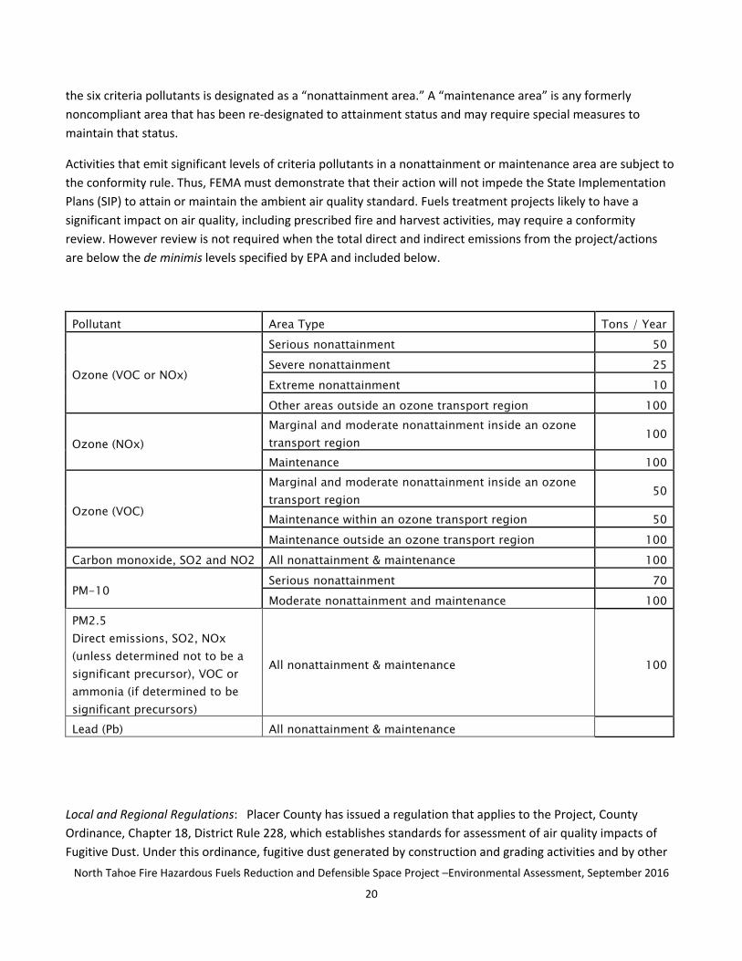
North Tahoe Fire Hazardous Fuels Reduction and Defensible Space Project ndashEnvironmental Assessment September 2016
20
the six criteria pollutants is designated as a ldquononattainment areardquo A ldquomaintenance areardquo is any formerly noncompliant area that has been re-designated to attainment status and may require special measures to maintain that status
Activities that emit significant levels of criteria pollutants in a nonattainment or maintenance area are subject to the conformity rule Thus FEMA must demonstrate that their action will not impede the State Implementation Plans (SIP) to attain or maintain the ambient air quality standard Fuels treatment projects likely to have a significant impact on air quality including prescribed fire and harvest activities may require a conformity review However review is not required when the total direct and indirect emissions from the projectactions are below the de minimis levels specified by EPA and included below
Pollutant Area Type Tons Year Serious nonattainment 50
Ozone (VOC or NOx) Severe nonattainment 25 Extreme nonattainment 10 Other areas outside an ozone transport region 100
Ozone (NOx) Marginal and moderate nonattainment inside an ozone transport region
100
Maintenance 100
Ozone (VOC)
Marginal and moderate nonattainment inside an ozone transport region
50
Maintenance within an ozone transport region 50 Maintenance outside an ozone transport region 100
Carbon monoxide SO2 and NO2 All nonattainment amp maintenance 100
PM-10 Serious nonattainment 70 Moderate nonattainment and maintenance 100
PM25 Direct emissions SO2 NOx (unless determined not to be a significant precursor) VOC or ammonia (if determined to be significant precursors)
All nonattainment amp maintenance 100
Lead (Pb) All nonattainment amp maintenance
Local and Regional Regulations Placer County has issued a regulation that applies to the Project County Ordinance Chapter 18 District Rule 228 which establishes standards for assessment of air quality impacts of Fugitive Dust Under this ordinance fugitive dust generated by construction and grading activities and by other
North Tahoe Fire Hazardous Fuels Reduction and Defensible Space Project ndashEnvironmental Assessment September 2016
21
land use practices including recreational uses must meet established standards that apply to vehicle use on
unpaved areas (including minimization and clean up requirements of bulk materials and debris from paved
public roadways) to soil stockpiles and untraveled disturbed soilsground disturbance in order to prevent
fugitive dust from traveling outside of the project area boundary including shut down of activities if wind
conditions could transport the dust to transport of excavated soils and actions needed for site stabilization to
minimize wind‐driven dust from inactive disturbed surface areas Specific requirements apply to earth disturbing
activities which do not apply to forestry activities as they are not considered ground disturbing
Locally TRPA implements its own set of air quality standards and ordinances found in TRPA Code Chapter 65
including eight air quality standards and indicators adopted to protect air quality in the Lake Tahoe Air Basin
Regulations establish air quality control requirements to aid in the implementation of TRPA air quality goals and
policies for the purpose of attaining and maintaining applicable federal and state air quality standards and TRPA
thresholds Given the unique climatic conditions within the Lake Tahoe Air Basin the TRPA has established a
standard for 8‐hour CO which is more stringent than both state and national regulations
Environmental Consequences
PROPOSED ACTION The Proposed Action eliminated all parcels where post‐project fuels could not be treated
with methods other than burning Therefore no prescribed fire activity is considered in either the action or no
action alternative The Proposed Action includes the following key Air Quality‐related element as part of its
Project description
1 No prescribed fire activities including pile burning would be conducted on any parcel that receives
treatment under this Project including during the eleven‐year post‐treatment Project maintenance
period (Appendix C)
Pursuant to the requirements of the Chapter 65 of the TRPA Code and the conformity rule and because the
LTAB is a nonattainment area for PM10 and ozone analysis for this fuels reduction project requires assessing
whether project implementation would emit significant levels of criteria pollutants which would contribute
substantially to an existing air quality violation
All mechanical equipment produces exhaust that contains greenhouse gases including CO2 NO2 and PM As the
Proposed Action is a hand treatment project there would be no large scale mechanical harvest equipment (eg
masticator or feller buncher) used thus negligible equipment emissions would be produced There would be no
off‐road vehicle travel with all crew transportation occurring on paved subdivision streets and roads The small
amount of motorized equipment to be used (eg crew transport vehicles chainsaws chippers and chip vans or
other chip removal vehicle) would not result in short‐ or long‐term emissions of PM10 above the de minimis
threshold requirements for a Conformity Determination For all other applicable regulated pollutants
substantially less than 100 tons per year per pollutant would be generated Therefore the project qualifies as a
GCR exemption and has received a TRPA Permit (Appendix H) that contains no additional Air Quality‐related
requirements
North Tahoe Fire Hazardous Fuels Reduction and Defensible Space Project ndashEnvironmental Assessment September 2016
22
These conclusions were drawn without preparation of an emission study for the Proposed Action based upon an
analysis of more complex fuels reduction projects conducted by Federal agencies in the Lake Tahoe Basin that
conducted activities (prescribed burning) and use of mechanical equipment over substantially larger acreages
without triggering the requirements of a Conformity Determination Specifically the US Forest Service Lake
Tahoe Basin Management Unitrsquos South Shore Fuel Reduction and Healthy Forest Restoration projectrsquos
Environmental Impact Statement (Record of Decision January 2012) did not require a Conformity
Determination That more than 10000‐acre project anticipated an eight‐year period for implementation of
thinning activities by handcrews with chain saws use of tracked and rubber‐tired equipment and substantial
acreages of prescribed fire
That environmental analysis for the South Shore project determined it to be in compliance with NAAQS and
determined that generation of fugitive dust could result from the thinning operations due to log skidding
loading hauling and use of unpaved roads none of which would occur under the Proposed Action The amount
of mechanical equipment used for road maintenance and reconstruction water trucks for dust abatement and
trucks that transport biomass in any form occur on the South Shore projects at levels that are much greater and
generate more emissions than the Proposed Action Finally the South Shore project incorporates extensive
prescribed fire elements
Because the Project proposes no off‐road vehicle travel with all crew transportation occurring on paved
subdivision streets and roads and because hand crew forestry projects are not considered ground disturbing
activities the majority of District Rule 228 is inapplicable to this project However because chippers are located
on public streets the minimization and clean up requirements of bulk materials and debris from paved public
roadways of the rule are applicable to the Project Standard operating procedures for chipping in neighborhoods
entails such clean up which satisfies the requirement found in District Rule 228
The Project would have negligible short‐term impacts on air quality and it would not exceed any air quality
standards for criteria pollutants nor would it violate local or regional Air Quality standards or requirements
Implementation of this project would not impede the SIPrsquos ability to attain or maintain any ambient air quality
standards
NO ACTION ALTERNATIVE Under this alternative no mechanical equipment would be used and no equipment
emissions would occur There would be no short‐term project‐related air quality effects However the wildfire
hazard would remain unaddressed The No Action Alternative has the potential for indirect short‐ and long‐
term adverse effects to air quality if a wildfire occurs in the project area
The No Action Alternative does not alter the fuels condition and would not reduce the potential for a
catastrophic wildland fire and its detrimental effects or modify fuels and fire behavior Existing stand conditions
would not be changed and they could still result in high wildland fire intensity conditions and large‐scale crown
fires A wildfire would increase levels of most criteria pollutants contribute relatively large amounts of
greenhouse gasses including CO2 and both PM10 and PM25 to the atmosphere and increase other hazardous
air pollutants far beyond the relatively minor deleterious effects of the treatment measures Air quality
North Tahoe Fire Hazardous Fuels Reduction and Defensible Space Project ndashEnvironmental Assessment September 2016
23
standards would not be met for the duration of a wildfire and exposure of soils after a wildfire event could also
increase particulate emissions and wind‐driven fugitive dust potential In addition associated smoke from
intense severe wildfires would create both a nuisance and health concerns for adjacent communities for days or
weeks
313 Climate ChangeGreenhouse Gas Emissions
Affected Environment Environmental Setting
Climate change refers to long‐term fluctuations in temperature precipitation wind and other elements of Earthrsquos
climate system Natural processes such as solar‐irradiance variations variations in Earthrsquos orbital parameters and
volcanic activity can produce variations in climate The climate system can also be influenced by changes in the
concentration of various gases in the atmosphere such as greenhouse gases (GHG) which affect the earthrsquos
absorption of radiation GHGs are chemical compounds which trap heat in the atmosphere affecting the earthrsquos
temperature
California law defines GHGs to include carbon dioxide (CO2) methane (CH4) nitrous oxide (N2O)
hydrofluorocarbons perfluorocarbons and sulfur hexafluoride (Health and Safety Code Section 38505(g)) The
most common GHG that results from human activity is carbon dioxide followed by methane and nitrous oxide
As described in the California Natural Resources Agencyrsquos (CNRArsquos) Final ldquoSafeguarding California and Reducing
Climate Riskrdquo document Californiarsquos forests help absorb carbon dioxide and counteract the greenhouse gas
emissions that cause climate change In this report the CNRA recommends that these forests receive protective
actions to prepare them to withstand mounting climate threats such as increasing temperatures drought
increasing risk of pest infestations and increasing risk of severe wildfires In describing these forested lands the
CNRA notes that they provide many other benefits besides absorbing carbon dioxide which will assist with
climate problems For instance trees and forests help anchor soil and absorb rain and snowmelt so flooding and
landslides are less severe Forests also help regulate the timing and magnitude of water runoff and water flows
and they have highly beneficial impacts on water quality because they provide a filtering function that prevents
impurities from entering streams lakes and groundwater The report notes ldquoEfforts to improve forest health not
only make forests more capable of withstanding climate impacts (and avoids the negative impacts associated with
forest losses) but those efforts will also increase the long‐term carbon storage capacity of forests and aid in
fighting climate changerdquo
North Tahoe Fire Hazardous Fuels Reduction and Defensible Space Project ndashEnvironmental Assessment September 2016
24
Key Regulatory Requirements and Standards
Global Warming Solutions Act of 2006 (AB 32) The Global Warming Solutions Act codifies Californiarsquos goal of
reducing statewide emissions of GHGs to 1990 levels by 2020 This reduction will be accomplished through an
enforceable statewide cap on GHG emissions
Draft NEPA Guidance on Consideration of the Effects of Climate Change and Greenhouse Gas Emissions (Council
on Environmental Quality 2010) This document provides guidance to Federal agencies in considering climate
change in their decision making processes It advises that the agencies address the GHG effects of a proposed
action stating that ldquoif a proposed action would be reasonably anticipated to cause direct emissions of 25000
metric tons or more of carbon dioxide‐equivalent GHG emissions on an annual basis the agency should consider
it an indicator that a quantitative and qualitative assessment may be meaningful to decision makers and the
publicrdquo (CEQ 2010)
Environmental Consequences
PROPOSED ACTION GHG emissions and carbon sequestration effects from the Proposed Action are negligible
both directly and indirectly The carbon released from activities in the Proposed Action is much less than the
amount of carbon sequestered regionally and nationally on forested lands
The Proposed Action would be implemented through handwork which is a manner that would result in the
fewest potential environmental effects Project implementation would directly generate minimal temporary
and one‐time GHG emissions mainly from the short‐term use of equipment and vehicles (eg diesel‐powered
chippers and crew vehicles and gasoline‐powered chainsaws) during Project implementation and to a lesser
extent during the maintenance period GHG emitted during the combustion of these fuels would consist mainly
of carbon dioxide along with small amounts of methane and nitrous oxide Emissions would be intermittent
and short‐term GHG emissions as a result of the Proposed Project would be well below the 25000 metric ton
threshold described by the CEQ Over the long‐term these temporary emissions would be offset by new more
vigorous vegetation growth made possible by removal of overly dense vegetation as well as by the benefit of a
healthy forest condition that would better influence wildfire behavior As treatment areas cycle through
regrowth and additional maintenance treatment there is potential for future carbon sequestration rates in the
project area to meet or exceed the current sequestration rate
The Project would have minor short‐term impacts to GHG emissions with a negligible contribution to long‐term
global climate change
NO ACTION ALTERNATIVE The No Action Alternative would have no direct impact on climate change and GHG
emissions because no direct project activities resulting in air emissions would occur However under this
alternative since no fuel reduction would occur the hazard of wildfire would remain high A wildfire would
result in the release of carbon dioxide into the atmosphere from burning vegetative fuels Even under this
scenario the No Action Alternative could only result in minor short‐ and long‐term indirect effects on climate
change and GHG emissions due to the relatively small total acreage involved
32 Water Resources
North Tahoe Fire Hazardous Fuels Reduction and Defensible Space Project ndashEnvironmental Assessment September 2016
25
Affected Environment Environmental Setting
The projectrsquos analysis area is located within the Lake Tahoe watershed The treatment activities being
considered for implementation would occur in the lower to middle urban portions of the watershed rather than
the upper watershed that is generally comprised of roaded and unroaded National Forest System and State
lands A Total Maximum Daily Load (TMDL) was finalized for Lake Tahoe in 2010 TMDL is a regulatory term in
the US Clean Water Act describing a value of the maximum amount of a pollutant that a body of water can
receive while still meeting water quality standards Alternatively TMDL can also be considered an allocation of
that water pollutant deemed acceptable to the subject receiving waters Lake Tahoersquos TMDL identifies various
pollutant sources and their importance for the lakersquos clarity Some of the sources identified include urban
development unpaved roads particulates in the air from fires road sanding in the winter and stream bank
erosion
Because of the prized clarity of Lake Tahoe and the Regionrsquos other environmental resources numerous water
quality regulations have been implemented for the Lake Tahoe Basin Discharge limitations apply to water
discharges entering any surface water feature In addition the regionrsquos water quality regulations apply specific
protections for SEZ which are defined generally as an area that owes its biological and physical characteristics to
the presence of surface or seasonal high ground water table SEZs exhibit the ability to rapidly incorporate
nutrients into the usually dense vegetation and moist to saturated soils A SEZ is delineated by the presence of
drainage ways and floodplains including adjacent marshes meadows and riparian areas Consequently all
wetlands and Waters of the United States fall within the definition of SEZ some areas of floodplain do not but
most are included in the definition The more detailed delineation criteria for identifying SEZs includes indicators
of vegetation hydrology andor soil type TRPA maintains the Regional Plan elements that establish and map
SEZ as a sensitive natural community protected by specific standards and regulations Lahontan also maintains
standards in its Basin Plan related to activities in SEZ
SEZs are important because they make up a natural system of runoff conveyance provide wildlife habitat and
can filter and treat (through soils and vegetative complexes) spring snowmelt stormwater runoff and other
forms of surface runoff before discharge to Lake Tahoe
Lake Tahoe has been listed as an impaired water body under Section 303(d) of the Clean Water Act for sediment
and nutrients Efforts to eliminate or minimize delivery of sediment to surface waters that flow into Lake Tahoe
through floodplains and SEZs are critical to protect water quality
The SEZs in this project area often contain riparian elements and include both coniferous and deciduous
vegetation Like the upland area SEZs in the defense and threat zones have fuel loads that exceed the desired
condition for fire protection The two primary contributors to the high fuel loading are conifer species
encroaching in meadows and riparian areas and the arearsquos history of fire suppression
This project falls within coverage of the ldquoLahontan 2014 Timber Waiverrdquo as directed by the Lahontan Regional
Water Quality Control Board This project falls within Category 1 and 2 of this timber waiver which does not
require notification application or monitoring
North Tahoe Fire Hazardous Fuels Reduction and Defensible Space Project ndashEnvironmental Assessment September 2016
26
North Tahoe Fire Hazardous Fuels Reduction and Defensible Space Project ndashEnvironmental Assessment September 2016
27
Key Regulatory Requirements and Standards
Floodplain Management Requirements () Floodplains defined by Executive Order (EO) 11988 as ldquo the lowland
and relatively flat areas adjoining inland and coastal waters include flood prone areas of offshore islands
including at a minimum that area subject to a one percent [100‐year recurrence] or greater chance of flooding
in any one yearrdquo This EO requires federal agencies to avoid to the extent possible the long and short‐term
adverse impacts associated with the occupancy and modification of floodplains and to avoid direct and indirect
support of floodplain development wherever there is a practicable alternative FEMArsquos regulations for complying
with EO 11988 are contained in 44 CFR Part 9
Protection of Wetlands () Wetlands are defined by Executive Order (EO) 11990 as ldquoareas inundated by surface
or ground water with a frequency sufficient to support and under normal circumstances does or will support a
prevalence of vegetative or aquatic life that requires saturated or seasonally saturated soil conditions for growth
and reproduction Wetlands generally include swamps marshes bogs and similar areas such as sloughs
potholes wet meadows river overflows mud flats and natural pondsrdquo This executive order requires agencies
to avoid the adverse impacts associated with the destruction or modification of wetlands FEMArsquos regulations
for complying with EO 11990 are also contained in 44 CFR Part 9
Clean Water Act The Clean Water Act (CWA) applies to waters of the United States Under the provisions of
Section 404 of the CWA the Army Corps of Engineers (Corps) has primary federal responsibility for reviewing
projects that may have impacts on these waters including wetlands Corps regulations require that a permit be
obtained if a project proposes placing structures within over or under navigable waters andor discharging
dredged or fill material into waters of the US below the ordinary high‐water mark in non‐tidal waters or into a
jurisdictional feature Permits may be issued on a case‐by‐case basis (individual permit) or at a program level
(general permit) such as a Nationwide Permit which covers specific activities that generally have minimal
environmental effects The USACE Permanent discharges that exceed 01 acre require review under the
provisions of the applicable Nationwide Permit Discharges over 05 acres require consideration under the
provisions of an Individual Permit
Environmental Consequences
PROPOSED ACTION The Proposed Action includes the following Water Quality‐related elements as part of the
Project description in order to best protect aquatic resources
1 Fallers would use falling wedgestechniques to directionally fall trees away from stream channels and
SEZ
2 In SEZ preference would be given to retention of riparian vegetation (eg willows alders and aspens)
tree and brush removal would focus on encroaching conifers and flammable chaparral
3 Within SEZs and 100 year floodplains the bole of all existing down trees would be left in place with
limbs removed
4 All stream bank trees greater than 14rdquo DBH would be retained unless determined to be a safety hazard
to adjacent structures or other targets
North Tahoe Fire Hazardous Fuels Reduction and Defensible Space Project ndashEnvironmental Assessment September 2016
28
The table below shows the number of parcels proposed for treatment under the Proposed Action that at least
partially overlaps the 100 year floodplains andor SEZs that have been mapped by TRPA No additional wetland
delineation activities were performed to further determine whether the small portions of SEZs in the project
area met the criteria for designation as no structures or discharges are proposed as part of any project activities
in the action alternative In many cases only small portions of these parcels fall within SEZs or 100 year
floodplains
Phase Total Parcels Parcels with 100 of parcels with 100 Parcels of parcels year floodplains year floodplains with SEZ with SEZ
Phase 1 306 14 46 21 69 Phase 2 185 60 324 59 319 Phase 3 390 4 1 7 18 Total 881 78 89 87 99
Of the 881 parcels included for treatment 87 (10) include areas mapped as SEZs These 87 parcels account for
a total of 10 acres of the selected treatment area and only a small portion of that 10 acres is located within
mapped SEZs
There would be no occupancy or modification of floodplains nor direct or indirect development of floodplains
associated with implementation of the Proposed Action and no destruction or adverse modification of SEZs
(including wetlands) as the only modification proposed is riparian enhancement For this project travel by
wheeled mechanized equipment (crew trucks and chippers) would be limited to paved subdivision streets
eliminating any potential for sedimentation caused by vehicle travel All off‐pavement work would be completed
by hand crews the most environmentally benign removal method for the targeted forest management work
within SEZ which includes riparian vegetation and floodplains to accomplish the necessary for fuels hazard
reduction The forest practices with the greatest potential for causing erosion and sedimentation are road
construction and intensive site preparation neither of which were considered for this project As described in
Chapter 2 there are no practicable alternatives to the Proposed Action As described above in this section the
Proposed Action was developed to minimize adverse impacts to SEZs and hence floodplains and wetlands
Finally FEMA and the North Tahoe Fire Protection District would notify the public of their intent to take action
which impacts floodplains and wetlands Thus the project would comply with EO 11988 EO 11990 and 44 CFR
Part 9
The hand crew treatments being considered would best protect existing groundcover and would not displace or
compact soil which would best protect water resources while also accomplishing riparian habitat restoration as
preference would be given to retention of riparian vegetation (eg willows alders and aspens) Riparian habitat
restoration enhances the ability of SEZs to rapidly incorporate nutrients into the usually dense vegetation and
moist‐to‐saturated soils so important to the protection of water quality Additionally riparian vegetation is less
flammable than non‐riparian vegetation enabling the treatment best protect water quality in the long‐term by
best protecting the special riparian resource Tree removal in SEZs would focus on encroaching conifers and
brush removal would focus on flammable vegetation such as chaparral
North Tahoe Fire Hazardous Fuels Reduction and Defensible Space Project ndashEnvironmental Assessment September 2016
29
The vegetation management prescriptions within SEZs would improve stand conditions in the short‐term and
promote the long‐term health of riparian vegetation or mixed conifer type vegetation depending on the
location thus benefiting water quality over the long‐term The proposed treatments would reduce fuel loading
within SEZs effectively reducing the likelihood of a high intensity wildfire SEZs floodplains and stream channel
corridors would meet the fuels treatment objectives of the project and the condition of these riparian areas
would be improved following Project completion as hazardous fuels and live conifers encroaching into SEZs
would be removed In addition removing conifer vegetation along riparian area floodplains and meadows
would help restore a more natural timing variability and duration of floodplain inundation and increase water
table elevations due to the associated decrease in water uptake and transpiration This would improve the
growing conditions in these areas for these important riparian species over the long‐term
NO ACTION ALTERNATIVE The No Action Alternative would have no immediate impact on water quality
floodplains and stream environment zones However under this alternative no fuel reduction would occur
and the hazard of wildfire would remain high A wildfire would result in a loss of ground cover (vegetation duff
and mulch) that protects against soil erosion Accelerated soil erosion would adversely impact water quality
floodplains and SEZs Fire profoundly affects plant communities and soils when plants and litter are burned
increasing susceptibility to nutrient loss through erosion increased sedimentation and the effects of direct loss
of canopy cover
33 Biological Resources
331 Threatened and Endangered Plant Species and Critical Habitat
Affected Environment Environmental Setting
The Preliminary Biological Resources Review (January 2012) completed by AECOM for this Project identified
Tahoe yellow‐cress (Rorippa subumbellata Roll TYC) as the only federal special‐status plant species that is
known to occur within the analysis area Tahoe yellow cress is a flowering perennial plant in the mustard family
that grows on Lake Tahoersquos sandy shorelines in California and Nevada and nowhere else in the world The
species is listed as endangered by the State of California and as critically endangered in Nevada The US Fish
and Wildlife Service identified Tahoe yellow cress as a candidate species for listing in 1999 under the
Endangered Species Act of 1973 as amended however in October 2015 the agency announced its decision to
remove the plant from the Endangered Species Act candidate list The decision followed an extensive review
that found previously identified habitat threats no longer pose significant risk to the health and persistence of
the species Collaborative conservation efforts are successfully protecting Tahoe yellow cress and have allowed
the US Fish and Wildlife Service to determine that the plant does not require additional protections under the
federal Endangered Species Act The Tahoe Regional Planning Agency also protects this species under its Code of
Ordinances and Goals and Policies
Although no critical habitat is designated for TYC its habitat is very limited lake margins sandy substrates silty
soils among boulders near stream mouths in organically enriched dune slacks and in back‐beach depressions in
naturally dynamic environments One parcel in Phase 3 of the Analysis Area (near Idylwild) is located near a TYC
population that is located on an adjacent non‐Conservancy parcel Suitable habitat occurs near but not
North Tahoe Fire Hazardous Fuels Reduction and Defensible Space Project ndashEnvironmental Assessment September 2016
30
adjacent to several other parcels considered in the Analysis Area near to Lake Tahoersquos northern shore Because
of the concern regarding the long‐term survival of Tahoe yellow cress in the Lake Tahoe shore zone
conservation efforts have been undertaken to recover the species and ensure that it is protected A strategy was
originally completed in 2003 (and updated in 2013) that identifies goals and objectives to meet the conservation
and management needs of the species The strategy includes an experimental program monitoring component
and an adaptive management process which assists land and resource managers in making informed practical
decisions by filling in data gaps and providing an ever‐increasing knowledge base
Regulatory Requirements and Standards
Endangered Species Act of 1973 (ESA) as amended (16 USC sectsect 1531ndash1544) The ESA protects threatened or
endangered species and the ecosystems they need to survive Endangered species are in danger of extinction
throughout all or a significant portion of their range Threatened species are those which are likely to become
endangered within the foreseeable future
Environmental Consequences
PROPOSED ACTION The US Fish and Wildlife Service (USFWS) has concurred with FEMArsquos determination that
the Project may affect but is unlikely to adversely affect TYC (see Appendix D) No habitat is located on the
parcels being considered for treatment and no fuels reduction treatment would occur on the sandy beaches that
are habitat as recognized by the USFWS concurrence
NO ACTION ALTERNATIVE The No Action Alternative would have no impact on threatened and endangered plant species or critical habitat
332 Wildlife and Fish
Affected Environment Environmental Setting
The Sierran mixed conifer habitat in the projectrsquos Analysis Area is dominated by Jeffrey pine sugar pine incense
cedar white fir red fir and lodgepole pine Canopy cover varies from nearly 100 to more open stands on the
typically quarter‐acre urban lots being considered for fuels treatment Montane riparian habitat type such as
aspen stands are scattered in the Analysis Area and not usually associated with a stream channel An
herbaceous understory is typically evident and the habitat varies in structure and species composition This
habitat occurs to a lesser extent within the analysis area in isolated patches Conifers are encroaching upon
aspen stands which can reduce its wildlife habitat suitability
Dead wood both standing and down serves as important wildlife habitat Standing dead and dying trees called
ldquosnagsrdquo or ldquowildlife treesrdquo and downed woody material are recognized for their value to vertebrate wildlife
insects and fungi and for their role in the cycling of nutrients and organic matter in the forest Birds small
mammals and other wildlife use snags for nests nurseries storage areas foraging roosting and perching All
snag sizes provide value but large cavity trees (greater than 16 inches) are required by certain species such as
barred owl and typically last longer than small snags The value of downed woody material also increases with
size
North Tahoe Fire Hazardous Fuels Reduction and Defensible Space Project ndashEnvironmental Assessment September 2016
31
Birds such as woodpeckers forage on insects living in snags and then excavate cavities in the trees for nesting
Later these cavities are used by other birds and mammals for nesting and shelter Raptors such as hawks may
also use snags as perches from which they can prey on voles or other mammals
A snag habitat begins to form when a large tree dies and forms a Hard Snagrdquo As this hard snag decays it
gradually becomes a Soft Snagrdquo A partially or recently dead tree is a hard snag Hard snags tend to have their
bark intact while the heartwood (the non‐living inner core) and sapwood (the younger softer growing wood
between the bark and heartwood) are still firm These kinds of snags are good for cavity excavating birds A soft
snag has considerable decay in its heart and sapwood Fungi infiltrate the heartwood and the tree becomes soft
or hollow in the center A soft snag rarely has limbs and its top may be missing Over the years a soft snag gets
shorter as weather and animal activity weakens it Eventually it falls over and continues to provide important
food and shelter on the ground as fallen trees become infested with fungi and insects As the down logs
decompose nutrients are recycled into the soil and a microhabitat favorable for the growth of new tree
seedlings is often created Further insects snakes rodents seek refuge in rotting logs providing easy food
sources for larger mammals and birds
The analysis area ndash small parcels located within and immediately adjacent to residential neighborhoods ndash
contains habitat of low suitability for many wildlife species due to high existing human presence and use
Nevertheless a variety of common species utilize the urban habitat such as Stellarrsquos jay (Cyanocitta stelleri)
mountain chickadee (Poecile gambeli) northern flicker (Colaptes auratus) Douglas squirrel (Tamiasciurus
douglasii) coyote (Canis latrans) black bear (Ursus americanus) and western fence lizard (Sceloporus
occidentalis)
A preliminary biological resources review (January 2012) was prepared by AECOM for this Project Lahontan
cutthroat trout (Oncorhynchus clarkii henshawi LCT) is the only federally listed special‐status species (listed as
Threatened) with the potential to occur within the Project area although no critical habitat is designated in this
area LCT are the only trout native to the Lake Tahoe Basin and Lake Tahoe itself once provided an extensive
recreational and commercial fishery however this Lake Tahoe population was extirpated in the 1930s LCT
evolved in the absence of other trout species and because they do not compete well for food or habitat the
introduction of additional fish to the waters of Lake Tahoe and other water bodies in the region led to the
speciesrsquo demise LCT is still found in a variety of cold‐water habitats including large terminal alkaline lakes (eg
Pyramid and Walker lakes) alpine lakes (eg Independence Lake) slow meandering rivers (eg Humboldt
River) mountain rivers (eg Carson Truckee Walker and Marys Rivers) and small headwater tributary streams
(eg Donner and Prosser Creeks) Female sexual maturity is reached between the ages of three and four while
males mature at two to three years of age Consecutive repeat spawning is rare LCT is a stream spawner
spawning between February and July Spawning depends upon stream flow elevation and water temperature
Generally Lahontan cutthroat trout occur in cool flowing water with available cover of well‐vegetated and
stable stream banks in areas where there are stream velocity breaks and in relatively silt free rocky riffle‐run
areas
Early (1980s) Forest Service reintroduction efforts in the headwaters of the Upper Truckee River and more
recent efforts including the work of the Lake Tahoe Recovery Implementation Team (2007) and Plan (2010)
North Tahoe Fire Hazardous Fuels Reduction and Defensible Space Project ndashEnvironmental Assessment September 2016
32
combined with years of research stocking and adaptive management have resulted in the successful
reintroduction of LCT in portions of the Tahoe Basin including Lake Tahoe
There are no threatened endangered or proposed terrestrial wildlife species listed for this portion of the Tahoe
Basin No critical habitat for federally‐listed endangered threatened proposed or candidate species has been
designated Habitats designated for wildlife and fisheries threshold standards as designated by the Tahoe
Regional Planning Agency (TRPA) were also considered
In addition to this federally‐listed species two other non‐federal special status species northern goshawk
(Accipiter gentilis) and osprey (Pandion haliaetus) have habitatprotection zones in the Analysis Area
Northern goshawk a California Species of Special Concern occupies habitat within and in the vicinity of
coniferous forests This large bird reuses its old nests and maintains alternate sites It often nests on north
slopes near water in mature trees While no goshawk nests are located in the project area the TRPA Code
(Section 624) requires mapping of a 05‐mile radius ldquono disturbancerdquo zone around any nest site This limits fuel
reduction activities to only marking during the period between February 15 and September 15 annually Certain
parcels being considered for treatment under the Project are located within mapped protected no disturbance
zones as delineated on the Project maps (Appendix A)
Phase 1 ndash Agate Bay 1 parcel
Phase 2 ndash Cedar Flat 4 parcels
Phase 3 ndash Timberland 13 parcels
Phase 3 ndash Tahoe Pines 22 parcels
Osprey a California Species of Special Concern and a TRPA Sensitive Species inhabits areas associated with
rivers lakes and coastlines Osprey build their nests adjacent to water bodies While no osprey nests are located
in the project area the TRPA Code (Section 624) requires mapping of a 025‐mile radius ldquono disturbancerdquo zone
around any nest site This limits fuel reduction activities to only marking during the period between March 1 and
August 15 annually Certain parcels being considered for treatment under the Project are located within
mapped protected disturbance zones as delineated on the Project maps (Appendix A)
Phase 1 ndash Tahoe Vista 1 parcel
Phase 2 ndash Lake Forest 5 parcels
Regulatory Requirements and Standards
Endangered Species Act of 1973 (ESA) as amended (16 USC sectsect 1531ndash1544) Federally listed species are managed under the authority of the ESA The ESA requires federal agencies to ensure that all actions are not likely to jeopardize the continued existence of any federally listed species
Migratory Bird Treaty Act (MBTA 16 USC sect 701‐12) MBTA was first enacted in 1918 to implement four international treaties aimed at protecting migratory birds The Act makes it unlawful by any means or in any manner to take or attempt to take any of approximately 800 species of migratory birds including most common birds other than pigeons and starlings Regulations promulgated under the Act further define the term
North Tahoe Fire Hazardous Fuels Reduction and Defensible Space Project ndashEnvironmental Assessment September 2016
33
take as to pursue hunt shoot wound kill trap capture or collect any such birds Almost all bird species in the US are addressed by the MBTA
Environmental Consequences
PROPOSED ACTION The Proposed Action incorporates the following wildlife protection elements as part of the Project description
1 An average of two of the largest diameter non‐hazardous standing dead trees (also called ldquosnagsrdquo) per
acre will remain following treatment In evaluating snags for retention all snags greater than 30rdquo DBH
and all those greater than 24rdquo DBH in decay Class 6 or higher would be retained unless they become so
numerous that the forestry or fire professionals marking the property determine that they pose an
unacceptable fire hazard or evaluate them to be a hazard tree In order to protect life and property all
hazard trees would be removed around homes roads and trails even when the above‐described snag
retention standard cannot otherwise be met on a parcel
2 At least three to five of the largest logs per acre would remain
3 Certain parcels would be subjected to Limited Operating Periods (LOPs) for wildlife reasons Specifically
no fuels reduction activities that cause vegetation disturbance would occur in SEZ parcels with riparian
habitat between May 1 and August 15 Mapped ldquono disturbance zonesrdquo for northern goshawk and
osprey would also prohibit vegetation removal from February 15 to September 15 and March 1 to
August 15 respectively
4 Since migratory bird species have the potential to nest throughout the project area pre‐treatment
nesting bird surveys would be conducted during the nesting season (May 1 to August 15) and
treatments would be postponed in areas near active bird nests
Since no in‐water work is proposed and standard practices for water quality and erosion control are included in
the Project FEMA has determined that the project may affect but is not likely to adversely affect the
threatened LCT USFWS has concurred with FEMArsquos determination (see Appendix D)
Even small‐scale fuels reduction projects have the potential to affect components of wildlife habitat After
project implementation the same habitat types would continue to exist at their current locations in the project
area although the density of vegetation in forest and shrub habitats would be reduced Conifer encroachments
in riparian habitat would also be reduced enhancing riparian hardwood communities
With the incorporation of survey requirements and requirements for postponement of treatments if active
nesting is discovered as part of the Proposed Action the Project would comply with the MBTA
Coarse woody debris and snags are beneficial for soil replenishment and for numerous animals and plants that
live in Lake Tahoe forests Once a tree dies and decomposes in the form of a snag or downed woody debris it
creates a unique opportunity for feeding nesting and other functions that create the diverse food chain cycle
necessary for wildlife to thrive Within the wildland‐urban interface this natural cycle can create a fire andor
safety hazard to adjacent residential and commercial structures To reduce these hazards to an acceptable level
a balanced approach is necessary in which excess fuels and hazard trees are removed for fire prevention and
North Tahoe Fire Hazardous Fuels Reduction and Defensible Space Project ndashEnvironmental Assessment September 2016
34
safety while coarse woody debris and snags are retained where structures arenrsquot threatened No short‐ or long‐
term adverse wildlife impacts are anticipated related to Project implementation
NO ACTION ALTERNATIVE Under the No Action Alternative there would be no fuel reduction and no direct
effects to wildlife and fish would occur However a wildfire in the project area could result in an indirect impact
to these and other biological resources A wildfire could destroy terrestrial habitat and individual animals could
be affected Adverse impacts could also affect aquatic resources because fire residue and eroded soil could be
washed into streams If stream courses are directly burned stream temperature could be affected due to loss of
stream shading These effects could continue until vegetation is reestablished which would take time under an
intense wildfire scenario Short and long‐term adverse indirect effects could occur to wildlife and fish if a
wildfire occurs in the project area
333 Vegetation Resource
Affected Environment Environmental Setting
Conifer tree species in the analysis area are typically described as Sierra Nevada mixed conifer with Jeffrey pine
lodgepole pine and white fir as the predominant overstory tree species The forest also includes a smaller
component of Sierra juniper red fir sugar pine western white pine and incense cedar Canopy cover varies
from nearly 100 to more open stands Shrubs such as greenleaf manzanita and huckleberry oak mountain
whitethorn Mahala mat tobacco brush chinquapin current gooseberry serviceberry twinberry and
bitterbrush are common understory associates Montane riparian habitat type such as aspen stands with an
herbaceous understory are scattered geographically and not usually associated with a stream channel This
habitat occurs to a lesser extent within the analysis area in isolated patches Conifers often encroach upon
these aspen stands
Beginning in the 1870s nearly 70 of the Lake Tahoe watershed was logged to provide fuel and timber for
Comstock silver mining During this same time period large numbers of livestock removed herbaceous
vegetation and fires deliberately set at the end of the summer grazing season probably killed tree seedlings that
were regenerating in some of the clear‐cut areas Additionally fire intensities were low and there was little
mortality of mature trees Current vegetation conditions have been modified from their historic forest structure
and species composition due to fire suppression which has prevented the lower‐intensity fires that used to
regularly burn small trees surface and ladder fuels and brush
Tahoersquos forests today differ from pre‐European settlement forests in tree species composition and density they
have four times the density the relative frequency of white fir and incense cedar are two to three times higher
and the occurrence of Jeffrey pine is 50 less The forests within Tahoersquos urban areas have developed into
denser stands where fire suppression ability near ldquovalues at riskrdquo ndash primarily homes ‐‐ is now impeded and may
in fact be impossible during extreme fire weather High rates of tree mortality particularly white fir have
increased the fuel load of standing dead trees and downed logs Combined with the lack of frequent low
intensity fires these accumulations of fuels and increased size density and continuity of understory shrubs
have increased fire severity and the rate of fire spread
North Tahoe Fire Hazardous Fuels Reduction and Defensible Space Project ndashEnvironmental Assessment September 2016
35
Today high stand densities are characteristic of the Project area This unnaturally high density makes the forest
susceptible to most of the natural agents of disturbance (eg bark beetles disease and fire) found in the Lake
Tahoe Basin These degraded ecosystems ‐‐ like all ecosystems ‐‐ also face a growing threat from invasive
species which can replace native species alter natural balances and reduce habitat for other plant species as
invasive species are more competitive than native species
Key Regulatory Requirements and Standards
The Executive Order on Invasive Species (EO) 13112 (February 3 1999) aims to ldquoprevent the introduction of
invasive species and provide for their control and to minimize the economic ecological and human health
impacts that invasive species causerdquo To that end federal agencies are ordered ldquoto the extent practicable and
permitted by lawrdquo not to authorize fund or carry out actions that it believes are likely to cause or promote the
introduction or spread of invasive species unless the benefits of such actions outweigh the potential harm
Environmental Consequences
PROPOSED ACTION Fuels reduction would remove trees to achieve tree spacing goals and remove diseased
trees in order to allow larger healthier trees room to grow Following Project implementation the treated
parcels would reflect historic forest conditions with a stocking range thatrsquos typically between 50 and 150 square
feet of basal area per acre This is the primary long‐ and short‐term benefit of the project as thoroughly
described in the Projectrsquos Purpose and Need (Section 11 of this document)
Without the use of vehicles off pavement straw bales or other foreign materials being brought to the project
site there is little potential for the Proposed Project to contribute to the spread of invasive species Only chip
generated from the project area will be reapplied to the site Therefore Project implementation would comply
with EO 13112
NO ACTION ALTERNATIVE Under this alternative no vegetation treatments would take place There would be
no direct effects to vegetation or establishment (or treatment of) invasive species from Project implementation
However there would also be no reduction in the fuel loads in the project area The possibility of a crown‐
carried wildfire would not be reduced Conditions are ripe for a stand‐destroying wildfire spreading through the
tree crowns threatening forest stands and ecosystems
North Tahoe Fire Hazardous Fuels Reduction and Defensible Space Project ndashEnvironmental Assessment September 2016
36
34 Cultural Resources
341 Archaeological and Historic Resources
Affected Environment Environmental Setting
Historic properties are defined as any prehistoric or historic district site building structure or object included
in or eligible for listing for inclusion in the National Register of Historic Places FEMA in coordination with the
State Historic Preservation Officer (SHPO) Tribal Historic Preservation Officer (THPO) and other consulting
parties must identify historic properties that may be affected by any proposed project and assess adverse
effects of the actions To further this requirement AECOM completed a Final Historic Properties Inventory and
Evaluation Report for the Project in 2013 and SHPO consultation (see Appendix E) The report documents the
investigation that identified historic properties in the Projectrsquos Analysis Area and the Area of Potential Effects
(APE) and includes the methods and results of such investigation which consisted of consultation a records and
literature research archival research and an intensive pedestrian surveys by an archaeological field crew
In December of 2012 FEMA sent consultation letters (Appendix F) to Indian Tribes for whom the properties
might be religiously or culturally significant Letters were sent to the Washoe Tribe of Nevada and California the
Shingle Springs Band of Miwok Indians and the United Auburn Indian Community of the Auburn Rancheria of
California One response was received from the Shingle Springs Rancheria (included in Appendix F) which stated
that the Shingle Springs Band of Miwok Indians were not aware of any known cultural resources on the site The
Tribe requested continued consultation through project updates from FEMA in order to foster a greater
communication between the Tribe and the agency The Tribe made a similar request when commenting on the
Draft EA (see Appendix L) FEMA provided the requested consultation by notifying the Tribe of the Draft and
Final EA availability affording the Tribe an opportunity to review FEMArsquos cultural resources report and agreeing
to re‐consult with the Tribe in the event of an unanticipated discovery No tribal cultural resources (sites
features places cultural landscapes sacred places and objects with cultural value to a California Native
American tribe) have been identified through the records searches site surveys or tribal inquires conducted for
this project
Key Regulatory Requirements and Standards
National Historic Preservation Act of 1966 (NHPA 16 USC 470F as amended) and its implementing regulations
found at 36 CFR Part 800 and the 2005 First Amended Programmatic Agreement between FEMA and the State
Historic Preservation Officer (SHPO) and the Advisory Council on Historic Preservation NHPA and its
implementing regulations as well as the Programmatic Agreement require that FEMA take into account the
effects of any federally funded or assisted project on historic properties
Additionally Section 101(d)(6)(B) of NHPA recognizes the Federal governmentrsquos trust responsibilities to Tribes
under a government‐to‐government relationship and its obligation to ensure that the Tribesrsquo reserved rights are
protected Consultation with tribes helps insure that these trust responsibilities are met
Environmental Consequences
North Tahoe Fire Hazardous Fuels Reduction and Defensible Space Project ndashEnvironmental Assessment September 2016
37
PROPOSED ACTION All parcels in the Projectrsquos Analysis Area that contained potential historic resources were
removed from the Proposed Action Project area Consequently no historic properties are located within the APE
and no parcels with identified unevaluated historic resources are proposed for treatment under this Proposed
Action One resource (P‐31‐001889) was previously determined ineligible for listing in the National Register of
Historic Places in 1994 FEMA made a finding of no historic properties affected pursuant to the Programmatic
Agreement (see Appendix E)
With a full site survey and the elimination from the Project area of all parcels that contained unevaluated
historic resources the risk of damage to known historic resources is eliminated However there is the potential
to encounter previously undiscovered resources during Project implementation FEMA will condition the grant
to NLTFPD so that if any buried archaeological resources are discovered all ground disturbing activities would
cease at that location until a qualified archaeologist completes a determination of eligibility The Final Historic
Properties Inventory and Evaluation Report describes the following process in the event of such a discovery
If a discovery of an artifact andor human remains is made during the implementation of the Proposed
Project the operator will cease all activity within 100 feet (30 meters) and notify the Conservancy and
CalEMA immediately CalEMA will notify FEMA and ensure that all reasonable measures are taken to
avoid or minimize harm to the resource until FEMA completes additional consultation with the SHPO
and the appropriate tribes If human remains are found including disarticulated or cremated remains
the Conservancy will also contact the Placer County CoronerMedical Examiner and the local law
enforcement office Pursuant to the California Health and Safety Code if the CoronerMedical Examiner
determines that the human remains are or may be of Native American origin the discovery will be
treated in accordance with Section 509798 (a‐d) of the California Health and Safety Code At that point
the Conservancy would obtain a qualified archaeologist with Native American burial experience if
possible to conduct an investigation of the human remains All mitigation regarding the human remains
would be implemented prior to the resumption of ground‐disturbing activities within 100 feet of the
discovery site
The SHPO has no objection to FEMArsquos finding of No Historic Properties Affected for this undertaking as described
(see Appendix E) The project described in the Final Historic Properties Inventory and Evaluation Report
considered the potential for mechanical treatment (mastication) as well as hand treatment for vegetation
removal As the project evolved mechanical treatment was removed from consideration in the Proposed Action
leaving only hand treatments which is within the scope of the project described to the SHPO
NO ACTION ALTERNATIVE Under the No Action Alternative no direct impacts to historic properties would occur
because no forest treatment would occur The No Action Alternative could result in indirect effects to historic
properties in the event of a wildfire that damaged historic properties in or adjacent to the project area
North Tahoe Fire Hazardous Fuels Reduction and Defensible Space Project ndashEnvironmental Assessment September 2016
38
35 Socioeconomic Resources
351 Land Use
Affected Environment Environmental Setting
The project area contains scattered Conservancy‐owned urban lots within the unincorporated Placer County
portion of the Lake Tahoe Region within the zoning found in the Tahoe Regional Planning Agencyrsquos (TRPArsquos) Plan
Area Statements and Community Plan areas Nearby land uses include single family and some multifamily
homes undeveloped public and private areas recreational areas and schools and some retailcommercial
areas
The TRPA Regional Plan guides land use decision making Twenty‐five Plan Area Statements (PAS) and
Community Plans govern the geographic area encompassed by this project Each Plan Area Statement or
Community Plan provides a description of the land use for a planning area (mapped in Appendix G) identifies
area‐specific planning issues and establishes specific direction for planning to meet the policy direction of the
Regional Plan Goals and Policies document These plan area statements and any adopted community plans or
area plans that superseded the plan area statements where applicable provide detailed planning and land use
policies for the specific geographic areas over which they provide zoning Placer County has also adopted the
PAS and Community Plans in lieu of traditional zoning All projects and activities must be consistent with the
provisions of their applicable plan area statement
Land use regulatory authority for a fuels reduction project in this area rests with the TRPA The forestry‐related
Permissible Uses in the various PAS and Community Plans provide TRPA the authority to authorize fuel reduction
activities TRPA and the Tahoe Conservancy have an existing Memorandum of Understanding (MOU 1999) that
allows for vegetation management activities
Environmental Consequences
PROPOSED ACTION TRPA has issued a Tree Removal Permit (Appendix H) for the 881 properties being
considered for treatment under the Proposed Action that clarifies the Conservancyrsquos ability to move forward
with the project under the authority of the 1988 MOU No zoning or other Regional Plan changes were required
or requested in order to authorize this permit which authorizes Project activities consistent with the Resource
Management Permissible Uses found in the applicable PASCommunity Plans The project is consistent with all
applicable permissible land uses land use plans policies and regulations for agencies with jurisdiction over the
activities
NO ACTION ALTERNATIVE Under this alternative no vegetation removal would occur and no land use permits
would be required
North Tahoe Fire Hazardous Fuels Reduction and Defensible Space Project ndashEnvironmental Assessment September 2016
39
352 Noise
Affected Environment Environmental Setting
The Project is located on parcels within next to and near residential areas In addition to single‐ and multi‐
family homes additional potentially ldquosensitive receptorsrdquo ndash land uses where there is a reasonable degree of
sensitivity to noise such as hospitals schools churches rest homes cemeteries and libraries per the Placer
County Noise Ordinance (Ordinance 5280‐B) ‐‐ exist within the Project area These noise sensitive land uses
(mapped in Appendix I) are particularly adversely affected by noisy activities
The main source of noise is from vehicular traffic along roadways with secondary sources being aircraft
overflight transitory recreationist and more typical neighborhood sounds (eg lawn mowers home
construction sounds music children chainsaws log splitters and barking dogs) With the current emphasis on
creation of defensible space on private land the sound of chainsaws and chippers more commonplace
The TRPA has established an environmental standard for noise called the Community Noise Equivalent level
(CNEL) The TRPA CNEL for high density residential and urban outdoor recreation areas is 55 dBA and low
density residential areas is 50 dBA The CNEL value is an average sound level for a specific time interval with a
weight factor incorporated to penalize sounds which occur during evening or nighttime hours This is done to
reflect the intrusive effects noise sources have during nighttime hours Noise levels occurring between 700 am
and 700 pm are not normally weighted
Environmental Consequences
PROPOSED ACTION Noise producing mechanized equipment that would be used to implement the Proposed
Action would be limited to chainsaws chippers and crew vehicles all of which are commonly used in
neighborhood settings by tree service companies doing work for private landowners Short‐term noise effects
are anticipated during Project activities and occasional maintenance activities resulting in a temporary increase
in the ambient noise levels Because the project treats small urban lots the effect of project noise on area
residents would be transitory louder when work is done on nearby parcels quieter as the work progresses
down the street and elsewhere in the neighborhood This is because sound attenuates based upon distance
from the source However since the duration of impact at any one parcel would be very brief (typically less than
one day) and since the impact would occur during less sensitive daytime hours the impact from construction‐
related ground borne noise would not be substantial Project implementation may result in a temporary and
periodic exposure to noise levels in excess of the established standards as is allowable under local and Regional
ordinances Long‐term there are no new noise sources or changes to ambient noise levels resulting from the
project
Because 69 of the homes in the Placer County portion of the Tahoe Basin are second homes it is likely that the
occupants of many the houses in the Project vicinity will vary over the duration of project implementation No
specific neighbor notifications are proposed
The exemption to noise limitations Section 238 of the TRPA Code would apply to fuel reduction operations
associated with the Project This section permits approved projects to exceed the noise limitations between the
North Tahoe Fire Hazardous Fuels Reduction and Defensible Space Project ndashEnvironmental Assessment September 2016
40
hours of 800 am and 630 pm Similarly Placer Countyrsquos noise ordinance provides an exemption to its noise
ordinance (Article 936030 of the Placer County Code) for activities that take place between 600 am and 800
pm Monday through Friday and 800 am and 800 pm Saturday and Sunday The Project would comply with
the most restrictive of these limitations
NO ACTION ALTERNATIVE Under this alternative no vegetation clearing would take place There would be no
noise effects due to Project implementation
353 TransportationTraffic
Affected Environment Environmental Setting
The project area includes scattered urban parcels throughout the North and West shore areas The
transportation system serving these parcels is characterized by a street network of neighborhood roads
accessed by arterial streets and connected by State Routes 89 and 28 This system experiences low traffic
volumes along neighborhood streets that is well within acceptable design capacity Near the developed
commercial centers along the state highways traffic volumes during peak tourist visitation periods often
produce congestion
Environmental Consequences
PROPOSED ACTION Project activities would generate very low parking needs and low trip generation The
project would require access on neighborhood streets for crew vehicles and a mechanical chipper to be parked
near the urban parcels receiving treatment Site access would be on foot with no temporary roads constructed
as part of this project and no unpaved forest roads used Felled trees would be cut into firewood length pieces
(rounds) by the crews and left for hand removal by the public for firewood In limited cases crews may move
rounds to the edge of the street to prevent soil erosion The street system easily accommodates the limited
parking needs for project in additional to normal neighborhood use Locations for staging of rounds for public
fuelwood collection would be carefully selected to avoid causing or increasing traffic congestion or hazardous
traffic conditions In addition because the urban parcels are scattered over a large area additional trips tofrom
any one part of the project site are likely to be negligible
NO ACTION ALTERNATIVE No change to the transportation system or traffic volume or patterns would occur
with the No Action Alternative
354 Hazardous Materials
Affected Environment Environmental Setting
The term ldquohazardous substancerdquo refers to both hazardous materials and hazardous wastes including explosives
A material is defined as hazardous if it appears on a list of hazardous materials prepared by a federal state or
local regulatory agency or if it has characteristics defined as hazardous by such an agency The California
Environmental Protection Agencyrsquos (CalEPArsquos) Department of Toxic Substances Control (DTSC) defines hazardous
waste as a substance whose ldquoquantity concentration or physical chemical or infections characteristics (1)
cause or significantly contribute to an increase in mortality or an increase in serious irreversible or
North Tahoe Fire Hazardous Fuels Reduction and Defensible Space Project ndashEnvironmental Assessment September 2016
41
incapacitating reversible illness (2) pose a substantial present or potential hazard to human health or the
environment due to factors including but not limited to carcinogenicity acute toxicity chronic toxicity
bioaccumulative properties or persistence in the environment when improperly treated stored transported
or disposed of or otherwise managedrdquo See California Health and Safety Code sect25141(b) The CalEPA and the
State Board establish rules governing the use of hazardous materials and the management of hazardous waste
If a release of a hazardous substance is detected in the project area the NTFPD responds to evaluate conditions
and determine if additional emergency services will be required
Given that the project area is largely undeveloped land located away from industrial or heavy commercial sites
it has a low risk for hazardous materials contamination Known leaking and non‐leaking underground storage
tanks in this portion of Placer County are largely concentrated in the commercial areas along the highways
outside of the urban lots considered for treatment by this project Project construction or operation affected or
otherwise disturb these sites
Naturally occurring asbestos (NOA) is known to be present in Placer County To help identify areas in the county
that may contain NOA the California Department of Conservation California Geological Survey (CGS) has
prepared a 1100000‐scale map of relative likelihood for the presence of naturally occurring asbestos in Placer
County The project area is not located near any of the areas identified as containing Ultramafic Rocks and is
mapped as an Area Least Likely to Contain NOA
Environmental Consequences
PROPOSED ACTION Gasoline and diesel fuels oils and the like are hazardous materials that would be used to
power the mechanized equipment needed to complete the project (eg chainsaws and chippers) These are
hazardous materials that could impact natural resources such as water soils plants and animals if
unintentionally released into the environment Standard best management practices would be routinely
incorporated into Conservancy forestry operations including the Proposed Action to protect the environment
from the risk of Hazardous Materials spills resulting from land management activities Such best management
practices include the following
1 Vehicles and chippers would only be fueled at an offsite permitted fuel station and vehicle
maintenance including washing would also occur off site at an existing commercial facility
2 Small mobile equipment (eg chain saws) would be fueled and lubricated during operations typically
within the paved or vegetation‐free portions of a county road However chainsaw service and fuel
storage (in approved UL or DOT containers) would occasionally occur within more remote portions of
the project area but only in areas that are free of flammable materials for a radius of at least fifteen
feet Remote refueling and lubricating of small equipment would be restricted to upland areas at least
100 feet away from the edge of any streams wetlands ditches and other waterbodies and 150 feet
from water supply wells Dispensing of fuel would only occur at least 10 feet away from any sources of
ignition smoking is prohibited during fueling Chainsaws would not be started or operated within ten
feet of a refueling point or otherwise near stored fuel
3 Crews would be supplied with absorbent and barrier materials to contain and recover accidental spills of
fuels and lubricants (spill kit) The liquid recovery capacity of the spill kit would be equal to or greater
North Tahoe Fire Hazardous Fuels Reduction and Defensible Space Project ndashEnvironmental Assessment September 2016
42
than the maximum total volume of fuel plus lubricant for the equipment being used The spill kit would
be available in close proximity to areas where chemicals are stored or refueling would occur to enable
prompt response and clean‐up of spills or other discharges of hazardous substances Employees would
be briefed at weekly ldquotailgate sessionsrdquo with the location and contents of all spill kits and the procedures
to be followed in the event of a leak or spill
4 Any leaks drips and other spills would be cleaned up immediately to avoid soil or groundwater
contamination Cleanup of a spill on soil would include the removal of contaminated soil Any
contaminated soil and disposable gear used to clean up a hazardous materials spill would be properly
disposed of following State and Federal hazardous material disposal regulations Spills would be
immediately reported to the Conservancy
5 Major maintenance activities and repairs to equipment would occur off site at an approved facility
With implementation of these standard operating procedures the risk of Project implementation resulting in an
unintended hazardous material release is reduced to a level of nonsignificance
NO ACTION ALTERNATIVE The no action alternative would not use any gasoline diesel fuels or oils in the
project area eliminating any potential for contamination
355 Public Health and Safety
Affected Environment Environmental Setting
The general public utilizes the project area for community open space neighborhood pedestrian ldquocut throughsrdquo
and recreation access points to larger public lands Because these lands are proximate to residences the
possibility of a wildfire igniting on the public property is the primary public health and safety concern
Environmental Consequences
PROPOSED ACTION Standard best management practices that would be routinely incorporated into
Conservancy forestry operations including the Proposed Action protect Public Health and Safety from the
possibility of a fire ignition resulting from land management activities These best management practices
include
All chainsaws and chippers would be equipped with spark arrestors
For emergency use in the event of a fire vehicles would be typically equipped with one shovel one ax or
Pulaski and a fully charged fire extinguisher Additionally a ldquofire tool boxrdquo would be located within each
active operating area typically containing a five gallon backpack pump filled with water two axes or
Pulaski two McLeods one chainsaw (35 horsepower or greater) with a twenty inch or longer cutting
blade and one shovel for each employee at the operation
Employee smoking would not be permitted during the fire season except on the paved streets
With these standard operating procedures the risk of the project resulting in an unintended wildfire ignition is
reduced to a level of nonsignificance
North Tahoe Fire Hazardous Fuels Reduction and Defensible Space Project ndashEnvironmental Assessment September 2016
43
Community 2000 Population 2010 Population Percent Change Dollar Point 1539 1215 ‐211 Kings Beach 4037 3796 ‐60
Sunnyside 1761 1557 ‐116 Tahoe Vista 1668 1433 ‐141 Carnelian Bay na 524 na Tahoma na 1101 na
Other 3153 na na Total 12158 9716 ‐201
NO ACTION ALTERNATIVE Under this alternative vegetation treatment would not take place There would be
no direct risks to public health and safety from Project implementation There would also be no reduction in the
fuel loads in the project area Therefore the possibility of a wildfire ignition would not be reduced challenging
the ability to suppress a fire due to forest conditions in the area
356 Socioeconomics and Environmental Justice
Affected Environment Environmental Setting
The projectrsquos analysis area is situated on the northwest side of the Lake Tahoe Basin extending west from the
CaliforniaNevada state line on the north shore to the El Dorado County‐Placer County line on the west shore in
Tahoma The analysis area consists of approximately 238 acres of forested land located within and adjacent to
larger developed subdivisions and unincorporated communities located within the NTFPD (eg Carnelian Bay
Cedar Flat Dollar Point Highlands Lake Forest Homewood McKinney Tahoma Kings Beach Tahoe City Tahoe
Park Talmont Tahoe Vista and Agate Bay) The NTFPD serves the various communities within its approximately
34‐square mile boundary The area served has a permanent population of an estimated 10000 residents with a
seasonal fluctuation visitors that dramatically increases population especially on holiday weekends The
economy is primarily tourist‐based with governmental agencies and ski resorts as the major employers
Population Trends in the Project Area
Source Placer County Socio‐Economic Plan for Tahoe Basin Community Update (20002010 US Census)
The table above uses US Census data to demonstrate that the permanent population in the Project Area dropped by more than 20 percent between 2000 and 2010 Loss of employment opportunities coupled with quickly escalating housing prices drove some residents to relocate often do to lack of housing affordability or in other cases to capitalize on the sale of their homes for high prices Many of the residences sold to second homeowners who reside outside the Tahoe Basin and use their homes for vacations and recreation and sometimes as vacation rentals Others serve as long‐term rentals however todayrsquos higher selling prices often lead to increased rent being charged TRPArsquos parcel data base (2010) reports that 397 of Placer Countyrsquos homes are primary residences while 692 are second homes
Relative to most other regions in the United States all four counties in the Lake Tahoe Basin have a high percentage of housing that is vacant except during the summer The 2010 Census reports total housing units for the Tahoe Basin portion of Placer County as 12106 Estimates prepared for the TRPA indicate that Placer County has the greatest percentage (over 69) of second‐home ownership in the Basin Most second home occupancy occurs between the 4th of July and Labor Day which corresponds with the arearsquos peak fire season
North Tahoe Fire Hazardous Fuels Reduction and Defensible Space Project ndashEnvironmental Assessment September 2016
44
Housing Occupancy in the Project Area Community Total Units Vacant
(Typically) Percent Vacant
Vacant Used for Seasonal Use
Percent Vacant used for Seasonal Use
Carnelian Bay 947 691 730 654 946 Dollar Point 1822 1251 687 1178 942 Kings Beach 2372 1010 426 807 799
SunnysideTahoe City 2119 1375 649 1239 901 Tahoe Vista 1446 818 566 735 899 Tahoma 2058 1505 731 1428 949
Source Placer County Socio‐Economic Plan for Tahoe Basin Community Update (20002010 US Census)
According to the 2010 Census data most of the full time residents in the Project Area are White (69) One Placer County community in the project area Kings Beach has a higher percentage of Hispanic or Latino residents (56) Many of these residents earn less than the statewide average In 2010 the annual median household income for Kings Beach was $37348 while statewide it was $61094 Accordingly Kings Beach is classified as a disadvantaged community by the California Department of Water Resources A disadvantaged community is a community with a median household income less than 80 percent of the statewide average None of the other communities within the Project Area are classified as disadvantaged communities
2010 Census Data Placer County Race and Ethnicity Generally at Lake Tahoe
White (Non Hispanic Latino)
African American
American Indian
Asian Pacific Islander
Hispanic or Latino
Other or Multi‐Racial
Total
Total of Placer County
246267 4751 3011 21213 44710 28480 48432
Lake Tahoe portion of Placer County
6705 48 51 117 2720 807 10 448
Source US Census Bureau 2010 Census (Hispanic or Latino and Race)
Race and Ethnicity in the Project Communities Community White Hispanic or
Latino American Indian
Asian Black or African American
Other
Dollar Point 1090 83 6 19 4 13 Kings Beach 1620 2115 13 14 3 31
SunnysideTahoe City 1431 84 2 15 3 22 Tahoe Vista 1025 352 5 21 3 27 Carnelian Bay 482 13 4 14 1 10
Tahoma 1090 51 10 14 6 20 Total 6738 2698 40 97 20 123
Average 693 278 4 10 2 13 Source Placer County Socio‐Economic Plan for Tahoe Basin Community Update (2010 US Census)
Housing density in the Tahoe Basin is low when compared with other Placer County communities The Forest Service and the State both have had environmentally sensitive land acquisition programs that have purchased undeveloped urban lot parcels within developed subdivisions such as the parcels being considered for treatment with this Project When combined with regional growth control ordinances these public land acquisitions contribute to the low densities in these rural communities In the Project Area the Carnelian Bay community has the lowest housing density and Kings Beach has the highest
North Tahoe Fire Hazardous Fuels Reduction and Defensible Space Project ndashEnvironmental Assessment September 2016
45
Housing Density in the Project Area Community Total Units Acres by Corresponding Census Tract Units Per Acre Carnelian Bay 947 7037 013 Dollar Point 1822 5812 031 Kings Beach 2372 1850 128
SunnysideTahoe City 2119 5954 036 Tahoe Vista 1446 5563 026 Tahoma 2058 7027 029
Source Placer County Socio‐Economic Plan for Tahoe Basin Community Update (20002010 US Census)
Environmental justice is the fair treatment and meaningful involvement of all people regardless of race color
national origin or income with respect to the development implementation and enforcement of
environmental laws regulations and policies It would be achieved when everyone enjoys the same degree of
protection from environmental and health hazards equal access to the decision‐making process and the
opportunity to have a healthy environment in which to live learn and work
Regulatory Requirements and Standards
Environmental Justice in Minority Populations and Low‐Income Populations EO 12898 This Presidential
Executive Order directs federal agencies to ensure that their programs policies and activities do not have a
disproportionately high and adverse human health and environmental effect on minority or low‐income
populations It requires that all federal actions consider potentially disproportionate effects on minority and
low‐income communities especially if adverse effects to environmental or human health conditions are
identified It also tasks federal agencies with ensuring that public notifications regarding environmental issues
are concise understandable and readily accessible
Environmental Consequences
PROPOSED ACTION Factors considered in determining whether the Proposed Action would affect
environmental justice included the extent or degree to which its implementation would change any social
economic physical environmental or health conditions so as to disproportionately and adversely affect any
particular low‐income or minority group
Conditions created by the Proposed Action would not affect any minority or low‐income neighborhood
disproportionately The activities found in the Proposed Action were based solely on the existing and desired
condition of the vegetation sensitivity of the environment and practical treatment access in response to the
identified Project Purpose and Need In no case was the treatment prescription design based on the
demographic makeup occupancy property value income level or any other criteria reflecting the status of
adjacent non‐federal land The prescription to be applied to the forest treatment activities are consistent
between the communities The Conservancyrsquos State owned lands proposed for treatment are distributed
throughout the project area and are intermixed with non‐State lands The project would not affect land in any
way that would impact minority or low‐income neighborhoods disproportionately There is no evidence that any
individual group or portion of the community would benefit unequally from this decision
North Tahoe Fire Hazardous Fuels Reduction and Defensible Space Project ndashEnvironmental Assessment September 2016
46
NO ACTION ALTERNATIVE Under the No Action Alternative there are no socioeconomic or environmental
justice impacts This Alternative would not create conditions that could have potentially disproportionate effects
on minority and low‐income communities including those related to environmental or human health conditions
357 Recreation Resources
Affected Environment Environmental Setting
As urban lots in developed subdivisions the parcels within the Project Area are not part of the Tahoe Regionrsquos
system of destination developed recreation sites (Appendix I Recreation Infrastructure and Improvements
maps) However some parcels within the project area contain user‐created trails which provide access for
dispersed non‐motorized recreational opportunities such as walking mountain biking and cross‐country skiing
These trails often provide through access to other desired destinations including larger public land parcels
Motorized vehicles are generally not allowed on Conservancy properties
Environmental Consequences
PROPOSED ACTION Public recreation use could be impacted by debris from project activities Treatment
activities could pose a threat to public safety during tree felling from crews working with noise‐generating
equipment and from flying debris In addition to creating a public safety hazard noise from equipment could
also affect recreational users in the vicinity by adversely impacting the recreational experience
To protect public safety and Consistent with the Conservancyrsquos adopted Forestry Guidelines (Appendix B) prior
to implementation of forestry projects greater than three acres in size the Conservancy notifies adjacent
property owners by mail In addition notices regarding individual or groups of Conservancy properties may be
posted by the operator to redirect public use while fuels reduction activities are actively taking place At no time
would all California Tahoe Conservancy‐owned parcels proposed for treatment be posted to redirect use at the
same time Because of the small size of the parcels being treated implementation activities minimize the time
that each parcel or group of parcels is inaccessible and use is redirected around work sites User created trails
impacted by the project would be returned to a condition that is as similar as possible to their pre‐project
condition to restore existing public access patterns Public access would be restored as quickly as possible
following the completion of work in any given area within the Project
NO ACTION ALTERNATIVE The No Action Alternative would not have any immediate consequences for
recreational resources within the project area However long‐term adverse effects are likely from increasing
fuel loads Hazard trees could fall and impede passage through the project area presenting a safety hazard for
recreationists Overgrown brush may also compromise access to and through the project area
358 Visual Resources
Affected Environment Environmental Setting
Scenic quality in the Lake Tahoe Region is recognized as a primary resource of national significance The
combination of a stunning lake in a forested mountain setting creates this iconic landscape Within the Region
the undeveloped forests of the North Shore create the backdrop for a high diversity of lake and landscape views
North Tahoe Fire Hazardous Fuels Reduction and Defensible Space Project ndashEnvironmental Assessment September 2016
47
Scattered urban parcels included in the project area contribute to that backdrop and also provide a local
forested setting for residential and dispersed recreation development
The lands within the project area are well‐vegetated with cone‐bearing trees such as pines and firs deciduous
species such as aspens alders and willows shrubs such as manzanita gooseberry and bitterbrush and a variety
of forbs and grasses Many parcels contain downed woody material The visual character of the parcels in the
project area is dense vegetation with a diversity of colors and textures limited light penetration and areas of
substantial clutter from downed woody material The vegetation complex is considerably denser than historic
conditions when the forest character included a more open visually penetrable and mature‐tree dominated
landscape
In some cases the project area lands are visible from TRPA‐designated scenic corridors where they combine
with other undeveloped land to form the forested backdrop critical to attaining and maintaining visual
standards The TRPA adopted scenic threshold standards in 1984 that establish minimum visual and scenic
quality ratings for eight roadway eight shoreline and nine recreation area and bike trail scenic corridors in the
project vicinity
Environmental Consequences
PROPOSED ACTION Project activities would alter both the view of the subject parcels themselves and the
extent to which the vegetation on the parcels screens views of existing development On individual parcels fuel
reduction activities that have visual implications include removal of existing downed woody material and tree
and brush thinning These actions create a more sparsely vegetated site dominated by mature trees a condition
that is more consistent with historical conditions Visual effects include increased sunlight decreased clutter
from existing downed material and greater sight distances Retention of smaller tree and shrub islands (where
fuel reduction objectives can still be met) would serve to limit potential adverse effects of these changes as
would requiring stumps to be cut less than six inches in height (where possible) Increasing sunlight allows
diverse flower and shrub species to become established
Project activities would alter the visual environment for viewers close to the project lands Tree and shrub
removal would create an ldquoopen feelrdquo and a less dense forest and increase sight distance through each parcel In
some locations this would increase view of surrounding development typical in residential communities
including houses roads and trails Retaining areas of shrub and small diameter trees consistent with fuel
reduction goals would retain some screening value for surrounding land uses These smaller trees to be
retained and shrub ldquoislandsrdquo of irregular shapes and sizes would provide a more natural‐appearing mosaic in
the landscape as viewed from homes roads and trails As viewed from farther away and along scenic corridors
project activities would reduce the density of forest cover potentially increasing the view of existing
development within the forest backdrop While this is true the thinning prescription would retain substantial
numbers of mature trees on each parcel As viewed from a distance these mature trees would retain substantial
screening value and would maintain the visual continuity of the forested backdrop This would limit the effect on
TRPA designated scenic corridors and avoid threatening threshold attainment
North Tahoe Fire Hazardous Fuels Reduction and Defensible Space Project ndashEnvironmental Assessment September 2016
48
40
Project activities would produce a landscape with more historically accurate visual features The short‐term
effects of the project activities would create visual change on subject parcels yet project elements focused on
creating a healthy forest and mosaic of shrubs would limit the adverse effects of that change Long‐term effects
would be primarily beneficial because of the park‐like setting that will remain
NO ACTION ALTERNATIVE
The no action alternative would not have immediate consequences for the visual resources of the project area
Over time vegetation density would increase and further diminish sight distance through the forested parcels
Overstocked forests also have a higher likelihood of being impacted by diseases or pests which may increase
tree mortality Dead trees would degrade the visual character of the landscape as standing snags or fallen logs
Increased risk of wildfire inherent in the no action alternative would also increases the risk of significant visual
degradation resulting from fire
CUMULATIVE IMPACTS
NEPA defines a cumulative impact as an ldquoimpact on the environment which results from the incremental impact
of the action when added to other past present and reasonably foreseeable future actions regardless of what
agency (Federal or non‐Federal) or person undertakes such other actionsrdquo (40 CFR sect 15087) Cumulative
impacts can result from individually minor but collectively significant actions taking place over a period of time
PROPOSED ACTION The cumulative effect of the Proposed Action in combination with other existing and
proposed vegetation and fuel treatments by other agencies and the private sector would increase the overall
effectiveness of fuel reduction and improve forest health on the landscape scale The fuel treatments under the
Proposed Action would combine with existing treatments by other entities to create a relatively open forest
structure where fuel amounts and arrangements have been altered to change potential fire behavior in the
event of a wildfire keeping the burn low to the ground and out of the tree crowns
North Tahoe Fire Hazardous Fuels Reduction and Defensible Space Project ndashEnvironmental Assessment September 2016
49
50 SUMMARY OF IMPACTS AND MITIGATION
Mitigation measures are actions that have been identified to avoid or minimize environmental impacts of
project implementation on social cultural and natural environmental resources The environmental
consequences analysis for this Project has not identified any significant impacts requiring mitigation due largely
in part to the specific elements of the Proposed Action that protect specific natural and cultural resources
through avoidance and minimization of potential impact These measures for minimizing impacts are
summarized here
Air Quality
1 No prescribed fire activities including pile burning would be conducted on any parcel that receives
treatment under this Project including during the eleven‐year post‐treatment Project maintenance
period (Appendix C)
Water Quality
1 Fallers would use falling wedgestechniques to directionally fall trees away from stream channels and SEZ
2 In SEZ preference would be given to retention of riparian vegetation (eg willows alders and aspens)
tree and brush removal would focus on encroaching conifers and flammable chaparral
3 Within SEZs and 100 year floodplains the bole of all existing down trees would be left in place with limbs
removed
4 All stream bank trees greater than 14rdquo DBH would be retained unless determined to be a safety hazard to
adjacent structures or other targets
Wildlife
1 An average of two of the largest diameter non‐hazardous standing dead trees (also called ldquosnagsrdquo) per
acre will remain following treatment In evaluating snags for retention all snags greater than 30rdquo DBH and
all those greater than 24rdquo DBH in decay Class 6 or higher would be retained unless they become so
numerous that the forestry or fire professionals marking the property determine that they pose an
unacceptable fire hazard or evaluate them to be a hazard tree In order to protect life and property all
hazard trees would be removed around homes roads and trails even when the above‐described snag
retention standard cannot otherwise be met on a parcel
2 At least three to five of the largest logs per acre would remain
3 Certain parcels would be subjected to Limited Operating Periods (LOPs) for wildlife reasons Specifically
no fuels reduction activities that cause vegetation disturbance would occur in SEZ parcels with riparian
habitat between May 1 and August 15 Mapped ldquono disturbance zonesrdquo for northern goshawk and osprey
would also prohibit vegetation removal from February 15 to September 15 and March 1 to August 15
respectively
North Tahoe Fire Hazardous Fuels Reduction and Defensible Space Project ndashEnvironmental Assessment September 2016
50
4 Since migratory bird species have the potential to nest throughout the project area pre‐treatment nesting
bird surveys would be conducted during the nesting season (May 1 to August 15) and treatments would
be postponed in areas near active bird nests
Cultural Resources
1 If a discovery of an artifact andor human remains is made during the implementation of the Proposed
Project the operator will cease all activity within 100 feet (30 meters) and notify the Conservancy and
CalEMA immediately CalEMA will notify FEMA and ensure that all reasonable measures are taken to
avoid or minimize harm to the resource until FEMA completes additional consultation with the SHPO
and the appropriate tribes If human remains are found including disarticulated or cremated remains
the Conservancy will also contact the Placer County CoronerMedical Examiner and the local law
enforcement office Pursuant to the California Health and Safety Code if the CoronerMedical
Examiner determines that the human remains are or may be of Native American origin the discovery
will be treated in accordance with Section 509798 (a‐d) of the California Health and Safety Code At
that point the Conservancy would obtain a qualified archaeologist with Native American burial
experience if possible to conduct an investigation of the human remains All mitigation regarding the
human remains would be implemented prior to the resumption of ground‐disturbing activities within
100 feet of the discovery site
Noise
1 The exemption to noise limitations Section 238 of the TRPA Code would apply to fuel reduction
operations associated with the Project This section permits approved projects to exceed the noise
limitations between the hours of 800 am and 630 pm Similarly Placer Countyrsquos noise ordinance
provides an exemption to its noise ordinance (Article 936030 of the Placer County Code) for activities
that take place between 600 am and 800 pm Monday through Friday and 800 am and 800 pm
Saturday and Sunday The Project would comply with the most restrictive of these limitations
Hazardous Materials
1 Vehicles and chippers would only be fueled at an offsite permitted fuel station and vehicle maintenance
including washing would also occur off site at an existing commercial facility
2 Small mobile equipment (eg chain saws) would be fueled and lubricated during operations typically
within the paved or vegetation‐free portions of a county road However chainsaw service and fuel storage
(in approved UL or DOT containers) within more remote portions of the project area would occasionally
occur and would be free of flammable materials for a radius of at least fifteen feet Remote refueling and
lubricating of small equipment would be restricted to upland areas at least 100 feet away from the edge of
any streams wetlands ditches and other waterbodies and 150 feet from water supply wells Dispensing
of fuel would only occur at least 10 feet away from any sources of ignition smoking is prohibited during
fueling Chainsaws would not be started or operated within ten feet of a refueling point or otherwise near
stored fuel
North Tahoe Fire Hazardous Fuels Reduction and Defensible Space Project ndashEnvironmental Assessment September 2016
51
3 Crews would be supplied with absorbent and barrier materials to contain and recover accidental spills of
fuels and lubricants (spill kit) The liquid recovery capacity of the spill kit would be equal to or greater than
the maximum total volume of fuel plus lubricant for the equipment being used The spill kit would be
available in close proximity to areas where chemicals are stored or refueling would occur to enable
prompt response and clean‐up of spills or other discharges of hazardous substances Employees would be
briefed at ldquotailgate sessionsrdquo with the location and contents of all spill kits and the procedures to be
followed in the event of a leak or spill
4 Any leaks drips and other spills would be cleaned up immediately to avoid soil or groundwater
contamination Cleanup of a spill on soil would include the removal of contaminated soil Any
contaminated soil and disposable gear used to clean up a hazardous materials spill would be properly
disposed of following State and Federal hazardous material disposal regulations Spills would be
immediately reported to the Conservancy
5 Major maintenance activities and repairs to equipment would occur off site at an approved facility
Public Health and Safety
1 All chainsaws and chippers would be equipped with spark arrestors
2 For emergency use in the event of a fire vehicles would be typically equipped with one shovel one ax or
Pulaski and a fully charged fire extinguisher Additionally a ldquofire tool boxrdquo would be located within each
active operating area typically containing a five gallon backpack pump filled with water two axes or
Pulaski two McLeods one chainsaw (35 horsepower or greater) with a twenty inch or longer cutting
blade and one shovel for each employee at the operation
3 Employee smoking would not be permitted during the fire season except on the paved streets
Recreation
1 Notices regarding individual or groups of Conservancy properties may be posted by the operator to
redirect public use while fuels reduction activities are actively taking place
2 At no time would all California Tahoe Conservancy‐owned parcels proposed for treatment be posted to
redirect use at the same time
3 User created trails impacted by the project would be returned to a condition that is as similar as possible
to their pre‐project condition to restore existing public access patterns
Visual Resources
1 Where possible require stumps to be cut less than six inches in height
North Tahoe Fire Hazardous Fuels Reduction and Defensible Space Project ndashEnvironmental Assessment September 2016
52
60 PUBLIC PARTICIPATION AND AGENCY COORDINATION
Following the Angora Fire of 2007 the governors of Nevada and California created the California‐Nevada Tahoe
Basin Fire Commission (Commission) to examine regulatory and social environments that influence fuels
reduction in the Lake Tahoe Basin In their final report (May 2008) the Commission recognized the necessity of
multi‐jurisdictional collaboration to accomplish fuels reduction projects obtain and manage funding and to plan
and implement projects consistent with the Fuels Strategy or identified in geographically based community
wildfire protection plans The Tahoe Fire and Fuels Team (TFFT) implements the Fuels Strategy for the Lake
Tahoe Basin The original Strategy was updated and endorsed by the executives of TFFT member agencies in
August 2014
The TFFT allows partner agencies to collaborate plan and implement fuels reduction and other wildfire threat
reduction programs consistent with the Fuels Strategy and Community Wildfire Protection Plans throughout the
Tahoe Basin Final project locations are planned by the foresters for the fire district or state agency Members
include CAL FIRE California State Parks the Conservancy Fire Protection DistrictsDepartments in the Lake
Tahoe Basin Nevada Division of Forestry Nevada Division of State Lands Tahoe Regional Planning Agency and
the US Forest Service Supporting agencies include California Water Boards ndash Lahontan Region Tahoe
Resource Conservation District University of Nevada Cooperative Extension and the University of California
Cooperative Extension
An oversight body for the Fuels Strategy composed of the chief executive officers of the federal and state land
management agencies and the local fire agencies is called the Multi‐Agency Coordinating Group (MAC) It is the
principal group that monitors the Fuels Strategyrsquos implementation MAC members are charged with strategic
management of fuels reduction at Lake Tahoe They concur that the Proposed Action is a priority project under
the Fuels Strategy
The Conservancyrsquos Forest Improvement Program is responsible for managing the agencyrsquos forest resources
consistent with the Lake Tahoe Basinrsquos Environmental Improvement Program the Fuels Strategy and Community
Wildfire Protection Plan (CWPP) and California Government Code Section 6690710 which states ldquoThe
Conservancy may improve or develop lands for the purpose of protecting the natural environment or otherwise
meeting the objectives of this titlerdquo This Proposed Action was designed to treat priority areas based on the
Fuels Strategy and CWPP The Conservancy and the NTFPD have collaborated to refine the proposed treatment
areas for fuel reduction activities based upon these priorities
FEMA is the federal agency responsible for conducting the NEPA compliance process for the proposed project It
is FEMArsquos responsibility to expedite the preparation and review of NEPA documents in a way that is responsive to
the needs of the public while meeting the spirit and intent of NEPA and complying with all NEPA provisions
The proposed project is based on the work conducted in support of the NTFPDrsquos plan which involved a variety
of community organizations federal agencies state agencies regional and local agencies and educational
institutions in the process of identifying measures to reduce wildfire risk as described above
North Tahoe Fire Hazardous Fuels Reduction and Defensible Space Project ndashEnvironmental Assessment September 2016
53
FEMA and NTFPD circulated the Draft EA for a 30‐day public review and comment period beginning July 22 2016
The document was made available at FEMArsquos website (wwwfemagovmedia‐libraryassetsdocuments117686)
the California Tahoe Conservancyrsquos website (tahoecagov) the NTFPD website (wwwntfirenet) and in
hardcopies at local libraries (Tahoe City and Kings Beach) Notification of the Draft EArsquos availability was made via
direct mailing to known interested parties (Appendix K) FEMArsquos website and one‐time publication in the local
newspapers (Sierra Sun and North Lake Tahoe Bonanza) During the public comment period FEMA accepted
written comments on the Draft EA addressed to
FEMA Region IX
Environmental and Historic Preservation Office
Attn Draft EA for PDMC‐2010 CA‐019
1111 Broadway Suite 1200
Oakland California 94607
Email fema‐rix‐ehp‐documentsdhsgov
FEMA received three comment letters during the public review and comment period for the Draft EA These letters
are included in Appendix L At the end of the public review and comment period FEMA reviewed all public
comments and prepared this Final EA specifically to address those comments as part of the decision‐making
process This Final EA will be made available to all parties notified of the Draft EA (as listed in Appendix K) and the
individual who submitted the comment letters its availability will also be advertised in the Sierra Sun and North
Lake Tahoe Bonanza
North Tahoe Fire Hazardous Fuels Reduction and Defensible Space Project ndashEnvironmental Assessment September 2016
54
70 LIST OF PREPARERS
Federal Emergency Management Agency Region IX
Morgan Griffin
California Tahoe Conservancy
Whitney Brennan
Scott Cecchi
Brian Hirt
Sue Rae Irelan
Chris Jones‐Roberts
Lisa OrsquoDaly
Juan Carlos Urizar
North Tahoe Fire Hazardous Fuels Reduction and Defensible Space Project ndashEnvironmental Assessment September 2016
55
80 REFERENCES
Community Wildfire Protection Plan (P251 of the California Portion of the Tahoe Basin) 10‐year Plan C
G Celio amp Sons Co Steve Holl Consulting Wildland Rx November 20 2004
o httpwwwtrpaorgwp‐contentuploadsCWPP_CA_Basinpdf
Draft NEPA Guidance on Consideration of the Effects of Climate Change and Greenhouse Gas Emissions
The White House Council on Environmental Quality February 18 2010
o httpwwwwhitehousegovadministrationeopceqinitiativesnepaghg‐guidance
National Fire Plan Department of the Interior US Fish and Wildlife Service Number 15674 Catalog of
Federal Domestic Assistance
o httpswwwcfdagovindexs=programampmode=formamptab=coreampid=702d1ff743fd0d5f7b3860c
bf07ddeec
Lake Tahoe Basin Multi‐Jurisdictional Fuel Reduction and Wildfire Prevention Strategy US Forest
Service Dave Fournier August 2014
o httpwwwfsusdagovdetailltbmuhomecid=stelprdb5309771
National Cohesive Wildland Fire Management Strategy
o httpwwwforestsandrangelandsgovstrategy
Lake Tahoe Total Maximum Daily Load November 2010
o httpwwwwaterboardscagovlahontanwater_issuesprogramstmdllake_tahoe
Safeguarding California Reducing Climate Risk Natural Resources Agency July 2014
o httpresourcescagovdocsclimateFinal_Safeguarding_CA_Plan_July_31_2014pdf
Climate Change Guidelines for Forest Managers Food and Agriculture Organization of the United
Nations Rome 2013
o httpwwwfaoorgdocrep018i3383ei3383epdf
Lahontan Basin Plan Lahontan Regional Water Quality Control Board December 2005
o httpwwwwaterboardscagovrwqcb6water_issuesprogramsbasin_planindexshtml
TRPA Code of Ordinances December 12 2012 effective February 9 2013
o httpwwwtrpaorgregional‐plancode‐of‐ordinances
- Structure Bookmarks
-
North Tahoe Fire Hazardous Fuels Reduction and Defensible Space Project ndashEnvironmental Assessment September 2016
21
land use practices including recreational uses must meet established standards that apply to vehicle use on
unpaved areas (including minimization and clean up requirements of bulk materials and debris from paved
public roadways) to soil stockpiles and untraveled disturbed soilsground disturbance in order to prevent
fugitive dust from traveling outside of the project area boundary including shut down of activities if wind
conditions could transport the dust to transport of excavated soils and actions needed for site stabilization to
minimize wind‐driven dust from inactive disturbed surface areas Specific requirements apply to earth disturbing
activities which do not apply to forestry activities as they are not considered ground disturbing
Locally TRPA implements its own set of air quality standards and ordinances found in TRPA Code Chapter 65
including eight air quality standards and indicators adopted to protect air quality in the Lake Tahoe Air Basin
Regulations establish air quality control requirements to aid in the implementation of TRPA air quality goals and
policies for the purpose of attaining and maintaining applicable federal and state air quality standards and TRPA
thresholds Given the unique climatic conditions within the Lake Tahoe Air Basin the TRPA has established a
standard for 8‐hour CO which is more stringent than both state and national regulations
Environmental Consequences
PROPOSED ACTION The Proposed Action eliminated all parcels where post‐project fuels could not be treated
with methods other than burning Therefore no prescribed fire activity is considered in either the action or no
action alternative The Proposed Action includes the following key Air Quality‐related element as part of its
Project description
1 No prescribed fire activities including pile burning would be conducted on any parcel that receives
treatment under this Project including during the eleven‐year post‐treatment Project maintenance
period (Appendix C)
Pursuant to the requirements of the Chapter 65 of the TRPA Code and the conformity rule and because the
LTAB is a nonattainment area for PM10 and ozone analysis for this fuels reduction project requires assessing
whether project implementation would emit significant levels of criteria pollutants which would contribute
substantially to an existing air quality violation
All mechanical equipment produces exhaust that contains greenhouse gases including CO2 NO2 and PM As the
Proposed Action is a hand treatment project there would be no large scale mechanical harvest equipment (eg
masticator or feller buncher) used thus negligible equipment emissions would be produced There would be no
off‐road vehicle travel with all crew transportation occurring on paved subdivision streets and roads The small
amount of motorized equipment to be used (eg crew transport vehicles chainsaws chippers and chip vans or
other chip removal vehicle) would not result in short‐ or long‐term emissions of PM10 above the de minimis
threshold requirements for a Conformity Determination For all other applicable regulated pollutants
substantially less than 100 tons per year per pollutant would be generated Therefore the project qualifies as a
GCR exemption and has received a TRPA Permit (Appendix H) that contains no additional Air Quality‐related
requirements
North Tahoe Fire Hazardous Fuels Reduction and Defensible Space Project ndashEnvironmental Assessment September 2016
22
These conclusions were drawn without preparation of an emission study for the Proposed Action based upon an
analysis of more complex fuels reduction projects conducted by Federal agencies in the Lake Tahoe Basin that
conducted activities (prescribed burning) and use of mechanical equipment over substantially larger acreages
without triggering the requirements of a Conformity Determination Specifically the US Forest Service Lake
Tahoe Basin Management Unitrsquos South Shore Fuel Reduction and Healthy Forest Restoration projectrsquos
Environmental Impact Statement (Record of Decision January 2012) did not require a Conformity
Determination That more than 10000‐acre project anticipated an eight‐year period for implementation of
thinning activities by handcrews with chain saws use of tracked and rubber‐tired equipment and substantial
acreages of prescribed fire
That environmental analysis for the South Shore project determined it to be in compliance with NAAQS and
determined that generation of fugitive dust could result from the thinning operations due to log skidding
loading hauling and use of unpaved roads none of which would occur under the Proposed Action The amount
of mechanical equipment used for road maintenance and reconstruction water trucks for dust abatement and
trucks that transport biomass in any form occur on the South Shore projects at levels that are much greater and
generate more emissions than the Proposed Action Finally the South Shore project incorporates extensive
prescribed fire elements
Because the Project proposes no off‐road vehicle travel with all crew transportation occurring on paved
subdivision streets and roads and because hand crew forestry projects are not considered ground disturbing
activities the majority of District Rule 228 is inapplicable to this project However because chippers are located
on public streets the minimization and clean up requirements of bulk materials and debris from paved public
roadways of the rule are applicable to the Project Standard operating procedures for chipping in neighborhoods
entails such clean up which satisfies the requirement found in District Rule 228
The Project would have negligible short‐term impacts on air quality and it would not exceed any air quality
standards for criteria pollutants nor would it violate local or regional Air Quality standards or requirements
Implementation of this project would not impede the SIPrsquos ability to attain or maintain any ambient air quality
standards
NO ACTION ALTERNATIVE Under this alternative no mechanical equipment would be used and no equipment
emissions would occur There would be no short‐term project‐related air quality effects However the wildfire
hazard would remain unaddressed The No Action Alternative has the potential for indirect short‐ and long‐
term adverse effects to air quality if a wildfire occurs in the project area
The No Action Alternative does not alter the fuels condition and would not reduce the potential for a
catastrophic wildland fire and its detrimental effects or modify fuels and fire behavior Existing stand conditions
would not be changed and they could still result in high wildland fire intensity conditions and large‐scale crown
fires A wildfire would increase levels of most criteria pollutants contribute relatively large amounts of
greenhouse gasses including CO2 and both PM10 and PM25 to the atmosphere and increase other hazardous
air pollutants far beyond the relatively minor deleterious effects of the treatment measures Air quality
North Tahoe Fire Hazardous Fuels Reduction and Defensible Space Project ndashEnvironmental Assessment September 2016
23
standards would not be met for the duration of a wildfire and exposure of soils after a wildfire event could also
increase particulate emissions and wind‐driven fugitive dust potential In addition associated smoke from
intense severe wildfires would create both a nuisance and health concerns for adjacent communities for days or
weeks
313 Climate ChangeGreenhouse Gas Emissions
Affected Environment Environmental Setting
Climate change refers to long‐term fluctuations in temperature precipitation wind and other elements of Earthrsquos
climate system Natural processes such as solar‐irradiance variations variations in Earthrsquos orbital parameters and
volcanic activity can produce variations in climate The climate system can also be influenced by changes in the
concentration of various gases in the atmosphere such as greenhouse gases (GHG) which affect the earthrsquos
absorption of radiation GHGs are chemical compounds which trap heat in the atmosphere affecting the earthrsquos
temperature
California law defines GHGs to include carbon dioxide (CO2) methane (CH4) nitrous oxide (N2O)
hydrofluorocarbons perfluorocarbons and sulfur hexafluoride (Health and Safety Code Section 38505(g)) The
most common GHG that results from human activity is carbon dioxide followed by methane and nitrous oxide
As described in the California Natural Resources Agencyrsquos (CNRArsquos) Final ldquoSafeguarding California and Reducing
Climate Riskrdquo document Californiarsquos forests help absorb carbon dioxide and counteract the greenhouse gas
emissions that cause climate change In this report the CNRA recommends that these forests receive protective
actions to prepare them to withstand mounting climate threats such as increasing temperatures drought
increasing risk of pest infestations and increasing risk of severe wildfires In describing these forested lands the
CNRA notes that they provide many other benefits besides absorbing carbon dioxide which will assist with
climate problems For instance trees and forests help anchor soil and absorb rain and snowmelt so flooding and
landslides are less severe Forests also help regulate the timing and magnitude of water runoff and water flows
and they have highly beneficial impacts on water quality because they provide a filtering function that prevents
impurities from entering streams lakes and groundwater The report notes ldquoEfforts to improve forest health not
only make forests more capable of withstanding climate impacts (and avoids the negative impacts associated with
forest losses) but those efforts will also increase the long‐term carbon storage capacity of forests and aid in
fighting climate changerdquo
North Tahoe Fire Hazardous Fuels Reduction and Defensible Space Project ndashEnvironmental Assessment September 2016
24
Key Regulatory Requirements and Standards
Global Warming Solutions Act of 2006 (AB 32) The Global Warming Solutions Act codifies Californiarsquos goal of
reducing statewide emissions of GHGs to 1990 levels by 2020 This reduction will be accomplished through an
enforceable statewide cap on GHG emissions
Draft NEPA Guidance on Consideration of the Effects of Climate Change and Greenhouse Gas Emissions (Council
on Environmental Quality 2010) This document provides guidance to Federal agencies in considering climate
change in their decision making processes It advises that the agencies address the GHG effects of a proposed
action stating that ldquoif a proposed action would be reasonably anticipated to cause direct emissions of 25000
metric tons or more of carbon dioxide‐equivalent GHG emissions on an annual basis the agency should consider
it an indicator that a quantitative and qualitative assessment may be meaningful to decision makers and the
publicrdquo (CEQ 2010)
Environmental Consequences
PROPOSED ACTION GHG emissions and carbon sequestration effects from the Proposed Action are negligible
both directly and indirectly The carbon released from activities in the Proposed Action is much less than the
amount of carbon sequestered regionally and nationally on forested lands
The Proposed Action would be implemented through handwork which is a manner that would result in the
fewest potential environmental effects Project implementation would directly generate minimal temporary
and one‐time GHG emissions mainly from the short‐term use of equipment and vehicles (eg diesel‐powered
chippers and crew vehicles and gasoline‐powered chainsaws) during Project implementation and to a lesser
extent during the maintenance period GHG emitted during the combustion of these fuels would consist mainly
of carbon dioxide along with small amounts of methane and nitrous oxide Emissions would be intermittent
and short‐term GHG emissions as a result of the Proposed Project would be well below the 25000 metric ton
threshold described by the CEQ Over the long‐term these temporary emissions would be offset by new more
vigorous vegetation growth made possible by removal of overly dense vegetation as well as by the benefit of a
healthy forest condition that would better influence wildfire behavior As treatment areas cycle through
regrowth and additional maintenance treatment there is potential for future carbon sequestration rates in the
project area to meet or exceed the current sequestration rate
The Project would have minor short‐term impacts to GHG emissions with a negligible contribution to long‐term
global climate change
NO ACTION ALTERNATIVE The No Action Alternative would have no direct impact on climate change and GHG
emissions because no direct project activities resulting in air emissions would occur However under this
alternative since no fuel reduction would occur the hazard of wildfire would remain high A wildfire would
result in the release of carbon dioxide into the atmosphere from burning vegetative fuels Even under this
scenario the No Action Alternative could only result in minor short‐ and long‐term indirect effects on climate
change and GHG emissions due to the relatively small total acreage involved
32 Water Resources
North Tahoe Fire Hazardous Fuels Reduction and Defensible Space Project ndashEnvironmental Assessment September 2016
25
Affected Environment Environmental Setting
The projectrsquos analysis area is located within the Lake Tahoe watershed The treatment activities being
considered for implementation would occur in the lower to middle urban portions of the watershed rather than
the upper watershed that is generally comprised of roaded and unroaded National Forest System and State
lands A Total Maximum Daily Load (TMDL) was finalized for Lake Tahoe in 2010 TMDL is a regulatory term in
the US Clean Water Act describing a value of the maximum amount of a pollutant that a body of water can
receive while still meeting water quality standards Alternatively TMDL can also be considered an allocation of
that water pollutant deemed acceptable to the subject receiving waters Lake Tahoersquos TMDL identifies various
pollutant sources and their importance for the lakersquos clarity Some of the sources identified include urban
development unpaved roads particulates in the air from fires road sanding in the winter and stream bank
erosion
Because of the prized clarity of Lake Tahoe and the Regionrsquos other environmental resources numerous water
quality regulations have been implemented for the Lake Tahoe Basin Discharge limitations apply to water
discharges entering any surface water feature In addition the regionrsquos water quality regulations apply specific
protections for SEZ which are defined generally as an area that owes its biological and physical characteristics to
the presence of surface or seasonal high ground water table SEZs exhibit the ability to rapidly incorporate
nutrients into the usually dense vegetation and moist to saturated soils A SEZ is delineated by the presence of
drainage ways and floodplains including adjacent marshes meadows and riparian areas Consequently all
wetlands and Waters of the United States fall within the definition of SEZ some areas of floodplain do not but
most are included in the definition The more detailed delineation criteria for identifying SEZs includes indicators
of vegetation hydrology andor soil type TRPA maintains the Regional Plan elements that establish and map
SEZ as a sensitive natural community protected by specific standards and regulations Lahontan also maintains
standards in its Basin Plan related to activities in SEZ
SEZs are important because they make up a natural system of runoff conveyance provide wildlife habitat and
can filter and treat (through soils and vegetative complexes) spring snowmelt stormwater runoff and other
forms of surface runoff before discharge to Lake Tahoe
Lake Tahoe has been listed as an impaired water body under Section 303(d) of the Clean Water Act for sediment
and nutrients Efforts to eliminate or minimize delivery of sediment to surface waters that flow into Lake Tahoe
through floodplains and SEZs are critical to protect water quality
The SEZs in this project area often contain riparian elements and include both coniferous and deciduous
vegetation Like the upland area SEZs in the defense and threat zones have fuel loads that exceed the desired
condition for fire protection The two primary contributors to the high fuel loading are conifer species
encroaching in meadows and riparian areas and the arearsquos history of fire suppression
This project falls within coverage of the ldquoLahontan 2014 Timber Waiverrdquo as directed by the Lahontan Regional
Water Quality Control Board This project falls within Category 1 and 2 of this timber waiver which does not
require notification application or monitoring
North Tahoe Fire Hazardous Fuels Reduction and Defensible Space Project ndashEnvironmental Assessment September 2016
26
North Tahoe Fire Hazardous Fuels Reduction and Defensible Space Project ndashEnvironmental Assessment September 2016
27
Key Regulatory Requirements and Standards
Floodplain Management Requirements () Floodplains defined by Executive Order (EO) 11988 as ldquo the lowland
and relatively flat areas adjoining inland and coastal waters include flood prone areas of offshore islands
including at a minimum that area subject to a one percent [100‐year recurrence] or greater chance of flooding
in any one yearrdquo This EO requires federal agencies to avoid to the extent possible the long and short‐term
adverse impacts associated with the occupancy and modification of floodplains and to avoid direct and indirect
support of floodplain development wherever there is a practicable alternative FEMArsquos regulations for complying
with EO 11988 are contained in 44 CFR Part 9
Protection of Wetlands () Wetlands are defined by Executive Order (EO) 11990 as ldquoareas inundated by surface
or ground water with a frequency sufficient to support and under normal circumstances does or will support a
prevalence of vegetative or aquatic life that requires saturated or seasonally saturated soil conditions for growth
and reproduction Wetlands generally include swamps marshes bogs and similar areas such as sloughs
potholes wet meadows river overflows mud flats and natural pondsrdquo This executive order requires agencies
to avoid the adverse impacts associated with the destruction or modification of wetlands FEMArsquos regulations
for complying with EO 11990 are also contained in 44 CFR Part 9
Clean Water Act The Clean Water Act (CWA) applies to waters of the United States Under the provisions of
Section 404 of the CWA the Army Corps of Engineers (Corps) has primary federal responsibility for reviewing
projects that may have impacts on these waters including wetlands Corps regulations require that a permit be
obtained if a project proposes placing structures within over or under navigable waters andor discharging
dredged or fill material into waters of the US below the ordinary high‐water mark in non‐tidal waters or into a
jurisdictional feature Permits may be issued on a case‐by‐case basis (individual permit) or at a program level
(general permit) such as a Nationwide Permit which covers specific activities that generally have minimal
environmental effects The USACE Permanent discharges that exceed 01 acre require review under the
provisions of the applicable Nationwide Permit Discharges over 05 acres require consideration under the
provisions of an Individual Permit
Environmental Consequences
PROPOSED ACTION The Proposed Action includes the following Water Quality‐related elements as part of the
Project description in order to best protect aquatic resources
1 Fallers would use falling wedgestechniques to directionally fall trees away from stream channels and
SEZ
2 In SEZ preference would be given to retention of riparian vegetation (eg willows alders and aspens)
tree and brush removal would focus on encroaching conifers and flammable chaparral
3 Within SEZs and 100 year floodplains the bole of all existing down trees would be left in place with
limbs removed
4 All stream bank trees greater than 14rdquo DBH would be retained unless determined to be a safety hazard
to adjacent structures or other targets
North Tahoe Fire Hazardous Fuels Reduction and Defensible Space Project ndashEnvironmental Assessment September 2016
28
The table below shows the number of parcels proposed for treatment under the Proposed Action that at least
partially overlaps the 100 year floodplains andor SEZs that have been mapped by TRPA No additional wetland
delineation activities were performed to further determine whether the small portions of SEZs in the project
area met the criteria for designation as no structures or discharges are proposed as part of any project activities
in the action alternative In many cases only small portions of these parcels fall within SEZs or 100 year
floodplains
Phase Total Parcels Parcels with 100 of parcels with 100 Parcels of parcels year floodplains year floodplains with SEZ with SEZ
Phase 1 306 14 46 21 69 Phase 2 185 60 324 59 319 Phase 3 390 4 1 7 18 Total 881 78 89 87 99
Of the 881 parcels included for treatment 87 (10) include areas mapped as SEZs These 87 parcels account for
a total of 10 acres of the selected treatment area and only a small portion of that 10 acres is located within
mapped SEZs
There would be no occupancy or modification of floodplains nor direct or indirect development of floodplains
associated with implementation of the Proposed Action and no destruction or adverse modification of SEZs
(including wetlands) as the only modification proposed is riparian enhancement For this project travel by
wheeled mechanized equipment (crew trucks and chippers) would be limited to paved subdivision streets
eliminating any potential for sedimentation caused by vehicle travel All off‐pavement work would be completed
by hand crews the most environmentally benign removal method for the targeted forest management work
within SEZ which includes riparian vegetation and floodplains to accomplish the necessary for fuels hazard
reduction The forest practices with the greatest potential for causing erosion and sedimentation are road
construction and intensive site preparation neither of which were considered for this project As described in
Chapter 2 there are no practicable alternatives to the Proposed Action As described above in this section the
Proposed Action was developed to minimize adverse impacts to SEZs and hence floodplains and wetlands
Finally FEMA and the North Tahoe Fire Protection District would notify the public of their intent to take action
which impacts floodplains and wetlands Thus the project would comply with EO 11988 EO 11990 and 44 CFR
Part 9
The hand crew treatments being considered would best protect existing groundcover and would not displace or
compact soil which would best protect water resources while also accomplishing riparian habitat restoration as
preference would be given to retention of riparian vegetation (eg willows alders and aspens) Riparian habitat
restoration enhances the ability of SEZs to rapidly incorporate nutrients into the usually dense vegetation and
moist‐to‐saturated soils so important to the protection of water quality Additionally riparian vegetation is less
flammable than non‐riparian vegetation enabling the treatment best protect water quality in the long‐term by
best protecting the special riparian resource Tree removal in SEZs would focus on encroaching conifers and
brush removal would focus on flammable vegetation such as chaparral
North Tahoe Fire Hazardous Fuels Reduction and Defensible Space Project ndashEnvironmental Assessment September 2016
29
The vegetation management prescriptions within SEZs would improve stand conditions in the short‐term and
promote the long‐term health of riparian vegetation or mixed conifer type vegetation depending on the
location thus benefiting water quality over the long‐term The proposed treatments would reduce fuel loading
within SEZs effectively reducing the likelihood of a high intensity wildfire SEZs floodplains and stream channel
corridors would meet the fuels treatment objectives of the project and the condition of these riparian areas
would be improved following Project completion as hazardous fuels and live conifers encroaching into SEZs
would be removed In addition removing conifer vegetation along riparian area floodplains and meadows
would help restore a more natural timing variability and duration of floodplain inundation and increase water
table elevations due to the associated decrease in water uptake and transpiration This would improve the
growing conditions in these areas for these important riparian species over the long‐term
NO ACTION ALTERNATIVE The No Action Alternative would have no immediate impact on water quality
floodplains and stream environment zones However under this alternative no fuel reduction would occur
and the hazard of wildfire would remain high A wildfire would result in a loss of ground cover (vegetation duff
and mulch) that protects against soil erosion Accelerated soil erosion would adversely impact water quality
floodplains and SEZs Fire profoundly affects plant communities and soils when plants and litter are burned
increasing susceptibility to nutrient loss through erosion increased sedimentation and the effects of direct loss
of canopy cover
33 Biological Resources
331 Threatened and Endangered Plant Species and Critical Habitat
Affected Environment Environmental Setting
The Preliminary Biological Resources Review (January 2012) completed by AECOM for this Project identified
Tahoe yellow‐cress (Rorippa subumbellata Roll TYC) as the only federal special‐status plant species that is
known to occur within the analysis area Tahoe yellow cress is a flowering perennial plant in the mustard family
that grows on Lake Tahoersquos sandy shorelines in California and Nevada and nowhere else in the world The
species is listed as endangered by the State of California and as critically endangered in Nevada The US Fish
and Wildlife Service identified Tahoe yellow cress as a candidate species for listing in 1999 under the
Endangered Species Act of 1973 as amended however in October 2015 the agency announced its decision to
remove the plant from the Endangered Species Act candidate list The decision followed an extensive review
that found previously identified habitat threats no longer pose significant risk to the health and persistence of
the species Collaborative conservation efforts are successfully protecting Tahoe yellow cress and have allowed
the US Fish and Wildlife Service to determine that the plant does not require additional protections under the
federal Endangered Species Act The Tahoe Regional Planning Agency also protects this species under its Code of
Ordinances and Goals and Policies
Although no critical habitat is designated for TYC its habitat is very limited lake margins sandy substrates silty
soils among boulders near stream mouths in organically enriched dune slacks and in back‐beach depressions in
naturally dynamic environments One parcel in Phase 3 of the Analysis Area (near Idylwild) is located near a TYC
population that is located on an adjacent non‐Conservancy parcel Suitable habitat occurs near but not
North Tahoe Fire Hazardous Fuels Reduction and Defensible Space Project ndashEnvironmental Assessment September 2016
30
adjacent to several other parcels considered in the Analysis Area near to Lake Tahoersquos northern shore Because
of the concern regarding the long‐term survival of Tahoe yellow cress in the Lake Tahoe shore zone
conservation efforts have been undertaken to recover the species and ensure that it is protected A strategy was
originally completed in 2003 (and updated in 2013) that identifies goals and objectives to meet the conservation
and management needs of the species The strategy includes an experimental program monitoring component
and an adaptive management process which assists land and resource managers in making informed practical
decisions by filling in data gaps and providing an ever‐increasing knowledge base
Regulatory Requirements and Standards
Endangered Species Act of 1973 (ESA) as amended (16 USC sectsect 1531ndash1544) The ESA protects threatened or
endangered species and the ecosystems they need to survive Endangered species are in danger of extinction
throughout all or a significant portion of their range Threatened species are those which are likely to become
endangered within the foreseeable future
Environmental Consequences
PROPOSED ACTION The US Fish and Wildlife Service (USFWS) has concurred with FEMArsquos determination that
the Project may affect but is unlikely to adversely affect TYC (see Appendix D) No habitat is located on the
parcels being considered for treatment and no fuels reduction treatment would occur on the sandy beaches that
are habitat as recognized by the USFWS concurrence
NO ACTION ALTERNATIVE The No Action Alternative would have no impact on threatened and endangered plant species or critical habitat
332 Wildlife and Fish
Affected Environment Environmental Setting
The Sierran mixed conifer habitat in the projectrsquos Analysis Area is dominated by Jeffrey pine sugar pine incense
cedar white fir red fir and lodgepole pine Canopy cover varies from nearly 100 to more open stands on the
typically quarter‐acre urban lots being considered for fuels treatment Montane riparian habitat type such as
aspen stands are scattered in the Analysis Area and not usually associated with a stream channel An
herbaceous understory is typically evident and the habitat varies in structure and species composition This
habitat occurs to a lesser extent within the analysis area in isolated patches Conifers are encroaching upon
aspen stands which can reduce its wildlife habitat suitability
Dead wood both standing and down serves as important wildlife habitat Standing dead and dying trees called
ldquosnagsrdquo or ldquowildlife treesrdquo and downed woody material are recognized for their value to vertebrate wildlife
insects and fungi and for their role in the cycling of nutrients and organic matter in the forest Birds small
mammals and other wildlife use snags for nests nurseries storage areas foraging roosting and perching All
snag sizes provide value but large cavity trees (greater than 16 inches) are required by certain species such as
barred owl and typically last longer than small snags The value of downed woody material also increases with
size
North Tahoe Fire Hazardous Fuels Reduction and Defensible Space Project ndashEnvironmental Assessment September 2016
31
Birds such as woodpeckers forage on insects living in snags and then excavate cavities in the trees for nesting
Later these cavities are used by other birds and mammals for nesting and shelter Raptors such as hawks may
also use snags as perches from which they can prey on voles or other mammals
A snag habitat begins to form when a large tree dies and forms a Hard Snagrdquo As this hard snag decays it
gradually becomes a Soft Snagrdquo A partially or recently dead tree is a hard snag Hard snags tend to have their
bark intact while the heartwood (the non‐living inner core) and sapwood (the younger softer growing wood
between the bark and heartwood) are still firm These kinds of snags are good for cavity excavating birds A soft
snag has considerable decay in its heart and sapwood Fungi infiltrate the heartwood and the tree becomes soft
or hollow in the center A soft snag rarely has limbs and its top may be missing Over the years a soft snag gets
shorter as weather and animal activity weakens it Eventually it falls over and continues to provide important
food and shelter on the ground as fallen trees become infested with fungi and insects As the down logs
decompose nutrients are recycled into the soil and a microhabitat favorable for the growth of new tree
seedlings is often created Further insects snakes rodents seek refuge in rotting logs providing easy food
sources for larger mammals and birds
The analysis area ndash small parcels located within and immediately adjacent to residential neighborhoods ndash
contains habitat of low suitability for many wildlife species due to high existing human presence and use
Nevertheless a variety of common species utilize the urban habitat such as Stellarrsquos jay (Cyanocitta stelleri)
mountain chickadee (Poecile gambeli) northern flicker (Colaptes auratus) Douglas squirrel (Tamiasciurus
douglasii) coyote (Canis latrans) black bear (Ursus americanus) and western fence lizard (Sceloporus
occidentalis)
A preliminary biological resources review (January 2012) was prepared by AECOM for this Project Lahontan
cutthroat trout (Oncorhynchus clarkii henshawi LCT) is the only federally listed special‐status species (listed as
Threatened) with the potential to occur within the Project area although no critical habitat is designated in this
area LCT are the only trout native to the Lake Tahoe Basin and Lake Tahoe itself once provided an extensive
recreational and commercial fishery however this Lake Tahoe population was extirpated in the 1930s LCT
evolved in the absence of other trout species and because they do not compete well for food or habitat the
introduction of additional fish to the waters of Lake Tahoe and other water bodies in the region led to the
speciesrsquo demise LCT is still found in a variety of cold‐water habitats including large terminal alkaline lakes (eg
Pyramid and Walker lakes) alpine lakes (eg Independence Lake) slow meandering rivers (eg Humboldt
River) mountain rivers (eg Carson Truckee Walker and Marys Rivers) and small headwater tributary streams
(eg Donner and Prosser Creeks) Female sexual maturity is reached between the ages of three and four while
males mature at two to three years of age Consecutive repeat spawning is rare LCT is a stream spawner
spawning between February and July Spawning depends upon stream flow elevation and water temperature
Generally Lahontan cutthroat trout occur in cool flowing water with available cover of well‐vegetated and
stable stream banks in areas where there are stream velocity breaks and in relatively silt free rocky riffle‐run
areas
Early (1980s) Forest Service reintroduction efforts in the headwaters of the Upper Truckee River and more
recent efforts including the work of the Lake Tahoe Recovery Implementation Team (2007) and Plan (2010)
North Tahoe Fire Hazardous Fuels Reduction and Defensible Space Project ndashEnvironmental Assessment September 2016
32
combined with years of research stocking and adaptive management have resulted in the successful
reintroduction of LCT in portions of the Tahoe Basin including Lake Tahoe
There are no threatened endangered or proposed terrestrial wildlife species listed for this portion of the Tahoe
Basin No critical habitat for federally‐listed endangered threatened proposed or candidate species has been
designated Habitats designated for wildlife and fisheries threshold standards as designated by the Tahoe
Regional Planning Agency (TRPA) were also considered
In addition to this federally‐listed species two other non‐federal special status species northern goshawk
(Accipiter gentilis) and osprey (Pandion haliaetus) have habitatprotection zones in the Analysis Area
Northern goshawk a California Species of Special Concern occupies habitat within and in the vicinity of
coniferous forests This large bird reuses its old nests and maintains alternate sites It often nests on north
slopes near water in mature trees While no goshawk nests are located in the project area the TRPA Code
(Section 624) requires mapping of a 05‐mile radius ldquono disturbancerdquo zone around any nest site This limits fuel
reduction activities to only marking during the period between February 15 and September 15 annually Certain
parcels being considered for treatment under the Project are located within mapped protected no disturbance
zones as delineated on the Project maps (Appendix A)
Phase 1 ndash Agate Bay 1 parcel
Phase 2 ndash Cedar Flat 4 parcels
Phase 3 ndash Timberland 13 parcels
Phase 3 ndash Tahoe Pines 22 parcels
Osprey a California Species of Special Concern and a TRPA Sensitive Species inhabits areas associated with
rivers lakes and coastlines Osprey build their nests adjacent to water bodies While no osprey nests are located
in the project area the TRPA Code (Section 624) requires mapping of a 025‐mile radius ldquono disturbancerdquo zone
around any nest site This limits fuel reduction activities to only marking during the period between March 1 and
August 15 annually Certain parcels being considered for treatment under the Project are located within
mapped protected disturbance zones as delineated on the Project maps (Appendix A)
Phase 1 ndash Tahoe Vista 1 parcel
Phase 2 ndash Lake Forest 5 parcels
Regulatory Requirements and Standards
Endangered Species Act of 1973 (ESA) as amended (16 USC sectsect 1531ndash1544) Federally listed species are managed under the authority of the ESA The ESA requires federal agencies to ensure that all actions are not likely to jeopardize the continued existence of any federally listed species
Migratory Bird Treaty Act (MBTA 16 USC sect 701‐12) MBTA was first enacted in 1918 to implement four international treaties aimed at protecting migratory birds The Act makes it unlawful by any means or in any manner to take or attempt to take any of approximately 800 species of migratory birds including most common birds other than pigeons and starlings Regulations promulgated under the Act further define the term
North Tahoe Fire Hazardous Fuels Reduction and Defensible Space Project ndashEnvironmental Assessment September 2016
33
take as to pursue hunt shoot wound kill trap capture or collect any such birds Almost all bird species in the US are addressed by the MBTA
Environmental Consequences
PROPOSED ACTION The Proposed Action incorporates the following wildlife protection elements as part of the Project description
1 An average of two of the largest diameter non‐hazardous standing dead trees (also called ldquosnagsrdquo) per
acre will remain following treatment In evaluating snags for retention all snags greater than 30rdquo DBH
and all those greater than 24rdquo DBH in decay Class 6 or higher would be retained unless they become so
numerous that the forestry or fire professionals marking the property determine that they pose an
unacceptable fire hazard or evaluate them to be a hazard tree In order to protect life and property all
hazard trees would be removed around homes roads and trails even when the above‐described snag
retention standard cannot otherwise be met on a parcel
2 At least three to five of the largest logs per acre would remain
3 Certain parcels would be subjected to Limited Operating Periods (LOPs) for wildlife reasons Specifically
no fuels reduction activities that cause vegetation disturbance would occur in SEZ parcels with riparian
habitat between May 1 and August 15 Mapped ldquono disturbance zonesrdquo for northern goshawk and
osprey would also prohibit vegetation removal from February 15 to September 15 and March 1 to
August 15 respectively
4 Since migratory bird species have the potential to nest throughout the project area pre‐treatment
nesting bird surveys would be conducted during the nesting season (May 1 to August 15) and
treatments would be postponed in areas near active bird nests
Since no in‐water work is proposed and standard practices for water quality and erosion control are included in
the Project FEMA has determined that the project may affect but is not likely to adversely affect the
threatened LCT USFWS has concurred with FEMArsquos determination (see Appendix D)
Even small‐scale fuels reduction projects have the potential to affect components of wildlife habitat After
project implementation the same habitat types would continue to exist at their current locations in the project
area although the density of vegetation in forest and shrub habitats would be reduced Conifer encroachments
in riparian habitat would also be reduced enhancing riparian hardwood communities
With the incorporation of survey requirements and requirements for postponement of treatments if active
nesting is discovered as part of the Proposed Action the Project would comply with the MBTA
Coarse woody debris and snags are beneficial for soil replenishment and for numerous animals and plants that
live in Lake Tahoe forests Once a tree dies and decomposes in the form of a snag or downed woody debris it
creates a unique opportunity for feeding nesting and other functions that create the diverse food chain cycle
necessary for wildlife to thrive Within the wildland‐urban interface this natural cycle can create a fire andor
safety hazard to adjacent residential and commercial structures To reduce these hazards to an acceptable level
a balanced approach is necessary in which excess fuels and hazard trees are removed for fire prevention and
North Tahoe Fire Hazardous Fuels Reduction and Defensible Space Project ndashEnvironmental Assessment September 2016
34
safety while coarse woody debris and snags are retained where structures arenrsquot threatened No short‐ or long‐
term adverse wildlife impacts are anticipated related to Project implementation
NO ACTION ALTERNATIVE Under the No Action Alternative there would be no fuel reduction and no direct
effects to wildlife and fish would occur However a wildfire in the project area could result in an indirect impact
to these and other biological resources A wildfire could destroy terrestrial habitat and individual animals could
be affected Adverse impacts could also affect aquatic resources because fire residue and eroded soil could be
washed into streams If stream courses are directly burned stream temperature could be affected due to loss of
stream shading These effects could continue until vegetation is reestablished which would take time under an
intense wildfire scenario Short and long‐term adverse indirect effects could occur to wildlife and fish if a
wildfire occurs in the project area
333 Vegetation Resource
Affected Environment Environmental Setting
Conifer tree species in the analysis area are typically described as Sierra Nevada mixed conifer with Jeffrey pine
lodgepole pine and white fir as the predominant overstory tree species The forest also includes a smaller
component of Sierra juniper red fir sugar pine western white pine and incense cedar Canopy cover varies
from nearly 100 to more open stands Shrubs such as greenleaf manzanita and huckleberry oak mountain
whitethorn Mahala mat tobacco brush chinquapin current gooseberry serviceberry twinberry and
bitterbrush are common understory associates Montane riparian habitat type such as aspen stands with an
herbaceous understory are scattered geographically and not usually associated with a stream channel This
habitat occurs to a lesser extent within the analysis area in isolated patches Conifers often encroach upon
these aspen stands
Beginning in the 1870s nearly 70 of the Lake Tahoe watershed was logged to provide fuel and timber for
Comstock silver mining During this same time period large numbers of livestock removed herbaceous
vegetation and fires deliberately set at the end of the summer grazing season probably killed tree seedlings that
were regenerating in some of the clear‐cut areas Additionally fire intensities were low and there was little
mortality of mature trees Current vegetation conditions have been modified from their historic forest structure
and species composition due to fire suppression which has prevented the lower‐intensity fires that used to
regularly burn small trees surface and ladder fuels and brush
Tahoersquos forests today differ from pre‐European settlement forests in tree species composition and density they
have four times the density the relative frequency of white fir and incense cedar are two to three times higher
and the occurrence of Jeffrey pine is 50 less The forests within Tahoersquos urban areas have developed into
denser stands where fire suppression ability near ldquovalues at riskrdquo ndash primarily homes ‐‐ is now impeded and may
in fact be impossible during extreme fire weather High rates of tree mortality particularly white fir have
increased the fuel load of standing dead trees and downed logs Combined with the lack of frequent low
intensity fires these accumulations of fuels and increased size density and continuity of understory shrubs
have increased fire severity and the rate of fire spread
North Tahoe Fire Hazardous Fuels Reduction and Defensible Space Project ndashEnvironmental Assessment September 2016
35
Today high stand densities are characteristic of the Project area This unnaturally high density makes the forest
susceptible to most of the natural agents of disturbance (eg bark beetles disease and fire) found in the Lake
Tahoe Basin These degraded ecosystems ‐‐ like all ecosystems ‐‐ also face a growing threat from invasive
species which can replace native species alter natural balances and reduce habitat for other plant species as
invasive species are more competitive than native species
Key Regulatory Requirements and Standards
The Executive Order on Invasive Species (EO) 13112 (February 3 1999) aims to ldquoprevent the introduction of
invasive species and provide for their control and to minimize the economic ecological and human health
impacts that invasive species causerdquo To that end federal agencies are ordered ldquoto the extent practicable and
permitted by lawrdquo not to authorize fund or carry out actions that it believes are likely to cause or promote the
introduction or spread of invasive species unless the benefits of such actions outweigh the potential harm
Environmental Consequences
PROPOSED ACTION Fuels reduction would remove trees to achieve tree spacing goals and remove diseased
trees in order to allow larger healthier trees room to grow Following Project implementation the treated
parcels would reflect historic forest conditions with a stocking range thatrsquos typically between 50 and 150 square
feet of basal area per acre This is the primary long‐ and short‐term benefit of the project as thoroughly
described in the Projectrsquos Purpose and Need (Section 11 of this document)
Without the use of vehicles off pavement straw bales or other foreign materials being brought to the project
site there is little potential for the Proposed Project to contribute to the spread of invasive species Only chip
generated from the project area will be reapplied to the site Therefore Project implementation would comply
with EO 13112
NO ACTION ALTERNATIVE Under this alternative no vegetation treatments would take place There would be
no direct effects to vegetation or establishment (or treatment of) invasive species from Project implementation
However there would also be no reduction in the fuel loads in the project area The possibility of a crown‐
carried wildfire would not be reduced Conditions are ripe for a stand‐destroying wildfire spreading through the
tree crowns threatening forest stands and ecosystems
North Tahoe Fire Hazardous Fuels Reduction and Defensible Space Project ndashEnvironmental Assessment September 2016
36
34 Cultural Resources
341 Archaeological and Historic Resources
Affected Environment Environmental Setting
Historic properties are defined as any prehistoric or historic district site building structure or object included
in or eligible for listing for inclusion in the National Register of Historic Places FEMA in coordination with the
State Historic Preservation Officer (SHPO) Tribal Historic Preservation Officer (THPO) and other consulting
parties must identify historic properties that may be affected by any proposed project and assess adverse
effects of the actions To further this requirement AECOM completed a Final Historic Properties Inventory and
Evaluation Report for the Project in 2013 and SHPO consultation (see Appendix E) The report documents the
investigation that identified historic properties in the Projectrsquos Analysis Area and the Area of Potential Effects
(APE) and includes the methods and results of such investigation which consisted of consultation a records and
literature research archival research and an intensive pedestrian surveys by an archaeological field crew
In December of 2012 FEMA sent consultation letters (Appendix F) to Indian Tribes for whom the properties
might be religiously or culturally significant Letters were sent to the Washoe Tribe of Nevada and California the
Shingle Springs Band of Miwok Indians and the United Auburn Indian Community of the Auburn Rancheria of
California One response was received from the Shingle Springs Rancheria (included in Appendix F) which stated
that the Shingle Springs Band of Miwok Indians were not aware of any known cultural resources on the site The
Tribe requested continued consultation through project updates from FEMA in order to foster a greater
communication between the Tribe and the agency The Tribe made a similar request when commenting on the
Draft EA (see Appendix L) FEMA provided the requested consultation by notifying the Tribe of the Draft and
Final EA availability affording the Tribe an opportunity to review FEMArsquos cultural resources report and agreeing
to re‐consult with the Tribe in the event of an unanticipated discovery No tribal cultural resources (sites
features places cultural landscapes sacred places and objects with cultural value to a California Native
American tribe) have been identified through the records searches site surveys or tribal inquires conducted for
this project
Key Regulatory Requirements and Standards
National Historic Preservation Act of 1966 (NHPA 16 USC 470F as amended) and its implementing regulations
found at 36 CFR Part 800 and the 2005 First Amended Programmatic Agreement between FEMA and the State
Historic Preservation Officer (SHPO) and the Advisory Council on Historic Preservation NHPA and its
implementing regulations as well as the Programmatic Agreement require that FEMA take into account the
effects of any federally funded or assisted project on historic properties
Additionally Section 101(d)(6)(B) of NHPA recognizes the Federal governmentrsquos trust responsibilities to Tribes
under a government‐to‐government relationship and its obligation to ensure that the Tribesrsquo reserved rights are
protected Consultation with tribes helps insure that these trust responsibilities are met
Environmental Consequences
North Tahoe Fire Hazardous Fuels Reduction and Defensible Space Project ndashEnvironmental Assessment September 2016
37
PROPOSED ACTION All parcels in the Projectrsquos Analysis Area that contained potential historic resources were
removed from the Proposed Action Project area Consequently no historic properties are located within the APE
and no parcels with identified unevaluated historic resources are proposed for treatment under this Proposed
Action One resource (P‐31‐001889) was previously determined ineligible for listing in the National Register of
Historic Places in 1994 FEMA made a finding of no historic properties affected pursuant to the Programmatic
Agreement (see Appendix E)
With a full site survey and the elimination from the Project area of all parcels that contained unevaluated
historic resources the risk of damage to known historic resources is eliminated However there is the potential
to encounter previously undiscovered resources during Project implementation FEMA will condition the grant
to NLTFPD so that if any buried archaeological resources are discovered all ground disturbing activities would
cease at that location until a qualified archaeologist completes a determination of eligibility The Final Historic
Properties Inventory and Evaluation Report describes the following process in the event of such a discovery
If a discovery of an artifact andor human remains is made during the implementation of the Proposed
Project the operator will cease all activity within 100 feet (30 meters) and notify the Conservancy and
CalEMA immediately CalEMA will notify FEMA and ensure that all reasonable measures are taken to
avoid or minimize harm to the resource until FEMA completes additional consultation with the SHPO
and the appropriate tribes If human remains are found including disarticulated or cremated remains
the Conservancy will also contact the Placer County CoronerMedical Examiner and the local law
enforcement office Pursuant to the California Health and Safety Code if the CoronerMedical Examiner
determines that the human remains are or may be of Native American origin the discovery will be
treated in accordance with Section 509798 (a‐d) of the California Health and Safety Code At that point
the Conservancy would obtain a qualified archaeologist with Native American burial experience if
possible to conduct an investigation of the human remains All mitigation regarding the human remains
would be implemented prior to the resumption of ground‐disturbing activities within 100 feet of the
discovery site
The SHPO has no objection to FEMArsquos finding of No Historic Properties Affected for this undertaking as described
(see Appendix E) The project described in the Final Historic Properties Inventory and Evaluation Report
considered the potential for mechanical treatment (mastication) as well as hand treatment for vegetation
removal As the project evolved mechanical treatment was removed from consideration in the Proposed Action
leaving only hand treatments which is within the scope of the project described to the SHPO
NO ACTION ALTERNATIVE Under the No Action Alternative no direct impacts to historic properties would occur
because no forest treatment would occur The No Action Alternative could result in indirect effects to historic
properties in the event of a wildfire that damaged historic properties in or adjacent to the project area
North Tahoe Fire Hazardous Fuels Reduction and Defensible Space Project ndashEnvironmental Assessment September 2016
38
35 Socioeconomic Resources
351 Land Use
Affected Environment Environmental Setting
The project area contains scattered Conservancy‐owned urban lots within the unincorporated Placer County
portion of the Lake Tahoe Region within the zoning found in the Tahoe Regional Planning Agencyrsquos (TRPArsquos) Plan
Area Statements and Community Plan areas Nearby land uses include single family and some multifamily
homes undeveloped public and private areas recreational areas and schools and some retailcommercial
areas
The TRPA Regional Plan guides land use decision making Twenty‐five Plan Area Statements (PAS) and
Community Plans govern the geographic area encompassed by this project Each Plan Area Statement or
Community Plan provides a description of the land use for a planning area (mapped in Appendix G) identifies
area‐specific planning issues and establishes specific direction for planning to meet the policy direction of the
Regional Plan Goals and Policies document These plan area statements and any adopted community plans or
area plans that superseded the plan area statements where applicable provide detailed planning and land use
policies for the specific geographic areas over which they provide zoning Placer County has also adopted the
PAS and Community Plans in lieu of traditional zoning All projects and activities must be consistent with the
provisions of their applicable plan area statement
Land use regulatory authority for a fuels reduction project in this area rests with the TRPA The forestry‐related
Permissible Uses in the various PAS and Community Plans provide TRPA the authority to authorize fuel reduction
activities TRPA and the Tahoe Conservancy have an existing Memorandum of Understanding (MOU 1999) that
allows for vegetation management activities
Environmental Consequences
PROPOSED ACTION TRPA has issued a Tree Removal Permit (Appendix H) for the 881 properties being
considered for treatment under the Proposed Action that clarifies the Conservancyrsquos ability to move forward
with the project under the authority of the 1988 MOU No zoning or other Regional Plan changes were required
or requested in order to authorize this permit which authorizes Project activities consistent with the Resource
Management Permissible Uses found in the applicable PASCommunity Plans The project is consistent with all
applicable permissible land uses land use plans policies and regulations for agencies with jurisdiction over the
activities
NO ACTION ALTERNATIVE Under this alternative no vegetation removal would occur and no land use permits
would be required
North Tahoe Fire Hazardous Fuels Reduction and Defensible Space Project ndashEnvironmental Assessment September 2016
39
352 Noise
Affected Environment Environmental Setting
The Project is located on parcels within next to and near residential areas In addition to single‐ and multi‐
family homes additional potentially ldquosensitive receptorsrdquo ndash land uses where there is a reasonable degree of
sensitivity to noise such as hospitals schools churches rest homes cemeteries and libraries per the Placer
County Noise Ordinance (Ordinance 5280‐B) ‐‐ exist within the Project area These noise sensitive land uses
(mapped in Appendix I) are particularly adversely affected by noisy activities
The main source of noise is from vehicular traffic along roadways with secondary sources being aircraft
overflight transitory recreationist and more typical neighborhood sounds (eg lawn mowers home
construction sounds music children chainsaws log splitters and barking dogs) With the current emphasis on
creation of defensible space on private land the sound of chainsaws and chippers more commonplace
The TRPA has established an environmental standard for noise called the Community Noise Equivalent level
(CNEL) The TRPA CNEL for high density residential and urban outdoor recreation areas is 55 dBA and low
density residential areas is 50 dBA The CNEL value is an average sound level for a specific time interval with a
weight factor incorporated to penalize sounds which occur during evening or nighttime hours This is done to
reflect the intrusive effects noise sources have during nighttime hours Noise levels occurring between 700 am
and 700 pm are not normally weighted
Environmental Consequences
PROPOSED ACTION Noise producing mechanized equipment that would be used to implement the Proposed
Action would be limited to chainsaws chippers and crew vehicles all of which are commonly used in
neighborhood settings by tree service companies doing work for private landowners Short‐term noise effects
are anticipated during Project activities and occasional maintenance activities resulting in a temporary increase
in the ambient noise levels Because the project treats small urban lots the effect of project noise on area
residents would be transitory louder when work is done on nearby parcels quieter as the work progresses
down the street and elsewhere in the neighborhood This is because sound attenuates based upon distance
from the source However since the duration of impact at any one parcel would be very brief (typically less than
one day) and since the impact would occur during less sensitive daytime hours the impact from construction‐
related ground borne noise would not be substantial Project implementation may result in a temporary and
periodic exposure to noise levels in excess of the established standards as is allowable under local and Regional
ordinances Long‐term there are no new noise sources or changes to ambient noise levels resulting from the
project
Because 69 of the homes in the Placer County portion of the Tahoe Basin are second homes it is likely that the
occupants of many the houses in the Project vicinity will vary over the duration of project implementation No
specific neighbor notifications are proposed
The exemption to noise limitations Section 238 of the TRPA Code would apply to fuel reduction operations
associated with the Project This section permits approved projects to exceed the noise limitations between the
North Tahoe Fire Hazardous Fuels Reduction and Defensible Space Project ndashEnvironmental Assessment September 2016
40
hours of 800 am and 630 pm Similarly Placer Countyrsquos noise ordinance provides an exemption to its noise
ordinance (Article 936030 of the Placer County Code) for activities that take place between 600 am and 800
pm Monday through Friday and 800 am and 800 pm Saturday and Sunday The Project would comply with
the most restrictive of these limitations
NO ACTION ALTERNATIVE Under this alternative no vegetation clearing would take place There would be no
noise effects due to Project implementation
353 TransportationTraffic
Affected Environment Environmental Setting
The project area includes scattered urban parcels throughout the North and West shore areas The
transportation system serving these parcels is characterized by a street network of neighborhood roads
accessed by arterial streets and connected by State Routes 89 and 28 This system experiences low traffic
volumes along neighborhood streets that is well within acceptable design capacity Near the developed
commercial centers along the state highways traffic volumes during peak tourist visitation periods often
produce congestion
Environmental Consequences
PROPOSED ACTION Project activities would generate very low parking needs and low trip generation The
project would require access on neighborhood streets for crew vehicles and a mechanical chipper to be parked
near the urban parcels receiving treatment Site access would be on foot with no temporary roads constructed
as part of this project and no unpaved forest roads used Felled trees would be cut into firewood length pieces
(rounds) by the crews and left for hand removal by the public for firewood In limited cases crews may move
rounds to the edge of the street to prevent soil erosion The street system easily accommodates the limited
parking needs for project in additional to normal neighborhood use Locations for staging of rounds for public
fuelwood collection would be carefully selected to avoid causing or increasing traffic congestion or hazardous
traffic conditions In addition because the urban parcels are scattered over a large area additional trips tofrom
any one part of the project site are likely to be negligible
NO ACTION ALTERNATIVE No change to the transportation system or traffic volume or patterns would occur
with the No Action Alternative
354 Hazardous Materials
Affected Environment Environmental Setting
The term ldquohazardous substancerdquo refers to both hazardous materials and hazardous wastes including explosives
A material is defined as hazardous if it appears on a list of hazardous materials prepared by a federal state or
local regulatory agency or if it has characteristics defined as hazardous by such an agency The California
Environmental Protection Agencyrsquos (CalEPArsquos) Department of Toxic Substances Control (DTSC) defines hazardous
waste as a substance whose ldquoquantity concentration or physical chemical or infections characteristics (1)
cause or significantly contribute to an increase in mortality or an increase in serious irreversible or
North Tahoe Fire Hazardous Fuels Reduction and Defensible Space Project ndashEnvironmental Assessment September 2016
41
incapacitating reversible illness (2) pose a substantial present or potential hazard to human health or the
environment due to factors including but not limited to carcinogenicity acute toxicity chronic toxicity
bioaccumulative properties or persistence in the environment when improperly treated stored transported
or disposed of or otherwise managedrdquo See California Health and Safety Code sect25141(b) The CalEPA and the
State Board establish rules governing the use of hazardous materials and the management of hazardous waste
If a release of a hazardous substance is detected in the project area the NTFPD responds to evaluate conditions
and determine if additional emergency services will be required
Given that the project area is largely undeveloped land located away from industrial or heavy commercial sites
it has a low risk for hazardous materials contamination Known leaking and non‐leaking underground storage
tanks in this portion of Placer County are largely concentrated in the commercial areas along the highways
outside of the urban lots considered for treatment by this project Project construction or operation affected or
otherwise disturb these sites
Naturally occurring asbestos (NOA) is known to be present in Placer County To help identify areas in the county
that may contain NOA the California Department of Conservation California Geological Survey (CGS) has
prepared a 1100000‐scale map of relative likelihood for the presence of naturally occurring asbestos in Placer
County The project area is not located near any of the areas identified as containing Ultramafic Rocks and is
mapped as an Area Least Likely to Contain NOA
Environmental Consequences
PROPOSED ACTION Gasoline and diesel fuels oils and the like are hazardous materials that would be used to
power the mechanized equipment needed to complete the project (eg chainsaws and chippers) These are
hazardous materials that could impact natural resources such as water soils plants and animals if
unintentionally released into the environment Standard best management practices would be routinely
incorporated into Conservancy forestry operations including the Proposed Action to protect the environment
from the risk of Hazardous Materials spills resulting from land management activities Such best management
practices include the following
1 Vehicles and chippers would only be fueled at an offsite permitted fuel station and vehicle
maintenance including washing would also occur off site at an existing commercial facility
2 Small mobile equipment (eg chain saws) would be fueled and lubricated during operations typically
within the paved or vegetation‐free portions of a county road However chainsaw service and fuel
storage (in approved UL or DOT containers) would occasionally occur within more remote portions of
the project area but only in areas that are free of flammable materials for a radius of at least fifteen
feet Remote refueling and lubricating of small equipment would be restricted to upland areas at least
100 feet away from the edge of any streams wetlands ditches and other waterbodies and 150 feet
from water supply wells Dispensing of fuel would only occur at least 10 feet away from any sources of
ignition smoking is prohibited during fueling Chainsaws would not be started or operated within ten
feet of a refueling point or otherwise near stored fuel
3 Crews would be supplied with absorbent and barrier materials to contain and recover accidental spills of
fuels and lubricants (spill kit) The liquid recovery capacity of the spill kit would be equal to or greater
North Tahoe Fire Hazardous Fuels Reduction and Defensible Space Project ndashEnvironmental Assessment September 2016
42
than the maximum total volume of fuel plus lubricant for the equipment being used The spill kit would
be available in close proximity to areas where chemicals are stored or refueling would occur to enable
prompt response and clean‐up of spills or other discharges of hazardous substances Employees would
be briefed at weekly ldquotailgate sessionsrdquo with the location and contents of all spill kits and the procedures
to be followed in the event of a leak or spill
4 Any leaks drips and other spills would be cleaned up immediately to avoid soil or groundwater
contamination Cleanup of a spill on soil would include the removal of contaminated soil Any
contaminated soil and disposable gear used to clean up a hazardous materials spill would be properly
disposed of following State and Federal hazardous material disposal regulations Spills would be
immediately reported to the Conservancy
5 Major maintenance activities and repairs to equipment would occur off site at an approved facility
With implementation of these standard operating procedures the risk of Project implementation resulting in an
unintended hazardous material release is reduced to a level of nonsignificance
NO ACTION ALTERNATIVE The no action alternative would not use any gasoline diesel fuels or oils in the
project area eliminating any potential for contamination
355 Public Health and Safety
Affected Environment Environmental Setting
The general public utilizes the project area for community open space neighborhood pedestrian ldquocut throughsrdquo
and recreation access points to larger public lands Because these lands are proximate to residences the
possibility of a wildfire igniting on the public property is the primary public health and safety concern
Environmental Consequences
PROPOSED ACTION Standard best management practices that would be routinely incorporated into
Conservancy forestry operations including the Proposed Action protect Public Health and Safety from the
possibility of a fire ignition resulting from land management activities These best management practices
include
All chainsaws and chippers would be equipped with spark arrestors
For emergency use in the event of a fire vehicles would be typically equipped with one shovel one ax or
Pulaski and a fully charged fire extinguisher Additionally a ldquofire tool boxrdquo would be located within each
active operating area typically containing a five gallon backpack pump filled with water two axes or
Pulaski two McLeods one chainsaw (35 horsepower or greater) with a twenty inch or longer cutting
blade and one shovel for each employee at the operation
Employee smoking would not be permitted during the fire season except on the paved streets
With these standard operating procedures the risk of the project resulting in an unintended wildfire ignition is
reduced to a level of nonsignificance
North Tahoe Fire Hazardous Fuels Reduction and Defensible Space Project ndashEnvironmental Assessment September 2016
43
Community 2000 Population 2010 Population Percent Change Dollar Point 1539 1215 ‐211 Kings Beach 4037 3796 ‐60
Sunnyside 1761 1557 ‐116 Tahoe Vista 1668 1433 ‐141 Carnelian Bay na 524 na Tahoma na 1101 na
Other 3153 na na Total 12158 9716 ‐201
NO ACTION ALTERNATIVE Under this alternative vegetation treatment would not take place There would be
no direct risks to public health and safety from Project implementation There would also be no reduction in the
fuel loads in the project area Therefore the possibility of a wildfire ignition would not be reduced challenging
the ability to suppress a fire due to forest conditions in the area
356 Socioeconomics and Environmental Justice
Affected Environment Environmental Setting
The projectrsquos analysis area is situated on the northwest side of the Lake Tahoe Basin extending west from the
CaliforniaNevada state line on the north shore to the El Dorado County‐Placer County line on the west shore in
Tahoma The analysis area consists of approximately 238 acres of forested land located within and adjacent to
larger developed subdivisions and unincorporated communities located within the NTFPD (eg Carnelian Bay
Cedar Flat Dollar Point Highlands Lake Forest Homewood McKinney Tahoma Kings Beach Tahoe City Tahoe
Park Talmont Tahoe Vista and Agate Bay) The NTFPD serves the various communities within its approximately
34‐square mile boundary The area served has a permanent population of an estimated 10000 residents with a
seasonal fluctuation visitors that dramatically increases population especially on holiday weekends The
economy is primarily tourist‐based with governmental agencies and ski resorts as the major employers
Population Trends in the Project Area
Source Placer County Socio‐Economic Plan for Tahoe Basin Community Update (20002010 US Census)
The table above uses US Census data to demonstrate that the permanent population in the Project Area dropped by more than 20 percent between 2000 and 2010 Loss of employment opportunities coupled with quickly escalating housing prices drove some residents to relocate often do to lack of housing affordability or in other cases to capitalize on the sale of their homes for high prices Many of the residences sold to second homeowners who reside outside the Tahoe Basin and use their homes for vacations and recreation and sometimes as vacation rentals Others serve as long‐term rentals however todayrsquos higher selling prices often lead to increased rent being charged TRPArsquos parcel data base (2010) reports that 397 of Placer Countyrsquos homes are primary residences while 692 are second homes
Relative to most other regions in the United States all four counties in the Lake Tahoe Basin have a high percentage of housing that is vacant except during the summer The 2010 Census reports total housing units for the Tahoe Basin portion of Placer County as 12106 Estimates prepared for the TRPA indicate that Placer County has the greatest percentage (over 69) of second‐home ownership in the Basin Most second home occupancy occurs between the 4th of July and Labor Day which corresponds with the arearsquos peak fire season
North Tahoe Fire Hazardous Fuels Reduction and Defensible Space Project ndashEnvironmental Assessment September 2016
44
Housing Occupancy in the Project Area Community Total Units Vacant
(Typically) Percent Vacant
Vacant Used for Seasonal Use
Percent Vacant used for Seasonal Use
Carnelian Bay 947 691 730 654 946 Dollar Point 1822 1251 687 1178 942 Kings Beach 2372 1010 426 807 799
SunnysideTahoe City 2119 1375 649 1239 901 Tahoe Vista 1446 818 566 735 899 Tahoma 2058 1505 731 1428 949
Source Placer County Socio‐Economic Plan for Tahoe Basin Community Update (20002010 US Census)
According to the 2010 Census data most of the full time residents in the Project Area are White (69) One Placer County community in the project area Kings Beach has a higher percentage of Hispanic or Latino residents (56) Many of these residents earn less than the statewide average In 2010 the annual median household income for Kings Beach was $37348 while statewide it was $61094 Accordingly Kings Beach is classified as a disadvantaged community by the California Department of Water Resources A disadvantaged community is a community with a median household income less than 80 percent of the statewide average None of the other communities within the Project Area are classified as disadvantaged communities
2010 Census Data Placer County Race and Ethnicity Generally at Lake Tahoe
White (Non Hispanic Latino)
African American
American Indian
Asian Pacific Islander
Hispanic or Latino
Other or Multi‐Racial
Total
Total of Placer County
246267 4751 3011 21213 44710 28480 48432
Lake Tahoe portion of Placer County
6705 48 51 117 2720 807 10 448
Source US Census Bureau 2010 Census (Hispanic or Latino and Race)
Race and Ethnicity in the Project Communities Community White Hispanic or
Latino American Indian
Asian Black or African American
Other
Dollar Point 1090 83 6 19 4 13 Kings Beach 1620 2115 13 14 3 31
SunnysideTahoe City 1431 84 2 15 3 22 Tahoe Vista 1025 352 5 21 3 27 Carnelian Bay 482 13 4 14 1 10
Tahoma 1090 51 10 14 6 20 Total 6738 2698 40 97 20 123
Average 693 278 4 10 2 13 Source Placer County Socio‐Economic Plan for Tahoe Basin Community Update (2010 US Census)
Housing density in the Tahoe Basin is low when compared with other Placer County communities The Forest Service and the State both have had environmentally sensitive land acquisition programs that have purchased undeveloped urban lot parcels within developed subdivisions such as the parcels being considered for treatment with this Project When combined with regional growth control ordinances these public land acquisitions contribute to the low densities in these rural communities In the Project Area the Carnelian Bay community has the lowest housing density and Kings Beach has the highest
North Tahoe Fire Hazardous Fuels Reduction and Defensible Space Project ndashEnvironmental Assessment September 2016
45
Housing Density in the Project Area Community Total Units Acres by Corresponding Census Tract Units Per Acre Carnelian Bay 947 7037 013 Dollar Point 1822 5812 031 Kings Beach 2372 1850 128
SunnysideTahoe City 2119 5954 036 Tahoe Vista 1446 5563 026 Tahoma 2058 7027 029
Source Placer County Socio‐Economic Plan for Tahoe Basin Community Update (20002010 US Census)
Environmental justice is the fair treatment and meaningful involvement of all people regardless of race color
national origin or income with respect to the development implementation and enforcement of
environmental laws regulations and policies It would be achieved when everyone enjoys the same degree of
protection from environmental and health hazards equal access to the decision‐making process and the
opportunity to have a healthy environment in which to live learn and work
Regulatory Requirements and Standards
Environmental Justice in Minority Populations and Low‐Income Populations EO 12898 This Presidential
Executive Order directs federal agencies to ensure that their programs policies and activities do not have a
disproportionately high and adverse human health and environmental effect on minority or low‐income
populations It requires that all federal actions consider potentially disproportionate effects on minority and
low‐income communities especially if adverse effects to environmental or human health conditions are
identified It also tasks federal agencies with ensuring that public notifications regarding environmental issues
are concise understandable and readily accessible
Environmental Consequences
PROPOSED ACTION Factors considered in determining whether the Proposed Action would affect
environmental justice included the extent or degree to which its implementation would change any social
economic physical environmental or health conditions so as to disproportionately and adversely affect any
particular low‐income or minority group
Conditions created by the Proposed Action would not affect any minority or low‐income neighborhood
disproportionately The activities found in the Proposed Action were based solely on the existing and desired
condition of the vegetation sensitivity of the environment and practical treatment access in response to the
identified Project Purpose and Need In no case was the treatment prescription design based on the
demographic makeup occupancy property value income level or any other criteria reflecting the status of
adjacent non‐federal land The prescription to be applied to the forest treatment activities are consistent
between the communities The Conservancyrsquos State owned lands proposed for treatment are distributed
throughout the project area and are intermixed with non‐State lands The project would not affect land in any
way that would impact minority or low‐income neighborhoods disproportionately There is no evidence that any
individual group or portion of the community would benefit unequally from this decision
North Tahoe Fire Hazardous Fuels Reduction and Defensible Space Project ndashEnvironmental Assessment September 2016
46
NO ACTION ALTERNATIVE Under the No Action Alternative there are no socioeconomic or environmental
justice impacts This Alternative would not create conditions that could have potentially disproportionate effects
on minority and low‐income communities including those related to environmental or human health conditions
357 Recreation Resources
Affected Environment Environmental Setting
As urban lots in developed subdivisions the parcels within the Project Area are not part of the Tahoe Regionrsquos
system of destination developed recreation sites (Appendix I Recreation Infrastructure and Improvements
maps) However some parcels within the project area contain user‐created trails which provide access for
dispersed non‐motorized recreational opportunities such as walking mountain biking and cross‐country skiing
These trails often provide through access to other desired destinations including larger public land parcels
Motorized vehicles are generally not allowed on Conservancy properties
Environmental Consequences
PROPOSED ACTION Public recreation use could be impacted by debris from project activities Treatment
activities could pose a threat to public safety during tree felling from crews working with noise‐generating
equipment and from flying debris In addition to creating a public safety hazard noise from equipment could
also affect recreational users in the vicinity by adversely impacting the recreational experience
To protect public safety and Consistent with the Conservancyrsquos adopted Forestry Guidelines (Appendix B) prior
to implementation of forestry projects greater than three acres in size the Conservancy notifies adjacent
property owners by mail In addition notices regarding individual or groups of Conservancy properties may be
posted by the operator to redirect public use while fuels reduction activities are actively taking place At no time
would all California Tahoe Conservancy‐owned parcels proposed for treatment be posted to redirect use at the
same time Because of the small size of the parcels being treated implementation activities minimize the time
that each parcel or group of parcels is inaccessible and use is redirected around work sites User created trails
impacted by the project would be returned to a condition that is as similar as possible to their pre‐project
condition to restore existing public access patterns Public access would be restored as quickly as possible
following the completion of work in any given area within the Project
NO ACTION ALTERNATIVE The No Action Alternative would not have any immediate consequences for
recreational resources within the project area However long‐term adverse effects are likely from increasing
fuel loads Hazard trees could fall and impede passage through the project area presenting a safety hazard for
recreationists Overgrown brush may also compromise access to and through the project area
358 Visual Resources
Affected Environment Environmental Setting
Scenic quality in the Lake Tahoe Region is recognized as a primary resource of national significance The
combination of a stunning lake in a forested mountain setting creates this iconic landscape Within the Region
the undeveloped forests of the North Shore create the backdrop for a high diversity of lake and landscape views
North Tahoe Fire Hazardous Fuels Reduction and Defensible Space Project ndashEnvironmental Assessment September 2016
47
Scattered urban parcels included in the project area contribute to that backdrop and also provide a local
forested setting for residential and dispersed recreation development
The lands within the project area are well‐vegetated with cone‐bearing trees such as pines and firs deciduous
species such as aspens alders and willows shrubs such as manzanita gooseberry and bitterbrush and a variety
of forbs and grasses Many parcels contain downed woody material The visual character of the parcels in the
project area is dense vegetation with a diversity of colors and textures limited light penetration and areas of
substantial clutter from downed woody material The vegetation complex is considerably denser than historic
conditions when the forest character included a more open visually penetrable and mature‐tree dominated
landscape
In some cases the project area lands are visible from TRPA‐designated scenic corridors where they combine
with other undeveloped land to form the forested backdrop critical to attaining and maintaining visual
standards The TRPA adopted scenic threshold standards in 1984 that establish minimum visual and scenic
quality ratings for eight roadway eight shoreline and nine recreation area and bike trail scenic corridors in the
project vicinity
Environmental Consequences
PROPOSED ACTION Project activities would alter both the view of the subject parcels themselves and the
extent to which the vegetation on the parcels screens views of existing development On individual parcels fuel
reduction activities that have visual implications include removal of existing downed woody material and tree
and brush thinning These actions create a more sparsely vegetated site dominated by mature trees a condition
that is more consistent with historical conditions Visual effects include increased sunlight decreased clutter
from existing downed material and greater sight distances Retention of smaller tree and shrub islands (where
fuel reduction objectives can still be met) would serve to limit potential adverse effects of these changes as
would requiring stumps to be cut less than six inches in height (where possible) Increasing sunlight allows
diverse flower and shrub species to become established
Project activities would alter the visual environment for viewers close to the project lands Tree and shrub
removal would create an ldquoopen feelrdquo and a less dense forest and increase sight distance through each parcel In
some locations this would increase view of surrounding development typical in residential communities
including houses roads and trails Retaining areas of shrub and small diameter trees consistent with fuel
reduction goals would retain some screening value for surrounding land uses These smaller trees to be
retained and shrub ldquoislandsrdquo of irregular shapes and sizes would provide a more natural‐appearing mosaic in
the landscape as viewed from homes roads and trails As viewed from farther away and along scenic corridors
project activities would reduce the density of forest cover potentially increasing the view of existing
development within the forest backdrop While this is true the thinning prescription would retain substantial
numbers of mature trees on each parcel As viewed from a distance these mature trees would retain substantial
screening value and would maintain the visual continuity of the forested backdrop This would limit the effect on
TRPA designated scenic corridors and avoid threatening threshold attainment
North Tahoe Fire Hazardous Fuels Reduction and Defensible Space Project ndashEnvironmental Assessment September 2016
48
40
Project activities would produce a landscape with more historically accurate visual features The short‐term
effects of the project activities would create visual change on subject parcels yet project elements focused on
creating a healthy forest and mosaic of shrubs would limit the adverse effects of that change Long‐term effects
would be primarily beneficial because of the park‐like setting that will remain
NO ACTION ALTERNATIVE
The no action alternative would not have immediate consequences for the visual resources of the project area
Over time vegetation density would increase and further diminish sight distance through the forested parcels
Overstocked forests also have a higher likelihood of being impacted by diseases or pests which may increase
tree mortality Dead trees would degrade the visual character of the landscape as standing snags or fallen logs
Increased risk of wildfire inherent in the no action alternative would also increases the risk of significant visual
degradation resulting from fire
CUMULATIVE IMPACTS
NEPA defines a cumulative impact as an ldquoimpact on the environment which results from the incremental impact
of the action when added to other past present and reasonably foreseeable future actions regardless of what
agency (Federal or non‐Federal) or person undertakes such other actionsrdquo (40 CFR sect 15087) Cumulative
impacts can result from individually minor but collectively significant actions taking place over a period of time
PROPOSED ACTION The cumulative effect of the Proposed Action in combination with other existing and
proposed vegetation and fuel treatments by other agencies and the private sector would increase the overall
effectiveness of fuel reduction and improve forest health on the landscape scale The fuel treatments under the
Proposed Action would combine with existing treatments by other entities to create a relatively open forest
structure where fuel amounts and arrangements have been altered to change potential fire behavior in the
event of a wildfire keeping the burn low to the ground and out of the tree crowns
North Tahoe Fire Hazardous Fuels Reduction and Defensible Space Project ndashEnvironmental Assessment September 2016
49
50 SUMMARY OF IMPACTS AND MITIGATION
Mitigation measures are actions that have been identified to avoid or minimize environmental impacts of
project implementation on social cultural and natural environmental resources The environmental
consequences analysis for this Project has not identified any significant impacts requiring mitigation due largely
in part to the specific elements of the Proposed Action that protect specific natural and cultural resources
through avoidance and minimization of potential impact These measures for minimizing impacts are
summarized here
Air Quality
1 No prescribed fire activities including pile burning would be conducted on any parcel that receives
treatment under this Project including during the eleven‐year post‐treatment Project maintenance
period (Appendix C)
Water Quality
1 Fallers would use falling wedgestechniques to directionally fall trees away from stream channels and SEZ
2 In SEZ preference would be given to retention of riparian vegetation (eg willows alders and aspens)
tree and brush removal would focus on encroaching conifers and flammable chaparral
3 Within SEZs and 100 year floodplains the bole of all existing down trees would be left in place with limbs
removed
4 All stream bank trees greater than 14rdquo DBH would be retained unless determined to be a safety hazard to
adjacent structures or other targets
Wildlife
1 An average of two of the largest diameter non‐hazardous standing dead trees (also called ldquosnagsrdquo) per
acre will remain following treatment In evaluating snags for retention all snags greater than 30rdquo DBH and
all those greater than 24rdquo DBH in decay Class 6 or higher would be retained unless they become so
numerous that the forestry or fire professionals marking the property determine that they pose an
unacceptable fire hazard or evaluate them to be a hazard tree In order to protect life and property all
hazard trees would be removed around homes roads and trails even when the above‐described snag
retention standard cannot otherwise be met on a parcel
2 At least three to five of the largest logs per acre would remain
3 Certain parcels would be subjected to Limited Operating Periods (LOPs) for wildlife reasons Specifically
no fuels reduction activities that cause vegetation disturbance would occur in SEZ parcels with riparian
habitat between May 1 and August 15 Mapped ldquono disturbance zonesrdquo for northern goshawk and osprey
would also prohibit vegetation removal from February 15 to September 15 and March 1 to August 15
respectively
North Tahoe Fire Hazardous Fuels Reduction and Defensible Space Project ndashEnvironmental Assessment September 2016
50
4 Since migratory bird species have the potential to nest throughout the project area pre‐treatment nesting
bird surveys would be conducted during the nesting season (May 1 to August 15) and treatments would
be postponed in areas near active bird nests
Cultural Resources
1 If a discovery of an artifact andor human remains is made during the implementation of the Proposed
Project the operator will cease all activity within 100 feet (30 meters) and notify the Conservancy and
CalEMA immediately CalEMA will notify FEMA and ensure that all reasonable measures are taken to
avoid or minimize harm to the resource until FEMA completes additional consultation with the SHPO
and the appropriate tribes If human remains are found including disarticulated or cremated remains
the Conservancy will also contact the Placer County CoronerMedical Examiner and the local law
enforcement office Pursuant to the California Health and Safety Code if the CoronerMedical
Examiner determines that the human remains are or may be of Native American origin the discovery
will be treated in accordance with Section 509798 (a‐d) of the California Health and Safety Code At
that point the Conservancy would obtain a qualified archaeologist with Native American burial
experience if possible to conduct an investigation of the human remains All mitigation regarding the
human remains would be implemented prior to the resumption of ground‐disturbing activities within
100 feet of the discovery site
Noise
1 The exemption to noise limitations Section 238 of the TRPA Code would apply to fuel reduction
operations associated with the Project This section permits approved projects to exceed the noise
limitations between the hours of 800 am and 630 pm Similarly Placer Countyrsquos noise ordinance
provides an exemption to its noise ordinance (Article 936030 of the Placer County Code) for activities
that take place between 600 am and 800 pm Monday through Friday and 800 am and 800 pm
Saturday and Sunday The Project would comply with the most restrictive of these limitations
Hazardous Materials
1 Vehicles and chippers would only be fueled at an offsite permitted fuel station and vehicle maintenance
including washing would also occur off site at an existing commercial facility
2 Small mobile equipment (eg chain saws) would be fueled and lubricated during operations typically
within the paved or vegetation‐free portions of a county road However chainsaw service and fuel storage
(in approved UL or DOT containers) within more remote portions of the project area would occasionally
occur and would be free of flammable materials for a radius of at least fifteen feet Remote refueling and
lubricating of small equipment would be restricted to upland areas at least 100 feet away from the edge of
any streams wetlands ditches and other waterbodies and 150 feet from water supply wells Dispensing
of fuel would only occur at least 10 feet away from any sources of ignition smoking is prohibited during
fueling Chainsaws would not be started or operated within ten feet of a refueling point or otherwise near
stored fuel
North Tahoe Fire Hazardous Fuels Reduction and Defensible Space Project ndashEnvironmental Assessment September 2016
51
3 Crews would be supplied with absorbent and barrier materials to contain and recover accidental spills of
fuels and lubricants (spill kit) The liquid recovery capacity of the spill kit would be equal to or greater than
the maximum total volume of fuel plus lubricant for the equipment being used The spill kit would be
available in close proximity to areas where chemicals are stored or refueling would occur to enable
prompt response and clean‐up of spills or other discharges of hazardous substances Employees would be
briefed at ldquotailgate sessionsrdquo with the location and contents of all spill kits and the procedures to be
followed in the event of a leak or spill
4 Any leaks drips and other spills would be cleaned up immediately to avoid soil or groundwater
contamination Cleanup of a spill on soil would include the removal of contaminated soil Any
contaminated soil and disposable gear used to clean up a hazardous materials spill would be properly
disposed of following State and Federal hazardous material disposal regulations Spills would be
immediately reported to the Conservancy
5 Major maintenance activities and repairs to equipment would occur off site at an approved facility
Public Health and Safety
1 All chainsaws and chippers would be equipped with spark arrestors
2 For emergency use in the event of a fire vehicles would be typically equipped with one shovel one ax or
Pulaski and a fully charged fire extinguisher Additionally a ldquofire tool boxrdquo would be located within each
active operating area typically containing a five gallon backpack pump filled with water two axes or
Pulaski two McLeods one chainsaw (35 horsepower or greater) with a twenty inch or longer cutting
blade and one shovel for each employee at the operation
3 Employee smoking would not be permitted during the fire season except on the paved streets
Recreation
1 Notices regarding individual or groups of Conservancy properties may be posted by the operator to
redirect public use while fuels reduction activities are actively taking place
2 At no time would all California Tahoe Conservancy‐owned parcels proposed for treatment be posted to
redirect use at the same time
3 User created trails impacted by the project would be returned to a condition that is as similar as possible
to their pre‐project condition to restore existing public access patterns
Visual Resources
1 Where possible require stumps to be cut less than six inches in height
North Tahoe Fire Hazardous Fuels Reduction and Defensible Space Project ndashEnvironmental Assessment September 2016
52
60 PUBLIC PARTICIPATION AND AGENCY COORDINATION
Following the Angora Fire of 2007 the governors of Nevada and California created the California‐Nevada Tahoe
Basin Fire Commission (Commission) to examine regulatory and social environments that influence fuels
reduction in the Lake Tahoe Basin In their final report (May 2008) the Commission recognized the necessity of
multi‐jurisdictional collaboration to accomplish fuels reduction projects obtain and manage funding and to plan
and implement projects consistent with the Fuels Strategy or identified in geographically based community
wildfire protection plans The Tahoe Fire and Fuels Team (TFFT) implements the Fuels Strategy for the Lake
Tahoe Basin The original Strategy was updated and endorsed by the executives of TFFT member agencies in
August 2014
The TFFT allows partner agencies to collaborate plan and implement fuels reduction and other wildfire threat
reduction programs consistent with the Fuels Strategy and Community Wildfire Protection Plans throughout the
Tahoe Basin Final project locations are planned by the foresters for the fire district or state agency Members
include CAL FIRE California State Parks the Conservancy Fire Protection DistrictsDepartments in the Lake
Tahoe Basin Nevada Division of Forestry Nevada Division of State Lands Tahoe Regional Planning Agency and
the US Forest Service Supporting agencies include California Water Boards ndash Lahontan Region Tahoe
Resource Conservation District University of Nevada Cooperative Extension and the University of California
Cooperative Extension
An oversight body for the Fuels Strategy composed of the chief executive officers of the federal and state land
management agencies and the local fire agencies is called the Multi‐Agency Coordinating Group (MAC) It is the
principal group that monitors the Fuels Strategyrsquos implementation MAC members are charged with strategic
management of fuels reduction at Lake Tahoe They concur that the Proposed Action is a priority project under
the Fuels Strategy
The Conservancyrsquos Forest Improvement Program is responsible for managing the agencyrsquos forest resources
consistent with the Lake Tahoe Basinrsquos Environmental Improvement Program the Fuels Strategy and Community
Wildfire Protection Plan (CWPP) and California Government Code Section 6690710 which states ldquoThe
Conservancy may improve or develop lands for the purpose of protecting the natural environment or otherwise
meeting the objectives of this titlerdquo This Proposed Action was designed to treat priority areas based on the
Fuels Strategy and CWPP The Conservancy and the NTFPD have collaborated to refine the proposed treatment
areas for fuel reduction activities based upon these priorities
FEMA is the federal agency responsible for conducting the NEPA compliance process for the proposed project It
is FEMArsquos responsibility to expedite the preparation and review of NEPA documents in a way that is responsive to
the needs of the public while meeting the spirit and intent of NEPA and complying with all NEPA provisions
The proposed project is based on the work conducted in support of the NTFPDrsquos plan which involved a variety
of community organizations federal agencies state agencies regional and local agencies and educational
institutions in the process of identifying measures to reduce wildfire risk as described above
North Tahoe Fire Hazardous Fuels Reduction and Defensible Space Project ndashEnvironmental Assessment September 2016
53
FEMA and NTFPD circulated the Draft EA for a 30‐day public review and comment period beginning July 22 2016
The document was made available at FEMArsquos website (wwwfemagovmedia‐libraryassetsdocuments117686)
the California Tahoe Conservancyrsquos website (tahoecagov) the NTFPD website (wwwntfirenet) and in
hardcopies at local libraries (Tahoe City and Kings Beach) Notification of the Draft EArsquos availability was made via
direct mailing to known interested parties (Appendix K) FEMArsquos website and one‐time publication in the local
newspapers (Sierra Sun and North Lake Tahoe Bonanza) During the public comment period FEMA accepted
written comments on the Draft EA addressed to
FEMA Region IX
Environmental and Historic Preservation Office
Attn Draft EA for PDMC‐2010 CA‐019
1111 Broadway Suite 1200
Oakland California 94607
Email fema‐rix‐ehp‐documentsdhsgov
FEMA received three comment letters during the public review and comment period for the Draft EA These letters
are included in Appendix L At the end of the public review and comment period FEMA reviewed all public
comments and prepared this Final EA specifically to address those comments as part of the decision‐making
process This Final EA will be made available to all parties notified of the Draft EA (as listed in Appendix K) and the
individual who submitted the comment letters its availability will also be advertised in the Sierra Sun and North
Lake Tahoe Bonanza
North Tahoe Fire Hazardous Fuels Reduction and Defensible Space Project ndashEnvironmental Assessment September 2016
54
70 LIST OF PREPARERS
Federal Emergency Management Agency Region IX
Morgan Griffin
California Tahoe Conservancy
Whitney Brennan
Scott Cecchi
Brian Hirt
Sue Rae Irelan
Chris Jones‐Roberts
Lisa OrsquoDaly
Juan Carlos Urizar
North Tahoe Fire Hazardous Fuels Reduction and Defensible Space Project ndashEnvironmental Assessment September 2016
55
80 REFERENCES
Community Wildfire Protection Plan (P251 of the California Portion of the Tahoe Basin) 10‐year Plan C
G Celio amp Sons Co Steve Holl Consulting Wildland Rx November 20 2004
o httpwwwtrpaorgwp‐contentuploadsCWPP_CA_Basinpdf
Draft NEPA Guidance on Consideration of the Effects of Climate Change and Greenhouse Gas Emissions
The White House Council on Environmental Quality February 18 2010
o httpwwwwhitehousegovadministrationeopceqinitiativesnepaghg‐guidance
National Fire Plan Department of the Interior US Fish and Wildlife Service Number 15674 Catalog of
Federal Domestic Assistance
o httpswwwcfdagovindexs=programampmode=formamptab=coreampid=702d1ff743fd0d5f7b3860c
bf07ddeec
Lake Tahoe Basin Multi‐Jurisdictional Fuel Reduction and Wildfire Prevention Strategy US Forest
Service Dave Fournier August 2014
o httpwwwfsusdagovdetailltbmuhomecid=stelprdb5309771
National Cohesive Wildland Fire Management Strategy
o httpwwwforestsandrangelandsgovstrategy
Lake Tahoe Total Maximum Daily Load November 2010
o httpwwwwaterboardscagovlahontanwater_issuesprogramstmdllake_tahoe
Safeguarding California Reducing Climate Risk Natural Resources Agency July 2014
o httpresourcescagovdocsclimateFinal_Safeguarding_CA_Plan_July_31_2014pdf
Climate Change Guidelines for Forest Managers Food and Agriculture Organization of the United
Nations Rome 2013
o httpwwwfaoorgdocrep018i3383ei3383epdf
Lahontan Basin Plan Lahontan Regional Water Quality Control Board December 2005
o httpwwwwaterboardscagovrwqcb6water_issuesprogramsbasin_planindexshtml
TRPA Code of Ordinances December 12 2012 effective February 9 2013
o httpwwwtrpaorgregional‐plancode‐of‐ordinances
- Structure Bookmarks
-

North Tahoe Fire Hazardous Fuels Reduction and Defensible Space Project ndashEnvironmental Assessment September 2016
22
These conclusions were drawn without preparation of an emission study for the Proposed Action based upon an
analysis of more complex fuels reduction projects conducted by Federal agencies in the Lake Tahoe Basin that
conducted activities (prescribed burning) and use of mechanical equipment over substantially larger acreages
without triggering the requirements of a Conformity Determination Specifically the US Forest Service Lake
Tahoe Basin Management Unitrsquos South Shore Fuel Reduction and Healthy Forest Restoration projectrsquos
Environmental Impact Statement (Record of Decision January 2012) did not require a Conformity
Determination That more than 10000‐acre project anticipated an eight‐year period for implementation of
thinning activities by handcrews with chain saws use of tracked and rubber‐tired equipment and substantial
acreages of prescribed fire
That environmental analysis for the South Shore project determined it to be in compliance with NAAQS and
determined that generation of fugitive dust could result from the thinning operations due to log skidding
loading hauling and use of unpaved roads none of which would occur under the Proposed Action The amount
of mechanical equipment used for road maintenance and reconstruction water trucks for dust abatement and
trucks that transport biomass in any form occur on the South Shore projects at levels that are much greater and
generate more emissions than the Proposed Action Finally the South Shore project incorporates extensive
prescribed fire elements
Because the Project proposes no off‐road vehicle travel with all crew transportation occurring on paved
subdivision streets and roads and because hand crew forestry projects are not considered ground disturbing
activities the majority of District Rule 228 is inapplicable to this project However because chippers are located
on public streets the minimization and clean up requirements of bulk materials and debris from paved public
roadways of the rule are applicable to the Project Standard operating procedures for chipping in neighborhoods
entails such clean up which satisfies the requirement found in District Rule 228
The Project would have negligible short‐term impacts on air quality and it would not exceed any air quality
standards for criteria pollutants nor would it violate local or regional Air Quality standards or requirements
Implementation of this project would not impede the SIPrsquos ability to attain or maintain any ambient air quality
standards
NO ACTION ALTERNATIVE Under this alternative no mechanical equipment would be used and no equipment
emissions would occur There would be no short‐term project‐related air quality effects However the wildfire
hazard would remain unaddressed The No Action Alternative has the potential for indirect short‐ and long‐
term adverse effects to air quality if a wildfire occurs in the project area
The No Action Alternative does not alter the fuels condition and would not reduce the potential for a
catastrophic wildland fire and its detrimental effects or modify fuels and fire behavior Existing stand conditions
would not be changed and they could still result in high wildland fire intensity conditions and large‐scale crown
fires A wildfire would increase levels of most criteria pollutants contribute relatively large amounts of
greenhouse gasses including CO2 and both PM10 and PM25 to the atmosphere and increase other hazardous
air pollutants far beyond the relatively minor deleterious effects of the treatment measures Air quality
North Tahoe Fire Hazardous Fuels Reduction and Defensible Space Project ndashEnvironmental Assessment September 2016
23
standards would not be met for the duration of a wildfire and exposure of soils after a wildfire event could also
increase particulate emissions and wind‐driven fugitive dust potential In addition associated smoke from
intense severe wildfires would create both a nuisance and health concerns for adjacent communities for days or
weeks
313 Climate ChangeGreenhouse Gas Emissions
Affected Environment Environmental Setting
Climate change refers to long‐term fluctuations in temperature precipitation wind and other elements of Earthrsquos
climate system Natural processes such as solar‐irradiance variations variations in Earthrsquos orbital parameters and
volcanic activity can produce variations in climate The climate system can also be influenced by changes in the
concentration of various gases in the atmosphere such as greenhouse gases (GHG) which affect the earthrsquos
absorption of radiation GHGs are chemical compounds which trap heat in the atmosphere affecting the earthrsquos
temperature
California law defines GHGs to include carbon dioxide (CO2) methane (CH4) nitrous oxide (N2O)
hydrofluorocarbons perfluorocarbons and sulfur hexafluoride (Health and Safety Code Section 38505(g)) The
most common GHG that results from human activity is carbon dioxide followed by methane and nitrous oxide
As described in the California Natural Resources Agencyrsquos (CNRArsquos) Final ldquoSafeguarding California and Reducing
Climate Riskrdquo document Californiarsquos forests help absorb carbon dioxide and counteract the greenhouse gas
emissions that cause climate change In this report the CNRA recommends that these forests receive protective
actions to prepare them to withstand mounting climate threats such as increasing temperatures drought
increasing risk of pest infestations and increasing risk of severe wildfires In describing these forested lands the
CNRA notes that they provide many other benefits besides absorbing carbon dioxide which will assist with
climate problems For instance trees and forests help anchor soil and absorb rain and snowmelt so flooding and
landslides are less severe Forests also help regulate the timing and magnitude of water runoff and water flows
and they have highly beneficial impacts on water quality because they provide a filtering function that prevents
impurities from entering streams lakes and groundwater The report notes ldquoEfforts to improve forest health not
only make forests more capable of withstanding climate impacts (and avoids the negative impacts associated with
forest losses) but those efforts will also increase the long‐term carbon storage capacity of forests and aid in
fighting climate changerdquo
North Tahoe Fire Hazardous Fuels Reduction and Defensible Space Project ndashEnvironmental Assessment September 2016
24
Key Regulatory Requirements and Standards
Global Warming Solutions Act of 2006 (AB 32) The Global Warming Solutions Act codifies Californiarsquos goal of
reducing statewide emissions of GHGs to 1990 levels by 2020 This reduction will be accomplished through an
enforceable statewide cap on GHG emissions
Draft NEPA Guidance on Consideration of the Effects of Climate Change and Greenhouse Gas Emissions (Council
on Environmental Quality 2010) This document provides guidance to Federal agencies in considering climate
change in their decision making processes It advises that the agencies address the GHG effects of a proposed
action stating that ldquoif a proposed action would be reasonably anticipated to cause direct emissions of 25000
metric tons or more of carbon dioxide‐equivalent GHG emissions on an annual basis the agency should consider
it an indicator that a quantitative and qualitative assessment may be meaningful to decision makers and the
publicrdquo (CEQ 2010)
Environmental Consequences
PROPOSED ACTION GHG emissions and carbon sequestration effects from the Proposed Action are negligible
both directly and indirectly The carbon released from activities in the Proposed Action is much less than the
amount of carbon sequestered regionally and nationally on forested lands
The Proposed Action would be implemented through handwork which is a manner that would result in the
fewest potential environmental effects Project implementation would directly generate minimal temporary
and one‐time GHG emissions mainly from the short‐term use of equipment and vehicles (eg diesel‐powered
chippers and crew vehicles and gasoline‐powered chainsaws) during Project implementation and to a lesser
extent during the maintenance period GHG emitted during the combustion of these fuels would consist mainly
of carbon dioxide along with small amounts of methane and nitrous oxide Emissions would be intermittent
and short‐term GHG emissions as a result of the Proposed Project would be well below the 25000 metric ton
threshold described by the CEQ Over the long‐term these temporary emissions would be offset by new more
vigorous vegetation growth made possible by removal of overly dense vegetation as well as by the benefit of a
healthy forest condition that would better influence wildfire behavior As treatment areas cycle through
regrowth and additional maintenance treatment there is potential for future carbon sequestration rates in the
project area to meet or exceed the current sequestration rate
The Project would have minor short‐term impacts to GHG emissions with a negligible contribution to long‐term
global climate change
NO ACTION ALTERNATIVE The No Action Alternative would have no direct impact on climate change and GHG
emissions because no direct project activities resulting in air emissions would occur However under this
alternative since no fuel reduction would occur the hazard of wildfire would remain high A wildfire would
result in the release of carbon dioxide into the atmosphere from burning vegetative fuels Even under this
scenario the No Action Alternative could only result in minor short‐ and long‐term indirect effects on climate
change and GHG emissions due to the relatively small total acreage involved
32 Water Resources
North Tahoe Fire Hazardous Fuels Reduction and Defensible Space Project ndashEnvironmental Assessment September 2016
25
Affected Environment Environmental Setting
The projectrsquos analysis area is located within the Lake Tahoe watershed The treatment activities being
considered for implementation would occur in the lower to middle urban portions of the watershed rather than
the upper watershed that is generally comprised of roaded and unroaded National Forest System and State
lands A Total Maximum Daily Load (TMDL) was finalized for Lake Tahoe in 2010 TMDL is a regulatory term in
the US Clean Water Act describing a value of the maximum amount of a pollutant that a body of water can
receive while still meeting water quality standards Alternatively TMDL can also be considered an allocation of
that water pollutant deemed acceptable to the subject receiving waters Lake Tahoersquos TMDL identifies various
pollutant sources and their importance for the lakersquos clarity Some of the sources identified include urban
development unpaved roads particulates in the air from fires road sanding in the winter and stream bank
erosion
Because of the prized clarity of Lake Tahoe and the Regionrsquos other environmental resources numerous water
quality regulations have been implemented for the Lake Tahoe Basin Discharge limitations apply to water
discharges entering any surface water feature In addition the regionrsquos water quality regulations apply specific
protections for SEZ which are defined generally as an area that owes its biological and physical characteristics to
the presence of surface or seasonal high ground water table SEZs exhibit the ability to rapidly incorporate
nutrients into the usually dense vegetation and moist to saturated soils A SEZ is delineated by the presence of
drainage ways and floodplains including adjacent marshes meadows and riparian areas Consequently all
wetlands and Waters of the United States fall within the definition of SEZ some areas of floodplain do not but
most are included in the definition The more detailed delineation criteria for identifying SEZs includes indicators
of vegetation hydrology andor soil type TRPA maintains the Regional Plan elements that establish and map
SEZ as a sensitive natural community protected by specific standards and regulations Lahontan also maintains
standards in its Basin Plan related to activities in SEZ
SEZs are important because they make up a natural system of runoff conveyance provide wildlife habitat and
can filter and treat (through soils and vegetative complexes) spring snowmelt stormwater runoff and other
forms of surface runoff before discharge to Lake Tahoe
Lake Tahoe has been listed as an impaired water body under Section 303(d) of the Clean Water Act for sediment
and nutrients Efforts to eliminate or minimize delivery of sediment to surface waters that flow into Lake Tahoe
through floodplains and SEZs are critical to protect water quality
The SEZs in this project area often contain riparian elements and include both coniferous and deciduous
vegetation Like the upland area SEZs in the defense and threat zones have fuel loads that exceed the desired
condition for fire protection The two primary contributors to the high fuel loading are conifer species
encroaching in meadows and riparian areas and the arearsquos history of fire suppression
This project falls within coverage of the ldquoLahontan 2014 Timber Waiverrdquo as directed by the Lahontan Regional
Water Quality Control Board This project falls within Category 1 and 2 of this timber waiver which does not
require notification application or monitoring
North Tahoe Fire Hazardous Fuels Reduction and Defensible Space Project ndashEnvironmental Assessment September 2016
26
North Tahoe Fire Hazardous Fuels Reduction and Defensible Space Project ndashEnvironmental Assessment September 2016
27
Key Regulatory Requirements and Standards
Floodplain Management Requirements () Floodplains defined by Executive Order (EO) 11988 as ldquo the lowland
and relatively flat areas adjoining inland and coastal waters include flood prone areas of offshore islands
including at a minimum that area subject to a one percent [100‐year recurrence] or greater chance of flooding
in any one yearrdquo This EO requires federal agencies to avoid to the extent possible the long and short‐term
adverse impacts associated with the occupancy and modification of floodplains and to avoid direct and indirect
support of floodplain development wherever there is a practicable alternative FEMArsquos regulations for complying
with EO 11988 are contained in 44 CFR Part 9
Protection of Wetlands () Wetlands are defined by Executive Order (EO) 11990 as ldquoareas inundated by surface
or ground water with a frequency sufficient to support and under normal circumstances does or will support a
prevalence of vegetative or aquatic life that requires saturated or seasonally saturated soil conditions for growth
and reproduction Wetlands generally include swamps marshes bogs and similar areas such as sloughs
potholes wet meadows river overflows mud flats and natural pondsrdquo This executive order requires agencies
to avoid the adverse impacts associated with the destruction or modification of wetlands FEMArsquos regulations
for complying with EO 11990 are also contained in 44 CFR Part 9
Clean Water Act The Clean Water Act (CWA) applies to waters of the United States Under the provisions of
Section 404 of the CWA the Army Corps of Engineers (Corps) has primary federal responsibility for reviewing
projects that may have impacts on these waters including wetlands Corps regulations require that a permit be
obtained if a project proposes placing structures within over or under navigable waters andor discharging
dredged or fill material into waters of the US below the ordinary high‐water mark in non‐tidal waters or into a
jurisdictional feature Permits may be issued on a case‐by‐case basis (individual permit) or at a program level
(general permit) such as a Nationwide Permit which covers specific activities that generally have minimal
environmental effects The USACE Permanent discharges that exceed 01 acre require review under the
provisions of the applicable Nationwide Permit Discharges over 05 acres require consideration under the
provisions of an Individual Permit
Environmental Consequences
PROPOSED ACTION The Proposed Action includes the following Water Quality‐related elements as part of the
Project description in order to best protect aquatic resources
1 Fallers would use falling wedgestechniques to directionally fall trees away from stream channels and
SEZ
2 In SEZ preference would be given to retention of riparian vegetation (eg willows alders and aspens)
tree and brush removal would focus on encroaching conifers and flammable chaparral
3 Within SEZs and 100 year floodplains the bole of all existing down trees would be left in place with
limbs removed
4 All stream bank trees greater than 14rdquo DBH would be retained unless determined to be a safety hazard
to adjacent structures or other targets
North Tahoe Fire Hazardous Fuels Reduction and Defensible Space Project ndashEnvironmental Assessment September 2016
28
The table below shows the number of parcels proposed for treatment under the Proposed Action that at least
partially overlaps the 100 year floodplains andor SEZs that have been mapped by TRPA No additional wetland
delineation activities were performed to further determine whether the small portions of SEZs in the project
area met the criteria for designation as no structures or discharges are proposed as part of any project activities
in the action alternative In many cases only small portions of these parcels fall within SEZs or 100 year
floodplains
Phase Total Parcels Parcels with 100 of parcels with 100 Parcels of parcels year floodplains year floodplains with SEZ with SEZ
Phase 1 306 14 46 21 69 Phase 2 185 60 324 59 319 Phase 3 390 4 1 7 18 Total 881 78 89 87 99
Of the 881 parcels included for treatment 87 (10) include areas mapped as SEZs These 87 parcels account for
a total of 10 acres of the selected treatment area and only a small portion of that 10 acres is located within
mapped SEZs
There would be no occupancy or modification of floodplains nor direct or indirect development of floodplains
associated with implementation of the Proposed Action and no destruction or adverse modification of SEZs
(including wetlands) as the only modification proposed is riparian enhancement For this project travel by
wheeled mechanized equipment (crew trucks and chippers) would be limited to paved subdivision streets
eliminating any potential for sedimentation caused by vehicle travel All off‐pavement work would be completed
by hand crews the most environmentally benign removal method for the targeted forest management work
within SEZ which includes riparian vegetation and floodplains to accomplish the necessary for fuels hazard
reduction The forest practices with the greatest potential for causing erosion and sedimentation are road
construction and intensive site preparation neither of which were considered for this project As described in
Chapter 2 there are no practicable alternatives to the Proposed Action As described above in this section the
Proposed Action was developed to minimize adverse impacts to SEZs and hence floodplains and wetlands
Finally FEMA and the North Tahoe Fire Protection District would notify the public of their intent to take action
which impacts floodplains and wetlands Thus the project would comply with EO 11988 EO 11990 and 44 CFR
Part 9
The hand crew treatments being considered would best protect existing groundcover and would not displace or
compact soil which would best protect water resources while also accomplishing riparian habitat restoration as
preference would be given to retention of riparian vegetation (eg willows alders and aspens) Riparian habitat
restoration enhances the ability of SEZs to rapidly incorporate nutrients into the usually dense vegetation and
moist‐to‐saturated soils so important to the protection of water quality Additionally riparian vegetation is less
flammable than non‐riparian vegetation enabling the treatment best protect water quality in the long‐term by
best protecting the special riparian resource Tree removal in SEZs would focus on encroaching conifers and
brush removal would focus on flammable vegetation such as chaparral
North Tahoe Fire Hazardous Fuels Reduction and Defensible Space Project ndashEnvironmental Assessment September 2016
29
The vegetation management prescriptions within SEZs would improve stand conditions in the short‐term and
promote the long‐term health of riparian vegetation or mixed conifer type vegetation depending on the
location thus benefiting water quality over the long‐term The proposed treatments would reduce fuel loading
within SEZs effectively reducing the likelihood of a high intensity wildfire SEZs floodplains and stream channel
corridors would meet the fuels treatment objectives of the project and the condition of these riparian areas
would be improved following Project completion as hazardous fuels and live conifers encroaching into SEZs
would be removed In addition removing conifer vegetation along riparian area floodplains and meadows
would help restore a more natural timing variability and duration of floodplain inundation and increase water
table elevations due to the associated decrease in water uptake and transpiration This would improve the
growing conditions in these areas for these important riparian species over the long‐term
NO ACTION ALTERNATIVE The No Action Alternative would have no immediate impact on water quality
floodplains and stream environment zones However under this alternative no fuel reduction would occur
and the hazard of wildfire would remain high A wildfire would result in a loss of ground cover (vegetation duff
and mulch) that protects against soil erosion Accelerated soil erosion would adversely impact water quality
floodplains and SEZs Fire profoundly affects plant communities and soils when plants and litter are burned
increasing susceptibility to nutrient loss through erosion increased sedimentation and the effects of direct loss
of canopy cover
33 Biological Resources
331 Threatened and Endangered Plant Species and Critical Habitat
Affected Environment Environmental Setting
The Preliminary Biological Resources Review (January 2012) completed by AECOM for this Project identified
Tahoe yellow‐cress (Rorippa subumbellata Roll TYC) as the only federal special‐status plant species that is
known to occur within the analysis area Tahoe yellow cress is a flowering perennial plant in the mustard family
that grows on Lake Tahoersquos sandy shorelines in California and Nevada and nowhere else in the world The
species is listed as endangered by the State of California and as critically endangered in Nevada The US Fish
and Wildlife Service identified Tahoe yellow cress as a candidate species for listing in 1999 under the
Endangered Species Act of 1973 as amended however in October 2015 the agency announced its decision to
remove the plant from the Endangered Species Act candidate list The decision followed an extensive review
that found previously identified habitat threats no longer pose significant risk to the health and persistence of
the species Collaborative conservation efforts are successfully protecting Tahoe yellow cress and have allowed
the US Fish and Wildlife Service to determine that the plant does not require additional protections under the
federal Endangered Species Act The Tahoe Regional Planning Agency also protects this species under its Code of
Ordinances and Goals and Policies
Although no critical habitat is designated for TYC its habitat is very limited lake margins sandy substrates silty
soils among boulders near stream mouths in organically enriched dune slacks and in back‐beach depressions in
naturally dynamic environments One parcel in Phase 3 of the Analysis Area (near Idylwild) is located near a TYC
population that is located on an adjacent non‐Conservancy parcel Suitable habitat occurs near but not
North Tahoe Fire Hazardous Fuels Reduction and Defensible Space Project ndashEnvironmental Assessment September 2016
30
adjacent to several other parcels considered in the Analysis Area near to Lake Tahoersquos northern shore Because
of the concern regarding the long‐term survival of Tahoe yellow cress in the Lake Tahoe shore zone
conservation efforts have been undertaken to recover the species and ensure that it is protected A strategy was
originally completed in 2003 (and updated in 2013) that identifies goals and objectives to meet the conservation
and management needs of the species The strategy includes an experimental program monitoring component
and an adaptive management process which assists land and resource managers in making informed practical
decisions by filling in data gaps and providing an ever‐increasing knowledge base
Regulatory Requirements and Standards
Endangered Species Act of 1973 (ESA) as amended (16 USC sectsect 1531ndash1544) The ESA protects threatened or
endangered species and the ecosystems they need to survive Endangered species are in danger of extinction
throughout all or a significant portion of their range Threatened species are those which are likely to become
endangered within the foreseeable future
Environmental Consequences
PROPOSED ACTION The US Fish and Wildlife Service (USFWS) has concurred with FEMArsquos determination that
the Project may affect but is unlikely to adversely affect TYC (see Appendix D) No habitat is located on the
parcels being considered for treatment and no fuels reduction treatment would occur on the sandy beaches that
are habitat as recognized by the USFWS concurrence
NO ACTION ALTERNATIVE The No Action Alternative would have no impact on threatened and endangered plant species or critical habitat
332 Wildlife and Fish
Affected Environment Environmental Setting
The Sierran mixed conifer habitat in the projectrsquos Analysis Area is dominated by Jeffrey pine sugar pine incense
cedar white fir red fir and lodgepole pine Canopy cover varies from nearly 100 to more open stands on the
typically quarter‐acre urban lots being considered for fuels treatment Montane riparian habitat type such as
aspen stands are scattered in the Analysis Area and not usually associated with a stream channel An
herbaceous understory is typically evident and the habitat varies in structure and species composition This
habitat occurs to a lesser extent within the analysis area in isolated patches Conifers are encroaching upon
aspen stands which can reduce its wildlife habitat suitability
Dead wood both standing and down serves as important wildlife habitat Standing dead and dying trees called
ldquosnagsrdquo or ldquowildlife treesrdquo and downed woody material are recognized for their value to vertebrate wildlife
insects and fungi and for their role in the cycling of nutrients and organic matter in the forest Birds small
mammals and other wildlife use snags for nests nurseries storage areas foraging roosting and perching All
snag sizes provide value but large cavity trees (greater than 16 inches) are required by certain species such as
barred owl and typically last longer than small snags The value of downed woody material also increases with
size
North Tahoe Fire Hazardous Fuels Reduction and Defensible Space Project ndashEnvironmental Assessment September 2016
31
Birds such as woodpeckers forage on insects living in snags and then excavate cavities in the trees for nesting
Later these cavities are used by other birds and mammals for nesting and shelter Raptors such as hawks may
also use snags as perches from which they can prey on voles or other mammals
A snag habitat begins to form when a large tree dies and forms a Hard Snagrdquo As this hard snag decays it
gradually becomes a Soft Snagrdquo A partially or recently dead tree is a hard snag Hard snags tend to have their
bark intact while the heartwood (the non‐living inner core) and sapwood (the younger softer growing wood
between the bark and heartwood) are still firm These kinds of snags are good for cavity excavating birds A soft
snag has considerable decay in its heart and sapwood Fungi infiltrate the heartwood and the tree becomes soft
or hollow in the center A soft snag rarely has limbs and its top may be missing Over the years a soft snag gets
shorter as weather and animal activity weakens it Eventually it falls over and continues to provide important
food and shelter on the ground as fallen trees become infested with fungi and insects As the down logs
decompose nutrients are recycled into the soil and a microhabitat favorable for the growth of new tree
seedlings is often created Further insects snakes rodents seek refuge in rotting logs providing easy food
sources for larger mammals and birds
The analysis area ndash small parcels located within and immediately adjacent to residential neighborhoods ndash
contains habitat of low suitability for many wildlife species due to high existing human presence and use
Nevertheless a variety of common species utilize the urban habitat such as Stellarrsquos jay (Cyanocitta stelleri)
mountain chickadee (Poecile gambeli) northern flicker (Colaptes auratus) Douglas squirrel (Tamiasciurus
douglasii) coyote (Canis latrans) black bear (Ursus americanus) and western fence lizard (Sceloporus
occidentalis)
A preliminary biological resources review (January 2012) was prepared by AECOM for this Project Lahontan
cutthroat trout (Oncorhynchus clarkii henshawi LCT) is the only federally listed special‐status species (listed as
Threatened) with the potential to occur within the Project area although no critical habitat is designated in this
area LCT are the only trout native to the Lake Tahoe Basin and Lake Tahoe itself once provided an extensive
recreational and commercial fishery however this Lake Tahoe population was extirpated in the 1930s LCT
evolved in the absence of other trout species and because they do not compete well for food or habitat the
introduction of additional fish to the waters of Lake Tahoe and other water bodies in the region led to the
speciesrsquo demise LCT is still found in a variety of cold‐water habitats including large terminal alkaline lakes (eg
Pyramid and Walker lakes) alpine lakes (eg Independence Lake) slow meandering rivers (eg Humboldt
River) mountain rivers (eg Carson Truckee Walker and Marys Rivers) and small headwater tributary streams
(eg Donner and Prosser Creeks) Female sexual maturity is reached between the ages of three and four while
males mature at two to three years of age Consecutive repeat spawning is rare LCT is a stream spawner
spawning between February and July Spawning depends upon stream flow elevation and water temperature
Generally Lahontan cutthroat trout occur in cool flowing water with available cover of well‐vegetated and
stable stream banks in areas where there are stream velocity breaks and in relatively silt free rocky riffle‐run
areas
Early (1980s) Forest Service reintroduction efforts in the headwaters of the Upper Truckee River and more
recent efforts including the work of the Lake Tahoe Recovery Implementation Team (2007) and Plan (2010)
North Tahoe Fire Hazardous Fuels Reduction and Defensible Space Project ndashEnvironmental Assessment September 2016
32
combined with years of research stocking and adaptive management have resulted in the successful
reintroduction of LCT in portions of the Tahoe Basin including Lake Tahoe
There are no threatened endangered or proposed terrestrial wildlife species listed for this portion of the Tahoe
Basin No critical habitat for federally‐listed endangered threatened proposed or candidate species has been
designated Habitats designated for wildlife and fisheries threshold standards as designated by the Tahoe
Regional Planning Agency (TRPA) were also considered
In addition to this federally‐listed species two other non‐federal special status species northern goshawk
(Accipiter gentilis) and osprey (Pandion haliaetus) have habitatprotection zones in the Analysis Area
Northern goshawk a California Species of Special Concern occupies habitat within and in the vicinity of
coniferous forests This large bird reuses its old nests and maintains alternate sites It often nests on north
slopes near water in mature trees While no goshawk nests are located in the project area the TRPA Code
(Section 624) requires mapping of a 05‐mile radius ldquono disturbancerdquo zone around any nest site This limits fuel
reduction activities to only marking during the period between February 15 and September 15 annually Certain
parcels being considered for treatment under the Project are located within mapped protected no disturbance
zones as delineated on the Project maps (Appendix A)
Phase 1 ndash Agate Bay 1 parcel
Phase 2 ndash Cedar Flat 4 parcels
Phase 3 ndash Timberland 13 parcels
Phase 3 ndash Tahoe Pines 22 parcels
Osprey a California Species of Special Concern and a TRPA Sensitive Species inhabits areas associated with
rivers lakes and coastlines Osprey build their nests adjacent to water bodies While no osprey nests are located
in the project area the TRPA Code (Section 624) requires mapping of a 025‐mile radius ldquono disturbancerdquo zone
around any nest site This limits fuel reduction activities to only marking during the period between March 1 and
August 15 annually Certain parcels being considered for treatment under the Project are located within
mapped protected disturbance zones as delineated on the Project maps (Appendix A)
Phase 1 ndash Tahoe Vista 1 parcel
Phase 2 ndash Lake Forest 5 parcels
Regulatory Requirements and Standards
Endangered Species Act of 1973 (ESA) as amended (16 USC sectsect 1531ndash1544) Federally listed species are managed under the authority of the ESA The ESA requires federal agencies to ensure that all actions are not likely to jeopardize the continued existence of any federally listed species
Migratory Bird Treaty Act (MBTA 16 USC sect 701‐12) MBTA was first enacted in 1918 to implement four international treaties aimed at protecting migratory birds The Act makes it unlawful by any means or in any manner to take or attempt to take any of approximately 800 species of migratory birds including most common birds other than pigeons and starlings Regulations promulgated under the Act further define the term
North Tahoe Fire Hazardous Fuels Reduction and Defensible Space Project ndashEnvironmental Assessment September 2016
33
take as to pursue hunt shoot wound kill trap capture or collect any such birds Almost all bird species in the US are addressed by the MBTA
Environmental Consequences
PROPOSED ACTION The Proposed Action incorporates the following wildlife protection elements as part of the Project description
1 An average of two of the largest diameter non‐hazardous standing dead trees (also called ldquosnagsrdquo) per
acre will remain following treatment In evaluating snags for retention all snags greater than 30rdquo DBH
and all those greater than 24rdquo DBH in decay Class 6 or higher would be retained unless they become so
numerous that the forestry or fire professionals marking the property determine that they pose an
unacceptable fire hazard or evaluate them to be a hazard tree In order to protect life and property all
hazard trees would be removed around homes roads and trails even when the above‐described snag
retention standard cannot otherwise be met on a parcel
2 At least three to five of the largest logs per acre would remain
3 Certain parcels would be subjected to Limited Operating Periods (LOPs) for wildlife reasons Specifically
no fuels reduction activities that cause vegetation disturbance would occur in SEZ parcels with riparian
habitat between May 1 and August 15 Mapped ldquono disturbance zonesrdquo for northern goshawk and
osprey would also prohibit vegetation removal from February 15 to September 15 and March 1 to
August 15 respectively
4 Since migratory bird species have the potential to nest throughout the project area pre‐treatment
nesting bird surveys would be conducted during the nesting season (May 1 to August 15) and
treatments would be postponed in areas near active bird nests
Since no in‐water work is proposed and standard practices for water quality and erosion control are included in
the Project FEMA has determined that the project may affect but is not likely to adversely affect the
threatened LCT USFWS has concurred with FEMArsquos determination (see Appendix D)
Even small‐scale fuels reduction projects have the potential to affect components of wildlife habitat After
project implementation the same habitat types would continue to exist at their current locations in the project
area although the density of vegetation in forest and shrub habitats would be reduced Conifer encroachments
in riparian habitat would also be reduced enhancing riparian hardwood communities
With the incorporation of survey requirements and requirements for postponement of treatments if active
nesting is discovered as part of the Proposed Action the Project would comply with the MBTA
Coarse woody debris and snags are beneficial for soil replenishment and for numerous animals and plants that
live in Lake Tahoe forests Once a tree dies and decomposes in the form of a snag or downed woody debris it
creates a unique opportunity for feeding nesting and other functions that create the diverse food chain cycle
necessary for wildlife to thrive Within the wildland‐urban interface this natural cycle can create a fire andor
safety hazard to adjacent residential and commercial structures To reduce these hazards to an acceptable level
a balanced approach is necessary in which excess fuels and hazard trees are removed for fire prevention and
North Tahoe Fire Hazardous Fuels Reduction and Defensible Space Project ndashEnvironmental Assessment September 2016
34
safety while coarse woody debris and snags are retained where structures arenrsquot threatened No short‐ or long‐
term adverse wildlife impacts are anticipated related to Project implementation
NO ACTION ALTERNATIVE Under the No Action Alternative there would be no fuel reduction and no direct
effects to wildlife and fish would occur However a wildfire in the project area could result in an indirect impact
to these and other biological resources A wildfire could destroy terrestrial habitat and individual animals could
be affected Adverse impacts could also affect aquatic resources because fire residue and eroded soil could be
washed into streams If stream courses are directly burned stream temperature could be affected due to loss of
stream shading These effects could continue until vegetation is reestablished which would take time under an
intense wildfire scenario Short and long‐term adverse indirect effects could occur to wildlife and fish if a
wildfire occurs in the project area
333 Vegetation Resource
Affected Environment Environmental Setting
Conifer tree species in the analysis area are typically described as Sierra Nevada mixed conifer with Jeffrey pine
lodgepole pine and white fir as the predominant overstory tree species The forest also includes a smaller
component of Sierra juniper red fir sugar pine western white pine and incense cedar Canopy cover varies
from nearly 100 to more open stands Shrubs such as greenleaf manzanita and huckleberry oak mountain
whitethorn Mahala mat tobacco brush chinquapin current gooseberry serviceberry twinberry and
bitterbrush are common understory associates Montane riparian habitat type such as aspen stands with an
herbaceous understory are scattered geographically and not usually associated with a stream channel This
habitat occurs to a lesser extent within the analysis area in isolated patches Conifers often encroach upon
these aspen stands
Beginning in the 1870s nearly 70 of the Lake Tahoe watershed was logged to provide fuel and timber for
Comstock silver mining During this same time period large numbers of livestock removed herbaceous
vegetation and fires deliberately set at the end of the summer grazing season probably killed tree seedlings that
were regenerating in some of the clear‐cut areas Additionally fire intensities were low and there was little
mortality of mature trees Current vegetation conditions have been modified from their historic forest structure
and species composition due to fire suppression which has prevented the lower‐intensity fires that used to
regularly burn small trees surface and ladder fuels and brush
Tahoersquos forests today differ from pre‐European settlement forests in tree species composition and density they
have four times the density the relative frequency of white fir and incense cedar are two to three times higher
and the occurrence of Jeffrey pine is 50 less The forests within Tahoersquos urban areas have developed into
denser stands where fire suppression ability near ldquovalues at riskrdquo ndash primarily homes ‐‐ is now impeded and may
in fact be impossible during extreme fire weather High rates of tree mortality particularly white fir have
increased the fuel load of standing dead trees and downed logs Combined with the lack of frequent low
intensity fires these accumulations of fuels and increased size density and continuity of understory shrubs
have increased fire severity and the rate of fire spread
North Tahoe Fire Hazardous Fuels Reduction and Defensible Space Project ndashEnvironmental Assessment September 2016
35
Today high stand densities are characteristic of the Project area This unnaturally high density makes the forest
susceptible to most of the natural agents of disturbance (eg bark beetles disease and fire) found in the Lake
Tahoe Basin These degraded ecosystems ‐‐ like all ecosystems ‐‐ also face a growing threat from invasive
species which can replace native species alter natural balances and reduce habitat for other plant species as
invasive species are more competitive than native species
Key Regulatory Requirements and Standards
The Executive Order on Invasive Species (EO) 13112 (February 3 1999) aims to ldquoprevent the introduction of
invasive species and provide for their control and to minimize the economic ecological and human health
impacts that invasive species causerdquo To that end federal agencies are ordered ldquoto the extent practicable and
permitted by lawrdquo not to authorize fund or carry out actions that it believes are likely to cause or promote the
introduction or spread of invasive species unless the benefits of such actions outweigh the potential harm
Environmental Consequences
PROPOSED ACTION Fuels reduction would remove trees to achieve tree spacing goals and remove diseased
trees in order to allow larger healthier trees room to grow Following Project implementation the treated
parcels would reflect historic forest conditions with a stocking range thatrsquos typically between 50 and 150 square
feet of basal area per acre This is the primary long‐ and short‐term benefit of the project as thoroughly
described in the Projectrsquos Purpose and Need (Section 11 of this document)
Without the use of vehicles off pavement straw bales or other foreign materials being brought to the project
site there is little potential for the Proposed Project to contribute to the spread of invasive species Only chip
generated from the project area will be reapplied to the site Therefore Project implementation would comply
with EO 13112
NO ACTION ALTERNATIVE Under this alternative no vegetation treatments would take place There would be
no direct effects to vegetation or establishment (or treatment of) invasive species from Project implementation
However there would also be no reduction in the fuel loads in the project area The possibility of a crown‐
carried wildfire would not be reduced Conditions are ripe for a stand‐destroying wildfire spreading through the
tree crowns threatening forest stands and ecosystems
North Tahoe Fire Hazardous Fuels Reduction and Defensible Space Project ndashEnvironmental Assessment September 2016
36
34 Cultural Resources
341 Archaeological and Historic Resources
Affected Environment Environmental Setting
Historic properties are defined as any prehistoric or historic district site building structure or object included
in or eligible for listing for inclusion in the National Register of Historic Places FEMA in coordination with the
State Historic Preservation Officer (SHPO) Tribal Historic Preservation Officer (THPO) and other consulting
parties must identify historic properties that may be affected by any proposed project and assess adverse
effects of the actions To further this requirement AECOM completed a Final Historic Properties Inventory and
Evaluation Report for the Project in 2013 and SHPO consultation (see Appendix E) The report documents the
investigation that identified historic properties in the Projectrsquos Analysis Area and the Area of Potential Effects
(APE) and includes the methods and results of such investigation which consisted of consultation a records and
literature research archival research and an intensive pedestrian surveys by an archaeological field crew
In December of 2012 FEMA sent consultation letters (Appendix F) to Indian Tribes for whom the properties
might be religiously or culturally significant Letters were sent to the Washoe Tribe of Nevada and California the
Shingle Springs Band of Miwok Indians and the United Auburn Indian Community of the Auburn Rancheria of
California One response was received from the Shingle Springs Rancheria (included in Appendix F) which stated
that the Shingle Springs Band of Miwok Indians were not aware of any known cultural resources on the site The
Tribe requested continued consultation through project updates from FEMA in order to foster a greater
communication between the Tribe and the agency The Tribe made a similar request when commenting on the
Draft EA (see Appendix L) FEMA provided the requested consultation by notifying the Tribe of the Draft and
Final EA availability affording the Tribe an opportunity to review FEMArsquos cultural resources report and agreeing
to re‐consult with the Tribe in the event of an unanticipated discovery No tribal cultural resources (sites
features places cultural landscapes sacred places and objects with cultural value to a California Native
American tribe) have been identified through the records searches site surveys or tribal inquires conducted for
this project
Key Regulatory Requirements and Standards
National Historic Preservation Act of 1966 (NHPA 16 USC 470F as amended) and its implementing regulations
found at 36 CFR Part 800 and the 2005 First Amended Programmatic Agreement between FEMA and the State
Historic Preservation Officer (SHPO) and the Advisory Council on Historic Preservation NHPA and its
implementing regulations as well as the Programmatic Agreement require that FEMA take into account the
effects of any federally funded or assisted project on historic properties
Additionally Section 101(d)(6)(B) of NHPA recognizes the Federal governmentrsquos trust responsibilities to Tribes
under a government‐to‐government relationship and its obligation to ensure that the Tribesrsquo reserved rights are
protected Consultation with tribes helps insure that these trust responsibilities are met
Environmental Consequences
North Tahoe Fire Hazardous Fuels Reduction and Defensible Space Project ndashEnvironmental Assessment September 2016
37
PROPOSED ACTION All parcels in the Projectrsquos Analysis Area that contained potential historic resources were
removed from the Proposed Action Project area Consequently no historic properties are located within the APE
and no parcels with identified unevaluated historic resources are proposed for treatment under this Proposed
Action One resource (P‐31‐001889) was previously determined ineligible for listing in the National Register of
Historic Places in 1994 FEMA made a finding of no historic properties affected pursuant to the Programmatic
Agreement (see Appendix E)
With a full site survey and the elimination from the Project area of all parcels that contained unevaluated
historic resources the risk of damage to known historic resources is eliminated However there is the potential
to encounter previously undiscovered resources during Project implementation FEMA will condition the grant
to NLTFPD so that if any buried archaeological resources are discovered all ground disturbing activities would
cease at that location until a qualified archaeologist completes a determination of eligibility The Final Historic
Properties Inventory and Evaluation Report describes the following process in the event of such a discovery
If a discovery of an artifact andor human remains is made during the implementation of the Proposed
Project the operator will cease all activity within 100 feet (30 meters) and notify the Conservancy and
CalEMA immediately CalEMA will notify FEMA and ensure that all reasonable measures are taken to
avoid or minimize harm to the resource until FEMA completes additional consultation with the SHPO
and the appropriate tribes If human remains are found including disarticulated or cremated remains
the Conservancy will also contact the Placer County CoronerMedical Examiner and the local law
enforcement office Pursuant to the California Health and Safety Code if the CoronerMedical Examiner
determines that the human remains are or may be of Native American origin the discovery will be
treated in accordance with Section 509798 (a‐d) of the California Health and Safety Code At that point
the Conservancy would obtain a qualified archaeologist with Native American burial experience if
possible to conduct an investigation of the human remains All mitigation regarding the human remains
would be implemented prior to the resumption of ground‐disturbing activities within 100 feet of the
discovery site
The SHPO has no objection to FEMArsquos finding of No Historic Properties Affected for this undertaking as described
(see Appendix E) The project described in the Final Historic Properties Inventory and Evaluation Report
considered the potential for mechanical treatment (mastication) as well as hand treatment for vegetation
removal As the project evolved mechanical treatment was removed from consideration in the Proposed Action
leaving only hand treatments which is within the scope of the project described to the SHPO
NO ACTION ALTERNATIVE Under the No Action Alternative no direct impacts to historic properties would occur
because no forest treatment would occur The No Action Alternative could result in indirect effects to historic
properties in the event of a wildfire that damaged historic properties in or adjacent to the project area
North Tahoe Fire Hazardous Fuels Reduction and Defensible Space Project ndashEnvironmental Assessment September 2016
38
35 Socioeconomic Resources
351 Land Use
Affected Environment Environmental Setting
The project area contains scattered Conservancy‐owned urban lots within the unincorporated Placer County
portion of the Lake Tahoe Region within the zoning found in the Tahoe Regional Planning Agencyrsquos (TRPArsquos) Plan
Area Statements and Community Plan areas Nearby land uses include single family and some multifamily
homes undeveloped public and private areas recreational areas and schools and some retailcommercial
areas
The TRPA Regional Plan guides land use decision making Twenty‐five Plan Area Statements (PAS) and
Community Plans govern the geographic area encompassed by this project Each Plan Area Statement or
Community Plan provides a description of the land use for a planning area (mapped in Appendix G) identifies
area‐specific planning issues and establishes specific direction for planning to meet the policy direction of the
Regional Plan Goals and Policies document These plan area statements and any adopted community plans or
area plans that superseded the plan area statements where applicable provide detailed planning and land use
policies for the specific geographic areas over which they provide zoning Placer County has also adopted the
PAS and Community Plans in lieu of traditional zoning All projects and activities must be consistent with the
provisions of their applicable plan area statement
Land use regulatory authority for a fuels reduction project in this area rests with the TRPA The forestry‐related
Permissible Uses in the various PAS and Community Plans provide TRPA the authority to authorize fuel reduction
activities TRPA and the Tahoe Conservancy have an existing Memorandum of Understanding (MOU 1999) that
allows for vegetation management activities
Environmental Consequences
PROPOSED ACTION TRPA has issued a Tree Removal Permit (Appendix H) for the 881 properties being
considered for treatment under the Proposed Action that clarifies the Conservancyrsquos ability to move forward
with the project under the authority of the 1988 MOU No zoning or other Regional Plan changes were required
or requested in order to authorize this permit which authorizes Project activities consistent with the Resource
Management Permissible Uses found in the applicable PASCommunity Plans The project is consistent with all
applicable permissible land uses land use plans policies and regulations for agencies with jurisdiction over the
activities
NO ACTION ALTERNATIVE Under this alternative no vegetation removal would occur and no land use permits
would be required
North Tahoe Fire Hazardous Fuels Reduction and Defensible Space Project ndashEnvironmental Assessment September 2016
39
352 Noise
Affected Environment Environmental Setting
The Project is located on parcels within next to and near residential areas In addition to single‐ and multi‐
family homes additional potentially ldquosensitive receptorsrdquo ndash land uses where there is a reasonable degree of
sensitivity to noise such as hospitals schools churches rest homes cemeteries and libraries per the Placer
County Noise Ordinance (Ordinance 5280‐B) ‐‐ exist within the Project area These noise sensitive land uses
(mapped in Appendix I) are particularly adversely affected by noisy activities
The main source of noise is from vehicular traffic along roadways with secondary sources being aircraft
overflight transitory recreationist and more typical neighborhood sounds (eg lawn mowers home
construction sounds music children chainsaws log splitters and barking dogs) With the current emphasis on
creation of defensible space on private land the sound of chainsaws and chippers more commonplace
The TRPA has established an environmental standard for noise called the Community Noise Equivalent level
(CNEL) The TRPA CNEL for high density residential and urban outdoor recreation areas is 55 dBA and low
density residential areas is 50 dBA The CNEL value is an average sound level for a specific time interval with a
weight factor incorporated to penalize sounds which occur during evening or nighttime hours This is done to
reflect the intrusive effects noise sources have during nighttime hours Noise levels occurring between 700 am
and 700 pm are not normally weighted
Environmental Consequences
PROPOSED ACTION Noise producing mechanized equipment that would be used to implement the Proposed
Action would be limited to chainsaws chippers and crew vehicles all of which are commonly used in
neighborhood settings by tree service companies doing work for private landowners Short‐term noise effects
are anticipated during Project activities and occasional maintenance activities resulting in a temporary increase
in the ambient noise levels Because the project treats small urban lots the effect of project noise on area
residents would be transitory louder when work is done on nearby parcels quieter as the work progresses
down the street and elsewhere in the neighborhood This is because sound attenuates based upon distance
from the source However since the duration of impact at any one parcel would be very brief (typically less than
one day) and since the impact would occur during less sensitive daytime hours the impact from construction‐
related ground borne noise would not be substantial Project implementation may result in a temporary and
periodic exposure to noise levels in excess of the established standards as is allowable under local and Regional
ordinances Long‐term there are no new noise sources or changes to ambient noise levels resulting from the
project
Because 69 of the homes in the Placer County portion of the Tahoe Basin are second homes it is likely that the
occupants of many the houses in the Project vicinity will vary over the duration of project implementation No
specific neighbor notifications are proposed
The exemption to noise limitations Section 238 of the TRPA Code would apply to fuel reduction operations
associated with the Project This section permits approved projects to exceed the noise limitations between the
North Tahoe Fire Hazardous Fuels Reduction and Defensible Space Project ndashEnvironmental Assessment September 2016
40
hours of 800 am and 630 pm Similarly Placer Countyrsquos noise ordinance provides an exemption to its noise
ordinance (Article 936030 of the Placer County Code) for activities that take place between 600 am and 800
pm Monday through Friday and 800 am and 800 pm Saturday and Sunday The Project would comply with
the most restrictive of these limitations
NO ACTION ALTERNATIVE Under this alternative no vegetation clearing would take place There would be no
noise effects due to Project implementation
353 TransportationTraffic
Affected Environment Environmental Setting
The project area includes scattered urban parcels throughout the North and West shore areas The
transportation system serving these parcels is characterized by a street network of neighborhood roads
accessed by arterial streets and connected by State Routes 89 and 28 This system experiences low traffic
volumes along neighborhood streets that is well within acceptable design capacity Near the developed
commercial centers along the state highways traffic volumes during peak tourist visitation periods often
produce congestion
Environmental Consequences
PROPOSED ACTION Project activities would generate very low parking needs and low trip generation The
project would require access on neighborhood streets for crew vehicles and a mechanical chipper to be parked
near the urban parcels receiving treatment Site access would be on foot with no temporary roads constructed
as part of this project and no unpaved forest roads used Felled trees would be cut into firewood length pieces
(rounds) by the crews and left for hand removal by the public for firewood In limited cases crews may move
rounds to the edge of the street to prevent soil erosion The street system easily accommodates the limited
parking needs for project in additional to normal neighborhood use Locations for staging of rounds for public
fuelwood collection would be carefully selected to avoid causing or increasing traffic congestion or hazardous
traffic conditions In addition because the urban parcels are scattered over a large area additional trips tofrom
any one part of the project site are likely to be negligible
NO ACTION ALTERNATIVE No change to the transportation system or traffic volume or patterns would occur
with the No Action Alternative
354 Hazardous Materials
Affected Environment Environmental Setting
The term ldquohazardous substancerdquo refers to both hazardous materials and hazardous wastes including explosives
A material is defined as hazardous if it appears on a list of hazardous materials prepared by a federal state or
local regulatory agency or if it has characteristics defined as hazardous by such an agency The California
Environmental Protection Agencyrsquos (CalEPArsquos) Department of Toxic Substances Control (DTSC) defines hazardous
waste as a substance whose ldquoquantity concentration or physical chemical or infections characteristics (1)
cause or significantly contribute to an increase in mortality or an increase in serious irreversible or
North Tahoe Fire Hazardous Fuels Reduction and Defensible Space Project ndashEnvironmental Assessment September 2016
41
incapacitating reversible illness (2) pose a substantial present or potential hazard to human health or the
environment due to factors including but not limited to carcinogenicity acute toxicity chronic toxicity
bioaccumulative properties or persistence in the environment when improperly treated stored transported
or disposed of or otherwise managedrdquo See California Health and Safety Code sect25141(b) The CalEPA and the
State Board establish rules governing the use of hazardous materials and the management of hazardous waste
If a release of a hazardous substance is detected in the project area the NTFPD responds to evaluate conditions
and determine if additional emergency services will be required
Given that the project area is largely undeveloped land located away from industrial or heavy commercial sites
it has a low risk for hazardous materials contamination Known leaking and non‐leaking underground storage
tanks in this portion of Placer County are largely concentrated in the commercial areas along the highways
outside of the urban lots considered for treatment by this project Project construction or operation affected or
otherwise disturb these sites
Naturally occurring asbestos (NOA) is known to be present in Placer County To help identify areas in the county
that may contain NOA the California Department of Conservation California Geological Survey (CGS) has
prepared a 1100000‐scale map of relative likelihood for the presence of naturally occurring asbestos in Placer
County The project area is not located near any of the areas identified as containing Ultramafic Rocks and is
mapped as an Area Least Likely to Contain NOA
Environmental Consequences
PROPOSED ACTION Gasoline and diesel fuels oils and the like are hazardous materials that would be used to
power the mechanized equipment needed to complete the project (eg chainsaws and chippers) These are
hazardous materials that could impact natural resources such as water soils plants and animals if
unintentionally released into the environment Standard best management practices would be routinely
incorporated into Conservancy forestry operations including the Proposed Action to protect the environment
from the risk of Hazardous Materials spills resulting from land management activities Such best management
practices include the following
1 Vehicles and chippers would only be fueled at an offsite permitted fuel station and vehicle
maintenance including washing would also occur off site at an existing commercial facility
2 Small mobile equipment (eg chain saws) would be fueled and lubricated during operations typically
within the paved or vegetation‐free portions of a county road However chainsaw service and fuel
storage (in approved UL or DOT containers) would occasionally occur within more remote portions of
the project area but only in areas that are free of flammable materials for a radius of at least fifteen
feet Remote refueling and lubricating of small equipment would be restricted to upland areas at least
100 feet away from the edge of any streams wetlands ditches and other waterbodies and 150 feet
from water supply wells Dispensing of fuel would only occur at least 10 feet away from any sources of
ignition smoking is prohibited during fueling Chainsaws would not be started or operated within ten
feet of a refueling point or otherwise near stored fuel
3 Crews would be supplied with absorbent and barrier materials to contain and recover accidental spills of
fuels and lubricants (spill kit) The liquid recovery capacity of the spill kit would be equal to or greater
North Tahoe Fire Hazardous Fuels Reduction and Defensible Space Project ndashEnvironmental Assessment September 2016
42
than the maximum total volume of fuel plus lubricant for the equipment being used The spill kit would
be available in close proximity to areas where chemicals are stored or refueling would occur to enable
prompt response and clean‐up of spills or other discharges of hazardous substances Employees would
be briefed at weekly ldquotailgate sessionsrdquo with the location and contents of all spill kits and the procedures
to be followed in the event of a leak or spill
4 Any leaks drips and other spills would be cleaned up immediately to avoid soil or groundwater
contamination Cleanup of a spill on soil would include the removal of contaminated soil Any
contaminated soil and disposable gear used to clean up a hazardous materials spill would be properly
disposed of following State and Federal hazardous material disposal regulations Spills would be
immediately reported to the Conservancy
5 Major maintenance activities and repairs to equipment would occur off site at an approved facility
With implementation of these standard operating procedures the risk of Project implementation resulting in an
unintended hazardous material release is reduced to a level of nonsignificance
NO ACTION ALTERNATIVE The no action alternative would not use any gasoline diesel fuels or oils in the
project area eliminating any potential for contamination
355 Public Health and Safety
Affected Environment Environmental Setting
The general public utilizes the project area for community open space neighborhood pedestrian ldquocut throughsrdquo
and recreation access points to larger public lands Because these lands are proximate to residences the
possibility of a wildfire igniting on the public property is the primary public health and safety concern
Environmental Consequences
PROPOSED ACTION Standard best management practices that would be routinely incorporated into
Conservancy forestry operations including the Proposed Action protect Public Health and Safety from the
possibility of a fire ignition resulting from land management activities These best management practices
include
All chainsaws and chippers would be equipped with spark arrestors
For emergency use in the event of a fire vehicles would be typically equipped with one shovel one ax or
Pulaski and a fully charged fire extinguisher Additionally a ldquofire tool boxrdquo would be located within each
active operating area typically containing a five gallon backpack pump filled with water two axes or
Pulaski two McLeods one chainsaw (35 horsepower or greater) with a twenty inch or longer cutting
blade and one shovel for each employee at the operation
Employee smoking would not be permitted during the fire season except on the paved streets
With these standard operating procedures the risk of the project resulting in an unintended wildfire ignition is
reduced to a level of nonsignificance
North Tahoe Fire Hazardous Fuels Reduction and Defensible Space Project ndashEnvironmental Assessment September 2016
43
Community 2000 Population 2010 Population Percent Change Dollar Point 1539 1215 ‐211 Kings Beach 4037 3796 ‐60
Sunnyside 1761 1557 ‐116 Tahoe Vista 1668 1433 ‐141 Carnelian Bay na 524 na Tahoma na 1101 na
Other 3153 na na Total 12158 9716 ‐201
NO ACTION ALTERNATIVE Under this alternative vegetation treatment would not take place There would be
no direct risks to public health and safety from Project implementation There would also be no reduction in the
fuel loads in the project area Therefore the possibility of a wildfire ignition would not be reduced challenging
the ability to suppress a fire due to forest conditions in the area
356 Socioeconomics and Environmental Justice
Affected Environment Environmental Setting
The projectrsquos analysis area is situated on the northwest side of the Lake Tahoe Basin extending west from the
CaliforniaNevada state line on the north shore to the El Dorado County‐Placer County line on the west shore in
Tahoma The analysis area consists of approximately 238 acres of forested land located within and adjacent to
larger developed subdivisions and unincorporated communities located within the NTFPD (eg Carnelian Bay
Cedar Flat Dollar Point Highlands Lake Forest Homewood McKinney Tahoma Kings Beach Tahoe City Tahoe
Park Talmont Tahoe Vista and Agate Bay) The NTFPD serves the various communities within its approximately
34‐square mile boundary The area served has a permanent population of an estimated 10000 residents with a
seasonal fluctuation visitors that dramatically increases population especially on holiday weekends The
economy is primarily tourist‐based with governmental agencies and ski resorts as the major employers
Population Trends in the Project Area
Source Placer County Socio‐Economic Plan for Tahoe Basin Community Update (20002010 US Census)
The table above uses US Census data to demonstrate that the permanent population in the Project Area dropped by more than 20 percent between 2000 and 2010 Loss of employment opportunities coupled with quickly escalating housing prices drove some residents to relocate often do to lack of housing affordability or in other cases to capitalize on the sale of their homes for high prices Many of the residences sold to second homeowners who reside outside the Tahoe Basin and use their homes for vacations and recreation and sometimes as vacation rentals Others serve as long‐term rentals however todayrsquos higher selling prices often lead to increased rent being charged TRPArsquos parcel data base (2010) reports that 397 of Placer Countyrsquos homes are primary residences while 692 are second homes
Relative to most other regions in the United States all four counties in the Lake Tahoe Basin have a high percentage of housing that is vacant except during the summer The 2010 Census reports total housing units for the Tahoe Basin portion of Placer County as 12106 Estimates prepared for the TRPA indicate that Placer County has the greatest percentage (over 69) of second‐home ownership in the Basin Most second home occupancy occurs between the 4th of July and Labor Day which corresponds with the arearsquos peak fire season
North Tahoe Fire Hazardous Fuels Reduction and Defensible Space Project ndashEnvironmental Assessment September 2016
44
Housing Occupancy in the Project Area Community Total Units Vacant
(Typically) Percent Vacant
Vacant Used for Seasonal Use
Percent Vacant used for Seasonal Use
Carnelian Bay 947 691 730 654 946 Dollar Point 1822 1251 687 1178 942 Kings Beach 2372 1010 426 807 799
SunnysideTahoe City 2119 1375 649 1239 901 Tahoe Vista 1446 818 566 735 899 Tahoma 2058 1505 731 1428 949
Source Placer County Socio‐Economic Plan for Tahoe Basin Community Update (20002010 US Census)
According to the 2010 Census data most of the full time residents in the Project Area are White (69) One Placer County community in the project area Kings Beach has a higher percentage of Hispanic or Latino residents (56) Many of these residents earn less than the statewide average In 2010 the annual median household income for Kings Beach was $37348 while statewide it was $61094 Accordingly Kings Beach is classified as a disadvantaged community by the California Department of Water Resources A disadvantaged community is a community with a median household income less than 80 percent of the statewide average None of the other communities within the Project Area are classified as disadvantaged communities
2010 Census Data Placer County Race and Ethnicity Generally at Lake Tahoe
White (Non Hispanic Latino)
African American
American Indian
Asian Pacific Islander
Hispanic or Latino
Other or Multi‐Racial
Total
Total of Placer County
246267 4751 3011 21213 44710 28480 48432
Lake Tahoe portion of Placer County
6705 48 51 117 2720 807 10 448
Source US Census Bureau 2010 Census (Hispanic or Latino and Race)
Race and Ethnicity in the Project Communities Community White Hispanic or
Latino American Indian
Asian Black or African American
Other
Dollar Point 1090 83 6 19 4 13 Kings Beach 1620 2115 13 14 3 31
SunnysideTahoe City 1431 84 2 15 3 22 Tahoe Vista 1025 352 5 21 3 27 Carnelian Bay 482 13 4 14 1 10
Tahoma 1090 51 10 14 6 20 Total 6738 2698 40 97 20 123
Average 693 278 4 10 2 13 Source Placer County Socio‐Economic Plan for Tahoe Basin Community Update (2010 US Census)
Housing density in the Tahoe Basin is low when compared with other Placer County communities The Forest Service and the State both have had environmentally sensitive land acquisition programs that have purchased undeveloped urban lot parcels within developed subdivisions such as the parcels being considered for treatment with this Project When combined with regional growth control ordinances these public land acquisitions contribute to the low densities in these rural communities In the Project Area the Carnelian Bay community has the lowest housing density and Kings Beach has the highest
North Tahoe Fire Hazardous Fuels Reduction and Defensible Space Project ndashEnvironmental Assessment September 2016
45
Housing Density in the Project Area Community Total Units Acres by Corresponding Census Tract Units Per Acre Carnelian Bay 947 7037 013 Dollar Point 1822 5812 031 Kings Beach 2372 1850 128
SunnysideTahoe City 2119 5954 036 Tahoe Vista 1446 5563 026 Tahoma 2058 7027 029
Source Placer County Socio‐Economic Plan for Tahoe Basin Community Update (20002010 US Census)
Environmental justice is the fair treatment and meaningful involvement of all people regardless of race color
national origin or income with respect to the development implementation and enforcement of
environmental laws regulations and policies It would be achieved when everyone enjoys the same degree of
protection from environmental and health hazards equal access to the decision‐making process and the
opportunity to have a healthy environment in which to live learn and work
Regulatory Requirements and Standards
Environmental Justice in Minority Populations and Low‐Income Populations EO 12898 This Presidential
Executive Order directs federal agencies to ensure that their programs policies and activities do not have a
disproportionately high and adverse human health and environmental effect on minority or low‐income
populations It requires that all federal actions consider potentially disproportionate effects on minority and
low‐income communities especially if adverse effects to environmental or human health conditions are
identified It also tasks federal agencies with ensuring that public notifications regarding environmental issues
are concise understandable and readily accessible
Environmental Consequences
PROPOSED ACTION Factors considered in determining whether the Proposed Action would affect
environmental justice included the extent or degree to which its implementation would change any social
economic physical environmental or health conditions so as to disproportionately and adversely affect any
particular low‐income or minority group
Conditions created by the Proposed Action would not affect any minority or low‐income neighborhood
disproportionately The activities found in the Proposed Action were based solely on the existing and desired
condition of the vegetation sensitivity of the environment and practical treatment access in response to the
identified Project Purpose and Need In no case was the treatment prescription design based on the
demographic makeup occupancy property value income level or any other criteria reflecting the status of
adjacent non‐federal land The prescription to be applied to the forest treatment activities are consistent
between the communities The Conservancyrsquos State owned lands proposed for treatment are distributed
throughout the project area and are intermixed with non‐State lands The project would not affect land in any
way that would impact minority or low‐income neighborhoods disproportionately There is no evidence that any
individual group or portion of the community would benefit unequally from this decision
North Tahoe Fire Hazardous Fuels Reduction and Defensible Space Project ndashEnvironmental Assessment September 2016
46
NO ACTION ALTERNATIVE Under the No Action Alternative there are no socioeconomic or environmental
justice impacts This Alternative would not create conditions that could have potentially disproportionate effects
on minority and low‐income communities including those related to environmental or human health conditions
357 Recreation Resources
Affected Environment Environmental Setting
As urban lots in developed subdivisions the parcels within the Project Area are not part of the Tahoe Regionrsquos
system of destination developed recreation sites (Appendix I Recreation Infrastructure and Improvements
maps) However some parcels within the project area contain user‐created trails which provide access for
dispersed non‐motorized recreational opportunities such as walking mountain biking and cross‐country skiing
These trails often provide through access to other desired destinations including larger public land parcels
Motorized vehicles are generally not allowed on Conservancy properties
Environmental Consequences
PROPOSED ACTION Public recreation use could be impacted by debris from project activities Treatment
activities could pose a threat to public safety during tree felling from crews working with noise‐generating
equipment and from flying debris In addition to creating a public safety hazard noise from equipment could
also affect recreational users in the vicinity by adversely impacting the recreational experience
To protect public safety and Consistent with the Conservancyrsquos adopted Forestry Guidelines (Appendix B) prior
to implementation of forestry projects greater than three acres in size the Conservancy notifies adjacent
property owners by mail In addition notices regarding individual or groups of Conservancy properties may be
posted by the operator to redirect public use while fuels reduction activities are actively taking place At no time
would all California Tahoe Conservancy‐owned parcels proposed for treatment be posted to redirect use at the
same time Because of the small size of the parcels being treated implementation activities minimize the time
that each parcel or group of parcels is inaccessible and use is redirected around work sites User created trails
impacted by the project would be returned to a condition that is as similar as possible to their pre‐project
condition to restore existing public access patterns Public access would be restored as quickly as possible
following the completion of work in any given area within the Project
NO ACTION ALTERNATIVE The No Action Alternative would not have any immediate consequences for
recreational resources within the project area However long‐term adverse effects are likely from increasing
fuel loads Hazard trees could fall and impede passage through the project area presenting a safety hazard for
recreationists Overgrown brush may also compromise access to and through the project area
358 Visual Resources
Affected Environment Environmental Setting
Scenic quality in the Lake Tahoe Region is recognized as a primary resource of national significance The
combination of a stunning lake in a forested mountain setting creates this iconic landscape Within the Region
the undeveloped forests of the North Shore create the backdrop for a high diversity of lake and landscape views
North Tahoe Fire Hazardous Fuels Reduction and Defensible Space Project ndashEnvironmental Assessment September 2016
47
Scattered urban parcels included in the project area contribute to that backdrop and also provide a local
forested setting for residential and dispersed recreation development
The lands within the project area are well‐vegetated with cone‐bearing trees such as pines and firs deciduous
species such as aspens alders and willows shrubs such as manzanita gooseberry and bitterbrush and a variety
of forbs and grasses Many parcels contain downed woody material The visual character of the parcels in the
project area is dense vegetation with a diversity of colors and textures limited light penetration and areas of
substantial clutter from downed woody material The vegetation complex is considerably denser than historic
conditions when the forest character included a more open visually penetrable and mature‐tree dominated
landscape
In some cases the project area lands are visible from TRPA‐designated scenic corridors where they combine
with other undeveloped land to form the forested backdrop critical to attaining and maintaining visual
standards The TRPA adopted scenic threshold standards in 1984 that establish minimum visual and scenic
quality ratings for eight roadway eight shoreline and nine recreation area and bike trail scenic corridors in the
project vicinity
Environmental Consequences
PROPOSED ACTION Project activities would alter both the view of the subject parcels themselves and the
extent to which the vegetation on the parcels screens views of existing development On individual parcels fuel
reduction activities that have visual implications include removal of existing downed woody material and tree
and brush thinning These actions create a more sparsely vegetated site dominated by mature trees a condition
that is more consistent with historical conditions Visual effects include increased sunlight decreased clutter
from existing downed material and greater sight distances Retention of smaller tree and shrub islands (where
fuel reduction objectives can still be met) would serve to limit potential adverse effects of these changes as
would requiring stumps to be cut less than six inches in height (where possible) Increasing sunlight allows
diverse flower and shrub species to become established
Project activities would alter the visual environment for viewers close to the project lands Tree and shrub
removal would create an ldquoopen feelrdquo and a less dense forest and increase sight distance through each parcel In
some locations this would increase view of surrounding development typical in residential communities
including houses roads and trails Retaining areas of shrub and small diameter trees consistent with fuel
reduction goals would retain some screening value for surrounding land uses These smaller trees to be
retained and shrub ldquoislandsrdquo of irregular shapes and sizes would provide a more natural‐appearing mosaic in
the landscape as viewed from homes roads and trails As viewed from farther away and along scenic corridors
project activities would reduce the density of forest cover potentially increasing the view of existing
development within the forest backdrop While this is true the thinning prescription would retain substantial
numbers of mature trees on each parcel As viewed from a distance these mature trees would retain substantial
screening value and would maintain the visual continuity of the forested backdrop This would limit the effect on
TRPA designated scenic corridors and avoid threatening threshold attainment
North Tahoe Fire Hazardous Fuels Reduction and Defensible Space Project ndashEnvironmental Assessment September 2016
48
40
Project activities would produce a landscape with more historically accurate visual features The short‐term
effects of the project activities would create visual change on subject parcels yet project elements focused on
creating a healthy forest and mosaic of shrubs would limit the adverse effects of that change Long‐term effects
would be primarily beneficial because of the park‐like setting that will remain
NO ACTION ALTERNATIVE
The no action alternative would not have immediate consequences for the visual resources of the project area
Over time vegetation density would increase and further diminish sight distance through the forested parcels
Overstocked forests also have a higher likelihood of being impacted by diseases or pests which may increase
tree mortality Dead trees would degrade the visual character of the landscape as standing snags or fallen logs
Increased risk of wildfire inherent in the no action alternative would also increases the risk of significant visual
degradation resulting from fire
CUMULATIVE IMPACTS
NEPA defines a cumulative impact as an ldquoimpact on the environment which results from the incremental impact
of the action when added to other past present and reasonably foreseeable future actions regardless of what
agency (Federal or non‐Federal) or person undertakes such other actionsrdquo (40 CFR sect 15087) Cumulative
impacts can result from individually minor but collectively significant actions taking place over a period of time
PROPOSED ACTION The cumulative effect of the Proposed Action in combination with other existing and
proposed vegetation and fuel treatments by other agencies and the private sector would increase the overall
effectiveness of fuel reduction and improve forest health on the landscape scale The fuel treatments under the
Proposed Action would combine with existing treatments by other entities to create a relatively open forest
structure where fuel amounts and arrangements have been altered to change potential fire behavior in the
event of a wildfire keeping the burn low to the ground and out of the tree crowns
North Tahoe Fire Hazardous Fuels Reduction and Defensible Space Project ndashEnvironmental Assessment September 2016
49
50 SUMMARY OF IMPACTS AND MITIGATION
Mitigation measures are actions that have been identified to avoid or minimize environmental impacts of
project implementation on social cultural and natural environmental resources The environmental
consequences analysis for this Project has not identified any significant impacts requiring mitigation due largely
in part to the specific elements of the Proposed Action that protect specific natural and cultural resources
through avoidance and minimization of potential impact These measures for minimizing impacts are
summarized here
Air Quality
1 No prescribed fire activities including pile burning would be conducted on any parcel that receives
treatment under this Project including during the eleven‐year post‐treatment Project maintenance
period (Appendix C)
Water Quality
1 Fallers would use falling wedgestechniques to directionally fall trees away from stream channels and SEZ
2 In SEZ preference would be given to retention of riparian vegetation (eg willows alders and aspens)
tree and brush removal would focus on encroaching conifers and flammable chaparral
3 Within SEZs and 100 year floodplains the bole of all existing down trees would be left in place with limbs
removed
4 All stream bank trees greater than 14rdquo DBH would be retained unless determined to be a safety hazard to
adjacent structures or other targets
Wildlife
1 An average of two of the largest diameter non‐hazardous standing dead trees (also called ldquosnagsrdquo) per
acre will remain following treatment In evaluating snags for retention all snags greater than 30rdquo DBH and
all those greater than 24rdquo DBH in decay Class 6 or higher would be retained unless they become so
numerous that the forestry or fire professionals marking the property determine that they pose an
unacceptable fire hazard or evaluate them to be a hazard tree In order to protect life and property all
hazard trees would be removed around homes roads and trails even when the above‐described snag
retention standard cannot otherwise be met on a parcel
2 At least three to five of the largest logs per acre would remain
3 Certain parcels would be subjected to Limited Operating Periods (LOPs) for wildlife reasons Specifically
no fuels reduction activities that cause vegetation disturbance would occur in SEZ parcels with riparian
habitat between May 1 and August 15 Mapped ldquono disturbance zonesrdquo for northern goshawk and osprey
would also prohibit vegetation removal from February 15 to September 15 and March 1 to August 15
respectively
North Tahoe Fire Hazardous Fuels Reduction and Defensible Space Project ndashEnvironmental Assessment September 2016
50
4 Since migratory bird species have the potential to nest throughout the project area pre‐treatment nesting
bird surveys would be conducted during the nesting season (May 1 to August 15) and treatments would
be postponed in areas near active bird nests
Cultural Resources
1 If a discovery of an artifact andor human remains is made during the implementation of the Proposed
Project the operator will cease all activity within 100 feet (30 meters) and notify the Conservancy and
CalEMA immediately CalEMA will notify FEMA and ensure that all reasonable measures are taken to
avoid or minimize harm to the resource until FEMA completes additional consultation with the SHPO
and the appropriate tribes If human remains are found including disarticulated or cremated remains
the Conservancy will also contact the Placer County CoronerMedical Examiner and the local law
enforcement office Pursuant to the California Health and Safety Code if the CoronerMedical
Examiner determines that the human remains are or may be of Native American origin the discovery
will be treated in accordance with Section 509798 (a‐d) of the California Health and Safety Code At
that point the Conservancy would obtain a qualified archaeologist with Native American burial
experience if possible to conduct an investigation of the human remains All mitigation regarding the
human remains would be implemented prior to the resumption of ground‐disturbing activities within
100 feet of the discovery site
Noise
1 The exemption to noise limitations Section 238 of the TRPA Code would apply to fuel reduction
operations associated with the Project This section permits approved projects to exceed the noise
limitations between the hours of 800 am and 630 pm Similarly Placer Countyrsquos noise ordinance
provides an exemption to its noise ordinance (Article 936030 of the Placer County Code) for activities
that take place between 600 am and 800 pm Monday through Friday and 800 am and 800 pm
Saturday and Sunday The Project would comply with the most restrictive of these limitations
Hazardous Materials
1 Vehicles and chippers would only be fueled at an offsite permitted fuel station and vehicle maintenance
including washing would also occur off site at an existing commercial facility
2 Small mobile equipment (eg chain saws) would be fueled and lubricated during operations typically
within the paved or vegetation‐free portions of a county road However chainsaw service and fuel storage
(in approved UL or DOT containers) within more remote portions of the project area would occasionally
occur and would be free of flammable materials for a radius of at least fifteen feet Remote refueling and
lubricating of small equipment would be restricted to upland areas at least 100 feet away from the edge of
any streams wetlands ditches and other waterbodies and 150 feet from water supply wells Dispensing
of fuel would only occur at least 10 feet away from any sources of ignition smoking is prohibited during
fueling Chainsaws would not be started or operated within ten feet of a refueling point or otherwise near
stored fuel
North Tahoe Fire Hazardous Fuels Reduction and Defensible Space Project ndashEnvironmental Assessment September 2016
51
3 Crews would be supplied with absorbent and barrier materials to contain and recover accidental spills of
fuels and lubricants (spill kit) The liquid recovery capacity of the spill kit would be equal to or greater than
the maximum total volume of fuel plus lubricant for the equipment being used The spill kit would be
available in close proximity to areas where chemicals are stored or refueling would occur to enable
prompt response and clean‐up of spills or other discharges of hazardous substances Employees would be
briefed at ldquotailgate sessionsrdquo with the location and contents of all spill kits and the procedures to be
followed in the event of a leak or spill
4 Any leaks drips and other spills would be cleaned up immediately to avoid soil or groundwater
contamination Cleanup of a spill on soil would include the removal of contaminated soil Any
contaminated soil and disposable gear used to clean up a hazardous materials spill would be properly
disposed of following State and Federal hazardous material disposal regulations Spills would be
immediately reported to the Conservancy
5 Major maintenance activities and repairs to equipment would occur off site at an approved facility
Public Health and Safety
1 All chainsaws and chippers would be equipped with spark arrestors
2 For emergency use in the event of a fire vehicles would be typically equipped with one shovel one ax or
Pulaski and a fully charged fire extinguisher Additionally a ldquofire tool boxrdquo would be located within each
active operating area typically containing a five gallon backpack pump filled with water two axes or
Pulaski two McLeods one chainsaw (35 horsepower or greater) with a twenty inch or longer cutting
blade and one shovel for each employee at the operation
3 Employee smoking would not be permitted during the fire season except on the paved streets
Recreation
1 Notices regarding individual or groups of Conservancy properties may be posted by the operator to
redirect public use while fuels reduction activities are actively taking place
2 At no time would all California Tahoe Conservancy‐owned parcels proposed for treatment be posted to
redirect use at the same time
3 User created trails impacted by the project would be returned to a condition that is as similar as possible
to their pre‐project condition to restore existing public access patterns
Visual Resources
1 Where possible require stumps to be cut less than six inches in height
North Tahoe Fire Hazardous Fuels Reduction and Defensible Space Project ndashEnvironmental Assessment September 2016
52
60 PUBLIC PARTICIPATION AND AGENCY COORDINATION
Following the Angora Fire of 2007 the governors of Nevada and California created the California‐Nevada Tahoe
Basin Fire Commission (Commission) to examine regulatory and social environments that influence fuels
reduction in the Lake Tahoe Basin In their final report (May 2008) the Commission recognized the necessity of
multi‐jurisdictional collaboration to accomplish fuels reduction projects obtain and manage funding and to plan
and implement projects consistent with the Fuels Strategy or identified in geographically based community
wildfire protection plans The Tahoe Fire and Fuels Team (TFFT) implements the Fuels Strategy for the Lake
Tahoe Basin The original Strategy was updated and endorsed by the executives of TFFT member agencies in
August 2014
The TFFT allows partner agencies to collaborate plan and implement fuels reduction and other wildfire threat
reduction programs consistent with the Fuels Strategy and Community Wildfire Protection Plans throughout the
Tahoe Basin Final project locations are planned by the foresters for the fire district or state agency Members
include CAL FIRE California State Parks the Conservancy Fire Protection DistrictsDepartments in the Lake
Tahoe Basin Nevada Division of Forestry Nevada Division of State Lands Tahoe Regional Planning Agency and
the US Forest Service Supporting agencies include California Water Boards ndash Lahontan Region Tahoe
Resource Conservation District University of Nevada Cooperative Extension and the University of California
Cooperative Extension
An oversight body for the Fuels Strategy composed of the chief executive officers of the federal and state land
management agencies and the local fire agencies is called the Multi‐Agency Coordinating Group (MAC) It is the
principal group that monitors the Fuels Strategyrsquos implementation MAC members are charged with strategic
management of fuels reduction at Lake Tahoe They concur that the Proposed Action is a priority project under
the Fuels Strategy
The Conservancyrsquos Forest Improvement Program is responsible for managing the agencyrsquos forest resources
consistent with the Lake Tahoe Basinrsquos Environmental Improvement Program the Fuels Strategy and Community
Wildfire Protection Plan (CWPP) and California Government Code Section 6690710 which states ldquoThe
Conservancy may improve or develop lands for the purpose of protecting the natural environment or otherwise
meeting the objectives of this titlerdquo This Proposed Action was designed to treat priority areas based on the
Fuels Strategy and CWPP The Conservancy and the NTFPD have collaborated to refine the proposed treatment
areas for fuel reduction activities based upon these priorities
FEMA is the federal agency responsible for conducting the NEPA compliance process for the proposed project It
is FEMArsquos responsibility to expedite the preparation and review of NEPA documents in a way that is responsive to
the needs of the public while meeting the spirit and intent of NEPA and complying with all NEPA provisions
The proposed project is based on the work conducted in support of the NTFPDrsquos plan which involved a variety
of community organizations federal agencies state agencies regional and local agencies and educational
institutions in the process of identifying measures to reduce wildfire risk as described above
North Tahoe Fire Hazardous Fuels Reduction and Defensible Space Project ndashEnvironmental Assessment September 2016
53
FEMA and NTFPD circulated the Draft EA for a 30‐day public review and comment period beginning July 22 2016
The document was made available at FEMArsquos website (wwwfemagovmedia‐libraryassetsdocuments117686)
the California Tahoe Conservancyrsquos website (tahoecagov) the NTFPD website (wwwntfirenet) and in
hardcopies at local libraries (Tahoe City and Kings Beach) Notification of the Draft EArsquos availability was made via
direct mailing to known interested parties (Appendix K) FEMArsquos website and one‐time publication in the local
newspapers (Sierra Sun and North Lake Tahoe Bonanza) During the public comment period FEMA accepted
written comments on the Draft EA addressed to
FEMA Region IX
Environmental and Historic Preservation Office
Attn Draft EA for PDMC‐2010 CA‐019
1111 Broadway Suite 1200
Oakland California 94607
Email fema‐rix‐ehp‐documentsdhsgov
FEMA received three comment letters during the public review and comment period for the Draft EA These letters
are included in Appendix L At the end of the public review and comment period FEMA reviewed all public
comments and prepared this Final EA specifically to address those comments as part of the decision‐making
process This Final EA will be made available to all parties notified of the Draft EA (as listed in Appendix K) and the
individual who submitted the comment letters its availability will also be advertised in the Sierra Sun and North
Lake Tahoe Bonanza
North Tahoe Fire Hazardous Fuels Reduction and Defensible Space Project ndashEnvironmental Assessment September 2016
54
70 LIST OF PREPARERS
Federal Emergency Management Agency Region IX
Morgan Griffin
California Tahoe Conservancy
Whitney Brennan
Scott Cecchi
Brian Hirt
Sue Rae Irelan
Chris Jones‐Roberts
Lisa OrsquoDaly
Juan Carlos Urizar
North Tahoe Fire Hazardous Fuels Reduction and Defensible Space Project ndashEnvironmental Assessment September 2016
55
80 REFERENCES
Community Wildfire Protection Plan (P251 of the California Portion of the Tahoe Basin) 10‐year Plan C
G Celio amp Sons Co Steve Holl Consulting Wildland Rx November 20 2004
o httpwwwtrpaorgwp‐contentuploadsCWPP_CA_Basinpdf
Draft NEPA Guidance on Consideration of the Effects of Climate Change and Greenhouse Gas Emissions
The White House Council on Environmental Quality February 18 2010
o httpwwwwhitehousegovadministrationeopceqinitiativesnepaghg‐guidance
National Fire Plan Department of the Interior US Fish and Wildlife Service Number 15674 Catalog of
Federal Domestic Assistance
o httpswwwcfdagovindexs=programampmode=formamptab=coreampid=702d1ff743fd0d5f7b3860c
bf07ddeec
Lake Tahoe Basin Multi‐Jurisdictional Fuel Reduction and Wildfire Prevention Strategy US Forest
Service Dave Fournier August 2014
o httpwwwfsusdagovdetailltbmuhomecid=stelprdb5309771
National Cohesive Wildland Fire Management Strategy
o httpwwwforestsandrangelandsgovstrategy
Lake Tahoe Total Maximum Daily Load November 2010
o httpwwwwaterboardscagovlahontanwater_issuesprogramstmdllake_tahoe
Safeguarding California Reducing Climate Risk Natural Resources Agency July 2014
o httpresourcescagovdocsclimateFinal_Safeguarding_CA_Plan_July_31_2014pdf
Climate Change Guidelines for Forest Managers Food and Agriculture Organization of the United
Nations Rome 2013
o httpwwwfaoorgdocrep018i3383ei3383epdf
Lahontan Basin Plan Lahontan Regional Water Quality Control Board December 2005
o httpwwwwaterboardscagovrwqcb6water_issuesprogramsbasin_planindexshtml
TRPA Code of Ordinances December 12 2012 effective February 9 2013
o httpwwwtrpaorgregional‐plancode‐of‐ordinances
- Structure Bookmarks
-
North Tahoe Fire Hazardous Fuels Reduction and Defensible Space Project ndashEnvironmental Assessment September 2016
23
standards would not be met for the duration of a wildfire and exposure of soils after a wildfire event could also
increase particulate emissions and wind‐driven fugitive dust potential In addition associated smoke from
intense severe wildfires would create both a nuisance and health concerns for adjacent communities for days or
weeks
313 Climate ChangeGreenhouse Gas Emissions
Affected Environment Environmental Setting
Climate change refers to long‐term fluctuations in temperature precipitation wind and other elements of Earthrsquos
climate system Natural processes such as solar‐irradiance variations variations in Earthrsquos orbital parameters and
volcanic activity can produce variations in climate The climate system can also be influenced by changes in the
concentration of various gases in the atmosphere such as greenhouse gases (GHG) which affect the earthrsquos
absorption of radiation GHGs are chemical compounds which trap heat in the atmosphere affecting the earthrsquos
temperature
California law defines GHGs to include carbon dioxide (CO2) methane (CH4) nitrous oxide (N2O)
hydrofluorocarbons perfluorocarbons and sulfur hexafluoride (Health and Safety Code Section 38505(g)) The
most common GHG that results from human activity is carbon dioxide followed by methane and nitrous oxide
As described in the California Natural Resources Agencyrsquos (CNRArsquos) Final ldquoSafeguarding California and Reducing
Climate Riskrdquo document Californiarsquos forests help absorb carbon dioxide and counteract the greenhouse gas
emissions that cause climate change In this report the CNRA recommends that these forests receive protective
actions to prepare them to withstand mounting climate threats such as increasing temperatures drought
increasing risk of pest infestations and increasing risk of severe wildfires In describing these forested lands the
CNRA notes that they provide many other benefits besides absorbing carbon dioxide which will assist with
climate problems For instance trees and forests help anchor soil and absorb rain and snowmelt so flooding and
landslides are less severe Forests also help regulate the timing and magnitude of water runoff and water flows
and they have highly beneficial impacts on water quality because they provide a filtering function that prevents
impurities from entering streams lakes and groundwater The report notes ldquoEfforts to improve forest health not
only make forests more capable of withstanding climate impacts (and avoids the negative impacts associated with
forest losses) but those efforts will also increase the long‐term carbon storage capacity of forests and aid in
fighting climate changerdquo
North Tahoe Fire Hazardous Fuels Reduction and Defensible Space Project ndashEnvironmental Assessment September 2016
24
Key Regulatory Requirements and Standards
Global Warming Solutions Act of 2006 (AB 32) The Global Warming Solutions Act codifies Californiarsquos goal of
reducing statewide emissions of GHGs to 1990 levels by 2020 This reduction will be accomplished through an
enforceable statewide cap on GHG emissions
Draft NEPA Guidance on Consideration of the Effects of Climate Change and Greenhouse Gas Emissions (Council
on Environmental Quality 2010) This document provides guidance to Federal agencies in considering climate
change in their decision making processes It advises that the agencies address the GHG effects of a proposed
action stating that ldquoif a proposed action would be reasonably anticipated to cause direct emissions of 25000
metric tons or more of carbon dioxide‐equivalent GHG emissions on an annual basis the agency should consider
it an indicator that a quantitative and qualitative assessment may be meaningful to decision makers and the
publicrdquo (CEQ 2010)
Environmental Consequences
PROPOSED ACTION GHG emissions and carbon sequestration effects from the Proposed Action are negligible
both directly and indirectly The carbon released from activities in the Proposed Action is much less than the
amount of carbon sequestered regionally and nationally on forested lands
The Proposed Action would be implemented through handwork which is a manner that would result in the
fewest potential environmental effects Project implementation would directly generate minimal temporary
and one‐time GHG emissions mainly from the short‐term use of equipment and vehicles (eg diesel‐powered
chippers and crew vehicles and gasoline‐powered chainsaws) during Project implementation and to a lesser
extent during the maintenance period GHG emitted during the combustion of these fuels would consist mainly
of carbon dioxide along with small amounts of methane and nitrous oxide Emissions would be intermittent
and short‐term GHG emissions as a result of the Proposed Project would be well below the 25000 metric ton
threshold described by the CEQ Over the long‐term these temporary emissions would be offset by new more
vigorous vegetation growth made possible by removal of overly dense vegetation as well as by the benefit of a
healthy forest condition that would better influence wildfire behavior As treatment areas cycle through
regrowth and additional maintenance treatment there is potential for future carbon sequestration rates in the
project area to meet or exceed the current sequestration rate
The Project would have minor short‐term impacts to GHG emissions with a negligible contribution to long‐term
global climate change
NO ACTION ALTERNATIVE The No Action Alternative would have no direct impact on climate change and GHG
emissions because no direct project activities resulting in air emissions would occur However under this
alternative since no fuel reduction would occur the hazard of wildfire would remain high A wildfire would
result in the release of carbon dioxide into the atmosphere from burning vegetative fuels Even under this
scenario the No Action Alternative could only result in minor short‐ and long‐term indirect effects on climate
change and GHG emissions due to the relatively small total acreage involved
32 Water Resources
North Tahoe Fire Hazardous Fuels Reduction and Defensible Space Project ndashEnvironmental Assessment September 2016
25
Affected Environment Environmental Setting
The projectrsquos analysis area is located within the Lake Tahoe watershed The treatment activities being
considered for implementation would occur in the lower to middle urban portions of the watershed rather than
the upper watershed that is generally comprised of roaded and unroaded National Forest System and State
lands A Total Maximum Daily Load (TMDL) was finalized for Lake Tahoe in 2010 TMDL is a regulatory term in
the US Clean Water Act describing a value of the maximum amount of a pollutant that a body of water can
receive while still meeting water quality standards Alternatively TMDL can also be considered an allocation of
that water pollutant deemed acceptable to the subject receiving waters Lake Tahoersquos TMDL identifies various
pollutant sources and their importance for the lakersquos clarity Some of the sources identified include urban
development unpaved roads particulates in the air from fires road sanding in the winter and stream bank
erosion
Because of the prized clarity of Lake Tahoe and the Regionrsquos other environmental resources numerous water
quality regulations have been implemented for the Lake Tahoe Basin Discharge limitations apply to water
discharges entering any surface water feature In addition the regionrsquos water quality regulations apply specific
protections for SEZ which are defined generally as an area that owes its biological and physical characteristics to
the presence of surface or seasonal high ground water table SEZs exhibit the ability to rapidly incorporate
nutrients into the usually dense vegetation and moist to saturated soils A SEZ is delineated by the presence of
drainage ways and floodplains including adjacent marshes meadows and riparian areas Consequently all
wetlands and Waters of the United States fall within the definition of SEZ some areas of floodplain do not but
most are included in the definition The more detailed delineation criteria for identifying SEZs includes indicators
of vegetation hydrology andor soil type TRPA maintains the Regional Plan elements that establish and map
SEZ as a sensitive natural community protected by specific standards and regulations Lahontan also maintains
standards in its Basin Plan related to activities in SEZ
SEZs are important because they make up a natural system of runoff conveyance provide wildlife habitat and
can filter and treat (through soils and vegetative complexes) spring snowmelt stormwater runoff and other
forms of surface runoff before discharge to Lake Tahoe
Lake Tahoe has been listed as an impaired water body under Section 303(d) of the Clean Water Act for sediment
and nutrients Efforts to eliminate or minimize delivery of sediment to surface waters that flow into Lake Tahoe
through floodplains and SEZs are critical to protect water quality
The SEZs in this project area often contain riparian elements and include both coniferous and deciduous
vegetation Like the upland area SEZs in the defense and threat zones have fuel loads that exceed the desired
condition for fire protection The two primary contributors to the high fuel loading are conifer species
encroaching in meadows and riparian areas and the arearsquos history of fire suppression
This project falls within coverage of the ldquoLahontan 2014 Timber Waiverrdquo as directed by the Lahontan Regional
Water Quality Control Board This project falls within Category 1 and 2 of this timber waiver which does not
require notification application or monitoring
North Tahoe Fire Hazardous Fuels Reduction and Defensible Space Project ndashEnvironmental Assessment September 2016
26
North Tahoe Fire Hazardous Fuels Reduction and Defensible Space Project ndashEnvironmental Assessment September 2016
27
Key Regulatory Requirements and Standards
Floodplain Management Requirements () Floodplains defined by Executive Order (EO) 11988 as ldquo the lowland
and relatively flat areas adjoining inland and coastal waters include flood prone areas of offshore islands
including at a minimum that area subject to a one percent [100‐year recurrence] or greater chance of flooding
in any one yearrdquo This EO requires federal agencies to avoid to the extent possible the long and short‐term
adverse impacts associated with the occupancy and modification of floodplains and to avoid direct and indirect
support of floodplain development wherever there is a practicable alternative FEMArsquos regulations for complying
with EO 11988 are contained in 44 CFR Part 9
Protection of Wetlands () Wetlands are defined by Executive Order (EO) 11990 as ldquoareas inundated by surface
or ground water with a frequency sufficient to support and under normal circumstances does or will support a
prevalence of vegetative or aquatic life that requires saturated or seasonally saturated soil conditions for growth
and reproduction Wetlands generally include swamps marshes bogs and similar areas such as sloughs
potholes wet meadows river overflows mud flats and natural pondsrdquo This executive order requires agencies
to avoid the adverse impacts associated with the destruction or modification of wetlands FEMArsquos regulations
for complying with EO 11990 are also contained in 44 CFR Part 9
Clean Water Act The Clean Water Act (CWA) applies to waters of the United States Under the provisions of
Section 404 of the CWA the Army Corps of Engineers (Corps) has primary federal responsibility for reviewing
projects that may have impacts on these waters including wetlands Corps regulations require that a permit be
obtained if a project proposes placing structures within over or under navigable waters andor discharging
dredged or fill material into waters of the US below the ordinary high‐water mark in non‐tidal waters or into a
jurisdictional feature Permits may be issued on a case‐by‐case basis (individual permit) or at a program level
(general permit) such as a Nationwide Permit which covers specific activities that generally have minimal
environmental effects The USACE Permanent discharges that exceed 01 acre require review under the
provisions of the applicable Nationwide Permit Discharges over 05 acres require consideration under the
provisions of an Individual Permit
Environmental Consequences
PROPOSED ACTION The Proposed Action includes the following Water Quality‐related elements as part of the
Project description in order to best protect aquatic resources
1 Fallers would use falling wedgestechniques to directionally fall trees away from stream channels and
SEZ
2 In SEZ preference would be given to retention of riparian vegetation (eg willows alders and aspens)
tree and brush removal would focus on encroaching conifers and flammable chaparral
3 Within SEZs and 100 year floodplains the bole of all existing down trees would be left in place with
limbs removed
4 All stream bank trees greater than 14rdquo DBH would be retained unless determined to be a safety hazard
to adjacent structures or other targets
North Tahoe Fire Hazardous Fuels Reduction and Defensible Space Project ndashEnvironmental Assessment September 2016
28
The table below shows the number of parcels proposed for treatment under the Proposed Action that at least
partially overlaps the 100 year floodplains andor SEZs that have been mapped by TRPA No additional wetland
delineation activities were performed to further determine whether the small portions of SEZs in the project
area met the criteria for designation as no structures or discharges are proposed as part of any project activities
in the action alternative In many cases only small portions of these parcels fall within SEZs or 100 year
floodplains
Phase Total Parcels Parcels with 100 of parcels with 100 Parcels of parcels year floodplains year floodplains with SEZ with SEZ
Phase 1 306 14 46 21 69 Phase 2 185 60 324 59 319 Phase 3 390 4 1 7 18 Total 881 78 89 87 99
Of the 881 parcels included for treatment 87 (10) include areas mapped as SEZs These 87 parcels account for
a total of 10 acres of the selected treatment area and only a small portion of that 10 acres is located within
mapped SEZs
There would be no occupancy or modification of floodplains nor direct or indirect development of floodplains
associated with implementation of the Proposed Action and no destruction or adverse modification of SEZs
(including wetlands) as the only modification proposed is riparian enhancement For this project travel by
wheeled mechanized equipment (crew trucks and chippers) would be limited to paved subdivision streets
eliminating any potential for sedimentation caused by vehicle travel All off‐pavement work would be completed
by hand crews the most environmentally benign removal method for the targeted forest management work
within SEZ which includes riparian vegetation and floodplains to accomplish the necessary for fuels hazard
reduction The forest practices with the greatest potential for causing erosion and sedimentation are road
construction and intensive site preparation neither of which were considered for this project As described in
Chapter 2 there are no practicable alternatives to the Proposed Action As described above in this section the
Proposed Action was developed to minimize adverse impacts to SEZs and hence floodplains and wetlands
Finally FEMA and the North Tahoe Fire Protection District would notify the public of their intent to take action
which impacts floodplains and wetlands Thus the project would comply with EO 11988 EO 11990 and 44 CFR
Part 9
The hand crew treatments being considered would best protect existing groundcover and would not displace or
compact soil which would best protect water resources while also accomplishing riparian habitat restoration as
preference would be given to retention of riparian vegetation (eg willows alders and aspens) Riparian habitat
restoration enhances the ability of SEZs to rapidly incorporate nutrients into the usually dense vegetation and
moist‐to‐saturated soils so important to the protection of water quality Additionally riparian vegetation is less
flammable than non‐riparian vegetation enabling the treatment best protect water quality in the long‐term by
best protecting the special riparian resource Tree removal in SEZs would focus on encroaching conifers and
brush removal would focus on flammable vegetation such as chaparral
North Tahoe Fire Hazardous Fuels Reduction and Defensible Space Project ndashEnvironmental Assessment September 2016
29
The vegetation management prescriptions within SEZs would improve stand conditions in the short‐term and
promote the long‐term health of riparian vegetation or mixed conifer type vegetation depending on the
location thus benefiting water quality over the long‐term The proposed treatments would reduce fuel loading
within SEZs effectively reducing the likelihood of a high intensity wildfire SEZs floodplains and stream channel
corridors would meet the fuels treatment objectives of the project and the condition of these riparian areas
would be improved following Project completion as hazardous fuels and live conifers encroaching into SEZs
would be removed In addition removing conifer vegetation along riparian area floodplains and meadows
would help restore a more natural timing variability and duration of floodplain inundation and increase water
table elevations due to the associated decrease in water uptake and transpiration This would improve the
growing conditions in these areas for these important riparian species over the long‐term
NO ACTION ALTERNATIVE The No Action Alternative would have no immediate impact on water quality
floodplains and stream environment zones However under this alternative no fuel reduction would occur
and the hazard of wildfire would remain high A wildfire would result in a loss of ground cover (vegetation duff
and mulch) that protects against soil erosion Accelerated soil erosion would adversely impact water quality
floodplains and SEZs Fire profoundly affects plant communities and soils when plants and litter are burned
increasing susceptibility to nutrient loss through erosion increased sedimentation and the effects of direct loss
of canopy cover
33 Biological Resources
331 Threatened and Endangered Plant Species and Critical Habitat
Affected Environment Environmental Setting
The Preliminary Biological Resources Review (January 2012) completed by AECOM for this Project identified
Tahoe yellow‐cress (Rorippa subumbellata Roll TYC) as the only federal special‐status plant species that is
known to occur within the analysis area Tahoe yellow cress is a flowering perennial plant in the mustard family
that grows on Lake Tahoersquos sandy shorelines in California and Nevada and nowhere else in the world The
species is listed as endangered by the State of California and as critically endangered in Nevada The US Fish
and Wildlife Service identified Tahoe yellow cress as a candidate species for listing in 1999 under the
Endangered Species Act of 1973 as amended however in October 2015 the agency announced its decision to
remove the plant from the Endangered Species Act candidate list The decision followed an extensive review
that found previously identified habitat threats no longer pose significant risk to the health and persistence of
the species Collaborative conservation efforts are successfully protecting Tahoe yellow cress and have allowed
the US Fish and Wildlife Service to determine that the plant does not require additional protections under the
federal Endangered Species Act The Tahoe Regional Planning Agency also protects this species under its Code of
Ordinances and Goals and Policies
Although no critical habitat is designated for TYC its habitat is very limited lake margins sandy substrates silty
soils among boulders near stream mouths in organically enriched dune slacks and in back‐beach depressions in
naturally dynamic environments One parcel in Phase 3 of the Analysis Area (near Idylwild) is located near a TYC
population that is located on an adjacent non‐Conservancy parcel Suitable habitat occurs near but not
North Tahoe Fire Hazardous Fuels Reduction and Defensible Space Project ndashEnvironmental Assessment September 2016
30
adjacent to several other parcels considered in the Analysis Area near to Lake Tahoersquos northern shore Because
of the concern regarding the long‐term survival of Tahoe yellow cress in the Lake Tahoe shore zone
conservation efforts have been undertaken to recover the species and ensure that it is protected A strategy was
originally completed in 2003 (and updated in 2013) that identifies goals and objectives to meet the conservation
and management needs of the species The strategy includes an experimental program monitoring component
and an adaptive management process which assists land and resource managers in making informed practical
decisions by filling in data gaps and providing an ever‐increasing knowledge base
Regulatory Requirements and Standards
Endangered Species Act of 1973 (ESA) as amended (16 USC sectsect 1531ndash1544) The ESA protects threatened or
endangered species and the ecosystems they need to survive Endangered species are in danger of extinction
throughout all or a significant portion of their range Threatened species are those which are likely to become
endangered within the foreseeable future
Environmental Consequences
PROPOSED ACTION The US Fish and Wildlife Service (USFWS) has concurred with FEMArsquos determination that
the Project may affect but is unlikely to adversely affect TYC (see Appendix D) No habitat is located on the
parcels being considered for treatment and no fuels reduction treatment would occur on the sandy beaches that
are habitat as recognized by the USFWS concurrence
NO ACTION ALTERNATIVE The No Action Alternative would have no impact on threatened and endangered plant species or critical habitat
332 Wildlife and Fish
Affected Environment Environmental Setting
The Sierran mixed conifer habitat in the projectrsquos Analysis Area is dominated by Jeffrey pine sugar pine incense
cedar white fir red fir and lodgepole pine Canopy cover varies from nearly 100 to more open stands on the
typically quarter‐acre urban lots being considered for fuels treatment Montane riparian habitat type such as
aspen stands are scattered in the Analysis Area and not usually associated with a stream channel An
herbaceous understory is typically evident and the habitat varies in structure and species composition This
habitat occurs to a lesser extent within the analysis area in isolated patches Conifers are encroaching upon
aspen stands which can reduce its wildlife habitat suitability
Dead wood both standing and down serves as important wildlife habitat Standing dead and dying trees called
ldquosnagsrdquo or ldquowildlife treesrdquo and downed woody material are recognized for their value to vertebrate wildlife
insects and fungi and for their role in the cycling of nutrients and organic matter in the forest Birds small
mammals and other wildlife use snags for nests nurseries storage areas foraging roosting and perching All
snag sizes provide value but large cavity trees (greater than 16 inches) are required by certain species such as
barred owl and typically last longer than small snags The value of downed woody material also increases with
size
North Tahoe Fire Hazardous Fuels Reduction and Defensible Space Project ndashEnvironmental Assessment September 2016
31
Birds such as woodpeckers forage on insects living in snags and then excavate cavities in the trees for nesting
Later these cavities are used by other birds and mammals for nesting and shelter Raptors such as hawks may
also use snags as perches from which they can prey on voles or other mammals
A snag habitat begins to form when a large tree dies and forms a Hard Snagrdquo As this hard snag decays it
gradually becomes a Soft Snagrdquo A partially or recently dead tree is a hard snag Hard snags tend to have their
bark intact while the heartwood (the non‐living inner core) and sapwood (the younger softer growing wood
between the bark and heartwood) are still firm These kinds of snags are good for cavity excavating birds A soft
snag has considerable decay in its heart and sapwood Fungi infiltrate the heartwood and the tree becomes soft
or hollow in the center A soft snag rarely has limbs and its top may be missing Over the years a soft snag gets
shorter as weather and animal activity weakens it Eventually it falls over and continues to provide important
food and shelter on the ground as fallen trees become infested with fungi and insects As the down logs
decompose nutrients are recycled into the soil and a microhabitat favorable for the growth of new tree
seedlings is often created Further insects snakes rodents seek refuge in rotting logs providing easy food
sources for larger mammals and birds
The analysis area ndash small parcels located within and immediately adjacent to residential neighborhoods ndash
contains habitat of low suitability for many wildlife species due to high existing human presence and use
Nevertheless a variety of common species utilize the urban habitat such as Stellarrsquos jay (Cyanocitta stelleri)
mountain chickadee (Poecile gambeli) northern flicker (Colaptes auratus) Douglas squirrel (Tamiasciurus
douglasii) coyote (Canis latrans) black bear (Ursus americanus) and western fence lizard (Sceloporus
occidentalis)
A preliminary biological resources review (January 2012) was prepared by AECOM for this Project Lahontan
cutthroat trout (Oncorhynchus clarkii henshawi LCT) is the only federally listed special‐status species (listed as
Threatened) with the potential to occur within the Project area although no critical habitat is designated in this
area LCT are the only trout native to the Lake Tahoe Basin and Lake Tahoe itself once provided an extensive
recreational and commercial fishery however this Lake Tahoe population was extirpated in the 1930s LCT
evolved in the absence of other trout species and because they do not compete well for food or habitat the
introduction of additional fish to the waters of Lake Tahoe and other water bodies in the region led to the
speciesrsquo demise LCT is still found in a variety of cold‐water habitats including large terminal alkaline lakes (eg
Pyramid and Walker lakes) alpine lakes (eg Independence Lake) slow meandering rivers (eg Humboldt
River) mountain rivers (eg Carson Truckee Walker and Marys Rivers) and small headwater tributary streams
(eg Donner and Prosser Creeks) Female sexual maturity is reached between the ages of three and four while
males mature at two to three years of age Consecutive repeat spawning is rare LCT is a stream spawner
spawning between February and July Spawning depends upon stream flow elevation and water temperature
Generally Lahontan cutthroat trout occur in cool flowing water with available cover of well‐vegetated and
stable stream banks in areas where there are stream velocity breaks and in relatively silt free rocky riffle‐run
areas
Early (1980s) Forest Service reintroduction efforts in the headwaters of the Upper Truckee River and more
recent efforts including the work of the Lake Tahoe Recovery Implementation Team (2007) and Plan (2010)
North Tahoe Fire Hazardous Fuels Reduction and Defensible Space Project ndashEnvironmental Assessment September 2016
32
combined with years of research stocking and adaptive management have resulted in the successful
reintroduction of LCT in portions of the Tahoe Basin including Lake Tahoe
There are no threatened endangered or proposed terrestrial wildlife species listed for this portion of the Tahoe
Basin No critical habitat for federally‐listed endangered threatened proposed or candidate species has been
designated Habitats designated for wildlife and fisheries threshold standards as designated by the Tahoe
Regional Planning Agency (TRPA) were also considered
In addition to this federally‐listed species two other non‐federal special status species northern goshawk
(Accipiter gentilis) and osprey (Pandion haliaetus) have habitatprotection zones in the Analysis Area
Northern goshawk a California Species of Special Concern occupies habitat within and in the vicinity of
coniferous forests This large bird reuses its old nests and maintains alternate sites It often nests on north
slopes near water in mature trees While no goshawk nests are located in the project area the TRPA Code
(Section 624) requires mapping of a 05‐mile radius ldquono disturbancerdquo zone around any nest site This limits fuel
reduction activities to only marking during the period between February 15 and September 15 annually Certain
parcels being considered for treatment under the Project are located within mapped protected no disturbance
zones as delineated on the Project maps (Appendix A)
Phase 1 ndash Agate Bay 1 parcel
Phase 2 ndash Cedar Flat 4 parcels
Phase 3 ndash Timberland 13 parcels
Phase 3 ndash Tahoe Pines 22 parcels
Osprey a California Species of Special Concern and a TRPA Sensitive Species inhabits areas associated with
rivers lakes and coastlines Osprey build their nests adjacent to water bodies While no osprey nests are located
in the project area the TRPA Code (Section 624) requires mapping of a 025‐mile radius ldquono disturbancerdquo zone
around any nest site This limits fuel reduction activities to only marking during the period between March 1 and
August 15 annually Certain parcels being considered for treatment under the Project are located within
mapped protected disturbance zones as delineated on the Project maps (Appendix A)
Phase 1 ndash Tahoe Vista 1 parcel
Phase 2 ndash Lake Forest 5 parcels
Regulatory Requirements and Standards
Endangered Species Act of 1973 (ESA) as amended (16 USC sectsect 1531ndash1544) Federally listed species are managed under the authority of the ESA The ESA requires federal agencies to ensure that all actions are not likely to jeopardize the continued existence of any federally listed species
Migratory Bird Treaty Act (MBTA 16 USC sect 701‐12) MBTA was first enacted in 1918 to implement four international treaties aimed at protecting migratory birds The Act makes it unlawful by any means or in any manner to take or attempt to take any of approximately 800 species of migratory birds including most common birds other than pigeons and starlings Regulations promulgated under the Act further define the term
North Tahoe Fire Hazardous Fuels Reduction and Defensible Space Project ndashEnvironmental Assessment September 2016
33
take as to pursue hunt shoot wound kill trap capture or collect any such birds Almost all bird species in the US are addressed by the MBTA
Environmental Consequences
PROPOSED ACTION The Proposed Action incorporates the following wildlife protection elements as part of the Project description
1 An average of two of the largest diameter non‐hazardous standing dead trees (also called ldquosnagsrdquo) per
acre will remain following treatment In evaluating snags for retention all snags greater than 30rdquo DBH
and all those greater than 24rdquo DBH in decay Class 6 or higher would be retained unless they become so
numerous that the forestry or fire professionals marking the property determine that they pose an
unacceptable fire hazard or evaluate them to be a hazard tree In order to protect life and property all
hazard trees would be removed around homes roads and trails even when the above‐described snag
retention standard cannot otherwise be met on a parcel
2 At least three to five of the largest logs per acre would remain
3 Certain parcels would be subjected to Limited Operating Periods (LOPs) for wildlife reasons Specifically
no fuels reduction activities that cause vegetation disturbance would occur in SEZ parcels with riparian
habitat between May 1 and August 15 Mapped ldquono disturbance zonesrdquo for northern goshawk and
osprey would also prohibit vegetation removal from February 15 to September 15 and March 1 to
August 15 respectively
4 Since migratory bird species have the potential to nest throughout the project area pre‐treatment
nesting bird surveys would be conducted during the nesting season (May 1 to August 15) and
treatments would be postponed in areas near active bird nests
Since no in‐water work is proposed and standard practices for water quality and erosion control are included in
the Project FEMA has determined that the project may affect but is not likely to adversely affect the
threatened LCT USFWS has concurred with FEMArsquos determination (see Appendix D)
Even small‐scale fuels reduction projects have the potential to affect components of wildlife habitat After
project implementation the same habitat types would continue to exist at their current locations in the project
area although the density of vegetation in forest and shrub habitats would be reduced Conifer encroachments
in riparian habitat would also be reduced enhancing riparian hardwood communities
With the incorporation of survey requirements and requirements for postponement of treatments if active
nesting is discovered as part of the Proposed Action the Project would comply with the MBTA
Coarse woody debris and snags are beneficial for soil replenishment and for numerous animals and plants that
live in Lake Tahoe forests Once a tree dies and decomposes in the form of a snag or downed woody debris it
creates a unique opportunity for feeding nesting and other functions that create the diverse food chain cycle
necessary for wildlife to thrive Within the wildland‐urban interface this natural cycle can create a fire andor
safety hazard to adjacent residential and commercial structures To reduce these hazards to an acceptable level
a balanced approach is necessary in which excess fuels and hazard trees are removed for fire prevention and
North Tahoe Fire Hazardous Fuels Reduction and Defensible Space Project ndashEnvironmental Assessment September 2016
34
safety while coarse woody debris and snags are retained where structures arenrsquot threatened No short‐ or long‐
term adverse wildlife impacts are anticipated related to Project implementation
NO ACTION ALTERNATIVE Under the No Action Alternative there would be no fuel reduction and no direct
effects to wildlife and fish would occur However a wildfire in the project area could result in an indirect impact
to these and other biological resources A wildfire could destroy terrestrial habitat and individual animals could
be affected Adverse impacts could also affect aquatic resources because fire residue and eroded soil could be
washed into streams If stream courses are directly burned stream temperature could be affected due to loss of
stream shading These effects could continue until vegetation is reestablished which would take time under an
intense wildfire scenario Short and long‐term adverse indirect effects could occur to wildlife and fish if a
wildfire occurs in the project area
333 Vegetation Resource
Affected Environment Environmental Setting
Conifer tree species in the analysis area are typically described as Sierra Nevada mixed conifer with Jeffrey pine
lodgepole pine and white fir as the predominant overstory tree species The forest also includes a smaller
component of Sierra juniper red fir sugar pine western white pine and incense cedar Canopy cover varies
from nearly 100 to more open stands Shrubs such as greenleaf manzanita and huckleberry oak mountain
whitethorn Mahala mat tobacco brush chinquapin current gooseberry serviceberry twinberry and
bitterbrush are common understory associates Montane riparian habitat type such as aspen stands with an
herbaceous understory are scattered geographically and not usually associated with a stream channel This
habitat occurs to a lesser extent within the analysis area in isolated patches Conifers often encroach upon
these aspen stands
Beginning in the 1870s nearly 70 of the Lake Tahoe watershed was logged to provide fuel and timber for
Comstock silver mining During this same time period large numbers of livestock removed herbaceous
vegetation and fires deliberately set at the end of the summer grazing season probably killed tree seedlings that
were regenerating in some of the clear‐cut areas Additionally fire intensities were low and there was little
mortality of mature trees Current vegetation conditions have been modified from their historic forest structure
and species composition due to fire suppression which has prevented the lower‐intensity fires that used to
regularly burn small trees surface and ladder fuels and brush
Tahoersquos forests today differ from pre‐European settlement forests in tree species composition and density they
have four times the density the relative frequency of white fir and incense cedar are two to three times higher
and the occurrence of Jeffrey pine is 50 less The forests within Tahoersquos urban areas have developed into
denser stands where fire suppression ability near ldquovalues at riskrdquo ndash primarily homes ‐‐ is now impeded and may
in fact be impossible during extreme fire weather High rates of tree mortality particularly white fir have
increased the fuel load of standing dead trees and downed logs Combined with the lack of frequent low
intensity fires these accumulations of fuels and increased size density and continuity of understory shrubs
have increased fire severity and the rate of fire spread
North Tahoe Fire Hazardous Fuels Reduction and Defensible Space Project ndashEnvironmental Assessment September 2016
35
Today high stand densities are characteristic of the Project area This unnaturally high density makes the forest
susceptible to most of the natural agents of disturbance (eg bark beetles disease and fire) found in the Lake
Tahoe Basin These degraded ecosystems ‐‐ like all ecosystems ‐‐ also face a growing threat from invasive
species which can replace native species alter natural balances and reduce habitat for other plant species as
invasive species are more competitive than native species
Key Regulatory Requirements and Standards
The Executive Order on Invasive Species (EO) 13112 (February 3 1999) aims to ldquoprevent the introduction of
invasive species and provide for their control and to minimize the economic ecological and human health
impacts that invasive species causerdquo To that end federal agencies are ordered ldquoto the extent practicable and
permitted by lawrdquo not to authorize fund or carry out actions that it believes are likely to cause or promote the
introduction or spread of invasive species unless the benefits of such actions outweigh the potential harm
Environmental Consequences
PROPOSED ACTION Fuels reduction would remove trees to achieve tree spacing goals and remove diseased
trees in order to allow larger healthier trees room to grow Following Project implementation the treated
parcels would reflect historic forest conditions with a stocking range thatrsquos typically between 50 and 150 square
feet of basal area per acre This is the primary long‐ and short‐term benefit of the project as thoroughly
described in the Projectrsquos Purpose and Need (Section 11 of this document)
Without the use of vehicles off pavement straw bales or other foreign materials being brought to the project
site there is little potential for the Proposed Project to contribute to the spread of invasive species Only chip
generated from the project area will be reapplied to the site Therefore Project implementation would comply
with EO 13112
NO ACTION ALTERNATIVE Under this alternative no vegetation treatments would take place There would be
no direct effects to vegetation or establishment (or treatment of) invasive species from Project implementation
However there would also be no reduction in the fuel loads in the project area The possibility of a crown‐
carried wildfire would not be reduced Conditions are ripe for a stand‐destroying wildfire spreading through the
tree crowns threatening forest stands and ecosystems
North Tahoe Fire Hazardous Fuels Reduction and Defensible Space Project ndashEnvironmental Assessment September 2016
36
34 Cultural Resources
341 Archaeological and Historic Resources
Affected Environment Environmental Setting
Historic properties are defined as any prehistoric or historic district site building structure or object included
in or eligible for listing for inclusion in the National Register of Historic Places FEMA in coordination with the
State Historic Preservation Officer (SHPO) Tribal Historic Preservation Officer (THPO) and other consulting
parties must identify historic properties that may be affected by any proposed project and assess adverse
effects of the actions To further this requirement AECOM completed a Final Historic Properties Inventory and
Evaluation Report for the Project in 2013 and SHPO consultation (see Appendix E) The report documents the
investigation that identified historic properties in the Projectrsquos Analysis Area and the Area of Potential Effects
(APE) and includes the methods and results of such investigation which consisted of consultation a records and
literature research archival research and an intensive pedestrian surveys by an archaeological field crew
In December of 2012 FEMA sent consultation letters (Appendix F) to Indian Tribes for whom the properties
might be religiously or culturally significant Letters were sent to the Washoe Tribe of Nevada and California the
Shingle Springs Band of Miwok Indians and the United Auburn Indian Community of the Auburn Rancheria of
California One response was received from the Shingle Springs Rancheria (included in Appendix F) which stated
that the Shingle Springs Band of Miwok Indians were not aware of any known cultural resources on the site The
Tribe requested continued consultation through project updates from FEMA in order to foster a greater
communication between the Tribe and the agency The Tribe made a similar request when commenting on the
Draft EA (see Appendix L) FEMA provided the requested consultation by notifying the Tribe of the Draft and
Final EA availability affording the Tribe an opportunity to review FEMArsquos cultural resources report and agreeing
to re‐consult with the Tribe in the event of an unanticipated discovery No tribal cultural resources (sites
features places cultural landscapes sacred places and objects with cultural value to a California Native
American tribe) have been identified through the records searches site surveys or tribal inquires conducted for
this project
Key Regulatory Requirements and Standards
National Historic Preservation Act of 1966 (NHPA 16 USC 470F as amended) and its implementing regulations
found at 36 CFR Part 800 and the 2005 First Amended Programmatic Agreement between FEMA and the State
Historic Preservation Officer (SHPO) and the Advisory Council on Historic Preservation NHPA and its
implementing regulations as well as the Programmatic Agreement require that FEMA take into account the
effects of any federally funded or assisted project on historic properties
Additionally Section 101(d)(6)(B) of NHPA recognizes the Federal governmentrsquos trust responsibilities to Tribes
under a government‐to‐government relationship and its obligation to ensure that the Tribesrsquo reserved rights are
protected Consultation with tribes helps insure that these trust responsibilities are met
Environmental Consequences
North Tahoe Fire Hazardous Fuels Reduction and Defensible Space Project ndashEnvironmental Assessment September 2016
37
PROPOSED ACTION All parcels in the Projectrsquos Analysis Area that contained potential historic resources were
removed from the Proposed Action Project area Consequently no historic properties are located within the APE
and no parcels with identified unevaluated historic resources are proposed for treatment under this Proposed
Action One resource (P‐31‐001889) was previously determined ineligible for listing in the National Register of
Historic Places in 1994 FEMA made a finding of no historic properties affected pursuant to the Programmatic
Agreement (see Appendix E)
With a full site survey and the elimination from the Project area of all parcels that contained unevaluated
historic resources the risk of damage to known historic resources is eliminated However there is the potential
to encounter previously undiscovered resources during Project implementation FEMA will condition the grant
to NLTFPD so that if any buried archaeological resources are discovered all ground disturbing activities would
cease at that location until a qualified archaeologist completes a determination of eligibility The Final Historic
Properties Inventory and Evaluation Report describes the following process in the event of such a discovery
If a discovery of an artifact andor human remains is made during the implementation of the Proposed
Project the operator will cease all activity within 100 feet (30 meters) and notify the Conservancy and
CalEMA immediately CalEMA will notify FEMA and ensure that all reasonable measures are taken to
avoid or minimize harm to the resource until FEMA completes additional consultation with the SHPO
and the appropriate tribes If human remains are found including disarticulated or cremated remains
the Conservancy will also contact the Placer County CoronerMedical Examiner and the local law
enforcement office Pursuant to the California Health and Safety Code if the CoronerMedical Examiner
determines that the human remains are or may be of Native American origin the discovery will be
treated in accordance with Section 509798 (a‐d) of the California Health and Safety Code At that point
the Conservancy would obtain a qualified archaeologist with Native American burial experience if
possible to conduct an investigation of the human remains All mitigation regarding the human remains
would be implemented prior to the resumption of ground‐disturbing activities within 100 feet of the
discovery site
The SHPO has no objection to FEMArsquos finding of No Historic Properties Affected for this undertaking as described
(see Appendix E) The project described in the Final Historic Properties Inventory and Evaluation Report
considered the potential for mechanical treatment (mastication) as well as hand treatment for vegetation
removal As the project evolved mechanical treatment was removed from consideration in the Proposed Action
leaving only hand treatments which is within the scope of the project described to the SHPO
NO ACTION ALTERNATIVE Under the No Action Alternative no direct impacts to historic properties would occur
because no forest treatment would occur The No Action Alternative could result in indirect effects to historic
properties in the event of a wildfire that damaged historic properties in or adjacent to the project area
North Tahoe Fire Hazardous Fuels Reduction and Defensible Space Project ndashEnvironmental Assessment September 2016
38
35 Socioeconomic Resources
351 Land Use
Affected Environment Environmental Setting
The project area contains scattered Conservancy‐owned urban lots within the unincorporated Placer County
portion of the Lake Tahoe Region within the zoning found in the Tahoe Regional Planning Agencyrsquos (TRPArsquos) Plan
Area Statements and Community Plan areas Nearby land uses include single family and some multifamily
homes undeveloped public and private areas recreational areas and schools and some retailcommercial
areas
The TRPA Regional Plan guides land use decision making Twenty‐five Plan Area Statements (PAS) and
Community Plans govern the geographic area encompassed by this project Each Plan Area Statement or
Community Plan provides a description of the land use for a planning area (mapped in Appendix G) identifies
area‐specific planning issues and establishes specific direction for planning to meet the policy direction of the
Regional Plan Goals and Policies document These plan area statements and any adopted community plans or
area plans that superseded the plan area statements where applicable provide detailed planning and land use
policies for the specific geographic areas over which they provide zoning Placer County has also adopted the
PAS and Community Plans in lieu of traditional zoning All projects and activities must be consistent with the
provisions of their applicable plan area statement
Land use regulatory authority for a fuels reduction project in this area rests with the TRPA The forestry‐related
Permissible Uses in the various PAS and Community Plans provide TRPA the authority to authorize fuel reduction
activities TRPA and the Tahoe Conservancy have an existing Memorandum of Understanding (MOU 1999) that
allows for vegetation management activities
Environmental Consequences
PROPOSED ACTION TRPA has issued a Tree Removal Permit (Appendix H) for the 881 properties being
considered for treatment under the Proposed Action that clarifies the Conservancyrsquos ability to move forward
with the project under the authority of the 1988 MOU No zoning or other Regional Plan changes were required
or requested in order to authorize this permit which authorizes Project activities consistent with the Resource
Management Permissible Uses found in the applicable PASCommunity Plans The project is consistent with all
applicable permissible land uses land use plans policies and regulations for agencies with jurisdiction over the
activities
NO ACTION ALTERNATIVE Under this alternative no vegetation removal would occur and no land use permits
would be required
North Tahoe Fire Hazardous Fuels Reduction and Defensible Space Project ndashEnvironmental Assessment September 2016
39
352 Noise
Affected Environment Environmental Setting
The Project is located on parcels within next to and near residential areas In addition to single‐ and multi‐
family homes additional potentially ldquosensitive receptorsrdquo ndash land uses where there is a reasonable degree of
sensitivity to noise such as hospitals schools churches rest homes cemeteries and libraries per the Placer
County Noise Ordinance (Ordinance 5280‐B) ‐‐ exist within the Project area These noise sensitive land uses
(mapped in Appendix I) are particularly adversely affected by noisy activities
The main source of noise is from vehicular traffic along roadways with secondary sources being aircraft
overflight transitory recreationist and more typical neighborhood sounds (eg lawn mowers home
construction sounds music children chainsaws log splitters and barking dogs) With the current emphasis on
creation of defensible space on private land the sound of chainsaws and chippers more commonplace
The TRPA has established an environmental standard for noise called the Community Noise Equivalent level
(CNEL) The TRPA CNEL for high density residential and urban outdoor recreation areas is 55 dBA and low
density residential areas is 50 dBA The CNEL value is an average sound level for a specific time interval with a
weight factor incorporated to penalize sounds which occur during evening or nighttime hours This is done to
reflect the intrusive effects noise sources have during nighttime hours Noise levels occurring between 700 am
and 700 pm are not normally weighted
Environmental Consequences
PROPOSED ACTION Noise producing mechanized equipment that would be used to implement the Proposed
Action would be limited to chainsaws chippers and crew vehicles all of which are commonly used in
neighborhood settings by tree service companies doing work for private landowners Short‐term noise effects
are anticipated during Project activities and occasional maintenance activities resulting in a temporary increase
in the ambient noise levels Because the project treats small urban lots the effect of project noise on area
residents would be transitory louder when work is done on nearby parcels quieter as the work progresses
down the street and elsewhere in the neighborhood This is because sound attenuates based upon distance
from the source However since the duration of impact at any one parcel would be very brief (typically less than
one day) and since the impact would occur during less sensitive daytime hours the impact from construction‐
related ground borne noise would not be substantial Project implementation may result in a temporary and
periodic exposure to noise levels in excess of the established standards as is allowable under local and Regional
ordinances Long‐term there are no new noise sources or changes to ambient noise levels resulting from the
project
Because 69 of the homes in the Placer County portion of the Tahoe Basin are second homes it is likely that the
occupants of many the houses in the Project vicinity will vary over the duration of project implementation No
specific neighbor notifications are proposed
The exemption to noise limitations Section 238 of the TRPA Code would apply to fuel reduction operations
associated with the Project This section permits approved projects to exceed the noise limitations between the
North Tahoe Fire Hazardous Fuels Reduction and Defensible Space Project ndashEnvironmental Assessment September 2016
40
hours of 800 am and 630 pm Similarly Placer Countyrsquos noise ordinance provides an exemption to its noise
ordinance (Article 936030 of the Placer County Code) for activities that take place between 600 am and 800
pm Monday through Friday and 800 am and 800 pm Saturday and Sunday The Project would comply with
the most restrictive of these limitations
NO ACTION ALTERNATIVE Under this alternative no vegetation clearing would take place There would be no
noise effects due to Project implementation
353 TransportationTraffic
Affected Environment Environmental Setting
The project area includes scattered urban parcels throughout the North and West shore areas The
transportation system serving these parcels is characterized by a street network of neighborhood roads
accessed by arterial streets and connected by State Routes 89 and 28 This system experiences low traffic
volumes along neighborhood streets that is well within acceptable design capacity Near the developed
commercial centers along the state highways traffic volumes during peak tourist visitation periods often
produce congestion
Environmental Consequences
PROPOSED ACTION Project activities would generate very low parking needs and low trip generation The
project would require access on neighborhood streets for crew vehicles and a mechanical chipper to be parked
near the urban parcels receiving treatment Site access would be on foot with no temporary roads constructed
as part of this project and no unpaved forest roads used Felled trees would be cut into firewood length pieces
(rounds) by the crews and left for hand removal by the public for firewood In limited cases crews may move
rounds to the edge of the street to prevent soil erosion The street system easily accommodates the limited
parking needs for project in additional to normal neighborhood use Locations for staging of rounds for public
fuelwood collection would be carefully selected to avoid causing or increasing traffic congestion or hazardous
traffic conditions In addition because the urban parcels are scattered over a large area additional trips tofrom
any one part of the project site are likely to be negligible
NO ACTION ALTERNATIVE No change to the transportation system or traffic volume or patterns would occur
with the No Action Alternative
354 Hazardous Materials
Affected Environment Environmental Setting
The term ldquohazardous substancerdquo refers to both hazardous materials and hazardous wastes including explosives
A material is defined as hazardous if it appears on a list of hazardous materials prepared by a federal state or
local regulatory agency or if it has characteristics defined as hazardous by such an agency The California
Environmental Protection Agencyrsquos (CalEPArsquos) Department of Toxic Substances Control (DTSC) defines hazardous
waste as a substance whose ldquoquantity concentration or physical chemical or infections characteristics (1)
cause or significantly contribute to an increase in mortality or an increase in serious irreversible or
North Tahoe Fire Hazardous Fuels Reduction and Defensible Space Project ndashEnvironmental Assessment September 2016
41
incapacitating reversible illness (2) pose a substantial present or potential hazard to human health or the
environment due to factors including but not limited to carcinogenicity acute toxicity chronic toxicity
bioaccumulative properties or persistence in the environment when improperly treated stored transported
or disposed of or otherwise managedrdquo See California Health and Safety Code sect25141(b) The CalEPA and the
State Board establish rules governing the use of hazardous materials and the management of hazardous waste
If a release of a hazardous substance is detected in the project area the NTFPD responds to evaluate conditions
and determine if additional emergency services will be required
Given that the project area is largely undeveloped land located away from industrial or heavy commercial sites
it has a low risk for hazardous materials contamination Known leaking and non‐leaking underground storage
tanks in this portion of Placer County are largely concentrated in the commercial areas along the highways
outside of the urban lots considered for treatment by this project Project construction or operation affected or
otherwise disturb these sites
Naturally occurring asbestos (NOA) is known to be present in Placer County To help identify areas in the county
that may contain NOA the California Department of Conservation California Geological Survey (CGS) has
prepared a 1100000‐scale map of relative likelihood for the presence of naturally occurring asbestos in Placer
County The project area is not located near any of the areas identified as containing Ultramafic Rocks and is
mapped as an Area Least Likely to Contain NOA
Environmental Consequences
PROPOSED ACTION Gasoline and diesel fuels oils and the like are hazardous materials that would be used to
power the mechanized equipment needed to complete the project (eg chainsaws and chippers) These are
hazardous materials that could impact natural resources such as water soils plants and animals if
unintentionally released into the environment Standard best management practices would be routinely
incorporated into Conservancy forestry operations including the Proposed Action to protect the environment
from the risk of Hazardous Materials spills resulting from land management activities Such best management
practices include the following
1 Vehicles and chippers would only be fueled at an offsite permitted fuel station and vehicle
maintenance including washing would also occur off site at an existing commercial facility
2 Small mobile equipment (eg chain saws) would be fueled and lubricated during operations typically
within the paved or vegetation‐free portions of a county road However chainsaw service and fuel
storage (in approved UL or DOT containers) would occasionally occur within more remote portions of
the project area but only in areas that are free of flammable materials for a radius of at least fifteen
feet Remote refueling and lubricating of small equipment would be restricted to upland areas at least
100 feet away from the edge of any streams wetlands ditches and other waterbodies and 150 feet
from water supply wells Dispensing of fuel would only occur at least 10 feet away from any sources of
ignition smoking is prohibited during fueling Chainsaws would not be started or operated within ten
feet of a refueling point or otherwise near stored fuel
3 Crews would be supplied with absorbent and barrier materials to contain and recover accidental spills of
fuels and lubricants (spill kit) The liquid recovery capacity of the spill kit would be equal to or greater
North Tahoe Fire Hazardous Fuels Reduction and Defensible Space Project ndashEnvironmental Assessment September 2016
42
than the maximum total volume of fuel plus lubricant for the equipment being used The spill kit would
be available in close proximity to areas where chemicals are stored or refueling would occur to enable
prompt response and clean‐up of spills or other discharges of hazardous substances Employees would
be briefed at weekly ldquotailgate sessionsrdquo with the location and contents of all spill kits and the procedures
to be followed in the event of a leak or spill
4 Any leaks drips and other spills would be cleaned up immediately to avoid soil or groundwater
contamination Cleanup of a spill on soil would include the removal of contaminated soil Any
contaminated soil and disposable gear used to clean up a hazardous materials spill would be properly
disposed of following State and Federal hazardous material disposal regulations Spills would be
immediately reported to the Conservancy
5 Major maintenance activities and repairs to equipment would occur off site at an approved facility
With implementation of these standard operating procedures the risk of Project implementation resulting in an
unintended hazardous material release is reduced to a level of nonsignificance
NO ACTION ALTERNATIVE The no action alternative would not use any gasoline diesel fuels or oils in the
project area eliminating any potential for contamination
355 Public Health and Safety
Affected Environment Environmental Setting
The general public utilizes the project area for community open space neighborhood pedestrian ldquocut throughsrdquo
and recreation access points to larger public lands Because these lands are proximate to residences the
possibility of a wildfire igniting on the public property is the primary public health and safety concern
Environmental Consequences
PROPOSED ACTION Standard best management practices that would be routinely incorporated into
Conservancy forestry operations including the Proposed Action protect Public Health and Safety from the
possibility of a fire ignition resulting from land management activities These best management practices
include
All chainsaws and chippers would be equipped with spark arrestors
For emergency use in the event of a fire vehicles would be typically equipped with one shovel one ax or
Pulaski and a fully charged fire extinguisher Additionally a ldquofire tool boxrdquo would be located within each
active operating area typically containing a five gallon backpack pump filled with water two axes or
Pulaski two McLeods one chainsaw (35 horsepower or greater) with a twenty inch or longer cutting
blade and one shovel for each employee at the operation
Employee smoking would not be permitted during the fire season except on the paved streets
With these standard operating procedures the risk of the project resulting in an unintended wildfire ignition is
reduced to a level of nonsignificance
North Tahoe Fire Hazardous Fuels Reduction and Defensible Space Project ndashEnvironmental Assessment September 2016
43
Community 2000 Population 2010 Population Percent Change Dollar Point 1539 1215 ‐211 Kings Beach 4037 3796 ‐60
Sunnyside 1761 1557 ‐116 Tahoe Vista 1668 1433 ‐141 Carnelian Bay na 524 na Tahoma na 1101 na
Other 3153 na na Total 12158 9716 ‐201
NO ACTION ALTERNATIVE Under this alternative vegetation treatment would not take place There would be
no direct risks to public health and safety from Project implementation There would also be no reduction in the
fuel loads in the project area Therefore the possibility of a wildfire ignition would not be reduced challenging
the ability to suppress a fire due to forest conditions in the area
356 Socioeconomics and Environmental Justice
Affected Environment Environmental Setting
The projectrsquos analysis area is situated on the northwest side of the Lake Tahoe Basin extending west from the
CaliforniaNevada state line on the north shore to the El Dorado County‐Placer County line on the west shore in
Tahoma The analysis area consists of approximately 238 acres of forested land located within and adjacent to
larger developed subdivisions and unincorporated communities located within the NTFPD (eg Carnelian Bay
Cedar Flat Dollar Point Highlands Lake Forest Homewood McKinney Tahoma Kings Beach Tahoe City Tahoe
Park Talmont Tahoe Vista and Agate Bay) The NTFPD serves the various communities within its approximately
34‐square mile boundary The area served has a permanent population of an estimated 10000 residents with a
seasonal fluctuation visitors that dramatically increases population especially on holiday weekends The
economy is primarily tourist‐based with governmental agencies and ski resorts as the major employers
Population Trends in the Project Area
Source Placer County Socio‐Economic Plan for Tahoe Basin Community Update (20002010 US Census)
The table above uses US Census data to demonstrate that the permanent population in the Project Area dropped by more than 20 percent between 2000 and 2010 Loss of employment opportunities coupled with quickly escalating housing prices drove some residents to relocate often do to lack of housing affordability or in other cases to capitalize on the sale of their homes for high prices Many of the residences sold to second homeowners who reside outside the Tahoe Basin and use their homes for vacations and recreation and sometimes as vacation rentals Others serve as long‐term rentals however todayrsquos higher selling prices often lead to increased rent being charged TRPArsquos parcel data base (2010) reports that 397 of Placer Countyrsquos homes are primary residences while 692 are second homes
Relative to most other regions in the United States all four counties in the Lake Tahoe Basin have a high percentage of housing that is vacant except during the summer The 2010 Census reports total housing units for the Tahoe Basin portion of Placer County as 12106 Estimates prepared for the TRPA indicate that Placer County has the greatest percentage (over 69) of second‐home ownership in the Basin Most second home occupancy occurs between the 4th of July and Labor Day which corresponds with the arearsquos peak fire season
North Tahoe Fire Hazardous Fuels Reduction and Defensible Space Project ndashEnvironmental Assessment September 2016
44
Housing Occupancy in the Project Area Community Total Units Vacant
(Typically) Percent Vacant
Vacant Used for Seasonal Use
Percent Vacant used for Seasonal Use
Carnelian Bay 947 691 730 654 946 Dollar Point 1822 1251 687 1178 942 Kings Beach 2372 1010 426 807 799
SunnysideTahoe City 2119 1375 649 1239 901 Tahoe Vista 1446 818 566 735 899 Tahoma 2058 1505 731 1428 949
Source Placer County Socio‐Economic Plan for Tahoe Basin Community Update (20002010 US Census)
According to the 2010 Census data most of the full time residents in the Project Area are White (69) One Placer County community in the project area Kings Beach has a higher percentage of Hispanic or Latino residents (56) Many of these residents earn less than the statewide average In 2010 the annual median household income for Kings Beach was $37348 while statewide it was $61094 Accordingly Kings Beach is classified as a disadvantaged community by the California Department of Water Resources A disadvantaged community is a community with a median household income less than 80 percent of the statewide average None of the other communities within the Project Area are classified as disadvantaged communities
2010 Census Data Placer County Race and Ethnicity Generally at Lake Tahoe
White (Non Hispanic Latino)
African American
American Indian
Asian Pacific Islander
Hispanic or Latino
Other or Multi‐Racial
Total
Total of Placer County
246267 4751 3011 21213 44710 28480 48432
Lake Tahoe portion of Placer County
6705 48 51 117 2720 807 10 448
Source US Census Bureau 2010 Census (Hispanic or Latino and Race)
Race and Ethnicity in the Project Communities Community White Hispanic or
Latino American Indian
Asian Black or African American
Other
Dollar Point 1090 83 6 19 4 13 Kings Beach 1620 2115 13 14 3 31
SunnysideTahoe City 1431 84 2 15 3 22 Tahoe Vista 1025 352 5 21 3 27 Carnelian Bay 482 13 4 14 1 10
Tahoma 1090 51 10 14 6 20 Total 6738 2698 40 97 20 123
Average 693 278 4 10 2 13 Source Placer County Socio‐Economic Plan for Tahoe Basin Community Update (2010 US Census)
Housing density in the Tahoe Basin is low when compared with other Placer County communities The Forest Service and the State both have had environmentally sensitive land acquisition programs that have purchased undeveloped urban lot parcels within developed subdivisions such as the parcels being considered for treatment with this Project When combined with regional growth control ordinances these public land acquisitions contribute to the low densities in these rural communities In the Project Area the Carnelian Bay community has the lowest housing density and Kings Beach has the highest
North Tahoe Fire Hazardous Fuels Reduction and Defensible Space Project ndashEnvironmental Assessment September 2016
45
Housing Density in the Project Area Community Total Units Acres by Corresponding Census Tract Units Per Acre Carnelian Bay 947 7037 013 Dollar Point 1822 5812 031 Kings Beach 2372 1850 128
SunnysideTahoe City 2119 5954 036 Tahoe Vista 1446 5563 026 Tahoma 2058 7027 029
Source Placer County Socio‐Economic Plan for Tahoe Basin Community Update (20002010 US Census)
Environmental justice is the fair treatment and meaningful involvement of all people regardless of race color
national origin or income with respect to the development implementation and enforcement of
environmental laws regulations and policies It would be achieved when everyone enjoys the same degree of
protection from environmental and health hazards equal access to the decision‐making process and the
opportunity to have a healthy environment in which to live learn and work
Regulatory Requirements and Standards
Environmental Justice in Minority Populations and Low‐Income Populations EO 12898 This Presidential
Executive Order directs federal agencies to ensure that their programs policies and activities do not have a
disproportionately high and adverse human health and environmental effect on minority or low‐income
populations It requires that all federal actions consider potentially disproportionate effects on minority and
low‐income communities especially if adverse effects to environmental or human health conditions are
identified It also tasks federal agencies with ensuring that public notifications regarding environmental issues
are concise understandable and readily accessible
Environmental Consequences
PROPOSED ACTION Factors considered in determining whether the Proposed Action would affect
environmental justice included the extent or degree to which its implementation would change any social
economic physical environmental or health conditions so as to disproportionately and adversely affect any
particular low‐income or minority group
Conditions created by the Proposed Action would not affect any minority or low‐income neighborhood
disproportionately The activities found in the Proposed Action were based solely on the existing and desired
condition of the vegetation sensitivity of the environment and practical treatment access in response to the
identified Project Purpose and Need In no case was the treatment prescription design based on the
demographic makeup occupancy property value income level or any other criteria reflecting the status of
adjacent non‐federal land The prescription to be applied to the forest treatment activities are consistent
between the communities The Conservancyrsquos State owned lands proposed for treatment are distributed
throughout the project area and are intermixed with non‐State lands The project would not affect land in any
way that would impact minority or low‐income neighborhoods disproportionately There is no evidence that any
individual group or portion of the community would benefit unequally from this decision
North Tahoe Fire Hazardous Fuels Reduction and Defensible Space Project ndashEnvironmental Assessment September 2016
46
NO ACTION ALTERNATIVE Under the No Action Alternative there are no socioeconomic or environmental
justice impacts This Alternative would not create conditions that could have potentially disproportionate effects
on minority and low‐income communities including those related to environmental or human health conditions
357 Recreation Resources
Affected Environment Environmental Setting
As urban lots in developed subdivisions the parcels within the Project Area are not part of the Tahoe Regionrsquos
system of destination developed recreation sites (Appendix I Recreation Infrastructure and Improvements
maps) However some parcels within the project area contain user‐created trails which provide access for
dispersed non‐motorized recreational opportunities such as walking mountain biking and cross‐country skiing
These trails often provide through access to other desired destinations including larger public land parcels
Motorized vehicles are generally not allowed on Conservancy properties
Environmental Consequences
PROPOSED ACTION Public recreation use could be impacted by debris from project activities Treatment
activities could pose a threat to public safety during tree felling from crews working with noise‐generating
equipment and from flying debris In addition to creating a public safety hazard noise from equipment could
also affect recreational users in the vicinity by adversely impacting the recreational experience
To protect public safety and Consistent with the Conservancyrsquos adopted Forestry Guidelines (Appendix B) prior
to implementation of forestry projects greater than three acres in size the Conservancy notifies adjacent
property owners by mail In addition notices regarding individual or groups of Conservancy properties may be
posted by the operator to redirect public use while fuels reduction activities are actively taking place At no time
would all California Tahoe Conservancy‐owned parcels proposed for treatment be posted to redirect use at the
same time Because of the small size of the parcels being treated implementation activities minimize the time
that each parcel or group of parcels is inaccessible and use is redirected around work sites User created trails
impacted by the project would be returned to a condition that is as similar as possible to their pre‐project
condition to restore existing public access patterns Public access would be restored as quickly as possible
following the completion of work in any given area within the Project
NO ACTION ALTERNATIVE The No Action Alternative would not have any immediate consequences for
recreational resources within the project area However long‐term adverse effects are likely from increasing
fuel loads Hazard trees could fall and impede passage through the project area presenting a safety hazard for
recreationists Overgrown brush may also compromise access to and through the project area
358 Visual Resources
Affected Environment Environmental Setting
Scenic quality in the Lake Tahoe Region is recognized as a primary resource of national significance The
combination of a stunning lake in a forested mountain setting creates this iconic landscape Within the Region
the undeveloped forests of the North Shore create the backdrop for a high diversity of lake and landscape views
North Tahoe Fire Hazardous Fuels Reduction and Defensible Space Project ndashEnvironmental Assessment September 2016
47
Scattered urban parcels included in the project area contribute to that backdrop and also provide a local
forested setting for residential and dispersed recreation development
The lands within the project area are well‐vegetated with cone‐bearing trees such as pines and firs deciduous
species such as aspens alders and willows shrubs such as manzanita gooseberry and bitterbrush and a variety
of forbs and grasses Many parcels contain downed woody material The visual character of the parcels in the
project area is dense vegetation with a diversity of colors and textures limited light penetration and areas of
substantial clutter from downed woody material The vegetation complex is considerably denser than historic
conditions when the forest character included a more open visually penetrable and mature‐tree dominated
landscape
In some cases the project area lands are visible from TRPA‐designated scenic corridors where they combine
with other undeveloped land to form the forested backdrop critical to attaining and maintaining visual
standards The TRPA adopted scenic threshold standards in 1984 that establish minimum visual and scenic
quality ratings for eight roadway eight shoreline and nine recreation area and bike trail scenic corridors in the
project vicinity
Environmental Consequences
PROPOSED ACTION Project activities would alter both the view of the subject parcels themselves and the
extent to which the vegetation on the parcels screens views of existing development On individual parcels fuel
reduction activities that have visual implications include removal of existing downed woody material and tree
and brush thinning These actions create a more sparsely vegetated site dominated by mature trees a condition
that is more consistent with historical conditions Visual effects include increased sunlight decreased clutter
from existing downed material and greater sight distances Retention of smaller tree and shrub islands (where
fuel reduction objectives can still be met) would serve to limit potential adverse effects of these changes as
would requiring stumps to be cut less than six inches in height (where possible) Increasing sunlight allows
diverse flower and shrub species to become established
Project activities would alter the visual environment for viewers close to the project lands Tree and shrub
removal would create an ldquoopen feelrdquo and a less dense forest and increase sight distance through each parcel In
some locations this would increase view of surrounding development typical in residential communities
including houses roads and trails Retaining areas of shrub and small diameter trees consistent with fuel
reduction goals would retain some screening value for surrounding land uses These smaller trees to be
retained and shrub ldquoislandsrdquo of irregular shapes and sizes would provide a more natural‐appearing mosaic in
the landscape as viewed from homes roads and trails As viewed from farther away and along scenic corridors
project activities would reduce the density of forest cover potentially increasing the view of existing
development within the forest backdrop While this is true the thinning prescription would retain substantial
numbers of mature trees on each parcel As viewed from a distance these mature trees would retain substantial
screening value and would maintain the visual continuity of the forested backdrop This would limit the effect on
TRPA designated scenic corridors and avoid threatening threshold attainment
North Tahoe Fire Hazardous Fuels Reduction and Defensible Space Project ndashEnvironmental Assessment September 2016
48
40
Project activities would produce a landscape with more historically accurate visual features The short‐term
effects of the project activities would create visual change on subject parcels yet project elements focused on
creating a healthy forest and mosaic of shrubs would limit the adverse effects of that change Long‐term effects
would be primarily beneficial because of the park‐like setting that will remain
NO ACTION ALTERNATIVE
The no action alternative would not have immediate consequences for the visual resources of the project area
Over time vegetation density would increase and further diminish sight distance through the forested parcels
Overstocked forests also have a higher likelihood of being impacted by diseases or pests which may increase
tree mortality Dead trees would degrade the visual character of the landscape as standing snags or fallen logs
Increased risk of wildfire inherent in the no action alternative would also increases the risk of significant visual
degradation resulting from fire
CUMULATIVE IMPACTS
NEPA defines a cumulative impact as an ldquoimpact on the environment which results from the incremental impact
of the action when added to other past present and reasonably foreseeable future actions regardless of what
agency (Federal or non‐Federal) or person undertakes such other actionsrdquo (40 CFR sect 15087) Cumulative
impacts can result from individually minor but collectively significant actions taking place over a period of time
PROPOSED ACTION The cumulative effect of the Proposed Action in combination with other existing and
proposed vegetation and fuel treatments by other agencies and the private sector would increase the overall
effectiveness of fuel reduction and improve forest health on the landscape scale The fuel treatments under the
Proposed Action would combine with existing treatments by other entities to create a relatively open forest
structure where fuel amounts and arrangements have been altered to change potential fire behavior in the
event of a wildfire keeping the burn low to the ground and out of the tree crowns
North Tahoe Fire Hazardous Fuels Reduction and Defensible Space Project ndashEnvironmental Assessment September 2016
49
50 SUMMARY OF IMPACTS AND MITIGATION
Mitigation measures are actions that have been identified to avoid or minimize environmental impacts of
project implementation on social cultural and natural environmental resources The environmental
consequences analysis for this Project has not identified any significant impacts requiring mitigation due largely
in part to the specific elements of the Proposed Action that protect specific natural and cultural resources
through avoidance and minimization of potential impact These measures for minimizing impacts are
summarized here
Air Quality
1 No prescribed fire activities including pile burning would be conducted on any parcel that receives
treatment under this Project including during the eleven‐year post‐treatment Project maintenance
period (Appendix C)
Water Quality
1 Fallers would use falling wedgestechniques to directionally fall trees away from stream channels and SEZ
2 In SEZ preference would be given to retention of riparian vegetation (eg willows alders and aspens)
tree and brush removal would focus on encroaching conifers and flammable chaparral
3 Within SEZs and 100 year floodplains the bole of all existing down trees would be left in place with limbs
removed
4 All stream bank trees greater than 14rdquo DBH would be retained unless determined to be a safety hazard to
adjacent structures or other targets
Wildlife
1 An average of two of the largest diameter non‐hazardous standing dead trees (also called ldquosnagsrdquo) per
acre will remain following treatment In evaluating snags for retention all snags greater than 30rdquo DBH and
all those greater than 24rdquo DBH in decay Class 6 or higher would be retained unless they become so
numerous that the forestry or fire professionals marking the property determine that they pose an
unacceptable fire hazard or evaluate them to be a hazard tree In order to protect life and property all
hazard trees would be removed around homes roads and trails even when the above‐described snag
retention standard cannot otherwise be met on a parcel
2 At least three to five of the largest logs per acre would remain
3 Certain parcels would be subjected to Limited Operating Periods (LOPs) for wildlife reasons Specifically
no fuels reduction activities that cause vegetation disturbance would occur in SEZ parcels with riparian
habitat between May 1 and August 15 Mapped ldquono disturbance zonesrdquo for northern goshawk and osprey
would also prohibit vegetation removal from February 15 to September 15 and March 1 to August 15
respectively
North Tahoe Fire Hazardous Fuels Reduction and Defensible Space Project ndashEnvironmental Assessment September 2016
50
4 Since migratory bird species have the potential to nest throughout the project area pre‐treatment nesting
bird surveys would be conducted during the nesting season (May 1 to August 15) and treatments would
be postponed in areas near active bird nests
Cultural Resources
1 If a discovery of an artifact andor human remains is made during the implementation of the Proposed
Project the operator will cease all activity within 100 feet (30 meters) and notify the Conservancy and
CalEMA immediately CalEMA will notify FEMA and ensure that all reasonable measures are taken to
avoid or minimize harm to the resource until FEMA completes additional consultation with the SHPO
and the appropriate tribes If human remains are found including disarticulated or cremated remains
the Conservancy will also contact the Placer County CoronerMedical Examiner and the local law
enforcement office Pursuant to the California Health and Safety Code if the CoronerMedical
Examiner determines that the human remains are or may be of Native American origin the discovery
will be treated in accordance with Section 509798 (a‐d) of the California Health and Safety Code At
that point the Conservancy would obtain a qualified archaeologist with Native American burial
experience if possible to conduct an investigation of the human remains All mitigation regarding the
human remains would be implemented prior to the resumption of ground‐disturbing activities within
100 feet of the discovery site
Noise
1 The exemption to noise limitations Section 238 of the TRPA Code would apply to fuel reduction
operations associated with the Project This section permits approved projects to exceed the noise
limitations between the hours of 800 am and 630 pm Similarly Placer Countyrsquos noise ordinance
provides an exemption to its noise ordinance (Article 936030 of the Placer County Code) for activities
that take place between 600 am and 800 pm Monday through Friday and 800 am and 800 pm
Saturday and Sunday The Project would comply with the most restrictive of these limitations
Hazardous Materials
1 Vehicles and chippers would only be fueled at an offsite permitted fuel station and vehicle maintenance
including washing would also occur off site at an existing commercial facility
2 Small mobile equipment (eg chain saws) would be fueled and lubricated during operations typically
within the paved or vegetation‐free portions of a county road However chainsaw service and fuel storage
(in approved UL or DOT containers) within more remote portions of the project area would occasionally
occur and would be free of flammable materials for a radius of at least fifteen feet Remote refueling and
lubricating of small equipment would be restricted to upland areas at least 100 feet away from the edge of
any streams wetlands ditches and other waterbodies and 150 feet from water supply wells Dispensing
of fuel would only occur at least 10 feet away from any sources of ignition smoking is prohibited during
fueling Chainsaws would not be started or operated within ten feet of a refueling point or otherwise near
stored fuel
North Tahoe Fire Hazardous Fuels Reduction and Defensible Space Project ndashEnvironmental Assessment September 2016
51
3 Crews would be supplied with absorbent and barrier materials to contain and recover accidental spills of
fuels and lubricants (spill kit) The liquid recovery capacity of the spill kit would be equal to or greater than
the maximum total volume of fuel plus lubricant for the equipment being used The spill kit would be
available in close proximity to areas where chemicals are stored or refueling would occur to enable
prompt response and clean‐up of spills or other discharges of hazardous substances Employees would be
briefed at ldquotailgate sessionsrdquo with the location and contents of all spill kits and the procedures to be
followed in the event of a leak or spill
4 Any leaks drips and other spills would be cleaned up immediately to avoid soil or groundwater
contamination Cleanup of a spill on soil would include the removal of contaminated soil Any
contaminated soil and disposable gear used to clean up a hazardous materials spill would be properly
disposed of following State and Federal hazardous material disposal regulations Spills would be
immediately reported to the Conservancy
5 Major maintenance activities and repairs to equipment would occur off site at an approved facility
Public Health and Safety
1 All chainsaws and chippers would be equipped with spark arrestors
2 For emergency use in the event of a fire vehicles would be typically equipped with one shovel one ax or
Pulaski and a fully charged fire extinguisher Additionally a ldquofire tool boxrdquo would be located within each
active operating area typically containing a five gallon backpack pump filled with water two axes or
Pulaski two McLeods one chainsaw (35 horsepower or greater) with a twenty inch or longer cutting
blade and one shovel for each employee at the operation
3 Employee smoking would not be permitted during the fire season except on the paved streets
Recreation
1 Notices regarding individual or groups of Conservancy properties may be posted by the operator to
redirect public use while fuels reduction activities are actively taking place
2 At no time would all California Tahoe Conservancy‐owned parcels proposed for treatment be posted to
redirect use at the same time
3 User created trails impacted by the project would be returned to a condition that is as similar as possible
to their pre‐project condition to restore existing public access patterns
Visual Resources
1 Where possible require stumps to be cut less than six inches in height
North Tahoe Fire Hazardous Fuels Reduction and Defensible Space Project ndashEnvironmental Assessment September 2016
52
60 PUBLIC PARTICIPATION AND AGENCY COORDINATION
Following the Angora Fire of 2007 the governors of Nevada and California created the California‐Nevada Tahoe
Basin Fire Commission (Commission) to examine regulatory and social environments that influence fuels
reduction in the Lake Tahoe Basin In their final report (May 2008) the Commission recognized the necessity of
multi‐jurisdictional collaboration to accomplish fuels reduction projects obtain and manage funding and to plan
and implement projects consistent with the Fuels Strategy or identified in geographically based community
wildfire protection plans The Tahoe Fire and Fuels Team (TFFT) implements the Fuels Strategy for the Lake
Tahoe Basin The original Strategy was updated and endorsed by the executives of TFFT member agencies in
August 2014
The TFFT allows partner agencies to collaborate plan and implement fuels reduction and other wildfire threat
reduction programs consistent with the Fuels Strategy and Community Wildfire Protection Plans throughout the
Tahoe Basin Final project locations are planned by the foresters for the fire district or state agency Members
include CAL FIRE California State Parks the Conservancy Fire Protection DistrictsDepartments in the Lake
Tahoe Basin Nevada Division of Forestry Nevada Division of State Lands Tahoe Regional Planning Agency and
the US Forest Service Supporting agencies include California Water Boards ndash Lahontan Region Tahoe
Resource Conservation District University of Nevada Cooperative Extension and the University of California
Cooperative Extension
An oversight body for the Fuels Strategy composed of the chief executive officers of the federal and state land
management agencies and the local fire agencies is called the Multi‐Agency Coordinating Group (MAC) It is the
principal group that monitors the Fuels Strategyrsquos implementation MAC members are charged with strategic
management of fuels reduction at Lake Tahoe They concur that the Proposed Action is a priority project under
the Fuels Strategy
The Conservancyrsquos Forest Improvement Program is responsible for managing the agencyrsquos forest resources
consistent with the Lake Tahoe Basinrsquos Environmental Improvement Program the Fuels Strategy and Community
Wildfire Protection Plan (CWPP) and California Government Code Section 6690710 which states ldquoThe
Conservancy may improve or develop lands for the purpose of protecting the natural environment or otherwise
meeting the objectives of this titlerdquo This Proposed Action was designed to treat priority areas based on the
Fuels Strategy and CWPP The Conservancy and the NTFPD have collaborated to refine the proposed treatment
areas for fuel reduction activities based upon these priorities
FEMA is the federal agency responsible for conducting the NEPA compliance process for the proposed project It
is FEMArsquos responsibility to expedite the preparation and review of NEPA documents in a way that is responsive to
the needs of the public while meeting the spirit and intent of NEPA and complying with all NEPA provisions
The proposed project is based on the work conducted in support of the NTFPDrsquos plan which involved a variety
of community organizations federal agencies state agencies regional and local agencies and educational
institutions in the process of identifying measures to reduce wildfire risk as described above
North Tahoe Fire Hazardous Fuels Reduction and Defensible Space Project ndashEnvironmental Assessment September 2016
53
FEMA and NTFPD circulated the Draft EA for a 30‐day public review and comment period beginning July 22 2016
The document was made available at FEMArsquos website (wwwfemagovmedia‐libraryassetsdocuments117686)
the California Tahoe Conservancyrsquos website (tahoecagov) the NTFPD website (wwwntfirenet) and in
hardcopies at local libraries (Tahoe City and Kings Beach) Notification of the Draft EArsquos availability was made via
direct mailing to known interested parties (Appendix K) FEMArsquos website and one‐time publication in the local
newspapers (Sierra Sun and North Lake Tahoe Bonanza) During the public comment period FEMA accepted
written comments on the Draft EA addressed to
FEMA Region IX
Environmental and Historic Preservation Office
Attn Draft EA for PDMC‐2010 CA‐019
1111 Broadway Suite 1200
Oakland California 94607
Email fema‐rix‐ehp‐documentsdhsgov
FEMA received three comment letters during the public review and comment period for the Draft EA These letters
are included in Appendix L At the end of the public review and comment period FEMA reviewed all public
comments and prepared this Final EA specifically to address those comments as part of the decision‐making
process This Final EA will be made available to all parties notified of the Draft EA (as listed in Appendix K) and the
individual who submitted the comment letters its availability will also be advertised in the Sierra Sun and North
Lake Tahoe Bonanza
North Tahoe Fire Hazardous Fuels Reduction and Defensible Space Project ndashEnvironmental Assessment September 2016
54
70 LIST OF PREPARERS
Federal Emergency Management Agency Region IX
Morgan Griffin
California Tahoe Conservancy
Whitney Brennan
Scott Cecchi
Brian Hirt
Sue Rae Irelan
Chris Jones‐Roberts
Lisa OrsquoDaly
Juan Carlos Urizar
North Tahoe Fire Hazardous Fuels Reduction and Defensible Space Project ndashEnvironmental Assessment September 2016
55
80 REFERENCES
Community Wildfire Protection Plan (P251 of the California Portion of the Tahoe Basin) 10‐year Plan C
G Celio amp Sons Co Steve Holl Consulting Wildland Rx November 20 2004
o httpwwwtrpaorgwp‐contentuploadsCWPP_CA_Basinpdf
Draft NEPA Guidance on Consideration of the Effects of Climate Change and Greenhouse Gas Emissions
The White House Council on Environmental Quality February 18 2010
o httpwwwwhitehousegovadministrationeopceqinitiativesnepaghg‐guidance
National Fire Plan Department of the Interior US Fish and Wildlife Service Number 15674 Catalog of
Federal Domestic Assistance
o httpswwwcfdagovindexs=programampmode=formamptab=coreampid=702d1ff743fd0d5f7b3860c
bf07ddeec
Lake Tahoe Basin Multi‐Jurisdictional Fuel Reduction and Wildfire Prevention Strategy US Forest
Service Dave Fournier August 2014
o httpwwwfsusdagovdetailltbmuhomecid=stelprdb5309771
National Cohesive Wildland Fire Management Strategy
o httpwwwforestsandrangelandsgovstrategy
Lake Tahoe Total Maximum Daily Load November 2010
o httpwwwwaterboardscagovlahontanwater_issuesprogramstmdllake_tahoe
Safeguarding California Reducing Climate Risk Natural Resources Agency July 2014
o httpresourcescagovdocsclimateFinal_Safeguarding_CA_Plan_July_31_2014pdf
Climate Change Guidelines for Forest Managers Food and Agriculture Organization of the United
Nations Rome 2013
o httpwwwfaoorgdocrep018i3383ei3383epdf
Lahontan Basin Plan Lahontan Regional Water Quality Control Board December 2005
o httpwwwwaterboardscagovrwqcb6water_issuesprogramsbasin_planindexshtml
TRPA Code of Ordinances December 12 2012 effective February 9 2013
o httpwwwtrpaorgregional‐plancode‐of‐ordinances
- Structure Bookmarks
-

North Tahoe Fire Hazardous Fuels Reduction and Defensible Space Project ndashEnvironmental Assessment September 2016
27
Key Regulatory Requirements and Standards
Floodplain Management Requirements () Floodplains defined by Executive Order (EO) 11988 as ldquo the lowland
and relatively flat areas adjoining inland and coastal waters include flood prone areas of offshore islands
including at a minimum that area subject to a one percent [100‐year recurrence] or greater chance of flooding
in any one yearrdquo This EO requires federal agencies to avoid to the extent possible the long and short‐term
adverse impacts associated with the occupancy and modification of floodplains and to avoid direct and indirect
support of floodplain development wherever there is a practicable alternative FEMArsquos regulations for complying
with EO 11988 are contained in 44 CFR Part 9
Protection of Wetlands () Wetlands are defined by Executive Order (EO) 11990 as ldquoareas inundated by surface
or ground water with a frequency sufficient to support and under normal circumstances does or will support a
prevalence of vegetative or aquatic life that requires saturated or seasonally saturated soil conditions for growth
and reproduction Wetlands generally include swamps marshes bogs and similar areas such as sloughs
potholes wet meadows river overflows mud flats and natural pondsrdquo This executive order requires agencies
to avoid the adverse impacts associated with the destruction or modification of wetlands FEMArsquos regulations
for complying with EO 11990 are also contained in 44 CFR Part 9
Clean Water Act The Clean Water Act (CWA) applies to waters of the United States Under the provisions of
Section 404 of the CWA the Army Corps of Engineers (Corps) has primary federal responsibility for reviewing
projects that may have impacts on these waters including wetlands Corps regulations require that a permit be
obtained if a project proposes placing structures within over or under navigable waters andor discharging
dredged or fill material into waters of the US below the ordinary high‐water mark in non‐tidal waters or into a
jurisdictional feature Permits may be issued on a case‐by‐case basis (individual permit) or at a program level
(general permit) such as a Nationwide Permit which covers specific activities that generally have minimal
environmental effects The USACE Permanent discharges that exceed 01 acre require review under the
provisions of the applicable Nationwide Permit Discharges over 05 acres require consideration under the
provisions of an Individual Permit
Environmental Consequences
PROPOSED ACTION The Proposed Action includes the following Water Quality‐related elements as part of the
Project description in order to best protect aquatic resources
1 Fallers would use falling wedgestechniques to directionally fall trees away from stream channels and
SEZ
2 In SEZ preference would be given to retention of riparian vegetation (eg willows alders and aspens)
tree and brush removal would focus on encroaching conifers and flammable chaparral
3 Within SEZs and 100 year floodplains the bole of all existing down trees would be left in place with
limbs removed
4 All stream bank trees greater than 14rdquo DBH would be retained unless determined to be a safety hazard
to adjacent structures or other targets
North Tahoe Fire Hazardous Fuels Reduction and Defensible Space Project ndashEnvironmental Assessment September 2016
28
The table below shows the number of parcels proposed for treatment under the Proposed Action that at least
partially overlaps the 100 year floodplains andor SEZs that have been mapped by TRPA No additional wetland
delineation activities were performed to further determine whether the small portions of SEZs in the project
area met the criteria for designation as no structures or discharges are proposed as part of any project activities
in the action alternative In many cases only small portions of these parcels fall within SEZs or 100 year
floodplains
Phase Total Parcels Parcels with 100 of parcels with 100 Parcels of parcels year floodplains year floodplains with SEZ with SEZ
Phase 1 306 14 46 21 69 Phase 2 185 60 324 59 319 Phase 3 390 4 1 7 18 Total 881 78 89 87 99
Of the 881 parcels included for treatment 87 (10) include areas mapped as SEZs These 87 parcels account for
a total of 10 acres of the selected treatment area and only a small portion of that 10 acres is located within
mapped SEZs
There would be no occupancy or modification of floodplains nor direct or indirect development of floodplains
associated with implementation of the Proposed Action and no destruction or adverse modification of SEZs
(including wetlands) as the only modification proposed is riparian enhancement For this project travel by
wheeled mechanized equipment (crew trucks and chippers) would be limited to paved subdivision streets
eliminating any potential for sedimentation caused by vehicle travel All off‐pavement work would be completed
by hand crews the most environmentally benign removal method for the targeted forest management work
within SEZ which includes riparian vegetation and floodplains to accomplish the necessary for fuels hazard
reduction The forest practices with the greatest potential for causing erosion and sedimentation are road
construction and intensive site preparation neither of which were considered for this project As described in
Chapter 2 there are no practicable alternatives to the Proposed Action As described above in this section the
Proposed Action was developed to minimize adverse impacts to SEZs and hence floodplains and wetlands
Finally FEMA and the North Tahoe Fire Protection District would notify the public of their intent to take action
which impacts floodplains and wetlands Thus the project would comply with EO 11988 EO 11990 and 44 CFR
Part 9
The hand crew treatments being considered would best protect existing groundcover and would not displace or
compact soil which would best protect water resources while also accomplishing riparian habitat restoration as
preference would be given to retention of riparian vegetation (eg willows alders and aspens) Riparian habitat
restoration enhances the ability of SEZs to rapidly incorporate nutrients into the usually dense vegetation and
moist‐to‐saturated soils so important to the protection of water quality Additionally riparian vegetation is less
flammable than non‐riparian vegetation enabling the treatment best protect water quality in the long‐term by
best protecting the special riparian resource Tree removal in SEZs would focus on encroaching conifers and
brush removal would focus on flammable vegetation such as chaparral
North Tahoe Fire Hazardous Fuels Reduction and Defensible Space Project ndashEnvironmental Assessment September 2016
29
The vegetation management prescriptions within SEZs would improve stand conditions in the short‐term and
promote the long‐term health of riparian vegetation or mixed conifer type vegetation depending on the
location thus benefiting water quality over the long‐term The proposed treatments would reduce fuel loading
within SEZs effectively reducing the likelihood of a high intensity wildfire SEZs floodplains and stream channel
corridors would meet the fuels treatment objectives of the project and the condition of these riparian areas
would be improved following Project completion as hazardous fuels and live conifers encroaching into SEZs
would be removed In addition removing conifer vegetation along riparian area floodplains and meadows
would help restore a more natural timing variability and duration of floodplain inundation and increase water
table elevations due to the associated decrease in water uptake and transpiration This would improve the
growing conditions in these areas for these important riparian species over the long‐term
NO ACTION ALTERNATIVE The No Action Alternative would have no immediate impact on water quality
floodplains and stream environment zones However under this alternative no fuel reduction would occur
and the hazard of wildfire would remain high A wildfire would result in a loss of ground cover (vegetation duff
and mulch) that protects against soil erosion Accelerated soil erosion would adversely impact water quality
floodplains and SEZs Fire profoundly affects plant communities and soils when plants and litter are burned
increasing susceptibility to nutrient loss through erosion increased sedimentation and the effects of direct loss
of canopy cover
33 Biological Resources
331 Threatened and Endangered Plant Species and Critical Habitat
Affected Environment Environmental Setting
The Preliminary Biological Resources Review (January 2012) completed by AECOM for this Project identified
Tahoe yellow‐cress (Rorippa subumbellata Roll TYC) as the only federal special‐status plant species that is
known to occur within the analysis area Tahoe yellow cress is a flowering perennial plant in the mustard family
that grows on Lake Tahoersquos sandy shorelines in California and Nevada and nowhere else in the world The
species is listed as endangered by the State of California and as critically endangered in Nevada The US Fish
and Wildlife Service identified Tahoe yellow cress as a candidate species for listing in 1999 under the
Endangered Species Act of 1973 as amended however in October 2015 the agency announced its decision to
remove the plant from the Endangered Species Act candidate list The decision followed an extensive review
that found previously identified habitat threats no longer pose significant risk to the health and persistence of
the species Collaborative conservation efforts are successfully protecting Tahoe yellow cress and have allowed
the US Fish and Wildlife Service to determine that the plant does not require additional protections under the
federal Endangered Species Act The Tahoe Regional Planning Agency also protects this species under its Code of
Ordinances and Goals and Policies
Although no critical habitat is designated for TYC its habitat is very limited lake margins sandy substrates silty
soils among boulders near stream mouths in organically enriched dune slacks and in back‐beach depressions in
naturally dynamic environments One parcel in Phase 3 of the Analysis Area (near Idylwild) is located near a TYC
population that is located on an adjacent non‐Conservancy parcel Suitable habitat occurs near but not
North Tahoe Fire Hazardous Fuels Reduction and Defensible Space Project ndashEnvironmental Assessment September 2016
30
adjacent to several other parcels considered in the Analysis Area near to Lake Tahoersquos northern shore Because
of the concern regarding the long‐term survival of Tahoe yellow cress in the Lake Tahoe shore zone
conservation efforts have been undertaken to recover the species and ensure that it is protected A strategy was
originally completed in 2003 (and updated in 2013) that identifies goals and objectives to meet the conservation
and management needs of the species The strategy includes an experimental program monitoring component
and an adaptive management process which assists land and resource managers in making informed practical
decisions by filling in data gaps and providing an ever‐increasing knowledge base
Regulatory Requirements and Standards
Endangered Species Act of 1973 (ESA) as amended (16 USC sectsect 1531ndash1544) The ESA protects threatened or
endangered species and the ecosystems they need to survive Endangered species are in danger of extinction
throughout all or a significant portion of their range Threatened species are those which are likely to become
endangered within the foreseeable future
Environmental Consequences
PROPOSED ACTION The US Fish and Wildlife Service (USFWS) has concurred with FEMArsquos determination that
the Project may affect but is unlikely to adversely affect TYC (see Appendix D) No habitat is located on the
parcels being considered for treatment and no fuels reduction treatment would occur on the sandy beaches that
are habitat as recognized by the USFWS concurrence
NO ACTION ALTERNATIVE The No Action Alternative would have no impact on threatened and endangered plant species or critical habitat
332 Wildlife and Fish
Affected Environment Environmental Setting
The Sierran mixed conifer habitat in the projectrsquos Analysis Area is dominated by Jeffrey pine sugar pine incense
cedar white fir red fir and lodgepole pine Canopy cover varies from nearly 100 to more open stands on the
typically quarter‐acre urban lots being considered for fuels treatment Montane riparian habitat type such as
aspen stands are scattered in the Analysis Area and not usually associated with a stream channel An
herbaceous understory is typically evident and the habitat varies in structure and species composition This
habitat occurs to a lesser extent within the analysis area in isolated patches Conifers are encroaching upon
aspen stands which can reduce its wildlife habitat suitability
Dead wood both standing and down serves as important wildlife habitat Standing dead and dying trees called
ldquosnagsrdquo or ldquowildlife treesrdquo and downed woody material are recognized for their value to vertebrate wildlife
insects and fungi and for their role in the cycling of nutrients and organic matter in the forest Birds small
mammals and other wildlife use snags for nests nurseries storage areas foraging roosting and perching All
snag sizes provide value but large cavity trees (greater than 16 inches) are required by certain species such as
barred owl and typically last longer than small snags The value of downed woody material also increases with
size
North Tahoe Fire Hazardous Fuels Reduction and Defensible Space Project ndashEnvironmental Assessment September 2016
31
Birds such as woodpeckers forage on insects living in snags and then excavate cavities in the trees for nesting
Later these cavities are used by other birds and mammals for nesting and shelter Raptors such as hawks may
also use snags as perches from which they can prey on voles or other mammals
A snag habitat begins to form when a large tree dies and forms a Hard Snagrdquo As this hard snag decays it
gradually becomes a Soft Snagrdquo A partially or recently dead tree is a hard snag Hard snags tend to have their
bark intact while the heartwood (the non‐living inner core) and sapwood (the younger softer growing wood
between the bark and heartwood) are still firm These kinds of snags are good for cavity excavating birds A soft
snag has considerable decay in its heart and sapwood Fungi infiltrate the heartwood and the tree becomes soft
or hollow in the center A soft snag rarely has limbs and its top may be missing Over the years a soft snag gets
shorter as weather and animal activity weakens it Eventually it falls over and continues to provide important
food and shelter on the ground as fallen trees become infested with fungi and insects As the down logs
decompose nutrients are recycled into the soil and a microhabitat favorable for the growth of new tree
seedlings is often created Further insects snakes rodents seek refuge in rotting logs providing easy food
sources for larger mammals and birds
The analysis area ndash small parcels located within and immediately adjacent to residential neighborhoods ndash
contains habitat of low suitability for many wildlife species due to high existing human presence and use
Nevertheless a variety of common species utilize the urban habitat such as Stellarrsquos jay (Cyanocitta stelleri)
mountain chickadee (Poecile gambeli) northern flicker (Colaptes auratus) Douglas squirrel (Tamiasciurus
douglasii) coyote (Canis latrans) black bear (Ursus americanus) and western fence lizard (Sceloporus
occidentalis)
A preliminary biological resources review (January 2012) was prepared by AECOM for this Project Lahontan
cutthroat trout (Oncorhynchus clarkii henshawi LCT) is the only federally listed special‐status species (listed as
Threatened) with the potential to occur within the Project area although no critical habitat is designated in this
area LCT are the only trout native to the Lake Tahoe Basin and Lake Tahoe itself once provided an extensive
recreational and commercial fishery however this Lake Tahoe population was extirpated in the 1930s LCT
evolved in the absence of other trout species and because they do not compete well for food or habitat the
introduction of additional fish to the waters of Lake Tahoe and other water bodies in the region led to the
speciesrsquo demise LCT is still found in a variety of cold‐water habitats including large terminal alkaline lakes (eg
Pyramid and Walker lakes) alpine lakes (eg Independence Lake) slow meandering rivers (eg Humboldt
River) mountain rivers (eg Carson Truckee Walker and Marys Rivers) and small headwater tributary streams
(eg Donner and Prosser Creeks) Female sexual maturity is reached between the ages of three and four while
males mature at two to three years of age Consecutive repeat spawning is rare LCT is a stream spawner
spawning between February and July Spawning depends upon stream flow elevation and water temperature
Generally Lahontan cutthroat trout occur in cool flowing water with available cover of well‐vegetated and
stable stream banks in areas where there are stream velocity breaks and in relatively silt free rocky riffle‐run
areas
Early (1980s) Forest Service reintroduction efforts in the headwaters of the Upper Truckee River and more
recent efforts including the work of the Lake Tahoe Recovery Implementation Team (2007) and Plan (2010)
North Tahoe Fire Hazardous Fuels Reduction and Defensible Space Project ndashEnvironmental Assessment September 2016
32
combined with years of research stocking and adaptive management have resulted in the successful
reintroduction of LCT in portions of the Tahoe Basin including Lake Tahoe
There are no threatened endangered or proposed terrestrial wildlife species listed for this portion of the Tahoe
Basin No critical habitat for federally‐listed endangered threatened proposed or candidate species has been
designated Habitats designated for wildlife and fisheries threshold standards as designated by the Tahoe
Regional Planning Agency (TRPA) were also considered
In addition to this federally‐listed species two other non‐federal special status species northern goshawk
(Accipiter gentilis) and osprey (Pandion haliaetus) have habitatprotection zones in the Analysis Area
Northern goshawk a California Species of Special Concern occupies habitat within and in the vicinity of
coniferous forests This large bird reuses its old nests and maintains alternate sites It often nests on north
slopes near water in mature trees While no goshawk nests are located in the project area the TRPA Code
(Section 624) requires mapping of a 05‐mile radius ldquono disturbancerdquo zone around any nest site This limits fuel
reduction activities to only marking during the period between February 15 and September 15 annually Certain
parcels being considered for treatment under the Project are located within mapped protected no disturbance
zones as delineated on the Project maps (Appendix A)
Phase 1 ndash Agate Bay 1 parcel
Phase 2 ndash Cedar Flat 4 parcels
Phase 3 ndash Timberland 13 parcels
Phase 3 ndash Tahoe Pines 22 parcels
Osprey a California Species of Special Concern and a TRPA Sensitive Species inhabits areas associated with
rivers lakes and coastlines Osprey build their nests adjacent to water bodies While no osprey nests are located
in the project area the TRPA Code (Section 624) requires mapping of a 025‐mile radius ldquono disturbancerdquo zone
around any nest site This limits fuel reduction activities to only marking during the period between March 1 and
August 15 annually Certain parcels being considered for treatment under the Project are located within
mapped protected disturbance zones as delineated on the Project maps (Appendix A)
Phase 1 ndash Tahoe Vista 1 parcel
Phase 2 ndash Lake Forest 5 parcels
Regulatory Requirements and Standards
Endangered Species Act of 1973 (ESA) as amended (16 USC sectsect 1531ndash1544) Federally listed species are managed under the authority of the ESA The ESA requires federal agencies to ensure that all actions are not likely to jeopardize the continued existence of any federally listed species
Migratory Bird Treaty Act (MBTA 16 USC sect 701‐12) MBTA was first enacted in 1918 to implement four international treaties aimed at protecting migratory birds The Act makes it unlawful by any means or in any manner to take or attempt to take any of approximately 800 species of migratory birds including most common birds other than pigeons and starlings Regulations promulgated under the Act further define the term
North Tahoe Fire Hazardous Fuels Reduction and Defensible Space Project ndashEnvironmental Assessment September 2016
33
take as to pursue hunt shoot wound kill trap capture or collect any such birds Almost all bird species in the US are addressed by the MBTA
Environmental Consequences
PROPOSED ACTION The Proposed Action incorporates the following wildlife protection elements as part of the Project description
1 An average of two of the largest diameter non‐hazardous standing dead trees (also called ldquosnagsrdquo) per
acre will remain following treatment In evaluating snags for retention all snags greater than 30rdquo DBH
and all those greater than 24rdquo DBH in decay Class 6 or higher would be retained unless they become so
numerous that the forestry or fire professionals marking the property determine that they pose an
unacceptable fire hazard or evaluate them to be a hazard tree In order to protect life and property all
hazard trees would be removed around homes roads and trails even when the above‐described snag
retention standard cannot otherwise be met on a parcel
2 At least three to five of the largest logs per acre would remain
3 Certain parcels would be subjected to Limited Operating Periods (LOPs) for wildlife reasons Specifically
no fuels reduction activities that cause vegetation disturbance would occur in SEZ parcels with riparian
habitat between May 1 and August 15 Mapped ldquono disturbance zonesrdquo for northern goshawk and
osprey would also prohibit vegetation removal from February 15 to September 15 and March 1 to
August 15 respectively
4 Since migratory bird species have the potential to nest throughout the project area pre‐treatment
nesting bird surveys would be conducted during the nesting season (May 1 to August 15) and
treatments would be postponed in areas near active bird nests
Since no in‐water work is proposed and standard practices for water quality and erosion control are included in
the Project FEMA has determined that the project may affect but is not likely to adversely affect the
threatened LCT USFWS has concurred with FEMArsquos determination (see Appendix D)
Even small‐scale fuels reduction projects have the potential to affect components of wildlife habitat After
project implementation the same habitat types would continue to exist at their current locations in the project
area although the density of vegetation in forest and shrub habitats would be reduced Conifer encroachments
in riparian habitat would also be reduced enhancing riparian hardwood communities
With the incorporation of survey requirements and requirements for postponement of treatments if active
nesting is discovered as part of the Proposed Action the Project would comply with the MBTA
Coarse woody debris and snags are beneficial for soil replenishment and for numerous animals and plants that
live in Lake Tahoe forests Once a tree dies and decomposes in the form of a snag or downed woody debris it
creates a unique opportunity for feeding nesting and other functions that create the diverse food chain cycle
necessary for wildlife to thrive Within the wildland‐urban interface this natural cycle can create a fire andor
safety hazard to adjacent residential and commercial structures To reduce these hazards to an acceptable level
a balanced approach is necessary in which excess fuels and hazard trees are removed for fire prevention and
North Tahoe Fire Hazardous Fuels Reduction and Defensible Space Project ndashEnvironmental Assessment September 2016
34
safety while coarse woody debris and snags are retained where structures arenrsquot threatened No short‐ or long‐
term adverse wildlife impacts are anticipated related to Project implementation
NO ACTION ALTERNATIVE Under the No Action Alternative there would be no fuel reduction and no direct
effects to wildlife and fish would occur However a wildfire in the project area could result in an indirect impact
to these and other biological resources A wildfire could destroy terrestrial habitat and individual animals could
be affected Adverse impacts could also affect aquatic resources because fire residue and eroded soil could be
washed into streams If stream courses are directly burned stream temperature could be affected due to loss of
stream shading These effects could continue until vegetation is reestablished which would take time under an
intense wildfire scenario Short and long‐term adverse indirect effects could occur to wildlife and fish if a
wildfire occurs in the project area
333 Vegetation Resource
Affected Environment Environmental Setting
Conifer tree species in the analysis area are typically described as Sierra Nevada mixed conifer with Jeffrey pine
lodgepole pine and white fir as the predominant overstory tree species The forest also includes a smaller
component of Sierra juniper red fir sugar pine western white pine and incense cedar Canopy cover varies
from nearly 100 to more open stands Shrubs such as greenleaf manzanita and huckleberry oak mountain
whitethorn Mahala mat tobacco brush chinquapin current gooseberry serviceberry twinberry and
bitterbrush are common understory associates Montane riparian habitat type such as aspen stands with an
herbaceous understory are scattered geographically and not usually associated with a stream channel This
habitat occurs to a lesser extent within the analysis area in isolated patches Conifers often encroach upon
these aspen stands
Beginning in the 1870s nearly 70 of the Lake Tahoe watershed was logged to provide fuel and timber for
Comstock silver mining During this same time period large numbers of livestock removed herbaceous
vegetation and fires deliberately set at the end of the summer grazing season probably killed tree seedlings that
were regenerating in some of the clear‐cut areas Additionally fire intensities were low and there was little
mortality of mature trees Current vegetation conditions have been modified from their historic forest structure
and species composition due to fire suppression which has prevented the lower‐intensity fires that used to
regularly burn small trees surface and ladder fuels and brush
Tahoersquos forests today differ from pre‐European settlement forests in tree species composition and density they
have four times the density the relative frequency of white fir and incense cedar are two to three times higher
and the occurrence of Jeffrey pine is 50 less The forests within Tahoersquos urban areas have developed into
denser stands where fire suppression ability near ldquovalues at riskrdquo ndash primarily homes ‐‐ is now impeded and may
in fact be impossible during extreme fire weather High rates of tree mortality particularly white fir have
increased the fuel load of standing dead trees and downed logs Combined with the lack of frequent low
intensity fires these accumulations of fuels and increased size density and continuity of understory shrubs
have increased fire severity and the rate of fire spread
North Tahoe Fire Hazardous Fuels Reduction and Defensible Space Project ndashEnvironmental Assessment September 2016
35
Today high stand densities are characteristic of the Project area This unnaturally high density makes the forest
susceptible to most of the natural agents of disturbance (eg bark beetles disease and fire) found in the Lake
Tahoe Basin These degraded ecosystems ‐‐ like all ecosystems ‐‐ also face a growing threat from invasive
species which can replace native species alter natural balances and reduce habitat for other plant species as
invasive species are more competitive than native species
Key Regulatory Requirements and Standards
The Executive Order on Invasive Species (EO) 13112 (February 3 1999) aims to ldquoprevent the introduction of
invasive species and provide for their control and to minimize the economic ecological and human health
impacts that invasive species causerdquo To that end federal agencies are ordered ldquoto the extent practicable and
permitted by lawrdquo not to authorize fund or carry out actions that it believes are likely to cause or promote the
introduction or spread of invasive species unless the benefits of such actions outweigh the potential harm
Environmental Consequences
PROPOSED ACTION Fuels reduction would remove trees to achieve tree spacing goals and remove diseased
trees in order to allow larger healthier trees room to grow Following Project implementation the treated
parcels would reflect historic forest conditions with a stocking range thatrsquos typically between 50 and 150 square
feet of basal area per acre This is the primary long‐ and short‐term benefit of the project as thoroughly
described in the Projectrsquos Purpose and Need (Section 11 of this document)
Without the use of vehicles off pavement straw bales or other foreign materials being brought to the project
site there is little potential for the Proposed Project to contribute to the spread of invasive species Only chip
generated from the project area will be reapplied to the site Therefore Project implementation would comply
with EO 13112
NO ACTION ALTERNATIVE Under this alternative no vegetation treatments would take place There would be
no direct effects to vegetation or establishment (or treatment of) invasive species from Project implementation
However there would also be no reduction in the fuel loads in the project area The possibility of a crown‐
carried wildfire would not be reduced Conditions are ripe for a stand‐destroying wildfire spreading through the
tree crowns threatening forest stands and ecosystems
North Tahoe Fire Hazardous Fuels Reduction and Defensible Space Project ndashEnvironmental Assessment September 2016
36
34 Cultural Resources
341 Archaeological and Historic Resources
Affected Environment Environmental Setting
Historic properties are defined as any prehistoric or historic district site building structure or object included
in or eligible for listing for inclusion in the National Register of Historic Places FEMA in coordination with the
State Historic Preservation Officer (SHPO) Tribal Historic Preservation Officer (THPO) and other consulting
parties must identify historic properties that may be affected by any proposed project and assess adverse
effects of the actions To further this requirement AECOM completed a Final Historic Properties Inventory and
Evaluation Report for the Project in 2013 and SHPO consultation (see Appendix E) The report documents the
investigation that identified historic properties in the Projectrsquos Analysis Area and the Area of Potential Effects
(APE) and includes the methods and results of such investigation which consisted of consultation a records and
literature research archival research and an intensive pedestrian surveys by an archaeological field crew
In December of 2012 FEMA sent consultation letters (Appendix F) to Indian Tribes for whom the properties
might be religiously or culturally significant Letters were sent to the Washoe Tribe of Nevada and California the
Shingle Springs Band of Miwok Indians and the United Auburn Indian Community of the Auburn Rancheria of
California One response was received from the Shingle Springs Rancheria (included in Appendix F) which stated
that the Shingle Springs Band of Miwok Indians were not aware of any known cultural resources on the site The
Tribe requested continued consultation through project updates from FEMA in order to foster a greater
communication between the Tribe and the agency The Tribe made a similar request when commenting on the
Draft EA (see Appendix L) FEMA provided the requested consultation by notifying the Tribe of the Draft and
Final EA availability affording the Tribe an opportunity to review FEMArsquos cultural resources report and agreeing
to re‐consult with the Tribe in the event of an unanticipated discovery No tribal cultural resources (sites
features places cultural landscapes sacred places and objects with cultural value to a California Native
American tribe) have been identified through the records searches site surveys or tribal inquires conducted for
this project
Key Regulatory Requirements and Standards
National Historic Preservation Act of 1966 (NHPA 16 USC 470F as amended) and its implementing regulations
found at 36 CFR Part 800 and the 2005 First Amended Programmatic Agreement between FEMA and the State
Historic Preservation Officer (SHPO) and the Advisory Council on Historic Preservation NHPA and its
implementing regulations as well as the Programmatic Agreement require that FEMA take into account the
effects of any federally funded or assisted project on historic properties
Additionally Section 101(d)(6)(B) of NHPA recognizes the Federal governmentrsquos trust responsibilities to Tribes
under a government‐to‐government relationship and its obligation to ensure that the Tribesrsquo reserved rights are
protected Consultation with tribes helps insure that these trust responsibilities are met
Environmental Consequences
North Tahoe Fire Hazardous Fuels Reduction and Defensible Space Project ndashEnvironmental Assessment September 2016
37
PROPOSED ACTION All parcels in the Projectrsquos Analysis Area that contained potential historic resources were
removed from the Proposed Action Project area Consequently no historic properties are located within the APE
and no parcels with identified unevaluated historic resources are proposed for treatment under this Proposed
Action One resource (P‐31‐001889) was previously determined ineligible for listing in the National Register of
Historic Places in 1994 FEMA made a finding of no historic properties affected pursuant to the Programmatic
Agreement (see Appendix E)
With a full site survey and the elimination from the Project area of all parcels that contained unevaluated
historic resources the risk of damage to known historic resources is eliminated However there is the potential
to encounter previously undiscovered resources during Project implementation FEMA will condition the grant
to NLTFPD so that if any buried archaeological resources are discovered all ground disturbing activities would
cease at that location until a qualified archaeologist completes a determination of eligibility The Final Historic
Properties Inventory and Evaluation Report describes the following process in the event of such a discovery
If a discovery of an artifact andor human remains is made during the implementation of the Proposed
Project the operator will cease all activity within 100 feet (30 meters) and notify the Conservancy and
CalEMA immediately CalEMA will notify FEMA and ensure that all reasonable measures are taken to
avoid or minimize harm to the resource until FEMA completes additional consultation with the SHPO
and the appropriate tribes If human remains are found including disarticulated or cremated remains
the Conservancy will also contact the Placer County CoronerMedical Examiner and the local law
enforcement office Pursuant to the California Health and Safety Code if the CoronerMedical Examiner
determines that the human remains are or may be of Native American origin the discovery will be
treated in accordance with Section 509798 (a‐d) of the California Health and Safety Code At that point
the Conservancy would obtain a qualified archaeologist with Native American burial experience if
possible to conduct an investigation of the human remains All mitigation regarding the human remains
would be implemented prior to the resumption of ground‐disturbing activities within 100 feet of the
discovery site
The SHPO has no objection to FEMArsquos finding of No Historic Properties Affected for this undertaking as described
(see Appendix E) The project described in the Final Historic Properties Inventory and Evaluation Report
considered the potential for mechanical treatment (mastication) as well as hand treatment for vegetation
removal As the project evolved mechanical treatment was removed from consideration in the Proposed Action
leaving only hand treatments which is within the scope of the project described to the SHPO
NO ACTION ALTERNATIVE Under the No Action Alternative no direct impacts to historic properties would occur
because no forest treatment would occur The No Action Alternative could result in indirect effects to historic
properties in the event of a wildfire that damaged historic properties in or adjacent to the project area
North Tahoe Fire Hazardous Fuels Reduction and Defensible Space Project ndashEnvironmental Assessment September 2016
38
35 Socioeconomic Resources
351 Land Use
Affected Environment Environmental Setting
The project area contains scattered Conservancy‐owned urban lots within the unincorporated Placer County
portion of the Lake Tahoe Region within the zoning found in the Tahoe Regional Planning Agencyrsquos (TRPArsquos) Plan
Area Statements and Community Plan areas Nearby land uses include single family and some multifamily
homes undeveloped public and private areas recreational areas and schools and some retailcommercial
areas
The TRPA Regional Plan guides land use decision making Twenty‐five Plan Area Statements (PAS) and
Community Plans govern the geographic area encompassed by this project Each Plan Area Statement or
Community Plan provides a description of the land use for a planning area (mapped in Appendix G) identifies
area‐specific planning issues and establishes specific direction for planning to meet the policy direction of the
Regional Plan Goals and Policies document These plan area statements and any adopted community plans or
area plans that superseded the plan area statements where applicable provide detailed planning and land use
policies for the specific geographic areas over which they provide zoning Placer County has also adopted the
PAS and Community Plans in lieu of traditional zoning All projects and activities must be consistent with the
provisions of their applicable plan area statement
Land use regulatory authority for a fuels reduction project in this area rests with the TRPA The forestry‐related
Permissible Uses in the various PAS and Community Plans provide TRPA the authority to authorize fuel reduction
activities TRPA and the Tahoe Conservancy have an existing Memorandum of Understanding (MOU 1999) that
allows for vegetation management activities
Environmental Consequences
PROPOSED ACTION TRPA has issued a Tree Removal Permit (Appendix H) for the 881 properties being
considered for treatment under the Proposed Action that clarifies the Conservancyrsquos ability to move forward
with the project under the authority of the 1988 MOU No zoning or other Regional Plan changes were required
or requested in order to authorize this permit which authorizes Project activities consistent with the Resource
Management Permissible Uses found in the applicable PASCommunity Plans The project is consistent with all
applicable permissible land uses land use plans policies and regulations for agencies with jurisdiction over the
activities
NO ACTION ALTERNATIVE Under this alternative no vegetation removal would occur and no land use permits
would be required
North Tahoe Fire Hazardous Fuels Reduction and Defensible Space Project ndashEnvironmental Assessment September 2016
39
352 Noise
Affected Environment Environmental Setting
The Project is located on parcels within next to and near residential areas In addition to single‐ and multi‐
family homes additional potentially ldquosensitive receptorsrdquo ndash land uses where there is a reasonable degree of
sensitivity to noise such as hospitals schools churches rest homes cemeteries and libraries per the Placer
County Noise Ordinance (Ordinance 5280‐B) ‐‐ exist within the Project area These noise sensitive land uses
(mapped in Appendix I) are particularly adversely affected by noisy activities
The main source of noise is from vehicular traffic along roadways with secondary sources being aircraft
overflight transitory recreationist and more typical neighborhood sounds (eg lawn mowers home
construction sounds music children chainsaws log splitters and barking dogs) With the current emphasis on
creation of defensible space on private land the sound of chainsaws and chippers more commonplace
The TRPA has established an environmental standard for noise called the Community Noise Equivalent level
(CNEL) The TRPA CNEL for high density residential and urban outdoor recreation areas is 55 dBA and low
density residential areas is 50 dBA The CNEL value is an average sound level for a specific time interval with a
weight factor incorporated to penalize sounds which occur during evening or nighttime hours This is done to
reflect the intrusive effects noise sources have during nighttime hours Noise levels occurring between 700 am
and 700 pm are not normally weighted
Environmental Consequences
PROPOSED ACTION Noise producing mechanized equipment that would be used to implement the Proposed
Action would be limited to chainsaws chippers and crew vehicles all of which are commonly used in
neighborhood settings by tree service companies doing work for private landowners Short‐term noise effects
are anticipated during Project activities and occasional maintenance activities resulting in a temporary increase
in the ambient noise levels Because the project treats small urban lots the effect of project noise on area
residents would be transitory louder when work is done on nearby parcels quieter as the work progresses
down the street and elsewhere in the neighborhood This is because sound attenuates based upon distance
from the source However since the duration of impact at any one parcel would be very brief (typically less than
one day) and since the impact would occur during less sensitive daytime hours the impact from construction‐
related ground borne noise would not be substantial Project implementation may result in a temporary and
periodic exposure to noise levels in excess of the established standards as is allowable under local and Regional
ordinances Long‐term there are no new noise sources or changes to ambient noise levels resulting from the
project
Because 69 of the homes in the Placer County portion of the Tahoe Basin are second homes it is likely that the
occupants of many the houses in the Project vicinity will vary over the duration of project implementation No
specific neighbor notifications are proposed
The exemption to noise limitations Section 238 of the TRPA Code would apply to fuel reduction operations
associated with the Project This section permits approved projects to exceed the noise limitations between the
North Tahoe Fire Hazardous Fuels Reduction and Defensible Space Project ndashEnvironmental Assessment September 2016
40
hours of 800 am and 630 pm Similarly Placer Countyrsquos noise ordinance provides an exemption to its noise
ordinance (Article 936030 of the Placer County Code) for activities that take place between 600 am and 800
pm Monday through Friday and 800 am and 800 pm Saturday and Sunday The Project would comply with
the most restrictive of these limitations
NO ACTION ALTERNATIVE Under this alternative no vegetation clearing would take place There would be no
noise effects due to Project implementation
353 TransportationTraffic
Affected Environment Environmental Setting
The project area includes scattered urban parcels throughout the North and West shore areas The
transportation system serving these parcels is characterized by a street network of neighborhood roads
accessed by arterial streets and connected by State Routes 89 and 28 This system experiences low traffic
volumes along neighborhood streets that is well within acceptable design capacity Near the developed
commercial centers along the state highways traffic volumes during peak tourist visitation periods often
produce congestion
Environmental Consequences
PROPOSED ACTION Project activities would generate very low parking needs and low trip generation The
project would require access on neighborhood streets for crew vehicles and a mechanical chipper to be parked
near the urban parcels receiving treatment Site access would be on foot with no temporary roads constructed
as part of this project and no unpaved forest roads used Felled trees would be cut into firewood length pieces
(rounds) by the crews and left for hand removal by the public for firewood In limited cases crews may move
rounds to the edge of the street to prevent soil erosion The street system easily accommodates the limited
parking needs for project in additional to normal neighborhood use Locations for staging of rounds for public
fuelwood collection would be carefully selected to avoid causing or increasing traffic congestion or hazardous
traffic conditions In addition because the urban parcels are scattered over a large area additional trips tofrom
any one part of the project site are likely to be negligible
NO ACTION ALTERNATIVE No change to the transportation system or traffic volume or patterns would occur
with the No Action Alternative
354 Hazardous Materials
Affected Environment Environmental Setting
The term ldquohazardous substancerdquo refers to both hazardous materials and hazardous wastes including explosives
A material is defined as hazardous if it appears on a list of hazardous materials prepared by a federal state or
local regulatory agency or if it has characteristics defined as hazardous by such an agency The California
Environmental Protection Agencyrsquos (CalEPArsquos) Department of Toxic Substances Control (DTSC) defines hazardous
waste as a substance whose ldquoquantity concentration or physical chemical or infections characteristics (1)
cause or significantly contribute to an increase in mortality or an increase in serious irreversible or
North Tahoe Fire Hazardous Fuels Reduction and Defensible Space Project ndashEnvironmental Assessment September 2016
41
incapacitating reversible illness (2) pose a substantial present or potential hazard to human health or the
environment due to factors including but not limited to carcinogenicity acute toxicity chronic toxicity
bioaccumulative properties or persistence in the environment when improperly treated stored transported
or disposed of or otherwise managedrdquo See California Health and Safety Code sect25141(b) The CalEPA and the
State Board establish rules governing the use of hazardous materials and the management of hazardous waste
If a release of a hazardous substance is detected in the project area the NTFPD responds to evaluate conditions
and determine if additional emergency services will be required
Given that the project area is largely undeveloped land located away from industrial or heavy commercial sites
it has a low risk for hazardous materials contamination Known leaking and non‐leaking underground storage
tanks in this portion of Placer County are largely concentrated in the commercial areas along the highways
outside of the urban lots considered for treatment by this project Project construction or operation affected or
otherwise disturb these sites
Naturally occurring asbestos (NOA) is known to be present in Placer County To help identify areas in the county
that may contain NOA the California Department of Conservation California Geological Survey (CGS) has
prepared a 1100000‐scale map of relative likelihood for the presence of naturally occurring asbestos in Placer
County The project area is not located near any of the areas identified as containing Ultramafic Rocks and is
mapped as an Area Least Likely to Contain NOA
Environmental Consequences
PROPOSED ACTION Gasoline and diesel fuels oils and the like are hazardous materials that would be used to
power the mechanized equipment needed to complete the project (eg chainsaws and chippers) These are
hazardous materials that could impact natural resources such as water soils plants and animals if
unintentionally released into the environment Standard best management practices would be routinely
incorporated into Conservancy forestry operations including the Proposed Action to protect the environment
from the risk of Hazardous Materials spills resulting from land management activities Such best management
practices include the following
1 Vehicles and chippers would only be fueled at an offsite permitted fuel station and vehicle
maintenance including washing would also occur off site at an existing commercial facility
2 Small mobile equipment (eg chain saws) would be fueled and lubricated during operations typically
within the paved or vegetation‐free portions of a county road However chainsaw service and fuel
storage (in approved UL or DOT containers) would occasionally occur within more remote portions of
the project area but only in areas that are free of flammable materials for a radius of at least fifteen
feet Remote refueling and lubricating of small equipment would be restricted to upland areas at least
100 feet away from the edge of any streams wetlands ditches and other waterbodies and 150 feet
from water supply wells Dispensing of fuel would only occur at least 10 feet away from any sources of
ignition smoking is prohibited during fueling Chainsaws would not be started or operated within ten
feet of a refueling point or otherwise near stored fuel
3 Crews would be supplied with absorbent and barrier materials to contain and recover accidental spills of
fuels and lubricants (spill kit) The liquid recovery capacity of the spill kit would be equal to or greater
North Tahoe Fire Hazardous Fuels Reduction and Defensible Space Project ndashEnvironmental Assessment September 2016
42
than the maximum total volume of fuel plus lubricant for the equipment being used The spill kit would
be available in close proximity to areas where chemicals are stored or refueling would occur to enable
prompt response and clean‐up of spills or other discharges of hazardous substances Employees would
be briefed at weekly ldquotailgate sessionsrdquo with the location and contents of all spill kits and the procedures
to be followed in the event of a leak or spill
4 Any leaks drips and other spills would be cleaned up immediately to avoid soil or groundwater
contamination Cleanup of a spill on soil would include the removal of contaminated soil Any
contaminated soil and disposable gear used to clean up a hazardous materials spill would be properly
disposed of following State and Federal hazardous material disposal regulations Spills would be
immediately reported to the Conservancy
5 Major maintenance activities and repairs to equipment would occur off site at an approved facility
With implementation of these standard operating procedures the risk of Project implementation resulting in an
unintended hazardous material release is reduced to a level of nonsignificance
NO ACTION ALTERNATIVE The no action alternative would not use any gasoline diesel fuels or oils in the
project area eliminating any potential for contamination
355 Public Health and Safety
Affected Environment Environmental Setting
The general public utilizes the project area for community open space neighborhood pedestrian ldquocut throughsrdquo
and recreation access points to larger public lands Because these lands are proximate to residences the
possibility of a wildfire igniting on the public property is the primary public health and safety concern
Environmental Consequences
PROPOSED ACTION Standard best management practices that would be routinely incorporated into
Conservancy forestry operations including the Proposed Action protect Public Health and Safety from the
possibility of a fire ignition resulting from land management activities These best management practices
include
All chainsaws and chippers would be equipped with spark arrestors
For emergency use in the event of a fire vehicles would be typically equipped with one shovel one ax or
Pulaski and a fully charged fire extinguisher Additionally a ldquofire tool boxrdquo would be located within each
active operating area typically containing a five gallon backpack pump filled with water two axes or
Pulaski two McLeods one chainsaw (35 horsepower or greater) with a twenty inch or longer cutting
blade and one shovel for each employee at the operation
Employee smoking would not be permitted during the fire season except on the paved streets
With these standard operating procedures the risk of the project resulting in an unintended wildfire ignition is
reduced to a level of nonsignificance
North Tahoe Fire Hazardous Fuels Reduction and Defensible Space Project ndashEnvironmental Assessment September 2016
43
Community 2000 Population 2010 Population Percent Change Dollar Point 1539 1215 ‐211 Kings Beach 4037 3796 ‐60
Sunnyside 1761 1557 ‐116 Tahoe Vista 1668 1433 ‐141 Carnelian Bay na 524 na Tahoma na 1101 na
Other 3153 na na Total 12158 9716 ‐201
NO ACTION ALTERNATIVE Under this alternative vegetation treatment would not take place There would be
no direct risks to public health and safety from Project implementation There would also be no reduction in the
fuel loads in the project area Therefore the possibility of a wildfire ignition would not be reduced challenging
the ability to suppress a fire due to forest conditions in the area
356 Socioeconomics and Environmental Justice
Affected Environment Environmental Setting
The projectrsquos analysis area is situated on the northwest side of the Lake Tahoe Basin extending west from the
CaliforniaNevada state line on the north shore to the El Dorado County‐Placer County line on the west shore in
Tahoma The analysis area consists of approximately 238 acres of forested land located within and adjacent to
larger developed subdivisions and unincorporated communities located within the NTFPD (eg Carnelian Bay
Cedar Flat Dollar Point Highlands Lake Forest Homewood McKinney Tahoma Kings Beach Tahoe City Tahoe
Park Talmont Tahoe Vista and Agate Bay) The NTFPD serves the various communities within its approximately
34‐square mile boundary The area served has a permanent population of an estimated 10000 residents with a
seasonal fluctuation visitors that dramatically increases population especially on holiday weekends The
economy is primarily tourist‐based with governmental agencies and ski resorts as the major employers
Population Trends in the Project Area
Source Placer County Socio‐Economic Plan for Tahoe Basin Community Update (20002010 US Census)
The table above uses US Census data to demonstrate that the permanent population in the Project Area dropped by more than 20 percent between 2000 and 2010 Loss of employment opportunities coupled with quickly escalating housing prices drove some residents to relocate often do to lack of housing affordability or in other cases to capitalize on the sale of their homes for high prices Many of the residences sold to second homeowners who reside outside the Tahoe Basin and use their homes for vacations and recreation and sometimes as vacation rentals Others serve as long‐term rentals however todayrsquos higher selling prices often lead to increased rent being charged TRPArsquos parcel data base (2010) reports that 397 of Placer Countyrsquos homes are primary residences while 692 are second homes
Relative to most other regions in the United States all four counties in the Lake Tahoe Basin have a high percentage of housing that is vacant except during the summer The 2010 Census reports total housing units for the Tahoe Basin portion of Placer County as 12106 Estimates prepared for the TRPA indicate that Placer County has the greatest percentage (over 69) of second‐home ownership in the Basin Most second home occupancy occurs between the 4th of July and Labor Day which corresponds with the arearsquos peak fire season
North Tahoe Fire Hazardous Fuels Reduction and Defensible Space Project ndashEnvironmental Assessment September 2016
44
Housing Occupancy in the Project Area Community Total Units Vacant
(Typically) Percent Vacant
Vacant Used for Seasonal Use
Percent Vacant used for Seasonal Use
Carnelian Bay 947 691 730 654 946 Dollar Point 1822 1251 687 1178 942 Kings Beach 2372 1010 426 807 799
SunnysideTahoe City 2119 1375 649 1239 901 Tahoe Vista 1446 818 566 735 899 Tahoma 2058 1505 731 1428 949
Source Placer County Socio‐Economic Plan for Tahoe Basin Community Update (20002010 US Census)
According to the 2010 Census data most of the full time residents in the Project Area are White (69) One Placer County community in the project area Kings Beach has a higher percentage of Hispanic or Latino residents (56) Many of these residents earn less than the statewide average In 2010 the annual median household income for Kings Beach was $37348 while statewide it was $61094 Accordingly Kings Beach is classified as a disadvantaged community by the California Department of Water Resources A disadvantaged community is a community with a median household income less than 80 percent of the statewide average None of the other communities within the Project Area are classified as disadvantaged communities
2010 Census Data Placer County Race and Ethnicity Generally at Lake Tahoe
White (Non Hispanic Latino)
African American
American Indian
Asian Pacific Islander
Hispanic or Latino
Other or Multi‐Racial
Total
Total of Placer County
246267 4751 3011 21213 44710 28480 48432
Lake Tahoe portion of Placer County
6705 48 51 117 2720 807 10 448
Source US Census Bureau 2010 Census (Hispanic or Latino and Race)
Race and Ethnicity in the Project Communities Community White Hispanic or
Latino American Indian
Asian Black or African American
Other
Dollar Point 1090 83 6 19 4 13 Kings Beach 1620 2115 13 14 3 31
SunnysideTahoe City 1431 84 2 15 3 22 Tahoe Vista 1025 352 5 21 3 27 Carnelian Bay 482 13 4 14 1 10
Tahoma 1090 51 10 14 6 20 Total 6738 2698 40 97 20 123
Average 693 278 4 10 2 13 Source Placer County Socio‐Economic Plan for Tahoe Basin Community Update (2010 US Census)
Housing density in the Tahoe Basin is low when compared with other Placer County communities The Forest Service and the State both have had environmentally sensitive land acquisition programs that have purchased undeveloped urban lot parcels within developed subdivisions such as the parcels being considered for treatment with this Project When combined with regional growth control ordinances these public land acquisitions contribute to the low densities in these rural communities In the Project Area the Carnelian Bay community has the lowest housing density and Kings Beach has the highest
North Tahoe Fire Hazardous Fuels Reduction and Defensible Space Project ndashEnvironmental Assessment September 2016
45
Housing Density in the Project Area Community Total Units Acres by Corresponding Census Tract Units Per Acre Carnelian Bay 947 7037 013 Dollar Point 1822 5812 031 Kings Beach 2372 1850 128
SunnysideTahoe City 2119 5954 036 Tahoe Vista 1446 5563 026 Tahoma 2058 7027 029
Source Placer County Socio‐Economic Plan for Tahoe Basin Community Update (20002010 US Census)
Environmental justice is the fair treatment and meaningful involvement of all people regardless of race color
national origin or income with respect to the development implementation and enforcement of
environmental laws regulations and policies It would be achieved when everyone enjoys the same degree of
protection from environmental and health hazards equal access to the decision‐making process and the
opportunity to have a healthy environment in which to live learn and work
Regulatory Requirements and Standards
Environmental Justice in Minority Populations and Low‐Income Populations EO 12898 This Presidential
Executive Order directs federal agencies to ensure that their programs policies and activities do not have a
disproportionately high and adverse human health and environmental effect on minority or low‐income
populations It requires that all federal actions consider potentially disproportionate effects on minority and
low‐income communities especially if adverse effects to environmental or human health conditions are
identified It also tasks federal agencies with ensuring that public notifications regarding environmental issues
are concise understandable and readily accessible
Environmental Consequences
PROPOSED ACTION Factors considered in determining whether the Proposed Action would affect
environmental justice included the extent or degree to which its implementation would change any social
economic physical environmental or health conditions so as to disproportionately and adversely affect any
particular low‐income or minority group
Conditions created by the Proposed Action would not affect any minority or low‐income neighborhood
disproportionately The activities found in the Proposed Action were based solely on the existing and desired
condition of the vegetation sensitivity of the environment and practical treatment access in response to the
identified Project Purpose and Need In no case was the treatment prescription design based on the
demographic makeup occupancy property value income level or any other criteria reflecting the status of
adjacent non‐federal land The prescription to be applied to the forest treatment activities are consistent
between the communities The Conservancyrsquos State owned lands proposed for treatment are distributed
throughout the project area and are intermixed with non‐State lands The project would not affect land in any
way that would impact minority or low‐income neighborhoods disproportionately There is no evidence that any
individual group or portion of the community would benefit unequally from this decision
North Tahoe Fire Hazardous Fuels Reduction and Defensible Space Project ndashEnvironmental Assessment September 2016
46
NO ACTION ALTERNATIVE Under the No Action Alternative there are no socioeconomic or environmental
justice impacts This Alternative would not create conditions that could have potentially disproportionate effects
on minority and low‐income communities including those related to environmental or human health conditions
357 Recreation Resources
Affected Environment Environmental Setting
As urban lots in developed subdivisions the parcels within the Project Area are not part of the Tahoe Regionrsquos
system of destination developed recreation sites (Appendix I Recreation Infrastructure and Improvements
maps) However some parcels within the project area contain user‐created trails which provide access for
dispersed non‐motorized recreational opportunities such as walking mountain biking and cross‐country skiing
These trails often provide through access to other desired destinations including larger public land parcels
Motorized vehicles are generally not allowed on Conservancy properties
Environmental Consequences
PROPOSED ACTION Public recreation use could be impacted by debris from project activities Treatment
activities could pose a threat to public safety during tree felling from crews working with noise‐generating
equipment and from flying debris In addition to creating a public safety hazard noise from equipment could
also affect recreational users in the vicinity by adversely impacting the recreational experience
To protect public safety and Consistent with the Conservancyrsquos adopted Forestry Guidelines (Appendix B) prior
to implementation of forestry projects greater than three acres in size the Conservancy notifies adjacent
property owners by mail In addition notices regarding individual or groups of Conservancy properties may be
posted by the operator to redirect public use while fuels reduction activities are actively taking place At no time
would all California Tahoe Conservancy‐owned parcels proposed for treatment be posted to redirect use at the
same time Because of the small size of the parcels being treated implementation activities minimize the time
that each parcel or group of parcels is inaccessible and use is redirected around work sites User created trails
impacted by the project would be returned to a condition that is as similar as possible to their pre‐project
condition to restore existing public access patterns Public access would be restored as quickly as possible
following the completion of work in any given area within the Project
NO ACTION ALTERNATIVE The No Action Alternative would not have any immediate consequences for
recreational resources within the project area However long‐term adverse effects are likely from increasing
fuel loads Hazard trees could fall and impede passage through the project area presenting a safety hazard for
recreationists Overgrown brush may also compromise access to and through the project area
358 Visual Resources
Affected Environment Environmental Setting
Scenic quality in the Lake Tahoe Region is recognized as a primary resource of national significance The
combination of a stunning lake in a forested mountain setting creates this iconic landscape Within the Region
the undeveloped forests of the North Shore create the backdrop for a high diversity of lake and landscape views
North Tahoe Fire Hazardous Fuels Reduction and Defensible Space Project ndashEnvironmental Assessment September 2016
47
Scattered urban parcels included in the project area contribute to that backdrop and also provide a local
forested setting for residential and dispersed recreation development
The lands within the project area are well‐vegetated with cone‐bearing trees such as pines and firs deciduous
species such as aspens alders and willows shrubs such as manzanita gooseberry and bitterbrush and a variety
of forbs and grasses Many parcels contain downed woody material The visual character of the parcels in the
project area is dense vegetation with a diversity of colors and textures limited light penetration and areas of
substantial clutter from downed woody material The vegetation complex is considerably denser than historic
conditions when the forest character included a more open visually penetrable and mature‐tree dominated
landscape
In some cases the project area lands are visible from TRPA‐designated scenic corridors where they combine
with other undeveloped land to form the forested backdrop critical to attaining and maintaining visual
standards The TRPA adopted scenic threshold standards in 1984 that establish minimum visual and scenic
quality ratings for eight roadway eight shoreline and nine recreation area and bike trail scenic corridors in the
project vicinity
Environmental Consequences
PROPOSED ACTION Project activities would alter both the view of the subject parcels themselves and the
extent to which the vegetation on the parcels screens views of existing development On individual parcels fuel
reduction activities that have visual implications include removal of existing downed woody material and tree
and brush thinning These actions create a more sparsely vegetated site dominated by mature trees a condition
that is more consistent with historical conditions Visual effects include increased sunlight decreased clutter
from existing downed material and greater sight distances Retention of smaller tree and shrub islands (where
fuel reduction objectives can still be met) would serve to limit potential adverse effects of these changes as
would requiring stumps to be cut less than six inches in height (where possible) Increasing sunlight allows
diverse flower and shrub species to become established
Project activities would alter the visual environment for viewers close to the project lands Tree and shrub
removal would create an ldquoopen feelrdquo and a less dense forest and increase sight distance through each parcel In
some locations this would increase view of surrounding development typical in residential communities
including houses roads and trails Retaining areas of shrub and small diameter trees consistent with fuel
reduction goals would retain some screening value for surrounding land uses These smaller trees to be
retained and shrub ldquoislandsrdquo of irregular shapes and sizes would provide a more natural‐appearing mosaic in
the landscape as viewed from homes roads and trails As viewed from farther away and along scenic corridors
project activities would reduce the density of forest cover potentially increasing the view of existing
development within the forest backdrop While this is true the thinning prescription would retain substantial
numbers of mature trees on each parcel As viewed from a distance these mature trees would retain substantial
screening value and would maintain the visual continuity of the forested backdrop This would limit the effect on
TRPA designated scenic corridors and avoid threatening threshold attainment
North Tahoe Fire Hazardous Fuels Reduction and Defensible Space Project ndashEnvironmental Assessment September 2016
48
40
Project activities would produce a landscape with more historically accurate visual features The short‐term
effects of the project activities would create visual change on subject parcels yet project elements focused on
creating a healthy forest and mosaic of shrubs would limit the adverse effects of that change Long‐term effects
would be primarily beneficial because of the park‐like setting that will remain
NO ACTION ALTERNATIVE
The no action alternative would not have immediate consequences for the visual resources of the project area
Over time vegetation density would increase and further diminish sight distance through the forested parcels
Overstocked forests also have a higher likelihood of being impacted by diseases or pests which may increase
tree mortality Dead trees would degrade the visual character of the landscape as standing snags or fallen logs
Increased risk of wildfire inherent in the no action alternative would also increases the risk of significant visual
degradation resulting from fire
CUMULATIVE IMPACTS
NEPA defines a cumulative impact as an ldquoimpact on the environment which results from the incremental impact
of the action when added to other past present and reasonably foreseeable future actions regardless of what
agency (Federal or non‐Federal) or person undertakes such other actionsrdquo (40 CFR sect 15087) Cumulative
impacts can result from individually minor but collectively significant actions taking place over a period of time
PROPOSED ACTION The cumulative effect of the Proposed Action in combination with other existing and
proposed vegetation and fuel treatments by other agencies and the private sector would increase the overall
effectiveness of fuel reduction and improve forest health on the landscape scale The fuel treatments under the
Proposed Action would combine with existing treatments by other entities to create a relatively open forest
structure where fuel amounts and arrangements have been altered to change potential fire behavior in the
event of a wildfire keeping the burn low to the ground and out of the tree crowns
North Tahoe Fire Hazardous Fuels Reduction and Defensible Space Project ndashEnvironmental Assessment September 2016
49
50 SUMMARY OF IMPACTS AND MITIGATION
Mitigation measures are actions that have been identified to avoid or minimize environmental impacts of
project implementation on social cultural and natural environmental resources The environmental
consequences analysis for this Project has not identified any significant impacts requiring mitigation due largely
in part to the specific elements of the Proposed Action that protect specific natural and cultural resources
through avoidance and minimization of potential impact These measures for minimizing impacts are
summarized here
Air Quality
1 No prescribed fire activities including pile burning would be conducted on any parcel that receives
treatment under this Project including during the eleven‐year post‐treatment Project maintenance
period (Appendix C)
Water Quality
1 Fallers would use falling wedgestechniques to directionally fall trees away from stream channels and SEZ
2 In SEZ preference would be given to retention of riparian vegetation (eg willows alders and aspens)
tree and brush removal would focus on encroaching conifers and flammable chaparral
3 Within SEZs and 100 year floodplains the bole of all existing down trees would be left in place with limbs
removed
4 All stream bank trees greater than 14rdquo DBH would be retained unless determined to be a safety hazard to
adjacent structures or other targets
Wildlife
1 An average of two of the largest diameter non‐hazardous standing dead trees (also called ldquosnagsrdquo) per
acre will remain following treatment In evaluating snags for retention all snags greater than 30rdquo DBH and
all those greater than 24rdquo DBH in decay Class 6 or higher would be retained unless they become so
numerous that the forestry or fire professionals marking the property determine that they pose an
unacceptable fire hazard or evaluate them to be a hazard tree In order to protect life and property all
hazard trees would be removed around homes roads and trails even when the above‐described snag
retention standard cannot otherwise be met on a parcel
2 At least three to five of the largest logs per acre would remain
3 Certain parcels would be subjected to Limited Operating Periods (LOPs) for wildlife reasons Specifically
no fuels reduction activities that cause vegetation disturbance would occur in SEZ parcels with riparian
habitat between May 1 and August 15 Mapped ldquono disturbance zonesrdquo for northern goshawk and osprey
would also prohibit vegetation removal from February 15 to September 15 and March 1 to August 15
respectively
North Tahoe Fire Hazardous Fuels Reduction and Defensible Space Project ndashEnvironmental Assessment September 2016
50
4 Since migratory bird species have the potential to nest throughout the project area pre‐treatment nesting
bird surveys would be conducted during the nesting season (May 1 to August 15) and treatments would
be postponed in areas near active bird nests
Cultural Resources
1 If a discovery of an artifact andor human remains is made during the implementation of the Proposed
Project the operator will cease all activity within 100 feet (30 meters) and notify the Conservancy and
CalEMA immediately CalEMA will notify FEMA and ensure that all reasonable measures are taken to
avoid or minimize harm to the resource until FEMA completes additional consultation with the SHPO
and the appropriate tribes If human remains are found including disarticulated or cremated remains
the Conservancy will also contact the Placer County CoronerMedical Examiner and the local law
enforcement office Pursuant to the California Health and Safety Code if the CoronerMedical
Examiner determines that the human remains are or may be of Native American origin the discovery
will be treated in accordance with Section 509798 (a‐d) of the California Health and Safety Code At
that point the Conservancy would obtain a qualified archaeologist with Native American burial
experience if possible to conduct an investigation of the human remains All mitigation regarding the
human remains would be implemented prior to the resumption of ground‐disturbing activities within
100 feet of the discovery site
Noise
1 The exemption to noise limitations Section 238 of the TRPA Code would apply to fuel reduction
operations associated with the Project This section permits approved projects to exceed the noise
limitations between the hours of 800 am and 630 pm Similarly Placer Countyrsquos noise ordinance
provides an exemption to its noise ordinance (Article 936030 of the Placer County Code) for activities
that take place between 600 am and 800 pm Monday through Friday and 800 am and 800 pm
Saturday and Sunday The Project would comply with the most restrictive of these limitations
Hazardous Materials
1 Vehicles and chippers would only be fueled at an offsite permitted fuel station and vehicle maintenance
including washing would also occur off site at an existing commercial facility
2 Small mobile equipment (eg chain saws) would be fueled and lubricated during operations typically
within the paved or vegetation‐free portions of a county road However chainsaw service and fuel storage
(in approved UL or DOT containers) within more remote portions of the project area would occasionally
occur and would be free of flammable materials for a radius of at least fifteen feet Remote refueling and
lubricating of small equipment would be restricted to upland areas at least 100 feet away from the edge of
any streams wetlands ditches and other waterbodies and 150 feet from water supply wells Dispensing
of fuel would only occur at least 10 feet away from any sources of ignition smoking is prohibited during
fueling Chainsaws would not be started or operated within ten feet of a refueling point or otherwise near
stored fuel
North Tahoe Fire Hazardous Fuels Reduction and Defensible Space Project ndashEnvironmental Assessment September 2016
51
3 Crews would be supplied with absorbent and barrier materials to contain and recover accidental spills of
fuels and lubricants (spill kit) The liquid recovery capacity of the spill kit would be equal to or greater than
the maximum total volume of fuel plus lubricant for the equipment being used The spill kit would be
available in close proximity to areas where chemicals are stored or refueling would occur to enable
prompt response and clean‐up of spills or other discharges of hazardous substances Employees would be
briefed at ldquotailgate sessionsrdquo with the location and contents of all spill kits and the procedures to be
followed in the event of a leak or spill
4 Any leaks drips and other spills would be cleaned up immediately to avoid soil or groundwater
contamination Cleanup of a spill on soil would include the removal of contaminated soil Any
contaminated soil and disposable gear used to clean up a hazardous materials spill would be properly
disposed of following State and Federal hazardous material disposal regulations Spills would be
immediately reported to the Conservancy
5 Major maintenance activities and repairs to equipment would occur off site at an approved facility
Public Health and Safety
1 All chainsaws and chippers would be equipped with spark arrestors
2 For emergency use in the event of a fire vehicles would be typically equipped with one shovel one ax or
Pulaski and a fully charged fire extinguisher Additionally a ldquofire tool boxrdquo would be located within each
active operating area typically containing a five gallon backpack pump filled with water two axes or
Pulaski two McLeods one chainsaw (35 horsepower or greater) with a twenty inch or longer cutting
blade and one shovel for each employee at the operation
3 Employee smoking would not be permitted during the fire season except on the paved streets
Recreation
1 Notices regarding individual or groups of Conservancy properties may be posted by the operator to
redirect public use while fuels reduction activities are actively taking place
2 At no time would all California Tahoe Conservancy‐owned parcels proposed for treatment be posted to
redirect use at the same time
3 User created trails impacted by the project would be returned to a condition that is as similar as possible
to their pre‐project condition to restore existing public access patterns
Visual Resources
1 Where possible require stumps to be cut less than six inches in height
North Tahoe Fire Hazardous Fuels Reduction and Defensible Space Project ndashEnvironmental Assessment September 2016
52
60 PUBLIC PARTICIPATION AND AGENCY COORDINATION
Following the Angora Fire of 2007 the governors of Nevada and California created the California‐Nevada Tahoe
Basin Fire Commission (Commission) to examine regulatory and social environments that influence fuels
reduction in the Lake Tahoe Basin In their final report (May 2008) the Commission recognized the necessity of
multi‐jurisdictional collaboration to accomplish fuels reduction projects obtain and manage funding and to plan
and implement projects consistent with the Fuels Strategy or identified in geographically based community
wildfire protection plans The Tahoe Fire and Fuels Team (TFFT) implements the Fuels Strategy for the Lake
Tahoe Basin The original Strategy was updated and endorsed by the executives of TFFT member agencies in
August 2014
The TFFT allows partner agencies to collaborate plan and implement fuels reduction and other wildfire threat
reduction programs consistent with the Fuels Strategy and Community Wildfire Protection Plans throughout the
Tahoe Basin Final project locations are planned by the foresters for the fire district or state agency Members
include CAL FIRE California State Parks the Conservancy Fire Protection DistrictsDepartments in the Lake
Tahoe Basin Nevada Division of Forestry Nevada Division of State Lands Tahoe Regional Planning Agency and
the US Forest Service Supporting agencies include California Water Boards ndash Lahontan Region Tahoe
Resource Conservation District University of Nevada Cooperative Extension and the University of California
Cooperative Extension
An oversight body for the Fuels Strategy composed of the chief executive officers of the federal and state land
management agencies and the local fire agencies is called the Multi‐Agency Coordinating Group (MAC) It is the
principal group that monitors the Fuels Strategyrsquos implementation MAC members are charged with strategic
management of fuels reduction at Lake Tahoe They concur that the Proposed Action is a priority project under
the Fuels Strategy
The Conservancyrsquos Forest Improvement Program is responsible for managing the agencyrsquos forest resources
consistent with the Lake Tahoe Basinrsquos Environmental Improvement Program the Fuels Strategy and Community
Wildfire Protection Plan (CWPP) and California Government Code Section 6690710 which states ldquoThe
Conservancy may improve or develop lands for the purpose of protecting the natural environment or otherwise
meeting the objectives of this titlerdquo This Proposed Action was designed to treat priority areas based on the
Fuels Strategy and CWPP The Conservancy and the NTFPD have collaborated to refine the proposed treatment
areas for fuel reduction activities based upon these priorities
FEMA is the federal agency responsible for conducting the NEPA compliance process for the proposed project It
is FEMArsquos responsibility to expedite the preparation and review of NEPA documents in a way that is responsive to
the needs of the public while meeting the spirit and intent of NEPA and complying with all NEPA provisions
The proposed project is based on the work conducted in support of the NTFPDrsquos plan which involved a variety
of community organizations federal agencies state agencies regional and local agencies and educational
institutions in the process of identifying measures to reduce wildfire risk as described above
North Tahoe Fire Hazardous Fuels Reduction and Defensible Space Project ndashEnvironmental Assessment September 2016
53
FEMA and NTFPD circulated the Draft EA for a 30‐day public review and comment period beginning July 22 2016
The document was made available at FEMArsquos website (wwwfemagovmedia‐libraryassetsdocuments117686)
the California Tahoe Conservancyrsquos website (tahoecagov) the NTFPD website (wwwntfirenet) and in
hardcopies at local libraries (Tahoe City and Kings Beach) Notification of the Draft EArsquos availability was made via
direct mailing to known interested parties (Appendix K) FEMArsquos website and one‐time publication in the local
newspapers (Sierra Sun and North Lake Tahoe Bonanza) During the public comment period FEMA accepted
written comments on the Draft EA addressed to
FEMA Region IX
Environmental and Historic Preservation Office
Attn Draft EA for PDMC‐2010 CA‐019
1111 Broadway Suite 1200
Oakland California 94607
Email fema‐rix‐ehp‐documentsdhsgov
FEMA received three comment letters during the public review and comment period for the Draft EA These letters
are included in Appendix L At the end of the public review and comment period FEMA reviewed all public
comments and prepared this Final EA specifically to address those comments as part of the decision‐making
process This Final EA will be made available to all parties notified of the Draft EA (as listed in Appendix K) and the
individual who submitted the comment letters its availability will also be advertised in the Sierra Sun and North
Lake Tahoe Bonanza
North Tahoe Fire Hazardous Fuels Reduction and Defensible Space Project ndashEnvironmental Assessment September 2016
54
70 LIST OF PREPARERS
Federal Emergency Management Agency Region IX
Morgan Griffin
California Tahoe Conservancy
Whitney Brennan
Scott Cecchi
Brian Hirt
Sue Rae Irelan
Chris Jones‐Roberts
Lisa OrsquoDaly
Juan Carlos Urizar
North Tahoe Fire Hazardous Fuels Reduction and Defensible Space Project ndashEnvironmental Assessment September 2016
55
80 REFERENCES
Community Wildfire Protection Plan (P251 of the California Portion of the Tahoe Basin) 10‐year Plan C
G Celio amp Sons Co Steve Holl Consulting Wildland Rx November 20 2004
o httpwwwtrpaorgwp‐contentuploadsCWPP_CA_Basinpdf
Draft NEPA Guidance on Consideration of the Effects of Climate Change and Greenhouse Gas Emissions
The White House Council on Environmental Quality February 18 2010
o httpwwwwhitehousegovadministrationeopceqinitiativesnepaghg‐guidance
National Fire Plan Department of the Interior US Fish and Wildlife Service Number 15674 Catalog of
Federal Domestic Assistance
o httpswwwcfdagovindexs=programampmode=formamptab=coreampid=702d1ff743fd0d5f7b3860c
bf07ddeec
Lake Tahoe Basin Multi‐Jurisdictional Fuel Reduction and Wildfire Prevention Strategy US Forest
Service Dave Fournier August 2014
o httpwwwfsusdagovdetailltbmuhomecid=stelprdb5309771
National Cohesive Wildland Fire Management Strategy
o httpwwwforestsandrangelandsgovstrategy
Lake Tahoe Total Maximum Daily Load November 2010
o httpwwwwaterboardscagovlahontanwater_issuesprogramstmdllake_tahoe
Safeguarding California Reducing Climate Risk Natural Resources Agency July 2014
o httpresourcescagovdocsclimateFinal_Safeguarding_CA_Plan_July_31_2014pdf
Climate Change Guidelines for Forest Managers Food and Agriculture Organization of the United
Nations Rome 2013
o httpwwwfaoorgdocrep018i3383ei3383epdf
Lahontan Basin Plan Lahontan Regional Water Quality Control Board December 2005
o httpwwwwaterboardscagovrwqcb6water_issuesprogramsbasin_planindexshtml
TRPA Code of Ordinances December 12 2012 effective February 9 2013
o httpwwwtrpaorgregional‐plancode‐of‐ordinances
- Structure Bookmarks
-
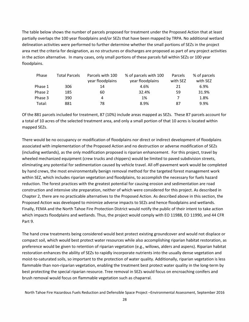
North Tahoe Fire Hazardous Fuels Reduction and Defensible Space Project ndashEnvironmental Assessment September 2016
35
Today high stand densities are characteristic of the Project area This unnaturally high density makes the forest
susceptible to most of the natural agents of disturbance (eg bark beetles disease and fire) found in the Lake
Tahoe Basin These degraded ecosystems ‐‐ like all ecosystems ‐‐ also face a growing threat from invasive
species which can replace native species alter natural balances and reduce habitat for other plant species as
invasive species are more competitive than native species
Key Regulatory Requirements and Standards
The Executive Order on Invasive Species (EO) 13112 (February 3 1999) aims to ldquoprevent the introduction of
invasive species and provide for their control and to minimize the economic ecological and human health
impacts that invasive species causerdquo To that end federal agencies are ordered ldquoto the extent practicable and
permitted by lawrdquo not to authorize fund or carry out actions that it believes are likely to cause or promote the
introduction or spread of invasive species unless the benefits of such actions outweigh the potential harm
Environmental Consequences
PROPOSED ACTION Fuels reduction would remove trees to achieve tree spacing goals and remove diseased
trees in order to allow larger healthier trees room to grow Following Project implementation the treated
parcels would reflect historic forest conditions with a stocking range thatrsquos typically between 50 and 150 square
feet of basal area per acre This is the primary long‐ and short‐term benefit of the project as thoroughly
described in the Projectrsquos Purpose and Need (Section 11 of this document)
Without the use of vehicles off pavement straw bales or other foreign materials being brought to the project
site there is little potential for the Proposed Project to contribute to the spread of invasive species Only chip
generated from the project area will be reapplied to the site Therefore Project implementation would comply
with EO 13112
NO ACTION ALTERNATIVE Under this alternative no vegetation treatments would take place There would be
no direct effects to vegetation or establishment (or treatment of) invasive species from Project implementation
However there would also be no reduction in the fuel loads in the project area The possibility of a crown‐
carried wildfire would not be reduced Conditions are ripe for a stand‐destroying wildfire spreading through the
tree crowns threatening forest stands and ecosystems
North Tahoe Fire Hazardous Fuels Reduction and Defensible Space Project ndashEnvironmental Assessment September 2016
36
34 Cultural Resources
341 Archaeological and Historic Resources
Affected Environment Environmental Setting
Historic properties are defined as any prehistoric or historic district site building structure or object included
in or eligible for listing for inclusion in the National Register of Historic Places FEMA in coordination with the
State Historic Preservation Officer (SHPO) Tribal Historic Preservation Officer (THPO) and other consulting
parties must identify historic properties that may be affected by any proposed project and assess adverse
effects of the actions To further this requirement AECOM completed a Final Historic Properties Inventory and
Evaluation Report for the Project in 2013 and SHPO consultation (see Appendix E) The report documents the
investigation that identified historic properties in the Projectrsquos Analysis Area and the Area of Potential Effects
(APE) and includes the methods and results of such investigation which consisted of consultation a records and
literature research archival research and an intensive pedestrian surveys by an archaeological field crew
In December of 2012 FEMA sent consultation letters (Appendix F) to Indian Tribes for whom the properties
might be religiously or culturally significant Letters were sent to the Washoe Tribe of Nevada and California the
Shingle Springs Band of Miwok Indians and the United Auburn Indian Community of the Auburn Rancheria of
California One response was received from the Shingle Springs Rancheria (included in Appendix F) which stated
that the Shingle Springs Band of Miwok Indians were not aware of any known cultural resources on the site The
Tribe requested continued consultation through project updates from FEMA in order to foster a greater
communication between the Tribe and the agency The Tribe made a similar request when commenting on the
Draft EA (see Appendix L) FEMA provided the requested consultation by notifying the Tribe of the Draft and
Final EA availability affording the Tribe an opportunity to review FEMArsquos cultural resources report and agreeing
to re‐consult with the Tribe in the event of an unanticipated discovery No tribal cultural resources (sites
features places cultural landscapes sacred places and objects with cultural value to a California Native
American tribe) have been identified through the records searches site surveys or tribal inquires conducted for
this project
Key Regulatory Requirements and Standards
National Historic Preservation Act of 1966 (NHPA 16 USC 470F as amended) and its implementing regulations
found at 36 CFR Part 800 and the 2005 First Amended Programmatic Agreement between FEMA and the State
Historic Preservation Officer (SHPO) and the Advisory Council on Historic Preservation NHPA and its
implementing regulations as well as the Programmatic Agreement require that FEMA take into account the
effects of any federally funded or assisted project on historic properties
Additionally Section 101(d)(6)(B) of NHPA recognizes the Federal governmentrsquos trust responsibilities to Tribes
under a government‐to‐government relationship and its obligation to ensure that the Tribesrsquo reserved rights are
protected Consultation with tribes helps insure that these trust responsibilities are met
Environmental Consequences
North Tahoe Fire Hazardous Fuels Reduction and Defensible Space Project ndashEnvironmental Assessment September 2016
37
PROPOSED ACTION All parcels in the Projectrsquos Analysis Area that contained potential historic resources were
removed from the Proposed Action Project area Consequently no historic properties are located within the APE
and no parcels with identified unevaluated historic resources are proposed for treatment under this Proposed
Action One resource (P‐31‐001889) was previously determined ineligible for listing in the National Register of
Historic Places in 1994 FEMA made a finding of no historic properties affected pursuant to the Programmatic
Agreement (see Appendix E)
With a full site survey and the elimination from the Project area of all parcels that contained unevaluated
historic resources the risk of damage to known historic resources is eliminated However there is the potential
to encounter previously undiscovered resources during Project implementation FEMA will condition the grant
to NLTFPD so that if any buried archaeological resources are discovered all ground disturbing activities would
cease at that location until a qualified archaeologist completes a determination of eligibility The Final Historic
Properties Inventory and Evaluation Report describes the following process in the event of such a discovery
If a discovery of an artifact andor human remains is made during the implementation of the Proposed
Project the operator will cease all activity within 100 feet (30 meters) and notify the Conservancy and
CalEMA immediately CalEMA will notify FEMA and ensure that all reasonable measures are taken to
avoid or minimize harm to the resource until FEMA completes additional consultation with the SHPO
and the appropriate tribes If human remains are found including disarticulated or cremated remains
the Conservancy will also contact the Placer County CoronerMedical Examiner and the local law
enforcement office Pursuant to the California Health and Safety Code if the CoronerMedical Examiner
determines that the human remains are or may be of Native American origin the discovery will be
treated in accordance with Section 509798 (a‐d) of the California Health and Safety Code At that point
the Conservancy would obtain a qualified archaeologist with Native American burial experience if
possible to conduct an investigation of the human remains All mitigation regarding the human remains
would be implemented prior to the resumption of ground‐disturbing activities within 100 feet of the
discovery site
The SHPO has no objection to FEMArsquos finding of No Historic Properties Affected for this undertaking as described
(see Appendix E) The project described in the Final Historic Properties Inventory and Evaluation Report
considered the potential for mechanical treatment (mastication) as well as hand treatment for vegetation
removal As the project evolved mechanical treatment was removed from consideration in the Proposed Action
leaving only hand treatments which is within the scope of the project described to the SHPO
NO ACTION ALTERNATIVE Under the No Action Alternative no direct impacts to historic properties would occur
because no forest treatment would occur The No Action Alternative could result in indirect effects to historic
properties in the event of a wildfire that damaged historic properties in or adjacent to the project area
North Tahoe Fire Hazardous Fuels Reduction and Defensible Space Project ndashEnvironmental Assessment September 2016
38
35 Socioeconomic Resources
351 Land Use
Affected Environment Environmental Setting
The project area contains scattered Conservancy‐owned urban lots within the unincorporated Placer County
portion of the Lake Tahoe Region within the zoning found in the Tahoe Regional Planning Agencyrsquos (TRPArsquos) Plan
Area Statements and Community Plan areas Nearby land uses include single family and some multifamily
homes undeveloped public and private areas recreational areas and schools and some retailcommercial
areas
The TRPA Regional Plan guides land use decision making Twenty‐five Plan Area Statements (PAS) and
Community Plans govern the geographic area encompassed by this project Each Plan Area Statement or
Community Plan provides a description of the land use for a planning area (mapped in Appendix G) identifies
area‐specific planning issues and establishes specific direction for planning to meet the policy direction of the
Regional Plan Goals and Policies document These plan area statements and any adopted community plans or
area plans that superseded the plan area statements where applicable provide detailed planning and land use
policies for the specific geographic areas over which they provide zoning Placer County has also adopted the
PAS and Community Plans in lieu of traditional zoning All projects and activities must be consistent with the
provisions of their applicable plan area statement
Land use regulatory authority for a fuels reduction project in this area rests with the TRPA The forestry‐related
Permissible Uses in the various PAS and Community Plans provide TRPA the authority to authorize fuel reduction
activities TRPA and the Tahoe Conservancy have an existing Memorandum of Understanding (MOU 1999) that
allows for vegetation management activities
Environmental Consequences
PROPOSED ACTION TRPA has issued a Tree Removal Permit (Appendix H) for the 881 properties being
considered for treatment under the Proposed Action that clarifies the Conservancyrsquos ability to move forward
with the project under the authority of the 1988 MOU No zoning or other Regional Plan changes were required
or requested in order to authorize this permit which authorizes Project activities consistent with the Resource
Management Permissible Uses found in the applicable PASCommunity Plans The project is consistent with all
applicable permissible land uses land use plans policies and regulations for agencies with jurisdiction over the
activities
NO ACTION ALTERNATIVE Under this alternative no vegetation removal would occur and no land use permits
would be required
North Tahoe Fire Hazardous Fuels Reduction and Defensible Space Project ndashEnvironmental Assessment September 2016
39
352 Noise
Affected Environment Environmental Setting
The Project is located on parcels within next to and near residential areas In addition to single‐ and multi‐
family homes additional potentially ldquosensitive receptorsrdquo ndash land uses where there is a reasonable degree of
sensitivity to noise such as hospitals schools churches rest homes cemeteries and libraries per the Placer
County Noise Ordinance (Ordinance 5280‐B) ‐‐ exist within the Project area These noise sensitive land uses
(mapped in Appendix I) are particularly adversely affected by noisy activities
The main source of noise is from vehicular traffic along roadways with secondary sources being aircraft
overflight transitory recreationist and more typical neighborhood sounds (eg lawn mowers home
construction sounds music children chainsaws log splitters and barking dogs) With the current emphasis on
creation of defensible space on private land the sound of chainsaws and chippers more commonplace
The TRPA has established an environmental standard for noise called the Community Noise Equivalent level
(CNEL) The TRPA CNEL for high density residential and urban outdoor recreation areas is 55 dBA and low
density residential areas is 50 dBA The CNEL value is an average sound level for a specific time interval with a
weight factor incorporated to penalize sounds which occur during evening or nighttime hours This is done to
reflect the intrusive effects noise sources have during nighttime hours Noise levels occurring between 700 am
and 700 pm are not normally weighted
Environmental Consequences
PROPOSED ACTION Noise producing mechanized equipment that would be used to implement the Proposed
Action would be limited to chainsaws chippers and crew vehicles all of which are commonly used in
neighborhood settings by tree service companies doing work for private landowners Short‐term noise effects
are anticipated during Project activities and occasional maintenance activities resulting in a temporary increase
in the ambient noise levels Because the project treats small urban lots the effect of project noise on area
residents would be transitory louder when work is done on nearby parcels quieter as the work progresses
down the street and elsewhere in the neighborhood This is because sound attenuates based upon distance
from the source However since the duration of impact at any one parcel would be very brief (typically less than
one day) and since the impact would occur during less sensitive daytime hours the impact from construction‐
related ground borne noise would not be substantial Project implementation may result in a temporary and
periodic exposure to noise levels in excess of the established standards as is allowable under local and Regional
ordinances Long‐term there are no new noise sources or changes to ambient noise levels resulting from the
project
Because 69 of the homes in the Placer County portion of the Tahoe Basin are second homes it is likely that the
occupants of many the houses in the Project vicinity will vary over the duration of project implementation No
specific neighbor notifications are proposed
The exemption to noise limitations Section 238 of the TRPA Code would apply to fuel reduction operations
associated with the Project This section permits approved projects to exceed the noise limitations between the
North Tahoe Fire Hazardous Fuels Reduction and Defensible Space Project ndashEnvironmental Assessment September 2016
40
hours of 800 am and 630 pm Similarly Placer Countyrsquos noise ordinance provides an exemption to its noise
ordinance (Article 936030 of the Placer County Code) for activities that take place between 600 am and 800
pm Monday through Friday and 800 am and 800 pm Saturday and Sunday The Project would comply with
the most restrictive of these limitations
NO ACTION ALTERNATIVE Under this alternative no vegetation clearing would take place There would be no
noise effects due to Project implementation
353 TransportationTraffic
Affected Environment Environmental Setting
The project area includes scattered urban parcels throughout the North and West shore areas The
transportation system serving these parcels is characterized by a street network of neighborhood roads
accessed by arterial streets and connected by State Routes 89 and 28 This system experiences low traffic
volumes along neighborhood streets that is well within acceptable design capacity Near the developed
commercial centers along the state highways traffic volumes during peak tourist visitation periods often
produce congestion
Environmental Consequences
PROPOSED ACTION Project activities would generate very low parking needs and low trip generation The
project would require access on neighborhood streets for crew vehicles and a mechanical chipper to be parked
near the urban parcels receiving treatment Site access would be on foot with no temporary roads constructed
as part of this project and no unpaved forest roads used Felled trees would be cut into firewood length pieces
(rounds) by the crews and left for hand removal by the public for firewood In limited cases crews may move
rounds to the edge of the street to prevent soil erosion The street system easily accommodates the limited
parking needs for project in additional to normal neighborhood use Locations for staging of rounds for public
fuelwood collection would be carefully selected to avoid causing or increasing traffic congestion or hazardous
traffic conditions In addition because the urban parcels are scattered over a large area additional trips tofrom
any one part of the project site are likely to be negligible
NO ACTION ALTERNATIVE No change to the transportation system or traffic volume or patterns would occur
with the No Action Alternative
354 Hazardous Materials
Affected Environment Environmental Setting
The term ldquohazardous substancerdquo refers to both hazardous materials and hazardous wastes including explosives
A material is defined as hazardous if it appears on a list of hazardous materials prepared by a federal state or
local regulatory agency or if it has characteristics defined as hazardous by such an agency The California
Environmental Protection Agencyrsquos (CalEPArsquos) Department of Toxic Substances Control (DTSC) defines hazardous
waste as a substance whose ldquoquantity concentration or physical chemical or infections characteristics (1)
cause or significantly contribute to an increase in mortality or an increase in serious irreversible or
North Tahoe Fire Hazardous Fuels Reduction and Defensible Space Project ndashEnvironmental Assessment September 2016
41
incapacitating reversible illness (2) pose a substantial present or potential hazard to human health or the
environment due to factors including but not limited to carcinogenicity acute toxicity chronic toxicity
bioaccumulative properties or persistence in the environment when improperly treated stored transported
or disposed of or otherwise managedrdquo See California Health and Safety Code sect25141(b) The CalEPA and the
State Board establish rules governing the use of hazardous materials and the management of hazardous waste
If a release of a hazardous substance is detected in the project area the NTFPD responds to evaluate conditions
and determine if additional emergency services will be required
Given that the project area is largely undeveloped land located away from industrial or heavy commercial sites
it has a low risk for hazardous materials contamination Known leaking and non‐leaking underground storage
tanks in this portion of Placer County are largely concentrated in the commercial areas along the highways
outside of the urban lots considered for treatment by this project Project construction or operation affected or
otherwise disturb these sites
Naturally occurring asbestos (NOA) is known to be present in Placer County To help identify areas in the county
that may contain NOA the California Department of Conservation California Geological Survey (CGS) has
prepared a 1100000‐scale map of relative likelihood for the presence of naturally occurring asbestos in Placer
County The project area is not located near any of the areas identified as containing Ultramafic Rocks and is
mapped as an Area Least Likely to Contain NOA
Environmental Consequences
PROPOSED ACTION Gasoline and diesel fuels oils and the like are hazardous materials that would be used to
power the mechanized equipment needed to complete the project (eg chainsaws and chippers) These are
hazardous materials that could impact natural resources such as water soils plants and animals if
unintentionally released into the environment Standard best management practices would be routinely
incorporated into Conservancy forestry operations including the Proposed Action to protect the environment
from the risk of Hazardous Materials spills resulting from land management activities Such best management
practices include the following
1 Vehicles and chippers would only be fueled at an offsite permitted fuel station and vehicle
maintenance including washing would also occur off site at an existing commercial facility
2 Small mobile equipment (eg chain saws) would be fueled and lubricated during operations typically
within the paved or vegetation‐free portions of a county road However chainsaw service and fuel
storage (in approved UL or DOT containers) would occasionally occur within more remote portions of
the project area but only in areas that are free of flammable materials for a radius of at least fifteen
feet Remote refueling and lubricating of small equipment would be restricted to upland areas at least
100 feet away from the edge of any streams wetlands ditches and other waterbodies and 150 feet
from water supply wells Dispensing of fuel would only occur at least 10 feet away from any sources of
ignition smoking is prohibited during fueling Chainsaws would not be started or operated within ten
feet of a refueling point or otherwise near stored fuel
3 Crews would be supplied with absorbent and barrier materials to contain and recover accidental spills of
fuels and lubricants (spill kit) The liquid recovery capacity of the spill kit would be equal to or greater
North Tahoe Fire Hazardous Fuels Reduction and Defensible Space Project ndashEnvironmental Assessment September 2016
42
than the maximum total volume of fuel plus lubricant for the equipment being used The spill kit would
be available in close proximity to areas where chemicals are stored or refueling would occur to enable
prompt response and clean‐up of spills or other discharges of hazardous substances Employees would
be briefed at weekly ldquotailgate sessionsrdquo with the location and contents of all spill kits and the procedures
to be followed in the event of a leak or spill
4 Any leaks drips and other spills would be cleaned up immediately to avoid soil or groundwater
contamination Cleanup of a spill on soil would include the removal of contaminated soil Any
contaminated soil and disposable gear used to clean up a hazardous materials spill would be properly
disposed of following State and Federal hazardous material disposal regulations Spills would be
immediately reported to the Conservancy
5 Major maintenance activities and repairs to equipment would occur off site at an approved facility
With implementation of these standard operating procedures the risk of Project implementation resulting in an
unintended hazardous material release is reduced to a level of nonsignificance
NO ACTION ALTERNATIVE The no action alternative would not use any gasoline diesel fuels or oils in the
project area eliminating any potential for contamination
355 Public Health and Safety
Affected Environment Environmental Setting
The general public utilizes the project area for community open space neighborhood pedestrian ldquocut throughsrdquo
and recreation access points to larger public lands Because these lands are proximate to residences the
possibility of a wildfire igniting on the public property is the primary public health and safety concern
Environmental Consequences
PROPOSED ACTION Standard best management practices that would be routinely incorporated into
Conservancy forestry operations including the Proposed Action protect Public Health and Safety from the
possibility of a fire ignition resulting from land management activities These best management practices
include
All chainsaws and chippers would be equipped with spark arrestors
For emergency use in the event of a fire vehicles would be typically equipped with one shovel one ax or
Pulaski and a fully charged fire extinguisher Additionally a ldquofire tool boxrdquo would be located within each
active operating area typically containing a five gallon backpack pump filled with water two axes or
Pulaski two McLeods one chainsaw (35 horsepower or greater) with a twenty inch or longer cutting
blade and one shovel for each employee at the operation
Employee smoking would not be permitted during the fire season except on the paved streets
With these standard operating procedures the risk of the project resulting in an unintended wildfire ignition is
reduced to a level of nonsignificance
North Tahoe Fire Hazardous Fuels Reduction and Defensible Space Project ndashEnvironmental Assessment September 2016
43
Community 2000 Population 2010 Population Percent Change Dollar Point 1539 1215 ‐211 Kings Beach 4037 3796 ‐60
Sunnyside 1761 1557 ‐116 Tahoe Vista 1668 1433 ‐141 Carnelian Bay na 524 na Tahoma na 1101 na
Other 3153 na na Total 12158 9716 ‐201
NO ACTION ALTERNATIVE Under this alternative vegetation treatment would not take place There would be
no direct risks to public health and safety from Project implementation There would also be no reduction in the
fuel loads in the project area Therefore the possibility of a wildfire ignition would not be reduced challenging
the ability to suppress a fire due to forest conditions in the area
356 Socioeconomics and Environmental Justice
Affected Environment Environmental Setting
The projectrsquos analysis area is situated on the northwest side of the Lake Tahoe Basin extending west from the
CaliforniaNevada state line on the north shore to the El Dorado County‐Placer County line on the west shore in
Tahoma The analysis area consists of approximately 238 acres of forested land located within and adjacent to
larger developed subdivisions and unincorporated communities located within the NTFPD (eg Carnelian Bay
Cedar Flat Dollar Point Highlands Lake Forest Homewood McKinney Tahoma Kings Beach Tahoe City Tahoe
Park Talmont Tahoe Vista and Agate Bay) The NTFPD serves the various communities within its approximately
34‐square mile boundary The area served has a permanent population of an estimated 10000 residents with a
seasonal fluctuation visitors that dramatically increases population especially on holiday weekends The
economy is primarily tourist‐based with governmental agencies and ski resorts as the major employers
Population Trends in the Project Area
Source Placer County Socio‐Economic Plan for Tahoe Basin Community Update (20002010 US Census)
The table above uses US Census data to demonstrate that the permanent population in the Project Area dropped by more than 20 percent between 2000 and 2010 Loss of employment opportunities coupled with quickly escalating housing prices drove some residents to relocate often do to lack of housing affordability or in other cases to capitalize on the sale of their homes for high prices Many of the residences sold to second homeowners who reside outside the Tahoe Basin and use their homes for vacations and recreation and sometimes as vacation rentals Others serve as long‐term rentals however todayrsquos higher selling prices often lead to increased rent being charged TRPArsquos parcel data base (2010) reports that 397 of Placer Countyrsquos homes are primary residences while 692 are second homes
Relative to most other regions in the United States all four counties in the Lake Tahoe Basin have a high percentage of housing that is vacant except during the summer The 2010 Census reports total housing units for the Tahoe Basin portion of Placer County as 12106 Estimates prepared for the TRPA indicate that Placer County has the greatest percentage (over 69) of second‐home ownership in the Basin Most second home occupancy occurs between the 4th of July and Labor Day which corresponds with the arearsquos peak fire season
North Tahoe Fire Hazardous Fuels Reduction and Defensible Space Project ndashEnvironmental Assessment September 2016
44
Housing Occupancy in the Project Area Community Total Units Vacant
(Typically) Percent Vacant
Vacant Used for Seasonal Use
Percent Vacant used for Seasonal Use
Carnelian Bay 947 691 730 654 946 Dollar Point 1822 1251 687 1178 942 Kings Beach 2372 1010 426 807 799
SunnysideTahoe City 2119 1375 649 1239 901 Tahoe Vista 1446 818 566 735 899 Tahoma 2058 1505 731 1428 949
Source Placer County Socio‐Economic Plan for Tahoe Basin Community Update (20002010 US Census)
According to the 2010 Census data most of the full time residents in the Project Area are White (69) One Placer County community in the project area Kings Beach has a higher percentage of Hispanic or Latino residents (56) Many of these residents earn less than the statewide average In 2010 the annual median household income for Kings Beach was $37348 while statewide it was $61094 Accordingly Kings Beach is classified as a disadvantaged community by the California Department of Water Resources A disadvantaged community is a community with a median household income less than 80 percent of the statewide average None of the other communities within the Project Area are classified as disadvantaged communities
2010 Census Data Placer County Race and Ethnicity Generally at Lake Tahoe
White (Non Hispanic Latino)
African American
American Indian
Asian Pacific Islander
Hispanic or Latino
Other or Multi‐Racial
Total
Total of Placer County
246267 4751 3011 21213 44710 28480 48432
Lake Tahoe portion of Placer County
6705 48 51 117 2720 807 10 448
Source US Census Bureau 2010 Census (Hispanic or Latino and Race)
Race and Ethnicity in the Project Communities Community White Hispanic or
Latino American Indian
Asian Black or African American
Other
Dollar Point 1090 83 6 19 4 13 Kings Beach 1620 2115 13 14 3 31
SunnysideTahoe City 1431 84 2 15 3 22 Tahoe Vista 1025 352 5 21 3 27 Carnelian Bay 482 13 4 14 1 10
Tahoma 1090 51 10 14 6 20 Total 6738 2698 40 97 20 123
Average 693 278 4 10 2 13 Source Placer County Socio‐Economic Plan for Tahoe Basin Community Update (2010 US Census)
Housing density in the Tahoe Basin is low when compared with other Placer County communities The Forest Service and the State both have had environmentally sensitive land acquisition programs that have purchased undeveloped urban lot parcels within developed subdivisions such as the parcels being considered for treatment with this Project When combined with regional growth control ordinances these public land acquisitions contribute to the low densities in these rural communities In the Project Area the Carnelian Bay community has the lowest housing density and Kings Beach has the highest
North Tahoe Fire Hazardous Fuels Reduction and Defensible Space Project ndashEnvironmental Assessment September 2016
45
Housing Density in the Project Area Community Total Units Acres by Corresponding Census Tract Units Per Acre Carnelian Bay 947 7037 013 Dollar Point 1822 5812 031 Kings Beach 2372 1850 128
SunnysideTahoe City 2119 5954 036 Tahoe Vista 1446 5563 026 Tahoma 2058 7027 029
Source Placer County Socio‐Economic Plan for Tahoe Basin Community Update (20002010 US Census)
Environmental justice is the fair treatment and meaningful involvement of all people regardless of race color
national origin or income with respect to the development implementation and enforcement of
environmental laws regulations and policies It would be achieved when everyone enjoys the same degree of
protection from environmental and health hazards equal access to the decision‐making process and the
opportunity to have a healthy environment in which to live learn and work
Regulatory Requirements and Standards
Environmental Justice in Minority Populations and Low‐Income Populations EO 12898 This Presidential
Executive Order directs federal agencies to ensure that their programs policies and activities do not have a
disproportionately high and adverse human health and environmental effect on minority or low‐income
populations It requires that all federal actions consider potentially disproportionate effects on minority and
low‐income communities especially if adverse effects to environmental or human health conditions are
identified It also tasks federal agencies with ensuring that public notifications regarding environmental issues
are concise understandable and readily accessible
Environmental Consequences
PROPOSED ACTION Factors considered in determining whether the Proposed Action would affect
environmental justice included the extent or degree to which its implementation would change any social
economic physical environmental or health conditions so as to disproportionately and adversely affect any
particular low‐income or minority group
Conditions created by the Proposed Action would not affect any minority or low‐income neighborhood
disproportionately The activities found in the Proposed Action were based solely on the existing and desired
condition of the vegetation sensitivity of the environment and practical treatment access in response to the
identified Project Purpose and Need In no case was the treatment prescription design based on the
demographic makeup occupancy property value income level or any other criteria reflecting the status of
adjacent non‐federal land The prescription to be applied to the forest treatment activities are consistent
between the communities The Conservancyrsquos State owned lands proposed for treatment are distributed
throughout the project area and are intermixed with non‐State lands The project would not affect land in any
way that would impact minority or low‐income neighborhoods disproportionately There is no evidence that any
individual group or portion of the community would benefit unequally from this decision
North Tahoe Fire Hazardous Fuels Reduction and Defensible Space Project ndashEnvironmental Assessment September 2016
46
NO ACTION ALTERNATIVE Under the No Action Alternative there are no socioeconomic or environmental
justice impacts This Alternative would not create conditions that could have potentially disproportionate effects
on minority and low‐income communities including those related to environmental or human health conditions
357 Recreation Resources
Affected Environment Environmental Setting
As urban lots in developed subdivisions the parcels within the Project Area are not part of the Tahoe Regionrsquos
system of destination developed recreation sites (Appendix I Recreation Infrastructure and Improvements
maps) However some parcels within the project area contain user‐created trails which provide access for
dispersed non‐motorized recreational opportunities such as walking mountain biking and cross‐country skiing
These trails often provide through access to other desired destinations including larger public land parcels
Motorized vehicles are generally not allowed on Conservancy properties
Environmental Consequences
PROPOSED ACTION Public recreation use could be impacted by debris from project activities Treatment
activities could pose a threat to public safety during tree felling from crews working with noise‐generating
equipment and from flying debris In addition to creating a public safety hazard noise from equipment could
also affect recreational users in the vicinity by adversely impacting the recreational experience
To protect public safety and Consistent with the Conservancyrsquos adopted Forestry Guidelines (Appendix B) prior
to implementation of forestry projects greater than three acres in size the Conservancy notifies adjacent
property owners by mail In addition notices regarding individual or groups of Conservancy properties may be
posted by the operator to redirect public use while fuels reduction activities are actively taking place At no time
would all California Tahoe Conservancy‐owned parcels proposed for treatment be posted to redirect use at the
same time Because of the small size of the parcels being treated implementation activities minimize the time
that each parcel or group of parcels is inaccessible and use is redirected around work sites User created trails
impacted by the project would be returned to a condition that is as similar as possible to their pre‐project
condition to restore existing public access patterns Public access would be restored as quickly as possible
following the completion of work in any given area within the Project
NO ACTION ALTERNATIVE The No Action Alternative would not have any immediate consequences for
recreational resources within the project area However long‐term adverse effects are likely from increasing
fuel loads Hazard trees could fall and impede passage through the project area presenting a safety hazard for
recreationists Overgrown brush may also compromise access to and through the project area
358 Visual Resources
Affected Environment Environmental Setting
Scenic quality in the Lake Tahoe Region is recognized as a primary resource of national significance The
combination of a stunning lake in a forested mountain setting creates this iconic landscape Within the Region
the undeveloped forests of the North Shore create the backdrop for a high diversity of lake and landscape views
North Tahoe Fire Hazardous Fuels Reduction and Defensible Space Project ndashEnvironmental Assessment September 2016
47
Scattered urban parcels included in the project area contribute to that backdrop and also provide a local
forested setting for residential and dispersed recreation development
The lands within the project area are well‐vegetated with cone‐bearing trees such as pines and firs deciduous
species such as aspens alders and willows shrubs such as manzanita gooseberry and bitterbrush and a variety
of forbs and grasses Many parcels contain downed woody material The visual character of the parcels in the
project area is dense vegetation with a diversity of colors and textures limited light penetration and areas of
substantial clutter from downed woody material The vegetation complex is considerably denser than historic
conditions when the forest character included a more open visually penetrable and mature‐tree dominated
landscape
In some cases the project area lands are visible from TRPA‐designated scenic corridors where they combine
with other undeveloped land to form the forested backdrop critical to attaining and maintaining visual
standards The TRPA adopted scenic threshold standards in 1984 that establish minimum visual and scenic
quality ratings for eight roadway eight shoreline and nine recreation area and bike trail scenic corridors in the
project vicinity
Environmental Consequences
PROPOSED ACTION Project activities would alter both the view of the subject parcels themselves and the
extent to which the vegetation on the parcels screens views of existing development On individual parcels fuel
reduction activities that have visual implications include removal of existing downed woody material and tree
and brush thinning These actions create a more sparsely vegetated site dominated by mature trees a condition
that is more consistent with historical conditions Visual effects include increased sunlight decreased clutter
from existing downed material and greater sight distances Retention of smaller tree and shrub islands (where
fuel reduction objectives can still be met) would serve to limit potential adverse effects of these changes as
would requiring stumps to be cut less than six inches in height (where possible) Increasing sunlight allows
diverse flower and shrub species to become established
Project activities would alter the visual environment for viewers close to the project lands Tree and shrub
removal would create an ldquoopen feelrdquo and a less dense forest and increase sight distance through each parcel In
some locations this would increase view of surrounding development typical in residential communities
including houses roads and trails Retaining areas of shrub and small diameter trees consistent with fuel
reduction goals would retain some screening value for surrounding land uses These smaller trees to be
retained and shrub ldquoislandsrdquo of irregular shapes and sizes would provide a more natural‐appearing mosaic in
the landscape as viewed from homes roads and trails As viewed from farther away and along scenic corridors
project activities would reduce the density of forest cover potentially increasing the view of existing
development within the forest backdrop While this is true the thinning prescription would retain substantial
numbers of mature trees on each parcel As viewed from a distance these mature trees would retain substantial
screening value and would maintain the visual continuity of the forested backdrop This would limit the effect on
TRPA designated scenic corridors and avoid threatening threshold attainment
North Tahoe Fire Hazardous Fuels Reduction and Defensible Space Project ndashEnvironmental Assessment September 2016
48
40
Project activities would produce a landscape with more historically accurate visual features The short‐term
effects of the project activities would create visual change on subject parcels yet project elements focused on
creating a healthy forest and mosaic of shrubs would limit the adverse effects of that change Long‐term effects
would be primarily beneficial because of the park‐like setting that will remain
NO ACTION ALTERNATIVE
The no action alternative would not have immediate consequences for the visual resources of the project area
Over time vegetation density would increase and further diminish sight distance through the forested parcels
Overstocked forests also have a higher likelihood of being impacted by diseases or pests which may increase
tree mortality Dead trees would degrade the visual character of the landscape as standing snags or fallen logs
Increased risk of wildfire inherent in the no action alternative would also increases the risk of significant visual
degradation resulting from fire
CUMULATIVE IMPACTS
NEPA defines a cumulative impact as an ldquoimpact on the environment which results from the incremental impact
of the action when added to other past present and reasonably foreseeable future actions regardless of what
agency (Federal or non‐Federal) or person undertakes such other actionsrdquo (40 CFR sect 15087) Cumulative
impacts can result from individually minor but collectively significant actions taking place over a period of time
PROPOSED ACTION The cumulative effect of the Proposed Action in combination with other existing and
proposed vegetation and fuel treatments by other agencies and the private sector would increase the overall
effectiveness of fuel reduction and improve forest health on the landscape scale The fuel treatments under the
Proposed Action would combine with existing treatments by other entities to create a relatively open forest
structure where fuel amounts and arrangements have been altered to change potential fire behavior in the
event of a wildfire keeping the burn low to the ground and out of the tree crowns
North Tahoe Fire Hazardous Fuels Reduction and Defensible Space Project ndashEnvironmental Assessment September 2016
49
50 SUMMARY OF IMPACTS AND MITIGATION
Mitigation measures are actions that have been identified to avoid or minimize environmental impacts of
project implementation on social cultural and natural environmental resources The environmental
consequences analysis for this Project has not identified any significant impacts requiring mitigation due largely
in part to the specific elements of the Proposed Action that protect specific natural and cultural resources
through avoidance and minimization of potential impact These measures for minimizing impacts are
summarized here
Air Quality
1 No prescribed fire activities including pile burning would be conducted on any parcel that receives
treatment under this Project including during the eleven‐year post‐treatment Project maintenance
period (Appendix C)
Water Quality
1 Fallers would use falling wedgestechniques to directionally fall trees away from stream channels and SEZ
2 In SEZ preference would be given to retention of riparian vegetation (eg willows alders and aspens)
tree and brush removal would focus on encroaching conifers and flammable chaparral
3 Within SEZs and 100 year floodplains the bole of all existing down trees would be left in place with limbs
removed
4 All stream bank trees greater than 14rdquo DBH would be retained unless determined to be a safety hazard to
adjacent structures or other targets
Wildlife
1 An average of two of the largest diameter non‐hazardous standing dead trees (also called ldquosnagsrdquo) per
acre will remain following treatment In evaluating snags for retention all snags greater than 30rdquo DBH and
all those greater than 24rdquo DBH in decay Class 6 or higher would be retained unless they become so
numerous that the forestry or fire professionals marking the property determine that they pose an
unacceptable fire hazard or evaluate them to be a hazard tree In order to protect life and property all
hazard trees would be removed around homes roads and trails even when the above‐described snag
retention standard cannot otherwise be met on a parcel
2 At least three to five of the largest logs per acre would remain
3 Certain parcels would be subjected to Limited Operating Periods (LOPs) for wildlife reasons Specifically
no fuels reduction activities that cause vegetation disturbance would occur in SEZ parcels with riparian
habitat between May 1 and August 15 Mapped ldquono disturbance zonesrdquo for northern goshawk and osprey
would also prohibit vegetation removal from February 15 to September 15 and March 1 to August 15
respectively
North Tahoe Fire Hazardous Fuels Reduction and Defensible Space Project ndashEnvironmental Assessment September 2016
50
4 Since migratory bird species have the potential to nest throughout the project area pre‐treatment nesting
bird surveys would be conducted during the nesting season (May 1 to August 15) and treatments would
be postponed in areas near active bird nests
Cultural Resources
1 If a discovery of an artifact andor human remains is made during the implementation of the Proposed
Project the operator will cease all activity within 100 feet (30 meters) and notify the Conservancy and
CalEMA immediately CalEMA will notify FEMA and ensure that all reasonable measures are taken to
avoid or minimize harm to the resource until FEMA completes additional consultation with the SHPO
and the appropriate tribes If human remains are found including disarticulated or cremated remains
the Conservancy will also contact the Placer County CoronerMedical Examiner and the local law
enforcement office Pursuant to the California Health and Safety Code if the CoronerMedical
Examiner determines that the human remains are or may be of Native American origin the discovery
will be treated in accordance with Section 509798 (a‐d) of the California Health and Safety Code At
that point the Conservancy would obtain a qualified archaeologist with Native American burial
experience if possible to conduct an investigation of the human remains All mitigation regarding the
human remains would be implemented prior to the resumption of ground‐disturbing activities within
100 feet of the discovery site
Noise
1 The exemption to noise limitations Section 238 of the TRPA Code would apply to fuel reduction
operations associated with the Project This section permits approved projects to exceed the noise
limitations between the hours of 800 am and 630 pm Similarly Placer Countyrsquos noise ordinance
provides an exemption to its noise ordinance (Article 936030 of the Placer County Code) for activities
that take place between 600 am and 800 pm Monday through Friday and 800 am and 800 pm
Saturday and Sunday The Project would comply with the most restrictive of these limitations
Hazardous Materials
1 Vehicles and chippers would only be fueled at an offsite permitted fuel station and vehicle maintenance
including washing would also occur off site at an existing commercial facility
2 Small mobile equipment (eg chain saws) would be fueled and lubricated during operations typically
within the paved or vegetation‐free portions of a county road However chainsaw service and fuel storage
(in approved UL or DOT containers) within more remote portions of the project area would occasionally
occur and would be free of flammable materials for a radius of at least fifteen feet Remote refueling and
lubricating of small equipment would be restricted to upland areas at least 100 feet away from the edge of
any streams wetlands ditches and other waterbodies and 150 feet from water supply wells Dispensing
of fuel would only occur at least 10 feet away from any sources of ignition smoking is prohibited during
fueling Chainsaws would not be started or operated within ten feet of a refueling point or otherwise near
stored fuel
North Tahoe Fire Hazardous Fuels Reduction and Defensible Space Project ndashEnvironmental Assessment September 2016
51
3 Crews would be supplied with absorbent and barrier materials to contain and recover accidental spills of
fuels and lubricants (spill kit) The liquid recovery capacity of the spill kit would be equal to or greater than
the maximum total volume of fuel plus lubricant for the equipment being used The spill kit would be
available in close proximity to areas where chemicals are stored or refueling would occur to enable
prompt response and clean‐up of spills or other discharges of hazardous substances Employees would be
briefed at ldquotailgate sessionsrdquo with the location and contents of all spill kits and the procedures to be
followed in the event of a leak or spill
4 Any leaks drips and other spills would be cleaned up immediately to avoid soil or groundwater
contamination Cleanup of a spill on soil would include the removal of contaminated soil Any
contaminated soil and disposable gear used to clean up a hazardous materials spill would be properly
disposed of following State and Federal hazardous material disposal regulations Spills would be
immediately reported to the Conservancy
5 Major maintenance activities and repairs to equipment would occur off site at an approved facility
Public Health and Safety
1 All chainsaws and chippers would be equipped with spark arrestors
2 For emergency use in the event of a fire vehicles would be typically equipped with one shovel one ax or
Pulaski and a fully charged fire extinguisher Additionally a ldquofire tool boxrdquo would be located within each
active operating area typically containing a five gallon backpack pump filled with water two axes or
Pulaski two McLeods one chainsaw (35 horsepower or greater) with a twenty inch or longer cutting
blade and one shovel for each employee at the operation
3 Employee smoking would not be permitted during the fire season except on the paved streets
Recreation
1 Notices regarding individual or groups of Conservancy properties may be posted by the operator to
redirect public use while fuels reduction activities are actively taking place
2 At no time would all California Tahoe Conservancy‐owned parcels proposed for treatment be posted to
redirect use at the same time
3 User created trails impacted by the project would be returned to a condition that is as similar as possible
to their pre‐project condition to restore existing public access patterns
Visual Resources
1 Where possible require stumps to be cut less than six inches in height
North Tahoe Fire Hazardous Fuels Reduction and Defensible Space Project ndashEnvironmental Assessment September 2016
52
60 PUBLIC PARTICIPATION AND AGENCY COORDINATION
Following the Angora Fire of 2007 the governors of Nevada and California created the California‐Nevada Tahoe
Basin Fire Commission (Commission) to examine regulatory and social environments that influence fuels
reduction in the Lake Tahoe Basin In their final report (May 2008) the Commission recognized the necessity of
multi‐jurisdictional collaboration to accomplish fuels reduction projects obtain and manage funding and to plan
and implement projects consistent with the Fuels Strategy or identified in geographically based community
wildfire protection plans The Tahoe Fire and Fuels Team (TFFT) implements the Fuels Strategy for the Lake
Tahoe Basin The original Strategy was updated and endorsed by the executives of TFFT member agencies in
August 2014
The TFFT allows partner agencies to collaborate plan and implement fuels reduction and other wildfire threat
reduction programs consistent with the Fuels Strategy and Community Wildfire Protection Plans throughout the
Tahoe Basin Final project locations are planned by the foresters for the fire district or state agency Members
include CAL FIRE California State Parks the Conservancy Fire Protection DistrictsDepartments in the Lake
Tahoe Basin Nevada Division of Forestry Nevada Division of State Lands Tahoe Regional Planning Agency and
the US Forest Service Supporting agencies include California Water Boards ndash Lahontan Region Tahoe
Resource Conservation District University of Nevada Cooperative Extension and the University of California
Cooperative Extension
An oversight body for the Fuels Strategy composed of the chief executive officers of the federal and state land
management agencies and the local fire agencies is called the Multi‐Agency Coordinating Group (MAC) It is the
principal group that monitors the Fuels Strategyrsquos implementation MAC members are charged with strategic
management of fuels reduction at Lake Tahoe They concur that the Proposed Action is a priority project under
the Fuels Strategy
The Conservancyrsquos Forest Improvement Program is responsible for managing the agencyrsquos forest resources
consistent with the Lake Tahoe Basinrsquos Environmental Improvement Program the Fuels Strategy and Community
Wildfire Protection Plan (CWPP) and California Government Code Section 6690710 which states ldquoThe
Conservancy may improve or develop lands for the purpose of protecting the natural environment or otherwise
meeting the objectives of this titlerdquo This Proposed Action was designed to treat priority areas based on the
Fuels Strategy and CWPP The Conservancy and the NTFPD have collaborated to refine the proposed treatment
areas for fuel reduction activities based upon these priorities
FEMA is the federal agency responsible for conducting the NEPA compliance process for the proposed project It
is FEMArsquos responsibility to expedite the preparation and review of NEPA documents in a way that is responsive to
the needs of the public while meeting the spirit and intent of NEPA and complying with all NEPA provisions
The proposed project is based on the work conducted in support of the NTFPDrsquos plan which involved a variety
of community organizations federal agencies state agencies regional and local agencies and educational
institutions in the process of identifying measures to reduce wildfire risk as described above
North Tahoe Fire Hazardous Fuels Reduction and Defensible Space Project ndashEnvironmental Assessment September 2016
53
FEMA and NTFPD circulated the Draft EA for a 30‐day public review and comment period beginning July 22 2016
The document was made available at FEMArsquos website (wwwfemagovmedia‐libraryassetsdocuments117686)
the California Tahoe Conservancyrsquos website (tahoecagov) the NTFPD website (wwwntfirenet) and in
hardcopies at local libraries (Tahoe City and Kings Beach) Notification of the Draft EArsquos availability was made via
direct mailing to known interested parties (Appendix K) FEMArsquos website and one‐time publication in the local
newspapers (Sierra Sun and North Lake Tahoe Bonanza) During the public comment period FEMA accepted
written comments on the Draft EA addressed to
FEMA Region IX
Environmental and Historic Preservation Office
Attn Draft EA for PDMC‐2010 CA‐019
1111 Broadway Suite 1200
Oakland California 94607
Email fema‐rix‐ehp‐documentsdhsgov
FEMA received three comment letters during the public review and comment period for the Draft EA These letters
are included in Appendix L At the end of the public review and comment period FEMA reviewed all public
comments and prepared this Final EA specifically to address those comments as part of the decision‐making
process This Final EA will be made available to all parties notified of the Draft EA (as listed in Appendix K) and the
individual who submitted the comment letters its availability will also be advertised in the Sierra Sun and North
Lake Tahoe Bonanza
North Tahoe Fire Hazardous Fuels Reduction and Defensible Space Project ndashEnvironmental Assessment September 2016
54
70 LIST OF PREPARERS
Federal Emergency Management Agency Region IX
Morgan Griffin
California Tahoe Conservancy
Whitney Brennan
Scott Cecchi
Brian Hirt
Sue Rae Irelan
Chris Jones‐Roberts
Lisa OrsquoDaly
Juan Carlos Urizar
North Tahoe Fire Hazardous Fuels Reduction and Defensible Space Project ndashEnvironmental Assessment September 2016
55
80 REFERENCES
Community Wildfire Protection Plan (P251 of the California Portion of the Tahoe Basin) 10‐year Plan C
G Celio amp Sons Co Steve Holl Consulting Wildland Rx November 20 2004
o httpwwwtrpaorgwp‐contentuploadsCWPP_CA_Basinpdf
Draft NEPA Guidance on Consideration of the Effects of Climate Change and Greenhouse Gas Emissions
The White House Council on Environmental Quality February 18 2010
o httpwwwwhitehousegovadministrationeopceqinitiativesnepaghg‐guidance
National Fire Plan Department of the Interior US Fish and Wildlife Service Number 15674 Catalog of
Federal Domestic Assistance
o httpswwwcfdagovindexs=programampmode=formamptab=coreampid=702d1ff743fd0d5f7b3860c
bf07ddeec
Lake Tahoe Basin Multi‐Jurisdictional Fuel Reduction and Wildfire Prevention Strategy US Forest
Service Dave Fournier August 2014
o httpwwwfsusdagovdetailltbmuhomecid=stelprdb5309771
National Cohesive Wildland Fire Management Strategy
o httpwwwforestsandrangelandsgovstrategy
Lake Tahoe Total Maximum Daily Load November 2010
o httpwwwwaterboardscagovlahontanwater_issuesprogramstmdllake_tahoe
Safeguarding California Reducing Climate Risk Natural Resources Agency July 2014
o httpresourcescagovdocsclimateFinal_Safeguarding_CA_Plan_July_31_2014pdf
Climate Change Guidelines for Forest Managers Food and Agriculture Organization of the United
Nations Rome 2013
o httpwwwfaoorgdocrep018i3383ei3383epdf
Lahontan Basin Plan Lahontan Regional Water Quality Control Board December 2005
o httpwwwwaterboardscagovrwqcb6water_issuesprogramsbasin_planindexshtml
TRPA Code of Ordinances December 12 2012 effective February 9 2013
o httpwwwtrpaorgregional‐plancode‐of‐ordinances
- Structure Bookmarks
-
North Tahoe Fire Hazardous Fuels Reduction and Defensible Space Project ndashEnvironmental Assessment September 2016
36
34 Cultural Resources
341 Archaeological and Historic Resources
Affected Environment Environmental Setting
Historic properties are defined as any prehistoric or historic district site building structure or object included
in or eligible for listing for inclusion in the National Register of Historic Places FEMA in coordination with the
State Historic Preservation Officer (SHPO) Tribal Historic Preservation Officer (THPO) and other consulting
parties must identify historic properties that may be affected by any proposed project and assess adverse
effects of the actions To further this requirement AECOM completed a Final Historic Properties Inventory and
Evaluation Report for the Project in 2013 and SHPO consultation (see Appendix E) The report documents the
investigation that identified historic properties in the Projectrsquos Analysis Area and the Area of Potential Effects
(APE) and includes the methods and results of such investigation which consisted of consultation a records and
literature research archival research and an intensive pedestrian surveys by an archaeological field crew
In December of 2012 FEMA sent consultation letters (Appendix F) to Indian Tribes for whom the properties
might be religiously or culturally significant Letters were sent to the Washoe Tribe of Nevada and California the
Shingle Springs Band of Miwok Indians and the United Auburn Indian Community of the Auburn Rancheria of
California One response was received from the Shingle Springs Rancheria (included in Appendix F) which stated
that the Shingle Springs Band of Miwok Indians were not aware of any known cultural resources on the site The
Tribe requested continued consultation through project updates from FEMA in order to foster a greater
communication between the Tribe and the agency The Tribe made a similar request when commenting on the
Draft EA (see Appendix L) FEMA provided the requested consultation by notifying the Tribe of the Draft and
Final EA availability affording the Tribe an opportunity to review FEMArsquos cultural resources report and agreeing
to re‐consult with the Tribe in the event of an unanticipated discovery No tribal cultural resources (sites
features places cultural landscapes sacred places and objects with cultural value to a California Native
American tribe) have been identified through the records searches site surveys or tribal inquires conducted for
this project
Key Regulatory Requirements and Standards
National Historic Preservation Act of 1966 (NHPA 16 USC 470F as amended) and its implementing regulations
found at 36 CFR Part 800 and the 2005 First Amended Programmatic Agreement between FEMA and the State
Historic Preservation Officer (SHPO) and the Advisory Council on Historic Preservation NHPA and its
implementing regulations as well as the Programmatic Agreement require that FEMA take into account the
effects of any federally funded or assisted project on historic properties
Additionally Section 101(d)(6)(B) of NHPA recognizes the Federal governmentrsquos trust responsibilities to Tribes
under a government‐to‐government relationship and its obligation to ensure that the Tribesrsquo reserved rights are
protected Consultation with tribes helps insure that these trust responsibilities are met
Environmental Consequences
North Tahoe Fire Hazardous Fuels Reduction and Defensible Space Project ndashEnvironmental Assessment September 2016
37
PROPOSED ACTION All parcels in the Projectrsquos Analysis Area that contained potential historic resources were
removed from the Proposed Action Project area Consequently no historic properties are located within the APE
and no parcels with identified unevaluated historic resources are proposed for treatment under this Proposed
Action One resource (P‐31‐001889) was previously determined ineligible for listing in the National Register of
Historic Places in 1994 FEMA made a finding of no historic properties affected pursuant to the Programmatic
Agreement (see Appendix E)
With a full site survey and the elimination from the Project area of all parcels that contained unevaluated
historic resources the risk of damage to known historic resources is eliminated However there is the potential
to encounter previously undiscovered resources during Project implementation FEMA will condition the grant
to NLTFPD so that if any buried archaeological resources are discovered all ground disturbing activities would
cease at that location until a qualified archaeologist completes a determination of eligibility The Final Historic
Properties Inventory and Evaluation Report describes the following process in the event of such a discovery
If a discovery of an artifact andor human remains is made during the implementation of the Proposed
Project the operator will cease all activity within 100 feet (30 meters) and notify the Conservancy and
CalEMA immediately CalEMA will notify FEMA and ensure that all reasonable measures are taken to
avoid or minimize harm to the resource until FEMA completes additional consultation with the SHPO
and the appropriate tribes If human remains are found including disarticulated or cremated remains
the Conservancy will also contact the Placer County CoronerMedical Examiner and the local law
enforcement office Pursuant to the California Health and Safety Code if the CoronerMedical Examiner
determines that the human remains are or may be of Native American origin the discovery will be
treated in accordance with Section 509798 (a‐d) of the California Health and Safety Code At that point
the Conservancy would obtain a qualified archaeologist with Native American burial experience if
possible to conduct an investigation of the human remains All mitigation regarding the human remains
would be implemented prior to the resumption of ground‐disturbing activities within 100 feet of the
discovery site
The SHPO has no objection to FEMArsquos finding of No Historic Properties Affected for this undertaking as described
(see Appendix E) The project described in the Final Historic Properties Inventory and Evaluation Report
considered the potential for mechanical treatment (mastication) as well as hand treatment for vegetation
removal As the project evolved mechanical treatment was removed from consideration in the Proposed Action
leaving only hand treatments which is within the scope of the project described to the SHPO
NO ACTION ALTERNATIVE Under the No Action Alternative no direct impacts to historic properties would occur
because no forest treatment would occur The No Action Alternative could result in indirect effects to historic
properties in the event of a wildfire that damaged historic properties in or adjacent to the project area
North Tahoe Fire Hazardous Fuels Reduction and Defensible Space Project ndashEnvironmental Assessment September 2016
38
35 Socioeconomic Resources
351 Land Use
Affected Environment Environmental Setting
The project area contains scattered Conservancy‐owned urban lots within the unincorporated Placer County
portion of the Lake Tahoe Region within the zoning found in the Tahoe Regional Planning Agencyrsquos (TRPArsquos) Plan
Area Statements and Community Plan areas Nearby land uses include single family and some multifamily
homes undeveloped public and private areas recreational areas and schools and some retailcommercial
areas
The TRPA Regional Plan guides land use decision making Twenty‐five Plan Area Statements (PAS) and
Community Plans govern the geographic area encompassed by this project Each Plan Area Statement or
Community Plan provides a description of the land use for a planning area (mapped in Appendix G) identifies
area‐specific planning issues and establishes specific direction for planning to meet the policy direction of the
Regional Plan Goals and Policies document These plan area statements and any adopted community plans or
area plans that superseded the plan area statements where applicable provide detailed planning and land use
policies for the specific geographic areas over which they provide zoning Placer County has also adopted the
PAS and Community Plans in lieu of traditional zoning All projects and activities must be consistent with the
provisions of their applicable plan area statement
Land use regulatory authority for a fuels reduction project in this area rests with the TRPA The forestry‐related
Permissible Uses in the various PAS and Community Plans provide TRPA the authority to authorize fuel reduction
activities TRPA and the Tahoe Conservancy have an existing Memorandum of Understanding (MOU 1999) that
allows for vegetation management activities
Environmental Consequences
PROPOSED ACTION TRPA has issued a Tree Removal Permit (Appendix H) for the 881 properties being
considered for treatment under the Proposed Action that clarifies the Conservancyrsquos ability to move forward
with the project under the authority of the 1988 MOU No zoning or other Regional Plan changes were required
or requested in order to authorize this permit which authorizes Project activities consistent with the Resource
Management Permissible Uses found in the applicable PASCommunity Plans The project is consistent with all
applicable permissible land uses land use plans policies and regulations for agencies with jurisdiction over the
activities
NO ACTION ALTERNATIVE Under this alternative no vegetation removal would occur and no land use permits
would be required
North Tahoe Fire Hazardous Fuels Reduction and Defensible Space Project ndashEnvironmental Assessment September 2016
39
352 Noise
Affected Environment Environmental Setting
The Project is located on parcels within next to and near residential areas In addition to single‐ and multi‐
family homes additional potentially ldquosensitive receptorsrdquo ndash land uses where there is a reasonable degree of
sensitivity to noise such as hospitals schools churches rest homes cemeteries and libraries per the Placer
County Noise Ordinance (Ordinance 5280‐B) ‐‐ exist within the Project area These noise sensitive land uses
(mapped in Appendix I) are particularly adversely affected by noisy activities
The main source of noise is from vehicular traffic along roadways with secondary sources being aircraft
overflight transitory recreationist and more typical neighborhood sounds (eg lawn mowers home
construction sounds music children chainsaws log splitters and barking dogs) With the current emphasis on
creation of defensible space on private land the sound of chainsaws and chippers more commonplace
The TRPA has established an environmental standard for noise called the Community Noise Equivalent level
(CNEL) The TRPA CNEL for high density residential and urban outdoor recreation areas is 55 dBA and low
density residential areas is 50 dBA The CNEL value is an average sound level for a specific time interval with a
weight factor incorporated to penalize sounds which occur during evening or nighttime hours This is done to
reflect the intrusive effects noise sources have during nighttime hours Noise levels occurring between 700 am
and 700 pm are not normally weighted
Environmental Consequences
PROPOSED ACTION Noise producing mechanized equipment that would be used to implement the Proposed
Action would be limited to chainsaws chippers and crew vehicles all of which are commonly used in
neighborhood settings by tree service companies doing work for private landowners Short‐term noise effects
are anticipated during Project activities and occasional maintenance activities resulting in a temporary increase
in the ambient noise levels Because the project treats small urban lots the effect of project noise on area
residents would be transitory louder when work is done on nearby parcels quieter as the work progresses
down the street and elsewhere in the neighborhood This is because sound attenuates based upon distance
from the source However since the duration of impact at any one parcel would be very brief (typically less than
one day) and since the impact would occur during less sensitive daytime hours the impact from construction‐
related ground borne noise would not be substantial Project implementation may result in a temporary and
periodic exposure to noise levels in excess of the established standards as is allowable under local and Regional
ordinances Long‐term there are no new noise sources or changes to ambient noise levels resulting from the
project
Because 69 of the homes in the Placer County portion of the Tahoe Basin are second homes it is likely that the
occupants of many the houses in the Project vicinity will vary over the duration of project implementation No
specific neighbor notifications are proposed
The exemption to noise limitations Section 238 of the TRPA Code would apply to fuel reduction operations
associated with the Project This section permits approved projects to exceed the noise limitations between the
North Tahoe Fire Hazardous Fuels Reduction and Defensible Space Project ndashEnvironmental Assessment September 2016
40
hours of 800 am and 630 pm Similarly Placer Countyrsquos noise ordinance provides an exemption to its noise
ordinance (Article 936030 of the Placer County Code) for activities that take place between 600 am and 800
pm Monday through Friday and 800 am and 800 pm Saturday and Sunday The Project would comply with
the most restrictive of these limitations
NO ACTION ALTERNATIVE Under this alternative no vegetation clearing would take place There would be no
noise effects due to Project implementation
353 TransportationTraffic
Affected Environment Environmental Setting
The project area includes scattered urban parcels throughout the North and West shore areas The
transportation system serving these parcels is characterized by a street network of neighborhood roads
accessed by arterial streets and connected by State Routes 89 and 28 This system experiences low traffic
volumes along neighborhood streets that is well within acceptable design capacity Near the developed
commercial centers along the state highways traffic volumes during peak tourist visitation periods often
produce congestion
Environmental Consequences
PROPOSED ACTION Project activities would generate very low parking needs and low trip generation The
project would require access on neighborhood streets for crew vehicles and a mechanical chipper to be parked
near the urban parcels receiving treatment Site access would be on foot with no temporary roads constructed
as part of this project and no unpaved forest roads used Felled trees would be cut into firewood length pieces
(rounds) by the crews and left for hand removal by the public for firewood In limited cases crews may move
rounds to the edge of the street to prevent soil erosion The street system easily accommodates the limited
parking needs for project in additional to normal neighborhood use Locations for staging of rounds for public
fuelwood collection would be carefully selected to avoid causing or increasing traffic congestion or hazardous
traffic conditions In addition because the urban parcels are scattered over a large area additional trips tofrom
any one part of the project site are likely to be negligible
NO ACTION ALTERNATIVE No change to the transportation system or traffic volume or patterns would occur
with the No Action Alternative
354 Hazardous Materials
Affected Environment Environmental Setting
The term ldquohazardous substancerdquo refers to both hazardous materials and hazardous wastes including explosives
A material is defined as hazardous if it appears on a list of hazardous materials prepared by a federal state or
local regulatory agency or if it has characteristics defined as hazardous by such an agency The California
Environmental Protection Agencyrsquos (CalEPArsquos) Department of Toxic Substances Control (DTSC) defines hazardous
waste as a substance whose ldquoquantity concentration or physical chemical or infections characteristics (1)
cause or significantly contribute to an increase in mortality or an increase in serious irreversible or
North Tahoe Fire Hazardous Fuels Reduction and Defensible Space Project ndashEnvironmental Assessment September 2016
41
incapacitating reversible illness (2) pose a substantial present or potential hazard to human health or the
environment due to factors including but not limited to carcinogenicity acute toxicity chronic toxicity
bioaccumulative properties or persistence in the environment when improperly treated stored transported
or disposed of or otherwise managedrdquo See California Health and Safety Code sect25141(b) The CalEPA and the
State Board establish rules governing the use of hazardous materials and the management of hazardous waste
If a release of a hazardous substance is detected in the project area the NTFPD responds to evaluate conditions
and determine if additional emergency services will be required
Given that the project area is largely undeveloped land located away from industrial or heavy commercial sites
it has a low risk for hazardous materials contamination Known leaking and non‐leaking underground storage
tanks in this portion of Placer County are largely concentrated in the commercial areas along the highways
outside of the urban lots considered for treatment by this project Project construction or operation affected or
otherwise disturb these sites
Naturally occurring asbestos (NOA) is known to be present in Placer County To help identify areas in the county
that may contain NOA the California Department of Conservation California Geological Survey (CGS) has
prepared a 1100000‐scale map of relative likelihood for the presence of naturally occurring asbestos in Placer
County The project area is not located near any of the areas identified as containing Ultramafic Rocks and is
mapped as an Area Least Likely to Contain NOA
Environmental Consequences
PROPOSED ACTION Gasoline and diesel fuels oils and the like are hazardous materials that would be used to
power the mechanized equipment needed to complete the project (eg chainsaws and chippers) These are
hazardous materials that could impact natural resources such as water soils plants and animals if
unintentionally released into the environment Standard best management practices would be routinely
incorporated into Conservancy forestry operations including the Proposed Action to protect the environment
from the risk of Hazardous Materials spills resulting from land management activities Such best management
practices include the following
1 Vehicles and chippers would only be fueled at an offsite permitted fuel station and vehicle
maintenance including washing would also occur off site at an existing commercial facility
2 Small mobile equipment (eg chain saws) would be fueled and lubricated during operations typically
within the paved or vegetation‐free portions of a county road However chainsaw service and fuel
storage (in approved UL or DOT containers) would occasionally occur within more remote portions of
the project area but only in areas that are free of flammable materials for a radius of at least fifteen
feet Remote refueling and lubricating of small equipment would be restricted to upland areas at least
100 feet away from the edge of any streams wetlands ditches and other waterbodies and 150 feet
from water supply wells Dispensing of fuel would only occur at least 10 feet away from any sources of
ignition smoking is prohibited during fueling Chainsaws would not be started or operated within ten
feet of a refueling point or otherwise near stored fuel
3 Crews would be supplied with absorbent and barrier materials to contain and recover accidental spills of
fuels and lubricants (spill kit) The liquid recovery capacity of the spill kit would be equal to or greater
North Tahoe Fire Hazardous Fuels Reduction and Defensible Space Project ndashEnvironmental Assessment September 2016
42
than the maximum total volume of fuel plus lubricant for the equipment being used The spill kit would
be available in close proximity to areas where chemicals are stored or refueling would occur to enable
prompt response and clean‐up of spills or other discharges of hazardous substances Employees would
be briefed at weekly ldquotailgate sessionsrdquo with the location and contents of all spill kits and the procedures
to be followed in the event of a leak or spill
4 Any leaks drips and other spills would be cleaned up immediately to avoid soil or groundwater
contamination Cleanup of a spill on soil would include the removal of contaminated soil Any
contaminated soil and disposable gear used to clean up a hazardous materials spill would be properly
disposed of following State and Federal hazardous material disposal regulations Spills would be
immediately reported to the Conservancy
5 Major maintenance activities and repairs to equipment would occur off site at an approved facility
With implementation of these standard operating procedures the risk of Project implementation resulting in an
unintended hazardous material release is reduced to a level of nonsignificance
NO ACTION ALTERNATIVE The no action alternative would not use any gasoline diesel fuels or oils in the
project area eliminating any potential for contamination
355 Public Health and Safety
Affected Environment Environmental Setting
The general public utilizes the project area for community open space neighborhood pedestrian ldquocut throughsrdquo
and recreation access points to larger public lands Because these lands are proximate to residences the
possibility of a wildfire igniting on the public property is the primary public health and safety concern
Environmental Consequences
PROPOSED ACTION Standard best management practices that would be routinely incorporated into
Conservancy forestry operations including the Proposed Action protect Public Health and Safety from the
possibility of a fire ignition resulting from land management activities These best management practices
include
All chainsaws and chippers would be equipped with spark arrestors
For emergency use in the event of a fire vehicles would be typically equipped with one shovel one ax or
Pulaski and a fully charged fire extinguisher Additionally a ldquofire tool boxrdquo would be located within each
active operating area typically containing a five gallon backpack pump filled with water two axes or
Pulaski two McLeods one chainsaw (35 horsepower or greater) with a twenty inch or longer cutting
blade and one shovel for each employee at the operation
Employee smoking would not be permitted during the fire season except on the paved streets
With these standard operating procedures the risk of the project resulting in an unintended wildfire ignition is
reduced to a level of nonsignificance
North Tahoe Fire Hazardous Fuels Reduction and Defensible Space Project ndashEnvironmental Assessment September 2016
43
Community 2000 Population 2010 Population Percent Change Dollar Point 1539 1215 ‐211 Kings Beach 4037 3796 ‐60
Sunnyside 1761 1557 ‐116 Tahoe Vista 1668 1433 ‐141 Carnelian Bay na 524 na Tahoma na 1101 na
Other 3153 na na Total 12158 9716 ‐201
NO ACTION ALTERNATIVE Under this alternative vegetation treatment would not take place There would be
no direct risks to public health and safety from Project implementation There would also be no reduction in the
fuel loads in the project area Therefore the possibility of a wildfire ignition would not be reduced challenging
the ability to suppress a fire due to forest conditions in the area
356 Socioeconomics and Environmental Justice
Affected Environment Environmental Setting
The projectrsquos analysis area is situated on the northwest side of the Lake Tahoe Basin extending west from the
CaliforniaNevada state line on the north shore to the El Dorado County‐Placer County line on the west shore in
Tahoma The analysis area consists of approximately 238 acres of forested land located within and adjacent to
larger developed subdivisions and unincorporated communities located within the NTFPD (eg Carnelian Bay
Cedar Flat Dollar Point Highlands Lake Forest Homewood McKinney Tahoma Kings Beach Tahoe City Tahoe
Park Talmont Tahoe Vista and Agate Bay) The NTFPD serves the various communities within its approximately
34‐square mile boundary The area served has a permanent population of an estimated 10000 residents with a
seasonal fluctuation visitors that dramatically increases population especially on holiday weekends The
economy is primarily tourist‐based with governmental agencies and ski resorts as the major employers
Population Trends in the Project Area
Source Placer County Socio‐Economic Plan for Tahoe Basin Community Update (20002010 US Census)
The table above uses US Census data to demonstrate that the permanent population in the Project Area dropped by more than 20 percent between 2000 and 2010 Loss of employment opportunities coupled with quickly escalating housing prices drove some residents to relocate often do to lack of housing affordability or in other cases to capitalize on the sale of their homes for high prices Many of the residences sold to second homeowners who reside outside the Tahoe Basin and use their homes for vacations and recreation and sometimes as vacation rentals Others serve as long‐term rentals however todayrsquos higher selling prices often lead to increased rent being charged TRPArsquos parcel data base (2010) reports that 397 of Placer Countyrsquos homes are primary residences while 692 are second homes
Relative to most other regions in the United States all four counties in the Lake Tahoe Basin have a high percentage of housing that is vacant except during the summer The 2010 Census reports total housing units for the Tahoe Basin portion of Placer County as 12106 Estimates prepared for the TRPA indicate that Placer County has the greatest percentage (over 69) of second‐home ownership in the Basin Most second home occupancy occurs between the 4th of July and Labor Day which corresponds with the arearsquos peak fire season
North Tahoe Fire Hazardous Fuels Reduction and Defensible Space Project ndashEnvironmental Assessment September 2016
44
Housing Occupancy in the Project Area Community Total Units Vacant
(Typically) Percent Vacant
Vacant Used for Seasonal Use
Percent Vacant used for Seasonal Use
Carnelian Bay 947 691 730 654 946 Dollar Point 1822 1251 687 1178 942 Kings Beach 2372 1010 426 807 799
SunnysideTahoe City 2119 1375 649 1239 901 Tahoe Vista 1446 818 566 735 899 Tahoma 2058 1505 731 1428 949
Source Placer County Socio‐Economic Plan for Tahoe Basin Community Update (20002010 US Census)
According to the 2010 Census data most of the full time residents in the Project Area are White (69) One Placer County community in the project area Kings Beach has a higher percentage of Hispanic or Latino residents (56) Many of these residents earn less than the statewide average In 2010 the annual median household income for Kings Beach was $37348 while statewide it was $61094 Accordingly Kings Beach is classified as a disadvantaged community by the California Department of Water Resources A disadvantaged community is a community with a median household income less than 80 percent of the statewide average None of the other communities within the Project Area are classified as disadvantaged communities
2010 Census Data Placer County Race and Ethnicity Generally at Lake Tahoe
White (Non Hispanic Latino)
African American
American Indian
Asian Pacific Islander
Hispanic or Latino
Other or Multi‐Racial
Total
Total of Placer County
246267 4751 3011 21213 44710 28480 48432
Lake Tahoe portion of Placer County
6705 48 51 117 2720 807 10 448
Source US Census Bureau 2010 Census (Hispanic or Latino and Race)
Race and Ethnicity in the Project Communities Community White Hispanic or
Latino American Indian
Asian Black or African American
Other
Dollar Point 1090 83 6 19 4 13 Kings Beach 1620 2115 13 14 3 31
SunnysideTahoe City 1431 84 2 15 3 22 Tahoe Vista 1025 352 5 21 3 27 Carnelian Bay 482 13 4 14 1 10
Tahoma 1090 51 10 14 6 20 Total 6738 2698 40 97 20 123
Average 693 278 4 10 2 13 Source Placer County Socio‐Economic Plan for Tahoe Basin Community Update (2010 US Census)
Housing density in the Tahoe Basin is low when compared with other Placer County communities The Forest Service and the State both have had environmentally sensitive land acquisition programs that have purchased undeveloped urban lot parcels within developed subdivisions such as the parcels being considered for treatment with this Project When combined with regional growth control ordinances these public land acquisitions contribute to the low densities in these rural communities In the Project Area the Carnelian Bay community has the lowest housing density and Kings Beach has the highest
North Tahoe Fire Hazardous Fuels Reduction and Defensible Space Project ndashEnvironmental Assessment September 2016
45
Housing Density in the Project Area Community Total Units Acres by Corresponding Census Tract Units Per Acre Carnelian Bay 947 7037 013 Dollar Point 1822 5812 031 Kings Beach 2372 1850 128
SunnysideTahoe City 2119 5954 036 Tahoe Vista 1446 5563 026 Tahoma 2058 7027 029
Source Placer County Socio‐Economic Plan for Tahoe Basin Community Update (20002010 US Census)
Environmental justice is the fair treatment and meaningful involvement of all people regardless of race color
national origin or income with respect to the development implementation and enforcement of
environmental laws regulations and policies It would be achieved when everyone enjoys the same degree of
protection from environmental and health hazards equal access to the decision‐making process and the
opportunity to have a healthy environment in which to live learn and work
Regulatory Requirements and Standards
Environmental Justice in Minority Populations and Low‐Income Populations EO 12898 This Presidential
Executive Order directs federal agencies to ensure that their programs policies and activities do not have a
disproportionately high and adverse human health and environmental effect on minority or low‐income
populations It requires that all federal actions consider potentially disproportionate effects on minority and
low‐income communities especially if adverse effects to environmental or human health conditions are
identified It also tasks federal agencies with ensuring that public notifications regarding environmental issues
are concise understandable and readily accessible
Environmental Consequences
PROPOSED ACTION Factors considered in determining whether the Proposed Action would affect
environmental justice included the extent or degree to which its implementation would change any social
economic physical environmental or health conditions so as to disproportionately and adversely affect any
particular low‐income or minority group
Conditions created by the Proposed Action would not affect any minority or low‐income neighborhood
disproportionately The activities found in the Proposed Action were based solely on the existing and desired
condition of the vegetation sensitivity of the environment and practical treatment access in response to the
identified Project Purpose and Need In no case was the treatment prescription design based on the
demographic makeup occupancy property value income level or any other criteria reflecting the status of
adjacent non‐federal land The prescription to be applied to the forest treatment activities are consistent
between the communities The Conservancyrsquos State owned lands proposed for treatment are distributed
throughout the project area and are intermixed with non‐State lands The project would not affect land in any
way that would impact minority or low‐income neighborhoods disproportionately There is no evidence that any
individual group or portion of the community would benefit unequally from this decision
North Tahoe Fire Hazardous Fuels Reduction and Defensible Space Project ndashEnvironmental Assessment September 2016
46
NO ACTION ALTERNATIVE Under the No Action Alternative there are no socioeconomic or environmental
justice impacts This Alternative would not create conditions that could have potentially disproportionate effects
on minority and low‐income communities including those related to environmental or human health conditions
357 Recreation Resources
Affected Environment Environmental Setting
As urban lots in developed subdivisions the parcels within the Project Area are not part of the Tahoe Regionrsquos
system of destination developed recreation sites (Appendix I Recreation Infrastructure and Improvements
maps) However some parcels within the project area contain user‐created trails which provide access for
dispersed non‐motorized recreational opportunities such as walking mountain biking and cross‐country skiing
These trails often provide through access to other desired destinations including larger public land parcels
Motorized vehicles are generally not allowed on Conservancy properties
Environmental Consequences
PROPOSED ACTION Public recreation use could be impacted by debris from project activities Treatment
activities could pose a threat to public safety during tree felling from crews working with noise‐generating
equipment and from flying debris In addition to creating a public safety hazard noise from equipment could
also affect recreational users in the vicinity by adversely impacting the recreational experience
To protect public safety and Consistent with the Conservancyrsquos adopted Forestry Guidelines (Appendix B) prior
to implementation of forestry projects greater than three acres in size the Conservancy notifies adjacent
property owners by mail In addition notices regarding individual or groups of Conservancy properties may be
posted by the operator to redirect public use while fuels reduction activities are actively taking place At no time
would all California Tahoe Conservancy‐owned parcels proposed for treatment be posted to redirect use at the
same time Because of the small size of the parcels being treated implementation activities minimize the time
that each parcel or group of parcels is inaccessible and use is redirected around work sites User created trails
impacted by the project would be returned to a condition that is as similar as possible to their pre‐project
condition to restore existing public access patterns Public access would be restored as quickly as possible
following the completion of work in any given area within the Project
NO ACTION ALTERNATIVE The No Action Alternative would not have any immediate consequences for
recreational resources within the project area However long‐term adverse effects are likely from increasing
fuel loads Hazard trees could fall and impede passage through the project area presenting a safety hazard for
recreationists Overgrown brush may also compromise access to and through the project area
358 Visual Resources
Affected Environment Environmental Setting
Scenic quality in the Lake Tahoe Region is recognized as a primary resource of national significance The
combination of a stunning lake in a forested mountain setting creates this iconic landscape Within the Region
the undeveloped forests of the North Shore create the backdrop for a high diversity of lake and landscape views
North Tahoe Fire Hazardous Fuels Reduction and Defensible Space Project ndashEnvironmental Assessment September 2016
47
Scattered urban parcels included in the project area contribute to that backdrop and also provide a local
forested setting for residential and dispersed recreation development
The lands within the project area are well‐vegetated with cone‐bearing trees such as pines and firs deciduous
species such as aspens alders and willows shrubs such as manzanita gooseberry and bitterbrush and a variety
of forbs and grasses Many parcels contain downed woody material The visual character of the parcels in the
project area is dense vegetation with a diversity of colors and textures limited light penetration and areas of
substantial clutter from downed woody material The vegetation complex is considerably denser than historic
conditions when the forest character included a more open visually penetrable and mature‐tree dominated
landscape
In some cases the project area lands are visible from TRPA‐designated scenic corridors where they combine
with other undeveloped land to form the forested backdrop critical to attaining and maintaining visual
standards The TRPA adopted scenic threshold standards in 1984 that establish minimum visual and scenic
quality ratings for eight roadway eight shoreline and nine recreation area and bike trail scenic corridors in the
project vicinity
Environmental Consequences
PROPOSED ACTION Project activities would alter both the view of the subject parcels themselves and the
extent to which the vegetation on the parcels screens views of existing development On individual parcels fuel
reduction activities that have visual implications include removal of existing downed woody material and tree
and brush thinning These actions create a more sparsely vegetated site dominated by mature trees a condition
that is more consistent with historical conditions Visual effects include increased sunlight decreased clutter
from existing downed material and greater sight distances Retention of smaller tree and shrub islands (where
fuel reduction objectives can still be met) would serve to limit potential adverse effects of these changes as
would requiring stumps to be cut less than six inches in height (where possible) Increasing sunlight allows
diverse flower and shrub species to become established
Project activities would alter the visual environment for viewers close to the project lands Tree and shrub
removal would create an ldquoopen feelrdquo and a less dense forest and increase sight distance through each parcel In
some locations this would increase view of surrounding development typical in residential communities
including houses roads and trails Retaining areas of shrub and small diameter trees consistent with fuel
reduction goals would retain some screening value for surrounding land uses These smaller trees to be
retained and shrub ldquoislandsrdquo of irregular shapes and sizes would provide a more natural‐appearing mosaic in
the landscape as viewed from homes roads and trails As viewed from farther away and along scenic corridors
project activities would reduce the density of forest cover potentially increasing the view of existing
development within the forest backdrop While this is true the thinning prescription would retain substantial
numbers of mature trees on each parcel As viewed from a distance these mature trees would retain substantial
screening value and would maintain the visual continuity of the forested backdrop This would limit the effect on
TRPA designated scenic corridors and avoid threatening threshold attainment
North Tahoe Fire Hazardous Fuels Reduction and Defensible Space Project ndashEnvironmental Assessment September 2016
48
40
Project activities would produce a landscape with more historically accurate visual features The short‐term
effects of the project activities would create visual change on subject parcels yet project elements focused on
creating a healthy forest and mosaic of shrubs would limit the adverse effects of that change Long‐term effects
would be primarily beneficial because of the park‐like setting that will remain
NO ACTION ALTERNATIVE
The no action alternative would not have immediate consequences for the visual resources of the project area
Over time vegetation density would increase and further diminish sight distance through the forested parcels
Overstocked forests also have a higher likelihood of being impacted by diseases or pests which may increase
tree mortality Dead trees would degrade the visual character of the landscape as standing snags or fallen logs
Increased risk of wildfire inherent in the no action alternative would also increases the risk of significant visual
degradation resulting from fire
CUMULATIVE IMPACTS
NEPA defines a cumulative impact as an ldquoimpact on the environment which results from the incremental impact
of the action when added to other past present and reasonably foreseeable future actions regardless of what
agency (Federal or non‐Federal) or person undertakes such other actionsrdquo (40 CFR sect 15087) Cumulative
impacts can result from individually minor but collectively significant actions taking place over a period of time
PROPOSED ACTION The cumulative effect of the Proposed Action in combination with other existing and
proposed vegetation and fuel treatments by other agencies and the private sector would increase the overall
effectiveness of fuel reduction and improve forest health on the landscape scale The fuel treatments under the
Proposed Action would combine with existing treatments by other entities to create a relatively open forest
structure where fuel amounts and arrangements have been altered to change potential fire behavior in the
event of a wildfire keeping the burn low to the ground and out of the tree crowns
North Tahoe Fire Hazardous Fuels Reduction and Defensible Space Project ndashEnvironmental Assessment September 2016
49
50 SUMMARY OF IMPACTS AND MITIGATION
Mitigation measures are actions that have been identified to avoid or minimize environmental impacts of
project implementation on social cultural and natural environmental resources The environmental
consequences analysis for this Project has not identified any significant impacts requiring mitigation due largely
in part to the specific elements of the Proposed Action that protect specific natural and cultural resources
through avoidance and minimization of potential impact These measures for minimizing impacts are
summarized here
Air Quality
1 No prescribed fire activities including pile burning would be conducted on any parcel that receives
treatment under this Project including during the eleven‐year post‐treatment Project maintenance
period (Appendix C)
Water Quality
1 Fallers would use falling wedgestechniques to directionally fall trees away from stream channels and SEZ
2 In SEZ preference would be given to retention of riparian vegetation (eg willows alders and aspens)
tree and brush removal would focus on encroaching conifers and flammable chaparral
3 Within SEZs and 100 year floodplains the bole of all existing down trees would be left in place with limbs
removed
4 All stream bank trees greater than 14rdquo DBH would be retained unless determined to be a safety hazard to
adjacent structures or other targets
Wildlife
1 An average of two of the largest diameter non‐hazardous standing dead trees (also called ldquosnagsrdquo) per
acre will remain following treatment In evaluating snags for retention all snags greater than 30rdquo DBH and
all those greater than 24rdquo DBH in decay Class 6 or higher would be retained unless they become so
numerous that the forestry or fire professionals marking the property determine that they pose an
unacceptable fire hazard or evaluate them to be a hazard tree In order to protect life and property all
hazard trees would be removed around homes roads and trails even when the above‐described snag
retention standard cannot otherwise be met on a parcel
2 At least three to five of the largest logs per acre would remain
3 Certain parcels would be subjected to Limited Operating Periods (LOPs) for wildlife reasons Specifically
no fuels reduction activities that cause vegetation disturbance would occur in SEZ parcels with riparian
habitat between May 1 and August 15 Mapped ldquono disturbance zonesrdquo for northern goshawk and osprey
would also prohibit vegetation removal from February 15 to September 15 and March 1 to August 15
respectively
North Tahoe Fire Hazardous Fuels Reduction and Defensible Space Project ndashEnvironmental Assessment September 2016
50
4 Since migratory bird species have the potential to nest throughout the project area pre‐treatment nesting
bird surveys would be conducted during the nesting season (May 1 to August 15) and treatments would
be postponed in areas near active bird nests
Cultural Resources
1 If a discovery of an artifact andor human remains is made during the implementation of the Proposed
Project the operator will cease all activity within 100 feet (30 meters) and notify the Conservancy and
CalEMA immediately CalEMA will notify FEMA and ensure that all reasonable measures are taken to
avoid or minimize harm to the resource until FEMA completes additional consultation with the SHPO
and the appropriate tribes If human remains are found including disarticulated or cremated remains
the Conservancy will also contact the Placer County CoronerMedical Examiner and the local law
enforcement office Pursuant to the California Health and Safety Code if the CoronerMedical
Examiner determines that the human remains are or may be of Native American origin the discovery
will be treated in accordance with Section 509798 (a‐d) of the California Health and Safety Code At
that point the Conservancy would obtain a qualified archaeologist with Native American burial
experience if possible to conduct an investigation of the human remains All mitigation regarding the
human remains would be implemented prior to the resumption of ground‐disturbing activities within
100 feet of the discovery site
Noise
1 The exemption to noise limitations Section 238 of the TRPA Code would apply to fuel reduction
operations associated with the Project This section permits approved projects to exceed the noise
limitations between the hours of 800 am and 630 pm Similarly Placer Countyrsquos noise ordinance
provides an exemption to its noise ordinance (Article 936030 of the Placer County Code) for activities
that take place between 600 am and 800 pm Monday through Friday and 800 am and 800 pm
Saturday and Sunday The Project would comply with the most restrictive of these limitations
Hazardous Materials
1 Vehicles and chippers would only be fueled at an offsite permitted fuel station and vehicle maintenance
including washing would also occur off site at an existing commercial facility
2 Small mobile equipment (eg chain saws) would be fueled and lubricated during operations typically
within the paved or vegetation‐free portions of a county road However chainsaw service and fuel storage
(in approved UL or DOT containers) within more remote portions of the project area would occasionally
occur and would be free of flammable materials for a radius of at least fifteen feet Remote refueling and
lubricating of small equipment would be restricted to upland areas at least 100 feet away from the edge of
any streams wetlands ditches and other waterbodies and 150 feet from water supply wells Dispensing
of fuel would only occur at least 10 feet away from any sources of ignition smoking is prohibited during
fueling Chainsaws would not be started or operated within ten feet of a refueling point or otherwise near
stored fuel
North Tahoe Fire Hazardous Fuels Reduction and Defensible Space Project ndashEnvironmental Assessment September 2016
51
3 Crews would be supplied with absorbent and barrier materials to contain and recover accidental spills of
fuels and lubricants (spill kit) The liquid recovery capacity of the spill kit would be equal to or greater than
the maximum total volume of fuel plus lubricant for the equipment being used The spill kit would be
available in close proximity to areas where chemicals are stored or refueling would occur to enable
prompt response and clean‐up of spills or other discharges of hazardous substances Employees would be
briefed at ldquotailgate sessionsrdquo with the location and contents of all spill kits and the procedures to be
followed in the event of a leak or spill
4 Any leaks drips and other spills would be cleaned up immediately to avoid soil or groundwater
contamination Cleanup of a spill on soil would include the removal of contaminated soil Any
contaminated soil and disposable gear used to clean up a hazardous materials spill would be properly
disposed of following State and Federal hazardous material disposal regulations Spills would be
immediately reported to the Conservancy
5 Major maintenance activities and repairs to equipment would occur off site at an approved facility
Public Health and Safety
1 All chainsaws and chippers would be equipped with spark arrestors
2 For emergency use in the event of a fire vehicles would be typically equipped with one shovel one ax or
Pulaski and a fully charged fire extinguisher Additionally a ldquofire tool boxrdquo would be located within each
active operating area typically containing a five gallon backpack pump filled with water two axes or
Pulaski two McLeods one chainsaw (35 horsepower or greater) with a twenty inch or longer cutting
blade and one shovel for each employee at the operation
3 Employee smoking would not be permitted during the fire season except on the paved streets
Recreation
1 Notices regarding individual or groups of Conservancy properties may be posted by the operator to
redirect public use while fuels reduction activities are actively taking place
2 At no time would all California Tahoe Conservancy‐owned parcels proposed for treatment be posted to
redirect use at the same time
3 User created trails impacted by the project would be returned to a condition that is as similar as possible
to their pre‐project condition to restore existing public access patterns
Visual Resources
1 Where possible require stumps to be cut less than six inches in height
North Tahoe Fire Hazardous Fuels Reduction and Defensible Space Project ndashEnvironmental Assessment September 2016
52
60 PUBLIC PARTICIPATION AND AGENCY COORDINATION
Following the Angora Fire of 2007 the governors of Nevada and California created the California‐Nevada Tahoe
Basin Fire Commission (Commission) to examine regulatory and social environments that influence fuels
reduction in the Lake Tahoe Basin In their final report (May 2008) the Commission recognized the necessity of
multi‐jurisdictional collaboration to accomplish fuels reduction projects obtain and manage funding and to plan
and implement projects consistent with the Fuels Strategy or identified in geographically based community
wildfire protection plans The Tahoe Fire and Fuels Team (TFFT) implements the Fuels Strategy for the Lake
Tahoe Basin The original Strategy was updated and endorsed by the executives of TFFT member agencies in
August 2014
The TFFT allows partner agencies to collaborate plan and implement fuels reduction and other wildfire threat
reduction programs consistent with the Fuels Strategy and Community Wildfire Protection Plans throughout the
Tahoe Basin Final project locations are planned by the foresters for the fire district or state agency Members
include CAL FIRE California State Parks the Conservancy Fire Protection DistrictsDepartments in the Lake
Tahoe Basin Nevada Division of Forestry Nevada Division of State Lands Tahoe Regional Planning Agency and
the US Forest Service Supporting agencies include California Water Boards ndash Lahontan Region Tahoe
Resource Conservation District University of Nevada Cooperative Extension and the University of California
Cooperative Extension
An oversight body for the Fuels Strategy composed of the chief executive officers of the federal and state land
management agencies and the local fire agencies is called the Multi‐Agency Coordinating Group (MAC) It is the
principal group that monitors the Fuels Strategyrsquos implementation MAC members are charged with strategic
management of fuels reduction at Lake Tahoe They concur that the Proposed Action is a priority project under
the Fuels Strategy
The Conservancyrsquos Forest Improvement Program is responsible for managing the agencyrsquos forest resources
consistent with the Lake Tahoe Basinrsquos Environmental Improvement Program the Fuels Strategy and Community
Wildfire Protection Plan (CWPP) and California Government Code Section 6690710 which states ldquoThe
Conservancy may improve or develop lands for the purpose of protecting the natural environment or otherwise
meeting the objectives of this titlerdquo This Proposed Action was designed to treat priority areas based on the
Fuels Strategy and CWPP The Conservancy and the NTFPD have collaborated to refine the proposed treatment
areas for fuel reduction activities based upon these priorities
FEMA is the federal agency responsible for conducting the NEPA compliance process for the proposed project It
is FEMArsquos responsibility to expedite the preparation and review of NEPA documents in a way that is responsive to
the needs of the public while meeting the spirit and intent of NEPA and complying with all NEPA provisions
The proposed project is based on the work conducted in support of the NTFPDrsquos plan which involved a variety
of community organizations federal agencies state agencies regional and local agencies and educational
institutions in the process of identifying measures to reduce wildfire risk as described above
North Tahoe Fire Hazardous Fuels Reduction and Defensible Space Project ndashEnvironmental Assessment September 2016
53
FEMA and NTFPD circulated the Draft EA for a 30‐day public review and comment period beginning July 22 2016
The document was made available at FEMArsquos website (wwwfemagovmedia‐libraryassetsdocuments117686)
the California Tahoe Conservancyrsquos website (tahoecagov) the NTFPD website (wwwntfirenet) and in
hardcopies at local libraries (Tahoe City and Kings Beach) Notification of the Draft EArsquos availability was made via
direct mailing to known interested parties (Appendix K) FEMArsquos website and one‐time publication in the local
newspapers (Sierra Sun and North Lake Tahoe Bonanza) During the public comment period FEMA accepted
written comments on the Draft EA addressed to
FEMA Region IX
Environmental and Historic Preservation Office
Attn Draft EA for PDMC‐2010 CA‐019
1111 Broadway Suite 1200
Oakland California 94607
Email fema‐rix‐ehp‐documentsdhsgov
FEMA received three comment letters during the public review and comment period for the Draft EA These letters
are included in Appendix L At the end of the public review and comment period FEMA reviewed all public
comments and prepared this Final EA specifically to address those comments as part of the decision‐making
process This Final EA will be made available to all parties notified of the Draft EA (as listed in Appendix K) and the
individual who submitted the comment letters its availability will also be advertised in the Sierra Sun and North
Lake Tahoe Bonanza
North Tahoe Fire Hazardous Fuels Reduction and Defensible Space Project ndashEnvironmental Assessment September 2016
54
70 LIST OF PREPARERS
Federal Emergency Management Agency Region IX
Morgan Griffin
California Tahoe Conservancy
Whitney Brennan
Scott Cecchi
Brian Hirt
Sue Rae Irelan
Chris Jones‐Roberts
Lisa OrsquoDaly
Juan Carlos Urizar
North Tahoe Fire Hazardous Fuels Reduction and Defensible Space Project ndashEnvironmental Assessment September 2016
55
80 REFERENCES
Community Wildfire Protection Plan (P251 of the California Portion of the Tahoe Basin) 10‐year Plan C
G Celio amp Sons Co Steve Holl Consulting Wildland Rx November 20 2004
o httpwwwtrpaorgwp‐contentuploadsCWPP_CA_Basinpdf
Draft NEPA Guidance on Consideration of the Effects of Climate Change and Greenhouse Gas Emissions
The White House Council on Environmental Quality February 18 2010
o httpwwwwhitehousegovadministrationeopceqinitiativesnepaghg‐guidance
National Fire Plan Department of the Interior US Fish and Wildlife Service Number 15674 Catalog of
Federal Domestic Assistance
o httpswwwcfdagovindexs=programampmode=formamptab=coreampid=702d1ff743fd0d5f7b3860c
bf07ddeec
Lake Tahoe Basin Multi‐Jurisdictional Fuel Reduction and Wildfire Prevention Strategy US Forest
Service Dave Fournier August 2014
o httpwwwfsusdagovdetailltbmuhomecid=stelprdb5309771
National Cohesive Wildland Fire Management Strategy
o httpwwwforestsandrangelandsgovstrategy
Lake Tahoe Total Maximum Daily Load November 2010
o httpwwwwaterboardscagovlahontanwater_issuesprogramstmdllake_tahoe
Safeguarding California Reducing Climate Risk Natural Resources Agency July 2014
o httpresourcescagovdocsclimateFinal_Safeguarding_CA_Plan_July_31_2014pdf
Climate Change Guidelines for Forest Managers Food and Agriculture Organization of the United
Nations Rome 2013
o httpwwwfaoorgdocrep018i3383ei3383epdf
Lahontan Basin Plan Lahontan Regional Water Quality Control Board December 2005
o httpwwwwaterboardscagovrwqcb6water_issuesprogramsbasin_planindexshtml
TRPA Code of Ordinances December 12 2012 effective February 9 2013
o httpwwwtrpaorgregional‐plancode‐of‐ordinances
- Structure Bookmarks
-

North Tahoe Fire Hazardous Fuels Reduction and Defensible Space Project ndashEnvironmental Assessment September 2016
37
PROPOSED ACTION All parcels in the Projectrsquos Analysis Area that contained potential historic resources were
removed from the Proposed Action Project area Consequently no historic properties are located within the APE
and no parcels with identified unevaluated historic resources are proposed for treatment under this Proposed
Action One resource (P‐31‐001889) was previously determined ineligible for listing in the National Register of
Historic Places in 1994 FEMA made a finding of no historic properties affected pursuant to the Programmatic
Agreement (see Appendix E)
With a full site survey and the elimination from the Project area of all parcels that contained unevaluated
historic resources the risk of damage to known historic resources is eliminated However there is the potential
to encounter previously undiscovered resources during Project implementation FEMA will condition the grant
to NLTFPD so that if any buried archaeological resources are discovered all ground disturbing activities would
cease at that location until a qualified archaeologist completes a determination of eligibility The Final Historic
Properties Inventory and Evaluation Report describes the following process in the event of such a discovery
If a discovery of an artifact andor human remains is made during the implementation of the Proposed
Project the operator will cease all activity within 100 feet (30 meters) and notify the Conservancy and
CalEMA immediately CalEMA will notify FEMA and ensure that all reasonable measures are taken to
avoid or minimize harm to the resource until FEMA completes additional consultation with the SHPO
and the appropriate tribes If human remains are found including disarticulated or cremated remains
the Conservancy will also contact the Placer County CoronerMedical Examiner and the local law
enforcement office Pursuant to the California Health and Safety Code if the CoronerMedical Examiner
determines that the human remains are or may be of Native American origin the discovery will be
treated in accordance with Section 509798 (a‐d) of the California Health and Safety Code At that point
the Conservancy would obtain a qualified archaeologist with Native American burial experience if
possible to conduct an investigation of the human remains All mitigation regarding the human remains
would be implemented prior to the resumption of ground‐disturbing activities within 100 feet of the
discovery site
The SHPO has no objection to FEMArsquos finding of No Historic Properties Affected for this undertaking as described
(see Appendix E) The project described in the Final Historic Properties Inventory and Evaluation Report
considered the potential for mechanical treatment (mastication) as well as hand treatment for vegetation
removal As the project evolved mechanical treatment was removed from consideration in the Proposed Action
leaving only hand treatments which is within the scope of the project described to the SHPO
NO ACTION ALTERNATIVE Under the No Action Alternative no direct impacts to historic properties would occur
because no forest treatment would occur The No Action Alternative could result in indirect effects to historic
properties in the event of a wildfire that damaged historic properties in or adjacent to the project area
North Tahoe Fire Hazardous Fuels Reduction and Defensible Space Project ndashEnvironmental Assessment September 2016
38
35 Socioeconomic Resources
351 Land Use
Affected Environment Environmental Setting
The project area contains scattered Conservancy‐owned urban lots within the unincorporated Placer County
portion of the Lake Tahoe Region within the zoning found in the Tahoe Regional Planning Agencyrsquos (TRPArsquos) Plan
Area Statements and Community Plan areas Nearby land uses include single family and some multifamily
homes undeveloped public and private areas recreational areas and schools and some retailcommercial
areas
The TRPA Regional Plan guides land use decision making Twenty‐five Plan Area Statements (PAS) and
Community Plans govern the geographic area encompassed by this project Each Plan Area Statement or
Community Plan provides a description of the land use for a planning area (mapped in Appendix G) identifies
area‐specific planning issues and establishes specific direction for planning to meet the policy direction of the
Regional Plan Goals and Policies document These plan area statements and any adopted community plans or
area plans that superseded the plan area statements where applicable provide detailed planning and land use
policies for the specific geographic areas over which they provide zoning Placer County has also adopted the
PAS and Community Plans in lieu of traditional zoning All projects and activities must be consistent with the
provisions of their applicable plan area statement
Land use regulatory authority for a fuels reduction project in this area rests with the TRPA The forestry‐related
Permissible Uses in the various PAS and Community Plans provide TRPA the authority to authorize fuel reduction
activities TRPA and the Tahoe Conservancy have an existing Memorandum of Understanding (MOU 1999) that
allows for vegetation management activities
Environmental Consequences
PROPOSED ACTION TRPA has issued a Tree Removal Permit (Appendix H) for the 881 properties being
considered for treatment under the Proposed Action that clarifies the Conservancyrsquos ability to move forward
with the project under the authority of the 1988 MOU No zoning or other Regional Plan changes were required
or requested in order to authorize this permit which authorizes Project activities consistent with the Resource
Management Permissible Uses found in the applicable PASCommunity Plans The project is consistent with all
applicable permissible land uses land use plans policies and regulations for agencies with jurisdiction over the
activities
NO ACTION ALTERNATIVE Under this alternative no vegetation removal would occur and no land use permits
would be required
North Tahoe Fire Hazardous Fuels Reduction and Defensible Space Project ndashEnvironmental Assessment September 2016
39
352 Noise
Affected Environment Environmental Setting
The Project is located on parcels within next to and near residential areas In addition to single‐ and multi‐
family homes additional potentially ldquosensitive receptorsrdquo ndash land uses where there is a reasonable degree of
sensitivity to noise such as hospitals schools churches rest homes cemeteries and libraries per the Placer
County Noise Ordinance (Ordinance 5280‐B) ‐‐ exist within the Project area These noise sensitive land uses
(mapped in Appendix I) are particularly adversely affected by noisy activities
The main source of noise is from vehicular traffic along roadways with secondary sources being aircraft
overflight transitory recreationist and more typical neighborhood sounds (eg lawn mowers home
construction sounds music children chainsaws log splitters and barking dogs) With the current emphasis on
creation of defensible space on private land the sound of chainsaws and chippers more commonplace
The TRPA has established an environmental standard for noise called the Community Noise Equivalent level
(CNEL) The TRPA CNEL for high density residential and urban outdoor recreation areas is 55 dBA and low
density residential areas is 50 dBA The CNEL value is an average sound level for a specific time interval with a
weight factor incorporated to penalize sounds which occur during evening or nighttime hours This is done to
reflect the intrusive effects noise sources have during nighttime hours Noise levels occurring between 700 am
and 700 pm are not normally weighted
Environmental Consequences
PROPOSED ACTION Noise producing mechanized equipment that would be used to implement the Proposed
Action would be limited to chainsaws chippers and crew vehicles all of which are commonly used in
neighborhood settings by tree service companies doing work for private landowners Short‐term noise effects
are anticipated during Project activities and occasional maintenance activities resulting in a temporary increase
in the ambient noise levels Because the project treats small urban lots the effect of project noise on area
residents would be transitory louder when work is done on nearby parcels quieter as the work progresses
down the street and elsewhere in the neighborhood This is because sound attenuates based upon distance
from the source However since the duration of impact at any one parcel would be very brief (typically less than
one day) and since the impact would occur during less sensitive daytime hours the impact from construction‐
related ground borne noise would not be substantial Project implementation may result in a temporary and
periodic exposure to noise levels in excess of the established standards as is allowable under local and Regional
ordinances Long‐term there are no new noise sources or changes to ambient noise levels resulting from the
project
Because 69 of the homes in the Placer County portion of the Tahoe Basin are second homes it is likely that the
occupants of many the houses in the Project vicinity will vary over the duration of project implementation No
specific neighbor notifications are proposed
The exemption to noise limitations Section 238 of the TRPA Code would apply to fuel reduction operations
associated with the Project This section permits approved projects to exceed the noise limitations between the
North Tahoe Fire Hazardous Fuels Reduction and Defensible Space Project ndashEnvironmental Assessment September 2016
40
hours of 800 am and 630 pm Similarly Placer Countyrsquos noise ordinance provides an exemption to its noise
ordinance (Article 936030 of the Placer County Code) for activities that take place between 600 am and 800
pm Monday through Friday and 800 am and 800 pm Saturday and Sunday The Project would comply with
the most restrictive of these limitations
NO ACTION ALTERNATIVE Under this alternative no vegetation clearing would take place There would be no
noise effects due to Project implementation
353 TransportationTraffic
Affected Environment Environmental Setting
The project area includes scattered urban parcels throughout the North and West shore areas The
transportation system serving these parcels is characterized by a street network of neighborhood roads
accessed by arterial streets and connected by State Routes 89 and 28 This system experiences low traffic
volumes along neighborhood streets that is well within acceptable design capacity Near the developed
commercial centers along the state highways traffic volumes during peak tourist visitation periods often
produce congestion
Environmental Consequences
PROPOSED ACTION Project activities would generate very low parking needs and low trip generation The
project would require access on neighborhood streets for crew vehicles and a mechanical chipper to be parked
near the urban parcels receiving treatment Site access would be on foot with no temporary roads constructed
as part of this project and no unpaved forest roads used Felled trees would be cut into firewood length pieces
(rounds) by the crews and left for hand removal by the public for firewood In limited cases crews may move
rounds to the edge of the street to prevent soil erosion The street system easily accommodates the limited
parking needs for project in additional to normal neighborhood use Locations for staging of rounds for public
fuelwood collection would be carefully selected to avoid causing or increasing traffic congestion or hazardous
traffic conditions In addition because the urban parcels are scattered over a large area additional trips tofrom
any one part of the project site are likely to be negligible
NO ACTION ALTERNATIVE No change to the transportation system or traffic volume or patterns would occur
with the No Action Alternative
354 Hazardous Materials
Affected Environment Environmental Setting
The term ldquohazardous substancerdquo refers to both hazardous materials and hazardous wastes including explosives
A material is defined as hazardous if it appears on a list of hazardous materials prepared by a federal state or
local regulatory agency or if it has characteristics defined as hazardous by such an agency The California
Environmental Protection Agencyrsquos (CalEPArsquos) Department of Toxic Substances Control (DTSC) defines hazardous
waste as a substance whose ldquoquantity concentration or physical chemical or infections characteristics (1)
cause or significantly contribute to an increase in mortality or an increase in serious irreversible or
North Tahoe Fire Hazardous Fuels Reduction and Defensible Space Project ndashEnvironmental Assessment September 2016
41
incapacitating reversible illness (2) pose a substantial present or potential hazard to human health or the
environment due to factors including but not limited to carcinogenicity acute toxicity chronic toxicity
bioaccumulative properties or persistence in the environment when improperly treated stored transported
or disposed of or otherwise managedrdquo See California Health and Safety Code sect25141(b) The CalEPA and the
State Board establish rules governing the use of hazardous materials and the management of hazardous waste
If a release of a hazardous substance is detected in the project area the NTFPD responds to evaluate conditions
and determine if additional emergency services will be required
Given that the project area is largely undeveloped land located away from industrial or heavy commercial sites
it has a low risk for hazardous materials contamination Known leaking and non‐leaking underground storage
tanks in this portion of Placer County are largely concentrated in the commercial areas along the highways
outside of the urban lots considered for treatment by this project Project construction or operation affected or
otherwise disturb these sites
Naturally occurring asbestos (NOA) is known to be present in Placer County To help identify areas in the county
that may contain NOA the California Department of Conservation California Geological Survey (CGS) has
prepared a 1100000‐scale map of relative likelihood for the presence of naturally occurring asbestos in Placer
County The project area is not located near any of the areas identified as containing Ultramafic Rocks and is
mapped as an Area Least Likely to Contain NOA
Environmental Consequences
PROPOSED ACTION Gasoline and diesel fuels oils and the like are hazardous materials that would be used to
power the mechanized equipment needed to complete the project (eg chainsaws and chippers) These are
hazardous materials that could impact natural resources such as water soils plants and animals if
unintentionally released into the environment Standard best management practices would be routinely
incorporated into Conservancy forestry operations including the Proposed Action to protect the environment
from the risk of Hazardous Materials spills resulting from land management activities Such best management
practices include the following
1 Vehicles and chippers would only be fueled at an offsite permitted fuel station and vehicle
maintenance including washing would also occur off site at an existing commercial facility
2 Small mobile equipment (eg chain saws) would be fueled and lubricated during operations typically
within the paved or vegetation‐free portions of a county road However chainsaw service and fuel
storage (in approved UL or DOT containers) would occasionally occur within more remote portions of
the project area but only in areas that are free of flammable materials for a radius of at least fifteen
feet Remote refueling and lubricating of small equipment would be restricted to upland areas at least
100 feet away from the edge of any streams wetlands ditches and other waterbodies and 150 feet
from water supply wells Dispensing of fuel would only occur at least 10 feet away from any sources of
ignition smoking is prohibited during fueling Chainsaws would not be started or operated within ten
feet of a refueling point or otherwise near stored fuel
3 Crews would be supplied with absorbent and barrier materials to contain and recover accidental spills of
fuels and lubricants (spill kit) The liquid recovery capacity of the spill kit would be equal to or greater
North Tahoe Fire Hazardous Fuels Reduction and Defensible Space Project ndashEnvironmental Assessment September 2016
42
than the maximum total volume of fuel plus lubricant for the equipment being used The spill kit would
be available in close proximity to areas where chemicals are stored or refueling would occur to enable
prompt response and clean‐up of spills or other discharges of hazardous substances Employees would
be briefed at weekly ldquotailgate sessionsrdquo with the location and contents of all spill kits and the procedures
to be followed in the event of a leak or spill
4 Any leaks drips and other spills would be cleaned up immediately to avoid soil or groundwater
contamination Cleanup of a spill on soil would include the removal of contaminated soil Any
contaminated soil and disposable gear used to clean up a hazardous materials spill would be properly
disposed of following State and Federal hazardous material disposal regulations Spills would be
immediately reported to the Conservancy
5 Major maintenance activities and repairs to equipment would occur off site at an approved facility
With implementation of these standard operating procedures the risk of Project implementation resulting in an
unintended hazardous material release is reduced to a level of nonsignificance
NO ACTION ALTERNATIVE The no action alternative would not use any gasoline diesel fuels or oils in the
project area eliminating any potential for contamination
355 Public Health and Safety
Affected Environment Environmental Setting
The general public utilizes the project area for community open space neighborhood pedestrian ldquocut throughsrdquo
and recreation access points to larger public lands Because these lands are proximate to residences the
possibility of a wildfire igniting on the public property is the primary public health and safety concern
Environmental Consequences
PROPOSED ACTION Standard best management practices that would be routinely incorporated into
Conservancy forestry operations including the Proposed Action protect Public Health and Safety from the
possibility of a fire ignition resulting from land management activities These best management practices
include
All chainsaws and chippers would be equipped with spark arrestors
For emergency use in the event of a fire vehicles would be typically equipped with one shovel one ax or
Pulaski and a fully charged fire extinguisher Additionally a ldquofire tool boxrdquo would be located within each
active operating area typically containing a five gallon backpack pump filled with water two axes or
Pulaski two McLeods one chainsaw (35 horsepower or greater) with a twenty inch or longer cutting
blade and one shovel for each employee at the operation
Employee smoking would not be permitted during the fire season except on the paved streets
With these standard operating procedures the risk of the project resulting in an unintended wildfire ignition is
reduced to a level of nonsignificance
North Tahoe Fire Hazardous Fuels Reduction and Defensible Space Project ndashEnvironmental Assessment September 2016
43
Community 2000 Population 2010 Population Percent Change Dollar Point 1539 1215 ‐211 Kings Beach 4037 3796 ‐60
Sunnyside 1761 1557 ‐116 Tahoe Vista 1668 1433 ‐141 Carnelian Bay na 524 na Tahoma na 1101 na
Other 3153 na na Total 12158 9716 ‐201
NO ACTION ALTERNATIVE Under this alternative vegetation treatment would not take place There would be
no direct risks to public health and safety from Project implementation There would also be no reduction in the
fuel loads in the project area Therefore the possibility of a wildfire ignition would not be reduced challenging
the ability to suppress a fire due to forest conditions in the area
356 Socioeconomics and Environmental Justice
Affected Environment Environmental Setting
The projectrsquos analysis area is situated on the northwest side of the Lake Tahoe Basin extending west from the
CaliforniaNevada state line on the north shore to the El Dorado County‐Placer County line on the west shore in
Tahoma The analysis area consists of approximately 238 acres of forested land located within and adjacent to
larger developed subdivisions and unincorporated communities located within the NTFPD (eg Carnelian Bay
Cedar Flat Dollar Point Highlands Lake Forest Homewood McKinney Tahoma Kings Beach Tahoe City Tahoe
Park Talmont Tahoe Vista and Agate Bay) The NTFPD serves the various communities within its approximately
34‐square mile boundary The area served has a permanent population of an estimated 10000 residents with a
seasonal fluctuation visitors that dramatically increases population especially on holiday weekends The
economy is primarily tourist‐based with governmental agencies and ski resorts as the major employers
Population Trends in the Project Area
Source Placer County Socio‐Economic Plan for Tahoe Basin Community Update (20002010 US Census)
The table above uses US Census data to demonstrate that the permanent population in the Project Area dropped by more than 20 percent between 2000 and 2010 Loss of employment opportunities coupled with quickly escalating housing prices drove some residents to relocate often do to lack of housing affordability or in other cases to capitalize on the sale of their homes for high prices Many of the residences sold to second homeowners who reside outside the Tahoe Basin and use their homes for vacations and recreation and sometimes as vacation rentals Others serve as long‐term rentals however todayrsquos higher selling prices often lead to increased rent being charged TRPArsquos parcel data base (2010) reports that 397 of Placer Countyrsquos homes are primary residences while 692 are second homes
Relative to most other regions in the United States all four counties in the Lake Tahoe Basin have a high percentage of housing that is vacant except during the summer The 2010 Census reports total housing units for the Tahoe Basin portion of Placer County as 12106 Estimates prepared for the TRPA indicate that Placer County has the greatest percentage (over 69) of second‐home ownership in the Basin Most second home occupancy occurs between the 4th of July and Labor Day which corresponds with the arearsquos peak fire season
North Tahoe Fire Hazardous Fuels Reduction and Defensible Space Project ndashEnvironmental Assessment September 2016
44
Housing Occupancy in the Project Area Community Total Units Vacant
(Typically) Percent Vacant
Vacant Used for Seasonal Use
Percent Vacant used for Seasonal Use
Carnelian Bay 947 691 730 654 946 Dollar Point 1822 1251 687 1178 942 Kings Beach 2372 1010 426 807 799
SunnysideTahoe City 2119 1375 649 1239 901 Tahoe Vista 1446 818 566 735 899 Tahoma 2058 1505 731 1428 949
Source Placer County Socio‐Economic Plan for Tahoe Basin Community Update (20002010 US Census)
According to the 2010 Census data most of the full time residents in the Project Area are White (69) One Placer County community in the project area Kings Beach has a higher percentage of Hispanic or Latino residents (56) Many of these residents earn less than the statewide average In 2010 the annual median household income for Kings Beach was $37348 while statewide it was $61094 Accordingly Kings Beach is classified as a disadvantaged community by the California Department of Water Resources A disadvantaged community is a community with a median household income less than 80 percent of the statewide average None of the other communities within the Project Area are classified as disadvantaged communities
2010 Census Data Placer County Race and Ethnicity Generally at Lake Tahoe
White (Non Hispanic Latino)
African American
American Indian
Asian Pacific Islander
Hispanic or Latino
Other or Multi‐Racial
Total
Total of Placer County
246267 4751 3011 21213 44710 28480 48432
Lake Tahoe portion of Placer County
6705 48 51 117 2720 807 10 448
Source US Census Bureau 2010 Census (Hispanic or Latino and Race)
Race and Ethnicity in the Project Communities Community White Hispanic or
Latino American Indian
Asian Black or African American
Other
Dollar Point 1090 83 6 19 4 13 Kings Beach 1620 2115 13 14 3 31
SunnysideTahoe City 1431 84 2 15 3 22 Tahoe Vista 1025 352 5 21 3 27 Carnelian Bay 482 13 4 14 1 10
Tahoma 1090 51 10 14 6 20 Total 6738 2698 40 97 20 123
Average 693 278 4 10 2 13 Source Placer County Socio‐Economic Plan for Tahoe Basin Community Update (2010 US Census)
Housing density in the Tahoe Basin is low when compared with other Placer County communities The Forest Service and the State both have had environmentally sensitive land acquisition programs that have purchased undeveloped urban lot parcels within developed subdivisions such as the parcels being considered for treatment with this Project When combined with regional growth control ordinances these public land acquisitions contribute to the low densities in these rural communities In the Project Area the Carnelian Bay community has the lowest housing density and Kings Beach has the highest
North Tahoe Fire Hazardous Fuels Reduction and Defensible Space Project ndashEnvironmental Assessment September 2016
45
Housing Density in the Project Area Community Total Units Acres by Corresponding Census Tract Units Per Acre Carnelian Bay 947 7037 013 Dollar Point 1822 5812 031 Kings Beach 2372 1850 128
SunnysideTahoe City 2119 5954 036 Tahoe Vista 1446 5563 026 Tahoma 2058 7027 029
Source Placer County Socio‐Economic Plan for Tahoe Basin Community Update (20002010 US Census)
Environmental justice is the fair treatment and meaningful involvement of all people regardless of race color
national origin or income with respect to the development implementation and enforcement of
environmental laws regulations and policies It would be achieved when everyone enjoys the same degree of
protection from environmental and health hazards equal access to the decision‐making process and the
opportunity to have a healthy environment in which to live learn and work
Regulatory Requirements and Standards
Environmental Justice in Minority Populations and Low‐Income Populations EO 12898 This Presidential
Executive Order directs federal agencies to ensure that their programs policies and activities do not have a
disproportionately high and adverse human health and environmental effect on minority or low‐income
populations It requires that all federal actions consider potentially disproportionate effects on minority and
low‐income communities especially if adverse effects to environmental or human health conditions are
identified It also tasks federal agencies with ensuring that public notifications regarding environmental issues
are concise understandable and readily accessible
Environmental Consequences
PROPOSED ACTION Factors considered in determining whether the Proposed Action would affect
environmental justice included the extent or degree to which its implementation would change any social
economic physical environmental or health conditions so as to disproportionately and adversely affect any
particular low‐income or minority group
Conditions created by the Proposed Action would not affect any minority or low‐income neighborhood
disproportionately The activities found in the Proposed Action were based solely on the existing and desired
condition of the vegetation sensitivity of the environment and practical treatment access in response to the
identified Project Purpose and Need In no case was the treatment prescription design based on the
demographic makeup occupancy property value income level or any other criteria reflecting the status of
adjacent non‐federal land The prescription to be applied to the forest treatment activities are consistent
between the communities The Conservancyrsquos State owned lands proposed for treatment are distributed
throughout the project area and are intermixed with non‐State lands The project would not affect land in any
way that would impact minority or low‐income neighborhoods disproportionately There is no evidence that any
individual group or portion of the community would benefit unequally from this decision
North Tahoe Fire Hazardous Fuels Reduction and Defensible Space Project ndashEnvironmental Assessment September 2016
46
NO ACTION ALTERNATIVE Under the No Action Alternative there are no socioeconomic or environmental
justice impacts This Alternative would not create conditions that could have potentially disproportionate effects
on minority and low‐income communities including those related to environmental or human health conditions
357 Recreation Resources
Affected Environment Environmental Setting
As urban lots in developed subdivisions the parcels within the Project Area are not part of the Tahoe Regionrsquos
system of destination developed recreation sites (Appendix I Recreation Infrastructure and Improvements
maps) However some parcels within the project area contain user‐created trails which provide access for
dispersed non‐motorized recreational opportunities such as walking mountain biking and cross‐country skiing
These trails often provide through access to other desired destinations including larger public land parcels
Motorized vehicles are generally not allowed on Conservancy properties
Environmental Consequences
PROPOSED ACTION Public recreation use could be impacted by debris from project activities Treatment
activities could pose a threat to public safety during tree felling from crews working with noise‐generating
equipment and from flying debris In addition to creating a public safety hazard noise from equipment could
also affect recreational users in the vicinity by adversely impacting the recreational experience
To protect public safety and Consistent with the Conservancyrsquos adopted Forestry Guidelines (Appendix B) prior
to implementation of forestry projects greater than three acres in size the Conservancy notifies adjacent
property owners by mail In addition notices regarding individual or groups of Conservancy properties may be
posted by the operator to redirect public use while fuels reduction activities are actively taking place At no time
would all California Tahoe Conservancy‐owned parcels proposed for treatment be posted to redirect use at the
same time Because of the small size of the parcels being treated implementation activities minimize the time
that each parcel or group of parcels is inaccessible and use is redirected around work sites User created trails
impacted by the project would be returned to a condition that is as similar as possible to their pre‐project
condition to restore existing public access patterns Public access would be restored as quickly as possible
following the completion of work in any given area within the Project
NO ACTION ALTERNATIVE The No Action Alternative would not have any immediate consequences for
recreational resources within the project area However long‐term adverse effects are likely from increasing
fuel loads Hazard trees could fall and impede passage through the project area presenting a safety hazard for
recreationists Overgrown brush may also compromise access to and through the project area
358 Visual Resources
Affected Environment Environmental Setting
Scenic quality in the Lake Tahoe Region is recognized as a primary resource of national significance The
combination of a stunning lake in a forested mountain setting creates this iconic landscape Within the Region
the undeveloped forests of the North Shore create the backdrop for a high diversity of lake and landscape views
North Tahoe Fire Hazardous Fuels Reduction and Defensible Space Project ndashEnvironmental Assessment September 2016
47
Scattered urban parcels included in the project area contribute to that backdrop and also provide a local
forested setting for residential and dispersed recreation development
The lands within the project area are well‐vegetated with cone‐bearing trees such as pines and firs deciduous
species such as aspens alders and willows shrubs such as manzanita gooseberry and bitterbrush and a variety
of forbs and grasses Many parcels contain downed woody material The visual character of the parcels in the
project area is dense vegetation with a diversity of colors and textures limited light penetration and areas of
substantial clutter from downed woody material The vegetation complex is considerably denser than historic
conditions when the forest character included a more open visually penetrable and mature‐tree dominated
landscape
In some cases the project area lands are visible from TRPA‐designated scenic corridors where they combine
with other undeveloped land to form the forested backdrop critical to attaining and maintaining visual
standards The TRPA adopted scenic threshold standards in 1984 that establish minimum visual and scenic
quality ratings for eight roadway eight shoreline and nine recreation area and bike trail scenic corridors in the
project vicinity
Environmental Consequences
PROPOSED ACTION Project activities would alter both the view of the subject parcels themselves and the
extent to which the vegetation on the parcels screens views of existing development On individual parcels fuel
reduction activities that have visual implications include removal of existing downed woody material and tree
and brush thinning These actions create a more sparsely vegetated site dominated by mature trees a condition
that is more consistent with historical conditions Visual effects include increased sunlight decreased clutter
from existing downed material and greater sight distances Retention of smaller tree and shrub islands (where
fuel reduction objectives can still be met) would serve to limit potential adverse effects of these changes as
would requiring stumps to be cut less than six inches in height (where possible) Increasing sunlight allows
diverse flower and shrub species to become established
Project activities would alter the visual environment for viewers close to the project lands Tree and shrub
removal would create an ldquoopen feelrdquo and a less dense forest and increase sight distance through each parcel In
some locations this would increase view of surrounding development typical in residential communities
including houses roads and trails Retaining areas of shrub and small diameter trees consistent with fuel
reduction goals would retain some screening value for surrounding land uses These smaller trees to be
retained and shrub ldquoislandsrdquo of irregular shapes and sizes would provide a more natural‐appearing mosaic in
the landscape as viewed from homes roads and trails As viewed from farther away and along scenic corridors
project activities would reduce the density of forest cover potentially increasing the view of existing
development within the forest backdrop While this is true the thinning prescription would retain substantial
numbers of mature trees on each parcel As viewed from a distance these mature trees would retain substantial
screening value and would maintain the visual continuity of the forested backdrop This would limit the effect on
TRPA designated scenic corridors and avoid threatening threshold attainment
North Tahoe Fire Hazardous Fuels Reduction and Defensible Space Project ndashEnvironmental Assessment September 2016
48
40
Project activities would produce a landscape with more historically accurate visual features The short‐term
effects of the project activities would create visual change on subject parcels yet project elements focused on
creating a healthy forest and mosaic of shrubs would limit the adverse effects of that change Long‐term effects
would be primarily beneficial because of the park‐like setting that will remain
NO ACTION ALTERNATIVE
The no action alternative would not have immediate consequences for the visual resources of the project area
Over time vegetation density would increase and further diminish sight distance through the forested parcels
Overstocked forests also have a higher likelihood of being impacted by diseases or pests which may increase
tree mortality Dead trees would degrade the visual character of the landscape as standing snags or fallen logs
Increased risk of wildfire inherent in the no action alternative would also increases the risk of significant visual
degradation resulting from fire
CUMULATIVE IMPACTS
NEPA defines a cumulative impact as an ldquoimpact on the environment which results from the incremental impact
of the action when added to other past present and reasonably foreseeable future actions regardless of what
agency (Federal or non‐Federal) or person undertakes such other actionsrdquo (40 CFR sect 15087) Cumulative
impacts can result from individually minor but collectively significant actions taking place over a period of time
PROPOSED ACTION The cumulative effect of the Proposed Action in combination with other existing and
proposed vegetation and fuel treatments by other agencies and the private sector would increase the overall
effectiveness of fuel reduction and improve forest health on the landscape scale The fuel treatments under the
Proposed Action would combine with existing treatments by other entities to create a relatively open forest
structure where fuel amounts and arrangements have been altered to change potential fire behavior in the
event of a wildfire keeping the burn low to the ground and out of the tree crowns
North Tahoe Fire Hazardous Fuels Reduction and Defensible Space Project ndashEnvironmental Assessment September 2016
49
50 SUMMARY OF IMPACTS AND MITIGATION
Mitigation measures are actions that have been identified to avoid or minimize environmental impacts of
project implementation on social cultural and natural environmental resources The environmental
consequences analysis for this Project has not identified any significant impacts requiring mitigation due largely
in part to the specific elements of the Proposed Action that protect specific natural and cultural resources
through avoidance and minimization of potential impact These measures for minimizing impacts are
summarized here
Air Quality
1 No prescribed fire activities including pile burning would be conducted on any parcel that receives
treatment under this Project including during the eleven‐year post‐treatment Project maintenance
period (Appendix C)
Water Quality
1 Fallers would use falling wedgestechniques to directionally fall trees away from stream channels and SEZ
2 In SEZ preference would be given to retention of riparian vegetation (eg willows alders and aspens)
tree and brush removal would focus on encroaching conifers and flammable chaparral
3 Within SEZs and 100 year floodplains the bole of all existing down trees would be left in place with limbs
removed
4 All stream bank trees greater than 14rdquo DBH would be retained unless determined to be a safety hazard to
adjacent structures or other targets
Wildlife
1 An average of two of the largest diameter non‐hazardous standing dead trees (also called ldquosnagsrdquo) per
acre will remain following treatment In evaluating snags for retention all snags greater than 30rdquo DBH and
all those greater than 24rdquo DBH in decay Class 6 or higher would be retained unless they become so
numerous that the forestry or fire professionals marking the property determine that they pose an
unacceptable fire hazard or evaluate them to be a hazard tree In order to protect life and property all
hazard trees would be removed around homes roads and trails even when the above‐described snag
retention standard cannot otherwise be met on a parcel
2 At least three to five of the largest logs per acre would remain
3 Certain parcels would be subjected to Limited Operating Periods (LOPs) for wildlife reasons Specifically
no fuels reduction activities that cause vegetation disturbance would occur in SEZ parcels with riparian
habitat between May 1 and August 15 Mapped ldquono disturbance zonesrdquo for northern goshawk and osprey
would also prohibit vegetation removal from February 15 to September 15 and March 1 to August 15
respectively
North Tahoe Fire Hazardous Fuels Reduction and Defensible Space Project ndashEnvironmental Assessment September 2016
50
4 Since migratory bird species have the potential to nest throughout the project area pre‐treatment nesting
bird surveys would be conducted during the nesting season (May 1 to August 15) and treatments would
be postponed in areas near active bird nests
Cultural Resources
1 If a discovery of an artifact andor human remains is made during the implementation of the Proposed
Project the operator will cease all activity within 100 feet (30 meters) and notify the Conservancy and
CalEMA immediately CalEMA will notify FEMA and ensure that all reasonable measures are taken to
avoid or minimize harm to the resource until FEMA completes additional consultation with the SHPO
and the appropriate tribes If human remains are found including disarticulated or cremated remains
the Conservancy will also contact the Placer County CoronerMedical Examiner and the local law
enforcement office Pursuant to the California Health and Safety Code if the CoronerMedical
Examiner determines that the human remains are or may be of Native American origin the discovery
will be treated in accordance with Section 509798 (a‐d) of the California Health and Safety Code At
that point the Conservancy would obtain a qualified archaeologist with Native American burial
experience if possible to conduct an investigation of the human remains All mitigation regarding the
human remains would be implemented prior to the resumption of ground‐disturbing activities within
100 feet of the discovery site
Noise
1 The exemption to noise limitations Section 238 of the TRPA Code would apply to fuel reduction
operations associated with the Project This section permits approved projects to exceed the noise
limitations between the hours of 800 am and 630 pm Similarly Placer Countyrsquos noise ordinance
provides an exemption to its noise ordinance (Article 936030 of the Placer County Code) for activities
that take place between 600 am and 800 pm Monday through Friday and 800 am and 800 pm
Saturday and Sunday The Project would comply with the most restrictive of these limitations
Hazardous Materials
1 Vehicles and chippers would only be fueled at an offsite permitted fuel station and vehicle maintenance
including washing would also occur off site at an existing commercial facility
2 Small mobile equipment (eg chain saws) would be fueled and lubricated during operations typically
within the paved or vegetation‐free portions of a county road However chainsaw service and fuel storage
(in approved UL or DOT containers) within more remote portions of the project area would occasionally
occur and would be free of flammable materials for a radius of at least fifteen feet Remote refueling and
lubricating of small equipment would be restricted to upland areas at least 100 feet away from the edge of
any streams wetlands ditches and other waterbodies and 150 feet from water supply wells Dispensing
of fuel would only occur at least 10 feet away from any sources of ignition smoking is prohibited during
fueling Chainsaws would not be started or operated within ten feet of a refueling point or otherwise near
stored fuel
North Tahoe Fire Hazardous Fuels Reduction and Defensible Space Project ndashEnvironmental Assessment September 2016
51
3 Crews would be supplied with absorbent and barrier materials to contain and recover accidental spills of
fuels and lubricants (spill kit) The liquid recovery capacity of the spill kit would be equal to or greater than
the maximum total volume of fuel plus lubricant for the equipment being used The spill kit would be
available in close proximity to areas where chemicals are stored or refueling would occur to enable
prompt response and clean‐up of spills or other discharges of hazardous substances Employees would be
briefed at ldquotailgate sessionsrdquo with the location and contents of all spill kits and the procedures to be
followed in the event of a leak or spill
4 Any leaks drips and other spills would be cleaned up immediately to avoid soil or groundwater
contamination Cleanup of a spill on soil would include the removal of contaminated soil Any
contaminated soil and disposable gear used to clean up a hazardous materials spill would be properly
disposed of following State and Federal hazardous material disposal regulations Spills would be
immediately reported to the Conservancy
5 Major maintenance activities and repairs to equipment would occur off site at an approved facility
Public Health and Safety
1 All chainsaws and chippers would be equipped with spark arrestors
2 For emergency use in the event of a fire vehicles would be typically equipped with one shovel one ax or
Pulaski and a fully charged fire extinguisher Additionally a ldquofire tool boxrdquo would be located within each
active operating area typically containing a five gallon backpack pump filled with water two axes or
Pulaski two McLeods one chainsaw (35 horsepower or greater) with a twenty inch or longer cutting
blade and one shovel for each employee at the operation
3 Employee smoking would not be permitted during the fire season except on the paved streets
Recreation
1 Notices regarding individual or groups of Conservancy properties may be posted by the operator to
redirect public use while fuels reduction activities are actively taking place
2 At no time would all California Tahoe Conservancy‐owned parcels proposed for treatment be posted to
redirect use at the same time
3 User created trails impacted by the project would be returned to a condition that is as similar as possible
to their pre‐project condition to restore existing public access patterns
Visual Resources
1 Where possible require stumps to be cut less than six inches in height
North Tahoe Fire Hazardous Fuels Reduction and Defensible Space Project ndashEnvironmental Assessment September 2016
52
60 PUBLIC PARTICIPATION AND AGENCY COORDINATION
Following the Angora Fire of 2007 the governors of Nevada and California created the California‐Nevada Tahoe
Basin Fire Commission (Commission) to examine regulatory and social environments that influence fuels
reduction in the Lake Tahoe Basin In their final report (May 2008) the Commission recognized the necessity of
multi‐jurisdictional collaboration to accomplish fuels reduction projects obtain and manage funding and to plan
and implement projects consistent with the Fuels Strategy or identified in geographically based community
wildfire protection plans The Tahoe Fire and Fuels Team (TFFT) implements the Fuels Strategy for the Lake
Tahoe Basin The original Strategy was updated and endorsed by the executives of TFFT member agencies in
August 2014
The TFFT allows partner agencies to collaborate plan and implement fuels reduction and other wildfire threat
reduction programs consistent with the Fuels Strategy and Community Wildfire Protection Plans throughout the
Tahoe Basin Final project locations are planned by the foresters for the fire district or state agency Members
include CAL FIRE California State Parks the Conservancy Fire Protection DistrictsDepartments in the Lake
Tahoe Basin Nevada Division of Forestry Nevada Division of State Lands Tahoe Regional Planning Agency and
the US Forest Service Supporting agencies include California Water Boards ndash Lahontan Region Tahoe
Resource Conservation District University of Nevada Cooperative Extension and the University of California
Cooperative Extension
An oversight body for the Fuels Strategy composed of the chief executive officers of the federal and state land
management agencies and the local fire agencies is called the Multi‐Agency Coordinating Group (MAC) It is the
principal group that monitors the Fuels Strategyrsquos implementation MAC members are charged with strategic
management of fuels reduction at Lake Tahoe They concur that the Proposed Action is a priority project under
the Fuels Strategy
The Conservancyrsquos Forest Improvement Program is responsible for managing the agencyrsquos forest resources
consistent with the Lake Tahoe Basinrsquos Environmental Improvement Program the Fuels Strategy and Community
Wildfire Protection Plan (CWPP) and California Government Code Section 6690710 which states ldquoThe
Conservancy may improve or develop lands for the purpose of protecting the natural environment or otherwise
meeting the objectives of this titlerdquo This Proposed Action was designed to treat priority areas based on the
Fuels Strategy and CWPP The Conservancy and the NTFPD have collaborated to refine the proposed treatment
areas for fuel reduction activities based upon these priorities
FEMA is the federal agency responsible for conducting the NEPA compliance process for the proposed project It
is FEMArsquos responsibility to expedite the preparation and review of NEPA documents in a way that is responsive to
the needs of the public while meeting the spirit and intent of NEPA and complying with all NEPA provisions
The proposed project is based on the work conducted in support of the NTFPDrsquos plan which involved a variety
of community organizations federal agencies state agencies regional and local agencies and educational
institutions in the process of identifying measures to reduce wildfire risk as described above
North Tahoe Fire Hazardous Fuels Reduction and Defensible Space Project ndashEnvironmental Assessment September 2016
53
FEMA and NTFPD circulated the Draft EA for a 30‐day public review and comment period beginning July 22 2016
The document was made available at FEMArsquos website (wwwfemagovmedia‐libraryassetsdocuments117686)
the California Tahoe Conservancyrsquos website (tahoecagov) the NTFPD website (wwwntfirenet) and in
hardcopies at local libraries (Tahoe City and Kings Beach) Notification of the Draft EArsquos availability was made via
direct mailing to known interested parties (Appendix K) FEMArsquos website and one‐time publication in the local
newspapers (Sierra Sun and North Lake Tahoe Bonanza) During the public comment period FEMA accepted
written comments on the Draft EA addressed to
FEMA Region IX
Environmental and Historic Preservation Office
Attn Draft EA for PDMC‐2010 CA‐019
1111 Broadway Suite 1200
Oakland California 94607
Email fema‐rix‐ehp‐documentsdhsgov
FEMA received three comment letters during the public review and comment period for the Draft EA These letters
are included in Appendix L At the end of the public review and comment period FEMA reviewed all public
comments and prepared this Final EA specifically to address those comments as part of the decision‐making
process This Final EA will be made available to all parties notified of the Draft EA (as listed in Appendix K) and the
individual who submitted the comment letters its availability will also be advertised in the Sierra Sun and North
Lake Tahoe Bonanza
North Tahoe Fire Hazardous Fuels Reduction and Defensible Space Project ndashEnvironmental Assessment September 2016
54
70 LIST OF PREPARERS
Federal Emergency Management Agency Region IX
Morgan Griffin
California Tahoe Conservancy
Whitney Brennan
Scott Cecchi
Brian Hirt
Sue Rae Irelan
Chris Jones‐Roberts
Lisa OrsquoDaly
Juan Carlos Urizar
North Tahoe Fire Hazardous Fuels Reduction and Defensible Space Project ndashEnvironmental Assessment September 2016
55
80 REFERENCES
Community Wildfire Protection Plan (P251 of the California Portion of the Tahoe Basin) 10‐year Plan C
G Celio amp Sons Co Steve Holl Consulting Wildland Rx November 20 2004
o httpwwwtrpaorgwp‐contentuploadsCWPP_CA_Basinpdf
Draft NEPA Guidance on Consideration of the Effects of Climate Change and Greenhouse Gas Emissions
The White House Council on Environmental Quality February 18 2010
o httpwwwwhitehousegovadministrationeopceqinitiativesnepaghg‐guidance
National Fire Plan Department of the Interior US Fish and Wildlife Service Number 15674 Catalog of
Federal Domestic Assistance
o httpswwwcfdagovindexs=programampmode=formamptab=coreampid=702d1ff743fd0d5f7b3860c
bf07ddeec
Lake Tahoe Basin Multi‐Jurisdictional Fuel Reduction and Wildfire Prevention Strategy US Forest
Service Dave Fournier August 2014
o httpwwwfsusdagovdetailltbmuhomecid=stelprdb5309771
National Cohesive Wildland Fire Management Strategy
o httpwwwforestsandrangelandsgovstrategy
Lake Tahoe Total Maximum Daily Load November 2010
o httpwwwwaterboardscagovlahontanwater_issuesprogramstmdllake_tahoe
Safeguarding California Reducing Climate Risk Natural Resources Agency July 2014
o httpresourcescagovdocsclimateFinal_Safeguarding_CA_Plan_July_31_2014pdf
Climate Change Guidelines for Forest Managers Food and Agriculture Organization of the United
Nations Rome 2013
o httpwwwfaoorgdocrep018i3383ei3383epdf
Lahontan Basin Plan Lahontan Regional Water Quality Control Board December 2005
o httpwwwwaterboardscagovrwqcb6water_issuesprogramsbasin_planindexshtml
TRPA Code of Ordinances December 12 2012 effective February 9 2013
o httpwwwtrpaorgregional‐plancode‐of‐ordinances
- Structure Bookmarks
-
North Tahoe Fire Hazardous Fuels Reduction and Defensible Space Project ndashEnvironmental Assessment September 2016
38
35 Socioeconomic Resources
351 Land Use
Affected Environment Environmental Setting
The project area contains scattered Conservancy‐owned urban lots within the unincorporated Placer County
portion of the Lake Tahoe Region within the zoning found in the Tahoe Regional Planning Agencyrsquos (TRPArsquos) Plan
Area Statements and Community Plan areas Nearby land uses include single family and some multifamily
homes undeveloped public and private areas recreational areas and schools and some retailcommercial
areas
The TRPA Regional Plan guides land use decision making Twenty‐five Plan Area Statements (PAS) and
Community Plans govern the geographic area encompassed by this project Each Plan Area Statement or
Community Plan provides a description of the land use for a planning area (mapped in Appendix G) identifies
area‐specific planning issues and establishes specific direction for planning to meet the policy direction of the
Regional Plan Goals and Policies document These plan area statements and any adopted community plans or
area plans that superseded the plan area statements where applicable provide detailed planning and land use
policies for the specific geographic areas over which they provide zoning Placer County has also adopted the
PAS and Community Plans in lieu of traditional zoning All projects and activities must be consistent with the
provisions of their applicable plan area statement
Land use regulatory authority for a fuels reduction project in this area rests with the TRPA The forestry‐related
Permissible Uses in the various PAS and Community Plans provide TRPA the authority to authorize fuel reduction
activities TRPA and the Tahoe Conservancy have an existing Memorandum of Understanding (MOU 1999) that
allows for vegetation management activities
Environmental Consequences
PROPOSED ACTION TRPA has issued a Tree Removal Permit (Appendix H) for the 881 properties being
considered for treatment under the Proposed Action that clarifies the Conservancyrsquos ability to move forward
with the project under the authority of the 1988 MOU No zoning or other Regional Plan changes were required
or requested in order to authorize this permit which authorizes Project activities consistent with the Resource
Management Permissible Uses found in the applicable PASCommunity Plans The project is consistent with all
applicable permissible land uses land use plans policies and regulations for agencies with jurisdiction over the
activities
NO ACTION ALTERNATIVE Under this alternative no vegetation removal would occur and no land use permits
would be required
North Tahoe Fire Hazardous Fuels Reduction and Defensible Space Project ndashEnvironmental Assessment September 2016
39
352 Noise
Affected Environment Environmental Setting
The Project is located on parcels within next to and near residential areas In addition to single‐ and multi‐
family homes additional potentially ldquosensitive receptorsrdquo ndash land uses where there is a reasonable degree of
sensitivity to noise such as hospitals schools churches rest homes cemeteries and libraries per the Placer
County Noise Ordinance (Ordinance 5280‐B) ‐‐ exist within the Project area These noise sensitive land uses
(mapped in Appendix I) are particularly adversely affected by noisy activities
The main source of noise is from vehicular traffic along roadways with secondary sources being aircraft
overflight transitory recreationist and more typical neighborhood sounds (eg lawn mowers home
construction sounds music children chainsaws log splitters and barking dogs) With the current emphasis on
creation of defensible space on private land the sound of chainsaws and chippers more commonplace
The TRPA has established an environmental standard for noise called the Community Noise Equivalent level
(CNEL) The TRPA CNEL for high density residential and urban outdoor recreation areas is 55 dBA and low
density residential areas is 50 dBA The CNEL value is an average sound level for a specific time interval with a
weight factor incorporated to penalize sounds which occur during evening or nighttime hours This is done to
reflect the intrusive effects noise sources have during nighttime hours Noise levels occurring between 700 am
and 700 pm are not normally weighted
Environmental Consequences
PROPOSED ACTION Noise producing mechanized equipment that would be used to implement the Proposed
Action would be limited to chainsaws chippers and crew vehicles all of which are commonly used in
neighborhood settings by tree service companies doing work for private landowners Short‐term noise effects
are anticipated during Project activities and occasional maintenance activities resulting in a temporary increase
in the ambient noise levels Because the project treats small urban lots the effect of project noise on area
residents would be transitory louder when work is done on nearby parcels quieter as the work progresses
down the street and elsewhere in the neighborhood This is because sound attenuates based upon distance
from the source However since the duration of impact at any one parcel would be very brief (typically less than
one day) and since the impact would occur during less sensitive daytime hours the impact from construction‐
related ground borne noise would not be substantial Project implementation may result in a temporary and
periodic exposure to noise levels in excess of the established standards as is allowable under local and Regional
ordinances Long‐term there are no new noise sources or changes to ambient noise levels resulting from the
project
Because 69 of the homes in the Placer County portion of the Tahoe Basin are second homes it is likely that the
occupants of many the houses in the Project vicinity will vary over the duration of project implementation No
specific neighbor notifications are proposed
The exemption to noise limitations Section 238 of the TRPA Code would apply to fuel reduction operations
associated with the Project This section permits approved projects to exceed the noise limitations between the
North Tahoe Fire Hazardous Fuels Reduction and Defensible Space Project ndashEnvironmental Assessment September 2016
40
hours of 800 am and 630 pm Similarly Placer Countyrsquos noise ordinance provides an exemption to its noise
ordinance (Article 936030 of the Placer County Code) for activities that take place between 600 am and 800
pm Monday through Friday and 800 am and 800 pm Saturday and Sunday The Project would comply with
the most restrictive of these limitations
NO ACTION ALTERNATIVE Under this alternative no vegetation clearing would take place There would be no
noise effects due to Project implementation
353 TransportationTraffic
Affected Environment Environmental Setting
The project area includes scattered urban parcels throughout the North and West shore areas The
transportation system serving these parcels is characterized by a street network of neighborhood roads
accessed by arterial streets and connected by State Routes 89 and 28 This system experiences low traffic
volumes along neighborhood streets that is well within acceptable design capacity Near the developed
commercial centers along the state highways traffic volumes during peak tourist visitation periods often
produce congestion
Environmental Consequences
PROPOSED ACTION Project activities would generate very low parking needs and low trip generation The
project would require access on neighborhood streets for crew vehicles and a mechanical chipper to be parked
near the urban parcels receiving treatment Site access would be on foot with no temporary roads constructed
as part of this project and no unpaved forest roads used Felled trees would be cut into firewood length pieces
(rounds) by the crews and left for hand removal by the public for firewood In limited cases crews may move
rounds to the edge of the street to prevent soil erosion The street system easily accommodates the limited
parking needs for project in additional to normal neighborhood use Locations for staging of rounds for public
fuelwood collection would be carefully selected to avoid causing or increasing traffic congestion or hazardous
traffic conditions In addition because the urban parcels are scattered over a large area additional trips tofrom
any one part of the project site are likely to be negligible
NO ACTION ALTERNATIVE No change to the transportation system or traffic volume or patterns would occur
with the No Action Alternative
354 Hazardous Materials
Affected Environment Environmental Setting
The term ldquohazardous substancerdquo refers to both hazardous materials and hazardous wastes including explosives
A material is defined as hazardous if it appears on a list of hazardous materials prepared by a federal state or
local regulatory agency or if it has characteristics defined as hazardous by such an agency The California
Environmental Protection Agencyrsquos (CalEPArsquos) Department of Toxic Substances Control (DTSC) defines hazardous
waste as a substance whose ldquoquantity concentration or physical chemical or infections characteristics (1)
cause or significantly contribute to an increase in mortality or an increase in serious irreversible or
North Tahoe Fire Hazardous Fuels Reduction and Defensible Space Project ndashEnvironmental Assessment September 2016
41
incapacitating reversible illness (2) pose a substantial present or potential hazard to human health or the
environment due to factors including but not limited to carcinogenicity acute toxicity chronic toxicity
bioaccumulative properties or persistence in the environment when improperly treated stored transported
or disposed of or otherwise managedrdquo See California Health and Safety Code sect25141(b) The CalEPA and the
State Board establish rules governing the use of hazardous materials and the management of hazardous waste
If a release of a hazardous substance is detected in the project area the NTFPD responds to evaluate conditions
and determine if additional emergency services will be required
Given that the project area is largely undeveloped land located away from industrial or heavy commercial sites
it has a low risk for hazardous materials contamination Known leaking and non‐leaking underground storage
tanks in this portion of Placer County are largely concentrated in the commercial areas along the highways
outside of the urban lots considered for treatment by this project Project construction or operation affected or
otherwise disturb these sites
Naturally occurring asbestos (NOA) is known to be present in Placer County To help identify areas in the county
that may contain NOA the California Department of Conservation California Geological Survey (CGS) has
prepared a 1100000‐scale map of relative likelihood for the presence of naturally occurring asbestos in Placer
County The project area is not located near any of the areas identified as containing Ultramafic Rocks and is
mapped as an Area Least Likely to Contain NOA
Environmental Consequences
PROPOSED ACTION Gasoline and diesel fuels oils and the like are hazardous materials that would be used to
power the mechanized equipment needed to complete the project (eg chainsaws and chippers) These are
hazardous materials that could impact natural resources such as water soils plants and animals if
unintentionally released into the environment Standard best management practices would be routinely
incorporated into Conservancy forestry operations including the Proposed Action to protect the environment
from the risk of Hazardous Materials spills resulting from land management activities Such best management
practices include the following
1 Vehicles and chippers would only be fueled at an offsite permitted fuel station and vehicle
maintenance including washing would also occur off site at an existing commercial facility
2 Small mobile equipment (eg chain saws) would be fueled and lubricated during operations typically
within the paved or vegetation‐free portions of a county road However chainsaw service and fuel
storage (in approved UL or DOT containers) would occasionally occur within more remote portions of
the project area but only in areas that are free of flammable materials for a radius of at least fifteen
feet Remote refueling and lubricating of small equipment would be restricted to upland areas at least
100 feet away from the edge of any streams wetlands ditches and other waterbodies and 150 feet
from water supply wells Dispensing of fuel would only occur at least 10 feet away from any sources of
ignition smoking is prohibited during fueling Chainsaws would not be started or operated within ten
feet of a refueling point or otherwise near stored fuel
3 Crews would be supplied with absorbent and barrier materials to contain and recover accidental spills of
fuels and lubricants (spill kit) The liquid recovery capacity of the spill kit would be equal to or greater
North Tahoe Fire Hazardous Fuels Reduction and Defensible Space Project ndashEnvironmental Assessment September 2016
42
than the maximum total volume of fuel plus lubricant for the equipment being used The spill kit would
be available in close proximity to areas where chemicals are stored or refueling would occur to enable
prompt response and clean‐up of spills or other discharges of hazardous substances Employees would
be briefed at weekly ldquotailgate sessionsrdquo with the location and contents of all spill kits and the procedures
to be followed in the event of a leak or spill
4 Any leaks drips and other spills would be cleaned up immediately to avoid soil or groundwater
contamination Cleanup of a spill on soil would include the removal of contaminated soil Any
contaminated soil and disposable gear used to clean up a hazardous materials spill would be properly
disposed of following State and Federal hazardous material disposal regulations Spills would be
immediately reported to the Conservancy
5 Major maintenance activities and repairs to equipment would occur off site at an approved facility
With implementation of these standard operating procedures the risk of Project implementation resulting in an
unintended hazardous material release is reduced to a level of nonsignificance
NO ACTION ALTERNATIVE The no action alternative would not use any gasoline diesel fuels or oils in the
project area eliminating any potential for contamination
355 Public Health and Safety
Affected Environment Environmental Setting
The general public utilizes the project area for community open space neighborhood pedestrian ldquocut throughsrdquo
and recreation access points to larger public lands Because these lands are proximate to residences the
possibility of a wildfire igniting on the public property is the primary public health and safety concern
Environmental Consequences
PROPOSED ACTION Standard best management practices that would be routinely incorporated into
Conservancy forestry operations including the Proposed Action protect Public Health and Safety from the
possibility of a fire ignition resulting from land management activities These best management practices
include
All chainsaws and chippers would be equipped with spark arrestors
For emergency use in the event of a fire vehicles would be typically equipped with one shovel one ax or
Pulaski and a fully charged fire extinguisher Additionally a ldquofire tool boxrdquo would be located within each
active operating area typically containing a five gallon backpack pump filled with water two axes or
Pulaski two McLeods one chainsaw (35 horsepower or greater) with a twenty inch or longer cutting
blade and one shovel for each employee at the operation
Employee smoking would not be permitted during the fire season except on the paved streets
With these standard operating procedures the risk of the project resulting in an unintended wildfire ignition is
reduced to a level of nonsignificance
North Tahoe Fire Hazardous Fuels Reduction and Defensible Space Project ndashEnvironmental Assessment September 2016
43
Community 2000 Population 2010 Population Percent Change Dollar Point 1539 1215 ‐211 Kings Beach 4037 3796 ‐60
Sunnyside 1761 1557 ‐116 Tahoe Vista 1668 1433 ‐141 Carnelian Bay na 524 na Tahoma na 1101 na
Other 3153 na na Total 12158 9716 ‐201
NO ACTION ALTERNATIVE Under this alternative vegetation treatment would not take place There would be
no direct risks to public health and safety from Project implementation There would also be no reduction in the
fuel loads in the project area Therefore the possibility of a wildfire ignition would not be reduced challenging
the ability to suppress a fire due to forest conditions in the area
356 Socioeconomics and Environmental Justice
Affected Environment Environmental Setting
The projectrsquos analysis area is situated on the northwest side of the Lake Tahoe Basin extending west from the
CaliforniaNevada state line on the north shore to the El Dorado County‐Placer County line on the west shore in
Tahoma The analysis area consists of approximately 238 acres of forested land located within and adjacent to
larger developed subdivisions and unincorporated communities located within the NTFPD (eg Carnelian Bay
Cedar Flat Dollar Point Highlands Lake Forest Homewood McKinney Tahoma Kings Beach Tahoe City Tahoe
Park Talmont Tahoe Vista and Agate Bay) The NTFPD serves the various communities within its approximately
34‐square mile boundary The area served has a permanent population of an estimated 10000 residents with a
seasonal fluctuation visitors that dramatically increases population especially on holiday weekends The
economy is primarily tourist‐based with governmental agencies and ski resorts as the major employers
Population Trends in the Project Area
Source Placer County Socio‐Economic Plan for Tahoe Basin Community Update (20002010 US Census)
The table above uses US Census data to demonstrate that the permanent population in the Project Area dropped by more than 20 percent between 2000 and 2010 Loss of employment opportunities coupled with quickly escalating housing prices drove some residents to relocate often do to lack of housing affordability or in other cases to capitalize on the sale of their homes for high prices Many of the residences sold to second homeowners who reside outside the Tahoe Basin and use their homes for vacations and recreation and sometimes as vacation rentals Others serve as long‐term rentals however todayrsquos higher selling prices often lead to increased rent being charged TRPArsquos parcel data base (2010) reports that 397 of Placer Countyrsquos homes are primary residences while 692 are second homes
Relative to most other regions in the United States all four counties in the Lake Tahoe Basin have a high percentage of housing that is vacant except during the summer The 2010 Census reports total housing units for the Tahoe Basin portion of Placer County as 12106 Estimates prepared for the TRPA indicate that Placer County has the greatest percentage (over 69) of second‐home ownership in the Basin Most second home occupancy occurs between the 4th of July and Labor Day which corresponds with the arearsquos peak fire season
North Tahoe Fire Hazardous Fuels Reduction and Defensible Space Project ndashEnvironmental Assessment September 2016
44
Housing Occupancy in the Project Area Community Total Units Vacant
(Typically) Percent Vacant
Vacant Used for Seasonal Use
Percent Vacant used for Seasonal Use
Carnelian Bay 947 691 730 654 946 Dollar Point 1822 1251 687 1178 942 Kings Beach 2372 1010 426 807 799
SunnysideTahoe City 2119 1375 649 1239 901 Tahoe Vista 1446 818 566 735 899 Tahoma 2058 1505 731 1428 949
Source Placer County Socio‐Economic Plan for Tahoe Basin Community Update (20002010 US Census)
According to the 2010 Census data most of the full time residents in the Project Area are White (69) One Placer County community in the project area Kings Beach has a higher percentage of Hispanic or Latino residents (56) Many of these residents earn less than the statewide average In 2010 the annual median household income for Kings Beach was $37348 while statewide it was $61094 Accordingly Kings Beach is classified as a disadvantaged community by the California Department of Water Resources A disadvantaged community is a community with a median household income less than 80 percent of the statewide average None of the other communities within the Project Area are classified as disadvantaged communities
2010 Census Data Placer County Race and Ethnicity Generally at Lake Tahoe
White (Non Hispanic Latino)
African American
American Indian
Asian Pacific Islander
Hispanic or Latino
Other or Multi‐Racial
Total
Total of Placer County
246267 4751 3011 21213 44710 28480 48432
Lake Tahoe portion of Placer County
6705 48 51 117 2720 807 10 448
Source US Census Bureau 2010 Census (Hispanic or Latino and Race)
Race and Ethnicity in the Project Communities Community White Hispanic or
Latino American Indian
Asian Black or African American
Other
Dollar Point 1090 83 6 19 4 13 Kings Beach 1620 2115 13 14 3 31
SunnysideTahoe City 1431 84 2 15 3 22 Tahoe Vista 1025 352 5 21 3 27 Carnelian Bay 482 13 4 14 1 10
Tahoma 1090 51 10 14 6 20 Total 6738 2698 40 97 20 123
Average 693 278 4 10 2 13 Source Placer County Socio‐Economic Plan for Tahoe Basin Community Update (2010 US Census)
Housing density in the Tahoe Basin is low when compared with other Placer County communities The Forest Service and the State both have had environmentally sensitive land acquisition programs that have purchased undeveloped urban lot parcels within developed subdivisions such as the parcels being considered for treatment with this Project When combined with regional growth control ordinances these public land acquisitions contribute to the low densities in these rural communities In the Project Area the Carnelian Bay community has the lowest housing density and Kings Beach has the highest
North Tahoe Fire Hazardous Fuels Reduction and Defensible Space Project ndashEnvironmental Assessment September 2016
45
Housing Density in the Project Area Community Total Units Acres by Corresponding Census Tract Units Per Acre Carnelian Bay 947 7037 013 Dollar Point 1822 5812 031 Kings Beach 2372 1850 128
SunnysideTahoe City 2119 5954 036 Tahoe Vista 1446 5563 026 Tahoma 2058 7027 029
Source Placer County Socio‐Economic Plan for Tahoe Basin Community Update (20002010 US Census)
Environmental justice is the fair treatment and meaningful involvement of all people regardless of race color
national origin or income with respect to the development implementation and enforcement of
environmental laws regulations and policies It would be achieved when everyone enjoys the same degree of
protection from environmental and health hazards equal access to the decision‐making process and the
opportunity to have a healthy environment in which to live learn and work
Regulatory Requirements and Standards
Environmental Justice in Minority Populations and Low‐Income Populations EO 12898 This Presidential
Executive Order directs federal agencies to ensure that their programs policies and activities do not have a
disproportionately high and adverse human health and environmental effect on minority or low‐income
populations It requires that all federal actions consider potentially disproportionate effects on minority and
low‐income communities especially if adverse effects to environmental or human health conditions are
identified It also tasks federal agencies with ensuring that public notifications regarding environmental issues
are concise understandable and readily accessible
Environmental Consequences
PROPOSED ACTION Factors considered in determining whether the Proposed Action would affect
environmental justice included the extent or degree to which its implementation would change any social
economic physical environmental or health conditions so as to disproportionately and adversely affect any
particular low‐income or minority group
Conditions created by the Proposed Action would not affect any minority or low‐income neighborhood
disproportionately The activities found in the Proposed Action were based solely on the existing and desired
condition of the vegetation sensitivity of the environment and practical treatment access in response to the
identified Project Purpose and Need In no case was the treatment prescription design based on the
demographic makeup occupancy property value income level or any other criteria reflecting the status of
adjacent non‐federal land The prescription to be applied to the forest treatment activities are consistent
between the communities The Conservancyrsquos State owned lands proposed for treatment are distributed
throughout the project area and are intermixed with non‐State lands The project would not affect land in any
way that would impact minority or low‐income neighborhoods disproportionately There is no evidence that any
individual group or portion of the community would benefit unequally from this decision
North Tahoe Fire Hazardous Fuels Reduction and Defensible Space Project ndashEnvironmental Assessment September 2016
46
NO ACTION ALTERNATIVE Under the No Action Alternative there are no socioeconomic or environmental
justice impacts This Alternative would not create conditions that could have potentially disproportionate effects
on minority and low‐income communities including those related to environmental or human health conditions
357 Recreation Resources
Affected Environment Environmental Setting
As urban lots in developed subdivisions the parcels within the Project Area are not part of the Tahoe Regionrsquos
system of destination developed recreation sites (Appendix I Recreation Infrastructure and Improvements
maps) However some parcels within the project area contain user‐created trails which provide access for
dispersed non‐motorized recreational opportunities such as walking mountain biking and cross‐country skiing
These trails often provide through access to other desired destinations including larger public land parcels
Motorized vehicles are generally not allowed on Conservancy properties
Environmental Consequences
PROPOSED ACTION Public recreation use could be impacted by debris from project activities Treatment
activities could pose a threat to public safety during tree felling from crews working with noise‐generating
equipment and from flying debris In addition to creating a public safety hazard noise from equipment could
also affect recreational users in the vicinity by adversely impacting the recreational experience
To protect public safety and Consistent with the Conservancyrsquos adopted Forestry Guidelines (Appendix B) prior
to implementation of forestry projects greater than three acres in size the Conservancy notifies adjacent
property owners by mail In addition notices regarding individual or groups of Conservancy properties may be
posted by the operator to redirect public use while fuels reduction activities are actively taking place At no time
would all California Tahoe Conservancy‐owned parcels proposed for treatment be posted to redirect use at the
same time Because of the small size of the parcels being treated implementation activities minimize the time
that each parcel or group of parcels is inaccessible and use is redirected around work sites User created trails
impacted by the project would be returned to a condition that is as similar as possible to their pre‐project
condition to restore existing public access patterns Public access would be restored as quickly as possible
following the completion of work in any given area within the Project
NO ACTION ALTERNATIVE The No Action Alternative would not have any immediate consequences for
recreational resources within the project area However long‐term adverse effects are likely from increasing
fuel loads Hazard trees could fall and impede passage through the project area presenting a safety hazard for
recreationists Overgrown brush may also compromise access to and through the project area
358 Visual Resources
Affected Environment Environmental Setting
Scenic quality in the Lake Tahoe Region is recognized as a primary resource of national significance The
combination of a stunning lake in a forested mountain setting creates this iconic landscape Within the Region
the undeveloped forests of the North Shore create the backdrop for a high diversity of lake and landscape views
North Tahoe Fire Hazardous Fuels Reduction and Defensible Space Project ndashEnvironmental Assessment September 2016
47
Scattered urban parcels included in the project area contribute to that backdrop and also provide a local
forested setting for residential and dispersed recreation development
The lands within the project area are well‐vegetated with cone‐bearing trees such as pines and firs deciduous
species such as aspens alders and willows shrubs such as manzanita gooseberry and bitterbrush and a variety
of forbs and grasses Many parcels contain downed woody material The visual character of the parcels in the
project area is dense vegetation with a diversity of colors and textures limited light penetration and areas of
substantial clutter from downed woody material The vegetation complex is considerably denser than historic
conditions when the forest character included a more open visually penetrable and mature‐tree dominated
landscape
In some cases the project area lands are visible from TRPA‐designated scenic corridors where they combine
with other undeveloped land to form the forested backdrop critical to attaining and maintaining visual
standards The TRPA adopted scenic threshold standards in 1984 that establish minimum visual and scenic
quality ratings for eight roadway eight shoreline and nine recreation area and bike trail scenic corridors in the
project vicinity
Environmental Consequences
PROPOSED ACTION Project activities would alter both the view of the subject parcels themselves and the
extent to which the vegetation on the parcels screens views of existing development On individual parcels fuel
reduction activities that have visual implications include removal of existing downed woody material and tree
and brush thinning These actions create a more sparsely vegetated site dominated by mature trees a condition
that is more consistent with historical conditions Visual effects include increased sunlight decreased clutter
from existing downed material and greater sight distances Retention of smaller tree and shrub islands (where
fuel reduction objectives can still be met) would serve to limit potential adverse effects of these changes as
would requiring stumps to be cut less than six inches in height (where possible) Increasing sunlight allows
diverse flower and shrub species to become established
Project activities would alter the visual environment for viewers close to the project lands Tree and shrub
removal would create an ldquoopen feelrdquo and a less dense forest and increase sight distance through each parcel In
some locations this would increase view of surrounding development typical in residential communities
including houses roads and trails Retaining areas of shrub and small diameter trees consistent with fuel
reduction goals would retain some screening value for surrounding land uses These smaller trees to be
retained and shrub ldquoislandsrdquo of irregular shapes and sizes would provide a more natural‐appearing mosaic in
the landscape as viewed from homes roads and trails As viewed from farther away and along scenic corridors
project activities would reduce the density of forest cover potentially increasing the view of existing
development within the forest backdrop While this is true the thinning prescription would retain substantial
numbers of mature trees on each parcel As viewed from a distance these mature trees would retain substantial
screening value and would maintain the visual continuity of the forested backdrop This would limit the effect on
TRPA designated scenic corridors and avoid threatening threshold attainment
North Tahoe Fire Hazardous Fuels Reduction and Defensible Space Project ndashEnvironmental Assessment September 2016
48
40
Project activities would produce a landscape with more historically accurate visual features The short‐term
effects of the project activities would create visual change on subject parcels yet project elements focused on
creating a healthy forest and mosaic of shrubs would limit the adverse effects of that change Long‐term effects
would be primarily beneficial because of the park‐like setting that will remain
NO ACTION ALTERNATIVE
The no action alternative would not have immediate consequences for the visual resources of the project area
Over time vegetation density would increase and further diminish sight distance through the forested parcels
Overstocked forests also have a higher likelihood of being impacted by diseases or pests which may increase
tree mortality Dead trees would degrade the visual character of the landscape as standing snags or fallen logs
Increased risk of wildfire inherent in the no action alternative would also increases the risk of significant visual
degradation resulting from fire
CUMULATIVE IMPACTS
NEPA defines a cumulative impact as an ldquoimpact on the environment which results from the incremental impact
of the action when added to other past present and reasonably foreseeable future actions regardless of what
agency (Federal or non‐Federal) or person undertakes such other actionsrdquo (40 CFR sect 15087) Cumulative
impacts can result from individually minor but collectively significant actions taking place over a period of time
PROPOSED ACTION The cumulative effect of the Proposed Action in combination with other existing and
proposed vegetation and fuel treatments by other agencies and the private sector would increase the overall
effectiveness of fuel reduction and improve forest health on the landscape scale The fuel treatments under the
Proposed Action would combine with existing treatments by other entities to create a relatively open forest
structure where fuel amounts and arrangements have been altered to change potential fire behavior in the
event of a wildfire keeping the burn low to the ground and out of the tree crowns
North Tahoe Fire Hazardous Fuels Reduction and Defensible Space Project ndashEnvironmental Assessment September 2016
49
50 SUMMARY OF IMPACTS AND MITIGATION
Mitigation measures are actions that have been identified to avoid or minimize environmental impacts of
project implementation on social cultural and natural environmental resources The environmental
consequences analysis for this Project has not identified any significant impacts requiring mitigation due largely
in part to the specific elements of the Proposed Action that protect specific natural and cultural resources
through avoidance and minimization of potential impact These measures for minimizing impacts are
summarized here
Air Quality
1 No prescribed fire activities including pile burning would be conducted on any parcel that receives
treatment under this Project including during the eleven‐year post‐treatment Project maintenance
period (Appendix C)
Water Quality
1 Fallers would use falling wedgestechniques to directionally fall trees away from stream channels and SEZ
2 In SEZ preference would be given to retention of riparian vegetation (eg willows alders and aspens)
tree and brush removal would focus on encroaching conifers and flammable chaparral
3 Within SEZs and 100 year floodplains the bole of all existing down trees would be left in place with limbs
removed
4 All stream bank trees greater than 14rdquo DBH would be retained unless determined to be a safety hazard to
adjacent structures or other targets
Wildlife
1 An average of two of the largest diameter non‐hazardous standing dead trees (also called ldquosnagsrdquo) per
acre will remain following treatment In evaluating snags for retention all snags greater than 30rdquo DBH and
all those greater than 24rdquo DBH in decay Class 6 or higher would be retained unless they become so
numerous that the forestry or fire professionals marking the property determine that they pose an
unacceptable fire hazard or evaluate them to be a hazard tree In order to protect life and property all
hazard trees would be removed around homes roads and trails even when the above‐described snag
retention standard cannot otherwise be met on a parcel
2 At least three to five of the largest logs per acre would remain
3 Certain parcels would be subjected to Limited Operating Periods (LOPs) for wildlife reasons Specifically
no fuels reduction activities that cause vegetation disturbance would occur in SEZ parcels with riparian
habitat between May 1 and August 15 Mapped ldquono disturbance zonesrdquo for northern goshawk and osprey
would also prohibit vegetation removal from February 15 to September 15 and March 1 to August 15
respectively
North Tahoe Fire Hazardous Fuels Reduction and Defensible Space Project ndashEnvironmental Assessment September 2016
50
4 Since migratory bird species have the potential to nest throughout the project area pre‐treatment nesting
bird surveys would be conducted during the nesting season (May 1 to August 15) and treatments would
be postponed in areas near active bird nests
Cultural Resources
1 If a discovery of an artifact andor human remains is made during the implementation of the Proposed
Project the operator will cease all activity within 100 feet (30 meters) and notify the Conservancy and
CalEMA immediately CalEMA will notify FEMA and ensure that all reasonable measures are taken to
avoid or minimize harm to the resource until FEMA completes additional consultation with the SHPO
and the appropriate tribes If human remains are found including disarticulated or cremated remains
the Conservancy will also contact the Placer County CoronerMedical Examiner and the local law
enforcement office Pursuant to the California Health and Safety Code if the CoronerMedical
Examiner determines that the human remains are or may be of Native American origin the discovery
will be treated in accordance with Section 509798 (a‐d) of the California Health and Safety Code At
that point the Conservancy would obtain a qualified archaeologist with Native American burial
experience if possible to conduct an investigation of the human remains All mitigation regarding the
human remains would be implemented prior to the resumption of ground‐disturbing activities within
100 feet of the discovery site
Noise
1 The exemption to noise limitations Section 238 of the TRPA Code would apply to fuel reduction
operations associated with the Project This section permits approved projects to exceed the noise
limitations between the hours of 800 am and 630 pm Similarly Placer Countyrsquos noise ordinance
provides an exemption to its noise ordinance (Article 936030 of the Placer County Code) for activities
that take place between 600 am and 800 pm Monday through Friday and 800 am and 800 pm
Saturday and Sunday The Project would comply with the most restrictive of these limitations
Hazardous Materials
1 Vehicles and chippers would only be fueled at an offsite permitted fuel station and vehicle maintenance
including washing would also occur off site at an existing commercial facility
2 Small mobile equipment (eg chain saws) would be fueled and lubricated during operations typically
within the paved or vegetation‐free portions of a county road However chainsaw service and fuel storage
(in approved UL or DOT containers) within more remote portions of the project area would occasionally
occur and would be free of flammable materials for a radius of at least fifteen feet Remote refueling and
lubricating of small equipment would be restricted to upland areas at least 100 feet away from the edge of
any streams wetlands ditches and other waterbodies and 150 feet from water supply wells Dispensing
of fuel would only occur at least 10 feet away from any sources of ignition smoking is prohibited during
fueling Chainsaws would not be started or operated within ten feet of a refueling point or otherwise near
stored fuel
North Tahoe Fire Hazardous Fuels Reduction and Defensible Space Project ndashEnvironmental Assessment September 2016
51
3 Crews would be supplied with absorbent and barrier materials to contain and recover accidental spills of
fuels and lubricants (spill kit) The liquid recovery capacity of the spill kit would be equal to or greater than
the maximum total volume of fuel plus lubricant for the equipment being used The spill kit would be
available in close proximity to areas where chemicals are stored or refueling would occur to enable
prompt response and clean‐up of spills or other discharges of hazardous substances Employees would be
briefed at ldquotailgate sessionsrdquo with the location and contents of all spill kits and the procedures to be
followed in the event of a leak or spill
4 Any leaks drips and other spills would be cleaned up immediately to avoid soil or groundwater
contamination Cleanup of a spill on soil would include the removal of contaminated soil Any
contaminated soil and disposable gear used to clean up a hazardous materials spill would be properly
disposed of following State and Federal hazardous material disposal regulations Spills would be
immediately reported to the Conservancy
5 Major maintenance activities and repairs to equipment would occur off site at an approved facility
Public Health and Safety
1 All chainsaws and chippers would be equipped with spark arrestors
2 For emergency use in the event of a fire vehicles would be typically equipped with one shovel one ax or
Pulaski and a fully charged fire extinguisher Additionally a ldquofire tool boxrdquo would be located within each
active operating area typically containing a five gallon backpack pump filled with water two axes or
Pulaski two McLeods one chainsaw (35 horsepower or greater) with a twenty inch or longer cutting
blade and one shovel for each employee at the operation
3 Employee smoking would not be permitted during the fire season except on the paved streets
Recreation
1 Notices regarding individual or groups of Conservancy properties may be posted by the operator to
redirect public use while fuels reduction activities are actively taking place
2 At no time would all California Tahoe Conservancy‐owned parcels proposed for treatment be posted to
redirect use at the same time
3 User created trails impacted by the project would be returned to a condition that is as similar as possible
to their pre‐project condition to restore existing public access patterns
Visual Resources
1 Where possible require stumps to be cut less than six inches in height
North Tahoe Fire Hazardous Fuels Reduction and Defensible Space Project ndashEnvironmental Assessment September 2016
52
60 PUBLIC PARTICIPATION AND AGENCY COORDINATION
Following the Angora Fire of 2007 the governors of Nevada and California created the California‐Nevada Tahoe
Basin Fire Commission (Commission) to examine regulatory and social environments that influence fuels
reduction in the Lake Tahoe Basin In their final report (May 2008) the Commission recognized the necessity of
multi‐jurisdictional collaboration to accomplish fuels reduction projects obtain and manage funding and to plan
and implement projects consistent with the Fuels Strategy or identified in geographically based community
wildfire protection plans The Tahoe Fire and Fuels Team (TFFT) implements the Fuels Strategy for the Lake
Tahoe Basin The original Strategy was updated and endorsed by the executives of TFFT member agencies in
August 2014
The TFFT allows partner agencies to collaborate plan and implement fuels reduction and other wildfire threat
reduction programs consistent with the Fuels Strategy and Community Wildfire Protection Plans throughout the
Tahoe Basin Final project locations are planned by the foresters for the fire district or state agency Members
include CAL FIRE California State Parks the Conservancy Fire Protection DistrictsDepartments in the Lake
Tahoe Basin Nevada Division of Forestry Nevada Division of State Lands Tahoe Regional Planning Agency and
the US Forest Service Supporting agencies include California Water Boards ndash Lahontan Region Tahoe
Resource Conservation District University of Nevada Cooperative Extension and the University of California
Cooperative Extension
An oversight body for the Fuels Strategy composed of the chief executive officers of the federal and state land
management agencies and the local fire agencies is called the Multi‐Agency Coordinating Group (MAC) It is the
principal group that monitors the Fuels Strategyrsquos implementation MAC members are charged with strategic
management of fuels reduction at Lake Tahoe They concur that the Proposed Action is a priority project under
the Fuels Strategy
The Conservancyrsquos Forest Improvement Program is responsible for managing the agencyrsquos forest resources
consistent with the Lake Tahoe Basinrsquos Environmental Improvement Program the Fuels Strategy and Community
Wildfire Protection Plan (CWPP) and California Government Code Section 6690710 which states ldquoThe
Conservancy may improve or develop lands for the purpose of protecting the natural environment or otherwise
meeting the objectives of this titlerdquo This Proposed Action was designed to treat priority areas based on the
Fuels Strategy and CWPP The Conservancy and the NTFPD have collaborated to refine the proposed treatment
areas for fuel reduction activities based upon these priorities
FEMA is the federal agency responsible for conducting the NEPA compliance process for the proposed project It
is FEMArsquos responsibility to expedite the preparation and review of NEPA documents in a way that is responsive to
the needs of the public while meeting the spirit and intent of NEPA and complying with all NEPA provisions
The proposed project is based on the work conducted in support of the NTFPDrsquos plan which involved a variety
of community organizations federal agencies state agencies regional and local agencies and educational
institutions in the process of identifying measures to reduce wildfire risk as described above
North Tahoe Fire Hazardous Fuels Reduction and Defensible Space Project ndashEnvironmental Assessment September 2016
53
FEMA and NTFPD circulated the Draft EA for a 30‐day public review and comment period beginning July 22 2016
The document was made available at FEMArsquos website (wwwfemagovmedia‐libraryassetsdocuments117686)
the California Tahoe Conservancyrsquos website (tahoecagov) the NTFPD website (wwwntfirenet) and in
hardcopies at local libraries (Tahoe City and Kings Beach) Notification of the Draft EArsquos availability was made via
direct mailing to known interested parties (Appendix K) FEMArsquos website and one‐time publication in the local
newspapers (Sierra Sun and North Lake Tahoe Bonanza) During the public comment period FEMA accepted
written comments on the Draft EA addressed to
FEMA Region IX
Environmental and Historic Preservation Office
Attn Draft EA for PDMC‐2010 CA‐019
1111 Broadway Suite 1200
Oakland California 94607
Email fema‐rix‐ehp‐documentsdhsgov
FEMA received three comment letters during the public review and comment period for the Draft EA These letters
are included in Appendix L At the end of the public review and comment period FEMA reviewed all public
comments and prepared this Final EA specifically to address those comments as part of the decision‐making
process This Final EA will be made available to all parties notified of the Draft EA (as listed in Appendix K) and the
individual who submitted the comment letters its availability will also be advertised in the Sierra Sun and North
Lake Tahoe Bonanza
North Tahoe Fire Hazardous Fuels Reduction and Defensible Space Project ndashEnvironmental Assessment September 2016
54
70 LIST OF PREPARERS
Federal Emergency Management Agency Region IX
Morgan Griffin
California Tahoe Conservancy
Whitney Brennan
Scott Cecchi
Brian Hirt
Sue Rae Irelan
Chris Jones‐Roberts
Lisa OrsquoDaly
Juan Carlos Urizar
North Tahoe Fire Hazardous Fuels Reduction and Defensible Space Project ndashEnvironmental Assessment September 2016
55
80 REFERENCES
Community Wildfire Protection Plan (P251 of the California Portion of the Tahoe Basin) 10‐year Plan C
G Celio amp Sons Co Steve Holl Consulting Wildland Rx November 20 2004
o httpwwwtrpaorgwp‐contentuploadsCWPP_CA_Basinpdf
Draft NEPA Guidance on Consideration of the Effects of Climate Change and Greenhouse Gas Emissions
The White House Council on Environmental Quality February 18 2010
o httpwwwwhitehousegovadministrationeopceqinitiativesnepaghg‐guidance
National Fire Plan Department of the Interior US Fish and Wildlife Service Number 15674 Catalog of
Federal Domestic Assistance
o httpswwwcfdagovindexs=programampmode=formamptab=coreampid=702d1ff743fd0d5f7b3860c
bf07ddeec
Lake Tahoe Basin Multi‐Jurisdictional Fuel Reduction and Wildfire Prevention Strategy US Forest
Service Dave Fournier August 2014
o httpwwwfsusdagovdetailltbmuhomecid=stelprdb5309771
National Cohesive Wildland Fire Management Strategy
o httpwwwforestsandrangelandsgovstrategy
Lake Tahoe Total Maximum Daily Load November 2010
o httpwwwwaterboardscagovlahontanwater_issuesprogramstmdllake_tahoe
Safeguarding California Reducing Climate Risk Natural Resources Agency July 2014
o httpresourcescagovdocsclimateFinal_Safeguarding_CA_Plan_July_31_2014pdf
Climate Change Guidelines for Forest Managers Food and Agriculture Organization of the United
Nations Rome 2013
o httpwwwfaoorgdocrep018i3383ei3383epdf
Lahontan Basin Plan Lahontan Regional Water Quality Control Board December 2005
o httpwwwwaterboardscagovrwqcb6water_issuesprogramsbasin_planindexshtml
TRPA Code of Ordinances December 12 2012 effective February 9 2013
o httpwwwtrpaorgregional‐plancode‐of‐ordinances
- Structure Bookmarks
-

North Tahoe Fire Hazardous Fuels Reduction and Defensible Space Project ndashEnvironmental Assessment September 2016
40
hours of 800 am and 630 pm Similarly Placer Countyrsquos noise ordinance provides an exemption to its noise
ordinance (Article 936030 of the Placer County Code) for activities that take place between 600 am and 800
pm Monday through Friday and 800 am and 800 pm Saturday and Sunday The Project would comply with
the most restrictive of these limitations
NO ACTION ALTERNATIVE Under this alternative no vegetation clearing would take place There would be no
noise effects due to Project implementation
353 TransportationTraffic
Affected Environment Environmental Setting
The project area includes scattered urban parcels throughout the North and West shore areas The
transportation system serving these parcels is characterized by a street network of neighborhood roads
accessed by arterial streets and connected by State Routes 89 and 28 This system experiences low traffic
volumes along neighborhood streets that is well within acceptable design capacity Near the developed
commercial centers along the state highways traffic volumes during peak tourist visitation periods often
produce congestion
Environmental Consequences
PROPOSED ACTION Project activities would generate very low parking needs and low trip generation The
project would require access on neighborhood streets for crew vehicles and a mechanical chipper to be parked
near the urban parcels receiving treatment Site access would be on foot with no temporary roads constructed
as part of this project and no unpaved forest roads used Felled trees would be cut into firewood length pieces
(rounds) by the crews and left for hand removal by the public for firewood In limited cases crews may move
rounds to the edge of the street to prevent soil erosion The street system easily accommodates the limited
parking needs for project in additional to normal neighborhood use Locations for staging of rounds for public
fuelwood collection would be carefully selected to avoid causing or increasing traffic congestion or hazardous
traffic conditions In addition because the urban parcels are scattered over a large area additional trips tofrom
any one part of the project site are likely to be negligible
NO ACTION ALTERNATIVE No change to the transportation system or traffic volume or patterns would occur
with the No Action Alternative
354 Hazardous Materials
Affected Environment Environmental Setting
The term ldquohazardous substancerdquo refers to both hazardous materials and hazardous wastes including explosives
A material is defined as hazardous if it appears on a list of hazardous materials prepared by a federal state or
local regulatory agency or if it has characteristics defined as hazardous by such an agency The California
Environmental Protection Agencyrsquos (CalEPArsquos) Department of Toxic Substances Control (DTSC) defines hazardous
waste as a substance whose ldquoquantity concentration or physical chemical or infections characteristics (1)
cause or significantly contribute to an increase in mortality or an increase in serious irreversible or
North Tahoe Fire Hazardous Fuels Reduction and Defensible Space Project ndashEnvironmental Assessment September 2016
41
incapacitating reversible illness (2) pose a substantial present or potential hazard to human health or the
environment due to factors including but not limited to carcinogenicity acute toxicity chronic toxicity
bioaccumulative properties or persistence in the environment when improperly treated stored transported
or disposed of or otherwise managedrdquo See California Health and Safety Code sect25141(b) The CalEPA and the
State Board establish rules governing the use of hazardous materials and the management of hazardous waste
If a release of a hazardous substance is detected in the project area the NTFPD responds to evaluate conditions
and determine if additional emergency services will be required
Given that the project area is largely undeveloped land located away from industrial or heavy commercial sites
it has a low risk for hazardous materials contamination Known leaking and non‐leaking underground storage
tanks in this portion of Placer County are largely concentrated in the commercial areas along the highways
outside of the urban lots considered for treatment by this project Project construction or operation affected or
otherwise disturb these sites
Naturally occurring asbestos (NOA) is known to be present in Placer County To help identify areas in the county
that may contain NOA the California Department of Conservation California Geological Survey (CGS) has
prepared a 1100000‐scale map of relative likelihood for the presence of naturally occurring asbestos in Placer
County The project area is not located near any of the areas identified as containing Ultramafic Rocks and is
mapped as an Area Least Likely to Contain NOA
Environmental Consequences
PROPOSED ACTION Gasoline and diesel fuels oils and the like are hazardous materials that would be used to
power the mechanized equipment needed to complete the project (eg chainsaws and chippers) These are
hazardous materials that could impact natural resources such as water soils plants and animals if
unintentionally released into the environment Standard best management practices would be routinely
incorporated into Conservancy forestry operations including the Proposed Action to protect the environment
from the risk of Hazardous Materials spills resulting from land management activities Such best management
practices include the following
1 Vehicles and chippers would only be fueled at an offsite permitted fuel station and vehicle
maintenance including washing would also occur off site at an existing commercial facility
2 Small mobile equipment (eg chain saws) would be fueled and lubricated during operations typically
within the paved or vegetation‐free portions of a county road However chainsaw service and fuel
storage (in approved UL or DOT containers) would occasionally occur within more remote portions of
the project area but only in areas that are free of flammable materials for a radius of at least fifteen
feet Remote refueling and lubricating of small equipment would be restricted to upland areas at least
100 feet away from the edge of any streams wetlands ditches and other waterbodies and 150 feet
from water supply wells Dispensing of fuel would only occur at least 10 feet away from any sources of
ignition smoking is prohibited during fueling Chainsaws would not be started or operated within ten
feet of a refueling point or otherwise near stored fuel
3 Crews would be supplied with absorbent and barrier materials to contain and recover accidental spills of
fuels and lubricants (spill kit) The liquid recovery capacity of the spill kit would be equal to or greater
North Tahoe Fire Hazardous Fuels Reduction and Defensible Space Project ndashEnvironmental Assessment September 2016
42
than the maximum total volume of fuel plus lubricant for the equipment being used The spill kit would
be available in close proximity to areas where chemicals are stored or refueling would occur to enable
prompt response and clean‐up of spills or other discharges of hazardous substances Employees would
be briefed at weekly ldquotailgate sessionsrdquo with the location and contents of all spill kits and the procedures
to be followed in the event of a leak or spill
4 Any leaks drips and other spills would be cleaned up immediately to avoid soil or groundwater
contamination Cleanup of a spill on soil would include the removal of contaminated soil Any
contaminated soil and disposable gear used to clean up a hazardous materials spill would be properly
disposed of following State and Federal hazardous material disposal regulations Spills would be
immediately reported to the Conservancy
5 Major maintenance activities and repairs to equipment would occur off site at an approved facility
With implementation of these standard operating procedures the risk of Project implementation resulting in an
unintended hazardous material release is reduced to a level of nonsignificance
NO ACTION ALTERNATIVE The no action alternative would not use any gasoline diesel fuels or oils in the
project area eliminating any potential for contamination
355 Public Health and Safety
Affected Environment Environmental Setting
The general public utilizes the project area for community open space neighborhood pedestrian ldquocut throughsrdquo
and recreation access points to larger public lands Because these lands are proximate to residences the
possibility of a wildfire igniting on the public property is the primary public health and safety concern
Environmental Consequences
PROPOSED ACTION Standard best management practices that would be routinely incorporated into
Conservancy forestry operations including the Proposed Action protect Public Health and Safety from the
possibility of a fire ignition resulting from land management activities These best management practices
include
All chainsaws and chippers would be equipped with spark arrestors
For emergency use in the event of a fire vehicles would be typically equipped with one shovel one ax or
Pulaski and a fully charged fire extinguisher Additionally a ldquofire tool boxrdquo would be located within each
active operating area typically containing a five gallon backpack pump filled with water two axes or
Pulaski two McLeods one chainsaw (35 horsepower or greater) with a twenty inch or longer cutting
blade and one shovel for each employee at the operation
Employee smoking would not be permitted during the fire season except on the paved streets
With these standard operating procedures the risk of the project resulting in an unintended wildfire ignition is
reduced to a level of nonsignificance
North Tahoe Fire Hazardous Fuels Reduction and Defensible Space Project ndashEnvironmental Assessment September 2016
43
Community 2000 Population 2010 Population Percent Change Dollar Point 1539 1215 ‐211 Kings Beach 4037 3796 ‐60
Sunnyside 1761 1557 ‐116 Tahoe Vista 1668 1433 ‐141 Carnelian Bay na 524 na Tahoma na 1101 na
Other 3153 na na Total 12158 9716 ‐201
NO ACTION ALTERNATIVE Under this alternative vegetation treatment would not take place There would be
no direct risks to public health and safety from Project implementation There would also be no reduction in the
fuel loads in the project area Therefore the possibility of a wildfire ignition would not be reduced challenging
the ability to suppress a fire due to forest conditions in the area
356 Socioeconomics and Environmental Justice
Affected Environment Environmental Setting
The projectrsquos analysis area is situated on the northwest side of the Lake Tahoe Basin extending west from the
CaliforniaNevada state line on the north shore to the El Dorado County‐Placer County line on the west shore in
Tahoma The analysis area consists of approximately 238 acres of forested land located within and adjacent to
larger developed subdivisions and unincorporated communities located within the NTFPD (eg Carnelian Bay
Cedar Flat Dollar Point Highlands Lake Forest Homewood McKinney Tahoma Kings Beach Tahoe City Tahoe
Park Talmont Tahoe Vista and Agate Bay) The NTFPD serves the various communities within its approximately
34‐square mile boundary The area served has a permanent population of an estimated 10000 residents with a
seasonal fluctuation visitors that dramatically increases population especially on holiday weekends The
economy is primarily tourist‐based with governmental agencies and ski resorts as the major employers
Population Trends in the Project Area
Source Placer County Socio‐Economic Plan for Tahoe Basin Community Update (20002010 US Census)
The table above uses US Census data to demonstrate that the permanent population in the Project Area dropped by more than 20 percent between 2000 and 2010 Loss of employment opportunities coupled with quickly escalating housing prices drove some residents to relocate often do to lack of housing affordability or in other cases to capitalize on the sale of their homes for high prices Many of the residences sold to second homeowners who reside outside the Tahoe Basin and use their homes for vacations and recreation and sometimes as vacation rentals Others serve as long‐term rentals however todayrsquos higher selling prices often lead to increased rent being charged TRPArsquos parcel data base (2010) reports that 397 of Placer Countyrsquos homes are primary residences while 692 are second homes
Relative to most other regions in the United States all four counties in the Lake Tahoe Basin have a high percentage of housing that is vacant except during the summer The 2010 Census reports total housing units for the Tahoe Basin portion of Placer County as 12106 Estimates prepared for the TRPA indicate that Placer County has the greatest percentage (over 69) of second‐home ownership in the Basin Most second home occupancy occurs between the 4th of July and Labor Day which corresponds with the arearsquos peak fire season
North Tahoe Fire Hazardous Fuels Reduction and Defensible Space Project ndashEnvironmental Assessment September 2016
44
Housing Occupancy in the Project Area Community Total Units Vacant
(Typically) Percent Vacant
Vacant Used for Seasonal Use
Percent Vacant used for Seasonal Use
Carnelian Bay 947 691 730 654 946 Dollar Point 1822 1251 687 1178 942 Kings Beach 2372 1010 426 807 799
SunnysideTahoe City 2119 1375 649 1239 901 Tahoe Vista 1446 818 566 735 899 Tahoma 2058 1505 731 1428 949
Source Placer County Socio‐Economic Plan for Tahoe Basin Community Update (20002010 US Census)
According to the 2010 Census data most of the full time residents in the Project Area are White (69) One Placer County community in the project area Kings Beach has a higher percentage of Hispanic or Latino residents (56) Many of these residents earn less than the statewide average In 2010 the annual median household income for Kings Beach was $37348 while statewide it was $61094 Accordingly Kings Beach is classified as a disadvantaged community by the California Department of Water Resources A disadvantaged community is a community with a median household income less than 80 percent of the statewide average None of the other communities within the Project Area are classified as disadvantaged communities
2010 Census Data Placer County Race and Ethnicity Generally at Lake Tahoe
White (Non Hispanic Latino)
African American
American Indian
Asian Pacific Islander
Hispanic or Latino
Other or Multi‐Racial
Total
Total of Placer County
246267 4751 3011 21213 44710 28480 48432
Lake Tahoe portion of Placer County
6705 48 51 117 2720 807 10 448
Source US Census Bureau 2010 Census (Hispanic or Latino and Race)
Race and Ethnicity in the Project Communities Community White Hispanic or
Latino American Indian
Asian Black or African American
Other
Dollar Point 1090 83 6 19 4 13 Kings Beach 1620 2115 13 14 3 31
SunnysideTahoe City 1431 84 2 15 3 22 Tahoe Vista 1025 352 5 21 3 27 Carnelian Bay 482 13 4 14 1 10
Tahoma 1090 51 10 14 6 20 Total 6738 2698 40 97 20 123
Average 693 278 4 10 2 13 Source Placer County Socio‐Economic Plan for Tahoe Basin Community Update (2010 US Census)
Housing density in the Tahoe Basin is low when compared with other Placer County communities The Forest Service and the State both have had environmentally sensitive land acquisition programs that have purchased undeveloped urban lot parcels within developed subdivisions such as the parcels being considered for treatment with this Project When combined with regional growth control ordinances these public land acquisitions contribute to the low densities in these rural communities In the Project Area the Carnelian Bay community has the lowest housing density and Kings Beach has the highest
North Tahoe Fire Hazardous Fuels Reduction and Defensible Space Project ndashEnvironmental Assessment September 2016
45
Housing Density in the Project Area Community Total Units Acres by Corresponding Census Tract Units Per Acre Carnelian Bay 947 7037 013 Dollar Point 1822 5812 031 Kings Beach 2372 1850 128
SunnysideTahoe City 2119 5954 036 Tahoe Vista 1446 5563 026 Tahoma 2058 7027 029
Source Placer County Socio‐Economic Plan for Tahoe Basin Community Update (20002010 US Census)
Environmental justice is the fair treatment and meaningful involvement of all people regardless of race color
national origin or income with respect to the development implementation and enforcement of
environmental laws regulations and policies It would be achieved when everyone enjoys the same degree of
protection from environmental and health hazards equal access to the decision‐making process and the
opportunity to have a healthy environment in which to live learn and work
Regulatory Requirements and Standards
Environmental Justice in Minority Populations and Low‐Income Populations EO 12898 This Presidential
Executive Order directs federal agencies to ensure that their programs policies and activities do not have a
disproportionately high and adverse human health and environmental effect on minority or low‐income
populations It requires that all federal actions consider potentially disproportionate effects on minority and
low‐income communities especially if adverse effects to environmental or human health conditions are
identified It also tasks federal agencies with ensuring that public notifications regarding environmental issues
are concise understandable and readily accessible
Environmental Consequences
PROPOSED ACTION Factors considered in determining whether the Proposed Action would affect
environmental justice included the extent or degree to which its implementation would change any social
economic physical environmental or health conditions so as to disproportionately and adversely affect any
particular low‐income or minority group
Conditions created by the Proposed Action would not affect any minority or low‐income neighborhood
disproportionately The activities found in the Proposed Action were based solely on the existing and desired
condition of the vegetation sensitivity of the environment and practical treatment access in response to the
identified Project Purpose and Need In no case was the treatment prescription design based on the
demographic makeup occupancy property value income level or any other criteria reflecting the status of
adjacent non‐federal land The prescription to be applied to the forest treatment activities are consistent
between the communities The Conservancyrsquos State owned lands proposed for treatment are distributed
throughout the project area and are intermixed with non‐State lands The project would not affect land in any
way that would impact minority or low‐income neighborhoods disproportionately There is no evidence that any
individual group or portion of the community would benefit unequally from this decision
North Tahoe Fire Hazardous Fuels Reduction and Defensible Space Project ndashEnvironmental Assessment September 2016
46
NO ACTION ALTERNATIVE Under the No Action Alternative there are no socioeconomic or environmental
justice impacts This Alternative would not create conditions that could have potentially disproportionate effects
on minority and low‐income communities including those related to environmental or human health conditions
357 Recreation Resources
Affected Environment Environmental Setting
As urban lots in developed subdivisions the parcels within the Project Area are not part of the Tahoe Regionrsquos
system of destination developed recreation sites (Appendix I Recreation Infrastructure and Improvements
maps) However some parcels within the project area contain user‐created trails which provide access for
dispersed non‐motorized recreational opportunities such as walking mountain biking and cross‐country skiing
These trails often provide through access to other desired destinations including larger public land parcels
Motorized vehicles are generally not allowed on Conservancy properties
Environmental Consequences
PROPOSED ACTION Public recreation use could be impacted by debris from project activities Treatment
activities could pose a threat to public safety during tree felling from crews working with noise‐generating
equipment and from flying debris In addition to creating a public safety hazard noise from equipment could
also affect recreational users in the vicinity by adversely impacting the recreational experience
To protect public safety and Consistent with the Conservancyrsquos adopted Forestry Guidelines (Appendix B) prior
to implementation of forestry projects greater than three acres in size the Conservancy notifies adjacent
property owners by mail In addition notices regarding individual or groups of Conservancy properties may be
posted by the operator to redirect public use while fuels reduction activities are actively taking place At no time
would all California Tahoe Conservancy‐owned parcels proposed for treatment be posted to redirect use at the
same time Because of the small size of the parcels being treated implementation activities minimize the time
that each parcel or group of parcels is inaccessible and use is redirected around work sites User created trails
impacted by the project would be returned to a condition that is as similar as possible to their pre‐project
condition to restore existing public access patterns Public access would be restored as quickly as possible
following the completion of work in any given area within the Project
NO ACTION ALTERNATIVE The No Action Alternative would not have any immediate consequences for
recreational resources within the project area However long‐term adverse effects are likely from increasing
fuel loads Hazard trees could fall and impede passage through the project area presenting a safety hazard for
recreationists Overgrown brush may also compromise access to and through the project area
358 Visual Resources
Affected Environment Environmental Setting
Scenic quality in the Lake Tahoe Region is recognized as a primary resource of national significance The
combination of a stunning lake in a forested mountain setting creates this iconic landscape Within the Region
the undeveloped forests of the North Shore create the backdrop for a high diversity of lake and landscape views
North Tahoe Fire Hazardous Fuels Reduction and Defensible Space Project ndashEnvironmental Assessment September 2016
47
Scattered urban parcels included in the project area contribute to that backdrop and also provide a local
forested setting for residential and dispersed recreation development
The lands within the project area are well‐vegetated with cone‐bearing trees such as pines and firs deciduous
species such as aspens alders and willows shrubs such as manzanita gooseberry and bitterbrush and a variety
of forbs and grasses Many parcels contain downed woody material The visual character of the parcels in the
project area is dense vegetation with a diversity of colors and textures limited light penetration and areas of
substantial clutter from downed woody material The vegetation complex is considerably denser than historic
conditions when the forest character included a more open visually penetrable and mature‐tree dominated
landscape
In some cases the project area lands are visible from TRPA‐designated scenic corridors where they combine
with other undeveloped land to form the forested backdrop critical to attaining and maintaining visual
standards The TRPA adopted scenic threshold standards in 1984 that establish minimum visual and scenic
quality ratings for eight roadway eight shoreline and nine recreation area and bike trail scenic corridors in the
project vicinity
Environmental Consequences
PROPOSED ACTION Project activities would alter both the view of the subject parcels themselves and the
extent to which the vegetation on the parcels screens views of existing development On individual parcels fuel
reduction activities that have visual implications include removal of existing downed woody material and tree
and brush thinning These actions create a more sparsely vegetated site dominated by mature trees a condition
that is more consistent with historical conditions Visual effects include increased sunlight decreased clutter
from existing downed material and greater sight distances Retention of smaller tree and shrub islands (where
fuel reduction objectives can still be met) would serve to limit potential adverse effects of these changes as
would requiring stumps to be cut less than six inches in height (where possible) Increasing sunlight allows
diverse flower and shrub species to become established
Project activities would alter the visual environment for viewers close to the project lands Tree and shrub
removal would create an ldquoopen feelrdquo and a less dense forest and increase sight distance through each parcel In
some locations this would increase view of surrounding development typical in residential communities
including houses roads and trails Retaining areas of shrub and small diameter trees consistent with fuel
reduction goals would retain some screening value for surrounding land uses These smaller trees to be
retained and shrub ldquoislandsrdquo of irregular shapes and sizes would provide a more natural‐appearing mosaic in
the landscape as viewed from homes roads and trails As viewed from farther away and along scenic corridors
project activities would reduce the density of forest cover potentially increasing the view of existing
development within the forest backdrop While this is true the thinning prescription would retain substantial
numbers of mature trees on each parcel As viewed from a distance these mature trees would retain substantial
screening value and would maintain the visual continuity of the forested backdrop This would limit the effect on
TRPA designated scenic corridors and avoid threatening threshold attainment
North Tahoe Fire Hazardous Fuels Reduction and Defensible Space Project ndashEnvironmental Assessment September 2016
48
40
Project activities would produce a landscape with more historically accurate visual features The short‐term
effects of the project activities would create visual change on subject parcels yet project elements focused on
creating a healthy forest and mosaic of shrubs would limit the adverse effects of that change Long‐term effects
would be primarily beneficial because of the park‐like setting that will remain
NO ACTION ALTERNATIVE
The no action alternative would not have immediate consequences for the visual resources of the project area
Over time vegetation density would increase and further diminish sight distance through the forested parcels
Overstocked forests also have a higher likelihood of being impacted by diseases or pests which may increase
tree mortality Dead trees would degrade the visual character of the landscape as standing snags or fallen logs
Increased risk of wildfire inherent in the no action alternative would also increases the risk of significant visual
degradation resulting from fire
CUMULATIVE IMPACTS
NEPA defines a cumulative impact as an ldquoimpact on the environment which results from the incremental impact
of the action when added to other past present and reasonably foreseeable future actions regardless of what
agency (Federal or non‐Federal) or person undertakes such other actionsrdquo (40 CFR sect 15087) Cumulative
impacts can result from individually minor but collectively significant actions taking place over a period of time
PROPOSED ACTION The cumulative effect of the Proposed Action in combination with other existing and
proposed vegetation and fuel treatments by other agencies and the private sector would increase the overall
effectiveness of fuel reduction and improve forest health on the landscape scale The fuel treatments under the
Proposed Action would combine with existing treatments by other entities to create a relatively open forest
structure where fuel amounts and arrangements have been altered to change potential fire behavior in the
event of a wildfire keeping the burn low to the ground and out of the tree crowns
North Tahoe Fire Hazardous Fuels Reduction and Defensible Space Project ndashEnvironmental Assessment September 2016
49
50 SUMMARY OF IMPACTS AND MITIGATION
Mitigation measures are actions that have been identified to avoid or minimize environmental impacts of
project implementation on social cultural and natural environmental resources The environmental
consequences analysis for this Project has not identified any significant impacts requiring mitigation due largely
in part to the specific elements of the Proposed Action that protect specific natural and cultural resources
through avoidance and minimization of potential impact These measures for minimizing impacts are
summarized here
Air Quality
1 No prescribed fire activities including pile burning would be conducted on any parcel that receives
treatment under this Project including during the eleven‐year post‐treatment Project maintenance
period (Appendix C)
Water Quality
1 Fallers would use falling wedgestechniques to directionally fall trees away from stream channels and SEZ
2 In SEZ preference would be given to retention of riparian vegetation (eg willows alders and aspens)
tree and brush removal would focus on encroaching conifers and flammable chaparral
3 Within SEZs and 100 year floodplains the bole of all existing down trees would be left in place with limbs
removed
4 All stream bank trees greater than 14rdquo DBH would be retained unless determined to be a safety hazard to
adjacent structures or other targets
Wildlife
1 An average of two of the largest diameter non‐hazardous standing dead trees (also called ldquosnagsrdquo) per
acre will remain following treatment In evaluating snags for retention all snags greater than 30rdquo DBH and
all those greater than 24rdquo DBH in decay Class 6 or higher would be retained unless they become so
numerous that the forestry or fire professionals marking the property determine that they pose an
unacceptable fire hazard or evaluate them to be a hazard tree In order to protect life and property all
hazard trees would be removed around homes roads and trails even when the above‐described snag
retention standard cannot otherwise be met on a parcel
2 At least three to five of the largest logs per acre would remain
3 Certain parcels would be subjected to Limited Operating Periods (LOPs) for wildlife reasons Specifically
no fuels reduction activities that cause vegetation disturbance would occur in SEZ parcels with riparian
habitat between May 1 and August 15 Mapped ldquono disturbance zonesrdquo for northern goshawk and osprey
would also prohibit vegetation removal from February 15 to September 15 and March 1 to August 15
respectively
North Tahoe Fire Hazardous Fuels Reduction and Defensible Space Project ndashEnvironmental Assessment September 2016
50
4 Since migratory bird species have the potential to nest throughout the project area pre‐treatment nesting
bird surveys would be conducted during the nesting season (May 1 to August 15) and treatments would
be postponed in areas near active bird nests
Cultural Resources
1 If a discovery of an artifact andor human remains is made during the implementation of the Proposed
Project the operator will cease all activity within 100 feet (30 meters) and notify the Conservancy and
CalEMA immediately CalEMA will notify FEMA and ensure that all reasonable measures are taken to
avoid or minimize harm to the resource until FEMA completes additional consultation with the SHPO
and the appropriate tribes If human remains are found including disarticulated or cremated remains
the Conservancy will also contact the Placer County CoronerMedical Examiner and the local law
enforcement office Pursuant to the California Health and Safety Code if the CoronerMedical
Examiner determines that the human remains are or may be of Native American origin the discovery
will be treated in accordance with Section 509798 (a‐d) of the California Health and Safety Code At
that point the Conservancy would obtain a qualified archaeologist with Native American burial
experience if possible to conduct an investigation of the human remains All mitigation regarding the
human remains would be implemented prior to the resumption of ground‐disturbing activities within
100 feet of the discovery site
Noise
1 The exemption to noise limitations Section 238 of the TRPA Code would apply to fuel reduction
operations associated with the Project This section permits approved projects to exceed the noise
limitations between the hours of 800 am and 630 pm Similarly Placer Countyrsquos noise ordinance
provides an exemption to its noise ordinance (Article 936030 of the Placer County Code) for activities
that take place between 600 am and 800 pm Monday through Friday and 800 am and 800 pm
Saturday and Sunday The Project would comply with the most restrictive of these limitations
Hazardous Materials
1 Vehicles and chippers would only be fueled at an offsite permitted fuel station and vehicle maintenance
including washing would also occur off site at an existing commercial facility
2 Small mobile equipment (eg chain saws) would be fueled and lubricated during operations typically
within the paved or vegetation‐free portions of a county road However chainsaw service and fuel storage
(in approved UL or DOT containers) within more remote portions of the project area would occasionally
occur and would be free of flammable materials for a radius of at least fifteen feet Remote refueling and
lubricating of small equipment would be restricted to upland areas at least 100 feet away from the edge of
any streams wetlands ditches and other waterbodies and 150 feet from water supply wells Dispensing
of fuel would only occur at least 10 feet away from any sources of ignition smoking is prohibited during
fueling Chainsaws would not be started or operated within ten feet of a refueling point or otherwise near
stored fuel
North Tahoe Fire Hazardous Fuels Reduction and Defensible Space Project ndashEnvironmental Assessment September 2016
51
3 Crews would be supplied with absorbent and barrier materials to contain and recover accidental spills of
fuels and lubricants (spill kit) The liquid recovery capacity of the spill kit would be equal to or greater than
the maximum total volume of fuel plus lubricant for the equipment being used The spill kit would be
available in close proximity to areas where chemicals are stored or refueling would occur to enable
prompt response and clean‐up of spills or other discharges of hazardous substances Employees would be
briefed at ldquotailgate sessionsrdquo with the location and contents of all spill kits and the procedures to be
followed in the event of a leak or spill
4 Any leaks drips and other spills would be cleaned up immediately to avoid soil or groundwater
contamination Cleanup of a spill on soil would include the removal of contaminated soil Any
contaminated soil and disposable gear used to clean up a hazardous materials spill would be properly
disposed of following State and Federal hazardous material disposal regulations Spills would be
immediately reported to the Conservancy
5 Major maintenance activities and repairs to equipment would occur off site at an approved facility
Public Health and Safety
1 All chainsaws and chippers would be equipped with spark arrestors
2 For emergency use in the event of a fire vehicles would be typically equipped with one shovel one ax or
Pulaski and a fully charged fire extinguisher Additionally a ldquofire tool boxrdquo would be located within each
active operating area typically containing a five gallon backpack pump filled with water two axes or
Pulaski two McLeods one chainsaw (35 horsepower or greater) with a twenty inch or longer cutting
blade and one shovel for each employee at the operation
3 Employee smoking would not be permitted during the fire season except on the paved streets
Recreation
1 Notices regarding individual or groups of Conservancy properties may be posted by the operator to
redirect public use while fuels reduction activities are actively taking place
2 At no time would all California Tahoe Conservancy‐owned parcels proposed for treatment be posted to
redirect use at the same time
3 User created trails impacted by the project would be returned to a condition that is as similar as possible
to their pre‐project condition to restore existing public access patterns
Visual Resources
1 Where possible require stumps to be cut less than six inches in height
North Tahoe Fire Hazardous Fuels Reduction and Defensible Space Project ndashEnvironmental Assessment September 2016
52
60 PUBLIC PARTICIPATION AND AGENCY COORDINATION
Following the Angora Fire of 2007 the governors of Nevada and California created the California‐Nevada Tahoe
Basin Fire Commission (Commission) to examine regulatory and social environments that influence fuels
reduction in the Lake Tahoe Basin In their final report (May 2008) the Commission recognized the necessity of
multi‐jurisdictional collaboration to accomplish fuels reduction projects obtain and manage funding and to plan
and implement projects consistent with the Fuels Strategy or identified in geographically based community
wildfire protection plans The Tahoe Fire and Fuels Team (TFFT) implements the Fuels Strategy for the Lake
Tahoe Basin The original Strategy was updated and endorsed by the executives of TFFT member agencies in
August 2014
The TFFT allows partner agencies to collaborate plan and implement fuels reduction and other wildfire threat
reduction programs consistent with the Fuels Strategy and Community Wildfire Protection Plans throughout the
Tahoe Basin Final project locations are planned by the foresters for the fire district or state agency Members
include CAL FIRE California State Parks the Conservancy Fire Protection DistrictsDepartments in the Lake
Tahoe Basin Nevada Division of Forestry Nevada Division of State Lands Tahoe Regional Planning Agency and
the US Forest Service Supporting agencies include California Water Boards ndash Lahontan Region Tahoe
Resource Conservation District University of Nevada Cooperative Extension and the University of California
Cooperative Extension
An oversight body for the Fuels Strategy composed of the chief executive officers of the federal and state land
management agencies and the local fire agencies is called the Multi‐Agency Coordinating Group (MAC) It is the
principal group that monitors the Fuels Strategyrsquos implementation MAC members are charged with strategic
management of fuels reduction at Lake Tahoe They concur that the Proposed Action is a priority project under
the Fuels Strategy
The Conservancyrsquos Forest Improvement Program is responsible for managing the agencyrsquos forest resources
consistent with the Lake Tahoe Basinrsquos Environmental Improvement Program the Fuels Strategy and Community
Wildfire Protection Plan (CWPP) and California Government Code Section 6690710 which states ldquoThe
Conservancy may improve or develop lands for the purpose of protecting the natural environment or otherwise
meeting the objectives of this titlerdquo This Proposed Action was designed to treat priority areas based on the
Fuels Strategy and CWPP The Conservancy and the NTFPD have collaborated to refine the proposed treatment
areas for fuel reduction activities based upon these priorities
FEMA is the federal agency responsible for conducting the NEPA compliance process for the proposed project It
is FEMArsquos responsibility to expedite the preparation and review of NEPA documents in a way that is responsive to
the needs of the public while meeting the spirit and intent of NEPA and complying with all NEPA provisions
The proposed project is based on the work conducted in support of the NTFPDrsquos plan which involved a variety
of community organizations federal agencies state agencies regional and local agencies and educational
institutions in the process of identifying measures to reduce wildfire risk as described above
North Tahoe Fire Hazardous Fuels Reduction and Defensible Space Project ndashEnvironmental Assessment September 2016
53
FEMA and NTFPD circulated the Draft EA for a 30‐day public review and comment period beginning July 22 2016
The document was made available at FEMArsquos website (wwwfemagovmedia‐libraryassetsdocuments117686)
the California Tahoe Conservancyrsquos website (tahoecagov) the NTFPD website (wwwntfirenet) and in
hardcopies at local libraries (Tahoe City and Kings Beach) Notification of the Draft EArsquos availability was made via
direct mailing to known interested parties (Appendix K) FEMArsquos website and one‐time publication in the local
newspapers (Sierra Sun and North Lake Tahoe Bonanza) During the public comment period FEMA accepted
written comments on the Draft EA addressed to
FEMA Region IX
Environmental and Historic Preservation Office
Attn Draft EA for PDMC‐2010 CA‐019
1111 Broadway Suite 1200
Oakland California 94607
Email fema‐rix‐ehp‐documentsdhsgov
FEMA received three comment letters during the public review and comment period for the Draft EA These letters
are included in Appendix L At the end of the public review and comment period FEMA reviewed all public
comments and prepared this Final EA specifically to address those comments as part of the decision‐making
process This Final EA will be made available to all parties notified of the Draft EA (as listed in Appendix K) and the
individual who submitted the comment letters its availability will also be advertised in the Sierra Sun and North
Lake Tahoe Bonanza
North Tahoe Fire Hazardous Fuels Reduction and Defensible Space Project ndashEnvironmental Assessment September 2016
54
70 LIST OF PREPARERS
Federal Emergency Management Agency Region IX
Morgan Griffin
California Tahoe Conservancy
Whitney Brennan
Scott Cecchi
Brian Hirt
Sue Rae Irelan
Chris Jones‐Roberts
Lisa OrsquoDaly
Juan Carlos Urizar
North Tahoe Fire Hazardous Fuels Reduction and Defensible Space Project ndashEnvironmental Assessment September 2016
55
80 REFERENCES
Community Wildfire Protection Plan (P251 of the California Portion of the Tahoe Basin) 10‐year Plan C
G Celio amp Sons Co Steve Holl Consulting Wildland Rx November 20 2004
o httpwwwtrpaorgwp‐contentuploadsCWPP_CA_Basinpdf
Draft NEPA Guidance on Consideration of the Effects of Climate Change and Greenhouse Gas Emissions
The White House Council on Environmental Quality February 18 2010
o httpwwwwhitehousegovadministrationeopceqinitiativesnepaghg‐guidance
National Fire Plan Department of the Interior US Fish and Wildlife Service Number 15674 Catalog of
Federal Domestic Assistance
o httpswwwcfdagovindexs=programampmode=formamptab=coreampid=702d1ff743fd0d5f7b3860c
bf07ddeec
Lake Tahoe Basin Multi‐Jurisdictional Fuel Reduction and Wildfire Prevention Strategy US Forest
Service Dave Fournier August 2014
o httpwwwfsusdagovdetailltbmuhomecid=stelprdb5309771
National Cohesive Wildland Fire Management Strategy
o httpwwwforestsandrangelandsgovstrategy
Lake Tahoe Total Maximum Daily Load November 2010
o httpwwwwaterboardscagovlahontanwater_issuesprogramstmdllake_tahoe
Safeguarding California Reducing Climate Risk Natural Resources Agency July 2014
o httpresourcescagovdocsclimateFinal_Safeguarding_CA_Plan_July_31_2014pdf
Climate Change Guidelines for Forest Managers Food and Agriculture Organization of the United
Nations Rome 2013
o httpwwwfaoorgdocrep018i3383ei3383epdf
Lahontan Basin Plan Lahontan Regional Water Quality Control Board December 2005
o httpwwwwaterboardscagovrwqcb6water_issuesprogramsbasin_planindexshtml
TRPA Code of Ordinances December 12 2012 effective February 9 2013
o httpwwwtrpaorgregional‐plancode‐of‐ordinances
- Structure Bookmarks
-
North Tahoe Fire Hazardous Fuels Reduction and Defensible Space Project ndashEnvironmental Assessment September 2016
42
than the maximum total volume of fuel plus lubricant for the equipment being used The spill kit would
be available in close proximity to areas where chemicals are stored or refueling would occur to enable
prompt response and clean‐up of spills or other discharges of hazardous substances Employees would
be briefed at weekly ldquotailgate sessionsrdquo with the location and contents of all spill kits and the procedures
to be followed in the event of a leak or spill
4 Any leaks drips and other spills would be cleaned up immediately to avoid soil or groundwater
contamination Cleanup of a spill on soil would include the removal of contaminated soil Any
contaminated soil and disposable gear used to clean up a hazardous materials spill would be properly
disposed of following State and Federal hazardous material disposal regulations Spills would be
immediately reported to the Conservancy
5 Major maintenance activities and repairs to equipment would occur off site at an approved facility
With implementation of these standard operating procedures the risk of Project implementation resulting in an
unintended hazardous material release is reduced to a level of nonsignificance
NO ACTION ALTERNATIVE The no action alternative would not use any gasoline diesel fuels or oils in the
project area eliminating any potential for contamination
355 Public Health and Safety
Affected Environment Environmental Setting
The general public utilizes the project area for community open space neighborhood pedestrian ldquocut throughsrdquo
and recreation access points to larger public lands Because these lands are proximate to residences the
possibility of a wildfire igniting on the public property is the primary public health and safety concern
Environmental Consequences
PROPOSED ACTION Standard best management practices that would be routinely incorporated into
Conservancy forestry operations including the Proposed Action protect Public Health and Safety from the
possibility of a fire ignition resulting from land management activities These best management practices
include
All chainsaws and chippers would be equipped with spark arrestors
For emergency use in the event of a fire vehicles would be typically equipped with one shovel one ax or
Pulaski and a fully charged fire extinguisher Additionally a ldquofire tool boxrdquo would be located within each
active operating area typically containing a five gallon backpack pump filled with water two axes or
Pulaski two McLeods one chainsaw (35 horsepower or greater) with a twenty inch or longer cutting
blade and one shovel for each employee at the operation
Employee smoking would not be permitted during the fire season except on the paved streets
With these standard operating procedures the risk of the project resulting in an unintended wildfire ignition is
reduced to a level of nonsignificance
North Tahoe Fire Hazardous Fuels Reduction and Defensible Space Project ndashEnvironmental Assessment September 2016
43
Community 2000 Population 2010 Population Percent Change Dollar Point 1539 1215 ‐211 Kings Beach 4037 3796 ‐60
Sunnyside 1761 1557 ‐116 Tahoe Vista 1668 1433 ‐141 Carnelian Bay na 524 na Tahoma na 1101 na
Other 3153 na na Total 12158 9716 ‐201
NO ACTION ALTERNATIVE Under this alternative vegetation treatment would not take place There would be
no direct risks to public health and safety from Project implementation There would also be no reduction in the
fuel loads in the project area Therefore the possibility of a wildfire ignition would not be reduced challenging
the ability to suppress a fire due to forest conditions in the area
356 Socioeconomics and Environmental Justice
Affected Environment Environmental Setting
The projectrsquos analysis area is situated on the northwest side of the Lake Tahoe Basin extending west from the
CaliforniaNevada state line on the north shore to the El Dorado County‐Placer County line on the west shore in
Tahoma The analysis area consists of approximately 238 acres of forested land located within and adjacent to
larger developed subdivisions and unincorporated communities located within the NTFPD (eg Carnelian Bay
Cedar Flat Dollar Point Highlands Lake Forest Homewood McKinney Tahoma Kings Beach Tahoe City Tahoe
Park Talmont Tahoe Vista and Agate Bay) The NTFPD serves the various communities within its approximately
34‐square mile boundary The area served has a permanent population of an estimated 10000 residents with a
seasonal fluctuation visitors that dramatically increases population especially on holiday weekends The
economy is primarily tourist‐based with governmental agencies and ski resorts as the major employers
Population Trends in the Project Area
Source Placer County Socio‐Economic Plan for Tahoe Basin Community Update (20002010 US Census)
The table above uses US Census data to demonstrate that the permanent population in the Project Area dropped by more than 20 percent between 2000 and 2010 Loss of employment opportunities coupled with quickly escalating housing prices drove some residents to relocate often do to lack of housing affordability or in other cases to capitalize on the sale of their homes for high prices Many of the residences sold to second homeowners who reside outside the Tahoe Basin and use their homes for vacations and recreation and sometimes as vacation rentals Others serve as long‐term rentals however todayrsquos higher selling prices often lead to increased rent being charged TRPArsquos parcel data base (2010) reports that 397 of Placer Countyrsquos homes are primary residences while 692 are second homes
Relative to most other regions in the United States all four counties in the Lake Tahoe Basin have a high percentage of housing that is vacant except during the summer The 2010 Census reports total housing units for the Tahoe Basin portion of Placer County as 12106 Estimates prepared for the TRPA indicate that Placer County has the greatest percentage (over 69) of second‐home ownership in the Basin Most second home occupancy occurs between the 4th of July and Labor Day which corresponds with the arearsquos peak fire season
North Tahoe Fire Hazardous Fuels Reduction and Defensible Space Project ndashEnvironmental Assessment September 2016
44
Housing Occupancy in the Project Area Community Total Units Vacant
(Typically) Percent Vacant
Vacant Used for Seasonal Use
Percent Vacant used for Seasonal Use
Carnelian Bay 947 691 730 654 946 Dollar Point 1822 1251 687 1178 942 Kings Beach 2372 1010 426 807 799
SunnysideTahoe City 2119 1375 649 1239 901 Tahoe Vista 1446 818 566 735 899 Tahoma 2058 1505 731 1428 949
Source Placer County Socio‐Economic Plan for Tahoe Basin Community Update (20002010 US Census)
According to the 2010 Census data most of the full time residents in the Project Area are White (69) One Placer County community in the project area Kings Beach has a higher percentage of Hispanic or Latino residents (56) Many of these residents earn less than the statewide average In 2010 the annual median household income for Kings Beach was $37348 while statewide it was $61094 Accordingly Kings Beach is classified as a disadvantaged community by the California Department of Water Resources A disadvantaged community is a community with a median household income less than 80 percent of the statewide average None of the other communities within the Project Area are classified as disadvantaged communities
2010 Census Data Placer County Race and Ethnicity Generally at Lake Tahoe
White (Non Hispanic Latino)
African American
American Indian
Asian Pacific Islander
Hispanic or Latino
Other or Multi‐Racial
Total
Total of Placer County
246267 4751 3011 21213 44710 28480 48432
Lake Tahoe portion of Placer County
6705 48 51 117 2720 807 10 448
Source US Census Bureau 2010 Census (Hispanic or Latino and Race)
Race and Ethnicity in the Project Communities Community White Hispanic or
Latino American Indian
Asian Black or African American
Other
Dollar Point 1090 83 6 19 4 13 Kings Beach 1620 2115 13 14 3 31
SunnysideTahoe City 1431 84 2 15 3 22 Tahoe Vista 1025 352 5 21 3 27 Carnelian Bay 482 13 4 14 1 10
Tahoma 1090 51 10 14 6 20 Total 6738 2698 40 97 20 123
Average 693 278 4 10 2 13 Source Placer County Socio‐Economic Plan for Tahoe Basin Community Update (2010 US Census)
Housing density in the Tahoe Basin is low when compared with other Placer County communities The Forest Service and the State both have had environmentally sensitive land acquisition programs that have purchased undeveloped urban lot parcels within developed subdivisions such as the parcels being considered for treatment with this Project When combined with regional growth control ordinances these public land acquisitions contribute to the low densities in these rural communities In the Project Area the Carnelian Bay community has the lowest housing density and Kings Beach has the highest
North Tahoe Fire Hazardous Fuels Reduction and Defensible Space Project ndashEnvironmental Assessment September 2016
45
Housing Density in the Project Area Community Total Units Acres by Corresponding Census Tract Units Per Acre Carnelian Bay 947 7037 013 Dollar Point 1822 5812 031 Kings Beach 2372 1850 128
SunnysideTahoe City 2119 5954 036 Tahoe Vista 1446 5563 026 Tahoma 2058 7027 029
Source Placer County Socio‐Economic Plan for Tahoe Basin Community Update (20002010 US Census)
Environmental justice is the fair treatment and meaningful involvement of all people regardless of race color
national origin or income with respect to the development implementation and enforcement of
environmental laws regulations and policies It would be achieved when everyone enjoys the same degree of
protection from environmental and health hazards equal access to the decision‐making process and the
opportunity to have a healthy environment in which to live learn and work
Regulatory Requirements and Standards
Environmental Justice in Minority Populations and Low‐Income Populations EO 12898 This Presidential
Executive Order directs federal agencies to ensure that their programs policies and activities do not have a
disproportionately high and adverse human health and environmental effect on minority or low‐income
populations It requires that all federal actions consider potentially disproportionate effects on minority and
low‐income communities especially if adverse effects to environmental or human health conditions are
identified It also tasks federal agencies with ensuring that public notifications regarding environmental issues
are concise understandable and readily accessible
Environmental Consequences
PROPOSED ACTION Factors considered in determining whether the Proposed Action would affect
environmental justice included the extent or degree to which its implementation would change any social
economic physical environmental or health conditions so as to disproportionately and adversely affect any
particular low‐income or minority group
Conditions created by the Proposed Action would not affect any minority or low‐income neighborhood
disproportionately The activities found in the Proposed Action were based solely on the existing and desired
condition of the vegetation sensitivity of the environment and practical treatment access in response to the
identified Project Purpose and Need In no case was the treatment prescription design based on the
demographic makeup occupancy property value income level or any other criteria reflecting the status of
adjacent non‐federal land The prescription to be applied to the forest treatment activities are consistent
between the communities The Conservancyrsquos State owned lands proposed for treatment are distributed
throughout the project area and are intermixed with non‐State lands The project would not affect land in any
way that would impact minority or low‐income neighborhoods disproportionately There is no evidence that any
individual group or portion of the community would benefit unequally from this decision
North Tahoe Fire Hazardous Fuels Reduction and Defensible Space Project ndashEnvironmental Assessment September 2016
46
NO ACTION ALTERNATIVE Under the No Action Alternative there are no socioeconomic or environmental
justice impacts This Alternative would not create conditions that could have potentially disproportionate effects
on minority and low‐income communities including those related to environmental or human health conditions
357 Recreation Resources
Affected Environment Environmental Setting
As urban lots in developed subdivisions the parcels within the Project Area are not part of the Tahoe Regionrsquos
system of destination developed recreation sites (Appendix I Recreation Infrastructure and Improvements
maps) However some parcels within the project area contain user‐created trails which provide access for
dispersed non‐motorized recreational opportunities such as walking mountain biking and cross‐country skiing
These trails often provide through access to other desired destinations including larger public land parcels
Motorized vehicles are generally not allowed on Conservancy properties
Environmental Consequences
PROPOSED ACTION Public recreation use could be impacted by debris from project activities Treatment
activities could pose a threat to public safety during tree felling from crews working with noise‐generating
equipment and from flying debris In addition to creating a public safety hazard noise from equipment could
also affect recreational users in the vicinity by adversely impacting the recreational experience
To protect public safety and Consistent with the Conservancyrsquos adopted Forestry Guidelines (Appendix B) prior
to implementation of forestry projects greater than three acres in size the Conservancy notifies adjacent
property owners by mail In addition notices regarding individual or groups of Conservancy properties may be
posted by the operator to redirect public use while fuels reduction activities are actively taking place At no time
would all California Tahoe Conservancy‐owned parcels proposed for treatment be posted to redirect use at the
same time Because of the small size of the parcels being treated implementation activities minimize the time
that each parcel or group of parcels is inaccessible and use is redirected around work sites User created trails
impacted by the project would be returned to a condition that is as similar as possible to their pre‐project
condition to restore existing public access patterns Public access would be restored as quickly as possible
following the completion of work in any given area within the Project
NO ACTION ALTERNATIVE The No Action Alternative would not have any immediate consequences for
recreational resources within the project area However long‐term adverse effects are likely from increasing
fuel loads Hazard trees could fall and impede passage through the project area presenting a safety hazard for
recreationists Overgrown brush may also compromise access to and through the project area
358 Visual Resources
Affected Environment Environmental Setting
Scenic quality in the Lake Tahoe Region is recognized as a primary resource of national significance The
combination of a stunning lake in a forested mountain setting creates this iconic landscape Within the Region
the undeveloped forests of the North Shore create the backdrop for a high diversity of lake and landscape views
North Tahoe Fire Hazardous Fuels Reduction and Defensible Space Project ndashEnvironmental Assessment September 2016
47
Scattered urban parcels included in the project area contribute to that backdrop and also provide a local
forested setting for residential and dispersed recreation development
The lands within the project area are well‐vegetated with cone‐bearing trees such as pines and firs deciduous
species such as aspens alders and willows shrubs such as manzanita gooseberry and bitterbrush and a variety
of forbs and grasses Many parcels contain downed woody material The visual character of the parcels in the
project area is dense vegetation with a diversity of colors and textures limited light penetration and areas of
substantial clutter from downed woody material The vegetation complex is considerably denser than historic
conditions when the forest character included a more open visually penetrable and mature‐tree dominated
landscape
In some cases the project area lands are visible from TRPA‐designated scenic corridors where they combine
with other undeveloped land to form the forested backdrop critical to attaining and maintaining visual
standards The TRPA adopted scenic threshold standards in 1984 that establish minimum visual and scenic
quality ratings for eight roadway eight shoreline and nine recreation area and bike trail scenic corridors in the
project vicinity
Environmental Consequences
PROPOSED ACTION Project activities would alter both the view of the subject parcels themselves and the
extent to which the vegetation on the parcels screens views of existing development On individual parcels fuel
reduction activities that have visual implications include removal of existing downed woody material and tree
and brush thinning These actions create a more sparsely vegetated site dominated by mature trees a condition
that is more consistent with historical conditions Visual effects include increased sunlight decreased clutter
from existing downed material and greater sight distances Retention of smaller tree and shrub islands (where
fuel reduction objectives can still be met) would serve to limit potential adverse effects of these changes as
would requiring stumps to be cut less than six inches in height (where possible) Increasing sunlight allows
diverse flower and shrub species to become established
Project activities would alter the visual environment for viewers close to the project lands Tree and shrub
removal would create an ldquoopen feelrdquo and a less dense forest and increase sight distance through each parcel In
some locations this would increase view of surrounding development typical in residential communities
including houses roads and trails Retaining areas of shrub and small diameter trees consistent with fuel
reduction goals would retain some screening value for surrounding land uses These smaller trees to be
retained and shrub ldquoislandsrdquo of irregular shapes and sizes would provide a more natural‐appearing mosaic in
the landscape as viewed from homes roads and trails As viewed from farther away and along scenic corridors
project activities would reduce the density of forest cover potentially increasing the view of existing
development within the forest backdrop While this is true the thinning prescription would retain substantial
numbers of mature trees on each parcel As viewed from a distance these mature trees would retain substantial
screening value and would maintain the visual continuity of the forested backdrop This would limit the effect on
TRPA designated scenic corridors and avoid threatening threshold attainment
North Tahoe Fire Hazardous Fuels Reduction and Defensible Space Project ndashEnvironmental Assessment September 2016
48
40
Project activities would produce a landscape with more historically accurate visual features The short‐term
effects of the project activities would create visual change on subject parcels yet project elements focused on
creating a healthy forest and mosaic of shrubs would limit the adverse effects of that change Long‐term effects
would be primarily beneficial because of the park‐like setting that will remain
NO ACTION ALTERNATIVE
The no action alternative would not have immediate consequences for the visual resources of the project area
Over time vegetation density would increase and further diminish sight distance through the forested parcels
Overstocked forests also have a higher likelihood of being impacted by diseases or pests which may increase
tree mortality Dead trees would degrade the visual character of the landscape as standing snags or fallen logs
Increased risk of wildfire inherent in the no action alternative would also increases the risk of significant visual
degradation resulting from fire
CUMULATIVE IMPACTS
NEPA defines a cumulative impact as an ldquoimpact on the environment which results from the incremental impact
of the action when added to other past present and reasonably foreseeable future actions regardless of what
agency (Federal or non‐Federal) or person undertakes such other actionsrdquo (40 CFR sect 15087) Cumulative
impacts can result from individually minor but collectively significant actions taking place over a period of time
PROPOSED ACTION The cumulative effect of the Proposed Action in combination with other existing and
proposed vegetation and fuel treatments by other agencies and the private sector would increase the overall
effectiveness of fuel reduction and improve forest health on the landscape scale The fuel treatments under the
Proposed Action would combine with existing treatments by other entities to create a relatively open forest
structure where fuel amounts and arrangements have been altered to change potential fire behavior in the
event of a wildfire keeping the burn low to the ground and out of the tree crowns
North Tahoe Fire Hazardous Fuels Reduction and Defensible Space Project ndashEnvironmental Assessment September 2016
49
50 SUMMARY OF IMPACTS AND MITIGATION
Mitigation measures are actions that have been identified to avoid or minimize environmental impacts of
project implementation on social cultural and natural environmental resources The environmental
consequences analysis for this Project has not identified any significant impacts requiring mitigation due largely
in part to the specific elements of the Proposed Action that protect specific natural and cultural resources
through avoidance and minimization of potential impact These measures for minimizing impacts are
summarized here
Air Quality
1 No prescribed fire activities including pile burning would be conducted on any parcel that receives
treatment under this Project including during the eleven‐year post‐treatment Project maintenance
period (Appendix C)
Water Quality
1 Fallers would use falling wedgestechniques to directionally fall trees away from stream channels and SEZ
2 In SEZ preference would be given to retention of riparian vegetation (eg willows alders and aspens)
tree and brush removal would focus on encroaching conifers and flammable chaparral
3 Within SEZs and 100 year floodplains the bole of all existing down trees would be left in place with limbs
removed
4 All stream bank trees greater than 14rdquo DBH would be retained unless determined to be a safety hazard to
adjacent structures or other targets
Wildlife
1 An average of two of the largest diameter non‐hazardous standing dead trees (also called ldquosnagsrdquo) per
acre will remain following treatment In evaluating snags for retention all snags greater than 30rdquo DBH and
all those greater than 24rdquo DBH in decay Class 6 or higher would be retained unless they become so
numerous that the forestry or fire professionals marking the property determine that they pose an
unacceptable fire hazard or evaluate them to be a hazard tree In order to protect life and property all
hazard trees would be removed around homes roads and trails even when the above‐described snag
retention standard cannot otherwise be met on a parcel
2 At least three to five of the largest logs per acre would remain
3 Certain parcels would be subjected to Limited Operating Periods (LOPs) for wildlife reasons Specifically
no fuels reduction activities that cause vegetation disturbance would occur in SEZ parcels with riparian
habitat between May 1 and August 15 Mapped ldquono disturbance zonesrdquo for northern goshawk and osprey
would also prohibit vegetation removal from February 15 to September 15 and March 1 to August 15
respectively
North Tahoe Fire Hazardous Fuels Reduction and Defensible Space Project ndashEnvironmental Assessment September 2016
50
4 Since migratory bird species have the potential to nest throughout the project area pre‐treatment nesting
bird surveys would be conducted during the nesting season (May 1 to August 15) and treatments would
be postponed in areas near active bird nests
Cultural Resources
1 If a discovery of an artifact andor human remains is made during the implementation of the Proposed
Project the operator will cease all activity within 100 feet (30 meters) and notify the Conservancy and
CalEMA immediately CalEMA will notify FEMA and ensure that all reasonable measures are taken to
avoid or minimize harm to the resource until FEMA completes additional consultation with the SHPO
and the appropriate tribes If human remains are found including disarticulated or cremated remains
the Conservancy will also contact the Placer County CoronerMedical Examiner and the local law
enforcement office Pursuant to the California Health and Safety Code if the CoronerMedical
Examiner determines that the human remains are or may be of Native American origin the discovery
will be treated in accordance with Section 509798 (a‐d) of the California Health and Safety Code At
that point the Conservancy would obtain a qualified archaeologist with Native American burial
experience if possible to conduct an investigation of the human remains All mitigation regarding the
human remains would be implemented prior to the resumption of ground‐disturbing activities within
100 feet of the discovery site
Noise
1 The exemption to noise limitations Section 238 of the TRPA Code would apply to fuel reduction
operations associated with the Project This section permits approved projects to exceed the noise
limitations between the hours of 800 am and 630 pm Similarly Placer Countyrsquos noise ordinance
provides an exemption to its noise ordinance (Article 936030 of the Placer County Code) for activities
that take place between 600 am and 800 pm Monday through Friday and 800 am and 800 pm
Saturday and Sunday The Project would comply with the most restrictive of these limitations
Hazardous Materials
1 Vehicles and chippers would only be fueled at an offsite permitted fuel station and vehicle maintenance
including washing would also occur off site at an existing commercial facility
2 Small mobile equipment (eg chain saws) would be fueled and lubricated during operations typically
within the paved or vegetation‐free portions of a county road However chainsaw service and fuel storage
(in approved UL or DOT containers) within more remote portions of the project area would occasionally
occur and would be free of flammable materials for a radius of at least fifteen feet Remote refueling and
lubricating of small equipment would be restricted to upland areas at least 100 feet away from the edge of
any streams wetlands ditches and other waterbodies and 150 feet from water supply wells Dispensing
of fuel would only occur at least 10 feet away from any sources of ignition smoking is prohibited during
fueling Chainsaws would not be started or operated within ten feet of a refueling point or otherwise near
stored fuel
North Tahoe Fire Hazardous Fuels Reduction and Defensible Space Project ndashEnvironmental Assessment September 2016
51
3 Crews would be supplied with absorbent and barrier materials to contain and recover accidental spills of
fuels and lubricants (spill kit) The liquid recovery capacity of the spill kit would be equal to or greater than
the maximum total volume of fuel plus lubricant for the equipment being used The spill kit would be
available in close proximity to areas where chemicals are stored or refueling would occur to enable
prompt response and clean‐up of spills or other discharges of hazardous substances Employees would be
briefed at ldquotailgate sessionsrdquo with the location and contents of all spill kits and the procedures to be
followed in the event of a leak or spill
4 Any leaks drips and other spills would be cleaned up immediately to avoid soil or groundwater
contamination Cleanup of a spill on soil would include the removal of contaminated soil Any
contaminated soil and disposable gear used to clean up a hazardous materials spill would be properly
disposed of following State and Federal hazardous material disposal regulations Spills would be
immediately reported to the Conservancy
5 Major maintenance activities and repairs to equipment would occur off site at an approved facility
Public Health and Safety
1 All chainsaws and chippers would be equipped with spark arrestors
2 For emergency use in the event of a fire vehicles would be typically equipped with one shovel one ax or
Pulaski and a fully charged fire extinguisher Additionally a ldquofire tool boxrdquo would be located within each
active operating area typically containing a five gallon backpack pump filled with water two axes or
Pulaski two McLeods one chainsaw (35 horsepower or greater) with a twenty inch or longer cutting
blade and one shovel for each employee at the operation
3 Employee smoking would not be permitted during the fire season except on the paved streets
Recreation
1 Notices regarding individual or groups of Conservancy properties may be posted by the operator to
redirect public use while fuels reduction activities are actively taking place
2 At no time would all California Tahoe Conservancy‐owned parcels proposed for treatment be posted to
redirect use at the same time
3 User created trails impacted by the project would be returned to a condition that is as similar as possible
to their pre‐project condition to restore existing public access patterns
Visual Resources
1 Where possible require stumps to be cut less than six inches in height
North Tahoe Fire Hazardous Fuels Reduction and Defensible Space Project ndashEnvironmental Assessment September 2016
52
60 PUBLIC PARTICIPATION AND AGENCY COORDINATION
Following the Angora Fire of 2007 the governors of Nevada and California created the California‐Nevada Tahoe
Basin Fire Commission (Commission) to examine regulatory and social environments that influence fuels
reduction in the Lake Tahoe Basin In their final report (May 2008) the Commission recognized the necessity of
multi‐jurisdictional collaboration to accomplish fuels reduction projects obtain and manage funding and to plan
and implement projects consistent with the Fuels Strategy or identified in geographically based community
wildfire protection plans The Tahoe Fire and Fuels Team (TFFT) implements the Fuels Strategy for the Lake
Tahoe Basin The original Strategy was updated and endorsed by the executives of TFFT member agencies in
August 2014
The TFFT allows partner agencies to collaborate plan and implement fuels reduction and other wildfire threat
reduction programs consistent with the Fuels Strategy and Community Wildfire Protection Plans throughout the
Tahoe Basin Final project locations are planned by the foresters for the fire district or state agency Members
include CAL FIRE California State Parks the Conservancy Fire Protection DistrictsDepartments in the Lake
Tahoe Basin Nevada Division of Forestry Nevada Division of State Lands Tahoe Regional Planning Agency and
the US Forest Service Supporting agencies include California Water Boards ndash Lahontan Region Tahoe
Resource Conservation District University of Nevada Cooperative Extension and the University of California
Cooperative Extension
An oversight body for the Fuels Strategy composed of the chief executive officers of the federal and state land
management agencies and the local fire agencies is called the Multi‐Agency Coordinating Group (MAC) It is the
principal group that monitors the Fuels Strategyrsquos implementation MAC members are charged with strategic
management of fuels reduction at Lake Tahoe They concur that the Proposed Action is a priority project under
the Fuels Strategy
The Conservancyrsquos Forest Improvement Program is responsible for managing the agencyrsquos forest resources
consistent with the Lake Tahoe Basinrsquos Environmental Improvement Program the Fuels Strategy and Community
Wildfire Protection Plan (CWPP) and California Government Code Section 6690710 which states ldquoThe
Conservancy may improve or develop lands for the purpose of protecting the natural environment or otherwise
meeting the objectives of this titlerdquo This Proposed Action was designed to treat priority areas based on the
Fuels Strategy and CWPP The Conservancy and the NTFPD have collaborated to refine the proposed treatment
areas for fuel reduction activities based upon these priorities
FEMA is the federal agency responsible for conducting the NEPA compliance process for the proposed project It
is FEMArsquos responsibility to expedite the preparation and review of NEPA documents in a way that is responsive to
the needs of the public while meeting the spirit and intent of NEPA and complying with all NEPA provisions
The proposed project is based on the work conducted in support of the NTFPDrsquos plan which involved a variety
of community organizations federal agencies state agencies regional and local agencies and educational
institutions in the process of identifying measures to reduce wildfire risk as described above
North Tahoe Fire Hazardous Fuels Reduction and Defensible Space Project ndashEnvironmental Assessment September 2016
53
FEMA and NTFPD circulated the Draft EA for a 30‐day public review and comment period beginning July 22 2016
The document was made available at FEMArsquos website (wwwfemagovmedia‐libraryassetsdocuments117686)
the California Tahoe Conservancyrsquos website (tahoecagov) the NTFPD website (wwwntfirenet) and in
hardcopies at local libraries (Tahoe City and Kings Beach) Notification of the Draft EArsquos availability was made via
direct mailing to known interested parties (Appendix K) FEMArsquos website and one‐time publication in the local
newspapers (Sierra Sun and North Lake Tahoe Bonanza) During the public comment period FEMA accepted
written comments on the Draft EA addressed to
FEMA Region IX
Environmental and Historic Preservation Office
Attn Draft EA for PDMC‐2010 CA‐019
1111 Broadway Suite 1200
Oakland California 94607
Email fema‐rix‐ehp‐documentsdhsgov
FEMA received three comment letters during the public review and comment period for the Draft EA These letters
are included in Appendix L At the end of the public review and comment period FEMA reviewed all public
comments and prepared this Final EA specifically to address those comments as part of the decision‐making
process This Final EA will be made available to all parties notified of the Draft EA (as listed in Appendix K) and the
individual who submitted the comment letters its availability will also be advertised in the Sierra Sun and North
Lake Tahoe Bonanza
North Tahoe Fire Hazardous Fuels Reduction and Defensible Space Project ndashEnvironmental Assessment September 2016
54
70 LIST OF PREPARERS
Federal Emergency Management Agency Region IX
Morgan Griffin
California Tahoe Conservancy
Whitney Brennan
Scott Cecchi
Brian Hirt
Sue Rae Irelan
Chris Jones‐Roberts
Lisa OrsquoDaly
Juan Carlos Urizar
North Tahoe Fire Hazardous Fuels Reduction and Defensible Space Project ndashEnvironmental Assessment September 2016
55
80 REFERENCES
Community Wildfire Protection Plan (P251 of the California Portion of the Tahoe Basin) 10‐year Plan C
G Celio amp Sons Co Steve Holl Consulting Wildland Rx November 20 2004
o httpwwwtrpaorgwp‐contentuploadsCWPP_CA_Basinpdf
Draft NEPA Guidance on Consideration of the Effects of Climate Change and Greenhouse Gas Emissions
The White House Council on Environmental Quality February 18 2010
o httpwwwwhitehousegovadministrationeopceqinitiativesnepaghg‐guidance
National Fire Plan Department of the Interior US Fish and Wildlife Service Number 15674 Catalog of
Federal Domestic Assistance
o httpswwwcfdagovindexs=programampmode=formamptab=coreampid=702d1ff743fd0d5f7b3860c
bf07ddeec
Lake Tahoe Basin Multi‐Jurisdictional Fuel Reduction and Wildfire Prevention Strategy US Forest
Service Dave Fournier August 2014
o httpwwwfsusdagovdetailltbmuhomecid=stelprdb5309771
National Cohesive Wildland Fire Management Strategy
o httpwwwforestsandrangelandsgovstrategy
Lake Tahoe Total Maximum Daily Load November 2010
o httpwwwwaterboardscagovlahontanwater_issuesprogramstmdllake_tahoe
Safeguarding California Reducing Climate Risk Natural Resources Agency July 2014
o httpresourcescagovdocsclimateFinal_Safeguarding_CA_Plan_July_31_2014pdf
Climate Change Guidelines for Forest Managers Food and Agriculture Organization of the United
Nations Rome 2013
o httpwwwfaoorgdocrep018i3383ei3383epdf
Lahontan Basin Plan Lahontan Regional Water Quality Control Board December 2005
o httpwwwwaterboardscagovrwqcb6water_issuesprogramsbasin_planindexshtml
TRPA Code of Ordinances December 12 2012 effective February 9 2013
o httpwwwtrpaorgregional‐plancode‐of‐ordinances
- Structure Bookmarks
-
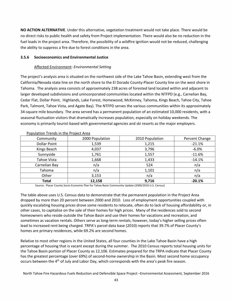
North Tahoe Fire Hazardous Fuels Reduction and Defensible Space Project ndashEnvironmental Assessment September 2016
44
Housing Occupancy in the Project Area Community Total Units Vacant
(Typically) Percent Vacant
Vacant Used for Seasonal Use
Percent Vacant used for Seasonal Use
Carnelian Bay 947 691 730 654 946 Dollar Point 1822 1251 687 1178 942 Kings Beach 2372 1010 426 807 799
SunnysideTahoe City 2119 1375 649 1239 901 Tahoe Vista 1446 818 566 735 899 Tahoma 2058 1505 731 1428 949
Source Placer County Socio‐Economic Plan for Tahoe Basin Community Update (20002010 US Census)
According to the 2010 Census data most of the full time residents in the Project Area are White (69) One Placer County community in the project area Kings Beach has a higher percentage of Hispanic or Latino residents (56) Many of these residents earn less than the statewide average In 2010 the annual median household income for Kings Beach was $37348 while statewide it was $61094 Accordingly Kings Beach is classified as a disadvantaged community by the California Department of Water Resources A disadvantaged community is a community with a median household income less than 80 percent of the statewide average None of the other communities within the Project Area are classified as disadvantaged communities
2010 Census Data Placer County Race and Ethnicity Generally at Lake Tahoe
White (Non Hispanic Latino)
African American
American Indian
Asian Pacific Islander
Hispanic or Latino
Other or Multi‐Racial
Total
Total of Placer County
246267 4751 3011 21213 44710 28480 48432
Lake Tahoe portion of Placer County
6705 48 51 117 2720 807 10 448
Source US Census Bureau 2010 Census (Hispanic or Latino and Race)
Race and Ethnicity in the Project Communities Community White Hispanic or
Latino American Indian
Asian Black or African American
Other
Dollar Point 1090 83 6 19 4 13 Kings Beach 1620 2115 13 14 3 31
SunnysideTahoe City 1431 84 2 15 3 22 Tahoe Vista 1025 352 5 21 3 27 Carnelian Bay 482 13 4 14 1 10
Tahoma 1090 51 10 14 6 20 Total 6738 2698 40 97 20 123
Average 693 278 4 10 2 13 Source Placer County Socio‐Economic Plan for Tahoe Basin Community Update (2010 US Census)
Housing density in the Tahoe Basin is low when compared with other Placer County communities The Forest Service and the State both have had environmentally sensitive land acquisition programs that have purchased undeveloped urban lot parcels within developed subdivisions such as the parcels being considered for treatment with this Project When combined with regional growth control ordinances these public land acquisitions contribute to the low densities in these rural communities In the Project Area the Carnelian Bay community has the lowest housing density and Kings Beach has the highest
North Tahoe Fire Hazardous Fuels Reduction and Defensible Space Project ndashEnvironmental Assessment September 2016
45
Housing Density in the Project Area Community Total Units Acres by Corresponding Census Tract Units Per Acre Carnelian Bay 947 7037 013 Dollar Point 1822 5812 031 Kings Beach 2372 1850 128
SunnysideTahoe City 2119 5954 036 Tahoe Vista 1446 5563 026 Tahoma 2058 7027 029
Source Placer County Socio‐Economic Plan for Tahoe Basin Community Update (20002010 US Census)
Environmental justice is the fair treatment and meaningful involvement of all people regardless of race color
national origin or income with respect to the development implementation and enforcement of
environmental laws regulations and policies It would be achieved when everyone enjoys the same degree of
protection from environmental and health hazards equal access to the decision‐making process and the
opportunity to have a healthy environment in which to live learn and work
Regulatory Requirements and Standards
Environmental Justice in Minority Populations and Low‐Income Populations EO 12898 This Presidential
Executive Order directs federal agencies to ensure that their programs policies and activities do not have a
disproportionately high and adverse human health and environmental effect on minority or low‐income
populations It requires that all federal actions consider potentially disproportionate effects on minority and
low‐income communities especially if adverse effects to environmental or human health conditions are
identified It also tasks federal agencies with ensuring that public notifications regarding environmental issues
are concise understandable and readily accessible
Environmental Consequences
PROPOSED ACTION Factors considered in determining whether the Proposed Action would affect
environmental justice included the extent or degree to which its implementation would change any social
economic physical environmental or health conditions so as to disproportionately and adversely affect any
particular low‐income or minority group
Conditions created by the Proposed Action would not affect any minority or low‐income neighborhood
disproportionately The activities found in the Proposed Action were based solely on the existing and desired
condition of the vegetation sensitivity of the environment and practical treatment access in response to the
identified Project Purpose and Need In no case was the treatment prescription design based on the
demographic makeup occupancy property value income level or any other criteria reflecting the status of
adjacent non‐federal land The prescription to be applied to the forest treatment activities are consistent
between the communities The Conservancyrsquos State owned lands proposed for treatment are distributed
throughout the project area and are intermixed with non‐State lands The project would not affect land in any
way that would impact minority or low‐income neighborhoods disproportionately There is no evidence that any
individual group or portion of the community would benefit unequally from this decision
North Tahoe Fire Hazardous Fuels Reduction and Defensible Space Project ndashEnvironmental Assessment September 2016
46
NO ACTION ALTERNATIVE Under the No Action Alternative there are no socioeconomic or environmental
justice impacts This Alternative would not create conditions that could have potentially disproportionate effects
on minority and low‐income communities including those related to environmental or human health conditions
357 Recreation Resources
Affected Environment Environmental Setting
As urban lots in developed subdivisions the parcels within the Project Area are not part of the Tahoe Regionrsquos
system of destination developed recreation sites (Appendix I Recreation Infrastructure and Improvements
maps) However some parcels within the project area contain user‐created trails which provide access for
dispersed non‐motorized recreational opportunities such as walking mountain biking and cross‐country skiing
These trails often provide through access to other desired destinations including larger public land parcels
Motorized vehicles are generally not allowed on Conservancy properties
Environmental Consequences
PROPOSED ACTION Public recreation use could be impacted by debris from project activities Treatment
activities could pose a threat to public safety during tree felling from crews working with noise‐generating
equipment and from flying debris In addition to creating a public safety hazard noise from equipment could
also affect recreational users in the vicinity by adversely impacting the recreational experience
To protect public safety and Consistent with the Conservancyrsquos adopted Forestry Guidelines (Appendix B) prior
to implementation of forestry projects greater than three acres in size the Conservancy notifies adjacent
property owners by mail In addition notices regarding individual or groups of Conservancy properties may be
posted by the operator to redirect public use while fuels reduction activities are actively taking place At no time
would all California Tahoe Conservancy‐owned parcels proposed for treatment be posted to redirect use at the
same time Because of the small size of the parcels being treated implementation activities minimize the time
that each parcel or group of parcels is inaccessible and use is redirected around work sites User created trails
impacted by the project would be returned to a condition that is as similar as possible to their pre‐project
condition to restore existing public access patterns Public access would be restored as quickly as possible
following the completion of work in any given area within the Project
NO ACTION ALTERNATIVE The No Action Alternative would not have any immediate consequences for
recreational resources within the project area However long‐term adverse effects are likely from increasing
fuel loads Hazard trees could fall and impede passage through the project area presenting a safety hazard for
recreationists Overgrown brush may also compromise access to and through the project area
358 Visual Resources
Affected Environment Environmental Setting
Scenic quality in the Lake Tahoe Region is recognized as a primary resource of national significance The
combination of a stunning lake in a forested mountain setting creates this iconic landscape Within the Region
the undeveloped forests of the North Shore create the backdrop for a high diversity of lake and landscape views
North Tahoe Fire Hazardous Fuels Reduction and Defensible Space Project ndashEnvironmental Assessment September 2016
47
Scattered urban parcels included in the project area contribute to that backdrop and also provide a local
forested setting for residential and dispersed recreation development
The lands within the project area are well‐vegetated with cone‐bearing trees such as pines and firs deciduous
species such as aspens alders and willows shrubs such as manzanita gooseberry and bitterbrush and a variety
of forbs and grasses Many parcels contain downed woody material The visual character of the parcels in the
project area is dense vegetation with a diversity of colors and textures limited light penetration and areas of
substantial clutter from downed woody material The vegetation complex is considerably denser than historic
conditions when the forest character included a more open visually penetrable and mature‐tree dominated
landscape
In some cases the project area lands are visible from TRPA‐designated scenic corridors where they combine
with other undeveloped land to form the forested backdrop critical to attaining and maintaining visual
standards The TRPA adopted scenic threshold standards in 1984 that establish minimum visual and scenic
quality ratings for eight roadway eight shoreline and nine recreation area and bike trail scenic corridors in the
project vicinity
Environmental Consequences
PROPOSED ACTION Project activities would alter both the view of the subject parcels themselves and the
extent to which the vegetation on the parcels screens views of existing development On individual parcels fuel
reduction activities that have visual implications include removal of existing downed woody material and tree
and brush thinning These actions create a more sparsely vegetated site dominated by mature trees a condition
that is more consistent with historical conditions Visual effects include increased sunlight decreased clutter
from existing downed material and greater sight distances Retention of smaller tree and shrub islands (where
fuel reduction objectives can still be met) would serve to limit potential adverse effects of these changes as
would requiring stumps to be cut less than six inches in height (where possible) Increasing sunlight allows
diverse flower and shrub species to become established
Project activities would alter the visual environment for viewers close to the project lands Tree and shrub
removal would create an ldquoopen feelrdquo and a less dense forest and increase sight distance through each parcel In
some locations this would increase view of surrounding development typical in residential communities
including houses roads and trails Retaining areas of shrub and small diameter trees consistent with fuel
reduction goals would retain some screening value for surrounding land uses These smaller trees to be
retained and shrub ldquoislandsrdquo of irregular shapes and sizes would provide a more natural‐appearing mosaic in
the landscape as viewed from homes roads and trails As viewed from farther away and along scenic corridors
project activities would reduce the density of forest cover potentially increasing the view of existing
development within the forest backdrop While this is true the thinning prescription would retain substantial
numbers of mature trees on each parcel As viewed from a distance these mature trees would retain substantial
screening value and would maintain the visual continuity of the forested backdrop This would limit the effect on
TRPA designated scenic corridors and avoid threatening threshold attainment
North Tahoe Fire Hazardous Fuels Reduction and Defensible Space Project ndashEnvironmental Assessment September 2016
48
40
Project activities would produce a landscape with more historically accurate visual features The short‐term
effects of the project activities would create visual change on subject parcels yet project elements focused on
creating a healthy forest and mosaic of shrubs would limit the adverse effects of that change Long‐term effects
would be primarily beneficial because of the park‐like setting that will remain
NO ACTION ALTERNATIVE
The no action alternative would not have immediate consequences for the visual resources of the project area
Over time vegetation density would increase and further diminish sight distance through the forested parcels
Overstocked forests also have a higher likelihood of being impacted by diseases or pests which may increase
tree mortality Dead trees would degrade the visual character of the landscape as standing snags or fallen logs
Increased risk of wildfire inherent in the no action alternative would also increases the risk of significant visual
degradation resulting from fire
CUMULATIVE IMPACTS
NEPA defines a cumulative impact as an ldquoimpact on the environment which results from the incremental impact
of the action when added to other past present and reasonably foreseeable future actions regardless of what
agency (Federal or non‐Federal) or person undertakes such other actionsrdquo (40 CFR sect 15087) Cumulative
impacts can result from individually minor but collectively significant actions taking place over a period of time
PROPOSED ACTION The cumulative effect of the Proposed Action in combination with other existing and
proposed vegetation and fuel treatments by other agencies and the private sector would increase the overall
effectiveness of fuel reduction and improve forest health on the landscape scale The fuel treatments under the
Proposed Action would combine with existing treatments by other entities to create a relatively open forest
structure where fuel amounts and arrangements have been altered to change potential fire behavior in the
event of a wildfire keeping the burn low to the ground and out of the tree crowns
North Tahoe Fire Hazardous Fuels Reduction and Defensible Space Project ndashEnvironmental Assessment September 2016
49
50 SUMMARY OF IMPACTS AND MITIGATION
Mitigation measures are actions that have been identified to avoid or minimize environmental impacts of
project implementation on social cultural and natural environmental resources The environmental
consequences analysis for this Project has not identified any significant impacts requiring mitigation due largely
in part to the specific elements of the Proposed Action that protect specific natural and cultural resources
through avoidance and minimization of potential impact These measures for minimizing impacts are
summarized here
Air Quality
1 No prescribed fire activities including pile burning would be conducted on any parcel that receives
treatment under this Project including during the eleven‐year post‐treatment Project maintenance
period (Appendix C)
Water Quality
1 Fallers would use falling wedgestechniques to directionally fall trees away from stream channels and SEZ
2 In SEZ preference would be given to retention of riparian vegetation (eg willows alders and aspens)
tree and brush removal would focus on encroaching conifers and flammable chaparral
3 Within SEZs and 100 year floodplains the bole of all existing down trees would be left in place with limbs
removed
4 All stream bank trees greater than 14rdquo DBH would be retained unless determined to be a safety hazard to
adjacent structures or other targets
Wildlife
1 An average of two of the largest diameter non‐hazardous standing dead trees (also called ldquosnagsrdquo) per
acre will remain following treatment In evaluating snags for retention all snags greater than 30rdquo DBH and
all those greater than 24rdquo DBH in decay Class 6 or higher would be retained unless they become so
numerous that the forestry or fire professionals marking the property determine that they pose an
unacceptable fire hazard or evaluate them to be a hazard tree In order to protect life and property all
hazard trees would be removed around homes roads and trails even when the above‐described snag
retention standard cannot otherwise be met on a parcel
2 At least three to five of the largest logs per acre would remain
3 Certain parcels would be subjected to Limited Operating Periods (LOPs) for wildlife reasons Specifically
no fuels reduction activities that cause vegetation disturbance would occur in SEZ parcels with riparian
habitat between May 1 and August 15 Mapped ldquono disturbance zonesrdquo for northern goshawk and osprey
would also prohibit vegetation removal from February 15 to September 15 and March 1 to August 15
respectively
North Tahoe Fire Hazardous Fuels Reduction and Defensible Space Project ndashEnvironmental Assessment September 2016
50
4 Since migratory bird species have the potential to nest throughout the project area pre‐treatment nesting
bird surveys would be conducted during the nesting season (May 1 to August 15) and treatments would
be postponed in areas near active bird nests
Cultural Resources
1 If a discovery of an artifact andor human remains is made during the implementation of the Proposed
Project the operator will cease all activity within 100 feet (30 meters) and notify the Conservancy and
CalEMA immediately CalEMA will notify FEMA and ensure that all reasonable measures are taken to
avoid or minimize harm to the resource until FEMA completes additional consultation with the SHPO
and the appropriate tribes If human remains are found including disarticulated or cremated remains
the Conservancy will also contact the Placer County CoronerMedical Examiner and the local law
enforcement office Pursuant to the California Health and Safety Code if the CoronerMedical
Examiner determines that the human remains are or may be of Native American origin the discovery
will be treated in accordance with Section 509798 (a‐d) of the California Health and Safety Code At
that point the Conservancy would obtain a qualified archaeologist with Native American burial
experience if possible to conduct an investigation of the human remains All mitigation regarding the
human remains would be implemented prior to the resumption of ground‐disturbing activities within
100 feet of the discovery site
Noise
1 The exemption to noise limitations Section 238 of the TRPA Code would apply to fuel reduction
operations associated with the Project This section permits approved projects to exceed the noise
limitations between the hours of 800 am and 630 pm Similarly Placer Countyrsquos noise ordinance
provides an exemption to its noise ordinance (Article 936030 of the Placer County Code) for activities
that take place between 600 am and 800 pm Monday through Friday and 800 am and 800 pm
Saturday and Sunday The Project would comply with the most restrictive of these limitations
Hazardous Materials
1 Vehicles and chippers would only be fueled at an offsite permitted fuel station and vehicle maintenance
including washing would also occur off site at an existing commercial facility
2 Small mobile equipment (eg chain saws) would be fueled and lubricated during operations typically
within the paved or vegetation‐free portions of a county road However chainsaw service and fuel storage
(in approved UL or DOT containers) within more remote portions of the project area would occasionally
occur and would be free of flammable materials for a radius of at least fifteen feet Remote refueling and
lubricating of small equipment would be restricted to upland areas at least 100 feet away from the edge of
any streams wetlands ditches and other waterbodies and 150 feet from water supply wells Dispensing
of fuel would only occur at least 10 feet away from any sources of ignition smoking is prohibited during
fueling Chainsaws would not be started or operated within ten feet of a refueling point or otherwise near
stored fuel
North Tahoe Fire Hazardous Fuels Reduction and Defensible Space Project ndashEnvironmental Assessment September 2016
51
3 Crews would be supplied with absorbent and barrier materials to contain and recover accidental spills of
fuels and lubricants (spill kit) The liquid recovery capacity of the spill kit would be equal to or greater than
the maximum total volume of fuel plus lubricant for the equipment being used The spill kit would be
available in close proximity to areas where chemicals are stored or refueling would occur to enable
prompt response and clean‐up of spills or other discharges of hazardous substances Employees would be
briefed at ldquotailgate sessionsrdquo with the location and contents of all spill kits and the procedures to be
followed in the event of a leak or spill
4 Any leaks drips and other spills would be cleaned up immediately to avoid soil or groundwater
contamination Cleanup of a spill on soil would include the removal of contaminated soil Any
contaminated soil and disposable gear used to clean up a hazardous materials spill would be properly
disposed of following State and Federal hazardous material disposal regulations Spills would be
immediately reported to the Conservancy
5 Major maintenance activities and repairs to equipment would occur off site at an approved facility
Public Health and Safety
1 All chainsaws and chippers would be equipped with spark arrestors
2 For emergency use in the event of a fire vehicles would be typically equipped with one shovel one ax or
Pulaski and a fully charged fire extinguisher Additionally a ldquofire tool boxrdquo would be located within each
active operating area typically containing a five gallon backpack pump filled with water two axes or
Pulaski two McLeods one chainsaw (35 horsepower or greater) with a twenty inch or longer cutting
blade and one shovel for each employee at the operation
3 Employee smoking would not be permitted during the fire season except on the paved streets
Recreation
1 Notices regarding individual or groups of Conservancy properties may be posted by the operator to
redirect public use while fuels reduction activities are actively taking place
2 At no time would all California Tahoe Conservancy‐owned parcels proposed for treatment be posted to
redirect use at the same time
3 User created trails impacted by the project would be returned to a condition that is as similar as possible
to their pre‐project condition to restore existing public access patterns
Visual Resources
1 Where possible require stumps to be cut less than six inches in height
North Tahoe Fire Hazardous Fuels Reduction and Defensible Space Project ndashEnvironmental Assessment September 2016
52
60 PUBLIC PARTICIPATION AND AGENCY COORDINATION
Following the Angora Fire of 2007 the governors of Nevada and California created the California‐Nevada Tahoe
Basin Fire Commission (Commission) to examine regulatory and social environments that influence fuels
reduction in the Lake Tahoe Basin In their final report (May 2008) the Commission recognized the necessity of
multi‐jurisdictional collaboration to accomplish fuels reduction projects obtain and manage funding and to plan
and implement projects consistent with the Fuels Strategy or identified in geographically based community
wildfire protection plans The Tahoe Fire and Fuels Team (TFFT) implements the Fuels Strategy for the Lake
Tahoe Basin The original Strategy was updated and endorsed by the executives of TFFT member agencies in
August 2014
The TFFT allows partner agencies to collaborate plan and implement fuels reduction and other wildfire threat
reduction programs consistent with the Fuels Strategy and Community Wildfire Protection Plans throughout the
Tahoe Basin Final project locations are planned by the foresters for the fire district or state agency Members
include CAL FIRE California State Parks the Conservancy Fire Protection DistrictsDepartments in the Lake
Tahoe Basin Nevada Division of Forestry Nevada Division of State Lands Tahoe Regional Planning Agency and
the US Forest Service Supporting agencies include California Water Boards ndash Lahontan Region Tahoe
Resource Conservation District University of Nevada Cooperative Extension and the University of California
Cooperative Extension
An oversight body for the Fuels Strategy composed of the chief executive officers of the federal and state land
management agencies and the local fire agencies is called the Multi‐Agency Coordinating Group (MAC) It is the
principal group that monitors the Fuels Strategyrsquos implementation MAC members are charged with strategic
management of fuels reduction at Lake Tahoe They concur that the Proposed Action is a priority project under
the Fuels Strategy
The Conservancyrsquos Forest Improvement Program is responsible for managing the agencyrsquos forest resources
consistent with the Lake Tahoe Basinrsquos Environmental Improvement Program the Fuels Strategy and Community
Wildfire Protection Plan (CWPP) and California Government Code Section 6690710 which states ldquoThe
Conservancy may improve or develop lands for the purpose of protecting the natural environment or otherwise
meeting the objectives of this titlerdquo This Proposed Action was designed to treat priority areas based on the
Fuels Strategy and CWPP The Conservancy and the NTFPD have collaborated to refine the proposed treatment
areas for fuel reduction activities based upon these priorities
FEMA is the federal agency responsible for conducting the NEPA compliance process for the proposed project It
is FEMArsquos responsibility to expedite the preparation and review of NEPA documents in a way that is responsive to
the needs of the public while meeting the spirit and intent of NEPA and complying with all NEPA provisions
The proposed project is based on the work conducted in support of the NTFPDrsquos plan which involved a variety
of community organizations federal agencies state agencies regional and local agencies and educational
institutions in the process of identifying measures to reduce wildfire risk as described above
North Tahoe Fire Hazardous Fuels Reduction and Defensible Space Project ndashEnvironmental Assessment September 2016
53
FEMA and NTFPD circulated the Draft EA for a 30‐day public review and comment period beginning July 22 2016
The document was made available at FEMArsquos website (wwwfemagovmedia‐libraryassetsdocuments117686)
the California Tahoe Conservancyrsquos website (tahoecagov) the NTFPD website (wwwntfirenet) and in
hardcopies at local libraries (Tahoe City and Kings Beach) Notification of the Draft EArsquos availability was made via
direct mailing to known interested parties (Appendix K) FEMArsquos website and one‐time publication in the local
newspapers (Sierra Sun and North Lake Tahoe Bonanza) During the public comment period FEMA accepted
written comments on the Draft EA addressed to
FEMA Region IX
Environmental and Historic Preservation Office
Attn Draft EA for PDMC‐2010 CA‐019
1111 Broadway Suite 1200
Oakland California 94607
Email fema‐rix‐ehp‐documentsdhsgov
FEMA received three comment letters during the public review and comment period for the Draft EA These letters
are included in Appendix L At the end of the public review and comment period FEMA reviewed all public
comments and prepared this Final EA specifically to address those comments as part of the decision‐making
process This Final EA will be made available to all parties notified of the Draft EA (as listed in Appendix K) and the
individual who submitted the comment letters its availability will also be advertised in the Sierra Sun and North
Lake Tahoe Bonanza
North Tahoe Fire Hazardous Fuels Reduction and Defensible Space Project ndashEnvironmental Assessment September 2016
54
70 LIST OF PREPARERS
Federal Emergency Management Agency Region IX
Morgan Griffin
California Tahoe Conservancy
Whitney Brennan
Scott Cecchi
Brian Hirt
Sue Rae Irelan
Chris Jones‐Roberts
Lisa OrsquoDaly
Juan Carlos Urizar
North Tahoe Fire Hazardous Fuels Reduction and Defensible Space Project ndashEnvironmental Assessment September 2016
55
80 REFERENCES
Community Wildfire Protection Plan (P251 of the California Portion of the Tahoe Basin) 10‐year Plan C
G Celio amp Sons Co Steve Holl Consulting Wildland Rx November 20 2004
o httpwwwtrpaorgwp‐contentuploadsCWPP_CA_Basinpdf
Draft NEPA Guidance on Consideration of the Effects of Climate Change and Greenhouse Gas Emissions
The White House Council on Environmental Quality February 18 2010
o httpwwwwhitehousegovadministrationeopceqinitiativesnepaghg‐guidance
National Fire Plan Department of the Interior US Fish and Wildlife Service Number 15674 Catalog of
Federal Domestic Assistance
o httpswwwcfdagovindexs=programampmode=formamptab=coreampid=702d1ff743fd0d5f7b3860c
bf07ddeec
Lake Tahoe Basin Multi‐Jurisdictional Fuel Reduction and Wildfire Prevention Strategy US Forest
Service Dave Fournier August 2014
o httpwwwfsusdagovdetailltbmuhomecid=stelprdb5309771
National Cohesive Wildland Fire Management Strategy
o httpwwwforestsandrangelandsgovstrategy
Lake Tahoe Total Maximum Daily Load November 2010
o httpwwwwaterboardscagovlahontanwater_issuesprogramstmdllake_tahoe
Safeguarding California Reducing Climate Risk Natural Resources Agency July 2014
o httpresourcescagovdocsclimateFinal_Safeguarding_CA_Plan_July_31_2014pdf
Climate Change Guidelines for Forest Managers Food and Agriculture Organization of the United
Nations Rome 2013
o httpwwwfaoorgdocrep018i3383ei3383epdf
Lahontan Basin Plan Lahontan Regional Water Quality Control Board December 2005
o httpwwwwaterboardscagovrwqcb6water_issuesprogramsbasin_planindexshtml
TRPA Code of Ordinances December 12 2012 effective February 9 2013
o httpwwwtrpaorgregional‐plancode‐of‐ordinances
- Structure Bookmarks
-
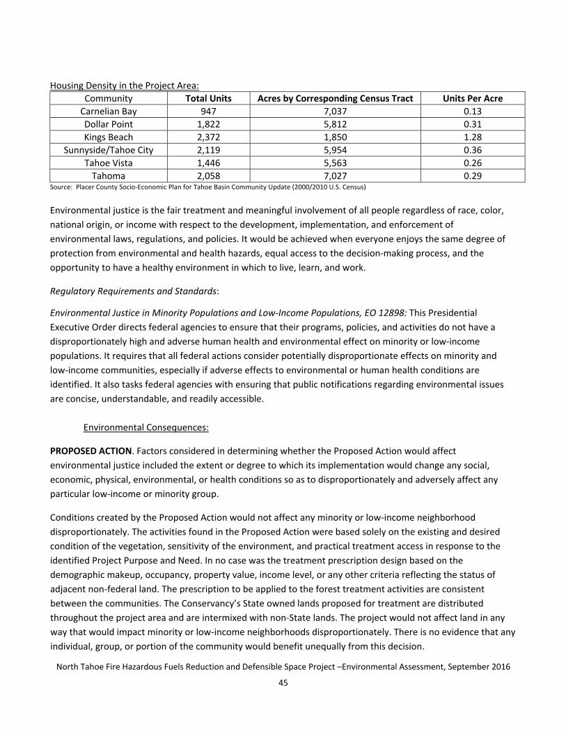
North Tahoe Fire Hazardous Fuels Reduction and Defensible Space Project ndashEnvironmental Assessment September 2016
47
Scattered urban parcels included in the project area contribute to that backdrop and also provide a local
forested setting for residential and dispersed recreation development
The lands within the project area are well‐vegetated with cone‐bearing trees such as pines and firs deciduous
species such as aspens alders and willows shrubs such as manzanita gooseberry and bitterbrush and a variety
of forbs and grasses Many parcels contain downed woody material The visual character of the parcels in the
project area is dense vegetation with a diversity of colors and textures limited light penetration and areas of
substantial clutter from downed woody material The vegetation complex is considerably denser than historic
conditions when the forest character included a more open visually penetrable and mature‐tree dominated
landscape
In some cases the project area lands are visible from TRPA‐designated scenic corridors where they combine
with other undeveloped land to form the forested backdrop critical to attaining and maintaining visual
standards The TRPA adopted scenic threshold standards in 1984 that establish minimum visual and scenic
quality ratings for eight roadway eight shoreline and nine recreation area and bike trail scenic corridors in the
project vicinity
Environmental Consequences
PROPOSED ACTION Project activities would alter both the view of the subject parcels themselves and the
extent to which the vegetation on the parcels screens views of existing development On individual parcels fuel
reduction activities that have visual implications include removal of existing downed woody material and tree
and brush thinning These actions create a more sparsely vegetated site dominated by mature trees a condition
that is more consistent with historical conditions Visual effects include increased sunlight decreased clutter
from existing downed material and greater sight distances Retention of smaller tree and shrub islands (where
fuel reduction objectives can still be met) would serve to limit potential adverse effects of these changes as
would requiring stumps to be cut less than six inches in height (where possible) Increasing sunlight allows
diverse flower and shrub species to become established
Project activities would alter the visual environment for viewers close to the project lands Tree and shrub
removal would create an ldquoopen feelrdquo and a less dense forest and increase sight distance through each parcel In
some locations this would increase view of surrounding development typical in residential communities
including houses roads and trails Retaining areas of shrub and small diameter trees consistent with fuel
reduction goals would retain some screening value for surrounding land uses These smaller trees to be
retained and shrub ldquoislandsrdquo of irregular shapes and sizes would provide a more natural‐appearing mosaic in
the landscape as viewed from homes roads and trails As viewed from farther away and along scenic corridors
project activities would reduce the density of forest cover potentially increasing the view of existing
development within the forest backdrop While this is true the thinning prescription would retain substantial
numbers of mature trees on each parcel As viewed from a distance these mature trees would retain substantial
screening value and would maintain the visual continuity of the forested backdrop This would limit the effect on
TRPA designated scenic corridors and avoid threatening threshold attainment
North Tahoe Fire Hazardous Fuels Reduction and Defensible Space Project ndashEnvironmental Assessment September 2016
48
40
Project activities would produce a landscape with more historically accurate visual features The short‐term
effects of the project activities would create visual change on subject parcels yet project elements focused on
creating a healthy forest and mosaic of shrubs would limit the adverse effects of that change Long‐term effects
would be primarily beneficial because of the park‐like setting that will remain
NO ACTION ALTERNATIVE
The no action alternative would not have immediate consequences for the visual resources of the project area
Over time vegetation density would increase and further diminish sight distance through the forested parcels
Overstocked forests also have a higher likelihood of being impacted by diseases or pests which may increase
tree mortality Dead trees would degrade the visual character of the landscape as standing snags or fallen logs
Increased risk of wildfire inherent in the no action alternative would also increases the risk of significant visual
degradation resulting from fire
CUMULATIVE IMPACTS
NEPA defines a cumulative impact as an ldquoimpact on the environment which results from the incremental impact
of the action when added to other past present and reasonably foreseeable future actions regardless of what
agency (Federal or non‐Federal) or person undertakes such other actionsrdquo (40 CFR sect 15087) Cumulative
impacts can result from individually minor but collectively significant actions taking place over a period of time
PROPOSED ACTION The cumulative effect of the Proposed Action in combination with other existing and
proposed vegetation and fuel treatments by other agencies and the private sector would increase the overall
effectiveness of fuel reduction and improve forest health on the landscape scale The fuel treatments under the
Proposed Action would combine with existing treatments by other entities to create a relatively open forest
structure where fuel amounts and arrangements have been altered to change potential fire behavior in the
event of a wildfire keeping the burn low to the ground and out of the tree crowns
North Tahoe Fire Hazardous Fuels Reduction and Defensible Space Project ndashEnvironmental Assessment September 2016
49
50 SUMMARY OF IMPACTS AND MITIGATION
Mitigation measures are actions that have been identified to avoid or minimize environmental impacts of
project implementation on social cultural and natural environmental resources The environmental
consequences analysis for this Project has not identified any significant impacts requiring mitigation due largely
in part to the specific elements of the Proposed Action that protect specific natural and cultural resources
through avoidance and minimization of potential impact These measures for minimizing impacts are
summarized here
Air Quality
1 No prescribed fire activities including pile burning would be conducted on any parcel that receives
treatment under this Project including during the eleven‐year post‐treatment Project maintenance
period (Appendix C)
Water Quality
1 Fallers would use falling wedgestechniques to directionally fall trees away from stream channels and SEZ
2 In SEZ preference would be given to retention of riparian vegetation (eg willows alders and aspens)
tree and brush removal would focus on encroaching conifers and flammable chaparral
3 Within SEZs and 100 year floodplains the bole of all existing down trees would be left in place with limbs
removed
4 All stream bank trees greater than 14rdquo DBH would be retained unless determined to be a safety hazard to
adjacent structures or other targets
Wildlife
1 An average of two of the largest diameter non‐hazardous standing dead trees (also called ldquosnagsrdquo) per
acre will remain following treatment In evaluating snags for retention all snags greater than 30rdquo DBH and
all those greater than 24rdquo DBH in decay Class 6 or higher would be retained unless they become so
numerous that the forestry or fire professionals marking the property determine that they pose an
unacceptable fire hazard or evaluate them to be a hazard tree In order to protect life and property all
hazard trees would be removed around homes roads and trails even when the above‐described snag
retention standard cannot otherwise be met on a parcel
2 At least three to five of the largest logs per acre would remain
3 Certain parcels would be subjected to Limited Operating Periods (LOPs) for wildlife reasons Specifically
no fuels reduction activities that cause vegetation disturbance would occur in SEZ parcels with riparian
habitat between May 1 and August 15 Mapped ldquono disturbance zonesrdquo for northern goshawk and osprey
would also prohibit vegetation removal from February 15 to September 15 and March 1 to August 15
respectively
North Tahoe Fire Hazardous Fuels Reduction and Defensible Space Project ndashEnvironmental Assessment September 2016
50
4 Since migratory bird species have the potential to nest throughout the project area pre‐treatment nesting
bird surveys would be conducted during the nesting season (May 1 to August 15) and treatments would
be postponed in areas near active bird nests
Cultural Resources
1 If a discovery of an artifact andor human remains is made during the implementation of the Proposed
Project the operator will cease all activity within 100 feet (30 meters) and notify the Conservancy and
CalEMA immediately CalEMA will notify FEMA and ensure that all reasonable measures are taken to
avoid or minimize harm to the resource until FEMA completes additional consultation with the SHPO
and the appropriate tribes If human remains are found including disarticulated or cremated remains
the Conservancy will also contact the Placer County CoronerMedical Examiner and the local law
enforcement office Pursuant to the California Health and Safety Code if the CoronerMedical
Examiner determines that the human remains are or may be of Native American origin the discovery
will be treated in accordance with Section 509798 (a‐d) of the California Health and Safety Code At
that point the Conservancy would obtain a qualified archaeologist with Native American burial
experience if possible to conduct an investigation of the human remains All mitigation regarding the
human remains would be implemented prior to the resumption of ground‐disturbing activities within
100 feet of the discovery site
Noise
1 The exemption to noise limitations Section 238 of the TRPA Code would apply to fuel reduction
operations associated with the Project This section permits approved projects to exceed the noise
limitations between the hours of 800 am and 630 pm Similarly Placer Countyrsquos noise ordinance
provides an exemption to its noise ordinance (Article 936030 of the Placer County Code) for activities
that take place between 600 am and 800 pm Monday through Friday and 800 am and 800 pm
Saturday and Sunday The Project would comply with the most restrictive of these limitations
Hazardous Materials
1 Vehicles and chippers would only be fueled at an offsite permitted fuel station and vehicle maintenance
including washing would also occur off site at an existing commercial facility
2 Small mobile equipment (eg chain saws) would be fueled and lubricated during operations typically
within the paved or vegetation‐free portions of a county road However chainsaw service and fuel storage
(in approved UL or DOT containers) within more remote portions of the project area would occasionally
occur and would be free of flammable materials for a radius of at least fifteen feet Remote refueling and
lubricating of small equipment would be restricted to upland areas at least 100 feet away from the edge of
any streams wetlands ditches and other waterbodies and 150 feet from water supply wells Dispensing
of fuel would only occur at least 10 feet away from any sources of ignition smoking is prohibited during
fueling Chainsaws would not be started or operated within ten feet of a refueling point or otherwise near
stored fuel
North Tahoe Fire Hazardous Fuels Reduction and Defensible Space Project ndashEnvironmental Assessment September 2016
51
3 Crews would be supplied with absorbent and barrier materials to contain and recover accidental spills of
fuels and lubricants (spill kit) The liquid recovery capacity of the spill kit would be equal to or greater than
the maximum total volume of fuel plus lubricant for the equipment being used The spill kit would be
available in close proximity to areas where chemicals are stored or refueling would occur to enable
prompt response and clean‐up of spills or other discharges of hazardous substances Employees would be
briefed at ldquotailgate sessionsrdquo with the location and contents of all spill kits and the procedures to be
followed in the event of a leak or spill
4 Any leaks drips and other spills would be cleaned up immediately to avoid soil or groundwater
contamination Cleanup of a spill on soil would include the removal of contaminated soil Any
contaminated soil and disposable gear used to clean up a hazardous materials spill would be properly
disposed of following State and Federal hazardous material disposal regulations Spills would be
immediately reported to the Conservancy
5 Major maintenance activities and repairs to equipment would occur off site at an approved facility
Public Health and Safety
1 All chainsaws and chippers would be equipped with spark arrestors
2 For emergency use in the event of a fire vehicles would be typically equipped with one shovel one ax or
Pulaski and a fully charged fire extinguisher Additionally a ldquofire tool boxrdquo would be located within each
active operating area typically containing a five gallon backpack pump filled with water two axes or
Pulaski two McLeods one chainsaw (35 horsepower or greater) with a twenty inch or longer cutting
blade and one shovel for each employee at the operation
3 Employee smoking would not be permitted during the fire season except on the paved streets
Recreation
1 Notices regarding individual or groups of Conservancy properties may be posted by the operator to
redirect public use while fuels reduction activities are actively taking place
2 At no time would all California Tahoe Conservancy‐owned parcels proposed for treatment be posted to
redirect use at the same time
3 User created trails impacted by the project would be returned to a condition that is as similar as possible
to their pre‐project condition to restore existing public access patterns
Visual Resources
1 Where possible require stumps to be cut less than six inches in height
North Tahoe Fire Hazardous Fuels Reduction and Defensible Space Project ndashEnvironmental Assessment September 2016
52
60 PUBLIC PARTICIPATION AND AGENCY COORDINATION
Following the Angora Fire of 2007 the governors of Nevada and California created the California‐Nevada Tahoe
Basin Fire Commission (Commission) to examine regulatory and social environments that influence fuels
reduction in the Lake Tahoe Basin In their final report (May 2008) the Commission recognized the necessity of
multi‐jurisdictional collaboration to accomplish fuels reduction projects obtain and manage funding and to plan
and implement projects consistent with the Fuels Strategy or identified in geographically based community
wildfire protection plans The Tahoe Fire and Fuels Team (TFFT) implements the Fuels Strategy for the Lake
Tahoe Basin The original Strategy was updated and endorsed by the executives of TFFT member agencies in
August 2014
The TFFT allows partner agencies to collaborate plan and implement fuels reduction and other wildfire threat
reduction programs consistent with the Fuels Strategy and Community Wildfire Protection Plans throughout the
Tahoe Basin Final project locations are planned by the foresters for the fire district or state agency Members
include CAL FIRE California State Parks the Conservancy Fire Protection DistrictsDepartments in the Lake
Tahoe Basin Nevada Division of Forestry Nevada Division of State Lands Tahoe Regional Planning Agency and
the US Forest Service Supporting agencies include California Water Boards ndash Lahontan Region Tahoe
Resource Conservation District University of Nevada Cooperative Extension and the University of California
Cooperative Extension
An oversight body for the Fuels Strategy composed of the chief executive officers of the federal and state land
management agencies and the local fire agencies is called the Multi‐Agency Coordinating Group (MAC) It is the
principal group that monitors the Fuels Strategyrsquos implementation MAC members are charged with strategic
management of fuels reduction at Lake Tahoe They concur that the Proposed Action is a priority project under
the Fuels Strategy
The Conservancyrsquos Forest Improvement Program is responsible for managing the agencyrsquos forest resources
consistent with the Lake Tahoe Basinrsquos Environmental Improvement Program the Fuels Strategy and Community
Wildfire Protection Plan (CWPP) and California Government Code Section 6690710 which states ldquoThe
Conservancy may improve or develop lands for the purpose of protecting the natural environment or otherwise
meeting the objectives of this titlerdquo This Proposed Action was designed to treat priority areas based on the
Fuels Strategy and CWPP The Conservancy and the NTFPD have collaborated to refine the proposed treatment
areas for fuel reduction activities based upon these priorities
FEMA is the federal agency responsible for conducting the NEPA compliance process for the proposed project It
is FEMArsquos responsibility to expedite the preparation and review of NEPA documents in a way that is responsive to
the needs of the public while meeting the spirit and intent of NEPA and complying with all NEPA provisions
The proposed project is based on the work conducted in support of the NTFPDrsquos plan which involved a variety
of community organizations federal agencies state agencies regional and local agencies and educational
institutions in the process of identifying measures to reduce wildfire risk as described above
North Tahoe Fire Hazardous Fuels Reduction and Defensible Space Project ndashEnvironmental Assessment September 2016
53
FEMA and NTFPD circulated the Draft EA for a 30‐day public review and comment period beginning July 22 2016
The document was made available at FEMArsquos website (wwwfemagovmedia‐libraryassetsdocuments117686)
the California Tahoe Conservancyrsquos website (tahoecagov) the NTFPD website (wwwntfirenet) and in
hardcopies at local libraries (Tahoe City and Kings Beach) Notification of the Draft EArsquos availability was made via
direct mailing to known interested parties (Appendix K) FEMArsquos website and one‐time publication in the local
newspapers (Sierra Sun and North Lake Tahoe Bonanza) During the public comment period FEMA accepted
written comments on the Draft EA addressed to
FEMA Region IX
Environmental and Historic Preservation Office
Attn Draft EA for PDMC‐2010 CA‐019
1111 Broadway Suite 1200
Oakland California 94607
Email fema‐rix‐ehp‐documentsdhsgov
FEMA received three comment letters during the public review and comment period for the Draft EA These letters
are included in Appendix L At the end of the public review and comment period FEMA reviewed all public
comments and prepared this Final EA specifically to address those comments as part of the decision‐making
process This Final EA will be made available to all parties notified of the Draft EA (as listed in Appendix K) and the
individual who submitted the comment letters its availability will also be advertised in the Sierra Sun and North
Lake Tahoe Bonanza
North Tahoe Fire Hazardous Fuels Reduction and Defensible Space Project ndashEnvironmental Assessment September 2016
54
70 LIST OF PREPARERS
Federal Emergency Management Agency Region IX
Morgan Griffin
California Tahoe Conservancy
Whitney Brennan
Scott Cecchi
Brian Hirt
Sue Rae Irelan
Chris Jones‐Roberts
Lisa OrsquoDaly
Juan Carlos Urizar
North Tahoe Fire Hazardous Fuels Reduction and Defensible Space Project ndashEnvironmental Assessment September 2016
55
80 REFERENCES
Community Wildfire Protection Plan (P251 of the California Portion of the Tahoe Basin) 10‐year Plan C
G Celio amp Sons Co Steve Holl Consulting Wildland Rx November 20 2004
o httpwwwtrpaorgwp‐contentuploadsCWPP_CA_Basinpdf
Draft NEPA Guidance on Consideration of the Effects of Climate Change and Greenhouse Gas Emissions
The White House Council on Environmental Quality February 18 2010
o httpwwwwhitehousegovadministrationeopceqinitiativesnepaghg‐guidance
National Fire Plan Department of the Interior US Fish and Wildlife Service Number 15674 Catalog of
Federal Domestic Assistance
o httpswwwcfdagovindexs=programampmode=formamptab=coreampid=702d1ff743fd0d5f7b3860c
bf07ddeec
Lake Tahoe Basin Multi‐Jurisdictional Fuel Reduction and Wildfire Prevention Strategy US Forest
Service Dave Fournier August 2014
o httpwwwfsusdagovdetailltbmuhomecid=stelprdb5309771
National Cohesive Wildland Fire Management Strategy
o httpwwwforestsandrangelandsgovstrategy
Lake Tahoe Total Maximum Daily Load November 2010
o httpwwwwaterboardscagovlahontanwater_issuesprogramstmdllake_tahoe
Safeguarding California Reducing Climate Risk Natural Resources Agency July 2014
o httpresourcescagovdocsclimateFinal_Safeguarding_CA_Plan_July_31_2014pdf
Climate Change Guidelines for Forest Managers Food and Agriculture Organization of the United
Nations Rome 2013
o httpwwwfaoorgdocrep018i3383ei3383epdf
Lahontan Basin Plan Lahontan Regional Water Quality Control Board December 2005
o httpwwwwaterboardscagovrwqcb6water_issuesprogramsbasin_planindexshtml
TRPA Code of Ordinances December 12 2012 effective February 9 2013
o httpwwwtrpaorgregional‐plancode‐of‐ordinances
- Structure Bookmarks
-
North Tahoe Fire Hazardous Fuels Reduction and Defensible Space Project ndashEnvironmental Assessment September 2016
49
50 SUMMARY OF IMPACTS AND MITIGATION
Mitigation measures are actions that have been identified to avoid or minimize environmental impacts of
project implementation on social cultural and natural environmental resources The environmental
consequences analysis for this Project has not identified any significant impacts requiring mitigation due largely
in part to the specific elements of the Proposed Action that protect specific natural and cultural resources
through avoidance and minimization of potential impact These measures for minimizing impacts are
summarized here
Air Quality
1 No prescribed fire activities including pile burning would be conducted on any parcel that receives
treatment under this Project including during the eleven‐year post‐treatment Project maintenance
period (Appendix C)
Water Quality
1 Fallers would use falling wedgestechniques to directionally fall trees away from stream channels and SEZ
2 In SEZ preference would be given to retention of riparian vegetation (eg willows alders and aspens)
tree and brush removal would focus on encroaching conifers and flammable chaparral
3 Within SEZs and 100 year floodplains the bole of all existing down trees would be left in place with limbs
removed
4 All stream bank trees greater than 14rdquo DBH would be retained unless determined to be a safety hazard to
adjacent structures or other targets
Wildlife
1 An average of two of the largest diameter non‐hazardous standing dead trees (also called ldquosnagsrdquo) per
acre will remain following treatment In evaluating snags for retention all snags greater than 30rdquo DBH and
all those greater than 24rdquo DBH in decay Class 6 or higher would be retained unless they become so
numerous that the forestry or fire professionals marking the property determine that they pose an
unacceptable fire hazard or evaluate them to be a hazard tree In order to protect life and property all
hazard trees would be removed around homes roads and trails even when the above‐described snag
retention standard cannot otherwise be met on a parcel
2 At least three to five of the largest logs per acre would remain
3 Certain parcels would be subjected to Limited Operating Periods (LOPs) for wildlife reasons Specifically
no fuels reduction activities that cause vegetation disturbance would occur in SEZ parcels with riparian
habitat between May 1 and August 15 Mapped ldquono disturbance zonesrdquo for northern goshawk and osprey
would also prohibit vegetation removal from February 15 to September 15 and March 1 to August 15
respectively
North Tahoe Fire Hazardous Fuels Reduction and Defensible Space Project ndashEnvironmental Assessment September 2016
50
4 Since migratory bird species have the potential to nest throughout the project area pre‐treatment nesting
bird surveys would be conducted during the nesting season (May 1 to August 15) and treatments would
be postponed in areas near active bird nests
Cultural Resources
1 If a discovery of an artifact andor human remains is made during the implementation of the Proposed
Project the operator will cease all activity within 100 feet (30 meters) and notify the Conservancy and
CalEMA immediately CalEMA will notify FEMA and ensure that all reasonable measures are taken to
avoid or minimize harm to the resource until FEMA completes additional consultation with the SHPO
and the appropriate tribes If human remains are found including disarticulated or cremated remains
the Conservancy will also contact the Placer County CoronerMedical Examiner and the local law
enforcement office Pursuant to the California Health and Safety Code if the CoronerMedical
Examiner determines that the human remains are or may be of Native American origin the discovery
will be treated in accordance with Section 509798 (a‐d) of the California Health and Safety Code At
that point the Conservancy would obtain a qualified archaeologist with Native American burial
experience if possible to conduct an investigation of the human remains All mitigation regarding the
human remains would be implemented prior to the resumption of ground‐disturbing activities within
100 feet of the discovery site
Noise
1 The exemption to noise limitations Section 238 of the TRPA Code would apply to fuel reduction
operations associated with the Project This section permits approved projects to exceed the noise
limitations between the hours of 800 am and 630 pm Similarly Placer Countyrsquos noise ordinance
provides an exemption to its noise ordinance (Article 936030 of the Placer County Code) for activities
that take place between 600 am and 800 pm Monday through Friday and 800 am and 800 pm
Saturday and Sunday The Project would comply with the most restrictive of these limitations
Hazardous Materials
1 Vehicles and chippers would only be fueled at an offsite permitted fuel station and vehicle maintenance
including washing would also occur off site at an existing commercial facility
2 Small mobile equipment (eg chain saws) would be fueled and lubricated during operations typically
within the paved or vegetation‐free portions of a county road However chainsaw service and fuel storage
(in approved UL or DOT containers) within more remote portions of the project area would occasionally
occur and would be free of flammable materials for a radius of at least fifteen feet Remote refueling and
lubricating of small equipment would be restricted to upland areas at least 100 feet away from the edge of
any streams wetlands ditches and other waterbodies and 150 feet from water supply wells Dispensing
of fuel would only occur at least 10 feet away from any sources of ignition smoking is prohibited during
fueling Chainsaws would not be started or operated within ten feet of a refueling point or otherwise near
stored fuel
North Tahoe Fire Hazardous Fuels Reduction and Defensible Space Project ndashEnvironmental Assessment September 2016
51
3 Crews would be supplied with absorbent and barrier materials to contain and recover accidental spills of
fuels and lubricants (spill kit) The liquid recovery capacity of the spill kit would be equal to or greater than
the maximum total volume of fuel plus lubricant for the equipment being used The spill kit would be
available in close proximity to areas where chemicals are stored or refueling would occur to enable
prompt response and clean‐up of spills or other discharges of hazardous substances Employees would be
briefed at ldquotailgate sessionsrdquo with the location and contents of all spill kits and the procedures to be
followed in the event of a leak or spill
4 Any leaks drips and other spills would be cleaned up immediately to avoid soil or groundwater
contamination Cleanup of a spill on soil would include the removal of contaminated soil Any
contaminated soil and disposable gear used to clean up a hazardous materials spill would be properly
disposed of following State and Federal hazardous material disposal regulations Spills would be
immediately reported to the Conservancy
5 Major maintenance activities and repairs to equipment would occur off site at an approved facility
Public Health and Safety
1 All chainsaws and chippers would be equipped with spark arrestors
2 For emergency use in the event of a fire vehicles would be typically equipped with one shovel one ax or
Pulaski and a fully charged fire extinguisher Additionally a ldquofire tool boxrdquo would be located within each
active operating area typically containing a five gallon backpack pump filled with water two axes or
Pulaski two McLeods one chainsaw (35 horsepower or greater) with a twenty inch or longer cutting
blade and one shovel for each employee at the operation
3 Employee smoking would not be permitted during the fire season except on the paved streets
Recreation
1 Notices regarding individual or groups of Conservancy properties may be posted by the operator to
redirect public use while fuels reduction activities are actively taking place
2 At no time would all California Tahoe Conservancy‐owned parcels proposed for treatment be posted to
redirect use at the same time
3 User created trails impacted by the project would be returned to a condition that is as similar as possible
to their pre‐project condition to restore existing public access patterns
Visual Resources
1 Where possible require stumps to be cut less than six inches in height
North Tahoe Fire Hazardous Fuels Reduction and Defensible Space Project ndashEnvironmental Assessment September 2016
52
60 PUBLIC PARTICIPATION AND AGENCY COORDINATION
Following the Angora Fire of 2007 the governors of Nevada and California created the California‐Nevada Tahoe
Basin Fire Commission (Commission) to examine regulatory and social environments that influence fuels
reduction in the Lake Tahoe Basin In their final report (May 2008) the Commission recognized the necessity of
multi‐jurisdictional collaboration to accomplish fuels reduction projects obtain and manage funding and to plan
and implement projects consistent with the Fuels Strategy or identified in geographically based community
wildfire protection plans The Tahoe Fire and Fuels Team (TFFT) implements the Fuels Strategy for the Lake
Tahoe Basin The original Strategy was updated and endorsed by the executives of TFFT member agencies in
August 2014
The TFFT allows partner agencies to collaborate plan and implement fuels reduction and other wildfire threat
reduction programs consistent with the Fuels Strategy and Community Wildfire Protection Plans throughout the
Tahoe Basin Final project locations are planned by the foresters for the fire district or state agency Members
include CAL FIRE California State Parks the Conservancy Fire Protection DistrictsDepartments in the Lake
Tahoe Basin Nevada Division of Forestry Nevada Division of State Lands Tahoe Regional Planning Agency and
the US Forest Service Supporting agencies include California Water Boards ndash Lahontan Region Tahoe
Resource Conservation District University of Nevada Cooperative Extension and the University of California
Cooperative Extension
An oversight body for the Fuels Strategy composed of the chief executive officers of the federal and state land
management agencies and the local fire agencies is called the Multi‐Agency Coordinating Group (MAC) It is the
principal group that monitors the Fuels Strategyrsquos implementation MAC members are charged with strategic
management of fuels reduction at Lake Tahoe They concur that the Proposed Action is a priority project under
the Fuels Strategy
The Conservancyrsquos Forest Improvement Program is responsible for managing the agencyrsquos forest resources
consistent with the Lake Tahoe Basinrsquos Environmental Improvement Program the Fuels Strategy and Community
Wildfire Protection Plan (CWPP) and California Government Code Section 6690710 which states ldquoThe
Conservancy may improve or develop lands for the purpose of protecting the natural environment or otherwise
meeting the objectives of this titlerdquo This Proposed Action was designed to treat priority areas based on the
Fuels Strategy and CWPP The Conservancy and the NTFPD have collaborated to refine the proposed treatment
areas for fuel reduction activities based upon these priorities
FEMA is the federal agency responsible for conducting the NEPA compliance process for the proposed project It
is FEMArsquos responsibility to expedite the preparation and review of NEPA documents in a way that is responsive to
the needs of the public while meeting the spirit and intent of NEPA and complying with all NEPA provisions
The proposed project is based on the work conducted in support of the NTFPDrsquos plan which involved a variety
of community organizations federal agencies state agencies regional and local agencies and educational
institutions in the process of identifying measures to reduce wildfire risk as described above
North Tahoe Fire Hazardous Fuels Reduction and Defensible Space Project ndashEnvironmental Assessment September 2016
53
FEMA and NTFPD circulated the Draft EA for a 30‐day public review and comment period beginning July 22 2016
The document was made available at FEMArsquos website (wwwfemagovmedia‐libraryassetsdocuments117686)
the California Tahoe Conservancyrsquos website (tahoecagov) the NTFPD website (wwwntfirenet) and in
hardcopies at local libraries (Tahoe City and Kings Beach) Notification of the Draft EArsquos availability was made via
direct mailing to known interested parties (Appendix K) FEMArsquos website and one‐time publication in the local
newspapers (Sierra Sun and North Lake Tahoe Bonanza) During the public comment period FEMA accepted
written comments on the Draft EA addressed to
FEMA Region IX
Environmental and Historic Preservation Office
Attn Draft EA for PDMC‐2010 CA‐019
1111 Broadway Suite 1200
Oakland California 94607
Email fema‐rix‐ehp‐documentsdhsgov
FEMA received three comment letters during the public review and comment period for the Draft EA These letters
are included in Appendix L At the end of the public review and comment period FEMA reviewed all public
comments and prepared this Final EA specifically to address those comments as part of the decision‐making
process This Final EA will be made available to all parties notified of the Draft EA (as listed in Appendix K) and the
individual who submitted the comment letters its availability will also be advertised in the Sierra Sun and North
Lake Tahoe Bonanza
North Tahoe Fire Hazardous Fuels Reduction and Defensible Space Project ndashEnvironmental Assessment September 2016
54
70 LIST OF PREPARERS
Federal Emergency Management Agency Region IX
Morgan Griffin
California Tahoe Conservancy
Whitney Brennan
Scott Cecchi
Brian Hirt
Sue Rae Irelan
Chris Jones‐Roberts
Lisa OrsquoDaly
Juan Carlos Urizar
North Tahoe Fire Hazardous Fuels Reduction and Defensible Space Project ndashEnvironmental Assessment September 2016
55
80 REFERENCES
Community Wildfire Protection Plan (P251 of the California Portion of the Tahoe Basin) 10‐year Plan C
G Celio amp Sons Co Steve Holl Consulting Wildland Rx November 20 2004
o httpwwwtrpaorgwp‐contentuploadsCWPP_CA_Basinpdf
Draft NEPA Guidance on Consideration of the Effects of Climate Change and Greenhouse Gas Emissions
The White House Council on Environmental Quality February 18 2010
o httpwwwwhitehousegovadministrationeopceqinitiativesnepaghg‐guidance
National Fire Plan Department of the Interior US Fish and Wildlife Service Number 15674 Catalog of
Federal Domestic Assistance
o httpswwwcfdagovindexs=programampmode=formamptab=coreampid=702d1ff743fd0d5f7b3860c
bf07ddeec
Lake Tahoe Basin Multi‐Jurisdictional Fuel Reduction and Wildfire Prevention Strategy US Forest
Service Dave Fournier August 2014
o httpwwwfsusdagovdetailltbmuhomecid=stelprdb5309771
National Cohesive Wildland Fire Management Strategy
o httpwwwforestsandrangelandsgovstrategy
Lake Tahoe Total Maximum Daily Load November 2010
o httpwwwwaterboardscagovlahontanwater_issuesprogramstmdllake_tahoe
Safeguarding California Reducing Climate Risk Natural Resources Agency July 2014
o httpresourcescagovdocsclimateFinal_Safeguarding_CA_Plan_July_31_2014pdf
Climate Change Guidelines for Forest Managers Food and Agriculture Organization of the United
Nations Rome 2013
o httpwwwfaoorgdocrep018i3383ei3383epdf
Lahontan Basin Plan Lahontan Regional Water Quality Control Board December 2005
o httpwwwwaterboardscagovrwqcb6water_issuesprogramsbasin_planindexshtml
TRPA Code of Ordinances December 12 2012 effective February 9 2013
o httpwwwtrpaorgregional‐plancode‐of‐ordinances
- Structure Bookmarks
-

North Tahoe Fire Hazardous Fuels Reduction and Defensible Space Project ndashEnvironmental Assessment September 2016
50
4 Since migratory bird species have the potential to nest throughout the project area pre‐treatment nesting
bird surveys would be conducted during the nesting season (May 1 to August 15) and treatments would
be postponed in areas near active bird nests
Cultural Resources
1 If a discovery of an artifact andor human remains is made during the implementation of the Proposed
Project the operator will cease all activity within 100 feet (30 meters) and notify the Conservancy and
CalEMA immediately CalEMA will notify FEMA and ensure that all reasonable measures are taken to
avoid or minimize harm to the resource until FEMA completes additional consultation with the SHPO
and the appropriate tribes If human remains are found including disarticulated or cremated remains
the Conservancy will also contact the Placer County CoronerMedical Examiner and the local law
enforcement office Pursuant to the California Health and Safety Code if the CoronerMedical
Examiner determines that the human remains are or may be of Native American origin the discovery
will be treated in accordance with Section 509798 (a‐d) of the California Health and Safety Code At
that point the Conservancy would obtain a qualified archaeologist with Native American burial
experience if possible to conduct an investigation of the human remains All mitigation regarding the
human remains would be implemented prior to the resumption of ground‐disturbing activities within
100 feet of the discovery site
Noise
1 The exemption to noise limitations Section 238 of the TRPA Code would apply to fuel reduction
operations associated with the Project This section permits approved projects to exceed the noise
limitations between the hours of 800 am and 630 pm Similarly Placer Countyrsquos noise ordinance
provides an exemption to its noise ordinance (Article 936030 of the Placer County Code) for activities
that take place between 600 am and 800 pm Monday through Friday and 800 am and 800 pm
Saturday and Sunday The Project would comply with the most restrictive of these limitations
Hazardous Materials
1 Vehicles and chippers would only be fueled at an offsite permitted fuel station and vehicle maintenance
including washing would also occur off site at an existing commercial facility
2 Small mobile equipment (eg chain saws) would be fueled and lubricated during operations typically
within the paved or vegetation‐free portions of a county road However chainsaw service and fuel storage
(in approved UL or DOT containers) within more remote portions of the project area would occasionally
occur and would be free of flammable materials for a radius of at least fifteen feet Remote refueling and
lubricating of small equipment would be restricted to upland areas at least 100 feet away from the edge of
any streams wetlands ditches and other waterbodies and 150 feet from water supply wells Dispensing
of fuel would only occur at least 10 feet away from any sources of ignition smoking is prohibited during
fueling Chainsaws would not be started or operated within ten feet of a refueling point or otherwise near
stored fuel
North Tahoe Fire Hazardous Fuels Reduction and Defensible Space Project ndashEnvironmental Assessment September 2016
51
3 Crews would be supplied with absorbent and barrier materials to contain and recover accidental spills of
fuels and lubricants (spill kit) The liquid recovery capacity of the spill kit would be equal to or greater than
the maximum total volume of fuel plus lubricant for the equipment being used The spill kit would be
available in close proximity to areas where chemicals are stored or refueling would occur to enable
prompt response and clean‐up of spills or other discharges of hazardous substances Employees would be
briefed at ldquotailgate sessionsrdquo with the location and contents of all spill kits and the procedures to be
followed in the event of a leak or spill
4 Any leaks drips and other spills would be cleaned up immediately to avoid soil or groundwater
contamination Cleanup of a spill on soil would include the removal of contaminated soil Any
contaminated soil and disposable gear used to clean up a hazardous materials spill would be properly
disposed of following State and Federal hazardous material disposal regulations Spills would be
immediately reported to the Conservancy
5 Major maintenance activities and repairs to equipment would occur off site at an approved facility
Public Health and Safety
1 All chainsaws and chippers would be equipped with spark arrestors
2 For emergency use in the event of a fire vehicles would be typically equipped with one shovel one ax or
Pulaski and a fully charged fire extinguisher Additionally a ldquofire tool boxrdquo would be located within each
active operating area typically containing a five gallon backpack pump filled with water two axes or
Pulaski two McLeods one chainsaw (35 horsepower or greater) with a twenty inch or longer cutting
blade and one shovel for each employee at the operation
3 Employee smoking would not be permitted during the fire season except on the paved streets
Recreation
1 Notices regarding individual or groups of Conservancy properties may be posted by the operator to
redirect public use while fuels reduction activities are actively taking place
2 At no time would all California Tahoe Conservancy‐owned parcels proposed for treatment be posted to
redirect use at the same time
3 User created trails impacted by the project would be returned to a condition that is as similar as possible
to their pre‐project condition to restore existing public access patterns
Visual Resources
1 Where possible require stumps to be cut less than six inches in height
North Tahoe Fire Hazardous Fuels Reduction and Defensible Space Project ndashEnvironmental Assessment September 2016
52
60 PUBLIC PARTICIPATION AND AGENCY COORDINATION
Following the Angora Fire of 2007 the governors of Nevada and California created the California‐Nevada Tahoe
Basin Fire Commission (Commission) to examine regulatory and social environments that influence fuels
reduction in the Lake Tahoe Basin In their final report (May 2008) the Commission recognized the necessity of
multi‐jurisdictional collaboration to accomplish fuels reduction projects obtain and manage funding and to plan
and implement projects consistent with the Fuels Strategy or identified in geographically based community
wildfire protection plans The Tahoe Fire and Fuels Team (TFFT) implements the Fuels Strategy for the Lake
Tahoe Basin The original Strategy was updated and endorsed by the executives of TFFT member agencies in
August 2014
The TFFT allows partner agencies to collaborate plan and implement fuels reduction and other wildfire threat
reduction programs consistent with the Fuels Strategy and Community Wildfire Protection Plans throughout the
Tahoe Basin Final project locations are planned by the foresters for the fire district or state agency Members
include CAL FIRE California State Parks the Conservancy Fire Protection DistrictsDepartments in the Lake
Tahoe Basin Nevada Division of Forestry Nevada Division of State Lands Tahoe Regional Planning Agency and
the US Forest Service Supporting agencies include California Water Boards ndash Lahontan Region Tahoe
Resource Conservation District University of Nevada Cooperative Extension and the University of California
Cooperative Extension
An oversight body for the Fuels Strategy composed of the chief executive officers of the federal and state land
management agencies and the local fire agencies is called the Multi‐Agency Coordinating Group (MAC) It is the
principal group that monitors the Fuels Strategyrsquos implementation MAC members are charged with strategic
management of fuels reduction at Lake Tahoe They concur that the Proposed Action is a priority project under
the Fuels Strategy
The Conservancyrsquos Forest Improvement Program is responsible for managing the agencyrsquos forest resources
consistent with the Lake Tahoe Basinrsquos Environmental Improvement Program the Fuels Strategy and Community
Wildfire Protection Plan (CWPP) and California Government Code Section 6690710 which states ldquoThe
Conservancy may improve or develop lands for the purpose of protecting the natural environment or otherwise
meeting the objectives of this titlerdquo This Proposed Action was designed to treat priority areas based on the
Fuels Strategy and CWPP The Conservancy and the NTFPD have collaborated to refine the proposed treatment
areas for fuel reduction activities based upon these priorities
FEMA is the federal agency responsible for conducting the NEPA compliance process for the proposed project It
is FEMArsquos responsibility to expedite the preparation and review of NEPA documents in a way that is responsive to
the needs of the public while meeting the spirit and intent of NEPA and complying with all NEPA provisions
The proposed project is based on the work conducted in support of the NTFPDrsquos plan which involved a variety
of community organizations federal agencies state agencies regional and local agencies and educational
institutions in the process of identifying measures to reduce wildfire risk as described above
North Tahoe Fire Hazardous Fuels Reduction and Defensible Space Project ndashEnvironmental Assessment September 2016
53
FEMA and NTFPD circulated the Draft EA for a 30‐day public review and comment period beginning July 22 2016
The document was made available at FEMArsquos website (wwwfemagovmedia‐libraryassetsdocuments117686)
the California Tahoe Conservancyrsquos website (tahoecagov) the NTFPD website (wwwntfirenet) and in
hardcopies at local libraries (Tahoe City and Kings Beach) Notification of the Draft EArsquos availability was made via
direct mailing to known interested parties (Appendix K) FEMArsquos website and one‐time publication in the local
newspapers (Sierra Sun and North Lake Tahoe Bonanza) During the public comment period FEMA accepted
written comments on the Draft EA addressed to
FEMA Region IX
Environmental and Historic Preservation Office
Attn Draft EA for PDMC‐2010 CA‐019
1111 Broadway Suite 1200
Oakland California 94607
Email fema‐rix‐ehp‐documentsdhsgov
FEMA received three comment letters during the public review and comment period for the Draft EA These letters
are included in Appendix L At the end of the public review and comment period FEMA reviewed all public
comments and prepared this Final EA specifically to address those comments as part of the decision‐making
process This Final EA will be made available to all parties notified of the Draft EA (as listed in Appendix K) and the
individual who submitted the comment letters its availability will also be advertised in the Sierra Sun and North
Lake Tahoe Bonanza
North Tahoe Fire Hazardous Fuels Reduction and Defensible Space Project ndashEnvironmental Assessment September 2016
54
70 LIST OF PREPARERS
Federal Emergency Management Agency Region IX
Morgan Griffin
California Tahoe Conservancy
Whitney Brennan
Scott Cecchi
Brian Hirt
Sue Rae Irelan
Chris Jones‐Roberts
Lisa OrsquoDaly
Juan Carlos Urizar
North Tahoe Fire Hazardous Fuels Reduction and Defensible Space Project ndashEnvironmental Assessment September 2016
55
80 REFERENCES
Community Wildfire Protection Plan (P251 of the California Portion of the Tahoe Basin) 10‐year Plan C
G Celio amp Sons Co Steve Holl Consulting Wildland Rx November 20 2004
o httpwwwtrpaorgwp‐contentuploadsCWPP_CA_Basinpdf
Draft NEPA Guidance on Consideration of the Effects of Climate Change and Greenhouse Gas Emissions
The White House Council on Environmental Quality February 18 2010
o httpwwwwhitehousegovadministrationeopceqinitiativesnepaghg‐guidance
National Fire Plan Department of the Interior US Fish and Wildlife Service Number 15674 Catalog of
Federal Domestic Assistance
o httpswwwcfdagovindexs=programampmode=formamptab=coreampid=702d1ff743fd0d5f7b3860c
bf07ddeec
Lake Tahoe Basin Multi‐Jurisdictional Fuel Reduction and Wildfire Prevention Strategy US Forest
Service Dave Fournier August 2014
o httpwwwfsusdagovdetailltbmuhomecid=stelprdb5309771
National Cohesive Wildland Fire Management Strategy
o httpwwwforestsandrangelandsgovstrategy
Lake Tahoe Total Maximum Daily Load November 2010
o httpwwwwaterboardscagovlahontanwater_issuesprogramstmdllake_tahoe
Safeguarding California Reducing Climate Risk Natural Resources Agency July 2014
o httpresourcescagovdocsclimateFinal_Safeguarding_CA_Plan_July_31_2014pdf
Climate Change Guidelines for Forest Managers Food and Agriculture Organization of the United
Nations Rome 2013
o httpwwwfaoorgdocrep018i3383ei3383epdf
Lahontan Basin Plan Lahontan Regional Water Quality Control Board December 2005
o httpwwwwaterboardscagovrwqcb6water_issuesprogramsbasin_planindexshtml
TRPA Code of Ordinances December 12 2012 effective February 9 2013
o httpwwwtrpaorgregional‐plancode‐of‐ordinances
- Structure Bookmarks
-
North Tahoe Fire Hazardous Fuels Reduction and Defensible Space Project ndashEnvironmental Assessment September 2016
51
3 Crews would be supplied with absorbent and barrier materials to contain and recover accidental spills of
fuels and lubricants (spill kit) The liquid recovery capacity of the spill kit would be equal to or greater than
the maximum total volume of fuel plus lubricant for the equipment being used The spill kit would be
available in close proximity to areas where chemicals are stored or refueling would occur to enable
prompt response and clean‐up of spills or other discharges of hazardous substances Employees would be
briefed at ldquotailgate sessionsrdquo with the location and contents of all spill kits and the procedures to be
followed in the event of a leak or spill
4 Any leaks drips and other spills would be cleaned up immediately to avoid soil or groundwater
contamination Cleanup of a spill on soil would include the removal of contaminated soil Any
contaminated soil and disposable gear used to clean up a hazardous materials spill would be properly
disposed of following State and Federal hazardous material disposal regulations Spills would be
immediately reported to the Conservancy
5 Major maintenance activities and repairs to equipment would occur off site at an approved facility
Public Health and Safety
1 All chainsaws and chippers would be equipped with spark arrestors
2 For emergency use in the event of a fire vehicles would be typically equipped with one shovel one ax or
Pulaski and a fully charged fire extinguisher Additionally a ldquofire tool boxrdquo would be located within each
active operating area typically containing a five gallon backpack pump filled with water two axes or
Pulaski two McLeods one chainsaw (35 horsepower or greater) with a twenty inch or longer cutting
blade and one shovel for each employee at the operation
3 Employee smoking would not be permitted during the fire season except on the paved streets
Recreation
1 Notices regarding individual or groups of Conservancy properties may be posted by the operator to
redirect public use while fuels reduction activities are actively taking place
2 At no time would all California Tahoe Conservancy‐owned parcels proposed for treatment be posted to
redirect use at the same time
3 User created trails impacted by the project would be returned to a condition that is as similar as possible
to their pre‐project condition to restore existing public access patterns
Visual Resources
1 Where possible require stumps to be cut less than six inches in height
North Tahoe Fire Hazardous Fuels Reduction and Defensible Space Project ndashEnvironmental Assessment September 2016
52
60 PUBLIC PARTICIPATION AND AGENCY COORDINATION
Following the Angora Fire of 2007 the governors of Nevada and California created the California‐Nevada Tahoe
Basin Fire Commission (Commission) to examine regulatory and social environments that influence fuels
reduction in the Lake Tahoe Basin In their final report (May 2008) the Commission recognized the necessity of
multi‐jurisdictional collaboration to accomplish fuels reduction projects obtain and manage funding and to plan
and implement projects consistent with the Fuels Strategy or identified in geographically based community
wildfire protection plans The Tahoe Fire and Fuels Team (TFFT) implements the Fuels Strategy for the Lake
Tahoe Basin The original Strategy was updated and endorsed by the executives of TFFT member agencies in
August 2014
The TFFT allows partner agencies to collaborate plan and implement fuels reduction and other wildfire threat
reduction programs consistent with the Fuels Strategy and Community Wildfire Protection Plans throughout the
Tahoe Basin Final project locations are planned by the foresters for the fire district or state agency Members
include CAL FIRE California State Parks the Conservancy Fire Protection DistrictsDepartments in the Lake
Tahoe Basin Nevada Division of Forestry Nevada Division of State Lands Tahoe Regional Planning Agency and
the US Forest Service Supporting agencies include California Water Boards ndash Lahontan Region Tahoe
Resource Conservation District University of Nevada Cooperative Extension and the University of California
Cooperative Extension
An oversight body for the Fuels Strategy composed of the chief executive officers of the federal and state land
management agencies and the local fire agencies is called the Multi‐Agency Coordinating Group (MAC) It is the
principal group that monitors the Fuels Strategyrsquos implementation MAC members are charged with strategic
management of fuels reduction at Lake Tahoe They concur that the Proposed Action is a priority project under
the Fuels Strategy
The Conservancyrsquos Forest Improvement Program is responsible for managing the agencyrsquos forest resources
consistent with the Lake Tahoe Basinrsquos Environmental Improvement Program the Fuels Strategy and Community
Wildfire Protection Plan (CWPP) and California Government Code Section 6690710 which states ldquoThe
Conservancy may improve or develop lands for the purpose of protecting the natural environment or otherwise
meeting the objectives of this titlerdquo This Proposed Action was designed to treat priority areas based on the
Fuels Strategy and CWPP The Conservancy and the NTFPD have collaborated to refine the proposed treatment
areas for fuel reduction activities based upon these priorities
FEMA is the federal agency responsible for conducting the NEPA compliance process for the proposed project It
is FEMArsquos responsibility to expedite the preparation and review of NEPA documents in a way that is responsive to
the needs of the public while meeting the spirit and intent of NEPA and complying with all NEPA provisions
The proposed project is based on the work conducted in support of the NTFPDrsquos plan which involved a variety
of community organizations federal agencies state agencies regional and local agencies and educational
institutions in the process of identifying measures to reduce wildfire risk as described above
North Tahoe Fire Hazardous Fuels Reduction and Defensible Space Project ndashEnvironmental Assessment September 2016
53
FEMA and NTFPD circulated the Draft EA for a 30‐day public review and comment period beginning July 22 2016
The document was made available at FEMArsquos website (wwwfemagovmedia‐libraryassetsdocuments117686)
the California Tahoe Conservancyrsquos website (tahoecagov) the NTFPD website (wwwntfirenet) and in
hardcopies at local libraries (Tahoe City and Kings Beach) Notification of the Draft EArsquos availability was made via
direct mailing to known interested parties (Appendix K) FEMArsquos website and one‐time publication in the local
newspapers (Sierra Sun and North Lake Tahoe Bonanza) During the public comment period FEMA accepted
written comments on the Draft EA addressed to
FEMA Region IX
Environmental and Historic Preservation Office
Attn Draft EA for PDMC‐2010 CA‐019
1111 Broadway Suite 1200
Oakland California 94607
Email fema‐rix‐ehp‐documentsdhsgov
FEMA received three comment letters during the public review and comment period for the Draft EA These letters
are included in Appendix L At the end of the public review and comment period FEMA reviewed all public
comments and prepared this Final EA specifically to address those comments as part of the decision‐making
process This Final EA will be made available to all parties notified of the Draft EA (as listed in Appendix K) and the
individual who submitted the comment letters its availability will also be advertised in the Sierra Sun and North
Lake Tahoe Bonanza
North Tahoe Fire Hazardous Fuels Reduction and Defensible Space Project ndashEnvironmental Assessment September 2016
54
70 LIST OF PREPARERS
Federal Emergency Management Agency Region IX
Morgan Griffin
California Tahoe Conservancy
Whitney Brennan
Scott Cecchi
Brian Hirt
Sue Rae Irelan
Chris Jones‐Roberts
Lisa OrsquoDaly
Juan Carlos Urizar
North Tahoe Fire Hazardous Fuels Reduction and Defensible Space Project ndashEnvironmental Assessment September 2016
55
80 REFERENCES
Community Wildfire Protection Plan (P251 of the California Portion of the Tahoe Basin) 10‐year Plan C
G Celio amp Sons Co Steve Holl Consulting Wildland Rx November 20 2004
o httpwwwtrpaorgwp‐contentuploadsCWPP_CA_Basinpdf
Draft NEPA Guidance on Consideration of the Effects of Climate Change and Greenhouse Gas Emissions
The White House Council on Environmental Quality February 18 2010
o httpwwwwhitehousegovadministrationeopceqinitiativesnepaghg‐guidance
National Fire Plan Department of the Interior US Fish and Wildlife Service Number 15674 Catalog of
Federal Domestic Assistance
o httpswwwcfdagovindexs=programampmode=formamptab=coreampid=702d1ff743fd0d5f7b3860c
bf07ddeec
Lake Tahoe Basin Multi‐Jurisdictional Fuel Reduction and Wildfire Prevention Strategy US Forest
Service Dave Fournier August 2014
o httpwwwfsusdagovdetailltbmuhomecid=stelprdb5309771
National Cohesive Wildland Fire Management Strategy
o httpwwwforestsandrangelandsgovstrategy
Lake Tahoe Total Maximum Daily Load November 2010
o httpwwwwaterboardscagovlahontanwater_issuesprogramstmdllake_tahoe
Safeguarding California Reducing Climate Risk Natural Resources Agency July 2014
o httpresourcescagovdocsclimateFinal_Safeguarding_CA_Plan_July_31_2014pdf
Climate Change Guidelines for Forest Managers Food and Agriculture Organization of the United
Nations Rome 2013
o httpwwwfaoorgdocrep018i3383ei3383epdf
Lahontan Basin Plan Lahontan Regional Water Quality Control Board December 2005
o httpwwwwaterboardscagovrwqcb6water_issuesprogramsbasin_planindexshtml
TRPA Code of Ordinances December 12 2012 effective February 9 2013
o httpwwwtrpaorgregional‐plancode‐of‐ordinances
- Structure Bookmarks
-

North Tahoe Fire Hazardous Fuels Reduction and Defensible Space Project ndashEnvironmental Assessment September 2016
52
60 PUBLIC PARTICIPATION AND AGENCY COORDINATION
Following the Angora Fire of 2007 the governors of Nevada and California created the California‐Nevada Tahoe
Basin Fire Commission (Commission) to examine regulatory and social environments that influence fuels
reduction in the Lake Tahoe Basin In their final report (May 2008) the Commission recognized the necessity of
multi‐jurisdictional collaboration to accomplish fuels reduction projects obtain and manage funding and to plan
and implement projects consistent with the Fuels Strategy or identified in geographically based community
wildfire protection plans The Tahoe Fire and Fuels Team (TFFT) implements the Fuels Strategy for the Lake
Tahoe Basin The original Strategy was updated and endorsed by the executives of TFFT member agencies in
August 2014
The TFFT allows partner agencies to collaborate plan and implement fuels reduction and other wildfire threat
reduction programs consistent with the Fuels Strategy and Community Wildfire Protection Plans throughout the
Tahoe Basin Final project locations are planned by the foresters for the fire district or state agency Members
include CAL FIRE California State Parks the Conservancy Fire Protection DistrictsDepartments in the Lake
Tahoe Basin Nevada Division of Forestry Nevada Division of State Lands Tahoe Regional Planning Agency and
the US Forest Service Supporting agencies include California Water Boards ndash Lahontan Region Tahoe
Resource Conservation District University of Nevada Cooperative Extension and the University of California
Cooperative Extension
An oversight body for the Fuels Strategy composed of the chief executive officers of the federal and state land
management agencies and the local fire agencies is called the Multi‐Agency Coordinating Group (MAC) It is the
principal group that monitors the Fuels Strategyrsquos implementation MAC members are charged with strategic
management of fuels reduction at Lake Tahoe They concur that the Proposed Action is a priority project under
the Fuels Strategy
The Conservancyrsquos Forest Improvement Program is responsible for managing the agencyrsquos forest resources
consistent with the Lake Tahoe Basinrsquos Environmental Improvement Program the Fuels Strategy and Community
Wildfire Protection Plan (CWPP) and California Government Code Section 6690710 which states ldquoThe
Conservancy may improve or develop lands for the purpose of protecting the natural environment or otherwise
meeting the objectives of this titlerdquo This Proposed Action was designed to treat priority areas based on the
Fuels Strategy and CWPP The Conservancy and the NTFPD have collaborated to refine the proposed treatment
areas for fuel reduction activities based upon these priorities
FEMA is the federal agency responsible for conducting the NEPA compliance process for the proposed project It
is FEMArsquos responsibility to expedite the preparation and review of NEPA documents in a way that is responsive to
the needs of the public while meeting the spirit and intent of NEPA and complying with all NEPA provisions
The proposed project is based on the work conducted in support of the NTFPDrsquos plan which involved a variety
of community organizations federal agencies state agencies regional and local agencies and educational
institutions in the process of identifying measures to reduce wildfire risk as described above
North Tahoe Fire Hazardous Fuels Reduction and Defensible Space Project ndashEnvironmental Assessment September 2016
53
FEMA and NTFPD circulated the Draft EA for a 30‐day public review and comment period beginning July 22 2016
The document was made available at FEMArsquos website (wwwfemagovmedia‐libraryassetsdocuments117686)
the California Tahoe Conservancyrsquos website (tahoecagov) the NTFPD website (wwwntfirenet) and in
hardcopies at local libraries (Tahoe City and Kings Beach) Notification of the Draft EArsquos availability was made via
direct mailing to known interested parties (Appendix K) FEMArsquos website and one‐time publication in the local
newspapers (Sierra Sun and North Lake Tahoe Bonanza) During the public comment period FEMA accepted
written comments on the Draft EA addressed to
FEMA Region IX
Environmental and Historic Preservation Office
Attn Draft EA for PDMC‐2010 CA‐019
1111 Broadway Suite 1200
Oakland California 94607
Email fema‐rix‐ehp‐documentsdhsgov
FEMA received three comment letters during the public review and comment period for the Draft EA These letters
are included in Appendix L At the end of the public review and comment period FEMA reviewed all public
comments and prepared this Final EA specifically to address those comments as part of the decision‐making
process This Final EA will be made available to all parties notified of the Draft EA (as listed in Appendix K) and the
individual who submitted the comment letters its availability will also be advertised in the Sierra Sun and North
Lake Tahoe Bonanza
North Tahoe Fire Hazardous Fuels Reduction and Defensible Space Project ndashEnvironmental Assessment September 2016
54
70 LIST OF PREPARERS
Federal Emergency Management Agency Region IX
Morgan Griffin
California Tahoe Conservancy
Whitney Brennan
Scott Cecchi
Brian Hirt
Sue Rae Irelan
Chris Jones‐Roberts
Lisa OrsquoDaly
Juan Carlos Urizar
North Tahoe Fire Hazardous Fuels Reduction and Defensible Space Project ndashEnvironmental Assessment September 2016
55
80 REFERENCES
Community Wildfire Protection Plan (P251 of the California Portion of the Tahoe Basin) 10‐year Plan C
G Celio amp Sons Co Steve Holl Consulting Wildland Rx November 20 2004
o httpwwwtrpaorgwp‐contentuploadsCWPP_CA_Basinpdf
Draft NEPA Guidance on Consideration of the Effects of Climate Change and Greenhouse Gas Emissions
The White House Council on Environmental Quality February 18 2010
o httpwwwwhitehousegovadministrationeopceqinitiativesnepaghg‐guidance
National Fire Plan Department of the Interior US Fish and Wildlife Service Number 15674 Catalog of
Federal Domestic Assistance
o httpswwwcfdagovindexs=programampmode=formamptab=coreampid=702d1ff743fd0d5f7b3860c
bf07ddeec
Lake Tahoe Basin Multi‐Jurisdictional Fuel Reduction and Wildfire Prevention Strategy US Forest
Service Dave Fournier August 2014
o httpwwwfsusdagovdetailltbmuhomecid=stelprdb5309771
National Cohesive Wildland Fire Management Strategy
o httpwwwforestsandrangelandsgovstrategy
Lake Tahoe Total Maximum Daily Load November 2010
o httpwwwwaterboardscagovlahontanwater_issuesprogramstmdllake_tahoe
Safeguarding California Reducing Climate Risk Natural Resources Agency July 2014
o httpresourcescagovdocsclimateFinal_Safeguarding_CA_Plan_July_31_2014pdf
Climate Change Guidelines for Forest Managers Food and Agriculture Organization of the United
Nations Rome 2013
o httpwwwfaoorgdocrep018i3383ei3383epdf
Lahontan Basin Plan Lahontan Regional Water Quality Control Board December 2005
o httpwwwwaterboardscagovrwqcb6water_issuesprogramsbasin_planindexshtml
TRPA Code of Ordinances December 12 2012 effective February 9 2013
o httpwwwtrpaorgregional‐plancode‐of‐ordinances
- Structure Bookmarks
-
North Tahoe Fire Hazardous Fuels Reduction and Defensible Space Project ndashEnvironmental Assessment September 2016
53
FEMA and NTFPD circulated the Draft EA for a 30‐day public review and comment period beginning July 22 2016
The document was made available at FEMArsquos website (wwwfemagovmedia‐libraryassetsdocuments117686)
the California Tahoe Conservancyrsquos website (tahoecagov) the NTFPD website (wwwntfirenet) and in
hardcopies at local libraries (Tahoe City and Kings Beach) Notification of the Draft EArsquos availability was made via
direct mailing to known interested parties (Appendix K) FEMArsquos website and one‐time publication in the local
newspapers (Sierra Sun and North Lake Tahoe Bonanza) During the public comment period FEMA accepted
written comments on the Draft EA addressed to
FEMA Region IX
Environmental and Historic Preservation Office
Attn Draft EA for PDMC‐2010 CA‐019
1111 Broadway Suite 1200
Oakland California 94607
Email fema‐rix‐ehp‐documentsdhsgov
FEMA received three comment letters during the public review and comment period for the Draft EA These letters
are included in Appendix L At the end of the public review and comment period FEMA reviewed all public
comments and prepared this Final EA specifically to address those comments as part of the decision‐making
process This Final EA will be made available to all parties notified of the Draft EA (as listed in Appendix K) and the
individual who submitted the comment letters its availability will also be advertised in the Sierra Sun and North
Lake Tahoe Bonanza
North Tahoe Fire Hazardous Fuels Reduction and Defensible Space Project ndashEnvironmental Assessment September 2016
54
70 LIST OF PREPARERS
Federal Emergency Management Agency Region IX
Morgan Griffin
California Tahoe Conservancy
Whitney Brennan
Scott Cecchi
Brian Hirt
Sue Rae Irelan
Chris Jones‐Roberts
Lisa OrsquoDaly
Juan Carlos Urizar
North Tahoe Fire Hazardous Fuels Reduction and Defensible Space Project ndashEnvironmental Assessment September 2016
55
80 REFERENCES
Community Wildfire Protection Plan (P251 of the California Portion of the Tahoe Basin) 10‐year Plan C
G Celio amp Sons Co Steve Holl Consulting Wildland Rx November 20 2004
o httpwwwtrpaorgwp‐contentuploadsCWPP_CA_Basinpdf
Draft NEPA Guidance on Consideration of the Effects of Climate Change and Greenhouse Gas Emissions
The White House Council on Environmental Quality February 18 2010
o httpwwwwhitehousegovadministrationeopceqinitiativesnepaghg‐guidance
National Fire Plan Department of the Interior US Fish and Wildlife Service Number 15674 Catalog of
Federal Domestic Assistance
o httpswwwcfdagovindexs=programampmode=formamptab=coreampid=702d1ff743fd0d5f7b3860c
bf07ddeec
Lake Tahoe Basin Multi‐Jurisdictional Fuel Reduction and Wildfire Prevention Strategy US Forest
Service Dave Fournier August 2014
o httpwwwfsusdagovdetailltbmuhomecid=stelprdb5309771
National Cohesive Wildland Fire Management Strategy
o httpwwwforestsandrangelandsgovstrategy
Lake Tahoe Total Maximum Daily Load November 2010
o httpwwwwaterboardscagovlahontanwater_issuesprogramstmdllake_tahoe
Safeguarding California Reducing Climate Risk Natural Resources Agency July 2014
o httpresourcescagovdocsclimateFinal_Safeguarding_CA_Plan_July_31_2014pdf
Climate Change Guidelines for Forest Managers Food and Agriculture Organization of the United
Nations Rome 2013
o httpwwwfaoorgdocrep018i3383ei3383epdf
Lahontan Basin Plan Lahontan Regional Water Quality Control Board December 2005
o httpwwwwaterboardscagovrwqcb6water_issuesprogramsbasin_planindexshtml
TRPA Code of Ordinances December 12 2012 effective February 9 2013
o httpwwwtrpaorgregional‐plancode‐of‐ordinances
- Structure Bookmarks
-

North Tahoe Fire Hazardous Fuels Reduction and Defensible Space Project ndashEnvironmental Assessment September 2016
55
80 REFERENCES
Community Wildfire Protection Plan (P251 of the California Portion of the Tahoe Basin) 10‐year Plan C
G Celio amp Sons Co Steve Holl Consulting Wildland Rx November 20 2004
o httpwwwtrpaorgwp‐contentuploadsCWPP_CA_Basinpdf
Draft NEPA Guidance on Consideration of the Effects of Climate Change and Greenhouse Gas Emissions
The White House Council on Environmental Quality February 18 2010
o httpwwwwhitehousegovadministrationeopceqinitiativesnepaghg‐guidance
National Fire Plan Department of the Interior US Fish and Wildlife Service Number 15674 Catalog of
Federal Domestic Assistance
o httpswwwcfdagovindexs=programampmode=formamptab=coreampid=702d1ff743fd0d5f7b3860c
bf07ddeec
Lake Tahoe Basin Multi‐Jurisdictional Fuel Reduction and Wildfire Prevention Strategy US Forest
Service Dave Fournier August 2014
o httpwwwfsusdagovdetailltbmuhomecid=stelprdb5309771
National Cohesive Wildland Fire Management Strategy
o httpwwwforestsandrangelandsgovstrategy
Lake Tahoe Total Maximum Daily Load November 2010
o httpwwwwaterboardscagovlahontanwater_issuesprogramstmdllake_tahoe
Safeguarding California Reducing Climate Risk Natural Resources Agency July 2014
o httpresourcescagovdocsclimateFinal_Safeguarding_CA_Plan_July_31_2014pdf
Climate Change Guidelines for Forest Managers Food and Agriculture Organization of the United
Nations Rome 2013
o httpwwwfaoorgdocrep018i3383ei3383epdf
Lahontan Basin Plan Lahontan Regional Water Quality Control Board December 2005
o httpwwwwaterboardscagovrwqcb6water_issuesprogramsbasin_planindexshtml
TRPA Code of Ordinances December 12 2012 effective February 9 2013
o httpwwwtrpaorgregional‐plancode‐of‐ordinances
- Structure Bookmarks
-