Final Environmental Assessment NEW STATION 291 ... · Final Environmental Assessment NEW STATION...
46
Final Environmental Assessment NEW STATION 291 CONSTRUCTION PROJECT FOR SNOQUALMIE PASS FIRE & RESCUE Assistance to Firefighters Grant Program: EMW-2009-FC-02883 April 13, 2010
Transcript of Final Environmental Assessment NEW STATION 291 ... · Final Environmental Assessment NEW STATION...

Final Environmental Assessment
NEW STATION 291 CONSTRUCTION PROJECT FOR SNOQUALMIE PASS FIRE & RESCUE
Assistance to Firefighters Grant Program: EMW-2009-FC-02883
April 13, 2010

Prepared For: U.S. Department of Homeland Security Federal Emergency Management Agency Region X 130 228th Street SW Bothell, WA 98021-979
Prepared By: Matt Cowan, Fire Chief Snoqualmie Pass Fire & Rescue P.O. Box 99 Snoqualmie Pass, WA 98068 Mark Rigos, PE Concept Engineering Inc.

TABLE OF CONTENTS
Page
List of Acronyms and Abbreviations .................................................................................................... 3
1.0 Introduction .................................................................................................................................... 4
2.0 Purpose and Need ........................................................................................................................... 5 3.0 Alternatives Analysis ..................................................................................................................... 7 4.0 Affected Environment and Potential Impacts ............................................................................. 16 4.1 Physical Resources .......................................................................................................... 16 4.2 Water Resources .............................................................................................................. 20 4.3 Coastal Resources ............................................................................................................ 22 4.4 Biological Resources ....................................................................................................... 22 4.5 Cultural Resources ........................................................................................................... 25 4.6 Socioeconomic Resources ............................................................................................... 28 4.7 Hazardous Materials………………………………………………………………….32 5.0 Cumulative Impacts .................................................................................................................... 34 6.0 Agency Coordination and Public Involvement ........................................................................... 34 7.0 Conclusions, Project Conditions and Mitigation Measures…………………………………..35 8.0 List of Preparers ........................................................................................................................... 36 References ........................................................................................................................................... 37 Appendix I – Three Bay Station Design ............................................................................................. 39 Appendix II – Five Bay Site Design ................................................................................................... 41 Appendix III – Location Map ............................................................................................................. 42 Appendix IV –Stormwater Site Design .............................................................................................. 43 Appendix V – Historic Preservation Consultation ............................................................................. 44 Appendix VI – Public Notice .............................................................................................................. 45

ACRONYMS AND ABBREVIATIONS
ADA Americans with Disabilities Act AFG Assistance to Firefighters Grant Program AMA Adaptive Management Area APE Area of Potential Effect ARPA Archaeological Resources Protection Act ARRA American Reinvestment and Recovery Act ASR Archaeology Survey Report BMP Best management practices CEA Connectivity Emphasis Areas CEQ Council on Environmental Quality CFR Code of Federal Regulations CWA Clean Water Act DAHP Department of Archaeology and Historical Preservation DOH Washington State Department of Health DNR Washington State Department of Natural Resources EA Environmental Assessment EFH Essential Fish Habitat EIS Environmental Impact Statement EPA U.S. Environmental Protection Agency ESA Endangered Species Act FEMA Federal Emergency Management Agency FIRM Flood Insurance Rate Map FONSI Finding of No Significant Impact KCEMS King County Emergency Medical Services LSH Late-Successional Habitat NAGPRA Native American Graves Protection and Repatriation Act NEPA National Environmental Policy Act NFPA National Fire Protection Association NHPA National Historic Preservation Act NOAA Fisheries National Oceanic and Atmospheric Administration, National Marine Fisheries Service NOI Notice of Intent NPDES National Pollution Discharge Elimination System NRCS Natural Resources Conservation Service MPD Medical Program Director SPFR Snoqualmie Pass Fire & Rescue TES Threatened, endangered, and sensitive TMDL Total maximum daily load USC United States Code USFS United States Forest Service USFWS United States Fish and Wildlife Service WDF Washington State Department of Fish and Wildlife

4
1.0 Introduction Snoqualmie Pass Fire & Rescue (SPFR) has applied to the U.S. Department of Homeland Security’s Federal Emergency Management Agency (FEMA) Assistance to Firefighters Grant Program (AFG) for funding assistance for a new fire station at Snoqualmie Pass, Washington. Funding for fire station construction has been made available through the American Reinvestment and Recovery Act of 2009 (ARRA). The ARRA is an economic stimulus package and the purpose of the Fiscal Year 2009 funds is to create or save jobs in recession-hit areas which include supporting ‘shovel-ready’ projects. Moreover, ARRA will further help achieve AFG goals of firefighter safety and improved response capability/capacity based on need, through the construction, renovation or modification of fire stations.
The SPFR is a small, volunteer fire department serving a population with demographics similar to that of a small city, but whose funding sources are derived from a small, residential community. Snoqualmie Pass is located at the top of the Cascade Mountain range 50 miles east of Seattle, Washington at an altitude just over 3,000 feet. Although the existing station is physically located in Kittitas County, the SPFR service area also includes part of King County. The surrounding terrain is very beautiful and attracts hundreds of thousands of people traveling to the Pass to hike, bike, climb, boat, ski, snowshoe, and snowmobile every year. Our community of 400 increases to 1,500 during ski season and soars to over 20,000 on busy weekends. Furthermore, nearly 60,000 vehicles will travel through Snoqualmie Pass on a busy day using Interstate 90 (I-90). The I-90 Snoqualmie Pass corridor is the busiest mountain highway in the country. Additionally, Snoqualmie Pass often has very severe weather conditions, particularly in the winter when it receives an average of 37 feet of snow annually. These two factors contribute heavily to this small fire department having to respond to calls that often involve severe trauma. Up to 84 percent of our emergency incidents will be caused by people traveling through or to the area. To keep up with this demand, and to increase the safety of our firefighters and community, we completed a long range planning initiative in 2006 that evaluated options for a fire station facility that meets our emergency response mission. Prior to the FEMA application, we enlisted the aid of our United States Representatives and Senators to secure a parcel of U.S. Forest Service (USFS) land where we could build a new station. The Snoqualmie Pass Land Conveyance Act was signed into law by President Obama in 2009 facilitating the USFS to transfer ownership of property near the current fire station over to the SPFR. The real estate transaction for this conveyance is in process. The USFS completed a very limited environmental review of the property proposed for transfer as part of the conveyance process. We employed the Watershed Company, an environmental assessment company, to do a site inspection; and Concept Engineering to survey the site and start designing wetland mitigation features. We have also met with the Kittitas County Planning Department and their department heads for permitting the project.

5
Because the USFS action did not require completion of an Environmental Assessment (EA), this has been prepared in accordance with the National Environmental Policy Act (NEPA) of 1969, the President’s Council on Environmental Quality regulations to implement NEPA (40 Code of Federal Regulations Parts 1500-1508), and FEMA’s regulations implementing NEPA (44 CFR Part 10). FEMA is required to consider potential environmental impacts before funding or approving actions and projects. The purpose of this EA is to analyze the potential environmental impacts of the proposed project. FEMA will use the findings in this EA to determine whether to prepare an Environmental Impact Statement (EIS) or a Finding of No Significant Impact (FONSI). It should also be noted that USFS has completed a programmatic level Environmental Impact Statement (EIS) that encompasses Snoqualmie Pass in terms of forest resources management that will be referenced herein.
2.0 Purpose and Need The purpose of the FEMA AFG station construction program is to provide funding to assist states and local governments in improving their emergency response capabilities. Thus the purpose of this action is to provide funding to the SPFR for construction of a fire station.
SPFR has needed a new fire station since the 1970’s. By conducting a community risk assessment in 2005 we were able to use the results in a long-range planning process to determine future needs. The long-range planning process included representatives from SPFR, local businesses, and the community at large. The highest priority item identified in our 2006 report was replacing our fire station. Station 291 was originally built in the early 1930’s as a maintenance shed and over the years has been used for many different activities until it became the headquarters for our Fire Department. The building has numerous deficiencies some of which affect the safety of our firefighters. There is structural damage, poor site design, a non-compliant electrical system, no smoke alarm or sprinkler systems, no vehicle exhaust system, not enough apparatus bays, insufficient space in the apparatus bays, no decontamination area, and no hose tower. Additionally, there are inadequate training and exercise areas, insufficient office and dormitory space, no emergency shelter, command, or communication capabilities, and it is not in compliance with the American Disabilities Act (ADA) or National Fire Protection Agency (NFPA) 1500. Most of the deficiencies listed above are self-explanatory, but it is necessary to elaborate on the structural damage and site design issues. The Snoqualmie Pass area receives an average of 47 feet of snow annually, which creates significant challenges for our Department. The site where our fire station sits is about 20 feet above SR906, a state highway, resulting in a steep driveway for our apparatus. This, combined with the snow and ice that accumulates, can create dangerous driving conditions for five months of the year. Additionally, station 291 has a peaked roof that sheds snow to the front and back of the station. When the snow slides off of the roof it piles up
6
very quickly. Six inches of snow on the roof becomes a four foot ridge of ice in front of our apparatus bays. Sometimes, even small ridges of ice will need to be removed before an apparatus can respond. This problem is compounded by the use of our station siren as a backup to our pagers for alerting firefighters of an incident. The siren will often trigger the release of the snow off of the roof making it the worst possible time for the snow release to occur, considerably affecting response times. While the snow shedding off of the front creates problems with our response times, the snow shedding off of the back is a structural problem that creates unsafe conditions. As it accumulates it actually pushes the rear wall of the station in at the top, changing the shape of our fire station from a rectangle to a rhombus. The “racking” of our fire station has occurred for decades and was unmanaged until recent years. Now we employ bulldozers to try and push the snow away from the back of the station to limit the impact. Unfortunately, the damage is already done. We have had to make emergency repairs using steel I-beams and 8x8 wood columns to help shore up the damage, but we have a hallway that literally meanders as it travels the length of the station and stress fractures in the walls are evident in all parts of the station. We have not had a structural engineer look at the building in the past few years due to the possibility that the station may become condemned and there will be nowhere for us to go, leaving the community at risk. The current station does not have enough apparatus bays for our current apparatus and they are not large enough either. Currently, we have two aid cars, two fire engines, a wild land fire engine, special operations trailer, and a battalion chief car. The fire engines literally have only inches around them on the sides when parked in the bays and a foot and a half in front and rear. Furthermore, in the community we have multi-family, non-sprinklered structures that reach seven stories tall and when we conducted the community risk assessment it was determined that we need to acquire a ladder truck to reach them to increase community and firefighter safety. This was supported in documentation by the Washington State Rating Bureau that not only recommended a ladder truck for the Department, but a second one to be located within a 20-minute response. Any ladder truck that we acquire will not fit into our current fire station. Moreover, while we own station 291, we do not own the land that it currently sits on. We lease the land from the USFS and we will be forced to move or destroy our current fire station when we vacate the premises. In 2006 our Fire Department was contacted by the USFS to ask if we would be interested in purchasing the land where our Fire Station is currently located. The USFS desires to sell off parcels of land in commercial areas such as ours at fair market value because they do not meet their organizational mission. We have been looking at alternatives for many years, but unfortunately in this case, as with others, we were unable to obtain the funding to start the project until the land conveyance and ARRA funding opportunity materialized. In an apparatus needs evaluation it was decided that our fire department ultimately needs a five bay fire station, but with current budget constraints we are planning on a three bay station with an

7
expansion plan to five bays.
3.0 Alternatives Analysis A number of alternatives to achieve the SPFR stated purpose and need have been evaluated over the past few years, taking into account the following key factors. SPFR was formed for the purpose of fire prevention services, fire suppression services, emergency medical services, and for the protection of life and property pursuant to Chapter 52, Revised Codes of Washington. One of the most important aspects of providing emergency services pertains to the time it takes to get to the emergency scene otherwise known as response time. Response times can be further separated into two different categories, turnout time and response time. Turnout time, also referred to as reaction time, is the time it takes for the unit to start responding after being dispatched. Response time is the time it takes to get to the scene once a unit has started responding. While SPFR is not staffed with career firefighters yet, we need to consider the standards established for both career and volunteer staffed fire departments. Career fire departments use the recommendation of the NFPA Standard 1710 as a target goal for staffing and responses. The standard affects nearly all aspects of operations within a fire department, but in regards to response times it specifically states that a first arriving engine should do so with a turnout time of one minute and response time of less than four minutes for a total response time of less than five minutes. The remainder of a first alarm assignment should also arrive within a total of nine minutes. The standard also states that this time objective should be reached at least 90 percent of the time (NFPA 1710). The NFPA has also drafted a similar standard for fire departments that are primarily staffed with volunteers, NFPA 1720. In this standard the recommendation is that responses should be adjusted for different demographics. The demographic criteria reflect population density and in that regard SPFR falls under the rural classification of less than 500 people per square mile. In that classification the minimum overall response time are six personnel arriving on scene in less than 14 minutes. This benchmark should be reached 80 percent of the time. (NFPA 1720). The NFPA standards are a good starting point for obtaining definitive benchmarks for firefighting operations. While NFPA standards are recommendations only, they are generally adopted unilaterally within the industry. NFPA 1710 specifically addresses career fire department emergency responses in chapter four (NFPA 1710). Not only does this chapter specify an appropriate response time, but it also states what percentage of the time, 90 percent, this objective should be met. While chapter four addresses response times, it applies to fire departments staffed with career firefighters, not volunteer

8
staffed fire departments. SPFR is currently staffed with volunteers so NFPA 1720, which pertains to volunteer fire departments, must also be considered. In chapter four of NFPA 1720:
“4.3.2* Table 4.3.2 shall be used by the AHJ to determine staffing and response time capabilities, and the fractal accomplishment of that for reporting purposes as required in 4.
Table 4.3.2 Staffing and Response Time
Demand Zone
Demographics
Staffing and Response Time
Percentage
Special risks AHJ AHJ 90
Urban 1000 people/1 sq. mi. 15/9 90
Suburban 500-1000 people/1 sq. mi. 10/10 80
Rural < 500 people/1 sq. mi. 6/14 80
Remote* > Travel Dist 8 miles 4 90
*Upon assembling the necessary resources at the emergency scene, the fire department should have the capability to safely initiate an initial attack within 2 minutes 90 percent of the time.” (NFPA 1720)
Within this standard, SPFR would fall under the “Rural” demand zone and therefore would need six personnel on scene within 14 minutes, 80 percent of the time. Considering which demand zone to use is a significant factor because Snoqualmie Pass does not fit the regular demographics of a fire department staffed by volunteers. The year round population of the area is approximately 400 which would indicate that the Department serves a rural community. Unfortunately that is only part of the equation. On busy weekends, with the population soaring to over 35,000, the population load is equivalent to that of a suburban or even an urban area. In “A Needs Assessment of the U.S. Fire Service” document written by the United States Fire Administration (USFA) and NFPA:
“Community size is related to the US fire service not only in terms of the relative emphasis on career vs. volunteer firefighters but also in terms of the challenges faced by local departments. However, it is possible to exaggerate those differences. Even a rural community can have a large factory complex, a large stadium, or even a high-rise building, with all the technical complexities and potential for high concentration of people or valued property that such a property entails.” (Assessment, 2004, p. 5)
This directly relates to the heart of the problem in Snoqualmie Pass where there are periods of time with extreme population swings and emergency services needs. Given the above standards and as part of the process in determining the appropriate size of fire station that we need, we started with an evaluation of our apparatus and personnel needs over the next 50 years. We anticipate that we will need to add a ladder truck and possibly a rescue vehicle for a total of nine apparatus. To accommodate these apparatus needs we designed our new fire station to have five

9
bays deep enough for a ladder truck and/or two smaller apparatus per bay (see Appendices I and II for designs). It was also determined that staffing levels should reach a total of six on duty per shift, three for the engine, two for the aid car, and a Duty Chief. Our parameters resulted in design of a two-story fire station with about 20,000 sq ft. We were required to choose a two-story design due to site space limitations and our snow load requirements for the roof. With the amount of snow that we receive, a 250 pound per square foot snow load is required. Therefore, it was more cost effective to build a second story and an elevator than to build a larger single story structure. The station will be designed to be ADA compliant and will include functional areas for office space, work stations, dormitory areas, exercise room, training room, kitchen, day room, laundry room, equipment storage, oxygen and air filling room, generator room, decontamination room with extractor, bunker gear storage, EMS supply storage, repair room, meeting room, rest rooms, and apparatus bays. The apparatus bays will be designed for interior apparatus washing with water separation. The station will be equipped with ergonomic alerting such as the Locution system and there will be an emergency backup generator. Once we determine the facility operational requirements and because the USFS would like us to either purchase our existing parcel or move, this caused us to intensify our search for a parcel that would best suit our needs. Over the past decade, we have evaluated available parcels for access options, response time criteria, site topography, wetlands, acquisition, and construction costs. A number of locations were dismissed as not viable and are not discussed herein. Three parcels were included in the final evaluation, including our existing fire station site. These locations are generally known as the existing station 291 (the No Action Alternative A), the exit 53 parking lot (Proposed Alternative B), and the Hyak parking lot (Alternative C). The proposed alternative was chosen as preferred because it is located approximately one half of a mile to the east of our current site. It is centrally located in the District, flat, with full and easy access to I-90. The utilities for the site are all easily available and there are no anticipated construction challenges. Table 1 lists different response and travel times within the District relative to the three site locations.

10
Response Times for Volunteers From Residential Areas to Station Sites
To Existing
Sta 291 To Exit 53
Parking LotTo Hyak
Parking Lot Hyak Condos 5 min, 49 sec 4 min, 37 sec 1 min, 1 sec Yellowstone 3 min, 0 sec 2 min, 26 sec 5 min, 59 sec Alpental Condos 3 min, 31 sec 4 min, 43 sec 8 min, 19 sec
Response Times for Apparatus to Access Points and Common Response Locations To Exit 52 To Exit 53 To Exit 54 To Summit West To Summit CentralExisting Sta 291 27 sec 1 min, 12 sec 4 min, 55 sec 6 sec 2 min, 37 sec Exit 53 Parking Lot 1 min, 39 sec 27 sec 3 min, 43 sec 1 min, 3 sec 1 min, 28 sec Hyak Parking Lot 5 min, 15 sec 4 min, 3 sec 29 sec 4 min, 39 sec 2 min, 8 sec
All times are averages at posted speed limits. Apparatus response times would potentially be slightly faster due to the possibility of exceeding the speed limit by 10 mph per District policy.
Table 1
The upper portion of the table refers to the time it takes for volunteers to drive from three separate residential areas to the three proposed station sites. The lower portion lists the response times for apparatus to respond from the station sites to access points and common emergency location sites. However, the general location of emergency incidents is also needed. The map in Figure 1 illustrates the location of incidents for SPFR. It is difficult to interpret the map, but it does give a visual representation of where emergency incidents occurred in 2005 and 2006. For example, 45 percent of all emergency incidents occur on I-90 and 26 percent at the ski areas, predominantly Summit Central and Summit West.
Figure 1

11
Alternative Site Discussion
The following provides an overview of each alternative relative to established feasibility criteria, Appendix III provides a location map. Also, it is anticipated construction would occur between late spring and late fall.
No Action Alternative A - Existing Station 291
Under the no action alternative no FEMA funding would be available and the SPFR would continue operating out of the existing Station 291 which is located on SR906 immediately across from the Summit at Snoqualmie Pass Ski Area (west) (see Figure 2). The structure was originally built in the early 1930’s as a maintenance shed and over the years has been modified and used for many different purposes until it became the headquarters for our Fire Department, at its inception.
Figure 2
Construction: No construction would occur under this alternative. The existing facility would continue to deteriorate as described above. Extensive investigation was conducted to evaluate the possibility of remodeling the current station and continued use as a headquarters fire station. Due to numerous structural and functional deficiencies this option was not feasible. A complete reconstruction of the fire station would be required.
Costs: Although no construction would occur under this alternative, it has been determined that this is not a viable option. The station is at a point where major work would be required to extend even the short term usability of the station. As identified above the cost of remodeling

12
the fire station is cost prohibitive. It would be less expensive to demolish the station and start a new construction project.
Response Times: The response times to the fire station from Alpental and Yellowstone residential areas are good, but from Hyak it is more remote. Responding apparatus have great access to westbound I-90 at exit 52 and good access to eastbound I-90 from exit 53. The station is located for good access to Summit West and Alpental, and decent access to Summit Central. The station is situated at the top of Snoqualmie Pass so responses are fairly centrally located and are not inhibited by responding uphill.
Environmental Aspects: The location of the existing station is surrounded on three sides by I-90 and SR906 with trees, etc. on the parcel outside the footprint of the station and parking lot. There are areas of wetlands, but generally the lot does not appear to be a habitat for a significant amount of wildlife.
Property Acquisition: The USFS currently owns this property and has expressed an interest in selling the property. The market value of this property has not been determined, however, this property is zoned for Commercial use. Consequently, it is a highly desirable piece of property for development and therefore sale price would be elevated, if the SPFR were able to secure alternate funds for purchase.
Proposed Alternative B - Exit 53 Parking Lot
This site is located approximately ½ mile south of Station 291 on SR906 and consists of a gravel lot that is currently used for parking (see Figure 3). As previously discussed, the parcel is in the process of being conveyed from the USFS to SPFR. Historically, the parcel was used as a fill disposal site during I90 expansion.
Figure 3

13
Construction: Constructing a new station on this site would be relatively straightforward. The lot is level and at the same elevation as SR906 making easy access. The footprint of the station and parking lot are anticipated to be entirely or predominantly on the existing parking lot eliminating much site preparation. Appendices I and II provide a preliminary building and site design of the fire station at this location. The building is currently designed for three bays based on budget constraints, but eventually two bays will be added and thus represented in the site design.
Costs: There are no unique or additional costs associated with construction on this site. Because the land is being conveyed by the USFS, there are no property acquisition costs associated with this alternative.
Response Times: The response times to the fire station from Alpental and Yellowstone residential areas are good. Responses from Hyak are better, but still lengthy. This location is the most centrally located site for response times from the different residential areas. Responding apparatus have great access to west and eastbound I-90 from exit 53. The station is located for good access to Summit West and Summit Central with slightly longer access to Alpental. The station is situated at the top of Snoqualmie Pass so responses are fairly centrally located and are not inhibited by responding uphill.
Environmental Aspects: This location is similar to the existing station 291 in that it is surrounded on three sides by I-90 and SR906 with trees, etc. on the parcel outside the footprint of the station and parking lot. Although, there are some areas of wetlands to the north and south of the proposed build site that would need to be buffered, the parcel itself does not appear to have any other environmental concerns.
Property Acquisition: The USFS currently owns this property and is in the process of conveying it to the SPFR.
Alternative C - Hyak Parking Lot
This site is located approximately 2 miles south of Station 291 at the corner of SR906 and Hyak Drive East near I90 Exit 54 and consists of a gravel lot that is currently used for parking (see Figure 4).

14
Figure 4
Construction: Constructing a new station on this site would be slightly difficult. The lot is level and at the same elevation as Hyak Drive East. However, the footprint of the station would not easily fit onto the parcel. The new station will be longer than it is wide, but it also requires area in front and behind the apparatus bays for access. It is not entirely clear where the parcel lot lines are for this site, but the lot does not appear to be deep enough to allow the station to sit facing SR906, based on the proposed design (Appendix I). This would require the station to face Hyak Drive East, but the site is also not deep enough in this direction for access to the station requiring the removal of drive through apparatus bays. Facing Hyak Drive East is not a desirable direction of travel for responding apparatus due to the intersection of Snoqualmie Drive and that most responses would require apparatus to turn onto Hyak Drive East and then onto SR906.
Costs: There are no known unique or additional costs associated with construction on this site. However, as discussed below, the parcel would require acquisition which would significantly increase project costs.
Response Times: This location is a remote site for responding volunteers and apparatus. The response times to the fire station from Alpental and Yellowstone residential areas are very poor, but responses from Hyak would be great. There is great access to west and eastbound I-90 from exit 54. The station is located for decent access to Summit Central, but poor access to Summit West and Alpental. Furthermore, the station is situated at the east end of Snoqualmie Pass and at a lower elevation so responses to most emergencies would be lengthy and uphill.
Environmental Aspects: This location is similar to the other sites in that it is a parking lot bordered on three sides by roads. The parcel has single-family residences and natural growth including wetlands to the east. In general the lot does not appear to have environmental concerns.
15
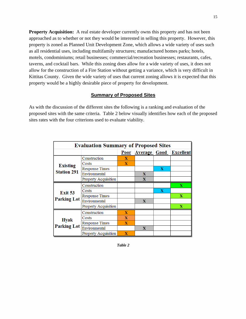
Property Acquisition: A real estate developer currently owns this property and has not been approached as to whether or not they would be interested in selling this property. However, this property is zoned as Planned Unit Development Zone, which allows a wide variety of uses such as all residential uses, including multifamily structures; manufactured homes parks; hotels, motels, condominiums; retail businesses; commercial/recreation businesses; restaurants, cafes, taverns, and cocktail bars. While this zoning does allow for a wide variety of uses, it does not allow for the construction of a Fire Station without getting a variance, which is very difficult in Kittitas County. Given the wide variety of uses that current zoning allows it is expected that this property would be a highly desirable piece of property for development.
Summary of Proposed Sites
As with the discussion of the different sites the following is a ranking and evaluation of the proposed sites with the same criteria. Table 2 below visually identifies how each of the proposed sites rates with the four criterions used to evaluate viability.
Table 2

16
4.0 Affected Environment and Potential Impacts
The environmental analysis is presented below. For each potentially affected resource topic, the analysis includes a description of the affected environment; applicable resource laws and regulations or thresholds of significance used to determine potential impacts for that particular resource topic; a summary of the potential environmental impacts associated with the alternatives under consideration; and any mitigation/conservation measures that would be implemented to reduce adverse affects.
For each resource category, the impact analysis follows the same general approach. When possible, quantitative information is provided to establish impacts. Qualitatively, these impacts will be measured based on small, moderate, or large impacts as outlined in the Table 3 below.
Impact Scale Criteria
Small Environmental effects would not be detectable or would be so minor that they would neither destabilize nor noticeably alter any important attribute of the resource.
Moderate Environmental effects would be sufficient to alter noticeably, but not to destabilize, important attributes of the resource.
Large Environmental effects would be clearly noticeable and would be sufficient to destabilize important attributes of the resource.
Table 3
Impacts are disclosed based on the amount of change or loss of the resource from the baseline conditions. Impacts may be direct or indirect. Direct impacts are caused by an action and occur at the same time and place as the action. Indirect impacts are caused by the action and occur later in time or are farther removed from the area, but are still reasonably foreseeable (40 CFR Part 1508). Cumulative impacts are discussed in Section Five.
4.1 Physical Resources
Physical resources discussed in this section include geology, soils, air quality, and climate.
4.1.1 Affected Environment
The Snoqualmie Pass area lies approximately 50 miles east of Seattle, Washington, along the crest of the Cascade Mountain Range. This mountainous area is located in the north central portion of the Cascade Range, which roughly spans from southern Oregon to northern Washington. Snoqualmie Pass is located in a saddle at approximately 3,000 feet above mean sea level elevation. Snoqualmie Pass is also located in roughly the mid-point of Washington State. Nearby mountain peaks tower over Snoqualmie Pass, such as Snoqualmie Mountain, located just

17
northwest of the Pass, is at approximately 6,200 feet elevation. The geologic conditions of the area influenced some early mining activities to seek physical resources such as gold, iron, silver, copper, etc. Resource minerals such as coal and petroleum have not been mined extensively in this area. Review of the Geologic Map of Washington Northwest Quarter, Map GM-50, indicates native soils across the site and area consist largely of alluvial deposits. The Kittitas County Soil Conservation Service (SCS) map indicates the area contains Chinkmin ashy sandy loam (Map Unit 187). This soil formed along mountain valley sidewalls and typically consists of ash and pumice overlying glacial till. However, due to significant clearing and grading that has occurred in the past century at Snoqualmie Pass valley, much of the native sand and gravel has been mined and replaced with waste fill.
Steep slopes, landslide hazards, erosion hazards, and liquefaction hazards are considered critical areas in King County and Kittitas County. Critical areas are regulated and generally protected by local, state, and federal government codes. Local governments such as King County and Kittitas County also protect and regulate critical area buffers. Buffers can be different in one jurisdiction compared to a different jurisdiction. A geotechnical engineering study was completed by Earth Solutions NW LLC in conjunction with the site work done by Concept Engineering (Earth Solutions, 2010). There are no critical areas for landslide and erosion hazards designated in the immediate vicinity of the alternative sites.
Generally, the climate at Snoqualmie can be described as an alpine environment. Due to its high altitude, Snoqualmie Pass receives a significant amount of snowfall as shown in Table 4.
Table 4

18
Because of its proximity to Pacific Ocean, it receives a tremendous amount of precipitation. Rainfall is more frequent in the fall and spring seasons and the summer season is much drier than the other three seasons. These weather variables contribute mightily to a significant amount of aquatic physical resources such as streams, river, and lakes in the Snoqualmie Pass region. According to the US Environmental Protection Agency (2010), the Snoqualmie Pass area, eastern King County and western Kittitas County, meet national ambient air quality standards. In summary, there are a significant amount of physical resources in the Snoqualmie Pass region.
4.1.3 Environmental Consequences Alternative A: Existing Station 291 Under the no-action alternative, there would be no impacts or change to physical resources. The existing station would remain occupied and support emergency response operations as it currently does. Alternative B: Exit 53 Parking Lot Under this action alternative, there would be little change to physical resources. Construction of a new fire station would result in no change to the area’s geologic conditions. Fairly large quantities of existing fill soils in the gravel parking pad would be removed during site preparation. Some of these fill soils originated approximately 50 years ago when the I-90 corridor was expanded, which is actually below the site to the east. Also, to construct adjacent SR-906, the native soils in the road corridor had to be excavated. Some of those excavation spoils could have been placed on this site as well. In this alternative, to provide adequate structural foundation support for the new fire station, some of the fill soils will have to be removed and exported offsite to an approved location. There may be a need for this soil locally for the ski area as part of their approved master plan. Because of extensive past site disturbance, impacts to native soils from fire station construction will be small. There is no avalanche and landslide danger at this location. The hill above the site to the west is fully forested and does not have a severe slope. There has never been a recorded avalanche or landslide in this area. Project site stormwater, after flow control and water quality treatment, would be discharged toward the wetland south of the site as described in figure 6 on the next page and in Appendix IV. Relocating emergency response operations to this new site will not result in any new permanent air emissions. Negligible impacts would be anticipated from vehicle exhaust emissions and increased dust during site work and facility construction. Federal and state air quality attainment levels would not be exceeded.

19
Alternative C: Hyak Parking Lot Under this action alternative, there would also be little change to physical resources. Construction of a new fire station would result in no change to the area’s geologic conditions. In this alternative also, to provide adequate structural foundation support for the new fire station, some of the fill soils will have to be removed and exported offsite to an approved location. There may be a need for this soil locally for the ski area as part of their approved master plan. Because of extensive past site disturbance, impacts to native soils from fire station construction will be small. There exists an extremely small avalanche and landslide danger at this location. The hill above the site is fully developed with residential houses, but in January of 2009 there was a massive avalanche and landslide nearby. Due to excessive rains on a ski slope in the area an avalanche/landslide occurred. This damaged a few homes along the edges of the ski slope, but did not progress further than the outskirts of the ski area. This occurrence was approximately ¼ of a mile from this potential building site and was no risk to the immediate area. Relocating emergency response operations to this new site will not result in any new permanent air emissions. Negligible impacts would be anticipated from vehicle exhaust emissions and increased dust during site work and facility construction. Federal and state air quality attainment levels would not be exceeded. 4.1.4 Mitigation Measures Although the three sites contain critical areas and buffers on their perimeters, the central portions of the sites, where grading would occur, lack critical areas and buffers. However, some mitigation measures would be provided, which include: First, best management practices (BMP) would be employed during site construction to minimize soil erosion offsite during site work for both Alternatives B and C. Secondly, site soils would be covered and/or wetted during construction to minimize fugitive dust. Third, too mitigate facility risks from heavy snowfall in the pass, the new fire station will be designed for heavy snow loads as well as to shed snow off the roof such that it does not impede response operations. Fourth, downstream erosion will be minimized from the project site, as the project will include a flow control facility (likely a detention vault) to decrease the flow of stormwater runoff leaving the site, which will result in decreased downstream soil erosion. Fifth, the project will be designed so that the fire station will be nearly balanced in earthworks, except for the needed structural fill. Excavated soils may be used for landscaping, instead of being exported offsite.

20
4.2 Water Resources
Water resources will include discussion streams, wetlands, and floodplains.
4.2.1 Affected Environment
The Snoqualmie Pass region receives a tremendous amount of snowfall and precipitation each year with an estimated 37 feet per year. Rainfall is more frequent in the fall and spring seasons and the summer season is much drier than the other three seasons. Because of the snowmelt and precipitation there is a significant amount of stormwater runoff into area surface waters. The State Divide runs through Snoqualmie Pass. Precipitation and snowmelt falling east of the State Divide results in storm water runoff, which flows east toward the Yakima River, which flows into the mighty Columbia River, followed by discharge into the Pacific Ocean at the Oregon / Washington State border, approximately 400 river miles away from Snoqualmie Pass.
Precipitation / snowmelt falling west of the State Divide results in stormwater runoff which flows west into the South Fork Snoqualmie River, which merges with the Middle and South Forks, flows over Snoqualmie Falls, merges with Skykomish River, and is renamed Snohomish River. The Snohomish River flows northwest and discharges into Puget Sound just north of the City of Everett, Washington.
As noted above, both King and Kittitas County designate critical areas, which also include wetlands and aquatic areas. The Snoqualmie Pass region has an abundance of critical areas. During the past century, Snoqualmie Pass has been developed with wagon trails, roads, highways, buildings, parking lots, etc. Many critical areas have been modified drastically or removed altogether. It was only until the last 20-25 years that critical areas started to become regulated.
Kittitas County is the governing jurisdiction east of the State Divide. King County is the governing jurisdiction west of the State Divide. Kittitas County has adopted the Washington State Department of Ecology Stormwater Management Manuals to address drainage / runoff from project sites. There is the 2004 Eastern Washington Manual and the 2005 Western Washington Manual. King County has created the 2009 King County Surface Water Design Manual. In terms of end goals, the manuals are very similar. The intent is to protect downstream resources and properties. In 2007 a sensitive areas study was completed by the Watershed Company for the alternative sites (Watershed Company, 2007). In terms of wetlands and surface waters, there are wetlands and seasonal streams adjacent to each of the different properties. However, there are no wetlands or streams that will be directly impacted by construction.
A review of FEMA’s Flood Insurance Rate Maps indicates there are no designated floodplain areas in either of the alternative sites.

21
4.2.3 Environmental Consequences
Alternative A: Existing Station 291
Under the no-action alternative, because there would be no construction, existing site conditions would persist. There are four depressional wetlands surrounding the site and no streams in the immediate vicinity. Stormwater runoff will continue to flow west toward Denny Creek and ultimately into Snoqualmie River. This site is west of the State Divide and in King County.
Alternative B: Exit 53 Parking Lot
Under this action alternative, stormwater runoff would be discharged to the south into a small wetland. Just downstream, the wetland seasonally overflows into a drainage ditch adjacent to I-90. Ultimately, the site’s runoff reaches Lake Kacheelus and begins its journey southeast in the Yakima River. This site is east of the State Divide and is located in Kittitas County. Kittitas County staff indicated that either the Western or Eastern Washington Stormwater Management Manuals could be used to address stormwater runoff for this project site.
North of the site is a small wetland and a seasonal stream that discharges into Coals Creek. South of the site is the above noted slightly larger wetland. An isolated steep slope is located just south of the site. None of these critical areas would be directly impacted as part of the fire station construction. The wetlands would not be filled, nor the stream. From a buffer standpoint, the wetland buffers may need to be averaged slightly to allow for exterior parking. Buffer reductions would be very minor, as it would only involve a few feet. Very minimal grading would occur in the outer portion of the buffers. Based on wetland/stream location, site design and mitigation measures described below; impacts to wetlands and nearby streams would be small.
Alternative C: Hyak Parking Lot
Under this action alternative, runoff from this site would flow east toward Yakima River. Again, either the Western or Eastern Washington Stormwater Management Manuals could be used to address stormwater runoff for this project site. There is a category III wetland east of the parking lot and a seasonal Gold Creek tributary stream just north of the site. The stream is presumed fish bearing. Although no site design was prepared for this location, stormwater management features would be incorporated consistent with the County manuals. Based on wetland/stream locations, potential site design and mitigation measures described below; impacts to wetlands and nearby streams would be small.

22
4.2.4 Mitigation Measures
The development of either alternatives B and C, both in Kittitas County would involve significant stormwater management provisions per the Critical Areas Ordinance. Flow control and runoff treatment would be integrated into the site design (see Appendix IV). Due to a lack of available land, the likely detention option would be underground via a vault or tank. Because site work will likely exceed 1 acre, BMPs would be implemented during construction consistent with the National Pollution Discharge Elimination System (NPDES) permit, to minimize erosion into adjacent wetlands/streams. Both alternatives B and C sites would involve wetland buffers, enhancement and native vegetation plantings in the outer portions of the wetland buffers.
4.3 Coastal Resources
All three site alternatives are located in Kittitas County, which is not in the Washington Department of Ecology’s designated Coastal Zone (2010). Therefore this section is not applicable.
4.4 Biological Resources
Biological resources will include discussion of the existing vegetation; fish and wildlife; and threatened and endangered species, per Section 7 of the Endangered Species Act (ESA).
4.4.1 Affected Environment
The Snoqualmie Pass region is considered a diverse ecosystem. The region’s elevation ranges from 2,500 – 6,300 feet. The differences of vegetation and wildlife are quite different at 2,500 feet vs. 6,300 feet. At the lower elevations of the Pass, western red cedar, western hemlock, and douglas fir are still present and dominant. At higher elevations, those species are replaced by mountain hemlock and alpine fir. Also, shrubs such as sword fern and salal are prevalent in the lower regions of the Pass, but are replaced by black huckleberry and mountain heathers on the higher mountain slopes. Wildlife such as marmots are more frequently found at higher regions, whereas black-tailed deer are more frequently found in the lower regions. Another diverse aspect of the ecosystem is the transition from a mountain rain forest on the west side of the Pass to a drier forest on the east side of the Pass. The weather and soil moisture conditions greatly influence the types of vegetation. Many decades ago, the Snoqualmie Pass area was logged extensively and still is today, but not to the degree it was previously. The Snoqualmie Pass area still has a tremendous amount of wood. Tall stands of Douglas fir, western red cedar, western hemlock, among others are physical resources in great demand. Many properties still being logged today are regulated by Washington State Department of Ecology (DOE), Washington State Department of Natural

23
Resources (DNR) and/or USFS. Furthermore, in 1997, the USFS completed an EIS for its Snoqualmie Pass Adaptive Management Area (AMA) Plan, which designates much of the Snoqualmie Pass area as a Connectivity Emphasis Area (CEA). CEAs are broadly designated for late-successional habitat (LSH), contiguous habitat or corridors, they can provide for dependent wildlife. The Plan acknowledged that much of the AMA has been fragmented by past timber harvesting and development, nonetheless new development that is neutral or beneficial to LSH are consistent with the AMA’s goals. The project areas and/or vicinity may provide temporary refuge, foraging habitat, and/or nesting areas for a variety of mammals, birds, and amphibian species. Black-tailed deer (Odocoileus hemionus columbianus), black bear (Ursus americanus), and elk (Cervus Canadensis) are some of the larger mammal species found in the vicinity. Smaller mammals found in the vicinity include coyote (Canis latrans), squirrel (Sciurus griseus), beaver (Castor Canadensis), vole (Arvicolinae spp.), raccoon (Procyon lotor), and muskrat (Ondatra zibethiscus). These mammalians are more likely found in greater densities in higher quality riparian habitats away from the developed areas of Snoqualmie Pass. The adjacent mountainous area, just outside the commercialized portion of Snoqualmie Pass, provides excellent refuge, foraging habitat, and nesting areas. Bird species observed onsite include the raven (Corvus corax), American crow (Corvus spp.), and songbird (Passeri spp.). Other birds such as hawks and eagles are likely to be found in the area as well. Fish were not observed on or adjacent to any of the alternative sites. However, many different fish species are present in the downstream systems of Snoqualmie River to the west and Yakima River to the east. Fish include rainbow trout, brown trout, sockeye, Kokanee salmon, Chinook salmon, silver salmon, and bass. Many streams, rivers, and lakes below Snoqualmie Pass have been dammed, culverted, or re-routed, which have altered fish distribution and species currently present at Snoqualmie Pass. Per the Washington State Department of Fish and Wildlife, there are three levels of protected species designations. First, Endangered Species is any wildlife species native to the State of Washington that is seriously threatened with extinction throughout all or a significant portion of its range within the state. Second, Threatened Species is any wildlife species native to the State of Washington that is likely to become endangered species within the foreseeable future throughout a significant portion of its range within the state without cooperative management or removal of threats. Third, Sensitive Species is any wildlife species native to the State of Washington that is vulnerable or declining and is likely to become endangered or threatened throughout a significant portion of its range within the state without cooperative management or removal of threats. Threatened and sensitive species may reside in the Snoqualmie Pass region, and include the sage grouse and peregrine falcon, respectively. There are no federally listed threatened or endangered species in the immediate project alternatives vicinity. However, the US Fish and Wildlife Service has identified the Westslope Cutthroat Trout as a species of

24
concern, which may be present in Coals Creek. The ESA does not require federal agencies consult for federal species of concern. In 2007 a sensitive areas study was completed by the Watershed Company for the alternative sites (Watershed Company, 2007). In terms of wildlife and habitat, site conditions for each site are characterized as fragmented and isolated. For all three sites, habitat connectivity is generally lacking due to the adjacent SR-906, I-90, commercial development, and residential homes. Small pockets of habitat remain, but they are extremely isolated from the far superior wildlife areas approx. one mile away from the three sites.
4.4.3 Environmental Consequences
Alternative A: Existing Station 291
Under the no-action alternative, there would be no construction or related activities. The existing fire station would continue to be occupied, maintained, and repaired as needed. The continued operation of this site would no change in affect on biological resources from human disturbance, and associated thresholds of significance would not be exceeded.
Alternative B: Exit 53 Parking Lot
Under this action alternative, very few trees and vegetation would be removed. Virtually all of the grading activities would occur in an existing gravel parking lot, where wildlife habitat is practically non-existent. The project’s attenuated stormwater discharge would be into a wetland to the south. There are no fish or suitable habitat in this downstream system within at least ½ mile. In summary, the construction and new use of this site should have small affects on biological resources from human disturbance. There would be no effect to federally listed threatened or endangered species because none are present on or adjacent to the site. Because of the site’s location, adjacent uses, poor habitat values, and mitigation measures; construction and operation of the fire station would be considered neutral relative to the AMA’s goals.
Alternative C: Hyak Parking Lot
Under this action alternative, it appears that few trees and vegetation would be removed. Virtually of the grading activities would also occur in an existing gravel parking lot, where wildlife habitat is practically non-existent. The project’s attenuated stormwater discharge would be into a wetland to the east. In summary, construction and the new use of this site should have small affects on biological resources from human disturbance. There would be no effect to federally listed threatened or endangered species because none are present on or adjacent to the site. Because of the site’s location, adjacent uses, poor habitat values, and mitigation measures;

25
construction and operation of a fire station would be considered neutral relative to the AMA’s goals.
4.4.4 Mitigation Measures
Per the Kittitas County Critical Areas Ordinance, Alternatives B and C would involve buffer enhancement by planting native trees and shrubs on the fringes of the parking lot. This would result in additional habitat values for the wetland and stream buffers as there would be increased opportunities for refuge, foraging, and nesting. Also, the new planting screening would help decrease lights, noise, etc. from fire station activities.
4.5 Cultural Resources This section will discuss historic properties, cultural resources and tribal interest in the Area of Potential Affect (APE) consistent with Section 106 of the National Historic Preservation Act. In developing the APE for an undertaking (project alternatives), consideration must be given to those effects that would occur immediately and directly as well as those that are reasonably foreseeable and may occur later, are farther removed in distance, or are cumulative, but might still result from the undertaking. Areas immediately and directly affected by the undertaking include those areas within the project footprint. The APE for the alternative sites includes the parcel and extant structures, and adjacent views. 4.5.1 Affected Environment The Cascade Crest forms an ethnographic territorial boundary between the Snoqualmie people on the west and the Upper Yakama or Kittitas people on the east. The Snoqualmie occupied the Snoqualmie River watershed from its confluence with the Skykomish River at present-day Monroe to its headwaters at Snoqualmie Pass. The Kittitas occupied the Yakima River valley above Selah and the Kittitas valley. The Snoqualmie spent the winters in permanent villages along the Snoqualmie and Tolt rivers and at Sallal Prairie near present-day North Bend. In early spring, the Snoqualmie split up into smaller groups and traveled to seasonal camps and locations to obtain and process a variety of resources as they become available. They traveled into the mountains, including the Snoqualmie Pass area, during the summer, where they collected huckleberries, bear grass, and other plants, and hunted deer, elk, bear, mountain goats and smaller game. Yakama winter villages were located mostly on the Yakima and Columbia rivers. Fishing was the most important subsistence activity, followed by root and berry gathering supplemented by hunting. The Kittitas traveled to higher elevation resource areas during the summers, including

26
Lake Keechelus, where they obtained sockeye salmon, and Snoqualmie Pass, where they collected huckleberries along with the Snoqualmie. After they obtained horses in the eighteenth century, the Yakama also traveled east to hunt bison on the Great Plains. Strong ties were formed across the mountains as people from both sides of the Cascades exchanged goods, socialized, and intermarried. The Snoqualmie and Yakama traveled across the mountains along an extensive trail system over Snoqualmie and Yakama passes. The Snoqualmie Pass trail, which was used mostly by foot travelers, followed the South Fork Snoqualmie River to the pass, where it crossed to the north side of Coal Creek and continued east along the east shore of Lake Keechelus and the Yakima River through the Kittitas Valley. (Master, 2008) Snoqualmie Pass has always been a busy thoroughfare for travelers moving east or west across Washington. The first dam at nearby Lake Keechelus, southeast of Snoqualmie Pass, was constructed in 1906, which really enabled Snoqualmie Pass to be developed. A wagon trail was installed in 1907 around the lake and through the Pass. As travel increased so did the need for improved roads. By 1913 it had become the Sunset Highway and in 1920 Highway 10. Many of the cabins that were built in the Pass were to support men working for the Department of Transportation that were employed to make the original wagon trail into a road, and eventually a highway. By 1934, a paved road extended across Snoqualmie Pass in entirety. Today, Snoqualmie Pass is the most heavily traveled mountain pass in the United States. I-90 freeway is 2 to 5 lanes wide in each direction crossing the Pass. Throughout the development of the roads through Snoqualmie Pass there were other business opportunities as well. The Denny Iron Mines Company was formed in 1882 but did not last long as the ore was of low grade. In 1909 the Chicago, Milwaukee, and St Paul Railroad’s main line was completed through Snoqualmie Pass, which joined the Northern Pacific and Great Northern routes (Kinnick, 2007). In 1912 there was a ferry to take vehicles and passengers across Lake Keechelus to avoid the unreliable wagon trail. It remained in operation until 1915 when a gravel road was completed. Eventually, as travel continued to increase campgrounds were created such as the very popular Denny Creek Campgrounds west of Snoqualmie Pass. However, as the railroad went bankrupt and the other businesses waned, one business remained, skiing. The original ski slope was developed at what is now known as Summit East (originally known as Hyak). Three other ski areas have now been added, Alpental, Summit Central (previously known as Ski Acres), and Summit East (previously known as Snoqualmie Summit). There are also hundreds of miles of cross country ski and hiking trails, hundreds of homes, commercial businesses, a hotel, and other supporting businesses. Snoqualmie Pass is now a major recreational epicenter in the State of Washington.
27
A review of Washington Department of Archeology and Historic Preservation (DAHP) records indicates several historic properties have been identified along Snoqualmie Pass and several cultural resource surveys completed. Much of the survey work has been associated with the ski areas and I90 corridor. No historic properties are listed in the alternative site APEs. One site record, the “Sunset Highway/Snoqualmie Pass Highway” which is also SR 906, is immediately adjacent to each of the site alternatives. Records do indicate that the highway was evaluated for National Register eligibility and determined not eligible. The existing fire station has not been evaluated for its historical significance. As part of this EA, consultation was completed with the DAHP for alternative construction sites (see Appendix V). According to the US National Park Service (2010), tribes with historical interests in the project region include the Yakama Nation; Snoqualmie and Muckleshoot Tribes; and Confederated Tribes of the Colville Reservation. Tribes were provided opportunity for comment as part of the public involvement process of the draft EA. 4.5.3 Environmental Consequences
Alternative A: Existing Station 291
Under this no-action alternative, there would be no FEMA funding provided, thus no undertaking or potential to affect historic properties. However, the existing fire station is over 50 years old and associated with the historical development of the Pass, thus it may meet criteria for eligibility for the National Register of Historic Places. Further evaluation would have to be completed to determine its historical significance and integrity. If the structure is historic, future modification could result in adverse effects.
Alternative B: Exit 53 Parking Lot
Under this action alternative, construction activities affect previously disturbed soil that has already been sampled and labeled as fill material, thus no historic properties would be affected. Consultation has been completed with DAHP. Under this alternative the existing station 291 would be vacated. Current mitigation measures are being undertaken with the USFS on what to do with the structure. It may be rented out, sold, or demolished. In any event the DAHP will be involved in the process.
Alternative C: Hyak Parking Lot
Under this action alternative, construction activities affect previously disturbed soil in a parking lot that has been sampled and labeled as fill material, thus no historic properties would be affected. Consultation has been completed with DAHP. Under this alternative the existing station 291 would be vacated. Current mitigation measures are being undertaken with the USFS

28
on what to do with the structure. It may be rented out, sold, or demolished. In any event the DAHP will be involved in the process.
4.5.4 Mitigation Measures and Residual Impacts Although, no mitigation measures are necessary based on findings, the unanticipated discovery of previously unreported cultural resources during project work would trigger additional review and consultation with the DAHP and tribal interests.
4.6 Socioeconomic Resources Socioeconomic resources will include discussion of environmental justice, noise, traffic, public services, utilities, health and safety. 4.6.1 Affected Environment Federal agencies are required, by Executive Order 12898 (Environmental Justice, 59 Fed. Reg. 7629 [1994]), to achieve environmental justice by addressing "disproportionately high and adverse human health and environmental effects on minority and low-income populations." To do this, the demographics of the affected area are examined to determine whether minority populations, low income populations, or Indian tribes are present in the area impacted by a proposed action. If so, it must be determined whether implementing or developing the proposed project may cause disproportionately high and adverse human health or environmental effects on these populations. The Snoqualmie Pass community is a diverse group of part-time and full-time residents: people who work at the Pass and live elsewhere, or who live at the Pass and work elsewhere; and some who make both their home and their livelihood at the Pass. The Snoqualmie Pass area is a magnificent recreational area, including ski areas, the Pacific Crest/John Wayne Trail and Ironhorse State Park Trail, many lakes, and scenic alpine wilderness. These features are remarkable not only for their beauty and recreational opportunities, but also for the ease of public access via I-90, a National Scenic Byway. The natural splendor of the mountain setting, the economic and recreational opportunities, the existing extensive infrastructure, and the diverse mix of public and private stakeholders are features, which are not found together in any other community in the State of Washington. The challenges of planning for this community are truly unique. There are no census statistics specifically for the Snoqualmie Pass area because it is an unincorporated area. Table 5 on the next page shows the statistics for the closest city, North Bend, which is located approximately 20 miles to the west. However, the Snoqualmie Pass area probably has similar diversity and better poverty statistics to that of the North Bend area.

29
Race alone or in combination with one
or more other races: 3 Number Percentage White 4,474 94.3%
Black or African American 58 1.2
American Indian and Alaska Native 77 1.6
Asian 136 2.9
Native Hawaiian and Other Pacific Islander 16 0.3
Some other race 104 2.2
Poverty Status in 1999
Number below
poverty level
Percentage below poverty
level Families 28 2.1%
with related children under 18 years 28 3.7
with related children under 5 years 19 5.1
Families with female householder, no husband present ‐‐‐ ‐‐‐
with related children under 18 years ‐‐‐ ‐‐‐
with related children under 5 years ‐‐‐ ‐‐‐
Individuals 226 4.7
18 years and over 144 4.3
65 years and over 11 3
Related children under 18 years 73 5.1
Related children 5 to 17 years 56 5.9
Unrelated individuals 15 years and over 109 14
Table 5
A fire station, such as the one at Snoqualmie Pass, is typically not louder than any other commercial property most of the time, except when units are responding to an emergency. Then units will use lights and siren as appropriate. Not all 911 calls result in an emergency that the units would be required to respond “code red”, which are lights and sirens. Although code red call-outs vary widely at Snoqualmie Pass commensurate with the season, recent statistics indicate they range from 280 to 330 calls per year, of which 10% are night-time call-outs Residents and businesses in the immediate vicinity of a fire station will inevitably be briefly subjected to siren noise. It should also be noted that sounds created by emergency equipment are exempt from the County noise ordinance. Traffic in Snoqualmie Pass fluctuates greatly due to the weather and recreational opportunities, in particular along SR 906. If the snow conditions are good and the ski area is open then there is a dramatic increase in both vehicle and pedestrian traffic throughout the Pass. Similarly, in the summer there can also be an increase in traffic during sunny weekend days due to people travelling to the Pass to hike, bike, etc. Traffic patterns in the immediate vicinity of a fire station can be a concern given rapid egress needs during call-outs.

30
By design, a fire station provides a critical public health and safety service to the district it covers as well as through mutual aid to surrounding communities. SPFR is located within two different counties. Each County has the ability to establish its own set of Medical Program Director (MPD) protocols, under the authority of the Washington State Department of Health (DOH). When SPFR was created, it was the result of Kittitas County Fire Protection District #5 merging into King County Fire Protection #49. Because of this SPFR has always followed King County MPD Protocols. This is logical considering that 98% of our BLS patients and 100% of our ALS patients are transported to King County Hospitals, and therefore are treated under King County Emergency Medical Services (KCEMS). The SPFR Board of Fire Commissioners also has the option at any time to choose between which County’s medical protocols it will follow. The District has no plans to change protocols because the physical location from which it operates has changed as there is no anticipated change in where patients will be transported. The DOH has a long standing position that MPD protocols “follow” EMS responders across county lines and each of the County MPD’s actively work together to resolve any issues that arise. The services provided by SPFR are also extensively discussed in Section 2. 4.6.3 Environmental Consequences
Alternative A: Existing Station 291
Under this no-action alternative, because there would be no change to the status quo, there would be no disproportionate impacts on minority or low-income populations; or change to noise or traffic patterns. As discussed in the purpose and need section above, continued operation out of the existing substandard facility does impair emergency response operations, and in particular response times. As the facility continues to deteriorate and projected response demand increases, the level of the public service provided by the SPFR could further diminish with adverse consequences to public safety in the Pass. Furthermore, as described above, vehicular accident risks at this location, across from the seasonally busy ski area, from equipment ingress and egress would persist.
Alternative B: Exit 53 Parking Lot
Under this action alternative, there would be no disproportionate impacts on minority or low-income populations as they would continue to be equally served by the SPFR. Effects of relocating the SPFR function to this location on SR 906 traffic patterns would be small. The ingress and egress traffic patterns at this site would be improved compared to the existing fire station in terms of traffic volume, type of equipment, and timing. Because this location is not near a busy ski facility parking area, the risks of vehicular accidents during equipment ingress

31
and egress would be significantly reduced. Specifically, this new location would not have foot traffic, unlike the current fire station location. Moreover, because of the site’s design elevations, navigating the apparatus onto the highway in front of the station would no longer include the risk of sliding into other cars and people passing by. No problems are anticipated with driveway access to SR 906 from the Washington Department of Transportation.
Because there is little development in the immediate area surrounding this property and frequency of anticipated night-time call-outs, episodic and short duration noise from code red call-outs is buffered and thus impacts to nearby residents are expected to be small.
Typical utilities required for fire station construction and operation include electrical, water, wastewater, refuse collection, and communications; all of which are readily available at this location. No problems are expected for tie-in to utilities.
From a community service and public safety standpoint, there would be a myriad of positive impacts. The most significant effect is that we would no longer be operating out of a substandard structure that is structurally compromised. Firefighter safety would be improved by the addition of a vehicle exhaust system and better clearance around fire apparatus in the station. Increased training could occur with proper work areas and an exercise room. All apparatus could be kept inside, which is especially beneficial during the winter months. An equipment decontamination area would decrease the risk of communicable disease transmission to firefighters and our next medical patients. A new station will be equipped with proper facilities to provide an emergency shelter for the surrounding community, the only one in the area. Proper storage of equipment such as drying hose in a hose tower would increase its lifespan, subsequently improving firefighter safety and saving taxpayer money. A room designed to become an emergency operations center would allow for a proper command post in the event of a major emergency, which occurs often due to our environment and remote location. Sufficient dormitory space would ensure an efficient and appropriate staffing level and emergency response.
The station will be centrally located to decrease response times for on duty personnel and for volunteers reporting to the station. It will be adjacent to exit 53 on Interstate 90 that will allow for full access in both directions, alleviating the need to travel on SR 906 to the next exit as we do now. The new location will improve the five minute response area from 58% of the district, to 91%. Response models indicate that the new location meets the criterion set forth in NFPA 1720 and once full-time staffing occurs, NFPA 1710. Even though the station would be moving from King County to Kittitas County there would be no change in protocols or standards of performance in operations. A new fire station will decrease our need for mutual aid and improve the mutual aid that we can provide. Due to our remote location, type of construction, and height of our structures we include

32
a ladder truck on our first alarm assignments. This initiates a response from the closest ladder truck, which is about 45 minutes away. If we had our own ladder truck it would decrease that need. Furthermore, this same fire department also has to respond into our area with their fully staffed apparatus when we do not have enough personnel to respond on calls. This results in our fire district receiving mutual aid an average of 83 times annually and providing it only 19 times per year. Proper full-time staffing of our fire station will allow us to expand our level of services, provide increased mutual aid fire and emergency medical services to our neighbors more consistently, and add the operational advantages of a ladder truck.
Alternative C: Hyak Parking Lot
Under this action alternative, there would be no disproportionate impacts on minority or low-income populations as they would be equally served by the SPFR. While the ingress and egress patterns at this site would be similar as the existing fire station in terms of traffic volume, type of equipment, and timing; there would be an affect to residents and businesses along Hyak Drive East from the increase in SPFR operation traffic. Mostly because the fire station would now be exiting on to the main residential access for Hyak residential division I, II, III, and IV compared to exiting onto SR 906 as with the other sites. Hyak Drive has the capacity to accommodate this small increase in fire station traffic. There would also be episodic and short duration increases to ambient noise levels at this site from equipment sirens activated during code red responses. Given ambient noise levels because of this location’s proximity to nearby houses and the number of expected night-time call-outs (based on historical frequency statistics), affects on nearby residents would be small.
Utilities requirements at this location are the same as for Alternative B; all of which are readily available. No problems are expected for tie-in to utilities. The significant benefits to community services and public safety described under alternative B would be the same for this location. Even though the station would be moving from King County to Kittitas County there would be no change in protocols or standards of performance in operations. 4.6.4 Mitigation Measures and Residual Impacts As stated previously SPFR will try to minimize impacts when responding to ensure proper siren usage, but no other mitigation measures are proposed under any alternatives.
4.7 Hazardous Materials Assessment This discussion will focus on environmental conditions at the site alternatives in terms of hazardous materials, wastes, or contamination.

33
Alternative A: Existing Station 291
The current fire station is nearly 70 years old. During that time the structure has been used for different functions, but at no time was there any hazardous materials, aside from the use of common lubricants and cleaning agents, either in use or brought to the site that would constitute a threat to the environment. Given the building’s age there may be lead-based paint and asbestos containing materials. Under this alternative there would be no change to those existing conditions. Alternative B: Exit 53 Parking Lot White Shield, Inc. (WSI) has completed a Phase II Environmental Site Assessment in December 2009 of the Alternative B property in accordance with the guidelines presented in ASTM E1903-97 (Phase II, 2009). This report was prepared for the Mt Baker – Snoqualmie National Forest (MBSNF) as part of the real estate transfer to SPFR, to document activities and observations during the sampling of eight test pits and drilling and sampling of two temporary monitoring wells on the subject property. In July 2009 an expanded Phase I Environmental Site Assessment (ESA) was conducted by the USFS (Phase II, 2009). This ESA included soil and water samples from the subject site. The results of the samples indicated that water emanating from the bottom of a 10,000 cubic yard pile of fill placed on the subject property in 1970 contained elevated concentrations of aluminum, arsenic, cadmium, chromium, copper, nickel and zinc (the “contaminants-of-concern”). This was identified by the USFS as a recognized environmental condition. In an effort to ascertain whether fill materials placed on the site were the source of the metals detected in the water sample collected by the USFS, White Shield, Inc. collected samples of soil material from eight test pits excavated in the fill material on October 30, 2009. Two temporary monitoring wells were drilled, and groundwater samples were collected for analysis. . Based on the data developed during this investigation, it appears that neither the fill material nor the water on the subject property are contaminated with aluminum, cadmium, chromium, copper, nickel, or zinc in concentrations warranting concern or further action. Based on the results of this investigation, it is White Shield’s opinion that no further action is required at this site. Alternative C: Hyak Parking Lot This site is similar in composition to alternative B. The parking lot is composed of material exported from the I-90 expansion project. It is likely that the fill at this site would also have similar metals, etc. as described above. If this site was chosen a Phase I ESA would need to be completed prior to property acquisition.

34
5.0 Cumulative Impacts Cumulative impacts are those that result from the incremental effect of a proposed action when added to other past, present, and reasonably foreseeable future actions regardless of what agency or person undertakes such other action (40 CFR 1508.7). Only those resources associated with cumulative effects are described below. Potential incremental effects from the Alternative Actions when added to other activities in the Snoqualmie Pass area would result primarily from vegetation clearing and soil disturbance. These activities would have very small cumulative adverse effects on soils, hydrology and water quality, vegetation/habitat, fish and aquatic life, and general wildlife, because the scale of the site development and construction is so small. The land surrounding the Alternative B project site is primarily publicly owned, with an Interstate Highway and State Route bordering on three sides. These surrounding lands are undevelopable and although the project would result in a building with a footprint of approximately 10,000 square feet there will be very little impact due to the current condition of the site as a parking lot. The Alternative C is bordered by residential development and SR906, and a narrow wooded strip. Because this site is in a parking lot and developed corridor, cumulative impacts would be small.
6.0 Public Involvement and Agency Coordination The building of a new fire station for the Snoqualmie Pass community has been a high priority for well over a decade. Public involvement is ongoing and had begun before the initiation of this EA. The project has frequently been an agenda item for regularly scheduled SPFR Fire Commissioner public meetings, most recently at the February 8, 2010 meeting. Furthermore, SPFR placed a sign at the Alternative B site that provided notice of the proposed fire station and solicited public input to the draft EA. Throughout the process of developing alternatives and in particular Alternative B, we also engaged local organizations to address any of their concerns as well. Many meetings and conversations occurred with the Washington Wilderness Coalition, the Washington Trails Association, Backcountry Horseman of Washington, Conservation Northwest, the Earth Ministry, The Nature Conservancy of Washington, the Cascade Land Conservancy, the Alpine Lake Protection Society, the Sierra Club – Cascade Chapter, the Washington Environmental Council, Seattle Audubon, the North Cascades Conservation Council, the Mountains to Sound Greenway Trust, Audubon Washington, the Pacific Crest Trails Association and Kittitas County Parks District #1. By the time that a bill conveying USFS land to SPFR was signed into law by President Obama all of the concerns raised by interest groups had been addressed and we received letters of support from many of the above organizations.
35
Public involvement was required for the draft EA (see Appendix VI). Public notices were published in the Seattle Times on March 5 and 12, 2010. The public notice was mailed to interested parties and tribes including: the US Forrest Service; Sierra Club Cascade Chapter; The Cascade Land Conservancy; Conservation Northwest; The Mountaineers; the Yakama Nation; Confederated Tribes of the Colville Reservation, and Snoqualmie and Muckleshoot Tribes. The public and resource agencies wereprovided opportunity to comment on the draft EA during the comment period, from March 5 to April 7, 2010. Also, the SPFR hosted an open house on March 20, 2010 at the existing Station 291 and made the EA and fire station plans available for public review. The only substantive comment received was from the Washington Department of Ecology regarding requirements for NPDES permitting and water rights. Agency coordination has occurred mainly on the Alternative B location. Two Pre-Application Meetings were held at Kittitas County Permit Center in Ellensburg, Washington. The following items were discussed; parking layout, critical areas such as wetlands and streams, property line locations, setbacks, utility connections, commercial building permit application process, public facilities permit application process, etc. SPFR has also coordinated with the Washington Department of Transportation regarding access to SR906. Consultation was completed with the Washington DAHP, related to historic properties at the alternative construction sites.
7.0 Conclusions, Project Conditions, and Mitigation Measures This EA evaluated the potential impacts to environmental, cultural and historic resources from the No Action, Proposed Alternative B, and Alternative C. The EA has also addressed the compliance requirements of the National Historic Preservation Act, Endangered Species Act, Executive Orders 11988 (Floodplain Management), 11990 (Protection of Wetlands), and 12898 (Environmental Justice), and other related environmental statutes along with considering issues such as hazardous and toxic wastes, infrastructure, and socioeconomics. The evaluation was based on the grant application, site review, proposed action scope of work and site/building design, resource studies, agency consultations, public involvement, and mitigation and conservation measures. The findings of this EA indicate there are no significant impacts to the resources discussed herein, and therefore an Environmental Impact Statement is not required. A Finding of No Significant Impact has been prepared. For the Proposed Alternative SPFR would comply with the following conditions and mitigation measures before and during implementation:
This review does not address all Federal, State, and local requirements. Acceptance of Federal funding requires recipient to secure and comply with all Federal, State, and local permitting requirements. Failure to obtain all appropriate Federal, State, and local permits and clearances may jeopardize Federal funding.

36
Any change to the approved scope of work stated in the FEMA grant application and described in this EA as the proposed action will require re-evaluation for compliance with NEPA and other laws and Executive Orders.
The SPFR is responsible for selecting, implementing, monitoring, and maintaining best management practices to control erosion and sediment, reduce spills and pollution, and provide habitat protection during site work.
Site soils would be covered and/or wetted during construction to minimize fugitive dust.
Mitigation measures associated with wetlands adjacent to the site shall be implemented per Kittitas County Critical Areas requirements.
In the event that archaeological or historic materials are discovered during site work, activities in the immediate vicinity shall be discontinued, the area secured, and the SHPO and FEMA notified.
8.0 List of Preparers Matt Cowan Fire Chief Snoqualmie Pass Fire & Rescue PO Box 99 Snoqualmie Pass, WA 98068 (425) 434-6333
Mark Rigos Professional Engineer Concept Engineering Inc. 455 Rainier Boulevard North Issaquah, WA 98027 (425) 392-8055

37
REFERENCES CEQ (Council on Environmental Quality). 1997. Environmental Justice. Guidance under the
National Environmental Policy Act. Available online at: http://handle.dtic.mil/100.2/ADA434918
Cowan, Matt. 2006. Long Range Plan 2006-2016. Prepared by Fire Chief, Snoqualmie Pass Fire
& Rescue. Available online at: http://snoqualmiepassfire.org/Long%20Range%20Plan%202007.pdf
Cowan, Matt. 2007. An Evaluation of New Fire Station Locations for Snoqualmie Pass Fire &
Rescue. Available online at: http://www.snoqualmiepassfire.org/New-Station/documents/NewSta291LocationReport.pdf
Earth Solutions NW LLC. 2010. Geotechnical Engineering Study Snoqualmie Pass Fire and
Rescue Facility. Available online at: http://snoqualmiepassfire.org/New-Station/documents/GeologyReport.pdf
EPA (U.S. Environmental Protection Agency). 1998. Final Guidance for Incorporating
Environmental Justice Concerns in EPA’s NEPA Compliance Analysis. April 1998. Available online at: www.epa.gov/oecaerth/resources/policies/ej/ej_guidance_nepa_epa0498.pdf.
FEMA (Federal Emergency Management Agency). 1985. FEMA Flood Insurance Rate Map
(FIRM) panel FM0200218750C. Available online at: http://msc.fema.gov/webapp/wcs/stores/servlet/CategoryDisplay?catalogId=10001&storeId=10001&categoryId=12001&langId=-1&userType=G&type=1.
Kinnick, John and Chery. 2007. Images of America – Snoqualmie Pass. Charleston, SC:
Arcadia Publishing. Master Development Plan, Summit-at-Snoqualmie. 2008. Available online at: http://www.fs.fed.us/r6/mbs/projects/summit-at-snoqualmie/feis-download.shtml National Volunteer Fire Council (NVFC) Fact Sheet. Available online at: http://www.nvfc.org/pdf/2003_fact_sheet.pdf NFPA 1710 Standard for the Organization and Deployment of Fire Suppression Operations,
Emergency Medical Operations, and Special Operations to the Public by Career Fire Departments. (2004 ed.). National Fire Protection Agency (NFPA). p. 24-30.

38
REFERENCES (continued) NFPA 1720 Standard for the Organization and Deployment of Fire Suppression Operations,
Emergency Medical Operations, and Special Operations to the Public by Volunteer Fire Departments. (2004 ed.). p. 16.
Phase II Environmental Site Assessment Prospective Snoqualmie Pass Fire and Rescue Station
Site Snoqualmie Pass, Washington. 2009. USFS, Mt. Baker – Snoqualmie National Forest. Available online at: http://snoqualmiepassfire.org/New-Station/documents/SnoqPassSitePhaseIIESARevFinalReport.pdf
Snoqualmie Pass Annual Snowfall. Available online at:
http://www.wsdot.wa.gov/NR/rdonlyres/7C5D5B02-0237-46DD-8AD2-3F3C0226485D/62148/102809HistoricalSnowfallthrough0809season1.pdf
The Fire Service Needs Assessment Survey. Available online at:
http://www.usfa.fema.gov/downloads/pdf/publications/fa-240.pdf U.S. Census Bureau. 2000. Small Area Income and Poverty Estimates for 2005. Available
online at: http://censtats.census.gov/data/WA/1605349485.pdf U.S. EPA (U.S. Environmental Protection Agency). 2010. The Greenbook Non-Attainment
Areas for Criteria Pollutants. Available online at: http://www.epa.gov/air/oaqps/greenbk/
US National Park Service (NPS). Native American Consultation Database. Available online at:
http://grants.cr.nps.gov/nacd/index.cfm. Washington Department of Ecology. 2010. Coastal Zone Management Program. Available
online at: http://www.ecy.wa.gov/programs/sea/czm/prgm.html Washington Department of Fish and Wildlife. 2009. Priority Habitat and Species Database.
Protected species data for Kittitas and King County. Watershed Company. October 2007. Sensitive Areas Study, Snoqualmie Pass Fire & Rescue
Proposed New Station #291. Available online at: http://www.snoqualmiepassfire.org/New-Station/documents/InitialEnvironmentalScoping.pdf

39
APPENDIX I (3 Bay Station Design, 1st Floor)

40
APPENDIX I (3 Bay Station Design, 2nd Floor)

41
APPENDIX II (5 Bay Station Site Design)

42
APPENDIX III (Site Location Map)

43
APPENDIX IV (Stormwater Site Design)

44
APPENDIX V (Historic Preservation Consultation)

45
APPENDIX VI (Draft EA Public Notice)
PUBLIC NOTICE Federal Emergency Management Agency
Draft Environmental Assessment Snoqualmie Pass Fire Rescue New Station 291 Construction
The U.S. Department of Homeland Security’s Federal Emergency Management Agency (FEMA) proposes to provide funding to the Snoqualmie Pass Fire Rescue for a new fire station project at Snoqualmie Pass in Kittitas County, Washington. Funding would be provided through the Assistance to Firefighters Grant Program as authorized by the American Reinvestment and Recovery Act. A draft Environmental Assessment (EA) has been prepared for the proposed project pursuant to the National Environmental Policy Act (NEPA) of 1969 and FEMA’s implementing regulations found in 44 Code of Federal Regulations (CFR) Part 10. The EA evaluates alternatives for compliance with applicable environmental laws, including Executive Orders #11990 (Protection of Wetlands), #11988 (Floodplain Management), and #12898 (Environmental Justice). The alternatives evaluated in the EA are the (A) no action – continued use of Station 291; and (B) construction of a new Station 291 near I90 Exit 53; and (C) construction of a new Station 291 near the Hyak Parking Lot and I90 Exit 54. The draft EA is available for review online at the FEMA environmental web site at: http://www.fema.gov/plan/ehp/envdocuments under Region X and SPFR’s web site at: http://snoqualmiepassfire.org/. If no significant issues are identified during the comment period, FEMA will finalize the draft EA, issue a Finding of No Significant Impact (FONSI), and fund the project. Unless substantive comments are received, FEMA will not publish another notice for this project. However, should a FONSI be issued, it will be available for public viewing at http://www.fema.gov/plan/ehp/envdocuments under Region X. The draft EA and associated documents is also available for review by appointment between March 5 and April 2, 2010 at the SPFR Station 291 located at 69802 SR 906, Snoqualmie Pass, WA. Please make appointments via e-mail at [email protected]. Written comments on the draft EA should be directed no later than 5 p.m. on April 7, 2010 to Mark G. Eberlein, Regional Environmental Officer, FEMA Region X, 130 228th Street SW, Bothell, WA 98021, or by e-mail at [email protected]. Comments also can be faxed to 425-487-4613.