FINAL ENGINEERING EVALUATION/COST ANALYSIS (EE/CA ... · Preparedfor: 305633 RESURRECTION MINING...
137
Preparedfor: 305633 RESURRECTION MINING COMPANY 1700 Lincoln Street Denver, Colorado 80203 FILE PLAN FINAL ENGINEERING EVALUATION/COST ANALYSIS GARIBALDI MINE SITE WITHIN UPPER C A L I F O R N I A G U L C H - OPERABLE U N I T 4 CALIFORNIA GULCH SITE LEADVILLE, COLORADO July 1995 Prepared by: TerraMatrix Inc. Shepherd Miller, Inc. 1475 Pine Grove Road, Suite 109 1600 Specht Point Drive, Suite F Steamboat Springs, Colorado 80477 Fort Collins, Colorado 80525 H:\664\EECA\GARIBALD.FNL 07/27/95 4:01pm WPSl/cmc
Transcript of FINAL ENGINEERING EVALUATION/COST ANALYSIS (EE/CA ... · Preparedfor: 305633 RESURRECTION MINING...

Preparedfor: 305633R E S U R R E C T I O N M I N I N G C O M P A N Y
1700 L i n c o l n S t r e e tDenver, Co lorado 80203
F I L E P L A N
F I N A LE N G I N E E R I N G E V A L U A T I O N / C O S T A N A L Y S I S
G A R I B A L D I M I N E S I T E W I T H I NU P P E R C A L I F O R N I A G U L C H - O P E R A B L E U N I T 4
C A L I F O R N I A G U L C H S I T EL E A D V I L L E , C O L O R A D O
July 1995
Prepared by:
TerraMatrix Inc. Shepherd Miller, Inc.1475 Pine Grove Road, S u i t e 109 1600 Spech t Point Drive, S u i t e FSteamboat S p r i n g s , Co lorado 80477 For t C o l l i n s , Colorado 80525
H : \ 6 6 4 \ E E C A \ G A R I B A L D . F N L07/27/95 4:01pm W P S l / c m c

July 27, 1995___________________________________FINAL * EE/CA Garibaldi Mine Site » i
T A B L E O F C O N T E N T SPage N o .
1.0 E X E C U T I V E S U M M A R Y ......................................... 11.1 G E N E R A L B A C K G R O U N D ................................ 11.2 P R O J E C T SCOPE AND OBJECTIVES ......................... 11.3 R E M O V A L ACTION ALTERNATIVES E V A L U A T E D ............ 21.4 RECOMMENDED REMOVAL ACTION ALTERNATIVE .......... 41.5 REPORT ORGANIZATION ................................ 4
2.0 SITE CHARACTERIZATION ...................................... 62.1 SITE DESCRIPTION AND B A C K G R O U N D .................... 6
2.1.1 Site I d e n t i f i c a t i o n and Background ........................ 62.1.2 Regula tory Framework ................................ 62.1.3 F a c i l i t y T y p e and Operat ional S t a t u s ....................... 62.1.4 T o p o g r a p h y ........................................ 72.1.5 P e d o l o g y and G e o l o g y ................................. 72.1.6 H y d r o l o g y ......................................... 72.1.7 S u r r o u n d i n g Land Use and P o p u l a t i o n ..................... 92.1.8 S e n s i t i v e Ecosystems .................................. 92.1.9 C l i m a t e ........................................... 92.1.10 H i s t o r i c and C u l t u r a l Resources .......................... 10
2.2 PREVIOUS REMOVAL ACTIONS ........................... 102.3 S O U R C E , N A T U R E , AND E X T E N T OF CONTAMINATION ...... 11
2.3.1 I d e n t i f i c a t i o n of Source s of H a z a r d o u s or Con tamina t ingSubstance s ......................................... 11
2.3.2 Character i s t i c s of Source ............................... 112.3.3 Physical and Chemical A t t r i b u t e s of Contaminat ion ............ 142.3.4 Areas A f f e c t e d ...................................... 25
2.4 RISK ASSESSMENT ....................................... 252.4.1 S c o p e of Risk Evaluation ............................... 252.4.2 Conceptual S i t e Model ................................. 252.4.3 A p p l i c a t i o n to G a r i b a l d i Mine Site Removal Act i on ............ 26
3.0 IDENTIFICATION OF REMOVAL ACTION OBJECTIVES ............... 273.1 STATUTORY LIMITS ON REMOVAL ACTIONS ................ 273.2 REMOVAL ACTION SCOPE, G O A L S , AND OBJECTIVES ........ 27
3.2.1 Removal A c t i o n S c o p e ................................. 273.2.2 Removal Act i on Goal s ................................. 273.2.3 Removal Act ion Objec t ive s ............................. 27
3.3 REMOVAL ACTION S C H E D U L E ........................... 283.3.1 Removal S c h e d u l e .................................... 283.3.2 Planned A c t i v i t i e s .................................... 28
4.0 IDENTIFICATION AND ANALYSIS OFREMOVAL ACTION ALTERNATIVES ............... 29
4.1 ALTERNATIVE IDENTIFICATION AND INITIAL SCREENING .. . 294.2 EVALUATION CRITERIA ................................. 31
H : \ 6 6 4 \ E E C A \ G A R B A L D . F N L0 7 / 2 7 / 9 5 4:01pm W P 5 1 / c m c

July 27, 1995_________________________________FINAL * EE/CA Garibaldi Mine Site » ii4 . 3 A L T E R N A T I V E A - S U R F A C E W A T E R A N D P O R T A L F L O W
D I V E R S I O N ............................................ 334.3.1 D e s c r i p t i o n of A l t e r n a t i v e A ............................ 334.3.2 A n a l y s i s of A l t e r n a t i v e A ............................... 34
4.4 ALTERNATIVE B - S U R F A C E W A T E R , P O R T A L F L O W , ANDS H A L L O W A L L U V I A L G R O U N D W A T E R D I V E R S I O N .......... 3 64.4.1 D e s c r i p t i o n of A l t e r n a t i v e B ............................. 364.4.2 A n a l y s i s of A l t e r n a t i v e B ............................... 37
4 .5 ALTERNATIVE C - S U R F A C E W A T E R , P O R T A L F L O W , ANDS H A L L O W A L L U V I A L G R O U N D W A T E RDIVERSION/REGRADING/SIMPLE COVER ................... 394.5.1 Des c r ip t i on of A l t e r n a t i v e C ............................ 394.5.2 A n a l y s i s of A l t e r n a t i v e C ............................... 40
4.6 ALTERNATIVE D - WASTE ROCK REMOVAL ................. 424.6.1 D e s c r i p t i o n of A l t e r n a t i v e D ............................ 424.6.2 A n a l y s i s of A l t e r n a t i v e D ............................... 43
5.0 C O M P A R A T I V E ANALYSIS OFREMOVAL ACTION ALTERNATIVES ............... 46
6.0 R E C O M M E N D E D REMOVAL ACTION ALTERNATIVE ................ 486.1 DESCRIPTION OF ALTERNATIVE B ........................ 486.2 RATIONALE FOR S E L E C T I O N OF ALTERNATIVE B ........... 49
6.2.1 E f f e c t i v e n e s s ........................................ 496.2.2 I m p l e m e n t a b i l i t y ..................................... 506.2.3 Co s t . . . . . . . . . . . . . . . . . . . . . . . . . . . . . . . . . . . . . . . . . . . . . . 50
7.0 R E F E R E N C E S .................................................. 51
H : \ 6 6 4 \ E E C A \ G A R f f i A L D . F N L0 7 / 2 7 / 9 5 4:01pm W P 5 1 / c m c

July 17, 1995 FINAL * EE/CA Garibaldi Mine Site » m
L I S T O F T A B L E ST a b l e No. Descr ipt ion Page No.
1 G a r i b a l d i Was t e Rock Data ................................. 122 Surfac e Water Analys i s - C a l i f o r n i a Gulch Upstream of Garibaldi Mine S i t e 15-163 S u r f a c e Water A n a l y s i s - Gariba ld i Portal ..................... 17-184 S u r f a c e W a t e r A n a l y s i s - G a r i b a l d i W a s t e Rock P i l e ( T o e S e e p ) ...... 19-205 S u r f a c e W a t e r A n a l y s i s - C a l i f o r n i a Gulch Downstream of
G a r i b a l d i Mine Site ..................................... 21-226 G a r i b a l d i Ground-water A n a l y s i s ............................. 237 A l t e r n a t i v e A - Cost Summary .............................. 368 A l t e r n a t i v e B - Cost Summary ............................... 399 A l t e r n a t i v e C - Cost Summary ............................... 42
10 A l t e r n a t i v e D - Cost Summary ............................... 4411 Compar i s on of A l t e r n a t i v e s ................................. 4512 Summary of G a r i b a l d i W a s t e Rock E E / C A A l t e r n a t i v e s ............ 46
12
L I S T O F F I G U R E S(located following text)
F i g u r e N o . DescriptionGeneral Locat ionO p e r a b l e Unit 4
L I S T O F D R A W I N G S(located following text)
Drawing No. Description12345
G a r i b a l d i Mine S i t e E x i s t i n g C o n d i t i o n sG a r i b a l d i Mine Sit e A l t e r n a t i v e AG a r i b a l d i Mine Site A l t e r n a t i v e BG a r i b a l d i Mine S i t e A l t e r n a t i v e CG a r i b a l d i Mine Si t e A l t e r n a t i v e D
H : \ 6 6 4 \ E E C A \ G A R f f i A L D . F N L07/27/95 4:01pm W P 5 1 / c m c

July 27, 1995 FINAL * EE/CA Garibaldi Mine Site * m
L I S T O F A T T A C H M E N T SAttachment Descript ion
1 P u b l i c Comments and Response s
L I S T O F A P P E N D I C E SA p p e n d i x Descript ion
ABCDEFG
S t a t e H i s t o r i c Preservation O f f i c e L e t t e rH E C - 1 Mode lH E L P ModelS o i l Loss C a l c u l a t i o n sS t a b i l i t y A n a l y s i sARARsCost Es t imat e s
H : \ 6 6 4 \ E E C A \ G A R B A L D . F N L0 7 / 2 7 / 9 5 4:01pm W P 5 1 / c m c

July 27, 1995___________________________________FINAL * EE/CA Garibaldi Mine Site » 1
1 . 0 E X E C U T I V E S U M M A R YA p p e n d i x1 . 1 G E N E R A L B A C K G R O U N DT h i s Engineering E v a l u a t i o n / C o s t A n a l y s i s ( E E / C A ) has been p e r f o r m e d to i d e n t i f y a pre f errednon-time critical removal action to be impl ement ed for the G a r i b a l d i Mine site located withinU p p e r C a l i f o r n i a Gulch. T h i s area, located a p p r o x i m a t e l y three miles southeast of the City ofL e a d v i l l e , i s part of Operab l e Unit 4 (OU-4) of the C a l i f o r n i a G u l c h S u p e r f u n d Site (Site) inLake County, Colorado . The general lo ca t ion o f the C a l i f o r n i a Gulch S u p e r f u n d Site i s shownin F i g u r e 1, General Location.OU-4 is d e f i n e d as the area h y d r o l o g i c a l l y drained by C a l i f o r n i a Gulch f r o m i m m e d i a t e l yups tr eam of the Yak Portal to the headwaters of the gulch, as shown in F i g u r e 2, Operable Unit4. The area covers a p p r o x i m a t e l y 2.4 square miles and contains mine waste p i l e s , mill t a i l i n g ,and f l u v i a l t a i l i n g material. A p p r o x i m a t e l y 150 mine waste rock p i l e s exist in this area ( U S D C ,1994). S a m p l i n g of surface water, groundwater and stream s ed iment s indicate s that miningact iv i t i e s may have produced acid mine drainage and heavy metal contamination which haveimpac t ed these media. Remedial inve s t iga t i on ac t iv i t i e s i d e n t i f i e d f l u v i a l t a i l i n g and waste rockp i l e s as areas p o t e n t i a l l y requiring remedial action within OU-4.The G a r i b a l d i Mine s i te is located within OU-4 near the headwaters of C a l i f o r n i a Gulch , asshown in Drawing 1, G a r i b a l d i Mine Site Ex i s t ing Condit ions . Prominent f e a t u r e s at theG a r i b a l d i Mine si te inc lude a waste rock p i l e covering an area of a p p r o x i m a t e l y 1.6 acres anda c o l l a p s e d mine por ta l ( W C C , 1990). A steam engine and other mining remains are locatedadjac en t to the c o l l a p s e d p o r t a l . Run-on diversion channels have been constructed by theR e s u r r e c t i o n / A S A R C O J o i n t Venture around the waste rock p i l e ( W C C , 1990). In a d d i t i o n ,a p o r t i o n of the p o r t a l discharge is currently diverted around the p i l e . Previous site ac t ivi t i e sare f u r t h e r discussed in Sec t i on 2.2.S u r f a c e water data indicate that the waste rock p i l e a n d / o r the Garibald i Mine por ta l continueto contribute to surface water contamination (acidic pH levels; elevated heavy metal l o a d i n g s )in U p p e r Cal i f orn ia Gulch. Seasonal f i e l d observations noted by Resurrection in 1993/94 (SML,1994; S M I / T e r r a M a t r i x , 1994b; S M I / T e r r a M a t r i x , 1995) indicate that water discharges f r o m thetoe of the p i l e . Potent ial f l o w pathways through the waste rock p i l e are f u r t h e r discussed inS e c t i o n 2.3.3.1 . 2 P R O J E C T S C O P E A N D O B J E C T I V E ST h i s E E / C A i d e n t i f i e s and evaluates removal action al t ernat ive s for the G a r i b a l d i Mine site inOU-4. The p r o j e c t scope includes site characterization ( u t i l i z i n g ex i s t ing Remedial Inve s t iga t i ondata and a d d i t i o n a l l y co l l e c t ed f i e l d data); i d e n t i f i c a t i o n of removal action ob j e c t iv e s ;i d e n t i f i c a t i o n and analysis of removal action alternatives; and the se lec t ion of the p r e f e r r e dremoval action. The ob j e c t iv e of the E E / C A is to i d e n t i f y a pre f erred removal action that cost-e f f e c t i v e l y controls or reduces the release of contaminants to the environment and consequentlyreduces the potent ia l risk to human health and the environment posed by such releases.T h i s removal action is part of the overall remedial activities being undertaken in the OU-4F e a s i b i l i t y S t u d y (FS) by Resurrection Mining Company. As such, the removal action
H : \ 6 6 4 \ E E C A \ G A R I B A L D . F N L07/27/95 4:01pm W P 5 1 / c m c
July 27, 1995___________________________________FINAL * EE/CA Garibaldi Mine Site » 2
a l t e rna t iv e s evaluated in th i s E E / C A are considered to represent interim response actions in thecontext that remedial a l t e rna t iv e s for waste rock and other sources in OU-4 wil l al so beevaluated in the F e a s i b i l i t y S t u d y . The proposed removal actions are not intended to be f i n a lactions, but are rather intended to contribute to the e f f i c i e n t p e r f o r m a n c e of the remedialactions for OU-4. The Record of Decision (ROD) for OU-4 will u l t i m a t e l y determine whetherf u r t h e r remedial actions are required.1 . 3 R E M O V A L A C T I O N A L T E R N A T I V E S E V A L U A T E DT h i s E E / C A discusses e f f i c i e n t , i m p l e m e n t a b l e , and c o s t - e f f e c t i v e t e c h n o l o g i e s that a p p l y t owaste rock removal actions. Guidance for the i d e n t i f i c a t i o n of a p p r o p r i a t e t e c h n o l o g i e s is f r o mthe Final Screening Feasibility Study for Remediation Alternatives at the California, Gulch NPL Site,Leadville, Colorado, (SFS) p a r t i c u l a r l y S e c t i o n 9, W a s t e Rock (EPA, 1993a) and f r o m the EPA-a p p r o v e d F z r M / Engineering Evaluation/Cost Analysis Work Plan for the Garibaldi Mine Site (OU-4) (TerraMatrix/SMI, 1994). Guidance for the p r e p a r a t i o n of th i s E E / C A is also prov id ed inthe Guidance on Conducting Non-Time-Critical Removal Actions Under the ComprehensiveEnvironmental Response, Compensation, and Liability Act (EPA, 1993b).The SFS retained the f o l l o w i n g waste rock al t ernat ive s f or d e t a i l e d analysis in the F e a s i b i l i t yS t u d y :
• A l t e r n a t i v e 1: No A c t i o n• A l t e r n a t i v e 2: I n s t i t u t i o n a l Control• A l t e r n a t i v e 3: Containment ( S u r f a c e Water C o n t r o l ) / I n s t i t u t i o n a l Contro l• A l t e r n a t i v e 4: Containment ( S u r f a c e Water C o n t r o l , S u r f a c e Barrier)/
I n s t i t u t i o n a l C o n t r o l s• A l t e r n a t i v e 5: Containment ( S u r f a c e Water Control , Source S u r f a c e Contro l)/
I n s t i t u t i o n a l C o n t r o l s• A l t e r n a t i v e 6: Containment ( S u r f a c e W a t e r C o n t r o l , Source S u r f a c eC o n t r o l , S u r f a c e B a r r i e r ) / I n s t i t u t i o n a l C o n t r o l s• A l t e r n a t i v e 7: R e m o v a l / T r a n s p o r t / D i s p o s a l / I n s t i t u t i o n a l C o n t r o l s
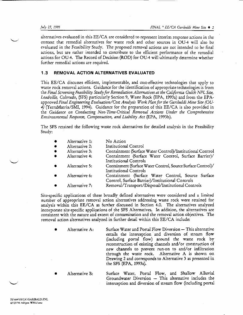
S i t e - s p e c i f i c a p p l i c a t i o n s of these broad ly d e f i n e d al t ernat ive s were considered and a l imi t ednumber of a p p r o p r i a t e removal action al t ernat ive s addre s s ing waste rock were retained foranalysi s wi thin th i s E E / C A as f u r t h e r discussed in S e c t i o n 4.0. The al t ernat ive s analyzedincorporate s i t e - s p e c i f i c a p p l i c a t i o n s o f the SFS Alt erna t iv e s . In a d d i t i o n , the alternatives areconsistent with the nature and extent of contamination and the removal action ob j e c t ive s . Theremoval action al t ernat ive s analyzed in f u r t h e r de tai l within this E E / C A include:• A l t e r n a t i v e A: S u r f a c e Water and Portal F l o w Diversion — T h i s al ternativeentail s the in t e r c ep t i on and diversion of stream f l o w
(including portal f l o w ) around the waste rock byreconstruction of ex i s t ing channels and/or construction ofnew channels to prevent run-on to a n d / o r i n f i l t r a t i o nthrough the waste rock. A l t e r n a t i v e A is shown onDrawing 2 and corresponds to A l t e r n a t i v e 3 as presented inthe SFS (EPA, 1993a).
• A l t e r n a t i v e B: S u r f a c e Water, Portal F l o w , and S h a l l o w A l l u v i a lGroundwater Diversion — T h i s alternative inc ludes thein t e r c ep t i on and diversion of stream f l o w (inc lud ing portal
H : \ 6 6 4 \ E E C A \ G A R B A L D . F N L07/27/95 4:01pm W P 5 1 / c m c

July 27, 1995 FINAL * EE/CA Garibaldi Mine Site » 3
A l t e r n a t i v e C:
f l o w ) around the waste rock by reconstruct ion of e x i s t i n gchannels a n d / o r cons truc t ion of new channels to preventrun-on to a n d / o r i n f i l t r a t i o n through the waste rock. Italso entail s the diversion of shallow al luvia l groundwaterf l o w around the waste rock by cons truc t ion of groundwaterin t er c ep tor trenches. A l t e r n a t i v e B is shown on Drawing3 and also corre sponds to A l t e r n a t i v e 3 as pre s en t ed in theS F S ( E P A , 1993a).S u r f a c e W a t e r , Portal F l o w , and S h a l l o w A l l u v i a lGroundwater D i v e r s i o n / R e g r a d i n g / S i m p l e Cover — T h i sal t ernat ive inc lude s the i n t e r c e p t i o n and diversion of streamf l o w ( i n c l u d i n g por ta l f l o w ) around the waste rock byreconstruct ion of e x i s t i n g channels a n d / o r construction ofnew channels to prevent run-on to a n d / o r i n f i l t r a t i o nthrough the waste rock; divers ion of shallow al luvialgroundwater f l o w around the waste rock by construction ofgroundwater i n t e r c e p t o r trenches; and regrading of thewaste rock p i l e and construct ion of a s i m p l e cover tominimize i n f i l t r a t i o n through the waste rock p i l e ande x p e d i t e non-erosive r u n o f f f r o m t h e p i l e surface. T h es i m p l e cover would be des igned as both a source sur fac econtrol and surface barrier. A l t e r n a t i v e C is shown inDrawing 4 and corre sponds to A l t e r n a t i v e 5 as pre s ented int h e S F S ( E P A , 1993a).W a s t e Rock Removal — T h i s a l t ernat ive en ta i l s the removalof the waste rock f r o m the s i t e and t ranspor t to the OregonG u l c h T a i l i n g I m p o u n d m e n t f o r d i s p o s a l . I t also inc lude sree s tab l i shment of the original drainage channel.A l t e r n a t i v e D, shown on Drawing 5, corre sponds toA l t e r n a t i v e 7 as pre s ented in the SFS ( E P A , 1993a).
I n s t i t u t i o n a l control s ( A l t e r n a t i v e 2 in the SFS), i n c l u d i n g po s t ed warnings, i n f o r m a t i o n andeducat ion programs, a n d / o r other contro l s would also be incorporated as approved by the EPA,within the removal action al t ernat ive s evaluated.The criteria u t i l i z ed in the analysi s of the f o u r removal action alternatives are d e f i n e d in theGuidance on Conducting Non-Time-Critical Removal Actions Under the ComprehensiveEnvironmental Response, Compensation,, and Liability Act (CERCLA) (EPA, 1993b), and includee f f e c t i v e n e s s , i m p l e m e n t a b i l i t y , and cost. T h e s e EPA criteria are u t i l i z e d as screening criteriato aid in the se lect ion of the a p p r o p r i a t e removal action for the Gariba ld i Mine site. Ina d d i t i o n , the Work Area Management Plan (WAMP) ( U S D C , 1994) performance criteria oferosion s t a b i l i t y and f l o w capaci ty and s t a b i l i t y are u t i l i z ed in evaluating the e f f e c t i v e n e s s of theremoval action al ternatives in meeting the removal action ob j e c t ive s (RAOs). RAOs are f u r t h e rdiscussed in S e c t i o n 3.2.After d e t a i l e d evaluation of the individual removal action al ternatives ( S e c t i o n 4.0), acomparative analysis of these a l t e r n a t i v e s is presented ( S e c t i o n 5.0) which i d e n t i f i e s the
A l t e r n a t i v e D:
H : \ 6 6 4 \ E E C A \ G A R I B A L D . F N L0 7 / 2 7 / 9 5 4:01pm W P 5 1 / c m c

July 27, 1995___________________________________FINAL * EE/CA Garibaldi Mine Site » 4
advantages and d i sadvan tage s of each a l t e rna t iv e r e la t ive to one another cons ider ing the EPAcri teria of e f f e c t i v e n e s s , i m p l e m e n t a b i l i t y , and cost.1 . 4 R E C O M M E N D E D R E M O V A L A C T I O N A L T E R N A T I V EBased on the individual analysis of alternatives presented in Sect ion 4.0 and the comparativeanalysi s pre s ented in S e c t i o n 5.0, A l t e r n a t i v e B ( S u r f a c e Water , Portal F l o w , and S h a l l o wA l l u v i a l Groundwater Diversion) is recommended for i m p l e m e n t a t i o n . A l t e r n a t i v e B wouldmeet the RAOs described in S e c t i o n 3.2.A l t e r n a t i v e B e n t a i l s the i n t e r c e p t i o n and diversion of stream f l o w ( i n c l u d i n g p o r t a l f l o w )around the waste rock by the reconstruction of exist ing channels and/or the construct ion ofnew channels to prevent run-on to and/or i n f i l t r a t i o n through the waste rock. It also e n t a i l sthe divers ion of shal low al luvial groundwater f l o w around the waste rock by construct ion ofgroundwater i n t e r c e p t o r trenches.Best management prac t i c e s (BMPs), as described under A l t e r n a t i v e A in S e c t i o n 4.3.1.2 wouldbe u t i l i z e d dur ing all cons truct ion act ivi t i e s at the site.1 . 5 R E P O R T O R G A N I Z A T I O NT h i s E E / C A is organized into seven S e c t i o n s as f o l l o w s :
• S e c t i o n 1.0 — Executive Summary: T h i s section prov id e s a general overview ofthe si te, p r o j e c t scope and o b j e c t i v e s , removal action al t ernat ive s evaluated, theevaluation p e r f o r m e d , the recommended removal action al t ernat ive , and a generaloverview of the contents of the E E / C A .
• S e c t i o n 2.0 — Site Character izat ion: T h i s section prov id e s a di s cus s ion of the si ted e s c r i p t i o n and background; previous removal actions; source, nature, and extentof contamination; analyt ical data; and the s treamlined risk evaluation.
• S e c t i o n 3.0 — I d e n t i f i c a t i o n of Removal A c t i o n Object ives: T h i s section pre sent ss ta tu tory l i m i t s on removal actions, determination of removal action scope, and'the removal action schedule.
• S e c t i o n 4.0 — I d e n t i f i c a t i o n and A n a l y s i s of Removal Act ion A l t e r n a t i v e s :Removal action al ternatives are i d e n t i f i e d and evaluated based upon e f f e c t i v e n e s s ,i m p l e m e n t a b i l i t y , and cost.
• ' S e c t i o n 5.0 — Comparat ive A n a l y s i s of Removal A c t i o n A l t e r n a t i v e s : In thi ssection, a comparative analysi s is pre s ented which i d e n t i f i e s the advantages anddisadvantages of each alternative relative to one another considering the criteriaof e f f e c t i v e n e s s , i m p l e m e n t a b i l i t y , and cost.
• S e c t i o n 6.0 — Recommended Removal A c t i o n A l t e r n a t i v e : The removal actionthat best s a t i s f i e s the evaluation criteria is recommended and described in th i ssection.
• S e c t i o n 7.0 — T h i s section l i s t s references cited in the text.
H : \ 6 6 4 \ E E C A \ G A R I B A L D . F N L0 7 / 2 7 / 9 5 4:01pm W P 5 1 / c m c

July 27, 1995_________________________________FINAL * EE/CA Garibaldi Mine Site » 5S u p p o r t i n g da ta is pre s ented in several a p p e n d i c e s , as o u t l i n e d below:
A p p e n d i x A — S t a t e H i s t o r i c Preservation O f f i c e L e t t e rA p p e n d i x B — H E C - 1 Mode lA p p e n d i x C - H E L P M o d e lA p p e n d i x D — S o i l Los s C a l c u l a t i o n sA p p e n d i x E — S t a b i l i t y A n a l y s i sA p p e n d i x F — ARARsA p p e n d i x G — Cost Es t imate s
H : \ 6 6 4 \ E E C A \ G A R B A L D . F N L0 7 / 2 7 / 9 5 4:01pm W P 5 1 / c m c

July 27, 1995___________________________________FINAL * EE/CA Garibaldi Mine Site » 6
2 . 0 S I T E C H A R A C T E R I Z A T I O N
2 . 1 S I T E D E S C R I P T I O N A N D B A C K G R O U N D2.1.1 S i t e I d e n t i f i c a t i o n and BackgroundT h i s E E / C A has been p r e p a r e d to evaluate p o t e n t i a l removal action al ternatives and to selecta p r e f e r r e d a l t ernat ive for the remediation of waste rock at the G a r i b a l d i Mine site locatedwithin U p p e r C a l i f o r n i a Gulch. T h i s area, located a p p r o x i m a t e l y three miles southeast of theC i t y of L e a d v i l l e , i s part of Operab l e Unit 4 (OU-4) of the C a l i f o r n i a G u l c h S u p e r f u n d Site inLake County, Colorado. Lake County is approx imat e ly 100 miles southwest of the City ofDenver. The general l o ca t i on of the C a l i f o r n i a Gulch S u p e r f u n d Site is shown in F i g u r e 1,General Location.The C a l i f o r n i a G u l c h / L e a d v i l l e area has been an active mining area since the 1850s. Assoc ia t edwith the extensive underground mining act ivi t ie s are the remaining surface f ea ture s such as mineworkings, waste rock, and t a i l i n g ponds . In a d d i t i o n , mine drainage tunne l s were constructedto dewater the mine workings.OU-4 is d e f i n e d as the area hydro l og i ca l ly drained by C a l i f o r n i a Gulch f r om immediate lyup s t r eam of the Yak Portal to the headwaters of the gulch, as shown in F i g u r e 2, Operab l e Unit4. The area covers approx imat e ly 2.4 square miles and contains mine waste pi l e s , mill ta i l ing,and f l u v i a l t a i l i n g material. A p p r o x i m a t e l y 150 mine waste rock p i l e s exist in this area ( U S D C ,1994). S a m p l i n g of surface water, groundwater, and stream sediments indicate that miningact ivi t i e s may have contributed acid mine drainage and heavy metal contamination to thesemedia. Remedial inve s t igat ion ac t iv i t i e s i d e n t i f i e d f l u v i a l t a i l i n g and waste rock p i l e s as areasp o t e n t i a l l y requiring remedial action within OU-4. The s u b j e c t of th i s E E / C A is the waste rocklocated at the G a r i b a l d i Mine site in OU-4. The G a r i b a l d i Mine site is located within OU-4near the headwaters of C a l i f o r n i a Gulch, as shown in F i g u r e 2, Operable Unit 4, and de ta i l edin Drawing 1, G a r i b a l d i Mine S i t e E x i s t i n g Condi t i on s .2.1.2 R e g u l a t o r y F r a m e w o r kT h i s E E / C A has been undertaken in accordance with the Work Area, Management Plan (WAMP)for Resurrection Mining Company included as an a p p e n d i x to the Consent Decree in s e t t l ementof Civil A c t i o n No. 83-C-2388, United S t a t e s District Court for the District of C o l o r a d o( U S D C , 1994), and in accordance with guidance provided in 40 Code of Federa l Regulat ions(CFR) 300. In a d d i t i o n , guidance provided within the Guidance on Conducting Non-Time-Critical Removal Actions Under the Comprehensive Environmental Response, Compensation, andLiability Act (CERCLA) (EPA, 1993b) has been incorporated into this E E / C A study.2.1.3 F a c i l i t y T y p e and Operational Sta tu sThe Garibaldi Mine site is located within OU-4 near the headwaters of C a l i f o r n i a Gulcha p p r o x i m a t e l y 150 f e e t west of the Western F a u l t between Breece Hill and Green Mountain( W C C , 1990). The Garibaldi Mine site is shown in Drawing 1, Gar iba ld i Mine S i t e Exi s t ingCondi t i on s . As a component of G a r i b a l d i Mine, the G a r i b a l d i tunnel extends 2400 f e e tnortheast to the workings of the Sunday No. 2 Mine on the west s l o p e of Ball Mountain, and
H : \ 6 6 4 \ E E C A \ G A R f f i A L D . F N L07/27/95 4:01pm W P 5 1 / c m c

July 27, 1995_________________________________FINAL * EE/CA Garibaldi Mine Site 4 7was bu i l t to drain these workings (Emmons et al., 1929). Prominent f e a t u r e s at the G a r i b a l d iMine site inc lude a waste rock p i l e covering an area of a p p r o x i m a t e l y 1.6 acres and a c o l l a p s e dmine por ta l ( W C C , 1990). A steam engine and other mining remains are located adjacent to thec o l l a p s e d p o r t a l . " Run-on diversion channels have been constructed by theR e s u r r e c t i o n / A S A R C O J o i n t Ventur e around the waste rock p i l e . In a d d i t i o n , a p o r t i o n of thep o r t a l di scharge i s currently diverted around the p i l e ( W C C , 1990).S u r f a c e water data indicate s that the waste rock p i l e continues to contr ibute to sur face watercontaminat ion (acidic pH l e v e l s ; elevated heavy metal l o a d i n g s ) in U p p e r C a l i f o r n i a Gulch.F i e l d observations by Resurrection ind i ca t e that water di s charges f r o m the toe of the p i l e .2.1.4 T o p o g r a p h yThe G a r i b a l d i Mine s i t e is located near the headwaters of C a l i f o r n i a Gulch in a small t r i b u t a r ydrainage, as shown in F i g u r e 2 and Drawing 1. The site is at an e l evat ion of a p p r o x i m a t e l y11,175 f e e t above mean sea level (AMSL) at the p o r t a l and 11,120 f e e t AMSL at the toe of thewaste rock p i l e . The channel downstream of the G a r i b a l d i Mine s i t e i s a s m a l l , V-shaped v a l l e ywith water f l o w i n g in a s ou thwe s t e r ly direct ion. U p p e r C a l i f o r n i a Gulch crosses Lake Coun tyRoad 2, a p p r o x i m a t e l y one th ird of a mile downstream of the G a r i b a l d i Mine site.2.1.5 P e d o l o g y and G e o l o g yThe T r o u t v i l l e and Bross series, consi s t ing of de ep , well drained soil s on mountain s l o p e s , arethe predominant soil t y p e s in the v ic ini ty of the G a r i b a l d i Mine site. Deep, sandy loam, wi th inthe T o m i c h i series, also occurs in drainage channels upgrad i en t of the G a r i b a l d i Mine site.The g eo l ogy in U p p e r C a l i f o r n i a Gulch consists o f shal low co l luv ium over Precambrian granit i cand metamorphic rocks and Paleozoic sedimentary rocks. The Pendry F a u l t , a local prominentf a u l t marking the boundary between Lower and U p p e r C a l i f o r n i a Gulch, has a north 20 degreeseast trend (Emmons et al., 1927). The G a r i b a l d i Mine s i t e is located up s t r eam of the PendryF a u l t . C a l i f o r n i a G u l c h was not g la c ia t ed and up s t r eam of the Pendry F a u l t the uncon so l ida t edmaterial can genera l ly be characterized as r e l a t i v e l y thin d e p o s i t s of a l luvium, ta lu s , andcol luvium. Extensive areas of the U p p e r C a l i f o r n i a Gulch drainage, i n c l u d i n g most of Iron andBreece Hills, are covered with a thin layer of ta lu s "wash" which consist s of f r a g m e n t s of theu n d e r l y i n g bedrock ( W W L , 1990).2.1.6 H y d r o l o g yOU-4 includes the U p p e r C a l i f o r n i a Gulch drainage basin which is the area h y d r o l o g i c a l l ydrained by C a l i f o r n i a Gulch f r o m immedia t e ly upstream of the Yak Tunnel Portal to theheadwaters of the gulch. A p p r o x i m a t e l y 2.4 square miles are drained by U p p e r C a l i f o r n i aGulch.The G a r i b a l d i Mine site is located in the U p p e r C a l i f o r n i a Gulch sub-basin which covers an areaof a p p r o x i m a t e l y 211 acres. The site is located at the conf luence of two headwater sub-basinsof U p p e r C a l i f o r n i a Gulch. The northern headwater basin covers an area of a p p r o x i m a t e l y 134acres, draining a por t ion of the southern f l a n k of Breece Hill and the northwestern f l a n k of BallMountain. The channel outlet draining the northern headwater sub-basin lies s l i g h t l y to thenorthwest of the mine p o r t a l . The southern headwater basin covers a p p r o x i m a t e l y 77 acres,draining the western p o r t i o n of Ball Mountain and the norther ly p o r t i o n of the t o p o g r a p h i cdiv ide that separates U p p e r C a l i f o r n i a Gulch f r o m U p p e r Iowa Gulch. The channel out le t
H : \ 6 6 4 \ E E C A \ G A R B A L D . F N L07/27/95 4:01pm W P 5 1 / c m c

July 27. 1995___________________________________FINAL * EE/CA Garibaldi Mine Site » 8
draining the southern headwater sub-basin lies s l i g h t l y southeast of the mine p o r t a l . S u r f a c ewater f l o w in t h i s section o f U p p e r C a l i f o r n i a G u l c h i s e ph emera l , g e n e r a l l y r e s u l t i n g f r o msnowmelt or summer thunder s torms .S u r f a c e water s a m p l i n g and f l o w measurement have been conducted in the v i c i n i t y of theG a r i b a l d i Mine site. S e c t i o n 2.3.3 discusses water qual i ty data for s a m p l e s c o l l e c t ed ups tream,downstream, at the p o r t a l , and at the toe of the G a r i b a l d i Mine site. The water is g enera l lycharacterized by low pH with elevated l ev e l s of d i s s o lv ed metals.Groundwater in the L e a d v i l l e area occurs in bo th bedrock and al luvial s t r a t i g r a p h y . Theg e o l o g i c s tructure of the region varies in r e la t i on to the Pendry F a u l t . The Pendry F a u l t l i e salong the eastern edge of L e a d v i l l e and intersec t s C a l i f o r n i a Gulch j u s t below the Yak T u n n e lTreatment Plant surge pond ( W W L , 1990). Downstream of the Pendry F a u l t d e e p terrace graveland lake bed uncon so l ida t ed d e p o s i t s cover the bedrock. U p g r a d i e n t of the Pendry F a u l t ,C a l i f o r n i a Gulch was not glaciated (Tweto , 1970), and unconsolidated material can generally becharacterized as r e l a t i v e l y thin d e p o s i t s .of a l luv ium, t a l u s , and co l luvium over Precambriumgrani t i c and me tamorph i c rocks and Palozo i c s ed imentary rocks ( T w e t o , 1970; W W L , 1990;W C C , 1993a). Alluv ium occurring in the U p p e r C a l i f o r n i a Gulch as gravel d e p o s i t s is l imi t edto the bed of C a l i f o r n i a Gulch (Emmons, et al., 1927). D r i l l i n g l og s suggest that in OU-4 theth i cknes s of the over lying uncon so l ida t ed a l l u v i u m / c o l l u v i u m ranges f r o m 2 to 43 f e e t (EPA,1987a; W C C , 1993a).The various t y p e s of rock that comprise the bedrock are considered to f o r m a s ing l e aqu i f e rsystem because they are hydraul i ca l ly connected through mine workings and the extensivef a u l t i n g and f r a c t u r i n g ( T u r k and T a y l o r , 1979). A compl e x system of ma jor and minor f a u l t scauses s i g n i f i c a n t d i s p l a c e m e n t and f r a c t u r i n g of the bedrock (Emmons, et al., 1927). F l o wwithin the bedrock is pr imar i ly f a c i l i t a t e d by secondary p o r o s i t y and mine workings in the area( W C C , 1993a). Secondary p o r o s i t y consists of the p ermeab l e and h i g h l y f rac tur ed zonesa d j a c e n t to the major f a u l t s and the numerous interconnected minor f a u l t s and f ra c tur e s wi th inthe f a u l t blocks. The groundwater in U p p e r C a l i f o r n i a Gulch occurs p r i m a r i l y in bedrockaqu i f e r s ( E P A , 1987), a p p a r e n t l y e x i s t ing under uncon s o l i da t ed condi t ions , however,i r r egu lar i t i e s in the f rac ture dominated f l o w system may cause p a r t i a l l y c on f ined or perchedcond i t i on s l o c a l l y ( W C C , 1993a). The sur f i c ia l a l l u v i u m / c o l l u v i u m d e p o s i t s a p p e a r t o b e l o c a l l ysaturated with groundwater ( W C C , 1993a; S M I / T e r r a M a t r i x , 1995a). Reg iona l ly , recharge ofal luv ia l and bedrock aqui f er s re su l t s f r o m i n f i l t r a t i o n of p r e c i p i t a t i o n ( r a i n f a l l and snowmel t) andsurface water.Six background bedrock groundwater we l l s and three bedrock monitoring we l l s were i n s t a l l e dwith in the C a l i f o r n i a Gulch S i t e dur ing the Remedial I n v e s t i g a t i o n (RI) process ( W C C , 1993a).F o u r of the background bedrock groundwater w e l l s are located wi thin OU-4. A d d i t i o n a l l y , twoshallow alluvial monitoring wel l s were ins ta l l ed within OU-4 in 1989, only one of which iscurrently operat ional ( W W L , 1990). During the fall of 1994, three add i t i ona l groundwatermonitoring w e l l s were constructed, two which are adjacent to the G a r i b a l d i Mine site and onewithin the Agwalt Mine site ( S M I / T e r r a M a t r i x , 1995a).The moni tor ing we l l s d r i l l e d as part of the RI were i n s t a l l e d to d e p t h s of 291 to 1,227 f e e t .Depth to groundwater in the bedrock aquifer range from about 30 fee t to roughly 670 fee tbelow ground surface. At the operat ional a l luvia l groundwater well upgradient of the YakTunnel P o r t a l , a g o l d e n brown d o l o m i t e bedrock was encountered at a d e p t h of 43 f e e t (EPA,
H : \ 6 6 4 \ E E C A \ G A R B A L D . F N L0 7 / 2 7 / 9 5 4:01pm W P 5 1 / c m c

July 27, 1995___________________________________FINAL * EE/CA Garibaldi Mine Site » 9
1987a), and the d e p t h to groundwater ranges f r o m a p p r o x i m a t e l y 5.9 to 15.8 below groundsurface ( W W L , 1990; SMI, 1994; S M I / T e r r a M a t r i x , 1994b; S M I / T e r r a M a t r i x , 1995).D e p t h to bedrock in the two groundwater w e l l s i n s t a l l e d at the G a r i b a l d i s i te ranged f r o mapprox imate ly 10 to 11 f e e t , re spec t ively ( S M I / T e r r a M a t r i x , 1995b). Localized groundwater wasencountered in one of the we l l s during construct ion at a p p r o x i m a t e l y 9.5 f e e t below groundsurface.2.1.7 S u r r o u n d i n g Land Use and P o p u l a t i o nThe C a l i f o r n i a G u l c h Site i s located in the u p p e r Arkansas River watershed, with e l evat ionsranging f r o m a p p r o x i m a t e l y 9,570 f e e t AMSL to 12,250 f e e t AMSL. The site encompassesa p p r o x i m a t e l y 16.5 square miles and inc lude s the towns of L e a d v i l l e and S t r i n g t o w n and extendsto the conf luence of C a l i f o r n i a Gulch and the Arkansas River. The site is located in a h i g h l ymineralized area of the Rocky Mounta in s , and mining, mineral proce s s ing and sme l t ing ac t iv i t i e shave produced g o l d , silver, lead and zinc for more than 130 years. A large p o r t i o n of this s i tehas been a f f e c t e d by these act ivi t i e s .Lake County is r e la t iv e ly small (380 square mi l e s) and p r e d o m i n a t e l y rural county with a 1990p o p u l a t i o n of 6,007 (U.S. Department of Commerce, 1990). A p p r o x i m a t e l y half of thep o p u l a t i o n reside within the C i t y o f Leadv i l l e . The p o p u l a t i o n o f Lake County has f l u c t u a t e dwith the mining industry. The p o p u l a t i o n increased to a p p r o x i m a t e l y 9,000 between 1960 and1981 and then dec l ined throughout the 1980s. A p p r o x i m a t e l y two-thirds of the land in LakeCounty is f e d e r a l l y owned, and is part of San Isabe l N a t i o n a l F o r e s t or is managed by theBureau of Land Management. Land surrounding and within C a l i f o r n i a G u l c h is p r e d o m i n a t e l yded i ca t ed to mining, commercial, and re s ident ial uses.An unimproved dirt road runs f r o m the hairpin turn on Lake County Road 2 along C a l i f o r n i aGulch to the G a r i b a l d i Mine site. No other improvements exist at the G a r i b a l d i site.2.1.8 S e n s i t i v e EcosystemsPrevious inves t igat ions reveal that the occurrence of threatened, endangered or sensitive speciesin the t erres tr ial ecosystem is u n l i k e l y ( W C C , 1993b). However, erosion of t a i l i n g material andcontaminated stream sediment contribute heavy metal loading to Cal i f o rn ia Gulch and theArkansas River. T h e s e releases p o t e n t i a l l y a f f e c t the aquatic ecosystem.2.1.9 C l i m a t eThe climate of Lake County is r e la t ive ly dry, but is otherwise typ i ca l of most a lp ine regions inthe southern Rocky Mountains. The average annual maximum temperature in the L e a d v i l l e areais 50.5 degrees Fahrenhei t and the average annual minimum temperature is 21.9 degreesFahrenhe i t , with an annual mean temperature of 37.3 degrees Fahrenhei t .Prec ip i t a t i on occurs throughout the year with the most s ignif icant p r e c i p i t a t i o n occurring as rainin the summer months of J u l y and August. Pre c ip i ta t i on varies throughout Lake County inrelat ion to the elevation. The south-central p o r t i o n of the county at an elevation near 9,000 f e e tAMSL, receives about 10 inches of p r e c i p i t a t i o n annually. At higher elevations p r e c i p i t a t i o ncan reach 40 inches per year. The mean annual snowfa l l ranges f r om 134 inches at the lower
H : \ 6 6 4 \ E E C A \ G A R B A L D . F N L07/27/95 4:01pm W P 5 1 / c m c

July 27, 1995__________________________________FINAL * EE/CA Garibaldi Mine Site » 10
e l evat ions to 271 inches at the higher elevations. The wind is p r e d o m i n a n t l y f r o m thenorthwest , with s p e e d s t y p i c a l l y f r o m 0 to 30 mph ( W C C , 1993a).2.1.10 H i s t o r i c and C u l t u r a l ResourcesA cul tural resource survey was conducted by Goodson and Assoc ia t e s , Inc., (Martorano, 1990)pr ior to i m p l e m e n t a t i o n of s i te improvements by the R e s u r r e c t i o n / A S A R C O J o i n t Venture in1990. The o b j e c t i v e of the survey was to i d e n t i f y , record, and provide evaluat ions of thehi s t or i c and pr eh i s t o r i c resources which could have been a f f e c t e d by the site improvements. Theprimary tasks inc luded a l i t e ra tur e and records search, and intensive p e d e s t r i a n survey of areasp o t e n t i a l l y impac t ed , data analysi s , and p r e p a r a t i o n of a report. An assessment of e f f e c t isrequired for all resources determined e l i g i b l e for or l i s t e d in the N a t i o n a l Register of H i s t o r i cPlaces (NRHP), and located wi th in the Area of Pot en t ia l E f f e c t (APE).The 1990 cultural resource inve s t igat ions at the G a r i b a l d i Mine Site (OU4) re sul t ed in therecordation and documentat ion of the G a r i b a l d i Mine as site 5LK805. T h i s resource, 5 L K 8 0 5 ,was o f f i c i a l l y determined not e l i g i b l e for l i s t i n g in the N R H P by the S t a t e H i s t o r i c PreservationO f f i c e (SHPO), on Augus t 31, 1990 (see A p p e n d i x A). Under S e c t i o n 106 of the N a t i o n a lH i s t o r i c Preservation act of 1966 (as amended), no assessment of e f f e c t is required for resourcesdetermined not e l i g i b l e for the N R H P . No f u r t h e r cul tural resource inve s t igat ions are requiredp r i o r to i m p l e m e n t a t i o n of ground-d i s turb ing activities . Such actions are considered to have noe f f e c t on hi s toric p r o p e r t i e s , provided the Area of Potent ia l E f f e c t (APE) does not extendbeyond the area prev iou s ly surveyed. A d d i t i o n a l cultural resource inve s t iga t i on s would berequired for any p r o p o s e d actions outs ide of the areas previous ly surveyed.2 . 2 P R E V I O U S R E M O V A L A C T I O N SIn 1990/1991, the R e s u r r e c t i o n / A S A R C O J o i n t Venture constructed run-on diversion channelsaround the waste rock p i l e and a por ta l discharge diversion ( W C C , 1990). The intent of the siteimprovements was to reduce the volume and m o b i l i t y of contaminated material by minimizingthe water i n f i l t r a t i n g into and out of the mine workings and waste rock p i l e .The main improvement for this site was the regrading of the dirt road above the G a r i b a l d itunnel p o r t a l . The road was reconstructed to convey stormwater on the u p h i l l part (northerns ide) of the road instead of a l l owing the water to f l o w across the road and downhil l into themine waste rock area. The di t che s were designed for a 25-year 6-hour storm event.The exi s t ing p r o f i l e of the road did not change and remained re la t ive ly f l a t with a small di tchon the u p h i l l side. The road was regraded to be u n i f o r m l y s l o p i n g at a p p r o x i m a t e l y 3 to 5%down toward the u p h i l l side. A p p r o x i m a t e l y two f e e t away f r o m the center of the u p h i l l di tch,the downward s l o p e of the road (along the cross-sectional dimension at the beginning of thed i t c h ) was increased. The cut s l o p e of the ex i s t ing hi l l north and west of the road wasmaintained or f l a t t e n e d to a p p r o x i m a t e l y 1:2 (1 horizontal to 2 vertical). The bot tom of thedi t ch was constructed to be at least one f o o t wide and the top at least 3 f e e t wide. The d i t chwas terminated downhil l f rom the waste p i l e as indicated on Drawing 1. F l o w is diverted intoa culvert which carries it under the road and discharges it down the hill below the base of thewaste p i l e . The o u t f a l l area was pro t e c t ed f r o m erosion with r iprap .
H : \ 6 6 4 \ E E C A \ G A R B A L D . E N L07/27/95 4:01pm W P 5 1 / c m c

July 27, 1995_________________________________FINAL * EE/CA Garibaldi Mine Site » 11To divert r u n o f f f r o m the h i l l s i d e east and southeast of the mine waste, a d i t c h was construaedalong the south side of the p i l e , near the southwesterly end of the waste p i l e and extended tothe p o r t a l of the G a r i b a l d i tunnel. R i p r a p , g e o t e x t i l e , grass, a n d / o r straw were used to pro t e c tthe d i t c h f r om erosion. The f l o w f r o m G a r i b a l d i tunnel i s diverted into the new di tch. Thef l o w is then routed under the road by culvert to the d i t ch running p a r a l l e l to the road. The sizeof th i s d i t c h is the same as described above for the d i t c h ad ja c en t to the road.T h e s e s i t e improvements were expe c t ed to reduce the amount of run-on to the waste p i l e andthus reduce i n f i l t r a t i o n into the waste p i l e in the mine workings area by d iver t ing run-onaround th i s area. It was a n t i c i p a t e d that the quantity of poor qua l i ty water s e ep ing f r om themine workings into C a l i f o r n i a Gulch would be reduced. Recent surface water data indi ca t e s ,however, that the G a r i b a l d i waste rock and mine por ta l continue to contr ibute to surface watercontamination (acidic pH levels; elevated heavy metal l o a d i n g s ) in U p p e r C a l i f o r n i a Gulch.2 . 3 S O U R C E , N A T U R E , A N D E X T E N T O F C O N T A M I N A T I O N2.3.1 I d e n t i f i c a t i o n of Sourc e s of H a z a r d o u s or C o n t a m i n a t i n g Sub s tanc e sT h i s E E / C A addres se s m i t i g a t i o n o f the G a r i b a l d i Mine site. The major source o fcontamination at th i s s i t e is the waste rock p i l e . R u n o f f f r o m s p r i n g snowmelt and stormevents, and f l o w f r o m the G a r i b a l d i p o r t a l have leached metal contaminants f r o m the wasterock, and consequently increased the metal l o a d i n g to U p p e r C a l i f o r n i a Gulch. Laboratoryanalyses of the sur face waste rock material c o l l e c t ed at the G a r i b a l d i Mine s i te (Fall 1994)conf irms that the waste rock has the p o t e n t i a l to generate acid rock drainage and release metals.T h i s i s f u r t h e r discussed in the f o l l o w i n g section.2.3.2 Charac t e r i s t i c s of Sourc eF i e l d reconnaissance of the waste rock p i l e s within U p p e r C a l i f o r n i a Gulch was conducted inAugus t 1993 (SMI/TerraMatrix, 1994a) and S e p t e m b e r 1994 ( T e r r a M a t r i x / S M I 1995). Theinve s t igat ions indica t ed that the G a r i b a l d i waste rock p i l e covers a surface area of a p p r o x i m a t e l y1.6 acres, has an average height of a p p r o x i m a t e l y 35 f e e t and contains a volume of a p p r o x i m a t e l y27,900 cubic yards of material. The face angle of the waste rock p i l e is a p p r o x i m a t e l y 32-35degrees. The waste rock is pr imari ly coarse to f i n e grained material and no vegetation is presenton the p i l e . The waste rock p i l e is within the U p p e r C a l i f o r n i a Gulch drainage and inc lude sthe Xmas, No Name, Ohio Bonanza, and Lady Crawford claims.Laboratory analysis of a compos i t e sample co l l e c t ed f r o m the G a r i b a l d i waste rock p i l e in fall1994 confirmed that surface material on the mine waste p i l e has the p o t e n t i a l to generate acidand leach metals. The f o l l o w i n g analyses were p e r f o r m e d on the sample:
*
• Acid-Base Account ing (ABA) test• S y n t h e t i c P r e c i p i t a t i o n Leaching Procedure (EPA Method 1312)• T o t a l M e t a l s A n a l y s i s• Grain size
Results of these analyses are pre sented in T a b l e 1, Gariba ld i Mine W a s t e Geochemical Data, andare discussed below.
H : \ 6 M \ E E C A \ G A R B A L D . F N L0 7 / 2 7 / 9 5 4:01pm W P 5 1 / c m c

July 27, 1995 FINAL * EE/CA Garibaldi Mine Site » 12
T A B L E 1G A R I B A L D I W A S T E ROCK D A T A( S a m p l e S i t e U C G - 1 2 1 )
October 1994A B A A n a l y s i sS u l f u r , S 0 4 ( % )Sulfur , Pyr. & Org .(%)S u l f u r , T o t a l { % )A G P ( T / K T )N e u t r a l i z i n g P o t e n t i a l ( % C a C 0 3 )A N P ( T / K T )A B P ( T / K T )1312 A n a l y s i sA r s e n i cC a d m i u mC a l c i u mI r o nLeadM a g n e s i u mM e r c u r yP o t a s s i u mS o d i u mZ i n cp HA l k a l i n i t yT D SC h l o r i d eS u l f a t eT o t a l M e t a l sA r s e n i cC a d m i u mLeadZ i n cT e x t u r eS a n d ( % )S i l t ( % )C l a y ( % )T e x t u r e C l a s s i f i c a t i o n
0.841.592.43
75.90.10
-75.9Concen tra t i on ( m g / L )
0.00150.034
1 9 . 1 110.3
4.595.05
< 0.00021.782.586.242.92
2541
345Concentrat ion ( m g / k g )
1 1 50.613,570
382
601921
S C L
H : \ 6 6 4 \ E E C A \ G A R B A L D . F N L07/27/95 4:01pm W P 5 1 / c m c

July 27, 1995__________________________________FINAL * EE/CA Garibaldi Mine Site » 13
The ABA test is a commonly-used method to evaluate the p o t e n t i a l of a material to generateacid. The test involves measuring and comparing a sample ' s maximum acid p r o d u c t i o n p o t e n t i a l(AP or A G P ) with i t s maximum n e u t r a l i z a t i o n p o t e n t i a l (NP or ANP). The d i f f e r e n c e betweenAP and NP is r e f erred to as the Acid Base P o t e n t i a l (ABP) or Net N e u t r a l i z a t i o n Pot en t ia l(NNP). As stated in the d r a f t technical document Acid Mine Drainage Prediction, (EPA, 1994):
If the d i f f e r e n c e between (ANP) and (AGP) is negative then the p o t e n t i a l ex i s t sfor the waste to f o r m acid. If it is p o s i t i v e then there may be lower risk.P r e d i c t i o n of the acid p o t e n t i a l when the (ABP) is between -20 and 20 (TC a C O 3 / K T ) i s more d i f f i c u l t (EPA, 1994).
The ABP of the s a m p l e c o l l e c t e d f r o m G a r i b a l d i was -75.9 (T C a C O 3 / K T ) , i n d i c a t i n g thatsurface material on the mine waste p i l e has a high po t ent ia l to f o rm acid.To evaluate the p o t e n t i a l of t h i s material to leach metal s when contacted with p r e c i p i t a t i o n , thes a m p l e was analyzed by EPA Method 1312. T h i s test involves mixing a s a m p l e with a s y n t h e t i crainwater s o lu t i on and analyzing the l eachate that is generated for metal s and othercontaminants of concern. A l t h o u g h the metal concentrat ions measured in the leachate cannotbe d i r e c t l y compared to the concentrat ions that would occur in s i te r u n o f f due. to d i f f e r e n c e sin s a m p l e d i l u t i o n , the r e su l t s do give an ind i ca t i on of which c on s t i t u en t s may be e levated.The l eachate f r o m the surface material c o l l e c t e d f r o m G a r i b a l d i was s t r o n g l y acidic (pH 2.9) andcontained elevated concentrations of cadmium (0.034 mg/1), iron (10.3 m g / 1 ) , lead (4.59 m g / 1 ) ,s u l f a t e (345 m g / 1 ) and zinc (6.24 mg/1). W i t h the e x c ep t i on of l ead , these l eachate charac t er i s t i c sare comparab l e to the q u a l i t y of seep s a m p l e s c o l l e c t ed at the toe of the mine waste p i l e andsurface water s a m p l e s c o l l e c t e d in C a l i f o r n i a G u l c h downstream of G a r i b a l d i .Lead concentrations in the seep and downgradient surface water s a m p l e s were s i g n i f i c a n t l y lower(0.002 to 0.029 m g / 1 ) than in the leachate sampl e (4.59 mg/1), sugge s t ing that if th i s metal isleached f r o m the sur face material at the s i t e , it is s i g n i f i c a n t l y at tenuated wi thin a n d / o ri m m e d i a t e l y downgradient of the mine waste p i l e . Conversely, the concentration of arsenic inthe l eachate s a m p l e was r e l a t i v e l y low (0.0015 m g / 1 ) compared to concentrations observed in thetoe seep and downgradient surface water sampl e s (0.010 to 0.084 mg/1). T h i s may suggest asource of arsenic occurs wi th in , or i m m e d i a t e l y downgradient of, the G a r i b a l d i mine waste p i l e .In a d d i t i o n to ABA and leaching t e s t s , the compos i t e sampl e co l l e c t ed f r om G a r i b a l d i wasanalyzed for the to ta l concentration of f o u r metals (arsenic, cadmium, lead, and zinc). T o t a lmetal analyses were p e r f o r m e d to v e r i f y the source of some of the metal s measured in thesampl e leachate and to assess p o t e n t i a l air and water l o a d i n g e f f e c t s should surface material atthe si te be d i s turbed during reclamation activities. The surface material at G a r i b a l d i contained115 m g / k g to ta l arsenic, 0.61 m g / k g t o ta l cadmium, 3,570 m g / k g t o ta l l ead, and 382 m g / k g totalzinc.F i n a l l y , for use in potent ial reclamation and geotechnical evaluations, a grain size analysis wasp e r f o r m e d on the surface material at Gariba ld i . The material was f o u n d to contain thef o l l o w i n g grain size frac t ions:
• Sand (60%)• Silt (19%)• Clay (21%)
H : \ 6 6 4 \ E E C A \ G A R I B A L D . F N L0 7 / 2 7 / 9 5 4:<Upm W P 5 1 / o n c

July 27, 1995 FINAL * EE/CA Garibaldi Mine Site * 14
N o t e that these percentage s r e f l e c t the grain size d i s t r i b u t i o n of the f i n e r material exposed onthe surface of the p i l e that was sampled for geochemical analysis. Coarser material such asgravels, cobble s , and b o u l d e r s were not used to p r e p a r e the c ompo s i t e sample.2.3.3 Phys i ca l and Chemical A t t r i b u t e s of C o n t a m i n a t i o nS u r f a c e water s a m p l i n g and analyses have been conducted at several monitoring locat ions in thevic ini ty of the G a r i b a l d i Mine s i t e ( W W L , 1990 and SMI, 1994; S M I / T e r r a M a t r i x , 1994b;S M I / T e r r a M a t r i x , 1995a). Moni t o r ing ac t iv i t i e s were conducted at the f o l l o w i n g sites:
C a l i f o r n i a Gulch to the southeast and upstream of the Garibaldi Mine site (CG-17)C a l i f o r n i a Gulch to the northwest and upstream of the Garibaldi Mine site (CG-1F)Garibaldi Portal (GP-1)Garibaldi waste rock p i l e toe seep (GM-1)C a l i f o r n i a Gulch d irec t ly downstream of the Garibaldi Mine site (CG-16)C a l i f o r n i a Gulch downstream of the Garibaldi Mine site at County Road 2 (CG-1G)
In a d d i t i o n , groundwater s a m p l i n g and analyses have been conducted at a shal low a l luv ia l welllocated in the east drainage above the G a r i b a l d i Mine site. The well ( G M W 1 W ) was i n s t a l l e din October 1994 to investigate the presence of groundwater at the site.M o n i t o r i n g loca t ions are pre s ented in Drawing 1.S u r f a c e water data are presented in T a b l e 2, S u r f a c e Water Analy s i s - C a l i f o r n i a Gulch U p s t r e a mof Garibaldi Mine Si t e ; T a b l e 3, Surfac e Water Analysi s - Garibaldi Portal; T a b l e 4, Surfac eWater A n a l y s i s - Gar iba ld i Was t e Rock P i l e ( T o e S e e p ) ; and T a b l e 5, S u r f a c e Water A n a l y s i s -C a l i f o r n i a Gulch Downstream of G a r i b a l d i Mine S i t e . Groundwater data are pre s ented in T a b l e6, G a r i b a l d i Groundwater Analy s i s .Surfac e and groundwater quality samples were collected at 3 monitoring stations locatedu p g r a d i e n t of the Gar iba ld i Mine site; CG-17, C G - 1 F , and G M W 1 W . A n a l y s i s of the s ampl e sindicated the f o l l o w i n g concentration ranges for selected cons t i tuent s:
A l k a l i n i t y - 7 to 76 mg/1 (as CaCO3);S u l f a t e (D) - 13 to 103 mg/1;TDS - 32 to 238 mg/1;pH (field) - 6.34 to 6.75;Arsenic (D) - < 0.001 to < 0.005 mg/1;Cadmium (D) - < 0.005 to 0.002 mg/1Chromium (D) - < 0.005 mg/1;C o p p e r (D) - < 0.005 to <0.01 mg/1;Iron (D) - <0.01 to 0.07 mg/1;Lead (D) - < 0.001 to < 0.005 mg/1;Manganese (D) - < 0.005 to 0.05 mg/1;Nickel ( D ) - <0.01 mg/1;S e l e n i u m (D) - < 0.005 mg/1;S i l v e r (D) - < 0.0002 to < 0.005 mg/1; and,Zinc (D) - 0.08 to 0.37 mg/1.
H A 6 6 4 \ E E C A \ G A R J B A L D . F N L07/27/95 4:01pm W P 5 1 / c m c

July 27, 1995 FINAL * EE/CA Garibaldi Mine Site * 15
T A B L E 2S U R F A C E W A T E R A N A L Y S I S - C A L I F O R N I A G U L C H U P S T R E A M O F G A R I B A L D I M I N E S I T E
Locat i onDate
SourceF l o w ( c f s )C d - DC d - TCu-DCu-TPb-DPb-TZn-DZ n - TA I - DA I - TAs-DAs-TBa-DBa-TBi-DBi-TCr-DCr-TF e - DF e - TMn-DMn-TN i - DN i - TSe-DSe-TAg-DAg-TSr-DSr-TCa-DCa-TMg-DMg-TN a - DN a - TK - D
C G - 1 70 6 / 0 9 / 8 9
W W L0.0053<0.005<0.005<0.005<0.005<0.005<0.005
0.180.17<0.1<0.1
< 0.005< 0.005
0.05<0.05
<0.5<0.5
<0.005<0.005
<0.010.03
<0.005<0.005
<0.01<0.01
<0.005< 0.005< 0.005<0.005
0.020.028.47.61.41.30.40.40.7
G M G - 10 6 / 0 9 / 8 9
W W L0.0043< 0.005<0.005< 0.005< 0.005< 0.005< 0.005
0.0310.045
<0.10.2
< 0.005< 0.005
0.09^_ 0.08
<0.5<0.5
< 0.005<0.005
0.040.26
< 0.0050.009<0.01<0.01< 0.005< 0.005< 0.005< 0.005
0.020.02
65.4
0.660.630.70.60.6
C G - 1 7 A N DG M G - 1
1 0 / 2 6 / 8 9W W L
DRY
C G - 1 F0 5 / 2 6 / 9 4
S M I0.45
0.00060.0006
<0.01<0.01
<0.0010.003 u ( u j )
0.080.09 u
0.190.19
<0.001<0.001
nananananana
0.070.08 u
0.040.04
nananana
<0.0005< 0.0005 u j
nana5.4na0.80.80.6nana
C G - 1 F1 0 / 0 5 / 9 4
S M IDRY
H : \ 6 6 4 \ E E C A \ G A R I B A L D . F N L07/27/95 4:01pm W P 5 1 / c m c

July 27, 1995 FINAL * EE/CA Garibaldi Mine Site * 16
T A B L E 2 ( c o n t ' d )S U R F A C E W A T E R A N A L Y S I S - C A L I F O R N I A G U L C H U P S T R E A M O F G A R I B A L D I M I N E S I T E
Locat ionDate
SourceK-TS i - DS i - TC I - DC I - TF - DF - TC N - TA c i d i t yS0 4 -T ( f i l t )S0 4-T ( u n f i l t )A l k a l i n i t y - T ( f i l t )A l k a l i n i t y - T ( u n f i l t )C a r b o n a t e - DC a r b o n a t e - TBicarbonate-DBicarbona t e-Tp H ( l a b )p H ( l a b - f i l t )p H ( l a b - u n f i l t )S p e c . C o n d . ( l a b )p H ( f i e l d )S p e c Cond ( f i e l d )T D ST S ST e m p ( C ° )
C G - 1 70 6 / 0 9 / 8 9
W W L0.65.35.0<3<3
<0.5<0.5
< 0.0050.04
1620na7
<5<599
6.9nsns76
6.346656<52.2
G M G - 1
0 6 / 0 9 / 8 9W W L0.54
3.3<3<3
<0.5<0.5
<0.0050.04
1314na10<5<512126.9nsns47
6.654440<54.6
C G - 1 7 A N DG M G - 1
1 0 / 2 6 / 8 9W W L
C G - 1 F
0 5 / 2 6 / 9 4S M Inanananananananana1512138
nanananans
6 . 8 2 J6.85 j
na6.7550332na
4.3
C G - 1 F1 0 / 0 5 / 9 4
S M I
C o n c e n t r a t i o n i n m g / l ; d i s c h a r g e i n c f s ; p H i n s t a n d a r d u n i t s ; s p e c i f i c c onduc tance i n ^ / m h o s / c m ;a c i d i t y i n m e q / l .T = T o t a l na = not analyzedD = D i s s o l v e d u = not d e t e c t e dns = not s p e c i f i e d j = d a t a e s t i m a t e dC G - 1 7 = C a l i f o r n i a G u l c h t o S E above G a r i b a l d iC M G - 1 = C a l i f o r n i a G u l c h t o N E above G a r i b a l d i ( s i t e known a s C G - 1 F a f t e r 1 9 9 3 )
H : \ 6 6 4 \ E E C A \ G A R I B A L D . F N L07/27/95 4:01pm W P S l / c m c

July 27, 1995 FINAL * EE/CA Garibaldi Mine Site 4 17
T A B L E 3S U R F A C E W A T E R A N A L Y S I S - G A R I B A L D I P O R T A L
Locat ionDate
SourceF l o w ( c f s )C d - DC d - TCu-DCu-TPb-DPb-TZn-DZn-TA I - DA I - TS b - DSb-TAs-DAs-TBa-DBa-TBe-DBe-TBi-DBi-TCr-DCr-TF e - DF e - TMn-DMn-TH g - DH g - TMo-DMo-TN i - DN i - TSe-DSe-TA g - DAg-TSr-DS r - TT i - DT i - TCa-DCa-TMg-DM g - T
G M - 1 [ W W L ]0 6 / 0 9 / 8 9
W W L0.01280.0110.0110.0190.019< 0.005< 0.005
1.71.60.30.2nana
<0.005<0.005<0.05<0.05
nana
<0.5<0.5
< 0.005< 0.005<0.010.031.51.4nananana
<0.010.01
<0.005<0.005<0.005<0.005
0.050.05
nana20193.83.6
G M - 1 [ W W L ]1 0 / 2 6 / 8 9
W W L0.00110.0090.0090.0180.0280.0090.014
1.21.20.30.4nana
<0.005< 0.005<0.05<0.05
nananana
<0.005<0.005<0.010.251.81.7nananana
<0.01<0.01< 0.005< 0.005<0.005< 0.0.05
0.040.05
nanana21na4.4
T P - 21 0 / 1 6 / 9 1
W C C0.0025
0.0116 u0.0102 b
0.05 b0.05 b0.00880.0103
1.391 . 0 5 n0.3340.3850.12 b0.12 u0.02 u0.02 u0.4 be0.4 b
0.01 u0.01 u
nana
0.02 u0.02 u0.2 u0.2 b1.671.79
0.0002 u0.0002 u0.04 u0.04 u0.08 b0.08 b0.01 u
, na
0.02 u0.02 u
nana
0.01 u0.01 b
na23na5
T P - 20 9 / 1 5 / 9 2
W C C0.00330.024
0.02570.08820.07780.00680.0089
3.592.99 e0.4310.4670.06 b0.12 u0.01 u0.02 b0.2 b0.4 b
0.005 u0.005 u
nana
0.01 u0.02 u0.1 u0.1 b2.061.88
0.0002.U0.00030.02 u0.04 u0.04 b0.08 b
0.005 u0.01 un0.01 un0.02 u
nana
0.01 b0.01 b
na26na5 u
G P - 10 5 / 2 6 / 9 4
S M I0.08
0.0120.0120.06 j0.05 j0.0090.016
1.61.5
0.45 j0.38 j
nana
<0.0010.001
nananananananana
0.080.16 u
0.90.87
nananananananana
<0.005<0.005 uj
nananana
13.7na2.62.5
G P - 11 0 / 0 5 / 9 4
S M I0.001
0.0033 j0.018 j0.05 j0.04 j0.0080.0372.051.880.551.48
nana
<0.001 uj0.004 u
nananananananana
0.02 u1.541.831.84
nananananananana
< 0.00050.0012
nananana22na5 j4 j
H : \ 6 6 4 \ E E C A \ G A R I B A L D . F N L07/27/95 4:01pm W P S l / c m c

July 27, 1995 FINAL *EE/CA Garibaldi Mine Site * 18
T A B L E 3 (conf d )S U R F A C E W A T E R A N A L Y S I S - G A R I B A L D I P O R T A L
Locat ionDate
SourceN a - DN a - TK - DK - TS i - DS i - TC I - DC I - TF - DF-TC N - DC N - TA c i d i t yA l k a l i n i t y - T ( f i l t )A l k a l i n i t y - T( u n f i l t )C a r b o n a t e - DC a r b o n a t e - TBicarbonat e-DBicarbonat e-TN O 3 / N O 2S 0 4 ( u n f i l t )S 0 4 ( f i l t )P04-Tp H ( l a b )p H ( l a b - f i l t )p H ( l a b - u n f i l t )S p e c . C o n d .( l a b )p H ( f i e l d )S p e c Cond( f i e l d )T S ST D ST e m p ( ° C )
G M - 1 [ W W L ]0 6 / 0 9 / 8 9
W W L0.70.61.21.04.43.8<3<3
<0.5<0.5
na<0.005
0.26na<5<5<5<5<5na7067na4.7nsns
2004.57198<51302.9
G M - 1 [ W W L ]1 0 / 2 6 / 8 9
W W Lna0.8na1.2na3.3na<3na
<0.5na
<0.0050.22
na<5na<5na<5na86nana4.4nsns
1904.52260
61303.1
T P - 21 0 / 1 6 / 9 1
W C Cna5 una
5 una9
1 una
0.1 unana
0.01 unana2nananana
0.0788na
0.01 u4.7nsns
2294.44'2022
2 u1243.9
T P - 20 9 / 1 5 / 9 2
W C Cna5 una
5 una125 una0.2nana
0.01 unanananananana
0.1480na
0.01 u4.6nsns
1984.5236
61564.1
G P - 10 5 / 2 6 / 9 4
S M I0.7nananananananananananana<5<5nanananana47
52 jnans
4.72 j4.73 j
na5.39142na883.3
G P - 11 0 / 0 5 / 9 4
S M I<1na1
nanana<1nanananananana0
na0
na0
nana76nansna
4.6 jna
4.53220
na1384.9
C o n c e n t r a t i o n i n m g / l ; d i s c h a r g e i n c f s ; p H i n s t a n d a r d u n i t s ; s p e c i f i c c o n d u c t a n c e i n / / m h o s / c m ;a c i d i t y i n m e q / l .T = T o t a l na = not analyzed j = da ta e s t imatedD = D i s s o l v e d u = not d e t e c t e d ns = not s p e c i f i e dn = not v a l i d a t e d e = i n t e r f e r e n c e
b = below d e t e c t i o n l i m i t1 T a b l e 2.1-5 of the D r a f t H y d r o g e o l o g i c Rl l i s t s pH as 4.41, whi l e T a b l e 4.2-9a l i s t s pH as 4.442 T a b l e 2.1-5 o f th e D r a f t H y d r o g e o l o g i c Rl l i s t s S p e c . C o n d . a s 202, w h i l e T a b l e 4.2-9a l i s t s S p e c .C o n d . as 215G M - 1 [ W W L J , T P - 2 , a n d G P - 1 a l l a r e G a r i b a l d i P o r t a l m o n i t o r i n g s a m p l e s .
H : \ 6 6 4 \ E E C A \ G A R I B A L D . F N L07/27/95 5:34pm W P S l / c m c

July 27, FINAL * EE/CA Garibaldi Mine Site * 19
TABLE 4S U R F A C E W A T E R A N A L Y S I S - G A R I B A L D I W A S T E ROCK P I L E ( T O E S E E P )
Locat ionDate
SourceF l o w ( c f s )Cd-DCd-TCu-DCu-TPb-DPb-TZn-DZn-TA I - DA I - TAs-DAs-TBa-DBa-TBi-DBi-TCr-DCr-TF e - DF e - TMn-DMn-TN i - DN i - TSe-DSe-TAg-DAg-TSr-DSr-TCa-DCa-TM g - DMg-TN a - DNa-TK-DK-TS i - D
G M D - 10 6 / 0 9 / 8 9
W W LN O T
S A M P L E D
G M D - 11 0 / 2 6 / 8 9
W W L0.00220.0830.084
0.720.9
< 0.005< 0.005
15151214
0.0580.07
<0.05<0.05
nana
< 0.005< 0.005
44431111
0.020.02
< 0.005< 0.005< 0.005< 0.005
0.050.05
na22na7
na1.5na0.5na
G M - 10 5 / 2 7 / 9 4
S M I0.25
0.05150.1011 . 1 1 j0.97 j0.0290.0410.817.7
14.1 j1 2 . 5 J
0.084 j0.056 j
nananananana
31.258
6.1510.4
nananana
< 0.0005< 0.0005 uj
nana
24.8na8.27.58.8nananana
G M - 11 0 / 0 5 / 9 4
S M I0.004
0.0119 j0.118 j
1.171 . 1 2
0.0020.007
22122418.217.4
0.068 j0.1 1 j
nananananana
53.954.213.012.9
nananana
< 0.0005< 0.0005
nana25na882
na<1nana
H : \ 6 6 4 \ E E C A \ G A R I B A L D . F N L07/27/95 4:01pm W P 5 1 / c m c

July 27, 1995 FINAL * EE/CA Garibaldi Mine Site * 20
T A B L E 4 (con f d )S U R F A C E W A T E R A N A L Y S I S - G A R I B A L D I W A S T E ROCK P I L E ( T O E S E E P )
Loca t i onDate
SourceS i - TC I - DC I - TF - DF - TC N - TA c i d i t yA l k a l i n i t y - T ( f i l t )A l k a l i n i t y - T ( u n f i l t )C a r b o n a t e - DCarbonat e-TBicarbonat e-DBicarbona t e -TS 0 4 ( u n f i l t )S 0 4 ( f i l t )p H ( l a b )p H ( l a b f i l t )p H ( l a b u n f i l t )S p e c . C o n d . ( l a b )p H ( f i e l d )S p e c Cond ( f i e l d )T D ST S ST e m p ( C ° )
G M D - 10 6 / 0 9 / 8 9
W W L
G M D - 11 0 / 2 6 / 8 9
W W L14na<3na
<0.5<0.005
5.6na<5na<5na<5na
4003.0nsns
9802.76
1 , 2 1 1550
84.0
G M - 10 5 / 2 7 / 9 4
S M Inanananananana
<5 u<5 u
nananana
416418
ns2.85 j2.89 j
na3.22
1,230675 j
na2.3
G M - 11 0 / 0 5 / 9 4
S M Ina<1nanananana0
nan0
na0na
335nsns
2.9 jna
2.85730596na6.7
C o n c e n t r a t i o n i n m g / l ; d i s c h a r g e i n c f s ; p H i n s t a n d a r d un i t s ; s p e c i f i c c onduc tanc ein / t / m h o s / c m ; a c id i ty in m e q / l .
T = T o t a l na = not a n a l y z e d j = data e s t i m a t e dD = D i s s o l v e d u = not d e t e c t e d ns = not s p e c i f i e d
G M - 1 = G a r i b a l d i Waste Rock Pile ( T o e S e e p ) , (known as G M D - 1 pr ior to 1994)
H : \ 6 6 4 \ E E C A \ G A R B A L D . F N L07/27/95 4:01pm W P 5 1 / c m c

July 27, 1995 FINAL *EE/CA Garibaldi Mine Site * 21
T A B L E 5S U R F A C E W A T E R A N A L Y S I S - C A L I F O R N I A G U L C H
D O W N S T R E A M O F G A R I B A L D I M I N E S I T ELoca t i on
DateSource
F l o w ( c f s )Cd-DC d - TCu-DCu-TPb-DPb-TZn-DZn-TA I - DA I - TAs-DAs-TBa-DBa-TBi-DBi-TCr-DCr-TF e - DF e - TMn-DMn-TN i - DN i - TSe-DSe-TAg-D .A g - TSr-DSr-TCa-DCa-TM g - DM g - TN a - DN a - TK - DK-TS i - DS i - TC I - D
C G - 1 60 6 / 0 9 / 8 9
W W L0.03480.0830.0780.780.82
0.0180.023
17161 111
0.0440.045<0.05<0.05<0.5<0.5
<0.005<0.005
63609.18.4
0.020.02
< 0.005<0.005< 0.005<0.005
0.050.05
24226.76.60.70.80.50.49.89.2<3
C G - 1 50 6 / 0 9 / 8 9
W W L0.0889
0.120.11
1.11.0
0.020.021
20202726
<0.005<0.005<0.05<0.05<0.5<0.5
< 0.005<0.005
4.64.59.99.6
0.050.05
<0.005< 0.005< 0.005< 0.005
0.090.09
413914131.61.41.51.32018<3
C G - 1 6 A N DC G - 1 5
1 0 / 2 6 / 8 9W W LDRY
C G - 1 G0 5 / 2 7 / 9 4
S M I0.8
0.0750.0780.740.69
0.0160.017
13.512.8
14.1 j13.4
0.01 j0.008 j
nananananana
14.815.66.856.76
nananana
< 0.0005< 0.0005 uj
nana
24.4na8.48.31.2nananananana
C G - 1 G1 0 / 0 5 / 9 4
S M IDRY
H : \ 6 6 4 \ E E C A \ G A R I B A L D . F N L07/27/95 4:01pm W P 5 1 / c m c

July 27, 1995 FINAL * EE/CA Garibaldi Mine Site 4 22
T A B L E 5 ( c o n t ' d )S U R F A C E W A T E R A N A L Y S I S - C A L I F O R N I A G U L C H
D O W N S T R E A M O F G A R I B A L D I M I N E S I T ELocat ion
DateSourc e
C I - TF - DF-TC N - TA c i d i t yA l k a l i n i t y - T ( f i l t )A l k a l i n i t y - T( u n f i l t )Carbona t e-DCarbonat e-TBicarbonate-DBicarbona t e-TS 0 4 ( u n f i l t )S O 4 ( f i l t )p H ( l a b )p H ( l a b f i l t )p H ( l a b u n f i l t )S p e c . C o n d . ( l a b )p H ( f i e l d )S p e c Cond ( f i e l d )T D ST S ST e m p ( ° )
C G - 1 60 6 / 0 9 / 8 9
W W L<3
<0.5<0.5
<0.0056.5na<5<5<5<5<5
5405203.1nsns
10002.56
1 , 1 3 6600<54.9
C G - 1 50 6 / 0 9 / 8 9
W W L<3
<0.5<0.5
< 0.0054.4na<5<5<5<5<5
3803703.6nsns
7303.41820600<53.7
CG-16 A N DC G - 1 5
1 0 / 2 6 / 8 9W W L
C G - 1 G0 5 / 2 6 / 9 4
S M Inanananana
<5 u<5 u
nananana
253211ns
3.17 j3 . 1 6 J
na3.74750
452 jna3.4
C G - 1 G1 0 / 0 5 / 9 4
S M I
C o n c e n t r a t i o n i n m g / l ; d i s c h a r g e i n c f s ; p H i n s t a n d a r d un i t s ; s p e c i f i c c o n d u c t a n c e i n/ / m h o s / c m ; a c i d i t y i n m e q / l .T = T o t a l na = not analyzed j = data es t imatedD = D i s s o l v e d u = not d e t e c t e d ns = not s p e c i f i e dC G - 1 6 = C a l i f o r n i a G u l c h below G a r i b a l d iC G - 1 5 and C G - 1 G = C a l i f o r n i a G u l c h at C o u n t y Road 2
H : \ 6 6 4 V E E C A \ G A R J B A L D . F N L07/27/95 5:35pm W P 5 1 / c m c

July 27, 1995 FINAL * EE/CA Garibaldi Mine Site * 23
T A B L E 6G A R I B A L D I G R O U N D W A T E R A N A L Y S I S
Locat ionDateSourceA l k a l i n i t y ( a s C a C 0 3 )Bicarbona t e ( a s C a C O S )C a r b o n a t e ( a s C a C 0 3 )Ca-DCa-TC lMg-DMg-Tp H ( l a b )K - DN a - DN a - TS0 4I D ST S SA I - DA I - TAs-DAs-TCd-DCd-TCu-DCu-TF e - DF e - TPb-DPb-TMn-DMn-TAg-DA g - TZn-DZn-Tp H ( f i e l d )S p e c . C o n d . ( f i e l d )T e m p ° C ( f i e l d )
G M W 1 W1 0 / 1 2 / 9 4
S M I70700
53na<11126
7.0 j21
na103
238 jna
<0.051 1 1
<0.0010.0590.0020.072<0.010.37
<0.02 uj136
< 0.0011.82
0.05 j20.8
< 0.00050.05
0.37 j6.536.483394.2
G M W 1 W2 / 8 / 9 5
Resurrect ion76na52
51.911127.3
3.53.599
2329320.0523.6
<0.0010.016
0.00050.0210<0.010.15
<0.0352
<0.0010.39
<0.017.6
<0.00020.0180.132.296.723331.8
C o n c e n t r a t i o n i n m g / l ; p H i n s t a n d a r d u n i t s ; s p e c i f i c c onduc tanc e i n/ u m h o s / c m .T = Total na = not a n a l y z e dD = Dis s o lv ed u = not d e t e c t e dj = d a t a e s t i m a t e dG M W 1 W = G a r i b a l d i G r o u n d w a t e r M o n t o r i n g W e l l
H : \ 6 6 4 \ E E C A \ G A R I B A L D . F N L07/27/95 4:01pm W P 5 1 / c m c

July 27, 1995 FINAL * EE/CA Garibaldi Mine Site * 24S u r f a c e water s a m p l e s were also co l l eaed f r o m 3 moni tor ing s ta t ions located downgradient ofthe G a r i b a l d i Mine site: GM-1, CG-16, and CG-1G. For p u r p o s e s of comparison with theupgradi ent monitoring s i t e s , concentration ranges for these sampl e s are presented below:
A l k a l i n i t y - < 5 mg/1 (as CaCO3);S u l f a t e (D) - 211 to 520 mg/1;IDS - 452 to 675 mg/1;pH (field) - 2.56 to 3.74;Arsenic (D) - < 0.005 to 0.084 mg/1;Cadmium (D) - 0.0119 to 0.12 mg/1Chromium (D) - < 0.005 mg/1;C o p p e r (D) - 0.72 to 1.17 mg/1;Iron (D) - 4.6 to 63 mg/1;Lead (D) - < 0.005 to 0.029 mg/1;Manganese (D) - 6.15 to 13 mg/1;N i c k e l (D) - 0.02 to 0.05 mg/1;S e l e n i u m (D) - < 0.005 mg/1;S i l v e r (D) - < 0.0005 to < 0.005 mg/1; and,Zinc (D) - 10.8 to 221 mg/1.
Compari son of these data ind i ca t e that f r o m upgrad i en t to downgradient of the G a r i b a l d i Minesite, there is a s i g n i f i c a n t decrease in a l k a l i n i t y and pH and a s ign i f i can t increase inconcentrations of s u l f a t e , TDS, arsenic, cadmium, c o p p e r , iron, lead, manganese, and zinc. Theobserved changes in water quality suggest that the Garibaldi Mine site is a source of Acid RockDrainage (ARD) and heavy metal s to C a l i f o r n i a Gulch.A n a l y s i s o f water quali ty sample s c o l l e c t ed f r o m the G a r i b a l d i p or ta l sugges t s that por ta lo u t f l o w contributes to the ARD and heavy metals released f r o m the mine site. The range ofconstituent concentrations for the por ta l sampl e s is provided below:
A l k a l i n i t y - < 5 mg/1 (as CaCO3);S u l f a t e p) - 52 to 76 mg/1;TDS - 88 to 156 mg/1;p H ' ( f i e l d ) - 4 . 4 4 t o 5.39;.Arsenic (D) - < 0.001 to 0.02 mg/1;Cadmium (D) - 0.0033 to 0.024 mg/1Chromium (D) - < 0.005 mg/1;C o p p e r (D) - 0.018 to 0.0882 mg/1;Iron (D) - < 0.01 to 0.08 mg/1;Lead (D) - < 0.005 to 0.009 mg/1;Manganese (D) - 0.9 to 2.06 mg/1;N i c k e l ( D ) - <0.01 mg/1;Selenium (D) - < 0.005 mg/1;S i l v e r (D) - < 0.005 to 0.02 mg/1; and,Zinc (D) -1.2 to 3.59 mg/1.
Compared to the upgradient water quality samples , the por ta l samples generally exhibit lowerpH and a l k a l i n i t y and contain higher concentrations of s u l f a t e , TDS and heavy metals.However, for several parameters ( s u l f a t e , T D S , pH, arsenic, cadmium, copper, iron, l ead,
H : \ 6 6 4 \ E E C A \ G A R I B A L D . F N L07/27/95 4:01pm W P 5 1 / c m c

July 27, 1995_________________________________FINAL * EE/CA Garibaldi Mine Site » 25manganese, and zinc) the q u a l i t y of the p o r t a l s a m p l e s is n o t a b l y b e t t e r than the downgradientwater qua l i ty sample s . T h i s sugges t s that other sources at the mine site, in a d d i t i o n to thep o r t a l , are c on t r i bu t ing to the poor water q u a l i t y observed downgradient of G a r i b a l d i .The streams were g enera l ly dry during the fall monitoring events, while the p o r t a l and toe seepcontinued to f l o w . S e e p f l o w rates ranged f r o m 0.002 - 0.004 cfs dur ing fall monitoring to 0.025cfs during spring monitoring. Potential f l o w pathways through the waste rock could includesur face i n f i l t r a t i o n ( f r o m run-on or direct p r e c i p i t a t i o n onto the p i l e ) , p o r t a l f l o w noti n t e r c e p t e d by the R e s u r r e c t i o n / A S A R C O d i t ch , a n d / o r sha l l ow al luvial groundwaterupgrad i en t of the waste rock p i l e . The toe seep could result f r om one or more of these f l o wcomponents.2.3.4 Areas A f f e c t e dThe areas a f f e c t e d by the release of contaminants f r o m the waste rock p i l e inc lude s the surfacewater in U p p e r C a l i f o r n i a Gulch , Lower C a l i f o r n i a Gulch, and the Arkansas River. In a d d i t i o n ,the groundwater associated with C a l i f o r n i a G u l c h may be impacted by the i n f i l t r a t i o n of watercontaminated by metal s leached f r o m the waste rock p i l e . Pot en t ia l groundwater contaminationhowever, is not addressed within thi s E E / C A .2 . 4 R I S K A S S E S S M E N T2.4.1 S c o p e of Risk EvaluationA Draft Final Baseline Aquatic Ecological Risk Assessment (DFBAERA), California Gulch, Leadville,Colorado, (Roy F. W e s t o n , Inc. [ W e s t o n ] , 1994) i d e n t i f i e s the s i te-wide impact of mine wastecontamination on the terres trial and aquatic ecosystems at the C a l i f o r n i a Gulch site. TheD F B A E R A prov ide s a conceptual model of site-wide exposure for aquatic receptors. It i d e n t i f i e ssur face water and s ediment s as the exposure pathways of concern as these media are the mostdirect and s i g n i f i c a n t means of exposure for ecological receptors (page 1-12, D F B A E R A ) .Contaminants are delivered to the surface water and sediments by erosion of contaminated s o l i d sand by direct contact (i.e., r u n o f f over contaminated surfaces during high f l o w caused byep i s od i c storm events or spr ing snowmelt, or by direct contact of contaminated material ins treams) that l i b era t e s o lub l e metal s into the water. In a d d i t i o n , water pas s ing throughcontaminated material may cause contaminant l oad ing to groundwater which eventuallydischarges to surface water under certain hydro log i c conditions. However, data ( p r i m a r i l y thatc o l l e c t ed by the Colorado Division of W i l d l i f e [ C D O W ] as discussed in S e c t i o n 2.4 of theD F B A E R A ) provided in the DFBAERA indicates that storm events and spring snowmelt r u n o f fare the hydro log i c condit ions that cause the most s igni f i cant l oad ing of contaminants to surfacewater and risk to ecological receptors.2.4.2 Concep tua l S i t e M o d e lThe DFBAERA constructed a conceptual site model to describe the exposure pathwaysa p p l i c a b l e to the site (Wes t on , 1994). S u r f a c e s o i l s were i d e n t i f i e d as the primary sources ofcontaminants. Primary release mechanisms are i n f i l t r a t i o n transported by groundwater f l o w andsurface r u n o f f t ran spor t ed by surface water f l ow. Subs equent ly , groundwater, surface water andsediment become secondary sources. S e e p s f r om groundwater become secondary release
H : \ 6 6 4 \ E E C A \ G A R B A L D . F N L07/27/95 4:01pm W P 5 1 / c m c

July 27, 1995__________________________________FINAL * EE/CA Garibaldi Mine Site » 26
mechanisms to sur face water. Biot ic u p t a k e of sur face water and sediment also becomes asecondary release mechanism. Consequently, f our exposure media exist: surface water, biota,sediment and surface soil . Each impact r e c ep tor s through two exposure routes: inge s t ion anddirect contact.The r e c ep tor s in the aquatic ecosystem i d e n t i f i e d by the D F B A E R A inc lude algae and p l a n k t o n ,macrophyt e s , macroinvertebrates, amphib ians , and f i s h ( p r i m a r i l y trout species). Benthicmacroinvertebrates are i m p o r t a n t specie s of prey for trout. Other species depend on the aquaticecosystem inc luding waterfowl and birds which inhabit riparian areas, and mammals.2.4.3 A p p l i c a t i o n t o G a r i b a l d i Mine S i t e Removal A c t i o n2.4.3.1 A q u a t i c Ecosystem RiskThe conceptual model of risk to the aquatic ecosystem prov ided in the D F B A E R A i d e n t i f i e s thepr imary exposure pathways for the aquatic ecosystem in C a l i f o r n i a Gulch and the ArkansasRiver as s ur fa c e water r u n o f f and s ed iment s due to erosion f r o m contaminated sources. Asecondary exposure pathway is the l eaching of contaminated s ed iment s and transpor t of theleachate through ground water f l ow. As such, control of these exposure pathways is theo b j e c t i v e of t h i s removal action. Control of the exposure pathways can be achieved by removal,i s o l a t i o n , chemical treatment or surface s t a b i l i z a t i o n . The direct contact of r u n o f f withcontaminated sur fac e s wi l l be reduced, thereby reducing erosion of these surfaces. I n f i l t r a t i o nthrough contaminated material wil l also be reduced. The e f f e c t i v e n e s s of a removal actional t ernat ive to control the releases of contaminants via these pathways is used to evaluate there lat ive e f f e c t i v e n e s s in reducing aquatic ecosystem risk between the various removal actionalternatives evaluated in this E E / C A .2.4.3.2 T e r r e s t r i a l Ecosystem RiskAt th i s time, the p o t e n t i a l risk f r o m u p t a k e of metals by vegetation or direct contact withcontaminated surfaces cannot be assessed. However, it can be concluded that risk does resultf r o m reduction in vegetat ion and hab i t a t , and the a l t ernat ive s in this E E / C A address that risk.
H : \ 6 6 4 \ E E C A \ G A R f f i A L D . F N L07/27/95 4:01pm W P 5 1 / c m c

July 27, 1995_________________________________FINAL * EE/CA Garibaldi Mine Site » 27
3 . 0 I D E N T I F I C A T I O N O F R E M O V A L A C T I O N O B J E C T I V E S
3 . 1 S T A T U T O R Y L I M I T S O N R E M O V A L A C T I O N SThe s t a tu t o ry l i m i t s on removal actions pursuant to section 104 (c)(l) of C E R C L A do not a p p l yto th i s E E / C A since it is not F u n d - f i n a n c e d .3 . 2 R E M O V A L A C T I O N S C O P E , G O A L S , A N D O B J E C T I V E S3.2.1 Removal A c t i o n S c o p eThe scope of t h i s removal action is the remediat ion of the G a r i b a l d i Mine si te in U p p e rC a l i f o r n i a Gulch. T h i s removal action is part of the overall remediation ac t iv i t i e s undertakenin OU-4 by Resurrection M i n i n g Company in compliance with the Consent Decree ( U S D C ,1994).T h i s E E / C A evaluates interim response actions. T h e F i n a l Work Plan f o r th i s E E / C A( T e r r a M a t r i x / S M I , 1994) states that the p r o p o s e d removal actions are not intended to be f i n a lactions, but are intended to ensure that the site is s tab i l i z ed unti l remedial action begins. TheE E / C A nonethele s s c o m p l i e s with the N a t i o n a l Cont ingency Plan and a p p l i c a b l e EPA guidancebecause the E E / C A evaluates removal action al t ernat ive s that wil l contribute to the e f f i c i e n tper f o rmanc e of the long-term remedial actions for the site.3.2.2 Removal A c t i o n G o a l sThe primary removal action goal of th i s E E / C A is to reduce the risk to the aquatic andterres trial ecosystems by reducing the release of contaminated material into the environment.T h e s e releases contribute to the degradat ion of water quality downstream of the site in U p p e rC a l i f o r n i a G u l c h and p o t e n t i a l l y the Arkansas River. By minimizing run-on to, r u n o f f f rom,and i n f i l t r a t i o n through the G a r i b a l d i Mine site, the removal action is intended to reduce theoverall p o t e n t i a l for leaching heavy metals f rom the waste rock and the migration of heavymetal contamination into surface water.3.2.3 Removal A c t i o n Objec t ive sThe primary object ive of the selected removal action is to control releases of contaminants tothe environment in a c o s t - e f f e c t i v e and t i m e l y manner. Remedial action o b j e c t i v e s described int h e SFS (EPA, 1993a) include:
• Control wind and water erosion of waste rock material f r om the source locat ions• Control leaching and migration of metals f r om waste rock into surface water• Control leaching and migration of metals f r om waste rock into groundwater
The removal action alternatives d eve l oped for thi s E E / C A are intended to control the releasemechanisms of erosion and leaching, and thereby prevent the consequential degradat ion of waterqual i ty in downstream receiving streams. All alternatives are evaluated based upon theire f f e c t i v e n e s s , i m p l e m e n t a b i l i t y , and cost.
H : \ 6 6 4 \ E E C A \ G A R B A L D . F N L07/27/95 4:01pm W P 5 1 / c m c

July 27, 1995_________________________________FINAL * EE/CA Garibaldi Mine Site » 28A n o t h e r o b j e c t i v e is the i m p l e m e n t a t i o n of a non-time cri t i cal removal action that w i l l bec o m p a t i b l e with the f i n a l remedial action p l a n that i s d e v e l o p e d for OU-4 within the F e a s i b i l i t yS t u d y ( F S ) process.3 . 3 R E M O V A L A C T I O N S C H E D U L E3.3.1 Removal S c h e d u l eI m p l e m e n t a t i o n of the ^referred removal action is currently s chedu l ed to be c o m p l e t e d in 1995,but is d e p e n d e n t on a. proval of the f i n a l E E / C A report and remedial design. The d e t a i l e ds chedule for f i e l d ac t ivi t i e s must be reconciled with the short construction season in LakeCounty. P o t e n t i a l d e l a y s in the p r e p a r a t i o n of the Act i on Memorandum that will impacte x p e d i t i o u s s c h e d u l i n g of construction ac t iv i t i e s wil l be considered a de lay by f or c e majeure.C o m p l e t i o n of the admini s t ra t ive process for the removal action wil l prevent construction unti lat least the f o u r t h quarter of 1995.3.3.2 P l a n n e d A c t i v i t i e sAn E E / C A must be c omp l e t ed for all non-time-critical removal actions as required byC E R C L A . A p u b l i c notice de s cr ib ing the E E / C A and announcing a p u b l i c comment periodof at least 30 days wi l l be p u b l i s h e d in a major local newspaper. The E E / C A is part of theadmini s t ra t ive record f i l e and is sub j e c t to the p u b l i c comment and comment responserequirements for the adminis trat ive record. The p u b l i c comment period is expected to beginin early J u n e 1995 and end in early July 1995. A p u b l i c meting to discuss the removal actional t ernat ive s is expec t ed to be scheduled in mid J u n e 1995.After the period for p u b l i c comment, an A c t i o n Memorandum will be p r e p a r e d by the EPA.The A c t i o n Memorandum prov id e s a concise, writ ten record of the decision to select ana p p r o p r i a t e removal action. The Action Memorandum also comprises a summary of thecomments f r o m the p u b l i c . Based on the current schedule, it is an t i c i pa t ed that the A c t i o nMemorandum will be f i n a l i z e d by the EPA in early August 1995.F o l l o w i n g issuance of the Action Memorandum, a detailed engineering document, referred toas the Remedial Design (RD), is prepared to present the design of the selected removal action.It is a n t i c i p a t e d that the Remedial Design process wil l be comple t ed in S e p t e m b e r 1995. Asecond document, e n t i t l e d the Remedial A c t i o n (RA) Work Plan, is then prepared to describethe p lan s and schedules for implementat ion of the selected removal action. Based on the currents chedule , it is an t i c i pa t ed that the RA Work Plan will also be c ompl e t ed in S e p t e m b e r 1995.S u b j e c t to EPA issuance of the Act i on Memorandum, prepara t i on and EPA and S t a t e approvalof the RD and RA Work Plan, and contractor s e l e c t ion, it is an t i c ipa t ed that construction ofthe selected removal action will be init iated in S e p t e m b e r 1995. Assuming f a v o r a b l e weathercondi t ions , it is an t i c ipa t ed that construction could be comple t ed in November 1995.
H : \ 6 6 4 \ E E C A \ G A R B A L D . F N L07/27/95 4:01pm W P 5 1 / c m c

July 27, 1995__________________________________FINAL * EE/CA Garibaldi Mine Site » 29
4 . 0 I D E N T I F I C A T I O N A N D A N A L Y S I S O FR E M O V A L A C T I O N A L T E R N A T I V E S
4 . 1 A L T E R N A T I V E I D E N T I F I C A T I O N A N D I N I T I A L S C R E E N I N GT h i s E E / C A discusses e f f i c i e n t , i m p l e m e n t a b l e , a n d c o s t - e f f e c t i v e t e chno l og i e s that a p p l y t owaste rock removal actions. Guidance for the i d e n t i f i c a t i o n of a p p r o p r i a t e t e c h n o l o g i e s i s f r o mthe Final Screening Feasibility Study for Remediation Alternatives at the California Gulch NPL Site,Leadville, Colorado, (SFS) p a r t i c u l a r l y S e c t i o n 9, W a s t e Rock (EPA, 1993a) and f r o m the EPA-a p p r o v e d . F z ? M / Engineering Evaluation/Cost Analysis Work Plan for the Garibaldi Mine Site (OU-4) ( T e r r a M a t r i x / S M I , 1994). Guidance for the preparat ion of this E E / C A is also provided inthe Guidance on Conducting Non-Time-Critical Removal Actions Under the ComprehensiveEnvironmental Response, Compensation, and Liability Act (EPA, 1993b).The SFS retained the f o l l o w i n g waste rock a l t ernat ive s f or d e t a i l e d analysis in the F e a s i b i l i t yS t u d y :
• A l t e r n a t i v e 1: No Act i on• A l t e r n a t i v e 2: I n s t i t u t i o n a l Contro l• A l t e r n a t i v e 3: Containment ( S u r f a c e Water C o n t r o l ) / I n s t i t u t i o n a l Control• Alternat iv e 4: Containment ( S u r f a c e Water Contro l , S u r f a c e Barrier)/
I n s t i t u t i o n a l C o n t r o l s• A l t e r n a t i v e s : Containment ( S u r f a c e Water Control , Source Surfac e Contro l)/
I n s t i t u t i o n a l C o n t r o l s• A l t e r n a t i v e 6: Containment ( S u r f a c e W a t e r C o n t r o l , Source S u r f a c e
C o n t r o l , S u r f a c e B a r r i e r ) / I n s t i t u t i o n a l C o n t r o l s• A l t e r n a t i v e 7: R e m o v a l / T r a n s p o r t / D i s p o s a l / I n s t i t u t i o n a l C o n t r o l s
S i t e - s p e c i f i c a p p l i c a t i o n s of these b road ly d e f i n e d a l t ernat ive s were considered and a l i m i t e dnumber of a p p r o p r i a t e removal action al t ernat ive s addre s s ing waste rock were retained foranalysi s wi thin th i s E E / C A .The No A c t i o n al ternative d e f i n e d in the SFS was not retained for d e t a i l e d analysis in theE E / C A . In accordance with EPA guidance on conduct ing non-time-critical removal actions, thep u r p o s e of the non-time-critical removal action process is to evaluate a l imi t ed number ofa p p r o p r i a t e removal action al ternatives and to implement a selected removal action consistentwith the e s tab l i sh ed goals and ob j e c t ive s . The No A c t i o n al t ernat ive does not seek to controlsources, but leaves sources in their existing condition. As such, the No Action alternative doesnot s a t i s f y the o b j e c t i v e s d e f i n e d by the E E / C A , and is inconsistent with the purpo s e of thenon-time-critical removal action.The I n s t i t u t i o n a l C o n t r o l s al ternative d e f i n e d in the SFS was not retained for d e t a i l e d analysisin the E E / C A as a separate alternative, but is a component of other alternatives. Othert e chnologie s i d e n t i f i e d in the SFS were retained for analysis in the E E / C A . W h i l e the E E / C Aincorporates these technologies in alternatives, the structure of presentation has been m o d i f i e df r o m the SFS to r e f l e c t the s i t e - s p e c i f i c nature and extent of G a r i b a l d i waste rock. For instance,a surface barrier as d e f i n e d under A l t e r n a t i v e s 4 and 6 in the SFS is not analyzed f u r t h e r withinth i s E E / C A , since it would not be e f f e c t i v e given the nature and extent of s i te contamination.
H : \ 6 6 4 \ E E C A \ G A R I B A L D . F N L07/27/95 4:01pm W P 5 1 / c m c
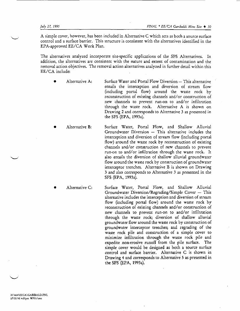
July 27, 1995 FINAL * EE/CA Garibaldi Mine Site * 30
A s i m p l e cover, however, has been i n c l u d e d in A l t e r n a t i v e C which acts as bo th a source sur facecontrol and a sur face barrier. T h i s s truc ture is consistent wi th the a l t e r n a t i v e s i d e n t i f i e d in theEPA-approved E E / C A Work Plan.T h e a l t e rna t iv e s analyzed incorporate s i t e - s p e c i f i c a p p l i c a t i o n s o f t h e S F S A l t e r n a t i v e s . I na d d i t i o n , the a l t e rna t iv e s are consistent with the nature and extent of contamination and theremoval action o b j e c t i v e s . The removal action a l t ernat ive s analyzed in f u r t h e r de ta i l wi th in t h i sE E / C A include:
• A l t e r n a t i v e A: S u r f a c e W a t e r and Portal F l o w Diversion — T h i s a l t ernat iveen ta i l s the i n t e r c e p t i o n and diversion of stream f l o w( i n c l u d i n g p o r t a l f l o w ) around the waste rock byreconstruct ion of e x i s t ing channels a n d / o r construct ion ofnew channels to prevent run-on to a n d / o r i n f i l t r a t i o nthrough the waste rock. A l t e r n a t i v e A is shown onDrawing 2 and corre sponds to A l t e r n a t i v e 3 as pr e s en t ed int h e S F S ( E P A , 1993a).
• A l t e r n a t i v e B: S u r f a c e Water , Portal F l o w , and S h a l l o w A l l u v i a lGroundwater Diversion — T h i s a l t ernat ive inc lude s thei n t e r c e p t i o n and diversion of stream f l o w ( i n c l u d i n g p o r t a lf l o w ) around the waste rock by reconstruction of ex i s t ingchannels a n d / o r construction of new channels to preventrun-on to a n d / o r i n f i l t r a t i o n through the waste rock. Italso en ta i l s the diversion of s ha l l ow al luvial groundwaterf l o w around the waste rock by construction of groundwaterin t e r c ep t or trenches. A l t e r n a t i v e B is shown on Drawing3 and also corresponds to Alternat ive 3 as presented in theS F S ( E P A , 1993a).
• A l t e r n a t i v e C: S u r f a c e Water, Portal F l o w , and S h a l l o w A l l u v i a lGroundwater D i v e r s i o n / R e g r a d i n g / S i m p l e Cover — T h i sal t ernat ive inc lude s the i n t e r c e p t i o n and diversion of streamf l o w ( inc lud ing portal f l o w ) around the waste rock byreconstruction of ex i s t ing channels a n d / o r construction ofnew channels to prevent run-on to a n d / o r i n f i l t r a t i o nthrough the waste rock; diversion of sha l low al luvialgroundwater f l o w around the waste rock by construction ofgroundwater in t erc ep tor trenches; and regrading of thewaste rock p i l e and construction of a s i m p l e cover tominimize i n f i l t r a t i o n through the waste rock p i l e ande x p e d i t e non-erosive r u n o f f f r o m t h e p i l e surface. T h es i m p l e cover would be designed as both a source surfacecontrol and surface barrier. A l t e r n a t i v e C is shown inDrawing 4 and corresponds to A l t e r n a t i v e 5 as presented int h e S F S ( E P A , 1993a).
H : \ 6 6 4 \ E E C A \ G A R I B A L D . F N L07/27/95 4:01pm W P 5 1 / c m c

July 27, 1995__________________________________FINAL * EE/CA Garibaldi Mine Site » 31
• A l t e r n a t i v e D: W a s t e Rock Removal — T h i s a l t ernat ive entai l s the removalof the waste rock f r o m the site and transpor t to the OregonGulch T a i l i n g Impoundment for d i spo sa l . It also includesrees tabli shment of the original drainage channel.A l t e r n a t i v e D, shown on Drawing 5, corre sponds toA l t e r n a t i v e 7 as pre sented in the SFS (EPA, 1993a).
I n s t i t u t i o n a l control s ( A l t e r n a t i v e 2 in the SFS), in c lud ing po s t ed warnings, i n f o r m a t i o n andeducation programs, and/or other controls would also be incorporated within the removalaction al t ernat ive s evaluated, as approved by EPA.The criteria u t i l i z ed in the analysis of the f o u r removal action al t ernat ive s are d e f i n e d in theGuidance on Conducting Non-Time-Critical Removal Actions Under the ComprehensiveEnvironmental Response, Compensation, and Liability Act (CERCLA) (EPA, 1993b), and inc ludee f f e c t i v e n e s s , i m p l e m e n t a b i l i t y , and cost. T h e s e EPA criteria are u t i l i z e d as screening criteriato aid in the s e l e c t ion of the a p p r o p r i a t e removal action for the G a r i b a l d i Mine site. Ina d d i t i o n , the Work Area. Management Plan (WAMP) ( U S D C , 1994) per f ormance criteria oferosion s t a b i l i t y and f l o w capac i ty and s t a b i l i t y are u t i l i z ed in evaluat ing the e f f e c t i v e n e s s of theremoval action al ternatives in meeting the removal action o b j e c t i v e s (RAOs). RAOs are f u r t h e rdiscussed in S e c t i o n 3.2.A f t e r d e t a i l e d evaluation of the individual removal action al t ernat ive s , a comparative analysisof these al t ernat ive s is presented in S e c t i o n 5.0 i d e n t i f i e s the advantages and di sadvantage s ofeach al ternative relative to one another considering the EPA criteria of e f f e c t i v e n e s s ,i m p l e m e n t a b i l i t y , and cost.4 . 2 E V A L U A T I O N C R I T E R I AEPA guidance (EPA, 1993a) prescribe s the evaluation of removal al ternatives according to threemain criteria: e f f e c t i v e n e s s , i m p l e m e n t a b i l i t y and cost. T h e s e criteria are d e f in ed in theGuidance on Conducting Non-Time-Critical Removal Actions Under the ComprehensiveEnvironmental Response, Compensation, and Liability Act (CERCLA) (EPA, 1993b) and areu t i l i z ed as screening criteria to aid in the se lec t ion of the a p p r o p r i a t e removal action for theGaribaldi Mine site. These criteria are described below.E f f e c t i v e n e s s — The e f f e c t i v e n e s s of an alternative re f er s to its a b i l i t y to meet the ob j eaive swithin the scope of the removal action. T h i s criterion is evaluated f or:
(1) Overall pro t e c t i on of p u b l i c heal th and the environment, compri s ing of:how each alternative achieves adequate pro t e c t i onhow each alternative reduces riski d e n t i f i c a t i o n of any unacceptable short-term impact s;
(2) Compl iance with A p p l i c a b l e or Relevant and A p p r o p r i a t e Requirements (ARARs)and other guidance criteria, compris ing of:
summary of po t en t ia l ARARss trategy for compliance with ARARs;
H : \ 6 6 4 \ E E C A \ G A R B A L D . F N L07/27/95 4:01pm W P 5 1 / c m c

July 27, 1995_________________________________FINAL * EE/CA Garibaldi Mine Site * 32(3) Long-term e f f e c t i v e n e s s and permanence, compri s ing of:
assessment of risk f r o m residual wastecontr ibut ion to f u t u r e remedial o b j e c t i v e sadequacy and r e l i a b i l i t y of controls;
(4) Reduct ion of t o x i c i ty , m o b i l i t y or volume through treatment , c ompr i s ing of:treatment process employed and nature of mater ia l s treatedamount of contaminated material to be treateddegree of reduct ion expec t ed in t ox i c i ty , m o b i l i t y or volumedegree to which treatment is irreversiblet y p e and quant i ty of treatment r e s idua l swhether t h e a l t ernat ive s a t i s f i e s C E R C L A ' s p r e f e r e n c e f o r t r ea tment; a n d
(5) Shor t- t erm e f f e c t i v e n e s s , c ompri s ing o f:p r o t e c t i o n of the communityp r o t e c t i o n of the workersno adverse impact s to the environmenttime to achievement of o b j e c t i v e s
I m p l e m e n t a b i l i t y — I m p l e m e n t a b i l i t y of an a l t ernat ive addresses its technical and admini s t ra t ivef e a s i b i l i t y and the avai lab i l i ty of necessary services and materials. The evaluation is based on:
(1) Technical f e a s i b i l i t y , c ompri s ing o f:a b i l i t y of the t e chno logy to implement the remedyr e l i a b i l i t y of the t e chnologyi n f l u e n c e of c l imatic condi t ionspost-removal site control sin t egra t i on with f i n a l remediat ion;
(2) A d m i n i s t r a t i v e f e a s i b i l i t y , compri s ing o f:s ta tu tory l i m i t sp e rmi t s and waivers;
(3) A v a i l a b i l i t y of services and materials, compris ing of:personnel and t e chnologyo f f - s i t e treatment, storage and d i spo sa lservices and materialsavai labi l i ty of f u l l - s c a l e technology;
(4) S t a t e / E P A acceptance; and(5) Community acceptance.
Cost — T h i s is an order-of-magnitude evaluation of p r o j e a costs, which is comprised of directcapi ta l costs, indirect capi tal costs, and post-removal site c o n t r o l / o p e r a t i o n and maintenancecosts. A present worth analysis will be carried out for the post-removal site c o n t r o l / o p e r a t i o nand maintenance costs using a 7% discount rate (EPA, 1987b), assuming that the f inalremediation wil l occur within f our years.
H : \ 6 6 4 \ E E C A \ G A R B A L D . F N L07/27/95 4:01pm W P 5 1 / c m c

July 27, 1995_________________________________FINAL * EE/CA Garibaldi Mine Site » 33Performance cri teria described in the W A M P ( U S D C , 1994) w i l l also be u t i l i z e d to evaluate thee f f e c t i v e n e s s of the removal action a l t e rnat ive s in a i e e t ing RAOs.Diversion d i t c h e s ( A l t e r n a t i v e s A, B, and C) were de s igned to s a f e l y convey the peak dischargef r o m the 100-year, 24-hour storm. The H E C - 1 h y d r o l o g i c model was u t i l i z e d to s imulatesur face r u n o f f r e s u l t i n g f r o m the des ign storm. Resul t s are pre s en t ed in A p p e n d i x B. S u r f a c ewater diversions were sized using M a n n i n g ' s Equation for open channel f l o w .The H y d r o l o g i c Evalua t ion of L a n d f i l l Performance (HELP) model was u t i l i z ed to predi c ti n f i l t r a t i o n through the waste rock p i l e with and without regrading and a s i m p l e cover( A l t e r n a t i v e s A, B, and C). H E L P re su l t s are inc luded in A p p e n d i x C. The S E D C A D + mode l ,u t i l i z i n g the Revised Universal S o i l Loss Equation (RUSLE) subroutine, was used to determinethe sediment y i e ld of the waste rock p i l e with and without regrading and a s i m p l e cover( A l t e r n a t i v e s A, B, and C). S e d i m e n t l o a d i n g ca l cu la t ions are included in A p p e n d i x D. As t a b i l i t y analys i s , using XSTABL s o f t w a r e , was also p e r f o r m e d for the waste rock p i l e with andwithout r egrading and a s i m p l e cover ( A l t e r n a t i v e s A, B, and C). The XSTABL analysi s isin c luded in A p p e n d i x E.4 . 3 A L T E R N A T I V E A - S U R F A C E W A T E R A N D P O R T A L F L O W D I V E R S I O N4.3.1 D e s c r i p t i o n of A l t e r n a t i v e AA l t e r n a t i v e A e n t a i l s the d i v e r s i p n of sur face water f l o w ( i n c l u d i n g p o r t a l f l o w ) around thewaste rock by reconstruction of e x i s t ing channels and the construction of new channels toprevent run-on to the waste rock.4.3.1.1 Diversion C h a n n e l s / A c c e s s Road I m p r o v e m e n t sUnder A l t e r n a t i v e A, f o u r channels would be constructed ( a p p r o x i m a t e l y 1,960 f e e t ) . DiversionDitch 1, located along the southern edge of the waste p i l e would divert r u n o f f around the wasterock p i l e and into Diversion Ditch 2. Diversion Ditch 2 located along the northeast edge of thewaste rock p i l e would divert r u n o f f f r o m Diversion Ditch 1, and the eastern stream channelaround the waste rock p i l e to Diversion Ditch 4. Diversion Ditch 2 would be routed througha 36-inch culvert under the ex i s t ing access road. In a d d i t i o n , drainage f r o m the exi s t ing c o l lap s edpor ta l would be routed through Diversion Ditch 2. Diversion Ditch 3, located along theex i s t ing access road northeast of the waste rock p i l e , would divert r u n o f f along the northeast endof the p i l e to Diversion Ditch 4. Diversion Ditch 4, located a long the ex i s t ing access road onthe north side of the waste rock p i l e , would col lec t r u n o f f f r o m Diversion Ditches 2 and 3 andthe north stream channel, and route the f l o w around the p i l e to the natural stream bed. Two36-inch culverts would be i n s t a l l e d in the u p p e r p o r t i o n of Diversion Ditch 4 to route the r u n o f funder the ex i s t ing access road. A 48-inch culvert would be placed at the end of Diversion Ditch4 to convey the r u n o f f back under the ex i s t ing access road and down the s t eep s l o p e to thenatural drainage. An energy d i s s i p a t e r would be required at the end of the 48-inch culvert.The diversion di tches were designed to s a f e l y convey the peak discharge f r o m the 100-year, 24-hour event. All r u n o f f calculat ions were per f ormed u t i l i z i n g the HEC-1 C o m p u t e r Modeldeve l oped by U.S. Army C o r p s of Engineers. HEC-1 is a hydrologic and hydraulic calculationmodel a d a p t e d for use on a PC system. The HEC-1 hydro l og i c model calculates peak f l o w andr u n o f f volume via a numerical m o d e l i n g technique based on user i n p u t s of a de s ign storm event.
H : \ 6 6 4 \ E E C A \ G A R B A L D . F N L07/27/95 4:01pm W P 5 1 / c m c

July 27, 1995_________________________________FINAL * EE/CA Garibaldi Mine Site » 34The m e t h o d o l o g y and a s sumpt i on s used in c a l c u l a t i n g r u n o f f , and model o u t p u t s are in c ludedin A p p e n d i x B, H E C - 1 M o d e l . The d i t c h de s ign s chedu l e is pr e s en t ed on Drawing 2.As shown on Drawing 2, all diversion d i t ch e s would be t r a p e z o i d a l d i t che s with 2-foot bo t t omsand 2H:1V side s l o p e s . Diversion Ditches 2 and 4 would be lined with concrete (or ana l t e rna t iv e l i n i n g system) for erosional s t a b i l i t y . Ditches which do not cross a n d / o r are notad ja c en t to the p i l e wi l l not be l ined with concrete. Diversion Ditch 1 would be grass-lined andDiversion Ditch 3 would be l ined with r i p r a p . A l t e r n a t i v e d i t c h l i n i n g systems wi l l be f u r t h e revaluated in the Remedial Design.Under th i s a l t ernat ive , the access road to the G a r i b a l d i Mine Site would require improvementfor use by heavy equipment and the haul ing of mat er ia l s to the site. A p p r o x i m a t e l y 500 f e e tof the access road would be improved by minor r egrad ing and b l a d i n g . Cu lv er t s would berep laced , as shown on Drawing 2.4.3.1.2 C o n s t r u c t i o nBest management pract ice s (BMPs) would be u t i l i z ed during all construction act ivi t ie s at the site.T e m p o r a r y sediment control s tructures, in c lud ing placement of straw bales , sediment controlf enc e s , or small berms wi l l be u t i l i z ed to control sediment r u n o f f f r o m the site. In a d d i t i o n ,dust control , ( i n c l u d i n g use of a water truck) would be pract iced during construction.4.3.2 A n a l y s i s of A l t e r n a t i v e AEPA guidance (EPA, 1993b) prescribes the evaluation of removal action alternatives accordingto three main criteria: e f f e c t i v e n e s s , i m p l e m e n t a b i l i t y , and cost. An evaluation of A l t e r n a t i v eA u t i l i z i n g these criteria f o l l o w s .4.3.2.1 E f f e c t i v e n e s s of Alt erna t iv e AThe e f f e c t i v e n e s s of an a l t ernat ive r e f e r s to its a b i l i t y to meet the o b j e c t i v e s wi thin the scopeof the removal action. The e f f e c t i v e n e s s of an al t ernat ive is evaluated based upon overallpro t e c t i on of p u b l i c heal th and the environment, compliance with ARARs, long-terme f f e c t i v e n e s s , reduct ion of t o x i c i t y , m o b i l i t y , or volume, and short-term e f f e c t i v e n e s s .Overall Protect ion of Public H e a l t h and the Environment: F o u r components of f l o w throughthe waste rock have been i d e n t i f i e d , in c lud ing surface water run-on; direct p r e c i p i t a t i o n ontothe p i l e ; shal low alluvial groundwater; and por ta l f l o w . T h i s al ternative would divert surfacerun-on and por ta l f l o w around the waste rock p i l e and minimize leaching and erosional releasesfrom these f l o w components. Sur fa c e i n f i l t r a t i o n (from direct pr e c ip i ta t i on onto the p i l e ) andsha l l ow alluvial groundwater could, however continue to f l o w through the p i l e and contributeto the leaching and migration of metals f r om the waste rock. I n f i l t r a t i o n through the p i l e ( f r o mdirect p r e c i p i t a t i o n on the p i l e ) was estimated at 1.4 inches per year, u t i l i z i n g the H E L P model( A p p e n d i x C). In addi t ion, erosion associated with these f l o w components would continue.Sediment yield was estimated at 6.1 t o n s / a c r e / y e a r u t i l i z i n g the RUSLE equation ( A p p e n d i x D).The s t a b i l i t y evaluation indicate s that the waste rock has a F a c t o r of Safety of 1.0 or greater, asdescribed in A p p e n d i x E.
H : \ 6 6 4 \ E E C A \ G A R I B A L D . F N L0 7 / 2 7 / 9 5 4:01pm W P 5 1 / c m c

July 27. 1995__________________________________FINAL * EE/CA Garibaldi Mine Site » 35
Compl iance W i t h ARARs: A p p e n d i x F p r e s e n t s a l i s t o f p o t e n t i a l ARARs for the r emed ia t i onof the C a l i f o r n i a Gulch site, as revised by EPA. C o m p l i a n c e with ARARs ( i n c l u d i n g cu l turalresources ARARs, the Cl: n Air A c t , the C o l o r a d o Air Q u a l i t y Contro l A c t , the s tormwaterprogram o f th e N a t i o n a l P o l l u t a n t Discharge E l imina t i on S y s t e m , th e C o l o r a d o N o i s eAbatemen t A c t , and the C o l o r a d o Mined Land Reclamation A c t ) wi l l be achieved for th i sremoval action a l t e rna t iv e , as required by EPA.Long-Term E f f e c t i v e n e s s : T h i s a l t ernat ive , de s igned for the 100-year f l o o d event, would bee f f e c t i v e in d iver t ing , and s t a b l e under, the 100-year peak f l o w . As discussed p r e v i o u s l y , itwould be e f f e c t i v e in d iv er t ing surface run-on and p o r t a l f l o w around the waste rock. Since le s swater would come in contact with the source (waste rock), overall metal l o a d i n g to U p p e rC a l i f o r n i a G u l c h through leaching a n d / o r erosion would be reduced.Reduction of Toxi c i ty , M o b i l i t y , or Volume: Under th i s a l t e rna t iv e , the overall volume ofwater f l o w i n g t h r o u g h / o v e r the waste rock source material would be reduced, thus reducingerosion and the l each ing and migrat ion of metal s f r o m the waste rock.Short-Term E f f e c t i v e n e s s : Poten t ia l short-term risks to the community r e su l t ing f r o m thei m p l e m e n t a t i o n of th i s removal action inc lude dust emissions and increased road t r a f f i c . TheG a r i b a l d i Mine S i t e , however is located a p p r o x i m a t e l y 3 miles f r o m the p o p u l a t e d areas ofL e a d v i l l e and is in a t o p o g r a p h i c a l l y i s o la t ed area. In a d d i t i o n , short-term risk f a c t o r s wouldbe e f f e c t i v e l y mi t iga t ed through the i m p l e m e n t a t i o n of s tandard construct ion practices. Dustabatement practices would be f o l l o w e d during construction activities. A d d i t i o n a l road t r a f f i cwould be l i g h t and l i m i t e d to the immediate v i c in i ty of the G a r i b a l d i Mine S i t e , except duringmobi l i za t i on , d e m o b i l i z a t i o n , and the de l ivery of construction materials .Risk to workers during i m p l e m e n t a t i o n of th i s removal action may result f r o m dust inha la t i on ,contact with contaminated mater ial s , and other indus tr ia l s a f e t y hazards. Dust abatementmeasures during construct ion would e f f e c t i v e l y manage dust exposure. Contact withcontaminated material s through accidental exposure is u n l i k e l y to occur to a trained remediat ionworker, because a p p r o p r i a t e s a f e t y measures would minimize t h i s and other p o t e n t i a l hazards.I m p a c t to the environment during i m p l e m e n t a t i o n of t h i s removal action may result f r o maccidental discharge of r u n o f f with suspended s o l i d s f r o m contaminated materials d i s turbedduring construction act ivi t i e s . Pot en t ia l releases would be minimized through the use of BMPs,discussed pr ev iou s ly in S e c t i o n 4.3.1.2.4.3.2.2 I m p l e m e n t a b i l i t y of A l t e r n a t i v e AThe i m p l e m e n t a b i l i t y of an a l t ernat ive addresses its technical and admini s t ra t ive f e a s i b i l i t y andthe a v a i l a b i l i t y of necessary services and materials. The evaluation is based on technicalf e a s i b i l i t y , adminis trat ive f e a s i b i l i t y , a v a i l a b i l i t y of services and materials, s t a t e / E P A acceptance,and community acceptance.Technical Feas ib i l i ty: The t e chnologi e s used in thi s alternative are common and w ide lyaccepted. The time-frame for i m p l e m e n t a t i o n can occur within the short construction seasonof the L e a d v i l l e area. The r e l i a b i l i t y of de s ign and imp l emen ta t i on is based on e s tab l i sh edpractice. C l i m a t i c condi t ions wil l not in t e r f e r e with "he operat ion of thi s removal actionalternative.
H : \ 6 6 4 \ E E C A \ G A R I B A L D . F N L0 7 / 2 7 / 9 5 4i01pm W P 5 1 / c m c

July 27, 1995 FINAL * EE/CA Garibaldi Mine Site * 36
Adminis trat ive F e a s i b i l i t y : C o m p l i a n c e with s ta tu tory l i m i t s on removal actions wil l not benecessary since this removal action is not C E R C L A f u n d - f i n a n c e d . Cons t ruc t i on p e r m i t s wi l lnot be necessary. Certa in f e d e r a l p ermi t s , such as a stormwater permi t , may be required.T h e r e f o r e , the s chedul e for th i s a l t ernat ive could be hindered by admini s t ra t iv e requirements.Avai lab i l i ty of Services and Materials: T h i s alternative can be i m p l e m e n t e d using commonlyavailable earth-moving equipment. Mater ia l s and personnel will also be readi ly available.S t a t e , EPA and Community Acceptance: It is believed that the EPA and S t a t e of Co l oradowil l f i n d e lements of th i s al ternative acceptable . However, th i s criterion wil l be f u r t h e raddres s ed in the A c t i o n Memorandum.The E E / C A process requires p u b l i c review, and comments f r o m the p u b l i c wi l l also beaddres sed in the A c t i o n Memorandum. Community acceptance of th i s removal actional t ernat ive is expec t ed .4.3.2.3 Cost of Alternat ive AThe cost evaluation is an order-of-magni tude evaluation of p r o j e c t costs and is comprised ofdirect capi ta l costs, indirect capi tal costs, and post-removal site c o n t r o l / o p e r a t i o n andmaintenance costs.The cost e s t imate for A l t e r n a t i v e A is summarized in T a b l e 7, A l t e r n a t i v e A Cost Summary.T o t a l costs are e s t imated at $175,615, and i n c l u d e $93,416 for direct capital costs, $57,918 forindirect cap i ta l costs and $24,281 for post removal s i te control costs (present worth). F u r t h e rcost es t imate data are pre sented in A p p e n d i x G.
TABLE 7A L T E R N A T I V E A - C O S T S U M M A R Y
Direct C a p i t a l Co s t sI n d i r e c t C a p i t a l CostsPost-Removal S i t e C o n t r o l Co s t s ( p r e s e n t wor th)T O T A L
$93,416$57,918$24,281
$ 1 7 5 , 6 1 5
4 . 4 A L T E R N A T I V E B - S U R F A C E W A T E R , P O R T A L F L O W , A N D S H A L L O WA L L U V I A L G R O U N O W A T E R D I V E R S I O N
4.4.1 Descr ip t i on of A l t e r n a t i v e BAlternat ive B entails the diversion of stream f l o w (including portal f l o w ) around the waste rockby the reconstruction of ex i s t ing channels and the construction of new channels to prevent run-on to and/or i n f i l t r a t i o n through the waste rock. It also involves the diversion of shallowalluvial groundwater f l o w around the waste rock by construction of groundwater in t er c ep tortrenches.
H:\664\EECA\GARIB A L D . F N L07/27/95 4:01pm W P 5 1 / c m c

July 27, 1995_________________________________FINAL * EE/CA Garibaldi Mine Site » 374.4.1.1 Diversion C h a n n e l s / A c c e s s Road I m p r o v e m e n t sDiversion channels and access road improvement s constructed under A l t e r n a t i v e B would be thesame as described under A l t e r n a t i v e A in S e c t i o n 4.3.1.1, with the f o l l o w i n g except ions:
• Diversion Ditch 2 would also convey f l o w f r o m the eastern groundwaterin t e r c ep tor trench, as f u r t h e r discussed below under S e c t i o n 4.4.1.2.
• Diversion Ditch 4 would also convey f l o w f r o m the northern groundwaterin t e r c ep t or trench, as f u r t h e r discussed below under S e c t i o n 4.4.1.2.
Alternat ive B is portrayed in Drawing 3.4.4.1.2 G r o u n d w a t e r I n t e r c e p t o r T r e n c h e sUnder A l t e r n a t i v e B, two groundwater in t e r c ep t or trenches would be constructed, as shown inDrawing 3. The groundwater in t e r c ep t or trench for the eastern channel would divert f l o w intoDiversion Ditch 2 and the groundwater in t er c ep tor trench for the northern stream channelwould divert f l o w into Diversion Ditch 4. The in t e r c ep t or trenches would be a p p r o x i m a t e l y3 f e e t wide and a p p r o x i m a t e l y 10 f e e t d e e p , down to bedrock. The trenches would consist ofa gravel drain back-lined with a high d e n s i t y p o l y e t h y l e n e ( H D P E ) liner. A f i l t e r f a b r i c wouldbe i n s t a l l e d around the clean gravel to reduce s i l t a t i o n and c logging. A p e r f o r a t e d p o l y v i n y lch l or id e ( P V C ) p i p e would be p la c ed in the b o t t o m of the trench. The p e r f o r a t e d PVC p i p ewould be connected to a sol id PVC p i p e which would tie into the diversion channels, as shownon Drawing 3. The in t e r c ep t o r trench would be keyed into bedrock, as condi t ions allow.4.4.1.3 ConstructionBMPs, as described under A l t e r n a t i v e A in S e c t i o n 4.3.1.2 would be u t i l i z e d during allconstruction activit ies at the site.4.4.2 A n a l y s i s of A l t e r n a t i v e B4.4.2.1 E f f e c t i v e n e s s of A l t e r n a t i v e BOverall Protection of Public H e a l t h and the Environment — As discussed under A l t e r n a t i v eA, f our components of f l o w through the waste rock have been i d e n t i f i e d , inc lud ing surfacewater run-on; direct p r e c i p i t a t i o n onto the p i l e ; shal low al luvial groundwater; and por ta l f l o w .T h i s a l t ernat ive would minimize the contact of three of these components with the waste rockand thereby reduce leaching and erosional releases f r o m these f l o w components. UnderA l t e r n a t i v e B, surface run-on and por ta l f l o w would be diverted around the waste rock p i l e andthe shallow alluvial groundwater would be diverted f rom the p i l e through the groundwaterint er c ep tor trench to the diversion channels. S u r f a c e i n f i l t r a t i o n f r om direct p r e c i p i t a t i o nwould, however continue to f l o w through the p i l e and contribute to the leaching and migrationof metals f r o m the waste rock. I n f i l t r a t i o n through the p i l e ( f r o m direct p r e c i p i t a t i o n on thep i l e ) was estimated at 1.4 inches per year, u t i l i z i n g the H E L P model ( A p p e n d i x C). In a d d i t i o n ,erosion associated with thi s f l o w component would continue. S e d i m e n t yield was e s t imated at6.1 tons per acre per year u t i l i z i n g the RUSLE equation ( A p p e n d i x D). The s t a b i l i t y evaluation
H : \ 6 6 4 \ E E C A \ G A R B A L D . F N L07/27/95 4:01pm W P 5 1 / c m c

July 27, 1995__________________________________FINAL * EE/CA Garibaldi Mine Site » 38
i n d i c a t e s that the waste rock p i l e has a F a c t o r of S a f e t y of 1.0 or greater, as described inA p p e n d i x E.Compl iance "With ARARs — A p p e n d i x F pre s en t s a l i s t o f p o t e n t i a l ARARs for theremediation of the C a l i f o r n i a Gulch site, as revised by EPA. Compl ianc e with ARARs( i n c l u d i n g cul tural resources ARARs, the Clean Air A c t , the C o l o r a d o Air Q u a l i t y Contro l A c t ,the stormwater program of the N a t i o n a l P o l l u t a n t Discharge E l i m i n a t i o n S y s t e m , the C o l o r a d oN o i s e Abat emen t Act and the C o l o r a d o Mined Land Reclamation A c t ) wil l be achieved for t h i sremoval action a l t ernat ive , as required.Long-Term E f f e c t i v e n e s s — T h i s a l t ernat ive , des igned for the 100-year f l o o d event, would bee f f e c t i v e in d iver t ing , and s t a b l e under, the 100-year peak f l o w . As discussed prev iou s ly , itwould be e f f e c t i v e in d iv er t ing surface run-on, p o r t a l f l o w , and shal low a l l u v i a l groundwateraround the waste rock. W h i l e it is a n t i c i p a t e d that the groundwater in t e r c ep t or trenches wil ldivert a por t i on of the al luvial groundwater around the p i l e , the overall e f f e c t i v e n e s s of t o t a l l ye l i m i n a t i n g th i s source of contact with the p i l e is uncertain. S i n c e le s s water would come incontact with the source (waste rock), however, overall metal s l o a d i n g to U p p e r C a l i f o r n i a G u l c hwould be reduced.Reduction of Toxi c i ty , Mobil i ty, or Volume — Under this alternative, the overall volume ofwater f l o w i n g through the waste rock source material would be reduced, thus reducing thel eaching and migrat ion of metal s f r o m the waste rock.Short-Term E f f e c t i v e n e s s — Pot en t ia l short-term risks to the community r e su l t ing f r o m thei m p l e m e n t a t i o n of th i s removal action inc lude dust emissions and increased road t r a f f i c . TheG a r i b a l d i Mine S i t e , however is located a p p r o x i m a t e l y 3 mile s f r o m the p o p u l a t e d areas ofL e a d v i l l e and is in a t o p o g r a p h i c a l l y i s o la t ed area. In a d d i t i o n , short-term risk f a c t o r s wouldbe e f f e c t i v e l y mi t iga t ed through the i m p l e m e n t a t i o n of s tandard construction practices. Dustabatement pract i ce s would be f o l l o w e d during construction activit ie s . A d d i t i o n a l road t r a f f i cwould be l i g h t and l i m i t e d to the immediate vicinity of the G a r i b a l d i Mine S i t e , except duringmob i l i za t i on , d e m o b i l i z a t i o n , and the del ivery of construction materials.Risk to workers during imp l emen ta t i on of th i s removal action may result f r o m dust inha la t i on ,contact vith contaminated material s , and other indus tr ia l s a f e t y hazards. Dust abatementmeasures during construction would e f f e c t i v e l y manage dust exposure. Contact withcontaminated materials through accidental exposure is un l ik e ly to occur to a trained remediat ionworker, because a p p r o p r i a t e s a f e t y measures would minimize t h i s and other p o t e n t i a l hazards.I m p a c t to the environment during i m p l e m e n t a t i o n of th i s removal action may result f r omaccidental discharge o f r u n o f f with suspended s o l i d s f r o m contaminated material s d i s turbedduring construction activities. Potent ia l releases would be minimized through the use of BMPs,discussed previous ly in Sec t i on 4.3.1.2.4.4.2.2 I m p l e m e n t a b i l i t y of A l t e r n a t i v e BTechnical F e a s i b i l i t y — The t echnologie s used in this alternative are common and wide lyaccepted. The t ime-frame for i m p l e m e n t a t i o n can occur within the short construction seasonof the L e a d v i l l e area. The r e l i a b i l i t y of design and i m p l e m e n t a t i o n is based on e s tabl i shed
H : \ 6 6 4 V E E C A \ G A R I B A L D . F N L0 7 / 2 7 / 9 5 4 : O I p m W P 5 1 / c m c

July 27, 1995 FINAL * EE/CA Garibaldi Mine Site * 39pract i c e . C l i m a t i c c o n d i t i o n s w i l l not i n t e r f e r e with the o p e r a t i o n of th i s removal actional t ernat ive .Adminis trat ive F e a s i b i l i t y — C o m p l i a n c e with s t a t u t o r y l i m i t s on removal actions w i l l not benecessary since th i s removal action is not CERCLA f u n d - f i n a n c e d . Cons truc t i on p e r m i t s w i l lnot be necessary. Cer ta in f e d e r a l p e r m i t s , such as a stormwater p ermi t , may be required.T h e r e f o r e , the s chedule for t h i s a l t e rna t iv e could be hindered by admini s t ra t iv e requirements.A v a i l a b i l i t y of Services and Mater ia l s — T h i s a l t ernat ive can be implemented using commonlya v a i l a b l e earth-moving equipment. M a t e r i a l s and personnel wil l also be r e a d i l y avai lable .S t a t e , EPA and Community Acceptance — It is be l ieved that the EPA and S t a t e of C o l o r a d owill f i n d e l ement s o f th i s a l t ernat ive a c c ep tab l e . However, th i s criterion wi l l be f u r t h e raddres sed in the A c t i o n Memorandum.The E E / C A process requires p u b l i c review, and comments f r o m the p u b l i c wil l be addres sedin the A c t i o n Memorandum. Communi ty acceptance of th i s removal action a l t e rna t iv e ise xpe c t ed .4.4.2.3 Cost of A l t e r n a t i v e BThe cost e s t imate for A l t e r n a t i v e B is summarized in T a b l e 8, A l t e r n a t i v e B Cost Summary.T o t a l costs are e s t imat ed at $208,039, and inc lude $113,431 for direct cap i ta l costs, $70,327 forindirect cap i ta l costs and $24,281 for post removal si te control costs (pre s en t worth). F u r t h e rcost e s t imate data are presented in A p p e n d i x G.
T A B L E 8A L T E R N A T I V E B - C O S T S U M M A R Y
Direct C a p i t a l Co s t sI n d i r e c t C a p i t a l Co s t sPost-Removal S i t e C o n t r o l Co s t s ( p r e s e n t wor th)T O T A L
$ 1 1 3 , 4 3 1$70,327$24,281
$208,039
4 . 5 A L T E R N A T I V E C - S U R F A C E W A T E R , P O R T A L F L O W , A N D S H A L L O WA L L U V I A L G R O U N D W A T E R D I V E R S I O N / R E G R A D I N G / S I M P L E C O V E R
4.5.1 D e s c r i p t i o n of A l t e r n a t i v e CA l t e r n a t i v e C entai l s the diversion of stream f l o w (inc lud ing por ta l f l o w ) around the waste rockby the reconstruction of ex i s t ing channels and the construction of new channels to prevent run-on to a n d / o r i n f i l t r a t i o n through the waste rock. It also involves the diversion of sha l lowalluvial groundwater f l o w around the waste rock by construction of groundwater in t er c ep tortrenches. A d d i t i o n a l l y , the p i l e surface would be regraded and a low p e r m e a b i l i t y s i m p l e coverwould be constructed to promote r u n o f f and minimize i n f i l t r a t i o n through the p i l e s .
H : \ 6 6 4 \ E E C A \ G A R B A L D . F N L07/27/95 4:01pm WP51/cmc

July 27, 199?__________________________________FINAL * EE/CA Garibaldi Mine Site » 40
4.5.1.1 Diversion C h a n n e l s / A c c e s s Road I m p r o v e m e n t sDiversion channels and access road improvement s constructed under A l t e r n a t i v e C would bethe same as described under A l t e r n a t i v e B in S e c t i o n 4.4.1.1.A l t e r n a t i v e C is por trayed in Drawing 4.4.5.1.2 G r o u n d w a t e r I n t e r c e p t o r T r e n c h e sThe groundwater i n t e r c e p t o r trenches constructed under A l t e r n a t i v e C would be the same asdescribed under A l t e r n a t i v e B in S e c t i o n 4.4.1.2.4.5.1.3 R e g r a d i n g / S i m p l e CoverThe waste rock p i l e would be regraded and s t a b i l i z e d to e l iminat e p o n d i n g , promot e drainage,and create a sur face c o n f i g u r a t i o n that is e r o s i ona l ly s tab l e . No terrain wil l be regraded s t e ep erthan 3H:1V as shown on Drawing 4. The F a c t o r of S a f e t y of the regraded p i l e was de t erminedto be 2.0 under p s e u d o s t a t i c c ondi t i on s and greater than 2.0 under drained condit ions.Regrading would require a p p r o x i m a t e l y 3,100 cy of material movement.S t a b i l i z e d surfaces would be covered with low p e r m e a b i l i t y borrow soil amended with organicmatter and f e r t i l i z e r . The amendment would be mixed into the top 12 inches of the soil byd i s c ing or using other a p p r o p r i a t e methods. H y d r o s e e d i n g , involving the a p p l i c a t i o n of amixture of seed, f e r t i l i z e r , and a t a c k i f i e r may be used at the site. H y d r o s e e d i n g would preventexcessive erosion of the s i t e b e f o r e a produc t iv e vegetat ive cover is e s t a b l i s h e d .4.5.1.4 C o n s t r u c t i o nBMPs, as described under A l t e r n a t i v e A in S e c t i o n 4.3.1.2 would be u t i l i z e d during allcons truc t ion ac t iv i t i e s at the site.4.5.2 A n a l y s i s of A l t e r n a t i v e C4.5.2.1 E f f e c t i v e n e s s of A l t e r n a t i v e COverall Protection of Public H e a l t h and the Environment — As discussed under A l t e r n a t i v eA, f o u r components of f l o w through the waste rock have been i d e n t i f i e d , i n c l u d i n g surfacewater run-on; direct p r e c i p i t a t i o n onto the p i l e ; sha l low alluvial groundwater; and por ta l f l o w .T h i s a l t ernat ive would minimize the contact of all f o u r of these components with the waste rockand thereby reduce leaching and erosional releases f r om these f l o w components. UnderA l t e r n a t i v e C, surface run-on and por ta l f l o w would be diverted around the waste rock p i l e andthe sha l low al luvial groundwater would be diverted f r o m the p i l e through the groundwaterin t e r c ep t or trench to the diversion channels. S u r f a c e i n f i l t r a t i o n through the p i l e and theerosional release of sediment would be minimized through the construction of the s i m p l e cover.S u r f a c e i n f i l t r a t i o n through the p i l e ( f rom direct p r e c i p i t a t i o n on the p i l e ) would be reduced toa p p r o x i m a t e l y 0.8 inches per year (see A p p e n d i x C) and sediment yield would be reduced toa p p r o x i m a t e l y 1 ton per acre per year (see A p p e n d i x D). Under th i s alternative, the F a c t o r ofS a f e t y for the waste rock p i l e is es t imated at 2.0 using the XSTABL model , as described inA p p e n d i x E.
H : \ 6 6 4 \ E E C A \ G A R I B A L D . F N L07/27/95 4:01pm W P 5 1 / c m c

July 27, 1995_________________________________FINAL * EE/CA Garibaldi Mine Site » 41Compliance W i t h ARARs — A p p e n d i x F pre s en t s a l i s t o f p o t e n t i a l ARARs for theremediation of the C a l i f o r n i a Gulch site, as revised by EPA. C o m p l i a n c e with ARARs(inc lud ing cultural resources ARARs, the Clean Air A c t , the Colorado Air Q u a l i t y Control A c t ,the storm-water program of the N a t i o n a l P o l l u t a n t Discharge El imina t i on S y s t e m , the Co l oradoN o i s e Abatement Act and the C o l o r a d o Mined Land Reclamation A c t ) will be achieved for thisremoval action al ternative, as required.Long-Term E f f e c t i v e n e s s — T h i s a l t ernat ive , designed for the 100-year f l o o d event, would bee f f e c t i v e in divert ing, and s tab l e under, the 100-year peak f l ow . As discussed prev iou s ly , itwould be e f f e c t i v e in d iv e r t ing surface run-on, por ta l f l o w , and shal low al luvial groundwateraround the waste rock and would minimize i n f i l t r a t i o n f l o w through the waste rock. W h i l e itis a n t i c i p a t e d that the groundwater in t er c ep tor trenches will divert a por t i on of the a l luvia lgroundwater around the p i l e , the overall e f f e c t i v e n e s s of t o t a l l y e l iminat ing this source ofcontact with the p i l e is uncertain. Since le s s water would come in contact with the source(waste rock), however, overall metal s l o a d i n g to U p p e r C a l i f o r n i a Gulch would be reduced.Reduction of Toxic i ty , Mobi l i ty, or Volume — Under this al ternative, the overall volume ofwater f l o w i n g through the waste rock source material would be reduced, thus reducing theleaching and migration of metals f r o m the waste rock.Short-Term E f f e c t i v e n e s s — Potent ia l short-term risks to the community re su l t ing f r o m thei m p l e m e n t a t i o n of th i s removal action include dust emissions and increased road t r a f f i c . TheG a r i b a l d i Mine S i t e , however is located a p p r o x i m a t e l y 3 miles f r o m the p o p u l a t e d areas ofL e a d v i l l e and is in a t o p o g r a p h i c a l l y i so lated area. In a d d i t i o n , short-term risk f a c t o r s wouldbe e f f e c t i v e l y mitigated through the implementat ion of standard construction practices. Dustabatement pract ice s would be f o l l o w e d during construction activities . A d d i t i o n a l road t r a f f i cwould be l igh t and l imi t ed to the immediate vicinity of the G a r i b a l d i Mine S i t e , except duringmobi l i za t i on , demob i l i za t i on , and the del ivery of construction materials.Risk to workers during i m p l e m e n t a t i o n of this removal action may result f r o m dust inhala t ion,contact with contaminated materials, and other indus tr ia l s a f e t y hazards. Dust abatementmeasures during construction would e f f e c t i v e l y manage dust exposure. Contact withcontaminated materials through accidental exposure is unl ike ly to occur to a trained remediationworker, because a p p r o p r i a t e s a f e t y measures would minimize this and other po t en t ia l hazards.Impact to the environment during impl ementa t i on of thi s removal action may result f r o maccidental discharge of r u n o f f with suspended so l id s f r o m contaminated materials d i s turbedduring construction activities. Potential releases would be minimized through the use of BMPs,discussed prev iou s ly in Sec t i on 4.3.1.2.4.5.2.2 I m p l e m e n t a b i l i t y of A l t e r n a t i v e CTechnical Feas i b i l i ty — The technologie s used in this alternative are common and wide lyaccepted. The time-frame for impl ementa t i on can occur within the short construction seasonof the L e a d v i l l e area. The r e l i a b i l i t y of design and implementa t i on is based on es tabli shedpractice. Construct ion of a s i m p l e cover, however, would involve the location and transportof su i table cover material. C l i m a t i c conditions wi l l not inter fere with the operation of thi sremoval action alternative.
H : \ 6 6 4 \ E E C A \ G A R B A L D - F N L07/27/95 4:01pm W P 5 1 / c m c

July 27, 1995 FINAL * EE/CA Garibaldi Mine Site * 42
Adminis trat ive F e a s i b i l i t y — C o m p l i a n c e with s t a t u t o r y l i m i t s on removal actions wi l l not benecessary since th i s removal action is not CERCLA f u n d - f i n a n c e d . Cons truc t i on p e r m i t s wil lnot be necessary. Certa in f e d e r a l p e rmi t s , such as a stormwater p e r m i t , may be required.T h e r e f o r e , the s chedule for th i s a l t ernat ive could be hindered by admini s tra t ive requirements.A v a i l a b i l i t y of Services and Mater ia l s — T h i s a l t ernat ive can be impl ement ed using commonlyavai lab l e earth-moving equipment. Mater ia l s and personnel will also be r ead i ly avai lable .S t a t e , EPA and Community Acceptance — It is believed that the EPA and S t a t e of C o l o r a d owil l f i n d e l ement s of th i s a l t ernat ive acc ep tab l e . However, th i s criterion wil l be f u r t h e raddres s ed in the A c t i o n Memorandum.The E E / C A process requires p u b l i c review, and comments f r o m the p u b l i c wil l be addres sedin the A c t i o n Memorandum. Community acceptance of th i s removal action al t ernat ive isuncertain, since it would involve covering an area that could have hi s tor ic value to thecommunity.4.5.2.3 Cost of A l t e r n a t i v e CThe cost e s t imate for A l t e r n a t i v e C is summarized in T a b l e 9, A l t e r n a t i v e C Cost Summary.T o t a l costs are e s t imated at $324,233 and inc lude $174,188 for direct capi tal costs, $107,997 forindirect cap i ta l costs and $42,048 for post removal site control costs (present worth). F u r t h e rcost e s t imate data are presented in A p p e n d i x G.
TABLE 9A L T E R N A T I V E C - C O S T S U M M A R Y
Direct C a p i t a l Co s t sI n d i r e c t C a p i t a l Co s t sPost-Removal S i t e C o n t r o l Cos t s ( p r e s e n t wor th)T O T A L
$ 1 7 4 , 1 8 8$107,997$42,048
$324,233
4 . 6 A L T E R N A T I V E D - W A S T E ROCK R E M O V A L4.6.1 D e s c r i p t i o n of A l t e r n a t i v e DA l t e r n a t i v e D entail s the removal of the waste rock material and transport to the Oregon GulchT a i l i n g Impoundment for d i s p o s a l / u t i l i z a t i o n in remediation measures in OU-10. Waste rockwould be removed down to the exi s t ing channel grade, loaded with an excavator, andtranspor t ed via 10 cubic yard trucks. Trucks would travel f r o m the G a r i b a l d i site along theG a r i b a l d i access road to Lake County Road 2. F r o m Lake County Road 2, trucks wouldproceed to the access road to the Yak Tunnel Treatment Plant. A new haul road would beconstructed f r om the p l a n t , over the ridge to the northeast of the p lant to the Oregon GulchT a i l i n g Impoundment . Construct ion of the new haul road would provide a shorter haul route,thus reducing removal costs. In add i t i on , it would e l iminate construction t r a f f i c through town.Under this alternative, a p p r o x i m a t e l y 500 fee t of the Garibaldi access road would be repairedand a p p r o x i m a t e l y 1,600 f e e t of new road would be constructed. T h i s alternative would require
H : \ 6 6 4 \ E E C A \ G A R B A L D . F N L0 7 / 2 7 / 9 5 4:01pm W P 5 1 / c m c

July 27, 2995__________________________________FINAL * EE/CA Garibaldi Mine Site » 43
that a d d i t i o n a l cul tural resource inventory and evaluat ion be conducted for road improvement sand new road construction. The p r o p o s e d haul route is d e l i n e a t e d on F i g u r e 2. A l t e r n a t i v e Dis shown on Drawing 5.BMPs, as described under A l t e r n a t i v e A in S e c t i o n 4.3.1.2 would be u t i l i z e d during allcons truct ion ac t iv i t i e s at the site.4.6.2 A n a l y s i s of A l t e r n a t i v e D4.6.2.1 E f f e c t i v e n e s s of A l t e r n a t i v e DOverall Protection of Public H e a l t h and the Environment: As discussed under A l t e r n a t i v eA, four components of f l o w through the waste rock have been i d e n t i f i e d , including surfacewater run-on; direct p r e c i p i t a t i o n onto the p i l e ; sha l low a l l u v i a l groundwater; and p o r t a l f l o w .T h i s a l t e rna t iv e would e l iminate the contact of all f o u r of these components with the waste rockand thereby e l imina t e l eaching and erosional releases f r o m these f l o w components. UnderA l t e r n a t i v e D, the waste rock would be removed f rom the si te and water contact with th i ssource would be e l im ina t ed . The waste rock would be d i s p o s e d in the Oregon Gulch T a i l i n gI m p o u n d m e n t and would be remediated along with the overall OU-10 remediat ion p l a n s to bedetermined under the OU-10 F e a s i b i l i t y S t u d y . Under th i s a l t ernat ive , f l o w f r o m the G a r i b a l d ip o r t a l would continue t o f l o w through U p p e r C a l i f o r n i a Gulch.Compliance W i t h ARARs — A p p e n d i x F pre s ent s a l i s t of p o t e n t i a l ARARs for theremediat ion of the C a l i f o r n i a Gulch site, as revised by EPA. C o m p l i a n c e with ARARs( i n c l u d i n g cu l tural resources ARARs, the Clean Air Act , the C o l o r a d o Air Qual i ty Contro l Act ,the stormwater program of the National Pollutant Discharge Elimination System, the ColoradoN o i s e Abatement Act and the Co lorado Mined Land Reclamation A c t ) wil l be achieved for th i sremoval action al t ernat ive , as required.Long-Term E f f e c t i v e n e s s : Under A l t e r n a t i v e B, the source material would be re locatedp e r m a n e n t l y and erosional and leaching releases f r o m the G a r i b a l d i s i t e would be e l iminated.The waste rock, however, would be relocated to OU-10 and require remediation under the OU-10 F e a s i b i l i t y S t u d y activities . In a d d i t i o n , f l o w f r o m the G a r i b a l d i p o r t a l would continue tof l o w through U p p e r C a l i f o r n i a Gulch.Reduction of Toxi c i ty , Mobi l i ty , or Volume: Under th i s alternative, the waste rock sourcematerial would be re located, thus e l imina t ing the l eaching and migration of metals f r o m thewaste rock at the Gariba ld i site. The waste rock would, however contribute to the meta l sl oad ing at its new location in OU-iC, until that site undergoes remediation. In addition, f l o wf r o m the G a r i b a l d i p o r t a l would continue to f l o w through U p p e r C a l i f o r n i a Gulch.Short-Term E f f e c t i v e n e s s : Poten t ia l short-term risks to the community r e s u l t i n g f r o m thei m p l e m e n t a t i o n of th i s removal action inc lude dust emissions and increased road t r a f f i c . TheG a r i b a l d i Mine S i t e , however is located a p p r o x i m a t e l y 3 miles f r o m the p o p u l a t e d areas ofL e a d v i l l e and is in a t o p o g r a p h i c a l l y i so lated area. In addi t ion, short-term risk f a c t o r s wouldbe e f f e c t i v e l y mit igated through the imp l emen ta t i on of standard construction practices. Dustabatement practices would be f o l l o w e d during construction activities. A d d i t i o n a l road t r a f f i cwould result f r om the imp l emen ta t i on of th i s alternative, between the* Garibald i s i te and theOregon Gulch T a i l i n g Impoundment . For a per iod of a p p r o x i m a t e l y 1 month, 130 round t r i p sof truck haul ing would occur per day, assuming use of a 10 cubic yard dump truck.
H : \ 6 M \ E E C A \ G A R B A L D . F N L0 7 / 2 7 / 9 5 4i01pm W P 5 1 / c m c

July 27, 1995__________________________________FINAL * EE/CA Garibaldi Mine Site + 44
Risk to workers during i m p l e m e n t a t i o n of t h i s removal action may result f r o m dust i n h a l a t i o n ,contact wi th contaminated mater ia l s , and other indus t r ia l s a f e t y hazards. Dust abatementmeasures dur ing construct ion would e f f e c t i v e l y manage dust exposure. Contact withcontaminated material s through accidental exposure is u n l i k e l y to occur to a trained remediat ionworker, because a p p r o p r i a t e s a f e t y measures would minimize th i s and other p o t e n t i a l hazards.I m p a c t to the environment during imp l emen ta t i on of th i s removal action may result f r o maccidental discharge of r u n o f f with suspended so l id s f rom contaminated materials disturbedduring construction ac t ivi t i e s . P o t e n t i a l releases would be minimized through the use of BMPs,discussed p r e v i o u s l y in S e c t i o n 4.3.1.2.4.6.2.2 I m p l e m e n t a b i l i t y of A l t e r n a t i v e DTechnical Feas i b i l i ty: The t e chno log i e s used in thi s a l t ernat ive are common and wide lyaccepted. The t ime-frame for i m p l e m e n t a t i o n can occur wi th in the short construction seasonof the L e a d v i l l e area. The r e l i a b i l i t y of des ign and i m p l e m e n t a t i o n is based on e s t ab l i s h edpractice. C l i m a t i c c ondi t i ons wi l l not i n t e r f e r e with the operat ion of th i s removal actionalternative.Adminis trat ive Fea s i b i l i ty: C o m p l i a n c e with s ta tu tory l i m i t s on removal actions wil l not benecessary since thi s removal action is not CERCLA f u n d - f i n a n c e d . Cons truc t ion p e r m i t s wil lnot be necessary. Certa in f e d e r a l p ermi t s , such as a stormwater p ermi t , may be required.T h e r e f o r e , the s chedul e for th i s a l t ernat ive could be hindered by admini s tra t ive requirements.Several admin i s t ra t iv e issues associated with A l t e r n a t i v e D must, however, be resolved pr ior toimp l emen ta t i on . T h e s e inc lude cultural resource inventory work and compliance with S e c t i o n106 of the N a t i o n a l H i s t o r i c Preservation A c t ; acce s s /ownership issues associated with the haulroad construction; p o t e n t i a l regulatory rami f i ca t i on s associated with d e p o s i t i n g waste rockmaterial in Oregon Gulch; and concerns over u t i l i z i n g Oregon Gulch as a d e p o s i t area for wasterock material.Avai lab i l i ty of Services and Material s: T h i s a l t ernat ive can be impl ement ed using commonlyavai lab l e earth-moving equipment. Mater ia l s and personnel wi l l also be r ead i ly available.Stat e , EPA and Community Acceptance: It is believed that the EPA and S t a t e of Co loradowill f i n d th i s al ternative acceptable . Both the S t a t e and EPA have expressed interest in the pas tin the Removal A l t e r n a t i v e . T h i s criterion, however, wi l l be f u r t h e r addres s ed in the Act i onMemorandum.The E E / C A process requires p u b l i c review, and comments f r om the p u b l i c wil l be addressedin the Act ion Memorandum. Community acceptance of thi s removal action al t ernat ive isuncertain, since it would involve removing material f r o m an area that could have hi s toric valueto the community.4.6.2.3 Cost of A l t e r n a t i v e DThe cost e s t imate for A l t e r n a t i v e D is summarized in T a b l e 10, Alternat iv e D Cost Summary.T o t a l costs are estimated at $531,191, and include $301,940 for direct capital costs, $187,203 forindirect capital costs and $42,048 for post removal site control costs (present worth). F u r t h e rcost e s t imate data are pre s ented in A p p e n d i x D.
H : \ 6 6 4 \ E E C A \ G A R B A L D . F N L07/27/95 5:35pm W P 5 1 / c m c

July 27, 1995 FINAL * EE/CA Garibaldi Mine Site » 45
TABLE 10A L T E R N A T I V E D - C O S T S U M M A R Y
Direct C a p i t a l Cos t sI n d i r e c t C a p i t a l C o s t sPos t-Removal S i t e C o n t r o l C o s t s ( p r e s e n t wor th)T O T A L
$301,940$187,203$42,048
$ 5 3 1 , 1 9 1
H : \ 6 6 4 \ E E C A \ G A R J B A L D . F N L0 7 / 2 7 / 9 5 4:01pm W P 5 1 / c m c

July 27, 1995 FINAL * EE/CA Garibaldi Mine Site * 46
5 . 0 C O M P A R A T I V E A N A L Y S I S O FR E M O V A L A C T I O N A L T E R N A T I V E S
T h i s section p r o v i d e s a comparison of removal alternatives based on criteria contained in theGuidance on Conducting Non-Time-Critical Removal Actions Under CERCLA (EPA, 1993b) anddiscussed in S e c t i o n 4.2 of th i s E E / C A Report . In thi s evaluation, the r e la t iv e advantages anddisadvantages of the alternatives are d i r e c t ly compared in a matrix evaluation. Criteria used int h i s comparat ive analysi s inc lude the same three major categories ( e f f e c t i v e n e s s ,i m p l e m e n t a b i l i t y , and co s t) used to i n d i v i d u a l l y assess each al ternat ive in S e c t i o n 4.0.The comparative analysi s of the f our a l t ernat ive s considered within thi s E E / C A is pre s ented inT a b l e 11, Comparison of Alternatives. Alternat ive s are rated poor, fa ir , good, or very goodrelative to the evaluat ion criteria and each other. Plea s e re f er to S e c t i o n 4.0 for a more c o m p l e t ediscussion of the evaluation of the individual a l t ernat ive s u t i l i z i n g the e f f e c t i v ene s s ,i m p l e m e n t a b i l i t y , and cost criteria.
TABLE 1 1C O M P A R I S O N O F A L T E R N A T I V E S
Alterna t iv e A Alternat ive B Alterna t iv e C Alternat ive DE f f e c t i v e n e s sOveral l Prot e c t i on o f H u m a n Heal th andEnvironmentC o m p l i a n c e w i th A R A R sL o n g - T e r m E f f e c t i v e n e s sR e d u c t i o n o f T o x i c i t y , M o b i l i t y , V o l u m eS h o r t - T e r m E f f e c t i v e n e s s
F
GFFG
GGGGG
GGGGG
VGG
V GVG
FI m p l e m e n t a b i l i t yT e c h n i c a l F e a s i b i l i t yA d m i n i s t r a t i v e F e a s i b i l i t yA v a i l a b i l i t y o f S e r v i c e s and M a t e r i a l sA n t i c i p a t e d S t a t e / E P A A c c e p t a n c eA n t i c i p a t e d Communi ty Accep tanc e
GGGGG
GGGGG
FGGGF
GF
GVG
FCostT o t a l Direct C a p i t a l Cos t sI n d i r e c t C a p i t a l C o s t sPost-Removed S i t e C o n t r o l / O t h e rG r a n d T o t a l
$93,416$ 5 7 , 9 1 8$24,281
$ 1 7 5 , 6 1 5
$113,431$70,327$24,281
$208,039
$174,188$107,997$42,048
$324,233
$301,940$187,203$42,048
$ 5 3 1 , 1 9 1N O T E S : F = F a i rG = G o o dVG = Very G o o d
T a b l e 12 pre s en t s a more d e t a i l e d di scuss ion of the re lat ive e f f e c t i v e n e s s of each al ternative.
H : \ 6 6 4 \ E E C A \ G A R I B A L D . F N L0 7 / 2 7 / 9 5 4:01pm \?P51/cmc

TABLE 12S U M M A R Y O F G A R I B A L D I W A S T E ROCK E E / C A A L T E R N A T I V E S -
A l t e r n a t i v eA l t e r n a t i v e A — S u r f a c e Waterand Portal F l o w Diversion
A l t e r n a t i v e B — S u r f a c e Water ,Portal F l o w , and S h a l l o w A l l u v i a lGroundwater Diversion
A l t e r n a t i v e C - S u r f a c e Water ,Portal F l o w , a n d S h a l l o w A l l u v i a lGroundwater Diversion/R e g r a d i n g / S i m p l e Cover
A l t e r n a t i v e D — W a s t e RockRemoval
E f f e c t i v e n e s sReduces 2 of 4 p o t e n t i a l f l o w c o m p o n e n t s t h r o u g h the waste rock ( s u r f a c e run-on andp o r t a l f l o w )Reduces l e a c h i n g and ero s ional re l ease s a s s o c ia t ed w i th s u r f a c e run-on and p o r t a l f l o wS u r f a c e erosion o f waste rock p i l e f r o m d i r e c t p r e c i p i t a t i o n o n t h e p i l e would cont inue( a p p r o x i m a t e l y 6 . 1 t o n s / a c r e / y e a r )I n f i l t r a t i o n (1.4 i n c h e s / y e a r ) t h r o u g h t h e waste rock p i l e f r o m d i r e c t p r e c i p i t a t i o n o n t h e p i l ewould cont inueI m p r o v e s erosional s t a b i l i t y of the d iver s ion channelsS u r f a c e s t a b i l i t y f a c t o r o f s a f e t y gr ea t e r t h a n 1Reduces 3 o f 4 p o t e n t i a l f l o w c o m p o n e n t s t h r o u g h the waste rock ( s u r f a c e run-on, p o r t a lf l o w , a n d g r o u n d w a t e r )Reduces l e a c h i n g and eros ional releases a s soc iated w i t h s u r f a c e run-on, p o r t a l f l o w , andg r o u n d w a t e rS u r f a c e erosion o f waste rock p i l e f r o m d ir e c t p r e c i p i t a t i o n o n t h e p i l e wou ld c on t inue( a p p r o x i m a t e l y 6 . 1 t o n s / a c r e / y e a r )I n f i l t r a t i o n (1.4 i n c h e s / y e a r ) t h r o u g h t h e waste rock p i l e f r o m d i r e c t p r e c i p i t a t i o n o n t h e p i l ewould cont inueI m p r o v e s erosional s t a b i l i t y o f t h e d i v e r s i o n c h a n n e l sS u r f a c e s t a b i l i t y f a c t o r o f s a f e t y gr ea t e r than 1Reduces 4 o f 4 p o t e n t i a l f l o w c o m p o n e n t s t h r o u g h the waste rock ( s u r f a c e run-on, p o r t a lf l o w , g r o u n d w a t e r , a n d d i r e c t p r e c i p i t a t i o n o n t h e p i l e )Reduces l e a c h i n g and eros ional re l ease s a s s o c ia t ed w i th s u r f a c e run-on, p o r t a l f l o w ,g r o u n d w a t e r , and d i r e c t p r e c i p i t a t i o n on the p i l eReduces s u r f a c e erosion of waste rock p i l e to a p p r o x i m a t e l y 1 .0 t o n / a c r e / y e a rI n f i l t r a t i o n t h r o u g h t h e waste rock p i l e f r o m direc t p r e c i p i t a t i o n o n t h e p i l e would b edecreased to a p p r o x i m a t e l y 0.8 i n c h e s / y e a rI m p r o v e s ero s ional s t a b i l i t y o f t h e d i v e r s i o n channe l sI m p r o v e s s u r f a c e s t a b i l i t y o f waste rock p i l e t o f a c t o r o f s a f e t y o f 2 .0 under p s e u d o s t a t i cc o n d i t i o n s and gr ea t e r than 2.0 under d r a i n e d c o n d i t i o n sE l i m i n a t e s 4 o f 4 p o t e n t i a l f l o w c o m p o n e n t s t h r o u g h th e waste rock ( s u r f a c e run-on, p o r t a lf l o w , groundwater , and direct p r e c i p i t a t i o n on the pile) by removing the waste rockE l i m i n a t e s l e a c h i n g a n d ero s i ona l r e l ea s e s a s soc ia t ed w i th s u r f a c e run-on, p o r t a l f l o w ,g r o u n d w a t e r , and d i r e c t p r e c i p i t a t i o n on the p i l eE l i m i n a t e s s u r f a c e erosion o f waste rock p i l eE l i m i n a t e s i n f i l t r a t i o n t h r o u g h t h e waste rock p i l e f r o m d i r e c t p r e c i p i t a t i o n o n t h e p i l eF l o w f r o m G a r i b a l d i p o r t a l wou ld c on t inue t o f l o w i n U p p e r C a l i f o r n i a G u l c hR e l o c a t e d waste rock wou ld require r e m e d i a t i o n under O U - 1 0 F S a c t i v i t i e s
T o t a l Es t imatedCost
$ 1 7 5 , 6 1 5
$208,039
$324,233
$ 5 3 1 , 1 9 1

July 27, 1995_________________________________FINAL * EE/CA Garibaldi Mine Site » 48
6 . 0 R E C O M M E N D E D R E M O V A L A C T I O N A L T E R N A T I V E
Based on the ind iv idua l analysis of al ternatives pre s ented in Sect ion 4.0 and the comparativeanalysi s pre s ented in S e c t i o n 5.0, A l t e r n a t i v e B is recommended for implementat ion. Ad e s c r i p t i o n of A l t e r n a t i v e B and the rat ionale for its s e lec t ion are prov ided below.6 . 1 D E S C R I P T I O N O F A L T E R N A T I V E BA l t e r n a t i v e B en ta i l s the diversion of stream f l o w ( inc lud ing p o r t a l f l o w ) around the waste rockby the reconstruction of ex i s t ing channels and the construction of new channels to prevent run-on to and/or i n f i l t r a t i o n through the waste rock. It also involves the diversion of shallowal luvia l groundwater f l o w around the waste rock by construction of groundwater in t er c ep tortrenches. A l t e r n a t i v e B is portrayed in Drawing 3.Under A l t e r n a t i v e B, f o u r channels would be constructed ( a p p r o x i m a t e l y 1,960 f e e t ) . DiversionDitch 1, locat ed along the southern edge of the waste p i l e would divert r u n o f f around the wasterock p i l e and into Diversion Ditch 2. Diversion Ditch 2 located along the northeast edge of thewaste rock p i l e would divert r u n o f f f r o m Diversion Ditch 1, and the eastern stream channelaround the waste rock p i l e to Diversion Ditch 4. Diversion Ditch 2 would be routed througha 36-inch culvert under the ex i s t ing access road. In add i t i on , drainage f r o m the ex i s t ing c o l l a p s e dpor ta l and f r om the eastern groundwater in t e r c ep t or trench (discussed f u r t h e r be low) would berouted through Diversion Ditch 2. Diversion Ditch 3, located along the ex i s t ing access roadnortheast of the waste rock p i l e , would divert r u n o f f along the northeast end of the p i l e toDiversion Ditch 4. Diversion Ditch 4, located along the exis t ing access road on the north sideof the waste rock p i l e , would collect r u n o f f f rom Diversion Ditches 2 and 3 and the northstream channel, and route the f l o w around the p i l e to the natural stream bed. Diversion d i t ch4 would also convey f l o w f r o m the northern groundwater interceptor trench (discussed f u r t h e rbelow). Two 36-inch culverts would be in s t a l l ed in the u p p e r p o r t i o n of Diversion Ditch 4 toroute the r u n o f f under the ex i s t ing access road. A 48-inch culvert would be placed at the endof Diversion Ditch 4 to convey the r u n o f f back under the ex i s t ing access road and down thes t e ep s l o p e to the natural drainage. An energy d i s s i pa t e r would be .required at the end of the48-inch culvert.The diversion ditches would be designed to s a f e l y convey the peak discharge f r o m the 100-year,24-hour event. The me thodo l ogy and as sumptions used in ca l cu la t ing r u n o f f and model ou tpu t sare included in A p p e n d i x B, HEC-1 Model. The ditch design schedule is presented on Drawing3.As shown on Drawing 3, all diversion di tches would be trapezoidal d i t che s with 2-foot bo t tomsand 2H:1V side slopes. To h e l p reduce i n f i l t r a t i o n , Diversion Ditches 2 and 4 would be linedwith concrete. Ditches which do not cross and/or are not adjacent to the p i l e will not be linedwith concrete. Diversion Ditch 1 would be grass-lined and Diversion Ditch 3 would be linedwith r iprap.Under thi s alternative, the access road to the Gariba ld i Mine Site would require improvementfor use by heavy equipment and the hauling of materials to the site. A p p r o x i m a t e l y 500 f e e tof the access road would be improved by minor regrading and b lading. Culvert s would berep lac ed , as shown on Drawing 3.
H : \ 6 6 4 \ E E C A \ G A R B A L D . F N L07/27/95 4:01pm W P 5 1 / c m c

July 27, 1995_________________________________FINAL * EE/CA Garibaldi Mine Site » 49Under A l t e r n a t i v e B, two ground-water i n t e r c e p t o r trenches would be constructed, as shown inDrawing 3. The groundwater i n t e r c e p t o r trench for the eastern channel would divert f l o w intoDiversion Ditch 2 and the groundwater in t e r c ep t o r trench for the northern stream channelwould divert f l o w into Diversion Ditch 4. The in t e r c ep t or trenches would be a p p r o x i m a t e l y3 f e e t wide and a p p r o x i m a t e l y 10 f e e t d e ep , down to bedrock. The trenches would consist ofa gravel drain back-lined with a high den s i ty p o l y e t h y l e n e ( H D P E ) liner. A f i l t e r f a b r i c wouldbe i n s t a l l e d around the clean gravel to reduce s i l t a t o n and c logging. A p e r f o r a t e d p o l y v i n y lchloride ( P V C ) p i p e would be p lac ed in the bottom of the trench. The p e r f o r a t e d PVC p i p ewould be connected to a so l id PVC p i p e which would tie into the diversion channels, as shownon Drawing 3. The in t e r c ep t or trench would be keyed into bedrock, as condi t ions allow.Best management pract ice s (BMPs) would be u t i l i z ed during all construction ac t iv i t i e s at the site.T e m p o r a r y sediment control s tructures, i n c l u d i n g placement of straw bale s , sediment controlf ence s , or small berms would be u t i l i z e d to control sediment r u n o f f f r om the site. In a d d i t i o n ,dust c o n t r o l , ( i n c l u d i n g use of a water truck) would be prac t i c ed during construction.6 . 2 R A T I O N A L E F O R S E L E C T I O N O F A L T E R N A T I V E B6.2.1 E f f e c t i v e n e s sA l t e r n a t i v e B received a "good" rating in terms of overall p r o t e c t i o n of human heal th andenvironment, compliance with ARARs, long-term e f f e c t i v e n e s s , short-term e f f e c t i v e n e s s , andreduct ion of t o x i c i ty , m o b i l i t y , and volume. A l t e r n a t i v e B minimizes the contact of the threei d e n t i f i e d water components at the Gar iba ld i Mine Site (surface water run-on, por ta l f l o w , andshal low alluvial groundwater) with the waste rock source material.A l t e r n a t i v e B is considered e f f e c t i v e for the f o l l o w i n g reasons:
• Reduces 3 of 4 p o t e n t i a l f l o w components through the waste rock (surface run-on,por ta l f l o w and shal low alluvial groundwater)
• Reduces leaching associated with surface run-on, por ta l f l o w and shal low al luvialgroundwater
• Reduces erosional releases associated with surface run-on• I m p r o v e s erosional s t a b i l i t y of the diversion channels
Run-on is considered a f a i r l y major f l o w component at the Gar iba ld i site since the drainage areaabove Gar iba ld i is r e la t iv e ly large (211 acres). Since i n f i l t r a t i o n f r o m direct p r e c i p i t a t i o n onthe p i l e would not be reduced by this alternative, it is considered s l i g h t l y less e f f e c t i v e thanA l t e r n a t i v e C. The reduced costs of th i s alternative, however, j u s t i f y the minimal d i f f e r e n c e ine f f e c t i v e n e s s of the two alternatives. W h i l e Alt ernat iv e D is considered to be the most e f f e c t i v eof the alternatives analyzed, extremely high costs and administrative concerns do not warrantthe implementation of this alternative.
H : \ 6 M \ E E C A \ G A R I B A L D . F N L07/27/95 5:36pm W P 5 1 / c m c

July 27, 1995____________________________FINAL * EE/CA Garibaldi Mine Site » 50
6.2.2 I m p l e m e n t a b i l i t yA l t e r n a t i v e B is considered to be i m p l e m e n t a b l e in terms of the technical f e a s i b i l i t y ,a d m i n i s t r a t i v e f e a s i b i l i t y , a v a i l a b i l i t y of services and mater ia l s , a n t i c i p a t e d agency acceptance, andantic ipated community acceptance.6.2.3 CostT o t a l costs for A l t e r n a t i v e B are e s t imated at $208,039, and inc lude $113,431 for direct c a p i t a lcosts, $70,327 for indirect cap i ta l costs, and $24,281 for po s t removal s i te control costs (pre s entworth).
H : \ 6 6 4 \ E E C A \ G A R T O A L D . F N L07/27/95 4:01pm W P 5 1 / c m c
July 27, 1995__________________________________FINAL * EE/CA Garibaldi Mine Site »
7.0 REFERENCES
Abt, S.R., et al., 1988. Resistance to F l o w Over Riprap in S t e e p Channels. Water ResourcesB u l l e t i n 24(c): 1193-1200.
A l g e r m i s s e n , S.T., Perkins, D.M., Thenhau s , P.C., and Bender, B.L., 1990. P r o b a b i l i s t i cEarthquake A c c e l e r a t i o n and V e l o c i t y M a p s for the U n i t e d S t a t e s and Puerto Rico. U.S.Department of the Inter ior , U.S. Geological Service Miscel laneous F i e l d Map MF-2120.
C o l o r a d o Department of T r a n s p o r t a t i o n ( C D O T ) , 1993. Cost Data. The Co loradoDepartment of T r a n s p o r t a t i o n , Bid Plans, Room 117, 4201 E. Arkansas Ave, Denver,C o l o r a d o 80222.
Dames and Moore, 1986. S t a b i l i t y and Reclamation Evaluation of Abandoned T a i l i n g s PondsL e a d v i l l e U n i t , L e a d v i l l e , C o l o r a d o .
Emmons, S.F., J.D. Irving , and G.F. Laughl in , 1927. G e o l o g y and Ore D e p o s i t s of the L e a d v i l l eMining D i s t r i c t , Colorado . U.S. G e o l o g i c a l Survey P r o f e s s i o n a l Paper 148.
Haan, C . T . , B a r f i e l d , B J . a n d H a y e s , J . C . Design H y d r o l o g y a n d S e d i m e n t o l o g y f o r S m a l lCatchments . Academic Press, San Diego, CA. 588 p.
Means, 1993. Means Heavy Cons t ru c t i on Cost Data. R.S. Means Company, Inc. 100Cons t ruc t i on Plaza, P.O. Box 800, K i n g s t o n , MA 02364-0800.
Mortorano, Mari lyn A. and David G. K i l l a n . 1990. A d d e n d u m to Yak T u n n e l RemedialA c t i o n H i s t o r i c Resources Survey, Lake County, Co lorado . On f i l e at the S t a t e H i s t o r i cPreservation O f f i c e , Denver.
S h e p h e r d M i l l e r , Inc. (SMTj, 1994. Summary of S u r f a c e and Ground W a t e r S a m p l i n g inC a l i f o r n i a and Oregon Gulch per formed in October 1993.
S h e p h e r d M i l l e r , I n c . / T e r r a M a t r i x I n c . ( S M I / T e r r a M a t r i x ) , 1994. F i n a l EngineeringEvaluat ion/Cos t Analysis Work Plan for the Garibaldi Mine S i t e (OU-4).
S h e p h e r d M i l l e r , I n c . / T e r r a M a t r i x I n c . ( S M I / T e r r a M a t r i x ) , 1994a. Draf t F i n a l F i e l dReconnaissance Survey of Mine Waste Piles Located W i t h i n the U p p e r C a l i f o r n i a GulchDrainage.
S h e p h e r d M i l l e r , I n c . / T e r r a M a t r i x Inc. ( S M I / T e r r a M a t r i x ) , 1994b. Summary of Water andS e d i m e n t S a m p l i n g and H y d r o l o g i c Measurement in C a l i f o r n i a p e r f o r m e d in A p r i l , Mayand J u n e 1994.
S h e p h e r d M i l l e r , I n c . / T e r r a M a t r i x Inc. ( S M I / T e r r a M a t r i x ) , 1995. Summary of W a t e r andSediment S a m p l i n g and H y d r o l o g i c Measurements Program for C a l i f o r n i a GulchPerformed in October, 1994.
H:\664\EECA\GARBALD.FNL0 7 / 2 7 / 9 5 4:01pm W P 5 1 / c m c

fuly 27, 1995__________________________________FINAL * EE/CA Garibaldi Mine Site » 52
T e r r a M a t r i x I n c . / S h e p h e r d M i l l e r , Inc. ( T e r r a M a t r i x / S M I ) , 1994. F i n a l EngineeringE v a l u a t i o n / C o s t A n a l y s i s Work Plan for the Gar iba ld i Mine S i t e (OU-4).
T e r r a M a t r i x I n c . / S h e p h e r d M i l l e r , Inc. (TerraMatrix/SMI), 1995. Draf t Operab l e U n i t s 4, 8,and 10 Reconnaissance Report.
Turk, J.T. and T a y l o r , J.O., 1979. A p p r a i s a l of Ground Water in the Vicini ty of the LeadvilieDrainage T u n n e l , Lake County, Colorado . U.S. Geo log i ca l Survey Open File Report79-1538.
T w e t o , O., 1970. L e a d v i l i e Dis tr i c t , Colorado. In, MacDiarmid, R.A., ed., Ore D e p o s i t s of theUnited S t a t e s . U.S. Geo log i ca l Survey. W a s h i n g t o n , D.C. pgs 681-705.
U.S. Army C o r p s o f Engineers (COE), 1991. HEC-1 F l o o d H y d r o g r a p h Package. H y d r o l o g i cEngineering Center, Davis, CA.
U.S. Department of A g r i c u l t u r e - S o i l Conservation Service (SCS), 1980. Procedures forDetermining Peak F l o w s in Colorado. Technical Release No. 55.
U.S. Department of Commerce, Bureau of the Census, 1990. S e l e c t e d P o p u l a t i o n and H o u s i n gCharac t er i s t i c s , 1990.
U.S. District Court (USDC), District of Colorado, 1994. Civil action No. 83-C-2388, ConsentDecree with A S A R C O , Inc., Resurrection Mining Company, Newmont MiningC o r p o r a t i o n , and the Res-ASARCO J o i n t Venture, A p p e n d i x D: Work AreaManagement Plan f or th e C a l i f o r n i a Gulch S u p e r f u n d S i t e , I m p l e m e n t a t i o n byResurrection Mining Company. May.
U.S. Environmental Prote c t i on Agency (EPA), 1987a. Phase I Remedial I n v e s t i g a t i o n Report,C a l i f o r n i a Gulch , Leadv i l i e , Colorado.
U.S. Environmental Prote c t i on Agency (EPA), 1987b. Remedial Act i on Cos t ing ProceduresManual, O f f i c e of S o l i d W a s t e and Emergency Response, W a s h i n g t o n , D.C., EPAContract 68-03-3113, EPA\600\8-87\049, October.
U.S. Environmental Protect ion Agency (EPA), 1993a. Fina l Screening F e a s i b i l i t y S t u d y forRemedial A l t e r n a t i v e s at the C a l i f o r n i a Gulch NPL S i t e . Leadvi l i e , CO. S e p t e m b e r .
U.S. Environmental Protection Agency (EPA), 1993b. Guidance on Conducting Non-Time-Critical Removal Act ions under CERCLA. O f f i c e of Emergency and RemedialResponse, U.S. Environmental Protec t ion Agency, Wash ing ton , DC 20460. August .
U.S. Environmental Protect ion Agency (EPA), 1994. Acid Mine Drainage Prediction.Warner, R.C., and Schwab, P.J., 1992. S E D C A D + Version 3 Train ing Manual. Civil S o f t w a r e
Design, Ames, IA.Water, Waste and Land, (WWL) 1990. C a l i f o r n i a Gulch H y d r o l o g i c I n v e s t i g a t i o n Report.
Report prepared for Resurrection Mining Company.
H : \ 6 6 4 \ E E C A \ G A R B A L D . F N L07/27/95 4:01pm W 5 1 / c m c

July 27, 1995_________________________________FINAL * EE/CA Garibaldi Mine Site » 53W e s t o n , R.F., Inc., 1994. D r a f t F i n a l Baseline A q u a t i c Eco log i ca l Risk Asse s sment , C a l i f o r n i a
Gulch , L e a d v i l l e , C o l o r a d o .Woodward C l y d e C o n s u l t a n t s , ( W C C ) , 1990. S i t e Improvement s f or: G a r i b a l d i W o r k i n g s ;
N o r t h Mike W o r k i n g s ; Oregon Gulch T a i l i n g Pond; S t a r r Ditch.Woodward C l y d e C o n s u l t a n t s , Inc. ( W C C ) , 1993. H y d r o g e o l o g i c Remedial I n v e s t i g a t i o n
Repor t , D r a f t , C a l i f o r n i a Gulch S i t e , L e a d v i l l e , Colorado .Woodward C l y d e C o n s u l t a n t s , Inc. ( W C C ) , 1993a. T e r r e s t r i a l Ecosystem Evaluation Report ,
D r a f t , C a l i f o r n i a G u l c h S i t e , L e a d v i l l e , Colorado .Woodward C l y d e C o n s u l t a n t s , Inc. ( W C C ) , 1993 b. S u r f a c e W a t e r Remedial I n v e s t i g a t i o n
Repor t , D r a f t , C a l i f o r n i a Gulch S i t e , L e a d v i l l e , Co lorado .Woodward C l y d e C o n s u l t a n t s , Inc. ( W C C ) , 1994. F i n a l Mine W a s t e P i l e s Remedial
I n v e s t i g a t i o n Report .
H : \ 6 6 4 \ E E C A \ G A R J B A L D . F N L07/27/95 4:01pm W P S l / c m c

July 27, 1995 FINAL * EE/CA Garibaldi Mine Site * Drawings
F I G U R E S / D R A W I N G S
H A 6 6 4 \ E E C A \ G A R B A L D . F N L07/27/95 4:01pm W P 5 1 / c m c

O R A D O
CALIFORNIA GULCHSUPERFUND SITE
NOT TO SCALE
Project No.:664-0 100
File:RESWLOC.DWG
/ J r x ' U / n L l y :J.RAY
l)ra:nrn By:K.CONRATH
R E S U R R E C T I O N M I N I N G C O M P A N YO N E U N I T E D B A N K C E N T E R1700 L I N C O L N S T R E E TD E N V E R , C O L O R A D O 80203
•Sr.nlv:N/A
Date:JULY 1995
FIGURE 1
CALIFORNIA GULCH SITEGENERAL LOCATION

c
..- PROPOSED\ HAUL ROUTE( A l t e r n a t i v e D )
GARIBALDI MINE SITE( R e f e r T o D r a w i n g 1 F o r D e t a i l s )
SCALE0 2,500' 5,000'SCALE r = 5.000'
LEGENDN O P E R A B L E U N I T 4
C G I G S U R F A C E W A T E R M O N I T O R I N G L O C A T I O N
Project No.:664-O10O
File:OU-AREA4.DWG
Design By:J.RAY
Drawn By:T.LEIDICH
R E S U R R E C T I O N M I N I N G C O M P A N YO N E U N I T E D B A N K C E N T E R1700 L I N C O L N S T R E E TD E N V E R , C O L O R A D O 60203
Scale:1" .- 5000'
Date:JUL Y 1995
FIGURE 2
GARIBALDI MINE SITE EE/CAOPERABLE UNIT 4
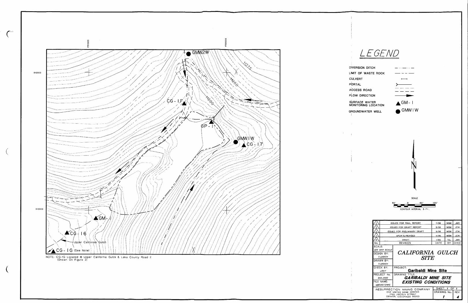
/ / - w V \ \ \ \ \ \ \
N O T E : C G - 1 G L o c a t e d 0 U p p e r C a l i f o r n i a G u l c h & , L a k e C o u n t y R o a d 2( S h o w n O n F i g u r e 2 )
LEGENDD I V E R S I O N D I T C HL I M I T O F W A S T E ROCKC U L V E R TP O R T A LA C C E S S R O A DF L O W D I R E C T I O NS U R F A C E W A T E RM O N I T O R I N G L O C A T I O N
G R O U N D W A T E R W E L L
N o .
k G M - Ii G M W I W
S C A L E5 0 ' 0 5 0 ' 1 0 0 '
C O N T O U R I N T E R V A L 5 F l .
I S S U E D F O R F I N A L R E P O R TI S S U E D F O R D R A F T R E P O R T
I S S U E D F O R P R E L I M I N A R Y D R A F TU P D A T E / R E V I S E D
D R A F TR E V I S I O N
S C A L E :SEE BAR SCALED E S I G N B Y :
T.LEID/CHD R A W N B Y :
T.LEIDICHC H E C K B Y :
J.RAYP R O J E C T N o .
664-3200F I L E N A M E :
GBEXIST.DWC
D A T E
M G M J M R
BY C H K D
CALIFORNIA GULCHSITEP R O J E C T : G a r i b a l d i M i n e S i t eD R A W I N G T I T L E :GARIBALDI MINE SITE
EXISTING CONDITIONSR E S U R R E C T I O N M I N I N G C O M P A N Y
O N E U N I T E D B A N K C E N T E R1 7 0 0 L I N C O L N S T R E E TD E N V E R . C O L O R A D O 80203
S H E E T : 1 O F 1D R A W I N G N o . : R E V .
4

\
FREEBOARD = o.s1
LEGEND
TYPICAL UNLINED CHANNEL
D I V E R S I O N D I T C HL I M I T O F W A S T E ROCKC U L V E R TP O R T A LA C C E S S R O A DF L O W D I R E C T I O NE N E R G Y D I S S I P A T O R
- 0 . 3 3 ' F R E E B O A R D = 0.3' C O N C R E T E
CONCRETE LINED CHANNELS C A L E
5 0 ' 0 5 0 ' 1 0 0 '
C O N T O U R I N T E R V A L 5 F t .
-1.5 x D50DIVERSION DITCH SCHEDULE
D I T C H
123
4 U P P E R4 L O W E R
P E A KD I S C H A R G E( C F S )
0.423.011.039.062.0
S I D ES L O P E
2 H i 1 V2 H : 1 V2 H : 1 V2 H : 1 V2 H : 1 V
C H A N N E LS L O P E( % )22
171611
V E L O C I T Y( F P S )
1.48.77.4
21.421.3
F L O WD E P T H( F T )0.10.80.50.60.8
L I N E RT Y P EG R A S S
C O N C R E T ER I P R A P D50=6"
C O N C R E T EC O N C R E T E
i - F R E E B O A R D = 0.3'1 r — — — — R I P R A P
TYPICAL RIPRAP LINED CHANNEL D R A W I N G N o . W H E R E •D E T A I L / S E C T I O NI S R E F E R E N C E D
- D E T A I L / S E C T I O NN U M B E R
D E T A I L / S J E C T I O NI S S H O W N
7KN o .
I S S U E D F O R F I N A L R E P O R TI S S U E D F O R D R A F T R E P O R T
I S S U E D F O R P R E L I M I N A R Y D R A F TU P D A T E / R E V I S E D
R E V I S I O NS C A L E :see BAR SCALED E S I G N B Y :
T.LEIDICHD R A W N B Y :
T.LBD/CHC H E C K B Y :
J.RAYP R O J E C T N o .
664-3200F I L E N A M E :
GBAL TIDWC
D A T ET E L J M RB Y C H K D
CALIFORNIA GULCHSITEP R O J E C T : G a r i b a l d i M i n e S i t eD R A W I N G T I T L E :GARIBALDI MINE SITE
AL TERNA TIVE AR E S U R R E C T I O N M I N I N G C O M P A N Y
O N E U N I T E D B A N K C E N T E R1700 L I N C O L N S T R E E TD E N V E R , C O L O R A D O 80203
S H E E T : 1 O F *D R A W I N G N o . :
2R E V .4

DIVERSION DITCH SCHEDULED I T C H
123
4 U P P E R4 L O W E R
P E A KD I S C H A R G E( C F S )
0.423.011.039.062.0
S I D ES L O P E
2 H : 1 V2 H : 1 V2 H : 1 V2 H : 1 V2 H : 1 V
C H A N N E LS L O P E( 5 4 )22
171611
V E L O C I T Y( F P S )
1.48.77.4
21.421.3
F L O WD E P T H
( F T )0.10.80.50.60.8
L I N E RT Y P E
G R A S SC O N C R E T E
R I P R A P D50=6"C O N C R E T EC O N C R E T E
F R E E B O A R D = 0.3'R I P R A P
TYPICAL RIPRAP LINED CHANNEL'
LEGEND
C L E A N G R A V E L -
H O P E L I N E R -
D I T C H
D I V E R S I O N D I T C HL I M I T O F W A S T E R O C KC U L V E R TP O R T A LA C C E S S R O A DG R O U N D W A T E R T R E N C HP I P EF L O W D I R E C T I O NE N E R G Y D I S S I P A T O R
S L O T T E D P V C P I P E
B E D R O C KN o t e : ( I n t e r c e p t o r T r e n c h W i l l B e K e y e d I n t oB e d r o c k A s C o n d i t i o n s A l l o w )
^\GROUNDWATER INTERCEPTOR TRENCHv 3 3 1
L F R E E B O A R D = 0.3'
• 2 ' -TYPICAL UNLINED CHA NNEL D R A W I N G N o . W H E R E •D E T A I L / S E C T I O N
I S R E F E R E N C E D
C O N T O U R I N T E R V A L 5 F l .
- D E T A I L / S E C T I O NN U M B E R
D R A W I N G N o . W H E R ED E T A I L / S E C T I O NI S S H O W N
F R E E B O A R D = 0 . 3 'C O N C R E T E -
TYPICAL CONCRETE LINED CHANNEL
ZL\
N o .
I S S U E D F O R F I N A L R E P O R TI S S U E D F O R D R A F T R E P O R T
I S S U E D F O R P R E L I M I N A R Y D R A F TU P D A T E / R E V I S E D
R E V I S I O NS C A L E :SEE BAR SCALE
D E S I G N B Y :T.LSDICH
D R A W N B Y :T.LEDICH
C H E C K B Y :J.RAY
P R O J E C T N o .664-3200
F I L E N A M E :GBAL T2.DWG
D A T E BY C H K D
CALIFORNIA GULCHSITEP R O J E C T : G a r i b a l d i M i n e S i t eD R A W I N G T I T L E ;GARIBALDI MINE SITEAL TERNA TIVE B
R E S U R R E C T I O N M I N I N G C O M P A N YO N E U N I T E D B A N K C E N T E R
1700 L I N C O L N S T R E E TD E N V E R . C O L O R A D O 80203
S H E E T : t O F 7D R A W I N G N o . :
3R E V .4

1 8 " O F L O W P E R M E A B I L I T Y M A T E R I A L LEGEND
TYPICAL SIMPLE COVER
C L E A N C O B B L E -
H O P E L I N E R -
D I T C H
D I V E R S I O N D I T C HL I M I T O F W A S T E ROCKC U L V E R TP O R T A LA C C E S S ROADG R O U N D W A T E R T R E N C HP I P ER E G R A D E D T O P O G R A P H YF L O W D I R E C T I O NE N E R G Y D I S S I P A T O R
• 1H2S-
C . ' ^ ' ^ JV ^ ^ E 1 S L O T T E D P V C P I P E
N o t e : ( I n t e r c e p t o r T r e n c h W i l l B e K e y e d I n t oB l e d r o c k A s C o n d i t i o n s A l l o w )
^GROUNDWATER INTERCEPTER TRENCH
F R E E B O A R D = 0 .3 '
C O N T O U R I N T E R V A L 5 F t .
TYPICAL UNLINED. CH/-NNEL D R A W I N G N O . W H E R E •D E T A I L / S E C T I O NI S R E F E R E N C E D
- D E T A I L / S E C T I O NN U M B E R
D R A W I N G N o . W H E R ED E T A I L / S E C T I O NI S S H O W N
M A T E R I A L M O V E M E N T - 3100 C YA R E A O F D I S T U R B A N C E - 1 . 6 A C R E S
DIVERSION DITCH SCHEDULED I T C H
123
4 U P P E R4 L O W E R
P E A KD I S C H A R G E( C F S I
0.423.011.039.062.0
S I D ES L O P E
2 H : 1 V2 H : 1 V2 H : 1 V2 H : 1 V2 H : 1 V
C H A N N E LS L O P E(%)
22
M1611
V E L O C I T Y( F P S )
1.48.77.421.421.3
F L O WD E P T H( F T )0.10.80.50.60.8
L I N E RT Y P E
G R A S SC O N C R E T E
R I P R A P D50=6"C O N C R E T EC O N C R E T E
F R E E B O A R D = 0 .3 'R I P R A P
F R E E B O A R D = ' 0 . 3 'C O N C R E T E -
TYPICAL RIPRAP LINED CHANNEL ^2\TYPICAL CONCRETE LINED CHANNEL
7\7KZ\
N o .
I S S U E D F O R F I N A L R E P O R TI S S U E D F O R D R A F T R E P O R T
I S S U E D F O R P R E L I M I N A R Y D R A F TU P D A T E / R E V I S E D
D R A F TR E V I S I O N
S C A L E :see BAR SCALED E S I G N B Y :
T.LEIDICHD R A W N B Y :
T.LEIDICHC H E C K B Y :
J.RAYP R O J E C T N o .
F I L E N A M E :GBAL T3.DWG
D A T E B Y C H K D
CALIFORNIA GULCHSITEP R O J E C T : G a r i b a l d i Mine S i t eD R A W I N G T I T L E :GARIBALDI MINE SITEALTERNATIVE C
R E S U R R E C T I O N M I N I N G C O M P A N YO N E U N I T E D B A N K C E N T E R
1700 L I N C O L N S T R E E TD E N V E R . C O L O R A D O 80203
S H E E T : 1 O F 1D R A W I N G N o . :
4R E V .4

r
N O T E : V O L U M E O F W A S T E R O C K R E M O V E D 27,900 C Y
LEGENDR E - E S T A B L I S H E D C H A N N E L — • • — •L I M I T O F W A S T E R O C K — — - -C U L V E R T > — — <P O R T A L > — — — —A C C E S S R O A D ~ ~ ~P R E - M I N E T O P O G R A P H Y — — n « s -F L O W D I R E C T I O N
S C A L E0_______SO^ Z
C O N T O U R I N T E R V A L 5
7\No.
I S S U E D F O R F I N A L R E P O R TI S S U E D F O R D R A F T R E P O R T
I S S U E D F O R P R E L I M I N A R Y D R A F TU P D A T E / R E V I S E D
D R A F TR E V I S I O N
S C A L E :SEE BAR SCALED E S I G N B Y :
r.LBOICHD R A W N B Y :
T.LEID/CHC H E C K B Y :
J.RAYP R O J E C T N o .
BBi-3200F I L E N A M E :
GBAL TJ.DWG
7 / 9 5 M G M J M R
D A T E B Y C H K D
CALIFORNIA GULCHSITEP R O J E C T : G a r i b a l d i M i n e S i t eD R A W I N G T I T L E :GARIBALDI MINE SITEALTERNATIVE D
R E S U R R E C T I O N M I N I N G C O M P A N YO N E U N I T E D B A N K C E N T E R1700 L I N C O L N S T R E E T
D E N V E R . C O L O R A D O 80203
S H E E T : 1 O F 1D R A W I N G N o . :
5R E V .4

July 27, 1995 FINAL * EE/CA Garibaldi Mine Site * Attachments
A T T A C H M E N T S
H : \ 6 6 4 \ E E C A \ G A R I B A L D . F N L07/27/95 5:36pm W P 5 1 / c m c

A T T A C H M E N T 1R E S P O N S E T O P U B L I C C O M M E N T S
Responses to comments on the D r a f t Engineering Evaluat ion and Cost A n a l y s i s for G a r i b a l d iMine S i t e W i t h i n U p p e r C a l i f o r n i a Gulch Operab l e Unit 4 ( E E / C A ) are pre s ent ed on thef o l l o w i n g pages. The E E / C A was submi t t ed to the EPA and the C o l o r a d o Department ofP u b l i c H e a l t h and Environment ( C D P H E ) on J u n e 2, 1995, and was avai lab l e for p u b l i c reviewand comment f r o m J u n e 5, 1995 to July 7, 1995.Comments on the E E / C A were received f r o m the C D P H E and the Bureau of Reclamation onJ u l y 11, 1995 and f r o m the Lake County Board of County Commissioners on J u l y 13, 1995.
H:\664\gmssub.Itr07/27/95 4:48pm W P 5 1 / c m c

United S t a t e s Department of the Interior-BUREAU OF RECLAMATIONR*olMUktto» Sctvit* OvotorP.O. But 850076T, Dcawr F«d«r*l Ctot tr, Cctendo SCOS-COO?
E N V - 3 . 0 0J U N 3 0 199S
Environmental Protection AgencAttent i on: MS. Denise LinkReroedial Proj e c t ManagerRegion V T I I , S u i t e 5 0 0999 isch streetDenver CO 80202Dear Ms. L i n k ;Thank you for the opportunity to review the Pi-aft Ena it A n a l v s i j s f or Gariba ld i Miae S i t e W i t h i n( E E / C A ) prepared byS h e p h e r d - l t i l l e r Inc . , and TerraMatrix . I have the l o l l o w i n gconmetnt:
Section 4. S . I . 3 . Refracting / S i m p l e Covwi . T h i s auctionreferences Drawing 4 and states that 3K:1V s lopes areshown. I do not f i n d , thia 3:1 e l ope clearly indicatedon the drawing, the s lope s within the proposed channelsappear to retain the 2H:1V slopes from previousdrawings .Section 4.6.1. Description of A l t e r n a t i v e D. T h i salternative would require the conduct of addit ionalcultural resource inventory and evaluation for the roadimprovements and the new road construction. This is noti d e n t i f i e d within the discussion. Tfce discussion shouldLuwiuUe a. section relative to this worfc and a discussionthat increased costs will be added per the culturalresource requirements, if new road construction wil lrequire a roadway to accommodate two-way t r a f f i c , ratherthan ju s t one t r a f f i c direction, if addit ional turnoutsor staging areas will be involved, these will requirecultural resource work. Compliance with Section 106 ofthe Nat iona l H i s t o r i c Preservation Act will be requiredfor improvements and/or new construction. No drawing ofthe proposed route is included. If S h e p h e r d - M i l l e r andTerraMatrix have been able to state that construction ofa new haul road would "provide a shorter haul route.1 Iassume a proposed route has been i d e n t i f i e d . T h i sshould be included.

Sec t i on 4.6.2.2. Admini s t ra t iv e F e a s i b i l i t y , i t wouldbo h e l p f u l to include a statement d e t a i l i n g that forA l t e r n a t i v e D, addi t ional adminis trat ive issuespertinent to cultural resources will be required.S p e c i f i c a l l y , p lanning for Sec t i on 106 compliance.section 6.1. Page 48. S p e l l i n g Error: Condition ism i s s p e l l e d .A p p e n d i x F , F . 2 . 4 Cultural Resources. T h e f i r s tparagraph should be corrected to s ta t e the removalaction is an "undertaking under the NHPA." Thestatement: "EPA has however, made a preliminarydetermination that resources within the area p o t e n t i a l l ye f f e c t e d by the proposed removal action are not e l i g i b l efor inclusion in the N a t i o n a l Register of H i s t o r i cP l a c e s . 8 should be reworded. The l e t t e r the ColoradoS t a t e H i s t o r i c Preservation O f f i c e r ( S H P O ) provided i nwhich th e SHPO determined th e Garibaldi Mine S i t e 'no ti n d i v i d u a l l y e l i g i b l e , ... not within the ex i s t ingL e a d v i l l e H i s t o r i c District and ... not contribute todi s tr i c t expansion' does not c l a r i f y if A3ARCO wasrequested to submit this material to the SHPO for EPA.However, as SPA does not wish to d i spu t e the)determination made by the SHPO/ EPA nay now u t i l i z e thisdetermination to conclude the S e c t i o n 106 process, forthis individual site. The determination is f i n a l notpre l iminary.in the next paragraph the H i s t o r i c a l and ArchaeologicalPreservation Act of 1974 is incorrectly i d e n t i f i e d . Theword Data needs to be de l e t ed.F . 2 . 6 . Clean water Act (Sec t ion 404). is the• N a t i o n a l ' permit discussed here a Sect ion 404 Permit ora Nationwide Permit?T a b l e F.I. Archaeological and His tor i ca l PreservationAct should be correctly i d e n t i f i e d . Del e t e Data fromthe t i t l e . The His t or i c S i t e s Act of 1935 is i n c l u d e dwithin this table but no discussion of this is presentin the text.Appendix G. Coat Estimates. All cost estimates haveincluded Cultural Resources, i d e n t i f i e d as a lump sumpayment* amount ( $ 1 0 , 0 0 0 ) and source as previousp r o j e c t s . For Alternat ive A, no historic propert ie s areinvolved in the on-site construction for ditches 1-4.Any cultural resource work would only be necessity forthe 500 f e e t of improvement, regrading and b lad ing , tothe existing road. The amount ( $ 1 0 , 0 0 0 ) a l located here

for cultural resource work appears to be excessive, inf a c t , if road improvements are c on f ined to the rereadingand b lading with no increase in roadway wid th , thencultural resource work may be e l iminated a l t o g e t h e r .The in i t ia l construction of the road may have des troyedthe potent ial for s i g n i f i c a n t cultural p r o p e r t i e s to bepresent.Again for Alternat ive B, the same level s of costs arei d e n t i f i e d - for cultural resources. Review ofAlternat ive B indicates that on-siLe work wi l l beconf ined to areas previously included in culturalresource inventory and evaluation. Road improvementsare ant i c ipat ed Lo be the same as A l t e r n a t i v e A. Myprevious comment relative to the amount ( $ 1 0 , 0 0 0 )a p p l i e s here a l so ,Alternat ive C nay also be included in my comment on thecosts.Alternat ive D is exactly the same as the others, $10,000is targeted for cultural resources work. A l t e r n a t i v e Dwill require addit ional cultural resource work,reportage, and addi t ional time for EPA Lo ini t ia t e andconclude the Sect ion 106 process. Does the amountindicated here provide Cor the conduct of this new workor has the amount al located s i m p l y been carried forwardwith l i t t l e thought Cor actual expenses?
I have one correction to comment provided Cor the BE/CA forthe Colorado Zinc-Lead T a i l i n g Area, l e t t e r dated 23 June1995. in section 1.4, my sentence reading: 'The discussionhere needs to be revised to indicate the removal action forthe t a i l ing s will only e f f e c t site 5 L K 8 4 5 ; " should bereworded to: The discussion here needs to be revised toindicate the removal action will only e f f e c t Feature D ofs i t e 5 L K 8 4 5 .I look forward to continuing to work with you andResurrection Mining Company aa this pro j e c t moves f orward.Should you have questions regarding these conraontc, p l e a s ecall me at 236-2722 extension 341.
Sincerely, &-Patricia McCcy OCultural Resource S p « c i « l i a uTechnical Service Center

July 24, 1995_______________________________________Comment Responses * OU-4__B U R E A U O F R E C L A M A T I O N C O M M E N T S1. Comment: S e c t i o n 4.5.1.3. R e g r a d i n g / S i m p l e Cover. T h i s section re f erence s drawing
4 and s ta t e s that 3H:1V s l o p e s are shown. I do not f i n d this 3:1 s l o p e c l ear ly indicatedon the drawing. The s l o p e s within the p r o p o s e d channels a p p e a r to retain the 2H:1Vs l o p e s f r o m previous drawings.Response: The drawing wil l be c l a r i f i e d to indica t e a 3:1 s l o p e .
2. Comment: S e c t i o n 4.6.1. D e s c r i p t i o n of A l t e r n a t i v e D. T h i s a l t e r n a t i v e would requirethe conduct of add i t i ona l cul tural resource inventory and evaluation for the roadimprovements and the new road construction. T h i s is not i d e n t i f i e d w i th in thediscussion. The discuss ion should inc lude a section relat ive to t h i s work and a di scus s ionthat increased costs wi l l be added per the cu l tural resource requirements. If new roadconstruction will require a roadway to accommodate two-way t r a f f i c , rather than j u s t onet r a f f i c d i r e c t i on , if a d d i t i o n a l turnouts or s tag ing areas wi l l be involved, these wi l l requirecu l tura l resource work. C o m p l i a n c e with S e c t i o n 106 of the N a t i o n a l H i s t o r i cPreservation Act will be required for improvements and/or new construction. Nodrawing of the p r o p o s e d route is in c luded . If S h e p h e r d - M i l l e r and T e r r a M a t r i x havebeen able to s tate that construct ion of a new haul road would "provide a shorter haulroute," I assume a proposed route has been i d e n t i f i e d . T h i s should be included.Response: The d e s c r i p t i o n of A l t e r n a t i v e D will be enhanced to discuss p o t e n t i a lcultural resources requirements associated with the i m p l e m e n t a t i o n of the alternative.Cos t s w i l l be u p d a t e d to inc lude the a p p r o p r i a t e level of cultural resources worka n t i c i p a t e d for t h i s al ternative. A drawing wil l be prov id ed i n d i c a t i n g the p r o p o s e d haulroute.
3. Comment: S e c t i o n 4.6.2.2. A d m i n i s t r a t i v e F e a s i b i l i t y . It would be h e l p f u l to in c ludea statement d e t a i l i n g that for A l t e r n a t i v e D, add i t i ona l admini s tra t ive issues per t inent tocultural resources wil l be required. S p e c i f i c a l l y , p l a n n i n g for S e c t i o n 106 compliance .Response: A statement p e r t a i n i n g to add i t i ona l admini s trat ive issues associated withcul tural resources wi l l be added to this section.
4. Comment: S e c t i o n 6.1 Page 48. S p e l l i n g Error: C o n d i t i o n is m i s s p e l l e d .Response: The m i s s p e l l i n g will be corrected.
5. Comment: A p p e n d i x F, F.2.4. Cul tura l Resources. The f i r s t paragraph should becorrected to state the removal action is an "undertaking under the N H P A . " Thes tatement: "EPA has however, made a pr e l iminary de t erminat ion that resources wi thinthe area p o t e n t i a l l y e f f e c t e d by the propo s ed removal action are not e l i g i b l e for inclusionin the National Register of H i s t o r i c Places." should be reworded. The l e t t er theC o l o r a d o S t a t e H i s t o r i c Preservation O f f i c e r (SHPO) provided in which the S H P Odetermined the G a r i b a l d i Mine S i t e "not i n d i v i d u a l l y eligible,... not within the ex i s t ingL e a d v i l l e H i s t o r i c District and...not contribute to di s tr ic t expansion" does not c l a r i f y ifA S A R C O was requested to submit thi s material to the S H P O for EPA. However, asEPA does not wish to d i s p u t e the de t erminat ion made by the S H P O , EPA may not
H:\664\COMMENTS-RSP07/27/95 4:25pm W P 5 1 / c m c

July 24, 1995______________________________________Comment Responses * OU-4
u t i l i z e th i s d e t e r m i n a t i o n to conclude the S e c t i o n 106 proce s s , for t h i s i n d i v i d u a l site.The d e t e r m i n a t i o n is f i n a l not pre l iminary.In the next p a r a g r a p h the H i s t o r i c a l and Archaeo l og i ca l Preservation Act of 1974 isincorre c t ly i d e n t i f i e d . The work Data needs to be d e l e t e d .Response: A p p e n d i x F, S e c t i o n F.2.4 wi l l be revised as sugges t ed.
6. Comment: F.2.6. C l e a n W a t e r Act ( S e c t i o n 404). Is the "Nat iona l" permi t di scus sedhere a S e c t i o n 404 Permit or a N a t i o n w i d e Permit?Response: The word " N a t i o n a l " wi l l be r ep lac ed wi th the work "Nationwide" .
7. Comment: T a b l e F.I. Archaeo log i ca l and H i s t o r i c a l Preservation Act should becorrectly i d e n t i f i e d . Del e t e Data f r o m the t i t l e . The H i s t o r i c S i t e s Act o f 1935 i sinc luded wi th in th i s t a b l e but no di scus s ion of th i s is present in the text .Response: "Data" wil l be d e l e t e d f r o m the t i t l e of the A r c h a e o l o g i c a l and H i s t o r i c a lPreservation Act. The H i s t o r i c S i t e s Act of 1935 will be de le ted f r om the table.
8. Comment: A p p e n d i x G. Cost Est imates . All cost e s t imate s have in c lud ed C u l t u r a lResources, i d e n t i f i e d as a l u m p sum payment , amount ($10,000) and source as previousp r o j e c t s . For A l t e r n a t i v e A, no h i s t or i c p r o p e r t i e s are involved in the on-siteconstruct ion for di t che s 1-4. Any cultural resource work would only be necessary forthe 500 f e e t of improvement, regrading and b l a d i n g , to the e x i s t ing road. The amount($10,000) a l l o c a t e d here for cu l tural resource work a p p e a r s to be excessive. In f a c t , ifroad improvements are confined to the regrading and b lad ing with no increase inroadway w i d t h , then cul tural resource work may be e l iminated al toge ther . The ini t ia lconstruction of the road may have de s troyed the p o t e n t i a l for s i g n i f i c a n t culturalp r o p e r t i e s to be present.Again for A l t e r n a t i v e B, the same level s of costs are i d e n t i f i e d for cultural resources.Review of A l t e r n a t i v e B indica t e s that on-site work will be conf ined to areas pr ev i ou s lyinc luded in cul tural resource inventory and evaluation. Road improvements areant i c ipat ed to be the same as Alternat ive A. My previous comment relative to theamount ($10,000) a p p l i e s here also.A l t e r n a t i v e C may also be included in my comment on the costs.A l t e r n a t i v e D is exact ly the same as the others, $10,000 is targeted for cultural resourceswork. A l t e r n a t i v e D will require add i t i ona l cultural resource work, reportage, anda d d i t i o n a l time for EPA to i n i t i a t e and conclude the S e c t i o n 106 process. Does theamount indicated here provide for the conduct of this new work or has the amounta l l o ca t ed s i m p l y been carried forward with l i t t l e thought for actual expenses?Response: The costs will be a d j u s t e d to r e f l e c t the relative d i f f e r e n c e s in the scope ofthe cultural resources ac t iv i t i e s under each Alt erna t iv e .
H : \ 6 6 4 \ C O M M E N T S . R S P0 7 / 2 7 / 9 5 4:25pm W P 5 1 / c m c

STATE OF COLORADORwy K . H . r r t , O~«-i i** •• Jfl! ^ » -r, Acting ExecuCv* Dtre«fer - / Ptf ?. Av< '
''''4300U*nyu««kL>r>. 222 5. «h *nm town 232Dcn«r. Colorado W222-1530 ^ J g j d S o M ^ d o 91 501-2766. ^ ColoiadoPt»fl« 003) 692-3300nut ciwifofuncot
My 6, 1995Ms. Denise LinkRemedial Project Maoager-^HM-SRCalifornia Gulch SiteU.S. EPA, Region Vin999 18th Street, Suite 5UODenver, Colorado 80202-2405
RE: CDPHE Comments on tbe Fol lowing Resurrection Mining Company EE/CAs:-Draft EE/CA for tb» Garibaldi Mine Site is UpperCalifornia Chilct (OU-4);-Draft EE/CA for the Colorado Zinc-Lead Tailing Areain Lower California Gulch (OU-8).
Dear Ms. Link:Attached are the CDPHE comments for the above-referenced EE/CAs. These commentsare in addition to those submitted to EPA on May 26,1995, pertaining to tbe PreliminaryDraft versions of the ED/CA». Filial disposition of Ac EE/CA ARARs Usue*, and th»comments regarding such, will be forthcoming subsequent to further discussion by EPA andthe CDPHE.If you have any questions, please don't hesitate in calling me at 692-3382.
Sincerely. /\UUUU«s —
Russ AlienHazardous Materials andWaste Management Division
cc: Gary Herbert, CBRCLA-AOODon Deere, RMC

CDPHE C O M M E N T S : D R A F T E E / C A . G A R I B A L D I M I N E S I T EUPPER CALIFORNIA GULCH, OU-4JUNE 1995(TERRA MATRIX & SHEPHERD MILLER FOR RESURRECTION MINING)
G E N E R A L C O M M E N T S -
1. The e f f ec t ivenes s of this EE/CA, in sat i s factori ly achieving final sitewidewater quality AJRARs (when addressed ic OU-12), cannot be adequatelyevaluated until all FS remedial action performance criteria, as presented intne Ressurection WAMP (i.e.,surface erosional s tabi l i ty, slope s tabil i ty, f l o wcapacity and stability, surface water and ground water loading reduction,terrestrial ecusystcm exposure, and non-residential soils), have beenquontotatively assessed. Accordingly, the CDPHE concur? with R e s u r r e c t i o n ' sassertion (page I, last paragraph; and page 2. fus t paragraph) that clean-upconducted under this h t / C A is not intended to be a final action but ratheran interim action that is intended to contribute to the e f f i c i e n t performanceof future remedial actions for OU-4. The Record of Dtxbiuu (ROD) forOU-4 may determine that further clean-up actions will be required byResurrection Mining (at the Garibaldi Mine Site) pursuant to the ConsentDecree in settlement of Civil Action No. 86-C-1675 (consolidated with CivilAction No. 83-C-2388).
2. CDPIIE previously commmented (May 25,1995 correspondence to EPA) thatthe 2:1 side slopes on the riprap lined channels were too steep and that theyshould be no steeper than 3:1. The Draft EE/CA continues to show sidedopes at 2:1, accordingly, please demonstrate the stability and providerationale for the use of these steep side slopes.
3. The EE/CA should be expanded to demonstrate how die e f f e c t ivenes s of thisinterim action will be evaluated.

July 24, 1995________________________________________Comment Responses * OU-4
C O L O R A D O D E P A R T M E N T O F P U B L I C H E A L T H A N D E N V I R O N M E N T C O M M E N T S1. Comment: The e f f e c t i v e n e s s of th i s E E / C A , in s a t i s f a c t o r i l y achieving f i n a l s i te-wide
water qua l i ty ARARs (when addressed in OU-12), cannot be adequately evaluated untilall FS remedial action p er f ormance criteria, as pr e s en t ed in the Resurrection WAMP (i.e..,surface erosional s t a b i l i t y , s l o p e s t a b i l i t y , f l o w capac i ty and s t a b i l i t y , surface water andground water l oad ing reduction, terre s tr ial ecosystem exposure, and non-residential soi l s),have been q u a n t i t a t i v e l y assessed. A c c o r d i n g l y , the C D P H E concurs with R e s u r r e c t i o n ' sassert ion (page 1, last p a r a g r a p h ; and page 2, f i r s t p a r a g r a p h ) that clean-up conductedunder this E E / C A is not intended to be a f i n a l action but rather an interim action thatis intended to contr ibute the e f f i c i e n t p e r f o r m a n c e of f u t u r e remedial actions for OU-4.The Record of Decision (ROD) for OU-4 may determine that f u r t h e r clean-up actionswill be required by Resurrection M i n i n g (at the G a r i b a l d i Mine Site) pursuant to theConsent Decree in s e t t l ement of Civi l A c t i o n No. 86-C-1675 ( c o n s o l i d a t e d with Civi lA c t i o n No. 83-C-2388).Response: T h i s comment requires no response.
2. Comment: CDPHE prev iou s ly commented (May 26, 1995 correspondence to E P A ) that-the 2:1 side s l o p e s on the r i p r a p lined channels were too s t e ep and that they should beno steeper than 3:1. The Draf t E E / C A continues to show side s l op e s at 2:1, accordingly,p l e a s e d emons tra t e the s t a b i l i t y and prov ide rat ionale for the sue of these s t e ep sides l o p e s .Response: As discussed in the comment responses to your May 26, 1995 correspondencewith EPA, due to area constraints , the s id e- s l op e s have been designed at a 2:1 s l op e . Ade ta i l ed survey of the Garibald i site is p r e s e n t l y underway for use during remedial designactivi t ie s . If s u f f i c i e n t area is available , the remedial design will r e f l e c t a 3:1 s l o p e , assugges t ed. Otherwise, s t a b i l i t y of the 2:1 side s l o p e s wi l l be demons trat ed .
3. Comment: The E E / C A should be expanded to demons trate how the e f f e c t i v e n e s s ofth i s interim action wil l be evaluated.
0 Response: Per the Consent Decree and W A M P , no water qual i ty s tandards for thi sinterim action are p e r m i t t e d . As discussed in the comment responses to your May 26,1995 correspondence with E P A , Pre-EE/CA water quality is p r e s e n t l y being monitoredat the G a r i b a l d i site. P o s t - E E / C A water qua l i ty will be monitored at the same sitesf o l l o w i n g procedures set f o r t h in the Work Plan for a Water and Aquatic BiologicalSampling Program for Upper Arkansas River/California Gulch. F l o w and water qual i tymonitoring will continue a f t e r impl ementa t i on of the Removal Act i on in order to assessthe e f f e c t iv ene s s of the Removal Action. Particular emphasis will be placed upon f l o wat the toe of the p i l e .
H : \ 6 6 4 \ C O M M E N T S . R S P0 7 / 2 7 / 9 5 4:25pm W P S l / c m c

BOARD OPcocmnrJuly 7,1995
Demise LinkU.S. Environmental Protection Agency8 H W M - S R999 Eighteenth Stree t , Suite 500Denver, Colorado 80202-2466Re: Draft Engineering Evaluation/Cost Analysis ForHie Garibaldi Mine SiteDear Ms. Unk;We appreciate the opportunity to comment on the Draft Engineering Kvaluat ion/Cos fAnalysis for The Garibaldi Mine Site. In general we are in agreement with theRecommended Removal Action, Alternative B. The historical significance of theGaribaldi waste rock, as wall as the other wade rock pile s included in die Cali forniaGulch Super fund Site, require thai these areas be preserved Alternative B accomplishesthis objective which is important to the heritage and economy of our community.
Vcc: Lake ComityPeal v.
Yours very truly,
fames E. Matting ^P^Lake County Commissioner
Robert WLake County
Earl BLake County
C O M M I S S I O N E R Sfi. Martin-Chairman. Robert W. CWM? • Eari Boeve • timothy H- Berry-County Attorney— muni. m*> 4MMMMS • Fax ( T i t ) 4£e-397STOTflL P.84

July 24, 1995________________________________________Comment Responses * OU-4
L A K E C O U N T Y BOARD O F C O U N T Y C O M M I S S I O N E R S1. Comment: We a p p r e c i a t e the o p p o r t u n i t y to comment on the D r a f t Engineer ing
E v a l u a t i o n / C o s t A n a l y s i s for the G a r i b a l d i Mine S i t e . In general we are in agreementwith the Recommended Removal A c t i o n , A l t e r n a t i v e B. The h i s tor i ca l s ign i f i cance ofthe G a r i b a l d i waste rock, as well as the other waste rock p i l e s included in the C a l i f o r n i aG u l c h S u p e r f u n d S i t e , require that these areas be preserved. A l t e r n a t i v e B accompli shesth i s o b j e c t i v e which is impor tant to the heritage and economy of our community.Response: T h i s comment requires no response.
H : \ 6 6 4 \ C O M M E N T S . R S P07/27/95 4:38pm W P 5 1 / c m c

July 27, 1995 FINAL * EE/CA Garibaldi Mine Site * Appendices
A P P E N D I X AS T A T E H I S T O R I C P R E S E R V A T I O N 0 ™ F I C E L E T T E R
H : \ 6 6 4 \ E E C A \ G A R B A L D . F N L07/27/95 4:01pm W P 5 1 / c m c

COLORADOH I S T O R I C A LS O C I E T YThe Colorado H i s t o r y Museum 1300 Broadway Denver. Colorado 80203-2137
August 31, 1990
G l e n n Ander s onA S A R C O1019 8th S t r e e t , S u i t e 304G o l d e n , C o l o r a d o 80401
Re: R e s - A S A R C O J o i n t Venture D r a f t C u l t u r a l Resources ReportDear Mr. Anderson:We have reviewed d r a f t in f ormat i on for the above report and have thef o l l o w i n g comments about the components of this undertaking:
W e l l S i t e s (#1, *2. #3 and *6) - The in format ion s a t i s f a c t o r i l ydocuments the lack of historic proper t i e s in these locations. T h e r e f o r e weant i c ipa t e that there w i l l be no e f f e c t on historic proper t i e s .
N o r t h Mike Work ing s - It is our opinion that this is a contributingelement of the A d e l a i d e site ( 5 L K 7 0 9 ) , which has been determined e l i g i b l efor inclusion in the N a t i o n a l Register of H i s t o r i c Places . We f i n d thatthe nature of the proposed site improvement p r o j e c t will have no e f f e c t onthe qualit ies of s igni f i cance of the historic property.
Oregon G u l c h T a i l i n g s Pond f S U C 3 8 2 ) - We can f i n d no record of adetermination o f e l i g i b i l i t y for the Resurrection H i l l / Y a k Tunnel S i t e .However, the Resurrection S i t e s ( 5 L X 7 0 0 ) , which are not in the vicinity ofthis ta i l ings pond or the mill site, have been determined e l igible . Thepond and the large co l l e c t ion of upright support s would be contributingelements to the cultural landscape of the proposed boundary expansion ofthe Leadvi l l e His tor i c District for their contribution to our understandingof metal mining processes. The two small metal structures would be non-contributing. It is our determination that the proposed site improvementp r o j e c t wil l have no e f f e c t on historic properties.
Garibaldi Workings (SLK80S1 - He f ind that this property is notind iv idual ly e l i g i b l e , is not within the existing Leadvi l l e H i s t o r i cDistrict and would not contribute to the district expansion. Again, thenature of the site improvements is such that there will be no e f f e c t onhistoric propert i e s .

July 27, 1995 FINAL * EE/CA Garibaldi Mine Site * Appendices
A P P E N D I X BH E C - 1 M O D E L
H : \ 6 6 4 \ E E C A \ G A R I B A L D . F N L0 7 / 2 7 / 9 5 4:01pm W P 5 1 / c m c

S U R F A C E W A T E R S Y S T E M D E S I G NM E T H O D O L O G I E S A N D A S S U M P T I O N S
H Y D R O L O G I C M O D E L I N GH y d r o l o g i c m o d e l i n g was per formed to determine the peak r u n o f f f l o w s for design of diversionchannels around the waste rock p i l e .HEC-1 F l o o d H y d r o g r a p h Computer ModelR u n o f f ca l cu la t i on s f o r a l l alternatives were p e r f o r m e d u t i l i z i n g th e HEC-1 F l o o d H y d r o g r a p hC o m p u t e r M o d e l d e v e l o p e d by U.S. Army C o r p s of Engineers (1991). HEC-1 is a h y d r o l o g i cand hydrau l i c ca l cu la t i on model des igned for use on PC computer systems. The model isdesigned to s imulate the surface r u n o f f response of a watershed to p r e c i p i t a t i o n by representingthe basin as an interconnected system of hydro l og i c and hydraul i c components. The result ofthe m o d e l i n g process is the computa t ion of s t r eamf l ow hydrograph s at desired lo ca t ions in theriver basin. A hydrograph is s i m p l y a p l o t of f l o w peak f l o w rates as a f u n c t i o n of time at apo in t in the drainage basin. HEC-1 ca l culate s peak f l o w rates and r u n o f f volumes via anumerical m o d e l i n g technique based on user i n p u t s of a des ign storm event, (i.e., p r e c i p i t a t i o nfrequency data and s e l e c t i on of r a i n f a l l d i s t r i b u t i o n ) . H y d r o g r a p h s are d e v e l o p e d on asubwatershed basis with the input of area, lag time, and p r e c i p i t a t i o n loss (i.e., SCS CurveNumber which relates drainage to soil t y p e , soil cover, land use, and antecedent moisturecondi t ions). Routing of h y d r o g r a p h s is accompli shed by the kinematic wave method foroverland f l o w and the Muskingum method for co l l e c t or channels.I n p u t s to the model include:
P r e c i p i t a t i o n I n f o r m a t i o nP r e c i p i t a t i o n LossesH y d r o g r a p h Response S h a p eLag T i m eRouting Parameters
I n p u t values used in this model are explained below and are shown in the HEC-1 I n p u t inc ludedin A p p e n d i x B-l (Alt e rna t iv e s A, B, and C) and A p p e n d i x B-2 ( A l t e r n a t i v e D).Precipi tat ion Informat i onThe p r e c i p i t a t i o n in format ion needed includes the amount of p r e c i p i t a t i o n and stormd i s t r i b u t i o n and duration.The Work Area Management Plan ( U S D C , 1994) s p e c i f i e s that remedial alternatives u t i l i z i n gdiversion channels and/or reconstructed stream channels located outs ide of the 500-yearf l o o d p l a i n of C a l i f o r n i a Gulch must have s u f f i c i e n t capaci ty to convey the 100-year, 24-hour and2-hour storm events.Based on the N O A A A t l a s II - P r e c i p i t a t i o n Frequency A t l a s of the Western United S t a t e s ,Volume m, Colorado (May - October), the p r e c i p i t a t i o n amount used for the Gariba ld i MineS i t e i s:
100-year, 24-hour storm event 2.4 inches

The SCS de t ermined that the r e l a t i o n s h i p between lag t ime and the t ime of c oncentra t i on canbe ca l cu la t ed using the equation:
tL = 0.6 t c
where, tL is the lag in hourst c is the t ime of concentration in hours
Routing ParametersS u b b a s i n o u t f l o w may be obtained u t i l i z i n g overland f l o w p l a n e s , c o l l e c t o r channels and a mainchannel. Two routing methods were used to route r a i n f a l l r u n o f f through the watershed. TheMuskingum rout ing technique was used to route overland f l o w , and the kinematic wave methodwas used to route lateral i n f l o w s and upstream hydrographs through channels.The Muskingum rout ing technique re l i e s on the SCS U p l a n d Method. The u p l a n d methodca l cu la t e s the t ime of concentration for a watershed or watershed segment by summing the f l o wtime for overland f l o w and channel f l o w . F l o w time is a f u n c t i o n of land use, l e n g t h of travel,and s l o p e .The kinematic wave method was used to route la t eral i n f l o w s and up s t r eam h y d r o g r a p h sthrough channels. The kinematic wave parameter s used to determine the t o ta l hydrau l i c timeare based on an a p p r o x i m a t i o n of Manning's equation. T h i s rou t ing method uses phys i ca lchannel p r o p e r t i e s and the ups tream i n f l o w hydrograph. I n p u t da ta consi s t s o f channel l e n g t h ,channel bed s l o p e , Manning roughness c o e f f i c i e n t , and channel cross-section i n f o r m a t i o n .
C H A N N E L MODELThe sur face water diversions were sized using M a n n i n g ' s Equation for open channel f l o w . Thes l o p e of the d i t c h e s were determined f r o m a 1" = 1000' computer generated map.
Q = 1.486 AR%S"n
where, Q = peak discharge f r om a storm event (cfs)n = Manning's roughness c o e f f i c i e n tA = cross sectional area of f l o w (ft2)R = hydraulic radius (ft)S = channel s l o p e (ft/ f t)
A Manning's roughness c o e f f i c i e n t of 0.035 and 0.015 was used for grass l ined and concretechannels r e spe c t iv e ly (Haan, et al., 1994). Accord ing to Abt (1988), a Manning's n for r i p r a pin s t e ep channels can be a p p r o x i m a t e d by:
i0.159n = 0.0456 (D50 S)a
where, n = Manning's roughness c o e f f i c i e n tD5 0 = average r i p r a p diameter (inches)S = channel s l o p e (ft/ f t)
A Manning's "n" of 0.041 was calculated for the r i p r a p lined channel.

July 27, 1995 FINAL * EE/CA Garibaldi Mine Site * Appendices
A P P E N D I X B - 1H E C - 1 M O D E L
A L T E R N A T I V E S A , B , A N D C
H : \ 6 6 4 \ E E C A \ G A R I B A L D . F N L0 7 / 2 7 / 9 5 4:01pm W P 5 1 / c m c
H E C 1 S / N : 0134300665 H M V e r s i o n : 6.33 D a t a F i l e : c : \ h e c p a c k \ r e s u r r e c \ g a r i b a l d . h c 1
*************************************\^_^/ *
* F L O O D H Y D R O G R A P H P A C K A G E ( H E C - 1 ) ** HAY 1991 ** VERSION 4.0.1E ** ** R U N D A T E 0 5 / 1 1 / 1 9 9 5 T I M E 1 1 : 3 5 : 5 9 ** ******************************************
***************************************
U . S . A R M Y C O R P S O F E N G I N E E R SH Y D R O L O G I C E N G I N E E R I N G C E N T E R
6 0 9 S E C O N D S T R E E TD A V I S , C A L I F O R N I A 95616
( 9 1 6 ) 756-1104***************************************
X X X X X X X X X X X X X XX X X X XX X X XX X X X X X X X X X X XX X X XX X X X XX X X X X X X X X X X X X X
X X X X X
XX X
XXXX
X X X
F u l l M i c r o c o m p u t e r I m p l e m e n t a t i o nby
H a e s t a d M e t h o d s , I n c .
37 B r o o k s i d e Road * W a t e r b u r y , C o n n e c t i c u t 06708 * ( 2 0 3 ) 755-1666
T H I S P R O G R A M R E P L A C E S A L L P R E V I O U S V E R S I O N S O F H E C - 1 K N O U N A S H E C 1 ( J A N 73), H E C 1 G S , H E C 1 D B , A N D H E C 1 K W .
T H E D E F I N I T I O N S O F V A R I A B L E S - R T I H P - A N D - R T I O R - H A V E C H A N G E D F R O M T H O S E U S E D W I T H T H E 1 9 7 3 - S T Y L E I N P U T S T R U C T U R E .T H E D E F I N I T I O N O F - A M S K K - O N R M - C A R D W A S C H A N G E D W I T H R E V I S I O N S D A T E D 2 8 S E P 8 1 . T H I S I S T H E F O R T R A N ? ? V E R S I O NN E W O P T I O N S : D A M B R E A K O U T F L O W S U B M E R G E N C E , S I N G L E E V E N T D A M A G E C A L C U L A T I O N , D S S : W R I T E S T A G E F R E Q U E N C Y ,
D S S : R E A D T I M E S E R I E S A T D E S I R E D C A L C U L A T I O N I N T E R V A L L O S S R A T E : G R E E N A N D A M P T I N F I L T R A T I O NK I N E M A T I C W A V E : N E W F I N I T E D I F F E R E N C E A L G O R I T H M

H E C - 1 I N P U T P A G E 2
L I N E ID.......1.......2.......3.......4.......5.......6.......7.......8.......9......10
3 8 K K d i t c h 4 A l p i n e Overland F l o w Routed t o D i t c h 439 KM route a l p i n e f l o w t h r o u g h woods t o d i t c h #440 RM -1 0.119 0.339
41 KK 4 w o o d s D i t c h 4 W o o d s S u b w a t e r s h e d G e n e r a t i o n42 KM r u n o f f f r o m woods t h a t d r a i n s to d i t c h #443 BA 0.071744 LS 0 6045 UD 0.145
4 6 K K 3 a n d 4 U p p e r D i t c h 4 F l o w4 7 K M combine d i t c h 3 f l o w w i t h i n f l o w s f r o m d i t c h 4 subwatersheds48 HC 3
4 9 K K 4 a t 2 R o u t e U p p e r D i t c h 4 H y d r o g r a p h t o j u n c t i o n w i t h D i t c h 25 0 K M route f l o w t h r o u g h upper d i t c h 4 t o d i t c h 2 i n f l o w51 RK 220 0.16 0.015 TRAP 2 2
5 2 K K I w o o d s D i t c h 1 W o o d s S u b w a t e r s h e d G e n e r a t i o n53 KM r u n o f f f r o m woods t h a t d r a i n s to d i t c h #154 BA 0.007355 LS 0 6056 UD 0.072
5 7 K K l o u t f l R o u t e D i t c h 1 f l o w t o D i t c h 2 i n f l o w58 KM route d i t c h 1 f l o w t o d i t c h 259 RK 441 0.02 0.035 TRAP 2 2
6 0 K K 2 a l p i n D i t c h 2 A l p i n e S u b w a t e r s h e d G e n e r a t i o n61 KM r u n o f f f r o m a l p i n e subwatershed tha t d r a i n s t o d i t c h 262 BA 0.061163 LS 0 8064 UD 0.126
6 5 K K d i t c h 2 A l p i n e Overland F l o w Routed t o D i t c h # 266 KM route a l p i n e f l o w t hrough woods to d i t c h #267 RM -1 0.13 0.34768 KK 2 w o o d s D i t c h 2 Woods S u b w a t e r s h e d G e n e r a t i o n69 KM r u n o f f f r o m woods that d r a i n s to d i t c h 270 BA 0.047371 LS 0 6072 UO 0.077
7 3 K K 1and2Combine D i t c h 1 f l o w w i t h D i t c h 2 subwatershed i n f l o w s7 4 K M combine f l o w f r o m d i t c h 1 w i t h d i t c h 2 i n f l o w s75 HC 3
76 KK 2at4Route Combined D i t c h 1 and D i t c h 2 Flow to D i t c h 477 KM route f l o w s f r o m d i t c h 2 to d i t c h 4 j u n c t i o n78 RK 225 0.08 0.015 TRAP 2 2

I N P U T
N O .
7
18
S C H E M A T I C D I A G R A M O F S T R E A M N E T W O R K
( V ) R O U T I N G ( — > ) D I V E R S I O N O R P U M P F L O W
( . ) C O N N E C T O R <<---) R E T U R N O F D I V E R T E D O R P U M P E D F L O W
3 a l p i nVV
d i t c h 3
21 3woods
26
29
D I T C H 3 .VV
3 o u t f l
32
37
4 a l p i nVV
d i t c h 4
40 4woods
45
48
3and4.VV
4at2
51
56
1woodsVV
l o u t f l
59
64
2 a l p i nVV
d i t c h 2
67 2 woods
72 1and2.VV
2at4
78 4and2.V

R U N O F F S U M M A R YF L O W I N C U B I C F E E T P E R S E C O N D
T I M E I N H O U R S , A R E A I N S Q U A R E M I L E S
O P E R A T I O N
H Y D R O G R A P H A T
R O U T E D T O
H Y D R O G R A P H A T
2 C O M B I N E D A T
R O U T E D T O
H Y D R O G R A P H A T
R O U T E D T O
HYDROGRAPH AT
3 C O M B I N E D A T
R O U T E D T O
H Y D R O G R A P H A T
R O U T E D T O
HYDROGRAPH AT
R O U T E D T O
H Y D R O G R A P H A T
3 C O M B I N E D A T
R O U T E D T O
2 COMBINED AT
R O U T E D T O
H Y D R O G R A P H A T
2 C O M B I N E D A T
S T A T I O N
3 a t p i nd i t c h 3 .3woods
D I T C H 3
3 o u t f l
4 a l p i nd i t c h 44 woods
3and44at2
1 woodsl o u t f l2 a l p i nd i t c h 22woods
1and22at4
4and24 o u t f lI o u e r 4
C a l G u l
P E A <F L O W
12.
11.
1.
12.
11.
29.
26.2.
39.39.0.
0.
23.
21.
1.
23.23.62.62.
0.
62.
T I M E O FP E A K
12.00
12.50
12.50
12.50
12.50
12.00
12.5012.5012.5012.50
12.50
12.5012.0012.5012.50
12.5012.5012.5012.5012.5012.50
A V E R A G E6- HOUR
3.
3.
0.3.3.6.
6.1.
11.11.0.
0.5.
5.1.
6.6.
17.
16.
0.
16.
F L O W F O R M A X I M U M2 4 - H O U R
1.
1.
0.
1.
1.
2.
2.
0.
4.
4.
0.
0.
2.
2.
0.
2.2.
6.
6.
0.
6.
P E R I O D7 2 - H O U R
1.
1.
0.
1.
1.
2.
2.0.4.
4.
0.
0.
2.
2.
0.
2.2.
6.
6.
0.
6.
B A S I NA R E A
0.03
0.03
0.03
0.06
0.06
0.08
0.08
0.07
0.21
0.21
0.01
0.01
0.06
0.06
0.05
0.120.120.320.320.01
0.33
M A X I M U M T I M E O FS T A G E M A X S T A G E

July 27, 1995 FINAL * EE/CA Garibaldi Mine Site * Appendices
A P P E N D I X B - 2H E C - 1 M O D E L
A L T E R N A T I V E D
H : \ 6 6 4 \ E E C A \ G A R 1 B A L D . F N L0 7 / 2 7 / 9 5 4:01pm W P 5 1 / c m c
H E C 1 S / N : 0134300665 H M V e r s i o n : 6.33 D a t a F i l e : g a r a l t d . h d
*************************************
* F L O O D H Y D R O G R A P H P A C K A G E ( H E C - 1 ) ** MAY 1991 ** V E R S I O N 4 . 0 . I E ** ** R U N D A T E 0 5 / 1 1 / 1 9 9 5 T I M E 74:33:34 *
**************************************** ** U . S . A R M Y C O R P S O F E N G I N E E R S *
H Y D R O L O G I C E N G I N E E R I N G C E N T E R *6 0 9 S E C O N D S T R E E T *
D A V I S , C A L I F O R N I A 95616 *( 9 1 6 ) 756-1104 *
***************************************** ***************************************
XXX
XXXx x x x x x x
XXX
XXX
xxxxxxxXXxxxxXXx x x x x x x
xxxxxX XXXXX Xxxxxx
xxxxx
XXX
XXXX
X X X
F u l l M i c r o c o m p u t e r I m p l e m e n t a t i o nby
H a e s t a d M e t h o d s , I n c .
37 Brook s id e Road * W a t e r b u r y , Connec t i cu t 06708 * ( 2 0 3 ) 755-1666
T H I S P R O G R A M R E P L A C E S A L L P R E V I O U S V E R S I O N S O F H E C - 1 K N O W N A S H E C 1 ( J A N 73), H E C 1 G S , H E C 1 D B , A N D H E C 1 K U .
T H E D E F I N I T I O N S O F V A R I A B L E S - R T I M P - A N D - R T I O R - H A V E C H A N G E D F R O M T H O S E U S E D W I T H T H E 1 9 7 3 - S T Y L E I N P U T S T R U C T U R E .T H E D E F I N I T I O N O F - A M S K K - O N R M - C A R D W A S C H A N G E D W I T H R E V I S I O N S D A T E D 2 8 S E P 8 1 . T H I S I S T H E F O R T R A N 7 7 V E R S I O NN E W O P T I O N S : D A M B R E A K O U T F L O W S U B M E R G E N C E , S I N G L E E V E N T D A M A G E C A L C U L A T I O N , D S S : W R I T E S T A G E F R E Q U E N C Y ,D S S : R E A D T I M E S E R I E S A T D E S I R E D C A L C U L A T I O N I N T E R V A L L O S S R A T E : G R E E N A N D A M P T I N F I L T R A T I O NK I N E M A T I C W A V E : N E W F I N I T E D I F F E R E N C E A L G O R I T H M

H E C - 1 I N P U T P A G E 2
L I N E ID.......1.......2.......3.......4.......5.......6.......7.......8.......9......10
3 8 K K u p p e r 2 A l p i n e Overland F l o w Routed t o U p p e r D i t c h 239 KM route a l p i n e f l o w t h r o u g h woods to upper d i t c h #240 RM -1 0.119 0.339
41 KK 2 w o o d s U p p e r D i t c h 2 W o o d s S u b w a t e r s h e d G e n e r a t i o n42 KM r u n o f f f r o m woods t h a t d r a i n s to upper d i t c h #243 BA 0.088344 LS 0 6045 UD 0.145
4 6 K K U P P E R 2 U p p e r D i t c h 2 F l o w47 KM combine r u n o f f f r o m a l p i n e and woods subuater shed s48 HC 2
4 9 K K 2 a t 1 R o u t e U p p e r D i t c h 2 H y d r o g r a p h t o j u n c t i o n w i t h D i t c h 150 KM route f l o w through upper d i t c h 2 to d i t c h 1 i n f l o w51 RK 330 0.19 0.035 TRAP 2 2
52 KK 2at1Combine D i t c h 1 h y d r o g r a p h w i t h U p p e r D i t c h 2 h y d r o g r a p h53 KM comined h y d r o g r a p h for d i t c h 1 and upper d i t c h 254 HC 25 5 K K c a l g u l R o u t e combined h y d r o g r a p h t h r o u g h lower d i t c h 2 t o C a l G u l c h56 KM Combined h y d r o g r a p h routed to Cal G u l c h57 RK 400 0.13 0.035 TRAP 2 2
5 8 K K 2 l o w e r L o w e r D i t c h 1 W o o d s S u b w a t e r s h e d G e n e r a t i o n59 KM r u n o f f f r o m woods that d r a i n s t o l ower d i t c h #260 BA 0.012561 LS 0 6062 UD 0.0570
6 3 K K c a l g u l R o u t e Lower D i t c h 2 f l o w t o C a l G u l c h64 KM route lower d i t c h 2 f l o w t o Cal G u l c h65 RK 400 0.13 0.035 TRAP 2 2
6 6 K K C a l G u l6 7 K M combined f l o w i n C a l i f o r n i a G u l c h b e l ow G a r i b a l d i P i l e68 HC 269 ZZ

R U N O F F S U M M A R YF L O W I N C U B I C F E E T P E R S E C O N D
T I M E I N H O U R S , A R E A I N S Q U A R E M I L E S
O P E R A T I O N
H Y D R O G R A P H A T
R O U T E D T O
H Y D R O G R A P H A T
2 C O M B I N E D A T
R O U T E D T O
H Y D R O G R A P H A T
ROUTED TO
H Y D R O G R A P H A T
2 C O M B I N E D A T
R O U T E D T O
2 C O M B I N E D A T
R O U T E D T O
H Y D R O G R A P H A T
R O U T E D T O
2 C O M B I N E D A T
S T A T I O N
l a l p i n
d i t c M2woods
D I T C H 11a t2
2 a l p i n
upper22woodsU P P E R 2
2at1
2at1c a l g u l2 l owerc a l g u lC a l G u l
P E A KF L O W
29.26.
2.28.28.33.
29.
3.
32.
32.
60.60.
0.
0.
60.
T I M E O FP E A K
12.0012.5012.5012.5012.5012.00
12.5012.5012.5012.5012.5012.5012.5012.50
12.50
A V E R A G E6- HOUR
7.
7.1.7.7.7.7.1.9.9.
16.16.0.
0.16.
F L O W F O R M A X I M U M24- HOUR
2.2.0.
3.3.3.3.0.
3.3.6.6.0.
0.
6.
P E R I O D72- HOUR
2.
2.0.
3.3.3.3.0.3.3.6.6.0.
0.
6.
B A S I N M A X I M U M T I M E O FA R E A S T A G E M A X S T A G E
0.08
0.08
0.06
0.13
0.13
0.09
0.09
0.09
0.17
0.17
0.31
0.31
0.01
0.01
0.32

July 27, 1995 FINAL * EE/CA Ganbaldi Mine Site * Appendices
A P P E N D I X CH E L P M O D E L
H : \ 6 6 4 \ E E C A \ G A R I B A I D . F N L07/27/95 4:01pm W P 5 1 / c m c

June 2, 1995 HELP Model * Appendix C * Page C-lT h i s a p p e n d i x di scusse s i n f i l t r a t i o n rates f or th e G a r i b a l d i waste rock p i l e using the U.S. EPAH y d r o l o g i c Evaluat ion o f L a n d f i l l Performance ( H E L P ) model. I n f i l t r a t i o n w a s e s t imated f o rbare t a i l i n g s and was then compared to i n f i l t r a t i o n rates for various cover systems.C . I Cover S c e n a r i o sThe t a i l i n g s cover scenarios analyzed are p r o v i d e d below:
Bare t a i l i n g sDesign 1 - E x i s t i n g weathered capDesign 2 - S i m p l e cover
E x i s t i n g weathered cap consists of a p p r o x i m a t e l y 12-inches off weathered waste rock. Thes i m p l e cover consist s of an 18-inch thick layer of borrow soi l .C . 2 H E L P M o d e l l i n gThe U.S. EPA H E L P Mode l version 2 was used to pred i c t i n f i l t r a t i o n and r u n o f f for the wasterock p i l e .T h e i n f i l t r a t i o n m o d e l l i n g w a s conducted u t i l i z i n g H E L P ' s syn the t i c weather generator. GrandJ u n c t i o n , C o l o r a d o , was seleaed f r o m the H E L P Mode l c l imat i c database o f c i t i e s for c l imat i cgeneration. Grand J u n c t i o n was seleaed bused on its close p r o x i m i t y to L e a d v i l l e l a t i t u d e andc l imat i c condit ions . T a b l e C.I shows average monthly temperature data f r o m 1895 to 1960 andaverage month ly p r e c i p i t a t i o n data f r o m 1905 to 1960 for L e a d v i l l e (U.S. Weather Bureau, 1960)that was entered in the H E L P M o d e l to increase the accuracy of the calculat ions . In a d d i t i o n ,T a b l e C.2 shows the humid i ty data for L e a d v i l l e , which was entered to increase the accuracyof the model.
T A B L E C . 1A V E R A G E M O N T H L Y T E M P E R A T U R E A N D P R E C I P I T A T I O N
A v g T e m p( F )
A v g P r e c i p( i n )
J A N17.9
1.32
F E B19.3
1.51
M A R23.2
1.71
A P R32.2
1.83
M A Y42.0
1.44
J U N51.4
1 .13
J U L56.9
2.73
A U G55.6
2.11
S E P49.6
1.35
OCT39.4
1 . 1 1
NOV26.4
1.07
DEC20.3
1.17
TABLE C.2Q U A R T E R L Y A V E R A G E H U M I D I T Y I N L E A D V I L L E
% H u m i d i t y1 st Quarter
52.32nd Quarter
52.63rd Quarter
64.34th Quarter
47,7
The input parameters used or c l imat i c condit ions were: 1) a l a t i t u d e of 39.14; 2) a l ea f areaindex of 1.60 for covers with vegetat ion (the maximum s u p p o r t a b l e without irr igat ion); 3) a l ea farea index of 0.00 for covers with no vegetation; 4) 20 years of weather generation; 5) an 18-inch
H : \ 6 6 4 \ E E C A \ G A R A P P . C0 6 / 0 1 / 9 5 6:29am W P 5 1 / c m c

July 27, 1995__________ ______ FINAL * EE/CA Garibaldi Mine Site * Appendices
A P P E N D I X C - 1H E L P M O D E L O U T P U T
G A R I B A L D I W E A T H E R E D C A P
H : \ 6 6 4 \ E E C A \ G A R B A L D . F N L07/27/95 4:01pm W P 5 1 / c m c

* *** H Y D R O L O G I C E V A L U A T I O N O F L A N D F I L L P E R F O R M A N C E
H E L P MODEL V E R S I O N 3.03 ( 3 1 DECEMBER 1 9 9 4 }D E V E L O P E D BY ENVIRONMENTAL LABORATORY
U S A E W A T E R W A Y S E X P E R I M E N T S T A T I O NF O R U S E P A R I S K R E D U C T I O N E N G I N E E R I N G L A B O R A T O R Y
P R E C I P I T A T I O N D A T A F I L E :T E M P E R A T U R E D A T A F I L E :S O L A R R A D I A T I O N D A T A F I L E :E V A P O T R A N S P I R A T I O N D A T A :S O I L A N D D E S I G N D A T A F I L E :O U T P U T D A T A F I L E :
C : \ H E L P 3 \ L E A D . D 4C : \ H E L P 3 \ L E A D . D 7C : \ H E L P 3 \ G J L E A D . D 1 3C : \ H E L P 3 \ G J L D O . D l lC : \ H E L P 3 \ G B E X I S T . D 1 0C : \ H E L P 3 \ G B E X I S T . O U T
T I M E : 9 : 2 7 D A T E : 5 / 3 1 / 1 9 9 5
T I T L E : G A R I B A L D I W E A T H E R E D C A P
N O T E : I N I T I A L M O I S T U R E C O N T E N T O F T H E L A Y E R S A N D S N O W W A T E R WEREC O M P U T E D A S N E A R L Y S T E A D Y - S T A T E V A L U E S B Y T H E P R O G R A M .
L A Y E R 1
T Y P E 1 - V E R T I C A L P E R C O L A T I O N L A Y E RM A T E R I A L T E X T U R E N U M B E R 1 0
T H I C K N E S SP O R O S I T YF I E L D C A P A C I T YW I L T I N G P O I N TI N I T I A L S O I L W A T E R C O N T E N TE F F E C T I V E S A T . H Y D . C O N D .
12.00 I N C H E S0.3980 V O L / V O L0.2440 V O L / V O L0.1360 V O L / V O L? ? ? ? ? ? ? ? ? ? ? V O L / V O L0 . 1 1 9 9 9 9 9 9 7 0 0 0 E - 0 3 C M / S E C
G E N E R A L D E S I G N A N D E V A P O R A T I V E Z O N E D A T A
N O T E : S C S R U N O F F CURVE N U M B E R W A S C O M P U T E D F R O M A U S E R -S P E C I F I E D CURVE N U M B E R O F 8 6 . 0 , A S U R F A C E S L O P EOF 31.% AND A S L O P E LENGTH OF 100. F E E T .
S C S R U N O F F CURVE N U M B E RF R A C T I O N O F . AREA A L L O W I N G R U N O F FAREA P R O J E C T E D ON HORIZONTAL P L A N EE V A P O R A T I V E Z O N E D E P T HI N I T I A L W A T E R I N E V A P O R A T I V E ZONEU P P E R L I M I T O F E V A P O R A T I V E S T O R A G ELOWER L I M I T O F E V A P O R A T I V E S T O R A G EI N I T I A L S N O W W A T E RI N I T I A L W A T E R I N L A Y E R M A T E R I A L ST O T A L I N I T I A L W A T E RT O T A L S U B S U R F A C E I N F L O W
========= ?•>=•>•>
87.80100.01.60012.02 .627
4.7761.6320.000•> •> •> •} •) •>•> •> •>
P E R C E N TA C R E SI N C H E SI N C H E SI N C H E SI N C H E SI N C H E SI N C H E S
0.00 I N C H E S / Y E A R

P E R C O L A T I O N / L E A K A G E ' T H R O U G H L A Y E R 1T O T A L S
S T D . D E V I A T I O N S
0.00000.41120.00000.4575
0.00000 . 2 9 6 40.00000 . 4 5 5 0
0.01670.09080.07450 . 1 8 6 9
0.09720 . 0 7 5 90.21710.3074
0.24160.01240.34490.0285
0.18310.00070 . 3 6 3 80.0032
P R E C I P I T A T I O NR U N O F FE V A P O T R A N S P I R A T I O NP E R C O L A T I O N / L E A K A G E T H R O U G H
17.2.
13.1.
I N C H E S.69 (.804 (.437 (.42583 (
C U . F E E T2
1.2.0.
. 5 7 3 )3 6 2 5 )2 0 3 6 )6 4 2 1 6 )
1 0 2 7 2 6 .1 6 2 8 3 .78044.
8281.
.1
.31
.84
.223
P E R C E N T100.
15.75.
8.
.00
.851
.974
.06146
C H A N G E I N W A T E R S T O R A G E 116.73 0.114

F I N A L W A T E R S T O R A G E A T E N D O F Y E A R 2 0L A Y E R ' ( I N C H E S ) ( V O L / V O L )
1 ? ? ? ? ? ? ? ? ? ? ? ? ? ? ? ? ? ? ? ?S N O W W A T E R 0.000

July 27, 1995 FINAL * EE/CA Garibaldi Mine Site * Appendices
A P P E N D I X C - 2H E L P M O D E L O U T P U T
G A R I B A L D I S I M P L E C O V E R
H : \ 6 6 4 \ E E C A \ G A R I B A L D . F N L07/27/95 4:01pm W P 5 1 / c m c
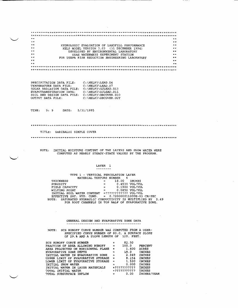
* ** *
* ** ** *
H Y D R O L O G I C E V A L U A T I O N O F L A N D F I L L P E R F O R M A N C EH E L P MODEL V E R S I O N 3.03 ( 3 1 D E C E M B E R 1 9 9 4 )
D E V E L O P E D BY ENVIRONMENTAL L A B O R A T O R YU S A E W A T E R W A Y S E X P E R I M E N T S T A T I O N
F O R U S E P A R I S K R E D U C T I O N E N G I N E E R I N G LABORATORY
* ***
P R E C I P I T A T I O N D A T A F I L E :T E M P E R A T U R E D A T A F I L E :S O L A R R A D I A T I O N D A T A F I L E :E V A P O T R A N S P I R A T I O N D A T A :S O I L A N D D E S I G N D A T A F I L E :O U T P U T D A T A F I L E :
C : \ H E L P 3 \ L E A D . D 4C : \ H E L P 3 \ L E A D . D 7C : \ H E L P 3 \ G J L E A D . D 1 3C : \ H E L P 3 \ G J L E A D . D 1 1C : \ H E L P 3 \ G B C O V E R . D 1 0C : \ H E L P 3 \ G B C O V E R . O U T
T I M E : 9: 9 D A T E : 5 / 3 1 / 1 9 9 5
T I T L E : G A R I B A L D I S I M P L E COVER
N O T E : I N I T I A L M O I S T U R E C O N T E N T O F T H E L A Y E R S A N D S N O W W A T E R WEREC O M P U T E D A S N E A R L Y S T E A D Y - S T A T E V A L U E S B Y T H E P R O G R A M .
L A Y E R
T Y P E 1 - V E R T I C A L P E R C O L A T I O N L A Y E RM A T E R I A L T E X T U R E N U M B E R 6
T H I C K N E S S = 18.00 I N C H E SP O R O S I T Y = 0.4530 V O L / V O LF I E L D C A P A C I T Y = 0.1900 V O L / V O LW I L T I N G P O I N T = 0.0850 V O L / V O LI N I T I A L S O I L W A T E R C O N T E N T = ? ? ? ? ? ? ? ? ? ? ? ? V O L / V O LE F F E C T I V E S A T . H Y D . C O N D . = 0.720000011000E-03 C M / S E C
N O T E : S A T U R A T E D H Y D R A U L I C C O N D U C T I V I T Y I S M U L T I P L I E D B Y 2 ,F O R ROOT C H A N N E L S I N T O P H A L F O F E V A P O R A T I V E Z O N E .
49
G E N E R A L D E S I G N A N D E V A P O R A T I V E Z O N E D A T A
N O T E : S C S R U N O F F CURVE N U M B E R W A S C O M P U T E D F R O M A U S E R -S P E C I F I E D CURVE NUMBER OF 80.0, A S U R F A C E SLOPEOF 29.% AND A S L O P E LENGTH OF 120. F E E T .
S C S R U N O F F CURVE N U M B E RF R A C T I O N O F AREA A L L O W I N G R U N O F FAREA P R O J E C T E D ON HORIZONTAL P L A N EE V A P O R A T I V E Z O N E D E P T HI N I T I A L W A T E R I N E V A P O R A T I V E Z O N EU P P E R L I M I T O F E V A P O R A T I V E S T O R A G ELOWER L I M I T O F E V A P O R A T I V E S T O R A G EI N I T I A L S N O W W A T E RI N I T I A L W A T E R I N L A Y E R M A T E R I A L ST O T A L I N I T I A L W A T E RT O T A L S U B S U R F A C E I N F L O W
82.50100.01.60018.02.8498.1541.5300.000
= ? ? ? ? ? ? ? ? ? ? ?=???????????0.00
P E R C E N TA C R E SI N C H E SI N C H E SI N C H E SI N C H E SI N C H E SI N C H E SI N C H E SI N C H E S / Y E A R

S T D . D E V I A T I O N S
P E R C O L A T I ON / L E A K A G ET O T A L S
S T D . D E V I A T I O N S
0.1.
T H R O U G H0.0.0.0.
251080
L A Y E R00002 5 3 300005243
0.1500 . 9 8 21
0.00000 . 1 9 4 50.00000 . 3 0 6 5
00
0000
.389.920
.0000.0415
.0000.1075
0 . 5 4 30 . 5 2 2
0.00060 . 0 4 2 20.00160.1561
0..8920.278
0.10100.01740 . 2 6 4 40.0775
0.9140 . 3 1 0
0.11850.00030 . 3 2 0 60.0014
A V E R A G E A N N U A L T O T A L S &
P R E C I P I T A T I O NR U N O F FE V A P O T R A N S P I R A T I O NP E R C O L A T I O N / L E A K A G E T H R O U G H
( S T D .
17.2.
14.0.
D E V I A T I O N S )I N C H E S
69 (291 (613 (7 6 9 2 7 (
FOR Y E A R S 1 T H R O U G HC U . F E E T
21.2.0.
. 5 7 3 )2 1 3 7 )3 8 9 4 )6 8 4 6 6 )
1 0 2 7 2 61330684871
4467
.1
.50
.07
.936
20P E R C E N T
100.001 2 . 9 5 38 2 . 6 1 9
4 . 3 4 9 3 7
C H A N G E I N W A T E R S T O R A G E 80.61 0.078

F I N A L W A T E R S T O R A G E A T E N D O F Y E A R 2 0L A Y E R ( I N C H E S ) ( V O L / V O L )
1 ? ? ? ? ? ? ? ? ? ? ? ? ? ? ? ? ? ? ? ?S N O W W A T E R 0.000

July 27, 1995 FINAL * EE/CA Garibaldi Mine Site * Appendices
A P P E N D I X DS O I L L O S S C A L C U L A T I O N S
H : \ 6 6 4 \ E E C A \ G A R B A L D . F N L0 7 / 2 7 / 9 5 4:01pm W P 5 1 / c m c

A N N U A L S O I L L O S S C A L C U L A T I O N SM E T H O D O L O G I E S A N D A S S U M P T I O N S
1.0 S E D C A D + SEDIMENTATION C O M P U T E R MODELS e d i m e n t y i e ld was determined for a s ingl e storm event (10-year 24-hour) and converted to anannual y i e ld .The ca l cu la t i on s to de termine the storm sediment yie ld were p e r f o r m e d by the use of theS E D C A D + C o m p u t e r Mode l d ev e l op ed by Civil S o f t w a r e Design.The S E D C A D - t - model de termines soil lo s s using the Revised Universal S o i l Loss Equation( R U S L E ) with the f o l l o w i n g input parameters:
Y = 95*(V*Qp)°-56*K*LS*CP
Where: Y = S e d i m e n t yie ld ( t o n s )V = R u n o f f volume (acre- f e e t)Q p = Peak di scharge (cfs)K = S o i l c r e d i b i l i t y f a c t o rLS = Repre s en ta t ive l e n g t h - s l o p e f a c t o rCP = Contro l prac t i c e f a c t o r
The l e n g t h - s l o p e f a c t o r for the RUSLE subrout ine i s a s f o l l o w s :
LS = —^— * (slope factor)7 2 . 6
Where: X = Representat ive s l o p e l eng th (ft)m = 0.6 for s l o p e > 10%m = 0.5 for 4% < s l o p e < 10%m = 0.4 for s l o p e = 4%m = 0.3 for s l o p e < 4%
The s l o p e f a c t o r is a piecewise linear r e l a t i o n s h i p with the s l o p e breakpoint at 8% as shown onF i g u r e 5.5, S l o p e F a c t o r for the R U S L E , contained in the S E D C A D + Users Manual..I n p u t s for the s edimentology portion of the S E D C A D + routine are:
R u n o f f volumePeak dischargeS o i l e r o d i b i l i t y f a c t o rRepresentative s l o p e l eng thAverage s l o p eControl practice f a c t o rSediment s p e c i f i c weight
H : \ 6 M \ E E C A \ G A R I B A L D . A P D06/01/95 7:00am W P 5 1 / c m c

1.5 Control Practice F a c t o r , CPThe control prac t i c e f a c t o r is d e f i n e d as the ratio of s ediment lo s s f r o m an area with a givencover and conservation p r a c t i c e to that of a f i e l d in cont inuous f a l l o w . The f o l l o w i n g valueswere u t i l i z e d :Cover Condi t i onE x i s t i n g CementedS i m p l e Cover No a p p r e c i a b l e canopy, 20% grass
CP0.30.20
1.6 Annual sediment yie ld , V,innual
S e d i m e n t y i e l d s ca l cu la t ed by S E D C A D + for s i n g l e storm events can be converted to annualy i e l d s by the f o l l o w i n g equation:
annualD_ annualR storm
Where: V,-D
annual•annual
F o r a S C S T y p e H S t o r m :
Annual sediment yie ld ( t o n s / y r )S i n g l e storm r a i n f a l l f a c t o rS i n g l e storm r a i n f a l l f a c t o rS e t t l e m e n t y i e ld for 10-yr, 24-hr storm event (ton s)
Rannual = 2 7 * ( P 2 , 6 ) 2.2
Where: 2-yr, 6-hr p r e c i p i t a t i o n in inches = 0.8 inches
Rstorm 19 .25£ j 0 . 4 6 7 2
, 2 . 2
Where: 10,24D10-yr, 24-hr p r e c i p i t a t i o n in inches = 1.6 inchesS t o r m Duration = 24 hours
2.0 R E S U L T SS o i l lo s s analyses were conducted for al t ernat ive s A through C. The f o l l o w i n g are the result s:
A l t e r n a t i v e A & BA l t e r n a t i v e C6.1 t o n s / a c r e / y e a r1.0 t o n s / a c r e / y e a r
H : \ 6 6 4 \ E E C A \ G A R B A L D . A P D0 6 / 0 1 / 9 5 7:00am W P 5 1 / c m c

July 27, 1995 FINAL * EE/CA Garibaldi Mine Site '• Appendices
A P P E N D I X D - 1S E D C A D + P R I N T O U T S
H : \ 6 6 4 \ E E C A \ G A R B A L D . F N L0 7 / 2 7 / 9 5 4:01pm W P 5 1 / c m c

C I V I L S O F T W A R E D E S I G N
S E D C A D + V e r s i o n 3
G A R A B A L D I : S O I L L O S S F O R E X I S T I N G C O N D I T I O N S
by
N a m e : T E L
Company N a m e : A C Z , I N C .F i l e Name: D : \ T O M \ R E S U R E C T \ G B A S I S
Date: 03-30-1995

C I V I L S O F T W A R E D E S I G N
S E D C A D + V e r s i o n 3
G A R A B A L D I : R E G R A D E D A N D S I M P L E S U R F A C E
by
N a m e : T E L
Company N a m e : A C Z , I N C .F i l e N a m e : D : \ T C M \ R E S U R E C T \ G B R E G R
Date: 03-16-1995

July 27, 1995 _____ FINAL * EE/CA Garibaldi Mine Site * Appendices
A P P E N D I X D - 2S O I L E R O D I B I L I T Y N O M O G R A P H
H : \ 6 6 4 \ E E C A \ G A R B A L D . F N L07/27/95 4:01pm W P 5 1 / c m c

vo
u4V )Xlu
VJ
\
ONVS 3NU XH3A «• US JJOOWJd
•H C~4 O
u uiUCM (0— i-( US•H OW O JO 60-HM C Otu <H CO
IU 9O
aCOViM
7.1-290

July 27, 1995 ____________ FINAL * EE/CA Garibaldi Mine Site * Appendices
A P P E N D I X ES T A B I L I T Y A N A L Y S I S
H : \ 6 f r 4 \ E E C A \ G A R B A L D . F N L07/27/95 4:01pm W P 5 1 / c m c

S T A B I L I T Y A N A L Y S I SG A R I B A L D I M I N E S I T E
A L T E R N A T I V E A T H R O U G H C
In A l t e r n a t i v e s A and B the waste rock p i l e will remain in this current configuration. Thewaste rock p i l e is a p p r o x i m a t e l y 30 f e e t high with 1.4H:1V s lopes . The waste rock p i l e hasbeen in existences for more than 50 years with no indications of i n s t a b i l i t y or surface f a i l u r e .Given th i s observation, it can be concluded that the waste rock p i l e in its current c o n f i g u r a t i o nhas a F a c t o r of S a f e t y of at least 1.0 or greater. However, given the current i n f o r m a t i o n on thewaste rock material it i s d i f f i c u l t to determine the actual F a c t o r of S a f e t y for the currentc o n f i g u r a t i o n . If there was a f a i l u r e due to earthquakes, a n d / o r heavy p r e c i p i t a t i o n events, therewould be most l i k e l y a minor sha l l ow surface f a i l u r e . Given the c o n f i g u r a t i o n of the waste rockp i l e , this t y p e of f a i l u r e would have l i t t l e or no e f f e c t on the propo s ed access road a n d / o r thep r o p o s e d drainage diversions.In A l t e r n a t i v e C, the s l o p e s wil l be regraded to 3 H : 1 V . W a s t e rock material p r o p e r t i e s for thes t a b i l i t y analys i s of the regraded s l o p e s were de termined through back analys i s of the e x i s t i n gcondi t i on s . The back analys i s was conducted using XSTABL computer so f tware. The Bishopmet 1 - >d was s e l e c t ed wi th in XSTABL for c o m p u t i n g the F a c t o r o f S a f e t y . The back analys i swas conducted on the highes t and s t e epe s t cross-section as shown on the XSTABL computerp r i n t o u t s , assuming drained condi t ions , a cohesion equal to 0, and a F a c t o r of S a f e t y of 1.0.Using th i s a p p r o a c h , a maximum internal f r i c t i o n angle of 36 was de t ermined.The material p r o p e r t i e s determined in the back analysi s were then used to de t ermine the F a c t o rof S a f e t y for the regraded s l o p e s . W i t h an average regraded s l o p e of 3H:1V and drainedc ond i t i on s , the F a c t o r of S a f e t y for A l t e r n a t i v e C was greater than 2.0. In a d d i t i o n , the F a c t o rof S a f e t y under p s e u d o s t a t i c c ond i t i on s was determined. P s e u d o s t a t i c c ondi t i ons were s imula t edusing the seismic acceleration c o e f f i c i e n t (k) of 0.04g for 50 year return, th i s value wase s t ab l i s h ed by review of p u b l i s h e d data for A l g e r m i s s e n (1991) and was checked against datap u b l i s h e d by Dames and Moore in S t a b i l i t y and Reclamation Evaluation of A b a n d o n e d T a i l i n g sPond (1986). The F a c t o r of Safety for the regraded s l o p e s under p s u e d o s t a t i c c ond i t i on s i s 2.0.All i n p u t s , cross-sections, f a i l u r e surface s , and re su l t s are shown on the XSTABL computerp r i n t o u t s contained in A p p e n d i x E-l.
H : \ 6 6 4 V E E C A \ G A R A P P - E . T X T0 6 / 0 1 / 9 5 7:3 lam WPS 1/cmc E-l

July 27, 1995 FINAL * EE/CA Garibaldi Mine Site * Appendices
A P P E N D I X E - 1X S T A B L C O M P U T E R P R I N T O U T S
H : \ 6 6 4 \ E E C A \ G A R J B A L D . F N L0 7 / 2 7 / 9 5 4:01pm W P 5 1 / c m c
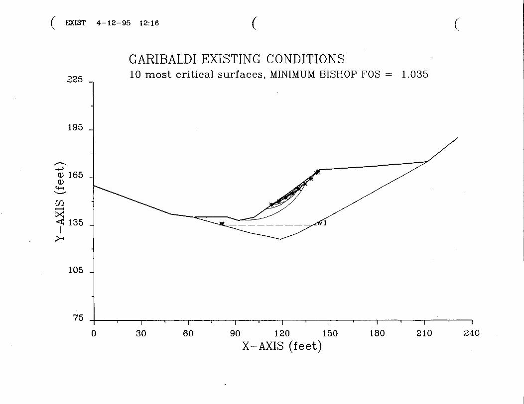
E X I S T 4-12-95 12:16
225 _
195 _
0) 165<D
C/3i — iX< 135
105 _
75
G A R I B A L D I E X I S T I N G C O N D I T I O N S1 0 most c r i t i c a l s u r f a c e s , M I N I M U M B I S H O P F O S - 1.035
30T
60 90 120 150X - A X I S ( f e e t )
180 210 240

I S O T R O P I C S o i l Parameter s
2 t y p e ( s ) o f soil
S o i l Unit W e i g h t Cohesion F r i c t i o n Pore Pressure W a t e rUnit Moi s t S a t . I n t e r c e p t A n g l e Parameter Cons tant S u r f a c eN o . ( p c f ) ( p c f ) ( p s f ) ( d e g ) R u ( p s f ) N o .1 126.0 132.0 .0 36.00 .000 .0 12 150.0 150.0 .0 50.00 .000 .0 1
1 Water s u r f a c e ( s ) have been s p e c i f i e dUnit weight o f water = 62.40 (pc f)
W a t e r S u r f a c e No. 1 s p e c i f i e d by 2 coordinate p o i n t s**********************************
P H R E A T I C S U R F A C E ,**********************************Point x-water y-waterN o . ( f t ) ( f t )
1 80.00 135.002 142.00 135.00
A cr i t i cal f a i l u r e s u r f a c e searching method , using a randomtechnique for generating CIRCULAR sur fac e s has been s p e c i f i e d .
100 trial sur face s w i l l be generated and analyzed.
10 S u r f a c e s in i t ia t e f r o m each of 10 po int s equal ly spacedalong the ground s u r f a c e between x = 90.0 ftand x = 125.0 ft
Each s u r f a c e terminates between x = 126.0 ftand x = 212.0 ft
U n l e s s f u r t h e r l i m i t a t i o n s were i m p o s e d , the minimum e l evat ionat which a s ur fa c e extends is y = 120.0 ft
5 .0 f t l ine segments d e f i n e each trial f a i l u r e s ur fa c e .
A N G U L A R R E S T R I C T I O N S :

m)l 4-12-95 12:24 C225 _
195 _
0) 165 _0)
C / 3i — iXI 135 _
105 _
750
G A R I B A L D I R E G R A D E D ( . 0 4 G )1 0 most c r i t i c a l s u r f a c e s , M I N I M U M B I S H O P F O S = 1.988
i30
i60 90 120 150
X - A X I S ( f e e t )180 210 240

S o i l U n i t W e i g h t C o h e s i o n F r i c t i o n Pore Pres sure W a t e rUnit M o i s t S a t . I n t e r c e p t A n g l e Parameter C o n s t a n t S u r f a c eN o . ( p c f ) ( p c f ) ( p s f ) ( d e g ) R u ( p s f ) N o .1 126.0 132.0 .0 36.00 .000 .0 12 150.0 150.0 .0 50.00 .000 .0 1
1 W a t e r s u r f a c e ( s ) have been s p e c i f i e dUnit weight o f water = 62.40 ( p c f )
W a t e r S u r f a c e No. 1 s p e c i f i e d by 2 coord inat e p o i n t s**********************************
P H R E A T I C S U R F A C E ,**********************************PointN o .
12
x-water( f t )80.00
142.00
y-water( f t )135.00135.00
A horizontal earthquake l o a d i n g c o e f f i c i e n tof .040 has been a s s ignedA vertical earthquake l o a d i n g c o e f f i c i e n tof .000 has been as s igned
A cr i t i cal f a i l u r e s u r f a c e searching method , us ing a randomtechnique for generating CIRCULAR surface s has been s p e c i f i e d .
100 trial s u r f a c e s w i l l be generated and a n a l y z e d .
10 S u r f a c e s in i t i a t e f r o m each of 10 p o i n t s e q u a l l y spaceda long the ground s u r f a c e between x = 70.0 ftand x = 125.0 ft
Each s u r f a c e terminates between x = 126.0 ftand x = 212.0 ft
U n l e s s f u r t h e r l i m i t a t i o n s were i m p o s e d , the minimum e l evat ionat which a s u r f a c e ex t ends is y = 120.0 ft
5 . 0 f t l ine segments d e f i n e each t r ia l f a i l u r e s u r f a c e .

( ! T 0 1 4-12-95 12:26
225 _
195 _
0) 165 _0)
COi—(X<CI 135 _
105 _
750
G A R I B A L D I R E G R A D E D1 0 most cr i t i ca l s u r f a c e s , M I N I M U M B I S H O P F O S = 2.261
30i
60 90 120 150X - A X I S ( f e e t )
180 210 240

s a a j B a p ( o * 9 - a i f i u B a d o i s ) =: q .TuiTT.saaa£ap o * 9 f r - = *
a q T T T W
aaddn
: Aq p a u T j a p abuea a e j n f i u B au;q.a a n i f e g : qoea 3:0 ^uauibas q . s a f g f
a u T j a p sq.uaui6as o * S
^•5 0 * 0 2 T = A ST spuaq.xa ao e jan sw n u i T U T U i aiiq. ' p a s o d u r c a j a w s s a j u n
0*921
p a o c d s= x PUBO ' O i = x uaaMq.aq a o e j a n s punoa£>sq .uTod oi jo qoea uioaj a q . B T q . T U t s a o B j a n s 01
P U B paq.Baaua6 a q T T T M s a o B j a n s T B T J t q . o o i
• p a j g i T o a d s uaaq s ^ s a oBjans H V i n D H I D 6uTq.BJ:aua6 a o jB £ > u T s n ' p o n q a u i f i u T q o a B a s aoBjans a a n t T B j i B O T q . T a o v
0 0 * 9 C T0 0 - 9 C T
O O ' S f r T00*08
ZI
•ONq.uTOd
********************************************************************
sq .uTod 9 q . B U T p a o o o z Aq p a T j T o a d s i -ON aoBjans
( j o d ) O f r ' 2 9p a T j T o a d s uaaq
j o q . q T a / i q.Tun( s ) a o B j a n s Jaq.BM T
Ii•ON
0 'o* 000ooo( j s d )qsuoaanssaad
0 0 * 0 9o o * 9 e( 6 e p )
0*o* 0*091 0*0910 * 9 2 1 Zi( j o d )qdaoaaqui *q.BS ( j o d ) - O N
q^s jow q T u f lq .J u n I T ° S

July 27, 1995 FINAL * EE/CA Garibaldi Mine Site * Appendices
A P P E N D I X FA R A R s
H : \ 6 6 4 \ E E C A \ G A R B A L D . F N L0 7 / 2 7 / 9 5 4:01pm W P 5 1 / c m c

A P P E N D I X F A R A R s
T h i s a p p e n d i x i d e n t i f i e s all requirements that EPA has determined are A p p l i c a b l e or Relevantand A p p r o p r i a t e Requirements ("ARARs") for the G a r i b a l d i Mine Site removal action.As a matter of p o l i c y , EPA requires attainment of ARARs in removal actions to the greatestextent p r a c t i c a b l e given the exigencies at a given site. See C E R C L A C o m p l i a n c e W i t h OtherLaws Manual at xii, EPA-540-6-89-006 (Inter im F i n a l , August 1988). EPA general ly de terminesthat compl iance with ARARs is p r a c t i c a b l e for "non-time-critical" removal actions, such as th i sone. Resurrection takes no p o s i t i o n with respect to the p r o p r i e t y of t h i s p o l i c y and it reservesall rights that it may have with respect to complying with it.In accordance with EPA's direct ive, a l l requirements that EPA has determined are ARARs forthis removal action will be met unless EPA determines that compl iance is not p r a c t i c a b l e orc ompl ianc e is waived in accordance with S e c t i o n 3 0 0 . 4 3 0 ( f ) ( i i ) ( C ) of the N a t i o n a l Cont ingencyPlan. A t t a i n m e n t of water-qual i ty based, c h e m i c a l - s p e c i f i c ARARs is not required unt i li m p l e m e n t a t i o n of the remedial action for S i t e - w i d e S u r f a c e and Ground W a t e r s (seeResurrection W A M P § 4.6.5).The p o t e n t i a l ARARs i d e n t i f i e d below were selected based on s tandards , gu id e l in e s and cr i t er iaf ound in relevant l i t e ra tur e; discuss ions with a p p r o p r i a t e r egula tory agency p er s onne l ; and pr i o rp r o j e c t experience. The pr inc ipa l references used were:
• Pre l iminary A p p l i c a b l e or Relevant and A p p r o p r i a t e Requirements A n a l y s i s ,A p p e n d i x A, F i n a l Screening F e a s i b i l i t y S t u d y for Remedial A l t e r n a t i v e s a t theC a l i f o r n i a Gulch N P L S i t e , L e a d v i l l e , C o l o r a d o ( S e p t e m b e r 1993) (the "FinalS F S " ) ;
• Guidance on Conduc t ing N o n - T i m e - C r i t i c a l Removal A c t i o n s Under C E R C L A ,EPA/540/R-93/057 (August 1993);
• Guidance on the Cons id era t i on of ARARs During Removal Act ion s , E P A / 5 4 0 / P -91/011 (Sept ember 1991); and
• CERCLA Compl ianc e W i t h Other Laws Manual, E P A / 5 4 0 / G - 8 9 / 0 0 6 , ( I n t e r i mFinal) (August 1988).
A d e t a i l e d analysis of the p o t e n t i a l ARAR se l e c t ion proces s and a d e s c r i p t i o n of the terms usedbelow can be f ound in S e c t i o n s Al - A5 of the F i n a l SFS.F . 1 C H E M I C A L - S P E C I F I C A R A R SC h e m i c a l - s p e c i f i c requirements are based on heal th or risk-based concentration l i m i t s ordischarge l imi ta t i on s in environmental media (i.e., water, air) for s p e c i f i c hazardous chemicals.T h e s e requirements may be used to set c leanup l eve l s for the chemicals of concern (in th i s case,me ta l s) in the de s ignated media, or to set a sa f e level of discharge (e.g., wastewater discharge,taking into account water quality s t a n d a r d s ) where a discharge occurs as part of the remedialactivity.
H : \ 6 6 4 \ E E C A \ G A R I B A L D \ G A R A P P F . T X T07/27/95 4:04pm WPS 1/cmc F-1

F . 1 . 1 W a s t e C l a s s i f i c a t i o nThe waste under consideration is waste rock. The source of contamination is the G a r i b a l d iwaste rock p i l e . Based on 40 CFR 261.4(b)(7), these wastes are exc luded f r o m ResourceConservat ion and Recovery Act ( R C R A ) S u b t i t l e C. For th i s reason, RCRA S u b t i t l e C is nota p p l i c a b l e as a matter of law to these wastes for thi s removal action.Based on 6 CCR 1007-3, S e c t i o n 261.4(b)(7), these wastes are also exc luded f r o m the C o l o r a d oHazardous Waste Act. For this reason, the Colorado Hazardou s Was t e Act is not a p o t e n t i a lARAR for t h i s removal action.F . 1 . 2 T o B e Cons ider ed I t e m s ( " T B C " ) f o r S o i lThe EPA has issued an O f f i c e of S o l i d W a s t e and Emergency Response ( O S W E R ) direc t ivee n t i t l e d "Inter im Guidance on E s t a b l i s h i n g S o i l Lead C l e a n u p Levels at S u p e r f u n d Si t e s "( O S W E R Directive #9355.4-02, S e p t e m b e r 1989). The d ire c t ive sets f o r t h interim soil c l eanupleve l s when the land use is r e s i d en t ia l and is intended s o l e l y as guidance. However, U p p e rC a l i f o r n i a Gulch is not d e s ignat ed for re s ident ia l use nor does EPA fore s e e re s ident ia l use as areasonable f u t u r e land use. For t h i s reason, O S W E R Directive #9355.4-02 is not a p o t e n t i a lA R A R for t h i s removal action.F . 1 . 3 S u m m a r yAs discussed on page F-l, there are no c h e m i c a l - s p e c i f i c requirements that are a p p l i c a b l e orrelevant and a p p r o p r i a t e requirements for t h i s removal action.F . 2 L O C A T I O N - S P E C I F I C A R A R SL o c a t i o n - s p e c i f i c ARARs are re s tr i c t ions p l a c e d on the type s of a c t i v i t i e s that may occur inp a r t i c u l a r locat ions . The loca t ion of a s i t e may be an impor tant characteri s t ic in d e t e rmin ingi t s impact on p u b l i c h ea l th and the environment; thus s ta t e s tandards o f t e n e s t a b l i s h locat ion-s p e c i f i c ARARs. T h e s e ARARs may restrict or p r e c l u d e certain remedial actions or may a p p l yonly to certain p o r t i o n s of a site. E x a m p l e s of l o c a t i o n - s p e c i f i c ARARs inc lude f e d e r a l and s ta t erequirements for pre s ervat ion of h i s tor ic landmarks , endangered spec i e s and w e t l a n d s p r o t e c t i o n ,and f l o o d p l a i n restrict ions on management of hazardous waste.F . 2 . 1 T h r e a t e n e d / E n d a n g e r e d S p e c i e sIf T h r e a t e n e d / E n d a n g e r e d species are f o u n d to inhabit areas that w i l l be impacted by ac t iv i t i e s ,the F e d e r a l Endangered S p e c i e s Act and the S t a t e Nongame, Endangered, or Threa t ened S p e c i e sAct will be a p p l i c a b l e and coordination with f edera l and state agencies will be needed toimpl ement m i t i g a t i o n measures or a l t ernat ive removal activities.A Terres trial Ecosystem Evaluation (TEE) (WCC, 1993) was conducted in the C a l i f o r n i a Gulchs i te as part of the Phase n Remedial Inve s t iga t i on s . The TEE stated that no evidence of thep o t e n t i a l presence of threatened, endangered or sensitive specie s was f o u n d wi thin the s t udy area(WWC, 1993). For this reason, the Federal Endangered Spec i e s Act and the S t a t e NongameEndangered or Threat ened S p e c i e s Act are not p o t e n t i a l ARARs for th i s removal action.
H : \ 6 6 4 \ E E C A \ G A R I B A L D \ G A R A P P F . T X T0 7 / 2 7 / 9 5 4:04pm W P S l / c m c F-2

F . 2 . 2 S p e c i e s o f S p e c i a l Concern and Unde t ermined S t a t u sUnder C o l o r a d o Law (or p o l i c y ) , the C o l o r a d o Department of N a t u r a l Resources ( C D N R ) hase s t a b l i s h e d two d e s i g n a t i o n s to protec t w i l d l i f e species. T h e s e two de s ignat ion s are "species ofspecial concern" and "species of undetermined status". S p e c i e s of spec ial concern are d e f i n e d asnative spec i e s or sub spec i e s which have been threatened or endangered or could becomethreatened or endangered due to low p o p u l a t i o n levels. S p e c i e s of undetermined s ta tu s arespec i e s about which too l i t t l e is known to accurately determine their s ta tus in the state.C o l o r a d o ' s Division of W i l d l i f e maintains a l i s t o f specie s which have been determined to f i tthese categories. If species of special concern or of undetermined s tatus are f o u n d at the si te andremoval activit ies could p o t e n t i a l l y impact those species (or their habitats), the Division ofWildli fe ' s Directive E-l, 1985 ( m o d i f i e d ) , should be taken into consideration and coord inat ionwith the Division i m p l e m e n t e d . T h e s e internal de s ignat ions would be p o t e n t i a l To BeConsidered (TBCs) for th i s removal action only if spec ie s in either category are f o u n d in U p p e rC a l i f o r n i a Gulch.F . 2 . 3 C o l o r a d o N a t u r a l Areas ProgramThe C o l o r a d o N a t u r a l Areas Program maintains a l i s t of Plant S p e c i e s of S p e c i a l Concern to theS t a t e of Colorado. It is not authorized by s ta tu t e and is considered a p l a n n i n g and managementtoo l . If removal ac t iv i t i e s impact p l a n t specie s maintained on the l i s t , the program is a To BeConsidered (TBC) ARAR and coordinat ion with the Colorado Division of Parks and OutdoorRecreation may be required.F.2.4 Cul tura l ResourcesS e c t i o n 106 of the N a t i o n a l H i s t o r i c Preservation Act (NHPA) is a p o t e n t i a l ARAR for th i sremoval action because the removal action is an undertaking under the NHPA. The S t a t eH i s t o r i c Preservation O f f i c e (SHPO), however, has determined that the G a r i b a l d i p r o p e r t y "isnot i n d i v i d u a l l y e l i g i b l e , is not within the ex i s t ing L e a d v i l l e H i s t o r i c District and would notcontribute to the d i s t r i c t expansion". The S H P O l e t t e r i s inc luded in A p p e n d i x A. S e c t i o n110(f) of the NHPA, which establishes procedures to minimize harm to National His t o r i cLandmarks, is not a p p l i c a b l e as U p p e r C a l i f o r n i a Gulch does not lie within the L e a d v i l l eN a t i o n a l H i s t o r i c Landmark District .Executive Order 11593 on the Protec t ion and Enhancement of the Cul tural Environment is apo t en t ia l ARAR and requires consul tat ion with the Council on the preservation andenhancement of hi s toric resources if removal activities should threaten them. If historicaland/or archeological data are impacted by removal activities, the Historical and ArcheologicalPreservation Act would also be a p o t e n t i a l ARAR.The Archeological Resources Protect ion Act of 1979 provide s for the pro t e c t i on of culturalresources on p u b l i c or Indian lands and may be a p o t e n t i a l ARAR with respect to removalactions impact ing such proper t i e s . The Gariba ld i Mine S i t e removal action wil l impact onlyprivate lands, not p u b l i c or Indian lands.The S t a t e H i s t o r i c a l , Prehi s tor i ca l , and Archeological Resources Act addresses the loaning ofarcheological resources on state-owned land to s c i e n t i f i c or educational ins t i tu t ions . S h o u l dremoval activities endanger an archeological site that may necessitate removal of the resource,the procedures out l ined by the Act would be a p o t e n t i a l ARAR. In a d d i t i o n , if removalact ivi t i e s uncover any human remains that are of archeological interest , the procedures for
H : \ 6 6 4 \ E E C A \ G A R B A L D \ G A R A P P F . T X T0 7 / 2 7 / 9 5 4:04pm W P 5 1 / c m c F-3

excavation of remains under the act would also be " a p p l i c a b l e or relevant, and a p p r o p r i a t e " .F i n a l l y , th e Stat e ' s Register o f H i s t o r i c Place s i s a p o t e n t i a l ARAR i f removal ac t iv i t i e s mayimpact an area l i s t e d on the Register.F.2.5 W e t l a n d s and F l o o d p l a i n ManagementExecutive Order 11990 requires the avoidance of l ong and short term impact s associated withthe d e s t r u c t i o n or m o d i f i c a t i o n of we t lands . A wetland evaluation of the C a l i f o r n i a G u l c h siteconducted by Woodward-Clyde in 1992 did not i d e n t i f y wet lands at the G a r i b a l d i Mine S i t e .However, a comprehensive wetland survey wil l be conducted pr ior to the i m p l e m e n t a t i o n ofthe recommended removal action. If any w e t l a n d s i d e n t i f i e d in thi s survey are impacted by theremoval action, m i t i g a t i o n wi l l be addres sed during the f e a s i b i l i t y s tudy for OU-4. M i t i g a t i o nwill consist of wetland re s torat ion, creation or enhancement in a p p r o p r i a t e areas of OU-4, 8,or 10.Executive Order 11988 on Pro t e c t i on of F l o o d p l a i n s is a p o t e n t i a l ARAR. Removal must beconducted to avoid long- and short-term adverse impact s associated with the occupation orm o d i f i c a t i o n o f f l o o d p l a i n s .F . 2 . 6 Clean W a t e r Act ( S e c t i o n 404)U p p e r C a l i f o r n i a Gulch is one of the major gulches on the site and contains an in t ermi t t entstream that f e d e r a l agencies, in c lud ing the EPA, have determined are "waters of the Uni t edS t a t e s " [33 CFR 328.3(a)]. EPA has determined that any removal r, ,</ity di scharging fillmater ia l s into, or changing the bo t t om elevat ion of, these drainages (suu; as stream diversiondi t che s or construct ion of road crossings which impact the drainages) requires compliance withthe dr edge and fill substantive requirements of S e c t i o n 404 of the Clean Water Act. Pursuantto S e c t i o n 121(e) of C E R C L A , EPA is not required to a p p l y for and obtain a N a t i o n w i d epermi t . Resurrection is exempt f r o m the p e r m i t t i n g process but is required to demons tratesubstantive compliance with the requirements of S e c t i o n 404.The recommended removal action for th i s E E / C A will avoid dredge and f i l l a c t iv i t i e s in U p p e rC a l i f o r n i a Gulch. A f i n a l de terminat ion, however, must be made by EPA.F.2.7 F i s h and Wild l i f e Coordination ActA c t i v i t i e s such as stream f l o w m o d i f i c a t i o n and construction of reservoirs or surge ponds , couldimpact f i s h and w i l d l i f e resources in and along these drainages. The F i s h and W i l d l i f eCoordinat ion Act is a po t en t ia l ARAR since removal act ivi t ie s may a f f e c t or m o d i f y U p p e rC a l i f o r n i a Gulch. EPA may need to coordinate with both U.S. F i s h and W i l d l i f e Service andthe Co lorado Department of N a t u r a l Resources to discuss mi t igat ion measures to prevent lossor damage to these resources, if necessary.The i m p l e m e n t a t i o n of the p r e f e r r e d alternatives of the E E / C A will cause an improvement interres trial habitat in the gulch and a reduction in the amount of water-borne contaminationleaving the gulch. Aquatic l i f e does not exist in U p p e r Cal i f o rn ia Gulch due to the intermittentf l o w s and poor water quality. There wil l be no loss or damage to f i s h or w i l d l i f e resources inthe remediated area, t h e r e f o r e it is ant ic ipated that the U.S. F i s h and Wildlife Service and theColorado Department of Natural Resources wil l not ob j e c t to the p r e f e r r e d al t ernat iverecommended in the E E / C A .
H : \ 6 6 4 \ E E C A \ G A R I B A L D \ G A R A P P F . T X T0 7 / 2 7 / 9 5 4:04pm W P 5 1 / c m c F-4

F . 2 . 8 S u m m a r yP o t e n t i a l l o c a t i o n - s p e c i f i c ARARs for removal action in U p p e r C a l i f o r n i a G u l c h are pr e s en t edin T a b l e F.I. The removal action a l t ernat ive s described in thi s E E / C A have been p r e p a r e d inaccordance with a n d / o r evaluated f or compl iance with the f o l l o w i n g l o c a t i o n - s p e c i f i c ARARs:
• C u l t u r a l resource requirements i n c l u d i n g S e c t i o n 106 of the NHPA• Clean W a t e r Act ( S e c t i o n 404)• F i s h and W i l d l i f e C o o r d i n a t i o n Act
F . 3 A C T I O N - S P E C I F I C A R A R SA c t i o n - s p e c i f i c ARARs are activity-based requirements tr iggered by the p a r t i c u l a r removalact ivi t i e s s e l e c t ed . Regula t i on s r egarding worker h e a l t h and s a f e t y (i.e., GSHA requirements)are not t e c h n i c a l l y A R A R s as they are not environmental or p u b l i c h e a l t h requirements.F . 3 . 1 C l e a n A i r A c tThe Clean Air Act es tabli shes emission s tandards for certain categories of indus tr ia l s tat ionarysources. It is only a p p l i c a b l e if a removal action creates air emissions r egu la t ed by thoses tandards . Removal action activity wil l involve earth moving and associated dust generation.For thi s reason the Clean Air Act is a po t en t ia l ARAR for this removal action. However, theseac t iv i t i e s are regulated under the C o l o r a d o Air Q u a l i t y Contro l Act and will be addressed underits r egu la t i on s as described below.F . 3 . 2 C o l o r a d o A i r Q u a l i t y Contro l A c tThe Colorado Air Quality Control Act es tabli shes emissions standards for airborne part i cu late sand lead and is a p p l i c a b l e if a removal action creates emissions of r egula t ed materials. Removalaction ac t iv i ty wil l involve earth moving and associated dust generation. For t h i s reason theColorado Air Quali ty Control Act is a po t ent ia l ARAR for this removal action.It is an t i c i pa t ed that the removal action wil l be exempt f r om requirements to f i l e an AirP o l l u t i o n Emission N o t i c e since d i s t urb ed areas wil l not exceed 25 acres and the duration of thedi s turbance wi l l not exceed six months. However, as s tated in the E E / C A , dust abatement wi l lbe prac t i c ed dur ing construction. An air p o l l u t i o n control p l a n will be prepared and submi t t edin the Remedial Design report that addres se s dust abatement during all a spec t s of dirt workrequired for the i m p l e m e n t a t i o n of the removal action. Dust control s considered in the airp o l l u t i o n control p l a n include watering, chemical s tab i l i z er s , compaction, enclosures andrevegetation.The regulat ion of the C o l o r a d o Air Qual i ty Control Commiss ion require the use of all avai lab l eand pract i cal methods which are t e c h n o l o g i c a l l y f e a s i b l e and economically reasonable in orderto minimize emissions. The a p p l i c a b l e emission l i m i t a t i o n gu ide l ine is 20% opac i ty and no off-p r o p e r t y transport .F.3.3 S o l i d Waste Disposal Act as amended by the Resource Conservation andRecovery ActThe Resource Conservation and Recovery Act (RCRA) establishes criteria for use in determiningwhich so l id waste d i s p o s a l f a c i l i t i e s and prac t i c e s po s e a reasonable p r o b a b i l i t y of adverse e f f e c t s
H : \ 6 6 4 V E E C A \ G A R I B A L D \ G A R A P P F . T X T0 7 / 2 7 / 9 5 4:04pm W P 5 1 / c m c F-5

on h ea l th . RCRA is a p p l i c a b l e to land d i s p o s a l of s o l id waste. S i n c e any c o n s o l i d a t i o n ord i s p o s a l of s o l i d wastes w i l l occur e n t i r e l y on-site, RCRA r e g u l a t i o n s do not a p p l y to th i sremoval action.F . 3 . 4 H a z a r d o u s M a t e r i a l s T r a n s p o r t a t i o n A c tT h e H a z a r d o u s M a t e r i a l s T r a n s p o r t a t i o n A c t r egu la t e s t h e o f f - s i t e t r a n s p o r t a t i o n o f hazardousmater ia l s and a f f e c t s packaging, p l a c a r d i n g , use of p r o p e r containers, and r e p o r t i n g of di scharges .The removal action in thi s E E / C A wi l l not entail o f f - s i t e t r a n s p o r t a t i o n of hazardous mat er ia l sand t h e r e f o r e the H a z a r d o u s M a t e r i a l s T r a n s p o r t a t i o n Act i s not a p o t e n t i a l A R A R for t h i sremoval action.F . 3 . 5 O c c u p a t i o n a l H e a l t h a n d S a f e t y A c t a n d t h e F e d e r a l M i n e S a f e t y a n d H e a l t h A c tThe Occupational H e a l t h and S a f e t y Act r egu la t e s worker h e a l t h and s a f e t y in the workp lac eand the Mine S a f e t y and H e a l t h Act e s t ab l i s h e s requirements to safeguard worker s a f e t y in andaround mines. W h i l e each act will be adhered to where a p p l i c a b l e , neither is a po t ent ia l ARARbecause neither is an environmental regulat ion.F.3.6 N a t i o n a l P o l l u t a n t Discharge E l i m i n a t i o n Sys t emT h e N a t i o n a l P o l l u t a n t Discharge E l i m i n a t i o n S y s t e m ( N P D E S ) requires p e r m i t s f o r d i s chargeof p o l l u t a n t s f r om any point source into waters of the U.S., inc luding discharges of storm water.The S t a t e of C o l o r a d o has an approved program for managing the NPDES p e r m i t s wi thin thestate. General p ermi t s may be obtained under a category of discharges under the Cl ean W a t e rAct for storm water point sources. The NPDES is a p o t e n t i a l ARAR for thi s removal action.A Cons t ru c t i on S t o r m Water Management Plan (CSWMP) wil l be p r e p a r e d and submi t t ed withthe Remedial Design report . The o b j e c t i v e of the C S W M P will be to i d e n t i f y Best ManagementPractices (BMPs) that wi l l be used to reduce the p o l l u t a n t s in storm water di s charges associatedwith cons truc t ion activities. The C S W M P will be prepared according to gu id e l in e s p r o v i d e d bythe S t a t e o f C o l o r a d o in the ir General Permit A p p l i c a t i o n for Discharges A s s o c i a t e d withCons truc t ion A c t i v i t i e s . The C S W M P wil l inc lude a site d e s c r i p t i o n , s i t e map, and a d e s c r i p t i o nof BMPs u t i l i z ed inc lud ing structural prac t i c e s (straw bales, s i l t f ences , dikes, swales), non-s tructural pract i ce s (seeding, mulching, g e o t e x t i l e s , preservation of ex i s t ing vege ta t i on), andmaterial h a n d l i n g and s p i l l prevention procedures.F.3.7 S t a t e S o l i d Was t e Di spo sa l S i t e s a n d F a c i l i t i e s A c tThe S t a t e S o l i d Waste Disposal S i t e s and F a c i l i t i e s Act establishes p o l i c y for licensing,cons truc t ing, and o p e r a t i n g so l id waste d i s p o s a l f a c i l i t i e s . Permit s ar e 'no t required f or on-siteac t iv i t i e s at a s i t e l i s t ed on the N P L . Removal actions wi l l not involve e s tab l i shment of a s o l idwaste d i spo sa l f a c i l i t y . For this reason the S t a t e S o l i d Waste Disposal S i t e s and F a c i l i t y Act isnot a p o t e n t i a l a c t i o n - s p e c i f i c ARAR for thi s removal action.F.3.8 C o l o r a d o Mined Land Reclamation ActThe Colorado Mined Land Reclamation Act regulates all aspects of land use for mining,inc luding the location of mining operat ions and related reclamation activit ies and otherenvironmental and socioeconomic impacts. A permit is not required for activities on CERCLA
H : \ 6 6 4 \ E E C A \ G A R I B A L D \ G A R A P P F . T X T0 7 / 2 7 / 9 5 4:04pm W P 5 1 / o n c F-6

sites. EPA has determined that the f o l l o w i n g C o l o r a d o Mined Land Reclamai ton Board Rulesare p o t e n t i a l ARARs for t h i s removal action.
• Rule 3: Reclamation Performance S t a n d a r d s , I n s p e c t i o n , M o n i t o r i n g andEnforcement;
• Rule 7: Des ignated M i n i n g Opera t i on s;• Rule 8: Emergency Response Plan for Designated M i n i n g Operat ions -
Emergency N o t i f i c a t i o n by Operators, and Emergency ResponseA u t h o r i t y o f th e O f f i c e .
The a l t ernat ive s in t h i s E E / C A will be p r e p a r e d in accordance wi th and evaluated forcompl iance with the C o l o r a d o Mined Land Reclamation Board Rules 3, 7, and 8. Therequirements of Rule 3 wi l l be incorporated in the Remedial Design r epor t , e x c e p t i n g referencesto water qua l i ty s tandard s and numeric p r o t e c t i o n levels . One of the m a j o r requirements of rule7 is an Environmental Protec t ion Plan. The Remedial Design report wil l contain an o u t l i n e ofthe requirements of the Environmental Pro t e c t i on Plan and a d e s c r i p t i o n of how the a p p l i c a b l erequirements wil l be met. Rule 8 requires an Emergency Response Plan. A Cont ingency Plancontaining an Emergency Response Plan wil l be pr epar ed and contained in the Remedial Designreport .F . 3 . 9 C o l o r a d o N o i s e Abat emen t A c tThe C o l o r a d o N o i s e Abatement Act e s tab l i she s maximum p e r m i s s i b l e noise l eve l s f or p a r t i c u l a rtime p e r i o d s and land use zones. Removal action act ivi t i e s under thi s E E / C A will involve
, construct ion equipment and t h e r e f o r e , the N o i s e Abatement Act is a p o t e n t i a l ARAR. Asummary of the r egu la t i on s is provided below.Cons truc t i on p r o j e c t s are s u b j e c t to the maximum p e r m i s s i b l e noise l eve l s s p e c i f i e d for indus tr ia lzones. T h e s e are: 80 db(A) f r o m 7:00 a.m. to next 7:00 p.m.; 7 5 d b ( A ) f r o m 7:00 p.m. to next7:00 a.m. A l s o , in the hours between 7:00 a.m. and the next 7:00 p.m., the noise l eve l s may beincreased by ten db(A) for a per iod not to exceed f i f t e e n minutes in any one-hour per i od .Sound leve l s of noise shall be measured at a di s tance of twenty-f ive f e e t or more f r o m thep r o p e r t y line.Since the G a r i b a l d i Mine site is several hundred f e e t f r o m the nearest residence, it is nota n t i c i p a t e d that excessive noise wil l be a p r o b l e m during the construction of th i s al ternative.However, if excessive noise becomes a prob l em s t e p s considered to remediate the p r o b l e minclude: 1) o p e r a t i n g during l i m i t e d hours, 2) ensuring p r o p e r noise suppre s s i on equipment isused on equipment, and 3) i n s t a l l i n g noise screening or s ound-proo f ing .F . 3 . 1 0 Regulat ions on the C o l l e c t i o n of Aquatic LifeThe Regulat ions on the C o l l e c t i o n of Aquat i c L i f e are requirements governing the c o l l e c t i o n ofw i l d l i f e for s c i e n t i f i c purpo s e s and are a p p l i c a b l e if removal action ac t iv i t i e s t r igger the need forb io logical monitoring. Removal actions wil l not tr igger b io logical monitoring and theseRegulations on the C o l l e c t i o n of Aquat i c L i f e are not po t en t ia l ARARs.
H : \ 6 6 4 \ E E C A \ G A R I B A L D \ G A R A P P F . T X T07/27/95 5:46pm W P 5 1 / c m c F-7

F . 3 . 1 1 S u m m a r yP o t e n t i a l a c t i o n - s p e c i f i c ARARs for removal action in th i s E E / C A are discussed above andpresented in T a b l e F.2. The removal action a l t ernat ive s described in thi s E E / C A have beenprepar ed in accordance with a n d / o r evaluated for compliance with the f o l l o w i n g a c t i o n - s p e c i f i cARARs:
Clean Air ActN a t i o n a l P o l l u t a n t Discharge -El iminat ion S y s t e mC o l o r a d o Air Qual i ty Contro l ActC o l o r a d o N o i s e Abatement ActC o l o r a d o Mined Land Reclamation Act
H : \ 6 6 4 \ E E C A \ G A R B A L D \ G A R A P P F . T X T07/27/95 5:31pm W P 5 1 / c m c F-8
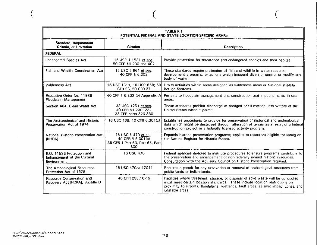
T A B L E F . 1P O T E N T I A L F E D E R A L A N D S T A T E L O C A T I O N - S P E C I F I C A R A R s
S t a n d a r d , RequirementCri t er ia , or L i m i t a t i o n C i t a t i o n D e s c r i p t i o nF E D E R A LEndanger ed S p e c i e s A c tF i s h a n d W i l d l i f e C o o r d i n a t i o n A c t
W i l d e r n e s s A c tExecu t ive Order No. 1 1 988F l o o d p l a i n M a n a g e m e n tS e c t i o n 404, C l e a n W a t e r Act
The Archaeo l og i ca l and H i s t o r i cPre s erva t i on Act of 1 974N a t i o n a l H i s t o r i c Pre s ervat ion A c t( N H P A )
E.O. 1 1 593 P r o t e c t i o n andEnhancement of the C u l t u r a lEnvironmentT h e A r c h e o l o g i c a l ResourcesP r o t e c t i o n Act of 1979Resource C o n s e r v a t i o n andRecovery A c t ( R C R A ) , S u b t i t l e D
16 USC § 1531 et seq.50 CFR § § 200 and 40216 USC § 661 et seq.40 CFR § 6.302
1 6 USC 1 3 1 1 , 1 6 USC 668; 50CFR 53, 50 CFR 2740 CFR § 6.302 (b) A p p e n d i x A
33 USC 1251 et seq.40 CFR §§ 230, 23133 CFR p a r t s 320-33016 USC 469; 40 CFR 6. 301 (c)
1 6 USC § 470 et seq40 CFR § 6.301 (b)36 CFR § Part 63, Part 65, Part80016 USC 470
1 6 U S C 4 7 0 a a - 4 7 0 1 140 CFR 258. 10-15
P r o v i d e p r o t e c t i o n f o r t h r e a t e n e d a n d e n d a n g e r e d s p e c i e s a n d t h e i r h a b i t a t .T h e s e s t a n d a r d s require p r o t e c t i o n o f f i s h a n d w i l d l i f e i n water resourced e v e l o p m e n t p r o g r a m s , or a c t i on s which i m p o u n d d i v e r t or c on tro l or m o d i f y anybody of water.L i m i t s a c t i v i t i e s w i t h i n areas d e s i g n e d a s w i l d e r n e s s areas o r N a t i o n a l W i l d l i f eR e f u g e S y s t e m s .P e r t a i n s to f l o o d p l a i n management and c o n s t r u c t i o n and i m p o u n d m e n t s in suchareas.T h e s e s t a n d a r d s p r o h i b i t d i s c h a r g e o f d r e d g e d o r f i l l m a t e r i a l into waters o f t h eU n i t e d S t a t e s w i thou t p e r m i t .E s t a b l i s h e s procedures to p r o v i d e for pre s ervat ion of h i s t or i ca l and a r c h e o l o g i c a ld a t a which m i g h t be d e s t r o y e d t h r o u g h a l t e r a t i o n of t e r r a i n as a r e su l t of a f e d e r a lc o n s t r u c t i o n p r o j e c t o r a f e d e r a l l y l i c e n s e d a c t i v i t y p r o g r a m .E x p a n d s h i s t o r i c p r e s e r v a t i o n p r o g r a m s ; a p p l i e s t o resources e l i g i b l e f o r l i s t i n g o nt h e N a t u r a l R e g i s t e r f o r H i s t o r i c Plac e s .
F e d e r a l agenc i e s d i r e c t e d t o i n s t i t u t e p r o c e d u r e s t o ensure p r o g r a m s c o n t r i b u t e t othe p r e s e r v a t i o n and enhancement o f n o n - f e d e r a l l y owned h i s t o r i c resources.C o n s u l t a t i o n w i th t h e A d v i s o r y C o u n c i l o n H i s t o r i c P r e s e r v a t i o n required .Requires a p e r m i t for any e x cava t i on or removal of a r c h e o l o g i c a l resources f r o mp u b l i c l a n d s o r I n d i a n l a n d s .F a c i l i t i e s where t r e a t m e n t , s t o r a g e , or d i s p o s a l o f s o l i d waste w i l l b e c o n d u c t e dmust meet c e r ta in l o c a t i o n s t a n d a r d s . T h e s e i n c l u d e l o c a t i o n r e s t r i c t i o n s onp r o x i m i t y t o a i r p o r t s , f l o o d p l a i n s , w e t l a n d s , f a u l t areas, s e i smic i m p a c t zones, a n du n s t a b l e areas.
H : \ 6 6 4 \ E E C A \ G A R I B A L D \ G A R A P P F . T X T0 7 / 2 7 / 9 5 4:04pm W P 5 1 / c m c F-8

cT A B L E F . I
P O T E N T I A L F E D E R A L A N D S T A T E L O C A T I O N - S P E C I F I C A R A R sS t a n d a r d , RequirementC r i t e r i a , or L i m i t a t i o n C i t a t i o n D e s c r i p t i o n
S T A T E O F COLORADON o n g a m e , E n d a n g e r e d orT h r e a t e n e d S p e c i e s A c tC o l o r a d o R e g i s t e r o f H i s t o r i cP l a c e sC o l o r a d o H i s t o r i c a l , P r e h i s t o r i c a l ,and A r c h a e o l o g i c a l Resources ActC o l o r a d o S p e c i e s o f S p e c i a lConcern and S p e c i e s ofU n d e t e r m i n e d S t a t u sC o l o r a d o N a t u r a l A r e a s
S t a t e S o l i d W a s t e D i s p o s a l S i t e sa n d F a c i l i t i e s A c t , C o l o r a d oRevised S t a t u t e s , T i t l e 3 0 , A r t i c l e20, S e c t i o n s 1 0 1 - 1 1 8
CRS §§ 33-2-101 to 108CRS §§ 24-80.1-101 to 108
CRS §§ 24-80-401 to 4101301 to 1305C o l o r a d o D i v i s i o n o f W i l d l i f eA d m i n i s t r a t i v e D i r e c t i v e E-1,1 9 8 5 , m o d i f i e d
C o l o r a d o Revised S t a t u t e s , T i t l e33, A r t i c l e 33, Sec . 104
6 CCR 1007-2
6 C C R 1007-2, P a r t i
T h e s e s t a n d a r d s p r o v i d e f o r t h e r e g u l a t i o n o f nongame w i l d l i f e a n d t h r e a t e n e d a n de n d a n g e r e d sp e c i e s .A u t h o r i z e s S t a t e H i s t o r i c a l S o c i e t y t o nomina t e p r o p e r t i e s f o r i n c l u s i o n o n S t a t eR e g i s t e r .Concerns h i s t o r i c a l , p r e h i s t o r i c a l a n d a r c h a e o l o g i c a l resources; a p p l i e s o n l y t oareas owned by S t a t e or i t s p o l i t i c a l s u b d i v i s i o n .P r o t e c t s a n i m a l s l i s t e d o n t h e C o l o r a d o D i v i s i o n o f W i l d l i f e g e n e r a t e d l i s t .C o o r d i n a t i o n w i t h t h e D i v i s i o n o f w i l d l i f e i s s t r o n g l y urged i f an imal s p e c i e s a r e t obe i m p a c t e d .T h e C o l o r a d o N a t u r a l Areas P r o g r a m m a i n t a i n s a l i s t o f p l a n t s p e c i e s o f s p e c i a lconcern f o r t h e S t a t e . A l t h o u g h n o t p r o t e c t e d b y S t a t e s t a t u e , c o o r d i n a t i o n w i t hD i v i s i o n o f Parks and O u t d o o r Recrea t ion i s recommended i f a c t i v i t i e s w i l l i m p a c tl i s t e d spe c i e s .E s t a b l i s h e s r e g u l a t i o n s f o r s o l i d waste management f a c i l i t i e s , i n c l u d i n g l o c a t i o ns t a n d a r d s .
E s t a b l i s h e s broad c i t i n g c r i t e r i a a n d s i t e e v a l u a t i o n p r o c e d u r e s f o r i n d i v i d u a ls t o rage a n d d i s p o s a l u n i t s ( i . e . , i m p o u n d m e n t s , l a n d f i l l s , e t c . )
H : \ 6 6 4 \ E E C A \ G A R I B A L D \ G A R A P P F . T X T0 7 / 2 7 / 9 5 4:04pm W P 5 1 / c m c F-9

T A B L E F . 2P O T E N T I A L F E D E R A L A N D S T A T E A C T I O N - S P E C I F I C A R A R s
S t a n d a r d , RequirementCri t e r ia , or L i m i t a t i o n C i t a t i o n D e s c r i p t i o nF E D E R A LC l e a n A i r A c tSol id W a s t e D i s p o s a l Act a samended by the ResourceC o n s e r v a t i o n and Recovery Act of1 9 7 6 ( R C R A )H a z a r d o u s M a t e r i a l sT r a n s p o r t a t i o n A c tO c c u p a t i o n a l H e a l t h a n d S a f e t yActF e d e r a l M i n e S a f e t y a n d H e a l t hAct
42 USC § 7401-764240 CFR 6042 USC § 6901-698740 CFR 257
49 USC § 1 8 0 1 - 1 8 1 349 CFR 107, 1 7 1 - 1 7 729 USC § 651-678
30 USC § 800-962
E s t a b l i s h e s emi s s i on s t a n d a r d s f o r c e r t a i n c a t e g o r i e s o f i n d u s t r i a l s t a t i o n a r ysources.E s t a b l i s h e s c r i t e r i a f o r d e t e r m i n i n g which s o l i d waste d i s p o s a l f a c i l i t i e s a n dp r a c t i c e s pose a r ea s onab l e p r o b a b i l i t y o f adver se e f f e c t s on h e a l t h .
R e g u l a t e s t r a n s p o r t a t i o n o f h a z a r d o u s m a t e r i a l s .R e g u l a t e s worker h e a l t h a n d s a f e t y .E s t a b l i s h e s r equ i r emen t s to p r o t e c t worker h e a l t h and s a f e t y in and around mines.
S T A T E O F C O L O R A D OS t a t e S o l i d W a s t e D i s p o s a l S i t e sand F a c i l i t i e s ActC o l o r a d o M i n e d Land R e c l a m a t i o nActC o l o r a d o A i r Q u a l i t y C o n t r o l A c tC o l o r a d o N o i s e A b a t e m e n t A c tC o l o r a d o R e g u l a i t o n f o r t h e S t a t eDi s charge Permit S y s t e mR e g u l a t i o n s on the C o l l e c t i o n ofA q u a t i c L i f e
6 C C R 1007-2
CRS 34-32-1 01 to 1252 C C R 407-1
5 C C R S 1001-1, 3, 4, 5, 8, 10CRS 25-12-101 to 108
6.1.0, 5 CCR 1002-22 C C R 406-8, Ch. 13,A r t i c l e I I I , S e c . 1316
E s t a b l i s h e s p o l i c y f o r l i c e n s i n g , l o c a t i n g , c o n s t r u c t i n g a n d o p e r a t i n g s o l i d wastef a c i l i t i e s .R e g u l a t e s a l l a s p e c t s o f l a n d u s e f o r m i n i n g , i n c l u d i n g t h e l o c a t i o n o f m i n i n go p e r a t i o n s and r e l a t e d r e c l a m a t i o n a c t i v i t i e s and o ther e n v i r o n m e n t a l and socio-economic i m p a c t s .E s t a b l i s h e s emi s s ions s t a n d a r d s f o r p a r t i c u l a t e s a n d l e a d .E s t a b l i s h e s maximum p e r m i s s i b l e noise l e v e l s f o r p a r t i c u l a r t ime p e r i o d s a n duse zones. l a n dE s t a b l i s h e s r e g u l a t i o n s f o r s t ormwater r u n o f f a t c o n s t r u c t i o n s i t e s .R e q u i r e m e n t s g o v e r n i n g t h e c o l l e c t i o n o f w i l d l i f e f o r s c i e n t i f i c p u r p o s e s .
H : \ 6 6 4 \ E E C A \ G A R I B A L D \ G A R A P P F . T X T0 7 / 2 7 / 9 5 4:04pm W P 5 1 / c m c F-10

F . 4 R E F E R E N C E SU n i t e d S t a t e s Army C o r p s o f Engineers (COE), 1985. Regula tory Program A p p l i c a n t
I n f o r m a t i o n . EP 1145-2-1, May.F o o t h i l l s Engineer ing C o n s u l t a n t s ( F E C ) , 1 9 9 3 . C u l t u r a l Resources Survey o f P r o p o s e d R I / F S
S a m p l i n g Locat ions i n Oregon Gulch , C a l i f o r n i a G u l c h S u p e r f u n d S i t e , Lake County ,C o l o r a d o . October.
Roy F. W e s t o n , Inc. and Terra T e c h n o l o g i e s ( W e s t o n ) , 1995. P r e l i m i n a r y Eco log i ca l RiskAsse s sment for Oregon Gulch (OU 10). January.
W o o d w a r d - C l y d e C o n s u l t a n t s ( W W C ) , 1 9 9 2 . W e t l a n d s M a p f o r C a l i f o r n i a Gulch R I / F S S t u d yArea. S e p t e m b e r .
W o o d w a r d - C l y d e C o n s u l t a n t s ( W W C ) , 1993. T e r r e s t r i a l Ecosystem Evaluat ion ReportC a l i f o r n i a G u l c h S i t e , L e a d v i l l e , Co lorado . A p r i l .
H : \ 6 6 4 V E E C A \ G A R B A L D \ G A R A P P F . T X T0 7 / 2 7 / 9 5 4:04pm W P 5 1 / c m c F - l l

July 27, 1995 FINAL * EE/CA Garibaldi Mine Site * Appendices
A P P E N D I X GC O S T E S T I M A T E S
H : \ 6 6 4 \ E E C A \ G A R f f i A L D . F N L0 7 / 2 7 / 9 5 4:01pm W P 5 1 / c m c
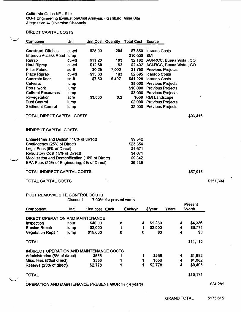
C a l i f o r n i a G u l c h N P L S i t eOU-4 E n g i n e e r i n g E v a l u a t i o n / C o s t A n a l y s i s - G a r i b a l d i M i n e S i t eA l t e r n a t i v e A- Diversion C h a n n e l sD I R E C T C A P I T A L C O S T SComponen t Unit U n i t Cost Quant i ty T o t a l Cost SourceConstruct DitchesI m p r o v e Access RoadR i p r a pH a u l R i p r a pF i l t e r F a b r i cPlace R i p r a pConcrete l i n e rCulver t sPorta l workC u l t u r a l ResourcesRevege ta t i onDust ControlS e d i m e n t Control
cu-ydl u m pcu-ydcu-ydsq-ftcu-ydsq-ftl u m pl u m pl u m pacrel u m pl u m p
$25.00$11.20$12.60
$0.25$15.00
$7.50
$3,000
294193193
7.000193
5,497
0.2
$7,350$10,000
$2,162$2,432$1,750$2,895
$41 ,228$8,000
$10,000$3,000
$600$2,000$2,000
I d a r a d o CostsS M IASI-RCC, Buena V i s t aASI-RCC, Buena VistaPrevious Projec t sI d a r a d o CostsI d a r a d o CostsPrevious Pro j e c t sPrevious Pro j e c t sPrevious Pro j e c t sRBI LandscapePrevious Pro j e c t sPrevious Pro j e c t s
,co,co
T O T A L D I R E C T C A P I T A L C O S T S $93,416
I N D I R E C T C A P I T A L C O S T SE n g i n e e r i n g and Design (10% of Direct)C o n t i n g e n c y (25% of Direct)Legal F e e s (5% of Direct)R e g u l a t o r y Cost (5% of Direct)Mobi l i za t i on and Demobi l izat ion (10% of Direct)EPA F e e s (20% of E n g i n e e r i n g , 5% of Direc t)T O T A L I N D I R E C T C A P I T A L C O S T ST O T A L C A P I T A L C O S T S
$9,342$23,354
$4,671$4,671$9,342$6,539
$57,918$151,334
P O S T R E M O V A L S I T E C O N T R O L C O S T SDiscount 7.00% for present worthComponent U n i t PresentUni t cost Each E a c h / y r $/year Years W o r t hD I R E C T O P E R A T I O N A N D M A I N T E N A N C EI n s p e c t i o n hourErosion Repair l u m pVege ta t i on Repair l u m pT O T A LI N D I R E C T O P E R A T I O N A N DA d m i n i s t r a t i o n (5% of d ir e c t)Misc. f e e s (5%of d i r e c t)Reserve (25% of d irec t)
$40.00$2,000$15,000
M A I N T E N A N C E$556$556
$2,778
810
C O S T S111
410
111
$1,280$2,000
$0
$556$556
$2,778
444
444
$4,336$6.774
$0$11.110
$1,882$1,882$9,408
T O T A LO P E R A T I O N A N D M A I N T E N A N C E P R E S E N T W O R T H ( 4 years)
$13,171$24,281
G R A N D T O T A L $175,615

C a l i f o r n i a G u l c h N P L S i t eOU-4 Engine er ing E v a l u a t i o n / C o s t A n a l y s i s - G a r i b a l d i M i n e S i t eA l t e r n a t i v e C- Diversion C h a n n e l s / G r o u n d w a t e r I n t e r c e p t o r T r e n c h / R e g r a d e / S i m p l e CoverD I R E C T C A P I T A L C O S T SComponent U n i t Uni t Cost Quant i ty Total Cost SourceConstruct DitchesI m p r o v e Access RoadRiprapH a u l R i p r a pF i l t e r F a b r i cPlace R i p r a pConcrete l i n e rCulver t sGroundwater TrenchRegradeCover S o i l S u p p l yCover Soil PlacementRevegetationPortal workC u l t u r a l ResourcesDust ControlS e d i m e n t Control
cu-ydl u m pcu-ydcu-ydsq-ftcu-ydsq-ftl u m peachcu-ydcu-ydcu-ydacresl u m pl u m pl u m pl u m p
$25.00$11.20$12.60$0.25$15.00$7.50
$10,000$1.00$10.00$1.75$3,000
275193193
7,000193
5,1202
3,1004,1004,100
1.8
$6.875$20,000$2,162$2,432$1,750$2,895
$38,400$4,000
$20,000$3,100
$41,000$7,175$5,400$10,000$5,000$2,000$2,000
I d a r a d o CostsS M IA S t - R C C , Buena Vista ,ASI-RCC, Buena Vis ta ,Previous Pro j e c t sI d a r a d o CostsI d a r a d o CostsMeansPrevious Proje c t sPrevious Proj e c t s
COCO
Webster Sand and GravelI d a r a d o CostsRBI L a n d s c a p i n gPrevious Proj e c t sPrevious ProjectsPrevious Projec t sPrevious Proj e c t sT O T A L D I R E C T C A P I T A L C O S T S $174,188
I N D I R E C T C A P I T A L C O S T SEngine er ing and Design (10% of Direc t)Cont ingency (25% of Direc t)Legal F e e s (5% of Dire c t)Regula t ory Cost ( 5% of Direc t)M o b i l i z a t i o n and Demob i l i za t i on (10% of Direc t)EPA Fees (20% of Engineering, 5% of Direct)T O T A L I N D I R E C T C A P I T A L C O S T ST O T A L C A P I T A L C O S T S
$17,419$43,547
$8,709$8,709
$17,419$12,193
$107,997$282,185
P O S T R E M O V A L S I T E C O N T R O L C O S T SDiscount 7.00% for present worthComponent Unit Unit cost Each E a c h / y r Present$/year Years WorthD I R E C T O P E R A T I O N A N D M A I N T E N A N C EI n s p e c t i o n hourErosion Repair l u m pV e g e t a t i o n Repair l u m pT O T A LI N D I R E C T O P E R A T I O N A N DA d m i n i s t r a t i o n (5% of d i r e c t)Misc. f e e s (5%of d ire c t)Reserve (25% of d ir e c t)
$40.00$2,000$2,400
M A I N T E N A N C E$962$962
$4,810
811
C O S T S111
411
111
$1,280$2,000$2,400
$962$962
$4,810
444
444
$4,336$6,774$8,129
$19,239
$3,258$3.258
$16,292T O T A LO P E R A T I O N A N D M A I N T E N A N C E P R E S E N T W O R T H ( 4 years)
$22,809$42,048
G R A N D T O T A L $324,233

C A L I F O R N I A G U L C H N P L S I T EO U 4 E N G I N E E R I N G E V A L U A T I O N / C O S T A N A L Y S I S - G A R I B A L D I M I N E S I T EW A S T E ROCK R E M O V A L U N I T C O S T
D A T E : 29-May-95R E M O V E $ . W Q 1
E Q U I P M E N T R E Q U I R E D-4 12 CY TRUCKS-1 EXCAVATOR-1 DOZER-1 WATER TRUCK-1 M O T O R G R A D E R
P R O D U C T I O NH A U L T I M ER E T U R N T I M EF I X E D T I M ET O T A L C Y C L E T I M ET R I P S P E R H O U RT R U C K C A P A C I T YR A W P R O D U C T I V I T YU T I L I Z A T I O N ( 5 0 M I N / H R )
A D J . P R O D U C T I V I T YF L E E T P R O D U C T I V I T Y
15.0 M I N .12.0 M I N .
5 M I N .
4 T R U C K S
32.0 M I N .1.88 T R I P S / H O U R
12 LCY2 3 L C Y / H R
0.831 9 L C Y / S C H H R
7 5 L C Y / S C H H R
S C R A P E R F L E E T C O S TE Q U I P M E N TT R U C K SE X C A V A T O RDOZERM O T O R G R A D E R ( 1 6 G )W A T E R T R U C KF O R M A N A N D T R U C K
U N I T S411
0.500.501
U N I TC O S T$60.00$90.00$70.00$75.00$45.00$32.00
T O T A L
T O T A LC O S T
$240.00$90.00$70.00$37.50$22.50$32.00
/ S C H H R/ S C H H R/ S C H H R/ S C H H R/ S C H H R/ S C H H R
$492.00 / S C H H R
T O T A L U N I T C O S TD I R E C TO V E R H E A D A N D P R O F I T (25% o f d i r e c t )T O T A L
$6.59 / L C Y$1.65 / L C Y$8.23 / L C Y

TerraMatrixEngineering & Environmental Services•^BHiB^BffCTlBM1475 Pine Grove Road • PO Box 774018Steamboat S p r i n g s , Colorado 80477303-879-6260 • fax 303-879-9048
J u l y 27, 1995
Ms. Denise LinkEPA Region 8, 8 H W M - S R999 18th S t r e e t , S u i t e 500Denver, C o l o r a d o 80202-2405Re: S u b m i t t a l of Final Engineering Evaluation/Cost Analysis for Garibaldi Mine Site WithinUpper California Gulch Operable Unit 4.Dear Ms. Link:On b e h a l f of Resurrection Mining Company, enclosed are three copie s of the Final EE/CA forGaribaldi Mine Site Within Upper California Gulch Operable Unit 4. T h i s f i n a l E E / C Aincorporate s comments received f r om the p u b l i c during the p u b l i c comment per iod and provide sresponses to those comments.We wil l d i s t r i b u t e copie s to add i t i ona l par t i e s upon your a p p r o v a l . If you have any commentsor questions, p l e a s e contact me.S i n c e r e l y ,T e r r a M ;
A l a nPro j e c tJMR:cmcencl.cc: Dave Baker, Resurrection Mining Company (1 copy)
Eileen J o s s e l y n , Roy F. Wes ton (1 copy)Tom S h e p h e r d , S h e p h e r d M i l l e r , Inc. (2 copie s)Bruce F e a t h e r s t o n e , K i r k l a n d & E l l i s (1 copy)Russ A l i e n , C D P H E (2 cop i e s)Don Deere, Rocky Mountain C o n s u l t a n t s (1 c o p y )
H:\664Wissub. l trSteamboat S p r i n g s , CO • Denver, CO. Fort C o l l i n s , CO • S e a t t l e , WA. J u n e a u , AK • S a n t i a g o , C h i l e SA