
Final Draft Stormwater Management Manual for Eastern ...
222
FINAL DRAFT Stormwater Management Manual for Eastern Washington Glossary Bibliography Cost Analysis Response to Comments June 2003 Publication Number 03-10-038D
Transcript of Final Draft Stormwater Management Manual for Eastern ...
FINAL DRAFT Stormwater Management Manual
for Eastern Washington
GlossaryBibliographyCost Analysis
Response to Comments
June 2003 Publication Number 03-10-038D


FINAL DRAFT Stormwater Management Manual
for Eastern Washington
GlossaryBibliographyCost Analysis
Response to Comments
Washington State Department of Ecology Water Quality Program
June 2003 Publication Number -03-10-038D

How to Get Printed Copies of the Stormwater Manual If you have a credit card, you can order printed copies of the stormwater manual at the following Internet address:
https://wws2.wa.gov/prt/printwa/wsprt/default.asp
You can also use this website to get price information and then send a check or money order payable to “Department of Printing” at the following address:
Department of Printing P.O. Box 798 Olympia, WA 98507-0798
Make sure you include your name, mailing address, phone number, and the name of the publication. Allow about two weeks for delivery. If you have questions about ordering the stormwater manual and model program please call the Department of Printing at (360) 570-5555.
How to Find the Stormwater Manual on the Internet The Stormwater Management Manual for Eastern Washington is also available on Ecology’s Stormwater Homepage. The Internet address is:
http://www.ecy.wa.gov/programs/wq/stormwater/
If you require this document in an alternative format, please call the secretary at (360) 407-6401. The TTY number is 711 or 1-800-833-6388.
June 2003 Table of Contents TOC -1
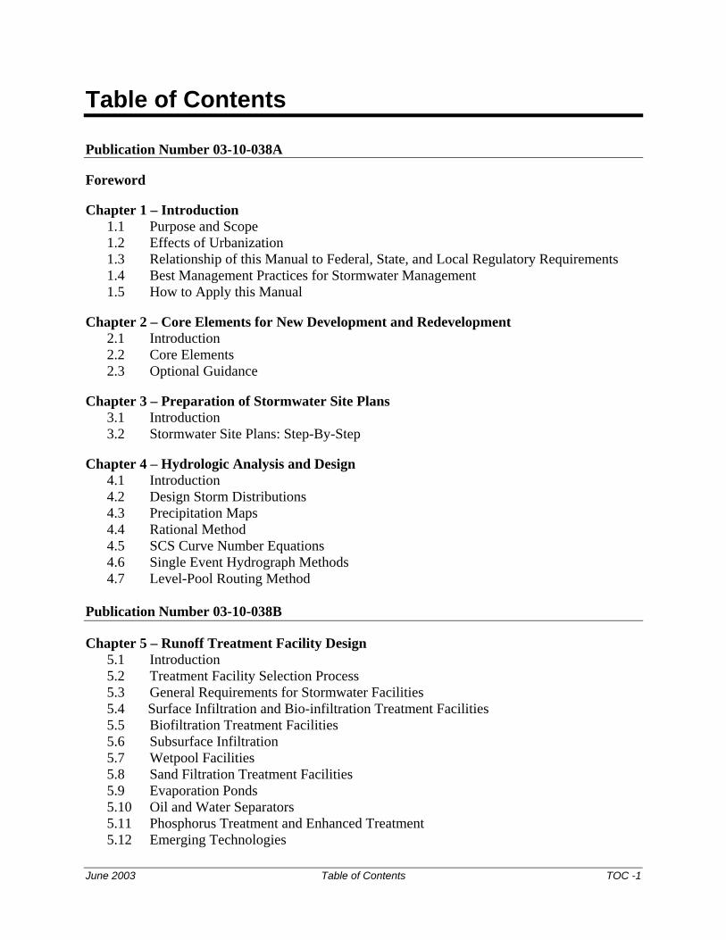
Table of Contents
Publication Number 03-10-038A
Foreword
Chapter 1 – Introduction 1.1 Purpose and Scope 1.2 Effects of Urbanization 1.3 Relationship of this Manual to Federal, State, and Local Regulatory Requirements 1.4 Best Management Practices for Stormwater Management 1.5 How to Apply this Manual
Chapter 2 – Core Elements for New Development and Redevelopment 2.1 Introduction 2.2 Core Elements 2.3 Optional Guidance
Chapter 3 – Preparation of Stormwater Site Plans 3.1 Introduction 3.2 Stormwater Site Plans: Step-By-Step
Chapter 4 – Hydrologic Analysis and Design 4.1 Introduction 4.2 Design Storm Distributions 4.3 Precipitation Maps 4.4 Rational Method 4.5 SCS Curve Number Equations 4.6 Single Event Hydrograph Methods 4.7 Level-Pool Routing Method
Publication Number 03-10-038B
Chapter 5 – Runoff Treatment Facility Design 5.1 Introduction 5.2 Treatment Facility Selection Process 5.3 General Requirements for Stormwater Facilities 5.4 Surface Infiltration and Bio-infiltration Treatment Facilities 5.5 Biofiltration Treatment Facilities 5.6 Subsurface Infiltration 5.7 Wetpool Facilities 5.8 Sand Filtration Treatment Facilities 5.9 Evaporation Ponds 5.10 Oil and Water Separators 5.11 Phosphorus Treatment and Enhanced Treatment 5.12 Emerging Technologies

TOC -2 Table of Contents June 2003
Chapter 6 – Flow Control Facility Design 6.1 Introduction 6.2 Detention Facilities 6.3 Infiltration of Stormwater for Quantity Control 6.4 Evaporation Ponds 6.5 Natural Dispersion
Publication Number 03-10-038C
Chapter 7 – Construction Stormwater Pollution Prevention 7.1 Introduction 7.2 Planning 7.3 Standards and Specifications for Best Management Practices
Chapter 8 – Source Control 8.1 Introduction 8.2 Stormwater Pollutants and Their Adverse Impact 8.3 Selection of Operational and Structural Source Control Best Management Practices
Publication Number 03-10-038D
Glossary
Bibliography
Cost Analysis
Response to Comments
FINAL DRAFT
June 2003 Glossary GLO-1
GlossaryThe following terms are provided for reference and use with this Manual. They shall be superseded by any other definitions for these terms adopted by ordinance, unless they are defined in a Washington State WAC or RCW.
Absorption The penetration of a substance into or through another, such as the dissolving of a soluble gas in a liquid.
Adaptive management The modification of management practices to address changing conditions and new knowledge. Adaptive management is an approach that incorporates monitoring and research to allow projects and activities, including projects designed to produce environmental benefits, to go forward in the face of some uncertainty regarding consequences. The key provision of adaptive management is the responsibility to change adaptively in response to new understanding or information after an action is initiated.
Adsorption The adhesion of a substance to the surface of a solid or liquid; often used to extract pollutants by causing them to be attached to such adsorbents as activated carbon or silica gel. Hydrophobic, or water-repulsing adsorbents, are used to extract oil from waterways when oil spills occur. Heavy metals such as zinc and lead often adsorb onto sediment particles.
AKART All Known, Available, and Reasonable methods of prevention, control, and Treatment. The most current methodology that can be reasonably required for preventing, controlling, or abating the pollutants associated with a discharge. The concept of AKART applies to both point and nonpoint sources of pollution. Best Management Practices (BMPs) typically applied to nonpoint source pollution controls are considered a subset of the AKART requirement. The Stormwater Management Manual for Easter Washington may be used as a guideline, to the extent appropriate, for developing best management practices to apply AKART for storm water discharges. AKART and BAT are roughly equivalent State and Federal terms for the same concept.
Annual flood The highest peak discharge on average which can be expected in any given year.
Antecedent moisture conditions
The degree of wetness of a watershed or within the soil at the beginning of a storm.
Applicable BMPs As used in Chapters 2 and 8, applicable BMPs are those source control BMPs that are expected to be required by local governments at new development and redevelopment sites. Applicable BMPs will also be
FINAL DRAFT
GLO-2 Glossary June 2003
required if they are incorporated into NPDES permits, or they are included by local governments in a stormwater program for existing facilities.
Aquifer A geologic stratum containing ground water that can be withdrawn and used for human purposes.
Arid Excessively dry; having insufficient rainfall to support agriculture without irrigation.
Arterial A road or street primarily for through traffic. A major arterial connects an Interstate Highway to cities and counties. A minor arterial connects major arterials to collectors. A collector connects an arterial to a neighborhood. A collector is not an arterial. A local access road connects individual homes to a collector.
Average daily traffic (ADT)
The expected number of vehicles using a roadway is represented by the projected average daily traffic volume considered in designing the roadway. ADT counts must be estimated using "Trip Generation" published by the Institute of Transportation Engineers or from a traffic study prepared by a professional engineer or transportation specialist with expertise in traffic volume estimation. ADT counts shall be made for the design life of the project. For project sites with seasonal or varied use, evaluate the highest period of expected traffic impacts.
Bankfull discharge A flow condition where streamflow completely fills the stream channel up to the top of the bank. In undisturbed watersheds, the discharge conditions occur on average every 1.5 to 2 years and controls the shape and form of natural channels.
BAT Best Available Technology. The most current technology available for controlling releases of pollutants to the environment. Major dischargers are required to use BAT unless it can be demonstrated that it is unfeasible for energy, environmental, or economic reasons. BAT and AKART are roughly equivalent Federal and State terms for the same concept.
BCT Best available Control Technology. All technologies and/or methods currently available for preventing releases of hazardous substances and demonstrated to work under similar site circumstances or through pilot studies, and applicable to the site at reasonable cost.
Bedrock The more or less solid rock in place either on or beneath the surface of the earth. It may be soft, medium, or hard and have a smooth or irregular surface.

FINAL DRAFT
June 2003 Glossary GLO-3
Beneficial uses Those water uses identified in state water quality standards that must be achieved and maintained as required under the Federal Clean Water Act. “Beneficial use” and “designated use” are often used interchangeably.
Berm A constructed barrier of compacted earth, rock, or gravel. In a stormwater facility, a berm may serve as a vertical divider typically built up from the bottom.
Best available science The technical provisions in the Stormwater Management Manual for Eastern Washington represent common provisions for the protection of waters of the State from adverse impacts of urban stormwater. Implementation of these provisions is necessary to minimize project specific and cumulative impacts to waters of the State. This Manual reflects the best available science and practices related to protection of water quality. The Manual will incorporate new information as it becomes available, and to allow for alternative practices that provide equal or greater protection for waters of the State.
Best Management Practices (BMPs)
The schedules of activities, prohibitions of practices, maintenance procedures, and structural and/or managerial practices approved by Ecology that, when used singly or in combination, prevent or reduce the release of pollutants and other adverse impacts to waters of Washington State.
Buffer zone The area adjacent to a critical or sensitive area for which location and limits are described by federal, State, or local governments and intent is ensuring protection of the critical area by separating incompatible use from the critical or sensitive area.
Catch basin A chamber or well, usually built at the curb line of a street, for the admission of surface water to a sewer or subdrain, having at its base a sediment sump designed to retain grit and detritus below the point of overflow.
Catchment Surface drainage area.
Cation exchange capacity (CEC)
The amount of exchangeable cations that a soil can adsorb at pH 7.0.
Channel, constructed Reconstructed natural channels or other channels or ditches constructed to convey surface water.
Channel, natural Streams, creeks, or swales that convey surface water and groundwater and have existed long enough to establish a stable route and/or biological community.

FINAL DRAFT
GLO-4 Glossary June 2003
Channel stabilization Erosion prevention and stabilization of velocity distribution in a channel using vegetation, jetties, drops, revetments, and/or other measures.
Channel storage Water temporarily stored in channels while enroute to an outlet.
Channelization Alteration of a stream channel by widening, deepening, straightening, cleaning, or paving certain areas to change flow characteristics.
Check dam Small dam constructed in a gully or other small watercourse to decrease the streamflow velocity, minimize channel scour, and promote deposition of sediment.
Commercial agriculture
Those activities conducted on lands defined in RCW 84.34.020(2), and activities involved in the production of crops or livestock for wholesale trade. An activity ceases to be considered commercial agriculture when the area on which it is conducted is proposed for conversion to a nonagricultural use or has lain idle for more than five (5) years, unless the idle land is registered in a federal or state soils conservation program, or unless the activity is maintenance of irrigation ditches, laterals, canals, or drainage ditches related to an existing and ongoing agricultural activity.
Compaction The densification, settlement, or packing of soil in such a way that permeability of the soil is reduced. Compaction effectively shifts the performance of a hydrologic group to a lower permeability hydrologic group. For example, a group B hydrologic soil can be compacted and be effectively converted to a group C hydrologic soil in the way it performs in regard to runoff. Compaction may also refer to the densification of a fill by mechanical means.
Contractor Erosion and Spill Control Lead (CESCL)
The employee designated as the responsible representative in charge of erosion and spill control. The CESCL shall be qualified in construction site erosion and sediment control regulatory requirements and BMPs and shall have thorough knowledge and understanding of the Construction Stormwater Pollution Prevention Plan (SWPPP) for the project site.
Conveyance A mechanism for transporting water from one point to another, including pipes, ditches, and channels.
Conveyance system The drainage facilities, both natural and man-made, which collect, contain, and provide for the flow of surface and stormwater from the highest points on the land down to a receiving water. The natural elements of the conveyance system include swales and small drainage courses, streams, rivers, lakes, and wetlands. The human-made elements of the conveyance system include gutters, ditches, pipes, channels, and most retention/detention facilities.
FINAL DRAFT
June 2003 Glossary GLO-5
Critical area Any of the following areas and ecosystems: (a) wetlands; (b) areas with a critical recharging effect on aquifers used for potable water; (c) fish and wildlife habitat conservation areas; (d) frequently flooded areas; and (e) geologically hazardous areas.
Dangerous waste According to RCW 70.105.010, any discarded, useless, unwanted, or abandoned substances, including but not limited to certain pesticides, or any residues or containers of such substances which are disposed of in such quantity or concentration as to pose a substantial present or potential hazard to human health, wildlife, or the environment. These wastes may have short-lived, toxic properties that may cause death, injury, or illness or have mutagenic, teratogenic, or carcinogenic properties; or be corrosive, explosive, flammable, or may generate pressure through decomposition or other means. See also hazardous waste.
Design storm A prescribed hyetograph and total precipitation amount (for a specific duration recurrence frequency) used to estimate runoff for a hypothetical storm of interest or concern for the purposes of analyzing existing drainage, designing new drainage facilities or assessing other impacts of a proposed project on the flow of surface water. (A hyetograph is a graph of percentages of total precipitation for a series of time steps representing the total time during which the precipitation occurs.)
Design storm frequency
The anticipated period in years that will elapse, based on average probability of storms in the design region, before a storm of a given intensity and/or total volume will recur; thus a 10-year storm can be expected to occur on the average once every 10 years. Facilities designed to handle flows that occur under such storm conditions would be expected to be surcharged by any storms of greater amount or intensity.
Detention The release of stormwater runoff from the site at a slower rate than it is collected by the stormwater facility system, the difference being held in temporary storage.
Detention facility An above or below ground facility, such as a pond or tank, that temporarily stores stormwater runoff and subsequently releases it at a slower rate than it is collected by the drainage facility system. There is little or no infiltration of stored stormwater.
Detention time The theoretical time required to displace the contents of a stormwater treatment facility at a given rate of discharge (volume divided by rate of discharge).

FINAL DRAFT
GLO-6 Glossary June 2003
Development Means new development, redevelopment, or both. See definitions for each.
Discharge Runoff leaving a new development or redevelopment via overland flow, built conveyance systems, or infiltration facilities. A hydraulic rate of flow, specifically fluid flow; a volume of fluid passing a point per unit of time, commonly expressed as cubic feet per second, cubic meters per second, gallons per minute, gallons per day, or millions of gallons per day.
Dispersion Release of surface and stormwater runoff from a drainage facility system such that the flow spreads over a wide area and is located so as not to allow flow to concentrate anywhere upstream of a drainage channel with erodible underlying granular soils.
Ditch A long narrow excavation dug in the earth for drainage with its top width less than 10 feet at design flow.
Divide, Drainage The boundary between one drainage basin and another.
Drain A buried pipe or other conduit (closed drain). A ditch (open drain) for carrying off surplus surface water or ground water.
Drywell A well completed above the water table so that its bottom and sides are typically dry except when receiving fluids. Drywells are designed to disperse water below the land surface and are commonly used for stormwater management in eastern Washington. See also UIC.
Effective impervious surface
Those impervious surfaces that are connected via sheet flow or a conveyance system to a drainage system. Most impervious areas are effective.
Emerging technology Treatment technologies that have not been evaluated with approved protocols, but for which preliminary data indicate that they may provide a necessary function(s) in a stormwater treatment system. Emerging technologies need additional evaluation to define design criteria to achieve, or to contribute to achieving, state performance goals, and to define the limits of their use.
Erodible or leachable materials
Substances which, when exposed to rainfall, measurably alter the physical or chemical characteristics of the rainfall runoff. Examples include erodible soils that are stockpiled; uncovered process wastes; manure; fertilizers; oily substances; ashes; kiln dust; and garbage dumpster leakage.

FINAL DRAFT
June 2003 Glossary GLO-7
Erosion The wearing away of the land surface by running water, wind, ice, or other geological agents, including such processes as gravitational creep. Also, detachment and movement of soil or rock fragments by water, wind, ice, or gravity.
Erosion and sedimentation control (ESC)
Any temporary or permanent measures taken to reduce erosion; control siltation and sedimentation; and ensure that sediment-laden water does not leave the site.
Erosion and sediment control facility
A type of drainage facility designed to hold water for a period of time to allow sediment contained in the surface and stormwater runoff directed to the facility to settle out so as to improve the quality of the runoff.
Evapotranspiration The collective term for the processes of evaporation and plant transpiration by which water is returned to the atmosphere.
Excavation The mechanical removal of earth material.
Exception Relief from the application of a Core Element to a project.
Existing condition The impervious surfaces, drainage systems, land cover, native vegetation and soils that exist at the site with approved permits and engineering plans when required. If sites have impervious areas and drainage systems that were built without approved permits, then the existing condition is defined as those that existed prior to the adoption of this Manual. These conditions can be verified by record aerial photography, or other methods.
First order stream An unbranched tributary. The tributary is a continuous perennial stream reach, meaning that the water table is always above the bottom of the stream channel during a year of normal precipitation and the perennial reach continues downstream to a confluence with another perennial stream.
Fish-bearing stream According to WAC 222-16-030: Type S, F and Np waters are fish habitat streams. Until these fish habitat water type maps are available, an interim water typing system applies (see WAC 222-16-031): Type 1, 2, 3, and 4 waters are fish habitat streams.
Flood An overflow or inundation that comes from a river or any other source, including (but not limited to) streams, tides, wave action, storm drains, or excess rainfall. Any relatively high stream flow overtopping the natural or artificial banks in any reach of a stream.
FINAL DRAFT
GLO-8 Glossary June 2003
Flood frequency The frequency with which the flood of interest may be expected to occur at a site in any average interval of years. Frequency analysis defines the "n-year flood" as being the flood that will, over a long period of time, be equaled or exceeded on the average once every "n" years.
Flood routing An analytical technique used to compute the effects of system storage dynamics on the shape and movement of flow represented by a hydrograph.
Flow duration The aggregate time that peak flows are at or above a particular flow rate of interest. For example, the amount of time that peak flows are at or above 50% of the 2-year peak flow rate for a period of record.
Flow frequency The inverse of the probability that the flow will be equaled or exceeded in any given year (the exceedance probability). For example, if the exceedance probability is 0.01 or 1 in 100, that flow is referred to as the 100-year flow.
Flow path The route that stormwater runoff follows between two points of interest.
Forest practice Any activity conducted on or directly pertaining to forest land and relating to growing, harvesting, or processing timber, including but not limited to: road and trail construction; harvesting, final and intermediate; precommercial thinning; reforestation; fertilization; prevention and suppression of diseases and insects; salvage of trees; and brush control.
Freeway A multilane, arterial highway with full access control.
Frost-heave The upward movement of soil surface due to the expansion of water stored between particles in the first few feet of the soil profile as it freezes. May cause surface fracturing of asphalt or concrete and/or affect soil infiltration capacity.
Functions The ecological (physical, chemical, and biological) processes or attributes of a water body without regard for their importance to society. Functions include food chain support, provision of ecosystem diversity and fish and wildlife habitat, floodflow alteration, ground water recharge and discharge, water quality improvement, and soil stabilization.
Groundwater Water in a saturated zone or stratum beneath the land surface or beneath a surface water body.

FINAL DRAFT
June 2003 Glossary GLO-9
Groundwater recharge
Inflow to a groundwater reservoir or aquifer.
Groundwater table The free surface of the ground water, that surface subject to atmospheric pressure under the ground, generally rising and falling with the season, the rate of withdrawal, the rate of restoration, and other conditions. It is seldom static.
Gully A channel caused by the concentrated flow of surface and stormwater runoff over unprotected erodible land.
Habitat The specific area or environment in which a particular type of plant or animal lives. An organism's habitat must provide all of the basic requirements for life and should be protected from harmful biological, chemical, and physical alterations.
Hazardous waste According to RCW 70.105.010 includes all dangerous and extremely hazardous waste, including substances composed of both radioactive and hazardous components. See also dangerous waste.
Hazardous substance According to RCW 70.105.010 any liquid, solid, gas, or sludge, including any material, substance, product, commodity, or waste, regardless of quantity, that exhibits any of the characteristics or criteria of hazardous waste. See also dangerous waste.
High use sites Sites that generate high concentrations of oil due to high traffic turnover or the frequent transfer of oil and(or) other petroleum products. High-use sites are land uses where sufficient quantities of free oil are likely to be present such that they can be effectively removed with special treatment. A high-use site is any one of the following:
¶ A road intersection with expected ADT of 25,000 vehicles or more on the main roadway and 15,000 vehicles or more on any intersecting roadway, excluding projects proposing primarily pedestrian or bicycle use improvements; or
¶ A commercial or industrial site with an expected trip end count equal to or greater than 100 vehicles per 1,000 square feet of gross building area (best professional judgment should be used in comparing this criterion with the following criterion); or
¶ A customer or visitor parking lot with an expected trip end count equal to or greater than 300 vehicles (best professional judgment should be used in comparing this criterion with the preceding criterion); or

FINAL DRAFT
GLO-10 Glossary June 2003
¶ Commercial on-street parking areas on streets with an expected total ADT count equal to or greater than 7,500; or
¶ Fueling stations and facilities; orA commercial or industrial site subject to petroleum storage and transfer in excess of 1,500 gallons per year, not including locations where heating fuel is routinely delivered to end users (heating fuel handling and storage facilities are subject to this definition); or
¶ A commercial or industrial site subject to use, storage, or maintenance of a fleet of 25 or more diesel vehicles that are over 10 tons gross weight (trucks, buses, trains, heavy equipment, etc.); or
¶ Maintenance and repair facilities for vehicles, aircraft, construction equipment, railroad equipment or industrial machinery and equipment; or
¶ Outdoor areas where hydraulic equipment is stored; or Log storage and sorting yards and other sites subject to frequent use of forklifts and(or) other hydraulic equipment; or
¶ Railroad yards.
Highway A main public road connecting towns and cities.
Horton overland flow A runoff process whereby the rainfall rate exceeds the infiltration rate, so that the precipitation that does not infiltrate flows downhill over the soil surface.
HSPF Hydrological Simulation Program-Fortran. A continuous simulation hydrologic model that transforms an uninterrupted rainfall record into a concurrent series of runoff or flow data by means of a set of mathematical algorithms which represent the rainfall-runoff process at some conceptual level.
Hydrograph A graph of runoff rate, inflow rate, discharge rate, or another characteristic of a body of water during a specific period of time.
Hydrologic cycle The circuit of water movement from the atmosphere to the earth and return to the atmosphere through various stages or processes as precipitation, interception, runoff, infiltration, percolation, storage, evaporation, and transpiration.

FINAL DRAFT
June 2003 Glossary GLO-11
Hydrologic soil groups
A soil characteristic classification system defined by the U.S. Soil Conservation Service in which a soil may be categorized into one of four soil groups (A, B, C, or D) based upon infiltration rate and other properties:
Type A: Low runoff potential. Soils having high infiltration rates, even when thoroughly wetted, and consisting chiefly of deep, well drained to excessively drained sands or gravels. These soils have a high rate of water transmission. Type B: Moderately low runoff potential. Soils having moderate infiltration rates when thoroughly wetted, and consisting chiefly of moderately fine to moderately coarse textures. These soils have a moderate rate of water transmission. Type C: Moderately high runoff potential. Soils having slow infiltration rates when thoroughly wetted, and consisting chiefly of soils with a layer that impedes downward movement of water, or soils with moderately fine to fine textures. These soils have a slow rate of water transmission. Type D: High runoff potential. Soils having very slow infiltration rates when thoroughly wetted, and consisting chiefly of clay soils with a high swelling potential, soils with a permanent high water table, soils with a hardpan, till, or clay layer at or near the surface, soils with a compacted subgrade at or near the surface, and shallow soils or nearly impervious material. These soils have a very slow rate of water transmission (Novotney and Olem, 1994).
Hydrology The science of the behavior of water in the atmosphere, on the surface of the earth, and underground.
Hydroperiod A seasonal occurrence of flooding and/or soil saturation; it encompasses depth, frequency, duration, and seasonal pattern of inundation.
Hyetograph A graph or table of percentages of total precipitation for a series of time steps representing the total time in which precipitation occurs.
Illicit discharge All non-stormwater discharges to stormwater drainage systems that cause or contribute to a violation of state water quality, sediment quality or ground water quality standards, including but not limited to sanitary sewer connections, industrial process water, interior floor drains, car washing, and grey-water systems.
Impaired waters Water bodies not fully supporting their beneficial uses.
FINAL DRAFT
GLO-12 Glossary June 2003
Impervious surface A hard surface area which either prevents or retards the entry of water into the soil mantle as under natural conditions prior to development. A hard surface area which causes water to run off the surface in greater quantities or at an increased rate of flow from the flow present under natural conditions prior to development. Common impervious surfaces include, but are not limited to, roof tops, walkways, patios, driveways, parking lots or storage areas, concrete or asphalt paving, gravel roads, packed earthen materials, and oiled, macadam or other surfaces which similarly impede the natural infiltration of stormwater. Open, uncovered retention/detention facilities shall not be considered as impervious surfaces for the purposes of determining whether the thresholds for application of Core Elements are exceeded. Open, uncovered retention or detention facilities shall be considered impervious surfaces for purposes of runoff modeling.
Industrial activities Material handling, transportation, or storage; manufacturing; maintenance; treatment; or disposal. Areas with industrial activities include plant yards, access roads and rail lines used by carriers of raw materials, manufactured products, waste material, or by-products; material handling sites; refuse sites; sites used for the application or disposal of process waste waters; sites used for the storage and maintenance of material handling equipment; sites used for residual treatment, storage, or disposal; shipping and receiving areas; manufacturing buildings; storage areas for raw materials, and intermediate and finished products; and areas where industrial activity has taken place in the past and significant materials remain and are exposed to stormwater.
Ineffective impervious surface
Impervious surfaces on residential development sites where the runoff is not concentrated and is dispersed via sheet flow off the pavement and then through at least one hundred feet of native vegetation before flowing into a drainage system. An example is a tennis court in the middle of a park.
Infiltration The downward movement of water from the land surface to the subsoil.
Infiltration facility(or system)
A drainage facility designed to use the hydrologic process of surface and stormwater runoff soaking into the ground, commonly referred to as a percolation, to dispose of surface and stormwater runoff.
Infiltration rate The rate, usually expressed in inches per hour, at which water percolates, or moves downward through the soil profile. Short-term infiltration rates may be inferred from soil analysis or texture or derived from field measurements. Long-term infiltration rates are affected by variability in soils and subsurface conditions at the site, the effectiveness of pretreatment or influent control, and the degree of long-term maintenance of the infiltration facility.

FINAL DRAFT
June 2003 Glossary GLO-13
Interflow That portion of rainfall that infiltrates into the soil and moves laterally through the upper soil horizons until intercepted by a stream channel or until it returns to the surface for example, in a roadside ditch, wetland, spring or seep. Interflow is a function of the soil system depth, permeability, and water-holding capacity.
Intermittent stream or intermittent channel
A stream or portion of a stream that flows only in direct response to precipitation. Intermittent streams receive little or no water from springs and no long-continued supply from melting snow or other sources and are dry for a large part of the year.
Irrigation ditch That portion of a designed and constructed conveyance system that serves the purpose of transporting irrigation water from its supply source to its place of use; this may include natural water courses or channels incorporated in the system design, but does not include the area adjacent to the water course or channel.
Isopluvial map A map with lines representing constant depth of total precipitation for a given return frequency.
Lag time The interval between the center of mass of the storm precipitation and the peak flow of the resultant runoff.
Land disturbing activity
Any activity that results in movement of earth, or a change in the existing soil cover (both vegetative and non-vegetative) and/or the existing soil topography. Land disturbing activities include, but are not limited to clearing, grading, filling, and excavation. Compaction that is associated with stabilization of structures and road construction shall also be considered a land disturbing activity. Vegetation maintenance practices are not considered land-disturbing activity.
Leachable materials Those substances that, when exposed to rainfall, measurably alter the physical or chemical characteristics of the rainfall runoff. Examples include erodible soils, uncovered process wastes, manure, fertilizers, oil substances, ashes, kiln dust, and garbage dumpster leakage.
Level pool routing The basic technique of storage routing used for sizing and analyzing detention storage and determining water levels for ponding water bodies. The level pool routing technique is based on the continuity equation: inflow minus outflow equals change in storage.
Local government Any county, city, town, or special purpose district having its own incorporated government for local affairs.
Low flow channel An incised or paved channel from inlet to outlet in a dry basin which is designed to carry low runoff flows and/or baseflow, directly to the outlet without detention.
FINAL DRAFT
GLO-14 Glossary June 2003
Low impact development
LID is an evolving approach to land development and stormwater management using a site's natural features and specially designed BMPs to manage stormwater. LID involves assessing and understanding the site; protecting native vegetation and soils; and minimizing and managing stormwater at the source. LID practices appropriate for a variety of development types.
Low permeable liner A layer of compacted till or clay, or a geomembrane.
Maintenance Repair and maintenance includes activities conducted on currently serviceable structures, facilities, and equipment that involves no expansion or use beyond that previously existing and resulting in no significant adverse hydrologic impact. It includes those usual activities taken to prevent a decline, lapse, or cessation in the use of structures and systems and includes replacement of disfunctioning facilities, including cases where environmental permits require replacing an existing structure with a different type structure, as long as the functioning characteristics of the original structure are not changed. For example, replacing a collapsed, fish blocking, round culvert with a new box culvert under the same span, or width, of roadway. For further details on the application of this manual to various road management functions, please see Section 2.1.1.
MEP Maximum Extent Practicable. The highest level of effectiveness that can be achieved through the use of personnel and best achievable technology. In determining what is the maximum extent practicable, Ecology shall consider, at a minimum, the effectiveness, engineering feasibility, commercial availability, safety, and the cost of the measures.
Metals Elements such as lead, mercury, copper, cadmium and zinc which are of environmental concern because they can be toxic to aquatic life and do not degrade over time.
Mitigation In the following order of preference, mitigation means: (a) Avoiding the impact altogether by not taking a certain action or
part of an action; (b) Minimizing impacts by limiting the degree or magnitude of the
action and its implementation, by using appropriate technology, or by taking affirmative steps to avoid or reduce impacts;
(c) Rectifying the impact by repairing, rehabilitating or restoring the affected environment;
(d) Reducing or eliminating the impact over time by preservation and maintenance operations during the life of the action; and
(e) Compensating for the impact by replacing, enhancing, or providing substitute resources or environments.

FINAL DRAFT
June 2003 Glossary GLO-15
Modified wetland A wetland whose physical, hydrological, or water quality characteristics have been purposefully altered for a management purpose, such as by dredging, filling, forebay construction, and inlet or outlet control.
Monitoring The systematic collection of data by various methods for the purposes of understanding natural systems and features, evaluating the impacts of development proposals on such systems, and assessing the performance of mitigation measures imposed as conditions of development.
Municipality The term ‘municipality’ shall include every city, county, town, district, or other public agency thereof which is authorized by law to require the execution of public work, except drainage districts, diking districts, diking and drainage improvement districts, drainage improvement districts, diking improvement districts, consolidated diking and drainage improvement districts, consolidated drainage improvement districts, consolidated diking improvement districts, irrigation districts, or any such other districts as shall from time to time be authorized by law for the reclamation or development of waste or undeveloped lands.
Native vegetation Vegetation comprised of plant species that are indigenous to Eastern Washington and which reasonably could have been expected to naturally occur on the site. Plant species classified as noxious weeds are excluded from this definition.
Natural conditions Surface water quality that was present before any human-caused pollution. When estimating natural conditions in the headwaters of a disturbed watershed it may be necessary to use the less disturbed conditions of a neighboring or similar watershed as a reference condition.
Natural location Means the location of those channels, swales, and other non-manmade conveyance systems as defined by the first documented topographic contours existing for the subject property, either from maps or photographs, or such other means as appropriate. In the case of outwash soils with relatively flat terrain, no natural location of surface discharge may exist.
New development Land disturbing activities, including Class IV general forest practices that are conversions from timber land to other uses; structural development, including construction or installation of a building or other structure; creation of impervious surfaces; and subdivision, short subdivision and binding site plans, as defined and applied in Chapter 58.17 RCW. Projects meeting the definition of redevelopment shall not be considered new development.

FINAL DRAFT
GLO-16 Glossary June 2003
Nonfish-bearingstream
According to WAC 222-16-030: Type Ns waters are nonfish habitat streams. Until these fish habitat water type maps are available, an interim water typing system applies (see WAC 222-16-031): Type 5 waters are nonfish habitat streams.
Non-PollutantGeneratingImpervious Surfaces (NPGIS)
NPGIS are considered to be insignificant or low sources of pollutants in stormwater runoff. Roofs that are subject only to atmospheric deposition or normal heating, ventilation and air conditioning vents are considered NPGIS. The following may also be considered NPGIS: paved bicycle pathways and pedestrian sidewalks that are separated from and not subject to drainage from roads for motor vehicles, fenced fire lanes, infrequently used maintenance access roads, and "in-slope" areas of roads. Sidewalks that are regularly treated with salt or other deicing chemicals are not considered NPGIS.
Nonpoint source pollution
Pollution that enters any waters of the State from any dispersed land-based or water-based activities and does not result from discernible, confined, or discrete conveyances.
NPDES National Pollutant Discharge Elimination System. A provision of the Clean Water Act which prohibits point-source discharges of pollutants into waters of the United States unless a special permit is issued and administered by the U.S. Environmental Protection Agency or by Ecology as the delegated authority in Washington State. Municipal Separate Stormwater Sewer Systems are classified as point-source discharges.
NRCS Method See SCS Method.
Nutrients Essential chemicals needed by plants or animals for growth. Excessive amounts of nutrients can lead to degradation of water quality and algal blooms. Some nutrients can be toxic at high concentrations.
Off-line facilities Water quality treatment facilities to which stormwater runoff is restricted to some maximum flow rate or volume by a flow-splitter.
Off-system storage Facilities for holding or retaining excess flows over and above the carrying capacity of the stormwater conveyance system, in chambers, tanks, lagoons, ponds, or other basins that are not a part of the subsurface sewer system.
Oil/water separator A vault, usually underground, designed to provide a quiescent environment to separate oil from water.

FINAL DRAFT
June 2003 Glossary GLO-17
On-line facilities Water quality treatment facilities which receive all of the stormwater runoff from a drainage area. Flows above the water quality design flow rate or volume are passed through at a lower percent removal efficiency.
On-site stormwater management BMPs
Development and mitigation techniques that serve to infiltrate, disperse, and retain stormwater runoff on a project site.
Operational BMPs Operational BMPs are a type of Source Control BMP. They are schedules of activities, prohibition of practices, and other managerial practices to prevent or reduce pollutants from entering stormwater. Operational BMPs include formation of a pollution prevention team, good housekeeping, preventive maintenance procedures, spill prevention and clean-up, employee training, inspections of pollutant sources and BMPs, and record keeping. They can also include process changes, raw material/product changes, and recycling wastes.
Ordinary high water mark
The line on the shore established by the fluctuations of water and indicated by physical characteristics such as a clear, natural line impressed on the bank; shelving; changes in the character of soil destruction on terrestrial vegetation, or the presence of litter and debris; or other appropriate means that consider the characteristics of the surrounding area. The ordinary high water mark is found by examining the bed and banks of a stream and ascertaining where the presence and action of waters are so common and usual, and so long maintained in all ordinary years, as to mark upon the soil a character distinct from that of the abutting upland, in respect to vegetation. In any area where the ordinary high water mark cannot be found, the line of mean high water shall substitute. In any area where neither can be found, the channel bank shall be substituted. In braided channels and alluvial fans, the ordinary high water mark or substitute shall be measured so as to include the entire stream feature.
Orifice An opening with closed perimeter, usually sharp-edged, and of regular form in a plate, wall, or partition through which water may flow, generally used for the purpose of measurement or control of water.
Outlet Point of water disposal from a stream, river, lake, tidewater, or artificial drain.
Outlet channel A waterway constructed or altered primarily to carry water from man-made structures, such as terraces, tile lines, and diversions.

FINAL DRAFT
GLO-18 Glossary June 2003
Overflow A pipeline or conduit device, together with an outlet pipe, that provides for the discharge of portions of combined sewer flows into receiving waters or other points of disposal, after a regular device has allowed the portion of the flow which can be handled by interceptor sewer lines and pumping and treatment facilities to be carried by and to such water pollution control structures.
Overflow rate Detention basin release rate divided by the surface area of the basin. It can be thought of as an average flow rate through the basin.
Overtopping Flow over the limits of a containment or conveyance element.
Particle size The effective diameter of a particle as measured by sedimentation, sieving, or micrometric methods.
Peak discharge The maximum instantaneous rate of flow during a storm, usually in reference to a specific design storm event.
Peak-shaving Controlling post-development peak discharge rates to pre-development levels by providing temporary detention in a BMP.
Percolation The movement of water through soil.
Percolation rate The rate, often expressed in minutes/inch, at which clear water, maintained at a relatively constant depth, will seep out of a standardized test hole that has been previously saturated. The term percolation rate is often used synonymously with infiltration rate (short-term infiltration rate).
Perennial stream A stream reach that does not go dry during a year of normal precipitation: the elevation of the water table is always above the bottom of the stream channel during a year of normal precipitation.
PermanentStormwater Control (PSC) Plan
A plan which includes permanent BMPs for the control of pollution from stormwater runoff after construction and/or land disturbing activity has been completed
Permeable soils Soil materials with a sufficiently rapid infiltration rate so as to greatly reduce or eliminate surface and stormwater runoff. These soils are generally classified as SCS hydrologic soil types A and B.
Pesticide A general term used to describe any substance - usually chemical - used to destroy or control organisms; includes herbicides, insecticides, algicides, fungicides, and others. Many of these substances are manufactured and are not naturally found in the environment. Others, such as pyrethrum, are natural toxins that are extracted from plants and animals.
FINAL DRAFT
June 2003 Glossary GLO-19
pH A measure of the alkalinity or acidity of a substance which is conducted by measuring the concentration of hydrogen ions in the substance. A pH of 7.0 indicates neutral water. A 6.5 reading is slightly acid.
Physiographic Characteristics of the natural physical environment (including hills).
Plan Approval Authority
The Plan Approval Authority is defined as that department within a local government that has been delegated authority to approve stormwater site plans.
Plat A map or representation of a subdivision showing the division of a tract or parcel of land into lots, blocks, streets, or other divisions and dedications.
Point discharge The release of collected and/or concentrated surface and stormwater runoff from a pipe, culvert, or channel.
Point of compliance The location at which compliance with a discharge performance standard or a receiving water quality standard is measured.
Pollution Contamination or other alteration of the physical, chemical, or biological properties, of waters of the state, including change in temperature, taste, color, turbidity, or odor of the waters, or such discharge of any liquid, gaseous, solid, radioactive or other substance into any waters of the state as will or is likely to create a nuisance or render such waters harmful, detrimental or injurious to the public health, safety or welfare, or to domestic, commercial, industrial, agricultural, recreational, or other legitimate beneficial uses, or to livestock, wild animals, birds, fish or other aquatic life.
Pollutant-generating impervious surface (PGIS)
PGIS are considered to be significant sources of pollutants in stormwater runoff. Such surfaces include those that are subject to vehicular use, industrial activities, or storage of erodible or leachable materials that receive direct rainfall or run-on or blow-in of rainfall.Metal roofs are considered to be PGIS unless coated with an inert, non-leachable material. Roofs that are subject to venting of manufacturing, commercial or other indoor pollutants are also considered PGIS. A surface, whether paved or not, shall be considered PGIS if it is regularly used by motor vehicles. The following are considered regularly-used surfaces: roads, unvegetated road shoulders, bike lanes within the traveled lane of a roadway, driveways, parking lots, unfenced fire lanes, vehicular equipment storage yards, and airport runways.

FINAL DRAFT
GLO-20 Glossary June 2003
Pollution-generating pervious surface (PGPS)
Any non-impervious surface subject to use of pesticides and fertilizers or loss of soil. Typical PGPS include lawns, landscaped areas, golf courses, parks, cemeteries, and sports fields.
Predeveloped condition
The native vegetation and soils that existed at a site prior to the influence of Euro-American settlement.
Prediction For the purposes of this document an expected outcome based on the results of hydrologic modeling and/or the judgment of a trained professional civil engineer or geologist.
Pretreatment The removal of material such as solids, grit, grease, and scum from flows prior to physical, biological, or physical treatment processes to improve treatability. Pretreatment may include screening, grit removal, settling, oil/water separation, or application of a Basic Treatment BMP prior to infiltration.
Process wastewater The used water and solids from an industrial source. This water should be directed to a treatment facility and kept separate from the stormwater generated from the site.
Project Any proposed action to alter or develop a site. The proposed action of a permit application or an approval, which requires drainage review.
Project site That portion of a property, properties, or right of way that is subject to land disturbing activities and new or replaced impervious surfaces.
Properly Functioning Soil System (PFSS)
Equivalent to engineered soil/landscape system. This can also be a natural system that has not been disturbed or modified.
Rare, threatened, or endangered species
Threatened and endangered species means those native plant or animal species that are listed in rule by the Washington State Department of Fish and Wildlife pursuant to RCW 77.12.020 as threatened (WAC 232-12-011) or endangered (WAC 232-12-014), or that are listed as threatened or endangered species under the federal Endangered Species Act, 16 U.S.C. 1533. Rare plant or animal species are regionally relatively uncommon, are nearing endangered status, or whose existence is in immediate jeopardy and is usually restricted to highly specific habitats; rare species are unofficial species of concern.
Rational Method A method of computing storm drainage flow rates (Q) by use of the formula Q = CIA, where C is a coefficient describing the physical drainage area, I is the rainfall intensity and A is the area. In this Manual, the use of the Rational Method is limited to sizing only certain types of runoff treatment facilities; see Chapter 4.
Reach A length of a water body with uniform characteristics.

FINAL DRAFT
June 2003 Glossary GLO-21
Receiving waters Bodies of water or surface water systems to which surface runoff is discharged via a point source of stormwater or via sheet flow.
Recommended BMPs As used in Chapters 2 and 8, recommended BMPs are those BMPs that are not expected to be mandatory by local governments at new development and redevelopment sites. However, they may improve pollutant control efficiency, and may provide a more comprehensive and environmentally effective stormwater management program.
Redevelopment On a site that is already substantially developed (i.e., has 35% or more of existing impervious surface coverage), the replacement of impervious surfaces, including buildings and other structures and replacement of impervious parking and road surfaces that is not part of a routine maintenance activity. Any new impervious surfaces created by a redevelopment project are subject to the requirements for new development.
Regional detention facility
A stormwater quantity control structure designed to correct existing surface water runoff problems of a basin or subbasin. The area downstream has been previously identified as having existing or predicted significant and regional flooding and/or erosion problems. This term is also used when a detention facility is sited to detain stormwater runoff from a number of new developments or areas within a catchment.
Release rate The computed peak rate of surface and stormwater runoff from a site.
Replaced impervious surface
For structures, the removal and replacement of any exterior impervious surfaces or foundation. For other impervious surfaces, the removal down to bare soil or base course and replacement.
Residential density The number of dwelling units per unit of surface area. Net density includes only occupied land. Gross density includes unoccupied portions of residential areas, such as roads and open space.
Retention The process of collecting and holding surface and stormwater runoff with no surface outflow.
Retention/detention(R/D) facility
A type of drainage facility designed either to hold water for a considerable length of time and then release it by evaporation, plant transpiration, and/or infiltration into the ground; or to hold surface and stormwater runoff for a short period of time and then release it to the surface and stormwater management system.
Retrofitting The renovation of an existing structure or facility to meet changed conditions or to improve performance.
FINAL DRAFT
GLO-22 Glossary June 2003
Return frequency or recurrence interval
A statistical term for the average expected time interval between events (e.g. flows, floods, droughts, or rainfall) that equal or exceed given conditions.
Runoff Water originating from rainfall and other precipitation that is found in drainage facilities, rivers, streams, springs, seeps, ponds, lakes and wetlands as well as shallow ground water. As applied in this manual, it also means the portion of rainfall or other precipitation that becomes surface flow and interflow.
Saturation point In soils, the point at which a soil or an aquifer will no longer absorb any amount of water without losing an equal amount.
SCS Soil Conservation Service (now the Natural Resources Conservation Service), U.S. Department of Agriculture
SCS Method A single-event hydrologic analysis technique for estimating runoff based on the Curve Number method. The Curve Numbers are published by the SCS, now NRCS, in Urban Hydrology for Small Watersheds, 55 TR, June 1986. Since the change in the agency’s name, the method may be referred to as the NRCS Method.
Seasonal stream A stream or segments of a stream that normally goes dry during a year of normal rainfall. Seasonal streams often receive water from springs and/or long-continued water supply from melting snow or other sources.
Sediment Fragmented material that originates from weathering and erosion of rocks or unconsolidated deposits, and is transported by, suspended in, or deposited by water.
Semi-arid Characterized by light rainfall; having from about 10 to 20 inches of annual precipitation.
Sensitive area Any area designated by a federal, State, or local government to have unique or important environmental characteristics that may require special additional protective measures. These areas include, but are not limited to: wetlands and their buffer zones, stream riparian areas, well-head protection areas, and geologic hazard areas. See alsocritical area.
Settleable solids Those suspended solids in stormwater that separate by settling when the stormwater is held in a quiescent condition for a specified time.
Sheet flow Runoff that flows over the ground surface as a thin, even layer, not concentrated in a channel.

FINAL DRAFT
June 2003 Glossary GLO-23
Siltation The process by which a river, lake, or other waterbody becomes clogged with sediment. Silt can clog gravel beds and prevent successful salmon spawning.
Site The area defined by legal boundaries of a parcel or parcels of land that is (are) subject to new development or redevelopment. For road projects, the length of the project site and the right-of-way boundaries define the site.
Soil stabilization The use of measures such as rock lining, vegetation or other engineering structures to prevent the movement of soil when loads are applied to the soil.
Sorption The physical or chemical binding of pollutants to sediment or organic particles.
Source control BMP A structure or operation that is intended to prevent pollutants from coming into contact with stormwater through physical separation of areas or careful management of activities that are sources of pollutants.This manual separates source control BMPs into two types. Structuralsource control BMPs are physical, structural, or mechanical devices or facilities that are intended to prevent pollutants from entering stormwater. Operational BMPs are non-structural practices that prevent or reduce pollutants from entering stormwater. See Chapter 8 for details.
Spill control device A tee section or turn down elbow designed to retain a limited volume of pollutant that floats on water, such as oil or antifreeze. Spill control devices are passive and must be cleaned-out for the spilled pollutant to actually be removed.
Spillway A passage such as a paved apron or channel for surplus water over or around a dam or similar obstruction. An open or closed channel, or both, used to convey excess water from a reservoir. It may contain gates, either manually or automatically controlled, to regulate the discharge of excess water.
Storage routing A method to account for the attenuation of peak flows passing through a detention facility or other storage feature.
Storm drain system Refers to the system of gutters, pipes, streams, or ditches used to carry surface and stormwater from surrounding lands to streams or lakes.
Storm sewer A sewer that carries stormwater and surface water, street wash and other wash waters or drainage, but excludes sewage and industrial wastes. Also called a storm drain.

FINAL DRAFT
GLO-24 Glossary June 2003
Stormwater That portion of precipitation that does not naturally percolate into the ground or evaporate, but flows via overland flow, interflow, pipes and other features of a stormwater drainage system into a defined surface water body, or a constructed infiltration facility.
Stormwater drainage system
Constructed and natural features which function together as a system to collect, convey, channel, hold, inhibit, retain, detain, infiltrate, divert, treat or filter stormwater.
Stormwater facility A constructed component of a stormwater drainage system designed or constructed to perform a particular function or multiple functions. Stormwater facilities include but are not limited to: pipes, swales, ditches, culverts, street gutters, detention ponds, retention ponds, constructed wetlands, infiltration devices, catch basins, oil/water separators, and biofiltration swales.
Stormwater Management Manual for Eastern Washington(Stormwater Manual)
This Manual, as prepared by Ecology, contains BMPs to prevent, control or treat pollution in stormwater and reduce other stormwater-related impacts to waters of the State. The Stormwater Manual is intended to provide guidance on measures necessary in eastern Washington to control the quantity and quality of stormwater runoff from new development and redevelopment.
Stormwater Site Plan (SSP)
The comprehensive report containing all of the technical information and analysis necessary for regulatory agencies to evaluate a proposed new development or redevelopment project for compliance with stormwater requirements. Contents of the Stormwater Site Plan will vary with the type and size of the project, and individual site characteristics. It includes a Construction Stormwater Pollution Prevention Plan (Construction SWPPP) and a Permanent Stormwater Control Plan (PSC Plan). Guidance on preparing a SSP is provided in Chapter 3.
Stream An area where surface waters flow sufficiently to produce a defined channel or bed. A defined channel or bed is an area that demonstrates clear evidence of the passage of water including, but not limited to, hydraulically sorted sediments or the removal of vegetative litter or loosely rooted vegetation by the action of moving water. The channel or bed need not contain water year-round. This definition is not meant to include irrigation ditches, canals, stormwater runoff devices or other entirely artificial watercourses unless they are used to convey streams naturally occurring prior to construction. Those topographic features that resemble streams but have no defined channels (i.e. swales) shall be considered streams when hydrologic and hydraulic analyses done pursuant to a development proposal predict formation of a defined channel after development.

FINAL DRAFT
June 2003 Glossary GLO-25
Stream order A dimensionless basin characteristic indicating the degree of stream channel branching, used in geomorphology and runoff studies. An nth order stream is formed by two or more streams of (n-1) order: a second order stream exists below the confluence of two first order streams, a third order stream below the confluence of two second order streams, and so on.
Subbasin A drainage area that drains to a water-course or water body named and noted on common maps and which is contained within a basin.
Susceptibility The ease with which contaminants can move from the land surface to the aquifer, based solely on the types of surface and subsurface materials in the area. Susceptibility usually defines the rate at which a contaminant will reach an aquifer unimpeded by chemical interactions with the vadose zone media.
Suspended solids Organic or inorganic particles suspended in and carried by the water.The term includes sand, mud, and clay particles (and associated pollutants) as well as solids in stormwater.
Swale A shallow drainage conveyance with relatively gentle side slopes, generally with flow depths less than one foot.
Tightline A continuous length of pipe that conveys water from one point to another (typically down a steep slope) with no inlets or collection points in between.
Time of concentration The time period necessary for surface runoff to reach the outlet of a subbasin from the hydraulically most remote point in the tributary drainage area.
TMDL Total Maximum Daily Load, also known as a Water Cleanup Plan. A calculation of the maximum amount of a pollutant that a water body can receive and still meet water quality standards, and an allocation of that amount to the pollutant’s sources. A TMDL is the sum of the allowable loads of a single pollutant from all contributing point and nonpoint sources. The calculation must include a margin of safety to ensure that the water body can be used for the purposes the State has designated. The calculation must also account for seasonable variation in water quality. Water quality standards are set by states, territories, and tribes. They identify the uses for each water body, for example, drinking water supply, contact recreation (swimming), and aquatic like support (fishing), and the scientific criteria to support that use. The Clean Water Act, section 303, establishes the water quality standards and TMDL programs.

FINAL DRAFT
GLO-26 Glossary June 2003
Topography General term to include characteristics of the ground surface such as plains, hills, mountains, degree of relief, steepness of slopes, and other physiographic features.
Travel time The estimated time for surface water to flow between two points of interest.
Treatment BMP A BMP that is intended to remove pollutants from stormwater. A few examples of treatment BMPs are detention ponds, oil/water separators, biofiltration swales, and constructed wetlands.
Treatment liner A layer of soil that is designed to slow the rate of infiltration and provide sufficient pollutant removal so as to protect groundwater quality.
Treatment train A combination of two or more treatment facilities connected in series.
Trip end The expected number of vehicles using a parking area is represented by the projected trip end counts for the parking area associated with a proposed land use. Trip end counts must be estimated using "Trip Generation" published by the Institute of Transportation Engineers or from a traffic study prepared by a professional engineer or transportation specialist with expertise in traffic volume estimation. Trip end counts shall be made for the design life of the project. For project sites with seasonal or varied use, evaluate the highest period of expected traffic impacts.
Turbidity Dispersion or scattering of light in a liquid, caused by suspended solids and other factors; commonly used as a measure of suspended solids in a liquid.
UIC Underground Injection Control, a Federal regulatory program established to protect underground sources of drinking water from UIC well discharges. A UIC well is defined as a bored, drilled, or driven shaft whose depth is greater than the largest surface dimension; or a dug hole whose depth is greater than the largest surface dimension; or an improved sinkhole; or a subsurface fluid distribution system which includes an assemblage of perforated pipes, drain tiles, or other similar mechanisms intended to distribute fluids below the surface of the ground. Examples of UIC wells or a subsurface infiltration systems are drywells, drain fields, catch basins, pipe or french drains and other similar devices that discharge to ground.
Upgrade The replacement of paved areas with a better surface or in a way that enhances the traffic capacity of the road.
Urban runoff Stormwater from streets and adjacent domestic or commercial properties that may carry pollutants of various kinds into storm sewers or drywells and/or receiving waters.

FINAL DRAFT
June 2003 Glossary GLO-27
Variance See Exception.
Water body segment A stream reach or portion of a water body generally having the same characteristics. Water body segments may be defined by reaches between confluences with major tributaries or by section lines on a 1:24,000 scale topographical map.
Watershed The land area that drains into a stream, lake, or other body of water.An area of land that contributes runoff to one specific delivery point.Large watersheds may be composed of several smaller subwatersheds, each of which contributes runoff to different runoff locations that ultimately combine at a common delivery point or receiving water. The words “watershed” and “basin” are often used interchangeably.
Water quality A term used to describe the chemical, physical, and biological characteristics off water, usually in respect to its suitability for a particular purpose.
Water quality criteria Levels or measures of water quality considered necessary to protect a beneficial use.
Water quality standards
Minimum requirements of purity of water for various uses; levels or measures of water quality considered necessary to protect a beneficial use.In Washington State, the Department of Ecology sets water quality standards.
Waters of the State State waters include lakes, rivers, ponds, streams, inland waters, underground waters, salt waters, wetlands and all other surface waters and watercourses within the jurisdiction of the state of Washington.
Water table The upper surface or top of the saturated portion of the soil or bedrock layer, indicating the uppermost extent of groundwater.
Wetlands Areas characterized by saturated or nearly saturated soils most of the year that form an interface between terrestrial (land-based) and aquatic environments. Wetlands include marshes around lakes or ponds and along river or stream channels.

FINAL DRAFT
FINAL DRAFT
June 2003 Bibliography BIB-1
Bibliography
The following sources of information have been used in preparing each chapter in this Manual.
Chapter 1 – Introduction Bledsoe, BP and Watson, CC (2001), "Effects of urbanization on channel instability" in Water Pollution Control Federation Journal 45 (5), pp. 850-869.
Booth, D.B. (1997) Rationale for a "Threshold of Concern" in Stormwater Release Rates: Center for Urban Water Resources Management, Department of Civil Engineering, University of Washington, 8 pp.
Booth, D.B., Hartley, D. and Jackson, R. (2002) Forest Cover, Impervious-Surface Area, and the Mitigation of Stormwater Impacts:Journal of the American Water Resources Association, Vol. 38 No. 3, 11 pp.
Booth, D.B. and Jackson, C.R. (1997) Urbanization of Aquatic Systems -- Degradation Thresholds, Stormwater Detention, and the Limits of Mitigation: Journal of the American Water Resources Association, Vol. 22 No. 5, 20 pp.
California Department of Transportation (2002) Stormwater Monitoring and Data Management 2000-2001 Annual Data Summary Report:California Department of Transportation Publication Number CTSW-RT-02-002, 51 pp.
Cappuccitti, DJ and Page, WE (2000), Stream response to stormwater management best management practices in Maryland, Section 319(h) Clean Water Act Report submitted by the Maryland Department of the Environment to U.S. Environmental Protection Agency.
Hammer, TR (1972), "Stream channel enlargement due to urbanization"in Water Resources Research, Vol. 8, No. 6.
Harvey, DE and Watson, CC (1986), "Fluvial processes and morphological thresholds in incised channel restoration" in Water Resources Bulletin, Vol. 22, No. 3.
Institute of Traffic Engineers (1991), "Trip Generation" 5th edition, IR-016C. (Note: a 6th edition was published in 1997.)
Leopold, LB, Wolman, MG and Miller, JP (1964), Fluvial Processes in Geomorphology, San Francisco: WH Freeman Co., 511 pp.
Molash, Ed (1999) Washington State Department of Transportation Fourth Year NPDES Program Summary, official submittal to Washington State Department of Ecology dated September 7, 1999.

FINAL DRAFT
BIB-2 Bibliography June 2003
Pitt, R., Clark, S., and Field, R. (1999), "Groundwater contamination potential from stormwater infiltration practices" in Urban Water, vol. 1, no. 3, pp. 217-236.
Schueler, Tom (1995) Site Planning for Stream Protection: Environmental Land Planning Series, Prepared for the Department of Environmental Programs, Metropolitan Washington Council of Governments in Washington, D.C.
Stormwater Strategies for Arid and Semi-Arid Watersheds, WatershedProtection Techniques, Vol. 3 No. 3, March 2000.
Strecker, E.W. et al (1997) Analysis of Oregon Urban Runoff Water Quality Monitoring Data Collected from 1990 to 1996: Oregon Association of Clean Water Agencies.
US Environmental Protection Agency (2001), Our Built and Natural Environments, EPA 231-R-01-002, 93 pp.
USEPA (1983) Results of the Nationwide Urban Runoff Program: NTISaccession number PB84-185545.
U.S. Environmental Protection Agency (1999), The Class V Underground Injection Control Study: EPA/816-R-99-014.
USEPA (1990) Urban targeting and BMP selection: an information and guidance manual for state NPS program staff engineers and managers:Final report for EPA Contract No. 68-C8-0034.
Williams, GP (1978), "Bankfull discharge of rivers" in Water Resources Research, Vol. 14, No. 6, pp. 1141-1153.
Chapter 2 – Core Elements for New Development and Redevelopment
Bledsoe, BP and Watson, CC (2001) “Effects of urbanization on channel instability” in Water Pollution Control Federation Journal 45 (5), pp. 850-869.
Booth, DB (1997) Rationale for a "threshold of concern" in stormwater release rates, Seattle: University of Washington Center for Urban Water Resources Management.
Cappuccitti, DJ and Page, WE (2000) Stream response to stormwater management best management practices in Maryland, Section 319(h) Clean Water Act Report submitted by the Maryland Department of the Environment to U.S. Environmental Protection Agency.
Hammer, TR (1972) "Stream channel enlargement due to urbanization" in Water Resources Research, Vol. 8, No. 6.
Harvey, DE and Watson, CC (1986) "Fluvial processes and morphological thresholds in incised channel restoration" in Water Resources Bulletin, Vol. 22, No. 3.

FINAL DRAFT
June 2003 Bibliography BIB-3
Institute of Traffic Engineers (1991) "Trip Generation" 5th edition, IR-016C, (Note: a 6th edition was published in 1997.)Leopold, LB, Wolman, MG and Miller, JP (1964) Fluvial Processes in Geomorphology, San Francisco: WH Freeman Co., 511 pp.
USEPA (1990) Urban targeting and BMP selection: an information and guidance manual for state NPS program staff engineers and managers:Final report for EPA Contract No. 68-C8-0034.
USEPA (1983) Results of the Nationwide Urban Runoff Program: NTISaccession number PB84-185545.
U.S. Environmental Protection Agency (1999), The Class V Underground Injection Control Study: EPA/816-R-99-014.
Williams, GP (1978) "Bankfull discharge of rivers" in Water Resources Research, Vol. 14, No. 6, pp. 1141-1153.
Chapter 3 – Preparation of Stormwater Site Plans Adapted from: Volume I, Chapters 2 and 3, Stormwater Management Manual for Western Washington, August, 2001.
Section 2, Spokane County Guidelines for Stormwater Management,February, 1998.
Chapter 4 – Hydrologic Analysis and Design Adapted from: Volume III, Chapter 2, Stormwater Management Manual for Western Washington, August, 2001.
Center for Watershed Protection, Stormwater Practices for Cold Climates,Stormwater Manager’s Resource Center (SMRC), Ellicot City, Maryland.
Chow VT, Handbook of Hydrology, Section 8, Frequency Analysis, McGraw Hill, 1964.
Daly C, Neilson RP, and Phillips DL, A Statistical-Topographic Model for Mapping of Climatological Precipitation over Mountainous Terrain(PRISM Parameter-Elevation Regression on Independent Slopes Model),Journal of Applied Meteorology, Volume 33, pp140-158, 1994.
Frederick RH, Richards FP, and Schwerdt RW, Interduration Precipitation Relations for Storms – Western United States, NOAA Technical Memorandum NWS 27, U.S. Dept. of Commerce, NOAA, National Weather Service, Washington DC, 1981.
Hosking JRM, and Wallis JR, Regional Frequency Analysis - An Approach Based on L-Moments, Cambridge Press, 1997.
Miller JF, Frederick RH and Tracey RS, NOAA ATLAS 2, Precipitation-Frequency Atlas of the Western United States, U.S. Dept. of Commerce, NOAA, National Weather Service, Washington DC, 1973.
FINAL DRAFT
BIB-4 Bibliography June 2003
National Weather Service, Probable Maximum Precipitation for the Pacific Northwest States - Columbia, Snake River, and Pacific Coastal Drainages, Hydrometeorological Report No. 57, US Department of Commerce, NOAA, Silver Spring, MD, October 1994.
Oregon Climate Service, Mean Annual Precipitation Maps for Western United States, PRISM Model, Corvallis Oregon, 1997.
Parrett C, Characteristics of Extreme Storms in Montana and Methods for Constructing Synthetic Storm Hyetographs, USGS, Water Resources Investigations Report 98-4100, Helena Montana, July 1998.
Schaefer MG, Characteristics of Extreme Precipitation Events in Washington State, Washington State Dept. of Ecology, Water Resources Program, Report 89-51, October 1989.
Schaefer MG, Design Storm Construction, Technical Note 3, Washington State Dept. of Ecology, Dam Safety Guidelines, Water Resources Program, Report 92-55G, April 1993.
Schaefer MG, Regional Analyses of Precipitation Annual Maxima in Washington State, Water Resources Research, Vol.26, No.1, pp119-132, January 1990.
Schaefer MG, Background Information on Design Storms to be Condensed for Inclusion in Manual, January, 2002.
Schaefer MG, Application of Water Quality Storm in Sizing Infiltration Swales and Wetpools Revision 1, May 2002.
Stahre, P. and B. Urbonas (1989). Swedish Approach to Infiltration and Percolation Design, in Design of Urban Runoff Quality Controls, edited by L.A. Roesner, B. Urbonas and M.B. Sonnen, ASCE, New York, NY.
Stedinger JR, Vogel RM, and Foufoula-Georgiou E, Frequency Analysis of Extreme Events, Chapter 18, Handbook of Hydrology, McGraw Hill, 1992.WSDOT, Hydraulics Manual, January 1997.
United States Department of Agriculture, Natural Resources Conservation Service, Urban Hydrology for Small Watersheds, Technical Release 5, June 1986
Chapter 5 – Runoff Treatment Facility Design Adapted from: Volume V, Stormwater Management Manual for Western Washington, August, 2001.
Appleyard, S.J. (1993), "Impact of the stormwater infiltration basins on groundwater quality, Perth metropolitan region, Western Australia" in Environmental Geology, vol. 21, no. 4, pp. 227-236.
Hitchcock and Cronquist, Flora of the Pacific Northwest, 1973.
Hortus Northwest, Wetland Plants for Western Oregon, Issue 4, 1993.
FINAL DRAFT
June 2003 Bibliography BIB-5
Ingloria, R.V., Hawthorn, W.E., and Yonge, D.R. (1997), "Native organic matter and trace metal attenuation during stormwater infiltration" in Journal of Hydrologic Engineering, vol. 2, no. 3, pp. 120-128.
Kadlec, Robert and Robert L. Knight. Treatment Wetlands, 1996.
King County, King County Surface Water Design Manual, September 1998.
Kulzer, Louise, Urban Stream Protection, Restoration, and Stewardship in the Pacific Northwest, New Westminster, BC, March 10, 1997.
Mason, Y., Ammann, A.A., Ulrich, A., and Sigg, L. (1999), "Behavior of heavy metals, nutrients, and major components during roof runoff infiltration" in Environmental Science and Technology, vol. 33, no. 10, pp. 1588-1597.
Mikkelsen, P.S., Haefliger, M., Ochs, M., Jacobsen, P., Tjell, J.C., and Boller, M. (1996, #1), "Pollution of soil and groundwater from infiltration of highly contaminated stormwater - a case study" in Water Science and Technology, vol. 36 no. 8-9, pp. 325-330.
Mikkelsen, P.S., Haefliger, M., Ochs, M., Tjell, J.C., Jacobsen, P., and Boller, M. (1996, #2), "Experimental assessment of soil and groundwater contamination from two old infiltration systems for road run-off in Switzerland" in Science of the Total Environment, vol. 189-190, pp. 341-347.
Pitt, R., Clark, S., and Field, R. (1999), "Groundwater contamination potential from stormwater infiltration practices" in Urban Water, vol. 1, no. 3, pp. 217-236.
Schaefer, MG, Application of Water Quality Storm in Sizing Infiltration Swales and Wetpools Revision 1, May 2002.
Section 5, Spokane County Guidelines for Stormwater Management,February, 1998.
Stormwater Strategies for Arid and Semi-Arid Watersheds, WatershedProtection Techniques, Vol. 3 No. 3, March 2000.
Schueler, Thomas. Design of Stormwater Wetland Systems, Guidelines for Creating Diverse and Effective Stormwater Wetland Systems in the Mid-Atlantic Region, October, 1992.
U.S. Environmental Protection Agency (1999), The Class V Underground Injection Control Study: EPA/816-R-99-014.
Washington State Department of Ecology, Stormwater Management Manual for Western Washington, 2001.
Washington State Department of Ecology, Restoring Wetlands in Washington, Pub. #93-17.
FINAL DRAFT
BIB-6 Bibliography June 2003
Chapter 6 – Flow Control Facility Design Adapted from: Volume III, Chapter 3, Stormwater Management Manual for Western Washington, August, 2001.
Center for Watershed Protection, Stormwater Practices for Cold Climates,Stormwater Manager’s Resource Center (SMRC), Ellicot City, Maryland.
GeoEngineers, Inc. (Harakas), Guidance for Infiltration Rate Determination, Technical Memo, June, 2002.
Section 3, Spokane County Guidelines for Stormwater Management,February, 1998.
Washington State Department of Ecology (Barrett et. al.), GroundwaterSusceptibility Memo, July, 2002.
Chapter 7 – Construction Stormwater Pollution Prevention
Adapted from: Volume II, Stormwater Management Manual for Western Washington, August 2001.
Association of General Contractors of Washington, Water Quality Manual.
Clark County Conservation District, Erosion and Runoff Control, January 1981.
King County Conservation District, Construction and Erosion Control,December 1981.
King County Department of Transportation, Road Maintenance BMP Manual (Final Draft), May 1998.
King County, Surface Water Design Manual, September 1998.
Maryland Erosion and Sedimentation Control Manual, 1983.
Michigan State Guidebook for Erosion and Sediment Control, 1975.
Reinelt Loren, University of Washington, Construction Site Erosion and Sediment Control Inspector Training Manual, Center for Urban Water Resources Management, October 1991.
Reinelt Loren, University of Washington, Processes, Procedures, and Methods to Control Pollution Resulting from all Construction Activity,Center for Urban Water Resources Management, October 1991.
Snohomish County, Addendum to the 1992 Ecology Stormwater Management Manual for the Puget Sound Basin, September 1998.
Virginia, Erosion and Sediment Control Handbook, 2nd Edition, 1980.
FINAL DRAFT
June 2003 Bibliography BIB-7
Chapter 8 – Source Control Adapted from: Volume IV, Stormwater Management Manual for Western Washington, August 2001.
CH2M Hill, Comments on Washington State Department of Ecology Draft Publication 99-11 through 99-15, Soil Improvement Project Engineering Report for Snohomish County, February 2000.
Control of Open Fugitive Dust Sources, EPA-450/3-88-088.
Daar, Olkowski & Olkowski, IPM Training Manual for Gardeners, 1992.
Daar, Sheila, Least Toxic Pest Management for Lawns, Integral Resource Center, Berkeley, CA 94707; 1992.
Environmental Protection Agency, Suspended, Canceled and Restricted Pesticides.
Field, Richard and Pitt, Robert, E., et. al., Urban Wet-weather Flows,Water Environment Research Literature Review, 1997.
Fugitive Dust Background Document and Technical Information Document for Best Available Control Measures, EPA-450/2-92-004.
Gaus, J., High Use/Oil Control Decision Paper-Second Draft, King County Surface Water Management, 1994.
King County Surface Water Management, Best Management Practices for Businesses, July 1995.
Olkowski, William, Helga Olkowski and Sheila Daar, What is IPM? In Common Sense Pest Control, Volume 3, summer 1988.
Perry, George et al, A Comprehensive IPM Program, King County Local Hazardous Waste Management Program, November 7, 2000.
Pitt, Robert, Urban Stormwater Toxic Pollutants: Assessment, Sources, and Treatability, Water Environment Research, May/June 1995.
Sartor, J.D. and B.G. Boyd, Water Pollution Aspects of Street Surface Contaminants, EPA-R2-72-081, November 1972, P.7.
Schueler, Thomas, R., Comparative Pollutant Removal Capability of Urban BMPs: A Reanalysis, Watershed Protection Techniques, June 1997.
Silverman, Gary S. and Michael K. Stenstrom, Source Control of Oil and Grease in an Urban Area, in Design of Urban Runoff Quality Controls,ASCE, 1988.
Standard Industrial Classification Manual, Office of Management and Budget, 1987.
Strecker, Eric, W., et. al., Analysis of Oregon Urban Runoff Water Quality Monitoring Data Collected from 1990 to 1996, The Oregon Association of Clean Water Agencies, February 1997 Draft.
FINAL DRAFT
BIB-8 Bibliography June 2003
Sutherland, Roger, High Efficiency Sweeping as an Alternative to the Use of Wet Vaults for Stormwater Treatment, 1998.
U.S. Environmental Protection Agency, Multi-sector Stormwater Permit and Fact Sheet, September 1995.
U.S. Environmental Protection Agency, Results of the Nationwide Urban Runoff Program, December 1983.
Washington State Department of Ecology, Implementation Guidance for the Ground Water Quality Standards, publication 96-02, 1996.
Washington Department of Ecology, NPDES and State Waste Discharge Baseline General Permit for Stormwater Discharge Associated with Industrial Activities, November 18, 1995.
Washington State Department of Ecology, Techniques for Dust Prevention and Suppression, publication #96-433, 1996.
Washington State Department of Ecology, Stormwater Pollution Prevention Planning for Industrial Facilities, WQ-R-93-015, 9/93.
Washington State Department of Ecology, Emergency Spill Response in Washington State, Publication #97-1165-CP.
Washington State Department of Ecology, Compost Facility Resource Handbook, Guidance for Washington State, Publication #97-502, November 1998.
Washington State Department of Ecology, A Guide for Screen Printers,Publication #94-137.
Washington State Department of Ecology, A Guide for Lithographic Printers, Publication #94-139.
Washington Department of Ecology, Hazardous Waste Pesticides, Publication #89-41.
Washington State Department of Ecology, Best Management Practices to Prevent Stormwater Pollution at Log Yards, Publication #95-053, May 1995.
Washington State Department of Ecology, Best Management Practices to Prevent Stormwater Pollution at Vehicle Recycler Facilities, #94-146, September 1994.
Washington State Department of Ecology, Vehicle and Equipment Washwater Discharges, WQ-95-056, June 1995.

FINAL DRAFT
June 2003 MANUAL - Cost Analysis CA-i
Cost Analysis of Stormwater Treatment and Flow Control Requirements for Eastern Washington
Table of Contents
Cost Analysis of Stormwater Treatment and Flow Control Requirements for Eastern Washington.................................................................................................... 1
Introduction ................................................................................................................................. 1 Overview of Cost Analysis Approach......................................................................................... 1 Methods of Analysis.................................................................................................................... 2 Summary of Example Development Site Assumptions .............................................................. 7 Summary of Cost Estimate Results............................................................................................. 9
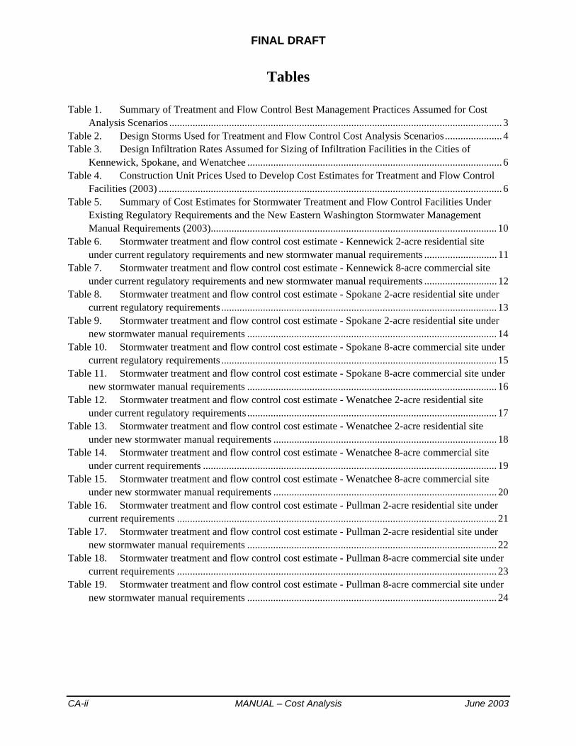
FINAL DRAFT
CA-ii MANUAL – Cost Analysis June 2003
Tables
Table 1. Summary of Treatment and Flow Control Best Management Practices Assumed for Cost Analysis Scenarios ................................................................................................................................ 3
Table 2. Design Storms Used for Treatment and Flow Control Cost Analysis Scenarios...................... 4Table 3. Design Infiltration Rates Assumed for Sizing of Infiltration Facilities in the Cities of
Kennewick, Spokane, and Wenatchee .................................................................................................. 6Table 4. Construction Unit Prices Used to Develop Cost Estimates for Treatment and Flow Control
Facilities (2003) .................................................................................................................................... 6Table 5. Summary of Cost Estimates for Stormwater Treatment and Flow Control Facilities Under
Existing Regulatory Requirements and the New Eastern Washington Stormwater Management Manual Requirements (2003).............................................................................................................. 10
Table 6. Stormwater treatment and flow control cost estimate - Kennewick 2-acre residential site under current regulatory requirements and new stormwater manual requirements ............................ 11
Table 7. Stormwater treatment and flow control cost estimate - Kennewick 8-acre commercial site under current regulatory requirements and new stormwater manual requirements ............................ 12
Table 8. Stormwater treatment and flow control cost estimate - Spokane 2-acre residential site under current regulatory requirements .......................................................................................................... 13
Table 9. Stormwater treatment and flow control cost estimate - Spokane 2-acre residential site under new stormwater manual requirements ................................................................................................ 14
Table 10. Stormwater treatment and flow control cost estimate - Spokane 8-acre commercial site under current regulatory requirements .......................................................................................................... 15
Table 11. Stormwater treatment and flow control cost estimate - Spokane 8-acre commercial site under new stormwater manual requirements ................................................................................................ 16
Table 12. Stormwater treatment and flow control cost estimate - Wenatchee 2-acre residential site under current regulatory requirements ................................................................................................ 17
Table 13. Stormwater treatment and flow control cost estimate - Wenatchee 2-acre residential site under new stormwater manual requirements ...................................................................................... 18
Table 14. Stormwater treatment and flow control cost estimate - Wenatchee 8-acre commercial site under current requirements ................................................................................................................. 19
Table 15. Stormwater treatment and flow control cost estimate - Wenatchee 8-acre commercial site under new stormwater manual requirements ...................................................................................... 20
Table 16. Stormwater treatment and flow control cost estimate - Pullman 2-acre residential site under current requirements ........................................................................................................................... 21
Table 17. Stormwater treatment and flow control cost estimate - Pullman 2-acre residential site under new stormwater manual requirements ................................................................................................ 22
Table 18. Stormwater treatment and flow control cost estimate - Pullman 8-acre commercial site under current requirements ........................................................................................................................... 23
Table 19. Stormwater treatment and flow control cost estimate - Pullman 8-acre commercial site under new stormwater manual requirements ................................................................................................ 24

FINAL DRAFT
June 2003 MANUAL - Cost Analysis CA-1
Cost Analysis of Stormwater Treatment and Flow Control Requirements for Eastern Washington
IntroductionIn many areas of eastern Washington the requirements for management of stormwater runoff in new development and redevelopment projects are changing in relation to the minimum requirements presented in the Washington State Department of Ecology’s Stormwater Management Manual for Eastern Washington. A concern with the new manual requirements is the cost that typical development projects will face in meeting them. This memorandum summarizes cost estimates that were developed for stormwater treatment and flow control facilities for two example development scenarios in four different locations in eastern Washington. The intent of the cost analysis is to provide estimates of the approximate design and construction costs that can be anticipated for various types of runoff flow control and treatment practices in different climate areas and in different soils. This memorandum supersedes a similar preliminary memorandum prepared by Herrera in June 2002.
Overview of Cost Analysis Approach The cost analysis examples entail a common basis of a typical 2-acre residential development and a typical 8-acre commercial development, with locations in the cities of Kennewick, Spokane, Pullman, and Wenatchee. The development examples for the Kennewick and Spokane locations provide an indication of stormwater management costs where infiltration of runoff in extremely porous soils is the primary factor in the drainage plans, with varying precipitation characteristics in those locations affecting the size of the stormwater facilities. The development examples for the Wenatchee location provide an indication of stormwater management costs where a slower infiltration rate prevails, but where most of the site runoff can still be discharged via infiltration to ground water. Wenatchee experiences slightly lesser precipitation in relation to Spokane, and greater precipitation in relation to Kennewick. The development examples for the Pullman location provide an indication of stormwater management costs where surface discharge of runoff is the primary factor in the drainage plans.
Cost estimates were developed for construction of permanent flow control and treatment facilities under each scenario. The estimates incorporate several line items for the various cost components, such as excavation, maintenance access driveway surfacing, soil amendment, vegetation seeding and plantings, flow control structures, inlet and outlet piping, and drain rock backfill. The cost estimates also include a flat 10% cost for mobilization and demobilization to construct the treatment and flow
FINAL DRAFT
CA-2 MANUAL – Cost Analysis June 2003
control facilities, a 25% contingency, taxes, and a flat cost ranging from 10% to 30% for engineering design and permitting of the treatment and flow control facilities and preparation of related technical documentation, depending on the complexity of the facilities. The costs were developed for comparison and planning purposes only. They should be considered accurate to an “order-of-magnitude” level only. Actual project costs may vary significantly depending on several factors, such as site size, configuration, conditions, etc.
The draft Stormwater Management Manual for Eastern Washington requires analysis of soil infiltration suitability and in-situ infiltration rates for sites where infiltration of runoff is proposed. This type of infiltration evaluation may not be necessary in locations where infiltration of stormwater runoff from development sites has historically been accomplished successfully. In other areas where infiltration rates are variable, and where it is less “guaranteed” to be effective, it is important to conduct a site-specific evaluation of infiltration rate. For this analysis it was assumed that evaluation of the onsite infiltration rate would not be necessary in Kennewick or Spokane, but that it would be necessary in Wenatchee. Thus, the cost estimates for the Wenatchee examples include the cost for analysis of soil characteristics for infiltration suitability. This cost was ignored for the Pullman examples because this analysis assumed that runoff from the example development sites in Pullman would not be purposefully infiltrated.
These eight cost examples were developed following the stormwater management facility design guidelines that are presented in the draft chapters of the Stormwater Management Manual for Eastern Washington.Details on the methods, assumptions, and results of these cost analyses are provided below.
Methods of Analysis This analysis includes estimates of “pre-manual” and “post-manual” costs for stormwater treatment and flow control. In many areas of eastern Washington, stormwater treatment and/or flow control are required to some degree for new development and redevelopment projects. To enable a useful characterization of cost impacts that can be expected in these areas, it is necessary to incorporate reasonably accurate estimates of stormwater treatment and flow control costs that are experienced under current regulatory requirements for the example development scenarios.
Stormwater Treatment and Flow Control Practices Under Existing Regulatory Requirements and the New Eastern Washington Manual To enable estimation of treatment and flow control costs under the “pre-manual” scenarios, it was necessary to gain an understanding of current stormwater treatment and flow control practices in the four cities that are

June 2003 MANUAL – Cost Analysis CA-3
the subject of this analysis, Kennewick, Spokane, Wenatchee, and Pullman. Stormwater managers and other public works staff were contacted in each of the four jurisdictions to determine the types of treatment and flow control best management practices (BMPs) that would typically be expected of a 2-acre residential development and an 8-acre commercial development in their jurisdiction. Those same individuals were asked to assess the likely treatment and flow control BMPs that would be used on those same types of development sites under the new Stormwater Management Manual for Eastern Washington. Table 1 provides a summary of the assumed treatment and flow control BMPs for both the pre- and post-manual cost estimate scenarios.
Table 1. Summary of Treatment and Flow Control Best Management Practices Assumed for Cost Analysis Scenarios
Site Development Example
Treatment Facility Under Existing Requirements
Treatment Facility Under New Manual Requirements
Flow Control Facility Under Existing Requirements
Flow Control Facility Under New Manual Requirements
2-acre residential in Kennewick
None None Infiltration in drywells
Infiltration in drywells
8-acre commercial in Kennewick
None None Infiltration in drywells or open pond
Infiltration in drywells or open pond
2-acre residential in Spokane
Bioinfiltration swale Bioinfiltration swale Infiltration in drywells
Infiltration in drywells
8-acre commercial in Spokane
Bioinfiltration swale Bioinfiltration swale Infiltration in drywells or open pond
Infiltration in drywells or open pond
2-acre residential in Wenatchee
Biofiltration swale Bioinfiltration swale None Infiltration in drywells or open pond
8-acre commercial in Wenatchee
Oil/waterseparator(s)
Bioinfiltration swale None Infiltration in drywells or open pond
2-acre residential in Pullman
None Wet pond Detention pond Detention pond
8-acre commercial in Pullman
Biofiltration swale(s)
Wet pond Detention pond Detention pond
Sizing of Stormwater Treatment and Flow Control FacilitiesThe costs of the BMPs listed in Table 1 are largely a function of their approximate size. Thus, to enable determination of approximate costs for these facilities it was necessary to develop estimates of the sizes of the various BMPs for each of the example scenarios. The size of a particular treatment or flow control BMP is related to the design storm events that it is intended to manage, and the peak rates and volumes of runoff that occur in those events. Under current regulatory requirements, the four cities incorporated in this analysis rely upon varying design storms for sizing of treatment and/or flow control BMPs. Table 2 summarizes the design storm events used for the “pre-manual” cost examples. Table 2 also
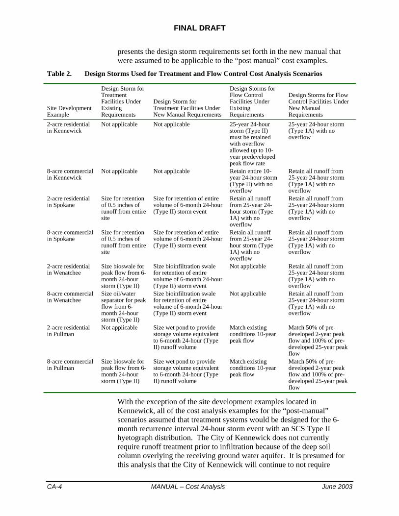
FINAL DRAFT
CA-4 MANUAL – Cost Analysis June 2003
presents the design storm requirements set forth in the new manual that were assumed to be applicable to the “post manual” cost examples.
Table 2. Design Storms Used for Treatment and Flow Control Cost Analysis Scenarios
Site Development Example
Design Storm for Treatment Facilities Under ExistingRequirements
Design Storm for Treatment Facilities Under New Manual Requirements
Design Storms for Flow Control Facilities Under ExistingRequirements
Design Storms for Flow Control Facilities Under New Manual Requirements
2-acre residential in Kennewick
Not applicable Not applicable 25-year 24-hour storm (Type II) must be retained with overflow allowed up to 10-year predeveloped peak flow rate
25-year 24-hour storm (Type 1A) with no overflow
8-acre commercial in Kennewick
Not applicable Not applicable Retain entire 10-year 24-hour storm (Type II) with no overflow
Retain all runoff from 25-year 24-hour storm (Type 1A) with no overflow
2-acre residential in Spokane
Size for retention of 0.5 inches of runoff from entire site
Size for retention of entire volume of 6-month 24-hour (Type II) storm event
Retain all runoff from 25-year 24-hour storm (Type 1A) with no overflow
Retain all runoff from 25-year 24-hour storm (Type 1A) with no overflow
8-acre commercial in Spokane
Size for retention of 0.5 inches of runoff from entire site
Size for retention of entire volume of 6-month 24-hour (Type II) storm event
Retain all runoff from 25-year 24-hour storm (Type 1A) with no overflow
Retain all runoff from 25-year 24-hour storm (Type 1A) with no overflow
2-acre residential in Wenatchee
Size bioswale for peak flow from 6-month 24-hour storm (Type II)
Size bioinfiltration swale for retention of entire volume of 6-month 24-hour (Type II) storm event
Not applicable Retain all runoff from 25-year 24-hour storm (Type 1A) with no overflow
8-acre commercial in Wenatchee
Size oil/water separator for peak flow from 6-month 24-hour storm (Type II)
Size bioinfiltration swale for retention of entire volume of 6-month 24-hour (Type II) storm event
Not applicable Retain all runoff from 25-year 24-hour storm (Type 1A) with no overflow
2-acre residential in Pullman
Not applicable Size wet pond to provide storage volume equivalent to 6-month 24-hour (Type II) runoff volume
Match existing conditions 10-year peak flow
Match 50% of pre-developed 2-year peak flow and 100% of pre-developed 25-year peak flow
8-acre commercial in Pullman
Size bioswale for peak flow from 6-month 24-hour storm (Type II)
Size wet pond to provide storage volume equivalent to 6-month 24-hour (Type II) runoff volume
Match existing conditions 10-year peak flow
Match 50% of pre-developed 2-year peak flow and 100% of pre-developed 25-year peak flow
With the exception of the site development examples located in Kennewick, all of the cost analysis examples for the “post-manual” scenarios assumed that treatment systems would be designed for the 6-month recurrence interval 24-hour storm event with an SCS Type II hyetograph distribution. The City of Kennewick does not currently require runoff treatment prior to infiltration because of the deep soil column overlying the receiving ground water aquifer. It is presumed for this analysis that the City of Kennewick will continue to not require

June 2003 MANUAL – Cost Analysis CA-5
treatment prior to runoff infiltration on development sites in the future. All of the cost analysis examples for these same scenarios assumed that flow control, whether accomplished with infiltration or surface discharge systems, would be designed to manage all of the runoff generated in the 25-year 24-hour storm event with an SCS Type 1A hyetograph distribution. For the examples in Kennewick, Spokane, and Wenatchee, where infiltration of runoff typically occurs, it was assumed that the infiltration systems would be sized to infiltrate the entire runoff volume from this 25-year storm event without overtopping. For the surface discharge examples in Pullman, it was assumed that the post-developed peak flow rates in the 2-year storm would be reduced to match 50% of the predeveloped peak flow rate, and that the post-developed peak flow rates in the 25-year storm would be reduced to match the predeveloped peak flow rate.
Most of the BMP sizes estimated for this analysis were derived using the StormShed computer program (Engenious Systems 2000). StormShed is a program that calculates runoff hydrographs using the Santa Barbara Urban Hydrograph (SBUH) method, with inputs of drainage areas and runoff curve numbers for different ground covers and soil types, in addition to the design storm event precipitation data. Some of the infiltration BMP sizes were developed based on “rules of thumb” provided by representatives of Kennewick and Spokane (specifically, development in Kennewick typically occurs with four 6-foot-diameter drywells per acre of impervious surface, and Spokane typically requires bioinfiltration swales sized for 0.5 inches of runoff from the tributary drainage area).
A driving factor in the sizing of all of the BMPs for the examples in Kennewick, Spokane, and Wenatchee is the assumed soil infiltration rate. Each of these geographic areas contains soils that are typically conducive to infiltration of large amounts of runoff, though at varying rates.Infiltration treatment BMPs in these areas, such as bioinfiltration swales, must include amendment of the native, high-permeability soils to reduce the rate of infiltration and to add organic matter that is crucial for vegetation growth and effective pollutant removal. Table 3 lists the assumed natural infiltration rates for the soils in Spokane and Wenatchee for sizing of infiltration facilities for flow disposal (such as open basins and drywells), and the assumed infiltration rates (with soil amendment in Spokane) in corresponding treatment BMPs in these areas. These rates were obtained via contacts with city staff in each jurisdiction (Steve Hansen in Spokane and Steve King in Wenatchee). The design infiltration rate was not needed for the Kennewick area because the city’s rule of thumb sizing procedure for drywells was used in this analysis (no modeling of infiltration BMPs was performed for the Kennewick examples).
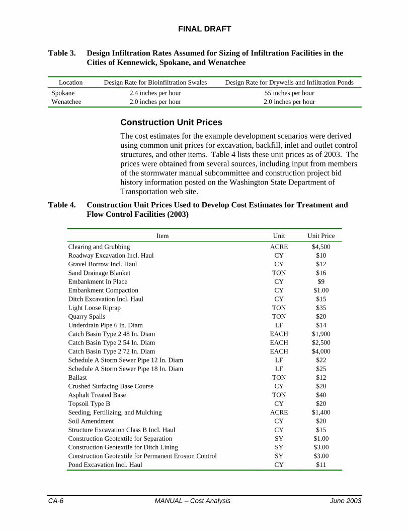
FINAL DRAFT
CA-6 MANUAL – Cost Analysis June 2003
Table 3. Design Infiltration Rates Assumed for Sizing of Infiltration Facilities in the Cities of Kennewick, Spokane, and Wenatchee
Location Design Rate for Bioinfiltration Swales Design Rate for Drywells and Infiltration Ponds Spokane 2.4 inches per hour 55 inches per hour Wenatchee 2.0 inches per hour 2.0 inches per hour
Construction Unit Prices The cost estimates for the example development scenarios were derived using common unit prices for excavation, backfill, inlet and outlet control structures, and other items. Table 4 lists these unit prices as of 2003. The prices were obtained from several sources, including input from members of the stormwater manual subcommittee and construction project bid history information posted on the Washington State Department of Transportation web site.
Table 4. Construction Unit Prices Used to Develop Cost Estimates for Treatment and Flow Control Facilities (2003)
Item Unit Unit Price Clearing and Grubbing ACRE $4,500 Roadway Excavation Incl. Haul CY $10 Gravel Borrow Incl. Haul CY $12 Sand Drainage Blanket TON $16 Embankment In Place CY $9 Embankment Compaction CY $1.00 Ditch Excavation Incl. Haul CY $15 Light Loose Riprap TON $35 Quarry Spalls TON $20 Underdrain Pipe 6 In. Diam LF $14 Catch Basin Type 2 48 In. Diam EACH $1,900 Catch Basin Type 2 54 In. Diam EACH $2,500 Catch Basin Type 2 72 In. Diam EACH $4,000 Schedule A Storm Sewer Pipe 12 In. Diam LF $22 Schedule A Storm Sewer Pipe 18 In. Diam LF $25 Ballast TON $12 Crushed Surfacing Base Course CY $20 Asphalt Treated Base TON $40 Topsoil Type B CY $20 Seeding, Fertilizing, and Mulching ACRE $1,400 Soil Amendment CY $20 Structure Excavation Class B Incl. Haul CY $15 Construction Geotextile for Separation SY $1.00 Construction Geotextile for Ditch Lining SY $3.00 Construction Geotextile for Permanent Erosion Control SY $3.00 Pond Excavation Incl. Haul CY $11

June 2003 MANUAL – Cost Analysis CA-7
The itemized cost estimates for treatment and flow control BMPs for each of the development scenarios included in this analyses are attached to this memorandum, and the results are summarized later in the text.
Summary of Example Development Site Assumptions
Several important assumptions for development site characteristics were made in developing these cost estimates. These assumptions are listed below.
2-acre Residential Development Characteristics The following assumptions were made for the 2-acre residential development examples:
1. The entire 2-acre development would drain to a common area where stormwater treatment and flow control facilities would be located.
2. The cost of storm drain conveyance systems to direct the runoff to these BMPs was ignored.
3. Rooftop runoff would be separated from other impervious surface runoff where cost-effective to do so to avoid the need for treatment. For residential developments, it can be assumed that rooftop runoff is non-pollution generating impervious surface (NPGIS). It was assumed that 8 houses would be constructed in the development, and that the rooftop area for each house would average 2,000 square feet. For the examples in Kennewick, Spokane, and Wenatchee, it was assumed that all rooftop runoff would be managed with downspout infiltration facilities. For the examples in Pullman, it was assumed that rooftop runoff would mix with runoff from the remainder of the development, and the treatment and flow control facilities were sized accordingly.
4. The total pollution generating impervious surface (PGIS) area in the development (i.e., streets, driveways, and sidewalks that drain to adjacent streets) is 20,600 square feet.
5. The pervious areas of the site would consist of 75% lawns (37,900 square feet) and 25% native open space/landscaping (12,600 square feet). The runoff from lawns and other landscaped areas (whatever minor amounts of runoff are predicted by the hydrologic model) would mix with street and driveway runoff.
8-acre Commercial Development Characteristics The following assumptions were made for the 8-acre commercial development examples:
1. The entire 8-acre development would drain to a common area where stormwater treatment and flow control facilities would be located.

FINAL DRAFT
CA-8 MANUAL – Cost Analysis June 2003
2. The cost of storm drain conveyance systems to direct the runoff to these BMPs was ignored.
3. The development would consist of one large building, such as a “big box” retail store or a combination of strip mall stores within one contiguous building structure. The remainder of the development would be mostly parking lot area, with a minor amount of perimeter landscaping.
4. Rooftop runoff would be separated from other impervious surface runoff where cost-effective to do so to avoid the need for treatment. For many commercial developments, it can be assumed that rooftop runoff is non-pollution generating impervious surface (NPGIS). It was assumed that the building rooftop area would total 1.9 acres. For the examples in Kennewick, Spokane, and Wenatchee, it was assumed that all building rooftop runoff would be managed with downspout infiltration facilities. For the examples in Pullman, it was assumed that the building rooftop runoff would mix with the parking lot runoff, and the treatment and flow control facilities were sized accordingly.
5. The total pollution generating impervious surface (PGIS) area in the development (i.e., parking lot area and sidewalks that drain to the adjacent parking lot) was assumed to be 5.3 acres.
6. The total area of landscaping in the development would be 0.8 acres (10 percent of the total site area), including the general area of the stormwater management facilities. It was assumed that runoff from these landscaped areas would mix with parking lot runoff, and thus would be routed into the treatment and flow control facilities.
Geometric Design Parameters for Treatment and Flow Control BMPs In the residential development examples in Spokane and Wenatchee, bioinfiltration swales for runoff treatment were assumed to have a design depth of 6 inches for storage and eventual infiltration of the entire volume of the 6-month design storm event. It was assumed that these swales would overflow to drywells in larger storms. The drywell structures were assumed to be 6 feet in interior diameter and 10 feet deep.
In the commercial development examples in Spokane and Wenatchee, it was assumed that overflows from bioinfiltration swales would enter an adjacent infiltration basin excavated in the native (unamended) soils. The infiltration basins were assumed to have a maximum ponding depth of 5 to 6 feet, plus 1 foot of freeboard for a total excavated depth of 6 to 7 feet. It was assumed that the bioinfiltration swales and infiltration basins would be constructed entirely via excavation, without use of perimeter fill berms.
For the residential development example in Kennewick, it was assumed that drywells would be used for flow disposal, without pretreatment. The typical drywell structure used in Kennewick is 6 feet in interior diameter

June 2003 MANUAL – Cost Analysis CA-9
and a minimum of 9 feet deep, and that size was incorporated in this analysis. For the commercial development example in Kennewick, it was assumed that 4 drywells per acre of parking lot would be used for disposal of all of the site runoff. For the wet/detention ponds in the residential and commercial development examples in Pullman, it was assumed that the total pond depth would be 6 feet and 7 feet, respectively. The lower 3 to 4 feet would accommodate the treatment pool, and the upper 2 to 3 feet would provide live storage for flow control, including 1 foot of freeboard above the peak 25-year storm water surface elevation. It was assumed that the storage volume in these wet/detention ponds would be constructed via approximately ¾ excavation and ¼ perimeter fill berms. Minor amounts of runoff infiltration through the bottom of the ponds during and immediately following storm events were ignored in sizing of the storage volume.
Summary of Cost Estimate Results Table 5 lists the total cost estimates that were developed for the site development examples and the estimated site areas that would be dedicated to stormwater treatment and flow control facilities. All of the cost estimates were developed assuming that no additional land would need to be acquired for the treatment and flow control facilities. The detailed breakdown of these cost estimates is provided in Tables 6 through 19 for each of the examples.
As indicated in Table 5, the costs for stormwater treatment and flow control may rise in some instances and may drop in other instances in relation to current practice in many areas of eastern Washington. These differences are largely dependent on the stormwater control requirements currently enforced. For example, the City of Wenatchee often requires use of one or more oil/water separators to treat runoff from heavily used parking lots, such as the example for the 8-acre commercial retail site. Due to the large site size in this example, the sizes of oil/water separator vaults required to treat the 6-month storm peak flow, per current Wenatchee practice, are quite large and therefore expensive to purchase and install. The new stormwater manual would allow a bioinfiltration swale for treatment of oil and other runoff pollutants at this example development site, and construction of a large bioinfiltration swale would be far less expensive relative to oil/water separator vaults. The result is a significant cost reduction reflected for this example site in Wenatchee. An example of the opposite effect on cost is reflected by the development examples in Pullman. The City of Pullman currently requires treatment and flow control with similar BMPs as presented in the Stormwater Management Manual for Eastern Washington, but to a lesser extent than will be required with the new stormwater manual. Thus, this analysis indicates that the cost to meet stormwater treatment and flow control requirements would likely rise in Pullman relative to current practice.

FINAL DRAFT
CA-10 MANUAL – Cost Analysis June 2003
Table 5. Summary of Cost Estimates for Stormwater Treatment and Flow Control Facilities Under Existing Regulatory Requirements and the New Eastern Washington Stormwater Management Manual Requirements (2003)
Site Example
Estimated Total BMP Costs Under Current Practice
Total Area Required for BMPs Under Current Practice
Estimated Total BMP Costs Under the New Manual Requirements
Total Area Required for BMPs Under the New Manual Requirements
1. Kennewick 2-acre residential $13,000 0.01 acres $13,000 0.01 acres 2. Kennewick 8-acre commercial $138,000 0.06 acres $138,000 0.06 acres 3. Spokane 2-acre residential $10,000 0.16 acres $8,000 0.11 acres 4. Spokane 8-acre commercial $44,000 0.64 acres $29,000 0.40 acres 5. Wenatchee 2-acre residential $7,000 0.06 acres $12,000 0.12 acres 6. Wenatchee 8-acre commercial $111,000 0.01 acres $47,000 0.56 acres 7. Pullman 2-acre residential $12,000 0.05 acres $18,000 0.08 acres 8. Pullman 8-acre commercial $54,000 0.55 acres $69,000 0.39 acres Note: the drywells used for the Kennewick sites can also serve as drainage collection structures, whereas all of the other siteexamples would require drainage collection and conveyance systems to direct runoff to the treatment and flow control facilities.
The lower costs indicated in Table 5 for treatment and flow control facilities in the City of Spokane under the new stormwater manual relative to current practice are directly related to the assumed procedure for sizing of the bioinfiltration swale that is incorporated in each scenario. Bioinfiltration swales in Spokane are typically sized to have storage capacity equivalent to 0.5 inches of runoff from the contributing pollution-generating impervious surface. If the same bioinfiltration swale is instead sized with a flow routing procedure that accounts for infiltration through the bottom of the swale during the storm runoff hydrograph time sequence, then the swale size is smaller in comparison even though the 6-month design storm precipitation depth is greater than 0.5 inches. The bioinfiltration swales for the 2- and 8-acre development examples under the “post-manual” scenarios in the City of Spokane were sized based on a hydrograph routing method, and as a result the estimated sizes were smaller compared to those sized to hold 0.5 inches of runoff from the same site drainage area. The smaller swales translate into lesser cost. Otherwise, all aspects of the Spokane examples are the same for the “pre-manual” and “post-manual” scenarios.

June 2003 MANUAL – Cost Analysis CA-11
Table 6. Stormwater treatment and flow control cost estimate - Kennewick 2-acre residential site under current regulatory requirements and new stormwater manual requirements
Description Unit Quantity UnitCost Cost
Flow control - 4 drywells per 1 acre of impervious surface Impervious surface (not incl. rooftops) = 20,600 square feet Drywells EACH 2 $4,000 $8,000 Subtotal permanent BMP construction cost $8,000 Mobilization and demobilization (10%) $800 Subtotal permanent BMP construction cost including mobilization and demobilization $8,800 Contingencies (25%) $2,200 Total permanent BMP construction cost $11,000 Taxes (7.7%) $847 Engineering and permitting fees for stormwater facilities (10%) $1,100 (excluding basic site drainage infrastructure) Total cost for permanent stormwater BMP construction $13,000
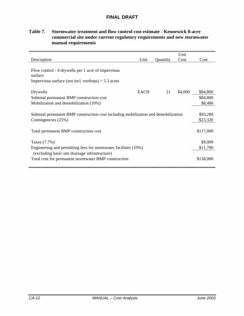
FINAL DRAFT
CA-12 MANUAL – Cost Analysis June 2003
Table 7. Stormwater treatment and flow control cost estimate - Kennewick 8-acre commercial site under current regulatory requirements and new stormwater manual requirements
Description Unit QuantityUnitCost Cost
Flow control - 4 drywells per 1 acre of impervious surface Impervious surface (not incl. rooftops) = 5.3 acres Drywells EACH 21 $4,000 $84,800 Subtotal permanent BMP construction cost $84,800 Mobilization and demobilization (10%) $8,480 Subtotal permanent BMP construction cost including mobilization and demobilization $93,280 Contingencies (25%) $23,320 Total permanent BMP construction cost $117,000 Taxes (7.7%) $9,009 Engineering and permitting fees for stormwater facilities (10%) $11,700 (excluding basic site drainage infrastructure) Total cost for permanent stormwater BMP construction $138,000

June 2003 MANUAL – Cost Analysis CA-13
Table 8. Stormwater treatment and flow control cost estimate - Spokane 2-acre residential site under current regulatory requirements
Description Unit Quantity UnitCost Cost
Water quality treatment - bioinfiltration swale with 850 cubic feet storage volume Clearing and Grubbing ACRE 0.11 $4,500 $478 Common Excavation Incl. Haul CY 111 $10 $1,111 Quarry Spalls (overflow to infiltration basin) TON 3.8 $20 $76 Soil Amendment CY 30 $20 $600 Seeding, Fertilizing, and Mulching ACRE 0.11 $1,400 $149 Flow control - infiltration basin 4' x 8' bottom x 6' deep Clearing and Grubbing ACRE 0.05 $4,500 $218 Common Excavation Incl. Haul CY 199 $10 $1,991 Seeding, Fertilizing, and Mulching ACRE 0.05 $1,400 $68 Emergency overflow spillway - riprap TON 9 $35 $315 Gravel access driveway TON 15 $20 $300 Subtotal permanent BMP construction cost $5,300 Mobilization and demobilization (10%) $530 Subtotal permanent BMP construction cost including mobilization and demobilization $5,830 Contingencies (25%) $1,458 Total permanent BMP construction cost $7,000 Taxes (8.1%) $567 Engineering and permitting fees for stormwater facilities (30%) $2,100 (excluding basic site drainage infrastructure) Total cost for permanent stormwater BMP construction $10,000

FINAL DRAFT
CA-14 MANUAL – Cost Analysis June 2003
Table 9. Stormwater treatment and flow control cost estimate - Spokane 2-acre residential site under new stormwater manual requirements
Description Unit QuantityUnitCost Cost
Water quality treatment - bioinfiltration swale with 480 cubic feet storage volume Clearing and Grubbing ACRE 0.06 $4,500 $270 Common Excavation Incl. Haul CY 65 $10 $653 Quarry Spalls (overflow to infiltration basin) TON 3.8 $20 $76 Soil Amendment CY 18 $20 $360 Seeding, Fertilizing, and Mulching ACRE 0.06 $1,400 $84 Flow control - infiltration basin 4' x 8' bottom x 6' deep Clearing and Grubbing ACRE 0.05 $4,500 $218 Common Excavation Incl. Haul CY 199 $10 $1,991 Seeding, Fertilizing, and Mulching ACRE 0.05 $1,400 $68 Emergency overflow spillway - riprap TON 9 $35 $315 Gravel access driveway TON 15 $20 $300 Subtotal permanent BMP construction cost $4,300 Mobilization and demobilization (10%) $430 Subtotal permanent BMP construction cost including mobilization and demobilization $4,730 Contingencies (25%) $1,183 Total permanent BMP construction cost $6,000 Taxes (8.1%) $486 Engineering and permitting fees for stormwater facilities (30%) $1,800 (excluding basic site drainage infrastructure) Total cost for permanent stormwater BMP construction $8,000

June 2003 MANUAL – Cost Analysis CA-15
Table 10. Stormwater treatment and flow control cost estimate - Spokane 8-acre commercial site under current regulatory requirements
Description Unit Quantity UnitCost Cost
Water quality treatment - bioinfiltration swale with 9,600 cubic feet storage volume Clearing and Grubbing ACRE 0.59 $4,500 $2,642 Common Excavation Incl. Haul CY 1114 $10 $11,135 Quarry Spalls (overflow to infiltration basin) TON 3.8 $20 $76 Soil Amendment CY 263 $20 $5,260 Seeding, Fertilizing, and Mulching ACRE 0.59 $1,400 $822 Flow control - infiltration basin 1' x 1' bottom x 7' deep, 3H:1V side slopes Clearing and Grubbing ACRE 0.05 $4,500 $229 Common Excavation Incl. Haul CY 240 $10 $2,398 Seeding, Fertilizing, and Mulching ACRE 0.05 $1,400 $71 Emergency overflow spillway - riprap TON 9 $35 $315 Gravel access driveway TON 15 $20 $300 Subtotal permanent BMP construction cost $23,200 Mobilization and demobilization (10%) $2,320 Subtotal permanent BMP construction cost including mobilization and demobilization $25,520 Contingencies (25%) $6,380 Total permanent BMP construction cost $32,000 Taxes (8.1%) $2,592 Engineering and permitting fees for stormwater facilities (30%) $9,600 (excluding basic site drainage infrastructure) Total cost for permanent stormwater BMP construction $44,000

FINAL DRAFT
CA-16 MANUAL – Cost Analysis June 2003
Table 11. Stormwater treatment and flow control cost estimate - Spokane 8-acre commercial site under new stormwater manual requirements
Description Unit QuantityUnitCost Cost
Water quality treatment - bioinfiltration swale with 5,400 cubic feet storage volume Clearing and Grubbing ACRE 0.35 $4,500 $1,580 Common Excavation Incl. Haul CY 643 $10 $6,430 Quarry Spalls (overflow to infiltration basin) TON 3.8 $20 $76 Soil Amendment CY 157 $20 $3,140 Seeding, Fertilizing, and Mulching ACRE 0.35 $1,400 $492 Flow control - infiltration basin 1' x 1' bottom x 7' deep, 3H:1V side slopes Clearing and Grubbing ACRE 0.05 $4,500 $229 Common Excavation Incl. Haul CY 240 $10 $2,398 Seeding, Fertilizing, and Mulching ACRE 0.05 $1,400 $71 Emergency overflow spillway - riprap TON 9 $35 $315 Gravel access driveway TON 15 $20 $300 Subtotal permanent BMP construction cost $15,000 Mobilization and demobilization (10%) $1,500 Subtotal permanent BMP construction cost including mobilization and demobilization $16,500 Contingencies (25%) $4,125 Total permanent BMP construction cost $21,000 Taxes (8.1%) $1,701 Engineering and permitting fees for stormwater facilities (30%) $6,300 (excluding basic site drainage infrastructure) Total cost for permanent stormwater BMP construction $29,000
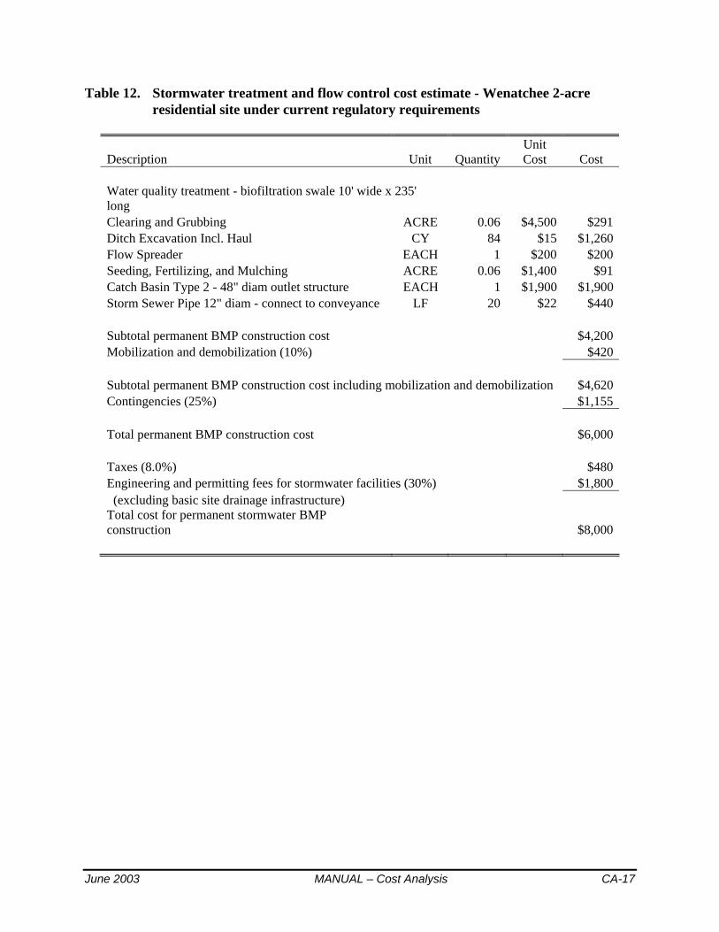
June 2003 MANUAL – Cost Analysis CA-17
Table 12. Stormwater treatment and flow control cost estimate - Wenatchee 2-acre residential site under current regulatory requirements
Description Unit QuantityUnitCost Cost
Water quality treatment - biofiltration swale 10' wide x 235' long Clearing and Grubbing ACRE 0.06 $4,500 $291 Ditch Excavation Incl. Haul CY 84 $15 $1,260 Flow Spreader EACH 1 $200 $200 Seeding, Fertilizing, and Mulching ACRE 0.06 $1,400 $91 Catch Basin Type 2 - 48" diam outlet structure EACH 1 $1,900 $1,900 Storm Sewer Pipe 12" diam - connect to conveyance LF 20 $22 $440 Subtotal permanent BMP construction cost $4,200 Mobilization and demobilization (10%) $420 Subtotal permanent BMP construction cost including mobilization and demobilization $4,620 Contingencies (25%) $1,155 Total permanent BMP construction cost $6,000 Taxes (8.0%) $480 Engineering and permitting fees for stormwater facilities (30%) $1,800 (excluding basic site drainage infrastructure) Total cost for permanent stormwater BMP construction $8,000

FINAL DRAFT
CA-18 MANUAL – Cost Analysis June 2003
Table 13. Stormwater treatment and flow control cost estimate - Wenatchee 2-acre residential site under new stormwater manual requirements
Description Unit QuantityUnitCost Cost
Water quality treatment - bioinfiltration swale with 470 cubic feet storage volume Clearing and Grubbing ACRE 0.03 $4,500 $153 Common Excavation Incl. Haul CY 64 $10 $640 Quarry Spalls (overflow to infiltration basin) TON 3.8 $20 $76 Soil Amendment CY 9 $20 $180 Seeding, Fertilizing, and Mulching ACRE 0.03 $1,400 $48 Flow control - infiltration basin 20' x 20' bottom x 6' deep Clearing and Grubbing ACRE 0.09 $4,500 $389 Common Excavation Incl. Haul CY 393 $10 $3,930 Seeding, Fertilizing, and Mulching ACRE 0.09 $1,400 $121 Emergency overflow spillway - riprap TON 9 $35 $315 Gravel access driveway TON 18 $20 $360 Subtotal permanent BMP construction cost $6,200 Mobilization and demobilization (10%) $620 Subtotal permanent BMP construction cost including mobilization and demobilization $6,820 Contingencies (25%) $1,705 Total permanent BMP construction cost $9,000 Taxes (8.0%) $720 Engineering and permitting fees for stormwater facilities (30%) $2,700 (excluding basic site drainage infrastructure) Total cost for permanent stormwater BMP construction $12,000

June 2003 MANUAL – Cost Analysis CA-19
Table 14. Stormwater treatment and flow control cost estimate - Wenatchee 8-acre commercial site under current requirements
Description Unit QuantityUnitCost Cost
Water quality treatment - 2 oil/water separators with dimensions 9'W x 7'H x 17' L Clearing and Grubbing ACRE 0.01 $4,500 $60 Structure Excavation Incl. Haul CY 206 $15 $3,090 Shoring SF 896 $10 $8,960 Crushed Gravel Bedding for Vaults TON 20 $20 $405 Prefabricated Coalescing Plate Separator Vaults EACH 2 $25,000 $50,000 Storm Sewer Pipe 12" diam - connect to conveyance LF 25 $22 $550 Subtotal permanent BMP construction cost $63,100 Mobilization and demobilization (10%) $6,310 Subtotal permanent BMP construction cost including mobilization and demobilization $69,410 Contingencies (25%) $17,353 Total permanent BMP construction cost $87,000 Taxes (8.0%) $6,960 Engineering and permitting fees for stormwater facilities (20%) $17,400 (excluding basic site drainage infrastructure) Total cost for permanent stormwater BMP construction $111,000
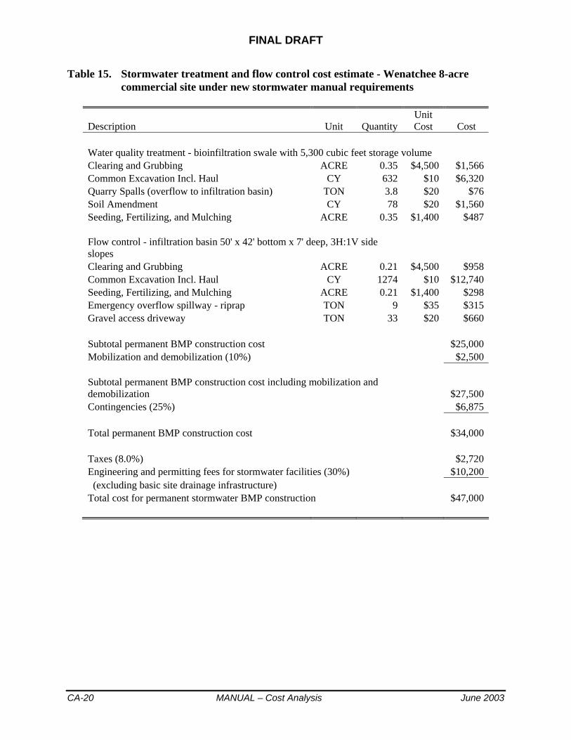
FINAL DRAFT
CA-20 MANUAL – Cost Analysis June 2003
Table 15. Stormwater treatment and flow control cost estimate - Wenatchee 8-acre commercial site under new stormwater manual requirements
Description Unit QuantityUnitCost Cost
Water quality treatment - bioinfiltration swale with 5,300 cubic feet storage volume Clearing and Grubbing ACRE 0.35 $4,500 $1,566 Common Excavation Incl. Haul CY 632 $10 $6,320 Quarry Spalls (overflow to infiltration basin) TON 3.8 $20 $76 Soil Amendment CY 78 $20 $1,560 Seeding, Fertilizing, and Mulching ACRE 0.35 $1,400 $487 Flow control - infiltration basin 50' x 42' bottom x 7' deep, 3H:1V side slopes Clearing and Grubbing ACRE 0.21 $4,500 $958 Common Excavation Incl. Haul CY 1274 $10 $12,740 Seeding, Fertilizing, and Mulching ACRE 0.21 $1,400 $298 Emergency overflow spillway - riprap TON 9 $35 $315 Gravel access driveway TON 33 $20 $660 Subtotal permanent BMP construction cost $25,000 Mobilization and demobilization (10%) $2,500 Subtotal permanent BMP construction cost including mobilization and demobilization $27,500 Contingencies (25%) $6,875 Total permanent BMP construction cost $34,000 Taxes (8.0%) $2,720 Engineering and permitting fees for stormwater facilities (30%) $10,200 (excluding basic site drainage infrastructure) Total cost for permanent stormwater BMP construction $47,000

June 2003 MANUAL – Cost Analysis CA-21
Table 16. Stormwater treatment and flow control cost estimate - Pullman 2-acre residential site under current requirements
Description Unit QuantityUnitCost Cost
Flow control in detention pond, no water quality treatment Pond dimensions = 44' x 44' at top, total depth = 4', 3H:1V side slopes Clearing and Grubbing ACRE 0.05 $4,500 $240 Common Excavation Incl. Haul CY 173 $10 $1,730 Seeding, Fertilizing, and Mulching ACRE 0.05 $1,400 $75 Emergency overflow spillway - riprap TON 9 $35 $315 Gravel access driveway TON 15 $20 $300 Catch Basin Type 2 Outlet Control Structure - 54" diam EACH 1 $3,500 $3,500 Storm Sewer Pipe 12" diam - connect to conveyance LF 30 $22 $660 Subtotal permanent BMP construction cost $6,800 Mobilization and demobilization (10%) $680 Subtotal permanent BMP construction cost including mobilization and demobilization $7,480 Contingencies (25%) $1,870 Total permanent BMP construction cost $9,000 Taxes (7.6%) $684 Engineering and permitting fees for stormwater facilities (30%) $2,700 (excluding basic site drainage infrastructure) Total cost for permanent stormwater BMP construction $12,000

FINAL DRAFT
CA-22 MANUAL – Cost Analysis June 2003
Table 17. Stormwater treatment and flow control cost estimate - Pullman 2-acre residential site under new stormwater manual requirements
Description Unit QuantityUnitCost Cost
Water quality treatment and flow control in combined wet/detention pond Pond dimensions = 54' x 54' at top, total depth = 7', 3H:1V side slopes Clearing and Grubbing ACRE 0.08 $4,500 $361 Common Excavation Incl. Haul CY 397 $10 $3,970 Seeding, Fertilizing, and Mulching ACRE 0.08 $1,400 $112 Emergency overflow spillway - riprap TON 9 $35 $315 Gravel access driveway TON 18 $20 $360 Catch Basin Type 2 Outlet Control Structure - 54" diam EACH 1 $3,500 $3,500 Storm Sewer Pipe 12" diam - connect to conveyance LF 30 $22 $660 Subtotal permanent BMP construction cost $9,300 Mobilization and demobilization (10%) $930 Subtotal permanent BMP construction cost including mobilization and demobilization $10,230 Contingencies (25%) $2,558 Total permanent BMP construction cost $13,000 Taxes (7.6%) $988 Engineering and permitting fees for stormwater facilities (30%) $3,900 (excluding basic site drainage infrastructure) Total cost for permanent stormwater BMP construction $18,000

June 2003 MANUAL – Cost Analysis CA-23
Table 18. Stormwater treatment and flow control cost estimate - Pullman 8-acre commercial site under current requirements
Description Unit QuantityUnitCost Cost
Runoff Treatment in 2 Bioswales - each 300' long x 20' wide Clearing and Grubbing ACRE 0.33 $4,500 $1,488 Ditch Excavation Incl. Haul CY 247 $15 $3,705 Flow Spreader EACH 2 $400 $800 Seeding, Fertilizing, and Mulching ACRE 0.33 $1,400 $463 Catch Basin Type 2 - 48" diam outlet structure EACH 2 $1,900 $3,800 Storm Sewer Pipe 12" diam - connect to conveyance LF 40 $22 $880 Flow control in detention pond Pond dimensions = 100' x 80' at top, total depth = 5', 3H:1V side slopes Clearing and Grubbing ACRE 0.22 $4,500 $992 Common Excavation Incl. Haul CY 1065 $10 $10,650 Seeding, Fertilizing, and Mulching ACRE 0.22 $1,400 $309 Emergency overflow spillway - riprap TON 9 $35 $315 Gravel access driveway TON 37 $20 $740 Catch Basin Type 2 Outlet Control Structure - 54" diam EACH 1 $3,500 $3,500 Storm Sewer Pipe 12" diam - connect to conveyance LF 40 $22 $880 Subtotal permanent BMP construction cost $28,500 Mobilization and demobilization (10%) $2,850 Subtotal permanent BMP construction cost including mobilization and demobilization $31,350 Contingencies (25%) $7,838 Total permanent BMP construction cost $39,000 Taxes (7.6%) $2,964 Engineering and permitting fees for stormwater facilities (30%) $11,700 (excluding basic site drainage infrastructure) Total cost for permanent stormwater BMP construction $54,000

FINAL DRAFT
CA-24 MANUAL – Cost Analysis June 2003
Table 19. Stormwater treatment and flow control cost estimate - Pullman 8-acre commercial site under new stormwater manual requirements
Description Unit QuantityUnitCost Cost
Runoff treatment and flow control in combined wet/detention pond Pond dimensions = 130' x 110' at top, total depth = 8', 3H:1V side slopes Clearing and Grubbing ACRE 0.39 $4,500 $1,773 Common Excavation Incl. Haul CY 2872 $10 $28,720 Seeding, Fertilizing, and Mulching ACRE 0.39 $1,400 $552 Emergency overflow spillway - riprap TON 9 $35 $315 Gravel access driveway TON 44 $20 $880 Catch Basin Type 2 Outlet Control Structure - 54" diam EACH 1 $3,500 $3,500 Storm Sewer Pipe 12" diam - connect to conveyance LF 40 $22 $880 Subtotal permanent BMP construction cost $36,600 Mobilization and demobilization (10%) $3,660 Subtotal permanent BMP construction cost including mobilization and demobilization $40,260 Contingencies (25%) $10,065 Total permanent BMP construction cost $50,000 Taxes (7.6%) $3,800 Engineering and permitting fees for stormwater facilities (30%) $15,000 (excluding basic site drainage infrastructure) Total cost for permanent stormwater BMP construction $69,000

FINAL DRAFT
June 2003 Introductory Notes to Comments and Responses RTC Intro-I
September 2002 Draft Stormwater Management Manual for Eastern Washington
SUMMARY OF PUBLIC COMMENTS AND RESPONSES
Introductory Notes
On the following pages are all comments received from reviewers of the September 2002 Draft Stormwater Management Manual for Eastern Washington, and the September 2002 Draft Model Municipal Stormwater Program for Eastern Washington.
LEGEND: Each comment is generally followed by one of the following two responses:
COMMENT NOTED: means the comment has been taken into consideration but generally no change to the document is suggested at this time
RESPONSE: the change suggested in the comment is either accepted, rejected, or edited as described
Prior to the Subcommittee meetings, the following four initial responses were used to facilitate review and draft responses by the Subcommittee members:
COMMENT NOTED: means the comment has been taken into consideration but generally no change to the document is suggested at this time
RESPONSE: the change suggested in the comment is either accepted, rejected, or edited as described
SUGGESTED RESPONSE: followed by a draft response which was considered by the Subcommittee
SUBCOMMITTEE TO DISCUSS: the comment should be addressed, but a suggested change may or may not have been proposed – required discussion by the Subcommittee
NOTE: All references to Chapters, Sections, Figures, Tables, etc. are based upon the numbering used in the September 2002 Draft documents. Please note that in the June 2003 Final Draft version of the Manual, Chapter 5 and Chapter 6 have been switched. Also, some of the numbering in various chapters may have changed from the September 2002 Draft documents.

FINAL DRAFT
RTC Intro-II Introductory Notes to Comments and Responses June 2003
This page intentionally left blank.

FINAL DRAFT
June 2003 Comments and Responses Table of Contents RTC i
Response to Comments Table of Contents
MANUAL
Introductory Notes ................................................................................................................. Intro-i
General, Bibliography.................................................................................................................... 1
Chapter 1........................................................................................................................................ 9
Chapter 2...................................................................................................................................... 15
Redevelopment......................................................................................................................... 21 Commercial/Industrial................................................................................................... 21 Roads............................................................................................................................. 25
Core Elements #1, 2, 3 ............................................................................................................. 29 Core Element #4....................................................................................................................... 31 Core Element #5....................................................................................................................... 35 Core Element #6....................................................................................................................... 43 Core Element #5 and #6 (Design Storms and Snowmelt)........................................................ 49 Core Elements #7, 8 ................................................................................................................. 55
Chapter 3...................................................................................................................................... 57
Chapter 4...................................................................................................................................... 61
Chapter 5...................................................................................................................................... 69
Chapter 6...................................................................................................................................... 81
Chapter 7.................................................................................................................................... 115
Chapter 8.................................................................................................................................... 123
MODEL PROGRAM
Model Municipal Stormwater Program ..................................................................................... 135

FINAL DRAFT
RTC ii Comments and Responses Table of Contents June 2003
FINAL DRAFT
June 2003 MANUAL - Comments and Responses RTC 1
September 2002 Draft Stormwater Management Manual for Eastern Washington
SUMMARY OF PUBLIC COMMENTS AND RESPONSES
General Comments and Bibliography Subcommittee discussion and changes to responses proposed at the January 16, 2003 meeting
and additional responses proposed at the May 8, 2003 meeting
General Comments on the Manual
Public Workshops: 1. Review the manual every 3 years
COMMENT NOTED: There will be periodic reviews of the manual as new information becomes available. In the interim, Ecology plans to provide continuous updates to the Manual on their website.
2. Teach college stormwater engineering courses COMMENT NOTED: Ecology will consider developing training workshops for using the Stormwater Management Manual for E. WA, similar to workshops being conducted for the Stormwater Management Manual for W. WA.
3. Need to allow practical and flexible plan review COMMENT NOTED: The Manual provides guidelines for site development plans. Local jurisdictions will be responsible for establishing ‘practical and flexible plan review.’
4. E WA needs a manual; good start COMMENT NOTED: Thanks!
5. Concerns about cost to local government for enforcement COMMENT NOTED
6. Concerns about cost versus benefit of other environmental work in E WA COMMENT NOTED
7. Concerns about cost of monitoring; credibility of samples and analyses COMMENT NOTED
8. Manual is a guideline COMMENT NOTED: Correct.
29 Cheryl Morgan: 1. It is inherent that definitions of urban stormwater runoff and RCW 90.48.080 are clearly
defined within this proposed technical manual. RESPONSE: Stormwater is defined in the Manual's glossary and is further explained in Chapter 1. The regulatory text of RCW 90.40.080 will be added to Chapter 1.
2. Because this proposed technical manual consists of guidance and recommendations and not mandates, enforcement is of concern. It may become just another toothless document that simulates the SEPA process, which has proven to be a document with no enforcement power by the State of Washington.

FINAL DRAFT
RTC 2 MANUAL - Comments and Responses June 2003
COMMENT NOTED: The Manual is required when a permit is issued that specifies that its technical guidance must be implemented. Enforcement generally falls to the local jurisdiction, but Ecology will step in when a water quality problem is identified. We recognize that enforcement budgets and personnel are limited and that the Manual may be helpful in designing projects for which it is not required, but this is outside of the scope of the process of developing a technical stormwater manual. Your comment has been forwarded to enforcement personnel at Ecology.
3. The continued use of antiquated methods (e.g. the "Rational Method", direct piping, etc.) allows continued significant degradation to our natural waterways. RESPONSE: The Manual does not address conveyance or flooding issues, which fall to the local jurisdiction to regulate and specify design requirements. See also numbers 4 and 8 below.
4. The use of the Rational Method must be dropped from use within this technical manual. RESPONSE: In this Manual, the use of the Rational Method is limited to sizing of water quality treatment facilities. For this purpose, it is generally a more conservative method than more recently developed methods. The Rational Method is not allowed for use in designing flow control structures to protect stream morphology.
5. Ecology must list required Offsite Analysis as a Core Element within this technical manual. The statement on page 3-7 that erosion, flooding and slope failures frequently do not impact water quality should be stricken. RESPONSE: Agree that the referenced sentence should be stricken and also will delete "however" at the beginning of the following sentence. Although Offsite Analysis is still not a Core Element in the revised draft manual, additional guidance has been added in various sections about when it is required.
6. Ecology must list required Offsite Easements as a Core Element within this technical manual. RESPONSE: Much of this section has been stricken due to concerns raised by others about potential liability.
7. Bioswales are often unmaintained and therefore ineffective, sometimes causing more harm than benefit. COMMENT NOTED: Agree that the most common cause of BMP failure is improper operation and maintenance; thus the emphasis on O&M as a Core Element.
8. Additional concerns about local flooding problems and potential of the manual to address them. COMMENT NOTED: The Eastern Washington manual addresses stormwater runoff as it affects water quality, including stream habitat. This generally means that only smaller, frequent rainfall events are covered by the manual, and local jurisdictions are responsible for establishing requirements to protect private property owners from damage caused by flooding from larger events. Pullman has not yet been identified as a jurisdiction that will be covered by the Phase II stormwater rules, therefore Ecology cannot require the city to adopt this manual or an equivalent; nor is Ecology in a position to evaluate the adequacy of Pullman's stormwater program. In any case, the federal rules (and the manual) only apply to new development and redevelopment, meaning that retrofit to correct existing problems is not required. Communities can adopt stormwater programs broader than the federal requirements and some do include maintenance and even upgrading of existing facilities in their programs. Outside the
June 2003 MANUAL - Comments and Responses RTC 3
federal requirements, these problems are best resolved by citizens working together with local government.
9. Ecology should list Pullman as a jurisdiction subject to the federal phase II municipal stormwater regulations. RESPONSE: Ecology must develop a process and set of evaluation criteria to apply to Pullman and nine other "bubble cities" across the State to determine whether the Phase II rules will apply to them. This will be a public process and we invite your participation.Because of potential legislative action overseeing this process, the timing for this activity has not yet been determined.
30 Yakima Co: 1. Information about how the Manual affects development should be easily identifiable to
reader.COMMENT NOTED: See response to comment 30.4 under Chapter 1.
2. Manual treats all projects the same, with the exception of thresholds. The complexity of developing a stormwater control plan is beyond the ability of smaller project developers and makes it difficult to comply with the requirements, while small projects are less likely to need intensive controls. Some method should be considered and recommended for streamlining or simplifying the process for smaller but non-exempt development in situations where there are few specific stormwater concerns. This might include recommendations for “canned” stormwater plans that can be easily modified for small projects that meet given conditions. RESPONSE: Agree that canned plans would be a useful tool but should be developed by local jurisdictions to address local conditions. Caution that CE #4 may be difficult to address with canned plans (see all comments on CE #1). An engineering stamp would be provided by the local jurisdiction that developed the plan.
33 Spokane Co: 1. Every mention of “discharge to surface waters or water bodies” etc. should be revised to
read “discharge to waters of the State.” The manual needs a clear definition of “waters of the state” and of the bodies of surface water considered to be “waters of the state.” RESPONSE: RCW 88.40.011, 88.46.010, and 90.56.010 defines ‘Waters of the state’ to include “lakes, rivers, ponds, streams, inland waters, underground water, salt waters, estuaries, tidal flats, beaches and lands adjoining the seacoast of the state, sewers, and all other surface waters and watercourses within the jurisdiction of the state of Washington.” {Emphasis added.} Since this definition includes surface waters, groundwater, and sewers, and the requirements/thresholds in the Manual relate only to surface waters, ground waters, or both, a review of these terms throughout the Manual will be completed to ensure the correct term is used for the issue being addressed.
2. This manual alone has no authority to prohibit uses. COMMENT NOTED: This Manual does not regulate land uses; however it may prohibit discharges. If the reviewer identifies a section containing wording that implies a land or other use prohibition, we ask that that section be specifically identified.
34 USPS: 1. The USPS understands that the Manual is not a regulation nor does it have independent
regulatory authority. However, regulations can cite this Manual and its BMPs, Core Elements, etc. as the means to compliance. It is expected that the UIC Rule Revision will

FINAL DRAFT
RTC 4 MANUAL - Comments and Responses June 2003
cite relevant portions of the Manual as the means to compliance or criteria for rule authorization of Class V wells. It is thus difficult to provide specific comments with respect to portions of the Manual that may or may not “in essence” become regulation via references in the still undefined UIC Rule Revision. The USPS believes this uncertainty also complicates the Manual’s goal of supporting sound public health and environmental policy related to stormwater. COMMENT NOTED
2. The Manual should not limit options of continued injection but instead rely on the ongoing revision to UICP rules and its definition of Authorized by Rule (with that definition’s inherent impacts to non-endangerment). COMMENT NOTED
3. The Manual authors should distribute and incorporate results of pilot studies attempting to demonstrate the sufficiency of natural available attenuation (treatment) of dry wells. (Spokane County study of dry wells.) COMMENT NOTED
4. Will the Manual be subject to revisions once the final UIC Rule revisions are cast? RESPONSE: No. The Manual should be completed before the rule is finalized, and referenced by the rule. The Manual may be updated periodically as changes in regulations and technical requirements occur, but revisions and updates to the Manual will generally be focused on incorporating new scientific and technical information.
5. Has the state completed a classification of Aquifer Susceptibility? If so where can it be viewed? RESPONSE: Ecology has developed critical aquifer recharge area guidance that addresses susceptibility. A reference will be provided in the Manual. See also comments on and proposed revisions to Chapter 6, Section 6.
6. Who or what is eligible for being classified as a municipality? RESPONSE: RCW 39.35A.020 states: “The term ‘municipality’ shall include every city, county, town, district or other public agency thereof which is authorized by law to require the execution of public work, except drainage districts, diking districts, diking and drainage improvement districts, drainage improvement districts, diking improvement districts, consolidated diking and drainage improvement districts, consolidated drainage improvement districts, consolidated diking improvement districts, irrigation districts or any such other districts as shall from time to time be authorized by law for the reclamation or development of waste or undeveloped lands.” This definition will be added to the Glossary. The definition of “Local Government” that is already in the Glossary will be reviewed and updated as may be appropriate.
37 Ecology: 1. Ecology would like to reiterate for the members of the Steering Committee and both
Subcommittees how we anticipate that the Model Program and the Manual will be used by local jurisdictions, and how they relate to the future Phase II Municipal Stormwater permit. The purpose of developing all three documents is to protect local water quality. Each jurisdiction and most project proponents will, appropriately, select different combinations of practices to employ in order to meet this objective. Although no decision has yet been made as to what the Phase II permit for eastern Washington jurisdictions will require, our expectation is that the permit will draw from the Model Program and the permit applications to establish appropriate requirements. At this point,
June 2003 MANUAL - Comments and Responses RTC 5
we do not expect that the Phase II permit will require eastern Washington jurisdictions to fully implement all aspects of the Model Program. It is Ecology’s expectation that the on-site stormwater management practices in the Manual represent an acceptable standard for protecting water quality. The requirement that a project proponent follow certain practices will come from a permit or other regulatory program; the Manual provides technical guidance on how to comply with that requirement. COMMENT NOTED
2. The eastern and western Washington Manuals appropriately have many common elements as well as contrasting approaches to on-site stormwater management. Because both of the Manuals will be used by many project proponents and by agency staff, it would be helpful to provide a summary comparison of the two manuals in the foreword or in the introductory chapter of the eastern Washington Manual. Such a section should be included in revisions and updates to the western Washington Manual as well. It is essential from Ecology’s perspective that the differences in the two Manuals be technically supportable, e.g. based on differences in climate, hydrology, geology, and other available scientific information that merits changing approaches to managing stormwater – and not stem from divergent policy decisions. RESPONSE: Ecology will provide a paragraph in the Introduction or Foreword summarizing the differences between the W. WA Manual and the E. WA Manual. The purpose of the paragraph will be to clarify the organizational differences between the two Manuals and explain the rationale for having a separate Manual for eastern WA.Ecology is frequently asked this question, so it will be very helpful to state it in writing. Ecology may also address this issue on their website.
38 Ten Cities: 1. Throughout the document, there are statements that the requirement(s) “does not excuse
any discharge from the obligation to apply whatever technology is necessary to comply with State Water Quality Standards”. We suggest substituting “as not to cause a violation of” for “to comply with”. This change clarifies that the discharge itself need not meet water quality standards but that the discharge will not cause a violation. RESPONSE: Agree with the suggested wording substitution.
2. The Manual is not very user friendly (Ch. 4, 5, 6). Most of the design/regulatory information is buried in the text. It would be helpful if the design parameters were place in tabular form with flow charts provided for various projects types. COMMENT NOTED
39 City of Spokane: 1. We have concerns that until regulation has been written to address UIC, our comments
concerning those parts of this document may not be complete. We are getting mixed signals locally from Ecology on the future validity of drywells and whether or not they will be rule authorized. City involvement in the regulatory process for UIC is a must. COMMENT NOTED: Several eastern Washington cities and counties are involved in the regulatory process; we hope your concerns are being addressed. Ecology fully intends to authorize stormwater discharges to drywells in the rule revision; however those discharges must meet the non-endangerment standard defined in the rule. The role of this manual is to provide appropriate technical guidance for protecting water quality.
2. Existing platted projects should have additional exemptions from this manual (we may wish to be more specific).

FINAL DRAFT
RTC 6 MANUAL - Comments and Responses June 2003
COMMENT NOTED: Vesting is an accepted practice in many areas of this State, but such an exemption does not belong in the technical guidance manual, as some local areas may wish to impose additional requirements on some projects.
40 WSDOT: 1. In addition to our specific comments, we included copies of the relevant work that has
been generated from our Department’s Highway Runoff Manual (HRM) revision effort.An interdisciplinary technical and policy team is guiding the revision, made up of headquarters and region offices, as well as a few local agencies. COMMENT NOTED
2. The HRM revision is using as its foundation the ten minimum requirements from Ecology’s recently published Stormwater Management Manual for Western Washington (SMMWW) as well as building from the existing 1995 HRM. Analyses were prepared to outline how the SMMWW minimum requirements can be met in ways that make sense in a highway setting and are good for the aquatic environment. From these assessments, policy discussion papers were developed that are being used to initiate our collaborative effort to resolve issues and develop solutions with Ecology. COMMENT NOTED
Editorial Comments: 1. The type of draft watermark that was used made the documents very difficult to upload
and print. Ecology received numerous complaints regarding this issue. A different type of watermark should be used in the next electronic version; it should also be tested prior to mass production for ease of uploading and printing. RESPONSE: Adding “DRAFT” to the header and/or footer of each page may be a better way to deal with this issue.
2. Consistent terminology and definitions: “drainage manual administrator” “local permitting authority” RESPONSE: A definition of these terms will be provided and a review of each chapter to ensure the correct terminology is used will be done.
3. Since websites and addresses (including the location of information within sites) change so frequently, it may be better to refer to the overall site (home page) and tell the reader to look for a specific topic. RESPONSE: Agree that web addresses change frequently. References to Ecology’s home page and specific topics will replace web site addresses.
4. Use the same permit name every time a permit is mentioned. RESPONSE: A search and replace of permit names will be done for each chapter.
5. It may be helpful to users of the Manual for the chapter titles to more closely reflect the Core Elements. Specifically, the titles of Chapters 3, 7, and 8 already accomplish this, but Chapter 5 might be re-titled “Flow Control Facility Design” or “Design of Flow Control Facilities” and Chapter 6 “Runoff Treatment Facility Design” or “Design of Runoff Treatment Facilities.” RESPONSE: Will change names of Chapters 5 and 6 to “Flow Control Facility Design” and “Runoff Treatment Facility Design,” respectively.
6. Chapter order and names should reflect the “Core Elements”. Example: Chapter 5 should be renamed “Flow Control” and renumbered as Chapter 6 since the Core Element “Runoff Treatment” comes before “Flow Control”.

June 2003 MANUAL - Comments and Responses RTC 7
RESPONSE: Will change chapter titles per comment 5 above and switch the numbers of Chapters 5 and 6. All references throughout the Manual will be reviewed to ensure accuracy, completeness, and consistency.
Bibliography
37 Ecology:1. Bibliography is missing from the printed document. Please include it in next version.
RESPONSE: The revised draft will include the Bibliography. It was available, but unfortunately did not get printed in the first draft.

FINAL DRAFT
RTC 8 MANUAL - Comments and Responses June 2003
This page intentionally left blank.
FINAL DRAFT
June 2003 MANUAL - Comments and Responses RTC 9
September 2002 Draft Stormwater Management Manual for Eastern Washington
SUMMARY OF PUBLIC COMMENTS AND RESPONSES
Chapter 1 Subcommittee discussion and changes to responses proposed at the January 16, 2003 meeting
Chapter 1 – Introduction30 Yakima Co:
1. Manual becomes a regulation through NPDES permit. Should be clearly stated. RESPONSE: The Manual does NOT become a regulation through the permit. The manual provides technical guidance for complying with the requirements of the permit.This can and should be clarified.
2. Why discuss research in Puget Sound? What is applicability to E WA? Present research and problems identified in arid lands. RESPONSE: Agree that rewrite of chapter should focus on E WA setting and only refer to W WA to provide rationale for differences between the two Manuals.
3. Differences between Phase I and Phase II requirements should be summarized; compare Core Elements and thresholds for Phase I and Phase II. RESPONSE: Since Phase I is not applicable to any areas of E WA this is probably unnecessary for municipal requirements; but need to address construction Phase I.
4. Include a summary table of how manual affects development types and land uses; areas to address (Core Elements). RESPONSE: Agree that this is a good idea and local jurisdictions may address.
32 Wenatchee UA: 1. p. 1-6 Stormwater pollution data for Washington should be reported. See UW and WSU
studies of highway runoff. RESPONSE: Agree to include, particularly if E WA data are available. Commenter needs to provide specific references. Wenatchee city staff will provide.
33 Spokane Co: 1. Page FOR-1, 2nd paragraph, first sentence: Replace with the following: “The objective
of this Manual is to provide guidance in stormwater design and management. The Manual aims to present a commonly accepted set of technical standards, in addition to presenting new design information and new approaches to stormwater management.” RESPONSE: Agree to make the change.
2. The Manual explains in depth the background behind the requirements. However, it also needs to provide the users the tools to design a project that complies with the Manual. This document needs to specifically provide concise steps that achieve the goals put forth in this Manual. COMMENT NOTED: we hope the revised draft better achieves this goal.

FINAL DRAFT
RTC 10 MANUAL - Comments and Responses June 2003
3. This Manual covers several State and Federal permits, but also tries to provide general guidance for stormwater design in Eastern Washington. Ecology needs to clarify in the Manual the expected roles of local jurisdictions in implementing and enforcing these other permits and programs such as the Industrial permit and UIC program. RESPONSE: it is inappropriate to define jurisdictional roles and expectations in advance of developing the Phase II municipal stormwater permit. Jurisdictional roles for the UIC program should be outlined in that rule revision. The Industrial permit is a concern, though (see CE 3 comment 36 ACEC Spokane 1), and it is appropriate to identify known and expected jurisdictional roles. It would be helpful to add a section in each chapter that highlights local jurisdiction responsibilities and highlight that here.
4. Section 1.1 Purpose and Scope, Page 1-1, 2nd paragraph, first sentence: Replace with the following: “The objective of this Manual is to provide guidance in stormwater design and management. The Manual aims to present a commonly accepted set of technical standards, in addition to presenting new design information and new approaches to stormwater management.” RESPONSE: Agree; same as comment 33.1 above.
5. Section 1.3.3 Construction Stormwater General Permit, 1st paragraph, Page 1-9: Expand sentence after “…and/or storm drain” to “…and/or public storm drain system used to carry surface and stormwater from surrounding lands to streams and lakes.” This is the Glossary definition of a ‘storm drain system.’ RESPONSE: This section, the equivalent section in the Model Program, and the glossary will be reviewed to ensure that they are all consistent and correct at time of publication.
6. Section 1.4.1 Best Management Practices, 3rd paragraph, Page 1-13: Change Item (3) from, “through reduction of discharge flow rates” to “through the discharge of flow rates that best mimic those which naturally occur.” This change reflects Ecology’s comments at the Manual Subcommittee Meetings regarding Ecology’s goal with respect to protection of stream channels from erosion. RESPONSE: Section 1.4 will be revised following the subcommittee’s consideration of all comments on the flow control and water quality treatment requirements. This comment will be considered at that time. Revisit later/review with chapter 4.
7. Section 1.4.2 Source Control BMPs, 2nd paragraph, Page 1-13: Source Control is not more cost effective because the agency or developer is required to “pay” twice: once when implementing Source Control and again when required to provide stormwater treatment. No “credit” is given in this manual for source control. The same amount of runoff treatment is still required in Core Element No. 5. Either this paragraph should be deleted, or it should be reworded so as to encourage Source Control prior a problem occurring. In either case, Source Control should not be noted as cost-effective, unless it specified that it is cost-effective to the community at-large, rather than the designer/ developer implementing the design requirements. RESPONSE: Will change “always” to “sometimes” in last sentence to acknowledge that source control may be all that is needed in some situations. See also comment 33.8 below.
8. Another possibility is to allow a credit for utilizing Source Control. Since it is assumed that Source Control lessens the potential impact of pollutants entering runoff, then the Manual could propose a reduction in treatment requirements when Source Controls are implemented – this could be considered cost effective versus being required to do both.

FINAL DRAFT
June 2003 MANUAL - Comments and Responses RTC 11
RESPONSE: No change suggested. In designing a project with a good stormwater site plan, a project proponent may prevent stormwater from coming into contact with pollutants and reduce the amount of PGIS to where no treatment is required.
9. Section 1.4.4 Flow Control BMPs, 7th paragraph, 2nd to the last sentence, Page 1-15:Replace this sentence with, “Accurate estimates of what should be done to maintain the natural hydroperiod may require data collection prior to the development activity and the use of a continuous runoff model.” This eliminates the end of the original sentence. RESPONSE: See comment 33.6 above. Revisit later/review with chapter 4.
10. Section 1.4.5 New and Emerging BMPs, 1st paragraph, first sentence, Page 1-15: Change the word “managing stormwater” to “treating stormwater.” RESPONSE: Suggest including both management and treatment in sentence.
11. After Section 1.4.5, Page 1-16: Add a new subsection entitled: 1.4.6 New Design Approaches. The intent of this section is to describe the methodology to review the new design approaches. RESPONSE: See response to comment 33.6 above. Revisit later/review with chapter 4.
12. After Section 1.4.5, Page 1-16: Add the following paragraph after this new subheading:Ecology recognizes that technology, software, philosophies and methodologies related to stormwater design and management are ever-evolving and will undoubtedly continue to change with time. Since this Manual is intended to be a living document, a process has been developed to aid local jurisdictions in their pursuit to propose new design ideas with respect to stormwater design and management. More information can be found in Chapter 4, Section 4.8, regarding this process, including Ecology’s role in the concept, review and approval of new design approaches. RESPONSE: See response to comment 33.6 above. Revisit later/review with chapter 4.
13. Section 1.5.2 Alternative Technical Manuals, Page 1-17: Last sentence: Local jurisdictions are “directed” to adopt this Manual while they develop a local “equivalent” manual. We request that Ecology allow us to use our current manual for a period of time (a grace period of two years, for example) from the date of adoption of the Eastern Washington Manual while we revise our existing drainage standards.RESPONSE: The permit will determine appropriate requirements and timelines for local jurisdictions regarding adoption of equivalent manuals. Will change “are” to “may be” or consider deleting/rewording.
34 USPS: 1. The USPS suggests adding an explanation/example for using the Demonstration
Approach and the expected timeline of using the demonstration approach for achieving compliance. RESPONSE: Ecology will draft an explanation/example for the demonstration approach. Suggest that the timeline be dependent upon the complexity of the individual project and the nature of the receiving environment.
36 ACEC Spokane: 1. Chapter 1 is weak on showing a local jurisdiction an approach that could be taken if an
engineer or developer sponsors a methodology that differs from the manual. COMMENT NOTED: See response to 34.1 above.
2. Chapter is weak in clear definitions for various regulatory standards. COMMENT NOTED: The author will try to improve clarity of definitions where appropriate, but where standards are evolving and changing we suggest that the Manual

FINAL DRAFT
RTC 12 MANUAL - Comments and Responses June 2003
instead reference where current available information is available to users of the Manual.
38 Ten Cities: 1. p. 1-10 Will the Manual be changed to reflect the actual revisions to the UIC Rule? Since
the UIC Rule revision will be finalized after the Stormwater Management Manual is adopted, the Manual should refer to future UIC changes or be revised after the UIC Rule Making is complete. RESPONSE: The Manual provides the best available information on how to properly manage stormwater. The timeline for revising the UIC rule is loosely tied to the completion of this manual, so the UIC rule revision should be informed by the Manual, not vice versa. We expect that the final printed Manual will provide the most useful current information possible and a reference (probably Ecology’s website) where the reader can get updated information.
39 City of Spokane: 1. Under Objective of Manual, second paragraph, revise to read "... water quality standards
and protect beneficial uses of the receiving waters and groundwater" since we have included a portion of the manual addressing susceptibility issues, drywells, etc. RESPONSE: The term “receiving waters” includes groundwater, but the author will revise the sentence to clarify that both surface and groundwaters are addressed.
2. 1.3.4, last sentence, remove the reference to catch basins or define better. If the intent is to leave in, redefine separate item as seepage catch basin. RESPONSE: Ecology will confirm or clarify with UIC rule writer.
3. Table 1B see the attached flow chart (separate document) that may help clarify the redevelopment status. This should be included in addition to Table 1B RESPONSE: Your flow chart may be helpful. Would like to clarify that this comment will be considered in revising Chapter 2, not Chapter 1. Revisit with comments on redevelopment in Chapter 2.
40 WSDOT: 1. Page 1-3: In Figure 1.A under hydrology, the last bullet states, "transportation
infrastructure represents between 50% and 75% of the impervious surface area within any single watershed". How are these percentages derived? They seem high for a watershed scale, particularly watershed in a rural setting. RESPONSE: When you consider that transportation infrastructure includes parking lots and driveways, it does not seem that high. See EPA’s report on Built and Natural Environments and Tom Schueler’s work. More detail and precise references will be provided in the revised chapter.
2. The statement that “about one house per five acres” causes adverse impacts in Eastern Washington has no scientific basis for the vast majority of eastern Washington. Its inclusion fosters the perception of imposing western Washington conditions and regulations on eastern Washington. This may be true of directly connected impervious areas, but that is not the norm in eastern Washington. COMMENT NOTED: The revised chapter will not rely on W WA data. See also the response to Yakima comment 30.2 for Chapter 1. Will check reference.
3. Page 1-8: Section 1.3. As an agency of state government, WSDOT is responsible and obligated to comply with federal and state regulation and to those federal and state regulations that are passed down to local jurisdictions. This section may be interpreted by

FINAL DRAFT
June 2003 MANUAL - Comments and Responses RTC 13
manual users and local jurisdictions that WSDOT is subject to local government requirements, but it has been ruled that WSDOT is not subject to ordinances and rules established by local governments. COMMENT NOTED: See also response to WSDOT comment 40.1 for Core Element 8.
4. Page 1-16: Section 1-5. We concur and agree with the statement that ‘The Manual itself has no independent regulatory authority.’” We support the understanding that this manual is not a regulation, but a guidance document that provides general and industry accepted set of technical standards for stormwater management that should, if applied, protect water quality. WSDOT has been practicing and leading stormwater management for numerous years through the NPDES permit process both individually and generally during construction; developing the statewide construction erosion and sediment control program and certification; and through other federal and state permits and approvals. WSDOT has also developed and gotten approval on its own Highway Runoff Manual.This manual is currently going through a rewrite and update so that it can continue to be considered as an “equivalent” manual by Ecology for both Western and Eastern Washington.COMMENT NOTED
5. Page 1-11: Will this manual be reviewed and approved by NMFS and USFW for ESA compliance? COMMENT NOTED: The draft Manual was sent to both agencies but no comments were received. The revised draft will also be sent to the agencies for the next comment period.
Editorial Comments: 1. Page FOR-3: Add to Gary Beeman’s information: “WSDOT -- South Central Region
Environmental Program”. RESPONSE: Indicate region for all state agency employees involved in developing the Manual.
2. p. 1-7 paragraph 1 line 5 “range” is misspelled RESPONSE: Thank you. We will correct the error.

FINAL DRAFT
RTC 14 MANUAL - Comments and Responses June 2003
This page intentionally left blank.

FINAL DRAFT
June 2003 MANUAL - Comments and Responses RTC 15
September 2002 Draft Stormwater Management Manual for Eastern Washington
SUMMARY OF PUBLIC COMMENTS AND RESPONSES
Chapter 2 Subcommittee discussion and changes to responses proposed at several meetings
General Comments on Ch. 2
30 Yakima Co: 1. Difficult to find how manual applies to different developments and land uses.
COMMENT NOTED: We hope the revised final draft provides more clarity.
32 Wenatchee UA: 1. Table 2.A, page 2-2: For total impervious surface < 10,000 and PGIS < 5,000 SF, Core
Element #1 should be “Yes” with a foot note excluding single family residential homes. Core element #1 is necessary in order for local agencies to review core elements #2, #3, #4, and #8. RESPONSE: Agreed; partially addressed in comments on CE 1. The table was dropped from the revised chapter.
2. Figure 2.A, page 2-3: Core element #2 should be required on the left side of the flow chart where the answers to the questions are “No”. As written, this flow chart is not consistent with Table 2.A. RESPONSE: Agreed. The figure was dropped from the revised chapter.
3. Figure 2.A, page 2-3: Define light, moderate, and heavy pollutant loading sources in the glossary or clarify the location of discussion in Chapter 6. RESPONSE: Agree. The discussion of pollutant loading in Chapter 6 has been revised to address this. The figure was dropped from the revised Chapter 2.Note to reviewers: The UIC rule revision advisory committee also provided input on the pollutant loading definitions.
4. 2.1.2, page 2-5: Core element #1 is necessary to demonstrate how the other core elements are implemented. RESPONSE: Agree; addressed in comments on CE 1.
5. 2.1.4, page 2-9: This section needs revising to specify the criteria needed to allow a local exception or variance to the regulations rather than describing the process of publication and written finding of fact. This section should state that the process for providing a variance is to be established by local ordinance. Also, include that it is the proponent’s responsibility to provide all information necessary for the local agency to make a determination on the variance. RESPONSE: Agree; accept suggested changes.

FINAL DRAFT
RTC 16 MANUAL - Comments and Responses June 2003
33 Spokane Co: 1. The Manual needs to mention the NPDES Phase II Federal threshold of one acre for
project compliance. RESPONSE: The one-acre threshold should be in the description of the NPDES Phase II Program in Chapter 1, section 1.3.1 but this regulatory threshold should not be mentioned in Chapter 2: the PGIS threshold agreed upon by the committee, rather than the 1-acre NPDES Phase II threshold, applies to the Core Elements. See also the response to your comment #3 below.
2. Section 2.1 Introduction, 1st paragraph, second sentence, Page 2-1: Replace the phrase “…that discharge to surface waters or…” with “that discharge to waters of the state or…” This will prompt the reader to look up and read the definition of ‘waters of the State’, which will include lakes, streams, etc. The second sentence states that the core elements are applicable to discharges to surface waters and (the draft manual says “or”) to UIC rule-authorized subsurface infiltration systems. Recommend this be noted in the title for Table 2.A and then remove footnotes 1 & 2 at the bottom of the page since these are redundant.RESPONSE: Will end sentence after “Washington” and clarifying that the chapter provides specific guidance for stormwater discharges to (1) surface waters (2) wetlands (specifically) and (3) groundwater via UIC wells. Will consider revising the title and footnotes for Table 2.A.
3. Table 2.A, Page 2-2: In the header, insert “that disturb more than 1 acre” after the word ‘projects.’ Suggest removing the words “use in” from the title of Table 2.A. The first “No” on the table should be “Yes” because in order to demonstrate that the required Core Elements have been satisfied (i.e. Source Control BMPs, for example), a Stormwater Site Plan must be a part of the submittal package. The first “No,” under Core Element No. 7, should be “Yes” because many of the Source Control BMPs will require regular maintenance. The two boxes under Runoff Treatment that indicate “Yes” should be footnoted to reflect the criteria outlined in the two bullets on Page 2-17 (Section 2.2.5, Guidelines); the “Yes” alone implies that it is always “Yes,” whereas the text on Page 2-17 indicates otherwise. How does this table apply to discharge to surface waters? If it is intended specifically for UIC regulation, then the header should state that. If not, then this table’s application to discharge to waters of the State should be clearly stated. RESPONSE: The Manual will apply to some projects which disturb less than one acre. The Permit will likely apply only to projects which disturb more than one acre (see carry-over comment from Chapter 3 included with responses to comments on Chapter 7). This clarification belongs in Chapter 1, not in Chapter 2. The subcommittee will consider modifying or replacing both Table 2.A. and Figure 2.A.
4. Figure 2.A, Page 2-3: In the italicized statement below the heading, replace the first sentence with, “Guidance is provided in Chapter 6 of this Manual for determining pollutant loading source and aquifer susceptibility classifications.” The remainder of the sentence is unnecessary and was already deleted from Core Element No. 5. In the italicized statement below the heading, remove the second sentence, “All projects should consider implementation of Core Element No. 2,” as it is inconsistent with Table 2.A on page 2-2 which indicates that all projects require Core Element No. 2. Core Element No. 2 should be included in the boxes on the flow chart where applicable.
FINAL DRAFT
June 2003 MANUAL - Comments and Responses RTC 17
RESPONSE: Agree with suggested revisions. Both Table 2.A and Figure 2.A were dropped.
5. Section 2.1.1 Exemptions, Page 2-4: Change ‘Non-exempt practices’ to its own Section (Section 2.1.2, for example). If the reader was looking for what practices were non-exempt, they would not expect to find them under ‘Exemptions.’ The first bullet under ‘Non-exempt practices’ is actually worded as an ‘Exemption;’ move the first two sentences up to ‘Exemptions’. Modify the last sentence to say “If impervious surfaces are expanded, and they meet the surface area thresholds, the new surfaces are subject to all of the Core Elements.” In addition, the Manual states that if you cannot hydraulically separate the new surface from the old surface, then the entire surface must be treated. To be consistent, this should be restated here. RESPONSE: Agree with suggested revisions. Will renumber subsections as follows: 2.1.1 New Development, 2.1.2 Redevelopment, 2.1.3 Non-exempt practices, 2.1.4 Exemptions, and 2.1.5 Local Exceptions/Variances.
6. Section 2.1.2 New Development, Page 2-5: Core Element No. 1 should be a requirement; how can Core Element No 4, Preservation of Natural Drainage Systems and Outfalls be shown without a Site/Drainage Plan? RESPONSE: Agree; addressed in comments on CE 1.
7. Section 2.1.4 Local Exceptions/Variances, Page 2-9: Remove the first bullet, as it is too broad. Who is the implied “permitting authority” in the first sentence of the paragraph below the three bullets? Is it Ecology or the local jurisdiction? Remove the word ‘generally’ from the second sentence in the paragraph below the three bullets; leaving it in takes away the ability of a local jurisdiction to grant a deviation based upon site-specific criteria. RESPONSE: The first bullet should be made more specific rather than deleted. Ecology is the permitting authority to approve jurisdiction-wide exceptions. Delete “generally do not require approval of the permitting authority” and add to the end of the sentence “or the permitting authority for an individual project.” Intent is that authority goes with responsibility – whoever approves the project for meeting stormwater regulations may approve a variance for that project.
34 USPS: 1. Concern is avoiding Manual-created impacts to existing infiltration and injection systems
COMMENT NOTED2. We suggest that the Manual consider exemptions for projects enhancing the performance
of existing infiltration and injection systems similar as those included for road and parking area maintenance (2.1.1) If the project’s change to runoff characteristics is positive (improves the runoff (less pollutants)) then exempt the activity. Consider adding language that goes beyond replacements as defined in 2.1.1 to include “improvement in runoff characteristics”. This suggestion seems consistent with Section 2.1.4 Local Exceptions/VariancesRESPONSE: Agree with concept. Will consider this comment with redevelopment comments.
3. Do the core elements apply even if the UIC system is pre-existing and not part of a “project”? (Page 2-1) COMMENT NOTED: Section 2.3.1, Redevelopment, describes the thresholds that would apply to a redevelopment project that may have existing infiltration systems. If the

FINAL DRAFT
RTC 18 MANUAL - Comments and Responses June 2003
redevelopment thresholds are met then, yes, the core elements would apply to the portion of the site affected by the “project.”
4. Do the Core Elements apply only for dry wells associated with project activity meeting identified thresholds? COMMENT NOTED: The Core Elements apply to all development and redevelopment projects regardless of whether infiltration or surface discharge is proposed. If a development or redevelopment project proposes the use of drywells for stormwater disposal and the thresholds are met, the Core Elements apply to the drywells associated with the project.
5. If the core elements are required by a project – is there a submittal requirement for prepared documents and plans? If so, can the applicable reporting process be outlined in the Manual?COMMENT NOTED: Core Element #1 describes the development of a Stormwater Site Plan. This document is generally used for the submittal requirement. Chapter 3 describes the elements of the site plan.
6. The manual contains a local regulatory fee approach to avoid constructing treatment facilities. We encourage the inclusion of this option and the associated flexibility it provides local communities. COMMENT NOTED: Local jurisdictions will determine how much treatment capacity can be provided by constructing regional facilities in lieu of requiring site-by-site treatment in a basin or basins. This option will not be available to project proponents in advance of planning by the local jurisdiction.
36 ACEC Spokane: 1. Page 2-3: The actions after step should include a reference to Core Requirement #2, and
should be coordinated with Table 2.A RESPONSE: Agree; see 32 Wenatchee UA #2.
2. Table 2.A: how is CR #4 met without showing how on a plan (CR#1)? RESPONSE: Addressed with comments on CE 1.
3. Page 2-9, section 2.1.4: Need to define “permitting authority” RESPONSE: A definition will be included in the Glossary and consistent terminology used throughout the document.
38 Ten Cities: 1. p. 2-2 What is the basis for utilizing the 5,000-sf/10,000-sf thresholds for determining the
applicability of Core Elements? A justification or reference and a discussion of applicability to eastern Washington should be provided. RESPONSE: The collective contribution of pollutants and increased flow from urban areas is well documented. Establishing a minimum threshold for requiring treatment on an individual is necessarily somewhat arbitrary and based primarily on practicability.During the discussions on this issue, the subcommittee agreed to use the same thresholds used in other stormwater manuals.
2. Limited research at construction sites has established an average dust emission rate of 1.2 tons/acre/month for active construction (Stormwater Management Manual for the Puget Sound Basin, WA Dept. of Ecology, 1992). Given the drier climate and more prevalent wind in E WA, dust control should be considered a potential major source of pollutants. COMMENT NOTED: Dust control is required as part of Core Element #2 and is described in detail in Chapter 7, BMP C140.

FINAL DRAFT
June 2003 MANUAL - Comments and Responses RTC 19
3. The text states that “metal roofs are also considered to be PGIS unless coated with an inert, non-leachable material”. We suggest substituting “so that leaching of metals from the roof will not occur”. This change avoids problems with the definition of “inert” and addresses the fact that all coatings may leach some chemical albeit at very low concentrations. RESPONSE: Agree. Revised sentence will read, “Metal roofs are also considered to be PGIS unless coated so that leaching of metals from the roof will not occur.”
39 City of Spokane: 1. Existing platted projects should have additional exemptions from this manual (we may
wish to be more specific). COMMENT NOTED: Vesting decisions are left to local jurisdictions.
2. We have had considerable discussion of the following issues with no proposed remedies: a) There are still numerous types of redevelopment, which may be interpreted in
different ways such as binding site plans and redevelopment of large sites in stages where the first improvements may not kick in requirements, but the adjacent subsequent business improvement may. There may be issues of equity. It's my understanding that we are not proposing changes to this section based on the reference to project limits, which may give us the latitude we need.COMMENT NOTED: We hope the revised chapter provides clarity and equity.
b) There was also a general concern that the Supplemental and Local Exemptions may not stand up to third party lawsuits. No specific changes are proposed at this time. COMMENT NOTED
c) There is some concern as to how we should treat asphaltic roofs. The glossary is unclear whether this is included in PGIS or not. Also, we are hearing that if an asphaltic roof is flushed several times capturing the runoff, that the discharge could then be directly to ground or surface water. Where does Ecology stand on this? RESPONSE: We acknowledge that asphalt roofs may initially produce some pollutant loading but generally do not consider the long term contribution to be an issue. Revised chapter will provide more definition of what roofs in what land uses are considered pollutant loading.
d) The supplemental guidelines might be more fitting if moved to the appendix. We would have to look at whether all the issues could be covered in a central location. COMMENT NOTED
3. Consider subdividing a section called Local Options or Local Jurisdiction Guidance.This could be included with the supplemental guidelines in the appendix. We don't disagree with the importance of this clarification, but wonder if it dilutes the info provided in the main body (typ. various sections and chapters) where more stringent guidelines are being suggested, preface such with "Optional Local Requirement". RESPONSE: In responding to comments on other parts of the manual, the subcommittee decided that including sections on jurisdictional requirements would be helpful. Many of the supplemental guidelines will be moved to those sections.
4. 2.1.1 It is confusing having Non-Exempt practices under the heading of Exemptions. Delete the subheading and/or reword to make this easier to follow. RESPONSE: Agree; see 33 Spokane Co #5.
5. 2.1.3 Move Exemptions: to after New and Redevelopment RESPONSE: Agree; see 33 Spokane Co #5.

FINAL DRAFT
RTC 20 MANUAL - Comments and Responses June 2003
6. 2.1.4 first paragraph, second sentence - add "including provisions for appeal of such decisions."RESPONSE: Agree to revise second sentence to include suggested wording.
7. 2.3.2 Adjustments - Who is the drainage manual administrator? RESPONSE: The “drainage manual administrator of the local government” will be replaced with a common term that indicates the “local jurisdiction.”
8. Tie Chapter 2 together with later chapters containing the BMPs. COMMENT NOTED: We hope the revised draft manual will have more clear ties.
40 WSDOT: 1. Page 2-2: Table 2.A is confusing from a roadway perspective.
COMMENT NOTED2. Page 2-8: What does “equivalent area” mean? Does this mean that stormwater
mitigation or facilities can take place and be off site like at a site identified in a watershed plan? RESPONSE: Equivalent area is defined in the paragraph to mean an area having the same flow and pollution characteristics. The site must drain to the same water body segment.
3. Pages 2-8 & 9: Supplemental guidelines. What does “equivalent area” mean? Stormwater facilities could be very expensive and exceed or be the majority of a developments cost. Fee-in-lieu could be an advantage to local government and developers. Local government can use funds to get better stormwater improvements at more critical locations and develop can take place at less critical sites. RESPONSE: See 40 WSDOT #2 above and 34 USPS #6.
4. Page 2-30. 2.3.1 Financial Liability. WSDOT, as an agency of state government, is exempt from locally implied performance bonds. COMMENT NOTED
FINAL DRAFT
June 2003 MANUAL - Comments and Responses RTC 21
September 2002 Draft Stormwater Management Manual for Eastern Washington
SUMMARY OF PUBLIC COMMENTS AND RESPONSES
Chapter 2 – Redevelopment (Commercial/Industrial, and Roads) Subcommittee discussion and changes to responses proposed at several meetings
Redevelopment – commercial/industrial
Note to reviewers: after considering proposed responses to all of the comments on redevelopment, the subcommittee decided to pursue a risk-based approach to defining redevelopment requirements. Proposed drafts were reviewed, discussed, and revised at subsequent meetings.
30 Yakima Co: 1. Need to clarify definition
COMMENT NOTED2. No scientific basis for 35% impervious surface
COMMENT NOTED: See 33 Spokane Co #1
32 Wenatchee UA: 1. 2-2 Feedback requested, page 2-5: This definition is reasonable for small sites. Further
refinement is needed for large sites where impervious areas are large but a relatively small portion of the total property area. How is the site area determined? Parcel boundary? Area of commercial or industrial activity or use? RESPONSE: See 33 Spokane Co #2.
2. 2-3 Feedback requested, page 2-7: Each site should be evaluated on a case by case basis in terms of the level of pollutants they potentially discharge and the level and adequacy of their current stormwater system. For example, a site that was developed two years ago and has a stormwater problem should not be exempt. On the other hand, a ten year old site may have very adequate stormwater facilities. To what level will Phase II allow grandfathering? RESPONSE: Agree that time elapsed since redevelopment may not be an appropriate evaluation measure. The Phase II rules require development of stormwater requirements for new development and redevelopment (MR#5; grandfathering is allowed). The Manual is intended to provide a programmatic evaluation using an acceptable default set of redevelopment standards and practices. A project proponent or jurisdiction may propose an alternative that better fits the unique situation facing that particular project or receiving water. See also 36 ACEC #2.
3. 2.1.3, page 2-7: The fourth threshold currently reads: “Treatment facilities at the site do not perform according to the requirements of this manual.” We suggest revising to
FINAL DRAFT
RTC 22 MANUAL - Comments and Responses June 2003
“Treatment facilities do not exist or are not performing according to the requirements of this manual.” RESPONSE: Agree to make the suggested change.
4. 2.1.3, page 2-8: Add a statement to the effect that local jurisdictions can require correction of existing stormwater quality and quantity problems upon redevelopment. RESPONSE: Agree to make the suggested change.
33 Spokane Co: 1. Re-development thresholds are arbitrary (i.e. 35%).
COMMENT NOTED: The whole issue of thresholds is a policy call. The first question is if at some point on a redevelopment project there should be a point where it is appropriate to bring the site up to current standards. If the answer to this is yes, then there is a policy question of what is the appropriate trigger. Subcommittee must decide.
2. Page 2-5: 2-2 Feedback requested. Each local jurisdiction should establish its own definition.RESPONSE: The Manual needs to identify a default definition of redevelopment; this does not necessarily require a definition of a developed site. Local jurisdictions may add restrictions or requirements. (Also see 32 Wenatchee UA #2.)
3. Page 2-7, the third bullet needs to be re-worded. Once this manual has been in circulation for 5 years (or whatever the exemption from new treatment requirement is), this statement is obsolete. RESPONSE: Suggest changing bullet to read “The site was previously developed without a stormwater site plan addressing runoff treatment and source control requirements.”
4. Page 2-7, 2-3 Feedback requested. Five years seems to be a reasonable amount of time. RESPONSE: see 32 Wenatchee UA #2 and 33 Spokane Co #3.
34 USPS:1. What is the definition of commercial as used within the Manual?
COMMENT NOTED: Land use classifications are determined by local jurisdictions. In general the local definition should not affect requirements of the Manual.
2. Please clarify the language surrounding retrofitting and redevelopment activities associated with sites containing existing dry wells. If retrofitting of existing dry wells to Manual described BMPs is to be required via the UIC Rule Revision, then we recommend that a “grandfathering” option be available for existing drywells to reduce the economic and operational burden on regulated entities. COMMENT NOTED: This is being addressed by the UIC rule revision. Retrofitting of existing drywells outside of redevelopment projects may be required by a local jurisdiction based on a risk assessment and according to local priorities. Redevelopment provides an opportunity to evaluate the risk of an existing individual well to groundwater and address any identified potential threat.
3. Project Thresholds/definitions: we suggest that those replaced or additional impervious surfaces associated with enhancements to storm water handling should not be counted toward the redevelopment, and project threshold including incrementally deployed projects.RESPONSE: disagree – not justified; constructing these facilities disturbs land.

FINAL DRAFT
June 2003 MANUAL - Comments and Responses RTC 23
4. The installation of treatment to achieve rule-authorization of an existing Class V dry well should be identified as being excluded from the definition of “project” within the Manual. COMMENT NOTED: Rule will refer to manual for guidance as appropriate.
5. We suggest that local jurisdictions should not be able to create their own definition of a developed Site as a concession to businesses operating in multiple jurisdictions. RESPONSE: see 33 Spokane Co #2.
36 ACEC 1. 2-2 Feedback requested: Local jurisdictions should establish their own definition of
“developed site”. For example, the Liberty Lake Sewer & Water District considers a developed surface as any change from the native condition. RESPONSE: see 33 Spokane Co #2.
2. Redevelopment: Should strive for “no net increase”. If an existing parking lot is repaved (and not expanded), then there is no increase in the impact. If the existing lot is expanded, then the increase in area should be addressed. COMMENT NOTED: Any increase in PGIS is considered new development subject to those requirements. Repaving a parking lot may fall under maintenance activities exempt from the requirements of the Manual. There are some redevelopment scenarios where there is no net increase but the level of investment in the site makes it reasonable to bring the entire site up to current standards. See also 32 Wenatchee UA #2 and 33 Spokane Co #1.
3. Page 2-7, 1st bullet: How often (east of the Cascades) are sites redeveloped within 5 years of a previous development action? COMMENT NOTED
38 Ten Cities 1. p. 2-5 Cost must be considered in all decision making since it is inefficient to spend
endless money to solve problems that have little impact. Both cost and potential impacts (change in characteristics) should be equally considered in determining what type of project should be regulated. COMMENT NOTED
2. Why was the Western Washington trigger of 35% used for considering a site to be a source of stormwater? The soil type and drainage characteristics better determine the potential for stormwater to migrate off-site. Particularly in eastern Washington where the rainfall is low and many of the soils are unsaturated and are highly permeable, the 35% threshold may include sites that have no runoff. A “developed” site should be determined based on the potential for polluted runoff from that site. RESPONSE: See 33 Spokane Co #1 and #2.
3. The redevelopment definition is too vague. According to a strict definition of impervious surfaces, replacing a roof would trigger the need to comply with these guidelines. The triggering mechanism needs to be changed to refer to the replacement of pollution generating surfaces. COMMENT NOTED: The triggering mechanism for requiring treatment is pollutant-generating surfaces. See also 36 ACEC #2.
4. The redevelopment threshold is met when all 4 criteria are met (bulleted items on page 2-7 & 8). The first 2 criteria are intended to limit the redevelopment definition to projects above a certain minimum size and impact. The fourth criterion is intended to recognize

FINAL DRAFT
RTC 24 MANUAL - Comments and Responses June 2003
that the existing site stormwater controls may be adequate to protect water quality. The intent and meaning of the third criterion is unclear. COMMENT NOTED: See 33 Spokane Co #3.
5. The redevelopment impervious percentage triggers don't make seem to make sense. Table 1.B appears to make it more restrictive to replace impervious than to add new. COMMENT NOTED: Agree that Table 1.B on p. 2-7 illustrates that the definition in the first draft does not work as intended. We hope that the redevelopment definition in the revised final draft makes more sense.
39 City of Spokane: 1. Table 1B see the attached flow chart (separate document) that may help clarify the
redevelopment status. This should be included in addition to Table 1B RESPONSE: Your flow chart may be helpful. Suggest developing a similar flowchart once final thresholds and requirements are agreed upon.
2. 2.1.3 last paragraph under Supplemental Guidelines, revise to say "...to municipally-owned storm/combined sewer may continue..." RESPONSE: Accept suggested change.
3. 2.1.3 last paragraph under Objective, "(When a structure or a property undergoes significant remodeling, local governments often require...) replace often with sometimes RESPONSE: Accept suggested change.
4. 2.1.3 third bullet under Guidelines, eliminate reference to 5 years RESPONSE: See 32 Wenatchee UA #2
5. 2.1.3 Stop loss provision ?? How does the Western Washington document address this issue? We are ok with how this reads, but it would be helpfull to know where Ecology expects the limits to be... i.e. No more than 10% of the project costs are expected to be devoted to stormwater retrofit or ???. COMMENT NOTED: The W WA Manual allows local governments to establish a reasonable upper limit of expenditures (such as 10% of the project costs, as suggested in this comment) as long as a plan is in place for regional treatment facilities to make up the difference.
6. 2-1.3 last sentence of second paragraph, "The Core Elements apply to all new impervious..." implies that the thresholds are not applicable here. Should this be rewritten? RESPONSE: Agree that this sentence needs to be re written. The flowchart developed in response to comment 39 City of Spokane #1 should also address this.
40 WSDOT: 1. Page 2-5: Feedback requested 2-2. A developed site should have a standard definition.
The definition should apply to any site that has any type of improvement or development. How does the definition of “developed site” apply to roads? Defining a developed site as one with at least 35% existing impervious surface coverage would be difficult to apply to roadways based on the current wording. Local jurisdictions should not be allowed to establish their own definition.RESPONSE: Agree. See 33 Spokane Co #1 and #2

FINAL DRAFT
June 2003 MANUAL - Comments and Responses RTC 25
Redevelopment – roads
Note to reviewers: Several commenters participated in the first subcommittee meeting where these issues were discussed. A preliminary resolution was agreed upon at that meeting. Along with the decision to move to a risk-based approach for commercial and residential redevelopment, the subcommittee decided to try to apply a similar approach to road redevelopment projects. A proposed framework and accompanying text were presented for discussion at a later meeting; the final draft chapter 2 contains the agreed-upon revisions to that approach.
SUGGESTED REVISION: The redevelopment definition for roads proposed should be revised in two ways based on the input received during the public comment period and discussion during the afternoon of the January 16th Subcommittee meeting.
1. Replace the first sentence of the third bullet under Non-exempt practices with: “Resurfacing by upgrading from dirt or gravel to BST or asphalt or concrete.”
2. Add a fourth bullet that states: “Upgrading from a soft shoulder to a curb-and-gutter street, parking area or roadway.”
NOTE: Two of the subsequent comments (36.1 and 39.1) require additional responses.
26 WSTIB: 1. Requiring stormwater upgrades for conversion to asphalt is an undue economic burden
for small cities (both E and W Manuals). COMMENT NOTED (see proposed response above)
30 Yakima Co: 1. Exemptions for maintenance should be allowed as long as does not cause serious harm to
environment COMMENT NOTED (see proposed response above)
2. Chip seal on gravel roads should not trigger stormwater upgrades COMMENT NOTED (see proposed response above)
3. BST provides dust control benefit under clean air requirements COMMENT NOTED (see proposed response above)
32 Wenatchee UA: 1. Upgrading from BST to asphalt without widening does not represent a significant enough
investment to warrant upgrading stormwater. In the Chelan/Douglas County area, this practice is considered maintenance and pavement preservation. It is extremely important to us that upgrading from BST to ACP be changed to an exemption. In addition, there is no hydrologic or water quality basis for making a distinction between runoff generated from BST and ACP surfaces. COMMENT NOTED (see proposed response above)
33 Spokane Co: 1. Applying this manual when upgrading an existing road from dirt, gravel, or BST to ACP
will have significant negative impacts on future road upgrade projects throughout Eastern

FINAL DRAFT
RTC 26 MANUAL - Comments and Responses June 2003
Washington.COMMENT NOTED (see proposed response above)
2. Information for Reviewers: If this box remains for the second draft, the phrase following upgrading dirt to gravel…should be replaced with: “the surface area becomes more impervious;” as written, it says there will be more impervious surface area (in amount). COMMENT NOTED: Box will be removed.
3. 2-1 Feedback requested: The requirement to implement the Core Elements should be based upon runoff characteristics. The runoff characteristics do not change very much from hard packed dirt to ACP. Therefore, if area of coverage is not expanded, then this should be treated the same as an overlay. COMMENT NOTED (see proposed response above)
36 ACEC Spokane: 1. p. 2-4: Non-exempt Practices: 2nd bullet – how can the pavement edge be extended
without increasing the road prism? How is “road prism” defined? RESPONSE: Will replace the sentence with: “Paving dirt or gravel shoulders or otherwise extending the pavement edge.”
2. p. 2-4 “Information for Reviewers”: When road surfaces are upgraded, the area becomes more impervious, there is not necessarily more impervious area. Once you have a vehicle track, the surface is typically considered as “impervious”; that is, less pervious than a natural or landscaped surface COMMENT NOTED
3. p. 2-5, 2-1 Feedback requested: The residents owning the treated frontage typically pay for dust control, not a county agency. Depending on the operator of the truck and the surface condition of the road, there can be anywhere from an unnoticeable to a significant amount of free product left on the surface. This could create a problem if a sudden rain were to occur before the dust control agent can soak into the road surface. COMMENT NOTED (see proposed response above)
38 Ten Cities: 1. The manual provides triggers for compliance on road projects based on material
conversion (i.e. Gravel to BST to Asphalt etc.). Very small towns not covered under Phase II frequently do these kinds of projects with state or federal funding. It appears the manual will be applied to these projects, and the added cost associated with compliance will be a hardship on these communities. COMMENT NOTED (see proposed response above)
39 City of Spokane: 1. 2.1.1 It is not clear when discussing dirt and gravel in this section versus the glossary
definition of PGIS when dirt or gravel roads may require treatment. We somehow need tie the fact that there are certain exemptions for non-paved roads with respect to treatment. This also needs to be consistent with the 6th paragraph under Guidelines in 2.2.5.RESPONSE: Will check for consistency. There should not be exemptions from treatment for new non-paved roads, which are considered PGIS, unless they are “fenced fire lanes, [or] infrequently used maintenance access roads.”
2. 2-1 Feedback Requested - Is there any current mandates that need to be covered re: dust control? We generally agreed that dust control should be left out of here and up to local

FINAL DRAFT
June 2003 MANUAL - Comments and Responses RTC 27
jurisdictions to address as allowed. COMMENT NOTED (see proposed response above)
3. 2.1.1 Under information for reviewers: we should not be concerned with dirt to gravel (this should be consistent throughout the manual) COMMENT NOTED (see proposed response above)
4. 2.1.1 Alley paving will undoubtedly be a problem to provide treatment. Specifically within the existing platted areas of the city where we have 16 feet of r/w and pave 16 feet of asphalt. We should have an exemption for those alley sites where treatment is not practical. (Minimal treatment such as catch basins should be installed.) COMMENT NOTED (see proposed response above)
40 WSDOT: 1. Overlays or replacement of impervious surface even down to sub-grade that do not
increase or add impervious surface should not be considered as redevelopment because it is not changing the existing baseline.COMMENT NOTED (see proposed response above)
2. Page 2-5: Feedback requested 2-1. Recommend using a combination of the runoff characteristics based on new PGIS and cost of project. Dust control is a major issue on the east side, especially around Climatic Region 2, and is something that should be addressed. Stormwater treatment should be required when upgrading from gravel to BST or ACP. However, stormwater treatment should not be required when overlaying a BST rural road with ACP since the runoff characteristics are the same. COMMENT NOTED (see proposed response above)
3. Page 2-5: Non-exempt practices, third bullet. Should be changed to state “Resurfacing by upgrading from dirt or gravel or to bituminous surface treatment (BST or ‘chip seal’) to asphalt or concrete. These are considered new impervious surfaces and are subject to all of the Core Elements.” COMMENT NOTED (see proposed response above)
FINAL DRAFT
RTC 28 MANUAL - Comments and Responses June 2003
This page intentionally left blank.

FINAL DRAFT
June 2003 MANUAL - Comments and Responses RTC 29
September 2002 Draft Stormwater Management Manual for Eastern Washington
SUMMARY OF PUBLIC COMMENTS AND RESPONSES
Chapter 2 – Core Elements #1, #2, and #3 Subcommittee discussion and changes to responses proposed at the January 16, 2003 meeting
Core Element #133 Spokane Co:
1. Core Element No. 1 should be a requirement; how can Core Element No 4, Preservation of Natural Drainage Systems and Outfalls be shown without a Site/Drainage Plan? RESPONSE: Agree that CE #1 will be required for any project where Core Elements 2, 3, 4, or 8 are required. Suggest that local jurisdictions provide an easier approach for use at small sites.
36 ACEC Spokane: 1. How is CE #4 met without showing how on a plan (CE#1)?
RESPONSE: see comment 33.1 above.39 City of Spokane:
1. 2.1.2 It may not be possible or reasonable to address CE #4 without addressing CE #1 (stormwater site plan) RESPONSE: see comment 33.1 above.
Core Element #233 Spokane Co:
1. Section 2.2.2 Core Element No. 2, Supplemental Guidelines, Page 2-11: Move the first paragraph to ‘Guidelines’ as it is a requirement (thus it cannot also be optional). RESPONSE: Change “should” to “shall” and move to the Guidelines section. Also include definition of an inadequate SWPPP.
36 ACEC Spokane: 1. Page 2-11, Guidelines: What about discharge of sediments to the public right of way?
COMMENT NOTED: The second construction SWPPP element, establish construction access, is intended to address this. The 12 SWPPP elements detailed in Chapter 7 will be reviewed to ensure they include protection of rights-of-way as appropriate.
39 City of Spokane: 1. 2.2.2 Supplemental Guidelines, last paragraph, make Construction Stormwater Pollution
Prevention required rather than suggested. Minimal treatment may be limited to nonwoven fabric over grate. RESPONSE: Agree that CE #2 should be required to protect and ensure the proper function of the drywell. Suggest accepting change, noting that all required implementation of this CE is limited to BMPs that are appropriate to the situation.

FINAL DRAFT
RTC 30 MANUAL - Comments and Responses June 2003
Core Element #333 Spokane Co:
1. Section 2.2.3 Core Element No. 3, Objective, Page 2-12: We suggest switching the words “stormwater” and “pollutants” in the first sentence. It should read “The intent of Source Control Best Management Practices (BMPs) is to prevent pollutants from coming into contact with stormwater.” RESPONSE: We believe the sentence works either way. Suggest accepting change.
36 ACEC Spokane: 1. Page 2-12 CR#3: how can source control BMPs be enforced? If they can’t be enforced,
then they shouldn’t be in the standards. COMMENT NOTED: Proper implementation of source control BMPs is commonly enforced during site inspections and in response to complaints about a site or facility.Whose inspections? Ecology and/or the local jurisdiction. Inspections by local jurisdictions will probably made only as part of their illicit discharge detection and elimination program.

FINAL DRAFT
June 2003 MANUAL - Comments and Responses RTC 31
September 2002 Draft Stormwater Management Manual for Eastern Washington
SUMMARY OF PUBLIC COMMENTS AND RESPONSES
Chapter 2 – Core Element #4 Subcommittee discussion and changes to responses proposed at several meetings
Core Element #432 Wenatchee UA:
1. 2.2.4, page 2-13: It should be made clear the Eastern Washington Wetlands Rating System has not been adopted by Ecology and a final version will be available if they are adopted.RESPONSE: See response to 37 Ecology #1.
2. 2.2.4, page 2-13, 2-14: Do all of the criteria listed for hydrologic modification of a wetland have to be met? RESPONSE: Will group the bullets such that meeting one from each of a few categories is acceptable.
33 Spokane Co: 1. Core Element No. 1 should be a requirement; how can Core Element No 4 be shown
without a Site/Drainage Plan? RESPONSE: Change accepted; addressed in comments on CE #1.
2. Revise the last sentence of the first paragraph under ‘Guidelines’ to read: Outfalls may require energy dissipation. Not all outfalls need energy dissipation: the need for and the design of an outfall is based upon flow rate, velocity and earth or soil condition at the outfall.RESPONSE: See 39 City of Spokane #3.
3. Item No. 1, in order of preference to maintain natural drainage channels, should be: Discharge in the same manner, at the same location, at the same flow rate and volume as was originally prior to discharge from development. RESPONSE: Agree that this is preferred and include Item #3. Suggest stating this and indicating that the remainder of the list addresses preferred methods of discharging excess volumes and rates from a site.
4. Under ‘Applicability to wetlands,’ does the second bullet imply that if any one of the following criteria are met, then a wetland can be considered for stormwater treatment? Or does it mean that all of the following criteria must be met? Reading the list, it would seem improbable to find many wetlands that meet all of those criteria. COMMENT NOTED: See 32 Wenatchee UA #2.
5. Under ‘Applicability to wetlands,’ second bullet, fifth criteria: is the outlet orifice that is referred to going into or out of the wetland?RESPONSE: Out, if one exists. Will clarify sentence.

FINAL DRAFT
RTC 32 MANUAL - Comments and Responses June 2003
6. 2-4 Feedback requested. This information or scrutiny of wetlands seems beyond the level of what is expected in this Manual. Recommend leaving the bullet, but rewording it to say: “The wetland does not exhibit any features that a wetland biologist believes will be threatened should the wetland be utilized for stormwater disposal. These features should be revealed and documented during the wetland rating process.” RESPONSE: Accept the suggested wording change but substitute “the rating analysis determines” for “a wetland biologist believes”.
7. Supplemental Guidelines: Remove all suggestions in this section which reference acceptable point discharge rates. It may be necessary to verify the legal implications of allowing concentrated discharge onto an adjacent property where previously overland or sheet flow existed.RESPONSE: Agree to remove specific discharge rates and make the guidance more general; may refer reader to local guidelines and/or applicable tort law. See also 36 ACEC Spokane #4-7 and 39 City of Spokane #5. May need an easement.
8. Appendix 2A, Eastern Washington Wetlands Rating Form, Page 2-32: a. Does this rating form supersede current Ecology Wetland Rating Form?
COMMENT NOTED: yes b. This level of wetland analysis seems well beyond the level of what is expected in this
Manual. It was understood that the rating of a wetland would always require the approval of Ecology and the wetland biologists would work directly with Ecology during the rating process. In addition, design coordination with Ecology would be necessary even when utilizing an “approved” wetland. Further, the Manual needs to indicate that any use in or near a wetland or buffer for stormwater management must be approved by Ecology, and having stated that, Appendix 2A could be removed and remain a tool for Ecology to distribute to wetland biologists, not civil design engineers.RESPONSE: See 37 Ecology #1.
36 ACEC Spokane: 1. How is CR #4 met without showing how on a plan (CR#1 CE#1)?
COMMENT NOTED: addressed in comments on CE #12. Page 2-13 list of preferences: 1st preference should be to mimic the natural
characteristics; #7 seems to contradict the objective stated in on page 2-12 RESPONSE: see 33 Spokane Co #3
3. Applicability to wetlands: discharge to native wetlands (not designed for stormwater treatment/control) typically needs to have some sort of pretreatment. Lawns can be a big source of nutrients from fertilizer RESPONSE: Guidelines state that discharge must comply with all applicable Core Elements, including pretreatment. Addressed this comment with Core Element 5 Runoff Treatment and also addressed potential impacts of deicers.
4. page 2-15: Supplemental Guidelines, 2nd paragraph – need to define “significantly lower” concentrated flow. This needs to be coordinated with the case law on discharges onto a downstream property. RESPONSE: Rest of the section was intended to define; however, see 33 Spokane Co #7.
5. 3d paragraph: if no downstream conveyance system exists at the property line, then why allow one? Case law issue RESPONSE: Since runoff may have to be concentrated in order to treat for water

FINAL DRAFT
June 2003 MANUAL - Comments and Responses RTC 33
quality, some reasonable option must be provided for disposing of that stormwater runoff. Project proponent must decide whether to retain on site, or if necessary, pursue an easement. See also 33 Spokane Co #7. Eliminate third paragraph and bullets.
6. 2nd bullet: what about increased flows impacting the groundwater regime (such as the Moran Prairie and West Plains areas in Spokane County)? RESPONSE: Add potential groundwater flooding to list of considerations.
7. Who determines “significant adverse impact”? RESPONSE: This should be determined as part of the offsite analysis. Will add to last paragraph of CE.
37 Ecology: 1. The wetlands guidance provided in Appendix 2A is draft guidance (currently out for
public comment) that should be finalized in February 2003. Ecology requests that the final guidance be included in the revised Manual and that our staff working on that guidance be made aware of proposed revisions to the Manual regarding its use (Tom Hruby at 360.407.7274). RESPONSE: The revised final draft manual will refer to, but not include, the final wetlands rating guidance document.
38 Ten Cities: 1. Re Feedback Requested: This additional “scrutiny” will halt the use of almost every
wetland for stormwater treatment. Most of the bulleted items listed here are subjective and as such, can be used by interested parties to delay and obstruct the use of wetlands for treatment. It may be more useful to use existing wetland classification systems to delineate the types of wetland that should not be used for stormwater treatment. The existing Draft Wetland Rating System for Eastern Washington should be used to help define the types of wetlands that are not suitable for stormwater treatment. It is assumed that the Phase II communities will adopt this wetland rating system and use it to identify wetlands within their legal boundaries. If the exceptions could be based on the same criteria for identifying wetlands, the subjective nature of the exceptions would be limited. Also see Ecology Pub. 96-06 regarding water quality standards and wetland activities. RESPONSE: See 33 Spokane Co #6
39 City of Spokane: 1. 2-14 Feedback Requested - The criteria for wetlands does not contain quantifiable
standards. Are such numbers, measures or thresholds available? RESPONSE: See 33 Spokane Co #6
2. Appendix 2A - Eastern Washington Wetlands Rating Form We have some concern that extensive wetlands guidance is appropriate to other documents and not to this manual. One concern is that as a municipality, our staff might be expected to interpret the information and give guidance. We have limited resources for that purpose and I suspect smaller jurisdictions may have no staff members up to that challenge. It may be a better solution to give reference to other appropriate documents. RESPONSE: See 37 Ecology #1
3. 2.2.4 first paragraph under Guidelines, final sentence should read, "All outfalls must address energy dissipation as necessary." RESPONSE: Accept change but also include: “Project proponents who believe that
FINAL DRAFT
RTC 34 MANUAL - Comments and Responses June 2003
energy dissipation should not be required for their outfalls must provide a narrative justification in their stormwater site plans or drainage study reports.”
4. 2.2.4 and other locations - it may be worth considering adding at least one more level of numbers, for example 2.2.4.1, since at least this section becomes confusing with numbers, solid bullets and open bullets. RESPONSE: Will use white space at left for sub-section headings on applicability to drywells and to wetlands throughout this chapter.
5. 2.2.4 Supplemental Guidelines - Although these bullets seem reasonable, we should not deviate from court findings such as Halverson vs. Skagit County where the findings stated that "...and the surface waters are not artificially collected and discharged upon the adjoining land in quantities greater than or in a manner different from the natural flow thereof." We may wish to research additional cases and RCW's etc. to assure ourselves that we are in general conformance when giving specific numbers. Simple may be best! RESPONSE: see 33 Spokane Co #7
40 WSDOT: 1. Page 2-13: A wetland can be considered for hydrologic modification and/or use in
stormwater treatment if Category 4 and some types of Category 3. However, there does not seem to be good criteria on what one should consider for hydrological modification or use. This is somewhat covered in Chapters 5 and 6 but not tied together well. RESPONSE: will try to clarify sections regarding wetland modification for flow control or treatment in Core Elements 4, 5, 6 and those chapters.
2. Page 2-14: Feedback requested 2-4. Artificially or inadvertently created wetlands at sites in uplands, dry coulees, drainages, etc. that were historically not present, but developed due to irrigation improvement projects or runoff should be allowed to receive stormwater. RESPONSE: Will clarify that proposed discharges to artificial wetlands that were created to mitigate for another activity must receive the same level of scrutiny as natural wetlands. Note that discharges to all jurisdictional wetlands are subject to pretreatment requirements.
3. Page 2-32. Appendix A. What is the reason for including the Eastern Washington Wetlands Rating Form as an appendix to Chapter 2 or in the manual? COMMENT NOTED: see 37 Ecology #1

FINAL DRAFT
June 2003 MANUAL - Comments and Responses RTC 35
September 2002 Draft Stormwater Management Manual for Eastern Washington
SUMMARY OF PUBLIC COMMENTS AND RESPONSES
Chapter 2 – Core Element #5 Subcommittee discussion and changes to responses proposed at several meetings
Core Element #5: Runoff TreatmentPublic Workshops:
1. BMP requirements should be left to local officials and consulting engineers. COMMENT NOTED
30 Yakima Co: 1. Local governments should have flexibility to allow other effective post-development
water quality controls not in the manual. COMMENT NOTED
32 Wenatchee UA: 1. 2-6 Feedback requested, page 2-21: Volume based BMPs should have bypass system
most of the time. There are cases where bypasses may not be necessary. RESPONSE: Agree that some volume-based BMPs should have bypasses. See also 33 Spokane 12, 36 ACEC Spokane 4, 38 Ten Cities 3, 39 City of Spokane 1 and 40 WSDOT 4.
2. 2.2.5, page 2-18: Parking lots should be considered under high use sites. Typically, parking lots with more the 20 stalls may be considered for needing oil/water separation.Average Daily Trips should be considered in the evaluation of whether or not the parking lot is a high use site.RESPONSE: Agreed. See proposed definition in the revised text.
33 Spokane Co: 1. Thresholds for treatment, such as 5,000 sq. ft. of new impervious area for treatment
requirements, are often based upon the thresholds of Westside jurisdictions and not based on scientific studies.COMMENT NOTED
2. This Manual requires treatment for runoff from fertilized lawns. It has been our contention that the water quality storm does not result in runoff from pervious surfaces in Eastern WA. COMMENT NOTED
3. Multiple “treatment trains” are required for “High ADT” intersections. There have been no estimates of costs associated with this level of treatment, and no consideration given

FINAL DRAFT
RTC 36 MANUAL - Comments and Responses June 2003
to whether or not there is room in a typical ROW to implement more than one type of treatment. RESPONSE: There are at least five options for treatment at high ADT intersections. The project designer needs to select the approach that works best within constraints at a site.
4. Third paragraph: Under ‘Guidelines’ should be stated that although only one water quality method based on rate and one based on volume can be utilized per local jurisdiction, if dispersal and infiltration are appropriate and can still meet the treatment requirements, then they would be allowed. As it reads, it seems in conflict with the “only one each of two types of treatment allowed…” criteria. RESPONSE: Agreed.
5. 3rd paragraph: Clarify what is meant by dispersal and infiltration. The only place that dispersal is mentioned is 5.5 – Natural Dispersion, which seems to be only for single-family residences. All of the examples shown in Chapter 5 require collection to get to the infiltration area. Explain how this works.RESPONSE: Additional guidance for natural dispersion is being developed for Chapter 5 and should not be limited to residential projects. We hope the explanation is clear.
6. Unvegetated road shoulders should not be required to be treated as there isn’t regular vehicle travel on the shoulders to warrant treatment of pollutants. On Page 2-17, second paragraph: move unvegetated road shoulders to regularly-used surfaces that may be excluded from PGIS areas. Some PGIS areas may not be required to be included in the calculations for treatment if they are ineffective (i.e. not hydraulically connected to the other PGIS areas that drain to the treatment system). As with the definition of “ineffective impervious surfaces,” even sidewalks that are adjacent to a roadway may be excluded if they are sloped away from the road and flow instead onto a grassy strip parallel to the road/walk. It would be better to describe the areas as hydraulically connected or not hydraulically connected versus attempting to list every possible scenario.RESPONSE: Disagreed. Road shoulders are not likely to be hydraulically disconnected from road surfaces – instead, shoulders are intended to be easily accessible by vehicles traveling the road. The situation described above for sidewalks is only correct if there is a ditch or curb and gutter preventing the road from draining across the sidewalk; if the road runoff does drain across the sidewalk, the sidewalk is no longer NPGIS. Will clarify that treatment of “in-slope areas” is not expected.
7. Page 2-18, first paragraph: It has been requested in previous comments that “discharge from certain industrial and commercial sites” be defined. This section has been revised in this draft to prohibit ‘hazardous substances.’ Whether it be “discharge from certain” businesses or “hazardous substances,” both statements are ambiguous and need to be defined. In addition, a list of hazardous substances needs to be given. RESPONSE: Agreed.
8. Page 2-18, fourth bullet: This information is too detailed for a set of minimum standards guidelines. It should be reduced to a statement that refers the designer to the local jurisdiction’s Traffic Engineer.RESPONSE: Suggest that the first sentence of the bullet remain and the second sentence be moved to the narrative. See proposed revisions.

FINAL DRAFT
June 2003 MANUAL - Comments and Responses RTC 37
9. Page 2-19, second paragraph: Remove the sentence “Local jurisdictions should also identify a preferred method to calculate water quality design volume.” The local jurisdictions are already directed to pick one each of the two types of water quality treatment: flow rate and volume; whichever method they choose for volume will be the one and only method, and subsequently the ‘preferred’ method for sizing of volume based treatment facilities. RESPONSE: Agreed.
10. Page 2-20, Change Preferred and Alternative Methods to Method 1, Method 2, etc. RESPONSE: Accepted.
11. Page 2-20, Item No. 1, Region 3 volume sizing should read: “…runoff from PGIS that are hydraulically connected to the treatment facility. No credit for infiltration through the swale bottom may be granted for sizing treatment facilities using this method.” Replace “impervious surface” with “PGIS” throughout this item. RESPONSE: Disagreed. Treatment facilities will not be effective if they receive a greater volume of water than they were designed for, even if the additional runoff does not contain pollutants. At the March 13th meeting, we agreed that Spokane County’s method for sizing bioinfiltration swales (which accounts for this extra volume by not crediting the designer with the infiltration capacity that is required for the BMP) is also acceptable, but that will be noted in the design specifications for that BMP and not here. However, we acknowledge that the way Spokane County is currently designing bioinfiltration swales is working to meet the same objectives. Agree to include language specific to that BMP allowing this modified design volume.
12. Page 2-21, 2-6 Feedback requested: Volume based treatment facilities should not be required to divert volumes that exceed the design (25 year) storm. A Supplemental Guideline could be added that recommends that in areas where downstream conditions would allow bypass of larger design storms, it would be appropriate to consider. (In most cases, this is not feasible as there would be nowhere to bypass it too. Swales typically overflow back out into the street if their capacity is exceeded during a larger event storm.) Note that the paragraph above “Supplemental Guidelines” already requires a bypass. Why is feedback requested on this issue if it is already required in this document? RESPONSE: Agreed, but no bypass requirements will be added to the supplemental guidelines. The bypass requirement noted is for flow-rate BMPs; this will be clarified.See 32 Wenatchee UA 1, 36 ACEC Spokane 4, 38 Ten Cities 3, 39 City of Spokane 1, and 40 WSDOT 4.
13. Page 2-21, first bullet, the references to ‘longer time interval than the computation time step’ may turn out to be a correct statement in one case, but not both. Until the details of how to model the custom long and short duration storms have been worked out, The Manual should not include speculations on what may or may not be necessary when modeling these, or any, storms. COMMENT NOTED
14. Page 2-21, first bullet, the BMPs in which a time interval/time step is specified need to be listed as we have been unable to find the BMPs to which this statement refers. RESPONSE: Agreed.

FINAL DRAFT
RTC 38 MANUAL - Comments and Responses June 2003
15. Page 2-21, Supplemental Guidelines: The statement that “Stormwater treatment facilities are not allowed within a wetland or its natural vegetated buffer…” is in conflict with the instances where it is already specified to be acceptable (see Page 2-13 and 2-14 regarding Category 3 and 4 Wetlands). Also, it has long been acceptable with Ecology personnel in Spokane to employ vegetated grassy strips nearby and/or parallel to wetlands to allow treatment prior to subsurface discharge (i.e. recharge) to the wetland. RESPONSE: See 40 WSDOT 5.
34 USPS: 1. The USPS suggests additional investigation into determining actual pollutant loading
associated with parking lots. Investigation should strive to deliver some objective standards where possible. Using ADT for roads seems reasonable but the USPS struggles to see how Traffic Estimations reflect exposures from parking lots. Average Daily Vehicle trips, and pollutant loading (light or heavy) all affect which Manual elements will be mandatory. RESPONSE. See 32 Wenatchee UA 2. Data gathered from commercial sites generally reflects parking areas and indicates that acute water quality standards for metals are commonly exceeded in stormwater runoff. The same ADT in a parking lot and on a street will generally result in a higher pollutant loading in the parking lot. The proposed revision is based on consideration of basic ADT count estimation for various land uses.
36 ACEC Spokane: 1. Page 2-18: 2nd bullet – heating fuel handling & storage sites should be included; 4th
bullet – too detailed. This will increase right of way costs by a significant amount! RESPONSE: Agree to specify that heating fuel handing and storage sites are included but onsite delivery locations for individual users are not included. See also 33 Spokane Co 8.
2. Page 2-19 – Information for reviewers: new models should be field tested and compared to existing models before a willy-nilly implementation is required. Do the models reflect reality with a reasonable degree of reliability and accuracy? COMMENT NOTED. A considerable amount of additional effort, including modeling comparisons, went into evaluating and recommending the methodologies included in the revised draft.
3. Need to evaluate storm runoff data – what event really generates the threshold volume? Spokane County’s research indicates that 80% of the contaminants is a reasonable threshold. At what point does the cost of the extra effort outweigh the benefits? COMMENT NOTED. The performance goal for basic treatment BMPs is 80% removal of TSS. If our goal is to treat at least 90% of the annual runoff with basic treatment BMPs, then about 72% of the solid phase contaminants – and a small, variable amount of the dissolved phase contaminants – will be removed. Additional treatment is required when water quality would not be protected by only this level of pollutant removal, based on data for concentrations of pollutants in storm runoff from various land uses (but not for the threshold precipitation event).
4. Page 2-21 2-6 Feedback Requested: Yes! The bypass should be tuned to the water quality treatment storm event RESPONSE: Agreed for some BMPs. See also 32 Wenatchee UA 1, 33 Spokane Co 12, 38 Ten Cities 3, 39 City of Spokane 1 and 40 WSDOT 4.
FINAL DRAFT
June 2003 MANUAL - Comments and Responses RTC 39
37 Ecology: 1. The Draft Manual does not address pollutants in runoff from pervious surfaces. While
saturated ground conditions do not occur in eastern Washington at the same frequency as those conditions occur in western Washington, there are pervious surfaces in eastern Washington that are known to generate runoff, especially during commonly-experienced intense summer thunderstorms. Ignoring these sources may result in under-design of stormwater BMPs. In particular, contribution of runoff from these surfaces may affect the performance of flow-rate-based runoff treatment BMPs. We recommend that project engineers include estimates of runoff from pervious surfaces in designing BMPs that have flow-rate-based design criteria.RESPONSE: Agreed, in part. All facilities must be designed to handle the entire flow directed toward them. Most flow-rate-based BMPs are not designed to remove typical pollutants of concern in stormwater runoff from lawns and other pervious surfaces. Additional TSS loading should be considered. Exception will be made for Spokane County bioinfiltration swale design method.
2. Sidewalks may be pollutant-generating if they are commonly salted or sanded to prevent formation of ice on the surfaces. This should be addressed in the stormwater site plan and appropriately considered in sizing treatment facilities. RESPONSE: Agreed.
38 Ten Cities: 1. The general requirement for treatment of stormwater discharging to drywells that are 1)
located above an aquifer of “moderate or high susceptibility” and the discharge is from any “pollutant loading source area” or 2) located above an aquifer with “low susceptibility” and the discharge is from a “moderate or heavy pollutant-loading source area.” Such general requirements are overly conservative and do not consider many factors that influence aquifer susceptibility. For example, the type of pollutant is a very important factor and most urban runoff contaminants are not particularly mobile in the soil or groundwater environment. Contaminant solubility and soil chemistry also will influence potential risks to receptors. At a minimum, there should be an alternative that allows for impacted entities to demonstrate that impacts will be insignificant without treatment on a case-by-case basis. RESPONSE: Chapter 6.6 is being revised and the changes should address your issues.Core Element 5 will reference the requirements identified in the revised Chapter 6.6.
2. There are no definitions on what is low, moderate and high regarding pollutant source area. These must be defined to assess impacts. RESPONSE: Agreed.
3. p. 2-21 Re Bypass: This “request for feedback” is confusing. It infers that all treatment facilities be designed to treat the 25-year storm, which is excessive. In addition, we assume that by-pass does not necessarily mean an engineered system, since it is impossible to design a conveyance that can handle every size storm. RESPONSE: Agreed in part. Facilities must be able to pass those velocities without being damaged or having pollutants dislodged from within them. See also 32 Wenatchee UA 2, 33 Spokane Co 12, 36 ACEC Spokane 4, 39 City of Spokane 1 and 40 WSDOT 4.

FINAL DRAFT
RTC 40 MANUAL - Comments and Responses June 2003
39 City of Spokane:1. 2-6 Feedback Requested – (Bypass required?) yes, consistent with last paragraph in
section "Water Quality Design Flow Rate" RESPONSE: Agreed. Subcommittee members will work to revise this language. See also 32 Wenatchee UA 1, 33 Spokane 12, 36 ACEC Spokane 4, 38 Ten Cities 3 and 40 WSDOT 4.
2. 2.2.5 Objective - The statement "a conservative approach is suggested" is not necessary.Just prescribe the standard.RESPONSE: Agreed.
3. 2.2.5 first paragraph - change wording to "Note that discharges to drywells that contain processed water or any other discharges..." RESPONSE: Agreed.
4. 2.2.5 Treatment Facility Sizing, page 2-19 - change to "a water quality design volume, or a water quality design flow rate"RESPONSE: Agreed.
5. 2.2.5 top of page and pages 2-20 and 2-21 - "water quality design volume" and "water quality design flow rate" should be formatted the same. RESPONSE: Agreed.
40 WSDOT: 1. Page 2-17: “Runoff treatment is required for all projects creating 5,000 square feet or
more of pollutant-generating impervious surfaces (PGIS) with discharges to surface waters.” What storm event do you analyze to consider discharge to surface water? If the water quality design storm does not reach surface water then no further treatment is required.RESPONSE: Treatment is not required for projects that meet the requirements for natural dispersion. If the water quality design storm does not reach surface water and also is not discharged directly to groundwater via a drywell or other UIC facility then treatment is not required; such an analysis must consider all of the water flowing to the conveyance system – not just the water from the project site. If the runoff collects at a low point off site, treatment may be required prior to infiltration.
2. How will a designer know how to distinguish "heavy pollutant-loading source areas"? There are categories that include rural highways and residential streets, urban highways and arterials, and high traffic intersections. All need further definition such as Average Daily Travel (ADT). See comments under #78. RESPONSE: Agreed. See also 32 Wenatchee UA 2.
3. Page 2-19: Treatment Facility Sizing: “Each local jurisdiction must adopt only one of each of the following criteria in order to provide for consistent sizing of treatment facilities: a water quality design volume, and a water quality design flow rate.” WSDOT disagrees. Engineers should be able to pick and chose between methods that best fit a particular site. RESPONSE: Local jurisdictions should establish consistent methodologies that apply to most projects, otherwise a project proponent may simply choose the lowest cost option. Local jurisdictions may also choose to accept projects designed per the requirements of WSDOT’s revised Highway Runoff Manual, which should be accepted by Ecology as
FINAL DRAFT
June 2003 MANUAL - Comments and Responses RTC 41
equivalent to this Manual. At any time, a project proponent may choose to demonstrate that an alternative approach is equally or more protective of water quality at a given site.Will change the language from “must” to “should” and identify a default design storm for volume and flow rate for use where local jurisdictions have not identified their preferred method.
4. Page 2-21: Feedback requested 2-6. No, it should be based on site conditions considering flood control and damage. Facilities should be design with an overflow if deemed necessary. RESPONSE: Agreed. Will add overflow suggestion. See also 32 Wenatchee UA 1, 33 Spokane Co 12, 36 ACEC Spokane 4, 38 Ten Cities 3 and 39 City of Spokane 1). The bypass will ultimately protect the treatment facility; other design approaches could be considered.
5. Pages 2-21 & 22: Supplemental Guidelines. “Stormwater treatment facilities are not allowed within a wetland or its natural vegetated buffer except for: Necessary conveyance systems approved by the local government; or As allowed in a wetland mitigation plan.” How does this statement correspond to the idea that Category 4 and some Category 3 wetlands can be considered for stormwater treatment use? Add non-jurisdictional wetlands like irrigation caused, man-made, designed for stormwater treatment, etc. to the bulleted list. RESPONSE: Both this section and Core Element 4 have been revised to be more consistent. We hope the requirements and exceptions are clear.

FINAL DRAFT
RTC 42 MANUAL - Comments and Responses June 2003
This page intentionally left blank.
FINAL DRAFT
June 2003 MANUAL - Comments and Responses RTC 43
September 2002 Draft Stormwater Management Manual for Eastern Washington
SUMMARY OF PUBLIC COMMENTS AND RESPONSES
Chapter 2 – Core Element #6 Subcommittee discussion and changes to responses proposed at several meetings
Core Element #6: Flow Control30 Yakima Co:
1. Detention should not be required for direct discharges to major rivers or to storm drains with sufficient capacity that discharge to major rivers. Channel forming flows in large watersheds are not affected by urbanization.RESPONSE: Agreed. See revised Exemption #7 in proposed revised CE 6.
2. Flow control should be required for discharges to small creeks in urban areas. These creeks typically have low base flows and are sensitive to urbanization. RESPONSE: Agreed. Proposed revised CE 6 focuses on smaller streams.
3. A study of the impacts of urbanization on E WA stream ecological function should be sponsored by Ecology.COMMENT NOTED. Agree that further study is desirable.
32 Wenatchee UA: 1. 2.2.6, page 2-23: Local jurisdictions should be able to specify the total amount of
impervious surface that triggers the Flow Control Core Element #6. 10,000 SF can be used as an upper limit for all jurisdictions; however, an agency may wish to reduce the SF requirement (Chelan County uses 5,000 SF). RESPONSE: Agreed. See revised Exemption #4 in proposed revised CE 6; also, the 10,000 square foot impervious area threshold in the guidelines is a default threshold.
2. 2.2.6, page 2-26: Information for reviewers. Do not include devices that require manual operation such as changing diversions. RESPONSE: Agreed.
3. 2.2.6, page 2-27: Does “post developed 25 year runoff” under exemptions #2 and #3 mean total runoff from the site or additional runoff from the development? RESPONSE: As currently stated, the total 25-year runoff is volume is required.Clarified in text and added reference to Natural Dispersion guidance in Chapter 5.
4. 2.2.6, page 2-27: Exemption #4 should be clarified that it pertains to large sites with very little impervious area. This exemption may need to be tied to land use zoning. RESPONSE: The original purpose of this exemption was to exempt projects for which flow control facilities may be impractical to design and operate. The cumulative impacts of many such sites in a small basin could damage stream habitat. Suggest that urban projects be required to retain the change in volume on site and rural projects be directed to look at natural dispersion guidance. But will leave to local jurisdictions.

FINAL DRAFT
RTC 44 MANUAL - Comments and Responses June 2003
5. 2.2.6, page 2-28: Can this list be expanded short of making more work for local agencies by requiring an exhaustive watershed plan? RESPONSE: The list of exempt waters was expanded per the suggestion of the consulting team selected to review this issue and make professional recommendations. See revised Exemption #7 in proposed revised CE 6. If a local governments wishes to pursue an exemption for a smaller stream, the watershed plan should be objective driven and not “exhaustive.” We hope the supplemental guidance provides sufficient information.
33 Spokane Co: 1. We recommend that Ecology explore the idea of doing a comprehensive study of eastern
Washington creeks and streams to identify characteristics that would require flow control protection. There are not that many creeks and streams in eastern Washington compared to the west side of the state. There may be streams in eastern Washington that do not support the habitat that flow control requirements would protect. COMMENT NOTED. See also Yakima Co 3.
2. Page 2-27, Item No. 2 under Exemptions: Most downstream properties to which stormwater discharges are not “under the functional control of the project proponent.”This wording should be deleted and replaced with a requirement that a downstream analysis be completed and any potential downstream impacts mitigated. RESPONSE: Disagree. Disposal of a discharge of this magnitude necessitates that the receiving land not be subject to future development. Without an easement or other written authorization, future flooding problems could occur. The Manual cannot implicitly or specifically authorize such a trespass on property that is not “under the functional control of the project proponent.” Reader is directed to Natural Dispersion guidance in Chapter 5 (under development).
3. Page 2-27, Item No. 4 under Exemptions: Replace reference to long duration storm with design storm. RESPONSE: The final terminology will reflect the final decision of the subcommittee on the flow control standard and modeling methodology identified in Chapter 4.
4. Page 2-28, Item No. 6 under Exemptions: The free-flowing reaches of the Spokane River should be included in the list of rivers exempted from flow control requirements. The amount of stormwater runoff discharging to the Spokane River is small in comparison to the total flow in the river during the winter and spring seasons. Because of the 30-40,000 cfs flow normally passing through the Spokane River every spring, the few hundred cfs coming from the City’s stormwater sewer system or other stormwater outfalls will not cause detrimental impacts to stream morphology. RESPONSE: Agreed. See Exemption #7 in proposed revised CE 6.
5. Page 2-28, Item No. 9 under Exemptions: End this exemption after the word “events.” Ecology defined intermittent streams/channels as those that only flow in direct response to precipitation, and have stated during previous Manual Subcommittee meetings that discharge to intermittent streams does not constitute discharge to waters of the State. This issue was specifically discussed at length in an effort to determine what type of channel/stream constitutes waters of the State. RESPONSE: Disagreed. If the discharge reaches a perennial stream via surface flow, then the discharge is to a water of the State under any of the definitions discussed and included in State law. Need to check this in glossary.

FINAL DRAFT
June 2003 MANUAL - Comments and Responses RTC 45
37 Ecology: 1. Pre-development “existing condition,” page 2-24: Tree cover has a moderating influence
on runoff generation during rain-on-snow events, and reduction in tree cover should be a primary consideration in evaluating the change in pre- and post-development runoff volumes in many areas of eastern Washington. Ecology recommends that the Subcommittee consider that whenever a forest conversion has occurred, natural forest cover conditions should be used to calculate pre-development runoff. This would not apply to vast areas of Regions 2 and 3 where forest cover was not present in the natural predeveloped condition. RESPONSE: Agree to add this discussion to the supplemental guidelines but change the reference to “tree cover” to “natural cover” instead..
2. Chapter 2, Core Element #6 Flow Control: The Manual should include a short section with guidance or references for project proponents to use in designing projects that generate less runoff. In particular, it makes sense to discuss alternatives for sidewalks, parking areas (especially overflow parking), selected roadways, and other traditionally impervious surfaces. For example, porous pavement has been demonstrated to be effective in road projects in Arizona, and grassed pavers are in use at WSU Tri-Cities campus. These practices may reduce heating of summer runoff and allow more on-site infiltration.RESPONSE: Agreed. If time allows, such a section will be developed. Otherwise, this information will be included in the supplemental guidelines and the reader will be directed to other sources of information. WDSOT’s revised Highway Runoff Manual will also have a section on LID.
38 Ten Cities: 1. The Manual requires the post development release rates must be held at 50% of the
predevelopment release rates. This appears to be based on the fact that post development releases will be longer in duration due to the % impervious increase. The theory is that longer duration releases are detrimental to receiving systems. How was the 50% criteria developed?COMMENT NOTED. The target is based on research relating to the average channel threshold of movement, or the flow rate that begins to mobilize sediments in stream beds and banks. According to this research (Booth, 1997), between 14 and 90% of the 2-year discharge reaches this threshold. The variability is due to the geologic material in the stream channel: a sand channel has a much lower threshold than a clay channel. Fifty percent was chosen as a reasonable middle target because it is an easily implemented, single number that will be protective in most cases. The approach is targeted to smaller streams. We acknowledge that this approach can be either over or under protective in some cases.
2. The tacit assumption in reading the manual seems to be that runoff from storms in eastern Washington directly, and negatively impacts streams. Thus the emphasis in the first part of Ch 5 on detention and retention structures. This emphasis may be misplaced. The construction of such structures in an arid to semi-arid climate could easily be detrimental to long-term watershed health as it will promote evaporative loss of rainfall runoff when that runoff could be more beneficial to a watershed by allowing it to infiltrate into the ground and eventually recharge groundwater (and later yet surface water). The reality for much of eastern Washington is that the climate dictates that as much rainfall runoff as
FINAL DRAFT
RTC 46 MANUAL - Comments and Responses June 2003
possible be captured for infiltration to maintain aquifer and watershed health. Emphasize infiltration of runoff as a preferred option where that run off will not negatively impact groundwater quality.RESPONSE: Agreed. Infiltration is preferred whenever possible, and we have attempted to include more of this language in the guidance.
39 City of Spokane: 1. 2.2.6 Guidelines, first paragraph - after "Discharges to groundwater are exempt from flow
control requirements." add, ", unless local conditions such as high groundwater levels require restrictions." RESPONSE: Agreed. Will reference potential regulation by the local jurisdiction.
2. 2.2.6 Exemptions, item 6 - we need to consider the free flowing portions of the Spokane River or provide sufficient supporting evidence of adverse impacts that are not remedied with the existing dams. RESPONSE: The Spokane River has been added to the list of large rivers exempt from the flow control requirement.
3. 2.2.6 Exemptions - the first sentence after order and before fulfill, add "to" RESPONSE: Thank you for the correction.
40 WSDOT: 1. Page 2-23: Concur that infiltration is the preferred method of flow control for urban
runoff. It is the preferred method for all runoff, both rural and urban.COMMENT NOTED. Thank you.
2. Page 2-24: How are Category 4 wetlands excluded from flow control? What is the process or criteria? RESPONSE: See proposed revisions to Core Element 4.
3. Page 2-28: Exemption 6. This exemption, even though they are not specifically named, appear to apply to reservoirs in the Yakima, Tieton, Naches and other river systems that were developed and controlled for irrigation and other purposes. Intermittent, seasonal streams with no defined water channel should also be included in the exempted water body list.RESPONSE: See 32 Wenatchee UA 5 and your comment #6 below. The list of exempt large rivers has been greatly expanded. Seasonal streams that discharge via surface flow to nonexempt perennial streams cannot be exempted from this requirement.
4. Page 2-28: Exemption 9. Most streams in the non-mountain areas of eastern Washington fit this description. Does the reference to “does not discharge directly to a perennial stream.” refer to the intermittent stream or the project? Nearly all intermittent streams discharge during spring snowmelt to a perennial stream or river. There are some that do not such as in the Spokane Valley. RESPONSE. The statement refers to the intermittent stream, not the project (clarified in the text). See your comment #3 above.
5. Page 2-29: Exemption 10. The reference to impervious area should be “effective impervious” not total. What is the evidence that impervious areas away from streams in eastern Washington have an adverse impact on the hydrology of the system? RESPONSE: In small watersheds, all man-made impervious surfaces need to be considered; amended the text to note that natural impervious surfaces such as bedrock do not need to be included in the analysis. See next comment below.

FINAL DRAFT
June 2003 MANUAL - Comments and Responses RTC 47
6. Page 2-29: WSDOT realizes that work is being done to determine if flow control, to protect stream morphology, is required on all streams in eastern Washington. We look forward to assisting in and evaluating that effort. COMMENT NOTED: Thank you. We hope you have had a chance to review and consider the draft white paper developed by the consulting team on the scientific basis for requiring flow control to protect streams in eastern Washington. See also the meeting summary of the March 13th presentation and discussion on this topic.

FINAL DRAFT
RTC 48 MANUAL - Comments and Responses June 2003
This page intentionally left blank.

FINAL DRAFT
June 2003 MANUAL - Comments and Responses RTC 49
September 2002 Draft Stormwater Management Manual for Eastern Washington
SUMMARY OF PUBLIC COMMENTS AND RESPONSES
Chapter 2 – Core Elements #5 and #6 (Design Storms and Snowmelt) Subcommittee discussion and changes to responses proposed at several meetings
Design storms for CEs #5 & #6:
Public Workshops: 1. Option 4 is best for region 2 [page 2-26]
COMMENT NOTED: See revised text for CE #6.2. Design storms should be left to local officials and consulting engineers
RESPONSE: Chapter 2 will set regulatory policy. Local officials will establish local requirements for consulting engineers. Stormwater Manual is intended to give guidance.
30 Yakima Co: 1. Design storms need to be listed clearly where can be easily looked up
COMMENT NOTED: See revised version of Chapter 4.2. Local jurisdiction should set design storms until science supporting custom storms is
acceptedRESPONSE: Chapters 2 & 4 of the Manual will establish policy and recommend design storms, such as NRCS (SCS). Also see response to Public Workshops #2 above.
3. 6-month event for treatment and 25-year event for volume are adequate RESPONSE: The requirements are established in Chapter 2.
32 Wenatchee UA: 1. 2-8 Feedback requested, page 2-25: Comments on design storms have been deferred
based on the knowledge that further work will be performed in this area. TR-55 methodology with the SCS Type II storm event has typically been used for most designs in the Chelan/Douglas County area. COMMENT NOTED
33 Spokane Co: 1. It is Spokane County’s position that the SCS method and the Type II 24 hour storm needs
to remain as an accepted and available method for water quality and flow control design. Spokane County also feels that the Eastern Washington Stormwater Manual should endorse the option of utilizing alternative design methods if the individual jurisdiction feels a particular method better meets its needs. The choice of the design method and storm distribution should be left up to the local agency. RESPONSE: Okay for treatment; not okay for flow control. See updated text of CE #5 and CE #6.

FINAL DRAFT
RTC 50 MANUAL - Comments and Responses June 2003
2. Local jurisdictions should be able to use the hydrology methods currently in use. RESPONSE: See response to 33 Spokane Co. #1 above.
3. Page 2-26, third bullet: A detention pond should not be designed using two different storm durations. RESPONSE: Agreed; rewrite of CE #6 excludes this paragraph.
36 ACEC Spokane: 1. The long duration storm, also called the regional or winter storm appears to have been
created with reasonable science. It is however very arguable that significant peer review by local qualified engineers who have significant expertise in hydrologic analysis has not occurred. Many challenges face local practicing engineers if this new event is mandated. As an example, this winter storm model can’t be fitted for Soil Conservation Service or Santa Barbara Urban Hydrographic Method Distribution. We strongly suggest that a minimum two-year period be allowed wherein existing modeling/storm event approaches now utilized in Eastern Washington are kept as valid. This approach will allow timely and accurate comparisons of process and results not only for practicing engineers, but developers and agency managers. RESPONSE: NRCS (SCS) methods are recommended. See updated text of CE #5 and CE #6.
2. Engineers in Eastern Washington amongst several engineering council members believe that there is a good functional relationship between current pond sizing methods used in the Spokane County Stormwater Guidelines and actual field runoff rates and volumes. It is our belief that tighter more conservative calculations requiring larger storm treatment facilities must be justified with solid science that can be rationally analyzed and agreed to. It is not beneficial to have more stringent calculations only for the sake of being more conservative.RESPONSE: NRCS (SCS) methods are recommended. See updated text of CE #5 and CE #6.
3. Local jurisdictions should decide which design storms should be used. Our office uses historical storm data for the Tri-Cities to create our storm models. Folks using other custom design storms based on local historical data will submit those for consideration during this public comment period. But in the case that a different design storm is specified and established in the final manual, the local jurisdiction would have to demonstrate that a differently developed design storm will provide the same or higher level of protection as the one prescribed in the manual. RESPONSE: NRCS (SCS) methods are recommended. See updated text of CE #5 and CE #6. Also see response to Public Workshops #2 above.
37 Ecology:1. Treatment facility sizing criteria (pp. 2-19 to 2-21): Due to the wide variety of natural
settings in eastern Washington, Ecology would like Core Element #5 in the Manual to maintain as many appropriate alternatives as possible for jurisdictions to use as guidance in establishing their own local design criteria. To this end, we request that the revised Draft Manual include reliable modeling guidance for utilizing the custom regional design storms to generate estimates of runoff volumes and flow rates, regardless of the outcome of the Subcommittee’s decision-making process for Core Element #6 Flow Control. RESPONSE: See updated text of CE #5 and CE #6.

FINAL DRAFT
June 2003 MANUAL - Comments and Responses RTC 51
2. (Feedback Requested 2-8 and 4-1) Design storms and hydrologic modeling: The selection of design storms identified for flow control in each region must be based on achieving the primary environmental objective of the Manual which is protecting the biological functions of stream channels in eastern Washington. The Subcommittee should consider this objective separately from the engineering design considerations. Once an appropriate target is established as meeting the environmental objective, the committee can decide the best way to reach that target in consideration of the limitations of existing methods and technologies – but these limitations should not determine the target. RESPONSE: Agreed. See updated text of CE #5 and CE #6.
3. Ecology is open to considering new information in defining that target, and we hope that Subcommittee members are equally open. Ecology hopes to assist the Subcommittee in gathering additional information and procuring the assistance of consultants with appropriate technical expertise to resolve the question of what design storms will protect biological functions of eastern Washington streams and what modeling approaches will provide the most reliable estimates of pre- and post-developed runoff volumes and flow rates. We believe that bringing such information and expertise to the Subcommittee will help to resolve the majority of the issues raised here. COMMENT NOTED
4. We also ask that the Subcommittee support us in asking the engineering design community to be open to considering new information and making necessary adjustments in responding appropriately to that information. COMMENT NOTED
38 Ten Cities: 1. p. 2-19 Information for reviewers: This approach is welcomed since there is plentiful
data available to describe eastern Washington storm events and tailor the design storm events to the unique eastern Washington climate. COMMENT NOTED. Thank you.
2. In Region 2, Option 6 seems reasonable for this area. Region 1 and 4 probably do not have any design standards in place at this time and will be looking to Ecology for direction. Option 1 could be used, but it would be need to be modified when a final flow control standard is adopted by Ecology. Region 3 has the Spokane County example to work from. Option 4 could be used in Region 3. It is difficult to imagine a situation where both the long-duration winter storm and the short-duration storm would be used to design facilities. It seems that designing for the “worst-case” scenario would protect water quality in both events. RESPONSE: Generally agreed. See updated text of CE #6.
3. “If both design storms are required, the facility will need to be designed to operate one way in the summer and another in the winter/spring.” Just prior to this comment, it is stated that both short and long duration storms should be considered for any eastern Washington storm event. These seem to be disconnected. They also generally ignore the fact that most systems are passive and will be “operated” passively. Also, longer term events tend to spread runoff over larger areas reducing the peak load at any one location. RESPONSE: Agreed. See response to 33 Spokane Co. #3 above.
4. The most critical event for any system to handle in eastern Washington is probably the event that puts the largest load on a “system” in a relatively short time. Suggest that
FINAL DRAFT
RTC 52 MANUAL - Comments and Responses June 2003
analysis and design go down that road. Identify the largest credible event, then design and operate for it. COMMENT NOTED
39 City of Spokane: 1. We have a general concern regarding moving to a region 72 hour-long duration storm and
the appropriate modeling method. Although our group is generally supportive of moving in this direction, the modeling data to date suggest a significantly larger storm volume than what we have seen using the SCS method. Previous analyses may not be statistically accurate using the SCS Type II storm, but we have not identified failures as a result of this existing methodology. Please spend the time necessary to test the new design storm out along with the appropriate methodology before full implementation. The City may have several basins that could be used for calibrating and testing different design methods. The burden should be with Ecology and the TAG to document the effectiveness of the new method(s). COMMENT NOTED
40 WSDOT: 1. Page 2-25: Feedback requested 2-8. Each climatic region should use the new design
storms for both the long and short storms, but be allowed to use the new design storm with the currently available tools (i.e., computer modeling software programs) or federal modeling programs like SWMM. Until the new tools have been properly identified and validated, the designers should be allowed to use the current design methodology. RESPONSE: Generally agreed. See updated text of CE #6.
Snowmelt factors for CEs #5 & #6[NOTE: Including a snowmelt factor is optional, but encouraged where needed, and will be left to the local jurisdiction. See Chapter 4 for optional design methods.]
Public Workshops: 1. Snowmelt factor should be different for roof areas and landscapes versus plowed road,
parking, and other areas. RESPONSE: See updated text of CE #5 and CE #6. Also see response to 33 Spokane Co. #14 for Chapter 4.
30 Yakima Co: 1. Snowmelt factor should not be included.
RESPONSE: See updated text of CE #5 and CE #6. Also see response to 33 Spokane Co. #14 for Chapter 4.
32 Wenatchee UA: 1. 2-5 Feedback requested, p. 2-20: Snowmelt should be addressed. Some of our most
consistent discharges come from snowmelt. It is not clear whether applying a snow melt factor produces an accurate water quality design flow. We usually get at least once a year a winter or spring thaw (sometimes with rain; however, often it is associated with warm Chinook winds) in which 4-8 inches of snowmelt that produces significant runoff. The following considerations should be included in a snow melt analysis:

FINAL DRAFT
June 2003 MANUAL - Comments and Responses RTC 53
a. Snowmelt factors should not be applied to summer thunderstorm design events. b. How does snow plowing or maintenance impact discharges. Snow is often plowed
into detention facilities. c. Should there be requirements for snow dump sites? d. Where sanding is performed, snowmelt runoff can be particularly high in
sediments. Cold weather BMP’s can address sand sediment loads. RESPONSE: See updated text of CE #5 and CE #6. Also see response to 33 Spokane Co. #14 for Chapter 4.
2. 2-7 Feedback requested, page 2-24: See comment above. RESPONSE: See updated text of CE #5 and CE #6. Also see response to 33 Spokane Co. #14 for Chapter 4.
33 Spokane Co: 1. Page 2-20 and 2-24, 2-5 and 2-7 Feedback requested: A snowmelt factor should not be
applied to any climatic region. Each local jurisdiction should reserve the option as to when and if to implement any design criteria related to snowmelt runoff. RESPONSE: See updated text of CE #5 and CE #6. Also see response to 33 Spokane Co. #14 for Chapter 4. Including snowmelt factor is optional, but encouraged where needed; will be left to the local jurisdiction.
2. Section 4.2.7 Rain-on-Snow Design Storm, Page 4-28: The statement in the third paragraph that ‘adding inches of snowmelt (water equivalent) to the design recurrence interval storm should preserve the approximate probability of the design recurrence interval’ is an incorrect assumption. The design recurrence interval storm magnitude whether it be in the form of the “2-year precipitation depth” or a hydrograph that represents the rainfall distribution associated with a 2-year event, these magnitudes are going to vary depending upon the recurrence interval (i.e., 2 yr versus 100 yr). The amount of snowmelt proposed is a constant value. It would be a false assumption that adding the very same constant rainfall depth (water equivalent of snowfall accumulation) to the 2 year, 10 year etc. recurrence interval would result in “preserving the approximate probability of the design recurrence interval.” Some other numerical approach is warranted for the option to include a snowmelt factor into the design of a stormwater management facility. RESPONSE: See updated text of CE #5 and CE #6. This same comment is also responded to under 33 Spokane Co. #14 for Chapter 4.
36 ACEC Spokane: 1. p. 2-20, 2-5 Feedback requested: More study is needed.
COMMENT NOTED
37 Ecology: 1. (Feedback Requested 2-5 and 2-7) Snowmelt factor for runoff treatment and flow
control: Ecology recommends that snowmelt be included in runoff calculations on all areas except for the areas of Region 2 where the average daily snow depth is less than one inch. Considering snowmelt in runoff calculations at any place with greater than one inch average snow depth is a prudent recommendation based published investigations of runoff produced by rainfall on snow pack. RESPONSE: Incorporating snowmelt is an optional recommendation, especially in areas

FINAL DRAFT
RTC 54 MANUAL - Comments and Responses June 2003
where snow is more prevalent (e.g. Regions 1 & 4); not being required. See updated text of CE #5 and CE #6. Also see response to 33 Spokane Co. #14 for Chapter 4.
38 Ten Cities 1. For treatment: The Manual developers did a good job of identifying the unique eastern
Washington storm events for rainfall. Is there data available to develop snow accumulation occurrences? RESPONSE: No accurate data is known to be available.
2. For flow control: See comments on wetlands criteria (under CE 4 above). COMMENT NOTED
39 City of Spokane: 1. 2-5 Feedback Requested - A requirement for a snowmelt analysis should be a local
decision based on basin characteristics. RESPONSE: Incorporating snowmelt is an optional recommendation, especially in areas where snow is more prevalent (e.g. Regions 1 & 4); not being required. See updated text of CE #5 and CE #6. Also see response to 33 Spokane Co. #14 for Chapter 4.
2. 2-7 Feedback Requested - No, although it may be easier for some jurisdictions to require this additional calculation, the City of Spokane (and I presume others) is in a position to know which basins and areas are significantly affected by snowmelt. This may be a necessary requirement in Regions 1 and 4. RESPONSE: Focus is for Regions 1 & 4. See updated text of CE #5 and CE #6.
40 WSDOT: 1. Page 2-20: Feedback requested 2-5. Snowmelt should not be added into the precipitation
for sizing water quality treatment facilities. There is no science to determine if this is a problem. Snowmelt comes off at a slower rate or time interval than storm runoff. This normally causes a flooding problem if it comes off rapidly or under a rain on snow or frozen ground event. WSDOT feels that water quality treatment is adequately met through the treatment of the 6-month event. RESPONSE: Incorporating snowmelt for volume-based water quality (runoff) treatment BMPs is an optional recommendation, especially in areas where snow is more prevalent (e.g. Regions 1 & 4); not being required. See updated text of CE #5.
2. Page 2-24: Feedback requested 2-7. Yes, the snowmelt factor should be applied to every climatic region for flow control. Even in Region 2, there have been severe Chinooks during heavy winters. Snowmelt seems to be a factor in natural or landscaped areas where snow accumulates naturally. Snow plowed off the road is not a factor in increasing runoff. Care should be taken so as to not overcomplicate the analysis, especially since SCS methods are not valid for computing runoff from rain on snow events.RESPONSE: Incorporating snowmelt for flow control BMPs is an optional recommendation, especially in areas where snow is more prevalent (e.g. Regions 1 & 4); not being required. See updated text of CE #6.

FINAL DRAFT
June 2003 MANUAL - Comments and Responses RTC 55
September 2002 Draft Stormwater Management Manual for Eastern Washington
SUMMARY OF PUBLIC COMMENTS AND RESPONSES
Chapter 2 – Core Elements #7 and #8 Subcommittee discussion and changes to responses proposed at the January 16, 2003 meeting
Core Element #732 Wenatchee UA:
1. 2.2.7, page 2-29: How can operation and maintenance requirements, manuals, etc. be enforced and tied to the property? Chelan County requires Notice to Title for a Condition of Approval on certain land use applications and a Maintenance Agreement with an Auditor’s File Number on Plats. RESPONSE: Proper operation and maintenance practices can be enforced during site inspections or in response to complaints about a site or facility. Suggest adding requirement to ensure funding for long term O&M requirements at a property.
39 City of Spokane: 1. 2.2.7 O&M plans for commercial and residential - we (the City of Spokane) can only
address a problem with our stormwater ordinance if we receive a complaint from someone other than the City. If we need to discuss the lack of maintenance with residential and/or commercial sites, we may have to revisit this area in the ordinance. We have some concerns about the cost of enforcement. COMMENT NOTED
Core Element #830 Yakima Co:
1. Manual (CE 1) reminds reader to look for and consider critical areas in planning stages.Activities affecting the critical area (construction, discharge, etc.) require critical area review or permitting by the appropriate local government authority. For example, 7.2.2 discusses discharges to streams, which may require special permits or consideration beyond stormwater control. This would apply to both construction controls and to permanent controls. COMMENT NOTED
37 Ecology:1. Chapter 2, Core Element #8: This Core Element should include implementation of
planning and other recommendations from basin studies related to water quality. It should also address requirements of TMDLs, or water clean-up plans. RESPONSE: Suggest adding these elements to CE #8.
40 WSDOT: 1. Page 2-30: Core Element #8 – Local Requirements. WSDOT should not be subject to all
local requirements “for any other purpose”. As described earlier, WSDOT, as an agency

FINAL DRAFT
RTC 56 MANUAL - Comments and Responses June 2003
of state government, is subject to federal and state regulation, but exempt from local ordinances. WDSDOT has a long history of incorporating stormwater requirements in its projects and maintenance facilities and activities. COMMENT NOTED: State agencies are subject to CARAs and other local requirements. WSDOT must otherwise pursue clarifying their legal requirements. It is outside the scope and authority of the Manual to provide any entity such an exemption.

FINAL DRAFT
June 2003 MANUAL - Comments and Responses RTC 57
September 2002 Draft Stormwater Management Manual for Eastern Washington
SUMMARY OF PUBLIC COMMENTS AND RESPONSES
Chapter 3 Subcommittee discussion and changes to responses proposed at the January 16, 2003 meeting
and additional responses proposed at the May 8, 2003 meeting
Chapter 3 – Stormwater Site Plans32 Wenatchee UA:
1. Appendix 3C, page 3-11: Include elevation datum, north arrow, right of way, outfall, and ditch details. RESPONSE: Agree; will add to the list.
2. Long-term maintenance information should also be included in the plans. RESPONSE: Will add the line item “Summary of operation and maintenance requirements.”
33 Spokane Co: 1. Page 3-1, Step 4 should be revised to state “Provide a copy of Ecology-approved
Construction SWPPP.” RESPONSE: No change. Ecology does not review or approve Construction SWPPPs as part of the application process; SWPPPs are typically reviewed during on-site inspections. There are 800 facilities covered under the Phase I stormwater rules and potentially hundreds more under the Phase II rules. Local governments know more than Ecology about local site conditions and appropriate selection and implementation of erosion and sediment controls in their jurisdictions. Those jurisdictions subject to Phase II regulations will be required to review SWPPPs under the federal rules (see below); other jurisdictions should also be encouraged to review SWPPPs. Local regulatory agencies may require review and approval of construction SWPPPs. Committee members expressed general concern about review and implementation of SWPPPs. Will add to Chapter 3: under current regulations, if a project disturbs greater than one acre and discharges to surface water, the local jurisdiction may require review and approval of the SWPPP.
2. Page 3-2, Add third bullet: Observation of potential runoff contribution from off-site basins.”RESPONSE: Agree with the suggested wording addition.
3. Page 3-2, Add the words “propose to” between “that” and “discharge” in the first sentence under ‘Offsite Analysis.’ RESPONSE: Agree with the suggested wording addition.
4. Page 3-4, Step 4: All of this information should be either be removed or the heading should be revised so that the reader understands that this a Ecology approved item and

FINAL DRAFT
RTC 58 MANUAL - Comments and Responses June 2003
that it is a part of a Construction Stormwater General Permit which is reviewed and approved only by Ecology. RESPONSE: See response to 33 Spokane Co. #1 above.
5. Page 3-6: Add to the list of items to submit for a plan change: “Revise and resubmit a new report if any calculations have been changed.” Loose sheets or even a separately bound document have the tendency to get lost or separated from the originally accepted report. It is good practice to require a “new” report, printed in its entirety, for the project file. RESPONSE: Leave to local jurisdiction. No change.
6. Appendix 3A – Offsite Analysis, Page 3-7: It is unclear if Offsite Analysis is required. RESPONSE: Will change the word “Offsite” to “Downstream” and clarify what is meant by offsite versus downstream.
7. If it is, then none of this is Supplemental, it should all be entitled “Guidelines,” as this is the process that must be followed if an Offsite Analysis is warranted. RESPONSE: Agree with the suggested wording deletion of “Supplemental”.
36 ACEC Spokane: 1. General comment. Overall Chapter 3 is a good guideline and pretty well done.
COMMENT NOTED: Thanks!2. General comment. There is an excessive use of the words “all” and “any”. These words
do not improve clarity. Guidelines are stronger without them, as omitting them promotes a more reasonable mindset and predisposition by both the review agency and the developer. Look in the other chapters of the manual to see if the same holds true. RESPONSE: Agree; will review/edit to minimize excess use of “all” and “any.”
3. Page 3-1, Section 3.1, 4th paragraph. The goal of the chapter is to “provide a framework for uniformity in plan preparation.” This is an excellent goal. It improves the chances of uniformity throughout the review process from agency to agency and city to city, and even greater specificity might be appropriate in some areas. COMMENT NOTED: Thanks!
4. Page 3-1, Section 3.1, 5th paragraph, 6th line. The word “should” should be replaced with “shall”. The rest of the paragraph outlines the fact that State law requires the work to be stamped by a P.E. RESPONSE: Agree with the suggested wording change.
5. Page 3-2, Offsite Analysis, 1st paragraph. A sentence reads, “An initial qualitative analysis should extend downstream for the entire flow path from the project site to the receiving water or up to one mile, whichever is less.” I could not find a definition of receiving water that indicates what constitutes the receiving water. Is it a perennial stream? Ephemeral? A borrow ditch that is well defined??? RESPONSE: In this situation the receiving water is a surface water which requires flow control per Core Element 6. Will change wording accordingly. See also comment 39.1 below.
6. Page 3-6, Stormwater Site Plan Changes. Should be 4 items required with the first one as follows: “1. Brief narrative description of the change and the purpose/reason for the change.RESPONSE: Agree with the suggested wording addition.
7. Page 3-6, Final Corrected Plan Submittal. This talks about Record Drawings and indicates that corrected drawings must be “professionally drafted”. This is unnecessary.

FINAL DRAFT
June 2003 MANUAL - Comments and Responses RTC 59
In many cases, legible hand written notes or corrections clearly noted (with clouded area) are entirely adequate. Why require the expense of “professionally drafted”. Either/or should be allowed. RESPONSE: Will substitute “legibly” for “professionally.”
8. Page 3-7, Appendix 3A; Objective paragraph. The “Objective” statement should be more positive. Currently it is negative. It starts the regulatory review person out with the mindset that development is “bad”. Development is inevitable and necessary, and the idea that progress and development can be done while totally preventing or eliminating impacts is unrealistic. Rather the mindset should be to “mitigate”, “reduce”, “minimize”, etc. impacts. Most developers want to reasonably control and reduce impacts. This needs to be balanced with regulators who are trained (i.e. the Stormwater Manual) with reasonable plan review expectations. Proposed revised wording is as follows:“Objective: To identify and evaluate potential offsite water quality, erosion, slope stability, and drainage impacts that could result from the proposed project, and to determine measures to mitigate potential impacts or mitigate aggravating existing problems. Aggravated means increasing the frequency of occurrence and/or severity of an already existing problem.” RESPONSE: Agree with the suggested wording changes.
9. Along the same lines, reword the next section as follows: Supplemental Guidelines: Some of the common negative impacts of land development can be erosion of… However, taking the precautions of offsite analysis can reduce future property damage and public safety risks. RESPONSE: Agree with the suggested wording changes.
10. Page 3-7, Task 1. Showing property lines should not be a blanket requirement for off-site analysis. Furthermore, showing property lines on a USGS quad in most cases can’t be done with any clarity. Use wording that specifies when they should be included (i.e. if it affects drainage provisions, need for easements, etc.). RESPONSE: Change the text to require showing “site” property lines. Must always show the property lines of the subject project.
11. Page 3-8, Task 3. The next to the last bullet requires contacting “neighboring property owners, and residents”. This should be a suggestion depending on the situation and not a requirement. RESPONSE: Agree with the suggestion to reword: “in some cases” it may be required or appropriate.
12. Page 3-10. 2nd bullet item. The words, “field verified by the engineer” should be deleted. The plan will be stamped by the engineer. And the necessity of this should be left up to the judgement of the engineer. RESPONSE: Will leave as is.
13. Page 3-10. Last bullet item “Existing easements”. I assume this means drainage easements. I don’t see a reason to show all easements. RESPONSE: Will leave as is. This is part of the legal description of the land. Includes utilities and access as well as drainage easements.
14. Page 3-11. 1st bullet item. What does “all systems” mean? Needs to be more specific. RESPONSE: Will revise line item to read “A plan-profile of all key drainage systems, including streets, roads, and drainage facilities.” Also add the bullet item: “Show Existing and Proposed Utilities.”

FINAL DRAFT
RTC 60 MANUAL - Comments and Responses June 2003
15. Page 3-11. 10th bullet item. “…all survey information”. Why and what survey information is required? It seems enough to only say, “Drainage easements shall be shown.” A determination of what is appropriate for research and/or surveying should be left up to the judgment of the engineer. RESPONSE: Will revise line item to read “Drainage easements shown, with key dimensions for depicting location, width, and length.”
39 City of Spokane: 1. 3.2.1 under Offsite Analysis and Mitigation Procedure, third sentence - regarding the
reference to one mile add "or to a point where the impact to receiving waters are minimal or nonexistent as determined by the local jurisdiction." RESPONSE: Agree with the suggested wording addition.
2. 3.2.2 under Final Corrected Plan Submittal, eliminate "civil" in the last sentence. RESPONSE: The word “civil” will be deleted. Note that some jurisdictions specifically require the professional stamp of a civil engineer only. Also, many engineers will not stamp the Record Drawings, even if required by the jurisdiction, or if stamped, will not resign it. It is understood that State Law requires only the Bidding Documents to be stamped, not the Record Drawings. Additionally, many engineers will require the construction contractor to maintain the record drawings and will put a note on the Record Drawings which says “Drawings revised to conform with construction records of the Contractor.”
3. Appendix 3A - Offsite Analysis, last bullet under Supplemental Guidelines, add "or any other known violation that exists." RESPONSE: Agree with the suggested wording addition.

FINAL DRAFT
June 2003 MANUAL - Comments and Responses RTC 61
September 2002 Draft Stormwater Management Manual for Eastern Washington
SUMMARY OF PUBLIC COMMENTS AND RESPONSES
Chapter 4 Subcommittee discussion and changes to responses proposed at the April 17, 2003 meeting
(updated based upon additional discussion at the May 8, 2003 meeting)
Chapter 4 – Hydrologic Analysis and Design[See also comments on Design Storms for CE #5 & CE #6]
30 Yakima Co: 1. Various methods for analyzing a storm event should be an appendix
RESPONSE: Some storm analysis methods are included in the Appendix. Also, will add text at the beginning of the chapter noting that other methods can be approved by local jurisdictions if peer-reviewed and supported by local data.
2. p. 4-9 most of region 2 gets 8 not 12-16 inches/year precip. Map is too broad to be useful RESPONSE: Add a new sentence just before the last sentence at the bottom of the page: “The majority of the area in this region receives about 8-inches mean annual precipitation.”
32 Wenatchee UA: 1. Chapter 4 – No comment at this time. The local agencies await the results of further
research. Steve King will keep us informed of further work. COMMENT NOTED
33 Spokane Co: 1. Table 4-1.1: The meaning of “Note 1” in the Application column of the first SCS and
SBUH model methods is unclear. What volumes have been predetermined based on the long-duration water quality storm? Suggest removing this note or rewording it to make it more understandable to the manual user. RESPONSE: Delete the entire text for Note 1; delete the words “Note 2:” and leave the remaining text.
2. Table 4-1.1: Application column (for the Rational Method): Suggest revising the second item listed in this cell to read “Common method for calculating peak flows for the design of drywells and conveyance systems.” RESPONSE: Agreed; will update as suggested.
3. Section 4.1.2 Hydrologic Analysis Methods and Applicability, Page 4-1: The website given in the text box is no longer linked to the site indicated. RESPONSE: Will delete the website link or add a generic link.
4. Section 4.1.3 Hydrologic Analysis for Core Element #5 – Runoff Treatment, Page 4-3: The Volume Based Treatment BMPs are still referred to as Preferred Methods and Alternate Methods; the methods need to be renamed to Method 1, Method 2…etc. RESPONSE: Agreed; see revised text for CE #5.
FINAL DRAFT
RTC 62 MANUAL - Comments and Responses June 2003
5. Page 4-3 First bullet: Section 6.8.3 does not have any look-up tables. RESPONSE: Agreed; entire section has been modified.
6. Page 4-3 Third bullet: Alternate Method 1: Change the second sentence to read: “This method is utilized in Spokane.” And add this sentence following it: “The method utilizes a bioinfiltration swale to treat the first ½ inch of runoff from the hydraulically connected PGIS area contributing to the treatment swale. RESPONSE: Agreed; see revised text for CE#5.
7. Page 4-4, Suggest upgrading the heading “Hydrologic Analysis for Core Element #6 – Flow Control” to subsection 4.1.4 similar to subsection 4.1.3, Hydrologic Analysis for Core Element #5 – Runoff Treatment, on page 4-3. RESPONSE: Agreed; will edit as suggested.
8. Page 2-26, should be the same in Chapter 4 [page 4-7 for Region 3], but the Options are missing “Option No. 1. RESPONSE: Options were misnumbered; entire section has been modified.
9. Section 4.2.3 Storm Analysis, Page 4-10: Figure 4-2.7, Comparison of SCS Type II, Short Duration and Long Duration Storms, the lengths of rainfall durations and lag time are different: This Figure has no rainfall for less than a half an hour (versus 6 hrs in Figure 4-2.4), then 16.5 hrs of rainfall (versus 15 hrs in Figure 4-2.4), then a lag of 7.5 hrs with no rainfall (versus 15 hours in Figure 4-2.4), followed by 48 hrs of rainfall (versus 30 hrs in Figure 4-2.4). These two figures should not be in conflict. RESPONSE: Agree. Note that Figure 4-2.4 is for a specific location, but Figure 4-2.7 is generic. Will modify and/or eliminate the figures that are incorrect.
10. Why are “typical” hydrographs and hyetographs given in Figure 4-2.3 and 4-2.4 and then all of the 6 month Water Quality Storms are given in Figure 4-2.5 (which are incorrectly referred to as “typical” as well). RESPONSE: Agreed; will correct this. See response to 33 Spokane Co. #9 above.
11. It is cumbersome to switch from “hydrograph in one figure (4-2.3), then to “hyetograph” in another figure (4-2.4), then back to “hydrograph” in yet another figure (4-2.5), that all appear to be displaying rainfall distributions, not “storms.” Although the vertical axis units are different, since the graph data is similar from figure to figure, wouldn’t it be more straightforward to have them all hydrographs or all hyetographs? RESPONSE: Agreed; will correct this. See response to 33 Spokane Co. #9 above.
12. Explain the vertical axis in Figure 4-2.4: fraction/30 minutes? Fraction of inches per 30 minutes? RESPONSE: This Figure will be deleted.
13. Section 4.2.4 Precipitation Magnitude/Frequency Analysis, Page 4-25: the website given was inaccessible the days that we tried to visit it. RESPONSE: Will delete the website link or add a generic link.
14. Section 4.2.7 Rain-on-Snow Design Storm, Page 4-28: The statement in the third paragraph that ‘adding inches of snowmelt (water equivalent) to the design recurrence interval storm should preserve the approximate probability of the design recurrence interval’ is an incorrect assumption. The design recurrence interval storm magnitude whether it be in the form of the “2-year precipitation depth” or a hydrograph that represents the rainfall distribution associated with a 2-year event, these magnitudes are going to vary depending upon the recurrence interval (i.e., 2 yr versus 100 yr). The amount of snowmelt proposed is a constant value. It would be a false assumption that

FINAL DRAFT
June 2003 MANUAL - Comments and Responses RTC 63
adding the very same constant rainfall depth (water equivalent of snowfall accumulation) to the 2 year, 10 year etc. recurrence interval would result in “preserving the approximate probability of the design recurrence interval.” Some other numerical approach is warranted for the option to include a snowmelt factor into the design of a stormwater management facility. RESPONSE: Given the lack of extensive snowmelt data, it still may be appropriate to add a constant value for snowmelt, in those areas of certain regions (such as Regions 1 & 4). The text will be edited to not imply the approximate probability of the design recurrence interval is preserved. The other option might be to add snowmelt with a multiplier for larger recurrence intervals. This section will be noted as “optional” and may be supplemented with other suggested methods from “Cold Weather Considerations”.
15. Section 4.2.8 Using Hyetographs in Computer Models, Page 4-29: It is unclear what the following statement means: “When using the hyetographs in most computer models and the spreadsheet method, precipitation adjustments will automatically be made from….to….” Please clarify. RESPONSE: Good point; will try to improve this text as the chapter is updated.
16. Section 4.3 Precipitation Maps, Page 4-29: The grayscale lines on the maps in Appendix 4B are difficult to read. Better resolution maps are needed in order to read the precipitation accurately. RESPONSE: In the FINAL Manual, the maps will be printed at 11 x 17 size in color.Also electronic versions may be available, either by CD-ROM or on Ecology’s website.
17. Section 4.4.1 Introduction, Page 4-30: the equation (past mid-page) for calculating rainfall intensity is: I = m / (Tc)n where the time of concentration is raised to the “nth”power, not times “n.” RESPONSE: Agreed; will edit as suggested.
18. Section 4.4.2 Time of Concentration for Rational Method, Page 4-31 and 4-32: The last paragraph on Page 4-31 states, “The procedure described…is sensitive to…the size of the channel.” How does the equation for time of travel (which makes up the segments in the overall time of concentration) account for changes in channel geometry? RESPONSE: It does not. The intent is that the channel size affects flow velocity, thus time of concentration.
19. Section 4.5.2 Area, Page 4-35: The two paragraphs are saying the same thing: drainage basins with distinctly different runoff characteristics (i.e. forest versus a subdivision; and permeable versus impervious) need to have separate hydrographs computed and then recombining them for the total runoff hydrograph for the basin. RESPONSE: Agreed; will update this Section to clarify and eliminate the duplication.
20. Section 4.5.3 Curve Number: a) Page 4-37: Fifth paragraph needs to be clarified; an area of high groundwater or an
area that has bedrock will not “cause a significant increase in runoff.” Both of these are subsurface features, where as Curve Numbers are related only to surface characteristics. Curve numbers take into account the fact that a soil with predominately clay or bedrock has poor infiltration capacity and thus the Hydrologic Soil Group is typically “D”. Designing a drainage facility in an area that has high groundwater and/or bedrock can be very difficult, that is what should be emphasized. RESPONSE: Text is okay as is.

FINAL DRAFT
RTC 64 MANUAL - Comments and Responses June 2003
b) Page 4-41: Bold print at the bottom of the page: Why are two adjustment factors (coefficients) necessary to bring the new storm data in-line with the old? It seems that with every adjustment that is made, another possible source of error is introduced and the accuracy of the custom storms is compromised. RESPONSE: Will review with chapter update to confirm the math is correct.
c) Page 4-42: In calculating the runoff volume using the PM2 Method: The example should actually give the individual unit conversion factors instead of a composite.The units (in) should be located underneath the variable that they represent. Instead of an upper case X to indicate multiplication, follow the same format as established in other parts of the Manual and on this page, simply use brackets (15)(Q)(A) to represent this operation; the X could be confused as another variable. RESPONSE: Will review with chapter update to confirm the math is correct.
21. Section 4.6.1 Hydrograph Design Process – Sizing a Detention/Retention Facility, Page 4-53:a) Step 8 – Verify that the Steps noted are correct. It seems that it should be 2, 4, 5 & 7.
RESPONSE: Will review with chapter update to confirm the text is correct.b) Step 10 – The last sentence should read: “The 2-year post-developed flows in this
situation must be retained as dead storage that will ultimately infiltrate or evaporate.” RESPONSE: Agreed; will edit as suggested.
c) Step 11 – The legal implications of allowing concentrated discharge onto an adjacent property, where previously overland or sheet flow existed, should be verified. RESPONSE: After discussion, the text is okay as is.
d) Step 13 – A 1-inch diameter orifice is too small. The minimum diameter should be no smaller than 3 inches and should be on the order of 4 inches, if at all possible. RESPONSE: Minimum orifice size shall be left to the local jurisdiction. See also Chapter 5 responses for 33 Spokane Co. #6, 39 Spokane #6, and 40 WSDOT #3.
22. Section 4.6.1 Hydrograph Design Process – Sizing a Water Quality Treatment Facility: Step 4 – Use a subscript font for both the Csds and Cwqs terms. RESPONSE: Agreed; will edit as suggested.
23. Section 4.6.3 Travel Time and Time of Concentration: Page 4-47: Sheet Flow: Use a subscript font for the friction term ns, typical throughout Section. RESPONSE: Agreed; will edit as suggested.
24. Page 4-51: Open Channel Flow: Use a subscript font for the term kc, typical. RESPONSE: Agreed; will edit as suggested.
25. Section 4.6.4 Hydrograph Synthesis: Page 4-53: Use a subscript font for the term dt,typical.RESPONSE: Disagree; “dt” is appropriate as typed.
26. Add a new Section 4.8 New Design Approaches (See Attachment “A”): As discussed in the Chapter 2 Comments, a process similar to Emerging Technologies (for stormwater treatment) needs to be in place for all other new methodologies that develop over time. RESPONSE: After discussion is was decided to insert a paragraph at the beginning of Chapter 4, not add “Section 4.8 New Design Approaches”. See 30 Yakima Co #1.
38 Ten Cities: 1. This chapter is difficult to read and use. If, as is stated in the introduction its purpose
“… is to provide guidance for sizing (1) runoff treatment facilities… and (2) flow control facilities…” then it should be rewritten in a fashion to facilitate its use by system

FINAL DRAFT
June 2003 MANUAL - Comments and Responses RTC 65
designers and owners. It is recommended that the chapter be rewritten/reorganized in such as fashion to present users with a decision tree that allows them to select most appropriate methods and designs based on site conditions. A user could then refer to a technical appendix that provides details on the various analyses and designs. Much of what is currently in the chapter would probably end up in this appendix. This approach could easily give a user several appropriate choices that they could then choose from. Part of this decision tree could include the user’s region. RESPONSE: Propose that portions of text be moved to the appendix to improve clarity and use.
2. We recommend that Ecology rewrite/reorganize chapter, move much of the technical information to appendices, and organize so chapter has a flow that users can use to choose analyses and designs. Recommend the use of flow charts to guide designers through the decision path that is recommended for developing design storm flows. RESPONSE: Propose that portions of text be moved to the appendix to improve clarity and use, but not add flow charts for engineering design since this tends to limit the engineer’s considerations of all pertinent factors.
39 City of Spokane:1. We have included limited comments on Chapter 4. Our understanding is that additional
committee and consultant time will be devoted to document and further the work on the proposed regional storms and associated methodology. For that reason, we would appreciate the opportunity to make additional comments when that work has been completed. COMMENT NOTED
2. If we are to use a sum larger than unity 1.00 in the referenced long-duration hyetographs, then these should be called “Modified Hyetographs.” Preferably, we stay with a cumulative distribution sum of 1.00 and provide a multiplier to go from the 24-hour storm to the 72-hour storm. RESPONSE: Agreed; will edit as suggested.
3. A Table or Flow Chart for choosing the appropriate storm for a hydrologic analysis should be included. With references to short duration, long duration, 2yr-2hr, 2yr-24hr, 6mo-24hr, 10yr-24hr, 25yr-24hr, 72hr storms, etc. this can get confusing for the user.Please add some clarity. RESPONSE: Agreed; will add clarity as suggested, but only engineering aspects in Chapter 4, whereas policy aspects only in Chapter 2 – Core Elements #5 & #6.
4. 4.1.2 last paragraph "The chapter does not provide guidance for sizing…" Consider combining this paragraph with the Purpose Section leading off the Chapter. RESPONSE: Agreed; will combine and edit as recommended.
5. 4.2.3 Short Duration Storm - The antecedent moisture condition from pre-developed to post-developed can vary dramatically (for example, non-irrigated field to irrigated lawns). We should make note of that and reference the later subsection on Antecedent Moisture Conditions. RESPONSE: Good point, but this is true in many other situations; suggest leaving text as is and expect use of good engineering judgment.
6. 4.5.3 Curve Number - NRCS definition should be placed in the glossary under NRCS with reference to SCS. This occurs in locations before this without a clear definition.

FINAL DRAFT
RTC 66 MANUAL - Comments and Responses June 2003
RESPONSE: Agree; in the Glossary add “NRCS” and the definition “Natural Resource Conservation Service (formerly SCS – Soil Conservation Service).”
7. 4.5.3 Curve Number - the new (proposed) NRCS Curve numbers will affect this section.This should be further reviewed on the second draft. RESPONSE: New NRCS curve numbers have not been released. Add note, such as: “At the time of publication of this Manual, revisions were pending. Check with NRCS to see if revised curve numbers are available.”
8. Appendix 4b - Precipitation Maps - these maps should be in color on the final draft for clarity. Are large-scale maps going to be available? RESPONSE: See response to 33 Spokane Co. #16 and 40 WSDOT #9.
40 WSDOT: 1. Page 4-i: Table of Contents. Suggest that the four sample methods (4.4, 4.5, 4.6, & 4.7)
be included as appendixes. This would shorten the chapter and if a user wants to review how a particular method is used or competed, they can go to that appendix. RESPONSE: The Committee agreed that these sections remain in the chapter text.
2. Page 4-6: Feedback requested 4-1. Need further investigation into design storms and the rainfall/runoff relationship. RESPONSE: Specialty consultant hired for updating Chapter 4.
3. Page 4-10: Why select the short-duration storm at 3 hours if there is current information on 2-hour storms and the conversation between the 2- and 3-hour is only by the factor of 1.06? Is this worth that extra step considering all the built-in assumptions on everything else to derive the discharge rate or volume? The percent error in hydrology is much greater than the 6% increase in rainfall depth. RESPONSE: Committee agreed it is worth the extra step because 2 hours at 1.0 is significantly different than 3 hours at 1.06 due to the timeframe being 50% longer.
4. Pages 4-13 to 4-14: Figures are good graphical representations of the long duration storm for each region. Since they are all similar, use the one typical on page 4-12 and put the rest in the appendix with the report. RESPONSE: Agreed; see response to 33 Spokane Co. #9.
5. Pages 4-16 to 4-24: Should be moved into an appendix and referenced in the text where they are used to develop the Figure. RESPONSE: Will leave some tables and move others to the Appendix.
6. Page 4-27: Why is there a section on snowmelt given that the previous chapter questioned whether it should be included? RESPONSE: See response to 33 Spokane Co. #14.
7. Last paragraph. This indicates the snowmelt should be considered in water quality design. It may include some pollutants, but it is no different or concentrated than what would come off under several storm events, it is just held in the snow longer and released over a longer period of time. RESPONSE: See response to 33 Spokane Co. #14.
8. Page 4-28: 2nd paragraph. Should not assume that the entire daily snow on the ground will melt during the long duration storm. Normally it may take longer to melt depending on depth, density, water content, etc. Also, if the snow has been plowed, piled, disturbed, etc., then it becomes more compacted and melts at a slower rate. RESPONSE: See response to 33 Spokane Co. #14.

FINAL DRAFT
June 2003 MANUAL - Comments and Responses RTC 67
9. Page 4-29: 4.3 Precipitation Maps. Only Figure 4-3.1 has been completed. I believe the Isopluvial Maps are under development. May want to include a note both here and in the appendix.RESPONSE: See response to 33 Spokane Co. #16 and 39 Spokane #8.
10. Page 4-35: Should state a maximum size of basin area for each method. RESPONSE: Agreed a maximum size not be specified; use best engineering judgment.
11. Page 4-38: Should have standard for describing existing conditions rather than using pre-settlement conditions. RESPONSE: Unclear where “pre-settlement conditions” are mentioned. Recommend this issue be left for Chapter 2, not Chapter 4.

FINAL DRAFT
RTC 68 MANUAL - Comments and Responses June 2003
This page intentionally left blank.
FINAL DRAFT
June 2003 MANUAL - Comments and Responses RTC 69
September 2002 Draft Stormwater Management Manual for Eastern Washington
SUMMARY OF PUBLIC COMMENTS AND RESPONSES
Chapter 5 Subcommittee discussion and changes to responses proposed at several meetings
Chapter 5 – Detention, Retention, and Infiltration Design[Note this will be changed to: Chapter 6 – Flow Control Facility Design]
30 Yakima Co: 1. Stormwater facilities will not be effective with frozen orifices, so orifices need to be as
large as possible. Also need a design to protect from debris. COMMENT NOTED: See 39 Spokane Comment #6 and 40 WSDOT #3.
2. Require only a percolation test, provided that consideration is given to conditions during test and allowance for long-term sedimentation. RESPONSE: Table 5.3.5 will be removed and will require each jurisdiction to specify their own approach. See also 32 Wenatchee UA #1, 33 Spokane Co #12 b), c) & d), and 38 Ten Cities #6.
3. 5.3.1 second paragraph. Insert “water quality based street cleaning “after “typically” and define it. Include street cleaning or other pollutant loading reduction, not just treatment. RESPONSE: It is not proposed that street sweeping can be a replacement for treatment, but it can be helpful as a supplement. We will add the following sentence: “Companion practices, such as street sweeping, catch basin inserts, and similar BMPs can provide additional benefit, and reduce the cleaning and maintenance needs for the infiltration facility.” (See also 39 Spokane #17 and #18.)
4. Table 5.3.5 Infiltration rates need a dimension (per sq ft?)RESPONSE: The infiltration rate is a velocity. By knowing the volume you can calculate the square footage needed.
5. Geo-textile selection is critical to long-term function of infiltration systems and is very commonly misunderstood: an incorrectly specified fabric will plug-up much faster than some native soils. Non-woven needle punched fabrics should not be used where sediment containing water may be present; woven fabrics with large percent opening should be used instead. The fabric used needs to be determined on a case-by-case basis.COMMENT NOTED
6. Many times runoff will flow to a coarse sediment pre-settling manhole prior to being distributed to infiltration trenches. In this case it is possible to place a “shut-off” valve between the manhole and the trench array so that soil and groundwater can be protected during a spill. Consider showing details that include a shut-off valve. PVC or other solvent resistant plastic is recommended.RESPONSE: Will be left up to the designer, or may be added to the Final Manual.

FINAL DRAFT
RTC 70 MANUAL - Comments and Responses June 2003
32 Wenatchee UA: 1. 5.3.3, page 5-33: The presumptive infiltration rates are high considering the tendency for
infiltration facilities to plug in the long term. We disagree with this presumptive approach. An in situ test at the proposed location of the BMP combined with knowledge of the soil classification and the bulk density of the material provides a more conservative and better estimate of soil infiltration capacity. Listing these presumptive rates puts the reviewer in a difficult situation in terms of disputing infiltration capacity with project proponents. The City of East Wenatchee standards allow maximum infiltration rates of 20 in/hr, which is then reduced by a safety factor to account for plugging. Furthermore, the rates provided in the table do not necessarily correspond to values provided in other literature such as the County soil surveys.RESPONSE: Table 5.3.5 will be removed and will require each jurisdiction to specify their own approach: See also 30 Yakima Co #2, 33 Spokane Co #12 b), c) & d), and 38 Ten Cities #6.
33 Spokane Co: 1. Section 5.2.1 BMP F 5.10 Detention Ponds, Figure 5.2.1, Page 5-8: This is a very good
detail with the exception that it is out of focus; an example of better resolution would be helpful.RESPONSE: Will attempt to get a better picture; is one available?
2. Page 5-11, Maintenance, Vegetation: This seems like an important maintenance element but it is not included in Appendix 5A Maintenance of Detention Ponds. Verify that all elements in the text are also included in the Appendix as well for consistency.RESPONSE: Will add brief text for vegetation maintenance.
3. Page 5-11, Methods of Analysis, Detention Volume and Outflow: Text states that design must be in accordance with the “regulatory agency.” Is the regulatory agency Ecology or the local jurisdiction?RESPONSE: Will be defined in Core Element #6.
4. Page 5-12, Methods of Analysis, Emergency Overflow Spillway Capacity: Revise layout of variables for the broad-crested weir equation so that “runoff event (cfs)” is all on one line or at least centered under the text describing the variable.RESPONSE: Agreed. Will edit.
5. The following figures in this chapter have the “Figure X.X.X Description” outside the box that encloses the figure. The Manual format is to have this information inside the detail box. Revise the following to match the rest of the Manual: 5.2.4, 5.2.6, 5.2.7, 5.2.10 through 5.2.13.RESPONSE: We will do the best we can, but the MSWord files are very complex and sometimes “refuse” to be edited as desired.
6. Section 5.2.4 Control Structures, Page 5-21: 5-1 Feedback requested: The appropriate size for an orifice should depend upon the expected head in the pond. For example, the following orifices operate very well under the given conditions:
control structure pond head outlet pipe very low v-notch weir low slotted weir moderate multi-stage orifice high

FINAL DRAFT
June 2003 MANUAL - Comments and Responses RTC 71
It should be noted that slots are intended to extend the full height of the outflow structure.If slots are utilized in this manner they can be as small as ½ inch in width. As for the minimum size of a typical circular orifice, they should be no smaller than 3-4 inches; anything smaller becomes a maintenance problem that will need constant attention to keep clear and operating properly.RESPONSE: The suggested table above is a good idea, and it will be added. Also add the following text: “A 1-inch diameter minimum orifice is recommended, but must be confirmed with the requirements of the local jurisdiction.” See also 39 Spokane #6 and 40 WSDOT #3.
7. Section 5.3 Infiltration of Stormwater for Quantity Control, Page 5-29: All references to “basin” need to be changed to “pond” in order to maintain the distinction between a contributing drainage basin area and a stormwater storage facility.RESPONSE: Agreed. Will edit.
8. Section 5.3.2 Applications, Page 5-29: Text states that runoff in excess of the infiltration capacity must be detained and released in compliance with…the “regulatory agency.” Is the regulatory agency Ecology or the local jurisdiction? RESPONSE: The local jurisdiction. This is a flooding-related issue. Will edit.
9. Box at the top of Page 5-30 says “should” when it needs to say “must.” RESPONSE: Agreed. Will change it.
10. All of Appendix 5B should be moved forward into SSC 1 as all of the information is applicable. It appears that the draft Appendix 5B was extracted from Spokane County’s Appendix I (Guidelines for Stormwater Management). See the entire appendix (Available for download at the E WA Stormwater Project ftp site). RESPONSE: Will create a table in SSC-1.
11. Chapter 6 also has a SSC that discusses “Depth to Limiting Layer.” This and all of the SSC for Chapter 5 and 6 should be coordinated so that the wording is the same.RESPONSE: Will create a table.
12. Section 5.3.3 Determination of Infiltration Rates, Page 5-32:a) This manual should not only refer to design procedures in the City of Spokane and
Spokane County.RESPONSE: Will delete this reference.
b) In addition, there should not be “preliminary” infiltrative rates in this manual as discussed at the Manual Subcommittee level since data printed in a guidance manual takes on a life of its own; preliminary and/or experimental data has no place in a technical manual.RESPONSE: It seems helpful to give at least general values that provide some guidance, but require each jurisdiction to specify their local requirements and/or require validation by the project proponent. It was agreed, however, to remove the table of infiltrative rates.
c) Jim Harakas of GeoEngineers told the Manual Subcommittee that the table he put together was for the purpose of showing us “where the idea of a matrix was going;” and not intended for publication as is. It would be fine to mention that Spokane is currently performing (or are preparing to perform) testing in our area that will be the start of the work that needs to be done in order to develop a matrix such as this. Other areas in eastern Washington should also participate. It seems reasonable that in order to present this type of information for publication, the data needs to be sampled
FINAL DRAFT
RTC 72 MANUAL - Comments and Responses June 2003
from all of eastern Washington, not just one isolated area. The text for this section should emphasize that in-place permeability testing and full-scale drywell tests (for example) will continue to be the proper infiltration-determination procedure until the matrix is completed. Our methods for establishing infiltration rates are attached (Appendix I of Spokane County’s Guidelines for Stormwater Management is available for downloading from the E WA Stormwater Project ftp site).RESPONSE: Will remove the table as noted above..
d) When the table is finalized, a footnote needs to be added that lets the designer know that a safety factor has already been applied to the infiltrative rates shown in the table.The Safety Factor should be stated and if it happens to differ from soil to soil, all of them should be listed; design engineers should have the option to increase the Safety Factor if site conditions warrant.RESPONSE: Will remove the table as noted above..
13. Section 5.3.4 General Design, Maintenance…Page 5-34: Second paragraph under Design Criteria-Sizing Facilities:a) Reword first sentence to read: “Infiltration facilities are sized according to the
methods described in Chapter 4.”RESPONSE: Reword the first sentence to read: “Inflow to infiltration facilities is calculated according to the methods described in Chapter 4.”
b) Text states that overflow from an infiltration facility must comply with the requirements of the “regulatory agency.” Is the regulatory agency Ecology or the local jurisdiction? RESPONSE: The local jurisdiction. Will edit.
c) Third bullet under Additional Design Criteria: We know of no “common requirement to store the 10-year design storm below the surface in drywells.” Spokane’s use of drywells is purely for rate control, not for volume. This statement should be revised to only refer to infiltrative trenches, if in fact that is a common requirement of that particular infiltrative design. RESPONSE: Will delete. See also 39 Spokane #20 and 40 WSDOT #11.
14. Section 5.3.5 BMP F 5.20 Drywells, Page 5-35: a) Third paragraph (statement) under Design Criteria for Infiltration Drywells states that
drywells have a depth of approximately 5 ft. For a Type A drywell (single depth, as shown in Figure 5.3.2) the depth from ground surface to bottom of barrel is over 8 ft; for a Type B drywell (double depth, as shown in Figures 5.3.1 and 5.3.2), the overall depth is over 12 ft. Revise the dimensions in the text.RESPONSE: Suggest replacing 5 ft with: “…5 to 10 feet, or more.” Then also delete the second sentence of that paragraph.
b) Third paragraph from bottom of page says that drywells should be wrapped in filter fabric. Based on recent experience Spokane County plans to change this standard by removing the filter fabric from around the drywell barrel. Suggest this be deleted from this manual also. RESPONSE: Will add text such as “…may need to be wrapped in filter fabric, depending upon local soil conditions and local jurisdiction requirements.”
c) Fifth paragraph (statement) under Design Criteria for Infiltration Drywells states that spacing between drywells should be a minimum of 20 ft. Spokane County requires a minimum separation of 30 ft from center to center. For typical excavated sideslopes
FINAL DRAFT
June 2003 MANUAL - Comments and Responses RTC 73
of 1.5:1 (H:V), two Type A (single depth) drywells excavated side by side would have the ground-level circumference overlapping about 1 ft, even at 30 ft separation.For two Type B (double depth) drywells, approximately 13 ft of overlap occurs in the upper circumference of the gravel backfill. In tighter soils, a steeper slope can be achieved inside the excavated hole, but for the better infiltrative soils (predominately sands/gravels), the excavated hole could be 3:1 or flatter. Thus, the 30 ft separation should be the minimum. RESPONSE: Agreed. See also 39 Spokane #23.
d) Sixth paragraph (statement) under Design Criteria for Infiltration Drywells states in the first sentence that “drywells should not be built on slopes greater than 25% (4:1).”The next sentence states that “drywells may not be placed on or above a landslide hazard area or slopes greater than 15% without evaluation by a professional engineer with geotechnical expertise…” These two statements seem to be saying the same thing, but at different slopes. This criterion should be revised to state that any drywell proposed to be placed on a slope of 15% or greater, needs a geotechnical report prepared by a qualified geotechnical engineer that includes a recommendation to do so. Further, the language can state separately that drywells cannot be placed in a landslide area or in highly erodible soils. These two items (slope and soil stability) seem to need separate clarification. RESPONSE: Agreed. Will update/clarify by splitting into two separate sentences.
e) There does not appear to be any reference to water quality storm, or Chapter 4, or what outflow rates can be expected for a drywell. Information must be provided that instructs the designer as to how to use a drywell in a drainage facility design.RESPONSE: This will be clarified with updates to Core Elements in Chapter 2 and updates to design storms in Chapter 4.
15. Section 5.3.6 BMP F 5.21 Infiltration Basins Ponds, Page 5-39: a) How would the designer know how to size a drainage facility that utilized an
infiltration pond? Information must be provided that instructs the designer as to how to use this BMP in a drainage facility design.RESPONSE: See 33 Spokane Co #14 e) above.
b) Figure 5.3.4, Page 5-40: Keep the word “Pond” in the description and remove “Basin.”RESPONSE: Agreed. Will also update to “pond” elsewhere in this BMP.
16. Section 5.3.7 BMP F 5.22 Infiltration Trenches, Page 5-41: a) What design infiltration rate should be expected (or tested or designed for)?
RESPONSE: Depends upon local conditions.b) Where is the information on how to design an Infiltration Trench?
RESPONSE: See 33 Spokane Co #14 e) above.c) Figure 5.3.6, Page 5-42: Show the WSE on the Elevation view of the detail.
RESPONSE: Agreed. Will update17. Section 5.4 Evaporation Ponds, Page 5-47:
a) Second paragraph below variables: A two-year cycle is required for evaporation pond sizing not “to account for seasonal variations in precipitation rates and evaporation rates.” The spreadsheet is established as a one-year cycle that is simply repeated; i.e. the precipitation rates change with each month, but not from year to year; same for the evaporation rates. The reason for the two-year cycle is because if

FINAL DRAFT
RTC 74 MANUAL - Comments and Responses June 2003
the design condition requires that the cycle begin with the 100-year storm as dead storage in the pond, many times that initial amount does not allow the system to reach equilibrium until a second cycle. While the pond (in some circumstances) may never go dry (theoretically), the designer knows that the system has reached a steady-state when the month in which the total volume stored in the pond is reduced in the same month one year later; this indicates a trend toward volume reduction and it is assumed that the pond’s capacity is adequate. RESPONSE: Agreed. Will remove the inaccurate phrase.
b) The directions given in this section do not provide enough information for a designer to size an evaporation pond. Steps should be given (like those established for pond sizing, for example) that explain how to set up the spreadsheet, etc. RESPONSE: See 33 Spokane Co #14 e) above.
c) Liner specifications need to be specified. The minimum seepage allowed from an evaporative pond in Spokane County is 1 x 10⁻⁷ cm/s. RESPONSE: Agreed. Will add text to mention liner needs to be considered. There are liner specifications in Section 6.8.5.
18. Section 5.4.1 Runoff Volume Determination, Page 5-48: a) First paragraph, last sentence: Is the “local approval authority” Ecology or the local
jurisdiction? RESPONSE: The local jurisdiction. Will edit.
b) Third paragraph, last sentence: Since the only reduction allowed in the runoff analysis (interception, initial abstraction, etc.) is already accounted for in the SCS Curve Number Method, why mention it? Only mention reductions that are in addition to what’s accounted for; it makes no sense to offer something that isn’t available. RESPONSE: It gives the reader a broader understanding on the assumptions. Will edit as needed to clarify..
c) The information provided in this Section is not enough for a designer to determine how to size this type of drainage facility. Expand this Section or refer the designer to the local jurisdiction. RESPONSE: See 33 Spokane Co #14 e) above.
19. Section 5.4.2 Other Design Considerations, Page 5-49: a) Second paragraph needs to be revised to: “The design of the evaporative pond facility
will need to evaluate the potential of for groundwater seeping into the pond from the surrounding area for an unlined pond and evaluate the potential for groundwater mounding or uplift for a lined pond.” In Spokane County, most of the time, evaporative ponds are lined to keep groundwater seepage from entering the pond and to protect downstream properties. And when the proximity to groundwater is close, there is a potential for mounding under the pond, creating a buoyant affect, which could damage the liner and/or cause the pond to breach. RESPONSE: Agreed. Will replace with the sentence (in quotations) above.
b) Last paragraph (regarding snow removal operations) should also be included in Appendix 5A under Maintenance for Evaporation Ponds.” RESPONSE: Agreed. Will add.
20. Section 5.5.1 BMP F 5.40 Concentrated Flow Dispersion, Page 5-49:

FINAL DRAFT
June 2003 MANUAL - Comments and Responses RTC 75
a) Could the reference to “other pavement” in the first sentence include rural County roads or parking lots?COMMENT NOTED: Seems like an appropriate interpretation.
b) Could this BMP still satisfy Core Element #5 (Treatment) and #6 (Flow Control)?RESPONSE: This will be clarified with updates to Core Element #6 in Chapter 2.
36 ACEC Spokane: 1. p. 5-32 just above info for reviewers, change “for information purposes only” to: “in
Table 6.4.1.” RESPONSE: Agreed. Will replace.
2. p. 5-33 Replace table 5.3.5 with revised table RESPONSE: Will delete Table 5.3.5.
3. p. 5-39 add at end of third bullet: “See Table 6.4.1 for design infiltration rates.” RESPONSE: Agreed. Will add to narrative for “design criteria”.
4. p. 5-46 Unstable excavation sites: change to sides. RESPONSE: No; “sites” seems to be more appropriate than “sides.”
5. p. 5-44 Geotextile fabric liner: insert “non-woven” into “engineering geotextile material.” RESPONSE: Prefer to leave as is. The last sentence of the paragraph states: “Geotextile fabric with acceptable properties must be carefully selected to avoid plugging.” Will add: “ For example, see Section 530 of the State Highway Design Manual and Section 9-33 of the WSDOT 2002 Standard Specifications.”
6. p. 5-42 and 43 indicate “non-woven” filter fabric in all four figures (p. 5-43 line sides and protective layer)RESPONSE: Prefer to leave figure as general; will add design criteria. See 36 ACEC-Spokane #5 above.
7. p. 5-43 change “clean stone” to “washed stone” RESPONSE: Prefer to leave as is. What if the washed stone is not clean because it has been piled in a dirty/muddy area?
38 Ten Cities: 1. The tacit assumption in reading the manual seems to be that runoff from storms in eastern
Washington directly, and negatively impacts streams. Thus the emphasis in the first part of Ch 5 on detention and retention structures. This emphasis though, may be misplaced. The construction of such structures in an arid to semi-arid climate could easily be detrimental to long term watershed health as it will promote evaporative loss of rainfall runoff when that runoff could be more beneficial to a watershed by allowing it to infiltrate into the ground and eventually recharge groundwater (and later yet surface water). The reality for much of eastern Washington is that the climate dictates that as much rainfall runoff as possible be captured for infiltration to maintain aquifer and watershed health. Reorganize Chapter 5 to emphasize infiltration of run off as a preferred option where that run off will not negatively impact groundwater quality. Place material in section 5.3, Infiltration before the other design options. COMMENT NOTED
2. Soil/subsurface moisture content is an important component to any calculation of infiltration capacity/quantity in arid and semi-arid environments. In fact, highly porous or permeable materials may not easily transmit water under unsaturated conditions. This concept generally does not seem to be evident in much of these chapters.

FINAL DRAFT
RTC 76 MANUAL - Comments and Responses June 2003
COMMENT NOTED3. At a minimum, soil/subsurface moisture conditions need to be factored into susceptibility
assessments and runoff loading calculations/estimates. This could be done in some sort of rainfall/infiltration component in aquifer susceptibility ratings.COMMENT NOTED
4. Should runoff quality be addressed before runoff quantity (Ch 5)? Whether or not runoff is polluted needs to be considered before structures are designed for retention, disposal, infiltration, etc. This conceptual approach would seem to be more in line with how a manual user would design a system. We suggest that Chapters 5 and 6 be reordered. RESPONSE: Nice suggestion; will reverse Chapters 5 & 6.
5. p. 5-6 High water intake trees such as hybrid poplars and cottonwoods provide an option in reducing contaminant loads in water infiltrating into the ground from basins, ponds, ditches, etc. As written currently, many of the design criteria seem to preclude the beneficial use of such plants. Acknowledge the use of such plants in mitigating the impacts of certain pollutants and provide for their use in water conveyance or retention structure designs.COMMENT NOTED
6. p. 5-33 Reviewers are requested to provide information regarding infiltration rates for soil types common to their area and for the types of infiltration facilities used for on-site stormwater disposal in their locale. Methods for establishing design infiltration rates are also requested from reviewers. The presumptive rates shown in Table 3.3.5 will be modified in the final version of the manual based on information from the reviewers. Kennedy/Jenks is analyzing this information for the City of Pasco and will provide this information to Ecology at a later date.RESPONSE: Table 5.3.5 will be removed and will require each jurisdiction to specify their own approach. See also 30 Yakima Co #2, 32 Wenatchee UA #1, and 33 Spokane Co #12 b), c) & d).
7. p. 5-33 Many drywells extend below the ground surface into native geologic materials, including indurated deposits. Table should also incorporate compatible geologic materials terminology.COMMENT NOTED
39 City of Spokane: 1. This Chapter might be better titled "Flow Control - Detention, Retention and Infiltration"
RESPONSE: Will retitle as: Chapter 6 – Flow Control Facility Design.2. Maintenance of Control Structures - Metal Grates, we design our grates for the condition
of being half blocked vs. 20%.COMMENT NOTED
3. The City review group has generally agreed that some of Chapter 5 and much of Chapter 6 could be condensed. We appreciate the simple reference such as on Pages 5-14, where the reader is referred back to 5.2.1 for access road specifics.COMMENT NOTED
4. Where did we get the numbering system for the BMP's?RESPONSE: Updated from Western Washington Manual. “F” stands for “Flow” (Chapter 5 now, to be 6) and “T” stands for “Treatment” (Chapter 6 now, to be 5).

FINAL DRAFT
June 2003 MANUAL - Comments and Responses RTC 77
5. Maintenance Requirements - This may be helpful info, but how are we going to pay for all of this?COMMENT NOTED
6. 5-1 Feedback Requested - Freezing has generally not been a problem below the frost line (3 feet, more or less) and we have sufficient distance on the outlet pipe. If we propose to use orifices with less than the 1-inch diameter, the designer should provide additional trash control. Bottom line: 1/2 inch. RESPONSE: A 1-inch minimum size will be recommended, to be confirmed by the local jurisdiction. See also 33 Spokane Co #6 and 40 WSDOT #3.
7. 5.2.1 Right-of-Way - This could be eliminated from the chapter. First, it is unlikely that an additional right-of-way take would be the answer. And second, the access may be by either easement or tract with the width determined by the terrain. RESPONSE: Prefer to leave as is.
8. 5.2.1 Landscaping - The information provided in this section seems excessive when we are dealing with stormwater, such as "...blow down trees". This might be an area where we simply say to consult with your local landscape architect and/or arborist as to what, where, and how to plant. RESPONSE: Trees do grow in these types of places; prefer to leave as is.
9. 5.2.1 Sediment - Regular testing of sediment as discussed is unlikely to occur given the budget most of us have to operate within. So where does this leave us? This might better be written that where higher levels of contaminants are found to exist, there may be additional responsibilities for disposal. RESPONSE: Will change “continually” and “regularly” to: “periodically”.
10. 5.2.1 Overflow Spillway Capacity - L is discussed as both the length of the weir and width of the weir. Let's be consistent.RESPONSE: Agreed. Change “width” to “length.”
11. 5.2.2 General - What is the reason for a 36 inch minimum pipe diameter? RESPONSE: It is less prone to plugging and is easier to clean when necessary.
12. 5.2.2 General - the Note after Item 4 is unclear. Reword. RESPONSE: Delete the word “additional” to make it read more clearly.
13. 5.2.2 Structural Stability - Need to be more general, such as, "Tanks must meet loading criteria as appropriate for the site." RESPONSE: Change second sentence to read: “H-20 live loads, or other loading criteria applicable to the site, must…”.
14. 5.2.2 Access - Why a maximum of 20 feet? Also, we should make reference to confined space requirements. RESPONSE: 20 feet maximum is suggested for safety and easier access. Item 6 already refers to compliance with OSHA confined space requirements.
15. 5.2.4 Access - Reference to OSHA should be changed to WISHA or refer to both OSHA and WISHA. Also, eliminate reference to confined space signs. So, number 3 should read, "Manholes, catch-basins and vaults must meet the WISHA confined space requirements." RESPONSE: Suggest leaving OSHA and adding WISHA.
16. 5.2.4 Maintenance - If we are aware of problem structures, it may be appropriate to clean structures twice yearly. Otherwise, we are not funded adequately to provide cleaning
FINAL DRAFT
RTC 78 MANUAL - Comments and Responses June 2003
more than once yearly. RESPONSE: Delete: “…at least twice per year.”
17. 5.3.1 Description - We should note that groundwater quality standards shall be determined at the top of the aquifer. RESPONSE: No change. Reference Chapter 1 and Section 6.6 for UIC criteria.
18. 5.3.1 Description - 2nd paragraph, "Typically, ...", does this mean all cases or most? RESPONSE: Delete “Typically,” and change “is” to “may be”. See also 30 Yakima Co #3.
19. 5.3.2 Applications - 2nd paragraph, change and to or "...water quality design storm or where runoff is treated prior to discharge." RESPONSE: Agreed. Replace “and” with “or.”
20. 5.3.4 General Design, Maintenance, and ... - 3rd bullet, where is this a common requirement and why? RESPONSE: Delete. See also 33 Spokane Co #13 c) and 40 WSDOT #11.
21. 5.3.4 General Design, Maintenance, and ... - last bullet, change to "During the initial operation, verification testing of facility performance is recommended." RESPONSE: Update as suggested, with edit noted.
22. 5.3.5 BMP F 5.20 Drywells - 6th paragraph, should read "Filter fabric (geotextile) should be placed to prevent the migration of fines into the drain rock." RESPONSE: Agreed. See also 33 Spokane Co #14 b).
23. 5.3.5 BMP F 5.20 Drywells - 7th paragraph, should read, " Drywells should be no closer than 20 feet center to center or twice the depth in free flowing soils, whichever is greater."RESPONSE: Agreed, except use “30 feet.” See 33 Spokane Co #14 c) for explanation.
24. 5.3.5 Maintenance Criteria for Drywells - should we refer to "...from the drywell grate..." rather than "...over the drywell..."? RESPONSE: Agreed. Will update the text.
25. 5.3.6 BMP F 5.21 Infiltration Basins - 6th bullet, what about cattails?RESPONSE: No change. Cattails indicate that infiltration isn’t very effective. Also cattails are not recommended for planting because they are so invasive.
40 WSDOT: 1. General comment. In most parts of the dry, arid areas of eastern Washington, infiltration
will be the most effective and used facility. Some surface detention facilities may be used to meter out and control flow so as not to cause erosion, however, WSDOT does not expect to see underground facilities used, if at all, but including them does provide options. Retention facilities would probably be rare or not used at all because of the limited amount of water able to be kept in the facility, it will evaporate between rain events.COMMENT NOTED
2. Page 5-3: Dam safety is only required for 10 acre-feet of storage above natural ground. COMMENT NOTED
3. Page 5-21: Feedback requested 5-1. The minimum size orifice should be one inch. Anything smaller will plug causing the system to not function as designed. Small orifice sizes will probably not work in most all situations, especially above ground, during the winter due to freezing. However, those installed underground in facilities would likely have less of a freezing problem due to the warmer air and water temperatures

FINAL DRAFT
June 2003 MANUAL - Comments and Responses RTC 79
underground and in enclosed systems. A down turned pipe would probably work as long as it is below the water surface and ice layer. (See Figure 5.2.10, page 5-26) RESPONSE: Agreed. See 33 Spokane Co #6 and 39 Spokane #6.
4. Page 5-29: Section 5.3. Need to differentiate between subsurface and surface infiltration. The Description (Section 5.3.1) and the first two paragraphs of the Applications (Section 5.3.2) are confusing. RESPONSE: Propose to reword for added clarity or add in Glossary.
5. Page 5-30: SSC-1, second bullet. WSDOT disagrees that additional setbacks are necessary. WSDOT has designed infiltration facilities with the cooperation and input of the Department of Health and have consistently used the 100-foot setback mentioned in the first bullet. RESPONSE: Propose to leave text as is, which just states they must be “considered”, except will add “,and Special zones,”.
6. Page 5-31: SSC-4. Add “for the 25-year design event.”RESPONSE: No change.
7. Page 5-32: Section 5.3.3. Differentiate between subsurface and surface infiltration determination. RESPONSE: Will add to Glossary. See 40 WSDOT #4 above.
8. Page 5-33: Feedback requested 5-2. The current WSDOT testing procedure for infiltration rates uses the D10 analysis as stated in Ecology’s Stormwater Management Manual for Western Washington. The D10 analysis should be considered a valid method for testing surface infiltration. RESPONSE: Table 5.3.5 is being deleted.
9. Infiltration is our best friend for reducing runoff in Eastern WA. The highly permeable soils can handle even most high intensity thunderstorms with minimal runoff and most long duration storms. It is the rain on snow or frozen ground that causes the major problems because the soils ability to infiltrate is blocked. Then the problem becomes a flooding concern. COMMENT NOTED
10. Page 5-33: Add “subsurface” to the title of Table 5.3.5. RESPONSE: Table will be deleted. See also 36 ACEC-Spokane #2.
11. Page 5-34: Section 5.3.4. Confusing because lack of clarification between subsurface and surface infiltration. Where is it a common practice to store the 10-year design storm below the surface in the drywell? WSDOT has never done this. RESPONSE: Paragraph will be deleted. See also 33 Spokane Co #13 c) and 39 Spokane #20.
12. Page 5-35: 5.3.5 Drywells. – Drywells are an acceptable method of getting rid of stormwater by infiltration especially in the urban environment in most situations due to the porous soils. WSDOT concurs that they could cause other problems with shallow water tables and sole source aquifers, but if these situations are not present then they should be an acceptable stormwater treatment system. COMMENT NOTED
13. Page 5-35: Maintenance Criteria. Maintenance every 6 months is not a reasonable expectation.COMMENT NOTED
14. Page 5-39: Section 5.3.6.

FINAL DRAFT
RTC 80 MANUAL - Comments and Responses June 2003
a) How is the infiltration rate established?RESPONSE: In Section 5.3.3 and Section 6.4.3.
b) WSDOT would not use 72 inches/hour per Table 5.3.5.COMMENT NOTED
c) In the maintenance criteria, dense turf is not really possible in eastern Washington and mowing is not usually done.RESPONSE: Change first sentence to read: “Maintain pond floor and side slopes to minimize erosion.” Add “Where appropriate,” to last sentence.
15. Page 5-49: Section 5.5. Need to expand this BMP to include roads and highways. This is an important BMP that needs further investigation and work. Credit should also be given for partial use of this BMP even if the criteria are not totally met. Natural dispersion of water by sheet flow should be the first option and encouraged by agencies in handling and treating stormwater. This method will mimic the natural condition. This section should be moved to the front of this chapter and expanded to discuss its advantages and benefits. RESPONSE: A BMP for “Full Dispersion” is to be added which deals with roads and highways. Also, Core Element #6 is updated for roads and highways.
16. Page 5-50: Design Guidelines. Slope criteria should increased to 17% (6:1 side slope is 16.7%) at a minimum and preferable higher. Should be able to justify steeper slopes by an analysis and/or application of some criteria such as bullet.RESPONSE: Will change the 20% value to 6:1.
17. Page 5-52: Section 5.5.2. Why are roadways not listed as a candidate for sheet flow dispersion? Design guidance should be developed to analyze all natural and landscaped areas where sheet flow exists or can be developed. WSDOT would like to see a section on design guidelines for sheet flow natural dispersion from roadways.RESPONSE: A BMP for “Full Dispersion” is to be added which deals with roads and highways. Also, Core Element #6 is updated for roads and highways.

FINAL DRAFT
June 2003 MANUAL - Comments and Responses RTC 81
September 2002 Draft Stormwater Management Manual for Eastern Washington
SUMMARY OF PUBLIC COMMENTS AND RESPONSES
Chapter 6 Subcommittee discussion and changes to responses proposed at several meetings
Chapter 6 – Runoff Treatment Facilities[Note this will be changed to: Chapter 5 – Runoff Treatment Facility Design]
28 Gary Minton: 1. Sand filter size has no effect on performance; project proponents may overstate benefits
if increasing area. [Figure 6.2.1 and BMP T6.81]RESPONSE: The statement may be true, but supporting documentation needs to be provided. Where sand filters are appropriate, much of the treatment is the result of sediment trapping which is improved with filter size.
2. Sand filters unlikely to remove dissolved phosphorus. [BMP T6.81]COMMENT NOTED
3. Table 6.11.1 (sic); it is assumed that Table 6.11.2 was intended to be referenced.a. Dissolved metals removal is not the same as total metals removal cited in original
source (King Co.).COMMENT NOTED: But does that mean something should be changed in the table?
b. Swales, strips, and wet vaults will not remove dissolved metals.RESPONSE: The table proposes a treatment train, and dissolved metals are removed by the combination of facilities.
c. Media filters, wet ponds, and constructed wetlands have the best potential to remove dissolved metals.COMMENT NOTED
4. Page 6-84 Dubious treatment benefit of second box.COMMENT NOTED
5. Swales should not precede filters due to erosion potential.RESPONSE: Swale should be designed so it won’t erode.
30 Yakima Co: 1. Please refer to “Arid and Cold Climate BMPs” document provided.
RESPONSE: Comment is unclear; please clarify. See response to 33 Spokane Co. #4.2. Water quality street cleaning programs should be equivalent to on-site runoff treatment
and added to the manual as a BMP. The description of proper use should include methods, equipment, and frequencies.RESPONSE: The question of whether to consider source controls as equivalent to structural treatment BMPs is partly a policy decision and partly a technological

FINAL DRAFT
RTC 82 MANUAL - Comments and Responses June 2003
equivalency decision. To be included in the Manual as an approved treatment BMP, new technologies must be subject to the protocols described in Chapter 6.12. Local jurisdictions may petition Ecology for conditional or provisional approval of any such BMP while supporting information is being collected. We agree that clearly identified methods, equipment, and frequencies would be necessary for approval. Here are some considerations: 1. Conditions of use for street cleaning programs must include a maximum street surface area that can be actively treated on a regular basis by a given single piece of equipment. There must be a way to ensure that the total amount of pavement each municipally-owned sweeper is responsible for will not exceed the recommended amount. 2. Sweepers would not have access to areas occupied by vehicles or other obstructions. The project's stormwater site plan would need to include a map with the route and schedule of the municipally-owned sweeper; identify no-parking times and zones that would be posted; and explain how those no-parking times and zones would be enforced. 3. The frequency of application must include considerations and back-up plans for vehicle maintenance and repair, absence or departure of the licensed vehicle operator, or other situations that would prevent regular and effective implementation. 4. Ultimately there is no guarantee for meeting a recommended operation and maintenance schedule. A municipality might decide in the future that they cannot continue to clean the streets as frequently as identified in the stormwater manual. This could be worse than the existing situation in which budgets are lacking to properly operate and maintain structural facilities. 5. Finally, since pavement is wet quite frequently in the winter in some areas of eastern Washington, some minimum level of structural treatment would be still necessary in addition to sweeping. No change to the Manual will be made at this time.
3. Acceptance of new and emerging technologies should be based on science not cost; BMPs based on sound scientific theory or for research projects should be given experimental approval without prior data collection. Results and data must be reviewed for final BMP approval.COMMENT NOTED
4. Should be called “Controls” not “ Treatment” to allow for street sweeping and infiltration.RESPONSE: Comment is unclear; please clarify.
5. p. 6-71 manifold pipe should be identified in text and plan view as perforated pipe. RESPONSE: Perforated pipe noted in the section seems adequate.
6. Treatment train needs technical review, esp. for dissolved metals removal. Is it worth cost? Are other controls (sweeping, source control, operational changes) more effective? RESPONSE: The specific project requirements will depend on the specific receiving water issues at the site. For other controls, such as sweeping, see response to 30 Yakima County #2.
7. Oil/water separators and other devices that collect material and require specific maintenance actions should be greatly discouraged and only used in special instances where maintenance is ensured.RESPONSE: The use of oil/water separators is typically intended for high use areas. Their proper installation, maintenance and inspection should be part of an overall

FINAL DRAFT
June 2003 MANUAL - Comments and Responses RTC 83
drainage review, approval, inspection, and enforcement program developed by the jurisdiction.
32 Wenatchee UA: 1. 6.2.1, page 6-5: In step 2, Ecology encourages an off-site analysis of water quality. What
level of off-site analysis is expected? Water quality testing? General categorization of receiving water?RESPONSE: The detailed requirements are included in Appendix 3A. Looking for existing data; WQ testing is not required.
2. 6.4.2, page 6-25: SSC-7 requires assessment of performance in terms of water quality. What level of assessment is required? Water quality testing is very costly.RESPONSE: Change the second sentence in the paragraph to read: “Following construction, the facility should be visually monitored quarterly over a 2-year period to assess its performance as designed.”
3. Chapter 6 – The manual should encourage the use of landscaping areas for BMPs.RESPONSE: Suggest expanding the text in Chapter 3 since this issue is pertinent to developing the site plan. Under “Step 3 - Prepare a Permanent Stormwater Control Plan” update the first paragraph to read: “Select stormwater control BMPs and facilities that will serve the project site in its developed condition. The designer may want to consider the use of landscaping and/or low impact development techniques for stormwater quantity and quality control. The local jurisdiction may have landscaping or low impact development policies and they should be incorporated where required. Several references are available on the topic of low impact development: http://www.lowimpactdevelopment.org/
http://www.epa.gov/owow/nps/lidlit.html
http://www2.ncsu.edu/ncsu/CIL/WRRI/news/so00lowimpactmanuals.html
Add “low impact” to the Glossary. Add multiuse areas/parks.
33 Spokane Co: 1. There are several different ways to go through the BMP selection process: the tables and
the text (steps, etc.). All of the many tools given for selecting the proper BMPs do not correlate to one-another. This chapter needs to revision to clarify the process of selecting treatment BMPs.RESPONSE: We agree; changes proposed are intended to improve.
2. It is incorrectly stated that Alternative Design Method 1 matches Spokane County’s method.RESPONSE: Will delete the words “matches Spokane County’s method and”.
3. Multiple “treatment trains” are required for “High ADT” intersections. There have been no estimates of costs associated with this level of treatment, and no consideration given to whether or not there is room in a typical ROW to implement more than one type of treatment.COMMENT NOTED
4. Several of the treatment BMPs are not suitable for cold weather climate. The Manual does not provide recommendations for amending the BMPs to work in cold weather/

FINAL DRAFT
RTC 84 MANUAL - Comments and Responses June 2003
frozen ground conditions.RESPONSE: The Manual is being updated to incorporate additional cold weather factors. There is currently a subsection starting on page 6-12 specifically pertaining to “Cold Weather Considerations”. This subsection will be expanded using the reference cited, plus other pertinent references. This amended subsection will be placed into its own subsection and numbered 6.2.3. [The revised/updated text and figures for this subsection are submitted separately for the Subcommittee’s review.] Also see response to 33 Spokane Co. #6 i).
5. Section 6.1.2 Runoff Treatment Facilities, Page 6-2: a) Under the “Performance Goals” header, the stated treatment goal is “about 90-95%.
This goal should match the treatment goal stated at the bottom of Page 1-13, which is 90%.RESPONSE: Change “about 90 to 95 percent” to read “at least 90 percent”.
b) Under the “Basic Treatment Facilities” sub-heading, individual pollutant removal goals are not necessary - this is a “presumptive” manual: when the BMPs in the Manual are employed, then it is presumed that the pollutant removal and/or treatment goal has been met. The following phrase in this paragraph implies that monitoring may be necessary: “For influent concentrations greater than 200 mg/l, a higher treatment goal may be appropriate.” Since the Manual is presumptive, we recommend that the implied monitoring requirements be deleted.SUGGESTED RESPONSE: The presumptive approach assumes stormwater concentrations are within typical ranges for various constituents and that the BMPs proposed will remove an acceptable percentage of those constituents. For such applications, monitoring is not required. If it is anticipated for a specific project that influent concentrations are higher than these typical values or ranges, or the BMP might not offer appropriate removal effectiveness, then extra design considerations may be necessary. As for monitoring, it would be required for unapproved BMPs that are employed using a demonstration approach. It is therefore appropriate to leave these values in the Manual as a point of reference.(Example list that exceeds 200 mg/L - ?)
c) The order of the facility types needs to be rearranged so that all three places in the Manual match: Figure 6.2.1, Section 6.1.2 under Performance Goals and Section 6.2.1, the Step by Step selection process; one starts with Basic Treatment and the other two end with Basic Treatment.RESPONSE: Change Step 1 to read: “Determine if Site Discharges to Surface Water, to Ground or Groundwater, or Both [see top of Figure 6.2.1]”. Also, edits to several heading in the boxes of Figure 6.2.1 are recommended to distinguish Subsurface from Surface Infiltration. See the proposed modified version of Figure 6.2.1.
d) Under the “Metals Treatment” sub-heading, it says that there isn’t enough data to support a removal efficiency goal. Several “Basic Treatment” BMPs are suggested for Metals Treatment in Section 6.11. Given these two facts, there is no proof that “Basic Treatment” isn’t enough already. Therefore, the requirement to provide “Metals Treatment” should be eliminated.RESPONSE: See 28 Gary Minton #3 which suggests that some Basic treatment

FINAL DRAFT
June 2003 MANUAL - Comments and Responses RTC 85
facilities are not adequate for metals treatment by themselves. They are therefore used as a component of a treatment train for metals treatment.
6. Section 6.2.1 Step by Step Selection for Treatment Facilities, Page 6-3: a) Remove the duplicate shorter version set of “steps;” the brief summary of each step,
immediately followed by the lengthy, detailed steps is unnecessary and confusing.RESPONSE: The summary seems appropriate. No change is proposed.
b) Remove the italicized instructions that direct the reader to go to the next step; the instructions are inconsistent and never suggest that you could skip a step, so it should be obvious that the reader needs to go on to the next step.RESPONSE: Not recommended to delete in all cases, but rather move or edit to clarify requirements. See also response to 33 Spokane Co. #5 c) and #6 i).
The following text edits are proposed for Step 1and the text which follows (the exact final edits may be somewhat updated from those listed below):“Step 1: Determine if Site Discharges to Surface Water, to Ground or Groundwater, or Both [see top of Figure 6.2.1]. “If All Site Stormwater Discharges to Surface Waters, Proceed to Step 2 “If Site Discharges to Ground or Groundwater via Infiltration (whether Surface Infiltration or Subsurface Infiltration) Determine if Treatment is Required and Apply Infiltration BMP”
The following text edits are proposed for the last sentence of Step 1(before Step 2):“If Some or All Site Stormwater Discharges to Surface Waters, Proceed to Step 2; if There are No Discharges to Surface Waters, then Perform Step 1.”
Delete last two sentences at end of Step 3. See response to 33 Spokane Co. #6 e) 5).
Delete the last sentence at the end of Step 5 (just before Step 6).
Replace the last sentence at the end of Step 6 (just before Step 7) with the following: “If Phosphorus Control or Metals Treatment is Required, Step 7 is Not Required.”
c) Step 1: 1) Remove “Infiltration Facilities” from the header; the step is supposed to be
observing the existing, natural conditions. If a constructed man-made facility exists as part of the existing site, this could designate the site as redevelopment, which is not the purpose of this chapter.RESPONSE: Agreed; see response to 33 Spokane Co. #5 c) and #6 b) above.
2) The first sentence, “Check the infiltration treatment design criteria in Section 6.4 of this chapter,” does not belong in this section. This misdirects the reader to investigate the types of treatment, which for this step, is completely unrelated. If the objective is to determine whether “the site discharges to ground or groundwater, or surface waters, or both,” then provide guidance for determining if it does or does not.RESPONSE: Add the word “will” to top of flow control.

FINAL DRAFT
RTC 86 MANUAL - Comments and Responses June 2003
3) Based upon the information given in Step 1, the reader could not have made a decision about whether the discharge from the site was to ground or groundwater, etc. The instructions need to better explain the reader how to make that decision.RESPONSE: Given the edits proposed above, the decision process is clarified.No change is proposed.
d) Step 2: 1) This step is asking two separate questions at once: 1) determine the receiving
waters, if any; and, 2) determine the pollutants of concern. These should be two separate steps as they are unrelated.RESPONSE: Yes these could be two steps, but propose they remain as one step.
2) Based upon the information given in Step 2, the reader could not have made a decision about the receiving waters or the pollutants of concern. The instructions need to better explain the reader how to make that decision.RESPONSE: Step 2 includes guidance, and also refers to Chapter 3 for further guidance. Also, see CE #5 in Chapter 2.
e) Step 3: 1) A list of the high-use sites should be listed right here; the reader should not have
to flip back to Chapter 2 to find the list.RESPONSE: The list is appropriate in Chapter 2. Repeating in Chapter 6 involves a full page of text, which is too lengthy. If we assigned the list in Chapter 2 a subsection number, it would be more than 3 levels, which is not allowable. No change is proposed. See Chapter 2, Section 2.2.5, Guidelines Section, Special High Use Treatment.
2) This step is supposed to help the reader to determine if an oil control facility is required. If so, why does the text immediately tell the reader how to apply oil control? This step needs to tell the reader what criteria help pinpoint if oil control is necessary.RESPONSE: The step does tell the reader to go to Core Element #5 in Chapter 2.
3) The “Note” under oil control options needs to give a list of the land uses referred to as possibly requiring spill control.RESPONSE: The text under the Note refers the reader to Chapter 8.
4) After the bullets under the “Note,” the first sentence refers the reader to General Requirements in “Section 4” – there is no “Section 4.”RESPONSE: Agreed; this will be updated to refer to Sections 6.3 and 6.10.6.
5) The bold print at the end of this step says to proceed to Step 4 regardless of which choice you make, thus it is not necessary and only confuses the reader that there may be somewhere else they should be going other than to the next step.RESPONSE: Agreed. Delete the last two bolded sentences.
6) Based upon the information given in Step 3, the reader could not have made a decision about whether an oil control facility was needed. The instructions need to better explain the reader how to make that decision.RESPONSE: See response to 33 Spokane Co #6 e) 2) above.
f) Step 4: Based upon the information given in Step 4, the reader could not have made a decision about whether pollutant removal via infiltration and collection is feasible. No decision or determination was made before proceeding to the next Step. The instructions need to better explain the reader how to make that decision.

FINAL DRAFT
June 2003 MANUAL - Comments and Responses RTC 87
RESPONSE: Add the following sentence after the first sentence in this section: “See Section 6.4 for planning guidance and design criteria to determine the feasibility of infiltration.”
g) Step 5: The language in this Step gives the background behind “why” it is required and then immediately (last paragraph on Page 6-7) jumps to, “If phosphorus control is required, select and apply treatment.” No decision or determination was made before this statement is made. Based upon the information given in Step 5, the reader could not have made a decision about whether the control of phosphorus is required. The instructions need to better explain the reader how to make that decision.RESPONSE: The reader is not going to make that decision; one of the entities listed in the first sentence will do so.
h) Step 6: 1) The language in this Step is the closest to achieving the desired result: assisting
the reader as to how to make the decision if treatment is necessary.COMMENT NOTED
2) Revise the second sentence as follows: Areas of arterials and highways, multifamily, industrial and commercial project sites that do not discharge to fish bearing streams or lakes are not subject to Metals Treatment Requirements.RESPONSE: It does not make sense to remove the phrase you suggested. That would mean you need to provide metals treatment even if a basin plan said you didn’t. Suggest leaving as is.
i) Step 7: The last sentence of this Step says that the reader has completed the treatment facility selection process. This is not true because continued in Section 6.2.2, there are three more pages of text describing “Other Treatment Facility Selection Factors,” followed by Section 6.2.3, “Other Physical Factors,” which is an additional four pages of selection criteria to consider. The reader will quit at the end of Step 7 unless this statement is revised. A reference to Sections 6.2.2. and 6.2.3 needs to provided in the steps so the reader can incorporate them in the treatment facility selection process.RESPONSE: Good points. Three related edits are included: (1) Delete the last sentence after Step 7. (2) Move the text of Section 6.2.3 into Section 6.2.2 just before “Cold Weather Considerations.” [Section 6.2.3 will be assigned/used for “Cold Weather Considerations.” See response to 33 Spokane Co. #4.] And (3) replace the first and second sentences in the first paragraph of Section 6.2 with the following three sentences: “This section describes a process for selecting the type of treatment facilities that will apply to individual projects. See Figures 6.2.1 and 6.2.2 to assist in the seven-step selection process described in Section 6.2.1. Refer to Section 6.2.2 for other treatment facility factors which should be reviewed and incorporated during the selection process.”
7. Section 6.2 Treatment Facility Selection Process, Figure 6.2.1, BMP Selection Process, Page 6-10: a) Left side of flow chart: If you say “No” to “Determine if Site Discharges to
Subsurface Infiltration System,” then for the last step, Why would you “Apply Infiltration Treatment” ?RESPONSE: Because if you don’t discharge to surface water, or you don’t discharge to subsurface infiltration, you must discharge to surface infiltration, or maybe to an evaporation pond, or CSO. See the proposed modified version of Figure 6.2.1.

FINAL DRAFT
RTC 88 MANUAL - Comments and Responses June 2003
b) If you “Apply Infiltration Treatment” are you done? Or do you still need to “Apply a Basic Treatment Facility” ? If so, flow chart needs another arrow; if not, flow chart needs an explanation as to why project does not need basic treatment.RESPONSE: Yes you are done. See the proposed modified version of Figure 6.2.1
c) If you follow the flow chart and say “Yes” to Step 4, you rule out infiltration altogether. Most of the Metals Treatment BMPs involve infiltration, so how does this work? You only proceed to the Metals Treatment “box” if you have said “No” to infiltration.RESPONSE: Actually, a “Yes” requires you to then use Surface Infiltration. See the proposed modified version of Figure 6.2.1
d) Right side of flow chart: Metals Treatment facilities do not match those in Table 6.2.2; these two should match. The table indicates that a constructed wetland is one of the best solutions for metals treatment, however this choice is not offered on the flow chart, nor is this BMP included in this Manual.RESPONSE: Table 6.2.2 is adapted from other reference documents, and not intended to match exactly with the list in Figure 6.2.1. To clarify, however, modify Note (1) to read: (1) Adapted from Kulzer, King Co. Additional BMPs not included in the table, but that have metals treatment benefit, are amended sand filter, and two facility treatment trains; for phosphorus treatment are large sand filter, two facility treatment trains, and amended sand filter.”Also, will add constructed wetlands to the Manual.
e) Several of the treatment facility options (any of the sand filter options) for phosphorus and metals treatment are not recommended (Section 6.8.4 Site Suitability, second bullet) for regions with climates such as that found in Eastern Washington. Provide specific recommendations as to how to “make” these options function properly in Eastern Washington or take them out of the Manual. RESPONSE: See response to 33 Spokane Co. #4 for edits to Cold Weather Considerations. Table 6.2.4 notes adaptations for arid environments. Chapter 6 was updated to incorporate cold climate and arid factors where appropriate.
8. Section 6.2 Treatment Facility Selection Process, Figure 6.2.2, BMP Selection Process, Page 6-11: Are all of the Treatment BMPs in the flow chart equivalent? The order of the list should be from the most common to Emerging Technologies. Catch Basin Inserts are an Emerging Technologies and should be referenced as such, just like they are in the Oil Control Facility box of Figure 6.2.2.RESPONSE: You are generally correct in suggesting a list from the common to Emerging Technologies. See the modified version of Figure 6.2.2. In addition, to better introduce Figure 6.2.2 to the reader, add the following paragraph after the third paragraph under Step 1 on page 6-4: “Figure 6.2.2 describes a BMP selection process for discharges to subsurface infiltration facilities, sometimes referred to as drywells. One of the initial steps is to determine pollutant source and loading. The geologic matrix and depth to ground water should be determined using the criteria and guidance in Chapter 5. Using Table 6.6.4, a determination is then made whether treatment is required prior to discharge. If treatment is required, appropriate controls are then selected, such as oil control, and/or other treatment BMPs as applicable. The reader should use Chapter 5 for subsurface infiltration system siting and design guidance.”
9. Section 6.2.2 Other Treatment Facility Selection Factors, Page 6-12:

FINAL DRAFT
June 2003 MANUAL - Comments and Responses RTC 89
a) Text discusses physical factors first, followed by pollutants of concerns; the order of the sub-headings should follow the text: revise one to match the other.RESPONSE: Agreed; will reverse the order of text as suggested.
b) All of the information under the sub-heading “Pollutants of Concern” has been covered in previous areas. There is nothing in this particular paragraph that adds to what is already known.COMMENT NOTED
c) Last paragraph under “Cold Weather Considerations” says, “The designer should consult with the local plan authority before making a final decision on the inclusion of cold weather measures.” A local plan authority should not make the decision with regard to this matter, otherwise, the effect from site to site will vary widely due to the bias of the individual making the decision. This suggestion (allowing local governments to change the BMPs) is in direct opposition to Section 1.1, Page 1-2 that outlines the difference between the ‘presumptive’ and ‘demonstrative’ approach. If the designer is required to modify a BMP in an attempt to mitigate the affects of cold weather, then how does he demonstrate that “the alternative approach is equally or more protective of water quality, as is required in Section 1.1?”RESPONSE: See response to 33 Spokane Co. #4 for edits to Cold Weather Considerations. The expanded text on cold weather design will provide the local jurisdiction with more specific guidance.
d) Same paragraph, same sentence: What ‘cold weather measures’ have been established in this section? Only the cold weather ‘problems’ have been listed and discussed; protective or preventative measures are not included.RESPONSE: See response to 33 Spokane Co. #9 c) above.
e) Figure 6.2.3, Page 6-15: A review of this figure indicates that the all of Eastern Washington is considered a “Cold Weather Area,” defined as “especially vulnerable to the effects of cold weather.” Eastern Washington is an established cold weather region and this Manual recommends BMPs despite the stated fact that they will not function properly. This Manual presents no solutions to the limitations of the BMPs.RESPONSE: See response to 33 Spokane Co. #9 c) above.
10. Section 6.2.3 Other Physical Factors, Page 6-15: a) King County design procedure (Chapter 10 – Urban Water Quality) for biofiltration
swales says that the slope needs to be less than 4%; this says 6%, Page 6-31 says 5%.Verify the correct maximum design slope and ensure that the slope is the same in all places in the text that it is mentioned. Also, site the source.RESPONSE: Ecology’s western Washington Manual (Vol. V, page 9-4) says 1.5% to 2.5% and the King County Surface Water Design Manual (Page 6-41) says 1% to 6%, but with some restrictions. Will delete the specific slope percentages.
b) If the design criterion is less than 4-6%, then delete the last sentence; a biofiltration swale should not be place in 15% slopes.RESPONSE: The second sentence refers to biofiltration swales. The third sentence refers to infiltration BMPs, which are not the same.
c) Third bullet should be revised to “Depth to Limiting Layer” (delete bedrock/hardpan/ till)RESPONSE: Agreed; will edit as suggested.

FINAL DRAFT
RTC 90 MANUAL - Comments and Responses June 2003
d) Third bullet, first sentence should be revised to, “The downward exfiltration of stormwater can be impeded by many different types of impervious limiting layers, including by not limited to: bedrock, hardpan, till, or clay.” RESPONSE: Agreed; will edit as suggested.
11. Table 6.2.1, Page 6-16: a) The heading for this table still does not match the information in the table.
RESPONSE: Agreed; change the heading to read “Typical Sources for Pollutants of Concern in Stormwater”
b) Vents and Emissions (under Roofs) is an air quality constraint and has nothing to do with the management of stormwater runoff.RESPONSE: There can be oils & greases, particulate solids, etc. that are vented or exhausted onto roofs that can be washed off by stormwater.
c) Footnote in italics under the table implies that treatment may not be necessary if source controls are implemented. This is in conflict with the statement on Page 1-13 that states, “…some combination of source control and treatment will always be needed.” One of these two statements needs to be revised to match the other for consistency.COMMENT NOTED
12. Table 6.2.2, Page 6-17: It seems unclear what is meant by significant processes and lesser processes. RESPONSE: Proposed to change “Significant Process” to “Indicates treatment facility is often a good consideration for removal of pollutant” and change “Lesser Process” to “Indicates treatment facility may be considered, but is often less effective for removal of pollutant” but this is also a bit awkward, so will leave as is for now. Add the heading “Treatment Facility” to the first column in the table. Also, for Footnote (3), change to read: If cell is “blank”, then the Treatment Facility….
13. Table 6.2.3, Page 6-17: Constructed Wetlands and Sand Filters should have columns on this chart.RESPONSE: Wetlands can generally be considered as part of Wetponds. Sand Filters (as noted at the bottom of the table) are not dependent upon native soil types.
14. Table 6.2.4, Page 6-18: a) The table needs to be more complete and have better explanations in the table or by
footnote to make sure that it is addressed elsewhere.COMMENT NOTED
b) This table should have the option of using grasses other than dryland grass if an irragation system is provided for areas with less than 16 in. of rainfall.RESPONSE: Agreed; will add to table.
c) Sand Filters: Preferred Option(s) for Semi-Arid Watersheds; there is nothing in the box.RESPONSE: Delete the colon after Preferred.
d) Extended detention dry ponds: Preferred Option(s) for Semi-Arid Watersheds; says to use “dry or wet” forebay. These are completely opposite, how can they be equivalent? And if doesn’t matter whether it is dry or wet, then why mention it? What other option is there?RESPONSE: To assure that a forebay is provided which helps settle out the larger solids.

FINAL DRAFT
June 2003 MANUAL - Comments and Responses RTC 91
e) Infiltration: Preferred Option(s) for Semi-Arid Watersheds; Clarify when and why to limit pervious area treatment (Pervious areas should not require treatment). Clarify what multiple pretreatment is and when is needed.RESPONSE: Change “limit pervious area treatment” to read “minimize erodable soils that reduce infiltration” in both columns. Delete “multiple” in both columns.
15. Section 6.3 General Requirements for Stormwater Facilities, Page 6-19: a) Delete first bullet under “Summary of Areas Needing Treatment” regarding
treatment of runoff from lawn and landscaped areas. While there may be a small percentage of fertilizer on a residential or commercial lawn, the amount of runoff contributed to the treatment facility is insignificant in comparison to the amount contributed from impervious surfaces.RESPONSE: The accumulation of fertilizers, herbicides and pesticides may cause a problem. Text to remain as is.
b) Delete fifth bullet under “Summary of Areas Needing Treatment” regarding treatment of runoff from non-pollution generating surfaces that eventually reach a stormwater facility. This criterion needs to be eliminated because it is always assumed that runoff from the entire basin will reach the treatment facility: the treatment area is one facet of the facility, and discharge to an infiltrative structure that occurs after treatment, is expected. The outflow structure is designed to accommodate the stormwater volume generated by the remaining impervious and permeable surfaces within the drainage basin.RESPONSE: It is not true that all runoff would necessarily pass through the treatment facility. No change is proposed.
16. Section 6.3.2 Sequence of Facilities, Page 6-20: This section needs to be reworded. The text discusses location of facilities as upstream or downstream, and it is very confusing to follow the direction of this paragraph.RESPONSE: Will consider edits to clarify.
17. Section 6.3.3 Side Slopes and Embankments, Page 6-21: Specify the wall height when a retaining wall analysis is required.RESPONSE: Will leave that up to design engineer based upon code requirements.
18. Section 6.4.1 Purpose, Page 6-21: The word “basin” should only be used when referring to a drainage basin or watershed, not as a structure. The word pond or swale should be utilized to distinguish the difference. This comment is typical for all of this section.RESPONSE: Agreed; will use “pond” instead of “basin.”
19. Section 6.4.3 General Considerations for Infiltration and Bio-infiltration Facilities: a) Page 6-22, 6-2 Feedback Requested: No Comment.
COMMENT NOTEDb) Page 6-23, second paragraph below “Site Suitability Criteria:” Is this applicable when
a site does not meet all 7 SSC? Or does it imply that a geotechnical report is always required?RESPONSE: Will be left to local jurisdiction requirements.
c) Page 6-24, SSC-3 Soil Infiltration Rate/Drawdown Time: Is it presumed that Hydrologic Soil Groups B and C will equate to an infiltration rate of 2.4 in/hour or less? Or does this criterion imply that post-construction testing must be done to verify this rate? RESPONSE: If in BMP or a local jurisdiction…. If required: Yes, If not: No

FINAL DRAFT
RTC 92 MANUAL - Comments and Responses June 2003
d) Page 6-25, SSC-5 Soil Physical and Chemical Suitability for Treatment: first bullet seems to imply that CEC testing is required for any soil that isn’t a ”loamy sand.” Spokane County has several “pre-approved” soils for use in treatment swales that have designations other than “loamy sand;” the soils have been CEC tested for compliance, i.e. the pre-approved soils are presumed to meet the CEC criteria for treatment.RESPONSE: To allow for pre-approved soils by local jurisdictions, add a 6th bullet on page 6-25 that reads: “Local jurisdictions may establish pre-approved soil types for treatment suitability. Check locally for specific allowances and requirements.”
e) Page 6-25, SSC-5, third bullet: The organic content of a soil cannot be determined without testing. Is the determination of the organic content required? Or can it be presumed from soils that meet the minimum CEC? Is this why ASTM D2974 is specified?RESPONSE: The CEC test is required (in western Washington) to determine if soils provide adequate treatment for target pollutant. Suggest text remain as is.
f) Page 6-25, SSC-6 Seepage Analysis and Control: This sentence could imply that an off-site/downstream analysis is required with every design submittal that includes infiltration. If this is the intention, the Manual needs to outline the steps necessary to meet this SSC. If not, the Manual needs to specify when an analysis is needed. RESPONSE: Will refer to SSC for Chapter 5.
g) Page 6-26, Sizing Criteria: How does the 2.4 in/hr (or less) infiltrative rate found in SSC-3 correlate to the requirement that the Water Quality Design Storm Volume must be infiltrated within 72 hours after the cessation of flow? In addition, SSC 3 says that the pond must be empty 24 hours after completion of inflow. SSC 7 says the size is “based on the requirement of infiltrating the Water Quality Design Storm Volume within 72 hours after cessation of flow.” Which is correct? RESPONSE: Change all to 72 hours, when referring to the same matter.
h) Is the SSC a checklist or a formal report that must be submitted as part of the review package? Are these guidelines or does the designer have to prove that all of the SSCs have been satisfied prior to proposing an infiltrative system?RESPONSE: Add the following sentence after the first sentence under the Site Suitability Criteria (SSC) heading on page 6-23: “Check with the local jurisdiction for reporting requirements and other possible requirements specific to local conditions.”
20. Section 6.4.4 BMPs for Infiltration and Bio-Infiltration Treatment, Page 6-27: General Comment: Clarify the difference between an infiltration pond (basin), trench and swale.It is not clear in the text or details how these three facilities differ.RESPONSE: Replace the text for BMP T6.10, T6.20 and T6.21 as follows:
BMP T6.10 Infiltration PondsDescription Infiltration ponds are earthen impoundments used for the collection, temporary storage and infiltration of incoming stormwater runoff. Design Criteria Design of infiltration ponds for water quality treatment is identical to the criteria given in Section 5.3.6 (BMP F5.21), except that the allowable infiltration rate is limited to 2.4 in/hr or less.
FINAL DRAFT
June 2003 MANUAL - Comments and Responses RTC 93
BMP T6.20 Infiltration TrenchesDescription Infiltration trenches are trenches, generally at least 24 inches wide, with a perforated pipe and backfilled with a coarse stone aggregate, allowing for temporary storage of stormwater runoff in the voids of the aggregate material. Stored runoff then is gradually infiltrated into the surrounding soil. Design Criteria The design of infiltration trenches for water quality treatment is identical to the criteria given in Section 5.3.7 (BMP F5.22), except that the allowable infiltration rate is limited to 2.4 in/hr or less.
BMP T6.21 Infiltration SwalesDescription Infiltration swales are conveyances designed for removal of stormwater pollutants by percolation into the ground. Design Criteria The design of infiltration swales for water quality treatment is identical to bio-infiltration swales (BMP T6.30, below) except that amended soil may be required to meet SSC-5 (Soil Physical and Chemical Suitability for Treatment). Greater soil depth is required for treatment because there is no uptake by vegetation. Appropriate vegetation or a landscaped rock surface such as river rock or crushed basalt is recommended for aesthetic purposes and for dust and erosion control.
21. Requiring the designer to coordinate the selected BMP with Section 6.2 is redundant.Section 6.2 also refers to 6.4. If the designer goes through the selection process (provided that the language in the Steps is revised), he should have a list of what his requirements are and what BMPs can achieve the requirements. When the reader gets to 6.4.4, he should not need to go back to 6.2. If this reference must remain, revise introductory paragraph to say, “Selection of a specific BMP will depend upon having followed the Treatment Facility Selection Process in Section 6.2.”RESPONSE: Agreed; revise the sentence as suggested.
22. BMP T6.10: Revise to read, “Infiltration Ponds,” not ‘Basins.’ See Comment No. 14 above. Call out specific Section in Chapter 5, not just “Chapter 5.” (BMP T6.20 also)RESPONSE: Agreed; will revise as suggested. See response to #20 above.
23. BMP T6.30: Replace “Preferred Method” with “Method No. 1,” typical.RESPONSE: Will revise title to read: “Basic Design Method” to make more consistent with the text discussion in Chapter 2.
24. Preferred Method 1: Table 6.4.2, 6.4.3 and 6.7.1 all show a trend that indicates an increasing volume requirement per 1000 sq ft of impervious area as the 2 year – 24 hr precipitation range increases. For P=1.56 inches and greater, how do you know that the utilizing the Hydrograph Method will result in a volumetric requirement that follows the given trend?RESPONSE: This will be checked/updated along with Chapter 4.
25. Alternative Design Method 1: This method as currently worded is not the method that Spokane County uses. As commented on previous draft reviews of this Chapter, revise the text to read: “This method matches Spokane County’s method and uses the first one-half inch of runoff from pollution-generating impervious surfaces (that are hydraulically connected to the treatment facility) to size the bio-infiltration swale. This method does not require treatment of any permeable surfaces such as lawn or landscaped areas.”RESPONSE: See response to 33 Spokane Co. #2.

FINAL DRAFT
RTC 94 MANUAL - Comments and Responses June 2003
26. Additional Design Criteria for Bio-infiltration Swales: Revise fourth bullet to read: “The maximum flood depth of swale should be 6 inches, prior to overflow to a drywell or other infiltrative facility.” Delete seventh bullet, as it is a duplication of the fifth bullet: organic content is covered there. RESPONSE: Agree on the suggested edit to the fourth bullet; disagree to delete the seventh bullet which refers to enhancement of vegetative growth, whereas the fifth bullet refers to capacity of soil for treatment.
27. Section 6.5.3 BMPs for Biofiltration Treatment, Page 6-31: The “General Criteria” overlaps with the actual “Steps” given to design a biofiltration swale. Take out the bullets that have repeated information encountered when designing the BMP and keep only the remaining bullets. RESPONSE: Replace the first bullet with the following: “Though the actual dimensions for a specific site may vary, the swale should generally have a length of 200 feet. The maximum bottom width is typically 10 feet. The depth of flow should not exceed 4 inches during the design storm. The flow velocity should not exceed 1 ft/sec.”
28. Page 6-31 First bullet says that the swale should have a length of 200 ft and a maximum bottom width of 10 ft. It should be noted here that if 200 ft is not available, it does not rule out the possibility of using a biofiltration swale: if the length must be less than 200 ft, then the bottom width must be increased so that the total area of the biofilter is maintained.COMMENT NOTED
29. Page 6-31 Second bullet has a maximum slope that does not match King County’s biofiltration design procedure and also does not match the slope given on Page 6-15 of this Manual. Verify the correct maximum design slope and that the slope criteria is consistent in all of the places mentioned. Also, site the source.RESPONSE: See response to comment 33 Spokane Co. #10 a).
30. Page 6-31 Seventh bullet suggests placing a biofiltration swale within a pond where sufficient land does not exist for both. Where is this type of design discussed in the Manual?RESPONSE: Will delete the text for this seventh bullet.
31. Design Procedure: Step 2 discusses a maximum slope that does not match King County’s biofiltration design procedure and also does not match the slope given on Page 6-15 of this Manual. Verify the correct maximum design slope and that the slope criteria are consistent in all of the places mentioned. Also, site the source. Step 2 also mentions that when slopes are less than 2%, the need for under-drainage must be evaluated. Explain the criteria to determine when under-drainage is needed. Clarify why a under-drainage is needed for shallow slopes, it seems that the intent of a biofilter is to slow down the rate of flow over a gently sloping filter strip to provide the maximum amount of treatment. RESPONSE: See response to comment 33 Spokane Co. #10 a).
32. Design Procedure: Step 9, revise second to the last sentence to state: “Check the shear stress or velocity to determine if erosive forces are present in the channel.” Provide criteria describing how to determine if erosion due to shear stress can be expected to occur. There should be a table of allowable velocities and shear stresses based upon the soils present. Step 9 states that typically “n = 0.04 for the 25 year storm.” The friction value is not related to the recurrence interval, but to the ground cover that is being

FINAL DRAFT
June 2003 MANUAL - Comments and Responses RTC 95
utilized.RESPONSE: Will need to be reviewed further; maybe update in the Final Manual.
33. Section 6.5.3, BMPs for Biofiltration Treatment, BMP T6.50 Vegetated Filter Strip, Page 6-34: Seventh bullet under “General Criteria” states that, “Vegetated filter strips should not be used on roadways with longitudinal slopes greater than 5 percent…” and Step 2 below in “Design Procedure” states that, “The maximum longitudinal slope allowed is 15%.” This is a 15% difference in slope recommendations. Correct the slope so that it is consistent in both places.RESPONSE: The 5% refers to the longitudinal direction of the flowpath as it enters the filter strip, but the 20% refers to the slope of the filter strip itself.
34. Page 6-34 35: Step 1 under “Design Procedure” says that the flow path is typically the “width of the paved area.” Unless the road is super-elevated, wouldn’t the flow path typically be the half-width of the paved area? This method could be used for a parking lot as well as a road, and in that case it would be the “width of the paved area,” but all of the examples given and even the details shown refer to ‘road’ and ‘roadway.’ This should be clarified.RESPONSE: Add the following sentence to Step 1: “In the case of crowned roadways, the flowpath may be half the width of the roadway.”
35. Page 6-36, Figure 6.5.1, Filter Strip Design Graph, should be entitled, “Vegetated Filter Strip Design Graph” in the heading, and ‘Filter Strip Slope’ should be entitled, “Vegetated Filter Strip Slope,” in order to be consistent with the name of the BMP.RESPONSE: Agreed; will edit as suggested.
36. Page 6-37, Figure 6.5.2, Typical Filter Strip Details, should be entitled “Typical Vegetated Filter Strip Details,” in order to be consistent with the name of the BMP. RESPONSE: Agreed; will edit as suggested.
37. Section 6.6.4 Siting Criteria and Treatment Requirements, Page 6-38: Who is the local approval authority? Ecology or the local jurisdiction? RESPONSE: See response to 37 Ecology #2.
38. Tables 6.6.1 – 6.6.4: These tables contain a matrix for determining groundwater susceptibility and drywell suitability under different geologic conditions. Data collected on the Spokane aquifer indicates that susceptibility is much higher than would be indicated by applying these tables. See the attached detailed memo from Stan Miller for a complete discussion of this issue. RESPONSE: See response to 37 Ecology #2. The tables and narrative have been modified to address this.
39. Table 6.6.4: According to the text on Page 6-42 (see first bullet), a site with moderate pollutant loading over an aquifer with very low susceptibility can discharge directly to subsurface if “source control eliminates or significantly reduces target pollutants.” The box reflecting these two site conditions needs to be changed to read ‘Direct Discharge following Source Control or Discharge following treatment.” RESPONSE: See response to 37 Ecology #2. The revised narrative provides some exceptions to the revised tables. Source control will be different for publicly owned versus privately owned wells.
40. For Heavy Pollutant Loadings, How can the answer under High Susceptibility be “No Discharge,” and “Discharge following treatment and source control,” at the same time? The box should be reworded to state “Typically, no discharge allowed. Discharge

FINAL DRAFT
RTC 96 MANUAL - Comments and Responses June 2003
following treatment and source control only allowed when ___.” Provide the criteria for when it is acceptable. RESPONSE: See response to 37 Ecology #2. A separate section has been added to the narrative to address prohibitions.
41. It is not obvious that the Footnotes and Notes for table are on the following page. Since the next set of information (“The following text can be used in conjunction with Table 6.6.4”) is also tied to the table, this information should be placed under a sub-heading called, “Information to be used in conjunction with Table 6.6.4.” RESPONSE: See response to 37 Ecology #2. The revised tables and narrative should address this.
42. Page 6-41: Sub-heading: “Direct discharge to subsurface infiltration systems without treatment:” Delete this sentence from the first paragraph: “This includes discharges from non-pollutant generating surfaces such as landscaping and vegetated areas that have not been treated with pesticides or fertilizers, non-contaminant generating roofs, bicycle paths, etc.” To leave this in implies that a fertilized lawn is an area that must be considered for treatment. The first sentence above the first set of bullets seems to be a bulleted item that was mistakenly typed as a sentence; this matches what is shown in the table. Revise as a bullet. RESPONSE: See response to 37 Ecology #2. The revised tables and narrative should address this.
43. Page 6-42, Sub-heading: “Discharge to subsurface infiltration systems following the use of treatment BMPs:” a) The entire Section 6.6 should italicize the loadings in order to help the reader follow
along.RESPONSE: See response to 37 Ecology #2. Agreed
b) The Manual discusses wetpools in Section 6.7, but does not list it as a choice in any of the Chapter 6 tables. In addition, the Manual offers design information on wetponds and wet vaults, but not Water Quality Vaults (as listed here). Revise to either remove the BMPs that are not discussed or add design criteria information on these BMPs. RESPONSE: See response to 37 Ecology #2. The reader is now referred o the rest of the Chapter.
c) Are wetpools and wetponds the same drainage facility/feature? RESPONSE: Yes.
d) Under “Treatment BMPs include:” This paragraph indicates some BMPs, such as water quality vaults, wetpools and oil water separators “may be limited to certain land uses or to areas where the susceptibility to contamination is moderate.” This section, or the section on each BMP, should be expanded to answer the following questions:
o What land uses are these BMPs limited to? RESPONSE: See response to 37 Ecology #2. The guidance is in the BMP descriptions; additional requirements for specific land uses is provided in a new section of the narrative.
o What areas are these BMPs limited to? RESPONSE: See response to bullet above

FINAL DRAFT
June 2003 MANUAL - Comments and Responses RTC 97
o Are they limited to areas of very low, low, or moderate susceptibility? RESPONSE: See response to bullet above
44. Page 6-43, The section that begins, “The following uses of subsurface infiltration systems may not be allowed due to potential contamination...” a) The “Introduction” indicates that this manual has no independent authority and is
only technical guidance. Therefore, this manual alone cannot prohibit uses. This prohibition would need to be contained in the new UIC rule and would likely only give Ecology the authority to prohibit specific land uses. RESPONSE: See response to 37 Ecology #2. The DISCHARGE is prohibited, not the land use. This has been clarified.
b) Local governments do not have the authority to prohibit uses. Local governments also do not have the authority to require or review management plans for storage and spill prevention. RESPONSE: Local governments can adopt ordinances that would provide this authority; it may also exist in fire codes. Commenter is reconsidering.
c) This section should be revised to discuss what law prohibits the uses of concern and what agency will regulate this prohibition. RESPONSE: See 44(a) above
d) The “activities” that have a “high risk of runoff becoming contaminated,” and have the potential to be prohibited, need to be listed. RESPONSE: See response to 37 Ecology #2. Agreed. Revised narrative addresses this.
e) Table 6.6.4 does not indicate that sites with Moderate Susceptibility and accept runoff from Commercial or Industrial sites or High ADT Roads “may not” be allowed to utilize subsurface infiltrative systems. Revise text to match table. RESPONSE: See response to 37 Ecology #2. Revised tables should now match revised text.
45. Section 6.7 Wetpool Facilities, Page 6-43: a) It would appear that the only difference between a Basic Wetpond and a Large
Wetpond is given by a sentence in Step 1 under 6.7.3 Design Criteria (Page 6-45), wherein a Large Wetpond is the size of a Basic Wetpond increased by 50%. RESPONSE: Yes
b) When is a wetpool required or best utilized? RESPONSE: As presented in Section 6.2 and as specifically listed on Figure 6.2.1.
c) The detail shown in Figure 6.7.1 on Page 6-45, indicates an “access road to an outlet structure.” How can this BMP have an outlet when the text on Page 6-43 says that, “..the only discharge is by evaporation and slow infiltration. The following text indicates that indeed the wetpond is designed like a detention pond, thus the text on Page 6-43 needs to be revised to account for this form of discharge from this BMP. RESPONSE: Agreed; will delete the phrase “…the only discharge is by evaporation and slow infiltration.”
d) Under 6.7.3, Design Criteria: the first bullet should be a sub-heading or sentence, not a bullet. RESPONSE: Agreed; will edit as suggested.
46. Section 6.8.4 Site Suitability, Page 6-61: A criterion listed for siting a sand filtration system says, ”Average winter conditions at the project site do not create snow or ice

FINAL DRAFT
RTC 98 MANUAL - Comments and Responses June 2003
conditions that prevent the filter from operating as designed.” Snow or ice conditions are very common in Eastern Washington during the winter, and perhaps this BMP should not be included. Ecology indicated that there were things that could be done with sand filters to make them acceptable BMPs for winter conditions and that these design modifications would be included in a future draft. To-date, only Cold Weather Considerations have been mentioned; no recommendations, modifications or suggestions have been included.RESPONSE: See response to 33 Spokane Co. #4.
47. Section 6.8.5 Design Criteria, Item No. 5 under ‘Additional Design Information’ on Page 6-66: second to the last paragraph: the word “basin” should be revised to “pond.” RESPONSE: On page 6-66, will revise the word “basin” to “sand filter” in the 3rd paragraph. Also in the 2nd paragraph, the word “basins” will be replaced with “facilities”.
48. Section 6.8.7 Maintenance Criteria, Page 6-67: The bulleted items in this section seem to ignore the 3 inches of topsoil shown in Figure 6.8.1 on page 6-69. The sand is shown as being underneath 3 inches of topsoil. Therefore, the topsoil would have to be removed before the filter surface could be aerated. Removing the topsoil to aerate the filter surface would accomplish scraping the top layer of fine-grain sediment. Therefore, the bulleted items should include removing and replacing the topsoil in the list of maintenance items. A specification for the topsoil should be added to the design criteria so that the storm water can percolate to the sand filter. RESPONSE: Propose that topsoil not be used at all. Therefore, revise Figure 6.8.1 to stipulate, instead of 3" Topsoil: "Sport sod/grass (optional). No topsoil may be used." Add a new item at the bottom of page 6-66: "9. A sport-field sod, grown in sand, may be used on the sand surface. No other soil may be used due to the high clay content in most sod soils. No topsoil may be added to sand filter beds because fine-grained materials (e.g. silt and clay) reduce the hydraulic capacity of the filter."
On page 6-67, delete the parenthetical phrases "(and topsoil if applicable)" from bullets 2 and 5 at bottom of page. Also, add the following new bullet item: "For sand filters with sport sod/grass cover, remove and replace sod as appropriate. Sod removal may not be necessary for aeration of top of filter sand."
49. After 6.8.7 Maintenance Criteria, BMP T6.90 Sand Filter Vault, Page 6-70 & 6-71: a) This looks like it is part of “Maintenance Criteria” because it is the last thing in the
section. Consider a new sub-heading: 6.8.8 Sand Filtration BMPs. RESPONSE: Agreed; will edit as suggested.
b) Third bullet: Where is the 8-inch distance between the top of the spreader indicated on the detail? RESPONSE: Figure 6.8.2 is not the correct figure, and it will be replaced with the figures from the western Washington Manual (Vol. V - Figures 8.6a and 8.6b). The currently proposed Figure 6.8.2. can remain as another alternative.
c) Third bullet: Detail shows flow going under a baffle. Bullet says over the top of a wall. Where is this indicated on the detail? RESPONSE: See response to 33 Spokane Co. #49 b) above for new figure and details.

FINAL DRAFT
June 2003 MANUAL - Comments and Responses RTC 99
d) Third bullet: How do you size the “permanent pool volume in the first cell?” RESPONSE: Reviewed this question when updating Chapter 4, but specific sizing steps are not included yet; maybe in the Final Manual.
e) Fourth bullet: Where is the inlet and pipe manifold on the detail? RESPONSE: Manifold is not shown; would need to be provided by the designer. May add note in the design criteria.
f) Fourth bullet: If multiple inlets or multiple holes in spreader manifold are recommended, then this should be noted on the detail. RESPONSE: Manifold details are not shown; would need to be provided by the designer. May add note in the design criteria.
g) Fifth bullet: Where is the erosion protection located on the detail? RESPONSE: See response to 33 Spokane Co. #49 b) above for new figure and details.
h) Fifth bullet: Where is the geotextile fabric located on the detail? Does the “gravel debris screen” shown on the detail satisfy either the requirement for erosion control or geotextile fabric? RESPONSE: See response to 33 Spokane Co. #49 b) above for new figure and details.
i) Sixth bullet: Where is the geotextile fabric shown on the detail? RESPONSE: See response to 33 Spokane Co. #49 b) above for new figure and details.
j) The “Design Criteria” should dovetail with the detail; most, if not all, of the items discussed should be shown on the detail, or footnoted, at a minimum. RESPONSE: See response to 33 Spokane Co. #49 b) above for new figure and details.
50. After 6.8.7 Maintenance Criteria, BMP T6.91, Linear Sand Filter, Page 6-72: Provide a detail for this BMP. How do you size the cells? Minimum dimensions are given, but directions for volume sizing are not included. RESPONSE: Will add a figure. It will be the same as Figure 8.7 (Vol. V) of the western Washington Manual. Sizing criteria is in Section 6.8.5.
51. Section 6.11.1 Phosphorus Treatment, Page 6-82: a) Table 6.11.1, Page 6-84: Several of the treatment facility options (any of the sand
filter, wetpool, or wetpond options) for metals (and phosphorus) treatment are not recommended (Section 6.8.4 Site Suitability, second bullet, Page 6-62) for regions with climates such as that found in Eastern Washington. Provide specific recommendations as to how to “make” these options function properly in Eastern Washington or take them out of the Manual.RESPONSE: Add a row to the bottom of Table 6.11.1 with the following text:“NOTE: See Section 6.2.3 (or Table ___) for Cold Weather Considerations and Table 6.2.4 for Arid and Semi-Arid Climate Considerations."
b) Under “Infiltration preceded by Basic Treatment” and “Infiltration preceded by Phosphorus Treatment” (on page 6-83). No infiltration options should be available for soils that do not meet the site suitability criteria for infiltration treatment. If the soils do not meet the SSC for infiltrative treatment, then infiltration should not be an option. These paragraphs need to be revised to be consistent with the section on site suitability.

FINAL DRAFT
RTC 100 MANUAL - Comments and Responses June 2003
RESPONSE: The site suitability criteria are not necessarily absolute. If there is a problem with a particular criterion it may be possible to mitigate for that deficiency.In the case of a site not meeting the soil infiltration criteria for treatment, the final infiltration would need to be preceded by a given treatment component, as described in the text.
c) Amended Sand Filter: It says see Section 6.8. Amended Sand Filters are discussed in Section 6.12 on Page 91. RESPONSE: Agreed; will edit as suggested.
52. Section 6.11.2 Metals Treatment, Page 6-84 and 6-85: a) Under “Infiltration preceded by Basic Treatment” and “Infiltration preceded by
Metals Treatment.” No infiltration options should be available for soils that do not meet the site suitability criteria for infiltration treatment. If the soils do not meet the SSC for infiltrative treatment, then infiltration should not be an option. These paragraphs need to be revised to be consistent with the section on site suitability. RESPONSE: See response to 33 Spokane Co. #51 b).
b) If Metals Treatment is applied only when discharging to fish bearing lakes or streams, then why does the text on Page 6-85 imply that an infiltration structure is to be used first prior to discharge? If you are infiltrating, they you aren’t discharging to a stream (or water source). This needs to be better explained in the body of the text if it is correct and is to remain in the Manual. RESPONSE: For stormwater treatment facilities, it is important to remember that discharge could either be surface or subsurface. Infiltration-type BMPs are commonly used for treatment, particularly for removing phosphorus and metals, before discharging the runoff. (If WQ storm is treated, then rest can go to stream)
53. Section 6.12.5 Assessing Levels of Development of Emerging Technologies, Page 6-88: Second Bullet: the sentence that begins: “To obtain general statewide acceptance…” should be changed to “To obtain acceptance in eastern Washington…” RESPONSE: Agreed; will edit as follows: “To obtain general acceptance in eastern Washington…”
54. Section 6.12.6 Examples of Emerging Technologies for Stormwater Treatment and Control, Page 6-89: Figure 6.12.1, Vertical Media Filter: It was agreed at a Manual Subcommittee meeting that brand names of proprietary software, structures, etc. would not be published in this Manual. Thus, the “Courtesy of Stormwater Management Inc.” should be removed as a footnote below the figure. RESPONSE: Agreed; will edit as suggested.
55. Appendix 6A Recommended Maintenance Criteria, Page 6-97: a) What about maintenance criteria for drywells and bio-infiltration facilities (ponds,
swales, trenches and grassed-percolation areas)? RESPONSE: Good idea, but we may or may not have time to write and insert.
b) Every BMP in Chapter 6 that has its own “Maintenance and Operations” section should refer to the Appendix for more detailed information. RESPONSE: Agreed; will edit as suggested.
34 USPS: 1. Have pollutant levels been identified that confirm attainment of the Non-endangerment
performance standard? If so where can they be found?

FINAL DRAFT
June 2003 MANUAL - Comments and Responses RTC 101
RESPONSE: See response to 37 Ecology #2. This is addressed in the revised narrative of Chapter 6.6. There is more confidence regarding some pollutants than others.
2. The USPS seeks definitions for the terms handle, potential and hazardous substances as used on page 2-18: handle hazardous substances and the potential to reach the subsurface. We encourage the authors to consider including some additional de minimus levels for these activities and a “No Exposure Certification” option.RESPONSE: This is being addressed in the UIC rule revision. Contact Mary Shaleen-Hansen at Ecology (360.407.6143 or [email protected]) for more information.
3. For existing dry wells, where a “project” exceeding thresholds is initiated, will siting criteria and treatment requirements need to be evaluated and determined (Section 6.6.4)? RESPONSE: See response to 37 Ecology #2. This comment is addressed in the revisions.We hope the requirements are clearer.
4. We suggest additional investigation into determining actual pollutant loading associated with parking lots. Investigation should strive to deliver some objective standards where possible. Using ADT for roads seems reasonable but the USPS struggles to see how Traffic Estimations reflect exposures from parking lots. Average Daily Vehicle trips, and pollutant loading (light or heavy) all affect which Manual elements will be mandatory. RESPONSE: See response to 37 Ecology #2. Agreed. The subcommittee came up with a proposed framework for applying estimated trip ends from the ITE Trip Generation manual or qualified traffic studies. The same concept was applied to the redevelopment standard and to define a lower pollutant loading for commercial sites that could be exempt from the metals treatment requirements for discharges to surface water. Thank you for your suggestion.
5. We believe there is a conflict in the language within Table 6.6.4 and the supporting text on page 6-41. Clarify the list of non-pollutant generating surfaces that are allowed direct discharge without treatment. The Manual should also define non-contaminant generating roofs.RESPONSE: See response to 37 Ecology #2. We believe this is reconciled in the revised text and tables.
36 ACEC Spokane: 1. Chapter is hard to follow. It was very time consuming to try to figure out. Titles on one
section should be consistent with titles or labels in tables, charts, etc. Keep items in same order when listing choices in two different places (i.e. in the text and then in a table or figure).RESPONSE: Given the edits/updates proposed, hopefully it will be easier to follow.
2. Section 6.2.1 a) Page 6-4, Step 1, first paragraph: The title just above the first paragraph says
“Determine if Treatment is Required and Apply Infiltration BMP”. The first sentence of the first paragraph directs the reader to Section 6.4. Section 6.4 does not tell if treatment is required.RESPONSE: See responses to 33 Spokane Co. #5 c) and #6 b).
b) Page 6-4, Step 1, second paragraph: First sentence talks about pretreatment facilities however it does not tell when pretreatment is required.RESPONSE: See responses to 33 Spokane Co. #5 c) and #6 b).
c) Page 6-4, Step 1, second paragraph: Seems to be in conflict with Figure 6.2.1 which

FINAL DRAFT
RTC 102 MANUAL - Comments and Responses June 2003
indicates that if the site doesn’t discharge to subsurface infiltration, then you apply pretreatment. Which is it?RESPONSE: See responses to 33 Spokane Co. #5 c) and #6 b).
d) Page 6-5, Step 2, second paragraph: Experience with local government has shown that they will only tell you what is required within their jurisdiction and they believe that this is the limit of their responsibility. Since local government will not tell about state or federal requirements, suggest indicating that the developer/owner/engineerneeds to check all other agencies for requirements. RESPONSE: Agreed; will update as suggested.
e) Page 6-6, Step 3, Application on the Project Site: The discussion seems a bit too detailed. Is this necessary or why not treat everything?RESPONSE: The text is intended to consider applicability to many situations.
f) Page 6-7, first paragraph: First sentence refers to Section 4…should reference Section 6.4.RESPONSE: See response to 33 Spokane Co. #6 e) 4).
g) Page 6-7, Step 4: Suggest rewording title to match Figure 6.2.1.RESPONSE: Agreed; will update to match the figure.
h) Page 6-7, Step 4: If local government doesn’t control phosphorous, are you exempt? RESPONSE: Not exempt if controlled by Ecology or EPA.
i) Page 6-8, Step 6: Determining if metal treatment is required is not up to local jurisdiction?RESPONSE: May be controlled by other agencies having jurisdiction as well.
j) Page 6-8, Step 6: Lists 4 bulleted types of projects…what about other types of projects (i.e. residential, educational, institutional, etc.)?RESPONSE: The listed land uses are where metals are typically generated.
k) Page 6-8, Step 6, last sentence: Another analysis is required to determine the 50% exception? Do we need this?RESPONSE: Yes.
l) Page 6-10, Figure 6.2.1: This figure could use work. It needs to be coordinated with titles in the chapter that are worded differently on the figure, keep lists in the chapter in the same order on the chart (makes it easier to follow), and names on the figure that are slightly different than in the text of the chapter. Right now this figure is more work to figure out than to use.RESPONSE: Agreed; see the proposed modified version of Figure 6.2.1.
m) Page 6-11, Figure 6.2.2: Coordinate title with text in Section 6.4 (per Step 1). RESPONSE: Agreed; see the proposed modified version of Figure 6.2.2.
3. Section 6.2.2 a) Page 6-12, Cold Weather Considerations: Interesting and OK to keep, but what is the
point of this section in the guidelines?RESPONSE: See response to 33 Spokane Co. #4.
b) Page 6-14, Cold Weather Areas in Eastern Washington: Why do we care what the rest of the United States is doing? RESPONSE: The map shows how eastern Washington compares nationwide.

FINAL DRAFT
June 2003 MANUAL - Comments and Responses RTC 103
4. Section 6.2.3 a) Page 6-15, Figure 6.2.3: This map should only show Washington State and should be
of better quality so that it is easier to read.COMMENT NOTED
b) Page 6-15, Section 6.2.3: Would rather see this information and the impacts listed with each BMP. Having this information here causes too much chance of missing it.RESPONSE: Will move into Section 6.2.2; see response to 33 Spokane Co. #6 i).
c) Page 6-16, Table 6.2.1: 1. Roofs: Need a footnote for item “Vents & Emissions (2)”
RESPONSE: Change “(1)” and add a footnote. Add (1) Manufacturing and Food Production
2. Streets and Highways: Do these really need to be separate categories? Why not just one category for streets?RESPONSE: Yes; greater delineation is appropriate to show range of conditions.
3. Streets and Highways: Definition for “High Use Site Intersections”?RESPONSE: Propose adding definition to the Glossary. Also reference CE#5.
4. Other Sources: Recommend eliminating pest/herbicides from the residential development section. This is not a big deal.RESPONSE: Propose leaving as is.
d) Page 6-17, Table 6.2.2, Footnote 2: What about other soils? We use many other soils.RESPONSE: See response to 33 Spokane Co. #19 d).
e) p. 6-17, Table 6.2.3 Insert column between soil type and infiltration columns showing unified soil classification designations which correspond to SCS soil typeRESPONSE: OK as is.
f) Page 6-18, Table 6.2.4: Bullet items are too detailed in this table. If they are kept, suggest putting this table by the BMP’s that are discussed.RESPONSE: The table is being updated, based upon several other comments.
5. Section 6.3 Page 6-19, Section 6.3: Title is “General Requirements for Stormwater Facilities”. Are these really requirements?RESPONSE: In order to utilize a presumptive approach, these requirements are necessary as the design basis for stormwater treatment. They also become requirements when the manual is adopted by the local jurisdiction.
6. Section 6.3.1 Page 6-19, Summary of Areas Needing Treatment, third bullet: Why? Metal roofs are generally not treated now.RESPONSE: Metal roofs contain zinc, copper and other metals which can leach. See also response to 39 City of Spokane #7.
7. Section 6.3.3 Page 6-21, Side Slopes and Embankments, last bullet: Does this apply to berms in swales? Is there a height limitation that causes compliance with the listed WAC?RESPONSE: It is hard to imagine a swale that would fall under the WAC, but infiltration ponds might. It is appropriate to refer to the Dam Safety Regulations if water is impounded.
8. Section 6.3.4 Page 6-21, Section 6.3.4: Why is some of the information on maintenance in Appendix 6A? Can’t it all be together?

FINAL DRAFT
RTC 104 MANUAL - Comments and Responses June 2003
RESPONSE: Appendix 6A provides a consolidated approach to facilitate O&M considerations for BMPs. Also see response to 33 Spokane Co. #55 a).
9. Section 6.4 Page 6-21, Section 6.4.1, last sentence of first paragraph: How far will this be taken? This is typically not considered in current design standards.RESPONSE: These considerations are part of the current state of practice for stormwater management, and will continue to be advanced as more data is available. For example, see response to 33 Spokane Co. #19 d).
10. Section 6.4.3 a) Page 6-24, SSC-3: Is it necessary to provide infiltration testing? What is the
acceptable method to prove this? RESPONSE: See response to 33 Spokane Co. #19 c).
b) Page 6-25, SSC-7: This is not always required (construction monitoring) and the recommended monitoring “quarterly over a 2-year period” will never happen.COMMENT NOTED: Also see response to 32 Wenatchee UA #2.
c) Page 6-25 and 6-26, Sizing Criteria: Conflicts with SSC-3 statement that the infiltration basin must empty “maximum ponded depth (water quality volume)” within 24-hours. RESPONSE: See response to 33 Spokane Co. #19 g).
d) Page 6-26, Verification of Performance: This will never happen unless it is required. COMMENT NOTED
11. Section 6.4.4 a) Page 6-27, BMP T6.10 and T6.20: The design is listed as “identical to the procedure
given in Chapter 5, except”…are these exceptions listed in Chapter 5? Why not list the design procedures here with the “exception” included?RESPONSE: See response to 33 Spokane Co. #20.
b) Page 6-27, BMP T6.21: Should spell out what SSC-5 is in case someone did not read this manual from front to back. RESPONSE: See response to 33 Spokane Co. #20.
c) Page 6-27, Preferred Method 1: Why is this the “preferred method”? If the designer or the local jurisdiction can choose the methods, these should be labeled something else (i.e. method 1, 2, 3 and 4). RESPONSE: See response to 33 Spokane Co. #23.
d) Page 6-28, Equation for required volume: The “R” value is described as the runoff volume shown in column 4 of Table 6.4.3… column 4 of Table 6.4.3 is “Examples of Applicable Sites”.RESPONSE: Revised the text to read: “R = runoff volume ratio shown in the third column of Tables 6.4.2 and 6.4.3 as appropriate.”
e) Page 6-28 and 6-29, Tables 6.4.2 and 6.4.3: Either more information is needed or these tables can be eliminated because they are not very useful in the current situation. Why not list Spokane as one of the example sites?RESPONSE: Propose these tables be kept and expanded as more information becomes available.
f) Page 6-29, last bullet item: Spokane County allows higher flooded depths based on certain circumstances…do not limit it to 6-inches.COMMENT NOTED
FINAL DRAFT
June 2003 MANUAL - Comments and Responses RTC 105
12. Section 6.5.3 a) Page 6-31, General Criteria, first bullet: Why does this use the 6-month storm?
Shouldn’t it match the design storm?RESPONSE: Agreed; see response to 33 Spokane Co. #27.
b) Page 6-34, General Criteria, first bullet: Only 1-foot (minimum) is listed for this same dimension on Figure 6.5.2…which is it? One foot or 3-feet?RESPONSE: Revise the text in the first bullet to read: “Along roadways, filter strips should be placed at least 1 foot, and preferably 3 to 4 feet from the edge of pavement, to accommodate a vegetation free zone.”
c) Page 6-34, General Criteria, fifth bullet: This is not OK for road widths with center crowned sections that have a half width greater than 30-feet? Figure 6.5.2 indicates that flow paths in excess of 50-feet can contribute…which is it?RESPONSE: 30’ vs 50’ ?? 50’ is probably correct; will need to edit in Final Manual, after obtaining an editable copy of the figure.
d) Page 6-37, Figure 6.5.2: Coordinate with comments 37, 38 and 39. RESPONSE: Don’t know where comments 37, 38 and 39 are…please clarify.
e) Page 6-37, Figure 6.5.2, Section A-A: Filter strip lists a range of (1%-15% long. slope) however Step 2 on page 6-35 lists a range of 2%-20% slope. Which is it?RESPONSE: Will need to review further and reconcile.
13. Section 6.8.4 Page 6-62, second bullet: Most areas of Eastern Washington experience snow or ice…is this an appropriate BMP to suggest for this area?RESPONSE: See response to 33 Spokane Co. #4.
14. Appendix 6A a) Page 6-100, Maintenance Component, General: Why is there a duplication of
“General” items for wet ponds? See page 6-97 and page 6-100. RESPONSE: Will need to review further and reconcile.
b) Page 6-101: It would be much better if all the boxes that say “See Wet Ponds” were actually filled in with the text from the Wet Pond section. This document has enough flipping back and forth and the benefit is greater than the extra paper and ink.COMMENT NOTED
c) Page 6-101, Emergency Overflow Spillway: The sections “Rock Missing” and “Erosion” are referred to the Wet Pond section. The Wet Pond section under subsection Emergency Overflow/Spillway does not have either of these defects listed. RESPONSE: Will need to review further and reconcile.
d) Page 6-105, No. 6 – Debris Barriers, Damaged/Missing Bars: Shouldn’t the tolerances of “needing maintenance” and the “fix” match? 3” vs. ¾”?RESPONSE: No, they should be different, just as stated.
e) Page 6-105, No. 6 – Debris Barriers, Inlet/Outlet Pipe: Already mentioned the “missing barrier” condition above…eliminate here?RESPONSE: Seems okay; suggest leaving as is.
15. If a drywell needs an oil/water separator will a turned down PVC pipe suffice or does an actual oil/water separator need to be installed and maintained? An oil/water separator must be used if one is required. A turned-down PVC elbow is not an oil/water separator, but this design idea will probably do a good job of protecting a drywell in the event of a spill.COMMENT NOTED

FINAL DRAFT
RTC 106 MANUAL - Comments and Responses June 2003
16. Drywells and Percolation Trenches: will monitoring be required? If so, how often? It is unlikely that monitoring will be required. There may be exceptions, for example in the few cases where individual state waste discharge permits are required. Monitoring may also be part of the adaptive management feedback loop to justify the "presumptive" approach to protecting water quality. O&M requirements may include inspections of catch basins or other pretreatment devices associated with the drywells. COMMENT NOTED
37 Ecology: 1. (Feedback Requested 6-1) It would be helpful to have notes on BMPs which should be
preferred, adapted, or eliminated from consideration for use under specific conditions.The Manual covers a large and varied area, and such qualifiers may be appropriate and helpful to project proponents. [Perhaps some kind of indicator for recommendations or notes specific to cold weather uses (such as a snowflake), discharges to ground (such as “UIC”), or areas of the lowest rainfall (such as a cactus) might be used to indicate to readers that a BMP may or may not be especially suitable or applicable when these conditions apply.] Ecology staff submitted the following specific recommendations for addressing cold-weather BMPs in Chapters 5, 6, and 7; we hope that the Subcommittee and consultant identify more guidance for both arid and cold-weather conditions than is included here. See also our comments for Chapter 8 concerning the use of salt for de-icing.COMMENT NOTED
a. Median strip trench (p. 5-44): Dumping or pushing parking lot snow over strip trenches will increase their likelihood of their plugging.COMMENT NOTED
b. Dispersion berms (p. 5-53) may cause problems with plowing or traction in snowy areas. Consider the use of depressions for dispersion in these areas.RESPONSE: Add the following sentence to the first bullet: “In snowy areas where berms could hamper plowing or traction, consider constructing depressions instead of using berms.
c. Ice formation may be reduced by having stormwater structures on the south side of buildings (p. 6-13). This concept should also be included in Core Element #1.RESPONSE: Propose this suggestion be included into “Cold Weather Considerations.” See response to 33 Spokane Co. #4.
d. Evergreen trees should not be used on the south or west side of wet ponds in cold areas because they impend natural ice melting (p. 6-52).RESPONSE: Delete the words “Evergreen or” at the beginning of the sentence.Also add to the end of the first sentence inn the “Intent” paragraph, the following:“, except on the south and west sides which may inhibit the melting of ice during the winter.”
e. BMP C106 Wheel Wash (p. 7-37): Use of wheel washes during freezing weather is not recommended because of ice formation on surrounding streets.RESPONSE: Add a new bullet to the Conditions of Use: “Use of wheel washes during freezing weather is not recommended because of ice formation on surrounding streets.”
2. Chapter 6.6, particularly Tables 6.6.1 through 6.6.4: Ecology is in the process of revising the Underground Injection and Control (UIC) rule provisions related to stormwater

FINAL DRAFT
June 2003 MANUAL - Comments and Responses RTC 107
discharges. The UIC advisory committee is reviewing this section and these tables, and plans to propose revisions at its next meeting on January 23rd, 2003. We request that the Manual Subcommittee (several members of which are participating in the UIC advisory committee meetings) also consider those recommendations in revising the Manual. RESPONSE: The revised Section 6.6 text and tables were submitted separately by the UIC rule revision advisory committee for the Subcommittee’s review and were discussed at the meeting on May 8, 2003.
3. Page 6-43: The Manual should clarify that infiltration of stormwater is not recommended on or up-gradient of contaminated sites where infiltration of even clean water can cause contaminates to mobilize; infiltration is not practical in areas with shallow groundwater; and infiltration above steep slopes can cause soil instability problems and is not recommended.RESPONSE: Add the following sentence to SSC-6 on page 6-25: “Infiltration of stormwater is not recommended on or up-gradient of contaminated sites where infiltration of even clean water can cause contaminants to mobilize.” Also, add the same sentence (in bold italics) just before 6.6.5. The other comments are already addressed in SSC-4 and SSC-6.
38 Ten Cities: 1. Soil/subsurface moisture content is an important component to any calculation of
infiltration capacity/quantity in arid and semi-arid environments. In fact, highly porous or permeable materials may not easily transmit water under unsaturated conditions. This concept generally does not seem to be evident in much of these chapters.RESPONSE: It is anticipated that the proposed modifications to the design storm and runoff calculations in Chapter 4 will address this issue.
2. At a minimum, soil/subsurface moisture conditions need to be factored into susceptibility assessments and runoff loading calculations/estimates. This could be done in some sort of rainfall/infiltration component in aquifer susceptibility ratings. RESPONSE: See response to 37 Ecology #2. This was considered, and although the idea has merit, an alternative approach was pursued. The commenter noted that the chosen approach is agreeable.
3. Should runoff quality be addressed before runoff quantity (Ch 5)? Whether or not runoff is polluted needs to be considered before structures are designed for retention, disposal, infiltration, etc. This conceptual approach would seem to be more in line with how a manual user would design a system. We suggest that Chapters 5 and 6 be reordered.RESPONSE: Agreed; will reverse the order of Chapters 5 and 6.
4. p. 6-1 Feedback requested on arid and cold-weather BMPs: Kennedy/Jenks is analyzing this information for the City of Pasco and will provide this information to Ecology at a later date.COMMENT NOTED
5. p. 6-22 Feedback requested on infiltration rates: Kennedy/Jenks is analyzing this information for the City of Pasco and will provide this information to Ecology at a later date.COMMENT NOTED
6. p. 6-39 Table 6.6.1 to 6.6.4. These need to be consistent with UIC rule changes and should include precipitation in some way. UIC advisory group is currently looking at

FINAL DRAFT
RTC 108 MANUAL - Comments and Responses June 2003
redoing these tables. This revisions, once done, need to be incorporated into manual. RESPONSE: See response to 37 Ecology #2. and response to your comment #2 above.
7. Table 6.6.1 isn’t clear in the use of the geologic matrix. Does one pick the shallowest geologic materials or those with the lowest unsaturated hydraulic conductivity? The Manual should clarify this, possibly incorporating vadose zone concepts with respect to unsaturated moisture movement. RESPONSE: See response to 37 Ecology #2. The table has been removed. We hope the intent of the table that replaced it is clear.
8. Table 6.6.4: Are the surfaces used in the table comprehensive enough? When an aquifer has a very low susceptibility to contamination from runoff, the need to treat runoff should be tied to other issues, not the aquifer. The range of surfaces needs to be matched to their significance in arid and semi-arid climates and other human activities. Also, in those circumstances where a very low susceptibility aquifer is present runoff treatment (if any) should be evaluated against other conditions, not impacts to the aquifer. RESPONSE: See response to 37 Ecology #2. Many new types of surfaces were added in the revised narrative and tables of Chapter 6.6. See also response to your comment #2 above.
9. p. 6-87 New and Emerging Technologies: This website is well organized and provides very useful information on developing technologies for stormwater management. It would be helpful if Ecology also provided a list of recommended BMPs and technologies that are included in the Manual for each of the treatment processes listed on the emerging technologies website. For example, categories could include sedimentation, flow control, nutrient removal, oil/grease removal, etc.RESPONSE: Ecology proposes to include/add to their website as data is available; your suggestion has been passed on to the program coordinator.
39 City of Spokane: 1. This chapter might be better titled: "Runoff Treatment - Water Quality Facility Design."
RESPONSE: Will change title to “ Chapter 5 - Runoff Treatment Facility Design”2. This chapter is especially bulky and shows the effect of importing much of the material
from the Western Washington document. This might be the one chapter that should be condensed substantially.COMMENT NOTED
3. An effort could be made to tie together chapter 2 with these later chapters containing the BMPs.COMMENT NOTED
4. Where do we address treatment for bacteria? This can be a major concern over aquifers.RESPONSE: Given the number of Fecal Coliform violations in the State’s 303(d) list and the number of TMDL studies currently being conducted or planned, we agree that this is an important aspect of treatment for both aquifer and stream protection. Sand and soil filtration methods as well as wet ponds can provide some reduction in loading. A reasonable estimate may be 50 percent, but results from most studies have been quite variable. Some proprietary systems (e.g., StormTreat) claim removals as high as 97 percent. Alum treated stormwater facilities report bacteria removals of 99 percent. The South Florida Water Management District operated a “Chemical Treatment - Solids Separation” pilot scale project which produced similar removal through the use of aluminum chloride as a coagulant. However, elevated concentrations of aluminum and

FINAL DRAFT
June 2003 MANUAL - Comments and Responses RTC 109
chlorides were reported in the effluent. Maintenance concerns over this type of structure would be of concern as would performance changes because of arid climates. Programs to address source control may provide the best means of reducing concentrations.
5. The City of Spokane uses catch basins extensively ahead of drywells and conveyance systems. We believe that they provide some benefit for both TSS and oil containment. This is supported by the type and amount of sediment removed from these structures on a yearly or better basis. We should address their benefit within this document.RESPONSE: Agreed. See revised narrative and Table 6.6.3
6. 6.2.2 Annual Rainfall - Is the use of arid and semi-arid consistent with the rainfall levels that we are talking about? Arid being up to 16 inches and semi-arid to 35 inches. If not, either change or discuss the definition in the glossary regarding the use of these terms in this manual.RESPONSE: Add definitions to the Glossary consistent with the manual, particularly Table 6.2.4.
7. 6.3.1 Summary of Areas Needing Treatment - 3rd bullet, add "zinc-coated" in front of roofs. Are there other metals we should be concerned about which may leach?RESPONSE: Louisiana DEQ found evidence suggesting diffuse concentrations of lead from painted roofs and exterior walls. California found that roof runoff may have high copper and nickel concentrations and that roofs with no visible contamination may be a significant pollutant source. Suggest leaving text as is.
8. 6.3.3 Setbacks, Slopes, and Embankments - This is covered in other areas. Can we find a central location for this and refer to that location?RESPONSE: Interesting thought; but would require extensive edits and cross-checking.
9. 6.4.4 BMP T6.10 Infiltration Basins - This is a great attempt to condense. Make an attempt to do more of this.COMMENT NOTED: Thank you.
10. 6.6.4 Siting Criteria and Treatment Requirements - 3rd bullet, high ADT, we could include the definition in the glossary. RESPONSE: See response to 37 Ecology #2. Agreed. Definition of ADT is in the glossary. ADT categories are in Table 6.6.2.
11. 6.6.4 Direct discharge to subsurface infiltration systems without Treatment - "Susceptibility to contamination is very low or low" should be its own bullet. RESPONSE: This comment is addressed in the revision of the narrative and tables.
12. 6.7.3 Design Criteria - remove first bullet ahead of statement.RESPONSE: Agreed; will remove first bullet and move text to the left.
13. Table 6.2.2 - Doesn't bioinfiltration largely remove phosphorus?RESPONSE: Bioinfiltration does reduce Total Phosphorus, at least for the design storm.
14. Table 6.2.4 - Why is irrigated grass not a possibility for Arid Watersheds?RESPONSE: It’s likely to not get irrigated and die, so is not recommended.
15. Table 6.6.4 - below table, make sure that the italicized Notes for Table 6.6.4:" is moved to the top of the next page. RESPONSE: The table has been revised and those footnotes no longer apply.
40 WSDOT: 1. Page 6-1: Feedback requested 6-1. Filter strips can be enhanced with compost to
decrease runoff and maybe even allow for steep application like on 4:1. WSDOT has developed and is currently revising and updating its Highway Runoff Manual (HRM).
FINAL DRAFT
RTC 110 MANUAL - Comments and Responses June 2003
There may be new technologies or BMPs that are in or will be in the HRM update. As part of the HRM update, there are identified differences and concerns with the Western and Eastern WA stormwater manual that need to be addressed. The WSDOT is developing policy papers that they will be coordinating with and taking to Ecology for resolution. Some of those issues are in this chapter. RESPONSE: Basic treatment fulfills the requirement of technology-based water quality treatment. In certain cases, where required to protect receiving waters, additional water-quality-based treatment must be applied. Using the best available science, the Stormwater Management Manual for Eastern Washington must define land uses or special circumstances under which additional pollutants are likely generated in runoff. The Manual must also address where receiving waters are more sensitive to the pollutants in urban and highway runoff, e.g. where violations of State water quality standards have occurred or are likely to occur. Where not already provided, the affected sections of Chapter 6 should include a clear explanation of the rationale and circumstances for applying treatment requirements beyond approved basic treatment techniques. Project proponents always have the option to choose to demonstrate on a case-by-case basis that a project protects water quality rather than following the presumptive approach outlined in the manual.
2. Page 6-2: Performance Goals, Phosphorous Treatment: WSDOT realizes that these are performance goals, but normally roadway and street runoff do not contain large amounts of phosphorous. If it does get in roadway runoff, it would from an off-site location like agriculture or resident sources. Having to treat for pollutants contributed by off site-sources would put a burden on the agency rather the source. Step 5 on page 6-7 should not be required for roadway projects. RESPONSE: Highway runoff routinely contains phosphorus. However, the application of phosphorus treatment is only required where federal, state or local government has determined that phosphorus control is necessary for a water body to achieve the water quality standard to protect its beneficial uses and that reduction in phosphorus from new development and redevelopment is necessary. Where it is deemed necessary, a strategy will be adopted to achieve the reduction in phosphorus. The strategy will be based on knowledge of the sources of phosphorus and effectiveness of proposed methods of treatment in removing phosphorus. WSDOT projects must comply with the requirements of that strategy, regardless of the level of government imposing them.
3. Page 6-3: Performance Goals, Metals Treatment: Ecology and this manual admits that it has limited data, science or information to support that metals are at concentrations or a concern in roadway runoff. Therefore, until there is more science or data to justify metals treatment, this issue or goal should be removed as a requirement for the treatment of roadway runoff. Step 6 on page 6-8 should not be required for roadway projects. RESPONSE: Data irrefutably show that highway runoff frequently exceeds the acute and chronic water quality standards for dissolved zinc and copper. Ecology agrees that the Stormwater Management Manual for Eastern Washington should include a list of receiving waters in eastern Washington that are presumed to provide adequate dilution so that the basic treatment requirement will suffice to protect water quality in those water bodies. This list will include the Columbia, Snake, Pend Oreille and other rivers to be determined. Many receiving waters will have little capacity to dilute the discharge concentration so that it complies with water quality standards. CE #5 lists exemptions.

FINAL DRAFT
June 2003 MANUAL - Comments and Responses RTC 111
4. Page 6-6: Recommend adding an oil boom in detention ponds as another option for oil control treatment. See WSDOT draft Policy Proposal on Oil Control (Available for download from E WA Stormwater Project ftp site). RESPONSE: Specific response to the oil control policy paper: (1) Ecology agrees that passive oil-absorbing booms may provide an effective source control technology in the circumstances described in the paper. WSDOT must provide design specifications and conditions of use for this proposed BMP and submit supporting information to Ecology for conditional approval following established protocols. (2) The oil control menu applies to parking areas with high turnover rates, including highway rest areas.
5. Page 6.7: Step 5. See WSDOT Policy Proposal on Phosphorous Treatment. RESPONSE: See response to 40 WSDOT #2.
6. Page 6-8: Step 6. Sand filtration treatment facilities are not feasible in eastern Washington because of freezing conditions. Other options need to be available if enhance treatment is to apply in eastern Washington. Need a definition of arterials and highways. WSDOT would like to see an average daily travel (ADT) or other threshold for roadways to determine when metals treatment should apply. There is no definition of threshold discharge nor is it mentioned in the Core Elements. See WSDOT Policy Proposal on Enhanced Treatment. RESPONSE: See responses to 33 Spokane Co. #4 and 40 WSDOT #3.
7. Page. 6-15: Section 6.2.3, Slope. Add statement that slopes steeper than 15% need to be analyzed by an engineer for stability. Slopes greater than 15% should not have a hard prohibition.RESPONSE: Generally speaking, the prohibition against slopes greater than 15 % for infiltration is that the water drains away too quickly to infiltrate. This is probably true for many places in eastern Washington. Will delete references to slope percentages.
8. Page. 6-21. Are infiltration trenches “surface” infiltration in eastern Washington? RESPONSE: At this time they are categorized under surface infiltration. However, if perforated pipe is used then the UIC rule applies. Ecology proposes to rule authorize infiltration trenches designed, constructed, operated and maintained in accordance with this manual without applying Chapter 6.6 to them; but they still must be registered.
9. Page 6-22: Feedback requested 6-2. The highly permeable soils can handle even most high intensity thunderstorms with minimal runoff and most long duration storms. It is the rain on snow or frozen ground that causes the major problems because the soils ability to infiltrate is blocked. Then the problem becomes a flooding concern. See response to Feedback requested 5-2 under comment #50. COMMENT NOTED: See also response to 33 Spokane Co. #4.
10. Page 6-24: SSC-3. Infiltration rate of 0 to 2.4 inches/hour is too restrictive in that it is impractical to define an infiltration rate to this small of range. Media-based criteria, such as used by Spokane County or described in SSC-5, such as of 6 inches of topsoil should be sufficient. Drawdown time does not concur with previous criteria of the 72-hour period instead of the 24-hour. RESPONSE: See responses to 33 Spokane Co. #19 c) and #19 g).
11. Page 6-27: Section 6.6.4. 6.4.4. Why state an infiltration rate for quality treatment? What happens if the infiltration rate is too high? For example, it does not make sense to

FINAL DRAFT
RTC 112 MANUAL - Comments and Responses June 2003
have to line ditches for treatment. Recommend also allowing the use of a given media that meets the treatment objectives. RESPONSE: See response to 33 Spokane Co. #20.
12. For constructed basins, trenches, swales, etc., soils amendments to reduce infiltration rates to 2.4 inches/hour is probably all right. However, this philosophy should not be transposed over to constructed roadside ditches that infiltrate stormwater. Existing native soils should be utilized without soil amendments under most circumstances. Natural dispersion and infiltration into native soils in roadside slopes and ditches are the best and most reliable stormwater treatment methods in eastern Washington. COMMENT NOTED
13. Page 6-27: BMP T6.30 Bio-infiltration Swale. If all methods are valid, the designing engineer should be able to pick the method that fits the site best. Local jurisdiction should not be able to limit types of method used. Infiltration rates should not be specified.RESPONSE: These are guidelines, not absolutes. Also see response to 33 Spokane Co. #23.
14. Page 6-28: Table 6.4.2. Not sure if or how this table or other method takes into consideration of runoff in an open system like a roadside ditch that is infiltrated before it gets to a constructed facility like a swale, infiltration pond, etc. Constructed ditches with intermittent spaced rock or soil dams should be acceptable infiltration systems for long linear projects like roadways in place of ponds, vaults, etc.COMMENT NOTED
15. Page 6-30. Fourth Bullet. Infiltration rate discussion is confusing. RESPONSE: Agreed; change the sentence to read: “The average infiltration rate of the 6-inch thick layer of treatment soil should not exceed 1-inch per hour for a system relying on the root zone to enhance pollutant removal. Furthermore, a maximum infiltration rate of 2.4 inches per hour is applicable and the Site Suitability Criteria in Section 6.4.3 must also be applied.”
16. Page 6-31: BPM T6.40 Biofiltration Swale. Add velocity less than one foot/second in the General Criteria bullet one.RESPONSE: Agreed; also see response to 33 Spokane Co. #27.
17. Pages 6-32 & 33: Design Procedure, Steps 4 & 7. Recommend looking at the Manning n value again for east side grasses and conditions. The equation in Step 4 should be adjusted to allow for selection of an appropriate Manning’s n based on type of grass used.In Step 7, minimum length is 100 feet.RESPONSE: Will consider changing criteria to residence time = __ minutes, for Final Manual.
18. Page 6-35: BMP T6.50 Vegetated Filter Strip, Step 2. Why is the maximum slope set at 20%? Recommend setting it at 25% for a 4:1 if slope is amended with compost to reduce runoff.RESPONSE: Data is lacking for this recommended change. Dry season effects on compost/filter strip are not currently known. Excessive erosion in some areas may occur.
19. Pages 6-34 to 36: BMP T6.50 Vegetated Filter Strip. Extend flow path to a maximum width to 40 feet and add additional width line to Figure 6.5.1. This allows use on typical 2-lane shed roadway section. Could be justified by lower hydraulic loading in eastern

FINAL DRAFT
June 2003 MANUAL - Comments and Responses RTC 113
Washington and increased filter strip width up to 20 feet.RESPONSE: Reviewing data to support this; may update in Final Manual.
20. Page 6-37: Figure 6.5.2 indicated longitudinal slope of 1-15% and the compost is already included in the detail. Should explain the benefits of compost and be given credit when used. Roadway subgrade material should be adequate and function as the flow spreader or gravel filled trench adjacent to the pavement.RESPONSE: A comment could be added regarding the purpose of the compost near the end of the “General Criteria” section. No additional credit seems warranted unless the compost is an option.
21. Page 6-38. Section 6.6, Subsurface Infiltration. Should add trenches to this section. Define pollution loading from streets and highway by ADT instead of Rural Highway, Arterials, and urban Highways in such a way that High ADT intersections are defined. RESPONSE: See response to 37 Ecology #2. This is now addressed in Section 6.6.1.
22. Pages 6-40 & 41. Should consider defining pollution loading from streets and highways by ADT instead of Rural Highway, Arterials, and Urban Highways in a way such that High ADT intersections are defined. RESPONSE: See response to 37 Ecology #2. Agreed. See also comment 34 USPS 4.
23. Page 6-60: Sand filtration treatment facilities are not feasible in eastern Washington because of freezing conditions. RESPONSE: This is not always true; see response to 33 Spokane Co. #4.
24. Page 6-62: The large sand filter incorporates King County design criteria of 95% of the annual runoff and not the proposed east side criteria.RESPONSE: Use Water Quality Design Storm, but how to apply (may change factors) still needs to be considered for Final Manual.
25. Page 6-82: 6.11.1 Phosphorus Treatment. There is not science, data, information, etc. that phosphorus comes from roadways or vehicles. Any on the roadway would come from off site or from the air. Therefore, roadway should be exempt from phosphorus treatment. Also, it appears that infiltration is to be restricted within ¼-mile of a lake or receiving water. This seems to be excessive, even with ESA issue only a 300 ft. buffer or set back is necessary. WSDOT is developing a position paper on the issue as part of the Highway Runoff Manual rewrite that it will be coordinated with Ecology. See WSDOT Policy Proposal on Phosphorous Treatment (Available for download from E WA Stormwater Project ftp site).RESPONSE: See response to 40 WSDOT #2. Also, see edits on page 6-82 and 6-83.
26. Page 6-83: 3rd paragraph. A link to or list of phosphorus sensitive waters should be included.RESPONSE: Since a list may change over time, a link will be added, if available.
27. Page 6-84: 6.11.2 Metals Treatment. The performance goals indicate that there is sparse science, data, information, etc. available that metals are a problem or that treatment facilities are effective in removing metals, yet it lists that metals treatment is required for arterials and highways. Therefore, until more science, data, etc. are available to quantify an impact or problem, the roadways should be exempt from metals treatment. WSDOT is developing a position paper on the issue as part of the Highway Runoff Manual rewrite that it will be coordinated with Ecology. See WSDOT Policy Proposal on Enhanced Treatment (Available for download from E WA Stormwater Project ftp site).
FINAL DRAFT
RTC 114 MANUAL - Comments and Responses June 2003
RESPONSE: (Note to reviewers - enhanced treatment as referred to in this paper actually refers to the metals treatment requirements of the Stormwater Management Manual for Eastern Washington.) See response to 40 WSDOT #3.
28. Page 6-87: Feedback requested 6-3. WSDOT has extensive history, research, process, etc. that they have used to develop and test stormwater BMPs and technologies. A lot of them are included in this and other manuals. Ecology should make the process simple for submittals with backup and support documentation to the proposed Technical Review Committee. Due to WSDOT expertise, WSDOT may want to be a member of this committee, not just local governments.RESPONSE: See response to 40 WSDOT #1. Ecology welcomes WSDOT’s input.

FINAL DRAFT
June 2003 MANUAL - Comments and Responses RTC 115
September 2002 Draft Stormwater Management Manual for Eastern Washington
SUMMARY OF PUBLIC COMMENTS AND RESPONSES
Chapter 7 Subcommittee discussion and changes to responses proposed at several meetings
Chapter 7 Construction Stormwater Pollution Prevention
Public Workshops: 1. Include erosivity waiver in Manual.
COMMENT NOTED: An Erosivity Waiver will probably be made available in the Draft Construction Stormwater General Permit for small construction sites (<5 acres). Ecology has not determined how the waiver will be implemented. When available, the waiver provisions will be outlined in the General Permit and depending on the timing of the General Permit for Small Construction, the waiver provisions may be included in the Stormwater Manual as an Appendix.RESPONSE: Will note in Chapter 1 and possibly include as an appendix.
32 Wenatchee UA: 1. It would be useful to have a list/index of the Construction Stormwater BMPs included.
RESPONSE: The Construction Stormwater BMPs are listed in the table of contents on Page 7-i and 7-ii. A similar table or list will be added to the beginning of Section 7.3.
33 Spokane Co: 1. General Comment: The BMPs in this chapter are related to the Ecology approved
Construction Stormwater General Permit which requires a Construction SWPPP. Local jurisdictions should not be required to review or approve a Construction SWPPP, it should be submitted to the local jurisdiction already reviewed and approved by Ecology. The local jurisdictions should not be responsible for the SWPPP. RESPONSE: The following sentence will be deleted from the first paragraph in Section 7.2.1: “The local permitting authority must review these construction SWPPPs.” It is suggested that a separate section address the role of local jurisdictions in regulating construction stormwater. See also Chapter 3 carryover comment and response included at the beginning of this document.
2. Section 7.1.1 Objective, Page 7-1: 3rd paragraph: An initial discussion with regard to the project would not include the contractor at this stage of the design. It would be a rare situation in which the contractor has been chosen prior to the development of the road and drainage plans. In a private or commercial development, the owner/developer typically hires a design engineer who meets with the local jurisdiction for guidance to develop a set of road and drainage plans. When the plans have been accepted by the local jurisdiction, the owner/developer takes his plans to several contractors for a bid estimate. For a public project, road and drainage plans are developed by the local jurisdiction and put out for public bid. The contractor is never a part of the design process in the public

FINAL DRAFT
RTC 116 MANUAL - Comments and Responses June 2003
sector, and only very rarely in the private sector. All references to contractors and compliance inspectors should be deleted.RESPONSE: Agree with the comment; the reference to contractor and compliance inspectors will be deleted from this paragraph.
3. Section 7.1.3 How to Use This Chapter, Page 7-2: First paragraph, first sentence: This sentence should also refer the reader to Core Element No. 2, which is the requirement to develop a Construction SWPPP. The reference to “Section 2” and “Section 3” has been mentioned in previous Manual comments. What Chapter would these Sections be found in?RESPONSE: Agree with comment; will add reference to Core Element #2. References to “Section 2” and “Section 3” will be changed to Sections 7.2 and 7.3 respectively.
4. Section 7.2 Planning, Page 7-9 and 7-10: The last paragraph on Page 7-9 states that, “The Construction SWPPP may be a subset of the Stormwater Site Plan or construction plan set,” but under Section 7.2.1, second paragraph, it states that, “the Construction SWPPP should be a separate document that can stand alone.” If it is intended that the specific SWPPP sheets can stand alone, but should be included as a part of the entire set of plans, then this is what should be stated in both places. RESPONSE: To eliminate this confusion, the first sentence in the second paragraph of Section 7.2.1 will be deleted: “While it is a good idea to include standards and specifications from the Construction SWPPP in the contract documents, the Construction SWPPP should be a separate document that can stand alone.”
5. Section 7.2.1 General SWPPP Guidelines, Page 7-10: a. First paragraph and third paragraph: Who is the local permitting authority? Is it
Ecology or the local jurisdiction? COMMENT NOTED: The local permitting authority is the local jurisdiction. RESPONSE: Throughout the manual, use of these terms will be made clear. We will probably use “State permitting authority” and/or “local jurisdiction.”
b. First paragraph: If the definition of “local permitting authority” is the local jurisdiction, then the statement that “the local permitting authority must review the Construction SWPPP,” is incorrect. As of March 10, 2003 (Page 1-9), a Construction Stormwater General Permit will be required for site disturbance of one acre or greater. This permit is granted by the Department of Ecology. Since a Construction SWPPP is a required element of the Permit, the review and approval of any Construction SWPPP would occur at the time the Permit is granted. The Ecology approved SWPPP would be included in the construction plan set only for the purpose of implementation during construction; not for local review.RESPONSE: See comment 33 Spokane #1.
c. First paragraph, last sentence: Very few, if any, “single-family home construction projects” will involve the disturbance of 1 acre or more.COMMENT NOTED: SWPPPs may be appropriate for small sites that have potential to cause water quality problems; the manual should address these.Since the Phase II rules also require permit coverage for certain <1 acre sites, the SWPPP requirements will probably apply to many small sites. RESPONSE: We will clarify this section as to what <1 acre sites may require
FINAL DRAFT
June 2003 MANUAL - Comments and Responses RTC 117
permits (part of a common plan of development >1 acre) and make it more general as to where simplified SWPPPs may be used.
d. Third paragraph: The statement that, “As site work progresses, the plan must be modified to reflect changing site conditions…” is inappropriate. Unless Ecology plans to have the contractor (who has not played any role in the development of the SWPPP) contact Ecology for approval of any changes to the SWPPP, the local jurisdiction will not allow changes to the SWPPP. The SWPPP becomes a permanent part of the construction plan set and if it is altered in anyway, the design engineer must submit for a plan change. However, since Ecology has the approval authority for any Construction SWPPP, the local jurisdiction would not approve any changes that have not been reviewed and approved by Ecology.COMMENT NOTED: This statement is intended to address the idea of the SWPPP as a “living document” that is modified throughout the life of the construction project, as needed to comply with the Construction Stormwater General NPDES Permit, Special Condition S9.B.6.c. “The permittee shall modify the SWPPP whenever there is a change in design, construction, operation, or maintenance of any BMP which cause(s) the SWPPP to be less effective in controlling the pollutants, and d. Whenever a self-inspection reveals that the description of pollutant sources or the BMPs identified in the SWPPP are inadequate, due to the actual discharge of or potential to discharge a significant amount of any pollutant, the SWPPP shall be modified, as appropriate. The permittee shall provide for implementation of any modifications to the SWPPP in a timely manner”.
e. Page 7-10, What is an adequate SWPPP? i. This entire section is a duplication of information found on Page 3-4.
COMMENT NOTED. This information is appropriate in both sections. ii. Wherever the information is found, it should be made clear to the reader
that this an Ecology approved item and that it is a part of a Construction Stormwater General Permit which is reviewed and approved only by Ecology.COMMENT NOTED. SWPPPs are not reviewed or approved by Ecology during the permitting process. See 33 Spokane #1.
iii. The statement in this section requiring information about the construction schedule to be included in the Construction SWPPP narrative is unrealistic. At the time that plans are developed and prepared, the construction schedule is not known. It is not until the plans are completed and accepted by the local jurisdiction that a contractor’s bid is sought out. RESPONSE: The initial SWPPP should contain as much information about the construction schedule as possible, such as the general sequence of construction activities and the approximate month/year of initial groundbreaking and site stabilization. This section can be modified or added later when the information is available. In addition, this section should also include information related to Element #12, Manage the Project, such as phasing construction, seasonal work limitations, etc. We will add a note to the section in the Manual that certain information in the SWPPP can be added later.

FINAL DRAFT
RTC 118 MANUAL - Comments and Responses June 2003
iv. The 12 steps that are referred to need to be identified as being found in Section X.X in this or another chapter.RESPONSE: The location of the 12 elements referenced will be added to the sentence.
f. Page 7-11, BMP Standards and Specifications: Are the references to Chapter 6 correct? It seems as if the references (3) should be to Chapter 7.RESPONSE: Agreed, these will be changed to Chapter 7.
g. Page 7-11, General Principles: Sixth bullet cannot be reasonably implemented.COMMENT NOTED. This General Principle will be retained since the incorporation of compost or other organic material into disturbed or compacted soils has been proven to improve the success of revegetation, which is a fundamental aspect of erosion and sediment control. Amended soils have better infiltration, which minimizes the volume of runoff that could cause damaging erosion before the site is fully stabilized. See 36 ACEC Spokane 2.
6. Section 7.2.2 Step-By-Step Procedure, Page 7-12: a. First paragraph, last sentence: “single-family home construction projects” do not
typically involve the disturbance of 1 acre or more. Thus, the reference to single-family homes should be deleted. COMMENT NOTED: See comment 33 Spokane 5c.
b. Step 1 – Data Collection, Precipitation Records, Page 7-13: The last sentence should include the same wording for Precipitation Records in Step 2 – Data Analysis, Page 7-14.RESPONSE: Agree with the comment; sentence will be replaced with wording from Precipitation Records, Page 7-14.
c. Step 3 – Construction SWPPP Development and Implementation: i. The project proponent does not develop the SWPPP, a licensed civil
engineer prepares it along with the construction plans.RESPONSE: Although many SWPPPs are currently prepared by licensed civil engineers, they are acting on behalf of the project proponent who is ultimately responsible for permitting requirements including the SWPPP. As the permitting threshold is lowered down to one acre, it is expected that many SWPPPs will be prepared directly by project proponents.
ii. Element #4: Who is the Local Permitting Authority? If the “Local Permitting Authority” is the local jurisdiction, and if the Construction SWPPP guidance remains in the Manual, the last sentence in bullet number two needs to be deleted; the local jurisdiction has no authority to review or approve a Construction SWPPP. RESPONSE: Local Permitting Authority is the local jurisdiction. This sentence will be deleted since local review/approval is unrelated to the development of the SWPPP. It is suggested that a separate section be added to address the role of local jurisdictions in regulating construction stormwater. Also, see the response to comment 33 Spokane #1.
iii. Element #12: Fourth bullet, second paragraph: The “Qualified Professional in Erosion and Sediment Control” cannot be identified in the Construction SWPPP because the owner/developer will not know who that person is until the project has gone out for bid.

FINAL DRAFT
June 2003 MANUAL - Comments and Responses RTC 119
RESPONSE: The Qualified Professional in Erosion and Sediment Control must be identified in the SWPPP. If this information is not available during SWPPP development, that should be noted in the narrative of the SWPPP. When the contract is secured and the individual is identified, the information must be added to the SWPPP. This will be made clear in this section.
7. Section 7.3.1 Source Control BMPs: BMP C160 Contractor Erosion and Spill Control Lead, Page 7-69: The Construction SWPPP cannot include the name, telephone number, fax number and address of the designated CESCL because the owner/developer will not know who that person is until the project has gone out for bid. RESPONSE: If the CESCL information is not available during initial SWPPP development, it should be noted in the narrative of the SWPPP. When the CESCL information becomes available to the owner/developer, it must be added to the SWPPP.
36 ACEC Spokane: 1. Page 7-10. Section 7.2.1 General SWPPP Guidelines – subheading What is and
Adequate SWPPP?, first paragraph: Can narrative be brief notes on plans? RESPONSE: As part of the development of the Phase II construction permit, Ecology is planning to develop a Construction SWPPP guidance document to assist in the preparation of SWPPPs; the purpose is to clarify the requirements. In general, the narrative should be more detailed than the plan notes. The narrative should include the 12 SWPPP Elements (pp. 7-15 through 7-24) and justification should be provided if any elements are unnecessary. Starting on Page 7-25, Section I, a SWPPP Checklist summarizes the narrative requirements.
2. Page 7-11. BMP Standards and Specifications – sixth bulleted item: Revise sentence to read as follows: “Before reseeding a disturbed soil area, amend soils when practical with compost wherever topsoil has been removed.” RESPONSE: If “when practical” is added to the sentence, developers will be more likely to forgo this General Principle. However, suggest that this principle be expanded as follows: “Before seeding or planting permanent vegetation on an area where the topsoil has been stripped or compacted, the area should be reconditioned using the original topsoil and/or soil amendments such as compost to restore soil quality and promote successful revegetation.”
3. Page 7-12. 4th bulleted item from the top of page: Revise sentence to read as follows:“Minimize the tracking of sediment off-site.”RESPONSE: While completely preventing offsite tracking of sediment is nearly impossible, the goal of this principle is to minimize offsite tracking to the maximum extent possible. Bullet will be restated to reflect both the goal and the practical limitations of its implementation.
4. Page 7-12. Last paragraph first sentence: Revise sentence to read as follows: “Soils should if possible, be characterized for permeability, percent organic matter, and effective depth by a qualified soil professional or engineer.”RESPONSE: Additional clarification may be needed on this comment, but it is unclear when it would not be possible to characterize soils. I think the intent of the comment was “when necessary” rather than “when possible”. There may be a contradiction in the original wording of the entire paragraph. Adequate soils data are typically available in county soil surveys or other published literature, so it may not always be necessary to

FINAL DRAFT
RTC 120 MANUAL - Comments and Responses June 2003
have a soil scientist or engineer characterize the soils on-site, unless required for specific aspects of the design, i.e. infiltration systems. The following revision will be made: “Soil permeability, percent organic matter, and effective depth should be expressed in average or nominal terms for the subject site or project. This information is frequently available in published literature, such as NRCS soil surveys. If it is not, the soils should be characterized by a qualified soil professional or engineer.”
5. Page 7-14. Second paragraph, Soils: first sentence: Add the words “As practical” at the beginning of sentence.RESPONSE: Paragraph will be rewritten. This sentence will be moved to the end and “where necessary” will be added.
6. Page 7-15. Element #2: Establish Construction Access, fourth bulleted item: Revise sentence to read as follows: “Roads shall be cleaned thoroughly at the end of each day or as agreed upon with the regulatory authority.”RESPONSE: The frequency of cleaning up tracked-out sediment should not be any less than once a day. However, this sentence should be clarified to require road cleaning only when sediment has been tracked out. The following change will be made: “If sediment is tracked off the construction site, roads shall be cleaned thoroughly at the end of each day.”
7. Page 7-17. delete entire First bulleted item at top of page. COMMENT NOTED. There is no basis for deleting this bullet.
39 City of Spokane: 1. It is not clear in either Chapter 7 or Chapter 2 when implementation of the Construction
Stormwater Pollution Prevention Plan would be required. If the intention is to be clear about when these measures need to be in place, then add additional language. We would prefer that this be left up to local control and have no problem with not addressing this issue in the manual providing there is no hidden requirement. For the record, we will likely address this issue by local ordinance in the near future.COMMENT NOTED. The intent of the SWPPP is to prevent discharges of sediment to surface waters; problems that develop at a site where a SWPPP has not been implemented will likely be handled differently than at a site where a SWPPP is fully implemented but found to be inadequate. The Construction Stormwater General Permit will address SWPPP implementation. Local governments may adopt additional requirements to address SWPPP implementation for construction sites which may or may not require NPDES permit coverage.
2. Both Chapters 7 and 8 are bulky. This appears to be typical Western Washington document. See what can be done to keep to the point.COMMENT NOTED
3. 7.2.2 Critical Areas - add something to the effect that "the local jurisdiction may have the critical areas largely established by local ordinance and the drawing should reflect those in addition to features identified by site inspection" RESPONSE: It is agreed that this would add clarity and this section will be revised accordingly.
40 WSDOT: 1. Page 7-1: General comment. WSDOT has extensive experience in construct stormwater
pollution prevention and have developed a training and certification program for WSDOT staff and contractors for construction projects. This program is also used and

FINAL DRAFT
June 2003 MANUAL - Comments and Responses RTC 121
administered by the Associated General Contractors (AGC).COMMENT NOTED
2. Page 7-10: First paragraph. Indicates that construction SWPPPs must be reviewed by the local permitting authority. WSDOT, as the local permitting agency on our projects, should not be required to submit WSDOT construction contract SWPPPs to the local agencies for review. If they request them we will provide them a copy. WSDOT has extensive experience in construction activities and as the developer and author of the certification program. COMMENT NOTED. See the response to comment 33 Spokane #1.
3. Page 7-14: Critical Areas. Temporary, fabric, and high visibility construction fencing in place of chain link fencing should be included as options to assure that equipment operators and others to stay out of critical areas.RESPONSE: The reference to fencing will be deleted from this paragraph and the discussion of marking techniques limited to the BMPs specs listed below. This paragraph (Step 2 – Analyze Data - Critical Areas) should be kept general, i.e. the critical areas identified in Step 1 (data collection) should be protected by delineating the areas on the plans and marking them in the field. The options for marking critical areas are detailed in Element #1 (page 7-15), and in BMPs C102, C103 and C104.
4. Page 7-22: BMP inspections. It should be made clear that daily inspections of sediment control BMPs during the wet season are not necessary if the contract has gone into winter shutdown and no activity is taking place. RESPONSE: Add to section. The statement allows for an alternate inspection frequency for stabilized, inactive sites (including those that have gone into winter shutdown), based upon the level of soil stability and potential for adverse environmental impacts.
5. Page 7-35: BMP C105. Make the use of Geotextile optional and allow use of other types of crushed rock such as Base Course.RESPONSE: The geotextile is intended to prevent fines from pumping up into the rock pad which could reduce the lifetime and overall effectiveness of the BMP. If site conditions do not warrant the use of geotextile, it is not required. Will change section to recognize that different types of rock such as base course may be appropriate for different soils and size specifications should be based on local conditions. Also will specify that BMP addresses construction traffic, not general roadway traffic.
6. Page 7-102: BMP C230. Bullet four basically eliminates use of straw bale weirs in streams, channels and ditches. The WSDOT has experience using fabric wrapped straw bale weirs as temporary short-term dams in streams during low flows to contain, trap, and prevent sediment and turbid waters from leaving in-water work areas. These applications are limited and care has to be performed when installing them, but they can work if done correctly.COMMENT NOTED. BMP addresses sheet flow. RESPONSE: Add note to section referencing BMP C207 check dams.
7. BMP C207: Committee discussed use of straw bales as check dams and noted that while failure in this application is common, there may be appropriate limited applications. RESPONSE: Gary Beeman of WSDOT will draft specifications for use of straw bales as check dams for the committee to review.

FINAL DRAFT
RTC 122 MANUAL - Comments and Responses June 2003
This page intentionally left blank.

FINAL DRAFT
June 2003 MANUAL - Comments and Responses RTC 123
September 2002 Draft Stormwater Management Manual for Eastern Washington
SUMMARY OF PUBLIC COMMENTS AND RESPONSES
Chapter 8 Subcommittee discussion and changes to responses proposed at the January 30, 2003 meeting
Chapter 8 – Source Control
RESPONSE (GENERAL): Chapter 8 was adapted from Vol. IV of the Stormwater Management Manual for Western Washington (SWMMWW). Given the large population base and correspondingly significant level of development in western Washington, the content of Vol. IV is quite extensive. In its application to eastern Washington, some may feel Vol. IV is too comprehensive. It is recommended, however, that Chapter 8 not be stripped back. Over time, eastern Washington will continue to develop and many of these issues may and will apply. It is recommended that stormwater management for eastern Washington stay ahead of development, and not be in a catch up mode like is often the case in western Washington. Other chapters in this Manual are receiving greater scrutiny and customization in their specific application to eastern Washington. Chapter 8 should remain as a comprehensive resource, even if some BMPs are not used in the near term and/or are rarely used in the future.
30 Yakima Co: 1. BMPs for de-icing (starting on page 8-14):
a) Define “least environmental impact” (first bullet on page 8-15)RESPONSE: This is general language. The second bullet on page 8-15 lists several examples of materials that typically cause less environmental impact.
b) Should an impervious pad be required if there is no history of spillage and/or the material has little or no environmental impact?RESPONSE: Yes; it is good environmental and maintenance practice and reduces risk of contamination.
c) Say “as soon as practicable” rather than “as soon as possible”RESPONSE: Will change text as suggested.
2. BMPs for dust control (pages 8-16 and 8-17) a) It is almost impossible to water a road without creating some runoff
COMMENT NOTEDb) Why is there a recommended BMP for paved roads here?
RESPONSE: The comment is somewhat unclear; not sure which paragraph is referred to. A general response is that paved roads, particularly near construction sites where vehicles leave, get layered with dust and soil and must be managed by vacuuming/sweeping or preventing the soil from leaving the site.
3. BMPs for roadside ditch maintenance (starting on page 8-35)

FINAL DRAFT
RTC 124 MANUAL - Comments and Responses June 2003
a) Shouldn’t encourage vegetation growth in ditchesRESPONSE: Appropriate vegetation can assist in improving water quality in stormwater runoff, though its maintenance can be costly. There are climatic and soil conditions in some areas of eastern Washington that support ditch vegetation, and there are some areas that do not. Therefore, add the following phrase to the beginning of the third bullet text: “In situations where appropriate, vegetation…”
b) Why discuss handling of non-contaminated cleanings?RESPONSE: “Contamination” is a relative term. Improper handling and disposal of “clean” cleanings can result in surface water damage, such as from excess materials entering receiving waters, deposition to waterbody sediments, and leaching of chemical constituents from vegetation, soil, etc.
c) Manual should not dictate culvert maintenance priorities (top of page 8-36)RESPONSE: Though there is a mention of “salmon bearing streams” which may not be the priority in all areas of eastern Washington, the text seems general in nature and will remain as is.
4. BMPs for maintaining drainage and treatment system (page 8-36) a) Any evidence that warning signs are effective? Resources could be used
elsewhere.RESPONSE: Each jurisdiction should follow prudent practices and employ notices and signs which help educate, improve performance, and minimize risk.
5. BMPs for urban streets (page 8-53) a) Editorial comments should be removed. Format inconsistent with other sections.
RESPONSE: These portions will be reformatted by deleting the word “Note:” and by not using italics..
31 Fairchild AFB: 1. The first applicable BMP for aircraft deicer (Page 8-15) mentions the conveyance of
spent aircraft deicer to the sanitary sewer. This contradicts the current policy of Ecology’s ERO: AKART analysis of this process wastewater stream is required before a disposal option is selected; and sanitary sewer discharge to the Spokane Regional Wastewater Treatment Facility is not a desirable alternative due to the high BOD of the glycol component.RESPONSE: Replace the second sentence in this paragraph with two sentences as follows:“Collect aircraft deicer or anti-icer spent chemicals, such as glycol, draining from aircraft in deicing or anti-icing application areas. Convey the spent chemicals, in accordance with an adopted plan approved by agencies with jurisdiction, to a sanitary sewer, treatment facility, or other disposal or recovery facility consistent with the plan.”
2. The second applicable BMP for aircraft deicer (Page 8-15) prohibits the discharge of spent deicer from application areas. Although airports are not allowed to discharge deicer under dry weather conditions according to NPDES stormwater discharge permits, there is not currently any prohibition against deicer contaminated runoff leaving application areas during precipitation events and snowmelt conditions. Collection and disposal of this dilute material during “wet weather” events can be next to impossible unless infrastructure is in place to capture what can be “excessive flows” under these conditions.RESPONSE: The Manual is for new development and redevelopment. Hence, when

FINAL DRAFT
June 2003 MANUAL - Comments and Responses RTC 125
upgrading or constructing new facilities, install the infrastructure to capture the material for proper handling, treatment and disposal. Also consider installing an infrared barn or employ other technology that does not use any liquid deicer. Here is a website link that may be helpful: http://www.airporttech.tc.faa.gov/Safety/old_files/infrared.htm
3. The pollutant control approach outlined under the BMPs for washing vehicles and equipment mentions “washwater may be discharged to the ground after proper treatment in accordance with Ecology guidance document WQ-95-056.” The preceding paragraph in the narrative includes charity car washes in this category. Although all of the Fairchild AFB wash racks discharge to the sanitary sewer system after passing through pretreatment equipment, these wash racks are not convenient for use by organizations conducting “charity car washes”. The base has limited (in writing from the Base Commander) the charity car wash function to be conducted at one designated location.This location was selected based upon availability to the general base populace and the possibility of isolating the runoff from the stormwater collection system. Runoff from the selected location is allowed to flow along an asphalt parking area at the elementary school and overflow, if necessary, to the adjacent grass area. There is not any form of treatment available. Will this practice be acceptable or will this be in violation of the new requirement? We feel that the base is using best management practice by limiting the charity car wash to only one area and the small amount of water discharged gets some degree of treatment in the adjacent grass/soil area.RESPONSE: EPA’s stormwater regulations do not preclude discharges from several named sources, as long as these discharges are not impairing water quality in receiving waters, such as “Individual Residential Car Washing.” Some believe that “charity car washes” may impact receiving water quality and should be regulated. Here is a website link that may be helpful:http://www.ci.federal-way.wa.us/depts/PW/swm/carwash/brochure.htm
33 Spokane Co: 1. General Comments: An Industrial Stormwater General Permit “requires (the) description
and implementation of operation source control BMPs.” Further, the Eastern Washington Stormwater Management Manual is the applicable reference for the selection of BMPs necessary to obtain this General Permit. Almost all of the Source Control BMPs found in Chapter 8 are BMPs that are more appropriately linked to the Industrial Stormwater General Permit, and less likely to be feasible on a common commercial, residential or public project in eastern Washington. COMMENT NOTED
2. There should not be any BMP having post-construction requirements/recommendations because they are cannot be enforced feasibly by the local jurisdiction. Almost of the BMPs are post-construction related and it appears that the local jurisdiction would have to monitor and enforce these BMPs at significant cost impact. If the post-construction requirements are needed for approval of an Industrial Stormwater General Permit, then Ecology should monitor and enforce the use of the specific BMPs. For example: BMPs for Commercial Animal Handling Areas: regularly sweeping and cleaning animal keeping areas, collect and properly dispose of droppings, uneaten food, avoidance of hosing down areas that could flow to receiving waters. These are BMPs that must be monitored throughout the operation of such a facility. Many source control BMPs would add maintenance responsibilities to local jurisdictions (such as sprinkling unpaved roads

FINAL DRAFT
RTC 126 MANUAL - Comments and Responses June 2003
and specific maintenance procedures) that will cause significant cause impacts. These requirements go far beyond the scope of “source control” during construction of a stormwater management facility. RESPONSE: If a local jurisdiction is covered under an NPDES Phase II permit, then the jurisdiction will be required to implement a program for post-construction stormwater management in accordance with: 40 CFR 122.34(b)(5) Post-construction Stormwater Management in New Development and Redevelopment. In part, the regulation states: “(i) You must develop, implement, and enforce a program to address stormwater runoff from new development and redevelopment projects that disturb greater than or equal to one acre, including projects less than one acre that are part of a larger common plan of development or sale, that discharge into your small MS4. Your program must ensure that controls are in place that would prevent or minimize water quality impacts.” Also see Chapter 6 in the Model Program. Therefore no change is recommended.
3. The BMPs should be separated into two sections that delineate those that are necessary for obtaining an Industrial Stormwater General Permit, and those that can be implemented on a local level. We recommend that the BMPs listed in chapter 8 that are not specifically related to new development and redevelopment be removed and put in a separate document related to municipal/industrial/commercial NPDES permits. Another suggestion would be to reword each of the BMPs listed in chapter 8 such that they relate to the design and construction of a project during the development or redevelopment of a particular facility.RESPONSE: We will assume professionals using the Manual will know when to use what. It is not appropriate to categorize each BMP and limit their use when needed. Therefore no change is recommended for this comment.
4. Use the same permit name every time the permit is mentioned; there are several variations in this chapter of the same two permits.RESPONSE: Will review for consistency, and update as you suggested.
5. Section 8.1.2 Content and Organization of this Chapter: First paragraph, Page 8-2: The following sentence is not necessary: “This chapter should be consulted to select specific BMPs for source control for inclusion in Stormwater Site Plans (see Chapter 3). Either you would be in Chapter 3, reading about utilizing Chapter 8 for source control BMPs or you would already be reading Chapter 8, and thus do not need to be reminded to consult this chapter for satisfying a requirement of Chapter 3.RESPONSE: It is possible that someone reading Chapter 8 may not have read Chapter 3 yet, so this reference to Chapter 3 will remain in Chapter 8. The Manual has several similar cross-references to support the reader/user.
6. Section 8.1.4 Treatment BMPs for Specific Pollutant Sources: This section talks about how “treatment BMPs may be required by Ecology or local governments if a significant amount of pollutant remains in the stormwater discharge after the application of…BMPs…” This implies that monitoring, after implementation of source controls, is required since there is no other way to determine whether or not a “significant amount of pollutant remains…” The fact that Page 1-13 makes a statement that claims that a combination of treatment and source control will always be required, makes Section 8.1.4 unnecessary. The issue of why treatment is necessary and why source control is necessary and how they can work in tandem has been covered repeatedly in other areas of the Manual; it is not needed here also.

FINAL DRAFT
June 2003 MANUAL - Comments and Responses RTC 127
RESPONSE: It is possible that someone reading Chapter 8 may not have read other chapters yet, so this discussion will remain in Chapter 8. The Manual has several similar cross-references to support the reader/user.
7. Section 8.1.5.1 Applicable BMPs, Page 8-3: First paragraph: Which BMPs are applicable for redevelopment and for new development? Local governments can only enforce construction BMPs for new development. Local governments cannot enforce post-construction BMPs on new construction or re-development. This is done by Ecology with the Industrial Stormwater General Permit.RESPONSE: BMPs will be used as appropriate, whether for new development or redevelopment. Local governments will need to enforce both scenarios. If current ordinances and policies are not in place to do so, the jurisdiction will need to adopt some. Therefore no change is recommended for this comment.
8. Section 8.2, Page 8-4: Change this heading to “Selection of Operational and Structural Source Control BMPs Applicable to Industrial Stormwater General Permit.”RESPONSE: Will leave this generic and not be just for the Industrial Stormwater General Permit.
9. Section 8.2.2 Pollutant Source-Specific BMPs: a. Page 8-16, BMPs for Dust Control at Disturbed Land Areas and Unpaved
Roadways and Parking Lots: It was previously agreed upon at a Manual Subcommittee meeting that the first bullet under Applicable Operational BMPs would be deleted. This is an air quality control problem prior to it becoming a stormwater pollution issue. In addition, it isn’t practical to expect any municipality to control dust to this extent.RESPONSE: Chapter 8 provides guidance; not every item will be implemented or required. A beginning note was added to “Contact the local Air Quality Authority for appropriate and required BMPs for dust control to implement at your project site.”
b. Page 8-31, BMPs for Log Sorting and Handling: Revise the bold heading near the bottom of the page to “Ecology’s [Current] Industrial Stormwater General Permit Requirements:”RESPONSE: Add the word “Current” as inserted above.
c. Page 8-33, BMPs for Maintenance of Public and Private Utility Corridors and Facilities and Page 8-35, BMPs for Maintenance of Roadside Ditches:Maintenance of roadside ditches will always occur post-construction, thus it cannot be expected that on a project by project basis that BMPs such as this will be incorporated into a source control plan.COMMENT NOTED
d. Page 8-36, BMPs for Maintenance of Stormwater Drainage and Treatment Facilities: All of the necessary maintenance for every aspect of a stormwater management facility is covered in Chapters 5, 6 and 7. It would be confusing to the reader if he thinks that this is where the maintenance criteria are found. This BMP should be deleted.RESPONSE: The text within this section states “Maintain stormwater treatment facilities according to the O&M procedures presented in this manual in addition to the following BMPs…” This section recommended to remain as is.

FINAL DRAFT
RTC 128 MANUAL - Comments and Responses June 2003
e. Page 8-42, BMPs for Parking and Storage of Vehicles and Equipment: The stormwater treatment criteria that covers these land uses are found in Chapter 5 and does not need to be re-emphasized here. This BMP should be deleted.RESPONSE: Suggest this remain and add reference to Chapter 5.
f. Page 8-44, BMPs for Roof/Building Drains: The stormwater treatment criteria that covers these land uses are found in Chapter 5 and does not need to be re-emphasized here. This BMP should be deleted.RESPONSE: Suggest this remain and add reference to Chapter 5.
g. Page 8-44, BMPs for Soil Erosion and Sediment Control at Industrial Sites: All of Chapter 7 is devoted to Erosion and Sediment Control and has little or no impact when just briefly mentioned here. This BMP should be deleted.RESPONSE: Suggest this remain and add reference to Chapter 7.
h. Page 8-52, BMPs for Urban Streets: The stormwater treatment criteria that covers this land use are found in Chapter 5 and does not need to be re-emphasized here.RESPONSE: Suggest this remain and add reference to Chapter 5.
10. Section 8.2.2 Pollutant Source-Specific BMPs: After reading all of the BMPs in this chapter, we recommend that the BMPs be divided into two sections. The first section would be for BMPs that can only be implemented with an approved Department of Ecology Industrial Stormwater General Permit. The second section would be the BMPs that can be implemented with a building permit application.RESPONSE: Two distinct sections are not recommended. It seems inappropriate to categorize each BMP and limit their use when needed.
Spokane County suggests the following elements of each BMP might be applicable and practical to implement by the local agency with a building permit:
a. BMPs for Fueling at Dedicated Stations: i. Construct fueling station on an impervious concrete pad under a roof or
canopy to prevent the direct entry of precipitation onto the spill containment pad. The roof or canopy must cover, at a minimum, the spill containment pad, but should extend several additional feet to reduce the introduction of windblown rain;
ii. Convey all roof drains to storm drains outside the fueling containment area;
iii. A treatment BMP must be used for contaminated stormwater and wastewater in the fueling containment area;
iv. Slope the concrete containment pad around the fueling island toward drains; either trench drains, catch basins and/or a dead end sump;
v. The slope of the drains shall not be less than 1 percent; vi. Drains to treatment shall have shutoff valve;
vii. Stormwater collected on the spill containment pad shall be conveyed to a sanitary sewer system (if approved by the sanitary sewer authority) or to an approved treatment system such as an oil/water separator and a water quality treatment BMP;
viii. Design the fueling island as a spill containment pad with a sill or berm raised to a minimum of four inches to prevent the runoff of spilled liquids and to prevent run-on of stormwater from the surrounding area;

FINAL DRAFT
June 2003 MANUAL - Comments and Responses RTC 129
ix. The fueling pad must be paved with Portland cement concrete, or equivalent. Asphalt is not considered an equivalent material.
x. If the vehicles that will utilizing the fueling station are 10 ft in height or greater, then a roof or canopy may not be practical. In this situation, the fueling station must be equipped emergency spill control.
b. BMPs for Landscaping and Lawn/Vegetation Management: i. Specify engineered soil for landscaped areas to improve infiltration;
ii. Use at least a 6 inch (Chapter 6 says 6 inch, Chapter 8 says 8 inch; this discrepancy needs to be resolved) topsoil layer with 1% organic matter (Chapter 6 says minimum of 1%, Chapter 8 says 8%; this discrepancy needs to be resolved) needs to be utilized in landscape areas.
iii. When this topsoil mix requirement is required needs to be clarified. There is no way to implement and/or enforce this in a residential development as lawn and landscaping does not occur until the individual lot is sold. Furthermore, does not occur until the home is completely built, which may happen over the course of several years.
iv. Select an appropriate turfgrass mixture based upon the suggested seed mixes indicated in Chapter 7 and based upon the regional climate.
c. BMPs for Loading and Unloading Areas for Liquid or Solid Material: i. Install overhangs or door skirts that enclose the expected trailer end to
prevent contact with rainwater; ii. Design the loading/unloading area with berms, sloping, etc. to prevent the
run-on of stormwater; iii. Pave the area on which the transfer takes place. If the transfer involves a
liquid which could be reactive with asphalt, the area must be paved with Portland concrete cement;
iv. Slope, berm or dike the transfer area to a dead-end sump, spill containment sump, a spill control oil/water separator, or other spill control device;
v. The minimum spill retention time should be the peak flow rate of the 6 month, 24 hour storm event over the surface containment pad;
vi. The volume of the spill containment sump should be a minimum of 50 gallons with an adequate grit sedimentation volume.RESPONSE: The text proposed above generally seems appropriate, but is not consistent with the format of Chapter 8, and will not be added.
36 ACEC Spokane: 1. Page 8-3, 3rd paragraph: why are “industrial stormwater general permit” standards being
applied to other than industrial discharges?RESPONSE: It seems this text is included for reference and a point of comparison.
2. Page 8-5 section 8.2.1, 3rd bullet: the reference to the SWMMWW should be deleted, and the appropriate information included in this manualRESPONSE: The referenced text will be inserted.
3. Page 8-5 section 8.2.1, 4th/5th bullets: need to define “promptly”RESPONSE: Definition for “promptly”: as soon as identified as a problem.
4. Page 8-6, section 8.2.1.1, 3rd bullet; clarify reference to discharge to sanitary sewer. Most municipalities would require this sort of discharge to undergo pre-treatment.

FINAL DRAFT
RTC 130 MANUAL - Comments and Responses June 2003
RESPONSE: The text notes “where allowed by local sewer authority…” If pretreatment were required, the local authority would say so.
5. Page 8-8, section 8.2.1.5: what is the statutory source for a minimum of 3-year records retention?RESPONSE: Good question; anybody know where this came from?
6. Page 8-9, section 8.2.2: why does this manual double up on other permits? This manual should only address those activities that are not otherwise addressed by other permits. If boatyards are covered either under the “boatyard activities” or “industrial activities’ permits, they don’t need to be included here. Conversely, this manual addresses commercial animal handling areas, but not feedlots.RESPONSE: Committee agreed to leave text as is.
7. Page 8-12, commercial composting, 1st bullet: the composting facility has not control over what fertilizers, etc. are applied by homeowners, business owners and other who generate the feedstock. Is the intent of this to require testing for each and every load brought in?RESPONSE: No; but the Spokane compost facility was recently contaminated by some herbicides and probably should have. There is a reference in this section to Chapter 2 in the “Compost Facility Resource Handbook, Guidance for Washington State”, November 1998, Publication #97-502 which may provide some related guidance.
8. page 8-17, 5th bullet: is there any land subject to ORV use that is not “dust-generating”??COMMENT NOTED
9. 6th bullet (paving trafficked areas) would result in an increase in runoff, which seems at odds with the intent of the manual.COMMENT NOTED
10. 7th bullet (chemicals)leads to other problems as noted the 1st 3 bullets of this sectionCOMMENT NOTED
11. Page 8-18: why doesn’t “fueling stations’ include areas where bulk fuels are transferred?RESPONSE: Those are included elsewhere in Chapter 8.
12. Page 8-21, “illicit connections”: just when are these implemented? The connections may have been allowable at the time the building permit was issued.RESPONSE: Chapter 4 of the Model Program is devoted entirely to “illicit discharges.”
13. Page 8-22: “landscaping” would appear to apply to single-family residences. Just how does ECOLOGY intend to require a single homeowner to develop and implement an IPM, particularly those in low-income areas?RESPONSE: “Landscaping” is at single-family residences, but this guidance is likely intended to predominantly address multi-family, parks, etc., commercial and industrial facilities.
14. What about domestic animal wastes? How can a homeowner control the neighbor who allows their animal to defecate on the homeowner’s property (particularly if the homeowner is absent/not attentive? What about stray animals?COMMENT NOTED: It’s nearly impossible. The reality is that stormwater typically contains lots of bacteria, even off roadways.
15. The manual should be revised and limited to what is practical, and what will provide a “pretty good” result, rather than a “perfect” result.COMMENT NOTED

FINAL DRAFT
June 2003 MANUAL - Comments and Responses RTC 131
16. Page 8-52, “urban streets”: how is an “efficient vacuum sweeper” defined? Will Ecology provide the funding for municipalities to upgrade/acquire the required equipment? How about funding for studies to determine optimal sweeping frequencies, and then to sweep at the “optimal” frequencies? If not, then don’t impose an unfunded mandate!COMMENT NOTED
37 Ecology: 1. Specific comments regarding the use of salt for de-icing roads, parking areas, sidewalks
and other surfaces: a. Sidewalks may be pollutant-generating if they are commonly salted or sanded to
prevent formation of ice on the surfaces. This should be addressed in the stormwater site plan and appropriately considered in sizing treatment facilities.RESPONSE: It is proposed that residential sidewalks and “incidential” sidewalks adjacent to roadways not be considered as PGIS. Sidewalks directly serving commercial and industrial facilities, in geographic areas where salt is commonly used, could be considered as PGIS. . Here’s a link that may be helpful: http://www.wsdot.wa.gov/news/nov02/saltpilot.htm
b. Salt loading to wetlands from road de-icing may impact biologic functions. This potential problem should be discussed and addressed in both Core Element #4 Protection of Natural Drainages and Core Element #5 Runoff Treatment, as well as in source control and runoff BMPs for roads, sidewalks and parking areas subject to the use of salt.COMMENT NOTED: Consider impacts when reviewing CE#4 and CE#5.
c. BMPs for the use and storage of salt should be included in the Manual.RESPONSE: See discussion in section 8.2.2 under “BMPs for Storage or Transfer (Outside) of Solid Raw Materials, By-Products, or Finished Products.”
38 Ten Cities: 1. p. 8-1 and section 8.1.5.2: Kennedy/Jenks is reviewing BMPs in use at the City of Pasco
and will recommend emerging BMPs to Ecology at a later date.COMMENT NOTED
2. p. 8-7 There is no mention of Spill Prevention and Control (SPCC for short) that some industrial companies and those with above ground storage tanks, etc. have to complete in Washington. Some of the information and BMPs in SPCC plans are very similar to storm water BMPs, and complementary. Some of the source control BMPs are similar to the SPCC measures. Therefore, cities that have SPCCs should coordinate the SPCC and stormwater spill control efforts.COMMENT NOTED
3. p. 8-24 3rd bullet from last "Do not spray pesticides within 100 feet ..." - How might this effect the maintenance of irrigation canals in cities? Irrigation Districts typically use pesticides to limit plant growth to maintain flows in their system of canals. Irrigation Districts have Ecology issued permits for use of pesticides in their canal systems.RESPONSE: Edit to read: “Do not spray non-permitted pesticides…”
39 City of Spokane: 1. Both Chapters 7 and 8 are bulky. This appears to be typical Western Washington
document. See what can be done to keep to the point.

FINAL DRAFT
RTC 132 MANUAL - Comments and Responses June 2003
RESPONSE: Agreed, they are fairly lengthy, but the information is generally and specifically applicable and is recommended to be retained.
2. Go through and remove language specific to Western Washington such as Acute and Chronic Saltwater in the table on page 8-59.RESPONSE: This table is intended as a general reference. Some arid climate water bodies are saline, though are not usually labeled as a saltwater body. Leave table as is.
3. 8.2.1.2 add sentence pointing out that we must legally dispose of cleanup material (Rags used for cleanup shall be purple and gold. These soiled rags shall be sent back to the U of W for processing.)RESPONSE: Several places in this chapter already note that such items shall be disposed of properly.
4. 8.2.2 page 46 - consider requiring 110% for temp. storage as required under Applicable Structural Source Control BMP's on page 49.RESPONSE: The last paragraph on page 8-47 notes 110%.
40 WSDOT: 1. Page 8-1. General comment. Suggest changing the order/organization of this chapter.
Move Section 8-3, Stormwater Pollutants and Their Impact ahead of Section 8.2, BMPs. Section 8.3 would become Section 8.2 and vise versa. The reason for this order change is that the info on pollutants would be presented to the user first. Then solutions to the impacts via the BMPs would follow.RESPONSE: The suggestion bears careful consideration and is helpful. Chapter 8 was adapted from Vol. IV of the Stormwater Management Manual for Western Washington (SWMMWW). Section 8.3 was originally included as Appendix IV-B in the SWMMWW. Therefore, we will reverse Sections 8.2 and 8.3.
2. Page 8-1: Feedback Requested 8-1. References to Puget Sound, salt water, tide flats, shellfish, etc. should be removed or edited to include eastern Washington information.RESPONSE: Some of the references relate to results of surveys and studies for particular BMPs which can apply throughout the state. They should be left in. Some references pertain mostly to the Seattle/Puget Sound area, but are interesting to note and provide a point of reference, and should also be left in. Some references, however, can be updated, wherein deleting “Puget Sound” or “Seattle” doesn’t change the meaning.And finally, adding other discussion and references specific to eastern Washington would be helpful but is challenging due to budget and schedule limitations. Does WSDOT have pertinent eastern Washington references and language that could be added?
3. The first and recommended source control BMP should be to use sheet flow, infiltration by natural dispersion as the first and primary treatment of runoff. Collecting and concentrating of stormwater should be discouraged because treatment has to be utilized.COMMENT NOTED
4. Page 8-4: Section 8.1.5.2, Recommended BMPs. WSDOT agrees that this manual and BMPs are recommendations and not requirements or regulations. It is in the best interest of the user to consider source control first before having to provide treatment options. There are numerous sections where must or other forceful connotations are used, would suggest that a softer tone be used like should, recommend, etc.COMMENT NOTED
5. Page 8-23: Pesticides. Pesticide applications should be made by applicator that has gone through the proper training and testing and are qualified or certified for applying

FINAL DRAFT
June 2003 MANUAL - Comments and Responses RTC 133
pesticides and herbicides. This is especially important near water sources.COMMENT NOTED
6. Page 8-35: 2nd to last paragraph. This indicates that roadside ditch cleanings may be screened to remove litter and vegetative matter. This is not the normal practice for current public agencies. This would be too labor intensive and materials may be in large quantities for long linear roadways. Normally this material is transported to identified upland sites for backfill that have limited potential for release to or effect on water resources.COMMENT NOTED

FINAL DRAFT
RTC 134 MANUAL - Comments and Responses June 2003
This page intentionally left blank.

June 2003
June 2003 MODEL PROGRAM - Comments and Responses RTC 135
September 2002 Draft Model Municipal Stormwater Program for Eastern Washington
SUMMARY OF PUBLIC COMMENTS AND RESPONSES
Model Program: All Chapters Subcommittee discussion and changes to responses proposed
at the January 16, 2003 meeting
Comments are grouped by topic (in bold/underline). Commenter is identified in bold/italic. The comments below are in most cases summaries of the actual comment received.
LEGEND: Each comment, and if necessary, changes to the text of the Model Program is followed by SUBCOMMITTEE DECISION to indicate how the subcommittee wanted to respond to that comment at the January 16 meeting. A double line separates each comment and response.
Model Program Organizational Comments
32 Wenatchee UA: The Model Program will have greater value to users if the program elements are rearranged and/or combined in a more logical fashion, perhaps as outlined below. This may help communities to more effectively deal with each program element and better understand the relationship between elements. The Model Program should also be restructured to encourage communities to approach this as a planning exercise, that is, to develop a plan and secondly, a program for implementation. Additionally, each element should be developed with meaningful public/stakeholder involvement to assure community support for the program. Finally, the proposed timing for implementation of each element should incorporate greater flexibility in order that communities can successfully move from one task to the next.
Chelan/Douglas County suggested the following Program Modifications & Timing:
Public Involvement & Participation¶ develop a public involvement plan, consistent with the adopted GMA public
involvement plan—complete within 6 months ¶ implement the plan—over the course of the 5 year permit

FINAL DRAFT
RTC 136 MODEL PROGRAM - Comments and Responses June 2003
Public Education¶ develop a public education element, with citizen involvement—complete by the end
of year 1 ¶ implement the strategy—over the course of the 5 year permit
Illicit Discharge Detection & Elimination¶ assess existing conditions ¶ identify needs ¶ examine alternatives ¶ develop an overall plan—complete by the end of year 2 ¶ prepare a program for implementation & proceed—years 3 thru 5 ¶ develop & implement a record keeping system
Construction Stormwater Control & Post-Construction Stormwater Management¶ assess existing conditions ¶ identify needs ¶ examine alternatives ¶ develop an overall plan—complete by the end of year 3 ¶ prepare a program for implementation & proceed—years 4 thru 5 ¶ develop & implement a record keeping system
Pollution Prevention /Good Housekeeping¶ assess existing conditions ¶ identify needs ¶ examine alternatives ¶ develop an O&M plan—complete by the end of year 3 ¶ train staff on procedures—complete by the middle of year 4 ¶ implement BMP’s—thru the end of the permit ¶ develop & implement a record keeping system
SUBCOMMITTEE DECISION: No changes to the text of the various chapters, except for Chapter 4, Illicit Discharges. The changes to this chapter are included in redline/strikeout below:
Illicit Discharge Detection & EliminationSection 4.3 will be updated as follows:
4.3 Model Program for Illicit Discharge Detection and Elimination The Model Program for illicit discharge detection and elimination has the following components:
¶ Development of a storm sewer system map (4.3.1)
¶ An ordinance to prohibit illicit discharges (4.3.2)
¶ A plan to detect and address illicit discharges (4.3.3)

June 2003
June 2003 MODEL PROGRAM - Comments and Responses RTC 137
¶ Screening of outfalls for illicit discharges (4.3.4)
¶ A spill response plan (4.3.5)
¶ A plan for enforcement actions (4.3.6)
¶ Train municipal staff on spill and illicit discharge BMPs (4.3.7)
Begin by assessing the existing conditions for your storm drain system and developing an overall plan to address illicit discharges to the system. The assessment will include the development of a storm sewer system map and the screening of outfalls for illicit discharges. The overall plan will include the illicit discharge plan, spill response plan, enforcement plan, and an ordinance to prohibit illicit discharges. Training of staff will likely take place concurrent with the assessment and planning efforts. Finally, develop a record keeping system to ensure areas that have more illicit discharges are identified and the total numbers of illicit discharges and spills are tracked, along with the outcome of each.
The Phase II regulations require the jurisdiction to “inform public employees, business, and the general public of hazards associated with illegal discharges and improper disposal of waste.” (40 CFR 122.34(b)(3)(ii)(D)). This requirement is addressed in both Chapter 2 (Public Education) and Chapter 7 (Good Housekeeping for Municipal Operations).
All the BMPs in this chapter, BMPs 4A – 4G, are required.
=====================================================================
Chapter 1 – Introduction
37 Ecology:Regulatory language in Chapter 1 of Model Program and Manual should be consistent and/or identical. Ecology will provide language to use. Mention Phase II application form.
SUBCOMMITTEE DECISION: Ecology will draft regulatory language consistent between the Model Program and the Manual. The Subcommittee would like to review (via email) the draft language for the Model Program.
=====================================================================
30 Yakima County:Introduction in model program and manual should include information that summarizes how the law is intended to affect development and land uses. In addition, Phase I and II affect development and land uses differently. The documents might include a summary table that describes: - Development types (new construction, redevelopment, etc.) - Uses (industrial, commercial, etc.) - Areas to address (construction stormwater control, treatment, flow control, etc.)
SUBCOMMITTEE DECISION: This is an issue for the Manual. No changes to the Model Program.

FINAL DRAFT
RTC 138 MODEL PROGRAM - Comments and Responses June 2003
=====================================================================
32 Wenatchee UA:How should the impacts of agricultural land that contribute sediments/pollutants to the MS4 be handled?
SUBCOMMITTEE DECISION: The following text (with redline changes made during the Jan. 16 meeting) will be inserted at the end of section 1.4.3 (Who is Covered by the Stormwater Phase II Regulation?):
“The stormwater Phase II regulation addresses stormwater runoff from the urban areas of the cities and counties listed above. If runoff from agricultural land is discharging to a municipal storm drain system and contributing to a water quality problem, then the community should work to resolve those discharges.”
=====================================================================
32 Wenatchee UA:Who verifies compliance on industrial sites that are required to have an NPDES Industrial stormwater permit?
SUBCOMMITTEE DECISION: The following text (with redline changes made during the Jan. 16 meeting) will be inserted into section 1.4.4 (What does Phase II Require?):
“Industrial facilitiesThe EPA stormwater regulations do not require Phase II communities to inspect industrial sites. Ecology is responsible for inspecting industrial sites to ensure compliance with the statewide industrial stormwater permit. However, the Phase II community would still be expected to investigate reports of illicit discharges to the MS4 at industrial sites, review erosion and sediment control plans for construction of new industrial sites, and implement other aspect of the Phase II program that are generally applicable jurisdiction-wide.”
=====================================================================
Model Program Boundary
37 Ecology:Model program should apply throughout the jurisdiction, however, the Phase II general permit (not yet developed) could be limited to requiring programs be implemented within the UA boundary.
32 Wenatchee UA:Clarification is needed on how appropriate Phase II boundaries should be established (Chapter 1).
33 Spokane County:Program boundary should be the smallest boundary possible. Ecology should not enlarge boundary beyond Federal Rules.
SUBCOMMITTEE DECISION (to 3 comments above): Insert the following text in front of the last paragraph on page 1-10:

June 2003
June 2003 MODEL PROGRAM - Comments and Responses RTC 139
“The EPA stormwater Phase II regulations only require the Phase II program to be implemented within urbanized areas. However, these urbanized areas do not necessarily follow city and county boundaries. Phase II communities, for ease of implementation, may implement the program jurisdiction-wide instead of only within the urbanized areas. For Phase II counties where only a small portion of the county is in the urbanized area, the county may want to implement the program within the urban growth boundary or similar urban area.”
=====================================================================
33 Spokane County:Spokane County should not be listed in the “mandatory coverage” category. County does not discharge from an MS4 to waters of the State.
SUBCOMMITTEE DECISION: Spokane County will be kept on the list, but the “mandatory coverage” category will be renamed. Edits to section 1.4.3 are included below:
Cities and counties in eastern Washington are required to apply for stormwater Phase II permit coverage if they meet all of the following conditions:
o Own and operate a municipal separate storm sewer system (MS4) o Discharge from the MS4 to surface waters, and o Within an urbanized area or otherwise designated by Ecology.
This model program, and the Phase II program, only applies to discharges to surface waters. Communities that do not discharge to surface waters are not required to apply for NPDES stormwater permits. The following cities and counties in eastern Washington are potentially covered by the stormwater Phase II regulation. Cities and counties in the Census Urbanized Areas column that meet the three conditions above must develop and implement a Phase II program. Communities with less than 1,000 people in the urbanized area could be exempt from complying with the Phase II general permit. Ecology will notify these communities if they are eligible for this waiver. Cities and counties in the Potential Designation column may need to develop a Phase II program if designated for permit coverage by Ecology.

FINAL DRAFT
RTC 140 MODEL PROGRAM - Comments and Responses June 2003
Census Urbanized Areas: Potential Designation:
The Phase II regulations require coverage for the following communities in Urbanized Areas, as defined in the 2000 Census:¶ Asotin¶ Clarkston¶ East Wenatchee ¶ Liberty Lake ¶ Kennewick¶ Millwood¶¶ Pasco¶ Richland¶¶ Selah¶ Spokane¶ Spokane Valley (new city) ¶ Union Gap¶ Wenatchee¶ West Richland ¶ Yakima
The Census Defined Urbanized Area of the following counties:¶ Asotin County ¶ Benton County ¶ Chelan County ¶ Douglas County ¶ Franklin County ¶ Spokane County ¶ Walla Walla County ¶ Yakima County
In addition to those communities that require mandatory coverage, Ecology must evaluate communities with more than 10,000 in population and a density of 1,000 persons per square mile or greater:¶ Ellensburg¶ Moses Lake ¶ Pullman ¶ Sunnyside¶ Walla Walla
=====================================================================
30 Yakima County:The program boundary should also include areas of significant industrial or commercial land uses that are outside of the urbanized area and discharge to surface waters.
SUBCOMMITTEE DECISION: Add statement at bottom of page 1-10: “When identifying the Phase II boundary, communities may consider areas of significant industrial or commercial land uses that are outside of the urbanized area and discharge to the storm drain system.”

June 2003
June 2003 MODEL PROGRAM - Comments and Responses RTC 141
=====================================================================
Chapter 2 & 3 – Public Education and Involvement
30 Yakima County:Public education needs to be tailored to each community. Recommend that Ecology re-institute “water quality education support” program.
SUBCOMMITTEE DECISION: No changes necessary. =====================================================================
Chapter 4 – Illicit Discharges
37 Ecology:List of “allowable” non-stormwater discharges on page 4-3 includes some inappropriate sources. Do not label these sources as “allowable”
SUBCOMMITTEE DECISION: Section 4.1.1 will be rewritten as follows: 4.1.1 Non-stormwater Discharges EPA’s stormwater regulations allow two types of discharges to storm drain systems that are not composed entirely of stormwater: discharges under an existing NPDES permit and discharges due to fire fighting activities (which need only be addressed where they are identified as significant sources of pollutants to surface waters). The following list of non-stormwater discharges only need to be addressed if the Phase II community identifies them as significant contributors of pollutants to the storm drain system: ¶ Water line flushing
=====================================================================
39 City of Spokane:In section 4.3.4 (p.4-11) revise the boxed BMP statement for clarification to read "Required BMP 4D: Visually inspect for illicit discharges during dry weather at all known outfalls that discharge to surface waters."
SUBCOMMITTEE DECISION: BMP 4D on page 4-11 changed to read: Required BMP 4D: Visually inspect for illicit discharges during dry weather at all known outfalls that discharge to surface waters (in conjunction with BMP 4A)
=====================================================================
32 Wenatchee UA:How much effort is anticipated in the screening of outfalls? (Chapter 4)
SUBCOMMITTEE DECISION: Before the next to last paragraph in 4.3.4, add the following: “The goal is to inspect all outfall at least once over the 5 year permit term. Some outfalls may need to be inspected more often.”
=====================================================================
30 Yakima County:Program must include effective enforcement measures.
FINAL DRAFT
RTC 142 MODEL PROGRAM - Comments and Responses June 2003
SUBCOMMITTEE DECISION: This is already addressed in BMP 4F and appendix 4E. It is also addressed on page 5-5. No changes to text necessary.
=====================================================================
Chapter 5 – Construction
37 Ecology:Chapter 5 of Model Program (Construction) should be consistent with Core Element #2 in Chapter 2 of the Manual. Both subcommittees should review together.
SUBCOMMITTEE DECISION: Section 5.3.1 will have the following section inserted: “Stormwater Management Manual for Eastern Washington
The Stormwater Management Manual for Eastern Washington (Manual) provides the technical guidance to help municipalities implement this Model Program. The Manual provides commonly accepted stormwater management practices which if implemented are presumed to protect water quality. Cities and counties may develop alternative technical manuals but may need to demonstrate that alternative technical manuals and alternative stormwater management practices will protect water quality.
The Manual consists of eight core elements applicable to new development and redevelopment projects in Eastern Washington that discharge to surface waters or to UIC rule-authorized subsurface drainage systems. For the construction site stormwater runoff control measure, the main core elements are #1, Preparation of a Stormwater Site Plan and #2, Construction Stormwater Pollution Prevention.
Core element #2, Construction Stormwater Pollution Prevention, contains twelve Construction stormwater pollution prevention plan (SWPPP) elements to prevent pollution resulting from erosion and sediment runoff during the construction phase:
1. Mark Clearing Limits 2. Establish Construction Access 3. Control Flow Rates 4. Install Sediment Controls 5. Stabilize Soils 6. Protect Slopes 7. Protect Drain Inlets 8. Stabilize Channels and Outlets 9. Control Pollutants 10. Control De-Watering 11. Maintain BMPs 12. Manage The Project
In addition, Chapter 7 of the Manual provides guidance on planning, design, and implementation of stormwater management practices at construction sites. This chapter includes a series of source control BMPs and runoff conveyance and treatment BMPs for construction SWPPPs.

June 2003
June 2003 MODEL PROGRAM - Comments and Responses RTC 143
At the time of publication of this Model Program, the Stormwater Management Manual for Eastern Washington was still in draft form. Ensure that you have the latest copy of the Manual when developing your stormwater program.”
=====================================================================
32 Wenatchee UA:Who verifies compliance or performs plan reviews on construction sites inside and/or outside of the urban area that are required to have an NPDES Construction stormwater permit?
SUBCOMMITTEE DECISION: Add the following paragraph after the first paragraph in section 5.3 (model program for construction): “This Model Program addresses a local program to control erosion from construction site. Construction operators for sites disturbing more than 1 acre are also required to apply to Ecology for an NPDES construction permit. Ecology oversees compliance with the NPDES construction permit while the community oversees compliance with its own local ordinances, permits, and stormwater program.”
=====================================================================
32 Wenatchee UA:Will there be requirements for personnel performing plan reviews and inspections? Education? Certification? (Chapter 5)
SUBCOMMITTEE DECISION: Add the following text to the bottom of section 5.3.2: “This BMP requires plan reviews and field inspectors to receive training, but does not specify exactly how this training should occur. Issues such as the type of training, length of training, and whether to require certification are left to each individual community to decide.”
=====================================================================
30 Yakima County:Model program treats all projects the same. For simple projects that are not exempt, some method should be developed for streamlining or simplifying the process.
SUBCOMMITTEE DECISION: No changes to Model Program necessary. =====================================================================
Chapter 6 – Post-Construction
37 Ecology:Chapter 6 of Model Program (New Development) should be consistent with Core Elements #5 and #6 in Chapter 2 of Manual and design specification in Chapters 5 and 6 of Manual. Both subcommittees should review together. BMP 6E (Inspections of structural post-construction BMPs) should propose an inspection schedule (not covered in Manual).
SUBCOMMITTEE DECISION: Section 6.3.1 will have the following section inserted: “Stormwater Management Manual for Eastern Washington

FINAL DRAFT
RTC 144 MODEL PROGRAM - Comments and Responses June 2003
The Stormwater Management Manual for Eastern Washington (Manual) provides the technical guidance to help municipalities implement this Model Program. The Manual provides commonly accepted stormwater management practices which if implemented are presumed to protect water quality. Cities and counties may develop alternative technical manuals but may need to demonstrate that alternative technical manuals and alternative stormwater management practices will protect water quality.
The Manual consists of eight core elements applicable to new development and redevelopment projects in Eastern Washington that discharge to surface waters or to UIC rule-authorized subsurface drainage systems. The post-construction site stormwater runoff control measure will primarily be implemented through the requirement for a permanent stormwater control plan, which is part of a stormwater site plan. These are described in Chapter 3 of the Manual.
At the time of publication of this Model Program, the Stormwater Management Manual for Eastern Washington was still in draft form. Ensure that you have the latest copy of the Manual when developing your stormwater program.”
Section 6.3.5 of the Manual will also be revised as follows:
Required BMP 6E: In accordance with the plan developed in BMP 6B, inspect priority structural post-construction BMPs for compliance with operation and maintenance (O&M) standards.
Measurable Goal: Inspect structural post-construction BMPs based on a frequency developed by the local jurisdiction as required to protect water quality.
=====================================================================
30 Yakima County:Include the ability to use post development control methods that are equivalent to typical stormwater treatment. For example, using a water quality based program of street sweeping for post construction instead of treatment.
SUBCOMMITTEE DECISION: No changes to Model Program text needed.
=====================================================================
Chapter 7 – Good Housekeeping
37 Ecology:Chapter 7 of Model Program (Good Housekeeping) should be consistent with Core Element #7 (Source Control) in Chapter 2 of the Manual and design specifications in Chapter 8 of the Manual. Both subcommittees should review together.
SUBCOMMITTEE DECISION: Section 7.3.1 will have the following section inserted: “Stormwater Management Manual for Eastern Washington

June 2003
June 2003 MODEL PROGRAM - Comments and Responses RTC 145
The Stormwater Management Manual for Eastern Washington (Manual) provides the technical guidance to help municipalities implement this Model Program. The Manual provides commonly accepted stormwater management practices which if implemented are presumed to protect water quality. Cities and counties may develop alternative technical manuals but may need to demonstrate that alternative technical manuals and alternative stormwater management practices will protect water quality.
The Manual consists of eight core elements applicable to new development and redevelopment projects in Eastern Washington that discharge to surface waters or to UIC rule-authorized subsurface drainage systems. The good housekeeping measure will be implemented through core element #7, Operation and Maintenance. This core element requires an O&M plan for structural BMPs.
In addition, the Manual Chapter 8 on Source Control includes information on operational and source control BMPs for a variety of activities.
At the time of publication of this Model Program, the Stormwater Management Manual for Eastern Washington was still in draft form. Ensure that you have the latest copy of the Manual when developing your stormwater program.”
=====================================================================
Chapter 8 – Reporting
37 Ecology:Reporting and record keeping (Chapter 8) needs to address assessment of the effectiveness of BMPs. Not necessarily chemical or biological monitoring, but could include qualitative information. Ecology recommends the Subcommittee consider: visual monitoring of during dry and wet weather conditions, including photos upstream and downstream of each outfall; jurisdictions cooperatively monitoring BMP effectiveness; conducting surveys to assess the effectiveness of public outreach and education efforts; and reporting (in addition to the number of inspections completed) whether BMPs are properly constructed and operated.
SUBCOMMITTEE DECISION: Section 8.1 will be revised as follows: 8.1 Evaluation and Assessment
Under federal NPDES regulations, operators of regulated small MS4s are required to evaluate the appropriateness of their identified BMPs and progress toward achieving their identified measurable goals.
The purpose of this evaluation is to determine whether or not the MS4 is meeting the requirements of the minimum control measures. Ecology is responsible for determining whether and what types of monitoring needs to be conducted and may require monitoring in accordance with State/Tribe monitoring plans appropriate to the watershed. This model program does not include specific monitoring requirements. In the federal Phase II rule, EPA does not encourage requirements for “end-of-pipe”
FINAL DRAFT
RTC 146 MODEL PROGRAM - Comments and Responses June 2003
monitoring for regulated small MS4s. Rather, EPA encourages states to carefully examine existing ambient water quality and assess data needs. EPA encourages states to consider a combination of physical, chemical, and biological monitoring or the use of other environmental indicators such as exceedance frequencies of water quality standards, impacted dry weather flows, and increased flooding frequency. For a discussion of monitoring in greater detail, see Claytor, R. and W. Brown, 1996, Environmental Indicators to Assess Storm Water Control Programs and Practices, Center for Watershed Protection, Silver Spring, MD - Section II.L., Water Quality Issues.
Under the federal regulations, Ecology is encouraged to consider the following watershed objectives in determining monitoring requirements:
(1) To characterize water quality and ecosystem health in a watershed over time,
(2) To determine causes of existing and future water quality and ecosystem health problems in a watershed and develop a watershed management program,
(3) To assess progress of a watershed management program or effectiveness of pollution prevention and control practices, and
(4) To support documentation of compliance with permit conditions and/or water quality standards.
The federal rules are intended to provide flexibility to both MS4s and permitting authorities regarding appropriate evaluation and assessment. Permitting authorities can specify monitoring or other means of evaluation when writing permits. If additional requirements are not specified, MS4s can specify the most appropriate way to evaluate their storm water management program.
In order to demonstrate the effectiveness of BMPs and the stormwater program, municipalities can consider tracking and documenting implementation using a variety of measures. The following are examples of programs or activities that can be used to help demonstrate effectiveness:
Public Education/Involvement
¶ How many school children receive education on stormwater or water quality topics?
¶ How many people are involved in stream cleanup or other volunteer activities?
¶ Conduct a survey to assess the effectiveness of public outreach and education efforts

June 2003
June 2003 MODEL PROGRAM - Comments and Responses RTC 147
Illicit Discharges
¶ Track the visual monitoring of outfalls during dry and wet weather conditions
¶ Photograph the conditions of streams upstream and downstream of outfalls periodically
¶ Track the number of spills or illicit connections found each year
Construction
¶ Track the number of plans that are reviewed for adequate erosion and sediment controls
¶ Track the number of local construction operators who are training on proper erosion and sediment controls
¶ Track the number of erosion and sediment control inspections at construction sites
Post-Construction
¶ Track the number of stormwater site plans and permanent stormwater control plans that are reviewed
¶ Track the number of structural stormwater BMPs that are constructed and maintained each year
Good Housekeeping
¶ Track the number of pollution prevention plans developed
¶ Track the amount of deicing materials applied to roads
¶ Track the number of curb miles swept annually
¶ Track the number of employees trained on proper stormwater practices
SUBCOMMITTEE DECISION: Appendix 8A will be referred to as “Proposed Eastern Washington Stormwater Phase II Annual Report Form.” The DRAFT watermark will be removed from the form (and the rest of the document).
=====================================================================
Chapter 9 – Costs
No specific comments received. =====================================================================
Other Comments
Both comments received via email from Don McGahuey on 10/23/2002:

FINAL DRAFT
RTC 148 MODEL PROGRAM - Comments and Responses June 2003
McGahuey:BMP 4D in the text (page 4-11) relates to Conducting Field Inspections, and the Cost Estimates relates to the Spill Response Plan.
SUBCOMMITTEE DECISION: The BMPs in Chapter 4 are in the correct order. The cost estimate BMPs in Appendix 9A and 9B were mis-numbered, and will be revised to follow the order in Chapter 4:
BMP 4A: Create Storm Sewer System Map
BMP 4B: Develop Ordinance BMP 4C: Illicit Discharge Plan BMP 4D: Conduct Field Inspections BMP 4E: Spill Response Plan BMP 4F: Enforcement Plan BMP 4G: Training
=====================================================================
McGahuey:Also, in the estimate, BMP 4F Screen Outfalls - there is no "Additional Years" cost, but I believe that this would be an activity that would have a perpetual annual cost.
SUBCOMMITTEE DECISION: Agreed. The cost chapter will be updated to include an estimate for additional years of outfall screening. This would add approximately $47,900 to additional year costs for the Small City, and approximately $119,400 to additional year costs for the Large City.
Section 9.6.2, BMP 4F will have the following note added: “NOTE: Costs for this activity should decrease as the jurisdiction finds and eliminates illicit discharges.”
=====================================================================
Other Changes (not from specific comments)
Edits to Chapter 1:
SUBCOMMITTEE DECISION:A new section 1.5.3 will be created and added: “1.5.3 Ecology’s NPDES Phase II Stormwater Permit Application The Department of Ecology has released an application for local governments or special districts to use to apply for an NPDES permit to discharge stormwater runoff from a Phase II MS4. The cities and counties required to apply for Phase II permit coverage should complete and submit an application to the Department of Ecology before March 10, 2003. A copy of an application is included in Appendix 1B.

June 2003
June 2003 MODEL PROGRAM - Comments and Responses RTC 149
SUBCOMMITTEE DECISION: Edits to BMP 5C: Required BMP 5C: Review stormwater site plans prior to construction to ensure that they include adequate E&S controls in the construction SWPPP and post-construction controls in the permanent stormwater control plan. This review is conducted to determine compliance with local ordinances and the Stormwater Management Manual for Eastern Washington or an equivalent manual. NPDES requires that all construction sites greater than one disturbed acre be subject to plan review. Jurisdictions may, at their discretion, require plan review for smaller sites based on local conditions and needs.
Measurable Goal: Review all site plans subject to the local ordinance by the end of permit year 5.
=====================================================================
SUBCOMMITEE DECISION: Edits to Chapter 7: The Phase II application asks if pollution prevention plans have been developed for municipal facilities that would reasonably be expected to discharge contaminated stormwater and are not covered under a NPDES permit. To address this, an additional BMP will be added to the list. The subcommittee discussed whether this BMP should be added to the costs in Chapter 9. The following will be added to Chapter 9 in discussion of this BMP:
BMP 7J - Stormwater Plans for Municipal Facilities The cost to develop a stormwater plan for municipal facilities is dependent on the number of plans developed and the complexity of each facility and plan. For the purposes of this model program, the cost for this BMP is assumed to be included in the cost for BMP 7A, developing an O&M Plan. When municipalities estimate costs for their stormwater program, they should include the cost to develop stormwater plans for those municipal facilities that require a plan.
The following are edits to Chapter 7:
“7.3.8 Stormwater Plans for Municipal Facilities Required BMP 7J: Develop stormwater plans for all municipal facilities that would reasonably be expected to discharge contaminated runoff and are not covered under a NPDES industrial stormwater permit. Submit a permit application for all municipal facilities that are required to be covered under a NPDES industrial stormwater permit. Measurable Goal: Submit permit application for municipal facilities that are required to be covered under a NPDES industrial permit. Identify municipal facilities that would reasonably be expected to discharge contaminated runoff and not covered under a NPDES industrial stormwater permit by the end of permit year 1. Develop stormwater plans for these facilities by the end of permit year 3.
Industrial Stormwater General Permit Some municipally owned or operated industrial facilities that discharge stormwater runoff to surface waters and/ or storm drains are required to apply for coverage under Ecology’s Industrial Stormwater General Permit. Municipal facilities subject to this permit typically include:

FINAL DRAFT
RTC 150 MODEL PROGRAM - Comments and Responses June 2003
¶ Landfills that receive or have received any industrial wastes (even closed landfills) ¶ Vehicle maintenance shops for local public transportation ¶ Wastewater treatment plans with a design flow of 1.0 million gallons per day
Other municipal facilities could be required to apply for this permit. For more information and a full list of the types of facilities required to apply, see http://www.ecy.wa.gov/programs/wq/stormwater/industrial/index.html.
Stormwater PlansMunicipal facilities that would reasonably be expected to discharge contaminated runoff and are not covered by the NPDES Industrial General Permit should also have a stormwater plan developed. The development of facility-specific pollution prevention plans can be based on the guidance in Chapter 8 of the Stormwater Management Manual for Eastern Washington. This chapter describes a series of BMPs that could be considered for such a plan.”
=====================================================================


