
Fij tiisp iee sigatoka valley road – bridge rehabilitation
53
Environmental Assessment Document Project No: xxxx August 2014 Fiji: Transport Infrastructure Investment Sector Project Sigatoka Valley Road – Bridge Rehabilitation Initial Environmental Examination Prepared by the Fiji Roads Authority This initial environmental examination is a document of the borrower. The views expressed herein do not necessarily represent those of ADB’s Board of Directors, Management or staff, and may be preliminary in nature. In preparing any country program or strategy, financing any project, or by making any designation of or reference to a particular territory or geographic area in this document, the Asian Development Bank does not intend to make any judgments as to the legal or other status of any territory or area.
-
Upload
fiji-roads-authority -
Category
Documents
-
view
214 -
download
0
description
Â
Transcript of Fij tiisp iee sigatoka valley road – bridge rehabilitation

1
Environmental Assessment Document
Project No: xxxx
August 2014
Fiji: Transport Infrastructure Investment Sector Project
Sigatoka Valley Road – Bridge Rehabilitation
Initial Environmental Examination
Prepared by the Fiji Roads Authority
This initial environmental examination is a document of the borrower. The views expressed herein do not necessarily represent those of ADB’s Board of Directors, Management or staff, and may be preliminary in nature.
In preparing any country program or strategy, financing any project, or by making any designation of or reference to a particular territory or geographic area in this document, the Asian Development Bank does not intend to make any judgments as to the legal or other status of any territory or area.

i
CONTENTS
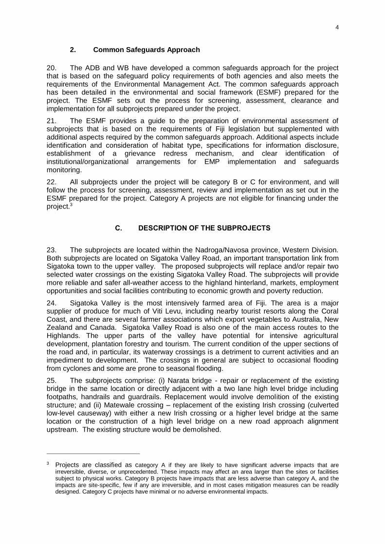
Page
ABBREVIATIONS
A. EXECUTIVE SUMMARY ERROR! BOOKMARK NOT DEFINED.
B. INTRODUCTION ERROR! BOOKMARK NOT DEFINED.
C. POLICY, LEGAL, AND ADMINISTRATIVE FRAMEWORKERROR! BOOKMARK NOT DEFINED.
1. Fiji Legislation and Environmental Guidelines Error! Bookmark not defined.
2. Common Safeguards Approach Error! Bookmark not defined.
D. DESCRIPTION OF THE SUBPROJECTS ERROR! BOOKMARK NOT DEFINED.
1. Narata Bridge Error! Bookmark not defined.
2. Matewale Crossing Error! Bookmark not defined.
E. ASSESSMENT OF ALTERNATIVES ERROR! BOOKMARK NOT DEFINED.
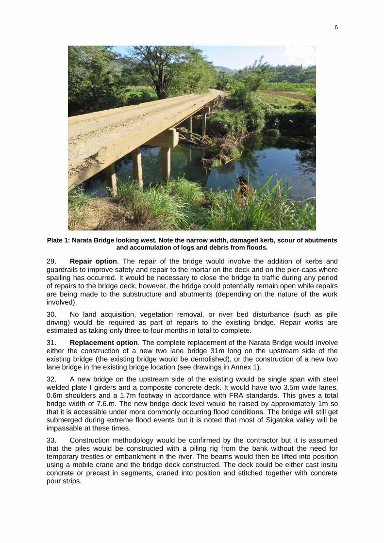
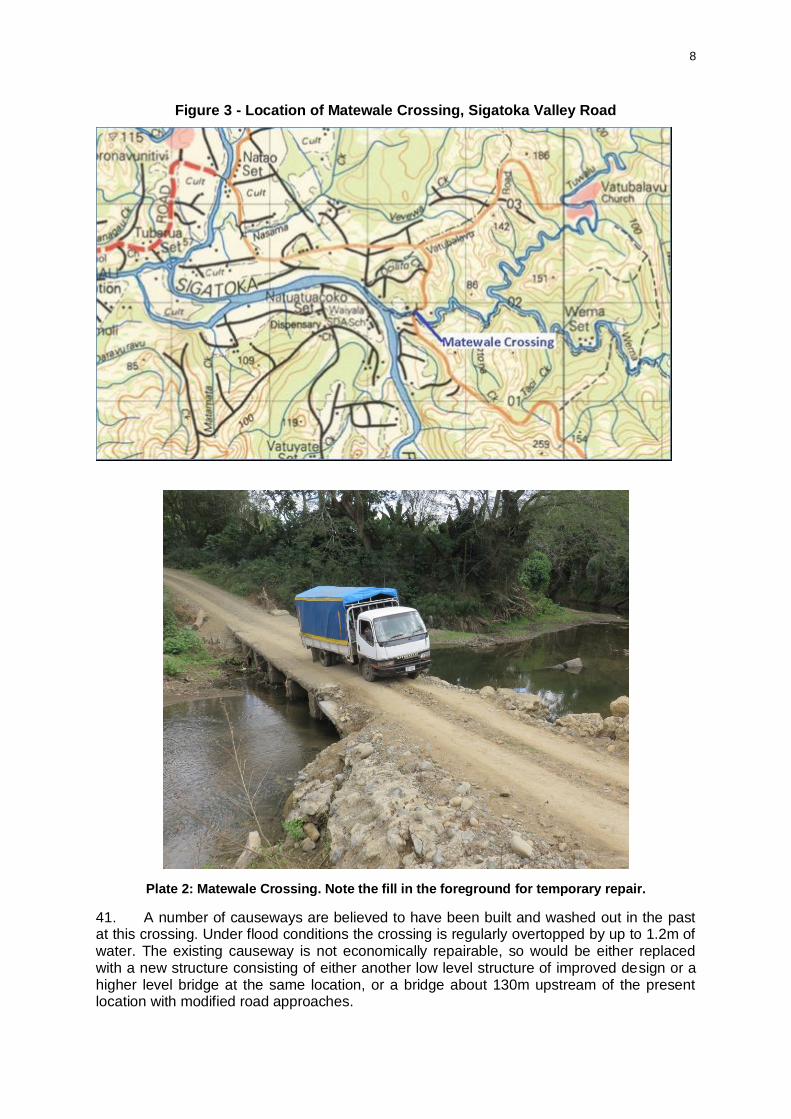
1. Narata Bridge Error! Bookmark not defined.
2. Matewale Crossing Error! Bookmark not defined.
F. DESCRIPTION OF THE ENVIRONMENT (BASELINE DATA)ERROR! BOOKMARK NOT DEFINED.
1. Physical Resources Error! Bookmark not defined.
2. Ecological Resources Error! Bookmark not defined.
3. Social and Economic Conditions Error! Bookmark not defined.
G. ANTICIPATED ENVIRONMENTAL/ SOCIAL IMPACTS AND MITIGATION MEASURESERROR! BOOKMARK NOT DEFINED.
1. Design and Pre-construction impacts Error! Bookmark not defined.
Physical Error! Bookmark not defined.
Ecological Error! Bookmark not defined.
Social and Economic Error! Bookmark not defined.
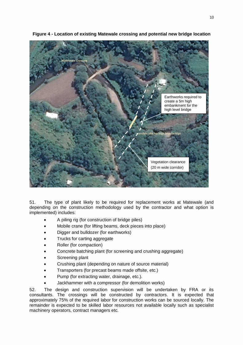
2. Construction Impacts Error! Bookmark not defined.
Physical Error! Bookmark not defined.
Ecological Error! Bookmark not defined.
Social and Economic Error! Bookmark not defined.
3. Operation Impacts Error! Bookmark not defined.
Physical Error! Bookmark not defined.
Ecological Error! Bookmark not defined.
Social and Economic Error! Bookmark not defined.
H. CONSULTATION AND INFORMATION DISCLOSURE ERROR! BOOKMARK NOT DEFINED.
I. GRIEVANCE REDRESS MECHANISM ERROR! BOOKMARK NOT DEFINED.
1. During construction Error! Bookmark not defined.
2. During Operation Error! Bookmark not defined.
J. ENVIRONMENTAL MANAGEMENT (AND MONITORING) PLANERROR! BOOKMARK NOT DEFINED.
K. SUMMARY AND CONCLUSION ERROR! BOOKMARK NOT DEFINED.
Appendices

ii
ABBREVIATIONS
ADB Asian Development Bank
CEMP construction environmental management plan
COEP Codes of Environmental Practice
CPP Consultation and Participation Plan (for the project)
CSS Country safeguard system
DOE Department of Environment (within Ministry of Local Government, Urban Development, Housing and Environment)
DSC Design and supervision consultant
EHSG Environmental, Health and Safety Guidelines
EIA environmental impact assessment
EMP Environmental management (and monitoring) plan
EPC Engineering, procurement and construction
ESMF Environmental and social management framework
ESS Environment safeguards specialist (in DSC team)
FRA Fiji Roads Authority
GRM Grievance Redress Mechanism
LARP Land Acquisition and Resettlement Plan
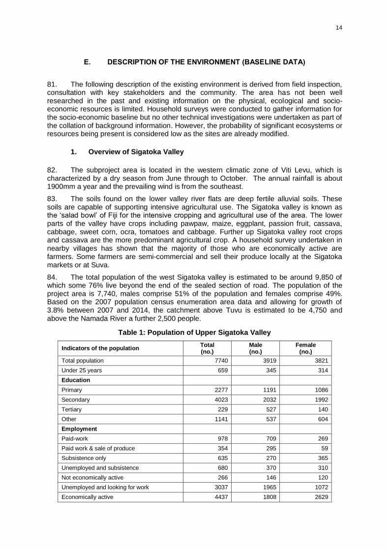
LARF Land Acquisition and Resettlement Framework
NSS National safeguards specialist (in DSC team)
OP Operational Policy (of the World Bank)
SPS Safeguards Policy Statement 2009
SSS Social safeguards/resettlement specialist (in DSC team)
WB World Bank
iii
EXECUTIVE SUMMARY
1. Introduction. The Asian Development Bank (ADB) and the World Bank (WB) have been asked to provide assistance to the Fiji government to support its transport sector planning and management with the over-arching objective to improve accessibility to socio-economic opportunities by improving land and sea transport infrastructure. The support being provided will result in a 20-year national transport sector plan and the preparation and implementation of a sector project; Transport Infrastructure Investment Sector Project (the project). The project comprises physical works including new infrastructure and/or the upgrading, renewal, rehabilitation, repair of roads, bridges, and/or rural maritime infrastructure in Fiji. The project also includes non-physical works such as institutional strengthening and capacity building within the transport sector. The project will deliver two outputs: (i) rehabilitated, climate resilient land and maritime transport infrastructure; and (ii) efficient project management support and institutional strengthening.
2. This environmental impact assessment (EIA)1 covers two subprojects drawn from the Fiji Road Authority’s (FRA) ten-year Asset Management Plan. The EIA has been prepared by EIA consultants registered with the Fiji Department of Environment (DOE).
3. The subprojects involve the repair or replacement of two existing crossings, Narata Bridge and Matewale Crossing, both located on Sigatoka Valley Road. The existing crossings have suffered from deterioration and flood damage and are in poor condition. There are safety concerns due to the narrow breadth of the structures and lack of guardrails (particularly on the Narata Bridge). The proposed works will rehabilitate the crossings to provide for more reliable and safer access across the waterways.
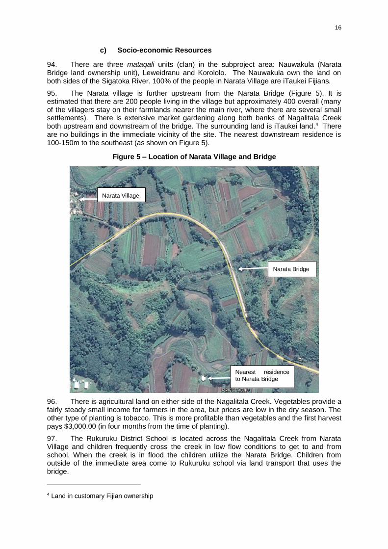
4. Policy, legal and administrative framework. The project will comply with Fiji’s
country safeguards system with additional elements as required in order to also comply with the requirements of ADB’s Safeguard Policy Statement 2009 (SPS) and WB’s Operational Policy (OP) 4.01.
5. The Environmental Management Act 2005 requires an EIA must be undertaken for developments that involve the dredging or excavating of a river bed, or which require an environmental assessment as a condition of finance by an international or local development finance institution. The EIA is undertaken by an EIA consultant registered with the DOE on behalf of the project proponent and clearance obtained from the DOE as approving authority. The environmental clearance and development consent (and other permits) must be obtained before any works commence.
6. The objectives of the EIA are to: (i) describe the existing environmental conditions; (ii) identify potential environmental impacts; (iii) carry-out public consultations to document any issues/concerns and to ensure that such concerns are addressed in the project design; (iv) evaluate and determine the significance of the impacts; and (v) develop an EMP detailing mitigation measures, monitoring activities, reporting requirements, institutional responsibilities and cost estimates to address adverse environmental impacts.
1 This environmental assessment has been prepared in accordance with Fiji’s Environmental Management Act 2005 plus the additional elements required to also comply with the ADB’s Safeguard Policy Statement (SPS) 2009 and WB’s Operational Policy Operational Policy (OP) 4.01. It is referred to as an environmental impact assessment (EIA) as per Fiji’s Environmental Management Act 2005 but it is not equivalent to EIA in ADB’s SPS or WB’s OP 4.01. Within the parameters of SPS it is equivalent to an initial environmental examination as appropriate for a category B project. All subprojects under the Transport Infrastructure Investment Sector Project will be category B or C projects, and will follow the process for screening, assessment, review and implementation as set out in the environmental and social management framework prepared for the project. Category A projects are not eligible for financing under the project.

iv
7. The EIA is based on field inspection, review of existing information on the physical, ecological and socio-economic resources of the subproject sites, and information gathered through discussions with key government agencies and stakeholder consultations. This EIA is submitted to ADB and WB by FRA as the implementing agency. The final EIA report will be disclosed to the public by providing the EIA and environmental management plan (EMP) to the government’s approving authority – DOE- as well as being uploaded to FRA, ADB and WB websites.
8. Description of subprojects. The subprojects are located in the Nadroga/Navosa
province on Viti Levu, one of the two largest islands in Fiji. The subprojects comprise: (i) Narata bridge - repair or replacement of the existing bridge in the same location or directly adjacent with a two lane high level bridge including footpaths, handrails and guardrails. Replacement would involve demolition of the existing structure; and (ii) Matewale crossing – replacement of the existing Irish crossing (culverted low-level causeway) with either a new Irish crossing or a higher level bridge at the same location or the construction of a high level bridge on a new road approach alignment upstream. The existing structure would be demolished.
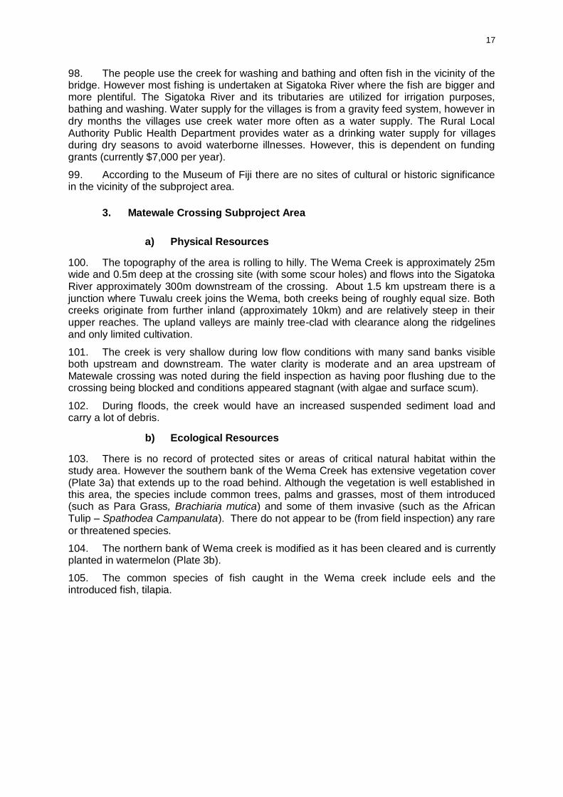
9. The exact works to be undertaken at each site, and even the selected subprojects themselves, have not yet been confirmed and so this assessment considers all the potential options for the rehabilitation of the two crossings. Should these two crossings be selected for funding under the project then the options considered in this assessment will be refined and the EIA and EMP updated based on detailed design of the preferred option for each site.
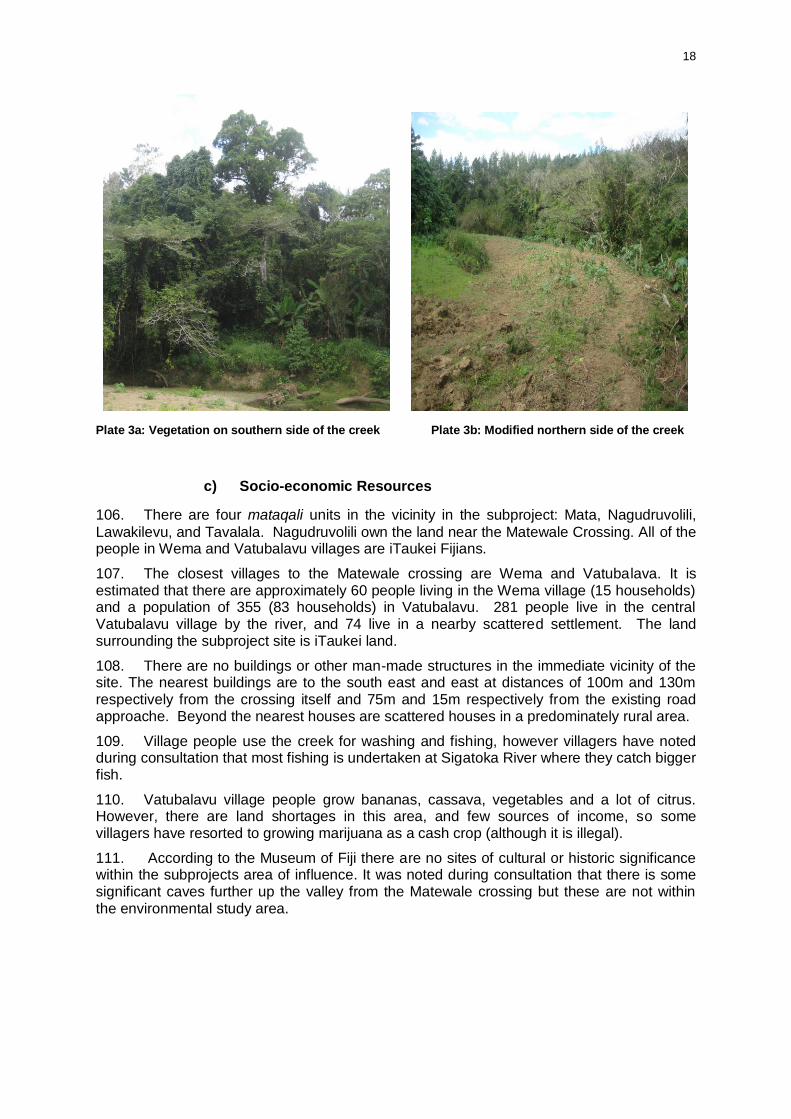
10. Assessment of impacts. The proposed works are assessed as having minor adverse and site-specific environmental impacts in areas that are already modified, and most impacts are temporary and relate to the construction phase. Repair works will not involve any piling, significant earthworks, land acquisition or vegetation removal. Replacement works will be either in the same footprint as existing structures (in the case of Narata bridge) or directly adjacent. An exception is a potential new bridge site and minor road realignment approximately 130m upstream of Matewale crossing.
11. The main potential impacts of the subprojects will be on water quality and potential runoff of exposed surfaces or increased turbidity from piling and earthworks. There are positive impacts associated with increased safety (particularly for pedestrians) and improved access providing more reliability for users of the Sigatoka Valley Road. This is expected to have flow on positive economic and social benefits for the villages up the Sigatoka Valley.
12. Environmental management plan. Although the impacts of the subprojects are not considered to be significant, an EMP is provided to mitigate any adverse impacts including through erosion and sedimentation control, materials sourcing and spoil management, waste management, minimization of habitat disturbance, and worker and community health and safety.
13. The plan also outlines environmental monitoring and capacity development for the design, construction and operation phases of the subprojects. The design and supervision consultant (DSC) and contractor will be tasked with finalizing the detailed design and compilation of an updated EMP and the contractor will be responsible for implementing the EMP. The EMP will form part of the construction contract documents and the contractor will be required to prepare a site-specific construction environmental management plan (CEMP) based on the contract EMP. The contractor will submit the CEMP to FRA’s environment manager for approval prior to commencement of works.
14. Consultation and information disclosure. The consultation process included discussions with relevant government agencies such as DOE, the Nadroga/Navosa Rural Local Authority, Department of Lands, and iTaukei Lands Trust Board. The subprojects were discussed at these initial meetings and the process for environmental assessment and community consultation confirmed.
v
15. Consultation with local government stakeholders including the Keiyasi Agricultural District Office, Provincial Office, and district health nurse as well as village meetings were undertaken to discuss the subprojects and gather information relevant to the EIA (such as existing uses of the site, any particular resources of significance, and socio-economic information).
16. The process also gathered information on relevant concerns of the local community for the project so as to address these in the project design and implementation stages. No significant environmental concerns were raised during consultations and the local communities were happy for the project to go ahead so that they could benefit from safer and more reliable water crossings.
17. The EIA will be disclosed according to the provisions of ADB Public Communications Policy 2011 and requirements of the laws of Fiji.
18. Grievance redress mechanism. A grievance redress mechanism (GRM) will be established to receive, evaluate and facilitate the resolution of affected people’s concerns, complaints and grievances about the environmental and social performance of the subprojects. The GRM is based on accepted practices in Fiji and provides an accessible, time-bound and transparent mechanism for the affected persons to voice and resolve social and environmental concerns linked to the project.
19. Institutional arrangements. FRA will include an environmental manager to oversee the tasks undertaken by the DSC and monitor compliance by the contractor in implementing the measures in the EMP and approved CEMP. The DSC will include international and national environmental safeguards specialists, at least the national specialist will be required to be registered as an EIA consultant with the DOE. FRA’s environment manager and DSC specialists will together provide training and build capacity of FRA, and contractors in safeguards.
20. Conclusion. The potential environmental impacts arising from design, construction, operation and maintenance of the subprojects will be minor, site-specific and readily mitigated provided that the measures set out in the EMP are implemented properly. The EMP will be updated by the contractor in the construction phase and a CEMP prepared for approval by FRA’s environment. Supervision of EMP implementation will be by FRA which will report regularly to the ADB, WB, and DOE.
21. The project will create positive impacts associated with increased safety (particularly for pedestrians), improved access providing more reliability for users of the Sigatoka Valley Road and access to socio-economic opportunities.
1
A. INTRODUCTION
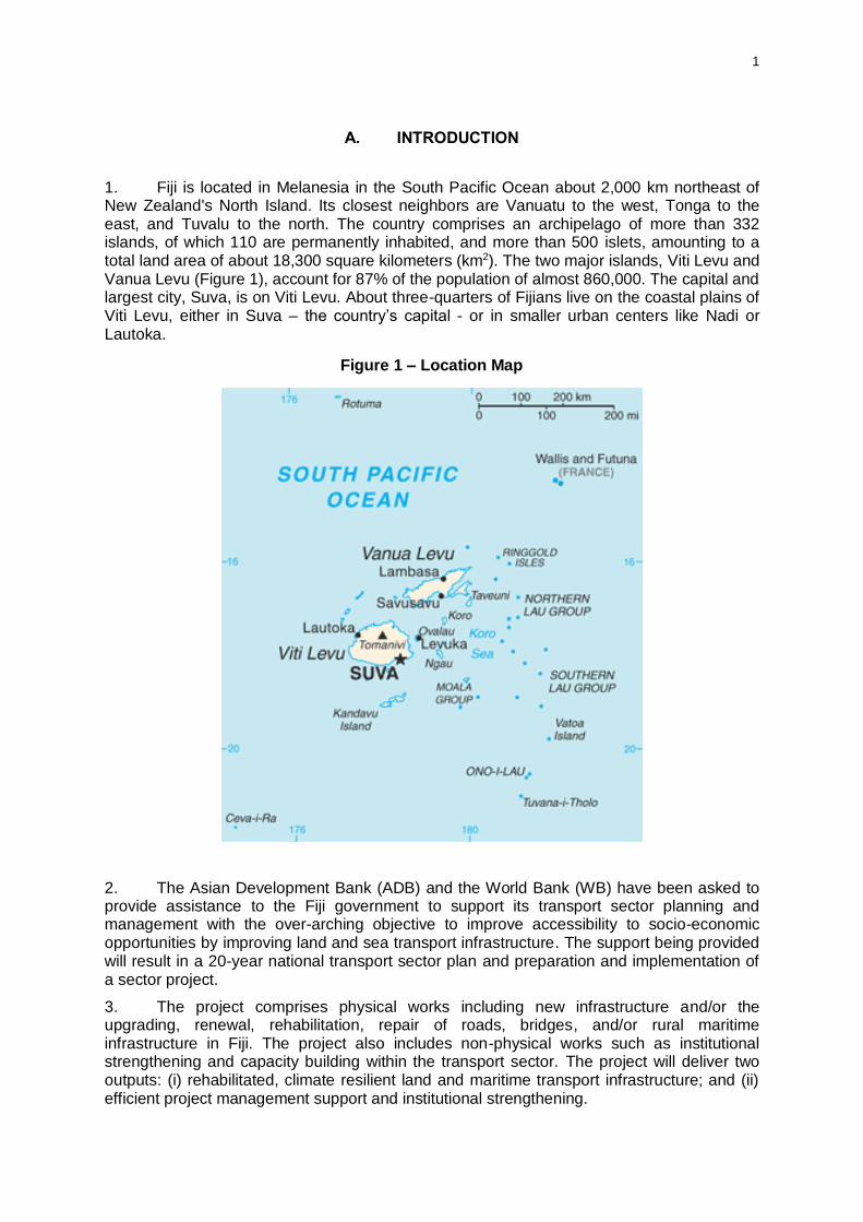
1. Fiji is located in Melanesia in the South Pacific Ocean about 2,000 km northeast of New Zealand's North Island. Its closest neighbors are Vanuatu to the west, Tonga to the east, and Tuvalu to the north. The country comprises an archipelago of more than 332 islands, of which 110 are permanently inhabited, and more than 500 islets, amounting to a total land area of about 18,300 square kilometers (km2). The two major islands, Viti Levu and Vanua Levu (Figure 1), account for 87% of the population of almost 860,000. The capital and largest city, Suva, is on Viti Levu. About three-quarters of Fijians live on the coastal plains of Viti Levu, either in Suva – the country’s capital - or in smaller urban centers like Nadi or Lautoka.
Figure 1 – Location Map
2. The Asian Development Bank (ADB) and the World Bank (WB) have been asked to provide assistance to the Fiji government to support its transport sector planning and management with the over-arching objective to improve accessibility to socio-economic opportunities by improving land and sea transport infrastructure. The support being provided will result in a 20-year national transport sector plan and preparation and implementation of a sector project.
3. The project comprises physical works including new infrastructure and/or the upgrading, renewal, rehabilitation, repair of roads, bridges, and/or rural maritime infrastructure in Fiji. The project also includes non-physical works such as institutional strengthening and capacity building within the transport sector. The project will deliver two outputs: (i) rehabilitated, climate resilient land and maritime transport infrastructure; and (ii) efficient project management support and institutional strengthening.
2
4. The Ministry of Finance will be the executing agency for the project and the Fiji Roads Authority (FRA) will be the implementing agency.
5. The subprojects considered in this environmental assessment include the repair and replacement of two crossings on Sigatoka Valley Road, an important transportation link between Sigatoka town and the upper Sigatoka Valley. They are the Narata Bridge and Matewale Crossing, both located within the Nadroga/Navosa province. The two crossings are in a state of disrepair and have safety issues for existing users. It is considered that the two subprojects are therefore good representative examples of the likely works to be undertaken under the project.
6. The subprojects are categorized as environmental category B in accordance with the ADB Safeguard Policy Statement (SPS) 2009. Pursuant to Section 28 (4) of the Environment Management Act 2005 this assessment has been prepared by accredited consultants registered with the Department of Environment (DOE).
B. POLICY, LEGAL, AND ADMINISTRATIVE FRAMEWORK
1. Fiji Legislation and Environmental Guidelines
7. Environmental Management Act. The main legislation governing development activities in Fiji is the Environmental Management Act 2005 (the Act). The Act provides a framework for national coordination and planning in relation to environmental matters and control of environmentally harmful activities through a process of development consent and environmental impact assessment (EIA). The DOE has the mandate to implement the Act.
8. Section 4 of the Act requires that any proposed development activity that is likely to cause significant impact on the environment to undergo an assessment process which includes screening, scoping, preparation, reviewing and decision-making. In context of the Act, "environment" is taken to include all aspects of the natural and human environment. Section 32 of the Act states that a condition of any approved EIA must be that proponents are required to prepare and implement an environmental management plan (EMP), monitoring program, protection plan or mitigation measure, which may be subject to inspection by the DOE.
9. The Act (Schedule 2, Part 1) requires developments that involve the dredging or excavating of a river bed, or which require an environmental assessment as a condition of finance by an international or local development finance institution, be processed by the DOE. As the subprojects may involve the sourcing of material from the river bed (gravel) and are also to be funded by the ADB and WB, an environmental assessment is required as part of the environmental safeguards for the project. This EIA2 will therefore be processed by the DOE and will also be cleared by ADB and WB.
2 This environmental assessment has been prepared in accordance with Fiji’s Environmental Management Act 2005 plus the additional elements required to also comply with the ADB’s Safeguard Policy Statement (SPS) 2009 and WB’s Operational Policy Operational Policy (OP) 4.01. It is referred to as an environmental impact assessment (EIA) as per Fiji’s Environmental Management Act 2005 but it is not equivalent to EIA in ADB’s SPS or WB’s OP 4.01. Within the parameters of SPS it is equivalent to an initial environmental examination as appropriate for a category B project. All subprojects under the project will be category B or C projects, and will follow the process for screening, assessment, review and implementation as set out in the environmental and social management framework prepared for the project. Category A projects are not eligible for financing under the project.

3
10. Part 5 of the Act establishes a waste and pollution permit system that aims to protect the environment by controlling the release of solid and liquid wastes, the emission of polluting gases, smoke and dust, and the handling, storage and disposal of waste and hazardous substances.
11. The Environment Management (Waste Disposal and Recycling) Regulations 2007 gives the Waste and Pollution Control Administrator power to issue permits for solid and liquid waste discharge and air discharges.
12. Section 8 (1) of the regulations states:
"8. - (1) A solid or liquid waste permit may relate to either construction or operation of a facility or any premises.
(2) A construction waste permit -
(a) relates to solid or liquid waste and pollutants generated during construction or demolition of premises of a facility; and
(b) lapses upon completion of the construction or demolition work"
13. It is likely that the construction of new bridges will generate waste construction materials as existing structures will need to be demolished. A solid waste permit may be required to dispose of construction materials. This will be confirmed during detailed design.
14. Town Planning Act 1978. The Town Planning Act 1978 establishes the tools and processes for the planning, restriction and approval of development across the country. The different parts of the Town Planning Act establish the scope and key facets of the planning system.
15. Part I - establishes the role of the Director of Town and Country Planning, who is responsible for implementing the Town Planning Act and the Subdivision of Land Act. Part II – describes Town Planning Schemes, which provide planning tools and regulations for development within local areas. Part III – outlines the functions of city, town councils and rural local authorities which have powers to prepare, implement and enforce planning schemes.
16. Part III of the Town Planning Act states that local councils are responsible for the implementation of town planning schemes, subdivision of land and building development in urban areas, whereas rural local authorities manage subdivision of land and building developments within their districts. The subproject locations are outside of urban areas and are therefore within the jurisdiction of the rural local authority. Both sites are classified as rural agricultural land and are located within the Nadroga/Navosa Rural Authority area.
17. As Narata and Matewale are without an approved town planning scheme, the local authority is the receiving agent for applications for development permission, but does not have the capacity to grant approval. All applications are forwarded to the Department of Town and Country Planning for consideration and a decision. A development application is required where earthworks, building, removing large trees or changing the use of a site or building is proposed. Given the subprojects will involve earthworks and the construction of new structures, and one of the options for Matewale crossing will involve the removal of large trees, a development application is a necessary approval.
18. Crown Lands Act 1978. The beds of all rivers and streams are crown land. As the subprojects involve development on crown land they will require a lease, obtained from the Director of Lands.
19. Codes of Environmental Practice. The Fiji Codes of Environmental Practice (COEP) sets out minimum environmental standards to be met and that appropriate procedures are undertaken to reduce the environmental impact of various activities related to road works and services. Many of these procedures are carried through into the EMP.
4
2. Common Safeguards Approach
20. The ADB and WB have developed a common safeguards approach for the project that is based on the safeguard policy requirements of both agencies and also meets the requirements of the Environmental Management Act. The common safeguards approach has been detailed in the environmental and social framework (ESMF) prepared for the project. The ESMF sets out the process for screening, assessment, clearance and implementation for all subprojects prepared under the project.
21. The ESMF provides a guide to the preparation of environmental assessment of subprojects that is based on the requirements of Fiji legislation but supplemented with additional aspects required by the common safeguards approach. Additional aspects include identification and consideration of habitat type, specifications for information disclosure, establishment of a grievance redress mechanism, and clear identification of institutional/organizational arrangements for EMP implementation and safeguards monitoring.
22. All subprojects under the project will be category B or C for environment, and will follow the process for screening, assessment, review and implementation as set out in the ESMF prepared for the project. Category A projects are not eligible for financing under the project.3
C. DESCRIPTION OF THE SUBPROJECTS
23. The subprojects are located within the Nadroga/Navosa province, Western Division. Both subprojects are located on Sigatoka Valley Road, an important transportation link from Sigatoka town to the upper valley. The proposed subprojects will replace and/or repair two selected water crossings on the existing Sigatoka Valley Road. The subprojects will provide more reliable and safer all-weather access to the highland hinterland, markets, employment opportunities and social facilities contributing to economic growth and poverty reduction.
24. Sigatoka Valley is the most intensively farmed area of Fiji. The area is a major supplier of produce for much of Viti Levu, including nearby tourist resorts along the Coral Coast, and there are several farmer associations which export vegetables to Australia, New Zealand and Canada. Sigatoka Valley Road is also one of the main access routes to the Highlands. The upper parts of the valley have potential for intensive agricultural development, plantation forestry and tourism. The current condition of the upper sections of the road and, in particular, its waterway crossings is a detriment to current activities and an impediment to development. The crossings in general are subject to occasional flooding from cyclones and some are prone to seasonal flooding.
25. The subprojects comprise: (i) Narata bridge - repair or replacement of the existing bridge in the same location or directly adjacent with a two lane high level bridge including footpaths, handrails and guardrails. Replacement would involve demolition of the existing structure; and (ii) Matewale crossing – replacement of the existing Irish crossing (culverted low-level causeway) with either a new Irish crossing or a higher level bridge at the same location or the construction of a high level bridge on a new road approach alignment upstream. The existing structure would be demolished.
3 Projects are classified as category A if they are likely to have significant adverse impacts that are irreversible, diverse, or unprecedented. These impacts may affect an area larger than the sites or facilities subject to physical works. Category B projects have impacts that are less adverse than category A, and the impacts are site-specific, few if any are irreversible, and in most cases mitigation measures can be readily designed. Category C projects have minimal or no adverse environmental impacts.

5
1. Narata Bridge
26. Narata Bridge is within Waicoba tikina and located across the Nagalitala Creek, a tributary of the Sigatoka River (Figure 2). The existing bridge is a three span, 26.3m long, 3.4m wide structure, with a concrete deck on steel girder resting on concrete pile caps and abutments and concrete pile foundations.
27. The Narata Bridge provides the sole vehicular access to the entire west bank of the Sigatoka River valley above this point, a population catchment of around 9,800 people. It also provides access to several schools and other community facilities. The bridge carries about 440 vehicles per day, including rural bus services to the upper Sigatoka valley and heavy trucks carrying produce and logs. The bridge also provides access for farm stock and agricultural tractors, pedestrians and horses which are a common form of local transport in the valley.
28. The deck, pilecaps, piles and abutments of the bridge have suffered damage from past flood debris impacts, in particular logs (Plate 1). The existing bridge poses a road safety risk due to its narrow width, the lack of guard railing, footpath, end markers or protection. There is a risk that further damage or deterioration could cause the bridge to be load-limited or possibly closed to traffic.
Figure 2 - Location of Narata Bridge, Sigatoka Valley Road
6
Plate 1: Narata Bridge looking west. Note the narrow width, damaged kerb, scour of abutments and accumulation of logs and debris from floods.
29. Repair option. The repair of the bridge would involve the addition of kerbs and
guardrails to improve safety and repair to the mortar on the deck and on the pier-caps where spalling has occurred. It would be necessary to close the bridge to traffic during any period of repairs to the bridge deck, however, the bridge could potentially remain open while repairs are being made to the substructure and abutments (depending on the nature of the work involved).
30. No land acquisition, vegetation removal, or river bed disturbance (such as pile driving) would be required as part of repairs to the existing bridge. Repair works are estimated as taking only three to four months in total to complete.
31. Replacement option. The complete replacement of the Narata Bridge would involve either the construction of a new two lane bridge 31m long on the upstream side of the existing bridge (the existing bridge would be demolished), or the construction of a new two lane bridge in the existing bridge location (see drawings in Annex 1).
32. A new bridge on the upstream side of the existing would be single span with steel welded plate I girders and a composite concrete deck. It would have two 3.5m wide lanes, 0.6m shoulders and a 1.7m footway in accordance with FRA standards. This gives a total bridge width of 7.6.m. The new bridge deck level would be raised by approximately 1m so that it is accessible under more commonly occurring flood conditions. The bridge will still get submerged during extreme flood events but it is noted that most of Sigatoka valley will be impassable at these times.
33. Construction methodology would be confirmed by the contractor but it is assumed that the piles would be constructed with a piling rig from the bank without the need for temporary trestles or embankment in the river. The beams would then be lifted into position using a mobile crane and the bridge deck constructed. The deck could be either cast insitu concrete or precast in segments, craned into position and stitched together with concrete pour strips.

7
34. A new bridge would necessitate the relocation of existing powerlines on the upstream side of the bridge and a small amount of land acquisition for the minor road realignment (see drawings in Annex 1).
35. Only minor vegetation removal immediately adjacent to the road approaches would be required with this option and there are no notable species. Excavation and disposal of about 2,000 m3 of spoil is likely to be required for embankments.
36. The alternative to constructing a new structure adjacent to the existing bridge is to construct a temporary single span Bailey Bridge or equivalent alongside the structure. The existing bridge would then be demolished and a new structure as described above constructed whilst traffic is diverted to the temporary structure. This option would also involve the acquisition of a small amount of land to accommodate a minor road realignment to direct traffic over the temporary structure (see drawings in Annex 1).
37. The type of plant likely to be required for replacement works at Narata (and depending on the construction methodology used by the contractor and which option is implemented) includes:
A piling rig (for construction of piles)
Mobile crane (for lifting beams, deck pieces into place)
Digger
Trucks for carting aggregate
Roller (for compaction)
Concrete batching plant (for screening and crushing aggregate)
Screening plant
Crushing plant (depending on the nature of source material)
Transporters (for precast beams made offsite, etc.)
Pump (for extracting water, drainage, etc.).
Jackhammer and compressor (for demolition)
38. The design and construction supervision will be undertaken by FRA or its consultants. The road will be constructed by contractors. It is expected that approximately 75% of the required labor for construction works can be sourced locally. The remainder is expected to be skilled labor resources not available locally such as specialist machinery operators, contract managers, etc. Replacement works are expected to take between six and nine months for the above options.
2. Matewale Crossing
39. Matewale crossing is within the Noikoro tikina, located across the Wema Creek, a tributary of the Sigatoka River (Figure 3). The Matewale crossing is located approximately 57.6km from Sigatoka town, and is a single lane Irish Crossing on a gravel road. It is 22.8m long and 4.3m wide and approximately 2m above the bed level (see drawings in Annex 1).
40. The original crossing has suffered serious damage from flood scouring beneath it and has settled significantly, with a rotation of the whole crossing of about 200mm upstream being evident. The end 6m on one side has collapsed completely and an embankment has been constructed to maintain access (Plate 2). It is likely that in a significant flood in the near future the crossing will become impassable thus cutting off all traffic to the upper Sigatoka valley above this point, until a temporary crossing or ford is constructed. Several villages upstream of this location, including villages on the eastern bank of the Sigatoka via the Draubuta crossing, rely on the Matewale Crossing for access.
8
Figure 3 - Location of Matewale Crossing, Sigatoka Valley Road
Plate 2: Matewale Crossing. Note the fill in the foreground for temporary repair.
41. A number of causeways are believed to have been built and washed out in the past at this crossing. Under flood conditions the crossing is regularly overtopped by up to 1.2m of water. The existing causeway is not economically repairable, so would be either replaced with a new structure consisting of either another low level structure of improved design or a higher level bridge at the same location, or a bridge about 130m upstream of the present location with modified road approaches.

9
42. Replacement crossing. A replacement Irish crossing would be constructed adjacent to the existing crossing on the downstream side, and then the existing crossing demolished. This may require the acquisition of a very small area of additional property depending on where the road reserve boundaries are located (see drawings in Annex 1). The existing crossing would be used as the temporary crossing during construction works.
43. The replacement Irish crossing would be provided with extensive aprons to protect against scour. Upstream sloping walls would also be provided to help shed flood debris (and minimize past debris related structural problems) during high flows.
44. Although the construction methodology would be confirmed by the contractor, it is likely the crossing would be constructed from precast concrete components, stitched together on site with concrete pours. The replacement crossing would be 23m long comprising seven barrels and approximately 2m overall depth (see drawings in Annex 1). The minor road realignment to access the new or temporary structure built alongside of the existing Irish crossing would require the removal of some minor vegetation from the banks of the creek.
45. Construction time is expected to be in the order of six months and work would need to be carried out in the drier months of the year.
46. Replacement by bridge at existing location. The alternative to a replacement irish
crossing is the construction of a new 44m long single lane bridge on the downstream side of the existing crossing. The existing structure would then be demolished (see drawings in Annex 1). This would require the acquisition of some additional property, but a similar area of the existing road area can be released back at the end of construction following road realignment.
47. The new bridge would be provided with sufficient flood opening and deck elevation to carry a 100year flood in accordance with current FRA standards.
48. The new bridge has been assumed to be two spans, with steel welded plate I girders and a composite concrete deck. These would be carried by a concrete central piercap and concrete abutment beams, all supported on driven or bored concrete piles (see drawings in Annex 1). The piles in the river can be constructed from a rig working on a small embankment in the river, accessed off the existing crossing, during periods of low flow. The beams could then be lifted into position using a mobile crane and the bridge deck constructed. As for Narata the deck could be either cast insitu concrete or precast in segments, craned into position and stitched together with concrete pour strips. Construction time is estimated to take approximately 8 to 10 months in total.
49. Replacement by bridge at alternative location. Another option for the Matewale
crossing is to construct a new bridge at an alternative location approximately 130m upstream of the existing crossing. This option has been suggested by FRA as it would allow an improved road alignment (see drawings in Annex 1).
50. A bridge in this location would be about 44m length. The new alignment is approximately 250m long and would require significant earthworks to allow construction of a road with gradients not exceeding the 13%, which currently exists for the adjacent road. It requires extensive land acquisition and significant earthworks (approximately 30,000 cubic meters) and vegetation clearance along a 20m wide corridor (Figure 4) on the southern side. Construction would take approximately nine months to one year.
10
Figure 4 - Location of existing Matewale crossing and potential new bridge location
51. The type of plant likely to be required for replacement works at Matewale (and depending on the construction methodology used by the contractor and what option is implemented) includes:
A piling rig (for construction of bridge piles)
Mobile crane (for lifting beams, deck pieces into place)
Digger and bulldozer (for earthworks)
Trucks for carting aggregate
Roller (for compaction)
Concrete batching plant (for screening and crushing aggregate)
Screening plant
Crushing plant (depending on nature of source material)
Transporters (for precast beams made offsite, etc.)
Pump (for extracting water, drainage, etc.).
Jackhammer with a compressor (for demolition works)
52. The design and construction supervision will be undertaken by FRA or its consultants. The crossings will be constructed by contractors. It is expected that approximately 75% of the required labor for construction works can be sourced locally. The remainder is expected to be skilled labor resources not available locally such as specialist machinery operators, contract managers etc.
Earthworks required to create a 5m high embankment for the high level bridge
Vegetation clearance
(20 m wide corridor)

11
D. ASSESSMENT OF ALTERNATIVES
53. The alternatives considered below are the various options for each of the sites to remedy existing problems with safe and reliable access. As the Narata Bridge and Matewale crossing are sample subprojects under the project consideration of other bridges has not been included here (as these may well form subprojects themselves in the future).
1. Narata Bridge
54. The main options for Narata Bridge include repair of the existing structure, replacement with a similar structure, replacement with an improved bridge/Irish crossing and do nothing.
55. Physical resources. The options for Narata Bridge will have varying impacts on the
physical resources of the site. Potential impacts will be limited to the water and land resources as all options will not impact on the topography, geology or soils of the area. It is noted that the physical resources (such as water quality and land) are already modified in the subproject area by agriculture and the existing road and bridge.
56. The do nothing and repair options will have no impact on the physical resources of the site but do not provide for future climate change impacts such as an increased frequency of extreme flood events. This may result in the crossing suffering from severe damage and failure in the future.
57. The option of replacement with a similar structure or low level irish crossing may have some minor impacts on water quality during construction works (and associated sediment disturbance and runoff) but will have no impact on the surrounding land. These options will also not provide for future climate change impacts as discussed under the do nothing and repair options above.
58. The replacement of the existing structure with an improved bridge may have impacts on water quality during construction but these are expected to be minor. This option will provide the ability to adapt to future climate change impacts as the new structure will have an improved design to better mitigate the effects of more frequent and extreme flood events (such as a raised bridge deck level and less piles to allow for more flood debris to pass under unimpeded).
59. Ecological resources. All options are likely to have only minor impacts on ecological
resources. This is because the site is already heavily modified with the surrounding agricultural land uses (and associated pesticide and fertilizer runoff), village developments upstream (that are on septic for waste water disposal) and the existing road and bridge crossing.
60. However, the do nothing and repair options will involve the least modification to existing terrestrial vegetation and will result in no disturbance of aquatic ecology as there will be no works in the bed of the creek and no earthworks that could result in sediment runoff.
61. Socio-economic resources. In the case of the Narata Bridge the option of doing nothing is not considered a feasible long term option as the bridge is in a state of disrepair and may soon be rendered unusable by local people who are reliant upon it for access to schools, medical facilities, etc. It is also a health and safety hazard due to the narrow width and absence of guardrails, which is a concern given the high volume of pedestrian traffic, including school children, who regularly use the bridge.
62. The option of replacing Narata Bridge with a similar design of bridge would remedy the existing structural concerns but would not provide for the safety of pedestrians utilizing the structure and the high volumes of traffic (due to the narrow width).
12
63. The replacement of the existing bridge with a lower level irish crossing would be a less costly option than a bridge, but it is likely to result in the structure being unusable during floods and may have an impact on people’s livelihoods (if they can’t access schools, medical facilities, work places).
64. The replacement of the existing bridge with a new bridge of improved design to provide two lanes and a footpath for pedestrians will require some land acquisition for a minor realignment of road approaches but in the long term will have positive impacts on people’s ability to safely cross the creek as well as improve people’s livelihoods through the provision of more reliable access.
65. Summary. It is considered that the replacement of the existing structure with a new bridge of improved design that provides two lanes, a footpath, handrail and guardrails is the best option to meet the safety and reliability objectives of the project. Although this option would have the greatest potential for impacts on ecological and physical resources (as it involves the greatest amount of construction work), the positive social and economic impacts outweigh any minor adverse impacts.
2. Matewale Crossing
66. The options considered for the Matewale crossing is repair, replacement of the existing Irish crossing with either a new Irish crossing or a high level bridge, the construction of a new bridge in a new location or do nothing.
67. Physical resources. The options for Matewale crossing will have varying impacts on the physical resources of the site. The subproject location is modified by the existing road and Irish crossing and upstream agriculture (currently planted in watermelon).
68. The do nothing and repair of the existing crossing options will have the least impact on physical resources as they will not involve works within the streambed (and will have no sediment runoff or turbidity issues) and will not modify the topography or geology of the area. However, these options will not account for future climate change and the predicted increase in frequency of extreme flood events is likely to result in severe damage to the existing structure so that it fails completely in the future. Even in the absence of climate change impacts, the structure is likely to continue to suffer damage from existing floods and require replacement in the short term.
69. The option of replacing the existing Irish crossing with a new Irish crossing of improved design will have minor impacts on water quality as there will be works within the creek associated with constructing the new structure. Although the improved design of a new Irish crossing will provide for the impacts of existing flood impacts, it is noted that the structure will be subject to an increased frequency of severe flood events as a result of climate change and will likely require more maintenance, and potentially more frequent repairs/replacement in the future.
70. The option of constructing a new bridge at the existing location will also have minor impacts on water resources but negligible impact on land resources (topography, geology, soils). A high level bridge in this location will better mitigate any future climate change impact as it will better withstand an increased frequency of flood events.
71. The option of constructing a high level bridge in a new location upstream of the existing structure will result in the modification of the topography of the area through the significant amount of earthworks required to create embankments for the new road approaches to the bridge. The bridge itself would be approximately 45m long and embankments 5m high would need to be constructed on the northern side. It will also have a greater potential to impact on water resources through increased sediment runoff from exposed surfaces associated with the large volume of earthworks and vegetation clearance required to provide a new road corridor.
13
72. As above, it is expected that a high level bridge will better mitigate any future climate change impact as it will better withstand an increased frequency of flood events.
73. Ecological resources. The do nothing and repair options will have negligible impact on ecological resources as no earthworks, vegetation clearance and works within the creek bed will be required.
74. The replacement of the existing low level crossing with either a new low level crossing or a high level bridge will require some minor roadside vegetation clearance and earthworks to allow for a minor realignment of the road approaches as well as some works within the creek bed. There may therefore be some minor adverse impacts on terrestrial ecology and aquatic ecology (although nothing of significance is present).
75. The option of constructing a high level bridge in a new location upstream of the existing structure is likely to have the greatest impact of all options on terrestrial ecology. This is because, although there are no protected areas, critical natural habitat or forests, there will be clearance of previously unmodified vegetation to provide for the new road corridor. It will also have a greater potential to impact on aquatic ecology through the larger volume of earthworks required and therefore increased potential for turbidity in the watercourse.
76. Socio-economic resources. In the case of the Matewale crossing the option of do
nothing is not considered feasible as it is likely that the crossing will continue to suffer flood damage and scouring that will make the structure unusable in the near future. As the structure provides access to a number of villages further up the valley it is likely to have a significant impact on people’s livelihoods (access to medical facilities, work places, etc.) if it is unusable.
77. The repair of the existing structure is also not considered feasible as the existing damage is so significant that repairs would not remedy the existing issues and the crossing would likely fail within the next five years, impacting on peoples livelihoods.
78. The replacement of the existing structure with a new Irish crossing of improved design would extend the life of the crossing, remedy existing structural issues and improve the safety of users. However, it is possible that over time the crossing will need to be repaired or replaced as the existing crossing has, according to local people, already been damaged by floods and replaced many times before. The local communities have raised concerns during consultation that another Irish crossing will suffer the same damage as the existing structure. This may impact on people’s livelihoods if they cannot reliably access medical facilities and their places of work/worship, etc. in the future. The need for continuous repairs/replacements of the low level structure would also come with an economic cost as ongoing repairs/replacements are likely to be more frequently required.
79. The new high level bridge at an upstream location would require a larger amount of land acquisition than all other options. However, the land is currently planted in watermelon and has parts that are very steep (and is considered low economic value as it not able to be used for agriculture) and so is not considered to be a significant socio-economic impact.
80. Summary. Overall the higher level bridge in the same location as the existing low level crossing is considered to be the option that offers the greatest potential positive socio-economic impacts, whilst minimizing adverse impacts on physical, ecological and socio-economic resources.
14
E. DESCRIPTION OF THE ENVIRONMENT (BASELINE DATA)
81. The following description of the existing environment is derived from field inspection, consultation with key stakeholders and the community. The area has not been well researched in the past and existing information on the physical, ecological and socio-economic resources is limited. Household surveys were conducted to gather information for the socio-economic baseline but no other technical investigations were undertaken as part of the collation of background information. However, the probability of significant ecosystems or resources being present is considered low as the sites are already modified.
1. Overview of Sigatoka Valley
82. The subproject area is located in the western climatic zone of Viti Levu, which is characterized by a dry season from June through to October. The annual rainfall is about 1900mm a year and the prevailing wind is from the southeast.
83. The soils found on the lower valley river flats are deep fertile alluvial soils. These soils are capable of supporting intensive agricultural use. The Sigatoka valley is known as the ‘salad bowl’ of Fiji for the intensive cropping and agricultural use of the area. The lower parts of the valley have crops including pawpaw, maize, eggplant, passion fruit, cassava, cabbage, sweet corn, ocra, tomatoes and cabbage. Further up Sigatoka valley root crops and cassava are the more predominant agricultural crop. A household survey undertaken in nearby villages has shown that the majority of those who are economically active are farmers. Some farmers are semi-commercial and sell their produce locally at the Sigatoka markets or at Suva.
84. The total population of the west Sigatoka valley is estimated to be around 9,850 of which some 76% live beyond the end of the sealed section of road. The population of the project area is 7,740, males comprise 51% of the population and females comprise 49%. Based on the 2007 population census enumeration area data and allowing for growth of 3.8% between 2007 and 2014, the catchment above Tuvu is estimated to be 4,750 and above the Namada River a further 2,500 people.
Table 1: Population of Upper Sigatoka Valley
Indicators of the population Total (no.)
Male (no.)
Female (no.)
Total population 7740 3919 3821
Under 25 years 659 345 314
Education
Primary 2277 1191 1086
Secondary 4023 2032 1992
Tertiary 229 527 140
Other 1141 537 604
Employment
Paid-work 978 709 269
Paid work & sale of produce 354 295 59
Subsistence only 635 270 365
Unemployed and subsistence 680 370 310
Not economically active 266 146 120
Unemployed and looking for work 3037 1965 1072
Economically active 4437 1808 2629

15
85. Indigenous Fijians (iTaukei) account for 5,403 or nearly 70% of the valley population, and Indo-Fijians account for 2,282 or 29%, with a few Rotuman and others making up the remaining 1%. Most of the Indo-Fijians live on leased or freehold land in the lower part of the valley, typically on their farms or in settlements, while iTaukei live in villages.
86. There are 15 primary and secondary schools in the middle and upper Sigatoka valley, some serving villages on both west and east banks.
87. The subprojects will provide safe and reliable access directly to the villages, schools and farming settlements up the Sigatoka Valley. No other practical access is available in the event that the water crossings which are the subject of this assessment are closed or reach a state of disrepair that they have to be load restricted.
2. Narata Bridge Subproject Area
a) Physical Resources
88. The topography of the area is generally flat. The Nagalitala Creek is approximately 15m wide and 1m deep at the crossing site. It extends from hill country, some 15km to the north and meanders down to flow into the Sigatoka River approximately 5 km below the bridge. The river bed is muddy silt with some gravel in the location of the bridge with more pockets of gravel further up in the creek bed. The Nadroga/Navosa Rural Local Authority has advised that there is an existing EIA study lodged with DOE for gravel extraction from the creek in the vicinity of Narata Village. However a copy of the EIA was not available to confirm details such as the exact location of the proposed extraction site, the quantity required, and the timing.
89. The creek is low flowing during the dry season and it floods 3-4 times per year. During floods, the creek would have an increased suspended sediment load and carry a lot of debris, as evidenced by the trees and branches that have accumulated around the existing bridge piles.
90. The road approach alignment is straight on either side of the bridge. The stream bed is approximately 5 meters below the level of the road. The bridge does not carry any services such as water pipelines or other conduits. There are powerlines supported on pylons on the upstream side of the bridge, extending across the creek.
91. A side road access to Rararua village is located approximately 300m east of the bridge, and a side road access to Narata village approximately 500m to the west of the bridge. Wastewater from Narata village is disposed of by septic systems (land based discharge) and this has likely impacted on water quality of the creek.
b) Ecological Resources
92. The ecological character of the surrounding area is highly modified due to the intensive agricultural use of the land. There is no vegetation with biodiversity or conservation significance adjacent to the road approaches. There are no records of critical or natural terrestrial habitats or forests within the subproject area. There are existing rain trees (Albizia saman) located adjacent to the road/bridge but these have been introduced into Fiji and have no special characteristics to merit their protection. There are many other rain trees along this particular stretch of creek.
93. There are no records of critical or natural aquatic habitats at the subproject site. Given the level of modification of the area, including upstream land disposal of wastewater and the use of agricultural pesticides and fertilizers confirmed during consultation, the aquatic ecology of the creek is not expected to have any species of significance or particular sensitivity. The most common fish species in the creek is the introduced fish tilapia, which is an invasive species.
16
c) Socio-economic Resources
94. There are three mataqali units (clan) in the subproject area: Nauwakula (Narata Bridge land ownership unit), Leweidranu and Korololo. The Nauwakula own the land on both sides of the Sigatoka River. 100% of the people in Narata Village are iTaukei Fijians.
95. The Narata village is further upstream from the Narata Bridge (Figure 5). It is estimated that there are 200 people living in the village but approximately 400 overall (many of the villagers stay on their farmlands nearer the main river, where there are several small settlements). There is extensive market gardening along both banks of Nagalitala Creek both upstream and downstream of the bridge. The surrounding land is iTaukei land.4 There are no buildings in the immediate vicinity of the site. The nearest downstream residence is 100-150m to the southeast (as shown on Figure 5).
Figure 5 – Location of Narata Village and Bridge
96. There is agricultural land on either side of the Nagalitala Creek. Vegetables provide a fairly steady small income for farmers in the area, but prices are low in the dry season. The other type of planting is tobacco. This is more profitable than vegetables and the first harvest pays $3,000.00 (in four months from the time of planting).
97. The Rukuruku District School is located across the Nagalitala Creek from Narata Village and children frequently cross the creek in low flow conditions to get to and from school. When the creek is in flood the children utilize the Narata Bridge. Children from outside of the immediate area come to Rukuruku school via land transport that uses the bridge.
4 Land in customary Fijian ownership
Nearest residence to Narata Bridge
Narata Bridge
Narata Village
17
98. The people use the creek for washing and bathing and often fish in the vicinity of the bridge. However most fishing is undertaken at Sigatoka River where the fish are bigger and more plentiful. The Sigatoka River and its tributaries are utilized for irrigation purposes, bathing and washing. Water supply for the villages is from a gravity feed system, however in dry months the villages use creek water more often as a water supply. The Rural Local Authority Public Health Department provides water as a drinking water supply for villages during dry seasons to avoid waterborne illnesses. However, this is dependent on funding grants (currently $7,000 per year).
99. According to the Museum of Fiji there are no sites of cultural or historic significance in the vicinity of the subproject area.
3. Matewale Crossing Subproject Area
a) Physical Resources
100. The topography of the area is rolling to hilly. The Wema Creek is approximately 25m wide and 0.5m deep at the crossing site (with some scour holes) and flows into the Sigatoka River approximately 300m downstream of the crossing. About 1.5 km upstream there is a junction where Tuwalu creek joins the Wema, both creeks being of roughly equal size. Both creeks originate from further inland (approximately 10km) and are relatively steep in their upper reaches. The upland valleys are mainly tree-clad with clearance along the ridgelines and only limited cultivation.
101. The creek is very shallow during low flow conditions with many sand banks visible both upstream and downstream. The water clarity is moderate and an area upstream of Matewale crossing was noted during the field inspection as having poor flushing due to the crossing being blocked and conditions appeared stagnant (with algae and surface scum).
102. During floods, the creek would have an increased suspended sediment load and carry a lot of debris.
b) Ecological Resources
103. There is no record of protected sites or areas of critical natural habitat within the study area. However the southern bank of the Wema Creek has extensive vegetation cover (Plate 3a) that extends up to the road behind. Although the vegetation is well established in this area, the species include common trees, palms and grasses, most of them introduced (such as Para Grass, Brachiaria mutica) and some of them invasive (such as the African Tulip – Spathodea Campanulata). There do not appear to be (from field inspection) any rare
or threatened species.
104. The northern bank of Wema creek is modified as it has been cleared and is currently planted in watermelon (Plate 3b).
105. The common species of fish caught in the Wema creek include eels and the introduced fish, tilapia.
18
Plate 3a: Vegetation on southern side of the creek Plate 3b: Modified northern side of the creek
c) Socio-economic Resources
106. There are four mataqali units in the vicinity in the subproject: Mata, Nagudruvolili,
Lawakilevu, and Tavalala. Nagudruvolili own the land near the Matewale Crossing. All of the people in Wema and Vatubalavu villages are iTaukei Fijians.
107. The closest villages to the Matewale crossing are Wema and Vatubalava. It is estimated that there are approximately 60 people living in the Wema village (15 households) and a population of 355 (83 households) in Vatubalavu. 281 people live in the central Vatubalavu village by the river, and 74 live in a nearby scattered settlement. The land surrounding the subproject site is iTaukei land.
108. There are no buildings or other man-made structures in the immediate vicinity of the site. The nearest buildings are to the south east and east at distances of 100m and 130m respectively from the crossing itself and 75m and 15m respectively from the existing road approache. Beyond the nearest houses are scattered houses in a predominately rural area.
109. Village people use the creek for washing and fishing, however villagers have noted during consultation that most fishing is undertaken at Sigatoka River where they catch bigger fish.
110. Vatubalavu village people grow bananas, cassava, vegetables and a lot of citrus. However, there are land shortages in this area, and few sources of income, so some villagers have resorted to growing marijuana as a cash crop (although it is illegal).
111. According to the Museum of Fiji there are no sites of cultural or historic significance within the subprojects area of influence. It was noted during consultation that there is some significant caves further up the valley from the Matewale crossing but these are not within the environmental study area.
19
F. ANTICIPATED ENVIRONMENTAL AND SOCIAL IMPACTS AND MITIGATION MEASURES
112. The context for the assessment is that the crossings already exist and environmental impacts would have occurred when they were first constructed. The environment consists of habitat that has been highly modified by the structures, road, agriculture and other land uses and the presence of the villages in the surrounding area.
113. The key environmental and social impacts relate to any proposed works that involve the construction of a new or replacement structure and may be either positive or adverse. The repair and maintenance of existing structures will have only minor impacts that can be avoided through careful and adequate environmental mitigation measures during construction. In this case the EMP covers potential impacts.
114. The following discussion therefore relates to a consideration of options that involve full replacement or construction of new structures.
1. Design and Pre-construction impacts
a) Impacts on Physical Resources
115. Physical impacts in the design and pre-construction stage relate to the consideration of climate change and natural hazard impacts, impacts on topography, geology and soils impacts as well as impacts that may arise through the course of the project due to inadequate inclusion of mitigation measures in contract documents and capacity enhancement/training of contractors at the outset of the project.
116. Impacts associated with inadequate inclusion of mitigation measures in contract documents and lack of understanding of environmental issues can be addressed through proper inclusion of the EMP into tender documents and training of contractors in the requirements of the EMP, as well as ensuring the EMP is updated as necessary following the detailed design phase.
117. Mitigation measures include:
Obtain lease and development consent for earthworks/structures within a river/stream as specified in the Crown Lands Act and Town and Country Planning Act
EMP and any conditions of the EIA, development consent and lease are included in EPC tender documents and mitigation measures appropriately budgeted for.
Specify in tender documentation that the contractor shall engage appropriately qualified and experienced staff to take responsibility for the environmental management and safety issues at the working level and to monitor the effectiveness and review mitigation measures as the project proceeds.
EPC contractor to submit construction environmental management plan (CEMP) based on contractual EMP for approval by DSC (i.e., site clearance, site drainage, waste and materials management, traffic, noise and dust management etc.).
118. Climate Change/Natural Hazard Impacts. The subproject areas are located within a catchment that has periodic flooding of the watercourses. Indeed, the condition of the crossings is in part due to damage suffered during severe flood events. As both subprojects are inland, the most significant climate change consideration is an increase in the frequency of extreme flood events in the future.
20
119. The structures will need to accommodate stronger and faster water flows, which could be achieved by increasing the height of the water crossings to accommodate increased flood discharges and by having a single span bridge that will allow for debris movement during flood (and minimize blockage risk). In addition, if a new low level crossing is to be installed at Matewale, this should be designed to accommodate a greater level of flood debris that will be possibly carried during more extreme flood events without causing the structure to block, such as providing a sloping upstream buttress wall.
120. Mitigation measures include:
Design criteria in respect of peak flood size and levels to be established based on available climate change modelling data. In the absence of such data, design criteria to be demonstrably conservative.
The proposed works will be designed in accordance with the design criteria so as to mitigate the future potential impact of climate change.
121. Topography, geology and soils. With the exception of the potential upstream bridge at Matewale crossing, there are no significant earthworks that would impact on the existing topography, geology and soils of the subproject sites. A new high level bridge upstream of the Matewale crossing would require approximately 30,000m3 of earthworks, including embankments 5m high for road approaches. Despite this being a significant amount of earthworks, the topography of the Matewale crossing area is already steep to rolling and so the proposed earthworks would improve the terrain, particularly from a road user’s safety perspective.
122. The embankments associated with crossings would be constructed using material cut from the existing area and so the geology and soils of the subproject sites would not be altered. No mitigation is considered necessary.
123. Scour/erosion. Structures within a watercourse have the potential to cause scour/erosion by altering the current flows. This is particularly the case around piers and piles which slow the current flow on the upstream side and accelerate it on the downstream side (causing scour). The creeks where the subprojects are located have a very low flow and slow current speeds when not in flood and so the expected impacts of the replaced structures during these periods is considered to be minimal. During flood conditions, the current speeds increase and correspondingly the scour potential. However, mitigation measures are proposed as follows:
Minimize the number of piles in bridge design
Design structures to allow continued flow of water through or appropriate overtopping in flood.
b) Impacts on Ecological Resources
124. The main ecological impacts that would arise from the design and pre-construction phase relate to designs that would require significant vegetation clearance, such as new road alignments through unmodified areas. The terrestrial ecology in the vicinity of the subprojects is modified already through introduced, and often invasive, flora (such as the African Tulip) and fauna (such as mongoose) as well as the agricultural crops and existing road, crossings and villages. Although there is no specific information or studies of the ecology of the site, there were not any species or habitats of significance (i.e. critical or natural) observed during field inspection that may be impacted. There are no recorded protected sites in the project area.
1. It was noted during field inspection that the area on the southern bank of the Wema creek upstream of the Matewale crossing is densely vegetated and extends right up to the road. Although an area of this vegetation 20m wide would need to be cleared to provide for road approaches to a new bridge in this upstream location, it is not critical or natural habitat and so impacts will be minor. However, mitigation should be provided as follows:
Adjust alignment of access roads to minimize need for removing large trees.

21
Minimize the width of the vegetation clearance corridor for the realigned road if the bridge upstream of Matewale crossing is implemented.
Mark the boundary of vegetation clearance corridors with high visibility tape to ensure construction workers are aware of clearance boundaries.
c) Impacts on Socio-economic Resources
125. Loss of high value land through land acquisition. There is potential for the loss of valuable agricultural land through realignment of roads if good land is taken and unproductive land is returned post-works. The requirement for land, especially land that is considered high value due to the economic returns it offers the landowner, can have an impact on the economic prosperity of locals. However, if only small parcels of land are required, such is the case for the realignments associated with replacement crossings adjacent to existing structures, the impacts will be minor.
126. The most significant impact would be associated with a new bridge structure upstream of the Matewale Crossing. The land would be required on both sides of the creek. Part of this land is heavily vegetated and is not currently used for economic gain. The northern side of the creek in this location has a crop of watermelon which has just been planted. Overall it is considered that the land required is not high value and provided appropriate compensation, as outlined in the land acquisition and resettlement plan (LARP) prepared for the subprojects, is made then impacts on land owners will be minor.
127. The impacts of land acquisition can be mitigated as follows:
Design road realignments to take into account the value of land and to minimize the area required.
No physical displacement of people, either on an individual household basis or through the acquisition of public properties such as schools, churches or other community centers should occur.
Stockpiles and construction camps to be located on lower value land or public land.
Loss of land is to be compensated through measures outlined in LARP.
2. Construction Impacts
a) Impacts on Physical Resources
128. Climate change and greenhouse gas emissions. There will be greenhouse gas emissions from construction vehicles, although this will be temporary and is not expected to be a significant contributor to overall greenhouse gases.
129. Fiji has emission and air quality standards which are provided in Schedule 5 (Part B), Part 4 of the Environmental Management Regulations 2007. This regulation indicates that “a point source of an air polluting substance should not, in isolation or combination with any other source of that substance, cause a concentration of that substance in the ambient air to exceed the emission standards set out.”
130. Since the impact on air quality is likely to be minimal and associated with construction stage only and machinery will be maintained and serviced regularly to minimize emissions, the standards are not expected to be exceeded.

22
131. Water quality. There is potential for an increased suspended sediment load in the watercourse during construction works that are within the bed of the creek or from runoff from surrounding earthworks. There is also the potential for oils and hydrocarbons from machinery to impact on water quality during construction.
132. Significant sediment loads or contaminants from spills, for example, could be carried downstream to eventually discharge into the Sigatoka River. The main potential sources of discharge are any excavation works on slopes above the watercourse, fill works and machinery movements within a stream bed, spills of hydrocarbons adjacent to watercourses, sediment disturbance during piling and from runoff from spoil disposal or stockpile areas.
133. It is noted that potential impacts on water quality are temporary and relate to the construction phase only. These impacts are expected to be no more significant than the periodic flood conditions, when the level of suspended sediment in rivers naturally increases.
134. Earthworks as part of the subprojects will have roughly equal cut to fill and so it is not expected that there will be excess materials or spoil to dispose of following construction works. Earthworks are also not significant and therefore it is not considered necessary to have a spoil management plan. Water quality impacts proposed works can be mitigated as follows:
Schedule excavation activities in the drier months (Jun - Oct)
Minimize the width of vegetation clearance corridor for the realigned road if the bridge upstream of Matewale crossing is implemented
Immediately re-vegetate and/or stabilize exposed surfaces and stockpiles of excavated material
Implement effective construction site drainage such that runoff is directed to sediment traps before discharge to water course
Locate stockpiles away from watercourses
Install cut-off drains above excavated areas on steep slopes to reduce erosion
Minimize any machinery movements within creek beds
No machinery refueling to occur within 20 m of watercourses
Install river bank protection measures (gabion baskets etc.) at bridge abutments
As far as possible ensure cut to fill balance.
Effective construction supervision to ensure the above measures are implemented.
135. Riverbed extraction. The construction materials for the upgrading of crossings will be small quantities required for concrete aggregates. For example a replacement bridge of the size of Narata would need about 200m3 for the bridge concrete and 300-400m3 for the approach roads. Materials are likely to be sourced from the Sigatoka River which can accommodate small takes much better than smaller tributaries.
136. The river has been used for a long time as the source of road aggregate. We are aware, through consultation with DOE, that there are a number of unauthorized gravel extraction activities occurring in the Sigatoka River. There is no information on what has been extracted or what is a sustainable extraction rate or the impacts of extraction. In the absence of a suitable alternative for construction materials the extraction of river gravels will need to minimize the potential for any adverse effects. In this respect, existing gravel supplies will be used where possible to minimize the requirement for extraction.
23
137. If riverbed extraction is required the contractor will be required to prepare an aggregate extraction plan and ensure that a gravel extraction permit is obtained, issued by the Ministry of Lands and Mineral Resources either to a supplier or directly to the contractor for the extraction of materials. The gravel extraction plan should be incorporated as part of a wider construction EMP (CEMP) to be developed by the contractor prior to works and that will be based on the EIA and EMP and the existing COEP. Extraction will not commence until Ministry of Lands and Mineral Resources has issued the permit. The following mitigation measures are proposed:
Investigate viable alternatives to river gravel
Prepare a gravel extraction plan, including determining volumes required and incorporate as part of a wider construction EMP (CEMP).
Riverbed gravel extraction permit obtained if required.
No gravel extraction from the active river channel.
Extraction spread out over a number of different extraction locations.
2. Waste storage and disposal. During construction waste will be generated by construction workers (general waste and packaging), and through the replacement of existing structures which will require old structures to be demolished. In most cases, much of the demolished material may be reused in the construction of other structures under the project or in the new structure itself. The remainder of the non-toxic material may be provided to the local community (if useful) or will be taken offsite and disposed of to an appropriate location (such as landfill). The impacts of solid waste storage and disposal will be mitigated as follows:
Prepare and implement a Waste Management Plan (WMP) as part of CEMP before construction to cover all aspects of waste storage disposal and accidental spills. The WMP is to be approved in writing by FRA’s environment manager/DSC one month prior to starting works. Contractor to implement the WMP provisions.
Segregation of wastes shall be observed.
Recyclables shall be recovered and either reused in other crossing construction or sold to recyclers.
Residual wastes shall be disposed of in disposal sites approved by local authorities and not located within 500m of rivers or streams.
Construction offices and facilities shall be provided with garbage bins
Burning of construction and domestic wastes shall be prohibited.
Disposal of solid wastes into drainage ditches and public areas shall be prohibited.
All general solid waste will be collected and removed from the work areas and disposed in local waste disposal sites as identified by the waste management plan.
138. Hazardous substances. The use and storage of hazardous substances during construction can impact on physical soil and water resources if they accidentally spill or leak into the environment and if hazardous materials are not properly disposed of. Hazardous substances that will be stored as part of the construction of the subprojects will be machinery fuels and oil. Hazardous waste in the form of used batteries, fuel drums and oily wastes may require disposal as part of the construction works.
139. To mitigate the impacts of hazardous substance use the contractor will be required to implement the following:
24
Hydrocarbons and toxic material will be stored in adequately protected sites consistent with international best practices to prevent soil and water contamination.
All areas intended for storage of hazardous materials will be quarantined and provided with adequate facilities to combat emergency situations.
Segregate hazardous wastes (oily wastes, used batteries, fuel drums) and ensure that storage, transport and disposal shall not cause pollution and shall be undertaken consistent with international best practice.
Ensure all storage containers are in good condition with proper labeling.
Regularly check containers for leakage and undertake necessary repair or replacement.
Store hazardous materials above possible flood level (although it is noted construction works are to occur during dry season when floods are less likely).
Discharge of oil contaminated water shall be prohibited.
Used oil and other toxic and hazardous materials shall be disposed of off-site at a facility authorized by permit.
Ensure availability of spill clean-up materials (e.g., absorbent pads, etc.) specifically designed for petroleum products and other hazardous substances where such materials are being stored.
Spillage, if any, will be immediately cleared with utmost caution to leave no traces.
No refueling of vehicles within 20m of a watercourse.
b) Impacts on Ecological Resources
140. Aquatic ecology. The replacement or construction of new structures has the
potential to impact on aquatic ecology through decreased water quality, disturbance to river/creek bed sediments and vibration from piling.
141. Although there is no technical information on the aquatic ecology in the vicinity of the proposed works, it is likely to be typical of modified areas and have no species of significance (e.g. native, endangered or rare) or critical or natural habitats that may be impacted by the subprojects. Consultation with local village people has confirmed that the types of fish species caught are representative of a modified environment (i.e. introduced fish species such as tilapia).
142. Water quality impacts and appropriate mitigation measures has been discussed under physical resources above. It is considered that with mitigation in the form of erosion and sediment runoff control, appropriate hazardous substances storage and disposal, minimization of vegetation clearance, and refueling of machinery at least 20m from watercourses, the water quality will not be significantly degraded and aquatic ecology impacts minor.
143. Piling causes vibration which may impact on aquatic species that cannot move away from the noise source. Species that inhabit the riverbed sediments are also directly affected from piling. However, the new bridges will be single span, reducing the number of piles required and there are no records of any critical or natural species or habitats that would be at risk.
144. Terrestrial ecology. Terrestrial ecology may be impacted during construction
through noise, dust and vibration.
25
3. During construction noise and vibration may impact on fauna but will be limited to those species that can’t move away from the disturbance. Given the works will be temporary, there are not likely to be any endangered or rare species, and most species will be able to move away from the source of the disturbance, it is not considered that there will be significant adverse impacts on fauna. However, to limit the impacts the following will be undertaken:
Construction machinery will be maintained to a good standard and shall be equipped with muffler silencers.
Limit the use of machinery that causes vibrational impacts as far as practicable.
145. Dust from construction vehicles and exposed soil can impact on adjacent vegetation health and function. The dust will not be chemically active (such as highly alkaline limestone a highly acidic dust) and so impacts are limited to physical impacts such as leaf surface abrasion or blocking of the plants’ stomata and a reduction in photosynthetic abilities. However, the subprojects are in an area where dust is already occurring from road surfaces as they are currently unsealed and the volume of construction traffic is not expected to significantly increase the dust loading vegetation currently receives. Dust impacts on vegetation will therefore be minor and no mitigation is necessary.
c) Impacts on Socio-economic Resources
146. Construction camp, site offices and works yard. The presence of construction camps and site offices within a rural community such as the subprojects can cause an adverse impact through the increased disturbance, noise and waste generated by camps, especially if the sites are located close to village areas and houses. The temporary camps can also be the cause of conflict, especially if many workers are brought in from outside of the local area. The impacts of the temporary construction camps and site offices can be mitigated by:
Locating the site office and facilities in an area agreed with the local community in association with the Turanga-ni-Koro (elected administrative head of each village) and having the facilities approved by FRA’s environment manager/DSC. The sites should be in accordance with the protocols established in the CPP and GRM.
Providing potable water, clean water for showers, hygienic sanitation facilities/toilets with sufficient water supply, worker canteen/rest area and first aid facilities onsite.
Separate toilets shall be provided for male and female workers.
Hiring and training as many local workers as possible for construction.
Installing adequate toilet facilities and prohibiting open defecation. The use of toilets will be encouraged by keeping toilet facilities clean at all times.
The contractors facilities area will be cleaned up to the satisfaction of FRA’s environment manager/ Turanga-ni-Koro after use.
All waste materials shall be removed and disposed to disposal sites approved by local authorities.
146. Worker health and safety. A number of activities, plant and products can give rise
to health and safety impacts for workers during the construction phase. Most of these impacts can be managed and/or mitigated. The potential impacts are (i) contamination of local water supplies by potential contaminants such as sediments, fuel products and lubricants (ii) air pollution from exhaust fumes and dust giving rise to respiratory conditions; (iii) risk of accidents at work sites; and (iv) spread of communicable diseases.
26
147. To avoid these impacts contractors will observe general health and safety requirements and as a minimum must be compliant with the Labour Act of 1978 and the Safety at Work Act of 1996. The WB Environmental Health and Safety Guidelines will apply to the project.
148. The contractor will provide personal protective equipment (PPE) to construction workers suitable for civil work such as safety boots, helmets, gloves, high visibility vests, protective clothes, goggles, and ear protection at no cost to the workers. The contractor will also prepare a health and safety plan (HSP) instructing workers in health and safety matters. This plan is to be approved in writing by FRA’s environment manager/DSC one month prior to starting works. All workers will receive training from the contractor on the HSP as well as general environmental, safety and environmental hygiene.
149. Mitigation measures are proposed as follows:
Contractor to prepare a Health and Safety Plan (HSP) instructing workers in health and safety matters. The HSP is to be approved in writing by FRA’s environment manager/DSC one month prior to starting works. Contractor to implement HSP provisions.
Before construction commences the contractor will conduct training for all workers on environment, safety and hygiene. The contractor will instruct workers in health and safety matters as required by good engineering practice and provide first aid facilities.
Workers shall be provided (before they start work) with appropriate PPE suitable for civil work such as safety boots, helmets, gloves, protective clothes, goggles, and ear protection at no cost to the workers. Site agents/foremen will follow up to see that the safety equipment is used and not sold on.
Fencing shall be installed on all areas of excavation greater than 1m deep and at sides of temporary works.
Provision of potable water supply in all work locations.
150. Community health and safety. Construction will involve a number of truck movements within and around the subprojects sites, including large equipment transporters and general construction traffic (workers transport, etc.). Most construction traffic will utilize existing roads and crossings as haulage routes. The increase in vehicle movements has the potential to place people using the area at risk, particularly children. This risk can be avoided by ensuring specific measures are undertaken to protect the users of the crossing including using traffic control such as stop/go men to control and regulate the movement of people through construction areas and timing the works to avoid the periods when people are most frequently using the crossing, such as the start and finish of the work/school day. The provision of a temporary structure will also provide safe access through the area during construction works.
151. The presence of a construction crew at the location for extended periods can increase the risk of spread of communicable diseases, including HIV, to the local community.
152. Mitigation measures are proposed including the following:
Provide a temporary access across the watercourse to facilitate safe access during construction.
Timing of large scale construction works to occur outside of frequent use, such as the start and finish of the work/school day.
27
Include in HSP the use of barriers (e.g., temporary fence). These shall be installed at construction areas to deter pedestrian access except at designated crossing points.
The general public/local residents shall not be allowed in high-risk areas
Provide warning signs at periphery of site warning public not to enter
Traffic control measures during construction shall be provided and included in the CEMP. Traffic control shall include the use of stop/go men/women and strict imposition of speed limits through the site.
Implementation of communicable diseases (incl. STIs and HIV) awareness and prevention measures.
153. Noise. The construction activities can lead to an increase in noise levels for users of the road or nearby residences. The nearest residence to the Narata Bridge is 100-150m away and the closest school is the Rukuruku District School upstream (across the creek from Narata Village). The closest residence to Matewale is 100m away. It is considered that any noise generated at the site of the existing crossings will not impact on these receptors given their distance from the site. However, the potential new bridge upstream of the existing Matewale crossing will require vegetation removal and earthworks associated with realignment of the road adjacent to the residence to the east of the site.
154. The potential adverse impact of noise during construction can be mitigated as follows:
Construction equipment and vehicles will be maintained to a good standard and shall be provided with muffler silencers.
No construction works between the hours of 1900 and 0700 every day.
Monitor and investigate complaints; propose alternative mitigation measures.
155. Dust. Dust from the movement of construction vehicles can cause a nuisance for neighboring property owners in regards to residences and crops. Dust is likely to already be a nuisance to road users and residents of Sigatoka Valley Road in the vicinity of the proposed works as the roads are currently unsealed. The potential for additional dust generation during construction (from machinery movements and earthworks) can be mitigated by:
Using of a water cart in dry conditions.
Limiting the area of soils exposed through earthworks that may be the source of dust.
156. Disruption to existing road users. During construction works existing structures may have to be closed off to the public. This could cause a disruption to road users and may impact on the livelihood of those that depend on the road for access to work, school, markets, etc. However, disruption to road users will be avoided through the provision of alternative access during construction (either by utilizing the existing crossing while a new structure is built or by constructing a temporary structure alongside the structure being replaced) and traffic management in accordance with a construction environment management plan developed for the works.
157. Construction works in the area have the potential to impact on the normal lives of locals but this can also be minimized by arranging public consultation prior to construction works commencing to advise affected communities of the scope and scheduling of the subproject and to raise awareness within the communities of the likely phasing of events that will occur within their boundaries.
28
158. The disruption to users of the road will be minor provided the following mitigation measures are undertaken:
Avoid closure of the crossing, particularly at high use times. Provide an alternative crossing through the use of temporary structures.
Communication to the public through public consultation and notice boards regarding the scope and schedule of construction as well as certain construction activities causing disruptions and access restrictions.
159. Sites of significance. Construction works and road realignments can cause an impact on sites of significance such as cultural or historic sites, particularly where earthworks are required. Although the Museum of Fiji has no records of sites of cultural or historic significance within the area where earthworks and vegetation clearance is to occur for road realignment and construction of new structures, it is possible that unidentified sites may be uncovered during construction.
160. To avoid impacts on sites of significance, a discovery protocol is to be put in place and contractors educated on its use. The discovery protocol will direct what actions are to be taken in the event of uncovering a site of potential significance. This will avoid any impact on the site and provide information on appropriate measures to be taken to preserve the site.
3. Operation Impacts
a) Impacts on Physical Resources
161. Greenhouse gas emissions. Once constructed, the subprojects will not significantly increase vehicle emissions that contribute to greenhouse gases. Although more vehicles may use the road if the crossings are improved as part of the project, the structures that are two lanes will reduce the existing stopping and starting associated for waiting for other vehicles to clear the crossing and so will reduce emissions.
162. Mitigation measures are as follows:
Road alignments are designed to create consistent vehicle speeds as far as practicable
Two lane crossings provided to avoid stop/start associated with waiting for the crossing to clear of traffic.
163. Water quality. Ongoing (post construction) impacts on water quality will be no different to the existing structures as the proposed use of the structures will not change. In addition, improvements to bridge abutments may limit the amount of scouring of stream banks and reduce the amount of sediment entrained into the watercourse, improving the water quality in the longer term. No mitigation is necessary.
b) Impacts on Ecological Resources
164. Impacts on flora and fauna are generally expected to be the same as previously as the subproject sites were modified by roads and water crossings already and the indirect impacts from traffic using the structures (noise, vibration, dust, and water quality) was already occurring. No mitigation is necessary.
c) Impacts on Socio-economic Resources
165. Community health and safety. Upon completion the crossings will be significantly improved from a safety perspective with the addition of footpaths and the provision of two lanes for traffic.
29
166. Noise. Noise from vehicles using the upgraded or new structures is not considered to warrant a noise barrier with nearby receptors because the noise will be no different to the existing road environment.
167. Dust. On completion of the works, the new crossings will cause no on-going dust issues, and may reduce dust if the road approaches are sealed.
168. Disruption to road users. Upon completion, crossings that are two lanes will minimize disruption further by reducing the need for vehicles to wait until others have passed.
G. CONSULTATION AND INFORMATION DISCLOSURE
169. Consultation in accordance with the Community Consultation Plan (CCP) developed as part of the project was undertaken during the preparation of this EIA. Potentially affected parties and key interest groups were identified and consulted in the early stages of the EIA. These parties included the Nadroga/Navosa Rural Local Authority, DOE, FRA, local district health nurse, the Keiyasi Agricultural District Office representative, Provincial Council, Assistant District Officer (Nadroga/Navosa), local school principal (Rukuruku District School) and local communities.
170. The subprojects were discussed at these meetings and questions were targeted at identifying any particular values and uses of the sites and to gain an understanding of the surrounding land uses and economic and social environment. It also allowed the project team to gain information on any particular issues or concerns for the EIA to specifically address.
171. Community consultations were undertaken between 23 and 25 July 2014. Meetings on the subprojects were held with men and women and a sample survey on household income, social conditions and transportation was conducted in the Sigatoka Valley Road project area. Surveys in the four villages were undertaken, respondents included 42 males and 36 females.
172. All persons consulted said they wanted the crossings to be upgraded and understood the need for repair/replacement. Benefits of the project were seen to be:
(i) Sigatoka valley is one of the most productive parts of Fiji, and the rehabilitation of the crossings would provide for continuity of access to schools, markets, churches, residences.
(ii) The repairs/rehabilitation or replacements of the crossings would bring significant economic benefits as it would continue to allow large trucks carrying produce and tourism businesses to the area;
(iii) All weather access (i.e. during floods) would help everyone in the area. Bus and other transport services avoided the area in flood conditions. This prevented people from going to market to buy and sell, and children from attending school. In the wet season accessing any kinds of services was a problem.
173. There were no specific environmental concerns raised in regards to the subprojects. However, comments regarding the proposed options included: (i) concern (raised in Vatubalava village) that a replacement Irish crossing would suffer the same damage the existing Irish crossing has experienced. A higher level bridge in this location was the preference; and (ii) two lane crossings were preferred as a means to provide for vehicles as well as pedestrians and horses.

30
174. No concerns were raised with impacts on fishing as consultation with local people revealed most fish are caught in Sigatoka River rather than the creeks where works are to occur.

31
175. Information disclosure. Project documents will be disclosed as per ADB Public Communications Policy 2011. A copy of the EIA and EMP will be provided to the key stakeholders and local villagers as part of information disclosure. The public will have the opportunity to review and comment on the EIA during the public submission phase (during EIA review). The EIA and EMP will also be disclosed in the WB InfoShop.
176. During project implementation, the contractor will provide a site office that people will be able to get more information about the works. The contractor is also required to communicate to the public, through public consultation and notice boards, the scope and schedule of construction as well as certain construction activities that may cause disruptions and access restrictions. Noticeboards and signs will provide information in English and Fijian languages.
H. GRIEVANCE REDRESS MECHANISM
177. The grievance redress mechanism (GRM) will be based on traditional systems for conflict and dispute resolution and will be used to resolve, as far as possible, problems, concerns or grievances created by the project. The GRM is also integrated into the land acquisition and resettlement framework and will be an important element of any land acquisition and resettlement plans prepared for the project.
178. The following process is to be used and is based on the principle of dealing with concerns as far as possible directly at subproject level as a first stage. If this cannot be resolved then the grievance will be referred to the FRA’s environment manager.
1. During Construction
179. The contractor’s responsibility in respect of consultation and communication will be set out in the CPP and the relevant section of the CPP will be integrated into the EMP and bid and tender documents. The contractor will engage with communities primarily through the community advisory committees and specific grievance redress committees established in each subproject area and recorded in the EIA. The protocols for behavior of workers and conduct in and around villages will be set out in the CPP and will be an element of the EMP to help mitigate any impacts resulting from construction workforce and camp.
180. Affected people are in the first place to discuss their complaint directly with the Turanga-ni-Koro (elected administrative head) in their village. If the Turanga-ni-Koro supports the complaint both persons take the complaint to the contractor’s site office. For those who wish to remain anonymous, a register of their complaint or issue can be made on a register held with the village head. This register will be provided to the Turanga-ni-Koro as per the above.
181. Any complaints arriving at the contractor’s site office will be recorded in a register that is kept at the site and which will be subject to monitoring. The register will record complaints by date, name, contact address and/or phone number if available, and reason for the complaint. If the complainant desires, their identity may be kept anonymous but the nature of their concern should still be recorded. A duplicate copy of the entry is given to the person making the complaint for their record at the time of registering the complaint. The duplicate copy given to the complainant will also show the procedure that will be followed in assessing the concern or complaint, together with a statement affirming the rights of the person to make a complaint. For straightforward grievances, the project engineer can make an on-the-spot determination to resolve the issue.
182. The register will show:
who has been directed to deal with the concern/complaint
32
the date when the complaint was made
the date when the complainant was informed of the decision, and
how the decision was conveyed to the complainant.
183. The register is then signed off by the person who is responsible for the decision and dated. The register is to be kept at the front desk of the contractor’s site office and will be a public document. For anybody making a complaint no costs will be charged. The register will be the subject of monitoring.
184. For more complicated complaints the project engineer will forward the complaint to the FRA’s environment manager. FRA’s environment manager has a maximum of five days to resolve the complaint and convey a decision to the affected person. The affected person and the Turanga-ni-Koro may, if so desired, discuss the complaint directly with the project engineer and environment manager. If the complaint of the affected person is dismissed the affected person will be informed of their rights in taking it to the next step. A copy of the decision is to be sent to DOE.
185. Should the person who made the complaint or raised the issue not be satisfied, the affected person may take the complaint to DOE to review the complaint. The DOE will have 10 days to make a determination.
186. If the affected person is dissatisfied with the determination they may appeal to the national court. This will be at the affected persons cost but if the court shows that the project engineer, or the environment manager have been negligent in making their determination, the affected person will be able to seek costs.
2. During Operation
187. The same procedure is followed except that the complaint is now directed to FRA rather than the contractor’s site office. During operation, the same conditions apply; i.e., there are no fees attached to the affected person for making a complaint, the complainant is free to make the complaint which will be treated in a transparent manner and the affected person will not be subject to retribution for making the complaint.
33
I. ENVIRONMENTAL MANAGEMENT PLAN
1. Introduction
188. The environmental assessment of the construction and operation stages of the two subprojects has determined that they will have relatively minor and site-specific impacts on the local environment. Environmental mitigation measures have been proposed to avoid or minimize environmental impacts to acceptable levels.
189. International best practice requires the EMP contained in the approved EIA be updated based on detailed design and then a detailed construction EMP (CEMP) be prepared and implemented. These plans are approved by FRA, DOE and ADB prior to implementation. The roles and responsibilities for various environmental management tasks as well as the overall institutional arrangements are discussed in section 2 below.
190. An EMP for the project is presented below and complies with government and ADB/WB requirements. The EMP includes the following information:
Implementation arrangements for the EMP including: (i) institutional roles and responsibilities for EMP implementation throughout all stages of the project (procurement, design, construction, operation); (ii) capacity building requirements for executing agency to ensure environmental management requirements are properly understood and fully implemented; and (iii) grievance redress mechanism;
Environmental mitigation and monitoring matrices including: (i)potential environmental impacts that could occur during each stage of the project (pre-construction/design, construction, operation); (ii) proposed mitigation measures to address each impact identified; (iii) agency responsible for implementing each mitigation measure; (iv) monitoring tasks to ensure mitigation measures have been implemented effectively during each stage of the project; and (v) schedule and responsibility for monitoring;
Costs associated with implementation of all aspects of the EMP.
191. Prior to construction commencing, the outline EMP matrix (Table 2) will be developed into a detailed construction phase EMP by the contractor, a CEMP. A project supervision team will be set up within FRA which will include an environment manager. This unit will be responsible for supervision of the EMP through regular observation and spot checks of construction-related activities. FRA with DOE’s endorsement will ensure that the CEMP will be adequately prepared and consistent with the EMP matrix (Table 2). FRA will ensure that adequate and timely remedial actions are taken by the contractor.
192. Local communities will have access to the supervising engineer to report and have resolved any project-related concerns or problems. Any construction-related problems, along with follow-up actions undertaken, will be reported by the supervising engineer to FRA, WB and ADB on a quarterly basis.
34
2. Institutional Arrangements, Roles and Responsibilities
193. These include the FRA’s project supervision team which will be responsible for overseeing and managing project execution including compliance with project requirements (financial management, procurement, safeguards, and monitoring and evaluation). A DSC will be responsible for the screening and analysis required for the prioritization and ranking of subprojects5, preparation of feasibility studies of selected subprojects, preliminary and detailed designs, preparation of bidding documents and assisting with bid evaluation, and monitoring construction.
194. Fiji Roads Authority. FRA will be the implementing agency for the project, and a project supervision team will be established for the purposes of delivering the project. The project supervision team will be responsible for overseeing and managing project execution including compliance with project requirements (financial management, procurement, safeguards, and monitoring and evaluation). The project supervision team will consist of a project manager/engineer, accountant, environment manager, and social impact manager. The environment manager will be consulted to ensure that the procedures and processes established in this ESMF are followed for the project. However, documentation of how the ESMF will be applied for the project will be the responsibility of the safeguards specialists within the DSC.
195. Feasibility studies (including screening and analysis required for the prioritization and ranking of subprojects, safeguards assessments and consultation), detailed designs, and supervision of construction and civil works contractor will be the responsibility of the DSC.
196. Design and Supervision Consultant. The DSC will include international and
national specialists to implement the safeguard tasks as required by this ESMF and the LARF. Amongst a number of others, the DSC will include: (i) environmental safeguard specialist (international) (ESS); (ii) social safeguard/resettlement specialist (international) (SSS); (iii) safeguards specialist (national) (NSS); and (iv) gender and community development specialist (national) (GCDS). The DSC will be headed by a team leader.
197. General environmental management responsibilities of the DSC include:
Updating of the COEP to reflect current FRA institutional arrangements and requirements of Environmental Management Act 2005.
Through the team leader, ensuring that the environmental safeguards are implemented as set out in this ESMF so as to meet intended requirements. This includes undertaking safeguards assessments during the feasibility study, ensuring that the EMPs from approved environmental assessments are included as part of construction section and tendering conditions of the bid and contract documents, and monitoring is undertaken.
Supervising the implementation of the EMP during construction.
198. Within the DSC team, the ESS, SSS and NSS will have specific responsibilities for implementation of this ESMF. Their duties include:
(i) During the project inception, brief the DSC team on the ESMF and safeguard and CPP requirements that need to be implemented during the project.
5 The prioritized subprojects will be agreed and selected for feasibility study by the Project Steering Committee. Subprojects with approved feasibility studies will go forward to detailed design. Feasibility studies will be cleared by government, WB and ADB.
35
(ii) Undertaking the screening of each subproject (including individual components such as water crossings at different locations) and identify main environmental impacts and prepare project descriptions.
(iii) Prepare the development consent applications including subproject descriptions and the screening forms, and after approval by FRA submit to DOE for assessment determination.
(iv) Prepare the assessments (EIA or just EMP as determined by DOE) for the selected or prioritized subprojects as required to meet the requirements of this ESMF.
(v) Undertake adequate consultations with affected people and studies of the subproject area/catchment to identify baseline conditions and impacts;
(vi) Ensure that disclosure of the draft assessments is done in accordance with the project’s CPP in compliance with ADB’s Public Communications Policy (2011), WB and government requirements.
(vii) Submit the environmental assessment to DOE. Arrange for a copy and the conditions of the EIA issued by DOE to be sent to the ADB/WB.
(viii) During pre-construction, ensure that issues that need to be addressed by the design engineers are considered. Prepare a design brief containing main requirements for action by the technical design team.
(ix) Based on detailed designs, update the EMP from the approved environmental assessment. Integrate the revised/updated EMP and DOE’s EIA conditions into the construction section of the bid and contract documents.
(x) With the GCDS arrange public consultation to advise affected communities of the scope and scheduling of the subproject and to raise awareness within the communities of the likely phasing of events that will occur within their boundaries.
(xi) If required by the team leader, provide a review of environmental management aspects during bid evaluation.
(xii) Following the award of the contract and prior to submission of the construction EMP (CEMP), provide EMP and safeguards induction for the contractor (if required).
(xiii) Ensure that contractor has access to the environmental assessments of the subprojects and the EIA conditions issued by DOE.
(xiv) Evaluate, and when satisfactory, advise FRA that the CEMP may be approved.
(xv) Advise the contractor of their responsibilities to mitigate environmental impacts and issues associated with construction activities.
(xvi) With the project engineer, supervise and monitor the contractor’s compliance with the approved CEMP. As required, issue defect notices concerning non-compliant work which will be channeled to the contractor via the project engineer. Any instructions or requirements for corrective actions will be issued through the project engineer.
(xvii) Prepare reports of site visits and compliance checks at least every two months, contribute to the quarterly progress reports (summary of compliance reports and contractor’s monthly reports and any other safeguards activities including training seminars or workshops and the like), and prepare safeguards monitoring reports twice per year.
199. Contractor. The contractor will be responsible for complying with the environmental
management requirements included in the contract as follows:
(i) Prior to construction commencing, the contractor will address the construction section of the EMP which will be developed into the detailed CEMP that addresses the EIA conditions and details working statements
36
and methodologies as required by the EMP. It will include a monitoring plan and a reporting program. Submit the CEMP to the DSC for clearance.
(ii) Designate an environmental and safety officer and deputy environmental and safety officer who will take lead responsibility for implementation of the CEMP.
(iii) Provide briefings and training seminars for all workers (and sub-contractors as relevant) on the CEMP and safeguards requirements governing the project.
(iv) Following approval of the CEMP, the contractor is required to attend a site meeting where the CEMP is further discussed to ensure that all compliance conditions are clearly understood.
(v) The contractor’s site engineer and environmental and safety officer will be responsible for daily supervision of the CEMP. The contractor is required to undertake work as directed by the project engineer (who will be assisted by the ESS and NSS). If the work is non-compliant with the CEMP or conditions, the contractor must respond to the defect notice issued and rectify the issue or work.
(vi) The contractor will cover CEMP implementation, including grievance redress, in the monthly reports that will be submitted to the DSC. The report will also contain the monthly accident/incident report.
200. Department of Environment. The DOE will be responsible for: (i) respond to the
initial screening application and determine what assessment is required for each subproject and review the assessment reports when submitted; (ii) issue EIA approval with or without conditions or advise on why it has not been approved; (iii) participate in a monitoring committee and review monthly monitoring reports (for larger projects), iv) undertake periodic monitoring of the subprojects and implementation of EIA conditions as required; and (v) undertake to review the environmental grievances or complaints that cannot be resolved through the GRM.
201. ADB and WB. During the project, the ADB and WB will provide support to FRA and
DSC as required during review missions and at other times as required. ADB/WB will review and clear environmental assessments prepared for subprojects and safeguards monitoring reports and disclose these documents as per Public Communication Policy 2011. Review missions will review the procedures being implemented by DSC, and the contractor, and will include review of screening, assessment, consultations, EMP updating, bid documents, and monitoring.
3. Monitoring and Reporting
202. In the periodic reporting on the project the project supervisor is required to include a status report of compliance with environmental mitigation measures. The proposed project will follow such requirements. In circumstances where the supervisor and the contractor are the same organization, an independent review of compliance with the EMP should be undertaken.
203. Each EMP will contain a monitoring and reporting program suitable for the subproject. The DSC will be responsible for reviewing and updating the monitoring program to ensure that it meets the intention of the EMP and the ESS, NSS and contractor will be responsible for carrying it out. The DSC will undertake safeguards supervision and monitoring at least every two months (monthly for larger projects – as determined by DOE during screening phase), in addition to CEMP compliance checking being undertaken on a daily basis by the project engineer. Following the supervision and monitoring checks, reports will be prepared and submitted to DOE and FRA.

37
204. Local communities will have access to the GRM (as set out in Section H) and the supervising engineer to report and have resolved any project-related concerns or problems. Any construction-related problems, along with follow-up actions undertaken, will be reported by the supervising engineer to FRA, WB and ADB on a quarterly basis.
205. The DSC will prepare quarterly progress reports that will summarize the CEMP compliance monitoring undertaken by ESS and NSS and the contractor’s monthly reports. These reports will be submitted to FRA, DOE, WB and ADB. The DSC will also prepare semi-annual safeguards monitoring reports and submit to FRA, DOE, WB and ADB. These reports will be disclosed to the public.
206. ADB/WB will prepare a project completion report after the project has finished. This report will summarize safeguards implementation (including any requirements for capacity building) and monitoring and comment on compliance with the ESMF.
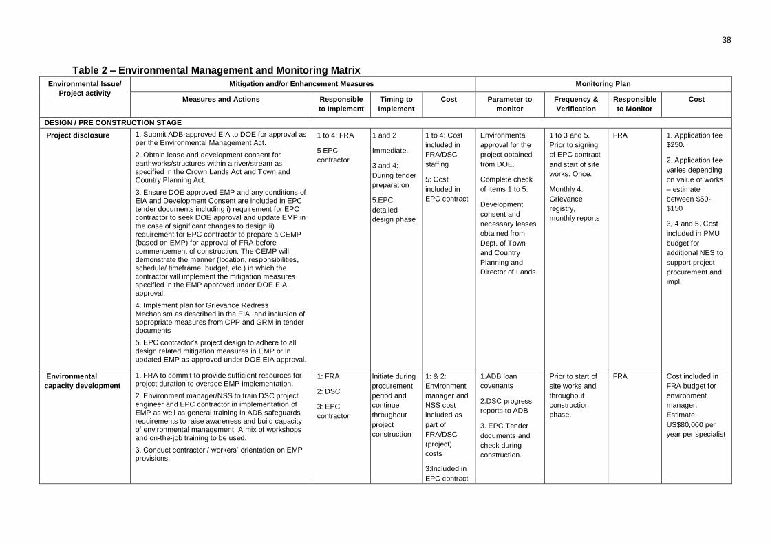
38
Table 2 – Environmental Management and Monitoring Matrix
Environmental Issue/
Project activity
Mitigation and/or Enhancement Measures Monitoring Plan
Measures and Actions Responsible
to Implement
Timing to
Implement
Cost Parameter to
monitor
Frequency &
Verification
Responsible
to Monitor
Cost
DESIGN / PRE CONSTRUCTION STAGE
Project disclosure 1. Submit ADB-approved EIA to DOE for approval as per the Environmental Management Act.
2. Obtain lease and development consent for
earthworks/structures within a river/stream as specified in the Crown Lands Act and Town and Country Planning Act.
3. Ensure DOE approved EMP and any conditions of
EIA and Development Consent are included in EPC tender documents including i) requirement for EPC contractor to seek DOE approval and update EMP in
the case of significant changes to design ii) requirement for EPC contractor to prepare a CEMP (based on EMP) for approval of FRA before
commencement of construction. The CEMP will demonstrate the manner (location, responsibilities, schedule/ timeframe, budget, etc.) in which the
contractor will implement the mitigation measures specified in the EMP approved under DOE EIA approval.
4. Implement plan for Grievance Redress
Mechanism as described in the EIA and inclusion of appropriate measures from CPP and GRM in tender documents
5. EPC contractor’s project design to adhere to all
design related mitigation measures in EMP or in updated EMP as approved under DOE EIA approval.
1 to 4: FRA
5 EPC
contractor
1 and 2
Immediate.
3 and 4:
During tender
preparation
5:EPC
detailed
design phase
1 to 4: Cost
included in
FRA/DSC
staffing
5: Cost
included in
EPC contract
Environmental
approval for the
project obtained
from DOE.
Complete check
of items 1 to 5.
Development
consent and
necessary leases
obtained from
Dept. of Town
and Country
Planning and
Director of Lands.
1 to 3 and 5.
Prior to signing
of EPC contract
and start of site
works. Once.
Monthly 4.
Grievance
registry,
monthly reports
FRA 1. Application fee
$250.
2. Application fee
varies depending
on value of works
– estimate
between $50-
$150
3, 4 and 5. Cost
included in PMU
budget for
additional NES to
support project
procurement and
impl.
Environmental
capacity development
1. FRA to commit to provide sufficient resources for project duration to oversee EMP implementation.
2. Environment manager/NSS to train DSC project
engineer and EPC contractor in implementation of EMP as well as general training in ADB safeguards requirements to raise awareness and build capacity
of environmental management. A mix of workshops and on-the-job training to be used.
3. Conduct contractor / workers’ orientation on EMP provisions.
1: FRA
2: DSC
3: EPC
contractor
Initiate during
procurement
period and
continue
throughout
project
construction
1: & 2:
Environment
manager and
NSS cost
included as
part of
FRA/DSC
(project)
costs
3:Included in
EPC contract
1.ADB loan
covenants
2.DSC progress
reports to ADB
3. EPC Tender
documents and
check during
construction.
Prior to start of
site works and
throughout
construction
phase.
FRA Cost included in
FRA budget for
environment
manager.
Estimate
US$80,000 per
year per specialist
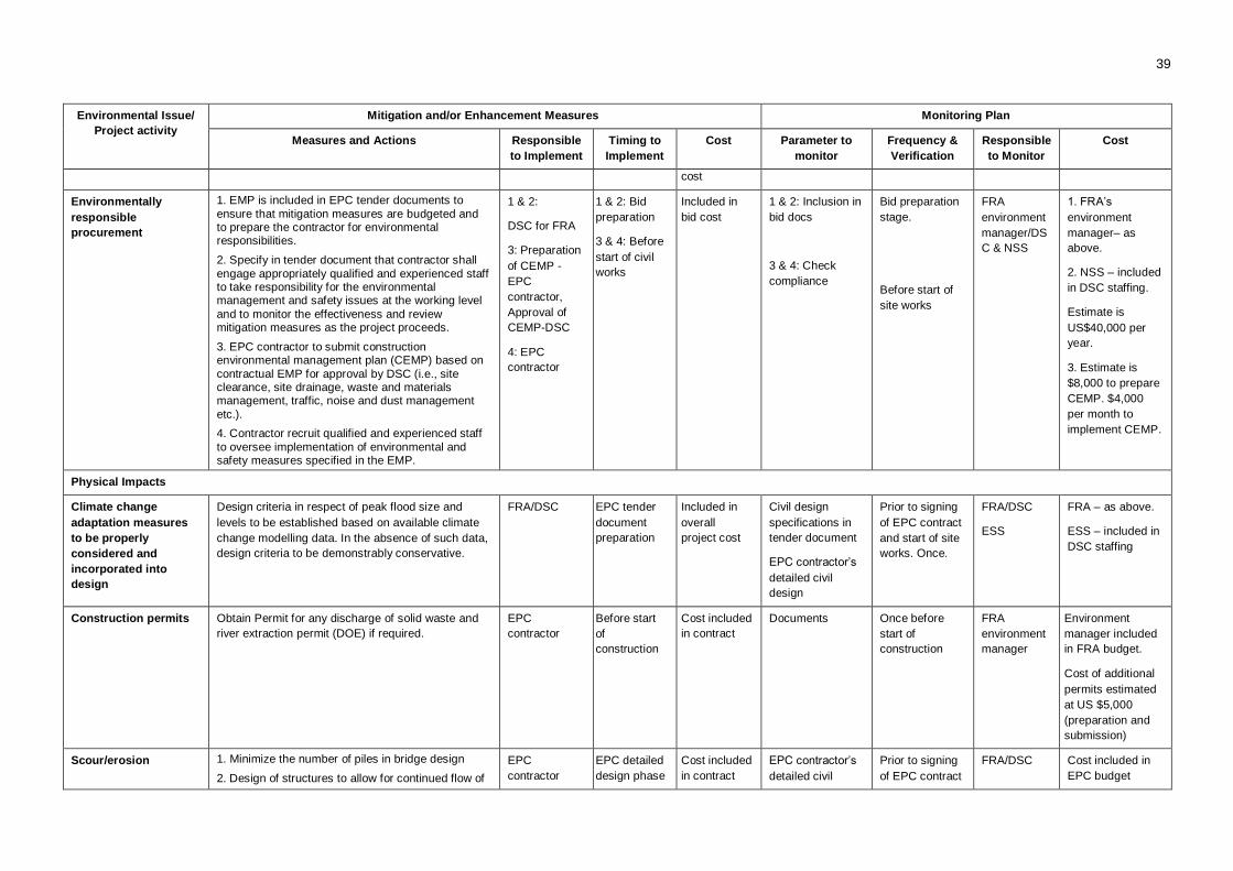
39
Environmental Issue/
Project activity
Mitigation and/or Enhancement Measures Monitoring Plan
Measures and Actions Responsible
to Implement
Timing to
Implement
Cost Parameter to
monitor
Frequency &
Verification
Responsible
to Monitor
Cost
cost
Environmentally
responsible
procurement
1. EMP is included in EPC tender documents to
ensure that mitigation measures are budgeted and to prepare the contractor for environmental responsibilities.
2. Specify in tender document that contractor shall
engage appropriately qualified and experienced staff to take responsibility for the environmental management and safety issues at the working level
and to monitor the effectiveness and review mitigation measures as the project proceeds.
3. EPC contractor to submit construction environmental management plan (CEMP) based on
contractual EMP for approval by DSC (i.e., site clearance, site drainage, waste and materials management, traffic, noise and dust management
etc.).
4. Contractor recruit qualified and experienced staff
to oversee implementation of environmental and safety measures specified in the EMP.
1 & 2:
DSC for FRA
3: Preparation
of CEMP -
EPC
contractor,
Approval of
CEMP-DSC
4: EPC
contractor
1 & 2: Bid
preparation
3 & 4: Before
start of civil
works
Included in
bid cost
1 & 2: Inclusion in
bid docs
3 & 4: Check
compliance
Bid preparation
stage.
Before start of
site works
FRA
environment
manager/DS
C & NSS
1. FRA’s
environment
manager– as
above.
2. NSS – included
in DSC staffing.
Estimate is
US$40,000 per
year.
3. Estimate is
$8,000 to prepare
CEMP. $4,000
per month to
implement CEMP.
Physical Impacts
Climate change
adaptation measures
to be properly
considered and
incorporated into
design
Design criteria in respect of peak flood size and
levels to be established based on available climate
change modelling data. In the absence of such data,
design criteria to be demonstrably conservative.
FRA/DSC EPC tender
document
preparation
Included in
overall
project cost
Civil design
specifications in
tender document
EPC contractor’s
detailed civil
design
Prior to signing
of EPC contract
and start of site
works. Once.
FRA/DSC
ESS
FRA – as above.
ESS – included in
DSC staffing
Construction permits Obtain Permit for any discharge of solid waste and
river extraction permit (DOE) if required.
EPC
contractor
Before start
of
construction
Cost included
in contract
Documents Once before
start of
construction
FRA
environment
manager
Environment
manager included
in FRA budget.
Cost of additional
permits estimated
at US $5,000
(preparation and
submission)
Scour/erosion 1. Minimize the number of piles in bridge design
2. Design of structures to allow for continued flow of
EPC
contractor
EPC detailed
design phase
Cost included
in contract
EPC contractor’s
detailed civil
Prior to signing
of EPC contract
FRA/DSC Cost included in
EPC budget

40
Environmental Issue/
Project activity
Mitigation and/or Enhancement Measures Monitoring Plan
Measures and Actions Responsible
to Implement
Timing to
Implement
Cost Parameter to
monitor
Frequency &
Verification
Responsible
to Monitor
Cost
water through or appropriate overtopping in flood. design and start of site
works. Once. ESS
Ecological Impacts
Terrestrial ecology 1. Adjust alignment of access roads to minimize need for removing large trees.
2. Minimize width of vegetation clearance corridor for
realigned road if bridge upstream of Matewale crossing implemented
3. Mark boundary of vegetation clearance corridors with high visibility tape to ensure construction
workers are aware of clearance boundaries.
EPC
contractor
EPC detailed
design phase
and before
clearance
works
Cost included
in contract
Visual
observation of
boundary
markings
Before start of
vegetation
clearance
DSC
(ESS/NSS)
As above
3. Survey set out
and maintenance
estimate $10,000
Socio-economic Impacts
Loss of high value
land or displacement
of people through land
acquisition
1. Design road realignments to take into account value of land and to minimize area required
2. No physical displacement of people, either on an
individual household basis or through the acquisition of public properties such as schools, churches or other community centers.
3. Stockpiles located on lower value land or public
land.
4. Loss of land compensated through measures
outlined in LARP.
1 to 3 EPC
contractor
4. FRA
environment
manager
EPC detailed
design phase
Cost included
in contract.
Cost of land
acquired to
be
determined
using LARP.
EPC contractor’s
detailed civil
design.
Prior to signing
of EPC
contract and
start of site
works. Once.
FRA/DSC
ESS
Cost included in
EPC budget
4. Compensation
calculated as per
LARP.
CONSTRUCTION STAGE
Physical Impacts
Climate
change/greenhouse
gas emissions from
construction vehicles
1. Construction equipment and vehicles will be
serviced regularly to minimize emissions.
EPC
contractor
Throughout
construction
phase
Cost included
in contract
Check
implementation
Once a month
as part of
routine
monitoring
DSC
(SSS/NSS)
Included in
contract cost.
Water Quality impact
due to sediment
runoff, disturbance to
creek beds, scour or
1. Schedule excavation activities in the drier months
(Jun - Oct)
2. Minimize width of vegetation clearance corridor for realigned road if bridge upstream of Matewale
EPC
contractor
Throughout
construction
phase
Cost included
in contract
Check
implementation of
all items
Twice a month
as part of
routine
construction
DSC
(ESS/NSS)
1, 2, 5, 7 ,8, 10
and 11 Cost
included in EPC
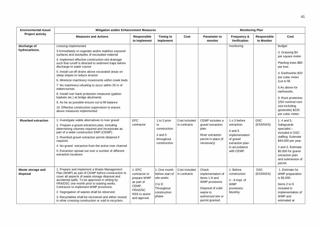
41
Environmental Issue/
Project activity
Mitigation and/or Enhancement Measures Monitoring Plan
Measures and Actions Responsible
to Implement
Timing to
Implement
Cost Parameter to
monitor
Frequency &
Verification
Responsible
to Monitor
Cost
discharge of
hydrocarbons.
crossing implemented
3 Immediately re-vegetate and/or stabilize exposed
surfaces and stockpiles of excavated material
4. Implement effective construction site drainage
such that runoff is directed to sediment traps before discharge to water course
5. Install cut-off drains above excavated areas on
steep slopes to reduce erosion
6. Minimize machinery movements within creek beds
7. No machinery refueling to occur within 20 m of
watercourses.
8. Install river bank protection measures (gabion baskets etc.) at bridge abutments
9. As far as possible ensure cut to fill balance
10. Effective construction supervision to ensure
above measures implemented
monitoring budget
3. Grassing $4
per square meter.
Planting trees $80
per tree.
4. Earthworks $20
per cubic meter
(cut to fill.
6 As above for
earthworks.
9. Rock protection
(250 nominal rock
size including
geotextile) $220
per cubic meter.
Riverbed extraction 1. Investigate viable alternatives to river gravel
2. Prepare a gravel extraction plan, including
determining volumes required and incorporate as part of a wider construction EMP (CEMP).
3. Riverbed gravel extraction permit obtained if required.
4. No gravel extraction from the active river channel
5. Extraction spread out over a number of different
extraction locations
EPC
contractor
1 to 3 prior
to
construction.
4 and 5
throughout
construction.
Cost included
in contracts
CEMP includes a
gravel extraction
plan.
River extraction
permit in place (if
necessary)
1 o 3 before
extraction.
4 and 5
implementation
of gravel
extraction plan
in accordance
with CEMP.
DSC
(ESS/NSS)
1, 4 and 5.
Safeguards
specialist –
included in DSC
staffing. Estimate
$40,000 per year.
2 and 3. Estimate
$5,000 for gravel
extraction plan
and submission of
permit.
Waste storage and
disposal
1. Prepare and implement a Waste Management
Plan (WMP) as part of CEMP before construction to cover all aspects of waste storage disposal and accidental spills. To be approved in writing by
FRA/DSC one month prior to starting works. Contractor to implement WMP provisions.
2. Segregation of wastes shall be observed.
3. Recyclables shall be recovered and either reused in other crossing construction or sold to recyclers.
1: EPC
contractor to
prepare WMP
as part of
CEMP,
FRA/DSC
NSS to assist
and approve
1: One month
before start of
site works
2 to 9:
Throughout
construction
phase
Cost included
in contracts
Check
implementation of
items 1-9 and
WMP provisions
Disposal of solid
waste to
authorized site or
permit granted.
1: Before
construction
2 - 9 Impl. of
WMP
provisions:
Monthly
DSC
(ESS/NSS)
1. Estimate for
WMP preparation
is $3,000.
Items 2 to 9
included in
implementation of
WMP and
estimated at
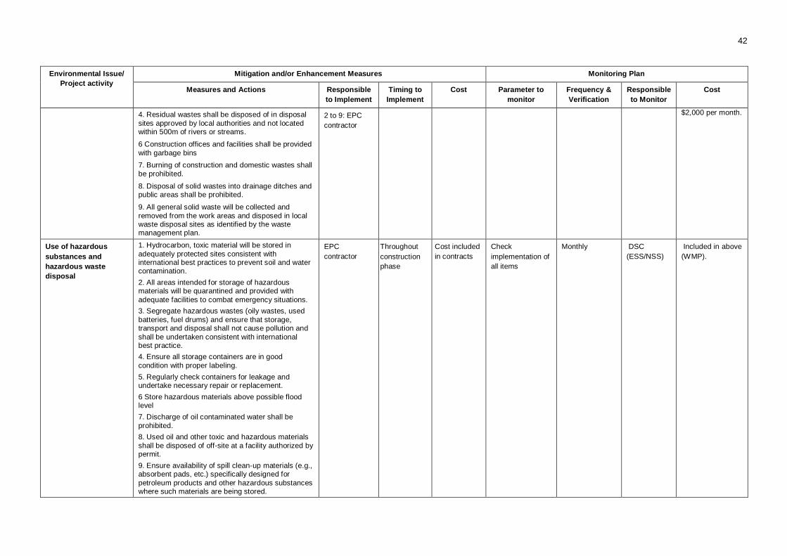
42
Environmental Issue/
Project activity
Mitigation and/or Enhancement Measures Monitoring Plan
Measures and Actions Responsible
to Implement
Timing to
Implement
Cost Parameter to
monitor
Frequency &
Verification
Responsible
to Monitor
Cost
4. Residual wastes shall be disposed of in disposal
sites approved by local authorities and not located within 500m of rivers or streams.
6 Construction offices and facilities shall be provided
with garbage bins
7. Burning of construction and domestic wastes shall
be prohibited.
8. Disposal of solid wastes into drainage ditches and public areas shall be prohibited.
9. All general solid waste will be collected and
removed from the work areas and disposed in local waste disposal sites as identified by the waste management plan.
2 to 9: EPC
contractor
$2,000 per month.
Use of hazardous
substances and
hazardous waste
disposal
1. Hydrocarbon, toxic material will be stored in
adequately protected sites consistent with international best practices to prevent soil and water contamination.
2. All areas intended for storage of hazardous materials will be quarantined and provided with
adequate facilities to combat emergency situations.
3. Segregate hazardous wastes (oily wastes, used
batteries, fuel drums) and ensure that storage, transport and disposal shall not cause pollution and
shall be undertaken consistent with international best practice.
4. Ensure all storage containers are in good
condition with proper labeling.
5. Regularly check containers for leakage and undertake necessary repair or replacement.
6 Store hazardous materials above possible flood level
7. Discharge of oil contaminated water shall be
prohibited.
8. Used oil and other toxic and hazardous materials
shall be disposed of off-site at a facility authorized by permit.
9. Ensure availability of spill clean-up materials (e.g., absorbent pads, etc.) specifically designed for
petroleum products and other hazardous substances where such materials are being stored.
EPC
contractor
Throughout
construction
phase
Cost included
in contracts
Check
implementation of
all items
Monthly DSC
(ESS/NSS)
Included in above
(WMP).
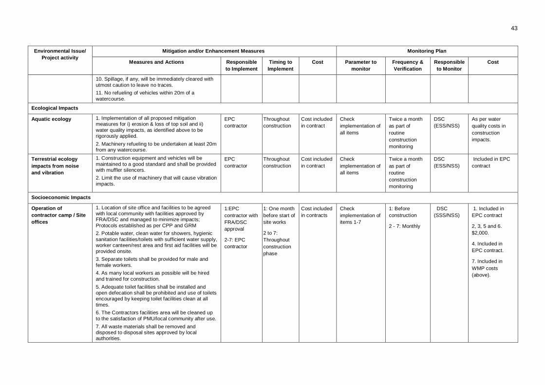
43
Environmental Issue/
Project activity
Mitigation and/or Enhancement Measures Monitoring Plan
Measures and Actions Responsible
to Implement
Timing to
Implement
Cost Parameter to
monitor
Frequency &
Verification
Responsible
to Monitor
Cost
10. Spillage, if any, will be immediately cleared with
utmost caution to leave no traces.
11. No refueling of vehicles within 20m of a
watercourse.
Ecological Impacts
Aquatic ecology 1. Implementation of all proposed mitigation measures for i) erosion & loss of top soil and ii)
water quality impacts, as identified above to be rigorously applied.
2. Machinery refueling to be undertaken at least 20m from any watercourse.
EPC
contractor
Throughout
construction
Cost included
in contract
Check
implementation of
all items
Twice a month
as part of
routine
construction
monitoring
DSC
(ESS/NSS)
As per water
quality costs in
construction
impacts.
Terrestrial ecology
impacts from noise
and vibration
1. Construction equipment and vehicles will be
maintained to a good standard and shall be provided with muffler silencers.
2. Limit the use of machinery that will cause vibration
impacts.
EPC
contractor
Throughout
construction
Cost included
in contract
Check
implementation of
all items
Twice a month
as part of
routine
construction
monitoring
DSC
(ESS/NSS)
Included in EPC
contract
Socioeconomic Impacts
Operation of
contractor camp / Site
offices
1. Location of site office and facilities to be agreed with local community with facilities approved by FRA/DSC and managed to minimize impacts;
Protocols established as per CPP and GRM
2. Potable water, clean water for showers, hygienic
sanitation facilities/toilets with sufficient water supply, worker canteen/rest area and first aid facilities will be
provided onsite.
3. Separate toilets shall be provided for male and
female workers.
4. As many local workers as possible will be hired
and trained for construction.
5. Adequate toilet facilities shall be installed and open defecation shall be prohibited and use of toilets encouraged by keeping toilet facilities clean at all
times.
6. The Contractors facilities area will be cleaned up
to the satisfaction of PMU/local community after use.
7. All waste materials shall be removed and disposed to disposal sites approved by local authorities.
1:EPC
contractor with
FRA/DSC
approval
2-7: EPC
contractor
1: One month
before start of
site works
2 to 7:
Throughout
construction
phase
Cost included
in contracts
Check
implementation of
items 1-7
1: Before
construction
2 - 7: Monthly
DSC
(SSS/NSS)
1. Included in
EPC contract
2, 3, 5 and 6.
$2,000.
4. Included in
EPC contract.
7. Included in
WMP costs
(above).
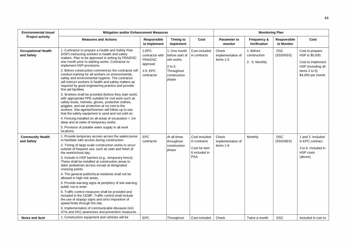
44
Environmental Issue/
Project activity
Mitigation and/or Enhancement Measures Monitoring Plan
Measures and Actions Responsible
to Implement
Timing to
Implement
Cost Parameter to
monitor
Frequency &
Verification
Responsible
to Monitor
Cost
Occupational Health
and Safety
1. Contractor to prepare a Health and Safety Plan
(HSP) instructing workers in health and safety matters. Plan to be approved in writing by FRA/DSC
one month prior to starting works. Contractor to implement HSP provisions.
2. Before construction commences the contractor will
conduct training for all workers on environmental, safety and environmental hygiene. The contractor
will instruct workers in health and safety matters as required by good engineering practice and provide first aid facilities.
3. Workers shall be provided (before they start work)
with appropriate PPE suitable for civil work such as safety boots, helmets, gloves, protective clothes, goggles, and ear protection at no cost to the
workers. Site agents/foremen will follow up to see that the safety equipment is used and not sold on.
4. Fencing installed on all areas of excavation > 1m
deep and at sides of temporary works.
5. Provision of potable water supply in all work locations.
1:EPC
contractor with
FRA/DSC
approval
2-5: EPC
contractor
1: One month
before start of
site works
2 to 5:
Throughout
construction
phase
Cost included
in contracts
Check
implementation of
items 1-5
1: Before
construction
2 - 5: Monthly
DSC
(SSS/NSS)
Cost to prepare
HSP is $5,000.
Cost to implement
HSP (including all
items 2 to 5)
$4,000 per month.
Community Health
and Safety
1. Provide temporary access across the watercourse to facilitate safe access during construction.
2. Timing of large scale construction works to occur
outside of frequent use, such as start and finish of the work/school day.
3. Include in HSP barriers (e.g., temporary fence).
These shall be installed at construction areas to deter pedestrian access except at designated
crossing points.
4. The general public/local residents shall not be
allowed in high-risk areas,
5. Provide warning signs at periphery of site warning
public not to enter
6. Traffic control measures shall be provided and included in the CEMP. Traffic control shall include
the use of stop/go signs and strict imposition of speed limits through the site.
6. Implementation of communicable diseases (incl.
STIs and HIV) awareness and prevention measures.
EPC
contractor
At all times
throughout
construction
phase
Cost included
in contracts
Cost for item
6 included in
PSA
Check
implementation of
items 1-6
Monthly DSC
(SSS/NES)
1 and 2. Included
in EPC contract.
3 to 6. Included in
HSP costs
(above)
Noise and dust 1. Construction equipment and vehicles will be EPC Throughout Cost included Check Twice a month DSC Included in cost to

45
Environmental Issue/
Project activity
Mitigation and/or Enhancement Measures Monitoring Plan
Measures and Actions Responsible
to Implement
Timing to
Implement
Cost Parameter to
monitor
Frequency &
Verification
Responsible
to Monitor
Cost
nuisances maintained to a good standard and shall be provided
with muffler silencers.
2. Ensure watering of access road adjacent to
residential areas during dry periods
3. No construction works between the hours of 1900
and 0700 every day.
4. Monitor and investigate complaints; propose alternative mitigation measures.
contractor construction
phase
in contract implementation as part of
routine
construction
monitoring
(SSS/NSS) implement CEMP
(above).
Disruption to users of
the road.
1. Avoid closure of the crossing, particularly at high use times. Provide an alternative crossing through
the use of temporary structures.
2. Communication to the public through public
consultation and notice boards regarding the scope and schedule of construction as well as certain
construction activities causing disruptions and access restrictions.
EPC
contractor
At all times
throughout
construction
phase
Cost included
in contracts
Check
implementation of
items
Monthly DSC
(SSS/NES)
Included in EPC
contract.
2. Cost included
in DSC
safeguards
staffing. Signage
estimated at
$2,000.
Damage or
disturbance of sites
of cultural or historic
significance during
earthworks or
vegetation clearance
1. Prepare a discovery protocol – chance find
procedures - and educate contractors on its
contents, including what actions are to be taken in
the event of uncovering a site of potential
significance.
EPC
contractor
Training by
SSS within
DSC.
At all times
throughout
construction
phase
Training prior
to
construction
works.
Cost included
in contracts
Check Discovery
protocol in place
and training
completed.
Monthly checks of
implementation.
Once for check
and training in
discovery
protocol.
Monthly checks
of
implementation.
DSC
(SSS/NES)
$3,000 to prepare
discovery
protocol.
OPERATION STAGE
Increase in vehicle
emissions from
increased traffic use of
improved crossings
1. Road alignments to create consistent vehicle speeds
2. Two lane crossings to avoid stop/start.
EPC
contractor
Design Included in
overall
project cost
EPC contractor’s
detailed civil
design.
Once, after
detailed design
DSC (ESS) Included in contract
costs
*Cost is approximate and provided as a rough indication only. Costs have been estimated based on a typical schedule of quantities for a road project prepared in 2013. Costs will vary depending on contractor’s equipment and resources (i.e. whether owned, leased or purchased). Costs to be confirmed in site specific CEMP.
Costs in Fijian dollars unless otherwise indicated.

46
J. SUMMARY AND CONCLUSION
207. The overall finding of the assessment is that the proposed works associated with the subprojects will not cause any significant adverse environmental impacts, the impacts will be site-specific and temporary and can be readily mitigated provided the EMP is properly implemented. The EMP will be updated by the contractor in the construction phase into a detailed CEMP once detailed design has confirmed the options (if the subprojects are selected for implementation under the project. The CEMP will incorporate a gravel extraction plan (if necessary), erosion and sediment control measures, a waste management plan and traffic control measures. Supervision of the EMP will be by FRA’s environment manager, who will act on behalf the government and will report regularly to the ADB, WB, DOE and FRA.
208. The project proposes institutional arrangements suitable to the duration of the project and likely subprojects to be prepared and implemented through it. These include FRA’s project supervision team which will be responsible for overseeing and managing project execution including compliance with project requirements (financial management, procurement, safeguards, and monitoring and evaluation). A DSC (which could include more than one firm) will be responsible for supporting FRA in project implementation by undertaking the screening and analysis required for the prioritization and ranking of subprojects, preparation of feasibility studies of selected subprojects, preliminary and detailed designs, preparation of bidding documents and assisting with bid evaluation, and monitoring construction. The DSC will include environmental and social safeguards specialists to oversee compliance by the contractor in implementing the measures in the EMP.
209. Provision is also made to train and upskill local staff in environmental and safeguards compliance and requirements to enhance the capacity of the local workforce in implementing the measures contained within the EMP.
210. A grievance redress mechanism has been suggested for any affected parties to be able to make a complaint or raise an issue. Measures are proposed for resolving any complaint or issues raised throughout the implementation of the subprojects.

47
Annex 1 – Drawings (to be included)