Figure 1: Location map of hydrographic and coastal sampling stations.
16
Figure 1: Location map of hydrographic and coastal sampling stations .
-
Upload
gael-barbery -
Category
Documents
-
view
219 -
download
5
Transcript of Figure 1: Location map of hydrographic and coastal sampling stations.

Figure 1: Location map of hydrographic and coastal sampling stations .

29/01/03
0
100
200
300
400
500
600
700
160 180 200 220 240
DO (µM)
Dep
th (
dbar
)
16/02/03
0
100
200
300
400
500
600
700
160 180 200 220 240
DO (µM)
Dep
th (d
bar)
20/03/03
0
100
200
300
400
500
600
700
160 180 200 220 240
DO (µM)
Dep
th (
dbar
)
A1
OS
13/04/03
0
100
200
300
400
500
600
700
160 180 200 220 240
DO (µM)
Dep
th (d
bar)
A1
OS
11/05/03
0
100
200
300
400
500
600
700
160 180 200 220 240
DO (µM)
Dep
th (d
bar)
A1
OS
15/06/03
0
100
200
300
400
500
600
700
160 180 200 220 240
Oxygen (µmol/L.)
Dep
th (d
bar)
A1
OS
13/07/03
0
100
200
300
400
500
600
700
160 180 200 220 240
DO (µM)
Dep
th (
dbar
)
A1
OS
10/08/03
0
100
200
300
400
500
600
700
800
900
160 180 200 220 240
DO (µM)De
pth
(dba
r)
A1
OS
B1
14/09/03
0
100
200
300
400
500
600
700
160 180 200 220 240
DO (µM)
Dep
th (
dbar
)
A1
OS
26/10/03
0
100
200
300
400
500
600
700
160 180 200 220 240
DO (µM)
Dep
th (
dbar
)
A1
OS
16/11/03
0
100
200
300
400
500
600
700
160 180 200 220 240
DO (µM)
Dep
th (
dbar
)
A1
OS
Figure 2: Dissolved oxygen profiles in stations A1 (blue), OS (pink) and B1 (green) during the cruise of 10/8/2003. The oxygen saturation for surface water is represented by the dashed blue line. Note the very low oxygen concentration in deep water (Nov. 2003) indicating high supply of POM, productivity. This is corroborated by the oxygen maximum developed at ca. 60 m during stratification (O2˜ 5 mol·L-1) indicating relatively high summer productivity. This used to be a rare phenomenon in the Gulf that happened after deep mixing winter such as 1992 and 2000.

29/01/03
0
100
200
300
400
500
600
700
8.1 8.2 8.3
pH
Dep
th (
dbar
)
16/02/03
0
100
200
300
400
500
600
700
8.1 8.2 8.3
pH
Dep
th (d
bar)
20/03/03
0
100
200
300
400
500
600
700
8.1 8.2 8.3
pH
Dep
th (
dbar
)
A1
OS
13/04/03
0
100
200
300
400
500
600
700
8.1 8.2 8.3
pH
Dep
th (d
bar)
A1
OS
11/05/03
0
100
200
300
400
500
600
700
8.1 8.2 8.3
pH
Dep
th (d
bar)
A1
OS
15/06/03
0
100
200
300
400
500
600
700
8.1 8.2 8.3
pH
Dep
th (
dbar
)
A1
OS
13/07/03
0
100
200
300
400
500
600
700
8.1 8.2 8.3
pH
Dep
th (
dbar
)
A1
OS
10/08/03
0
100
200
300
400
500
600
700
800
900
8.1 8.2 8.3
pH
Dep
th (
dbar
)
A1
OS
B1
14/09/03
0
100
200
300
400
500
600
700
8.1 8.2 8.3
pH
Dep
th (
dbar
)
A1
OS
26/10/03
0
100
200
300
400
500
600
700
8.1 8.2 8.3
pH
Dep
th (
dbar
)
A1
OS
16/11/03
0
100
200
300
400
500
600
700
8.1 8.2 8.3
pH
Dep
th (d
bar)
A1
OS
Figure 3: pH profiles in stations A1 (blue), OS (pink) and B1 (green) during the cruise of 10/8/2003.

29/01/03
0
100
200
300
400
500
600
700
0.0 0.5 1.0
Nitrite (µM)
Dep
th (d
bar)
16/02/03
0
100
200
300
400
500
600
700
0.0 0.5 1.0
Nitrite (µM)
Dep
th (d
bar)
20/03/03
0
100
200
300
400
500
600
700
0.0 0.5 1.0
Nitrite (µM)
Dep
th (d
bar)
A1
OS
13/04/03
0
100
200
300
400
500
600
700
0.0 0.5 1.0
Nitrite (µM)
Dep
th (d
bar)
A1
OS
11/05/03
0
100
200
300
400
500
600
700
0.0 0.5 1.0
Nitrite (µM)
Dep
th (d
bar)
A1
OS
15/06/03
0
100
200
300
400
500
600
700
0.0 0.5 1.0
Nitrite (µM)
Dep
th (
dbar
)
A1
OS
13/07/03
0
100
200
300
400
500
600
700
0.0 0.5 1.0
Nitrite (µM)
Dep
th (
dbar
)
A1
OS
10/08/03
0
100
200
300
400
500
600
700
800
900
0.0 0.5 1.0
Nitrite (µM)D
epth
(db
ar)
A1
OS
B1
14/09/03
0
100
200
300
400
500
600
700
0.0 0.5 1.0
Nitrite (µM)
Dep
th (
dbar
)
A1
OS
26/10/03
0
100
200
300
400
500
600
700
0.0 0.5 1.0
Nitrite (µM)
Dep
th (d
bar)
A1
OS
16/11/03
0
100
200
300
400
500
600
700
0.0 0.5 1.0
Nitrite (µM)
Dep
th (
dbar
)
A1
OS
Figure 4: Nitrite profiles in stations A1 (blue), OS (pink) and B1 (green) during the cruise of 10/8/2003. Note that the vertical location of the nitrite peak (during stratification) depends on the location of the station.

29/01/03
0
100
200
300
400
500
600
700
0 1 2 3 4 5 6 7
Nitrate (µM)
Dep
th (
dbar
)
16/02/03
0
100
200
300
400
500
600
700
0 1 2 3 4 5 6 7
Nitrate (µM)
Dep
th (
dbar
)
20/03/03
0
100
200
300
400
500
600
700
0 1 2 3 4 5 6 7
Nitrate (µM)
Dep
th (
dbar
)
A1
OS
13/04/03
0
100
200
300
400
500
600
700
0 1 2 3 4 5 6 7
Nitrate (µM)
Dep
th (
dbar
)
A1
OS
11/05/03
0
100
200
300
400
500
600
700
0 1 2 3 4 5 6 7
Nitrate (µM)
Dep
th (
dbar
)
A1
OS
15/06/03
0
100
200
300
400
500
600
700
0 1 2 3 4 5 6 7
Nitrate (µM)
Dep
th (
dbar
)
A1
OS
13/07/03
0
100
200
300
400
500
600
700
0 1 2 3 4 5 6 7
Nitrate (µM)
Dep
th (
dbar
)
A1
OS
10/08/03
0
100
200
300
400
500
600
700
800
900
0 1 2 3 4 5 6 7
Nitrate (µM)D
epth
(db
ar)
A1
OS
B1
14/09/03
0
100
200
300
400
500
600
700
0 1 2 3 4 5 6 7
Nitrate (µM)
Dep
th (
dbar
)
A1
OS
26/10/03
0
100
200
300
400
500
600
700
0 1 2 3 4 5 6 7
Nitrate (µM)
Dep
th (
dbar
)
A1
OS
16/11/03
0
100
200
300
400
500
600
700
0 1 2 3 4 5 6 7
Nitrate (µM)
Dep
th (
dbar
)
A1
OS
Figure 5: Nitrate profiles in stations A1 (blue), OS (pink) and B1 (green) during the cruise of 10/8/2003. Note the excellent similarity between stations A1 and B1 indicating no traceable horizontal gradient in deep water on a scale of 20 km.

16/02/03
0
100
200
300
400
500
600
700
0.00 0.25 0.50
Phosphate (µmol/L.)
Dep
th (d
bar)
29/01/03
0
100
200
300
400
500
600
700
0.00 0.25 0.50
Phosphate (µmol/L.)
Dep
th (d
bar)
20/03/03
0
100
200
300
400
500
600
700
0.00 0.25 0.50
Phosphate (µmol/L.)
Dep
th (
dbar
)
A1
OS
13/04/03
0
100
200
300
400
500
600
700
0.00 0.25 0.50
Phosphate (µmol/L.)
Dep
th (d
bar)
A1
OS
11/05/03
0
100
200
300
400
500
600
700
0.00 0.25 0.50
Phosphate (µmol/L.)
Dep
th (d
bar)
A1
OS
15/06/03
0
100
200
300
400
500
600
700
0.00 0.25 0.50
Phosphate (µmol/L.)
Dep
th (
dbar
)
A1
OS
13/07/03
0
100
200
300
400
500
600
700
0.00 0.25 0.50
Phosphate (µmol/L.)
Dep
th (
dbar
)
A1
OS
10/08/03
0
100
200
300
400
500
600
700
800
900
0.00 0.25 0.50
Phosphate (µmol/L.)D
epth
(db
ar)
A1
OS
B1
14/09/03
0
100
200
300
400
500
600
700
0.00 0.25 0.50
Phosphate (µmol/L.)
Dep
th (
dbar
)
A1
OS
26/10/03
0
100
200
300
400
500
600
700
0.00 0.25 0.50
Phosphate (µmol/L.)
Dep
th (
dbar
)
A1
OS
16/11/03
0
100
200
300
400
500
600
700
0.00 0.25 0.50
Phosphate (µmol/L.)
Dep
th (
dbar
)
A1
OS
Figure 6: Phosphate profiles in stations A1 (blue), OS (pink) and B1 (green) during the cruise of 10/8/2003. Note the excellent similarity between stations A1 and B1 indicating no traceable horizontal gradient in deep water on a scale of 20 km.

Figure 7: Time versus depth variations of a- temperature, b- salinity, and c- fluorescence (chlorophyll) in station A1.
a
b
c

Figure 8: Time versus depth variations of nitrate in station A1 (solid points denote water samples) from Sep. 99 to Apr. 04. a- vertical scale 0-100 m; b- vertical scale 100-300 m; and c- the whole water column (0-700 m, surface to bottom). The color concentration scale (at the right of each section) is different for each depth range. Note: 1. The high nitrate concentrations in surface waters during the deep mixing of march 2000 and the decrease during march of the consecutive years when mixing depth did not reach the bottom (b); 2. The enhanced nitrate regeneration in mid-water during summer 2000, following the deep mixing event as compared to consecutive years (b); and 3. The high nitrate content deep water prior to the deep mixing event of 2000, the decease during the deep mixing event and the build up of large deep water nitrate reservoir toward the 2004 values (see also Fig. 18 in report number 7, Lazar and Erez, 2004). At present, t is not clear whether a new steady state has been reached.
a
b
c
mol
·L-1
No
cru
ises
No
cru
ises
No
cru
ises
mol
·L-1
mol
·L-1

Figure 9: Time variations of Chlorophyll-a in surface water between Jan. 2000 and April 2004: coastal stations and open sea. Note that chlorophyll is higher in the north than in the south. The lowest concentration are in the open sea station (OS). Station locations are given in Fig. 1 where N and T denotes MP and Tb (in Fig. 1) respectively.

Figure 10: Time variations of Secci disk visibility between Jan. 2000 and April 2004: coastal stations and open sea. Note that visibility is lower in the northern stations than in the south. The highest visibility is in the open sea station (OS). Station locations are given in Fig. 1 where N and T denotes MP and Tb (in Fig. 1) respectively.

Figure 11: Time variations of nitrate in surface water between Jan. 2000 and April 2004: coastal stations and open sea. Note that nitrate is higher in the north than in the south and in the open sea station (OS). Station locations are given in Fig. 1 where N and T denotes MP and Tb (in Fig. 1) respectively.

Figure 12: Time variations of nitrite in surface water between Jan. 2000 and April 2004: coastal stations and open sea. All stations show roughly the same mixing/stratification behavior. Station locations are given in Fig. 1 where N and T denotes MP and Tb (in Fig. 1) respectively.

Figure 13: Time variations of ammonium in surface water between Jan. 2000 and April 2004: coastal stations and open sea. Note that ammonium is higher in the north than in the south and in the open sea station (OS) and the highest concentrations were measured during 2001 close to the fish farms (FF). Station locations are given in Fig. 1 where N and T denotes MP and Tb (in Fig. 1) respectively.

Figure 14: Time variations of phosphate in surface water between Jan. 2000 and April 2004: coastal stations and open sea. Note that phosphate is highest in the fish farms (FF) up to the year 2002. Relatively high concentrations were measured in the north beach (NB) and the highest concentrations were measured close to the port (PT) during June and August 2000 (phosphate loading?). Station locations are given in Fig. 1 where N and T denotes MP and Tb (in Fig. 1) respectively.
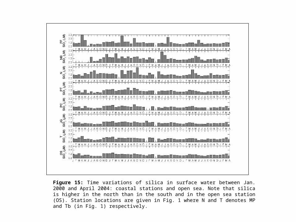
Figure 15: Time variations of silica in surface water between Jan. 2000 and April 2004: coastal stations and open sea. Note that silica is higher in the north than in the south and in the open sea station (OS). Station locations are given in Fig. 1 where N and T denotes MP and Tb (in Fig. 1) respectively.

Figure 16: Time variations of pH (a) in surface water between Jan. 2000 and April 2004: coastal stations and open sea. The pH is lower in the north than in the south and in the open sea station (OS) as indicated by the deviations from the contemporaneous open sea (OS) pH values (b) and that the lowest pH was measured close to the fish farms (FF). Note that a pH decrease by 0.l units is equivalent to a PCO2 rise (due to enhanced respiration?) by ca. 60 atm (assuming constant total alkalinity), more than 15 % increase as compare to equilibrium with atmospheric CO2. Station locations are given in Fig. 1 where N and T denotes MP and Tb (in Fig. 1) respectively.
a b