Fermi Avenue Harwell Campus Didcot ... -...
23
ESA UNCLASSIFIED - For Official Use Prepared by ESA Climate Office Reference CCI-PRGM-EOPS-TN-13-0009 Issue/Revision 2.0 Date of Issue 17/09/2018 Status For Information Only ecsat Fermi Avenue Harwell Campus Didcot, Oxfordshire OX11 0FD United Kingdom T +44 (0)1235 444200 www.esa.int STANDARDS CCI Data Standards
Transcript of Fermi Avenue Harwell Campus Didcot ... -...

ESA UNCLASSIFIED - For Official Use
Prepared by ESA Climate Office Reference CCI-PRGM-EOPS-TN-13-0009 Issue/Revision 2.0 Date of Issue 17/09/2018 Status For Information Only
ecsat Fermi Avenue
Harwell Campus Didcot, Oxfordshire OX11 0FD
United Kingdom T +44 (0)1235 444200
www.esa.int
STANDARDS
CCI Data Standards

ESA UNCLASSIFIED - For Official Use
Page 2/23 CCI Data Standards Issue Date 17/09/2018 Ref CCI-PRGM-EOPS-TN-13-0009
CHANGE LOG Reason for change Issue Nr. Revision Number Date
First issue of Data Standards Requirements (Victoria Bennett & Sarah James)
1 0 20/05/2013
Revision incorporating comments from DSWG (Victoria Bennett & Sarah James)
1 1 24/05/2013
Changing definitions in section 2.1 of source global attribute, platform attribute, and Envisat term in Section 2.1, Appendix A and section 2.7 Product String examples §
1 2 09/03/2015
Rearranged content, added more examples, additional requirements and clarifications ahead of, and following, CCI Colocation March 2018 and to apply during CCI+. Led by Ed Pechorro (ESA), Alison Waterfall (CCI ODP), Victoria Bennett (CCI ODP) and supported by Kevin Marsh (ECMWF) and Cedric Bergeron (ECMWF).
2 0 17/09/2018

ESA UNCLASSIFIED - For Official Use
Page 3/23 CCI Data Standards Issue Date 17/09/2018 Ref CCI-PRGM-EOPS-TN-13-0009
Table of contents:
1 BACKGROUND ..................................................................................................... 42 PRODUCT GUIDELINES ....................................................................................... 52.1 Standard products: minimum requirements .................................................................................. 52.2 Products for existing user communities .......................................................................................... 52.3 Conformance with international standards .................................................................................... 62.4 CCI Ontology ..................................................................................................................................... 62.5 File contents ...................................................................................................................................... 72.5.1 Global Attributes ............................................................................................................................. 72.5.2Variables .......................................................................................................................................... 92.5.3Gridded data – coordinate variables ............................................................................................ 102.6 Directory structure .......................................................................................................................... 122.7 Filenaming ....................................................................................................................................... 122.8 Version Numbering ......................................................................................................................... 202.9 Support for checking compliance with the data format ............................................................... 21APPENDIX A – EXAMPLE GLOBAL ATTRIBUTE FIELDS ........................................ 22

ESA UNCLASSIFIED - For Official Use
Page 4/23 CCI Data Standards Issue Date 17/09/2018 Ref CCI-PRGM-EOPS-TN-13-0009
1 BACKGROUND
The ESA Climate Change Initiative (CCI) is a programme which is generating a set of validated, error-characterised, Essential Climate Variables (ECVs) from existing satellite observations. The CCI Programme was launched in 2009 and initially consisted of thirteen Projects, each addressing a particular ECV, and CMUG, the Climate Modelling User Group. CCI+ will begin in 2018, building on this earlier work and introducing a further set of ECV’s. This has provided the opportunity to revise the data standards outlined in this document in the light of the experience of the earlier phases of the CCI programme.
This document is based on the “Guidelines for Data Producers – CCI Phase 1”1, and the subsequent “Data Standards Requirements for Data Producers”2. The motivation and content for these documents came from the first CCI collocation meeting in September 2011, subsequent discussions at the CCI collocation meeting, the CCI integration meetings and within the Data Standards Working Group.
This document provides the minimum requirements to CCI data producers to ensure consistency between output products from the CCI projects. The requirements in this document are intended to apply to all CCI projects in CCI+.
In case of new developments (e.g. due to evolving user requirements, international standards and formats), these requirements may still evolve during the course of the programme. Any updates will only be made after discussion with, and agreement in the CCI Data Engineering Working Group.
The overall aim of these standards is to make the CCI datasets as widely usable as possible, in user communities outside the existing ones. Using common formats and a number of agreed and consistent metadata conventions will facilitate this. Further help and advice on data formatting and support for checking compliance with these standards is available from the CCI Open Data Portal, and CCI Projects are encouraged to liaise with the Portal when developing their data formats.
CCI Sustainability Version 2.0 of the CCI Data Standards is the first edition of the standards developed with the support of the European Centre for Medium-Range Weather Forecasts (ECMWF). A number of CCI datasets have served as input to, and evolved under, ECMWF implementation of the Copernicus Climate Change Service (C3S). The cooperation between the ESA Climate Office and ECMWF/C3S on the CCI Data Standards, from v2.0 onwards, optmises the sustainability of CCI datasets beyond the CCI programme, and facilitates their use and further development by ECMWF/C3S. In addition, CCI Data Standards v2.0 supports a complementary activity between the ESA Climate Office and ECMWF/C3S on climate data interoperability, following CCI Toolbox Iteration Review Meeting 9 (IRM9) on 20 June 2018 participated by ECMWF/C3S : the development of a proof-of-concept data link between the (ESA) CCI Toolbox API and the (C3S) CDS API.
1 CCI-PRGM-EOPS-TN-11-0003, issue 4, revision 1, May 2013 2 CCI-PRGM-EOPS-TN-13-0009, issue 1, revison 2, March 2015

ESA UNCLASSIFIED - For Official Use
Page 5/23 CCI Data Standards Issue Date 17/09/2018 Ref CCI-PRGM-EOPS-TN-13-0009
2 PRODUCT GUIDELINES
2.1 Standard products: minimum requirements
All CCI projects shall produce data according to the following minimum requirements for data products:
R-1
CCI projects shall produce data according to the CCI Data Standards Requirements:
a. Produced in netCDF-4 (classic) format3
b. Conform with the CF (Climate and Forecasting) convention4 (currently version 1.7)
c. CF standard names used for the main variables
d. Include the global attributes listed in section 2.5.1 below
For netCDF-4 (classic) format, the mode must be set to NC_CLASSIC_MODEL, but compression can be invoked.
If netCDF-4 cannot be used (e.g. user tools not yet mature enough), data may be produced in netCDF-3 format.
It is recommended that chunking of the datasets be considered when writing to NetCDF, particularly in case of compression5. The appropriate chunking to use will however depend on the intended uses of the product. If specified, it is recommended that the chunk size is an integer fraction of the respective dimension (i.e. that there are no smaller chunks at a border).
2.2 Products for existing user communities
It is understood that existing user communities require data in specific formats that are not in all cases compatible with the requirements in this document (e.g. GeoTiff, shape files).
Projects producing such files in other formats are required to follow these requirements as far as possible in terms of filenaming and metadata for their non-standard data, and to produce a standardised, netCDF format dataset, in addition to their domain specific datasets.
R-2 Projects who have commitments to produce data in other formats, shall do this in addition to the standardized products, and shall ensure these products comply as much as possible to the CCI Data Standards (e.g. filenames, metadata)
3 http://www.unidata.ucar.edu/software/netcdf/ 4 http://cfconventions.org/latest.html 5 https://www.unidata.ucar.edu/blogs/developer/entry/chunking_data_why_it_matters

ESA UNCLASSIFIED - For Official Use
Page 6/23 CCI Data Standards Issue Date 17/09/2018 Ref CCI-PRGM-EOPS-TN-13-0009
2.3 Conformance with international standards
The choice of CF and ACDD6 conventions for CCI data products ensures it will be possible to extract the metadata from the files to a number of standard metadata formats, e.g. ISO19115, FGDC, etc, as required by data discovery systems.
Within the CF-convention there are still areas where there are ongoing discussions, for example, in the representation of swath data under CF (see, for example, ongoing discussions in CF-satellite community http://www.unidata.ucar.edu/mailing_lists/archives/cf-satellite/ ). CCI data producers who are producing such data products are strongly encouraged to engage with this community to progress the development of CF conventions for satellite swath data, either directly or via the Data Engineering Working Group, which can provide coordination for discussions with the CF-community
R-3 CCI Data Producers shall engage with the CF community to help develop the standards they require for satellite data
The INSPIRE (Infrastructure for Spatial Information in the European Community) directive requires INSPIRE compliant discovery metadata to be generated for geospatial datasets that are within scope of the directive, which covers a broad range of environmental themes. All data products that are held in the CCI Open Data Portal will have INSPIRE compliant metadata records created by the Data Portal team. In exceptional cases products are held in external sites with agreement with ESA. The producers of these products must ensure INSPIRE compliant metadata records are created.
R-4 The CCI projects shall ensure that INSPIRE compliant metadata records are created for each dataset. For datasets held in the CCI Open Data Portal, this requires the CCI projects to provide information to the Data Portal Team.
2.4 CCI Ontology
To ensure consistency where the same global attributes apply to several ECVs, and to avoid different terms being used for the same thing, relevant terms have been gathered in an ontology, defining the CCI entities and the relationship between those entities, including :
• project
• platform
• sensor
• institution
The CCI Ontology is available online on the ESA CCI website at cci.esa.int/working-groups.
6Attribute Convention for Data Discovery (http://wiki.esipfed.org/index.php/Attribute_Convention_for_Data_Discovery)

ESA UNCLASSIFIED - For Official Use
Page 7/23 CCI Data Standards Issue Date 17/09/2018 Ref CCI-PRGM-EOPS-TN-13-0009
R-5 CCI Data Producers shall use terms from the CCI vocabulary tables in the netCDF global attributes, or if terms are missing they shall request that they are added to the tables.
2.5 File contents
2.5.1 Global Attributes The following section outlines which global attributes shall be included in the files. Example content for these attributes are given in Appendix A. For consistency, CCI output netCDF files shall include these global attributes to provide usage information about the data:
a. title (succinct description of the dataset)
b. institution (where the data was produced, use names from CCI common vocabulary)
c. source (original data source(s), e.g. MERIS RR L1B version 4.02) Multiple source datasets and ancillary datasets used, with their DOI if available, as a free-text, comma-separated list)
d. history (processing history of dataset)
e. references (references to algorithm, ATBD, technical note describing dataset)
f. tracking_id (a UUID (Universal Unique Identifier) value)7
g. Conventions (the CF Version)
h. product_version (the product version of this data file (see section Error! Reference source not found.))
Discovery metadata allows information about the data to be harvested into catalogues and data federations. For dataset discovery, the netCDF attributes recommended in http://wiki.esipfed.org/index.php/Attribute_Convention_for_Data_Discovery shall be included in addition to the attributes listed above:
i. summary (a paragraph describing the dataset)
j. keywords (a comma separated list of key words and phrases)
k. id
l. naming authority (the combination of the naming authority and the id should be a globally unique identifier for the dataset)
m. keywords_vocabulary (if you are following a guideline for the words/phrases in your “keywords” attribute, put the name of that guideline here)
n. cdm_data_type (the THREDDS data type appropriate for this dataset)
o. comment (miscellaneous information about the data)
p. date_created (the date on which the data was created)
q. creator_name
7 The unique tracking ID allows files to be referenced, and linked up to processing description, input data, documentation, etc. The software to generate the UUID can be downloaded from : http://www.ossp.org/pkg/lib/uuid/ and CCI shall use version 4 (random number based) for consistency with CMIP5

ESA UNCLASSIFIED - For Official Use
Page 8/23 CCI Data Standards Issue Date 17/09/2018 Ref CCI-PRGM-EOPS-TN-13-0009
r. creator_url
s. creator_email
t. project (the scientific project that produced the data: “Climate Change Initiative – European Space Agency”)
u. geospatial_lat_min (decimal degrees north, range -90 to +90)
v. geospatial_lat_max (decimal degrees north, range -90 to +90)
w. geospatial_lon_min (decimal degrees east, range -180 to +180)
x. geospatial_lon_max (decimal degrees east, range -180 to +180)
y. geospatial_vertical_min (assumed to be in metres above ground unless geospatial_vertical_units attribute defined otherwise)
z. geospatial_vertical_max (assumed to be in metres above ground unless geospatial_vertical_units attribute defined otherwise)
aa. time_coverage_start (format yyyymmddThhmmssZ)
bb. time_coverage_end (format yyyymmddThhmmssZ)
cc. time_coverage_duration (should be an ISO8601 duration string)
dd. time_coverage_resolution (should be an ISO8601 duration string). For L2 data on the original satellite sampling it is acceptable to use 'satellite_orbit_frequency'
ee. standard_name_vocabulary (the name of the controlled vocabulary from which variable standard names are taken)
ff. license (describe the restrictions to data access and distribution)
The following CCI project specific attributes shall be included in the files:
gg. platform (satellite name, e.g. Envisat; use names from CCI common vocabulary list. Separated by commas if more than one, and use angled brackets for a platform series, eg. ‘Envisat, NOAA-<12,14,16,17,18>, Metop-A’)
hh. sensor (sensor name, e.g. AATSR, use names from CCI common vocabulary. Separated by commas if more than one )
ii. spatial_resolution (a string describing the approximate resolution of the product. For example, “1.1km at nadir”)
jj. key_variables (a comma separated list of the key primary variables in the file i.e. those that have been scientifically validated, and are appropriate for display in the CCI Open Data Portal and CCI Toolbox)
For gridded (level3/level4) data on a regular lat/lon grid, the following attributes shall be included in the files (not compulsory for level2 data, or data on other grids, e.g. polar stereographic) :
kk. geospatial_lat_units
ll. geospatial_lon_units
mm. geospatial_lon_resolution
nn. geospatial_lat_resolution
Projects are free to include any number of additional attributes which are specific to their domain or user community, or for compatability with other external initiatives e.g. Copernicus C3S.

ESA UNCLASSIFIED - For Official Use
Page 9/23 CCI Data Standards Issue Date 17/09/2018 Ref CCI-PRGM-EOPS-TN-13-0009
2.5.2 Variables Variables should be stored in the NetCDF file in conformance with the CF-convention (http://cfconventions.org/) and using the standard name attribute where appropriate. Where an existing standard name exists this should be included as an attribute on the variable. Where a standard name does not exist, or has not yet been accepted by CF, it should be omitted from the file. Data producers are strongly encouraged to submit new standard names for inclusion in CF as appropriate. In addition the following should be considered:
a. The key primary variables in the file (i.e. those that are scientifically validated, and for instance, are appropriate for visualisation through the CCI Portal and Toolbox), shall be identified by the use of the ‘key_variables’ global attribute. This should be in the form of a comma separated list.
b. Ancillary and coordinate variables should also be identified as specified in the CF conventions4:
o Ancillary variables such as uncertainty or quality flags should be identified by the ‘ancillary_variables’ attribute of the related primary variable. Ancillary variables that are required to correctly interpret a key primary variable must be identified in this way. (Section 3.4 of CF-1.7 conventions document)
o Coordinate variables are identified as those with the same name as the corresponding dimensions, whilst related auxiliary coordinate variables can be identified using the ‘coordinates’ attribute of a variable (Section 4 and 5 of CF-1.7 conventions document)
c. For each variable, the attributes ‘valid_range’ (or alternatively ‘valid_min’,’valid_max’) and ‘actual_range’ shall be provided, if appropriate.
o The ‘valid_range’ should define the expected valid range of the variable. Under the CF-convention, values outside this range are treated as missing data.
o The ‘actual_range’ provides the actual range of the data within the file, within the limits of the valid range.
d. Where quality flags are included, it is recommended that a value of ‘0’ (the number zero) or no bits set is taken to indicate good quality data.
e. For variables with a defined colour table (e.g. for land cover classes), this colour mapping information shall be included in the NetCDF file.
In addition, to allow the datasets to be best displayed through the CCI Open Data Portal and CCI Toolbox, display information are requested to be provided for the variables e.g. a recommended colour bar and display min/max. Such information could be included in the comment attribute of the respective variables, or alternatively could be provided outside of the data file, directly to the CCI Open Data Portal.
R-6 The key primary variables in the file and their related ancillary variables (e.g. uncertainty) shall be identified, and the range of their expected values shall be indicated.
Example of including variables and corresponding attributes in the file :

ESA UNCLASSIFIED - For Official Use
Page 10/23 CCI Data Standards Issue Date 17/09/2018 Ref CCI-PRGM-EOPS-TN-13-0009
float variable1(time, lat, lon) ;
variable1:long_name = "a_longer_descriptive_name_of variable" ;
variable1:standard_name = "CF_standard_name_here" ;
variable1:units = "unit from UDUNITS" ;
variable1:valid_range = 0f,10f ;
variable1:actual_range = 1f,9f ;
variable1:anciliary_variables = ‘variable1_uncertainty variable1_flag’ ;
float variable1_uncertainty(time, lat, lon) ;
variable1:long_name = " uncertainty associated with variable1" ;
variable1:units = "unit from UDUNITS" ;
byte variable1_flag(time,lat,lon) ;
variable1_flag:long_name = “status flag associated with variable1” ;
variable1_flag:standard_name = “status_flag” ;
variable1_flag:_FillValue = -128b ;
variable1_flag:valid_range = 0b,2b ;
variable1_flag:flag_values = 0b,1b,2b ;
variable1_flag:flag_meanings = “good_quality problem1 problem2” ;
//global attributes:
:key_variables = “variable1” ;
2.5.3 Gridded data – coordinate variables Data products from the CCI which are most likely to be used outside the community of EO (Earth Observation) specialists are the global gridded (level3, level4) datasets. To achieve consistency across these ECV products, and enable them to be used and understood by a wide variety of users and tools, including the CCI Open Data Portal and CCI Toolbox, it is important to ensure consistent use of dimensions for variables within the files.
R-7 For consistency across CCI gridded products, variables shall have, as a minimum, the following dimensions: time, latitude, longitude (or alternative horizontal grid)
1. The dimensions time, latitude and longitude of a netCDF variable shall have an associated time, latitude and longitude coordinate variable
o A coordinate variable is defined in the cf-convention as a one dimensional variable with the same name as its dimensions (e.g. time(time), lat(lat),lon(lon), and it is defined as a numeric data type with values that are ordered monotonically. Missing values are not allowed in coordinate variables.
2. All products shall have a time dimension, even if there is only a single timestep within an individual file. This is recommended to have be of dimension = ‘UNLIMITED’. The corresponding time variable should be an array and not a scalar variable. This allows users

ESA UNCLASSIFIED - For Official Use
Page 11/23 CCI Data Standards Issue Date 17/09/2018 Ref CCI-PRGM-EOPS-TN-13-0009
to aggregate the data files along the time dimension and facilitates display of the data within the CCI Open Data Portal.
3. Horizontal grid dimensions shall also be included.
o If coordinates other than latitude and longitude are used for the horizontal grid, then, following the cf-conventions, it is required that the true latitude and longitude coordinates be supplied via the coordinates attribute.
o The dimensions of any latitude or longitude auxiliary coordinate variable should be the horizontal grid dimensions only (e.g. lat(nx,ny) )Ifit is desired to describe the mapping between the given coordinate variables and the true latitude and longitude coordinates, the attribute grid_mapping should be used to supply this description. For more information and examples see section 5.6 of CF-1.7.
4. For each coordinate variable in a gridded data product, the boundaries of the grid shall be described via the use of boundary variables, as described in section 7.1 of the CF-1.7 conventions document. The boundary variable is linked to the corresponding coordinate variable by the use of the attribute ‘bounds’, which contains the name of the boundary variable. (see example below)
The GHRSST project (Group for High Resolution Sea Surface Temperature) has developed conventions for non-regular latitude/longitude grids (swath) which have been adopted in the SST community – details and examples are given in the GHRSST Data Specification document8.
Examples can be found in the CF-conventions document and the CF Unidata NetCDF Users’ Guide9, and a simple example of CDL for CCI gridded lat/lon data is given here:
netcdf CCI_example_grid {
dimensions:
time = UNLIMITED ;
lat = 1200 ;
lon = 1200 ;
nv = 2 ; //number of vertices (to define the grid boundaries)
variables:
float lat(lat) ;
lat:standard_name = "latitude" ;
lat:units = "degrees_north" ;
lat:bounds = “lat_bnds” ;
float lon(lon) ;
lon:standard_name = "longitude" ;
lon:units = "degrees_east" ;
lon:bounds = “lon_bnds” ;
double time(time) ;
time:standard_name = "time" ;
time:units = "seconds since 1970-01-01 00:00:00 0:00" ;
time:bounds = “time_bnds” ;
float lat_bnds(lat,nv)
float lon_bnds(lon,nv)
double time_bnds(time,nv)
float ecv_variable(time, lat, lon) ;
ecv_variable:long_name = "a_longer_descriptive_name_of_the_variable" ;
8 See https://www.ghrsst.org/documents/q/category/gds-documents/ 9 https://www.unidata.ucar.edu/software/netcdf/docs/user_guide.html

ESA UNCLASSIFIED - For Official Use
Page 12/23 CCI Data Standards Issue Date 17/09/2018 Ref CCI-PRGM-EOPS-TN-13-0009
ecv_variable:standard_name = "CF_standard_name_here" ;
ecv_variable:units = "unit from UDUNITS" ;
ecv_variable:valid_range = 0f,10f ;
ecv_variable:actual_range = 1f,9f ;
2.6 Directory structure
A common CCI directory structure has been defined.
R-8 CCI Data Producers shall use the common directory structure for all output data made available to users
If projects need to use a different structure (e.g. due to conflicting requirements of existing user communities), it shall be possible to map to the CCI common structure using symbolic links. The common directory structure is based on suggestions and existing conventions used by CCI teams and is arranged as follows: /<archive_root>/<type>/<version>/<time>/ where each <…> may itself be complex, e.g. <time> may be <year>/<month> or <year>/<week-in-year> or <year>/<month>/<day> <archive-root> is /esacci/<cci_project>/ <cci_project> is e.g. <sst> or <aerosol> <type> will be different for each ECV, but needs to be defined, and consistent within an ECV <version> uniquely identifies the version (see Section Error! Reference source not found.)
2.7 Filenaming
A common CCI filenaming convention has been developed to simplify access to the project data across the different disciplines involved.
R-9 CCI Data Producers shall use the CCI filenaming convention for all output data made available to users
Overview of CCI Filename Convention Note that there are two forms that the filename can take:
1. It can begin with the date and time information (which will be digits). This form is compatible with the GHRSST filenaming convention used by Sea Surface Temperature scientists. https://www.ghrsst.org/news/q/date/2011/11/07/ghrsst-data-specification-gds-2-0-revision-4/ Or

ESA UNCLASSIFIED - For Official Use
Page 13/23 CCI Data Standards Issue Date 17/09/2018 Ref CCI-PRGM-EOPS-TN-13-0009
2. It can begin with the string ‘ESACCI’ in which case the date and time information will be in
the field immediately before the version information.
Overview form 1 <Indicative Date>[<Indicative Time>]-ESACCI-<Processing Level>_<CCI Project>-<Data Type>-<Product String>[-<Additional Segregator>][-v<GDS version>]-fv<File version>.nc Overview form 2 ESACCI-<CCI Project>-<Processing Level>-<Data Type>-<Product String>[-<Additional Segregator>]-<IndicativeDate>[<Indicative Time>]-fv<File version>.nc The fields in the filename convention are: <Indicative Date> The identifying date for this data set. Format is YYYY[MM[DD]], where YYYY is the four digit year, MM is the two digit month from 01 to 12 and DD is the two digit day of the month from 01 to 31. The date used should best represent the observation date for the data set. It can be a year, a year and a month or a year and a month and a day. <Indicative Time> The identifying time for this data set in UTC. Format is [HH[MM[SS]]] where HH is the two digit hour from 00 to 23, MM is the two digit minute from 00 to 59 and SS is the two digit second from 00 to 59. ESACCI This corresponds to RDAC (Regional Data Assembly Centre) in the GHRSST filenaming convention. <Processing Level>
Level <Processing Level> Code
Description Based on Source
Level 0 L0 Unprocessed instrument and payload data at full resolution. CCI does not make recommendations regarding formats or content for data at this processing level.
GHRSST
Level 1A L1A Reconstructed unprocessed instrument data at full resolution, time referenced, and annotated with ancillary information, including radiometric and geometric
GHRSST

ESA UNCLASSIFIED - For Official Use
Page 14/23 CCI Data Standards Issue Date 17/09/2018 Ref CCI-PRGM-EOPS-TN-13-0009
Level <Processing Level> Code
Description Based on Source
calibration coefficients and georeferencing parameters, computed and appended, but not applied, to L0 data.
Level 1B L1B Level 1A data that have been processed to sensor units. GHRSST
Level 1C L1C Level 1b data that have been further processed, e.g. by correcting radiances or by mapping onto a spatial grid, prior to deriving geophysical variables from the data.
SMOS data products definition
and ESACCI discussions
Level 2 L2 Retrieved environmental variables at the same resolution and location as the level 1 source CEOS
handbook10
Level 2 Pre-
processed
L2P Geophysical variables derived from Level 1 source data at the same resolution and location as the level 1 data, typically in a satellite projection with geographic information. These data form the fundamental basis for higher level CCI products.
GHRSST
Level 3 L3
Level 2 variables mapped on a defined grid with reduced requirements for ancillary data. Three types of L3 products are defined:
GHRSST
L3U Uncollated (L3U): L2 data granules remapped to a space grid without combining any observations from overlapping orbits.
L3C Collated (L3C): Observations combined from a single instrument into a space-time grid.
L3S Super-collated (L3S): observations combined from multiple instruments into a space-time grid.
Level 4 L4 Data sets created from the analysis of lower level data that result in gridded, gap-free products.
GHRSST
Indicator IND Indicators derived from satellite data. ESACCI
10 http://wiki.ieee-earth.org/@api/deki/files/7/=Handbook_0802.pdf

ESA UNCLASSIFIED - For Official Use
Page 15/23 CCI Data Standards Issue Date 17/09/2018 Ref CCI-PRGM-EOPS-TN-13-0009
<CCI Project> This corresponds to GHRSST in the GHRSST filenaming convention.
CCI Project <CCI Project>
Aerosol AEROSOL
Antarctic Ice Sheet AIS11
Cloud CLOUD
Fire FIRE
Greenhouse Gases GHG
Glaciers GLACIERS
Ice Sheets Greenland GIS11
Land Cover LC
Ocean Colour OC
Ozone OZONE
Sea Ice SEAICE
Sea Level SEALEVEL
Sea Surface Temperature GHRSST
Soil Moisture SOILMOISTURE
Further CCI projects will be added in as the programme continues. <Data Type> This corresponds to SST Type in the GHRSST convention and shall contain a short term describing the main data type in the data set. Examples from Phase 1 are given in the following list. Where new or different data types are produced in the CCI programme, the new term shall be added to the list by informing the CCI Open Data Portal. 11 This was formerly part of the Icesheets project and could also have <CCI Project> = ICESHEETS

ESA UNCLASSIFIED - For Official Use
Page 16/23 CCI Data Standards Issue Date 17/09/2018 Ref CCI-PRGM-EOPS-TN-13-0009
CCI Project Parameter <Data Type>
Aerosol Aerosol optical depth AOD
Absorbing aerosol index AAI
Stratospheric aerosol extinction profile AEX
Aerosol type ATY
Multiple aerosol products AER_PRODUCTS
Cloud Cloud cover CFC
Cloud top pressure CTP
Cloud top height CTH
Cloud top temperature CTT
Cloud optical thickness COT
Cloud effective radius CER
Cloud liquid water path LWP
Cloud ice water path IWP
Joint cloud physical properties JCH
Multiple cloud products CLD_PRODUCTS
Fire Burned area BA
GHG column-averaged dry air mole fraction of CO2 CO2
column-averaged dry air mole fraction of CH4 CH4
Glaciers Glacier area GA
Ice Sheets Ice sheet surface elevation change SEC
Ice sheet velocity IV

ESA UNCLASSIFIED - For Official Use
Page 17/23 CCI Data Standards Issue Date 17/09/2018 Ref CCI-PRGM-EOPS-TN-13-0009
CCI Project Parameter <Data Type>
Glacier calving front location CFL
Glacier grounding line location GLL
Land Cover Land cover map Map
Condition fire (burned area) BA
Condition water (water bodies) WB
Condition snow Snow
Condition normalised difference vegetation index NDVI
Condition albedo Alb
Leaf Area Index LAI
Surface reflectance SR
Ocean Colour Multiple products (chla, nlw, IOPs, etc) OC_PRODUCT
S
Phytoplankton Chlorophyll-a concentration CHLOR_A
Normalised water leaving radiance NLW
Remote Sensing Reflectance RRS
Spectral attenuation coefficient for downwelling irradiance K_490
Total absorption ATOT
Total backscattering BB
Absorption by coloured dissolved organic matter ADG
Backscattering by particulate matter BBP
Absorption by phytoplankton APH
Ozone Ozone total column TC
ESA UNCLASSIFIED - For Official Use
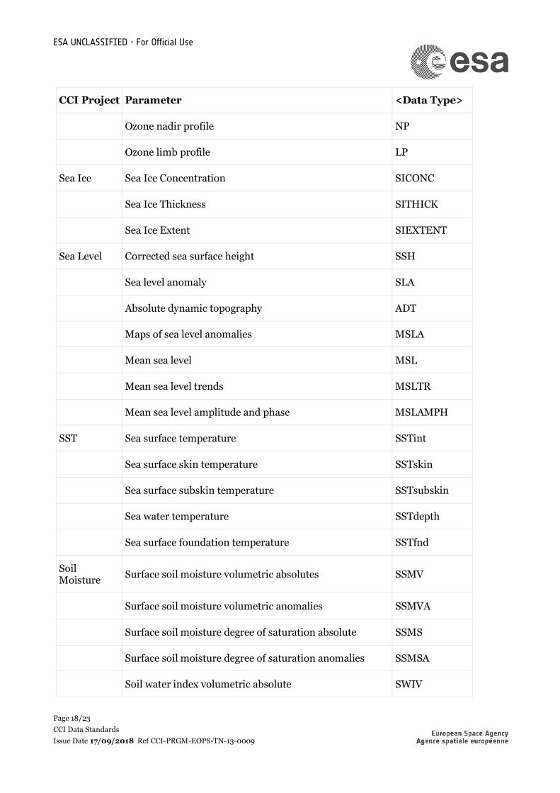
Page 18/23 CCI Data Standards Issue Date 17/09/2018 Ref CCI-PRGM-EOPS-TN-13-0009
CCI Project Parameter <Data Type>
Ozone nadir profile NP
Ozone limb profile LP
Sea Ice Sea Ice Concentration SICONC
Sea Ice Thickness SITHICK
Sea Ice Extent SIEXTENT
Sea Level Corrected sea surface height SSH
Sea level anomaly SLA
Absolute dynamic topography ADT
Maps of sea level anomalies MSLA
Mean sea level MSL
Mean sea level trends MSLTR
Mean sea level amplitude and phase MSLAMPH
SST Sea surface temperature SSTint
Sea surface skin temperature SSTskin
Sea surface subskin temperature SSTsubskin
Sea water temperature SSTdepth
Sea surface foundation temperature SSTfnd
Soil Moisture Surface soil moisture volumetric absolutes SSMV
Surface soil moisture volumetric anomalies SSMVA
Surface soil moisture degree of saturation absolute SSMS
Surface soil moisture degree of saturation anomalies SSMSA
Soil water index volumetric absolute SWIV

ESA UNCLASSIFIED - For Official Use
Page 19/23 CCI Data Standards Issue Date 17/09/2018 Ref CCI-PRGM-EOPS-TN-13-0009
CCI Project Parameter <Data Type>
Soil water index volumetric anomalies SWIVA
Soil water index degree of saturation absolute SWIS
Soil water index degree of saturation anomalies SWISA
<Product String> Each ECV team shall define the Product Strings they will use for their data and make this information available in their documentation. The Product String field must not include any hyphens but can include underscores. Examples:
Example Product String Description
MERGED Data from more than one platform and/or sensor
AVHRR_MERGED Data from AVHRR, more than one platform
AATSR_ENVISAT Data from AATSR on Envisat
ORAC Data from Oxford RAL Aerosol and Cloud algorithm
OPERA Data from OPERA analysis
<Additional Segregator> This is an optional part of the filename. It must be used if otherwise different data sets would generate the same filename. It can also be used to include in the filename information that doesn't fit elsewhere in the filename convention, but which projects feel is useful for easy identification of different data sets. Each ECV team shall define the Additional Segregators they will use for their data and make this information available in their documentation. More than one element may be included, separated by an underscore, not a hyphen. Examples:

ESA UNCLASSIFIED - For Official Use
Page 20/23 CCI Data Standards Issue Date 17/09/2018 Ref CCI-PRGM-EOPS-TN-13-0009
Information Example <Additional Segregator> element
Description
Composite data <n><Y|M|D>[<n><y|m|d>] nY or nM or nD corresponds to the period over which data are aggregated of n number of years or months or days. An optional ny or nm or nd refers to the 'season' covered by the composite data set. For example 15Y7d indicates 15 year composite data covering a specific 7 days of the year. The start date and time of the earliest data included in the composite data product will be given by the <Indicative Date>[<Indicative Time>]
Orbit identifier <id> where id is an orbit identifier
Ground or sea area <code>|<tile number> code identifying the area of land or sea covered by the data or tile number. Projects expecting to produce regional products have generally described codes to identify them.
Length of time period covered.
[<n>]<DAILY | MONTHLY | YEARLY>
Identify that data set holds n days, months or years data, where the filenames might otherwise coincide.
Resolution <n>m where n is the number of metres resolution.
Processing Centre <Processing centre abbreviation>
name of processing centre
Algorithm <Algorithm> name of algorithm
v<GDS version> Including the version number of the GHRSST Data Specification is optional for the CCI filenaming convention. If used it shall be 02.0 fv<File Version> File version number in the form n{1,}[.n{1,}] (That is 1 or more digits followed by optional . and another 1 or more digits.)
2.8 Version Numbering
The version of a dataset12can be specified via both the product version in the global attributes and the file version in the filename In this current version of the data standards it is left to the discretion of the product teams as to whether these refer to he same version numbering or differ, and it is proposed that this should be discussed further within the Data Engineering Working Group going forward. The following shall apply:
12 In this case we refer to a dataset as a specific instance of a data product (e.g. it could contain a new reprocessing of the data product, or a different format of the same data product)

ESA UNCLASSIFIED - For Official Use
Page 21/23 CCI Data Standards Issue Date 17/09/2018 Ref CCI-PRGM-EOPS-TN-13-0009
1. The combination of file version and product version shall uniquely identify the particular instance of the dataset
2. Filenames for different versions should differ. It is recommended that file version increases between versions, but if for some reason this is not the case, then filenames corresponding to the different product version should still be distinguishable in some way.
3. Version numbering should increase with new instances of a given dataset.
Other global attributes to identify e.g. the algorithm version can also be set if required.
2.9 Support for checking compliance with the data format
CCI data producers are encouraged to liaise with the CCI Open Data Portal when producing their data formats. The Open Data Portal can provide support for checking the compliance of any datasets to these standards. Files can be checked for compliance with the CF convention using the on-line checking tool: http://cfconventions.org/compliance-checker.html

ESA UNCLASSIFIED - For Official Use
Page 22/23 CCI Data Standards Issue Date 17/09/2018 Ref CCI-PRGM-EOPS-TN-13-0009
APPENDIX A – EXAMPLE GLOBAL ATTRIBUTE FIELDS
For fields coloured blue, please select terms from the CCI vocabulary at http://cci.esa.int/working-groups.
Global Attribute Example content title ESA CCI aerosol product level 3 daily institution Plymouth Marine Laboratory source MERIS FR L1B version 4.02, MERIS RR L1B version 4.02, SPOT
VGT P version 3.013 history 2011-02-14 12:22:43 - Product generated from ORAC-SW dual-
view version 2.0 references http://www.esa-landcover-cci.org/ tracking_id 0c9e9570-cd44-102f-8001-0050c28e1010 Conventions CF-1.7 product_version 1.3 summary This dataset contains Level-3 monthly global sea surface
temperature products from satellite observations. Level-3 data are raw observations processed to geophysical quantities, and placed onto a regular grid.
keywords satellite,observation,ocean id filename.nc naming authority uk.ac.pml keywords_vocabulary NASA Global Change Master Directory (GCMD) Science Keywords cdm_data_type Swath comment These data were produced at ESACCI as part of the ESA SST CCI
project. date_created 20120131T120000Z creator_name Plymouth Marine Laboratory Remote Sensing Group creator_url http://rsg.pml.ac.uk
creator_email [email protected]
project Climate Change Initiative - European Space Agency geospatial_lat_min -90.0 geospatial_lat_max 90.0 geospatial_lon_min -180.0 geospatial_lon_max 180.0 geospatial_vertical_min 0.0 geospatial_vertical_max 0.0 time_coverage_start 20120131T070000Z time_coverage_end 20120131T083000Z time_coverage_duration P1Y time_coverage_resolution P1D standard_name_vocabulary NetCDF Climate and Forecast (CF) Metadata Convention version
18 13 For assimilation datasets the model could also be included here, e.g. “TM5 model, MIPAS L2 data (CCI_ozone product version 1.5)”

ESA UNCLASSIFIED - For Official Use
Page 23/23 CCI Data Standards Issue Date 17/09/2018 Ref CCI-PRGM-EOPS-TN-13-0009
license ESA CCI Data Policy: free and open access platform Envisat sensor AATSR, MERIS spatial_resolution 1.1km at nadir geospatial_lat_units degrees_north geospatial_lon_units degrees_east geospatial_lon_resolution 0.1 geospatial_lat_resolution 0.1 key_variables sea_surface_temperature,sea_surface_temperature_depth