FEMA Region IV · FEMA Region IV HAZUS Technical Team produced a complete set of maps and reports...
2
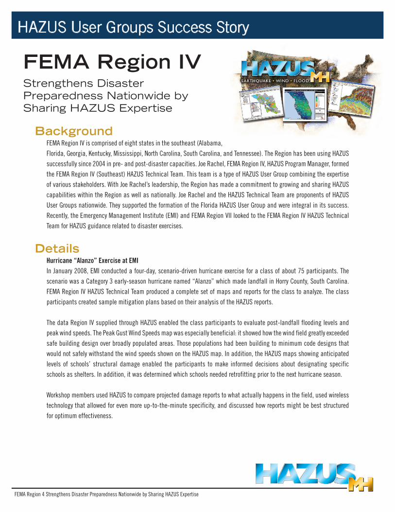
FEMA Region 4 Strengthens Disaster Preparedness Nationwide by Sharing HAZUS Expertise HAZUS User Groups Success Story FEMA Region IV Strengthens Disaster Preparedness Nationwide by Sharing HAZUS Expertise Background FEMA Region IV is comprised of eight states in the southeast (Alabama, Florida, Georgia, Kentucky, Mississippi, North Carolina, South Carolina, and Tennessee). The Region has been using HAZUS successfully since 2004 in pre- and post-disaster capacities. Joe Rachel, FEMA Region IV, HAZUS Program Manager, formed the FEMA Region IV (Southeast) HAZUS Technical Team. This team is a type of HAZUS User Group combining the expertise of various stakeholders. With Joe Rachel’s leadership, the Region has made a commitment to growing and sharing HAZUS capabilities within the Region as well as nationally. Joe Rachel and the HAZUS Technical Team are proponents of HAZUS User Groups nationwide. They supported the formation of the Florida HAZUS User Group and were integral in its success. Recently, the Emergency Management Institute (EMI) and FEMA Region VII looked to the FEMA Region IV HAZUS Technical Team for HAZUS guidance related to disaster exercises. Details Hurricane “Alanzo” Exercise at EMI In January 2008, EMI conducted a four-day, scenario-driven hurricane exercise for a class of about 75 participants. The scenario was a Category 3 early-season hurricane named “Alanzo” which made landfall in Horry County, South Carolina. FEMA Region IV HAZUS Technical Team produced a complete set of maps and reports for the class to analyze. The class participants created sample mitigation plans based on their analysis of the HAZUS reports. The data Region IV supplied through HAZUS enabled the class participants to evaluate post-landfall flooding levels and peak wind speeds. The Peak Gust Wind Speeds map was especially beneficial: it showed how the wind field greatly exceeded safe building design over broadly populated areas. Those populations had been building to minimum code designs that would not safely withstand the wind speeds shown on the HAZUS map. In addition, the HAZUS maps showing anticipated levels of schools’ structural damage enabled the participants to make informed decisions about designating specific schools as shelters. In addition, it was determined which schools needed retrofitting prior to the next hurricane season. Workshop members used HAZUS to compare projected damage reports to what actually happens in the field, used wireless technology that allowed for even more up-to-the-minute specificity, and discussed how reports might be best structured for optimum effectiveness.
Transcript of FEMA Region IV · FEMA Region IV HAZUS Technical Team produced a complete set of maps and reports...
FEMA Region 4 Strengthens Disaster Preparedness Nationwide by Sharing HAZUS Expertise
HAZUS User Groups Success Story
FEMA Region IVStrengthens Disaster Preparedness Nationwide by Sharing HAZUS Expertise
BackgroundFEMA Region IV is comprised of eight states in the southeast (Alabama, Florida, Georgia, Kentucky, Mississippi, North Carolina, South Carolina, and Tennessee). The Region has been using HAZUS successfully since 2004 in pre- and post-disaster capacities. Joe Rachel, FEMA Region IV, HAZUS Program Manager, formed the FEMA Region IV (Southeast) HAZUS Technical Team. This team is a type of HAZUS User Group combining the expertise of various stakeholders. With Joe Rachel’s leadership, the Region has made a commitment to growing and sharing HAZUS capabilities within the Region as well as nationally. Joe Rachel and the HAZUS Technical Team are proponents of HAZUS User Groups nationwide. They supported the formation of the Florida HAZUS User Group and were integral in its success. Recently, the Emergency Management Institute (EMI) and FEMA Region VII looked to the FEMA Region IV HAZUS Technical Team for HAZUS guidance related to disaster exercises.
DetailsHurricane “Alanzo” Exercise at EMIIn January 2008, EMI conducted a four-day, scenario-driven hurricane exercise for a class of about 75 participants. The scenario was a Category 3 early-season hurricane named “Alanzo” which made landfall in Horry County, South Carolina. FEMA Region IV HAZUS Technical Team produced a complete set of maps and reports for the class to analyze. The class participants created sample mitigation plans based on their analysis of the HAZUS reports.
The data Region IV supplied through HAZUS enabled the class participants to evaluate post-landfall flooding levels and peak wind speeds. The Peak Gust Wind Speeds map was especially beneficial: it showed how the wind field greatly exceeded safe building design over broadly populated areas. Those populations had been building to minimum code designs that would not safely withstand the wind speeds shown on the HAZUS map. In addition, the HAZUS maps showing anticipated levels of schools’ structural damage enabled the participants to make informed decisions about designating specific schools as shelters. In addition, it was determined which schools needed retrofitting prior to the next hurricane season.
Workshop members used HAZUS to compare projected damage reports to what actually happens in the field, used wireless technology that allowed for even more up-to-the-minute specificity, and discussed how reports might be best structured for optimum effectiveness.

FEMA Region 4 Strengthens Disaster Preparedness Nationwide by Sharing HAZUS Expertise
Four Corners Earthquake ExerciseIn December 2007, FEMA Region VII contacted Joe Rachel and the HAZUS Technical Team for assistance with HAZUS scenario maps for the Four Corners Earthquake Exercise. The Four Corners represents the area where Missouri, Kansas, Oklahoma, and Arkansas come together. The exercise focused on their shared susceptibility to the Nemaha Ridge Seismic Fault. The Nemaha Ridge Seismic Fault extends 400 miles vertically from southeastern Nebraska and northeastern Kansas through to northern and central Oklahoma. Its last notable earthquake occurred in 1952, causing moderate damage from the El Reno, Oklahoma epicenter, and slight damage in nearby towns.
AJ Lehmaen, Missouri’s Exercise Officer, and Steve Besemer, Earthquake Program Manager, ran the exercise that allowed the four states to collaborate and solve emergency response issues. In order to make the exercise applicable to professionals present from all four states, the epicenter of the earthquake was located in southeast Kansas. The dozen maps and varied reports generated by the FEMA Region IV HAZUS Technical Team using HAZUS for the tabletop exercise allowed each of the four states to identify issues unique to each of them, as well as common areas of concern and how they could collaborate to solve problems. Some top concerns included: mass care, damage assessment, emergency protective actions, and transportation route restoration.
BenefitsThe many benefits of collaboration cannot be underestimated. Thanks to the leadership of Joe Rachel and the FEMA Region IV HAZUS Technical Team in Region IV, two diverse exercises, each examining a different hazard, provided experiential knowledge of the dynamic ways HAZUS software can help develop and refine emergency management plans across the country. According to “FEMA 404: How to Create a HAZUS User Group,” HAZUS User Groups include data developers, data manipulators, data interpreters and decision makers. The HAZUS software is a powerful tool, and its power is multiplied when skilled people work together using it.
PossibilitiesFEMA Region IV HAZUS Technical Team will continue to assist HAZUS users in government, private industry, and educational sectors as they aim for the highest levels of preparedness, response, and recovery. The two examples above demonstrate how the FEMA Region IV HAZUS Technical Team provided HAZUS scenarios for disaster exercises which may directly lead to mitigation strategies and increased preparedness for those regions.
By developing and expanding HAZUS collaboration and HAZUS User Groups and supporting all four levels of HAZUS users, the HAZUS software begins to work at its fullest potential. The commitment and expertise repeatedly demonstrated by Joe Rachel and the FEMA Region IV HAZUS Technical Team continues to multiply the value of HAZUS as it is shared and used across regions.
Program ContactJoe RachelHAZUS Program ManagerFederal Emergency Management Agency Region IVP: 770.220.5426E: [email protected]
Base Map
Legend:
kj EpCenter_at_77EQ
o
airports
Study Region TractCountiesPOP00_SQMI
401 - 67,454151 - 40051 - 15011 - 500 - 10RailroadFreeway System (State)Study Region BoundaryStudyRegionBndry
_̂
_̂
oo
o
o
o
o
o
o
o
o
o oo
o
o
o
o
o
o
o
o
o
kj
K a n s a sK a n s a s
O k l a h o m aO k l a h o m a
M i s s o u r iM i s s o u r i
A r k a n s a sA r k a n s a s
Osage
Butler
Yell
Kay
Elk
Lyon
Grant
Grady
ScottLe Flore
Creek
Pope
CowleySumner
Polk
Bates
Barry
Pittsburg
Linn
Cass
Marion
Craig
Reno
Lincoln
Garfield
Pettis
Henry
Noble
Saline
Chase
Logan
Benton
Vernon
Morris
Adair
Payne Tulsa
Sedgwick
Newton
Coffey
Hughes
Allen
Taney
Mayes
Greenwood
Johnson
Rogers
Madison
Miami
Garvin
Dade
Latimer
Jasper
Carroll
Barton
Boone
Dickinson
Greene
St. Clair
Stone
Dallas
Labette
Wilson
Delaware
Haskell
McPherson
Cedar
CherokeeWashington
Muskogee
McIntosh Franklin
Nowata
Harvey
Kingfisher
Neosho
Bourbon
Pawnee
Jackson
Perry
Harper
Sequoyah
McClain
Canadian Oklahoma
Ottawa
Crawford
Okmulgee
Seminole
Okfuskee
Christian
GearyWabaunsee
Wagoner
Pontotoc
Lawrence
Morgan
Anderson
Douglas
Rice
Hickory
Lafayette
Cleveland
McDonald
Woodson
Sebastian
Chautauqua Montgomery
Webster
Shawnee
Kingman
Coal
Cooper
Garland
Pottawatomie
Camden
Ellsworth
Searcy
Riley Jefferson
Stephens
Leavenworth
Conway
Pushmataha
Wyandotte
Caddo
Howard
Atoka
Clay
Alfalfa
Major
MurrayComanche
Moniteau
Ray
Nemaha ZoneEarthquakeNov 11, 2007
0 25 50 75 10012.5Miles
¶ Chamblee Tucker RoadAtlanta, GA 30341
FEMA Region IV, RRCC GIS Analysis
Regional Setting Map
kj
§̈¦44
§̈¦70
§̈¦35
§̈¦135
§̈¦40
§̈¦335
§̈¦240 §̈¦540
§̈¦235
§̈¦470
§̈¦244
§̈¦235
§̈¦35
§̈¦40§̈¦40
§̈¦35
§̈¦35
§̈¦35
§̈¦40
§̈¦35
§̈¦44
§̈¦35
§̈¦44
§̈¦44
§̈¦35
§̈¦44
§̈¦44
§̈¦335
§̈¦35
§̈¦40
§̈¦44
§̈¦40
§̈¦540
§̈¦70
£¤412
£¤69
£¤75
£¤64
£¤62
£¤77
£¤169
Osage
Kay
Butler
Yell
Elk
Reno
Le Flore
Grant
Grady
Lyon
Scott
Creek
CowleySumner
Bates
Polk
Pittsburg
Barry
Cass
LinnMarion
Craig
Garfield
Lincoln
Henry
Noble
Saline
Chase
Pettis
Logan
Benton
Vernon
Payne
Morris
Garvin
Adair
Rice
Mayes
Hughes
Coffey
Harper
Greenwood
Dade
Rogers
Allen
Madison
Miami
Johnson
Latimer
GreeneJasper
St. Clair
Canadian
Carroll
Stone
Barton
Labette
Delaware
Kingfisher
Haskell
Newton
Wilson
Cedar
McPherson
Cherokee
Muskogee
Nowata
Washington
Harvey
McIntosh
Neosho
Franklin
Pawnee
Bourbon
Pontotoc
Sequoyah
Kingman
Ottawa
Okmulgee
Crawford
Okfuskee
Coal
Wagoner
Dickinson
Lawrence
Anderson
Hickory
McDonald
Woodson
Chautauqua
DouglasWabaunseeGeary
Stephens Pushmataha
Tulsa
Sedgwick
McClain
Oklahoma
Seminole
Pope
PottawatomieCleveland
Sebastian
Alfalfa
Montgomery
Ellsworth
Christian
Major
Garland
Jackson
Perry
AtokaMurray
Morgan
Camden
Spectral Acceleration At 1.0 Second: EQ 7.7 At Montgomery Co
-0 25 5012.5 Miles
kj EpCenter_at_77EQ
County Boundary
eqTract_Sa10Sa10
0 - 0.25668
0.25668 - 0.51336
0.51336 - 0.77004
0.77004 - 1.02672
1.02672 - 1.2834
1.2834 - 1.54006
Study Region Tract
Major Highway


![Discovery Meeting FEMA Region [#]. 2 Introductions.](https://static.fdocuments.in/doc/165x107/56649f4d5503460f94c6e744/discovery-meeting-fema-region-2-introductions.jpg)