February 25, 2010 CC Miami Feb 16 th 2009 Robert Muir-Wood Chief Research Officer, RMS.
36
February 25, 2010 CC Miami Feb 16 th 2009 Robert Muir-Wood Chief Research Officer, RMS
-
Upload
brook-parrish -
Category
Documents
-
view
213 -
download
0
Transcript of February 25, 2010 CC Miami Feb 16 th 2009 Robert Muir-Wood Chief Research Officer, RMS.

February 25, 2010
CCMiami
Feb 16th 2009
Robert Muir-Wood
Chief Research Officer, RMS

CONFIDENTIAL© 2010 Risk Management Solutions, Inc. 2
Larry Ruff and Hiroo Kanamori (1980) Seismicity and SubductionPhysics of the Earth and Planetary Interiors, 23, pp240-252

CONFIDENTIAL© 2010 Risk Management Solutions, Inc.
Mw 9.1 earthquake 1200km fault rupture
Displacement up to 20m

CONFIDENTIAL© 2010 Risk Management Solutions, Inc.
Halobanon Tuangku Islands
12% of land in Banda Acheh has subsided and is
now at increased risk of surge and flood

CONFIDENTIAL© 2010 Risk Management Solutions, Inc. 5

CONFIDENTIAL© 2010 Risk Management Solutions, Inc. 6
After Dec 26th 2004 the old ‘M9 earthquake theory’ was clearly wrong
If the medical community had a theory – and then 300,000 people died in an event that the theory said could not happen – would they:
– Apologize?
– Immediately ensure this could not happen again
& initiate a research project to determine where else such events could occur.
Such as NE Japan?

CONFIDENTIAL© 2010 Risk Management Solutions, Inc.
In 869 AD earthquake and tsunami was known to have struck the area around Sendai, Sanriku Coast, Japan– At the time of the earthquake, the Imperial Court of Japan battled with an
indigenous people of the Tohoku region. According to Nihon Sandai Jitsuroku, around 1000 people were killed by the tsunami.
– The tsunami caused extensive flooding of the Sendai plain, destroying the town of Tagajo.
By 2001 archaeological investigations had identified the remains of 8th and 9th century buildings beneath the town, covered by sediments dated to the middle of the 10th century. Tsunami sand deposits were found up to 4 kilometres (2.5 mi) from the coast.
Three tsunami deposits were identified within the Holocene sequence of the Sendai plain, all formed within the last 3,000 years, suggesting an 800 to 1,100 year recurrence interval for large tsunamigenic earthquakes.
In 2001 it was reckoned that, after more than 1100 years there was a high likelihood of a large tsunami hitting the Sendai plain
The projected source (Mw=8.1 to 8.3) was much larger than the anticipated ‘Miyagi-oki earthquak’e (M~~7.5) given ‘99% probability in the next 30 years’.
http://adsabs.harvard.edu/abs/2007AGUFM.T31G..03S

CONFIDENTIAL© 2010 Risk Management Solutions, Inc. 8
‘The Jogan Sanriku Earthquake of 869 may have been the strongest seismic disturbance ever to strike Japan’, a joint research team of Osaka City University, Tohoku University, Tokyo University and others reported.
The finding, based on evidence that traces of the tsunami following the quake impacted a wider area than previously thought, was revealed at a meeting of the Japan Society of Engineering Geology being held in Osaka.
The team began researching sediment left by past tsunamis in marshes along the Pacific coast and inner bays between Miyako, Iwate Prefecture, and Kesennuma, Miyagi Prefecture, in 2004.
The researchers found evidence of tsunami impacts far inland in Iwate Prefecture, leading them to believe the earthquake that caused the tsunami ‘might have measured around a magnitude of 9, stronger than the magnitude 8.6 Hoei Earthquake of 1707, which was previously believed to have been the country's strongest quake’.
The finding ‘is expected to influence how damage is forecast for future earthquakes expected to occur along the Japan Trench’.
In 2008-9 as part of site relicensing at the Fukushima NPPs evidence of the 869AD tsunami was raised - but dismissed by TEPCO as a ‘historic earthquake’. The safety agency also dropped the issue.

CONFIDENTIAL© 2010 Risk Management Solutions, Inc.

CONFIDENTIAL© 2010 Risk Management Solutions, Inc. 10

CONFIDENTIAL© 2010 Risk Management Solutions, Inc. 11
A bigger earthquake has longer duration and longer period motions– However, for most buildings duration does not simply lead to greater damage– And maximum impact at a site will principally reflect distance to the fault rupture
However a larger coseismic deformation directly couples to a larger tsunami For M9 earthquakes it is the tsunami that contributes most to both
casualties and property damages. In particular at intermediate distances - only an M9 earthquake will create a
tsunami significantly higher than the natural range of extreme sea/wave levels.
In both the Japan and Indian Ocean earthquake > 95% of the casualties were caused by the Tsunami– Indian Ocean - 280,000 killed - 1.5 million homes lost– Japan 20,000 killed and major nuclear contamination from 3 reactor
meltdowns at Fukushima triggered by the tsunami For any region experiencing an M9 earthquake there will not have been a
previous M9 event in the past 200 years of history– And hence will overwhelm tsunami protection walls, previous flood zones etc.
M9 tsunamis have caused c30% of all earthquake casualties since 2000

CONFIDENTIAL© 2010 Risk Management Solutions, Inc. 12
Earth … shaking off, as a horse doth his rider, so many and such great cities. …. of the Libyans all and every one. Prostrate lie the largest towns of Sicily, prostrate all of Greece save one; (Libanius)
‘Crete was very much shaken, as was likewise the Peloponnese, and all Greece, many places being destroyed; indeed almost all were overturned, except Athens and the country of Attica.’ (Chronicler Zosimus)
‘100 towns in Crete were completely destroyed’.(Chronicler Malalas) ‘there was destruction in Crete, Achaea, Boeotia, Epirus and Sicily and
many ships were thrown 100 stades on to mountainsides’. (Chronicler: George the Monk)
‘ ‘the sea changed its familiar boundaries; for in some places the quaking was so severe that places where previously people walked they could now sail. In other places, the sea retreated so far that the bottom of the sea was found to be dry. (5thC Socrates Scholasticus)

CONFIDENTIAL© 2010 Risk Management Solutions, Inc. 13
‘In these times there occurred a great and very fearsome earthquake to the extent that at Alexandria the sea disappeared for a long time and boats were found lying as if on dry land. And a multitude of people ran to see the unexpected wonder, and when the water turned around and came back further than its accustomed place, 50,000 people were drowned and some of the ships moored there were covered by the waters, and others found in the River Nile were thrown inland up to 180 stades (18km)’. (Byzantine chronicler George the Monk)
‘Slightly after daybreak, and heralded by a thick succession of fiercely shaken thunderbolts, the solidity of the whole earth was made to shake and shudder, and the sea was driven away, its waves were rolled back, and it disappeared….. For the mass of waters returning when least expected killed many thousands by drowning, and with the tides whipped up to a height as they rushed back. Other huge ships, thrust out by the mad blasts, perched on the roofs of houses, as happened at Alexandria, (Ammanius)
Other (ships) were hurled nearly two miles from the shore, like the Laconian vessel near the town of Methone (SW Pelopenese) which I saw when I passed by, yawning apart from long decay.’
“There was an earthquake throughout the world, and the sea flowed over the shore, causing suffering to countless people in Sicily and many other islands”. Jerome
Alexandria at the western end of the Nile delta was the second largest city in the Empire after Rome, with a population of more than 300,000.
Even two hundred years later Alexandrians held a yearly commemorative festival 'the birthday of the earthquake',

CONFIDENTIAL© 2010 Risk Management Solutions, Inc. 14
Crete– Kissamos (W Crete) shortly after 355-361 (destruction so great the dead
were left unburied– Eleutherna W Crete shortly after 355-361– Gortyn I(Central Crete) 10-15 years before 383AD
Libya– Leptis Magna, Tripolitis NW coast shortly after 364-367– Sabratha, Tripolitic NW coast shortly after 364-387 before 378– Balagrae (El Beida) Cyrenaica, NE Coast shortly after 364– Cyrene, Cyrenaica, NE Coast shortly after 364– Ptolemais, Cyrenaica, NE Coast shortly before 364-378
Cyprus– Kourion between late 364 and Sept 365
Sicily/Italy– Agrigento – shortly after 364-367– Selinunte Temple C after 330AD– Reggio Calabria before 374
There were 4 Roman emperors between 360-365ADNew emperor’s head coin stamps were sent to each town Coins in rubble constrain the date of collapse

CONFIDENTIAL© 2010 Risk Management Solutions, Inc. 15

CONFIDENTIAL© 2010 Risk Management Solutions, Inc. 16
‘ ‘the sea changed its familiar boundaries; for in some places the quaking was so severe that places where previously people walked they could now sail. In other places, the sea retreated so far that the bottom of the sea was found to be dry. (5thC Socrates Scholasticus)

CONFIDENTIAL© 2010 Risk Management Solutions, Inc. 17

CONFIDENTIAL© 2010 Risk Management Solutions, Inc. 18
The earthquake historian Emanuela Guidoboni argued that because Libanius wrote about the places impacted by the earthquake in a funeral oration to the Emperor Julian (who died in June 363AD) these must reflect otherwise unknown earthquakes at least two years before 365AD
The funeral oration references the supernatural troubles that had befallen the world after Julian’s untimely death. – Earth truly has been fully sensible of her loss, and has honoured the hero by an
appropriate … shaking off, as a horse doth his rider, so many and such great cities. In Palestine several; of the Libyans all and every one. Prostrate lie the largest towns of Sicily, prostrate all of Greece save one; the fair Nicaea lies in ruins…. These are the honours paid to him by Earth … just as though it were not lawful for creatures upon earth to enjoy health now that he has departed! ‘
The first on the list, the earthquake in Palestine, is well established to have occurred on May 19th 363 AD, a month before the death of Julian
However the destruction of Nicaea (modern Iznik on the Marmara Sea) occurred in an earthquake in October 368AD
Classical historian Peter Van Nuffelen (2007) has demonstrated that the oration, and the list contained, was compiled after 368AD (at least 5 years after Julian’s death)
The destruction in Libya, Greece and Sicily can therefore all be attributable to the single 365AD mega-earthquake - as referenced by other contemporary commentators
No need to ‘invent’ additional and otherwise unknown earthquakes

CONFIDENTIAL© 2010 Risk Management Solutions, Inc. 19
Far field uplift in Crete of 1-2m (100-150km to the east of culmination of uplift) not explained by this single fault model
20+m displacement on a 100km fault length of the Shaw et al model is inconsistent with the ‘aspect ratio’ (shear strain) of any other modern major earthquake fault rupture
Does not explain impact of the earthquake in Cyprus, Libya or Sicily
Does not explain the first motion retreat of the sea at Alexandria or the magnitude of the tsunami at that city,
Therefore – as with the 1964 M9.2 Alaska earthquake - the fault displacement beneath western Crete appears to be a steeper thrust emerging off the low angle overthrust subduction displacement
20m displacement therefore minimum displacement on the underlying subduction zone fault

CONFIDENTIAL© 2010 Risk Management Solutions, Inc. 20
Available fault rupture = 150km x 1200km
Displacement >20mAverage 10-15m?
Mw = 9.3 - 9.6

CONFIDENTIAL© 2010 Risk Management Solutions, Inc. 21
600km
??
??
Contemporary government surveys in Portugal and Spain provide detailed data on felt effects
There was no survey of the impacts in Morocco and the small number of contemporary accounts have some conflicts
• MMI VII in the north
• Accounts indicating widespread damage (MMI VIII) in the south (Sale, Safi, Agadir & Marrakech?)

CONFIDENTIAL© 2010 Risk Management Solutions, Inc.
The most extraordinary feature of the 1755 earthquake remains the range and intensity of farfield long period effects – most widespread and intense ever observed.– In Alaska earthquake 1964 only four seiches observed in coterminous US >0.3m amplitude.
At distances of a few hundred kilometers from the earthquake source, the tops of some high buildings fell (as in Malaga, south Spain).
At distances greater than 1000km, chandelier ‘branches’ hung from church and cathedral roofs oscillated – E-W for up to an hour (in particular in N Germany and Holland)
– In the same region many rivers and canals were also sent into spectacular oscillation.
Across southern Britain almost every pond and small lake was set in motion– at Pibley Pond, Derby in a 10 hectare body of water: the water rose 0.6m and
continued flowing backwards and forwards for 2 hours. Further to the north most large lakes and fjords were sent into motion
– At Loch Lomond in west Scotland water levels rose and fell 0.8m with a period of 10 minutes, with the principal phase lasting for 45 minutes.
This far field long period signature, across a very wide range of resonant periods of water bodies, indicates a high amplitude of long period energy, within a coherent long lasting low frequency wave train.
This implies a single phase of rupture on a very large seismic source.
22

CONFIDENTIAL© 2010 Risk Management Solutions, Inc.
300km Fault
Unilateral rupture
For some realistic terrestrial physics: • Rupture velocity 3km/sec,• Radiating the strongest modes of surface wave vibration at a group velocity of 4km/sec for the lower frequencies, reducing to 3km/sec for the higher frequencies. • Meanwhile the fastest P waves travel at 6km/sec.
200s125s50s
epicentre
However vibrations may not be perceived radiated from far sections of the fault. The Mw 9.2 1964 Alaska earthquake, involved 800km of fault rupture starting at Valdez and ending beneath Kodiak Island 300 seconds later. However an observant geologist at Valdez only felt vibrations for 210 seconds - implying that vibrations radiated from further than about 300km down the fault rupture were too weak to be observed.
N
S
EWDuration of felt shaking

CONFIDENTIAL© 2010 Risk Management Solutions, Inc.
7788
77
66
66
Observations are Observations are generally consistent at generally consistent at
one locationone location
Extends with distance Extends with distance reflecting the expansion reflecting the expansion
of the observed wave of the observed wave train with distancetrain with distance
Actual rupture duration Actual rupture duration likely to be 3-4 minutes likely to be 3-4 minutes
implies 540-720kmimplies 540-720km
Fact that full duration Fact that full duration reported over a range reported over a range
of azimuths could of azimuths could suggest slower (or suggest slower (or
multiple) fault rupturemultiple) fault rupture88
Source area

CONFIDENTIAL© 2010 Risk Management Solutions, Inc.
Primary farfieldPrimary farfieldpolarisationpolarisation
FaultFault

CONFIDENTIAL© 2010 Risk Management Solutions, Inc.
‘‘On the island of Saba it flowed 21 feet’. On the island of Saba it flowed 21 feet’. ‘‘At St Martin’s a sloop that At St Martin’s a sloop that rode at anchor in 15 feet of rode at anchor in 15 feet of water was laid dry on her water was laid dry on her broadside’. broadside’.
‘‘Antigua rose twelve feet Antigua rose twelve feet perpendicular’. perpendicular’.
‘‘Martinique overflowed Martinique overflowed the low land and water the low land and water alsoalso retreated a mile and in retreated a mile and in other places flowed other places flowed into the upper rooms of into the upper rooms of houses’. houses’.
Barbados five feet. Barbados ‘water Barbados five feet. Barbados ‘water
ran over the wharfs into the houses’.ran over the wharfs into the houses’.
Inferred Inferred principal principal Megafault Megafault orientation orientation
Strongest fa
rfield
Strongest fa
rfield
tsunami polarity
tsunami polarity
Also see: Barkan et al., (2009) Marine Geology 264 109–122

CONFIDENTIAL© 2010 Risk Management Solutions, Inc. 27
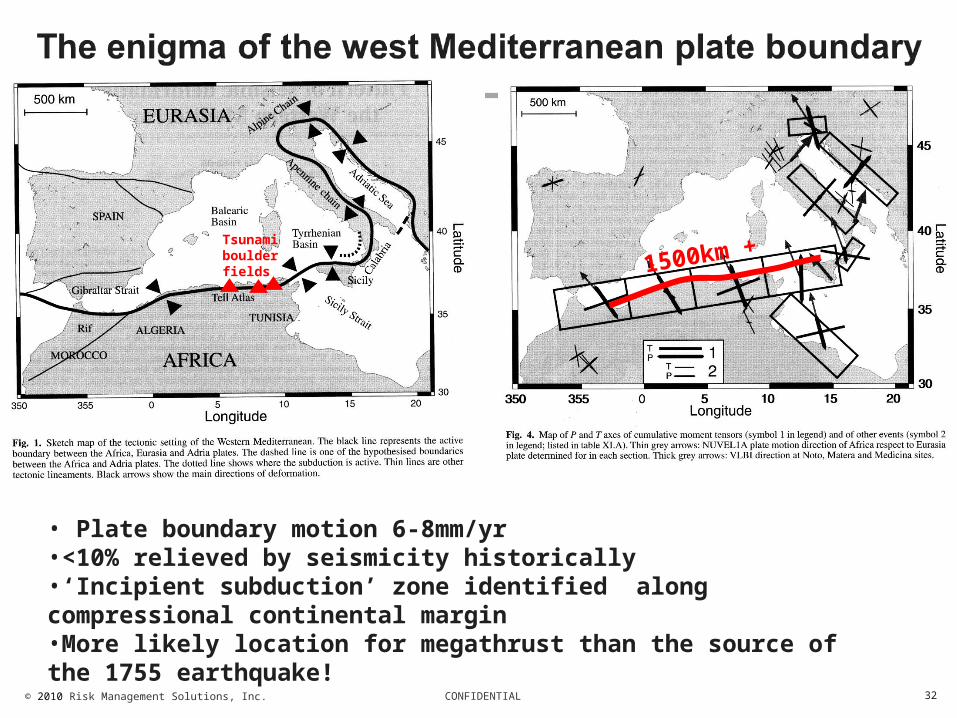
Hellenic Arc
SW Iberia

CONFIDENTIAL© 2010 Risk Management Solutions, Inc. 28
The question as to where M9 earthquakes can occur is the critical issue around life safety for coastal dwellers in many regions
The principal question for global earthquake hazard?

CONFIDENTIAL© 2010 Risk Management Solutions, Inc. 29
T
T
T

CONFIDENTIAL© 2010 Risk Management Solutions, Inc. 30
Major coseismic strain deficit Long term tectonic uplift of Barbados – evidence it may be intermittent
and coseismic? Kelletat et al. (2004) mapped coral reef boulders on Long Island and
Eleuthera (Bahamas) as tsunami deposits. – Atlantic facing cliffs between about 10 to 20 m above sea level and at 150
m distance from the cliff edge.– The weight of individual boulders may reach more than 300 tons
Coarse tsunami deposits of the Younger Holocene have been discovered on the Netherlands Antilles islands of Curaçao, Bonaire, and Aruba.– Rampart deposited on 5-6 m high Pleistocene reef terraces contains
several million tons of boulders and coarse fragments. Much material originates from a fringing reef, but the largest boulders (max. 260 t) are broken out of the Pleistocene cliff.
– The deposits reach up to 400 m inland– There is a clear regional westward decrease in amount and size from the
east coast of Bonaire to the east coast of Aruba.

CONFIDENTIAL© 2010 Risk Management Solutions, Inc. 31
Sander R. Scheffers, Jay Haviser, Tony Browne and Anja Scheffers, Tsunamis, hurricanes, the demise of coral reefs and shifts in pre-historic human populations in the Caribbean, Quaternary International (2008), doi:10.1016/j.quaint.2008.07.016
E coast of St. Martin (500 BP)
S coast of Anguilla (1,500 BP)
Curaçao (1,500 BP); 6 m asl
15m asl E coast of N Eleuthera, (3,000 BP)
CONFIDENTIAL© 2010 Risk Management Solutions, Inc. 32
1500km +
• Plate boundary motion 6-8mm/yr•<10% relieved by seismicity historically•‘Incipient subduction’ zone identified along compressional continental margin•More likely location for megathrust than the source of the 1755 earthquake!
Tsunami boulder fields

CONFIDENTIAL© 2010 Risk Management Solutions, Inc. 33
Earthquake epicentres– yellow: all
NEIC events 1973-2009;
– red: the same but Ms>5;
Main faults (black lines:
Main MTD (pink areas:
Cattaneo et al., 2010 Submarine Landslides Along the Algerian Margin: A Review of Their Occurrence and Potential Link with Tectonic Structures, pp515-525 in D.C. Mosher et al. (eds.), Submarine Mass Movements and Their Consequences, Advances in Natural and Technological Hazards Research, Vol 28, © Springer Science (2010 p515-525

CONFIDENTIAL© 2010 Risk Management Solutions, Inc. 34
Hellenic Arc
SW Iberia
Caribbean? W.Med??
250 yrs
500 yrs
1000 yrs
2000 yrs4000 yrs
RP for 20mslip

CONFIDENTIAL© 2010 Risk Management Solutions, Inc. 35
Regions totally unprepared for megatsunamis– No warning systems– No historical memory– Significant exposure concentrations at 500-1000km distances (unlike Pacific) but
comparable to Sri Lanka and Thailand in 2004 Potential for major tsunamis at moderate distances in places which would
not have felt the earthquake Enormous tourism and port infrastructures close to sea level Concentrations of exposure directly above the potential fault rupture
– Algiers, Oran, Blida etc– Barbados
Potential for massive tsunami life loss in western Mediterranean – Valencia, Barcelona, Nice, Genoa etc
What probability should be assigned to potential M9 events in Caribbean and Mediterranean?
Or is there too much vested interest (from NPPs and political authorities) in not ‘rocking the boat’ – as was the case in Japan?

CONFIDENTIAL© 2010 Risk Management Solutions, Inc.
Clustering of the largest Earthquakes
Data: USGS PAGERCAT 1900-2008, USGS-NEIC & gCMT 2008-presentFigure courtesy of Charles Ammon, after Ammon et al., SRL, 2010
17 yrs
6xM>8.5
15 yrs
8xM>8.53xM>9.0
5xM>8.52xM>9.0
28 yrs 39 yrs
0xM>8.5 0xM>8.5