February, 2018 public IAG meetings,
33
February, 2018 Dear Representatives of Harvard University, It is with appreciation and acknowledgement of all your work to date that we submit this letter to you. We want to note our mutual deep commitment to the neighborhood and its future. Given the significant concerns that have been surfaced throughout the course of our multiple public IAG meetings, the IAG cannot currently support the project as it is currently proposed. If Harvard is able to modify plans to address the comments in the attached list, or provide alternative solutions, the IAG would be happy to consider these solutions with an eye toward endorsing the plan. Attached please find our aggregated comments on the Enterprise Research Campus Framework Plan and PDA plans. We have also attached direct quotes from non IAG and IAG members on the topics which were emailed to us by those who attended meetings and those who could not attend but wanted to offer a perspective. As the next step in our mutual process we respectfully request that Harvard: 1. Provide a short bulleted response to each item on the attached list on their assessment of the feasibility of each listed item. Alternative solutions to meet these goals are welcome. a. E.g. if the list says "Air pollution" the Harvard response could be "Get a baseline to determine risk level. If levels are elevated (or at risk), talk with experts to identify possible strategies" or if the list says "Make sure both sides of Western Ave bike path are protected by a curb" the Harvard response could be "Technically difficult because of fragile underground piping" or for the Greenway the response could be "Design changed because of concerns about water table, contamination, night safety and narrow land mass on western ave." 2. Share this response with the IAG for mutual discussion no later than Feb 11th, 2 days prior to our next meeting on February 13th, and before the conclusion of this phase of the process. a. Note: If this timeline is too fast, the IAG would be happy to adjust the dates of the meeting to allow for a 2 day reading-window prior to meeting and discussing Harvard’s written response. b. Based on the response, the IAG and Harvard can assess alignment on issues and arrange a setting to brainstorm how to close the gaps on key issues. Impact Advisory Group, Harvard Enterprise Research Campus, 1
Transcript of February, 2018 public IAG meetings,

February, 2018
Dear Representatives of Harvard University, It is with appreciation and acknowledgement of all your work to date that we submit this letter to you. We want to note our mutual deep commitment to the neighborhood and its future. Given the significant concerns that have been surfaced throughout the course of our multiple public IAG meetings, the IAG cannot currently support the project as it is currently proposed. If Harvard is able to modify plans to address the comments in the attached list, or provide alternative solutions, the IAG would be happy to consider these solutions with an eye toward endorsing the plan. Attached please find our aggregated comments on the Enterprise Research Campus Framework Plan and PDA plans. We have also attached direct quotes from non IAG and IAG members on the topics which were emailed to us by those who attended meetings and those who could not attend but wanted to offer a perspective. As the next step in our mutual process we respectfully request that Harvard:
1. Provide a short bulleted response to each item on the attached list on their assessment of the feasibility of each listed item. Alternative solutions to meet these goals are welcome.
a. E.g. if the list says "Air pollution" the Harvard response could be "Get a baseline to determine risk level. If levels are elevated (or at risk), talk with experts to identify possible strategies" or if the list says "Make sure both sides of Western Ave bike path are protected by a curb" the Harvard response could be "Technically difficult because of fragile underground piping" or for the Greenway the response could be "Design changed because of concerns about water table, contamination, night safety and narrow land mass on western ave."
2. Share this response with the IAG for mutual discussion no later than Feb 11th, 2 days prior to our next meeting on February 13th, and before the conclusion of this phase of the process.
a. Note: If this timeline is too fast, the IAG would be happy to adjust the dates of the meeting to allow for a 2 day reading-window prior to meeting and discussing Harvard’s written response.
b. Based on the response, the IAG and Harvard can assess alignment on issues and arrange a setting to brainstorm how to close the gaps on key issues.
Impact Advisory Group, Harvard Enterprise Research Campus, 1

We hope our comments help to inform a process that will produce a Master Plan that better reflects the needs and interests of the Allston-Brighton community. We remain committed to working with Harvard and the BPDA to produce this outcome. The scope, importance, and complexity of the many interdependent issues is considerable. We believe that a high degree of consensus should be reached between the IAG, our Allston neighbors, Harvard, and the BPDA and other City agencies before the PDA Master Plan or any other zoning changes are approved. Many of these issues date back to at least the 2005 North Allston Strategic Framework for Planning and now is the time to set specific, measurable, results-based, and time-bound goals. Sincerely, IAG Members
Impact Advisory Group, Harvard Enterprise Research Campus, 2

IAG TOP PRIORITIES Context for our Top Priorities:
Recent history in the Boston area has seen a number of new neighborhoods developed rapidly over a period of 10-15 years. Areas like Kendall Square, Alewife and the Seaport are all successful in providing
office space for innovative businesses and contributing to the economic growth of the city. However these areas often feel sterile and cut-off from the rest of the city. These new neighborhoods fall short in
achieving the lively and intimate scale that defines Cambridge and Boston. The planned ERC may as much as double the population of North-Allston-Brighton. We want to ensure that these new residents feel a part of our vibrant neighborhood. We want to ensure that this project contributes to a vision of a city that
is diverse, quirky, interconnected and wonderful to live and work in. Green Space: Provide an additional 2 acres of compelling natural green spaces (more acreage and more contiguous) that feel more like a large-natural-park and less like a plaza. Green space should connect the ERC to the wider neighborhood and be implemented early in the build-out. Circulation: Modify plans to include a protected bike and pedestrian friendly path from Rena Path directly to Western Ave. Environment: Reinforce commitment to drainage and climate resilience. Ensure clean air and water and habitat access. Reduce consumption and ensure development relies on green energy. Housing: Ensure economic, racial, and family structure diversity in housing: Plan for new construction with a ⅓ market-rate, ⅓ middle income, ⅓ affordable mix of units and for new 1
housing construction that accommodates at least 40% families and 5% elders . To ensure this is 2
lasting, increase the percentage of owner occupied units. Create 3-5 guiding ‘Equitable Development’ principles . Become an innovative example the rest of the city can point to. 3
Mobility: Plan for mode share of 10-14% auto, 53% public transit 46% walking and 20% biking by 2030 . Modify plan to include substantially less parking than is currently in the plan for both 4
the nearterm and longterm. Invest the resources that would be spent on parking (e.g. sq footage investments) in walking, bike, and transit infrastructure. 5
1 Benchmarks drawn from https://imagine.boston.gov/wp-content/uploads/2017/08/Ib2030-BOOK_Spreads-Enhance-Neighborhoods.pdf 2 Proportions drawn from http://www.bostonplans.org/getattachment/7656c7b1-74dc-4883-b4e6-476b1e9252e7 3 See Equitable Development Plan for example of high-level yet practical equity goals paired with early stage planning. https://bridgepark.org/sites/default/files/Resources/EDP%20Final%20-%20UPDATED.pdf 4 Benchmarks taken by applying Go Boston 2030 goals (https://www.boston.gov/sites/default/files/document-file-03-2017/go_boston_2030_-_4_goals_and_targets_spreads.pdf) to BPDA’s published report on Allston mode share: http://www.bostonplans.org/getattachment/7656c7b1-74dc-4883-b4e6-476b1e9252e7 Calculations: 27% auto * 0.5 = 13.5% auto target 19% bus + 21% train = 40% public transit; 40% public transit *1.33= 53% public transit target 23% walk now *2x=46% walk target 5% bike *4x=20% bike target Note: numbers do not add up to 100% due to direct application of Go Boston standards. Numbers can be scaled proportionally. (I.e. 13.5+53+46+20=132.5; 13.5 auto /132.5 total→ 10% auto) 5 See http://www.abettercity.org/docs-new/Future of Parking in Boston.pdf
Impact Advisory Group, Harvard Enterprise Research Campus, 3

IAG recommended modifications to the Framework plan and PDA: Comments by Theme Note: In Harvard’s responses please provide a response to each individual bullet. A drawing showing an update or modification to the plan would also work. Green Space
● Bigger: Dedicate more acerage to green space than is in the current plan. Create two acres of parkland adjacent to the PDA Master Plan development parcels 6
● Conjoined: Have fewer small parcels and more mini-expanses where, like Olmstead said people can “find the city put far away from them” even if right in the city.
○ Rather than breaking up the green space as in the current plan, return to the 2013 commitment of a large contiguous space
● Connected: Ensure the green space connects directly to other green space networks and walk/bike paths.Green space should be used to connect the existing neighborhood of North Allston into the the ERC and not simply to provide relief within the ERC. In sensitive location parks may provide buffering between existing residential areas and new development. Provide more proximate, protected connections to the Dudley White Path and the possible People’s Pike near West Station (if station area is flipped).
○ For example the current plan requires going down several streets to get to the Charles River, at a lower harder to get to point, even though you were only a few blocks away before: change the design to prioritize clear, protected connections.
● Natural: Provide natural landscape features and functional parklands (urban wilds, Muddy River Fens) that incorporate passive recreational amenities (for example volleyball net, community gardens, picnic area, dog walking) over concrete plazas. Focus on creating areas that are ‘permit-able’ (like a park) rather than ‘programmable’ (like hard concrete) in the green spaces. The distinction between “public space”, “open space”, “green space”, and “parkland” is important, and neighbors have voiced clear discomfort with substituting paved areas for green space.
● Sooner: Move more of the green space construction from phase II to phase I. For any green space construction in phase II or after, create clear commitment mechanisms to ensure they will be built. (Blackboard notes read: “more sooner, more certain”)
● Public-Feel: Ensure everyone, of all backgrounds feels welcome. Should feel like Ray Mellone Park or Hooker-Sorrento Playground. Should avoid feeling like some green space near Kendall developments or the Harborwalk near the Golden Slipper where even if the spaces are technically public they feel private or corporate.
● Drainage: Increase flood resiliency via providing green spaces which can manage large volumes of stormwater. Day-light the underground streams where possible rather than providing new underground culverts and hard pipe infrastructure. Provide more natural systems to manage higher storms through (blue) greenways and wetland systems. Refer to CRWA handout for further details.
● Character of the green space: Create green space that feels like:
6 Based on the new construction/Greenway ratio established by Harvard's 2013 Master Plan
Impact Advisory Group, Harvard Enterprise Research Campus, 4

○ Create spaces that feel like like: The Muddy River, Rena Park, Urban Wilds, Alewife Reservation and Stormwater Wetland, Southwest Corridor, The Highline, Central Park, Mt Auburn Cemetery, Storrow Lagoon, Boston Public Garden
○ Not like: Kendall Square, Flat lawn across from District Hall ● Where is the Big Idea? This is a unique opportunity. The design should inspire and
promote a vision for a resilient urban campus and neighborhood. Possible creative, innovative and implementable ideas include:
○ Modifying the height and depth to re-create a river, like the Muddy River (takes advantage of high water table, need for drainage, desire to serve wildlife, return to original ecology, ability to take “thinking-walks” next to office but away from it)
○ In addition to large parks, provide green garden space on all roofs and most walls. Given shadows and desire to garden, plan all area roofs to allow public access and community gardening. Plan for prominent walls to be “living” green walls. 7
○ Expanded blue-greenways and stormwater wetland systems. For full vision refer to CRWA handout.
Abide by previous commitments:
○ Function: The 2013 Harvard IMP states: “Overall, the Greenway represents the University’s commitment to open space and sustainability. It will carry people, infrastructure, stormwater, and wildlife across the campus and community as well as help to address climate change adaptation.“ Both the first phase of ERC construction and subsequent phases should adhere to this commitment.
○ Size: Harvard’s 2013 Greenway plan & 2014 Greenway Planning report commit to 2.5 acres of parkland adjacent to 123,000 sq ft of development pad space. Harvard is currently proposing 112,000 sq ft of development pad space which therefore should be accompanied by 2 acres of parkland built in parallel with the adjacent construction.
○ Connections: The 2013 Harvard IMP declares “an ambitious linear Greenway connecting the neighborhood and campus with the Charles River to the east” and Harvard’s 2014 Greenway Report notes that “ The [hotel]’s position should allow the open space to turn the corner—facilitating movements between the Greenway, East Drive, and Western Avenue
○ Tree Canopy: “Building on the University’s commitment to sustainable practices, the [2013 Harvard IMP] embraces Boston’s goal of a substantial increase in coverage of the urban tree canopy”
● Quotes: ○ “Harvard should re-commit to the 10 acre Greenway described in its 2013 IMP,
including the construction of the Greenway parcels adjacent to the proposed ERC buildings when those ERC buildings are built.”
7 See Singapore for successful implementation. Impact Advisory Group, Harvard Enterprise Research Campus, 5

○ “Green spaces should have height diversity and visual appeal (like Rena Park has) - avoid all-flat green spaces. Include some ‘wilds’ or natural areas (also promote wildlife per the 2013 Harvard plan).”
○ “Ensure tree plantings are diverse so that they don’t all get wiped out by a given blight. Design underground planting to allow roots of adjacent trees to touch (see Peter Wohlleben research on tree survival). Ensure tree canopy is robust-- nothing is worse than many trees dying all in a row as they are on Western Ave.”
○ “Landscape maximizes shade trees and greenspace as destinations, not just as pathways. Outdoor cafes don't count in my opinion...they exclude people who haven't purchased something. We need free, shaded parks (including a playground) in addition to the wide corridor of outdoor cafe seating on Cattle Drive.”
○ “Cambridge puts parks on the river, we put huge buildings, what would we rather have?”
○ “Establishing green space should be prioritized at every stage of development and not postponed (eg. a parking lot will eventually become a park.)”
Circulation
● Direct bike/ped connection to from Rena Path to Western Ave: Reinstate and expand the greenway from the Honnan Library to the Charles River. Greenway should include a protected bike and pedestrian friendly pathways from Rena Park through the Campus to the River. While neighbors appreciated and liked the idea of minimizing curb cuts and keeping loading docks on the inside of blocks, there is a need for creative design to both maintain this and simultaneously allow for a direct, protected connection to the Western Ave intersection and thence to the Charles River, Central Square and beyond for people walking and biking in both directions, both from Allston to Cambridge and Cambridge to Allston. This was emphasized at every meeting and in every written document by a multitude of voices of spanning ages and backgrounds.
● Protected low-stress protected cycletracks on both sides of Western Ave: Western Ave should have a protected low-stress bike path (separated by a raised curb) on going both directions on the street, not just one way.
○ While the delicate below-street infrastructure is an important consideration and must be accomodated, plans can still include low-stress protected paths going both directions (eg via the discussed burm on the HBS side, or added protective rain gardens or via expanding the lane on the ERC side of the street to allow bikes going both directions.)
● Western Ave Safety: Make improvements at the end of Western Ave my modifying the curb line and traffic island to increase bike/ped safety as proposed by MassDOT in its Western Ave Bridge design (slide 51 of https://www.massdot.state.ma.us/Portals/26/docs/Western_River/River_Western_presentation031312.pdf and page 20 of https://www.massdot.state.ma.us/Portals/26/docs/Western_River/HwyPlans25Percent.pdf)
Impact Advisory Group, Harvard Enterprise Research Campus, 6

● Bus turn around: The IAG had strong appetite for the idea of extending area bus lines into Allston, and providing turn-around loops. Expedite this implementation into phase I to alleviate car traffic and the early-on need for parking, and expand public transit as a core part of the neighborhood identity from the earliest stages. Culture is hard to unseat once it has been established.
● Connectivity to nearby areas: The master plan should not only address circulation within the PDA but should also take up the larger issues of interconnection between the PDA and surrounding locations, enhancing the non-auto connections to other destinations.
Environment
● Prioritize drainage and flood storage: Reinstate and expand (blue) greenways and use surface green infrastructure strategies to manage a two hundred year storm and mitigate existing and future flood risk.
● Provide high performance green infrastructure: Use natural filtration systems like rain gardens, bio-swales and stormwater wetland features to manage stormwater and provide mitigation for heat island treatment. 8
● Resilience to climate change: Create a system of resilient parklands that would provide multiple environmental benefits and build capacity for current and future impacts from climate change. Plan for risks outlined in Climate Ready Boston and front load investment in blue-green infrastructure.
● Create plan to reduce air pollution during and after construction: Provide upfront plan to ensure high air quality including reducing or eliminating emissions from diesel, train layover, idling, buses and construction vehicles. Provide clear plan for construction related emissions and environmental risks as well as a seperate plan for ongoing usage.
● Promote local wildlife: Ensure green spaces allow for habitat for local wildlife and connectivity between other patches of habitat, including the Charles River.
● District energy for entire area: Ensure district energy provides services to the entire area.
● Require new construction to reduce total consumption and rely on renewable sources for energy required: Require new buildings to be LEED certified, compost, and employ water reduction and recycling technologies. Ensure buildings rely primarily on district energy, solar and wind power.
Housing
● Income Diverse: Implement guidelines that ensure new housing construction with a ⅓ market-rate ⅓ middle income ⅓ affordable mix of units . Ensure income diversity is long 9
lasting through techniques such as deed restriction. These goals must be codified within the PDA and PDA master-plan as a prerequisite for community approval.
8 See CRWA letter for specific options. 9 Benchmarks drawn from https://imagine.boston.gov/wp-content/uploads/2017/08/Ib2030-BOOK Spreads-Enhance-Neighborhoods.pdf
Impact Advisory Group, Harvard Enterprise Research Campus, 7

● Units built for families and elders: Implement guidelines that ensure new housing construction that accommodates at least 40% families and 5% elders . Plan for family 10
sized housing that accommodates a diversity of family-unit sizes (children, elders etc) both in number of bedrooms, design features, accessibility and proximity to relevant amenities.
● Racial and language diversity: Ensure this neighborhood has a strong base of people from every background. In particular design with families from a variety of ethnicities and language backgrounds in mind. Set a number of racial concentration that will trigger an evaluation.
● Equitable Development commitments: Write 3-5 public equitable development commitments. Commit dedicated funds to those commitments. 11
● Transit access: Given increases in density make sure all new residents, workers and visitors can get where they want to without a car. Ensure new housing units have excellent access to key job centers. Every development that goes into construction should be tied with a corresponding increase in non-auto infrastructure, implemented in the same year, and able to hold the specific number of new people the development is scoped for.
● Stability and Owner Occupancy: Increase the percentage of owner-occupied units in North Allston. Allston has among the lowest levels of owner occupancy within the City of Boston. New development should shift the balance toward greater neighborhood stability though owner occupancy. 50% of new units should be deed restricted owner occupied.
● Owner-occupied: Ensure that a substantial proportion of new housing units can be owner occupied, and owned by people with a range of incomes.
● Context sensitive design: In both scale, height and density ensure new buildings integrate seamlessly with the neighborhood so that someone new would not notice where one begins and the other ends. Locate the planned residential building closer to the existing neighborhoods. Streets as currently designed are creating superblocks - break up blocks into human scale subsections, which integrate better with the area. Create view corridors to the river.
○ Housing Type and Distribution: Smaller scale townhouse style housing with easy street access is preferable to high-rise construction. High levels of housing density can be achieved while still maintaining the character contiguous with the surrounding neighborhood (see height/density/housing typologies ). Housing 12
should be located and oriented toward the existing neighborhood. ● Access to local services: Design for ages 8-80 (ensure designs include daycare, play
lots, elder care and accessible amenities such as enough public bathrooms and regularly spaced seating). Begin coordination now with the City to ensure fire EMS police and ambulance speed to arrive and expansion of services to meet density. Provide local
10 Proportions drawn from http://www.bostonplans.org/getattachment/7656c7b1-74dc-4883-b4e6-476b1e9252e7 11 For inspiration see D4SI’s work and the 11th Street Bridge Project. 12 2008-2009 North Allston-Brighton Community wide planning innitiative, Boston Planning and Development Agency.
Impact Advisory Group, Harvard Enterprise Research Campus, 8

access to retail to meet needs of daily life routines and ensure that the retail is at least 70% locally owned, not big-box chains.
● Quotes: ○ “Harvard's new residential program should reflect and model the age, income
and racial diversity of the existing neighborhood. Residential buildings should include low- and middle-income residents by offering a proportion of units at affordable rent or condo prices/fees; merely paying into a city of Boston pool for building affordable housing elsewhere exacerbates segregation of the city. Residential buildings [should] have a variety of unit sizes including three and four-bedrooms to accommodate families. Current development in the rest of Allston has cut families out of the market by offering only small units. Programming [should] include non-profit services such as daycare, a senior center, and community health care to encourage all ages to populate the area 24/7.”
○ “Plans for elders and those on fixed income whose taxes rise and price them out” ○ “To integrate with the neighborhood Housing should start near Windom street
and should begin with a density that is not to great a contrast to the residential street”
○ “Mix of housing types (not just continuum style but also some housing more similar to what is in the neighborhood. See 2008-2009 BRA community wide planning initiative)”
○ “ Especially in light of the recent Spotlight article see: A Brand New Boston, Even Whiter than the Old. How do we NOT miss the chance to create a diverse neighborhood. What can be done in the early planning phases of this project to ensure that this is not a new Seaport.”
○ “Hire a diverse group of developers. Involve diverse people in the design process.”
○ “ERC businesses should be a diverse representation of the city.” ○ “If hotel is included, adopt a similar policy that was used in Cambridge that if any
hotel/motel was developed there would need to be a commitment to building an amount of affordable housing equal to the 20% of the hotel’s GFA”
Mobility ● Mode Share: Plan for mode share of 10-14% auto, 53% public transit 46% walking and
20% biking by 2030 . 13
13 Benchmarks taken by applying Go Boston 2030 goals (https://www.boston.gov/sites/default/files/document-file-03-2017/go_boston_2030_-_4_goals_and targets spreads.pdf) to BPDA’s published report on Allston mode share: http://www.bostonplans.org/getattachment/7656c7b1-74dc-4883-b4e6-476b1e9252e7 Calculations: 27% auto * 0.5 = 13.5% auto target 19% bus + 21% train = 40% public transit; 40% public transit *1.33= 53% public transit target 23% walk now *2x=46% walk target 5% bike *4x=20% bike target
Impact Advisory Group, Harvard Enterprise Research Campus, 9
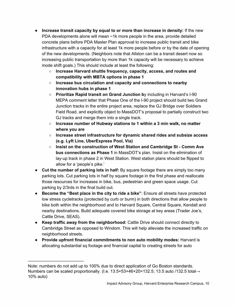
● Increase transit capacity by equal to or more than increase in density: If the new PDA developments alone will mean ~1k more people in the area, provide detailed concrete plans before PDA Master Plan approval to increase public transit and bike infrastructure with a capacity for at least 1k more people before or by the date of opening of the new developments. (Neighbors note that Allston can be a transit desert now so increasing public transportation by more than 1k capacity will be necessary to achieve mode shift goals.) This should include at least the following:
○ Increase Harvard shuttle frequency, capacity, access, and routes and compatibility with MBTA options in phase 1
○ Increase bus circulation and capacity and connections to nearby innovation hubs in phase 1
○ Prioritize Rapid transit on Grand Junction by including in Harvard’s I-90 MEPA comment letter that Phase One of the I-90 project should build two Grand Junction tracks in the entire project area, replace the GJ Bridge over Soldiers Field Road, and explicitly object to MassDOT’s proposal to partially construct two GJ tracks and merge them into a single track.
○ Increase number of Hubway stations to 1 within a 3 min walk, no matter where you are
○ Increase street infrastructure for dynamic shared rides and subsize access (e.g. Lyft Line, UberExpress Pool, Via)
○ Insist on the construction of West Station and Cambridge St - Comm Ave bus connections as Phase 1 in MassDOT’s plan. Insist on the elimination of lay-up track in phase 2 in West Station. West station plans should be flipped to allow for a ‘people’s pike.’
● Cut the number of parking lots in half: By square footage there are simply too many parking lots. Cut parking lots in half by square footage in the first phase and reallocate those resources for increases in bike, bus, pedestrian and green space usage. Cut parking by 2/3rds in the final build out.
● Become the “Best place in the city to ride a bike”: Ensure all streets have protected low stress cycletracks (protected by curb or burm) in both directions that allow people to bike both within the neighborhood and to Harvard Square, Central Square, Kendall and nearby destinations. Build adequate covered bike storage at key areas (Trader Joe’s, Cattle Drive, SEAS).
● Keep traffic away from the neighborhood: Cattle Drive should connect directly to Cambridge Street as opposed to Windom. This will help alleviate the increased traffic on neighborhood streets.
● Provide upfront financial commitments to non auto mobility modes: Harvard is allocating substantial sq footage and financial capital to creating streets for auto
Note: numbers do not add up to 100% due to direct application of Go Boston standards. Numbers can be scaled proportionally. (I.e. 13.5+53+46+20=132.5; 13.5 auto /132.5 total→ 10% auto)
Impact Advisory Group, Harvard Enterprise Research Campus, 10

transportation. An equivalent financial and sq footage commitment should be made to bus bike and pedestrian transportation.
● Threshold commitments: If mobility gets too bad provide commitments that kick in when thresholds are met. E.g. If if buslines reach 10% above MBTA defined capacity at peak hours Harvard should subsidize expresspool / line rides to get fewer vehicles on the road and more folks sharing rides. (This basically ups the bus-like services if the MBTA service is maxed out by new density.)
● Reduce air pollution: Reduce air pollution by decreasing or eliminating, diesel trucks, idling, layover tracks, buses, and construction vehicles.
● Improve Harvard’s Transportation Demand Management program for all Allston faculty and staff: Harvard’s ERC expansion will place additional demands on Allston’s already-strained streets and transit. Harvard should increase what it is doing to reduce current automobile use. The Harvard shuttle should connect to the Boston Landing commuter rail station. Policies regarding use of Harvard shuttles by Allston residents should be clarified and http://www.transportation.harvard.edu/ and existing signage, marketing, and branding should make this clear to all. Harvard should do at least as much as MIT which provides faculty and staff with free, unlimited subway and local bus usage, increased subsidies for parking at MBTA stations and commuter rail tickets, and has shifted to pay-per-day parking at most lots in an effort to reduce the number of cars on campus.
● Quotes: ○ “It is unacceptable to have large scale development without any improvement to
the current mobility options. Harvard should not just coordinate, but invest in improved transit service in the Allston neighborhood”
○ “If West station does not get built by deadline, whomever is building the additional density must provide accommodations for other non-vehicle modes to offset the increase in traffic (ie bike, ped, bus, pool)”
○ “District needs better transit that connects Harvard Sq, Barry’s Corner and West Station”
Retail and Innovation Feel ● Retail to serve all: Ground floor should be activated for general public use and include
civic functions and amenities serving Allston residents and visitors of all ages and socioeconomic backgrounds
● Local businesses: Ensure the majority of retail is local and not chain. At least 35% of the floor area of the Required Active Space in the Final Development Plan shall be devoted to Independent Retail Operators each occupying no more than 3,000 square feet of floor area
● Innovation space: A minimum of 5% of newly constructed space should be dedicated to entrepreneurship and incubator activity that is accessible to the community
● Build for technical innovation and prototyping: Allow the streets on cattle drive to accommodate pilots of new tech services for pedestrians and community, by making sure there are electrical outlets and utilities in a microtrench. Demonstrate innovation vision by being a local beta-testing ground for streetscape innovation.
Impact Advisory Group, Harvard Enterprise Research Campus, 11

● Retail timing: Put in place community-centric interim programming to reduce the time that ground floor retail sits vacant.
● Utilities: All utilities should be microtrenched. Avoid ad-hoc overburdened utility poles in the existing neighborhood.
● Quotes: ○ “Corporate tenants do not build community, residents do. There should be a way
for residents to use corporate spaces to pull in the vibrancy of the area into these spaces and begin to make it feel alive and quirky, vs canned”
Phasing The PDA Master Plan makes the vague statement that “it is anticipated that construction of the Proposed Project will be phased”. More clarity is needed on when each element of the plan will be built, especially those that Harvard anticipates will be built first. The Full View In order to properly evaluate the PDA, the IAG needs a more complete understanding of the rest of the 36 acres. While plans may adjust and change, more communication about how this fits into the greater whole, especially in terms of neighborhood character and density is pivotal. Future Amendments Details are needed regarding when and why the PDA Master Plan may be amended. Assurances that this plan will not be amended in the near future would be helpful to the support of the IAG. 14
14 Concern stems from the history of frequent changes after hard-negotiated conclusions: The Charlesview PDA was approved in January 2010, amended in October 2010, amended in 2014, and amended in 2015. The Harvard IMP has been amended four times since it was approved in 2013.
Impact Advisory Group, Harvard Enterprise Research Campus, 12

1
February 2, 2018
Gerald Autler
Senior Project Manager/Planner
Boston Planning and Development Agency
One City Hall Square
Boston, MA 02201
RE: Harvard Enterprise Research Campus (ERC), Master Plan for Planned Developed Area No.
115 and Framework Plan.
Dear Mr. Autler:
Charles River Watershed Association (CRWA) has reviewed the Master Plan for Planned Development Area (PDA) No. 115 and the Framework Plan (FP) filed by Harvard University (proponent) and submits the following comments to help the BPDA with the ongoing review process. CRWA is concerned about the lack of a comprehensive framework for analyzing the cumulative impacts of the various projects already underway or in the pipeline, both within and outside the purview of the Institutional Master Plan (IMP) and the PDA. In particular, at a minimum, the proponent should coordinate the PDA infrastructure planning with DOT’s I-90 reconstruction (2018-2024) and the IMP Long-term Framework Plan so as not to foreclose regional strategies to help meet state and local water quality standards and enhance Allston’s resiliency to climate change impacts. Blue greenway and open space connections to the Charles River Harvard's ERC PDA continues a poor tradition of a fragmented review process that undermines the very purpose of developing an IMP for Harvard’s expansion into Allston. It appears as though the proponent has completely deviated from the original proposed greenway that proposed as part of the Harvard IMP Framework Plan as a “wet weather corridor” connecting to the Charles, and instead is proposing the construction of a 72” or greater pipe and a new outfall that would discharge stormwater into the Charles with minimal treatment.
Harvard had previously installed a 72-inch storm drain trunk line for BWSC along the general alignment of Rena Path and then along the southern and eastern perimeter of the SEC foundation. This line currently connects to the existing 36-inch stormwater line that runs through the Harvard Business School (“HBS”) campus to an existing outfall at the Charles River. As part of the Proposed Project, on behalf of BWSC,

2
Harvard will extend this trunk line through the ERC to a new outfall to the north of the River Street Bridge. This system will convey stormwater flows from a 100 +/- acre contributing area of Allston upstream of the PDA Area, as well as all of the flows from the ERC.
While the proponent still refers to “a” greenway “Consistent with Boston’s Complete Streets Guidelines, the Greenway along Science Drive and the Cattle Drive Promenade will be designed with landscaped elements to control stormwater flow into the system, to maximize the use of stormwater for irrigation and to reduce phosphorous run-off.”
Harvard’s approach to planning the greenway has been very disjointed since it was first proposed by it in 2013. Instead of emphasizing the hydrological links between the greenway and a new riverfront park, the planning for the “wet weather corridor” proposed in the long-term plan seems to have been subverted. CRWA is frankly appalled by Harvard’s proposal to resort to this grey infrastructure (large new pipe and outfall system) that will discharge stormwater directly into the Charles River.
As per the Massachusetts Stormwater Standards1 “No new stormwater conveyances (e.g. outfalls) may discharge untreated stormwater directly to or cause erosion in wetlands or waters of the Commonwealth.” We note that BWSC’s Stormwater NPDES permit (1999) (BWSC Permit) “The permittee shall provide a notification to EPA and MA DEP of all new separate storm sewer outfalls as they are activated and of all existing outfalls which are de-activated.” Additionally, the BWSC Permit explicitly provides under its pollution prevention requirements that the permittee shall develop and implement the following pollution prevention measures as they relate to separate storm sewer discharges:
The permittee (BWSC) shall assist and coordinate with the appropriate municipal agencies with jurisdiction over land use to ensure that municipal approval of all new development and significant redevelopment projects within the City of Boston which discharge to the MS4 is conditioned on due consideration of water quality impacts. The permittee shall cooperate with appropriate municipal agencies to ensure that development activities conform to applicable state and local regulations, guidance and policies relative to storm water discharges to separate storm sewers. Such requirements shall limit increases in the discharge of pollutants in storm water as a result of new development, and reduce the discharge of pollutants in storm water as a result of redevelopment.
1 Massachusetts Department of Environmental Protection Stormwater Handbook (rev2008).

3
We urge Harvard to move forward instead with a comprehensive blue greenway design, sections of which should be implemented in tandem with the I-90 project. The blue greenway is essential not only for providing public access through the campus, but also for improving the health of the Charles River. This blue greenway is an essential part of stormwater management and flood resiliency for this entire sub-watershed. It is frustrating that a series of temporary parking lots are now being proposed as part of the PDA which would defeat the purpose of having an open space connection from the Science Center to the river. We note that access to the river and parkland is highly desirable to the community and has been identified as high priority needs in various park and regional master plans.
To show the feasibility of green infrastructure stormwater management CRWA has designed conceptual, connected bioretention systems that serve as a blue greenway system, sized to capture between 2”-5” of precipitation. The blue greenway(s) can be sited to connect the Harvard ERC project area to the Charles River as well as to the I-90 project area and new parkland proposed by MassDOT (see, Attachment A hereto). The PDA and FP should provide more details and specific commitments for achieving the proponent’s stated goals2 of creating continuous open space corridors through the campus for pedestrian, habitat and water connections to the Charles River and its parklands. If there are any existing infrastructural constraints that prevent the realization of the IMP long-term vision, then the proponent should delineate the nature of the constraints and provide a comprehensive alternatively analysis for the new pipe and outfall design. Stormwater Management Due to the location, size, and imperviousness of the project site, stormwater management is a critical. Polluted stormwater runoff is the leading cause of water quality impairments in the Charles River; this section of the river is impaired for chlorophyll-a, Escherichia coli, nutrient/eutrophication biological indicators, dissolved oxygen, and phosphorus (total), among other impairments. As recognized by the proponent, the project area drains directly to the segment of the Charles River that is subject to the Lower Charles River Nutrient Total Maximum Daily Load (TMDL) and the Bacteria TMDL.3 The nutrient TMDL requires a 64% reduction in phosphorus loading from the project site. While CRWA appreciates that the proponent states it will comply with the MassDEP stormwater Standards, the PDA Master Plan lacks a
2 In the IMPNF, the greenway is characterized as a “long-term initiative” and “concept,” despite Harvard’s
acknowledgment of it “as an organizing element . . . [that] could provide opportunities for a new type of campus landscape and new civic ecology.” Harvard also recognizes that in addition to “serving as a recreation and open space corridor, it should be an integral working landscape for stormwater management.” Id. 3 Total Maximum Daily Load for Nutrients in the Lower Charles River, Massachusetts (DEP 2007); Total Maximum
Daily Load for Bacteria in the Lower Charles River, Massachusetts (DEP 2007)

4
comprehensive discussion of drainage and runoff calculations for the entire project area and there is no indication as to how it will comply with both TMDLs. The proponent should incorporate regional green infrastructure strategies within the public realm (neighborhood streets and open spaces) to treat stormwater runoff in the ERC PDA area. The existing ERC site is over 95% impervious, and, while the proponent will “utilize Best Management Practices (BMPs) for water quality and stormwater management on the parcels and the new roadways”4, it should be required to demonstrate how these strategies will result in TMDL compliance. While the project broadly complements the series of open spaces and green corridors proposed as a part of the long-term framework by providing a large, publicly-accessible landscaped area, there seems to be a complete lack of coordination with the design of the surrounding open spaces with respect to the stormwater management strategy. Most importantly, the project doesn’t utilize its proximity to the greenway as an opportunity to design a stormwater management system at the sub-watershed level. A comprehensive stormwater management plan is therefore needed for the Harvard ERC PDA and FP site to manage the runoff from building roofs as well as the surrounding impervious areas by incorporating strategies for retention, treatment and infiltration, or reuse, of stormwater. There is no information in the PDA filing with quantitative analysis of the storm water discharge with respect to phosphorous reduction and infiltration. The stormwater management plan should be designed, at a minimum, to meet the 1-inch infiltration and 65% phosphorous reduction standards set by BWSC. BWSC’s current 10-year/24-hour design storm is 5.20 inches, while their 2035 climate change scenario of the 100-year/24 design storm is 9.3 inches.5 The proponent should therefore work with BWSC to determine the 100-year design storm as it will help in sizing BMPs throughout the project area. Green Infrastructure opportunities CRWA has identified opportunities for Green Infrastructure (GI) in the Harvard ERC and designed conceptual systems to capture and manage a minimum of 2” and maximum 5” rain storm (Attachment A, Figure 1). Two constructed wetlands, totaling 5.43 acres, in our design are sized and sited southeast of the District Energy Facility : where I-90 currently forms a loop just north of River Street and
4 ERC Framework Plan, Pg. 46
5 BWSC Climate Change Risk Assessment, Findings and Mitigation/Adaptation Strategies for Wastewater and Storm
Drainage, Charlie Jewell, NEWEA 2015 <http://www.newea.org/wp-content/uploads/2015/05/AC15_Session30_CJewell.pdf

5
across the street just south of the District Energy Facility. These two wetlands are designed to be connected by piping. A 4.97 acre +1.14 acre bio retention system is designed as a blue greenway running along Cattle Drive and Science Drive. CRWA also identifies opportunities for additional bioretention systems and parkland north of the Genzyme building extending from East Drive to Soldiers Field Road (SFR). CRWA also designed additional bioretention systems, totaling 10 acres, as a blue greenway connecting from the Harvard ERC project area to a 4-acre constructed wetland sited between East Drive and SFR, adjacent to the proposed parkland along the Charles River in the I-90 project area. These GI designs will provide increased public open space, reduce flooding, and mitigate the Urban Heat Island effect while managing stormwater from drainage areas (Attachment A, Figure 2). We believe that this is precisely the kind of stormwater management that Harvard should be adopting in the face of predicted climate change impacts in the coming years. Climate change and flood resiliency As shown in Attachment A, Figure 3, the project is located in an extremely flood-prone area.6 Historically, sections of the IMP and the ERC PDA sites both north and south of Western Avenue were low-lying tidal marshlands that were filled in to support development. In order to build capacity for current and increased flooding, the proponent should not only document the alteration of historic site hydrology, but also try to restore or mimic it through the establishment of a series of blue greenways and green infrastructure retrofits (bioswales, infiltration basins, etc.). As a critical first step, the proponent should coordinate with the MassDOT team that is using the Boston Harbor ADCIRC model to pinpoint flooding vulnerabilities due to sea-level rise, storm surges and inland flooding from increased precipitation in the I-90 project area. Preliminary MassDOT results suggest that areas adjacent to the river between the Western Avenue and River Street bridges are at a high risk of flooding, especially after 2030. Moreover, because of high imperviousness and poor drainage, this section of Allston already experiences frequent localized inland flooding, especially after intense precipitation events such as Nor’easter storms (1-2 events/year). Inland flooding risks are also heightened as the stormwater and sewage conveyance systems are overwhelmed under intense storm events, and these risks should be carefully identified and mitigated in the alternatives analysis undertaken with BWSC. MassDOT’s I-90 realignment creates an opportunity to move SFR away from the river and to create significant new parkland. A blue-greenway system would connect to this multi-functional riverfront park while cleansing stormwater, providing storage for flood waters and providing opportunities for public enjoyment and environmental stewardship of the Charles River. The
6 Flood maps from City of Cambridge of the Mean High High Water +5’ projected to occur by mid- to late-century
(equivalent to flooding from Hurricane Sandy if it hit Boston during high tide)

6
new “Allston Esplanade” would tie the ERC blue greenway to the new river parkland and connect the two systems hydrologically, in addition to providing a visual and physical link for public access. Please feel free to contact me should you have any questions at (781) 788-0007 ext. 232.
Sincerely,
Pallavi Mande,
Director of Blue Cities, CRWA
CC:
Harvard Planning Office
Harvard ERC Impact Advisory Group
Harvard Allston Task Force
Boston Water and Sewer Commission
Metropolitan Area Planning Council
Will Brownsberger
Marc Ciomo
Kevin Honan

7
ATTACHMENT A
Figure 1. A conceptual sketch designed by CRWA in 2018 showing Green Infrastructure
opportunities, including constructed wetlands and bioretention systems serving as a blue
greenway, connecting Harvard ERC to the Charles River, I-90 Project area, and new parklands.

8
Figure 2. CRWA analysis showing major drainage areas where stormwater can be captured and
managed by constructed wetlands and bioretention systems connected as a blue greenway.

9
Figure 3. MassDOT 0.1% flood inundation depth projections for the year 2070. Significant
portions of the Harvard ERC project area are shown to be up to 2-4 ft under water.


The proposed concept design aims to capture, store, and treat stormwater runoff from the following drain-age areas within the Harvard ERC project site.
Drainage Area (A)
• Located west of the District Energy Facility (DEF)• Drains to an outfall north of Western Ave, indicated
in orange
Drainage Area (B)
• Located between Western Ave and River Street encompassing the DEF
• Currently has no drainage outfall in place
CRWA has also identified opportunities for additional bioretention systems and parkland north of the Genzyme building extending from East Drive to Soldiers Field Road (SFR).
Constructed Wetlands
• Two wetlands totaling 5.4 acres• Designed to be connected by piping• Located south and southeast of the DEF
Blue Greenway
• A 6-acre bioretention system designed as a blue greenway (network of open space corridors), running parallel to Cattle Drive and Science Drive
• This design, when coupled with the constructed wetlands, is able to capture a 2” storm
Sizing Note: Constructed wetland and bio-retention systems were sized to be able to treat/manage/store 1”-5” of precipitation based on location and probability of flooding/inundation suggested by MassDOT’s 2070 projections of a 1% chance storm.
Source: Connect Kendall Square Framework Plan 2015
Source: Connect Kendall Square Framework Plan 2015
Source: CRWA
Harvard Enterprise Research CenterDrainage Areas and Green Infrastructure Strategies
Charles River Watershed Association 190 Park Road Weston, MA 02493 t 781 788 0007 f 781 788 0057 e [email protected] www.charlesriver.org


Constructed Wetlands
Bioretention Systems
• In order to capture a 1” storm from the area draining to MassDOT outfall #2, a wetland, 0.5 acre in size, was sited south of River Street. To capture a 2” storm, 0.5 acres of bioretention is needed
• To capture a 1” storm from the area draining to the MassDOT outfall #1, a 2.5-acre wetland was sited south of River Street. This area has a high probability of inundation suggested by MassDOT’s 2070 projections of a 01% chance storm
• A 10 acre bioretention system designed as a blue greenway (network of open space corridors)
• Connects from the Harvard ERC project area to a 4-acre constructed wetland sited between East Drive and SFR
• Located adjacent to the proposed parkland along the Charles River in the I-90 project area
Sizing Note: The wetland alone was sized to capture a 1” storm. Together with the bioretention systems in the blue greenway, these green infrastructure designs capture over a 5” storm. To capture a 2” storm, 4 acres of bioretention are required in addition to the 4-acre wetland.
Source: Connect Kendall Square Framework Plan 2015
Source: MWH Global Alewife Reservation Stormwater Wetland
Source: Connect Kendall Square Framework Plan 2015
I-90 Allston Interchange Project AreaProposed Green Infrastructure Strategies
Charles River Watershed Association 190 Park Road Weston, MA 02493 t 781 788 0007 f 781 788 0057 e [email protected] www.charlesriver.org
Source: MWH Global Alewife Reservation Stormwater Wetland

2/27/2018 City of Boston Mail - Feedback on Harvard's Master Plan for Planned Development (Area No. 115)
https://mail.google.com/mail/u/0/?ui=2&ik=b37e70f0af&jsver=iEEFj798MIw.en.&view=pt&cat=ERC%20Comments&search=cat&th=16167bf8a3d72225… 1/3
Gerald Autler <[email protected]>
Feedback on Harvard's Master Plan for Planned Development (Area No. 115) 1 me age
Joyce Radnor Mon, Feb 5, 2018 at 3:54 PMTo: Gerald Autler <[email protected]>Cc
February 1, 2018
Gerald Autler
Senior Project Manager/Planner
Boston Planning & Development Agency
1 City Hall Square
Boston, MA 02201-2013
Dear Gerald,
Thank you once again for the opportunity to comment on Harvard University’s continued expansioninto our beloved North Allston neighborhood.
I strongly oppose Harvard’s proposed plans for its Enterprise Research Campus (ERC). I imploreyou, as our Boston Planning & Development Agency (BPDA) representative, to reject Harvard’srequest in its Master Plan for Planned Development (Area No. 115). Further, I hope that the ERCImpact Advisory Group (IAG) and the BPDA Board of Directors also recognize the danger of thisplan.
In 2007, when the university proposed its four-building, five-acre Stem Cell Science Complex, Iendorsed its plans (although I voiced some comments/concerns on the design, construction andoperations of the complex). In 2009, when Harvard “paused” its science plans, I was genuinelydisappointed because the potential for life-saving discoveries/innovations/breakthroughs wouldhave been exciting to “host” in our neighborhood. In 2016, after its seven-year “pause,” Harvardintroduced plans for its School of Engineering & Applied Sciences on the same site. Although thisproject was far less inspirational than the Stem Cell Science opportunity, I still applauded the vision(with the same caveats mentioned earlier).

2/27/2018 City of Boston Mail - Feedback on Harvard's Master Plan for Planned Development (Area No. 115)
https://mail.google.com/mail/u/0/?ui=2&ik=b37e70f0af&jsver=iEEFj798MIw.en.&view=pt&cat=ERC%20Comments&search=cat&th=16167bf8a3d72225… 2/3
If Harvard’s plans for the ERC focused more on an institutional “R” (research) rather than a for-profit “E” (enterprise), I’d once again support the university’s plans.
In this case, however, I must break my streak.
This is a solely commercial endeavor for Harvard. We’ve down this road once before withHarvard’s leased-land development at the Continuum in Barry’s Corner. This project was adisaster, wreaking havoc on neighbors during construction; finger-pointing between Harvard andSamuels Development on liability; apartments that are too expensive and too small to lure families;and residents using their city-issued resident parking permits to flood our neighborhood streets.
I have attended every ERC IAG meeting because this development -- like the SEAS building – isvery, very close to my home. And, at every IAG meeting, here’s what I have heard from Harvardspokespeople: “We don’t know.”
“We don’t know” who our development partners are;“We don’t know” exactly how tall the apartment building and hotel will be (maybe 190’?);“We don’t know” how many apartments will be for families and/or affordable for low-income/middle income tenants;“We don’t know” how to foster diversity in tenants that would mirror the existing community;“We don’t know” when roads will take commuter traffic off of Windom Street, but WE DOKNOW that we will start building before the new roads connect to Cambridge Street(coincident with the lowering of I-90/Cambridge Street).
In addition, my neighbors and our trusted mobility activists have made the compelling case thatHarvard cannot provide any clarity about clean, safe and quiet transit to-and-from its proposedERC site. Although Harvard’s additional funding for a much-needed West Station is commendableand greatly appreciated, its lack of vocal lobbying to the State Department of Transportation(MassDOT) and Boston University puts this critical issue in the “We don’t know” column. This is ahuge unknown for a neighborhood already plagued by traffic from Harvard-owned properties.
Gerald, you and I have traveled this road (pun intended) together for more than ten years. Iunderstand that you straddle the desires of Harvard expansion with the quality-of-life issues of astable, tax-paying neighborhood. I don’t envy that role. But we both know that when Harvardsneezes, North Allston catches the Flu. This is the wrong development in the wrong location atthe wrong time.
Therefore, I ask you to protect our neighborhood by resisting the appetites of an ever-expandinginstitution and the development-driven desires of the City.
My best regards,

2/27/2018 City of Boston Mail - Feedback on Harvard's Master Plan for Planned Development (Area No. 115)
https://mail.google.com/mail/u/0/?ui=2&ik=b37e70f0af&jsver=iEEFj798MIw.en.&view=pt&cat=ERC%20Comments&search=cat&th=16167bf8a3d72225… 3/3
Joyce Radnor
59 Hopedale Street
Allston, MA 02134
___________________________
Joyce Radnor

2/27/2018 City of Boston Mail - Fwd: [HarvardAllstonERC] Fwd: IAG Letter
https://mail.google.com/mail/u/0/?ui=2&ik=b37e70f0af&jsver=iEEFj798MIw.en.&view=pt&cat=ERC%20Comments&search=cat&th=161735f9b3017591… 1/1
Gerald Autler <[email protected]>
Fwd: [HarvardAllstonERC] Fwd: IAG Letter 1 me age
Colleen McGuire Wed, Feb 7, 2018 at 10:04 PMTo: Gerald Autler <[email protected]>
I fully support the recommendations and requests for response in the attached IAG letter. I have been able to attend twoof the IAG meetings and found the IAG to be responsive to the community's comments and concerns. I feel this letterreflects a wide range of concerns from our community. As a neighbor, I am asking that Harvard explain more what theiroverall plan is for this area. I understand the ERC's plan but am not sure what it will inspire in their minds for the landbetween my home and the ERC. I am not against Harvard building so much as I am against them building with a "trustus" attitude.
Green space and transportation are foremost concerns for me.
I would like express my full support for this letter and what it asks.
Respectfully,Colleen McGuire35 Windom StreetAllston, MA 02134
IAG comments on Harvard ERC Reports (1).pdf 191K

2/27/2018 City of Boston Mail - IMP Comment Submission: Harvard University Allston Campus
https://mail.google.com/mail/u/0/?ui=2&ik=b37e70f0af&jsver=iEEFj798MIw.en.&view=pt&cat=ERC%20Comments&search=cat&th=16158d79b3f4993a… 1/2
Gerald Autler <[email protected]>
IMP Comment Submission: Harvard University Allston Campus 1 me age
[email protected] <[email protected]> Fri, Feb 2, 2018 at 6:26 PMTo: [email protected], [email protected]
CommentsSubmissionFormID: 6
IMPContact: [email protected]
Form inserted: 2/2/2018 6:25:50 PM
Form updated: 2/2/2018 6:25:50 PM
Document Name: Harvard University Allston Campus
Document Name Path: /Planning/Institutional Planning/Higher Education/Harvard University Allston Campus
Origin Page Url: /planning/institutional-planning/higher-ed/harvard-university-allston-campus
First Name: Priscilla
Last Name: Anderson
Organization:
Email:
Street Address: 30 Windom St
Address Line 2:
City: Allston
State: MA
Phone:
Zip: 02134
Comments: I'd like to submit comments on the proposed Harvard Enterprise Research Campus Master Plan for PlannedDevelopment Area No. 115 and the Framework Plan, both submitted on 12/7/2017. My family has owned a single-familyhome at #30 Windom Street for 15 years, and I have been a Harvard employee for 17 years. I try to hold a balancedviewpoint given my understanding and support of Harvard's mission as well as deep commitment to the historical andcultural value of the North Allston neighborhood. I understand and support Harvard's use of this land to generate incometo pursue its non-profit, educational mission. I think it is in Harvard's best interest, as well as Boston's, to construct thenew neighborhood to harmonize with the strengths of the existing adjacent neighborhood. To me, those strengths are: -Our centuries-old legacy of resident diversity (race, income level, age, and language, to name a few) - Our prime locationwith access to major arteries, jobs and services, and the Charles River - High quality public school and public library - Ourhigh level of community engagement grounded in multi-generational home-ownership. Many of my neighbors inheritedtheir homes, and hope to pass them on to their kids. Our tight neighborhood fabric keeps our neighbors safe, connected,and friendly. In order for Harvard's new development to benefit from and support these neighborhood values, I support thefollowing concepts to be factored into current and future plans: - Streets designed for pedestrian and cyclist safety. -Minimize curb cuts and left turns for bike routes. - Expand the Hubway program and the Harvard shuttle. - Improvepedestrian/bike safety at Storrow Drive intersections with Cambridge St. and Western Ave. - Street design minimizes cut-through traffic on residential streets - No entrance to SEAS parking lot from Rotterdam - Build Cattle Drive with theWindom St connector as soon as possible, and East Drive as a release valve for the cut-through traffic when Cattle getsclogged. - Minimize stoplights on East Drive to encourage through-traffic to choose that route. - Preserve neighborhoodvehicle access to Western Ave (via Windom/Rotterdam/Hague etc.) until ERC street structure is built out and the Mass

2/27/2018 City of Boston Mail - IMP Comment Submission: Harvard University Allston Campus
https://mail.google.com/mail/u/0/?ui=2&ik=b37e70f0af&jsver=iEEFj798MIw.en.&view=pt&cat=ERC%20Comments&search=cat&th=16158d79b3f4993a… 2/2
Pike is complete. - Landscape maximizes shade trees and greenspace as destinations, not just as pathways. Outdoorcafes don't count in my opinion...they exclude people who haven't purchased something. We need free, shaded parks(including a playground) in addition to the wide corridor of outdoor cafe seating on Cattle Drive. - Parking lots are alsoparks...with rows of trees planted in between the rows of cars to provide oxygen, shade, snow, and storm watermanagement. - Enhanced, multi-modal public transportation, including West Station, should be assumed from the verybeginning. I do not agree with the transportation study that says the existing buses are adequate for the four proposedbuildings in the Master Plan. I ride the 70 and 70A buses and find them crowded and infrequent. - All buildings built tohighest possible energy efficiency and healthful environment standards; I'm concerned that by farming out each buildingto a different developer, Harvard's existing high standards for new construction will be eroded/evaded. - Harvard's newresidential program should reflect and model the age, income and racial diversity of the existing neighborhood.Residential buildings should include low- and middle-income residents by offering a proportion of units at affordable rentor condo prices/fees; merely paying into a city of Boston pool for building affordable housing elsewhere exacerbatessegregation of the city. - Residential buildings have a variety of unit sizes including three and four-bedrooms toaccommodate families. Current development in the rest of Allston has cut families out of the market by offering only smallunits. - Programming includes non-profit services such as daycare, a senior center, and community health care toencourage all ages to populate the area 24/7. Community benefits should include: - City of Boston advocacy for generousfunding, given that this is all commercial development with no educational use intended; developers are going to make amint off of this and I'm concerned that they'll try to get away with minimizing community benefits, which is not in Harvard'sor the neighborhood's best interest, since Harvard is in this for the long haul, not a short-term profit. - Simple andtransparent processes for applying for benefits - Mechanism for property tax relief for lower-income residents; Harvard'spresence has already raised our property values, and this doesn't help the many of us who intend to live out our dayshere and pass the homes to our children. - Generous support for Gardner Pilot Academy and Honan-Allston Librarypriorities Procedurally, I'd like to ask the BPDA to provide a clear summary of distinct phases of construction for the NorthAllston neighborhood integrating the MassPike plans with Western Ave/Cambridge St bridge renovations and Harvard'splans. The evolution of the street system is particularly difficult to envision in the near, mid- and long-term. Manycommunity conversations are stalled because we are talking about different phases and think they conflict, but they willbe happening at different times. We need a timeline with street maps at each distinct phase. I'd also like to request thatair quality and noise pollution studies be done at each phase to mitigate unintended but substantial health risksassociated with nearby construction as well as dense development. Thank you for reading my comments. Sincerely,Priscilla Anderson

2/27/2018 City of Boston Mail - IMP Comment Submission: Harvard University Allston Campus
https://mail.google.com/mail/u/0/?ui=2&ik=b37e70f0af&jsver=iEEFj798MIw.en.&view=pt&cat=ERC%20Comments&search=cat&th=1613fd72b77d1b6e… 1/2
Gerald Autler <[email protected]>
IMP Comment Submission: Harvard University Allston Campus 1 me age
[email protected] <[email protected]> Sun, Jan 28, 2018 at 9:55 PMTo: [email protected], [email protected]
CommentsSubmissionFormID: 5
IMPContact: [email protected]
Form inserted: 1/28/2018 9:55:10 PM
Form updated: 1/28/2018 9:55:10 PM
Document Name: Harvard University Allston Campus
Document Name Path: /Planning/Institutional Planning/Higher Education/Harvard University Allston Campus
Origin Page Url: /planning/institutional-planning/higher-ed/harvard-university-allston-campus
First Name: Lisa
Last Name: Kunze
Organization:
Email:
Street Address: 65 Hopedale St
Address Line 2:
City: Allston
State: MA
Phone:
Zip: 02134
Comments: 1. I'd like to hear from Harvard if they are advocating with MassDOT, MBTA, etc for accelerating the timing ofWest Station. It is in the best interests of both the neighborhood and Harvard to get this done sooner. Right now it feelslike Harvard has just accepted the 2040 timetable, but I think that will hurt their ability to attract forward-thinking corporatepartners. It is not reasonable to expect people to commute to this area with public transportation if there is no publictransportation. I have used the MBTA when I lived in other locations, but there is no good service to North Allston. 2. As adaily cyclist and pedestrian in the neighborhood, my top priority is to have several safe routes to the river that minimizethe number of left turns. I'd like one route to go to Western Ave and one to go to Cambridge street and eventually to WestStation. There should be a cyclist/pedestrian way from Honan library to the river that bypasses major thoroughfares. 3.Olmstead is rolling over in his grave when Harvard discusses the greenspaces in the enterprise campus. There must bemore greenspace and parkland within the new campus. I would be OK with some of the parkland being in vertical spacessuch as rooftop parks, minigolf, etc. In fact, there should be rooftop gardens, bee keeping, and park land on the tops of allof the buildings. This would keep with green building practices and offer parkland without sacrificing ground. 4. Thereneeds to be more attention to roadways in the enterprise campus. The "temporary" connection of cattle drive ontoconnect to Windom street will result in gridlock. If this must occur then Cattle drive should be ONE WAY into the campuswith traffic exiting the enterprise campus onto western ave. The gridlock on Windom st will occur due to the lack of asecond egress and the close proximity of the planned intersection onto Cambridge st (which is often back up through theintersection of Windom st already). 5. There will be problems with noise in the neighborhood when the campus is built.The area acts like a big amphitheater and noise will bounce of the tall buildings and make life in the neighborhood prettyawful. It was a problem that I noted when the big snow pile was on the slab behind my house. There needs to be

2/27/2018 City of Boston Mail - IMP Comment Submission: Harvard University Allston Campus
https://mail.google.com/mail/u/0/?ui=2&ik=b37e70f0af&jsver=iEEFj798MIw.en.&view=pt&cat=ERC%20Comments&search=cat&th=1613fd72b77d1b6e… 2/2
consideration of noise abatement for homeowners in the area (window treatments, etc). 6. Light pollution is already worsein the area. The lights from the engineering building already have increased light in the area and the building isn't evenopen yet. Harvard needs to make plans to reduce unnecessary light. 7. Fire and Paramedic coverage of North Allston isalready inadequate and with the increased population, building density, and road construction will make these servicesworse. I have waited for paramedics for over 30 minutes twice in the past 7 years because they had to come fromDorchester. I can't even imagine how bad this will become when the Mass Pike project is added to the mix. The currentsituation is unacceptable. The development of these services should precede building and population growth, not bereactionary to it. Harvard should be responsible for most of the cost of these services as they will be required due to theirprojects.