Feasibility Study - Draft Report...report Wind Turbine Feasibility Study Moon Island iv Executive...
42
westonandsampson.com August 2009 Wind Turbine Feasibility Study City of Boston Department of Neighborhood Development 26 Court Street, 9th Floor Boston, Massachusetts 02108 MOON ISLAND Five Centennial Drive, Peabody, MA 01960-7985 tel: 978-532-1900 fax: 978-977-0100 report
Transcript of Feasibility Study - Draft Report...report Wind Turbine Feasibility Study Moon Island iv Executive...

westonandsampson.com
August 2009
Wind Turbine Feasibility Study
City of Boston Department of Neighborhood Development26 Court Street, 9th FloorBoston, Massachusetts 02108
MOON ISLAND
Five Centennial Drive, Peabody, MA 01960-7985tel: 978-532-1900 fax: 978-977-0100
report

Wind Turbine Feasibility Study Moon Island
iv
Executive Summary A limited feasibility study in accordance with our scope of services dated March 10, 2009, has been completed for the City of Boston for the proposed construction of a commercial-scale wind turbine on Moon Island. Moon Island is owned by the City of Boston and located within the City of Quincy. The following report presents a comprehensive review of the critical factors and considerations analyzed as part of the feasibility for installing a wind turbine at the site. This feasibility study incorporated a thorough evaluation of existing published wind data; electrical usage, consumption and generation; economics; environmental, avian and noise impacts; engineering assessments and permitting issues towards development of a commercial-scale wind turbine at the site. The feasibility study addresses the technical and economic factors associated with the construction of one 225 kW, 600 kW, 1.5 MW, or 1.65 MW wind turbine on Moon Island. Construction of a wind turbine would offset electrical consumption at Moon Island and other City-owned facilities through virtual net metering. Based on the results of this study, installation of a wind turbine is considered technically viable, with favorable wind resources and site characteristics. A long-term wind speed of 6.2 meters per second, at a height of 50 meters, is estimated for the site. The predicted wind speeds are considered favorable for development of a commercial scale wind turbine at the site, with a possible limiting factor being electrical grid modifications required for a larger (1MW - 2MW) turbine. A preliminary FAA height determination of 409 ft. has been estimated for the site. We are still awaiting a final determination from the FAA. Aesthetic concerns and the degree of public support or opposition are potential limiting factors, however these factors were not evaluated. Costs for design, permitting and construction of a single 225 kW to 1.65 MW wind turbine would range from $585,000 to $3,921,000 with grant funding. The Net Present Value, Net Cash Flow, Benefit to Cost Ratio and Internal Rate of Return are all positive, for the three largest size turbines (600 kW, 1.5 MW, and 1.65 MW), suggesting development of one of these size turbines is economically viable. Capacity factors range from of 28 - 31% for the 600 kW, 1.5 MW, and 1.65 MW turbines respectively. Simple payback would be on the order of 6-8 years. Internal rates of return would be 12 – 14%. A single 600 kW, 1.5 MW, or 1.65 MW wind turbine, financed over a term of 20 years at 4%, would be expected to produce positive annual net cash flows after the first year without any grant incentives. Benefit to cost ratios for the three largest size turbines evaluated are 1.62, 1.86, and 2.04, respectively under an equity financed scenario including grant funding. Based upon the above, it is our opinion that development of a large-scale wind turbine is technically viable and economically attractive. The City of Boston should determine the degree of public support within Boston and Quincy for development of a wind turbine, including the procurement strategies and ownership options. Wind turbine availability, price volatility, and limited local resources required for equipment maintenance are other limiting factors. It should be noted that due to the dynamic nature of the market, these factors are highly variable and subject to change over short time periods. Potential funding sources could include City resources (cash equity or municipal loan) or a third party, which could be used to finance and manage the project under a Power Purchase Agreement (PPA).

Wind Turbine Feasibility Study Moon Island
v
LIST OF ABBREVIATIONS ABC American Bird Conservancy AGL Above Ground Level ASTM American Society for Testing and Materials BCC Bird of Conservation Concern CMR Code of Massachusetts Regulation dB decibel dBA A-weighted sound, in decibels DMS Decimal, Minute, Second ESA Endangered Species Act FERC Federal Energy Regulatory Commission FRP Fiberglass Reinforced Plastic ft feet GWh Gigawatt hours kV kilovolts kVA kilovolt Amperes kW kilowatt kWh kilowatt-hours m meter Mass DEP Massachusetts Department of Environmental Protection MASS GIS Massachusetts Office of Geographic and Environmental Information System MEPA Massachusetts Environmental Policy Act MHC Massachusetts Historical Commission MHD Massachusetts Highway Department MMA Massachusetts Maritime Academy mph miles per hour ms meters per second MTC Massachusetts Technology Collaborative MW megawatt NHESP National Heritage and Endangered Species Program NIMBY Not In My Back Yard PPA Power Purchase Agreement REPI Renewable Energy Production Incentive rpm revolutions per minute USDA United State Department of Agriculture USFWS United State Fish and Wildlife Service USGS United States Geological Survey V Volt WECS Wind Energy Conversion System

Wind Turbine Feasibility Study Moon Island
1
1.0 INTRODUCTION AND BACKGROUND A feasibility study has been completed for the proposed construction of a commercial-scale wind energy conversation system (WECS) on Moon Island. Moon Island is owned by the City of Boston and located within the City of Quincy. The following report presents a review of the critical factors and considerations analyzed as part of the feasibility for installing a wind turbine at the site. This feasibility study incorporated evaluation of wind resources, site characteristics, existing electrical infrastructure, environmental and regulatory review, and permitting plan. An estimate of wind turbine energy production and a financial analysis are also presented. Moon Island is one of the Boston Harbor Islands. It is owned by the City of Boston, and located within the City of Quincy. Like many of the islands, Moon Island was farmed by colonists then abandoned. Beginning in the late 1800s, Moon Island served as the terminus for Boston's then state-of-the-art sewer system and as the site of Boston’s garbage reclamation plant. The garbage reclamation plant was relocated to Spectacle Island in 1912 and the sewerage treatment plant closed in the 1970s. In 1959 and 1960 the island was selected for training centers for fire and police protection, which are still operational today. The potential area for the siting of a wind turbine is on the top of the hill on the northeast end of the island, behind the Fire Training Academy. This feasibility study will evaluate one land based wind turbine in the 225kW to 1.65 MW size class, as limited by permitting or infrastructure constraints. The proposed wind turbine would provide power for the Fire Training Academy and other City owned facilities via net metering and support Mayor Menino’s climate change strategy, which targets a 7% reduction in carbon dioxide emissions by 2012, and an 80% reduction by 2050. The location of Moon Island is illustrated on a portion of a USGS topographic map as Figure 1 and an aerial view of the island as Figure 2. In December 2003, at the request of MTC’s Renewable Energy Trust, a representative of the University of Massachusetts Renewable Energy Research Laboratory (RERL) visited Long Island which is located directly north east of Moon Island. The report focused primarily on siting considerations for a MET tower and a fatal flaw analysis for a wind turbine. The report included an evaluation of the annual average wind speed at the Boston Harbor Islands. The report estimated the wind speed at Moon Island was 6.5 to 7.0 m/s at a height of 70 meters. The Boston Harbor Islands Renewables Planning Guide, is a study published by the Urban Harbors Institute, with support from the Massachusetts Technology Collaborative (MTC) and the cooperation of the City of Boston, in 2005 (Appendix A). Among its broad range of recommendations, the Guide recommended Moon Island as a possible location for wind energy development, and this recommendation has been identified as a priority by the City of Boston. The Boston Harbor Islands Renewables Planning Guide also indicates that there are sufficient wind resources on the island to make installation of a wind turbine feasible. Overall, a wind energy project on Moon Island appears viable. The following feasibility study addresses various technical and economic issues, including permitting, estimates of power production, and project costs, so that a more accurate economic evaluation of the project could be made. Aesthetic considerations were beyond the scope of this report.

Wind Turbine Feasibility Study Moon Island
2

Wind Turbine Feasibility Study Moon Island
3

Wind Turbine Feasibility Study Moon Island
4
2.0 WIND RESOURCES ASSESSMENT There are many factors that affect the siting of a wind turbine, including topography, soils, setbacks, access, construction considerations, electrical interconnection, and wind speeds. The following section presents an assessment of the expected wind resources at Moon Island based on available published wind data. 2.1 Methodology and Data Sources Weston & Sampson reviewed the AWS TrueWind Map model of wind speeds for the Moon Island location. Predicted annual average wind speeds from the AWS model were as follows:
Table 2-1 AWS Predicated Wind Speeds (m/s) at Various Heights
30 m 50 m 70 m 100 m 6.1 6.5 6.8 7.2
The AWS TrueWind estimates are useful for site screening and while they do not replace the accuracy of site specific anemometry, they are considered reliable with a 94% factor of confidence. Wind measurements were also taken using a ground based sodar device provided by Second Wind, Inc. The device works by sending out acoustic pulses (beeps or shots) and then listening for the return signal. Characteristics of the return signal are analyzed to gain information about wind speed, direction, and turbulence. This device collected data for a period of 2 months from February 26, 2009 to April 29, 2009. The data collected indicates that wind speed at Moon Island averages IEC Class 3 at a height of 50 meters. Class 3 wind speeds are between 6.4 and 7.0 m/s at a height of 50 meters. A summary of the data is provided below.
Table 2-2 Triton Average Wind Speeds (m/s) at Various Heights
40 m 50 m 60 m 80 m 100 m 5.7 6.0 6.4 6.2 6.4
2.2 Obstructions and Their Impact on Wind Resources There are few obstructions at the site which would impact the wind resources at the site. Ideally, the wind turbine would be placed on the highest available elevation (top of the hill), where trees would be cleared around the turbine sufficient to allow access and clear area. 2.3 Correlation to Long Term Data In general, a measuring period of two months is too short to make a reliable estimate of the long-term average wind speed. From year to year the average wind speed varies by approximately 4% (one standard deviation), which means that the 95% confidence interval for the long-term wind speed is ±8%. This estimate can be improved by correlating the wind speed measurements at the

Wind Turbine Feasibility Study Moon Island
5
site with a reference meteorological station. In this way the short-term measurements can be correlated and adjusted based on a longer range of wind speed measurement. For this correlation, wind speed data from the MET tower station located at Thompson Island, located approximately 1.2 miles west of Moon Island was used. The wind measurement devices on Thompson Island were installed in 2001 and a full 70 months of data were used for this correlation. Using the wind speed information from the Thompson Island MET tower data, least-square linear regression analysis was performed in order to estimate long-term wind speed averages for Moon Island. The data set for Thompson Island is considered appropriate for comparison with Moon Island based on the close proximity of the islands and the direction of the prevailing wind being similar to for both locations. Both islands also have large bodies of water between the installation point and other obstacles. No ground obstacles such as trees or buildings can interfere with the wind resources. Monthly average wind speeds at Moon Island from the sodar unit compare well to data from Thompson Island, where their average monthly wind speeds increase and decrease similarly. A long-term wind speed annual average of 6.2 m/s is predicated at a height of 50 meters. Extrapolation of the data to different hub heights using WindPRO modeling software indicates the following normalized wind speeds at various hub heights:
Table 2-3 Normalized Long Term Wind Speeds, Moon Island
Height (meters)
Predicted Wind Speed
(m/s) 30 5.9 40 6.0 50 6.2 60 6.3 80 6.4
These wind speeds are considered favorable or viable for development of a wind turbine on Moon Island. The Moon Island site meets the minimum criteria for grant eligibility under the Commonwealth Wind Program as having wind speeds over 6.0 m/s at 70 meters.

Wind Turbine Feasibility Study Moon Island
6
3.0 INSTALLATION SITE AND VICINITY 3.1 Evaluation of Site Vicinity Moon Island is 44 acres in area. The Boston Fire Department has a training facility on the northern end of the island, and the Boston Police Department maintains a firing range on the southern end. The island is not open to the public and access is restricted through a guardhouse located on Squantum Road. There are no residential properties located on Moon Island. The recommended location for a wind turbine is on the top of the hill on the island, behind the Fire Training Academy. There is a small, early generation wind turbine located onsite at the Fire Training Academy which is no longer in use. The key visual receptors for a wind turbine located at the site would include the Fire Training Academy and the Police Firing Range. The turbine would also be visible from the bridges which connect Moon Island to Long Island and Moon Island to Squantum, and from boats on the water. A larger turbine would also likely be visible to the Cities of Quincy, Boston, Hull, and Winthrop over longer vistas across the water; as well as incoming and outbound air traffic from Boston’s Logan International Airport. Noise receptors would likely be limited to the Fire Training Academy. Proximity to airports is another important siting factor. The location of the site with respect to operating airports and air navigation facilities was evaluated. The nearest airport is Logan International Airport at a distance of 2.66 nautical miles northwest of the site. The next closest air navigation facility is the South Weymouth Naval Air Station at a distance of 11.22 miles southeast of the site. The location of the facility with respect to Logan International Airport could be a limiting factor with respect to turbine height. At this location, any structure over 91 feet at grade level needs to be filed with the FAA. A structure up to 249 feet at grade level should receive a routine approval. A structure from 249 to 409 feet should be approvable, but may require extended study. Form 7640-1 was filed for the potential wind turbine location on July 17, 2009 with the FAA for a determination if the proposed height of 409 feet above ground level would pose a hazard to navigation. There are no known AM radio stations located within 3 miles of Moon Island. Successful development of a large scale wind turbine would require the support of the Boston and Quincy communities. The closest residential area is the Squantum area of Quincy. This area is located at a distance of approximately one mile from the proposed turbine location. Since there are no close residential abutters, opposition from residential neighbors should be minimal. 3.2 Site Physical Characteristics Moon Island is connected to the Squantum section of Quincy by a two-lane roadway over the causeway. The island itself is a drumlin which was formed during the last ice age. The dominant feature of the island is the four abandoned granite settling tanks built in the 1880’s that served as part of the City of Boston’s sewage treatment facilities until the 1960’s. With the cessation of sewage discharges, the waters around the island have become a prime fishing resource; however,

Wind Turbine Feasibility Study Moon Island
7
access is limited to private boat. Today, the island is not available for public access or use. The only buildings on the island are the Fire Department Training Academy buildings and a building at the police firing range. The lagoon on the northwest side of Moon Island formed by the Moon Island causeway, Squantum and Thompson Island has become an anchorage for private boats, providing protection from the boat wakes in Dorchester Bay and Western Way. Moon Island Road runs along the southern and eastern shores of the island before connecting with Long Island Road. 3.3 Wind Turbine Location The hill located behind the Fire Department Training Academy site is a suitable location for a wind turbine from an operational and safety viewpoint. Provided that the height of the proposed wind turbine allows for a sufficient fall zone area there are no significant safety issues with placing a wind turbine at the site. Operationally, a turbine located behind the Fire Training Academy would allow for access to maintain and repair a turbine since the site is accessible by truck. The proposed location, on the top of the hill, is at elevation 91 feet and at Latitude 42o 18’ 22.05’’N and Longitude 70o 59’ 22.25’’W. The location on top of the hill may require improved access. Access to the proposed wind turbine location is available through existing paved highways, roads, driveways and parking lots. Turning radii and slopes along the route, as well as local roads are expected to be passable without any significant alterations or modifications. Based on average expected weights and lengths of the components of a commercial class wind turbine, delivery of the major components and parts to the site are considered feasible and not a fatal flaw; however, further transportation planning would be required to develop a delivery plan. Construction of a wind turbine is not expected to disrupt the current continued operation of the site. There is adequate space for construction staging. Aside from curtailing firing at the range during construction, development is not expected to disrupt normal facility operations at the site. Further, only minor road access needs to be constructed to install a wind turbine at the site. A construction access road may need to be installed to reach the top of the hill. The distances from the wind turbine to the load center and point of interconnection are reasonable and not considered cost prohibitive for development of a wind turbine at the site. 3.4 Site Geology and Soil Conditions Boston Harbor is part of the Boston Basin, a topographic lowland underlain by sedimentary layers deposited at the end of the Precambrian time. Where bedrock is exposed (Calf Island, the Brewsters, and small islands near Hingham), it is a shaly to slaty formation called Cambridge Argillite which was deposited on the muddy floor of an ocean dating back some 570 million years.
In the past 100,000 years, two separate periods of Pleistocene glaciation formed the hills that cap most islands of Boston Harbor and created the local drainage system, consisting of the Charles, Mystic, and Neponset watersheds. The cores of many harbor islands are drumlins-glacier-formed, asymmetrical, elongate masses of till formed into smooth-sloped hills on the Boston

Wind Turbine Feasibility Study Moon Island
8
Basin lowlands. In profile, they look like upside-down teaspoons. As the climate warmed and the glacier receded from the Boston area some 15,000 years ago, the melting of glacial ice raised the level of the ocean, eventually creating this section of the basin and isolating the islands.
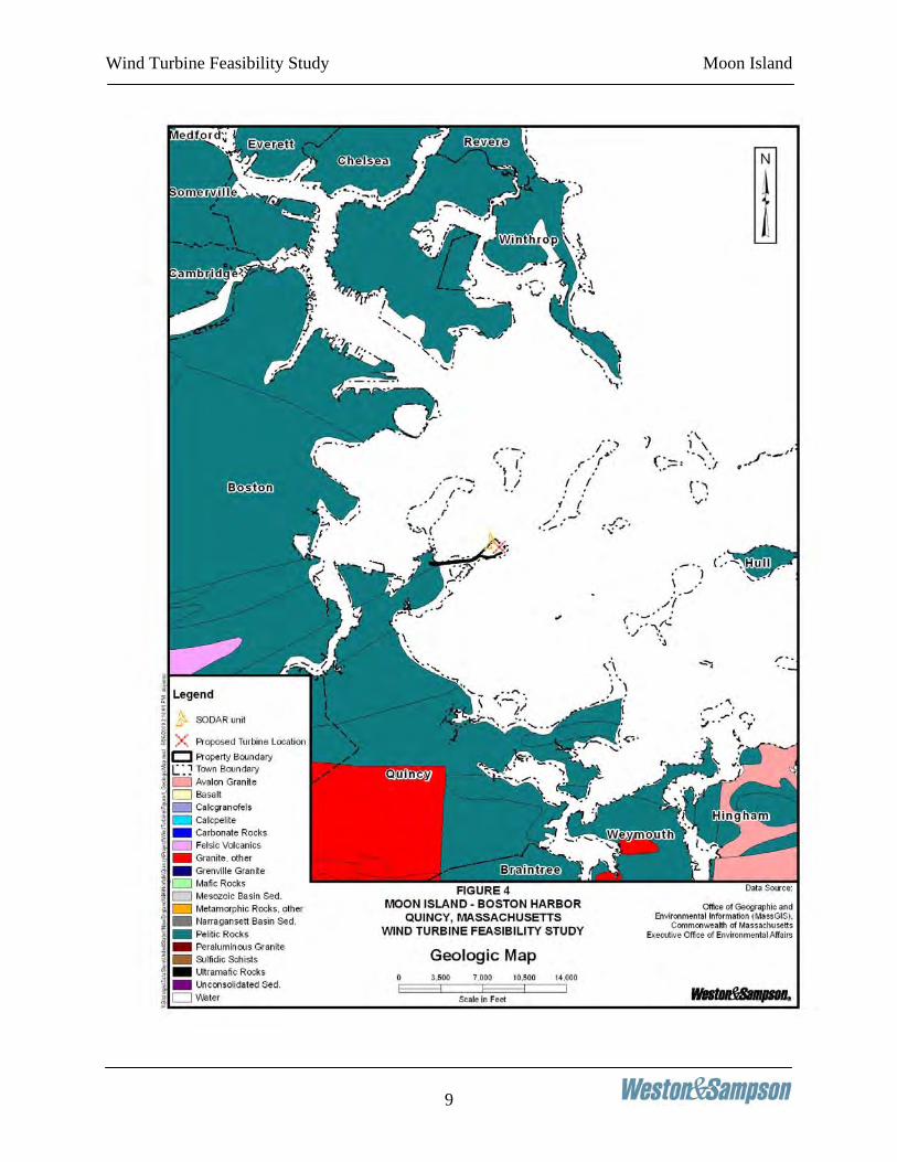
Based on review of the United Sates Geologic Survey Maps, the bedrock at Moon Island is undefined. This is because Moon Island is a drumlin with no exposed bedrock as stated above. Figure 4 depicts a portion of the Geologic Map illustrating the geological conditions in the area of Moon Island. Review of United State Department of Agriculture Soil Maps for Suffolk County, Massachusetts, the surficial soil at the site consists of Newport silt loam with slopes varying from 15 to 25 percent. Refer to Figure 5 for a portion of the referenced USDA Soil Map illustrating soil types at the site.
Wind Turbine Feasibility Study Moon Island
9

Wind Turbine Feasibility Study Moon Island
10

Wind Turbine Feasibility Study Moon Island
11
Soil borings should be conducted in the location of any proposed wind turbine in accordance with ASTM D-1586. The borings should be drilled to a depth of 100 feet or until bedrock is encountered, whichever is less. Where bedrock is encountered, drilling should include coring at depth of 10 feet to confirm the existing of bedrock versus glacial boulders. The data from the test borings should be evaluated by a geotechnical engineer who would provide such as bearing capacity, friction angles and other soil characteristics, including recommendations for a foundation type which could be used by a structural engineer to develop a foundation design once a specific turbine is selected. 3.5 Moon Island Electrical Infrastructure NSTAR provides electricity at the Fire Training Academy on Moon Island. Review of annual electrical data provided for the Fire Training Academy for 2007 indicates an annual usage of 61,920 kWh with a peak demand of 25 kW. Based on an average all-in rate of $0.128 per kW/hour for electricity, including transmission and delivery charges, total electric expenditures were $6,600 for the last fiscal year. The electrical billing and usage data provided for Moon Island and Long Island is included in Appendix B. Power is supplied from a 13.8kV NSTAR Electric distribution line (13,800V) from Dorchester Street and Moon Island Road in North Quincy. Primary metering for the Moon Island and Long Island feeder begins near the existing guard shack and entrance to the Moon Island causeway bridge. There are also three (3) 333kVA pole-mount step-down transformers located on three adjacent poles near the guard shack. These step-down transformers reduce the voltage of the 13.8kV feeder in Quincy to 4,160V (4.16kV) which is the voltage of the underground cables to Moon Island. The three transformers limit the power to be fed to the island, or what could be generated and fed back to the utility distribution system to 1MW (3 x 333kVA). Utility bills indicate that approximately 450kW of peak demand is consumed on Long Island, with another 30kW consumed on Moon Island, which totaled is about one-half of the present capacity available. The overhead primary is converted from 13.8kV to 4.16kV on the Quincy side where the NSTAR primary metering and the three step-down transformers are located. The overhead primary then goes underground for 0.85 miles until the primary electric system rises up on Pole #30 Moon Island Road, which is at the intersection of the driveway to the Boston Fire Department Training Academy. The driveway to the Training Academy has 15 poles and is a three-phase overhead line until near the end by the academy building itself. The proposed turbine location is nearest to existing pole #1/29-9. After the Boston Fire Department Training Academy driveway, the three-phase overhead 4.16kV primary continues northeast to the beginning of the causeway bridge to Long Island (0.4 miles). At existing Pole #47 Moon Island Road the electric line goes underground to supply Long Island.

Wind Turbine Feasibility Study Moon Island
12
3.6 Electrical Interconnection Plan There are a number of possible options that have been reviewed to connect the proposed wind turbine to the electrical system at the existing facility. Turbine sizes ranging from 100kW to 1,500kW have been evaluated based on electrical circuit size limitation, existing transformer capacity, amount of on-island power consumption, etc. Two options have been considered. The first is a small scale turbine, ranging in size from 100kW to 225kW; referred to as Option #1. The second is a large scale turbine ranging in size from 600kW to 1,500kW; referred to as Option #2. The proposed Option #1 maximizes the amount of electricity generation that is used on-site. The proposed interconnection for this option is detailed on the one-line Drawing E-1, with the new work shown in red. A 225kW turbine is shown as the maximum size to interconnect. The proposed interconnection for Option #1 would be to step-up the low voltage (480V) output of the turbine to a higher voltage for connection with the distribution system (4.16kV), which is appropriate for a 100-225kW turbine unit. A new 15kV class three-phase power cable would be installed in a new conduit ductbank to a new riser pole located near the turbine, outside of the blade area, and in an area that can be protected from vehicle traffic. The interconnection option also includes the installation of a pole-mounted primary switch on the riser pole, to provide a disconnect point for the underground primary cable. A three-phase switch may be required by the local utility for the ability to lock the switch in the open position, to provide a definitive means of preventing the wind turbine to backfeed in the NSTAR primary system during a period of sustained utility outage, as is customary. This type of group-operated air-break (GOAB) switch would have a visible open for positive confirmation. The proposed interconnection also includes the installation of turbine energy metering at the low-voltage turbine main breaker. As mentioned, Moon Island is primary metered back at the Quincy connection point, so a new meter would be required to measure turbine energy output. The existing NSTAR meter on Pole #5 Moon Island Road may need to be upgraded to a bi-directional meter, to capture any export of power off of the Island. For a generator rated up to 225kW, the current carrying requirement of the 4.16kV power cable circuit will be less than 100 amperes and can be accommodated by three, single conductor, 15kV class, #1 AWG, aluminum cables. New 15kV class cables should be installed in an underground conduit for physical protection rather than being directly buried. A new overhead primary pole line should be installed from the existing pole (#1/29-9) to a location near the turbine where the underground riser can be installed and protected from vehicles. The proposed Option #2 will exceed the amount of power consumed on-site and the facility will export power into the grid, especially during light load periods (nights, weekends, etc.). The proposed interconnection of this option is detailed in the one-line Drawing E-2, with the new work shown in red. A 1,500kW turbine is shown as the maximum size to interconnect.

Wind Turbine Feasibility Study Moon Island
13
The proposed interconnection would be to step-up the low-voltage (960V) output of the turbine to a higher voltage for connection with the distribution system (4.16kV). Turbines typically 600kW and larger generate at the European industrial voltage of 690V. A new 15kV class three-phase power cable would be installed in a new conduit ductbank to a new riser pole located near the turbine, outside of the blade area, and in an area that can be protected from vehicle traffic. The interconnection option also includes the installation of a pole mounted switch on the riser pole, to provide a disconnect point for the underground primary cable. A three-phase switch may be required by the local utility for the ability to lock the switch in the open position, to provide a definitive means of preventing the wind turbine to backfeed in the NSTAR primary system during a period of sustained utility outage, as is customary. This type of group-operated air-break (GOAB) switch would have a visible open for positive confirmation. The proposed interconnection also includes the installation of turbine energy metering at the low-voltage turbine main breaker. As mentioned, Moon Island is primary metered back at the Quincy connection point, so a new meter would be required to measure turbine energy output. The existing NSTAR meter on Pole #5 Moon Island Road may need to be upgraded to a bi-directional meter, to capture any export of power off of the Island during a light load period (nights, weekends, etc.). For a generator rated up to 1,500kW, the current carrying requirement of the 4.16kV power cable circuit will be less than 250 amperes and can be accommodated by three, single conductor, 15kV class, #4/0 AWG, copper cables. New 15kV class cables should be installed in an underground conduit for physical protection rather than being directly buried. A new overhead primary pole line should be installed from the existing pole (#1/29-9) to a location near the turbine where the underground riser can be installed and protected from vehicles. The existing step-down transformers at the Quincy end of the Island, near the Guard Shack are rated to carry 1000kVA. Since the largest turbine size exceeds this (1,500kW), it is assumed that NSTAR would upgrade those transformers from 3-333kVA to 3-500kVA units. It is also possible that NSTAR will require an upgrade of the existing underground 4kV cable into Moon Island and the existing overhead primary wire along the Fire Academy Driveway. A system impact study conducted by NSTAR will reveal what upgrades are needed at what cost. We would expect these upgrades for the largest turbine size, based on a visual evaluation of existing infrastructure. Both interconnection options show a proposed interconnection off of existing Pole #9 on the driveway to the Fire Academy driveway. This is one proposed turbine location. It is also possible to locate the turbine slightly closer to the Fire Academy Building, off of Pole #12, which is in the vicinity of the existing older wind turbine on the site. The interconnection would be similar, just off of a different NSTAR pole. 3.7 Electrical Interconnection Details NSTAR has specific standards and requirements for the interconnection of distributed generation such as the proposed wind turbine project. The interconnection requirements address electrical

Wind Turbine Feasibility Study Moon Island
14
system protection, revenue metering, operation, and the configuration of the primary interconnection equipment. NSTAR will review the proposed design of the electrical interconnection facilities and will perform analyses to determine the impact of the proposed generation on their electrical distribution system. Based on the results of NSTAR’s analysis, certain modifications may be needed with the NSTAR distribution system and/or to the interconnection facilities. The technical details of the major power system components associated with the electrical interconnection of the wind turbine generator are described below: The generator step-up transformer is described by specifying the transformer voltage rating (primary and secondary), power rating (kilovolt-amperes or kVA), winding configuration (primary and secondary), and construction type. All transformers shall be three phase, padmount type, oil-filled, self-cooled transformers. The primary voltage rating of the step-up transformer shall be consistent with the nominal voltage of the NSTAR distribution supply circuit to the facility which is 4.16kV phase-to-phase for all three phase transformers. To allow flexibility for local voltage deviations that may exist on the NSTAR distribution system or within the 4.16kV interconnection circuitry, the transformer primary winding shall be equipped with five (5) fixed taps to change the primary voltage rating +/- 5% from nominal voltage in 2 ½% increments. For the generator step-up transformer, the secondary voltage rating shall be consistent with the wind turbine generator voltage which is 480 volts. The transformer shall be mineral oil-filled and the owner may prefer less flammable oil or environmentally safe, seed-based oil at a price premium. The three phase power rating of the generator step-up transformer (expressed in kVA) shall be consistent with the wind turbine generator power rating (expressed in kW) and increased for the allowable generator power factor. A 225kW wind turbine generator (Option #1) operating at a 90% lagging power factor requires a padmount transformer with a minimum continuous rating of 300kVA. A 1,500kW wind turbine generator (Option #2) operating at a 90% lagging power factor requires a padmount transformer with a minimum continuous rating of 2,000kVA. Option #1 – The 300kVA transformer will be connected to the 350A, main low voltage circuit breaker of the wind turbine via secondary cabling. This cabling should consist of a minimum of 1 set of 4-wire, 500mcm copper conductor secondary cable with ground. This will provide 380A of capacity. For 480V turbines, secondary cables should be 600V class, type XHHW-2. Option #2 – The 2,000kVA transformer will be connected to the 2,000A, main low voltage circuit breaker of the wind turbine via secondary cabling. This cabling should consist of a minimum of 5 set of 4-wire, 600mcm copper conductor secondary cable with ground. This will provide 2,000A of capacity. For 690V turbines, secondary cables should be 2,000V class, type RHW-2.

Wind Turbine Feasibility Study Moon Island
15
The proposed wind turbine generator interconnection option requires the use of 15kVclass interconnection circuit cables, which is approximate on 4.16kV power systems. The power cables shall be specified for 15kV class insulation and consist of three, single conductor cables with either aluminum or copper conductors. For a wind turbine generator power rating of up to 225kW, the size of the power cables shall be a minimum of #1 AWG Aluminum. This is typically the smallest size primary cable installed by utilities. For a wind turbine generator power rating of up to 1,500kW, the size of the power cables shall be a minimum of #4/0AWG Copper. The power cable from the wind turbine generator step-up transformer to the 4.16kV interconnection point shall be installed in an underground conduit. The conduit shall be Schedule 40 PVC that is encased in concrete. At least one additional conduit for communications and control of the wind turbine generator should also be included in the conduit system. It is recommended that the primary cable ductbank be 2 to 5-inch conduits. Additional communications conduits (2, 2-inch) shall also be installed from the turbine to the Transfer Station building for remote monitoring. The required protective relays for the selected generator interconnection option will be specified by NSTAR based on the results of their system impact study. Based on a review of the NSTAR Interconnection Requirements, it is anticipated that the protective features of the wind turbine shall be able to detect over/under frequency and over/under voltage and overcurrent (via the turbine main low-voltage circuit breaker). Upon sensing conditions that exceed allowable operating limits, the protective features shall disconnect the wind turbine generator from the rest of the distribution system.

Wind Turbine Feasibility Study Moon Island
16
Figure E-1

Wind Turbine Feasibility Study Moon Island
17
Figure E-2

Wind Turbine Feasibility Study Moon Island
18
3.8 Revenue Metering Modifications As mentioned, the proposed interconnection will need to be metered to measure energy produced by the wind turbine. A new meter will be required at the turbine low-voltage (480V) location to meter output and for the sale of Renewable Energy Credits (REC’s). The existing primary metering cluster on Pole #5 Moon Island Road may need to have a new meter replaced in the socket to measure bi-directional power flow, unless the existing NSTAR meter is already capable of that function 3.9 Electrical Interconnection Cost Estimates The following planning accuracy cost estimate has been developed based on the conceptual design concept prior to completion of a formal interconnection application with NSTAR. The planning accuracy cost estimate is generally expected to be within an accuracy of +/- 25%. The cost estimate is based on recent project experience and vendor quotes and could change based on the final design and construction conditions. The estimated cost for materials, equipment, and construction required to interconnect a 225kW wind turbine to the existing utility grid is $187,275. The estimated cost for materials, equipment, and construction required to interconnect a 1.5MW wind turbine is $321,075. Tables 3-1 and 3-2 detail the major cost items for the two proposed interconnections. After the major electrical equipment listed, the balance of the interconnection system plant and miscellaneous high-voltage components includes surge arresters, cable terminations, control wiring, and start-up testing. The balance of the interconnection system plant and miscellaneous high-voltage components are estimated at 25% of the total installed cost for the major high-voltage interconnection system components. The additional cost for upgrades to the existing NSRAR system, should they be required, could range from $100,000 - $150,000, however this would need to be confirmed through an interconnection study. The cost estimate below is budgetary for planning purposes and does not include permitting, legal, financing and other costs beyond those listed above. The cost estimate does not include communication cable, as type is unknown at this time. The cost estimate is for interconnection and does not include wind turbine itself. The cost estimate does not include utility-related upgrades and back charges for those upgrades. The cost estimate is based on vendor quotes and is subject to change based on final design, construction conditions and market changing prices.

Wind Turbine Feasibility Study Moon Island
21
4.0 ENVIRONMENTAL AND REGULATORY REVIEW AND PERMITTING PLAN 4.1 Environmental Review The following section discusses the environmental and ecological characteristics of Moon Island. A review of various area receptors was conducted to determine what, if any, impact a wind turbine would have upon sensitive receptors on Moon Island. The result of this evaluation shows that development of a single wind turbine is not expected to result in unacceptable negative impacts to wildlife or other sensitive receptors on Moon Island. 4.1.1 Avian and Wildlife Impact Analysis The pertinent ecological and environmental factors associated with avian and wildlife impacts from the proposed construction of a single, commercial-scale wind turbine have been evaluated. The analysis consisted of a review of existing site conditions and available scientific databases. This information was correlated with available Mass GIS data layers including a review of aerial photographic imagery to make an initial determination of the potential ecological impacts of the proposed project. In addition, a determination of the likely avian impacts were formulated following the interim guideline developed by the United States Fish and Wildlife Service (USFWS), which include eight impact evaluation criteria for assessing avian impacts. Methodology used in making a determination about avian impacts was developed to incorporate three principal characteristics. These characteristics are environmental attributes, species composition, and ecological attractiveness of the area. Additional information regarding USFWS impact evaluation criteria can be found in Appendix C. Agency Consultation Federal and State agencies should be contacted to request information concerning endangered or threatened species and critical habitats within the project area. The Owner should contact the USFWS, New England Regional office, pursuant to Section 7 of the Endangered Species Act of 1973, to determine whether any federal listed species or habitats are present in the project area if construction of a wind turbine is planned. In addition, the Massachusetts Natural Heritage and Endangered Species Program (NHESP) should be consulted for information regarding any state listed species and habitats. The initial correspondence would constitute the beginning of the “informal” or “simple” review process as outlined by Section 7 of the Federal Endangered Species Act and the Massachusetts Endangered Species Act (321 CMR 10.0000). If, at the conclusion of these consultations, it is determined that no federal or state listed rare species are present or in close proximity to the proposed project site, then the informal or simple review process may be considered complete. Should the conclusion of these consultations reveals that the project site will likely disturb one or more listed species, then a more detailed biological assessment or order of conditions may be required.

Wind Turbine Feasibility Study Moon Island
22
Landscape Evaluation and Analysis Composition and spatial variation patterns for wildlife are strongly influenced by a multitude of biotic and aboitic landscape features. In lieu of comprehensive site surveys, Weston & Sampson gathered information regarding existing site conditions and habitats on the proposed site and analysis was conducted through review of site photographs, aerial photography, and scientific databases and literature. The landscape evaluation focused on examining aerial photography of existing conditions to identify those biotic and aboitic features of significance. Moon Island consists of cleared areas around the Fire Training Academy and the firing range. The top of the hill, one potential location for a wind turbine, is wooded. Examination of Moon Island reveals the lack of continuous corridors for wildlife movement. The island serves as a natural buffer to the natural communities and movement of wildlife between suitable habitats. Man-made travel corridors include roads, utility corridors, and urban development. Moon Island is connected to Long Island and to Squantum by man made bridges, these being the only possible corridor for wildlife movement for animals other than birds.
Marine Intertidal Wetlands
Marine intertidal wetlands are the predominant coastal wetland type found in both the Outer Harbor Islands (Great Brewster Island, Middle Brewster Island, Outer Brewster Island, Calf Island, Little Calf Island, and Green Island) and along the eastern exposures of Deer Island and Lovells Island. These habitats are exposed to the waves and currents of the open ocean (Massachusetts Bay) with the water regimes being determined primarily by the ebb and flow of the tides. Classes of marine intertidal wetlands within the national park area include rocky shore, aquatic bed and unconsolidated marine intertidal wetlands.
Estuarine Intertidal Wetlands
Estuarine intertidal wetlands are the predominant wetland type in the shoreline habitats of the majority of the Inner Harbor, Quincy Bay and Hingham Harbor areas within the Boston Harbor Islands national park area. These include the shorelines of Bumpkin Island, Button Island, Gallops Island, Georges Island, Grape Island, Hangman Island, Long Island, Moon Island, Nut Island, Peddocks Island, Raccoon Island, Ragged Island, Rainsford Island, Sarah Island, Sheep Island, Slate Island, Spectacle Island, Thompson Island, and World’s End, as well as the western shores of both Deer Island and Lovells Island. Estuarine wetlands may also be found in low-lying areas adjacent to the shoreline which may be partially or fully enclosed by land, but have regular or sporadic access to tidally influenced harbor water. These habitats include low-lying regions on Thompson Island, Spectacle Island, Deer Island, Long Island, Moon Island, Peddocks Island, Sheep Island, World’s End and Calf Island. Classes of estuarine intertidal wetlands within the national park area include unconsolidated, emergent, aquatic bed and rocky shore estuarine intertidal wetlands.

Wind Turbine Feasibility Study Moon Island
23
While most of the estuarine intertidal wetlands fringing the properties of the national park area are quite small in extent, the estuarine intertidal wetlands found at World’s End comprise the northern edge of a larger system, the Weir River Area of Critical Environmental Concern (ACEC). It is regionally significant both for its size and its importance in providing a relatively undisturbed marshland wildlife habitat.
Similarly, two additional ACECs, and part of a third ACEC, are located in the general proximity of the national park area: Weymouth Back River; Neponset River Estuary; and Rumney Marshes. While the ACECs are located almost entirely outside of the boundary of the national park area they are biologically connected and the habitats they provide are of great significance to the overall ecological health of the entire Boston Harbor area.
Mass GIS Data Layers Data regarding rare species and critical habitats is complied by the Massachusetts Office of Geographic and Environmental Information (Mass GIS) and organized as a number of Geographic Information System (GIS) data layers. These layers are represented as number of polygons drawn in conjunction with existing landscape features, and can be utilized to determine the spatial relationships between areas of environmental significance (e.g. wetlands) and a proposed project site. A table of the GIS data layers used in avian impact screenings and subsequent analysis within this report has been summarized below:
Table 4-1 Mass GIS Screening Data Layers
Data Layers Govering Authority Date of Update Estimated Habitats for Rare Wildlife NHESP September 2008
Priority Habitats for State-Protected Rare Species NHESP
September 2008
BioMap Core Habitat NHESP June 2002 BioMap Supporting Natural Landscape NHESP June 2002 Massachusetts Certified Vernal Pools NHESP January 2009 Potential Vernals Pools NHESP December 2000 Areas of Critical Environmental Concern (ACEC) DCR
April 2009
DEP Wetlands (1:12,000) MADEP December 2004 Notes/Abbreviations: NHESP: Natural Heritage and Endangered Species Program MADEP: Massachusetts Department of Environmental Protection DCR: Massachusetts Department of Conservation and Recreation
GIS screening of the area shows that no part of Moon Island is considered NHESP Estimated Habitats of Rare Wildlife. The NHESP Estimated Habitats of Rare Wildlife data layer represents estimations of the habitats of state-protected rare wildlife (plants and animals) populations that occur in Massachusetts, while NHESP Priority Habitats data layer represents estimations of

Wind Turbine Feasibility Study Moon Island
24
important state-listed rare species (animals only) habitats in Massachusetts. The NHESP habitat polygons are drawn by analyzing population records, species, habitat requirements, and available information about the landscape. BioMap Core Habitat data layers present the most viable habitat for rare species and natural communities in Massachusetts. The BioMap Supporting Natural Landscape layers buffer and connect Core Habitat polygons and identifies large, naturally vegetated blocks that are relatively free from the impact of roads and other development. Based on previous development, a large area of the site is not mapped as core wildlife habitat. Figure 6 is a map presenting the results of the habitat GIS screening for Natural Communities, Estimated Habitats for Rare Wildlife and Areas of Critical Environmental Concern with respect to the location of the Site. Species Listing and Habitat Considerations Correctly identifying the species and associated habitats is critical to successfully assessing potential impacts of a wind turbine. National, regional and local references were reviewed to create a comprehensive species listing for Moon Island. Compiling GIS screening information and visual examination of aerial imagery was performed to assess habitat constraints. These data were used to determine which species could reasonably be expected in the proposed study area. In addition, the surrounding areas were considered since regional and daily migratory effects can be substantial. Determination of likely impacted avian species was the main objective of this analysis. Species listings were evaluated from a number of sources and were assembled to account for those species utilizing the Town of Quincy area during migratory stopover. Species listings were further refined to specifically address federally and state listed wildlife with endangered/threatened status or species of special concern. In total, there are twelve federal and state listed species present in the area near the City of Quincy. Table 4-2 lists wildlife that are endangered, threatened or species of special concern status within the City of Quincy, MA, as compiled by the Massachusetts NHESP. The table includes the state listing status, taxonomic group and most recent field observation.

Wind Turbine Feasibility Study Moon Island
25

Wind Turbine Feasibility Study Moon Island
26
Table 4-2 List of Endangered or Threatened Wildlife in Quincy
Taxonomic Group
Scientific Name
Common Name
MESA Status
Federal Status
Most Recent
ObservationAmphibian Ambystoma opacum Marbled Salamander T 2004
Beetle Cicindela rufiventris
hentzii Hentz's Redbelly
Tiger Beetle T 1998
Bird Falco peregrinus Peregrine Falcon
E 2006
Bird Sternula antillarum Least Tern SC 2007 Reptile Glyptemys insculpta Wood Turtle SC Historic Vascular Plant
Ageratina aromatica Lesser Snakeroot E 2007
Vascular Plant
Houstonia longifolia Long-leaved Bluet E 1894
Vascular Plant
Myriophyllum alterniflorum
Alternate-flowered Water-milfoil
E 1894
Vascular Plant
Sabatia kennedyana Plymouth Gentian SC 1886
Vascular Plant
Setaria parviflora Bristly Foxtail SC 2001
Vascular Plant
Sphenopholis nitida Shining Wedgegrass T 1921
Vascular Plant
Spiranthes vernalis Grass-leaved Ladies'-tresses
T 1898
Table 4-3 was developed by USFWS Division of Migratory Management and identifies those Birds of Conservation Concern (BCC) in the New England/Mid-Atlantic Coast Region.

Wind Turbine Feasibility Study Moon Island
27
Table 4-3 Birds of Conservation Concern
Common Name Scientific Name 1 Peregrine Falcon Falco peregrinus 2 Black rail Laterallus jamaicensis 3 Wilson's Plover Charadrius wilsonia 4 American Oystercatcher Haematopus palliatus 5 Upland Sandpiper Bartramia longicauda 6 Whimbrel Numenius phaeopus 7 Hudsonian Godwit Limosa haemastica 8 Marbled Godwit Limosa fedoa 9 Red Knot Calidris canutus 10 Purple Sandpiper Calidris maritima 11 Buff-breasted Sandpiper Tryngites subruficollis 12 Common Tern Sterna hirundo 13 Least Tern Sterna antillarum 14 Black Skimmer Rynchops niger 15 Razorbill Alca torda 16 Short-eared Owl Asio flammeus 17 Whip-poor-will Caprimulgus vociferus 18 Red-headed Woodpecker Malanerpes erythrocephalus 19 Sedge Wren Cistothorus platensis 20 Marsh Wren Cistothorus palustris 21 Wood Thrush Hylocichla mustelina 22 Blue-winged Warbler Vermivora pinus 23 Golden-winged Warbler Vermivora chrysoptera 24 Prairie Warbler Dendroica discolor 25 Cerulean Warbler Dendroica cerulea 26 Kentucky Warbler Helmitheros vermivorus 27 Canada Warbler Oporornis formosus 28 Henslow's Sparrow Wilsonia canadensis 29 Salt-marsh Sharp-tailed Sparrow Ammodramus henlowii 30 Seaside Sparrow Ammodramus caudacutus 31 Baltimore Oriole Icterus galbula
Source: "Birds of Conservation Concern 2002" U.S. Fish and Wildlife Service: Division of Migratory Bird Management. Arlington, VA. December 2002.

Wind Turbine Feasibility Study Moon Island
28
Special Considerations The project site is located in the path of the North East Atlantic regional flyway, which can be identified as running along the east coast of North America. In a broad sense the flyway concept can be defined as the biological systems of migration routes that directly link sites in ecosystems in different geographical settings (Boere et al., 2006). Ecosystems primarily comprised of the suitable habitats of both breeding and non-breeding areas for birds. A flyway is in fact the totality of the ecological systems that are necessary to enable migratory birds to survive and fulfill their annual life cycles. Figure 7 illustrates the four generalized North American regional migration flyways, with respect to the location of the Site. Development of a single large scale wind turbine is not expected to result in unacceptable negative impacts to wildlife or substantially degrade habitat.

Wind Turbine Feasibility Study Moon Island
29

Wind Turbine Feasibility Study Moon Island
30
4.1.2 Wetlands The City of Quincy Conservation Commission is an appointed body with authority to protect and preserve natural resources within the City. The Conservation Commission's primary role is the administration of the Massachusetts Wetlands Protection Act (M.G.L. Chapter 131, Section 40) within the City of Quincy. The Wetland Protection Act provides for the protection of several types of Resource Areas including Bordering Vegetated Wetlands (bordering on lakes, ponds, and streams), Banks, Land Under Water, Land Subject to Flooding, and Riverfront Areas (area within 200 feet of a river or perennial stream) and coastal resource areas. Moon Island is not classified as having any type of the protected resource areas on site. Review of Mass GIS Wetland data layer indicates that no portions of the Moon Island property are protected open space with wetlands. The area for the proposed wind turbine is upland area and greater than 100 feet from the nearest wetland, streams, ponds or surface water body. Refer to Figure 6 for the Area Receptors Map for Moon Island. To confirm there is no potential for destruction or impacts to wetlands, written notification should be filed with the City’s Conservation Commission for a formal determination of no impacts by the proposed addition of a wind turbine at the Site. Based on review of the wetlands protection area maps and the expected footprint of a wind turbine, wetlands are not a concern for development. 4.2 Permitting Plan A review of permitting requirements for local, State and Federal jurisdictions was conducted as part of the project feasibility study. Below is a summary of the agencies having jurisdiction, where review and approval should be obtained:
Local Agencies City of Quincy Conservation Commission
State Agencies Massachusetts Environmental Policy Act (MEPA) Massachusetts Highway Department (MHD)
Massachusetts Historical Commission (MHC) Natural Heritage and Endangered Species Program (NHESP) Department of Environmental Protection (DEP)
Federal Agencies NPDES Permit Application with Environmental Protection Agency (EPA) Federal Aviation Administration (FAA)

Wind Turbine Feasibility Study Moon Island
31
Federal Energy Regulatory Commission (FERC)
A summary of regulatory stakeholders, applicability to the scope of the proposed project, and possible administrative review requirements is summarized in below Table 4-4.
Table 4-4 Permitting Matrix
Agency Permit or
Approval Project
Relevance Approval
Process/Timeframe Comments
City of Quincy City Wind Ordinance
Special Permit Required for
structure over 250 ft.Permit issued by City Council
Project must comply with City ordinance
requirements.
Loc
al
Conservation Commission
Notice of Intent (NOI)
Scope of work does not involve wetland or water resources
None
Subject site outside the 100 foot buffer zone of
any wetland/water resource.
MEPA Environmental
Notification Form (ENF)
Required for construction projects
disturbing greater than 2 acres.
N/A N/A
Environmental Impact Report
(EIR) N/A N/A N/A
NHESP ENF/MESA Checklist
Project does not take part in Estimated
Habitat
30 days from point of submission for simple review
Simple review pertains to those projects that
will disturb less than 5 acres of estimated
habitats
Mass Turnpike Authority
Special Hauling Permit
Transportation of Turbine
parts/accessories over state Highways
24 hours notice prior to transport
Project may not subject these
requirements based on loads and dimensional
characteristics of material
Mass Highway Department
Permit to Move Overweight or
Overdimensional Loads
Transportation of Turbine
parts/accessories via State highways
If regulated as oversize/dimension load, then
same day processing. If regulated as "super load," then
application must be filed in writing and requires full
structural analysis and detailed transportation routing plan.
Super load requirements: >115 x
14 x 14 (length, width, height). All units in
feet. Any transport of any oversized loads greater than 13'8" in
height require a routing survey.
Stat
e
Massachusetts Historical
Commission
Project Notification Form
All projects that require a permit,
license or funding from any state
agency must file a PNF
Project notification only

Wind Turbine Feasibility Study Moon Island
32
NSTAR
Interconnection with existing
transmission system study
Must be notified when doing work, and if electricity generated will be tied into existing
transmission system.
Project notification and possible Interconnection
Transmission System Study
EPA NPDES/CGP/NOI Applies to
construction sites that disturb > 1 acre
Notification only, supported with SWPP plan.
Construction General Permit is applied for by the entity that has operational control
over the job site, and the ability to enforce
SWPP plan.
FAA Aircraft warning lighting
Required for all towers greater than
200 feet
Must file Form 7460-1 at least 30 days prior to start of
construction
Max height of turbine expected to be 410 feet
FERC Qualifying Facility Status
Required in order to enter power
purchase agreement w/ electrical utility
Must file Form No. 556 with FERC
Dependent upon size of generating facility
Fede
ral
FWS
Informal Consultation Notice
and/or Biological Assessment
Requires applicant request a list of all
threatened, endangered,
candidate species and critical habitats prior to beginning
construction.
Notification only
If at the completion of informal consultation, further assessment is
required a formal Biological Assessment must be prepared and
reviewed by FWS. May require
implementation of Habitat Conservation
Plan (HCP) 4.2.1 City of Quincy Wind Ordinance The City of Quincy has adopted an ordinance regarding wind facilities. The purpose of this ordinance is to provide by either a special permit or a site plan review permit for the construction and operation of wind facilities, whether as the primary use or accessory use, and to provide standards for the placement, design, construction, monitoring, modification and removal of wind facilities that address public safety, minimize impacts on scenic, natural and historic resources of the city and provide adequate financial assurance for decommissioning. A copy of this ordinance is included in Appendix D. A site plan review permit is required for the construction and/or modification of wind facilities where the height of the wind turbine(s) is less than 250 feet. A special permit is required for the construction and/or modification of wind facilities where the height of the wind turbine(s) equals or exceeds 250 feet. A wind turbine located on Moon Island would most likely require the issuance of a special permit. The construction of a wind facility as a primary use is not permitted in Residence A, Residence B, or Residence C zoning districts. The construction of a wind facility as an accessory use in Residence A, Residence B, or Residence C zoning districts or as either an accessory use or

Wind Turbine Feasibility Study Moon Island
33
primary use in all other zoning districts is permitted subject to the issuance of a permit in accordance with the provisions of the ordinance. In addition to any other requirements of the Quincy Zoning Ordinance, such permits may also impose reasonable conditions to insure that wind facilities shall be constructed and operated in a manner that minimizes any adverse visual, safety, and environmental impacts; require safeguards and limitations on time and use; and may require the applicant to implement all reasonable measures to mitigate unforeseen adverse impacts of the wind facility, should they occur. Wind monitoring or meteorological towers are not permitted in Residence A, Residence B, or Residence C zoning districts. Wind monitoring or meteorological towers are permitted in all other zoning districts subject to issuance of a building permit for a temporary structure for a period of no longer than twelve (12) months and subject to sections 17.38.060, 17.38.070, and 17.38.080 of the ordinance. The minimum distance between the ground and any part of a rotor or a turbine blade shall be thirty (30) feet. Wind turbines shall be set back a distance equal to 1.5 times the overall blade tip height of the wind turbine from the nearest nonparticipating residential or commercial structure and from the nearest property line and public or private right of way line. This requirement should be easily met with a smaller size turbine, however a larger turbine may require a variance or waiver due to the proximity of Moon Island Road. The city council has added a new zoning control procedure known as site plan review which shall require a permit for: (1) all multi-family or apartment development in a Residential B zoning district of three units or more; (2) all multi-family or apartment development in any zoning district other than Residential B, in excess of twelve units; (3) all development where the area of any new structure is ten thousand square feet or more excluding single-family homes and related accessory structures; and (4) wind facilities that do not exceed 250 feet in height as described in section 17.38.030 of the ordinance.
Table 4-5 Table of Dimensional Requirements per City of Quincy Ordinance
District area ratio (sq. ft.) (sq. ft.)5 Front Side Rear feet (sq. ft.) stories4
RES. A None 7,650 7,650 25 1 13 20 85 None 2-1/2 RES. B
1-3 units 0.5 6,750 2,500 25 13 25 75 500 3 4-5 units 0.5 6,750 3,500 25 25 25 75 700 3
6-16 units 0.5 6,750 4,500 25 25 25 75 700 3 17 units and up 0.5 6,750 4,500 25 25 25 75 700 3
RES. C 1.0 14,000 2,000
1/2 the height of
the building but in no case less than 25
100 400 6
RES. D 2.0 42,000 2,500 1/3 the 100 100 6

Wind Turbine Feasibility Study Moon Island
34
height of the building
but in no case less than 40
BUS. A 2,5 0.75 5,000 None 15 15 15 40 None 3 BUS. B 2,5 1.5 5,000 None 15 3 15 20 60 None 4 BUS. C 2,5 3.5 5,000 None None None 20 60 None 6
IND. A 1.0 None None 25 3 25 3 25 3 50 None 4 IND. B 2.0 None None 25 3 25 3 25 3 50 None 8 B. Explanatory Notes. 1. In Residence A districts buildings shall be set back so as to conform to the average alignment of dwellings already erected on the same side of the street within three hundred feet on each side of the lot, except that no building shall be set back less than twenty-five feet and no building shall be set back more than fifty-five feet. 2. Multifamily residence and mixed use of a building are permitted within a Business A and B district with the issuance of a special permit in accordance with the standards and procedures of Sections 17.04.170 through 17.04.200 by the zoning board of appeals. Residential buildings and uses within Business A districts obtaining special permits, as provided herein, shall conform to all requirements of Residence B districts. Residential buildings and uses within Business B districts obtaining special permits, as provided herein, shall conform to all the requirements of Residence C districts. Multifamily residences and mixed use of a building are permitted within a Business C district; provided, that residential buildings and uses within a Business C district have a maximum FAR of three and five tenths, minimum lot size of forty-two thousand square feet, minimum lot area per dwelling unit of three hundred twenty-five square feet, minimum front, rear and side yards of one quarter the height of the building, minimum lot frontage and lot width of one hundred feet and minimum open space per dwelling unit of one hundred square feet. The site plans of buildings containing twelve units or more must be reviewed by the planning board. 3. Applies only to buildings hereafter constructed. 4. Notwithstanding the number of allowable stories, no residential building shall be more than sixty feet above the existing average grade exclusive of those necessary features appurtenant thereto as enumerated in Section 17.20.080, except for buildings in a PUD or PUD 1 district and commercial buildings where the height shall not be more than eighty feet above existing average grade. In no case shall any building exceed six stories except for those buildings in a PUD or PUD 1 district. Any commercial building with residential housing will be subject to the six-story above-grade limitation. These amendments shall not apply to any building for which a permit to construct foundations was issued prior to January 1, 1987. 5. Notwithstanding any provisions in the zoning by-law to the contrary, the minimum lot area per dwelling unit is two thousand five hundred square feet for residential uses as may be permitted in other districts, including Business A, B and C. (Ord. 99-106; Ord. 97-332; prior code Ch. 24, § 52) 4.2.2 Federal Aviation Administration A Notice of Proposed Construction or Alteration is required by the Federal Aviation Administration, Chapter 14 CFR, Part 77 and form 7640-1 (Notice of Proposed Construction or Alteration) for all structures over 200 feet above ground-level, or within a few miles of an airport. Any wind turbine with a tip-height over 200 feet will also likely require hazard lighting. Form 7640-1 was filed for the potential wind turbine location on July 17, 2009 with the FAA for a determination if the proposed height of 409 feet above ground level would pose a hazard to navigation. Copies of the filing are included in Appendix E as relevant correspondence.

Wind Turbine Feasibility Study Moon Island
35
5.0 WIND PLANT CONFIGURATIONS 5.1 Foundation and Turbine Support Wind turbine foundations vary depending upon the make, model and soil conditions at each site. Typical foundations include monolithic reinforced concrete slabs, pile supported mono slabs and deep piling or caissons. The foundation design depends on the tower design, which is usually either a lattice tower or monopole. The lattice towers are usually three or four sided and can be straight or tapered with guyed or non-guyed installations. The typical lattice tower will range in height from 50 feet to over 300 feet. Sleeker monopole designs are available with straight or tapered poles. Tapered monopoles for a 600 kW to 2.0 MW wind turbine generally range in height from 150 to 350 feet, would have a base diameter of 10 to 18 feet and the diameter of the pole at the hub height would be six to eight-feet in diameter. The foundation design will also depend upon the soil type, bearing capacity and tolerances of actual turbine and tower selected. Given the general soil characteristics of the region and area, a shallow, monolithic reinforced concrete slab could be used to support a tapered monopole. Foundations for similar projects have included octagonal-shaped reinforced monolithic slabs with a length and width of 40 to 50 feet and a thickness of six to eight feet. Deep foundation designs, which provide stability from overturning through the pressure created by the weight of the soil, is also likely to be a viable alternative on Moon Island. Analysis of a specific foundation design is beyond the scope of this feasibility study, but should be developed in conjunction with a geotechnical exploration conducted during the design stage of the project based on actual equipment specifications. The scope of a geotechnical study typically includes a series of standard penetration test borings, in accordance with ASTM D-1586, to depths of 50 to 100 feet or until bedrock is encountered and confirmed by coring. 5.2 Wind Turbine Alternatives There are a number of commercially produced wind turbines on the market today. Generally, the most popular models are vertical axis, three bladed, upwind models which are mounted atop of monopole towers. There are a large number of generator sizes, rotor blade lengths and tower highs which are commonly used. Table 5-1 provides a sample of the various manufacturers standard size wind turbine generators, rotor diameters, tower heights and overall height as measured from the tallest point of the blade in the 12 o’clock position.
Table 5-1 Typical Wind Turbine Sizes Generator Tower Rotor Overall Overall Manufacturer Size (kW) Height (m) Diameter (m) Height (m) Height (feet)Vestas V-90 2,000 105 90 150 492 95 90 140 459 80 90 125 410 AAER-2000 2,000 100 84 142 466 80 80 120 394

Wind Turbine Feasibility Study Moon Island
36
65 71 101 330 Vestas V-82 1,650 80 82 121 397 78 82 119 390 70 82 111 364 69 82 110 359 59 82 100 328 GE 1.5 SLE 1,500 80 77 119 389 Fuhrländer FL-1500 1,500 80 77 119 389 65 70 100 328 AAER-1500 1,500 80 77 119 389 65 70 100 328 Nordic 1000 1,000 70 59 129 326 60 54 114 285 AAER-1000 1,000 82 54 136 358 70 54 124 318 Vestas RRB PS 600 600 65 47 112 290 48 47 95 236 39 47 86 204 Elecon T600-48 DS 600 50 48 98 243 Norwin 225 40 29 55 179
Turbine Availability The percent of time that a wind turbine is capable of producing power is known as the total availability. The factors and values used to compute turbine availability at the Moon Island site are tabulated in Table 5-2. The total annual availability of a turbine was computed from the product of the factors and equaled 93.0% of the year for Moon Island.
Table 5-2- Factors Affecting the Availability of Turbines
Factor Percent/yr Grid connection efficiency 97.0% Turbine availability 97.0% Turbine icing and blade fouling 99.2% Substation maintenance 99.8% Utility downtime 99.9% High wind speed hysteresis 100%
Total Availability 93.0%

Wind Turbine Feasibility Study Moon Island
37
The following assumptions were made for the factors affecting availability: • Grid connection efficiency. The efficiency of the grid connection is estimated to be 97%.
This includes the losses in the transformer and the transmission line. This should be confirmed by an electric loss calculation once the grid connection has been defined.
• Turbine availability. The technical availability of the turbine is assumed to be 97%. This
figure is based on data from modern operational wind farms. Technical availability may be a part of the contract terms between the project owner and the wind turbine supplier. It is worth noting that manufacturers may not guarantee technical availability at the 97% level for small, one or two turbine projects. It is advisable to review this figure when the terms of the warranty are established.
• Turbine icing and blade fouling. Serious icing conditions can prevent a wind turbine from
operating, as the turbine shuts down if there is imbalance of the blades. Undoubtedly there is the prospect for ice to collect on turbine blades located on Moon Island. Three days has been given as the likely total occurrence per year of icing events, which equates to an availability of 99.2%. Blade fouling is not expected to occur, as this is primarily a problem in very hot climates where severe insect fouling can affect the aerodynamics of the turbine blades.
• Substation maintenance. The connection to the grid may have to be temporarily shut down
for maintenance. We have assumed that this might occur for a total of 16 hours per year. • Utility downtime. Most wind turbines will fail to efficiently produce energy during lower
wind conditions when the grid does not actively supply electricity for the machine’s control systems due to a grid power outage. The will occur, on average, approximately 8 hours per year.
• High wind speed hysteresis. During very high wind conditions, a wind turbine will shut
down to protect its electrical and mechanical components. The machine will only restart when wind conditions fall significantly below the cut-off wind speed. This factor is used to compensate for power loss during this restarting delay. Because Moon Island rarely experiences winds above the typical wind turbine cut-out speeds (~25 m/s), high wind speed hysteresis is not expected to have any significant effect on power output.
5.3 Sound Propagation In order to predict the sound pressure level at a distance from source with a known power level, one must determine how the sound waves propagate. In general, as sound propagates without obstruction from a point source, the sound pressure level decreases. The initial energy in the sound is distributed over a larger and larger area as the distance from the source increases. Thus, assuming spherical propagation, the same energy that is distributed over a square meter at a distance of one meter from a source is distributed over 10,000 m2 at a distance of 100 meters away from the source. With spherical propagation, the sound pressure level is reduced by 6 dB per doubling of distance. This simple model of spherical propagation must be modified in the

Wind Turbine Feasibility Study Moon Island
38
presence of reflective surfaces and other disruptive effects. The development of an accurate sound propagation model generally must include the following factors:
• Source characteristics (e.g., directivity, height, etc.) • Distance of the source from the observer • Air absorption, which depends on frequency • Ground effects (i.e., reflection and absorption of sound on the ground, dependent on
source height, terrain cover, ground properties, frequency, etc.) • Blocking of sound by obstructions and uneven terrain • Weather effects (i.e., wind speed, change of wind speed or temperature with height). The
prevailing wind direction can cause differences in sound pressure levels between upwind and downwind positions.
• Shape of the land; certain land forms can focus sound Aerodynamic sound generation is very sensitive to speed at the very tip of the blade. To limit the generation of aerodynamic sounds, large modern wind turbines may limit the rotor rotation speeds to reduce the tip speeds. Large variable speed wind turbines often rotate at slower speeds in low winds, increasing in higher winds until the limiting rotor speed is reached. This results in much quieter operation in low winds than a comparable constant speed wind turbine. Noise Evaluation Criteria The proposed wind turbine project would be subject to Massachusetts’s noise regulation (310 CMR 7.10). Massachusetts DEP Noise Guideline Document, dated March 2006, stipulates no increase of ambient sound levels at the property line, and at the nearest inhabited building, by more than 10 dB(A) above ambient conditions with no pure tone conditions. The nearest residences are located approximately one mile from the Moon Island site. The development of a single large scale wind turbine is not expected to result in a noise impact in excess of regulatory criteria. Wind Turbine Sound Production Wind turbines in operation produce sound. The sound is produced by the rotating blades passing through the air, and by the mechanical noise associated with the components in the turbine hub. Review of manufacture specifications for a Vestas V-82 (1,650 kW) indicates the maximum noise level produced at the hub is approximately 103 dB(A) at wind speed of 9.0 meters per second. 5.4 Shadow Flicker Shadow flicker is a phenomenon caused by periodic obstruction of light caused by the rotating blades of the turbine. Modern commercial-scale turbines are typically three-bladed and rotate at approximately 20 rpm, which means that shadow flicker, when present, would occur at a frequency of 60 shadows/minute, or 1 Hz. Shadow flicker at this frequency is normally considered a nuisance issue, but there are no established health and safety regulations or

Wind Turbine Feasibility Study Moon Island
39
exposure standards to date in the United States. Shadow flicker is an intermittent nuisance and is generally a concern only under the following conditions:
• The sun is shining and has a clear unobstructed path to the turbine; • The turbine is between the viewer(s) and the sun, and within approximately ½ mile of the
viewer(s); • The turbine is in operation; and • There are no obstacles between the turbine and the viewer(s).
As is evident from the list of conditions above, an evaluation of the significance of shadow flicker for a particular site is dependent on a number of factors, including site geometry, the locations of potential viewers, blade finish on the turbine’s rotors, the relative “sunniness” of the location and the operational status of the turbine at a given time on a daily basis. Shadow flicker is not expected to be a limiting factor for siting of a turbine on Moon Island since there are no permanent residents that would likely be affected by this phenomenon.

Wind Turbine Feasibility Study Moon Island
40
6.0 ENERGY PRODUCTION AND FINANCIAL ANALYSIS 6.1 Estimated Energy Production Based on the predicted wind speed and the wind resource modeling, the wind speed and direction distribution were derived at the selected wind turbine height. The wind speed distribution gives the number of hours that a particular wind speed blows per year. Using WindPRO modeling software, this wind speed distribution was then combined with the power curve of four different sized wind turbine generators to obtain an estimate of the annual wind energy production. The output is corrected for estimated availability and electrical grid efficiency to obtain an estimate for the net annual wind energy production. Based on the wind resource at Moon Island, four different sized wind turbines were considered for this assessment. The power curve for the various wind turbine generators was obtained from the modeling software data sources or input from manufactures specifications for modeling purposes. Copies of specification from the various wind turbines selected are included within Appendix F. Calculation of Net Energy Production The WindPRO calculations of energy production and capacity factors for the selected turbines are summarized shown in Table 6-1. Copies of the modeling output reports are also included in Appendix G. Net output of the turbines have conservatively taken into account a 90% availability factor for the issues discussed above.
Table 6-1 Summary of Energy Production Modeling
Norwin Elecon GE Vestas Characteristics 225 T600-48 1.5 SLE V-82 Turbine Size, kW 225 600 1500 1650 Project Cost $1,034,800 $1,900,000 $4,321,000 $4,521,000Possible MTC Grant $450,000 $600,000 $600,000 $600,000Cost per kW (No Grant) $4,599 $3,167 $2,881 $ 2,740Cost per kW (With Grant) $2,599 $2,167 $2,481 $ 2,376Capacity Factor, % 22.7% 28.4% 29.9% 31.5% Energy Output, MWh 403 1,343 3,536 4,098
Net Output = Gross output x availability factor (90% in this case).

Wind Turbine Feasibility Study Moon Island
41
Wind resource data and modeling indicate a favorable wind resource at the recommended location and merits further consideration for a utility scale wind turbine project. Estimates of the long-term annual average wind speed for the Moon Island site were obtained by using the wind speed information from the Thompson Island MET tower over 70 months. 6.2 Reduction in Air Pollution Based on information from the MTC website, a single 1.0-MW turbine displaces 2,000 tons of carbon dioxide each year, which is equivalent to planting a square mile of forest, based on the current average U.S. utility fuel mix. To generate the same amount of electricity as a single 1-MW turbine using the average U.S. utility fuel mix would mean emissions of 10 tons of sulfur dioxide and 6 tons of nitrogen oxide each year. To generate the same amount of electricity as a single 1-MW wind turbine for 20 years would require burning 26,000 tons of coal (a line of 10-ton trucks 10 miles long) or 87,000 barrels of oil. To generate the same amount of electricity as today's U.S. wind turbine fleet (6,374 MW) would require burning 8.6 million tons of coal (a line of 10-ton trucks 4,321 miles long) or 28 million barrels of oil each year. 100,000 MW of wind energy will reduce carbon dioxide production by nearly 200 million tons annually. Since 1993, ISO New England Inc. (ISO-NE) has analyzed the aggregate emission of SO2, NOX, and CO2 from fossil fuel-based electrical generating facilities. The 2006 DRAFT New England Marginal Emission Rate Analysis Report, dated 2008, provides calculated estimates of marginal SO2, NOX, and CO2 air emissions for the calendar year 2006 in pounds per megawatt hour (lbs/MWh). Emission rates were estimated using the energy weighted average emission rates of generating units that typically would increase loading during higher energy demands. Since the wind turbine uses air to generate electrons versus the predominately fossil-fuel based generation capacity of the NEPOOL’s system, each electron generated by a renewable energy system can be viewed as displacing from the grid an electron that would otherwise be created by the existing system’s fossil fueled marginal power plant. A 1.65 MW wind turbine is estimated to generate an output of approximately 4,098 MWh annually, based on a 31.5% capacity factor. Based on these statistics, the use of a 1.65.0 MW wind turbine would have the follow beneficial affect on air pollution:
Table 6-2 Pollution Reduction Per Year by 1.65 MW Wind Turbine
Pollutant Rate (From ISO-NE) Energy from Turbine Pollution Displaced SO2 1.59 lbs/MWh 4,098 MWh 6,517 lbs/yr NOX 0.67 lbs/MWh 4,098 MWh 2,746 lbs/yr CO2 808 lbs/MWh 4,098 MWh 3,311,992 lbs/yr