Fast Pfiffner Traverse - Altervistapbakwin.altervista.org/fkt/OvensonPfiffner2011.pdf · Fast...
11
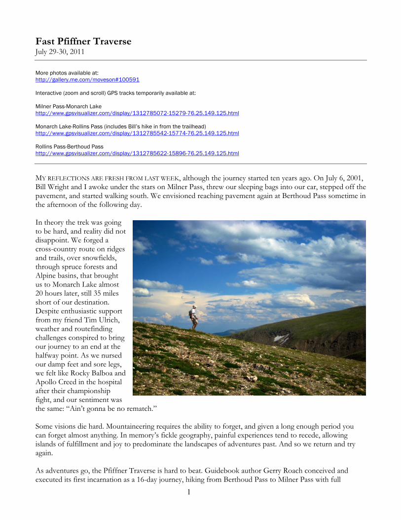
1 Fast Pfiffner Traverse July 29-30, 2011 More photos available at: http://gallery.me.com/moveson#100591 Interactive (zoom and scroll) GPS tracks temporarily available at: Milner Pass-Monarch Lake http://www.gpsvisualizer.com/display/1312785072-15279-76.25.149.125.html Monarch Lake-Rollins Pass (includes Bill’s hike in from the trailhead) http://www.gpsvisualizer.com/display/1312785542-15774-76.25.149.125.html Rollins Pass-Berthoud Pass http://www.gpsvisualizer.com/display/1312785622-15896-76.25.149.125.html MY REFLECTIONS ARE FRESH FROM LAST WEEK, although the journey started ten years ago. On July 6, 2001, Bill Wright and I awoke under the stars on Milner Pass, threw our sleeping bags into our car, stepped off the pavement, and started walking south. We envisioned reaching pavement again at Berthoud Pass sometime in the afternoon of the following day. In theory the trek was going to be hard, and reality did not disappoint. We forged a cross-country route on ridges and trails, over snowfields, through spruce forests and Alpine basins, that brought us to Monarch Lake almost 20 hours later, still 35 miles short of our destination. Despite enthusiastic support from my friend Tim Ulrich, weather and routefinding challenges conspired to bring our journey to an end at the halfway point. As we nursed our damp feet and sore legs, we felt like Rocky Balboa and Apollo Creed in the hospital after their championship fight, and our sentiment was the same: “Ain’t gonna be no rematch.” Some visions die hard. Mountaineering requires the ability to forget, and given a long enough period you can forget almost anything. In memory’s fickle geography, painful experiences tend to recede, allowing islands of fulfillment and joy to predominate the landscapes of adventures past. And so we return and try again. As adventures go, the Pfiffner Traverse is hard to beat. Guidebook author Gerry Roach conceived and executed its first incarnation as a 16-day journey, hiking from Berthoud Pass to Milner Pass with full
Transcript of Fast Pfiffner Traverse - Altervistapbakwin.altervista.org/fkt/OvensonPfiffner2011.pdf · Fast...
1
Fast Pfiffner TraverseJuly 29-30, 2011
More photos available at:http://gallery.me.com/moveson#100591
Interactive (zoom and scroll) GPS tracks temporarily available at:
Milner Pass-Monarch Lakehttp://www.gpsvisualizer.com/display/1312785072-15279-76.25.149.125.html
Monarch Lake-Rollins Pass (includes Bill’s hike in from the trailhead)http://www.gpsvisualizer.com/display/1312785542-15774-76.25.149.125.html
Rollins Pass-Berthoud Passhttp://www.gpsvisualizer.com/display/1312785622-15896-76.25.149.125.html
MY REFLECTIONS ARE FRESH FROM LAST WEEK, although the journey started ten years ago. On July 6, 2001, Bill Wright and I awoke under the stars on Milner Pass, threw our sleeping bags into our car, stepped off the pavement, and started walking south. We envisioned reaching pavement again at Berthoud Pass sometime in the afternoon of the following day.
In theory the trek was going to be hard, and reality did not disappoint. We forged a cross-country route on ridges and trails, over snowfields, through spruce forests and Alpine basins, that brought us to Monarch Lake almost 20 hours later, still 35 miles short of our destination.Despite enthusiastic support from my friend Tim Ulrich, weather and routefinding challenges conspired to bring our journey to an end at the halfway point. As we nursed our damp feet and sore legs, we felt like Rocky Balboa and Apollo Creed in the hospital after their championship fight, and our sentiment was the same: “Ain’t gonna be no rematch.”
Some visions die hard. Mountaineering requires the ability to forget, and given a long enough period you can forget almost anything. In memory’s fickle geography, painful experiences tend to recede, allowing islands of fulfillment and joy to predominate the landscapes of adventures past. And so we return and try again.
As adventures go, the Pfiffner Traverse is hard to beat. Guidebook author Gerry Roach conceived and executed its first incarnation as a 16-day journey, hiking from Berthoud Pass to Milner Pass with full

2
backpacking gear, camping each night and climbing dozens of peaks along the way. His goal was to spend time in the high country, to visit remote areas, and to climb remote mountains along the way. He named his journey the Pfiffner Traverse, in memory of a deceased mountaineering friend who had proposed a similar adventure, and he documented the trip in two popular guidebooks.
A work colleague gave me a copy of Gerry’s Indian Peaks guidebook in the summer of 1994, and the book changed my life. With few exceptions, I had always thought of the mountains as “the mountains” in a sort of collective sense. Gerry’s book opened my eyes to the individual character of each peak, each snowfield, each Alpine route. The entire book enthralled me, but in particular I was drawn to the Pfiffner Traverse.
THE ROUTE IS AWESOME.Trail Ridge Road crosses the Continental Divide at Milner Pass in Rocky Mountain National Park, about 20 miles outside the town of Grand Lake. Sixty miles to the south, U.S. Highway 40 crosses the Divide at Berthoud Pass near the town of Winter Park, south of the Indian Peaks and James Peak Wilderness Areas.Between those two paved highways along the Continental Divide lives a playground paradise of wilderness lakes, granite peaks, and remote, glacier-carved cirques. What is notbetween those two highways
is just as important: No pavement, no motor vehicle crossings, and except in a few concentrated areas, very, very few people.
I loved the route but couldn’t spend weeks away from family and work. In any case, I wanted to avoid overnight gear and camping permits. My vision was a faster Pfiffner. I wanted to see a lot of territory in a single weekend, with no major logistical challenges and no red tape. Fast Pfiffner has a personality of its own, which is to follow the path of least resistance from start to finish. When going is easy on the Divide, Fast Pfiffner stays on the Divide, topping out on whatever summits it finds along the way. When technical challenges make Divide travel difficult, Fast Pfiffner gets off the ridge and finds verdant Alpine meadows and snow-filled basins. And when the terrain conspires to create technical challenge up high and thick, forested bushwhacking at moderate elevations, Fast Pfiffner holds its head high and retreats to the trails, veering many miles from the Divide in favor of consistency of character and ease of use. Getting from Milner to Berthoud with a minimum of trouble is the Fast Pfiffner Philosophy.
“Path of least resistance” is a relative term, and it doesn’t mean something is going to be easy. My hope was that this adventure could be done in a single push—no overnight gear, no stopping to sleep, no heavy support. I dusted off my notes, dug out the maps, and reworked the numbers: The Traverse was 77 miles with 21,500 vertical feet of climbing, and somewhere between 16 and 20 peaks, all of them above 12,000feet and six above 13,000 feet. About 33 miles would be off trail, mainly on talus, tundra, and snow. Of the
3
on-trail miles, about 18 would be covered at night. The vast majority of the route would be above treeline, with an average elevation of about 11,200 feet and a high point of 13,391 feet.
Big adventures call for special skill sets, and Fast Pfiffner is no exception. Luckily for me, this route does not require boldness, technical climbing ability, or foot speed. It does require organizational skills, orienteering and routefinding, relentless forward motion for long distances, resistance to sleep deprivation, ability to move efficiently over rock and tundra, and unquenchable optimism. On top of all that, it would be extremely difficult to finish this route without help from at least a few dedicated friends.
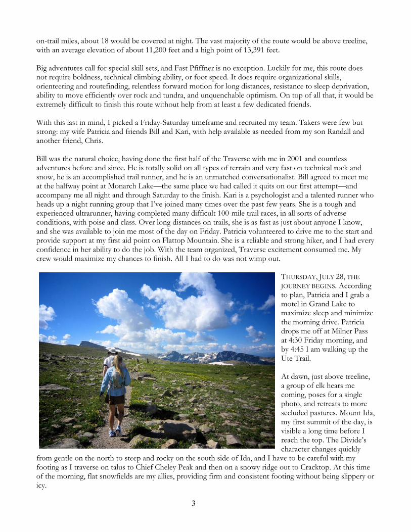
With this last in mind, I picked a Friday-Saturday timeframe and recruited my team. Takers were few but strong: my wife Patricia and friends Bill and Kari, with help available as needed from my son Randall and another friend, Chris.
Bill was the natural choice, having done the first half of the Traverse with me in 2001 and countless adventures before and since. He is totally solid on all types of terrain and very fast on technical rock and snow, he is an accomplished trail runner, and he is an unmatched conversationalist. Bill agreed to meet me at the halfway point at Monarch Lake—the same place we had called it quits on our first attempt—and accompany me all night and through Saturday to the finish. Kari is a psychologist and a talented runner who heads up a night running group that I’ve joined many times over the past few years. She is a tough and experienced ultrarunner, having completed many difficult 100-mile trail races, in all sorts of adverse conditions, with poise and class. Over long distances on trails, she is as fast as just about anyone I know,and she was available to join me most of the day on Friday. Patricia volunteered to drive me to the start and provide support at my first aid point on Flattop Mountain. She is a reliable and strong hiker, and I had every confidence in her ability to do the job. With the team organized, Traverse excitement consumed me. My crew would maximize my chances to finish. All I had to do was not wimp out.
THURSDAY, JULY 28, THE
JOURNEY BEGINS. According to plan, Patricia and I grab a motel in Grand Lake to maximize sleep and minimize the morning drive. Patricia drops me off at Milner Pass at 4:30 Friday morning, and by 4:45 I am walking up the Ute Trail.
At dawn, just above treeline, a group of elk hears me coming, poses for a single photo, and retreats to more secluded pastures. Mount Ida, my first summit of the day, isvisible a long time before I reach the top. The Divide’s character changes quickly
from gentle on the north to steep and rocky on the south side of Ida, and I have to be careful with my footing as I traverse on talus to Chief Cheley Peak and then on a snowy ridge out to Cracktop. At this time of the morning, flat snowfields are my allies, providing firm and consistent footing without being slippery or icy.

4
Between Cracktop and Sprague Mountain lies a long stretch of Alpine-flower-covered, Sound-of-Music terrain. Julie Andrews herself was never in spirits higher than mine. Clear skies, calm winds, and green slopes promise hours of easy-flowing miles. I need these easy miles to flow; the difficult miles will comesoon enough.
From the top of Sprague Mountain I radio Patricia on her way up the Flattop Mountain Trail, with her cargo of water and tasty treats. After cruising over Knobtop Mountain and Ptarmigan Point, I spot her in the distance hiking toward me with Kari...and someone else? I am dismayed at the sight of a third. I had picked my team carefully, since we couldn’t have anyone slowing us down. Getting a bit closer, I recognizethe unexpected guest as Stephanie Ehret. My consternation changes instantly to delight. Steph is a good friend and happens to be one of the most experienced ultra-running women anywhere. Her toughness has been forged by adventures of all kinds around the world. A slice of Pfiffner is right in her sweet spot, and she will not be slowing anybody down, least of all me.
PATRICIA LOADS ME UP with food, water, and dry socks, wishes us good luck, and heads back down towardBear Lake. Kari, Steph, and I turn south and enjoy the downhill trail miles—some of the few we will have all day. At the Lake Nokoni-Lake Nanita Trail we hang a left and start uphill. The trail is maintained up to Nanita, then becomes a faint path as it goes around the lake, disappearing as it ascends into the tundrabeyond. I enjoy playing tour guide, naming the peaks and glaciers for my companions, who have never seenthis remote corner of the Park before. A lone photographer at Lake Nanita bids us good luck. He is the last person Kari and I will see for the next 10 hours.
The basins above Lake Nanita are magical, and we are voluntarily entranced by tiny snowmelt pools below massive granite walls. There is no easy or fast way to get to these high basins—the journey is long by any measure and from any trailhead. We top out in a little pass between Andrews Peak and Mount Alice. On our Pfiffner attempt in 2001, Bill and I had reached this point at 1:59 in the afternoon. The time is now 2:01.There is much rejoicing.
We plunge down toward the trees. The bushwhack into the East Inlet proves no worse than I had remembered.Although we try to descend toward the east, we reach the bottom of the long, brushy slope exactly at Spirit Lake, farther west than I had hoped. It worksfor Steph, though. She takes her leave, trotting 8 miles west down the East Inlet Trail and out to Grand Lake, where she enjoys a hot shower and a real night’s sleep. Kari and I have a little more work to do, so we turn east and south, hike past Fourth Lake and Fifth Lake, then grind up the steep hill to the base of the rugged ridge descending west from the summit of Isolation Peak.
5
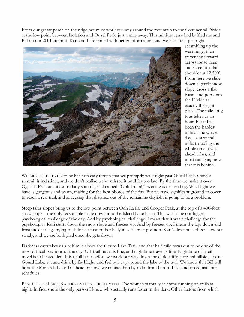
From our grassy perch on the ridge, we must work our way around the mountain to the Continental Divide at the low point between Isolation and Ouzel Peak, just a mile away. This mini-traverse had baffled me and Bill on our 2001 attempt. Kari and I are armed with better information, and we execute it just right,
scrambling up the west ridge, then traversing upward across loose talus and scree to a flat shoulder at 12,500'.From here we slidedown a gentle snow slope, cross a flat basin, and pop onto the Divide at exactly the right place. The mile-long tour takes us an hour, but it had been the hardest mile of the whole day—a stressful mile, troubling the whole time it wasahead of us, andmost satisfying now that it is behind.
WE ARE SO RELIEVED to be back on easy terrain that we promptly walk right past Ouzel Peak. Ouzel’ssummit is indistinct, and we don’t realize we’ve missed it until far too late. By the time we make it over Ogalalla Peak and its subsidiary summit, nicknamed “Ooh La La!,” evening is descending. What light we have is gorgeous and warm, making for the best photos of the day. But we have significant ground to cover to reach a real trail, and squeezing that distance out of the remaining daylight is going to be a problem.
Steep talus slopes bring us to the low point between Ooh La La! and Cooper Peak, at the top of a 400-footsnow slope—the only reasonable route down into the Island Lake basin. This was to be our biggest psychological challenge of the day. And by psychological challenge, I mean that it was a challenge for the psychologist. Kari starts down the snow slope and freezes up. And by freezes up, I mean she lays down and frostbites her legs trying to slide feet first on her belly in self-arrest position. Kari’s descent is oh-so-slow but steady, and we are both glad once she gets down.
Darkness overtakes us a half mile above the Gourd Lake Trail, and that half mile turns out to be one of the most difficult sections of the day. Off-trail travel is fine, and nighttime travel is fine. Nighttime off-trailtravel is to be avoided. It is a full hour before we work our way down the dark, cliffy, forested hillside, locateGourd Lake, eat and drink by flashlight, and feel our way around the lake to the trail. We know that Bill will be at the Monarch Lake Trailhead by now; we contact him by radio from Gourd Lake and coordinate our schedules.
PAST GOURD LAKE, KARI RE-ENTERS HER ELEMENT. The woman is totally at home running on trails at night. In fact, she is the only person I know who actually runs faster in the dark. Other factors from which
6
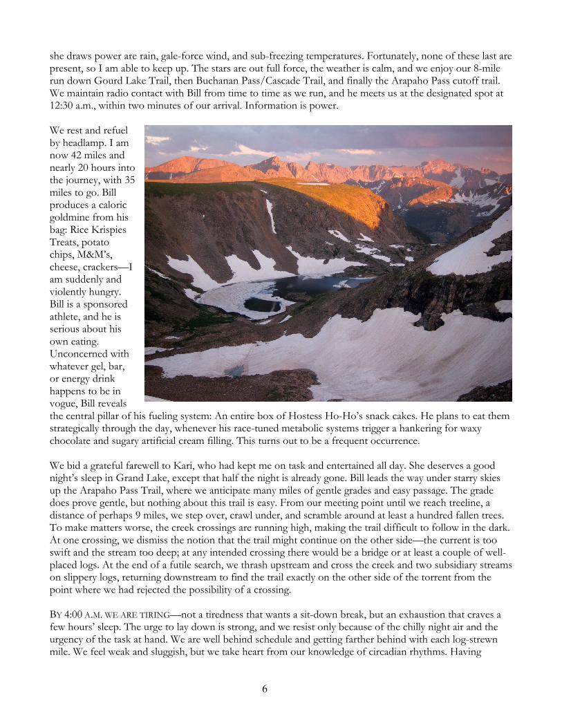
she draws power are rain, gale-force wind, and sub-freezing temperatures. Fortunately, none of these last arepresent, so I am able to keep up. The stars are out full force, the weather is calm, and we enjoy our 8-mile run down Gourd Lake Trail, then Buchanan Pass/Cascade Trail, and finally the Arapaho Pass cutoff trail.We maintain radio contact with Bill from time to time as we run, and he meets us at the designated spot at 12:30 a.m., within two minutes of our arrival. Information is power.
We rest and refuelby headlamp. I am now 42 miles and nearly 20 hours into the journey, with 35 miles to go. Bill produces a caloric goldmine from his bag: Rice Krispies Treats, potato chips, M&M’s, cheese, crackers—I am suddenly and violently hungry.Bill is a sponsored athlete, and he is serious about his own eating.Unconcerned with whatever gel, bar, or energy drink happens to be in vogue, Bill reveals the central pillar of his fueling system: An entire box of Hostess Ho-Ho’s snack cakes. He plans to eat them strategically through the day, whenever his race-tuned metabolic systems trigger a hankering for waxy chocolate and sugary artificial cream filling. This turns out to be a frequent occurrence.
We bid a grateful farewell to Kari, who had kept me on task and entertained all day. She deserves a good night’s sleep in Grand Lake, except that half the night is already gone. Bill leads the way under starry skies up the Arapaho Pass Trail, where we anticipate many miles of gentle grades and easy passage. The grade does prove gentle, but nothing about this trail is easy. From our meeting point until we reach treeline, a distance of perhaps 9 miles, we step over, crawl under, and scramble around at least a hundred fallen trees.To make matters worse, the creek crossings are running high, making the trail difficult to follow in the dark.At one crossing, we dismiss the notion that the trail might continue on the other side—the current is too swift and the stream too deep; at any intended crossing there would be a bridge or at least a couple of well-placed logs. At the end of a futile search, we thrash upstream and cross the creek and two subsidiary streams on slippery logs, returning downstream to find the trail exactly on the other side of the torrent from the point where we had rejected the possibility of a crossing.
BY 4:00 A.M. WE ARE TIRING—not a tiredness that wants a sit-down break, but an exhaustion that craves a few hours’ sleep. The urge to lay down is strong, and we resist only because of the chilly night air and the urgency of the task at hand. We are well behind schedule and getting farther behind with each log-strewnmile. We feel weak and sluggish, but we take heart from our knowledge of circadian rhythms. Having

7
survived all-night adventures in the past, we look forward to sunrise, when our body clocks will at last realign with our unusual version of reality.
Sunrise brings the twin blessings of daylight and treeline. With the deadfall tangle behind us for good, we refuel and climb Arapaho Pass with vigor. Once we reach the pass, we will be on the Continental Divide for the final 25 wonderfully treeless miles of our journey.
Immediately south of Arapaho Pass we encounter the north ridge of Mount Neva, our greatest technical challenge of the day. Bill does the hard work, finding our route along the complicated ridge, and I follow in a sort of haze. I am having a hard time processing thoughts. Climbing the short but exposed crux of the ridge, I say to Bill, “This is borderline irresponsible.” It’s not really a fair statement. I don’t feel as though I would slip, but I am somewhat worried I might do something stupid like forget to take my gloves off or grab a loose block. Bill waits patiently for me at the top of the crux wall. My autopilot climbing instinct remains in working order, and there is no real danger.
Past the difficulties, we enjoy the long, easy ridge to Neva’s summit, and then endure the much longer traverse to Jasper Peak. Travel on rock and tundra is becoming difficult as the accumulated miles—I am now beyond 50 for only the third time in my life—conspire to turn my legs to rubber. My body will enter uncharted territory in several dimensions on this adventure:Most continuous time on my feet, most vertical feet climbed, most hours
moving without sleep, most off-trail miles. I can’t think about Berthoud—it is too far away. The next objective is Rollins Pass, and from Jasper’s summit that should be a reasonable 5-mile stint. But with each mile I feel weaker, and our progress is slowing. What’s left of my rational mind tells me that this cannot possibly work.
Two events cheer us up. First, Chris calls us on the radio. My Spot tracking device had stopped transmitting around 7:00 last evening, and Chris had become worried and driven around to help out in case I needed a rescue. He is with Kari and Steph in Winter Park, many miles away but easily audible on the radio. Chrisasks if he can bring anything to us on Rollins Pass. “Heck yes,” I reply. “How about an Egg McMuffin?”“Make that two,” Bill chimes in. “OK, two Egg McMuffins, copy that. What time are you going to be on Rollins? We’ll try to time it so they’re still warm.”

8
As if this miracle were not enough, we reach Devils Thumb Pass and discover, to our delight, the Corona Trail. It isn’t much more than a footpath, maybe 12 inches wide on average, and somewhat rocky, but it makes all the difference. Travel by trail is tremendously easier than cross country travel over rock and tundra. On trail, you can clearly see and anticipate your next step. This eliminates the tension and uncertainty that comes from spongy, grassy terrain or shifting rocks.In addition, you don’t have to think about where you are going. The trail does the routefinding for you—assuming, of course, that you are on the right trail.Corona in fact is headed our way, and we take full advantage for three miles of chatty, level, low-stress walking. With our legs stretched and rested, we descend the hill to Rollins Pass and see the support vehicle parked at the trailhead. Chris, Kari, and Steph are all there, cheering us on, so we pick up the pace and manage a stiff-legged run-trot for 50 yards, to unanimous approbation.
SEEING FAMILIAR FACES IN THE WILDERNESS can be an intensely emotional experience. In the midst of all that work and wildness and suffering, here are friends who have taken their time, their weekend, to come out and help, for no reason other than they want you to succeed, and they want to be a part of that success.There is no envy here, no competition, no quid pro quo. It is pure service, for no reason other than they want to serve. In a phrase: They get it. Not everyone does. Chris and Kari and Steph irrefutably get it. After seeing this raucous crew, hearing their words of encouragement, and eating a fresh Egg McMuffin, how could I possibly fail? No sooner does the thought cross my mind than I catch myself—it is a dangerous idea. I could fail in a myriad of ways, and I needed to remain alert to that fact. I could get lost or injured or weathered off or attacked by rabid pikas. But in the face of that kind of positive energy, one risk of failure is eliminated. I no longer have the option to quit.
For the first hour out of Rollins things proceed nicely. The weather is holding, the route ahead is obvious, and a visual scan of nearby talus slopes reveals nary a mouth-foaming rodent. The problem—the bigproblem, the only problem—is the vert. Bill and I have just dispatched Sprint and Heartbeat Peaks, a couple of bumps along the Divide south of Rollins Pass, but those are anthills. James Peak looms ahead, and the closer we come, the larger the loom. The steep, 1500-vertical-foot climb from Rogers Pass to James’ summit
9
would be unremarkable in ordinary circumstances. But this climb will start 66 miles and nearly 32 hours into my trek. Assuming we make it up James, we will have five additional peaks to climb, with vertical gain between 400 and 750 feet each. The numbers are discouraging. I am so very ready to be done, and we are sonot nearly there.
On the plus side, we locate a good trail leading along the north ridge of James Peak. My friend Dan calls on the radio from Berthoud Pass, and our chat boosts my morale. But nothing can be done about the climb, and when it starts, it refuses to quit. The slopes steepen, and trail or no, the climb seems endless. To make matters worse, we encounter hikers, most of them headed down. My glazed eyes and halting upward stepsmust look pitiful, because I get lots of concerned glances. This is perhaps the only time during the entire Traverse during which I feel I would rather be somewhere else. At some point past frustration and well into misery, but short of despair, the slopes flatten out, and suddenly we are on top among the largest group of people we have seen all day. There must be a crowd of ten milling around up here.
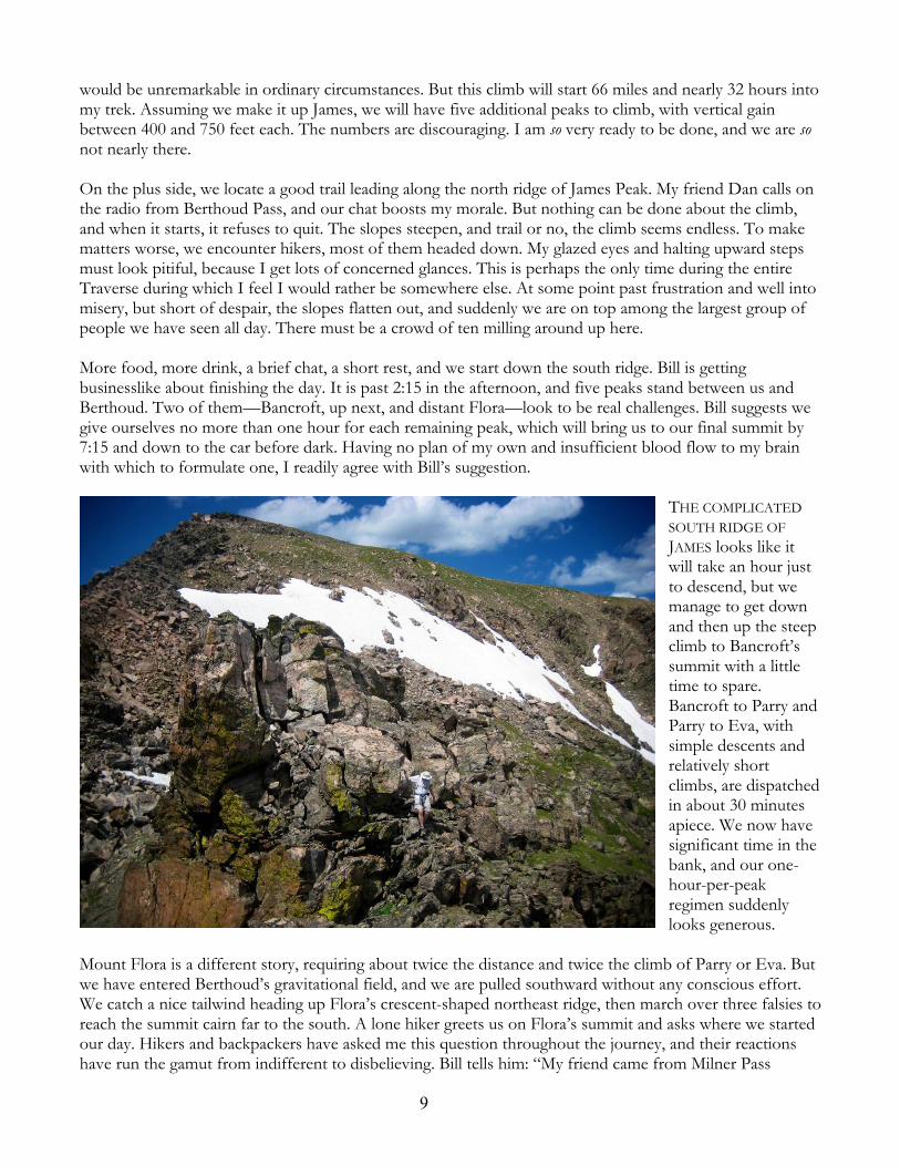
More food, more drink, a brief chat, a short rest, and we start down the south ridge. Bill is getting businesslike about finishing the day. It is past 2:15 in the afternoon, and five peaks stand between us and Berthoud. Two of them—Bancroft, up next, and distant Flora—look to be real challenges. Bill suggests we give ourselves no more than one hour for each remaining peak, which will bring us to our final summit by 7:15 and down to the car before dark. Having no plan of my own and insufficient blood flow to my brain with which to formulate one, I readily agree with Bill’s suggestion.
THE COMPLICATED
SOUTH RIDGE OF
JAMES looks like it will take an hour just to descend, but we manage to get downand then up the steep climb to Bancroft’s summit with a littletime to spare.Bancroft to Parry and Parry to Eva, with simple descents and relatively short climbs, are dispatchedin about 30 minutes apiece. We now have significant time in the bank, and our one-hour-per-peak regimen suddenly looks generous.
Mount Flora is a different story, requiring about twice the distance and twice the climb of Parry or Eva. But we have entered Berthoud’s gravitational field, and we are pulled southward without any conscious effort.We catch a nice tailwind heading up Flora’s crescent-shaped northeast ridge, then march over three falsies to reach the summit cairn far to the south. A lone hiker greets us on Flora’s summit and asks where we started our day. Hikers and backpackers have asked me this question throughout the journey, and their reactions have run the gamut from indifferent to disbelieving. Bill tells him: “My friend came from Milner Pass

10
yesterday morning.” The hiker’s reaction is immediate and unconstrained. “No way. Awesome! What an achievement! You should be so pleased and proud!”
He speaks as though we have finished, and looking ahead, that’s not far from true. Colorado Mines Peak isnow clearly in view, less than two miles away. The mood becomes a little bit festive as we descend a good trail. Since James Peak our conversation had centered on time schedules, mileages, and elevation numbers; now it falls back into a natural banter. The hiker from Mount Flora has flipped a switch in my brain. Fast Pfiffner is as good as finished, and for the first time I allow myself to think about the significance of the event.
THIS IS MY 18TH SUMMER climbing, hiking, and running in Colorado.During that time I’ve had the privilege to participate in some grand mountain adventures with wonderful partners.But each adventure of any significancehas, to some extent, followed somebody else’s script. I’ve been a performer, and I’ve even done some ad-libbing on stage. Today, in a smallbut meaningful way, I became a screenwriter. So far as I can tell, I am the only person in the world to have done this thing, and to a sizable group of like-minded people, it is a thing of significance. Fast Pfiffner is my creation. When I reach Berthoud Pass, my creation will gain the spark of life.It is a monster route. Perhaps Fast Pfiffner will outlive me.
As we coast down the slopes of Flora, I try to voice these thoughts to Bill, but I’m choking on emotion and the words are barely recognizable. He stops in the trail and we embrace. Billknows what I am feeling, and he could not possibly be more pleased for me.He is psyched to have played a vitalrole in my success, and because of his selfless service, my success becomes his success as well. Bill gets it.
THE FINAL CLIMB to the summit of Colorado Mines Peak is surreal. My balance is trashed. I reach out for a rock to steady myself but something isn’t working; my hand whiffs past the intended support point and I stumble. My fingers and elbows have become hypersensitive; the smallest bump or tap sets the hapless nerves to buzzing and prickling. I stub my toe on a rock and feel a blister burst in a tiny explosion of pain.None of it matters. Nothing can wipe the grin off my face. Bill respectfully steps aside and lets me lead the way up the last gentle slope to the top of Colorado Mines Peak, my 18th summit since leaving the road at Milner Pass a day and a half ago.

11
Berthoud Pass is along mile away down a dirt service road. We are tired to the core, yet the most fitting mode of travel seems to be a trot. Our Fast Pfiffner isn’t all that fast by any objective standard, but it seems proper to produce the illusion of speed so as to enhance our final memories of the adventure. The road is smooth and points downhill. It turns out to be the shortest long mile of the day.
Ten years ago, Bill and I stepped off the pavement and into the wilderness at Milner Pass. Some of the journey over that decade has been pretty rocky. Some years we’ve navigated separate courses; other times our paths have crossed or continued in sync for miles before diverging again. Today we run side by side.The service road comes to an end and our trot slows to a walk. At the base of Colorado Mines Peak, weleave the wilderness and cross back over into civilization. Berthoud Pass welcomes us, and we step onto the pavement, together.
Mark OvesonLouisville, Colorado, August 2011
Fast Pfiffner Statistics:76.7 miles, 21,500' vertical ascent, 37 hours 44 minutes pavement to pavement
The Peaks:
Peak Name Elevation Peak Name ElevationMount Ida 12,880' Jasper Peak 12,923'Chief Cheley Peak 12,804' Sprint Peak 12,110'Cracktop 12,760' Heartbeat Peak 12,251'Sprague Mountain 12,713' James Peak 13,294'Knobtop Mountain 12,331' Mount Bancroft 13,250'Ptarmigan Point 12,363' Parry Peak 13,391'Ogalalla Peak 13,138' Mount Eva 13,130'Ooh La La! 12,945' Mount Flora 13,132'Mount Neva 12,814' Colorado Mines Peak 12,493'