Farsley is a place of special character and This appraisal and ... Conservation Area...
26
1 Farsley CONSERVATION AREA APPRAISAL AND MANAGEMENT PLAN Farsley is a place of special character and historic interest. This appraisal and management plan sets out the features that contribute to its distinctiveness and identifies opportunities for its protection and enhancement. Approved as a material consideration in the determination of planning decisions—17th May 2010.
Transcript of Farsley is a place of special character and This appraisal and ... Conservation Area...

1
Farsley C O N S E R V A T I O N A R E A A P P R A I S A L A N D M A N A G E M E N T P L A N
Farsley is a place of special character and historic interest.
This appraisal and management plan sets out the features that contribute to its
distinctiveness and identifies opportunities for its protection and
enhancement.
Approved as a material consideration in the determination of planning decisions—17th May 2010.

2
Summary of Special Interest Farsley is a village steeped in history, much of which can be tied into to the development of Leeds. The Medieval village developed first into one of the most important cloth producers in the Leeds area, the prosperity of which allowed Farsley to be heavily influenced by the later industrialisation of Britain. By embracing the industrial revolution the 19th century people of Farsley left a legacy of imposing and important buildings which shape the important character which we see today. Industrial complexes, terrace rows, religious architecture and large detached houses all stand side-by-side, reminding all that Farsley didn’t simply grow in the 19th century, it exploded into the large thriving place which we see today. Today Farsley’s important industrial heritage is still clearly visible on the ground. This combined with the landscape setting helps Farsley retain its independence from its surroundings, despite being now physically connected to surrounding settlements.
Summary of Issues Farsley is a locality of both architectural and historic interest which is worthy of conservat ion area status. The c o n s e r v a t i o n a r e a h a s b e e n detrimentally affected in the past by
some inappropriate development and therefore there is a need for guidance to preserve and enhance the area. The protection and enhancement of the special character of the conservation area depends on positive management. The following key issues have been identified;
• Inappropriate infill development. Subdivision of sites and the consequent infill with properties which do not always reflect the historic context of Farsley are common in the conservation area. • Incremental loss of character on
terrace rows. Farsley has many historic terrace properties in important locations which add character to the conservation area. The incremental loss/change of detailing on these rows, usually due to the installation of UPVC doors and windows, can result in the loss of character to the row as a whole, and in turn impact negatively on the conservation area • Inconsistent public realm and
street surfacing. Where surviving, the historic street surfacing adds a great deal to the character and appearance of Farsley. Elsewhere, the inconsistent treatment of surfacing, and also public realm and street furniture, has a negative impact on the conservation area.
Aerial view of the Farsley conservation area
Old Road
West Royd Park
The Cenotaph
Springfield Mills
Town Street

3
Extent of the conservation area This conservation area review for Farsley closely follows the framework for an appraisal in the English Heritage document ‘Guidance on conservation area appraisals’ published in 2006. The survey work was carried out between September and December 2009. Cur ren t gu idance s ta tes tha t conservation area boundaries must be clearly based on analysis of the architectural and historic character of the area. For this reason any boundary must follow the lines of the character areas defined in this appraisal. It would not be acceptable to include one part of a given character area and not another. Inclusion of a character area within the conservation area must depend on an analysis of its historic importance and significance in the streetscape. With this in mind the conservation area boundary has been reviewed to include areas of special architectural and historic interest. Farsley’s history began as an independent settlement, the character of which has been retained. Many of the features of the conservation area’s long history are apparent today and are enough in number to dominate their s u r r ound i ng s and en su r e i t s independence.
This appraisal shows why Farsley has a special character and appearance that merited designation as a conservation area on 12th July 1987 and its subsequent review on 19th April 2010.
The Bagley area contains some buildings extremely important to the character and history of Fars-ley, including Springfield Mills.
___ Extent of the proposed Farsley Conservation Area
This map is reproduced from Ordnance Survey material with the permission of Ordnance Survey on behalf of the Controller of Her Majesty’s Stationery Office © Crown copyright. Unauthorised reproduction in-fringes Crown copyright and may lead to prosecution or civil proceedings. (100019567) 2009
The Marsden Memorial Garden is a key green space within the con-servation area of Farsley

4
Assessing the Special Interest Location and Setting Farsley is located approximately 12.5 km (7.5miles) west of Leeds city centre. The area is most readily accessed via the A657 from the north, and the A647 from the east and west. It is located within the Leeds district boundary and is within the Farsley and Calverley Ward. General character and plan form Farsley appears to have originated as a nuclear settlement based around what is now Town Street with the major junctions of the village being formed with Water Lane, Town Street and Back Lane. Throughout the 19th century the development became more linear, with initial development stretching north and south along Town Street and Old Road. The spread of development from this area has slowly encroached on settlements which were once removed from the main core, with Farsley now being physically connected to Bagley and Stanningley. The buildings of the conservation area strongly inform its character by establishing it as a historic area, but the heavy vehicular use of the village impacts greatly. The village has local amenities with pedestrians being present throughout much of the day.
This is complemented by the historic architecture and layout of the village centre, but unfortunately the character is dominated by the heavy road use of the area. Geology, topography and landscape setting The conservation area in Farsley is located on the south side of the Aire Valley. It lies on the valley slope between 88 and 133 metres above sea level on land which increases in height from north to south. Important views towards the northern slope of the Aire Valley, and to the higher reaches of the southern slope, are important features of the natural environment. Much of Farsley is located upon sandstone and lower coal measures. The local quarries and coal pits helped to shape the appearance of Farsley, with most of the buildings constructed of “Stanningley Rock” (a soft sandstone) which was quarried locally. The Aire Valley landscape setting allows Farsley to retain a strong level of independence from its surroundings. Being set up upon the valley slope allows key views of adjacent areas. The undulating road network also adds interest to the area.
This map is reproduced from Ordnance Survey material with the permission of Ordnance Survey on behalf of the Control-ler of Her Majesty’s Stationary Office © Crown copyright. Unauthorised reproduc-tion infringes Crown copyright and may lead to prosecution or civil proceedings. (100019567) 2008
Sandstone
Millstone grit and lower coal measures
This map is reproduced from Ordnance Survey material with the permission of Ordnance Survey on behalf of the Control-ler of Her Majesty’s Stationery Office © Crown copyright. Unauthorised reproduc-tion infringes Crown copyright and may lead to prosecution or civil proceedings. (100019567) 2009
Farsley in its wider context
This map is reproduced from Ordnance Survey material with the permission of Ordnance Survey on behalf of the Control-ler of Her Majesty’s Stationery Office © Crown copyright. Unauthorised reproduc-tion infringes Crown copyright and may lead to prosecution or civil proceedings. (100019567) 2009
5
Origins and Evolution The Medieval origins of Farsley The first documentary reference to Farsley is in the Domesday Book of 1086, at which time it was part of the Manor of Calverley and Farsley. The place name is thought to have Anglo-Saxon origins and is usually interpreted as ‘furze clearing’. As Farsley was conjoined with Calverley, the people of Farsley used St Wilfrid’s Church at Calverley, which is thought to date back at least to the 12th century. From examination of the 1st edition OS map of 1848 and the Tithe Award Map of 1846, it is possible to suggest that settlement in medieval Farsley centred around the area where Back Lane and Water Lane now meet Town Street. Linear development then appears to have occurred along what is now Old Road/Town Street/Calverley Lane from the 18th century onwards. To the south of the conservation area is Owlcotes deserted medieval hamlet, which provides important evidence for medieval settlement around Farsley. All the buildings at Owlcotes were demolished during the first half of the 20th century, but the site remains a Scheduled Ancient Monument. There is also a possibility that a medieval settlement existed in the Bagley area of Farsley, due to it
appearing as a personal name in the 1379 Poll Tax returns. Evidence for settlement around Farsley in the medieval period is also found at Wadland’s Farmhouse and Wadland’s Cottage to the northwest of the conservation area, once known as Wadland’s Hall. A large timber-framed aisled barn once existed here that was thought to date to the late 15th century. Unfortunately, despite being a Grade II* Listed Building, the barn was demolished in the 1980s. It is thought that Wadland’s Hall may not be complete, and that the large 19th century block adjoining the 18th century house may have replaced a medieval house that originally stood there. It is thought that both the barn and the house may have been associated with a manorial complex. The industrial expansion of Farsley The most defining period in Farsley’s history comes with the industrialisation of the village. Whilst the making of woollen cloth was already the most important industry in the area, the early 19th century industrialisation of the textile industry had a major impact on the village. Formerly, self-employed hand-loom weavers would create their cloth to sell in central Leeds. Some of the former three-storey weaving cottages are still visually dominant buildings in the conservation area. By the late 1700s machinery had begun to be introduced to this home industry. The Gaunt and Hainsworth families were most in f luent ia l i n the
Historic cottages in Bagley are some of the earliest buildings in Farsley and indicate the likeli-hood of a medieval settlement in the area.
The junction of Town Street and Back Lane is likely to be a part of the medieval nucleated settle-ment of Farsley.
John Warburton’s map of 1720 highlights that even in the early 18th century Farsley was still relatively undeveloped.

6
development of this aspect of the area. Mills in Farsley and Bramley were often initially built by them, with many passing between the hands of subsequent generations of the families. Sunnybank and Springfield Mills the are still in existence in the conservation area, though are no longer used for textile production. The buildings of these mills are characteristic of this important part of Farsley’s history. Springfield Mills was constructed by Reuben Gaunt in 1864 and was devoted to the spinning of fine yarns from merino wool imported from Australia and South Africa. Sunnybank Mill though is by far the most visually dominant mill in Farsley. Located just north of the village centre this company mill was constructed in 1832 and underwent vast expansion whilst still in use as a mill. Whilst neither Springfield or Sunnybank Mills are engaged today in the manufacture of cloth, the mills themselves are a distinct reminder of Farsley’s industrial boom. Whilst many of the mils may have been pulled down or turned to different uses the terrace housing which was constructed for the workers still dominates large parts of the conservation area. The first example of this was in 1841 with John Hainsworth’s planned street layout and sale of land which led to the development of Ebenezer Street, North Street, Well Street and East Street. The increased prosperity in the area can be seen with the construction of high
status housing along New Street. The wealthy mill owners were also instrumental in the construction of much of the more prominent architecture in central Farsley today. Increased prosperity led to the construction of schools and political Liberal and Conservative club-houses, and together with the terrace rows, detached housing, mills and religious buildings the face of Farsley changed drastically from a prosperous clothing vi l lage to a thriving industrial settlement. Religious influence in Farsley Religion played a very prominent role during the 18th and 19th century development of Farsley. As the village was only one mile from the Parish Church at Calverley the construction of its own church came quite late (1842).
The Sunnybank company mill (built 1832) was one of the earli-est large scale industrial mills in a village that had always played a large part in the cloth making industry of Leeds.
The development of terrace rows to house the increasing popula-tion is a key remnant of Farsley’s industrial past.
ABOVE The first edition Ordnance survey of 1847 shows Farsley to still be a quite nucleated settlement with early signs of large scale in-dustrialisation.
7
The Baptist Chapel (later renamed the Rehobeth Baptist Chapel) was possibly the first religious building constructed in Farsley, and dates from 1777. Along with the Baptists there was the non-conformist Methodist Church. All of these re l i g ious denominat ions influenced the appearance of central Farsley in the 19th century with a Baptist Chapel being constructed in 1866, two Methodist Chapels (the 1844 Methodist Chapel replacing the earlier 1824 building) and the Wesleyan Methodist Chapel in Town Street (1868). Such a high concentration of religious structures in the village centre highlights the importance of religion in the area. The construction of the 1842 St John’s Church in Farsley was due to St Wilfrid’s Church in Calverley not being able to cope with the rising population levels, and also due to the fear of the strength of non-conformity within the village. Modern day Farsley The increase in industrial prosperity was the main factor for the rapid increase of population in Farsley throughout the 19th century, which increased by almost five times to 5,500 by 1901. Farsley officially became a parish in its own right in 1844, and became an urban district in 1894. In 1937 it was annexed by the Borough of Pudsey which in 1972 was itself annexed by Leeds.
Following the impact of industrialisation throughout the 19th century Farsley has gradually been consumed in the 20th century by suburban development. The fields which once surrounded the village are now covered in housing which physically links this once independent place with the neighbouring settlements of Stanningley and Rodley. Farsley though, due to i t s h i s tor i ca l
The former Rehobeth Baptist Chapel (1777) is Farsley’s oldest remaining religious building.
Increased prosperity in the area led to construction of high status housing alongside the terrace rows, such as here on Calverley Lane.
By the time that the third edition Ordnance Survey map was pro-duced (1908) Farsley had undergone massive expansion, the most significant elements of which were the development of industrial mill complexes, and associated worker’s housing.
8
Character Analysis Spatial Analysis Settlement form Central Farsley is now a principally linear settlement focussed along Town Street and Old Road. The village originated in a nuclear settlement around Town Street and Water Lane, but later developed into a linear ribbon development following the introduction of mill complexes to the north and south of this area. Industrial sites and planned terraces made the central nuclear settlement less dominant, resulting in the form of the Farsley we see today. Character of Spaces The high density terrace rows and back of pavement location of many properties give a sense of enclosure to much of the Farsley Conservation Area. This contrasts sharply with the wider and more open feel of New Street and Old Road. The wide Town Street has an open feel. The interaction of this space with views towards Sunny Bank Mills and the north side of the Aire Valley allow this open character to be further reiterated. This open feel becomes more prominent the further north you travel, with the area around the cenotaph, Bagley Lane, and then Bagley itself all having an open, almost rural, feel.
Key views Significant views within and out of the conservation area are shown on the map (right). Long views towards the Aire Valley to the north give a sense of elevation. Enclosed views dominate much of the conservation area. The high density terrace housing restricts views due to their grid like layout, whilst the industrial areas, particularly Sunnybank Mills, are significant focal points which aid orientation around the area. Activity and grain Town Street/Old Road is a major thoroughfare north-south and as such is heav i ly used. With industr ia l , commercial and residential premises all being located in the conservation area there is a heavy vehicular and pedestrian movement, particularly in central Town Street and the junction of Town Street with Bagley Lane. The conservation area has a very mixed grain. The terrace properties have a very uniform and fine grain, whilst the more piecemeal development of the industrial sites and central Farsley are more loose grain due to their inconsistent layout, scale and the size of property boundaries within which they are placed. This mixed grain is important to the character of Farsley as it emphasizes its gradual historic development.
___
Long distance views along Town Street towards the other side of the Aire Valley are key to the landscape setting of Farsley
This map is reproduced from Ordnance Survey material with the permission of Ordnance Survey on behalf of the Control-ler of Her Majesty’s Stationery Office © Crown copyright. Unauthorised reproduc-tion infringes Crown copyright and may lead to prosecution or civil proceedings. (100019567) 2009

9
Character Analysis Built Environment Architectural characteristics Fa r s l e y exh ib i t s a r ch i t e c tu ra l characteristics that reflect its piecemeal development. Although the palette of building materials remains reasonably consistent the structures themselves are varied. This variety is a dominant fea ture w i th in Fars ley ’ s bu i l t environment. This includes 18th century weaver’s housing, 19th century terrace rows, ecclesiastical buildings, club buildings, industrial complexes, and detached domestic housing. Each of these have their own characteristics which add value to the conservation area. Domestic or commercial buildings are predominantly of two to four storeys in height, with full-height gables and roof pitches between about 35o-45o. Regular fenestration patterns give a clear sense of unity to terraced and street fronted facades. Historic club buildings, religious buildings, industrial complexes and educational buildings are all very conspicuous within the conservation area, yet it is the terraced and retail buildings that dominate much of the conservation area.
Materials Farsley is located on sources of sandstone and millstone grit which were understandably employed for the construction of most buildings. Up until the 20th century stone quarrying would have been a major industry within the Farsley area, with Stanningley’s main quarry running throughout the 20th century. The dominant roof materials are heavy stone slate and Welsh slate. This variation of traditional material adds interest to the roofscape. Local details Farsley developed mostly during the industrial revolution of the 19th century. Much of the domestic architecture is of a working class nature, i.e. plain and functional. This in turn means that this architecture does not have any details that can be classed as characteristic to the area. Farsley has a high retention of large industrial mill buildings, though they no longer have a heavy industrial use. The intact form of Springfield and Sunnybank Mills are characteristic to the appearance of the conservation area, and are unusual in a location with a high level of 20th century development. S t r u c t u r e s o f a c ommer c i a l , ecclesiastical, club or higher status domestic nature have an increased level of ornate detail. This detail is of interest to the conservation area, however none of the details are peculiar to Farsley.
Terrace rows dominate large parts of the conservation area. Tradi-tional coursed sandstone, Welsh slate and chimney stacks and pots are important characteristics of a terrace row.
Sunnybank Mill is an important historic structure in the Farsley Conservation Area.
Political club-houses, such as the late 19th century Liberal Club are very conspicuous in the con-servation area.

10
Streetscape and public realm The streetscape in Farsley is particularly strong in the areas of terrace properties. The formal and regimented layout of the terrace rows creates a streetscape that is full of interest. The less formal New Street and Bagley Lane with their associated buildings on the whole lack the strong impression which is gained from the terrace areas. The streetscape is further complemented by glimpses to the other side of the Aire Valley particularly. There is a distinctive streetscape within the Farsley Conservation Area. Features which are important include; • Strong boundary treatments,
particularly stone walls and mature hedgerows
• Back-of-pavement edge location of some properties which establishes a strong boundary to the road.
• Mature trees interspersed with the properties add important variation.
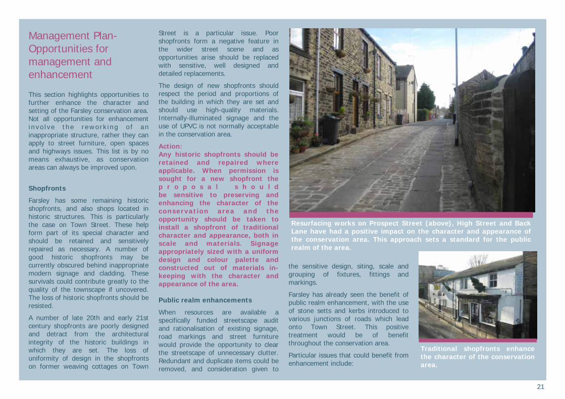
The public realm on the whole lacks distinctiveness, yet retains some traditional elements which complement the conservation area greatly. Historic signage is present on many terraces, though is in need of repair in many cases. Stone kerb stones are present along much of Town Street and again add to the surviving historic character as a whole. The majority of surfacing is
asphalt. Street lighting and traffic signage is generic and adds very little to the appearance of the conservation area. Some resurfacing works with stone flags and setts on High Street, New Street and Back Lane at their junctions with Town Street has improved the character and appearance of central Farsley. There is scope for similar work elsewhere in Farsley Greenscape The greenscape of Farsley is dominated by West Royd Park which has a key role in terms of public recreation and amenity. Links and access into this park are available from an assortment of locations, but the main access is from New Street. Expansive views of the Park, or glimpses into it, are prominent along New Street. Other green spaces include the Baptist burial ground on Coal Hill Lane (technically just in Bramley Parish), St John’s Churchyard and the Recreation Ground on Calverley Lane. All of these areas add variety to the environment around, particularly those close to the high density housing of the terrace and back-to-back groups.
West Royd Park is the most im-portant green space in a village which on the whole is made up of high density housing.
Sympathetic street surfacing on Back Lane improves the charac-ter and appearance of Farsley, and should employed where pos-sible elsewhere in the conserva-tion area
Dominant buildings and stone boundary walls enclose the streetscape around much of Farsley.

11
Character Analysis Character Areas There are sub-areas within the proposed conservation area known as “character areas”, the boundaries of which are often blurred but nonetheless have distinct qualities. The areas have different spatial characters and distinct form and functions generated by their uses. Unifying the character areas is a shared sense of history and connectivity to one another. Farsley Conservation Area is not a uniform area. As set out earlier, it developed at different periods in history and contains different types of buildings and spaces. Seven character areas have been i den t i f i ed w i t h i n t he Fa r s l e y Conservation Area. They are; • Character area 1 - The Historic Core • Character area 2 - The Cenotaph • Character area 3 - Bagley • Character area 4 - N e w S t r e e t t e r r a c e development • Character area 5 - Sunnybank Mills • Character area 6 - Low Bank development • Character Area 7 - West Royd Park
Positive buildings On the individual character area maps buildings coloured blue make a positive contribution to the character of the area. This contribution may be in one or more of the following ways: • Landmark buildings • Buildings which provide evidence of
the area’s history and development • Buildings of architectural merit • Buildings with local historical
associations • Buildings which exemplify local
vernacular styles • Groups of buildings which together
make a positive contribution to the streetscape
There should be a presumption in favour of the retention of positive structures in all but exceptional circumstances.
This map is reproduced from Ordnance Survey material with the permission of Ordnance Survey on behalf of the Control-ler of Her Majesty’s Stationery Office © Crown copyright. Unauthorised reproduc-tion infringes Crown copyright and may lead to prosecution or civil proceedings. (100019567) 2009
Character area 4 is made up al-most exclusively of 19th century terrace rows.
2
1
6
5
3
7 4
1
2
3
4
5
6
7
Farsley Conservation Area Character Areas
12
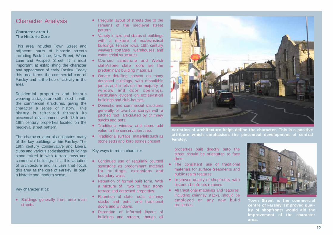
Character Analysis Character area 1- The Historic Core This area includes Town Street and adjacent parts of historic streets including Back Lane, New Street, Water Lane and Prospect Street. It is most important at establishing the character and appearance of early Farsley. Today this area forms the commercial core of Farsley and is the hub of activity in the area. Residential properties and historic weaving cottages are still mixed in with the commercial structures, giving the character a sense of history. This history is reiterated through its piecemeal development, with 18th and 19th century properties located on the medieval street pattern. The character area also contains many of the key buildings within Farsley. The 19th century Conservative and Liberal clubs and various ecclesiastical buildings stand mixed in with terrace rows and commercial buildings. It is this variation of architecture and its uses that focus this area as the core of Farsley, in both a historic and modern sense. Key characteristics: • Buildings generally front onto main
streets.
• Irregular layout of streets due to the remains of the medieval street pattern.
• Variety in size and status of buildings with a mixture of ecclesiastical buildings, terrace rows, 18th century weavers cottages, warehouses and commercial structures.
• Coursed sandstone and Welsh slate/stone slate roofs are the predominant building materials
• Ornate detailing present on many detached buildings, with monolithic jambs and lintels on the majority of window and door openings. Particularly evident on ecclesiastical buildings and club-houses.
• Domestic and commercial structures generally of two–four storeys with a pitched roof, articulated by chimney stacks and pots.
• Traditional window and doors add value to the conservation area.
• Traditional surface materials such as stone setts and kerb stones present.
Key ways to retain character: • Continued use of regularly coursed
sandstone as predominant material for buildings, extensions and boundary walls.
• Retention of formal built form. With a mixture of two to four storey terrace and detached properties.
• Retention of slate roofs, chimney stacks and pots, and traditional doors and windows.
• Retention of informal layout of buildings and streets, though all
properties built directly onto the street should be orientated to face them.
• The consistent use of traditional materials for surface treatments and public realm features.
• Improved quality of shopfronts, with historic shopfronts retained.
• All traditional materials and features, including chimney stacks, should be employed on any new build properties.
Town Street is the commercial centre of Farsley. Improved qual-ity of shopfronts would aid the improvement of the character area.
Variation of architecture helps define the character. This is a positive attribute which emphasises the piecemeal development of central Farsley.

13
This map is reproduced from Ordnance Survey material with the permission of Ordnance Survey on behalf of the Control-ler of Her Majesty’s Stationary Office © Crown copyright. Unauthorised reproduc-tion infringes Crown copyright and may lead to prosecution or civil proceedings. (100019567) 2009
Variation in scale, but with the consistent use of traditional ma-terials, gives central Farsley a strong character that should be retained.
A change in street level adds in-terest to the streetscape of the character area.
The listed former School House and St John’s Church are impor-tant historic buildings in the conservation area which are valuable to the streetscape and as landmark buildings.
This map is reproduced from Ordnance Survey material with the permission of Ordnance Survey on behalf of the Control-ler of Her Majesty’s Stationery Office © Crown copyright. Unauthorised reproduc-tion infringes Crown copyright and may lead to prosecution or civil proceedings. (100019567) 2009

14
Character area 2- The Cenotaph This character area forms a key gateway into central Farsley. The area was once called “The Green” and houses the cenotaph, which is one the village’s key landmarks. This area comprises High Street, part of Bagley Lane, the recreation ground and Bryan Street, all of which are located around the cenotaph monument. Activity in the area is heavily vehicular, though the presence of housing and commercial buildings ensures that pedestrian activity takes place also. Key characteristics: • Buildings generally face the main
streets. • Variation of types of properties,
including detached farm buildings, terrace rows and the former Baptist Sunday School.
• Coursed sandstone and Welsh slate/stone slate roofs are the predominant building materials.
• Ornate detailing present on many buildings. Monolithic jambs and lintels present on the majority of window and door openings. A common feature is the use of decorative stone door hoods on many terrace properties.
• Domestic structures generally two storeys with a pitched roof with chimney stacks.
• Strong and traditional boundary treatments, particularly tall stone
walls, mature hedgerows and cast iron railings.
• Trees and greenery make an important contribution to the area. The greenspace around the cenotaph, mature trees and soft boundary treatments are all positive characteristics.
Key ways to retain character: • Continued use of regularly coursed
sandstone as predominant material for buildings, extensions and boundary walls.
• Use of traditional materials and architectural details identified in key characteristics on all new build properties (such as chimneys).
• Retention of formal built form, with a mixture of terrace and detached properties.
• Retention of original plot sizes, with subdivision of plots avoided.
• Retention of slate roofs and chimneys.
• Retention of formal layout of buildings, though all properties built adjacent onto the street should be orientated to face them.
• Retention and reinforcement of fine grain of built form.
• Retention of mature gardens and traditional boundary treatments, particularly hedgerows and stone walls..
• Retention of open green areas and mature trees. The cenotaph area is an impor-
tant gateway into central Farsley. Terrace properties on the corner of Preisthorpe Road and Calver-ley Lane are quite ornate.
This map is reproduced from Ordnance Survey material with the permission of Ordnance Survey on behalf of the Control-ler of Her Majesty’s Stationery Office © Crown copyright. Unauthorised reproduc-tion infringes Crown copyright and may lead to prosecution or civil proceedings. (100019567) 2009
15
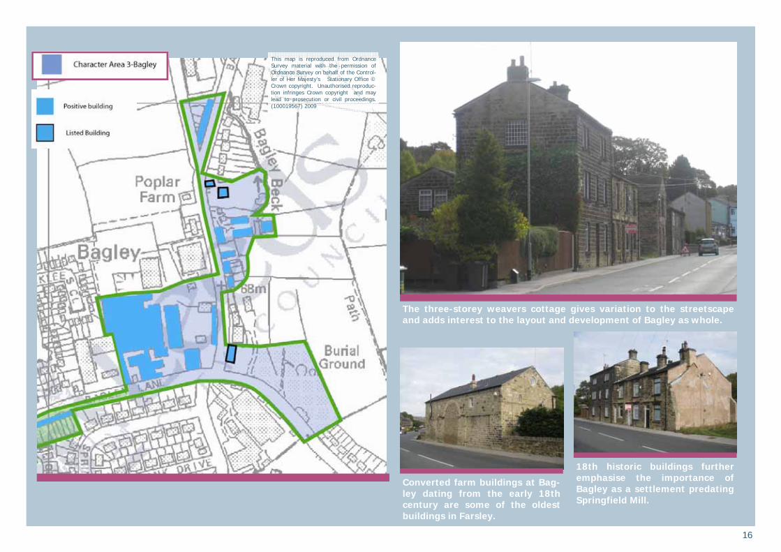
Character area 3- Bagley Bagley was once a small settlement independent from Farsley village. There is a high concentration of historic buildings, many very significant to the development of the area. Bagley probably first began life as a farming community with the early 18th century listed farmhouse testament to this. Later weaver’s cottages were built as well as the significant Rehobeth Baptist Chapel in the late 18th century, which is Farsley’s first known religious building. The most significant development for Bagley came with the development of mills. The surviving Springfield Mills (1864) are significant evidence of the industrial boom that took place in Farsley, largely reshaping the village. The variation of buildings means that there are many characteristics which contribute to the character area. Each type of structure and its positive characteristics are outlined below; Springfield Mills; • Variation of building types
including two-storey terrace rows and very large industr ia l properties.
• Consistent use of coursed sandstone and traditional roofing materials.
• Loose grain built form. • Character and appearance of an
industrial complex.
Detached farm buildings and weavers cottages; • Simple coursed sandstone
construction and traditional roofing materials.
• Two-three storeys • Varying orientation Terrace rows; • Two-storey eaves height. • Regularly coursed sandstone with
stone slate or welsh slate roofing material.
• Fine grain built form. • Orientated to face the road. • Quite ornate, employing door
hoods and monolithic lintels. Key ways to retain character: • Use of regularly coursed sandstone
as the predominant walling material. • Retention of variation in the built
environment. • Retention of prominent industrial
buildings, especially as many other industrial structures have been lost to redevelopment.
• Retention of slate roofs and chimneys.
• Retention of informal layout of buildings, though all properties built directly onto the street should be orientated to face them.
• Avoidance of plot subdivision and cul-de-sac type of development.
Terrace properties in the Bagley area add variation to the charac-ter of the area.
Springfield Mills has retained many parts of the historic mill, which increases its importance.
Springfield Mills (built 1864) is a key structure in the industrial devel-opment of Farsley. Its retention is an important visual legacy for the area.
16
This map is reproduced from Ordnance Survey material with the permission of Ordnance Survey on behalf of the Control-ler of Her Majesty’s Stationary Office © Crown copyright. Unauthorised reproduc-tion infringes Crown copyright and may lead to prosecution or civil proceedings. (100019567) 2009
18th historic buildings further emphasise the importance of Bagley as a settlement predating Springfield Mill.
Converted farm buildings at Bag-ley dating from the early 18th century are some of the oldest buildings in Farsley.
The three-storey weavers cottage gives variation to the streetscape and adds interest to the layout and development of Bagley as whole.

17
Character area 4- New Street terrace developments This character area is based on the 19th century terraces which were developed during the industrial boom in Farsley to house the increasing population of the area. The terrace properties vary in construction but are distinctive in scale and street pattern layout. There is some variation in the built environment, with later semi-detached and detached buildings also present. The structures which face directly onto New Road are larger than the majority of the terrace properties and are often set back from the road. This historic domestic area does contain infill inappropriate to the conservation area because it not respect the historic layout and materials of the majority of the positive structures around it. Key positive characteristics: • Buildings are street facing. Domestic
properties on whole located at back of pavement edge, exceptions present on large and detached properties.
• Detached buildings have a fine-grained built form.
• Consistently two-storey eaves heights.
• Coursed sandstone and Welsh roof slate are the predominant building materials. Roofs are articulated by chimney stacks and pots.
• Properties are one or two bays wide.
• Ornate detailing present on many detached and terrace rows, including monolithic lintels and sills, and ornate door hoods.
• Where original windows survive, they are often vertical sliding sashes.
Key ways to retain character: • Use of coursed sandstone as
predominant walling material for both boundary walls and buildings. Repairs/extensions to buildings and bounda r y wa l l s s hou l d be undertaken in the same materials as the existing structure.
• Terrace structures should retain dominance.
• Retention of slate roofs and chimneys.
• Retention of formal layout of buildings and streets.
• Retention and reinforcement of fine grain of built form.
• Resistance of inappropriate dormer extensions that would harm the character of the terrace row.
Many of the properties that front onto New Street have increased levels of ornate detail
Terrace rows make up the major-ity of the character area
This map is reproduced from Ordnance Survey material with the permission of Ordnance Survey on behalf of the Control-ler of Her Majesty’s Stationery Office © Crown copyright. Unauthorised reproduc-tion infringes Crown copyright and may lead to prosecution or civil proceedings. (100019567) 2009

18
Character area 5- Sunnybank Mill This mill complex is possibly the most distinctive and focal point building in Farsley. Originally built as a company mill in 1832 and greatly expanded from then until 1912, Sunnybank Mill is a key landmark in the h i s to ry and development of Farsley. Distinctive skyline structures, such as the chimney, and dominant road side buildings all add the imposing nature of the structures and the character area. Key positive characteristics: • The retention of the appearance
and layout of an industrial mill complex.
• Large and imposing buildings between two and five-storeys.
• Use of regular ly coursed sandstone as the predominant building material.
• Loose grain built form • U s e o f t h e s i t e a s a
commercial/light industrial area. • Regular fenestration covering a
high proportion of the walls. • Ornate architectural detailing on
the properties which front onto Town Street.
• Traditional windows painted a consistent colour.
• Terrace rows are quite simple in design and sit well next to an industrial complex.
• Heavy landscaping and tree coverage to the rear of the Mills.
Key ways to retain character: • Keep all buildings in continued use. • It is vital to retain as much of the
complex as possible. Partia l demolition of the site (i.e. one or two buildings) would have a detrimental affect on the overall character area.
• Retention and maintenance of focal point buildings.
• Preferable for the continued use of the site for light industrial activity.
• Ensuring new developments do not compromise views towards and away from the industrial complex.
• Retention of the mature wooded area to the rear of the Mills.
Sunnybank Mill complex
Uniform painting of the windows and doors enhances the special character and appearance of the Sunnybank Mill complex
The mill structures which front Town Street are positive features in the townscape of Farsley
The mill complex is a dominant and focal point structure from many parts of the settlement
This map is reproduced from Ordnance Survey material with the permission of Ordnance Survey on behalf of the Control-ler of Her Majesty’s Stationery Office © Crown copyright. Unauthorised reproduc-tion infringes Crown copyright and may lead to prosecution or civil proceedings. (100019567) 2009

19
Character area 6- Low Bank Terrace here were built in the mid-late 19th century, most likely for housing for the increasing numbers of industrial workers in Farsley. The historic curved street that separates this character area from Sunnybank Mills is an extension of Water Lane and possibly part of the medieval street pattern of Farsley. This area has a varied of architecture, with large detached properties located very close to the back-to-backs and terrace rows which are common to the conservation area, and especially to this character area. Key positive characteristics: • Buildings are street facing. Domestic
properties on whole located at back of pavement edge, exceptions present on large and detached properties.
• Detached buildings have a fine-grained built form.
• Consistently two-storey eaves heights.
• Coursed sandstone and Welsh roof slate are the predominant building materials. Roofs are articulated by chimney stacks and pots.
• Properties are one or two bays wide. • Ornate detailing present on many
semi-detached and terrace rows, including monolithic lintels and sills, and ornate door hoods.
• Variation in windows. Where original windows survive, they are often timber vertical sliding sashes.
• Contrast of the historic street and the rigid and straight lines of the terrace streets.
• Enclosed views caused by buildings being located on road edges.
Key ways to retain character: • Use of regularly coursed sandstone
as predominant walling material for both boundary walls and buildings. Repairs/extensions to buildings and bounda r y wa l l s s hou l d be undertaken in the same materials as the existing structure.
• Retention of formal built form. Terrace structures should retain dominance.
• Retention of slate roofs and chimneys.
• Retention of formal layout of buildings and streets.
• Retention and reinforcement of fine grain of built form.
The junction of High Bank Lane and Red Lane could have formed a part of the medieval street pat-tern.
The rear of some properties are located on the back of the pave-ment edge, forming an enclosed streetscape
This map is reproduced from Ordnance Survey material with the permission of Ordnance Survey on behalf of the Control-ler of Her Majesty’s Stationery Office © Crown copyright. Unauthorised reproduc-tion infringes Crown copyright and may lead to prosecution or civil proceedings. (100019567) 2009

20
Character area 7- West Royd Park This area is the most important green space within the conservation area and is readily accessible from the village centre. The character area is dominated by the 19th century West Royd House, and grounds which now are the public park. Attached is the remains of the historic Claremont which is now enclosed by modern buildings and is in use as a nursing home . The park is well maintained and attractive, and with easy access and permeability it is very important to the character of the conservation area. Key characteristics: • Open green space accessible
from central Farsley. • Area for recreational use which
adds a variation to the character of the conservation area.
• Historic buildings, notably the listed West Royd House. The ornate architecture contrasts with the terrace rows which are located nearby on New Street.
• Strong boundary treatments to New Street.
• Views towards the house and park from New Street.
Key ways to retain character: • Retent ion o f h igh leve l o f
accessibility to the park area. • Retention of views toward the park
and West Royd House from New Street.
• Retention and enhancement of strong and distinctive boundary treatments to New Street.
Views towards New Street from the park are a positive feature of the character area.
The gate piers which front onto New Street are an important characteristic of the area.
West Royd is an important green space within the conservation area.
The historic West Royd House, and its adjacent park, makes a significant contribution to the conservation area.
This map is reproduced from Ordnance Survey material with the permission of Ordnance Survey on behalf of the Control-ler of Her Majesty’s Stationery Office © Crown copyright. Unauthorised reproduc-tion infringes Crown copyright and may lead to prosecution or civil proceedings. (100019567) 2009
21
Management Plan-Opportunities for management and enhancement This section highlights opportunities to further enhance the character and setting of the Farsley conservation area. Not all opportunities for enhancement i nvo l ve the rework ing o f an inappropriate structure, rather they can apply to street furniture, open spaces and highways issues. This list is by no means exhaustive, as conservation areas can always be improved upon.
Shopfronts
Farsley has some remaining historic shopfronts, and also shops located in historic structures. This is particularly the case on Town Street. These help form part of its special character and should be retained and sensitively repaired as necessary. A number of good historic shopfronts may be currently obscured behind inappropriate modern signage and cladding. These survivals could contribute greatly to the quality of the townscape if uncovered. The loss of historic shopfronts should be resisted.
A number of late 20th and early 21st century shopfronts are poorly designed and detract from the architectural integrity of the historic buildings in which they are set. The loss of uniformity of design in the shopfronts on former weaving cottages on Town
Street is a particular issue. Poor shopfronts form a negative feature in the wider street scene and as opportunities arise should be replaced with sensitive, well designed and detailed replacements.
The design of new shopfronts should respect the period and proportions of the building in which they are set and should use high-quality materials. Internally-illuminated signage and the use of UPVC is not normally acceptable in the conservation area.
Action: Any historic shopfronts should be retained and repaired where applicable. When permission is sought for a new shopfront the p r o p o s a l s h o u l d be sensitive to preserving and enhancing the character of the conservation area and the opportunity should be taken to install a shopfront of traditional character and appearance, both in scale and materials. Signage appropriately sized with a uniform design and colour palette and constructed out of materials in-keeping with the character and appearance of the area.
Public realm enhancements
When resources are available a specifically funded streetscape audit and rationalisation of existing signage, road markings and street furniture would provide the opportunity to clear the streetscape of unnecessary clutter. Redundant and duplicate items could be removed, and consideration given to
the sensitive design, siting, scale and grouping of fixtures, fittings and markings.
Farsley has already seen the benefit of public realm enhancement, with the use of stone setts and kerbs introduced to various junctions of roads which lead onto Town Street. This positive treatment would be of benefit throughout the conservation area.
Particular issues that could benefit from enhancement include:
Traditional shopfronts enhance the character of the conservation area.
Resurfacing works on Prospect Street (above), High Street and Back Lane have had a positive impact on the character and appearance of the conservation area. This approach sets a standard for the public realm of the area.

22
• Appropriate treatment for street
furniture, such as painting streetlights and bollards black (as covered by current council policy).
• The sympathetic development and enhancement of surface treatments on public highways, particularly paths. The surfacing of some areas of the public highways could be improved. Inconsistent and patchy surfacing, as well of areas of disrepair are inappropriate to a conservation area.
• Retention and repair of historic street signage when still present.
• Redundant and duplicated signage and street furniture removed.
• More discrete public realm such as smaller traffic signs and the use of paler and narrower yellow lines when they are due for renewal.
• Ensuring all public realm is consistent and uniform.
Action: P r o m o t e p u b l i c r e a l m e nh anc em en t s w i th in th e conservation area as opportunities arise and funding permits. Ensure that future public realm works respect and enhance the special character of the conservation area. This will include; • Making sure the siting and
design of road signs and street furniture in the conservation area should have regard to current
English Heritage “Streets for A l l ” g u i d a n c e ( s e e references).
• Retain historic paving in the conservation area and restore where appropriate and when possible.
• Ensuring that street lighting r e s p e c t s t h e h i s t o r i c streetscape and proportions of buildings, with columns painted black.
Retention of industrial architecture The village of Farsley was shaped and defined by first light and then heavy industry. Many of Farsley’s historic mill structures have been lost due to redevelopment. As this architecture is so important to the character, appearance and history of Farsley, efforts should be made to retain that which is extant. This is particularly the case for Sunnybank Mills on Town Street and Springfield Mills on Bagley Lane. These significant complexes are very important to the character and appearance of the conservation area and Farsley as a whole. Action: Industrial structures marked positive within the character analysis should be retained and limited demolition will take place in only the most exceptional circumstances. Opportunities to make re-use of the industrial structures will take priority over
demolition and redevelopment of a site.
Sensitive new development in and adjacent to the conservation area
To be success fu l , any future development needs to be mindful of the local character of the conservation area, while at the same time addressing contemporary issues such as sustainability.
Any new development in the con-servation area should respond sensitively to historic buildings. As can be seen here.
The remaining industrial architecture is very important to the charac-ter, appearance and history of Farsley. With so much demolished, re-taining what is left would be of positive benefit to the village

23
A particular threat is the tendency for new build to be of suburban form and design, executed in materials of lower quality than the surrounding positive buildings. Equally, poorly designed and detailed ‘pastiche’ development can be as eroding to special character as development that shows no regard for its setting. Farsley has suffered in the past from development not relating to the character and appearance of the historic environment. This should be avoided in the future so the character of the area is not further eroded.
Successful new development in historic areas will:
• Relate well to the geography and history of the place and the lie of the land
• Sit happily in the pattern of existing development and routes through and around it
• Respect important views • Respect the scale of neighbouring
buildings • Use materials and building methods
which are as high in quality as those used in existing buildings
• Create new views and juxtapositions which add to the variety and texture of their setting.
Cabe and English Heritage, 2001, ‘Building in Context: New development in historic areas’
Action: New development must respond sensitively and creatively to the historic environment.
Terrace Housing The historic terrace rows are very important to the character and appearance of the conservation area. Their integrity can be compromised by unsympathetic and inappropriate alterations to detailing and fenestration. This is already apparent with the irregular installation of dormer windows. When possible in the future terrace properties should conform to the strong and consistent character which is already in place. Action: All planning decisions relating to the change of appearance of a terraced property will take into account the character and appearance of the whole row and not just the individual property.
Resistance to inappropriate forms of infill development
Conservation areas in general are sensitive to forms of inappropriate infill development and subdivision of plots and Farsley is no exception to this. Often the infill does not take into account the scale, massing and proportion of structures in the area. Spaces between the structures are also important. All of these criteria are important in maintaining the character of the area. The failure to ensure that these characteristics are upheld can result in developments that will have a detrimental affect on the character and appearance of the conservation area.
Action: Any development proposing the infill of a site, or the subdivision of a plot, should respond to the scale, proportion, layout, boundary features and materials of positive structures within the conservation area, as well as the spaces in between them and the effect this may have on the amenity of adjacent properties. Also views and vistas within the conservation area of key landmarks and features should not be compromised.
Boundary Treatments
Farsley, due to its layout and historical context, is particularly at risk from the negative effects that can be caused by inappropriate boundary treatments. All boundary treatments should be sympathetic with those in existence, and those which add character to the area.
Action: New boundary treatments within Farsley conservation area should be consistent with the traditional nature of those in existence. Positive boundary treatments will be valued and retained where possible.
Development affecting the setting of the conservation area It is important that development around the conservation area does not spoil its setting. Views towards and away from a conservation area can be spoilt by
inappropriately placed buildings or groups of buildings, at key locations. Appropriate design and materials should stil l be used when considering deve lopment ad jacen t to the conservat ion area, as wel l as consideration given to the impact it may have on views towards and away from the conservation area.
It is important to retain the uni-formity of terrace rows
Boundary walls and mature hedgerows are important aspects of the streetscape that should be retained and enhanced in the conservation area.

24
Action: The impact of developments outside the conservation area that might affect the character and appearance of the conservation area should be considered. This will ensure the character and setting of the conservation area is not compromised.
Protect surv iv ing h is tor ic architectural details and promote the replacement of inappropriate fixtures and fittings
The incremental loss of traditional architectural detailing is an issue which occurs heavily within the Farsley Conservation Area. Replacement of windows, doors and roof coverings with inappropriate materials and designs, is negative and affects individual buildings and the wider streetscape. This cumulative change is particularly noticeable in the terrace rows where the original uniformity has been weakened, the impact of which can be seen clearly throughout the conservation area.
Surviving historic features should be maintained and sympathetically repaired where necessary. Where historic fenestration and features have been lost in the identified positive buildings, reinstatement of appropriate, traditional detailed fittings is encouraged.
By encouraging the protection of surviving historic detail and the reinstatement of appropriately detailed fittings in the defined positive buildings, the character of the conservation area can be further enhanced.
Action: Where repairs or alterations are proposed on historic structures surviving historic features should be retained and where necessary sympathetically repaired. Tree management
Trees form an important part of the character of the area. Conservation area designation affords some degree of protection. A tree that has a trunk diameter of 7.5cm when measured at 1.5 metres above ground level is protected within a conservation area. Six weeks notification to Leeds City Council is required to undertake works to trees above this size. If the works are deemed unacceptable then a Tree Preservation Order may be made to give the tree permanent protection.
If possible a tree strategy could be undertaken to identify the most significant trees in the conservation area. This could lead to the making of more Tree Preservation Orders (TPOs) and could also identify general tree management issues. A replanting strategy should also be considered in order to manage the impact of loss of trees through over maturity.
Action: Consideration should be given to formulating a tree strategy to protect and enhance the local green character.
Protect archaeological remains The main areas of archaeological significance where one would anticipate archaeological below ground recording being required either in advance of or during any development would be around the Medieval core (where Water Lane and Back Lane meet Town Street) and also possibly in the Bagley area. The village on the whole is historic enough to require archaeological consideration even on small scale development. Action: Development which involves below-ground excavation must
have regard to the potential for archaeological finds.
Trees are a positive characteristic of the conservation area where they exist. The retention and management of these trees would be of great benefit to the conservation area.
The Bagley area could be one of the most archaeologically sensi-tive parts of the conservation area

25
References Sources
Caffyn, L. (1986) Workers Housing in West Yorkshire 1750-1920 London Gaunt, Reuben (1920) Springfield and Broom Mills: A Record of Three Centuries Connection with the Woollen Industry Pevsner, N. and Leach, P. (2009) Yorkshire West Riding-Leeds, Bradford and the North Yale University Press, London Old Ordnance Survey Maps—Farsley 1915 Alan Godfrey Maps Strong, Ruth (2006) The Hainsworth Story-Seven Generations of Textile Manufacturing. Huddersfield: Jeremy Mills
Strong, Ruth (1990) The differing economic development of Pudsey, Calverley, Farsley and Stanningley between the late seventeenth and early nineteenth centuries. (unpublished thesis)
Policy and strategy documents Cabe and English Heritage, 2001, Building in context
Department of Culture, Media and Sport, 2007, Heritage Protection for the 21st century
Department for Communities and Local Government, 2010, Planning Policy Statement 5 (PPS 5) - Planning for the Historic Environment
English Heritage, 2008, Climate Change and the Historic Environment
English Heritage, 2006, Guidance on conservation area appraisals
English Heritage, 2006, Guidance on the management of conservation areas
English Heritage, 2005, Streets for All-Yorkshire and Humber
Government Office for Yorkshire and the Humber, 2008, The Yorkshire and Humber Plan. Regional Spatial Strategy to 2026
Land Use Consultants, 1994, Leeds Landscape Assessment.
L e e d s C i t y C o u n c i l , 2 0 0 3 , Neighbourhoods for Living. A guide for residential design in Leeds
Leeds City Council, 2006, Leeds Unitary Development Plan (Review 2006), Vol. 1:Written Statement, Vol. 2: Appendices
Map sources
1848 – Ordnance Survey 1:10, 000 1891 – Ordnance Survey 1: 2,500 1909 – Ordnance Survey 1: 2,500 1956 – Ordnance Survey 1:10, 000
Acknowledgements
• West Yorkshire Archaeological Advisory Service (WYAAS).
• Ruth Strong and Pudsey Civic Society.
The funding for the production of this document was made available through the Outer West Area Committee of Leeds City Council with the support of the Calverley and Farsley ward councillors.
Where to find out more
Local sources are: Central Library (Local & Family History Section), The Headrow, Leeds LS1. Tel 0113 247 8290 emai l : [email protected] website: www.leeds.gov.uk/library
Leeds Civic Trust, Leeds Heritage & Design Centre, 17-19 Wharf Street, Leeds LS2 7EQ Tel: 0113 243 9594 Email: [email protected] website: www.leedscivictrust.org.uk
Victorian Society (West Yorkshire Group), Claremont, 23 Clarendon Road Leeds LS2 9NZ (postal address only)
West Yorkshire Archaeology Service, Newstead Road, Wakefield WF1 2DE T e l 0 1 9 2 4 3 0 6 8 1 0 e m a i l : w y s m r @ w y j s . o r g . u k w e b s i t e : www.arch.wyjs.org.uk
West Yorkshire Archive Service, Chapeltown Road, Sheepscar, Leeds LS7 3AP. Tel 0113 214 5814 email:
l e e d s @ w y j s . o r g . u k w e b s i t e : www.archives.wyjs.org.uk
In addition, much information is available on other websites:
• A c c e s s t o a r c h i v e s - www.a2a.org.uk
• www.heritagegateway.org.uk includes all l isted building descriptions and some photos
• www.leodis.net has archive photos of the Leeds district
• www.old-maps.co.uk includes early Ordnance Survey maps.
Copyright The maps are based on Ordnance Survey material with the permission of the Ordnance Survey on behalf of the Controller of Her Majesty’s Stationery Office © Crown copyright. Unauthorised reproduction infringes Crown copyright and may lead to prosecution and/or civil proceedings. The map data, derived from Ordnance Survey mapping, included within this publication is provided by Leeds City Council under licence from the Ordnance Survey in order to fulfil its public function to publicise local public services. Leeds City Council Licence No. (100019567) 2009.
26
Finding Out More What is a conservation area?
A conservation area is ‘an area of special architectural or historic interest the character or appearance of which it is desirable to preserve or enhance’.
Section 69 of the Planning (Listed Buildings and Conservation Areas) Act 1990.
What does conservation area status mean?
Conservation area status provides the opportunity to promote the protection and enhancement of the special character of the defined area. Designation confers a general control over development that could damage the area’s character. The details are complex but can be summarised as: • Most demolition requires permission
and will be resisted if the building makes a positive contribution to the area.
• Some minor works to houses is no longer "permitted development" and will require planning permission. Examples are rear dormer windows, external cladding and most satellite dishes on front elevations.
• Advertisement controls are tighter • Most work to trees has to be notified
to the Council who has six weeks in which to decide to impose restrictions.
• Generally, higher standards of design apply for new buildings and alterations to existing ones.
Change is inev i tab le in most conservation areas and it is not the intention of the designation to prevent the continued evolution of places. The challenge within conservation areas is to manage change in a way that maintains, reinforces and enhances the special qualities of the area. What is the purpose of this appraisal?
This appraisal provides the basis for making informed, sustainable decisions in the positive management, protection and enhancement of the conservation area. It provides a clear understanding of the special interest of Farsley conservation area by: • accessing how the settlement has
developed • analysing its present day character
and • ident i fy ing opportuni t ies for
enhancement This appraisal follows the current guidance set out by English Heritage in the 2006 publication ‘Guidance on conservation area appraisals’. The appraisal is not intended to be comprehensive and the omission of any particular building, feature or space should not be taken to imply that it is of no interest.
Planning policy context
This appraisal should be read in conjunction with the wider national, regional and local planning policy and guidance. Relevant documents include: • Planning (Listed Buildings and
Conservation Areas) Act 1990 • Department for Communities and
Local Government, 2010, Planning Policy Statement 5 (PPS 5) - Planning for the Historic Environment
• The Yorkshire and Humber Plan (The Regional Spatial Strategy) May 2008, particularly Policy ENV9 Historic Environment
• Leeds C i ty Counc i l , Un i tary Development Plan Review 2006, particularly Chapter 5 Environment and Appendices A3 Building Design, Conservation and Landscape Design and A4 Archaeological Policies
• L e e d s C i t y C o u n c i l , L o c a l Development Framework, emerging framework that will ultimately replace the Local Plan.
More background information on the planning system and conservation areas can be found on The Planning Portal website-www.planningportal.gov.uk
Community involvement and adoption
A draft version of this appraisal went through a six week public consultation process, which included;
• Ident i f i ed s takeho lders and interested parties being directly notified
• The appraisal and response form being made available through the Council’s website.
• A display in Farsley library from 25th January to 5th March which included copies on the appraisal and response forms.
• Posters were placed around the conservation area directing residents towards the information on-line and the public meeting which took place on 8 February 2010 in the Church Hall, New Street, Farsley.
• The consultation was placed on Leeds City Council’s ‘Talking Point’ public consultation system.
• Press releases were distributed, with the article appearing in the Yorkshire Post.
The consultation responses were evaluated and the appraisal was amended in light of comments received if it was deemed appropriate. This document was approved at the Leeds City Council Planning Board meeting in April 2010, with the document becoming a material consideration when applications for change within the conservation area or its setting are considered by the Council from 17 May 2010.
Published in May 2010 by the Sustainable Development Unit, Leeds City Council, The Leonardo Building, 2 Rossington Street, Leeds LS2 8HD Tel 0113 222 44 09 email: [email protected] website www.leeds.gov.uk/conservation