FAMILY ISLANDS - Windsong Sail
10
FAMILY ISLANDS During February, we visited Long Island, Farmers Cay, Black Pointe, Pipe Creek, Warderick Wells, and Eleuthera. We spent a week each at Long Island and at Eleuthera. They used to call them the “Out Islands” until someone decided it was diminuitive, and not politically correct. Now, they’re called the “Family Islands”. After a month in Georgetown along with a few hundred other cruisers, it’s time to move on and have a change of scenery. Ha! We’re still going SOUTH! Long Island! The cuts leading in and out of Elizabeth Harbor aren’t really treacherous; but they can be unforgiving if you don’t pay attention. There are rocks and reefs that are well charted, and you do zig-zags to get through them. The Explorer Charts have GPS waypoints. You plug them in, store the course lines on your chart plotter, and follow them CLOSELY. Even with the waypoints, you still PAY ATTENTION. Watch the color of the water, and where waves are breaking. Mary has the binoculars, watching a catamaran that’s going out ahead of us. The route to Long Island is almost a milk run. The first few miles are on the open Exuma Sound. You can have big waves. But, as you go, you gradually gain shelter from small rocky cays and shallow sandbars. The last half of the trip is like motoring down Lake Lanier! We reach Thompson Bay by mid- afternoon, set the anchor, and have plenty of time to get to the Island Breeze resort, and have a safe- arrival Kalik. Here’s the sunset from the Island Breeze resort at Salt Pond.
Transcript of FAMILY ISLANDS - Windsong Sail

FAMILY ISLANDS
During February, we visited Long Island, Farmers Cay, Black Pointe, Pipe Creek,
Warderick Wells, and Eleuthera. We spent a week each at Long Island and at Eleuthera.
They used to call them the “Out Islands” until someone decided it was diminuitive, and
not politically correct. Now, they’re called the “Family Islands”. After a month in
Georgetown along with a few hundred other cruisers, it’s time to move on and have a
change of scenery. Ha! We’re still going SOUTH! Long Island!
The cuts leading in and out of
Elizabeth Harbor aren’t really
treacherous; but they can be
unforgiving if you don’t pay
attention. There are rocks and
reefs that are well charted, and
you do zig-zags to get through
them.
The Explorer Charts have
GPS waypoints. You plug
them in, store the course lines
on your chart plotter, and
follow them CLOSELY.
Even with the waypoints, you
still PAY ATTENTION. Watch the color of the water, and where waves are breaking.
Mary has the binoculars, watching a catamaran that’s going out ahead of us.
The route to Long Island is almost a
milk run. The first few miles are on
the open Exuma Sound. You can
have big waves. But, as you go,
you gradually gain shelter from
small rocky cays and shallow
sandbars. The last half of the trip is
like motoring down Lake Lanier!
We reach Thompson Bay by mid-
afternoon, set the anchor, and have
plenty of time to get to the Island
Breeze resort, and have a safe-
arrival Kalik. Here’s the sunset
from the Island Breeze resort at Salt
Pond.

Sunday. It’s our habit as Christians to attend church, wherever we are. It’s sort of a
serendipity experience. You never know the blessings you may discover! From the
anchorage, we see St. Joseph Anglican church on the hill. This should be easy…
NOT! We landed the dinghy on a
semi-sandy stretch of shore line,
about a half mile away. Then, we
walked the rocky shore until even
with the church.
Where’s the path? There MUST
be a path from the church to the
water. No! There isn’t! We push
our way through tropical jungle
growth for a hundred yards up hill
to get to the church. Ah, the tests
for the faithful!
At the service, we meet a lady cruiser from another boat. She knows of a tangential path
from the nearby road, past an abandoned house.
We let her be our guide on the way
back to the dinghy; there’s still
jungle to push through, but it was a
shorter stretch, and with a stone
fence to climb over.
Ha! The lady manages this wearing
a dress and heels! We gave her a
ride in our dinghy back to her
sailboat. I’m a gentleman, so I
didn’t look (honest!) as she hiked
her skirt to climb aboard.
Wearing a dress to church…
knowing you have to ride a dinghy,
hike a jungle trail, and climb a stone
fence to get there? I’m impressed!

Long Island is truly a l-o-n-g island. We rent a car for a couple of days to do a driving
tour. One day south, and then one day north.
To the south is Clarence Town, with it’s two
beautiful white stone churches; one Anglican,
the other Catholic. Both were built by Father
Jerome.
From the front St. Paul’s Anglican
church looks beautiful; but then you
realize it lost its roof in hurricane Irene.
A year later, they’re still working on
raising funds so it can be rebuilt.
Further on, we hike to Lord
Dunmore’s Castle. Well… it used
to be a castle.
Here’s Mary amid the ruins. Look at
the background; that’s what we
hiked through to get there!
She’s smiling that we made it
without getting bitten by any spiders
or snakes, and now we can go back
to the car!

On a Long Island road trip, you gotta
stop at Max’s. It’s a road side bar, but
it’s well suited to cruisers looking for a
cold one ashore.
They even have coconut sculptures of a
cruising couple, desperate for an ice
cold Sands!
Mary is the red head; she’s the one on
the left. (Smile!)
On the north end of Long Island is the
Columbus Monument. It’s dripping
with irony.
It’s on an island that Columbus
didn’t land on; his log shows he
sailed past Cape Santa Maria.
And, if you read the inscription, it’s
dedicated to the Lucayans; “the
gentle, peaceful, and happy people”
that the Spaniards (who followed
Columbus) pushed to extinction by
carrying away the men as slaves.
You can bet the Lucayans didn’t
appreciate Columbus!

Time to get moving again. Back for a quick visit in Elizabeth Harbor, followed by a pit
stop at Emerald Bay marina, on Great Exuma.
It’s a beautiful multi-million
dollar western style marina
located on a remote island.
It has floating docks in an
enclosed basin; the perfect
place to stop for fuel and
water.
Notice the dinghy’s up on the
davits, since we’re going out
on Exuma Sound. We tow it
on calm days on protected
waters, but we hoist it when
we go on the exposed east
side where it’s rough.
On the way back up the Exumas, we
alternate. We take the time to stop at some
of the places in the chain that we had
skipped on the way down. Different sights
and scenery.
One is Farmers Cay. We anchored out
with two anchors in the tidal run in front of
the island.
Here’s Rapid Roy at the Farmers Cay
Yacht Club. Let me interpret this; “yacht
club” means they charge $5 for a beer
instead of $4; and “marina” means they
have a dinghy dock, so you don’t get your
feet wet wading ashore. (Smile!)
While there we walked up to J.R.’s wood
working shop. One of his sidelines is making
“conch horns” you can use to salute the sunset.
It requires grinding the tip down until you have
a nickel sized opening as a mouthpiece, and
then trim the sharp edges with a dremel.
You can make your own, but I don’t have these
tools aboard. Thanks, J.R !

Mary and I walked the island for
adventure and for exercise. (Dr. Oz says
it’s good for you!). There are small and
large marvels. Most of the geography is
a rocky, sandy, desert island. No
topsoil. That’s why the colonial
“plantations” never made it.
But then, amid all the sand and rock, you
see the incredible beauty of tropical
flowers. Wow!
And, while you’re out-and-about, you never
know what cultural lessons you’ll find. Life is
tough on the Family Islands. The knowledge
based economy hasn’t reached here yet; its
still pretty basic.
How do I feed my family? Well, there are
wild goats on a nearby island. Here’s a goat
being butchered on the dock. The entrails go
into the water, where “something” will eat
them.
BUT… out on the same walk, we passed a
local strolling along with his cell phone pasted to his ear. HA!
We continue northward along the Exumas, with a
stop at Black Pointe, and fresh baked bread from
Lorraine’s Café;
And a stop at Staniel Cay, where we donated
books to the library.
The library is the oldest building on
the island, built during British colonial
times. Note the air conditioning:
thick walls, cool inside, with shutters!

On our way north, we stop again at the Exuma Land and Sea park, on Warderick Wells.
This time we take a mooring ball in a different section, by Emerald Rock. The natural
beauty of the islands continues to amaze us; we spend several days here, exploring the
area by foot and by dinghy.
Here’s “Mary Loves Roy” on a deserted
beach by Hog Cay. We spent the afternoon
here, swimming and snorkeling and walking
on the beach.
After a few days, the winds die down, the big
rollers on Exuma sound subside, and we have
a mild south wind. PERFECT for crossing
Exuma Sound over to Eleuthera!
We get an early start, leave through the cut, and do a day sail across to Rock Sound. It’s
a lovely little community, fronted by a large natural harbor. It’s a nice stop for cruisers!
It’s late in the day as we arrive, so we
stay on the boat. The next day,
we’re ashore in Rock Sound to go
SHOPPING!
I find a “husbands chair” in front of a
local gift shop. Look close; I’m
wearing tie-dye and the chair is
painted in pastel colors. Hey,
Tropical Camo!
Here’s some more photos from Eleuthera:
Government building, in a pretty pink color. Gee, if
we painted the U.S. Capitol pink, do you think
congress would be a little more laid back?
Fifty pounds of laundry in a dry-bag
backpack. (The Admiral insists on
doing laundry from time to time.)
Governors Harbour, Eleuthera. The
mooring balls behind me are empty;
it’s a beautiful day for sailing and the
transients have headed out to their
next destination.
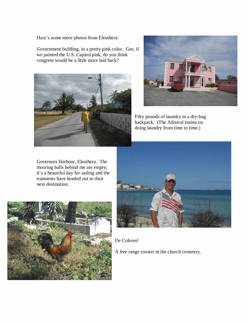
De Colores!
A free range rooster in the church cemetery.
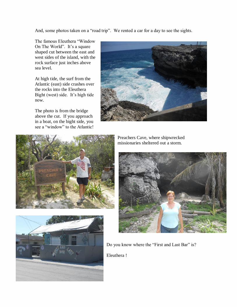
And, some photos taken on a “road trip”. We rented a car for a day to see the sights.
The famous Eleuthera “Window
On The World”. It’s a square
shaped cut between the east and
west sides of the island, with the
rock surface just inches above
sea level.
At high tide, the surf from the
Atlantic (east) side crashes over
the rocks into the Eleuthera
Bight (west) side. It’s high tide
now.
The photo is from the bridge
above the cut. If you approach
in a boat, on the bight side, you
see a “window” to the Atlantic!
Preachers Cave, where shipwrecked
missionaries sheltered out a storm.
Do you know where the “First and Last Bar” is?
Eleuthera !

It’s time to get underway again. We move from
Rock Sound to Governors Harbour;
Personal choice; we don’t take a harbor mooring,
instead we anchor out. Bahamas moorings come
in various stages of use, repair, and dis-repair.
(The exception are the moorings in the Exuma
Park; they’re maintained regularly).
In the Bahamas, I’ve learned to pay more
attention to anchoring. The subtropics weather
can be temperamental. Sometimes, the wind
blows 25 to 30 mph for several days!
I back down HARD on the anchor, rev’ing the
engine to 2000 rpm in reverse to make damn sure
it’s set solidly. I really TRY to pull the anchor
out and make it drag. If I can’t, then it’s set!
Once done, I trust my own tackle more than I do
an unknown mooring. I know my gear isn’t worn
or weak or frayed.
At Fraziers Hog Cay, a boat was on a mooring
that broke at night, and the boat went on the
rocks. It was towed off the next day and still
floated; but it doesn’t sound like a nice
experience!
After a few days to see the local sights and walk the nearby “pink beach”, we head on out
yet again, sailing north on the Eleuthera Bight. Next stop is “Current Cut”. February
29th we anchor on the north side, in the lee of the island.
Our last Eleuthera sunset! Tomorrow… March 1st, we sail across the Northeast
Providence Channel to the Abacos!
…Mary & Roy Stegall
S/V “Gideon”