Fallen arches: Dispelling myths concerning...
21
For permission to copy, contact [email protected] q 2003 Geological Society of America 695 GSA Bulletin; June 2003; v. 115; no. 6; p. 695–713; 14 figures. Fallen arches: Dispelling myths concerning Cambrian and Ordovician paleogeography of the Rocky Mountain region Paul M. Myrow ² Department of Geology, Colorado College, Colorado Springs, Colorado 80903, USA John F. Taylor Geosciences Department, Indiana University of Pennsylvania, Indiana, Pennsylvania 15705, USA James F. Miller Department of Geography, Geology and Planning, SW Missouri State University, Springfield, Missouri 65804, USA Raymond L. Ethington Department of Geological Sciences, University of Missouri, Columbia, Missouri 65211, USA Robert L. Ripperdan Department of Geology, University of Puerto Rico, Mayaguez, 00681-5000, Puerto Rico Joseph Allen Department of Physical Sciences, Concord College, Athens, West Virginia 24712-1000, USA ABSTRACT High-resolution sedimentologic, bio- stratigraphic, and stable isotope data from numerous measured sections across Colo- rado reveal a complex architecture for low- er Paleozoic strata in the central Cordille- ran region. A lack of precise age control in previous studies had resulted in misidenti- fication and miscorrelation of units between separate ranges. Corrections of these errors made possible by our improved data set in- dicate the following depositional history. The quartz-rich sandstone of the Sawatch Formation was deposited during onlap of the Precambrian erosion surface in the early Late Cambrian. The overlying Dotsero For- mation, a regionally extensive carbonate- and shale-rich succession records blanket- like deposition with only minor facies changes across the state. An extremely widespread, meter-scale stromatolite bed, the Clinetop Bed, caps the Dotsero For- mation in most areas. However, a latest Cambrian erosional episode removed 9–11 m of the upper Dotsero Formation, includ- ing the Clinetop Bed, from just east of the Homestake shear zone in the Sawatch Range eastward to the Mosquito Range. ² E-mail: [email protected]. The overlying Manitou Formation differs in character, and thus in member stratig- raphy, on the east vs. west sides of the state. These differences were previously inter- preted as the result of deposition on either side of a basement high that existed within the Central Colorado Embayment or Col- orado ‘‘Sag,’’ a region of major breaching across the Transcontinental Arch. This pa- leogeographic reconstruction is shown herein to be an artifact of miscorrelation. Biostratigraphic data show that the north- western members of the Manitou Forma- tion are older than the members exposed in the southeastern part of the state and that there is little or no overlap in age between the two areas. This circumstance is the re- sult of (1) removal of older Manitou For- mation strata in the southeast by an uncon- formity developed during the Rossodus manitouensis conodont Zone, and (2) ero- sion of younger Manitou strata in central and western Colorado along Middle Ordo- vician and Devonian unconformities. Deciphering these complex stratal geom- etries has led to invalidation of long-held views on western Laurentian paleogeogra- phy during the Cambrian and earliest Or- dovician, specifically the existence of the Colorado Sag and a northeast-trending high within the sag that controlled deposi- tional patterns on either side. The mid- Rossodus uplift and resultant unconformity eliminated any and all Upper Cambrian and Lower Ordovician deposits in southern Colorado and northern New Mexico, and thus their absence should not be miscon- strued as evidence for earlier nondeposition in this region. Lithofacies distribution pat- terns and isopach maps provide no evi- dence that highlands of the Transcontinen- tal Arch existed in Colorado prior to the mid-Rossodus age uplift event. In fact, re- gional reconstructions of earliest Paleozoic paleogeography along the entire length of the purported Transcontinental Arch should be reevaluated with similarly pre- cise biostratigraphic data to reconsider all potential causes for missing strata and to eliminate topographic elements not sup- ported by multiple stratigraphic tech- niques. This study illustrates how seriously paleogeographic reconstructions can be bi- ased by the presumption that missing strata represent periods of nondeposition rather than subsequent episodes of erosion, partic- ularly in thin cratonic successions where stratigraphic gaps are common and often inconspicuous. Keywords: Ordovician, Cambrian, Colora- do, Transcontinental Arch, biostratigraphy.
Transcript of Fallen arches: Dispelling myths concerning...

For permission to copy, contact [email protected] 2003 Geological Society of America 695
GSA Bulletin; June 2003; v. 115; no. 6; p. 695–713; 14 figures.
Fallen arches: Dispelling myths concerning Cambrian and Ordovicianpaleogeography of the Rocky Mountain region
Paul M. Myrow†
Department of Geology, Colorado College, Colorado Springs, Colorado 80903, USA
John F. TaylorGeosciences Department, Indiana University of Pennsylvania, Indiana, Pennsylvania 15705, USA
James F. MillerDepartment of Geography, Geology and Planning, SW Missouri State University, Springfield, Missouri 65804, USA
Raymond L. EthingtonDepartment of Geological Sciences, University of Missouri, Columbia, Missouri 65211, USA
Robert L. RipperdanDepartment of Geology, University of Puerto Rico, Mayaguez, 00681-5000, Puerto Rico
Joseph AllenDepartment of Physical Sciences, Concord College, Athens, West Virginia 24712-1000, USA
ABSTRACT
High-resolution sedimentologic, bio-stratigraphic, and stable isotope data fromnumerous measured sections across Colo-rado reveal a complex architecture for low-er Paleozoic strata in the central Cordille-ran region. A lack of precise age control inprevious studies had resulted in misidenti-fication and miscorrelation of units betweenseparate ranges. Corrections of these errorsmade possible by our improved data set in-dicate the following depositional history.The quartz-rich sandstone of the SawatchFormation was deposited during onlap ofthe Precambrian erosion surface in the earlyLate Cambrian. The overlying Dotsero For-mation, a regionally extensive carbonate-and shale-rich succession records blanket-like deposition with only minor facieschanges across the state. An extremelywidespread, meter-scale stromatolite bed,the Clinetop Bed, caps the Dotsero For-mation in most areas. However, a latestCambrian erosional episode removed 9–11m of the upper Dotsero Formation, includ-ing the Clinetop Bed, from just east of theHomestake shear zone in the SawatchRange eastward to the Mosquito Range.
†E-mail: [email protected].
The overlying Manitou Formation differsin character, and thus in member stratig-raphy, on the east vs. west sides of the state.These differences were previously inter-preted as the result of deposition on eitherside of a basement high that existed withinthe Central Colorado Embayment or Col-orado ‘‘Sag,’’ a region of major breachingacross the Transcontinental Arch. This pa-leogeographic reconstruction is shownherein to be an artifact of miscorrelation.Biostratigraphic data show that the north-western members of the Manitou Forma-tion are older than the members exposed inthe southeastern part of the state and thatthere is little or no overlap in age betweenthe two areas. This circumstance is the re-sult of (1) removal of older Manitou For-mation strata in the southeast by an uncon-formity developed during the Rossodusmanitouensis conodont Zone, and (2) ero-sion of younger Manitou strata in centraland western Colorado along Middle Ordo-vician and Devonian unconformities.
Deciphering these complex stratal geom-etries has led to invalidation of long-heldviews on western Laurentian paleogeogra-phy during the Cambrian and earliest Or-dovician, specifically the existence of theColorado Sag and a northeast-trendinghigh within the sag that controlled deposi-
tional patterns on either side. The mid-Rossodus uplift and resultant unconformityeliminated any and all Upper Cambrianand Lower Ordovician deposits in southernColorado and northern New Mexico, andthus their absence should not be miscon-strued as evidence for earlier nondepositionin this region. Lithofacies distribution pat-terns and isopach maps provide no evi-dence that highlands of the Transcontinen-tal Arch existed in Colorado prior to themid-Rossodus age uplift event. In fact, re-gional reconstructions of earliest Paleozoicpaleogeography along the entire length ofthe purported Transcontinental Archshould be reevaluated with similarly pre-cise biostratigraphic data to reconsider allpotential causes for missing strata and toeliminate topographic elements not sup-ported by multiple stratigraphic tech-niques. This study illustrates how seriouslypaleogeographic reconstructions can be bi-ased by the presumption that missing stratarepresent periods of nondeposition ratherthan subsequent episodes of erosion, partic-ularly in thin cratonic successions wherestratigraphic gaps are common and ofteninconspicuous.
Keywords: Ordovician, Cambrian, Colora-do, Transcontinental Arch, biostratigraphy.

696 Geological Society of America Bulletin, June 2003
MYROW et al.
Figure 1. Location map with traditional interpretation (e.g., Lochman-Balk, 1970) ofCambrian–Ordovician paleogeography of Colorado Sag region (white) (modified fromGerhard, 1972, 1974), largely invalidated by present study. Location abbreviations: SF—South Fork; MEC—Main Elk Creek; GC—Glenwood Canyon; EBC—East Brush Creek;Gil—Gilman; RC—Red Cliff; LC—Lime Creek; LP—Lambertson’s Peak; HM—Horse-shoe Mountain; TP—Taylor Pass; SM—Sheep Mountain; TC—Trout Creek; DMG—Dead Man’s Gulch; MG—Missouri Gulch; WC—Williams Canyon. The mountain rangesand White River Uplift are modern topographic features.
INTRODUCTION
Upper Cambrian and Lower Ordovicianrocks in the Colorado Rocky Mountains havehistorically played an important role in the re-construction of lower Paleozoic paleogeogra-phy in North America. Early depictions showa Transcontinental Arch trending diagonallythrough the middle of the state with a majorbreach, the Colorado Embayment (Lochman-Balk, 1970, 1971) or Colorado ‘‘Sag’’ (Ger-hard, 1972), oriented orthogonally (northwestto southeast) to its length (Fig. 1). Most ofcentral and northern New Mexico, along withsmall parts of western Texas, southern Colo-rado, and western Oklahoma composed an up-land area, the Sierra Grande Highlands, thatwas emergent throughout the Cambrian(Lochman-Balk, 1970). Furthermore, Gerhard(1972, 1974) used stratigraphic data to arguethat the Colorado Sag was divided into twosubbasins separated by a low ridge that af-fected sedimentation patterns on either sideduring times of uplift and/or sea-level fall. Hismain lines of evidence were differences in thefacies patterns in carbonate-platform depositsof the Ordovician Manitou Formation, as wellas lithologic differences in the Cambrian units(Dotsero, Peerless, and Sawatch Formations)below the Manitou, on opposite sides of thepurported high (Fig. 2). In Gerhard’s recon-
struction (Fig. 1), the high separated the Col-orado Sag into a northwestern subbasin con-nected to the paleo-Pacific margin and asoutheastern subbasin connected to the Mid-continental Sea. Allen (1994) posited that theinterbasin high corresponded to the Home-stake shear zone (Fig. 1), a reactivated Pre-cambrian northeast-striking basement faultsystem that occurs in the zone of facies tran-sitions. This paleogeographic scheme has re-ceived general acceptance and has been uti-lized in a number of studies (Ross, 1976;Ethington et al., 1987; Myrow et al., 1995,1999a, 1999b; among others) to analyze a va-riety of stratigraphic data.
In this paper, we present a synthesis of thedepositional and tectonic history of the low-ermost Paleozoic deposits of Colorado basedon high-resolution sedimentologic, physicalstratigraphic, chemostratigraphic, and paleon-tological data from numerous localities acrossthe state. Age control provided by new co-nodont and trilobite collections allows moreaccurate reconstruction of the spatial distri-bution of lithofacies through time as well asassessment of the roles of uplift, eustasy, anderosion on stratigraphic patterns in this region.Our revised correlations reveal that the afore-mentioned subbasins of the Colorado Sag, andperhaps even the existence of a well-definedTranscontinental Arch, are artifacts of miscor-
relation between mountain ranges across Col-orado. The following sections provide a re-view of the preexisting lithostratigraphicnomenclature, an explanation of lithostrati-graphic revisions required to correct severalcritical miscorrelations, and a chronologicalhistory of the depositional and tectonic eventsthat produced a deceptively complex architec-ture within the lower Paleozoic strata in thisregion.
In a more general sense, this study illus-trates how integrated and detailed stratigraphicdata can reveal flaws in long-standing paleo-geographic reconstructions and in the meth-odologies used in their construction. For ex-ample, the lateral thinning or disappearance oflithostratigraphic units has commonly been at-tributed by default to nondeposition on paleo-topographic highs, rather than to removal ofstrata by subsequent erosion. In the terminol-ogy utilized by Wheeler (1964), those inves-tigators failed to discriminate the part of thetotal gap (lacuna) caused by erosion (degra-dational vacuity) from that resulting from non-deposition (the hiatus). The flawed method-ology results in a proliferation of purportedhighlands, whose existence is not supportedby stratigraphic data.
CAMBRIAN–ORDOVICIANLITHOSTRATIGRAPHY OFCOLORADO
Numerous studies, particularly those con-ducted during the first half of the twentieth cen-tury, were aimed at mapping specific regionsof Colorado, and Cambrian and Ordovicianrocks were mapped in a number of mountainranges, many at high elevations. Correlation ofwidely scattered, poorly fossiliferous outcropswithin and between ranges proved to be a dif-ficult problem that was exacerbated by localvariation in lithofacies and the superimposedeffects of several unconformities developedfrom the Late Cambrian through Devonian. Asa result, separate stratigraphic schemes and no-menclatures were proposed for different areas,and attempts at correlation were flawed becauseof misidentification and miscorrelation of unitsin the absence of precise age control. Conse-quently, stratigraphic data summarized in fencediagrams, correlation figures, isopach maps,and lists of unit thicknesses in previous studiesmust be analyzed carefully to determine wheth-er they are reliable for reconstruction of depo-sitional patterns.
The oldest lower Paleozoic cover unit inColorado is the Upper Cambrian Sawatch For-mation (Fig. 2), named by Eldridge (1894) fora white quartzite unit in the Sawatch Range.

Geological Society of America Bulletin, June 2003 697
DISPELLING MYTHS OF CAMBRIAN AND ORDOVICIAN ROCKY MOUNTAIN PALEOGEOGRAPHY
Figure 2. (Upper) The traditional lithostratigraphy of Cambrian and Ordovician depositsof Colorado, including Gerhard’s (1972, 1974) member stratigraphy of the Manitou For-mation. (Lower) A revised stratigraphy for the entire state shows new members of Dotseroand Manitou Formations, as well as revised age relationships of the Manitou members.
Singewald and Butler (1930; see also Johnson,1934) described four informal subdivisions ofthe formation: ‘‘lower quartzite,’’ ‘‘thin-beddedlimy,’’ ‘‘upper quartzite,’’ and ‘‘purple quartz-ite.’’ The uppermost unit—referred to previ-ously as ‘‘transition shale’’ (Emmons, 1882,1886), and in other accounts as ‘‘red-castbeds’’—was designated as the Peerless ShaleMember of the Sawatch Formation by Behre(1932). This member of the Sawatch Forma-tion was elevated to formation rank by Sin-gewald (1947, 1951). The lower three infor-
mal members of the Sawatch Formation—lower and upper white quartzite members,separated by a middle glauconitic sandstonemember (5 thin-bedded limy member)—havebeen useful for mapping in the western Sa-watch Range and to the west on the WhiteRiver Plateau (Johnson, 1944, 1945; Mackay,1953). Isopach maps of the Sawatch Forma-tion for the central and western parts of thestate show that it thickens to the west (Rossand Tweto, 1980). In addition, the middlemember of the Sawatch Formation becomes
more distinct and richer in glauconite and do-lomite in that direction (Allen, 1994). Thesemembers have not been recognized in most ofthe eastern Sawatch Range or in the MosquitoRange, where the formation consists entirelyof silica-cemented and carbonate-cementedquartz sandstone (Fig. 3A). Similarly, the mid-dle glauconitic member was not recognized inthe Front Range, and thus the Sawatch For-mation was not divided into members in thatarea.
Mixed siliciclastic and carbonate rocks ofthe overlying Upper Cambrian Peerless For-mation (;25 m thick) (Fig. 4A) have beenmapped within the Front Range, MosquitoRange, and Sawatch Range. The type sectionis in the Mosquito Range where it was definedas having a distinctive purple quartzite bed atits base and a cap of ‘‘red-cast beds’’ (Behre,1932). Later workers, including Singewald(1951) and Anderson (1970), extended the topof the formation to higher levels and unwit-tingly crossed a major unconformity thatspans the Cambrian/Ordovician boundary, in-cluding strata better assigned to the overlyingManitou Formation (Myrow et al., 1999a).Behre (1939) and Singewald (1951) bothrecognized lower sandstone/shale and uppercarbonate-rich (‘‘red-cast beds’’) divisionswithin the Peerless Formation.
The Dotsero Formation is a unit of thick-ness similar to that of the Peerless Formation(;25 m) that was originally mapped in theWhite River uplift (Bass and Northrop, 1953).This formation occupies the same stratigraph-ic position as the Peerless, between the un-derlying Sawatch Formation and the overlyingManitou Formation (Fig. 2). Bass and Nor-throp (1953) divided the Dotsero into a lowerGlenwood Canyon Member and an upperClinetop Member, the latter comprising a sin-gle submeter-scale stromatolite bed with basaland upper limestone flat-pebble conglomeratedivisions. The Glenwood Canyon Memberconsists of shale, grainstone, and flat-pebbleconglomerate. The two latter lithologies haveproduced a suite of Late Cambrian trilobites(Myrow et al., 1999a; Taylor, 2001).
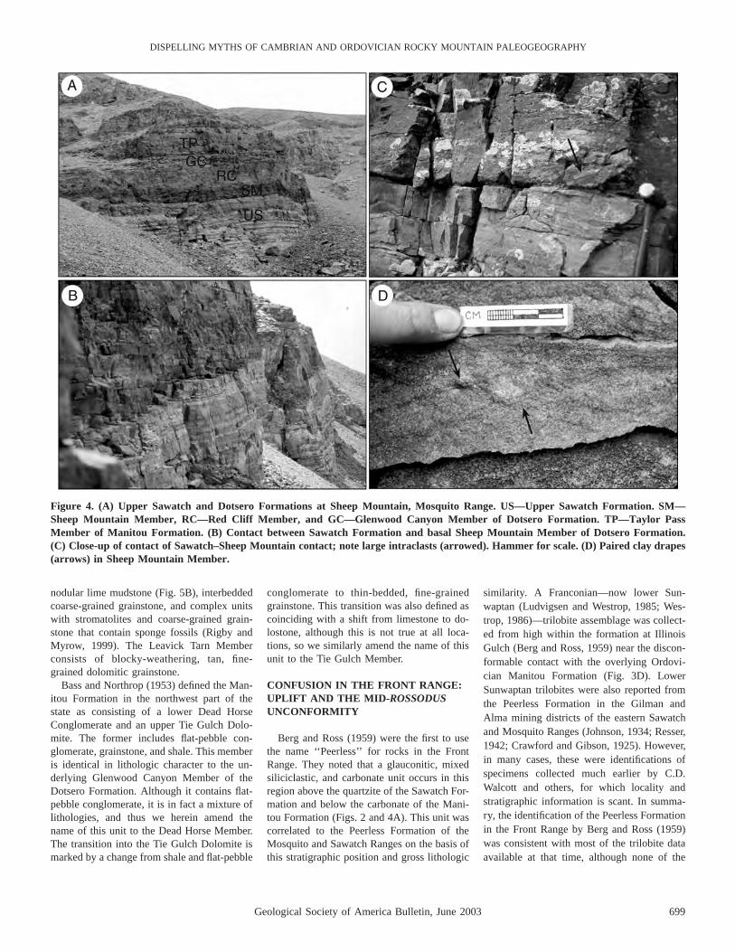
The Manitou Formation was first describedby Cross (1894) for Front Range localities, in-cluding Manitou Springs. An Ordovician ageis readily apparent from a wide range of fossiltaxa. Gerhard (1974) proposed a tripartite di-vision of the formation in the eastern part ofthe state, recognizing the Helena Canyon,Ptarmigan Chert, and Leavick Tarn DolomiteMembers, in ascending order. The HelenaCanyon Member consists of meter-scale peri-tidal cycles (Myrow, 1995; Fig. 5A). The Ptar-migan Chert member includes chert-bearing

698 Geological Society of America Bulletin, June 2003
MYROW et al.
Figure 3. Front Range and MosquitoRange. (A) Brown, carbonate-cementedand white, silica-cemented sandstone ofthe Sawatch Formation at HorseshoeMountain. (B) Blocky, karstic bed (K) atthe mid-Rossodus unconformity betweenthe middle Sawatch (MS) and Manitou(M) Formations. (C) Glauconitic, com-pound cross-bedded, subaqueous tidaldune deposits (X). Cross-bedded unit upto 5 m thick on right. (D) Manitou For-mation unconformably overlying irreg-ular nonconformity surface on PikesPeak Granite along Route 50 at CanonCity. (E) Lower and middle SawatchFormation at Manitou Springs. PC—Precambrian Pikes Peak Granite; LS—lower Sawatch; MS—middle Sawatch;M—Manitou Formation. Note 3-m-thick, glauconite-rich cross-bed set atbase of middle Sawatch (X). (F) Mid-Rossodus unconformity (RU) at 55.8 mof section at Horseshoe Mountain. Un-conformity is at top of ‘‘red-cast beds.’’Profound flooding surface (FS) withinlower Manitou Formation marked bytransition to shaly facies.
Geological Society of America Bulletin, June 2003 699
DISPELLING MYTHS OF CAMBRIAN AND ORDOVICIAN ROCKY MOUNTAIN PALEOGEOGRAPHY
Figure 4. (A) Upper Sawatch and Dotsero Formations at Sheep Mountain, Mosquito Range. US—Upper Sawatch Formation. SM—Sheep Mountain Member, RC—Red Cliff Member, and GC—Glenwood Canyon Member of Dotsero Formation. TP—Taylor PassMember of Manitou Formation. (B) Contact between Sawatch Formation and basal Sheep Mountain Member of Dotsero Formation.(C) Close-up of contact of Sawatch–Sheep Mountain contact; note large intraclasts (arrowed). Hammer for scale. (D) Paired clay drapes(arrows) in Sheep Mountain Member.
nodular lime mudstone (Fig. 5B), interbeddedcoarse-grained grainstone, and complex unitswith stromatolites and coarse-grained grain-stone that contain sponge fossils (Rigby andMyrow, 1999). The Leavick Tarn Memberconsists of blocky-weathering, tan, fine-grained dolomitic grainstone.
Bass and Northrop (1953) defined the Man-itou Formation in the northwest part of thestate as consisting of a lower Dead HorseConglomerate and an upper Tie Gulch Dolo-mite. The former includes flat-pebble con-glomerate, grainstone, and shale. This memberis identical in lithologic character to the un-derlying Glenwood Canyon Member of theDotsero Formation. Although it contains flat-pebble conglomerate, it is in fact a mixture oflithologies, and thus we herein amend thename of this unit to the Dead Horse Member.The transition into the Tie Gulch Dolomite ismarked by a change from shale and flat-pebble
conglomerate to thin-bedded, fine-grainedgrainstone. This transition was also defined ascoinciding with a shift from limestone to do-lostone, although this is not true at all loca-tions, so we similarly amend the name of thisunit to the Tie Gulch Member.
CONFUSION IN THE FRONT RANGE:UPLIFT AND THE MID-ROSSODUSUNCONFORMITY
Berg and Ross (1959) were the first to usethe name ‘‘Peerless’’ for rocks in the FrontRange. They noted that a glauconitic, mixedsiliciclastic, and carbonate unit occurs in thisregion above the quartzite of the Sawatch For-mation and below the carbonate of the Mani-tou Formation (Figs. 2 and 4A). This unit wascorrelated to the Peerless Formation of theMosquito and Sawatch Ranges on the basis ofthis stratigraphic position and gross lithologic
similarity. A Franconian—now lower Sun-waptan (Ludvigsen and Westrop, 1985; Wes-trop, 1986)—trilobite assemblage was collect-ed from high within the formation at IllinoisGulch (Berg and Ross, 1959) near the discon-formable contact with the overlying Ordovi-cian Manitou Formation (Fig. 3D). LowerSunwaptan trilobites were also reported fromthe Peerless Formation in the Gilman andAlma mining districts of the eastern Sawatchand Mosquito Ranges (Johnson, 1934; Resser,1942; Crawford and Gibson, 1925). However,in many cases, these were identifications ofspecimens collected much earlier by C.D.Walcott and others, for which locality andstratigraphic information is scant. In summa-ry, the identification of the Peerless Formationin the Front Range by Berg and Ross (1959)was consistent with most of the trilobite dataavailable at that time, although none of the
700 Geological Society of America Bulletin, June 2003
MYROW et al.
Figure 5. Manitou Formation. (A) Meter-scale carbonate cycles in Helena Canyon Mem-ber. Flat hard-ground marking base of cycle at lower left; hammer rests against grainstonebed at base of next cycle. (B) Ptarmigan Chert Member with abundant chert nodules atHorseshoe Mountain.
data was tied to a measured section, particu-larly the type section.
The first well-defined biostratigraphic datafor the Peerless Formation in its type section,on the flanks of Horseshoe Mountain next tothe Peerless Mine, were presented by Myrowet al. (1995). Their data establish that at leastthe top 4 m of the 20.5-m-thick Peerless For-mation contain conodonts of the Eoconodon-tus Zone (the lower Eoconodontus notchpeak-ensis Subzone), whereas the base of theoverlying Manitou Formation yields cono-donts of the Rossodus manitouensis Zone(Figs. 3F, 6, and 7). As with the sections atIllinois Gulch and Missouri Gulch in the FrontRange, these data document a lacuna thatspans much of the Cambrian–Ordovicianboundary interval. However, the Eoconodon-tus Zone conodonts from the type PeerlessFormation are Trempealeauan—now upperSunwaptan (Westrop, 1986)—forms, far tooyoung to be correlated with the lower Sun-
waptan strata in the Front Range. The cono-dont data from Horseshoe Mountain are inagreement with Chronic’s (1964) report of anupper Sunwaptan trilobite, Saukia colora-doensis Walcott, from somewhere within thePeerless Formation at its type locality.
Berg and Ross (1959) demonstrated, byfaunal and stratigraphic patterns, that a majorbreak exists between their ‘‘Peerless’’ For-mation and the overlying Manitou Formationin the Front Range. They showed that upliftin southern Colorado prior to deposition of theManitou Formation caused progressive ero-sional cut-out of the Cambrian units towardthe south and subsequent onlap of the ManitouFormation from north to south (Fig. 8). In lo-calities south of Colorado Springs, such asCanon City, the Manitou Formation rests di-rectly on Precambrian granite (Figs. 3E, 8),where the basal beds presumably contain theyoungest onlapping strata of the formation. AtMissouri Gulch to the north, the basal Mani-
tou Formation is much older, by at least threetrilobite zones, and rests on lower Sunwaptansedimentary rocks. Conodonts from the basalManitou Formation at Missouri Gulch are cur-rently assigned to the long-ranging Rossodusmanitouensis Zone (Fig. 9). Because strata ofthis age also rest unconformably on youngerEoconodontus Zone rocks at HorseshoeMountain to the northwest (Figs. 3F and 6),we interpret this surface as the same uncon-formity of R. manitouensis age that removedboth the ‘‘true’’ Peerless Formation and theupper quartzite member of the Sawatch For-mation to the south. The highly glauconiticunit that Berg and Ross (1959) identified as‘‘Peerless’’ Formation in the Front Range is infact the middle member of the Sawatch For-mation. The unconformity rises to even higherlevels to the west and rests on Rossodus agestrata at Taylor Pass (Fig. 10A), so it musthave developed during the Rossodus intervaland is thus named herein the ‘‘mid-Rossodusunconformity.’’
A close comparison of the lithologic char-acteristics of the Front Range ‘‘Peerless’’ For-mation with those of units farther to the westalso supports the conclusion that the formerrepresents the middle member of the SawatchFormation. Johnson (1944, p. 312) defined themiddle glauconitic sandstone member as aunit with quartzite, sandstone, glauconiticsandstone, calcareous sandstone, impure lime-stone, and calcareous sandy shale. These li-thologies match well with those of the litho-logically mixed unit that Berg and Ross(1959) attributed to the Peerless Formationalong the Front Range. Careful examination ofthe type section of the Peerless Formation re-veals that it in fact contains little glauconiteand is therefore not that similar lithologicallyto the Front Range deposits. The middle mem-ber of the Sawatch Formation has never beenidentified in areas southeast of the Homestakeshear zone of the Sawatch Range (see Allen,1994), but only because it has been misiden-tified as the Peerless Formation along theFront Range. The middle member of the Sa-watch Formation is not present in the centralpart of the state, in the Mosquito Range, or inparts of the eastern Sawatch Range, but occurswith increased glauconite content toward thewest. Our recognition of this unit in the FrontRange indicates that it was also depositedeastward of the central part of the state. Sed-imentologic analysis of this unit (under thename Peerless Formation) indicates that itformed as a result of rapid deepening (Myrow,1998). The distribution of glauconite in themiddle Sawatch Formation across the statewould therefore indicate a general deepening

Geological Society of America Bulletin, June 2003 701
DISPELLING MYTHS OF CAMBRIAN AND ORDOVICIAN ROCKY MOUNTAIN PALEOGEOGRAPHY
Fig
ure
6.C
onod
ont
bios
trat
igra
phy
for
sele
cted
loca
tion
sin
Col
orad
o.A
reas
wit
hve
rtic
allin
esde
note
lacu
nae—
inte
rval
sm
issi
ngat
unco
nfor
mit
ies.
Not
ela
rge
num
ber
ofzo
nes/
subz
ones
pres
ent
inse
ctio
nsto
the
nort
hwes
t.

702 Geological Society of America Bulletin, June 2003
MYROW et al.
Figure 7. Generalized stratigraphic column of Horseshoe Mountain with conodont zonations. The stratigraphic boundaries of the oldPeerless Formation are shown, as well as new members of the Dotsero and Manitou Formations. SM—Sheep Mountain Member, RC—Red Cliff Member, and GC—Glenwood Canyon Member of Dotsero Formation. TP—Taylor Pass Member of Manitou Formation.

Geological Society of America Bulletin, June 2003 703
DISPELLING MYTHS OF CAMBRIAN AND ORDOVICIAN ROCKY MOUNTAIN PALEOGEOGRAPHY
Figure 8. Comparison of correlation schemes for the Front Range and Mosquito Range.The ‘‘traditional view’’ (e.g., Berg and Ross, 1959) correlates glauconitic and dolomiticdeposits along the Front Range (Missouri Gulch, Williams Canyon, Deadman’s Canyon)with the Peerless Formation whose type section is exposed at Horseshoe Mountain. Co-nodonts recovered from the Peerless at the type section indicate a much younger age, andhence the Front Range deposits are correlated with the glauconite-rich middle member ofthe Sawatch Formation in the ‘‘proposed revision.’’ T.P.—Taylor Pass Member of Man-itou Formation; Eoconodontus un.—Eoconodontus unconformity.
both eastward and westward from the Sawatchand Mosquito Range area (Fig. 2).
UPPER CAMBRIAN DEPOSITION:LEVELING THE PLAYING FIELD
Sawatch Formation
Little is known about the paleoenviron-ments of the Sawatch Formation except forthe work of Myrow (1998), who examined ananomalously thin (4.5 m) lower quartzitemember and middle glauconite member alongthe Front Range in the vicinity of ManitouSprings (Fig. 3E). These members are inter-preted as transgressive deposits that includelarge-scale, glauconite-rich, subaqueous, buttidally influenced dune deposits that lie on aflooding surface at the base of the middlemember (Myrow, 1998) (Figs. 3C, 3E). Al-though no regional comprehensive deposition-al study has been made of the Sawatch For-mation, the quartz sandstones of the upper andlower members display conspicuous evidencefor shallow-marine deposition, including per-vasive bioturbation, Skolithos piperock, andhummocky cross-stratification. Isopach pat-terns (discussed subsequently) and the sedi-mentologic analysis of Myrow (1998) indicatethat the glauconite- and carbonate-rich middlemember represents a deepening event betweendeposition of the upper and lower quartzitemembers.
Allen (1994) constructed isopach maps forthe Sawatch Formation for the central andwestern parts of the state, where it ranges from0 to 127 m thick. These maps show thickeningto the west, which is consistent with a west-ward increase in development of the glauco-nitic middle member and deepening in that di-rection. The formation also thickens to thesouth and southwest, but is sharply truncatedby the mid-Rossodus unconformity alreadydescribed. The absence of the Sawatch For-mation in the southern part of the state and innorthern New Mexico led Lochman-Balk(1956, 1970) and others to suggest that a high-land existed to the south at this time. Notmuch can be said, however, about the originalpatterns of deposition for the southeastern partof the state during Sawatch Formation depo-sition, largely because thickness patterns arestrongly controlled by post-Sawatch erosion.
Several thickness anomalies indicate thatthe Sawatch Formation was deposited duringtransgression onto a somewhat irregular Cam-brian landscape. For example, Allen (1994)documented facies and thickness variationsthat suggest that the Sawatch Formation on-lapped a paleohigh bounded by reactivated
segments of the Homestake shear zone in thenortheastern Sawatch Range. In addition, asubstantial local high with ;50 m of reliefexists at Lime Creek Canyon in the westernSawatch Range, where the formation is rep-resented by as little as 2.14 m of quartzarenite(e.g., Allen, 1994). The 4.5 m of the lowermember of the Sawatch Formation quartzite at
Manitou Springs is also anomalously thin; themember triples in thickness just 35 km north-northwest at Missouri Gulch.
Deposition of the Sawatch Formation ap-pears to have filled an inherited topography;the lower member filled most of the irregular-ities. Development of the glauconitic middlemember in the eastern and western parts of the

704 Geological Society of America Bulletin, June 2003
MYROW et al.
Figure 9. Generalized stratigraphic column of Manitou Formation at Missouri Gulch. Allstrata are from the Bellefontia-Xenostegium Trilobite Zone. Lithologies: Sh—shale, NM—nodular carbonate mudstone, FG—fine-grained grainstone, CG—coarse-grained grain-stone, FP—flat-pebble conglomerate.
state indicates deeper-marine conditions inthose directions, but little is known aboutnorth-south patterns except that isopach mapsshow no evidence of regional thinning withonlap of the Sawatch Formation in either di-rection. Lack of data to the north is due to ab-sence of outcrop, and to the south the membersare gradually truncated by the mid-Rossodusunconformity. Some geologic maps (Tweto etal., 1976; Tweto, 1979) indicate that the south-ern limit of the Sawatch Formation is at leastlocally controlled by a pre-Ordovician faultlocated ;28 km northwest of Trout CreekPass. However, Allen (1994) demonstratedthat the Sawatch Formation is present and uni-form in thickness on both sides of the fault.The formation thins beneath the mid-Rossodusunconformity south of the fault to ,3.5 malong Limestone Ridge ;12 km northwest ofTrout Creek Pass and is truncated entirely atthe southern end of the ridge.
Dotsero/Peerless Formations
As a result of the stratigraphic revision justpresented, the Peerless Formation is nowknown to be restricted to the Mosquito andeastern Sawatch Ranges. The complex rela-tionship between the Peerless Formation andthe Dotsero Formation of western Coloradowas finally resolved by tracing members with-in the Dotsero Formation from west to eastinto the Mosquito Range.
Although previous studies recognize onlytwo members within the Dotsero Formation,there are in fact four lithologically distinct in-tervals that are traceable across wide areas.The basal unit is a trough cross-bedded, me-dium- to coarse-grained sandstone that is ironrich and weathers to a purple color in the cen-tral part of the state (Fig. 4). This unit is de-fined herein as the Sheep Mountain Member. Itstype section is at Sheep Mountain, 7.5 km eastof Horseshoe Mountain, 9 km east-southeast ofFairplay in Park County in the MosquitoRange. This member is best developed in cen-tral Colorado and less well developed in thewestern localities. The quartz-rich sandstonehas variable but generally low amounts ofglauconite, which is more abundant alongcross-bed set boundaries and foreset surfaces.The rock also contains abundant dark gray tored hematitic cement. Cross-bed sets rangefrom 3 to 8 cm thick (average, 5 cm) and lo-cally contain paired clay drapes (Fig. 4D). Thethickness of this member is remarkably con-sistent, ranging from 2.08 m at Main ElkCreek to 2.50 m at Horseshoe Mountain, a dis-tance of 150 km (Fig. 1). It is largely coveredat South Fork and Lime Creek, but well ex-


Geological Society of America Bulletin, June 2003 705
DISPELLING MYTHS OF CAMBRIAN AND ORDOVICIAN ROCKY MOUNTAIN PALEOGEOGRAPHY
Figure 10. (A) New stratigraphic framework for uppermost Cambrian and lowermost Ordovician strata in Colorado. Lateral distri-butions of members of the Dotsero and Manitou Formations are shown, as well as the location of three prominent unconformities: EU—Eoconodontus unconformity; MRU—mid-Rossodus unconformity; SDU—sub-Devonian unconformity. (B) Detailed measured section ofthe Glenwood Canyon Section, ;0.6 km west of the eastern end of Glenwood Canyon. Lithologies: sh—shale, slt—siltstone; vfs—veryfine-grained sandstone; fs—fine-grained sandstone; ms—medium-grained sandstone; mrl—marl; grn—grainstone; fpc—flat-pebbleconglomerate.N
posed at other localities in central Coloradowith a consistent thickness (2.14–2.5 m) (Fig.10A).
The Sheep Mountain Member directly over-lies the white quartzite of the upper memberof the Sawatch Formation. This member of theDotsero Formation is similar in characteristicsto the glauconitic middle member of the Sa-watch Formation, which also rests on whitequartzite (lower member of Sawatch Forma-tion). In the Front Range, the middle Sawatchcontains highly glauconitic (up to 80%), com-pound cross-bedded tidal dune facies (Myrow,1998; Fig. 3C) that are interpreted as con-densed deposits that accumulated above aflooding surface. The Sheep Mountain Mem-ber contains less glauconite but does containabundant iron-bearing minerals and also likelyformed as condensed deposits after rapidflooding. Development of paired clay drapesindicates that tidal forces were important lo-cally in the deposition of this unit. Transgres-sion is implicated in many instances with de-velopment of glauconite-rich tidal deposits(e.g., Narayan, 1963, 1971; Allen and Naray-an, 1964; Nio, 1976).
The second unit, the Red Cliff Member(new), is more variable in composition and iscomposed of 8–10 m of sandy dolomite anddolomitic sandstone. The type section of thismember is in the cliffs on the east wall of thecanyon of the Eagle River, immediately northof Gilman, 4–5 km northwest of the town ofRed Cliff. Very thin- to medium-bedded,laminated and bioturbated, dolomitic fine- tomedium-grained sandstone dominates the RedCliff Member in the Lime Creek and EastBrush Creek sections. It becomes less sandyto the east; it is primarily sandy dolomite atthe Red Cliff and Taylor Pass sections anddominantly dolomite farther east at HorseshoeMountain. Similarly, this unit becomes muchless sandy, more bioturbated, and richer inglauconite, flat-pebble conglomerate, andshale toward the west (Glenwood Canyon andMain Elk Creek). Distinction between thismember and the overlying deposits is less pro-nounced in the western sections.
There are few, if any, diagnostic sedimen-tary structures in the Red Cliff Member. Thetransition from the sandstone of the underly-
ing Sheep Mountain Member likely representscontinued flooding and deposition in clearer-water carbonate settings. The presence of quartz-rich sand at the Lime Creek and East BrushCreek sections indicates mixed siliciclastic-carbonate environments that were wave andcurrent influenced and thus free of siliciclasticmud.
The third unit consists of complexly inter-bedded lithofacies that include shale with lam-inae to very thin beds of grainstone, thin- tomedium-bedded grainstone, and thin- to thick-bedded flat-pebble conglomerate (Fig. 11A).This unit is the amended Glenwood CanyonMember, which is redefined herein to includethe shale-rich interval below the Clinetop Bed(see subsequent definition) and above thenewly defined Red Cliff Member (Fig. 10B).In western sections its thickness cannot be es-tablished with precision because the unit isgradational with the Red Cliff Member. It isbetter defined in central Colorado and rangesfrom 10.75 to 12 m thick in the SawatchRange from Lime Creek east to Red Cliff. Theshale contains locally abundant Teichichnusburrows. Grainstone beds are generally lessthan 25 cm thick, although some reach 90 cm.They contain parallel lamination, wave-ripplelamination, and small- to medium-scale hum-mocky cross-stratification. Carbonate flat-pebblebeds are more abundant in the upper half ofthe Glenwood Canyon Member, locally com-prising nearly 50% of the strata. These bedsare tabular and generally range from 7 to 30cm thick, although a few beds exceed 1 m inthickness. Slump structures are abundant inthe upper 15 m of the Dotsero Formation andthe lower 2 m of the Manitou Formation (My-row et al., 1999a; Fig. 10B). These featuresinclude enigmatic isolated, coherent blocksand contorted folds that appear to have origi-nated as locally derived seafloor slumps andslides. The lithofacies of this member arecommon in the inner-shelf deposits of NorthAmerica and dominate coeval, slightly moredistal deposits in Wyoming and Montana.
The fourth unit in the Dotsero Formation isthe Clinetop Bed (emended), a regionally ex-tensive meter-scale stromatolitic biostromewith thin upper and lower flat-pebble con-glomerate layers. Although considered a
member of the Dotsero (Clinetop Algal Lime-stone Member) in previous studies, the thinnature of the unit warrants reduction of itsrank to a lower level in the hierarchy of lith-ostratigraphic units. This marker bed was pre-viously thought to occur only in the WhiteRiver Plateau area (e.g., Campbell, 1976). Inthis study, the bed was discovered far to thesoutheast in the northern Sawatch Range (EastBrush Creek to Red Cliff, Fig. 1), increasingits extent by thousands of square kilometers.The isopach map and regional cross sectionon the Clinetop Bed presented by Campbell(1976) are inaccurate on several counts. Be-sides extending far to the southeast, the bedmay have extended farther to the north andwest, as it is of considerable thickness in thenorthwesternmost exposure at South Fork (57cm of stromatolitic boundstone, as opposed to,15 cm shown in Fig. 4 of Campbell [1976]).
In several of these locations in the SawatchRange, the strata within which the ClinetopBed occurs were mapped as Peerless Forma-tion (see subsequent discussion). In nearly alllocalities, the distinctive tall, conical stromat-olites overlie a thin flat-pebble conglomerate,and the upper surface is a flat hardground thattruncates stromatolitic lamination (Figs. 12A,12B). The hardground is, in most exposures,overlain directly by a wave-rippled grainstonebed that is locally glauconitic. Red silt–filledfractures interpreted as paleokarst features oc-cur within the Clinetop Bed at Glenwood Can-yon. Such paleokarst features also occur atseveral horizons within 2–3 m of section di-rectly below and above the Clinetop at nu-merous locations. The upper surface of theClinetop Bed at a remote locality on the WhiteRiver Plateau also contains deeply incisedchannels filled with coarse-grained, yellowgrainstone.
Conodonts recovered from the ClinetopBed and the immediately underlying 0.5 m ofstrata in all sections represent the Eoconodon-tus notchpeakensis Subzone of the Eocono-dontus Zone. However, conodont and trilobitedata from several sections indicate that a sig-nificant stratigraphic break exists ;1–2 m be-low the Clinetop Bed. The recovery of cono-donts characteristic of the Proconodontustenuiserratus Zone ,2 m below the base of

706 Geological Society of America Bulletin, June 2003
MYROW et al.
Figure 11. (A) Grainstone, flat-pebble conglomerate, and shale of Glenwood Canyon Member of Dotsero Formation. Scale has 10 cmdivisions. (B) Taylor Pass Member of Manitou Formation (TP) and underlying Glenwood Canyon Member (GC) of Dotsero Formationat Sheep Mountain. (C) Close-up of B showing karstic dolostone bed at top of Glenwood Canyon Member (GC). Note irregular karstfill to right of hammer.
the Clinetop Bed in several sections suggeststhe absence of the overlying Proconodontusmuelleri Zone. Similarly, the beds just 2–3 mbelow the base of the Clinetop yielded trilo-bite species (Monocheilus truncatus and Cle-landia typicalis) characteristic of the lowerpart of the Illaenurus Zone, suggesting thatthe upper part of that zone and perhaps thelower part of the Saukia Zone are missing.Paleokarst horizons at this same level in near-ly all sections in western Colorado probablyrecord the erosion and/or nondeposition thatcreated this lacuna. The trilobite Wilcoxaspisbulbosa Westrop, a species characteristic ofthe overlying Saukia Zone, was recoveredfrom the wave-rippled grainstone bed that im-mediately overlies the Clinetop Bed at Glen-wood Canyon. This species is known onlyfrom the upper part of the Saukia Zone (Wes-trop, 1986), suggesting that the sharp, karstic,and locally channeled upper surface of the
Clinetop Bed is a minor disconformity (My-row et al., 1999a).
Several extremely widespread stromatolitebeds also occur in the Upper Cambrian–LowerOrdovician strata of the Great Basin, and thesebeds appear to mark a widespread resurgenceof stromatolites at this time (Shapiro, 1998;Shapiro and Awramik, 2000). This resurgencewas likely due to relatively high sea levels andan equatorial position of Laurentia. The beditself may record a relative sea-level rise andfall. In this scenario, the flat-pebble base rep-resents a transgressive lag, and the stromato-lites are the sea-level highstand deposits. Karstfeatures and channeling at the top of the beddeveloped from exposure associated with sub-sequent relative sea-level fall.
All three members of the Dotsero Forma-tion, including the Clinetop Bed, are recog-nizable from South Fork in the northwest toRed Cliff in the Sawatch Range, a distance of
145 km (Fig. 10A). The formation differs inthickness between these sections by only 17.5m. There is a difference of 4 m between RedCliff and Glenwood Canyon (80 km) and thena uniform increase of another 13.5 m betweenthere and South Fork over a distance of 65km. If one were to assume that the ClinetopBed was a horizontal datum and that the dif-ference in thickness of the formation was dueto inherited accommodation space, then theregional slope on the upper surface of the un-derlying Sawatch Formation would be a re-markably low 0.0078. There does appear to bea hinge line in the vicinity of Glenwood Can-yon with a calculated slope of ,0.0038 to theeast and 0.0128 to the west. Explaining thethickness differences as a function of differ-ential subsidence would produce very low val-ues as well. (The age control unfortunately isinadequate for such a calculation.)
The uniformity in thickness of the Dotsero

Geological Society of America Bulletin, June 2003 707
DISPELLING MYTHS OF CAMBRIAN AND ORDOVICIAN ROCKY MOUNTAIN PALEOGEOGRAPHY
Figure 12. (A) Clinetop Bed at Red Cliff.Note planar hardground surface (H) attop of stromatolitic bed. Pencil (at top)is 14 cm long. (B) Stromatolitic lamina-tion of Clinetop Bed at Gilman. Pencilfor scale. (C) Close-up of Taylor PassMember at Gilman. Pencil is 14 cm long.(D) Taylor Pass Member at Gilman.Note Devonian white quartz sandstoneat top of photograph. Scale has 10 cmdivisions.
Formation across a nearly 150 km transect isremarkable (Fig. 10A). The distinction be-tween the Red Cliff and Glenwood CanyonMembers becomes less defined toward thewest, and the specific changes in character in-dicate gradual deepening in that direction. Theother units, however, are very consistent inthickness and character. This is particularlytrue for the Clinetop Bed, which is almost uni-formly 75 cm in thickness, contains a basalflat-pebble conglomerate bed, and has a veryflat upper hardground surface that is directlyoverlain by a thin bed of wave-rippledgrainstone.
EOCONODONTUS UNCONFORMITY
The Clinetop Bed was found only in out-crops northwest of the Homestake shear zone
(Fig. 10A), a northeast-striking structural lin-eament in the Sawatch Range that was initi-ated during the Precambrian and was reacti-vated several times during the Phanerozoic(Allen, 1994). In outcrops northwest of theshear zone at Lime Creek Canyon, Red Cliff,and Gilman, basal strata of the Manitou For-mation, which directly overlie the ClinetopBed, consist of mixed dolomitic sandstone andsandy dolomite (Figs. 12B, 12D). Coeval stra-ta in western Colorado are composed of shaleand carbonate lithologies. The Sawatch Rangeoutcrops were thus deposited closer to asource of siliciclastic sand. This sandy faciesyields very few conodonts, but recoveriesfrom Lime Creek indicate that it spans theEoconodontus to Rossodus manitouensisZones in that section. Similarly, a sample near
the top of this sandy interval at Taylor Passalso yielded R. manitouensis. Thus, thesesandstone-rich strata in the Sawatch Range areequivalent in age to the Dead Horse Memberand the lower Tie Gulch Member of the Man-itou Formation in sections farther west in theWhite River uplift.
Outcrops 22–30 km or more southeast ofthe shear zone in the Sawatch and MosquitoRanges (e.g., Taylor Pass, Sheep Mountain,and Horseshoe Mountain, Figs. 1 and 10A)contain the lower two members of the DotseroFormation and part of the third. The lower twomembers are similar in thickness, and all threeare similar in lithologic character to those ex-posed in outcrops west of the shear zone.However, the shaly Glenwood Canyon Mem-ber in these outcrops is less than 3 m thick
708 Geological Society of America Bulletin, June 2003
MYROW et al.
because of truncation by a sharp and irregularsurface that is directly overlain by medium- tocoarse-grained sandstone. At Taylor Pass, 22km southeast of the Homestake shear zone,the sandstone is nearly 3.5 m thick. This sand-stone is overlain by 13 m of sandy dolostoneand dolomitic sandstone similar to that foundabove the Clinetop Bed (i.e., at the base of theManitou Formation) as little as 8 km north-west of the shear zone. This sandy part of theManitou Formation is here designated theTaylor Pass Member for its fullest develop-ment at that locality, which is designated asits type section. The base of the Taylor PassMember in nearly all sections is an unconfor-mity that, in outcrops 22–30 km southeast ofthe Homestake shear zone, removed ;8–10 mof the upper Dotsero Formation, including theClinetop Bed (Fig. 10A). The unconformitypostdates Clinetop deposition and is also like-ly responsible for the well-developed paleo-karst features in this bed in the western sec-tions. At Horseshoe Mountain, 7.5 m of strataabove the unconformity, and referable to theTaylor Pass Member, correspond directly withthe ‘‘red-cast beds’’ of previous reports (Figs.4A, 11C, 11D). The member yields very fewfossils, but at Horseshoe Mountain it yieldsconodonts of the Eoconodontus Zone. TheClinetop Bed in other sections also containsconodonts of this zone; hence the unconfor-mity developed during deposition of this co-nodont zone and is therefore referred to as theEoconodontus unconformity. The Eoconodon-tus unconformity has tens of centimeters ofrelief in outcrops in the Mosquito Range. AtSheep Mountain, the uppermost carbonatebeds of the underlying Glenwood CanyonMember contain abundant karst features (Figs.11B, 11D).
The Horseshoe Mountain outcrop is thetype section of the Peerless Formation, whichwas defined as having a distinctive purplesandstone at its base (defined herein as theRed Cliff Member of the Dotsero Formation)and the ‘‘red-cast beds’’ at the top (Behre,1932; Fig. 7). According to this definition, thetype Peerless Formation encompasses theSheep Mountain and Red Cliff Members andpart of the Glenwood Canyon Member of theDotsero Formation as well as the lower partof the Taylor Pass Member of the ManitouFormation (‘‘red-cast beds’’). The PeerlessFormation was defined before the DotseroFormation and should, in accordance withrules of stratigraphic nomenclature, take pre-cedence over the latter. However, because thetype Peerless Formation contains an important(Eoconodontus Zone) unconformity and alsoincludes part of a previously defined forma-
tion (Manitou Formation), it is herein rejectedas a valid lithostratigraphic term.
The presence of more than half of the Dot-sero Formation as far east as HorseshoeMountain extends the northwest-southeast dis-tribution of the formation to 280 km. Thistransect covers both sides of the ColoradoSag, including the northwestern and south-eastern subbasins of Gerhard (1972, 1974),with its proposed highland that defines theboundary between these areas. The continuityof thickness and character of the well-definedlower three units of the Dotsero Formationacross the central and western parts of present-day Colorado conclusively indicates that therewere no significant paleotopographic featuresat this time.
The northwest-southeast orientation of theoutcrop belt of Cambrian and Ordovicianrocks likely also had a strong influence on thedepiction of the Colorado Sag as a featurehaving this orientation. There are no data tosuggest that facies of the Dotsero Formationchange in any appreciable way in a northwest-southeast direction, except that to the north-west, particularly in western Colorado, north-ern Wyoming, and southern Montana,temporally equivalent strata are more shalyand therefore more distal. The Dotsero For-mation appears to have formed an extensivemuddy and carbonate-rich blanket with no in-dication of an exposed basement-cored high-land that could have served as a source of sil-iciclastic sediment. It is likely that the removalof the Dotsero Formation to the south belowsubsequent unconformities, particularly themid-Rossodus unconformity, led workers tothink that Cambrian strata were not depositedin southern Colorado. The uplift to the souththat produced the mid-Rossodus unconformityclearly established a southern highland area,herein called the mid-Rossodus uplift, withbasement exposure (Fig. 13). The paleogeo-graphic limits of that uplift are very poorlydefined. The sandy Taylor Pass Member sug-gests that a source of siliciclastic sand wasexposed during deposition of the earlierEoconodontus strata, presumably from erosionof the Sawatch Formation and/or Precambrianbasement. The unconformity at the base of theTaylor Pass Member cuts downward to thesoutheast, but the geometry of the uplift sur-face cannot be reconstructed to the south andeast of the Mosquito Range and central Sa-watch Range because the mid-Rossodus un-conformity removed all record of the DotseroFormation (Fig. 13). The Eoconodontus un-conformity may record a regional but smaller-scale tectonic event that was a precursor to theevent that created the Rossodus uplift. Re-
moval of section below the Eoconodontus un-conformity is demonstrated only for outcropsto the southeast of the Homestake shear zone.If one assumes a hinge line in its vicinity, agently north-dipping surface of only ;0.36–0.45 m/km (0.0218–0.0268) would result in re-moval of the missing 8–10 m of uppermostDotsero Formation at Taylor Pass 22 kmsoutheast of the Homestake shear zone. In thissituation, the entire Dotsero Formation wouldhave been removed just ;56–70 km south-southeast of the Homestake shear zone, atwhich point exposure of the upper SawatchFormation would have provided a source ofsand.
Thus, the vicinity of the Homestake shearzone could have served as a hinge zone for apost–Clinetop Bed uplift in the southern partof central Colorado that exposed the SawatchFormation and possibly the Precambrian base-ment to erosion. On the basis of detailed geo-logic mapping, Allen (1994) documented sig-nificant basement-fault reactivation alongsome components of the shear zone just priorto deposition of the Sawatch Formation andsome time after deposition of the ManitouFormation. Although the mapped componentsof the shear zone provide no evidence forpost-Clinetop reactivation as a discrete brittlefault, it is possible that reactivation prior todeposition of the Sawatch Formation resultedin crustal weakening that allowed for the sub-sequent development of a very subtle hingezone in latest Cambrian time.
Tyler and Campbell (1975) suggested thata highland existed in the northeastern part ofthe White River Plateau region on the basis ofa purported abundance of sandstone and sandydolomite in the upper half of the Dotsero For-mation 16 km east of the South Fork locality.However, we examined this exposure andfound no evidence of sandstone or sandy do-lomite in the Dotsero or overlying Dead HorseMember of the Manitou Formation. Less than5 m of sandstone and sandy dolomite occursat the top of the lower Paleozoic successionthere, but these units yielded conodonts char-acteristic of the Cordylodus proavus Zone.These strata are assigned accordingly to theTaylor Pass Member of the ManitouFormation.
DEMISE OF THE DEADMAN’S GULCH
Bush (1973; Bush and Bush, 1974) intro-duced the term Deadman’s Gulch Formationfor a sandstone unit with a purported strati-graphic position between the Peerless/DotseroFormation and the Manitou Formation. Reas-sessment of the outcrops where this formation
Geological Society of America Bulletin, June 2003 709
DISPELLING MYTHS OF CAMBRIAN AND ORDOVICIAN ROCKY MOUNTAIN PALEOGEOGRAPHY
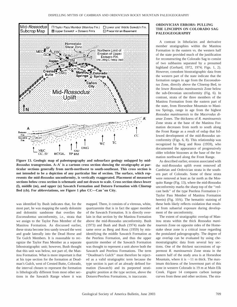
Figure 13. Geologic map of paleotopography and subsurface geology onlapped by mid-Rossodus transgression. A–A9 is a cartoon cross section showing the stratigraphy at par-ticular sections generally from north-northwest to south-southeast. This cross section isnot intended to be a depiction of any particular line of section. The surface, which rep-resents the mid-Rossodus unconformity, is vertically exaggerated. Placement of measuredsections below cross section is schematic and not drawn to scale. Cross section shows lower(l), middle (m), and upper (u) Sawatch Formation and Dotsero Formation with ClinetopBed (cb). For abbreviations, see Figure 1 plus CC—Can ˜on City.
was identified by Bush indicates that, for themost part, he was mapping the sandy dolomiteand dolomitic sandstone that overlies theEoconodontus unconformity, i.e., strata thatwe assign to the Taylor Pass Member of theManitou Formation. As discussed earlier,these strata become less sandy toward the westand grade laterally into the Dead Horse andTie Gulch Members. It is reasonable to rec-ognize the Taylor Pass Member as a separatelithostratigraphic unit; however, Bush thoughtthat this unit was below, not part of, the Man-itou Formation. What is more important is thatat his type section for the formation at Dead-man’s Gulch, west of Crested Butte, Colorado,the interval chosen to represent the formationis lithologically different from most other sec-tions in the Sawatch Range where it was
mapped. There, it consists of a vitreous, white,quartzarenite that is in fact the upper memberof the Sawatch Formation. It is directly over-lain in that section by the Manitou Formationabove the mid-Rossodus unconformity. Bush(1973) and Bush and Bush (1974) made thesame error as Berg and Ross (1959) by mis-identifying the middle Sawatch Formation asthe Peerless Formation, and thus the upperquartzite member of the Sawatch Formationwas thought to represent a unit above both theSawatch and Peerless Formations. The term‘‘Deadman’s Gulch’’ must therefore be reject-ed as a valid stratigraphic term because thetype section is part of an already defined for-mation (Sawatch) and its purported strati-graphic position at the type section, above theDotsero/Peerless Formations, is inaccurate.
ORDOVICIAN ERRORS: PULLINGTHE LINCHPIN ON COLORADO SAGPALEOGEOGRAPHY
A contrast in lithofacies and derivativemember stratigraphies within the ManitouFormation in the eastern vs. the western halfof the state provided much of the justificationfor reconstructing the Colorado Sag to consistof two subbasins separated by a presumedhighland (Gerhard, 1972, 1974; Figs. 1, 2).However, conodont biostratigraphic data fromthe western part of the state indicate that theformation ranges in age from the Eoconodon-tus Zone, directly above the Clinetop Bed, tothe lower Rossodus manitouensis Zone belowthe sub-Devonian unconformity (Fig. 6). Incontrast, strata of the three members of theManitou Formation from the eastern part ofthe state, from Horseshoe Mountain to Mani-tou Springs, range in age from the highestRossodus manitouensis to the Macerodus di-anae Zones. The thickness of R. manitouensisZone strata at the base of the Manitou For-mation decreases from north to south alongthe Front Range as a result of onlap that fol-lowed development of the mid-Rossodus un-conformity (Figs. 6, 8). This relationship wasrecognized by Berg and Ross (1959), whodocumented the appearance of progressivelyolder trilobite biozones at the base of the for-mation northward along the Front Range.
As described earlier, erosion associated withthe mid-Rossodus uplift event removed allCambrian and Ordovician strata in the south-ern part of Colorado. Some of these stratawere removed at least as far north as the Mos-quito Range (Fig. 13), where the mid-Rossodusunconformity marks the sharp top of the ‘‘red-cast beds’’ of the type Peerless Formation (5Taylor Pass Member of Manitou Formationherein) (Fig. 10A). The hematitic staining ofthese beds likely reflects oxidation that result-ed from subaerial exposure during develop-ment of the unconformity.
The extent of stratigraphic overlap of Man-itou strata within the thick Rossodus mani-touensis Zone on opposite sides of the Home-stake shear zone is a critical issue regardingthe postulated paleogeography. The degree ofage overlap can be evaluated by using che-mostratigraphic data from several key sec-tions. One of the thickest successions of up-permost R. manitouensis Zone strata in theeastern half of the study area is at HorseshoeMountain, where it is ;11 m thick. The max-imum thickness of the lowermost part of thiszone in western Colorado is 19 m at Main ElkCreek. Figure 14 compares carbon isotopecurves from these and other sections. The stra-

710 Geological Society of America Bulletin, June 2003
MYROW et al.
Figure 14. Carbon isotope stratigraphy of selected sections across Colorado based on whole-rock analysis. The datum for lower sectionsis Clinetop Bed and upper sections is base of Low Diversity Interval. Fine-grained lithologies were preferentially sampled. Conodontzones in the two western sections, South Fork and Main Elk Creek, range from Proconodontus tenuiserratus to Rossodus manitouensis(abbreviations correspond to zones shown in Fig. 6). The eastern sections cover the uppermost Rossodus manitouensis Zone, low-diversityinterval, and Macerodus dianae Zone. Elongate z-shaped lines in conodont zonation indicate unconformities.
ta directly overlying the Cambrian/Ordovicianunconformity at Horseshoe Mountain show arise in d13C values from 21‰ to 11‰ instrata from 55.8 to 67 m above the base of theSawatch Formation, the interval representingthe R. manitouensis Zone. The carbon isotopecurves for sections in the west show a steady
decline from positive values starting below theR. manitouensis Zone to a low slightly lessthan 21‰ in the basal part of the zone. Therest of the zone shows long-standing low-amplitude oscillations around 20.7‰. Innone of the sections in the west do values in-crease at the top of the zone; in the east all
sections show either the rise to positive valuesor all positive values. Therefore, these datasuggest that there is no overlap in the ages ofManitou Formation strata on opposite sides ofthe Homestake shear zone.
Trilobite data also indicate that most, per-haps all, Manitou Formation strata on the

Geological Society of America Bulletin, June 2003 711
DISPELLING MYTHS OF CAMBRIAN AND ORDOVICIAN ROCKY MOUNTAIN PALEOGEOGRAPHY
western side of the shear zone represent timethat falls within the lacuna of the mid-Rossodusunconformity on the eastern side. Similarly,the time represented by the three eastern mem-bers of the Manitou Formation falls within thelarge stratigraphic gap between the youngestManitou strata and overlying Devonian rocksin the western sections. At Williams Canyon,near the type section at Manitou Springs, thebasal bed of the Manitou Formation yieldedthe trilobite Leiostegium, confirming that theformation there contains no strata older thanthe Leiostegium-Kainella Zone. To the north,at Missouri Gulch, beds at the base of theManitou Formation contain species character-istic of the underlying Paraplethopeltis Zoneand, still lower (basal 1.5 m), those of thehighest subzone (Bellefontia chamberlainiSubzone) of the Bellefontia Zone (J.D. Loch,2002, personal commun.). In contrast, trilo-bites recovered from the Manitou Formationwest of the shear zone document the presenceof (in ascending order) the Saukia, Missis-quoia, and Symphysurina Zones and the low-est subzone (Bellefontia franklinense Sub-zone) of the Bellefontia Zone, but nothingyounger. Thus, the contrast in lithofacies andmember stratigraphy (e.g., the presence or ab-sence of chert) between northwestern andsoutheastern exposures of the Manitou For-mation, which formed the basis of the recon-struction that depicted separate subbasins, canbe attributed to differences in the ages of thestrata rather than paleogeographic isolation.
The sandy equivalent of the western mem-bers of the Manitou Formation, the TaylorPass Member, spans the Homestake shearzone and, in fact, underlies the PtarmiganChert Member of the eastern Manitou at sev-eral localities east of the Homestake shearzone. Therefore, the Homestake shear zonewas not a barrier to deposition during accu-mulation of the lower part of the Manitou For-mation. In contrast, the distribution of youngereastern Manitou members is directly related tomovement on the Homestake shear zone. Out-crops with cherty carbonate of the PtarmiganChert Member are exposed ,1 km to thesoutheast of the main shear zone, but no chert-bearing outcrops are found anywhere north-west of the fault zone. At one locality justsouth of the Homestake shear zone in the Sa-watch Range, an outcrop contains Middle Or-dovician Harding Formation resting uncon-formably on chert-bearing Manitou Formation(Allen, 1994). Just 800 m away, on the north-west side of the shear zone, the Harding restson red strata of the Taylor Pass Member, in-dicating post-Manitou and pre-Harding upliftand erosion. On the basis of the stratigraphic
offset, there was ;30 m of down-to-the-southmovement on the fault (Allen, 1994). Uplifton the shear-zone faults caused erosion of theManitou Formation to the west prior to de-position of Devonian rocks, whereas down-faulting to the southeast helped preserve theyounger Manitou Formation rocks. In sum-mary, the erosion that created the mid-Rossodus unconformity and the uplift asso-ciated with post-Manitou faulting (combinedwith pre-Devonian erosion) produced the con-trast in ages between eastern and westernManitou Formation strata. The Homestakeshear zone does not appear to have influencedpatterns of deposition or erosion during ac-cumulation of most of the Dotsero or ManitouFormations. The shear zone’s influence ap-pears to have been control on the location ofuplift and erosion during the development ofthe Eoconodontus unconformity and later re-moval of younger (eastern) Manitou strata tothe west prior to deposition of the HardingFormation.
SUMMARY OF HISTORY
Stage 1: Deposition of the SawatchFormation
Dramatic changes in thickness of the Sa-watch Formation across the state of Coloradoindicate deposition over an irregular land-scape. The distribution of the glauconitic fa-cies of the middle member of the formationindicates possible deepening to both the eastand west from the central part of the state.However, exposures are inadequate to deter-mine the degree to which these facies mayvary in a northeast-southwest orientation.Therefore, there is no conclusive evidence ofhighlands in these directions.
Stage 2: Deposition of the DotseroFormation
Facies patterns in the Dotsero Formation in-dicate very little variability over significantdistances. Increased accommodation space forsediment accumulation to the northwest is in-dicated by an increase in thickness and subtlefacies changes from Horseshoe Mountain toSouth Fork. These changes are remarkablysubtle given the distance involved, and theypoint to considerable uniformity of depositionand blanket-like deposition with only minorfacies changes.
Stage 3: Erosion of the Dotsero Formation
Removal of the Clinetop Bed and part ofthe underlying Glenwood Canyon Member of
the Dotsero Formation occurs from just eastof the Homestake shear zone in the SawatchRange eastward to the Mosquito Range, pro-ducing an Eoconodontus Zone unconformity.Karst features in the Clinetop Bed may rep-resent this unconformity in the west.
Stage 4: Deposition of the Lower ManitouFormation
Exposures of the Dead Horse Member inwestern Colorado record relatively continuousdeposition through the Cambrian–Ordovicianboundary interval from the EoconodontusZone through the lower Rossodus manitouen-sis Zone. Unconformities with lacunae ofmodest (subzonal) magnitude are also markedby karstic surfaces in these strata, but most ofthe conodont and trilobite zones in this inter-val are present despite the thin and condensednature of the Colorado succession relative tomore outboard sections in Utah and Nevada.In central Colorado, a local source of silici-clastic sand resulted in deposition of the Tay-lor Pass Member of the Manitou Formationimmediately above the Eoconodontus uncon-formity on both sides of the Homestake shearzone. A decrease in sand content and in-creased shale to the northwest indicate deep-ening in that direction. Conversely, the lowerManitou Formation is less sandy in the Mos-quito Range than in the Sawatch Range, butdata are insufficient to reconstruct a regionaltrend, identify any highland source area(s),and/or establish transport direction(s) for thesand.
Stage 5: Differential Uplift and Erosion
Uplift during the time represented by theRossodus manitouensis Zone caused completeremoval of Cambrian and Ordovician strata insouthern Colorado. The effects are less pro-nounced to the northwest; hence, the resultingmid-Rossodus unconformity climbs section inthis direction to rest progressively on the low-er, middle, and upper members of the SawatchFormation, then the Dotsero Formation, andeventually the lower Manitou Formation (Fig.8). The unconformity is not recognized inwestern Colorado exposures because it hasbeen truncated, along with the three youngermembers of the eastern Manitou Formation(stage 6), by the sub-Devonian unconformity(Fig. 10).
Stage 6: Deposition of the Upper ManitouFormation
All outcrops of younger Manitou strata as-signed to the upper R. manitouensis Zone,

712 Geological Society of America Bulletin, June 2003
MYROW et al.
low-diversity interval, and Macerodus dianaeZone occur east of the Homestake shear zone.These deposits comprise the three members ofthe Manitou Formation that Gerhard (1974)assigned to his southeast subbasin. Theseyoung Manitou Formation strata onlap themid-Rossodus unconformity surface from thenorthwest toward the southeast and eventuallyrest directly on Precambrian basement rocksat the southern end of the Front Range. Inmost sections the strata immediately below theunconformity are those of the middle SawatchFormation or the Dotsero Formation; locationswhere younger Manitou strata overlie themore resistant quartzite of the lower or upperSawatch Formation are rare. Apparently, thecontrast in erosional resistance of the quartziteunits and the intervening dolomitic units pro-duced a paleo–cliff-and-bench topography(Fig. 13) on which the cliff-forming quartziteunits offered little area for the onlapping stratato accumulate.
Stage 7: Erosion Following ManitouFormation Deposition
Upper Manitou strata were presumably re-moved in western Colorado as a result of up-to-the-northwest motion on the Homestakeshear zone some time after deposition of theManitou Formation, followed by erosion as-sociated with sub-Devonian but pre-HardingFormation erosion. (The Ordovician HardingFormation and its unconformity are generallymissing in western Colorado owing to sub-Devonian erosion.) Chert-bearing carbonate ofthe middle part of the Ptarmigan Chert Mem-ber are exposed within 1 km of the shear zone,suggesting that the eastern members of theManitou Formation likely extended acrossColorado to the west prior to sub-Devonianerosion.
DISCUSSION
The Transcontinental Arch is routinely re-constructed as trending south-southwest fromMinnesota to northern New Mexico (Lochman-Balk, 1971; Carlson, 1999). This structuralfeature was demonstrated to have been activeat various stages throughout the Phanerozoicand to have had a strong influence on depo-sitional patterns in western and central Lau-rentia. Middle Cambrian deposits occur inWyoming and Montana and in areas west ofColorado, but not in Colorado or in the restof the Midcontinent. This distribution sug-gests advance of the paleo–Pacific Ocean ontothe continent at this time with a generallynorth-trending shoreline that to the north of
Colorado extended slightly farther east. Theage of the oldest sedimentary cover rocks inColorado and many other parts of the Mid-continent is Late Cambrian. This fact indicatesthat transgression onto the craton pushed theshoreline farther inland in the Late Cambrianwhen relative sea level presumably rose to apoint that flooding occurred over a broad, rel-atively flat continental interior. So then whatevidence is there for a linear arch in west-central Laurentia during the Late Cambrianand Ordovician and for a ‘‘sag’’ in that archwithin present-day Colorado?
At the time the Colorado Sag was proposed(Lochman-Balk, 1956), physical stratigraphicand biostratigraphic data were too incompleteto allow recognition of the mid-Rossodus un-conformity and its effects. The work of Bergand Ross (1959) revealed some of the strati-graphic effects of this unconformity, despitemisidentification of the middle Sawatch For-mation as the Peerless Formation. However,the full importance of this surface becameclear only as a large amount of biostratigraph-ic, chemostratigraphic, and physical strati-graphic data was gathered from across thestate in the present study. Because the entireUpper Cambrian and lowermost Ordoviciandeposits were eliminated by the mid-Rossoduserosional event in southern Colorado, and pre-sumably in northern New Mexico, there sim-ply is no evidence with which to reconstructpre–mid-Rossodus paleogeography in this re-gion. The event in question created relief andupland areas onto which Rossodus manitouen-sis Zone and younger strata onlapped, namely,the mid-Rossodus uplift. However, the lack ofa record of pre-Rossodus deposits can in noway be construed as confirmation of nonde-position in this region. There is in fact no ev-idence, such as facies changes, to indicate thatany of the Upper Cambrian deposits lappedout against a pre–mid-Rossodus highland tothe south. Isopach maps of the Sawatch andManitou Formations (Allen, 1994) suggestsharp, postdepositional erosional truncationrather than syndepositional thinning to thesouth. Parsimonious interpretation of theavailable data should therefore eliminate anyhighland from paleogeographic reconstruc-tions that predate the mid-Rossodus-age upliftevent.
Similarly, there are almost no data withwhich to define the early history of the Souix-ia uplift to the northeast and, in particular, todemonstrate that it was a positive area duringdeposition of part or all of the Cambrian–Ordovician boundary interval. Developmentof the middle Sawatch Formation on oppositesides of the state confirms the existence of an
inherited basement high at that time. However,the lateral continuity of units within the over-lying Dotsero and lower Manitou Formationsargues strongly against any positive topo-graphic features during the latest Cambrianand Early Ordovician (pre–mid-Rossodusmanitouensis Zone). Thus, there is no evi-dence to support the idea of a Colorado Sagor that Cambrian and Ordovician strata ofnorthwest and southeast Colorado representdifferent facies belts separated by a highlandregion. These ideas resulted from miscorrela-tion and a paucity of biostratigraphic data.
The results of our study demonstrate theneed for reevaluation of the stratigraphic dataused to reconstruct lower Paleozoic paleoge-ography in areas proximal to the Transconti-nental Arch along its entire length. Signifi-cantly, recent integrated sedimentologic andbiostratigraphic studies in the Upper Cambri-an of the northern Midcontinent also reveal noevidence of a strong influence of the Trans-continental Arch on sedimentation patterns(Runkel, 1994; Runkel et al., 1998). Nonethe-less, the long-standing view that the Transcon-tinental Arch and Colorado Sag existed duringthe Cambrian to Early Ordovician is stillfound in recent publications (e.g., Carlson,1999). Careful stratigraphic analysis of otherparts of western and Midcontinent NorthAmerica utilizing similarly precise and varieddata are needed to better define the timing ofdevelopment and influence of the Transconti-nental Arch.
ACKNOWLEDGMENTS
This work was supported by National ScienceFoundation grant EAR-9419141 (to Myrow). Ac-knowledgment is made to the donors of The Petro-leum Research Fund, administered by the AmericanChemical Society, for partial support of this re-search. We thank Pete Palmer for loan of trilobitespecimens from the Institute for Cambrian Studies.We also express our thanks to the undergraduatestudents from Colorado College (R. Bennett, T.Brachle, E. Day, B. McMillan, J. Ruth, and C. VanLoon) and Indiana University of Pennsylvania (T.Bernot and C. Wright) for field and laboratory as-sistance and to Warren Stultz at the Elk CreekRanch and the staff at Cave of the Winds for accessto their properties. We thank editor Gene Rankeyand our anonymous reviewers Pete Palmer and JohnCooper for thorough and constructive reviews. Andwe thank Stephen Weaver of Colorado College fortechnical support in preparation of the manuscript.
REFERENCES CITED
Allen, J.L., 1994, Stratigraphic variations, fault rocks, andtectonics associated with brittle reactivation of theHomestake shear zone, central Colorado [Ph.D. the-sis]: Lexington, University of Kentucky, 296 p.
Allen, J.R.L., and Narayan, J., 1964, Cross-stratified units,some with silt bands, in the Folkestone Beds (Lower

Geological Society of America Bulletin, June 2003 713
DISPELLING MYTHS OF CAMBRIAN AND ORDOVICIAN ROCKY MOUNTAIN PALEOGEOGRAPHY
Greensand) of southeast England: Geologie en Mijn-bouw, v. 43, p. 451–461.
Anderson, T.B., 1970, Cambrian and Ordovician stratigra-phy of the southern Mosquito Range, Colorado:Mountain Geologist, v. 7, p. 51–64.
Bass, N.W., and Northrop, S.A., 1953, Dotsero and ManitouFormations, White River Plateau, Colorado, with spe-cial reference to Clinetop Algal Limestone Member ofDotsero Formation: American Association of Petro-leum Geologists Bulletin, v. 37, p. 889–912.
Behre, C.H., Jr., 1932, The Weston Pass mining district,Lake and Park Counties, Colorado: Colorado Scien-tific Society Proceedings, v. 12, p. 38–41.
Behre, C.H., Jr., 1939, Preliminary geologic report on thewest slope of the Mosquito Range in the vicinity ofLeadville, Colorado: Colorado Scientific Society Pro-ceedings, v. 14, p. 50–79.
Berg, R.R., and Ross, R.J., Jr., 1959, Trilobites from thePeerless and Manitou Formations, Colorado: Journalof Paleontology, v. 33, p. 106–119.
Bush, J.H., 1973, Upper Cambrian stratigraphy of centralColorado [Ph.D. thesis]: Pullman, Washington StateUniversity, 231 p.
Bush, J.H., and Bush, C.G., 1974, Revisions in Cambriannomenclature in central Colorado: Mountain Geolo-gist, v. 11, p. 59–69.
Campbell, J.A., 1976, Upper Cambrian stromatolitic bios-trome, Clinetop Member of the Dotsero Formation,western Colorado: Geological Society of AmericaBulletin, v. 87, p. 1331–1335.
Carlson, M.P., 1999, Transcontinental Arch—A patternformed by rejuvenation of local features across centralNorth America: Tectonophysics, v. 305, p. 225–233.
Chronic, J., 1964, Geology of the southern MosquitoRange, Colorado: Mountain Geologist, v. 1,p. 103–114.
Crawford, R.D., and Gibson, R., 1925, Geology and oredeposits of the Red Cliff District, Colorado: ColoradoGeological Survey Bulletin 30, 89 p.
Cross, C.W., 1894, Description of the Pikes Peak sheet,Colorado: U.S. Geological Survey Atlas, Pikes PeakFolio 7, 5 p.
Eldridge, G.H., 1894, Description of the sedimentary for-mations: Anthracite–Crested Butte Quadrangle, Col-orado: U.S. Geological Survey Atlas, Folio 9.
Emmons, S.F., 1882, Abstract of report on geology andmining industry of Leadville, Lake County, Colorado:U.S. Geological Survey 2nd Annual Report,p. 201–290.
Emmons, S.F., 1886, Geology and mining industry of Lead-ville, Lake County, Colorado: U.S. Geological SurveyMonograph 12, v. 47.
Ethington, R.L., Engel, K.M., and Elliot, K.L., 1987, Anabrupt change in conodont faunas in the Lower Or-dovician of the Midcontinent province, in Aldridge,R.J., ed., Palaeobiology of conodonts: Chichester, UK,Ellis Horwood, p. 111–127.
Gerhard, L.C., 1972, Canadian depositional environmentsand paleotectonics, central Colorado, in De Voto,R.H., ed., Paleozoic stratigraphy and structural evo-lution of Colorado: Colorado School of Mines Quar-terly, v. 67, no. 4, p. 1–36.
Gerhard, L.C., 1974, Redescription and new nomenclatureof Manitou Formation, Colorado: American Associa-tion of Petroleum Geologists Bulletin, v. 58,p. 1397–1406.
Johnson, J.H., 1934, Paleozoic formations of the Mosquito
Range, Colorado: U.S. Geological Survey Profession-al Paper 185-B, 43 p.
Johnson, J.H., 1944, Paleozoic stratigraphy of the SawatchRange, Colorado: Geological Society of America Bul-letin, v. 55, p. 303–378.
Johnson, J.H., 1945, A resume of the Paleozoic stratigraphyof Colorado: Colorado School of Mines Quarterly,v. 40, 109 p.
Lochman-Balk, C., 1956, The Cambrian of the RockyMountains and southwest deserts of the United Statesand adjoining Sonora Province, Mexico, in Rodgers,J., ed., El Sistemo Camrico, su paleogeografia y elproblema de su base: Mexico, D.F., 20th InternationalGeological Congress, v. 2, p. 529–661.
Lochman-Balk, C., 1970, Upper Cambrian faunal patternson the craton: Geological Society of America Bulletin,v. 81, p. 3197–3224.
Lochman-Balk, C., 1971, The Cambrian of the craton ofthe United States, in Holland, C.H., ed., Cambrian ofthe New World, lower Paleozoic rocks of the World,volume 1: New York, Wiley Interscience, p. 79–167.
Ludvigsen, R., and Westrop, S.R., 1985, Three new UpperCambrian stages for North America: Geology, v. 13,p. 139–143.
Mackay, I.H., 1953, Geology of the Thomasville–WoodsLake area, Eagle and Pitkin County, Colorado: Colo-rado School of Mines Quarterly, v. 48, p. 1–76.
Myrow, P.M., 1995, Thalassinoides and the enigma of earlyPaleozoic open-framework burrow systems: Palaios,v. 10, p. 58–74.
Myrow, P., 1998, Transgressive stratigraphy and deposi-tional framework of Cambrian tidal dune deposits,Peerless Formation, central Colorado, USA, in Alex-ander, C., Davis, R., and Henry, J., eds., Tidalites:Processes and Products, SEPM (Society for Sedimen-tary Geology) Special Publication 61, p. 143–154.
Myrow, P.M., Ethington, R.L., and Miller, J.F., 1995,Cambro–Ordovician proximal shelf deposits of Colo-rado, in Cooper, J.D., Finney, S.C., and Droser, M.L.,eds., Ordovician odyssey: Short papers for the Sev-enth International Symposium on the Ordovician Sys-tem: Pacific Section, SEPM (Society for SedimentaryGeology), Book 77, p. 375–379.
Myrow, P.M., Taylor, J.F., Miller, J.F., Ethington, R.L., Rip-perdan, R.L., and Brachle, C., 1999a, Stratigraphy,sedimentology, and paleontology of the Cambrian–Ordovician of Colorado, in Lageson, D.R., Lester, A.,and Trudgill, B., eds., Colorado and adjacent areas:Boulder, Colorado, Geological Society of AmericaField Guide 1, p. 157–176.
Myrow, P.M., Taylor, J.F., Miller, J.F., Ethington, R.L., Rip-perdan, R.L., Brachle, C.M., and Owen, M.,, 1999b,Stratigraphic synthesis of the Cambrian–Ordovicianrocks of Colorado: Acta Universitatis Carolinae, Geo-logica, v. 43, p. 9–12.
Narayan, J., 1963, Cross-stratification and palaeogeographyof the Lower Greensand of southeast England andBas-Boulonnais, France: Nature, v. 199, p. 1246–1247.
Narayan, J., 1971, Sedimentary structures in the LowerGreensand of the Weald, England, and Bas-Boulonnais,France: Sedimentary Geology, v. 6, p. 73–109.
Nio, S.-D., 1976, Marine transgressions as a factor in theformation of sandwave complexes: Geologie en Mi-jnbouw, v. 55, p. 18–40.
Resser, C.E., 1942, New Upper Cambrian trilobites: Smith-sonian Miscellaneous Collections, v. 103, p. 1–136.
Rigby, J.K., and Myrow, P.M., 1999, Lower Ordovician
sponges from the Manitou Formation in central Col-orado: Provo, Utah, Brigham Young University Press,v. 44, p. 135–153.
Ross, R.J., Jr., 1976, Ordovician sedimentation in the west-ern United States, in Bassett, M.G., ed., The Ordovi-cian System: Proceedings of a Palaeontological As-sociation Symposium, Birmingham, September, 1974:Cardiff, University of Wales Press and National Mu-seum of Wales, p. 73–105.
Ross, R.J., Jr., and Tweto, O., 1980, Lower Paleozoic sed-iments and tectonics in Colorado, in Kent, H.C., andPorter, K.W., eds., Colorado geology: Denver, Colo-rado, Rocky Mountain Association of Geologists—1980 Symposium, p. 47–56.
Runkel, A.C., 1994, Deposition of the uppermost Cambrian(Croixan) Jordan Sandstone, and the nature of theCambrian–Ordovician boundary in the Upper Missis-sippi Valley: Geological Society of America Bulletin,v. 106, p. 492–506.
Runkel, A.C., McKay, R.M., and Palmer, A.R., 1998, Or-igin of a classic cratonic sheet sandstone: Stratigraphyacross the Sauk II–Sauk III boundary in the UpperMississippi Valley: Geological Society of AmericaBulletin, v. 110, p. 188–210.
Shapiro, R.S., 1998, Upper Cambrian–lowermost Ordovi-cian stratigraphy and microbialites of the Great Basin,U.S.A. [Ph.D. thesis]: Santa Barbara, University ofCalifornia, 446 p.
Shapiro, R.S., and Awramik, S.M., 2000, Microbialite mor-phostratigraphy as a tool for correlating Late Cambri-an–Early Ordovician sequences: Journal of Geology,v. 108, p. 171–180.
Singewald, Q.D., 1947, Preliminary geologic map of theupper Blue River area, Summit County, Colorado:U.S. Geological Survey, preliminary map.
Singewald, Q.D., 1951, Geology and ore deposits of theupper Blue River area, Summit County, Colorado:U.S. Geological Survey Bulletin 970, 54 p.
Singewald, Q.D., and Butler, B.S., 1930, Preliminary geo-logic map of the Alma mining district, Colorado: Col-orado Scientific Society Proceedings, v. 12,p. 295–304.
Taylor, J.F., 2001, Uppermost Cambrian inner shelf faunasfrom the western United States: Oxford, United King-dom, Third International Conference on Trilobites andTheir Relatives, Abstracts with Program, p. 29–30.
Tweto, O., 1979, Geologic map of Colorado: U.S. Geolog-ical Survey, scale: 1:500,000.
Tweto, O., Stevens, T.A., Hail, W.J., Jr., and Moench, R.H.,1976, Preliminary geologic map of the Montrose 183 28 quadrangle, southwest Colorado: U.S. Geologi-cal Survey Mineral Investigations Field Studies MapMF-761, scale: 1:250,000.
Tyler, T.F., and Campbell, J.A., 1975, Dotsero Formation,western Colorado: Mountain Geologist, v. 12,p. 113–118.
Westrop, S.R., 1986, Trilobites of the Upper Cambrian Sun-waptan Stage, southern Canadian Rocky Mountains,Alberta: Palaeontographica Canadiana, v. 3, 179 p.
Wheeler, H.E., 1964, Base level, lithosphere surface, andtime-stratigraphy: Geological Society of America Bul-letin, v. 75, p. 599–609.
MANUSCRIPT RECEIVED BY THE SOCIETY 1 OCTOBER 2001REVISED MANUSCRIPT RECEIVED 30 SEPTEMBER 2002MANUSCRIPT ACCEPTED 10 OCTOBER 2002
Printed in the USA