FACULDADE DE LETRAS ESCOLA NAVAL -...
115
FACULDADE DE LETRAS ESCOLA NAVAL Shipwrecks of the “Carreira da Índia” (1595-1623) – Sources for the Study in Portuguese Maritime History Torsten Arnold Mestrado em História Marítima Dissertação 2014
Transcript of FACULDADE DE LETRAS ESCOLA NAVAL -...

FACULDADE DE LETRAS ESCOLA NAVAL
Shipwrecks of the “Carreira da Índia” (1595-1623) – Sources for
the Study in Portuguese Maritime History
Torsten Arnold
Mestrado em História Marítima
Dissertação
2014
FACULDADE DE LETRAS ESCOLA NAVAL
Shipwrecks of the “Carreira da Índia” (1595-1623) – Sources for
the Study in Portuguese Maritime History
Torsten Arnold
Mestrado em História Marítima
Dissertação
2014
Für Sónia
“The Portuguese ovserseas expansion is one of the most interesting research areas for
historians. […]The consequences were, either regarding the mother country or the
countries to where the Portuguese sailed, incalculable and one has to ask himself
repeatedly how it was possible that the small country Portugal managed to accomplish
this enormous achievement.”
(Hermann Kellenbenz, 1970)

Index
Acknowledgement……………………………………………………………....... …….1
Abstract…………………………………………………………………………..............3
Resumo…………………………………………………………………………..............4
List of Abbreviations…………………………………………………………….............8
List of Illustrations and Tables…………………………………………………………..9
Introduction…………………………………………………………………….............10
State of the Art……………………………………………………………………….…12
I Historical Background…………………………………………………............15
I.1 The Portuguese Estado da Índia 1497-1580 .......................................................15
I.2 Portuguese Estado da Índia, the British East India Company
and the Dutch United East India Company during the first half
of the 17th
century………………………………………………………............16
I.3 Comparing the principles of Portuguese and Dutch-Asiatic shipping….............21
I.4 Ships of the Portuguese Carreira da Índia and of
the Dutch United East India Company…………………………………………….…...24

II Shipwrecks of the Carreira da Índia 1595-1623………………………………..27
II.1 From naval conflicts to the Twelve Years Truce 1600-1625…………………..29
II.1.1 Observations……………………………………………………………............37
II.2 The Twelve Years Truce 1609-1621 …………………………………………..38
II.2.1 Observations …………………………………………………..........................41
II. 3 The recurrence of naval conflicts 1621-1623…………………………………..43
II.3.1 Observations……………………………………………………………………46
II.4 Final Remarks…...………………………………………………………...........47
III Underwater Archaeology……………………….………………………………50
III.1 The underwater geological formations of the
Mozambique Channel and the Carreira da Índia................................................50
III.2 Underwater Archaeology – Evidence of shipwrecks……….………………….56
III.3 1608 Naus São Francisco and Nossa Senhora da Consolação...........................58
III.4 1622 Nau São José...............................................................................................61
III.5 1622 Naus Santa Teresa de Jesus and São Carlos.............................................63

III.6 1622 Dutch Jacht ’t Hert......................................................................................65
III.7 Observations…………………………………………………………………....66
IV Naus of the Carreira da Índia during the first quarter
of the 17th
century………………………………………………………………68
IV.1 Shipbuilding theory and reconstruction based on shipwrecks………….……...68
IV.2 1606 Nossa Senhora dos Mártires…………………………………………........…..74
IV.3 1608 Nossa Senhora da Consolação..................................................................77
IV.4 Observations……………………………………………………………………79
V Monetary flows of the Portuguese outward bound armadas
during the first quarter of the 17th
century……………………………....……………...81
V.1 The armadas of 1622 and 1623………………………………………………...85
V.2 Observations……………………………………………………………………88
VI Final Remarks……………………………………………………...…………...90
Sources and Bibliography………………………………………………………………93

1
Acknowledgements
In this part, I would like to express my gratitude and thanks to the following
institutions and people who have supported me during the entire period of elaborating
the present thesis throughout the years:
To my supervisor Prof. Francisco Contente Domingues for the advice and
support given at any time throughout the period of elaboration of the thesis.
To the employees of the Arquivo Histórico Ultramarino (Lisbon), the Biblioteca
do Palácio da Ajuda (Lisbon), the Centro de História da Faculdade de Letras da
Universidade de Lisboa, the Library of the Faculdade de Letras da Universidade de
Lisboa, the National Archives of Portugal Torre do Tombo (Lisbon), the National
Library of Portugal (Lisbon) for their service and permission of using several material.
To Professor Peter Borschberg, lecturer at the National University of Singapore
(NUS) for the support and delivery of some of his books which until the present state
were not available in Portuguese libraries.
To Professor Augusto António Alves Salgado, lecturer at the Navy School of
Portugal (Escola Naval) for the support regarding Portuguese shipbuilding of the early
17th
century.
To Arqueonautas Worldwide, Arqueologia Subaquática S. A., especially Lic.
Alejandro Mirabal, the operations manager of Arqueonautas, for their support and
unlimited access to the company’s archive documenting the survey and excavation
campaigns in Mozambican waters, the artefacts and cultural material, diving logbooks
and the historical documentation of shipwrecks as well as the permission of using
several material.
To my father, Karl-Heinz Arnold who, without knowing, helped and supported
me a lot during the entire period of elaboration of the present thesis by asking questions
which led me to new points of interrogation as well as conclusions.
To my family and friends in general for the given support.

2
To Mrs. Maria Isabel dos Santos Pimenta Marques da Silva for proof reading
and correcting the thesis regarding spelling mistakes.
And last but not least I would like to deeply thank and dedicate this thesis to my
wife, Sónia who has and is always supporting me while researching.

3
Abstract
The present thesis Shipwrecks of the “Carreira da Índia” (1595-1623) – Sources
for the Study in Portuguese Maritime History deals with factors which caused losses of
ships of the Carreira da Índia which linked the European metropolis Lisbon with its
Goa based Estado da Índia between 1595 and 1623. Although Portuguese-Asiatic
shipping was formally separated from the Habsburg Empire during the Union of the
Two Iberian Crowns (1580-1640), the European policies of the Spanish Kings,
especially towards the United Provinces and the Netherlands had its influence and
effects on the Portuguese side.
Shipwrecks, either on the outward bound or homeward bound voyages had
occurred for various reasons since the early days of the Carreira da Índia yet the
emergence of the two private European Companies, the Dutch United East India
Company (founded in 1602) and the British East India Company (founded in 1600)
were a new momentum by which’s characteristics of concurrence and struggle for
supremacy of the European-Asiatic spice trade, losses of Portuguese ships were caused
by planned and executed military operations as well.
Focusing on the geographical region of the Mozambique Channel in which the
losses have taken place, the thesis combines a historiographical approach with records
of underwater archaeology analyzing questions related to the political environment and
planed military operations in which shipwrecks have occurred as well as causes of
shipwrecks observing ship building and design modifications and effects related to
economic patterns such as the monetary flows of the Portuguese outward bound
shipping during the period of observation.
Key words:
Carreira da Índia, Monetary flows, Mozambique Channel, Nau, Shipwrecks

4
Resumo
A presente dissertação de Mestrado em História, História Marítima pela
Faculdade de Letras da Universidade de Lisboa e da Escola Naval, intitula-se
“Shipwrecks of the “Carreira da Índia” (1595-1623) – Sources for the Study in
Portuguese Maritime History” procura encontrar e analisar os fatores que causaram
perda de embarcações da Carreira da Índia entre 1595 e 1623. Apesar da administração
do comércio e navegação luso-asiático estar formalmente separada do império
Habsburgo durante a União das Duas Coroas Ibéricas (1580-1640), as políticas hispano-
europeias e, particularmente, em relação às Províncias Unidas e aos Países Baixos,
influenciaram a vertente Portuguesa.
Os naufrágios, seja na fase da viagem de ida ou de volta, ocorreram desde os
primeiros dias da Carreira da Índia mas, o aparecimento das duas companhias privadas
europeias, a Companhia Holandesa das Índias Orientais (fundada em 1602) e a
Companhia Inglesa das Índias Orientais (fundada em 1600), pelas suas características de
concorrência e luta pela supremacia do comércio de especiarias eurasiático, fez com que
as perdas de embarcações portuguesas resultassem também de operações militares
planeadas.
Centrada na área geográfica do Canal de Moçambique, onde os naufrágios
ocorreram, a presente dissertação combina uma abordagem historiográfica nacional e
internacional com dados obtidos por arqueologia subaquática, comparando e analisando
questões relacionados com o ambiente político e as operações militares planeadas que
os envolveram; debruça-se também sobre as causas de perda de embarcações, através da
observação da construção naval e suas modificações e sobre os efeitos relacionados com
padrões económicos, tais como fluxos monetários na fase da ida da Carreira da Índia no
período em análise.
Construindo o discurso da dissertação (entre 1595 e 1623) pela cronologia dos
acontecimentos históricos dos finais do século XVI e início do século XVII, a mesma
começa com a primeira viagem de uma companhia privada holandesa com base nas
informações recolhidas e fornecidas por Jan Hyugen van Linschoten sobre a navegação
portuguesa no Índico, terminando em 1623, ano do massacre de Amboina, que teve

5
como consequência o fim da aliança militar europeia. A escolha da área geográfica, o
Canal de Moçambique, a passagem entre terra firme do continente africano e a ilha de
Madagáscar, na época em estudo chamada São Lourenço, prende-se com os seguintes
motivos: desde o início da Carreira da Índia, a ilha de Moçambique era um dos mais
importantes entrepostos da navegação portuguesa ao longo da rota do cabo no qual,
durante o século XVI, foram construídos uma feitoria, um hospital e sistemas
defensivos como a fortaleza de São Sebastião. Aqui, os navios podiam ser abastecidos
com água e alimentos e invernar quando o regime de monção não permitia uma
continuação da viagem de ida ou volta. Da mesma forma, ao longo do período de 1497
até 1650, cerca de 25 por cento dos naufrágios portugueses ocorreram no Canal de
Moçambique.
Estruturado em cinco capítulos, o discurso começa com uma observação
genérica do Estado da Índia até 1580 e o aparecimento das duas companhias privadas da
Europa do norte, a holandesa e a inglesa, centrando-se em assuntos dos princípios da
navegação e das embarcações utilizadas.
A segunda parte analisa a época dos finais do século XVI e dos inícios do século
XVII através de ângulos históricos, historiográficos e políticos. Caracterizado pelos
seguintes eventos históricos, o discurso é separado em três fases: de 1595 até 1609 pela
primeira viagem holandesa em águas asiáticas, as primeiras operações militares
planeadas em águas moçambicanas (1604, 1607 e 1608) até às Tréguas de Doze Anos
entre Portugal e os Países Baixos. Durante esse período (1609-1621) não se registaram
perdas devido ao chamado corso neerlandês mas a Carreira da Índia, a ligação por meio
marítimo entre Lisboa, a metrópole do império português e Goa, a capital do Estado da
Índia, sofreu perdas pela navegação e comércio de uma nova companhia privada da
Europa do norte, a Companhia Inglesa. Planos e tentativas para fundir as duas
companhias privadas em apenas uma falharam mas, uma colaboração formal entre as
companhias, através da constituição das chamadas frotas de defesa, impediu o
prolongamento das tréguas entre os Portugueses e Holandeses procuradas pelos últimos.
Entre 1621 e 1623, a última fase em análise, foram retomadas as operações militares
planeadas no Índico Ocidental causando a perda de três naus portuguesas no ano de
1622. Os desacordos entre ambas as companhias pela supremacia do comércio asiático,
que resultaram no massacre holandês contra os ingleses estacionados na feitoria
partilhada de Amboina em 1623, impediram a execução de um novo ataque das forças

6
combinadas em águas moçambicanas, contudo, parte da armada portuguesa de 1623,
que invernava na Ilha de Moçambique, perdeu-se devido a uma tempestade em Janeiro
de 1624.
O capítulo três “Underwater Archaeology” explica as formações geográficas
subaquáticas do Canal de Moçambique focando-se em fatores hidrográficos e
oceanográficos como baixos, correntes e bancos de areia, que condicionaram a
navegação luso-asiática, apresentando seis vestígios arqueológicos subaquáticos, cinco
da navegação portuguesa e um da navegação holandesa em águas moçambicanas,
observados e parcialmente escavados pela Arqueonautas Worldwide, Arqueologia
Subaquática S.A., uma companhia privada de arqueologia marítima.
Nos capítulos quatro e cinco, “Naus of the Carreira da Índia the first half of the
17th
century” and “Monetary flows of the Portuguese outward bound armadas during the
first quarter of the 17th
century”, a análise composta pelos métodos de pesquisa
historiográfica e dados arqueológicos recolhidos, trata assuntos e questões da
construção dos meios do transporte marítimo português, as naus, apresentando uma
comparação entre as teorias da construção naval portuguesa e a reconstrução baseada
em dois vestígios arqueológicos, a Nossa Senhora dos Mártires, que se perdeu em 1606
perto de São Julião de Barra, Portugal, e a Nossa Senhora da Consolação, que se perdeu
em 1608 perto da Ilha de Moçambique. Relativamente aos fluxos monetários das
armadas de ida que transportavam não só o dinheiro e o cabedal destinados à compra de
especiarias mas também o dinheiro destinado à administração do Estado da Índia, a
dissertação não só mostra a quantidade de dinheiro enviado, como apresenta a dimensão
do comércio luso-asiático com a dependência e procura de prata originada no Novo
Mundo e transportado pelas armadas espanholas. O caso da perda de várias
embarcações espanholas nas Caraíbas e a falta de moedas de prata, os reales, serve
como exemplo para o processo de preparação da armada portuguesa da Carreira da
Índia no ano seguinte. Incluído neste capítulo encontra-se uma estimativa da quantidade
de cabedal da armada de 1622 que, até agora, nunca tinha sido apresentada por ausência
de dados documentais explícitos.
Usando os factos conhecidos das investigações de historiadores nacionais e
internacionais e, através de uma nova interpretação baseada em documentos
contemporâneos à qual foi acrescentada a componente de arqueologia naval e marítima,
7
a presente dissertação apresenta uma nova perspetiva relacionada com as causas e
efeitos de naufrágios da Carreira da Índia em águas moçambicanas entre 1595 e 1623.
Palavras chave:
Carreira da Índia, fluxos monetários, Canal de Moçambique, Nau, Naufrágios

8
List of Abbreviations
AHU Arquivo Histórico Ultramarino, Lisbon, Portugal
BNL Biblioteca Nacional de Portugal, Lisbon
CARTi Cartographia imprensa, printed cartography section
C.C. Coleção de Cartografia, Cartographic Collection
Cf. confirm
cx. caixa, box
coord. coordination, coordinator
CU Conselho Ultramarino
D., doc. document
Dir. director, directed by
Ed., eds. editor, editors
FG Fundo Geral
Fol., fols. folio, folios
IDM Ilha de Moçambique, Mozambique Island
Introd. introduction, introduction by
MOG Mogincual
N0. Number
NAC Nacala
op. cit. obra citada
p., pp. Page, pages
s.d. sem data
s.l. sem local
s.n. sem nome
sep. separate, separated from
t. tomo
v. verso
vol., vols. volume, volumes

9
List of Illustrations and Tables
Figure 1 “The Portuguese India Route”......................................................23
Figure 2 “Carta Reduzia do Canal de Mosambique”..................................52
Figure 3 “Hydrographic plan of Mozambique Island”, 1823……...……..55
Figure 4 “General site plan of shipwrecks in the vicinities of
Mozambique Island”……………………………………………57
Figure 5 “Site plan of the wrecksite IDM-003”…………………………..60
Figure 6 “Underwater chart of the Infusse shoals”……………………….63
Figure 7 “Underwater chart of the Quissimajulo Bay” …………...66
Figure 8 “Scheme of clinker-planking and carvel-planking”…………….70
Figure 9 “Carvel-planking of a Portuguese Nau”………………………...70
Figure 10 “Scheme of organization of space per deck of a
Portuguese Nau”...........................................................................72
Figure 11 “The Pepper Wreck reconstructed after
Fernando Oliveira’s Livro da fábrica das naus”..........................75
Figure 12 “The sails of the Pepper Wreck”……………………………….76
Figure 13 “Nossa Senhora da Consolação reconstructed after
Manuel Fernandes Livro de Traças de Carpintaria “.................79
Table 1 “Effects of the Dutch and English attacks and the
Carreira da Índia”……………………………………………...49
Table 2 “Measurement units used in Portuguese shipbuilding
during the 17th
century”…………………………………………71
Table 3 “Monetary flows of the Portuguese outward bound
armadas 1600-1625”……………………………………………84
Table 4 “Figures of the 1622 Portuguese outward bound fleet”………...87
Table 5 “Figures of the 1623 Portuguese outward bound fleet”………...88
10
Introduction
The present thesis Shipwrecks of the “Carreira da Índia” (1595-1623) – Sources
for the Study in Portuguese Maritime History aims to analyze the various factors which
caused the losses of ships of the Portuguese-Asiatic trade during the historical time
period of the Union of the Two Iberian Crowns (1580-1640) and the first quarter of the
17th
century in Mozambican waters, in particular.
Structured into five main parts in which the first provides a generic overview of
the development of the Portuguese Estado da Índia until the late 16th
century, the
emergence of the European private companies, the Dutch United East India Company
(VOC, founded in 1602), the British East India Company (EIC, founded in 1602) and
the principles of the European-Asiatic shipping by observing the shipping routes and
ships used.
The second part analyses the era of the late 16th
century and the first quarter of
the 17th
century from a more historical, political and historiographical point of view and
is divided into three distinctive periods: 1595-1609, 1609-1621 and 1621-1623. This
separation is based on the following historical events: the first voyage of a Dutch
private company to Asia (1595), the Twelve Years Truce between the Portuguese and
Dutch (1609-1621), the recurrence of naval combats in Asian waters (1621) of which
the attack on the Portuguese outward bound fleet of 1622 symbolized the last planned,
and combined, European military action in the Western Indian Ocean. Given the fact
that the loss of ships of the Portuguese outward bound fleet of 1623 is directly related to
the loss of the silver fleet in the Caribbean in the previous year, the analysis of the same
was included in the present thesis.
The third chapter, “Underwater Archaeology”, explains the geographical
underwater formations of the Mozambique Channel focusing on hydrographical and
oceanographic factors such as currents, sandbanks and shoals which conditioned the
Portuguese-Asiatic shipping. Included in the presentation are the remains of six, five
Portuguese and one Dutch, shipwrecks which were surveyed and in some cases
excavated by Arqueonautas Worldwide, Arqueologia Subaquática S.A., a private
marine archaeology company.

11
Chapters four and five, “Naus of the Carreira da Índia the first half of the 17th
century” and “Monetary flows of the Portuguese outward bound armadas during the
first quarter of the 17th
century”, a combined analysis of historiography and maritime as
well as underwater archaeology deal with the construction of the means of Portuguese
maritime transport and the nau in particular, as well as monetary flows of the outward
bound fleets which, on one hand carried the annual money to buy spices and oriental
goods and, on the other, the financial supplies for Estado da Índia.
Given the fact that the European struggle for supremacy in world trade was not
only fought in European waters or in the regions where spices and oriental goods
originated from, such as the Spice Islands, but also took place at strategic points along
the cape route, the maritime trade route to India, the present study focuses on one
specific area in particular: Mozambique Island, the Portuguese way-station and entrepôt
situated at the northern end of the Mozambique Channel which separates the island of
Madagascar (or São Lourenço as it was named in the historical time period) from the
African continent. The emphasis on this geographical area of the Western Indian Ocean
is also based on the factor that approximately 25% of all known and documented
shipwrecks of the Portuguese Carreira da Índia have occurred when passing the
channel.
Analyzing known facts and introducing recent investigations, the thesis aims to
contribute to early modern European maritime history by focusing on the means of
maritime transport and the merchandise transported on board.

12
State of the Art
Shipwrecks as sources for Maritime History are not an invention of
present day’s studies. In his book History of Africa South of the Zambesi, George
McCall Theal refers to the importance of shipwrecks for Maritime History as
“Knowledge derived from Shipwrecks”1.
During the last decades, there has been a development towards a combined
observation, in which Maritime or Underwater Archaeology is used to find answers for
questions more related to Maritime History. Recent Portuguese and international studies
in shipbuilding treaties such as The Nau of the Livro Nautico: Reconstructing a
Sixteenth-Century Indiaman from Texts by Alexander Dean Hazlett (Texas A&M
University, 2007), The History and Development of Caravels by George Robert
Schwarz (Texas A&M University, 2008), Os Navios do Mar Oceano – Teoria e empiria
na arquitectura naval portuguesa dos séculos XVI e XVII by Francisco Contente
Domingues (Faculty of Letters, Lisbon University, 2004) or O Livro da fábrica das
Naos de Fernando Oliveira. Princípios e Procedimentos de Construção Naval by
Carlos Manuel Montalvão de Sousa (Faculty of Letters, Lisbon University, 2009)
provide new observations and knowledge about technical aspects on shipbuilding
treaties as well as questions like proportions, rigging or seaworthiness.
Recently published researches on questions like the impacts of the Dutch attacks
on the Portuguese East India Route, the Dutch-Portuguese struggle and naval combats
for economical and political supremacy in the East, A Carreira da Índia e o Corso
Neerlandês: 1595-1625 by André Murteira (Universidade Nova de Lisboa, 2006), The
Singapore and Melakka Straits: Violence, Security and Diplomacy in the 17th
Century
(Singapore, 2010) and Hugo Grotius, the Portuguese and Free Trade in the East Indies
(Singapore, 2011) by Peter Borschberg. Recent investigations in Dutch archives
revealed new possible views on information obtained by the capture of several letters
carried onboard of a Portuguese East Indiaman off Ilheus Queimados in 1606, shortly
before the tentative siege off Mozambique island (1607-1608).
1 See: George McCall Theal, History of Africa South of the Zambesi: From the Settlement of the
Portuguese at Sofala in September 1505 to the Conquest of the Cape Colony by the British in September
1795, vol.I, London, George Allen & Unwin, 1916, pp. 303-330.
13
Research investigation of the wood structure of an early 17th
century Portuguese
East Indiaman wrecked off São Julião de Barra, Lisbon, Portugal, believed to be the
Nossa Senhora dos Mártires which sunk on its homeward bound journey in 1606,
enabled the first virtual reconstruction of a Portuguese nau based on archival research
on technical manuscripts of shipbuilding as well as recovered and measured artefacts.
Filipe Castro, director of the excavation campaigns of the Nossa Senhora dos Mártires,
published his research in several scientific articles, books and as his PhD thesis at the
Texas A&M University: The Pepper Wreck, A Portuguese Indiaman at the mouth of the
Tagus river (Texas A/&M University, College Station, 2001), A Nau de Portugal – Os
navios da conquista do Império do Oriente 1498-1650 (Lisbon, 2003) as well as
Rigging the Pepper Wreck. Part 1-Masts and Yards (Malden, Oxford, 2007) and
Rigging the Pepper Wreck. Part 2-Sails (Malden, Oxford, 2009), among others. In
2006, Filipe Castro (in collaboration with Katie Custer) organized the Symposium
“Edge of Empire”, which communications especially dealt with the history of Iberian
seafaring and shipbuilding.
Introducing new information from an investigation of an early 17th
century
Portuguese nau, which sunk off Mozambique Island in 1608 and believed to be the
Nossa Senhora da Consolação, allows, for the first time, to observe and compare data
on 17th
century Portuguese shipbuilding, proportions and general reconstruction of the
two first documented findings of the same type of ship. The discovery of Spanish reales
in Mozambican waters, believed to belong to the São José, which sunk in consequence
of the combined Anglo-Dutch attack of the 1622 outward bound fleet off Mogincual
shoal in 1622, combined with the losses of three Spanish Galleons off Florida the same
year and the historical documentation of money supply for the Portuguese Estado da
Índia under the Union of the Two Iberian Crowns (1580-1640) not only enables a
numismatic analysis of the monetary flow but also the global impact of silver coins
from the New World send to Europe and Asia during the first half of the 17th
century.
Studies in Portuguese and International Maritime or Underwater Archaeology
either deal separately with the remains of ships, such as the wood structure, or with
artefacts. A combined analysis of the means of maritime transportation and the goods
transported by these is rare. In his book Looking for Leads: Shipwrecks of the past
revealed by contemporary documents and archaeological record, a research regarding
the Baltic Sea published in 1997, Christian Ahlström presented “a series of case studies
14
that illustrate how maritime archaeology and history offer insights into our
understanding of past political, economic and societal patterns” 2
, a methodology of
angles for research and investigation was applied for the elaboration of the present
thesis on Portuguese-Asiatic shipping and shipwrecks of the Carreira da Índia in
particular.
By using the methods of two different sciences, Underwater Archaeology and
History, the present thesis aims to provide a wider view of historical events which
occurred during the Union of the Two Iberian Crowns and an uprising European
struggle for the East India trade. Therefore, the analysis and comparison of archival
documentation with archaeological records of Portuguese ships during the first half of
the 17th
century will demonstrate how contemporary sources as well as archaeological
records correspond to each other.
2 See: Stefan H. Claesson, “Book Review: Looking for Leads: Shipwrecks of the Past Revealed by
Contemporary Documents and the Archaeological Record by Christian Ahlstrom”, in Northeast Historical Archaeology, [s.l.], [s.n.], vol. 26.1, 1997, pp. 89-90.

15
I Historical background
I.1 The Portuguese Estado da Índia
1497-1580
Before the arrival of the Portuguese, and later, other European maritime or
seaborne empires, maritime trade in Asia was undertaken by several local seafaring
people such as the Arakanese, the Chinese, the Javanese or the Malayans, organized in
“a network of maritime trade routes linking the ports of departure and call, the termini
and stapling points for the merchandise coming from the various production areas”3.
Soon after the first voyages to the East Indies initiated by the voyage of
discovery of the maritime trade route to India by Vasco da Gama (1497-1499), Portugal
had established its sphere of political influence in the Asiatic world by the foundation of
the Portuguese Cochin based Estado da Índia in 15054 and the conquest of Melakka by
Afonso de Albuquerque in 1511, and expanded its commerce by creating a complex
network “by occupying a number of strategic points which, once fortified, could easily
be defended from the sea by armed men-of-war”5. Characterized as a “political sea
power with an economic goal supported by a commercial organization”6 by alliances
and privileges of local authorities “operating from one central point and from one
central port of loading which linked both western and eastern Asia and therefore made
centralized inter-Asian trade possible“7, the Estado da Índia became a model, which
was copied and adopted by the Dutch East India Company almost a century later8.
The centralized maritime trade in Asia aimed at a monopolization of the spice
trade and commerce with precious oriental goods, which profits obtained by the
3 See: M. A. P. Meilink-Roelofsz, Asian Trade and European Influence in the Indonesian Archipelago
between 1500 and about 1630, The Hague, Martinus Nijnhoff, 1963, p. 118. 4 See: “Estado da Índia”, in Luís de Albuquerque (dir.), Francisco Contente Domingues (ed.), Dicionário
de História dos Descobrimentos Portugueses, Lisbon, Círculo de Leitores, 1994, vol. I, p. 390. 5 See: M. A. P. Meilink-Roelofsz, op. cit., p. 116.
6 See: Idem, p. 119.
7 See: Idem, ibidem.
8 See: Idem, p. 120.

16
Portuguese caused a European struggle for participation and even overtaking by military
force.
I.2 Portuguese Estado da Índia, the British East India
Company and the Dutch United East India Company
during the first half of the 17th
century
The first half of the seventeenth century is characterized by various historical
events whose impacts changed the established world known until then. By the end of
the previous century, the Habsburg Empire ruled over the Netherlands which entered
into their struggle of independence against the Spanish crown in 15689.
The unification of the two Iberian crowns, result of Cardinal Henry’s death in
1580 and the acclamation of King Philip II of Spain as King Philip I of Portugal10
in the
same year proved to be an important part of the political explanation why the Dutch had
started to attack Portuguese overseas possessions in West and East Africa, Asia and
Brazil by the end of the century. Furthermore, the Spanish king had introduced a law by
which foreign trade or shipping in Iberian territorial waters, ports and overseas
territories in Angola, Guinea, Principe and S. Tomé on the western African shores,
Brazil and the Caribbean on the western Atlantic trade or any Iberian possessions in the
Indian Ocean and Asian waters11
was forbidden.
The embargo and the Anglo-Spanish peace treaty12
, aimed to weaken the Dutch
economic position by excluding merchants from the Lisbon spice market, resulted in the
9 See: Charles Ralph Boxer, The Portuguese Seaborne Empire, Manchester, Carcanet, 1991, p. 107.
10 See: Idem, pp. 108, f.
11 See: Julio Firmino Judice Biker (ed.), Collecção de Tratados e concertos de pazes que o Estado da
Índia Portugueza fez com os Reis e Senhores com quem teve relações nas partes da Ásia e África
Oriental desde o princípio da conquista até ao fim do século XVII, Lisbon, Imprensa Nacional, 1884, t.
IV,, pp. 73, ff. 12
See: Jonathan I. Israel, Dutch Primacy in World Trade 1585-1740, Oxford, Clarendon, 2010, p. 82.

17
foundation of several Holland and Zeeland based overseas companies which, at the turn
of the century, took over the Portuguese shipping monopole with Asiatic and Oriental
goods bound for the European market13
, but also created an atmosphere of inner Dutch
rivalry, which was resolved by the creation of a joint stock company of the East Indian
trade: The Verenigde Oost-Indische Compagnie (VOC) or the United East India
Company in 160214
which purposes were not only to enable a Dutch East India trade but
also to attack and conquer Portuguese and Spanish overseas possessions in Asia15
such
as Mozambique island, an important entrepôt and way-station on the eastern African
shores, Amboina, Melakka, Ternate, Tidore and the Moluccas as well as Portuguese-
Asiatic shipping.
During the course of the thesis, the history of the Portuguese-Dutch conflict,
later also extended to the English during the first half of the seventeenth century, is
divided into three distinctive periods, each one observed and analyzed in detail. The
first, from 1595 to 1609 is characterized by the first overseas encounters of Portuguese
ships of the Carreira da Índia and the Dutch East India companies, including the VOC,
which, were more of an accidental nature than of planned attacks16
. Starting with the
Dutch expedition in the Western Indian Ocean in 1604 led by Admiral Steven van der
Hagen, the Dutch strategy changed towards a more offensive operation against the
Portuguese overseas possessions and shipping, as well as their allies,17
including the
blockades of Goa, Lisbon and Melakka, the capture of the Portuguese ship Santa
Catarina (1603), the losses of the Portuguese ships Santiago (1602), Nossa Senhora do
Loreto (1606), Nossa Senhora da Consolação (1608), Bom Jesus (1608), the Dutch ship
Zierikzee (1608) as well as the tentative conquest of Mozambique island in 1607 and
1608 and the conquest of the Spice islands, the Moluccas.
The following years, from 1609 to 1621, were a relatively peaceful momentum,
due to the ratification of the Twelve Years Truce and during which the Spanish
acknowledged the independence of the Netherlands provinces from the Habsburg
Empire. The Portuguese Estado da Índia in its limited possibilities caused by the
13
See: Idem, p. 68. 14
See Idem, pp. 69, ff. 15
See: Idem: pp. 71, ff; Charles Ralph Boxer, op. cit., pp.. 109, ff. 16
See: André Murteira, A Carreira da Índia e o Corso Neerlandês, 1595-1625, Lisbon, Tribuna, 2012,p
pp. 62-94. 17
See: Idem, pp.. 97, f; Cf: N. Mac Leod, De Oost-Indische Compagnie als Zeemogendheid in Azie,
Rijswick, Blankwaardt & Schoonhoven, vol. I, 1927, pp. 20- 58, f, 65.

18
unification of the two Iberian crowns, managed to regain parts of its annual trade with
the Far East. Also, the embargo of Dutch-Iberian shipping was lifted benefiting both
sides.
On the other side, the VOC expanded its economic network and alliances in the
Asiatic World such as the Johor-VOC alliance18
and the economic relationships with the
Kingdom of Jambi in southern Sumatra, the establishment of the Dutch East India
Company in Batavia (Jakarta) in 162119
, but also the construction of several
fortifications on the Moluccas20
and Pulicat, of which the later was only one of the
friction points regarding the Dutch-Portuguese struggle of the Asian cotton and spice
trade monopole21
as well as the general European supremacy, including the struggles
between the British East India Company (EIC), founded in 160022
, and the VOC.
Although attempts had been made to reach an Anglo-Dutch agreement regarding the
Asian spice trade in 1613 and 161523
, a merger of the two companies was rejected by
both parties. The Dutch scholar-politician Hugo Grotius (1583-1645) defended the right
of free trade and that “the seas were opened to all”24
, published with the title Mare
Libertum in 160925
. The arguments presented by Grotius and defended against the
Portuguese claims for the domination of the trade in the East Indies by the Dutch State-
generals and the general-council of the VOC, the Herren XVII, was neglected towards
the English26
. Nevertheless, a “Treaty of Defense” against the Spanish and Portuguese
(1619-1623) was concluded but was also overshadowed by several conflicts in the
Indonesian Archipelago region.
Growing English interests in the raw silk trade with the Persian Shah Abbas,
who had extended his sphere of influence into the Persian Gulf region formed the basis
for the Anglo-Persian merge of interests but also meant a new momentum challenging
the Portuguese East India trade and Ormus at its outer borders at the entry towards the
18
See: Peter Borschberg, The Johor-VOC alliance and the Twelve Years’ Truce: Factualism, Intrigue and
International Diplomacy C.1606-1613, Singapore, [s.n.], 2009. 19
See: Peter Borschberg, The Singapore and Melakka Straits; Violence, Security and Diplomacy in the
17th
Century, Singapore, NUS Press, 2010, p. 122. 20
See: Jonathan I. Israel, op. cit., pp. 101-105. 21
See: Idem, ibidem. 22
See: John Keay, The honorable company: a history of the English East India Company, London,
Harper Collins, 1993, p. 9. 23
See: Jonathan I. Israel, op. cit., pp. 104, f. 24
See: Idem: p. 104. 25
See: Peter Borschberg, Hugo Grotius, the Portuguese and Free Trade in the East Indies, Singapore,
NUS Press, 2011, with special regard to the principles of free trade: pp. 84-88. 26
See: Jonathan I. Israel, op. cit., pp. 104, f.

19
Persian Gulf. European collaboration with local kings and authorities, the Portuguese
supporting the interests of Ormus, the English the ones of the Persians, created a hostile
environment and the conquest of Ormus by the Anglo-Persian forces in 1622.
Apart from the loss of the VOC ship Witte Leeuw, caused by a naval combat
with ships of the Carreira da Índia in 1613, there has been no loss of ships on both
sides as observed above27
and regarding the Anglo-Portuguese encounters, only the
1613 Nossa Senhora da Nazaré and the 1616 São Julião incidents are reported.
As the treaty of Antwerp, the Twelve Years Truce, ended without a
prolongation or signing of a new treaty, the Dutch-Portuguese conflict was relaunched
by an intensified military strategy to confirm and extend the Dutch economic and
political pre-eminency compared to the Estado da Índia in Asia28
. After a joined Anglo-
Dutch attack on the 1622 armada led by the Vice-king D. Francisco da Gama, which
resulted in the losses of the S. José off Mozambique and the subsequent losses of the S.
Carlos and the S. Teresa at Mozambique island29
, the Dutch concentrated their forces
on the Asian seas rather than on the Indian Ocean by capturing several Portuguese ships
of the China-Goa route between 1630 and 1644, the struggle to capture Melakka
between 1633 and 164130
as well as several blockades of Goa31
of which the final
blockade of 1644 resulted in the provisionary peace treaty between the VOC and
Portugal32
which had gained its independence from Spain in 1640. Also, the VOC
launched several fleets towards the Philippines to attack the Spanish trans-oceanic
galleons of the Manila-Acapulco route33
as there has been a shortage of silver supply for
the purchase of goods due to the increased costs of war efforts34
.
27
See. André Murteira, op. cit., pp. 153-159. 28
See: Peter Borschberg, op. cit., p. 165. 29
See: Charles Ralph Boxer, Dom Francisco da Gama, Conde de Vidigueira e a sua viagem à Índia no
ano de 1622, Lisboa, Anais Clube Militar Naval, vol. 5-6, Lisbon, Imprensa da Marinha, 1930. 30
See: Peter Borschberg, op. cit., pp.. 165, f, 183-188. 31
See: Idem, ibidem, pp. 166, 175. 32
See: Julio Firmino Judice Biker (ed.), Collecção de Tratados e concertos de pazes que o Estado da
Índia Portugueza fez com os Reis e Senhores com quem teve relações nas partes da Asia e Africa
Oriental desde o princípio da conquista até ao fim do seculo XVIII, vol. II, Lisboa, Imprensa Nacional,
1882, 138, ff; José Ferreira Borges de Castro, Collecção de Tratados, Convenções, Contratos e Actos
Publicos celebrados entre a Coroa de Portugal e as mais Potencias desde 1640 até ao presente, vol. I,
Lisbon, Imprensa Nacional, 1856, pp.. 24, ff. 33
See: N. Mac Leod, op. cit., pp. 359, ff. 34
See: Jonathan I. Israel, op. cit., p. 171.

20
The 1630 treaty of Madrid35
, extended to the sphere of the Portuguese Estado da
Índia in 163536
, ended the Anglo-Portuguese and Anglo-Spanish animosities and led to
a de-escalation in times of rising conflicts between the Dutch and the Portuguese in
Asian waters.
Generally speaking, the historic time period of the end of the 16th
until the mid
17th
century is regarded as the decline of the Portuguese Estado da Índia and commerce
in Asia as, at the same time, the Dutch East India Company’s operations as the golden
age. The fact that the Dutch had lost part of its Mediterranean and Near East trade due
to higher freight charges37
opened new possibilities for their East India Company38
as
the reorganization of Dutch maritime trade after 1621, concentrated on the Asiatic and
Trans-Atlantic trade routes.
As stated above, silver was the major means of purchasing oriental goods and
spices and during the Union of the two Iberian crowns, was supplied by the Spanish
armadas of the New World39
but also minted in reales, the major currency in the
Portuguese Estado da Índia40
. The Spanish real-of-eight or piece-of-eight (the
Portuguese pataca) was a standard coin used in the East India trade, equivalent to eight
Dutch shilling41
. After the arrival of the Spanish armadas, the money was transferred to
the Lisbon India house, the Casa da Índia, from where it was distributed onto the fleets
departing towards the East.
35
See: José Ferreira Borges de Castro, op. cit., pp. 103-115. 36
See: Idem, pp. 102, f. 37
See: Idem, p. 150. 38
See: Idem, p. 171. 39
See: Alejandro Mirabal, Spanish coins in Mozambican Waters – The Numismatic Collection of the São
Jose (1622), [s.l.], Arqueonautas Publications, 2013. 40
See: T. W. Baxter, A. da Silva Rego (eds.), Documentos sobre os Portugueses em Moçambique e na
África Central: 1497-1840 – Documents on the Portuguese in Central Africa and Mozambique: 1497-
1840, Lisbon, Centro de História e Cartografia Antiga do Instituto de Investigação Científica Tropical,
1989, vol. IX, p. 180; Alejandro Mirabal, Idem, ibidem. 41
See: Kristof Glamann, Dutch-Asiatic Trade: 1620-1740, The Hague, Martinus Nijnhoff, 1981, p. 50.

21
I.3 Comparing the principles of
Portuguese and Dutch-Asiatic shipping
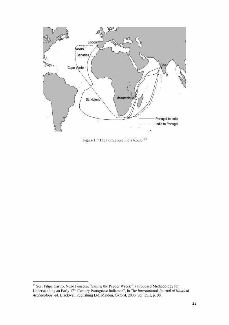
The annual Portuguese armadas linking Asia and Europe are known by the
expression Carreira da Índia or Rota do Cabo42
. Outward bound fleets usually left the
metropolis Lisbon during April and May, passing the islands of Madeira and Cape
Verde towards the Cape of Good Hope, entering the Indian Ocean and passing the
Mozambique Channel, the inner-route between the African main land and the island of
Madagascar43
, towards Cochin and Goa. In these journeys ships usually stayed at
Mozambique island to take refreshments, repairing purposes or to cure the sick at the
local hospital44
. The fortified possession at the northern end of the channel later gained
importance to secure the local Portuguese East African trade against the Dutch attacks
in 1607 and 1608 as well as in 1622. Homeward bound armadas left India around
December and until January of the following year, usually taking the outer course off
Madagascar and taking refreshments at the Azores before arriving in Lisbon
midsummer, an average round voyage of almost 1.5 years45
.
Dutch-Asiatic shipping differed from the Portuguese armadas. Dutch ships fitted
out several chambers such as Amsterdam, Delft or Zeeland left Northern Europe several
times a year without a fixed calendar46
, passing the Cape of Good Hope and the Indian
Ocean on an outer course off Madagascar towards Batavia (Jakarta), the Dutch
administrative headquarters in Asia which was founded in 162147
, but usually returned
per annum departing from Batavia between December and February of the following
year48
.
42
For a general observation of the Portuguese-India navigation see: Francisco Contente Domingues, A
Carreira da Índia, Lisbon, Clube do Coleccionador dos Correios, 1998; Roteiros Portugueses Inéditos da
Carreira da Índia do século XVI, Lisbon, Agência Geral das Colónias, 1940. 43
The island of Madagascar was known as S. Lourenço.; See Francisco Contente Domingues, Idem, p. 8. 44
See: Charles Ralph Boxer, Moçambique island and the carreira da Índia, STVDIA-Revista Semetral,
n0 8, July 1961, Lisbon, 1961, pp.. 99, ff.
45 See: André Murteira, op. cit., p. 26.
46 See: R. Bruijn, F. S. Gaastra, I. Schöffer (eds.), Dutch-Asiatic Shipping in the 17
th and 18
th centuries,
The Hague, Martinus Nijnhof, 1979-1987, vol. II, pp. 56, f, 73, ff. 47
See: R. Bruijn, F. S. Gaastra, I. Schöffer (eds.), op. cit., vol. III, pp.. 26, ff. 48
See: Peter Borschberg, The Singapore and Melakka Straits; Violence, Security and Diplomacy in the
17th
Century, Singapore, NUS Press, 2010, p. 122; For a general observation of the Dutch-Asiatic
navigation see: R. Bruijn, F. S. Gaastra, I. Schöffer (eds.), op. cit., vol. I, pp. 56-92.

22
The Dutch colony at the Cape of Good Hope was founded in 165249
and
represented an important way-station for outward and homeward bound fleets.
The principles of European-Asiatic navigation from which the Portuguese had
gained their experience during the 16th
century were a vital factor for the fast rise of the
Dutch East India Company. In fact, the experiences of Jan Hyugen van Linschoten
(1562/3-1611) who had lived five years in Goa50
and published as Reysgheschrift van de
navigation der Portugaloysers in 159551
became a kind of pilot of sailing instructions
for the first Dutch East India voyage of de Houtman in 159552
. The participation of
foreign seafarers, soldiers or passengers on board of Portuguese ships, a common
practice since the early days of the Carreira da Índia, was abolished by the decree of
King Philip I of Portugal in 1594 and renewed under his successor, Philip II in 160653
, a
fact which can be linked to the espionage of Linschoten.
On the other hand, this prohibition implied a limitation of mariners and soldiers
by their origins and nationalities which, in times of economical and political changes
and warfare meant a shortage of human resources for the Portuguese. Compared with
the principles of the VOC, which throughout its existence not only based its operations
on Dutch mariners and soldiers but also, and most probably, merely on foreigners like
Danish, Germans and other Northern and Central European regions, the restriction also
played an important role.
49
See. Charles Ralph Boxer, The Portuguese Seaborne Empire, op. cit., p. 111. 50
See: H. Houwens Post, “João Huygen van Linschoten: Administrador da casa do Arcebispo de Goa e
Espião da Holanda (1583-1587)”, sep. Ocidente, vol. 58, pp. 123-130; R. Bruijn, F. S. Gaastra, I.
Schöffer (eds.), Idem, p. 59. 51
See: R. Bruijn, F. S. Gaastra, I. Schöffer (eds.), Idem, ibidem. 52
See: Idem, ibidem; J. L. Mollema, „De erste Schifvaart der Hollanders Oost-Indie 1595-1597“, The
Hague, Martinus Nijnhoff, 1938. 53
See: Julio Firmino Judice Biker (ed.), Idem, ibidem.
23
Figure 1: “The Portuguese India Route”54
54
See: Filipe Castro, Nuno Fonseca, “Sailing the Pepper Wreck”: a Proposed Methodology for
Understanding an Early 17th
-Century Portuguese Indiaman”, in The International Journal of Nautical
Archaeology, ed. Blackwell Publishing Ltd, Malden, Oxford, 2006, vol. 35.1, p. 98.

24
I.4 Ships of the Portuguese Carreira da Índia and
of the Dutch United East India Company
Since the beginning, East Indiamen formed the core of the fleets from the
Portuguese Carreira da India55
, the Dutch56
and the English East India Companies.
Portuguese ships were mostly naus or carracks57
whereas spiegelschepen or square stern
ships58
as well as Fluyts or Flyboats were Dutch, neither denoting “a special type of
ship, but the particular use made of a certain type of ship”59
. During the course of the
first half of the 17th
century, both Portuguese and Dutch shipbuilding were subjected to
changes in design, the experimental phase of three or four deck naus or the introduction
of the Dutch Fluyt60
, which, compared to the spiegelschepen, differed by their extended
length and shorter draught as well as lower costs of maintenance and a higher capacity
of transporting cargo and less human resources needed for the navigation. During the
course of the 17th
century, the Fluyts became the preferred Dutch East Indiamen and
ultimately replaced the spiegelschepen.
55
See: “Nau”, in Luís de Albuquerque (dir.), Francisco Contente Domingues (coord.), Dicionário de
História dos Descobrimentos Portugueses, Lisbon, Círculo de Leitores, 1994, vol. II, p. 792; Francisco
Contente Domingues, Os Navios do Mar Oceano – Teoria e impiria na arquitectura naval portuguesa
dos séculos XVI e XVII, Lisbon, Centro de História, 2004, pp. 243-252; Filipe Vieira de Castro, “Navios
de vela”, in Francisco Contente Domingues (ed.), História da Marinha Portuguesa. Navios, Marinheiros
e Arte de Navegar 1500-1661, Lisbon, Academia de Marinha, 2012, pp. 60-63. 56
See: R. Bruijn, F. S. Gaastra, I. Schöffer (eds.), op. cit., vol. I, p. 38. 57
See: Alex Hazlett, “The Nau of the Livro Náutico: The Textual Excavation of a Portuguese Indiaman”,
in Edge of Empire – Proceedings of the Simposium “Edge of Empire” held at the 2006 Annual Meeting of
the Society for Historical Archaeology Sacramento CA (Filipe Castro, Katie Custer (eds.), Casal de
Cambra, Caleidoscópio, 2008. 58
See: R. Bruijn, F. S. Gaastra, I. Schöffer (eds.), Idem, ibidem. 59
See: Idem, ibidem; André Murteira, op. cit., pp. 30-35. 60
See: “Fleute”, in Alfred Dudszus, Ernest Henriot, Friedrich Krumrey (eds.), Das grosse Buch der
Schiffstypen – Schiffe, Boote, Flöße unter Riemen und Segel, Historische Schiffs- und Bootsfunde,
Berühmte Segelschiffe, 3rd
edition, Berlin, transpress VEB Verlag für Verkehrswesen, 1988, pp. 103-105.

25
Both naus and spiegelschepen were three masted ships of almost 40m in length
and approximately 10 to 13m in beam61
which results in an average proportion of length
to beam of 3/1. Also, a general comparison of the water displacement of a Portuguese
nau of a capacity of 500t and an East Indiama show similar characteristics: an average
of 1000 to 1200t62
. Also, East Indiaman, either the Portuguese or European were armed
merchantmen, a vessel mainly used for commercial purposes equipped with artillery for
defensive rather than offensive military intendment.
But the ships differed in several key aspects of their construction which
ultimately affected their navigation and performance. The Portuguese naus, during the
historical time period investigated in this thesis, are described as large vessels of three
or four decks and a draught of up to 10m. Dutch spiegelschepen were, as the East
Indiamen in general, a vessel of maximum two decks with a draught smaller than the
Portuguese naus.
The naus had a castle on both parts, the prow and the stern, the spiegelshepen
only at their stern, which, by its flat shape also called “spiegel” (mirror) differed from
the naus. Also, the process of the hull construction differed due to the historical
development of shipbuilding. While the Portuguese and Spanish followed the
Mediterranean tradition of the carvel-built or skeleton-first method of carvel-planking,
Dutch, and generally speaking Central and Northern European, shipbuilding was based
on the shell-first method of an overlapping planking, also known as clinker-planking.
Both the Portuguese and Dutch used other types of ships for the European-
Asiatic voyages as well, the galleons and jachten.
Generally speaking, Portuguese Galleons were four masted vessels, similar to
the appearance of naus, but mainly used for military purposes63
such as accompanying
61
See: Luís Filipe Monteiro Vieira de Castro, The Pepper Wreck: A Portuguese Indiaman at the mouth of
the Tagus river, PhD Thesis, Texas A&M University, College Station, 2001, p. 193; “Ostindienfahrer”, in
Alfred Dudszus, Ernest Henriot, Friedrich Krumrey (eds.), Das grosse Buch der Schiffstypen – Schiffe,
Boote, Flöße unter Riemen und Segel, Historische Schiffs- und Bootsfunde, Berühmte Segelschiffe, 3rd
edition, Berlin, transpress VEB Verlag für Verkehrswesen, 1988, p. 195. 62
See: Luís Filipe Monteiro Vieira de Castro, op. cit., p. 187; “Ostindienfahrer”, Idem, ibidem. 63
See: “Galeão”, in Luís de Albuquerque (dir.), Francisco Contente Domingues (coord.), Dicionário de
História dos Descobrimentos Portugueses, Lisbon, Círculo de Leitores, 1994, vol. I, pp. 442, f.; André
26
the convoys of naus to India or in the Asian waters itself. Differing by its construction
characteristics, the Galleon had a shorter draught than the three or four deck naus64
and
also differed from them by the amount of its armament.
Dutch jachten (plural of jacht) were small vessels used for transmitting
dispatches, reconnaissance or accompanying the merchant ships, the retourschepen or
fluyts65
.
Still, at the beginning of the 17th
century there has been no distinctive separation
and classification between types of ships based on their use as a merchant ship or
warship and Indiamen, either Dutch, English or Portuguese, were bifunctional sailing
ships which, as single operating vessel or composed in fleets, were the means of
communication and execution of economic, military or political strategies of a company
or empire linking its metropolis and branch headquarters, factories, strategic costal
defense positions and trade posts by using maritime routes.
Murteira, op. cit., pp. 34, f; Francisco Contente Domingues, Os Navios do Mar Oceano – Teoria e impiria
na arquitectura naval portuguesa dos séculos XVI e XVII, op. cit., pp. 252-258; Filipe Vieira de Castro,
op. cit., pp. 63-67. 64
See: Vasconcellos, 1897… 65
See: “Jaghd”, in Alfred Dudszus, Ernest Henriot, Friedrich Krumrey (eds.), Das grosse Buch der
Schiffstypen – Schiffe, Boote, Flöße unter Riemen und Segel, Historische Schiffs- und Bootsfunde,
Berühmte Segelschiffe, 3rd
edition, Berlin, transpress VEB Verlag für Verkehrswesen, 1988, p. 141, f; for
tecnical details regarding the construction of the Jachten: Werner Jaeger, Die Niederländische Jacht im
17. Jahrhundert – Eine historisch-technische Dokumentation, Bielefeld, Verlag für Regionalgeschichte,
2001..

27
II Shipwrecks of the Carreira da Índia
1595-1623
By the end of the 16th
and beginning of the 17th
century, Portuguese and Spanish
colonial possessions were scattered around the globe. As Charles Ralph Boxer had
pointed out, the Dutch offensive military operations were mainly directed against the
Portuguese overseas empire than against the Spanish66
. Either observed as struggle for
free trade or supremacy for the East Indies trade, or as defense of an empire established
by the voyages of Discoveries and ratified by the pope, the treaty of Tordesillas, the
investigation of the thesis Shipwrecks of the “Carreira da Índia” (1595-1623) –
Sources for the Study in Portuguese Maritime History will rather be conducted and
concentrated on the Indian Ocean and the Mozambique channel in particular.
Although the Dutch and combined Anglo-Dutch attacks on Portuguese
navigation on the Cape route during the first half of the seventeenth century had its
impact disturbing the regular annual shipment between Asia and Europe, the same had
already been affected by losses due to piracy and attacks in the Atlantic during the 16th
century67
but also due to navigation, weather or other causes68
. Nevertheless, each loss
or even a delay due to a late entering of the Indian Ocean and a mandatory wintering at
Mozambique Island consequently meant problems for a fragile overseas possession, the
Estado da Índia. As the Portuguese financial system was based on the profits of the
overseas trade exportations into Europe such as goods from the Atlantic (West Africa
and Brazil) as well as the spices and oriental goods carried onboard of the East
Indiamen, the Estado da Índia depended on the annual supply of the Asiatic trade
remittance from the metropolis which was directly re-invested in the outfitting of the
next years’ fleet69
and in purchasing new pepper. The Union of the Iberian crowns and
the uprising of the European concurrence of the Asiatic trade at the beginning of the 17th
66
Cf: Charles Ralph Boxer, “The Portuguese Seaborne Empire 1415-1825”, op. cit., p. 106. 67
See: André Murteira, op. cit., pp. 46-49. 68
See: Eduardo Frutuoso, Paulo Guinote, António Lopes, Naufrágios e Outras Perdas da “Carreira da
Índia”: Séculos XVI e XVII, Lisbon, Grupo de Trabalho do Ministério da Educação para as
Comemorações dos Descobrimentos Portugueses, 1998. 69
See: Jorge M. Pedreira, “Custos e Tendências no Império Português, 1415-1825”, in Francisco
Bethencourt, Diogo Ramado Curto (dir.), A Expansão Marítima Portuguesa, 1400-1825, Lisbon, Edições
70, 2010, p. 63.

28
century had several impacts on the Portuguese Empire such as the subvention of the
Spanish war in Flanders70
, the construction, repair and reinforcement of coastal
fortifications in West and East Africa as well as in Asia, an expense which had shifted
from being an extraordinary cost into a constant one.71
The impact of the blockades of
Lisbon harbor in 1606, hindering the departure of the annual Portuguese East India
fleet72
, the loss of the Nossa Senhora dos Mártires at São Julião de Barra near the river
mouth of the Tagus river near Lisbon in 160673
, the loss of the oriental goods, and the
losses of the São Francisco in 1607 and Nossa Senhora da Consolação in 1608 caused
by the tentative Dutch sieges off Mozambique Island, both carrying the remittance of a
total of 40,000 cruzados to purchase pepper and other oriental goods74
are examples of
the impact on the Portuguese.
Although the period of the Twelve Years Truce suggested a stabilization
regarding the military operations, the internal Portuguese administrative problems,
namely the borrowing of the king’s pepper money and corruption in the Estado da
Índia, but also the low prices of spices and oriental goods at the European market due to
the importations by the Dutch and English75
are seen as causes for the modest or non
existing recovery of the Portuguese East India trade76
.
The end of the Twelve Years Truce in 1621 and the renewal of the Dutch-
Portuguese struggle collide with the war efforts in the Persian Gulf in 1622 and the fall
of the important Portuguese trade post in Ormus by a combined Anglo-Persian force77
.
A year later, a joint Anglo-Dutch fleet attacked the Portuguese East India fleet
off Mozambique which resulted not only in the hindering of the supplies needed in
Persia but also in the losses of three ships, The São Carlos, the São José and the Santa
Teresa.
Resuming the losses of Portuguese ships of the Carreira da Índia during the first
half of the seventeenth century, either caused by enemies’ attacks or other
70
See.Idem, p. 64. 71
See: Idem, pp. 63, f 7272
See: André Murteira, op. cit., p. 110; James C. Boyajian, “Portuguese Trade in Asia under the
Habsburgs, 1580-1640”, Baltimore, London, The Johns Hopkins University Press, 1993, p. 93. 73
See: André Murteira, Idem, ibidem. 74
See: James C. Boyajian, Idem, ibidem. 75
See: Idem, p.. 100, f. 76
See: Idem, pp. 97, ff. 77
See: Francisco Bethencourt, Diogo Ramçpada Curto (dir.), op. cit., p. 65.
29
circumstances, the impacts, on a long term view, seem to be quite small. As a matter of
fact, the Carreira da Índia continued its annual shipment from and towards India but
the annual shipment was slowed down or sometimes blocked by the efforts of the
European enemies. Some losses, especially the Nossa Senhora dos Mártires, São
Francisco and the Nossa Senhora da Consolação (1606-1608), the S. Carlos, S. José
and Santa Teresa (1622) and the S. Bráz, S. Simão and Santa Isabel (1623) occurred at
weak points of the Portuguese Estado da Índia.
II.1 From naval conflicts to the Twelve Years Truce
1600-1609
During the first decade of the 17th
century, the relationships between the Dutch
and Portuguese were characterized by the struggle for supremacy in European-Asiatic
trade, either seen as the defense of the exclusive right by the treaty of Tordesillas in
149478
by the Portuguese, or as the necessity to open and guarantee access to free
navigation and trade, ports and merchandize by military force, from the Dutch point of
view.
Not only the neglected access to trade with oriental goods and spices by the
royal decrees and embargos of 1594 and 159879
but also the possibility to obtain silver
coins, (the Spanish reales and the 1 reales de peso de a ocho, a single coin of an
average of 26g of silver, in particular, was considered a stable currency at the Iberian
markets), were factors indicating economic reasons for the shifting of Dutch-Asiatic
policies.
78
See: “Tordesilhas, Tratado de” in Luís de Albuquerque (dir.), Francisco Contente Domingues (coord.),
op. cit., vol. II, pp. 1039-1043. 79
See: Jonathan I. Israel, op. cit., pp. 56,130, f.
30
The instructions of the Dutch fleet which left Northern Europe under the
command of Steven van der Hagen in December 1603 clearly stated the attack of
Portuguese or Castilian possessions or shipping as well as of their allies80
. However, the
decision of an offensive strategy was based on several factors: after the established
commercial and political relationships with several Asian kingdoms, such as Johore, the
Portuguese had been attacking Dutch-Asiatic ships and trade in the vicinities of the
Spice Islands such as Amboina, Bantam or Java81
. Also, the captures of the Portuguese
ship Santa Catarina82
, a Nnu, which laden with merchandize from China en route to
Goa was seized in the Singapore Straits in 1603 and caused a diplomatic incident83
should rather be seen as minor incidents than the bigger operations which unfolded
shortly after. Two years later, the Dutch managed to capture the Santo António off
Patani and actually kept the ship for their trade purposes84
, modified its physical
appearance85
and tried to include her in the homeward bound fleet of 160686
.
The first blockade and attempt of conquering Mozambique Island was
undertaken by the fleet under the command of Steven van der Hagen in June-August
160487
. Due to a late departure of the Portuguese outward bound East India fleet in 1604
under the command of D. Martim Afonso de Castro88
, the attempted conquest of
Portuguese ships off Mozambique only resulted in the capture of the annual ship of the
Goa-Mozambique trade, the Nau de trato89
. The departure of van der Hagen’s fleet of
80
Cf. André Murteira, Op. cit., pp. 97, f. 81
Cf: Idem, p. 98. 82
About the capture of the Santa Catarina: Peter Borschberg, “The Seizure of the Sta. Catarina Revisited:
The portuguese Empire in Asia, VOC Politics and the origins of the Dutch-Johor Alliance (1602-c.1616),
in Journal of Southeast Asian Studies, vol. 33 (1) , Cambridge, Cambridge University Press, 2002, pp. 31-
62; Idem, The Singapore and Melakka Straits; Violence, Security and Diplomacy in the 17th Century, op.
cit., p. 68, ff. 83
For further information about the diplomacy: Peter Borschberg, Hugo Grotius, the Portuguese and
Free Trade in the East Indies, op. cit, pp. 194-207. 84
See: Peter Borschberg, The Singapore and Melakka Straits; Violence, Security and Diplomacy in the
17th
Century, op. cit., pp. 100-107. 85
See: Idem, p. 100, p. 285, f. 86
See: Peter Borschberg, “The Seizure of the Santo António at Patani: VOC Freebooting, the Estado da
Índia and Peninsualr Politics, 1602-1609”, in Journal of the Siam Society, Vol. 90.1 & 2, Bangkok, The
Siam Society, 2002, pp. 59-72; Idem, The Singapore and Melakka Straits; Violence, Security and
Diplomacy in the 17th
Century, op. cit., p. 102; Alfredo Botelho de Sousa, “Subsídios para a História
Militar Marítima da Índia (1585-1669)”, Lisbon, Imprensa da Armada, 1930, vol. I, p620, f.. 87
See: André Murteira, op. cit., pp. 97-102; N. Mac Leod, op. cit., pp. 16-20; Alfredo Botelho de Sousa,
op. cit., p. 287, f.; O. J. O. Ferreira, Ilha de Moçambique Byna Hollands, Jeffreysbaai & Gordonsbaai,
Adamastor, 2007, pp. 33-36; R. Bruijn, F. S. Gaastra, I. Schöffer (eds.), op. cit., vol. II, pp.16-19. 88
See: André Murteira, op. cit., p. 107; J. H. da Cunha Rivara (ed.), Archivo Portuguez Oriental, New
Delhi, Asian Educational Services, 1992, fasciculo I, parte II, p. 131; João C. Reis, João Miguel O. Reis,
José João O. Reis, Memórias das Armadas da Índia: 1497-1650, Macau, Mar-Oceano, 1990, p. 263. 89
See:, Idem, pp. 100-107.

31
twelve ships90
from Mozambique towards Goa in mid August permitted that the delayed
Portuguese fleet did not suffer an earlier attack as in 1607 in the said region, but one
ship, the nau São Filipe under the command of António de Mendonça was lost at
Angoxa91
, a distance of 30 léguas off Mozambique Island92
, of which the Portuguese
managed to save all hands, the cabedal, the Kings money, the artillery and some other
cargo93
. The Portuguese had managed to defend Mozambique Island, their important
way-station for the Carreira da Índia shipping but had to become aware of the
possibility of another attempt.
During the next years Dutch military campaigns under the command of Willem
de Zoete van Haultain, planned in 1605 and executed in 1606, aimed at a blockade and
crusade of Iberian, mainly Portuguese, shipping in European waters94
, which, caused by
delayed preparations, resulted in a hindering of the departure of the Portuguese East
India fleet95
of the same year and the seizure of some ships at the river-mouth of the
Tagus river, Lisbon, Portugal96
. After his return to the United Provinces, Haultain was
appointed commander of the second expedition of the same nature which did not result
in success. Like the loss of the S. Filipe off Mozambique, the losses of the Nossa
Senhora da Salvação and Nossa Senhora dos Mártires, ships of the 1606 Portuguese
homeward bound fleet97
, were not direct results of Dutch operations. Although the
Portuguese managed to save all hands and cargo on board of the Nossa Senhora da
Salvação at the beach of Cascais98
, north of the river-mouth of the Tagus river, the same
cannot be said for the Nossa Senhora dos Mártires, lost in the vicinities of the São
Julião de Barra fortress99
, which due to its excavated wood structure which was
90
See: O. J. O. Ferreira, op. cit., p. 33. 91
See: André Murteira, op. cit., p. 107; Cf: J. H. da Cunha Rivara (ed.), op. cit., p. 142; See: Eduardo
Frutuoso, Paulo Guinote, António Lopes, op. cit., p. 233; Quirinho da Fonseca, Henrique Lopes de
Mendonça, Os Portugueses no Mar - Memórias Históricas e Arqueológicas das Naus de Portugal,
second edition, Lisbon Comissão Cultural de Marinha, 1989, (reedition fac-similada of the first edition of
the first edition of 1926), p. 413. 92
See: O. J. O. Ferreira, op. cit., pp. 33-35. 93
See: Raymundo António de Bulhão Pato (dir.), “Documentos Remettidos da Índia”, Lisbon, Academia
Real das Sciencias, 1880, vol. I, p. 100. 94
See. André Murteira, op. cit., pp. 108-114. 95
Cf: Idem, p. 110. 96
See: Idem, p. 109. 97
See: André Murteira, op. cit., pp. 110-114; Peter Borschberg, Hugo Grotius, the Portuguese and Free
Trade in the East Indies, op. cit.,pp. 179-181; Cf: Raymundo António de Bulhão Pato (dir.), op. cit., pp.
100, 130, f; João C. Reis, João Miguel O. Reis, José João O. Reis, op. cit., p. 264. 98
See: Raymundo António de Bulhão Pato (dir.), Idem, ibidem; Eduardo Frutuoso, Paulo Guinote,
António Lopes, Op. cit., p. 234; Quirinho da Fonseca, Henrique Lopes de Mendonça, op. cit., p. 452. 99
See: Raymundo António de Bulhão Pato (dir.), Idem, ibidem; Eduardo Frutuoso, Paulo Guinote,
António Lopes, Op. cit., p. 234; Quirinho da Fonseca, Henrique Lopes de Mendonça, op. cit., pp. 434, f.

32
preserved in a layer of pepper corns also became known as the Pepper Wreck100
and
will be later dealt in the chapter IV.2.
As the Dutch navigation in the Indian Ocean continued, King Philip II ordered to
undertake constructions at Mozambique’s fortress São Sebastião101
, situated at
Mozambique Island, to protect the Portuguese East India navigation. In the same
document, the King also ordered the observation of the Dutch activities as he thought
that there might be plans to construct a fortress at Madagascar,102
but as it turned out, the
Dutch fleets of 1607 and 1608 aimed to conquer the São Sebastião fortress103
.
Instructed to attack the Portuguese and their allies in Asia104
and following the
navigation of Steven van der Hagen105
, the VOC send a fleet of eight ships, which
departure took place in 1606, under the command of Paulus van Caerden106
while the
operations of Haultain in the vicinities of the Iberian Peninsula were still ongoing107
.
After a long voyage, van Careen’s fleet arrived at Mozambique Island late March
1607108
, an unusual time for Portuguese outward bound fleets but still common for
homeward bound fleets crossing the Indian Ocean due to the regime of the Monsoon
winds and currents109
. As in 1604, the Dutch had managed to capture two galleons of
the homeward bound fleet and the Galeota110
, a small vessel used for the annual
shipment between Goa and Mozambique, but as the men and cargo of the ships had
been removed to the fortress, the Dutch did not seize valuable cargo nor took prisoners
and therefore tried to conquer the São Sebastião fortress, but once again failed to do so.
In his letter, van Caerden later accused the size of the cannons or armory used for the
100
See: Filipe Castro, “The Pepper Wreck, an early 17th-century Portuguese Indiaman at the mouth of the
Tagus River, Portugal”, in The International Journal of Nautical Archaeology, [s.n.], [s.l.], 2003, vol.
32.1, pp. 6-23. 101
See: Raymundo António de Bulhão Pato (dir.), op. cit., p. 1. 102
See: Idem, p. 2. 103
See: O. J. O. Ferreira, op. cit., pp. 33-59; Charles Ralph Boxer, António Durão, Edgar Prestage,
Cercos de Moçambique, Defendidos por Don Estêvão de Ataíde Capitão General, Governador daquela
Praça, Lisbon, Tipografia Silvas, 1937; A. Meyrelles do Souto (ed.), “Hystoria dos cercos que os
Olandezes puzerão á fortaleza de Mozambique o anno de 1607 e 1608”, in STVDIA, Revista Semetral,
Lisbon, Centro de Estudos Históricos Ultramarinos, 1963, vol. XII, pp. 463-548. 104
See: André Murteira, op. cit., pp. 97, f. 105
See: Idem, p. 114. 106
See: Idem, p. 114, f; Alfredo Botelho de Sousa, op. cit., vol. II, p. 83; Charles Ralph Boxer, António
Durão, Edgar Prestage (eds.), op. cit., p. 98 N. Mac Leod, op. cit., p. 63; O. J. O. Ferreira, op. cit., pp. 16,
f; R. Bruijn, F. S. Gaastra, I. Schöffer (eds.), Op. cit., vol. II, p. 22. 107
See: André Murteira, op. cit., pp. 114, f. 108
See: Idem, p. 115; A. Meyrelles do Souto, op. cit., p. 491; Alfredo Botelho de Sousa, op. cit., p. 83; N.
Mac Leod, op. cit., p. 64; o. J. O. Ferreira, op. cit., p. 36. 109
See: Chapter “Comparing the principles of Portuguese and Dutch –Asiatic shipping”. 110
See: André Murteira, op. cit., p. 116.

33
failure111
. Leaving Mozambique Island for the continuation of the operations in the
Indian Ocean on May 29th
, the Zierickzee, a 760 tons ship112
, was hit under gun fire
from the S. Jorge tower, hit a shoal and ran aground off Cabaceira at the northern part of
the Mozambique bar113
.
After taking refreshments at Mayotte Island114
situated in the northern part of the
Mozambique Channel, van Caerden decided to return for a second attempt at
Mozambique Island115
.
Shortly after the departure of the Dutch, a part of the annual Portuguese outward
bound fleet of 1607 under the command of D. Jeronimo Coutinho116
, namely the naus
Jesus, São Francisco and the Nossa Senhora da Penha da França arrived safely at
Mozambique Island117
. Being aware of the danger, the administration of Mozambique
dispatched a small vessel for the islands of Angoche to118
warn the second part of the
Portuguese outward bound fleet under the command of João Correia de Sousa, namely
the galleons São Felipe e Santiago, Santo André and the naus Nossa Senhora do Loreto
and Nossa Senhora da Consolação, which had left Lisbon two weeks after the departure
of D. Jeronimo Coutinho119
to abort the planned stay at Mozambique Island and
continue directly towards India120
but only the São Felipe e Santiago and the Nossa
Senhora do Loreto had managed to do so121
; the Nossa Senhora da Consolação and the
Santo André arrived at Mozambique island in September, shortly after the departure of
the van Caerden’s fleet in late August122
.
111
See: Idem, p. 117. 112
See: R. Bruijn, F. S. Gaastra, I. Schöffer (eds.), op. cit., vol. II, pp. 20, f . 113
See. André Murteira, op. cit., pp. 120, f., A. Meyrelles do Souto (ed.), op. cit., p. 522; The Zierickzee
was attacked and sunk on May 18 th
. N. Mac Leod, op. cit., p. 65; O. J. O. Ferreira, op. cit., p. 46; By
leaving the bar of Mozambique, the Dutch ship Zierickzee hit the ground and wa taken to the other side
(of the entry channel), to the main land to avoid the sinking in the middle of the channel. The ship was
burnt after the cargo was taken off. Alfredo Botelho de Sousa, op. cit., p. 91. 114
See. André Murteira, op. cit., p. 122. 115
See: André Murteira, Idem, ibidem. 116
See: João C. Reis, João Miguel O. Reis, José João O. Reis, Idem, ibidem; Alfredo Botelho de Sousa,
op. cit., p. 94. 117
See: André Murteira, Idem, ibidem; João C. Reis, João Miguel O. Reis, José João O. Reis, Idem,
ibidem. 118
See: André Murteira, op. cit., p. 123. 119
See: João C. Reis, João Miguel O. Reis, José João O. Reis, Idem, ibidem; Alfredo Botelho de Sousa,
Idem, ibidem. 120
See: André Murteira, Idem ibidem. 121
See. Idem, ibidem; J. H. da Cunha Rivara (ed.), op. cit., p. 197; João C. Reis, João Miguel O. Reis,
José João O. Reis, Idem, ibidem; Alfredo Botelho de Sousa, Idem, ibidem. 122
See: André Murteira, Idem, ibidem; O. J. O. Ferreira, op. cit., p. 48, f; A. Meyrelles do Souto (ed.), op.
cit., p. 533; N. Mac Leod, op. cit., p. 65.

34
As a result of van Caerden’s attempt, the Dutch managed to capture the nau
Nossa Senhora do Loreto at the Ilheus Queimados islands, of which, Portuguese
historiography and sources would only refer to the loss of the cargo and the fact, that the
ship was burnt123
but, as recent research in Dutch archives shows, the impact of the
seizure of the Loreto’s cargo gave valuable information, provided in the royal
Portuguese letters124
. After the departure of the Dutch, the São Francisco was
dispatched to continue its voyage towards India125
but after hitting a shoal off the
church Nossa Senhora da Baluarte126
area, the ship was declared as not being
seaworthy due to an accident which had prior occurred at the Mogincual shoals127
and
due to the poor conditions of its hull structure128
, the cabedal of 30,000 cruzados, the
cargo and artillery were taken off and stored in the São Sebastião fortress129
and the
ships mainmast as well as the foremast were cut off130
. The galleon Santo André and the
nau Nossa Senhora da Consolação, as observed above, arrived at Mozambique Island in
September and were forced to stay until the following year’s monsoon season for
outward bound ships131
.
In late 1607, the VOC dispatched a fleet of ships, nine bigger, the Fluyts, and four
smaller, the jachten, under the command of Pieter Willemsz Verhoeff towards India and
Asia132
, eventually the last bigger fleet before the Twelve Years Truce (1609-1621)133
.
Provided with the same instructions as van der Hagen and van Caerden, Verhoeff
123
See. André Murteira, op. cit., p. 125, f; J. H. da Cunha Rivara (ed.), op. cit., p. 197; João C. Reis, João
Miguel O. Reis, José João O. Reis, Idem, ibidem; Alfredo Botelho de Sousa, Idem, ibidem, pp. 94, f;
Quirinho da Fonseca, Henrique Lopes de Mendonça, op. cit., pp. 429, f; Eduardo Frutuoso, Paulo
Guinote, António Lopes, op. cit., p. 235; N. Mac Leod, Idem, ibidem. 124
See: Peter Borschberg, Hugo Grotius, the Portuguese and Free Trade in the East Indies, op. cit., pp.
172-184. 125
See: André Murteira, op. cit., pp. 124, 130; João C. Reis, João Miguel O. Reis, José João O. Reis,
Idem, ibidem; Alfredo Botelho de Sousa, Idem, ibidem; Quirinho da Fonseca, Henrique Lopes de
Mendonça, op. cit., p. 417, f; Eduardo Frutuoso, Paulo Guinote, António Lopes, Idem, ibidem; T. W.
Baxter, A. da Silva Rego (eds.), op. cit., pp. 432, f. 126
See: T. W. Baxter, A. da Silva Rego (eds.), op. cit., pp. 440-443. 127
See: Idem, pp. 442, f. 128
See: Idem, ibidem. 129
See: Idem, pp. 192, f; 430, f; 440-443. 130
See: Idem, pp. 440, f; J. H. da Cunha Rivara (ed.), op. cit., p. 197; A. Meyrelles do Souto (ed.), op. cit.
pp. 533, 535. 131
See: André Murteira, Op. cit., p. 130; Alfredo Botelho de Sousa, op. cit., p. 94, f. 132
See: André Murteira, Op. cit., p. 130, f; Alfredo Botelho de Sousa, op. cit., pp. 109, f; Charles Ralph
Boxer, António Durão, Edgar Prestage (eds.), op. cit., p. 103. f; N. Mac Leod, op. cit., pp. 73, f; O. J. O.
Ferreira, op. cit., p. 50; R. Bruijn, F. S. Gaastra, I. Schöffer (eds.), op. cit., pp. 22-25; Johann Verken,
“Molukkenreise 1607-1612”, in Reisebeschreibungen von Deutschen Beamten und Kriegsleuten im
Dienst der Niederländischen West- und Ostindischen Kompagnien, 1602-1797, ed. S. P. L’Honoré Naber,
II, The Hague, Martinus Nijnhoff, 1930, pp. 3-5. 133
See: André Murteira, op. cit., p. 130.

35
arrived upon Mozambique Island in late July 1608134
two months after the departure of
the galleon Santo André135
. Still at anchor, Verhoeff encountered the nau Nossa
Senhora da Consolação and the annual Goa-Mozambique trade vessel but failed to
capture the Nossa Senhora da Consolação from which they managed to seize some of
the cargo namely ivory, Elephant tusks, wine, spices, and other goods136
. As the ship
had remained where it had stranded, the Portuguese burnt the Consolação the following
night to avoid a second attempt of seizure137
. The cabedal of the Nossa Senhora da
Consolação, which amounted to 10,000 cruzados138
was still stored in the São
Sebastião fortress when the Dutch tried to capture the ships139
. While waiting for the
arrival of the 1608 Portuguese outward bound fleet Verhoeff, like van der Hagen and
Caerden, tried to conquer the island and fortress, which later on was abandoned and the
focus had shifted towards the possible seizure of ships once again.
The first Portuguese East India fleet of 1608 composed of nine galleons and five
naus under the command of D. João Forjaz Pereira, Conde da Feira, left Lisbon on
March 29th140
and arrived near Mozambique Island in mid August. Verhoeff send four
ships, three jachten and a ship of higher capacity141
to attack the Portuguese galleon
Bom Jesus which was unable to escape the attack; after being captured she was brought
to proximity of the island of S. Tiago in the Southern Channel of Mozambique Island142
where the ship was burnt. Shortly after the capture of the Bom Jesus, the Dutch set sail
for Goa and Asia; during the voyage, the Dutch tried to capture the Portuguese nau
134
See: André Murteira, Idem, ibidem. 135
See: Idem, 132; Alfredo Botelho de Sousa, op. cit., p. 94, f; Quirinho da Fonseca, Henrique Lopes de
Mendonça, op. cit., p. 379. 136
See: O. J. O. Ferreira, op. cit., p. 50; Johann Verken, op. cit., p. 24; Torsten Arnold, “Historical
Background”, in Alejandro Mirabal, Excavation of the Nossa Senhora da Consolação (1608), [s.l.],
Arqueonautas Publications, 2013, p. 12-15. 137
See: O. J. O. Ferreira, op. cit., 50,f; Johann Verken, op. cit., p. 25; A. Meyrelles do Souto (ed.), op.
cit., p. 539, f.; Quirinho da Fonseca, Henrique Lopes de Mendonça, op. cit., p. 404; Eduardo Frutuoso,
Paulo Guinote, António Lopes, Idem, ibidem; AJ. H. da Cunha Rivara, op. cit., p. 220; For further
reading about the Nossa Senhora da Consolação: Torsten Arnold, op. cit.. 138
See: T. W. Baxter, A. Da Silva Rego (eds.), op. cit., p. 194, f . 139
See: André Murteira, op. cit., p. 133 140
See: João C. Reis, João Miguel O. Reis, José João O. Reis, op. cit., pp. 264, f. 141
The Jachten were classified as Pataxos and the ships of higher capacity as Naus by the Portuguese
historiography See Alfredo Botelho de Sousa, op. cit., , p. 109 142
See: André Murteira, op. cit., pp. 136-138; A. Meyrelles do Souto (ed.), op. cit., p. 544; Alfredo
Botelho de Sousa, op. cit., p. 113, f; Eduardo Frutuoso, Paulo Guinote, António Lopes, op. cit., p. 238; O.
J. O. Ferreira, op. cit., p. 56, f; Johann Verken, op. cit., p. 34; J. H. da Cunha Rivara, op. cit., p. 220.

36
Nossa Senhora de Oliveira but to avoid the same, she was burnt in the vicinities of the
Ilheus Queimados143
.
The second part of the 1608 Portuguese East India fleet composed of five sails,
one galleon, one caravel, a pataxo and two urcas, under the command of Rui Lourenço
de Távora, the new appointed Vice-king of the Portuguese Estado da Índia, who had
left Lisbon on October 24th144
, arrived in Mozambican waters after the departure of the
Dutch and therefore was not involved in any military operations.
As a result of the Dutch siege of Mozambique Island, the Portuguese lost the
Nossa Senhora da Consolação and the nau de trato or galeota de trato and the galleon
Bom Jesus and the nau Nossa Senhora de Oliveira close to Goa. In that same year, there
were several other losses of ships such as the loss of the nau Nossa Senhora da Palma
off Mogincual shoal, the galleon Espírito Santo or Santo Espírito off the Costa da
Cafraria, most likely near the Terra de Natal, the nau Salvação at the bar of
Mombasa145
. Either due to military operations or to other causes, no ship of the
Portuguese outward bound fleets of 1608 arrived in India the said year146
. On the other
hand, the Dutch did not suffer any loss of a ship like the previous year.
143
See: André Murteira, op. cit., p. 139, f, Quirinho da Fonseca, Henrique Lopes de Mendonça, op. cit.,
p. 440; Alfredo Botelho de Sousa, op. cit., p. 114. 144
See: João C. Reis, João Miguel O. Reis, José João O. Reis, op. cit., p. 265. 145
See: André Murteira, op. cit., pp. 150-142; Alfredo Botelho de Sousa, op. cit., p. 116,f; Eduardo
Frutuoso, Paulo Guinote, António Lopes, op. cit., pp. 237-239; Quirinho da Fonseca, Henrique Lopes de
Mendonça, op. cit., pp. 441, 452, f; João C. Reis, João Miguel O. Reis, José João O. Reis, op. cit., p. 237. 146
See: André Murteira, op. cit., p. 151

37
II.1.1 Observations
Three Dutch East India fleets, the first under the command of Steven van der
Hagen (1604), the second under the command of Paulus van Caerden (1607) and the
last under the command of Pieter Willemsz. Verhoeff (1607/1608) attempted but failed
to conquer the São Sebastião fortress at Mozambique Island, the important way-station
of the Portuguese Carreira da Índia. While the Dutch only suffered the loss of one ship,
the Zierickzee, in 1607, several Portuguese naus and galleons like the 1606 Nossa
Senhora do Loreto off the Ilheus Queimados, the 1608 Nossa Senhora da Consolação
off Mozambique Island, Nossa Senhora de Oliveira off Ilheus Queimados or Bom Jesus
off Mogincual shoal were either captured and seized, or burnt to avoid the same; other
ships were lost due either to bad navigation or condition of the ship such as the 1606
Nossa Senhora da Salvação off Cascais, Portugal, the Nossa Senhora dos Mártires off
São Julião de Barra, Lisbon, Portugal, the 1607 São Francisco or the 1608 Nossa
Senhora de Palma off Mozambique. Either caused by direct impact due to military
operations in Iberian or Mozambican waters, or due to indirect impact such as bad
navigation or condition of the ships, the annual Portuguese East India fleets, the
Carreira da Índia, were interrupted and, in times of military struggle of Portuguese-
Dutch supremacy for the spice trade, a continuous shipment of financial or military
support for the Portuguese Estado da Índia intercepted. On the other hand, Dutch East
India shipping did not lose many ships and even managed to expand its sphere of
influence in the East Indies. Part of the general plan, the interception and break-down of
the Portuguese East India shipping was not achieved as the annual Portuguese fleets
continued. Nevertheless, due to the number of ships lost during the outward or
homeward bound voyage, Portugal lost its position on the European market for oriental
goods due to missing cargoes from Asia. Also, the ships and men lost had to be
replaced, an additional cost in times of difficulties and financial bottle-neck situations.

38
II.2 The Twelve Years Truce
1609-1621
Following the first encounters and naval battles fought for European overseas
interests and supremacy, in this case the interception of the annual Portuguese East
Indies shipping, the Carreira da Índia, and the three attempts to conquer Mozambique
Island by the Dutch, the Twelve Years Truce (1609-1621)147
is generally seen and
characterized as a period of calm due to the absence of planned military operations in
European waters or the western Indian Ocean148
. Encounters of ships, such as the Witte
Leeuw incident, a Dutch ship sunk by the two Portuguese homeward bound naus Nossa
Senhora de Nazaré and the Nossa Senhora de Vencimento e Monte do Carmo in the
vicinities of Santa Helena in 1613149
, were more of an accidental momentum than a
planned military operation documented by the virtual nonexistence of shipwrecks on
both sides150
.
It was agreed by both sides that each party maintained their occupied overseas
possessions and no further expansion was supposed to be undertaken during the period
of twelve years151
. As the process of negotiations for the Truce was still in process, the
Dutch dispatched the small jacht Goede Hoop to instruct the captain of the 1607 Dutch
outward bound East India fleet, Pieter Willesmz. Verhoeff, to maintain and, if possible,
to extend the Dutch sphere of influence, especially regarding the Spice Islands by
creating commercial and friendly relationships with the local authorities152
. As the
Truce was signed in the United Provinces on April, 9th
1609 both sides accepted to send
147
About the Twelve Years Truce: Jonathan I. Israel, op. cit., pp. 80-86, 101-106; André Murteira, “El
Impacto la Tregua de los Doce Años en los dominios ultramarinos portugueses”, in Bernardo García
García, Manuel Herrero Sánchez, Alain Hugon (eds.), Actas del X Seminario Internacional de Historia:
el arte de la prudencia-la Tregua de los Doce Años en la Europa de los Pacificadores (1598-1618),
Madrid, Fundación Varlos Amberes, 2012, pp. 275-293. 148
See: André Murteira, op. cit., p. 153 149
See: Idem, pp. 153-158; João C. Reis, João Miguel O. Reis, José João O. Reis, op. cit.,, pp. 265, f.;
Eduardo Frutuoso, Paulo Guinote, António Lopes, As Armadas da Índia 1497-1835, Lisbon, Comissão
Nacional para as Comemorações dos Descobrimentos Portugueses, 2002, p. 155; R. Bruijn, F. S. Gaastra,
I. Schöffer (eds.), op. cit., vol. II, pp. 16, f. 150
See: Eduardo Frutuoso, Paulo Guinote, António Lopes, Naufrágios e Outras Perdas da “Carreira da
Índia”: Séculos XVI e XVII, op. cit., pp. 239-244; R. Bruijn, F. S. Gaastra, I. Schöffer (eds.), op. cit., vol.
II, pp. 26-49; Idem, vol. III, pp. 14-25. 151
See: Raymundo António de Bulhão Pato (dir.), op. cit., pp. 252, f. 152
See: N. Mac Leod, op. cit., p. 81; Alfredo Botelho de Sousa, op. cit., vol. I, pp. 142, f.

39
a representative of each party on board of a Dutch vessel, the jacht Hazewind to deliver
the news of the conceived Truce in the East Indies153
. However, it is stated that the
representative from Spain and Portugal did not board the said ship in February 1610154
and the vessel continued its voyage towards Bantam. After the signature of the Truce in
1608 and still before the official commencement of the agreed freedom of navigation,
the Portuguese king send a letter to the Vice-king Ruy Lourenço de Távora instructing
him to try to convince the local authorities and kings not to allow Dutch-Asiatic
shipping and commercial activities in their respective ports155
.
During the time of the Truce, the Portuguese king ordered the fortification and
expansion of the defense system of Mozambique Island due to its importance as way-
station for the Portuguese outward bound fleets and Estado da Índia156
, the necessary
repairs after the attacks in 1607 and 1608 and the possibility of a new attack and plan of
conquering the São Sebastião fortress157
. Fearing disobedience and eventually the
breaking of the Truce by the Dutch, the Portuguese king received news annually on the
preparations and departure of outward bound Dutch East India fleets by local informants
which immediately were sent towards India158
but also received direct information
concerning the Dutch-Asiatic shipping by the Vice-king and other officials.
Until the second decade of the 17th
century, the European struggle for supremacy
in the East India trade involved mainly the Luso-Dutch warfare in Asian waters and the
Western Indian Ocean. The entrance of the English East India Company (EIC) created a
new hostile environment, especially due to the construction of English factories in the
Indonesian Archipelago159
and the Persian Gulf region160
. Negotiations at the two
London conferences in 1613 and 1615 and the possibility of a merger of the two
European East India Companies161
, the VOC and the EIC, endangered the Portuguese
East India trade. Although the merger of the VOC and EIC was not finalized, a “loose
153
See: Alfredo Botelho de Sousa,, op. cit., p. 161; R. Bruijn, F. S. Gaastra, I. Schöffer (eds.), op. cit.,
vol. II, op. cit., pp. 26, f.. 154
See: Alfredo Botelho de Sousa,, op. cit., p. 162; R. Bruijn, F. S. Gaastra, I. Schöffer (eds.), Idem,
ibidem. 155
See: Raymundo António de Bulhão Pato (dir.), op. cit., vol. I, pp. 360, f.; Alfredo Botelho de Sousa,
op. cit., p. 142. 156
See: Raymundo António de Bulhão Pato (dir.), op. cit., vol. I, pp. 1, 116-118. 157
See: Idem, vol. IV, p. 154. 158
See: Idem, vol. II, pp. 261-263, 274-277, 312-323. 159
See: Jonathan I. Israel, op. cit., pp. 103, f. 160
See: John Keay, op. cit., pp. 74-76, 94, 102-108. 161
See: Idem, p. 105

40
treaty of collaboration”162
which led to the “treaty of defense” against the Portuguese
and Spanish (1619-1623)163
was settled. Although the Dutch and English had agreed on
collaborating against the Portuguese and Spanish, a naval conflict for the supremacy of
the trade in the Indonesian Archipelago between the VOC and EIC in the vicinities of
the Bantam islands and Batavia (nowadays Jakarta)164
led to the expulsion of the
English and the definite establishment of the VOC’s headquarters at Batavia.165
This,
together with the 1618 Zwarte Leeuw incident, a Dutch outward bound vessel which
was captured by the English in the vicinities of Bantam in December 1618166
are
evidence for different visions regarding economical overseas politics.
Portuguese attempts to negotiate an extension of the Twelve Years Truce or a
new kind of peace treaty which existed since 1619167
did not result in a continuation of
a more or less peaceful environment. The VOC voluntarily abandoned the project168
due
to the above mentioned Anglo-Dutch treaty but also due economical interests of
expanding the commercial relationships in Asia. The outbreak of the Thirty Years War
(1618-1648) in Europe had its part in taking a decision on the renewal of the rivalries as
well169
.
At the dawn of the English East India Company’s trade in the Persian Gulf
region of which the raw silk commerce played the major point of interest for the
Europeans, encounters with the Portuguese such as the 1613 Nossa Senhora da Nazaré
incident170
and the loss of the 1616 galleon São Julião which was voluntarily burnt at
the Comoro islands to avoid being seized by the English171
were rare and naval battles
162
See. Idem, p. 105, f. 163
See: José Eugenio Burao Mateo, “The Spanish Experience in Taiwan, 1626-1646: The Baroque
Ending of a Renaissance Endevour”, Hong Kong, Hong Kong University Press, 2010, p. 17. 164
See: Jonathan I. Israel, op. cit., p. 105. 165
See: Peter Borschberg, The Singapore and Melakka Straits; Violence, Security and Diplomacy in the
17th
Century, op. cit., p. 122. 166
See: Willem Ysbrantsz. Bontekoe, Het journal van Bontekoe: de gedenkwardige beschrijving van de
reis naar Oost-Indie van Schipper Willem Ijsbrantsz. Bontekoe uit Hoorn, in de jaren 1618 tot en met
1625, Schoorl, Pirola, 1989, p.130; R. Bruijn, F. S. Gaastra, I. Schöffer (eds.), op. cit. vol. II., pp. 36, f. 167
See: Documentos Remetidos da Índia ou Livro das Monções, Lisbon, Imprensa Nacional, 1935, pp.
235, 342; António da Silva Rego (dir.), Documentos Remetidos da Índia ou Livro das Monções, Lisbon,
Imprensa Nacional-Casa da Moeda, 1977, vol. VIII, pp. 46, f; Idem, vol. IX, 1978, pp. 74, f, 120, f. 168
See: James C. Boyajian, op. cit., pp. 185, f. 169
See: Idem, ibidem. 170
See: Eduardo Frutuoso, Paulo Guinote, António Lopes, Naufrágios e Outras Perdas da “Carreira da
Índia”: Séculos XVI e XVII, op. cit., p. 240. 171
See:; Alfredo Botelho de Sousa, p. cit., vol. II, pp. 503-509; Raymundo António de Bulhão Pato (dir.),
Documentos Remetidos da Índia ou Livro das Monções, op. cit., vol. IV, pp. 270, f., 347; John Keay, op.
cit., pp. 101, f;; Eduardo Frutuoso, Paulo Guinote, António Lopes, op. cit., p. 242; Quirinho da Fonseca,
Henrique Lopes de Mendonça, op. cit., pp. 428, f.

41
are seen as an exception. During the decade 1610-1620, the Persian Shah had constantly
expanded his sphere of political and economical influence in the Persian Gulf region
which the Portuguese tried to counteract with several attacks on the western shores such
as nowadays Bahrain, Oman and Qatar. Hormuz, situated on the eastern shore of the
entry to the Persian Gulf was one of the most important Portuguese fortresses of Estado
da Índia controlling the maritime trade of the Persian waters for more than a century172
.
As frictions between the parties involved grew, a military conflict which led to the
Portuguese loss of Hormuz to the joint English and Persian forces was inevitable.
II.2.1 Observations
During the second decade of the 17th
century, the strained relationship between
the Portuguese Estado da Índia and the Dutch East India Company seemed to have
eased during the Twelve Years Truce. The appearance of the English East India
Company at the scenario of the struggle for European supremacy in the spice trade and
for any other desired Asian goods such as silk represents a new momentum and a third
party involved. Negotiations for a possible merger of the two private European East
India companies and the “loose” treaty of collaboration were significant changes
challenging the Portuguese Estado da Índia.
Having tried to maintain and restore its economical relationships and commerce
in Asian waters, the Portuguese initiatives, following Boyajian, failed mainly due to
internal difficulties such as the financial incapacity to build the ten galleons in Indian
shipyards, meant for the escort of the Portuguese China trade, caused by the misuse of
the Estrada’s treasury under the reign of Vice-king D. Jerónimo d’ Azevedo173
. The
Habsburg policy regarding the Cape route during the second decade of the 17th
century
had its impacts on the decline of the Carreira shipping and the shortage of the revenues
172
See: John Keay, op. cit., p. 104. 173
See. James C. Boyajian, op. cit., pp. 156,f.

42
for the annual carracks174
. The European competitors of the Portuguese Asia shipping
had established and underlined their presence in Asian waters but still were far from the
exclusion of the their main competitor, the Estado da Índia and its commercial network.
However, the hostile environment grew and a continuation of the Twelve Years
Truce or any other treaty of peaceful economic relationships seemed unlikely to be
established. Frictions and tensions between the European naval powers grew and the
hostile environment was a rather stable momentum during the decade of 1620 and a
continuation of the prior one.
Nevertheless, the relatively absence of shipwrecks caused by military operations
by any European naval power or suffered by the same are scarce and if occurred, mainly
characterized as incidents. Regarding the case of the 1616 São Julião incident, Quirinho
da Fonseca and Henrique Lopes de Mendonça attributed the loss of the said ship to the
Dutch instead of the English175
.
174
See: Idem, pp. 96-105. 175
See: Note 164.

43
II.3 1621-1623
The recurrence of naval conflicts
By the year 1621, European nations were involved in the Thirty Years War
(1618-1648). The succession of Philip IV (1621-1665) to the throne of Spain (and king
of Portugal as Philip III until 1640) in the same year inflamed the Spanish-Dutch
conflict once again and Dutch-Iberian shipping was prohibited by a new embargo,
affecting less the Portuguese than the Spanish176
. As the Twelve Years Truce expired
and no continuation of a rather peaceful relationship between the Dutch and Portuguese
was completed, the Armada of Defense, a joined naval force against the Spanish and
Portuguese shipping, was created.
Regarding the recurrence of naval conflicts and planed military operations in the
Western Indian Ocean, the two 1621 Dutch outward bound ships Wappen van
Rotterdam and the Mauritius, which had left Holland in November and December of the
previous year177
encountered the 1622 homeward bound Portuguese nau São João
Baptista, which had left Goa accompanied by the Paraizo in early March of the same
year and started to pursue and attack her178
. Departing quite late for the homeward
bound voyage of the Carreira da Índia, the two ships were separated from each other in
the vicinities of the Cape of Good Hope179
. After the encounter between the two
European naval powers which lasted 19 days and did not result in a seizure of the
Portuguese vessel, the São João Baptista ran aground on the South African shores of the
region known as Terra de Natal180
.
176
See: Jonathan I. Israel, op. cit., pp. 124, f. 177
See: R. Bruijn, F. S. Gaastra, I. Schöffer (eds.), op. cit., vol. II, pp. 48,f; André Murteira, op. cit., p.
171. 178
See: André Murteira, Idem, pp. 170-174; Alfredo Botelho de Sousa, op. cit., vol. III, p. 148, ff; N. Mac
Leod, op. cit., pp. 272-275. 179
See: André Murteira, Idem, ibidem. 180
See: Idem, p. 172; Charles Ralph Boxer, Dom Francisco da Gama, Conde de Vidigueira e a sua
viagem à Índia no ano de 1622, Lisbon, Anais Clube Militar Naval, vol. 5-6, Imprensa da Armada, 1930,
p. 5; Eduardo Frutuoso, Paulo Guinote, António Lopes, Naufrágios e Outras Perdas da “Carreira da
Índia”: Séculos XVI e XVII, op. cit., p. 244; Quirinho da Fonseca, Henrique Lopes de Mendonça, op. cit.,
pp. 386, f. 180
See: Charles Ralph Boxer, Idem, p. 6.

44
Simultaneously, while the first Anglo-Dutch fleet of defense, composed of five
Dutch and five English ships of higher capacity, was operating in the far oriental parts
of Asia, the theatre of possible Anglo-Dutch attacks on Spanish or Portuguese Asiatic
shipping situated between Macau and Japan181
, and the Anglo-Persian battle against the
Portuguese in Ormus was ongoing, a second fleet of defense, composed of seven Dutch
and four English ships182
was sent on a mission to attack the Portuguese Carreira
outward and homeward bound shipping in the Western Indian Ocean and, if possible, to
undertake a blockade of Portuguese Goa.183
However, it suffered a defragmentation of
the joint forces before the attack: two Dutch ships were send back to Batavia, two Dutch
and one English ship towards the Red Sea and the t´Hert was lost after chasing a
Portuguese ship between Madagascar and Mozambique Island, the São Pedro184
, which,
after being captured and seized was burnt.
Departing Lisbon in March 1622, the annual Portuguese outward bound fleet
under the command of the new Vice-king D. Francisco da Gama, initially composed of
four naus da Carreira, two galleons and 2 pataxos185
, was weakened by the separation
of the nau São Tomé and the galleon Trindade close to the passage of the Equator186
.
Continuing its journey towards India, the fleet encountered three sails in the
vicinities of the Cape of Good Hope, the São João Baptista attack187
, but passed without
intervention due to the misjudgment and non recognition of the Dutch attack on the
Portuguese ship188
. After verifying that the 1622 Portuguese outward bound fleet had
not arrived yet in Mozambique Island, the Anglo-Dutch fleet waited for their arrival
between Mozambique Island and the Angoche islands group situated south of
Mozambique Island in the Mozambique Channel without an attempt to attack the São
Sebastião fortress. The remaining six ships under the command of Jacob Dedel
encountered the four Portuguese sails, the São José, the São Carlos, the Santa Teresa de
181
See: André Murteira, op. cit., p. 182. 182
See: Idem, pp. 177-179; Charles Ralph Boxer, op. cit., p. 8, f.; Alfredo Botelho de Sousa, op. cit., vol.
III, pp. 190, f; N. Mac Leod, op. cit., pp. 275, f; R. Bruijn, F. S. Gaastra, I. Schöffer (eds.), op.cit., vol. II,
pp. 34,f, 40-45. 183
See: André Murteira, Idem, pp. 177, f. 184
See: Charles Ralph Boxer, op. cit., p. 9; Alfredo Botelho de Sousa, Idem, ibidem; N. Mac Leod, op.
cit., p. 276; R. Bruijn, F. S. Gaastra, I. Schöffer (eds.), Idem, pp. 40, f. 185
See: Charles Ralph Boxer, Idem, p. 5. 186
See: Idem, p. 6. 187
See: Charles Ralph Boxer, op. cit., p. 7. 188
See: Idem, ibidem.

45
Jesus and the galleon São Salvador in the vicinities of the Mogincual shoals on June
23rd
concentrating their forces on the weakest of the Portuguese ships, the São José.
Verifying the situation of the São José, the São Carlos and the Santa Teresa de
Jesus managed to escape the enemy’s attacks but were both lost while entering the
harbor of Mozambique Island189
and only the galleon Trindade safely managed to enter
the said place. Still, the Anglo-Dutch fleet managed to salvage an approximate amount
of 68,553 cruzados in reales-of-eight of the São José190
before her final sinking upon
the Mogincual shoals191
. The loss declared by the Vice-king D. Francisco da Gama was
accounted at approximately 18,000 cruzados stored in nine boxes192
. Without any
further attempt to conquer Mozambique Island as in the first decade of the 17th
century,
the fleet set sail for Goa.
As news of the loss of Ormus arrived in Lisbon late 1622, the planned annual
outward bound fleet of three naus was reinforced by three galleons and two pataxos. As
the revenues of the Carreira trade were declining and the Silver Armada from the New
World had not arrived in Spain due to a storm in the Caribbean that caused, at least, the
loss of Nuestra Señora de Atocha, the Santa Margarita and another ship193
, King Philip
was urged to accept different forms of financing the 1623 outward bound fleet by using
part of his own money as well as a loan given by the Lisbon Santa Casa da
Misericórdia. Of the 1623 Portuguese fleet, only the galleon Santo André arrived in Goa
the same year, the remaining ships were forced to winter at Mozambique Island, where,
due to a storm in January 1624, the galleon São Simão, the nau Santa Isabel and the
189
See: André Murteira, op. cit., pp. 183, f.; Alfredo Botelho de Sousa, op. cit., vol III, pp. 191-193,
f.;Quirinho da Fonseca, Henrique Lopes de Mendonça, op. cit., p. 455; Eduardo Frutuoso, Paulo Guinote,
António Lopes, op. cit., pp. 244, f. 190
See: André Murteira, op. cit., pp.184, f; Sir William Foster, The English Factories in India (1622-
1623): A calendar of documents in the India Office and British Museum, Oxford, Clarendon Press, 1908,
p.145. 191
See: André Murteira, op. cit., pp. 181-184; Eduardo Frutuoso, Paulo Guinote, António Lopes, op. cit.,
p. 244; Quirinho da Fonseca, Henrique Lopes de Mendonça, op. cit., pp. 247, f; Alejandro Mirabal,
Spanish Coins in Mozambican Waters – The Numismatic Collection of the São José (1622), op. cit., pp.
10-13. 192
See: André Murteira, ibidem; Charles Ralph Boxer, op. cit., p. 12; A. da Silva Rego (dir.), op. cit., vol.
X, p. 282. 193
See: Carol Tedesco, The Deep Sea Tortugas Shipwreck, Florida (1622): the Silver Coins, Odysey
Papers 30, Odyssey Marine Exploration, 2013; Idem, Treasure Coins of the Nuestra Señora de Atocha &
the Santa Margarita, Key West Florida, Seastory Press, 2010.

46
pataxo São Braz were declared not seaworthy due to the damages suffered194
. The rest
of the prior year’s fleet arrived in Goa later in 1624.
Existing plans for a continuation of the Western Indian Ocean fleet of defense in
1624 were abandoned by the English as the struggle for the supremacy in South East
Asia grew due to different opinions regarding the Portuguese and Spanish Asiatic
shipping and to the difficulties in attacking the outward bound Carreira shipping in
particular but specially due to the 1623 incident of the shared factory and fort of
Amboina. Due to the discontinuation of the Anglo-Dutch treaty of defense and a rather
unobstructed voyage, the 1624 Portuguese outward bound fleet of two naus and six
galleons, which had left Lisbon in March, arrived in India in September ofthe said year.
II.3.1 Observations
After the expiration of the Twelve Years Truce, the European struggle for
supremacy of the spice trade entered a new phase. The joined Anglo-Persian forces
launched an attack on Ormus and conquered one of the most important strongholds of
the Portuguese Estado da Índia controlling the entrance to the Persian Gulf region. The
1622 homeward bound São João Baptista was attacked by two Dutch outward bound
ships close to the Cape of Good Hope and lost.
During a short time period, the Anglo-Dutch fleets of defense, one operating in
the Far East, the other in the Western Indian Ocean, of which the later was involved in
the attack on the 1622 Portuguese outward bound fleet under the command of the new
Vice-king D. Francisco da Gama and the loss of the nau São José at Mogincual shoals
and the galleons São Carlos and Santa Teresa de Jesus at the harbor of Mozambique
Island.
194
See: André Murteira, op. cit., p. 240; Eduardo Frutuoso, Paulo Guinote, António Lopes, op. cit., pp.
245, f.

47
Due not only to enemy attacks on the Portuguese outward and homeward bound
shipping, the Carreira lost several ships on the Eastern African shores, especially a vital
part of the 1623 outward fleet which, by wintering at Mozambique Island, was struck by
a storm and three of the ships lost. Also, the losses of ships of the 1622 Spanish Silver
Armada in the Caribbean overshadowed the financial situation of the Portuguese Estado
da Índia and the outfitting of the 1623 outward bound fleet in particular.
Due to the discontinuation of the Western Indian Ocean Anglo-Dutch fleet of
defense, the 1624 outward bound fleet did not suffer any attack. As no further attempt
either to attack the Portuguese Asiatic shipping in the Western Indian Ocean and in the
vicinities of Mozambique Island occurred neither to conquer the São Sebastião fortress,
the European struggle for the supremacy was rather focused on the Eastern parts of the
Indian Ocean, the Indian coast and the Straits of Melaka in particular.
II.4 Final Remarks
During the course of the first quarter of the 17th
century, the European Asiatic
shipping and spice trade faced several changes. The joining of several companies to
Dutch Asiatic in 1602, uniformed by the creation of the United Dutch East India
Company (VOC) caused a variety of implications regarding trade, policy and economy.
Until the appearance of the Dutch, and later the English, European Asiatic trade was a
monopoly of the Portuguese that, after 1580, was ruled by the Spanish kings. The
struggle for the independence of the Lower Provinces against the Habsburg Empire was
extended and taken overseas as a struggle for free trade and access to spices and other
oriental goods as several decrees of the Spanish expelled the Dutch from the Lisbon
market. Gaining access for Asiatic shipping was not only undertaken by diplomacy but
rather by planned military operations in European and Asian waters. Several attacks,
blockades and attempts to hinder the Portuguese trade and shipping in the East, the
Carreira da Índia, caused losses of ships and an increase of extraordinary expenses

48
such as the fortification of strategic coastal points and fortresses such as Mozambique
Island which, by a decline of the revenues, were difficult to deal with.
Mozambique Island, the important way-station of the Carreira’s outward bound
shipping was one of the theatres of the European struggle for supremacy during the first
and third decades of the 17th
century. The attempts to conquer the island with its harbor
and the São Sebastião fortress in 1604, 1607 and 1608, the attacks on the Portuguese
outward and homeward bound shipping in its surroundings during the same time and,
after the discontinuation of the Twelve Years Truce (1609-1621) ended with the last
planned and executed military operations in the Western Indian ocean by the joined
Anglo-Dutch forces, the fleet of defense in 1622. Also, the establishment of the English
Asiatic commerce, mainly with the Persians led to the conquest of the Portuguese
possession of Ormus (1622), one of the strongholds of the Estado da Índia and the loss
of the control over the Persian Gulf trade.
The effects of the European naval combats in East Africa resulted, as a direct
impact, in several captures and losses of ships such as the 1606 Nossa Senhora do
Loreto, the 1608 Nossa Senhora da Consolação and Bom Jesus as well as the 1622 São
João Baptista, the São José, the São Carlos and the Santa Teresa de Jesus but the
Portuguese Asiatic shipping also suffered shipwrecks due to non-military impacts such
as the losses of the 1623 outward bound ships São Braz, São Simão, and the Santa
Isabel due to a storm in early 1624. Shipwrecks not only symbolized loss of cargo and
money but moreover the loss of the means of transport, the ship itself, which had to be
replaced, signified a decline of economic and military operational material.
Indirectly, the Carreira suffered from lesser revenues of the spice trade but also
from delays of the scheduled calendar of arrival and departure in Asia and Europe due
to blockades and lesser quantity of goods arriving from the Far East meant for Europe.
As Portuguese ships usually left Lisbon in March, latest in April, arriving in Goa late
September the same year and were ready for the homeward bound voyage departing in
January and arriving in Lisbon between August and September, due mainly to the
Monsoon regime of the Indian Ocean, the military operations were quite predictable and
easy to hinder however, in the aftermath, the Dutch did not succeed in the attempt to
rule out the Portuguese.

49
Table 1 illustrates the outward bound and homeward Portuguese Carreira
shipping during the years in which the Dutch and English attacks occurred. Losses of
ships in the Mozambique Channel are indicated by the total number (figure 1 in the
column “Loss” and “Percentage of loss”) as well as caused by enemies’ attacks (figure 2
in column “Loss” and “Percentage of loss”); the captures and losses of the 1604, 1608
and 1622 nau de trato or galeão de trato (annual voyage Goa-Mozambique-Goa) in
Mozambican waters are excluded as not being part of the outward bound or homeward
bound Carreira shipping.
Year Outward Arrival Arrival Discontinued/ Loss Percentage
Bound same year following years Aborted
of loss
1604 5 1 0 3 1/ 0 20/ 0
1607 3 2 0 0 1/ 0 33/ 0
1607 4 1 1 0 2/ 1 50/ 50
1608 6 0 1 1 4/ 0 67/ 0
1608 8 0 4 2 2/ 1 25/ 50
1616 3 1 0 1 1/ 1 33/ 100
1622 4 1 0 0 3/ 3 75/ 100
1622 4 3 0 1 0/ 0 0/ 0
1623 8 1 3 0 4/ 0 50/ 0
Year Homeward Arrival Arrival Discontinued/ Loss Percentage
Bound same year following years Aborted
of loss
1622 2 1
1/ 1 50/ 100
Table 1: “Effects of the Dutch and English attacks on the Carreira da Índia”195
195
See: André Murteira, op. cit., pp. 148-152, 208-210; Eduardo Frutuoso, Paulo Guinote, António
Lopes, As Armadas da Índia 1497-1835, op. cit., pp. 149-154, 157, 160-163; Naufrágios e Outras Perdas
da “Carreira da Índia”: Séculos XVI e XVII, op. cit., pp. 235-246.

50
III Underwater Archaeology
III.1 The underwater geological formations of the
Mozambique Channel
and the Carreira da Índia
The passage through the Mozambique Channel, especially for the outward
bound Portuguese Asiatic shipping was one of the most dangerous sections of the
Carreira da Índia due to various reasons. First, the Mozambique Channel, the strait
between the island of Madagascar and the African mainland, was the direct path for the
outward bound shipping from Portugal towards Mozambique Island, the important
entrepôt of the Carreira da Índia as it was the first place for taking refreshments and
curing the sick after leaving the Cape Verde islands archipelago in the Eastern Atlantic
Ocean and having had passed the Cape of Good Hope. Although known for its difficult
navigation since the early days of the Portuguese Cape route trade, Mozambique Island
became one of the most important way stations where, during the course of the 16th
and
17th
century, a factory, a hospital and several defense systems and ultimately the São
Sebastião fortress were constructed.
Entering the channel on the outward bound voyage, the ships usually took a
northeastern course steering towards the Baixos da Índia shoals, then directing the
course closer to the mainland and passing between the Parcel de Sofala and João de
Nova Island towards the Primeiras Islands group heading towards Mozambique
Island196
. Stated in his notes regarding the Carreira in 1556, João Pereira Damtas
mentioned the adverse winds and currents in the section of the Parcel de Sofala area, the
196
See: Comandante Humberto Leitão, Dois roteiros do século XVI, de Manuel Monteiro e Gaspar
Ferreira Reimão, atribuidos a João Baptista Lavanha, Lisbon, Centro de Estudos Históricos
Ultramarinos, 1963, pp. 49-53.

51
calmness of the winds which sometimes occurred, caused sickness and death of the
seamen197
.
As stated in the Roteiros198
, the contemporary navigation descriptions and
sailing directions of the 16th
and 17th
century, the passage followed after the Parcel is
characterized by several dangerous shoals and sandbanks, especially regarding the
hazards situated between the Primeiras Islands group, situated at 17º5´S and 17
º17´S
latitude and Mozambique Island, situated in 15002´S latitude, 40
º44´E longitude.
Following the instructions of the Roteiro of navigation, reedited by Gaspar Ferreira
Reimão in 1612199
, Portuguese pilots were reminded of a careful navigation avoiding a
course too close to the shore as some of the reefs and sandbanks could reach up to two
léguas into the channel itself. Regarding the roadstead of Mozambique Island, these
hazards were and still are, namely, the reefs and sandbanks surrounding the Primeiras
Islands group and the Angoche islands, situated between 16º21´S and 16
º41´S latitude,
the Mogincual shoal, actually characterized by three distinctive shoals, namely
Chataputa, Infusse and Mucalanga, situated in 15º35´S latitude and between two to three
nautical miles off shore200
, a patch called Os Currais, situated in 15º46´S latitude and
today known as Mecade shoal201
. Before entering the harbor of Mozambique Island, the
1607 outward bound nau São Francisco struck parts of the Mogincual shoals nine
times, causing considerable damage to the hull structure and leaking water as stated in
the historical documentation202
.
197
See: “Apontamentos que fez João Pereira Damtas por mandado del Rey D. João terceiro no anno de
1556.”, sobre o modo de remediar as perdas das naus da carreira e navegação da Índia. Biblioteca do
Palácio de Ajuda, códice 51-VI-54, fols. 85-88. 198
See: “Roteiros”, in Luís de Albuquerque (dir.), Francisco Contente Domingues (coord.), Dicionário de
História dos Descobrimentos Portugueses, Lisbon, Círculo de Leitores, 1994, vol. II, pp. 390, f. 199
See: Gaspar Ferreira Reimão, Roteiro da Navegação e Carreira da Índia, com seus caminhos, &
derrotas, sinais, & aguageis & differenças da agulha: tirado do que escreveu Vicente Rodrigues &
Diogo Afonso, pilotos antigos, agora novamente acrescentado a viagem de Goa por dentro de São
Lourenço, & Moçambique, & outras muitas cousas, & advertências, por Gaspar Ferreira Reimão;
prefáciado por A. Fontoura da Costa, 2nd
edition, Lisbon, Agência Geral das Colónias, 1939. 200
See: Idem, p. 101. 201
See: Idem, p. 98. 202
See: T. W. Baxter, A. da Silva Rego, op. cit., vol., IX, pp. 442, f.

52
Figure 2: “Carta Reduzida do Canal de Mossambique”, ca. 1784203
203
See: Jacinto José Paganino, “Carta Reduzida do canal de Mosambique entre a costa de África e a Ilha
de S. Lourenço athe a Equinocial”, ca. 1784, BNL, C.C. 58 A.

53
Mozambique Islands harbor was also a hazard for the Portuguese outward bound
shipping. Usually arriving at the said place at the end of the Monsoon season, the bigger
ships of the Carreira, the naus and galleons could only enter the Northern channel at
high tide between noon and late afternoon by passing between São Jorge Islet and
Cabaceira shoal (reaching from the mainland into the entry channel), passing the Lewen
Bank and the São Sebastião fortress with its shoal surrounding the point of Nossa
Senhora do Baluarte, to reach the inner harbor between the mainland and Mozambique
Island. The Northern passage or entry channel is characterized by depths ranging from 9
to 40m depth.
Only small ships up to 300 tons were able to enter the outer harbor situated on
the Eastern part of Mozambique Island the beach of Santo António, also known as the
old fortress and the São Sebastião fortress by passing the Southern channel between São
Jorge and Santiago islet204
.
Anchorage at Mozambique Island was, and still is, characterized by a tidal range
of several meters reaching up to 6m at some areas. The tidal range velocity causes a
current generally registered as up to 4 knots. Bigger naus and galleons therefore could
have been floating while anchoring at high tide but set on the seabed on low tide
causing damages to the stressed hull structure after the long voyage passing the Atlantic
Ocean and the Cape of Good Hope, a factor usually not taken into consideration for the
short life span of the Carreira ships or losses of outward bound vessels. This data
justifies the loss of the 1607 São Francisco after wintering and part of the 1623 outward
bound fleet which, while wintering and due to a storm, was lost in early 1624 as
described above.
Furthermore, the surroundings of Mozambique Island are characterized by the
river mouth of the Calombo, Lombe and Mossuril (Calumbo) rivers forming the
Mossuril Bay; its constant inflow of sweet water, sediments and microorganisms posed
as another hazard for the wood structure of the Carreira ships, causing a slow but
constant rottenness of the ships by mineral bacteria when wintering for a period of
almost a year.
Scientific hydrographical data of the Mozambican coast was obtained by the
research done by the English admiralty under the command of Captain Owen published
204
See: Comandante Humberto Leitão, Op. cit., pp. 53, 104.

54
in 1832, the data obtained by researches and compiled as The Africa Pilot by Captain
Horsey as well as by the research of Leote do Rêgo, a Portuguese officer, published in
1904 as “Guide book and sailing directions”. There Common features of these works
with the old Portuguese Roteiros, though more detailed, are the general sailing
directions, observations of winds, currents, tides, depths and hazards such as shoals and
sandbanks but also the introduction of new aspects of navigation such as tidal ranges
and more accurate position of hazards.
A combined reading of the Roteiros and the works of Horsey, Owen and Rêgo
contribute to a better understanding of the Portuguese Asiatic shipping in Mozambican
waters but also prove the difficulties in understanding why shipwrecks occurred during
the historical time period studied in this thesis, the first quarter of the 17th
century. The
Roteiros are pilots written by experienced individuals that describe an experienced
navigation. Therefore, the Roteiro does not apply for a long term observation of a
specific geographical area for instance, the Northern Channel of the entry to the inner
harbor of Mozambique Island. Although being a description by observation according
to scientific methods of the mid 19th
and early 20th
century, neither the Africa Pilot by
Horsey nor the Guide book by Rêgo can provide answers to specific questions of the
Portuguese Carreira shipping as they were written in a time of mainly self-propelled
vessels, the steamships. The naus and galleons were non-self-propelled vessels
depending on natural conditions such as winds and currents. Hazards such as the shoals
and sandbanks between the Primeiras Islands group and Mozambique Island and the
Mozambique Island harbor with its characteristics itself, were dangers faced by the
sailing ships of the 16th
and 17th
century, especially the bigger nau of four decks which
had a deeper draught than the ones with only three decks but were easier to avoid by the
later steamships.
Having studied the characteristics of the Mozambique Channel and the Carreira
da Índia shipping it becomes clear that the inner passage, the route between the African
mainland and the island of Madagascar was one of the most dangerous sections of the
cape route. Following the data presented by Guinote, a total of 54 out of 219 known and

55
documented shipwrecks occurred in the Mozambique Channel between 1497 and 1650,
accounting to a total of 24.7 percent205
.
Figure 3: “Hydrographic plan of Mozambique Island”, 1823206
205
Eduardo Frutuoso, Paulo Guinote, António Lopes, Naufrágios e Outras Perdas da “Carreira da
Índia”: Séculos XVI e XVII, op. cit., p. 124. 206
See: “A Survey of Mozambique Harbor under the direction of Capt. W. F. W. Owen”, 1823 AHU,
AHU_CARTi_064.D.509.
56
III.2 Underwater archaeology – Evidence of shipwrecks
Evidence of the hazards faced by the Carreira shipping in the Mozambique
Channel, namely the remains of shipwrecks were discovered, documented, excavated
and, in some cases, artefacts recovered by Arqueonautas Worldwide, Arqueologia
Subaquática S. A., a private marine archaeology company which in partnership with
Património Internacional S.A.R.L., a Mozambican state controlled company. In 1999,
the Ministry of Culture of the Republic of Mozambique, granted the license for
underwater archaeological activities in Mozambican waters, namely the province of
Nampula covering the areas between the Lúrio river, situated in 13º30´S latitude, and
Fogo island, situated in 17º14´S latitude, (North-South direction), the most southern of
the Primeiras Islands group.
Based on data obtained by the underwater archaeological observations done until
recently, a combined archaeological and historiographical analysis and observation of
five shipwrecks of the Carreira da Índia, the 1608 Nossa Senhora da Consolação and
the São Francisco, the 1622 Santa Teresa de Jesus, the São Carlos and the São José as
well as one Dutch shipwreck, the 1622’t Hert, aims to provide new information by
using shipwrecks as sources for Maritime History.

57
Figure 4: “General site plan of shipwrecks in the vicinities of Mozambique Island”207
207
See: “general site plan of all shipwrecks in the vicinities of Mozambique Island discovered and
documented by Arqueonautas Worldwide, Arqueologia Subaquática S. A., archive of Arqueonautas
Worldwide, Arqueologia Subaquática S. A.

58
III.3 1608 Naus São Francisco and
Nossa Senhora da Consolação
As observed in chapter II.1, the 1608 São Francisco was part of the first outward
bound fleet of 1607, the Nossa Senhora da Consolação, a nau, was part of the second
outward bound fleet of 1607 which arrived at Mozambique Island in September of the
same year. Being too late for the continuation of the voyage towards India, the ships
remained wintering at Mozambique Island together. The São Francisco hit a shoal in
the vicinities of the chapel Nossa Senhora do Baluarte, situated at the northern end of
Mozambique Island close to the São Sebastião Fortress. As she was declared not
seaworthy, her main masts were cut and the cargo and her artillery taken out208
. The
remains of the ship were destroyed in a storm that hit the island in 1613.
During the course of several survey campaigns of Arqueonautas Worldwide
(2001-2013), four wreck sites (IDM-001, IDM-006, IDM-007 and IDM-014) in the
vicinities of the Nossa Senhora de Baluarte shoal have been surveyed and partially
excavated209
but a more decisive rather than tentative identification was not possible due
to the relative absence of sufficient cultural material, armament or wood structure
through which one of the four shipwrecks could be identified as the São Francisco.
The situation of the nau Nossa Senhora da Consolação differs from the São
Francisco. Unlike the prior shipwreck, the Consolação was lost due to an attempt of
seizure during the course of the 1608 Dutch blockade and siege of Mozambique Island
under the command of Pieter Willemsz. Verhoeff. Acknowledging that the first attempt
had failed and that the ship remained stranded, the Portuguese set her on fire, impeding
a successful second attempt; the Dutch only managed to seize some cargo.
208
See: T. W. Baxter, A. da Silva Rego (eds.), op. cit., pp. 440-443. 209
See: Alejandro Mirabal, Interim Report of the Marine Archaeological Survey performed in
Mozambique Island, from May to July 2001., pp. 6, 10; Idem, Second Interim Report of the Marine
Archaeological Survey performed in Ilha de Moçambique, from March to July 2004., pp. 9, f.;
Intermediate Report on Underwater Archaeological Excavation in Mogincual and Survey off the Island of
Mozambique, from April to November 2007., pp. 31-34, 40

59
During the 2001 and following survey and excavation campaigns210
, a quite
isolated wreck site was discovered, situated near Cabaceira Pequena reef at the North-
Eastern part of the entry channel separating the African main land from Mozambique
Island. The site, registered as IDM-003, the third shipwreck discovered in the vicinities
of Mozambique Island (IDM), was excavated and the remains of the wood structure
served for the study and reconstruction of the second Portuguese East Indiaman after the
Nossa Senhora dos Mártires by Filipe Castro. The confirmation of traces of fire, the
isolated position and the artefacts of cultural material211
, the wreck site IDM-003 led to
a tentative identification of the 1608 Nossa Senhora da Consolação. The tentative
identification was supported by the comparison of the description of the merchandise
encountered and taken by the Dutch, namely elephant tusks, olive jars and other goods
and the artefacts that were excavated, documented and recovered from the site212
.
210
See: Alejandro Mirabal, Interim Report of the Marine Archaeological Survey performed in
Mozambique Island, from May to July 2001, p. 8, f.; Intermediate Report on the Underwater
Archaeological Excavations off the Island of Mozambique and Mogincual, from April to November 2005.,
pp. 32-70; Interim Report on Underwater Archaeological Excavations off the Island of Mozambique and
Mogincual, from March to November 2006., pp. 21-53; Complete list of artefacts recovered from the
wreck sites IDM-003 and MOG-003during the 2005 excavation season., pp. 1-4. 211
See: Alejandro Mirabal (ed.), The Excavation of the Nossa Senhora da Consolação (1608), op. cit., pp.
104-193. 212
See: Idem, ibidem.

60
Figure 5: “Site plan of the wreck site IDM-003”213
213
See: “Site plan indicating the wreck site IDM-003”, archive of Arqueonautas Worldwide, Arqueologia
Subaquática S. A..

61
III.4 1622 Nau São José
The nau São José, or also referred to as São Joseph in the historical
documentation, was part of the 1622 Portuguese outward bound fleet under the
command of the new appointed Vice-king D. Francisco da Gama214
. During the course
of the attack by the second Anglo-Dutch fleet of defense under the command of Jacob
Dedel in late June, the said ship was separated from the Santa Teresa de Jesus, São
Carlos and the São Salvador given the fact that she was the last of the convoy215
. As the
attack continued, the heavily destroyed São José drifted to the Mogincual shoals where
she stranded. Concentrating their forces at the São José, the Anglo-Dutch fleet managed
to take a certain number of prisoners, mainly orphans, and a certain amount of money
declared by the Portuguese to be 18,000 cruzados, stored in nine cases216
or 30,000
cruzados stored in 15 cases217
and by the Anglo-Dutch forces to be approximately
68,000 reales218
or 668,553 reales of eight219
, depending on the documentation. In a
letter dated 23rd
of July 1623, D. Maria Coutinho declared the salvage undertaken by the
enemies as 680,000 cruzados of the king and other particulars”220
, most certainly a
spelling mistake instead of 68.000 cruzados. In a letter to the king D. Filipe III, the
Vice-king D. Francisco da Gama announced a new attempt to recover the artillery lost
in the São José221
.
Resulting from the survey and excavation campaigns that took place between
2004 and 2007, the isolated wreck site MOG-003 (Mogincual-003) was discovered,
documented and partially excavated at Infusse shoals222
, part of the group of the
214
See: Chapter II.3 of the present thesis. 215
See: Armando da Silva Saturnino Monteiro, op. cit., p. 308. 216
See: A. aa Silva Rego (ed.), Documentos Remetidos da Índia ou Livro das Monções, op. cit., vol. IX,
p. 282. 217
See: Relação do que passamos na viagem depois que passamos a linha e encontramos os inimigos
Ingleses, holandeses.., Biblioteca Nacional de Portugal, Lisbon, códice 1540, fol. 128v. 218
See: Sir William Foster, Idem, ibidem.. 219
See: Idem, p. 132. 220
See: A. da Silva Rego (introd.), Documentação Ultramarina Portuguesa, vol. 2, Lisbon, Centro de
Estudos Históricos Ultramarinos, 1962, p. 504. 221
See: A. da Silva Rego (ed.), Documentos Remetidos da Índia, op. cit., Vol. X, p. 160. 222
See: Alejandro Mirabal, “Marine Archaeological Survey, Nampula Province, Republic of
Mozambique, September to December 2004”, Third Interim Report, pp. 6-9; Intermediate Report on the
Underwater Archaeological Excavations off the Island of Mozambique and Mogincual, from April to
November 2005., pp. 5-31; Interim Report on Underwater Archaeological Excavations off the Island of
Mozambique and Mogincual, from March to November 2006., pp. 5-20; Intermediate Report on

62
Mogincual shoal223
. Due to the cultural material discovered, mainly Spanish coins in
reales from the historical time period of the Spanish rule in Portugal (1580-1640), along
with cannons permitted the identification of the wreck site as to be of the São José.
Until now, from a sole section of the wreck site, Arqueonautas recovered and
documented a total amount of 23,211 coins in reales, a total value of 146,918 reales,
estimated as 16,528 cruzados based on the calculation of the equivalence of 1 reales de
peso de a ocho as 0.9 cruzados224
)225
which, in comparison with the historiographical
information seems to be in accordance with the declared loss of 18,000 cruzados226
.
Some of the documented coin clusters enabled an observation of the amount of coins
per case which, compared with the historical documentation227
appears to be similar.
Furthermore, there have been a total of four bronze and five iron cannons at the wreck
site MOG-003 documented and recovered in situ 228
.
Underwater Archaeological Excavation in Mogincual and Survey off the Island of Mozambique, from
April to November 2007., pp. 6-25; Complete list of artefacts recovered from the wreck sites IDM-003
and MOG-003during the 2005 excavation season., pp. 5-61. 223
Comandante Humberto Leitão, op. cit., p. 101. 224
See: James C. Boyajian, op. cit., p. XVII, 325. 225
See: Alejandro Mirabal, Spanish Coins in Mozambican Waters – The Numismatic Collection of the
São José (1622), op. cit., p. 24. 226
See note 202. 227
See: T. W. Baxter, A. da Silva Rego (ed.), Documents... vol IX, pp. 440-443. 228
See: Alejandro Mirabal, “Marine Archaeological Survey, Nampula Province, Republic of
Mozambique, September to December 2004”, Third Interim Report, pp. 6, f.; Intermediate Report on the
Underwater Archaeological Excavations off the Island of Mozambique and Mogincual, from April to
November 2005., pp. 5-21 (18-20); Intermediate Report on Underwater Archaeological Excavation in
Mogincual and Survey off the Island of Mozambique, from April to November 2007., pp. 10-25 (16-25).

63
Figure 6: “underwater chart of the Infusse shoals”229
III.5 1622 Naus Santa Teresa de Jesus and São Carlos
Like the nau São José, the naus Santa Teresa de Jesus and São Carlos were part
of the 1622 outward bound fleet engaged in the Anglo-Dutch attack in July 1622.
Having confirmed the situation of the São José, the two ships sailed for Mozambique
Island trying to escape the enemy’s attacks, where, while entering the harbor at night,
the Santa Teresa de Jesus struck and stranded on a sandbank or shoal, known today as
Banco de São Lourenço and situated between the two islets São Jorge and Santiago and
Mozambique Island. Following in her company, the São Carlos struck a shoal situated
229
See: “underwater chart of the Infusse shoals”, archive of Arqueonautas Worldwide, Arqueologia
Subaquática S. A.
64
in the vicinities of the São Sebatião fortress and remained stranded as well230
. The
Anglo-Dutch fleet concentrated their forces on the São José permitting the salvage
attempts of the Portuguese that, at least, recovered part of the money and artillery of the
São Carlos due to her favorable position in shallow waters close to the fortress231
.
Attempts of a total salvage of the Santa Teresa de Jesus were complicated and hindered
by the currents and tides which enabled a salvage of some part of the king’s money and
of the particulars stored on the upper decks but part of the cargo on the lower decks was
lost232
. However, the Vice-king D. Francisco da Gama announced the successful salvage
of 29 cannons or pieces of artillery of the two naus, the Santa Teresa de Jesus and the
São Carlos233
. Both ships were set on fire to avoid salvage attempts by the Anglo-Dutch
fleet of defense.
Comparing the historiographical descriptions and documentation regarding the
losses of the Santa Teresa de Jesus and the São Carlos with information obtained by the
underwater archaeological survey of Arqueonautas Worldwide, an isolated wreck site,
registered as IDM-017234
, was discovered in 2004. Situated in the area of the São
Lourenco bank, the shipwreck was tentatively identified as the 1622 Santa Teresa de
Jesus which assumption was supported by a comparison of the recovered and
documented artefacts and the historiographical description. Likewise, the situation of
the 1608 nau São Francisco, the wreck site of the São Carlos, probably IDM-014235
,
cannot be identified with certainty due to the interference of cultural material in the
possible area in the vicinities of the São Sebastião fortress.
230
See: Relação do que passamos na viagem depois que passamos a linha e encontramos os inimigos
Ingleses, holandeses.., op. cit., fol. 128v. 231
See: Idem, ibidem. 232
See: Idem, ibidem. 233
233
See: A. da Silva Rego (ed.), Documentos Remetidos da Índia, op. cit., Vol. X, p. 159. 234
See: Alejandro Mirabal, Second Interim Report of the Marine Archaeological Survey performed in
Ilha de Moçambique, from March to July 2004, pp. 10, f; Intermediate Report on the Underwater
Archaeological Excavations off the Island of Mozambique and Mogincual, from April to November 2005.,
pp. 71-74; 235
See: Alejandro Mirabal, Second Interim Report of the Marine Archaeological Survey performed in
Ilha de Moçambique, from March to July 2004, p. 8.

65
III.6 1622 Dutch Jacht ’t Hert
Soon after the second Anglo-Dutch fleet of defense arrived in Mozambican
waters, the joint forces encountered a small Portuguese ship, São Pedro that after being
captured in the area of 14,5ºS Lat., was burnt. As a result of the incident, the Dutch
jacht ’t Hert of 280 tons236
was laid up, her cargo taken off and the ship ultimately lost
upon the hard ground in the bay close to where the São Pedro was captured237
.
During the survey of 2004 campaign, an isolated wreck site documented as
NAC-002 (Nacala, second documented wreck in the same area) was discovered at
Quissimajulo Bay situated in 14º32´S latitude
238. After studying the documented
remains of the wood structure as well as the cultural material, prominently brick stones,
an unusual cargo for Portuguese East Indiamen, along with the isolated position where
no Portuguese outward bound or homeward bound shipwreck is documented,
Arqueonautas concluded the tentative identification of the wreck site NAC-002 as most
likely to be the 1622 ’t Hert239
.
236
See: R. Bruijn, F. S. Gaastra, I. Schöffer (eds.), op. cit., vol. II, pp. 40, f. 237
See: The portuguese historiography indicates the the São Pedro incident as to have ocurred in the
vicinities of the Angoche islands group: André Murteira, op. cit., p. 180; Alfredo Botelho de Sousa, op.
cit., vol. III, p. 190, f. The Dutch and English historiography indicates the area of the seizure of the São
Pedro and ultimately the loss of the Hert further north: N. Mac Leod, op. cit., 276; Sir William Foster, op.
cit. p. 2. 238
Alejandro Mirabal, “Marine Archaeological Survey, Nampula Province, Republic of Mozambique,
September to December 2004”, Third Interim Report, p. 10, f.; Comandante Humberto Leitão, op. cit., p.
103. 239
See: Idem, ibidem; Alejandro Mirabal, Monitoring Report on the present condition of the NAC-002
wreck site at Quissimajulo Bay. (April 2012).

66
Figure 7: “underwater chart of the Quissimajulo Bay”240
III.7 Observation
The critical analysis and introduction of the data obtained by the underwater
archaeological survey and excavation campaigns by Arqueonautas Worldwide,
Arqueologia Subaquática S.A. permitted a comparison of information from historical
documentation and international historiography by which places of losses were
confirmed, such as the case studies of the 1608 Nossa Senhora da Consolação, the 1622
São Jose and the Santa Teresa de Jesus. Also, new information, especially concerning
the case study of the Dutch 1622 ’t Hert, is added. Regarding the case studies of the
1608 São Francisco and 1622 São Carlos, a definite attribution of a discovered wreck
240
See: : “underwater chart of the vicinities of Quissimajulo Bay”, archive of Arqueonautas Worldwide,
Arqueologia Subaquática S. A..
67
site to an historical shipwreck is not possible due to the disturbance of the debris field
discovered and documented in the vicinities of the shoals surrounding the São Sebastião
fortress at Mozambique Island.
Using the method of verification of artefacts and cultural material discovered,
documented and recovered from historical shipwrecks by comparing with information
obtained by historical research, both History and Underwater Archaeology as distinct
human sciences serve the purpose of gaining knowledge derived from shipwrecks, in
the case of the present study of the Portuguese Carreira da índia of the early 17th
century.

68
IV Naus of the Carreira da Índia during
the first half of the 17th
century
IV.1 Shipbuilding theory and
reconstruction based on shipwrecks
During the last three decades, a series of profound investigations on Iberian
shipbuilding resulted in the analyses of shipbuilding treaties and the theory of
shipbuilding, such as the galleons and naus of the 16th
and 17th
century. the theses and
articles on Portuguese shipbuilding such as “Os Navios do Mar Oceano” by Francisco
Contente Domingues, “The Nau of the Livro Nautico: The Textural Excavation of a
Portuguese Indiaman” by Alex Hazlett, “O Livro da fábrica das naos de Fernando
Oliveira: Princípios e Procedimentos da Construção naval” by Carlos Manuel
Montalvão de Sousa, or “Os Galeões da Coroa de Portugal durante o period Filipino:
Influências e Características” by Augusto António Alves Salgado are just some
examples. The excavation and analysis of the remains of the wood structure of the nau
Nossa Senhora dos Mártires that sunk in 1606 at São Julião de Barra in the vicinities of
the mouth of the Tagus river, near Lisbon, Portugal, initiated a combined underwater
archeological and historiographical approach for the reconstruction of Portuguese naus
(or carracks), namely under Filipe Castro. Data obtained by the archaeological
excavation, by then also enabled by the development of electronic devices during the
1990s, permitted the virtual reconstruction of Portuguese ships of which, the Nossa
Senhora dos Mártires was the first.
Also, the comparison of data obtained by analyzing the historical documentation
regarding shipbuilding processes, such as measurement units used with the underwater
archaeological evidence, was a new approach confirming the knowledge at that time.
The discovery of the remains of the Nossa Senhora da Consolação, a Portuguese
nau which was lost near the São Sebastião fortress at Mozambique Island in 1608 and

69
the subsequent reconstruction of the hull structure based on the model of the Nossa
Senhora dos Mártires permitted an observation of Portuguese shipbuilding of the same
type of ship, a nau, of the same time period, the beginning of the 17th
century, as both
ships were either lost during their homeward or outward bound voyage within a two
years difference.
Still, the statement of Alex Hazlett, PhD affirming that there is less knowledge
on Portuguese shipbuilding compared with the Spanish241
has yet to be confirmed.
As observed in chapter I.4, the Portuguese naus, like the Dutch retourshepen, the
square stern ships or later Fluyts, were armed merchantmen.
Portuguese naus of the early 17th
century were three masted ships of an average
total length of 40m, a keel length of approximately 27.5m and a beam up to 12m
resulting in a length to beam proportion of almost 3/1 and a depth of the hold of circa
8.8m242
. Its three main masts were equipped with two square sails on each, the foremast
and the mainmast, and a lateen sail on the mizzenmast. An additional square sail, the
spritsail, was set in front of the foremast243
.
Based on the principles and tradition of carvel-built or skeleton-first ships, the
process of constructing a nau of 18 rumos keel length which was mainly used during the
early 17th
century, was initiated by the laying of the keel followed by the erection of the
stern, the implementation of the masts and rudder and the prow244
. Continued by the
process of setting the U-shaped skeleton of the hull structure, the planks were set in a
continuous and joint form on the outer side of the skeleton, a process also known as
carvel-planking245
. In comparison with the Portuguese and, in general, Iberian
shipbuilding methods, Dutch ships were constructed by using the shell-first technology
and clinker-planking method in which the construction of the frame precedes the setting
241
See: Alex Hazlett, Idem, ibidem. 242
Filipe Castro, “The Pepper Wreck, an early 17th-century Portuguese Indiaman at the mouth of the
Tagus River, Portugal”, in The International Journal of Nautical Archaeology, [s.n.], [s.l.], 2003, vol.
32.1, p. 22; Alejandro Mirabal, The Exacavation of the Nossa Senhora da Consolação (1608), op. cit., p.
92. 243
See: Francisco Contente Domingues, Os Navios do Mar Oceano – Teoria e impiria na arquitectura
naval portuguesa dos séculos XVI e XVII, op. cit, p. 252; Filipe Castro, “Rigging the Pepper Wreck,
Part2-Sails” in The International Journal of Nautical Archaeology, ed. Blackwell Publishing Ldt.,
Malden, Oxford, 2009, vol. 38.1, p. 113. 244
See: Francisco Contente Domingues, Os Navios do Mar Oceano – Teoria e impiria na arquitectura
naval portuguesa dos séculos XVI e XVII, op. cit, pp. 228-230. 245
See: Idem, pp. 231-234.

70
of the planks246
, unlike the Portuguese, set in an overlapping form, the clinker-planking.
As the planks of a Portuguese ship were a structural element of the hull, the same were
of a more reinforcing nature for Dutch vessels247
.
Figure 8: Scheme of clinker-planking Figure 9: carvel-planking of a
and carvel-planking248
Portuguese Nau249
As shown in Table 4, Portuguese shipbuilding measurements during the 16th
and
17th
century were indicated in palmos, palmos de goa, or rumos and not calculated in
absolute values by the norms of the metric system, introduced in France in 1799250
.
246
See: Idem, p. 231. 247
See: Idem, ibidem. 248
See: Christian Ahlström, Looking for Leads: Shipwrecks of the past revealed by contemporary
documents and archaeological record, Helsinki, The Finnish Academy of Science and Letters,
Humaniora Series, vol. 284, 1997, p. 91. 249
See: Francisco Contente Domingues, Os Navios do Mar Oceano – Teoria e impiria na arquitectura
naval portuguesa dos séculos XVI e XVII, op. cit, p. 232. 250
See: Francisco Contente Domingues, “O rigor da medida: Unidades demedida linear e de arqueio da
construção naval ibérica nos inícios do século XVII”, in Rumos e Escrita da História – Estudos em

71
Unit 16th
/17th
century equivalent Metric equivalent
Palmo de vara 1/7 of a rumo 220mm
Palmo de goa 1/6 of a rumo 256.7mm
Vara 5 palmos de vara 1.10m
Goa 3 palmos de goa 770mm
Rumo 2 goas, 6 palmos de goa,
or 7 palmos de goa 27.5mm
Pelegada comum 1/8 of a palmo de vara 27.5mm
Pelegada de goa 1 palmo de goa, 1 palmo de vara 36.7mm
Table 2: “Measurement units used in Portuguese shipbuilding during the 17th
century”251
Observing the evolution of the naus during the late 16th
and early 17th
century
and comparing with the naus of the earlier Portuguese navigation with a capacity of
circa 500t, we can see a tendency of volume augmentation towards 700t and more, by
elongation and enlargement252
as well as experimentation of ships with four decks
instead of the commonly built three deck naus253
. The analysis of historical
documentation on shipbuilding demonstrates the absence of volume augmentation or
capacity by using an additional deck254
due to the fact that the three deck naus were
longer, of deeper draught and of higher distance between the decks themselves255
. the
use of naus with four decks and the enlargement of the ones with three, caused lesser
maneuverability (passage of hazards, such as sandbanks or shoals, as well as suitable
wharves).256
In times of naval warfare and economical changes, these were additional
factors that explain the decline of the Portuguese Cape route shipping indicated by the
personal experience of the Vice-king D. Francisco da Gama who, in 1622, had fought
against the Anglo-Dutch fleet of defense in Mozambican waters257
. The capacity of the
ships, either galleons or naus, indicated in the historical documentation, refers to the
lower decks, excluding the first deck or weather deck.
Homenagem a A. A. de Marques de Almeida, Maria de Fátima Reis (coord.), Lisbon, Edicões Colibri,
2007, p. 281. 251
See: Filipe Castro, op. cit., p. 10. 252
See: Francisco Contente Domingues, Os Navios do Mar Oceano – Teoria e impiria na arquitectura
naval portuguesa dos séculos XVI e XVII, op. cit., pp. 247-252. 253
See: Idem, ibidem. 254
See: AHU_CU_Índia, cx. 11, doc. 123 ( 18.05.1623); Francisco Contente Domingues, op. cit., p. 249,
f. 255
See: AHU_CU_Índia, cx. 11, doc. 123 (18.05.1623). 256
See: Francisco Contente Domingues, op. cit., p. 250, f.; Christiano Barcellos, “Construções de Naus
em lisboa e Goa no Começo do Século XVII”, in Boletim da Sociedade de Geografia de Lisboa, Lisbon,
Imprensa Nacional, 17ª série, No 1, 1899, p. 35.
257 See: A. da Silva Rego (ed.), op. cit., vol. X, pp. 126, 228.

72
Figure 10: “Scheme of the organization of space per deck of a Portuguese nau”258
Armament and artillery were part of the outfitting of the naus but did not consist
of a fixed assigned quantity depending on the capacity or size of the ship. Differing by
the type of artillery, the naus were mainly equipped with iron cannons, the galleons
mainly with bronze cannons259
. At the end of an outward bound or homeward bound
voyage, the ships were disarmed and the cannons and other armament stored in the
royal storage facilities260
. the outfitting of ships, cannons and other pieces of artillery
did not always originate from ships of prior fleets but also from sunken ships like the
case of the 1622 Santa Teresa de Jesus and São Carlos off Mozambique261
or vessels
that after having been stranded and declared unseaworthy but were also acquired from
foreign ships, mainly at the Tagus and Sado river in Portugal262
. Due to the absence of
detailed descriptions of the ships armament, either of the naus or galleons, given by
accounts of the late 16th
and early 17th
century or historical documentation, a profound
258
See: Luís de Figueiredo Falcão, Livro em que se contém Toda a Fazenda e Real Património dos
Reinos de Portugal, Índia e Ilhas Adjacentes e outras Particularidades, ordenado por Luiz de Figueiredo
Falcão, secretario de el rei Filippe II (1607), Lisbon, Imprensa Nacional, 1859, p. 200ª. 259
See: Augusto António Alves Salgado, Portugal e o Atlântico: Oragnização militar e acções navais
durante o periodo Filipino (1580-1640), PhD Thesis, Faculdade de Letras da Universidade de Lisboa,
2009, p. 237. 260
.See: Note 223. 261
See: Augusto António Alves Salgado, op. cit., pp. 238, f 262
See: Idem, ibidem.

73
analysis of the typology of the cannons and the projectiles used on board of Portuguese
ships still remains an object of research but, generally speaking, ships were equipped
with several types of smaller, medium and larger scale and size cannons based on
carriages of two or four wheels using several types of projectiles depending on the
purpose263
. Observing the armament of Portuguese ships during the historical time
period of the late 16th
and early 17th
century there are two affirmations which can be
drawn from the historiography: first, the late phase of continuous use of types of
artillery known since the early decades of the century264
, the Berças, a small piece of
artillery equipped with a chamber able to project a projectile of 3 pounds265
, the
Camelos, an old piece of artillery of small range266
and the Pedreiros, morters with
large caliber which projected stone projectiles267
; second, the introduction of the generic
term “peça” meaning piece, the designations if either from the city, “da cidade” or from
the Kingdom, “do reino” and the classification by weight in pounds268
263
See: José V. Pissarra, “Armamento Naval”, in Francisco Contente Domingues (ed.), História da
Marinha Portuguesa. Navios, Marinheiros e Arte de Navegar 1500-1661, Lisbon, Academia de Marinha,
2012, pp. 137-177 (174-177); Augusto António Alves Salgado, “Portuguese galleon’s armament at the
end of the sixteenth century”, in Inácio Guerreiro, Francisco Contente Domingues (eds.), Fernando
Oliveira e o Seu Tempo. Humanismo e Arte de Navegar no Renascimento Europeio (1450-1650) /
Fernando Oliveira and his Era. Humanism and the Art of Navigation in Renaissance Europe (1450-
1650), Cascais, Patrimonia, 2000, pp. 277-292. 264
See: José V. Pissarra, op. cit., p. 174. 265
See: “Berça”, in Comandante Humberto Leitão, Comandante José Vicente Lopes, Dicionário da
Linguagem de Marinha Antiga e Actual, 2nd edition, Lisbon, Centro de Estudos Históricos Ultramarinos
da Junta de Investigações Científicas do Ultramar, 1974, p. 93. 266
See: “Camelo”, in Idem, p. 130. 267
See: “Pedreiro”, in Idem, p. 404. 268
See: José V. Pissarra, op. cit., p. 175.

74
IV.2 1606 Nossa Senhora dos Mártires
in 1606 the Nossa Senhora dos Mártires, sailing on her homeward bound voyage
to the metropolis of the Portuguese Empire, Lisbon, in company of the Nossa Senhora
da Salvação or Salvação was lost in the vicinities of the sandbanks near São Julião de
Barra at the mouth of the Tagus river, Lisbon area, Portugal269
. Registered and
catalogued as SJB2, the second area consisting of cultural material and remains of a hull
structure in the vicinities of São Julião de Barra270
, the same were later identified as to
be most probably of the 1606 Nossa Senhora dos Mártires271
based on historical
documentation. Due to the fact that the remains of the wood structure were covered in a
layer of pepper corns, the wreck site became also known as the Pepper Wreck.
The methodology applied was the division of the area of excavation into
standardized grids, for the documentation in situ, the place of discovery before
recovery, similar to terrestrial archaeology272
followed by the controlled destruction of
the archaeological site for scientific purposes. This allowed obtaining first data
regarding the measurements of parts of the hull structure, later confirmed by recovered
parts273
.
Based on the documented area of the wood structure remains, namely “the keel,
an apron, eleven frames and twenty-six strakes of planking”274
, approximately
corresponding to “2/5 of the estimated original length of the keel and approximately the
width of the flat of the floors, plus 1/3 of the extension of the main deck” 275
, a virtual
model of the hull structure was created using the data obtained from the archaeological
survey and excavation campaigns compared with and applied to historical
documentation of shipbuilding processes and construction plans of the historic time
269
See: Luís Filipe Monteiro Vieira de Castro, The Pepper Wreck: A Portuguese Indiaman at the mouth
of the Tagus river, op. cit., pp. 96-98; Idem, pp. 100-104. 270
See: Idem, p. 117; pp. 127-136. 271
See: Idem, ibidem. 272
See: “Underwater Archaeology”, in Deborah M. Pearsall (ed.), Encyclopedia of Archaeology,
Amsterdam, Elsevier, 2008, Vol.. III,, p. 2162, ff; “underwater archaeology”, in Ruth D. Whitehouse
(ed.), The Macmillan Dictionary of Archaeology, London, Macmillan Press, 1983, pp. 527, f. 273
See: Luís Filipe Monteiro Vieira de Castro, The Pepper Wreck: A Portuguese Indiaman at the mouth
of the Tagus river, op. cit., pp. 125, f. 274
See: Idem, p. 139. 275
See: Idem, ibidem.

75
period, especially the plan of a nau by Manuel Fernandes and Fernando Oliveira “Livro
da fabrica das naus”276
.
The model of the Nossa Senhora dos Mártires, or the Pepper Wreck, is based on
a plan of Manuel Fernandes indicating a three deck nau of 18 rumos keel length but
neither the historical documentation nor the archaeological remains were able to clarify
the question whether the Mártires was a three of four deck nau.
Figure 11: “The Pepper Wreck reconstructed after Fernando Oliveira’s Livro da fábrica das naus”277
Continued research by the method of application of historical information and
the archaeological data obtained from the Nossa Senhora dos Mártires resulted in the
reconstruction of a possible calculation of the outfitting process.278
A possible sail plan
of a Portuguese nau was based on data obtained by the archaeological excavation of the
276
See: Idem, pp. 186-194; Manuel Fernandes, Livro de Traças de Carpintaria, Lisbon, Academia de
Marinha, 1989 (facsimilated edition of the edition of 1616), fol. 71 v. 277
See: Filipe Castro, “Rigging the Pepper Wreck, Part1-Masts and Yards” in The International Journal
of Nautical Archaeology, ed. Blackwell Publishing Ldt., Malden, Oxford, 2005, vol.. 34.1, p. 113. 278
See: Filipe Castro, Nuno Fonseca, Audrey Wells, “Outfitting the pepper Wreck”, in Historical
Archaeology, [s.l.], [s.n.], 2010, vol.. 44(2), 2010, pp. 14-34.

76
Swedish warship Wasa which sunk in Stockholm harbor 1628279
due to the fact that no
sails of a Portuguese Indiaman but some sails of the Wasa had also survived280
.
Figure 12: “The sails of the Pepper Wreck”281
Observing the amount and weight of the ballast stones of the Nossa Senhora dos
Mártires, the excavation of the remains did not permit an archaeological affirmation of
the same due to the characteristics of the wreck site282
. “Outfitting the Pepper Wreck”, a
prolonged investigation of the knowledge of the Pepper Wreck revealed an estimated
minimum weight of the ballast for a safe journey as to be circa 175t283
279
See: Sven Bengtsson, “The Sails of the Wasa”, in The International Journal of Nautical Archaeology
and Underwater Exploration, [s.l.], [s.n.], 1975, vol. 4.1, pp. 27-41. 280
Filipe Castro, “Rigging the Pepper Wreck, Part2-Sails” in The International Journal of Nautical
Archaeology, ed. Blackwell Publishing Ldt., Malden, Oxford, 2009, vol.. 38.1, pp. 105-115. 281
See: Filipe Castro, “Rigging the Pepper Wreck, Part2-Sails” in The International Journal of Nautical
Archaeology, ed. Blackwell Publishing Ldt., Malden, Oxford, 2009, vol.. 38.1, p. 111. 282
See: Luís Filipe Monteiro Vieira de Castro, The Pepper Wreck: A Portuguese Indiaman at the mouth
of the Tagus river, op. cit., pp. 183-185. 283
See: Filipe Castro, Nuno Fonseca, Audrey Wells, op. cit., p. 18.

77
In the chapter “Armament” of the same study, the authors refer to the fact of the
difficulties in identifying and classifying the artillery used on board of Portuguese naus.
Referring to the outfitting of naus of 600 tons of 1590, the study presents a general but
explaining overview of various pieces of artillery used, such as the Berças, Falcões and
Pedreiros284
IV.3 1608 Nossa Senhora da Consolação
As part of the second Portuguese outward bound fleet of 1607 under the
command of D. João Correia de Sousa, the Nossa Senhora da Consolação was
accompanied by three other ships, the nau Nossa Senhora do Loreto and the galleons
São Felipe e Santiago and the Santo André. Whilst the Nossa Senhora do Loreto and
the São Felipe e Santiago continued their voyage passing the Indian Ocean without
passing Mozambique Island, the Consolação and Santo André entered the harbor in late
August of the same year. as it was already too late for a continuous voyage, they were
forced to winter at the said place. The Consolação was set on fire by the Portuguese to
avoid a second attempt of seizure by the Dutch who were attacking the São Sebastião
fortress.
By using the principles and methodology of underwater archaeology, the wreck
site IDM-003 was surveyed and excavated by Arqueonautas Worldwide, Arqueologia
Subaquática S.A. during the course of several campaigns starting on 2000285
. Divided
into several grids, the wood structure remains and artefacts were, such as with Nossa
Senhora dos Mártires, documented, registered but only the cultural material was
284
See: Idem, pp. 22, f. 285
See: Chapter III.3

78
recovered; the remains of the hull structure were examined and measured in situ and not
recovered286
.
Based on the documented area of the wood structure remains, believed to be “the
complete part of the starboard half of the flat amidships”287
, “36 floors between tail
frames (18 each of the master frame) and 20.55m of the keel”288
, the data obtained by
underwater archaeological survey was compared with and applied to historical
documentation using information given by the results of the reconstruction of the Nossa
Senhora dos Mártires.
The model shown in Figure 13 representing the wood structure remains of the
Consolação was projected on a plan of a three deck nau by Fernando Oliveira but, as in
the case of the Mártires it was not possible to determine whether the Consolação was a
three deck or four deck nau.
Removing the ballast stones and measuring the weight of the bags used resulted
in an approximate total weight of ballast of 250t289
. Also, the remains of the armament
and artillery of the Consolação allowed an observation and comparison with the
affirmation as observed in Chapter IV.1. Nevertheless, it must be taken in consideration
that there has been human intervention during the past due to the low depth of the wreck
site permitting salvage by the Portuguese stationed at Mozambique Island at the time of
the loss. The iron cannons of the Consolação, four in total, are of a maximum total
length of 2.44m and 0.35m diameter290
. The excavation of the wreck site also revealed
two different types of cannon balls, the first made of iron with a diameter of 0.07m and
a weight of two kg, the second made of stone with a spherical shape and a diameter
between 0.15m and 0.25m291
as well as lead shots of 35g weight and 18mm diameter292
.
286
See: Alejandro Mirabal (ed.), The Excavation of the Nossa Senhora da Consolação (1608), op. cit., p.
92. 287
See: Idem, p. 91. 288
See: Idem, ibidem. 289
See: Idem, p. 62. 290
See: Idem, p. 34, f. 291
See: Idem, p. 35. 292
See: Idem, ibidem.

79
Figure 13: “Nossa Senhora da Consolação reconstructed after Manuel Fernandes Livro de Traças de
Carpintaria”293
IV.3 Observations
National and international investigations and research of the past three decades
have produced new knowledge regarding methodology of Portuguese shipbuilding.
Regarding the theoretical part, the publications, the analyses of historic shipbuilding
treaties such as Fernando Oliveira and Manuel Fernandes allowed a new understanding
of measurement units and construction methods used. Probably without knowing, the
same were basis for a new approach of understanding how ships, especially the naus,
were built in the late 16th
and early 17th
century: the comparison of data obtained by
underwater archaeological survey and excavation campaigns and the application of the
same in virtual ship models.
While using different mechanisms surveying and excavating the wreck sites
SJB2, believed to be the 1606 Nossa Senhora dos Mártires, also known as the Pepper
293
See: Alejandro Mirabal, Excavation of the Nossa Senhora da Consolação (1608), [s.l.], Arqueonautas
Publications, 2013, p. 93.

80
Wreck in the vicinities of São Julião de Barra, Lisbon area, Portugal, and IDM-003,
believed to be the 1608 Nossa Senhora da Consolação in the vicinities of Mozambique
Island, Mozambique, both Filipe Castro and Alejandro Mirabal came to similar results
for a reconstructed hull of a nau whereas the process of the remodeling of the
Consolação was based on the one of the Mártires. Although both models are based on a
three deck nau, the archaeological artefacts, namely the remains of the wood structure,
do not permit a determined observation whether both were either three deck or four
deck naus.
Both studies show different results of the ballast stones weight, the Consolação
measured approximately a total of 250t, the theoretical calculations for the Mártires as
to be of circa 175t minimum.
The wreck site IDM-003 showed evidence of iron cannons used on board of
Portuguese naus while MOG-003, most likely to be the 1622 nau São José, showed
evidence of a mixed outfitting by bronze and iron cannons which, however ,do not
confirm or refute a separation of cannons by metal and type of ship.
A combined observation of the research of the historical documentation and the
reconstructed ships based on underwater archaeology by Filipe Castro and Alejandro
Mirabal permit a new approach for understanding the Portuguese naus of the late 16th
and early 17th
century which were in a process of changes such as the experimental
phase of using three and four deck naus as well as the augmentation of capacity in
general, causing the loss of maneuverability.

81
V Monetary flows of the Portuguese outward bound
armadas 1600-1625
At the turn of the 16th
century, the Portuguese Estado da Índia, under the reign
of the Habsburgs since 1580, saw the emergence of Dutch sails in the Indian Ocean.
Challenging the Portuguese monopoly of the spice trade, several private companies of
the Lower Countries merged into the Dutch United East India Company, the VOC, in
1602. During the first decade of the 17th
century, the Portuguese trade with the Orient
was faced with a decline of its revenues since the favorable position of being the only
supplier of spices and other oriental goods for the European markets such as Amsterdam
and London was lost. Also, the fact of a Portuguese contribution financing the Spanish
forces against the Dutch rebellion took its share from the income of the cape route trade.
Additional factors such as the increase of enemies’ attacks in the Atlantic and
the Indian Ocean which resulted in an increasing number of losses of the Portuguese
homeward and outward bound voyages weakened the Iberian financial situation294
.
Based on the revenues that resulted from the sale of the merchandise of the prior year’s
homeward bound voyage, the Portuguese directly invested in the outfitting of the next
years’ outward bound fleet. this system, based on regular income, stable market
conditions such as demand, prices and supply as well as successful outward and
homeward bound shipping, was fragile itself and vulnerable to new conditions. As
extraordinary expenses such as the fortification of strategic coastal positions like the
São Sebastião fortress at Mozambique Island, the important way-station of the Carreira
da Índia turned into constant costs295
, new forms of financing the Luso-Asiatic shipping
were necessary in order to deal with the annual costs of shipbuilding and outfitting as
well financial supply for the purchase of merchandise.
Until 1598, private consortiums such as the Ximenes d’ Aragão either directly
participated in the Portuguese Asiatic trade by outfitting the ships and providing money
for the purchase of goods or were responsible for the selling and distribution of pepper
294
See: James C. Boyajian, op. cit., p. 86 295
See: Jorge M. Pedreira, Idem, ibidem.

82
(and other merchandise) of the royal monopoly, the real fazenda296
, a custom known
since the early days of the Carreira da Índia. As the negotiations for a renewal of the
pepper consortium failed, new forms of financing the Carreira were needed and an
allotment, the forced acquirement of pepper by the leading New Christian merchant
families was introduced in 1600297
. With it, the Portuguese crown guaranteed the
selling of spices for a fixed price298
. Initially thought as a temporary form of financing,
the allotment continued during the following years until the decade of 1630299
.
Throughout the period of the Twelve Years Truce in which no more than some
incidents occurred, no planned enemy attacks on the Portuguese cape route shipping
took place and it was supposed that revenues from the Carreira, due to a peaceful
environment, would have increased. Eventually, factors such as fraud, especially during
the administration of Vice-king D. Jerónimo d’ Azevedo (1612-1617), hindered an
improvement of the financial situation of the Estado da Índia300
.
During the decades of 1610 and 1620, King D. Filipe II of Portugal granted
several rights of commercial voyages to the convent and monastery Nossa Senhora da
Encarnação, found by his wife Queen Margaret of Austria. Documented since 1614301
,
revenues of several commercial voyages to China, India and Japan were dedicated to the
maintenance of the said monastery to which, the king send 40,000 cruzados em reales302
in 1618 and at least 10,000 cruzados em reales in 1622 303
.
The Spanish coins destined for the Portuguese Asiatic trade, the reales do peso
de a ocho (the Spanish real or piece-of-eight), either originated from the Spanish
overseas possessions in the New World, Mexico and Peru304
or were minted in Spain305
;
for this purpose, raw silver bars were send on board of the Silver Armada galleons. As
the total amount of coins sent was declared in the Portuguese currency cruzados but
consisted of Spanish reales, the total was usually declared as “cruzados em dez
296
See: James C. Boyajian, op. cit., pp. 86, f. 297
See: Idem, p. 88. 298
See: Idem, ibidem. 299
See: Idem, p. 199. 300
See: Idem, pp. 156, f. 301
See: Raymundo António de Bulhão Pato (dir.), op. cit., vol.. III, p. 155, f. 302
See: Documentos Remettidos da Índia ou Livro das Monções, Lisbon, Imprensa Nacional, 1935, pp.
155, f. 303
See: A. da Silva Rego (ed.), op. cit., vol.. IX, p. 148; Idem, vol.. X, p. 303. 304
See: Alejandro Mirabal, op. cit., pp. 24-36. 305
See: Idem, ibidem.

83
reales”306
. During the historical period analyzed in this thesis, no singular coin of ten
reales was in circulation and several coins of four or eight reales were compiled for the
Kings purposes. Since 1612 smaller coins of one real and two reales, referred to in the
historical documentation as “reales singelos”307
, had to be separated from the royal
money, the cabedal, due to their lesser acceptance in India308
. A coin of eight reales
contained an average of 26g of Silver. Concluded by the historical documentation and
analysis of artefacts documented and recovered from the 1622 São José wreck, it is
estimated that an average amount of 500 to 550 cruzados in reales was assorted and
stored in a straw bag which then, joined with several other, most likely four bags of the
same kind, were stored in cases amounting an estimated total of 2,000 cruzados in
reales per each case309
.
Generally, the monetary flows of the Portuguese outward bound armadas during
the first quarter of the 17th
century, an average amount of 66,970 cruzados em dez reales
was annually sent to India310
.
306
See: AHU_CU_Índia, cx. 15, doc. 177 (1626). 307
See: Raymundo António de Bulhão Pato (dir.), op. cit., vol.. II, pp. 220, f.; Alejandro Mirabal, op. cit.,
p. 38. 308
See: Alejandro Mirabal, op. cit., p. 38. 309
See: Idem, ibidem. 310
See: Table 1

84
Year Amount (in cruzados) Amount (in xerafins) Observations
1598 40,000
34.000 arrived, 1 ship lost in Brazil
1607 40,000
Naus S. Francisco, N. S. da Consolação
1610 100,000
1611 100,000 197,918 in 10 reales, 3 ships Gualdalupe, Piedade
S. Phelipe
1612 75,000 148,437 N.S. do Monte do Carmo, N. S. da Nazaret
1613 40,000
1614 90,000 179,111 N. S. da Luz, S. Phelipe, S. Boa Ventura
1615 172,500 341,402 N. S. da Boa Nova, N. S. dos Remedios,
N. S. de Nazare e N. S. de Jesus, Gualdalupe lost
1616 40,000 79,166 N. S. do Vencimento
1617 201,000 397,812 S. António, N. S. do Cabo,
N. S. da Penha da França
1618 120,000 237,500 S. Amaro, Capitania S. Carlos
1619 80,000 162,732 S. Teresa, Boa Nova
1620 80,000 161,772 N. S. da Guia, N.S. da Penha da França
1621 80,000 160,000 S. Amaro, N. S. do Rosário
1622 142,000 288,856 S. Teresa, S. Thome, S. Carlos, S. José (P. S.)
Falta do cabedal 162.437 xerafins
1623 218,000 476,000 1623, 1624 together, 1623 S. Isabel, Conceição,
1624
1624 Chagas, Quietação, S. João
1625 80,000 162,000 S. Bartolomeu, S. Helena
Table 3: “Monetary flows of the Portuguese outward bound armadas 1600-1625”311
Portuguese accounts of transactions in India were documented in another
currency, the xerafin that, according to statement of James C. Boyajian, was worth ¾ of
a cruzado312
, according to the statement of M. D. D. Newitt a cruzado was worth 400
reis and the xerafin 360 reis313
. Data obtained by the historical research in Portuguese
archives show quite different values indicating an average equivalence of one cruzado
as 1.97 to 2.03 xerafins314
.
311
See: James C. Boyajian, op. cit., pp. 88, 97; AHU_CU_Índia, cx. 15, doc. 177. 312
See: James C. Boyajian, op. cit., p. 326. 313
See: M. D. D. Newitt, A History of Mozambique, Bloomington, Indiana University Press, 1995, p. 585. 314
See: AHU_CU_Índia, cx 15, doc. 177.

85
V.1 The armadas of 1622 and 1623
due to the missing letter written by the treasury council of Goa shortly after the
arrival of the Vice-king D. Francisco da Gama in the Portuguese archives, the following
observation of the amount of money sent on the outward bound fleet is a rather educated
guess based on available historical documentation rather than on facts derived from an
official declaration but, nevertheless, it serves the purpose of analyzing the monetary
flow of a particular armada.
Declared in the historical documentation, the cabedal sent from Lisbon to Goa on board
of the 1622 Portuguese outward bound fleet and that actually arrived in India after the
Anglo-Dutch attack in Mozambique, amounted to a total of 142,000 cruzados or
288,856 xerafins315
. The same document mentions the following ships: Sam Thome,
Sam Carlos, Sam Jose (with a note “PS” after the ships name) and the Capitania Samta
Tereza316
. The same amount in cruzados, declared as 284,000 xerafins317
only mentions
that the cabedal on board of the three ships of the Vice-king’s Company safely arrived
in Goa with only 18,000 cruzados stored in nine cases, the case of the Santo Joseph
being lost318
. As presented in chapter III.4, the undated eye witness report of an
unknown individual stated the loss of some money belonging to the particulars and
merchants as well as the salvage of 30,000 cruzados in 15 cases of the King’s money or
the cabedal319
. As observed above, the Portuguese declaration by D. Maria Coutinho
stated the loss of 680,000 cruzados320
, the Dutch and English documentation and
historiography as 68,553 reales of eight321
.
Taking in consideration that the values mentioned in the historical documentation
are absolute values, the following calculation models enable the assumption of the
amount of money aboard each ship of the 1622 outward bound fleet.
315
See: Idem, fol. 5v. 316
See: Idem, ibidem. 317
See: A. da Silva Rego (ed.), op. cit., p. 282. 318
See: Idem, ibidem. 319
See: Relação do que passamos na viagem depois que passamos a linha e encontramos os inimigos
Ingleses, holandeses.., op. cit., fol. 128v. 320
See: Note 207. 321
See: Note 208.

86
The same amount, 142,000 cruzados divided by the three ships which had safely
arrived in India results in an average amount of 47,333 cruzados per ship. Adding the
declared 18,000 cruzados with the 30,000 cruzados of the São José results in a total of
48,000 cruzados, is similar to the prior result.
The amount of money of the three ships of the Vice-king’s company is declared as
being 142,000 cruzados, the loss of the cabedal of the São José as 18,000 or 30,000
cruzados, depending on the documentation. the salvage by the Dutch and English as an
average of 68,000 cruzados which together amounted to a total of 228,000 or 240,000
cruzados of four ships results in an average of 57,000 or 60,000 cruzados per ship
including the money of the particulars and of the convent and monastery Nossa Senhora
da Encarnação in Madrid that, on board of the Santa Teresa de Jesus, was of a
minimum amount of 10,0000 cruzados322
.
the amount of money of the three armadas of 1622, 1623 and 1624 arriving in
India, a total of 529,252 cruzados323
permits another calculation. Included in the same
document, the amount of money delivered to India in 1623 is stated as 104,000
cruzados324
, the amount for the following year as 110,000 cruzados325
resulting in
315,252 cruzados left. Subtracting from this amount the 68,000 cruzados declared by
the Dutch and English as well as the 18,000 cruzados or 30,000 cruzados by the
Portuguese, results in a total of 229,252 cruzados or 217,252 cruzados.
A comparison of the calculations permits an estimated amount of money sent to
India in 1622 as a total of, at least 220,000 cruzados, an average of 55,000 cruzados per
ship. As stated above, this calculation is based on absolute values with the assumption
of their correctness indicated in the historical documentation.
322
See: Note 234. 323
See: AHU_CU_Índia, cx. 13, doc. 124, fol. 1. 324
See: Idem, fol. 1v. 325
See: Idem, ibidem.

87
Indication Amount (in cruzados) Observations
Cabedal of the 3 ships of the
Company of D. Francisco da Gama 142,000
Loss of the São José 18,000 in 9 cases
Loss of the São José 30,000 in 15 cases
Money of the convent and monastery
Nossa Senhora da Encarnação, Madrid 10,000
at least, amount used to purchase
the ship Santa Cruz
Salvage by the Dutch and English 68,553 In reales, Dutch and English
Sources
Salvage by the Dutch and English 65,000 Portuguese sources
Coins recovered by Arqueonautas 23,528 Recovered until today
Worldwide, Arqueologia Subaquática S.A.
Excavation still in progress
Estimated amount of the 1622 fleet 220,000
Estimated amount per ship 47,333
Estimated amount per ship 55,000
Cabedal of the 1623 fleet 104,000 Amount which reached India
Cabedal of the 1624 fleet 110,000 Amount which reached India
Cabedal of the 1623 and 1624 fleet 218,000 Amount which reached India
Table 4: “Figures of the 1622 Portuguese outward bound fleet”
The situation of the 1623 money sent on board of the Portuguese outward bound
fleet symbolizes a particular case regarding the Portuguese trade in the East under the
Spanish rule. As stated above, the commerce in Asia demanded great quantities of silver
coins which derived from the New World. For the purpose of outfitting the 1623
Portuguese fleet, the Lisbon administration was waiting for the delivery of the Silver
fleet from the previous years, delayed due to a storm in the Caribbean. Eventually, at
least three ships with silver coins on board, the Nuestra Señora de Atocha, the Santa
Margarita and another documented ship were lost. Therefore, D. Filipe III had to accept
a loan given by the Santa Casa da Misericórdia de Lisboa to send a total of 200,000
cruzados in Portuguese money instead of the Spanish reales326
. Besides from this
money on board of the three naus of the fleet, the King also sent 18,000 cruzados, 6,000
cruzados in each galleon and an additional amount of 16,000 cruzados which came
326
See: A. da Silva Rego (ed.), op. cit., vol.. X, p. 268, f.

88
from Castile327
in a total of 34,000 cruzados. The historical documentation states the
arrival of 104,000 cruzados in India for the year 1623328
or 108,000 cruzados out of the
218,000 cruzados of the combined account of the 1623 and 1624 fleet, of which the
1624 fleet delivered a total of 110,000 cruzados329
.
Indication Amount (in cruzados) Observations
Cabedal send on board of the 3 Naus
Additional money send on board of the 200,000
3 Galleons 18,000 6,000 each
Additional money send 16,000 from Castile
Total amount 234,000
Cabedal declared as delivered in India 104,000 Declaration for the year 1623
Cabedal declared as delivered in India 108,000
Account of the 1623 and 1624
fleet, 1624 fleet delivered a total of
110,000
Table 5: “Figures of the 1623 Portuguese outward bound fleet”
V.2 Observations
Observing the Indo-Portuguese and, in a general perspective, the Indo-European
trade during the historical time period of the first quarter of the 17th
century, European-
Asiatic commerce was based on the purchase of spices and oriental goods paid in silver
coins. As Portugal was under the rule of the Spanish kings since 1580, the house of
Habsburg, the demanded supplies of silver as commodity for the acquirement of the
merchandise were coins mainly originating from the New World, especially the four
and eight reales or the real de peso de a ocho, equivalent to 0.9 Portuguese cruzados, in
327
See: Idem, ibidem. 328
See: AHU_CU_Índia, cx. 13, doc. 124, fol. 1v. 329
See: Idem, ibidem.

89
its turn, equivalent to 1.97 to 2.03 xerafins, the account currency used by the officials of
the Portuguese Estado da Índia.
The outfitting of the Portuguese Carreira da Índia fleet depended on the delivery
of the prior year’s delivery of the Silver fleets from Mexico, Peru and the Caribbean,
i.e., a fragile supply chain with a worldwide dimension. With the Portuguese trade in
Asia already weakened by the emergence of the Anglo-Dutch concurrence causing
lower revenues from the spice trade, the Lisbon administration was faced with an
additional struggle to maintain the monetary flows and, as the case of the delay and loss
of the 1622 Silver armada, had to arrange other solutions to finance the outward bound
fleets.
90
VI Final Remarks
As it is shown during the course of the thesis, the historical phenomenon
“Shipwrecks of the Carreira da Índia” which occurred in Mozambican waters during
the chosen time span of 1595 and 1623 may and, I think, should be viewed through
various angles and points, demonstrating a more complete picture of the early 17th
century.
Resuming the political situation in Europe, Portugal was under the dominion of
the Habsburg Empire since 1580, a historical time period also known as the Union of
the Two Iberian crowns (until 1640). Although there had been a separation of the local
Iberian and overseas administration, Spanish political decisions also affected the
neighboring country.
Although it is known that the Dutch Asiatic shipping had its origins in the first
voyage to the Spice Islands in 1595, based on the diary written by Jan Huygen van
Linschoten, and the formation of several private companies unified in 1602 into the
Dutch United East India Company (VOC), the question remains unanswered: Why did
the Dutch, after a period of almost 30 years of struggle against the Spanish domination
in the Low Countries, decided to undertake the first Asiatic voyage and not earlier?
There are several factors which should be taken into consideration: Long distance
travels to the origins of spices and other precious oriental goods were expensive and the
outcome depended on the successful homeward bound voyage. Until the last decade of
the 16th
century, the Iberian markets and ports, in our case, especially Lisbon, were
opened to the merchants of Northern Europe. this situation changed by the decree that
forbade the participation of foreigners on board of Asia bound ships as well as foreign
shipping in Iberian waters, i.e., the direct access to the spice markets such as Lisbon,
and the areas under the domain of the Portuguese and Spanish Empires, the origins of
pepper, nutmeg, mace and other desired oriental goods. Also, the same embargo or
neglected access symbolized a shortage of silver and coins such as the Spanish reales in
particular.
The first decade of the 17th
century, characterized by the three attempts to
conquer Mozambique Island, the important way-station of the Portuguese cape route,

91
(1604, 1607 and 1608) and the losses of several Portuguese ships in Mozambican
waters such as the 1608 Nossa Senhora da Consolação and the Bom Jesus caused by the
Luso-Dutch naval conflicts, affected the Portuguese Carreira da Índia shipping in a
phase of an already existing decline. A reduction of the volume of annual shipping, less
revenues from the Asiatic trade due to lower prices at the European markets was
accompanied by a continuous growth of Dutch-Asiatic shipping and fortification of
economic relationships with local Asiatic authorities such as the King of Johor.
After a span of 12 years of Truce (109-1621), the Luso-Dutch relationships
appeased but the emergence of the English trade in the Persian Gulf region and South
East Asian waters produced a new but yet just another economic and political
concurrent for the Portuguese Estado da Índia.
As the two North European countries agreed on the creation of two combined
Anglo-Dutch fleets of defense at the end of the term of the Twelve Years Truce, the
Portuguese negotiations for an extension of the Truce were unanswered and naval
conflicts recurred. 1622 marked the renewal of a planned attack on the Portuguese
outward bound shipping, resulting in the losses of the Santa Teresa de Jesus, the São
Carlos and the São José off Mozambique. A planned repetition of a joint attack in the
Western Indian Ocean was abandoned and shortly after the Anglo-Dutch alliance
terminated due to the Amboina massacre in 1623.
Whether the attacks on Portuguese Asiatic shipping in the Western Indian Ocean
and Mozambican waters especially during the period of 1595 and 1623 had a significant
direct or indirect impact on the increased losses, has been questioned and interpreted by
several international authors in the past and present commonly examining the object of
the study, the attacks, by decades. As demonstrated in Table 1, I obtained the method to
show the losses of Portuguese outward bound and homeward bound fleets during the
years of the attacks showing the figures of the total loss, as result of navigation, storms
or accidents, as well as directly or indirectly related to the attacks per se vizualing the
contemporary impact and effect. As a consequence of a successful outcome of naval
combats and seizures of ships, the attacks represent a total percentage of the main factor
for the losses occurred in 1607 and 1608 as 50 percent, in 1616 and 1622 as 100
percent. As the shipwrecks have taken place due to other factors during the critical years
92
of Portuguese Asiatic shipping, the attacks do not account for the losses of ships in the
years 1604 and 1623 as well as the separated fleets of 1607, 1608 and 1622.
Still, the direct or indirect implications of shipwrecks such as the loss of the
means of transport, cargo and human resources which had to be replaced as well as
shortage of money supply for the purchase of oriental goods or cargo at the Lisbon
market have to be taken in consideration during the historical time period of the early
17th
century.
The passage of the Mozambique Channel has been a hazard for the Carreira da
Índia since its early days as sandbanks and shoals, especially in the vicinities of the
Primeiras Islands group and Mozambique Island sometimes reach up to several nautical
miles into the channel. Naus, the Portuguese armed merchantmen of the Carreira da
Índia suffered a phase of volume augmentation and experiments of four deck ships
instead of the commonly used three deck ships. In times of decline, of economical and
political changes, passing from the only supplier of oriental goods at the European
market to the concurrence from the Dutch and English, the transformation of the
Portuguese Indiamen had also an impact on the losses.
Lastly, the analysis of the monetary flows of the Portuguese outward bound
shipping permits an examination of the quantity and origins of coins, the cruzados em
reales, mainly originating from the New World, were transported on board of Spanish
galleons to Seville (Spain), transferred to the Lisbon Casa da Índia and finally sent on
Portuguese ships towards India demonstrating the worldwide dimension of the
Portuguese Asiatic trade under the Habsburg in the early 17th
century.

93
Sources and Bibliography
Sources
Cartography
Arqueonautas Arqueologia Subaquática S.A.
– “general site plan of shipwrecks in the vicinities of Mozambique Island”, [s.d.].
– “site plan of the wreck site IDM-003”, [s.d.].
– “underwater chart of the Infusse shoals”, [s.d.].
– “underwater chart of the Quissimajulo Bay”, [s.d.].
Arquivo Histórico Ultramarino (Lisbon)
– AHU_CARTi_064.D.509, “A Survey of Mozambique Harbor under the
direction of Capt. W. F. W. Owen”, 1823.
Biblioteca Nacional de Portugal (Lisbon)
– C.C. 70ª., “Carta Reduzia do Canal de Mosambique”, ca. 1784.

94
Manuscripts
Arquivo Histórico Ultramarino (Lisbon)
Conselho Ultramarino Índia
– AHU_CU_Índia, cx. 11, doc. 70 (08.12.1622); doc. 123 (18.05.1623).
– AHU_CU_Índia, cx. 12, doc. 6 (20.01.1624); doc. 8 (24.01.1624).
– AHU_CU_Índia, cx. 13, doc. 124 (23.02.1625), doc. 126 (25.02.1625); doc. 176
(18.04.1625); doc. 176-A (18.04.1625).
– AHU_CU_Índia, cx. 15, doc. 177 (1626).
Biblioteca Nacional de Portugal (Lisbon)
Relação do que passamos na viagem depois que passamos a linha e encontramos os
inimigos Inglezes, holandeses.. , códice 1540, fols. 127-128v.
Cartas Régias sobre varios, e importantes Asumptos, escriptas a differentes sugeitos,
Tomo III., códice 1816
Cartas R. Do Conde ViseRey Dom Francisco da Gama, sobre varias, e importantes
materias ou Respostas das que S. Mag. De lhe escrevia sobre cousas daquelle Estado,
Tomo IV., códice F.G. 1817
Biblioteca do Palácio da Ajuda (Lisbon)
“Apontamentos que fez João Pereira Damtas por mandado del Rey D. João terceiro no
anno de 1556.”, sobre o modo de remediar as perdas das naus da carreira e navegação
da Índia., códice 51-VI-54, fols. 85-101v.

95
Printed Sources
BARCELLOS, Christiano, “Construções de Naus em Lisboa e Goa para a Carreira da
Índiano começo do século XVII”, in Boletim da Sociedade de Geografia de Lisboa,
Lisbon, Imprensa Nacional, 17a série, n
o 1, 1899, pp. 7-72.
BAXTER, T. W., REGO, A. da Silva (eds.), Documentos sobre os Portugueses em
Moçambique e na África Central: 1497-1840 – Documentos on the Portuguese in
Central Africa and Mozambique: 1497-1840, vol. IX, Lisbon, Centro de História e
Cartografia Antiga do Instituto de Investigação Científica Tropical, 1989.
BIKER, Julio Firmino Judice (ed.), Collecção de Tratados e concertos de pazes que o
Estado da Índia Portugueza fez com os Reis e Senhores com quem teve relações nas
partes da Ásia e África Oriental desde o princípio da conquista até ao fim do século
XVII, t. IV, Lisbon, Imprensa Nacional, 1884.
BONTEKOE, Willem Ysbrantsz, Het journaal van Bontekoe: de gedenkwardige
beschrijving van de reis naar Oost-Indie van Schipper Willem Ysbrantsz. Bontekoeuit
Hoorn, in de jaren 1618 tot en met 1625, Schoorl, Pirola, 1989.
BOXER, Charles Ralph, DURÃO, António, PRESTAGE, Edgar, Cercos de
Moçambique, Defendidos por Don Estêvão de Ataíde Capitão General, Governador
daquela Praça, Lisbon, Tipografia Silvas, 1937.
CASTRO, José Ferreira Borges de, Collecção de Tratados, Convenções, Contratos e
Actos Publicos celebrados entre a Coroa de Portugal e as mais Potencias desde 1640
até ao presente, vol. 1, Lisbon, Imprensa Nacional, 1856.
Documentos Remettidos da Índia ou Livro das Monções, Lisbon, Imprensa Nacional,
1935.
FALCÂO, Luís de Figueiredo, Livro em que se contém Toda a Fazenda e Real
Património dos Reinos de Portugal, Índia e Ilhas Adjacentes e outras Particularidades,
ordenado por Luiz de Figueiredo Falcão, secretario de el rei Filippe II (1607), Lisbon,
Imprensa Nacional, 1859.
96
FERNANDES, Manuel, Livro de Traças de Carpintaria, Lisbon, Academia de
Marinha, 1989 (facsimilated edition of the edition of 1616).
FOSTER, Sir William, The English Factories in India (1622-1623): A calendar of
documents in the India Office and British Museum, Oxford, Clarendon Press, 1908.
LEITÃO, Humberto, Dois roteiros do século XVI, de Manuel Monteiro e Gaspar
Ferreira Reimão, atribuidos a João Baptista Lavanha, Lisbon, Centro de Estudos
Históricos Ultramarinos, 1963.
MATOS, António Teodoro de (dir.), Documentos Remetidos da Índia ou Livro das
Monções: 1625-1627, Lisbon, Comissão Nacional para as Comemorações dos
Descobrimentos Portugueses, 2000.
MOLLEMA, J. L., De erste Schifvaart der Hollanders Oost-Indie 1595-1597, The
Hague, Martinus Nijnhoff, 1938.
PASSOS, Carlos de, Navegação Portuguesa dos Séculos XVI e XVII – Naufrágios
inéditos, Novos Subsídios para a História Trágico-Marítima de Portugal, Coimbra,
Imprensa da Universidade, 1917.
PATO, Raymundo António de Bulhão (dir.), Documentos Remettidos da Índia ou
Livros das Monções, 4 vols., Lisbon, Typographia da Academia Real das Sciencias,
1880-1893.
REGO, António da Silva (dir.), Documentos Remetidos da Índia ou Livros das
Monções, 5 vols., Lisbon, Imprensa Nacional - Casa da Moeda, 1974-1982.
______ (introd.), Documentação Ultramarina Portuguesa, 2nd
vol., Lisbon, Centro de
Estudos Históricos Ultramarinos, 1962.
REIMÃO, Gaspar Ferreira, Roteiro da Navegação e Carreira da Índia com seus
caminhos, & derrotas, sinais, & aguageis & differenças da agulha: tirado do que
escreveu Vicente Rodrigues & Diogo Afonso,pilotos antigos, agora novamente
acrescentado a viagem de Goa por dentro de São Lourenço, & Moçambique, & outras
muitas cousas, & advertências, por Gaspar Ferreira Reimão prefácio por António
Fontoura da Costa, 2nd
edition, Lisbon, Agência Geral das Colónias, 1939.

97
Relação das Plantas, & Dezcripsões de todas as Fortalezas, Cidades, e Povoações que
os Portuguezes tem no Estado da Índia Oriental, Lisbon, ed. Biblioteca Nacional, 1936,
(facsimilated reedition).
Roteiros Portugueses Inéditos da Carreira da Índia do século XVI, Lisbon, Agência
Geral das Colónias, 1940.
SOUTO, A. Meyrelles do (ed.), Hystoria dos cercos que os Olandezes puzerão á
fortaleza de Mozambique o anno de 1607 e 1608, in Studia, Lisbon, Centro de Estudos
Históricos Ultramarinos, 1963, Vol. XII, pp. 463-548.
THEAL, George McCall, History of Africa South of the Zambesi: From the Settlement
of the Portuguese at Sofala in September 1505 to the Conquest of the Cape Colony by
the British in September 1795, 1st
vol., London, George Allen & Unwin, 1916
VERKEN, Johann, “Molukkenreise 1607-1612”, in Reisebeschreibungen von
Deutschen Beamten und Kriegsleuten im Dienst der Niederländischen West- und
Ostindischen Kompagnien, 1602-1797, ed. S. P. L’Honoré Naber, II, The Hague,
Martinus Nijnhoff, 1930.
Bibliography
AHLSTRÖM, Christian, Looking for Leads: Shipwrecks of the past revealed by
contemporary documents and archaeological record, Helsinki, The Finnish Academy
of Science and Letters, Humaniora Series, vol. 284, 1997.
ALBUQUERQUE, Luís de (dir.), DOMINGUES, Francisco Contente (coord.),
Dicionário de História dos Descobrimentos Portugueses, 2 vols., Lisbon, Círculo de
Leitores, 1994.
ARNOLD, Torsten, “Historical Background”, in Alejandro Mirabal (ed.), The
Excavation of the Nossa Senhora da Consolação (1608), [s.l.], Arqueonautas
Publications, 2013.

98
AXELSON, Eric, Portuguese in South-East Africa: 1488-1600, Johannesburg, C.
Struik, 1973.
BENGTSSON, Sven, “The Sails of the Wasa”, in The International Journal of Nautical
Archaeology and Underwater Exploration, [s.l.], [s.n.], 1975, vol. 4.1, pp. 27-41.
BLACK, Jeremy, The British Seaborne Empire, New Haven, Yale University, 2004.
BORSCHBERG, Peter, Hugo Grotius, the Portuguese and Free Trade in the East
Indies, Singapore, NUS Press, 2011.
______The Johor-VOC Alliance and the Twelve Years’ Truce: Factionalism, Intrigue
and International Diplomacy 1606-1613, Singapore, [s.n.], 2009.
______”The Seizure of the Sta. Catarina Revisited: The Portuguese Empire in Asia,
VOC Politics and the origins of the Dutch-Johor Alliance (1602-c.1616), in Journal of
Southeast Asian Studies, vol. 33 (1), Cambridge, Cambridge University Press, 2002, pp.
31-62.
______”The Seizure of the Santo António at Patani: VOC Freebooting, the Estado da
Índia and Peninsular Politics, 1602-1609”, in Journal of the Siam Society, vol. 90.1 & 2,
Bangkok, The Siam Society, 2002, pp. 59-72.
______The Singapore and Melakka Straits: Violence, Security and Diplomacy in the
17th
Century, Singapore, NUS Press, 2010.
BOXER, Charles Ralph, “Anglo-Portuguese Rivalry in the Persian Gulf, 1615-135”, in
Edgar Prestage (ed.), Chapters in Anglo-PortugueseRelations, Watford, Voss and
Michael Limited, 1935, pp. 46-129.
______ Dom Francisco da Gama, Conde de Vidigueira e a sua viagem à Índia no ano
de 1622, Lisbon, Anais Clube Militar Naval, vol. 5-6, Imprensa da Marinha, 1930.
______Dutch Merchants and Mariners in Asia, 1602-1795, Aldershot, Variorum, 2004.
99
______ Moçambique island and the carreira da Índia, sep. Studia, n0 8, July 1961,
Lisbon, 1961.
______The Dutch Seaborne Empire, London, Hutchinson, 1965.
______The Portuguese Seaborne Empire, Manchester, Carcanet, 1991.
BOYAJIAN, James C., Portuguese Trade in Asia under the Habsburgs, 1580-1640,
Baltimore, London, The Johns Hopkins University Press, 1993.
BRUIJN,, R. GAASTRA, F. S., SCHÖFFER, I. (eds), Dutch-Asiatic Shipping in the
17th
and 18th
centuries, 3 vols., The Hague, Martinus Nijnhof, 1979-1987.
CASTRO, Filipe, A Nau de Portugal - Os navios da conquista do Império do Oriente
1498-1650, Lisboa, Tipografia Lousanense, 2003.
______“Navios de vela”, in Francisco Contente Domingues (ed.), História da Marinha
Portuguesa. Navios, Marinheiros, e Arte de Navegar 1500-1668, Lisboa, Academia de
Marinha, 2012, pp. 47-70.
______“O Livro da fábrica das naus no contexto da construção naval oceânica do
século XVI”, in Fernando Oliveira: um humanista genial, Carlos Morais (ed.), Aveiro,
Universidade de Aveiro, 2010.
______“Os destroços de uma Nau da Índia na Foz do Tejo, Lisboa, Portugal”,, in Actas
do 3º Congresso de Arqueologia Peninsular, 1999, Vol. 8 – “Terrenos” da Arqueologia
da Península Ibérica, Porto, ADECAP, 2000, pp. 475-495.
______“Os navios dos séculos XVI a XVII: linhas gerais de evolução; unidades e
medidas de arqueio”, in Francisco Contente Domingues (ed.), História da Marinha
Portuguesa. Navios, Marinheiros, e Arte de Navegar 1500-1668, Lisboa, Academia de
Marinha, 2012, pp. 17-45.
______“Rigging the Pepper Wreck. Part 1-Masts and Yards”, in The International
Journal of Nautical Archaeology, ed. Blackwell Publishing Ltd., Malden, Oxford, 2005,
vol. 34.1, pp. 110-122.

100
______“Rigging the Pepper Wreck. Part 2-Sails”, in The International Journal of
Nautical Archaeology, ed. Blackwell Publishing Ltd., Malden, Oxford, 2009, vol. 38.1,
pp. 105-115.
______“Rising and Narrowing: 16th
-Century Geometric Algorithms used to Design the
Bottom of Ships in Portugal”, in The International Jornal of Nautical Archaeology, ed.
Blackwell Publishing Ltd, Malden, Oxford, 2007, vol. 36.1, pp. 148-154.
______“The concept of Iberian Ship”, in Historical Archaeology, [s.l.], [s.l.], 2008, vol.
42.2, pp. 63-87.
______“The Pepper Wreck”, in The International Jornal of Nautical Archaeology,
[s.l.[, [s.n.[, 2003, vol. 32.1, pp. 6-23.
______The Pepper Wreck, College Station, A&M University Press, 2005.
______“The Pepper Wreck”, in Archaeology beneath the Sea George Bass (ed),
London, Thames and Hudson, 2005.
______“The remains of a Portuguese Indiaman at the mouth of the Tagus river, Lisboa,
Portugal (Nossa Senhora dos Mártires, 1606?), in Proceedings of the International
Symposium ‘Archaeology of Medieval and Modern Ships of Iberian-Atlantic Tradition,
Lisboa, 1998”, Lisboa, IPA, 2001, pp. 381-404.
______“The Pepper Wreck, an early 17th-century Portuguese Indiaman at the mouth of
the Tagus River, Portugal”, in The International Journal of Nautical Archaeology,
[s.n.], [s.l.], 2003, vol. 32.1, pp. 6-23.
CASTRO, Luís Filipe Monteiro Vieira de, The Pepper Wreck: A Portuguese Indiaman
at the mouth of the Tagus river, PhD Thesis, Texas A&M University, College Station,
2001.
CASTRO, Filipe Vieira de, CUSTER, Katie (eds.), Edge of Empire / Proceedings of the
Symposium “Edhe of Empire” held at the 2006 annual meeting of the Society of
Historical Archaeology Sacramento CA., Casal de Cambra, Caleidoscópio, 2008.

101
CASTRO, Filipe, FONSECA, Nuno, “Sailing the Pepper Wreck: a Proposed
Methodology for Understanding an early 17th
-Century Portuguese Indiaman”, in The
International Journal of Nautical Archaeology, ed. Blackwell Publishing Ltd., Malden,
Oxford, 2006, vol. 35.1, pp. 97-103.
CASTRO, Filipe, FONSECA, Nuno, SANTOS, Tiago, “Naval Architecture applied to
the Reconstruction of an Early XVII-Century Portuguese Nau”, in Marine Technology,
[s.n.], [s.l.], 2007, vol. 44.4, pp. 254-267.
______“Rigging an Early 17th – Century Portuguese Indiaman”, in Edge of Empire /
Proceedings of the Syposium “Edge of Empire” held at the annual meeting of the
Society of Historical Archaeology Sacramento CA., Casal de Cambra, Caleidoscópia,
2008, pp. 177-200.
CASTRO, F, FONSECA, N, SANTOS, T, VACAS, T, “A nau de dezassete rumos e
meio do Livro Primeiro de Arquitectura Naval”, in Jornadas Técnicas de Eng. Naval (O
Sector Marítimo Português), Lisboa, Edições Salamandra, 2008, pp. 165-182.
______“Reconstructing the Nau from Lavonia’s manuscript”, in Proceedings of the
2010 Annual Meeting of the Society for Historical Archaeology, Amelia Island, Florida,
2010, Columbus, ACUA, 2010, pp. 105-113.
______“The Nau from Lavanha´s manuscript”, in Nautical Research Journal, Beaufort,
North Carolina Maritime Museum, 2010, vol. 55.1, pp. 25-36.
CASTRO, Filipe, FONSECA, Nuno, Wells, Audrey, “Outfitting the Pepper Wreck”, in
Historical Archaeology, [s.l.], [s.n.], 2010, vol. 44(2), pp. 14-34.
CLAESSON, Stefan H., “Book Review: Looking for Leads: Shipwrecks of the Past
Revealed by Contemporary Documents and the Archaeological Record by Christian
Ahlstrom”, in Northeast Historical Archaeology, [s.l.], [s.n.], vol. 26.1, 1997, pp. 89-90.
CUNHA, João Manuel de Almeida Teles e, A Carreira da Índia e a criação do
mercado intercolonial Português, 1660-1750, PhD Thesis, Faculdade de Letras da
Universidade de Lisboa, 2007.

102
DELGADO, James, Encyclopedia of Underwater and Maritime Archaeology, London,
ed. British Museum, 1997.
DISNEY, A. R., Twilight of the Pepper Empire: Portuguese Trade in Southwest India in
the early Seventeenth Century, Cambridge, London, Massachusets, Harvard University
Press, 1978.
DOMINGUES, Francisco Contente, A Carreira da Índia, Lisbon, Clube do
Coleccionador dos Correios, 1998.
______(ed.), História da Marinha Portuguesa. Navios, Marinheiros e Arte de Navegar
1500-1661, Lisbon, Academia de Marinha, 2012.
______“O rigor da medida: Unidades de medida linear e de arqueio da construção naval
ibérica nos inícios do século XVII”, in Rumos e Escrita da História – Estudos em
Homenagem a A. A. de Marques de Almeida, Maria de Fátima Reis (coord.), Lisbon,
Edicões Colibri, 2007, pp. 277-285.
______Os Navios do Mar Oceano - Teoria e empiria na arquitectura naval portuguesa
dos séculos XVI e XVII, Lisbon, Centro de História da Universidade de Lisboa, 2004.
DUDSZUS, Alfred, HENRIOT, Ernest, KRUMREY, Friedrich (eds.), Das grosse Buch der Schiffstypen – Schiffe, Boote, Flöße unter Riemen und Segel, Historische Schiffs- und Bootsfunde, Berühmte Segelschiffe, 3rd edition, Berlin, transpress VEB Verlag für Verkehrswesen, 1988
DUFFY, James, Shipwreck & Empire: Being an account of Portuguese Maritime
disasters in a century of decline, Cambridge, Harvard University Press, 1955.
ESPARTEIRO, António Marques, Dicionário de Marinha Português-Inglês, Lisbon,
Centro de Estudos de Marinha, 1974.
______Dictionary of Naval Terms English-Portuguese, Lisbon, Centro de Estudos de
Marinha, 1974.

103
FERRAZ, Maria de Lourdes Esteves dos Santos de Freitas, Documentação histórica
moçambicana, Lisbon, Junta de Investigações do Ultramar, 1973.
FERREIRA, Joaquina Maria Araujo, Da importância da Ilha de Moçambique no
período filipino, Tese de Licenciatura em História, Faculdade de Letras da Universidade
de Lisboa, 1964.
FERREIRA, O. J. O., Ilha de Moçambique byna Hollands, Jeffreysbaai, Gordonsbaai,
Adamastor, 2007.
FONSECA, Quirinho de, MENDONÇA, Henrique Lopes de, Os Portugueses no Mar -
Memórias Históricas e Arqueológicas das Naus de Portugal, second edition, Lisbon,
Comissão Cultural de Marinha, 1989, (facsimilated reedition of the first edition of
1926).
FRUTUOSO, Eduardo, GUINOTE, Paulo, LOPES, António, As Armadas da Índia:
1497-1835, Lisbon, Comissão Nacional para as Comemorações dos Descobrimentos
Portugueses, 2002.
______Naufrágios e Outras Perdas da “Carreira da Índia”: Séculos XVI e XVII,
Lisbon, Grupo de Trabalho do Ministério da Educação para as Comemorações dos
Descobrimentos Portugueses, 1998.
GLAMANN, Kristof , Dutch-Asiatic Trade: 1620-1740, The Hague, Martinus Nijnhoff,
1981.
HAZLETT, Alexander Dean, The Nau of the Livro Náutico: Reconstructing a Sixteenth
Century Indianman from Texts, PhD Thesis, Texas A&M University, College Station,
2007.
_____”The nau of the Livro náutico: the textural excavation of a Portuguese indiaman”,
in Edge of Empire / Proceedings of the Syposium “Edge of Empire” held at the annual
meeting of the Society of Historical Archaeology Sacramento CA., Casal de Cambra,
Caleidoscópio, 2008, pp. 63-77.

104
HORSEY, Algernon F. R. de (compil.), The Africa Pilot, Part III, South and East
Coasts of Africa from the Cape of Good Hope to Ras Asir (Cape Guardafui) including
the Comoro Islands, 6th
edition, London, J. D. Potter, 1897.
ISRAEL, Jonathan I., Dutch Primacy in World Trade: 1585-1740, Oxford, Clarendon,
2010.
JAEGER, Werner, Die Niederländische Jacht im 17. Jahrhundert: Eine technisch-
historische Dokumentation, Bielefeld, Verlag für Regionalgeschichte, 2001.
KEAY, John, The honorable company: a history of the English East India Company ,
London, Harper Collins, 1993.
KELLENBENZ, Hermann, “Wirtschaftsgeschichtliche Aspekte der überseeischen
Expansion Portugals”, in Scripta Mercaturae, [s.l.], [s.n.], vol. II, 1970, pp. 1-39.
KLEY, Edwin J van, LACH, Donald F., Asia in the Making of Europe,4 vols., Chicago,
The Chicago University Press, 1993.
LEÃO, Francisco G Cunha (coord.), O Índico na Biblioteca da Ajuda: Catálogo da
Documentação Manuscrita Referente A Moçambique, Índia, Malaca, Molucas e Timor,
Lisbon, Comissão Nacional para as Comemorações dos Descobrimentos Portugueses,
Centro de Estudos Damião de Góis, Instituto Português do Património Arquitectónico
Biblioteca da Ajuda, 1998.
LEITÃO, Humberto, LOPES, José Vicente, Dicionário da Linguagem de Marinha
Antiga e Actual, 2nd
edition, Lisbon, Centro de Estudos Históricos Ultramarinos da
Junta de Investigações Científicas do Ultramar, 1974.
LEOD, N. Mac, De Oost-Indische Compagnie als Zeemogendheid in Azie, 1st vol.
(1602-1635), Rijswick, Blankwaardt & Schoonhoven, 1927.
LOPES, Maria de Lurdes, Ilha e fortaleza de Moçambique no século XVII: 1620-1668,
Tese de Licenciatura em Ciências Históricas e Filosóficas, Faculdade de Letras da
Universidade de Lisboa, 1960.
105
MARTINS, Adolfo da Silveira, A Arqueologia Naval Portuguesa (Século XIII-XVI):
Uma Aproximação ao seu Estudo Ibérico, Tese de Mestrado em História Moderna,
Universidade Autónoma, Lisbon, 2001.
MARTINS, Adolfo da Silveira, RAPOSO, Luís, Arqueologia: NormasGerais, Lisbon,
Instituto Português de Museus, 2000.
MATHEWSON III, R. Duncan, Treasure of the Atocha, a four hundred Million Dollar
Archaeological Adventure, Pisces Books, 1986.
MEILINK-ROELOFSZ, M. A. P., Asian Trade and European Influence in the
Indonesian Archipelago between 1500 and about 1630, The Hague, Martinus Nijnhoff,
1963.
MIRABAL, Alejandro, Complete list of artefacts recovered from the wreck sites IDM-
003 and MOG-003 during the 2005 excavation season,
http://publications.aww.pt/downloads/moz_en_artefacts_idm003_mog003.pdf (last
visited on January 15th
, 2014).
______Intermediate Report on Underwater Archaeological Excavation in Mogincual
and Survey off the Island of Mozambique, from April to November 2007.,
http://publications.aww.pt/downloads/moz_2007_en_april_nov.pdf (last visited on
January 15th
, 2014).
______ Intermediate Report on Underwater Archaeological Excavations off the Ilsand
of Mozambique and Mogincual, from April to November 2005.,
http://publications.aww.pt/downloads/moz_2005_en_april_nov.pdf (last visited on
January 15th
, 2014).
______Intermediate Report on Underwater Archaeological Survey off the Island of
Mozambique and Mogincual, from April to September 2008.,
http://publications.aww.pt/downloads/moz_2008_en_survey_report.pdf (last visited on
January 15th
, 2014).
______Interim Report on Underwater Archaeological Excavations off the Island of
Mozambique and Mogincual, from March to November 2006.,
http://publications.aww.pt/downloads/moz_2006_en_marco_nov.pdf (last visited on
January 15th
, 2014).

106
______Interim Report on Underwater Archaeological Survey performed in Ilha de
Moçambique, from May to July 2001.,
http://publications.aww.pt/downloads/moz_2001_en_survey_report.pdf (last visited on
January 15th
, 2014).
______ “Marine Archeological Survey, Nampula Province, Republic of Mozambique,
September to Dezember 2004”, Third Interim Report,
http://publications.aww.pt/downloads/moz_2004_en_dec.pdf (last visited on January
10th
, 2014).
______Monitoring Report of the present condition of the NAC-002 wreck site at
Quissimajulo Bay. (April 2012,
http://publications.aww.pt/downloads/moz_2012_en_nac002.pdf (last visited on
January 15th
, 2014).
______Second Interim Report of the Marine Archaeological Survey performed in Ilha
de Moçambique, from March to July 2004.,
http://publications.aww.pt/downloads/moz_2004_en_set.pdf (last visited on January
15th
, 2014).
______ Spanish coins in Mozambican Waters: The Numismatic Collection of the São
José (1622), [s.l.], Arqueonautas Publications, 2013.
______(ed.), The Excavation of the Nossa Senhora da Consolação (1608, [s.l.],
Arqueonautas Publications, 2013.
__Wrecksites excavated in Mozambique,
http://publications.aww.pt/downloads/moz_wrecks.pdf (last visited on January 15th
,
2014).
MONTEIRO, Armando da Silva Saturnino, Batalhas e Combates da Marinha
Portuguesa, 5th
vol. (1604-1625), Lisbon, Livraria Sá da Costa Editora, 1994.
MURTEIRA, André, A Carreira da Índia e o Corso Neerlandês, 1595-1625, Lisbon,
Tribuna, 2012.
______”El Impacto de la Tregua de los Doce Años en los dominios ultramarinos
portugueses”, in Bernardo García García, Manuel Herrero Sánchez, Alain Hugon (eds),
Actas del X Seminario Internacional de Historia: el arte de la prudencia-la Tregua de
los Doce Años en la Europa de los Pacificadores (1598-1618), Madrid, Fundación
Varlos Amberes, 2012, pp. 275-293.

107
______”O Estado da Índia e as Companhias das Índias Orientais neerlandesa e inglesa
no Índico Ocidental, 1600-1635”, in Santiago Martínez Hernández (ed.), Governo,
política e representaçõesdo poder no Portugal Habsburgo e nos seus territórios
ultramarinos, Lisbon, Centro de História de Almém-Mar, 2011, pp. 177-195.
NEWITT, M. D. D., A History of Mozambique, Bloomington, Indiana University Press,
1995.
OWEN, W. F. W., Narrative of voyages to explore the shores of Africa, Arabia, and
Madagascar; performed in H.M. Leven and Barracouta, under the direction of Captain
W. F. W. Owen, R. N. by the command of the Lords Commissioners of the Admiralty, 2
vols., New York, J&J Harper, 1833.
PEARSALL, Deborah M. (ed)., Encyclopedia of Archaeology, Amsterdam, Elsevier,
2008.
PEDREIRA, Jorge, M., “Custos e Tendências no Império Português, 1415-1825”, in
Francisco Bethencourt, Diogo Ramado Curto (dir.), A Expansão Marítima Portuguesa,
1400-1825, Lisbon, Edições70, 2010, pp. 53-91.
PEREIRA, José Manuel Malhão (coord), História da Marinha Portuguesa. Navios,
marinheiros e arte de navegar 1669-1823, Lisbon, Academia de Marinha, 2012.
PISSARRA, José V., “Armamento Naval”, in Francisco Contente Domingues (ed.),
História da Marinha Portuguesa. Navios, Marinheiros e Arte de Navegar 1500-1661,
Lisbon, Academia de Marinha, 2012, pp. 137-177.
POST, H. Houwens, João Huygen van Linschoten: Administrador da casa do Arcebispo
de Goa e Espião da Holanda (1583-1587), Lisbon, sep. Ocidente, vol. 58, 1960.
REGO, Jaime Daniel Leote do, Costa de Moçambique: Guia de Navegação, Lisbon,
Imprensa Nacional, 1904.
______Guide book and sailing directions, Lisbon, Imprensa Nacional, 1904.

108
REI, Claudia, Turning Points in Leadership: Shipping Technology in the Portuguese
and Dutch Merchant Empires, [s.l.], [s.n.], 2011.
REIS, João C., REIS, João Miguel O., REIS, José João O., Memórias das Armadas da
Índia: 1497-1650, Macau, Mar-Oceano, 1990.
SALGADO, Augusto António Alves, “Os Galeões da Coroa de Portugal durante o
periodo Filipino. Influências e Características”, in Actas da XIII Reunião de História da
Náutica e da Hidrografia, Cuadernos de Estudios Borjanos, L-LI, 2007-2008, Borja,
Centro de Estudios Borjanos, 2008, pp. 19-32.
______Os Navios da Coroa de Portugal durante o Reinado de Filipe II, Lisbon,
Academia de Marinha, 2004.
______“Portugal e o Atlântico Militar durante o periodo Filipino (1580-1640)”, in
Actas do XIV Colóquio de História Militar “Portugal e os Conflitos Militares
Internacionais”, vol. II, Lisbon, Comissão Portuguesa de História Militar, 2004.
______Portugal e o Atlântico: Oragnização militar e acções navais durante o periodo
Filipino (1580-1640), PhD Thesis, Faculdade de Letras da Universidade de Lisboa,
2009.
______“Portuguese galleon’s armament at the end of the sixteenth century”, in Inácio
Guerreiro, Francisco Contente Domingues (eds), Fernando Oliveira e o Seu Tempo.
Humanismo e Arte de Navegar no Renascimento Europeio (1450-1650) / Fernando
Oliveira and his Era. Humanism and the Art of Navigation in Renaissance Europe
(1450-1650), Cascais, Patrimonia, 2000, pp. 277-292.
SOUSA, Alfredo Botelho de, Subsídios para a História Militar Marítima da Índia, 1st-
3rd
vol. (1585-1635), Lisbon, Imprensa da Armada, União Gráfica, 1930-1953.
TEDESCO, Carol, The Deep Sea Tortugas Shipwreck, Florida (1622): the Silver Coins,
Odyssey Papers 30, Odyssey Marine Exploration, 2013,
http://shipwreck.net/pdf/OMEPapers30-2013_001.pdf (last vistited on January 15th
,
2014).

109
______Treasure Coins of the Nuestra Señora de Atocha & the Santa Margarita, Key
West Florida, Seastory Press, 2010.
THEAL, George McCall, History of Africa South of the Zambesi: From the Settlement
of the Portuguese at Sofala in September 1505 to the Conquest of the Cape Colony by
the British in September 1795, 1st vol., London, George Allen & Unwin, 1916
WHITEHOUSE, Ruth D. (ed), The Macmillan Dictionary of Archaeology, London,
Macmillan Press, 1983.