FACTUAL REPORT ON HONG KONG RAINFALL AND LANDSLIDES IN 2001
89
FACTUAL REPORT ON HONG KONG RAINFALL AND LANDSLIDES IN 2001 GEO REPORT No. 146 T.T.M. Lam GEOTECHNICAL ENGINEERING OFFICE CIVIL ENGINEERING AND DEVELOPMENT DEPARTMENT THE GOVERNMENT OF THE HONG KONG SPECIAL ADMINISTRATIVE REGION
Transcript of FACTUAL REPORT ON HONG KONG RAINFALL AND LANDSLIDES IN 2001
FACTUAL REPORT ON HONG KONG RAINFALL
AND LANDSLIDES IN 2001
GEO REPORT No. 146
T.T.M. Lam
GEOTECHNICAL ENGINEERING OFFICE
CIVIL ENGINEERING AND DEVELOPMENT DEPARTMENT
THE GOVERNMENT OF THE HONG KONG
SPECIAL ADMINISTRATIVE REGION

FACTUAL REPORT ON HONG KONG RAINFALL
AND LANDSLIDES IN 2001
GEO REPORT No. 146
T.T.M. Lam
This report was originally produced in May 2002 as GEO Special Project Report No. SPR 2/2002
- 2 -
© The Government of the Hong Kong Special Administrative Region First published, July 2004 Prepared by: Geotechnical Engineering Office, Civil Engineering and Development Department, Civil Engineering and Development Building, 101 Princess Margaret Road, Homantin, Kowloon, Hong Kong.

- 3 -
PREFACE In keeping with our policy of releasing information which may be of general interest to the geotechnical profession and the public, we make available selected internal reports in a series of publications termed the GEO Report series. The GEO Reports can be downloaded from the website of the Civil Engineering and Development Department (http://www.cedd.gov.hk) on the Internet. Printed copies are also available for some GEO Reports. For printed copies, a charge is made to cover the cost of printing. The Geotechnical Engineering Office also produces documents specifically for publication. These include guidance documents and results of comprehensive reviews. These publications and the printed GEO Reports may be obtained from the Government’s Information Services Department. Information on how to purchase these documents is given on the last page of this report. R.K.S. Chan
Head, Geotechnical Engineering Office July 2004
- 4 -
FOREWORD
This report presents the factual information on rainfall and landslides in Hong Kong in 2001. Most of the landslide data were obtained from the records of incidents reported to the Geotechnical Engineering Office (GEO). Supplementary information was collected by the GEO’s 2001 landslide investigation consultants. The Hong Kong Observatory provided weather and rainfall information. The Special Projects Division carried out a review of the rainfall records and rainfall analysis and prepared Section 2 of this report. All contributions are gratefully acknowledged.
(K.K.S. Ho) Chief Geotechnical Engineer/Landslip Investigation
- 5 -
ABSTRACT
This report presents the factual information on rainfall and landslides in Hong Kong in 2001. Rainfall information was obtained from the Geotechnical Engineering Office (GEO) automatic raingauge system and from the Hong Kong Observatory (HKO). Most of the landslide data were obtained from the records of incidents reported to the GEO. Supplementary information was collected by the GEO’s 2001 landslide investigation consultants. Rainfall at the HKO’s Principal Raingauge at Tsim Sha Tsui in 2001 amounted to 3091.8 mm, which ranked the fourth highest in terms of annual rainfall since records began in 1884. One Black Rainstorm Warning was issued on 1 September 2001 and Red Rainstorm Warnings were issued on nine occasions between 8 June 2001 and 7 September 2001. Eight Landslip Warnings were issued between 6 June 2001 and 8 September 2001. A total of 227 incidents that occurred in 2001 were reported to the GEO. Of these, 214 were classified as genuine landslides, 16 of which were major failures (i.e. with a failure volume of 50 m³ or more, or where a fatality has occurred). No fatalities were reported but a rockfall incident resulted in two injuries. The consequences resulting from the landslides included the permanent evacuation of 15 squatters and the temporary evacuation of 33 squatters and six houses. Twenty-three landslides resulted in closure of sections of roads and thirteen landslides resulted in closure of sections of pedestrian pavements, footpaths and other forms of minor foot and vehicular access.
- 6 -
CONTENTS
Page No. Title Page 1 PREFACE 3 FOREWORD 4 ABSTRACT 5 CONTENTS 6 1. INTRODUCTION 9 2. RAINFALL 9
2.1 The Raingauge System 9
2.2 Rainfall Records 9
2.3 Rainstorms in 2001 11
2.4 Warnings Issued by the Hong Kong Observatory 11 3. LANDSLIDES 12
3.1 Landslide Occurrence in 2001 12
3.2 Consequence of Landslides 12
3.2.1 General 12
3.2.2 Buildings 12
3.2.3 Roads and Transport Facilities 13
3.2.4 Squatters 13
3.2.5 Construction Sites 13
3.2.6 Other Areas 13
3.3 Types of Slope Failures 13
3.3.1 General 13
3.3.2 Fill Slopes 13
3.3.3 Cut Slopes 14
3.3.4 Retaining Walls 14
3.3.5 Natural Hillside 14
3.3.6 Disturbed Terrain 14

- 7 -
Page No. 3.4 Landslide Volume Distribution 14 4. NOTABLE LANDSLIDES 15
4.1 General 15
4.2 The 1 September 2001 Channelised Debris Flow on the 15 Natural Hillside above Lei Pui Street, Kwai Chung (GEO Incident No. 2001/09/0057)
4.3 The 9 June 2001 Rockfall from Slope No. 11NW-A/C58 15 at Castle Peak Road, Kwai Chung (GEO Incident No. MW2001/06/007)
4.4 The 25 June 2001 Rockfall from Slope No. 11SE-A/C561 16 at King’s Road, Tin Hau (GEO Incident No. HK2001/06/008)
4.5 The 8 June 2001 Boulder Fall from above Slope 16 No. 11SE-C/C54 at Tai Hang Road, Jardine’s Lookout (GEO Incident No. HK2001/06/002)
4.6 The 12 June 2001 Boulder Fall from the Hillside above 17 Slope No. 7SW-C/C72 at Kwai Shing Circuit, Kwai Chung (GEO Incident No. MW2001/06/021)
4.7 The 12 June 2001 Boulder Fall and the 27 June 2001 Landslide 17 on Natural Hillside above Hong Ning Road Park, Kwun Tong (GEO Incidents Nos. ME2001/06/030 and ME2001/06/059)
4.8 The 10 June 2001 Landslide at Wo Hop Shek Cemetery, Fanling 17 (GEO Incident No. MW2001/06/009)
4.9 The 1 September 2001 Landslide on Slope No. 11NE-B/FR249 18 below No. 56 Denon Terrace, Tseng Lan Shue, Sai Kung (GEO Incident No. 2001/09/0066)
4.10 The 11 June 2001 Landslide at No. 1A Tin Sum Village, Fanling 18 (GEO Incident No. MW2001/06/010)
4.11 The 9 June 2001 Landslide at Pun Shan Village, Tsuen Wan 18 (GEO Incident No. MW2001/06/016a) 5. CONCLUSIONS 19 6. REFERENCES 19 LIST OF TABLES 20 LIST OF FIGURES 28 LIST OF PLATES 48

- 8 -
Page No. APPENDIX A: RAINFALL OF SELECTED RAINSTORMS 59 RECORDED AT GEO RAINGAUGES APPENDIX B: LIST OF LANDSLIDE INCIDENTS REPORTED 64 TO THE GEO

- 9 -
1. INTRODUCTION This report presents a summary of the factual information on rainfall and landslides that occurred in 2001. Rainfall information was obtained from the Geotechnical Engineering Office (GEO) and the Hong Kong Observatory (HKO). Most of the landslide data were obtained from the records of incidents reported to the GEO. Supplementary information was collected by the GEO’s 2001 landslide investigation consultants. In this report, a landslide is defined as the detachment or excessive displacement of soil or rock mass, and includes failure of fill slopes, cut slopes, retaining walls, natural hillsides and disturbed terrain, rockfalls and boulder falls. A ‘major’ landslide is defined as a failure in which the estimated or recorded volume of the detached or displaced mass is 50 m3 or more, or where a fatality has occurred. This report presents rainfall and landslide information throughout the year rather than emphasising any one specific rainstorm or landslide. Diagnosis of landslides occurred in 2001 and recommendations for improving the performance of the slope safety system will be presented separately in a report on review of landslides in 2001. 2. RAINFALL
2.1 The Raingauge System The GEO, in cooperation with the Hong Kong Observatory (HKO), operates an automatic raingauge system that transmits real-time rainfall data via telephone lines to the GEO and HKO at five-minute intervals. During 2001, this system comprised 86 GEO raingauges and 24 HKO raingauges. The locations of all the raingauges are shown on Figure 1. 2.2 Rainfall Records The data from the raingauge system are checked, verified and stored by the GEO in a computer database, from which they can be extracted and analysed. A selection of rainfall depths with respect to different durations for the year, for individual months, and for individual storms is presented below. The weather in 2001 was described by the HKO, in the Monthly Weather Summary for December 2001 (HKO, 2002), as follows:
“The year 2001 was warmer and wetter than usual. The mean temperature of 23.6 degrees was 0.6 degrees above normal, ranking the fourth highest on record. The mean minimum temperature of 21.8 degrees was the second highest on record. The annual total rainfall of 3091.8 millimetres [as recorded at the HKO’s Principal Raingauge at Tsim Sha Tsui] also ranked the fourth highest. In June 2001, the total rainfall of 1083.6 millimetres [at the HKO] set a new record for the month.

- 10 -
Six tropical cyclones necessitated the hoisting of Tropical Cyclone Warning Signals. The No. 8 signal was hoisted during the passage of Typhoon Utor and Typhoon Yutu. The only Black Rainstorm Signal of the year was issued on September 1 while the Red Rainstorm Signal was issued on nine occasions.” “January was warmer and wetter than usual. February was again warmer but drier than usual. Warmer and drier weather continued into March. The rainstorm on 25 March necessitated the issuance of the Amber Rainstorm Warning, the earliest rainstorm warning in a year since the revised rainstorm warning system came into effect in 1998.” “April was again warmer and drier than usual. Hail fell on 9 April during the passage of thunderstorms. May was the fourth consecutive month with warmer and drier weather. The accumulated rainfall since 1 January amounted to only 410 millimetres, 33 per cent below the normal figure.” “With an active trough of low pressure lingering over the vicinity of the south China coast for about two thirds of the month, the weather of June was marked by persistent heavy rain and thunderstorms. The monthly rainfall amounted to 1083.6 millimetres, about three times the normal figure. This is also a new rainfall record for June, the previous record being 962.9 millimetres [at the HKO] in June 1966.” “In June, Typhoon Chebi led to the hoisting of the Standby Signal No. 1 in Hong Kong for the first time this year. Tropical Storm Durian, which developed into a full-fledged typhoon in early July, affected Hong Kong by the end of June and necessitated the hoisting of the Strong Wind Signal No. 3.” “July was wetter and cooler than usual. A waterspout formed over the Tathong Channel during the passage of Durian. Typhoon Utor and Typhoon Yutu both necessitated the hoisting of the No. 8 signal in Hong Kong. The last time the No. 8 signal was hoisted twice in July was in 1966.” “It was warmer and drier than usual in August. Standby Signal No. 1 was hoisted for Tropical Storm Fitow. September was warmer and wetter than usual. Typhoon Nari, characterised by its erratic movement and unusual long life-span of 15 days, necessitated the hoisting of the No. 3 signal in Hong Kong.” “It was warmer and drier than usual in October. Dry weather continued into November with only 4.3 millimetres of rainfall

- 11 -
recorded against a normal of 35.1 millimetres. December was warmer and wetter than usual.”
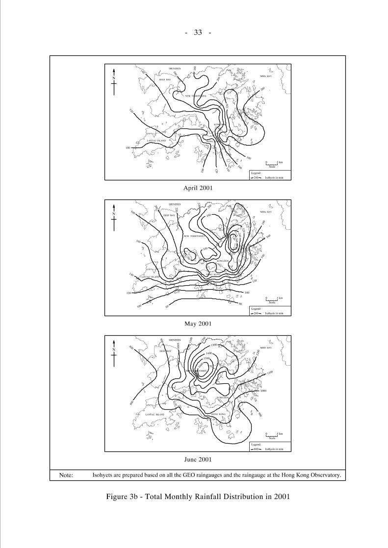
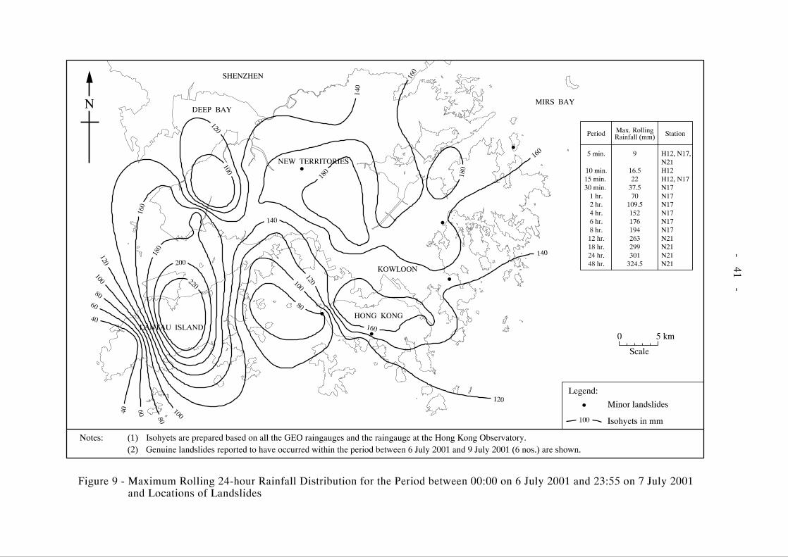
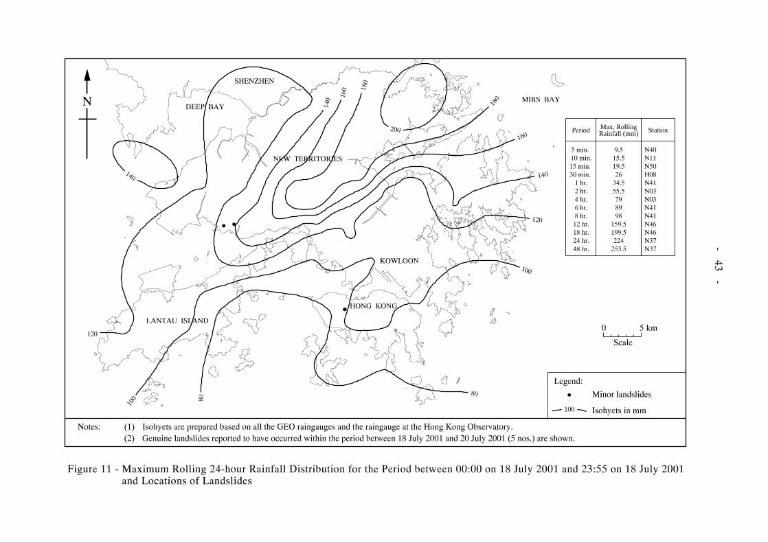
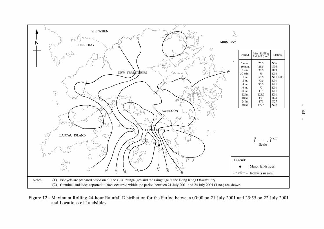
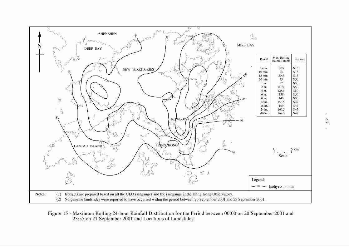
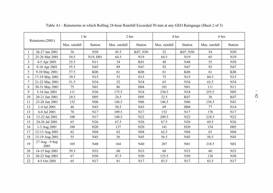
The cumulative rainfall for 2001 recorded at the HKO’s Principal Raingauge at Tsim Sha Tsui is shown in Figure 2, and is compared with the highest and lowest recorded and mean cumulative figures. Figures 3a, 3b, 3c and 3d show the total monthly rainfall distributions in 2001. Figure 4 shows the total annual rainfall distribution during 2001, together with the locations of reported landslides. 2.3 Rainstorms in 2001 The maximum 24-hour, five-hour and one-hour rolling rainfall (five-minute basic units) for the eleven storms during 2001 in which maximum 24-hour rolling rainfall exceeded 50 mm at the HKO are given in Table 1, together with the maximum amounts at any of the GEO raingauges. Also included are the 4-day and 15-day antecedent rainfall at the HKO, and the number of reported landslides. Similar data from selected previous major rainstorms are included for comparison. Figures 5 to 15 show isohyets of maximum rolling 24-hour rainfall during these eleven storms, together with landslide locations and the locations and values of maximum rainfall for durations from five minutes to 48 hours. Three storms triggered significant numbers of landslides. The storms of 5 to 13 June 2001, 24 to 28 June 2001 and 29 August 2001 to 8 September 2001 triggered 76, 17 and 42 reported landslides respectively. No other storms triggered more than six reported landslides. If all the GEO raingauges are considered, rather than just the Principal Raingauge at the HKO, there were 22 storms that exceeded 50 mm of rainfall in 24 hours (including the eleven storms shown in Table 1). Maximum rolling rainfall amounts with respect to different durations for all of these 22 storms are shown in Table A1 of Appendix A. 2.4 Warnings Issued by the Hong Kong Observatory Relevant warnings issued by the HKO and Landslip Warnings jointly issued by the GEO and the HKO in 2001 are summarised in Table 2. In total, eight Landslip Warnings were issued between 6 June 2001 and 8 September 2001. One Black Rainstorm Warning was issued on 1 September 2001 and Red Rainstorm Warnings were issued on nine occasions between 8 June 2001 and 7 September 2001.
- 12 -
3. LANDSLIDES
3.1 Landslide Occurrence in 2001 A total of 227 landslide incidents, which occurred in 2001 was reported to the GEO. In total, 214 landslides were classified as genuine landslides (summarised in Appendix B), 16 (7.5%) of which were major (see Table B2 in Appendix B). The remaining reported incidents were either not landslides or incidents that were of no geotechnical concern, such as fallen trees and very minor washouts, and were therefore not considered in the analysis described below. The locations of all the reported landslides are shown in Figure 4. Selected notable landslides are presented in Section 4 and illustrated in Plates 1 to 10. Information on the landslides collected when the incidents were attended to by the GEO are recorded on GEO Incident Reports and Landslip Cards (for major landslides). These information together with the scanned images of all GEO Incident Reports and Landslip Cards have been uploaded onto the Slope Information System which is accessible by the general public. Further details of these failures can be found in the incident files of the District Divisions of the GEO and in landslide studies or reviews conducted by GEO’s landslide investigation consultants. Wherever possible, the dates and times of the landslides were assessed by geotechnical engineers. Some incidents were not reported to the GEO until several days or weeks after they had occurred. For these, it was difficult to determine the exact times of occurrence. Of the 214 reported landslides, the timing of occurrence was determined to within one day for 108 incidents. It should be noted that there were almost certainly other landslides which were not reported to the GEO, many of which would have occurred in remote areas with no immediate consequences. 3.2 Consequence of Landslides
3.2.1 General The consequence of landslides in terms of number of landslides (including number of major landslides) affecting various types of facility (e.g. buildings, roads, squatters, etc.) in Hong Kong, Kowloon and the New Territories are shown in Table 3. It should be noted that a failure may affect more than one type of facility. Significant consequences of landslides (e.g. casualties, evacuation of squatters and buildings, closure of roads, etc.) classified according to type of slope failure, are listed in Table 4. Table 5 shows the distribution of the different facility group affected by major landslides. Further descriptions of selected notable landslides are presented in Section 4. 3.2.2 Buildings Six landslides affected buildings, and none of these was major. These landslides resulted in the temporary evacuation of six houses.

- 13 -
3.2.3 Roads and Transport Facilities Forty-eight landslides affected sections of roads and transport facilities (e.g. railways, tramways, LRT, etc.). Four of these were major. Twenty-three landslides resulted in the closure of sections of roads. Landslide incidents Nos. HK2001/06/002, HK2001/06/008, MW2001/06/007 and 2001/09/0057 are described in Section 4. 3.2.4 Squatters A total of 32 landslides affected squatter areas and five of these landslides were major. These landslides led to the permanent evacuation of 15 squatters and the temporary evacuation of 33 squatters. Landslide incidents Nos. MW2001/06/010, MW2001/06/016a, 2001/09/0057 and 2001/09/0066 are described in Section 4. 3.2.5 Construction Sites Five landslides affected active construction sites. Two of these were major. Landslide incident No. 2001/09/0057 is described in Section 4. 3.2.6 Other Areas Other areas affected by landslides include pedestrian pavements, footways, minor footpaths, minor access facilities, carparks, parks, playgrounds, gardens, backyard, open areas, etc.. Fifty landslides affected pedestrian pavements, footways, minor footpaths and access facilities, four of which were major. Eighty-five landslides affected carparks, parks, playgrounds, gardens, backyard, open areas, etc. and five of these were major. Thirteen landslides resulted in closure of sections of pedestrian pavements, footpath and other forms of foot and vehicular access. Landslide incidents Nos. ME2001/06/030, ME2001/06/059, MW2001/06/009 and MW2001/06/021 are described in Section 4. 3.3 Types of Slope Failures
3.3.1 General Landslides reported to the GEO have been classified into six types of slope failures, i.e. fill slopes, cut slopes, retaining walls, natural hillside and disturbed terrain. The number of different types of slope failures are shown in Table 6. 3.3.2 Fill Slopes There were eleven fill slope failures, comprising 5.1% of all landslides reported. Two of these failures were major. Landslide incident No. 2001/09/0066 is described in Section 4.

- 14 -
3.3.3 Cut Slopes There were 118 cut slope failures, comprising 55.2% of all landslides reported. These were classified further according to types of material involved, i.e. soil, soil/rock and rock. There were 84 landslides for soil cut slopes, two of which were major. There were 25 soil/rock cut slope failures, none of which were major. Landslide incidents Nos. HK2001/06/002 and MW2001/06/007 are described in Section 4. There were nine incidents on rock cut slopes, none of which were major. Landslide incident No. HK2001/06/008 is described in Section 4. 3.3.4 Retaining Walls There were 18 failures of retaining walls, comprising 8.4% of all landslides. Three of these incidents were major. Landslide incident No. MW2001/06/010 is described in Section 4. 3.3.5 Natural Hillside There were 62 natural hillside failures reported, comprising 29% of all landslides. Eight of these failures were major. Landslide incidents Nos. ME2001/06/030, ME2001/06/059, MW2001/06/016a, MW2001/06/021 and 2001/09/0057 are described in Section 4. 3.3.6 Disturbed Terrain There were five disturbed terrain failures reported, comprising 2.3% of all landslides. One of these failures was major. Landslide incident No. MW2001/06/009 is described in Section 4. 3.4 Landslide Volume Distribution Tables 7 and 8 show the distribution of landslide volumes for all landslides which were reported to the GEO. One hundred and six landslides (about 49.5%) involved less than 5 m3 of material. A total of 16 of the reported landslides (about 7.5%) involved a failure volume of 50 m3 or more. Of these 16 major failures, two were fill slopes, two were soil cut slopes, three were retaining walls, eight were on natural hillsides and one was on disturbed terrain. There were no rock slopes or soil/rock slopes in this group.

- 15 -
4. NOTABLE LANDSLIDES
4.1 General Out of the 214 genuine landslides reported to GEO in 2001, eleven are described in more detail here. These eleven landslides have been selected mainly on the basis of their failure volume, consequence or technical interest. 4.2 The 1 September 2001 Channelised Debris Flow on the Natural Hillside above Lei Pui
Street, Kwai Chung (GEO Incident No. 2001/09/0057)
(A major natural hillside failure that developed into a channelised debris flow, destroying two squatter units (i.e. one squatter hut and a canopy) and depositing debris within an active construction site as well as on Lei Pui Street and Shek Pai Street below. The incident resulted in temporary closure of the sole vehicular access to a residential area and two schools for three days, Plate 1)
During heavy rainfall and after Landslip Warning and Black Rainstorm Warning were hoisted on 1 September 2001, a major landslide (GEO Incident No. 2001/09/0057) occurred at about 10:50 p.m. on the natural hillside approximately 130 m above Lei Pui Street, Kwai Chung. The source area, located at about 230 mPD above a locally steep (60°) exposed rock face, was approximately 26 m long and 18 m wide, with a maximum depth of about 1.5 m. The detached material comprised mostly moderately decomposed granite in the form of slabs separated by persistent, dilated and infilled sheeting joints, with some overlying colluvium. The landslide involved a failure volume of approximately 250 m3. The sliding mass subsequently entrained a further volume of about 500 m3 of material from the natural drainage line and rapidly developed into a debris flow after mixing with concentrated surface runoff along the drainage line. The fast-moving debris demolished two squatter units located further downhill at about 100 mPD and adjacent to the natural drainage line. The debris came to rest within an active construction site above Lei Pui Street, except for about 50 m3 of outwash material which was washed on to Lei Pui Street and Shek Pai Street below by surface water flow. As a result, Lei Pui Street, which is the sole vehicular access to a residential area and two schools, was temporarily closed from 1 September 2001 to 4 September 2001 for three days. 4.3 The 9 June 2001 Rockfall from Slope No. 11NW-A/C58 at Castle Peak Road, Kwai
Chung (GEO Incident No. MW2001/06/007)
(A rockfall from the rock cut portion of a soil/rock cut slope onto Castle Peak Road, which resulted in injury to the driver and a passenger in a passing vehicle, Plate 2)
At about 6:00 p.m. on 9 June 2001, some 3 hours after a rainstorm, a rockfall (GEO Incident No. MW2001/06/007), with an estimated failure volume of about 0.05 m³, occurred on cut slope No. 11NW-A/C58 adjacent to Castle Peak Road below Wah Yuen Chuen, Kwai Chung. A fragment of rock hit a Post Office van, which was travelling on the inside lane of Castle Peak Road, and smashed through its windscreen. The van lost control and crashed into the toe of the slope. As a result, the driver and the only other passenger, who was also
- 16 -
in the front seat, were injured. The rockfall incident occurred on the northeast side of the section of Castle Peak Road below Wah Yuen Chuen. The slope is a soil and rock cut slope and is approximately 210 m long and up to about 35 m high. The slope comprises four batters formed at about 60° to the horizontal with three berms of 1.0 m to 1.3 m in width. The slope is mostly covered with shotcrete except for the exposed rock portion located approximately in the middle portion of the slope (which is about 100 m in length for the lowest two batters and about 40 m in length for the upper batter). The exposed rock face is heavily jointed and susceptible to detachment of small rock blocks. The rock face was locally covered with much unplanned vegetation, including grass and shrubs that are growing into the rock joints. The source of the rockfall was probably within the exposed rock face of the cut slope. 4.4 The 25 June 2001 Rockfall from Slope No. 11SE-A/C561 at King’s Road, Tin Hau
(GEO Incident No. HK2001/06/008)
(A rockfall which resulted in the temporary closure of the westbound lane of King’s Road and the adjacent footway at the slope toe, Plate 3)
Following heavy rainfall and after Amber Rainstorm Warning was hoisted on 25 June 2001, a rockfall (GEO Incident No. HK2001/06/008) occurred at around 8:00 p.m. on a 15 m high rock cut slope No. 11SE-A/C561 located above King’s Road, Tin Hau. The incident involved the detachment of a rock block (about 1.1 m by 0.4 m by 0.4 m) from a location about 10 m above the slope toe, which landed on the pedestrian footway along King’s Road at the slope toe. The incident resulted in the temporary closure of the footway and the inside lane of King’s Road. The rock slope face exposes adverse joint orientations which resulted in the formation of rock wedges. Persistent seepage from the slope face has promoted the growth of unplanned vegetation. Progressive tree root growth has penetrated into joint apertures, thereby wedging the joints open. 4.5 The 8 June 2001 Boulder Fall from above Slope No. 11SE-C/C54 at Tai Hang Road,
Jardine’s Lookout (GEO Incident No. HK2001/06/002)
(A boulder fall which resulted in the temporary closure of the southbound lane of Tai Hang Road, Plate 4)
On 8 June 2001, a boulder fall (GEO Incident No. HK2001/06/002) occurred at approximately 8:30 a.m. during heavy rainfall and after Landslip Warning and Red Rainstorm Warning were hoisted. The 0.1 m3 boulder originated from sloping ground at about 11 m above the carriageway. The source location of the boulder is within an area where slope upgrading works were completed in April 2001. The slope upgrading works on slope No. 11SE-C/C54 extended beyond the original crest line of the cut feature to cover a portion of the hillside above, including the source area of the boulder fall. The boulder came to rest on the inside lane of Tai Hang Road, which was temporarily closed as a result of the incident.

- 17 -
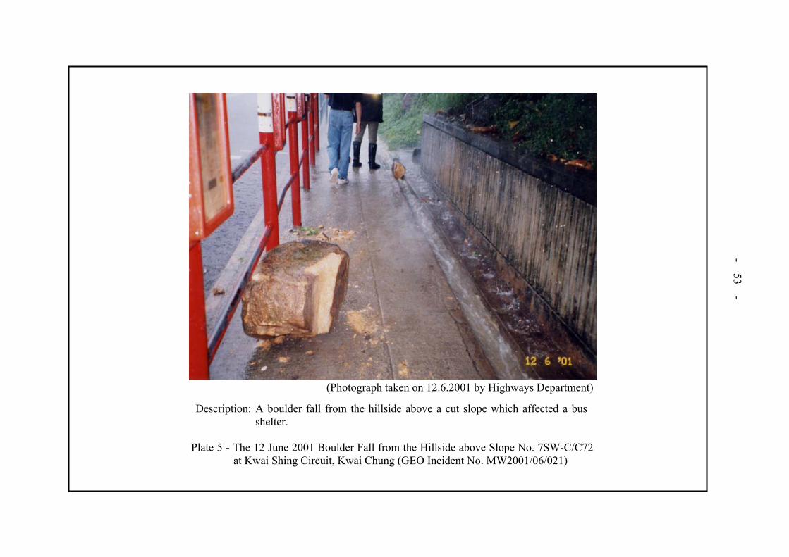
4.6 The 12 June 2001 Boulder Fall from the Hillside above Slope No. 7SW-C/C72 at Kwai Shing Circuit, Kwai Chung (GEO Incident No. MW2001/06/021)
(A boulder fall from the hillside above the crest of a 22 m high cut slope onto a bus shelter below, which resulted in temporary closure of the bus shelter, Plate 5).
On 12 June 2001 during relatively light rainfall and after Amber Rainstorm Warning was hoisted, a boulder (about 0.5 m by 0.5 m by 0.5 m) fell from the hillside above the crest of slope No. 7SW-C/C72 at about 1:00 p.m.. The failure (GEO Incident No. MW2001/06/021) resulted in temporary closure of the bus shelter. Although the exact origin of the boulder is uncertain, an area of flattened vegetation and a trail of freshly deposited rock fragments indicated that the source area was likely to be on the hillside about 6 m above the crest of slope No. 11NW-C/C72. 4.7 The 12 June 2001 Boulder Fall and the 27 June 2001 Landslide on Natural Hillside
above Hong Ning Road Park, Kwun Tong (GEO Incidents Nos. ME2001/06/030 and ME2001/06/059)
(A boulder fall and a landslide from the natural hillside above Hong Ning Road Park respectively, which resulted in damage to the park’s amenities and temporary closure of a portion of the park, Plate 6)
During moderate rainfall and after Amber Rainstorm Warning was hoisted on the morning of 12 June 2001, a boulder fall (GEO Incident No. ME2001/06/030) occurred on the natural hillside at about 2 m above an approximately 18 m high slope (registered as No. 11NE-D/DT32) within Hong Ning Road Park. The spheroidal boulder (about 1.5 m in size) from the natural hillside bounced several times on the shotcrete cover of the slope below and damaged some of the facilities in the park. The boulder came to rest in a fishpond which was about 20 m from the toe of slope No. 11NE-D/DT32. During rainfall and after Landslip Warning and Amber Rainstorm Warning were hoisted on 27 June 2001, another landslide (GEO Incident No. ME2001/06/059) occurred at about 10:00 p.m. on the natural hillside at a height of approximately 12 m above the park and to the west of the source area of the 12 June 2001 boulder fall. The failure volume was about 5 m³ comprising completely decomposed granite. One boulder (approximately 1 m in size) was released by the failure and travelled down the hillside, broke the drainage gully grating at the base and came to rest about 1 m from the public toilet block at the toe of the hillside. Both incidents occurred during heavy rainfall and resulted in temporary closure of a portion of Hong Ning Road Park. 4.8 The 10 June 2001 Landslide at Wo Hop Shek Cemetery, Fanling (GEO Incident
No. MW2001/06/009)
(A major slope failure within a cemetery area which resulted in temporary closure of part of the cemetery, Plate 7)

- 18 -
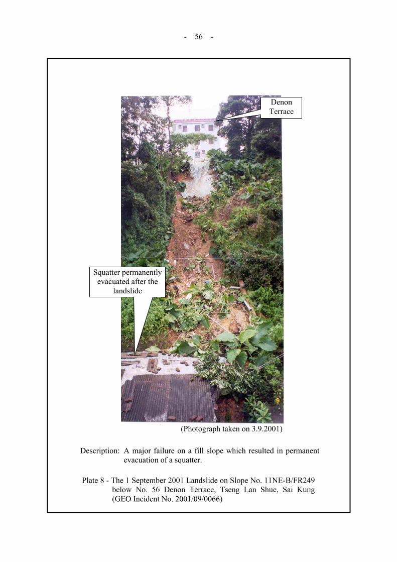
During heavy rainfall and after Amber Rainstorm Warning was hoisted on 10 June 2001, a major landslide (GEO Incident No. MW2001/06/009), involving a failure volume of approximately 250 m³ occurred at Wo Hop Shek Cemetery, Fanling. The failure site is located within a cemetery area, consisting of cut and fill burial platforms that range from about 1.5 m to 2 m in height. The landslide scar was about 15 m wide by 30 m long, with a maximum depth of about 1.3 m. The landslide debris was deposited on an access road and some open area at the toe of the cemetery. As a consequence of the landslide, some of the graves were damaged and the affected area was temporarily closed. 4.9 The 1 September 2001 Landslide on Slope No. 11NE-B/FR249 below No. 56 Denon
Terrace, Tseng Lan Shue, Sai Kung (GEO Incident No. 2001/09/0066)
(A major fill slope failure which resulted in severe damage of a squatter located below the fill slope and subsequent permanent evacuation of the squatter, Plate 8)
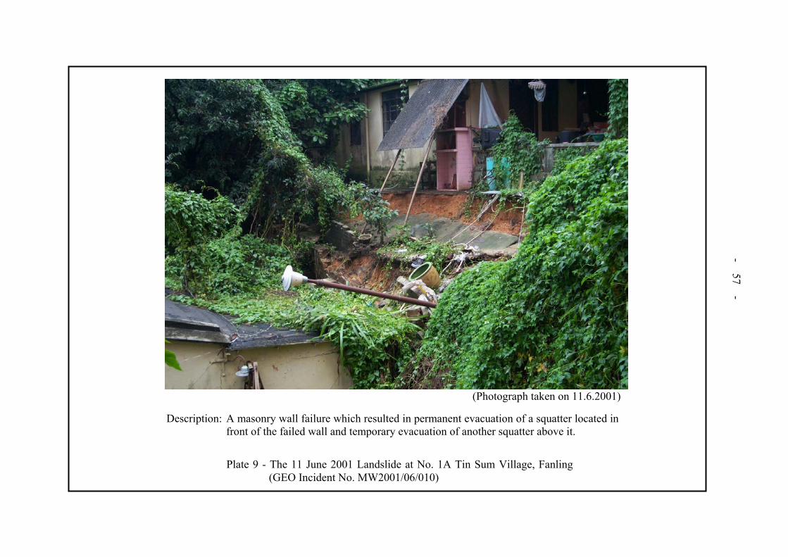
On 1 September 2001 during heavy rainfall and after Amber Rainstorm Warning was hoisted, a major fill slope failure (GEO Incident No. 2001/09/0066), involving a failure volume of about 50 m3, occurred at about 10:00 p.m. at slope No. 11NE-B/FR249 below No. 56 Denon Terrace, Tseng Lan Shue, Sai Kung. The landslide scar was about 6 m wide by 5 m long, with a maximum depth of about 1 m. The landslide debris, together with entrained material eroded from the natural hillside below, travelled downhill and came to rest against a squatter. The squatter was severely damaged by the debris and consequently it was permanently evacuated. 4.10 The 11 June 2001 Landslide at No. 1A Tin Sum Village, Fanling (GEO Incident
No. MW2001/06/010)
(A major failure of a retaining wall which resulted in the permanent evacuation of one squatter and temporary evacuation of another squatter, Plate 9)
On the morning of 11 June 2001 during heavy rainfall and after Amber Rainstorm Warning was hoisted, a maximum 5.5 m high, 20 m long masonry wall collapsed (GEO Incident No. MW2001/06/010). The collapsed section of the retaining wall together with the landslide debris rested against the squatter (No. 1A Tin Sum Village) at the toe. The estimated failure volume was approximately 90 m³. The squatter was severely damaged. As a result, the squatter was permanently evacuated and another squatter located above the crest of the wall was temporarily evacuated. 4.11 The 9 June 2001 Landslide at Pun Shan Village, Tsuen Wan (GEO Incident
No. MW2001/06/016a)
(A natural hillside landslide which resulted in temporary evacuation of a squatter, Plate 10)
During heavy rainfall and after Red Rainstorm Warning was hoisted on 9 June 2001, a landslide (GEO Incident No. MW2001/06/016a), occurred at about 10:30 a.m. on the natural

- 19 -
hillside below Tai Lam Chung Catchwater near Pun Shan Village, Tsuen Wan. The landslide scar was about 4 to 5 m wide and 10 m to 12 m long, with a failure volume of approximately 35 m³. Part of the landslide debris was deposited on a paved platform of a squatter. The landslide resulted in temporary evacuation of the affected squatter. 5. CONCLUSIONS Rainfall at the HKO’s Principal Raingauge at Tsim Sha Tsui amounted to 3091.8 mm in 2001, which ranked the fourth highest in terms of annual rainfall since records began in 1884. Eight Landslip Warnings were issued between 6 June 2001 and 8 September 2001. One Black Rainstorm Warning was issued on 1 September 2001 and Red Rainstorm Warnings were issued on nine occasions between 8 June 2001 and 7 September 2001. A total of 227 incidents were reported to the GEO, of which 214 were classified as genuine landslides. Sixteen landslides were major failures. A rockfall incident resulted in two injuries. The consequences of landslides included the permanent evacuation of 15 squatters and the temporary evacuation of 33 squatters and six houses. Twenty-three landslides resulted in closure of sections of roads and thirteen landslides resulted in closure of sections of pedestrian pavements, footpaths and other forms of minor foot and vehicular access. 6. REFERENCES Hong Kong Observatory (2002). Monthly Weather Summary for December 2001. Hong
Kong Observatory, Hong Kong, 33 p. Wong, C.K.L. (1998). The New Priority Classification Systems for Slopes and Retaining
Walls. Geotechnical Engineering Office, Hong Kong, 117 p. (GEO Report No. 68).

- 20 -
LIST OF TABLES Table No.
Page No.
1 Rainfall and Landslides in 2001, Compared with Selected Previous Major Rainstorms
21
2 Warnings Issued by the Hong Kong Observatory in 2001
22
3 Number of Landslides Affecting Different Facilities
23
4 Landslide Consequence Related to Type of Slope Failure
24
5 Distribution of Facility Groups Affected by Major Landslides
25
6 Number of Landslides as Classified by Type of Slope Failure
25
7 Landslide Volume Distribution with Respect to Geographic Locations
26
8 Landslide Volume Distribution with Respect to Type of Slope Failure
27

Table 1 - Rainfall and Landslides in 2001, Compared with Selected Previous Major Rainstorms
Maximum Rainfall (mm)(2)
Hong Kong Observatory (HKO) GEO Raingauges(3)
Antecedent
Date of Rainstorm
Event(1) 24-hr 5-hr 1-hr4 days 15 days
24-hours 5-hours 1-hour
Number of Landslides(4) Reported to GEO(5)
5-13 Jun 2001(6) 170 110 58 361 623 323 (N36) 251 (N05) 111 (N36) 76 29 Aug – 8 Sep 2001(6) 151 99 53 272 336 280 (N01) 214 (N01) 105 (N40) 42
24-28 Jun 2001(6) 133 73 53 369 453 263 (N41) 147 (N06) 95 (H21) 17 6-7 Jul 2001(6) 132 69 21 153 626 301 (N21) 165 (N17) 70 (N17) 6 15-16 Jul 2001 108 85 37 147 367 246 (N22) 216 (N22) 95 (N21) 5 21-22 Jul 2001 90 67 33 184 458 176 (N27) 97 (K01) 60 (N01, N08) 1 20-21 Sep 2001 76 35 19 76 220 170 (N47) 137 (N50) 67 (N50) 0
18 Jul 2001 69 29 18 190 384 224 (N37) 81 (N41) 35 (N41) 4 5 Apr 2001 57 34 17 62 113 98 (N15, N50) 30 (N15) 14 (N48) 0 1-2 Jul 2001 56 27 27 166 503 172 (N43) 73 (N14) 46 (N43) 2
2-3 Aug 2001 53 33 29 64 233 160 (H05) 141 (H20) 100 (H20) 0
Selected Previous Major Rainstorms (for comparison only)
28-29 May 82 394 153 44 1 11 430 237 111 238 17 Jun 83(6) 347 274 69 2 77 460 303 101 155
20-21 May 89(6) 388 149 37 28 42 566 224 51 378 7-9 May 92(6) 324 196 110 65 71 385 244 110 314
15-16 Jun 93(6) 155 129 54 18 275 285 195 111 123 4-5 Nov 93(6) 107 31 9 8 8 742 350 94 394 1-4 Jul 97(6) 110 49 18 183 380 799 296 125 150 8-9 Jun 98(6) 429 164 48 58 181 562 223 98 96
22-26 Aug 99(6) 313 143 51 11 175 565 249 121 269 Notes: (1) Rainstorm events in which rolling 24-hour rainfall at the Hong Kong Observatory, Tsim Sha Tsui, exceeded 50 mm are arranged in order of the
intensity of 24-hour rainfall. (2) The maxima are calculated using 5-minute rainfall as the basic unit, except those recorded at the HKO for the previous major rainstorms. They
are the rolling rainfall amounts using one-clock hour rainfall as the basic unit. The 1-hour maximum rainfall at the HKO refers to clock hours. (3) The maxima are selected from the 86 GEO Raingauges for the rainstorms. The GEO Raingauge reference number is shown in brackets. (4) Reported totals are for landslides attributed to the events. (5) GEO = Geotechnical Engineering Office. (6) Landslip warnings were issued for these events.
- 21 -

Table 2 - Warnings Issued by the Hong Kong Observatory in 2001(1)
Dates on which Warnings were in Effect Month Monthly Total
Rainfall (mm) Thunderstorm Flood Landslip(2) Tropical Storm Rainstorm
January 47.6 25, 26 - - - -February 10.9 - - - - -March 56.5 25 - - - 25 (Amber)April 133 4, 9, 11, 18, 21, 22, 24, 30 9 - - 9 (Amber) May 162 1, 8, 8-9, 9, 17, 17-18, 19,
21, 22, 30 21 - - 9 (Amber), 18 (Amber), 21 (Amber),
30 (Amber) June 1083.6 2, 3-4, 4, 4-5, 5-6, 6, 6-8,
9, 9-10, 11, 12, 13, 15, 16, 17, 20, 23-24, 24, 25, 26,
26-27, 28, 30
7, 9, 10, 12, 23-24,
27
6 (06:00-14:00), 8 (07:45-17:00), 12 (14:15-17:45),
27(15:45) - 28(07:25)
22-23 (Signal 1, Chebi), 30 (Signal 1-3, Durian)
5 (Amber), 7 (Amber), 8 (Amber, Red), 9 (Amber, Red),
10 (Amber), 11 (Amber, Red), 12 (Amber, Red), 13 (Amber), 23-24 (Amber), 25 (Amber),
26 (Amber), 27 (Amber, Red)
July 656.4 1, 3, 5, 6, 12-13, 15, 16, 17-18, 18, 19, 20, 20-21,
21, 24, 26, 27
- 6(18:00) - 7(09:50) 1-2 (Signal 3, Durian), 4-7 (Signal 1-8, Utor),
23-26 (Signal 1-8, Yutu)
6 (Amber), 13 (Amber), 15 (Amber), 17 (Amber), 18 (Amber), 21 (Amber)
August 318.9 1, 2-3, 10, 11, 12, 12-13, 13, 14, 14-15, 15, 16, 18, 19, 27-28, 29, 30, 30-31,
31
2 30 (15:30-23:15) 28-30 (Signal 1, Fitow) 1 (Amber), 2 (Amber, Red), 12 (Amber), 27-28 (Amber),
30 (Amber)
September 563.3 1, 1-2, 2, 2-3, 5, 6, 7-8, 14, 18, 20-21
1-2 1(22:45) - 2(10:00), 8 (03:30-08:45)
19-20 (Signal 3, Nari) 1 (Amber), 1-2 (Amber, Red, Black), 3 (Amber, Red), 5 (Amber),
7 (Amber, Red) October 10.7 4, 9 - - - -
November 4.3 - - - - -December 44.6 - - - - -
Total 3091.8 88 days 12 days 8 Warnings 6 Warnings 36 days
Notes: (1) Information in this Table was based on HKO (2002). (2) Landslip Warnings were issued after consultation between GEO and HKO.
- 22 -

- 23 -
Table 3 - Number of Landslides Affecting Different Facilities
Affected Facility Hong Kong Island Kowloon
New Territories
and Outlying Islands
All
Squatters 0 (0) 0 (0) 32 (5) 32 (5)
Buildings 0 (0) 0 (0) 6 (0) 6 (0)
Roads 10 (0) 1 (0) 37 (4) 48 (4)
Transportation Facilities (railways, tramways, LRT, etc.)
0 (0) 0 (0) 0 (0) 0 (0)
Pedestrian Pavements/ Footways 6 (1) 2 (0) 5 (0) 13 (1)
Minor Footpaths/Access 3 (0) 1 (0) 33 (3) 37 (3)
Construction Sites 1 (0) 0 (0) 4 (2) 5 (2)
Open Areas 6 (1) 7 (0) 37 (2) 50 (3)
Catchwaters 0 (0) 0 (0) 0 (0) 0 (0)
Others (e.g. carparks, parks, playgrounds, gardens, backyards, etc.)
3 (0) 0 (0) 32 (2) 35 (2)
Legend:
32 (5) Thirty-two landslides of which five were major failures (i.e. failure volume ≥ 50 m3).
Note: A given landslide may affect more than one key type of facility.
- 24 -
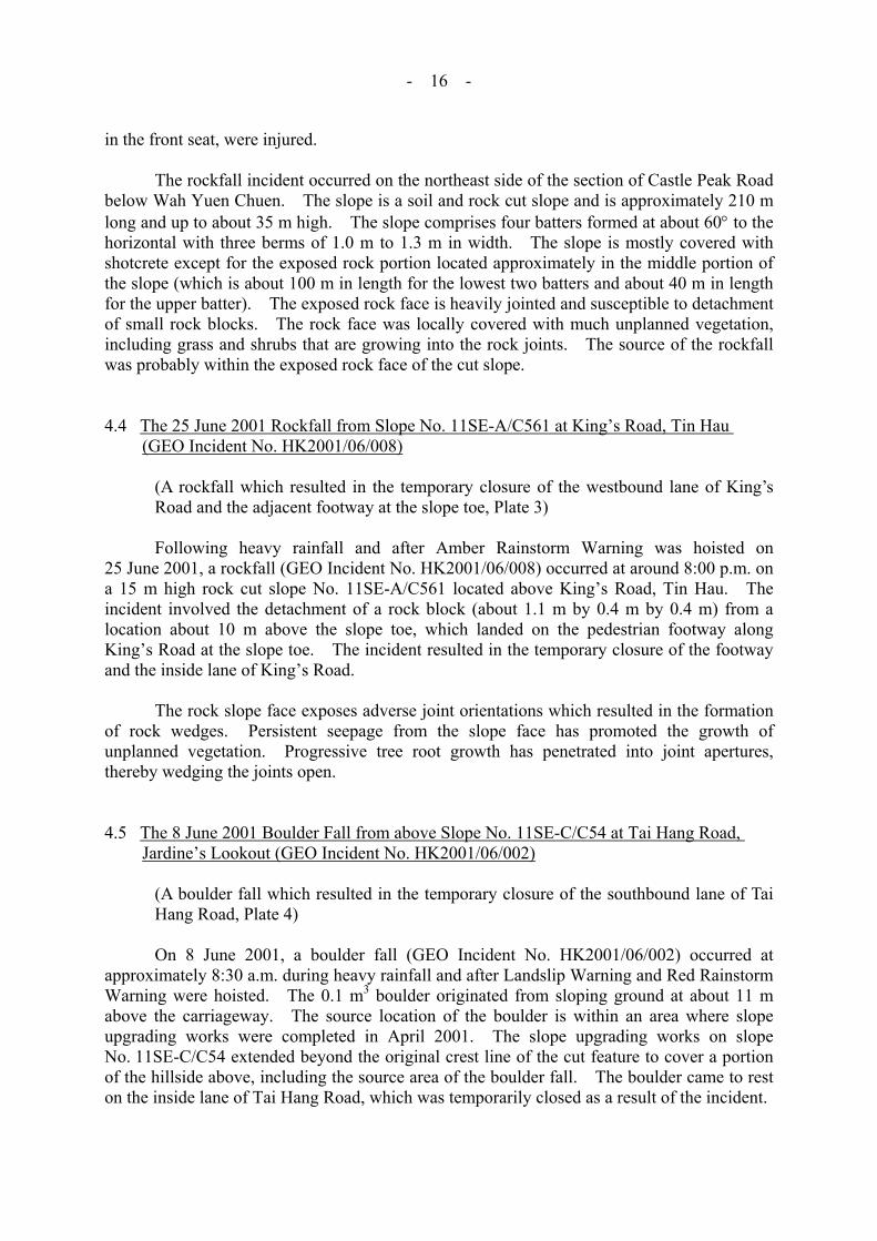
Table 4 - Landslide Consequence Related to Type of Slope Failure
No. of Squatters Evacuated No. of Landslides Closure
Type of Failure
Permanent
Temporary
No. of Blocks, Houses or Flats Evacuated or
Partially Closed Roads Pedestrian Pavements
Footpaths, Back Lanes,
Private Access
Deaths Injuries
Fill Slope 1 2 - - 2 - - -
Soil 3 10 5 4 - 3 - -
Soil/Rock - 5 1 5 1 1 - 2Cut Slope
Rock - - - 5 - - - -
Retaining Wall 5 2 - 1 - 2 - -
Natural Hillside 6 9 - 8 1 2 - -
Disturbed Terrain - 5 - - - 1 - -
Note: A failure may give rise to more than one key type of consequence.

- 25 -
Table 5 - Distribution of Facility Groups Affected by Major Landslides
Facility Group Affected by Major Landslides
Group No. 1 Group No. 2 Group No. 3 Group No. 4 Group No. 5
All Major Landslides 5 0 2 4 6
Major Landslides on Man-made Slope 4 0 1 2 1
Major Landslides on Hillside 1 0 1 2 5
Notes: (1) The facility group is classified in accordance with that adopted for the New Priority Classification Systems (Wong, 1998).
(2) A given landslide may affect more than one key type of facility.
Table 6 - Number of Landslides as Classified by Type of Slope Failure
Type of Failure No. Percentage (%)
Fill Slope 11 (2) 5.1
Soil 84 (2) 39.3
Soil/Rock 25 (0) 11.7 Cut Slope
Rock 9 (0) 4.2
Retaining Wall 18 (3) 8.4
Natural Hillside 62 (8) 29.0
Disturbed Terrain 5 (1) 2.3
Total 214 (16) 100
Legend:
11 (2) Eleven landslides of which two were major failures (i.e. failure volume ≥ 50 m3).
Note: Where a landslide involved more than one type of failure, the predominant type of failure has been assumed in the above classification.
- 26 -
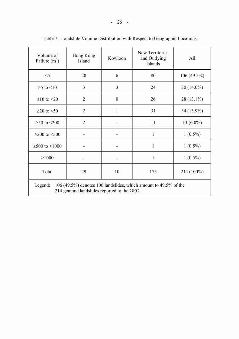
Table 7 - Landslide Volume Distribution with Respect to Geographic Locations
Volume of Failure (m3)
Hong Kong Island Kowloon
New Territories and Outlying
Islands All
<5 20 6 80 106 (49.5%)
≥5 to <10 3 3 24 30 (14.0%)
≥10 to <20 2 0 26 28 (13.1%)
≥20 to <50 2 1 31 34 (15.9%)
≥50 to <200 2 - 11 13 (6.0%)
≥200 to <500 - - 1 1 (0.5%)
≥500 to <1000 - - 1 1 (0.5%)
≥1000 - - 1 1 (0.5%)
Total 29 10 175 214 (100%)
Legend: 106 (49.5%) denotes 106 landslides, which amount to 49.5% of the 214 genuine landslides reported to the GEO.

- 27 -
Table 8 - Landslide Volume Distribution with Respect to Type of Slope Failure
Cut Slope Volume of Failure (m³) Fill Slope
Soil Slope Soil/Rock Rock
Retaining Wall
Natural Hillside
Disturbed Terrain Total
<5 3 48 18 7 8 20 2 106 (49.5%)
≥5 to <10 3 15 2 0 3 6 1 30 (14.0%)
≥10 to <20 0 12 4 2 2 8 0 28 (13.1%)
≥20 to <50 3 7 1 0 2 20 1 34 (15.9%)
≥50 to <200 2 1 0 0 3 7 0 13 (6.0%)
≥200 to <500 0 0 0 0 0 0 1 1 (0.5%)
≥500 to <1000 0 0 0 0 0 1 0 1 (0.5%)
≥1000 0 1 0 0 0 0 0 1 (0.5%)
Total 11 (5.1%) 84 (39.3%) 25 (11.7%) 9 (4.2%) 18 (8.4%) 62 (29.0%) 5 (2.3%) 214 (100%)
Legend: 106 (49.5%) denotes 106 landslides, which amount to 49.5% of the 214 genuine landslides reported to the GEO.

- 28 -
LIST OF FIGURES Figure No.
Page No.
1 Locations of GEO and HKO Automatic Raingauges
30
2 Cumulative Rainfall for 2001 at the Hong KongObservatory and its Recorded Highest, Mean and Lowest Cumulative Rainfalls
31
3 Total Monthly Rainfall Distribution in 2001
32
4 Total Annual Rainfall Distribution and Locations of 36Landslides in 2001
5 Maximum Rolling 24-hour Rainfall Distribution for thePeriod between 00:00 on 5 April 2001 and 23:55 on 5 April 2001 and Locations of Landslides
37
6 Maximum Rolling 24-hour Rainfall Distribution for thePeriod between 00:00 on 5 June 2001 and 23:55 on 13 June 2001 and Locations of Landslides
38
7 Maximum Rolling 24-hour Rainfall Distribution for thePeriod between 00:00 on 24 June 2001 and 23:55 on 28 June 2001 and Locations of Landslides
39
8 Maximum Rolling 24-hour Rainfall Distribution for thePeriod between 00:00 on 1 July 2001 and 23:55 on 2 July 2001 and Locations of Landslides
40
9 Maximum Rolling 24-hour Rainfall Distribution for thePeriod between 00:00 on 6 July 2001 and 23:55 on 7 July 2001 and Locations of Landslides
41
10 Maximum Rolling 24-hour Rainfall Distribution for thePeriod between 00:00 on 15 July 2001 and 23:55 on 16 July 2001 and Locations of Landslides
42
11 Maximum Rolling 24-hour Rainfall Distribution for thePeriod between 00:00 on 18 July 2001 and 23:55 on 18 July 2001 and Locations of Landslides
43
12 Maximum Rolling 24-hour Rainfall Distribution for thePeriod between 00:00 on 21 July 2001 and 23:55 on 22 July 2001 and Locations of Landslides
44

- 29 -
Figure No.
Page No.
13 Maximum Rolling 24-hour Rainfall Distribution for thePeriod between 00:00 on 2 August 2001 and 23:55 on 3 August 2001 and Locations of Landslides
45
14 Maximum Rolling 24-hour Rainfall Distribution for thePeriod between 00:00 on 29 August 2001 and 23:55 on 8 September 2001 and Locations of Landslides
46
15 Maximum Rolling 24-hour Rainfall Distribution for the
Period between 00:00 on 20 September 2001 and 23:55 on 21 September 2001 and Locations of Landslides
47


- 48 -
LIST OF PLATES Plate No.
Page No.
1 The 1 September 2001 Channelised Debris Flow on the Natural Hillside above Lei Pui Street, Kwai Chung (GEO Incident No. 2001/09/0057)
49
2 The 9 June 2001 Rockfall from Slope No. 11NW-A/C58 at Castle Peak Road, Kwai Chung (GEO Incident No. MW2001/06/007)
50
3 The 25 June 2001 Rockfall from Slope No. 11SE-A/C561 at King’s Road, Tin Hau (GEO Incident No. HK2001/06/008)
51
4 The 8 June 2001 Boulder Fall from above Slope No. 11SE-C/C54 at Tai Hang Road, Jardine’s Lookout (GEO Incident No. HK2001/06/002)
52
5 The 12 June 2001 Boulder Fall from the Hillside above Slope No. 7SW-C/C72 at Kwai Shing Circuit, Kwai Chung (GEO Incident No. MW2001/06/021)
53
6 The 12 June 2001 Boulder Fall and the 27 June 2001 Landslide on Natural Hillside above Hong Ning Road Park, Kwun Tong (GEO Incidents Nos. ME2001/06/030 and ME2001/06/059)
54
7 The 10 June 2001 Landslide at Wo Hop Shek Cemetery, Fanling (GEO Incident No. MW2001/06/009)
55
8 The 1 September 2001 Landslide on Slope No. 11NE-B/FR249 below No. 56 Denon Terrace, Tseng Lan Shue, Sai Kung (GEO Incident No. 2001/09/0066)
56
9 The 11 June 2001 Landslide at No. 1A Tin Sum Village, Fanling (GEO Incident No. MW2001/06/010)
57
10 The 9 June 2001 Landslide at Pun Shan Village, Tsuen Wan (GEO Incident No. MW2001/06/016a)
58

- 49 -
Plate 1 - The 1 September 2001 Channelised Debris Flow on the Natural Hillsideabove Lei Pui Street, Kwai Chung (GEO Incident No. 2001/09/0057)
Two damaged squatter units
Lei Pui Street
Active construction site
Source area
(Photograph taken on 7.9.2001)
Description: Channelised debris flow on natural hillside destroyed two squatter unitslocated on the flank of a natural drainage line. The majority of debriscame to rest within an active construction site above Lei Pui Street andabout 50 m3 of outwash material was deposited onto Lei Pui Streetresulting in temporary closure of Lei Pui Street for three days.

- 50 -
Plate 2 - The 9 June 2001 Rockfall from Slope No. 11NW-A/C58 at Castle Peak Road, Kwai Chung (GEO Incident No. MW2001/06/007)
Rock fragment involved in the
incident
Position where rock fragment punched
through the windscreen
(Photograph taken on 9.6.2001 by Police)
Description: A rock fragment fell from the rock portion of a soil/rock cut slope and hita post office van travelling along the inside lane of Castle Peak Road.The driver lost control and the van crashed into the toe of the slope. Theincident resulted in two injuries.

- 51 -
Fallen rock block
Source area of June 2001 rockfall
(Photograph taken on 26.6.2001)
Description: A rockfall from a rock cut slope resulted in temporary closure of the inside lane of King’s Road and the adjacent footway at the slope toe.
Plate 3 - The 25 June 2001 Rockfall from Slope No. 11SE-A/C561 at King’s Road, Tin Hau(GEO Incident No. HK2001/06/008)

D
~7
- 52 -
(Photograph taken on 8.6.2001)
escription: A boulder fell from the ground above a soil/rock cut slope. The incident resulted in temporary closure of one lane of Tai Hang Road.
Plate 4 - The 8 June 2001 Boulder Fall from above Slope No. 11SE-C/C54 at Tai Hang Road, Jardine’s Lookout (GEO Incident No. HK2001/06/002)
Possible path of the boulder fall
0° steep, shotcreted cut slope
Source location of boulder fall
45° to 50° steep soil cut slope(15 m high maximum)
- 53 -
(Photograph taken on 12.6.2001 by Highways Department)
Description: A boulder fall from the hillside above a cut slope which affected a busshelter.
Plate 5 - The 12 June 2001 Boulder Fall from the Hillside above Slope No. 7SW-C/C72 at Kwai Shing Circuit, Kwai Chung (GEO Incident No. MW2001/06/021)

D
- 54 -
(Photograph taken on 28.6.2001)(Photograph taken on 13.6.2001)
Description: (b) A landslide occurred on the hillside resultingin release of debris and a boulder that came torest against a toilet block. The incident resultedin temporary closure of a portion of Hong NingRoad Park. (GEO Incident No. ME2001/06/059)
escription: (a) A boulder fell from the hillside aboveHong Ning Road Park which resulted intemporary closure of a portion of the Park.(GEO Incident No. ME2001/06/030)
Plate 6 - The 12 June 2001 Boulder Fall and the 27 June 2001 Landslide on Natural Hillside above Hong Ning Road Park, Kwun Tong (GEO Incidents Nos. ME2001/06/030 and ME2001/06/059)
Toilet block
Fallen boulder
Site of GEO Incident No.
ME2001/06/030Source area of the landslide
Boulder fragment
Boulder impact point
Probable path of
boulder fall
Source area of the boulder fall

- 55 -
(Photograph taken on 10.6.2001 by Apple Daily)
Description: A major failure on a cemetery area (consisted of cut and fill burial platformsof 1.5 to 2 m high) resulted in damage of some of the graves and temporaryclosure of a part of the cemetery.
Plate 7 - The 10 June 2001 Landslide at Wo Hop Shek Cemetery, Fanling(GEO Incident No. MW2001/06/009)
- 56 -
Description:
Plate 8 - Thbe(G
Squatter permanently evacuated after the
landslide
(Photograph taken on 3.9.2001)
Denon Terrace
A major failure on a fill slope which resulted in permanentevacuation of a squatter.
e 1 September 2001 Landslide on Slope No. 11NE-B/FR249 low No. 56 Denon Terrace, Tseng Lan Shue, Sai KungEO Incident No. 2001/09/0066)
(Photograph taken on 11.6.2001)
Description: A masonry wall failure which resulted in permanent evacuation of a squatter located infront of the failed wall and temporary evacuation of another squatter above it.
Plate 9 - The 11 June 2001 Landslide at No. 1A Tin Sum Village, Fanling(GEO Incident No. MW2001/06/010)
- 57 -

- 58 -
(Photograph taken on 13.6.2001)
Description: A landslide on natural hillside resulted in temporaryevacuation of a squatter located below the failed hillside.
Plate 10 -
Site of GEO Incident No. MW2001/06/016a
The 9 June 2001 Landslide at Pun Shan Village, Tsuen Wan(GEO Incident No. MW2001/06/016a)

- 59 -
APPENDIX A
RAINFALL OF SELECTED RAINSTORMS RECORDED AT GEO RAINGAUGES

- 60 -
LIST OF TABLES Table No.
Page No.
A1 Rainstorms in which Rolling 24-hour Rainfall Exceeded 6150 mm at any GEO Raingauge

- 61 -
Table A1 - Rainstorms in which Rolling 24-hour Rainfall Exceeded 50 mm at any GEO Raingauge (Sheet 1 of 3)
5 min 10 min 15 min 30 min Rainstorm (2001)
Max. rainfall Station Max. rainfall Station Max. rainfall Station Max. rainfall Station
1 26-27 Jan 2001 9 K07, N11 16.5 N11 22.5 K07, N11 30 N502 25-26 Mar 2001 13 N25 20.5 N25 28 N17 44 H013 4-5 Apr 2001 7 N17 10.5 N19 12.5 N19 19 N11 4 9-10 Apr 2001 19.5 N10 33.5 N10 40.5 N37 50 K025 9-10 May 2001 14 K06 25.5 K06 34 N01 54.5 K066 17-19 May 2001 14 N16 23.5 N16 29 N16 37.5 N16 7 21-22 May 2001 11 N34 19 N34 23.5 N21 39 N218 30-31 May 2001 9.5 N01 17.5 N16 25 K06 45 N01 9 5-14 Jun 2001 19.5 N14 33.5 N17 43 N17 70 N17
10 20-21 Jun 2001 12 N39 18.5 N39 22 N39 23.5 N38, N39 11 23-28 Jun 2001 22.5 N10 39 N06 57.5 N06 91 N0612 1-4 Jul 2001 12 N35 22 N41 29 N41 35 N41, N43
13 6-8 Jul 2001 9 H12, N17, N21 16.5 H12 22 H12, N17 37.5 N17
14 13-22 Jul 2001 25.5 N36 28 N19 38.5 N19 57 N1715 24-26 Jul 2001 16 N10 27 N10, N24 38.5 N24 55 N26
16 1-3 Aug 2001 14.5 K03, N39 27.5 K03, N08, N39 39 K03, N08 64.5 N08
17 12-13 Aug 2001 19 H01 32.5 H12 42 H01 59 H0118 15-19 Aug 2001 13 N28, N49 23.5 N28 32.5 N28 52.5 N28
19 27 Aug - 9 Sep 2001 15.5 H08 28.5 H24 38 K03, H24 64.5 H24
20 14-15 Sep 2001 14 N32 22.5 N32 25 N32 38 N3321 20-22 Sep 2001 12.5 N13 24 N13 30.5 N13 43 N5022 4-5 Oct 2001 11 N17 19 N17 26.5 N17 47.5 N17
- 62 -
Table A1 - Rainstorms in which Rolling 24-hour Rainfall Exceeded 50 mm at any GEO Raingauge (Sheet 2 of 3)
1 hr 2 hrs 4 hrs 6 hrs Rainstorm (2001)
Max. rainfall Station Max. rainfall Station Max. rainfall Station Max. rainfall Station
1 26-27 Jan 2001 36 N50 45.5 K07, N50 52 K07, N50 54 N502 25-26 Mar 2001 54.5 N19, H01 64.5 N19 64.5 N19 65 N193 4-5 Apr 2001 25.5 N11 34 K01 48 N48 55 N504 9-10 Apr 2001 55.5 N45 89 N47 92 N47 92 N475 9-10 May 2001 57.5 K06 61 K06 61 K06 61 K066 17-19 May 2001 39.5 N15 53 N15 75 N15 84.5 N157 21-22 May 2001 51.5 N34 52 N34 63 N34 63.5 N348 30-31 May 2001 75 N01 86 H04 101 N01 111 N119 5-14 Jun 2001 111 N36 175.5 N34 230.5 N34 255.5 N05
10 20-21 Jun 2001 24.5 H05 24.5 H05 32.5 K07 38 K0711 23-28 Jun 2001 132 N06 146.5 N06 146.5 N06 156.5 N4112 1-4 Jul 2001 46 N43 50.5 N43 69 H08 77 N1413 6-8 Jul 2001 70 N17 109.5 N17 152 N17 176 N1714 13-22 Jul 2001 100 N17 140.5 N22 209.5 N22 218.5 N2215 24-26 Jul 2001 65 N26 67.5 N26 67.5 N26 69.5 N2616 1-3 Aug 2001 100 H20 137 H20 141 H20 154 H0517 12-13 Aug 2001 62 N04 62 N04 62.5 N04 63 N0418 15-19 Aug 2001 55 N45 56 N45 56.5 N45 56.5 N45
19 27 Aug - 9 Sep 2001 105 N40 164 N40 207 N01 218.5 N01
20 14-15 Sep 2001 59.5 N33 60 N33 60 N33 60 N3321 20-22 Sep 2001 67 N50 87.5 N50 125.5 N50 138 N5022 4-5 Oct 2001 65 N17 81 N17 83.5 N17 83.5 N17

Table A1 - Rainstorms in which Rolling 24-hour Rainfall Exceeded 50 mm at any GEO Raingauge (Sheet 3 of 3)
8 hrs 12 hrs 18 hrs 24 hrs 48 hrs Rainstorm (2001)
Max. rainfall Station Max. rainfall Station Max. rainfall Station Max. rainfall Station Max. rainfall Station
1 26-27 Jan 2001 58 N50 58 N50 58 N50 62 N50 64 N502 25-26 Mar 2001 65 N19 65 N19 65 N19 65 N19 65 N19
3 4-5 Apr 2001 59 N50 74.5 H14 81 N48 98 N50, N15 103 N50
4 9-10 Apr 2001 92 N47 92.5 N47 92.5 N47 93.5 N47 94 N475 9-10 May 2001 61 K06 61.5 K06 70 K07 71.5 K07 72 K076 17-19 May 2001 85.5 N15 143.5 N15 156 N15 160 N15 164 N157 21-22 May 2001 63.5 N34 64 N34 65.5 N34 69.5 N34 70.5 N348 30-31 May 2001 119.5 K06 119.5 K06 119.5 K06 119.5 K06 124 K069 5-14 Jun 2001 299.5 N05 312 N05 313 N05 323 N36 551.5 N35
10 20-21 Jun 2001 49 N43 57.5 N43 57.5 N43 58.5 N43 58.5 N4311 23-28 Jun 2001 183.5 N41 216 N41 231.5 N41 262.5 N41 376 N41 12 1-4 Jul 2001 98 H08 129 N43 161 N43 171.5 N43 221.5 N3613 6-8 Jul 2001 194 N17 263 N21 299 N21 301 N21 324.5 N2114 13-22 Jul 2001 240.5 N22 244.5 N22 245.5 N22 245.5 N22 282 N3715 24-26 Jul 2001 69.5 N26 69.5 N26 73 N26 104 N37 120 N37 16 1-3 Aug 2001 155 H05 156 H05 156 H05 160 H05 163 H0517 12-13 Aug 2001 63 N04 63 N04 63 N04 63 N04 63.5 N0418 15-19 Aug 2001 56.5 N45 56.5 N45 68.5 N07 79 H03 86 H01
19 27 Aug - 9 Sep 2001 226 N01 246.5 N01 258.5 N01 279.5 N01 356.5 N08
20 14-15 Sep 2001 60 N33 60 N33 60 N33 60 N33 60 N3321 20-22 Sep 2001 146 N50 153.5 N47 169 N47 169.5 N47 169.5 N4722 4-5 Oct 2001 83.5 N17 83.5 N17 83.5 N17 83.5 N17 83.5 N17
- 63 -
- 64 -
APPENDIX B
LIST OF LANDSLIDE INCIDENTS REPORTED TO THE GEO
- 65 -
LIST OF TABLES
Table No.
Page No.
B1 List of Major Landslide Incidents Reported to GEO
66
B2 List of Landslide Incidents in Hong Kong Island Reportedto GEO
68
B3 List of Landslide Incidents in Kowloon Reported to GEO
71
B4 List of Landslide Incidents in New Territories andOutlying Islands Reported to GEO
73

Table B1 - List of Major Landslide Incidents Reported to GEO (Sheet 1 of 2)
Failure Incident No. Location Slope No. Date
(Time) Type Scale (m³)
Facility Affected Consequence
ME2001/06/017 Hillside above Hong Chi Pinehill School, Tai Po Natural hillside Unknown Natural hillside 80* Drains Surface Drainage
blocked
ME2001/06/018 Access Road to Sha Lo Tung, Tai Po
Natural hillside and 3SW-D/C155 Unknown Natural hillside 60 Access road Access road closed
MW2001/04/001 Po Kok Branch School, No. 380, Tan Kwai Tsuen Road, Hung Shui Kiu, Yuen Long
Unregistered 9/4 (19:00) RC retaining wall 50*
Garden of school, open area of factory
Portion of school garden and factory open area closed
MW2001/06/005 Ling Wan San Tsuen near Ling Wan Temple, Pat Heung, Yuen Long
Unregistered 10/6 (08:00)
Cement plastered brick wall 60 Squatters 3 squatters permanently
evacuated
MW2001/06/008 Fanling Tai Lung Farm near North District Hospital, South-East of Fanling Golf Course, Fanling
Natural hillside 9/6 Natural hillside 100* Access road Access road closed
MW2001/06/009 Wo Hop Shek Cemetery, FanlingSeries of 1.5 to 2 m high soil cut and fill terrace
10/6 Disturbed terrain(1)* 250* Cemetery Closure of affected area of cemetery
MW2001/06/010 No. 1A Tin Sum Village, Yung Hang Road, Fanling Unregistered 11/6
(10:00) Masonry wall 90* Squatters
1 squatter permanently evacuated and 1 squatter temporarily evacuated
MW2001/06/033 DSD's construction site (Contract No. DD/98/04), near Kam Ying Yuen, Kam Tin Road, Yuen Long
Slope within construction site 10/6 – 11/6 Temporary soil cut 80 Squatters,
construction site 3 squatters temporarily evacuated
2001/07/0020 Broadwood Road 11SE-C/F103Few months
before 7/2001
Fill slope 50
(sign of distress)
Open area
- 66 -

Table B1 - List of Major Landslide Incidents Reported to GEO (Sheet 2 of 2)
Failure Incident No. Location Slope No. Date
(Time) Type Scale (m³)
Facility Affected Consequence
2001/07/0036 Below and opposite 59 South Bay Road Natural hillside 21/7
(03:30) Natural hillside 60 Pedestrian pavement, natural stream course
2001/07/0042 Waste Reception Area, North East NT Landfill (NENT), Sha Tau Kok
3NW-D/C254 10/7 Soil cut (majority) and natural hillside above 8000*
Landfill site of internal access road
Access road closed
2001/09/0057 Natural hillside above Lei Pui Street, Kwai Chung Natural hillside 1/9
(22:00) Natural hillside ~780 Squatters, active construction site, roads
2 squatters destroyed, 1 squatter temporarily evacuated, 2 roads closed
2001/09/0060 Downhill in front of huts Nos. 4-5 Kak Hang Tun Village, Sai Kung
Natural hillside 2/9 (12:30) Natural hillside 175* Open area
2001/09/0066 Below 56 Denon Terrace, Tseng Lan Shue, Clear Water Bay Road, Sai Kung.
11NE-B/FR249* 1/9 (22:30) Fill slope* 50* Squatter 1 squatter permanently
evacuated
2001/09/0088 Village Access leading to Pak A Village, Sai Kung
Natural hillside (majority) and 1.2 m high cut slope
1/9 (22:00)
Natural hillside and soil cut slope 100 Minor footpath Minor footpath closed
2001/09/0098 Near No. 4 Siu Lam Village, Tuen Mun Natural hillside 5/9
(11:00) Natural hillside 75 Minor private access
Legend:
* Information from GEO’s landslide investigation consultants and agreed by GEO’s District Divisions. (1) The man-made feature does not comply with the slope registration criteria given in GEO Circular No. 15.
- 67 -
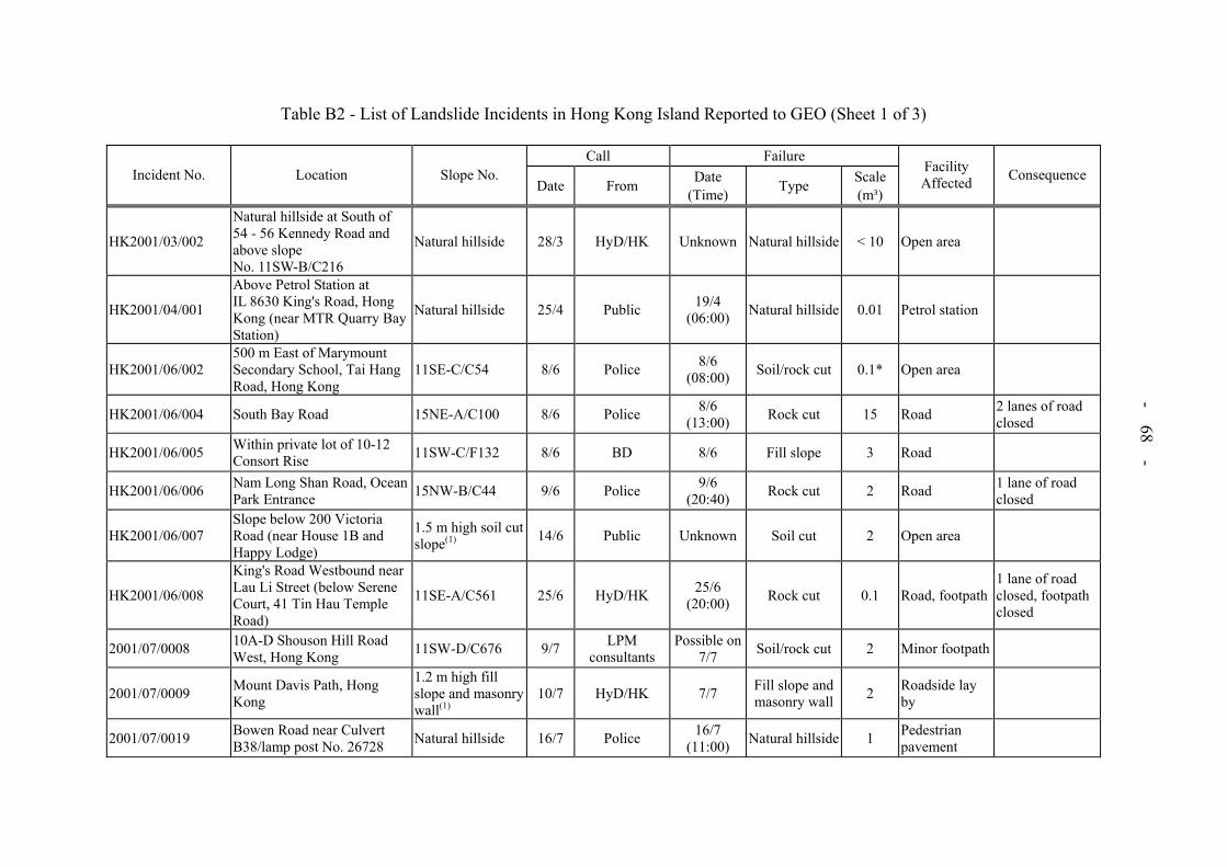
- 68 -
Table B2 - List of Landslide Incidents in Hong Kong Island Reported to GEO (Sheet 1 of 3)
Call FailureIncident No. Location Slope No.
Date From Date (Time) Type Scale
(m³)
Facility Affected Consequence
HK2001/03/002
Natural hillside at South of 54 - 56 Kennedy Road and above slope No. 11SW-B/C216
Natural hillside 28/3 HyD/HK Unknown Natural hillside < 10 Open area
HK2001/04/001
Above Petrol Station at IL 8630 King's Road, Hong Kong (near MTR Quarry Bay Station)
Natural hillside 25/4 Public 19/4 (06:00) Natural hillside 0.01 Petrol station
HK2001/06/002 500 m East of Marymount Secondary School, Tai Hang Road, Hong Kong
11SE-C/C54 8/6 Police 8/6 (08:00) Soil/rock cut 0.1* Open area
HK2001/06/004 South Bay Road 15NE-A/C100 8/6 Police 8/6 (13:00) Rock cut 15 Road 2 lanes of road
closed
HK2001/06/005 Within private lot of 10-12 Consort Rise 11SW-C/F132 8/6 BD 8/6 Fill slope 3 Road
HK2001/06/006 Nam Long Shan Road, Ocean Park Entrance 15NW-B/C44 9/6 Police 9/6
(20:40) Rock cut 2 Road 1 lane of road closed
HK2001/06/007 Slope below 200 Victoria Road (near House 1B and Happy Lodge)
1.5 m high soil cut slope(1) 14/6 Public Unknown Soil cut 2 Open area
HK2001/06/008
King's Road Westbound near Lau Li Street (below Serene Court, 41 Tin Hau Temple Road)
11SE-A/C561 25/6 HyD/HK 25/6 (20:00) Rock cut 0.1 Road, footpath
1 lane of road closed, footpath closed
2001/07/0008 10A-D Shouson Hill Road West, Hong Kong 11SW-D/C676 9/7 LPM
consultants Possible on
7/7 Soil/rock cut 2 Minor footpath
2001/07/0009 Mount Davis Path, Hong Kong
1.2 m high fill slope and masonry wall(1)
10/7 HyD/HK 7/7 Fill slope and masonry wall 2 Roadside lay
by
2001/07/0019 Bowen Road near Culvert B38/lamp post No. 26728 Natural hillside 16/7 Police 16/7
(11:00) Natural hillside 1 Pedestrian pavement

- 69 -
Table B2 - List of Landslide Incidents in Hong Kong Island Reported to GEO (Sheet 2 of 3)
Call FailureIncident No. Location Slope No.
Date From Date (Time) Type Scale
(m³)
Facility Affected Consequence
2001/07/0020 Broadwood Road 11SE-C/F103 13/7 PublicFew months
before 7/2001
Fill slope 50 Open area
2001/07/0033a Hospital Path off Barker Road near lamp post No. 19155
1 m high soil/rock cut slope(1) 19/7 HyD/HK Possible
18/7 Soil/rock cut 0.1 Minor footpath
2001/07/0033b Hospital Path off Barker Road near lamp post No. 19155
1.5 m high soil/rock cut slope(1)
19/7 HyD/HK Possible 18/7 Soil/rock cut 0.5 Minor footpath
2001/07/0033c Hospital Path off Barker Road near lamp post No. 19155
2.5 m high soil/rock cut slope(1)
19/7 HyD/HK Possible 18/7 Soil/rock cut <0.1 Minor footpath
2001/07/0036 Below and opposite 59 South Bay Road Natural hillside 21/7 Police 21/7
(03:30) Natural hillside 60
Pedestrian pavement and natural stream course
2001/08/0053 Within a construction site at APIL 129, Praya Road, Ap Lei Chau
Natural hillside 28/8 GEO Possible in
early 7/2001
Natural hillside 40 Construction site
2001/09/0059 Island Road between Shouson Hill Road and Deep Water Bay Road
15NW-B/C114 2/9 HyD/HK 1/9 (11:45) Soil/rock cut 3 Road 1 lane of road
closed
2001/09/0069 Opposite 22 Sun Shing Street, Chai Wan, Hong Kong 11SE-A/C5 3/9 Police 2/9 Rock cut 0.07 Road 1 lane of road
closed
2001/09/0072 Headland Road, Repulse Bay 15NE-A/C265 3/9 Police 3/9 Soil/rock cut ~5 Minor footpath Minor footpath closed
2001/09/0089 Right of way to No. 30 Peak Road 11SW-D/R1116 5/9 Police 5/9
(morning) Concrete wall 15 Building access
2001/09/0095 Middle Gap Road near lamp post No. 36873 11SW-D/C554 5/9 HyD/HK 5/9
(20:25) Rock cut 0.5 Road ½ lane of road closed

- 70 -
Table B2 - List of Landslide Incidents in Hong Kong Island Reported to GEO (Sheet 3 of 3)
Call FailureIncident No. Location Slope No.
Date From Date (Time) Type Scale
(m³)
Facility Affected Consequence
2001/09/0097 Roadside near 99 Repulse Bay Road 15NE-A/C47 5/9 Police 5/9
(16:45) Soil/rock cut 2 Road 1 lane of road closed
2001/09/0106 Backyard of 16 Ching Lin Terrace Western District Natural hillside 10/9 Public 8/9
(06:00) Soil/rock cut 2 Backyard
2001/09/0109 Tin Hau Temple Road 11SE-A/FR61 14/9 HyD 14/9 Fill slope 6 Open area
2001/10/0114 Behind 26 Ching Wah Street, North Point, Hong Kong
1.5 m high soil cut slope(1) 28/9 HyD/HK Unknown Soil cut Sign of
distress Backyard
2001/10/0116 Natural hillside above 60 Peak Road Natural hillside 8/10 Public Possible
9/2001 Natural hillside 1.5 Stream course
2001/12/0123 Below Pokfield Road, Hong Kong Unregistered 14/12 Police 14/12
(07:15) Fill slope* 30* Pedestrian pavement
Pedestrian pavement closed
2002/02/0008 To the south of the Sports House of the Hong Kong Stadium
11SW-D/DT17 20/2/2002 LCSD 17/9 Disturbed
terrain 0.4 Road
Legend:
* Information from GEO’s landslide investigation consultants and agreed by GEO’s District Divisions. (1) The man-made feature does not comply with the slope registration criteria given in GEO Circular No. 15.

- 71 -
Table B3 - List of Landslide Incidents in Kowloon Reported to GEO (Sheet 1 of 2)
Call FailureIncident No. Location Slope No.
Date From Date (Time) Type Scale
(m³)
Facility Affected Consequence
ME2001/06/001
Opposite Wellcome supermarket at Hiu Kwong Court, Hiu Kwong Street, Kwun Tong
11NE-D/C20 6/6 Public 6/6 Soil/rock cut 0.1 Open area
ME2001/06/003 88 Kung Lok Road - Home for the Aged, Kwun Tong 11NE-C/C68 8/6 Public 8/6
(09:00) Soil/rock cut 0.2 Pedestrian pavement
ME2001/06/004 Kung Lok Road, below St. Catharine’s School for Girls, Kwun Tong
11NE-C/C71 9/6 FSD Unknown Soil/rock cut 1 Pedestrian pavement
Pedestrian pavement closed
ME2001/06/029 Southern corner of King Hing Court, Kung Lok Road, Kwun Tong
11NE-C/C219 12/6 Public 12/6 (05:00) Soil/rock cut 4.5 Open area
ME2001/06/030 Natural hillside above slope No. 11NE-D/DT32, at Park off Hip Wo Street
Natural hillside 12/6 Police 12/6 Natural hillside 5 Road, open area
Pedestrian pavement closed
ME2001/06/059 Natural hillside above Hong Ning Road Park, Phase II, Kwun Tong
Natural hillside 28/6 Arch SD 27/6 (22:00) Natural hillside 7 Toilet block
2001/07/0040 Adjacent to slope No. 11NE-A/FR38, Morse Park, Kowloon
Natural hillside 23/7 GEO Unknown Natural hillside 2 Open area
2001/09/0058 Along Kwun Ping Road near lamp posts Nos. EB2957 and EB2958.
7SE-C/C352 2/9 Police 2/9 (09:00) Soil cut 8 Road
2001/09/0071 Natural hillside below slope No. 11SE-B/C205, Ko Chiu Road, Ko Chiu Path
Natural hillside* 3/9 Public 2/9 Natural hillside* 40* Open area
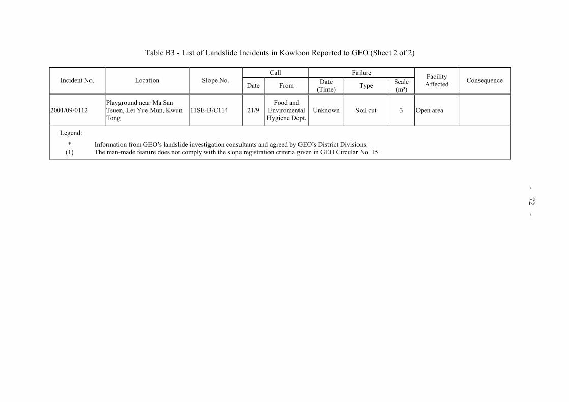
- 72 -
Table B3 - List of Landslide Incidents in Kowloon Reported to GEO (Sheet 2 of 2)
Call FailureIncident No. Location Slope No.
Date From Date (Time) Type Scale
(m³)
Facility Affected Consequence
2001/09/0112 Playground near Ma San Tsuen, Lei Yue Mun, Kwun Tong
11SE-B/C114 21/9Food and
Enviromental Hygiene Dept.
Unknown Soil cut 3 Open area
Legend:
* Information from GEO’s landslide investigation consultants and agreed by GEO’s District Divisions. (1) The man-made feature does not comply with the slope registration criteria given in GEO Circular No. 15.

- 73 -
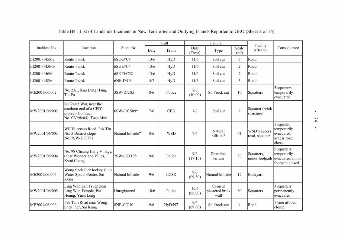
Table B4 - List of Landslide Incidents in New Territories and Outlying Islands Reported to GEO (Sheet 1 of 16)
Call FailureIncident No. Location Slope No.
Date From Date (Time) Type Scale
(m³)
Facility Affected Consequence
MW2001/02/003 Lot 957, DD118 Tai Shu Ha Road West, Nam Hang Tsuen Unregistered 22/2 Police Around
January Fill slope ~20 Open area
ME2001/03/001 Along access road near Luk Keng Road, Nam Chung 3SE-A/C6 23/3 HyD/NT Unknown Soil cut Sign of
distress Open area
MW2001/03/001 No. 38 Yau Oi Tsuen, Tao Fung Shan Road 7SW-B/CR260 26/2 Public Unknown Concrete wall 1 Open area
ME2001/03/002 Along access road near Luk Keng Road, Nam Chung 3SE-A/C6 23/3 HyD/NT Unknown Soil cut Sign of
distress Open area
LI2001/001M Tam Kon Shan Road, Tsing Yi Unregistered 9/4 HyD 9/4
(12:00)
Retaining fill wall under
construction35
Roads, construction site
1 lane of road closed
ME2001/04/001 Lung Ha Wan Road, Clear Water Bay, Sai Kung 12NW-D/C4 16/4 HyD/NT Unknown Soil/rock cut 9 Road 1 lane of road
closed
MW2001/04/001
Po Kok Branch School, No. 380, Tan Kwai Tsuen Road, Hung Shui Kiu, Yuen Long
Unregistered 10/4 Public 9/4 (19:00)
RC retaining wall 50*
Garden of school, open area of factory
Portion of school garden and factory open area closed
MW2001/04/002
Slope below Route Twisk near Tso Kung Tam Recreation Centre, Tsuen Wan
Natural hillside 10/4 HyD/NT 8/4 Natural hillside 10-15 Minor footpath
ME2001/04/004 Footpath adjacent to Chinese Permanent Cemetery, Tseung Kwan O
Natural hillside 23/4 DO/SK Unknown Natural hillside <1 Minor footpath
ME2001/05/001 O Pui Village, Mang Kung Uk, Sai Kung
1 m high retaining wall(1) 14/5 DLO Unknown RC retaining
wall 3 Road
MW2001/05/002 No. 5, Yung Shue Long Village, Lamma Island Unregistered 5/5 Public
Few Months
before MayMasonry wall 1 Open area
MW2001/05/003 Sham Wat Road near Tai Fung Au, Lantau Island Natural hillside* 24/5 Police 23/5 Natural
hillside* 0.3 Pedestrian pavement
- 74 -
Table B4 - List of Landslide Incidents in New Territories and Outlying Islands Reported to GEO (Sheet 2 of 16)
Call FailureIncident No. Location Slope No. Date From Date
(Time) Type Scale(m³)
Facility Affected Consequence
LI2001/145Ma Route Twisk 6SE-B/C4 13/6 HyD 11/6 Soil cut 3 Road
LI2001/145Mb Route Twisk 6SE-B/C4 13/6 HyD 11/6 Soil cut 2 Road
LI2001/146M Route Twisk 6SE-D/C52 13/6 HyD 11/6 Soil cut 2 Road
LI2001/158M Route Twisk 6NE-D/C6 4/7 HyD 11/6 Soil cut 3 Road
ME2001/06/002 No. 2A1, Kau Lung Hang, Tai Po 3SW-D/C85 8/6 Police 8/6
(10:00) Soil/rock cut 10 Squatters 5 squatters temporarily evacuated
MW2001/06/002
So Kwun Wat, near the southern end of a CED's project (Contract No. CV/98/04), Tuen Mun
6SW-C/C509* 7/6 CED 7/6 Soil cut 7 Squatter (brick structure)
MW2001/06/003 WSD's access Road, Pak Tin No. 5 District slope No. 7SW-D/C751
Natural hillside* 8/6 WSD 7/6 Natural hillside* <1 WSD’s access
road, squatter
1 squatter temporarily evacuated, access road closed
MW2001/06/004 No. 98 Cheung Hang Village, (near Wonderland Villa), Kwai Chung
7SW-C/DT98 9/6 Police 9/6 (17:15)
Disturbed terrain 30 Squatters,
minor footpath
5 squatters temporarily evacuated, minor footpath closed
ME2001/06/005 Wong Shek Pier Jockey Club Water Sports Centre, Sai Kung
Natural hillside 9/6 LCSD 9/6 (09:30) Natural hillside 12 Backyard
MW2001/06/005 Ling Wan San Tsuen near Ling Wan Temple, Pat Heung, Yuen Long
Unregistered 10/6 Police 10/6 (08:00)
Cement plastered brick
wall 60 Squatters
3 squatters permanently evacuated
ME2001/06/006 Pak Tam Road near Wong Shek Pier, Sai Kung 8NE-C/C10 9/6 HyD/NT 9/6
(09:00) Soil/rock cut 4 Road 1 lane of road closed
- 75 -
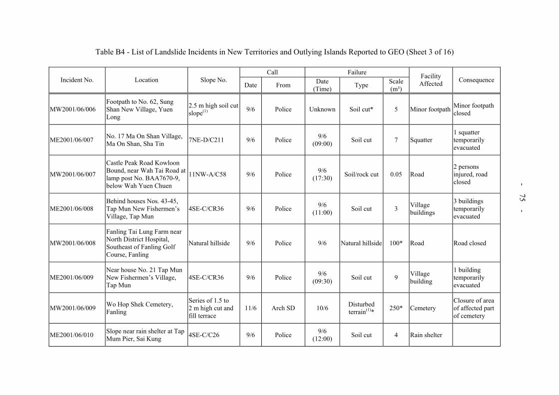
Table B4 - List of Landslide Incidents in New Territories and Outlying Islands Reported to GEO (Sheet 3 of 16)
Call FailureIncident No. Location Slope No.
Date From Date (Time) Type Scale
(m³)
Facility Affected Consequence
MW2001/06/006 Footpath to No. 62, Sung Shan New Village, Yuen Long
2.5 m high soil cut slope(1) 9/6 Police Unknown Soil cut* 5 Minor footpath Minor footpath
closed
ME2001/06/007 No. 17 Ma On Shan Village, Ma On Shan, Sha Tin 7NE-D/C211 9/6 Police 9/6
(09:00) Soil cut 7 Squatter 1 squatter temporarily evacuated
MW2001/06/007
Castle Peak Road Kowloon Bound, near Wah Tai Road at lamp post No. BAA7670-9, below Wah Yuen Chuen
11NW-A/C58 9/6 Police 9/6 (17:30) Soil/rock cut 0.05 Road
2 persons injured, road closed
ME2001/06/008 Behind houses Nos. 43-45, Tap Mun New Fishermen’s Village, Tap Mun
4SE-C/CR36 9/6 Police 9/6 (11:00) Soil cut 3 Village
buildings
3 buildings temporarily evacuated
MW2001/06/008
Fanling Tai Lung Farm near North District Hospital, Southeast of Fanling Golf Course, Fanling
Natural hillside 9/6 Police 9/6 Natural hillside 100* Road Road closed
ME2001/06/009 Near house No. 21 Tap Mun New Fishermen’s Village, Tap Mun
4SE-C/CR36 9/6 Police 9/6 (09:30) Soil cut 9 Village
building
1 building temporarily evacuated
MW2001/06/009 Wo Hop Shek Cemetery, Fanling
Series of 1.5 to 2 m high cut and fill terrace
11/6 Arch SD 10/6 Disturbed terrain(1)* 250* Cemetery
Closure of area of affected part of cemetery
ME2001/06/010 Slope near rain shelter at Tap Mum Pier, Sai Kung 4SE-C/C26 9/6 Police 9/6
(12:00) Soil cut 4 Rain shelter

- 76 -
Table B4 - List of Landslide Incidents in New Territories and Outlying Islands Reported to GEO (Sheet 4 of 16)
Call FailureIncident No. Location Slope No. Date From Date
(Time) Type Scale(m³)
Facility Affected Consequence
MW2001/06/010 No. 1A Tin Sum Village, Yung Hang Road, Fanling Unregistered 11/6 Police 11/6
(10:00) Masonry wall 90* Squatters, access road
1 squatter permanently evacuated, 1 squatter temporarily evacuated
ME2001/06/011 No. 184 Tong Hang Village, Tai Po 3SW-C/CR210 10/6 Public 10/6
(15:00) Soil cut 20 Squatters 2 squatters temporarily evacuated.
MW2001/06/011 Fan Kam Road, Lin Tong Mei, Tong Kung Leng, Sheung Shui
1 m high brick wall on 1.5 m soil cut slope(1)
9/6 Police Unknown Brick wall on soil cut <5 Access road
ME2001/06/012 Po Lo Che Road, Sai Kung 8SW-A/C172 9/6 WSD 9/6 (22:00) Soil cut 45 Road 1 lane of road
closed
ME2001/06/013 Wilson Trail near Kau Lung Hang Shan, Tai Po
2.8 m high soil cut slope(1) 11/6 HyD/NTE 11/6
(07:30) Soil cut 15 Minor footpath Minor footpath closed
ME2001/06/014 No. 169 Tong Hang Village, Tai Po 3SW-C/C182 11/6 DO/TP 11/6
(10:00) Soil cut 7 Open area
MW2001/06/014 No. 2, Pai Min Kok Village, Tsing Lung Tau, Sham Tseng, Tsuen Wan
2 m high soil cut slope(1) 11/6 HyD/NTW 9/6 Soil cut 1.5 Village house
MW2001/06/015 Access Road to Tin Hoi house, Ting Kau 6SE-C/C478 9/6 Police 9/6
(15:06) Soil cut 1 Road 1/2 lane of road closed
ME2001/06/016 Hon Ka Road (between lamp posts Nos. VA0079 and V83897), Tai Po
2.8 m high soil cut slope(1) 11/6 DO/TP Unknown Soil cut 3 Road
MW2001/06/016a Pun Shan Village, hillside below WSD Catchwater, Tsuen Wan
Natural hillside 11/6 WSD 9/6 (10:00) Natural hillside 35 Squatter
1 squatter temporarily evacuated
MW2001/06/016b Pun Shan Village, hillside below WSD Catchwater, Tsuen Wan
Natural hillside 11/6 WSD 9/6 (10:00) Natural hillside 20 Open area

- 77 -
Table B4 - List of Landslide Incidents in New Territories and Outlying Islands Reported to GEO (Sheet 5 of 16)
Call FailureIncident No. Location Slope No.
Date From Date (Time) Type Scale
(m³)
Facility Affected Consequence
ME2001/06/017 Hillside above Hong Chi Pinehill School, Tai Po Natural hillside 11/6 Public Unknown Natural hillside 80* Drains Surface drainage
blocked
MW2001/06/017 Access road connecting Route Twisk, near Kwong Pan Ting Village, Tsuen Wan
6SE-B/C315 11/6 DO/TW Unknown Soil/rock cut 4 Access road Access road closed
ME2001/06/018 Access Road to Sha Lo Tung, Tai Po
Natural hillside and 3SW-D/C155 10/6 HyD/NT Unknown Natural hillside 60 Road Access road
closed
MW2001/06/018 Huts Nos. 65 and 66 Kiu Tau Tsuen, Tai Kong Po, Shek Kong, Yuen Long
Natural hillside 11/6 Police 11/6 (04:00)
Natural hillside (river bank) 20 Squatters
2 squatters permanently evacuated
ME2001/06/019 Access Road to Sha Lo Tung, Tai Po 7NW-B/C171 10/6 Police Unknown Soil cut 4 Access path Access path
closed
MW2001/06/019 Nos. 190A-C, Lam Hau Tsuen, Ping Shan Heung, Yuen Long
2.6 m high soil cut slope(1) 11/6 DO/YL 11/6
(12:00) Soil cut 4-5 Village house1 village house temporarily evacuated
ME2001/06/020 Slope near house No. 62, Kap Pin Long, Sai Kung
Disturbed terrain(1)* 12/6 DO/SK 11/6
(10:00) Disturbed*
terrain 6 Access path
ME2001/06/021 City Bus depot, Wo Sheung Tun Street, Fo Tan, Sha Tin 7SW-B/C10 9/6 HyD/NT 9/6
(11:00) Soil/rock cut, fill on crest 10 Backyard
MW2001/06/021 Natural hillside behind slope No. 7SW-C/C72, Kwai Shing Circuit, Kwai Chung
Natural hillside 12/6 Police 12/6 (13:00) Natural hillside 0.7
Bus shelter, pedestrian pavement
Bus shelter closed
MW2001/06/022
Landslide at natural hillside of a stream course at Sham Tseng Tung Tsuen, Tsuen Wan
Natural hillside 12/6 Public Unknown Natural hillside 1 Open area
MW2001/06/023 House No. 92, Ta Shek Wu, Pat Heung, Yuen Long Natural hillside* 11/6 DO/YL 9/6
(09:00) Natural hillside* 30 Backyard of
village house

- 78 -
Table B4 - List of Landslide Incidents in New Territories and Outlying Islands Reported to GEO (Sheet 6 of 16)
Call FailureIncident No. Location Slope No.
Date From Date (Time) Type Scale
(m³)
Facility Affected Consequence
MW2001/06/024 No. 99A, Pak Tin Village, Area 2, Tai Wai
2 m high masonry wall(1) 12/6 Police 12/6
(02:00) Masonry wall 15 Open area, squatter
1 squatter temporarily evacuated
ME2001/06/025 Mang Kung Wo Village, Mang Kung Wo Road, Sai Kung
7SE-D/F33 9/6 HyD/NT 9/6 (11:30) Fill slope 25 Pedestrian
pavement Pedestrian pavement closed
MW2001/06/025 Wo Hop Shek Cemetery, Fanling 3SW-C/C629 11/6 Arch SD 10/6
(24:00) Soil cut 25 Cemetery Affected part of cemetery closed
ME2001/06/026 Behind Tsang Chun Service (dockyard), 24 Pak Sha Village, Sai Kung
Unregistered 12/6 HyD/NT 10/6 (12:00) Soil cut 2 Open area
MW2001/06/026 Wo Hop Shek Cemetery, Fanling 3SW-C/C659 11/6 Arch SD 10/6 Soil cut 3 Cemetery Affected part of
cemetery closed
ME2001/06/027 Behind house No. 160, San Tau Kok Village, Tai Po
2 m high soil cut slope(1) 12/6 Public 11/6 Soil cut 25 Access path
MW2001/06/027 Opposite house No. F43, Chung Kuk Path, Ho Sheung Heung, Sheung Shui
2.8 m high soil cut slope(1) 11/6 DO/N 10/6 Soil cut 5 Access road 1 land of access
road closed
ME2001/06/028 Storage shed near house No. 18, Ha Wan, Tap Mun 4SE-C/CR19 12/6 Police 12/6
(10:00) Soil cut 3 Squatter (storage shed)
MW2001/06/028 Behind house No. 30E, Man Kam To Road, Sheung Shui
2.8 m high soil cut slope(1) 11/6 DO/N 10/6 Soil cut 10 Backyard
MW2001/06/029 Near house No. 30E, Man Kam To Road, Sheung Shui Unregistered 11/6 DO/N 10/6 Soil cut 2 Open area
MW2001/06/030 Access Road in Tong Kung Leng, Sheung Shui, N. T.
2.5 m high masonry wall (1) 12/6 DO/N 11/6 Masonry wall 7 Access path 1 lane of access
path closed
ME2001/06/032 Behind Phase 2 of Classical Garden, Ma Wo, Tai Po 7NW-B/C416 13/6 Public 13/6
(09:30) Soil cut 8 Open area
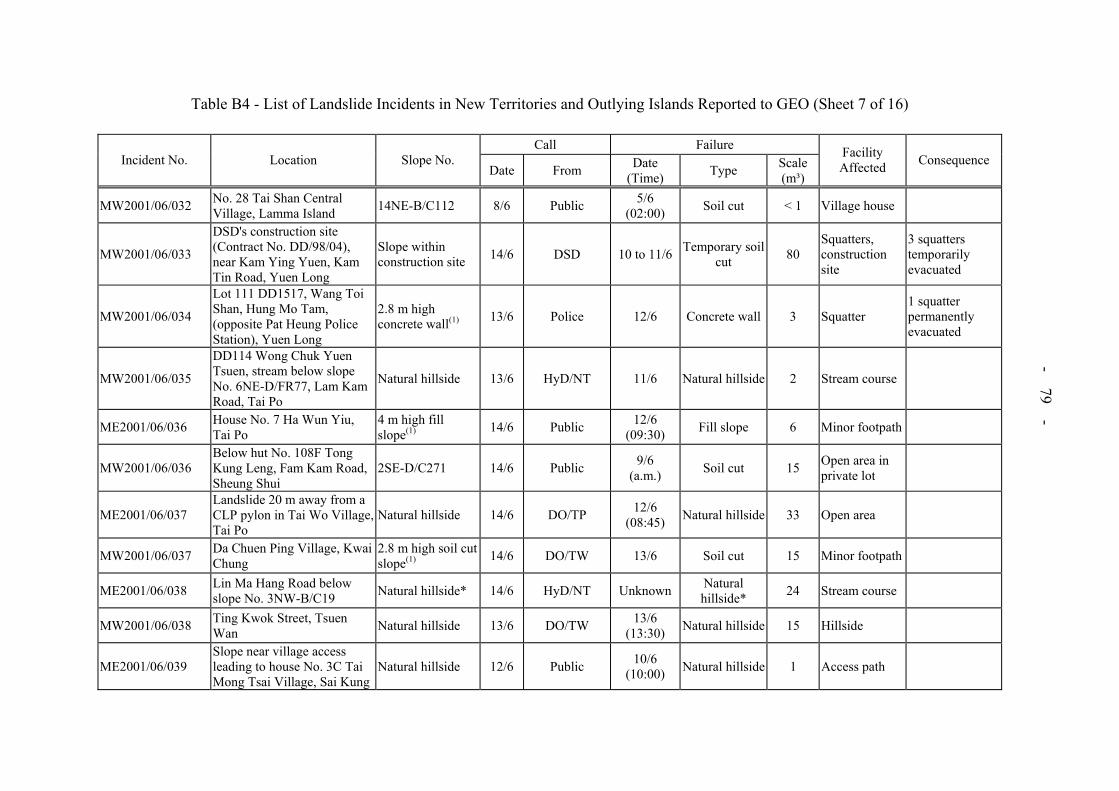
- 79 -
Table B4 - List of Landslide Incidents in New Territories and Outlying Islands Reported to GEO (Sheet 7 of 16)
Call FailureIncident No. Location Slope No.
Date From Date (Time) Type Scale
(m³)
Facility Affected Consequence
MW2001/06/032 No. 28 Tai Shan Central Village, Lamma Island 14NE-B/C112 8/6 Public 5/6
(02:00) Soil cut < 1 Village house
MW2001/06/033
DSD's construction site (Contract No. DD/98/04), near Kam Ying Yuen, Kam Tin Road, Yuen Long
Slope within construction site 14/6 DSD 10 to 11/6 Temporary soil
cut 80 Squatters, construction site
3 squatters temporarily evacuated
MW2001/06/034
Lot 111 DD1517, Wang Toi Shan, Hung Mo Tam, (opposite Pat Heung Police Station), Yuen Long
2.8 m high concrete wall(1) 13/6 Police 12/6 Concrete wall 3 Squatter
1 squatter permanently evacuated
MW2001/06/035
DD114 Wong Chuk Yuen Tsuen, stream below slope No. 6NE-D/FR77, Lam Kam Road, Tai Po
Natural hillside 13/6 HyD/NT 11/6 Natural hillside 2 Stream course
ME2001/06/036 House No. 7 Ha Wun Yiu, Tai Po
4 m high fill slope(1) 14/6 Public 12/6
(09:30) Fill slope 6 Minor footpath
MW2001/06/036 Below hut No. 108F Tong Kung Leng, Fam Kam Road, Sheung Shui
2SE-D/C271 14/6 Public 9/6 (a.m.) Soil cut 15 Open area in
private lot
ME2001/06/037 Landslide 20 m away from a CLP pylon in Tai Wo Village, Tai Po
Natural hillside 14/6 DO/TP 12/6 (08:45) Natural hillside 33 Open area
MW2001/06/037 Da Chuen Ping Village, Kwai Chung
2.8 m high soil cut slope(1) 14/6 DO/TW 13/6 Soil cut 15 Minor footpath
ME2001/06/038 Lin Ma Hang Road below slope No. 3NW-B/C19 Natural hillside* 14/6 HyD/NT Unknown Natural
hillside* 24 Stream course
MW2001/06/038 Ting Kwok Street, Tsuen Wan Natural hillside 13/6 DO/TW 13/6
(13:30) Natural hillside 15 Hillside
ME2001/06/039 Slope near village access leading to house No. 3C Tai Mong Tsai Village, Sai Kung
Natural hillside 12/6 Public 10/6 (10:00) Natural hillside 1 Access path
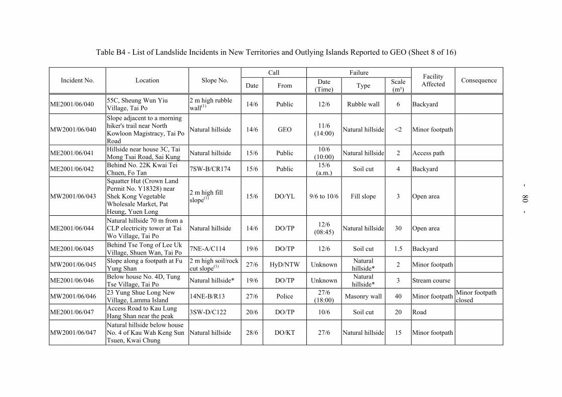
- 80 -
Table B4 - List of Landslide Incidents in New Territories and Outlying Islands Reported to GEO (Sheet 8 of 16)
Call FailureIncident No. Location Slope No.
Date From Date (Time) Type Scale
(m³)
Facility Affected Consequence
ME2001/06/040 55C, Sheung Wun Yiu Village, Tai Po
2 m high rubble wall(1) 14/6 Public 12/6 Rubble wall 6 Backyard
MW2001/06/040
Slope adjacent to a morning hiker's trail near North Kowloon Magistracy, Tai Po Road
Natural hillside 14/6 GEO 11/6 (14:00) Natural hillside <2 Minor footpath
ME2001/06/041 Hillside near house 3C, Tai Mong Tsai Road, Sai Kung Natural hillside 15/6 Public 10/6
(10:00) Natural hillside 2 Access path
ME2001/06/042 Behind No. 22K Kwai Tei Chuen, Fo Tan 7SW-B/CR174 15/6 Public 15/6
(a.m.) Soil cut 4 Backyard
MW2001/06/043
Squatter Hut (Crown Land Permit No. Y18328) near Shek Kong Vegetable Wholesale Market, Pat Heung, Yuen Long
2 m high fill slope(1) 15/6 DO/YL 9/6 to 10/6 Fill slope 3 Open area
ME2001/06/044 Natural hillside 70 m from a CLP electricity tower at Tai Wo Village, Tai Po
Natural hillside 14/6 DO/TP 12/6 (08:45) Natural hillside 30 Open area
ME2001/06/045 Behind Tse Tong of Lee Uk Village, Shuen Wan, Tai Po 7NE-A/C114 19/6 DO/TP 12/6 Soil cut 1.5 Backyard
MW2001/06/045 Slope along a footpath at Fu Yung Shan
2 m high soil/rock cut slope(1) 27/6 HyD/NTW Unknown Natural
hillside* 2 Minor footpath
ME2001/06/046 Below house No. 4D, Tung Tse Village, Tai Po Natural hillside* 19/6 DO/TP Unknown Natural
hillside* 3 Stream course
MW2001/06/046 23 Yung Shue Long New Village, Lamma Island 14NE-B/R13 27/6 Police 27/6
(18:00) Masonry wall 40 Minor footpath Minor footpath closed
ME2001/06/047 Access Road to Kau Lung Hang Shan near the peak 3SW-D/C122 20/6 DO/TP 10/6 Soil cut 20 Road
MW2001/06/047 Natural hillside below house No. 4 of Kau Wah Keng Sun Tsuen, Kwai Chung
Natural hillside 28/6 DO/KT 27/6 Natural hillside 15 Minor footpath
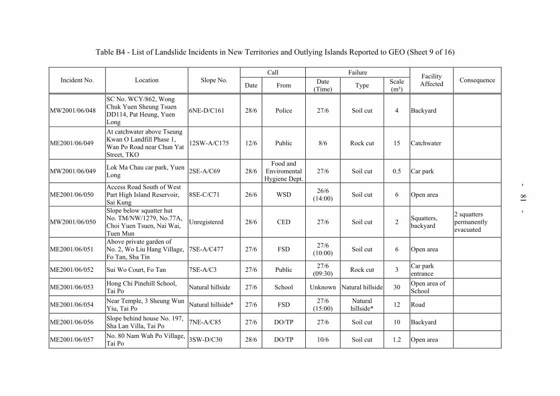
- 81 -
Table B4 - List of Landslide Incidents in New Territories and Outlying Islands Reported to GEO (Sheet 9 of 16)
Call FailureIncident No. Location Slope No.
Date From Date (Time) Type Scale
(m³)
Facility Affected Consequence
MW2001/06/048
SC No. WCY/862, Wong Chuk Yuen Sheung Tsuen DD114, Pat Heung, Yuen Long
6NE-D/C161 28/6 Police 27/6 Soil cut 4 Backyard
ME2001/06/049
At catchwater above Tseung Kwan O Landfill Phase 1, Wan Po Road near Chun Yat Street, TKO
12SW-A/C175 12/6 Public 8/6 Rock cut 15 Catchwater
MW2001/06/049 Lok Ma Chau car park, Yuen Long 2SE-A/C69 28/6
Food and Enviromental Hygiene Dept.
27/6 Soil cut 0.5 Car park
ME2001/06/050 Access Road South of West Part High Island Reservoir, Sai Kung
8SE-C/C71 26/6 WSD 26/6 (14:00) Soil cut 6 Open area
MW2001/06/050
Slope below squatter hut No. TM/NW/1279, No.77A, Choi Yuen Tsuen, Nai Wai, Tuen Mun
Unregistered 28/6 CED 27/6 Soil cut 2 Squatters, backyard
2 squatters permanently evacuated
ME2001/06/051 Above private garden of No. 2, Wo Liu Hang Village, Fo Tan, Sha Tin
7SE-A/C477 27/6 FSD 27/6 (10:00) Soil cut 6 Open area
ME2001/06/052 Sui Wo Court, Fo Tan 7SE-A/C3 27/6 Public 27/6 (09:30) Rock cut 3 Car park
entrance
ME2001/06/053 Hong Chi Pinehill School, Tai Po Natural hillside 27/6 School Unknown Natural hillside 30 Open area of
School
ME2001/06/054 Near Temple, 3 Sheung Wun Yiu, Tai Po Natural hillside* 27/6 FSD 27/6
(15:00) Natural hillside* 12 Road
ME2001/06/056 Slope behind house No. 197, Sha Lan Villa, Tai Po 7NE-A/C85 27/6 DO/TP 27/6 Soil cut 10 Backyard
ME2001/06/057 No. 80 Nam Wah Po Village, Tai Po 3SW-D/C30 28/6 DO/TP 10/6 Soil cut 1.2 Open area
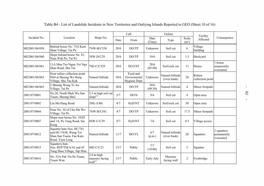
- 82 -
Table B4 - List of Landslide Incidents in New Territories and Outlying Islands Reported to GEO (Sheet 10 of 16)
Call FailureIncident No. Location Slope No.
Date From Date (Time) Type Scale
(m³)
Facility Affected Consequence
ME2001/06/058 Behind house No. 71G Kam Shan Village, Tai Po 7NW-B/C558 28/6 DO/TP Unknown Soil cut 6 Village
building
ME2001/06/060 Slope behind house No. 81, Nam Wah Po, Tai Po 3SW-D/C29 28/6 DO/TP 10/6 Soil cut 1.5 Backyard
ME2001/06/061 11A Mau Tso Ngan, Fei Ngo Shan Road, Sha Tin 7SE-C/C529 28/6 DLO/ST 28/6
(05:00) Soil/rock cut 13 House 1 house temporarily evacuated
ME2001/06/062 Near refuse collection point N64 at Sheung Wo Hang Village, Sha Tau Kok
Natural hillside 28/6Food and
Enviromental Hygiene Dept.
Unknown Natural hillside (river bank) 20 Refuse
collection point
ME2001/06/063 2 Sheung Wong Yi Au Village, Tai Po Natural hillside 30/6 DO/TP 30/6
(09:30) Natural hillside 4 Minor footpath
2001/07/0001 No.20, North Shek Wu San Tsuen, Sheung Shui
2.3 m high soil cut slope(1) 5/7 DO/N 9/6 Soil cut 4 Open area
2001/07/0002 Lin Ma Hang Road 3NE-A/R6 4/7 HyD/NT Unknown Soil/rock cut 30 Open area
2001/07/0004 Near No. 34 of Cho Ma Wo Village, Tai Po 7NW-B/C541 4/7 DO/TP Unknown Soil cut 17.5 Minor footpath
2001/07/0007 Slope near house No. 183D and 1A, Po Tung Road, Sai Kung
8SW-C/C29 9/7 HyD/NT 7/6 Soil cut 0.5 Village access
2001/07/0012
Squatter huts Nos. HC/741 and HC/741B, Wang Toi Shan San Tsuen, Fan Kam Road, Yuen Long
Natural hillside 11/7 DO/YL 6/7 (p.m.)
Natural hillside(river bank) 20 Squatters
2 squatters permanently evacuated
2001/07/0015 Squatters huts Nos. RTP/TM/A/42 and 43 Yung Shue Village, Tap Mun
4SE-C/C23 13/7 Public 7/7 (10:00) Soil cut 5 Squatter
2001/07/0016 No. 52A Pak Tin Pa Tsuen, Tsuen Wan
2.8 m high masonry facing wall(1)
13/7 Public Early July Masonry facing wall 2 Footbridge

- 83 -
Table B4 - List of Landslide Incidents in New Territories and Outlying Islands Reported to GEO (Sheet 11 of 16)
Call FailureIncident No. Location Slope No.
Date From Date (Time) Type Scale
(m³)
Facility Affected Consequence
2001/07/0017 East of No. 4 Ma Yau Tong Village, Po Lam Road, Ma Yau Tong, TKO
Natural hillside 14/7 HyD Unknown Natural hillside 30 Road
2001/07/0018 No. 13 Ngan Kwong Wan Road, Mui Wo, Lantau Island 10SW-C/C79 15/7 Police 15/7
(16:00) Soil cut 0.024 Open area
2001/07/0022 No. 94, Sheung Pak Nai, Yuen Long
2.5 m high soil cut slope(1) 3/7 DO/YL 28/6 Soil cut 5 Squatters
1 squatter permanently evacuated, 2 squatters temporarily evacuated
2001/07/0023 No. 16 Sung Shan New Village, Yuen Long
2 m high soil cut slope(1) 3/7 DO/YL 29/6 Soil cut 2-3 Stream course
2001/07/0025 Tsuen Wan Centre 6SE-D/C58 4/7 Arch SD 4/7 (11:00) Rock cut 0.2 Open area
2001/07/0028 Tai Hang Village, Tai Po 3SW-C/F213 3/7 DO/TP 10/6 Fill slope 6 Squatters 2 squatters temporarily evacuated
2001/07/0031
Access road to Tit Hang Village near Castle Peak Road, Lok Ma Chau, Yuen Long
2SE-B/C406 28/6 HyD 28/6 Soil cut 10 Road
2001/07/0030 No. 4 Cheung Sha Kan, Nim Shu Wan, Lantau Island
2.8 m high soil cut slope(1) 17/7 Public 16/7
(15:00) Soil cut 3 Backyard
2001/07/0032 No. 42 Siu Sau Village, Tuen Mun 6SW-C/CR700 18/7 HyD 18/7
(a.m.) Masonry wall and soil cut 2 Squatter
2001/07/0034 HD's SC No. TM/TTST/476, Tseng Tau Sheung Tsuen, Tuen Mun
2.5 m high soil cut/fill slope(1) 19/7 DLO/TM 15/7
Soil cut and fill protected by
masonry facing0.5 Squatter

- 84 -
Table B4 - List of Landslide Incidents in New Territories and Outlying Islands Reported to GEO (Sheet 12 of 16)
Call FailureIncident No. Location Slope No.
Date From Date (Time) Type Scale
(m³)
Facility Affected Consequence
2001/07/0038 Access Road to Tai Po Tau "D" pump house near Lamp Post No. EB4167(9)
2 m high soil cut/fill slope(1) 21/7 Police Unknown Soil/rock cut 0.5 Road
2001/07/0039 Nos. 3-4 Siu Lam Tsuen, Siu Lam, Tuen Mun Natural hillside 20/7 Public 19/7
(a.m.) Natural hillside 2 Access road
2001/07/0041 Fung Kat Heung Second Vegetable Station, Yuen Long
2.9 m high soil cut slope(1) 24/7 DO/YL 12/7 Soil cut 0.5 Road
2001/07/0042 Waste Reception Area, North East NT Landfill (NENT), Sha Tau Kok
3NW-D/C254 24/7 EPD 10/7
Soil cut (majority) and natural hillside
above
8000*Landfill site internal access road
Access road closed
2001/08/0045
No. 26, SC No. RTP/LW/A/126, Lo Wu Tsuen, Sha Ling, Man Kam To
2 m high fill slope(1) 1/8 DO/N 28/6 Fill slope 1 Village
building
2001/08/0046 Sha Chau near Tuen Mun Natural hillside 1/8 DO/TM Before 17/7 Natural hillside 30 Minor footpath
2001/08/0047 Adjacent to house No. 20, Hung Uk Village, Clear Water Bay Road, Sai Kung
12NW-C/C396 8/8 Public 6/7 Soil cut 1 Car park
2001/08/0048 Chuen Shui Tseng Village, Tai Po Unregistered* 9/8 DO/TP Unknown Soil cut 30 Agriculture
terrace
2001/08/0054
Opposite lamp post No. FC0473 near Tsuen Tsing Interchange, Kwai Tsing
7SW-C/C903 29/8 GEOBefore 15/7 as advised by HyD
Soil/rock cut 0.3 Open area
2001/09/0057 Natural hillside above Lei Pui Street, Kwai Chung Natural hillside 21/9 Police 1/9
(22:50*) Natural hillside ~780
Squatters, active construction site, roads
2 squatters destroyed, 1 squatter temporarily evacuated, roads closed

- 85 -
Table B4 – List of Landslide Incidents in New Territories and Outlying Islands Reported to GEO (Sheet 13 of 16)
Call FailureIncident No. Location Slope No.
Date From Date (Time) Type Scale
(m³)
Facility Affected Consequence
2001/09/0060 Downhill in front of huts Nos. 4-5 Kak Hang Tun Village, Sai Kung
Natural hillside 2/9 Police 2/9 (12:30) Natural hillside 175* Open area
2001/09/0062 Access road to Pak Tin Village Area 4 and 5 Heung Fan Liu, Tai Wai
Natural hillside* 2/9 DO/ST 2/9 (02:15)
Natural hillside* 45 Road, squatters
6 squatters temporarily evacuated
2001/09/0063 Tai Po Road at No. 54 Ma Liu Shui, between Yucca Villa and Yung Ping Path
Natural hillside and 1.2 m high fill slope
2/9 Police 2/9 Natural hillside 30Road, Pedestrian pavement
1 lane of road closed
2001/09/0064 Above Po Lei Street, Kwai Chung (opposite Shek Hing Road)
Natural hillside 2/9 GEO 1/9 Natural hillside 40 Minor footpath
2001/09/0065 Entrance of Luk Hop Village, Tai Wai Natural hillside 2/9 Police 2/9
(07:00) Natural hillside 7 Open area
2001/09/0066 Below 56 Denon Terrace, Tseng Lan Shue, Clear Water Bay Road, Sai Kung.
11NE-B/FR249* 2/9 Police 1/9 (22:30) Fill slope* 50* Squatter
1 squatter permanently evacuated
2001/09/0068 No. 1 Ku Ngam Monastery, Che Kung Mui Road, Sha Tin Natural hillside 2/9 HyD 2/9
(p.m.) Natural hillside 15 Open area
2001/09/0070 Hing Keng Shek Road, Sai Kung 7SE-D/C151 3/9 DO/SK 1/9
(20:00) Soil cut 2 Road 1 lane of road closed
2001/09/0073 Houses Nos. 294 and 295 Shek Lei Hang Village, Kwai Tsing
7SW-C/C999 3/9 Police 3/9 Soil cut 10 Squatters2 squatters temporarily evacuated
2001/09/0074 No. 56 Wong Chuk Yeng Village Path, Fo Tan 7SW-B/CR136 3/9 BD 3/9
(08:00) Soil cut 3 Open area

- 86 -
Table B4 - List of Landslide Incidents in New Territories and Outlying Islands Reported to GEO (Sheet 14 of 16)
Call FailureIncident No. Location Slope No.
Date From Date (Time) Type Scale
(m³)
Facility Affected Consequence
2001/09/0075 Slope in front of houses Nos. 397-398 Pai Tau Village, Sha Tin
Natural hillside 3/9 DO/ST 2/9 Natural hillside 15 Open area
2001/09/0077 96 Pai Tau Village, Sha Tin Natural hillside 3/9 LPM Consultants
3/9 (17:30) Natural hillside 5 Open area
2001/09/0078 Area 1 Pak Tin Village, Tai Wai Sha Tin Natural hillside 3/9 DO/ST 3/9
(a.m.) Natural hillside 40 WSD access road
Access road closed
2001/09/0079 No. 51 Siu Sau Tsuen, Siu Lam, Tuen Mun 6SW-C/CR673* 3/9 Public 3/9
(a.m.) Masonry wall 7 Open area
2001/09/0080 No. 14 Sha Tin Tau San Tsuen, Area 2, Sha Tin 7SW-D/C449 3/9 LPM
consultants 2/9
(p.m.) Soil cut 5 Squatter
2001/09/0081 Behind slope No. 7SW-D/C449 at Sha Tin Tau Village Area 2, Sha Tin
7SW-D/C450 3/9 LPM consultants
2/9 (p.m.) Soil cut 7 Open area
2001/09/0083 Behind No. 25 Lo Tsz Tin Village, Tai Po 3SE-D/C106 4/9 DO/TP Unknown Soil cut 1
Vacated 2-storey village house
2001/09/0084 Slope adjacent to 17 Ma On Sha Tsuen Natural hillside 4/9 DO/ST 2/9
(09:00) Natural hillside 10 Minor footpath
2001/09/0085 68 Wo Liu Hang, Fo Tan 7SE-A/CR125 5/9 Public 3/9 (10:00) Soil cut 3 Squatter
2001/09/0086 Near junction of Clear Water Bay and Road Razor Hill Road, Sai Kung
11NE-B/C804 5/9 HyD/NT 2/9 Soil cut 15 Pedestrian pavement
2001/09/0087 Man Yee Road, Sai Kung 8SE-C/C66 5/9 WSD 1/9 (21:00) Soil cut 10 Road
2001/09/0088 Village Access leading to Pak A Village, Sai Kung
Natural hillside (majority) and 1.2 m high cut slope
4/9 DO/SK 1/9 (22:00)
Natural hillside and soil cut 100 Minor footpath Minor footpath
closed
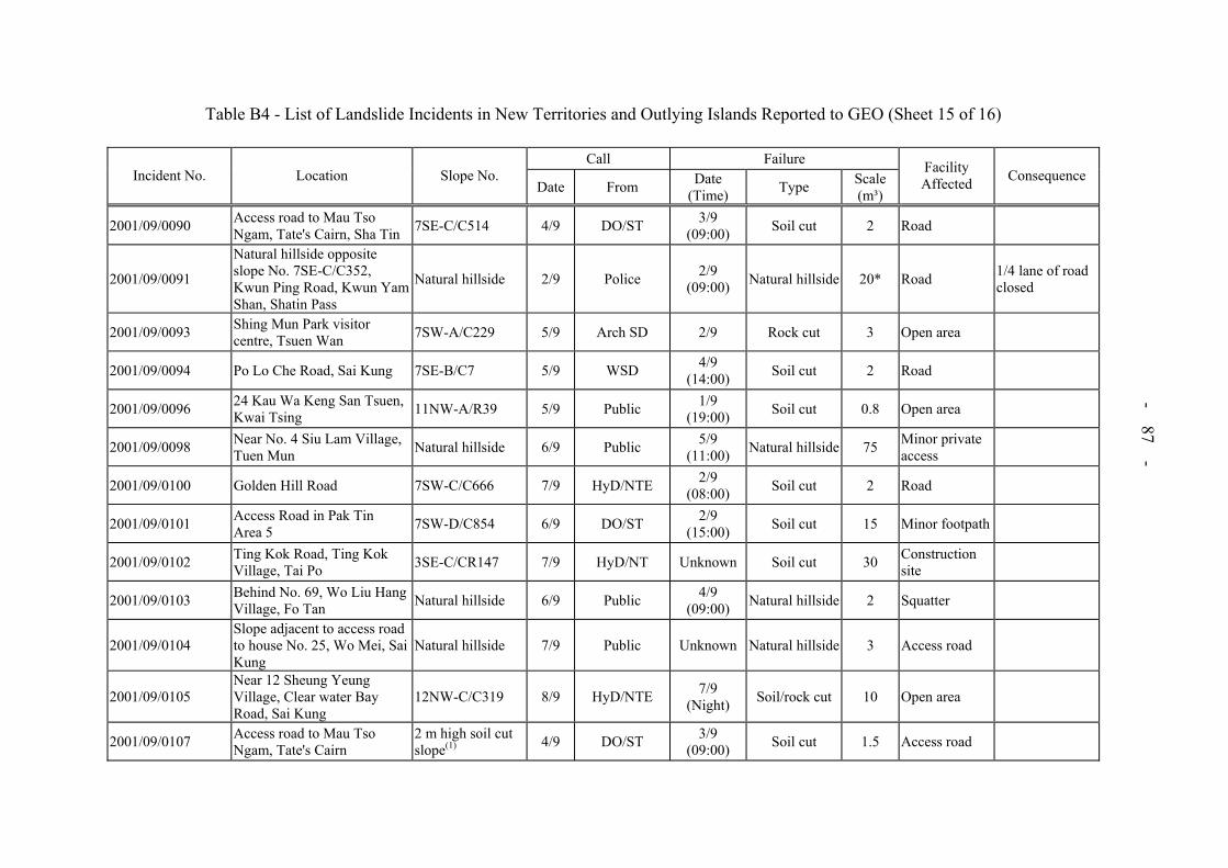
- 87 -
Table B4 - List of Landslide Incidents in New Territories and Outlying Islands Reported to GEO (Sheet 15 of 16)
Call FailureIncident No. Location Slope No.
Date From Date (Time) Type Scale
(m³)
Facility Affected Consequence
2001/09/0090 Access road to Mau Tso Ngam, Tate's Cairn, Sha Tin 7SE-C/C514 4/9 DO/ST 3/9
(09:00) Soil cut 2 Road
2001/09/0091
Natural hillside opposite slope No. 7SE-C/C352, Kwun Ping Road, Kwun Yam Shan, Shatin Pass
Natural hillside 2/9 Police 2/9 (09:00) Natural hillside 20* Road 1/4 lane of road
closed
2001/09/0093 Shing Mun Park visitor centre, Tsuen Wan 7SW-A/C229 5/9 Arch SD 2/9 Rock cut 3 Open area
2001/09/0094 Po Lo Che Road, Sai Kung 7SE-B/C7 5/9 WSD 4/9 (14:00) Soil cut 2 Road
2001/09/0096 24 Kau Wa Keng San Tsuen, Kwai Tsing 11NW-A/R39 5/9 Public 1/9
(19:00) Soil cut 0.8 Open area
2001/09/0098 Near No. 4 Siu Lam Village, Tuen Mun Natural hillside 6/9 Public 5/9
(11:00) Natural hillside 75 Minor private access
2001/09/0100 Golden Hill Road 7SW-C/C666 7/9 HyD/NTE 2/9 (08:00) Soil cut 2 Road
2001/09/0101 Access Road in Pak Tin Area 5 7SW-D/C854 6/9 DO/ST 2/9
(15:00) Soil cut 15 Minor footpath
2001/09/0102 Ting Kok Road, Ting Kok Village, Tai Po 3SE-C/CR147 7/9 HyD/NT Unknown Soil cut 30 Construction
site
2001/09/0103 Behind No. 69, Wo Liu Hang Village, Fo Tan Natural hillside 6/9 Public 4/9
(09:00) Natural hillside 2 Squatter
2001/09/0104 Slope adjacent to access road to house No. 25, Wo Mei, Sai Kung
Natural hillside 7/9 Public Unknown Natural hillside 3 Access road
2001/09/0105 Near 12 Sheung Yeung Village, Clear water Bay Road, Sai Kung
12NW-C/C319 8/9 HyD/NTE 7/9 (Night) Soil/rock cut 10 Open area
2001/09/0107 Access road to Mau Tso Ngam, Tate's Cairn
2 m high soil cut slope(1) 4/9 DO/ST 3/9
(09:00) Soil cut 1.5 Access road
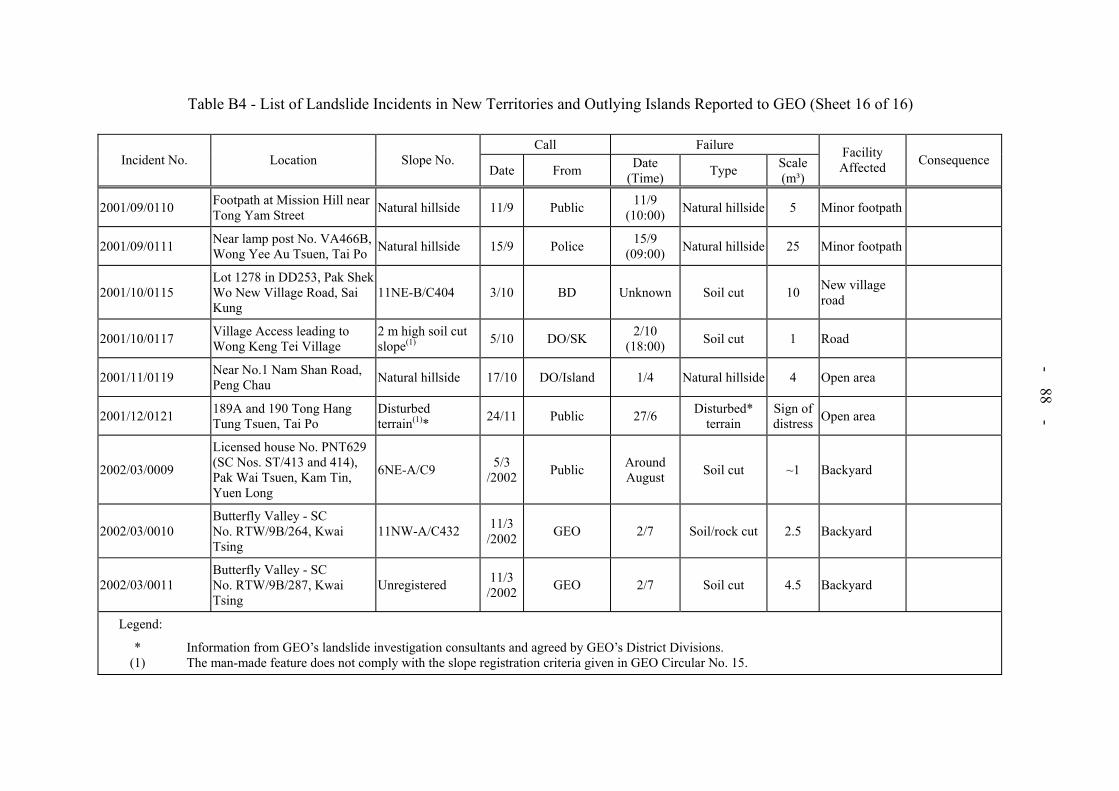
- 88 -
Table B4 - List of Landslide Incidents in New Territories and Outlying Islands Reported to GEO (Sheet 16 of 16)
Call FailureIncident No. Location Slope No.
Date From Date (Time) Type Scale
(m³)
Facility Affected Consequence
2001/09/0110 Footpath at Mission Hill near Tong Yam Street Natural hillside 11/9 Public 11/9
(10:00) Natural hillside 5 Minor footpath
2001/09/0111 Near lamp post No. VA466B, Wong Yee Au Tsuen, Tai Po Natural hillside 15/9 Police 15/9
(09:00) Natural hillside 25 Minor footpath
2001/10/0115 Lot 1278 in DD253, Pak Shek Wo New Village Road, Sai Kung
11NE-B/C404 3/10 BD Unknown Soil cut 10 New village road
2001/10/0117 Village Access leading to Wong Keng Tei Village
2 m high soil cut slope(1) 5/10 DO/SK 2/10
(18:00) Soil cut 1 Road
2001/11/0119 Near No.1 Nam Shan Road, Peng Chau Natural hillside 17/10 DO/Island 1/4 Natural hillside 4 Open area
2001/12/0121 189A and 190 Tong Hang Tung Tsuen, Tai Po
Disturbed terrain(1)* 24/11 Public 27/6 Disturbed*
terrain Sign of distress Open area
2002/03/0009
Licensed house No. PNT629 (SC Nos. ST/413 and 414), Pak Wai Tsuen, Kam Tin, Yuen Long
6NE-A/C9 5/3 /2002 Public Around
August Soil cut ~1 Backyard
2002/03/0010 Butterfly Valley - SC No. RTW/9B/264, Kwai Tsing
11NW-A/C432 11/3/2002 GEO 2/7 Soil/rock cut 2.5 Backyard
2002/03/0011 Butterfly Valley - SC No. RTW/9B/287, Kwai Tsing
Unregistered 11/3/2002 GEO 2/7 Soil cut 4.5 Backyard
Legend:
* Information from GEO’s landslide investigation consultants and agreed by GEO’s District Divisions. (1) The man-made feature does not comply with the slope registration criteria given in GEO Circular No. 15.