
Facts about Japan - Europe Direct Durham · Facts about Japan Form of Government ... a leaflet to...
30
Transcript of Facts about Japan - Europe Direct Durham · Facts about Japan Form of Government ... a leaflet to...


Facts about Japan Form of Government: Constitutional monarchy with parliamentary government Capital: Tokyo Population: 126, 048, 450 Official Language: Japanese Money: Japanese yen Area: 377,835 square kilometres Major Mountain Ranges: Japanese Alps Major Rivers: Biwa, Inawashiro, Kasumigaura
The location of Japan
Japan is an archipelago, or string of islands, on the eastern edge of Asia. There are four main islands - Hokkaido, Honshu, Shikoku and Kyushu. There are also nearly 4,000 smaller islands, too! Japan's nearest mainland neighbors are the Siberian region of Russia in the north, and Korea and China farther south. Almost four-fifths of Japan is covered with mountains. The Japanese Alps run down the centre of the largest island, Honshu. The highest peak and Japan’s most famous mountain is Mount Fuji, a cone-shaped volcano considered sacred by many Japanese. Japan can be a dangerous place. Three of the tectonic plates that form the Earth's crust meet nearby and often move against each other, causing earthquakes. More than a thousand earthquakes hit Japan every year. Japan also has about 200 volcanoes, 60 of which are still active.
The history of Japan
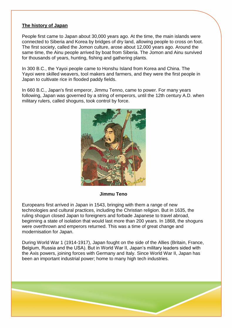
People first came to Japan about 30,000 years ago. At the time, the main islands were connected to Siberia and Korea by bridges of dry land, allowing people to cross on foot. The first society, called the Jomon culture, arose about 12,000 years ago. Around the same time, the Ainu people arrived by boat from Siberia. The Jomon and Ainu survived for thousands of years, hunting, fishing and gathering plants. In 300 B.C., the Yayoi people came to Honshu Island from Korea and China. The Yayoi were skilled weavers, tool makers and farmers, and they were the first people in Japan to cultivate rice in flooded paddy fields. In 660 B.C., Japan's first emperor, Jimmu Tenno, came to power. For many years following, Japan was governed by a string of emperors, until the 12th century A.D. when military rulers, called shoguns, took control by force.
Jimmu Teno
Europeans first arrived in Japan in 1543, bringing with them a range of new technologies and cultural practices, including the Christian religion. But in 1635, the ruling shogun closed Japan to foreigners and forbade Japanese to travel abroad, beginning a state of isolation that would last more than 200 years. In 1868, the shoguns were overthrown and emperors returned. This was a time of great change and modernisation for Japan. During World War 1 (1914-1917), Japan fought on the side of the Allies (Britain, France, Belgium, Russia and the USA). But in World War II, Japan’s military leaders sided with the Axis powers, joining forces with Germany and Italy. Since World War II, Japan has been an important industrial power; home to many high tech industries.

Japanese people and culture
The Japanese are famous for their willingness to work very hard. Children are taught to show respect for others, especially parents and bosses. They learn to do what's best for their family or company and worry less about their own needs. Japanese cuisine consists of lots of rice, fish and vegetables. With little fat and lots of vitamins and minerals, their food is very healthy. It’s believed their nutritious diet is what makes the Japanese, on average, one of the longest living populations in the world!
Japan's government and economy
Japan is the only country in the world with a reigning emperor. Emperors in Japan have no real power, but they are still respected as a symbol of the country's traditions and unity. World War II devastated Japan's economy, but the Japanese people's hard work and clever innovation turned things around. Today, Japan has the third largest economy in the world. The country’s high-tech industry makes some of the most popular electronic products and vehicles in the world.

Key Stage 1 Geography Geographical skills and communication are developed throughout the activities.
Locational knowledge
1. Pupils are given a series of clues from the Where in the world? pack and asked to investigate where in the world the country they are going to study is located. Pupils can use a world map to plot their ideas and then highlight the actual destination country. 2. Using a world map and atlas pupils are asked to describe where India is located, including the continent and surrounding countries. Encourage use of N/S/E/W
Place knowledge/ Human and physical features
1. Pupils will begin the think about what makes a place unique by using
their geographical skill of using photographs from the What can I find in a place? pack. Pupils are given a series of images and are asked to investigate what they can see. Begin with very general observations to build confidence.
2. Extend geographical understanding by asking pupils to label, apply
labels or circle physical and human features. Where possible, use the key geographical terms from eth National Curriculum.
3. Develop enquiry skills by asking pupils to pose geographical questions
about some of the places in the photographs 4A-4H which show a series of human and physical images taken from India. For each image pupils have to think about what type of questions they might ask to find out more information. To support this activity further, teachers may want to provide additional information about each image which can be found in the teacher pack
4. My place/ your place –what is the same? Comparing a small area of the
UK and a small area of non-European country.

4a.Begin as a whole class deciding what is important in a place – places to play, transport, homes, schools and our environment. This could be a simple diagram. 4b. Then in small groups, pupils are given a series of images which depict life in Ogawara. These are based around school, environment, transport and play. Teachers may want to focus on one category for comparison work. Pupils need to identify similarities/ differences between Ogawara and their own local area. Teachers might find it useful to provide some photographs of the local UK area for pupils to use. A basic comparison table is included at the back of these materials.
5. Using these images and any additional research pupils can produce an
extended piece of writing appropriate to their year group e.g. a poster or a leaflet to illustrate how life in Ogawara is similar or different to life in their home area. Writing can be supported by completing a Venn diagram with key words and images.

Key Stage 2 Geography Geographical skills and communication are developed throughout the activities.
Locational knowledge
1. Pupils will use a series of clues to work out hemisphere, continent,
country, and city in the Where in the World? pack. An extension resource, Location Challenge, can be found at the end of this planning for use in consolidation of locational knowledge.
2. Pupils should then write an accurate geographical description of the
location of Tokyo. Teachers may wish to use the opportunity to revise the location of the home town of the pupils. There are many extensions possible here for example: calculation of distance, use of scale in an atlas and looking at time zones. In upper key stage two, pupils should be able to use lines of longitude and latitude to aid accurate description of location.
3. The class could then go on to discuss what this location might mean for the physical geography of Japan. i.e. climate, vegetation, hazards. Pupils will need to research appropriate climate and vegetation maps to complete this task. There is an opportunity to look at biomes or tectonic processes here.
4. Pupils should use an up to date atlas to annotate a map of Japan to show the key human and physical landmarks. By Y6 this should include some topographical detail. Pupils should add a key, title and mark North, then discuss the scale of the maps used and produced.

Map of Japan

Place knowledge/ Human and physical features Focus: comparing the physical and human geography of a region of the UK and a region of a non-European country. This stepped enquiry focuses on working like a geographer and using different pieces of information to investigate a region of India and compare it to the pupils’ home region. Awareness of new geographical terms and the comparison of similarity and difference are the main objectives.
1. Using the resources in the What can I find in this place ? , set the big picture by looking at the Japan fact file information. Set up a comparison challenge. What can the pupils find out about the UK to complete a “big picture UK” chart? Support this with atlas and guided internet searches.
2. A tale of two cities. What are the similarities between Durham (or your nearest city) and Tokyo? Discuss with pupils the questions they would need to ask to try and answer this question. Discuss the types of things they would need to know and how they might find out. Ensure coverage of physical and human geography. The areas of research might include weather, population, main jobs, life at school, and types of houses, places to play, transport, decision makers, foods, languages spoken, money used, vegetation, rivers, important buildings, a university, healthcare, and life expectancy. The photographs included in the pack can support many of these enquiries. Other sources should be used; some examples are in the Ogawara pack. A research table could be drawn up for pupils to use to record their initial findings.
3. Draw the enquiry together by comparing 3 aspects of life in Tokyo with 3 aspects of life in Durham. This can start as a Venn diagram and then be developed into a longer report style piece of writing or a news cast using the images from the pack and voiceovers written by the pupils. Emphasise the use of geographical terms. Pupils could include graphs or diagrams in their report.


Aerial view
Ariel view from aeroplane over Tokyo
KS1 – Can you describe what you see?
KS2 – If you had to write a description for a travel website,
what would you write (location, settlement, natural
resources, population etc.)?

KS1
Label Japan.
Label the Equator.
Where is the UK?
Using the words North, South, East and West, state where Japan is in comparison to UK.
What do you think the weather will be like in Japan?
Write the names of the oceans you can see. Which oceans are missing? Can you label them?
KS2
In which hemisphere is Japan located?
Find the latitude and longitude of Japan.
Label the Equator, the Tropic of Cancer and the Tropic of Capricorn on your map.
Find a map of the tectonic plates. What do you notice about Japan’s location ?

KS1
What is a continent? Can you name this continent ?
Using an atlas, can you name the countries which make up this continent?
Can you describe the location of Japan? Use North/South/East/West
KS2
Using an atlas, locate the major cities, mountains and rivers of Japan.
Investigate the main types of vegetation found in Japan.
Find out what resources Japan uses to make energy.
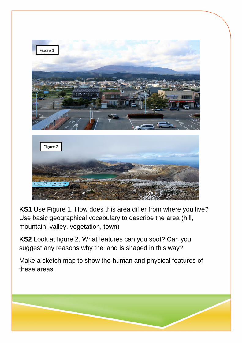
KS1 Use Figure 1. How does this area differ from where you live?
Use basic geographical vocabulary to describe the area (hill,
mountain, valley, vegetation, town)
KS2 Look at figure 2. What features can you spot? Can you
suggest any reasons why the land is shaped in this way?
Make a sketch map to show the human and physical features of
these areas.
Figure 1
Figure 2

Figure 3
KS1 Look at Figure 3. How is this place like or unlike your home
area? Is it a photo of a city or a town? Is this an old or new
settlement? What shapes can you find in the photograph?
KS2 Look at figure 3.
Add labels to show landscape, new buildings, traditional
buildings.
Explain what might happen in this area of the town.
Why are there so many tall buildings?
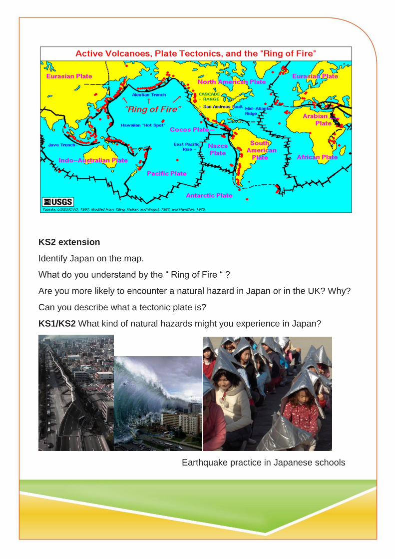
KS2 extension
Identify Japan on the map.
What do you understand by the “ Ring of Fire “ ?
Are you more likely to encounter a natural hazard in Japan or in the UK? Why?
Can you describe what a tectonic plate is?
KS1/KS2 What kind of natural hazards might you experience in Japan?
Earthquake practice in Japanese schools
Japan’s geographical position means that it suffers from a variety of hazards created by nature.
Typhoons
These are tropical storms which form in the North Pacific between July and October. Japan lies in the path which these storms normally take. They can bring fierce winds and torrential rain which causes flooding and great damage to crops and buildings.
Earthquakes
Japan lies in a part of the world which suffers from earthquakes. There are many almost unnoticeable quakes which do no damage but sometimes there are very serious ones. Children in schools have earthquake practice where they go under their desks when they hear a siren. They put on a protective helmet or head covering and are led to safety by their Headteacher. In 1923 a massive earthquake caused 100,000 deaths in Tokyo and left much of the city in ruins. Now buildings have to be built in a special way to protect them from quakes.
Tsunamis form as giant waves caused by earthquakes or volcanic eruptions under the sea which can cause huge damage as they reach the coast of countries.
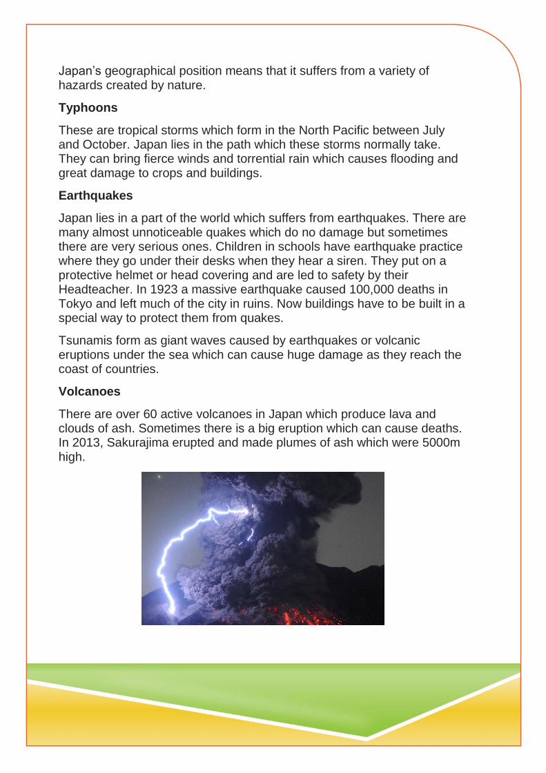
Volcanoes
There are over 60 active volcanoes in Japan which produce lava and clouds of ash. Sometimes there is a big eruption which can cause deaths. In 2013, Sakurajima erupted and made plumes of ash which were 5000m high.

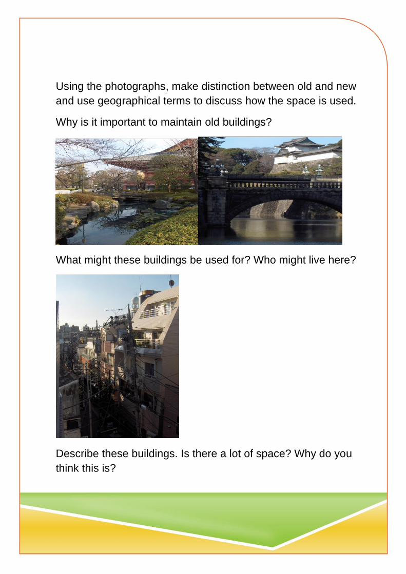
Using the photographs, make distinction between old and new
and use geographical terms to discuss how the space is used.
Why is it important to maintain old buildings?
What might these buildings be used for? Who might live here?
Describe these buildings. Is there a lot of space? Why do you
think this is?
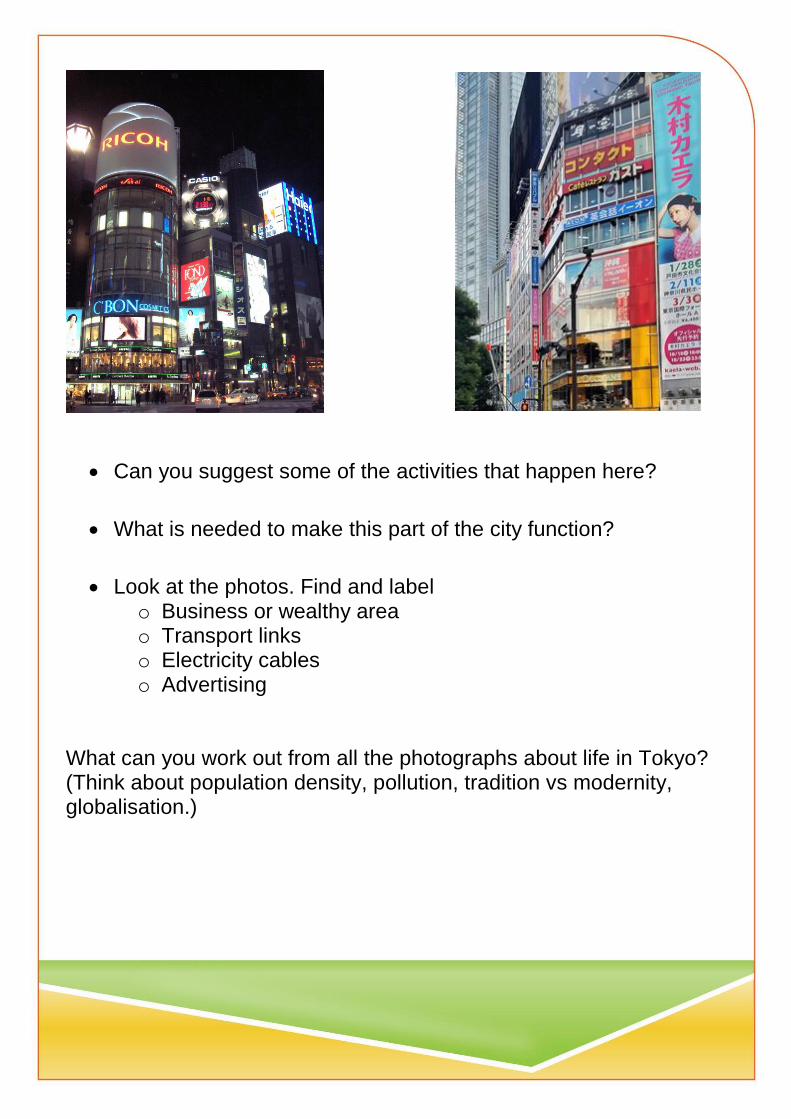
Can you suggest some of the activities that happen here?
What is needed to make this part of the city function?
Look at the photos. Find and label o Business or wealthy area o Transport links o Electricity cables o Advertising
What can you work out from all the photographs about life in Tokyo? (Think about population density, pollution, tradition vs modernity, globalisation.)

KS1 My place, your place
Spotting differences and things that are similar
Use the photographs to see what you can find
Tokyo My home area
Places to play
Places of worship
Food and drink
Transport


Tokyo has features of a modern and ancient culture. Can you think
about aspects of life in your town which are modern and some which
are traditional?
Look at the two types of transport.
Which words would you use to describe these modes of travel?
How are these different forms of transport suited to modern urban
life?
Japan's high speed bullet trains, also known as Shinkansen trains, offer
visitors an experience like no other with speeds reaching up to 320 km/hr!
The main Shinkansen lines with bullet trains include Tokaido, Sanyo,
Tohoku, Joetsu, Nagano and Kyushu.


Ogawara lies to the North East of Tokyo. Find it on an atlas and annotate the map. Also show Tokyo and Sendai. Mark the Sea of Japan and Pacific Ocean Name the main islands of Hokkaido, Honshu, Shikoku and Kyushu Which island is the largest and which is the furthest North ? Can you locate Mount Fuji? There are many mountains in Japan and 60 active volcanoes

Population
Town Capital city Country Land area
Ogawara Tokyo Japan 378,000km2
23,816 12,000,000 123,000,000
Durham London United Kingdom 242,495km2
50,000 8,674,000 64,100,000
There are a lot of mountains in Japan and some islands are not as populated as others. What do you think it would be like to live in Japan? And in Tokyo? Where would you like to live? Would it be crowded? The climate in Japan varies across the islands. What would the weather be like in Ogawara in each season
Winter(Jan) Spring (April)
Temp in C Rain in mm Temp in C Rain in mm
Sapporo -3.6 113.6 7.1 57
Sendai 1.6 37 10.3 98
Tokyo 6.1 52 14.6 125
Osaka 6 45 15.1 104
Fukuoka 6.6 68 15.1 117
Summer(July) Autumn (October)
Temp in C Rain in mm Temp in C Rain in mm
Sapporo 20.5 81 11.8 109
Sendai 22.2 179 15.2 122
Tokyo 25.4 154 18.5 198
Osaka 27.4 157 19 112
Fukuoka 27.2 278 19.2 74
When do you think it would be best to visit Japan? Which place would you visit and what would the weather be like?

Label the images with appropriate terms ( mountain, volcano, rocky)
This where Escomb’s partner school is located.
Near to Ogawara there was a great tsunami. Can you explain why
this happened?
The children in Ogawara go to this school?
What is the same and what is different about the school?

Children in Japan often help around the school. They serve meals
and also help to lean the school.
Do you think that children in England should do jobs in school? What
should they do?
What kind of foods do you think that Japanese children eat?

The children from Escomb School had a wonderful time with their
Japanese friends. They got to understand how life at school was
quite similar and also that there some differences; food, they way in
which people eat, how some people dress in a traditional fashion.
Write a letter to a Japanese friend which explains where you live, its
location, climate and population. Give details about the landscape
and land use and suggest how you think your town is similar and
different to Ogawara. Popular names for boys are Haruto and Riku
and for girls Hana and Himari.


![Where is Japan?€¦ · Facts About Japan “Shinzo Abe in Japan” by [GODL-India] is licensed under CC BY 2.0 Japan has a population of over 127 million people. The prime minister](https://static.fdocuments.in/doc/165x107/5f71f1bd530e6570990f8c2e/where-is-japan-facts-about-japan-aoeshinzo-abe-in-japana-by-godl-india-is-licensed.jpg)
