Drilling and the Associated Drillhole Measurements of the ...

University of Nebraska - Lincoln University of Nebraska - Lincoln
DigitalCommons@University of Nebraska - Lincoln DigitalCommons@University of Nebraska - Lincoln
Papers in the Earth and Atmospheric Sciences Earth and Atmospheric Sciences, Department of
2001
Facies Architecture of the CRP-3 Drillhole, Victoria Land Basin, Facies Architecture of the CRP-3 Drillhole, Victoria Land Basin,
Antarctica Antarctica
Christopher R. Fielding University of Nebraska-Lincoln, [email protected]
T. R. Naish Institute of Geological & Nuclear Sciences, New Zealand
K. J. Woolfe James Cook University
Follow this and additional works at: https://digitalcommons.unl.edu/geosciencefacpub
Part of the Earth Sciences Commons
Fielding, Christopher R.; Naish, T. R.; and Woolfe, K. J., "Facies Architecture of the CRP-3 Drillhole, Victoria Land Basin, Antarctica" (2001). Papers in the Earth and Atmospheric Sciences. 130. https://digitalcommons.unl.edu/geosciencefacpub/130
This Article is brought to you for free and open access by the Earth and Atmospheric Sciences, Department of at DigitalCommons@University of Nebraska - Lincoln. It has been accepted for inclusion in Papers in the Earth and Atmospheric Sciences by an authorized administrator of DigitalCommons@University of Nebraska - Lincoln.

© Terra Antartica PublicationTerra Antartica2001, 8(3), 217-224
Facies Architecture of the CRP-3 Drillhole, Victoria Land Basin, Antarctica
C.R. FIELDING1*, T.R. NAISH2 & K.J. WOOLFE3
1Dept of Earth Sciences, University of Queensland, Qld 4072 - Australia2Institute of Geological & Nuclear Sciences,PO Box 30 068, Lower Hutt - New Zealand
3School of Earth Sciences, James Cook University, Townsville, Qld 4811 - Australia (deceased)
Received 7 November 2000; accepted in revised form 10 October 2001
Abstract - The Cenozoic Victoria Land Basin (VLB) stratigraphic sectionpenetrated by CRP-3 is mostly of Early Oligocene age. It contains an array oflithofacies comprising fine-grained mudrocks, interlaminated and interbeddedmudrocks/sandstones, mud-rich and mud-poor sandstones, conglomerates anddiamctites that are together interpreted as the products of shallow marine topossibly non-marine environments of deposition, affected by the periodic advanceand retreat of tidewater glaciers. This lithofacies assemblage can be readilyrationalised using the facies scheme designed originally for CRP-2/2A, andpublished previously. The uppermost 330 metres below sea floor (mbsf) shows acyclical arrangement of lithofacies also similar to that recognised throughoutCRP-2/2A, and interpreted to reflect cyclical variations in relative sea-level driven by ice volume fluctuations(“Motif A”). Between 330 and 480 mbsf, a series of less clearly cyclical units, generally fining-upward butnonetheless incorporating a significant subset of the facies assemblage, has been identified and noted in theInitial Report as “Motif B. Below 480 mbsf, the section is arranged into a repetitive succession of fining-upward units, each of which comprises dolerite clast conglomerate at the base passing upward into relativelythick intervals of sandstones. The cycles present down 480 mbsf are defined as sequences, each interpretedto record cyclical variation of relative sea-level. The thickness distribution of sequences in CRP-3 providessome insights into the geological variables controlling sediment accumulation in the Early Oligocene section.The uppermost part of the section in CRP-3 comprises two or three thick, complete sequences that show abroadly symmetrical arrangement of lithofacies (similar to Sequences 9-11 in CRP-2/2A). This suggests aperiod of relatively rapid tectonic subsidence, which allowed preservation of the complete facies cycle.Below Sequence 3, however, is a considerable interval of thin, incomplete and erosionally truncatedsequences (4-23), which incorporates both the remainder of Motif A sequences and all Motif B sequencesrecognised. The thinner and more truncated sequences suggest sediment accumulation under conditions ofreduced accommodation, and given the lack of evidence for glacial conditions (see Powell et al., thisvolume) tends to argue for a period of reduced tectonic subsidence. The section below 480 mbsf consists ofa series of fining-upward, conglomerate to sandstone intervals which cannot be readily interpreted in termsof relative sea-level change. A relatively mudrock-rich interval above the basal conglomerate/breccia(782-762 mbsf) may record initial flooding of the basin during early rift subsidence.The lithostratigraphy summarised above has been linked to seismic reflection data using depth conversiontechniques (Henrys et al., this volume). The three uppermost reflectors (“o”, “p” and “q”) correlate to thepackage of thick sequences 1-3, and several deeper reflectors can also be correlated to sequence boundaries.The package of thick Sequences 1-3 shows a sheet-like cross-sectional geometry on seismic reflection lines,unlike the similar package recognised in CRP-2/2A.
INTRODUCTION
The cores acquired during drilling of CRP-1, -2/2A and -3 have provided a hitherto unavailable,virtually complete sample through the Oligocene andMiocene stratigraphy of the western Victoria LandBasin (Cape Roberts Science Team, 1998, 1999,2000). The lithostratigraphy of the succession, and asequence stratigraphic framework that embraces allbut the basal few hundred metres of section, havebeen reported in the above-mentioned volumes and inFielding et al. (1998, 2000). The succession in CRP-2/2A was found to contain a record of depositionalcyclicity on a variety of scales, and together with
geochronological and other data has alloweddifferentiation of the principal geological controls onstratigraphic architecture (Fielding et al., 2000). A keyelement of this latter analysis was the correlationbetween lithostratigraphic and sequence stratigraphicboundaries, and their equivalent horizons on seismicreflection records, which allowed the cross-sectionalgeometry of sequences to be elucidated. Faciespatterns, sequence architecture and thickness patternsand cross-sectional geometry were then integrated toprovide a framework in which tectonic andclimatic/glacioeustatic controls could be isolated(Fielding et al., 2000).
CRP-3 was drilled in October/November, 2000 to
*Corresponding author ([email protected])

C.R. Fielding et al.218
a total depth of 939.42 mbsf. The hole cored asection through mainly Early Oligocene strata to anangular unconformity at the base of the VLB and intounderlying Beacon Supergroup strata of interpretedDevonian age, thereby completing a verticalstratigraphic transect through the VLB (Cape RobertsScience Team, 2000; Figs. 1, 2). An underlap of tensof metres was interpreted between the base of thesection penetrated by CRP-2/2A and the top of –3.
In this paper, we summarise the lithostratigraphyof CRP-3, describe the styles of cyclicity evident inthe stratigraphy, and interpret these patterns in termsof the balance between tectonic, climatic/glacioeustatic and sediment supply controls. Theseresults are then compared to the younger sectionencountered in CRP-2/2A, and conclusions drawn asto the geological history of the VLB in the CapeRoberts area.
FACIES ANALYSIS
A facies scheme initially designed to account forthe CRP-1 core (Cape Roberts Science Team, 1998)was expanded to take into account the greater varietyof lithologies encountered in CRP-2/2A (Cape RobertsScience Team, 1999) and a variant of this schemewas reported by Fielding et al. (2000). This samescheme was adopted for CRP-3, since the array oflithofacies encountered in the final hole wascomparable to that in CRP-2/2A, albeit with ratherdifferent proportions and vertical successions of thevarious facies. A summary of this facies scheme isgiven in table 1. The facies recognised are interpretedto reflect a range of depositional processes andenvironments, from ice-proximal proglacial deposits(and possibly subglacial in certain intervals) to distalglacimarine, and from alluvial/colluvial fan and fandelta deposits to shoreface and offshore shelf/rampdeposits (see Powell et al., this volume, for furtherdetails). Although there are few unambiguousindicators of palaeo-water depth in the lower part ofthe Cainozoic succession, a deep-water turbidite fansystem such as has been championed by a minority ofsedimentologists represented in Cape Roberts ScienceTeam (2000) is not justified by data.
SEQUENCE STRATIGRAPHIC FRAMEWORK
A sequence stratigraphic model was first proposedto account for cyclicity in vertical lithofacies stackingpatterns observed in CRP-1 (Cape Roberts ScienceTeam, 1998; Fielding et al., 1998), and was employedwith modifications to subdivide CRP-2/2A (CapeRoberts Science Team, 1999; Fielding et al., 2000).This model is constructed similarly to conventional
Fig. 1 - Map showing the location of CRP drillholes and seismicreflection line NBP9601-89 close to the western margin of theVictoria Land Basin in McMurdo Sound, Antarctica.
Facies Lithology Interpretation Distribution in CRP-31 Mudstone Settling from suspension in offshore
water depthsCommon down to 329.96 mbsf, rarebelow this depth except between 762-782 mbsf
2 Interstratifiedsandstone/mudstone
Low-energy tractional flows andfallout from suspension
As for Facies 1
3 Poorly sorted, muddysandstone
High-energy deposits of ?densityflows
Abundant above 378.36 mbsf and within580-789.77 mbsf
4 Well-sorted, clean, fine-grained, stratified sandstone
Deposits of dilute, tractional flows inshoreface water depths
Uncommon between 378.36-580 mbsf, nooccurrences elsewhere
5 Well-sorted, clean, fine- tomedium-grained sandstone
Deposits of dilute tractional flows inshallow marine waters
Common between 378.36-580 mbsf, lesscommon through remainder of hole
6 Stratified diamictite Subglacial or ice-contact proglacialmarine deposition
Uncommon at intervals above378.36 mbsf
7 Massive diamictite Subglacial or ice-contact proglacialmarine deposition
Uncommon at intervals above378.36 mbsf
8 Rhythmically interstratifiedsandstone and siltstone
Deposition from turbid overflowplumes associated with glacier snoutefflux
Rare above 378.36 mbsf
9 Clast-supported conglomerate Deposition from a variety ofprocesses in shallow marine waters
Common throughout the hole
10 Matrix-supportedconglomerate
Deposition from a variety ofprocesses in shallow marine waters
Common throughout the hole
Tab. 1 - List of lithofacies recognised in CRP-3 (a modification of the facies scheme constructed for CRP-2/2A), together withinterpretation, and distribution of facies in CRP-3.

Facies Architecture of the CRP-3 Drillhole, Victoria Land Basin, Antarctica 219
Fig. 2 - Graphical log illustrating the verticaldistribution of lithologies in CRP-2/2A and -3, theirdivision into sequences where applicable, and thevertical limits of sequence Motifs A and B. Note theprogressive downward-coarsening of the Cenozoicsection (after Naish et al., this volume).

C.R. Fielding et al.220
sequence stratigraphic models for non-glaciatedcontinental margins, and interprets cyclical faciespatterns in terms of cyclical variations in relative sea-level (using the fundamental premise that grain-size,as a proxy for depositional energy in the marineenvironment, is a function of water depth, and takinginto account the complications that will arise in aglaciated continental margin system). However, the
model differs from conventional sequencestratigraphic models in that the sequence boundary isdesignated as a glacial surface of erosion andinterpreted to record the advance of a glacial ice bodytowards or across the study site.
The complete cycle can be arbitrarily divided intofour parts, in ascending order: 1) a sharply-based,coarse-grained interval dominated by diamictites
Fig. 3 - Diagram showing the character of sequences in the Cape Roberts drillholes, and their interpretation. A) fully-developed sequenceMotif “A”, B) less fully developed/cryptic Motif “B”. SB/GSE – Sequence Boundary/Glacial Surface of Erosion, SB/RS – Sequenceboundary amalgamated with transgressive Ravinement Surface, TS – Transgressive Surface, MFS – Maximum Flooding Surface, RSE –Regressive Surface of Erosion, LST – Lowstand Systems Tract, TST – Transgressive systems Tract, HST – highstand Systems Tract, RST –Regressive systems Tract. Facies codes are explained in Table 1.

Facies Architecture of the CRP-3 Drillhole, Victoria Land Basin, Antarctica 221
(Facies 6-8) and conglomerates (Facies 9/10), whichrest on a recognisable surface of erosion (defined asthe Sequence Boundary), 2) a typically fining-upwardinterval of sandstones and interlaminated facies (2-5),3) a mudstone (Facies 1) that passes up intoprogressively coarser-grained sediments (Facies 2-5),and 4) an often sharp-based interval of well-stratified,clean sandstones (Facies 4, 5). Such verticalsuccessions form a fining-upward then coarsening-upward interval, are interpreted as sequences, andinterpreted to record a cycle of glacial retreat andsubsequent advance (Fig. 3A). Relatively thicksequences are also more complete, preserving abroadly symmetrical cycle in terms of facies grain-size, whereas less thick sequences tend to show top-truncation, recording erosion (or non-deposition) ofthe upper part during the subsequent glacial advance(Fig. 3A).
Using the rationale summarised above, CRP-1 wasdivided into eight sequences, and the longer core ofCRP-2/2A into twenty-five sequences. It wasrecognised that some of these sequences wererelatively thick and complete in terms of thesuccession of facies, whereas others were thin,dominated by coarse-grained facies and generallystrongly top-truncated and amalgamated. Attention hasbeen drawn to the preservation of three relativelythick and complete sequences (Sequences 9-11) inCRP-2/2A by Fielding et al. (2000) and thepalaeoclimatic and other signals preserved in thosesequences is explored by Naish et al. (2001).
In CRP-3, the upper part of the hole(0-329.96 mbsf) can again be readily divided intosequences using the same criteria as previously.Between this depth and 480.27 mbsf, a succession ofmostly fining-upward cycles preserving someelements of the sequence architecture wererecognised, but mostly lacking diamictites at the baseand finer-grained facies typical of the central part ofthe other sequences. In order to separate these twocyclical patterns, the uppermost part (Sequences 1-14:0-309.96 mbsf) were defined in the Initial Report(Cape Roberts Science Team, 2000) as “Motif A”(Fig. 3A), and the interval below (Sequences 15-18:329.96-480.27 mbsf) as “Motif B” (Fig. 3B). Thesection below 480.27 mbsf comprises a thicksuccession of monotonous sandstone intervalspunctuated by fining-upward conglomerate-sandstoneunits, is not divisible into cycles, nor interpretable interms of variations in relative sea-level. As noted inCape Roberts Science Team (2000), it is possible thatdepositional cyclicity is preserved within these rocks,but such cyclicity is not identifiable at themacroscopic scale.
Alternatively, the erosional bases of conglomerateunits could record the base of event deposits relatedto slope failures or some other geomorphic thresholdduring a time of voluminous coarse sediment supply,
rather than representing lowstands of relative sea-level. We suggest that the interval referred to “MotifB” in Cape Roberts Science Team (2000) may beconsidered as a transitional style between the moreclearly cyclical sequence pattern above and the sandand gravel-dominated, largely non-cyclical patternbelow.
VERTICAL PATTERNS OF SEQUENCEDEVELOPMENT
As in CRP-2/2A (Fielding et al., 2000), variationsin the thickness, relative completeness and otherproperties of sequences can be recognised in CRP-3.The downhole distribution of sequence thickness forboth CRP-2/2A and CRP-3 is shown in figure 4. Inthis diagram, the underlap between the two holes ispresumed to all lie within a single sequence (this isconsistent with lithological patterns at the base ofCRP-2/2A and the top of CRP-3), giving rise to athick sequence 25 (= Sequence 1 of Cape RobertsScience Team, 2000). Taking this into account, theuppermost three (or two) sequences preserved inCRP-3 are unusually thick and complete in thecontext of sequences above and below (Fig. 4). Giventhe palaeoclimatic and other signals that have beenrecognised in a similar package of three thicksequences in CRP-2/2A (Sequences 9-11: Naish et al.,2001), it is here suggested that Sequences 25-27 offigure 4 (Sequences 1-3 of Cape Roberts ScienceTeam, 2000) would constitute an interesting target forfurther research.
From Sequence 4 to Sequence 14 inclusive, thereis a degree of top-truncation, but fine-grained faciesoccur in most sequences, allowing recognition of thesequence “Motif A” (Figs. 2, 3). All of thesesequences, however, are thin and many are probablyamalgamated. Sequences 15 to 23 inclusive (“MotifB”) show minor development of mudrock facies butare dominated by sandstones and gravel-grade facies,suggesting that any cyclical variation in depositionalconditions was being overwhelmed by voluminoussupply of coarse sediment. This trend is continuedbelow 480.27 mbsf, where only fining-upward trendscan be recognised, and these only at discrete intervalswithin the core.
The patterns summarised above can be interpretedin the same way as for CRP-2/2A (Fielding et al.,2000). The thick Sequences 1-3 (25-27) areinterpreted to record a period of increasedaccommodation, during which cycles of relative sea-level change could be fully recorded by sedimentaccumulation. As the array of lithofacies is similarimmediately above and below this package of threesequences, we infer that environmental conditionswere similar, and that the change in accommodationwas caused by a discrete period of acceleratedsubsidence (similar to our interpretation of Sequences

C.R. Fielding et al.222
9-11 in CRP-2/2A: Fielding et al., 2000).CORRELATION WITH SEISMIC
STRATIGRAPHY
As in CRP-2/2A, the significant reflectorsrecognisable on seismic reflection data across thedrillsite (Cape Roberts Science Team, 2000) can becorrelated with sequence boundaries to a considerabledegree (Henrys et al., this volume). Thecorrespondence between seismic reflectors andsequence boundaries in CRP-3 is shown on figure 4,and the cross-sectional geometry of these reflectorsand intervening stratigraphic intervals is illustrated infigure 5. Reflectors “o”, “p” and “q” lie within thepackage of thick Sequences 25-27, and define thecross-sectional geometry of those intervals as tabular,rather than the eastward-thickening wedge recognisedfor Sequences 9-11 in CRP-2/2A (Figs. 4, 5). Withthe exception of reflector “t”, which lies within asequence (17), all other significant reflectors noted inCape Roberts Science Team (2000) correspond to thebase of sequences (Fig. 4). The cross-sectional stratalgeometry indicated by these reflectors is apparentlytabular, and no evidence of asymmetrical subsidencedistribution such as might be expected during earlyrift development can be recognised (at least, not from
Fig. 4 - Plot of the distribution of sequence thickness in CRP-2/2Aand CRP-3, showing the coincidence of sequence boundaries andother horizons with seismic reflectors (from Cape Roberts ScienceTeam, 2000, and see Henrys et al., this volume). The uppermostsequence in CRP-3 (Sequence 25) is constructed on the assumptionthat the basal part of CRP-2/2A, the underlap between the twoholes, and the uppermost part of CRP-3 all lie in one sequence.Note the occurrence of a package of thick (and relatively complete)sequences in the top part of CRP-3 (25-27), similar to Sequences9-11 of CRP-2/2A. V3/V4 and V4/V5 refer to seismic sequenceboundaries, and lower case letters to seismic reflectors.
Fig. 5a - Seismic reflection lineNBP9601-89 with interpretation ofmajor reflectors, and b. line drawingof those interpretations to illustrate thetabular cross-sectional geometry of thesection penetrated by CRP-3. Thepackages of thick and relativelycomplete Sequences 9-11 and 25-27are highlighted in white. V3, V4 andV5 are the seismic sequences ofCooper et al. (1987).
Facies Architecture of the CRP-3 Drillhole, Victoria Land Basin, Antarctica 223
Line NBP9601-89).CONCLUSIONS
As in previous Cape Roberts Project drillholes, thevertical distribution of lithofacies in CRP-3 appears tobe cyclical as far down the hole as 480.27 mbsf, andis here interpreted in terms of cycles of relative sea-level change associated with climatic cycles and/orcycles of glacial advance and retreat. A package oftwo or three relatively thick and complete (in termsof facies succession) sequences is recognised in theuppermost part of CRP-3, and interpreted to recordperiod of increased accommodation. Given thesimilarity between these Sequences (25-27) andSequences 9-11 in CRP-2/2A, they may be expectedto yield important additional palaeoecological andpalaeoclimatological information in the future. Unlikein previous drillholes, however, the character ofcycles changes progressively downhole from thepreviously recognised style (termed “Motif A”) into amore cryptic and incomplete sequence style (termed“Motif B”). This in turn passes downward intopredominantly coarse-grained facies that cannot beresolved into cyclical sequences.
Sequence boundaries can be correlated withprominent seismic reflectors recognised from seismicline NBP9601-89, and illustrate a dominantly tabularcross-sectional stratal geometry, with no evidence ofeastward-thickening wedge geometry recognisable inpart of the interval penetrated by CRP-2/2A. Thistabular geometry also describes the package of thicksequences recognised in the uppermost part of CRP-3.The latter is interpreted to record a period ofaccelerated subsidence, given that the array oflithofacies is similar above, within and below this
interval.The distribution of lithofacies and sequence
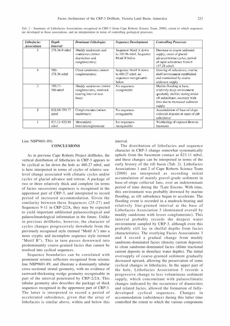
character in CRP-3 change somewhat systematicallyuphole from the basement contact at 823.11 mbsf,and these changes can be interpreted in terms of theearly history of the rift basin (Tab. 2). LithofaciesAssociations 1 and 2 of Cape Roberts Science Team(2000) are interpreted as recording initialaccumulation of mainly gravel-grade sediment inbase-of-slope colluvial fans, over an indeterminateperiod of time during the ?Late Eocene. With time,this environment was probably drowned by marineflooding, as rift subsidence began to accelerate. Theflooding event is recorded in a mudrock-bearing andrelatively fine-grained interval at the base ofLithofacies Association 3 (dominated overall bymuddy sandstone with lesser conglomerate). Thisinterval probably records the deepest waterenvironment sampled by CRP-3, although even thisprobably still lay in shelfal depths from faciescharacteristics. The overlying Facies Associations 3and 4 record a gradual change from muddysandstone-dominated facies (density current deposits)to clean sandstone-dominated facies (dilute tractionalcurrent deposits in shoreface water depths). The initialoversupply of coarse-grained sediment graduallydecreased upward, allowing the preservation of somecyclical changes in lithofacies. In the upper part ofthe hole, Lithofacies Association 5 records aprogressive change to less voluminous sedimentsupply, which concomitant with palaeoclimaticchanges indicated by the occurrence of diamictitesand related facies, allowed the formation of fully-developed cyclical sequences. Changes inaccommodation (subsidence) during this latter timecontrolled the extent to which the various components
Tab. 2 - Summary of Lithofacies Associations recognised in CRP-3 (from Cape Roberts Science Team, 2000), extent to which sequencesare developed in those associations, and an interpretation in terms of controlling geological processes.

C.R. Fielding et al.224
of sequences were preserved.ACKNOWLEDGEMENTS - We are proud to acknowledgethe superb effort of the Cape Roberts Project drillsite teamin executing CRP-3, which completed a vertical traversethrough the stratigraphy of the Victoria Land Basin. Wealso acknowledge the logistical support offered by the NewZealand and US Antarctic Programmes, without which noneof this would have been possible. All scientists and supportstaff involved in the Cape Roberts Project are thanked fortheir help, advice, and vigorous scientific debate whichhave together made the experience such a rewarding one forus. Greg Browne (IGNS – New Zealand) and Peter Kamp(Waikato University, New Zealand) are thanked for theirreviews of the submitted manuscript. KJW and CRF weresupported by two out-of-cycle Large Grants from theAustralian Research Council.
REFERENCES
Cape Roberts Science Team, 1998. Initial Report on CRP-1, CapeRoberts Project, Antarctica. Terra Antartica, 5, 1-187.
Cape Roberts Science Team, 1999. Studies from the Cape RobertsProject, Ross Sea, Antarctica: Initial Report on CRP-2/2A.Terra Antartica, 6, 1-173.
Cape Roberts Science Team 2000. Studies from the Cape RobertsProject, Ross Sea, Antarctica: Initial Report on CRP-3. Terra
Antartica, 7, 1-209.Cooper A.K., Davey F.J. & Cochrane G.R. 1987. Structure of the
extensionally rifted crust beneath the western Ross Sea andIselin Bank, Antarctica. In: A.K. Cooper & F.J. Davey (eds.),The Antarctic continental margin: Geology & Geophysics ofthe Western Ross Sea, Circum-Pacific Council for Energy &Mineral Resources, Earth Sciences Series, 5B, Houston, Texas,93-118.
Fielding C.R., Woolfe K.J., Howe J.A. & Lavelle M., 1998.Sequence Stratigraphic Analysis of CRP-1, Cape RobertsProject, McMurdo Sound, Antarctica. Terra Antartica, 5, 353-361.
Fielding C.R., Naish T.R., Woolfe K.J. & Lavelle M.A., 2000.Facies analysis and sequence stratigraphy of CRP-2/2A,Victoria Land Basin, Antarctica. Terra Antartica, 7, 323-338.
Henrys S.A., Bücker C.J., Niessen F. & Bartek L.R., 2001.Correlation of seismic reflectors with drillhole CRP-3, VictoriaLand Basin, Antarctica. This volume.
Naish T.R., Barrett P.J., Dunbar G.B., Woolfe K.J., Dunn A.G.,Henrys S.A., Claps M., Powell R.D. & Fielding C.R., 2001.Sedimentary cyclicity in CRP drillcore, Victoria Land Basin,Antarctica. This volume.
Naish T.R., Woolfe K.J., Wilson G.S., Atkins C., Barrett P.J.,Bohaty S.M., Bücker C., Claps M., Davey F., Dunbar G.,Dunn A.G., Fielding C.R., Florindo F., Hannah M., HarwoodD.M., Watkins D., Henrys S., Krissek L., Lavelle M.A., vander Meer J., McIntosh W.C., Niessen F., Passchier S., PowellR.D., Roberts A.P., Sagnotti L., Scherer R.P., Strong C.P.,Talarico F., Verosub K.L., Webb P.-N., & Wonik T., 2001.Orbitally induced oscillations in the East Antarctic Ice Sheet:direct evidence from the Cape Roberts Drilling Project. Nature,


![[PPT]Facies and Facies Models - UCSC Directory of individual …mclapham/eart120/slides/Facies... · Web viewWhat is a facies? A sedimentary unit with consistent characteristics (lithology,](https://static.fdocuments.in/doc/165x107/5aef4a8a7f8b9a8c308bc665/pptfacies-and-facies-models-ucsc-directory-of-individual-mclaphameart120slidesfaciesweb.jpg)