External Users Manual - National Oceanic and Atmospheric ...External Users Manual . for NPP ATMS ....
28
Microwave Integrated Retrieval System (MIRS) External Users Manual for NPP ATMS Compiled by NOAA Center for Satellite Applications and Research (STAR) NOAA Office for Satellite and Product Operations (OSPO) NOAA Office of Systems Development (OSD/NDE) Version 2.0 September, 2015 ___________________________________
Transcript of External Users Manual - National Oceanic and Atmospheric ...External Users Manual . for NPP ATMS ....
Microwave Integrated Retrieval System
(MIRS)
External Users Manual for NPP ATMS
Compiled by NOAA Center for Satellite Applications and Research (STAR) NOAA Office for Satellite and Product Operations (OSPO) NOAA Office of Systems Development (OSD/NDE)
Version 2.0 September, 2015
___________________________________

NOAA Microwave Integrated Retrieval System
External Users Manual for NPP ATMS Page 2 of 28
TITLE: MIRS EXTERNAL USERS MANUAL FOR NPP ATMS VERSION 2.0 AUTHORS: Kevin Garrett (Riverside Technology, Inc. and NOAA JCSDA) Xiwu Zhan (NOAA NESDIS/STAR) Christopher Grassotti (U. Maryland/ESSIC and NOAA NESDIS/STAR) Limin Zhao (NOAA NESDIS/OSPO)

NOAA Microwave Integrated Retrieval System
External Users Manual for NPP ATMS Page 3 of 28
DOCUMENT HISTORY DOCUMENT REVISION LOG
The Document Revision Log identifies the series of revisions to this document since the
baseline release. Please refer to the above page for version number information.
DOCUMENT TITLE: MIRS External Users Manual for NPP ATMS
DOCUMENT CHANGE HISTORY
Revision No. Date Revision Originator Project Group CCR Approval #
and Date
1.0 5/17/2013 Version 1 N/A
2.0 Jan 2014 OSPO to finish the documents with OSPO and NDE inputs N/A
3.0 Sep 2015 Updates to reflect v11.2 of MiRS N/A
NOAA Microwave Integrated Retrieval System
External Users Manual for NPP ATMS Page 4 of 28
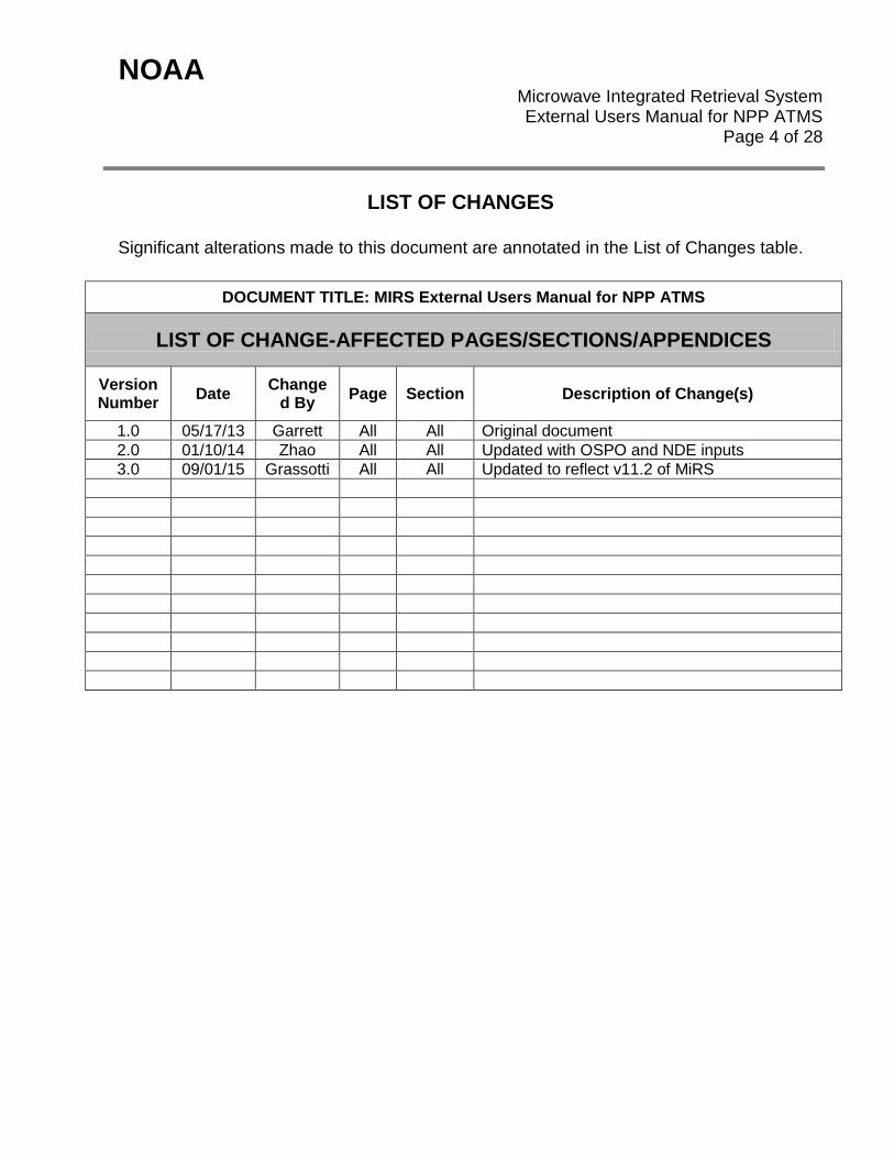
LIST OF CHANGES
Significant alterations made to this document are annotated in the List of Changes table.
DOCUMENT TITLE: MIRS External Users Manual for NPP ATMS
LIST OF CHANGE-AFFECTED PAGES/SECTIONS/APPENDICES
Version Number Date Change
d By Page Section Description of Change(s)
1.0 05/17/13 Garrett All All Original document 2.0 01/10/14 Zhao All All Updated with OSPO and NDE inputs 3.0 09/01/15 Grassotti All All Updated to reflect v11.2 of MiRS
NOAA Microwave Integrated Retrieval System
External Users Manual for NPP ATMS Page 5 of 28
TABLE OF CONTENTS
Page
LIST OF TABLES AND FIGURES .................................................................... 6 1. PRODUCTS ................................................................................................ 7
1.1. Product Overview ........................................................................... 7 1.1.1. Product Requirements ...................................................... 7 1.1.2. Product Team ................................................................... 8 1.1.3. Product Description ........................................................... 9
1.2. Product History ............................................................................... 10 1.3. Product Access ............................................................................... 11
2. ALGORITHM ............................................................................................... 19 2.1. Algorithm Overview ........................................................................ 19 2.2. Input Satellite Data ......................................................................... 20
2.2.1. Satellite Instrument Overview ........................................... 20 2.2.2. Satellite Data Preprocessing Overview ............................. 21
2.3. Input Ancillary Data ........................................................................ 22 3. PERFORMANCE ........................................................................................ 23
3.1. Product Testing .............................................................................. 23 3.1.1. Test Data Description ....................................................... 23 3.1.2. Unit Test Plans.................................................................. 23
3.2. Product Accuracy ........................................................................... 23 3.2.1. Test Results ...................................................................... 23 3.2.2. Product Accuracy .............................................................. 24
3.3. Product Quality Output ................................................................... 25 3.4. External Product Tools ................................................................... 27
4. PRODUCT STATUS .................................................................................... 28 4.1. Operations Documentation ............................................................. 28 4.2. Maintenance History ....................................................................... 28
NOAA Microwave Integrated Retrieval System
External Users Manual for NPP ATMS Page 6 of 28
LIST OF FIGURES
Page Figure 2-1. Concept characteristics of MIRS. .................................................................... 20 Figure 3-1. Quality control structure definitions. ................................................................. 26
LIST OF TABLES Page Table 1-1. MiRS STAR product development team. ........................................................... 9 Table 1-2. MiRS operational team. ...................................................................................... 9 Table 1-3. List of heritage, advanced and derived MiRS products. .................................... 10 Table 1-4. MiRS product development phases and delivery timeline for products and sensors. .............................................................................................................................. 11 Table 1-5. MiRS output files for downstream archive, tailoring, or QC DAP input. ............ 13 Table 1-6. MIRS SND file contents, NetCDF4 format........................................................ 16 Table 1-7. MIRS IMG file contents, NetCDF4 format. ....................................................... 17 Table 1-8. Contents of the metadata header contained within the MIRS NetCDF4 SND and IMG product files. ............................................................................................................... 19 Table 2-1. ATMS channels and passband characteristics. ................................................ 21 Table 3-1. Summary of MiRS ATMS product performance based on validation activities. Unless otherwise stated, results are for combined clear/cloudy conditions. ....................... 25
NOAA Microwave Integrated Retrieval System
External Users Manual for NPP ATMS Page 7 of 28
1. PRODUCTS
The Microwave Integrated Retrieval System (MiRS) algorithm inverts passive microwave radiances into multiple geophysical parameters to explain the atmospheric and surface conditions for a given observation. Currently there are 13 operational products from 7 polar-orbiting satellite platforms, detailed below, and made available to external users (outside of NOAA). This document serves to focus on the MiRS products derived from the Suomi-NPP Advanced Technology Microwave Sounder (ATMS) instrument data. The intended users of the External Users Manual (EUM) are end users of the NDE MiRS operational products files, and the product verification and validation (V&V) teams. The purpose of the EUM is to provide product users and testers with information that will enable them to acquire the product, understand its features, and use the data. External users are defined as those users who do not have direct access to the processing system (those outside of the OSPO and NDE). The output files are defined as those leaving the NDE DHS (running within ESPC) as opposed to those that are output by the MiRS processing, but available only internally within the NDE. The NDE MiRS does provide outputs for being tailored into McIDAS within ESPC. Those tailored files are described in a separate EUM.
1.1. Product Overview
1.1.1. Product Requirements
The MiRS was developed by the NOAA/NESDIS Center for Satellite Application and Research (STAR) as a major upgrade to the existing suite of microwave retrieval algorithms called the Microwave Surface and Precipitation Product System (MSPPS). MSPPS lacks profiling capability and is specific to a single instrument, the AMSU. Another objective for developing MIRS was to provide retrievals in all-weather and over all-surface conditions with the immediate benefits of extending the spatial coverage to critical areas such as active regions and using non-exploited measurements such as those made by surface-sensitive channels for temperature sounding. MiRS is applicable to both existing and future microwave sensors. It is currently being applied operationally to the NOAA-18, NOAA-19, METOP-A and METOP-B AMSU/MHS suite, the DMSP-F18 SSMI/S sensor, to SNPP ATMS measurements, and to Megha-Tropiques (MT) SAPHIR data. In addition MIRS has been applied to TRMM TMI, Megha-Tropiques (MT) MADRAS, GCOM-W1 AMSR2, and GPM GMI data in research mode. It could also be a system for Infrared (IR) sensors onboard the JPSS and GOES-R platforms.
NOAA Microwave Integrated Retrieval System
External Users Manual for NPP ATMS Page 8 of 28
MiRS is applicable to both existing and future microwave sensors. It is currently being applied operationally to the NOAA-18, NOAA-19, METOP-A and METOP-B AMSU/MHS suite, the DMSP-F16 and F18 SSMI/S sensors, and to NPP ATMS. In addition MIRS is applied to TRMM TMI, Megha-Tropiques (MT) MADRAS and SAPHIR data in research mode. It could also be a system for Infrared (IR) sensors onboard the JPSS and GOES-R platforms. Having one retrieval system for a multitude of sensors is scientifically sound because the radiative transfer physics involved is by and large the same and the mathematical basis for the inverse problem is identical. The practical advantages of having one single system for a multitude of sensors are numerous. They include among others, the time and cost savings related to generating a retrieval algorithm for a new sensor, the optimal use of the information content and the consistent treatment of time series of satellite data for long-term trend monitoring and climate studies. MiRS is coupled with the Joint Center for Satellite Data Assimilation (JCSDA) Community Radiative Transfer Model (CRTM) which is valid in both microwave and infrared spectral regions, as well as in clear, cloudy and precipitating conditions and over all surface types. Therefore, MiRS meets the following operational product requirements: temperature and humidity profiles in all-weather conditions, total precipitable water (TPW), land surface temperature (LST), surface emissivity, non-precipitating cloud water, ice/graupel, and rain profiles, as well as their integrated amounts (CLW, RWP, GWP), emissivity-based sea-ice concentration (SIC), sea ice age (SIA), snow water equivalent (SWE), snow effective grain size (SGS), snow cover extent (SCE), surface type classification (ST), and a high resolution surface rainfall rate (RR). Quality control metrics and flags defining retrieval product quality are also provided. For operational processing of NPP ATMS data in the NPOESS Data Exploitation (NDE) environment, and transitioned to the NOAA Office for Satellite and Product Operations (OSPO) in the July 2013 timeframe, the MIRS algorithm provides the capability to convert MiRS product files to the NetCDF4 format following the Climate and Forecast convention and STAR metadata standards. In both processing environments, two product files are created for each set of input observations (e.g. granule or orbit). One file, referred to as the sounding products file (SND) contains temperature and humidity profiles. The second file, referred to as the imaging products file (IMG), contains primarily products more responsive to surface sensitive channels including TPW, LST, CLW, RWP, IWP, surface emissivity, SIC, SIA, SWE, SGS, SCE, and RR.
1.1.2. Product Team
The MiRS product team is comprised by two entities, the development team and the operational team.
NOAA Microwave Integrated Retrieval System
External Users Manual for NPP ATMS Page 9 of 28
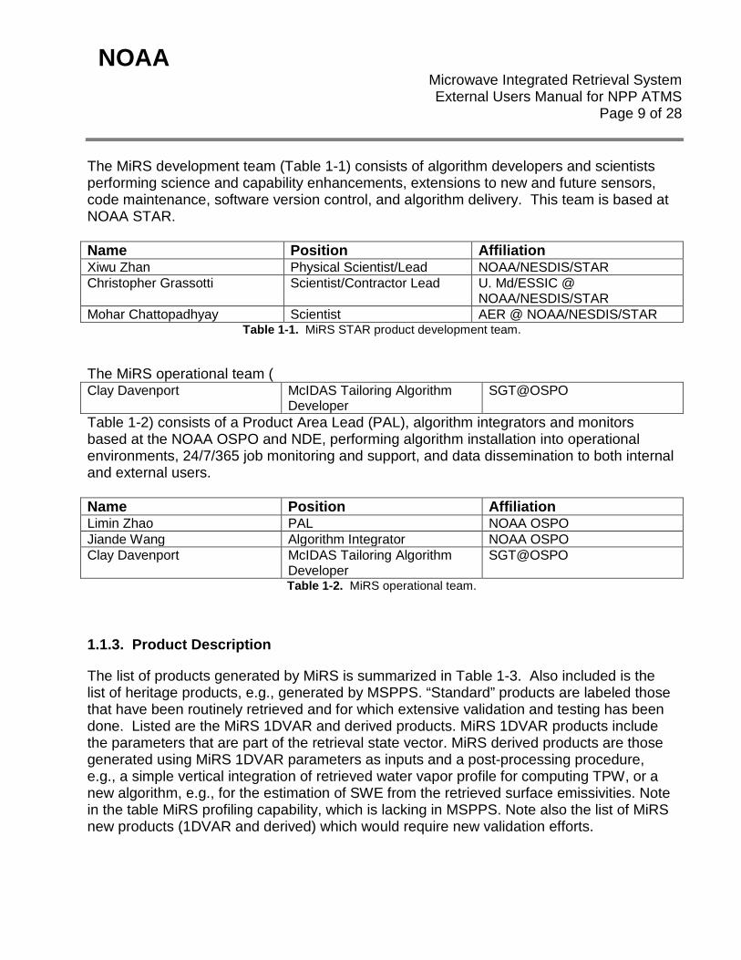
The MiRS development team (Table 1-1) consists of algorithm developers and scientists performing science and capability enhancements, extensions to new and future sensors, code maintenance, software version control, and algorithm delivery. This team is based at NOAA STAR. Name Position Affiliation Xiwu Zhan Physical Scientist/Lead NOAA/NESDIS/STAR Christopher Grassotti Scientist/Contractor Lead U. Md/ESSIC @
NOAA/NESDIS/STAR Mohar Chattopadhyay Scientist AER @ NOAA/NESDIS/STAR
Table 1-1. MiRS STAR product development team.
The MiRS operational team ( Clay Davenport McIDAS Tailoring Algorithm
Developer SGT@OSPO
Table 1-2) consists of a Product Area Lead (PAL), algorithm integrators and monitors based at the NOAA OSPO and NDE, performing algorithm installation into operational environments, 24/7/365 job monitoring and support, and data dissemination to both internal and external users. Name Position Affiliation Limin Zhao PAL NOAA OSPO Jiande Wang Algorithm Integrator NOAA OSPO Clay Davenport McIDAS Tailoring Algorithm
Developer SGT@OSPO
Table 1-2. MiRS operational team.
1.1.3. Product Description
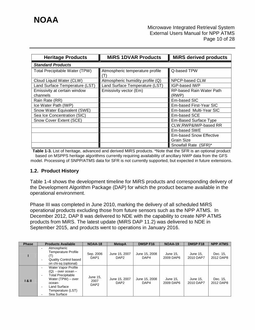
The list of products generated by MiRS is summarized in Table 1-3. Also included is the list of heritage products, e.g., generated by MSPPS. “Standard” products are labeled those that have been routinely retrieved and for which extensive validation and testing has been done. Listed are the MiRS 1DVAR and derived products. MiRS 1DVAR products include the parameters that are part of the retrieval state vector. MiRS derived products are those generated using MiRS 1DVAR parameters as inputs and a post-processing procedure, e.g., a simple vertical integration of retrieved water vapor profile for computing TPW, or a new algorithm, e.g., for the estimation of SWE from the retrieved surface emissivities. Note in the table MiRS profiling capability, which is lacking in MSPPS. Note also the list of MiRS new products (1DVAR and derived) which would require new validation efforts.
NOAA Microwave Integrated Retrieval System
External Users Manual for NPP ATMS Page 10 of 28
Heritage Products MiRS 1DVAR Products MiRS derived products Standard Products Total Precipitable Water (TPW) Atmospheric temperature profile
(T) Q-based TPW
Cloud Liquid Water (CLW) Atmospheric humidity profile (Q) NPCP-based CLW Land Surface Temperature (LST) Land Surface Temperature (LST) IGP-based IWP Emissivity at certain window channels
Emissivity vector (Em) RP-based Rain Water Path (RWP)
Rain Rate (RR) Em-based SIC Ice Water Path (IWP) Em-based First-Year SIC Snow Water Equivalent (SWE) Em-based Multi-Year SIC Sea Ice Concentration (SIC) Em-based SCE Snow Cover Extent (SCE) Em-Based Surface Type CLW,RWP&IWP-based RR Em-based SWE Em-based Snow Effective
Grain Size Snowfall Rate (SFR)*
Table 1-3. List of heritage, advanced and derived MiRS products. *Note that the SFR is an optional product based on MSPPS heritage algorithms currently requiring availability of ancillary NWP data from the GFS
model. Processing of SNPP/ATMS data for SFR is not currently supported, but expected in future extensions.
1.2. Product History
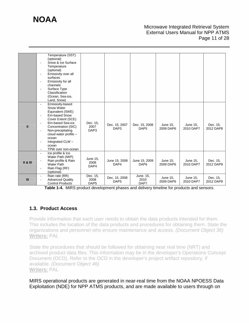
Table 1-4 shows the development timeline for MiRS products and corresponding delivery of the Development Algorithm Package (DAP) for which the product became available in the operational environment. Phase III was completed in June 2010, marking the delivery of all scheduled MiRS operational products excluding those from future sensors such as the NPP ATMS. In December 2012, DAP 8 was delivered to NDE with the capability to create NPP ATMS products from MiRS. The latest update (MiRS DAP 11.2) was delivered to NDE in September 2015, and products went to operations in January 2016.
Phase Products Available NOAA-18 MetopA DMSP F16 NOAA-19 DMSP F18 NPP ATMS
I
- Atmospheric Temperature Profile (T)
- Quality Control based on chi-sq (optional)
Sep. 2006 DAP1
June 15, 2007 DAP2
June 15, 2008 DAP4
June 15, 2009 DAP6
June 15, 2010 DAP7
Dec. 15, 2012 DAP8
I & II
- Water Vapor Profile (Q) - over ocean –
- Total Precipitable Water (TPW) – over ocean-
- Land Surface Temperature (LST)
- Sea Surface
June 15, 2007 DAP2
June 15, 2007 DAP2
June 15, 2008 DAP4
June 15, 2009 DAP6
June 15, 2010 DAP7
Dec. 15, 2012 DAP8
NOAA Microwave Integrated Retrieval System
External Users Manual for NPP ATMS Page 11 of 28
Temperature (SST) (optional)
- Snow & Ice Surface Temperature (optional)
- Emissivity over all surfaces
- Emissivity for all channels
- Surface Type Classification (Ocean, Sea-ice, Land, Snow)
II
- Emissivity-based Snow Water Equivalent (SWE)
- Em-based Snow Cover Extent (SCE)
- Em-based Sea-ice Concentration (SIC)
- Non-precipitating cloud water profile – ocean
- Integrated CLW – ocean
- TPW over non-ocean
Dec. 15, 2007 DAP3
Dec. 15, 2007 DAP3
Dec. 15, 2008 DAP5
June 15, 2009 DAP6
June 15, 2010 DAP7
Dec. 15, 2012 DAP8
II & III
- Ice profile & Ice Water Path (IWP)
- Rain profile & Rain Water Path
- Rain Flag (RF) (optional)
June 15, 2008 DAP4
June 15, 2008 DAP4
June 15, 2009 DAP6
June 15, 2009 DAP6
June 15, 2010 DAP7
Dec. 15, 2012 DAP8
III - Rain rate (RR) - Advanced Quality
Control Products
Dec. 15, 2008 DAP5
Dec. 15, 2008 DAP5
June. 15, 2010 DAP7
June 15, 2009 DAP6
June 15, 2010 DAP7
Dec. 15, 2012 DAP8
Table 1-4. MiRS product development phases and delivery timeline for products and sensors.
1.3. Product Access
Provide information that each user needs to obtain the data products intended for them. This includes the location of the data products and procedures for obtaining them. State the organizations and personnel who ensure maintenance and access. (Document Object 36) Writers: PAL State the procedures that should be followed for obtaining near real time (NRT) and archived product data files. This information may be in the developer’s Operations Concept Document (OCD). Refer to the OCD in the developer’s project artifact repository, if available. (Document Object 46) Writers: PAL MIRS operational products are generated in near-real time from the NOAA NPOESS Data Exploitation (NDE) for NPP ATMS products, and are made available to users through on
NOAA Microwave Integrated Retrieval System
External Users Manual for NPP ATMS Page 12 of 28
the NDE data distribution server at ESPC for real-time users. For access to this server, information about data files, and associated documentation, the MiRS PAL should be contacted (see Table 1-2). In general, users are required to fill out the Data Access Request Form located on http://www.ospo.noaa.gov/Organization/About/access.html, and submits to [email protected] with a copy to the PAL. The historical products are distributed for external users through the NOAA Comprehensive Large Array-data Stewardship System (CLASS) archive. Data can be queried and ordered from CLASS at the following web URL: http://www.class.noaa.gov. Registration with CLASS is required for ordering data. The actual data links are as follows: http://gis.ncdc.noaa.gov/geoportal/catalog/search/resource/details.page?id=gov.noaa.ncdc:C00865 http://gis.ncdc.noaa.gov/geoportal/catalog/search/resource/details.page?id=gov.noaa.ncdc:C00866 MIRS experimental products are generated for all sensors (operational and research) on a daily basis at the NOAA Center for Satellite Applications and Research (STAR), by the product development team. These experimental products reflect the current status of the MIRS algorithm as it is developed toward the next DAP release to operations. Products, images, and validation statistics can be viewed at the password-protected web URL: http://www.star.nesdis.noaa.gov/smcd/mirs. Login credentials may be obtained by contacting the MIRS product development lead listed above. The output data set from processing a single NPP ATMS granule in the NDE environment is listed in the output Process Status File (PSF). This PSF file is generated after completion of MiRS processing, and lists all of the product files relevant to MiRS ATMS both for archiving and downstream processing (e.g. tailoring, MiRS QC DAP). The PSF is located in the working directory specified in the PCF (Process Configuration File) defined by the production rules, and follows the naming convention “npp_scs_nde.PSF”. The file is ASCII and should list 7 filenames as output, with their absolute path (likely in a sub directory in the working directory). The 2 main output files are the product files in NetCDF4 format for imaging and sounding products. These products are used for tailoring and are also delivered to archive. Details about file attributes such as contents and size can be found at the end of this section.
NOAA Microwave Integrated Retrieval System
External Users Manual for NPP ATMS Page 13 of 28
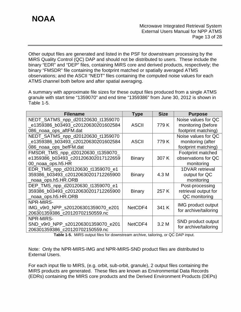
Other output files are generated and listed in the PSF for downstream processing by the MiRS Quality Control (QC) DAP and should not be distributed to users. These include the binary “EDR” and “DEP” files, containing MiRS core and derived products, respectively; the binary “FMSDR” file containing the footprint matched or spatially averaged ATMS observations; and the ASCII “NEDT” files containing the computed noise values for each ATMS channel both before and after spatial averaging. A summary with approximate file sizes for these output files produced from a single ATMS granule with start time “1359070” and end time “1359386” from June 30, 2012 is shown in Table 1-5.
Filename Type Size Purpose NEDT_SATMS_npp_d20120630_t1359070_e1359386_b03493_c20120630201602584086_noaa_ops_aftFM.dat
ASCII 779 K Noise values for QC monitoring (before footprint matching)
NEDT_SATMS_npp_d20120630_t1359070_e1359386_b03493_c20120630201602584086_noaa_ops_befFM.dat
ASCII 779 K Noise values for QC
monitoring (after footprint matching)
FMSDR_TMS_npp_d20120630_t1359070_e1359386_b03493_c20120630201712265900_noaa_ops.h5.HR
Binary 307 K Footprint matched
observations for QC monitoring
EDR_TMS_npp_d20120630_t1359070_e1359386_b03493_c20120630201712265900_noaa_ops.h5.HR.ORB
Binary 4.3 M 1DVAR retrieval
output for QC monitoring
DEP_TMS_npp_d20120630_t1359070_e1359386_b03493_c20120630201712265900_noaa_ops.h5.HR.ORB
Binary 257 K Post-processing
retrieval output for QC monitoring
NPR-MIRS-IMG_v9r0_NPP_s201206301359070_e201206301359386_c20120702150559.nc
NetCDF4 341 K IMG product output for archive/tailoring
NPR-MIRS-SND_v9r0_NPP_s201206301359070_e201206301359386_c20120702150559.nc
NetCDF4 3.2 M SND product output for archive/tailoring
Table 1-5. MiRS output files for downstream archive, tailoring, or QC DAP input.
Note: Only the NPR-MIRS-IMG and NPR-MIRS-SND product files are distributed to External Users. For each input file to MIRS, (e.g. orbit, sub-orbit, granule), 2 output files containing the MIRS products are generated. These files are known as Environmental Data Records (EDRs) containing the MIRS core products and the Derived Environment Products (DEPs)

NOAA Microwave Integrated Retrieval System
External Users Manual for NPP ATMS Page 14 of 28
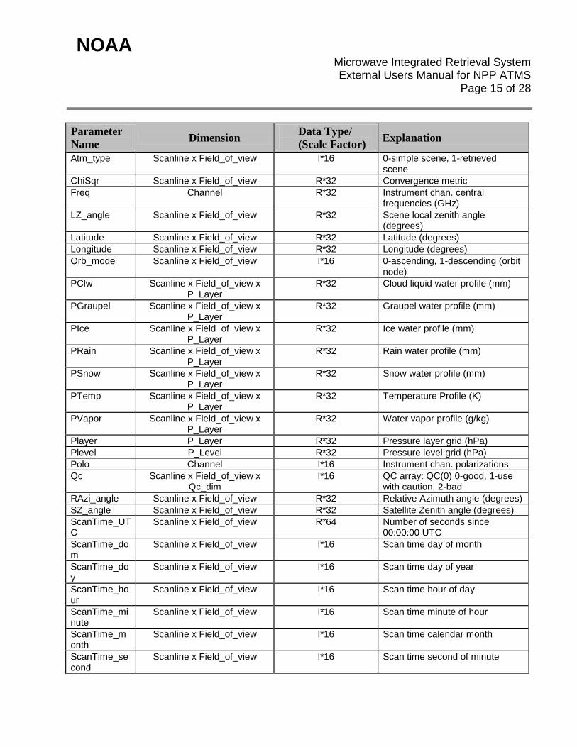
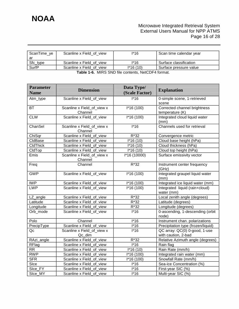
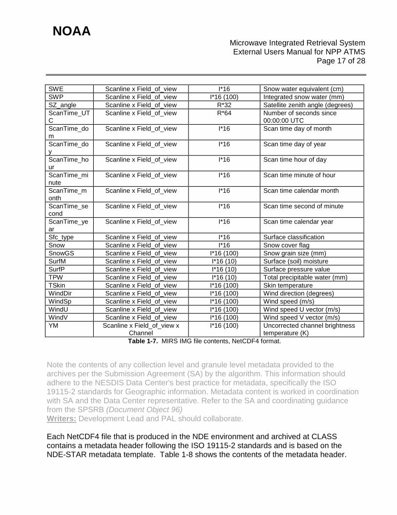
containing integrated and post-processing products. The files are internal formats to the MIRS algorithm and are only made available for experimental products through the STAR website mentioned above. However, these EDR and DEP files are reformatted for dissemination to operational users. For MIRS operational processing in the NDE environment of the current NPP ATMS sensor data, the MIRS EDR and DEP data is converted into 2 NetCDF4 formatted files to be archived at CLASS. The format adheres to the Climate and Forecast metadata convention. The MIRS sounding products are written to the “SND” prefixed file, while the imaging are written to the “IMG” prefixed file. The file naming convention follows: NPR-MIRS-SND_vXrY_satID_sYYYYMMDDHHMMSSS_eYYYYMMDDHHMMSSS_cYYYYMMDDHHMMSSS.nc and NPR-MIRS-IMG_vXrY_satID_sYYYYMMDDHHMMSSS_eYYYYMMDDHHMMSSS_cYYYYMMDDHHMMSSS.nc where: vXrY - refers to the algorithm release or version number and subversion number, satId – refers to the satellite name (e.g. NPP), sYYYYMMDDHHMMSSS – refers to the granule or orbit start time year, month, day, hour, minute, second, and tenths of second, eYYYYMMDDHHMMSSS – refers to the granule or orbit end time year, month, day, hour, minute, second, and tenths of second, cYYYYMMDDHHMMSSS – refers to the MIRS output file creation time year, month, day, hour, minute, and tenths of second. SND files for 1 NPP ATMS granule are approximately 3.3 MB in size, while IMG files are 350 KB. The contents for the SND and IMG files are described in Table 1-6 and Table 1-7, respectively.
NOAA Microwave Integrated Retrieval System
External Users Manual for NPP ATMS Page 15 of 28
Parameter Name Dimension Data Type/
(Scale Factor) Explanation
Atm_type Scanline x Field_of_view I*16 0-simple scene, 1-retrieved scene
ChiSqr Scanline x Field_of_view R*32 Convergence metric Freq Channel R*32 Instrument chan. central
frequencies (GHz) LZ_angle Scanline x Field_of_view R*32 Scene local zenith angle
(degrees) Latitude Scanline x Field_of_view R*32 Latitude (degrees) Longitude Scanline x Field_of_view R*32 Longitude (degrees) Orb_mode Scanline x Field_of_view I*16 0-ascending, 1-descending (orbit
node) PClw Scanline x Field_of_view x
P_Layer R*32 Cloud liquid water profile (mm)
PGraupel Scanline x Field_of_view x P_Layer
R*32 Graupel water profile (mm)
PIce Scanline x Field_of_view x P_Layer
R*32 Ice water profile (mm)
PRain Scanline x Field_of_view x P_Layer
R*32 Rain water profile (mm)
PSnow Scanline x Field_of_view x P_Layer
R*32 Snow water profile (mm)
PTemp Scanline x Field_of_view x P_Layer
R*32 Temperature Profile (K)
PVapor Scanline x Field_of_view x P_Layer
R*32 Water vapor profile (g/kg)
Player P_Layer R*32 Pressure layer grid (hPa) Plevel P_Level R*32 Pressure level grid (hPa) Polo Channel I*16 Instrument chan. polarizations Qc Scanline x Field_of_view x
Qc_dim I*16 QC array: QC(0) 0-good, 1-use
with caution, 2-bad RAzi_angle Scanline x Field_of_view R*32 Relative Azimuth angle (degrees) SZ_angle Scanline x Field_of_view R*32 Satellite Zenith angle (degrees) ScanTime_UTC
Scanline x Field_of_view R*64 Number of seconds since 00:00:00 UTC
ScanTime_dom
Scanline x Field_of_view I*16 Scan time day of month
ScanTime_doy
Scanline x Field_of_view I*16 Scan time day of year
ScanTime_hour
Scanline x Field_of_view I*16 Scan time hour of day
ScanTime_minute
Scanline x Field_of_view I*16 Scan time minute of hour
ScanTime_month
Scanline x Field_of_view I*16 Scan time calendar month
ScanTime_second
Scanline x Field_of_view I*16 Scan time second of minute
NOAA Microwave Integrated Retrieval System
External Users Manual for NPP ATMS Page 16 of 28
ScanTime_year
Scanline x Field_of_view I*16 Scan time calendar year
Sfc_type Scanline x Field_of_view I*16 Surface classification SurfP Scanline x Field_of_view I*16 (10) Surface pressure value
Table 1-6. MIRS SND file contents, NetCDF4 format.
Parameter Name Dimension Data Type/
(Scale Factor) Explanation
Atm_type Scanline x Field_of_view I*16 0-simple scene, 1-retrieved scene
BT Scanline x Field_of_view x Channel
I*16 (100) Corrected channel brightness temperature (K)
CLW Scanline x Field_of_view I*16 (100) Integrated cloud liquid water (mm)
ChanSel Scanline x Field_of_view x Channel
I*16 Channels used for retrieval
ChiSqr Scanline x Field_of_view R*32 Convergence metric CldBase Scanline x Field_of_view I*16 (10) Cloud base height (hPa) CldThick Scanline x Field_of_view I*16 (10) Cloud thickness (hPa) CldTop Scanline x Field_of_view I*16 (10) Cloud top height (hPa) Emis Scanline x Field_of_view x
Channel I*16 (10000) Surface emissivity vector
Freq Channel R*32 Instrument center frequency (GHz)
GWP Scanline x Field_of_view I*16 (100) Integrated graupel liquid water (mm)
IWP Scanline x Field_of_view I*16 (100) Integrated ice liquid water (mm) LWP Scanline x Field_of_view I*16 (100) Integrated liquid (rain+cloud)
water (mm) LZ_angle Scanline x Field_of_view R*32 Local zenith angle (degrees) Latitude Scanline x Field_of_view R*32 Latitude (degrees) Longitude Scanline x Field_of_view R*32 Longitude (degrees) Orb_mode Scanline x Field_of_view I*16 0-ascending, 1-descending (orbit
node) Polo Channel I*16 Instrument chan. polarizations PrecipType Scanline x Field_of_view I*16 Precipitation type (frozen/liquid) Qc Scanline x Field_of_view x
Qc_dim I*16 QC array: QC(0) 0-good, 1-use
with caution, 2-bad RAzi_angle Scanline x Field_of_view R*32 Relative Azimuth angle (degrees) RFlag Scanline x Field_of_view I*16 Rain flag RR Scanline x Field_of_view I*16 (10) Rain Rate (mm/h) RWP Scanline x Field_of_view I*16 (100) Integrated rain water (mm) SFR Scanline x Field_of_view I*16 (100) Snowfall Rate (mm/h) SIce Scanline x Field_of_view I*16 Sea-ice Concentration (%) SIce_FY Scanline x Field_of_view I*16 First-year SIC (%) SIce_MY Scanline x Field_of_view I*16 Multi-year SIC (%)
NOAA Microwave Integrated Retrieval System
External Users Manual for NPP ATMS Page 17 of 28
SWE Scanline x Field_of_view I*16 Snow water equivalent (cm) SWP Scanline x Field_of_view I*16 (100) Integrated snow water (mm) SZ_angle Scanline x Field_of_view R*32 Satellite zenith angle (degrees) ScanTime_UTC
Scanline x Field_of_view R*64 Number of seconds since 00:00:00 UTC
ScanTime_dom
Scanline x Field_of_view I*16 Scan time day of month
ScanTime_doy
Scanline x Field_of_view I*16 Scan time day of year
ScanTime_hour
Scanline x Field_of_view I*16 Scan time hour of day
ScanTime_minute
Scanline x Field_of_view I*16 Scan time minute of hour
ScanTime_month
Scanline x Field_of_view I*16 Scan time calendar month
ScanTime_second
Scanline x Field_of_view I*16 Scan time second of minute
ScanTime_year
Scanline x Field_of_view I*16 Scan time calendar year
Sfc_type Scanline x Field_of_view I*16 Surface classification Snow Scanline x Field_of_view I*16 Snow cover flag SnowGS Scanline x Field_of_view I*16 (100) Snow grain size (mm) SurfM Scanline x Field_of_view I*16 (10) Surface (soil) moisture SurfP Scanline x Field_of_view I*16 (10) Surface pressure value TPW Scanline x Field_of_view I*16 (10) Total precipitable water (mm) TSkin Scanline x Field_of_view I*16 (100) Skin temperature WindDir Scanline x Field_of_view I*16 (100) Wind direction (degrees) WindSp Scanline x Field_of_view I*16 (100) Wind speed (m/s) WindU Scanline x Field_of_view I*16 (100) Wind speed U vector (m/s) WindV Scanline x Field_of_view I*16 (100) Wind speed V vector (m/s) YM Scanline x Field_of_view x
Channel I*16 (100) Uncorrected channel brightness
temperature (K) Table 1-7. MIRS IMG file contents, NetCDF4 format.
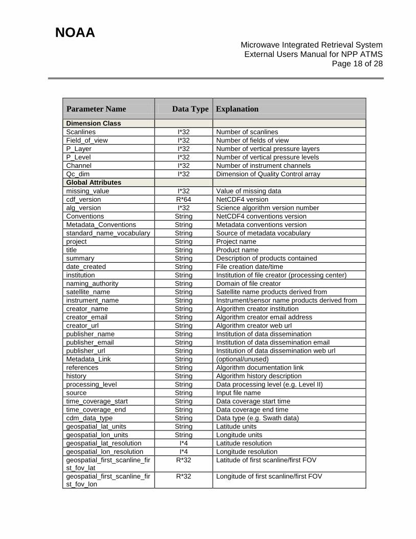
Note the contents of any collection level and granule level metadata provided to the archives per the Submission Agreement (SA) by the algorithm. This information should adhere to the NESDIS Data Center's best practice for metadata, specifically the ISO 19115-2 standards for Geographic information. Metadata content is worked in coordination with SA and the Data Center representative. Refer to the SA and coordinating guidance from the SPSRB (Document Object 96) Writers: Development Lead and PAL should collaborate. Each NetCDF4 file that is produced in the NDE environment and archived at CLASS contains a metadata header following the ISO 19115-2 standards and is based on the NDE-STAR metadata template. Table 1-8 shows the contents of the metadata header.
NOAA Microwave Integrated Retrieval System
External Users Manual for NPP ATMS Page 18 of 28
Parameter Name Data Type Explanation
Dimension Class Scanlines I*32 Number of scanlines Field_of_view I*32 Number of fields of view P_Layer I*32 Number of vertical pressure layers P_Level I*32 Number of vertical pressure levels Channel I*32 Number of instrument channels Qc_dim I*32 Dimension of Quality Control array Global Attributes missing_value I*32 Value of missing data cdf_version R*64 NetCDF4 version alg_version I*32 Science algorithm version number Conventions String NetCDF4 conventions version Metadata_Conventions String Metadata conventions version standard_name_vocabulary String Source of metadata vocabulary project String Project name title String Product name summary String Description of products contained date_created String File creation date/time institution String Institution of file creator (processing center) naming_authority String Domain of file creator satellite_name String Satellite name products derived from instrument_name String Instrument/sensor name products derived from creator_name String Algorithm creator institution creator_email String Algorithm creator email address creator_url String Algorithm creator web url publisher_name String Institution of data dissemination publisher_email String Institution of data dissemination email publisher_url String Institution of data dissemination web url Metadata_Link String (optional/unused) references String Algorithm documentation link history String Algorithm history description processing_level String Data processing level (e.g. Level II) source String Input file name time_coverage_start String Data coverage start time time_coverage_end String Data coverage end time cdm_data_type String Data type (e.g. Swath data) geospatial_lat_units String Latitude units geospatial_lon_units String Longitude units geospatial_lat_resolution I*4 Latitude resolution geospatial_lon_resolution I*4 Longitude resolution geospatial_first_scanline_first_fov_lat
R*32 Latitude of first scanline/first FOV
geospatial_first_scanline_first_fov_lon
R*32 Longitude of first scanline/first FOV
NOAA Microwave Integrated Retrieval System
External Users Manual for NPP ATMS Page 19 of 28
geospatial_first_scanline_last_fov_lat
R*32 Latitude of first scanline/last FOV
geospatial_first_scanline_last_fov_lon
R*32 Longitude of first scanline/last FOV
geospatial_last_scanline_first_fov_lat
R*32 Latitude of last scanline/first FOV
geospatial_last_scanline_first_fov_lon
R*32 Longitude of last scanline/last FOV
geospatial_last_scanline_last_fov_lat
R*32 Latitude of last scanline/last FOV
geospatial_last_scanline_last_fov_lon
R*32 Longitude of last scanline/last FOV
total_number_retrievals I*32 Total number of FOVs (scenes) in file percentage_optimal_retrievals
R*32 Total percentage of optimal quality retrievals in file
percentage_suboptimal_retrievals
R*32 Total percentage of suboptimal quality retrievals in file
percentage_bad_retrievals R*32 Total percentage of bad quality (failed) retrievals in file
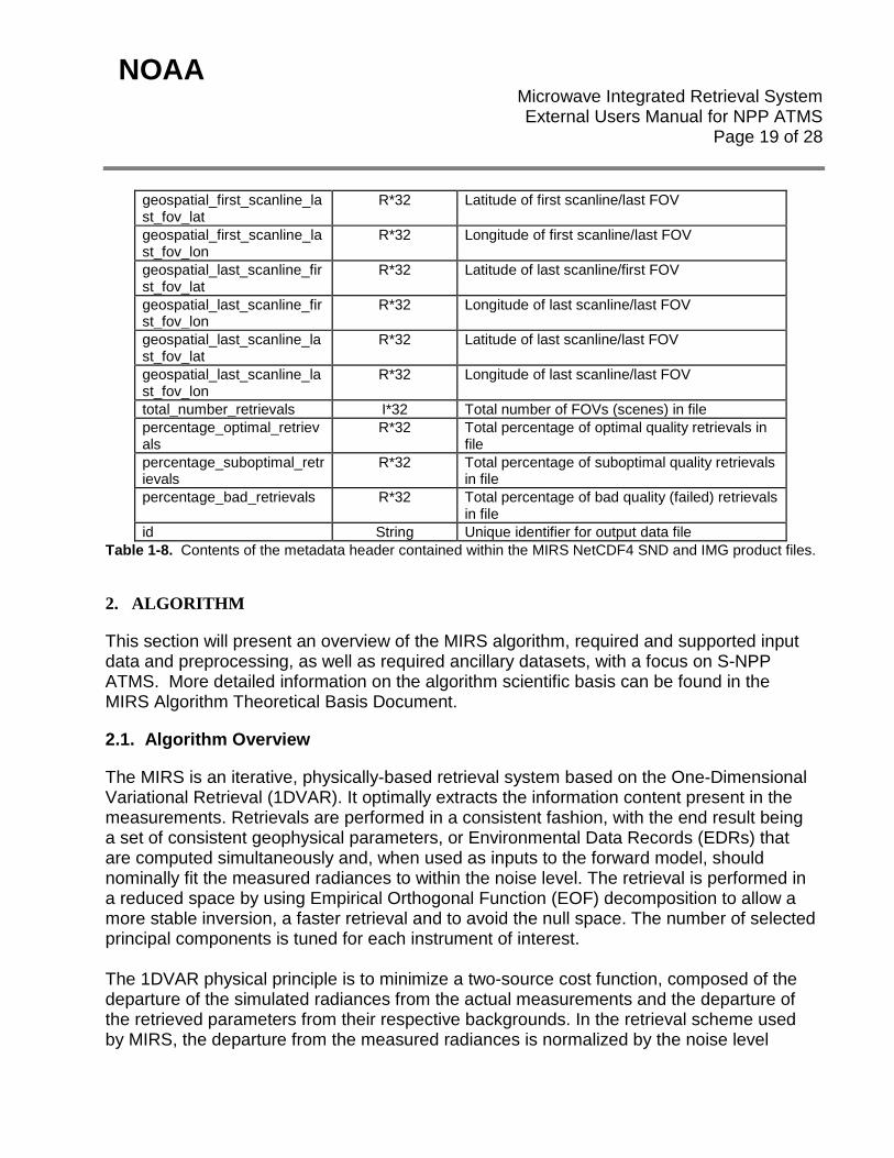
id String Unique identifier for output data file Table 1-8. Contents of the metadata header contained within the MIRS NetCDF4 SND and IMG product files.
2. ALGORITHM
This section will present an overview of the MIRS algorithm, required and supported input data and preprocessing, as well as required ancillary datasets, with a focus on S-NPP ATMS. More detailed information on the algorithm scientific basis can be found in the MIRS Algorithm Theoretical Basis Document.
2.1. Algorithm Overview
The MIRS is an iterative, physically-based retrieval system based on the One-Dimensional Variational Retrieval (1DVAR). It optimally extracts the information content present in the measurements. Retrievals are performed in a consistent fashion, with the end result being a set of consistent geophysical parameters, or Environmental Data Records (EDRs) that are computed simultaneously and, when used as inputs to the forward model, should nominally fit the measured radiances to within the noise level. The retrieval is performed in a reduced space by using Empirical Orthogonal Function (EOF) decomposition to allow a more stable inversion, a faster retrieval and to avoid the null space. The number of selected principal components is tuned for each instrument of interest. The 1DVAR physical principle is to minimize a two-source cost function, composed of the departure of the simulated radiances from the actual measurements and the departure of the retrieved parameters from their respective backgrounds. In the retrieval scheme used by MIRS, the departure from the measured radiances is normalized by the noise level
NOAA Microwave Integrated Retrieval System
External Users Manual for NPP ATMS Page 20 of 28
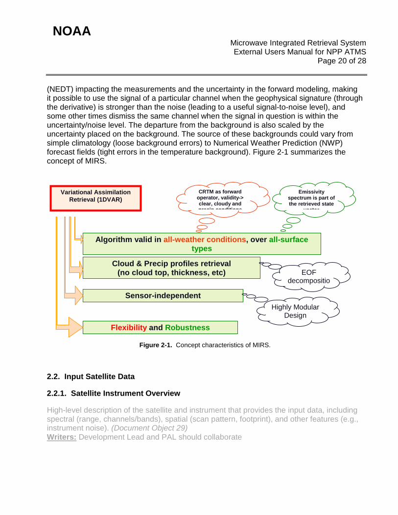
(NEDT) impacting the measurements and the uncertainty in the forward modeling, making it possible to use the signal of a particular channel when the geophysical signature (through the derivative) is stronger than the noise (leading to a useful signal-to-noise level), and some other times dismiss the same channel when the signal in question is within the uncertainty/noise level. The departure from the background is also scaled by the uncertainty placed on the background. The source of these backgrounds could vary from simple climatology (loose background errors) to Numerical Weather Prediction (NWP) forecast fields (tight errors in the temperature background). Figure 2-1 summarizes the concept of MIRS.
Figure 2-1. Concept characteristics of MIRS.
2.2. Input Satellite Data
2.2.1. Satellite Instrument Overview
High-level description of the satellite and instrument that provides the input data, including spectral (range, channels/bands), spatial (scan pattern, footprint), and other features (e.g., instrument noise). (Document Object 29) Writers: Development Lead and PAL should collaborate
Algorithm valid in all-weather conditions, over all-surface types
Variational Assimilation Retrieval (1DVAR)
Cloud & Precip profiles retrieval (no cloud top, thickness, etc)
Emissivity spectrum is part of the retrieved state
vector
CRTM as forward operator, validity-> clear, cloudy and precip conditions
Sensor-independent
EOF decompositio
Highly Modular Design
Flexibility and Robustness
NOAA Microwave Integrated Retrieval System
External Users Manual for NPP ATMS Page 21 of 28
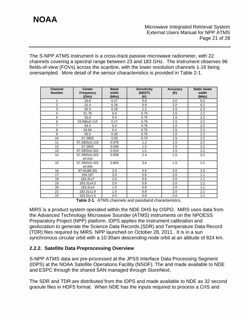
The S-NPP ATMS instrument is a cross-track passive microwave radiometer, with 22 channels covering a spectral range between 23 and 183 GHz. The instrument observes 96 fields-of-view (FOVs) across the scanline, with the lower resolution channels 1-16 being oversampled. More detail of the sensor characteristics is provided in Table 2-1.
Channel Number
Center Frequency
(GHz)
Band width (MHz)
Sensitivity (NEDT)
(K)
Accuracy (K)
Static beam width (MHz)
1 23.8 0.27 0.9 2.0 5.2 2 31.4 0.18 0.9 2.0 5.2 3 50.3 0.18 1.2 1.5 2.2 4 51.76 0.4 0.75 1.5 2.2 5 52.8 0.4 0.75 1.5 2.2 6 53.596±0.115 0.17 0.75 1.5 2.2 7 54.4 0.4 0.75 1.5 2.2 8 54.94 0.4 0.75 1.5 2.2 9 55.5 0.33 0.75 1.5 2.2
10 57.2903 0.33 0.75 1.5 2.2 11 57.2903±0.115 0.078 1.2 1.5 2.2 12 57.2903 0.036 1.2 1.5 2.2 13 57.2903±0.322 0.016 1.5 1.5 2.2 14 57.2903±0.322
±0.010 0.008 2.4 1.5 2.2
15 57.2903±0.322 ±0.004
0.003 3.6 1.5 2.2
16 87-91(88.20) 2.0 0.5 2.0 2.2 17 164-167 3.0 0.6 2.0 1.1 18 183.31±7 2.0 0.8 2.0 1.1 19 183.31±4.5 2.0 0.8 2.0 1.1 20 183.31±3 1.0 0.8 2.0 1.1 21 183.31±1.8 1.0 0.8 2.0 1.1 22 183.31±1.0 0.5 0.9 2.0 1.1
Table 2-1. ATMS channels and passband characteristics.
MiRS is a product system operated within the NDE DHS by OSPO. MiRS uses data from the Advanced Technology Microwave Sounder (ATMS) instruments on the NPOESS Preparatory Project (NPP) platform. IDPS applies the instrument calibration and geolocation to generate the Science Data Records (SDR) and Temperature Data Record (TDR) files required by MiRS. NPP launched on October 28, 2011. It is in a sun synchronous circular orbit with a 10:30am descending-node orbit at an altitude of 824 km.
2.2.2. Satellite Data Preprocessing Overview
S-NPP ATMS data are pre-processed at the JPSS Interface Data Processing Segment (IDPS) at the NOAA Satellite Operations Facility (NSOF). The and made available to NDE and ESPC through the shared SAN managed through StoreNext. The SDR and TDR are distributed from the IDPS and made available to NDE as 32 second granule files in HDF5 format. When NDE has the inputs required to process a CrIS and
NOAA Microwave Integrated Retrieval System
External Users Manual for NPP ATMS Page 22 of 28
ATMS granule set (based on the NUCAPS production rules), it executes the job to produce the output file described in this document.
Format information on the CrIS and ATMS SDR and TDR files is described in the NPOESS Common Data Format Control Book – External, Volume III – SDR/TDR Formats. The most recent versions of all the CDFCB documents can be obtained from the JPSS Program Office or from the NASA NPP site: http://jointmission.gsfc.nasa.gov/science/documents.html
2.2.3. Input Satellite Data Description Input satellite data is made available from various systems internal to NOAA for algorithm processing and product generation, such as the JPSS Interface Data Processing Segment (IDPS) for S-NPP ATMS. The same input satellite data is archived at and accessible from NOAA CLASS (http://www.class.noaa.gov) for download. The S-NPP ATMS data Temperature Data Record (TDR), Sensor Data Record (SDR) and geolocation (GATMO) files are required for MIRS ATMS processing. The TDR provide the antenna temperatures, the SDR provide the warm target brightness temperatures for NEDT calculation, and the GATMO files contain geolocation and other metadata. This Level 1b data is provided in HDF5 format, following the NPOESS Common Data Format Control Books - External Volume III (CDFCB-X III) and can be accessed from: http://jointmission.gsfc.nasa.gov/science/documents.html.
2.3. Input Ancillary Data
List each input file that contains ancillary data. Describe the ancillary data content of each file, either explicitly or by reference to the developer's design documents. This information may be in the developer’s Detailed Design Document (DDD). Refer to the DDD in the developer’s project artifact repository, if available. (Document Object 32) Writers: Algorithm Scientists and Development Programmers should collaborate There are no ancillary data required to run MiRS. However, analysis from GDAS and ECMWF are used for quality monitoring, and are required for the MiRS DAP.
NOAA Microwave Integrated Retrieval System
External Users Manual for NPP ATMS Page 23 of 28
3. PERFORMANCE
3.1. Product Testing
3.1.1. Test Data Description
Details of the data sets used for validation and verification as part of the code unit tests can be found in the following NOAA Enterprise Product Lifecycle (EPL) artifacts from the MiRS Test Readiness Review (TRR), the Code Unit Test Review (CUTR), and the System Readiness Review (SRR), which are located on the password-protected section of the MiRS website. Users should contact the algorithm developers for this information.
• http://www.star.nesdis.noaa.gov/smcd/mirs/meetings/meetingTRR20110119/MiRS_TRR_NPP_ATMS_2011-01-19_Final.pptx
• http://www.star.nesdis.noaa.gov/smcd/mirs/meetings/meeting20110526/MiRS_CUTR_NPP_ATMS_2011-05-26_Final.pptx
• http://www.star.nesdis.noaa.gov/smcd/mirs/meetings/meeting20120419/MiRS_SRR_NPP_ATMS_2012-04-19_Final.pdf
3.1.2. Unit Test Plans
Details of the software unit test plans can be found in the following NOAA Enterprise Product Lifecycle (EPL) artifacts from the MiRS Test Readiness Review (TRR), the Code Unit Test Review (CUTR), and the System Readiness Review(SRR), which are located on the password-protected section of the MiRS website. Users should contact the algorithm developers for this information.
• http://www.star.nesdis.noaa.gov/smcd/mirs/meetings/meetingTRR20110119/MiRS_TRR_NPP_ATMS_2011-01-19_Final.pptx
• http://www.star.nesdis.noaa.gov/smcd/mirs/meetings/meeting20110526/MiRS_CUTR_NPP_ATMS_2011-05-26_Final.pptx
• http://www.star.nesdis.noaa.gov/smcd/mirs/meetings/meeting20120419/MiRS_SRR_NPP_ATMS_2012-04-19_Final.pdf
3.2. Product Accuracy
3.2.1. Test Results
Details of the software code unit test results can be found in the following NOAA Enterprise Product Lifecycle (EPL) artifacts from the MiRS Test Readiness Review (TRR), the Code
NOAA Microwave Integrated Retrieval System
External Users Manual for NPP ATMS Page 24 of 28
Unit Test Review (CUTR), and the System Readiness Review (SRR), which are located on the password-protected section of the MiRS website. Users should contact the algorithm developers for this information.
• http://www.star.nesdis.noaa.gov/smcd/mirs/meetings/meetingTRR20110119/MiRS_TRR_NPP_ATMS_2011-01-19_Final.pptx
• http://www.star.nesdis.noaa.gov/smcd/mirs/meetings/meeting20110526/MiRS_CUTR_NPP_ATMS_2011-05-26_Final.pptx
• http://www.star.nesdis.noaa.gov/smcd/mirs/meetings/meeting20120419/MiRS_SRR_NPP_ATMS_2012-04-19_Final.pdf
3.2.2. Product Accuracy
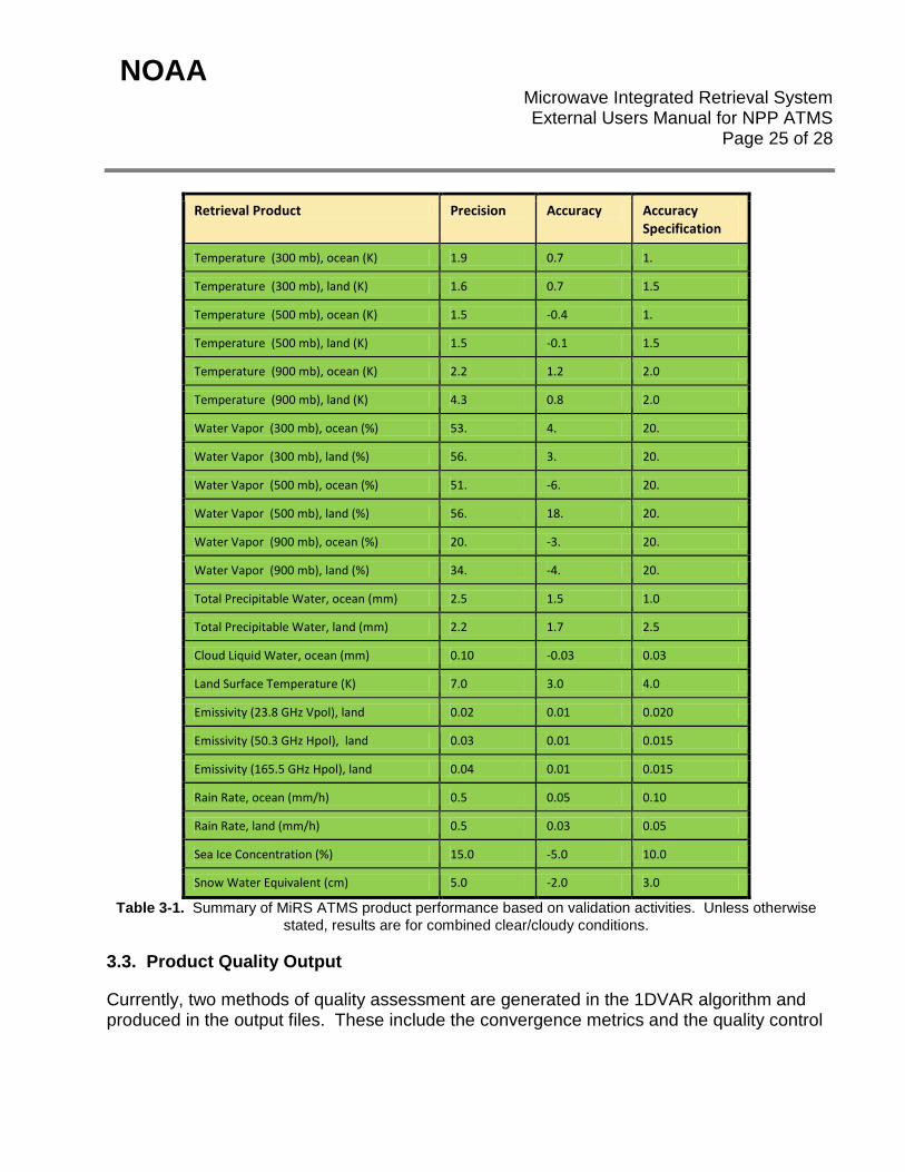
Description of MIRS ATMS post-launch product validation activities were described in the Validation section. Table 2-1 summarizes the MiRS retrieval performance in terms of accuracy and precision for the official products, along with accuracy objectives. For some products (e.g. temperature and water vapor profiles) only selected layers are shown. For certain hydrometeor products (e.g. ice and rain water) a reliable reference data set is not available. However, the performance results for surface rain rate can be considered an indirect measure of the ice and rain water performances since the rain rate is derived directly from these products. Further details and examples of validation results can be found at the official MiRS website http://www.star.nesdis.noaa.gov/smcd/mirs/index.php
NOAA Microwave Integrated Retrieval System
External Users Manual for NPP ATMS Page 25 of 28
Retrieval Product Precision Accuracy Accuracy Specification
Temperature (300 mb), ocean (K) 1.9 0.7 1.
Temperature (300 mb), land (K) 1.6 0.7 1.5
Temperature (500 mb), ocean (K) 1.5 -0.4 1.
Temperature (500 mb), land (K) 1.5 -0.1 1.5
Temperature (900 mb), ocean (K) 2.2 1.2 2.0
Temperature (900 mb), land (K) 4.3 0.8 2.0
Water Vapor (300 mb), ocean (%) 53. 4. 20.
Water Vapor (300 mb), land (%) 56. 3. 20.
Water Vapor (500 mb), ocean (%) 51. -6. 20.
Water Vapor (500 mb), land (%) 56. 18. 20.
Water Vapor (900 mb), ocean (%) 20. -3. 20.
Water Vapor (900 mb), land (%) 34. -4. 20.
Total Precipitable Water, ocean (mm) 2.5 1.5 1.0
Total Precipitable Water, land (mm) 2.2 1.7 2.5
Cloud Liquid Water, ocean (mm) 0.10 -0.03 0.03
Land Surface Temperature (K) 7.0 3.0 4.0
Emissivity (23.8 GHz Vpol), land 0.02 0.01 0.020
Emissivity (50.3 GHz Hpol), land 0.03 0.01 0.015
Emissivity (165.5 GHz Hpol), land 0.04 0.01 0.015
Rain Rate, ocean (mm/h) 0.5 0.05 0.10
Rain Rate, land (mm/h) 0.5 0.03 0.05
Sea Ice Concentration (%) 15.0 -5.0 10.0
Snow Water Equivalent (cm) 5.0 -2.0 3.0
Table 3-1. Summary of MiRS ATMS product performance based on validation activities. Unless otherwise stated, results are for combined clear/cloudy conditions.
3.3. Product Quality Output
Currently, two methods of quality assessment are generated in the 1DVAR algorithm and produced in the output files. These include the convergence metrics and the quality control
NOAA Microwave Integrated Retrieval System
External Users Manual for NPP ATMS Page 26 of 28
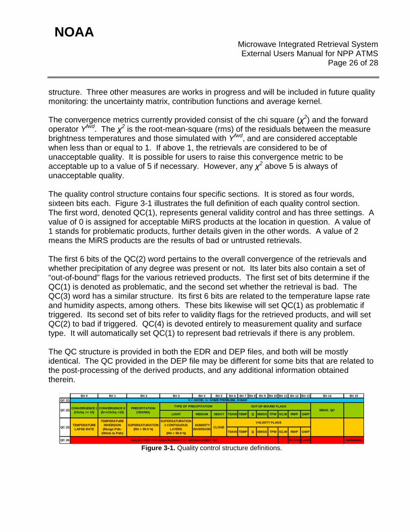
structure. Three other measures are works in progress and will be included in future quality monitoring: the uncertainty matrix, contribution functions and average kernel. The convergence metrics currently provided consist of the chi square (χ2) and the forward operator Yfwd. The χ2 is the root-mean-square (rms) of the residuals between the measure brightness temperatures and those simulated with Yfwd, and are considered acceptable when less than or equal to 1. If above 1, the retrievals are considered to be of unacceptable quality. It is possible for users to raise this convergence metric to be acceptable up to a value of 5 if necessary. However, any χ2 above 5 is always of unacceptable quality. The quality control structure contains four specific sections. It is stored as four words, sixteen bits each. Figure 3-1 illustrates the full definition of each quality control section. The first word, denoted QC(1), represents general validity control and has three settings. A value of 0 is assigned for acceptable MiRS products at the location in question. A value of 1 stands for problematic products, further details given in the other words. A value of 2 means the MiRS products are the results of bad or untrusted retrievals. The first 6 bits of the QC(2) word pertains to the overall convergence of the retrievals and whether precipitation of any degree was present or not. Its later bits also contain a set of “out-of-bound” flags for the various retrieved products. The first set of bits determine if the QC(1) is denoted as problematic, and the second set whether the retrieval is bad. The QC(3) word has a similar structure. Its first 6 bits are related to the temperature lapse rate and humidity aspects, among others. These bits likewise will set QC(1) as problematic if triggered. Its second set of bits refer to validity flags for the retrieved products, and will set QC(2) to bad if triggered. QC(4) is devoted entirely to measurement quality and surface type. It will automatically set QC(1) to represent bad retrievals if there is any problem. The QC structure is provided in both the EDR and DEP files, and both will be mostly identical. The QC provided in the DEP file may be different for some bits that are related to the post-processing of the derived products, and any additional information obtained therein.
Bit 0 Bit 1 Bit 2 Bit 3 Bit 4 Bit 5 Bit 6 Bit 7 Bit 8 Bit 9 Bit 10 Bit 11 Bit 12 Bit 13 Bit 14 Bit 15QC (1)
LIGHT MEDIUM HEAVY TSKIN TEMP Q EMISS TPW ICLW RWP GWP
TSKIN TEMP Q EMISS TPW ICLW RWP GWP
QC (4) OCEAN LAND Calibration
QC (3) TEMPERATURE LAPSE RATE
TEMPERATURE INVERSION
(Range:Psfc-200mb to Psfc)
SUPERSATURATION (RH > 99.9 %)
0 = GOOD, 1= SOME PROBLEM, 2=BAD
QC (2) CONVERGENCE I (ChiSq >= 10)
CONVERGENCE II (5<=ChiSq <10)
PRECIPITATION (YES/NO)
TYPE OF PRECIPITATION OUT-OF-BOUND FLAGSMEAS. QC
ALLOCATED FOR EACH ELEMENT OF MEASUREMENT QC
SUPERSATURATION 3 CONTIGUOUS
LAYERS (RH > 99.9 %)
HUMIDITY INVERSION CLOUD
VALIDITY FLAGS
Figure 3-1. Quality control structure definitions.
NOAA Microwave Integrated Retrieval System
External Users Manual for NPP ATMS Page 27 of 28
3.4. External Product Tools
MiRS data are in netCDF4 format, and can be read and processed with any public available netCDF tools. There no particular tools are provided from the MiRS team. External users can choose their own tools to display and analyze these output files.

NOAA Microwave Integrated Retrieval System
External Users Manual for NPP ATMS Page 28 of 28
4. PRODUCT STATUS
4.1. Operations Documentation
The NDE MiRS is running under the NDE frame work, and operated under “NDE Operations Handbook Version 1.0 (2013)”. OSPO ESPS operation tracks any changes made to the NDE system. The MiRS operational team keeps an Operational Event Log to track any changes made to science, instruments, and the MiRS system at high description level. Detailed changes are tracked under the Configuration Management system. Usual references can be referred to the NDE MiRS System Maintenance Manual, NDE Operations Handbook Version, and NDE MiRS Algorithm Theoretical Basis Document.
4.2. Maintenance History
The NDE MiRS System Maintenance Manual (SMM) will be updated to reflect the changes that will be required to maintain the MiRS system within the ESPC environment. Information regarding the changes to the products is tracked by the Operational Event Log and will be available to users upon request. Product metadata will be updated as per the changes required in the product including the version number, quality flags etc.
END OF DOCUMENT