Exposing the Underground: A Primer on Subsurface ...
2
Florida Engineering SOCIETY JOURNAL • MARCH 2005 20 www.fleng.org Exposing the Underground: A Primer on Subsurface Exploration Techniques BY MARK L. MONGEAU, PE, ARDAMAN & ASSOCIATES, INC Every semester during the first session of the geotechnical design course I teach at the University of Central Florida, I ask the students which specialty area of civil engineering they will pursue as their careers. Most of the students are pretty definite with their choices. However, there are usually a few students each year who tell me that they cannot decide between structural and geotechnical engineering. I find this conundrum amusing. Weighing between these two civil engineering specialties is akin to one deciding between veterinary medicine and taxidermy; after all, both deal with animals. Structural engineers work with materials (steel and concrete) the properties of which are fairly well quantified, conduct precise calculations, and comply with strict codes and standards. However, geotechnical engineers are faced with materials (soil and rock) with vague properties that vary in type and consistency both vertically and horizontally. There are few strict codes, thus, geotechnical engineers are required to exercise a significant amount of judgment and they practice according to a regionally variable and frequently changing standard of care. It’s not that one specialty is better or more rewarding than the other; they are just very different, requiring different mental approaches. Never having practiced as a structural engineer, I will reserve comment on the challenges posed to this specialty. However, I believe I am qualified to describe difficulties faced by geotechnical engineers. Probably the most frustrating aspect of geotechnical practice lies in the inability to accurately describe underground conditions. Simply put, there is a lot of soil and rock beneath a project site, and we just aren’t able to sample enough of the affected volume to get statistically valid results. Consider an analogy. Imagine you are looking at a famous painting, but that the entire painting is covered by a large piece of poster board. Naturally, you cannot identify the picture since it is completely covered from view. Now, imagine someone makes a dozen pinholes in the poster board, and asks that you then identify the painting. Of course, you would still not be able to see enough of the painting to make even an educated guess. Yet, geotechnical engineers are routinely asked to assess underground conditions with even less of a statistical sampling than the pinholes. A prominent developer in Central Florida once said that he didn’t need an exploration by a geotechnical engineer to assess the soil condition on his property. Rather, he would saddle up his Palomino and ride the site from one end to the other. Wherever the horse would balk because of soft ground, the developer would mark that point as the edge of the developable property. With all due respect to the developer and his talented pony, exploring the underground is central to geotechnical engineering practice. The methods used to gain a peek under the ground surface range from the simple to the complex. Let’s take a look at a few (but certainly not all) of these methods. TEST PITS The most direct and simplest way to determine the conditions beneath the surface is to dig a hole and look into it. Digging test pits to evaluate the underground is an effective tool used by both ancient builders and modern engineers alike. The best view of subsurface conditions is obtained by simply looking at it. Test pits, advanced either manually or mechanically, are still frequently used by geotechnical engineers, especially to map the extent of near surface anomalous conditions such as buried organic soils, rubble, trash, or shallow rock features. They afford engineers an effective way to obtain a great deal of information at a low cost. The disadvantages, however, include a very limited depth of exploration and the inability to determine soil properties such as strength, compressibility, and permeability; not to mention that the pit might be dug at the location of a future foundation. SOIL BORINGS Soil borings advanced mechanically by a drilling rig afford the engineer a greater depth of exploration than open pits. Traditionally, hollow or solid stem augers have been widely used to determine the types of soil beneath the ground surface. If water table conditions permit, auger borings can be used to obtain highly disturbed soil samples from depths limited only by the power of the rig and the ability of the soils to maintain an open hole. However, as with the test pits, auger methods do not provide the strength properties important to geotechnical engineers. The Standard Penetration Test (SPT) boring has become the most widely used method of exploring the underground. In Florida, the SPT is used in conjunction with rotary “mud” drilling to obtain disturbed samples of soil from most required depths. This test employs the dynamic force from dropping a weight (the hammer) onto a stem of drilling rods attached to the SPT sampler (a hollow, thick-walled stainless steel cylinder called a “split spoon”). The number of hammer drops (or blows) required to drive the sampler the last 12 inches is referred to as the “blow count” or “N value,” and is a function of the compactness and strength of the soil. This method, therefore, has the advantages of retrieving a reasonable sample from a known depth, while at the same time providing information regarding the relative strength of the soil. Because of the long-term popularity of the SPT, many researchers have developed empirical relationships between the test results (“N value”) and numerous engineering soil properties such as relative density, dry unit weight, modulus of elasticity and friction angle (a measure of strength), to name a few. The major disadvantage with this test is the dynamic nature of the test, which causes the sample Observing soil in a split spoon sampler. Conducting an auger boring.
Transcript of Exposing the Underground: A Primer on Subsurface ...

Florida Engineering SOCIETY JOURNAL • MARCH 200520 www.fleng.org Florida Engineering SOCIETY JOURNAL • MARCH 2005 21www.fleng.org
Exposing the Underground: A Primer on Subsurface Exploration Techniques BY MARK L. MONGEAU, PE, ARDAMAN & ASSOCIATES, INC
Every semester during the first session of the geotechnical design course I teach at the University of Central Florida, I ask the students which specialty area of civil engineering they will pursue as their careers. Most of the students are pretty definite with their choices. However, there are usually a few students each year who tell me that they cannot decide between structural and geotechnical engineering. I find this conundrum amusing. Weighing between these two civil engineering specialties is akin to one deciding between veterinary medicine and taxidermy; after all, both deal with animals.
Structural engineers work with materials (steel and concrete) the properties of which are fairly well quantified, conduct precise calculations, and comply with strict codes and standards. However, geotechnical engineers are faced with materials (soil and rock) with vague properties that vary in type and consistency both vertically and horizontally. There are few strict codes, thus, geotechnical engineers are required to exercise a significant amount of judgment and they practice according to a regionally variable and frequently changing standard of care. It’s not that one specialty is better or more rewarding than the other; they are just very different, requiring different mental approaches.
Never having practiced as a structural engineer, I will reserve comment on the challenges posed to this specialty. However, I believe I am qualified to describe difficulties faced by geotechnical engineers. Probably the most frustrating aspect of geotechnical practice lies in the inability to accurately describe underground conditions. Simply put, there is a lot of soil and rock beneath a project site, and we just aren’t able to sample enough of the affected volume to get statistically valid results. Consider an analogy. Imagine you are looking at a
famous painting, but that the entire painting is covered by a large piece of poster board. Naturally, you cannot identify the picture since it is completely covered from view. Now, imagine someone makes a dozen pinholes in the poster board, and asks that you then identify the painting. Of course, you would still not be able to see enough of the painting to make even an educated guess. Yet, geotechnical engineers are routinely asked to assess underground conditions with even less of a statistical sampling than the pinholes.
A prominent developer in Central Florida once said that he didn’t need an exploration by a geotechnical engineer to assess the soil condition on his property. Rather, he would saddle up his Palomino and ride the site from one end to the other. Wherever the horse would balk because of soft ground, the developer would mark that point as the edge of the developable property. With
all due respect to the developer and his talented pony, exploring the underground is central to geotechnical engineering practice. The methods used to gain a peek under the ground surface range from the simple to the complex. Let’s take a look at a few (but certainly not all) of these methods.
TEST PITSThe most direct and simplest way to determine the conditions beneath the surface is to dig a hole and look into it. Digging test pits to evaluate the underground is an effective tool used by both ancient builders and modern engineers alike. The best view of subsurface conditions is obtained by simply looking at it. Test pits, advanced either manually or mechanically, are still frequently used by geotechnical engineers, especially to map the extent of near surface anomalous conditions such as buried organic soils, rubble, trash, or shallow rock features. They afford engineers an effective way to obtain a great deal of information at a low cost. The disadvantages, however, include a very limited depth of exploration and the inability to determine soil properties such as strength, compressibility, and permeability;
not to mention that the pit might be dug at the location of a future foundation.
SOIL BORINGSSoil borings advanced mechanically by a drilling rig afford the engineer a greater depth of exploration than open pits. Traditionally, hollow or solid stem augers have been widely used to determine the types of soil beneath the ground surface. If water table conditions permit, auger borings can be used to obtain highly disturbed soil samples from depths limited only by the power of the rig and the ability of the soils to maintain an open hole. However, as with the test pits, auger methods do not provide the strength properties important to geotechnical engineers.
The Standard Penetration Test (SPT) boring has become the most widely used method of exploring the underground. In Florida, the SPT is used in conjunction with rotary “mud” drilling to obtain disturbed samples of soil from most required depths. This test employs the dynamic force from dropping a weight (the hammer) onto a stem of drilling rods attached to the SPT sampler (a hollow, thick-walled stainless steel cylinder called a “split spoon”). The number of hammer drops (or blows) required to drive the sampler the last 12 inches is referred to as the “blow count” or “N value,” and is a function of the compactness and strength of the soil. This method, therefore, has the advantages of retrieving a reasonable sample from a known depth, while at the same time providing information regarding the relative strength of the soil. Because of the long-term popularity of the SPT, many researchers have developed empirical relationships between the test results (“N value”) and numerous engineering soil properties such as relative density, dry unit weight, modulus of elasticity and friction angle (a measure of strength), to name a few. The major disadvantage with this test is the dynamic nature of the test, which causes the sample
Observing soil in a split spoon sampler.
Conducting an auger boring.
Florida Engineering SOCIETY JOURNAL • MARCH 200520 www.fleng.org Florida Engineering SOCIETY JOURNAL • MARCH 2005 21www.fleng.org
obtained to be disturbed, and sometimes adversely affects the soil (especially loose or soft soils) during the test, causing less reliable results regarding soil strength.
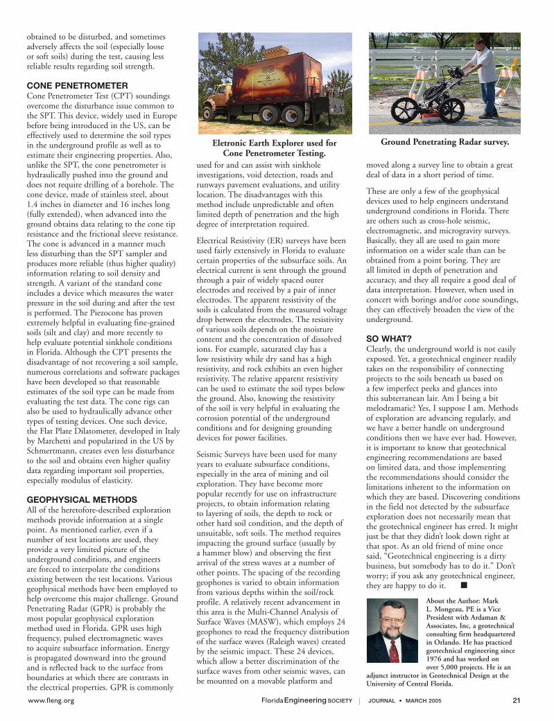
CONE PENETROMETERCone Penetrometer Test (CPT) soundings overcome the disturbance issue common to the SPT. This device, widely used in Europe before being introduced in the US, can be effectively used to determine the soil types in the underground profile as well as to estimate their engineering properties. Also, unlike the SPT, the cone penetrometer is hydraulically pushed into the ground and does not require drilling of a borehole. The cone device, made of stainless steel, about 1.4 inches in diameter and 16 inches long (fully extended), when advanced into the ground obtains data relating to the cone tip resistance and the frictional sleeve resistance. The cone is advanced in a manner much less disturbing than the SPT sampler and produces more reliable (thus higher quality) information relating to soil density and strength. A variant of the standard cone includes a device which measures the water pressure in the soil during and after the test is performed. The Piezocone has proven extremely helpful in evaluating fine-grained soils (silt and clay) and more recently to help evaluate potential sinkhole conditions in Florida. Although the CPT presents the disadvantage of not recovering a soil sample, numerous correlations and software packages have been developed so that reasonable estimates of the soil type can be made from evaluating the test data. The cone rigs can also be used to hydraulically advance other types of testing devices. One such device, the Flat Plate Dilatometer, developed in Italy by Marchetti and popularized in the US by Schmertmann, creates even less disturbance to the soil and obtains even higher quality data regarding important soil properties, especially modulus of elasticity.
GEOPHYSICAL METHODSAll of the heretofore-described exploration methods provide information at a single point. As mentioned earlier, even if a number of test locations are used, they provide a very limited picture of the underground conditions, and engineers are forced to interpolate the conditions existing between the test locations. Various geophysical methods have been employed to help overcome this major challenge. Ground Penetrating Radar (GPR) is probably the most popular geophysical exploration method used in Florida. GPR uses high frequency, pulsed electromagnetic waves to acquire subsurface information. Energy is propagated downward into the ground and is reflected back to the surface from boundaries at which there are contrasts in the electrical properties. GPR is commonly
used for and can assist with sinkhole investigations, void detection, roads and runways pavement evaluations, and utility location. The disadvantages with this method include unpredictable and often limited depth of penetration and the high degree of interpretation required.
Electrical Resistivity (ER) surveys have been used fairly extensively in Florida to evaluate certain properties of the subsurface soils. An electrical current is sent through the ground through a pair of widely spaced outer electrodes and received by a pair of inner electrodes. The apparent resistivity of the soils is calculated from the measured voltage drop between the electrodes. The resistivity of various soils depends on the moisture content and the concentration of dissolved ions. For example, saturated clay has a low resistivity while dry sand has a high resistivity, and rock exhibits an even higher resistivity. The relative apparent resistivity can be used to estimate the soil types below the ground. Also, knowing the resistivity of the soil is very helpful in evaluating the corrosion potential of the underground conditions and for designing grounding devices for power facilities.
Seismic Surveys have been used for many years to evaluate subsurface conditions, especially in the area of mining and oil exploration. They have become more popular recently for use on infrastructure projects, to obtain information relating to layering of soils, the depth to rock or other hard soil condition, and the depth of unsuitable, soft soils. The method requires impacting the ground surface (usually by a hammer blow) and observing the first arrival of the stress waves at a number of other points. The spacing of the recording geophones is varied to obtain information from various depths within the soil/rock profile. A relatively recent advancement in this area is the Multi-Channel Analysis of Surface Waves (MASW), which employs 24 geophones to read the frequency distribution of the surface waves (Raleigh waves) created by the seismic impact. These 24 devices, which allow a better discrimination of the surface waves from other seismic waves, can be mounted on a movable platform and
moved along a survey line to obtain a great deal of data in a short period of time.
These are only a few of the geophysical devices used to help engineers understand underground conditions in Florida. There are others such as cross-hole seismic, electromagnetic, and microgravity surveys. Basically, they all are used to gain more information on a wider scale than can be obtained from a point boring. They are all limited in depth of penetration and accuracy, and they all require a good deal of data interpretation. However, when used in concert with borings and/or cone soundings, they can effectively broaden the view of the underground.
SO WHAT?Clearly, the underground world is not easily exposed. Yet, a geotechnical engineer readily takes on the responsibility of connecting projects to the soils beneath us based on a few imperfect peeks and glances into this subterranean lair. Am I being a bit melodramatic? Yes, I suppose I am. Methods of exploration are advancing regularly, and we have a better handle on underground conditions then we have ever had. However, it is important to know that geotechnical engineering recommendations are based on limited data, and those implementing the recommendations should consider the limitations inherent to the information on which they are based. Discovering conditions in the field not detected by the subsurface exploration does not necessarily mean that the geotechnical engineer has erred. It might just be that they didn’t look down right at that spot. As an old friend of mine once said, “Geotechnical engineering is a dirty business, but somebody has to do it.” Don’t worry; if you ask any geotechnical engineer, they are happy to do it. ■
About the Author: Mark L. Mongeau, PE is a Vice President with Ardaman & Associates, Inc, a geotechnical consulting firm headquartered in Orlando. He has practiced geotechnical engineering since 1976 and has worked on over 5,000 projects. He is an
adjunct instructor in Geotechnical Design at the University of Central Florida.
Eletronic Earth Explorer used for Cone Penetrometer Testing.
Ground Penetrating Radar survey.