Explore Mercury Orbital Data - messenger...
29
1 ACT-REACT Quick Map 12 May 2017 http://www.actgate.com ACT-REACT Quick Map Links to Quick Map can be found at http://messenger.jhuapl.edu/ Explore Mercury Orbital Data Simple, interactive Web interface for Mercury maps is now available to the public! Recent enhancements: Completely new User Interface including 3D navigation! MDIS and MASCS product updates New MLA and MDIS regional DEMs
Transcript of Explore Mercury Orbital Data - messenger...

1ACT-REACT Quick Map 12 May 2017http://www.actgate.com
ACT-REACT Quick Map
Links to Quick Map can be found at http://messenger.jhuapl.edu/
Explore Mercury Orbital Data
Simple, interactive Web interface for Mercury maps is now available to the public!
Recent enhancements:
Completely new User Interface including 3D navigation!
MDIS and MASCS product updatesNew MLA and MDIS regional DEMs

2ACT-REACT Quick Map 12 May 2017http://www.actgate.com
ACT-REACT Quick Map allows users to:
• Navigate Mercury in 3D !
• Locate craters and other named Mercury features
• Explore global mosaics and mini-mosaics of targeted regions. Global mosaics are available for download.
• Explore Mercury topography with elevation profiles and DEM layers
• Locate orbital images within user-defined regions of interest (ROI) and download those images from PDS. Also access spectra and observation meta-data.
Explore Mercury Orbital Data
Links to Quick Map can be found at http://messenger.jhuapl.edu/
All of the MESSENGER data archived at PDS to-date are available at http://pds.nasa.gov

3ACT-REACT Quick Map 12 May 2017http://www.actgate.com
Links to Quick Map can be found at http://messenger.jhuapl.edu/ and http://www.nasa.gov/messenger
Startup view (2D) shows complete MESSENGER Mercury global mosaic created from images acquired during orbital operations.
Quick Map Controls
Zoomin/out
Managelayers
Show coordinates ofmouse pointer and allow
re-centering
Manage projectionsand switch to 3D!
Scale bar
Link to feedbackreport tool
Use arcs and polygonsto query regional data
Use probes toaccess point data
Access image exportand Permalink
Fullscreenmode
Change mapresolution

4ACT-REACT Quick Map 12 May 2017http://www.actgate.com
Quick Map Projections
Click on globe icon to choose between available 2D map projections or 3D mode
Click to display/hideprojection controls

5ACT-REACT Quick Map 12 May 2017http://www.actgate.com
Quick Map Layer Controls
Example of adding a map layer: ‘adding 3-Color High Resolution Northern Hemisphere Map’, from 'MDIS Global Mosaic Campaigns' layers group.
Click on the LayersIcon to display/hide
the control panel
Click name to expand/hidelayer group listing
Click info icon to display/hidelayer controls and description
Check box to displayselected layer on map
Drag to changelayer opacity
6ACT-REACT Quick Map 12 May 2017http://www.actgate.com
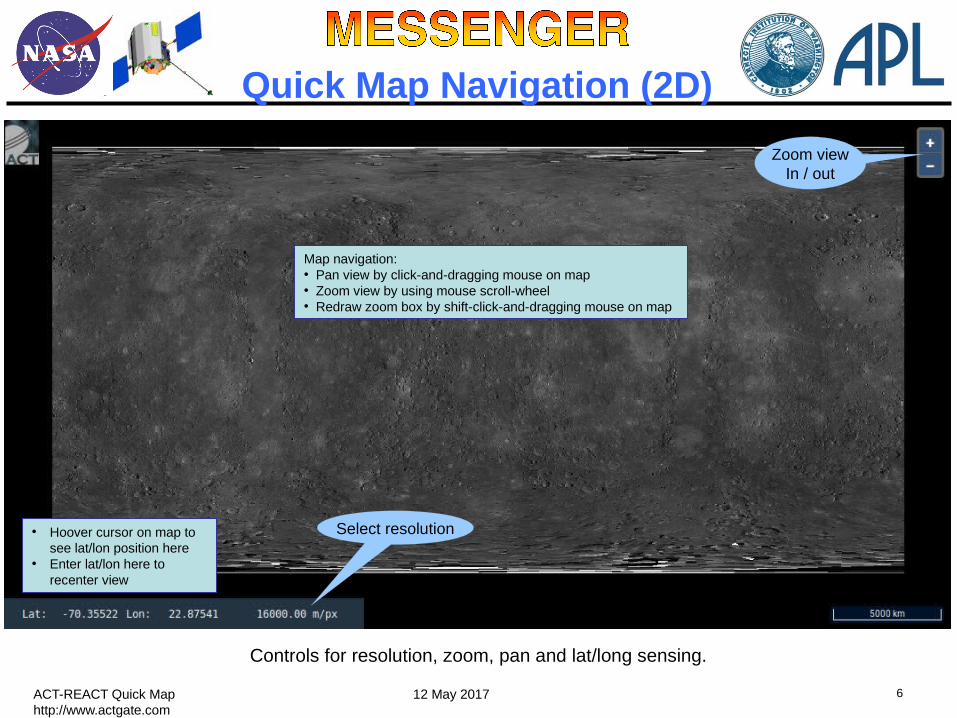
Quick Map Navigation (2D)
Controls for resolution, zoom, pan and lat/long sensing.
• Hoover cursor on map to see lat/lon position here
• Enter lat/lon here to recenter view
Map navigation:• Pan view by click-and-dragging mouse on map• Zoom view by using mouse scroll-wheel• Redraw zoom box by shift-click-and-dragging mouse on map
Select resolution
Zoom viewIn / out

7ACT-REACT Quick Map 12 May 2017http://www.actgate.com
Quick Map Navigation (3D)
Controls for zoom, rotate, camera orientation and lat/long sensing.
• Hoover cursor on map to see lat/lon position here
Globe navigation:• Rotate view by click-and-dragging mouse on globe• Zoom using mouse scroll-wheel• Use mouse middle click+drag to change camera orientation
NavigationShortcuts help
“Fly around”mode on/off
Fly around mode• Click on ‘Fly around’ icon• Double click on a point of interest on globe• See the globe rotating around the selected point• Stop by clicki9ng again on ‘Fly around’ icon
Back toHome view
8ACT-REACT Quick Map 12 May 2017http://www.actgate.com
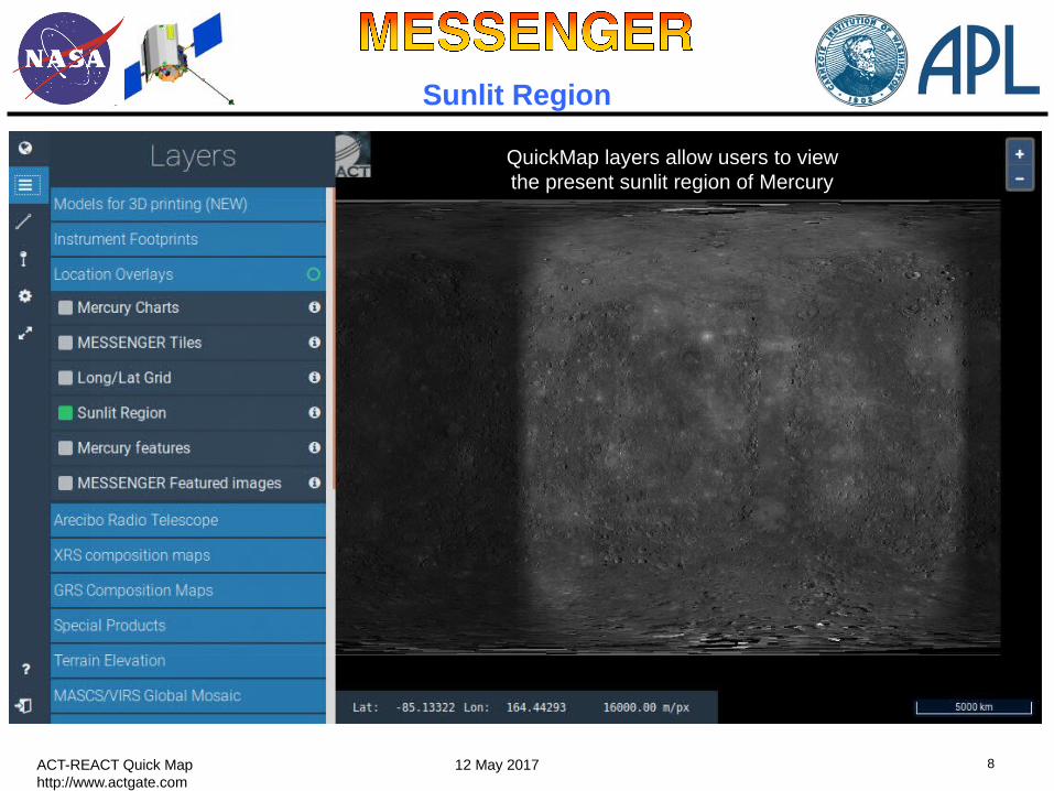
Sunlit Region
QuickMap layers allow users to view the present sunlit region of Mercury

9ACT-REACT Quick Map 12 May 2017http://www.actgate.com
Featured Images from MESSENGER Website
QuickMap allows users to locate and link to the featured images and associated descriptions from the MESSENGER website. Example showing “Revisiting Boccaccio” featured image near Mercury’s south pole.
a.With MESSENGER featured images layer selected (Location Overlays group), click on Search text box.b.Enter full or partial feature name (“revisiting” for this example search, on South Pole view) and click on Find. Results are listed below where you entered search text and marked by orange rings in display. Features are highlighted in yellow as the cursor is hovered over their names in results list.
c.Click on image of interest in results list to navigate to a higher-resolution view.d.Click on the featured image ring to display the image and associated description from the MESSENGER website.
Search for featured images (2D mode):

10ACT-REACT Quick Map 12 May 2017http://www.actgate.com
MASCS/VIRS Global Mosaics
MASCS/VIRS global mosaic layers are now updated to show the latest released data sets.
Monochrome mosaic
Color (Multispectral) mosaic

11ACT-REACT Quick Map 12 May 2017http://www.actgate.com
XRS Composition Maps
Latest global composition maps layers (showing element weight ratios) are available.
Al/Si
Ca/Si
Fe/SiMg/Si
S/Si

12ACT-REACT Quick Map 12 May 2017http://www.actgate.com
WIDE tool sample layer
A sample layer from the WIDE (Water Ice Data Exploration) tool has been included. It shows radar bright patches (in red shades) that are a signature of water ice presence. (Best viewed on the north polar projection)
Link to the WIDE tool

13ACT-REACT Quick Map 12 May 2017http://www.actgate.com
Additional Elevation Models
New Digital Elevation Model products are available: MLA North Polar DEM and four DEM quadrangles from DLR (German Aerospace Agency).
NEW (PDS delivery 16)

14ACT-REACT Quick Map 12 May 2017http://www.actgate.com
MDIS Global Mosaics
MDIS global mosaics are available for download from the MESSENGER website, http://messenger.jhuapl.edu
8 Color Global Map
3 Color High Resolution Northern Hemisphere Map
5 Color High Resolution North Polar Map

15ACT-REACT Quick Map 12 May 2017http://www.actgate.com
East illuminated map
MDIS Global Mosaics
These global mosaics were assembled from images acquired at high solar incidence angles (average >70°), illuminated from the east and from the west, to highlight topography and surface morphology.
Updated global mosaics with high incidence illumination (big shadows)
Sun from East
Sun from WestWest illuminated map
16ACT-REACT Quick Map 12 May 2017http://www.actgate.com
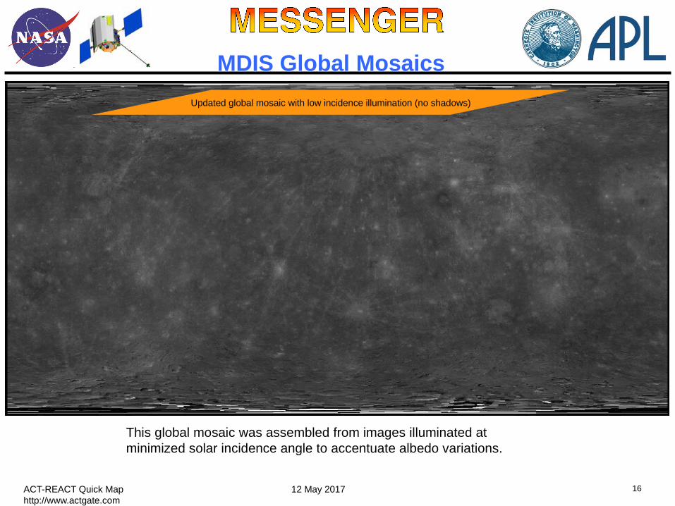
MDIS Global Mosaics
This global mosaic was assembled from images illuminated at minimized solar incidence angle to accentuate albedo variations.
Updated global mosaic with low incidence illumination (no shadows)

17ACT-REACT Quick Map 12 May 2017http://www.actgate.com
Master Target Mosaics
To view mini-mosaics of images satisfying targeted observations, select MDIS Regional Targeted Mosaics (RTM) layers at resolutions of 1000 meters per pixel or higher.

18ACT-REACT Quick Map 12 May 2017http://www.actgate.com
Regional Target Mosaics
Regional mosaics of enhanced observations pointed at special regions of scientific interest, like features for which higher-resolution morphological or multispectral imaging or denser spectral sampling could help in geological characterization, hypothesis testing or creating context for other MLA and MASCS observations.
Monochrome example 3-color example
8-color example 11-color example
19ACT-REACT Quick Map 12 May 2017http://www.actgate.com
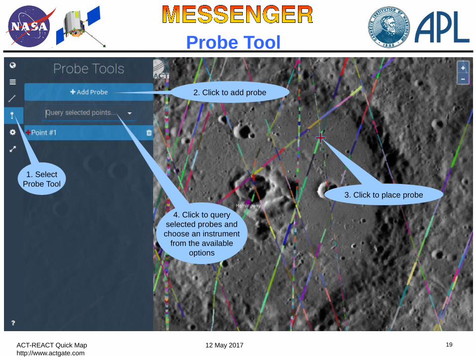
Probe Tool
1. SelectProbe Tool
2. Click to add probe
4. Click to queryselected probes andchoose an instrument
from the availableoptions
3. Click to place probe

20ACT-REACT Quick Map 12 May 2017http://www.actgate.com
Probe Tool: accessing spectra
MASCS/VIRS multispectral plotsMDIS multispectral plots

21ACT-REACT Quick Map 12 May 2017http://www.actgate.com
Enhanced Path Tool
Example use of path tool to measure geodetic distance across crater Tung Yuan on Mercury. The geodetic distance (path shown in blue) is measured over the surface of Mercury.
Supports geodetic distance
measuring
1. SelectQuery Tools
3.Click to start drawing path
5. Measured distance
4. Double-click to end drawing
2. SelectArc Tool

22ACT-REACT Quick Map 12 May 2017http://www.actgate.com
Enhanced Path Tool
6. Clicking on ‘Query Feature’and MESSENGER DEM modelsprovides terrain elevation plots
for the selected path
Note: Available fornorthern hemisphere
(MLA data) and globallyusing the USGStopographic map

23ACT-REACT Quick Map 12 May 2017http://www.actgate.com
3D Live/Printing ToolAccess regional 3D views
Visualization Options
This tool enablesinteractive exploration by
manipulating a 3-D model of portions of Mercury surface
1. Open Query Tools2. Click Polygon icon3. Draw a polygon around area of interest4. Select ‘Query Feature’ / 3D Live View5. Click link on next pop-up dialog to access 3D visualization/printing tool
Note: Available globally using the USGS topographic map
Creation ofmodels for3D printing
1 2
34

24ACT-REACT Quick Map 12 May 2017http://www.actgate.com
Quick Map Permalink Sharing
Using Quick Map Permalink to save view region.
1. Click on Settings button
2. Copy and use the provided URLas a way to capture the current map view
A shortenedversion of the Permalinkis available after clicking
this button

25ACT-REACT Quick Map 12 May 2017http://www.actgate.com
The feature name databaseupdates automatically when new feature
names are approved by the IAU !
Mercury Features Layer
Example view of larger features among over 400 International Astronomical Union (IAU) approved named Mercury features. Smaller features are displayed in higher resolution views. Close features are clustered when zoomed out. Features names are displayed at 500 m/pixel or higher resolution. See next slides for feature searches and higher resolution example.
Quickly view and locate named Mercury features
Check Mercuryfeatures layer
Click info iconfor key to color coding
of features by type
Increase resolution toview feature names and
smaller features

26ACT-REACT Quick Map 12 May 2017http://www.actgate.com
Mercury Feature Searches
Example Mercury feature search yields features with names containing search text “mo” – shown in results list on left and with orange rings on map display. Hovering the cursor over a feature in the results list highlights that feature in yellow on map display. Clicking on Mozart in the Search Results list navigates to higher resolution view of that crater – see next slide.
a.With Mercury features layer selected, click on Search text box.b.Enter full or partial feature name (“mo” for this example search) and hit Enter. Results are listed below where you entered search text and marked by orange rings in display. Features are highlighted in yellow as the cursor is hovered over their names in results list.
c.Click on feature of interest in resulting list to navigate to a higher-resolution view of that feature.
Search for named Mercury features:

27ACT-REACT Quick Map 12 May 2017http://www.actgate.com
Navigating Mercury Features
High-resolution view of Mercury Mozart crater navigated to via Quick Map Mercury feature search (as described on previous slide). Clicking on feature provides IAU information shown.

28ACT-REACT Quick Map 12 May 2017http://www.actgate.com
Polygon (ROI) Searches
Example search for images in user-defined region of interest (ROI). Links are provided to download images from PDS. Users can also search for targets and MASCS/VIRS observations in an ROI.
1. Enable Polygon tool
a.Draw ROI polygon by click-and-dragging mouse on map; end drawing by double-clicking.b.Click on the ‘Query Feature’ / MDIS Mosaic Imagesc.Search Results window will appear, listing requested results in ROI. Search can be iterated on same ROI for 750-nm mosaic images, all NAC images, and all WAC images.d.Links in search results: rightmost links enable image file download from PDS. Leftmost links indicate PDS image filenames which when clicked provide additional image meta-data.
2. Search for images in ROI
Now includes images from PDS delivery 16
3. Download Images from PDS
Image filenames at PDS
Links to download images from PDS

29ACT-REACT Quick Map 12 May 2017http://www.actgate.com
Quick Map BrowsersACT-REACT Quick Map can be used with all the major browsers
As of May 12, 2017 it has been tested on the latest version of each of the following browsers/devices:
FirefoxSafariGoogle ChromeEdgeMobile Browsers: iOS and Android web browsers
Browser settings: Javascript enabled