Exploratory Excavations at Fort Hawkins, Macon, Georgia ...
54
University of South Carolina Scholar Commons Research Manuscript Series Archaeology and Anthropology, South Carolina Institute of 10-1971 Exploratory Excavations at Fort Hawkins, Macon, Georgia: An Early Nineteenth Century Military Outpost Richard F. Carrillo Follow this and additional works at: hps://scholarcommons.sc.edu/archanth_books Part of the Anthropology Commons is Book is brought to you by the Archaeology and Anthropology, South Carolina Institute of at Scholar Commons. It has been accepted for inclusion in Research Manuscript Series by an authorized administrator of Scholar Commons. For more information, please contact [email protected]. Recommended Citation Carrillo, Richard F., "Exploratory Excavations at Fort Hawkins, Macon, Georgia: An Early Nineteenth Century Military Outpost" (1971). Research Manuscript Series. 13. hps://scholarcommons.sc.edu/archanth_books/13
Transcript of Exploratory Excavations at Fort Hawkins, Macon, Georgia ...
University of South CarolinaScholar Commons
Research Manuscript Series Archaeology and Anthropology, South CarolinaInstitute of
10-1971
Exploratory Excavations at Fort Hawkins, Macon,Georgia: An Early Nineteenth Century MilitaryOutpostRichard F. Carrillo
Follow this and additional works at: https://scholarcommons.sc.edu/archanth_books
Part of the Anthropology Commons
This Book is brought to you by the Archaeology and Anthropology, South Carolina Institute of at Scholar Commons. It has been accepted for inclusionin Research Manuscript Series by an authorized administrator of Scholar Commons. For more information, please contact [email protected].
Recommended CitationCarrillo, Richard F., "Exploratory Excavations at Fort Hawkins, Macon, Georgia: An Early Nineteenth Century Military Outpost"(1971). Research Manuscript Series. 13.https://scholarcommons.sc.edu/archanth_books/13
Exploratory Excavations at Fort Hawkins, Macon, Georgia: An EarlyNineteenth Century Military Outpost
KeywordsExcavations, Macon, Georgia, Archeology
DisciplinesAnthropology
PublisherThe South Carolina Institute of Archeology and Anthropology--University of South Carolina
CommentsIn USC online Library catalog at: http://www.sc.edu/library/
This book is available at Scholar Commons: https://scholarcommons.sc.edu/archanth_books/13

EXPLORATORY EXCAVATIONS AT FORT HAWKINS, MACON, GEORGIA:AN EARLY NINETEENTH CENTURY MILITARY OUTPOST
by
Richard F. Carrillo
4F14
Prepared by theInstitute of Archeology and Anthropology
University of South CarolinaOctober, 1971
TABLE OF CONTENTS
INTRODUCTION•••
ACKNOWLEDGEMENTS.
HISTORICAL BACKGROUND •
DESCRIPTION OF FORT HAWKINS SITE. .
ARCHEOLOGY OF FORT HAWKINS - 1936 •
INTERPRETATION OF 1936 EXCAVATIONS.
ARCHEOLOGY OF FORT HAWKINS - 1971 •
The East Palisade. •
The South Palisade
The West Palisade. •
INTERPRETATION OF ARCHEOLOGICAL DATA. •
The East Palisade.
The South Palisade
The West Palisade. •
EAST, SOUTH, AND WEST PALISADE COMPARISONS••
ARTIFACT DISCUSSION
SUMMARY • • • • •
RECOMMENDATIONS
PROPOSED ARCHEOLOGICAL BUDGET EXPLANATION
PROPOSED BUDGET FOR MAJOR ARCHEOLOGICAL INVESTIGATIONS OF FORTHA.WKINS • • • • • • • • • • • • • • • • • • • • • • •• •
BIBLIOGRAPHY.
ii
Page
· 1
· 4
• • • • • 6
• • 7
· 9
. . . .13
.15
.15
.20
••• 29
· .30
· .32
.34
. . . . . .36
.37
· .38
· .41
• • • • • •-41
. . . . .43
· .44
· .45

FIGURE
1-
2.
3.
4.
5. & 6.
7.
8.
9.
10.
11.
12.
13.
14.
15.
16.
17.
18.
19.
20.
LIST OF FIGURES
Archeological Plan of Fort Hawkins Excavations
Sketch of Fort Hawkins by E. I. Irvine
View of Reconstructed Blockhouse
1936 Excavations by Gordon R. Willey
1936 Excavations by Gordon R. Willey
1936 Excavations by Gordon R. Willey
Excavations as Seen From Top of Reconstructed SoutheastBlockhouse
Willey's map of 1936 Excavations
Willey's map of 1936 Excavations
Palisade Ditch and Posts in Unit 17
Palisade Ditch and Posts in Unit 17 After Drying
Palisade Ditch and Post Mold in Unit 4
Profile of Brick Floor and Fill in Unit 13 (A&B)
Profile of East Wall of Unit 14
Brick Floor and Foundation in Unit 6 (Feature 8)
Ceramics. from Unit 6 (Feature 8) and Unit 13B
Brick Floor in Unit 13B
End of Palisade Ditch in Unit 25
Artifacts From General Excavations of Fort Hawkins
iii
Page
Jacket
8
10
10
11
12
12
16
17
19
19
21
22
23
24
26
27
27
38

INTRODUCTION
Fort Hawkins was established in 1806 as a frontier military fort
by the United States Army to deal with the Indians and was abandoned in
1821 (Butler 1879:59-60 and Dollar MS). The area where this fort was
located is a historic site of local, state, and national significance.
The absence of firm historical documentation with which to establish a
definite plan or sketch of Fort Hawkins made it impossible to complete
the information necessary to establish this fort on the list of the National
Register of Historic Sites.
In November, 1970, a study was initiated by the Institute of Community
and Area Development, University of Georgia, for which Stanley South,
Archeologist with the Institute of Archeology and Anthropology, University
of South Carolina, acted as consultant. Mr. South was asked to submit a
proposed plan for archeological investigation of Fort Hawkins. The study
was conducted at the request of Dr. Louis De Vorsey, Assistant Professor
of Geography, University of Georgia, who, being an historical geographer,
has conducted detailed historical research on Fort Hawkins, and Mr. John
Waters, Assistant Professor of Environmental Design, and Project Director.
The study revealed that no building plans or sketches had ever been
found which could substantiate the exact dimensions of this structure.
Therefore, it was proposed that a two-week archeological investigation be
conducted that would essentially determine the original dimensions of the
fort, heretofore unknown, except by descriptions which tended to vary
between four (Bryan MS) and fourteen acres (Butler 1879:60). The archeo
logical work was proposed to; (1) Expose the palisade ditch and trace its
1

extent as nearly as possible, (2) locate the northwest blockhouse ruin,
and (3) determine the overall configuration of the fort.
The nature of the archeological investigation would be essentially
architectural in design. The palisade ditch would be revealed, in its
existing locations, specifically through archeological techniques. Any
important features located such as wells, cellarholes, refuse pits, in
terior structures, etc. would be mapped, but not excavated.
On the basis of the information gathered from such an exploratory
excavation, plans could be formulated as to whether or not a major archeo
logical investigation would be feasible or desirable. This would enable
information to be gathered regarding intramural structures and associated
features which would add to, and further enhance, the historic interpreta
tion of this important early nineteenth century site.
In August 1971 plans were made with the writer to begin archeological
investigations. One and a half days were spent in consultation with Mr.
Stanley South and Dr. Robert L. Stephenson, Director, Institute of Archeology
and Anthropology, University of South Carolina, Columbia, who were acting
as advisors for the project.
Upon arrival in Macon, Georgia, two days were spent arranging the
logistics for the project. This initial work was done in conjunction with
Mr. C. R. Rader, Chairman of the Fort Hawkins Commission, and coordinator
of the project.
The project was funded by the Bibb County Commission. The City of
Macon co-operated by supplying vital equipment and supplies, and perform
ins services necessary to the archeological project.
2

The actual excavation was conducted from August 16 to August 27 with
a crew of six men. The time from August 30 to September 30 was spent at
the Institute of Archeology and Anthropology, University of South Carolina,
assisted by staff members of the Institute, analyzing the excavated material
and preparing this report.
The proposed goals of the two-week investigation were achieved, mainly
locating the palisade ditch and tracing its extent as nearly as possible.
This was accomplished along three sides; the east, south, and west sides
of the fortified area. The north palisade wall and the northwest block
house were destroyed when Woolfolk Street was constructed. From the infor
mation retrieved, it can be stated that the architectural dimensions of
Fort Hawkins were definitely smaller than had previously been assumed.
Other unexpected features were found while searching for the palisade
ditch which shed more light on the significance of the nineteenth century
structure. The relationship of these architectural features is discussed
in further detail within the archeological section.
The plan showing the area of archeological research (Figure 1) is con
tained in an envelope in the back cover of this report and all references
are made to this within the archeological section.
3
ACKNOWLEDGEMENTS
The Fort Hawkins archeological project could not have taken place
had it not been for a few devoted persons who were willing to give of
their valuable time and effort to put forth their abilities thereby en
abling the project to get off the ground.
Initial thanks go to Mr. John Waters, Assistant Professor, School of
Environmental Design and Dr. Louis De Vorsey, Chairman of the Department
of Geography, both of the University of Georgia, and responsible for initia
ting the project. Special thanks are extended to Dr. De Vorsey for pro
viding information regarding research he had made, the photographs of the
1936 excavations (originals or negatives on file at the Southeast Archeo
logical Research Center, Macon, Georgia), and for making himself available
for assistance.
Thanks are extended to the citizens of Macon" who were always ready
to put forth to make the outcome of the project successful, especially
those affiliated with the Macon city government, from Mayor Ronnie Thompson's
office on down. Special thanks is extended to Mr. C. R. Rader, Chairman of
the Fort Hawkins Commission and Project Coordinator, for taking time from
his busy schedule whenever his services were required, and to Mr. John McKay,
member of the Fort Hawkins Commission, who has for years concerned himself
with the history of Macon and maintains a special interest in Fort Hawkins.
I wish to express my gratitude to the personnel of the National Park
Service's Southeast Archeological Research Center and Ocmu1gee National
Monument, Mr. Bernard Berg of the Monument who provided me with historical
data and photographs of the original blockhouse, and Mr. Richard Faust,
Chief, Archeological Research, who offered the use of the Research Center
facilities and made equipment available for our use. I am deeply grateful
4

to Mr. Jack Walker, Archeologist, who took time to come to the site every
day making himself available to provide technical assistance.
Finally, I would like to express my sincere thanks to Dr. Robert L.
Stephenson, Dr. John D. Combes, Assistant Director, and the rest of the
staff of the Institute of Archeology and Anthropology for providing the
manpower and facilities necessary for completion of this report. Special
thanks are extended to Mr. Stanley South, the highly knowledgeable archeol
ogist, who guided me from the initial stages of the project through the
completion of this report.
5
HISTORICAL BACKGROUND
The historical research for Fort Hawkins has been extensively done
by Dr. De Vorsey and will continue. This research was called upon to
aid in the archeological excavations, but need not be detailed in this
report as it will appear in a larger report of future work on the site.
For the present purposes only a brief historical description of the site
that pertains directly to the archeology is presented here.
Fort Hawkins was built by the United States Army in 1806 to serve as
a trading center, and a place where negotiations could be conducted with
the Creek Indians. It was named for Benjamin Hawkins, a former North
Carolina senator, who was the then Indian Affairs Agent and the person
most instrumental in conducting relations between the government and Creek
Indians during the first quarter of the nineteenth century (Butler 1859:59-
60). By 1821, the military and trading functions for which the fort had
been constructed were ended and it was closed by the army. The fort con-
tinued to be occupied as a settlement which eventually led to the present
day city of Macon (Butler 1879:77-78).
The fort was described, a half century after its abandonment by the
army, as follows:
One hundred acres of ground were, for many years,reserved for the uses of the fort. The fortifications consisted of two large block houses, surroundedby a strong stockade. The stockade was built of postsof hewn timber, fourteen feet long, and fourteen inchesthick; they were sunk in the ground four feet, withport holes for a musket in every alternate post. Thearea within the stockade was fourteen acres. Therewere four long houses, one in the centre of each sideof the stockade, their front forming part of· thestockade to the width of each house, about 20 feet.These houses were used for soldiers' quarters, provisions, and for the factory goods to be sold to the
6
Indians, and peltries received in return. In thecentre surrounded by oaks, were the officers'quarters (Butler 1879:60).
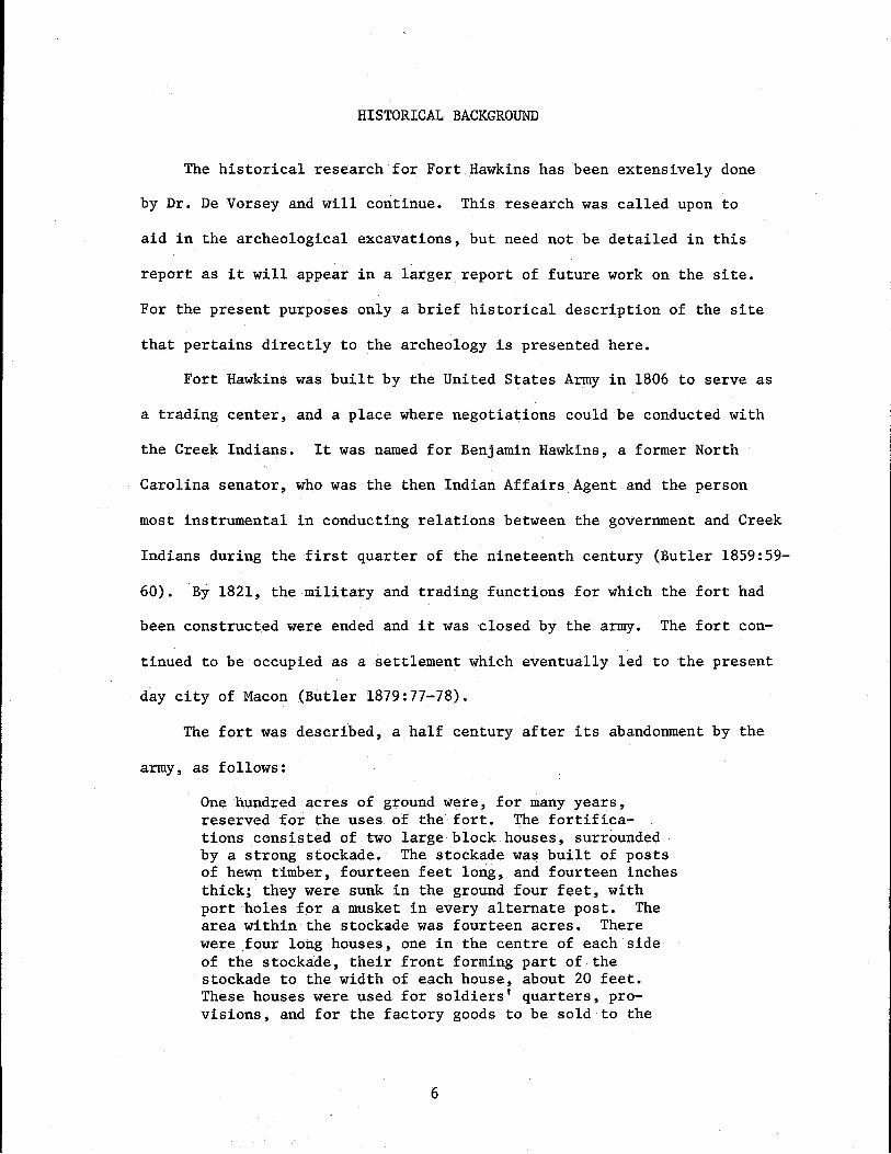
The above description by John C. Butler and a sketch drawn by E.D.
Irvine (Figure 2; taken from a sketch in Butler's Historical Record of
Macon and Central Georgia, page 61) indicate that Fort Hawkins consisted
of a stockaded fort enclosing 14 acres with two blockhouses located at
opposite ends. Inside there were four buildings built in the center of
each of the four walls which served as integral portions of the stockade
and were approximately 20 feet in width. Located in the central area of
the stockade was a building used as the officers' quarters.
DESCRIPTION OF THE FORT HAWKINS SITE
Fort Hawkins elementary school is presently located on the site where
Fort Hawkins once stood. This area consists of the northern half of a
city block (437 feet square) which is owned almost entirely by the Bibb
County Board of Education. The present streets bordering the block are;
Woolfolk Street on the north, Fort Hill Street on the west, Maynard Street
on the east, and on the south Emery Highway.
The northern half of the block constitutes the crest of a high hill
which is flat probably as a result of grading for the playground. A brick
retaining wall is situated along the north and east sides of the block en-
compassing the northeast quarter. Fill was apparently removed from the
center (of the playground) and deposited around the edges of the hill to
level the playground. It appears that along the crest of the hill, on the
south side, there has been considerable filling over the years. Along the
north and west sides, there appears to have been a natural dropoff, now
broken by street cuts.
7
I
00
FIGURE 2
Sketch of Fort Hawkins drawn by E. I. Irvine, Macon, Georgia. (Taken from Butler 1879:60).
IL _

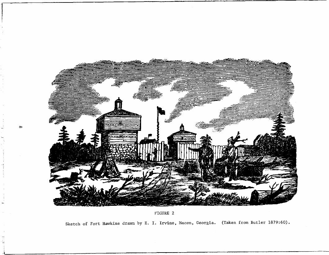
Situated at the crest of the hill at the southeast corner of the Fort
Hawkins schoolyard is a large, imposing, reconstructed concrete blockhouse
(Figure 3). Surrounded by a chain link fence 60 feet square the concrete
blockhouse was built in 1936-37 by the Nathaniel Macon Chapter of the
Daughters of the American Revolution through the Works Progress Adminis
tration and was supposedly reconstructed on the location where the original
southeast blockhouse once stood (South MSa).
ARCHEOLOGY AT THE FORT HAWKINS SITE - 1936
In 1936, while work was progressing on the reconstruction of the south
east blockhouse, a series of archeological tests were conducted to determine
whether the blockhouse was being built on the original site and to locate
the stockade (Figures 4, 5, 6, 7).
A two-week investigation was carried out by Gordon R. Willey who was
at that time working on the major archeological project being conducted at
Ocmulgee National Monument.
The excavation consisted of a series of trenches dug perpendicular
to (the direction of) the palisade ditch. The results of the excavation
indicated that the reconstructed blockhouse was located on the original
site and a row of partially decomposed palisade posts was found projecting
from the north and west sides of the blockhouse.
It was found that the palisade extended 105 feet from the blockhouse
along the east side before it suddenly ended. It was relocated ten feet
farther north, where it continued for 20 more feet before it was interrupted
once more by a 20 foot gap with the wall, once again, continuing on the
other side (Willey MS).
9
FIGURE 3 FIGURE 4
Reconstructed southeast blockhouse.View to the east.
1936 excavations:south palisade.
View of excavation along

FIGURE 5
1936 excavation: Posts along south palisadeprojectory from west side of blockhouse.
FIGURE 6
1936 excavation: Posts and profile and palisadeditch. View unknown.

FIGURE 7
Reconstructed basement of blockhouse and excavation. View to the southeast.
FIGURE 8
Slot trenches along east palisade as seen from top story of southeastblockhouse.
12
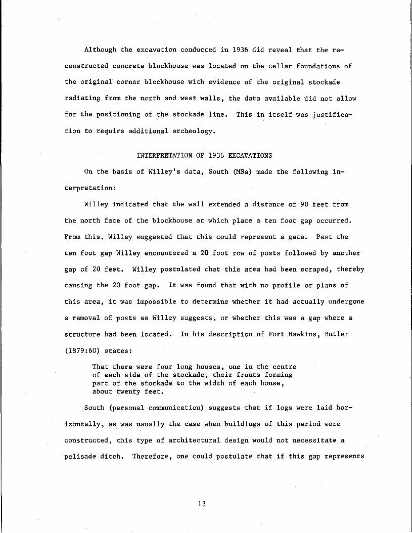
Although the excavation conducted in 1936 did reveal that the re-
constructed concrete blockhouse was located on the cellar foundations of
the original corner blockhouse with evidence of the original stockade
radiating from the north and west walls, the data available did not allow
for the positioning of the stockade line. This in itself was justifica-
tion to require additional archeology.
INTERPRETATION OF 1936 EXCAVATIONS
On the basis of Willey's data, South (MSa) made the following in-
terpretation:
Willey indicated that the wall extended a distance of 90 feet from
the north face of the blockhouse at which place a ten foot gap occurred.
From this, Willey suggested that this could represent a gate. Past the
ten foot gap Willey encountered a 20 foot row of posts followed by another
gap of 20 feet. Willey postulated that this area had been scraped, thereby
causing the 20 foot gap. It was found that with no profile or plans of
this area, it was impossible to determine whether it had actually undergone
a removal of posts as Willey suggests, or whether this was a gap where a
structure had been located. In his description of Fort Hawkins, Butler
(1879:60) states:
That there were four long houses, one in the centreof each side of the stockade, their fronts formingpart of the stockade to the width of each house,about twenty feet.
South (personal communication) suggests that if logs were laid hor-
izontally, as was usually the case when buildings of this period were
constructed, this type of architectural design would not necessitate a
palisade ditch. Therefore, one could postulate that if this gap represents
13

the section of the structure which was incorporated into the palisade
wall, an equal distance, to that between the blockhouse and the center of
the gap (120 feet) north would probably locate the northeast corner of
the stockade. The distance of 240 feet from the blockhouse would situate
the northeast corner of the palisade wall in the area where Woolfolk Street
is presently located.
Therefore, by the interpretation of Willey's data, and the topography
of the land, South conjectured that the fort would have been 240 feet square,
or slightly over an acre in size, provided that it was square. Although
the hypothesis did not correlate with Butler's description that the stock
ade encompassed an area of 14 acres, nor with Bryan's interpretation that
it had been four acres in size, it did conform with the terrain. Thus,
South stated that the area where Fort Hawkins school now stands is located
in the original stockaded area of Fort Hawkins.
South further indicates that if the interpretation of four acres is
adhered to, the north wall of the fort would have extended north over the
crest of the hill two hundred feet past Woolfolk Street. Defensively, this
would have been unwise. Also an area of only 20 feet would have been uti
lized as a storage shed, soldiers' quarters, etc., in the center of a wall
430 feet in length. This would have caused the fort to be considerably
out of proportion in relation to the existing interior structures, and
would not conform to the specifications of other forts that used such in
terior structures as part of the palisade wall. Another important factor
that should be considered is that a musket would be far more efficient at
a range of 240 feet than at 430 feet (South MSa).
Thus additional archeological excavation was required to, hopefully,
14

answer the questions raised by the 1936 excavations and to clearly delineate
the outlines of the fort.
ARCHEOLOGY OF FORT HAWKINS - 1971
The present archeological investigation was conducted using methods
similar to those used by Willey in 1936 and referred to as slot trenching.
By use of this method, instead of completely exposing an area, in this
case a palisade ditch, slots are excavated at right angles to the presumed
location of the palisade wall (Figure 8). This method does not require
than an entire structure be excavated, as the palisade ditch is located in
a series of archeological units, and the wall may be conjectured to exist
in the area not excavated between the units. This, of course, does not
usually allow for finding evidence of gates, and other possible existing
features in the wall, unless accidently excavated. Therefore, parallel
slots sometimes must be connected by excavating a trench along the con
jectured area of the palisade ditch between the slot trenches, thereby
exposing features that would not otherwise be located.
The initial excavations were begun along the areas north and west
of the reconstructed southeast blockhouse since these were the locations
where Willey had found evidence of the palisade ditch and posts.
The East Palisade
Along the east side of the fortified area, posts and a palisade ditch
eight-tenths of a foot wide, were detected at a depth of one foot from the
surface in initial excavation Units 2 and 3 located 44 feet and 66 feet,
respectively, from the north side of the reconstructed blockhouse. In Unit
7, 94 feet from the blockhouse, a four foot gap was encountered in the
15
palisade ditch. When this measurement is compared to Willey's map (Figure
9), this gap lies at approximately the same place where Willey dug a trench
in 1936. Aside from the gap, no other evidence of disturbance was able to
be detected. Willey's map indicates a measurement from the south wall of
the trench to be 91 feet from the blockhouse in contrast to the present
distance of 94 feet. When comparisons are made between the 1936 and the
1971 measurements a consistent discrepancy of three to four feet is seen
on Willey's map. This may be due to misinterpretation of the measurements.
Also some measurements do not correspond within the text of Willey's report
and the map.
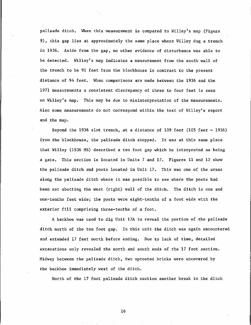
Beyond the 1936 slot trench, at a distance of 109 feet (105 feet - 1936)
from the blockhouse, the palisade ditch stopped. .It was at this same place
that Willey (1936 MS) described a ten foot gap which he interpreted as being
a gate. This section is located in Units 7 and 17. Figures 11 and 12 show
the palisade ditch and posts located in Unit 17. This was one of the areas
along the palisade ditch where it was possible to see where the posts had
been set abutting the west (right) wall of the ditch. The ditch is one and
one-tenths feet wide; the posts were eight-tenths of a foot wide with the
exterior fill comprising three-tenths of a foot.
A backhoe was used to dig Unit l7A to reveal the portion of the palisade
ditch north of the ten foot gap. In this unit the ditch was again encountered
and extended 17 feet north before ending. Due to lack of time, detailed
excavations only revealed the north and south ends of the 17 foot section.
Midway between the palisade ditch, two uprooted bricks were uncovered by
the backhoe immediately west of the ditch.
North of the 17 foot palisade ditch section another break in the ditch
16
are due our gratitude for taking the steps they did, for if they had
not, the site of Fort Hawkins may well have been totally lost to urban
Macon. For a city to have lost the memory of its nucleus in such a
manner would be as unfortunate as if the Creeks had forgotten that the
spirit of their nation lay in the mounds of Ocmulgee. Fort Hawkins
could become a shrine for Macon as refreshing and productive of reflec
tion as that monument to the Indian at Ocmulgee. We hope that Macon
will not fail to take advantage of the opportunity that offers itself
at this time, for to delay another decade will likely spell the end of
Fort Hawkins, and only a faded memory will remain.
17

,.
Upon this line of direction .. ~
cut:'! \·:<..~re mp0.e.<l.Crofl.S J'o[!..d cap,100' r.orth of offset 36. Tde.,' t'ldo ,.OCK:1.ne '.'!as no P1C \:€': up . I.)/j!
hEore; p.lthouc..1-t it. il'l. possible.i~ liasdestroyed ,'\S from 28 to. 36".
, . .
\~H;j
•) <0•;•,),,
.j9,(J,,
~
. ,FIGURE 9
·1
•· "',:•,,>I ,:.I·r1.M:
·L:"--.l,•'. l.,
. ," . !
· 'r.: ,...;))\1
<,·,•,•,,
q~K', ~~ .
.,
. I
.: \!\--\"' 'Ji a.\1\ \( \~j
!1,:t L.L"L'e bt 'I hl l2>b
.,).. , •\, \\\ '0III G'''il,~ \\1 l t; I
Si ~C\,,-",-'l12'J
•
.T17
.'
~
ft'O==~I.~'R::\=iI.tR='=:::'!~=":"=:~~'O::R=~=:,.=a;;,="=::"O:;U='==I~'O::,';J=3=':::::':~i]
PRJ~ p.;
T1-,. ,
,.s ,,-~\"'e.. :10 1:0 I'.U 11lL.\--.
s'tO../;qpo: f''Os.7'sSVF?o~ep L../,';j'e .~rslO<.It·~pec. CJ 7s
•
-., .

, '
"
, ' ,
, '
. .,
"
. FIGURE 10
~\'~ . •
- "
.1, 'J\\\;~S L'l--ClI..\] G..l \\)~~
~J6C\ L.\..~5 e... 01' 4f....'\.oh~
" tl, c.o<li>O" ~H\c::\~ ,
0. '
,( ?-.!)
, .."
, '
. ..,.
" ,
,
, ,
,
~ .... ':;,Dd: D.Oe.rUt.l~ll~ell L,Il,/e ~?S.iQd\.a.l)t.
~l.lb\t>h ..d.HJQ;. L\r..ie..s,:Co. oJ "'tL
.., .
•, I
•
,
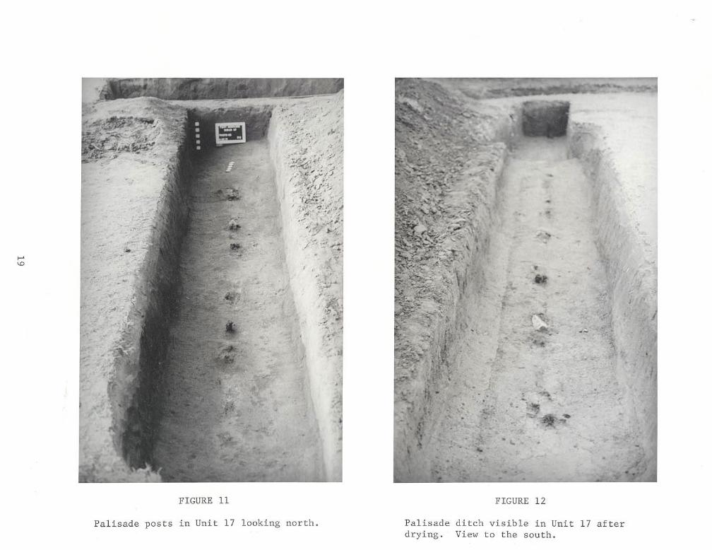
FIGURE 11
-.......,,.'-'.
./ -•
FIGURE 12
Palisade posts in Unit 17 looking north. Palisadedrying.
ditch visible in UnitView to the south.
17 after
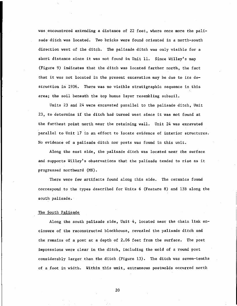
was encountered extending a distance of 22 feet, where once more the pali
sade ditch was located. Two bricks were found oriented in a north-south
direction west of the ditch. The palisade ditch was only visible for a
short distance since it was not found in Unit 11. Since Willey's map
(Figure 9) indicates that the ditch was located farther north, the fact
that it was not located in the present excavation may be due to its de
struction in 1936. There was no visible stratigraphic sequence in this
area; the soil beneath the top humus layer resembling subsoil.
Units 23 and 24 were excavated parallel to the palisade ditch, Unit
23, to determine if the ditch had turned west since it was not found at
the furthest point north near the retaining wall. Unit 24 was excavated
parallel to Unit 17 in an effort to locate evidence of interior structures.
No evidence of a palisade ditch nor posts was found in this unit.
Along the east side, the palisade ditch was located near the surface
and supports Willey's observations that the palisade tended to rise as it
progressed northward (MS).
There were few artifacts found along this side. The ceramics found
correspond to the types described for Units 6 (Feature 8) and l3B along the
south palisade.
The South Palisade
Along the south palisade side, Unit 4, located near the chain link en
closure of the reconstructed blockhouse, revealed the palisade ditch and
the remains of a post at a depth of 2.06 feet from the surface. The post
impressions were clear in the ditch, including the mold of a round post
considerably larger than the ditch (Figure 13). The ditch was seven-tenths
of a foot in width. Within this unit, extraneous postmolds occurred north
20
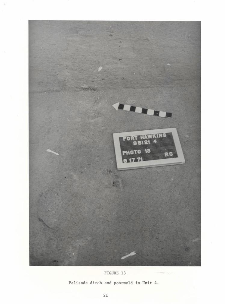
FIGURE 13
Palisade ditch and postmold in Unit 4.
21
of the ditch (interior portion of stockade). The postmolds located in this
unit tended to be very soft and after a rainstorm, some collapsed.
In Unit 6, excavated a distance of 57 feet from the west wall of the
blockhouse, a brick floor and foundation (Feature 8) were found at a depth
of one and one-tenths feet below the surface protruding from the north and
west walls of the unit (Figure 16). The bricks were not mortared and ap
peared to be bonded with clay. The bricks comprising this floor were set
with the lengths oriented in a north-south direction. At the north half
of the east edge of this fragment of the floor, the foundation two layers
high, was located. The basic style of construction appears to be English
bond. This style consists of the use of a row of headers, alternating with
two or more rows of stretchers, and was a bond used in the nineteenth cen
tury (South, personal communication).
A number of artifacts were recovered in the vicinity of the brick floor
and wall consisting mainly of ceramics. Ceramics when found in such a con
text, and as in Unit l3B, can serve as an aid in determining the date of an
architectural feature. These ceramics, mainly English, comprise types which
have a general time span from ca. 1780 to ca. 1835 (South, personal communi
cation). The types of ceramic sherds found in Unit 6 (Feature 8) consist
basically of types referred to as creamware and pearlware (Figure 17).
Creamware is a ceramic type that was produced by Josiah Wedgwood ca.
1759 and underwent varying evolutionary stages until its extinction in the
early 1800's (Noel Hume 1970:126). The style of creamware found in the con
text of Feature 8 was probably produced after ca. 1785 based on its lighter
coloration. A rim sherd can be dated prior to 1783 when only plain rims
were produced and which are found in late eighteenth and early nineteenth
22

G N
o .5' 1.0'I I J
SCALEFORT HAWKINS
(98121)
SOIL PROFILE
EAST FACE-TRENCH 13 (A a 8l
,
I TOPSOIL (LIGHT BROWN)
II HUMUS (GRAYISH BROWN)
ill CLAY FILL (REDDISH ORANGE)
III DISTURBED CLAY FILL (ORANGE BROWN)
1l BRICK LAYER 8 RUBBLE (RED)
'iII SUBSOIL (RED)
23 FIGURE 14
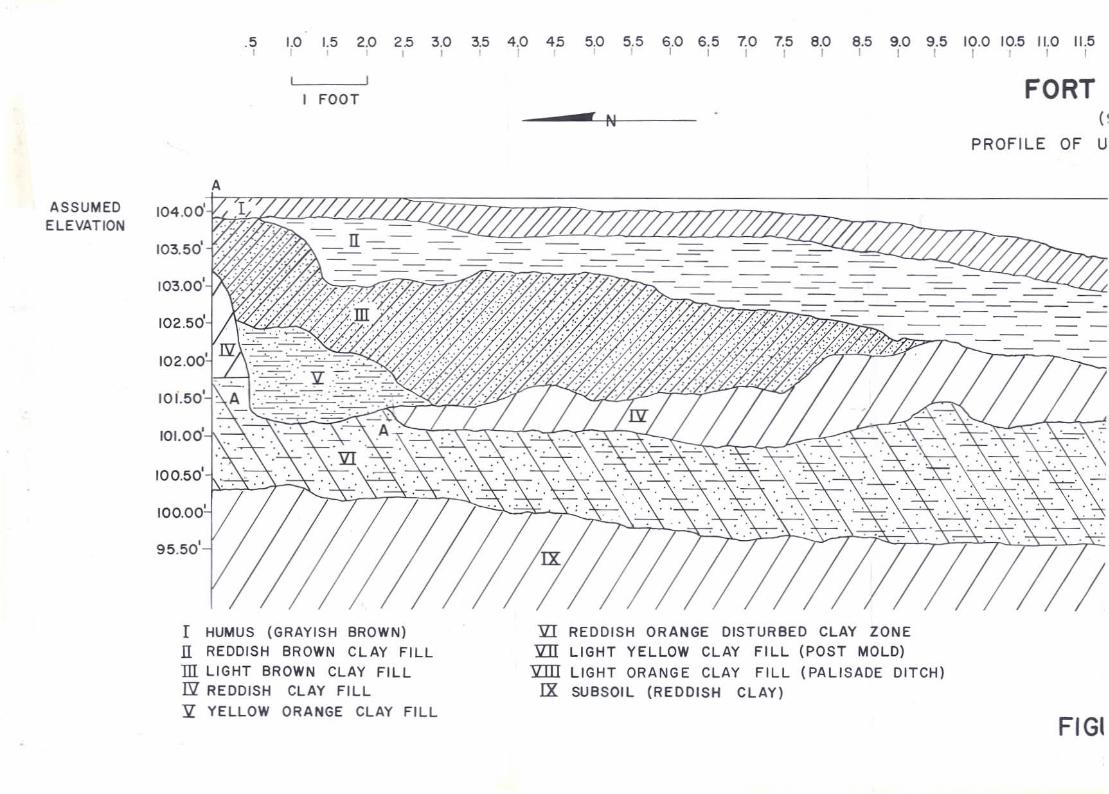
.5 1.0 1.5 2.0 25 3.0 3.5 4.0 45 5.0 5.5 6.0 6.5 7.0 7.5 8.0 8.5 9.0 9.5 10.0 10.5 11.0 11.5, , , , , , I , , , , I I I I I I I I I I I
FORTFOOTr N ( ~
PROFILE OF U
A
ASSUMED 104.00' 1/ELEVATION
103.50'
103.00'
102.50'
102.00'
101.50'
101.00'
100.50'
100.00'
95.50'
I HUMUS (GRAYISH 8ROWN)II REDDISH 8ROWN CLAY FILLill LIGHT 8ROWN CLAY FILLN REDDISH CLAY FILL
Jl YELLOW ORANGE CLAY FILL
JlI REDDISH ORANGE DISTUR8ED CLAY ZONEJlII LIGHT YELLOW CLAY FILL (POST MOLD)
JlIII LIGHT ORANGE CLAY FILL (PALISADE DITCH)IX SUBSOIL (REDDISH CLAY)
FIGI
12.0 12.5 13.0 13.5 14.0 14.5 15.0 15.5 16.0 [6.5 1"10 1"1:5 18.0 18.5 19.0 19.5 20.0 20.5 21.0 21.5 22.0 22.5 23.0 23.5 24.0I r I I I I I I I I I I r I I I I 1 1 I I I I I 1
HAWKINS8121)
IT 14 (A) - EAST FACE
I- -:B
SURFACEUNEXCAVATEO
AREA
,,,,,,,,
14 (B)-PALISADE DITCH
a POST MOLD IN WALL PROFILE
RE 154

.'
•
FIGURE 16
Brick floor and foundation in Unit 6 (Feature 8).
25
•
. -..

Unit 6
Unit 13B
FIGURE 17
CERAMICS FROM UNIT 6 (Feature 8) AND UNIT 13B.
a. Blue transfer printed pear1ware ca.1787-1820.b. Green edged pearlware ca.1785-1795.c. Plain edged creamware ca.1790-1800.
d. Blue transfer printed pear1ware ca.1787-1820.e. Blue painted pear1ware ca.1779-1810.f. Blue edged pear1ware ca.1785-1795.g. Mocha Ware ca.1795-1850.h. Polychrome hand painted pear1ware ca.1815-1835.i. Blue willow "transfer printed" pear1ware ca.1792-1820's.j. Blue underg1aze pear1ware,ca.1815-1835.k. Parian Ware ca.1840+1. Green edged pear1ware ca.1785-1795.

century contexts (Noel Hume 1970:126).
The majority of the ceramics constitute a type which is classified as
pearlware. This type was also made by Josiah Wedgwood about 1779 and lasted
through ca. 1820. Some forms continued to be made until ca. 1835. Pearl
ware can be recognized by a bluish coloring appearing in foot-ring crevices
and around handles (Noel Hume 1970:128-29).
Evidence of later disturbance in Unit 6 is indicated by a modern .22
calibre short cartridge which was found south of, and below, the brick floor.
According to Willey's map (Figure 10), a trench was excavated in this loca
tion in 1936 which may help explain the cartridge case. As was the case
along the east palisade, evidence of a recent disturbance was not detected.
In Unit 13, located 105 feet from the blockhouse, another brick floor
(Feature 13B) was located at a depth of 2.80 feet from the surface (Figures
14 and 18). It was evfdencethat this feature was not directly associated
with Feature 8 (Unit 6), located 48 feet to the east, since Unit 9 had been
excavated between Unit 6 and 13 and no features were found. This floor was
made up of a double layer of bricks laid in no apparent pattern. The bottom
section was intact except for the south edge, but most of the upper portion
had been disturbed, and some bricks removed. A considerable number of arti
facts, consisting mainly of ceramics, were recovered from the top of the
brick rubble and floor.
As with Unit 6 (Feature 8) the ceramic types comprise a time span from
ca. 1779 to ca. 1835. The most abundant type is pearlware. The pearlware
and other ceramic types found in Unit 13B represent a time span between ca.
1779 through ca. 1820. These dates compliment other data in associating
this brick floor with the period of 1806-1821 (Figure 17).
26

a
d
b
e
c
f
,,,,- ,,,,,,,,,,\:,,\..
"C~~;~,:···V .~ ",.. .
g h
•J
,-
k I
FIGURE 1727
One ceramic.type recovered from this level is known as Parian ware.
It is a porcelain which was not glazed when fired, or perhaps given a
slight "smear" glaze which gave it the dull appearance of polished marble.
It was originally produced for making figurines in the early 1840's (Ramsay
1961:81). Since this ceramic type constitutes a later date than the above,
possibilities exist for later intrusion.
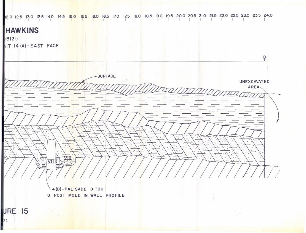
Within Unit 13, as with Unit 6, the palisade ditch was not found. The
palisade trench was found in Unit 14 adjacent to Unit 13 at a depth of 3.5
feet below the surface (Figure 15). As illustrated in Figure 15, consid
erable filling has occurred in this area.
The palisade ditch was again located along the south side of the area
in Unit 25 at a depth of 4.50 feet below the surface. This unit was ex
cavated with a backhoe and considerable amounts of charcoal were found in
the ditch, suggesting that the posts had been burned. Unit 25 revealed
that the palisade ditch ended at this location suggesting a gap for a gate
or some other feature, conceivably a structure somewhat suggestive of an
other blockhouse (Figure 19).
Two other trenches were excavated west of Unit 25, one with the backhoe,
but no trace of a ditch was revealed.
Machinery was used the last three days to accomplish the goals set out
for the project. A backhoe was used since considerable time had been ex
pended along the south side due to the depth of the palisade ditch. It was
necessary to try and follow the south palisade wall toward the west until
it turned north or otherwise ended before work could commence along the
west side.
28
The West Palisade
Excavations proceeded along the hedge parallel to Fort Hill Street.
As seen in Figure 1 most of the units along the west palisade side were
excavated by use of the backhoe.
The initial excavation, Unit 27, revealed a large, charred postmold
at 1.0 feet below the surface. Protruding from it toward the south and
northwest, was a feature resembling a narrow palisade ditch. Further
trenching north of this unit did not produce any further feature evidence,
except in Unit 29 which revealed a postmold in the south profile.
As excavations proceeded toward the north, south of the school side
walk, Unit 31 at 1.0 feet below the surface revealed considerable amounts
of brick and pieces of partially rotted wood. Plaster fragments were re
covered from this unit with a whitewash finish indicating that the walls
in this structure had been plastered and whitewashed. The feature encom
passed the entire length of the trench.
North of the school sidewalk, Unit 32 was excavated beginning near
the west 4edge and continuing east with the soil profile consisting of
subsoil beneath the topsoil and humus horizon. Approximately 30 feet from
the schoolhouse, a large, heavily burned, round postmold was found at 1.4
feet from the surface.
From this location, units were excavated north and south with some
units producing evidence of a palisade ditch. Sections of a palisade ditch
were found in Units 32, 34, 34A, and 37.
Along this side the ditch was not as well defined as along the south
and east sides, with no evidence of posts occurring within the ditch. All
occurrences of the palisade ditch were at a depth of 1.0 feet or less with
29

the exception of Unit 37 where the ditch was found at a depth of 4.0 feet
from the surface. At this depth it was not well defined, and the stratig
raphy indicated considerable disturbance above. The palisade ditch seemed
to occur sporadically along the west side. Its nearness to the surface
may be the reason for it not occurring in all the units.
In Units 22 and 40 a ditch was located which was slightly wider than
the palisade ditch in the other units. Also it appeared to be slightly
offset to the west of the palisade ditch. This may represent the east wall
of an exterior structure. This same ditch was found in Unit 42, a vertical
cut in the bank south of Woolfolk Street. The soil profile revealed that
the ditch extended in the direction of the street. The ditch was situated
1.40 feet from the surface and was 1.40 feet in height.
The artifacts recovered from the units along the west side constitute
mainly ceramics such as were recovered along the south and east sides, in
cluding window and bottle glass fragments, iron nails, and bone. Since
this area was excavated with a backhoe, no specific proveniences can be
given the artifacts recovered except to assign them to their primary units.
INTERPRETATION OF ARCHEOLOGICAL DATA
The main result of the 1971 archeological investigation is that the
east-west dimensions of Fort Hawkins are now known. It will no longer be
necessary for persons involved in historical research to interpret the size
of the structure merely by ambiguous data. It has been definitely ascer
tained that the size of Fort Hawkins is 290 feet from the east wall to the
west wall. However, the question still remains as to whether the fort was
actually square in plan or not. This information was impossible to retrieve
since the northern wall of the palisade had been destroyed. Due to this it
30
is impossible to present the complete plan incorporating the actual dimen-
sions of Fort Hawkins.
Destruction of archeological sites occurs constantly whether acciden-
tally, maliciously or as a result of the normal progress of civilization.
Therefore, it becomes necessary to derive as much information as possible
from archeological investigations. This knowledge, together with historical
documentation, can sometimes lead to a solution to a problem which might
otherwise remain unsolved.
Through the combined use of archeology and historic documents it was
possible, in this instance, to clearly identify some major dimensions of
Fort Hawkins and, by inference, conjecture the other dimensions. We there-
fore have, with some assurance, the complete plan of the fort.
The distance between the east and west wall is 290 feet (Figure 1).
The distance between the north wall of the southeast blockhouse and the
center of the 22 foot gap is 148 feet. This figure when doubled results
in a conjectured dimension of 296 feet for the east palisade. The fact that
the assumed north-south dimension coincides closely with that of the known
east-west dimension is evidence that the 22 foot gap represents one of the
areas mentioned in the historic account:
There were four long houses, one in the centreof each stockade to the width of each house,about twenty feet (Butler 1879:60).
The west palisade was extended a distance of 296 feet north to cor-
respond with the assumed length of the east palisade. The conjectured
north wall was extended from the northeast corner west for 290 feet. The
northwest corner was thus formed by the intersection of the west wall, and
the conjectured north wall. A line was then extended diagonally in align-
ment with the northwest and southeast corners of the southeast blockhouse
31
toward the conjectured northwest fort corner. This line intersected the
presumed northwest corner. A conjecture of the northwest blockhouse was
possible by projecting equal measurements obtained from the center of the
southeast blockhouse.
The data presented in the above discussion provides us with substantial
evidence indicating that Fort Hawkins did comprise a square configuration.
Plans similar to that of Fort Hawkins were used in the construction
of both military and civilian forts of the period and extending into later
times. Some examples are Fort Okanogan, built in 1811, by the Pacific Fur
Company in the state of Washington, utilizing a square palisade wall with
two blockhouses at opposite corners (Grabert 1968); Fort Spokane, built in
1812, also operated by the Pacific Fur Company, using a similar plan (Combes
1964); and Fort William, predecessor to Fort Laramie in Wyoming, built in
1834 and constructed on a similar plan as the above forts (Heib 1954).
Information is scarce regarding military forts constructed approximately
the same time as Fort Hawkins for the southeastern part of the United States.
An excavation is in progress at Fort Mitchell, Russell County, Alabama.
Fort Mitchell was a military post contemporary with Fort Hawkins. Once this
project is completed, it may be possible to determine its size and relation
ship to Fort Hawkins.
The East Palisade
Aside from the 22 foot gap along the east side, the ten foot gap is
another feature which must be interpreted. Willey (1936 MS) concluded that
the gap was a gate. The sketch drawn by E. D. Irvine (Figure 2) indicates
a gate along a palisade to the right of a blockhouse. It cannot be ascer
tained which blockhouse is represented in the sketch, but if one can assume
32
that it is the southeast blockhouse, then a gate in this area would explain
the gap along the east palisade. A further assumption can be made that even
if this is not the southeast blockhouse represented in the sketch, a gate
would have existed along two, and possibly all four palisade walls of the
fort.
The palisade ditch was evident along the east side for a distance of
150 feet from the southeast blockhouse. Remains of posts are still in
evidence, although not complete. The posts, and postmo1ds were square,
lending support to the historic account which states that:
The stockade was built of posts of hewn timber fourteenfeet long and fourteen inches thick (Butler 1879:60).
Although the posts were square, they were not fourteen inches thick.
Measurements taken of the posts indicate that they varied between six and
eight-tenths of a foot in width in most cases. Willey (1936 MS) states
that the posts were eight inches wide. Figure 12 shows the palisade ditch
and post outline observed in Unit 17. The ditch is 1.1 feet wide with
posts encompassing an area of eight tenths feet and the remainder taken up
by fill. The posts abutted against the west side of the ditch and the ditch
was filled along the exterior side.
Samples of wood comprising the palisade were not taken. Willey (1936 MS)
states that the wood used was pine. It seems reasonable that a coniferous
species would have been used in making wooden posts 18 feet in length.
The palisade tends to angle slightly toward a westerly direction as can
be seen in Figure 1. The south and west walls angle in comparable directions
giving the fort a slight parallelogram shape. Willey (1936 MS) indicates
that the east wall angled west at a rate of 23 inches (approx. 1.9 feet)
every 40 feet.
33
The bricks found along the palisade ditch may comprise portions of
structures which were destroyed. The palisade ditch along this side is a
foot or less in depth. The 1936 excavation showed that posts and the pali
sade ditch along this side were located close to the surface, and seemed
to rise as the ditch progressed northward.
The South Palisade
The 1936 excavation did not extend west very far from the blockhouse
along this side, however, Willey (1936 MS) states that he found posts and
a palisade ditch at two and one half feet (2.5 feet) below the surface.
The present excavation revealed the palisade ditch in three units, 4, 14,
and 25. In Unit 4 the ditch was located below two feet of fill, in Unit 14
over three and a half feet, and in Unit 25 the ditch was below four feet of
fill.
During the 1936 excavation a brick foundation was found which Willey
attributed to the post-Civil War period, based on the fact that brick was
present. The brick structural remains found in the present excavations
are presumed to be the same as, or related to, the structure found by Willey.
Evidence gathered during the present excavation by elevation comparisons
and ceramic analysis found in the context of the brick floor in Unit l3B,
and Unit 6 (Feature 8) indicates that these structures were associated with
the fort during its period of occupation by the military, and afterward.
The structures may represent a kitchen or a mess area. No evidence of the
palisade ditch was found in Units 6 and 13 presumably because the palisade
walls were incorporated into the stockade. The southern edges of the foun
dation of both Feature 8 and l3B were not intact. Willey's map (Figure 10)
shows that posts were located 57 to 67 feet from the blockhouse. This area
34

FIGURE 18
Brick floor in Unit 13B.

encompasses the location where the present Unit 6 was excavated. This may
explain the disturbed brick floor and also the cartridge case.
The palisade ditch found in Unit 25 corresponds closely in elevation
to the ones obtained in the preceding units. The ditch ends abruptly which
suggests that a structure may have been associated with the wall at this
location. The wall did not turn north to form a corner, and is approximately
15 feet east of where the southwest corner was conjectured to be located. A
gate would not seem feasible situated so near to a corner, therefore, a
structure such as a blockhouse may be conjectured for this corner until an
accurate assessment can be made.
The West Palisade
The excavations along the west side of the palisade were mainly con
structed with the use of a backhoe. Results of these excavations indicate
that considerable disturbance has occurred in this area. The palisade ditch
was located near the surface. In only one unit, 37, was the ditch found to
be about four feet from the surface, and at this depth it was not easily
recognizable.
In all of the locations where the ditch was found along this side,
considerable burning had occurred.
The rubble-fill in Unit 31 located 70 feet west of the palisade ditch
possibly represents a structure which was located outside the confines of
the stockade. This was not an uncommon practice.
The wide ditch located near the north portion of the schoolyard, ex
tending northward into Woolfolk Street, can be interpreted as a possible
builders' trench dug after the fort ceased to function as a military complex.
This interpretation is based on the nearness of the structural remains to the
36
west palisade. A structure located so close to the wall would have made
musket or rifle fire ineffective for defending the west wall from the
northwest blockhouse.
As has been stressed throughout the context of this report, the answers
to the above questions raised by the limited exploratory archeology will
only be determined by further archeology.
COMPARISONS BETWEEN THE EAST, SOUTH, AND WEST PALISADES
The ditch, comprising the east and west palisade remains, occurred
near the surface, while the south palisade ditch was found beneath two
and a half and four feet of fill (Figures 14 and 15). The reason for this
is that disturbance, grading or otherwise, has occurred over the past 35
years, and earlier, in the schoolyard which is probably the reason that
no evidence of the ditch was found near the north retaining wall. Also,
along the west palisade side, considerable disturbance has occurred which
may explain why the palisade ditch was not consistently located. The fill
removed from the east and west palisade areas has been used to fill the
area along the location of the south palisade.
Present elevations taken from the top of the palisade ditch along the
east and south sides reveal that the south palisade was three feet lower.
It is possible that in historic times the south palisade was lower than
the east palisade due to differences in the topography. Defensively, this
would not have caused any great concern since there are no topographic fea
tures near the south section of the hill upon which the fort was situated
which are at a higher elevation.
The feature found along the west palisade side in Unit 31 comprising
brick rubble and rotten wood may represent a structure associated with the
37

fort during 1806-1821. If this structure was present during the period of
military occupation, it would tend to verify Irvine's sketch (Figure 2)
which depicts a high three-story structure in the background. Furthermore,
this would then also identify the blockhouse in the left forefront as the
southeast blockhouse, and the gate would represent the ten foot gap located
along the east palisade ditch.
ARTIFACT DISCUSSION
The artifacts recovered during the course of the excavation consisted
mainly of ceramic fragments, a~though quantities of glass, both bottle and
window were found, as well as iron nails and bone (Figure 20).
Of the above, ceramic sherds probably represent the most important
items in helping to date an archeological site. Ceramics, as everything
else, undergo typological and stylistic changes through time, brought about
by social preferences, conditions, etc. Dating may be accomplished by
utilizing historical records which may indicate that a certain potter or
factory in England produced a certain type and style of pottery at a par
ticular period of time. The above factors can be combined to arrive at
dates which can be very close to the actual dates for the beginning and
abandoning of a site. This can be extremely useful when dates are not
known for a specific archeological site.
The dates for the military occupation of Fort Hawkins are documented
as 1806-1821. Information is scarce relating to the post-182l occupation,
although historical accounts (Butler 1879:77-78) indicate that it was oc
cupied and from this settlement the city of Macon was founded.
The ceramic dates for Fort Hawkins based on sherds found in controlled
archeological contexts range between ca. l779-ca. 1835 (Noel Hume 1970:126
32; and South, personal communication). The ceramic time span overlaps the
38
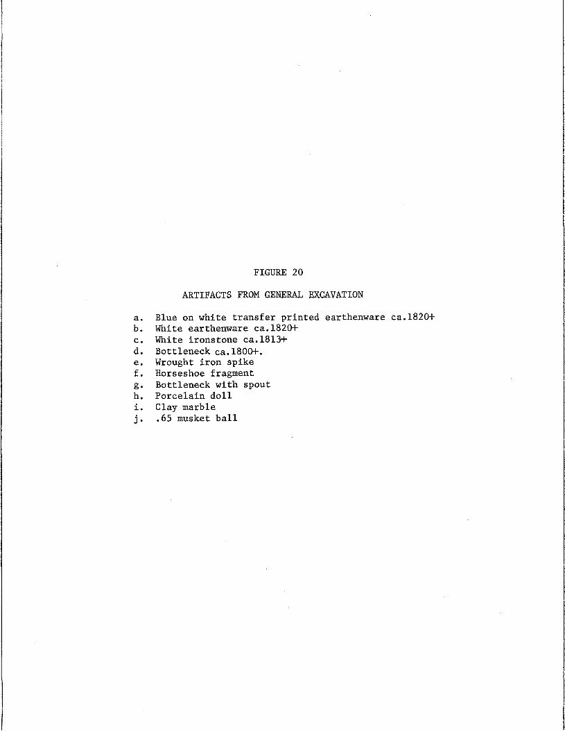
FIGURE 20
ARTIFACTS FROM GENERAL EXCAVATION
a. Blue on white transfer printed earthenware ca.1820+b. White earthenware ca.1820+c. White ironstone ca.1813+d. Bottleneck ca.1800+.e. Wrought iron spikef. Horseshoe fragmentg. Bottleneck with spouth. Porcelain dolli. Clay marblej. .65 musket ball
a b
df
• •g h •
I•J
FIGURE 20
39
military occupation by several years in either direction, but certain factors
must be considered. The date ca. 1779 represents the date when a specialized
type or style of ceramic was initially manufactured, but may have an ending
date of ca. 1810 which would correspond with the military occupation of Fort
Hawkins. All of the ceramic types found at Fort Hawkins and taken from.
known associated architectural features, regardless of their initial manu
facturing date, fall within the 1806 through 1821 range.
A ceramic analysis was conducted on ceramic types found in a context
certain to be associated with Fort Hawkins during 1806-1821, using a method
developed by Stanley South, Archeologist, Institute of Archeology and Anthro
pology, University of South Carolina (South MSb). The ceramics were typed,
based on specific established criteria, and dated accordingly. Quantities
were derived for each specific sherd type and a mean date was ascertained
based on beginning and ending manufacture dates. With the use of mathe
matical calculations a mean date of 1808.12 was derived. This date may
seem somewhat early, since theoretically the mean date should fall around
1815, however, South (1971 MSb) has indicated a plus or minus factor of three
years for the dates derived using his formula. Thus a date of 1808.12 plus
three years is quite close to the known historical median date for the site.
If a major excavation is executed, a larger sample of ceramics will be de
rived which could possibly exact a median date closer to 1815. One impor
tant aspect which must not be overlooked, however, is that the mean date
1808.13 ~three years was derived solely on dating the ceramic content and
does fall within the 1806-1821 range.
The above discussion is just one example of the technical skills which
are being developed by archeologists in the field of historical archeology
40
to serve as tools in a continuing effort to derive as much information as
possible from the past by utilizing archeological material to its fullest
extent.
SUMMARY
The exploratory archeological investigations conducted by use of slot
trenching, located the length of the south wall and demonstrated it to be
290 feet in length. Portions of the palisade ditch were revealed by slots
along the east and west walls. The east palisade was found to be 148 feet
from the north wall of the southeast blockhouse to a presumed mid-point and
was conjectured to extend to a length of 296 feet. The west palisade was
conjectured to be a length of 296 feet based on the information derived from
the east palisade. The north wall is clearly shown to be in Woolfolk Street
but may be assumed to be as long as the south wall or 290 feet.
The above dimensions (Figure 1) clearly outline the fort, suggest block
house locations and indicate locations of other structures. The area which
the fort encompasses is not 14 acres, or even four acres but appears instead
to be approximately one and one-half acres.
RECOMMENDATIONS
Although the dimensions of the area encompassed by Fort Hawkins are
now known, the research should not stop there. There are still several
questions which must be answered. The purpose which this project has ac
complished, has acted as a springboard from which further plans can now
be formulated which will serve toward the final development of the site.
If the final product is a reconstructed fort, then it can be said that this
final product was a result of the use made of the tools of history and
41

archeology which helped bring to life an architectural complex capable of
rivaling the original structure in its accuracy and splendor.
For the final product to be as architecturally correct as the original
fort, further archeological research will have to be conducted to answer
questions which were not answered in the limited two-week operation. Further-
more, additional questions were brought into the open as a result of the
excavation. Such questions as:
(1) What is the exact relationship of the brick floorsalong the south palisade to the fort?
(2) What relationship does the exterior structure locatedon the west side share with the fort proper?
(3) What are the dimensions of the interior structures?
(4) Why does the palisade ditch along the east sidedisappear as it approaches the north retaining wall?
(5) Was there a blockhouse located at the southwest corner?
The above are only a few of the important questions which should def-
initely be answered before further plans are formulated which can be used
to properly interpret and develop the site. The information retrieved from
a major archeological investigation would be of major importance since it
would be the only source available, acting in place of the original plan,
from which an historic architect could undertake to draw plans showing proper
location of the palisade ditch and interior buildings, necessary for a proper
interpretation.
Of course, there are many forms which historic site development can take,
the most popular being Disneyland type tourist traps which are designed pri-
marily to attract tourists and which possess little or no concern for histor-
ical accuracy and authenticity. There comes a'trtithful a.:tld difficult moment
in the process of decision making when individuals are called upon to bring
42
forth their true belief in the heritage of the past, or whether this belief
is allowed to be shunned in favor of profits in the future!
Why not make use of historical archeology to fulfill the means which
it is meant to accomplish; that being the responsibility, together with
history, of interpreting the heritage which has been handed down and which
plays an import~nt role in determining the future (South 1971:103-112).
Therefore, it is strongly urged that considerations be given for future
archeological research which will enable Fort Hawkins to become a shrine of
Macon, capable of reflecting the heritage of its people as it properly should,
and not serve merely as a structure erected to act solely as another means
of adding to the sources of city revenues, thus allowing an important aspect
of the heritage upon whose foundations this country was built to be desecrated.
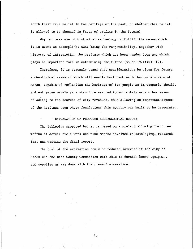
EXPLANATION OF PROPOSED ARCHEOLOGICAL BUDGET
The following proposed budget is based on a project allowing for three
months of actual field work and nine months involved in cataloging, research
ing, and writing the final report.
The cost of the excavation could be reduced somewhat if the city of
Macon and the Bibb County Commission were able to furnish heavy equipment
and supplies as was done with the present excavation.
43
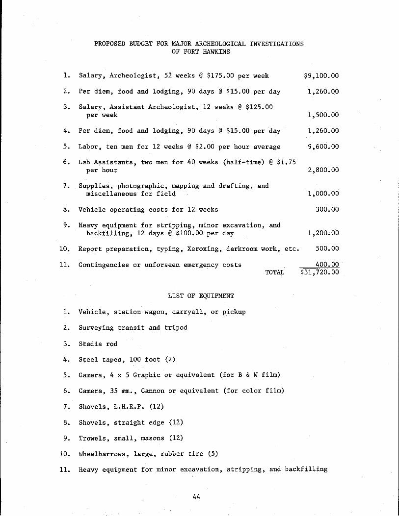
PROPOSED BUDGET FOR MAJOR ARCHEOLOGICAL INVESTIGATIONSOF FORT HAWKINS
1. Salary, Archeologist, 52 weeks @ $175.00 per week $9,100.00
2. Per diem, food and lodging, 90 days @$15.00 per day 1,260.00
3. Salary, Assistant Archeologist, 12 weeks @ $125.00per week 1,500.00
4. Per diem, food and lodging, 90 days @$15.00 per day 1,260.00
5. Labor, ten men for 12 weeks @$2.00 per hour average 9,600.00
6. Lab Assistants, two men for 40 weeks (half-time) @$1.75per hour 2,800.00
7. Supplies, photographic, mapping and drafting, andmiscellaneous for field 1,000.00
8. Vehicle operating costs for 12 weeks 300.00
9. Heavy equipment for stripping, minor excavation, andbackfilling, 12 days @$100.00 per day 1,200.00
10. Report preparation, typing, Xeroxing, darkroom work, etc. 500.00
11. Contingencies or unforseen emergency costsTOTAL
LIST OF EQUIPMENT
1. Vehicle, station wagon, carryall, or pickup
2. Surveying transit and tripod
3. Stadia rod
4. Steel tapes, 100 foot (2)
5. Camera, 4 x 5 Graphic or equivalent (for B & W film)
6. Camera, 35 rom., Cannon or equivalent (for color film)
7. Shovels, L.H.R.P. (12)
8. Shovels, straight edge (12)
9. Trowels, small, masons (12)
10. Wheelbarrows, large, rubber tire (5)
400.00$31,720.00
11. Heavy equipment for minor excavation, stripping, and backfilling
44
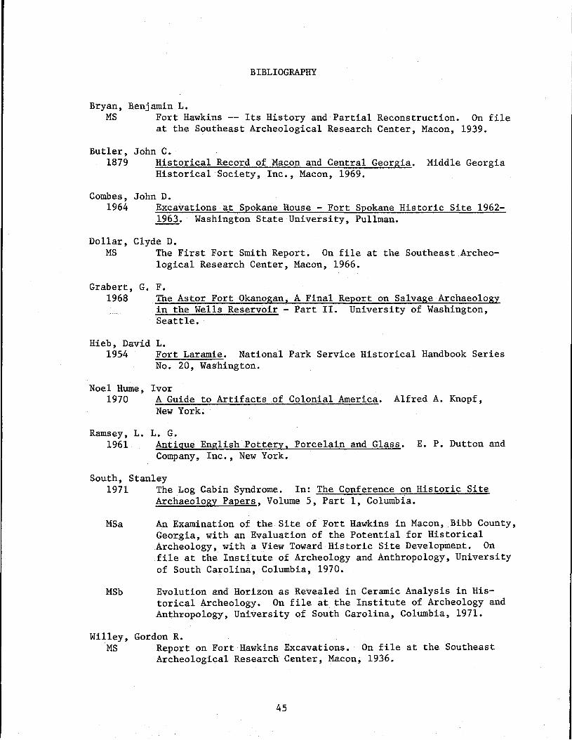
BIBLIOGRAPHY
Bryan, Benjamin L.MS Fort Hawkins -- Its History and Partial Reconstruction. On file
at the Southeast Archeological Research Center, Macon, 1939.
Butler, John C.1879 Historical Record of Macon and Central Georgia. Middle Georgia
Historical Society, Inc., Macon, 1969.
Combes, John D.1964 Excavations at Spokane House - Fort Spokane Historic Site 1962
1963. Washington State University, Pullman.
Dollar, Clyde D.MS The First Fort Smith Report. On file at the Southeast Archeo
logical Research Center, Macon, 1966.
Grabert, G.1968
F.The Astor Fort Okanogan, A Final Report on Salvage Archaeologyin the Wells Reservoir - Part II. University of Washington,Seattle.
Hieb, David L.1954 Fort Laramie. National Park Service Historical Handbook Series
No. 20, Washington.
Noel Hume~ Ivor1970 A Guide to Artifacts of Colonial America. Alfred A. Knopf,
New York.
Ramsey, L. L. G.1961 Antique English Pottery, Porcelain and Glass. E. P. Dutton and
Company, Inc., New York.
South, Stanley1971 The Log Cabin Syndrome. In: The Conference on Historic Site
Archaeology Papers, Volume 5, Part 1, Columbia.
MSa An Examination of the Site of Fort Hawkins in Macon, Bibb County,Georgia, with an Evaluation of the Potential for HistoricalArcheology, with a View Toward Historic Site Development. Onfile at the Institute of Archeology and Anthropology, Universityof South Carolina, Columbia, 1970.
MSb Evolution and Horizon as Revealed in Ceramic Analysis in Historical Archeology. On file at the Institute of Archeology andAnt.hropology, University of South Carolina, Columbia, 1971.
Willey, Gordon R.MS Report on Fort Hawkins Excavations. On file at the Southeast
Archeological Research Center, Macon, 1936.
45