EXPLORATION UPDATE Top Camp Project. For personal use ...2014/11/28 · exploration projects in the...
5
Page 1 of 5 Level 24, 71 Eagle St. Brisbane. QLD. 4000. Phone: (07) 3020 0000. Fax: (07) 3020 0011. Email: [email protected] ASX ANNOUNCEMENT 28 th November 2014 EXPLORATION UPDATE Top Camp Project. Orion Metals Limited (ASX:ORM), strategic metals, rare earth element (REE) and gold explorer, is pleased to provide this exploration update. HIGHLIGHTS Top Camp remains a fertile area for bulk alluvial (placer) gold opportunity Gravity survey confirmed up to 2km of palaeo-channel extent. Survey and data processing concluded palaeo channel depths attain 15m. Orion Metals Limited’s (ORM) Top Camp Project in West Queensland (Figure 1) was one of the original Projects acquired for Queensland Gold and Minerals Ltd (now Orion Metals Ltd) IPO in 2006. Top Camp Project is the site of the late 1800’s original Cloncurry alluvial gold field. Total production from past mining efforts from 1872 – 2005 indicates, anecdotally at least, 20,000 ounces of gold was extracted. But despite this level of productivity, records suggest that the alluvial gold mining methods were sporadic, superficial but intensive. ORM’s Top Camp mineral leases are contiguous and importantly, granted mining leases ( ML2764, ML2785, ML2786, ML2792) totalling 402ha encompassing the majority ofl the potentially gold enriched, alluvium deposits. The Mining Leases were granted between 1989 – 1992, and have been maintained by ORM since acquisition. Orion Metals Limited believes there is a significant business opportunity for bulk alluvial gold extraction, and plans to assess the potential for an alluvial gold resource within the Top Camp Project area. Photo courtesy Mr B. Aitchison, sample of some Top Camp alluvial gold extracted during 2005. For personal use only
Transcript of EXPLORATION UPDATE Top Camp Project. For personal use ...2014/11/28 · exploration projects in the...

Page 1 of 5
Level 24, 71 Eagle St. Brisbane. QLD. 4000. Phone: (07) 3020 0000. Fax: (07) 3020 0011. Email: [email protected]
ASX ANNOUNCEMENT 28th November 2014
EXPLORATION UPDATE
Top Camp Project.
Orion Metals Limited (ASX:ORM), strategic metals,
rare earth element (REE) and gold explorer, is pleased
to provide this exploration update.
HIGHLIGHTS
Top Camp remains a fertile area for
bulk alluvial (placer) gold opportunity
Gravity survey confirmed up to 2km
of palaeo-channel extent.
Survey and data processing concluded palaeo channel depths attain 15m.
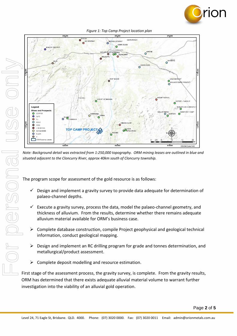
Orion Metals Limited’s (ORM) Top Camp Project in West Queensland (Figure 1) was one of the
original Projects acquired for Queensland Gold and Minerals Ltd (now Orion Metals Ltd) IPO in
2006. Top Camp Project is the site of the late 1800’s original Cloncurry alluvial gold field.
Total production from past mining efforts from 1872 – 2005 indicates, anecdotally at least, 20,000
ounces of gold was extracted. But despite this level of productivity, records suggest that the
alluvial gold mining methods were sporadic, superficial but intensive.
ORM’s Top Camp mineral leases are contiguous and importantly, granted mining leases ( ML2764,
ML2785, ML2786, ML2792) totalling 402ha encompassing the majority ofl the potentially gold
enriched, alluvium deposits. The Mining Leases were granted between 1989 – 1992, and have
been maintained by ORM since acquisition.
Orion Metals Limited believes there is a significant business
opportunity for bulk alluvial gold extraction, and plans to
assess the potential for an alluvial gold resource within the Top
Camp Project area.
Photo courtesy Mr B. Aitchison, sample of some Top Camp alluvial gold
extracted during 2005.
For
per
sona
l use
onl
y
Page 2 of 5
Level 24, 71 Eagle St, Brisbane. QLD. 4000. Phone: (07) 3020 0000. Fax: (07) 3020 0011 Email: [email protected]
Figure 1: Top Camp Project location plan
Note: Background detail was extracted from 1:250,000 topography. ORM mining leases are outlined in blue and
situated adjacent to the Cloncurry River, approx 40km south of Cloncurry township.
The program scope for assessment of the gold resource is as follows:
Design and implement a gravity survey to provide data adequate for determination of palaeo-channel depths.
Execute a gravity survey, process the data, model the palaeo-channel geometry, and thickness of alluvium. From the results, determine whether there remains adequate alluvium material available for ORM’s business case.
Complete database construction, compile Project geophysical and geological technical information, conduct geological mapping.
Design and implement an RC drilling program for grade and tonnes determination, and metallurgical/product assessment.
Complete deposit modelling and resource estimation.
First stage of the assessment process, the gravity survey, is complete. From the gravity results,
ORM has determined that there exists adequate alluvial material volume to warrant further
investigation into the viability of an alluvial gold operation.
For
per
sona
l use
onl
y

Page 3 of 5
Level 24, 71 Eagle St, Brisbane. QLD. 4000. Phone: (07) 3020 0000. Fax: (07) 3020 0011 Email: [email protected]
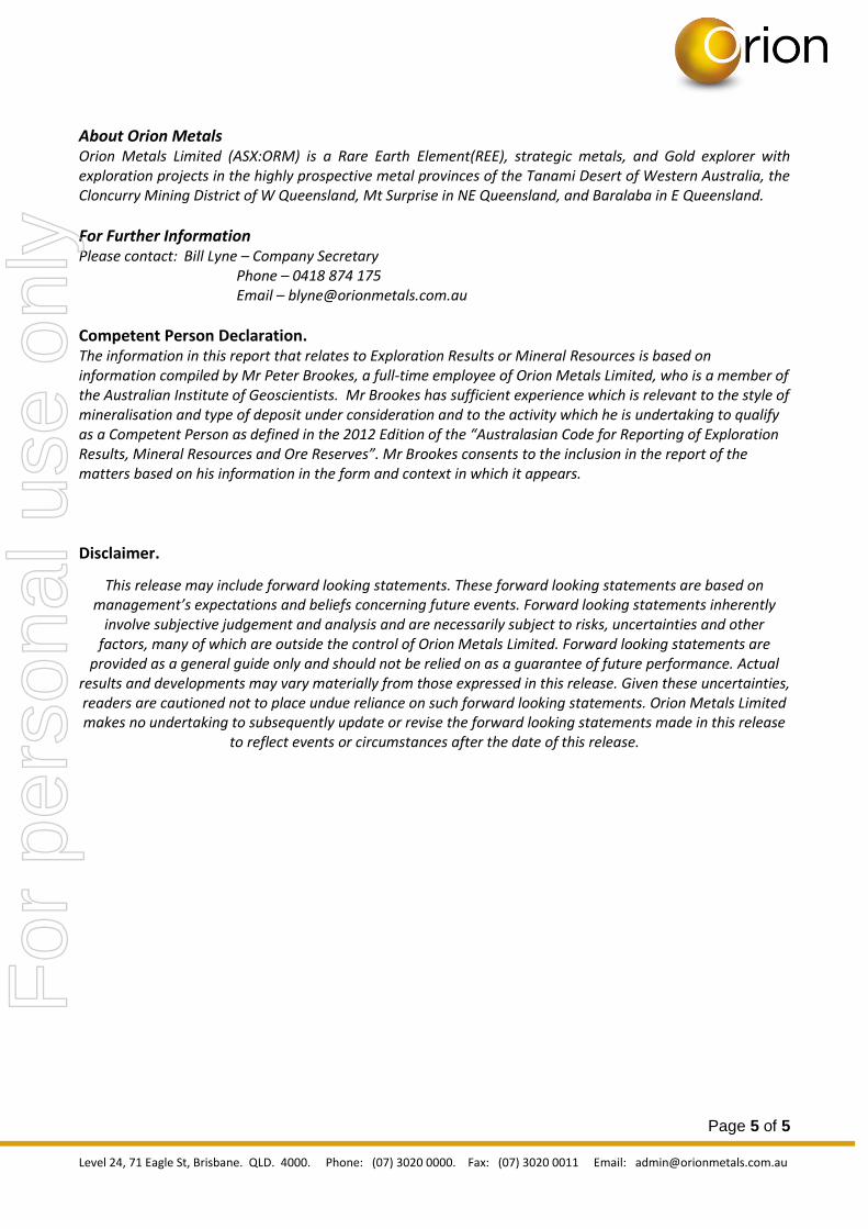
The gravity survey was completed by Haines Surveys Pty Ltd, using a Scintrex CG5 Autograv
instrument, with GPS data collected using a Trimble 5000. The gravity data was terrain corrected.
The gravity survey location points are presented in Figure 2, along with the projected outline of
potentially gold bearing palaeo-channels.
Figure 2: Top Camp Project Gravity Survey Area with Sample Locations.
Note: Tenement outlines are blue coloured, with google earth satellite image background. Note topographic highs
aligned with regional fault traces. A number of shafts are located in the area annotated by a white box with an X.
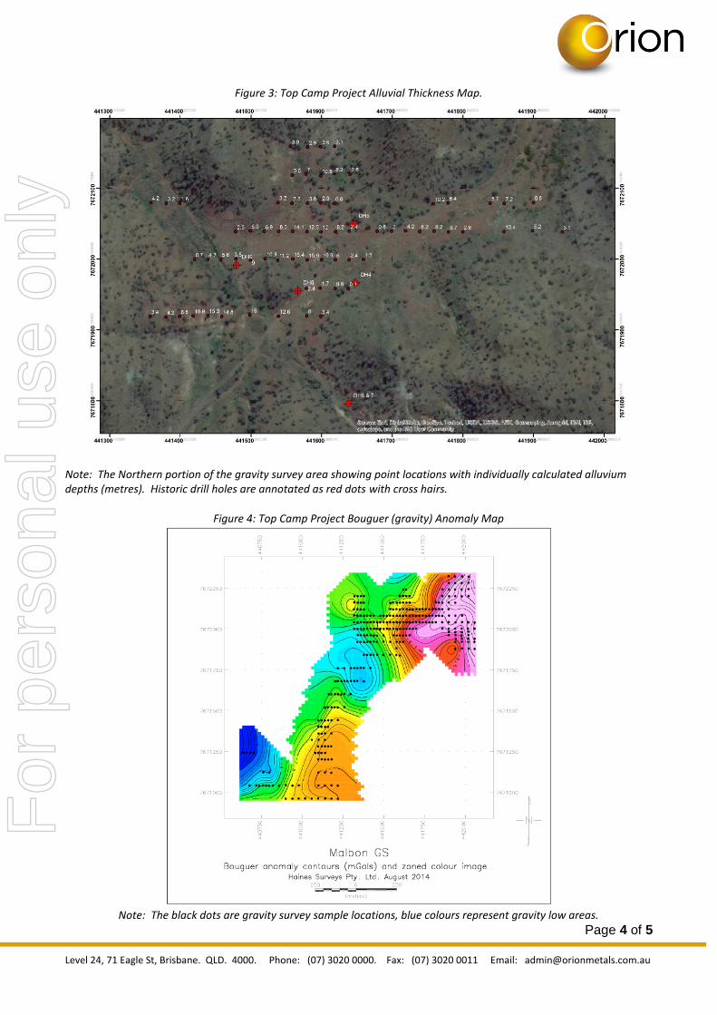
Results of the survey are presented in Figures 3 and 4. The alluvial thickness map (Figure 3) presents at each respective gravity sample station, the calculated depth of alluvium at that location. Gravity is a geophysical method used frequently in environments where density contrasts enable specific features to be mapped out. In this instance, a distinct density contrast is caused by the less dense alluvial material overlying more dense bedrock material. The density parameters used in the modelling were:
2.2 g/cc for alluvial materials.
2.67 g/cc for bedrock.
Figure 3 shows that there are depth anomalies which require drill testing to truly determine the
thickness of alluvium. The gravity survey has provided a relatively inexpensive option to determine
a preliminary understanding of the potentially gold enriched palaeo-channel.
For
per
sona
l use
onl
y
Page 4 of 5
Level 24, 71 Eagle St, Brisbane. QLD. 4000. Phone: (07) 3020 0000. Fax: (07) 3020 0011 Email: [email protected]
Figure 3: Top Camp Project Alluvial Thickness Map.
Note: The Northern portion of the gravity survey area showing point locations with individually calculated alluvium depths (metres). Historic drill holes are annotated as red dots with cross hairs.
Figure 4: Top Camp Project Bouguer (gravity) Anomaly Map
Note: The black dots are gravity survey sample locations, blue colours represent gravity low areas.
For
per
sona
l use
onl
y
Page 5 of 5
Level 24, 71 Eagle St, Brisbane. QLD. 4000. Phone: (07) 3020 0000. Fax: (07) 3020 0011 Email: [email protected]
About Orion Metals Orion Metals Limited (ASX:ORM) is a Rare Earth Element(REE), strategic metals, and Gold explorer with exploration projects in the highly prospective metal provinces of the Tanami Desert of Western Australia, the Cloncurry Mining District of W Queensland, Mt Surprise in NE Queensland, and Baralaba in E Queensland.
For Further Information Please contact: Bill Lyne – Company Secretary Phone – 0418 874 175 Email – [email protected]
Competent Person Declaration. The information in this report that relates to Exploration Results or Mineral Resources is based on information compiled by Mr Peter Brookes, a full-time employee of Orion Metals Limited, who is a member of the Australian Institute of Geoscientists. Mr Brookes has sufficient experience which is relevant to the style of mineralisation and type of deposit under consideration and to the activity which he is undertaking to qualify as a Competent Person as defined in the 2012 Edition of the “Australasian Code for Reporting of Exploration Results, Mineral Resources and Ore Reserves”. Mr Brookes consents to the inclusion in the report of the matters based on his information in the form and context in which it appears.
Disclaimer.
This release may include forward looking statements. These forward looking statements are based on management’s expectations and beliefs concerning future events. Forward looking statements inherently
involve subjective judgement and analysis and are necessarily subject to risks, uncertainties and other factors, many of which are outside the control of Orion Metals Limited. Forward looking statements are
provided as a general guide only and should not be relied on as a guarantee of future performance. Actual results and developments may vary materially from those expressed in this release. Given these uncertainties, readers are cautioned not to place undue reliance on such forward looking statements. Orion Metals Limited makes no undertaking to subsequently update or revise the forward looking statements made in this release
to reflect events or circumstances after the date of this release.
For
per
sona
l use
onl
y


![TANAMI GOLD NL...2010/01/28 · The acquisition is part of a broader transaction with its exploration alliance partner ABM Resources NL [“ABM”] encompassing an extensive exploration](https://static.fdocuments.in/doc/165x107/5eaa553f804eb203d82c71dc/tanami-gold-nl-20100128-the-acquisition-is-part-of-a-broader-transaction.jpg)