“Exploration of the Sierra Nevada” (1925) by Francis … · The purpose of this narrative is to...
28
Next: Introduction “Exploration of the Sierra Nevada” (1925) by Francis P. Farquhar “Exploration of the Sierra Nevada” appeared in the California Historical Society Quarterly for March 1925. It was a basis for at least two books, Place Names of the Sierra Nevada, appearing in 1926, and his best work, History of the Sierra Nevada (1946). The latter book is a popular classic still in print (and, unfortunately, still under copyright). However, if this Sierra Nevada history interests you, I highly recommend reading the book, as it provides more information than this article. • Introduction • Sierra Nevada • Moraga—1805 • Jedediah Smith and the American Trappers • Joseph Walker • Immigrant Parties • Frémont • Exploring the Passes • Yosemite and the Great Canyons • The Big Trees • The Whitney Survey and Clarence King • The Yosemite Valley Established as a Park • Other Events of the Sixties • John Muir • Joseph Le Conte • Mount Whitney • The Wheeler Survey • Frank Dusy • Wallace, Wales and Wright • Lil A. Winchell • Mining Ventures • Early Settlers in the High Sierra • Further Scientific Explorations • A New Epoch • The National Parks • McClure, Davis and Benson • The Sierra Club • Theodore S. Solomons • Bolton Coit Brown • Joseph N. Le Conte • Other Sierra Club Explorers • The United States Geological Survey • The United States Forest Service • Sierra Club Outings • Mountaineering • First Recorded Ascents of the Principal Peaks of the Sierra Nevada • Recent Scientific Explorations • The Future of Sierra Exploration
Transcript of “Exploration of the Sierra Nevada” (1925) by Francis … · The purpose of this narrative is to...

Next: Introduction
“Exploration of the Sierra Nevada” (1925)by Francis P. Farquhar“Exploration of the Sierra Nevada” appeared in the California Historical Society Quarterly for March 1925. It was a basis for at leasttwo books, Place Names of the Sierra Nevada, appearing in 1926, and his best work, History of the Sierra Nevada (1946). The latterbook is a popular classic still in print (and, unfortunately, still under copyright). However, if this Sierra Nevada history interests you, Ihighly recommend reading the book, as it provides more information than this article.
• Introduction
• Sierra Nevada
• Moraga—1805
• Jedediah Smith and the American Trappers
• Joseph Walker
• Immigrant Parties
• Frémont
• Exploring the Passes
• Yosemite and the Great Canyons
• The Big Trees
• The Whitney Survey and Clarence King
• The Yosemite Valley Established as a Park
• Other Events of the Sixties
• John Muir
• Joseph Le Conte
• Mount Whitney
• The Wheeler Survey
• Frank Dusy
• Wallace, Wales and Wright
• Lil A. Winchell
• Mining Ventures
• Early Settlers in the High Sierra
• Further Scientific Explorations
• A New Epoch
• The National Parks
• McClure, Davis and Benson
• The Sierra Club
• Theodore S. Solomons
• Bolton Coit Brown
• Joseph N. Le Conte
• Other Sierra Club Explorers
• The United States Geological Survey
• The United States Forest Service
• Sierra Club Outings
• Mountaineering
• First Recorded Ascents of the Principal Peaks of the Sierra Nevada
• Recent Scientific Explorations
• The Future of Sierra Exploration

About the Author
Francis P. Farquhar was born in Newton, Massachusetts in Dec. 31, 1887. He graduated from Harvard and came to San Francisco toset up practice as a CPA. He married his wife Marjory Bridge in 1934 and they had two sons and a daughter. Francis Farquhar wasan active Sierra Club leader and served as its president 1933-1935 and 1948-1949, Sierra Club Bulletin editor from 1926 to 1946, andserved in other club offices as director from 1924 to 1951. Mr. Farquhar was a mountaineer who introduced proper use of rope to SierraClub members on a club trip in 1931. He has made multiple first ascents, including the Middle Palisades in 1921. Mr. Farquhar is theauthor of several books and wrote the foreword for other books. He is best known for his book History of the Sierra Nevada (1946),which is still in print. He died Nov. 21, 1974 in Berkeley, California. His wife Marjory died 1999 in San Francisco. Mt. Francis Farquhar(12,893'), located 1.6 miles NW of Mt. Brewer in Kings Canyon National Park, was named in honor of him.
• Biographical sketch (Bancroft Library)
• Francis Farquhar Obituary (Sierra Club Bulletin)
• Place Names of the Sierra Nevada by Francis P. Farquhar (1925)
Bibliographical Information
Francis Peloubet Farquhar (1887 - 1974), “Exploration of the Sierra Nevada,” California Historical Society Quarterly, 4(1):3-58 (March1925). No copyright. ISSN 0008-1175. Available on microfilm.
This article was also printed in book form, but copies are rare. Only 275 copies were reprinted from the original article. Tan wrapper(Cowan (II), p. 204).
Digitized by Dan Anderson, October 2004, from a copy in the UCSD Library. These files may be used for any non-commercial purpose,provided this notice is left intact. —Dan Anderson, www.yosemite.ca.us
Next: Introduction
History of the Sierra Nevada
by Francis Farquhar (Paperback, 1965)Buy this book at Amazon.com
Place Names of the Sierra Nevada
by Peter Browning (Paperback, 1991)Buy this book at Amazon.com

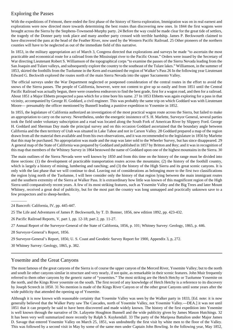
MOUNT WHITNEY, 14,501 FEETThe highest point in the United States. This view from MountBrewer is the one obtained by the Whitney Survey party in 1864when they named the mountain for Josiah Dwight Whitney.
Photograph by Ansel F. Hall.
Introduction
The purpose of this narrative is to trace the course of the exploration of the Sierra Nevada of California from the time when it firstbecame known to white men to the present day. The record is full of vivid personalities and of epic adventures, but these may only bebriefly recounted here and much that is interesting must be omitted as belonging more properly to other phases of history than that ofexploration. Exploration is held to mean more, however, than a search for mere geographical knowledge, and the record is distinguishedby splendid achievements in scientific research.
Completeness can hardly be attained even by confining attention to the field of exploration and there are doubtless many explorerswhose names should be included here but are omitted either because they are not on record or because the record has not come to myattention. If such there be, they are welcome to the fold and I will endeavor to do them justice at another time.
In writing of the Sierra it is always a temptation to one who knows the mountains to indulge in praise of their grandeur and beauty. Theforests, alpine meadows, lakes, streams, waterfalls, birds, animals, flowers, granite domes and spires, fields of perpetual snow-all theseare ever in the thoughts of those who have been there. For them no other setting is needed; and for those who have not been there, asearch among the references cited will reveal much.
Sierra Nevada
The earliest approaches to California were from the sea; consequently the regions along the coast were the first to become known tothe civilized world and to receive names. In 1542 Juan Rodriguez Cabrillo, while off the peninsula of San Francisco on November 18,beheld the Santa Cruz Mountains covered with snow and named them Sierras Nevadas. 1 On a map of 1564 by Ortelius the name SierraNevada appears near the coast but farther north, due to an error in description. As more specific names came to be applied to the coastmountains, it is not surprising to find this common general name moving farther and farther into the interior to designate in a vagueway some less familiar range.
The interior of California was rarely visited by the Spaniards until the nineteenth century, but there were one or two expeditions that ledtowards a knowledge of the Sierra Nevada, and on one of these the name became affixed to the range where it now rests. CommandardePedro Fages crossed the Coast Range at some point south of San Lun Obispo in 1773 and beheld the Tulare Valley; 2 and in 1776,Padre Francisco Garcés entered the Tulare Valley, probably by way of the Tejon Pass, crowd the Kern River, and visited several Indianrancherias. He beheld the Sierra Nevada, which he called Sierra de San Marcos, and in his journal, 3 and on Padre Pedro Font’s map ofthe same date, the relation of the Sierra to the Tulares and the Coast Range is well defined. Notwithstanding Garcés and the Font map,the name Sierra Nevada continued to wander, As late as 1841 Commander Charles Wilkes, U. S. N., called the inner part of the CoastRange east of San Juan, the Sierra; while the mountains beyond the great interior valley were known as the Californian Range. 4 justwhen the name Sierra Nevada finally became fixed would be hard to say.
————1 Bolton: Spanish Exploration in the Southwest, 1916, quoted in Chapman’s History of California, 1921, p. 79.
2 Bancroft: California I, p. 197.
3 Coues: On the Trail of a Spanish Pioneer, 1900, I, p. 291.
4 Wilkes: Narrative of the U. S. Exploring Expedition, 1852, II, pp. 232-233.

Moraga—1805
By the beginning of the nineteenth century, the Spanish settlers coming from Mexico were firmly established in Alta California, andboth churchmen and soldiers were beginning to find out more about the country in which they lived. Several expeditions crossed thecoast ranges into the great central valley of California between 1804 and 1806, visiting the Indian rancherias beyond the Tulares. DonGabriel Moraga, in 1805, named a liver descending from the eastern mountains “Rio de los Santos Reyes,” from which it might beinferred that he camped on its banks on the day of Epiphany. 5 The name has come down in English as Kings River, often erroneouslywritten “Kings.” In 1806 the Merced and other riven were named. It is improbable that any of the Spanish visitors to the San JoaquinValley penetrated the mountains, excepting to cross by the Tehachapi or Tejon passes to the south.
————5 Muñoz: Diaro, 1806, quoted in Richton’s California under Spain and Mexico, 1911, p. 465.
Jedediah Smith and the American Trappers
The first white men to visit the Sierra Nevada were undoubtedly the American trappers. In 1826 Jedediah Strong Smith, having recentlyformed a partnership with David E. Jackson and William L. Sublette in the fur trade, set out from Great Salt Lake towards the southwest,prospecting for a new and untried beaver country. 6 He passed through southwestern Utah by way of the Muddy and Virgin rivers andcame to the Spanish settlements at San Gabriel late in November. 7 American trappers were not welcome in Spanish California, and hewas obliged to move on promptly. Crossing the mountains, probably by the Tehachapi, he came into the great valley of California andtravelled north through a fertile country with a high range of mountains on his right. The precise movements of Jedediah Smith and hisparty will probably never be known, as the record of the next few months is very meager. That he camped for some time near the KingsRiver seems to be established beyond question by Dr. C. Hart Merriam through Smith’s references to the Wimmelche Indians. 8 It alsoseems clear that he tried to cross the Sierra in the vicinity of the Kings River, where he was turned back by deep snows after losing somemules. Whether he made other attempts in the immediate vicinity or whether he first went a considerable distance to the north is not soclear, At all events, on May 20, 1827, Jedediah Smith, with two companions, started on a successful attempt to cross the mountains. 9There has been much discussion over the route of this crossing, but in my opinion the evidence so far brought to light is not conclusiveenough to prove beyond a doubt any one of the suggested routes. 10 In eight days Smith had crossed the range and at the end of twentydays more reached Great Salt Lake. This is the first recorded crossing of the Sierra Nevada by white men.
Other trappers soon followed Jedediah Smith in the San Joaquin and undoubtedly ascended the Sierra streams for considerable distances.Ewing Young, with Kit Carson (then unknown to fame), entered the San Joaquin Valley from the south in 1829 and there met a party ofHudson Bay trappers under Peter Skene Ogden. 11 The Ewing Young party returned by the southern route, apparently without attemptingto cross the Sierra. Little is known of the Ogden party, but it is presumed that they came into California across the Siskiyou mountainsor by way of the Klamath, although they may have crossed the Sierra by mine route north of the Feather River, and possibly, as somesay, by Smith’s route. The character and capabilities of the men were such that it would not have been out of the question for them tohave come down the eastern side of the Sierra and over one of the passes that later became well known.
————6 Dale: The Ashley-Smith Explorations, 1918, pp. 183-186.
7 Merriam, in California Historical Society Quarterly, October 1923, II, pp. 228-233.
8 California Historical Society Quarterly, April 1924, III, pp. 25-26.
9 Smith’s letter to General Clark, quoted in Dale, pp. 191-193, and in California Historical Society Quarterly, October 1923, II, pp.233-236.
10 Merriam, in Sierra Club Bulletin, 1923, XI, 4, pp. 375-379; in California Historical Society Quarterly, April 1924, III, pp. 25-29;Fletcher, in California Historical Society Quarterly, January 1924, II, pp. 344-349.
11 California Historical Society Quarterly, October 1922, I, p. 114.
Joseph Walker
Reliable knowledge of the Sierra Nevada really begins with the expedition of Joseph Reddeford Walker in 1833, The results of Walker’sexpedition became popularly known almost immediately afterwards through the publication in 1837 of Washington Irving’s accountof the Bonneville expedition. 12 This was a very one-sided report and did not give to Walker the credit that was due him for a reallyremarkable achievement in exploration. Fortunately other accounts have been preserved and as they become better known, the fameof this remarkable pioneer will be greatly enhanced. Zenas Leonard, who acted as a clerk for the expedition, wrote a narrative whichwas published in 1839 in Clearfield, Pennsylvania, and reprinted in 1904 with annotations by Dr. W. F. Wagner. This narrative givesa circumstantial account by means of which we can trace closely the entire route. There is also in the Bancroft Library a manuscriptdictated by George Nidever, a member of the party, which corroborates many of the incidents told by Leonard. To these may be addedthe story of Joseph L. Meek as told in Mrs. Victor’s “River of the West,” an account by Stephen Meek quoted by Bancroft, 13 and thetestimony of men who knew Walker. 14
The Walker party, after coming down the valley of the Humboldt and passing south by Carson Lake, struck westward across the Sierraand reached the San Joaquin Valley early in November 1833. The variety of the sources of information and the importance of theexpedition invite a more extended discussion of the route than is possible within the limits of this article. The party probably ascended the

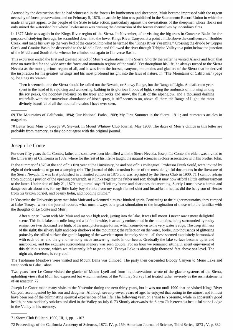
JOSEPH REDDEFORD WALKER1798-1876
The account of his expedition of 1833 contains the earliestdescription of Yosemite Valley and the Big Trees.
Courtesy of John M. Walker, Walnut Creek.
eastern flank of the Sierra by one of the southern tributaries of the East Walker River. Their experiences after crossing the summitof the pass indicate that they were lost for some days in a maze of lakes and mountains. 15 This description fits the character of theregion near what is now known as Virginia Canyon. From here they would have crowd the Tuolumne, perhaps near Conness Creek.Passing Tenaya Lake, they probably followed the general course of the present Tioga road. This accords both with the topography ofthe mountains and with the statement in the San Jose Pioneer (September 1, 1877): “His first attempt to descend to the west was nearthe headwaters of the Tuolumne, which he found impossible, but on working a little to the southwest he struck the waters of the Mercedand got into the Valley of the San Joaquin.”
There occurs in the Leonard narrative a most significant passage:
We travelled, few miles every day, still up the top of the mountain, and our course continually obstructed with snow hills androcks. Here we began to encounter in our path, many small streams which would shoot out from under these high snow-banks,and after running a short distance in deep chasms which they have through ages cut in the rocks, precipitate themselves, fromone lofty precipice to another, until they are exhausted in rain below.—Some of these precipices appeared to us to be morethan a mile high. Some of the men thought that if we could succeed in descending one of these precipices to the bottom, wemight thus work our way into the valley below—but on making several attempts we found it liberty impossible for a man todescend, to say nothing of our horses, We were then obliged to keep along the top of the dividing ridge between two of therechasms which accrued to land pretty near in the direction we were going— which was west,—in passing over the mountain,supposing it to me north and south. (p. 174.)
[Editor’s note: today historians generally believe the Walker party looked down The Cascades, which are just west of Yosemite Valley,instead of Yosemite Valley itself.—dea]
One can easily imagine some members of the party deviating to right or left in search of a route and coming out upon the brink of YosemiteValley at the top of Yosemite Falls, and perhaps looking off into Hetch Hetchy Valley from the summit of Smith Peak. The party foundits my down from the mountains into the lower canyon of the Tuolumne River, and thence passed on into the San Joaquin Valley.
Another passage in the Leonard narrative is of great interest:
In the last two days travelling we have found some trees of the Redwood species, incredibly large—some of which wouldmeasure from 16 to 18 fathom round the track at the height of a man’s head from the ground. (p. 180.)
The notes in the 1904 edition are misleading at this point, as the commentator evidently jumped to the conclusion that the big treesmentioned were those of the Mariposa Grove, perhaps not knowing that there were two small groves between the Merced and Tuolumnerivers. To my mind, there is not the slightest doubt that the reference is to the Tuolumne or Merced Grove and that this is the firstpublished mention of the Big Trees of California.
The Walker party spent the first part of the winter at Monterey and in February 1834 started on the return journey. This time they crossedthe Sierra further to the south, going up the Kern River and passing over what thereafter has been known as Walker’s Pass.
————12 The Rocky Mountains: or, Scenes, Incidents, and Adventures in the Far Wast; Digested from the Journal of Captain B. L. E.Bonneville, of the Army of the United States, and Illustrated from Various Other Sources, by Washington Irving, 2 volumes, Philadelphia,1837, (Later editions under title of “The Adventures of Captain Bonneville”).
13 Bancroft: California III, p. 390.
14 Sonoma Democrat, November 25, 1876; San Jose Pioneer, September 1, 1877; Bancroft: Nevada, p. 44.
15 Leonard Narrative, 1904, p. 174.
Immigrant Parties
For the next few years no parties seem to have attempted the passage of the Sierra, but the tide of westward expansion was swelling, andincreasing numbers of adventurous pioneers were penetrating the country west of the Missouri River. Oregon was already well knownand California was beginning to attract attention.
In 1841 the first real immigrant party crossed the Sierra into California. This was under the nominal leadership of John Bartleson,although at times the party seems to have been rather independent of leaders. Accounts of this expedition have been given by JohnBidwell and Josiah Belden, members of the party. 16 They came across the desert from Great Salt Lake and entered the valley of theHumboldt River, then known as Mary’s or Ogden’s River, which, through the explorations of Ogden, Walker and others, was now awell known route. Upon leaving the Humboldt sink, they struck across the Sierra from the head of the West Walker River, over whatis now known as Sonora Pass, and descended the Stanislaus. In later years, Bidwell told of his adventures while prospecting for a routethat led him to the discovery of the Big Trees of the Calaveras Grove; yet, while he was doubtless the first to see that grove, the Walkerdiscovery must take precedence.
Two years later came another immigrant party, or rather two parties: the first, under Joseph B. Chiles, splitting off from the main partyat Fort Hall and entering California by the Malheur and Pit rivers; the second, or larger portion of the joint party, comprising about fortymen, women and children, descending the Humboldt and going south along the eastern flank of the Sierra past Owens Lake, crossingby Walker Pass, and arriving at Gilroy’s Ranch in January 1844. 17
————16 Bancroft: California, IV, pp, 20-272; Bidwell: First Emigrant Train to California, Century Magazine, November 1890.
17 Bancroft: California, IV, pp, 392-395.
Frémont
Hitherto all of the parties that had crossed the Sierra had been either trappers or immigrants. There now began an era of definiteexploration for the purpose of obtaining a knowledge of the country. John Charles Frémont’s first expedition into the West had takenhim as far as the Rocky Mountains, and in 1843 he set out upon a much more ambitious journey, the purpose of which was to explore theoverland route to Oregon. Having accomplished this, he turned south through the Great Basin past Pyramid Lake, and then, in midwinter,endeavored to force a passage through the Sierra snow into California. Lost in the mazes of the tributaries of the Walker River, it wassome time before he reached the main wall of the range. His wanderings have been traced in detail, 18 and are too well known to callfor further comment here, excepting to say that on the 14th of February, 1844, Frémont and Charles Preuss beheld Lake Tahoe, andon the 20th the party crossed the pass and started down the American River, reaching Sutter’s Fort on March 6. After a brief rest, theywent south up the San Joaquin Valley, crossing the numerous rivers that descend from the Sierra, and about the middle of April wentover the Tehachapi mountains. 19
Frémont returned to California the following year. On November 24, 1845, he was at Walker Lake, and from there sent the larger part ofhis men south under the command of Theodore Talbot, with Joseph R. Walker as guide to conduct them across Walker’s Pass. Frémonthimself, with Kit Carson and about 15 men, started for Sutter’s Fort directly across the mountains to obtain supplies. This time he crossedby way of the Truckee River, passing Donner Lake, and reached Sutter’s Fort on December 9, 1845. 20 After a few days’ rest he startedup the San Joaquin Valley in order to join the Talbot-Walker party at an agreed rendezvous. This rendezvous Frémont supposed to bethe river then known to the Americans as the Lake Fork, but which still bore its Spanish name of Rio de los Santos Reyes. Walker,however, led his party over the pass and was camped in a valley in the upper Kern, which he supposed to be the rendezvous. 21
Anxious to find his party, Frémont began a search that carried him far up into the mountains among the sources of Kings River. 22 Anexamination of the account of this search as given in Frémont’s Memoirs, together with the route as traced on the map of 1848 drawnby Charles Preuss, convinces me that this search was conducted in the upper basin of the North Fork of Kings River. If Frémont hadendeavored to penetrate the mountains south of the main Kings River, his description would have been entirely different. He could hardlyhave gone beyond the basin of Roaring River without descending into the main Kings River Canyon. It was, of course, impossible for himto take his animals up the lower canyon. Failing to find any trace of the Talbot-Walker party, Frémont returned to Sutter’s Fort and wentthence to Yerba Buena and Monterey. Kit Carson and Dick Owens were sent out on further search, and the parties were ultimately united.
On the Pruess map of 1848, there appear for the first time several names which have become fixed in Sierra nomenclature: Kern Rivernamed for Edward M. Kern, topographer and artist of the expedition; Owens Lake for Richard Owens; and Walker River and CarsonRiver for Joseph R. Walker and Christopher (Kit) Carson respectively, It is on this map also that there appears the name of Lake Bonplandassigned to Lake Tahoe. Frémont gave this name in honor of Aimé Bonpland, the associate of Baron von Humboldt, but neither thisname nor its successor, Lake Bigler, has remained. Fortunately the lake is now known by a Washoe Indian name, Tahoe, said to mean“Big Water.” 23
————18 Frémont and ’49. By Frederick S. Dellenbaugh. New York, 1914, pp. 204-229.
19 Frémont; Exploring Expedition, 1845, pp. 248-255.
20 Letter of Frémont, in California Historical Society Quarterly, October 1924, III, p. 272.
21 Frémont: Memoirs of My Life, 1887, pp. 433-449.
22 Frémont: Memoirs, pp. “9451; Camp, in California Historical Society Quarterly, October 1922, I, p. 16.
23 James: The Lake of the Sky, 1915, pp. 56-62.
Exploring the Passes
With the expeditions of Frémont, there ended the first phase of the history of Sierra exploration, Immigration was on in real earnest andexplorations were now directed more towards determining the best routes than discovering new ones. In 1844 the first wagons werebrought across the Sierra by the Stephens-Townsend-Murphy party. 24 Before the way could be made clear for the great tide of settlers,the tragedy of the Donner party took place and many another party crossed with terrible hardship. James P. Beckwourth claimed tohave discovered the pass at the head of the Feather River, now used by the Western Pacific Railroad. 25 Other pioneers of the northerncounties will have to be neglected as out of the immediate field of this narrative.
In 1853, in the military appropriation act of March 3, Congress directed that explorations and surveys be made “to ascertain the mostpracticable and economical route for a railroad from the Mississippi river to the Pacific Ocean.” Orders were issued by the Secretary ofWar directing Lieutenant Robert S. Williamson of the topographical corps “to examine the passes of the Sierra Nevada leading from theSan Joaquin and Tulare valleys, and subsequently explore the country to the southeast of the Tulare lakes.” Williamson, in the summer of1853, skirted the foothills from the Tuolumne in the Kern and examined the region of Walker’s Pass 26 In the following year LieutenantEdward G. Beckwith explored the routes north of the main Sierra Nevada into the upper Sacramento Valley.
The official surveys under the War Department neglected or postponed consideration of the central routes in the effort to avoid thesnows of the Sierra passes. The people of California, however, were not content to give up so easily and from 1851 until the CentralPacific Railroad was actually begun, there were ceaseless endeavors to find the best grade, first for a wagon road, and then for a railroad.About 1851 a Major Ebbetts prospected a pass which for a time bore his name. 27 In 1853 Ebbetts was again exploring for a pass in thatvicinity, accompanied by George H. Goddard, a civil engineer. This was probably the same trip on which Goddard was with LieutenantMoore— presumably the officer mentioned by Bunnell leading a punitive expedition to Yosemite in 1852.
In 1855, the legislature of California authorized an investigation of the most practical wagon route across the Sierra, but failed to makean appropriation to carry on the survey. Nevertheless, under the energetic insistence of S. H. Marlette, Surveyor General, several partiestook the field under voluntary subscription and a road was located along the South Fork of American River by Slippery Ford. GeorgeH. Goddard and Sherman Day made the principal survey and on this occasion Goddard ascertained that the boundary angle betweenCalifornia and the then territory of Utah was situated in Lake Tahoe and not in Carson Valley. 28 Goddard prepared a map of the regiondrawn from all the material then available and from his own observations, and it was recommended to the legislature in 1856 by Marlettethat this map be purchased. No appropriation was made and the map was later sold to the Wheeler Survey, but has since disappeared. 29A general map of the State of California was prepared by Goddard and published in 1857 by Britton and Rey; and it was in recognition ofthis map that members of the Whitney Survey in 1864 bestowed the name of Goddard upon one of the highest mountains in the Sierra. 30
The main outlines of the Sierra Nevada were well known by 1850 and from this time on the history of the range must be divided intothree sections: (1) the development of practicable transportation routes across the mountains; (2) the history of the foothill country,which is largely a history of mining, lumbering and ranching; and (3) the history of the High Sierra and its great scenic canyons. It isonly with the last phase that we will continue to deal. Leaving out of considerations as belonging more to the first two classificationsthe region lying north of the Tuolumne, I will here consider only the history of that region lying between the main immigrant routesand the southern extremity of the Sierra at Walker Pass. It is extraordinary how little was known of this magnificent region of the HighSierra until comparatively recent years. A few of its most striking features, such as Yosemite Valley and the Big Trees and later MountWhitney, received a great deal of publicity, but for the most part the country was long unmapped and practically unknown save to afew prospectors and to sheep-herders.
————24 Bancroft: California, IV, pp. 445-447.
25 The Life and Adventures of James P. Beckwourth, by T. D. Bonner, 1856, new edition 1892, pp. 423-432.
26 Pacific Railroad Reports, V, part 1, pp. 12-18; part 2, pp. 11-27.
27 Annual Report of the Surveyor-General of the State of California, 1856, p. 101; Whitney Survey: Geology, 1865, p. 446.
28 Surveyor-General’s Report, 1856.
29 Surveyor-General’s Report, 1856; U. S. Coast and Geodetic Survey Report for 1900, Appendix 3, p, 272.
30 Whitney Survey: Geology, 1865, p. 382.
Yosemite and the Great Canyons
The most famous of the great canyons of the Sierra is of course the upper canyon of the Merced River, Yosemite Valley; but to the northand south lie other canyons similar in structure and very nearly, if not quite, as remarkable in their scenic features. John Muir frequentlyreferred to them other canyons by the generic name of “yosemites.” The most striking are the Hetch Hetchy or Tuolumne Yosemite onthe north, and the Kings River yosemite on the south. The first record of any knowledge of Hetch Hetchy is a reference to its discoveryby Joseph Screech in 1850. 31 No mention is made of the Kings River Canyon or of the other great Canyons until some years after thewide publicity that attended the opening up of Yosemite.
Although it is now known with reasonable certainty that Yosemite Valley was seen by the Walker party in 1833, [Ed. note: it is nowgenerally believed that the Walker Party saw The Cascades, north of Yosemite Valley, not Yosemite Valley.—DEA.] it was not until1851 that it can properly be said to have been discovered and made widely known. The history of the first expedition into Yosemiteis well known through the narrative of Dr. Lafayette Houghton Bunnell and the wide publicity given by James Mason Hutchings. 32It has been very well summarized more recently by Ralph S. Kuykendall. 33 The party of the Mariposa Battalion under Major JamesD. Savage that entered Yosemite Valley on March 25, 1851, was undoubtedly the first visit by white men to the floor of the Valley.This was followed by a second visit in May by some of the same men under Captain John Bowling. In the following year, May 1852,

two prospectors were killed by Indians near the foot of Bridal Veil Falls. Shortly thereafter a punitive expedition under First LieutenantTredwell Moore, 2nd Infantry, U. S. A., executed five of the Indians near the scene of the murder and pursued others across the mountainsby Lake Tenaya over the Mono trail to Bloody Canyon. They returned to Fort Miller by way of Tuolumne Soda Springs and over atrail that passed to the south of the Yosemite, evidently crossing at the head of Nevada Falls. The discovery of some gold depositsnear Mono Lake aroused excitement among the Fresno camps, and a certain Leroy Vining with some companions went to investigate.Leevining Canyon now bears his name.
James Capen Adams, the famous grizzly bear hunter, came to the Sierra in 1852 and established a camp somewhere between the Mercedand Tuolumne rivers. He visited Yosemite Valley in the spring of 1854 and shortly afterward, on the Mariposa River, captured aliveone of his best grizzlies, the famous Ben Franklin. 34
With the year 1855 the tourist history of Yosemite began when Hutchings visited the Valley with Thomas A. Ayers, Walter Millard, andAlexander Stair. Ayers made a sketch of Yosemite Falls which was published in October by Britton and Rey and was the first illustrationof Yosemite scenery to be given to the public. 35 Hutchings described the scenery in an article published in the Mariposa Gazette ofAugust 16, 1855. Several other parties followed immediately, including one which claimed to have discovered Vernal and Nevada falls,although Bunnell makes it very clear that both of these falls were seen by members of the Bowling party in 1851. 36
The first trail into Yosemite was built in 1856 by Milton Mann and Houston Mann, following in general the present route from Wawona.During the same year a primitive house of pine poles and shakes was commenced in the Valley and Yosemite received its first womenvisitors in a party from Mariposa.
The history of Kings River Canyon begins several years later. Captain John J. Kuykendall’s company of the Mariposa Battalionundoubtedly saw the canyon in 1851, and may have entered it, but the earliest visit to which I have men any definite reference was in1858, when a man from Tulare named J. H. Johnson and five comrades were piloted across Kearsarge Pass by a Digger Indian namedSampson. 37 It is not impossible that prospectors may have visited the canyon a year or two earlier, however. The real history of thecanyon begins with the year 1864 and will he told further on in connection with the explorations of the Whitney Survey. Nothing definiteis known of visitors to the other great canyons of the Sierra until some years later.
————31 Whitney Survey: Yosemite Guide Book, 1870, p. 110; Muir: Hetch Hetchy Valley, in Overland Monthly, July 1873, pp. 42-43.
32 Bunnell’s Discovery of the Yosemite, 1880; Hutchings Scenes, of Wonder and Curiosity in California, 1860; Hutchings: In the Heartof the Sierras, 1886.
33 Early History of Yosemite Valley, in The Grizzly Bear, July 1919, reprinted by U. S. National Park Service 1919; History of theYosemite Region, in Handbook of Yosemite National Park by Ansel F. Hall, 1921.
34 The Adventures of James Copan Adams, Mountaineer and Grizzly Bear Hunter of California, by Theodore H. Hittell, Boston andSan Francisco, 1861, pp. 196-206.
35 Hutchings: Heart of the Sierras, 1886, pp. 80, 97.
36 James H. Lawrence, in Overland Monthly, October 1884; Bunnell: Discovery 1880, p. 85.
37 Chalfant: Story of Inyo, 1922, p. 76.
The Big Trees
It has already been observed that the Walker party probably saw the Merced or Tuolumne Grove of Big Trees in 1833 and that Bidwellhappened upon the Calaveras Grove while trying to find a route for the Bartleson party in 1841. In those days men were more interestedin trapping and in gold than in the wonders of nature; so, while the big trees may have excited surprise and admiration for a moment,they were soon forgotten. Thus it may well be that many a hunter and miner paused to look at the colossal trunks and went his waywithout proclaiming the discovery.
Bunnell says that a man who worked for him in 1851 had seen same of the big trees near the Mariposa Grove in 1849, but this factseems to have been brought to light only after the announced discovery of the Mariposa Grove a few years later. The discovery of thebig trees is usually credited to A. T. Dowd, a hunter employed by a canal company at Murphy’s Camp, who brought attention to theCalaveras Grove in the spring of 1852. 38 Whatever the precise course of events may have been, the Calaveras Grove man received agreat deal of publicity. The scientific name has been the subject of considerable discussion, but the name Sequoia gigantea is now theone most frequently used. The first botanical descriptions were published in England based on specimens brought in 1853 by WilliamLobb, collector for Veitch’s Exotic Nursery. Specimens were transplanted shortly afterwards to nurseries and gardens in the easternUnited States and in England and the continent.
The big trees of California soon became celebrated and enterprising exhibitors hastened to secure tangible evidence of them wonders.In 1853 one of the Calaveras trees was cut down and the following year an exhibit of the bark was displayed in the Union Club, NewYork, In 1854 one of the finest trees, known as “The Mother of the Forest,” was stripped of its bark to a height of 116 feet. Portions ofthis bark were exhibited at the Crystal Palace, New York, in 1855, and in 1856 in London. The first London exhibit attracted so muchattention that the exhibit was transferred, in April 1857, to the Crystal Palace, Sydenham, where a full 100 feet of the bark was set up. 39
The Calaveras Grove was the first grove to become generally known, but others were soon discovered. In 1855 a workman named Hoggreported to Galen Clark the discovery of big trees near the route to Yosemite, and others were discovered shortly afterwards by J. E.Clayton. Bunnell says he accompanied Clayton on a second visit. In June 1856, Galen Clark and Milton Mann explored the MariposaGrove. The Fresno Grove and others became known soon afterwards. 40 There is little doubt that the big trees; of the Tule River regionwere a familiar sight to many prospectors, particularly those who crossed the Sierra from 1853 to 1855 in the rush to the Inyo gold

discoveries. These trees received no prominent mention, however, until the publications of the Whitney Survey, in which it was saidthat they were discovered by d’Heureuse, a member of the Survey. 41
The Giant Forest, on the Marble Fork of Kaweah River, was discovered by Hale Tharp in 1858. He carved his name and the date on alog at a spot now known as Log Meadow. In 1860 he visited the grove again, and from that time forth considered it his own particularstamping ground. The groves between the Kings River and the Kaweah were the first to fall before the attacks of the lumbermen, andby 1864 destruction of the forests was rapidly going forward.
The subsequent history of the big trees may be summarized as follows: The Calaveras Grove continued to attract the most attention fora long time and received innumerable tourists, particularly during the ’60s and ’70s; later, the Mariposa Grove came into prominenceon account of its favorable position on the Wawona route to Yosemite; to the south, the destruction of the forests for lumber went onfor many years, and is still in progress; some of the finest trees of all, however, were saved by the establishment of Sequoia and GeneralGrant National Parks in 1890, and by protection under the Forest Reserves. It is only today that these southerly groves are becomingmore appreciated, and at the same time there seems to be a revival of interest in the Calaveras Grove.
————38 Hutchings, Scenes of Wonder, and Curiosity, 1860, pp. 10-12.
39 Description of the Great Tree, etc., New York, 1854; Description of the Mammoth Tree from California, etc., London, 1857.
40 Bunnell: Discovery, 1880, p. 335.
41 Whitney Survey: Yosemite Guide Book, 1870, p. 154.
The Whitney Survey and Clarence King
A new period in the history of the Sierra Nevada opens with the establishment, in 1860, of the California State Geological Survey. In thenext few years the remote canyons and the highest mountain peaks were to become known and placed upon the map. Professor JosiahDwight Whitney of Harvard University received the appointment of State Geologist and proceeded to organize a staff of remarkableyoung men, several of whom became national leaders in the fields of geology and topography. William H. Brewer, later professor ofagriculture at Yale, was Whitney’s principal assistant; and William Ashburner and Chester Averill were also among the first membersof the staff. In the following year Charles F. Hoffmann was added as topographical assistant and Dr. J. G. Cooper as zoologist.
During the first two years of its existence, the Survey devoted most of its attention to preliminary surveys and to organization, and itwas not until 1863 that work was begun in the Sierra Nevada., Meanwhile the staff had been increased by the addition of William MoreGabb as palaeontologist, and by two young men who had recently graduated from the Scientific School at Yale, Clarence King andJames Terry Gardner. King volunteered to go an an expedition with the Survey to Lassen’s Peak and Mount Shasta, and after servingas volunteers for a while, both young men became permanently attached to the Survey.
For the next few years, this staff, under direction of Professor Whitney, was exceedingly active and produced a great quantity ofinformation which Whitney proceeded to prepare for publication. The legislature, however, while generous at first, soon becameantagonistic to Whitney, whom ideas of scientific research diverged more and more from the demands of politicians and “practical”men. His employers were man concerned with metals and other minerals than with mountain tops and glaciers and, especially, old bonesand shells. Whitney strove valiantly to impress upon the legislature and the people of the State the importance of palaeontology andthe other accompaniments of a geological survey. Support was more and more withdrawn, and by 1870 the work of the Survey waspractically closed, although it was not officially discontinued until 1874. 42
The results were published in a series of volumes, brought out largely at Whitney’s own expense and for which he received only partialreimbursement from the State. The series was never completed. There were also produced several editions of a Yosemite Guide Book,43 which for many years was the principal source of reliable information about the Yosemite region and almost the only one about theHigh Sierra. A perusal of them volumes, particularly the Yosemite Guide Book and the publication on geology, 44 brings to light thevivid personalities of the members of the Survey and affords many a delight in the picturesque descriptions of the rugged High Sierrascenery. Here we read the official record of the explorations that was immortalized in popular form by Clarence King in “Mountaineeringin the Sierra Nevada.” 45
In June 1863, Whitney, Brewer and Hoffmann made a thorough reconnaissance of the region beyond Yosemite Valley in the upper basinof the Tuolumne. It was on this occasion that they climbed and named Mount Dana, June 28, 1863. The name was given in honor ofJames Dwight Dana, then the most eminent American geologist and Vice-President of the National Academy of Sciences.
In 1864 them was undertaken the first extensive exploration of the hitherto vaguely known regions of the High Sierra. Inasmuch as theroute followed during them explorations has never to my knowledge been traced in detail since the publication of accurate topographicalmaps, it will perhaps not be out of place to follow its course as far as it can be ascertained from the reports of the Survey and thewritings of Clarence King.
The party under the leadership of Brewer, included Hoffmann, Gardner, and King. They entered the mountains from Thomas’ Mill andkept along the main divide between the North Fork of Kaweah River and Boulder Creek nearly to Mount Silliman, probably crossingwhat is now known as J. O. Pass. Mount Silliman was ascended by some members of the party and a clearly recognizable sketch byHoffmann is shown in the report. They observed the dome structure in this vicinity and may have visited Twin Lakes before turningnorthward. From Rowell Meadow, or vicinity, they followed Sugarloaf Creek as far as the Sugarloaf. Guided by observations fromSilliman and Sugarloaf, the party proceeded toward the western crest of the Sierra and crossed “King’s River, a stream twenty feet broad,and travelled up the valley of the south branch of the south fork of that river, camping at the western base of Mount Brewer.” 46
The identification of the route is materially assisted by Hoffmann’s map, published about 1873, on which the route is traced by a faintdotted line. 47 From this it is clear that the party ascended the eastern bank of Roaring River and ascended Brewer Creek. It is interesting

to observe that Clarence King, with characteristic freedom, in his description stretches the width of the stream to thirty feet. Both King’sdescription and that of the official report agree, however, in describing the remarkable system of moraines that flank Roaring River; infact the official report shows so much talent in description that one is inclined to believe that King wrote many of the best passages andafterwards dressed them up a little for his own purposes in the articles that he wrote for the Atlantic Monthly, which were ultimatelybrought out in his book. 48
From the camp at the base of Mount Brewer, the peak was twice ascended; first on the 2nd of July and again on the 4th. This statementis found in the Whitney report and is corroborated by the discovery of the original record on the summit by Miss Estelle Miller of JosephN. Le Conte’s party in 1896. 49 Two excellent drawings of Mount Brewer, one by Hoffmann and one by Gardner, appear in the 1865report. An estimate was made of the height of Mount Brewer by barometrical measurement, and was given as 13,986 feet. This was notfar from the height determined many years later by the United States Geological Survey, 13,577 feet.
It was from the upper slopes of Mount Brewer that Brewer and King and their companions first beheld the lofty peak which they thenand there hailed as the highest of the Sierra and named in honor of their chief, Mount Whitney. The view of Whitney from this point ismost inspiring and it is little wonder that Clarence King became excited and insisted upon attempting to reach it. He received permissionfrom Brewer, and with Richard Cotter, “an indomitable mountain-climber whose Services were of great value in more than one branchof the work,” 50 left the others on Mount Brewer on the 4th of July, and set out upon that adventurous scramble which, as describedin “Mountaineering in the Sierra Nevada,” is one of the classics of mountaineering literature. It would be vain to endeavor to trace theprecise course of their arduous climb, but a glance at the maze of granite walls and dizzy pinnacles is sufficient to win acknowledgmentof King’s extraordinary perserverance. If King had only known, he could have crossed the divide to the headwaters of the Kern by aneasier route but he seemed to have a special aptitude for discovering only the most difficult ones. This after all is not an uncommonfailing of mountaineers in attempting to go where no one has been before. I know from personal experience how easy it is to becometrapped upon a climb that presents at first a reasonably safe course, but which develops unexpected difficulties. If one has a fixed purposeto attain the objective,
MOUNT TYNDALL FROM MOUNT WILLIAMSONShowing the Great Western Divide in the distance, with Milestone Mountainand Table Mountain.
Photograph by J. N. LeConte.
it is not easy to relinquish a line of approach once adopted; thus one often becomes involved in dangers that in calmer moments would beavoided. With a fellow-feeling for King in such matters one can understand how he got himself into the difficulties described, especiallyas the Kings-Kern divide in the vicinity of Mount Brewer presents fewer opportunities for crossing than almost my other crest in theSierra.
Once over the divide, King and Cotter made rapid progress toward Mount Tyndall, but there again they became involved in difficultiesthat seem almost incredible to anyone who has been on the summit of that mountain. I have been up one side of Mount Tyndall anddown the other, and nowhere did I see any slope that seemed so hazardous as that described by King. Yet there is hardly a doubt thatthe mountain of his exploit is the same as the one that now bears the time. James D. Hague once intimated to Clarence King that hisstory of the slopes of Mount Tyndall might well seem pretty steep to an unimaginative reader, whereupon King offered to throw off fivedegrees for a flat acceptance or, otherwise, to conduct him personally to the scene of the adventure. 51
From the summit of Mount Tyndall observations were taken of Mount Whitney, Mount Williamson, and other points. Mount Whitneyproved too far away to be reached on this hasty trip and King and Cotter were obliged to turn back from Mount Tyndall and return tothe camp near Mount Brewer. The account of the return is given at great length in “Mountaineering in the Sierra Nevada” but in theofficial report is confined to the following few words: “We were obliged to take a new route home, but made the whole successfully,reaching the camp near Mount Brewer with our bones and the barometer whole, although twice on the way back Cotter came within ahair’s breadth of losing his life, and once I almost gave myself up.” 52
After King’s return, the whole party went back to Big Meadows, being out of provisions. From this camp, King and Brewer made a hastytrip to Visalia, whence Brewer returned to the party and King made another effort to reach the summit of Mount Whitney. He followedThe trail recently constructed across the Kern River to the Owens Lake region and passed by what is termed Sheep Rock, about eightmiles south of Mount Whitney, the point subsequently to come into fame as false Mount Whitney, later called Mount Corcoran andnow known as Mount Langley. After some difficulty in crossing the plateau, King reached the base of Mount Whitney but once morehe chose an unfortunate route for climbing and, after reaching a point within a few hundred feet of the summit, was forced to abandonthe attempt. The customary label of those days was therefore placed upon Mount Whitney by declaring it “utterly inaccessible.” Thisis qualified by the remark that “Mr. King thinks it possible, however, that some route may yet be found by which the summit can bereached.” This was, indeed, true as King himself learned nine years later. 53

While King was attempting to reach Mount Whitney, Brewer and the others descended into the great canyon of the South Fork of KingsRiver. They remarked its resemblance to the Yosemite and were impressed by the enormous height of its cliffs. Attempting to ascend themain South Fork towards Paradise Valley, they were forced to give up as they could not take their animals over the Indian foot trail. Theydid, nevertheless, succeed in scaling the north wall, probably by Copper Creek, and camped in Granite Basin. From there they madea series of unsuccessful attempts to reach Mount Goddard which they had seen and named from Mount Brewer a few weeks before.They observed that the canyon of the Middle Fork of Kings River was even deeper than that of the South Fork. From this point they alsoobserved and named Mount King and Mount Gardner. At the head of what is here termed “the north fork” they observed a very high rangeof peaks which they called the Palisades. 54 By “north fork” they probably meant the northerly branch entering Kings River Canyon,shown on present-day maps as the Upper South Fork of Kings River. They undoubtedly had a fairly correct conception of the maintopographical features of the Kings River basin, as is shown by Hoffmann’s map; and at the time of writing the report they were familiarwith the true North Fork of Kings River, which is shown in its proper location on the map as taking its source west of Mount Goddard.
After abandoning the attempt to take their animals into the Middle Fork, Brewer and his party returned to Kings River Canyon, ascendedBubbs Creek and Charlotte Creek, and crossed Kearsarge Pass. It is remarked that “the labor of crossing was much facilitated by the factthat a party of prospectors had crossed here not long before, and had done a good deal towards making a passable trail.” 55 This was theparty of Thomas Keough and others, including John Bubbs for whom the main tributary of the South Fork of Kings River was named. 56
The Brewer party went north through Owens Valley and reentered the mountains by way of Rock Creek and Mono Pass at the bead ofMono Creek, a tributary of the South Fork of the San Joaquin. To a peak just south of the pass on the main crest, they gave the name MountAbbot. The report mentions that this pass had been used in the preceding year (1863) by a party of seventy cavalrymen with pack train.
The members of Brewer’s party were much impressed by the grand scenery of the Mono Creek region and were particularly interestedin a group of dark, crimson colored peaks towards the north. Gardner visited this group, but it is not recorded that he reached the summitof my of the peaks. I judge from the route shown on Hoffmann’s map and from the character of the country itself, that Gardner went upone of the side canyons of Mono Creek and perhaps ascended the slopes of Red and White Mountain. Continuing down Mono Creek,the mingling of slate and volcanic formations with the granite was observed. One of the slate peaks, which may be the one now calledVolcanic Knob, was called Mount Gabb after the palaeontologist member of the Survey. The name has been transposed to one of thehigher granite peaks.
Crossing the South Fork of the San Joaquin, the plateau between that basin and the North Fork of Kings River was ascended, and anotherattempt was made to reach Mount Goddard. Cotter and one of the soldiers who had been detailed as an escort to the Survey party,managed to get within a few hundred feet of the summit and took a reading of the barometer. From this, the height of the mountain wascalculated to be about 14,000 feet. The United States Geological Survey has since determined the height to be 13,555 feet.
The Survey party now turned towards the northwest and made their way to what they call the north fork of the San Joaquin. Theyevidently reached the vicinity of the junction of the two forks now known as the South and Middle forks, and the remarkable canyon anddome scenery of that locality is unmistakable described. Brewer likened one of the domes to “the top of a gigantic balloon struggling toget up through the rock.[”] 57 The Middle Fork was crossed at a point north of this dome, probably in the vicinity of the later Miller andLux bridge. Ascending Granite Creek, they made camp in Jackass Meadow. A high peak east of Mount Lyell was observed and namedMammoth Mountain. Subsequently, when they saw it from the other side, they gave it the name Mount Ritter. The peak named BlackMountain on Hoffmann’s map was climbed and Mount Clark was beheld only eight miles to the north. A pass about eighteen miles tothe northeast appeared to them to be the lowest across the Sierra between Carson and Walker passes, which is in fact the case. It wasremarked that cattle had been driven across to Owens Valley by this route, using a crossing of the San Joaquin above the one they hadjust used—doubtless at the point known as Sheep Crossing. Turning southwest to the head of Chiquito San Joaquin, they found trailsindicating a return to the regions of civilization. From the head of Fresno River they reached Clark’s Ranch at Wawona on the 23rd ofAugust, “pretty nearly at the end of their resources, as well as their strength.” 58
Thus ended one of the greatest exploring trips in the history of the Sierra Nevada. It was the only attempt of the Whitney Surveyto examine the region of the High Sierra at the head-waters of the San Joaquin and Kings Rivers, excepting a visit to Mount Ritter.Subsequent efforts of the Survey in the High Sierra were in the region about the head-waters of the Merced and Tuolumne, which hadalready been reconnoitered in June and July 1863. In October and November 1864, King and Gardner were engaged in making a surveyand map of Yosemite Valley for the commissioners appointed by the Governor to manage the Yosemite Valley and the Mariposa Groveof Big Trees. They climbed many of the points around the Valley, and ascended Mounts Hoffmann and Conness. 59
The results of the publicity given to Yosemite and the High Sierra were already beginning to be shown, and the Whitney Survey reportstates that Mount Dana had received a number of visitors during the season of 1864. King, with Cotter—the comparion of his climb ofMount Tyndall, attempted to climb the Obelisk (Mount Clark), but they were driven from the mountains by a severe snow storm. Theirexperiences are vividly described in a chapter in King’s “Mountaineering in the Sierra Nevada.” An attempt was made by Brewer andHoffmann to climb Mount Lyell but they did not reach the very summit, “which was found to be a sharp and inaccessible pinnacle ofgranite rising above a field of snow. 60 What would they have said if they could have seen some seventy-five members of the SierraClub, many of them novices, grouped on this pinnacle fifty years later!
Names were given at this time to a number of the peaks including Lyell, Dana, Conness, Ritter, Warren, and Maclure (erroneouslyspelled McClure on later maps). 61
Further explorations of the Sierra were carried on in the seasons of 1866 and 1867. In the former year, King and Gardner made a surveyeast and southeast of Yosemite, and it may have been on this occasion that King attempted unsuccessfully to climb Mount Ritter. 62He did succeed, however, in reaching the summit of the Obelisk (Mount Clark), with Gardner, after a perilous leap that provides oneof the greatest thrills in King’s vivid writings. The fact that subsequent climbers have had little difficulty in reaching this summit andhave never been able to discover the “location” of this famous episode, should in no way detract from the enjoyment of the reader, forKing’s faculty for finding the worst possible route should always be borne in mind. 63

The principal exploration of 1867 was conducted by Hoffmann, who made a thorough study of the region just north of Yosemite Valley,including the canyon of the Tuolumne. A photographer, W. Harris, accompanied the expedition and four of his photographs wereincluded, with a number of Yosemite views by C. E. Watkins, in the first edition of Whitney’s Yosemite Guide Book, published in alimited edition in 1868. Notable among these is a photograph taken near the summit of Mount Hoffmann, showing Charles F. Hoffmannhimself with big transit on the mountain that had been named for him.
The Whitney Survey was the first great contribution to an accurate knowledge of the High Sierra, and the series of publications and mapsmade this knowledge generally available, yet perhaps the greatest achievement of the Survey was the initiation of the young men, whomWhitney had gathered together, into the splendors of the mountain scenery and their training in the sciences of geology and geography.The fruit of these experiences was borne almost immediately in the delightful literary products that came from Clarence King in theearly days of his enthusiasm; and later, in Hoffmann’s professional career, in the achievements of King and Gardner in the Survey ofthe Fortieth Parallel, and the organization under King of the United States Geological Survey.
————42 Brewster: Life and Letters of Josiah Dwight Whitney, 1909.
43 The Yosemite Book, 1868; the Yosemite Guide-Book, 1870; The Yosemite Guide-Book, pocket edition, 1871; same, revised, 1874.
44 Geology, Volume 1, 1865.
45 Boston, 1972; revised edition, 1874,
46 Whitney Survey; Geology, 1865, p. 378.
47 Reproduced in part in King’s Mountaineering in the Sierra Nevada, edition of 1874.
48 Atlantic Monthly, May, June, July, August, 1871.
49 Sierra Club Bulletin, 1897, II, 2, p. 88; 1922, XI, 3, p. 252, and plate LXXII.
50 Whitney Survey: Geology, 1965, p. 366.
51 Clarence King Memoirs, 1904, p. 410.
52 Whitney Survey: Geology, 1865, p. 397.
53 Whitney Survey: Geology, 1865, p. 301,
54 Whitney Survey: Geology. 1865, p, 301.
55 Whitney Survey: Geology, 1865, p. 394.
56 Sierra Club Bulletin, 1918, X, 3, p. 340.
57 Whitney Survey; Geology, 1865, p. 401; Yosemite Guide-Book, 1970, p. 137.
58 Whitney Survey: Geology, 1865, p. 403.
59 King: Mountaineering, 1872, p. 144; Whitney Survey: Yosemite Guide-Book, 1870, p. 103.
60 Whitney Survey; Yosemite Guide-Book, 1870, p. 104.
61 Whitney Survey: Yosemite Guide-Book, 1870, pp. 94, 100, 101.
62 Whitney Survey; Yosemite Guide-Book, 1870, p. 109.
63 King: Mountaineering, 1872, pp. 198-205.
The Yosemite Valley Established as a Park
Following the discovery of Yosemite and the first exploitation of the scenic attractions for tourists, the destiny of the Valley was fora time in suspense. James Mason Hutchings, James C. Lamon, and a few others settled in the Valley and began to claim portions ofthe land as homesteads. Inasmuch as no survey had been made, no legal applications could be filed, but for several years claims werebought, sold, and exchanged on a somewhat speculative basis. Fortunately public opinion became sufficiently aroused to bring aboutthe preservation of the Valley for the benefit of all the people, and in 1864, a bill was introduced in Congress backed by many influentialcitizens of California, for the purpose of setting aside the Yosemite Valley and the Mariposa Grove of Big Trees “for public use, resort,and recreation.” This bill was enacted, and approved by President Lincoln June 30, 1864. The act granted the territory to the Stateof California to be held inalienable for all time for public use. The grant was accepted by the State and a commission appointed tomanage it. The first commissioners were Frederick Law Olmsted, James Dwight Whitney, William Ashburner, L W. Raymond, E. S.Holden, Alexander Deering, George W. Coulter, and Galen Clark. The administration was at first closely connected with the work ofthe State Geological Survey under Whitney and, as noted above, two members of the Whitney Survey were among the commissioners.Galen Clark, who had already become identified with the Mariposa Grove and was established at Clark’s Station, now better known asWawona, was appointed Guardian of the Grove and Valley, and continued to serve in that capacity for some time.
Hutchings very actively contested the authority of the commissioners to require him to lease the property that he regarded as his own.He began a long and bitter contest which was not even terminated when the Supreme Court of the United States ruled against him. Hebrought his fight into the legislature of California where at last an appropriation was made by which he and the other claimants werepaid substantial amounts in settlement of their alleged rights. Even then, Hutchings continued to grumble for many years at what heconsidered an injustice and an inadequate compensation. 64

Many absurd stories regarding the Indians and their legends became current during the early years of tourist travel to Yosemite and arestill popular among visitors who know nothing of Indians and who are sentimentally inclined. The pity of it is that the genuine Indianlegends, which are far superior, are rarely to be heard. Fortunately, Dr. C. Hart Merriam box preserved many of them in his book, “TheDawn of the World,” and others may be found in ethnological and folk-lore publications.” 65
————64 Hutchings: Heart of the Sierras, 1886, pp. 149-162.
65 Bibliography, in The Dawn of the World; Myths and Weird Tales Told by the Mewan Indians of California, collected and editedby C. Hart Merriam, Cleveland, 1910, pp. 243-246.
Other Events of the Sixties
The summer of 1864 was one of extreme drought. This occurrence had a profound effect upon the history of the Sierra, as it drove thestockmen into the high mountains to seek pasture for their cattle. The Whitney Report mentions a large number of cattle in the meadowsnear the sources of the San Joaquin. The drought was felt on both sides of the range and it is probable that many of the passes werecrossed both from the east and west that summer and the region became well known as good summer grazing ground. From that time on,cattle and sheep were to be found in the most remote mountain meadows and canyon heads. The cattle, of course, did not travel so far asthe sheep, nor did they do so much damage. In dry years there was always over-grazing, and the destruction to the watershed, particularlyin the Kern River region, has probably permanently impaired the water supply of the San Joaquin Valley. Sheep eat everything withinreach, pulling up the small growth by the roots, leaving nothing for reproduction, and even destroying the soil itself by pulverizing itwith their sharp hoofs. The first rains thereafter wash the soil down the rivers. Clarence King observed on his trip to Mount Whitney in1873 that “The Kern Plateau, so, green and lovely on my former visit in 1864, was now a gray sea of rolling granite ridges, darkenedat intervals by forest, but no longer velveted with meadows and upland grasses. The indefatigable shepherds have camped everywhere,leaving hardly a spear of grass behind them. 66
For this the stockmen can hardly be blamed as they were acting for their own legitimate interests—at least in the early days—and neitherthey nor anyone else realized the damage they were doing until many years later. At first the stockmen were the typical Americanpioneer settlers, but in later years the sheep grazing industry fell largely into the hands of Portuguese, Frenchmen, and Basques, whohad no permanent interest in the country. The sheep-men divided the range among themselves and until the forest reserves and nationalparks were established, they had matters pretty much their own way. They built rude trails across passes that remained unknown toothers for half a century, and here and there, in some high gravelly open space near the snowline, one can still see their stone shelters.The sheepmen, like the Indians, were indeed pioneers, but as they contributed little to the public knowledge of the Sierra, it is onlyoccasionally that they will be brought into this record of exploration.
Miners also penetrated the High Sierra in the decade following 1860. The Kearsarge mines were located, in the fall of 1864, nearKearsarge Pass. Some sympathizers with the Confederate cause had recently named a small range of hills in Owens Valley the AlabamaHills in honor of the Confederate privateer. The discoverers of the new mines were Union sympathizers and evened up the score bynaming their mine for the Union battleship. The discovery of the Kearsarge mines brought other prospectors to the vicinity and a campwas soon established. On March 1, 1866, following a heavy storm in the mountains, an avalanche descended upon this camp, sweepingaway a number of cabins. The wife of one of the miners was killed in the disaster. 67 Development of the mine continued for severalyears, and a stamp mill was built at a cost of $40,000. But success as only intermittent, and the mines and mill ultimately fell into disuse;yet even today one may find some old bearded miner picking away at the rocks high up on Kearsarge Mountain with the hope thatsprings eternal in the human breast, particularly if that human be a miner.
A picturesque incident in the history of the Sierra occurred in 1861, when a little caravan of nine Bactrian camels crossed the SierraNevada to the Nevada mines. These camels should not be confused with the ones imported by the War Department in 1856 and 1857for the purpose of establishing a camel transport over the arid lands from New Mexico to Southern California. The earlier camels camefrom the Mediterranean, but the ones that were brought across the Sierra in 1861 were imported from Asia and were not connected withthe experiment of the War Department in the southwest. In Vischer’s Pictorial there is a picture of the Bactrian camels in the midst ofthe Calaveras Grove of Big Trees—a startlingly incongruous scene. 68
A visit to Kings River Canyon that deserves to be better known was made in September 1868 by E. C. Winchell of Millerton and CaptainJohn N. Appleton, retired English sea-captain, guided by William Haines. Winchell wrote a remarkably interesting account of the trip,with admirable descriptions of the sequoia forests, the meadows and streams on the route, and of the great canyon itself, which waspublished in the Daily Morning Call, San Francisco, September 11 and 12, 1872. Horse Corral Meadow was then known as “CrescentLawn,” and on the route from Thomas’ Mill were “People’s Creek” and “Water-Spout Creek.” Winchell gave names to many of thefeatures of the Canyon, as for instance, “Pillars of Hercules,” “The Colosseum,” “The Rotunda,” “Thunder Creek.” Eleven years laterhis son, Lil A. Winchell, gave similar names to the cliffs and domes of Tehipite.
————66 King: Mountaineering, 1874, p. 285.
67 Chalfant: The Story of Inyo, 1922, pp. 197-198.
68 Vischer’s Pictorial of California, San Francisco, 1870, pp. 51 66-67; Edward Fitzgerald Beale, by Stephen Bonsal, 1912, pp. 198-210.
John Muir
In 1868 there came to the Sierra for the first time the man who, more than any other, has given it world-wide fame. John Muir arrived inCalifornia in April of that year and immediately set out for the Yosemite accompanied by a young Englishman named Chilwell. They

walked in by way of Coulterville and Crane Flat and, after eight or ten days in the Valley, returned via Wawona and the Mariposa Groveto Snelling where Muir spent the following winter on a sheep ranch. The Yosemite made a profound impression upon Muir who wasthen about thirty years old and was in a receptive mood for the inspiration that was to bring him into his great life work.
The next year Muir, in his eagerness to visit the Sierra, engaged as an extra hand in taking the flocks of sheep belonging to Pat Delaneyinto the upper basin of the Tuolumne. The story is beautifully told in the publication of Muir’s journal of the trip under the title of “MyFirst Summer in the Sierra.” They followed the general course of the present Tioga Road to Tuolumne Meadows and Muir had plentyof time to make side trips and become familiar with the natural history of the region. He climbed Mount Hoffmann and spent a gloriousday on North Dome overlooking Yosemite. Later he crossed Mono Pass and went down Bloody Canyon to Mono Lake. At the end ofSeptember he returned to Delaney’s ranch, his mind made up to revisit Yosemite and study it more intensively. He returned to YosemiteValley in November and remained there all winter, and for several years thereafter Yosemite was his home.
Muir now began a series of trips through the Sierra and while he never described them systematically in terms of time and geography,he gathered from them the vivid impressions that are reproduced in his interpretations of nature and of geological history. From Muir’svarious Publications 69 and from the recently published “Life and Letters of John Muir” by William Frederic Badè, it is possible,however, to trace many of his journeys.
In 1870 Muir accompanied Professor Joseph Le Conte and his party to the Tuolumne Meadows, Mount Dana and Mono Lake. It was inthe following year, 1871, that Muir made his discovery of living glaciers in the Sierra in an amphitheatre at the base of Red Mountainand Merced Peak at the headwaters of the Merced River. He also climbed to the top of Mount Lyell and, at the end of the summer,was familiar with every canyon and lake in the upper Tuolumne and Merced regions. He descended the canyon of the Tuolumne, andin November made his first visit to Hetch Hetchy.
During most of the summer of 1872 Muir was pursuing his studies of the glacier system of the Merced and Tuolumne. With GalenClark, he conducted a series of experiments in measuring the movement of glaciers on Mounts Lyell, Maclure and Hoffmann. He alsoaccompanied William Keith, the artist, on a trip to Tuolumne Meadows and, leaving his friend for a few days, crossed over to MountRitter and, after a desperate scramble, succeeded in reaching the summit.
In 1873 Muir widened the field of his explorations and, after mother visit to the upper Yosemite regions, he set out in September,accompanied by Dr. Albert Kellogg, botanist, and William Sims, artist, on a trip to the Kings River region. Galen Clark accompaniedthem for the first two weeks of the journey, from the Mariposa Grove to the upper San Joaquin; the others continued across the SouthFork of the San Joaquin to the divide between that river and the North Fork of the Kings. From this point Muir set out on a solitaryjourney for a few days and climbed the highest mountain at the head of the San Joaquin, which he supposed was the one named bythe Whitney Survey Mount Humphreys. His description, however, clearly indicates that he was on one of the mountains a little farthersouth, probably Mount Darwin. A neighboring peak he named Mount Emerson in honor of Ralph Waldo Fireman with whom he hadspent several days in Yosemite Valley and the Mariposa Grove in May 1871.
Muir rejoined his companions and, continuing to the Kings River, they descended the 7,000 foot wall into the lower canyon below thejunction of the South and Middle forks and climbed out on the other side to the Converse Basin. There they observed the destructionof the sequoia and pine forests by axe, saw, and dynamite. From Thomas’ Mill, they turned to the northeast and visited Kings RiverCanyon where, for the first time, Muir beheld this remarkable counterpart of Yosemite. Again leaving his companions for a few days,Muir climbed to the summit of what he supposed to be Mount Tyndall; but, as his description places it at the head of one of the tributariesof Kings River, he doubtless ascended what is now known as Junction Peak or possibly its neighbor, Mount Keith. Precise pointsof nomenclature and geological position were never of particular interest to Muir although in describing natural phenomena he wasremarkably accurate. He continued his journey to the head-waters of the Kern and climbed some of the peaks between Tyndall andWhitney, very likely including the true Mount Tyndall.
Upon his return to Kings River Canyon, the party resumed their journey up Bubbs Creek and crossed Kearsarge Pass to Independence.Muir, more active than his companions, was eager to reach Mount Whitney. As will be seen later, the location of the true Mount Whitneyhad been obscured for several Years by mistakes of Hoffmann and King, and the error had been discovered only a few weeks beforeMuir and his party arrived in Owens Valley. His first journey to the mountain was with horse home by way of Cottonwood Creek. He leftIndependence on October 14, climbed the false Mount Whitney next day, and spent the following night without fire or food on one of thespires near the true Mount Whitney, dancing about all night to keep warm. Hampered by the care of a horse, he did not reach the summitof the highest peak, but returned to Independence. After two days of resting he set out again, this time on foot. Camping at timberlinethe second night, he reached the summit the following morning by 8 o’clock. In his original journal the date appears to be October 21.Here he found the records of Clarence King and Carl Rabe, the latter inscribed on a half-dollar as follows: “Notice—Gentlemen—thelooky finder of this half a Dollar is wellkome to it. Carl Rabe—Sep 6th, 1873.” Muir says, “Of course, I replaced these records, as wellas Carl Rabe’s half a dollar, but did not add my own name. I have never left my name on any mountain, rock, or tree in any wildernessI have explored or passed through, though I have spent ten years in the Sierra alone.” 70
After Muir’s return to Independence from this successful trip the party went north through Owens Valley to the region of Lake Tahoe.
In 1875 Muir took another extended trip through the Sierra. In June he visited the upper Yosemite region with William Keith, J. R.McChesney and John Swett, and then conducted a small party, including George B. Bayley and C. E. Washburn, on a journey southfrom Yosemite to the Kings River region and Mount Whitney. They followed a low route scarcely above the foothills until reachingKings River, visited the sequoia forests and Kings River Canyon, and crossed Kearsarge Pass. Thence they ascended Mount Whitneyon July 22. On their way back to Yosemite they skirted the eastern flank of the Sierra and returned by Bloody Canyon and Mono Pass.
The remainder of the summer was devoted to the famous journey through the forest belt from Yosemite south to the Sequoia groves ofthe Kaweah and Tule River regions, described in “Our National Parks.” It was on this trip that Muir met Hale Tharp and camped withhim in Tharp’s hollow log near the Giant Forest; and it was probably then that Muir bestowed the name of Giant Forest on the greatsequoia grove near the Marble Fork of the Kaweah.
Aroused by the destruction that he had witnessed in the forests by lumbermen and sheepmen, Muir became impressed with the urgentnecessity of forest preservation, and on February 5, 1876, an article by him was published in the Sacramento Record Union in which hemade an urgent appeal to the people of the State to take action, particularly against the devastations of the sheepmen whose flocks notonly mined the watershed but whose lawlessness was causing the destruction of the forests themselves by incendiary fires.
In 1877 Muir was again in the Kings River region of the Sierra. In November, after visiting the big trees in Converse Basin for thepurpose of studying their age, he scrambled down into the lower Kings River Canyon, at a point a little above the confluence of BoulderCreek, and made his way up the very bed of the canyon into what he termed the “Kings River Yosemite.” Crossing the divide by CopperCreek and Granite Basin, he descended to the Middle Fork and followed the river through Tehipite Valley to a point below the junctionof the Middle and South forks whence he climbed out again to Converse Basin.
This excursion ended the first and greatest period of Muir’s explorations in the Sierra. Shortly thereafter he visited Alaska and from thattime on travelled far and wide over the forest and mountain regions of the world. Yet throughout his life, he always turned to the SierraNevada as the most glorious region of all, and it was from the forests, canyons, mountains and glaciers of the Sierra that he derivedthe inspiration for his greatest writings and his most profound insight into the laws of nature. In “The Mountains of California” (page5), he sings its praises:
Then it seemed to me the Sierra should be called not the Nevada, or Snowy Range, but the Range of Light. And after ten yearsspent in the head of it, rejoicing and wondering, bathing in its glorious floods of light, seeing the sunbursts of morning amongthe icy peaks, the noonday radiance on the trees and rocks and snow, the flush of the alpenglow, and a thousand dashingwaterfalls with their marvelous abundance of irised spray, it stiff seems to on, above all them the Range of Light, the mostdivinely beautiful of all the mountain-chains I have ever seen.
————69 The Mountains of California, 1894; Our National Parks, 1909; My First Summer in the Sierra, 1911; and numerous articles inmagazine.
70 Letter from Muir to George W. Stewart, In Mount Whitney Club Journal, May 1903. The dates of Muir’s climbs in this letter areprobably from memory, as they do not agree with the original journal.
Joseph Le Conte
For over fifty years the Le Contes, father and son, have been identified with the Sierra Nevada. Joseph Le Conte, the elder, was invited tothe University of California in 1869, where for the rest of his life he taught the natural sciences in close association with his brother John.
In the summer of 1870 at the end of his first year at the University, he and one of his colleagues, Professor Frank Soulé, were invited byeight of their students to go on a camping trip. The journal of this excursion is one of the most delightful documents in the literature ofthe Sierra Nevada. It was first published in a limited edition in 1875 and was reprinted by the Sierra Club in 1900. 71 I cannot refrainfrom quoting a portion of the opening paragraph, as it links together the father and son; though it may now afford a little embarrassmentto the latter. Under date of July 21, 1870, the journal says “I left my home and dear ones this morning. Surely I must have a heroic anddangerous air about me, for my little baby boy shrinks from my rough flannel shirt and broad-brim hat, as did the baby sun of Hectorfrom his brazen corslet, and beamy helm, and nodding plume.”
In Yosemite the University party met John Muir and welcomed him as a kindred spirit. Continuing to the higher mountains, they campedat Lake Tenaya, where the journal records what must always be a great stimulation to the imagination of those who are familiar withthe thoughts of Le Conte and Muir:
After supper, I went with Mr. Muir and sat on a high rock, jutting into the lake. It was full moon. I never saw a more delightfulscene. This little lake, one mile long and a half mile wide, is actually embosomed in the mountains, being surrounded by rockyeminences two thousand feet high, of the most picturesque forms, which come down to the very water’s edge. The deep stillnessof the sight; the silvery light and deep shadows of the mountains; the reflection on the water, broke, into thousands of glitteringpoints by the trilled surface the gentle lapping of the wavelets upon the rocky shore—all these seemed exquisitely harmonizedwith each other, and the grand harmony made answering music in our hearts. Gradually the lake surface became quiet andmirror-like, and the exquisite surrounding scenery was seen double. For an hour we remained sitting in silent enjoyment ofthis delicious scene, which we reluctantly left to go to bed. Tenaya Lake is about eight thousand feet above sea level. Thenight air, therefore, is very cool.
The Tuolumne Meadows were visited and Mount Dana was climbed. The party then descended Bloody Canyon to Mono Lake andwent north to Lake Tahoe.
Two years later Le Conte visited the glacier of Mount Lyell and from his observations wrote of the glacier systems of the Sierra,upholding views that Muir had expressed but which members of the Whitney Survey had treated rather severely as the rush statementsof an amateur. 72
Joseph Le Conte made many visits to the Yosemite during the next thirty years, but it was not until 1900 that he visited Kings RiverCanyon, accompanied by his son and daughter. Although seventy-seven years of age, he enjoyed that outing to the utmost and it musthave been one of the culminating spiritual experiences of his life. The following year, on a visit to Yosemite, while in apparently goodhealth, he was suddenly stricken and died in the Valley on July 6. 73 Shortly afterwards the Sierra Club erected a beautiful stone Lodgein the Valley in his memory.
————71 Sierra Club Bulletin, 1900, III, 1, pp. 1-107.
72 Proceedings of the California Academy of Sciences, 1872, IV, p. 159; American Journal of Science, Third Series, 1873 , V, p. 332.

73 Autobiography of Joseph Le Conte, edited by William Dallam Armes, 1903; Frank Soulé, in Sierra Club Bulletin, 1902, IV, I, pp. 1-11.
Mount Whitney
From the time when Mount Whitney was first men and named by the Brewer party of the Whitney Survey in 1864, and the twounsuccessful attempts of Clarence King to reach its summit the same year, it means to have been neglected until 1871. In that year, King,no longer connected with the State Survey, took the stage South from Carson City by way of Aurora to Independence and Lone Pine;whence, with Paul Pinson, whom he had engaged to accompany him, he set out for the mountain. 74 King had with him a sketch madefrom a map prepared by Hoffmann, who had spent the summer of 1870 in the Owens Valley. Hoffmann had observed the mountainsonly from the valley and was thus led into an error which anyone visiting the region of Lone Pine can readily appreciate; for MountWhitney stands back of other more prominent peaks and appears lower than some of its neighbors, so that Hoffmann, partly influencedby inaccurate bearings, placed the name Mount Whitney on his map too far to the south. 75
After a night near timberline, King and Pinson set out for the summit. As they climbed, clouds closed in upon them and by the timethey stood on the crest they were able to obtain only a few intermittent views of the surrounding peaks. They could see down into theKern Canyon and recognize Mount Brewer and, for a moment, they caught sight of what King supposed to be Mount Tyndall, but whichwas probably the true Mount Whitney. 76
Two years later, King was rather severely taken to task by W. A. Goodyear for describing a view which he never saw; 77 neverthelessa careful reading of King’s account convinces me that his description fits the situation very well. King undoubtedly thought himselfupon the summit of the highest peak in the range, but, unable to take accurate bearings because of the clouds, he did the best he couldto describe the view as he really saw it. As a matter of fact, the view from the point on which he stood—which was the summit of whatis now known as Mount Langley, is not at all dissimilar to the view from the summit of the true Mount Whitney when seen throughthe shifting mists of a stormy day. Of course, King made the most of all of the difficulties of the route, both ascending and descending,and had many narrow escapes which modem travellers with the way marked out and a good contour map can easily avoid, and which abetter mountaineer than King would have avoided without these aids. The fact that King had not been on the summit of the true MountWhitney detracts not at all from his reference to Josiah Dwight Whitney: “There stand for him two monuments, —one a great reportmade by his own hand; another the loftiest peak in the Union, begun for him in the planet’s youth and sculptured of enduring graniteby the slow hand of Time.” 78
After King’s ascent, a number of parties followed the same route and no doubt supposed that they too were upon the highest peak,although they may have been perplexed by seeing one that was apparently higher a few miles away toward the north. The ease withwhich the ascent could be accomplished must also have been a surprise to those who had heard of King’s desperate effort to reach thesummit in 1864. Indeed, on August 6, 1872, Cyras Mulkey, Sheriff of Inyo County, accompanied by his wife and daughter, rode to thesummit in the saddle. But it was not until July 27, 1873, when W. A. Goodyear, a member of the State Geological Survey, and M. W.Belshaw, a mining man from Cerro Gordo, rode their mules to the same crest, that the difference in altitude between the peak on whichthey stood and the one a few miles to the north was detected. The news was at once given out that Mount Whitney was not the highestpeak of the Sierra at all, and Goodyear communicated his findings to the California Academy of Sciences, sending a letter which wasread at a meeting of August 4, 1873. 79
Meanwhile, the discovery stimulated a rivalry in Owens Valley and several parties hastened to climb the reported higher peak. Thecredit for the first ascent is usually given to John Lucas, Charles D. Begole, and A. H. Johnson, whose record of August 18 was still onthe summit when members of the Wheeler Survey visited it two years later. 80 By right of first ascent, they attempted to fix the nameof “Fisherman’s Peak” to the mountain. The best way to dispose of this attempted nomenclature is to quote from a letter written by W.A. Goodyear on July 30, 1888 to the editor of the Inyo Independent: 81
I do wish, however, to add a few words concerning the discreditable “Fisherman’s Peak” affair. It appears that when Prof.Whitney was in Owens Valley himself in 1872 for the purpose at studying the effects of the great earthquake of March 26thof that year, he became quite unpopular with a good many people in the Valley, some of whom took a very strong personaldislike for him. When, therefore, a year later it was suddenly discovered that a lower mountain had for three years been calledMt. Whitney by mistake some of these people thought it could be a fine opportunity for revenge upon the man whom theydisliked by making his name stick to the lower peak forever and calling the highest one something else. Therefore they dubbedMt. Whitney “Fisherman’s Peak,” and tried hard and long to make it stick. But it will not stick.
Mt. Whitney was named, and almost climbed by Clarence King in 1864 and was described by him in 1865. It is the highestmountain in the country, and Mt. Whitney it will remain! The “Sheep Mountain” also named by King in 1864, and that namewill adhere to it. The other high peaks in that neighborhood have names given to them many years ago, so that there is noplace nor habitation in these mountains for any such name as “Fisherman’s Peak”—which will doubtless fall into the utteroblivion which it deserves.
The news of big mistake and the criticism that had been directed against him reached Clarence King in the east and he lost no time invisiting the scene himself. From Visalia he came over the Hockett Trail to Kern Canyon and at length succeeded in reaching the baseof the true Mount Whitney. On the following morning, September 19, 1973, King, accompanied by Frank Knowles of Tulare County,stood at last upon the summit he had sought So long. There he found the records of the parties that had preceded him. He reports onlytwo: first Hunter and Crapo, second Rabe. 82 Hague gives the credit of the first ascent to Crapo and a companion (presumably Hunter),on August 15, but the claim of Lucas, Begole and Johnson has been generally accepted.
Following the discovery of Goodyear and Belshaw, it became a matter of great interest to determine the altitude of the new highest peak.Belshaw financed an expedition for this purpose, and Carl Rabe, an assistant in the State Geological Survey, carried a barometer to thesummit on September 6. He was. accompanied by William Cosine, William L. Hunter, and Thomas McDonough. From Rabe’s account
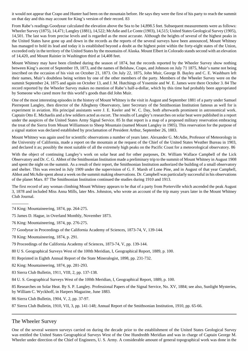
it would not appear that Crapo and Hunter had been on the mountain before. He says they were the first of his party to reach the summiton that day and this may account for King’s version of their record. 83
From Rabe’s readings Goodyear calculated the elevation above the Sea to be 14,898.5 feet. Subsequent measurements were as follows:Wheeler Survey (1875), 14,471; Langley (1881), 14,522; McAdie and Le Conte (1903), 14,515; United States Geological Survey (1905),14,501. The last was from precise levels and is regarded as the most accurate. Although the heights of several of the highest peaks inthe United States have gone up and down in the records as the reports of the several surveys have been announced, Mount Whitneyhas managed to hold its lead and today it is established beyond a doubt as the highest point within the forty-eight states of the Union,exceeded only in the territory of the United States by the mountains of Alaska. Mount Elbert in Colorado stands second with an elevationof 14,420, and Mount Rainier in Washington third at 14,408 feet.
Mount Whitney may have been climbed during the season of 1874, but the records reported by the Wheeler Survey show nothingbetween King’s ascent of September 19, 1873, and the names of Belshaw, Crapo, and Johnson on July 71 1875, Muir’s name not beinginscribed on the occasion of his visit on October 21, 1873. On July 22, 1875, John Muir, George B. Bayley and C. E. Washburn lefttheir names, Muir’s doubtless being written by one of the other members of the party. Members of the Wheeler Survey were on thesummit September 24, 1875 and again on October 13, and J. M. Hutchings of Yosemite and W. E. James were there October 3. 84 Therecord reported by the Wheeler Survey makes no mention of Rabe’s half-a-dollar, which by this time had probably been appropriatedby Someone who cared more for this world’s goods than did John Muir.
One of the most interesting episodes in the history of Mount Whitney is the visit in August and September 1881 of a party under SamuelPierrepont Langley, then director of the Allegheny Observatory, later Secretary of the Smithsonian Institution famous as well for isexperiment in aviation. His principal assistants were J. E. Keeler and W. C. Day, both afterwards prominent in astronomical work.Captain Otto E. Michaelis and a few soldiers acted as escort. The results of Langley’s researches on solar beat were published in a reportunder the auspices of the United States Army Signal Service. 85 In that report is a map of a proposed military reservation embracingthe treat of the Sierra from Mount Williamson to Sheep Mountain (named Mount Langley in 1905). This reservation for the purpose ofa signal station was declared established by proclamation of President Arthur, September 26, 1883.
Mount Whitney was again used for scientific observations a number of years later. Alexander G. McAdie, Professor of Meteorology inthe University of California, made a report on the mountain at the request of the Chief of the United States Weather Bureau in 1903,and declared it as; possibly the most suitable of all the extremely high peaks on the Pacific Coast for a meteorological observatory. 86
With the object of continuing Langley’s work on solar heat and for other purposes, Dr. William Wallace Campbell of the LickObservatory and Dr. C. G. Abbot of the Smithsonian Institution made a preliminary trip to the summit of Mount Whitney in August 1908and spent the night on the summit. As a result of their report, the Smithsonian Institution authorized the building of a small observatoryand shelter. This was erected in July 1909 under the supervision of G. F. Marsh of Lone Pine, and in August of that year Campbell,Abbot and McAdie spent about a week on the summit making observations. Dr. Campbell was particularly successful in his observationsof the planet Mars. 87 The Smithsonian Institution continued the studies during 1910 and 1913.
The first record of any woman climbing Mount Whitney appears to be that of a party from Porterville which ascended the peak August3, 1878 and included Miss Anna Mills, later Mrs. Johnston, who wrote an account of the trip many years later in the Mount WhitneyClub Journal.
————74 King: Mountaineering, 1874, pp. 264-275.
75 James D. Hague, in Overland Monthly, November 1873.
76 King: Mountaineering, 1874, pp. 276-275.
77 Goodyear in Proceedings of the California Academy of Sciences, 1873-74, V, 139-144.
78 King: Mountaineering, 1874, p. 291.
79 Proceedings of the California Academy of Sciences, 1873-74, V, pp. 139-144.
80 U S. Geographical Surveys West of the 100th Meridian, I, Geographical Report, 1889, p. 100.
81 Reprinted in Eighth Annual Report of the State Mineralogist, 1898, pp. 231-732.
82 King: Mountaineering, 1874, pp. 281-293.
83 Sierra Club Bulletin, 1911, VIII, 2, pp. 137-138.
84 U. S. Geographical Surveys West of the 100th Meridian, I, Geographical Report, 1889, p. 100.
85 Researches on Solar Heat. By S. P. Langley. Professional Papers of the Signal Service, No. XV, 1884; see also, Sunlight Mysteries,by William C. Wyckhoff, in Harpers Magazine, June 1883.
86 Sierra Club Bulletin, 1904, V, 2, pp. 37-97.
87 Sierra Club Bulletin, 1910, VII, 3, pp. 141-148; Annual Report of the Smithsonian Institution, 1910, pp. 65-66.
The Wheeler Survey
One of the several western surveys carried on during the decade prior to the establishment of the United States Geological Surveywas entitled the United States Geographical Surveys West of the One Hundredth Meridian and was in charge of Captain George M.Wheeler under direction of the Chief of Engineers, U. S. Army. A considerable amount of general topographical work was done in the

northern put of the Sierra Nevada and observations, already mentioned, were made on Mount Whitney in 1875, the latter by a partyunder command of Lieutenant Rogers Birnie.
Explorations in the Yosemite region were made in 1878 and 1879 by Lieutenant Montgomery Meigs Macomb, assisted by J. C. Spiller,topographer. Macomb and Spiller occupied a number of the higher peaks including Dunderberg, Conness, Lyell, Hoffmann, Merced,and Clark. The results of their work were compiled in what was for many years to come the standard map of the Yosemite region. Alist of altitudes of Yosemite peaks and waterfalls was also published. 88
————88 Annual Report of the Chief of Engineers, War Department, to, 1879, Appendix OO, pp. 2210-2144, 2233-2238; Sierra Club Bulletin,1915. X, 3, plate opp. p. 369.
Frank Dusy
The discovery of Tehipite Valley in the canyon of the Middle Fork of Kings River is credited to Frank Dusy. In 1869, while hunting onCrown Creek, he wounded a bear and, in the traditional manner, followed it to a new discovery. The bear made off down Crown Creekand Dusy pursued it to the brink of a cliff over which the bear tumbled. Dusy took off his shoes and walked barefoot along a ledge untilhe could reach a big oak by which he climbed down. Below he found the bear, by this time deceased. After continuing to the bottom ofthe canyon, Dusy climbed out through a wooded region not far from where the trail was subsequently built.
Frank Dusy was a very unusual man and deserves a prominent place in the annals of the Sierra. He was about the only stockman of hisday who took an interest in the mountains for reasons other than to find green feed. Bonn in Canada in 1836, he lived for a while in Maineand Boston, and came to California in 1858. He tried mining in Tuolumne County for a while and moved to Fresno County in 1864. Aftervarious occupations, including that of portrait photographer, he settled down to farming and stock-raising near Fowler. He establisheda summer home in the mountains between the San Joaquin and Kings rivers, This he called “Dinkey” from the name of his little dog.
Dusy was the last to explore the upper basin of the Middle Fork of Kings River. In 1877 he ascended as far as the Palisades, and in1879 he brought a bulky studio camera into Tehipite and took the first photograph ever made of Tehipite Dome. On this occasion hewas accompanied by Lil A. Winchell who still recalls the excitement of developing the wet plates in can improvised dark-room beside asmall creek. That Dusy, a man whose efforts were primarily engaged in raising sheep and cattle, should take such extraordinary troubleis an interesting comment on the enthusiasm aroused by Sierra scenery in all manner of people.
An interesting, though confused, account of Dusy is given in a remarkable paper-covered pamphlet entitled “A Guide to the Grand andSublime Scenery of the Sierra Nevada in the Region about Mount Whitney,” Published in 1883 by W. W. Elliott & Company, SanFrancisco. Part of the contents appeared in Elliott’s History of Fresno County the year before; but there are same notable additions,especially the lithographic plates of Tehipite Dome and Silver Spray Falls and some drawings by Gustav Eisen made on a trip into theSierra in 1875. The view of Tehipite is from Dusy’s first photograph. Aside from these two publications most of the information aboutDusy comes from correspondence with Lil A. Winchell, now living in Clovis.
Wallace, Wales and Wright
In the same little guide-book that gives us the information about Dusy and Tehipite, there is considerable information about the UpperKern River region derived from accounts furnished by Captain James William Abert Wright. In 1881 he made a trip to Mount Whitneywith William B. Wallace (now judge of the Superior Court of Tulare County), and the Reverend F. H. Wales. The three spent a nighton the summit of Mount Whitney in company with members of Langley’s party. 89 They then climbed Kaweah Peak and visited thehead-waters of the Kern. A number of the peaks and canyons were named on this trip and the names are shown on Wright’s map whichwas published both in Elliott’s History of Fresno County and in the “Guide.” Although several of these names are appropriate andcertainly have the right of priority, they have lapsed from use or have been superseded because the publications were not known to thosewho made subsequent maps. A few of the names remain, however, such as Mounts Young, Hitchcock, and Guyot.
Wallace made his first excursion in the Sierra in 1876 and still continues an active interest in the mountains, recently delivering aninspiring Fourth of July address from the brow of Moro Rock, whence he could look off up the Kaweah canyons to the Scenes of hisexpeditions of nearly fifty years ago. He was one of the most active men in the Mineral King mining excitement of 1879, and for thenext few years searched the Kings-Kern Divide and the head-waters of the Kaweah for signs of gold, silver, and copper. It was on oneof these expeditions that he located and named his Cloud Mine, from which came the name Cloud Creak, the easterly branch of RoaringRiver. 90 In 1889, in company with D. K. Zumwalt and John R. Zumwalt, he descended the Kings River from the upper canyon toa point below the ju[n]ction of the South and Middle forks. Supposing that they would be able to go through in one day, they weresurprised to find themselves entangled in almost insurmountable difficulties and only emerged after a battle of five days.
————89 Wallace, in Mount Whitney Club Journal, 1902, pp. 1-12.
90 Sierra Club Bulletin, 1924, XII, 1, pp. 47-48.
Lil A. Winchell
Lil A. Winchell, son of the E. C. Winchell who visited Kings River Canyon in 1868, became devoted to the Sierra as a young manand soon came to know its remoter regions perhaps better than any man of his time. After his visit to Tehipite with Dusy in 1879 hespent five months in the High Sierra, part of the time with Louis W. Davis, a Prospector whom he induced to accompany him. Mountainsummits were more in evidence than metals, and while this may have been disappointing to the prospector it was eminently satisfactory
to Winchell. On September 23, 1879, they made the first ascent of Mount Goddard. 91 Winchell’s knowledge of the High Sierra waslater of great value to Theodore S. Solomons and Joseph N. Le Conte in preparing the first detailed maps of the Middle and NorthForks of Kings River.
————91 Sierra Club Bulletin, 1923, XI, 4, p. 398.
Mining Ventures
It is only in recent years that the hope of discovering rich mining districts in the upper regions of the Sierra seems to have definitelysubsided. The Kearsarge and Mineral King excitements have already been mentioned. The next wave of excitement developed aboutthe year 1878 when prospectors staked out claims all over the main crest of the Sierra from Mammoth Pass at the head-waters of theSan Joaquin to the northern tributaries of the Tuolumne.
The Mammoth excitement began in the spring of 1878, and two towns known as Mammoth City and Pine City attained a total populationof about 1,500 in the following year. 92 The Minaret mining district, a little farther west, was established in 1878. As in a great manyother mining districts, the amount of capital required to develop the mines and the cost of Transporting the ore to the mills was too greatfor the quality of ore developed, and few of these mines continued active production for more than three or four years. Large depositsof iron were found in the Minaret region, and the time may still come when this ore will be mined, provided roads are developed. Asurvey for a railroad was actually made over the Mammoth Pass route in 1881, and it is surprising indeed that this pass has not beenutilized as one of the routes across the Sierra.
From 1879 to 1888 operations were carried on in the Homer mining district, principally in the May Lundy mine. At one time therewas a substantial mining town at Lundy. The temporary success of the May Lundy mine led to the development of operations higherup on the crest of the Sierra at the Tioga mine. As early as 1860, a sheep-herder had located a mine not far from the present TiogaPass, but it was not until 1881 that extensive development was carried on. At that time the Great Sierra Consolidated Silver MiningCompany was incorporated and during the next two years a wagon road was constructed to connect the mines with the roads leadingwestward into the San Joaquin Valley joining the Big Oak Flat mad at Crocker’s Station, a total length of about 56 miles, at a cost ofabout $61,000. Its eastern terminus was the town of Bennettsville, named for the president of the company, and situated near the Tiogamine, but Bennettsville and the mine soon faded from the scene and only the road remained as a monument to the type of enterprise thathas mined many an investor. 93 In 1888 a few of the eastern stockholders bought the entire property at sheriff’s sale and after severalattempts to resume operations at the mine, the property was practically abandoned until in 1915 Stephen T. Mather, who had just beeninvited to take charge of the national parks under the supervision of the Secretary of the Interior, recognized the value of the road fortourist travel and, largely through his own contributions, purchased it from heirs of the original stockholders and turned it over to thefederal government for the benefit of the public.
————92 Report of the State Mineralogist, 1888, p. 373.
93 Report of the State Mineralogist, 1888, pp. 367-371; R. S. Kuykendall, in Handbook of Yosemite National Park by Ansel F. Hall,1921, p. 26; Report of the Commission on Roads to Yosemite National Park, Senate Document No. 155, 56th Congress, 1st Session,February 8, 1900.
Early Settlers in the High Sierra
Before the National Forest Reserves and the National Parks were established, a few pioneers staked out their claims in the regions ofthe Sierra above the settlements. Some of these men explored the mountains far and wide, but as they seldom made known what theysaw, only a brief mention of a few of them will be made here.
One interesting pioneer of this period was John Baptist Lembert, a strange sort of hermit who took up a quarter-section of land inTuolumne Meadows in 1885 as a homestead. His claim included the Soda Springs and the meadow land across the river. Lembert hadlived for a time in and around Yosemite and conceived the idea of raising fine breeds of goats in the High Sierra. He built a log cabinon his claim and lived there with his goats for several years, both winter and summer, until the heavy storms in the winter of 1889-1890forced him to flee to Yosemite and abandon his goats. With the loss of his stock, he took to collecting butterflies and botanical specimens,which he sold to museums. His career ended in a tragedy in the winter of 1896-97 when his body was found in a cabin near CascadeCreek below Yosemite Valley, bearing the unmistakable signs of murder. The Lembert claim, which had been patented in 1895, waspurchased in 1912 by members of the Sierra Club. 94
John L. Murphy, a well-known guide of Yosemite Valley, secured a preemption patent on 160 acres on the shores of Lake Tenaya in1886. An interesting account of Murphy is given in Helen Hunt Jackson’s “Bits of Travel at Home.”
William Helm, for a time a partner of Frank Dusy, settled near the North Fork of Kings River. Helms Meadow beam his came. Collins,Shippe, Woods and others are likewise identified with the central regions of the Sierra. George Fiske of Sanger built a cabin at his mineon Cartridge Creek; Poly A. Kanawyer and D. K. Zumwalt established themselves in Kings River Canyon; and Jesse B. Agnew stillsspends his summers at Horse Corral Meadow.
In the Kaweah region the pioneers were less permanently established in the higher country as it was easier to make short excursionsfrom the valley. Hale Tharp has already been mentioned. Prominent among others were Joseph Palmer, William Clough, and JamesWolverton.
Strangest of all was the project of the Kaweah Co-operative Commonwealth Colony, a socialist enterprise for which an earthly paradisewas promised in the prospectuses and advertisements, but which ended with convictions in the courts. The essence of the proposal was: a

purely socialistic colony was to be established on the Kaweah River; a road was to be built by labor of the colonists up to the Giant Forest;the trees were then to be cut, sawed into lumber at the colony mill, and sold for a handsome price; the laborers were to receive wagesin paper time-checks, redeemable at the colony store for merchandise— real money was an abhorrence save as it came into the treasuryfrom the outside world. The first part of this program was carried out. The road was built nearly to Giant Forest and is still in use. Butthe titles to the timber lands were dubious and, luckily for future generations, none of the big trees were cut. The collapse of the schemewas hastened by internal discord and fraud on the part of the promoters and the Co-operative Colony faded from the scene in 1891. 95
————94 Sierra Club Bulletin, 1913, IX, pp. 36-30.
95 Visalia Delta, November and December 1891; Kaweah: How and Why the Colony Died, by Burnette G. Haskell, in Out West,September 1902; San Francisco Examiner, November 29, 1891.
Further Scientific Explorations
Following the State Geological Survey and the Wheeler Survey, there were several other scientific explorations of the Sierra. The UnitedStates Coast and Geodetic Survey under George Davidson made a reconnaissance of the northern Sierra Nevada in 1879 and at that timesignals were exchanged between stations on the summits of Round Top, near Lake Tahoe, and Mount Conness. A further reconnaissancefrom Mount Conness was carried on in 1887, and in 1890 it was occupied for a considerable period by a large party of the Survey. Theremains of a small observing station are still to be found on the summit. 96
The United States Geological Survey, organized in 1879 with Clarence King as its first Chief, proceeded to gather together all ofthe activities carried on by the several independent surveys that had been occupying the western field for the preceding ten years. Asystematic survey of the Sierra Nevada was not begun until about fifteen years later, but in 1882 and 1883 an intensive study wasmade of the region embracing Mount Lyell and Mount Ritter and Mono Lake. This work was carried on by Israel C. Russell, assistedby Willard D. Johnson as topographer, and under the general supervision of Grove Karl Gilbert. During the course of the field work,Russell and Gilbert visited the glaciers of Mount Dana and Mount Lyell, and Johnson made observations from the summits of MountsConness, Maclure, and Ritter.
In these explorations, particularly those dealing with the glaciers of Mounts Lyell, Dana, and Ritter, many of the findings of Muir andJoseph Le Conte in 1872 were confirmed. 97
————96 George Davidson, Overland Monthly, February 1892.
97 Fifth Annual Report of the U. S. Geological Survey, 1883-84, pp. 31-32, 303-328; Eighth Annual Report of the U. S. GeologicalSurvey, 1886-87, I, pp. 261-394; Glaciers of North America, by Israel C. Russell, 1897, pp. 37-54.
A New Epoch
By the year 1890 the main features of the Sierra Nevada had been pretty thoroughly explored and intensive studies had been made ofmany important sections. The mining possibilities had been exploited from one end of the crest to the other, with momentary periods ofsuccess but ultimate failure. A number of the high peaks had been ascended and all of the principal canyons had at least been visited.Yet, if one were to attempt to compile the reliable information existing in published form at that time, he would find little beyond thewritings of John Muir, the publications of the Whitney Survey, a few tables published by the Wheeler Survey, and the recent monographsof Israel C. Russell.
As for maps, the only ones obtainable were the Whitney and Wheeler Survey sheets and the detailed studies of Russell and Johnsonin the Mount Lyell and Mount Ritter region. No reliable details whatever of the sources of the San Joaquin, the Kings, and the Kernrivers were available. Even the Yosemite maps prepared by the Wheeler Survey were useful only for their main features and the detailshad to be supplied by later surveys.
The possibilities of recreational enjoyment in the High Sierra seemed to be almost forgotten since the early enthusiasm inspired by thewritings of King, Muir, and Le Conte. The remote recesses of the range were practically given over to the sheepmen, and in the timberbelt destruction was steadily going on among the big trees. The management of Yosemite Valley by the State was beginning to exciteunfavorable comment and, in short, the year 1890 may be said to mark the lowest point in the welfare of the Sierra as a permanentasset of the State and Nation.
A new generation now came forward, and in the next decade the Sierra was thoroughly explored from one end to the other. Vacanciesin the maps were filled in and a great many valuable contributions were made to several branches of the natural sciences. The leadersin this new period of exploration were members of the United States Geological Survey, officers of the United States Army on duty inthe national parks, and members of the Sierra Club. Their work was supplemented by that of a number of other groups and individuals.
The National Parks
Until 1890, with the exception of the Yosemite Valley and the Mariposa Grove, none of the public lands in the Sierra Nevada had beenwithdrawn from entry and reserved for public use, excepting by occasional temporary orders. It now became apparent to men of visionthat the entire watershed of the Sierra was so valuable for the general welfare that its exploitation for private gain would be an irreparableinjury. John Muir was foremost in urging the people of the country to protect their property before it was too late. In the summer of 1889

he accompanied Robert Underwood Johnson of the Century Magazine on a trip to Yosemite and the Tuolumne Meadows, and enlistedbig aid. In the following summer two articles by Muir appeared in the Century Magazine. 98
At about the same time the threatened destruction of the big trees of the Giant Forest by the Kaweah colonists and other timber claimantsaroused the public-spirited men of Tulare County and, led by George W. Stewart, Frank J. Walker, D. K. Zumwalt, John Tuohy, TiptonLindsey, and others, they succeeded in having the big tree lands withdrawn from entry pending action by Congress. The CaliforniaAcademy of Sciences, with the assistance of Dr. Gustav Eisen, took up the campaign and a bill proposing a national park was introducedby Representative William Vandever and enacted September 25, 1890. A few days later General Vandever’s bill establishing theYosemite National Park came up and on the tide of success an amendment was added practically doubling the Sequoia National Parkand tacking on the General Grant National Park for good measure. This bill was enacted October 1, 1890.
By this act the Yosemite National Park was constituted from territory surrounding Yosemite Valley embracing most of the upperwatersheds of the Merced and Tuolumne rivers and put of the upper San Joaquin. The Valley itself remained under management ofthe State of California until receded to the federal government by act of the state legislature of March 3, 1905, and accepted by jointresolution of Congress June 11, 1906, after which it was consolidated with the national park. An adjustment of boundaries was madeby act of February 7, 1905, by which the portion of the park in the San Joaquin watershed was eliminated and the northern tributariesof the Tuolumne added. A considerable portion of the forest lands in the western portion of the original park was in private ownershipbefore 1890, and in 1905 this area was also eliminated.
The establishment of the national parks had an important effect on the exploration of the Sierra as it placed upon the government aresponsibility for protection and in management. No provision was made, however, in the enactments in, guarding and maintaining theparks other than placing them under the authority of the Secretary of the Interior. Following a precedent recently established in theYellowstone National Park, the Secretary called upon the War Department for assistance, and from 1891 until 1914 the administrationwas in the hands of officers of the Army with troops of cavalry detailed for patrol and other duties.
The first superintendent of Sequoia National Park was Captain Joseph Haddox Dorst, 4th Cavalry, who was in charge in 1891 and1892. In Yosemite the first superintendent was Captain Abram Epperson Wood, 4th Cavalry, in charge from 1891 until his death inthe spring of 1894. These two officers inaugurated a regime of vigorous protection of the public interests, which was ably maintainedby their successors.
————98 Treasures of the Yosemite, in Century Magazine, August 1890; Features of the Proposed Yosemite National Park, in CenturyMagazine, September 1890.
McClure, Davis and Benson
The greatest difficulties at first were in convincing the sheep and cattle owners that the rights of the public were paramount in the publicdomain. Free grazing had been going on for so long that the stockmen considered the territory their own. The pursuit of these trespassersgave the army men some of the thrills of real warfare. The greatest deterrent proved to be the plan of Kettering the trespassing sheepover the boundary on one side of the park and conducting the herders over the opposite boundary many days’ journey away. LieutenantHarry C. Benson became the greatest exponent of this stategy, first in Sequoia and later Yosemite. 99 In both parks the administrationwas hampered by the lack of detailed maps showing definitely the boundaries established by Congress. The superintendents, therefore,set about making their own maps and were fortunate in the assistance of such capable and enthusiastic officers as Lieutenants NathanielF. McClure, Harry C. Benson, and Milton F. Davis. McClure prepared a map of Yosemite published in 1896, which was added toand corrected in the following year by Benson. About the mine time, Davis made a reconnaissance of the region surrounding SequoiaNational Park and prepared an excellent map. In 1899 Lieutenant Henry B. Clark brought out an improved map of the Sequoia NationalPark region, and in 1900 the boundaries of that park were accurately surveyed by Isaac M. Chapman.
McClure contributed a great deal to the knowledge of the upper Yosemite region. He made several trips in 1894 and 1895 north of theTuolumne River exploring the canyons and endeavoring to find a satisfactory route through this northern section of the park to connectTuolumne Meadows and Hetch Hetchy. Sergeant Alvin Arndt had made a preliminary reconnaissance in 1893. McClure also searchedfor a route across the head-waters of the Merced into the North Fork of the San Joaquin, and was successful in finding a pass near TripleDivide Peak which he named Isberg Pass for one of his men who discovered it. 100
Lieutenant Davis was in Yosemite from 1891 to 1893 and during that time travelled far and wide through the upper parts of the parkgathering valuable information about sheep-herders, trails and passes. In 1896 he was stationed in Sequoia National Park.
In Yosemite, Lieutenant Benson not only continued the mop-raking begun by McClure, but took the lead in stocking the upper watersof the Merced and the Tuolumne with trout largely supplied in the hatchery at Wawona. William F. Breeze and Lieutenant WilliamR. Smedberg rendered valuable assistance. A few years later Benson, then a major, returned to Yosemite as superintendent, servingfrom 1905 to 1908,
————99 Annual Report of the Acting-Superintendents, Sequoia National Park and Yosemite National Park, 1891-1897; California AlpineClub Trails, 1923, pp. 27-30.
100 McClure, in Sierra Club Bulletin, 1895, I, 5, pp. 168-186; 1896, I, 8, pp. 330-335.
The Sierra Club
The Sierra Club was established in 1892 “To explore, enjoy and render accessible the mountain regions of the Pacific Coast; to publishauthentic information concerning them; to enlist the support and co-operation of the people and the Government in preserving the forestsand other natural features of the Sierra Nevada Mountains.”
The charter members were energetic and enthusiastic and at once set about accomplishing to the best of their abilities the purposes ofthe Club. They loved the mountains and they loved the adventures of exploring unknown canyons and climbing hitherto unscaled peaks.It would be impossible even to enumerate all the pioneering trips undertaken by this group, but home of them were so important in thedevelopment of reliable information and in the production of maps that they should be given more than passing mention.
The annals of the Sierra Club are contained in the Sierra Club Bulletin, issued at first semi-annually, later once a year. Since its beginningin 1893 the Bulletin has been filled with interesting material, covering a more varied field than most mountaineering journals.
Theodore S. Solomons101
One of the most energetic of the Sierra Club explorers was Theodore Seixas Solomons who spent many months in the High Sierra from1892 to 1897. To him more than anyone else is due the credit of determining correctly the courses of the upper branches of the SanJoaquin. In 1892, accompanied by Joseph Le Conte and Sidney I. Peixotto, he crossed from Mount Lyell by way of Rush Creek to thebase of Mount Ritter and ascended the peak. A few weeks later he returned alone and after again climbing the mountain continued tothe canyon of Fish Creek, and thence by way of Balloon Dome to the Miller and Lux bridge on the San Joaquin. This trip resulted in agreat addition to the knowledge of the North and Middle forks of the San Joaquin.
In 1894 Solomons made a trip with Leigh Bierce, going from Wawona to Mono Creek, where they visited and named Vermilion Valley.Thence they crossed over to Bear Creek and climbed the beautiful mountain which they named Seven Gables. They were forced by amow storm to abandon their outfit and escape from the mountains at the end of September, by way of Ockenden’s.
The next year, 1895, Solomons took his most notable trip, in company with Ernest C. Bonner. Ascending the South Fork of the SanJoaquin they came to that splendid mass of mountains now designated the Evolution Group from the names bestowed upon them bySolomons. The grandest and highest of all be called Mount Darwin, and to the others he gave the names of Haeckel, Wallace, Fiske,Spencer, and Huxley. He and Bonner climbed Mount Wallace but were unsuccessful in an attempt to scale Mount Darwin. On recentmaps the name of Mount Wallace has been transposed from the point on the main crest just south of Mount Haeckel, to which it wasoriginally given by Solomons, to the westerly ridge of Mount Darwin. Continuing their explorations, Solomons and Bonner ascendedMount Goddard, whence they made their way down to Simpson Meadow by North Goddard Creek, and were the first to make thissection known.
Solomons’ excursions in the next two years added a few details here and them to the knowledge of Sierra topography, but his principalcontribution was a remarkably accurate map which he draughted and presented to the Sierra Club in 1896.
————101 Sierra Club Bulletin, 1894, I, 3, pp. 61-84, 1895, I, 6, pp. 221-237, 1896, I, 7, pp. 287-288; Appalachia, January 1896, pp. 41-57;Overland Monthly, May, June, August, November, 1896, and July, August, 1897.
Bolton Coit Brown102
Bolton Colt Brown, Professor of Fine Arts at Stanford University, devoted his attention mainly to the sources of Kings River. In 1895,after a trip in Kings River Canyon and a vain attempt to reach the summit of Mount King, he crossed to Simpson Meadow and ascendedMount Woodworth; thence he made his way up Cartridge Creek and returned to the head-waters of the South Fork of Kings River. Herehe observed and named Split Mountain, Striped Mountain, and Arrow Peak, and returned to Kings River Canyon by way of ParadiseValley. In the following year, accompanied by his wife, Lucy Fletcher Brown, he again visited Kings River Canyon and joined JosephN. Le Conte in a successful ascent of Mount Gardner. After a visit to Mount Brewer, he and Mrs. Brown crossed the Kings-Kern Divideand climbed Mount Williamson. A little later, Brown made the first ascent of Mount Stanford and gave it its name. He concluded theseason with a successful ascent of Mount King after a daring solitary climb.
Three years later, in 1899, Mr. and Mrs. Brown returned to the Kings River region, bringing with them their two year old daughter, whoseemed to enjoy the entire trip and was undoubtedly the most youthful pioneer of the High Sierra. From camp, at Bullfrog Lake nearKearsarge Pass, they explored the basin to the north with its many lakes and remarkable granite formations, naming one of them The Fin.
Professor Brown made a series of admirable sketches of the mountain summits, which appear in the Sierra Club Bulletin accompaniedby a number of charts showing his routes and the names which he gave to many of the landmarks. A number of them names survive onpresent maps, but unfortunately a few, such as Flying Cloud Pass and Castilleja Lake, have disappeared.
————102 Sierra Club Bulletin, 1896, I, 7, pp. 241-253, 289; 1896, I, 8, pp. 293-313; 1897, II, 1, pp. 17-29; 1897, II, 2, pp. 90-98; 1900,III, 2, pp. 135-149.
Joseph N. Le Conte103
The third great explorer of the Sierra Club group was Joseph N. Le Conte, son of Joseph Le Conte whom connection with the Sierrahas already been told. The younger Le Conte began his Sierra explorations in 1899 when he visited the upper regions of Yosemite with

his father and ascended Mount Dana and Mount Lyell. From that time to the present day he has been active in Sierra exploration andhas been the leading contributor to the knowledge of the High Sierra. Not content with exploring and making sketch-maps, Le Conterecognized the value of a truly Scientific exploration and early in his career began a series of observations to get accurate bearings, fromthe high peaks. Combining this scientific knowledge with the information furnished by Solomons, McClure, and other map-makers,Le Conte published through the Sierra Club a series of maps which were greatly appreciated by all visitors to the Sierra prior to thepublication of the quadrangles of the United States Geological Survey. Le Conte supplemented his maps with the finest collection ofphotographs of the high mountain regions that has ever been brought together. Many of them pictures, taken twenty-five or thirty yearsago, are still in demand as illustrations for publications on the mountains of California.
Some of Le Conte’s most notable excursions were: 1896, when with Miss Helen Marion Gompertz (later Mrs. Le Conte) and others,he climbed University Peak and Mount Brewer, and ascended Mount Gardner with Bolton Coit Brown; 1898, when with Clarence L.Cory he traversed the Sierra in search of a through route from Yosemite to Kings River Canyon; 1900, when he took his father on amemorable outing into the Kings River Canyon and up to Kearsarge Pass; 1902, when he explored the sources of the South Fork of KingsRiver after crossing from the Middle Fork by way of Cartridge Creek, ascended Split Mountain with Mrs. Le Conte, and completed theobservations of Brown already mentioned; 1903, when with James S. Hutchinson and James K. Moffitt, he made first ascents of theNorth Palisade and Mount Sill and explored the basin of Palisade Creek; 1904, when he visited the Evolution Peaks with Grove KarlGilbert and prospected a route from the head-waters of the South Fork of the San Joaquin to the Middle Fork of Kings River, later tobe developed as Muir Pass; 1908, when with James S. Hutchinson and Duncan McDuffie, he made mother search for a high mountainroute, this time keeping much closer to the main crest than anyone had hitherto attempted.
On the expedition of 1908, the party climbed several high peaks and crossed successfully from Evolution Basin to the Middle Fork ofKings River. This feat had been performed for the first time in the preceding year by a party of the United States Geological Surveyunder George R. Davis. The expedition of 1908 followed very nearly the ideal High Sierra route proposed later as the John Muir Trail.After Le Conte’s expedition, only one or two gaps in this route remained to be explored.
————103 Sierra Club Bulletin, numerous contributions.
Other Sierra Club Explorers
Other pioneers of the Sierra Club group who made valuable contributions to the knowledge of the high mountains during the decadefollowing 1892 deserve more extended mention than is possible within the present limits, but they should at least be enumerated. Amongthem were: Robert M. Price, Louis deF. Bartlett, Cornelius Beach Bradley, T. P. Lukens, W. L. Richardson, William R. Dudley, C.Mulholland, William L. Hunter, A. W. de la Cour Carroll, Howard Langley, M. R. Madary, Warren Gregory, Dr. Emmet Rixford,Charles A. Noble, James S. Hutchinson.
In 1899 Dr. and Mrs. David Starr Jordan, with a party of friends from Stanford University including Professor and Mrs. Elwood P.Cubberley, Professors George M. Richardson and Vernon L. Kellogg, and others, visited Kings River Canyon and climbed several ofthe peaks at the bead-waters of Bubbs Creek. 104
Since 1900 the efforts of the Sierra Club explorers, supplemented by those of many independent parties, have been directed towardsfinding improved routes and opening up new passes. In this they have co-operated with the surveying parties, the Forest Service andthe National Park Service, and with the several counties and the State of California. The culminating achievement of these endeavorswas the construction of a through trail from Yosemite to Mount Whitney, dedicated by the State of California as the John Muir Trail.Under the state appropriations, trails over Muir Pass from the San Joaquin to the Kings, and junction and Shepherd passes from theKings to the Kern, were constructed.
Two important connecting trails remain to be built over routes discovered and tested in recent years. A way suitable for pack animalswas long sought between the head-waters of Roaring River in the basin of the Kings to Kern River Canyon. Such a route had been usedby sheepmen, probably with burros, but it was so difficult of access that it remained for a long time obscure. In 1912, William E. Colby,leader of the Sierra Club Outing in the Kern, led a reconnaissance that discovered a practicable route from that side, and members ofthe party named it Colby Pass. Afterwards he prospected the route from Roaring River. It was not until 1920, however, that a partysucceeded in taking horses across. This was accomplished under the leadership of Duncan McDuffie, James S. Hutchinson, and ErnestMcKee, assisted by Ralph P. Merritt. 105
The other important connection lies over the pass from the head-waters of the South Fork of Kings River to the head of Palisade Creekin the Middle Fork basin. This pass was known to the sheepmen, but the first crossing by pack animals, other than burros, going all theway through from one basin to the other, was that of Chauncey 1. Hamlin and party, with Ernest McKee, in 1921. They named the passMather Pass, in honor of Stephen T. Mather, Director of the National Park Service. 106
————104 Jordan, in Sunset Magazine, April 1900; The Alps of the King[s]-Kern Divide, San Francisco, 1907; The Days of a Man, New York1922, I, pp. 650-655; Sierra Club Bulletin, 1900, III, 1, pp. 109-111, 1900, III, 2, pp. 167-169.
105 Sierra Club Bulletin 1921, XI, 2, pp. 128-129.
106 Sierra Club Bulletin 1922, XI, 3, p. 270; Sierra Club Bulletin 1923, XI, 4, p. 423.
The United States Geological Survey
The work of the United States Geological Survey in the Sierra Nevada began in the northern section, and it was not until 1893 and1894 that the Yosemite quadrangle was surveyed. This was followed by the Mount Lyell quadrangle in 1898 and 1899, and from that
time on the work was continued towards the south until the final section of the High Sierra was completely surveyed in 1909 and theMount Goddard quadrangle published in 1912.
The earlier work of these surveys was conducted by Robert B. Marshall who was later appointed Chief Geographer, and it was largelydue to his interest and enthusiasm that the work progressed so steadily. Among others who played an important part in the field workwere C. F. Urquhart and George R. Davis. Davis’ topographical work in the Mount Goddard region, comprising some of the roughestand most intricate country in the United States, is a remarkable achievement, and the Mount Goddard quadrangle is a testing monumentto his great ability as a topographer.
Following the main topographical work and the publication of the maps, a number of intensive studies were carried on by the Survey.The earlier work of Gilbert, Russell, and Johnson has already been mentioned. Grove Karl Gilbert subsequently made a number ofexpeditions into the High Sierra. In 1903 he was with the Sierra Club in the Kern, region and in the same year revisited the MountLyell glacier and compared its appearance with that in 1883. 107 In 1904 he was with J. N. Le Conte in the Evolution Basin, He wasagain in the Evolution Basin in 1908 and on that occasion was accompanied by E. C. Andrews of the Geological Survey of New SouthWales and by Willard D. Johnson. 108
The latest intensive studies of the Survey have been those of François E. Matthes, whose work in the Yosemite region is particularlynoteworthy.
————107 Sierra Club Bulletin, 1904, V, 1. pp. 23, 58; 1919, X, 4, p. 393.
108 Sierra Club Bulletin, 1920, XI, 1, p. 65; 1924, XII, 1, pp. 88-90.
The United States Forest Service
The Sierra Forest Reserve was established by act of Congress February 15, 1893, after eight years of effort on the part of its advocates.The reserve embraced most of the High Sierra not already included in the national parks. As in the case of the parks, the first problemwas to teach individuals that the forests were the Property of the nation and that they must be administered for the beat interests of thenation. By act of Congress February 1, 1905, the forest reserves were transferred from the Department of the Interior to the Departmentof Agriculture and have since been known as the National Forests, administered by the Forest Service. The Sierra National Forestwas divided by presidential proclamation on July 2, 1908 into two administrative units, the northern section retaining the name SierraNational Forest, the southern being designated as the Sequoia National Forest, Further subdivisions were made later.
The administration of the national forests brought a new element into the exploration of the Sierra. Trails were built, grazing and timberareas were investigated and plotted on maps, and many other beneficial activities were carried on. The names of the forest rangers andsupervisors who carried On this work would make a long list and only a few of the more prominent can be selected here as representative:Sam N. L. Ellis, Charles H. Shinn, A. H. Hogue and Richard L. P. Bigelow.
The engineers of the Forest Service, Walter Leroy Huber and his successor Frederick Hall Fowler, made thorough examinations of thewater resources, supplementing the work of the Geological Survey and Other engineers, for the purpose of passing on applications forwater supply and power sites; and the regulation of water risen. The development of hydroelectric power in the Sierra Nevada has beensummarized in a comprehensive treatise by Fowler. 109
In recent years one of the important contributions of the Forest Service to Sierra exploration was the assistance rendered to the StateEngineer in surveying the route and supervising the construction of the John Muir Trail. In this, the knowledge and enthusiasm ofSupervisor Paul G. Redington, now United States District Forester, were an important factor. Sedman W. Wynne located the route overJunction and Shepherd passes. 110
On July 6, 1911 the Devil’s Postpile, one of the finest instances of columnar basalt formation in the world, on the Middle Fork of SanJoaquin River, was proclaimed by President Taft a national monument under the administration of the Forest Service. 111
————109 Hydroelectric Power Systems of California, by Frederick Hall Fowler, U. S. Geological Survey Water-Supply Paper 493,Washington 1923, pp. xlix, 1276.
110 Sierra Club Bulletin, 1916, X, 1, pp. 96-92; 1917, X, 2, pp. 221-226.
111 Sierra Club Bulletin, 1912, VIII, 3, pp. 170-173.
Sierra Club Outings
The Sierra Club was a successful institution from the beginning, drawing to itself many ardent lovers of the mountains as well as manypublic spirited citizens who desired to support its objects. As the mountains became better known and access became easier, the leadersof the Club decided that something might be done to bring a larger number of its members into the High Sierra by means of an organizedexpedition each year. The first of these outings took place in 1901 when over one hundred members visited the Tuolumne Meadowsand vicinity for several weeks. The following year a larger party went to Kings River Canyon, and in 1903 the outing was held in theKern River region.
In spite of difficulties arising from inexperience, these outings were a success from the start and served not only to build up an enthusiasticmembership of the Club but to produce vastly more knowledge of all kinds about the Sierra than could have been obtained in so shorta time by any other means. The remarkably successful organization of these outings was due to a very competent Outing Committee

composed of William E. Colby, Joseph N. Le Conte, and Edward T. Parsons. This committee has continued to conduct the outingsannually, With only one change in membership when Clair S. Tappalan replaced Parsons after the latter’s death in 1914.
With the main Sierra Club encampment as a base, it was possible for the more enterprising of the members to take rapid excursions intothe surrounding country and to conduct scientific investigations, particularly in botany and geology, under the most favorable conditions.The significance of these outings in the history of Sierra exploration is apparent in the names included in the enrollment of the firstthree years: John Muir, William Keith, C. Hart Merriam, Henry Gannett, Theodore H. Hittell, Charles Keeler, John Gill Lemmon,Alexander G. McAdie, Grove Karl Gilbert, Andrew C. Lawson, John Knox McLean. An interesting account of the Kings River trip in1902, commenting particularly on these notable personalities, was published in Out West, November 1902, by Hugh S. Gibson, nowa member of the United States Diplomatic Corps.
Mountaineering
From the days of Clarence King in 1864, the High Sierra peaks have been an attraction to mountain climbers. They present problemsquite different from those of the Alps and other regions where snow and ice predominate and where sudden storms produce dangeroussituations that require extreme caution. Summer storms in the Sierra are infrequent and, excepting for lightning on exposed places,are never dangerous. The larger peaks of the Sierra Nevada are granite and, saving a few snow-fields such as those on Mount Lyelland Mount Ritter, most of the difficult climbing is on the bare rock—in this respect somewhat resembling the Dolomites. Most of theadventures recounted in the first ascents of the Sierra peaks occurred on attempts to find the routes; the second and subsequent ascentsrarely produced the same degree of difficulty.
Clarence King, as already mentioned, did not have the faculty of discovering the easiest routes and made a great deal of hard workout of ascents that other climbers have found comparatively easy. Nevertheless, it should be remembered that King was surrounded byconditions with which his successors did not have to deal. No one then knew just how difficult or dangerous these mountains were,and in such cases there is always a tendency to exaggerate. Moreover, King was a novice at the art of climbing and did not have theadvantage of being taught by skillful climbers of long experience. For these reasons he should not be too severely criticized.
Muir was a climber of an entirely different type; possessing the highest degree of skill and the steadiest of nerves, he was able to scramblewhere probably few individuals would ever be able to follow. Muir climbed for the sake of pure enjoyment and for the purpose ofobserving the particular things that he wanted to see. Records of his climbs were incidental to his major interests, and for that reason wecan seldom tell from the published accounts of his Sierra experiences just what mountains he climbed or, when that is known, by whatroute or on what date. Undoubtedly he climbed many a peak upon which he was the unrecorded first visitor.
Between the time of King and Muir and the activities of the Sierra Club members, only a few names appear in the annals of Sierramountaineering. Most of these names appear in the list of first ascents of the principal peaks given below. The narratives of first ascentssince 1890 are in most cases to be found in the pages of the Sierra Club Bulletin, and many of them deserve a high place in mountaineeringliterature. Many other parties climbed these and other less prominent peaks, but excepting for the discovery of better routes, their recordshardly belong in a history of exploration.
The following list is compiled largely from the Sierra Club Bulletin and precise references to original authorities may be traced in mostinstances through the list of place names to be found in the issues of 1923, 1924, and 1925. The elevations are from the United StatesGeological Survey maps.
FIRST RECORDED ASCENTS OF THE PRINCIPAL PEAKSOF THE SIERRA NEVADA
(Including all that exceed 14,000 feet)
Mount Whitney (14,501): John Lucas, Charles D. Begole, A. H. Johnson, August 18, 1873.
Mount Williamson (14,384): William L. Hunter, C. Mulholland. About 1884.
North Palisade (14,254): Joseph N. Le Conte, James K. Moffitt, James S. Hutchinson. July 25, 1903.
Mount Russell (14,190): No record.
Mount Sill (14,100 approx.): Joseph N. Le Conte, James K. Moffitt, James S. Hutchinson, Robert D. Pike. July 24, 1903.
Split Mountain (Smith Palisade) (14,051): Mrs. Helen M. Le Conte, Joseph N. Le Conte, Curtis M. Lindley, July 23, 1902.
Middle Palisade (14,049): Francis P. Farquhar, Ansel F. Hall. August 26, 1921.
Mount Langley (14,042): Clarence King, Paul Pinson. July 1871.
Mount Muir (14,025): No record.
Mount Tyndall (14,025); Clarence King, Richard Cotter. July 1864.
Mount Bernard (14,003): C. Mulholland, William L. Hunter, John Hunter, William Hunter. September 25, 1992.
Mount Keith (13,990): Cornelius Beach Bradley, Joseph C. Shinn, Mrs. Jennie E. Price, Robert M. Price. July 6, 1999.
Mount Stanford (13,983): Bolton Coit Brown. August 1896,
Mount Humphreys (13,972): James S. Hutchinson, Edward C. Hutchinson. July 19, 1904.
Mount Le Conte (18,960): No record of complete ascent.
Junction Peak (13,903): Edwin B. Copeland, E. N. Henderson. August 8, 1899.
Mount Darwin (13,841): E. C. Andrews. (Probably the only ascent to highest point.) August 12, 1908.
Mount Kaweah (13,816): J. W. A. Wright, William B. Wallace, F. H. Wales. September 1881,
Red Kaweah (13,754); Charles W. Michael. July 1912.
Black Kaweah (13,752): Duncan McDuffie, Onis Imus Brown, James S. Hutchinson. August 11, 1920.
Mount Abbot (13,736): Joseph N. Le Conte, James S. Hutchinson, Duncan McDuffie. July 13, 1908.
Table Mountain (13,646): Paul Shoup and party. August 1908.
Milestone Mountain (13,643): William E. Colby, Robert M. Price, Francis P. Farquhar. July 14, 1912. (Possibly by George R. Davis,earlier.)
Mount Ericsson (13,625): Bolton Colt Brown, Mrs. Lucy Fletcher Brown. 1896.
Tunnabora Peak (13,593): George R. Davis. August 1905.
University, Peak (13,588): Joseph N. Le Conte, Miss Helen M. Gompertz, Miss Belle J. Miller, Miss Estelle Miller. July 12, 1896.
Mount Brewer (13,577); William H. Brewer, Charles F. Hoffmann. July 2, 1864.
Mount Goddard (13,555): Lil A. Winchell, Louis W. Davis, September 23, 1879.
Mount Pinchot (13,471): George R. Davis. 1906.
Mount Haeckel (13,422): Walter Leroy Huber and party. July 14, 1920.
North Guard (13,304): David Starr Jordan. 1899.
Mount Ritter (13,156): John Muir. October 1872.
Red Slate Peak (13,152): Joseph N. Le Conte, Clarence L. Cory. June 22, 1898.
Mount Lyell (13,090): John Muir. 1871.
Mount Dana (13,050): James Dwight Whitney, William H. Brewer, Charles F. Hoffmann. June 28, 1863.
South Guard (12,964): Walter Leroy Huber, James Rennie, Florence C. Burrell, Inezetta Holt. July 26, 1916.
Banner Peak (12,057): Willard D. Johnson, John Miller. August 26, 1883.
Mount King (12,909): Bolton Coit Brown. 1896.
Mount Gardner (12,903): Joseph N. Le Conte, Bolton Colt Brown. July 1896.
Red and White Peak (12,840): Lincoln Hutchinson, James S. Hutchinson, Charles A. Noble, July 18, 1902.
Mount Conness (12,556): Clarence King, James T. Gardner. 1864.
The Minarets (Highest) (12,278): Charles W. Michael. September 6, 1923.
Mount Clark (11,506): Clarence King, James T. Gardner. July 12, 1866.
Half Dome (8,852): George G. Anderson. October 12, 1875.
Recent Scientific Explorations
To give an adequate account of the numerous contributions to the natural sciences that have been made in recent years would fill morethan one substantial volume. Perhaps the best way to indicate the extent and importance of these researches is to enumerate a fewof the more important publications of some of the more prominent individuals. The following list is not intended to be complete orcomprehensive:
Andrews, E. C. (Department of Mines, New South Wales).
An Excursion to the Yosemite (California), or Studies in the Formation of Alpine Cirques, “Steps,” and Valley “Treads.” InJournal and Proceedings of the Royal Society of New South Wales, Vol. XLIV. 1910.
Camp, Charles Lewis (Museum of Paleontology, University of California).
Several contributions to University of California Publications in Zoology. 1916-1918.
Eastwood, Alice.
A Flora of the South Fork of Kings River from Millwood to the Headwaters of Bubbs Creek. Publications of the Sierra Club,No. 27. 1902.
Evermann, Barton Warren (Director of the Museum of the California Academy of Sciences).
The Golden Trout of the Southern High Sierras. In Bulletin of the Bureau of Fisheries, XXV, 1905. 1906.
Gilbert, Grove Karl.
Variations of Sierra Glaciers. Sierra Club Bulletin, Vol. V, No. 1. 1904.

Domes and Dome Structure of the High Sierra. Bulletin of the Geological Society of America, Vol. 15, 1904. Reprinted inSierra Club Bulletin, Vol. V, No. 3. 1905.
Systematic Asymmetry of Crest Lines in the High Sierra of California, Journal of Geology, Vol. XII. Reprinted in Sierra ClubBulletin, Vol. V, No. 4. 1905.
Lake Ramparts. Sierra Club Bulletin, Vol. VI, No. 4. 1909.
Grinnell, Joseph (Director of the Museum of Vertebrate Zoology, University of California), and Storer, Tracy Irwin, (Field Naturalistof the Museum of Vertebrate Zoology, University of California).
Animal Life in the Yosemite: an Account of the Mammals, Birds, Reptiles, and Amphibians in a Cross-Section of the SierraNevada. Berkeley, 1924.
Life Zones, Birds, Mammals, and Reptiles and Amphibians of Yosemite National Park. In Handbook of Yosemite NationalPark, by Ansel F. Hall. 1921.
Hall, Harvey Monroe (Assistant Professor of Botany, University of California). With Carlotta Case Hall.
A Yosemite Flora. San Francisco, 1912.
Jepson, Willis Linn (Professor of Botany, University of California).
The Silva of California. Memoirs of the University of California, Vol. 2. 1910.
The Trees of California. San Francisco, 1909. New edition, Berkeley, 1923.
A Flora of California. Partly published, remainder in process of publication.
The Giant Sequoia, and Flowers of Yosemite National Park. In Handbook of Yosemite National Park, by Ansel F. Hall. 1921.
A Manual of the Flowering Plants of California, San Francisco, 1925.
Johnson, Willard D.
The Grade Profile in Alpine Glacial Erosion. Journal of Geology, October-November, 1904. Reprinted in Sierra Club Bulletin,Vol. V, No. 4. 1905.
Knopf, Adolph.
A Geological Reconnaissance of the Inyo Range and the Eastern Slope of the Southern Sierra Nevada, California. U. S.Geological Survey, Professional Paper 110. 1918.
With Paul Thelen: Sketch of the Geology of Mineral King, California. University of California Publications, Bulletin of theDepartment of Geology, Vol. 4, No. 12. 1905.
Lawson, Andrew C. (Professor of Geology and Mineralogy, University of California).
The Geomorphogeny of the Upper Kern Basin. University of California Publications, Bulletin of the Department of Geology,Vol. 3, No. 15. 1904.
Geology of Yosemite National Park. In Handbook of Yosemite National Park, by Ansel F. Hall. 1921.
Matthes, François E. (U. S. Geological Survey).
Little Studies in the Yosemite Valley, Sierra Club Bulletin, Vol. VII, No. 4; Vol. VIII, No. 1; Vol. VIII, No. 2; Vol. IX, No.1. 1910-1913.
Studying the Yosemite Problem. Sierra Club Bulletin, Vol. IX, No 3. 1914
Sketch of Yosemite National Park and Account of the Origin of the Yosemite and Hetch Hetchy Valley,. 1912.
Cockscomb Crest. Sierra Club Bulletin, Vol. XI, No. 1. 1920.
Merriam, C. Hart.
Indian Village and Camp Sites in Yosemite Valley. Sierra Club Bulletin, Vol. X, No. 2. 1917.
Smiley, Frank Jason.
A Report upon the Boreal Flora of the Sierra Nevada of California. University of California Publications in Botany, Volume9. 1921.
Sudworth, George B. (Dendrologist U. S. Forest Service).
Forest Trees of the Pacific Slope. 1908.
Turner, H. W.
Post-Tertuary Elevation of the Sierra Nevada. Bulletin of the Geological Society of America, Vol. 13. 1903.
The Rocks of the Sierra Nevada. In 14th Annual Report of the U. S. Geological Survey, Pact 2. 1894.
Wright, W. H.
Photographs of the Sierra Nevada Mountains Taken from Mount Hamilton. Sierra Club Bulletin, Vol. XI, No. 4. 1923.

The Future of Sierra Exploration
It is only within the past two or three years that the last of the main topographic features of the range have become mapped and describedin detail, but since the publication of the Mount Goddard quadrangle of the United States Geological Survey map, the entire region ofthe High Sierra is spread before us in clear and legible form. With the reports of geologists and naturalists just enumerated, it may besaid that the scientific exploration is well advanced. It is a far cry from the bold marches of Jedediah Smith and Joseph Walker to theflight of an airplane over the summit of Mount Whitney. Paved roads now lead through what were once impenetrable canyons, tunnelsare being driven through mountains. What then remains?
It seems to me that there is yet a great unexplored field, and this lies in finding out the beat uses for what has been disclosed. It isfortunate that we have not progressed far in the mutilation of the forests and canyons of this most beautiful of all mountain ranges.Some disfigurement must necessarily take place in those portions that are urgently demanded for the economic supply of a growingcivilization, but before we encroach too far and sacrifice needlessly some of am most treasured possessions, it is well to weigh themerits of all such demands.
Further exploration along such lines will, I believe, convince us that the value for recreation of mind and body and for spiritual inspirationis not a subordinate one, to be recognized only after all other interests are satisfied, but is after all the supreme value of the Sierra Nevada.
Francis P. Farquhar.
http://www.yosemite.ca.us/library/exploration_of_the_sierra_nevada/