Exploration and Discovery__New Cambridge Medieval History Volume 7
27
Cambridge Histories Online © Cambridge University Press, 2008 EXPLORATION AND DISCOVERY Felipe Fernández-Armesto cosmic observer, privileged to look down on the world of the fifteenth century from a commanding height, would have noticed a number of cultures and civilisations separated by great distances, poor communications and, in some cases, mutual ignorance or lack of interest. He might, however, have detected – in places, for the most part, outside Latin Christendom – some stir- rings at the edges: the dilation of political frontiers or the beginnings of move- ments of expansion, of settlement, trade, conquest and proselytisation, which would make the world of the next few centuries an arena of imperial competi- tion where expanding civilisations collided and where virtually all human communities were joined in conflict, commerce and contagion. The accomplishment of this enormous and conspicuous change depended on the creation of practical routes of access between previously isolated or barely- communicating groups of people. In these pages, ‘exploration’ is understood to mean the identification, investigation and recording of such routes. The process came to be dominated by explorers from Latin Christendom. Yet our hypothetical observer, unless also endowed with foresight, would probably not have been able to predict such an outcome until the century was well advanced. Such sources of motiva- tion as material exigency, scientific curiosity, missionary zeal, commercial spirit or wanton aggression were not peculiar to any one part of the world, and, com- pared with China and Islam, Latin Christendom was underequipped in the technical resources with which to undertake long journeys, to sustain life during them, to find directions in unfamiliar places, to record and communi- cate the information gathered. Some otherwise promising cultures were subject to even greater technical limitations which perhaps inhibited or disqualified them from further big achievements in exploration. Among the Aztecs and their neighbours, for instance, as among the indigenous peoples of sub-Saharan Africa, there was no means of long-range navigation by sea; in Peru, no maps. The Polynesians, sur- rounded by the vast Pacific, may have attained the limits of the world accessible
-
Upload
claudita-chibs -
Category
Documents
-
view
5 -
download
1
description
kkk
Transcript of Exploration and Discovery__New Cambridge Medieval History Volume 7
Cambridge Histories Online © Cambridge University Press, 2008
EXPLORATION AND DISCOVERY
Felipe Fernández-Armesto
cosmic observer, privileged to look down on the world of the fifteenthcentury from a commanding height, would have noticed a number of culturesand civilisations separated by great distances, poor communications and, insome cases, mutual ignorance or lack of interest. He might, however, havedetected – in places, for the most part, outside Latin Christendom – some stir-rings at the edges: the dilation of political frontiers or the beginnings of move-ments of expansion, of settlement, trade, conquest and proselytisation, whichwould make the world of the next few centuries an arena of imperial competi-tion where expanding civilisations collided and where virtually all humancommunities were joined in conflict, commerce and contagion. Theaccomplishment of this enormous and conspicuous change depended on thecreation of practical routes of access between previously isolated or barely-communicating groups of people.
In these pages, ‘exploration’ is understood to mean the identification,investigation and recording of such routes. The process came to be dominatedby explorers from Latin Christendom. Yet our hypothetical observer, unlessalso endowed with foresight, would probably not have been able to predictsuch an outcome until the century was well advanced. Such sources of motiva-tion as material exigency, scientific curiosity, missionary zeal, commercial spiritor wanton aggression were not peculiar to any one part of the world, and, com-pared with China and Islam, Latin Christendom was underequipped in thetechnical resources with which to undertake long journeys, to sustain lifeduring them, to find directions in unfamiliar places, to record and communi-cate the information gathered.
Some otherwise promising cultures were subject to even greater technicallimitations which perhaps inhibited or disqualified them from further bigachievements in exploration. Among the Aztecs and their neighbours, forinstance, as among the indigenous peoples of sub-Saharan Africa, there was nomeans of long-range navigation by sea; in Peru, no maps. The Polynesians, sur-rounded by the vast Pacific, may have attained the limits of the world accessible
Cambridge Histories Online © Cambridge University Press, 2008
-
Map The extent of European discoveries on the west African coast
Cambridge Histories Online © Cambridge University Press, 2008
to them with the technology at their disposal. Yet the record of these societiesfrom which routes were explored and recorded over vast distances – extendingin the Peruvian case across thirty degrees of latitude and in the Polynesian caseover thousands of miles of sea – shows how much can be achieved in defianceof technical insufficiency.
The best-equipped people, indeed, failed to fulfil their promise as explorers.Java, for instance, probably had by the late fourteenth century cartographicaltraditions and shipbuilding techniques at least as good as those of anywhereelse, but all her shipping was absorbed by the demands of trade within a fairlyrestricted zone between south Asia and the far east. By the mid-fourteenthcentury, Arabic travel literature and pilgrims’ guides covered the whole Islamicworld and extended selectively beyond it, for instance, into Sardinia and China;and Arabic sailing directions of the second half of the fifteenth centurycovered the Indian Ocean from southern Africa to the South China Sea. Yetafter the Arab commercial world had attained its desired limits in theMediterranean and the far east, Islamic exploration further afield became fitfuland slight. In particular, little attempt was made to imitate the achievements ofIndian Ocean navigators in Atlantic waters, and mariners satiated with theprofits of well-known routes showed no inclination to venture beyond thestormy latitudes which screen the Indian Ocean to the south. When the NewWorld became an extension of Christendom and the Portuguese discovered anAtlantic highway to the east, the Ottoman sultans came, too late, to regret theirfailings.
Meanwhile, development of the exploring traditions of China was similarlyarrested. The range of travel had long been limited to the reach of trade anddiplomacy; but in China that meant including a huge swathe of the world,exceeding the length of the silk roads and the breadth of the Indian Ocean.Geographical scholars collated and mapped the information collected. Inabout , for instance, a detailed account of the South China Sea and ofcountries of south-east Asia and India was produced, partly from personalobservation, by a scholar and diplomat. A century later, passable maps of theIndian Ocean were made, perhaps including the coast of Africa to beyond theCape of Good Hope.1 Between and , a series of tribute-gatheringmissions under the eunuch-admiral, Cheng Ho (Pinyin: Zheng He), consoli-dated knowledge of commercial routes and reported, from direct experience,on places as distant as Jiddah and Malindi. Yet for a combination of imper-fectly understood reasons – which included the effects of the ebb and flow offactional conflicts, the hostility of the mandarin elite to eunuchs and traders
Exploration and discovery
1 Needham et al. (– ), , p. ; Snow (), pp. –; Norwich (), pp. –; Fuchs (),p. ; review, by J. Duyvendak, of Fuchs (ed.), Mongol atlas, in T’oung Pao (), pp. –.

Cambridge Histories Online © Cambridge University Press, 2008
Cambridge Histories Online © Cambridge University Press, 2008
Map 4 Winds and currents facilitating the discoveries
\>
¥>�\-3S\\o
>1-x> XI
dé---W e s X e r I i e s
Azores - , ****"
^^//Madeira ,�' *
Cj^/Canaryjs^* j
jß^.y- f fTropjc of Can cer_
Cape Verde Is
...E-a"s t T r a d e s
y. . · · " " N O R T H
^Bermuda
A T L A N T I C O C E A N
N o r t h E a s t T r a d e s
(
ç â /
^ / ^ ^ ^ ^N o r t h '
Fernando /de Noronha /
Ascension I. X
V /
St Helena o
S O U T H
A T L A N T I C O C E A N
Trindade^
MJ ! êli
Tropicj)f Capricorn
II
VW
i f
Falkland Is
R o a r t n g
F o r t i e s
Tristan da Cunha °°
- \Z> Ocean currentsPrevailing windsCentral Atlantic routes establishedby Columbus in 1493
». North Atlantic routes establishedby Cabot in 1497
^. Sea routetothe IndianOceanestablished by Cabral in 1500
\ \ \ J Cape o f s
Good Hope
V\\e
V\m
SãoTomeS
. Equator
ÖSFernando Po/
Km \
Cambridge Histories Online © Cambridge University Press, 2008
Cambridge Histories Online © Cambridge University Press, 2008
and the prohibitive cost of the ventures – this potentially imperial initiative wasaborted. Naval shipbuilding was discontinued and many official records ofCheng Ho’s achievements were destroyed.
Thus while more prosperous and proficient civilisations rested content withthe exploitation of their traditional contacts, it was left to explorers from LatinChristendom to search for new resources, extend their reach and ultimatelyenmesh most of the world in their routes. Their biggest source of advantagewas probably their starting-place on the edge of the Atlantic. In the age of sail,maritime route-finding depended on access to favourable winds and currents.Navigators from the Indian Ocean and western Pacific would not have foundconditions favourable for long-range navigation outside the zone of mon-soons, even had they wished to do so. The only navigable route eastwardsacross the Pacific was an effective dead end until trading-places developed onthe west coast of America in colonial times. The ways out of the Indian Oceanto the south were laborious and dangerous and led, as far as was known, only tounrewarding destinations.
The Atlantic, by contrast, was a highway to the rest of the world. Its windsystems provided potential links with the Pacific and Indian Oceans as well asroutes between the Old and New Worlds. The location and exploitation ofthese routes was a labour, accomplished in the fifteenth and sixteenth cen-turies, which deserves its reputation as a revolutionary achievement in worldhistory. Though there were episodes of interest or importance in other parts ofthe world, the story of exploration in the fifteenth century is very largely of thecrossing of the Atlantic with routes that linked its shores and led to otheroceans.
This story should be understood against the background of the internalexploration of Latin Christendom in the late Middle Ages. The search for theorigins of the vocations of European explorers can only be rewarded by takinga very long-term view and acknowledging that the process grew, cumulativelybut slowly and unevenly, from modest beginnings. It can be traced, in a sense,to Latin Christendom’s era of self-discovery in the late eleventh and twelfthcenturies, when the riverbankers conquered the wild wood, in a vast project ofthe domestication of little-explored and underexploited environments, whileobservers and travellers turned inward to find and describe Europe’s innerbarbarians: the remote peoples of forest, bog and mountains, the imperfectlyassimilated marchland-dwellers, whose evangelisation was sketchy, at best, andwhose habitats were often blanks on the map. At about the same time, knowl-edge of the world beyond these recesses and thresholds was increased by the
-
Cambridge Histories Online © Cambridge University Press, 2008
colonists and crusaders who extended the frontiers of Latin Christendom.Scholars in western Europe were acquainted with the vastness of the world bythe experience of the crusades – reinforced, in the thirteenth and early four-teenth centuries, by the reports of merchants and missionaries who travelledthe Mongol road as far as China or sailed, with indigenous shipping, on theIndian Ocean.
The map had to be pieced together gradually from a number of sources.Two of these went back to Roman times: the map of Roman roads preserved,among surviving medieval sources, in the fourteenth-century Peutinger Tablesin Vienna; and local surveying techniques, the continuity of which is suggestedby fragmentary survivals of maps made by the Roman agrimensores and theirsuccessors. The estate maps of wealthy monasteries could cover vast areas thatwere sometimes widely separated from one another. Estate management andthe collective business of widespread religious orders generated itineraries –essentially, lists of stopping-places. Pilgrimages and royal progresses alsoyielded itineraries, which survive in map form in fairly large numbers from thethirteenth century. As their traditional, linear patterns were modified by thesurveyors’ tradition of rendering spatial relationships, so area maps evolved.The needs of warfare were an increasing stimulus to the development of tech-niques: the crusading propaganda of Marino Sanudo, for instance, was illus-trated with maps of uncanny accuracy, made with the aid of a grid. In thefifteenth century, maps gradually became part of the regular equipment offield commanders. Maps like those made for Sanudo by Pietro Vesconte, cov-ering areas not previously mapped by Christian hands, are documents ofexploration, as are those derived from Nicholas of Cusa’s fifteenth-centurymaps of Europe between the Baltic and the Black Sea, including regions onlylately and imperfectly incorporated into Latin Christendom.
A similar evolution turned written sailing directions into marine chartsduring the thirteenth century. St Louis, voyaging to Tunis in , had one, andthe earliest surviving examples are of not much later date. Though the conceptof scale was not applied with any rigour until well into the sixteenth century, asinstruments for recording routes by land and sea the products of late medievalcartography became highly serviceable.
The mariner’s occupation, according to Columbus, ‘inclines all who follow it towish to know the secrets of the world’.2 Exploration and geographical specula-tion fed off each other and were both reflected in maps which strained at the
Exploration and discovery
2 Varela (ed.), Crístóbal Colón, p. : ‘La mesma arte inclina a quien le prosigue a desear de saber lossecretos d’este mundo.’
Cambridge Histories Online © Cambridge University Press, 2008
limits of geographical knowledge and aimed to include discoveries as they hap-pened and conjectures as they arose. For it was not only the scope of maps thatchanged in the late Middle Ages but also their very nature. Until the thirteenthcentury – to judge from surviving examples – European world maps had beendevotional objects, intended to evoke God’s harmonious design in a schematicform, appropriate, for instance, for an altarpiece. By the fifteenth century,mapmakers were showing the same interest in geographical realism asRenaissance artists in naturalism. Mapmakers collated the reports of practicalnavigators, who set out, in some cases, to verify the cartographers’ specula-tions. From onwards, the sea chart was a common medium for recordingnew Atlantic discoveries. Increasingly, this became the maps’ explicit role. TheGenoese maker of an unpublished map of recorded how he had checkedthe details of his work against the experience and information of seamen.3 Afamous map made in London by the Genoese Andrea Bianco in isexpressly devoted to a record of the latest Atlantic discoveries of Portuguesenavigators.
Marine and strategic charts were by their nature practical instruments andtherefore susceptible to change and responsive to new information. The worldmap was encumbered with more tenacious traditions, derived from the genre’sdevotional origins. The convention of depicting the world as the orbis terrarum,a continuous landmass, surrounded by islands and ringed by a circumvallatoryocean, was maintained by some of the most up-to-date cartographers through-out the period: for instance by Henricus Martellus, who included the latest‘descriptionem Portugalensium’ in a map probably made in Florence in .4
It remained usual to show the earthly paradise at the extreme orient andJerusalem at least roughly in the middle of the world. Nevertheless, mappae
mundi and globes were increasingly used to illustrate particular theoreticalconceptions of the outlines of the world and the relative locations of places:most commonly, in the fifteenth century, those of Ptolemy, whose Geography,the text of which was translated into Latin early in the century, invited illustra-tion to supply the want of original maps and to render the sometimes difficultlanguage intelligible. Other examples from the fifteenth century includeGerman maps which display unknown antipodean continents; the lost mapmade by Pietro Paolo Toscanelli of Florence, before , to illustrate histheory of a navigably narrow Atlantic; and the Nuremberg globe of , tra-ditionally attributed to Martin Behaim, which seems designed, at least in part,to suggest the accessibility of the island of Cipangu, reported by Marco Polo.
Even in world maps – which gave their compilers a welcome chance to spec-ulate about the fabled splendours of the Orient and the Indian Ocean – the
-
3 Kraus (), pp. –. 4 Nebenzahl (), p. ; Vietor ().
Cambridge Histories Online © Cambridge University Press, 2008
greatest concentration of novelties was to be found in the fifteenth century indepictions of the Atlantic. This shows what a stimulus to the imaginationAtlantic exploration was and how consciousness of an exciting and exploitableAtlantic space developed. To the mythical islands commonly assigned imagi-nary positions in fourteenth-century maps – those of Brendan, St Ursula andBrasil – a Venetian chart of added large and alluring islands, including‘Antillia’, the latter identified with the island of ‘Seven Cities’, to which, in alegend not unlike that of St Ursula, Portuguese refugees from the Moors wereheld to have repaired in the eighth century.5 These islands became standard insubsequent cartographical tradition and inspired voyages in search of them. Aslate as , Portuguese official sailing directions gave courses to islands ‘notyet discovered’ and one of the most amusing forgeries of the sixteenth centuryis a spurious Spanish ‘chronicle’ of the conquest of St Brendan’s Isle.6
Attempts have been made to relate these mental wanderings to possible realfinds, usually in connection with theories of pre-Columbian discoveries ofAmerica. But once one appreciates the genuine excitement aroused in the fif-teenth century by the unlimited possibilities of the Atlantic, the fertility ofspeculation seems adequately explained.
Fresh discoveries were a direct stimulus: the Majorcan cartographers whofirst placed the Azores roughly in their correct position in maps of the salso introduced new speculative islands into the tradition. Andrea Bianco wasinterested in the latest verifiable novelties, as his sea chart of shows, but inhis world map of he scattered imaginary islands about the ocean and evenin the chart he included some traditional isles, with an assurance that an‘authentic island’7 lay , miles out in the equatorial Atlantic. Bianco seems tohave felt that ancient certainties about geography had to be discarded. Thesame point was made implicitly a few years later by his collaborator, theacknowledged master of the Venetian cartographic school, Fra Mauro, whoconfessed in a note on his world map of – – the fullest then devised –that his delineation must be imperfect, since the extent of the world wasunknown.8 The geographers of the fifteenth century were like prisoners-of-war who, unable to see their cell walls in the light of a tallow candle, couldimagine themselves free.
The freedom of conjecture can be sensed in the speculations of academicgeography as well as in the mapmakers’ fancies. The dividing line betweentravel literature and academic work in this field or, within travel literature,
Exploration and discovery
5 Cortesao (). 6 Benito Ruano ().7 Yule Oldham (), p. ; Kamal, Monumenta cartographica, , no. : ‘ixola otinticha’.8 Mauro, Il mapamondo, p. : ‘Quest opera . . . non ha in si quel complimento che la doveria, perchè certo
non è possibile a l’intellecto human senza qualche superna demostration verificar in tuto questacosmographia.’
Cambridge Histories Online © Cambridge University Press, 2008
between mirabilia and genuine reportage, is, in the case of some works, hard todefine. The Indian Ocean experiences of the Venetian merchant NicolòConti, between and , were represented by Poggio Bracciolini whowrote them down, as a moral tale ‘of the fickleness of fortune’9 but they werefull of facts which passed rapidly into geographical textbooks and scholarlymaps. The Travels of ‘Sir John Mandeville’ are notorious, among fourteenth-century works, as the fabrication of an armchair traveller, but it is also a persua-sive treatise, arguing for cosmographical propositions: the sphericity of theearth, the navigability of all oceans, the accessibility of all lands, the existenceof an ‘antipodean’ world. Marco Polo, dismissed as a fable-monger by some,was justly appreciated by others as a true reporter of real observations.Columbus’s indebtedness to these two last-named texts shows how such workscould influence and inspire explorers.
Though historians’ search for connections between the ‘Renaissance’ andthe ‘Age of Discovery’ has sometimes been conducted with an air of despera-tion, it is also true that more learned texts, including rediscoveries from classi-cal Antiquity, could also contribute to the atmosphere of speculation in whichexplorers’ expeditions were launched. Notable cases from the fifteenth centuryare those of Ptolemy (fl. second century ) and Strabo (d. ). Ptolemy’sGeography became the most widely used geographical book of reference inLatin Christendom in the fifteenth century; it helped to inspire influential geo-graphical treatises by Aeneas Sylvius Piccolomini and Pierre d’Ailly; it was readby Columbus and ransacked for points in support of his project; and itincluded speculations about the nature of the Indian Ocean which Portugueseexpeditions in the s may, in part, have been designed to test. Strabo wasparticularly important for the stimulus he gave to debate about the possibleexistence of the Antipodes; his text arrived in Italy in ; some of his ideascirculated widely from the time of the Council of Florence in (a greatoccasion for the exchange of cosmographical news as well as of ecclesiologicaldebate); and a translation into Latin was in print by . Though his refer-ences to the Antipodes10 sound ironic, they seem to have helped to convincegeographers of humanist inclinations or sympathies, before Columbus’svoyage to the New World, that the tradition of an unknown continent or conti-nents in the ocean was valid.
To some extent, however, the explorers who enormously extended the cover-age of the map in the fourteenth and fifteenth centuries must be seen as oper-
-
9 Bracciolini, De varietate fortunae, pp. –. 10 Geography of Strabo, , p. .
Cambridge Histories Online © Cambridge University Press, 2008
ating independently of the influence of academic geographers. Columbus wasexceptional in his bookishness and in his taste for theoretical cosmography;and, even in his case, his academic interests seem to have developed rather inconsequence than in anticipation of his vocation as an explorer.11 Explorersdid share a common culture, unique to Latin Christendom, which may help toexplain the pre-eminence of parts of western Europe in this field; but itssources must be sought in other texts and other traditions, its ingredients dis-cerned rather in patterns of behaviour than of thought. The task is not easy,because most explorers – those who were unsuccessful or unsung – probablyremain unknown. The precarious nature of their memorials is obvious: few,outside the household of Dom Henrique of Portugal, had a chronicler toitemise their feats; fewer still had the skill in self-praise of a Columbus or aVespucci; only one, Diogo Cão, engraved his deeds in stone. Many known byname are reported only or chiefly on maps: Lanzarotto Malocello, of Genoa,was recorded on the island in the Canaries which still bears a version of hisname by a cartographer of ; in a mapmaker’s note, Jaume Ferrer ofMajorca was reported lost off the west African coast in ; of the PortugueseDiogo Silves, who may have established the true lie of the Azores in , thesole memorial, on a Majorcan map, was accidentally blotted by ink spilled byGeorge Sand. However, just as their efforts can be reconstructed, in part, frommaps, so their common profile can be built up from a few surviving docu-ments.
They came, to begin with, mainly from Genoa and Majorca and – later andincreasingly – from Portugal, Andalusia and some maritime communities ofnorthern Europe. They often had crusading experience or aspirations, like thePoitevin adventurer Gadifer de la Salle, who went to the Canaries in , Joande Mora, who was the king of Aragon’s captain in Canarian waters in , orColumbus, whose long-term destination was Jerusalem. Others had a back-ground in piracy or privateering, like members of the retinue of the InfanteDom Henrique of Portugal (–), who were said to have raidedAragonese shipping in the s, or crewmen from Andalusia who sailed inColumbus’s wake in the s and had formerly served, as privateers, againstPortuguese vessels off the Guinea coast. Some of them were merchants,prospecting for offshore assets; more were penurious noblemen or would-benoblemen escaping from a society of restricted opportunity at home. Theysought a ‘river of gold’ like Ferrer and la Salle;12 or a route to spices, like theVivaldi brothers whose galleys were lost in on their way ‘ad partes Indiaeper Oceanum’;13 or a rich fishery, like the Bristol merchants who loaded salt on
Exploration and discovery
11 Fernández-Armesto (a), pp. –.12 Grosjean (), sheet ; Russell (), p. ; Taylor (): ‘Rio de oro.’13 Monumenta Henricina, , pp. –.
Cambridge Histories Online © Cambridge University Press, 2008
their quest for the fabled Isle of Brasil in ; or a source of slaves, like theLas Casas and Peraza families of Seville, who promoted a series of raids andconquests in the Canaries from .
They sought to win fiefs or create kingdoms, like la Salle’s partner, Jean deBéthencourt, who had himself proclaimed King of the Canaries in the streetsof Seville, or the ‘knights and squires’ of Dom Henrique, who felt called by hishoroscope to the accomplishment of great deeds. They came from a worldsteeped in the idealisation of adventure: the Perazas’ squalid wars againststone-age aboriginals on the island of Gomera in the s were celebrated inchivalric verse; the coat of arms of the Béthencourt family was charged withwild men in tribute to Jean’s wild adversaries. They bore or appropriated story-book-names, like ‘Gadifer’ and ‘Lancelot’ or, in the case of an unsavoury thugwho served Dom Henrique, ‘Tristram of the Island’. They aspired to fame, yethave been forgotten.
Most of them shared, and strove to embody, the great aristocratic ethos ofthe late Middle Ages in the west, the ‘code’ of chivalry. Their role-models werethe footloose princes who won themselves kingdoms by deeds of derring-doin popular romances of chivalry, which often had seaborne settings: figures likethe medieval ‘Brutus’, who, when Troy was lost, found a realm in Albion, orPrince Amadis of Gaul, who battled with giants and won an enchanted island.Their spokesman was the Castilian knight, Count Pero Niño, whose chronicle,written by his standard-bearer in the second quarter of the fifteenth century,mixes history, romance and chivalric discourse: El Victorial celebrates a knightnever vanquished in joust or war or love, whose greatest battles were fought atsea.14 Columbus, whose life’s trajectory startlingly resembled the plot of achivalric romance of the sea, probably had similar role-models in mind. Hearrogated to himself the prize for sighting land on his first Atlantic crossing,less, perhaps, out of naked greed than because his journey, though withoutprecedent in fact, was precedented in literature: in a Spanish version of themedieval Alexander romance, Alexander makes his own discovery of Asia bysea and, the poet emphasises, was first, before all his seamen, to see it.15
The trajectory of fictional heroes of romances of the sea could be followedin real life. A suggestive case in point is that of Bartolomeu Perestrelo, thefather of Columbus’s wife. He was the younger son of a merchant of Piacenza,who made a fortune in Portugal, sufficient to enable him to place his children atcourt or in its vicinity. Bartolomeu entered the household of the Infante DomHenrique, where service as a seafarer and coloniser won him the hereditarycaptaincy of the island of Porto Santo in . This example, which Columbus
-
14 Díez de Games, El Victorial, pp. –, –, .15 Libro de Alexandre, p. ; Navarro González (), pp. –.
Cambridge Histories Online © Cambridge University Press, 2008
had before his eyes, was typical of the experience of adventurers in otherislands of the Atlantic. ‘Tristram of the Island’ in Madeira presided over achivalric pantomime in which his vassals exchanged ritual kisses and insertedhands according to time-honoured convention. Columbus’s fellow Genoese,Antonio da Noli, set up as ruler of Santiago in the Cape Verde Islands. ThePeraza family ruled Gomera from a keep of stone and celebrated a chivalricself-perception. In , Pedro Álvares da Caminha dreamed of building onhis island of São Tomé in the Gulf of Guinea a city that would rival Rome.These self-cast romantic heroes were like pre-incarnations of Sancho Panza,begging the Don to make him governor of some island. Their spirit ofseaborne knight-errantry contrasted with the landlubbers’ complacency andcontempt for the maritime life that dominated prevailing values in China, say,or the Maghrib.
Yet even this intensity of commitment to adventure could not open new mari-time routes without overcoming formidable material constraints. Availabilityof shipping was not usually an insuperable problem: explorers’ expeditionswere infrequent and small – normally requiring between one and three shipswith crews of twenty to fifty men per ship – and could be supported, on thescale required in this period, from within the shipping stocks of many westernMediterranean and Atlantic ports. Few explorers, however, had the financialresources to pursue their vocation at their own expense or the power to protectany discoveries they might make against the depredations of interlopers. Theprogress of exploration, therefore, relied on powerful patrons and wealthybackers. Dom Henrique used exploration as a means of diverting to potentiallyprofitable ends his large and unruly household; his role as a patron of explor-ers, which he probably shared with other royal princes, was later exercised byKing João II. John Cabot had a pension from Henry VII and a royal commis-sion to explore similar to that of Columbus. It took Columbus longer to find anoble or royal patron than to reach the New World: he is said in early sources tohave approached at least two noble houses and perhaps as many as four or fivesovereigns. Except in Portugal, royal financial contributions were generallymodest: the patron’s role was rather to confer legitimate title to the explorer’spotential rewards or profits.
Even in Portugal, merchant-backers were essential, like the Flemings andGenoese who promoted voyages to the Atlantic islands, or Fernão Gomes whobought up Dom Henrique’s rights to send expeditions along the African coastafter the prince’s death, or the Florentines who financed Vasco da Gama’smission to India, or the consortium of Azoreans and Englishmen who
Exploration and discovery
Cambridge Histories Online © Cambridge University Press, 2008
equipped north Atlantic voyages between and . A large group ofBristol merchants, most of whom were engaged in the Icelandic trade and allof whom did business with Spain and Portugal, had combined in the s ands to finance the search for the Isle of Brasil. The Guerra brothers, hard-tack suppliers of Seville, were prominent among financiers of voyages inColumbus’s wake. Columbus’s own backers belonged to two groups, most ofwhose members had previously collaborated in raising money for conquestand colonisation in the Canary Islands: royal treasury officials combined withGenoese and Florentine merchants of Seville. The financial role of the crownwas largely limited to pourboires for Columbus and the promise that hisbackers would be indemnified from the royal share of the profits of indul-gences.
The viability of the explorers’ enterprises is hard to assess. Dom Henrique’snavigators found places where slaves could be got and gold traded cheaply, buthe seems for a long time to have subsidised exploration from the profits of hisinterests in fisheries, soap and – perhaps – corsairing. He died in debt butFernão Gomes, for one, recognised the profitability of his endeavours. Despiteheavy losses in shipping and men, the route Vasco da Gama found to Indiaproved instantly profitable, thanks largely to the price differentials that madepepper an extraordinarily valuable cargo. The same cannot be said, however, ofthe exploration of the north Atlantic, where voyagers persevered with extraor-dinary tenacity in the investigation of cloud-banks and ice-floes. Columbus’senterprise, though ultimately profitable, was jeopardised by paucity of returns.Anxiety to take home some evidence of potentially profitable trade or producefor his backers is a strong theme of the surviving version of his account of hisfirst Atlantic crossing.
The explorations undertaken from Latin Christendom in the period withwhich we are concerned were chiefly directed along five new long-range routes.Since each in turn dominated a distinct but overlapping phase of the story theycan conveniently be dealt with successively. First, the exploration of the princi-pal archipelagoes of the eastern Atlantic, which began towards the end of thethirteenth century or early in the fourteenth and which, though well advancedby the s, was only finally accomplished in the mid-fifteenth century; sec-ondly, the search for routes across and around the Sahara, which made littleprogress before the fifteenth century, but which was prolonged until the entirecoast of Africa had been explored to beyond the Cape of Good Hope by ;thirdly, the investigation of a new route into and across the north Atlantic,which can be documented in some detail from the s; next, the discovery of
-

Cambridge Histories Online © Cambridge University Press, 2008
routes back and forth across the ocean in central latitudes, made by Columbusin –; and, finally, the early exploration of the south Atlantic and theopening of a route to the Indian Ocean.
The first of these phases was the work of modest miracles of high medievaltechnology: the cog, the compass, the marine chart and primitive celestialnavigation, done by making rough assessments of relative latitude on the opensea through observation of the height of the sun or Pole Star with the nakedeye.16 In the thirteenth century, when Mediterranean navigators overcame theintimidatingly adverse current that races through the Strait of Gibraltar andbegan to frequent the Atlantic in large numbers, some turned north to thelucrative and well-known markets of Flanders and England; others turnedsouth into waters unsailed, as far as we know, for centuries, off the west coast ofAfrica. The record of only one such voyage has survived: the Vivaldi brothers’attempted circumnavigation of Africa in Genoese galleys in . They werenever heard of again, but it is likely that there were other journeys in the samedirection. It was probably in the course of such journeys that the CanaryIslands were discovered, ‘memoria patrum’ according to Petrarch, writing inthe s.17 The first record of some of the Canaries, and perhaps of Madeira,occurs in a map of . Records of voyages to the islands are prolific in thes. One, which included references to Italian, Portuguese and Spanish par-ticipants, was copied by Boccaccio and dated . From , a series ofvoyages in vessels described as cocas or coques to ‘islands newly found in parts ofthe west’ was recorded in Majorcan documents.18 Despite gaps in the archives,these can be shown to have had a more or less continuous history until thes, though the nature of the enterprise was transformed in its course, as,from onwards, missionaries replaced merchants as its prime movers.Visits to the Azores and Madeira group can be inferred both from the nature ofthe wind system, which tends to impose a daring passage out into the ocean ontraffic returning from the Canaries, and from cartographical evidence, whichsuggests that all but the two most westerly islands of the Azores may have beenknown to mapmakers of the s.19 In to , the gold-hunting expedi-tion of Béthencourt and La Salle contributed the first itinerary – transmitted ina form capable of being mapped – of an exploration by land, on the islands ofLanzarote and Fuerteventura. An exclusively Portuguese enterprise, inter-mittently pursued between and , established the true relationship ofthe islands of the Azores to one another, enabled mapmakers to fix them inroughly their true positions, and added the two remotest islands, Flores andCorvo, to the known tally.
Exploration and discovery
16 Adam (), pp. –; Verlinden (), pp. –. 17 Petrarch, Le familiari, , p. .18 Rumeu de Armas (), pp. –, –: ‘a les parts de les illes noveylment trobades envers les
parts de occident’. 19 Fernández-Armesto ().

Cambridge Histories Online © Cambridge University Press, 2008
Especially in its later stages, this enterprise has become inseparable from thename of the Infante Dom Henrique. His desire for an island-realm off theAfrican coast belongs in the context of the long-standing desire amongEuropean markets and courts to improve access to the sources of the trans-Saharan gold trade. The search may have begun as early as the mid-thirteenthcentury, for a plausible legend dates a Genoese expedition to Safi in . In Ramon Lull reported a journey towards the land of the Blacks fromCeuta.20 The oasis of Sijilmassa is depicted along the trans-Saharan camelroute that brought gold to Tlemcen in Giovanni di Carignano’s map of theearly fourteenth century. The auriferous reputation of the west African inter-ior was reinforced by reports of the pilgrimage to Mecca in of the MansaMusa of Mali, whose prodigality caused inflation in Egypt; but no fourteenth-century attempt to outflank the trans-Saharan routes, and open directcommunications by sea, was successful. Beyond the range of the Canarycurrent, in latitudes where fresh water was hard to find on shore, the naturalhazards of navigation seem to have been too formidable.
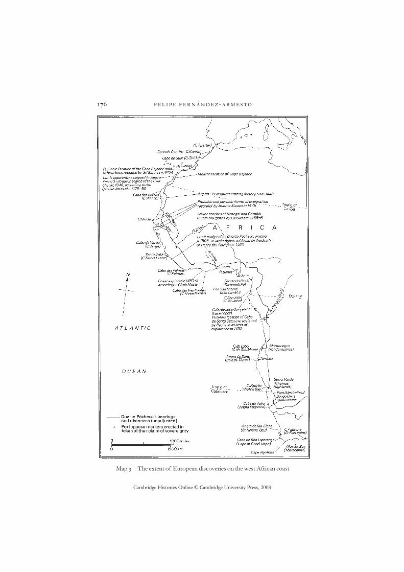
The land route continued to attract occasional explorers. In , Anselmed’Isalguier was reported to have returned to Toulouse from Gao with a haremof Black women, though how he could have got so far into the interior ofAfrica no one knows. In the Genoese Antonio Malfante got as far asTouat. In the Florentine Benedetto Dei claimed to have been toTimbuctoo and observed there a lively trade in European textiles. From thes to the s, Portuguese merchants made efforts to cut across countryfrom Arguin, via Waddan, heading for the same destination: at least they seemto have succeeded in diverting some gold caravans to meet them. It wasobvious, however, that the intractability of the land route demanded aseaborne approach.
Three developments gradually made such an approach viable: the emer-gence of a highly manoeuvrable type of ship, equipped with lateen sails forenhancing headway against the wind; improved methods of storing provisionsfor long journeys – the construction, in particular, of water casks which couldkeep their contents in potable form for periods extending to months ratherthan weeks; and the establishment, beginning in , of way-stations in theAzores where ships could stop to victual on the long run back from the westAfrican bulge, via the deep Atlantic, to find the homebound westerlies.
Traditionally, the status of a breakthrough in the enterprise has beenassigned to the rounding of Cape Bojador in by one of Dom Henrique’s
-
20 Lull, Libre de Evast e Blanquerna, , p. .
Cambridge Histories Online © Cambridge University Press, 2008
ships; but, to judge from surviving maps and sailing directions of the fifteenthand early sixteenth centuries, the cape known by that name in the vague andfluid toponymy of the time was the modern Cape Juby, which had certainlybeen rounded many times before.21 ‘The cape-by-cape depiction of the build-ing of empire’22 is in any case an heroic distortion, originating in the narrativetechnique of the chronicler Zurara, who wrote to glorify the deeds of fellowmembers of Dom Henrique’s entourage. More significant were the achieve-ments of expeditions led partly by Genoese navigators under Henrique’spatronage in the mid-s, which reported the existence of the Cape VerdeIslands, explored the lower reaches of the Gambia and Senegal rivers andestablished contact with outposts of the empire of Mali. These were genuinelyunprecedented achievements in exploration. They produced, moreover,reports written by a Venetian participant, Alvise Da Mosto, whose observa-tions of the people and environment of the Senegambia region were unsur-passed in vividness, among explorers’ accounts, until the writings ofColumbus.
After Henrique’s death in , explorers seem to have paused, presumablydeterred by lack of patronage and the lee shores around the turn of Africa’sbulge. In , the initiative was revived by the grant of the right of explora-tion to Fernão Gomes. He commissioned voyages which added some ,miles of coastline to the area navigated by Portuguese ships and extended therange of mapping to about the latitude of Cabo de Santa Caterina ( degreesN.), the approximate limit of navigation with favourable currents on theoutward voyage. Though his monopoly lasted only six years, on the face of ithis explorations represented an astonishing rate of increase over the tentativeefforts of Dom Henrique. But conditions were now more propitious. A wayhad been found through some of the most adverse of the sailing conditionsthat made the routes to and from Africa so arduous, and a route home, difficultbut practicable, had been established via well-stocked ports. Moreover, theprofitability of the enterprise had been enhanced by the discovery of furthersaleable products in the form of ivory and malaguetta ‘pepper’.
The crown rescinded Fernão’s monopoly in , perhaps in order to con-front Castilian interlopers on the Guinea coast. The navigation of west Africanow became the responsibility of the senior prince of the royal house, theInfante Dom João. Henceforth Portugal had an heir and, from his accession in, a king committed to the further exploration and exploitation of Africa.He had a militant and organising mentality, forged in war against the Castiliancorsairs. As ‘Lord of Guinea’ he boosted the prestige of African enterprise athome, centralised the control of commerce, built an emporium for the gold
Exploration and discovery
21 Mauny (); Campbell (), p. . 22 Russell-Wood (), p. .
Cambridge Histories Online © Cambridge University Press, 2008
trade about kilometres from the mouth of the river Volta and presidedover an extraordinary turnover in baptisms and rebaptisms of rapidly aposta-sising African chiefs.23 He was also the patron of heroic new feats of explora-tion, which dwarfed those of the eras of Dom Henrique and Fernão Gomes.
The voyages of Diogo Cão, who made contact with the kingdom of Kongoin and, having entered the river Zaire, established the shape of the coastto just beyond degrees S. in , were made with amazing tenacity in theface of adverse winds and currents. In the summer of , Cão was followedby Bartolomeu Dias, who left Lisbon with three ships and a commission tofind the ocean route round Africa. At first retracing Cão’s coastbound route, heseems subsequently, with great daring, to have turned away from the coast,perhaps in about or degrees S., in search of a favourable wind. The resultwas a major contribution to knowledge of the wind-system of the southAtlantic, for Cão encountered westerlies which carried him to a landfall some miles east of the Cape of Good Hope. The expedition seems to have beenexceptionally well provisioned, suggesting that the detour into the open oceanwas planned in advance.
The discovery of new sources of gold and slaves meant that the direct eco-nomic effects of west African exploration were potentially revolutionary. Yet inthe sixteenth century the development of transatlantic and Indian Ocean tradelargely left behind the west African world of dangerous shores, inhospitableclimes, difficult access and relatively limited rewards. Exploration had,however, yielded great benefits for the growth of Latin Christendom’s world-picture. The discovery of the south Atlantic wind-system was the key whichunlocked access to the Indian and Pacific Oceans. The shape and southwardreach of Africa had been established by empirical evidence after a long periodof insufficiently informed debate. The African enterprise had, moreover, takenEuropean seamen beyond the equator for the first time to a hemisphere where,out of sight of the Pole Star, an unfamiliar heaven made new demands ofcelestial navigators: this proved an enormous source of stimulation to thescience and technology, as well as the prestige, of navigation. The earlymodern revolution in the methods, range and results of navigation was thusprepared and, to some extent, pre-figured, in the fifteenth-century Africanvoyages.
In northern waters there was no great patron endowed with the means ortenacity of Dom Henrique or Dom João, no chronicler like Zurara to system-
-
23 Russell ().

Cambridge Histories Online © Cambridge University Press, 2008
atise or romanticise the gropings of the explorers. This is surprising. Thenorthern seas were full of romance. They were, for example, the setting of theperegrinations of St Brendan and the adventures of Amadis, of the voyages ofconquest of the Gesta Arthuri and the armchair travels of the fourteenth-century friar, Nicholas of Lynne, who claimed to have visited the north polefive times.24 Yet, perhaps because the results were disappointing, the real storyof their exploration, compared with these engaging fantasies, is relativelyunsung.
There was a route across the north Atlantic which might be called tradi-tional: it led from Scandinavia, by way of easterly currents north of the Faroesto Iceland and Greenland. This route could be and was pursued as far asNewfoundland, at which point an adverse current inhibited further progresssouth, while prevailing westerlies were available to take ships homeward. Theremains of a long-abandoned settlement or way-station at l’Anse-aux-Meadows in Newfoundland are consistent with Norse origins; these have beenlinked with the Icelandic saga tradition of the discovery of a land calledVinland at the end of the tenth century and its temporary settlement early inthe eleventh. Until , Icelandic annals continued to record journeys fortrading or trapping to Markland, a name apparently applied to part of the northAmerican mainland, north of Newfoundland. Thereafter, however, thisisland-hopper’s route across the Atlantic dwindled in significance, owing inpart, perhaps, to the colder weather which seems to have characterised north-ern latitudes for a while in the late Middle Ages. Communication ceased withsettlements in Greenland and attempts to revive it early in the fifteenth centuryfound that the colonists had died out or disappeared, although, if sixteenth-century traditions can be trusted, the attempt was renewed intermittently fromDenmark in the last third of the century. If, as is often assumed, fishing orwhaling expeditions from European ports continued to make voyages deepinto the Atlantic, they are unrecorded.
The axis of penetration of the Atlantic shifted south in the fifteenth centuryto the zone of prevailing westerlies. This may seem paradoxical, yet it is acurious fact that, outside monsoonal climates, in the history of maritimeexploration as a whole, most voyagers seem to have preferred to make theiroutwards journeys against the wind, presumably as an investment of presenttrouble in the hope of future return. The discovery of Flores and Corvo in marks the beginning of a series of such Atlantic voyages, which it mayhave helped to inspire. Between and at least eight Portuguesecommissions survive for voyages from the Azores to discover new lands; someof these refer explicitly to the evidence of sea charts. Among the most general
Exploration and discovery
24 Taylor (a).

Cambridge Histories Online © Cambridge University Press, 2008
terms are those of Fernão Teles’s grant, in , of ‘the Seven Cities or what-ever islands he shall find’. In , the Fleming Ferdinand von Olmen, alsosailing from the Azores under Portuguese auspices, was commissioned, interms strikingly similar to those of Columbus, for islands and mainland in theocean.25
Meanwhile, a similar project took shape in Bristol, where long experience inthe Iceland trade made navigators familiar with north Atlantic waters. What theislands of ‘Antillia’ or ‘the Seven Cities’ were to Azorean ambitions, that of‘Brasil’ was to the Bristolians. The origins of the legend of Brasil are obscurebut a putative island of that name appears, in various positions, on medievalAtlantic charts. The beginnings of what seems to be a sustained programme ofexploration in search of it were noticed by the writer on chivalry, WilliamWorcestre, in a notebook of personal memoranda of . On July, herecords, a ship belonging to two well-known merchant families, who regularlytraded with both Iceland and the Iberian peninsula, set off ‘usque ad insulam deBrasylle in occidentali parte Hibernie’.26 Bad weather forced them back inSeptember without success. The following year, another expedition with thesame objective was declared by a larger group of projectors. The continuationor resumption of the search is suggested by the terms of a letter of , inwhich a Castilian ambassador assured his sovereigns that Bristolians annuallyequipped expeditions in search of the Isle of Brasil and the Seven Cities.27
The context of this remark was the ambassador’s desire to acquaint hissuperiors with news of John Cabot, the Genoese navigator who had madeBristol his base for a more ambitious project: the crossing of the Atlantic in anattempt to reach China. Academic debate about the size of the globe and theextent of the ocean had encouraged speculations about the accessibility of theorient by way of the west. Paolo del Pozzo Toscanelli had proposed it in a letterto a correspondent at the Portuguese court in . The idea seems implicit inthe globe attributed to Martin Behaim. Columbus had attempted to put theidea into effect along a relatively southerly latitude – and, therefore, across alonger distance than would apply further north – in . The Nurembergphysician, Hieronymus Münzer, had appealed to the king of Portugal tosponsor an attempt in . Columbus’s experiences seemed, to some, toconfirm the viability of the project: Columbus himself professed to believethat he had got close to China and a published version of his report showedtraders in oriental garb visiting the lands he had discovered. The result ofCabot’s attempts, between and , was the recording of a viable directroute west, to and from Newfoundland, returning with the westerlies and
-
25 Verlinden () and (), pp. –. 26 Worcestre, Itineraries, pp. –.27 Calendar of state papers; Spanish, –, p. .

Cambridge Histories Online © Cambridge University Press, 2008
making use on the way out of a brief spring season of variable winds. It seemslikely that the use of these winds was already known in Bristol, where Cabot’sdiscovery was dismissed as of slight significance and identified with the Isle ofBrasil;28 nor did Cabot’s exploits excite the imitators and emulators inspired byColumbus. The search for a route to Asia across the north Atlantic was notresumed until well into the sixteenth century.
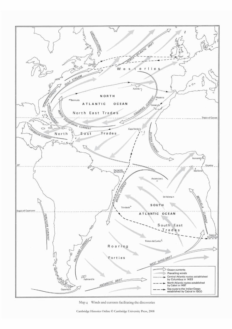
Sailing conditions for transatlantic voyages were far superior further south, inthe latitudes explored by Columbus. Yet, as he said of his own crossing in ,his route was one never, ‘as far as we know’, sailed before29 and the presump-tion that he had been preceded by an ‘unknown pilot’, while often aired, hasnever been vindicated. Compared with documented attempts further north,Columbus’s originality lay in his daring to sail with the wind at his back, to theconsternation of some of his crew, until he made a landfall, with no certaintythat he would find a means of return. This alone accounts for his unprece-dented success. The assumption that he knew the wind-system thoroughly inadvance is tempting but unjustified: he was a restless experimenter, a tirelessadvocate of an empirical epistemology, who, in the course of four Atlanticcrossings, tried three routes out to his discoveries and three routes back. On hisfirst crossing he adopted what seemed logically the shortest route between twopoints by trying to sail due west. If, as his language suggests, he steered by thecompass, this would have meant in practice a route somewhat south of west,owing to magnetic variation; he contemplated returning the same way and evenbegan on a more southerly course before turning in search of the familiar west-erlies of the north Atlantic. After further experiments, the routes of his secondvoyage, in , were established as the best: outward in the path of the north-east trade winds, along a diagonal from the Canary Islands to the Antilles, andback by climbing almost to the latitude of the Azores before turning due east.Indeed, apart from modifications made to the return route as a result of thediscovery of the Gulf Stream in , Columbus established what became themost favoured routes between Europe and most of the New World through-out the age of sail.
His reason for wanting to cross the Atlantic in the first place is a subject ofunresolved debate. He appears at different times during the formulation of hisplans to have contemplated a number of different objectives: the discovery ofnew islands, a search for the Antipodes and a short route to Asia. All these, as
Exploration and discovery
28 Gil and Varela (), p. .29 Varela (ed.), Cristóbal Colón, p. : ‘por donde hasta oy no sabemos por cierta fe que aya passado
nadie’.
Cambridge Histories Online © Cambridge University Press, 2008
we have seen, were matters of common speculation, discussed in academicgeography and illustrated in cartography. By the time of his first crossing in Columbus’s focus had narrowed to the quest for a short route to Asia:this, at least, is the only objective mentioned in what survives of his ownaccount of the voyage. Still, this was perhaps as much his patrons’ and backers’choice as his own, and Columbus’s subsequent commitment to the view thathis discoveries were indeed Asian, or close to Asia, should not be treated as evi-dence of what was in his mind earlier in his career. He seems to have been con-cerned not so much about what he would discover as whether, in a social sense,he would ‘arrive’. For Columbus, the geographical nature of his objective wasnegotiable; what he insisted on was the chance to make a voyage and, if hefound something exploitable, no matter exactly what, to claim the rewards ofwealth and ennoblement to which the hero of a seaborne romance was enti-tled. His true objective was identified by the potential mutineers, on his firstcrossing, who are said in an early narrative source to have grumbled at the riskposed to their lives by Columbus’s desire ‘to make himself a lord’.30
There was nothing new in his methods or equipment. His methods of naviga-tion, which he described as ‘like prophetic vision’,31 were a mixture of the tradi-tional and the intuitive. He relied on primitive celestial navigation and, probablyto a lesser extent, on dead reckoning (which consists in plotting one’s course bythe compass and determining position by estimating speed). He resorted whennecessary to such time-honoured expedients as following the flight of birds. Hecarried a quadrant or astrolabe, with which he impressed his men, but he nevermastered the use of it. His fixings of latitude were made by timing the hours ofsun and reading the corresponding latitude off a printed table.32 His attempts tocalculate longitude on shore by timing eclipses were, from a scientific point ofview, valueless. He had an uncanny way of interpreting the weather – unsur-passed, in a shipmate’s opinion, ‘since Genoa was Genoa’33 – and an enviablefacility in the haven-finding art in unfamiliar seas. He was genuinely, passionatelyinterested in technical innovations; but his achievements relied on technologywhich had been available literally for centuries.
By the time his exploring career came to an end, he had accumulated a daz-zling record. As well as his major achievement – the discovery of a transatlanticlink – he had observed and described the whole of the coast and part of theinterior of Hispaniola, and parts of the Bahamas, Cuba, Jamaica, Puerto Rico,the Virgin Islands, the Lesser Antilles and Trinidad. He had crossed theCaribbean and explored the mainland coast of the New World from the Bay of
-
30 Las Casas, Historia de las Indias, , p. : ‘por hacerse gran señor’.31 Varela (ed.), Cristobál Colón, p. : ‘a visión profética se asemeja esto’.32 Laguarda Trías (), pp. –, –; Ymago mundi de Pierre d’Ailly, , pp. –, –, plate facing
p. . 33 Gil and Varela (), p. : ‘desde que Génova es Génova’.

Cambridge Histories Online © Cambridge University Press, 2008
Honduras almost to the Gulf of Urabá and from the mouth of the Orinoco toMargarita. He had recognised South America as an ‘other world’ and ‘a verylarge continent, which hitherto has remained unknown’,34 though he misrepre-sented it as being close to or contiguous with Asia. He established an enduringtransatlantic link, inaugurated a series of previously unimagined cultural con-tacts and initiated Spanish colonisation in the New World.
In terms strictly of exploration, he left little for other explorers to accom-plish in the areas he touched. The terms of his royal commission granted him amonopoly of navigation to his discoveries; but, when he was out of favour atcourt from to , imitators were authorised to follow his route from asmall number of ports in and around the mouth of the Guadalquivir. Theyincluded collaborators and crew members of his own: Vicente Yáñez Pinzón,fellow traveller and brother of Columbus’s co-commander on the first cross-ing, whose family, dominant in the shipping business of the port of Palos, hadprovided the ships and recruited men for Columbus; Alonso de Hojeda, onwhom Columbus had relied heavily in the government of Hispaniola;Peralonso Niño and Juan de la Cosa, both of whom had accompanied at leastone of Columbus’s expedition; Cristóbal and Luis Guerra, who had suppliedhim with provisions; and Amerigo Vespucci, the business partner of one ofColumbus’s backers. Of leaders of expeditions in this direction in these years,only Rodrigo de Bastidas, Diego de Lepe and Luis Vélez de Mendoza camefrom outside Columbus’s circle.
Between them they extended Columbus’s achievement in two respects.Expeditions led by Hojeda and de la Cosa in , Niño and the Guerra broth-ers in –, and Bastidas and de la Cosa in – followed the mainlandcoast of America along the section omitted by Columbus between Margaritaand the Darién peninsula. Departing from Palos in November, , Pinzónattempted a more original effect by aiming for a more southerly landfall thanColumbus. Via the Cape Verde Islands, he crossed with the north-east tradeson what was almost the most southward course possible, reaching the coast ofwhat is now Brazil at a point he named Cabo de Consolación late in January,. He then followed the coast northwards across the mouth of the Amazonas far as the area already familiar from Columbus’s work. He can therefore becredited with the first recorded discovery of Brazil and a formidable additionto the information on the New World available at the Castilian court. In July,, Vespucci recorded a claim to have preceded him to the mouth of theAmazon by approaching from the north on a detour from an expeditionidentifiable with Hojeda’s; but, like most of the claims made by Vespucci, or onhis behalf and under his name, this cannot be independently verified.
Exploration and discovery
34 Varela (ed.), Cristobál Colón, p. : ‘esta es tierra firme grandíssima, de que hasta oy no se a sabido’.

Cambridge Histories Online © Cambridge University Press, 2008
Pinzón’s route led into the south Atlantic, to a point on the Brazilian coastwhere, had he chosen to turn south instead of north, the current would haveled him to beyond the Tropic of Capricorn and into the zone of the roaringforties. Luis Vélez de Mendoza, who followed hard on Pinzón’s heels, did turnsouth but without getting much further. It was left to Vespucci, sailing inPinzón’s wake under Portuguese auspices in company with Gonçalo Coelho, in–, to trace the extent of the coast along the path of the current. He got atleast as far as Rio de Janeiro – reached on New Year’s Day, – and, by hisown account, much further, though his reported southernmost reach of degrees along the coast and degrees after turning east into the open sea mustbe judged against the background both of his habit of exaggeration and of thepoor record generally of navigators of the time in determining latitude.Vespucci was unstinting in self-praise and some of his other contemporarieswere almost equally impressed with him. The rapid dissemination of anincreasingly accurate picture of the Atlantic shore of south America in theearly years of the sixteenth century probably owes much to his efforts andinfluence, and it was therefore not so great an error as is often suggested whenthe continent took its name from him.
Judged by its consequences, the exploration of the wind-system of thesouth Atlantic must be acknowledged to have been more important than thedelineation of the ocean’s coasts. Yet the sources available at present permitonly a patchy and unsatisfactory reconstruction of the events. Between thereturn of Bartolomeu Dias in and the departure of Vasco da Gama,bound for the Indian Ocean in , no voyages of exploration in those watersare known; the presumption that some part of the record is missing arises fromthe contrast between the tentative procedures of Dias and the boldness of daGama. The former, after long, slow headway against the Benguela current,waited until a late stage before turning his prow out into the ocean to find thewesterlies that carried him round the Cape. Da Gama, however, sailed exclu-sively with square-rigged vessels, demonstrating his intention of using follow-ing winds all the way. After his initial course to the Cape Verde Islands, he stoodout to sea at about the latitude of Sierra Leone and steered a long course to thesouth and west, across the belt of south-east trade winds, before turning withthe first favourable wind, probably around degrees S. Even this provedinsufficiently bold, for he made a landfall near the mouth of the Orange riverand had then to work his way coastwise around the southern tip of Africa. If, asseems likely, his plan was to round the Cape of Good Hope without makingland, he should have risked following an even wider arc into the south Atlanticand turning east below degrees S. This was the course adopted in by the
-
Cambridge Histories Online © Cambridge University Press, 2008
expedition of Pedro Álvares de Cabral, which, sent to follow up da Gama’sachievement, sailed so far west on the outward voyage that a landfall was madeon the Brazilian coast at about degrees S. Nevertheless, it seems remarkablethat, without benefit of any reconnaissance more thorough than that of Dias,Vasco da Gama should have undertaken this enormous voyage – probably byfar the longest ever made on the open sea from Europe – of ninety-three daysout of sight of land.
It is not even certain that he knew that this dangerous and laborious voyagewould end by giving him access to the Indian Ocean. Late fifteenth-centurymaps in the Ptolemaic tradition showed that sea to be landlocked and barred toan approach from the south. Investigation of this problem was one of theobjectives confided in to Pedro de Covilhã, whose mission to report onthe spice routes of the Indian Ocean was financed by some of the sameFlorentine merchant houses that were investing in Portugal’s exploration ofthe Atlantic. The surviving account of his exploits contains romantic episodesbut there is no reason to doubt the claim that he investigated the routesbetween southern India and east Africa as far south as Sofala. Hearing of thedeath of a colleague who had been sent as Portuguese ambassador to theNegus of Abyssinia, he then decided to take up that post himself; he was foundstill living at the Negus’s court by the next Portuguese embassy, which arrivedin . Meanwhile, however, he had despatched a report of his findings toLisbon. While there is no evidence that it ever arrived, its existence raises thepossibility that Vasco da Gama may have been guided by some such intelli-gence.35 Though he entered the Indian Ocean by a novel route, once he hadreached Sofala, da Gama did not engage in exploration but – like the manyEuropean merchants who had preceded him there in native shipping – merelyfollowed the existing trade routes with the help of local pilots and guides, mostnotably a Gujerati Muslim who showed him the way from Malindi to Calicut.
Exploration was a means whereby the civilisation of Latin Christendom estab-lished access to and, in the longer run, command of a disproportionate shareof the resources of the world. Explorers made a major contribution to thereversal of fortunes on a global scale. In the course of it, other civilisations,which in some cases had seemed better endowed and better equipped, becamebystanders and ultimately victims of ‘western’ hegemony. The conquest of theAtlantic in the fifteenth century seems, in retrospect, a decisive step because ofthe way Atlantic routes led to previously isolated and underexploited lands, andconnected with other oceans. Yet this great leap forward for LatinChristendom followed a period of demographic decline and, on most fronts,of contracting frontiers.
Exploration and discovery
35 Beckingham (), p. .
Cambridge Histories Online © Cambridge University Press, 2008
It may have helped to come from behind: in richer societies, there was lessincentive to look for new sources of wealth; larger civilisations, more autarkicand more secure, could afford contempt for the rest of the world. Consideredfrom one perspective, the endeavours of European explorers in this periodresemble the efforts of ‘developing’ economies today, desperately drilling foroffshore resources. On the other hand, as we have seen, the western rim ofLatin Christendom had important advantages as a base for world exploration:an Atlantic-side position and a ‘culture of explorers’, whose vocation enjoyedhigher prestige than in some potentially rival civilisations, reflected in theinspiration of literary role-models. The distribution of the technical pre-requisites of long-distance travel should not, perhaps, be stressed too much:the achievement of Columbus shows that rudimentary and antiquated tech-nology was adequate for revolutionary tasks. As for the new technologyneeded for African and south Atlantic exploration, the rule seems to have beensolvitur navigando.
Unsurprisingly, the communities which produced the explorers and contrib-uted the means were located, for the most part, in the western Mediterraneanand on the Atlantic rim, especially in Genoa, Majorca, the Atlantic shores ofthe Iberian peninsula and, to a lesser extent, parts of England, France,Flanders and perhaps Denmark. Very broadly, it is fair to say that there was anoverall displacement of the initiative, over the period as a whole, from othercentres to Portugal and lower Andalusia, which enjoyed privileged access to therelatively productive central Atlantic and south Atlantic routes.
The conspicuous achievements of the s raise a particular problem ofinterpretation. In a period of a few years, what came to be seen as decisivebreakthroughs were made into the New World and the Indian Ocean. Thevoyages of Columbus and Vasco da Gama have often been highlighted as ele-ments of what Adam Smith, for example, called ‘the most important event inhistory’,36 which helped to transform a ‘medieval’ world into a ‘modern’ one.These terms are not very helpful, and the gradualist assumptions of recent his-toriography have happily compelled us to see events in the contexts of long,grinding processes of change. Nevertheless, the pace of processes varies andchange sometimes occurs with bewildering rapidity. The story of Europeanexploration is a long one, but the concentrated speed and power of the epi-sodes of the fifteenth century, and of the s in particular, still demand to beacknowledged.
As well as influencing what might be called the balance of world power, theexplorers of this period had a major effect on the received picture of the worldthanks to the increasing exchange of information between explorers and car-
-
36 Smith, Wealth of nations, p. .
Cambridge Histories Online © Cambridge University Press, 2008
tographers. An agreed world map is a common resource of mankind: ours hasbeen pieced together slowly, over a long period, mainly in the last years.Whereas previous civilisations derived their images of the world from dogmasof cosmology, from inductive reasoning, from revelation, from inherited tradi-tion or from the elaboration of theory, we owe today’s largely to the practicalcontributions – often gathered at hazard in hostile environments and reportedover vast distances – of the empirical observers whom we call explorers.
Exploration and discovery