
Experiential Hierarchies of Streets
26
Experiential Hierarchies of Streets Martin TOMKO, Stephan WINTER, Christophe Claramunt To cite this version: Martin TOMKO, Stephan WINTER, Christophe Claramunt. Experiential Hierarchies of Streets. Computers, Environment and Urban Systems, Elsevier, 2008, pp.41-52. <10.1016/j.compenvurbsys.2007.03.003>. <hal-00771873> HAL Id: hal-00771873 https://hal.archives-ouvertes.fr/hal-00771873 Submitted on 9 Jan 2013 HAL is a multi-disciplinary open access archive for the deposit and dissemination of sci- entific research documents, whether they are pub- lished or not. The documents may come from teaching and research institutions in France or abroad, or from public or private research centers. L’archive ouverte pluridisciplinaire HAL, est destin´ ee au d´ epˆ ot et ` a la diffusion de documents scientifiques de niveau recherche, publi´ es ou non, ´ emanant des ´ etablissements d’enseignement et de recherche fran¸cais ou ´ etrangers, des laboratoires publics ou priv´ es.
description
introducing a novel measure allowing to rank streets in a street network. This rankingallows to construct experiential hierarchies reflecting the shared experience of the streets ina city. The measure is derived from network connectivity measures, and takes into accountthe structure of the street network as well as the higher-order partition of the urban spaceinto suburbs.
Transcript of Experiential Hierarchies of Streets

Experiential Hierarchies of Streets
Martin TOMKO, Stephan WINTER, Christophe Claramunt
To cite this version:
Martin TOMKO, Stephan WINTER, Christophe Claramunt. Experiential Hierarchiesof Streets. Computers, Environment and Urban Systems, Elsevier, 2008, pp.41-52.<10.1016/j.compenvurbsys.2007.03.003>. <hal-00771873>
HAL Id: hal-00771873
https://hal.archives-ouvertes.fr/hal-00771873
Submitted on 9 Jan 2013
HAL is a multi-disciplinary open accessarchive for the deposit and dissemination of sci-entific research documents, whether they are pub-lished or not. The documents may come fromteaching and research institutions in France orabroad, or from public or private research centers.
L’archive ouverte pluridisciplinaire HAL, estdestinee au depot et a la diffusion de documentsscientifiques de niveau recherche, publies ou non,emanant des etablissements d’enseignement et derecherche francais ou etrangers, des laboratoirespublics ou prives.

Experiential Hierarchies of Streets 1
Martin Tomkoa, Stephan Winter∗,b, Christophe Claramuntc
aCRC for Spatial Information, Department of Geomatics, University of Melbourne,Australia
bDepartment of Geomatics, University of Melbourne, AustraliacNaval Academy Research Institute, Brest, France
Abstract
Mental representations of spatial knowledge are organized hierarchically. Among peoplefamiliar with an urban environment, common spatial knowledge from these spatial mentalrepresentations enables successful communication of place and route descriptions, consist-ing of hierarchically-ordered references to prominent spatial features, such as streets. Themore prominent a street is, the more likely it is to be known by the wayfinder receiving thedirections. The automated construction of such descriptions therefore requires hierarchicaldata models ranking streets in street networks. This paper explores the reasons of overlapsin the content and hierarchical organization of common spatial knowledge among locals.We introduce a novel measure allowing to rank streets in a street network. This rankingallows to construct experiential hierarchies reflecting the shared experience of the streets ina city. The measure is derived from network connectivity measures, andtakes into accountthe structure of the street network as well as the higher-order partition ofthe urban spaceinto suburbs.
Key words: Experiential hierarchy, network analysis, centrality
∗ Corresponding author. Tel.: +61 3 8344 7875, Fax.: +61 3 9347 2916Email addresses:[email protected] (Martin Tomko),
[email protected] (Stephan Winter),[email protected](Christophe Claramunt).1 The work has been supported by the Cooperative Research Centre for Spatial Informa-tion, whose activities are funded by the Australian Commonwealth’s Cooperative ResearchCentres Programme. The authors would also like to acknowledge the valuablecommentsof three anonymous reviewers.
Preprint submitted to Elsevier 8 March 2007

1 Introduction
With repetitive interaction, people living in an urban environment get increasinglyfamiliar with its layout (Siegel and White, 1975). With continuing interactions, theaccuracy and completeness of this acquired knowledge increases. It is stored inmental representations that are to a large extent organizedhierarchically (Hirtleand Jonides, 1985; Stevens and Coupe, 1978).
Despite individual distortions in mental representations(Couclelis et al., 1987),people familiar with the environment can successfully communicate spatial knowl-edge. This signifies that speakers are able to identify the part of their knowledgethey expect to be shared with the hearer in a given communication context, andrefer to it. Conversely, hearers are able to match the received information with theirown mental representation.
The hierarchical organization of the spatial knowledge is reflected in hierarchicalplace and route descriptions. In hierarchical descriptions, references to elements ofthe city are introduced in order from most general to highly specific local references(Plumert et al., 2001; Shanon, 1979; Tomko and Winter, 2006b). Let us considerfor example the route directions given to a taxi driver in Melbourne:“Take meto A’Beckett Street, off Elizabeth Street.”(Fig 1). The speaker assumes that theknowledge of the highly prominent Elizabeth Street is common, without asking thedriver first. The speaker also assumes thatA’Beckett Streetis not prominent enoughto be localized by the taxi driver without reference toElizabeth Street.
Fig. 1. Schema of hierarchical route directions.
In order to model and generate hierarchical place and route descriptions automati-cally, we need to characterize the prominent parts of the street network by quantifi-able properties. In this paper, we explore the reasons of overlaps in the content andhierarchical organization of common spatial knowledge among locals. We assumethat the emergence of the shared experience of the street network’s hierarchicalorganization is due to the likelihood with which parts of it are used by locals.
Street connectivity influences the pattern of urban movement flows and determinesthe intensity of learning the urban layout. Frequently experienced parts of the net-work are prominent, and rank high in the hierarchical mentalrepresentations. Mod-els considering the experiential significance of streets are currently not available.
2

Administrative street hierarchies are traditionally the product of a classificationgrounded in design characteristics of streets (such as number of lanes), and notby their experiential prominence within the street network. Such hierarchies aretherefore not necessarily suitable for cognitively ergonomic provision of route di-rections.
Our hypothesis is that the prominence of streets in the network relates to the spatiallayout and properties of the street network and its spatial partition into suburbs.Our goal is the identification of a quantification measure reflecting the wayfinders’experience of the street network. This measure should consider connectivity at thestreet network level, as well as at higher levels of spatial organization, such as thesuburb partition of the urban environment.
Structural analysis of the street network connectivity properties will be coupled bythe analysis of its higher order functional partition. The result is a relative estimateof the prominence of a street in the city structure, presentedas a ranking of thestreets in a network in an experiential hierarchy.
An experiential hierarchy of streets allows the abstraction of the street network atdifferent granularities, preserving the inherent logic ofits structure. Experientialhierarchical models of spatial features, such as streets inthe street network presenta necessary input for hierarchical provision of wayfinding information to locals inhierarchical route directions (Tomko and Winter, 2006b).
The remainder of the paper is structured as follows: In Section 2, we point to pre-vious work as the foundation on which we build our hypothesisand approach. Wethen continue our argument by identifying and testing network analysis measuresfor the reconstruction of experiential hierarchies in street networks (Section 3).Street networks are embedded in higher order partitions of the city into suburbs,and we consider this overlaid structure in the final hierarchical ranking of streets inexperiential hierarchies in Section 4. The paper then concludes in Section 5.
2 Background
In this section we introduce the basic concepts in wayfindingand route direction re-search, relevance theory and topological analysis of city structures pertinent to ourresearch. We introduce the concept of spatial hierarchies and show their importancein place and route descriptions.
3

2.1 Mental Representations and Hierarchical Spatial Reasoning
People learn the spatial layout of their environment through repetitive interaction,such as wayfinding (Newman et al., forthcoming 2006; Siegel and White, 1975).The structure of their knowledge proceeds through stages ofdifferent characteris-tics. As people become familiar with the environment, they acquiresurvey knowl-edgeand are able to locate and infer directions and distances between spatial fea-tures. In urban environments, these features have been categorized into elementsof the city form (Lynch, 1960). In this paper, our attention is focused on the streetnetwork, consisting of streets, and the functional partition of the city into suburbs.Those would be classified by Lynch as paths and districts, respectively.
The accuracy and completeness of one’s spatial knowledge increases with the con-tinuing interaction. Individual mental representations are, however, always dis-torted through the individual experience of space and the cognitive processes lead-ing to their construction. Individual responses to specificproperties of the environ-ment, cognitive capabilities and behavior in the environment are all highly individ-ual.
People organize their spatial knowledge in hierarchicallyorganized mental rep-resentations (Hirtle, 2003; Hirtle and Jonides, 1985; Stevens and Coupe, 1978).Hierarchies in mental representations are not likely to follow discrete hierarchi-cal levels, but rather resemble to continuous order. The hierarchical organizationof mental representations is reflected in spatial reasoningtasks, where dependencebetween the categorization of a specific spatial entity in the hierarchy and its usein the spatial task has been demonstrated (Plumert et al., 1995; Timpf and Kuhn,2003; Timpf et al., 1992; Wiener and Mallot, 2003). Hierarchical mental conceptu-alizations emerge mostly for fast retrieval ofapproximateinformation. The resultsachieved using such information are acceptable if the information retrieved is suf-ficient to support the task of the agent, e.g. wayfinding.
2.2 Hierarchical Organization in Street Networks
At first sight, administrative hierarchies of urban networks seem to provide a classi-fication of streets in the street network which may to some extent reflect the organi-zation of the knowledge of locals. Administrative hierarchies are widely discussedin the literature (Eppell et al., 2001; Marshall, 2004). These hierarchical classifica-tions are, however, the product of different needs and processes, as they primarilyserve the function of urban traffic and transportation planners. Often the specifica-tion attributing a street to a specific hierarchical level isonly vaguely stated anddepends on the designer’s decision.
Many researchers have pointed to the fact that hierarchicalorganization of anthro-
4
pomorphic space is unnatural, claiming not only that boundaries may not be crisp,but also that the multitude of spatial connections allows for more than a singlefunctional partition (Alexander, 1988). We argue, however, that due to the way inwhich humans acquire spatial knowledge, a hierarchy emergesin spatial systemswhere connections between elementary spaces are facilitated by transport networks.We do not claim that the individual hierarchies are identical among all individualsinhabiting the specific urban environment. These individuals, however, are ableto relate information provided by others to their own knowledge, despite it beinggrounded in a different hierarchy. This is only possible to the extent to which thetwo hierarchies are similar, and we show how this similarityis due to the structuralproperties of the network as such, and its higher-order functional partition.
2.3 Common Knowledge and Urban Structure
Common knowledge is a term used by linguists to denote the knowledge whichis held by multiple individuals in the communication act. Ifonly two agents areconcerned, the term shared knowledge is often used. Note that the elements ofcommon knowledge are not explicit, i.e. the speaker does notnecessarily knowthat the hearer has this knowledge as well. If this second-level knowledge can beestablished, i.e. by direct inclusion of a reference in an utterance, it is called mutualknowledge. While relevance theory questions the possibility of the existence ofmutual knowledge (Sperber and Wilson, 1982, 1986), common knowledge playsan important part in communication and comprehension. In the communicationof place descriptions and route directions, the speaker does not establish evidenceof the existing spatial knowledge of the hearer. For example, the taxi passengerdoes not question the taxi driver about all the spatial features of the city she mayknow. Instead, the speaker assumes the taxi driver’s knowledge of some of thespatial features in the given urban environment. This assumption is grounded inthe way the speaker’s own spatial knowledge was gathered. Inthis paper, we arespecially looking at the role played by assumed common spatial knowledge in thecommunication of route directions.
The coarse structure of the city consists of spatial features known by the majorityof locals. In hierarchical mental representations, this coarse structure fills the toplevels. Hierarchical place or route descriptions will be understood by a hearer aslong as they know the referents. As a consequence, the communication of hierarchicplace and route descriptions can proceed only to a level of detail where referentsare still part of the common knowledge. Once this level is reached, detailed turn-by-turn descriptions are used. This switch is triggered by the hearer.
In communication of spatial information, features prominent due to their distinct-ness or salience are used as references (Michon and Denis, 2001; Raubal and Win-ter, 2002). This prominence can be due to visual, semantic and structural character-
5

istics, as they have been identified for landmarks by Sorrowsand Hirtle (1999). Allthree aspects are intertwined, but some of the elements of the city afford themselvesto be more prominent in some of these aspects. In the case of streets, the experi-ence of wayfinding through them makes the agents experience their structural rolewithin the fabric of the city. Previous work on the salience of the elements of thecity shows that the analysis of their structural propertiesallows to estimate theirsalience in the urban structure (Claramunt and Winter, accepted).
Central parts of the urban network are likely to be part of sometrips of a wayfinder.The more different trips an individual performs in a given urban network, the higheris the likelihood that she experiences these parts of the network. More central partsof the network are experienced with higher frequency, and hence they are are betterknown (Tversky, 1993). They gain higher prominence in the mental representationsof wayfinders.
Consciously or not, humans have the ability to assess the prominence of a part of theurban structure to others. Consequently, they refer to thoseparts in route directions,avoiding references to highly individual contexts, such ashome and work locations.This objectivization is part of our effort to be collaborative in communication, i.e.to use references of high relevance to the hearer (Sperber and Wilson, 1986). Thehearer expects relevant references, and interprets any reference in a manner maxi-mizing its relevance, based on previous knowledge and the communication context.
3 Experiential Hierarchies of Street Networks
In this section, we define a method to reconstruct experiential hierarchies of streetsin urban networks. Our selection of the appropriate measurefor the quantificationof the importance of the named street is motivated by its relation to wayfindingbehavior. Structural properties of the street network elements are distinct, as theycondition the visual or semantic experience. A street not visited will not be visuallynor semantically prominent to a wayfinder. Furthermore, ourapproach is specific inits cognitive grounding, where structural and semantic parameters of the networkelements are considered together, through the use of named streets. This approachcomplements previous structural approaches motivated by hierarchical spatial datageneralization (Jiang and Claramunt, 2003).
3.1 Basic Elements of the Network
The selection of the elementary constituent of an urban network has an importantimpact on the results of many analyzes. Most urban analyzes use street segmentsas the building block of the street pattern. Urban planners introduced the concept
6
of axial lines for urban space analysis (Hillier and Hanson,1984). Our approachbuilds on the selection of a named street as the building block of the network (Jiangand Claramunt, 2004). Named streets are defined as the set of segments of the streetnetwork sharing the same street name. A street name is often the only characteristicof a street that is part of common knowledge. It’s use in routedirections points tothe perception of the street as one feature, not a set of individual segments. Thus,named streets allow an integration of the semantic properties of the street network,supporting our main motivation is the construction of hierarchical data models forroute descriptions.
It is possible that further concatenation of streets in mental representations takesplace. For example, approaches based on strokes or continuity lines could also beused to provide coarser views on the urban network, for instance by amalgamationof streets changing their type, but not the name (e.g. Victoria street changing intoVictoria parade) (Figueiredo and Amorim, 2005; Thomson andRichardson, 1999).Thus, local specifics of the street network need to be considered on a case-by-casebasis.
The structural properties of the street network are furtherinfluenced by its func-tional embedding in the partition of the city into suburbs. Suburbs are parts of thecity labeled with names, frequently used as references in place descriptions. Theirprecise boundaries may not always be known to the wayfinders,but their roughlocation is part of the common knowledge of the inhabitants of the city.
The experiential formation of hierarchies in mental representations is largely influ-enced by the structural properties of the urban network and the overlaid functionalpartition of the city into suburbs. Common network analysis in geographic informa-tion systems largely relies on network metrics, with networks represented as graphswhere junctions are represented by nodes and streets by edges. We call such rep-resentations primal graphs. Space syntax theory uses dual graph representations ofurban networks where nodes represent axial lines and their connections to adjacentaxial lines are represented by edges (Hillier and Hanson, 1984). In this paper, thenodes in dual graph representations stand for named streetsin the street network, orsuburbs in the suburb partition of the city. We explore measures of network connec-tivity and derive one that quantifies and hierarchically ranks the streets in a networkin a manner that is cognitively plausible.
3.2 Measures for Experiential Network Hierarchies
Network analysis provides a variety of centrality indexes,also applied to, or adaptedfor, urban analysis (Bera and Claramunt, 2003; Claramunt and Winter, accepted;Hillier and Hanson, 1984; Porta et al., 2006).
Degree centrality, in space syntax calledconnectivity, is a measure specifying the
7
number of direct neighbors of a node in a network. It is a localmeasure. Thus, out-side of the confined area of a suburb, degree centrality does not provide a measureof prominence.
Closeness centralityis a measure reflecting the average length of the shortest pathsto all other nodes of the graph. Nodes or segments with high closeness centralityhave low average length of the path to all other nodes in the graph. When appliedto a given urban network, this measure reflects well the global structure of the city,revealing itscore. In space syntax this measure is known as global integration, orrelative asymmetry, and is usually applied on dual graphs constructed from axiallines (Hillier and Hanson, 1984). At first, it seems to be a plausible measure for theexperiential hierarchical ranking of the urban network. Yet, in naturally evolvedspatial transport networks, closeness centrality does notprovide a reliable measureof hierarchical importance of a network element in the overall network. It distortsthe hierarchy by assigning higher values to the streets in the core of the network.Side-lanes and alley-ways centrally located at the geographic center of the area ofinterest will always get high closeness values, as long as they create loops and thusdo not lie on the periphery of the graph. This structural property, however, does notnecessarily make them prominent.
A localized measure of integration considering only the network within a rangeof the three closest neighbors is often used to reveal the variation of integrationacross the network. This step-distance is based on empiricalfindings related to theaverage length of pedestrian walks. Its relevance to the formation of experientialhierarchies if other means of transport are considered is questionable. Furthermore,it is a measure designed to be applied to axial map analysis, as opposed to namedstreets.
Betweenness centralityprovides the means to quantify the likelihood a graph nodewill lie on a shortest path between two other nodes of the graph. Betweenness cen-trality provides a global value for a specific network element. The hierarchy createdby experience needs to take into account the likelihood of the usage of a specificstreet, not only its central aspect. Betweenness centralityis expected to reflect theprobability of being selected by a frequent wayfinder. Hencethe frequent use of thetermchoice. With the increasing number of trips performed by a wayfinderin a city,the likelihood that betweenness approximates the agent’s experience of the urbanenvironment increases. We will further investigate betweenness centrality and itsderivatives as plausible measures for explaining the experiential hierarchy of urbannetworks.
8

3.3 Distribution of Centrality Values in Street Networks
Let G(V,E) denote a GraphG consisting of verticesV connected in pairs by edgesE. Let i, j andk be distinct vertices ofG. Let njk denote the number of shortestpaths betweenj andk, andnjk(i) the number of such paths leading throughi. Be-tweenness centralityCB
i of the vertexi was defined by Freeman (1977) inG(V,E)as follows:
CBi =
∑
i6=j 6=k
njk(i)/njk (1)
We will study the distribution of betweenness centrality over several patterns ofurban networks to reveal their hierarchical structure.
3.3.1 Regular Grid Street Patterns
Rectangular grid patterns consist of perpendicular streetsforming blocks. All junc-tions have the same degree and are thus identical in their local structure. Such urbanlayouts are typical for modern planned cities. Downtown areas of major US andAustralian cities follow the pattern, as well as some European planned cities, e.g.Barcelona. Some of these cities have a few streets intersecting the grid pattern diag-onally. Such streets are usually well known. Betweenness centrality can reveal therelative importance of these streets, as we show by comparison with the remainingcentrality measures.
Figure 2 presents a grid pattern and its dual graph representation consisting of 6orthogonal streets, forming a grid of2 × 2 blocks. The dual graph analysis wasperformed using the software Pajek (Batagelj and Mrvar, 2006). The graphs revealthe bipartite structure of the north-south and east-west streets. The betweennessvalues of the network of named streets are all equal. Such a network does not revealany structural difference in any of the measures—degree, closeness or betweennesscentrality, if we consider named streets as the building element of the network.If the element of analysis is a street segment, higher betweenness and closenesscentrality values are attributed to the central part of the grid. As all the streets areintersected by the same number of connecting streets, degree centrality remainsuniform in the whole grid.
In such a regular grid, however, the hierarchical ranking ofstreets by betweennessand closeness is identical. Hence, irregularities in urbanlayouts that impact on theperception of the city as such also cause variance between the centrality values. Theaddition of a diagonal street (nodeN o 7 in Figure 3) in the grid network leads to achange of betweenness values of the streets. The north-south streets intersect all ofthe streets in the network and thus lie on most shortest paths. They top the ranking
9

(a) Street network (primal graph)
[0.10] 1
[0.10] 2 [0.10] 3
[0.10] 4
[0.10] 5[0.10] 6
Pajek
(b) Street network (dual graph). Labels rep-resent betweenness values of streets.
Fig. 2. Graph representations of a grid network of named streets.
when ordered by betweenness, with the newly introduced shortcut following in theranking. The ranking by degree and closeness centrality, however, does overem-phasize the prominence of the shortcut, ranking the shortcut first. These measurestherefore do not reflect the experience of the urban structure appropriately.
(a) Street network (primalgraph)
[0.08] 1
[0.05] 2
[0.05] 3
[0.05] 4
[0.08] 5
[0.08] 6
[0.07] 7
Pajek
(b) Street network (dual graph). Labelsrepresent betweenness values of streets.
Fig. 3. Graph representations of named streets grid with a diagonal street—shortcut.
3.3.2 Star-like Street Patterns
In a star-like network (Figure 4), the insertion of a shortcut changes the reachabil-ity of the peripheries of the street network involved. Betweenness centrality reflects
10

this change in a manner that is consistent with the hypothesis of experiential for-mation of hierarchies in mental representations.
Fig. 4. A primal graph representation of a star-shaped street network with streets1, 2, 3 and4 labeled. Street4 forms a shortcut.
It is the occurrence ofshortcutsbetween internally highly connected subgraphs thatmotivates the use of betweenness for the reconstruction of the hierarchical structureof the street network. In a street network, such subgraphs may stand for distinctcommunities or suburbs, where the internal connectivity ofthe street sub-networkis higher than that in the remainder of the city.
(a) Dual graph of the street network, withbetweenness centrality values.
(b) Dual graph of the street network, withcloseness centrality values.
Fig. 5. Dual graph representations of streets in a star-shaped street network with addedshortcut (street4).
The dual graph representation of the street network shown asa primal graph onFigure 4 is shown on Figure 5. It reveals the structural changes caused by theshortcut—the addition of street4. The two distant peripheric parts of the networkbecome directly connected. A new urban core is created by thetriangle1, 3 and4.The individual importance of streets1 and3 decreased with the introduction of thestreet4. The measure of betweenness reveals the alteration of experiential promi-nence of streets in the network. It preserves the high prominence of street2 andreflects the lowering of the importance of streets1 and3. Before the insertion of
11
street4, betweenness values for the streets1, 2 and3 in the network were equal,0.44. After the insertion of street4, street1 has a betweenness centrality value of0.41, streets1 and3 have values of0.23 and street 4 a value of0.18. The rank-ing by betweenness thus reveals their structural importance in the street networkappropriately.
Closeness centrality fails to reveal the alteration of this street network appropri-ately. The closeness centrality value of street2 decreases as street4 is inserted.Street2, however, remains the only means of access to a significant proportion ofthe graph. Also, the relatively high values of closeness of the streets on the periph-eries of the graph compared to the central streets have little justification from theexperiential point of view. Thus, measure of closeness centrality fails to reveal therelative importance of the streets to the overall structureof the city. The importanceof streets2 and4 would become even more prominent if a partition of the networkinto a suburb was introduced. We could cluster the peripheralparts of the graphs assuburbs. In such a case, the significance of streets2 and4 as links in the functionalstructure of the city would be emphasized even more.
3.4 Experiential Street Hierarchies and the Suburb Structure
The structural role of the streets facilitating movement between the functional par-tition of the city into suburbs should be considered for a refined ranking of streetsin experiential hierarchies. Note that suburbs are chosen as the elementary mod-eling element due to their structural and semantic properties similar to the namedstreets. Suburb names are part of the common knowledge of theurban structureand represent a labeling system locals can rely on. To reflectthe experiential delin-eation of suburbs inconsistent with administrative spatialpartitions, other modelsof reconstructing the lyncheandistrictsmay be explored (Dalton, 2006).
We start from the assumption that the hierarchical importance of a street is rela-tively higher if it provides the only access to a suburb. It is,however, more commonto have several streets with similar betweenness centrality values that connect thesame suburbs. In turn, their respective betweenness valuesare lower, as they lie onalternative access routes. This is frequently the case in modern agglomerations withregular grid patterns in the center of the city. Those streets, however, are still veryprominent, as their prominence is in turn supplemented by their membership in astructurally important suburb. As illustrated by Figure. 6, the two streets presentalternatives for travel between the two nodes. Their respective betweenness cen-trality values would, in a network, be equal to a half of the value if a single streetconnected the two nodes. These streets, however, connect a central suburb, whichmay change the perception of their prominence in a city.
The higher-order structural embedding of a street contributes to its hierarchical
12

Fig. 6. Alternative streets with equal betweenness related to their suburb context (primalgraph).
ranking in experiential hierarchies. The urban partition into suburbs thus representsan overlaying functional structure over the basic structure of the street network.Outside of the urban analysis literature, the relation between individual elementsin a graph and their higher-order embedding was explored by Newman and Girvan(2004). To fine-tune the experiential hierarchy of streets,the structural relationsbetween the suburbs should be explored.
In order to combine the functional and structural characteristics of the urban struc-ture, we propose to consider the betweenness centrality of suburbs as the second-order parameter influencing the ranking of streets in the network. A second graphis derived from the partition of suburbs where suburbs are the nodes of the graph,edges adjacency relationships between suburbs, as facilitated by streets. Between-ness centrality allows for consideration of the following structural properties in thestreet-suburb relationship as:
• Suburbs of high betweenness are crossed by a high proportionof possible tripsin the network.
• Streets contained in suburbs of high betweenness are likelyto be experiencedmore often.
Based on the betweenness centrality values of streets and suburbs, we introduce anovel measure for ranking of the streets in an experiential hierarchy of the streetnetwork. More formally, these notions are denoted as follows:
• Let i denote a street in the street network;• D the set of suburbs in the city;• Di the set of suburbs intersected by the streeti;• di
j a suburb out ofDi;• CB
i the betweenness centrality value of the streeti;• CB
dij
the betweenness centrality of the suburbdij;
• pdkdlthe number of shortest paths linking two suburbsdk anddl of D;
• pdkdl(di
j) the number of shortest paths linking two suburbsdk anddl that containsdi
j.
We can then defineCBdi
j
as follows:
CBdi
j=
∑
dij6=dk 6=dl
pdkdl(di
j)/pdkdl(2)
13

Theexperiential rankingvalueEi for a named streeti in the experiential hierarchyof the street network based on the betweenness centralitiesof the street network(Eq. 1) and the suburb partition of space (Eq. 2) is then defined as follows:
Ei =∑
j
CBi × CB
dij
(3)
The value ofEi is calculated based on the adjacency matrix of suburbs and streets.This matrix contains relations of suburbs intersected by streets in the street network.If such a relation exists, the betweenness centrality valueof the streeti—CB
i —ismultiplied by the betweenness centrality value of the suburb (di
j), and the resultingvalues are summarized. This can also be expressed in terms ofa matrix product ofstreet betweenness values and suburb betweenness values.Ei is not a normalizedvalue, and thus can be greater than 1. The values ofEi are calculated only for thepurpose of ranking, their direct comparisons between different street networks aremeaningless.
4 Study of the Experiential Street Hierarchy of Melbourne
4.1 Betweenness Analysis of the Street Network of Melbourne
We have performed an analysis of the urban pattern of the cityof Melbourne, Aus-tralia, to test betweenness centrality distributions in the street network on a largerscale (Fig. 7). Melbourne is a relatively young city with a distinct regular grid pat-tern in its center (the Central Business District—CBD), and a system of streetswhich reach radially beyond the center.
The analysis of the urban structure was performed on a dataset consisting of namedstreets in the space syntax software Mindwalk (Figueiredo,2002). The total num-ber of streets in the analysis was 1175. Mindwalk implementsa computationallyefficient version of betweenness centrality, calledfast choice. It considers only onerandom shortest path between each pair of nodes in a graph, instead of generatingall the alternative shortest paths. In larger networks, thedifferences in centralityvalues resulting from fast choice are statistically insignificant, which can be simplyverified by multiple analysis of the same network.
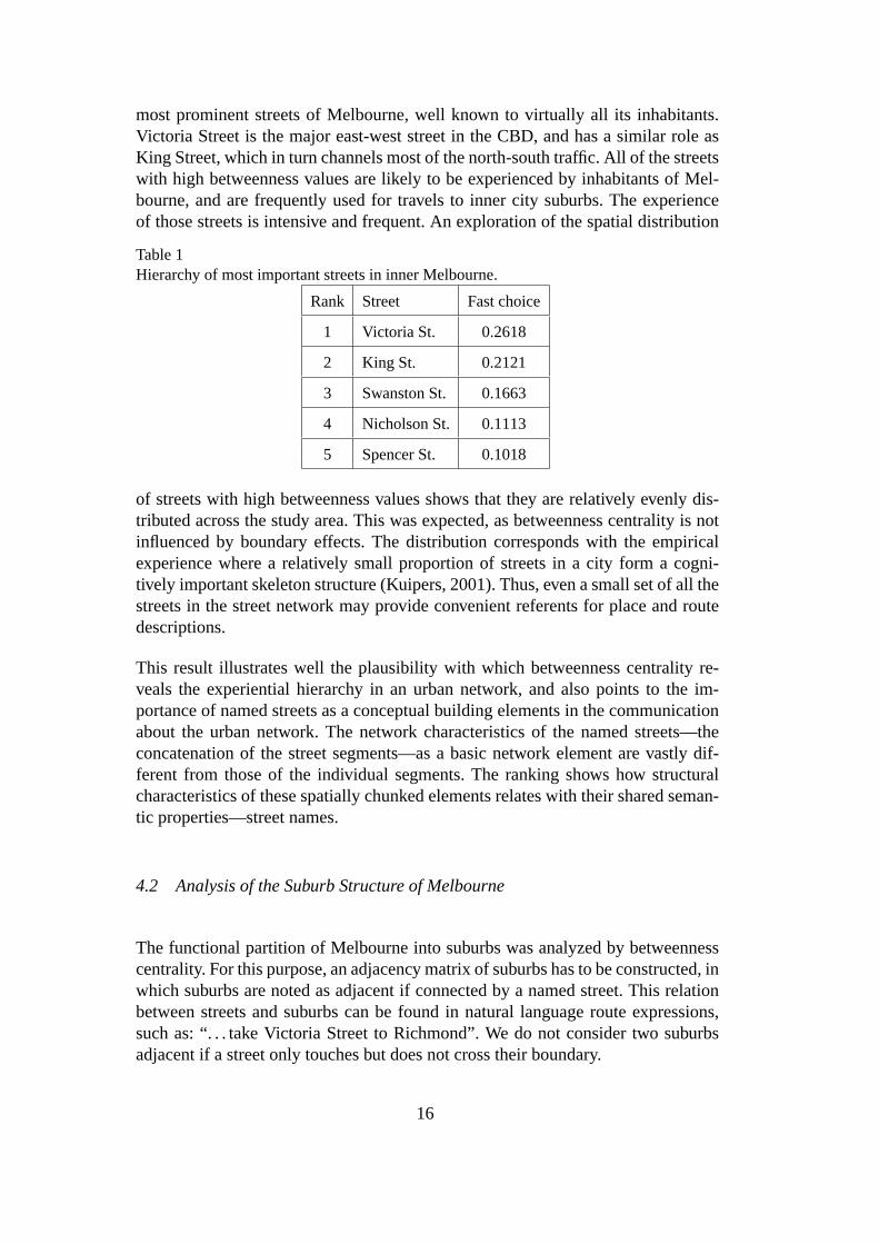
The plot of the fast choice values of streets in the city of Melbourne is shown in Fig-ure 8, along with the visualization of the street network with streets of betweennessvalues of more than oneσ above mean value. Betweenness values range between0.0017 and0.2618. The mean value calculated from the sample wasx = 0.0049with a standard deviation in the datasetσ = 0.0144. There are in total185 streetswith betweenness values above the meanx, and only 52 such that their betweenness
14
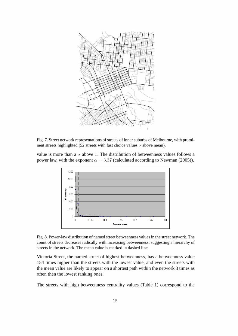
Fig. 7. Street network representations of streets of inner suburbs of Melbourne, with promi-nent streets highlighted (52 streets with fast choice valuesσ above mean).
value is more than aσ abovex. The distribution of betweenness values follows apower law, with the exponentα = 3.37 (calculated according to Newman (2005)).
Fig. 8. Power-law distribution of named street betweenness values in the street network. Thecount of streets decreases radically with increasing betweenness, suggesting a hierarchy ofstreets in the network. The mean value is marked in dashed line.
Victoria Street, the named street of highest betweenness, has a betweenness value154 times higher than the streets with the lowest value, and even the streets withthe mean value are likely to appear on a shortest path within the network 3 times asoften then the lowest ranking ones.
The streets with high betweenness centrality values (Table1) correspond to the
15
most prominent streets of Melbourne, well known to virtually all its inhabitants.Victoria Street is the major east-west street in the CBD, and has a similar role asKing Street, which in turn channels most of the north-south traffic. All of the streetswith high betweenness values are likely to be experienced byinhabitants of Mel-bourne, and are frequently used for travels to inner city suburbs. The experienceof those streets is intensive and frequent. An exploration of the spatial distribution
Table 1Hierarchy of most important streets in inner Melbourne.
Rank Street Fast choice
1 Victoria St. 0.2618
2 King St. 0.2121
3 Swanston St. 0.1663
4 Nicholson St. 0.1113
5 Spencer St. 0.1018
of streets with high betweenness values shows that they are relatively evenly dis-tributed across the study area. This was expected, as betweenness centrality is notinfluenced by boundary effects. The distribution corresponds with the empiricalexperience where a relatively small proportion of streets in a city form a cogni-tively important skeleton structure (Kuipers, 2001). Thus, even a small set of all thestreets in the street network may provide convenient referents for place and routedescriptions.
This result illustrates well the plausibility with which betweenness centrality re-veals the experiential hierarchy in an urban network, and also points to the im-portance of named streets as a conceptual building elementsin the communicationabout the urban network. The network characteristics of thenamed streets—theconcatenation of the street segments—as a basic network element are vastly dif-ferent from those of the individual segments. The ranking shows how structuralcharacteristics of these spatially chunked elements relates with their shared seman-tic properties—street names.
4.2 Analysis of the Suburb Structure of Melbourne
The functional partition of Melbourne into suburbs was analyzed by betweennesscentrality. For this purpose, an adjacency matrix of suburbs has to be constructed, inwhich suburbs are noted as adjacent if connected by a named street. This relationbetween streets and suburbs can be found in natural languageroute expressions,such as: “. . . take Victoria Street to Richmond”. We do not consider two suburbsadjacent if a street only touches but does not cross their boundary.
16
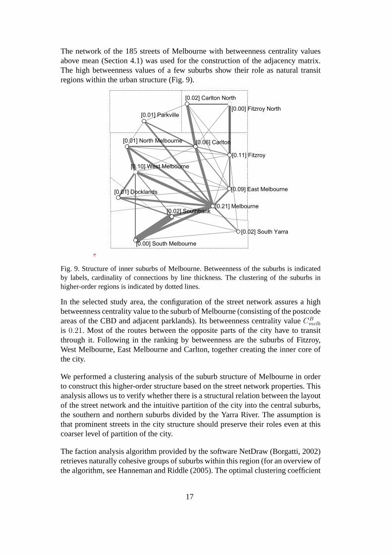
The network of the 185 streets of Melbourne with betweennesscentrality valuesabove mean (Section 4.1) was used for the construction of theadjacency matrix.The high betweenness values of a few suburbs show their role asnatural transitregions within the urban structure (Fig. 9).
Fig. 9. Structure of inner suburbs of Melbourne. Betweenness of the suburbs is indicatedby labels, cardinality of connections by line thickness. The clustering of the suburbs inhigher-order regions is indicated by dotted lines.
In the selected study area, the configuration of the street network assures a highbetweenness centrality value to the suburb of Melbourne (consisting of the postcodeareas of the CBD and adjacent parklands). Its betweenness centrality valueCB
melb
is 0.21. Most of the routes between the opposite parts of the city have to transitthrough it. Following in the ranking by betweenness are the suburbs of Fitzroy,West Melbourne, East Melbourne and Carlton, together creating the inner core ofthe city.
We performed a clustering analysis of the suburb structure of Melbourne in orderto construct this higher-order structure based on the streetnetwork properties. Thisanalysis allows us to verify whether there is a structural relation between the layoutof the street network and the intuitive partition of the cityinto the central suburbs,the southern and northern suburbs divided by the Yarra River.The assumption isthat prominent streets in the city structure should preserve their roles even at thiscoarser level of partition of the city.
The faction analysis algorithm provided by the software NetDraw (Borgatti, 2002)retrieves naturally cohesive groups of suburbs within thisregion (for an overview ofthe algorithm, see Hanneman and Riddle (2005). The optimal clustering coefficient
17

was obtained for five factions, as shown on Figure 9. This clustering follows andintuitive division of the inner part of Melbourne into the central suburbs north of theYarra River (Melbourne, West Melbourne, North Melbourne, Carlton, Fitzroy andEast Melbourne), the part of the city on the south of the river(Southbank, SouthYarra, South Melbourne) and the northern suburbs (Carlton North, Fitzroy North).The distinct region of Docklands represents a new development somehow isolatedon the other side of a sports stadium, and is in this respect similar to Parkville,which consists mostly of parkland with only a few connections to the surroundingsuburbs.
This analysis was performed to identify a hierarchically higher-order organizationof the city. It has successfully identified the major north-south division of the city bythe river, as well as the outer ring of inner suburbs around the CBD. This partition isstrongly experienced by the inhabitants of Melbourne. As wecan see, the structureof the suburb partition of the city is closely related to thatof the street network. Assuch, both should be considered when constructing experiential street hierarchies.
4.3 Experiential Hierarchy of the Street Network of Melbourne
The results of betweenness analysis of the street network ofMelbourne and of city’shigher-order functional partition into suburbs serve as the inputs for the reconstruc-tion of a refined experiential hierarchy of the street network by application of theexperiential rankingEi (Eq. 3).
The refined ranking of the named streets of Melbourne byEi is shown in Table 2.
Table 2Hierarchy of most important streets in inner Melbourne (with consideration of suburb struc-ture).
Rank Street Ei
1 Swanston St. 0.2176
2 Victoria St. 0.1518
3 Elizabeth St. 0.0658
4 King St. 0.0658
5 Flinders St. 0.0358
The ranking shows changes compared to Table 1. It reflects well the structural andfunctional role played by the streets identified in the city of Melbourne. SwanstonStreet is the major north-south connector between the northern inner suburbs andthe suburb of Melbourne, and serves its eastern part. Elizabeth Street serves a sim-ilar purpose, but runs more to the west. King Street is yet another north-south con-
18

nector, but in this case connects the westernmost edge of city and the western innersuburbs with the southern suburbs on the other side of the Yarra River. This systemof major connectors is completed by Victoria Street, which connects the east withthe west on the northern side of the inner central suburbs. Its function is comple-mentary to that of Flinders Street, serving the same purposeon the southern borderof the CBD. When relating this ranking with the higher-order partition of the city(Section 4.2), the top-ranking streets of Melbourne are still identifiable as connec-tors between the higher-order clusters of suburbs (Fig. 10). As such, they representa real backbone of the street network.
Fig. 10. The five major streets of Melbourne as identified by the combined street/suburbbetweenness (bold). Outlines of the suburb boundaries in dashed stroke.
The perception of prominence may be reinforced by the fact that these streets are allmulti-modal corridors (including tram lines) or are parts of the city bypass system.One can, however, argue that the presence of tram rails is a secondary result of anengineering process, by which the structurally significantfunction of these streetswas acknowledged and reinforced.
19

The joint consideration of the street network structure together with the suburb par-tition of the city allow for a reliable identification of the most prominent streets ofthe street network. We are now turning our attention to the integration of prominentstreets as references in the communication of granular route directions.
4.4 Further Considerations for Experiential Hierarchies ofStreet Networks
The structural position of a street affects its use in the street network. The parts ofthe network with high betweenness centrality attract more traffic flow and business.Ultimately, the intensity of use leads to overloading of these parts of the network.Administrative measures, such as alteration of traffic conditions from a two-wayinto a one-way street, are often taken to alter the structureof the network in orderto decrease the traffic. When the overcrowding exceeds some acceptable threshold,wayfinders optimize their trips. Locals with a thorough knowledge of their envi-ronment seek shortcuts and by-passes. The network properties of the alternativestreets found also have relatively high values of betweenness, even if they may notlie directly on the shortest paths.
Non-structural factors also contribute to the perception of prominence of streets.Semantic and visual characteristics of other types of elements of the city, such aslandmarks, have been widely studied before and we have no reason to believe thatthey do not influence our experience of the street network. Visual characteristicsof shopping arcades and important pedestrian zones can be highly salient. The ef-fect of semantic salience is harder to judge, but is certainly present as well. It is,however, unclear how these characteristics mix together tocontribute to the overallprominence of a specific street. Furthermore, our effort is focused on the identifi-cation of prominent parts of a transportation network in order to support the com-munication between two agents. If only a minimal knowledge about the contextof the recipient of the information is established, structural properties of the streetnetwork provide means to identify overlapping knowledge with a high degree ofreliability, based on some common behavioral patterns whichmay be inferred.
5 Conclusions
We have introduced the notion of experiential hierarchies in mental representationsof urban networks as a product of the interaction of wayfinders with streets in thecity. The intensity of experience is a reflection of the functional and structural im-portance of a specific street in the urban network. Such experiential hierarchiesrepresent one of the fundamental structures on which we can base our assumptionsabout the spatial knowledge of others. It allows for a selection of references toelements of a city in communication such as the exchange of route directions.
20

We have discussed the effects of three basic measures of network centrality for theplausibility of best operationalization of the experiential hierarchies: degree cen-trality, closeness centrality and betweenness centrality. We argue for the applicationof betweenness centrality as a basis for the novel measure. Betweenness centralityreflects the hierarchical importance of streets in the city network, without being in-fluenced by distortions due to the boundary effects. Our approach is based on theuse of named streets, which provides a mean to analyze streetnetworks reflectingadditional aspects of the shared experience, namely the labeling of the streets. Inthe communication between two locals who are mutual strangers and thus have noadditional shared context, this is likely to be one of the most important character-istics of streets one can rely upon and one that is expressed in the utterance. Thus,named streets are good candidate for references in automatically generated routedirections.
We further illustrate with the central part of the city of Melbourne, Australia, howbetweenness, or more precisely its computationally efficient implementation of fastchoice, reveals the hierarchical structure of this urban network. The distribution ofthe betweenness values identifies a small amount of highly prominent streets.
We then propose to fine-tune this hierarchical ranking of streets in the network byconsidering the higher order embedding in the suburb partition of the city. We con-struct a graph representation of the connectivity of suburbs in the urban structure,and argue for the use of betweenness centrality values of suburbs as an additionalfactor influencing the prominence of streets connecting them. Experiential ranking(Ei) is the novel measure proposed, merging the structural properties of the streetsin the network with influences of the functional partition ofthe urban network intosuburbs. The resulting ranking of streets follows our experience with the street net-work of Melbourne.
The empirical success of route direction communication in our daily lives suggeststhat there is a large overlap in the structures of our spatialknowledge, and that theknowledge of the prominent parts is common. Thus, a certain degree of differencein individual experiential hierarchies is not a barrier to reaching understanding.The match between the prominent parts of the hierarchies of the speaker and of thehearer is high when most of their elements are identical, butnot necessarily rankedin the same order. Due to the power-law distribution of streetprominence values inthe experiential hierarchies, highly prominent streets have values higher by mag-nitudes than those of low prominence. This also allows the use of the proposedobjectivized experiential hierarchy, based on the quantification of structural promi-nence of streets, for an automated construction of route directions by an automatedservice.
Individual experiential hierarchies are continuous rankings, and it is difficult todraw a line separating prominent and non-prominent streets. It is, however, possi-ble to approximate this limit by the mean value in the distribution. The bulk of the
21

streets in the hierarchy are below the mean value of prominence. In the case of thecity of Melbourne, the streets around the mean value of prominence are about 3times as prominent as those with the lowest prominence. Due to the even distribu-tion across the city, only a few top ranking streets can be called prominent and usedin hierarchical place and route descriptions for wayfinderswith local knowledge ofthe city.
Urban datasets that are structured to match the experience of locals are an importantinput for improved communication of spatial information incontext aware appli-cations, such as route direction generation for locals. Thereduction of the totallength of such route directions, compared to traditional turn-based directions, or todirections using spatial chunks (Richter et al., 2004), is due to process of relevance-based selection of referents. The direction giver assumes shared knowledge of thecoarse structure of the environment with the wayfinder, and describes the locationof the target in a zooming manner. We have proposed a formal model to determinethe referents in such granular route directions (Tomko and Winter, 2006a,b). Thismodel was applied on hierarchical partitions of districts.
The reconstruction of the experiential hierarchy in the urban street network is nec-essary for a coherent assignment of hierarchical values to streets and suburbs. Thiswill allow the development of an integrated hierarchical dataset of various elementsof the city, allowing for the selection of the most relevant referents for granularroute directions. Furthermore, it is also necessary to assess the internal structure ofthe street network within the individual suburbs. As hintedby Dalton (2006), it ispossible that our experience of suburbs does not exactly match the administrativepartition of the city, but is also strongly determined by thestructure of the streetnetwork. This could improve the constructed experiential street hierarchies.
References
Alexander, C., 1988. A City is not a Tree. In: Thackara, J. (Ed.), Design AfterModernism: Beyond the Object. Thames and Hudson, London, pp.67–84.
Batagelj, V., Mrvar, A., 2006. Pajek—Program for Large Network Analysis, v1.12.http://vlado.fmf.uni-lj.si/pub/networks/pajek/.
Bera, R., Claramunt, C., 2003. Topology-Based Proximities in Spatial Systems.Journal of Geographical Systems 5 (4), 331–415.
Borgatti, S. P., 2002. NetDraw v. 2.043. Graph VisualizationSoftware.Claramunt, C., Winter, S., accepted. Structural Salience of Elements of the City.
Environment and Planning B: Planning and Design .Couclelis, H., Golledge, R. G., Gale, N., Tobler, W. ., 1987. Exploring the Anchor-
point Hypothesis of Spatial Cognition. Journal of Environmental Psychology 7,99–122.
Dalton, N. S. C., 2006. Configuration and Neighborhood: Is PlaceMeasurable?
22

In: Space Syntax and Spatial Cognition Workshop of the SpatialCognition ’06conference. Bremen, Germany.
Eppell, V., McClurg, B. A., Bunker, J. M., 2001. A Four Level Road Hierarchyfor Network Planning and Management. In: Jaeger, Vicki (Eds.), 20th ARRBConference. Melbourne, Australia.
Figueiredo, L., 2002. Mindwalk.Figueiredo, L., Amorim, L., 2005. Continuity Lines in the Axial System. In: The
Fifth Space Syntax International Symposium. Delft University of Technology,Delft, The Netherlands.
Freeman, L. C., 1977. A Set of Measures of Centrality Based on Betweenness.Sociometry 40 (1), 35–41.
Hanneman, R., Riddle, M., 2005. Introduction to Social Network Methods.Hillier, B., Hanson, J., 1984. The Social Logic of Space. Cambridge University
Press, Cambridge, UK.Hirtle, S., 2003. Neighborhoods and Landmarks. In: Duckham, M., Goodchild, M.,
Worboys, M. (Eds.), Foundations of Geographic InformationScience. Taylor &Francis, London and New York, pp. 191–203.
Hirtle, S., Jonides, J., 1985. Evidence of Hierarchies in Cognitive Maps. Memoryand Cognition 13, 208–217.
Jiang, B., Claramunt, C., 2003. A Structural Approach to the Model Generalisationof an Urban Street Network. Geoinformatica 8 (2), 151–171.
Jiang, B., Claramunt, C., 2004. Topological Analysis of Urban Street Networks.Environment and Planning B: Planning and Design 31, 151–162.
Kuipers, B., 2001. The Skeleton in the Cognitive Map. A Computational Hypothe-sis. In: 3rd International Space Syntax Symposium. Atlanta.
Lynch, K., 1960. The Image of the City. The MIT Press, Cambridge, Massachusetts,USA.
Marshall, S., 2004. Streets and Patterns. Spon Press.Michon, P.-E., Denis, M., 2001. When and Why Are Visual Landmarks Used in
Giving Directions? In: Montello, D. R. (Ed.), Spatial Information Theory. Foun-dations of Geographic Information Science : InternationalConference, COSIT2001 Morro Bay, CA, USA, September 19-23, 2001. Proceedings. Vol. 2205of Lecture Notes in Computer Science. Springer-Verlag, Berlin, Heidelberg, pp.292–305.
Newman, E. L., Caplan, J. B., Kirschen, M. P., Korolev, I. O., Sekuler, R., Kahana,M. J., forthcoming 2006. Learning Your Way Around Town: How Virtual Taxi-cab Drivers Learn to use Both Layout and Landmark Information. Cognition .
Newman, M. E. J., 2005. Power Laws, Pareto Distributions andZipf’s Law. Con-temporary Physics 46 (5), 323–351.
Newman, M. E. J., Girvan, M., 2004. Finding and Evaluating Community Structurein Networks. Physical Review E 69 (026113), 1–6.
Plumert, J. M., Carswell, C., de Vet, K., Ihrig, D., 1995. The Content and Organi-zation of Communication about Object Locations. Journal of Memory and Lan-guage 37, 477–498.
Plumert, J. M., Spalding, T. L., Nichols-Whitehead, P., 2001. Preferences for As-
23

cending and Descending Hierarchical Organization in Spatial Communication.Memory and Cognition 29 (2), 274–284.
Porta, S., Crucitti, P., Latora, V., 2006. The Network Analysis of Urban Streets: ADual Approach. Physica A 369 (2), 853–866.
Raubal, M., Winter, S., 2002. Enriching Wayfinding Instructions With Local Land-marks. In: Egenhofer, M. J., Mark, D. M. (Eds.), Geographic Information Sci-ence: Second International Conference, GIScience 2002, Boulder, CO, USA,September 25-28, 2002. Proceedings. Vol. 2478 of Lecture Notes in ComputerScience. Springer-Verlag, Berlin, Heidelberg, pp. 243–259.
Richter, K.-F., Klippel, A., Freksa, C., 2004. Shortest, Fastest, – but what’s Next?A Different Approach to Route Directions. In: Muensteraner GI-Tage 2004.IfGIprints. Institut fuer Geoinformatik, Muenster, Germany.
Shanon, B., 1979. Where Questions. In: 17th Annual Meeting of the Associationfor Computational Linguistics. ACL, University of Californiaat San Diego, LaJolla, California, USA.
Siegel, A. W., White, S. H., 1975. The Development of Spatial Representationsof Large-Scale Environments. Advances in child development and behavior 10,9–55.
Sorrows, M. E., Hirtle, S., 1999. The Nature of Landmarks forReal and Elec-tronic Spaces. In: Freksa, C., Mark, D. (Eds.), Spatial Information Theory. Cog-nitive and Computational Foundations of Geographic Information Science: In-ternational Conference COSIT’99, Stade, Germany, August 1999. Proceedings.Vol. 1661 of Lecture Notes in Computer Science. Springer-Verlag, Berlin, Hei-delberg, pp. 37–50.
Sperber, D., Wilson, D., 1982. Mutual Knowledge and Relevance in Theories ofComprehension. In: Smith, N. V. (Ed.), Mutual Knowledge. Academic Press,London, pp. 61–85.
Sperber, D., Wilson, D., 1986. Relevance. Basil Blackwell Ltd,Oxford, UK.Stevens, A., Coupe, P., 1978. Distortions in Dudged Spatial Relations. Cognitive
Psychology 10, 422–437.Thomson, R. C., Richardson, D. E., 1999. The Good Continuation Principle of
Perceptual Organization Applied to the Generalization of Road Networks. In:ICA 19th International Cartographic Conference. Ottawa, Canada.
Timpf, S., Kuhn, W., 2003. Granularity Transformations in Wayfinding. In: Freksa,C., Habel, C., Brauer, W., Wender, K. (Eds.), Spatial Cognition III – Routes andNavigation, Human Memory and Learning, Spatial Representation and SpatialLearning. Vol. 2685 of Lecture Notes in Computer Science. Springer-Verlag,Berlin, Heidelberg, pp. 77–88.
Timpf, S., Volta, G., Pollock, D., Egenhofer, M. J., 1992. A Conceptual Model ofWayfinding Using Multiple Levels of Abstraction. In: Frank,A., Campari, I.,Formentini, U. (Eds.), Theories and Methods of Spatio-Temporal Reasoning inGeographic Space. International Conference GIS From Space to Territory: The-ories and Methods of Spatio-Temporal Reasoning Pisa, Italy,September 2123,1992 Proceedings. Vol. 639 of Lecture Notes in Computer Science. Springer-Verlag, Berlin, Heidleberg, pp. 348–367.
24

Tomko, M., Winter, S., 2006a. Initial Entity Identificationfor Granular Route Di-rections. In: Kainz, W., Riedl, A., Elmes, G. (Eds.), Progress in Spatial Data Han-dling. 12th International Symposium on Spatial Data Handling. Springer-Verlag,Vienna, Austria, pp. 43–60.
Tomko, M., Winter, S., 2006b. Recursive Construction of Granular Route Direc-tions. Journal of Spatial Science 51 (1), 101–115.
Tversky, B., 1993. Cognitive Maps, Cognitive Collages, and Spatial Mental Mod-els. In: Frank, A., Campari, I. (Eds.), Spatial Information Theory A TheoreticalBasis for GIS. European Conference, COSIT’93 Marciana Marina,Elba Island,Italy September 1922, 1993 Proceedings. Vol. 716 of LectureNotes in ComputerScience. Springer-Verlag, Berlin, Heidelberg, pp. 14–24.
Wiener, J. M., Mallot, H. A., 2003. ’Fine-to-Coarse’ Route Planning and Naviga-tion in Regionalized Environments. Spatial Cognition and Computation 3 (4),331–358.
25