Existing Transportation System Inventory Report Oahu ... · Existing Transportation System...
45
Existing Transportation System Inventory Report Oahu Regional Transportation Plan 2035 Project Deliverable 3.1.2 October 2009 Prepared for the Oahu Metropolitan Planning Organization Prepared by Parsons Brinckerhoff
Transcript of Existing Transportation System Inventory Report Oahu ... · Existing Transportation System...
Existing Transportation System Inventory Report Oahu Regional Transportation Plan 2035 Project
Deliverable 3.1.2
October 2009 Prepared for the
Oahu Metropolitan Planning Organization
Prepared by Parsons Brinckerhoff

This report was funded in part through grants from the Federal Highway Administration and Federal Transit Administration, U.S. Department of Transportation. The views and opinions of the agency expressed herein do not necessarily state or reflect those of the U. S. Department of Transportation.
Table of Contents EXECUTIVE SUMMARY ..................................................................................................... V
1 INTRODUCTION ......................................................................................................... 1-1 1.1 Report Purpose .................................................................................................... 1-1 1.2 Report Overview................................................................................................... 1-1
2 ROADWAY SYSTEM .................................................................................................. 2-1 2.1 State Roadway System ........................................................................................ 2-1
2.1.1 Interstate Freeways ..................................................................................... 2-2 2.1.2 Other Principal Arterials ............................................................................... 2-3
2.2 City Roadway System .......................................................................................... 2-4
3 TDM AND TSM............................................................................................................ 3-1 3.1 Contraflow and HOV Operations .......................................................................... 3-1
3.1.1 State Contraflow Operations........................................................................ 3-1 3.1.2 City Contraflow Operations .......................................................................... 3-2 3.1.3 State High Occupancy Vehicle Operations .................................................. 3-4 3.1.4 Special Shoulder Lanes ............................................................................... 3-5
3.2 Intelligent Transportation Systems / Centralized Traffic Signal Control Systems . 3-6 3.2.1 Existing System ........................................................................................... 3-7 3.2.2 Planned System........................................................................................... 3-7
4 TRANSIT ..................................................................................................................... 4-1 4.1 TheBus System .................................................................................................... 4-1 4.2 Transit Centers..................................................................................................... 4-2 4.3 Park-and-Ride Facilities ....................................................................................... 4-4 4.4 TheBoat................................................................................................................ 4-6 4.5 TheHandi-Van ...................................................................................................... 4-6 4.6 HDOT Vanpool Program ...................................................................................... 4-7 4.7 LOTMA Commuter Express ................................................................................. 4-7
5 BIKEWAY SYSTEM .................................................................................................... 5-1 5.1 Existing................................................................................................................. 5-2 5.2 Planned ................................................................................................................ 5-2
6 PEDESTRIAN SYSTEM .............................................................................................. 6-1
7 FREIGHT SYSTEM ..................................................................................................... 7-1
8 BASELINE PROJECTS .............................................................................................. 8-1
9 REFERENCES ............................................................................................................ 9-1
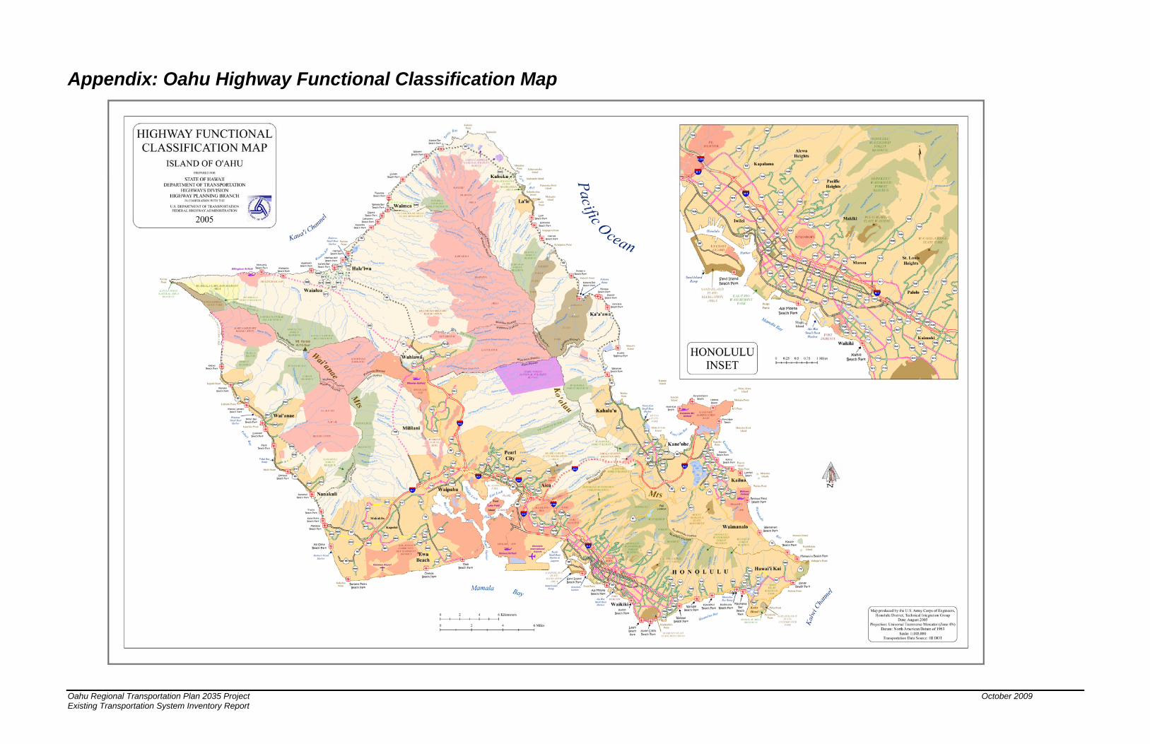
APPENDIX: OAHU HIGHWAY FUNCTIONAL CLASSIFICATION MAP
Oahu Regional Transportation Plan 2035 Project October 2009 Existing Transportation System Inventory Report Page i
List of Figures Figure 2-1: Existing State Roadway System...................................................................... 2-2
Figure 2-2: Existing City Roadway System for Urban Honolulu......................................... 2-6
Figure 3-1: Existing State Contraflow Facilities ................................................................. 3-2
Figure 3-2: Existing City Contraflow Facilities.................................................................... 3-3
Figure 3-3: Existing State HOV Facilities........................................................................... 3-5
Figure 3-4: Existing Special Shoulder Lanes ..................................................................... 3-6
Figure 4-1: Existing TheBus Transit System...................................................................... 4-3
Figure 4-2: Existing and Proposed Transit Center Locations............................................. 4-4
Figure 4-3: Existing Park-and-Ride Lot Locations ............................................................. 4-5
Figure 5-1: Bikeway System Map ...................................................................................... 5-2
Figure 7-1: Freight ............................................................................................................. 7-1
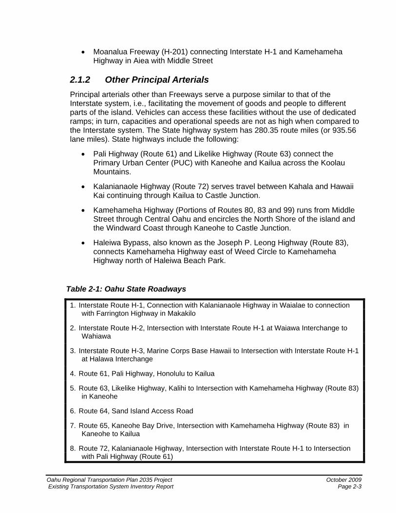
List of Tables Table 2-1: Oahu State Roadways...................................................................................... 2-3
Table 8-1: Baseline Project List ......................................................................................... 8-2
Oahu Regional Transportation Plan 2035 Project October 2009 Existing Transportation System Inventory Report Page ii
Oahu Regional Transportation Plan 2035 Project October 2009 Existing Transportation System Inventory Report Page iii
Acronyms Used in this Document ADA Americans with Disabilities Act CCTV Closed Circuit Television City City and County of Honolulu CSCS Centralized Signal Control Systems DTS Department of Transportation Services HDOT Hawaii Department of Transportation HOV High-Occupancy Vehicle ITS Intelligent Transportation Systems LOTMA Leeward Oahu Transportation Management Association OTS Oahu Transit Services PUC Primary Urban Center ROW Right of Way State State of Hawaii TCC Traffic Control Center TDM Transportation Demand Management TMC Traffic Management Center TSM Transportation System Management

Oahu Regional Transportation Plan 2035 Project October 2009 Existing Transportation System Inventory Report Page v
Executive Summary This report includes review and documentation of the existing island-wide transportation system, and it will form the basis for the existing transportation inventory section of the Oahu Regional Transportation Plan 2035. Elements of the transportation system described here include the street and highway system, transportation demand management (TDM) and transportation system management (TSM), transit services, the bikeway and pedestrian systems, and freight.
The existing street and highway system on Oahu consists of interstate freeways, state highways, and local streets. An integral part of this system is the provision of TDM and TSM by a set of special contraflow, shoulder, and high occupant vehicle (HOV) facilities. In addition, intelligent transportation systems (ITS) facilitate efficient management of these facilities through such systems as centralized traffic signal control and traffic surveillance.
The existing transit system on Oahu consists of TheBus local transit service, TheHandi-Van paratransit service, the Hawaii Department of Transportation (HDOT) vanpool program, Leeward Oahu Transportation Management Association (LOTMA) commuter bus service1, transit centers, and park-and-ride facilities.
An extensive bikeway system on Oahu consists of approximately 30 miles each of shared roadways, bike lanes, and shared use paths. Many more miles of bicycle facilities are planned.
The quality and extent of Honolulu’s pedestrian system varies depending on location. As the City develops into new, previously undeveloped areas, a complete and accessible network of sidewalks would most likely be constructed by private developers. In areas already developed but with non-conforming elements in place, additional effort would be needed to bring them up to Americans With Disabilities Act (ADA) standards.
Finally, freight movements2 on the island originate primarily at the harbors of Honolulu and Kalaeloa Barbers Point, as well as Honolulu International Airport. While Nimitz Highway, Interstate H-1, and Ala Moana Boulevard are heavily used freight corridors, virtually every roadway on Oahu may be used to facilitate goods movement.
1 This service was suspended as of December 2008. 2 Oahu does not have any specifically designated freight routes.

Oahu Regional Transportation Plan 2035 Project October 2009 Existing Transportation System Inventory Report Page 1-1
1 Introduction
1.1 Report Purpose This report includes review and documentation of the existing island-wide transportation system. It will form the basis for the existing transportation inventory section of the Oahu Regional Transportation Plan 2035.
1.2 Report Overview This report provides a description of the existing transportation system on the island of Oahu. Elements of the system described here include the street and highway system, transportation demand management and transportation system management, transit services, the bikeway and pedestrian systems, and freight.

2 Roadway System Roadways ranging from freeways to local streets form Oahu’s basic transportation network which allows for the movements of its people and goods. The transportation network is used by all types of vehicles (including trucks), public and private transit services, bicycles, and pedestrians. The roadway system on Oahu is maintained by HDOT and the City and County of Honolulu (City) Department of Facility Maintenance.
The roadway network on Oahu described below follows the federal functional classification system of classifying groups of roadways according to the character of service they are intended to provide and classifications made by HDOT based on the operational characteristics of a roadway. Each roadway is assigned a functional classification based on the roadway’s intended purpose.
The functional classification system groups roadways into four basic categories identified as:
• Principal arterials include Interstate freeways and other highways serving the major centers of activity that carry the major portion of trips entering and leaving the urban area. Principal arterials are major roadways of regional significance intended to serve through traffic where access to the roadway is carefully controlled. The Interstate H-1 and Moanalua Freeways are examples of principal arterials.
• Minor arterials are roadways that interconnect with and augment the principal arterials. They distribute traffic to smaller geographic areas providing service between and within communities. South King Street and Kapiolani Boulevard are examples of minor arterials.
• Collector streets are roadways that provide both land access service and traffic circulation within residential neighborhoods and commercial and industrial areas. The collector system distributes trips from the arterials through the area to either a local street or the ultimate destination. Kalihi and Waiakamilo Streets are examples of collector streets.
• Local streets are roadways that serve primarily to provide direct access to abutting land and access to higher order roadways. The streets on which most houses are located are examples of local streets.
A map reflecting the adopted Oahu Highway Functional Classification system can be found in the Appendix.
2.1 State Roadway System The State highway system includes all principal arterials and some minor arterials connecting various parts of the island. The following description provides background information on State roadways maintained by HDOT. The State
Oahu Regional Transportation Plan 2035 Project October 2009 Existing Transportation System Inventory Report Page 2-1
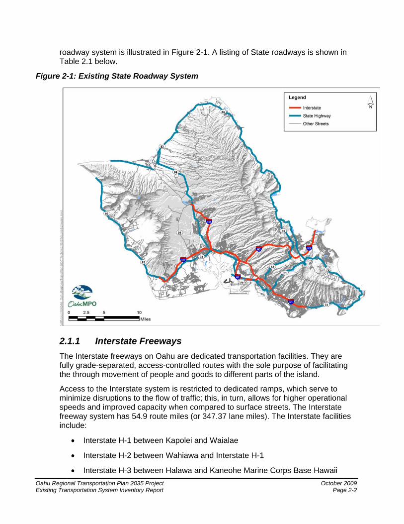
roadway system is illustrated in Figure 2-1. A listing of State roadways is shown in Table 2.1 below.
Figure 2-1: Existing State Roadway System
2.1.1 Interstate Freeways The Interstate freeways on Oahu are dedicated transportation facilities. They are fully grade-separated, access-controlled routes with the sole purpose of facilitating the through movement of people and goods to different parts of the island.
Access to the Interstate system is restricted to dedicated ramps, which serve to minimize disruptions to the flow of traffic; this, in turn, allows for higher operational speeds and improved capacity when compared to surface streets. The Interstate freeway system has 54.9 route miles (or 347.37 lane miles). The Interstate facilities include:
• Interstate H-1 between Kapolei and Waialae
• Interstate H-2 between Wahiawa and Interstate H-1
• Interstate H-3 between Halawa and Kaneohe Marine Corps Base Hawaii Oahu Regional Transportation Plan 2035 Project October 2009 Existing Transportation System Inventory Report Page 2-2
• Moanalua Freeway (H-201) connecting Interstate H-1 and Kamehameha Highway in Aiea with Middle Street
2.1.2 Other Principal Arterials Principal arterials other than Freeways serve a purpose similar to that of the Interstate system, i.e., facilitating the movement of goods and people to different parts of the island. Vehicles can access these facilities without the use of dedicated ramps; in turn, capacities and operational speeds are not as high when compared to the Interstate system. The State highway system has 280.35 route miles (or 935.56 lane miles). State highways include the following:
• Pali Highway (Route 61) and Likelike Highway (Route 63) connect the Primary Urban Center (PUC) with Kaneohe and Kailua across the Koolau Mountains.
• Kalanianaole Highway (Route 72) serves travel between Kahala and Hawaii Kai continuing through Kailua to Castle Junction.
• Kamehameha Highway (Portions of Routes 80, 83 and 99) runs from Middle Street through Central Oahu and encircles the North Shore of the island and the Windward Coast through Kaneohe to Castle Junction.
• Haleiwa Bypass, also known as the Joseph P. Leong Highway (Route 83), connects Kamehameha Highway east of Weed Circle to Kamehameha Highway north of Haleiwa Beach Park.
Table 2-1: Oahu State Roadways
1. Interstate Route H-1, Connection with Kalanianaole Highway in Waialae to connection with Farrington Highway in Makakilo
2. Interstate Route H-2, Intersection with Interstate Route H-1 at Waiawa Interchange to Wahiawa
3. Interstate Route H-3, Marine Corps Base Hawaii to Intersection with Interstate Route H-1 at Halawa Interchange
4. Route 61, Pali Highway, Honolulu to Kailua
5. Route 63, Likelike Highway, Kalihi to Intersection with Kamehameha Highway (Route 83) in Kaneohe
6. Route 64, Sand Island Access Road
7. Route 65, Kaneohe Bay Drive, Intersection with Kamehameha Highway (Route 83) in Kaneohe to Kailua
8. Route 72, Kalanianaole Highway, Intersection with Interstate Route H-1 to Intersection with Pali Highway (Route 61)
Oahu Regional Transportation Plan 2035 Project October 2009 Existing Transportation System Inventory Report Page 2-3
9. Route 76, Fort Weaver Road, Intersection with Interstate Route H-1 to Ewa Beach
10. Route H201, Moanalua Freeway, Middle Street to Halawa Interchange
11. Route 80, Kamehameha Highway, Wahiawa to Intersection with Kamehameha Highway (Route 99)
12. Route 83, Kamehameha Highway, Intersection with Pali Highway (Route 61) to Intersection with Kaneohe Bay Drive (Route 65)
13. Route 83, Kahekili Highway, Intersection with Likelike Highway (Route 63) to Kahaluu
14. Route 83, Kamehameha Highway, Kahaluu to Haleiwa
15. Route 92, Nimitz Highway, Pearl Harbor to Honolulu Harbor
16. Route 92, Ala Moana Boulevard, Honolulu Harbor to Waikiki
17. Route 93, Farrington Highway, Waiawa Interchange to Makua
18. Route 95, Kalaeloa Boulevard, Intersection with Interstate Route H-1, Makakilo
19. Route 99, Kamehameha Highway, Schofield Barracks to Waialua
20. Route 750, Kunia Road, Intersection with Interstate Route H-1 to Schofield Barracks
21. Route 930, Farrington Highway, Waialua to Dillingham Airfield
Source: Hawaii Department of Transportation.
2.2 City Roadway System The City’s roadway system consists of those facilities that are not in the State system and includes minor arterials, collector streets, and local streets.:
Principal Ewa/Koko Head roadways located in the PUC are highlighted in Figure 2-2 and include the following:
• Ala Wai Boulevard
• Beretania Street
• Dillingham Boulevard
• Kalakaua Avenue
• Kapiolani Boulevard
• King Street
• Kuhio Avenue
• Moanalua Road
Oahu Regional Transportation Plan 2035 Project October 2009 Existing Transportation System Inventory Report Page 2-4
• Salt Lake Boulevard
• School Street
The main mauka/makai roadways in the PUC are shown in Figure 2-2 and include the following:
• Houghtailing Street
• Kalakaua Avenue
• Kalihi Street
• Kapahulu Avenue
• Keeaumoku Street
• McCully Street
• Middle Street
• Pensacola Street
• Piikoi Street
• Punchbowl Street
• Puuloa Road
• South Street
• University Avenue
• Waiakamilo Road
• Ward Avenue
Portions of some of the roadways that fall under the city’s roadway system are not always under the sole jurisdiction of the City and County. For example, Farrington Highway, which is owned and operated by the City for the section between Kapolei Golf Course Access Road to Fort Weaver Road, is mostly a State-managed facility.
Oahu Regional Transportation Plan 2035 Project October 2009 Existing Transportation System Inventory Report Page 2-5

Figure 2-2: Existing City Roadway System for Urban Honolulu
Oahu Regional Transportation Plan 2035 Project October 2009 Existing Transportation System Inventory Report Page 2-6
Oahu Regional Transportation Plan 2035 Project October 2009 Existing Transportation System Inventory Report Page 3-1
3 TDM and TSM Transportation demand management (TDM) is a general term referring to a variety of strategies to reduce highway travel demand. Transportation systems management (TSM) has the basic objective of creating more efficient use of transportation facilities by improving the operation and management of vehicles and roads. Examples of TDM/TSM measures specific to the island of Oahu include carpools and vanpools, ride-matching services, contraflow operations, special shoulder lanes, HOV lanes, and ITS; these measures are overseen either by HDOT or the City, or a private transportation management association. The following sections discuss TDM/TSM measures that are currently in operation on the Oahu roadway system.
3.1 Contraflow and HOV Operations
3.1.1 State Contraflow Operations Contraflow lanes are a TSM strategy wherein a lane that typically provides vehicular travel in one direction is reversed during certain times of the day. Contraflow lanes are used to provide additional capacity in the peak direction of travel during peak periods. When the traffic flows in the peak versus off-peak directions are imbalanced, a lane can be removed from the off-peak direction of travel and used, instead, to increase peak direction capacity. HDOT currently provides contraflow operations at three locations within the State highway system during specific peak periods. Contraflow facilities operated by the State are restricted to buses, vanpools, motorcycles, and vehicles with the required number of occupants (see below). The reversible lanes on the State highway system all operate during the morning peak period only,3 although the precise hours of operation vary. State facilities currently operating with reversible contraflow lane operations include:
• H-1 Zipper Lane – The contraflow zipper lane provides a seventh Koko Head (eastbound) direction lane from Managers Drive in Waipahu to the Keehi Interchange during the morning peak period for HOV use only. Vehicles are required to have three or more occupants.
• Nimitz Highway (Route 92) – During the morning peak period, there is an eastbound contraflow lane between the Keehi Interchange and Pacific Street for HOV use only. Vehicles are required to have three or more occupants.
• Kalanianaole Highway (Route 72) – During the morning peak period, there is a westbound contraflow lane between West Halemaumau Street and Ainakoa Avenue for HOV use only. Vehicles are required to have two or more occupants, except for residents living mauka of the highway may receive a
3 An evening peak contraflow lane is being planned.
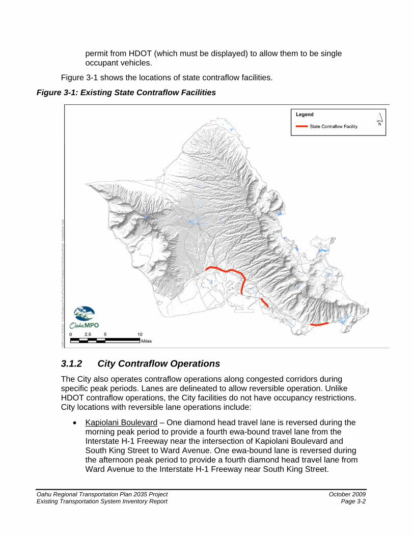
permit from HDOT (which must be displayed) to allow them to be single occupant vehicles.
Figure 3-1 shows the locations of state contraflow facilities.
Figure 3-1: Existing State Contraflow Facilities
3.1.2 City Contraflow Operations The City also operates contraflow operations along congested corridors during specific peak periods. Lanes are delineated to allow reversible operation. Unlike HDOT contraflow operations, the City facilities do not have occupancy restrictions. City locations with reversible lane operations include:
• Kapiolani Boulevard – One diamond head travel lane is reversed during the morning peak period to provide a fourth ewa-bound travel lane from the Interstate H-1 Freeway near the intersection of Kapiolani Boulevard and South King Street to Ward Avenue. One ewa-bound lane is reversed during the afternoon peak period to provide a fourth diamond head travel lane from Ward Avenue to the Interstate H-1 Freeway near South King Street.
Oahu Regional Transportation Plan 2035 Project October 2009 Existing Transportation System Inventory Report Page 3-2
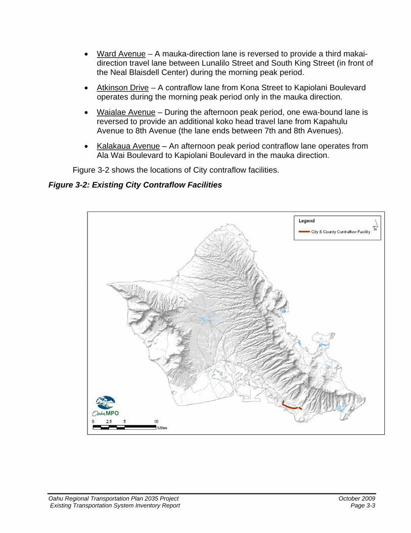
• Ward Avenue – A mauka-direction lane is reversed to provide a third makai-direction travel lane between Lunalilo Street and South King Street (in front of the Neal Blaisdell Center) during the morning peak period.
• Atkinson Drive – A contraflow lane from Kona Street to Kapiolani Boulevard operates during the morning peak period only in the mauka direction.
• Waialae Avenue – During the afternoon peak period, one ewa-bound lane is reversed to provide an additional koko head travel lane from Kapahulu Avenue to 8th Avenue (the lane ends between 7th and 8th Avenues).
• Kalakaua Avenue – An afternoon peak period contraflow lane operates from Ala Wai Boulevard to Kapiolani Boulevard in the mauka direction.
Figure 3-2 shows the locations of City contraflow facilities.
Figure 3-2: Existing City Contraflow Facilities
Oahu Regional Transportation Plan 2035 Project October 2009 Existing Transportation System Inventory Report Page 3-3
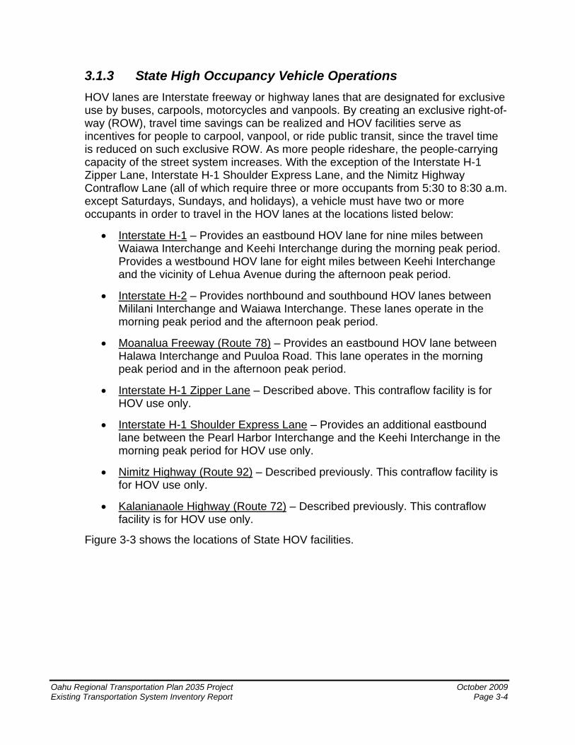
3.1.3 State High Occupancy Vehicle Operations HOV lanes are Interstate freeway or highway lanes that are designated for exclusive use by buses, carpools, motorcycles and vanpools. By creating an exclusive right-of-way (ROW), travel time savings can be realized and HOV facilities serve as incentives for people to carpool, vanpool, or ride public transit, since the travel time is reduced on such exclusive ROW. As more people rideshare, the people-carrying capacity of the street system increases. With the exception of the Interstate H-1 Zipper Lane, Interstate H-1 Shoulder Express Lane, and the Nimitz Highway Contraflow Lane (all of which require three or more occupants from 5:30 to 8:30 a.m. except Saturdays, Sundays, and holidays), a vehicle must have two or more occupants in order to travel in the HOV lanes at the locations listed below:
• Interstate H-1 – Provides an eastbound HOV lane for nine miles between Waiawa Interchange and Keehi Interchange during the morning peak period. Provides a westbound HOV lane for eight miles between Keehi Interchange and the vicinity of Lehua Avenue during the afternoon peak period.
• Interstate H-2 – Provides northbound and southbound HOV lanes between Mililani Interchange and Waiawa Interchange. These lanes operate in the morning peak period and the afternoon peak period.
• Moanalua Freeway (Route 78) – Provides an eastbound HOV lane between Halawa Interchange and Puuloa Road. This lane operates in the morning peak period and in the afternoon peak period.
• Interstate H-1 Zipper Lane – Described above. This contraflow facility is for HOV use only.
• Interstate H-1 Shoulder Express Lane – Provides an additional eastbound lane between the Pearl Harbor Interchange and the Keehi Interchange in the morning peak period for HOV use only.
• Nimitz Highway (Route 92) – Described previously. This contraflow facility is for HOV use only.
• Kalanianaole Highway (Route 72) – Described previously. This contraflow facility is for HOV use only.
Figure 3-3 shows the locations of State HOV facilities.
Oahu Regional Transportation Plan 2035 Project October 2009 Existing Transportation System Inventory Report Page 3-4
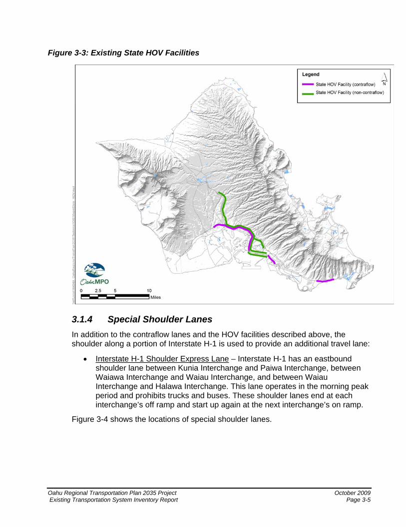
Figure 3-3: Existing State HOV Facilities
3.1.4 Special Shoulder Lanes In addition to the contraflow lanes and the HOV facilities described above, the shoulder along a portion of Interstate H-1 is used to provide an additional travel lane:
• Interstate H-1 Shoulder Express Lane – Interstate H-1 has an eastbound shoulder lane between Kunia Interchange and Paiwa Interchange, between Waiawa Interchange and Waiau Interchange, and between Waiau Interchange and Halawa Interchange. This lane operates in the morning peak period and prohibits trucks and buses. These shoulder lanes end at each interchange’s off ramp and start up again at the next interchange’s on ramp.
Figure 3-4 shows the locations of special shoulder lanes.
Oahu Regional Transportation Plan 2035 Project October 2009 Existing Transportation System Inventory Report Page 3-5
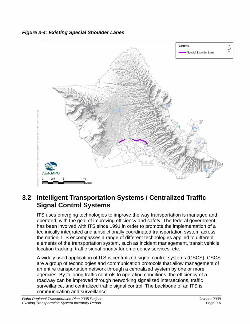
Figure 3-4: Existing Special Shoulder Lanes
3.2 Intelligent Transportation Systems / Centralized Traffic Signal Control Systems ITS uses emerging technologies to improve the way transportation is managed and operated, with the goal of improving efficiency and safety. The federal government has been involved with ITS since 1991 in order to promote the implementation of a technically integrated and jurisdictionally coordinated transportation system across the nation. ITS encompasses a range of different technologies applied to different elements of the transportation system, such as incident management, transit vehicle location tracking, traffic signal priority for emergency services, etc.
A widely used application of ITS is centralized signal control systems (CSCS). CSCS are a group of technologies and communication protocols that allow management of an entire transportation network through a centralized system by one or more agencies. By tailoring traffic controls to operating conditions, the efficiency of a roadway can be improved through networking signalized intersections, traffic surveillance, and centralized traffic signal control. The backbone of an ITS is communication and surveillance.
Oahu Regional Transportation Plan 2035 Project October 2009 Existing Transportation System Inventory Report Page 3-6
Oahu Regional Transportation Plan 2035 Project October 2009 Existing Transportation System Inventory Report Page 3-7
3.2.1 Existing System Currently, the City Department of Transportation Services (DTS) operates a centralized signal control center, referred to as the Traffic Control Center (TCC). The TCC offers signal coordination and preemption through live, video surveillance provided by a closed circuit television (CCTV) system. Live surveillance is available along most major arterial corridors.
The HDOT also operates a Traffic Management Center (TMC); the TMC provides live surveillance much like DTS’ TCC. The difference lies within the facilities monitored by each center. The State TMC monitors the State’s Interstate and highway system, including the Interstate H-3 tunnel.
The following describes the ITS infrastructure currently available on Oahu:
• 784 signalized intersections on Oahu.
• 400 signalized intersections controlled by the City’s TCC.
• 202 CCTVs on Oahu: 141 controlled by the City’s TCC and 61 controlled by the State’s TMC.
3.2.2 Planned System Long-term ITS initiatives, as indicated in Oahu Regional ITS Plan: Intelligent Transportation Systems Architecture & Integration Strategy - An Element of the Oahu Regional Transportation Plan (Parsons Brinckerhoff, April 2003), include expansion of the ITS infrastructure and the continued integration of other public agencies, both emergency and non-emergency. As the infrastructure is expanded and upgraded, system capabilities and interagency cooperation will be improved
.

Oahu Regional Transportation Plan 2035 Project October 2009 Existing Transportation System Inventory Report Page 4-1
4 Transit Transit plays an important role in Oahu’s transportation system. Such services provide an alternative to automobile travel and, by extension, benefit the island by aiding in the reduction of roadway congestion, air and noise pollution, and energy consumption. Transit also offers mobility options to youth and the elderly, the physically and mobility challenged, and persons who do not have access to an automobile. Transit in Honolulu consists of a fixed-route bus transit service known as TheBus, ferry service known as TheBoat,4 paratransit service known as TheHandi-Van, vanpools, and a private commuter bus service.5
4.1 TheBus System
Oahu Transit Services, Inc. (OTS) is a private management company formed solely to oversee and administer the daily operations of the City’s bus system (TheBus) and paratransit system (TheHandi-Van) on the island of Oahu. OTS is under contract to the City. TheBus system currently consists of 108 routes that serve approximately 3,800 bus stops. Of the 108 routes, 99 are fixed routes, 4 are deviation routes operated by the paratransit division, and 5 were feeder routes for TheBoat. Bus route categories include Rapid Bus, Urban Trunk, Urban Feeder, Suburban Trunk, Community Circulators, Community Access, and Peak Express. The characteristics of each service type are summarized below: • Rapid Bus includes CityExpress! and CountryExpress! routes that provide
limited-stop service in both directions. Service is provided early morning through late evening on weekdays. CityExpress! Routes A and B provide service every 15 minutes, and CountryExpress! routes typically provide 30-minute service.
• Urban Trunk routes provide frequent, direct service connecting neighborhoods
within the Primary Urban Center (PUC) along major Ewa/Koko Head corridors. Urban Trunk routes typically provide service every 15 minutes or less and include Routes 1, 2, 3, and 13.
• Urban Feeder routes connect the mauka/makai neighborhoods within the urban
center. The routes serving the hills and valleys of Honolulu connect residential areas to the Urban Trunk and Rapid Bus routes and provide service to major destinations such as Downtown, the University of Hawaii (UH) at Manoa, and Waikiki. These routes typically provide service every 30 minutes or less and include Routes 4, 5, 6, 7, and 8.
• Suburban Trunk routes provide service through late evenings and connect
outlying communities to the urban center. These routes stop at all local bus stops 4 TheBoat discontinued service on July 1, 2009. 5 Discontinued in December, 2008.
every day. Suburban Trunk routes typically provide 30-minute service. Examples include Routes 40, 42, 52, 55, and 56.
• Community Circulators provide local transit access within their communities.
They provide timed connections with other Community Circulators and Suburban Trunk routes at neighborhood hubs or transit centers. Routes with higher demand provide 30-minute service, and lower-demand routes provide 60-minute service. Some routes offer intermittent or peak-only service. Community Circulator service includes Routes 231–236 and 401–403.
• Community Access operates on a regular schedule using TheHandi-Van
vehicles. Curb-to-curb service is provided to registered TheHandi-Van customers who give 24-hour advance notice and are located within one-quarter mile of the service route. TheHandi-Van service can be used to connect to transit hubs through route deviation. These routes operate every 60 minutes, and time is included in the schedule for possible route deviations. Examples include Routes 501, 503, and 504.
• Peak Express routes serve predominantly home-to-work trips by connecting
neighborhoods to employment centers. Service is provided during peak periods and in the peak direction. Examples include Routes 81, 85, and 93.
Most bus routes operate seven days a week, including holidays. Passenger amenities include approximately 980 passenger shelters and 2,400 benches. The Honolulu High Capacity Transit Corridor Project Transportation Technical Report provides detailed information on the system, including schedules and routes.
TheBus system fleet consists of 540 buses. TheBus system carries approximately 73 million passengers per year. Adult fare is $2.25 one-way, while the fare for youth, senior citizens, persons with disabilities and U.S. Medicare card is $1 each. 1 free transfer is included with each paid cash fare. Children 5 years and under ride free. In addition, various monthly, annual and other passes are available for each category of passengers including special visitor passes. Figure 4-1 illustrates the extent of the transit service provided by TheBus fixed route system.
4.2 Transit Centers Transit centers are points within TheBus’ hub-and-spoke system; they offer locations for multimodal transfers and are intended to support the bus transit systems as well as alternate travel means. Currently on Oahu there are seven existing transit centers, along with one additional proposed transit center. The locations of these transit centers are shown in Figure 4-2 and listed below.
Existing Transit Centers
• Alapai Transit Center in Honolulu, located on King Street at Alapai Street
Oahu Regional Transportation Plan 2035 Project October 2009 Existing Transportation System Inventory Report Page 4-2
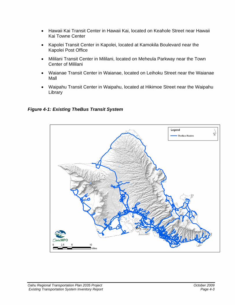
• Hawaii Kai Transit Center in Hawaii Kai, located on Keahole Street near Hawaii Kai Towne Center
• Kapolei Transit Center in Kapolei, located at Kamokila Boulevard near the Kapolei Post Office
• Mililani Transit Center in Mililani, located on Meheula Parkway near the Town Center of Mililani
• Waianae Transit Center in Waianae, located on Leihoku Street near the Waianae Mall
• Waipahu Transit Center in Waipahu, located at Hikimoe Street near the Waipahu Library
Figure 4-1: Existing TheBus Transit System
Oahu Regional Transportation Plan 2035 Project October 2009 Existing Transportation System Inventory Report Page 4-3
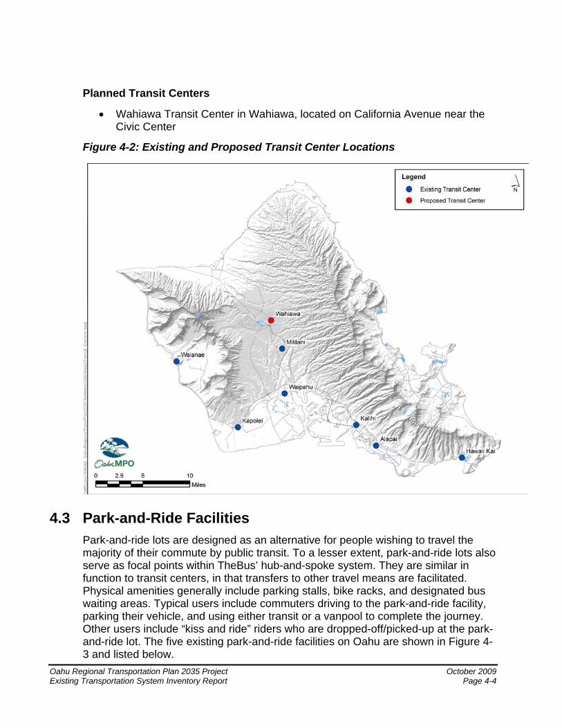
Planned Transit Centers
• Wahiawa Transit Center in Wahiawa, located on California Avenue near the Civic Center
Figure 4-2: Existing and Proposed Transit Center Locations
4.3 Park-and-Ride Facilities Park-and-ride lots are designed as an alternative for people wishing to travel the majority of their commute by public transit. To a lesser extent, park-and-ride lots also serve as focal points within TheBus’ hub-and-spoke system. They are similar in function to transit centers, in that transfers to other travel means are facilitated. Physical amenities generally include parking stalls, bike racks, and designated bus waiting areas. Typical users include commuters driving to the park-and-ride facility, parking their vehicle, and using either transit or a vanpool to complete the journey. Other users include “kiss and ride” riders who are dropped-off/picked-up at the park-and-ride lot. The five existing park-and-ride facilities on Oahu are shown in Figure 4-3 and listed below.
Oahu Regional Transportation Plan 2035 Project October 2009 Existing Transportation System Inventory Report Page 4-4
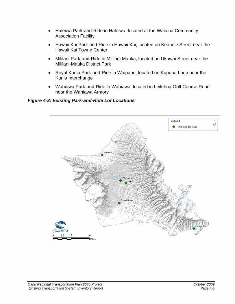
• Haleiwa Park-and-Ride in Haleiwa, located at the Waialua Community Association Facility
• Hawaii Kai Park-and-Ride in Hawaii Kai, located on Keahole Street near the Hawaii Kai Towne Center
• Mililani Park-and-Ride in Mililani Mauka, located on Ukuwai Street near the Mililani-Mauka District Park
• Royal Kunia Park-and-Ride in Waipahu, located on Kupuna Loop near the Kunia Interchange
• Wahiawa Park-and-Ride in Wahiawa, located in Leilehua Golf Course Road near the Wahiawa Armory
Figure 4-3: Existing Park-and-Ride Lot Locations
Oahu Regional Transportation Plan 2035 Project October 2009 Existing Transportation System Inventory Report Page 4-5
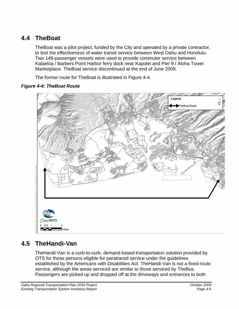
4.4 TheBoat TheBoat was a pilot project, funded by the City and operated by a private contractor, to test the effectiveness of water transit service between West Oahu and Honolulu. Two 149-passenger vessels were used to provide commuter service between Kalaeloa / Barbers Point Harbor ferry dock near Kapolei and Pier 9 / Aloha Tower Marketplace. TheBoat service discontinued at the end of June 2009.
The former route for TheBoat is illustrated in Figure 4-4.
Figure 4-4: TheBoat Route
4.5 TheHandi-Van TheHandi-Van is a curb-to-curb, demand-based transportation solution provided by OTS for those persons eligible for paratransit service under the guidelines established by the Americans with Disabilities Act. TheHandi-Van is not a fixed-route service, although the areas serviced are similar to those serviced by TheBus. Passengers are picked up and dropped off at the driveways and entrances to both
Oahu Regional Transportation Plan 2035 Project October 2009 Existing Transportation System Inventory Report Page 4-6
Oahu Regional Transportation Plan 2035 Project October 2009 Existing Transportation System Inventory Report Page 4-7
the public and private facilities. TheHandi-Van fleet consists of 166 vehicles that include different types of vans and has an annual ridership of 850,000. The days and hours of operation are the same as those of TheBus. Fares are $2 one-way and 24-hour, advance reservations are required. Costs for the TheHandi-Van operations are included in the City’s operations and maintenance budget.
4.6 HDOT Vanpool Program HDOT currently operates a vanpool program, Vanpool Hawaii, through an outside contractor, VPSI, Inc. A vanpool is a group of seven to 15 commuters sharing one vehicle during the commute to and from work. The vanpools operate five days a week and designated drivers may keep the vehicles over the weekend. As of December 2007, there were 198 vanpools in operation on Oahu. This program offers the option of a full size 15-passenger van at the cost of $65 per seat per month (Vanpool) or a seven-passenger minivan or sport utility vehicle at the cost of $80 per seat per month (Cool Pool). All riders share the vehicle’s fuel and parking costs, regardless of the vanpool option.
4.7 LOTMA Commuter Express6 The Leeward Oahu Transportation Management Association (LOTMA) offered the LOTMA Commuter Express, a private commuter bus service. The LOTMA Commuter Express provided non-stop freeway express lane service between Central Oahu and Honolulu as an alternative to solo driving. The Commuter Express operated five days a week, traveling inbound to Honolulu during the morning peak period and outbound to Central Oahu during the evening peak period. This was a subscription-based service with financial support by local companies. Additionally, LOTMA continues to offer carpooling and vanpooling programs, computerized ride-matching assistance, and an emergency ride home program. Figure 4-5 shows the route of the LOTMA Commuter Express service.
6 This service was suspended as of December 2008.
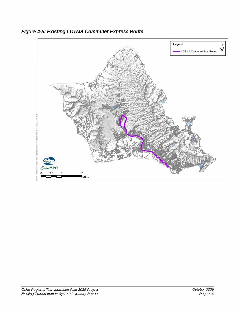
Figure 4-5: Existing LOTMA Commuter Express Route
Oahu Regional Transportation Plan 2035 Project October 2009 Existing Transportation System Inventory Report Page 4-8
5 Bikeway System The bikeway system provides residents as well as visitors with an inexpensive and convenient means of getting around Oahu for recreation, commuting, and/or utilitarian purposes. With the continued dependence on the automobile and increasing congestion found on the street system, the development and promotion of alternative travel means is important to the island of Oahu. There are three primary facility types that provide the bikeway infrastructure on the island. The three facility types fall into the following categories as defined by the Bike Plan Hawaii, A State of Hawaii Master Plan (2003):
• Shared Roadway – A shared roadway refers to any street or highway that is open to both bicycle and motor vehicle travel. Shared roadways may have signs designating the status as a preferred bike route.
• Bike Lane – A bike lane refers to a section of the roadway that has been designated by striping, signing, and/or pavement markings for the preferential or exclusive use by bicyclists. It delineates the ROW assigned to bicyclists and motorists in part to provide for more predictable movements by each type of user.
• Shared Use Path – Shared use path refers to a pathway that is physically separated from motorized vehicular traffic by an open space or a barrier, and is either within the highway ROW or has an independent ROW. Shared use paths may also be used by other non-motorized vehicle users.
The information in this section was drawn from the Bike Plan Hawaii (2003) document. In addition, the City developed the Honolulu Bicycle Master Plan (April 1999). Both of these documents are currently being updated.
Figure 5-1 illustrates the locations of existing and planned bikeway facilities on the island.
Oahu Regional Transportation Plan 2035 Project October 2009 Existing Transportation System Inventory Report Page 5-1
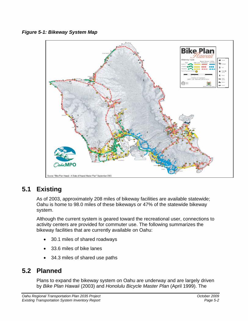
Figure 5-1: Bikeway System Map
5.1 Existing As of 2003, approximately 208 miles of bikeway facilities are available statewide; Oahu is home to 98.0 miles of these bikeways or 47% of the statewide bikeway system.
Although the current system is geared toward the recreational user, connections to activity centers are provided for commuter use. The following summarizes the bikeway facilities that are currently available on Oahu:
• 30.1 miles of shared roadways
• 33.6 miles of bike lanes
• 34.3 miles of shared use paths
5.2 Planned Plans to expand the bikeway system on Oahu are underway and are largely driven by Bike Plan Hawaii (2003) and Honolulu Bicycle Master Plan (April 1999). The
Oahu Regional Transportation Plan 2035 Project October 2009 Existing Transportation System Inventory Report Page 5-2
Oahu Regional Transportation Plan 2035 Project October 2009 Existing Transportation System Inventory Report Page 5-3
following describes the bikeway expansion underway since publication of Bike Plan Hawaii:
• 18.8 miles of shared roadways
• 4.6 miles of bike lanes
• 14.3 miles of shared use paths
The following includes bikeway expansion projects as proposed in both Bike Plan Hawaii and Honolulu Bicycle Master Plan:
• 171.8 miles of shared roadways
• 49.7 miles of bike lanes
• 37.4 miles of shared use paths
These bikeway expansion projects could increase the bikeway facilities on Oahu to 394.6 total miles upon completion.

Oahu Regional Transportation Plan 2035 Project October 2009 Existing Transportation System Inventory Report Page 6-1
6 Pedestrian System The pedestrian system provides residents and visitors with access to local shopping, business, residential, recreational, and educational opportunities. It also provides access to public transit services, which in turn expands opportunities for residents and visitors. More than one-third of residents do not have access to a car at any given time. These people are dependent on the pedestrian network to give them access to basic services and/or transportation options.
The quality and extent of Honolulu’s pedestrian system varies depending on location. In certain areas, such as Waikiki, Chinatown, and Downtown, the City has invested heavily in creating a continuous and accessible pedestrian system while in other neighborhoods the condition of pedestrian facilities is poor or incomplete. For example, pedestrian linkages are not fully developed in the Kapolei area because of the less dense land uses and the highway network. In most other areas, pedestrian facilities exist but are sometimes narrow or not continuous.
As the City develops into new, previously undeveloped areas, a complete and accessible network of sidewalks would most likely be constructed by private developers. In areas already developed but with a poor system in place, additional effort would be needed to bring them up to ADA standards.
Hawaii Department of Transportation is in the process of developing a Statewide Pedestrian Master Plan. The plan will document the policy, existing conditions for pedestrians, and education, enforcement and engineering measures that can prove useful in improving the conditions for pedestrians in Hawaii (Department of Transportation’s report to Legislature of the State of Hawaii on Act 232 Session Laws of Hawaii 2008, 2008). It will also provide guidance on optimal use of the resources to incorporate the various measures. HDOT plans to involve public and stakeholder groups in its effort to develop this plan.

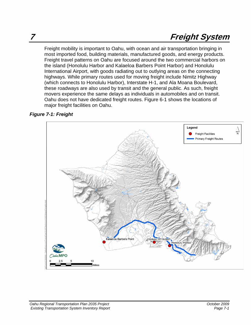
7 Freight System Freight mobility is important to Oahu, with ocean and air transportation bringing in most imported food, building materials, manufactured goods, and energy products. Freight travel patterns on Oahu are focused around the two commercial harbors on the island (Honolulu Harbor and Kalaeloa Barbers Point Harbor) and Honolulu International Airport, with goods radiating out to outlying areas on the connecting highways. While primary routes used for moving freight include Nimitz Highway (which connects to Honolulu Harbor), Interstate H-1, and Ala Moana Boulevard, these roadways are also used by transit and the general public. As such, freight movers experience the same delays as individuals in automobiles and on transit. Oahu does not have dedicated freight routes. Figure 6-1 shows the locations of major freight facilities on Oahu.
Figure 7-1: Freight
Oahu Regional Transportation Plan 2035 Project October 2009 Existing Transportation System Inventory Report Page 7-1

Oahu Regional Transportation Plan 2035 Project October 2009 Existing Transportation System Inventory Report Page 8-1
8 Baseline Projects This section provides a list of baseline transportation projects for the Oahu Regional Transportation Plan 2035 (ORTP 2035). These projects were recently completed, are currently under construction, or are funded for implementation. More specifically, to be considered as a baseline improvement for the ORTP 2035, a project must meet the following conditions:
• Project is performance enhancing at a regional scale; AND
• Project is currently being constructed; OR
• Project is programmed for construction within the first two (2) years of the current Transportation Improvement Program7, as revised.
Table 8-1 provides a list of baseline improvement projects for the ORTP 2035 (Baseline Projects Report, 2009).
7 FYs 2008 – 2011 Transportation Improvement Program: Projects as of Revision #13, Oahu Metropolitan Planning Organization, July, 2009.
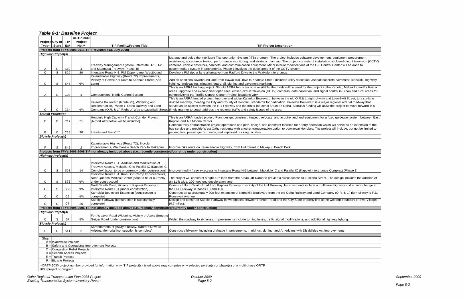
Table 8-1: Baseline Project
Project Type*
City or State
TIP ID#
ORTP 2030 Project No.** TIP Facility/Project Title TIP Project Description
Projects from FFYs 2008-2011 TIP (Revision #13, July 2009)Highway Project(s)
A S S10 4Freeway Management System, Interstate H-1, H-2, and Moanalua Freeway, Phase 1B
Manage and guide the Intelligent Transportation System (ITS) program. The project includes software development, equipment procurement assistance, acceptance testing, performance monitoring, and strategic planning. The project consists of installation of closed-circuit television (CCTV) cameras, vehicle detectors, cabinets, and communication equipment. Minor interior modifications of the H-3 Control Center will be done to accommodate system improvements. Phase 1 involves the development of the CCTV system.
C S S29 20 Interstate Route H-1, PM Zipper Lane, Westbound Develop a PM zipper lane alternative from Radford Drive to the Waikele Interchange.
C S S48 N/A
Kalanianaole Highway (Route 72) Improvements, Vicinity of Hawaii Kai Drive to Keahole Street (Add Lane)
Add an additional townbound lane from Hawaii Kai Drive to Keahole Street. Includes utility relocation, asphalt concrete pavement, sidewalk, highway lighting, landscaping, irrigation, guardrail, signing and pavement markings.
A C C03 4 Computerized Traffic Control System
This is an ARRA backup project. Should ARRA funds become available, the funds will be used for the project in the Kapolei, Makakilo, and/or Kailua areas. Upgrade and expand fiber optic lines, closed-circuit television (CCTV) cameras, data collection, and signal control in urban and rural areas for connectivity to the Traffic Control Center. Project locations vary.
C C C34 N/A
Kalaeloa Boulevard (Route 95), Widening and Reconstruction, Phase 1, Oahu Railway and Land Company (O.R. & L.) Right-of-Way to Lauwiliwili Street
This is an ARRA funded project. Improve and widen Kalaeloa Boulevard, between the old O.R.& L. right-of-way and Lauwiliwili Street, to a six-lane divided roadway, meeting the City and County of Honolulu standards for dedication. Kalaeloa Boulevard is a major regional arterial roadway that serves as an access between the H-1 Freeway and the major industrial areas on Oahu. Stimulus funding will allow the project to move forward in a timely manner to better address the regional traffic and safety issues of the area.
Transit Project(s)
E C C17 31Honolulu High Capacity Transit Corridor Project [Airport Alternative will be included]
This is an ARRA-funded project. Plan, design, construct, inspect, relocate, and acquire land and equipment for a fixed guideway system between East Kapolei and Ala Moana Center.
E C C18 30 Intra-Island Ferry****
Continue ferry demonstration project operations and plan, design, and construct facilities for a ferry operation which will serve as an extension of the bus service and provide West Oahu residents with another transportation option to downtown Honolulu. The project will include, but not be limited to, parking lots, passenger terminals, and improved docking facilities.
Bicycle Project(s)
F S S42 2Kalanianaole Highway (Route 72), Bicycle Improvements, Waimanalo Beach Park to Makapuu Improve bike route on Kalanianaole Highway, from Huli Street to Makapuu Beach Park
Projects from FFYs 2006-2008 TIP not already included above (i.e., recently constructed/currently under construction)Highway Project(s)
C S S63 14
Interstate Route H-1, Addition and Modification of Freeway Access, Makalilo IC to Palailai IC (Kapolei IC Complex) [soon to be or currently under construction] Improve/modify freeway access to Interstate Route H-1 between Makakilo IC and Palailai IC (Kapolei Interchange Complex) (Phase 1)
C S S73 N/A
Interstate Route H-1, Kinau Off-Ramp Improvements, Near Queens Medical Center [soon to be or currently under construction]
The project will construct a right-turn lane from the Kinau Off-Ramp to provide a direct access to Lusitana Street. The design includes the addition of an 11-ft wide, 200-foot long deceleration lane.
C S S58 N/ANorth/South Road, Vicinity of Kapolei Parkway to Interstate Route H-1 [under construction]
Construct North/South Road from Kapolei Parkway to vicinity of the H-1 Freeway. Improvements include a multi-lane highway and an interchange at the H-1 Freeway. (Phases 1B and 1C)
C C C6 N/AKamokila Boulevard Extension [construction is complete]
Construct an approximately 200-foot extension of Kamokila Boulevard from the old Oahu Railway and Land Company (O.R. & L.) right-of-way to F.D. Roosevelt Avenue.
C C C7 26Kapolei Parkway [construction is substantially complete]
Design and construct Kapolei Parkway in two phases between Renton Road and the City/State property line at the western boundary of Ewa Villages (0.7 miles).
Projects from FFYs 2004-2006 TIP not already included above (i.e., recently constructed/currently under construction)Highway Project(s)
C S S7 N/AFort Weaver Road Widening, Vicinity of Aawa Street to Geiger Road [under construction] Widen the roadway to six lanes. Improvements include turning lanes, traffic signal modifications, and additional highway lighting.
Bicycle Project(s)
F S S41 2Kamehameha Highway Bikeway, Radford Drive to Arizona Memorial [construction is complete] Construct a bikeway, including drainage improvements, markings, signing, and Americans with Disabilities Act improvements.
*KeyA = Islandwide ProjectsB = Safety and Operational Improvement ProjectsC = Congestion Relief ProjectsD = Second Access ProjectsE = Transit ProjectsF = Bicycle Projects
**ORTP 2030 project number provided for information only. TIP project(s) listed above may comprise only selected portion(s) or phase(s) of a multi-phase ORTP 2030 project or program.
Oahu Regional Transportation Plan 2035 Project October 2009 September 2009 Existing Transportation System Inventory Report Page 8-2 Page 8-2
9 References Hawaii Strategic Highway Safety Plan. 2007 thru 2012
Honolulu High-Capacity Transit Corridor Project Draft Environmental Impact Statement/Section 4(f) Evaluation. November 2008
LOTMA website (http://www.lotma.org)
TheBus website (http://www.thebus.org)
Vanpool Hawaii website (http://www.vanpoolhawaii.com)
Hawaii Department of Transportation Website. Oahu State Roads and Highways (http://hawaii.gov/dot/highways/islands/oahu/oahuroad.htm)
Bike Plan Hawaii, A State of Hawaii Master Plan. 2003
Honolulu Bicycle Master Plan. April 1999
Oahu Regional ITS Plan: Intelligent Transportation Systems Architecture & Integration Strategy - An Element of the Oahu Regional Transportation Plan. Parsons Brinckerhoff. April 2003
FYs 2008 – 2011 Transportation Improvement Program: Projects as of Revision #13. Oahu Metropolitan Planning Organization. July 2009
The Handi-Van Service. Department of Transportation Services, City and County of Honolulu website (http://www.honolulu.gov/dts/riders.htm)
Department of Transportation’s report to Legislature of the State of Hawaii on Act 232 Session Laws of Hawaii 2008. State of Hawaii. Department of Transportation. November 2008
The Boat: City and County of Honolulu website (http://www.trytheboat.com/)
Baseline Projects Report, Oahu Regional Transportation Plan 2035 Project, Deliverable 7.2.1. Parsons Brinckerhoff. July 2009
Oahu Regional Transportation Plan 2035 Project October 2009 Existing Transportation System Inventory Report Page 9-1

Oahu Regional Transportation Plan 2035 Project October 2009
Existing Transportation System Inventory Report
Appendix: Oahu Highway Functional Classification Map