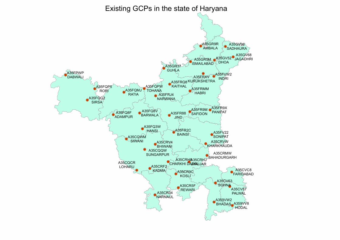
Existing GCPs in the state of Haryana
43
! . ! . ! . ! . ! . ! . ! . ! . ! . ! . ! . ! . ! . ! . ! . ! . ! . ! . ! . ! . ! . ! . ! . ! . ! . ! . ! . ! . ! . ! . ! . ! . ! . ! . ! . ! . ! . ! . ! . ! . ! . A35FQP5 RORI A35FR88 JIND A35GV52 DHOA A35CV63 SOHNA A35FQG2 SIRSA A35FQMJ RATIA A35CR9C KOSLI A35CRF2 KADMA A35FVW2 INDRI A359VV8 HODAL A35FQ3W HANSI A35FRMM HABRI A35GR37 GUHLA A35FQPW TOHANA A35CQWM SIWANI A35CR5F REWARI A35CV57 PALWAL A35CQCR LOHARU A359VW2 BHADAS A35FR2C BAINSI A35GR9R AMBALA A35FV22 SONIPAT A35FR9M SAFIDON A35FR9X PANIPAT A35FRJ4 NARWANA A35CR34 NARNAUL A35FRQ8 KAITHAL A35CRHJ JHAJJAR A35FPWP DABWALI A35CRV4 BHIWANI A35FQ8V BARWALA A35FQ8F ADAMPUR A35GV96 SADHAURA A35GV68 JAGADHRI A35CQQW SUNGARPUR A35CVC8 FARIDABAD A35CRVW KHARKHAUDA A35GR5M ISMAILABAD A35FRXV KURUKSHETRA A35CRMW BAHADURGARH A35CRH8 CHARKHI DADRI Existing GCPs in the state of Haryana
Transcript of Existing GCPs in the state of Haryana
!.
!.
!.
!.
!.
!.
!.
!.
!.
!.
!.
!.
!.
!.
!.
!.
!.
!.
!.
!.
!.
!.
!.
!.
!.
!.
!.
!.
!.
!.
!.
!.
!.
!.
!.
!.
!.
!.
!.
!.
!.A35FQP5
RORI
A35FR88JIND
A35GV52DHOA
A35CV63SOHNA
A35FQG2SIRSA
A35FQMJRATIA
A35CR9CKOSLI
A35CRF2KADMA
A35FVW2INDRI
A359VV8HODAL
A35FQ3WHANSI
A35FRMMHABRI
A35GR37GUHLA
A35FQPWTOHANA
A35CQWMSIWANI
A35CR5FREWARI A35CV57
PALWAL
A35CQCRLOHARU
A359VW2BHADAS
A35FR2CBAINSI
A35GR9RAMBALA
A35FV22SONIPAT
A35FR9MSAFIDON
A35FR9XPANIPAT
A35FRJ4NARWANA
A35CR34NARNAUL
A35FRQ8KAITHAL
A35CRHJJHAJJAR
A35FPWPDABWALI
A35CRV4BHIWANI
A35FQ8VBARWALAA35FQ8F
ADAMPUR
A35GV96SADHAURA
A35GV68JAGADHRI
A35CQQWSUNGARPUR
A35CVC8FARIDABAD
A35CRVWKHARKHAUDA
A35GR5MISMAILABAD
A35FRXVKURUKSHETRA
A35CRMWBAHADURGARHA35CRH8
CHARKHI DADRI
Existing GCPs in the state of Haryana
Haryana
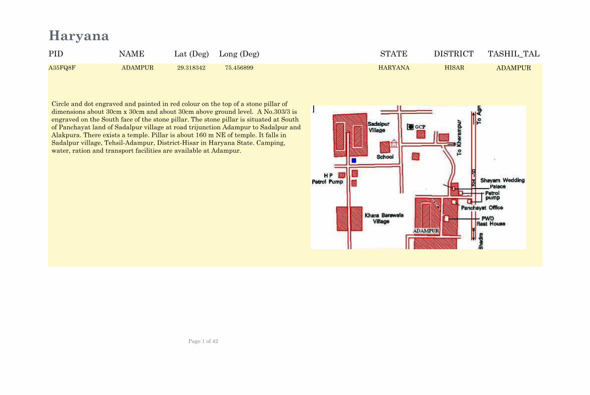
ADAMPUR 29.319172 75.456069 HARYANA HISAR ADAMPUR
Circle and dot engraved and painted in red colour on the top of a stone pillar of dimensions about 30cm x 30cm and about 30cm above ground level. A No.303/3 is engraved on the South face of the stone pillar. The stone pillar is situated at South of Panchayat land of Sadalpur village at road trijunction Adampur to Sadalpur and Alakpura. There exists a temple. Pillar is about 160 m NE of temple. It falls in Sadalpur village, Tehsil-Adampur, District-Hisar in Haryana State. Camping, water, ration and transport facilities are available at Adampur.
A35FQ8F ADAMPUR 29.318342 75.456899 HISARA35FQ8F ADAMPURHARYANA
NAME Lat (Deg) Long (Deg) STATE DISTRICT TASHIL_TALPID
Page 1 of 42
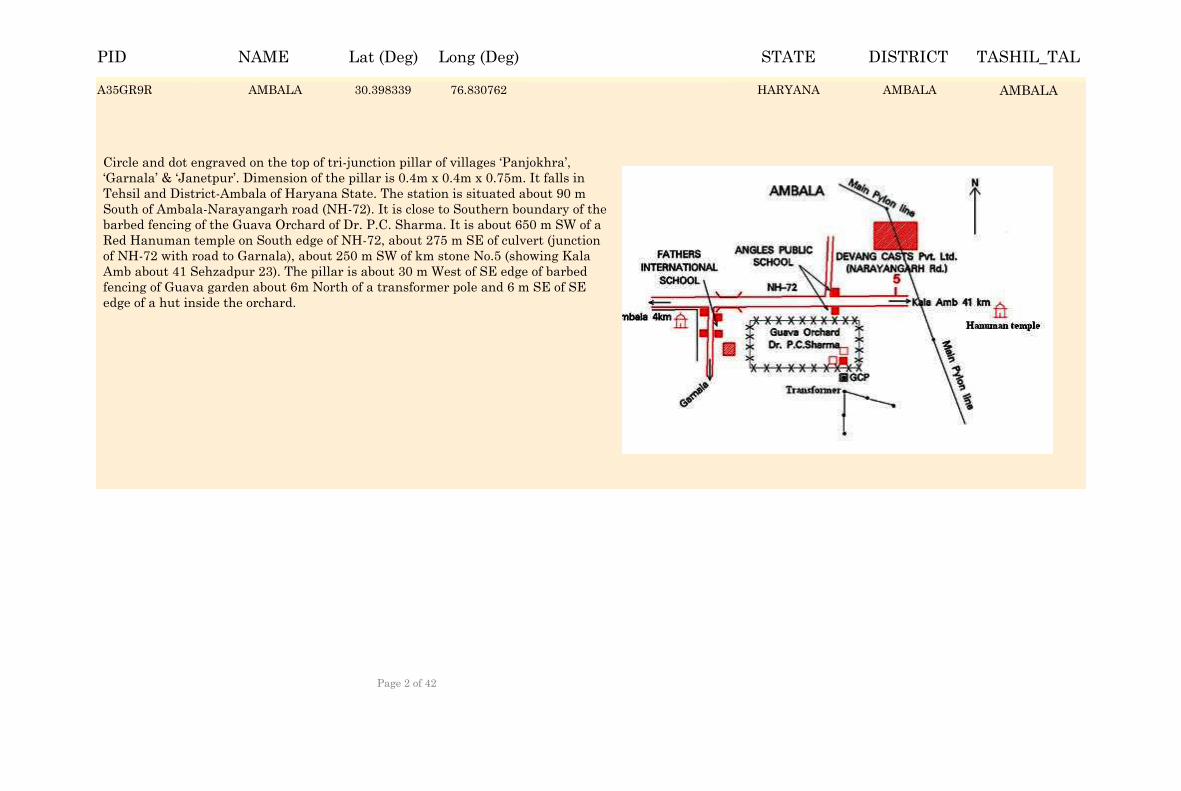
AMBALA 30.399169 76.829932 HARYANA AMBALA AMBALA
Circle and dot engraved on the top of tri-junction pillar of villages ‘Panjokhra’, ‘Garnala’ & ‘Janetpur’. Dimension of the pillar is 0.4m x 0.4m x 0.75m. It falls in Tehsil and District-Ambala of Haryana State. The station is situated about 90 m South of Ambala-Narayangarh road (NH-72). It is close to Southern boundary of the barbed fencing of the Guava Orchard of Dr. P.C. Sharma. It is about 650 m SW of a Red Hanuman temple on South edge of NH-72, about 275 m SE of culvert (junction of NH-72 with road to Garnala), about 250 m SW of km stone No.5 (showing Kala Amb about 41 Sehzadpur 23). The pillar is about 30 m West of SE edge of barbed fencing of Guava garden about 6m North of a transformer pole and 6 m SE of SE edge of a hut inside the orchard.
A35GR9R AMBALA 30.398339 76.830762 AMBALAA35GR9R AMBALAHARYANA
NAME Lat (Deg) Long (Deg) STATE DISTRICT TASHIL_TALPID
Page 2 of 42
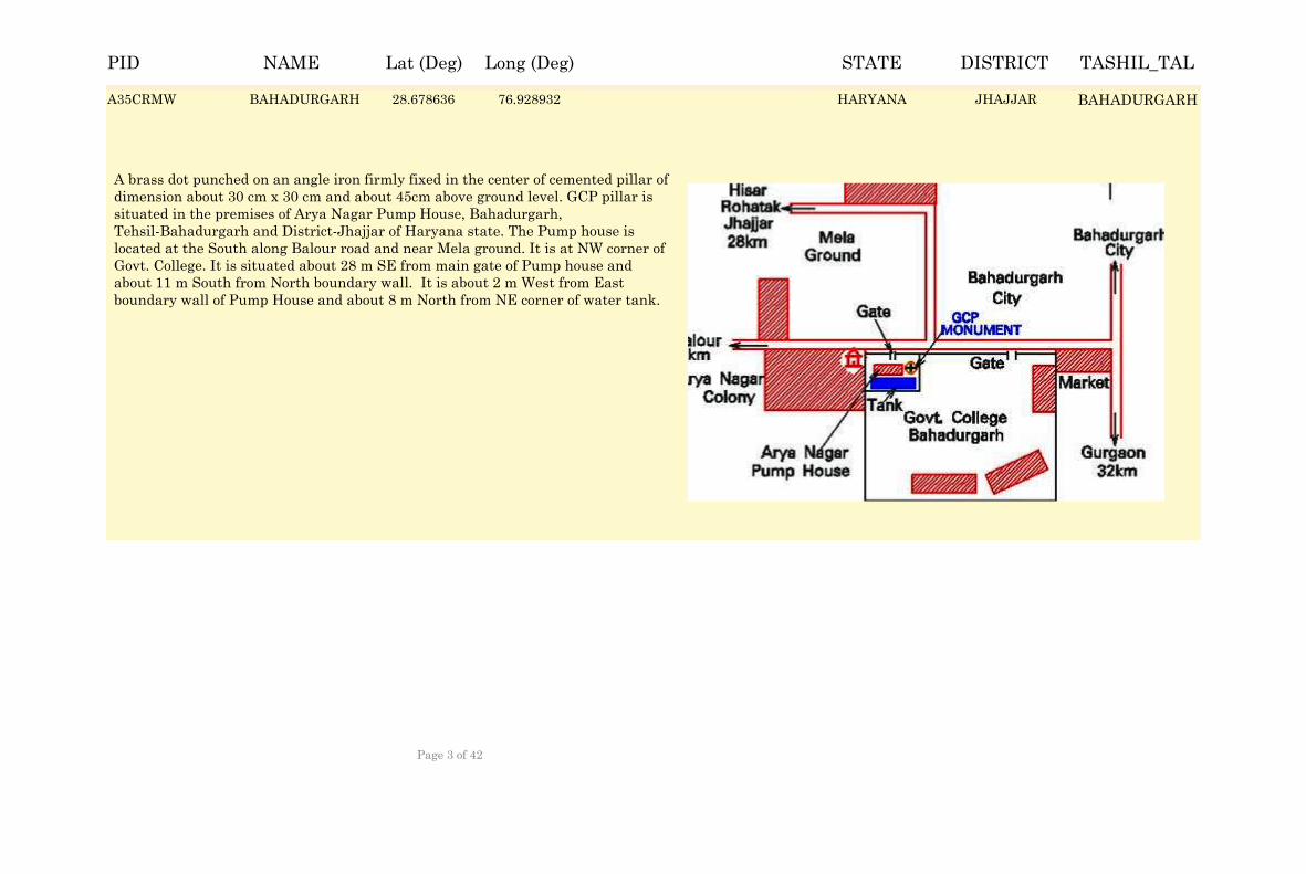
BAHADURGARH 28.679466 76.928102 HARYANA JHAJJAR BAHADURGARH
A brass dot punched on an angle iron firmly fixed in the center of cemented pillar of dimension about 30 cm x 30 cm and about 45cm above ground level. GCP pillar is situated in the premises of Arya Nagar Pump House, Bahadurgarh, Tehsil-Bahadurgarh and District-Jhajjar of Haryana state. The Pump house is located at the South along Balour road and near Mela ground. It is at NW corner of Govt. College. It is situated about 28 m SE from main gate of Pump house and about 11 m South from North boundary wall. It is about 2 m West from East boundary wall of Pump House and about 8 m North from NE corner of water tank.
A35CRMW BAHADURGARH 28.678636 76.928932 JHAJJARA35CRMW BAHADURGARHHARYANA
NAME Lat (Deg) Long (Deg) STATE DISTRICT TASHIL_TALPID
Page 3 of 42
BAINSI 29.042114 76.4057 HARYANA ROHTAK MAHAM
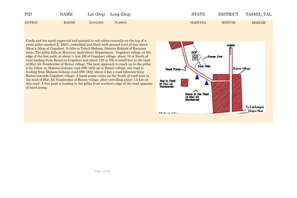
Circle and dot mark engraved and painted in red colour centrally on the top of a stone pillar marked Z- 488/3, embedded and flush with ground level of size about 30cm x 30cm at Gogaheri. It falls in Tehsil-Maham, District-Rohtak of Haryana state. The pillar falls at Haryana Agriculture Department, Gogaheri village on the edge of the foot path, at about ½ km. SE of Gogaheri village, about 70 m North of road leading from Bainsi to Gogaheri and about 120 m NE of small hut in the land of Shri Ali Numberdar of Bainsi village. The best approach to reach up to the pillar is by follow on Maham-Gohana road (SH-16A) up to Bainsi village, one road is leading from Maham-Gohana road (SH-16A), about 2 km a road bifercate from Bainsi towards Gogaheri village. A hand pump exists on the South of road near in the land of Shri Ali Numberdar of Bainsi village, after travelling about 1.5 km on this road. A foot path is leading to the pillar from northern edge of the road opposite of hand pump.
A35FR2C BAINSI 29.041284 76.40653 ROHTAKA35FR2C MAHAMHARYANA
NAME Lat (Deg) Long (Deg) STATE DISTRICT TASHIL_TALPID
Page 4 of 42
BARWALA 29.34512 75.870457 HARYANA HISAR BARWALA
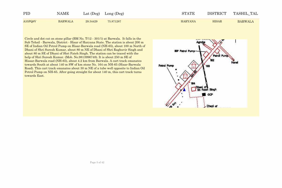
Circle and dot cut on stone pillar (BM No. T/12 - 301/1) at Barwala. It falls in the Sub Tehsil - Barwala, District - Hisar of Haryana State. The station is about 200 m SE of Indian Oil Petrol Pump on Hisar-Barwala road (NH-65), about 100 m North of Dhani of Shri Suresh Kumar, about 80 m NE of Dhani of Shri Raghuvir Singh and about 80 m SE of Dhani of Shri Fateh Singh. The station can be traced with the help of Shri Suresh Kumar. (Mob. No.9813996748). It is about 250 m SE of Hissar-Barwala road (NH-65), about 4.2 km from Barwala. A cart track emanates towards South at about 140 m SW of km stone No. 164 on NH-65 (Hisar-Barwala Road). This cart track emanates about 30 m NE of a tube well opposite to Indian Oil Petrol Pump on NH-65. After going straight for about 140 m, this cart track turns towards East.
A35FQ8V BARWALA 29.34429 75.871287 HISARA35FQ8V BARWALAHARYANA
NAME Lat (Deg) Long (Deg) STATE DISTRICT TASHIL_TALPID
Page 5 of 42
BHADAS 27.945622 77.039728 HARYANA MEWAT FEROZPURJHIRKHA
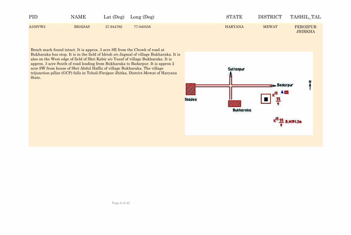
Bench mark found intact. It is approx. 3 acre SE from the Chowk of road at Bukharaka bus stop. It is in the field of Idrish s/o Jagmal of village Bukharaka. It is also on the West edge of field of Shri Kabir s/o Yusuf of village Bukharaka. It is approx. 3 acre South of road leading from Bukharaka to Badarpur. It is approx 2 acre SW from house of Shri Abdul Haffiz of village Bukharaka. The village trijunction pillar (GCP) falls in Tehsil-Firojpur Jhitka, District-Mewat of Haryana State.
A359VW2 BHADAS 27.944792 77.040558 MEWATA359VW2 FEROZPURJHIRKHA
HARYANA
NAME Lat (Deg) Long (Deg) STATE DISTRICT TASHIL_TALPID
Page 6 of 42
BHIWANI 28.853726 76.114964 HARYANA BHIWANI BHIWANI
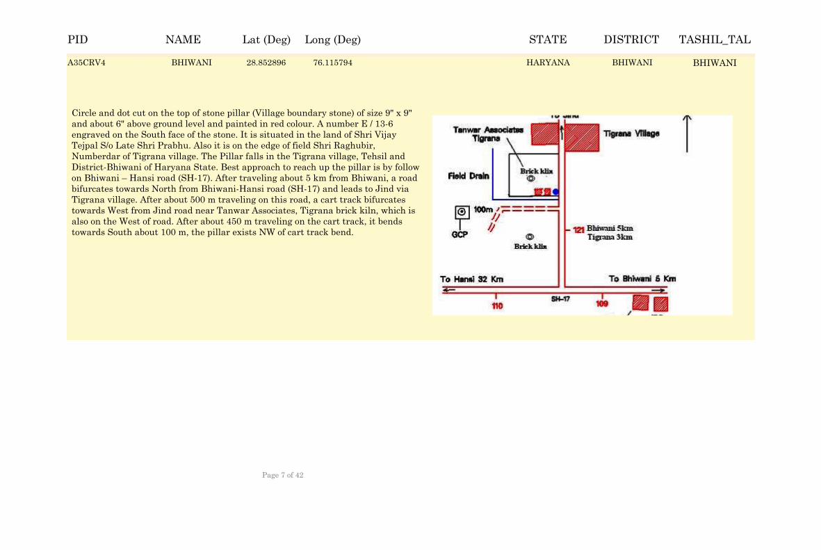
Circle and dot cut on the top of stone pillar (Village boundary stone) of size 9" x 9" and about 6" above ground level and painted in red colour. A number E / 13-6 engraved on the South face of the stone. It is situated in the land of Shri Vijay Tejpal S/o Late Shri Prabhu. Also it is on the edge of field Shri Raghubir, Numberdar of Tigrana village. The Pillar falls in the Tigrana village, Tehsil and District-Bhiwani of Haryana State. Best approach to reach up the pillar is by follow on Bhiwani – Hansi road (SH-17). After traveling about 5 km from Bhiwani, a road bifurcates towards North from Bhiwani-Hansi road (SH-17) and leads to Jind via Tigrana village. After about 500 m traveling on this road, a cart track bifurcates towards West from Jind road near Tanwar Associates, Tigrana brick kiln, which is also on the West of road. After about 450 m traveling on the cart track, it bends towards South about 100 m, the pillar exists NW of cart track bend.
A35CRV4 BHIWANI 28.852896 76.115794 BHIWANIA35CRV4 BHIWANIHARYANA
NAME Lat (Deg) Long (Deg) STATE DISTRICT TASHIL_TALPID
Page 7 of 42
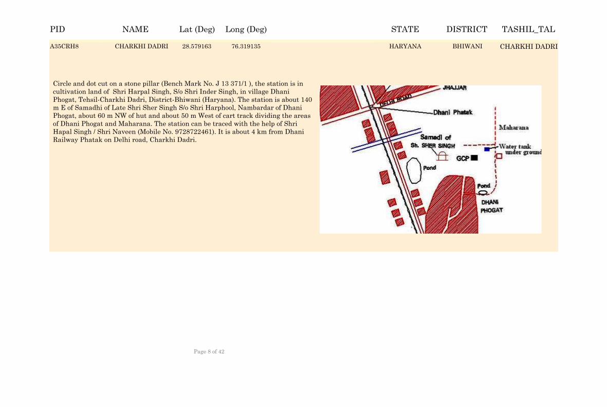
CHARKHI DADRI 28.579993 76.318305 HARYANA BHIWANI CHARKHI DADRI
Circle and dot cut on a stone pillar (Bench Mark No. J 13 371/1 ), the station is in cultivation land of Shri Harpal Singh, S/o Shri Inder Singh, in village Dhani Phogat, Tehsil-Charkhi Dadri, District-Bhiwani (Haryana). The station is about 140 m E of Samadhi of Late Shri Sher Singh S/o Shri Harphool, Nambardar of Dhani Phogat, about 60 m NW of hut and about 50 m West of cart track dividing the areas of Dhani Phogat and Maharana. The station can be traced with the help of Shri Hapal Singh / Shri Naveen (Mobile No. 9728722461). It is about 4 km from Dhani Railway Phatak on Delhi road, Charkhi Dadri.
A35CRH8 CHARKHI DADRI 28.579163 76.319135 BHIWANIA35CRH8 CHARKHI DADRIHARYANA
NAME Lat (Deg) Long (Deg) STATE DISTRICT TASHIL_TALPID
Page 8 of 42
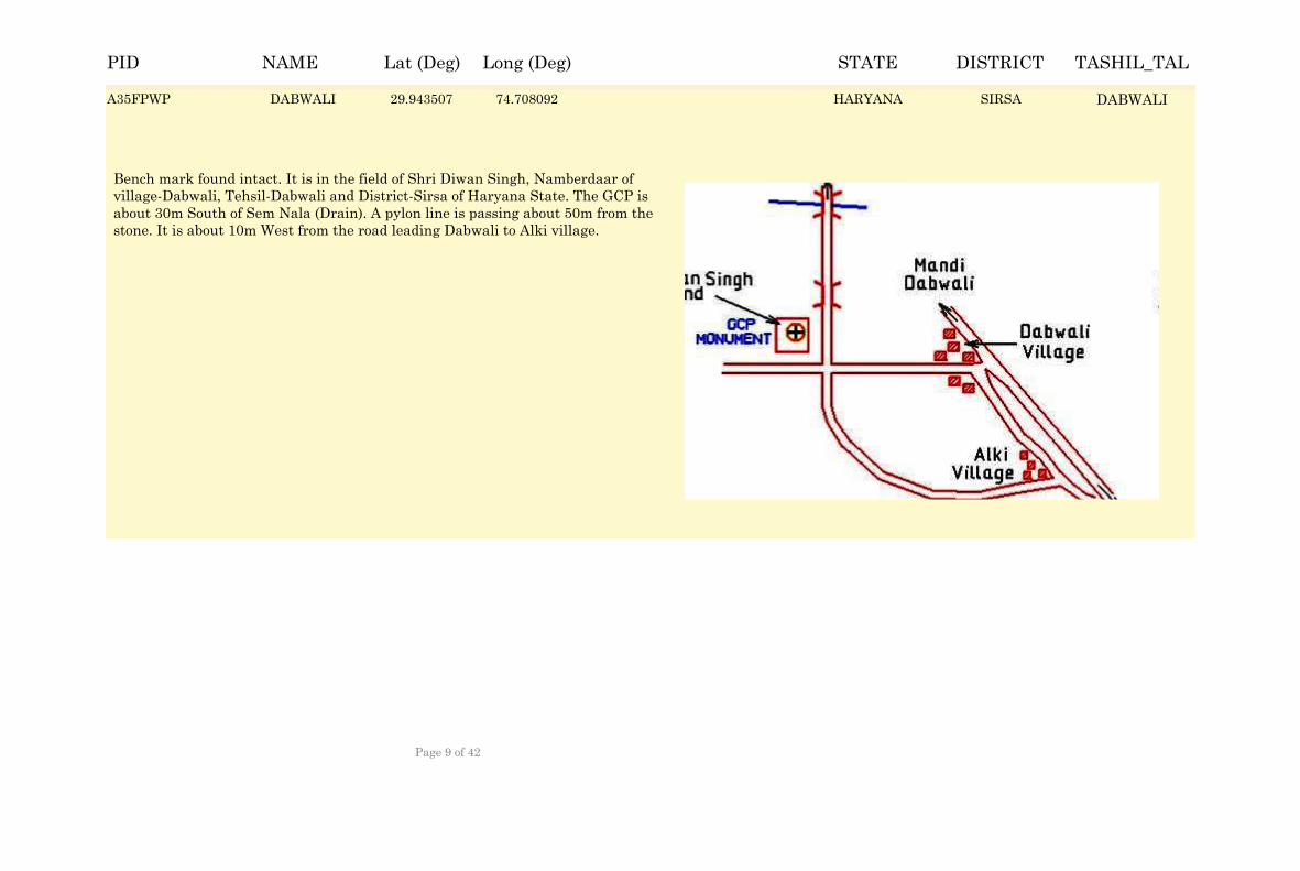
DABWALI 29.944337 74.707262 HARYANA SIRSA DABWALI
Bench mark found intact. It is in the field of Shri Diwan Singh, Namberdaar of village-Dabwali, Tehsil-Dabwali and District-Sirsa of Haryana State. The GCP is about 30m South of Sem Nala (Drain). A pylon line is passing about 50m from the stone. It is about 10m West from the road leading Dabwali to Alki village.
A35FPWP DABWALI 29.943507 74.708092 SIRSAA35FPWP DABWALIHARYANA
NAME Lat (Deg) Long (Deg) STATE DISTRICT TASHIL_TALPID
Page 9 of 42
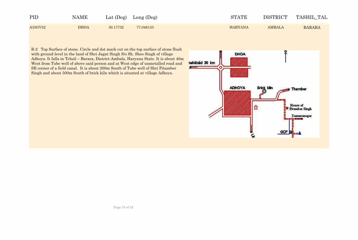
DHOA 30.17815 77.045303 HARYANA AMBALA BARARA
R-2 Top Surface of stone. Circle and dot mark cut on the top surface of stone flush with ground level in the land of Shri Jagat Singh S/o Sh. Sheo Singh of village Adhoya. It falls in Tehsil – Barara, District-Ambala, Haryana State. It is about 40m West from Tube well of above said person and at West edge of unmetalled road and SE corner of a field canal. It is about 200m South of Tube well of Shri Pitamber Singh and about 500m South of brick kiln which is situated at village Adhoya.
A35GV52 DHOA 30.17732 77.046133 AMBALAA35GV52 BARARAHARYANA
NAME Lat (Deg) Long (Deg) STATE DISTRICT TASHIL_TALPID
Page 10 of 42

FARIDABAD 28.418061 77.316863 HARYANA FARIDABAD FARIDABAD
The GCP Station is situated in the Campus of Municipal Corporation at old Faridabad, Tehsil and District-Faridabad of Haryana State. GCP station is about 10m North of South entrance gate, about 10m South of Toilet, about 15m West of South corner of MCF office and about 15m East of West compound wall/ Store room.
A35CVC8 FARIDABAD 28.417231 77.317693 FARIDABADA35CVC8 FARIDABADHARYANA
NAME Lat (Deg) Long (Deg) STATE DISTRICT TASHIL_TALPID
Page 11 of 42
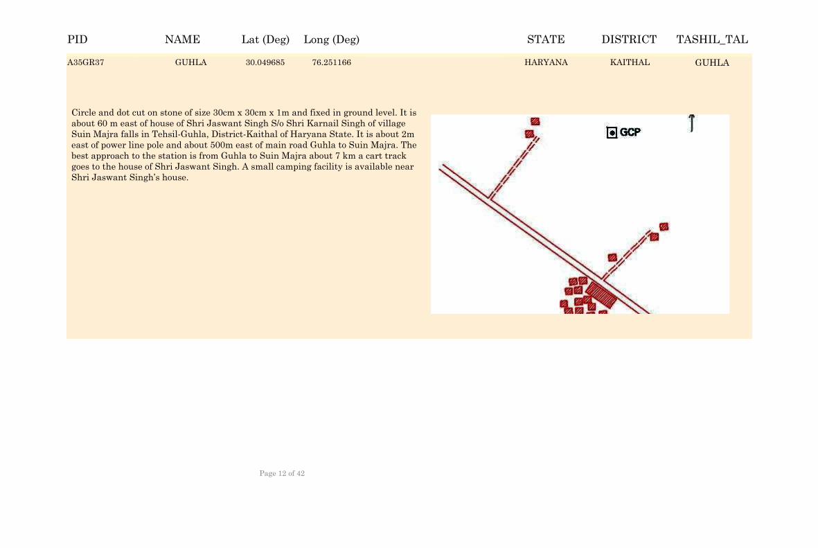
GUHLA 30.050515 76.250336 HARYANA KAITHAL GUHLA
Circle and dot cut on stone of size 30cm x 30cm x 1m and fixed in ground level. It is about 60 m east of house of Shri Jaswant Singh S/o Shri Karnail Singh of village Suin Majra falls in Tehsil-Guhla, District-Kaithal of Haryana State. It is about 2m east of power line pole and about 500m east of main road Guhla to Suin Majra. The best approach to the station is from Guhla to Suin Majra about 7 km a cart track goes to the house of Shri Jaswant Singh. A small camping facility is available near Shri Jaswant Singh’s house.
A35GR37 GUHLA 30.049685 76.251166 KAITHALA35GR37 GUHLAHARYANA
NAME Lat (Deg) Long (Deg) STATE DISTRICT TASHIL_TALPID
Page 12 of 42
HABRI 29.692968 76.66252 HARYANA KAITHAL KAITHAL
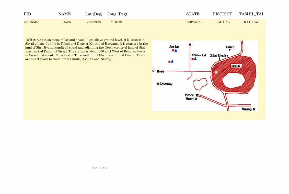
12/H 248/3 cut on stone pillar and about 10 cm above ground level. It is located in Sirsal village. It falls in Tehsil and District-Kaithal of Haryana. It is situated in the land of Shri Jiyalal Pandit of Sirsal and adjoining the North corner of land of Shri Krishan Lal Pandit of Sirsal. The station is about 600 m of West of Reliance tower in Sirsal and about 120 m east of Tube well hut of Shri Krishan Lal Pandit. There are direct roads to Sirsal from Pundri, Asandh and Nisang.
A35FRMM HABRI 29.692138 76.66335 KAITHALA35FRMM KAITHALHARYANA
NAME Lat (Deg) Long (Deg) STATE DISTRICT TASHIL_TALPID
Page 13 of 42
HANSI 29.097714 75.915028 HARYANA HISAR HANSI
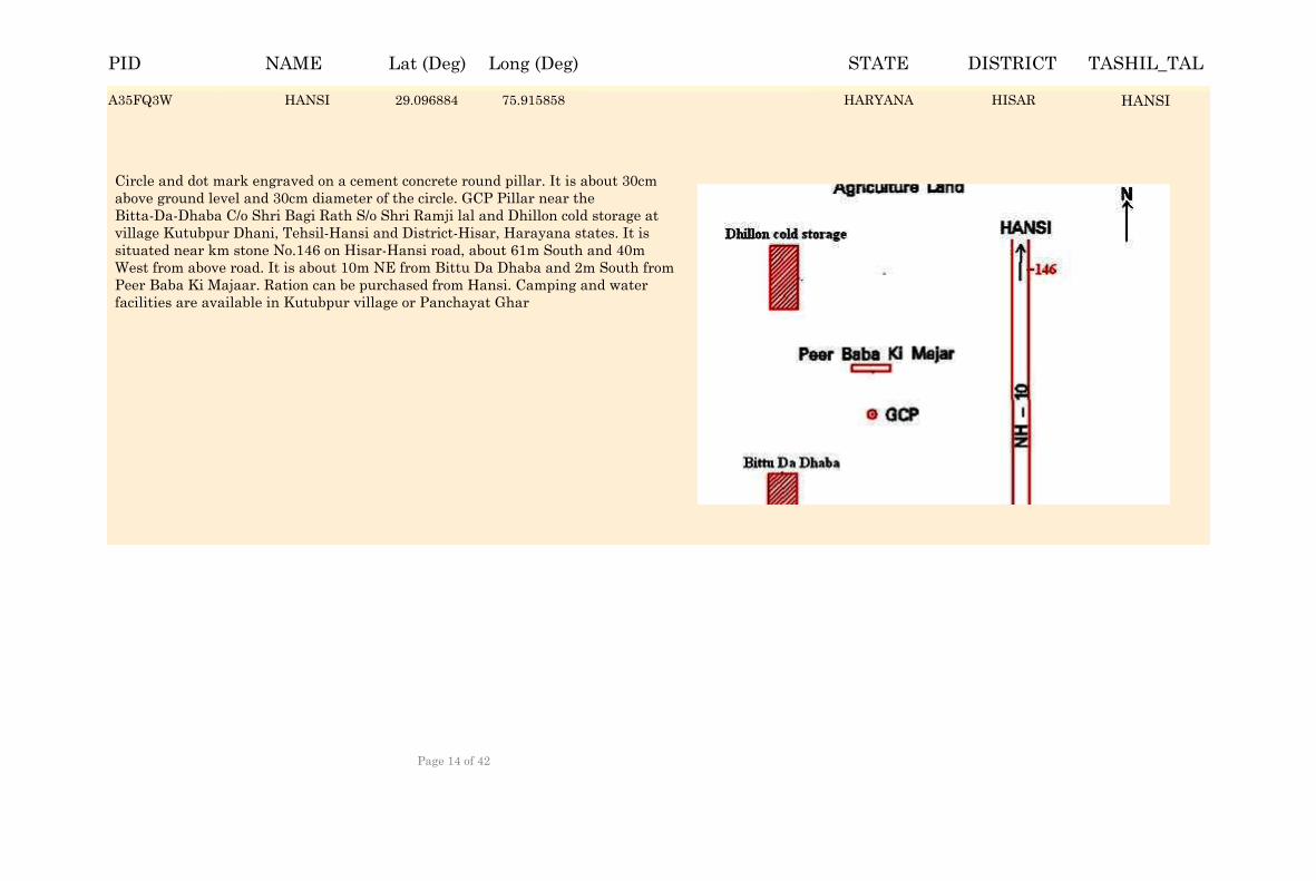
Circle and dot mark engraved on a cement concrete round pillar. It is about 30cm above ground level and 30cm diameter of the circle. GCP Pillar near the Bitta-Da-Dhaba C/o Shri Bagi Rath S/o Shri Ramji lal and Dhillon cold storage at village Kutubpur Dhani, Tehsil-Hansi and District-Hisar, Harayana states. It is situated near km stone No.146 on Hisar-Hansi road, about 61m South and 40m West from above road. It is about 10m NE from Bittu Da Dhaba and 2m South from Peer Baba Ki Majaar. Ration can be purchased from Hansi. Camping and water facilities are available in Kutubpur village or Panchayat Ghar
A35FQ3W HANSI 29.096884 75.915858 HISARA35FQ3W HANSIHARYANA
NAME Lat (Deg) Long (Deg) STATE DISTRICT TASHIL_TALPID
Page 14 of 42
HODAL 27.890757 77.325784 HARYANA PALWAL HODAL
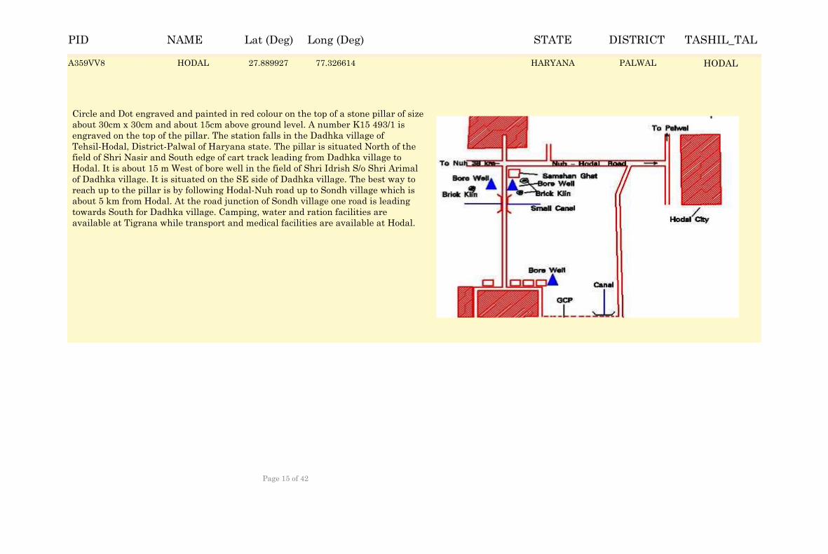
Circle and Dot engraved and painted in red colour on the top of a stone pillar of size about 30cm x 30cm and about 15cm above ground level. A number K15 493/1 is engraved on the top of the pillar. The station falls in the Dadhka village of Tehsil-Hodal, District-Palwal of Haryana state. The pillar is situated North of the field of Shri Nasir and South edge of cart track leading from Dadhka village to Hodal. It is about 15 m West of bore well in the field of Shri Idrish S/o Shri Arimal of Dadhka village. It is situated on the SE side of Dadhka village. The best way to reach up to the pillar is by following Hodal-Nuh road up to Sondh village which is about 5 km from Hodal. At the road junction of Sondh village one road is leading towards South for Dadhka village. Camping, water and ration facilities are available at Tigrana while transport and medical facilities are available at Hodal.
A359VV8 HODAL 27.889927 77.326614 PALWALA359VV8 HODALHARYANA
NAME Lat (Deg) Long (Deg) STATE DISTRICT TASHIL_TALPID
Page 15 of 42
INDRI 29.921982 77.035785 HARYANA KARNAL INDRI
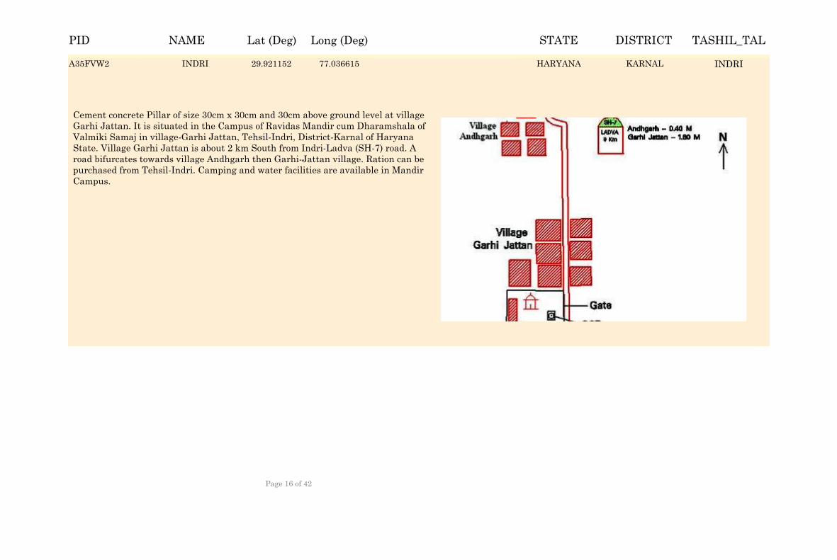
Cement concrete Pillar of size 30cm x 30cm and 30cm above ground level at village Garhi Jattan. It is situated in the Campus of Ravidas Mandir cum Dharamshala of Valmiki Samaj in village-Garhi Jattan, Tehsil-Indri, District-Karnal of Haryana State. Village Garhi Jattan is about 2 km South from Indri-Ladva (SH-7) road. A road bifurcates towards village Andhgarh then Garhi-Jattan village. Ration can be purchased from Tehsil-Indri. Camping and water facilities are available in Mandir Campus.
A35FVW2 INDRI 29.921152 77.036615 KARNALA35FVW2 INDRIHARYANA
NAME Lat (Deg) Long (Deg) STATE DISTRICT TASHIL_TALPID
Page 16 of 42
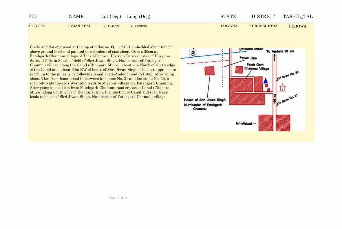
ISMAILABAD 30.155529 76.669066 HARYANA KURUKSHETRA PEHOWA
Circle and dot engraved at the top of pillar no. Q. 11 246/1 embedded about 6 inch above ground level and painted in red colour of size about 30cm x 30cm at Fatehgarh Chammu village of Tehsil-Pehowa, District-Kurukshestra of Haryana State. It falls in South of field of Shri Jiwan Singh, Numberdar of Fatehgarh Chammu village along the Canal (Chhapara Minor), about 2 m North of North edge of the Canal and about 60m NW of house of Shri Jiwan Singh. The best approach to reach up to the pillar is by following Ismailabad–Ambala road (NH-65). After going about 3 km from Ismailabad in between km stone No. 31 and km stone No. 30, a road bifurcate towards West and leads to Mirapur village via Fatehgarh Chammu. After going about 1 km from Fatehgarh Chammu road crosses a Canal (Chapara Minor) along South edge of the Canal from the junction of Canal and road track leads to house of Shri Jiwan Singh, Numberdar of Fatehgarh Chammu village.
A35GR5M ISMAILABAD 30.154699 76.669896 KURUKSHETRAA35GR5M PEHOWAHARYANA
NAME Lat (Deg) Long (Deg) STATE DISTRICT TASHIL_TALPID
Page 17 of 42
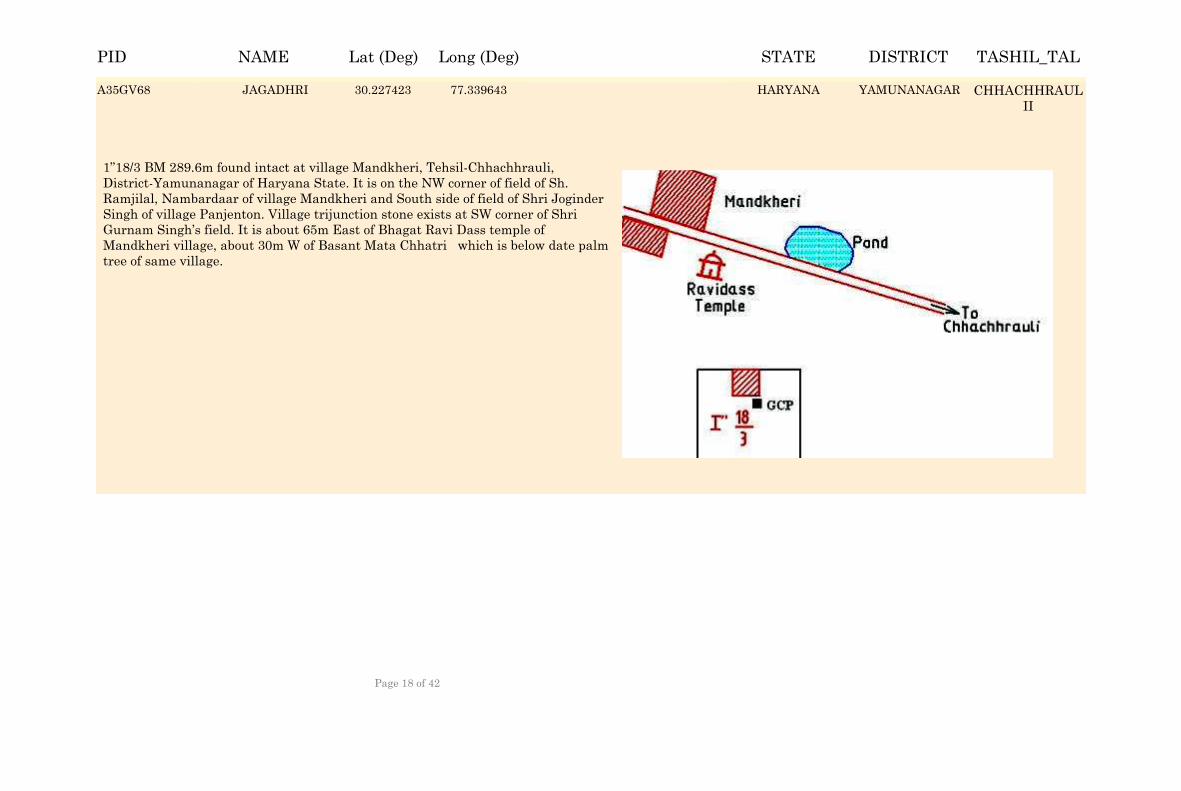
JAGADHRI 30.228253 77.338813 HARYANA YAMUNANAGAR CHHACHHRAULII
1”18/3 BM 289.6m found intact at village Mandkheri, Tehsil-Chhachhrauli, District-Yamunanagar of Haryana State. It is on the NW corner of field of Sh. Ramjilal, Nambardaar of village Mandkheri and South side of field of Shri Joginder Singh of village Panjenton. Village trijunction stone exists at SW corner of Shri Gurnam Singh’s field. It is about 65m East of Bhagat Ravi Dass temple of Mandkheri village, about 30m W of Basant Mata Chhatri which is below date palm tree of same village.
A35GV68 JAGADHRI 30.227423 77.339643 YAMUNANAGARA35GV68 CHHACHHRAULII
HARYANA
NAME Lat (Deg) Long (Deg) STATE DISTRICT TASHIL_TALPID
Page 18 of 42
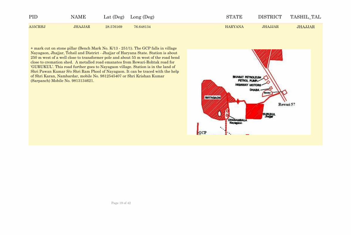
JHAJJAR 28.576999 76.647304 HARYANA JHAJJAR JHAJJAR
+ mark cut on stone pillar (Bench Mark No. K/13 - 251/1). The GCP falls in village Nayagaon, Jhajjar, Tehsil and District - Jhajjar of Haryana State. Station is about 250 m west of a well close to transformer pole and about 55 m west of the road bend close to cremation shed. A metalled road emanates from Rewari-Rohtak road for ‘GURUKUL’. This road further goes to Nayagaon village. Station is in the land of Shri Pawan Kumar S/o Shri Ram Phool of Nayagaon. It can be traced with the help of Shri Karan, Nambardar, mobile No. 9812545407 or Shri Krishan Kumar (Sarpanch) Mobile No. 9813134621.
A35CRHJ JHAJJAR 28.576169 76.648134 JHAJJARA35CRHJ JHAJJARHARYANA
NAME Lat (Deg) Long (Deg) STATE DISTRICT TASHIL_TALPID
Page 19 of 42
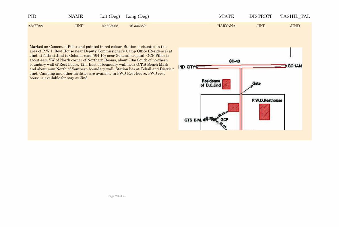
JIND 29.309798 76.335559 HARYANA JIND JIND
Marked on Cemented Pillar and painted in red colour. Station is situated in the area of P.W.D Rest House near Deputy Commissioner’s Camp Office (Residence) at Jind. It falls at Jind to Gohana road (SH-10) near General hospital. GCP Pillar is about 44m SW of North corner of Northern Rooms, about 70m South of northern boundary wall of Rest house, 12m East of boundary wall near G.T.S Bench Mark and about 44m North of Southern boundary wall. Station lies at Tehsil and District: Jind. Camping and other facilities are available in PWD Rest-house. PWD rest house is available for stay at Jind.
A35FR88 JIND 29.308968 76.336389 JINDA35FR88 JINDHARYANA
NAME Lat (Deg) Long (Deg) STATE DISTRICT TASHIL_TALPID
Page 20 of 42
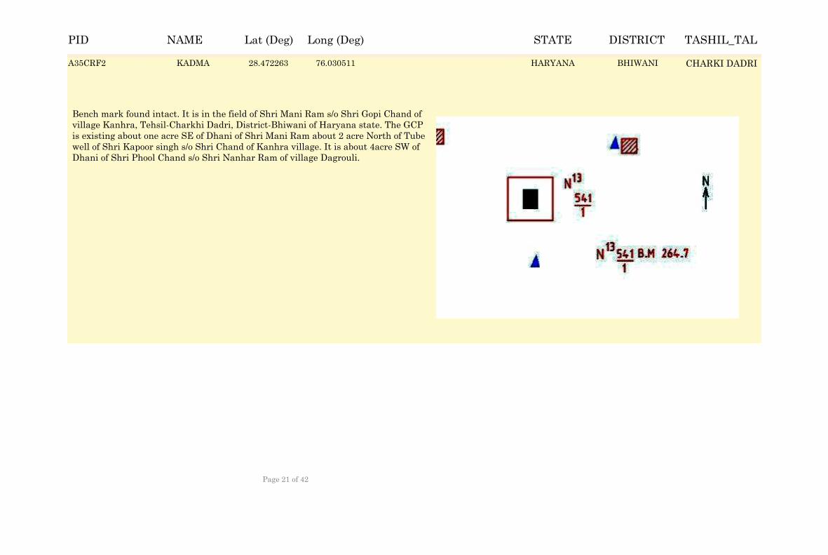
KADMA 28.473093 76.029681 HARYANA BHIWANI CHARKI DADRI
Bench mark found intact. It is in the field of Shri Mani Ram s/o Shri Gopi Chand of village Kanhra, Tehsil-Charkhi Dadri, District-Bhiwani of Haryana state. The GCP is existing about one acre SE of Dhani of Shri Mani Ram about 2 acre North of Tube well of Shri Kapoor singh s/o Shri Chand of Kanhra village. It is about 4acre SW of Dhani of Shri Phool Chand s/o Shri Nanhar Ram of village Dagrouli.
A35CRF2 KADMA 28.472263 76.030511 BHIWANIA35CRF2 CHARKI DADRIHARYANA
NAME Lat (Deg) Long (Deg) STATE DISTRICT TASHIL_TALPID
Page 21 of 42
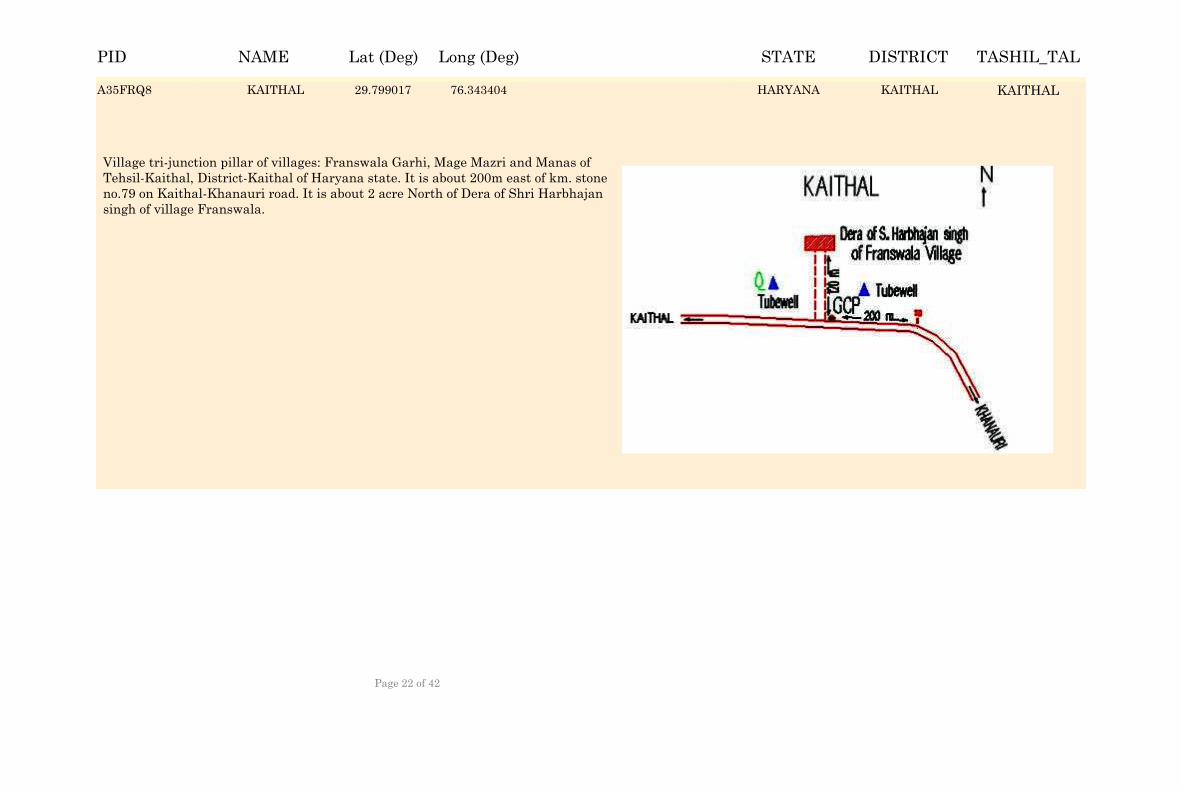
KAITHAL 29.799847 76.342574 HARYANA KAITHAL KAITHAL
Village tri-junction pillar of villages: Franswala Garhi, Mage Mazri and Manas of Tehsil-Kaithal, District-Kaithal of Haryana state. It is about 200m east of km. stone no.79 on Kaithal-Khanauri road. It is about 2 acre North of Dera of Shri Harbhajan singh of village Franswala.
A35FRQ8 KAITHAL 29.799017 76.343404 KAITHALA35FRQ8 KAITHALHARYANA
NAME Lat (Deg) Long (Deg) STATE DISTRICT TASHIL_TALPID
Page 22 of 42

KHARKHAUDA 28.862615 76.908352 HARYANA SONIPAT KHARKHAUDA
The pillar is situated in the campus of Rest House HVPN (Haryana Vidhut Prasaran Nigam Ltd. Karnal), Superintending Engineer, Uttar Haryana Bijli Vitran Nigam Ltd. Karnal and Staff Quarters of HVPN Karnal. It falls in Tehsil & District Karnal of Haryana State. The pillar is about 13.6m South from rectangular over head tank (OHT) inside fence behind Superintending Engineer’s Office, about 6m west from the transformer double pole inside the fence, about 5m west of septic tank in the garden inside fence, about 85m north from main gate of Rest house and about 56m NW from main entrance of Guest house.
A35CRVW KHARKHAUDA 28.861785 76.909182 SONIPATA35CRVW KHARKHAUDAHARYANA
NAME Lat (Deg) Long (Deg) STATE DISTRICT TASHIL_TALPID
Page 23 of 42
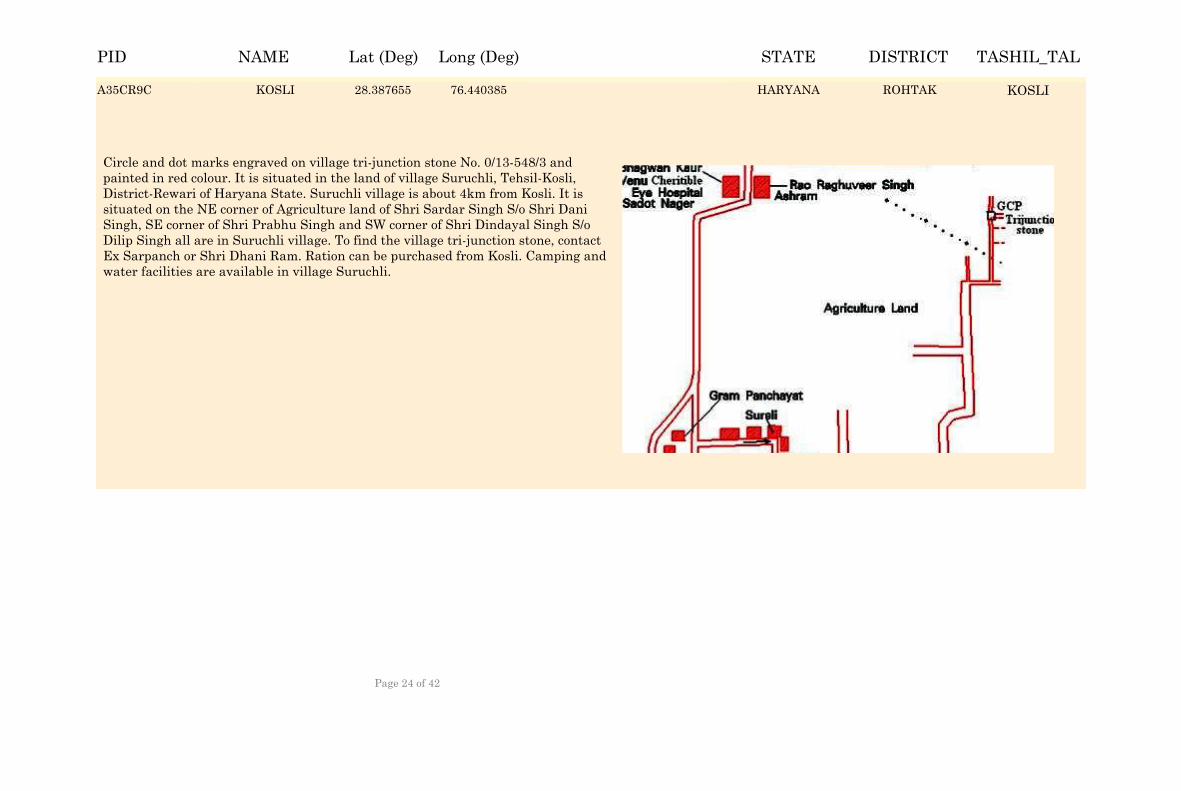
KOSLI 28.388485 76.439555 HARYANA ROHTAK KOSLI
Circle and dot marks engraved on village tri-junction stone No. 0/13-548/3 and painted in red colour. It is situated in the land of village Suruchli, Tehsil-Kosli, District-Rewari of Haryana State. Suruchli village is about 4km from Kosli. It is situated on the NE corner of Agriculture land of Shri Sardar Singh S/o Shri Dani Singh, SE corner of Shri Prabhu Singh and SW corner of Shri Dindayal Singh S/o Dilip Singh all are in Suruchli village. To find the village tri-junction stone, contact Ex Sarpanch or Shri Dhani Ram. Ration can be purchased from Kosli. Camping and water facilities are available in village Suruchli.
A35CR9C KOSLI 28.387655 76.440385 ROHTAKA35CR9C KOSLIHARYANA
NAME Lat (Deg) Long (Deg) STATE DISTRICT TASHIL_TALPID
Page 24 of 42
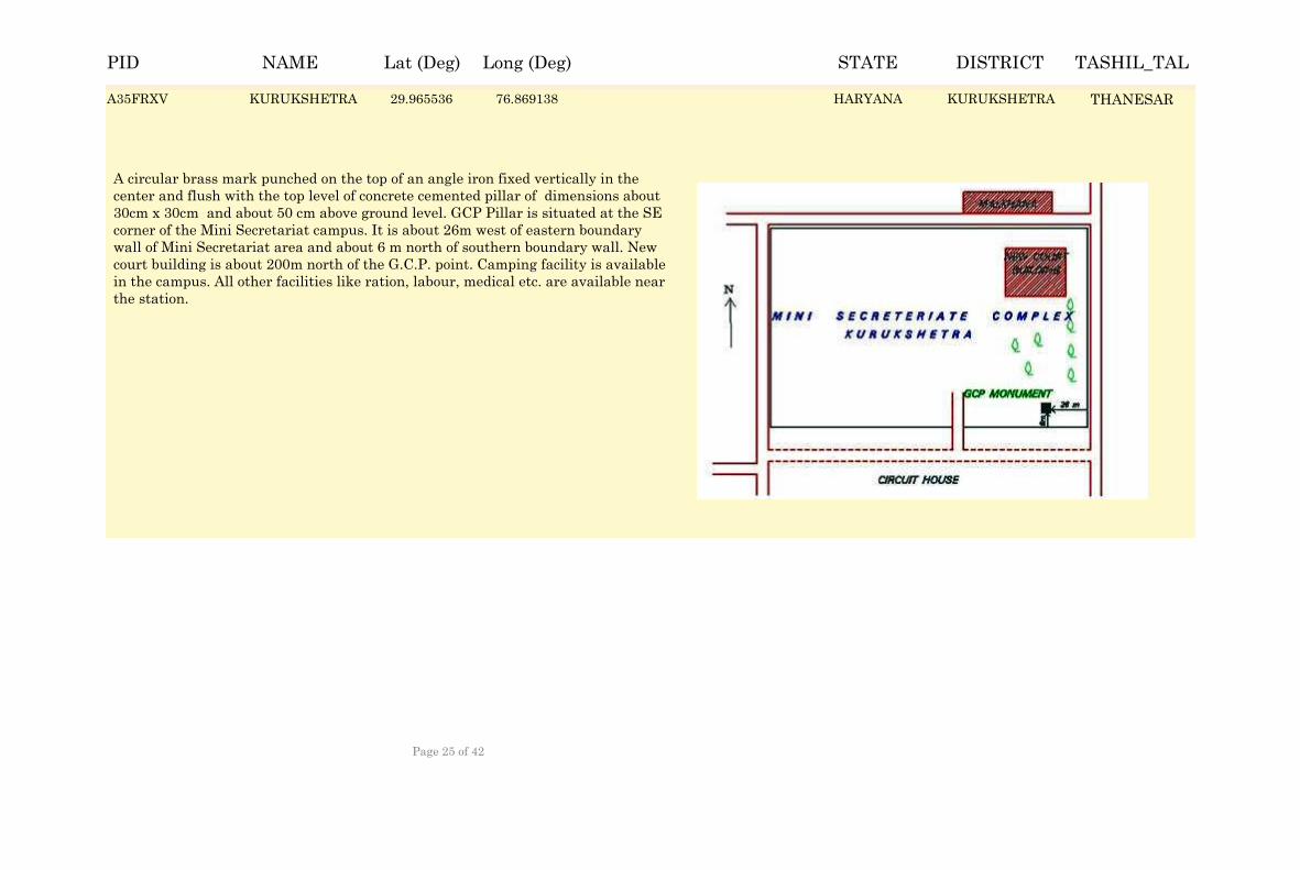
KURUKSHETRA 29.966366 76.868308 HARYANA KURUKSHETRA THANESAR
A circular brass mark punched on the top of an angle iron fixed vertically in the center and flush with the top level of concrete cemented pillar of dimensions about 30cm x 30cm and about 50 cm above ground level. GCP Pillar is situated at the SE corner of the Mini Secretariat campus. It is about 26m west of eastern boundary wall of Mini Secretariat area and about 6 m north of southern boundary wall. New court building is about 200m north of the G.C.P. point. Camping facility is available in the campus. All other facilities like ration, labour, medical etc. are available near the station.
A35FRXV KURUKSHETRA 29.965536 76.869138 KURUKSHETRAA35FRXV THANESARHARYANA
NAME Lat (Deg) Long (Deg) STATE DISTRICT TASHIL_TALPID
Page 25 of 42
LOHARU 28.446886 75.82409 HARYANA BHIWANI LOHARU
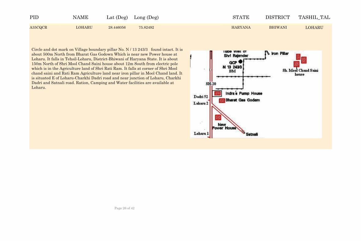
Circle and dot mark on Village boundary pillar No. N / 13 243/3 found intact. It is about 500m North from Bharat Gas Godown Which is near new Power house at Loharu. It falls in Tehsil-Loharu, District-Bhiwani of Haryana State. It is about 150m North of Shri Mool Chand Saini house about 12m South from electric pole which is in the Agriculture land of Shri Rati Ram. It falls at corner of Shri Mool chand saini and Rati Ram Agriculture land near iron pillar in Mool Chand land. It is situated E of Loharu-Charkhi Dadri road and near junction of Loharu, Charkhi Dadri and Satnali road. Ration, Camping and Water facilities are available at Loharu.
A35CQCR LOHARU 28.446056 75.82492 BHIWANIA35CQCR LOHARUHARYANA
NAME Lat (Deg) Long (Deg) STATE DISTRICT TASHIL_TALPID
Page 26 of 42
NARNAUL 28.058711 76.110659 HARYANA MAHENDRAGARH
NARNAUL
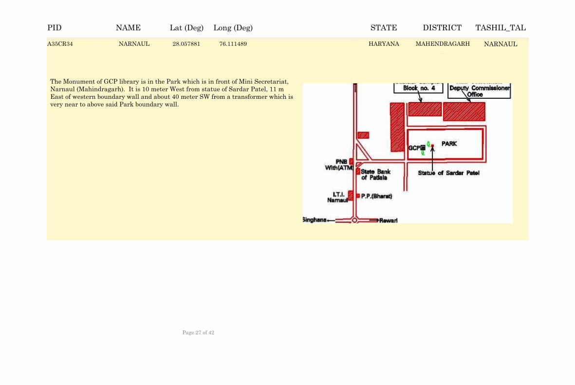
The Monument of GCP library is in the Park which is in front of Mini Secretariat, Narnaul (Mahindragarh). It is 10 meter West from statue of Sardar Patel, 11 m East of western boundary wall and about 40 meter SW from a transformer which is very near to above said Park boundary wall.
A35CR34 NARNAUL 28.057881 76.111489 MAHENDRAGARHA35CR34 NARNAULHARYANA
NAME Lat (Deg) Long (Deg) STATE DISTRICT TASHIL_TALPID
Page 27 of 42
NARWANA 29.615919 76.121397 HARYANA JIND NARWANA
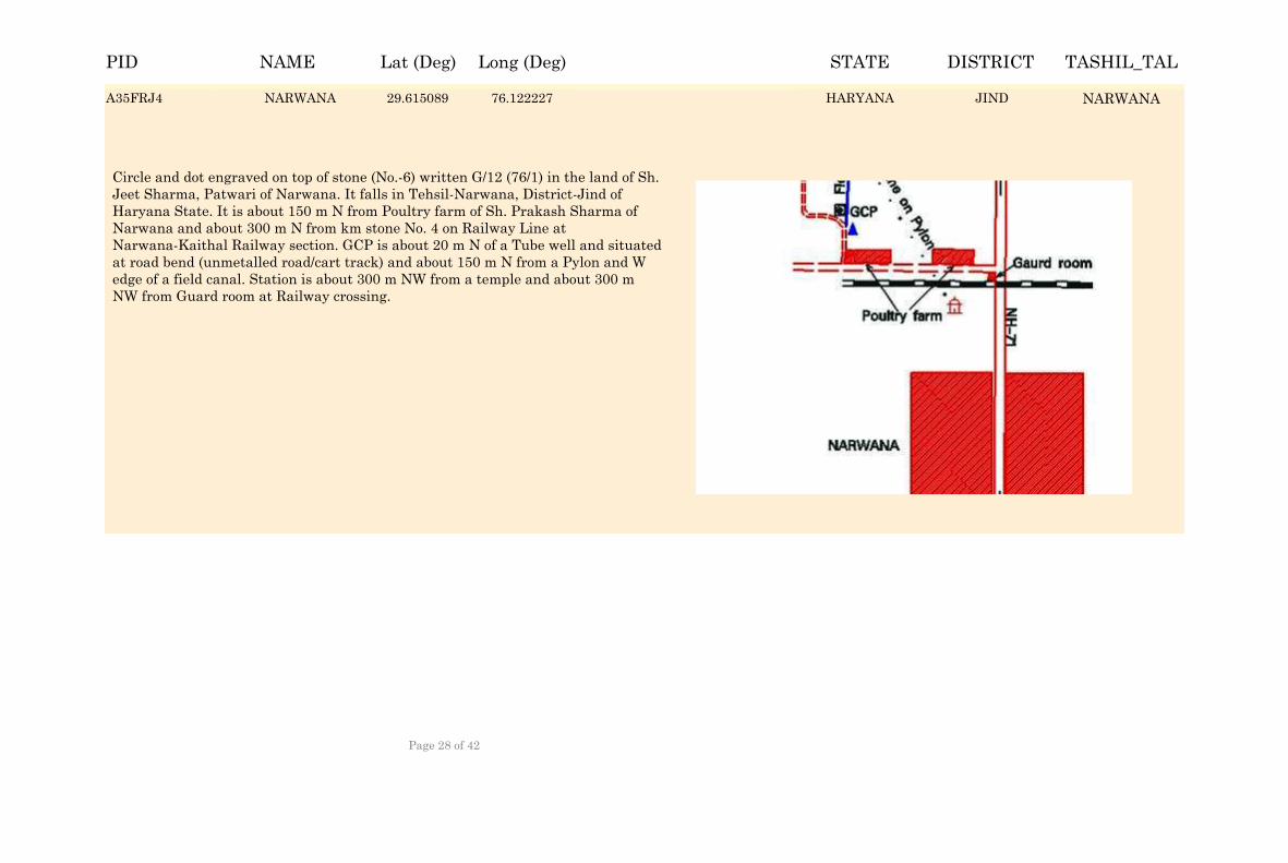
Circle and dot engraved on top of stone (No.-6) written G/12 (76/1) in the land of Sh. Jeet Sharma, Patwari of Narwana. It falls in Tehsil-Narwana, District-Jind of Haryana State. It is about 150 m N from Poultry farm of Sh. Prakash Sharma of Narwana and about 300 m N from km stone No. 4 on Railway Line at Narwana-Kaithal Railway section. GCP is about 20 m N of a Tube well and situated at road bend (unmetalled road/cart track) and about 150 m N from a Pylon and W edge of a field canal. Station is about 300 m NW from a temple and about 300 m NW from Guard room at Railway crossing.
A35FRJ4 NARWANA 29.615089 76.122227 JINDA35FRJ4 NARWANAHARYANA
NAME Lat (Deg) Long (Deg) STATE DISTRICT TASHIL_TALPID
Page 28 of 42
PALWAL 28.190442 77.285692 HARYANA FARIDABAD PALWAL
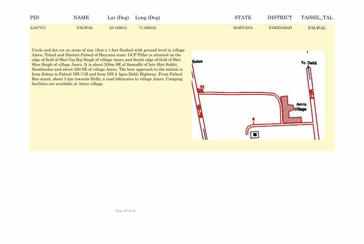
Circle and dot cut on stone of size 1feet x 1 feet flushed with ground level in village Amru, Tehsil and District-Palwal of Haryana state. GCP Pillar is situated on the edge of field of Shri Gaj Raj Singh of village Amru and South edge of field of Shri Shor Singh of village Amru. It is about 200m SE of Samadhi of late Shri Sukhi, Nambardar and about 500 SE of village Amru. The best approach to the station is from Sohna to Palwal NH-71B and from NH-2 Agra-Dehli Highway. From Palwal Bus stand, about 5 km towards Delhi, a road bifurcates to village Amru. Camping facilities are available at Amru village.
A35CV57 PALWAL 28.189612 77.286522 FARIDABADA35CV57 PALWALHARYANA
NAME Lat (Deg) Long (Deg) STATE DISTRICT TASHIL_TALPID
Page 29 of 42
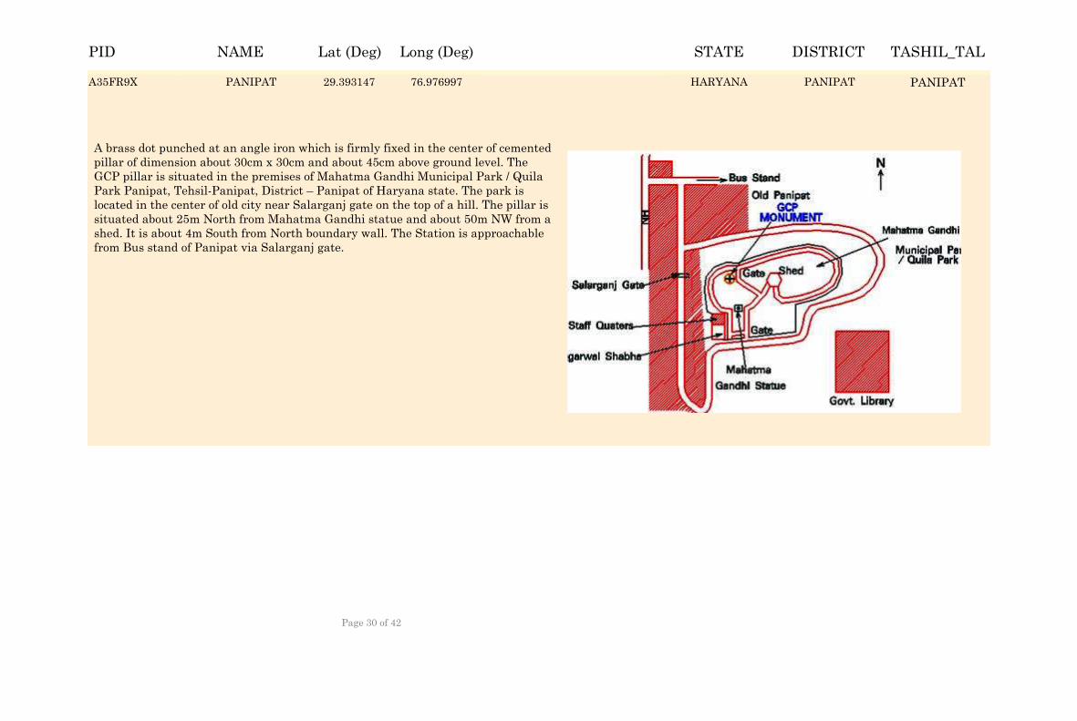
PANIPAT 29.393977 76.976167 HARYANA PANIPAT PANIPAT
A brass dot punched at an angle iron which is firmly fixed in the center of cemented pillar of dimension about 30cm x 30cm and about 45cm above ground level. The GCP pillar is situated in the premises of Mahatma Gandhi Municipal Park / Quila Park Panipat, Tehsil-Panipat, District – Panipat of Haryana state. The park is located in the center of old city near Salarganj gate on the top of a hill. The pillar is situated about 25m North from Mahatma Gandhi statue and about 50m NW from a shed. It is about 4m South from North boundary wall. The Station is approachable from Bus stand of Panipat via Salarganj gate.
A35FR9X PANIPAT 29.393147 76.976997 PANIPATA35FR9X PANIPATHARYANA
NAME Lat (Deg) Long (Deg) STATE DISTRICT TASHIL_TALPID
Page 30 of 42
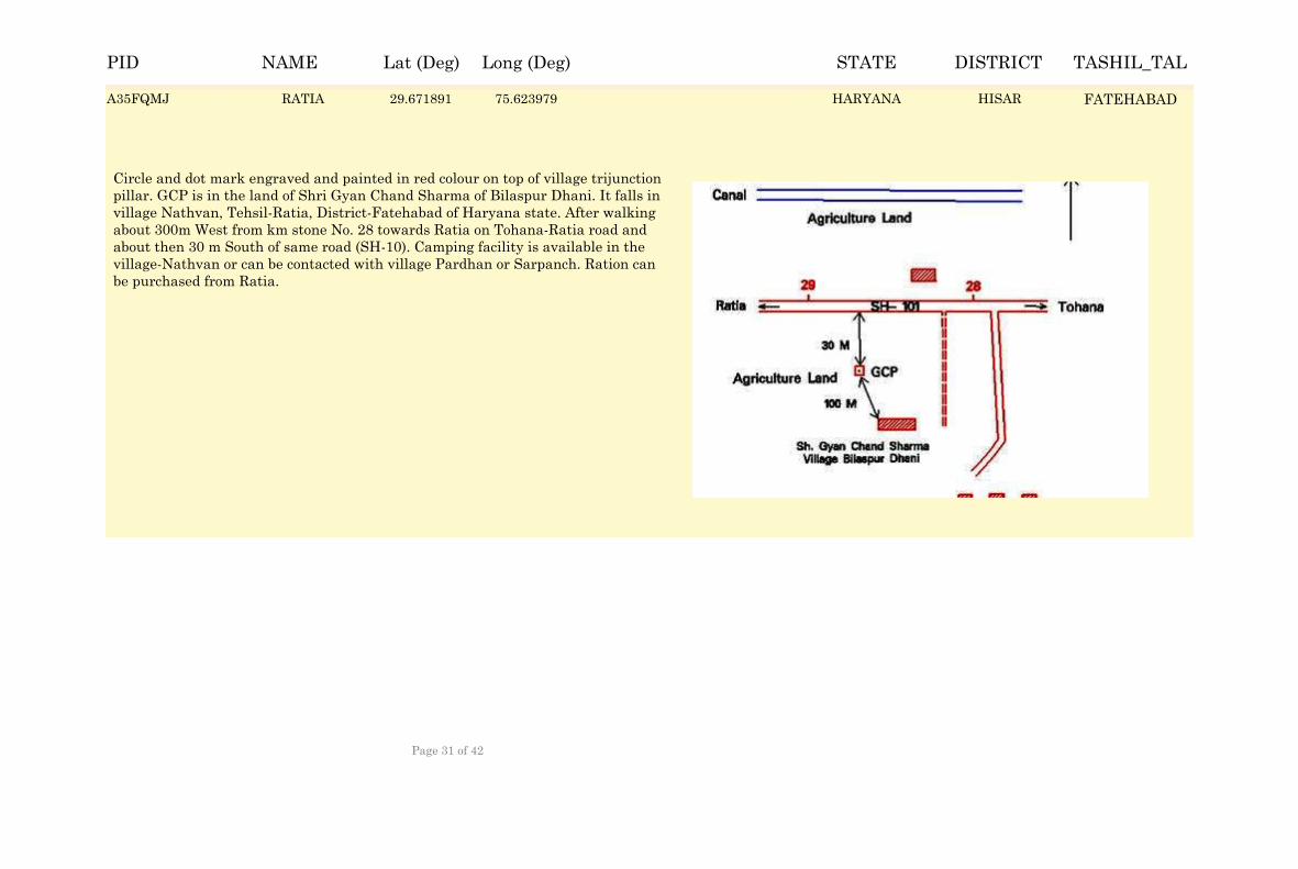
RATIA 29.672721 75.623149 HARYANA HISAR FATEHABAD
Circle and dot mark engraved and painted in red colour on top of village trijunction pillar. GCP is in the land of Shri Gyan Chand Sharma of Bilaspur Dhani. It falls in village Nathvan, Tehsil-Ratia, District-Fatehabad of Haryana state. After walking about 300m West from km stone No. 28 towards Ratia on Tohana-Ratia road and about then 30 m South of same road (SH-10). Camping facility is available in the village-Nathvan or can be contacted with village Pardhan or Sarpanch. Ration can be purchased from Ratia.
A35FQMJ RATIA 29.671891 75.623979 HISARA35FQMJ FATEHABADHARYANA
NAME Lat (Deg) Long (Deg) STATE DISTRICT TASHIL_TALPID
Page 31 of 42
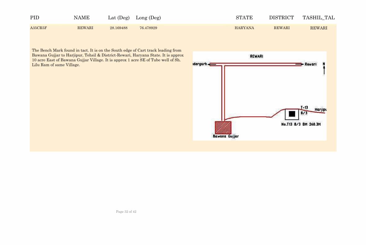
REWARI 28.170318 76.478099 HARYANA REWARI REWARI
The Bench Mark found in tact. It is on the South edge of Cart track leading from Bawana Gujjar to Harjipur, Tehsil & District-Rewari, Haryana State. It is approx 10 acre East of Bawana Gujjar Village. It is approx 1 acre SE of Tube well of Sh. Lilu Ram of same Village.
A35CR5F REWARI 28.169488 76.478929 REWARIA35CR5F REWARIHARYANA
NAME Lat (Deg) Long (Deg) STATE DISTRICT TASHIL_TALPID
Page 32 of 42
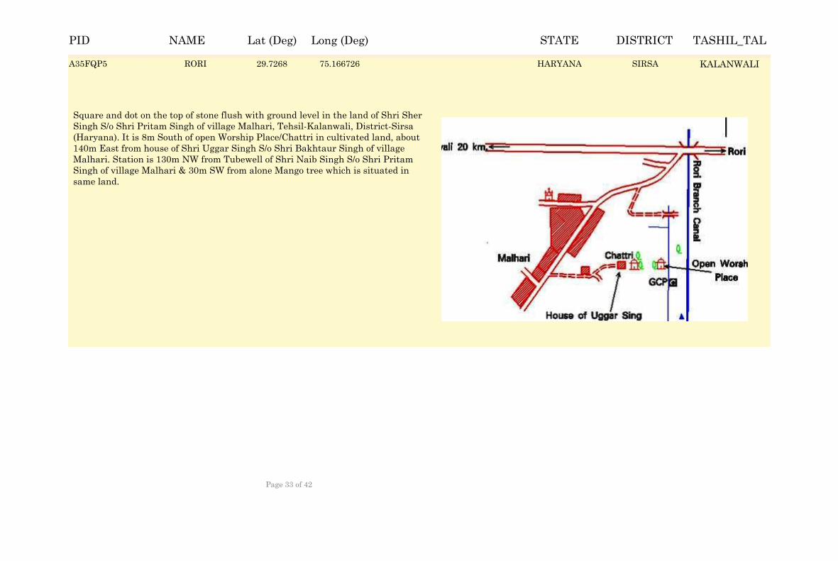
RORI 29.72763 75.165896 HARYANA SIRSA KALANWALI
Square and dot on the top of stone flush with ground level in the land of Shri Sher Singh S/o Shri Pritam Singh of village Malhari, Tehsil-Kalanwali, District-Sirsa (Haryana). It is 8m South of open Worship Place/Chattri in cultivated land, about 140m East from house of Shri Uggar Singh S/o Shri Bakhtaur Singh of village Malhari. Station is 130m NW from Tubewell of Shri Naib Singh S/o Shri Pritam Singh of village Malhari & 30m SW from alone Mango tree which is situated in same land.
A35FQP5 RORI 29.7268 75.166726 SIRSAA35FQP5 KALANWALIHARYANA
NAME Lat (Deg) Long (Deg) STATE DISTRICT TASHIL_TALPID
Page 33 of 42
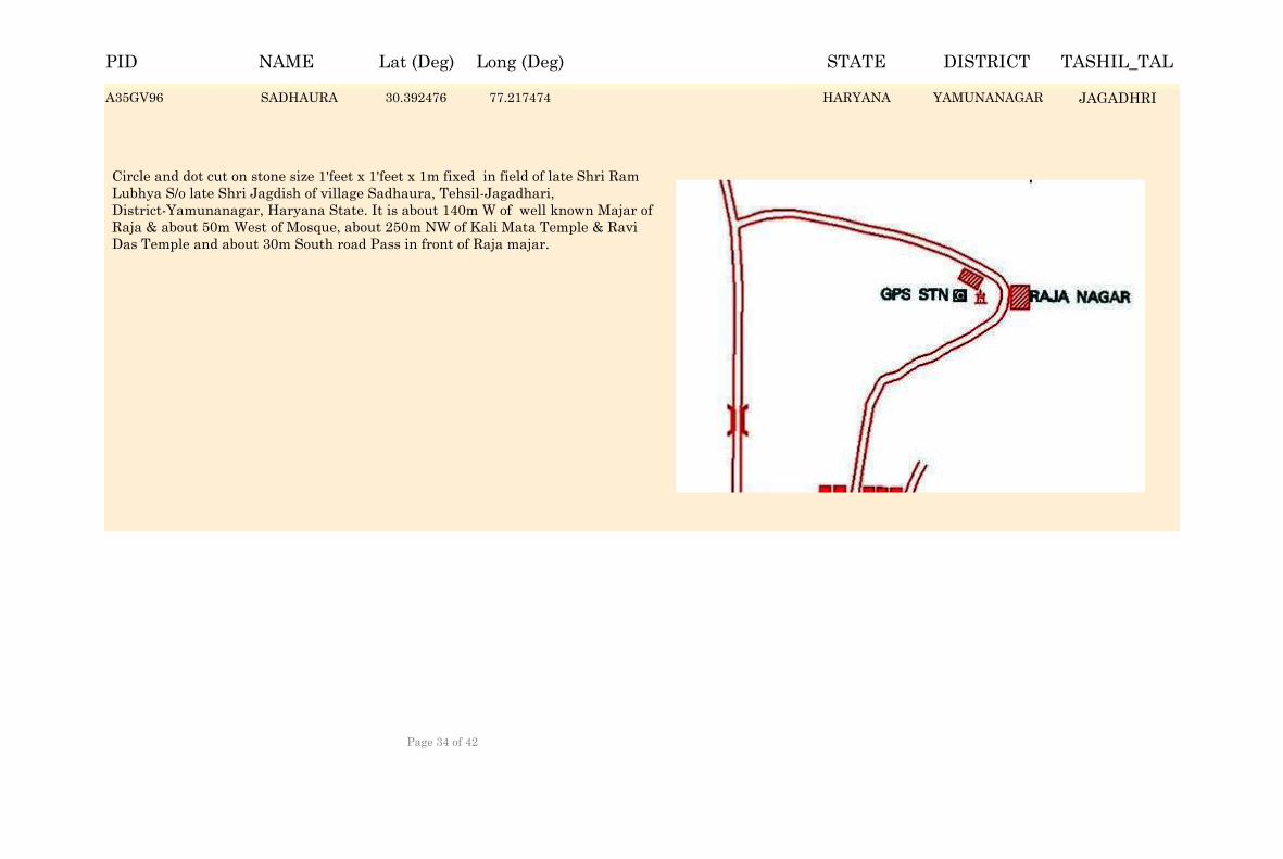
SADHAURA 30.393306 77.216644 HARYANA YAMUNANAGAR JAGADHRI
Circle and dot cut on stone size 1'feet x 1'feet x 1m fixed in field of late Shri Ram Lubhya S/o late Shri Jagdish of village Sadhaura, Tehsil-Jagadhari, District-Yamunanagar, Haryana State. It is about 140m W of well known Majar of Raja & about 50m West of Mosque, about 250m NW of Kali Mata Temple & Ravi Das Temple and about 30m South road Pass in front of Raja majar.
A35GV96 SADHAURA 30.392476 77.217474 YAMUNANAGARA35GV96 JAGADHRIHARYANA
NAME Lat (Deg) Long (Deg) STATE DISTRICT TASHIL_TALPID
Page 34 of 42
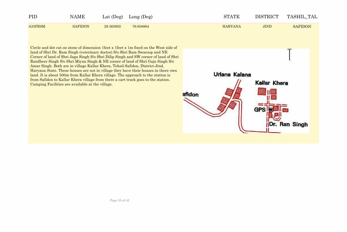
SAFIDON 29.366432 76.658034 HARYANA JIND SAFIDON
Circle and dot cut on stone of dimension 1feet x 1feet x 1m fixed on the West side of land of Shri Dr. Ram Singh (veterinary doctor) S/o Shri Ram Swaroop and NE Corner of land of Shri Jaga Singh S/o Shri Dilip Singh and SW corner of land of Shri Randheer Singh S/o Shri Miyan Singh & NE corner of land of Shri Gaja Singh S/o Amar Singh. Both are in village Kallar Khera, Tehsil-Safidon, District-Jind, Haryana State. These houses are not in village they have their houses in there own land. It is about 500m from Kallar Khera village. The approach to the station is from Safidon to Kallar Khera village from there a cart track goes to the station. Camping Facilities are available at the village.
A35FR9M SAFIDON 29.365602 76.658864 JINDA35FR9M SAFIDONHARYANA
NAME Lat (Deg) Long (Deg) STATE DISTRICT TASHIL_TALPID
Page 35 of 42
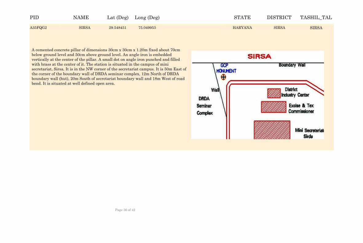
SIRSA 29.549281 75.049123 HARYANA SIRSA SIRSA
A cemented concrete pillar of dimensions 30cm x 30cm x 1.20m fixed about 70cm below ground level and 50cm above ground level. An angle iron is embedded vertically at the center of the pillar. A small dot on angle iron punched and filled with brass at the center of it. The station is situated in the campus of mini secretariat, Sirsa. It is in the NW corner of the secretariat campus. It is 50m East of the corner of the boundary wall of DRDA seminar complex, 12m North of DRDA boundary wall (hut), 20m South of secretariat boundary wall and 18m West of road bend. It is situated at well defined open area.
A35FQG2 SIRSA 29.548451 75.049953 SIRSAA35FQG2 SIRSAHARYANA
NAME Lat (Deg) Long (Deg) STATE DISTRICT TASHIL_TALPID
Page 36 of 42
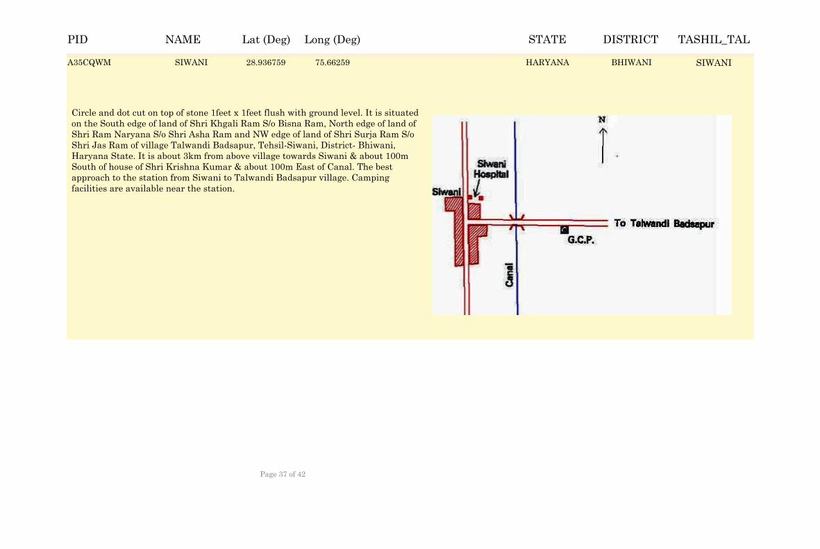
SIWANI 28.937589 75.66176 HARYANA BHIWANI SIWANI
Circle and dot cut on top of stone 1feet x 1feet flush with ground level. It is situated on the South edge of land of Shri Khgali Ram S/o Bisna Ram, North edge of land of Shri Ram Naryana S/o Shri Asha Ram and NW edge of land of Shri Surja Ram S/o Shri Jas Ram of village Talwandi Badsapur, Tehsil-Siwani, District- Bhiwani, Haryana State. It is about 3km from above village towards Siwani & about 100m South of house of Shri Krishna Kumar & about 100m East of Canal. The best approach to the station from Siwani to Talwandi Badsapur village. Camping facilities are available near the station.
A35CQWM SIWANI 28.936759 75.66259 BHIWANIA35CQWM SIWANIHARYANA
NAME Lat (Deg) Long (Deg) STATE DISTRICT TASHIL_TALPID
Page 37 of 42
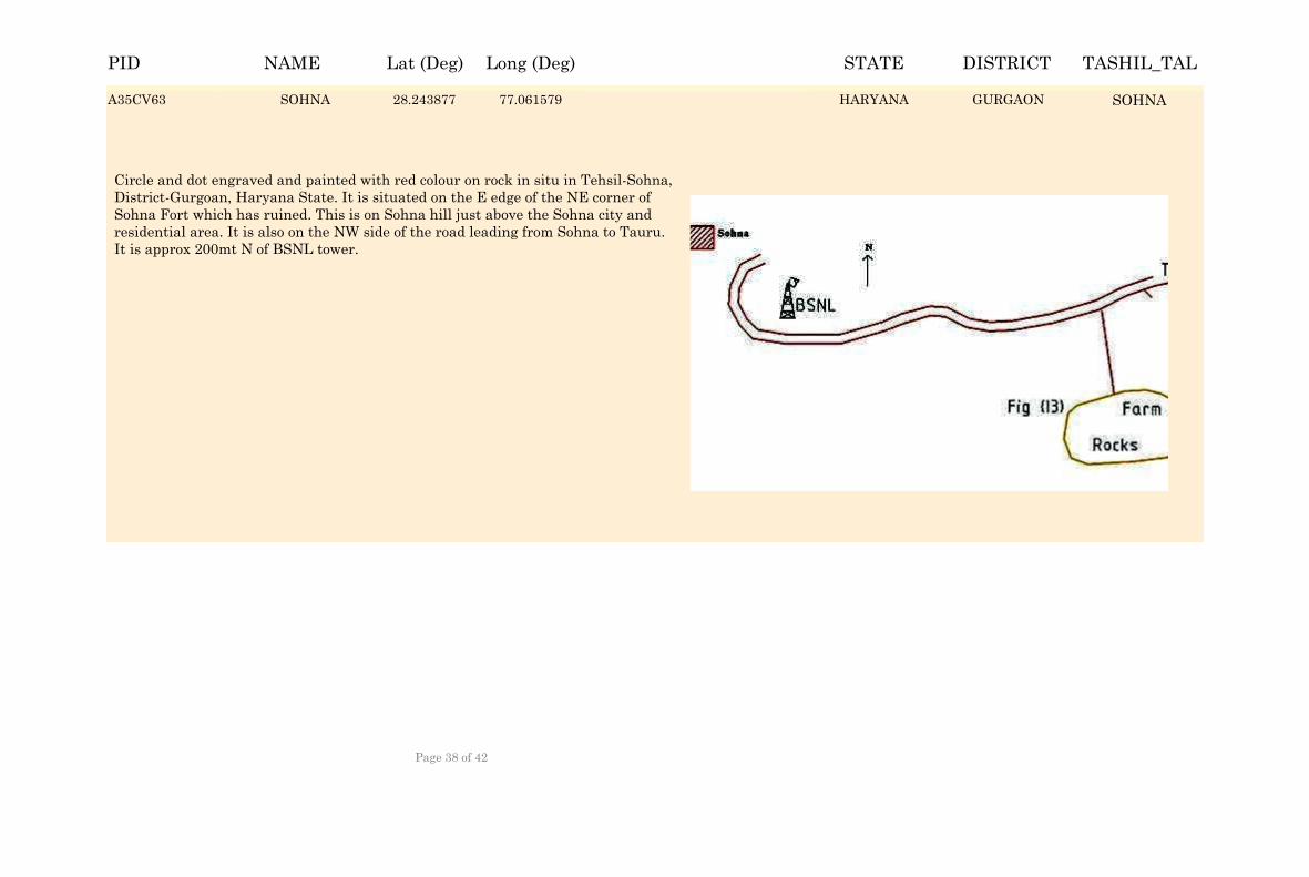
SOHNA 28.244707 77.060749 HARYANA GURGAON SOHNA
Circle and dot engraved and painted with red colour on rock in situ in Tehsil-Sohna, District-Gurgoan, Haryana State. It is situated on the E edge of the NE corner of Sohna Fort which has ruined. This is on Sohna hill just above the Sohna city and residential area. It is also on the NW side of the road leading from Sohna to Tauru. It is approx 200mt N of BSNL tower.
A35CV63 SOHNA 28.243877 77.061579 GURGAONA35CV63 SOHNAHARYANA
NAME Lat (Deg) Long (Deg) STATE DISTRICT TASHIL_TALPID
Page 38 of 42
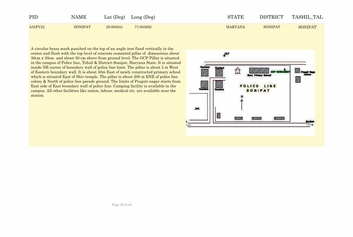
SONIPAT 29.006671 77.004862 HARYANA SONIPAT SONIPAT
A circular brass mark punched on the top of an angle iron fixed vertically in the center and flush with the top level of concrete cemented pillar of dimensions about 30cm x 30cm and about 50 cm above from ground level. The GCP Pillar is situated in the campus of Police line, Tehsil & District-Sonipat, Haryana State. It is situated inside NE corner of boundary wall of police line limit. The pillar is about 5 m West of Eastern boundary wall. It is about 50m East of newly constructed primary school which is situated East of Shiv temple. The pillar is about 200 m ENE of police line colony & North of police line parade ground. The limits of Pragati nagar starts from East side of East boundary wall of police line. Camping facility is available in the campus. All other facilities like ration, labour, medical etc. are available near the station.
A35FV22 SONIPAT 29.005841 77.005692 SONIPATA35FV22 SONIPATHARYANA
NAME Lat (Deg) Long (Deg) STATE DISTRICT TASHIL_TALPID
Page 39 of 42
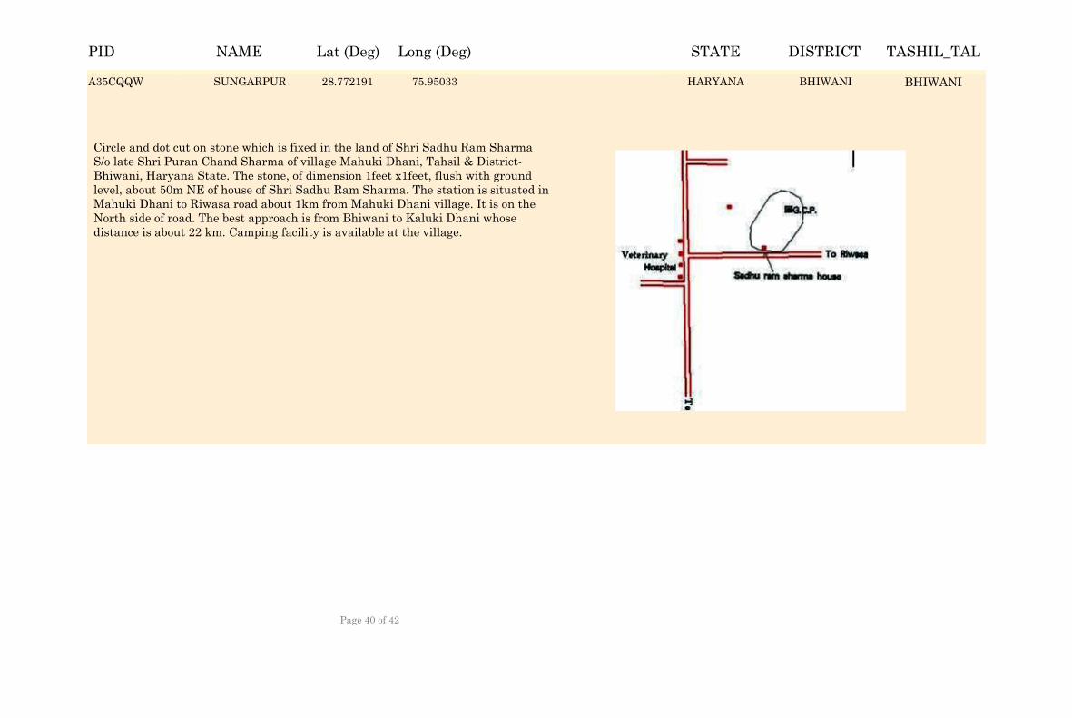
SUNGARPUR 28.773021 75.9495 HARYANA BHIWANI BHIWANI
Circle and dot cut on stone which is fixed in the land of Shri Sadhu Ram Sharma S/o late Shri Puran Chand Sharma of village Mahuki Dhani, Tahsil & District- Bhiwani, Haryana State. The stone, of dimension 1feet x1feet, flush with ground level, about 50m NE of house of Shri Sadhu Ram Sharma. The station is situated in Mahuki Dhani to Riwasa road about 1km from Mahuki Dhani village. It is on the North side of road. The best approach is from Bhiwani to Kaluki Dhani whose distance is about 22 km. Camping facility is available at the village.
A35CQQW SUNGARPUR 28.772191 75.95033 BHIWANIA35CQQW BHIWANIHARYANA
NAME Lat (Deg) Long (Deg) STATE DISTRICT TASHIL_TALPID
Page 40 of 42
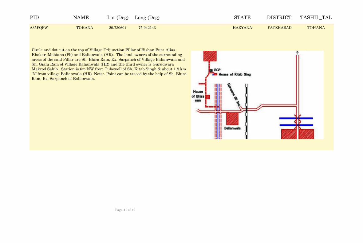
TOHANA 29.731434 75.941313 HARYANA FATEHABAD TOHANA
Circle and dot cut on the top of Village Trijunction Pillar of Bishan Pura Alias Khokar, Mohiana (Pb) and Balianwala (HR). The land owners of the surrounding areas of the said Pillar are Sh. Bhira Ram, Ex. Sarpanch of Village Balianwala and Sh. Giani Ram of Village Balianwala (HR) and the third owner is Gurudwara Makrod Sahib. Station is 6m NW from Tubewell of Sh. Kitab Singh & about 1.8 km ‘N’ from village Balianwala (HR). Note:- Point can be traced by the help of Sh. Bhira Ram, Ex. Sarpanch of Balianwala.
A35FQPW TOHANA 29.730604 75.942143 FATEHABADA35FQPW TOHANAHARYANA
NAME Lat (Deg) Long (Deg) STATE DISTRICT TASHIL_TALPID
Page 41 of 42
NAME Lat (Deg) Long (Deg) STATE DISTRICT TASHIL_TALPID
Page 42 of 42