EXHIBIT 99.1 UNDURSHIL AIMAG (“ALTAN”) PROPERTY ... fileSUMMARY In October of 2003, Rio Minerals...
29
EXHIBIT 99.1 UNDURSHIL AIMAG (“ALTAN”) PROPERTY – GEOLOGIST EXPLORATION REPORT STATEMENT OF QUALIFICATON I, Derrick Strickland, of 5-236 West 12 th Ave., Vancouver, B.C., do hereby certify that: 1. I am a graduate of Concordia University and hold a B.Sc. degree in Geology (1933). 2. I have been employed in the mineral exploration industry since 1986 in British Columbia, Alberta, Northwest Territories, Manitoba, Ontario, Quebec, and New Brunswick, United States, Mongolia, and have practiced my profession since graduation. 3. The observation, conclusions, and recommendations within this report are based on geological work conducted on the property. Some of the observation in this report are those of others, based on their work on the property. 4. I am a consulting geologist, and a registered member in good standing with the Association of Professional Engineers and Geoscientists of British Columbia. 5. I authorize the use of this report in, or in conjunction with, any prospectus or statement of fact. Dated at Vancouver, British Columbia, this 1 st of December, 2003 /s/ Derrick Strickland Derrick Strickland, P.Geo, B.Sc., MBA
Transcript of EXHIBIT 99.1 UNDURSHIL AIMAG (“ALTAN”) PROPERTY ... fileSUMMARY In October of 2003, Rio Minerals...
EXHIBIT 99.1 UNDURSHIL AIMAG (“ALTAN”) PROPERTY – GEOLOGIST EXPLORATION REPORT
STATEMENT OF QUALIFICATON I, Derrick Strickland, of 5-236 West 12th Ave., Vancouver, B.C., do hereby certify that:
1. I am a graduate of Concordia University and hold a B.Sc. degree in Geology (1933).
2. I have been employed in the mineral exploration industry since 1986 in British Columbia, Alberta, Northwest Territories, Manitoba, Ontario, Quebec, and New Brunswick, United States, Mongolia, and have practiced my profession since graduation.
3. The observation, conclusions, and recommendations within this report are based on geological work conducted on the property. Some of the observation in this report are those of others, based on their work on the property.
4. I am a consulting geologist, and a registered member in good standing with the Association of Professional Engineers and Geoscientists of British Columbia.
5. I authorize the use of this report in, or in conjunction with, any prospectus or statement of fact.
Dated at Vancouver, British Columbia, this 1st of December, 2003 /s/ Derrick Strickland Derrick Strickland, P.Geo, B.Sc., MBA

2
GEOLOGIAL EXPLORATION REPORT
ON THE
ALTAN PROPERTY
MONGOLIA
Latitude 44° 54� 00.0� N Longitude 108° 25� 00.0� W
Map Sheet L-49-109
For:
Ton Fei Fred Tham & Associates
By Derrick Strickland, P.Geo.
Rio Minerals Limited 209-475 Howe Street
Vancouver, B.C. V6C 2B3
November, 2003

3
TABLE OF CONTENTS TABLE OF CONTENTS ..............................................................................................................................................3 LIST OF FIGURES ...................................................................................................................................................1 LIST OF APPENDICES ............................................................................................................................................1 1 INTRODUCTION ............................................................................................................................................1 2 PROJECT LOCATION, ACCESS, & PHYSIOGRAPHY 3 PROPERTY OWNERSHIP 4 EXPLORATION HISTORY 5 REGIONAL GEOLOGICAL SETTING 6 PROPERY GEOLOGY .....................................................................................................................................8 7 SUMMARY OF WORK - 2003 8 CONCLUSIONS AND RECCOMENDATIONS 9 RECCOMENDIATIONS.................................................................................................................................12 10 BUDGET 11 STATEMENT OF QUALIFICATIONS ......................................................................................................14 12 BIBLIOGRAPHY ..........................................................................................................................................15

LIST OF FIGURES
FIGURE 1 REGIONAL PROPERTY LOCATION .............................................................................2
FIGURE 2 CONCESSION MAP..........................................................................................................4
FIGURE 3 SCHEMATIC TERRAINE MAP OF MONGOLIA ..........................................................6
FIGURE 4 PALEOTECTONIC RECONSTRUCTION ......................................................................7
FIGURE 5 OLZIIT METALLOGENIC BELT ....................................................................................9
FIGURE 6 SOUTH MONGOLIAN BELT ..........................................................................................9
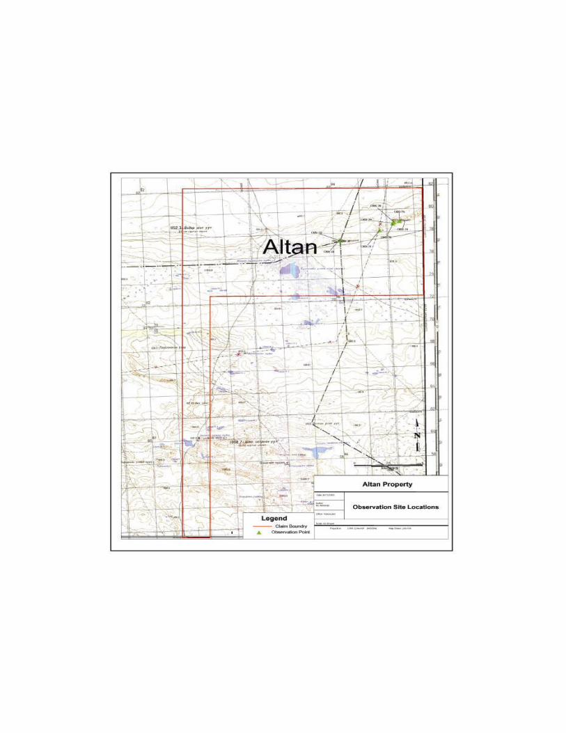
LIST OF APPENDICES APPENDIX A UNDURSHIL PROPERTY GEOLOGY MAP
APPENDIX B OBSERVATION SITE LOCATIONS
APPENDIX C OBSERVATIONS SITES TABLE
Metric Conversion Table
1 foot (ft) = 0.3848 meters (m)
1 inch (i.) = 2.54 centimetres (cm)
1 kilometre (k) = 0.26137 miles (mi)
SUMMARY
In October of 2003, Rio Minerals Limited of Vancouver was contracted by Ton Fei Fred Tham
& Associates to undertake reconnaissance geological investigation and conduct general
prospecting on the Altan property located 385 kilometres south of Ulaanbaatar, Mongolia. The
program consisted of prospecting, geological mapping, and the collection of nine ground truthing
locations. Further geological work on the property is recommended.

1
INTRODUCTION
In October 2003, Rio Minerals Limited of Vancouver, British Columbia, Canada was contracted
by Ton Fei Fred Tham & Associates to undertake a program of geological reconnaissance on the
Altan property located in the Undurshil Aimag of Southern Mongolia. The program consisted of
prospecting, geological mapping and the collection of nine ground truthing � geological
observation sites.
PROJECT LOCATION, ACCESS, & PHYsiOGRAPHY The Atlan project area is located in the Dundgovi and Dornogovi Aimags, Mandakh and
Undurshil Soum of Mongolia (figure 1). This Aimag is located approximately 385 kilometers
south of Ulaanbaatar, the Capital of Mongolia. The central point of the license is located
approximately 75 kilometers southeast of the town of Undurshil. Topographically, the license
lies within the Mongolian Highland, which represents the transitional zone between the Hangai�
Hently Mountains and the Gobi Lowlands. The territory consists of gently rolling plains with
scattered remnant hills and wide valleys between topographic highs. Elevations range from
1000-1400 meters above sea level. The climate is semi-arid. The summer season is from June to
mid-August and the winter season is from mid-December to mid-January. Winter temperatures
can reach lows of -25° Celsius and summer temperatures may reach highs of +35-40° Celsius.
The windy season is typically from March to June during which time wind velocities can reach
25-30 knots.
The soil composition of the area is Gobi-Brown sand and gravel. Vegetation consists of bunch
grass, wild onion, and sparse sage. There are no rivers and few springs. Many of the springs are
hand dug and are maintained by herders for their horses and sheep. Roads are accessible
throughout the year and offer excellent access to the property. The closest infrastructure is
located at the town Undurshil which has electricity from 20:00-23:00 hrs, gasoline, and a small
house which rents four bare rooms nightly.

2
Figure 1. - Altan Property Location.
Ton Fei Fred Tham & Associates Altan Property
Project Area

3
PROPERTY AND OWNERSHIP
The property is comprised of 20,000 hectares located on map sheet L49-109 in the Dungovi and
Dornovi Aimags, Mongolia. The claims are held with in license number 4767X, which is held
by Ton Fei Fred Tham & Associates. The License was issued on September 27th, 2002 and is
valid for a period of two years and eleven months; see Figure 2 for license boundary.
License Number Hectares Date Issued Period
4767X 20,000 September 27, 2002
2 years 11 months
EXPLORATION HISTORY
Past geological studies have focused mainly on oil and gas exploration within Cretaceous Basin. Geological mapping and prospecting for these commodities was carried out in 1953 at a scale of 1:200,000 (Bratash. VI, et.al) and drilled in 1954 by Davidov. R.V. Prospecting and mapping for minerals was carried out on a regional scale in 1972, 1973, and 1986-1988 on a 1:200,000 scale by Sanjaadorj. D., Bumburuu G., and Lkhundev S.H. There has not been any reported geological work since 1988 and no evidence of prospecting or geological activity was observed during the 2003 work program.

4
Figure 2 Claim Location
5
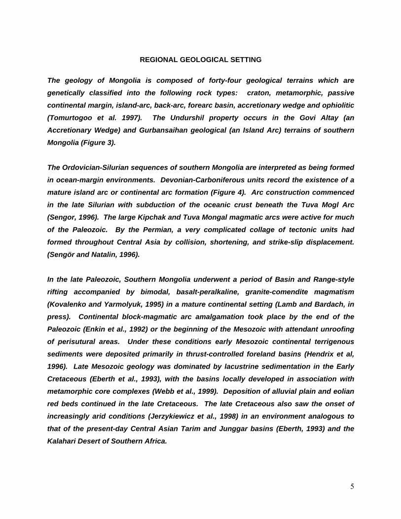
REGIONAL GEOLOGICAL SETTING
The geology of Mongolia is composed of forty-four geological terrains which are genetically classified into the following rock types: craton, metamorphic, passive continental margin, island-arc, back-arc, forearc basin, accretionary wedge and ophiolitic (Tomurtogoo et al. 1997). The Undurshil property occurs in the Govi Altay (an Accretionary Wedge) and Gurbansaihan geological (an Island Arc) terrains of southern Mongolia (Figure 3). The Ordovician-Silurian sequences of southern Mongolia are interpreted as being formed in ocean-margin environments. Devonian-Carboniferous units record the existence of a mature island arc or continental arc formation (Figure 4). Arc construction commenced in the late Silurian with subduction of the oceanic crust beneath the Tuva Mogl Arc (Sengor, 1996). The large Kipchak and Tuva Mongal magmatic arcs were active for much of the Paleozoic. By the Permian, a very complicated collage of tectonic units had formed throughout Central Asia by collision, shortening, and strike-slip displacement. (Sengör and Natalin, 1996). In the late Paleozoic, Southern Mongolia underwent a period of Basin and Range-style rifting accompanied by bimodal, basalt-peralkaline, granite-comendite magmatism (Kovalenko and Yarmolyuk, 1995) in a mature continental setting (Lamb and Bardach, in press). Continental block-magmatic arc amalgamation took place by the end of the Paleozoic (Enkin et al., 1992) or the beginning of the Mesozoic with attendant unroofing of perisutural areas. Under these conditions early Mesozoic continental terrigenous sediments were deposited primarily in thrust-controlled foreland basins (Hendrix et al, 1996). Late Mesozoic geology was dominated by lacustrine sedimentation in the Early Cretaceous (Eberth et al., 1993), with the basins locally developed in association with metamorphic core complexes (Webb et al., 1999). Deposition of alluvial plain and eolian red beds continued in the late Cretaceous. The late Cretaceous also saw the onset of increasingly arid conditions (Jerzykiewicz et al., 1998) in an environment analogous to that of the present-day Central Asian Tarim and Junggar basins (Eberth, 1993) and the Kalahari Desert of Southern Africa.

6
Figure 3. Schematic terrain and overlap assemblage map of Mongolia, complied by Badarch and O.Tomurtogoo, 1997.
- Altan Property Location.

7
Figure 4. Paleogeographic Interpretation of Southern Mongolia-Central Asia during the Devonian and the Paleotectonic reconstruction for the Early Devonian displaying the Tuva-Mongol arc (simplified and modified from Sengö and Natal’n 1996). - Altan Property location.

8
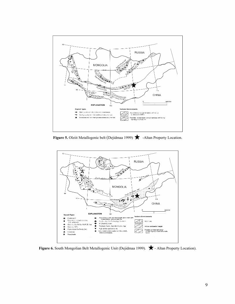
PROPERY GEOLOGY The Altan property displays typical basin and range style topography. The basin is covered with flat lying Devonian to Cenozoic sediments with topographic highs associated with igneous intrusions of Middle Carboniferous porphyritic granite. The surficial geology of the Altan property consists of Paleogenic sediments and modern quaternary deposits constituting 60 % of surface exposure. The remaining part of the property is composed of Middle-late Carboniferous Matad granitic complex, Devonian Erdenebayan and Hotol limestone and sandstone formations, and the Tsagaantsav formation; a Cretaceous basalt (see appendix A) Previous geological studies have delineated two metallogenic belts. The Olziit, and South
Mongolian Belts, which are separated by the Trans Mongolian Fault which runs through the
center of the property. A portion of the Olziit Metallogenic Belt overlays the northern section of
the property and the dominant mineralization associated with this belt includes base metal,
precious metal, and gold deposits. A portion of the South Mongolian Metallogenic Belt overlies
the southern area of the property. Mineralization found in this belt includes base metal,
manganese, and gold-silver mineralization.
9
Figure 5. Olziit Metallogenic belt (Dejidmaa 1999) -Altan Property Location.
Figure 6. South Mongolian Belt Metallogenic Unit (Dejidmaa 1999). - Altan Property Location).

10
SUMMARY OF WORK - 2003
In October of 2003, Rio Minerals Limited of Vancouver was contracted by Ton Fei Fred Tham
& Associates to undertake a reconnaissance geological investigation of the Altan property.
The geological program consisted of prospecting and ground truthing the Matad complex and the
Erdenebayan and Hotol formations. The Matad complex is located in the north-east portion of
the property whereas the Erdenebayan and Hotol formations are located in the southern part of
the property. While on the property the Rio Minerals crew spent one day prospecting and
ground truthing. A total of nine ground truth locations (observation sites) were generated; see
Appendix B for locations.
The Matad granite complex is middle-late carboniferous in age and is composed of medium to
coarse-grained granite which displays a moderate gneissic texture. Field observations confirmed
the presences of strong jointing ranging from 347º-360º Az. Associated with jointing is minor
epidotization along hairline fractures. The epidotization was observed throughout the entire
Matad complex. In the process of prospecting on the Matad complex a basaltic andesite dyke
was located. The dyke trends 327ºAz is weakly porphyritic and is composed of 1-2 mm
plagioclase phenocrysts and a fine grained gray weakly silicic matrix.
The Erdenebayan and Hotol formations were prospected for potential mineralization. The rock
types in these formations are aleurolite, limestone, and quartzite.
The Tsagaantsav formation, cretaceous basalt, and its associated faults is located in the southern part of the property. Due to time restrictions this area was not investigated.

CONCLUSIONS AND RECCOMENDATIONS The Altan property has had minor amounts of mineral exploration work undertaken to date. In
an effort to assess the economic potential, significant geological work needs to be completed.
There are, however encouraging factors for the property to host mineralization.
The property is located on two documented metallogenetic belts, the Olziit & South Mongolian,
which are associated with a major fault. The Trans Mongolian Liniment. Typically
mineralization is associated with major faults and their associated minor faults.
The Matad and Tassgaantsav igneous intrusives have not been fully investigated and may represent areas of likely mineralization. The scope of the reconnaissance program did not fully address these igneous events and they should be further investigated to determine their economic potential.

Reccomendations Based on the current understanding of the Altan property the following recommendations are put
forth:
• Conduct a property wide exploration program consisting of geological mapping,
sampling, and prospecting; paying particular attention to the Tsagaantsav formation and
Matad complex.
• Carry out air photo interpretation on the property.

BUDGET
Time Charges:
Travel 2 persons - 4 days $ 2250.00 Ulaanbaatar to interpret data/plan 2 persons - 1 day $ 850.00 Field 2 persons - 05 days $ 4250.00 Mongolian Driver/Interpreter 2 persons - 07 days $ 560.00 Mongolian Geologist 1 person - 07 days $ 455.00 Camp Cook 1 person - 07 days $ 250.00
Sub total: $ 8615.00
Expenses: Visas 2 persons - 1 country $ 160.00 Accommodation $ 950.00 Meals $ 950.00 Supplies and Rentals $ 650.00 4 x 4 vehicle rental 1 vehicle � 7 days (gas incl.) $ 550.00 Air tickets 2 persons $ 3500.00 Satellite phone $ 500.00 Assays and shipping $ 1500.00 Report Report $ 4500.00 Consumables Maps, etc. $ 375.00 Subtotal: $13635.00
Total $22250.00
*All terms are expressed in US Dollars.
STATEMENT OF QUALIFICATIONS
I: Derrick Strickland, of 5-236 West 12th Ave, Vancouver, B.C. do hereby certify that:
1. I am a graduate of Concordia University and hold a B.Sc. degree in Geology
(1993).
2. I have been employed in the mineral exploration industry since 1986 in British Columbia, Alberta, Northwest Territories, Manitoba, Ontario, Quebec, and New Brunswick, United States, Mongolia, and have practiced my profession since graduation.
3. The observations, conclusions, and recommendations within this report are based on
geological work conducted on the property. Some of the observations in this report are those of others, based on their work on the property.
4. I am a consulting geologist, and a registered member in good standing with the
Association of Professional Engineers and Geoscientists of British Columbia.
5. I authorize the use of this report in, or in conjunction with, any prospectus or statement of fact.
Dated at Vancouver, British Columbia, this 27th day of November, 2003.
__ Derrick Strickland. P.Geo, B.Sc, MBA.
BIBLIOGRAPHY Arribas. A, Jr. 1995
Characteristics of high-sulfidation epithernmal deposits and their relation to magmatic fluid: Mineralogical Association of Canada Short Course Series v. 23,. P 419-454.
Badarch. G., and Orolmaa D., 1998 Overview of the geology and tectonic evolution of southern Mongolia: Mongolian Geoscientist Special Issue 10, p 10-16.
Badarch G. 1990 Ph. D. Thesis, University of Ulaanbaatar, 200 p. Berzina, A.N. Sotmkov, V.I., Ponomarchuk, V.A., Berzina. A.P., andKiseleva. V.Y.. 1999 Temporal periods of formations of Cu-Mo porphyry deposits. Siberia and Mongolia in
Stanely C.J., et al eds.: Mineral Deposits: Processess to Processing: Rotterdam, Balkema v. 4 p. 321-324.
Cox, D.P. 1985 Geology of the Tanama and Helecho porphyry copper deposits and vicinity Puerto Rico:
U.S. Geological Survey Professional Paper 1327, 59p. Cunningham, W.D., 1996 Lithospheric controls on the late Cenoozoic construction of the Mongolain Altia;
Tectonics, v. 17 no.6, p. 891-902. Dejidmaa, G., Badarch, G. 1999
Summary of Pre-Accretionary and Accretionary Metallogenic Belts of Mongolia. Institute of Geology and Mineral Resources, Mongolian Academy of Sciences, Ulaanbaatar, Mongolia p 10.
Eberth, D.A., 1993
Depositional Environments and facies transition of dinosaur-bearing upper Cretaceous red beds at Bayan Mandahu (Inner Mongolia, Peoples Republic of China): Canadian Journal of Earth Sciences, v. 30, p. 2196-2213.
Enkin, R.J., et al 1992
Paleomagnetic constraints on the geodynamic history of the major blocks of China from the Permian to the Present. The Journal of Geophysical Research, V. 97, p. 13,953-13,989.
G.Bumburuu, G., Lhundev, S., Burentugs J. 1990
Report of geological mapping work of scale 1:200000 in area of the Dundgovi aimag. Open file Report 4377, Mongolian Geologic Information Center (in Mongolian).
Hedenquist, J.W., and Richards, J.P., 1998 The influence of the geochemical techniques on the development of genetic models for
porphyry copper deposits: Reviews in Economic Geology, v. 10. p. 235-256. Hedenquist, J.W., Arribas, A., and Gonzallez-Urien, E., 2000 Exploration for epithermal gold deposits: Reviews in Economic Geology, v. 13., p. 245-
277. Hendrix, M.S., Graham, S.A., Amory, J. Y., and Badarch., G., 1996. Noyon Uul syncline, southern Mongolia: Lover Mesozoic Sedimentary record of the
tectonic amalgamation of central Asia: Geological Society of America Bulletin, v. 108 p. 1256-1274.
Jerzykiewciz, T., Currie, P.J. Eberth, D.A. Johnston, P.A., Koster, E.H.., and Zheng, J.J., 1993 Djadokhata Formation Inner Mongolia: An Overview of the stratigraphy, sedimentary
geology(ical) , and paleontology and comparison with the type locality in the pre-Altai Gobi: Canadian Journal of Earth Science, V. 30, p. 2180-2195
Lamb, M.A. and Badarch, G. 1997 Paleozoic sedimentary basin and volcanic-arc system of southern Mongolia: New
stratigraphic and sedimentological constraints: International Geology Review, V. 39. p. 542-576.
Lang, J.R., Stanley, C.R., Thompson, J.F.H., and Dunne, K.P.E, 1995 Na-K-Ca magmatic-hydrothermal alteration I Alkalic porphyry Cu-Au deposits, British
Columbia: Mineralogical Association of Canada Short Course Seri(v)es v.23, p. 339-366. Levashev, G.V. Andreev, T.M. and Trentyev, T., 1964.
Report on results of 1:50,000 Scale geological mapping and general prospecting carried out in the territory of Dornogovi province. Open File Report Mongolian Geologic information Center (in Mongolian).
Perello, J. 1994
Geology of porphyry Cu-Au and epithermal Cu-Au-Ag mineralization of the Tombuliato district. North Sulawesi, Indonesia: Journal of Geochemical Exploration, v. 50, p. 221-256.
Perello, J. 1998 Fromation of giant chalcocite blankets: Lessons from the northern Chile porphyry copper
Belt: Society of Mining Engineers Annual Meeting: March 1-3, 1999. Denver, Colorado. Technical Program, p. 58.
Perlloe,J., Dennis, C., Dondog, G. et al 2001

Oyu Tolgoi, Mongolia: Siluro-Devonian Porphyry Cu-Au-(Mo) and High-Sulfidation Cu Mineralization with a Cretaceous Chalcocite Blanket: Economic Geology, v. 96, p. 1407-1428.
Poulsen, K.H. et al 1995
Volcanic-Associated Massive Sulphide Gold, Geology of Canadian Mineral Deposits Type, Geological Survey of Canada, Ministery of Natural Resources Canada, p. 183-186.
Qing, L., Xiaohuan, X., Yutao, Z., et al 1988 The study results about regional geochemical exploration methods and techniques in the
semi arid landscape of east part of Inner Mongolia; The second International Conference on Prospecting in Arid Terrain, Perth, Australia 1988, p. 109.
Ruzhentzsev S.V. and Pospelov, P.I. 1982 The south Mongolian Variscan fold system: Geotectonics, v.26. p. 383-395. Silliote, R.H., 1979 Some thoughts on gold-rich porphyry-copper deposits: Mineralium Deposita, v. 14. p.
161-174. Silliote, R.H., 1995 Exploration of Porphory Copper lithocaps: Pacific Rim Congress, Auckland, New
Zealland, Autralasian Institute of Mining and Metallurgy Proceedings, p. 527-523. Silliote R.H. 2000 Gold-rich prophyry deposits: Descriptive genetic models and their role in exploration and
discovery: Reviews in Economic Geology, v. 13. p 315-345. Sillitoe, R.H. Gerel, O. et al 1996 Mongolia�s gold potential: Mining Magazine, July 1996 p. 12-15. Taylor, B.E. 1995
Epithermal Gold Deposits, Quartz-(kaolinite)- alunite deposits, Adularia-sericite deposits, Geology of Canadian Mineral Deposits Type, Geological Survey of Canada, Ministery of Natural Resources Canada, p. 329-350.
Tsooj, S., Buerenhuu E., and Otgonbayar, L. 1991-1994
Report on results of 1:50,000 Scale geological group mapping carried out in the Erdenedalai area in 1991-1994. Open file Report 4782, Mongolian Geologic Information Center (in Mongolian).
Tomurtogoo, O. et al 1999

Terranes and accreationary tectonics of Mongolia; Mongolian Geoscientist, No. 14, 1999, p. 5-9.

APPENDIX A
ALTAN PROPERTY GEOLOGY MAP


APPENDIX B
OBSERVATION SITE LOCATIONS (OBS)

APPENDIX C
OBSERVATION SITE DESCRIPTIONS

Observation Site Descriptions
Observation Sites
Location Descriptions
OBS-28 Granite, well jointed, medium-coarse grained, locally pegmatitic (K-spar, quartz), secondary smoky quartz veins up to 5 cm, week-moderate gneissic texture, strongly jointed @ 65ºAz 90, 120º Az 80SW, rock composition approx. 30% plagioclase., 30% K-spar, 30% quartz, 10% biotite
OBS-29 Granite, medium grained, localized weak to moderate gneissocity, approx. 65% quartz, 40% plagioclase. 5% fine grained biotite, strong jointing @ 347ºAz 78W, 85/90
OBS-30 Granite, medium grained, moderate localized gneissocity, approx. 60% K-spar, 35% quartz, 5% fine grained biotite, trace hairline epidote veinlets, jointing @ 360ºAz 60E, 49ºAz 40 NW, gneissic fabric aligned
OBS-31 Granite, med-coarse grained, strong jointing and moderate gneissic texture, main jointing @ 50º/62NW, approx. 50% quartz, 45% Na plagioclase., 5% biotite with partial alteration to limonite and minor hematite
OBS-32 Granite, coarse grained, equigranular, approx. 40% quartz, 30% Na plagioclase., 25% K-spar, 15% black to greenish (chlorite altered) biotite, euhedral K-spar crystals up to 1.0 cm, rock unit strongly jointed @90ºAz 80S.
OBS-33 Basaltic andesite dike, trending ~ 327ºAz , fine grained, weakly porphyritic, plagioclase phenocryst 1-2 mm, gray, weakly silicic matrix
OBS-34 North terminus of basaltic andesite dike as in OBS-33
OBS-74 Meta-granite with K-spar, minor banding with epidote along fractures OBS-75 Meta-granite with minor epidote along fractures