EXHIBIT 1 - Baltimore City Department of...
57
Transcript of EXHIBIT 1 - Baltimore City Department of...


South Baltimore Gateway Complete Streets Plan Pigtown/Washington Village 1
S O U T H B A L T I M O R E G A T E W A Y C O M P L E T E S T R E E T S P L A N
PIGTOWN/WASHINGTON VILLAGE
Contents
Overview .............................................................................. 2
Land Use .............................................................................. 4
Existing Transportation ................................................... 5
Street Typology ................................................................. 9
Development Traffic Impacts and Mitigation ....... 16
City and Other Agency Projects ................................ 16
Neighborhood Complete Streets Inventory .......... 18
Community Connections ............................................. 19
Complete Streets Plan Principles ............................... 20
Complete Streets Plan ................................................... 21
Appendix I: Complete Streets Inventory………….….25
Appendix II: Street Tree Inventory………………..……..31
Appendix III: Traffic Mitigation Zones……….………..38
Appendix IV: Photo Guide……………….….……………….39
Exhibits
1: Neighborhood Map ..................................................... 2
2: Land Use Map ............................................................... 4
3: Sidewalk Map ................................................................ 6
4: Baltimore City Bike Master Plan Map .................... 7
5: Complete Streets Typologies and Elements ..... 10
6: Street Typology Map ................................................ 12
7: Community Collector Street Typology ............... 13
8: Neighborhood Street Type Typology ................. 14
9: Service / Alleyways Street Typology .................... 15
10: Community Connections Map ............................. 19
11: Complete Streets Plan Map ................................... 23
12: Complete Streets Plan Cost Table ......................24

2 South Baltimore Gateway Complete Streets Plan Pigtown/Washington Village
EXHIBIT 1 Neighborhood Map
Overview
Pigtown/Washington Village is located immediately
west of Martin Luther King, Jr. Blvd. (MLK, Jr. Blvd.)
with a northern boundary at West Pratt Street. The
eastern boundary is South Carey Street and Carroll
Park. The southern boundary is Bush, Wicomico,
South Paca, West Hamburg, and Russell Streets.
Neighborhood boundaries are shown in Exhibit 1.
West Pratt Street, which runs east and west on
Pigtown/Washington Village’s northern boundary,
was the site of the Baltimore and Ohio Railroad’s
horse-drawn cars the nation’s first regular
passenger rail service. Industrial development
followed, and slaughter houses were located near
the rail yard. Pigs being herded from rail cars
earned the neighborhood’s distinctive moniker.
The Pigtown/Washington Village central business
district, which is located along Washington
Boulevard, comprises of service-based businesses,
retail and residential units (primarily on upper
floors). Traditional row-homes are the predominant
residential unit within the community and side
streets with industrial uses in the neighborhood’s
south end.
The Pigtown/Washington Village Main Street
Association has helped cultivate a growing, vibrant
commercial core with a distinct sense of place,
although vacancy challenges and a weak gateway
image have yet to be overcome.

South Baltimore Gateway Complete Streets Plan Pigtown/Washington Village 3
The Citizens of Pigtown/Washington Village
Community Association has helped bring residents
together to strengthen the community’s
investments in the neighborhood.
Oriole Park at Camden Yards
M&T Bank Stadium
The B&O Railroad Museum
Royal Farms Arena
Enoch Pratt Free Library
University of Maryland Medical Center
The Mobtown Ballroom
Carroll Park
M&T Bank Stadium
The Pigtown/Washington Village neighborhood is
represented by three organizations Pigtown Main
Street, Citizens of Pigtown, and Southwest
Partnership.
Pigtown/Washington Village is a unique and vibrant
community that has been working toward
revitalizing the commercial and residential areas as
well as attract more attention to visitor and historic
destinations. The desire of Pigtown/Washington
Village residents is to have a safe, walkable, and
economically thriving neighborhood. The
community wants to be family oriented where
people of all ages can safely meet, travel, and visit
each other. The residents’ would like to eliminate
the barrier both physically and psychologically
created by MLK Boulevard. S. Cary Street is
considered a vital connection between
Pigtown/Washington Village and the entire
Southwest Partnership neighborhoods. The B & O
Railroad Bridge over S. Cary Street currently acts as
a barrier but could be transformed into an amenity
for the neighborhood.
For the commercial corridors, the community wants
to make Washington Boulevard more attractive for
retail and restaurants to attract more business and
support neighborhood sense of place. Provide
pedestrian connectivity on MLK, Jr. Blvd. to the
neighborhood, and, locate a gateway feature on
Washington Boulevard. Keeping the lively business
corridor of Washington Boulevard active and
occupied is important. Transportation and parking
are key to these thriving businesses.
Goals:
Create more walkable streets that incorporate
pedestrian and street elements such as
pedestrian lighting, bike safe grates, transit
stops, and bike facilities. Maintain aesthetically
pleasing and safe sidewalk conditions.
Achieve consistent street lighting and
pedestrian lighting throughout the
neighborhood.
Accommodate bicycling through better
provision and marking of facilities.
Streetscaping along Scott Street to enhance
connections to nearby amenities.
Upgrade the sidewalk/sidepath along MLK
connecting Washington Boulevard to W.
Hamburg Street at Russell Street.
Enhance the community garden and create a
community space at the end of W. Ostend
Street.

4 South Baltimore Gateway Complete Streets Plan Pigtown/Washington Village
Land Use
Low and medium density residential is the most
prominent land use in the neighborhood.
Institutional land uses are located on the northwest
portion of the neighborhood and include the
Southwest Baltimore Charter Elementary and
Middle School, Charles Carrol Barrister Elementary
School George Washington Elementary School, and
Saint Jerome School.
The primary commercial corridors are along
Washington Boulevard and Mount Clare Junction
along S. Carey Street. Washington Blvd is a main
street for the neighborhood with unique retail
facing the Boulevard just west of MLK Blvd.
EXHIBIT 2 Land Use Map

South Baltimore Gateway Complete Streets Plan Pigtown/Washington Village 5
Existing Transportation
According to the Complete Streets Principles used
by the Baltimore City Department of Transportation
(BCDOT) each mode of transportation – walking,
bicycling, riding transit, driving, and delivering
freight has been identified within the
neighborhood. Pigtown/Washington Village is also
home to the Baltimore City Tour Bus facility
operated by the Baltimore City Parking Authority.
One way to measure the livability of a
neighborhood is to use national scores for walking,
bicycling, and transit. These measurements provide
a comparison among neighborhoods, suburbs,
cities, and regions.
Walking
Pigtown/Washington Village is very walkable and
during the day, there is activity along the
Washington Boulevard Main Street and along
residential streets. As the sun sets, residents do not
have the same level of confidence walking.
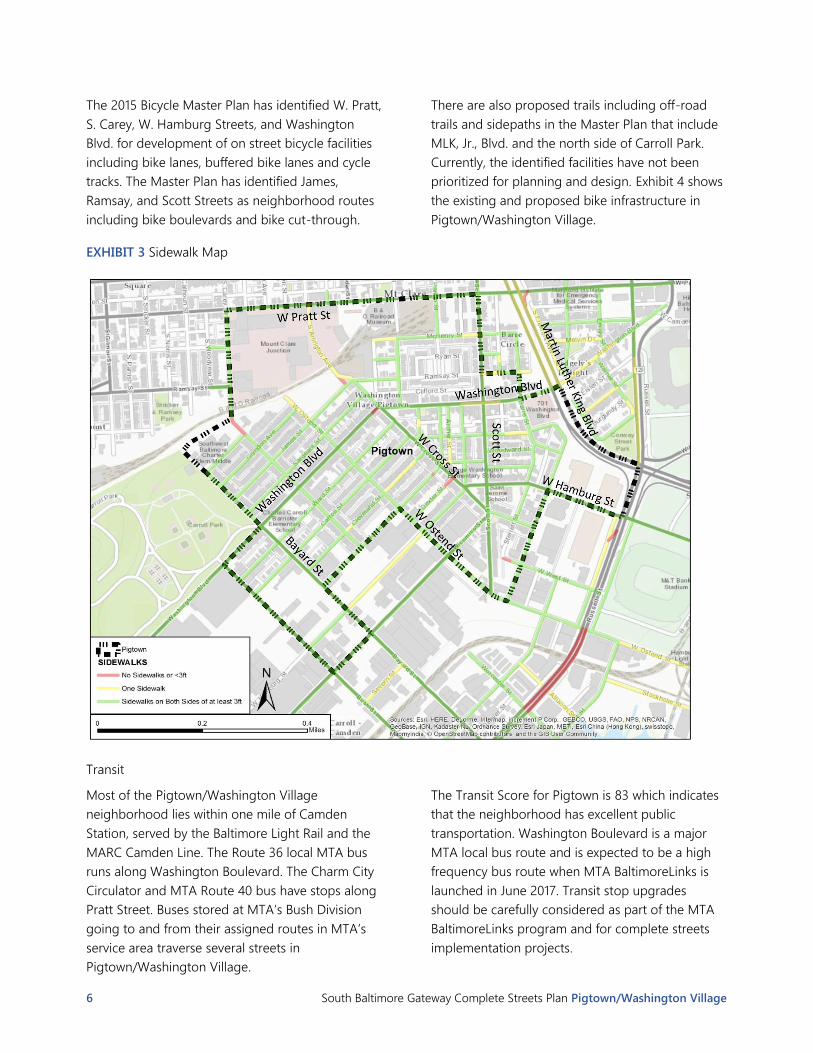
Sidewalks are available throughout the
neighborhood. Crosswalks are faded in many
locations. Exhibit 3 illustrates where sidewalks are
present. The majority of streets have sidewalks on
both sides and the sidewalk width is greater than
three feet. The following streets have been
identified as not having continuous sidewalks or as
having sidewalk widths of less than three feet:
S. Cary Street between Herkimer Street and
the B&O Railroad tracks
Dexter Street at W. Cross Street
S. Arlington Avenue between James Street
and W. Pratt Street
Intersection of Washington Blvd at W.
Cross Street
The Walk Score for Pigtown is 92 according to
Redfin Walk Score (https://www.redfin.com/how-
walk-score-works).
Walk Score measures the walkability of any address
based on the distance to nearby places and
pedestrian friendliness. Pigtown/Washington
Village is scored as a walker’s paradise.
90–100 Walker’s Paradise - Daily errands do not require
a car
70–89 Very Walkable - Most errands can be
accomplished on foot
50–69 Somewhat Walkable - Some errands can be
accomplished on foot
25–49 Car-Dependent - Most errands require a car
0–24 Car-Dependent - Almost all errands require a
car
Bicycle
Existing bicycle facilities in the Pigtown/Washington
Village neighborhood include off-road trails along
the western boundary of the neighborhood on
Bayard and Bush Streets. The Gwynn’s Falls Trail
connects Carroll Park with the Jones Falls Trail along
Bayard and Bush Streets within the neighborhood.
Additional bicycle facilities connecting east/west
through the neighborhood is desirable to complete
the bicycle network for residents and visitors.
Baltimore City will be launching the Bikeshare
program in October 2016 and the neighborhood of
Pigtown/Washington Village has been designated
for a bikeshare station.
The Bike Score for Pigtown is 68, indicating that the
neighborhood is bikeable with some bike
infrastructure present.
Bike Score measures whether an area is good for
biking based on bike lanes and trails, hills, road
connectivity, and destinations.
90–100 Biker’s Paradise - Daily errands can be
accomplished on a bike
70–89 Very Bikeable - Biking is convenient for most
trips
50–69 Bikeable - Some bike infrastructure
0–49 Somewhat Bikeable - Minimal bike infrastructure
6 South Baltimore Gateway Complete Streets Plan Pigtown/Washington Village
The 2015 Bicycle Master Plan has identified W. Pratt,
S. Carey, W. Hamburg Streets, and Washington
Blvd. for development of on street bicycle facilities
including bike lanes, buffered bike lanes and cycle
tracks. The Master Plan has identified James,
Ramsay, and Scott Streets as neighborhood routes
including bike boulevards and bike cut-through.
There are also proposed trails including off-road
trails and sidepaths in the Master Plan that include
MLK, Jr., Blvd. and the north side of Carroll Park.
Currently, the identified facilities have not been
prioritized for planning and design. Exhibit 4 shows
the existing and proposed bike infrastructure in
Pigtown/Washington Village.
EXHIBIT 3 Sidewalk Map
Transit
Most of the Pigtown/Washington Village
neighborhood lies within one mile of Camden
Station, served by the Baltimore Light Rail and the
MARC Camden Line. The Route 36 local MTA bus
runs along Washington Boulevard. The Charm City
Circulator and MTA Route 40 bus have stops along
Pratt Street. Buses stored at MTA’s Bush Division
going to and from their assigned routes in MTA’s
service area traverse several streets in
Pigtown/Washington Village.
The Transit Score for Pigtown is 83 which indicates
that the neighborhood has excellent public
transportation. Washington Boulevard is a major
MTA local bus route and is expected to be a high
frequency bus route when MTA BaltimoreLinks is
launched in June 2017. Transit stop upgrades
should be carefully considered as part of the MTA
BaltimoreLinks program and for complete streets
implementation projects.

South Baltimore Gateway Complete Streets Plan Pigtown/Washington Village 7
Transit Score measures how well a location is
served by public transit based on the distance and
type of nearby transit lines.
90–100 Rider’s Paradise - World-class public
transportation
70–89 Excellent Transit - Transit is convenient for most
trips
50–69 Good Transit - Many nearby public
transportation options
25–49 Some Transit - A few nearby public
transportation options
0–24 Minimal Transit - It is possible to get on a bus
EXHIBIT 4 Baltimore City Bike Master Plan Map, March 2015
8 South Baltimore Gateway Complete Streets Plan Pigtown/Washington Village
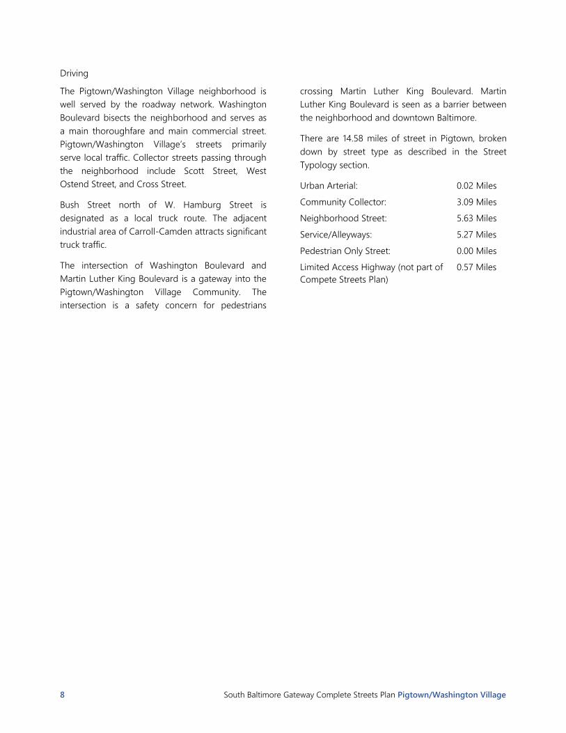
Driving
The Pigtown/Washington Village neighborhood is
well served by the roadway network. Washington
Boulevard bisects the neighborhood and serves as
a main thoroughfare and main commercial street.
Pigtown/Washington Village’s streets primarily
serve local traffic. Collector streets passing through
the neighborhood include Scott Street, West
Ostend Street, and Cross Street.
Bush Street north of W. Hamburg Street is
designated as a local truck route. The adjacent
industrial area of Carroll-Camden attracts significant
truck traffic.
The intersection of Washington Boulevard and
Martin Luther King Boulevard is a gateway into the
Pigtown/Washington Village Community. The
intersection is a safety concern for pedestrians
crossing Martin Luther King Boulevard. Martin
Luther King Boulevard is seen as a barrier between
the neighborhood and downtown Baltimore.
There are 14.58 miles of street in Pigtown, broken
down by street type as described in the Street
Typology section.
Urban Arterial: 0.02 Miles
Community Collector: 3.09 Miles
Neighborhood Street: 5.63 Miles
Service/Alleyways: 5.27 Miles
Pedestrian Only Street: 0.00 Miles
Limited Access Highway (not part of
Compete Streets Plan)
0.57 Miles
South Baltimore Gateway Complete Streets Plan Pigtown/Washington Village 9
Street Typology
Streets throughout the Pigtown/Washington Village
neighborhood have been classified according to a
set of observed characteristics, including speed,
traffic volume, roadway width, number of lanes, and
surrounding land use. The different classifications,
or street typologies, are then used as a framework
for understanding the function of the road and
setting the guidelines for various design elements
that are appropriate and may be used to foster
more complete streets.
Exhibit 5 shows the Complete Streets typology
framework, including the individual characteristics
and design elements associated with each type.
After the descriptions of the street typology, there
is a neighborhood map in Exhibit 6 showing the
classification of each street segment according to
the typology.
Following the map are lists of the individual streets
within each of the typologies found in the
Pigtown/Washington Village neighborhood, a
summary of the defining characteristics of each,
and an example section view for each street type.
Note: Street Typologies are closely aligned with the
typologies presented in the Baltimore City Bike
Master Plan (2013), from which the below typology
descriptions are derived. The Community Collector”
category in this Complete Streets plan comprises
both the “Community Collector” and “Community
Main Street” categories from the Bike Master Plan.
The classification of the typologies used in the
Complete Streets Plan do relate to the Federal
Highway Functional Classification System. This
system is used when The City is developing capital
improvement projects (CIP) seeking federal funding.
10 South Baltimore Gateway Complete Streets Plan Pigtown/Washington Village
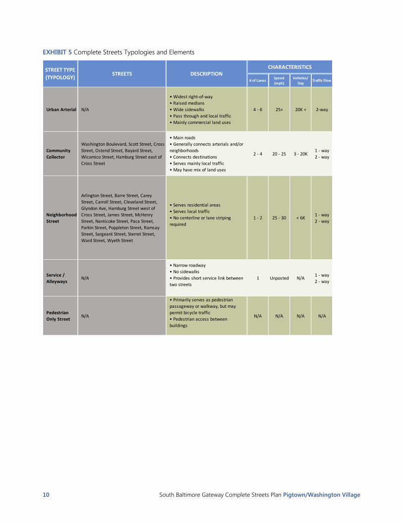
EXHIBIT 5 Complete Streets Typologies and Elements
# of LanesSpeed
(mph)
Vehicles/
DayTraffic Flow Sidewalks
Urban Arterial N/A
• Widest right-of-way
• Raised medians
• Wide sidewalks
• Pass through and local traffic
• Mainly commercial land uses
4 - 6 25+ 20K + 2-way ●
Community
Collector
Washington Boulevard, Scott Street, Cross
Street, Ostend Street, Bayard Street,
Wicomico Street, Hamburg Street east of
Cross Street
• Main roads
• Generally connects arterials and/or
neighborhoods
• Connects destinations
• Serves mainly local traffic
• May have mix of land uses
2 - 4 20 - 25 3 - 20K1 - way
2 - way ●
Neighborhood
Street
Arlington Street, Barre Street, Carey
Street, Carroll Street, Cleveland Street,
Glyndon Ave, Hamburg Street west of
Cross Street, James Street, McHenry
Street, Nanticoke Street, Paca Street,
Parkin Street, Poppleton Street, Ramsay
Street, Sargeant Street, Sterret Street,
Ward Street, Wyeth Street
• Serves residential areas
• Serves local traffic
• No centerline or lane striping
required
1 - 2 25 - 30 < 6K1 - way
2 - way●
Service /
AlleywaysN/A
• Narrow roadway
• No sidewalks
• Provides short service link between
two streets
1 Unposted N/A1 - way
2 - way ○
Pedestrian
Only StreetN/A
• Primarily serves as pedestrian
passageway or walkway, but may
permit bicycle traffic
• Pedestrian access between
buildings
N/A N/A N/A N/A ●
STREETSSTREET TYPE
(TYPOLOGY)DESCRIPTION
CHARACTERISTICS ELEMENTS

South Baltimore Gateway Complete Streets Plan Pigtown/Washington Village 11
EXHIBIT 5 Complete Streets Typologies and Elements (continued)
# of LanesSpeed
(mph)
Vehicles/
DayTraffic Flow Sidewalks
Urban Arterial N/A
• Widest right-of-way
• Raised medians
• Wide sidewalks
• Pass through and local traffic
• Mainly commercial land uses
4 - 6 25+ 20K + 2-way ●
Community
Collector
Washington Boulevard, Scott Street, Cross
Street, Ostend Street, Bayard Street,
Wicomico Street, Hamburg Street east of
Cross Street
• Main roads
• Generally connects arterials and/or
neighborhoods
• Connects destinations
• Serves mainly local traffic
• May have mix of land uses
2 - 4 20 - 25 3 - 20K1 - way
2 - way ●
Neighborhood
Street
Arlington Street, Barre Street, Carey
Street, Carroll Street, Cleveland Street,
Glyndon Ave, Hamburg Street west of
Cross Street, James Street, McHenry
Street, Nanticoke Street, Paca Street,
Parkin Street, Poppleton Street, Ramsay
Street, Sargeant Street, Sterret Street,
Ward Street, Wyeth Street
• Serves residential areas
• Serves local traffic
• No centerline or lane striping
required
1 - 2 25 - 30 < 6K1 - way
2 - way●
Service /
AlleywaysN/A
• Narrow roadway
• No sidewalks
• Provides short service link between
two streets
1 Unposted N/A1 - way
2 - way ○
Pedestrian
Only StreetN/A
• Primarily serves as pedestrian
passageway or walkway, but may
permit bicycle traffic
• Pedestrian access between
buildings
N/A N/A N/A N/A ●
STREETSSTREET TYPE
(TYPOLOGY)DESCRIPTION
CHARACTERISTICS ELEMENTS
Sidewalks Medians Shoulders Bike LanesStreet
Lighting
Pedestrian
Lighting
Street
FurnitureParking Landscaping
● ◒ ◒ ○ ● ◒ ◒ ◒ ●
● ◒ ○ ◒ ● ● ● ◒ ●
● ○ ○ ○ ● ◒ ◒ ● ●
○ ○ ○ ○ ◒ ◒ ○ ○ ○
● N/A N/A ○ ○ ● ◒ N/A ◒
ELEMENTS

12 South Baltimore Gateway Complete Streets Plan Pigtown/Washington Village
EXHIBIT 6 Street Typology Map

South Baltimore Gateway Complete Streets Plan Pigtown/Washington Village 13
Community Collector: Washington Boulevard, Scott
Street, Cross Street, Ostend Street, Bayard Street,
Wicomico Street, Hamburg Street east of Cross
Street
Community collectors combine with arterials to
complete a network providing access to and from
significant traffic generators in Baltimore City as
well as providing convenient access into and out of
the community. This street type serves travel as a
result of the land use nearby and connects
neighborhood streets to urban arterial. (Urban
arterials carry a mix of traffic which is both local and
through in nature, but generally greater emphasis is
placed on efficient vehicular travel movement along
the street.) Community collectors serve a broader
area than neighborhood streets.
EXHIBIT 7 Community Collector Street Typology
# of Lanes Speed (mph) Vehicles/ Day Traffic Flow
Community Collector • Main roads
• Generally connects arterials
and/or neighborhoods
• Connects destinations
• Serves mainly local traffic
• May have mix of land uses
2 - 4 20 - 25 3 - 20K1 - way
2 - way
STREET TYPE
(TYPOLOGY)
CHARACTERISTICS
DESCRIPTION

14 South Baltimore Gateway Complete Streets Plan Pigtown/Washington Village
Neighborhood Street: Arlington Street, Barre Street,
Carey Street, Carroll Street, Cleveland Street,
Glyndon Ave, Hamburg Street west of Cross Street,
James Street, McHenry Street, Nanticoke Street,
Paca Street, Parkin Street, Poppleton Street, Ramsay
Street, Sargeant Street, Sterret Street, Ward Street,
and Wyeth Street. Neighborhood streets primarily
serve adjacent land uses rather than facilitating
through traffic. The cross-section requirements for
neighborhood streets are related to the intensity of
land use in the immediate area.
EXHIBIT 8 Neighborhood Street Type Typology
# of Lanes Speed (mph) Vehicles/ Day Traffic Flow
Neighborhood
Street
• Serves residential areas
• Serves local traffic
• No centerline or lane striping
required
1 - 2 25 - 30 < 6K1 - way
2 - way
STREET TYPE
(TYPOLOGY)
CHARACTERISTICS
DESCRIPTION

South Baltimore Gateway Complete Streets Plan Pigtown/Washington Village 15
Service / Alleyways: Amity Street, Callendar Street,
Clifford Street, Eislen Street, Otterbein Street,
Reinhardt Street
This street type is most commonly a narrow
alleyway between two neighborhood streets,
though it can also be a wider road used for limited
purposes, such as access to industrial areas. This
type of street would generally not be considered
for Complete Streets improvements.
EXHIBIT 9 Service / Alleyways Street Typology
# of Lanes Speed (mph) Vehicles/ Day Traffic Flow
Service / Alleyways • Narrow roadway
• No sidewalks
• Provides short service link
between two streets
1 Unposted N/A1 - way
2 - way
STREET TYPE
(TYPOLOGY)
CHARACTERISTICS
DESCRIPTION

16 South Baltimore Gateway Complete Streets Plan Pigtown/Washington Village
Development Traffic Impacts and Mitigation
The Pigtown/ Washington Village neighborhood is
located within the Southwest Traffic Mitigation
Zone (TMZ). All new development and
redevelopment over 15,000 square feet or greater
than ten residential units are required to meet
Traffic Impact Study (TIS) requirements per
legislation 11-529. Within the TMZ, developments
meeting the TIS threshold requirements are
required to pay a Traffic Mitigation Agreement
(TMA) fee based on the forecasted new trips
generated by the development. BCDOT uses these
fees to mitigate traffic impacts across the
multimodal transportation system with the TMZ.
BCDOT prioritizes traffic mitigation projects for
each zone.
The inclusion of the TIS/TMA information in the
neighborhood chapter is to inform the residents
that new development and redevelopment provides
financial contributions to fund multimodal
transportation improvements within the study area
See Appendix III for map of Traffic Mitigation
Zones.
City and Other Agency Projects
ADA Self-Evaluation
The Baltimore City Department of Transportation
(BCDOT) is currently performing a citywide ADA
self-evaluation. Over the next five fiscal years FY16-
FY21, the self-evaluation will identify all ADA
facilities (curb ramps, sidewalks, etc., in the right of
way) that do not meet current ADA standards.
BCDOT has an ADA Transition Plan that is a
strategic guide prioritizing required improvements
to bring ADA facilities up to standard.
MTA BaltimoreLink
The MTA BaltimoreLink plan was recently
announced in and planning has begun. This multi-
phase plan will create an interconnected transit
system including the redesign of the entire local
and express bus systems throughout Baltimore. The
effort will add 12 new high-frequency, color-coded
bus routes that improve connections to jobs and
other transit modes.
The BaltimoreLink system will deliver a unified
transit network and includes renaming existing
Maryland Transit Administration (MTA) modes:
LocalLink (Local Bus), Light RailLink, Metro
SubwayLink and MobilityLink to create an
interconnected transit system. Other key elements
of the BaltimoreLink system include transitways,
transit hubs and transit signal priority.
BCDOT is coordinating with MTA and advocating
for the needs of residents and transit users in area
neighborhoods. MTA will be implementing the
BaltimoreLink system by June 30, 2017. The
Waterfront Partnership completed the Inner Harbor
Master Plan 2.0 in 2015 and is working on
implementation of the plan.
BaltimoreLInk 2.0 is MTA’s second version of the
complete overhaul and rebranding of the core
transit operating system operating within the city
and throughout the greater Baltimore region.
BaltimoreLink 2.0 has incorporated the feedback
from public workshops that took place in the winter
of 2015/2016. This second draft of the plan also
adjusted the 56 and 65 routes.
More information can be found at
http://www.baltimorelink.com.
Carey Street Underpass Vision Plan
The Neighborhood Design Center (NDC) worked
with the Southwest Partnership on the Carey Street
Underpass Vision Plan, which includes streets and
public spaces, the B & O Heritage Corridor, and the
B&O Bridge at Carey Street. Excerpts of the vision
plan are included in the appendix. The Southwest
Partnership has received some funding to begin
implementing the Vision Plan, which identified
specific goals and actions for improving the overall
quality of life for the southwest communities. A
focal area is South Carey Street, which is located
within the Complete Streets Plan boundary.

South Baltimore Gateway Complete Streets Plan Pigtown/Washington Village 17
The entire Vision plan can be viewed using the
following links.
http://southwestpartnershipbaltimore.org/
wp-content/uploads/2016/01/Southwest-
Partnership-Vision-Plan-.pdf
http://southwestpartnershipbaltimore.org/c
ommittees/safe-vibrant-and-walkable-
streets/
Capital Improvement Projects
There was a completed resurfacing projects in the
Pigtown/Washington Village neighborhood in 2016
on Carey Street from Nanticoke to Lexington Street.
Another resurfacing project is expected in 2017 for
Sargeant Street from Cross Street to Bayard Street.
Improvements for Washington Boulevard through
Chesapeake Bay Trust
Pigtown/Washington Village has submitted a grant
application to the Chesapeake Bay Trust for
improvements to Washington Boulevard for design
studies conducted by Pigtown/Washington Village
Main Street toward an eventual permit application
for stormwater bumpouts in the public right-of-way
along Washington Blvd. In July, BCDOT met with
representatives from Pigtown/Washington Village
Main Street’s design team to offer general guidance
on the permit application process for stormwater
bumpouts.
Safe Routes to School Program
Safe Routes to School (SRTS) programs operate
throughout the country. Baltimore City BCDOT has
safe routes to schools program. In
Pigtown/Washington Village three elementary and
middle schools have been selected to take part in
the SRTS program including Southwest Baltimore
Charter School Elementary/Middle to be
inventoried and completed 2021, Charles Carroll
Barrister Elementary completed in 2014 and George
Washington Elementary to be inventories and
completed in 2019. The purpose of this program is
to improve safety for students in grades K-8 who
walk and bike to school. The three main goals of
the program are:
To enable and encourage children, including
those with disabilities, to walk and bike to
school.
To make biking and walking to school safer
transportation choice, thereby encouraging a
healthy and active lifestyle from an early age.
To aid the planning and building of projects
and activities that will improve safety and
reduce traffic, fuel consumption, and air
pollution nearby primary and middle schools.

18 South Baltimore Gateway Complete Streets Plan Pigtown/Washington Village
Neighborhood Complete Streets Inventory
The Complete Streets inventory is a physical
inventory of the Right of Way (ROW). The ROW is
the area between private property boundaries,
which includes all above ground and underground
infrastructure controlled by the City of Baltimore.
The Department of Transportation began the
inventory phase of the Complete Streets Plan in
October 2015 and completed the inventory phase in
March 2016. The inventory captured key features of
the street for each block, including:
Presence and width of sidewalks on each
side of street
Presence of a planting strip / buffer
between sidewalk and street on each side
of street
Presence and width of parking on each side
of street
Presence, type, and width of bicycle
facilities on each side of street
Number of vehicle travel and turn lanes
and their total width on each side of street
Presence, type, and width of median
Street width (curb-to-curb)
Total width of the individual components
between the outer edges of sidewalks
(back of sidewalk to back of sidewalk).
Total number of tree planting spaces on
each side of street
Total number of trees on each side of
street of the street
The complete list of streets and their associated
inventory data are provided in Appendix I or
viewable at the City of Baltimore’s GIS page.
Street Tree Inventory
As part of the Complete Streets inventory process,
basic information about the presence of street tree
planting spaces and street trees was collected and
catalogued in a geodatabase during the Spring of
2016. The inventory and corresponding maps are
representative of trees in the right-of-way. Trees
that are located in adjacent property, such as a
public park or private yard are not included. This
information was collected on a block-by-block basis
to coincide with the City’s street centerline GIS file.
Maps intentionally show street tree data for all
areas inventoried within the view extent, not just
the neighborhood of interest, in acknowledgement
of the importance of continuity of tree canopy
when evaluating the urban forest. The data provide
a point of reference regarding the streetscape and
street tree canopy along each street segment within
the study area and the dataset is intended to
enable preliminary identification of where
additional trees may be needed/desired. This
information should be supplemented with up-to-
date field verification.
Note: the table and maps do not show information
for streets classified as “service/alleyway,” “inactive,”
or “limited access highway,” which generally are not
suitable for street trees. However, there are some
cases where trees or tree planting spaces exist on
streets of those types.
The full set of data collected is available in
Appendix II and in GIS format through the City’s GIS
system.

South Baltimore Gateway Complete Streets Plan Pigtown/Washington Village 19
Community Connections
Neighborhood goals must also be considered
within a broader context. Connections between
communities are essential for all modes of travel.
Exhibit 12 illustrates key community connections for
Pigtown Washington Village. The MLK sidepath has
been identified as a bicycle infrastructure priority
that would connect Pigtown/Washington Village to
Barre Circle and the stadium area. In 2016 BCDOT
received a grant to prepare preliminary engineering
documents for the MLK sidepath. BCDOT will use
the preliminary engineering documents to submit a
grant application in 2017 for the construction of the
MLK sidepath.
Washington Blvd, MLK Blvd, and West Ostend
Street are primary transit and passenger corridors.
Improvements in transit are necessary for
interconnecting Pigtown/Washington Village to
surrounding communities.
MLK Blvd provides multimodal transportation
options for Pigtown/Washington Village. MLK Blvd
is a freight corridor providing local access for
freight deliveries in the northwest sections of
Baltimore. The boulevard also serves pedestrians
and bicyclists on both sides of the roadway as a
bicycle facility on the west and an urban sidewalk
on the east side of the boulevard. MLK is a high
frequency transit corridor for the MTA local bus
service.
EXHIBIT 10 Community Connections Map

20 South Baltimore Gateway Complete Streets Plan Pigtown/Washington Village
Complete Streets Plan Principles
BCDOT has focused its efforts since 2010 in
developing best practices for typical street
configurations within Baltimore City. The initial
focus was on tracking and reporting. Individual
components of Complete Streets have been
generally described for walking, bicycling,
passenger vehicles, parking, transit, freight and
loading. Balanced consideration for the needs of
each area would improve the efficiency of mobility.
The guiding principle for Baltimore Complete
Streets is to create streets and related infrastructure
that provide safe, convenient, and comfortable
travel for all users. Because Baltimore is a city of
neighborhoods, each Complete Street needs to
reveal the unique characteristics of the
neighborhood the street serves. A Complete Street
accommodates the needs and expectations of the
travelers who want to access or pass through the
surrounding neighborhood, community, or region.
Typical elements that make up a Complete Street in
Baltimore include the following.
For walking:
Sidewalks
Safe crossings and crosswalks
ADA-compliant curb ramps, accessible
routes, and accessible pedestrian signals
Pedestrian refuge areas across wide streets
including medians and bump outs
Street trees for shade, ornamental trees,
planting beds
Amenities including benches, trash
receptacles, shade structures, and public
art
Pedestrian lighting
Pedestrian signage
Pedestrian signals
For bicycling:
Bicycle lanes
Shared-use paths
Bicycle signals
Bicycle signage and markings
For riding transit
(including bus, rail, and water services):
Designated bus lanes
Bus rapid transit corridors
Safe and accessible transit stops
Transit amenities including benches, trash
receptacles, shade structures, public art)
Pedestrian lighting
Transit signage
For delivering freight:
Designated truck routes
Sufficient travel lane widths and
intersection geometry for through and
turning movements
Safe at grade rail crossings and separated
rail and roadway crossings
Freight signage
For driving:
Appropriate lane configurations, width and
geometry
On-street parking that is safe and
convenient
Appropriate speed limits for street
designations and use
Alternative energy (electric charging
stations)
Traffic signage and markings
Traffic signal infrastructure and supporting
systems

South Baltimore Gateway Complete Streets Plan Pigtown/Washington Village 21
Complete Streets Plan
The Pigtown/Washington Village neighborhood is
represented by Pigtown Main Street and Citizens of
Pigtown Community Association. BCDOT met with
the Citizens of Pigtown Community Association on
April 12, 2016 and Pigtown Main Street on April 7,
2016 to present findings of its Complete Streets
Plan. A summary of the Pigtown/Washington
Village Complete Streets Plan was provided for the
stakeholders to review.
The numbering in this section corresponds with
Exhibit 11, the Complete Streets Plan Map.
Creating connections between neighborhoods for
various modes of travel, as well as connections to
the larger city, is important for creating a Complete
Street network for Pigtown/Washington Village.
The commercial corridor of Washington Boulevard
needs to include full amenities for walking, riding
transit, and driving. Creating corridors for both
residents and visitors to frequent and spend money
provides a stable economic base for the
neighborhood.
Bicycle routes that connect the residents and
visitors to the Inner Harbor, Gwynn’s Falls Trail, and
Jones Falls Trail are important. The Complete
Streets Plan prioritizes these connections including
Ramsey Street and Scott Street.
The Complete Streets Plan recognizes that the
sidewalk system is essentially complete and the
improvements identified to complete the streets for
walking are part of the BCDOT ADA self evaluation.
A full upgrade of all curb ramps is quite costly.
However, a shared cost among the City, private
developers, and the neighborhood makes
upgrading curb ramps more manageable. These
ramp upgrades are not included in the Complete
Streets Plan and cost estimate because the self-
evaluation project has not been completed. For
budget purposes, each curb ramp generally costs
about $5,000.
The community outreach process identified the
following projects as priorities for creating a
Complete Streets Plan for Pigtown/Washington
Village. Numbers correspond with map in Exhibit 11
showing planned projects.
Community Signs
Community Gateway signs would help plan for
neighboring gateway connections. A Gateway
connections are primarily pedestrian and bicycle
routes and facilities that allow residents and school
children to seamlessly travel between
neighborhoods these could include wayfinding
signage. Identified locations include but are not
limited to:
(1) Community gateway sign at S. Carey Street
and Herkimer Street
(3) Community sign at Washington Boulevard
and MLK Boulevard
(4) Community sign at Washington Boulevard
and Bush Street
Community Garden Area
A community garden can contribute to the
beautification of a streetscape while facilitating
community interaction and help foster a community
identity supporting a sense of place. Identified
locations include but are not limited to:
(2) Community garden in area between railroad
and Ostend Street
Intersection improvement
(5) BCDOT has been working with the
neighborhood on improving the intersection of S.
Arlington Avenue, W. Cross Street and Ramsey
Street and James Street, which acts as a gateway
between the neighborhood and the B and O
Museum. Narrowing the intersection, replacing the
sidewalk, and refreshing the train mural are
included in the project.
Decorative crosswalks
Identify intersections on interior neighborhood
streets that need high visibility or where residents
want to draw attention to the intersection. The
asphalt roadway is prepared by milling the asphalt
and applying a two-inch overlay of new asphalt at
the intersection. The crosswalk is then imprinted
with the chosen pattern as the decorative crosswalk.
This crosswalk treatment typically last the lifecycle
of the asphalt roadway, seven to ten years. BCDOT
will work with the neighborhood and residents
adjacent to the proposed intersection on the design

22 South Baltimore Gateway Complete Streets Plan Pigtown/Washington Village
and implementation of the decorative crosswalk.
Concrete intersections can also have decorative
crosswalks using an epoxy technique because
concrete cannot be resurfaced. This can incorporate
the same design procedures as described for the
stamped asphalt. The look of a decorative crosswalk
on concrete is different, but the overall goal is the
same.
(6) Washington Boulevard and W. Cross Street
(7) Washington Boulevard and Carey Street
(8) Washington Boulevard and W. Ostend
Street
Bicycle Facilities
Bicycle facilities provide Pigtown/Washington
Boulevard with needed neighborhood connectivity.
Identified locations include but are not limited to:
(9) On-street bike facility on Washington
Boulevard
(10) Complete on-street bike lane connection
on Bush Street from Carroll Park to Middle
Branch Trail.
Replant Street Trees
While many are in good condition, there are several
trees in poor condition or missing. Specific portions
and tree pits could be replanted as follows:
(11) MLK Boulevard.
(12) James Street from W. Cross Street to W.
Ostend Street and then north on W. Ostend
Street to its end at the proposed community
garden.
The following actions will also be pursued:
Implement the Pigtown Main Street Master Plan.
BCDOT has been working with the Pigtown Main
Street to support the implementation of the 2014
Pigtown Main Street Business District Strategic Plan.
Most recently, BCDOT participated in the
Sustainable Cities Design Academy 2016 to develop
the gateway at MLK and Washington Boulevard.
Upgrade area-wide street and pedestrian lighting
throughout Pigtown/Washington Village. At the
request of the community BCDOT has begun the
investigation to upgrade the light fixtures with high
output fixtures.
Exhibit 11 shows the placement of many of the
improvements planned for Pigtown/Washington
Village.
Gateway
Pigtown has been working on creating a gateway to
both the neighborhood and for Baltimore City. The
intersection of MLK Boulevard and Washington Blvd
is the first intersection at the end of I-395 in the
city. A preliminary design has been created that
BCDOT supports. BCDOT and the communities of
Pigtown/Washington Village, Ridgley’s Delight, and
Barre Circle will continue refining the design and
identify funding requirements in order to move
forward to engineering and construction.

South Baltimore Gateway Complete Streets Plan Pigtown/Washington Village 23
EXHIBIT 11 Complete Streets Plan Map
The South Baltimore Gateway Complete Streets Plan includes a Resource Guide (Part 3 of the Plan), which
provides information for Pigtown/Washington Village to move forward with the recommendations of this Plan
and any future improvements that the neighborhood wishes to pursue.
24 South Baltimore Gateway Complete Streets Plan Pigtown/Washington Village
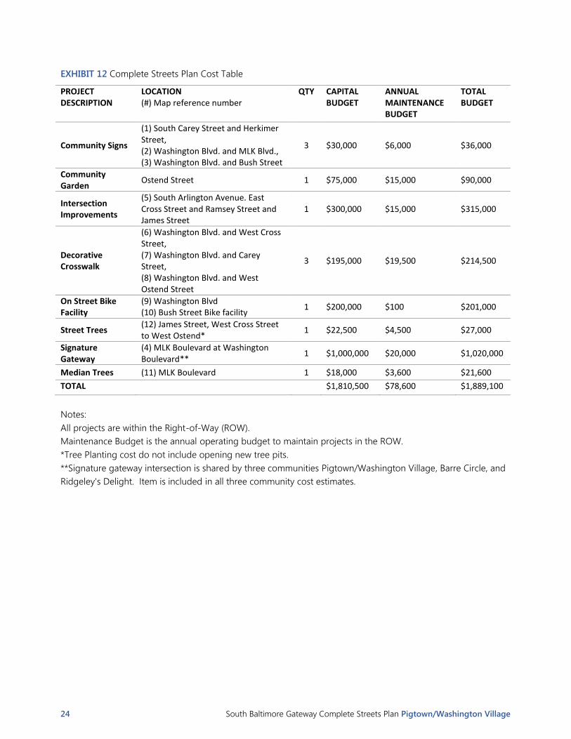
EXHIBIT 12 Complete Streets Plan Cost Table
PROJECT DESCRIPTION
LOCATION (#) Map reference number
QTY CAPITAL BUDGET
ANNUAL MAINTENANCE BUDGET
TOTAL BUDGET
Community Signs
(1) South Carey Street and Herkimer Street, (2) Washington Blvd. and MLK Blvd., (3) Washington Blvd. and Bush Street
3 $30,000 $6,000 $36,000
Community Garden
Ostend Street 1 $75,000 $15,000 $90,000
Intersection Improvements
(5) South Arlington Avenue. East Cross Street and Ramsey Street and James Street
1 $300,000 $15,000 $315,000
Decorative Crosswalk
(6) Washington Blvd. and West Cross Street, (7) Washington Blvd. and Carey Street, (8) Washington Blvd. and West Ostend Street
3 $195,000 $19,500 $214,500
On Street Bike Facility
(9) Washington Blvd (10) Bush Street Bike facility
1 $200,000 $100 $201,000
Street Trees (12) James Street, West Cross Street to West Ostend*
1 $22,500 $4,500 $27,000
Signature Gateway
(4) MLK Boulevard at Washington Boulevard**
1 $1,000,000 $20,000 $1,020,000
Median Trees (11) MLK Boulevard 1 $18,000 $3,600 $21,600
TOTAL $1,810,500 $78,600 $1,889,100
Notes:
All projects are within the Right-of-Way (ROW).
Maintenance Budget is the annual operating budget to maintain projects in the ROW.
*Tree Planting cost do not include opening new tree pits.
**Signature gateway intersection is shared by three communities Pigtown/Washington Village, Barre Circle, and
Ridgeley's Delight. Item is included in all three community cost estimates.

South Baltimore Gateway Complete Streets Plan Pigtown/Washington Village 25
APPENDIX I: COMPLETE STREETS INVENTORY
Introduction
The Complete Streets inventory is a physical inventory of the right of way (ROW). The ROW is the area between
private property boundaries, which includes all above ground and underground infrastructure controlled by the
City of Baltimore. BCDOT conducted the inventory phase of the Complete Streets Plan between October 2015
and March 2016. The inventory captured key features of the street for each block, including:
Presence and width of sidewalks on each side of street
Presence of a planting strip / buffer between sidewalk and street on each side of street
Presence and width of parking on each side of street
Presence, type, and width of bicycle facilities on each side of street
Number of vehicle travel and turn lanes and their total width on each side of street
Presence, type, and width of median
Street width (curb-to-curb)
Total width of the individual components between the outer edges of sidewalks (back of sidewalk to back
of sidewalk).
The complete list of streets and their associated inventory data are provided in the table on the following page,
or viewable at the City of Baltimore’s GIS page.
The diagram below illustrates what information is shown in each column of the table.

26 South Baltimore Gateway Complete Streets Plan Pigtown/Washington Village
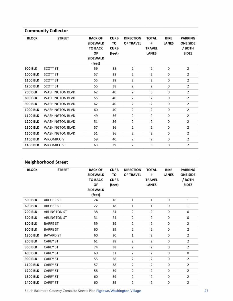
Complete Street Inventory Tables
Community Collector
BLOCK STREET BACK OF
SIDEWALK
TO BACK
OF
SIDEWALK
(feet)
CURB
TO
CURB
(feet)
DIRECTION
OF TRAVEL
TOTAL
#
TRAVEL
LANES
BIKE
LANES
PARKING
ONE SIDE
/ BOTH
SIDES
900 BLK BAYARD ST 55 40 2 2 0 2
1000 BLK BAYARD ST 55 40 2 2 0 2
1100 BLK BAYARD ST 54 39 2 2 0 2
1200 BLK BAYARD ST 57 44 1 2 1 2
1300 BLK BAYARD ST 63 40 1 2 1 2
1400 BLK BAYARD ST 59 45 1 2 1 2
1500 BLK BAYARD ST 60 45 1 2 1 2
1200 BLK BUSH ST 65 39 1 2 1 2
1400 BLK BUSH ST 65 44 1 2 1 2
1500 BLK BUSH ST 57 36 1 2 0 2
1000 BLK CROSS ST 55 37 2 2 0 2
1100 BLK CROSS ST 57 38 2 2 0 2
1200 BLK CROSS ST 59 39 2 2 0 2
1300 BLK CROSS ST 55 39 2 2 0 2
900 BLK CROSS ST 55 37 2 2 0 2
600 BLK HAMBURG ST 60 39 2 2 0 2
700 BLK HAMBURG ST 59 38 2 2 0 2
800 BLK HAMBURG ST 63 38 2 2 0 2
700 BLK OSTEND ST 63 36 2 2 0 0
800 BLK OSTEND ST 36 24 2 2 0 0
900 BLK OSTEND ST 64 39 2 2 0 2
1000 BLK OSTEND ST 61 39 2 2 0 2
1100 BLK OSTEND ST 56 38 2 2 0 2
1200 BLK OSTEND ST 54 38 2 2 0 2
1300 BLK OSTEND ST 57 39 2 2 0 2
1400 BLK OSTEND ST 60 38 2 2 0 2
800 BLK PRATT ST 58 38 1 2 0 2
900 BLK PRATT ST 59 38 1 2 0 2
1000 BLK PRATT ST 60 38 1 2 0 2
1100 BLK PRATT ST 60 38 1 2 0 2
1200 BLK PRATT ST 60 38 1 2 0 2
400 BLK SCOTT ST 59 38 2 2 0 2
500 BLK SCOTT ST 56 38 2 2 0 2
600 BLK SCOTT ST 54 38 2 2 0 2
700 BLK SCOTT ST 60 38 2 2 0 2
South Baltimore Gateway Complete Streets Plan Pigtown/Washington Village 27
Community Collector
BLOCK STREET BACK OF
SIDEWALK
TO BACK
OF
SIDEWALK
(feet)
CURB
TO
CURB
(feet)
DIRECTION
OF TRAVEL
TOTAL
#
TRAVEL
LANES
BIKE
LANES
PARKING
ONE SIDE
/ BOTH
SIDES
900 BLK SCOTT ST 59 38 2 2 0 2
1000 BLK SCOTT ST 57 38 2 2 0 2
1100 BLK SCOTT ST 55 38 2 2 0 2
1200 BLK SCOTT ST 55 38 2 2 0 2
700 BLK WASHINGTON BLVD 62 40 2 3 0 2
800 BLK WASHINGTON BLVD 55 40 2 2 0 2
900 BLK WASHINGTON BLVD 62 40 2 2 0 2
1000 BLK WASHINGTON BLVD 60 40 2 2 0 2
1100 BLK WASHINGTON BLVD 49 36 2 2 0 2
1200 BLK WASHINGTON BLVD 51 36 2 2 0 2
1300 BLK WASHINGTON BLVD 57 36 2 2 0 2
1500 BLK WASHINGTON BLVD 51 36 2 2 0 2
1100 BLK WICOMICO ST 59 40 2 2 0 2
1400 BLK WICOMICO ST 63 39 2 3 0 2
Neighborhood Street
BLOCK STREET BACK OF
SIDEWALK
TO BACK
OF
SIDEWALK
(feet)
CURB
TO
CURB
(feet)
DIRECTION
OF TRAVEL
TOTAL
#
TRAVEL
LANES
BIKE
LANES
PARKING
ONE SIDE
/ BOTH
SIDES
500 BLK ARCHER ST 24 16 1 1 0 1
600 BLK ARCHER ST 22 18 1 1 0 1
200 BLK ARLINGTON ST 38 24 2 2 0 0
300 BLK ARLINGTON ST 31 24 2 2 0 0
800 BLK BARRE ST 59 39 2 2 0 2
900 BLK BARRE ST 60 39 2 2 0 2
1300 BLK BAYARD ST 60 30 1 2 0 2
200 BLK CAREY ST 61 38 2 2 0 2
300 BLK CAREY ST 74 38 2 2 0 2
400 BLK CAREY ST 60 31 2 2 0 0
900 BLK CAREY ST 55 38 2 2 0 2
1100 BLK CAREY ST 57 38 2 2 0 2
1200 BLK CAREY ST 58 39 2 2 0 2
1300 BLK CAREY ST 60 39 2 2 0 2
1400 BLK CAREY ST 60 39 2 2 0 2

28 South Baltimore Gateway Complete Streets Plan Pigtown/Washington Village
Neighborhood Street
BLOCK STREET BACK OF
SIDEWALK
TO BACK
OF
SIDEWALK
(feet)
CURB
TO
CURB
(feet)
DIRECTION
OF TRAVEL
TOTAL
#
TRAVEL
LANES
BIKE
LANES
PARKING
ONE SIDE
/ BOTH
SIDES
700 BLK CARROLL ST 33 21 2 2 0 1
700 BLK CARROLL ST @ Barre St
51 36 2 2 0 2
800 BLK CARROLL ST 35 23 1 1 0 1
1100 BLK CARROLL ST 55 36 1 1 0 2
1200 BLK CARROLL ST 59 39 1 1 0 2
1300 BLK CARROLL ST 60 39 1 1 0 2
1400 BLK CARROLL ST 61 39 2 2 0 2
1200 BLK CLEVELAND ST 40 30 1 1 0 2
1300 BLK CLEVELAND ST 44 34 1 1 0 2
700 BLK CROSS ST 59 39 2 2 0 2
1300 BLK CROSS ST @Arlington Ave
21 15 2 2 0 0
1100 BLK DEXTER ST 21 21 1 1 0 0
1200 BLK GLYNDON AVE 35 24 1 1 0 2
1400 BLK HAMBURG ST 60 40 2 2 0 2
1100 BLK JAMES ST 61 38 2 2 0 2
1200 BLK JAMES ST 56 37 2 2 0 2
1300 BLK JAMES ST 58 38 2 2 0 2
800 BLK MANGOLD ST 38 24 1 1 0 2
800 BLK MCHENRY ST @Parkin St
60 34 2 2 0 1
800 BLK MCHENRY ST @Poppleton St
55 39 2 2 0 2
900 BLK MCHENRY ST 32 24 1 1 0 2
800 BLK NANTICOKE ST 12 12 1 1 0 0
1000 BLK NANTICOKE ST 12 12 1 1 0 0
1100 BLK NANTICOKE ST 64 38 1 1 0 2
1200 BLK NANTICOKE ST 61 39 2 2 0 2
1300 BLK NANTICOKE ST 64 39 2 2 0 2
800 BLK PACA ST 61 40 2 2 0 2
900 BLK PACA ST 57 39 2 2 0 2
1000 BLK PACA ST 60 40 2 2 0 2
1100 BLK PACA ST 57 40 2 2 0 2
1200 BLK PACA ST 62 39 2 2 0 2
200 BLK PARKIN ST 63 38 2 2 0 2
500 BLK PARKIN ST 31 20 1 1 0 1
600 BLK PARKIN ST 29 19 1 1 0 1
300 BLK POPPLETON ST 64 38 2 2 0 2

South Baltimore Gateway Complete Streets Plan Pigtown/Washington Village 29
Neighborhood Street
BLOCK STREET BACK OF
SIDEWALK
TO BACK
OF
SIDEWALK
(feet)
CURB
TO
CURB
(feet)
DIRECTION
OF TRAVEL
TOTAL
#
TRAVEL
LANES
BIKE
LANES
PARKING
ONE SIDE
/ BOTH
SIDES
300 BLK POPPLETON ST @Ryan St
56 38 2 2 0 2
400 BLK POPPLETON ST 60 38 2 2 0 2
700 BLK RAMSAY ST 42 30 2 2 0 2
900 BLK RAMSAY ST 60 38 2 2 0 2
1100 BLK RAMSAY ST 64 39 2 2 0 0
900 BLK RYAN ST 38 24 1 1 0 2
1100 BLK SARGEANT ST 47 29 2 2 0 2
1200 BLK SARGEANT ST 38 24 1 1 0 2
1300 BLK SARGEANT ST 35 24 1 1 0 2
800 BLK STERRETT ST 33 25 1 1 0 2
900 BLK STERRETT ST 13 13 1 1 0 0
1000 BLK STERRETT ST 25 12 1 1 0 0
1100 BLK WARD ST 31 20 1 1 0 1
1200 BLK WARD ST 48 28 1 1 0 2
1300 BLK WARD ST 45 30 1 1 0 2
1400 BLK WARD ST 49 30 1 1 0 2
800 BLK WOODWARD ST 42 30 1 1 0 2
800 BLK WEST ST 58 58 2 2 0 2**
800 BLK WEST ST @853 W West St
63 39 2 2 0 2
500 BLK WYETH ST 27 15 1 1 0 1
600 BLK WYETH ST 31 23 1 1 0 2

30 South Baltimore Gateway Complete Streets Plan Pigtown/Washington Village
Service / Alleyways (unlikely to be considered for Complete Streets improvements)
BLOCK STREET BACK OF SIDEWALK TO BACK
OF SIDEWALK
(feet)
CURB TO
CURB (feet)
DIRECTION OF TRAVEL
TOTAL #
TRAVEL LANES
BIKE LANES
PARKING ONE SIDE / BOTH SIDES
200 BLK AMITY ST 20 12 1 1 0 0
300 BLK AMITY ST 20 12 1 1 0 0
400 BLK AMITY ST 16 16 1 1 0 0
600 BLK ARCHER-WYETH 9 9 1 1 0 0
1200 BLK BUSH-BAYARD 11 11 1 1 0 0
400 BLK CALLENDAR ST 12 12 1 1 0 0
800 BLK CLIFFORD ST 20 20 1 1 0 0
900 BLK CLIFFORD ST 19 19 1 1 0 0
700 BLK EISLEN ST 21 21 1 1 0 0
800 BLK EISLEN ST 12 12 1 1 0 0
500 BLK OTTERBEIN ST 12 12 1 1 0 0
800 BLK REINHARDT ST 18 18 1 1 0 0
***List does not include many unnamed alleys

South Baltimore Gateway Complete Streets Plan Pigtown/Washington Village 31
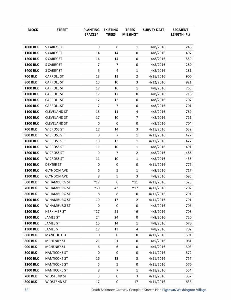
APPENDIX II: STREET TREE INVENTORY
Introduction
As part of the Complete Streets inventory process, basic information about the presence of street tree planting
spaces and street trees was collected and catalogued in a geodatabase during the spring of 2016. The inventory
and corresponding maps are representative of trees in the right of way. Trees that are located in adjacent
property, such as a public park or private yard, are not included. This information was collected on a block-by-
block basis to coincide with the City’s street centerline GIS file. Maps intentionally show street tree data for all
areas inventoried within the view extent, not just the neighborhood of interest, in acknowledgement of the
importance of continuity of tree canopy when evaluating the urban forest. The data provide a point of reference
regarding the streetscape and street tree canopy along each street segment within the study area and the
dataset is intended to enable preliminary identification of where additional trees may be needed/desired. This
information should be supplemented with up-to-date field verification.
Note: the table and maps do not show information for streets classified as “service/alleyway,” “inactive,” or
“limited access highway,” which generally are not suitable for street trees. However, there are some cases where
trees or tree planting spaces exist on streets of those types.
The full set of data collected is available in GIS format through the City’s GIS system.
Street Tree Inventory Table
BLOCK STREET PLANTING SPACES*
EXISTING TREES
TREES MISSING*
SURVEY DATE SEGMENT LENGTH (Ft)
500 BLK ARCHER ST ~9 0 ~9 4/12/2016 415
600 BLK ARCHER ST 0 0 0 4/12/2016 342
200 BLK S ARLINGTON AVE ~10 0 ~10 4/8/2016 172
300 BLK S ARLINGTON AVE ~47 21 ~26 4/12/2016 1033
800 BLK W BARRE ST 17 14 3 4/11/2016 506
900 BLK W BARRE ST 16 12 4 4/11/2016 450
900 BLK BAYARD ST 1 1 0 4/8/2016 253
1000 BLK BAYARD ST 2 2 0 4/8/2016 247
1100 BLK BAYARD ST 10 9 1 4/8/2016 495
1200 BLK BAYARD ST 14 11 3 4/8/2016 560
1300 BLK BAYARD ST ~19 5 ~14 4/8/2016 562
1400 BLK BAYARD ST ~20 0 ~20 4/8/2016 438
1500 BLK BAYARD ST ~21 0 ~21 4/8/2016 446
1200 BLK BUSH ST 3 0 3 4/8/2016 650
1400 BLK BUSH ST 14 6 8 4/8/2016 1001
1500 BLK BUSH ST 13 13 0 4/8/2016 443
500 BLK CALLENDAR ST 0 0 0 4/12/2016 413
200 BLK S CAREY ST 7 4 3 4/12/2016 481
300 BLK S CAREY ST 1 0 1 4/12/2016 537
400 BLK S CAREY ST ~13 0 ~13 4/12/2016 411
800 BLK S CAREY ST 2 2 0 4/12/2016 269
900 BLK S CAREY ST 4 4 0 4/8/2016 254
32 South Baltimore Gateway Complete Streets Plan Pigtown/Washington Village
BLOCK STREET PLANTING SPACES*
EXISTING TREES
TREES MISSING*
SURVEY DATE SEGMENT LENGTH (Ft)
1000 BLK S CAREY ST 9 8 1 4/8/2016 248
1100 BLK S CAREY ST 14 14 0 4/8/2016 497
1200 BLK S CAREY ST 14 14 0 4/8/2016 559
1300 BLK S CAREY ST 7 7 0 4/8/2016 280
1400 BLK S CAREY ST 5 4 1 4/8/2016 281
700 BLK CARROLL ST 13 11 2 4/11/2016 900
800 BLK CARROLL ST 13 10 3 4/12/2016 921
1100 BLK CARROLL ST 17 16 1 4/8/2016 765
1200 BLK CARROLL ST 17 17 0 4/8/2016 718
1300 BLK CARROLL ST 12 12 0 4/8/2016 707
1400 BLK CARROLL ST 7 7 0 4/8/2016 701
1100 BLK CLEVELAND ST 15 11 4 4/8/2016 769
1200 BLK CLEVELAND ST 17 10 7 4/8/2016 711
1300 BLK CLEVELAND ST 0 0 0 4/8/2016 704
700 BLK W CROSS ST 17 14 3 4/11/2016 632
900 BLK W CROSS ST 8 7 1 4/11/2016 427
1000 BLK W CROSS ST 13 12 1 4/11/2016 427
1100 BLK W CROSS ST 11 10 1 4/8/2016 491
1200 BLK W CROSS ST 9 7 2 4/8/2016 486
1300 BLK W CROSS ST 11 10 1 4/8/2016 435
1100 BLK DEXTER ST 0 0 0 4/11/2016 776
1200 BLK GLYNDON AVE 6 5 1 4/8/2016 717
1300 BLK GLYNDON AVE 8 5 3 4/8/2016 695
600 BLK W HAMBURG ST ~17 6 ~11 4/11/2016 525
700 BLK W HAMBURG ST ~60 43 ~17 4/11/2016 1202
800 BLK W HAMBURG ST 8 8 0 4/11/2016 291
1100 BLK W HAMBURG ST 19 17 2 4/11/2016 791
1400 BLK W HAMBURG ST 0 0 0 4/8/2016 706
1300 BLK HERKIMER ST ~27 21 ~6 4/8/2016 708
1200 BLK JAMES ST 24 24 0 4/8/2016 720
1100 BLK JAMES ST 15 14 1 4/8/2016 670
1300 BLK JAMES ST 17 13 4 4/8/2016 702
800 BLK MANGOLD ST 0 0 0 4/11/2016 591
800 BLK MCHENRY ST 21 21 0 4/5/2016 1081
900 BLK MCHENRY ST 6 6 0 4/5/2016 303
800 BLK NANTICOKE ST 0 0 0 4/11/2016 572
1100 BLK NANTICOKE ST 16 13 3 4/11/2016 757
1200 BLK NANTICOKE ST 5 5 0 4/11/2016 570
1300 BLK NANTICOKE ST 8 7 1 4/11/2016 554
700 BLK W OSTEND ST 3 0 3 4/11/2016 337
800 BLK W OSTEND ST 17 0 17 4/11/2016 636

South Baltimore Gateway Complete Streets Plan Pigtown/Washington Village 33
BLOCK STREET PLANTING SPACES*
EXISTING TREES
TREES MISSING*
SURVEY DATE SEGMENT LENGTH (Ft)
900 BLK W OSTEND ST 5 5 0 4/11/2016 449
1000 BLK W OSTEND ST 5 5 0 4/11/2016 437
1100 BLK W OSTEND ST 14 9 5 4/8/2016 561
1200 BLK W OSTEND ST 5 5 0 4/8/2016 559
1300 BLK W OSTEND ST 15 13 2 4/8/2016 491
1400 BLK W OSTEND ST ~19 6 ~13 4/8/2016 451
800 BLK S PACA ST ~16 3 ~13 4/11/2016 435
900 BLK S PACA ST ~24 17 ~7 4/11/2016 515
1000 BLK S PACA ST ~22 13 ~9 4/11/2016 519
1100 BLK S PACA ST ~26 17 ~9 4/11/2016 512
1200 BLK S PACA ST 7 0 7 4/11/2016 513
200 BLK PARKIN ST 7 7 0 4/5/2016 527
500 BLK PARKIN ST 0 0 0 4/11/2016 412
600 BLK PARKIN ST 0 0 0 4/11/2016 342
300 BLK S POPPLETON ST 14 14 0 4/5/2016 527
400 BLK S POPPLETON ST 8 6 2 4/5/2016 369
800 BLK W PRATT ST 19 17 2 4/12/2016 822
900 BLK W PRATT ST 9 9 0 4/12/2016 606
1000 BLK W PRATT ST 14 12 2 4/12/2016 520
1100 BLK W PRATT ST 15 12 3 4/12/2016 528
1200 BLK W PRATT ST 11 9 2 4/12/2016 500
900 BLK RAMSAY ST 13 12 1 4/5/2016 605
1100 BLK RAMSAY ST 0 0 0 4/8/2016 97
900 BLK RYAN ST 5 4 1 4/5/2016 301
1100 BLK SARGEANT ST 15 15 0 4/8/2016 765
1200 BLK SARGEANT ST 0 0 0 4/8/2016 719
1300 BLK SARGEANT ST 4 4 0 4/8/2016 803
500 BLK SCOTT ST 9 9 0 4/5/2016 168
600 BLK SCOTT ST 7 7 0 4/5/2016 217
900 BLK SCOTT ST 7 7 0 4/5/2016 228
1000 BLK SCOTT ST 5 5 0 4/5/2016 338
1100 BLK SCOTT ST 0 0 0 4/5/2016 73
1200 BLK SCOTT ST 10 7 3 4/11/2016 1010
400 BLK SCOTT ST 19 19 0 4/5/2016 374
500 BLK SCOTT ST 7 7 0 4/5/2016 247
600 BLK SCOTT ST 5 4 1 4/5/2016 126
700 BLK SCOTT ST 4 3 1 4/5/2016 89
900 BLK STERRETT ST 0 0 0 4/11/2016 468
1000 BLK STERRETT ST 0 0 0 4/11/2016 508
1100 BLK WARD ST 4 4 0 4/8/2016 770
1200 BLK WARD ST 8 8 0 4/8/2016 702

34 South Baltimore Gateway Complete Streets Plan Pigtown/Washington Village
BLOCK STREET PLANTING SPACES*
EXISTING TREES
TREES MISSING*
SURVEY DATE SEGMENT LENGTH (Ft)
1300 BLK WARD ST 14 14 0 4/8/2016 703
1400 BLK WARD ST 0 0 0 4/8/2016 707
700 BLK WASHINGTON BLVD 11 11 0 4/8/2016 484
800 BLK WASHINGTON BLVD 36 29 7 4/8/2016 821
900 BLK WASHINGTON BLVD 6 6 0 4/8/2016 234
1000 BLK WASHINGTON BLVD 7 6 1 4/8/2016 246
1100 BLK WASHINGTON BLVD 8 7 1 4/8/2016 768
1200 BLK WASHINGTON BLVD 25 25 0 4/8/2016 716
1300 BLK WASHINGTON BLVD 24 24 0 4/8/2016 700
1500 BLK WASHINGTON BLVD 4 4 0 4/8/2016 699
800 BLK W WEST ST 3 2 1 4/11/2016 244
1100 BLK WICOMICO ST 5 4 1 4/5/2016 728
1400 BLK WICOMICO ST 21 13 8 4/5/2016 707
800 BLK WOODWARD ST 12 9 3 4/11/2016 617
500 BLK WYETH ST 5 4 1 4/12/2016 412
600 BLK WYETH ST 0 0 0 4/11/2016 679
* Where continuous planting strips are present, estimates were generated using a 30 ft. on center spacing factor Note: figures reflect street trees and planting areas on either side of the street and does not include medians. See the map of median trees for further consideration; existing trees includes large shrubs in some cases.

South Baltimore Gateway Complete Streets Plan Pigtown/Washington Village 35
Street Tree Maps
Trees in the Median: Exhibit 1 highlights those segments of street in the Pigtown neighborhood where a median
exists and whether trees are present in the median (indicated as green segments).
Trees on the right and left sides of street: Exhibit 2 depicts the presence of street trees on each side of the street.
A red line represents no street trees on that segment of street. A yellow line indicates there is one or more street
trees on one side of that segment of street. A green line indicates there are street trees on both sides along that
segment of street. This map may be useful to determine where trees already exist and the areas where the
addition on trees may be needed/desired. Information about physical site constraints, such as overhead wires,
below ground utilities, and the presence of trees and other plants in adjacent areas should be considered in
determining the extent to which additional street trees are appropriate.
Percent of planting spaces filled: Exhibit 3 represents the percent of street tree planting spaces filled along each
segment of street centerline. Information about physical site constraints, such as overhead wires, below ground
utilities, and the presence of trees and other plants in adjacent areas should be considered in determining the
extent to which additional street trees are appropriate.
EXHIBIT 1 Street Trees in Median

36 South Baltimore Gateway Complete Streets Plan Pigtown/Washington Village
EXHIBIT 2 Street Trees On Each Side of the Street

South Baltimore Gateway Complete Streets Plan Pigtown/Washington Village 37
EXHIBIT 3 Percent of Planting Spaces Filled

38 South Baltimore Gateway Complete Streets Plan Pigtown/Washington Village
APPENDIX III: TRAFFIC MITIGATION ZONES
Baltimore City Department of Transportation Traffic Mitigation Zones

South Baltimore Gateway Complete Streets Plan Pigtown/Washington Village 39
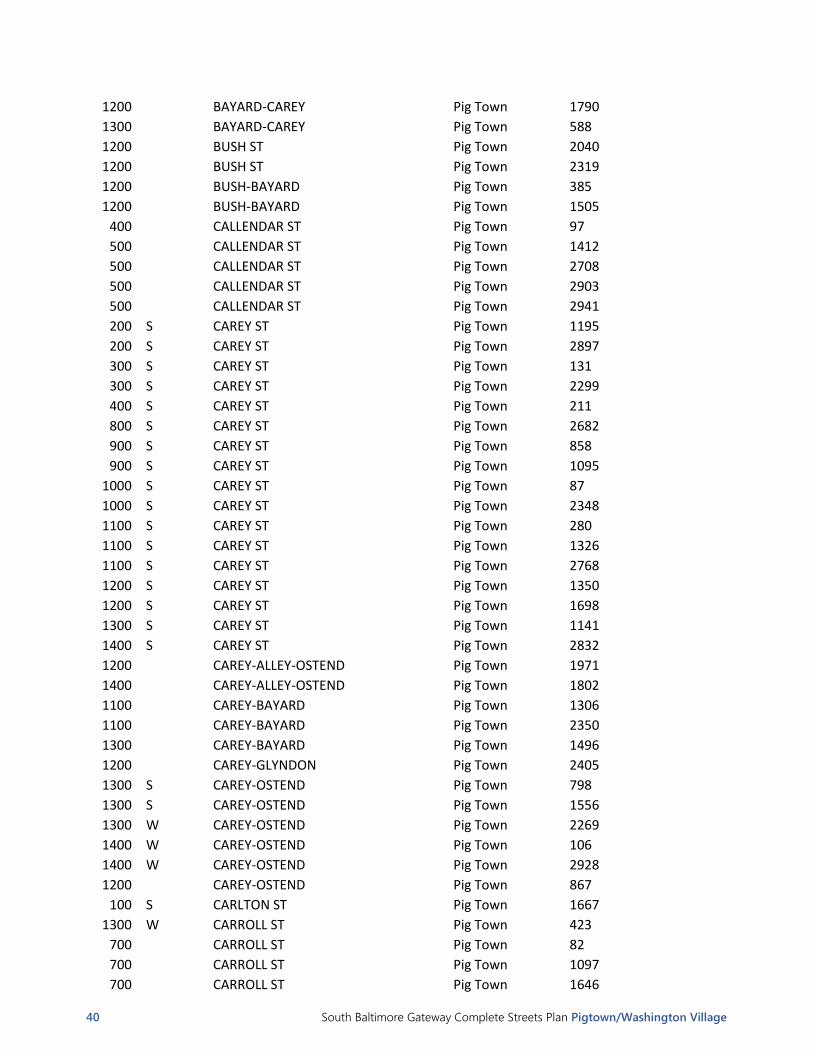
APPENDIX IV: Photo Guide
PHOTO GUIDE - PIG TOWN
BLOCK NSEW STREET NEIGHBORHOOD PHOTO NUMBER
900 ALLEY-BAYARD-CAREY Pig Town 189
900 ALLEY-BAYARD-CAREY Pig Town 1981
1100 ALLEY-CAREY-OSTEND Pig Town 41
1200 ALLEY-CAREY-OSTEND Pig Town 903
200 S AMITY ST Pig Town 1755
300 S AMITY ST Pig Town 229
400 S AMITY ST Pig Town 1129
400 S AMITY ST Pig Town 1454
500 ARCHER ST Pig Town 72
500 ARCHER ST Pig Town 1911
600 ARCHER ST Pig Town 2222
600 ARCHER-WYETH Pig Town 359
200 S ARLINGTON AVE Pig Town 214
300 S ARLINGTON AVE Pig Town 1805
800 W BARRE ST Pig Town 1360
800 W BARRE ST Pig Town 1431
800 W BARRE ST Pig Town 1926
800 W BARRE ST Pig Town 2858
900 W BARRE ST Pig Town 1763
900 W BARRE ST Pig Town 3006
1100 BAYARD ST Pig Town 590
1200 BAYARD ST Pig Town 724
1200 BAYARD ST Pig Town 1156
1300 BAYARD ST Pig Town 2163
1300 BAYARD ST Pig Town 2422
1000 BAYARD-ALLEY-CAREY Pig Town 797
1200 BAYARD-ALLEY-CAREY Pig Town 2761
1200 BAYARD-ALLEY-CAREY Pig Town 2835
1300 BAYARD-ALLEY-CAREY Pig Town 1219
1300 BAYARD-ALLEY-CAREY Pig Town 2566
1200 BAYARD-BUSH Pig Town 2869
900 BAYARD-CAREY Pig Town 1930
900 BAYARD-CAREY Pig Town 2158
1100 BAYARD-CAREY Pig Town 1179
1100 BAYARD-CAREY Pig Town 2061
40 South Baltimore Gateway Complete Streets Plan Pigtown/Washington Village
1200 BAYARD-CAREY Pig Town 1790
1300 BAYARD-CAREY Pig Town 588
1200 BUSH ST Pig Town 2040
1200 BUSH ST Pig Town 2319
1200 BUSH-BAYARD Pig Town 385
1200 BUSH-BAYARD Pig Town 1505
400 CALLENDAR ST Pig Town 97
500 CALLENDAR ST Pig Town 1412
500 CALLENDAR ST Pig Town 2708
500 CALLENDAR ST Pig Town 2903
500 CALLENDAR ST Pig Town 2941
200 S CAREY ST Pig Town 1195
200 S CAREY ST Pig Town 2897
300 S CAREY ST Pig Town 131
300 S CAREY ST Pig Town 2299
400 S CAREY ST Pig Town 211
800 S CAREY ST Pig Town 2682
900 S CAREY ST Pig Town 858
900 S CAREY ST Pig Town 1095
1000 S CAREY ST Pig Town 87
1000 S CAREY ST Pig Town 2348
1100 S CAREY ST Pig Town 280
1100 S CAREY ST Pig Town 1326
1100 S CAREY ST Pig Town 2768
1200 S CAREY ST Pig Town 1350
1200 S CAREY ST Pig Town 1698
1300 S CAREY ST Pig Town 1141
1400 S CAREY ST Pig Town 2832
1200 CAREY-ALLEY-OSTEND Pig Town 1971
1400 CAREY-ALLEY-OSTEND Pig Town 1802
1100 CAREY-BAYARD Pig Town 1306
1100 CAREY-BAYARD Pig Town 2350
1300 CAREY-BAYARD Pig Town 1496
1200 CAREY-GLYNDON Pig Town 2405
1300 S CAREY-OSTEND Pig Town 798
1300 S CAREY-OSTEND Pig Town 1556
1300 W CAREY-OSTEND Pig Town 2269
1400 W CAREY-OSTEND Pig Town 106
1400 W CAREY-OSTEND Pig Town 2928
1200 CAREY-OSTEND Pig Town 867
100 S CARLTON ST Pig Town 1667
1300 W CARROLL ST Pig Town 423
700 CARROLL ST Pig Town 82
700 CARROLL ST Pig Town 1097
700 CARROLL ST Pig Town 1646

South Baltimore Gateway Complete Streets Plan Pigtown/Washington Village 41
800 CARROLL ST Pig Town 710
800 CARROLL ST Pig Town 794
800 CARROLL ST Pig Town 2144
800 CARROLL ST Pig Town 2184
800 CARROLL ST Pig Town 2382
800 CARROLL ST Pig Town 2637
800 CARROLL ST Pig Town 2735
800 CARROLL ST Pig Town 3009
1100 CARROLL ST Pig Town 2104
1100 CARROLL ST Pig Town 2441
1200 CARROLL ST Pig Town 334
1200 CARROLL ST Pig Town 2987
1300 CARROLL ST Pig Town 1561
1300 CARROLL ST Pig Town 1848
1300 CARROLL ST Pig Town 1918
1400 CARROLL ST Pig Town 420
1400 CARROLL ST Pig Town 1659
1100 CARROLL-CLEVELAND Pig Town 762
1200 CARROLL-CLEVELAND Pig Town 83
1300 CARROLL-CLEVELAND Pig Town 1803
600 CARROLL-CROSS Pig Town 1604
1100 CLEVELAND ST Pig Town 580
1100 CLEVELAND ST Pig Town 2446
1200 CLEVELAND ST Pig Town 457
1200 CLEVELAND ST Pig Town 685
1200 CLEVELAND ST Pig Town 2370
1300 CLEVELAND ST Pig Town 1231
1300 CLEVELAND ST Pig Town 1252
1300 CLEVELAND ST Pig Town 1534
1300 CLEVELAND ST Pig Town 1764
1100 CLEVELAND-NANTICOKE Pig Town 1704
1200 CLEVELAND-NANTICOKE Pig Town 489
800 CLIFFORD ST Pig Town 1229
800 CLIFFORD ST Pig Town 3163
900 CLIFFORD ST Pig Town 2638
700 W CROSS ST Pig Town 47
700 W CROSS ST Pig Town 1117
900 W CROSS ST Pig Town 191
1000 W CROSS ST Pig Town 852
1000 W CROSS ST Pig Town 2178
1100 W CROSS ST Pig Town 443
1100 W CROSS ST Pig Town 1907
1200 W CROSS ST Pig Town 192
1200 W CROSS ST Pig Town 270
1200 W CROSS ST Pig Town 626

42 South Baltimore Gateway Complete Streets Plan Pigtown/Washington Village
1200 W CROSS ST Pig Town 2122
1300 W CROSS ST Pig Town 459
1300 W CROSS ST Pig Town 735
1300 W CROSS ST Pig Town 835
1300 W CROSS ST Pig Town 2597
1300 W CROSS ST Pig Town 2771
1300 W CROSS ST Pig Town 2994
700
CROSS-ALLEY-WEST Pig Town 2632
500
CROSS-CALLENDER Pig Town 1676
700
CROSS-WEST Pig Town 332
700
CROSS-WEST Pig Town 2870
1100
DEXTER ST Pig Town 1853
1100
DEXTER ST Pig Town 2406
700
EISLEN ST Pig Town 2250
800
EISLEN ST Pig Town 2598
1200
GLYNDON AVE Pig Town 349
1200
GLYNDON AVE Pig Town 1617
1200
GLYNDON AVE Pig Town 2394
1300
GLYNDON AVE Pig Town 544
1300
GLYNDON AVE Pig Town 1439
1300
GLYNDON AVE Pig Town 1442
1300
GLYNDON AVE Pig Town 1662
1200
GLYNDON-JAMES Pig Town 6
1300
GLYNDON-JAMES Pig Town 127
600 W HAMBURG ST Pig Town 111
700 W HAMBURG ST Pig Town 623
700 W HAMBURG ST Pig Town 721
700 W HAMBURG ST Pig Town 2100
800 W HAMBURG ST Pig Town 57
1100 W HAMBURG ST Pig Town 800
700
HAMBURG-CROSS Pig Town 306
1300
HERKIMER ST Pig Town 1040
1300
HERKIMER ST Pig Town 1043
1300
HERKIMER ST Pig Town 1574
1300
HERKIMER-GLYNDON Pig Town 269
1100
JAMES ST Pig Town 2545
1200
JAMES ST Pig Town 1756
1200
JAMES ST Pig Town 2115
1300
JAMES ST Pig Town 1026
1300
JAMES ST Pig Town 1635
1200
JAMES-SARGEANT Pig Town 2323A
1200
JAMES-SARGEANT Pig Town 2323
1300
JAMES-SARGEANT Pig Town 416
800
MANGOLD ST Pig Town 802
600 S MARTIN LUTHER KING JR BLVD Pig Town 608

South Baltimore Gateway Complete Streets Plan Pigtown/Washington Village 43
800
MCHENRY ST Pig Town 30
800
MCHENRY ST Pig Town 834
900
MCHENRY ST Pig Town 392
1300
MCHENRY ST Pig Town 1418
100
MOUNT CLARE ST Pig Town 1453
800
NANTICOKE ST Pig Town 118
800
NANTICOKE ST Pig Town 1123
800
NANTICOKE ST Pig Town 1898
800
NANTICOKE ST Pig Town 2896
1100
NANTICOKE ST Pig Town 691
1100
NANTICOKE ST Pig Town 1422
1100
NANTICOKE ST Pig Town 3011
1000 W OSTEND ST Pig Town 2402
1100 W OSTEND ST Pig Town 258
1100 W OSTEND ST Pig Town 1502
1100 W OSTEND ST Pig Town 1786
1100 W OSTEND ST Pig Town 2751
1200 W OSTEND ST Pig Town 1547
1200 W OSTEND ST Pig Town 1813
1200 W OSTEND ST Pig Town 2307
1200 W OSTEND ST Pig Town 2774
1200 W OSTEND ST Pig Town 2960
1200 W OSTEND ST Pig Town 2970
1300 W OSTEND ST Pig Town 966
1300 W OSTEND ST Pig Town 1881
1300 W OSTEND ST Pig Town 2511
1300 W OSTEND ST Pig Town 2740
1400 W OSTEND ST Pig Town 146
1400 W OSTEND ST Pig Town 690
1400 W OSTEND ST Pig Town 2398
1200
OSTEND-CAREY Pig Town 1721
800
OSTEND-CROSS Pig Town 853
800
OSTEND-CROSS Pig Town 1500
1000
OSTEND-CROSS Pig Town 1568
1000
OSTEND-CROSS Pig Town 2396
1100
OSTEND-CROSS Pig Town 406
1100
OSTEND-CROSS Pig Town 421
1100
OSTEND-CROSS Pig Town 1927
1100
OSTEND-CROSS Pig Town 2110
1200
OSTEND-CROSS Pig Town 2
1200
OSTEND-CROSS Pig Town 491
1200
OSTEND-CROSS Pig Town 1774
500
OTTERBEIN ST Pig Town 286
500
OTTERBEIN ST Pig Town 2125
800 S PACA ST Pig Town 1169

44 South Baltimore Gateway Complete Streets Plan Pigtown/Washington Village
900 S PACA ST Pig Town 1555
1100 S PACA ST Pig Town 1105
1100 S PACA ST Pig Town 1223
100
PARKIN ST Pig Town 2177
200
PARKIN ST Pig Town 1175
300
PARKIN ST Pig Town 208
300
PARKIN ST Pig Town 1493
300
PARKIN ST Pig Town 2936
500
PARKIN ST Pig Town 538
500
PARKIN ST Pig Town 1446
600
PARKIN ST Pig Town 53
600
PARKIN ST Pig Town 3103
600
PARKIN ST Pig Town 3130
600
PARKIN ST Pig Town 3146
300 S POPPLETON ST Pig Town 372
300 S POPPLETON ST Pig Town 1675
400 S POPPLETON ST Pig Town 1403
400 S POPPLETON ST Pig Town 1432
800 W PRATT ST Pig Town 65
800 W PRATT ST Pig Town 1995
800 W PRATT ST Pig Town 2721
900 W PRATT ST Pig Town 1518
900 W PRATT ST Pig Town 2794
1000 W PRATT ST Pig Town 93
1100 W PRATT ST Pig Town 494
1100 W PRATT ST Pig Town 974
1200 W PRATT ST Pig Town 2684
700
RAMSAY ST Pig Town 305
800
RAMSAY ST Pig Town 483
800
RAMSAY ST Pig Town 1039
800
RAMSAY ST Pig Town 1494
800
RAMSAY ST Pig Town 1800
800
RAMSAY ST Pig Town 1956
800
RAMSAY ST Pig Town 2041
800
RAMSAY ST Pig Town 2180
800
RAMSAY ST Pig Town 2501
800
RAMSAY ST Pig Town 2502
900
RAMSAY ST Pig Town 1323
900
RAMSAY ST Pig Town 2947
1100
RAMSAY ST Pig Town 431
1300
RAMSAY ST Pig Town 2415
800
REINHARDT ST Pig Town 692
200
ROUNDHOUSE CT Pig Town 408
200
ROUNDHOUSE CT Pig Town 1957
800
RYAN ST Pig Town 260

South Baltimore Gateway Complete Streets Plan Pigtown/Washington Village 45
800
RYAN ST Pig Town 655
800
RYAN ST Pig Town 905
800
RYAN ST Pig Town 1281
800
RYAN ST Pig Town 1307
800
RYAN ST Pig Town 2504
900
RYAN ST Pig Town 358
1100
SARGEANT ST Pig Town 273
1200
SARGEANT ST Pig Town 114
1200
SARGEANT ST Pig Town 373
1200
SARGEANT ST Pig Town 2150
1300
SARGEANT ST Pig Town 649
1300
SARGEANT ST Pig Town 906
1300
SARGEANT ST Pig Town 1149
1100
SARGEANT-WASHINGTON Pig Town 2813
1200
SARGEANT-WASHINGTON Pig Town 909
1200
SARGEANT-WASHINGTON Pig Town 2514
1300
SARGEANT-WASHINGTON Pig Town 204
1300
SARGEANT-WASHINGTON Pig Town 1132
300
SCOTT ST Pig Town 2234
400
SCOTT ST Pig Town 266
400
SCOTT ST Pig Town 503
500
SCOTT ST Pig Town 249
500
SCOTT ST Pig Town 1367
500
SCOTT ST Pig Town 2562
600
SCOTT ST Pig Town 1864
600
SCOTT ST Pig Town 2776
700
SCOTT ST Pig Town 2621
900
SCOTT ST Pig Town 2106
1000
SCOTT ST Pig Town 281
1000
SCOTT ST Pig Town 738
1100
SCOTT ST Pig Town 49
1100
SCOTT ST Pig Town 2242
1200
SCOTT-PACA Pig Town 796
1100
SCOTT-STERRETT Pig Town 1083
1100
SCOTT-STERRETT ST Pig Town 1758
900
STERRETT ST Pig Town 597
900
STERRETT ST Pig Town 848
900
STERRETT ST Pig Town 1387
1000
STERRETT ST Pig Town 2596
1100
STERRETT ST Pig Town 488
1100
STERRETT ST Pig Town 1687
1100
STERRETT-PACA Pig Town 2843
1400 W W WICOMICO ST Pig Town 74
1400 W WARD ST Pig Town 566
1100
WARD ST Pig Town 615
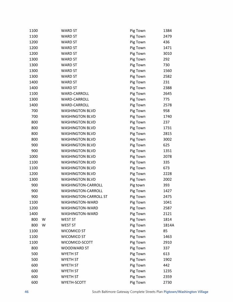
46 South Baltimore Gateway Complete Streets Plan Pigtown/Washington Village
1100 WARD ST Pig Town 1384
1100 WARD ST Pig Town 2479
1200 WARD ST Pig Town 436
1200 WARD ST Pig Town 1471
1200 WARD ST Pig Town 3010
1300 WARD ST Pig Town 292
1300 WARD ST Pig Town 730
1300 WARD ST Pig Town 1560
1300 WARD ST Pig Town 2582
1400 WARD ST Pig Town 231
1400 WARD ST Pig Town 2388
1100 WARD-CARROLL Pig Town 2645
1300 WARD-CARROLL Pig Town 775
1400 WARD-CARROLL Pig Town 2578
700 WASHINGTON BLVD Pig Town 958
700 WASHINGTON BLVD Pig Town 1740
800 WASHINGTON BLVD Pig Town 237
800 WASHINGTON BLVD Pig Town 1731
800 WASHINGTON BLVD Pig Town 2815
800 WASHINGTON BLVD Pig Town 3002
900 WASHINGTON BLVD Pig Town 625
900 WASHINGTON BLVD Pig Town 1351
1000 WASHINGTON BLVD Pig Town 2078
1100 WASHINGTON BLVD Pig Town 335
1100 WASHINGTON BLVD Pig Town 673
1200 WASHINGTON BLVD Pig Town 2228
1300 WASHINGTON BLVD Pig Town 2002
900 WASHINGTON-CARROLL Pig town 393
900 WASHINGTON-CARROLL Pig Town 1427
900 WASHINGTON-CARROLL ST Pig Town 2475
1100 WASHINGTON-WARD Pig Town 1041
1200 WASHINGTON-WARD Pig Town 2587
1400 WASHINGTON-WARD Pig Town 2121
800 W WEST ST Pig Town 1814
800 W WEST ST Pig Town 1814A
1100 WICOMICO ST Pig Town 85
1100 WICOMICO ST Pig Town 1463
1100 WICOMICO-SCOTT Pig Town 2910
800 WOODWARD ST Pig Town 337
500 WYETH ST Pig Town 613
500 WYETH ST Pig Town 1902
600 WYETH ST Pig Town 442
600 WYETH ST Pig Town 1235
600 WYETH ST Pig Town 2359
600 WYETH-SCOTT Pig Town 2730

South Baltimore Gateway Complete Streets Plan Pigtown/Washington Village 47

South Baltimore Gateway Complete Streets Plan Pigtown/Washington Village 48

South Baltimore Gateway Complete Streets Plan Pigtown/Washington Village 49

South Baltimore Gateway Complete Streets Plan Pigtown/Washington Village 50
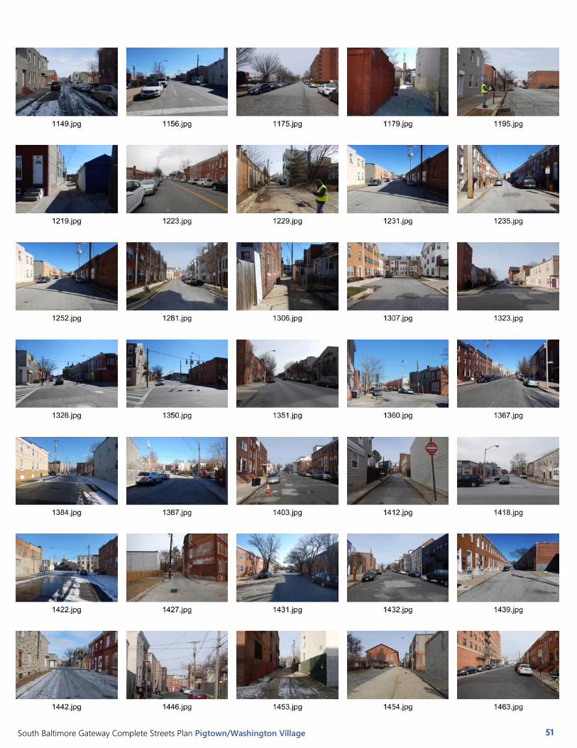
South Baltimore Gateway Complete Streets Plan Pigtown/Washington Village 51

South Baltimore Gateway Complete Streets Plan Pigtown/Washington Village 52

South Baltimore Gateway Complete Streets Plan Pigtown/Washington Village 53

South Baltimore Gateway Complete Streets Plan Pigtown/Washington Village 54
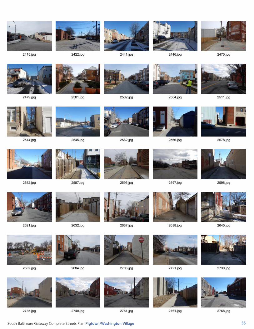
South Baltimore Gateway Complete Streets Plan Pigtown/Washington Village 55

South Baltimore Gateway Complete Streets Plan Pigtown/Washington Village 56