EXERCISE NO. 1 CHART INFORMATION - Splash Maritime · a. At a speed of 9 knots, how far will a...
30
Ranger Hope © 2008, revised v3 2016 1 COXSWAIN NAV. EXERCISES AUS197 (Inc M24 Supplement) NAME: A deviation card is supplied at the end of this workbook. Check the answers Validates to TDMMH1207B and MARH001 Plan and navigate a passage for a vessel up to 12 metres Validates with supplement to MARH004 Plan and navigate a passage for a vessel up to 80 metres EXERCISE NO. 1 CHART INFORMATION Question 1 (Validates to TDMMH1207B Element 1a) The Chart information of AUS 197 indicates that: (Circle the correct answer.) a. Chart Datum is approximately the level of LAT. TRUE FALSE b. Depths and Heights are in measures of fathoms and feet. TRUE FALSE c. INWARD bound vessels must not enter AREA C TRUE FALSE d. All positions are related to WGS 1984 survey datum. TRUE FALSE Question 2 (Validates to TDMMH1207B Element 1a) When and what were the Chart’s most recent small corrections? _______________________________________________________
-
Upload
trinhkhanh -
Category
Documents
-
view
215 -
download
0
Transcript of EXERCISE NO. 1 CHART INFORMATION - Splash Maritime · a. At a speed of 9 knots, how far will a...
Ranger Hope © 2008, revised v3 2016 1
COXSWAIN NAV. EXERCISES AUS197 (Inc M24 Supplement) NAME:
A deviation card is supplied at the end of this workbook. Check the answers Validates to TDMMH1207B and MARH001 Plan and navigate a passage for a vessel up to 12 metres Validates with supplement to MARH004 Plan and navigate a passage for a vessel up to 80 metres
EXERCISE NO. 1 CHART INFORMATION
Question 1 (Validates to TDMMH1207B Element 1a)
The Chart information of AUS 197 indicates that:
(Circle the correct answer.)
a. Chart Datum is approximately the level of LAT.
TRUE FALSE
b. Depths and Heights are in measures of fathoms and feet.
TRUE FALSE
c. INWARD bound vessels must not enter AREA C
TRUE FALSE
d. All positions are related to WGS 1984 survey datum.
TRUE FALSE
Question 2 (Validates to TDMMH1207B Element 1a)
When and what were the Chart’s most recent small corrections?
_______________________________________________________
Ranger Hope © 2008, revised v3 2016 2
Question 3 (Validates to TDMMH1207B Element 1a)
Small corrections for charts are published in the:
a. Australian Notices to Mariners.
b. Marine Orders.
c. National Tide tables.
d. Australian Marine Notices.
Question 4 (Validates to TDMMH1207B Element 1a)
What is the purpose of a compass rose on the chart?
__________________________________________________________________
Question 5 (Validates to TDMMH1207B Element 1a)
Use Chart AUS 197 to identify a minute of latitude (i.e. distance of one nautical mile) Compare one minute of latitude to one minute of longitude. Why is longitude not used to measure distance?
__________________________________________________________________
__________________________________________________________________
Question 6 (Validates to TDMMH1207B Element 1a)
Name three nautical publications (additional to Qu. 3) of use in planning a passage.
__________________________________________________________________
__________________________________________________________________
__________________________________________________________________
Ranger Hope © 2008, revised v3 2016 3
EXERCISE NO. 2 CHART SYMBOLS AND ABBREVIATIONS
Question 1 (Validates to TDMMH1207B Element 1a)
Use Chart AUS 197 to name the position of any:
a. steep coast, cliffs. b. lighthouse with obscured sector.
c. rock that covers/uncovers. d. tower.
e. sandy shore. f. wreck.
Question 2 (Validates to TDMMH1207B Element 1a) South East of Macquarie is a chart symbol, S.Sh. What does it mean?
__________________________________________________________________
Question 3 (Validates to TDMMH1207B Element 1a) Describe the lighting characteristics of Macquarie Lt __________________________________________________________________
__________________________________________________________________
Question 4 (Validates to TDMMH1207B Element 1a) What does the magenta coloured rectangle between Sydney Heads signify? __________________________________________________________________
Question 5 (Validates to TDMMH1207B Element 1a) East of Cape Solander is a chart symbol, FL.Y. 5s. What is it?
__________________________________________________________________
Question 6 (Validates to TDMMH1207B Element 1a) What is the function of the light at Port Hacking, Oc. WR. 3s 12/9M? __________________________________________________________________
Ranger Hope © 2008, revised v3 2016 4
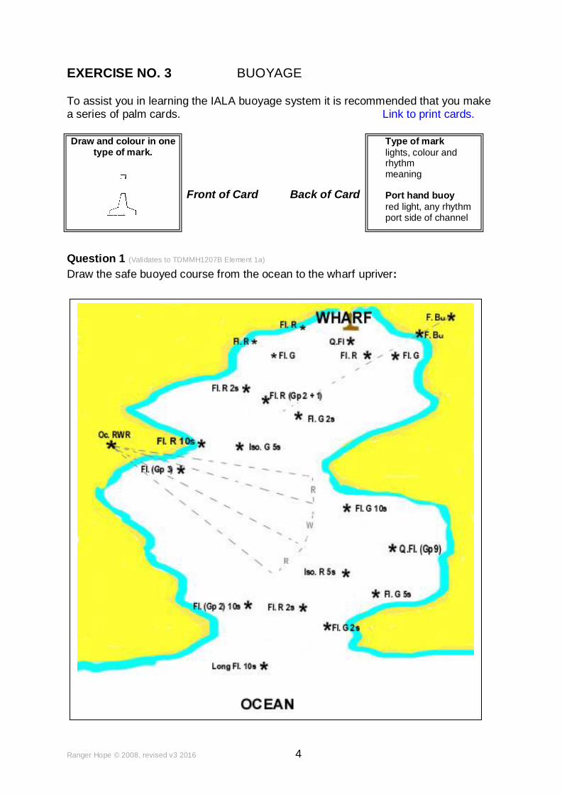
EXERCISE NO. 3 BUOYAGE
To assist you in learning the IALA buoyage system it is recommended that you make a series of palm cards. Link to print cards.
Front of Card Back of Card
Question 1 (Validates to TDMMH1207B Element 1a)
Draw the safe buoyed course from the ocean to the wharf upriver:
Draw and colour in one type of mark.
Type of mark
lights, colour and rhythm meaning Port hand buoy
red light, any rhythm port side of channel
Ranger Hope © 2008, revised v3 2016 5
EXERCISE NO. 4 POSITION - DISTANCE - DIRECTION
Question 1 (Validates to TDMMH1207B Element 1a) Identify the place names from following GPS derived positions.
a. 34o 00'.0S 151o 15'.0E
b. 33o 46'.1S 151o 18'.1E
c. 33o 55'.5S 151o 15'.9E
d. 33o 49'.4S 151
o 18'.0E
Find the geographical position of the following.
e. Barrenjoey Head Lt.
f. Mt. Pleasant (112) near Woy Woy
g. Wreck in depth of 48 mtrs 2.3 nm east of Avalon
Question 2 (Validates to TDMMH1207B Element 2a) What is the distance in nautical miles between Box Head and Barrenjoey Lt? __________________________________________________________________
Question 3 (Validates to TDMMH1207B Element 2a) What is the distance in nautical miles between North & South Head Lts?
__________________________________________________________________
Question 4 (Validates to TDMMH1207B Element 2b)
Find the distance and true directions between the following features /GPS positions.
FROM TO
a. Centre of south compass rose. Macquarie Lt.
b. 34o
00'.0S 151o 20'.0E 33
o 50'.0S 151
o 30'.0E
c. Bluefish Point (near Sydney) Boora Point (near Botany)
d. 33o 36'.3S 151
o 19'.6E 33
o 35'.7S 151
o 34'.5E
Ranger Hope © 2008, revised v3 2016 6
EXERCISE No.5 SPEED DISTANCE AND TIME
Question 1 (Validates to TDMMH1207B Element 4d) a. At a speed of 9 knots, how far will a vessel travel in 4 hours?
b. What speed will a vessel require to travel 27nm in 3 hours?
c. How long will a vessel take to travel 32nm at 8 knots?
Question 2 (Validates to TDMMH1207B Element 4d) a. At a speed of 9 knots, how far will a vessel travel in 3 hours 15 minutes?
b. What speed will a vessel require to travel 13.5 nm in 2 hours 42 minutes?
c. How long will a vessel take to travel 23 nm at 8 knots?
Question 4 (Validates to TDMMH1207B Element 4d) A vessel departs Pittwater at 09:25 and steams eastward at 10 kts to cross the 100 mtrs sounding contour at 11:00. What distance should she have travelled? Question 5 (Validates to TDMMH1207B Element 4d) A south bound vessel off Diamond Bay (33o 51'.9S) sees a Water Tower (129) Ø with a beacon. Twelve minutes later she sees a Tower (R Lts) in transit (Ø) with a Vent. If there are 1852 mtrs to a nautical mile, what speed is she achieving? Question 6 (Validates to TDMMH1207B Element 4d) At 14:00 a vessel departing Port Hacking reads 24mtrs on the echo sounder. Travelling at 7 kts, she rounds a special marker buoy and continues on to anchor in Long Bay in a depth of 3 mtrs. What will be the time of arrival?
Question 7 (Validates to TDMMH1207B Element 4d) At 05:45, a vessel departs from 34o 04'.55S 151o 38'.00E (SE of Port Jackson in 500 mtrs) inbound (steering 311
o T at 6.75 kts) to rendezvous with an outbound vessel
(4.5 kts) departing with North Head Lt. 0.6 nm abeam in 30 mtrs on a reciprocal course. When and where will they meet if they maintain their speeds and courses?
Ranger Hope © 2008, revised v3 2016 7
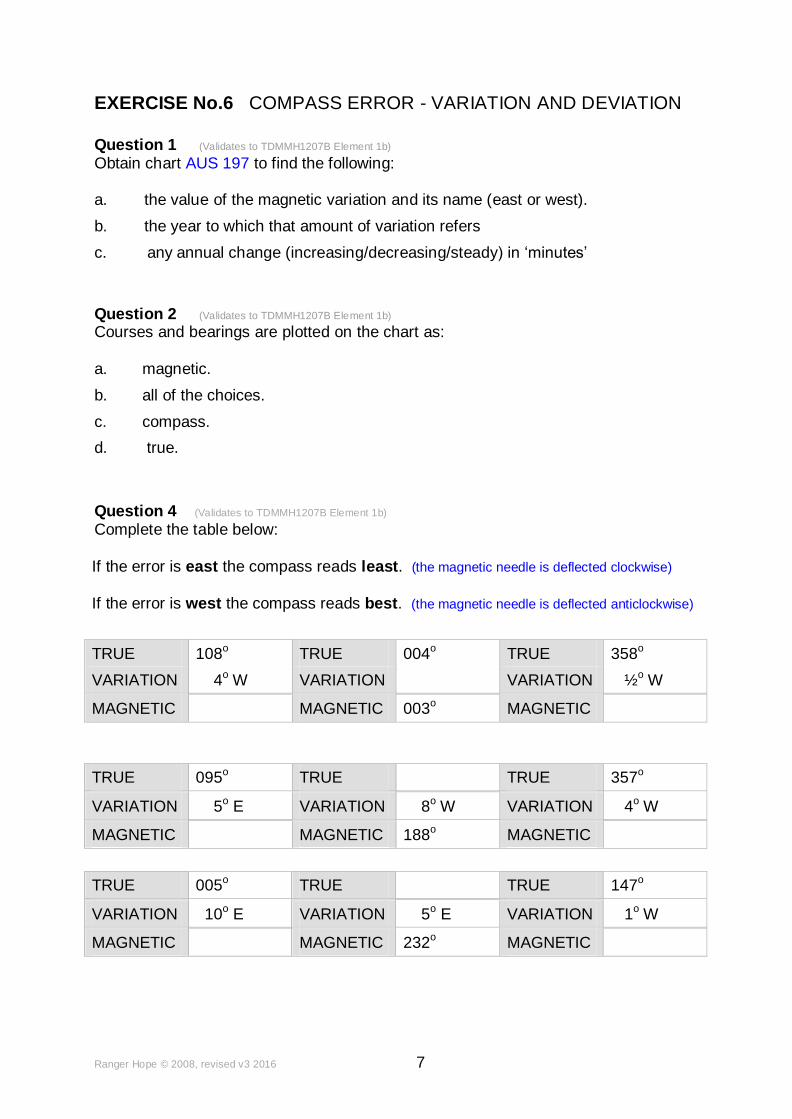
EXERCISE No.6 COMPASS ERROR - VARIATION AND DEVIATION
Question 1 (Validates to TDMMH1207B Element 1b)
Obtain chart AUS 197 to find the following:
a. the value of the magnetic variation and its name (east or west).
b. the year to which that amount of variation refers
c. any annual change (increasing/decreasing/steady) in ‘minutes’
Question 2 (Validates to TDMMH1207B Element 1b) Courses and bearings are plotted on the chart as: a. magnetic.
b. all of the choices.
c. compass.
d. true.
Question 4 (Validates to TDMMH1207B Element 1b) Complete the table below:
If the error is east the compass reads least. (the magnetic needle is deflected clockwise)
If the error is west the compass reads best. (the magnetic needle is deflected anticlockwise)
TRUE 108o TRUE 004o TRUE 358o
VARIATION 4o W VARIATION VARIATION ½o W
MAGNETIC MAGNETIC 003o MAGNETIC
TRUE 095o TRUE TRUE 357o
VARIATION 5o E VARIATION 8o W VARIATION 4o W
MAGNETIC MAGNETIC 188o MAGNETIC
TRUE 005o TRUE TRUE 147o
VARIATION 10o E VARIATION 5o E VARIATION 1o W
MAGNETIC MAGNETIC 232o MAGNETIC

Ranger Hope © 2008, revised v3 2016 8
Question 5 (Validates to TDMMH1207B Element 1b)
Complete the table below:
If the error is east the compass reads least. (the magnetic needle is deflected clockwise)
If the error is west the compass reads best. (the magnetic needle is deflected anticlockwise)
True Variation Magnetic
090o 13
o E
090o 13
o W
6o
E 281o
10o W 100o
000o 13
o E
353o 10
o W
012o 358
o
347o 360
o
Question 6 (Validates to TDMMH1207B Element 1b) Deviation of the compass is caused by: a. magnetic influences within the vessel.
b. the earth’s magnetic field.
c. friction in the compass.
d. the moon’s gravitational influence.
Question 7 (Validates to TDMMH1207B Element 1b) Compass error refers to: a. a mistake when taking an azimuth with a peloris.
b. the error between a gyro compass reading and the earth’s magnetic field.
c. the resultant effects of variation and deviation on a magnetic compass.
d. a deviation of the magnetic compass dependant on latitude.
Ranger Hope © 2008, revised v3 2016 9
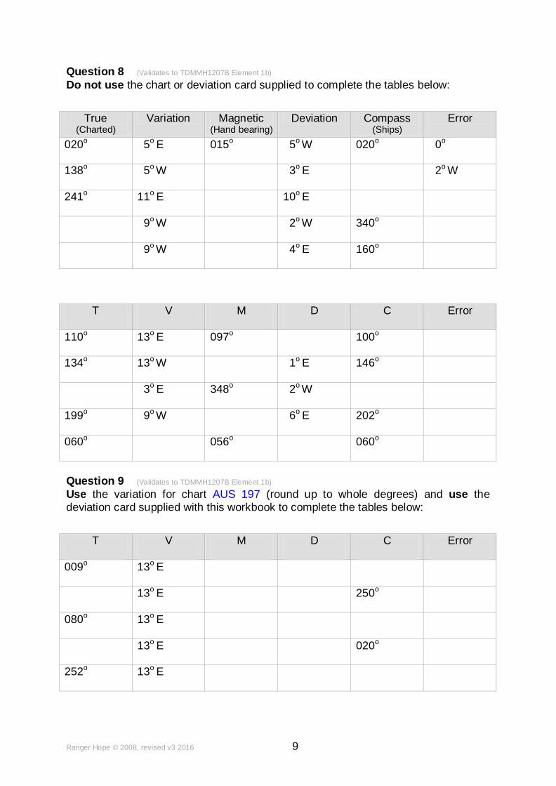
Question 8 (Validates to TDMMH1207B Element 1b)
Do not use the chart or deviation card supplied to complete the tables below:
True (Charted)
Variation Magnetic (Hand bearing)
Deviation Compass (Ships)
Error
020o 5o E 015o 5o W 020o 0o
138o 5o W 3o E 2o W
241o 11
o E 10
o E
9o W 2o W 340o
9o W 4o E 160o
T V M D C Error
110o 13
o E 097
o 100
o
134o 13o W 1o E 146o
3o
E 348o 2
o W
199o 9o W 6o E 202o
060o 056
o 060
o
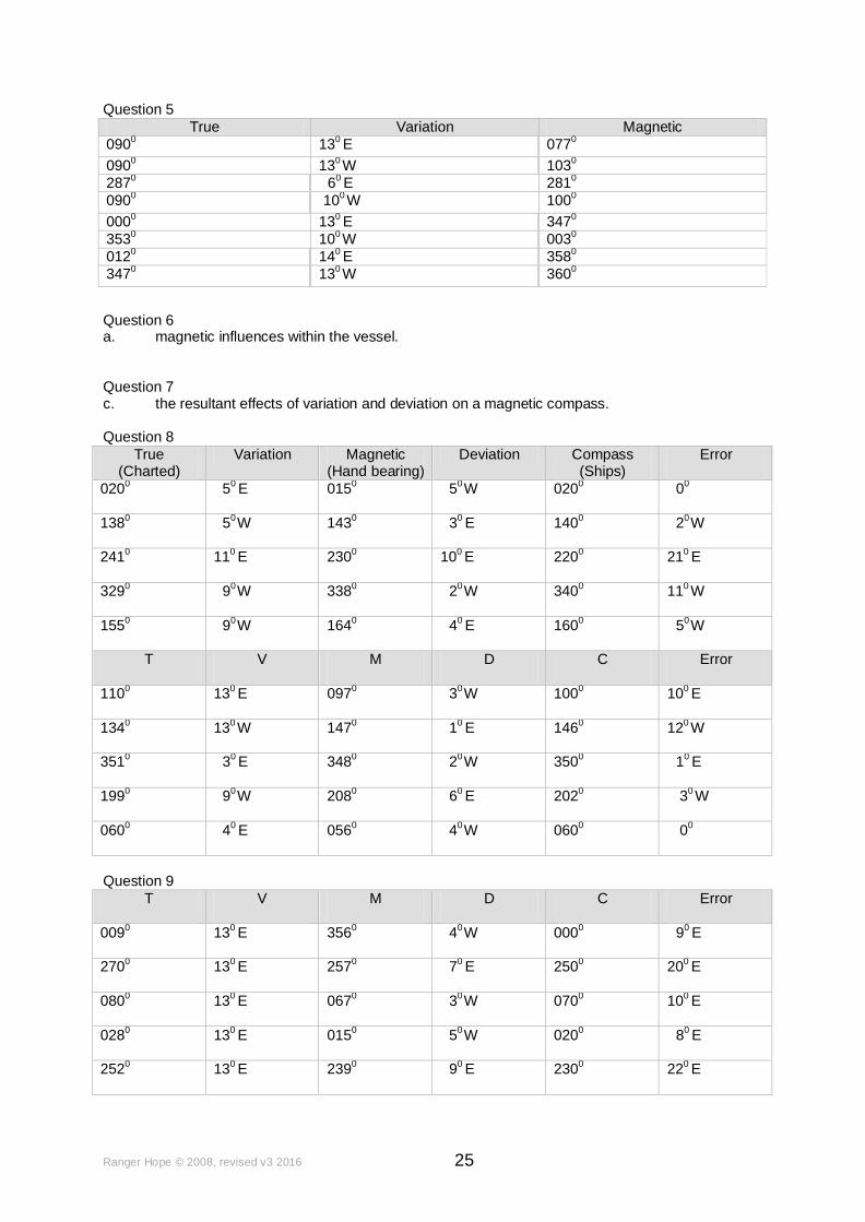
Question 9 (Validates to TDMMH1207B Element 1b)
Use the variation for chart AUS 197 (round up to whole degrees) and use the deviation card supplied with this workbook to complete the tables below:
T V M D C Error
009o 13
o E
13o E 250o
080o 13
o E
13o E 020o
252o 13o E

Ranger Hope © 2008, revised v3 2016 10
EXERCISE No.7 FIXING A POSITION
Question 1 (Validates to TDMMH1207B Element 4d)
From a position South East of Port Jackson, Grotto Point Lt. Ø South Head Lt., when the vessel is in 100 mtrs sounding. Fix the position of the vessel.
__________________________________________________________________
Question 2 (Validates to TDMMH1207B Element 4d)
From a position in approximately 38 mtrs soundings off Little Reef, a vessel notices that the Barrenjoey Lt. becomes obscured while its radar range is 5 nm. Fix the
position of the vessel.
__________________________________________________________________
Question 3 (Validates to TDMMH1207B Element 4d)
By radar range, the seaward edges of Barrenjoey Lt. and Box Head are 2 nm distant.
Lion Island is 2.7 nm distant. Fix the position of the vessel.
__________________________________________________________________
Question 4 (Validates to TDMMH1207B Element 1b)
Fix the position of the vessel using the magnetic bearings that were sighted.
T V M The bearings of these coastal features were taken with a hand bearing compass.
Pt. Hacking Pt. 228o
Cape Banks 256o
Wedding Cake Is. 309o
Position is:
Question 5 (Validates to TDMMH1207B Element 1b)
Fix the position of the vessel using the magnetic bearings that were sighted.
T V M The bearings of these coastal features were taken with a hand bearing compass.
Bangalley Hd. (117) 3110
Turimetta Hd. (59) 237o
Collaroy Twr. (128) 2200
Position is:
Ranger Hope © 2008, revised v3 2016 11
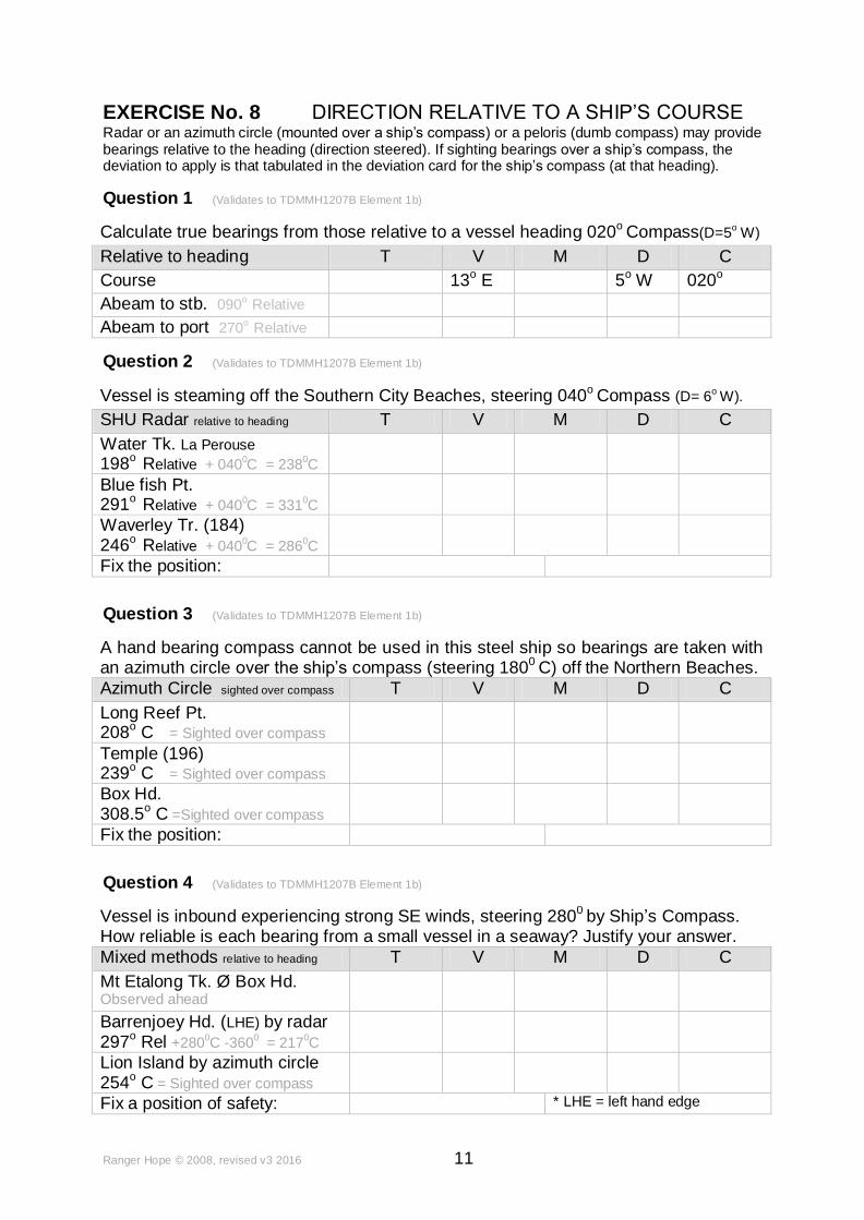
EXERCISE No. 8 DIRECTION RELATIVE TO A SHIP’S COURSE Radar or an azimuth circle (mounted over a ship’s compass) or a peloris (dumb compass) may provide bearings relative to the heading (direction steered). If sighting bearings over a ship’s compass, the deviation to apply is that tabulated in the deviation card for the ship’s compass (at that heading).
Question 1 (Validates to TDMMH1207B Element 1b)
Calculate true bearings from those relative to a vessel heading 020o Compass(D=5o W)
Relative to heading T V M D C
Course 13o E 5
o W 020
o
Abeam to stb. 090o
Relative
Abeam to port 270o
Relative
Question 2 (Validates to TDMMH1207B Element 1b)
Vessel is steaming off the Southern City Beaches, steering 040o Compass (D= 6o W).
SHU Radar relative to heading T V M D C
Water Tk. La Perouse
198o
Relative + 0400C = 238
0C
Blue fish Pt. 291
o Relative + 040
0C = 331
0C
Waverley Tr. (184) 246
o Relative + 040
0C = 286
0C
Fix the position:
Question 3 (Validates to TDMMH1207B Element 1b)
A hand bearing compass cannot be used in this steel ship so bearings are taken with an azimuth circle over the ship’s compass (steering 1800 C) off the Northern Beaches.
Azimuth Circle sighted over compass T V M D C
Long Reef Pt. 208o C = Sighted over compass
Temple (196) 239o C = Sighted over compass
Box Hd. 308.5o C =Sighted over compass
Fix the position:
Question 4 (Validates to TDMMH1207B Element 1b)
Vessel is inbound experiencing strong SE winds, steering 2800 by Ship’s Compass. How reliable is each bearing from a small vessel in a seaway? Justify your answer.
Mixed methods relative to heading T V M D C
Mt Etalong Tk. Ø Box Hd. Observed ahead
Barrenjoey Hd. (LHE) by radar 297
o Rel +280
0C -360
0 = 217
0C
Lion Island by azimuth circle 254o C = Sighted over compass
Fix a position of safety: * LHE = left hand edge

Ranger Hope © 2008, revised v3 2016 12
EXERCISE NO. 9 CHECKING THE COMPASS
Navigators never overlook the opportunity to check the accuracy of their steering compass.
Question 1Validates to TDMMH1207B Element 4) You are rolled beam on by a rogue wave. After recovery, dead ahead you see the eastern edge of Barrenjoey Hd. Ø centre of Lion Island. You suspect error in your compass as you are steering 341
o C.
T V M D C Error
341o
C
(Your given deviation tables will not help you here).
a. Calculate the new deviation of the compass on this heading. __________________________________________________________________
b. What is the new compass error on this heading? __________________________________________________________________
c. Is the deviation different from the deviation card? __________________________________________________________________
d. If yes, explain why and the action to take. __________________________________________________________________
__________________________________________________________________
__________________________________________________________________
__________________________________________________________________
Ranger Hope © 2008, revised v3 2016 13
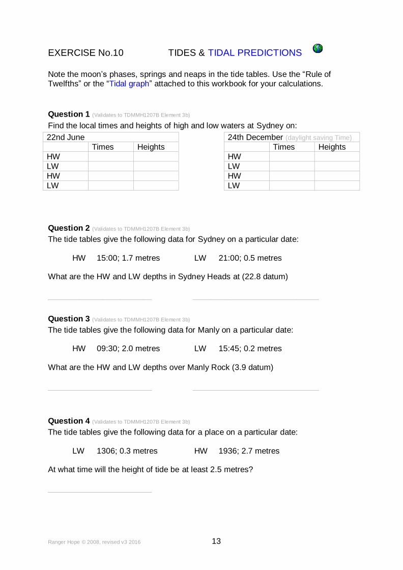
EXERCISE No.10 TIDES & TIDAL PREDICTIONS
Note the moon’s phases, springs and neaps in the tide tables. Use the “Rule of Twelfths” or the “Tidal graph” attached to this workbook for your calculations.
Question 1 (Validates to TDMMH1207B Element 3b)
Find the local times and heights of high and low waters at Sydney on:
22nd June 24th December (daylight saving Time)
Times Heights Times Heights
HW HW
LW LW
HW HW
LW LW
Question 2 (Validates to TDMMH1207B Element 3b)
The tide tables give the following data for Sydney on a particular date:
HW 15:00; 1.7 metres LW 21:00; 0.5 metres
What are the HW and LW depths in Sydney Heads at (22.8 datum)
____________________________________________________________
Question 3 (Validates to TDMMH1207B Element 3b)
The tide tables give the following data for Manly on a particular date:
HW 09:30; 2.0 metres LW 15:45; 0.2 metres
What are the HW and LW depths over Manly Rock (3.9 datum)
____________________________________________________________
Question 4 (Validates to TDMMH1207B Element 3b)
The tide tables give the following data for a place on a particular date:
LW 1306; 0.3 metres HW 1936; 2.7 metres
At what time will the height of tide be at least 2.5 metres?
________________________
Ranger Hope © 2008, revised v3 2016 14
Question 5 (Validates to TDMMH1207B Element 3b) The tide tables give the following data for Long Bay on a particular date:
HW 1450; 1.7 metres LW 2050; 0.5 metres
Find the depth in Long Bay (3.0 datum) at 1850. ____________
Question 6 (Validates to TDMMH1207B Element 3b)
The tide tables give the data for Fort Denison.
LW 0740; 0.5 metres HW 1350; 2.3 metres
Find the time when there is 5 mtrs over a 3.0 mtrs charted position at Gladesville.
________________________________________________________________
Question 7 (Validates to TDMMH1207B Element 3b)
A vessel drawing 2.3 meters passes over a reef with a charted depth of 3.1 meters. What would be the under keel clearance if the height of tide was 1.6 meters? ________________________________________________________________
Question 8 (Validates to TDMMH1207B Element 3b)
The charted depth of a shoal is 2 metres. What would be the clearance beneath the keel of a yacht drawing 1.5 metres at LW using the Tide Tables shown. HW 1117; 6.7 metres
LW 1720; 3.1 metres
________________________________________________________________
Question 9 (Validates to TDMMH1207B Element 3b)
A vessel drawing 4.1 meters waits to enter a river bar with a charted depth of 2.6 meters. What is the earliest time for minimum under keel clearance? LW 0937 0.3m
HW 1514 1.9m
________________________________________________________________
Ranger Hope © 2008, revised v3 2016 15
EXERCISE No.11 WEATHER.
Question 1 (Validates to TDMMH1207B Element 3a) List four sources of weather information. ________________________________________________________________
________________________________________________________________
Question 2 (Validates to TDMMH1207B Element 3a) a. Define a “sea breeze”. ________________________________________________________________
b. Define a “strong wind” warning. ________________________________________________________________
c. Define a “pressure gradient”. ________________________________________________________________
Question 3 (Validates to TDMMH1207B Element 3a) Describe what an aneroid barometer does and how to take readings from it. ________________________________________________________________
________________________________________________________________
Question 4 (Validates to TDMMH1207B Element 3a) Detail the typical weather associated with cold fronts on the NSW East Coast below.
Before the front At the front Behind the front
Wind direction and strength
Barometric Pressure
Temperature
Ranger Hope © 2008, revised v3 2016 16
EXERCISE NO. 12 PASSAGE MAKING Use chart AUS 197, the deviation card and extract tidal and meteorological information from the passage planner supplied overleaf. Question 1 (Validates to TDMMH1207B Element 4) Departing from Port Hacking in 34
o 04'.5S 151
o 09'.3E, plot a passage through the
waypoints below to anchor in Botany Bay.
. What are the compass courses to steer (CCTS) through each waypoint? GPS Waypoint 1, GPS Waypoint 2 GPS Waypoint 3 34o 03'.8S 151o 18'.9E 33o 59'.8S 151o 14'.0E 33o 59'.5S 151o 14'.0E
________________________________________________________________
Identify the characteristics of the six principle lights that you will encounter. ________________________________________________________________
________________________________________________________________
Your vessel cruises at 7kts and uses 8 ltrs of fuel per hour. How long will it take to reach your destination, and how much fuel is required (including 20% in reserve)?
________________________________________________________________
What weather conditions do you anticipate (use the passage planner forecast)? ________________________________________________________________
To reach your destination at high tide on the evening of 24/08/2009, what will be your planned departure time?
________________________________________________________________
To anchor at your planned destination (7 mtrs chart datum), how much chain (minimum) may you require and what lights shall you display? ________________________________________________________________

Ranger Hope © 2008, revised v3 2016 17
Question 1 Passage Mon Evening 24/08/2009 Port Hacking to Botany
PLAN:
Wind: Wave: Precipitation: Barometer and Trend:
LW: 0444 0.26
HW: 1102 1.60
LW: 1715 0.36
HW: 2316 1.45
Secondary port
VESSEL PREPARATION: OK Documentation ok?
Safety gear audit ok? Brief list.
OK Pre-departure checks ok? Enough fuel ok?
Brief list.
NAVIGATION PLAN: (INCLUDE ADVERSE CONDITIONS CONTINGENCIES OVERLEAF)
Wpt Time Position / Bearing / Speed / ETA T V M D C
Complete your passage details here.
13oE
Anticipated lights
Complete your passage details here.
13oE
Anticipated lights
Complete your passage details here.
13oE
Anticipated lights
Complete your passage details here.
13oE
Anticipated lights
Anticipated lights
Anticipated lights
Notes
Ranger Hope © 2006 revised 2009. Image Courtesy of BOM © Not for Navigation
Ranger Hope © 2008, revised v3 2016 18
Question 2 (Validates to TDMMH1207B Element 4) Use chart AUS 197, the deviation card and extract tidal and meteorological information from the passage planner supplied overleaf. Appraise forecast given. From position 33
o 49'.5S 151
o 20'.0E at 06:00, plan a north bound passage to pass
Long Reef Point (rocks to clear by 2 nm). What is the (CCTS)?
________________________________________________________________
At 06:45 the Hospital behind Mona Vale Beach bears 277o M, Turimetta Hd (59) bears 268
o M
and the Water Tower (128) at Collaroy bears 232
o M. What is your
position at this Waypoint (1) and speed over the ground (SMG) between 06:00 & 06:45?
________________________________________________________________
Shortly after, a severe squall with torrential rain and lightning hits. When visibility returns you see dead ahead (steering 250o C) the Hospital Ø Temple 196. Has the deviation of your compass been appreciably affected in this event? ________________________________________________________________
At 0700 Barrenjoey Light is first observed, while radar ranges confirm: Turimetta Head 3.0 nm distant Isolated rock pinnacle off Bungan Hd. 2.4 nm distant What is the Latitude and Longitude of the vessel at this Waypoint (2)? ________________________________________________________________
Plot a course from Waypoint 2 to a Waypoint 3 (three cables west of Box Head in 15 mtrs). What is the CCTS and ETA to Wpt 3 (speed 10 kts). ?
________________________________________________________________
Using the tidal information in the passage planner supplied, what is the earliest time could you clear a 0.7 mtrs (chart datum) sand bank at the entrance to Brisbane Water (your vessel’s draft is 2 mtrs). ________________________________________________________________
Ranger Hope © 2008, revised v3 2016 19
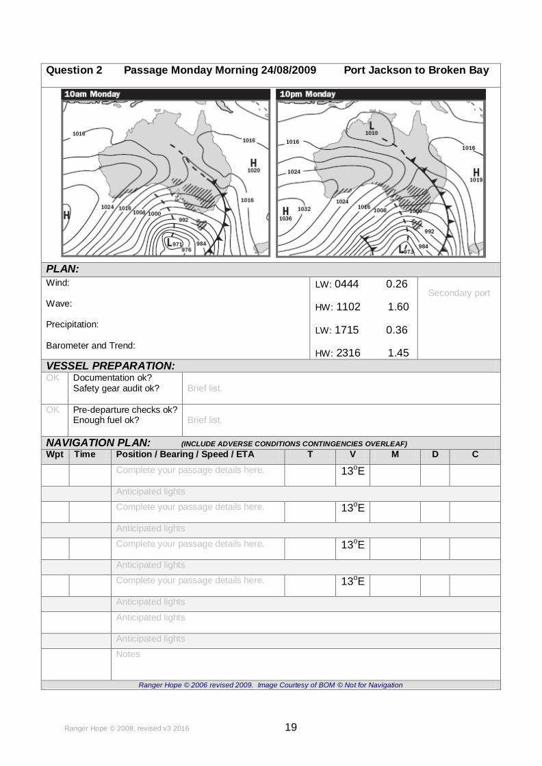
Question 2 Passage Monday Morning 24/08/2009 Port Jackson to Broken Bay
PLAN:
Wind: Wave: Precipitation: Barometer and Trend:
LW: 0444 0.26
HW: 1102 1.60
LW: 1715 0.36
HW: 2316 1.45
Secondary port
VESSEL PREPARATION: OK Documentation ok?
Safety gear audit ok? Brief list.
OK Pre-departure checks ok? Enough fuel ok?
Brief list.
NAVIGATION PLAN: (INCLUDE ADVERSE CONDITIONS CONTINGENCIES OVERLEAF)
Wpt Time Position / Bearing / Speed / ETA T V M D C
Complete your passage details here.
13oE
Anticipated lights
Complete your passage details here.
13oE
Anticipated lights
Complete your passage details here.
13oE
Anticipated lights
Complete your passage details here.
13oE
Anticipated lights
Anticipated lights
Anticipated lights
Notes
Ranger Hope © 2006 revised 2009. Image Courtesy of BOM © Not for Navigation
Ranger Hope © 2008, revised v3 2016 20
Question 3 (Validates to TDMMH1207B Element 4) Use chart AUS 197, the deviation card supplied. Find tidal and meteorological information current for a passage today. You are the Master of a 9 metre vessel named ‘Simulated One’. She is in 2C survey for 9 passengers and 2 crew. Plan a night passage from Patonga Jetty to Rose Bay. Considering the specifications below, determine the requirements for a safe voyage including planning for contingencies in the case of deteriorating weather conditions. Single 4/71 GM 120 kW Cruise speed 10 knots. Total Fuel Consumption 9 ltrs/hr Draft 1.5 meters GPS, radar, steering compass, hand bearing compass. MF/HF, VHF radios. Question 4 (Validates to TDMMH1207B Element 4) Use chart AUS 197, the deviation card supplied. Find tidal and meteorological information current for a passage today. You are the Master of a 12 meter vessel named ‘Simulated Two’. She is in 1C survey for 25 passengers and 2 crew. Plan a day passage from Manly to Bundeena. Considering the specifications below, determine the requirements for a safe voyage including planning for contingencies in the case of deteriorating weather conditions. Twin 6/71 GM 160 kW each Cruise speed 20 knots. Total Fuel Consumption 15 ltrs/hr (each engine) Draft 2.1 meters GPS, radar, steering compass, hand bearing compass. MF/HF, VHF radios.

Ranger Hope © 2008, revised v3 2016 21
SUPPLEMENT AUS197 (MASTER 5)
EXERCISE NO. 13 SET, RATE AND DRIFT
Use chart AUS 197, the deviation card supplied. Question 1 (Validates to TDMMH807B Element 4.a) At 12:00 a vessel departs from position 33o 50'.0S 151o 30'.0E steering 350o C at a speed of 5 kts. Plot the dead reckoning position at 14:00.
At 14:00 the following bearings were taken:
T V M
Barrenjoey Hd. Lt. 292o
M
North Hd. Lt. 222o M
Plot the fix position at 14:00:
From 12:00-14:00 what was the:
Current set Total Drift Current rate
Course made good (TCMG) Speed made good (SMG)
Question 2 (Validates to TDMMH807B Element 4.a) Allowing for a current (125
o T @ 1.5 kts.) and vessel speed of 6 kts, plan a course
departing at 15:00 from position 33o 40'.0S 151o 35'.0E to 33o 30'.0S 151o 35'.0E.
What will be the :
T V M D C
CCTS
ETA SMG
At what time will the FAD (Fl Y 5 s.) be abeam to port
Note: sighted abeam from the vessel.
Question 3 (Validates to TDMMH807B Element 4.a) At 06:00 a vessel departs from position 34
o 00'.1S 151
o 16'.3E steering 068
o C at a
speed of 16 kts. At 06:15 (Wpt 1) the buoy Fl Y 5s bears 340o M at 0.6nm distant. Determine the set, rate and drift and plot a course to the next buoy Fl Y 5s (Wpt 2).
T V M D C
06:00 CCTS Wpt 1 068 o
C
Bearing to Fl Y 5s 340o M
Current set Total Drift Current rate
06:15 CCTS Wpt 2
ETA SMG since 06:00

Ranger Hope © 2008, revised v3 2016 22
EXERCISE NO. 14 COMMON NAVIGATIONAL SOLUTIONS
Question 1 (Validates to TDMMH807B Element 4.a) A vessel close to Long Reef is feeling its way in thick fog, steering 357
o C at a speed
of 2.5 kts. The following soundings (reduced to datum) are recorded against the distance as logged for an hour. What is the approximate final position?
The distances as logged in miles and the soundings taken in metres.
Miles 0 .1 .2 .3 .4 .5 .6 .7 .8 .9 1.0 1.1 1.2 1.3 1.4 1.5 1.6 1.7 1.8 1.9 2.0 2.1 2.2 2.3 2.4 2.5
Metres 30 23 20 15.4 20 22 20 13 10 7.4 10 20 24 30
Approximate final position
Question 2 (Validates to TDMMH807B Element 4.a) From position 33
o 43'.7S 151
o 19'.65E, what would be the minimum clearance
bearing to maintain sailing northward to pass the rock off Little Reef by at least 1 nm. ________________________________________________________________
Question 3 (Validates to TDMMH807B Element 4.a) At 06:00 a vessel steering 168o C at a speed of 8 kts sights Bungan Head (103) as 045
o Relative. At 06:30 the same hill is abeam to starboard. What is the distance off
Bungan Head (103) and the position? ________________________________________________________________
Question 4 (Validates to TDMMH807B Element 4.a) At 15:00 a vessel steering 244
o C at a speed of 15 kts sights Box Head as 277
oM.
Six minutes later the bearing doubles to 307oM. What is the 15:06 distance off Box
Head and the position? ________________________________________________________________
Question 5 (Validates to TDMMH807B Element 4.a) At 21:00 a vessel steering 358o C at a speed of 6 kts sights the Flare Chimneys near Kurnell as 287
o M. After maintaining that course and speed until 22:00 they bear
222o M. What were the 21:00 and the 22:00 positions by the running fix method? ________________________________________________________________
Question 6 (Validates to TDMMH807B Element 4.a) At 12:15 a vessel steering 200o C at a speed of 8 kts sights the TANK at Terrigal Ø First Point. After maintaining that course and speed Barrenjoey Lt. bore 283o M at 12:50. What were the 12:15 and the 12:50 positions? ________________________________________________________________

Ranger Hope © 2008, revised v3 2016 23
ANSWERS TO EXERCISES
(Accuracy- Bearings/courses + or – 2o, Times + or – 5mins, Speeds + or – 0.5 kts)
EXERCISE NO. 1 CHART INFORMATION
Question 1 a. TRUE b FALSE c. FALSE d. TRUE Question 2 This correction is found at the bottom left of your chart Question 3 a. Australian Notices to Mariners. Question 4 Determination of true direction Question 5 In a Mercator projection the distance between longitudes is dependent on the latitude. Question 6 Admiralty Sailing directions of Australian Pilots, List of Lights, List of Radio Signals, etc. EXERCISE NO. 2 CHART SYMBOLS AND ABBREVIATIONS
Question 1 See Symbols & Abbeviations
Question 2 Sand & shell Question 3 Flashing twice every 10 seconds, height of centre of light 105 mtrs, nominal visibility 25 nm. Question 4 Traffic separation system Question 5 Special marker buoy, flashing yellow every 5 seconds Question 6 Marks safe entry and shoals in approach EXERCISE NO. 3 SEE BUOYAGE EXERCISE NO. 4 POSITION - DISTANCE - DIRECTION
Question 1 a. Cape Banks b. Dee Why Head c. Wedding Cake Island d. North Head Lt. e. 33
o 34'.8S 151
o 19'.8E
f. 33 o 28'.5S 151
o 20'.6E
g. 33 o 38'.4S 151
o 22'.65E
Question 2 2.1 nm

Ranger Hope © 2008, revised v3 2016 24
Question 3 1.15 nm Question 4 a. 7.5 nm 299
o T
b. 13 nm 040 o T
c. 9.9 nm 192 o T
d. 12.5 nm 087 o T
EXERCISE No.5 SPEED DISTANCE AND TIME
Question 1 a. 36nm b. 9 kts c. 4hrs Question 2 a. 29.25 b. 5 kts c. 2hrs 52.5 mins Question 4 Question 5 Question 6 Question 7 15.83 nm 6.95 kts 15:16 07:46 33 55'.75S 151 25'.80E EXERCISE No.6 COMPASS ERROR - VARIATION AND DEVIATION
Question 1 a. 12
o 40'E
b. 2009 c. 0' Question 2 d. true.
Question 4
TRUE 095o TRUE 180
o TRUE 357
o
VARIATION 5o E VARIATION 8
o W VARIATION 4
o W
MAGNETIC 090o MAGNETIC 188
o MAGNETIC 001
o
TRUE 005o TRUE 237
o TRUE 147
o
VARIATION 10o E VARIATION 5
o E VARIATION 1
o W
MAGNETIC 355o MAGNETIC 232
o MAGNETIC 148
o
TRUE 108o TRUE 004
o TRUE 358
o
VARIATION 4o W VARIATION 1
o E VARIATION ½
o W
MAGNETIC 112o MAGNETIC 003
o MAGNETIC 358½
o
Ranger Hope © 2008, revised v3 2016 25
Question 5
True Variation Magnetic
0900 13
0 E 077
0
0900 13
0 W 103
0
2870 6
0 E 281
0
0900 10
0 W 100
0
0000 13
0 E 347
0
3530 10
0 W 003
0
0120 14
0 E 358
0
3470 13
0 W 360
0
Question 6 a. magnetic influences within the vessel. Question 7 c. the resultant effects of variation and deviation on a magnetic compass. Question 8
True (Charted)
Variation Magnetic (Hand bearing)
Deviation Compass (Ships)
Error
0200 5
0 E 015
0 5
0 W 020
0 0
0
1380 5
0 W 143
0 3
0 E 140
0 2
0 W
2410 11
0 E 230
0 10
0 E 220
0 21
0 E
3290 9
0 W 338
0 2
0 W 340
0 11
0 W
1550 9
0 W 164
0 4
0 E 160
0 5
0 W
T V M D C Error
1100 13
0 E 097
0 3
0 W 100
0 10
0 E
1340 13
0 W 147
0 1
0 E 146
0 12
0 W
3510 3
0 E 348
0 2
0 W 350
0 1
0 E
1990 9
0 W 208
0 6
0 E 202
0 3
0 W
0600 4
0 E 056
0 4
0 W 060
0 0
0
Question 9
T V M D C Error
0090 13
0 E 356
0 4
0 W 000
0 9
0 E
2700 13
0 E 257
0 7
0 E 250
0 20
0 E
0800 13
0 E 067
0 3
0 W 070
0 10
0 E
0280 13
0 E 015
0 5
0 W 020
0 8
0 E
2520 13
0 E 239
0 9
0 E 230
0 22
0 E

Ranger Hope © 2008, revised v3 2016 26
EXERCISE No.7 FIXING A POSITION
Question 1 33
o 54'.6S 151
o 22'.6E
Question 2 33
o 39'.55S 151
o 21'.55E
Question 3 33
o 34'.27S 151
o 22'.33E
Question 4
T V M
Pt. Hacking Pt. 2410 13
0 E 228
0
Cape Banks 2690 13
0 E 256
0
Wedding Cake Is. 3220 13
0 E 309
0
Position 34o 00'.0S 151
o 20'. 0E
Question 5
T V M
Bangalley Hd. (117) 3240 13
0 E 311
0
Turimetta Hd. (59) 2500 13
0 E 237
0
Collaroy Twr. (128) 2330 13
0 E 220
0
Position 33o 40'.36S 151
o 22'. 96E
EXERCISE No. 8 DIRECTION RELATIVE TO A SHIP’S COURSE Question 1
T V M D C
Course 0280 13
0 E 015
0 5°W 020
0
Abeam to stb 0900
Relative 1180 13
0 E 105
0 5°W 110
0
Abeam to port 2700
Relative 2980 13
0 E 285
0 5°W 290
0
Question 2
T V M D C
Water Tk. La Perouse 2450 13
0 E 232
0 6
0 W 238
0
Blue fish Pt. 3380 13
0 E 325
0 6
0 W 331
0
Waverley Tr. (184) 2930 13
0 E 280
0 6
0 W 286
0
Fix the position 33o 56'.0S 151
o 22'. 07E
Question 3
T V M D C
Long Reef Pt. 2270 13
0 E 214
0 6
0 E 208
0
Temple (196) 2580 13
0 E 245
0 6
0 E 239
0
Box Hd. 327.50 13
0 E 314.5
0 6
0 E 308.5
0
Fix the position 33o 39'.4S 151
o 25'. 75E

Ranger Hope © 2008, revised v3 2016 27
Question 4
T V M D C
Mt Etalong Tk. Ø Box Hd.
2870
Barrenjoey Hd. Radar bearing
2330 13
0 E 220
0 3
0 E 217
0
Lion Is. (the centre) 2700 13
0 E 257
0 3
0 E 254
0
Fix a safe position 330 33'.3S 151
0 22'. 6E
EXERCISE NO. 9 CHECKING THE COMPASS
Question 1
T V M D C Error
3300 13
0 E 317
0 24
0 W 341
0 C 11
0 W
c. Yes d. Altered metallic or electrical configuration. Re-swing compass soon.
EXERCISE No.10 TIDES & TIDAL PREDICTIONS
Question 1
22nd June Times Heights 24th Dec Times Heights
HW 0434 1.32 HW 0116 1.28
LW 1028 0.51 LW 0657 0.69
HW 1709 1.70 HW 1301 1.36
LW 2352 0.51 LW 1939 0.49
Question 2 HW 15:00; 24.5 metres LW 21:00; 23.53 metres Question 3 HW 09:30; 5.9 metres LW 15:45; 4.1 metres Question 4 18:20 Question 5 3.8 mtr Question 6 1220 Question 7 2.4 mtrs Question 8 3.6 mtrs Question 9 13:20
EXERCISE No.11 WEATHER. Question 1 Radio, TV. Internet, Local VMR. Tc. Question 2 a. Afternoon onshore wind caused by local heating of land during the day. b. 25Kts c. The closeness of isobar spacing indicating the likely of wind strength. Question 3 Measures barometric pressure. Tap glass before reading. Question 4
Before At the front After
Wind direction and strength
Backing NE-NW -SW Light -increasing
Backing S Strong blow
Backing SE - NE Easing
Pressure Falling Sudden Rise Rising Slowly
Temperature Steady Sudden Drop Rising Slowly

Ranger Hope © 2008, revised v3 2016 28
EXERCISE NO. 8 PASSAGE MAKING Question 1
T V M D C
To wpt 1 0850 13
0 E 072
0 2
0 W 074
0
To wpt 2 3140 13
0 E 301
0 1
0 E 300
0
To wpt 3 0000 13
0 E 347
0 3
0 W 350
0
Identify the characteristics of the six principle lights that you will encounter.
Oc.WR. 3s 12/9M Fl (4) 16s 55m 13M Fl.Y.5s
Iso. WR.2s7/5M Oc. WR. 3s 7M & F Bu F. WRG. 13 & F.RG
Duration & fuel 14/2 = 2 hours 2 hours x 8 = 16 + 20% = 16 +3.2 = 19.2 ltr.
Forecast weather conditions P.M. 24/08/2009 – Early strong SW moderating to W, NW, high swell offshore, moderate inshore occasional heavy showers, barometric pressure rising slowly.
Planned departure time? 23: 16 – 2 hrs = 21:16
To anchor 7mtr + 1.45 mtr = 8.45 x 3 = 25.35 mtrs All around white Lt.
Question 2
T V M D C
To wpt 1 0110 13
0 E 358
0 4
0 W 002
0
Mona Vale Hospital 2900 13
0 E 277
0
Turimetta Hd 2810 13
0 E 268
0
Water twr 128 2450 13
0 E 232
0
What is your new position at 06:45 (Wpt 1) and SMG? 33
0 42'.15S 151
0 21'.67E 7.5 nm/0.75 hrs = 10kts
Forecast weather conditions A.M. 24/08/2009 - Southerly change in early morning, squalls & heavy showers, high swell, conditions improving after the passage of the front, becoming W to NW.
Has the deviation of your compass been appreciably affected by this event? No
Deviation as per card 2 269.500 13 E 256.5
0 7 E 249.5
0
What is your new position at 07:00 (Wpt 2)? 33
0 41'.2S 151
0 22'.1E
3500 13 E 337
0 3 W 340
0
What is ETA at (Wpt 3)? 7:50.4
Required 0.7 + 1.3 = 2.0 mtrs = approx 09:00
EXERCISE NO. 13 SET, RATE AND DRIFT
Question 1 T V M D C
Barrenjoey Hd. Lt. 2920 M 305
0 T 13
0 E 292
0 M
North Hd. Lt. 2220 M 235
0 T 13
0 E 222
0 M
Plot the fix position at 14:00: 330 41'.6 S 151
0 31'.4E
Current set 1430 T Total Drift 2 nm Current rate 1Kt.
TCMG 0080 T SMG 8.5/2 = 4.25 kts

Ranger Hope © 2008, revised v3 2016 29
Question 2
T V M D C
CCTS 3480 T 13
0 E 335
0 M 02
0 W 337
0 C
ETA 17:00 SMG 5 kts
At what time will the FAD (Fl Y 5 s.) be abeam to port
5.4nm/6kts = 0.9hrs x 60 = 54mins + 13:00 = 13:54
Question 3
T V M D C
Initial CCTS 0780 T 13
0 E 065
0 M 03
0 W 068
o C
Bearing to Fl Y 5s 3530 T 13
0 E 340
0 M
Current set 175 o T Total Drift 0.6 nm Current rate 2.4 kts
Second CCTS 0780 T 13
0 E 065
0 M 03
0 W 068
0 C
ETA 4.75/4= 1.2 x 15=17.8 + 16:15=16:33 SMG since 06:00 8.75nm/0.55hrs = 5.9 kts
EXERCISE NO. 14 COMMON NAVIGATIONAL SOLUTIONS
Question 1
Soundings reduced to datum T V M D C
006o 13
o E 353
o 04
o W 357
o
Approximate final position 33o 43'.7S 151
o 19'.65E
Question 2
T V M D C
Clearance bearing 018o 13
o E 005
o 4.5
o W 009.5
o
Question 3
T V M D C
Course 186o 13
o E 173
o 05
o E 168
o
0450
Relative 231o
0900
Relative 276o
Double the angle on the bow-distance run = distance off=4 nm 33o 40'.32S 151
o 23'.7E
Question 4
T V M D C
Course 260o 13
o E 247
o 03
o E 244
o
0300
Relative 290o 13
o E 277
o
0600
Relative 320o 13
o E 307
o
Double the angle on the bow-distance run = distance off=1.5 nm 33o 34'.00S 151
o 21'.9E
Question 5
T V M D C
Course 007o 13
o E 354
o 04
o W 358
o
21:00 bearing 300o 13
o E 287
o
22:00 bearing 235o 13
o E 222
o
21:00 Position 34o 03'.65S 151
o 18'.23E 22:00 Position 33
o 57'.70S 151
o 19'.10E
Question 6
T V M D C
Course 221o 13
o E 208
o 08
o E 200
o
12:15 bearing 352o
12:50 bearing 296o 13
o E 283
o
12:15 Position 34o 32'.00S 151
o 27'.30E 12:50 Position 33
o 35'.55S 151
o 23'.65E
Ranger Hope © 2008, revised v3 2016 30
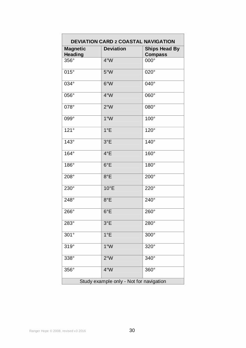
DEVIATION CARD 2 COASTAL NAVIGATION
Magnetic Heading
Deviation
Ships Head By Compass
356° 4°W
000°
015° 5°W
020°
034° 6°W
040°
056° 4°W
060°
078° 2°W
080°
099° 1°W
100°
121° 1°E
120°
143° 3°E
140°
164° 4°E
160°
186° 6°E
180°
208° 8°E
200°
230° 10°E
220°
248° 8°E
240°
266° 6°E
260°
283° 3°E
280°
301° 1°E
300°
319° 1°W
320°
338° 2°W
340°
356°
4°W
360°
Study example only - Not for navigation