Executive Summary - İKLİMSU | İklim Değişikliğinin...
75
REPUBLIC OF TURKEY THE MINISTRY OF FORESTRY AND WATER AFFAIRS GENERAL DIRECTORATE OF WATER MANAGEMENT CLIMATE CHANGE IMACTS ON WATER RESOURCES PROJECT Final Report Executive Summary June 2016
-
Upload
truongcong -
Category
Documents
-
view
233 -
download
0
Transcript of Executive Summary - İKLİMSU | İklim Değişikliğinin...
REPUBLIC OF TURKEY
THE MINISTRY OF FORESTRY AND
WATER AFFAIRS
GENERAL DIRECTORATE OF
WATER MANAGEMENT
CLIMATE CHANGE IMACTS ON WATER
RESOURCES PROJECT
Final Report
Executive Summary
June 2016

This report was prepared by Contractor Akar-Su Engineering and Consultancy Co. and
Subcontractor io Environmental Solutions R&D Co. for Ministry of Forestry and Water Affairs,
General Directorate of Water Management.

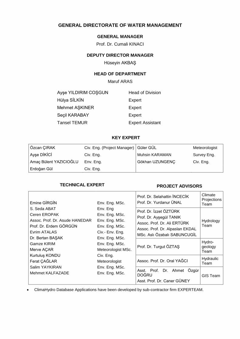
GENERAL DIRECTORATE OF WATER MANAGEMENT
GENERAL MANAGER
Prof. Dr. Cumali KINACI
DEPUTY DIRECTOR MANAGER
Hüseyin AKBAŞ
HEAD OF DEPARTMENT
Maruf ARAS
Ayşe YILDIRIM COŞGUN Head of Division
Hülya SİLKİN Expert
Mehmet AŞKINER Expert
Seçil KARABAY Expert
Tansel TEMUR Expert Assistant
KEY EXPERT
Özcan ÇIRAK Civ. Eng. (Project Manager) Güler GÜL Meteorologist
Ayşe DİKİCİ Civ. Eng. Muhsin KARAMAN Survey Eng.
Amaç Bülent YAZICIOĞLU Env. Eng. Gökhan UZUNGENÇ Civ. Eng.
Erdoğan Gül Civ. Eng.
TECHNICAL EXPERT PROJECT ADVISORS
Emine GİRGİN
S. Seda ABAT
Ceren EROPAK
Assoc. Prof. Dr. Asude HANEDAR
Prof. Dr. Erdem GÖRGÜN
Evrim ATALAS
Dr. Bertan BAŞAK
Gamze KIRIM
Merve AÇAR
Kurtuluş KONDU
Ferat ÇAĞLAR
Salim YAYKIRAN
Mehmet KALFAZADE
Env. Eng. MSc.
Env. Eng
Env. Eng. MSc.
Env. Eng. MSc.
Env. Eng. MSc.
Civ.- Env. Eng.
Env. Eng. MSc.
Env. Eng. MSc.
Meteorologist MSc.
Civ. Eng.
Meteorologist
Env. Eng. MSc.
Env. Eng. MSc.
Prof. Dr. Selahattin İNCECİK
Prof. Dr. Yurdanur ÜNAL
Climate Projections Team
Prof. Dr. İzzet ÖZTÜRK
Prof. Dr. Ayşegül TANIK
Assoc. Prof. Dr. Ali ERTÜRK
Assoc. Prof. Dr. Alpaslan EKDAL
MSc. Aslı Özabalı SABUNCUGİL
Hydrology Team
Prof. Dr. Turgut ÖZTAŞ Hydro-geology Team
Assoc. Prof. Dr. Oral YAĞCI Hydraulic Team
Asst. Prof. Dr. Ahmet Özgür DOĞRU
Asst. Prof. Dr. Caner GÜNEY
GIS Team
ClimaHydro Database Applications have been developed by sub-contractor firm EXPERTEAM.

Climate Change Impacts on Water Resources Project Final Report – Executive Summary (Date:6.13.2016)
I
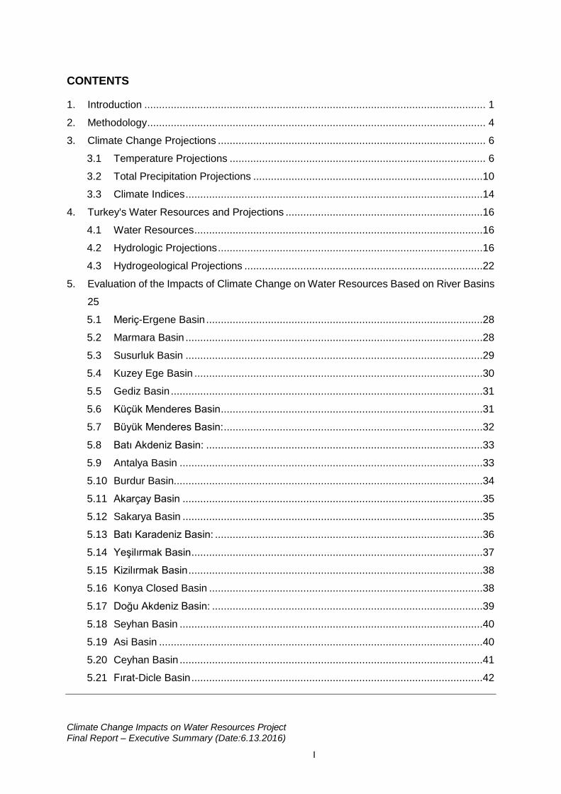
CONTENTS
1. Introduction .................................................................................................................... 1
2. Methodology ................................................................................................................... 4
3. Climate Change Projections ........................................................................................... 6
3.1 Temperature Projections ....................................................................................... 6
3.2 Total Precipitation Projections ..............................................................................10
3.3 Climate Indices .....................................................................................................14
4. Turkey's Water Resources and Projections ...................................................................16
4.1 Water Resources ..................................................................................................16
4.2 Hydrologic Projections ..........................................................................................16
4.3 Hydrogeological Projections .................................................................................22
5. Evaluation of the Impacts of Climate Change on Water Resources Based on River Basins
25
5.1 Meriç-Ergene Basin ..............................................................................................28
5.2 Marmara Basin .....................................................................................................28
5.3 Susurluk Basin .....................................................................................................29
5.4 Kuzey Ege Basin ..................................................................................................30
5.5 Gediz Basin ..........................................................................................................31
5.6 Küçük Menderes Basin .........................................................................................31
5.7 Büyük Menderes Basin: ........................................................................................32
5.8 Batı Akdeniz Basin: ..............................................................................................33
5.9 Antalya Basin .......................................................................................................33
5.10 Burdur Basin.........................................................................................................34
5.11 Akarçay Basin ......................................................................................................35
5.12 Sakarya Basin ......................................................................................................35
5.13 Batı Karadeniz Basin: ...........................................................................................36
5.14 Yeşilırmak Basin ...................................................................................................37
5.15 Kizilırmak Basin ....................................................................................................38
5.16 Konya Closed Basin .............................................................................................38
5.17 Doğu Akdeniz Basin: ............................................................................................39
5.18 Seyhan Basin .......................................................................................................40
5.19 Asi Basin ..............................................................................................................40
5.20 Ceyhan Basin .......................................................................................................41
5.21 Fırat-Dicle Basin ...................................................................................................42
Climate Change Impacts on Water Resources Project Final Report – Executive Summary (Date:6.13.2016)
II
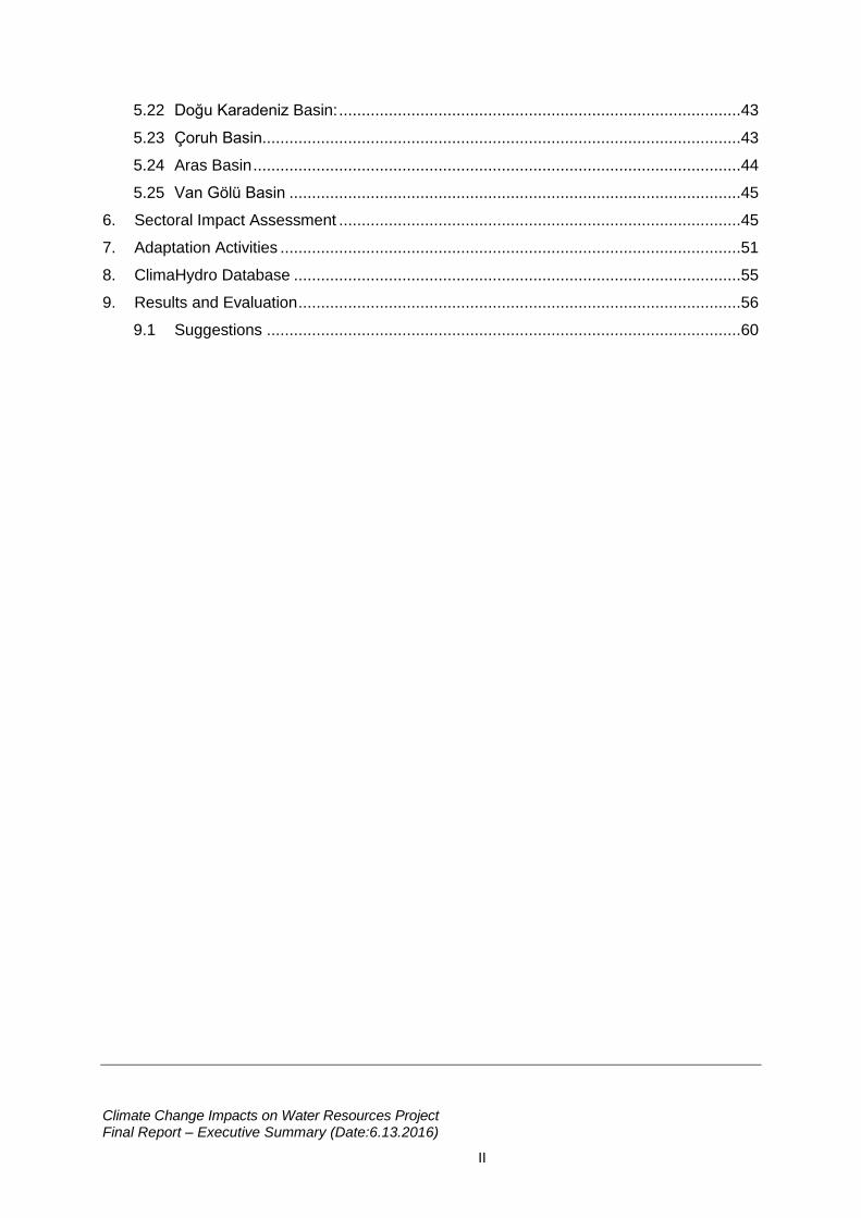
5.22 Doğu Karadeniz Basin: .........................................................................................43
5.23 Çoruh Basin..........................................................................................................43
5.24 Aras Basin ............................................................................................................44
5.25 Van Gölü Basin ....................................................................................................45
6. Sectoral Impact Assessment .........................................................................................45
7. Adaptation Activities ......................................................................................................51
8. ClimaHydro Database ...................................................................................................55
9. Results and Evaluation ..................................................................................................56
9.1 Suggestions .........................................................................................................60
Climate Change Impacts on Water Resources Project Final Report – Executive Summary (Date:6.13.2016)
1
1. Introduction
Climate change is the sudden, severe and important changes occurring in long term weather
events, and due to the increase in human activities, they are felt more intensely presently.
According to the Fifth Evaluation Report of Intergovernmental Panel on Climate Change
(IPCC), majority of the warming in the atmosphere since the mid 20th century resulted from
the increase in greenhouse gas concentrations arising from human activities (IPCC, 2014). As
a result, global temperature has risen approximately 0.89°C in the last 150 years and it
continues to increase. Because of increased greenhouse gas emissions, global warming has
caused changes in the distribution of water resources in many parts of the world, and global
and regional hydrological cycles have been greatly affected from the climate change (Brutsaert
& Parlange, 1998; Solomon et al., 2007; Hagemann at al., 2013; Dufresne et al., 2013).
Climate change in Turkey has been evaluated in many different studies with its different
aspects. Majority of both analysis performed and the future estimation works were focused on
temperature and precipitation changes which are the most important climate parameters and
extreme events. (Kadıoğlu, 1997; Şen Z. , 1997; Türkeş, 1998; Türkeş, 1999; Önol et al., 2006;
Önal & Semazzi, 2009) (Bozkurt et al., 2011; Demir, 2011; Önal, 2012; Ünal et al., 2012; Toros,
2012; Şen et al., 2013; Kurnaz, 2014). (Karaca et al., 2000; Tan & Ünal, 2003; Önal & Ünal,
2003; Ünal Y. , 2006; Ünal & Mentes, 2006; Ünal et al., 2010) (Ünal et al., 2013). Climate
projections demonstrate that the temperature increases will rise much more till the end of this
century. Because of this, in terms of evaluating the impacts of climate change on water
resources in Turkey, which is located in Southeastern Europe and Eastern Mediterranean, it
is crucial that the future projections should be made with sophisticated models to obtain
accurate results.
Even though climate change is considered as the increase in temperatures and global
warming, the most important impacts resulting from climate change are the impacts that will
take place due to the changes in the precipitation regime. Hydrological systems are affected
from the climate conditions in the world both directly and indirectly. Changes in precipitations
cause changes in the timing and severity of floods and drought, as well as the surface flow
regime, amount of water leaking underground, plant patterns and growth rates (Ragab &
Prudhomme, 2002).
Turkey is divided into 25 hydrological river basins having vital and social importance.
Precipitation regime of Turkey, which is located in a semi-arid region of the world in terms of
water, varies greatly in different seasons and regions, and it is seen that in some river basins
Climate Change Impacts on Water Resources Project Final Report – Executive Summary (Date:6.13.2016)
2
the water demand has exceeded the potential of the resources. However, impacts resulting
from the climate change in Turkey such as increased summer temperatures, decreasing winter
precipitations, loss of surface waters, more frequent droughts, deterioration of soil, erosion in
coasts, flood and water deluges threaten the existence of water resources directly (T.R.
Ministry of Environment and Urbanization, 2011). Because of this, Ministry of Forestry and
Water Affairs, General Directorate of Water Management, Flood and Drought Management
Department aimed to determine the impact of climate change on surface and ground waters
and define the adaptation activities with the "Climate Change Impacts on Water Resources
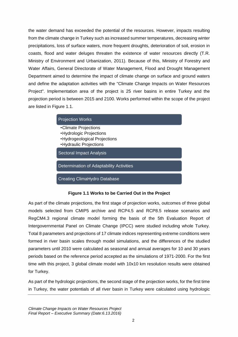
Project". Implementation area of the project is 25 river basins in entire Turkey and the
projection period is between 2015 and 2100. Works performed within the scope of the project
are listed in Figure 1.1.
Figure 1.1 Works to be Carried Out in the Project
As part of the climate projections, the first stage of projection works, outcomes of three global
models selected from CMIP5 archive and RCP4.5 and RCP8.5 release scenarios and
RegCM4.3 regional climate model forming the basis of the 5th Evaluation Report of
Intergovernmental Panel on Climate Change (IPCC) were studied including whole Turkey.
Total 8 parameters and projections of 17 climate indices representing extreme conditions were
formed in river basin scales through model simulations, and the differences of the studied
parameters until 2010 were calculated as seasonal and annual averages for 10 and 30 years
periods based on the reference period accepted as the simulations of 1971-2000. For the first
time with this project, 3 global climate model with 10x10 km resolution results were obtained
for Turkey.
As part of the hydrologic projections, the second stage of the projection works, for the first time
in Turkey, the water potentials of all river basin in Turkey were calculated using hydrologic
Projection Works
•Climate Projections
•Hydrologic Projections
•Hydrogeological Projections
•Hydraulic Projections
Sectoral Impact Analysis
Determination of Adaptability Activities
Creating ClimaHydro Database
Climate Change Impacts on Water Resources Project Final Report – Executive Summary (Date:6.13.2016)
3
model. Employing hydrologic models with the outcomes of the climate models, precipitation
values were converted to flow values, and water potential modeling/calculation study was
carried out considering the current situation of surface water and groundwater sources and the
estimated situation for projected periods.
As part of hydrogeological works, aquifer environments on the basis of river basin were defined
geologically and hydrogeologically; and current groundwater potential was calculated through
groundwater observations and considering properties such as current and planned pit
information in river basin scale. Groundwater potential amounts specific to water basis for the
projection period were calculated adding current groundwater potential data and the
precipitation, evaporation and temperature data changed due to climate change projections.
Turkey's static groundwater reserve was calculated for the first time in this project. Calculating
dynamic and static reserve together, the possible changes in groundwater levels were
predicted.
In the last stage of projection works, hydraulic modeling approach was used to convert the flow
values to the water level values along the principal river system and its side streams in the
river basin. Afterwards, surface water capacities in the principal river system and its side
streams in the river basin was determined.
As part of sectoral impact analysis works, a methodology was developed for the analysis of
the impacts of climate change in Turkey on water intended for human consumption, agriculture,
industry, ecosystem, tourism and energy main sectors. An evaluation systematic was
developed allowing the digitization of exposure levels for the sectors. Considering the climate
change projections in the three river basins elected as pilot river basins, impacts of water on
sectors were analyzed, and the exposure intensity of the river basins from all sectors were
determined in "low impact, medium impact, high impact, very high impact" categories.
As part of the determination of adaptation activities, considering all river basins, various
suggestions for adaptation activities such as rainwater harvesting, pricing the water, enclosed
irrigation system were developed for the elimination of the negative impacts of climate change
on water resources. In total, 138 adaptation activities were examined, and at least three
operations were evaluated in detail for each of the water intended for human consumption,
agriculture and industry main sectors.
All results produced in the project were processed in the ClimaHydro Database equipped with
GIS application. Therefore, it is ensured that the project outcomes are sustainable and can be
considered in similar projects.
Climate Change Impacts on Water Resources Project Final Report – Executive Summary (Date:6.13.2016)
4
Project Final Report in which the impacts of climate change projections on the climate
projection of our country until 2100 and the water potentials of water basis based on various
parameters is composed of a single volume and 30 annexes, and contains all of the data and
evaluation works produced during the 930-days project.
2. Methodology
Climate simulations at 50x50 km first and then 10x10 km resolution were obtained by using
start and limit conditions (ERA-40 reanalysis data) (Uppala et. al., 2005) for the reference
period within the scope of climate change projections. Afterwards, reference period climate
simulations were performed with 10x10 km resolution of HadGEM2-ES, MPI-ESM-MR and
CNRM-5.1 global climate models selected from the CMIP5 database. Comparisons were made
with the simulations performed by using reference period simulation observation data of the
global model, and the bias of the global model in the climate simulations was examined. Of
three global models, simulations based on RCP4.5 and RCP8.5 representational concentration
routes against the 4.5 W/m2 and 8.5 W/m2 climate forces in 2100, and climate simulations at
10x10 km resolution between 2015-2010 with RegCM4.3 regional climate model were
obtained.
By using climate models' projection results, hydrological variants in the river basin drainage
region scales were projected till 2100. Surface flow, soil moisture and evapotranspiration are
the fundamental values produced by the hydrological model, groundwater and surface water
potential was calculated in the river basins by using model outputs. Also, changes in the water
usage in river basins during the 85-year-long projection period were obtained and such values
were evaluated with hydrological variants produced by the model, and the projection for total
annual water demand in river basins was made. SWAT model was used in hydrological
modeling works, and such model was supported by the WEAP model in order to include it in
the hydrological modeling process of lakes, ponds and reservoirs, and improve the
hydrological model.
Within the scope of the hydrogeological projection works, first of all, locations and distribution
of all groundwater environments within river basins were explored and environmental volumes
were predicted; and the geo-hydraulic and hydrogeological environment characteristics were
defined by using homogenized average values. In the study, "periodical groundwater feeding"
and "periodical groundwater discharges" were calculated for each period by considering the
impact of climate change between 2015 and 2100. Differences in found values were defined
as the periodical ground water dynamic reserve of such hydrogeological environment for the
Climate Change Impacts on Water Resources Project Final Report – Executive Summary (Date:6.13.2016)
5
related period, and the hydrogeological, static and possible reserve values of the related
hydrogeological environment for the mentioned period were determined. Based on the
groundwater dynamic reserve values within the time periods determined in the hydrogeological
environments in the river basin, periodical free/pressurized groundwater level (dynamic level)
changes were predicted.
Flow values produced by the hydrologic model were transformed into flowrate and water level
values during the principal river system of river basins with hydraulic modeling works. For the
solution of hydraulic problems, Hec-RAS model, which is internationally accepted and often
proven to be accurate in the literature, was utilized. In the model, surface water profiles were
calculated by repeating the standard step method from one cross section to another and
solving the energy equation. Within the scope of creating the model structure works, thalweg
lines, stream rank lines, flood plains and cross sections along the principal river system and
its side streams in the river basin were defined, and the integration of variants into the model
was ensured.
Exposure, sensibility, impact, economical value, risk and adaptation capacity components and
10-year-long vulnerability levels of sectors were revealed in the sectoral vulnerability impact
analysis developed within the project scope. This study was practiced for 4 main sectors as
water intended for human consumption, agriculture, industry and ecosystem in 3 pilot river
basins. Tourism was included for the Büyük Menderes River basin, energy was included for
Ceyhan River basin and textile product manufacturing as the sub-industrial sector was
included for Meriç-Ergene River basin.
In various regions and countries of the world, adaptation strategies and activities planned and
implemented against climate change were examined, and over 100 adaptation activities were
suggested for our country in the light of this information. Adaptation activities for the 3 main
sectors (water intended for human consumption, agriculture, industry) that may be affected
from water in our country were examined in detail in terms of advantages/disadvantages,
cost/benefit, etc.in practice. Also, main sectors for the sectoral vulnerability analysis works
were defined and river basins of Turkey were considered and grouped based on different
geographical and climatic characteristics.
Climate Change Impacts on Water Resources Project Final Report – Executive Summary (Date:6.13.2016)
6
3. Climate Change Projections
3.1 Temperature Projections
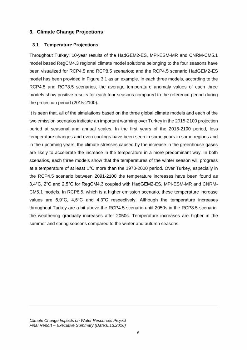
Throughout Turkey, 10-year results of the HadGEM2-ES, MPI-ESM-MR and CNRM-CM5.1
model based RegCM4.3 regional climate model solutions belonging to the four seasons have
been visualized for RCP4.5 and RCP8.5 scenarios; and the RCP4.5 scenario HadGEM2-ES
model has been provided in Figure 3.1 as an example. In each three models, according to the
RCP4.5 and RCP8.5 scenarios, the average temperature anomaly values of each three
models show positive results for each four seasons compared to the reference period during
the projection period (2015-2100).
It is seen that, all of the simulations based on the three global climate models and each of the
two emission scenarios indicate an important warming over Turkey in the 2015-2100 projection
period at seasonal and annual scales. In the first years of the 2015-2100 period, less
temperature changes and even coolings have been seen in some years in some regions and
in the upcoming years, the climate stresses caused by the increase in the greenhouse gases
are likely to accelerate the increase in the temperature in a more predominant way. In both
scenarios, each three models show that the temperatures of the winter season will progress
at a temperature of at least 1°C more than the 1970-2000 period. Over Turkey, especially in
the RCP4.5 scenario between 2091-2100 the temperature increases have been found as
3,4°C, 2°C and 2,5°C for RegCM4.3 coupled with HadGEM2-ES, MPI-ESM-MR and CNRM-
CM5.1 models. In RCP8.5, which is a higher emission scenario, these temperature increase
values are 5,9°C, 4,5°C and 4,3°C respectively. Although the temperature increases
throughout Turkey are a bit above the RCP4.5 scenario until 2050s in the RCP8.5 scenario,
the weathering gradually increases after 2050s. Temperature increases are higher in the
summer and spring seasons compared to the winter and autumn seasons.
Climate Change Impacts on Water Resources Project Final Report – Executive Summary (Date:6.13.2016)
7
Figure 3.1 The Change of the Average Temperature Anomaly Values in 10-Year Periods and Seasonally for HadGEM2-ES Model RCP4.5 scenario
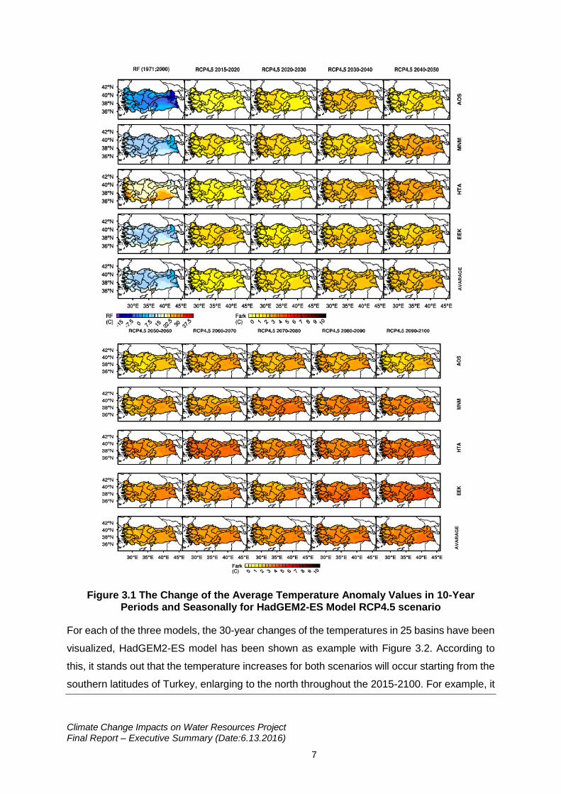
For each of the three models, the 30-year changes of the temperatures in 25 basins have been
visualized, HadGEM2-ES model has been shown as example with Figure 3.2. According to
this, it stands out that the temperature increases for both scenarios will occur starting from the
southern latitudes of Turkey, enlarging to the north throughout the 2015-2100. For example, it
AV
AR
AG
E
AV
AR
AG
E
Climate Change Impacts on Water Resources Project Final Report – Executive Summary (Date:6.13.2016)
8
is seen that the highest temperature increases occur in the Southeastern of Turkey and across
the Mediterranean. Especially within the topography where altitude is dominant, the
temperature increases expected during the summer months on Fırat-Dicle Basin are higher
compared to the other seasons and faster compared to the other regions. It is anticipated that
the temperature increases will reach 4-6°C towards 2100s especially in the east and southeast
of Turkey. The fact that the precipitation type more frequently turns into rain from snow in the
winter months due to increasing temperatures, causes the snow-covered areas to diminish
and the snow to melt earlier in the spring months. The diminishment in the snow-covered
surfaces causes the albedo of the surface to decrease and therefore causes the sun radiation
amount absorbed by the surface to increase and scales up the temperatures faster than the
other regions.
Climate Change Impacts on Water Resources Project Final Report – Executive Summary (Date:6.13.2016)
9
Figure 3.2 30-Year Averages of the Average Temperature Anomaly Values of the HadGEM2-ES Model on Basins throughout Turkey
Climate Change Impacts on Water Resources Project Final Report – Executive Summary (Date:6.13.2016)
10
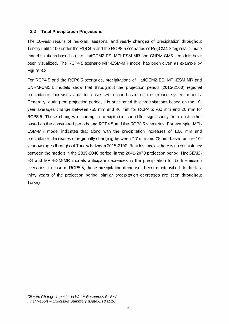
3.2 Total Precipitation Projections
The 10-year results of regional, seasonal and yearly changes of precipitation throughout
Turkey until 2100 under the RDC4.5 and the RCP8.5 scenarios of RegCM4.3 regional climate
model solutions based on the HadGEM2-ES, MPI-ESM-MR and CNRM-CM5.1 models have
been visualized. The RCP4.5 scenario MPI-ESM-MR model has been given as example by
Figure 3.3.
For RCP4.5 and the RCP8.5 scenarios, precipitations of HadGEM2-ES, MPI-ESM-MR and
CNRM-CM5.1 models show that throughout the projection period (2015-2100) regional
precipitation increases and decreases will occur based on the ground system models.
Generally, during the projection period, it is anticipated that precipitations based on the 10-
year averages change between -50 mm and 40 mm for RCP4.5; -60 mm and 20 mm for
RCP8.5. These changes occurring in precipitation can differ significantly from each other
based on the considered periods and RCP4.5 and the RCP8.5 scenarios. For example, MPI-
ESM-MR model indicates that along with the precipitation increases of 10,6 mm and
precipitation decreases of regionally changing between 7,7 mm and 28 mm based on the 10-
year averages throughout Turkey between 2015-2100. Besides this, as there is no consistency
between the models in the 2015-2040 period; in the 2041-2070 projection period, HadGEM2-
ES and MPI-ESM-MR models anticipate decreases in the precipitation for both emission
scenarios. In case of RCP8.5, these precipitation decreases become intensified. In the last
thirty years of the projection period, similar precipitation decreases are seen throughout
Turkey.
Climate Change Impacts on Water Resources Project Final Report – Executive Summary (Date:6.13.2016)
11
Figure 3.3 10-Year Period and Seasonal Changes of Total Precipitation Anomaly Values for MPI-ESM-MR Model RCP4.5 scenario
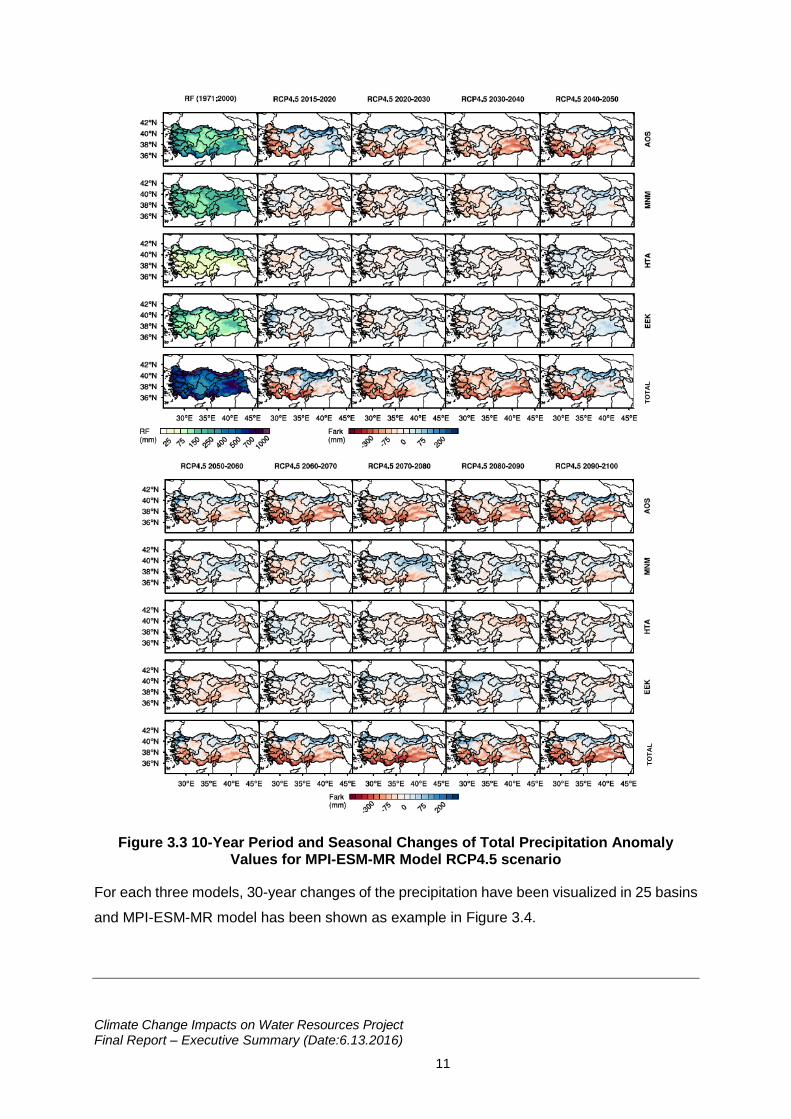
For each three models, 30-year changes of the precipitation have been visualized in 25 basins
and MPI-ESM-MR model has been shown as example in Figure 3.4.
TO
TA
L
TO
TA
L
Climate Change Impacts on Water Resources Project Final Report – Executive Summary (Date:6.13.2016)
12
Figure 3.4 30-Year Averages of Total Precipitation Anomaly Values of MPI-ESM-MR Model on Basins throughout Turkey
Climate Change Impacts on Water Resources Project Final Report – Executive Summary (Date:6.13.2016)
13
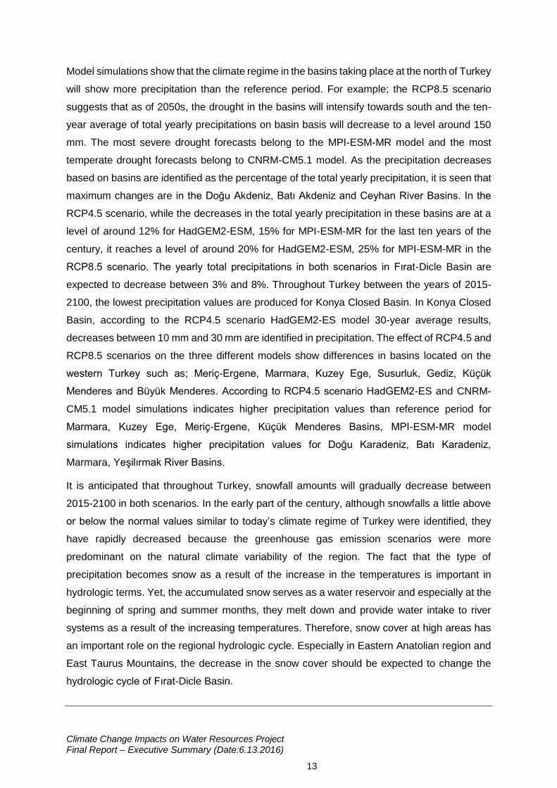
Model simulations show that the climate regime in the basins taking place at the north of Turkey
will show more precipitation than the reference period. For example; the RCP8.5 scenario
suggests that as of 2050s, the drought in the basins will intensify towards south and the ten-
year average of total yearly precipitations on basin basis will decrease to a level around 150
mm. The most severe drought forecasts belong to the MPI-ESM-MR model and the most
temperate drought forecasts belong to CNRM-CM5.1 model. As the precipitation decreases
based on basins are identified as the percentage of the total yearly precipitation, it is seen that
maximum changes are in the Doğu Akdeniz, Batı Akdeniz and Ceyhan River Basins. In the
RCP4.5 scenario, while the decreases in the total yearly precipitation in these basins are at a
level of around 12% for HadGEM2-ESM, 15% for MPI-ESM-MR for the last ten years of the
century, it reaches a level of around 20% for HadGEM2-ESM, 25% for MPI-ESM-MR in the
RCP8.5 scenario. The yearly total precipitations in both scenarios in Fırat-Dicle Basin are
expected to decrease between 3% and 8%. Throughout Turkey between the years of 2015-
2100, the lowest precipitation values are produced for Konya Closed Basin. In Konya Closed
Basin, according to the RCP4.5 scenario HadGEM2-ES model 30-year average results,
decreases between 10 mm and 30 mm are identified in precipitation. The effect of RCP4.5 and
RCP8.5 scenarios on the three different models show differences in basins located on the
western Turkey such as; Meriç-Ergene, Marmara, Kuzey Ege, Susurluk, Gediz, Küçük
Menderes and Büyük Menderes. According to RCP4.5 scenario HadGEM2-ES and CNRM-
CM5.1 model simulations indicates higher precipitation values than reference period for
Marmara, Kuzey Ege, Meriç-Ergene, Küçük Menderes Basins, MPI-ESM-MR model
simulations indicates higher precipitation values for Doğu Karadeniz, Batı Karadeniz,
Marmara, Yeşilırmak River Basins.
It is anticipated that throughout Turkey, snowfall amounts will gradually decrease between
2015-2100 in both scenarios. In the early part of the century, although snowfalls a little above
or below the normal values similar to today’s climate regime of Turkey were identified, they
have rapidly decreased because the greenhouse gas emission scenarios were more
predominant on the natural climate variability of the region. The fact that the type of
precipitation becomes snow as a result of the increase in the temperatures is important in
hydrologic terms. Yet, the accumulated snow serves as a water reservoir and especially at the
beginning of spring and summer months, they melt down and provide water intake to river
systems as a result of the increasing temperatures. Therefore, snow cover at high areas has
an important role on the regional hydrologic cycle. Especially in Eastern Anatolian region and
East Taurus Mountains, the decrease in the snow cover should be expected to change the
hydrologic cycle of Fırat-Dicle Basin.
Climate Change Impacts on Water Resources Project Final Report – Executive Summary (Date:6.13.2016)
14
3.3 Climate Indices
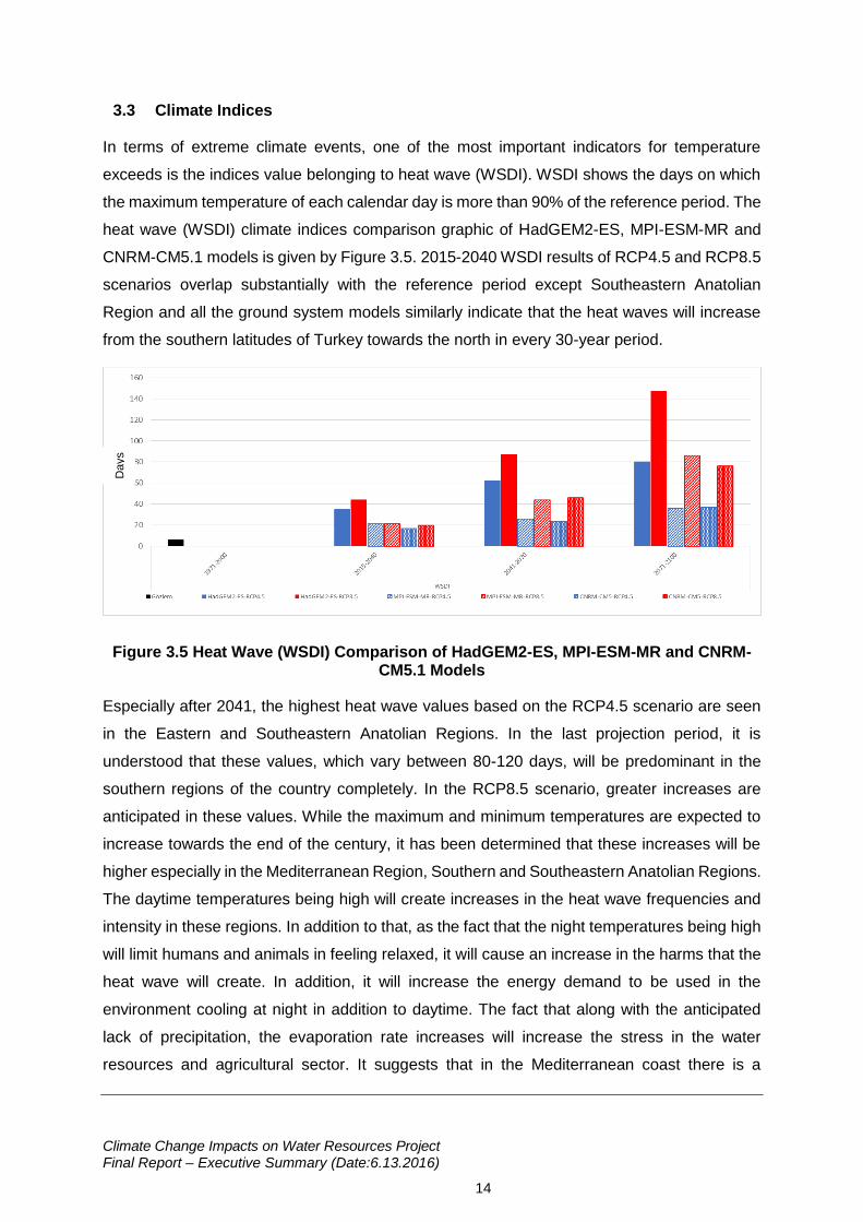
In terms of extreme climate events, one of the most important indicators for temperature
exceeds is the indices value belonging to heat wave (WSDI). WSDI shows the days on which
the maximum temperature of each calendar day is more than 90% of the reference period. The
heat wave (WSDI) climate indices comparison graphic of HadGEM2-ES, MPI-ESM-MR and
CNRM-CM5.1 models is given by Figure 3.5. 2015-2040 WSDI results of RCP4.5 and RCP8.5
scenarios overlap substantially with the reference period except Southeastern Anatolian
Region and all the ground system models similarly indicate that the heat waves will increase
from the southern latitudes of Turkey towards the north in every 30-year period.
Figure 3.5 Heat Wave (WSDI) Comparison of HadGEM2-ES, MPI-ESM-MR and CNRM-CM5.1 Models
Especially after 2041, the highest heat wave values based on the RCP4.5 scenario are seen
in the Eastern and Southeastern Anatolian Regions. In the last projection period, it is
understood that these values, which vary between 80-120 days, will be predominant in the
southern regions of the country completely. In the RCP8.5 scenario, greater increases are
anticipated in these values. While the maximum and minimum temperatures are expected to
increase towards the end of the century, it has been determined that these increases will be
higher especially in the Mediterranean Region, Southern and Southeastern Anatolian Regions.
The daytime temperatures being high will create increases in the heat wave frequencies and
intensity in these regions. In addition to that, as the fact that the night temperatures being high
will limit humans and animals in feeling relaxed, it will cause an increase in the harms that the
heat wave will create. In addition, it will increase the energy demand to be used in the
environment cooling at night in addition to daytime. The fact that along with the anticipated
lack of precipitation, the evaporation rate increases will increase the stress in the water
resources and agricultural sector. It suggests that in the Mediterranean coast there is a
Days
Climate Change Impacts on Water Resources Project Final Report – Executive Summary (Date:6.13.2016)
15
requirement of a new structuring in the tourism sector. The behaviors of the CDD - which gives
the number of the consecutive days on which the precipitation is less than 1mm – throughout
Turkey also supports this situation. While the CDD shows increase in each of the three models,
no significant change in the CWD, which gives the number of the consecutive wet days on
which the precipitation is more than 1 mm, is identified.
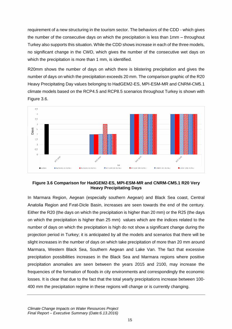
R20mm shows the number of days on which there is blistering precipitation and gives the
number of days on which the precipitation exceeds 20 mm. The comparison graphic of the R20
Heavy Precipitating Day values belonging to HadGEM2-ES, MPI-ESM-MR and CNRM-CM5.1
climate models based on the RCP4.5 and RCP8.5 scenarios throughout Turkey is shown with
Figure 3.6.
Figure 3.6 Comparison for HadGEM2-ES, MPI-ESM-MR and CNRM-CM5.1 R20 Very Heavy Precipitating Days
In Marmara Region, Aegean (especially southern Aegean) and Black Sea coast, Central
Anatolia Region and Fırat-Dicle Basin, increases are seen towards the end of the century.
Either the R20 (the days on which the precipitation is higher than 20 mm) or the R25 (the days
on which the precipitation is higher than 25 mm) values which are the indices related to the
number of days on which the precipitation is high do not show a significant change during the
projection period in Turkey; it is anticipated by all the models and scenarios that there will be
slight increases in the number of days on which take precipitation of more than 20 mm around
Marmara, Western Black Sea, Southern Aegean and Lake Van. The fact that excessive
precipitation possibilities increases in the Black Sea and Marmara regions where positive
precipitation anomalies are seen between the years 2015 and 2100, may increase the
frequencies of the formation of floods in city environments and correspondingly the economic
losses. It is clear that due to the fact that the total yearly precipitations increase between 100-
400 mm the precipitation regime in these regions will change or is currently changing.
Days
Climate Change Impacts on Water Resources Project Final Report – Executive Summary (Date:6.13.2016)
16
4. Turkey's Water Resources and Projections
4.1 Water Resources
According to the DSİ data, the total amount of the surface water and the groundwater is
identified as 112 billion m3 in economic and technical aspects, for the various purposes of
usage in Turkey. Hereunder, the usable surface water potential is a total of 98 billion m3 per
year; 95 billion m3 from the inland streams and 3 billion m3 from the streams coming to our
country from the neighbor countries. With the ground water potential determined to be 14 billion
m3, the available surface and ground water potential per year is a total of 112 billion m3 and 44
billion m3 of it being used (URL-1).
Within the scope of the Project; up to date data acquired from many different resources like
Activity Reports (DSİ, 2013; 2012), Forestry and Water Council Working Group Reports
(2013), Performance Reports (DSİ, 2011/2012/2013), Basin Protection Action Plans (2010;
2014), Development Program Human Development Program (United Nations, 2013) and
Turkey’s Development Report (Ministry of EU, 2013) have been taken into consideration and
it is aimed that the current situation of the water potential in Turkey is set forth in the best way.
Within the scope of the project, the water potential of Turkey has been calculated as
approximately 108,5 billion m3 which is close value to 112 billion m3 provided in many sources.
After the calculation of the usable water potential, the basic sectors, which will consume the
water in each basin, have been set forth. The said water potential is distributed among 4 main
sectors (water intended for human consumption, industry water, irrigation water and
ecosystem services requirement). According to this, along with the population, industry and
agriculture activities special to basins, the change of the ecosystem services requirements until
2100 is also foreseen. While the possible excess water or water deficit in the basins is being
calculated, basin based population growth trends and the important common investment plans
specific to basin have been taken into consideration. Similarly, with the progress of the
changes in basin based industrial and agricultural activities, the necessities of the ecosystem
services have also been taken into consideration.
4.2 Hydrologic Projections
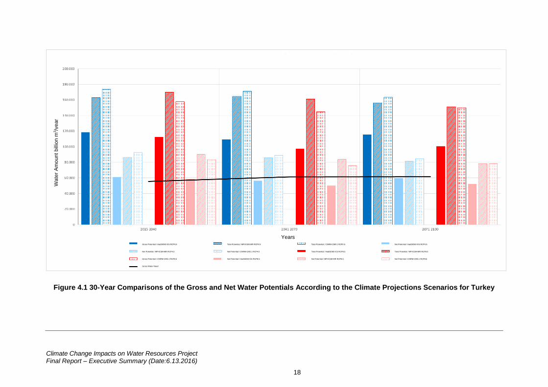
The change in the gross and net water potentials throughout Turkey in 2015-2100 period is
displayed in detail with Figure 4.1 on the basis of all the scenarios of the models. As the nation-
Climate Change Impacts on Water Resources Project Final Report – Executive Summary (Date:6.13.2016)
17
wide gross and net water potential forecasts of Turkey are observed, the lowest values for both
scenarios in 30-year averages are produced with HadGEM2–ES model.
According to the results of each three climate models and two scenarios (RCP4.5 and
RCP8.5), it is anticipated that the total flow in Turkey will decrease compared to the reference
period. The lowest total flow forecasts for the results of both the RCP4.5 and the RCP8.5
scenarios are produced with the HadGEM2–ES model. With MPI-ESM-MR and CNRM-CM5.1
models, close results have been produced throughout all the periods. Along with the fact that
the total flow forecasts made with the RCP4.5 scenario are a bit higher than the results of The
RCP8.5 scenario draws attention; all the model forecasts remain lower than the reference
period value (~186.000 million m3/year). Although 30-year yearly average forecasts are lower
compared to the reference period, it is seen that the period value of each of the 30-year periods
does not change too much for the same scenario of the same model.
In the simulations managed only with the HadGEM2-ES climate model outcomes, it is
anticipated that the water deficit in at least 3 ten-year periods may be at a level of ~6.000
million m3/year. In the hydrologic modelling simulations carried out for HadGEM2-ES model
and RCP8.5 scenario, there is an expectation of water deficit at a level of ~7.000 million
m3/year (max: ~15.000 million m3/year) at least in 6 ten-year periods. The results that MPI-
ESM-MR and CNRM-CM5.1 models have produced for both scenarios show similarity and it
is anticipated that in the 2015-2100 period, the total water requirement of our country can be
met and there will be no water deficit.
Within the scope of the evaluation of the model results throughout Turkey, a statistical analysis
in the characteristic of a brief study. In the simulations performed with the outcomes of climate
models and with WEAP supported SWAT hydrologic model, the status of the median gross
water potentials forecasted for 3 sub-projection periods is compared with the median value of
the reference period. According to this, with the hydrologic modelling base on the outcomes of
HadGEM2-ES climate model, it is anticipated that the median gross water potentials for 3 sub-
periods in the 2015-2100 period will decrease 40-45% compared to the median value of the
reference period. Under the same conditions, it is forecasted that the decrease ratio of the
median gross water potential obtained from the hydrologic model projections performed by the
outcomes of the MPI-MSM-MR climate model will remain at the range of 15-20%.
Climate Change Impacts on Water Resources Project Final Report – Executive Summary (Date:6.13.2016)
18
Figure 4.1 30-Year Comparisons of the Gross and Net Water Potentials According to the Climate Projections Scenarios for Turkey
Wate
r A
mo
unt
bill
ion m
3/y
ear
Years
Gross Potential / HadGEM2-ES RCP4.5
Net Potential / MPI-ESM-MR RCP4.5
Gross Potential / CNRM-CM5.1 RCP8.5
Gross Water Need
Total Potential / MPI-ESM-MR RCP4.5
Net Potential / CNRM-CM5.1 RCP4.5
Net Potential / HadGEM2-ES RCP8.5
Total Potential / CNRM-CM5.1 RCP4.5
Total Potential / HadGEM2-ES RCP8.5
Net Potential / MPI-ESM-MR RCP8.5
Net Potential / HadGEM2-ES RCP4.5
Total Potential / MPI-ESM-MR RCP8.5
Net Potential / CNRM-CM5.1 RCP8.5
Climate Change Impacts on Water Resources Project Final Report – Executive Summary (Date:6.13.2016)
19
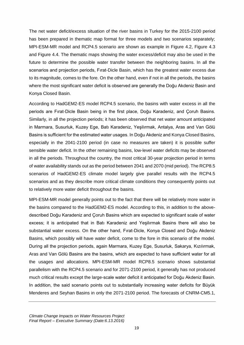
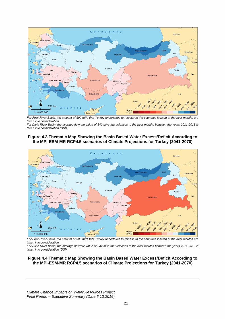
The net water deficit/excess situation of the river basins in Turkey for the 2015-2100 period
has been prepared in thematic map format for three models and two scenarios separately;
MPI-ESM-MR model and RCP4.5 scenario are shown as example in Figure 4.2, Figure 4.3
and Figure 4.4. The thematic maps showing the water excess/deficit may also be used in the
future to determine the possible water transfer between the neighboring basins. In all the
scenarios and projection periods, Fırat-Dicle Basin, which has the greatest water excess due
to its magnitude, comes to the fore. On the other hand, even if not in all the periods, the basins
where the most significant water deficit is observed are generally the Doğu Akdeniz Basin and
Konya Closed Basin.
According to HadGEM2-ES model RCP4.5 scenario, the basins with water excess in all the
periods are Fırat-Dicle Basin being in the first place, Doğu Karadeniz, and Çoruh Basins.
Similarly, in all the projection periods; it has been observed that net water amount anticipated
in Marmara, Susurluk, Kuzey Ege, Batı Karadeniz, Yeşilırmak, Antalya, Aras and Van Gölü
Basins is sufficient for the estimated water usages. In Doğu Akdeniz and Konya Closed Basins,
especially in the 2041-2100 period (in case no measures are taken) it is possible suffer
sensible water deficit. In the other remaining basins, low-level water deficits may be observed
in all the periods. Throughout the country, the most critical 30-year projection period in terms
of water availability stands out as the period between 2041 and 2070 (mid period). The RCP8.5
scenarios of HadGEM2-ES climate model largely give parallel results with the RCP4.5
scenarios and as they describe more critical climate conditions they consequently points out
to relatively more water deficit throughout the basins.
MPI-ESM-MR model generally points out to the fact that there will be relatively more water in
the basins compared to the HadGEM2-ES model. According to this, in addition to the above-
described Doğu Karadeniz and Çoruh Basins which are expected to significant scale of water
excess; it is anticipated that in Batı Karadeniz and Yeşilırmak Basins there will also be
substantial water excess. On the other hand, Fırat-Dicle, Konya Closed and Doğu Akdeniz
Basins, which possibly will have water deficit, come to the fore in this scenario of the model.
During all the projection periods, again Marmara, Kuzey Ege, Susurluk, Sakarya, Kızılırmak,
Aras and Van Gölü Basins are the basins, which are expected to have sufficient water for all
the usages and allocations. MPI-ESM-MR model RCP8.5 scenario shows substantial
parallelism with the RCP4.5 scenario and for 2071-2100 period, it generally has not produced
much critical results except the large-scale water deficit it anticipated for Doğu Akdeniz Basin.
In addition, the said scenario points out to substantially increasing water deficits for Büyük
Menderes and Seyhan Basins in only the 2071-2100 period. The forecasts of CNRM-CM5.1,
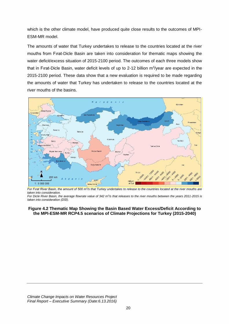
Climate Change Impacts on Water Resources Project Final Report – Executive Summary (Date:6.13.2016)
20
which is the other climate model, have produced quite close results to the outcomes of MPI-
ESM-MR model.
The amounts of water that Turkey undertakes to release to the countries located at the river
mouths from Fırat-Dicle Basin are taken into consideration for thematic maps showing the
water deficit/excess situation of 2015-2100 period. The outcomes of each three models show
that in Fırat-Dicle Basin, water deficit levels of up to 2-12 billion m3/year are expected in the
2015-2100 period. These data show that a new evaluation is required to be made regarding
the amounts of water that Turkey has undertaken to release to the countries located at the
river mouths of the basins.
For Fırat River Basin, the amount of 500 m3/s that Turkey undertakes to release to the countries located at the river mouths are taken into consideration. For Dicle River Basin, the average flowrate value of 342 m3/s that releases to the river mouths between the years 2011-2015 is taken into consideration (DSİ).
Figure 4.2 Thematic Map Showing the Basin Based Water Excess/Deficit According to the MPI-ESM-MR RCP4.5 scenarios of Climate Projections for Turkey (2015-2040)
Climate Change Impacts on Water Resources Project Final Report – Executive Summary (Date:6.13.2016)
21
For Fırat River Basin, the amount of 500 m3/s that Turkey undertakes to release to the countries located at the river mouths are taken into consideration. For Dicle River Basin, the average flowrate value of 342 m3/s that releases to the river mouths between the years 2011-2015 is taken into consideration (DSİ).
Figure 4.3 Thematic Map Showing the Basin Based Water Excess/Deficit According to the MPI-ESM-MR RCP4.5 scenarios of Climate Projections for Turkey (2041-2070)
For Fırat River Basin, the amount of 500 m3/s that Turkey undertakes to release to the countries located at the river mouths are taken into consideration. For Dicle River Basin, the average flowrate value of 342 m3/s that releases to the river mouths between the years 2011-2015 is taken into consideration (DSİ).
Figure 4.4 Thematic Map Showing the Basin Based Water Excess/Deficit According to the MPI-ESM-MR RCP4.5 scenarios of Climate Projections for Turkey (2041-2070)
Climate Change Impacts on Water Resources Project Final Report – Executive Summary (Date:6.13.2016)
22
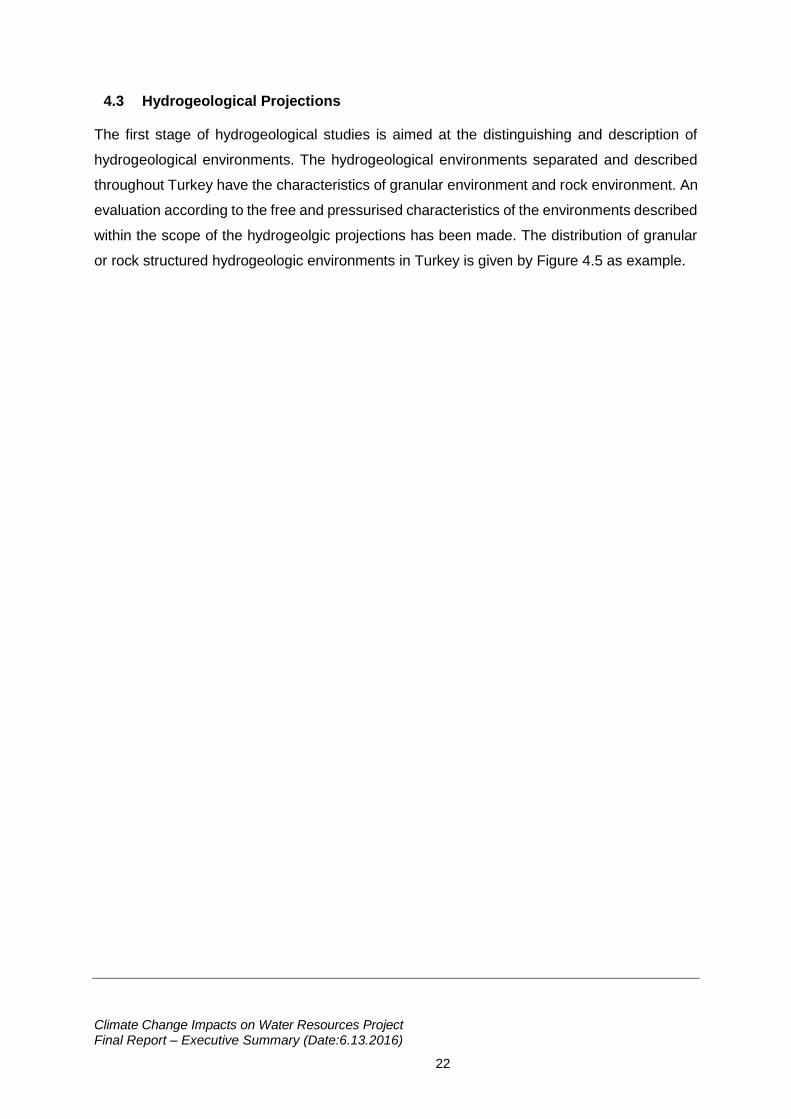
4.3 Hydrogeological Projections
The first stage of hydrogeological studies is aimed at the distinguishing and description of
hydrogeological environments. The hydrogeological environments separated and described
throughout Turkey have the characteristics of granular environment and rock environment. An
evaluation according to the free and pressurised characteristics of the environments described
within the scope of the hydrogeolgic projections has been made. The distribution of granular
or rock structured hydrogeologic environments in Turkey is given by Figure 4.5 as example.
Climate Change Impacts on Water Resources Project Final Report – Executive Summary (Date:6.13.2016)
23
Figure 4.5 The Distribution of Free ± Pressurised Granular and Rock Environment Aquifers (TS, TB, KS, KB ; Aquifer) and Semi-Aquifers (ts, tb, ks, kb ; Aquitard) in Turkey.
Climate Change Impacts on Water Resources Project Final Report – Executive Summary (Date:6.13.2016)
24
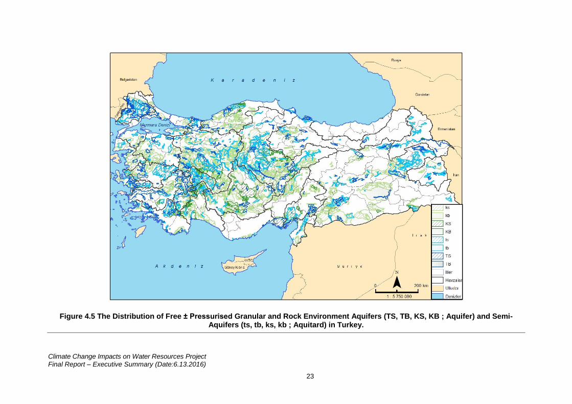
The ground water potentials of the hydrogeologic environments whose characteristics
throughout Turkey have been defined are determined as “dynamic, static, hydrogeologic,
possible” ground water reserves. The calculations have been performed according to the
“maximum ground water storage capability” by carrying out some environmental sizing
acceptances with geo-hydraulic coefficients whose environmental representations have been
homognized, entirely “taking the original geologic-hydrogeologic character of each
hydrogeologic environment as basis”. The interbasin comparison of the dynamic, static and
possible ground water reserve sizes - which are the expressions of the ground water potential
of the hydrogeologic environments at the river basins in Turkey in different ways – is given with
Figure 4.6 as example.
Figure 4.6 The Distribution of the Ground Water Potential of River Basins of Turkey in Terms of “Dynamic, Static, Hydrogeologic, Possible Reserves”
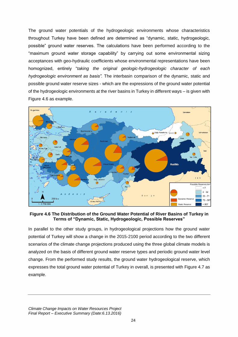
In parallel to the other study groups, in hydrogeological projections how the ground water
potential of Turkey will show a change in the 2015-2100 period according to the two different
scenarios of the climate change projections produced using the three global climate models is
analyzed on the basis of different ground water reserve types and periodic ground water level
change. From the performed study results, the ground water hydrogeological reserve, which
expresses the total ground water potential of Turkey in overall, is presented with Figure 4.7 as
example.
Possible Reserves km3
Dynamic Reserve
Static Reserve
Climate Change Impacts on Water Resources Project Final Report – Executive Summary (Date:6.13.2016)
25
Figure 4.7 The Change Trend Foreseen in the Ground Water Hydrogeological Reserve of Turkey According to the Climate Models - Scenarios
As the change foreseen in the hydrogeologic reserve is evaluated specific to the basins, Meriç-
Ergene and Fırat-Dicle Basins are among the basins which are least affected in Turkey overall.
On the other hand, the striking maximum impact of the climate models-scenarios in overall
Turkey is seen over the Asi Basin. In this context, the other most affected basins can be listed
from most affected to least affected as Burdur, Kuzey Ege, Batı Akdeniz and Akarçay Basins
which are in the western and middle parts of Turkey.
5. Evaluation of the Impacts of Climate Change on Water Resources Based on River Basins
Within the context of the project, the climate change projections of all the basins of Turkey and
the impact of the said change on the water resources in the basins is analyzed. In this context,
in the most general sense, the determinative river system in each basin is designated; the
current use of the surface and ground water resources and the usage areas of the resources,
the places where the composed domestic and industrial wastes are discharged and their
amounts are analyzed. The hydraulic variables have been projected until 2100 at the scale of
the drainage areas detected in the basin using temperature and precipitation projections based
on the RCP4.5 and RCP8.5 scenarios of the HadGEM2-ES, MPI-ESM-MR and CNRM-CM5.1
climate models for the 2015-2100 period and the gross and net water potential change in each
basin has been calculated. It is quite important for creating opportunities for the project
outcomes to be taken into consideration in the determination of the water management
strategies in all the basins and for the water deficit foreseen in the basin to be minimized.
H
ydro
geolo
gic
al R
eserv
e k
m3/y
ear
Years
Climate Change Impacts on Water Resources Project Final Report – Executive Summary (Date:6.13.2016)
26
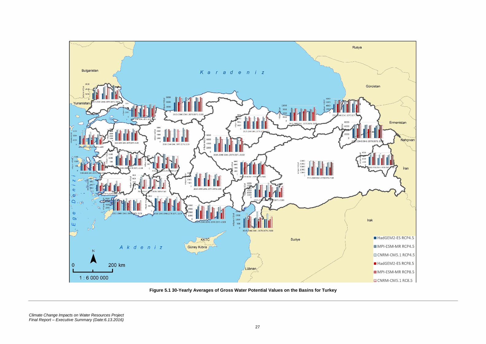
In the RCP4.5 and the RCP8.5 scenarios for each of the three models, the 30-year changes
of the gross water potential in 25 basins is shown with Figure 5.1.
Climate Change Impacts on Water Resources Project Final Report – Executive Summary (Date:6.13.2016)
27
Figure 5.1 30-Yearly Averages of Gross Water Potential Values on the Basins for Turkey
Climate Change Impacts on Water Resources Project Final Report – Executive Summary (Date:6.13.2016)
28
In this section, the change of the average temperature, total precipitation, gross water
potentials for 25 basins of Turkey are shown according to the reference period. Additionally,
the amounts of water deficit/excess and hydrogeological reserves in the basin are given. All
model results were evaluated over 30-year periods and possible extreme values were given in
basin.
5.1 Meriç-Ergene Basin
According to the climate change projections made for 2015-2100 period, it is expected that
there will be a continuous increase in average temperatures. It is expected that the average
temperature of the basin, which was 13,4oC according to 1971-2000 observations, will
increase by at least 1,5°C, maximum 4,7oC in 2071-2100 period.
According to the observations of 1971-2000, the average annual precipitation amount of the
reference period of the basin was determined to be 598,3 mm. According to the 30-year
projection results, there is no significant increase or decrease tendency for the total
precipitation parameter and it is predicted that the basin will receive 13% less rainfall
compared to the reference period in 2071-2100. It is expected that rainfall decreases for this
period will predominate in the northern parts of the basin.
DSİ (Directorate General for State Hydraulic Works) data were used for hydrological model
studies and the mean gross water potential of the basin for the reference period was
determined to be 1.838 million 3/year. With the effect of climate change, it is predicted that in
the period 2041-2070, the gross water potential of the basin could decrease up to 60%.
However, in the period 2071-2100, it is expected that the annual amount of water available will
not meet the total water need, and the water deficit will be around 1.485 million m3/year.
As a result of the hydrogeological studies carried out, the hydrogeological reserve of
groundwater of the basin was determined to be 188 km3. The technically and economically
usable amount of this reserve, the possible reserve is calculated to be 125 km3. It is estimated
that at the end of the century under the effects of the climate change, the hydrogeological
reserve of the basin will decrease by 2% and possible reserve by 3%.
5.2 Marmara Basin
According to the climate change projections made for 2015-2100 period, it is expected that
there will be a continuous increase in average temperatures. It is expected that the average
temperature of the basin, which was 13,9oC according to 1971-2000 observations, will
increase by at least 1,5°C, maximum 4,6oC in 2071-2100 period.
Climate Change Impacts on Water Resources Project Final Report – Executive Summary (Date:6.13.2016)
29
According to the observations of 1971-2000, the average annual precipitation amount of the
reference period of the basin was determined to be 679,2 mm. According to the results of the
projection carried out, there is an increase tendency in the total precipitation compared to the
reference period (1971-2000), and it is predicted that the basin will receive 13% more rainfall
compared to the reference period in 2071-2100. It is expected that rainfall increases for this
period will predominate in the Black Sea coasts of the basin.
DSİ (Directorate General for State Hydraulic Works) data were used for hydrological model
studies and the mean gross water potential of the basin for the reference period was
determined to be 8.566 million 3/year. With the effect of climate change, it is predicted that in
the period 2041-2070, the gross water potential of the basin could decrease up to 50%. Water
transfer from the Batı Karadeniz, Sakarya and Meriç-Ergene Basins to the Marmara Basin is
carried out so that the water need in the basin can be met at all times.
As a result of the hydrogeological studies carried out, the hydrogeological reserve of
groundwater of the basin was determined to be 53 km3. The technically and economically
usable amount of this reserve, the possible reserve is calculated to be 29 km3. It is estimated
that at the end of the century under the effects of the climate change, the hydrogeological
reserve of the basin will decrease by 6% and possible reserve by 10%.
5.3 Susurluk Basin
According to the climate change projections made for 2015-2100 period, it is expected that
there will be a continuous increase in average temperatures. It is expected that the average
temperature of the basin, which was 12,5oC according to 1971-2000 observations, will
increase by at least 1,6°C, maximum 4,7oC in 2071-2100 period.
According to the observations of 1971-2000, the average annual precipitation amount of the
reference period of the basin was determined to be 640 mm. According to the results of the
projection carried out, there is a decrease tendency in the total precipitation compared to the
reference period (1971-2000), and it is predicted that the basin will receive 10% less rainfall
compared to the reference period in 2071-2100. It is expected that rainfall decreases for this
period will predominate in the southern parts of the basin.
DSİ (Directorate General for State Hydraulic Works) data were used for hydrological model
studies and the mean gross water potential of the basin for the reference period was
determined to be 6.157 million 3/year. With the effect of climate change, it is predicted that in
the period 2041-2070, the gross water potential of the basin could decrease up to 50%.
Climate Change Impacts on Water Resources Project Final Report – Executive Summary (Date:6.13.2016)
30
Despite this, it is not expected that the annual available water amount for the projection period
will meet the total water need.
As a result of the hydrogeological studies carried out, the hydrogeological reserve of
groundwater of the basin was determined to be 34 km3. The technically and economically
usable amount of this reserve, the possible reserve is calculated to be 18 km3. It is estimated
that at the end of the century under the effects of the climate change, the hydrogeological
reserve of the basin will decrease by 6% and possible reserve by 11%.
5.4 Kuzey Ege Basin
According to the climate change projections made for 2015-2100 period, it is expected that
there will be a continuous increase in average temperatures. It is expected that the average
temperature of the basin, which was 15,9oC according to 1971-2000 observations, will
increase by at least 1,5°C, maximum 4,6oC in 2071-2100 period. It is expected that
temperature increases for this period will predominate in the eastern parts of the basin.
According to the observations of 1971-2000, the average annual precipitation amount of the
reference period of the basin was determined to be 615 mm. According to the 30-year
projection results, there is no significant increase or decrease tendency for the total
precipitation parameter and it is predicted that the basin will receive 15% less rainfall
compared to the reference period in 2071-2100. It is expected that rainfall decreases for this
period will predominate in the southern parts of the basin.
DSİ (Directorate General for State Hydraulic Works) data were used for hydrological model
studies and the mean gross water potential of the basin for the reference period was
determined to be 2.379 million 3/year. With the effect of climate change, it is predicted that in
the period 2041-2070, the gross water potential of the basin could decrease up to 60%.
However, in the same period, it is expected that the annual amount of water available will not
meet the total water need, and the water deficit will be around 75 million m3/year.
As a result of the hydrogeological studies carried out, the hydrogeological reserve of
groundwater of the basin was determined to be 19 km3. The technically and economically
usable amount of this reserve, the possible reserve is calculated to be 10 km3. It is estimated
that at the end of the century under the effects of the climate change, the hydrogeological
reserve of the basin will decrease by 11% and possible reserve by 21%.
Climate Change Impacts on Water Resources Project Final Report – Executive Summary (Date:6.13.2016)
31
5.5 Gediz Basin
According to the climate change projections made for 2015-2100 period, it is expected that
there will be a continuous increase in average temperatures. It is expected that the average
temperature of the basin, which was 14,6oC according to 1971-2000 observations, will
increase by at least 1,7°C, maximum 4,9oC in 2071-2100 period.
According to the observations of 1971-2000, the average annual precipitation amount of the
reference period of the basin was determined to be 589,7 mm. According to the results of the
projection carried out, there is a decrease tendency in the total precipitation compared to the
reference period (1971-2000), and it is predicted that the basin will receive 20% less rainfall
compared to the reference period in 2071-2100. It is expected that rainfall decreases for this
period will predominate in the southwestern and northeastern parts of the basin.
DSİ (Directorate General for State Hydraulic Works) data were used for hydrological model
studies and the mean gross water potential of the basin for the reference period was
determined to be 2.505 million 3/year. With the effect of climate change, it is predicted that in
the period 2041-2070, the gross water potential of the basin could decrease up to 75%.
However, in the same period, it is expected that the annual amount of water available will not
meet the total water need, and the water deficit will be around 1.445 million m3/year.
As a result of the hydrogeological studies carried out, the hydrogeological reserve of
groundwater of the basin was determined to be 40 km3. The technically and economically
usable amount of this reserve, the possible reserve is calculated to be 21 km3. It is estimated
that at the end of the century under the effects of the climate change, the hydrogeological
reserve of the basin will decrease by 11% and possible reserve by 20%.
5.6 Küçük Menderes Basin
According to the climate change projections made for 2015-2100 period, it is expected that
there will be a continuous increase in average temperatures. It is expected that the average
temperature of the basin, which was 16,7oC according to 1971-2000 observations, will
increase by at least 1,6°C, maximum 4,7oC in 2071-2100 period. It is expected that
temperature increases for this period will predominate in the areas other than the coasts of
Aegean.
According to the observations of 1971-2000, the average annual precipitation amount of the
reference period of the basin was determined to be 695,6 mm. According to the 30-year
projection results, there is no significant increase or decrease tendency for the total
precipitation parameter and it is predicted that the basin will receive 20% less rainfall
Climate Change Impacts on Water Resources Project Final Report – Executive Summary (Date:6.13.2016)
32
compared to the reference period in 2071-2100. It is expected that rainfall decreases for this
period will predominate in the eastern parts of the basin.
DSİ (Directorate General for State Hydraulic Works) data were used for hydrological model
studies and the mean gross water potential of the basin for the reference period was
determined to be 1.369 million 3/year. With the effect of climate change, it is predicted that in
the period 2041-2100, the gross water potential of the basin could decrease up to 70%.
However, in the same period, it is expected that the annual amount of water available will not
meet the total water need, and the water deficit will be around 315 million m3/year.
As a result of the hydrogeological studies carried out, the hydrogeological reserve of
groundwater of the basin was determined to be 56 km3. The technically and economically
usable amount of this reserve, the possible reserve is calculated to be 32 km3. It is estimated
that at the end of the century under the effects of the climate change, the hydrogeological
reserve of the basin will decrease by 3% and possible reserve by 5%.
5.7 Büyük Menderes Basin:
According to the climate change projections made for 2015-2100 period, it is expected that
there will be a continuous increase in average temperatures. It is expected that the average
temperature of the basin, which was 14,4oC according to 1971-2000 observations, will
increase by at least 1,8°C, maximum 5oC in 2071-2100 period. It is expected that
temperature increases for this period will predominate in the eastern parts of the basin.
According to the observations of 1971-2000, the average annual precipitation amount of the
reference period of the basin was determined to be 592,4 mm. According to the results of the
projection carried out, there is a decrease tendency in the total precipitation compared to the
reference period (1971-2000), and it is predicted that the basin will receive 25% less rainfall
compared to the reference period in 2071-2100. It is expected that rainfall decreases for this
period will predominate in the western parts of the basin.
DSİ (Directorate General for State Hydraulic Works) data were used for hydrological model
studies and the mean gross water potential of the basin for the reference period was
determined to be 4.028 million 3/year. With the effect of climate change, it is predicted that in
the period 2041-2070, the gross water potential of the basin could decrease up to 65%.
However, in the period 2071-2100, it is expected that the annual amount of water available will
not meet the total water need, and the water deficit will be around 2.480 million m3/year.
As a result of the hydrogeological studies carried out, the hydrogeological reserve of
groundwater of the basin was determined to be 228 km3. The technically and economically
Climate Change Impacts on Water Resources Project Final Report – Executive Summary (Date:6.13.2016)
33
usable amount of this reserve, the possible reserve is calculated to be 138 km3. It is estimated
that at the end of the century under the effects of the climate change, the hydrogeological
reserve of the basin will decrease by 4% and possible reserve by 7%.
5.8 Batı Akdeniz Basin:
According to the climate change projections made for 2015-2100 period, it is expected that
there will be a continuous increase in average temperatures. It is expected that the average
temperature of the basin, which was 16,2oC according to 1971-2000 observations, will
increase by at least 1,8°C, maximum 4,9oC in 2071-2100 period. It is expected that
temperature increases for this period will predominate in the northeastern parts of the basin.
According to the observations of 1971-2000, the average annual precipitation amount of the
reference period of the basin was determined to be 731 mm. According to the results of the
projection carried out, there is a decrease tendency in the total precipitation compared to the
reference period (1971-2000), and it is predicted that the basin will receive 28% less rainfall
compared to the reference period in 2071-2100. It is expected that rainfall decreases for this
period will predominate in the southern parts of the basin.
DSİ (Directorate General for State Hydraulic Works) data were used for hydrological model
studies and the mean gross water potential of the basin for the reference period was
determined to be 9.403 million 3/year. With the effect of climate change, it is predicted that in
the period 2071-2100, the gross water potential of the basin could decrease up to 50%.
Despite this, it is expected that the total water need of the basin can be met until 2100 and
there will be no water deficit in the basin.
As a result of the hydrogeological studies carried out, the hydrogeological reserve of
groundwater of the basin was determined to be 70 km3. The technically and economically
usable amount of this reserve, the possible reserve is calculated to be 43 km3. It is estimated
that at the end of the century under the effects of the climate change, the hydrogeological
reserve of the basin will decrease by 13% and possible reserve by 22%.
5.9 Antalya Basin
According to the climate change projections made for 2015-2100 period, it is expected that
there will be a continuous increase in average temperatures. It is expected that the average
temperature of the basin, which was 14,2oC according to 1971-2000 observations, will
increase by at least 1,8°C, maximum 5oC in 2071-2100 period. It is expected that
temperature increases for this period will predominate in the inner parts of the basin.
Climate Change Impacts on Water Resources Project Final Report – Executive Summary (Date:6.13.2016)
34
According to the observations of 1971-2000, the average annual precipitation amount of the
reference period of the basin was determined to be 690,5 mm. According to the results of the
projection carried out, there is a decrease tendency in the total precipitation compared to the
reference period (1971-2000), and it is predicted that the basin will receive 25% less rainfall
compared to the reference period in 2071-2100. It is expected that rainfall decreases for this
period will predominate in the southeastern parts of the basin.
DSİ (Directorate General for State Hydraulic Works) data were used for hydrological model
studies and the mean gross water potential of the basin for the reference period was
determined to be 12.153 million 3/year. With the effect of climate change, it is predicted that
in the period 2071-2100, the gross water potential of the basin could decrease up to 60%.
Despite this, it is expected that the total available water potential in the basin will be above the
total water need during 2015-2010, and there will be no water deficit in the basin.
As a result of the hydrogeological studies carried out, the hydrogeological reserve of
groundwater of the basin was determined to be 288 km3. The technically and economically
usable amount of this reserve, the possible reserve is calculated to be 168 km3. It is estimated
that at the end of the century under the effects of the climate change, the hydrogeological
reserve of the basin will decrease by 7% and possible reserve by 12%.
5.10 Burdur Basin
According to the climate change projections made for 2015-2100 period, it is expected that
there will be a continuous increase in average temperatures. It is expected that the average
temperature of the basin, which was 12,3oC according to 1971-2000 observations, will
increase by at least 1,9°C, maximum 5,1oC in 2071-2100 period.
According to the observations of 1971-2000, the average annual precipitation amount of the
reference period of the basin was determined to be 508,7 mm. According to the results of the
projection carried out, there is a decrease tendency in the total precipitation compared to the
reference period (1971-2000), and it is predicted that the basin will receive 25% less rainfall
compared to the reference period in 2071-2100.
DSİ (Directorate General for State Hydraulic Works) data were used for hydrological model
studies and the mean gross water potential of the basin for the reference period was
determined to be 606 million 3/year. With the effect of climate change, it is predicted that in
the period 2071-2100, the gross water potential of the basin could decrease up to 85%.
However, in the same period, it is expected that the annual amount of water available will not
meet the total water need, and the water deficit will be around 495 million m3/year.

Climate Change Impacts on Water Resources Project Final Report – Executive Summary (Date:6.13.2016)
35
As a result of the hydrogeological studies carried out, the hydrogeological reserve of
groundwater of the basin was determined to be 49 km3. The technically and economically
usable amount of this reserve, the possible reserve is calculated to be 26 km3. It is estimated
that at the end of the century under the effects of the climate change, the hydrogeological
reserve of the basin will decrease by 14% and possible reserve by 26%.
5.11 Akarçay Basin
According to the climate change projections made for 2015-2100 period, it is expected that
there will be a continuous increase in average temperatures. It is expected that the average
temperature of the basin, which was 11,3oC according to 1971-2000 observations, will
increase by at least 1,8°C, maximum 5oC in 2071-2100 period.
According to the observations of 1971-2000, the average annual precipitation amount of the
reference period of the basin was determined to be 460,4 mm. According to the results of the
projection carried out, there is a decrease tendency in the total precipitation compared to the
reference period (1971-2000), and it is predicted that the basin will receive 17% less rainfall
compared to the reference period in 2071-2100. It is expected that rainfall decreases for this
period will predominate in the northern parts of the basin.
DSİ (Directorate General for State Hydraulic Works) data were used for hydrological model
studies and the mean gross water potential of the basin for the reference period was
determined to be 678 million 3/year. With the effect of climate change, it is predicted that in
the period 2071-2100, the gross water potential of the basin could decrease up to 70%.
However, in the same period, it is expected that the annual amount of water available will not
meet the total water need, and the water deficit will be around 545 million m3/year.
As a result of the hydrogeological studies carried out, the hydrogeological reserve of
groundwater of the basin was determined to be 105 km3. The technically and economically
usable amount of this reserve, the possible reserve is calculated to be 57 km3. It is estimated
that at the end of the century under the effects of the climate change, the hydrogeological
reserve of the basin will decrease by 11% and possible reserve by 20%.
5.12 Sakarya Basin
According to the climate change projections made for 2015-2100 period, it is expected that
there will be a continuous increase in average temperatures. It is expected that the average
temperature of the basin, which was 11,3oC according to 1971-2000 observations, will
increase by at least 1,7°C, maximum 4,9oC in 2071-2100 period. It is expected that
Climate Change Impacts on Water Resources Project Final Report – Executive Summary (Date:6.13.2016)
36
temperature increases for this period will predominate in the northeastern and southeastern
parts of the basin.
According to the observations of 1971-2000, the average annual precipitation amount of the
reference period of the basin was determined to be 477,8 mm. According to the results of the
projection carried out, there is a decrease tendency in the total precipitation compared to the
reference period (1971-2000), and it is predicted that the basin will receive 8% less rainfall
compared to the reference period in 2071-2100. It is expected that rainfall decreases for this
period will predominate in the southwestern and northeastern parts of the basin.
DSİ (Directorate General for State Hydraulic Works) data were used for hydrological model
studies and the mean gross water potential of the basin for the reference period was
determined to be 8.592 million 3/year. With the effect of climate change, it is predicted that in
the period 2041-2070, the gross water potential of the basin could decrease by 75%. However,
in the same period, it is expected that the annual amount of water available will not meet the
total water need, and the water deficit will be around 1.175 million m3/year level.
As a result of the hydrogeological studies carried out, the hydrogeological reserve of
groundwater of the basin was determined to be 377 km3. The technically and economically
usable amount of this reserve, the possible reserve is calculated to be 200 km3. It is estimated
that at the end of the century under the effects of the climate change, the hydrogeological
reserve of the basin will decrease by 5% and possible reserve by 10%.
5.13 Batı Karadeniz Basin:
According to the climate change projections made for 2015-2100 period, it is expected that
there will be a continuous increase in average temperatures. It is expected that the average
temperature of the basin, which was 11,6oC according to 1971-2000 observations, will
increase by at least 1,6°C, maximum 4,7oC in 2071-2100 period.
According to the observations of 1971-2000, the average annual precipitation amount of the
reference period of the basin was determined to be 741,6 mm. According to the results of the
projection carried out, the amount of precipitation is above the reference period (1971-2000),
and it is predicted that the basin will receive 8% more rainfall compared to the reference period
in 2015-2020. It is expected that rainfall increases for this period will predominate in the
coastal parts of the basin.
DSİ (Directorate General for State Hydraulic Works) data were used for hydrological model
studies and the mean gross water potential of the basin for the reference period was
determined to be 10.346 million 3/year. With the effect of climate change, it is predicted that
Climate Change Impacts on Water Resources Project Final Report – Executive Summary (Date:6.13.2016)
37
in the period 2015-2020, the gross water potential of the basin could decrease up to 50%.
Despite this, it is expected that the total water need of the basin can be met until 2100 and
there will be no water deficit in the basin.
As a result of the hydrogeological studies carried out, the hydrogeological reserve of
groundwater of the basin was determined to be 93 km3. The technically and economically
usable amount of this reserve, the possible reserve is calculated to be 55 km3. It is estimated
that at the end of the century under the effects of the climate change, the hydrogeological
reserve of the basin will decrease by 11% and possible reserve by 18%.
5.14 Yeşilırmak Basin
According to the climate change projections made for 2015-2100 period, it is expected that
there will be a continuous increase in average temperatures. It is expected that the average
temperature of the basin, which was 11oC according to 1971-2000 observations, will increase
by at least 1,8°C, maximum 5oC in 2071-2100 period. It is expected that temperature
increases for this period will predominate in the southern parts of the basin.
According to the observations of 1971-2000, the average annual precipitation amount of the
reference period of the basin was determined to be 510,2 mm. According to the results of the
projection carried out, there is an increase tendency in the total precipitation compared to the
reference period (1971-2000), and it is predicted that the basin will receive 6% more rainfall
compared to the reference period in 2071-2100. It is expected that rainfall increases for this
period will predominate in the inner parts of the basin.
DSİ (Directorate General for State Hydraulic Works) data were used for hydrological model
studies and the mean gross water potential of the basin for the reference period was
determined to be 6.432 million 3/year. With the effect of climate change, it is predicted that in
the period 2041-2070, the gross water potential of the basin could decrease up to 30%.
Despite this, it is expected that the total water need of the basin can be met until 2100 and
there will be no water deficit in the basin.
As a result of the hydrogeological studies carried out, the hydrogeological reserve of
groundwater of the basin was determined to be 86 km3. The technically and economically
usable amount of this reserve, the possible reserve is calculated to be 48 km3. It is estimated
that at the end of the century under the effects of the climate change, the hydrogeological
reserve of the basin will decrease by 9% and possible reserve by 17%.
Climate Change Impacts on Water Resources Project Final Report – Executive Summary (Date:6.13.2016)
38
5.15 Kizilırmak Basin
According to the climate change projections made for 2015-2100 period, it is expected that
there will be a continuous increase in average temperatures. It is expected that the average
temperature of the basin, which was 10,3oC according to 1971-2000 observations, will
increase by at least 1,8°C, maximum 5,1oC in 2071-2100 period. It is expected that
temperature increases for this period will predominate in the southern and northwestern
parts of the basin.
According to the observations of 1971-2000, the average annual precipitation amount of the
reference period of the basin was determined to be 448,7 mm. According to the results of the
projection carried out, there is a decrease tendency in the total precipitation compared to the
reference period (1971-2000), and it is predicted that the basin will receive 6% less rainfall
compared to the reference period in 2041-2070.
DSİ (Directorate General for State Hydraulic Works) data were used for hydrological model
studies and the mean gross water potential of the basin for the reference period was
determined to be 8.011 million 3/year. With the effect of climate change, it is predicted that in
the period 2041-2070, the gross water potential of the basin could decrease up to 60%.
However, in the same period, it is expected that the annual amount of water available will not
meet the total water need, and the water deficit will be around 2.160 million m3/year.
As a result of the hydrogeological studies carried out, the hydrogeological reserve of
groundwater of the basin was determined to be 494 km3. The technically and economically
usable amount of this reserve, the possible reserve is calculated to be 266 km3. It is estimated
that at the end of the century under the effects of the climate change, the hydrogeological
reserve of the basin will decrease by 7% and possible reserve by 13%.
5.16 Konya Closed Basin
According to the climate change projections made for 2015-2100 period, it is expected that
there will be a continuous increase in average temperatures. It is expected that the average
temperature of the basin, which was 11,1oC according to 1971-2000 observations, will
increase by at least 1,9°C, maximum 5,2oC in 2071-2100 period.
According to the observations of 1971-2000, the average annual precipitation amount of the
reference period of the basin was determined to be 397,6 mm. According to the results of the
projection carried out, there is a decrease tendency in the total precipitation compared to the
reference period (1971-2000), and it is predicted that the basin will receive 16% less rainfall
Climate Change Impacts on Water Resources Project Final Report – Executive Summary (Date:6.13.2016)
39
compared to the reference period in 2071-2100. It is expected that rainfall decreases for this
period will predominate in the southwestern parts of the basin.
DSİ (Directorate General for State Hydraulic Works) data were used for hydrological model
studies and the mean gross water potential of the basin for the reference period was
determined to be 6.532 million 3/year. With the effect of climate change, it is predicted that in
the period 2071-2100, the gross water potential of the basin could decrease up to 70%.
However, in the same period, it is expected that the annual amount of water available will not
meet the total water need, and the water deficit will be around 4.490 million m3/year.
As a result of the hydrogeological studies carried out, the hydrogeological reserve of
groundwater of the basin was determined to be 518 km3. The technically and economically
usable amount of this reserve, the possible reserve is calculated to be 306 km3. It is estimated
that at the end of the century under the effects of the climate change, the hydrogeological
reserve of the basin will decrease by 3% and possible reserve by 6%.
5.17 Doğu Akdeniz Basin:
According to the climate change projections made for 2015-2100 period, it is expected that
there will be a continuous increase in average temperatures. It is expected that the average
temperature of the basin, which was 16oC according to 1971-2000 observations, will increase
by at least 2°C, maximum 5,1oC in 2071-2100 period. It is expected that temperature
increases for this period will predominate in the inner parts of the basin.
According to the observations of 1971-2000, the average annual precipitation amount of the
reference period of the basin was determined to be 629,1 mm. According to the results of the
projection carried out, there is a decrease tendency in the total precipitation compared to the
reference period (1971-2000), and it is predicted that the basin will receive 26% less rainfall
compared to the reference period in 2071-2100. It is expected that rainfall decreases for this
period will predominate in the southwestern parts of the basin.
DSİ (Directorate General for State Hydraulic Works) data were used for hydrological model
studies and the mean gross water potential of the basin for the reference period was
determined to be 11.167 million 3/year. With the effect of climate change, it is predicted that
in the period 2071-2100, the gross water potential of the basin could decrease up to 60%.
However, in the same period, it is expected that the annual amount of water available will not
meet the total water need, and the water deficit will be around 4.695 million m3/year.
As a result of the hydrogeological studies carried out, the hydrogeological reserve of
groundwater of the basin was determined to be 10 km3. The technically and economically
Climate Change Impacts on Water Resources Project Final Report – Executive Summary (Date:6.13.2016)
40
usable amount of this reserve, the possible reserve is calculated to be 6 km3. It is estimated
that at the end of the century under the effects of the climate change, the hydrogeological
reserve of the basin will decrease by 10% and possible reserve by 13%.
5.18 Seyhan Basin
According to the climate change projections made for 2015-2100 period, it is expected that
there will be a continuous increase in average temperatures. It is expected that the average
temperature of the basin, which was 12,3oC according to 1971-2000 observations, will
increase by at least 2°C, maximum 5,3oC in 2071-2100 period.
According to the observations of 1971-2000, the average annual precipitation amount of the
reference period of the basin was determined to be 545,3 mm. According to the results of the
projection carried out, there is a decrease tendency in the total precipitation compared to the
reference period (1971-2000), and it is predicted that the basin will receive 15% less rainfall
compared to the reference period in 2071-2100. It is expected that rainfall decreases for this
period will predominate in the southern parts of the basin.
DSİ (Directorate General for State Hydraulic Works) data were used for hydrological model
studies and the mean gross water potential of the basin for the reference period was
determined to be 8.711 million 3/year. With the effect of climate change, it is predicted that in
the period 2071-2100, the gross water potential of the basin could decrease up to 30%.
However, in the same period, it is expected that the annual amount of water available will not
meet the total water need, and the water deficit will be around 2.325 million m3/year.
As a result of the hydrogeological studies carried out, the hydrogeological reserve of
groundwater of the basin was determined to be 112 km3. The technically and economically
usable amount of this reserve, the possible reserve is calculated to be 70 km3. It is estimated
that at the end of the century under the effects of the climate change, the hydrogeological
reserve of the basin will decrease by 5% and possible reserve by 8%.
5.19 Asi Basin
According to the climate change projections made for 2015-2100 period, it is expected that
there will be a continuous increase in average temperatures. It is expected that the average
temperature of the basin, which was 18oC according to 1971-2000 observations, will increase
by at least 1,8°C, maximum 5oC in 2071-2100 period. It is expected that temperature
increases for this period will predominate in the northern parts of the basin.
Climate Change Impacts on Water Resources Project Final Report – Executive Summary (Date:6.13.2016)
41
According to the observations of 1971-2000, the average annual precipitation amount of the
reference period of the basin was determined to be 804,6 mm. According to the results of the
projection carried out, there is a decrease tendency in the total precipitation compared to the
reference period (1971-2000), and it is predicted that the basin will receive 21% less rainfall
compared to the reference period in 2071-2100.
DSİ (Directorate General for State Hydraulic Works) data were used for hydrological model
studies and the mean gross water potential of the basin for the reference period was
determined to be 1.572 million 3/year. With the effect of climate change, it is predicted that in
the period 2041-2070, the gross water potential of the basin could decrease up to 55%.
However, in the same period, it is expected that the annual amount of water available will not
meet the total water need, and the water deficit will be around 270 million m3/year.
As a result of the hydrogeological studies carried out, the hydrogeological reserve of
groundwater of the basin was determined to be 16 km3. The technically and economically
usable amount of this reserve, the possible reserve is calculated to be 9 km3. It is estimated
that at the end of the century under the effects of the climate change, the hydrogeological
reserve of the basin will decrease by 29% and possible reserve by 54%.
5.20 Ceyhan Basin
According to the climate change projections made for 2015-2100 period, it is expected that
there will be a continuous increase in average temperatures. It is expected that the average
temperature of the basin, which was 13,7oC according to 1971-2000 observations, will
increase by at least 2°C, maximum 5,3oC in 2071-2100 period. It is expected that
temperature increases for this period will predominate in the northeastern parts of the basin.
According to the observations of 1971-2000, the average annual precipitation amount of the
reference period of the basin was determined to be 619,3 mm. According to the results of the
projection carried out, there is a decrease tendency in the total precipitation compared to the
reference period (1971-2000), and it is predicted that the basin will receive 20% less rainfall
compared to the reference period in 2071-2100. It is expected that rainfall decreases for this
period will predominate in the southern parts of the basin.
DSİ (Directorate General for State Hydraulic Works) data were used for hydrological model
studies and the mean gross water potential of the basin for the reference period was
determined to be 8.165 million 3/year. With the effect of climate change, it is predicted that in
the period 2071-2100, the gross water potential of the basin could decrease up to 70%.
Climate Change Impacts on Water Resources Project Final Report – Executive Summary (Date:6.13.2016)
42
However, in the same period, it is expected that the annual amount of water available will not
meet the total water need, and the water deficit will be around 2.650 million m3/year.
As a result of the hydrogeological studies carried out, the hydrogeological reserve of
groundwater of the basin was determined to be 76 km3. The technically and economically
usable amount of this reserve, the possible reserve is calculated to be 41 km3. It is estimated
that at the end of the century under the effects of the climate change, the hydrogeological
reserve of the basin will decrease by 8% and possible reserve by 15%.
5.21 Fırat-Dicle Basin
According to the climate change projections made for 2015-2100 period, it is expected that
there will be a continuous increase in average temperatures. It is expected that the average
temperature of the basin, which was 12oC according to 1971-2000 observations, will increase
by at least 2,3°C, maximum 5,8oC in 2071-2100 period. It is expected that temperature
increases for this period will predominate in the southeastern parts of the basin.
According to the observations of 1971-2000, the average annual precipitation amount of the
reference period of the basin was determined to be 584,5 mm. According to the results of the
projection carried out, there is a decrease tendency in the total precipitation compared to the
reference period (1971-2000), and it is predicted that the basin will receive 12% less rainfall
compared to the reference period in 2041-2070. It is expected that rainfall decreases for this
period will predominate in the southern and inner parts of the basin.
DSİ (Directorate General for State Hydraulic Works) data were used for hydrological model
studies and the mean gross water potential of the basin for the reference period was
determined to be 57.167 million 3/year. With the effect of climate change, it is predicted that
in the period 2041-2070, the gross water potential of the basin could decrease up to 60%.
However, in the same period, it is expected that the annual amount of water available will not
meet the total water need, and the water deficit will be around 23.175 million m3/year.
As a result of the hydrogeological studies carried out, the hydrogeological reserve of
groundwater of the basin was determined to be 899 km3. The technically and economically
usable amount of this reserve, the possible reserve is calculated to be 473 km3. It is estimated
that at the end of the century under the effects of the climate change, the hydrogeological
reserve of the basin will decrease by 2% and possible reserve by 5%.
Climate Change Impacts on Water Resources Project Final Report – Executive Summary (Date:6.13.2016)
43
5.22 Doğu Karadeniz Basin:
According to the climate change projections made for 2015-2100 period, it is expected that
there will be a continuous increase in average temperatures. It is expected that the average
temperature of the basin, which was 12,2oC according to 1971-2000 observations, will
increase by at least 1,7°C, maximum 4,9oC in 2071-2100 period. It is expected that
temperature increases for this period will predominate in the southern parts of the basin.
According to the observations of 1971-2000, the average annual precipitation amount of the
reference period of the basin was determined to be 961,4 mm. According to the results of the
projection carried out, there is an increase tendency in the total precipitation compared to the
reference period (1971-2000), and it is predicted that the basin will receive 15% more rainfall
compared to the reference period in 2071-2100. It is expected that rainfall increases for this
period will predominate in the northeastern parts of the basin.
DSİ (Directorate General for State Hydraulic Works) data were used for hydrological model
studies and the mean gross water potential of the basin for the reference period was
determined to be 15.336 million 3/year. With the effect of climate change, it is predicted that
in the period 2015-2020, the gross water potential of the basin could decrease up to 60%.
Despite this, it is expected that the total water need of the basin can be met until 2100 and
there will be no water deficit in the basin.
As a result of the hydrogeological studies carried out, the hydrogeological reserve of
groundwater of the basin was determined to be 0,015 km3. The technically and economically
usable amount of this reserve, the possible reserve is calculated to be 0,008 km3. Under the
effects of the climate change, no significant change is expected in the hydrogeological and
possible reserves of the basin by the end of the century.
5.23 Çoruh Basin
According to the climate change projections made for 2015-2100 period, it is expected that
there will be a continuous increase in average temperatures. It is expected that the average
temperature of the basin, which was 8,5oC according to 1971-2000 observations, will increase
by at least 2°C, maximum 5,4oC in 2071-2100 period. It is expected that temperature
increases for this period will predominate in the southern parts of the basin.
According to the observations of 1971-2000, the average annual precipitation amount of the
reference period of the basin was determined to be 616,8 mm. According to the results of the
projection carried out, there is an increase tendency in the total precipitation compared to the
reference period (1971-2000), and it is predicted that the basin will receive 10% more rainfall
Climate Change Impacts on Water Resources Project Final Report – Executive Summary (Date:6.13.2016)
44
compared to the reference period in 2071-2100. It is expected that rainfall increases for this
period will predominate in the northern parts of the basin.
DSİ (Directorate General for State Hydraulic Works) data were used for hydrological model
studies and the mean gross water potential of the basin for the reference period was
determined to be 6.600 million 3/year. With the effect of climate change, it is predicted that in
the period 2071-2100, the gross water potential of the basin could decrease up to 20%.
Despite this, it is expected that the total available water potential in the basin will be above the
total water need during 2015-2010, and there will be no water deficit in the basin.
As a result of the hydrogeological studies carried out, the hydrogeological reserve of
groundwater of the basin was determined to be 1 km3. The technically and economically
usable amount of this reserve, the possible reserve is calculated to be 0,7 km3. It is estimated
that at the end of the century under the effects of the climate change, the hydrogeological
reserve of the basin will decrease by 5% and possible reserve by 7%.
5.24 Aras Basin
According to the climate change projections made for 2015-2100 period, it is expected that
there will be a continuous increase in average temperatures. It is expected that the average
temperature of the basin, which was 6,1oC according to 1971-2000 observations, will increase
by at least 2,3°C, maximum 5,7oC in 2071-2100 period. It is expected that temperature
increases for this period will predominate in the basin except for the northern end.
According to the observations of 1971-2000, the average annual precipitation amount of the
reference period of the basin was determined to be 460,5 mm. According to the 30-year
projection results, there is no significant increase or decrease tendency for the total
precipitation parameter and it is predicted that the basin will receive 5% less rainfall compared
to the reference period in 2041-2070. It is expected that rainfall decreases for this period will
predominate in the central parts of the basin.
DSİ (Directorate General for State Hydraulic Works) data were used for hydrological model
studies and the mean gross water potential of the basin for the reference period was
determined to be 4.886 million 3/year. With the effect of climate change, it is predicted that in
the period 2071-2100, the gross water potential of the basin could decrease by maximum
5%. Despite this, it is expected that the total water need of the basin can be met until 2100 and
there will be no water deficit in the basin.
As a result of the hydrogeological studies carried out, the hydrogeological reserve of
groundwater of the basin was determined to be 21 km3. The technically and economically
Climate Change Impacts on Water Resources Project Final Report – Executive Summary (Date:6.13.2016)
45
usable amount of this reserve, the possible reserve is calculated to be 14 km3. It is estimated
that at the end of the century under the effects of the climate change, the hydrogeological
reserve of the basin will decrease by 8% and possible reserve by 13%.
5.25 Van Gölü Basin
According to the climate change projections made for 2015-2100 period, it is expected that
there will be a continuous increase in average temperatures. It is expected that the average
temperature of the basin, which was 8oC according to 1971-2000 observations, will increase
by at least 2,2°C, maximum 6oC in 2071-2100 period. It is expected that temperature
increases for this period will predominate in the southeastern parts of the basin.
According to the observations of 1971-2000, the average annual precipitation amount of the
reference period of the basin was determined to be 527,6 mm. According to the results of the
projection carried out, there is an increase tendency in the total precipitation compared to the
reference period (1971-2000), and it is predicted that the basin will receive 7% more rainfall
compared to the reference period in 2071-2100. It is expected that rainfall increases for this
period will predominate in the southwestern parts of the basin.
DSİ (Directorate General for State Hydraulic Works) data were used for hydrological model
studies and the mean gross water potential of the basin for the reference period was
determined to be 2.569 million 3/year. With the effect of climate change, it is predicted that in
the period 2071-2100, the gross water potential of the basin could decrease up to 40%.
Despite this, it is expected that the annual available water amount for the projection period will
meet the total water need, and there will be no water deficit.
As a result of the hydrogeological studies carried out, the hydrogeological reserve of
groundwater of the basin was determined to be 14 km3. The technically and economically
usable amount of this reserve, the possible reserve is calculated to be 7 km3. It is estimated
that at the end of the century under the effects of the climate change, the hydrogeological
reserve of the basin will decrease by 9% and possible reserve by 17%.
6. Sectoral Impact Assessment
After the weighted index values of Sensitivity (S), Economical Value (EV) and Adaptation
Capacity (AC) parameters for 5 main sectors, which are the water intended for human
consumption, agriculture, industry, ecosystem services and tourism/energy/textile sub-sectors,
were defined, it was accepted that these values wouldn't change during the projection period,
and these were the values representing the river basin.
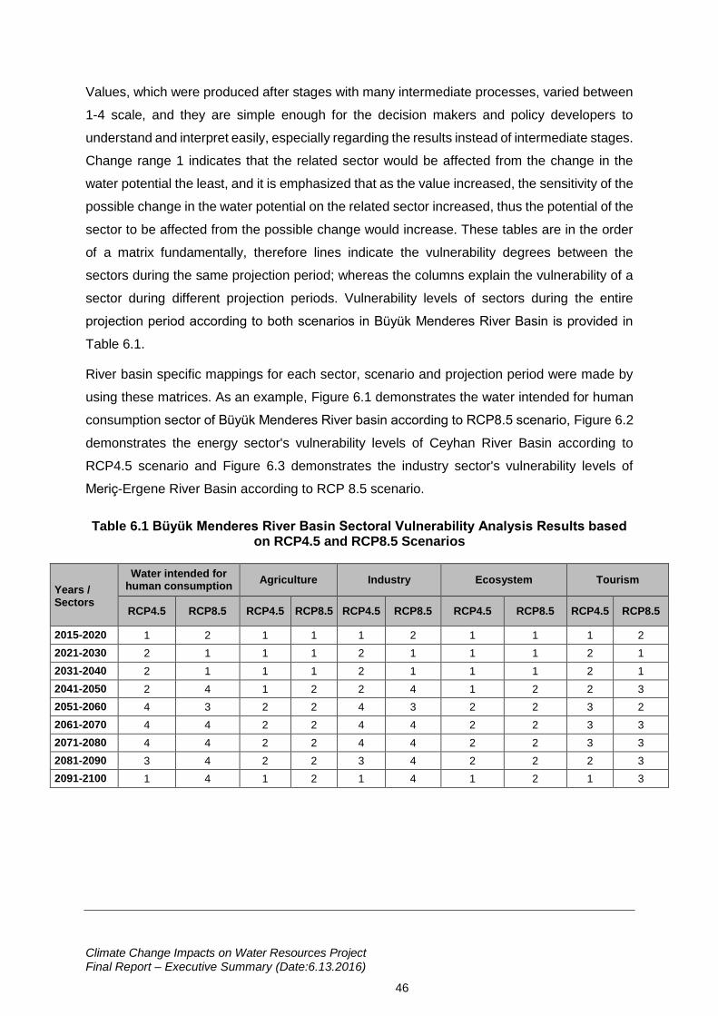
Climate Change Impacts on Water Resources Project Final Report – Executive Summary (Date:6.13.2016)
46
Values, which were produced after stages with many intermediate processes, varied between
1-4 scale, and they are simple enough for the decision makers and policy developers to
understand and interpret easily, especially regarding the results instead of intermediate stages.
Change range 1 indicates that the related sector would be affected from the change in the
water potential the least, and it is emphasized that as the value increased, the sensitivity of the
possible change in the water potential on the related sector increased, thus the potential of the
sector to be affected from the possible change would increase. These tables are in the order
of a matrix fundamentally, therefore lines indicate the vulnerability degrees between the
sectors during the same projection period; whereas the columns explain the vulnerability of a
sector during different projection periods. Vulnerability levels of sectors during the entire
projection period according to both scenarios in Büyük Menderes River Basin is provided in
Table 6.1.
River basin specific mappings for each sector, scenario and projection period were made by
using these matrices. As an example, Figure 6.1 demonstrates the water intended for human
consumption sector of Büyük Menderes River basin according to RCP8.5 scenario, Figure 6.2
demonstrates the energy sector's vulnerability levels of Ceyhan River Basin according to
RCP4.5 scenario and Figure 6.3 demonstrates the industry sector's vulnerability levels of
Meriç-Ergene River Basin according to RCP 8.5 scenario.
Table 6.1 Büyük Menderes River Basin Sectoral Vulnerability Analysis Results based on RCP4.5 and RCP8.5 Scenarios
Years / Sectors
Water intended for human consumption
Agriculture Industry Ecosystem Tourism
RCP4.5 RCP8.5 RCP4.5 RCP8.5 RCP4.5 RCP8.5 RCP4.5 RCP8.5 RCP4.5 RCP8.5
2015-2020 1 2 1 1 1 2 1 1 1 2
2021-2030 2 1 1 1 2 1 1 1 2 1
2031-2040 2 1 1 1 2 1 1 1 2 1
2041-2050 2 4 1 2 2 4 1 2 2 3
2051-2060 4 3 2 2 4 3 2 2 3 2
2061-2070 4 4 2 2 4 4 2 2 3 3
2071-2080 4 4 2 2 4 4 2 2 3 3
2081-2090 3 4 2 2 3 4 2 2 2 3
2091-2100 1 4 1 2 1 4 1 2 1 3
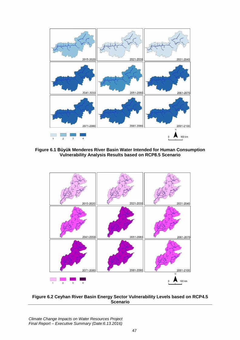
Climate Change Impacts on Water Resources Project Final Report – Executive Summary (Date:6.13.2016)
47
Figure 6.1 Büyük Menderes River Basin Water Intended for Human Consumption Vulnerability Analysis Results based on RCP8.5 Scenario
Figure 6.2 Ceyhan River Basin Energy Sector Vulnerability Levels based on RCP4.5 Scenario
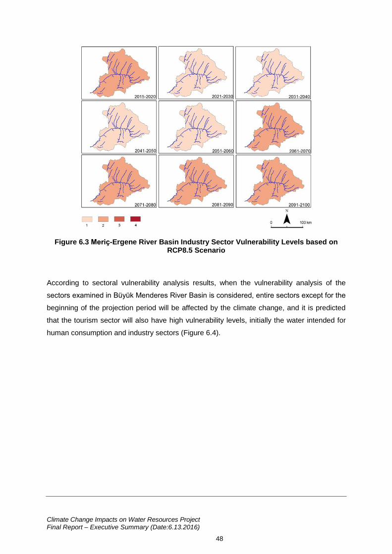
Climate Change Impacts on Water Resources Project Final Report – Executive Summary (Date:6.13.2016)
48
Figure 6.3 Meriç-Ergene River Basin Industry Sector Vulnerability Levels based on RCP8.5 Scenario
According to sectoral vulnerability analysis results, when the vulnerability analysis of the
sectors examined in Büyük Menderes River Basin is considered, entire sectors except for the
beginning of the projection period will be affected by the climate change, and it is predicted
that the tourism sector will also have high vulnerability levels, initially the water intended for
human consumption and industry sectors (Figure 6.4).
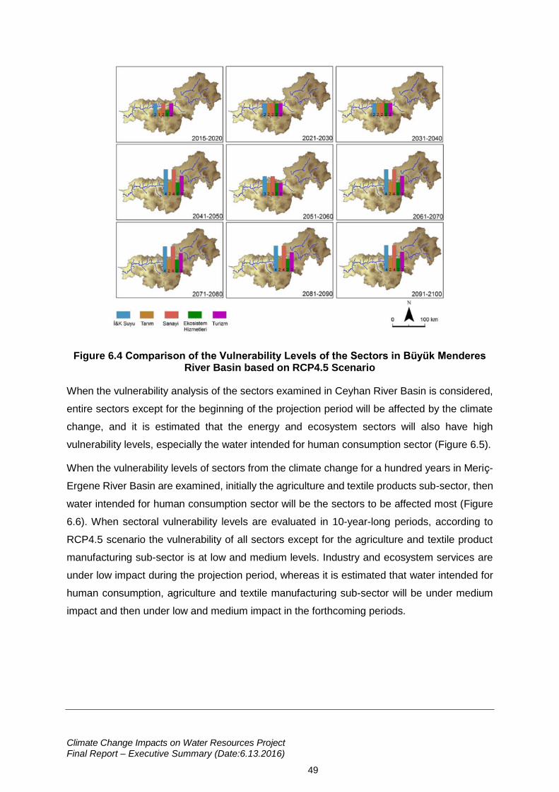
Climate Change Impacts on Water Resources Project Final Report – Executive Summary (Date:6.13.2016)
49
Figure 6.4 Comparison of the Vulnerability Levels of the Sectors in Büyük Menderes River Basin based on RCP4.5 Scenario
When the vulnerability analysis of the sectors examined in Ceyhan River Basin is considered,
entire sectors except for the beginning of the projection period will be affected by the climate
change, and it is estimated that the energy and ecosystem sectors will also have high
vulnerability levels, especially the water intended for human consumption sector (Figure 6.5).
When the vulnerability levels of sectors from the climate change for a hundred years in Meriç-
Ergene River Basin are examined, initially the agriculture and textile products sub-sector, then
water intended for human consumption sector will be the sectors to be affected most (Figure
6.6). When sectoral vulnerability levels are evaluated in 10-year-long periods, according to
RCP4.5 scenario the vulnerability of all sectors except for the agriculture and textile product
manufacturing sub-sector is at low and medium levels. Industry and ecosystem services are
under low impact during the projection period, whereas it is estimated that water intended for
human consumption, agriculture and textile manufacturing sub-sector will be under medium
impact and then under low and medium impact in the forthcoming periods.
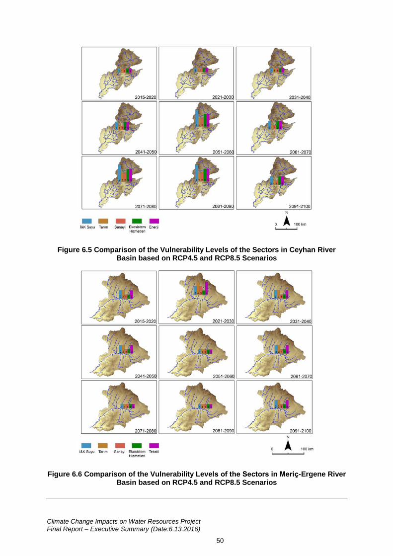
Climate Change Impacts on Water Resources Project Final Report – Executive Summary (Date:6.13.2016)
50
Figure 6.5 Comparison of the Vulnerability Levels of the Sectors in Ceyhan River Basin based on RCP4.5 and RCP8.5 Scenarios
Figure 6.6 Comparison of the Vulnerability Levels of the Sectors in Meriç-Ergene River Basin based on RCP4.5 and RCP8.5 Scenarios
Climate Change Impacts on Water Resources Project Final Report – Executive Summary (Date:6.13.2016)
51
7. Adaptation Activities
Specific to adaptation activities, considering all river basins, various suggestions for adaptation
activities are considered for the elimination of the negative impacts of climate change on water
resources. In the studies to determine the adaptation activities, primarily the strategies
developed in European Union (EU) are chronologically defined. The Green Document, the first
official document prepared by EU Commission in 2007, stipulated all the countries of the world,
mainly European countries to be prepared in their regions to be affected by the climate change,
to determine their social priorities for main adaptation activities, and to determine the short-
term measures. The document mainly explained the relevant legislation, the enforcement of
the legislation and the funds to be used during implementation process.
After the Green Document, EU Commission issued the White Document in 2009. The purpose
of this document is to form a basic framework to minimize the impacts of climate change and
to ensure the common action of EU countries in this framework. The Document explains the
basic ways to increase the resilience of the important sectors of Europe such as agriculture,
bio-diversity, coastal ecosystems, decreasing the sensitivity to the climate change. Afterwards,
the EU adaptation strategy formed as part of adaptation activities, the adaptation strategy of
EU was published under the title European Strategy in the Adaptation to the Climate Change
by European Commission. The main purpose of this strategy is to timely establish the
mechanisms that will ensure Europe's preparedness to the current and future impacts of
climate change. In 2013, the European Parliament and the European Council determined the
adaptation targets to be met until 2020.
To help the adaptation activities to be carried out in our country, sectoral analysis and
adaptation options in certain elected EU countries (Germany, France, Spain, Lower Danube
River Basin) are studied in detail. In addition to these, examples of certain EU Countries
(Germany, UK, France, Denmark, Italy) are included in the Adaptation Activities Report
regarding certain adaptation activities implemented.
Along with EU, sectoral analysis and measures to be taken in 8 main sectors determined in
the Climate Action Report in another developed country, USA, are included in the Adaptation
Activities Report. Another guiding example mentioned in the Report is the technical report
prepared by UNEP for the whole Africa continent and containing the sectors expected to be
affected by the climate change and the measures to be taken. Following such an intense
literature review, the Adaptation Activities Report contains the strategies, targets, plans and
solution suggestions regarding adaptation with the climate change in Turkey. 138 adaptation
activities are contained in the report as a result of these reviews.
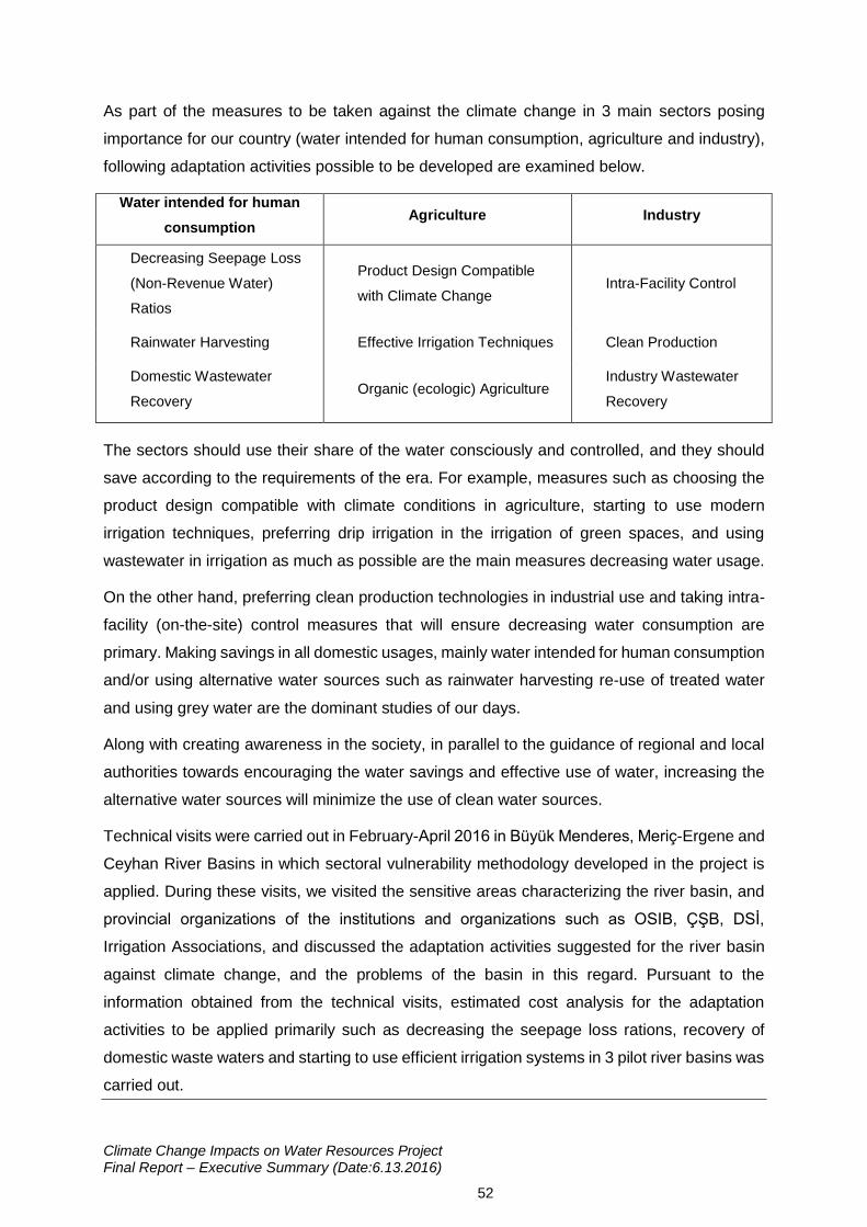
Climate Change Impacts on Water Resources Project Final Report – Executive Summary (Date:6.13.2016)
52
As part of the measures to be taken against the climate change in 3 main sectors posing
importance for our country (water intended for human consumption, agriculture and industry),
following adaptation activities possible to be developed are examined below.
Water intended for human
consumption Agriculture Industry
Decreasing Seepage Loss
(Non-Revenue Water)
Ratios
Product Design Compatible
with Climate Change Intra-Facility Control
Rainwater Harvesting Effective Irrigation Techniques Clean Production
Domestic Wastewater
Recovery Organic (ecologic) Agriculture
Industry Wastewater
Recovery
The sectors should use their share of the water consciously and controlled, and they should
save according to the requirements of the era. For example, measures such as choosing the
product design compatible with climate conditions in agriculture, starting to use modern
irrigation techniques, preferring drip irrigation in the irrigation of green spaces, and using
wastewater in irrigation as much as possible are the main measures decreasing water usage.
On the other hand, preferring clean production technologies in industrial use and taking intra-
facility (on-the-site) control measures that will ensure decreasing water consumption are
primary. Making savings in all domestic usages, mainly water intended for human consumption
and/or using alternative water sources such as rainwater harvesting re-use of treated water
and using grey water are the dominant studies of our days.
Along with creating awareness in the society, in parallel to the guidance of regional and local
authorities towards encouraging the water savings and effective use of water, increasing the
alternative water sources will minimize the use of clean water sources.
Technical visits were carried out in February-April 2016 in Büyük Menderes, Meriç-Ergene and
Ceyhan River Basins in which sectoral vulnerability methodology developed in the project is
applied. During these visits, we visited the sensitive areas characterizing the river basin, and
provincial organizations of the institutions and organizations such as OSIB, ÇŞB, DSİ,
Irrigation Associations, and discussed the adaptation activities suggested for the river basin
against climate change, and the problems of the basin in this regard. Pursuant to the
information obtained from the technical visits, estimated cost analysis for the adaptation
activities to be applied primarily such as decreasing the seepage loss rations, recovery of
domestic waste waters and starting to use efficient irrigation systems in 3 pilot river basins was
carried out.
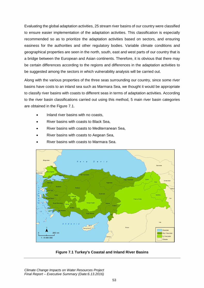
Climate Change Impacts on Water Resources Project Final Report – Executive Summary (Date:6.13.2016)
53
Evaluating the global adaptation activities, 25 stream river basins of our country were classified
to ensure easier implementation of the adaptation activities. This classification is especially
recommended so as to prioritize the adaptation activities based on sectors, and ensuring
easiness for the authorities and other regulatory bodies. Variable climate conditions and
geographical properties are seen in the north, south, east and west parts of our country that is
a bridge between the European and Asian continents. Therefore, it is obvious that there may
be certain differences according to the regions and differences in the adaptation activities to
be suggested among the sectors in which vulnerability analysis will be carried out.
Along with the various properties of the three seas surrounding our country, since some river
basins have costs to an inland sea such as Marmara Sea, we thought it would be appropriate
to classify river basins with coasts to different seas in terms of adaptation activities. According
to the river basin classifications carried out using this method, 5 main river basin categories
are obtained in the Figure 7.1.
Inland river basins with no coasts,
River basins with coasts to Black Sea,
River basins with coasts to Mediterranean Sea,
River basins with coasts to Aegean Sea,
River basins with coasts to Marmara Sea.
Figure 7.1 Turkey's Coastal and Inland River Basins
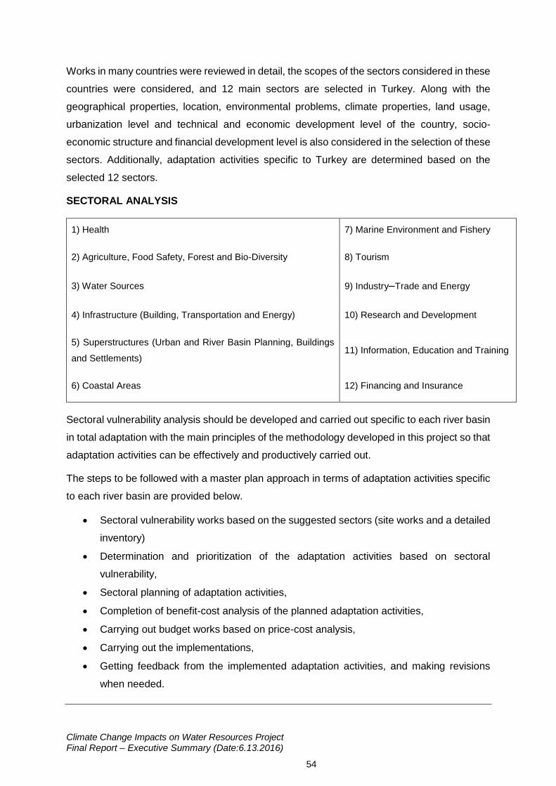
Climate Change Impacts on Water Resources Project Final Report – Executive Summary (Date:6.13.2016)
54
Works in many countries were reviewed in detail, the scopes of the sectors considered in these
countries were considered, and 12 main sectors are selected in Turkey. Along with the
geographical properties, location, environmental problems, climate properties, land usage,
urbanization level and technical and economic development level of the country, socio-
economic structure and financial development level is also considered in the selection of these
sectors. Additionally, adaptation activities specific to Turkey are determined based on the
selected 12 sectors.
SECTORAL ANALYSIS
1) Health 7) Marine Environment and Fishery
2) Agriculture, Food Safety, Forest and Bio-Diversity 8) Tourism
3) Water Sources 9) Industry–Trade and Energy
4) Infrastructure (Building, Transportation and Energy) 10) Research and Development
5) Superstructures (Urban and River Basin Planning, Buildings
and Settlements) 11) Information, Education and Training
6) Coastal Areas 12) Financing and Insurance
Sectoral vulnerability analysis should be developed and carried out specific to each river basin
in total adaptation with the main principles of the methodology developed in this project so that
adaptation activities can be effectively and productively carried out.
The steps to be followed with a master plan approach in terms of adaptation activities specific
to each river basin are provided below.
Sectoral vulnerability works based on the suggested sectors (site works and a detailed
inventory)
Determination and prioritization of the adaptation activities based on sectoral
vulnerability,
Sectoral planning of adaptation activities,
Completion of benefit-cost analysis of the planned adaptation activities,
Carrying out budget works based on price-cost analysis,
Carrying out the implementations,
Getting feedback from the implemented adaptation activities, and making revisions
when needed.
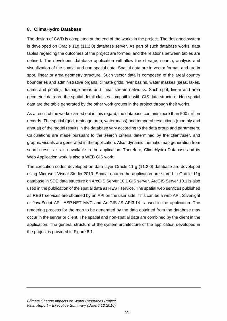
Climate Change Impacts on Water Resources Project Final Report – Executive Summary (Date:6.13.2016)
55
8. ClimaHydro Database
The design of CWD is completed at the end of the works in the project. The designed system
is developed on Oracle 11g (11.2.0) database server. As part of such database works, data
tables regarding the outcomes of the project are formed, and the relations between tables are
defined. The developed database application will allow the storage, search, analysis and
visualization of the spatial and non-spatial data. Spatial data are in vector format, and are in
spot, linear or area geometry structure. Such vector data is composed of the areal country
boundaries and administrative organs, climate grids, river basins, water masses (seas, lakes,
dams and ponds), drainage areas and linear stream networks. Such spot, linear and area
geometric data are the spatial detail classes compatible with GIS data structure. Non-spatial
data are the table generated by the other work groups in the project through their works.
As a result of the works carried out in this regard, the database contains more than 500 million
records. The spatial (grid, drainage area, water mass) and temporal resolutions (monthly and
annual) of the model results in the database vary according to the data group and parameters.
Calculations are made pursuant to the search criteria determined by the client/user, and
graphic visuals are generated in the application. Also, dynamic thematic map generation from
search results is also available in the application. Therefore, ClimaHydro Database and its
Web Application work is also a WEB GIS work.
The execution codes developed on data layer Oracle 11 g (11.2.0) database are developed
using Microsoft Visual Studio 2013. Spatial data in the application are stored in Oracle 11g
database in SDE data structure on ArcGIS Server 10.1 GIS server. ArcGIS Server 10.1 is also
used in the publication of the spatial data as REST service. The spatial web services published
as REST services are obtained by an API on the user side. This can be a web API, Silverlight
or JavaScript API. ASP.NET MVC and ArcGIS JS API3.14 is used in the application. The
rendering process for the map to be generated by the data obtained from the database may
occur in the server or client. The spatial and non-spatial data are combined by the client in the
application. The general structure of the system architecture of the application developed in
the project is provided in Figure 8.1.
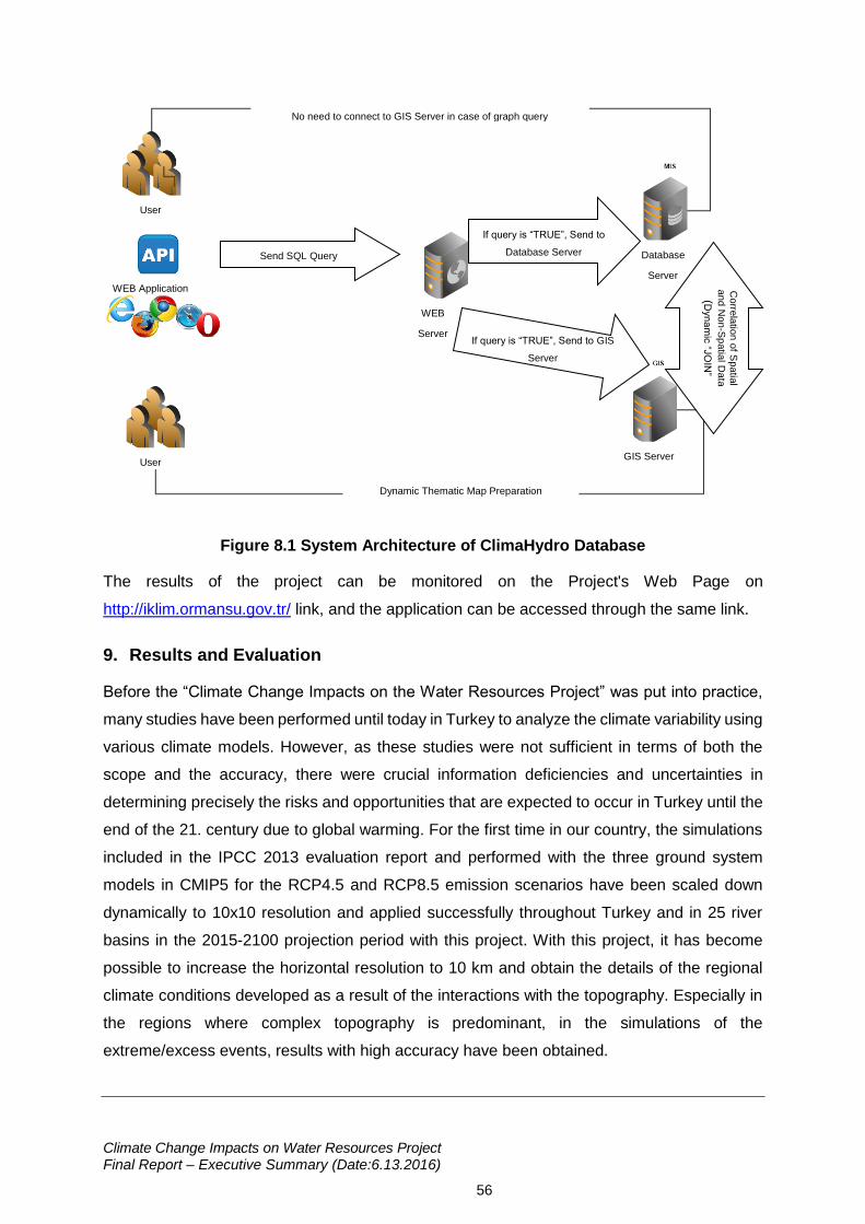
Climate Change Impacts on Water Resources Project Final Report – Executive Summary (Date:6.13.2016)
56
Figure 8.1 System Architecture of ClimaHydro Database
The results of the project can be monitored on the Project's Web Page on
http://iklim.ormansu.gov.tr/ link, and the application can be accessed through the same link.
9. Results and Evaluation
Before the “Climate Change Impacts on the Water Resources Project” was put into practice,
many studies have been performed until today in Turkey to analyze the climate variability using
various climate models. However, as these studies were not sufficient in terms of both the
scope and the accuracy, there were crucial information deficiencies and uncertainties in
determining precisely the risks and opportunities that are expected to occur in Turkey until the
end of the 21. century due to global warming. For the first time in our country, the simulations
included in the IPCC 2013 evaluation report and performed with the three ground system
models in CMIP5 for the RCP4.5 and RCP8.5 emission scenarios have been scaled down
dynamically to 10x10 resolution and applied successfully throughout Turkey and in 25 river
basins in the 2015-2100 projection period with this project. With this project, it has become
possible to increase the horizontal resolution to 10 km and obtain the details of the regional
climate conditions developed as a result of the interactions with the topography. Especially in
the regions where complex topography is predominant, in the simulations of the
extreme/excess events, results with high accuracy have been obtained.
Send SQL Query
Database
Server
If query is “TRUE”, Send to
Database Server
WEB
Server
GIS Server
Dynamic Thematic Map Preparation
No need to connect to GIS Server in case of graph query
User
WEB Application
User
Corre
latio
n o
f Spatia
l
and
No
n-S
patia
l Data
(Dyna
mic
“JO
IN”
If query is “TRUE”, Send to GIS
Server
Climate Change Impacts on Water Resources Project Final Report – Executive Summary (Date:6.13.2016)
57
When the climate projections obtained within the scope of the project are analyzed in terms of
temperature parameter; it is seen that all of the simulations based on the three global climate
models and on both emission scenarios indicate a substantial warming over Turkey in the
2015-2100 projection period at seasonal and yearly scales. In the last 10-years term of the
projection period, increases in temperature reach the maximum values as determined that
3,4°C for RCP4.5 scenario and 5,9°C for RCP8.5 scenario. For both scenarios, it draws
attention that the temperature increases will start from the southern latitudes of Turkey and
enlarge towards the north throughout 2015-2100, and that the highest temperatures occur in
the Southeast of Turkey, which includes the topographies where height is predominant, and
along the Mediterranean. Due to the increasing temperatures, the fact that the precipitation
type in the winter months turns into more frequently rain from snow causes the snow covered
areas to diminish and causes the snow to melt earlier in the spring months. The decrease in
the snow covered surfaces causes the surface albedo to decrease and therefore causes the
sun radiation amount absorbed by the surface to increase and increases the temperatures
faster than the other regions.
When the climate indices - which are the indicators of exceeded temperatures in terms of
extreme weather events – are analyzed, it is foreseen that the heat waves will increase from
the southern latitudes of Turkey towards the north in each 30-year period, that especially after
2041 the highest heat wave values based on the RCP4.5 scenario are observed in the Eastern
and Southeastern Anatolia Regions. While the maximum and minimum temperatures are
expected to increase towards the end of the century, especially in the Mediterranean, Southern
and Eastern Anatolia Regions these increases are identified to be higher. The fact that the
daytime temperatures are high will create increases in the heat wave frequencies and
severities in these regions. In addition to this, as the fact that the night temperatures being high
will limit humans and animals in feeling relaxed, it will cause an increase in the harms that the
heat wave will create. In addition, it will increase the energy demand to be used in the
environment cooling at night in addition to daytime. The fact that along with the anticipated
lack of precipitation the evaporation rate increases, will increase the stress in the water
resources and agricultural sector. It suggests that in the Mediterranean coast there is a
requirement of a new structuring in the tourism sector.
When the results of the climate projections are evaluated in terms of precipitation parameter,
it is seen that the precipitation projections foresee regional increases and decreases
throughout the projection period based on the ground system models. Generally, during the
projection period, it is anticipated that precipitations based on the 10-year averages change
between -50 mm and 40 mm for RCP4.5; -60 mm and 20 mm for RCP8.5. The model
Climate Change Impacts on Water Resources Project Final Report – Executive Summary (Date:6.13.2016)
58
simulations foresee that in the basins located at the north of Turkey, the climate regime will
have more precipitation than the reference period. For example, in RCP8.5 scenario assumes
that as of 2050s, the drought in the basins will become more severe towards the south and
that the ten-year total average yearly precipitations per basin will reach around 150 mm. Most
severe drought forecasts belong to the MPI-ESM-MR model, and the mildest drought forecasts
belong to the CNRM-CM5.1 model. When the precipitation changes per basins are analyzed
as percentages of yearly total precipitation, it is seen that the maximum changes are in Asi,
Doğu Akdeniz, Batı Akdeniz and Ceyhan Basins.
Overall in Turkey, it is seen that the snowfall amounts will gradually decrease between 2015-
2100 in both scenarios. Regardless of the fact that at the beginning of the century snowfalls of
a little above or below the normal levels have identified similar to the current climate regime of
Turkey, snowfall amounts have rapidly decreased due to the fact that greenhouse gas
emission scenarios are more predominant on the natural climate variation of the region. The
fact that the type of precipitation becomes snow due to the increase in the temperature is
important in terms of hydrology. Yet, the accumulated snow serves as a water reservoir and
especially at the beginning of spring and summer months they melt down and provide water
intake to river systems as a result of the increasing temperatures. Therefore, snow cover at
high areas has an important role on the regional hydrologic cycle. Especially in Eastern
Anatolian region and East Taurus Mountains, the decrease in the snow cover should be
expected to change the hydrologic cycle of Fırat-Dicle Basin.
Until today, the water potential calculations for overall Turkey have been performed without
using the hydrologic model. This project, which aims to determine the impact of the climate
change on the surface and ground waters on the basis of the basins, is a first due to the fact
that all the basins have been solved with a common hydrologic model. Within the scope of the
project, through hydrologic modelling study, possible changes in the water potentials based on
the basins under the impacts of the climate change for the 2015-2100 projection period have
been determined. Along with this, the main sectors which will consume the water in each basin
have been taken into consideration and the water requirement has been projected and for the
first time in our country, the periods in which possible water excess/deficit will be experienced
in 25 river basins have been presented. This project is a detailed study in which how the
dimensional and geohydrologic specifications of hydrogeological environments of Turkey will
be impacted by the dynamic, static, hydrogeological and possible reserves and under the
climate change impact of these components until 2100 is evaluated.
According to the model results, in the simulations which are run only with the outcomes of the
HadGEM2-ES climate model, it is anticipated that at least in 3 ten-year periods the water deficit
Climate Change Impacts on Water Resources Project Final Report – Executive Summary (Date:6.13.2016)
59
may be at a level of ~6.000 million m3/year. In the hydrologic modelling simulations run for the
HadGEM2-ES model and the RCP8.5 scenario, in at least 6 ten-year periods there is a water
deficit expectation of ~7.000 million m3/year. The results produced by the MPI-ESM-MR and
CNRM-CM5.1 models for both scenarios show similarity and they foresee that in the 2015-
2100 period the total water requirement of our country will be possibly met and there will be no
water deficit.
When the water potential change is evaluated specific to the basins, Fırat-Dicle Basin stands
out in all the scenarios and projection periods with having the highest water deficit. On the
other hand, even if not in all the periods, the basins where the most substantial water deficit is
observed are in general Doğu Akdeniz and Konya Closed Basins. When the water
deficit/excess situation is evaluated considering the amounts of water that Turkey undertakes
to release to the countries located at the river mouths from Fırat-Dicle Basin, it is foreseen that
water deficit at levels reaching 2-12 billion m3/year is expected in Fırat-Dicle basin in the 2015-
2100 period. These data show that a new evaluation is required to be made regarding the
amounts of water that Turkey has undertaken to release to the countries located at the river
mouths of the basins.
The impacts of the climate change have begun to be seen and in the forthcoming 10-year
periods this situation is expected to become more significant. Ensuring sustainable usage of
the water resources on the basis of the basins is becoming a priority. In this context, to protect
the water resources for our country, “Impact Analysis” methodology has been developed based
on the sectors. Sectoral vulnerability analysis has been applied on the Büyük Menderes, Meriç-
Ergene and Ceyhan Basins and impact levels in the main sectors in the forthcoming 10-year
periods have been determined.
According to the results of the sectoral impact analysis, in each pilot basins, except the
beginning of the projection period the water intended for human consumption sector reaches
a quite high vulnerability level. Also in Büyük Menderes Basin, industry and tourism; in Meriç-
Ergene Basin, agriculture and textile products sub-sector; in Ceyhan Basin, energy and eco-
system sectors stand out with high vulnerability levels.
The studies for struggling with climate change in our country are mainly aimed at reducing
emission and with this project, an important step has been taken in the determination of the
adaptation activities against climate change. In various regions and countries of the world, the
sectors standing out in adaptation have been analyzed with adaptation strategies and activities
put into practice and planned against climate change; and in the light of this information 25
river basins have been grouped, 12 main sectors have been identified for our country and
adaptation activities specific to these sectors have been suggested. Taking into consideration
Climate Change Impacts on Water Resources Project Final Report – Executive Summary (Date:6.13.2016)
60
the results of the sectoral impact analysis developed within the scope of the project and the
on-site monitoring made in the pilot basins, adaptation activities of top priority have been
determined for these basins.
The information generated as a result of the studies carried out within the scope of the
“ClimaHydro Database” project have been developed into a systematic and relational structure
and the sustainability of the data has been ensured. The application is defined as a WEB CBS
development work due to the fact that it performs dynamic thematical map production in
addition to visualization on graphics. ClimaHydro Database application constitutes an
important primary resource for the studies to be performed in the continuation of this project in
terms of dynamically questioning the results provided as 10 and/or 30-year periods in different
frequencies in the reports within the scope of the project.
9.1 Suggestions
The evaluation of the results obtained in this project and sustainability of the project outcomes,
the points to consider in the subsequent projects and the subjects required to be completed
are summarized under the following main topics:
The project outcomes should be put into information and use of the related public and
private bodies, maximum benefit should be gained from the project results.
It should be ensured that the sectoral impacts of the climate projections and the
hydrologic modelling forecasts on overall Turkey and in 25 river basins take place in
the related Master Plans as basic input and that they are reflected to the Water
Resources and Drought Management Plans.
It should be ensured that the project outcomes constitute basic input to the preparation
of Climate (Change Impacts) Resistant Water Management Master Plans of especially
the Metropolitans and Mega Cities.
With reference to the climate projections and the hydrologic modelling forecasts, how
the water quality in especially the accumulating structures (dams and lakes) which
supply water intended for human consumption to Metropolitans will be impacted and
the possible reflections of this situation to the treatment technology used in the Water
Treatment Facilities, to the operating technology and to the output quality should be
researched with new projects.
Taking the Turkey Geology Map with scale 1/500.000 dated 2002 as basis, a new
Turkey Hydrogeology Map should be prepared on the basis of “environmental
permeability variation” of lithostratigraphic units.
Climate Change Impacts on Water Resources Project Final Report – Executive Summary (Date:6.13.2016)
61
The Turkey Ground Water Reserves Inventory which has been brought to a very
important stage within the scope of this project should be supported with the site data
to be produced with the contributions of the related public bodies, the dynamic and
static reserve information of the hydrologic model and the water budget on the basis of
the basins should be updated and put into service of the users.
Taking into consideration the current ground water reserves, starting especially with
the ground water plains (aquifers) from where excess draft is performed, a National
Ground Water Master Plan should be prepared. The said Master Plan should also
include the enhancement strategies related to the aquifers which are contaminated for
various reasons.
Any kind of hydrogeologic data related to the ground water environments which are
found insufficient in terms of quality and quantity during the project studies, to the
periodic ground water observations and measurements, to the production structures
and to their usages should be re-approached and a new “Turkey hydrogeologic data
bank” should be created.
Plain (aquifer) surveys should be re-performed in a way to cover all the Plains of
Turkey.
The legal, administrative and technical works should be planned for primarily avoiding
and later on reducing the sea water attempt developed on the coastal plains where
especially the country tourism and agricultural activities are very intense; and following
the hydrogeologic researches, the methods for precautions should be realized.
Hydrogeoogic researches should be performed with support of the field works in order
to analyse, evaluate, develop and protect the rocks and granular environment aquifers
specitifed in overall Turkey in terms of their formal, geohydrologic, ground water
potential, utilizability and technical interference specifications.
Regional hydrogeologic researches which will set forth the availability potential of the
ground water environments should be performed. The ground water protection zones
- which will ensure that the groundwater is fed and that its quality is not impaired - and
the measures included by these zones should be defined.
Illegal ground water usages should be avoided, current boreholes inventory should be
formalised, borehole drillers should be audited and scientific-technical principles should
be made dominant on the drilling and usage conditions.
It is considered beneficial to prepare a Master Plan in adaptation with the Integrated
Coastal Area Management concept with respect to which parts of our country shall be
Climate Change Impacts on Water Resources Project Final Report – Executive Summary (Date:6.13.2016)
62
impacted from the glacial meltings and sea level increases due to climate change and
which preventive adaptation strategies can be implemented.
Within the scope of the effective usage of the water, the reduction of the supply network
losses and leakages especially in the urban areas in accordance with the targets of the
“Regulation Related to the Control of the Water Losses in the Drinking Water Supply
and Distribution Systems” (OSİB, 2014) should be effectively audited, new water
(resource) allocation should not be performed to the Municipalities where loss and
leakage ratio over the standard is identified.
In irrigation, the practices related to the extensification of the closed (sprinkling and
drip) irrigation techniques should be continued.
Extensification of the clean production technologies (Best Avaliable Technology (BAT)
practices) using small amount of water/chemical in the industry among all the OIZs
(organized industrial zones) and important contaminant industries should be tracked
and encouraged.
Taking into consideration the Impacts of the project outcomes on the current Nature
Protection and Wetlands in our country, project that will ensure the protection and the
sustainability of the said areas should be developed.
Taking into consideration the outcomes of the project regarding the transnational
waters in Turkey, our practiced Foreign Policy strategy and water disembogue
guarantees should be reviewed in this direction.
The climate and hydrologic modelling components of the project should be updated at
intervals of 5~10 years, and the practices should be reviewed according to the revised
outcomes to be obtained.
It is beneficial to test the simulations made within the scope of this project at more
confined areas with non-hydrostatic climate models where the resolution can go below
10 km and to diversify the used regional models. Especially, it is suggested that on the
regions where the topography is complex, solutions with higher resolutions should be
produced and compared with different models and different approaches in dynamic
scale reduction.
Sectoral analysis studies have been carried out on the basis of specific sectors specific
to 3 pilot basins according to the Project Technical Specification. However, in the
Adaptation Activities report, the situations of various countries have been analyzed in
detail and practicable sectors in our country have been suggested. It is crucial for the
methodology developed in this project is implemented on the basis of the suggested
sectors instead of the projects to be developed.
Climate Change Impacts on Water Resources Project Final Report – Executive Summary (Date:6.13.2016)
63
It is suggested that the sectoral impact analysis should be detailed on the basis of the
sub-basins as well as being performed throughout the basin.
With performing the sectoral analysis on all the basins and sub-basins, the applicable
adaptation activities should be determined and they should be prioritized for short,
medium and long terms.
Within a plan in which the prioritized adaptation activity suggestions stated in the final
report, interinstitutional duties and responsibilities are set forth; the necessary planning
and implementation processes should be carefully followed to be put into practice
specific to sub-basins.
Before practicing the prioritized adaptation activities, Cost /Benefit Analyses should be
made and budgeted for each adaptation activity.
With reference to the fact that our country is surrounded on 3 sides by the sea, it should
not be forgotten that management of the coastal areas is crucial. 17 out of 25 river
basins are coastal basins, and it is suggested for our country to make Strategic
Planning regarding Integrated Coastal Zone Management and to accelerate these
studies.
In the Data Processing infrastructure of T.R. Ministry of Forestry and Water Affairs, the
hardware to be used according to the requirements of the projects can only be
configured to be used by that project team in the beginning of the project.
In terms of the sustainability of this project and similar projects, using a cloud server
which is physically located outside the Ministry and which can easily be reached by
both the company executing the project and the Ministry personnel can be put into
practice. At specific time intervals, the database on the cloud and the replications of
the practices can be carried over to the servers of the Ministry by the Ministry personnel
and the development and execution steps of the project can be performed more
efficiently and rapidly.
Climate Change Impacts on Water Resources Project Final Report – Executive Summary (Date:6.13.2016)
64
REFERENCES
Ministry of EU. (2013). Progress Report of Turkey. Ankara: European Commission Directorate-
General for Enlargement.
United Nations. (2013). Human Development Program Report. United Nations Development
Program.
Bozkurt, & diğ. (2011). Bozkurt, D.; Turuncoglu, U.; Sen, O.L.; Önol, B.; Dalfes, B.H.N.
Downscaled Simulations of the ECHAM5, CCSM3 and HadCM3 Global Models For
The Eastern Mediterranean-Black Sea Region: Evaluation Of The Reference Period.
Climate Dynamics.
Brutsaert, W., & Parlange, M. (1998). Hydrologic cycle explains the evaporation paradox.
Nature, 396, 30, doi:10.1038/23845.
Demir, İ. (2011). Bölgesel Iklim Modeli Projeksiyonları:RCHAM5-B1. 5th Atmospheric Science
Symposium, (s. 153-160).
Dosio, A., Panitz, H., Frisius, M., & Lüthi D. (2015). Dynamical downscaling of CMIP5 global
circulation models over CORDEX Africa with COSMO CLM: evaluation over the
present climate and analysis of the added value. Climate Dynamics Vol. 44, 2637–
2661.
DSİ. (2011/2012/2013). DSİ General Directorate Performance Reports 2011/2012/2013.
Ankara.
DSİ. (2012). DSİ 2012 Activity Report. Ankara.
DSİ. (2013). DSİ 2013 Activity Report.
Dufresne, J., Foujols, M., Denvil, S., Caubel, A., Marti, O., Aumont, O., . . . Brockmann, P.
(2013). Climate change projections using the IPSL-CM5 Earth System Model: from
CMIP3 to CMIP5. Clim. Dynamics , 40, 2123-2165, doi: 10.1007/s00382-012-1636-1.
Hagemann, S., Chen, C., Clark, D., Folwell, S., Gosling, S., Haddeland, L., . . . Wilshire, A.
(2013). Climate change impact on available water resources obtained using multiple
global climate and hydrology models. Earth System Dynamics, 4, 129-144.
Hamdi, R., P., T., & P., B. (2011). Impacts of urbanization and climate change on surface runoff
of the Brussels. International Journal of Climatology, 31, 1959-1974.
IPCC. (2014). Intergovernmental Panel on Climate Change AR5-Fifth Assessment Report.
Cambridge: Cambridge University Press.
Climate Change Impacts on Water Resources Project Final Report – Executive Summary (Date:6.13.2016)
65
Kadıoğlu, M. (1997). Trends in Surface Air Temperature Data Over Turkey. International
Journal of Climatology, 511-520.
Karaca, & diğ. (2000). Karaca, M.; Ünal, Y.S.; Goksel, C. Impacts of urbanization on the
regional climate: Example of Istanbul. ECAC2000 3rd European Conf. On Applied
Climatology.
Kurnaz, L. (2014). Drought and Turkey. IPM-Mercator Politics Note. Sabancı University.
Forestry and Water Council. (2013, March 21-23). Basin Management and Water Information
System Working Group Report. Ankara: Forestry and Water Council.
OSİB. (2014, May 08). Regulation Related to the Control of the Water Losses in the Drinking
Water Supply and Distribution Systems. Issue:28994. Ankara: T. R. Ministry of Forestry
and Water Affairs.
Önal, B. (2012). Impacts of Coastal Topography on Climate: High-Resolution Simulation with
a Regional Climate Model. Climate Research.
Önal, B., & Semazzi, F. (2009). Regionalization Of Climate Change Simulations over the
Eastern Mediterranean. J.Climate, 1944-1961.
Önal, B., & Ünal, Y. (2003). Climate Simulation of Turkey and Its Neighborhood by Regional
Climate Model:Sensitivity of Surface Conditions. Nice.
Önol, & diğ. (2006). Önol, B.; Semazzi, F.H.M.; Unal, Y.; Dalfes, H.N. Regional Climatic
Impacts of Global Warming over the Eastern Mediterranean. Climate Change and the
Middle East – Past, Present and Future.
Ragab, R., & Prudhomme, C. (2002). Climate Change and Water Resources Management in
Arid and Semi-arid Regions: Prospective and Challenges for the 21st Century.
Biosystems Engineering, 81(1), 3-34.
Smith, I., J.I., S., L., R., & S.J., J. (2013). The relative performance of Australian CMIP5 models
based on rainfall and ENSO models. Australian Meteorological and Oceanographic
Journal, 63, 205-212.
Solomon, S., Qin, D., Manning, M., Marquis, M., Averyt, K., Tignor, M., . . . Chen, Z. (2007).
Climate Change 2007: The Physical Science Basis. Cambridge: Cambridge University
Press.
Şen, & diğ. (2013). Şen, Ö.L.; Bozkurt, D.; Göktürk, O.M.; Dündar, B.; Altürk, B. Climate
Change and Its Possible Impacts in Turkey. 3.National Overflow Symposium.
Climate Change Impacts on Water Resources Project Final Report – Executive Summary (Date:6.13.2016)
66
Şen, Z. (1997). Objective Analysis by Cumulative Semivariogram Technique and Its
Application in Turkey. Journal Applied Meteorology, 1712-1720.
T.R. Ministry of Environment and Urbanisation. (2011). Turkey's Climate Change Adaptation
Strategy and Action Plan.
Tan, E., & Ünal, Y. (2003). Impacts of the Northern Atlantic Emissions on Turkey's
Precipitations and Temperatures. Sırrı Erinç Symposium.
Toros, H. (2012). Spatio-Temporal Variation of Daily Extreme Temperatures over Turkey.
International Journal of Climatology, 1047-1055.
TÜBİTAK MAM. (2010). Basin Protection Action Plans. TUBITAK Marmara Research Center
on behalf of T.R. Ministry of Forestry and Water Affaris .
TÜBİTAK MAM. (2014). Basin Protection Action Plans. TUBITAK Marmara Research Center
on behalf of T.R. Ministry of Forestry and Water Affaris.
Türkeş, M. (1998). Influence of Geopotential Heights, Cyclone Frequency and Southern
Oscillation on Rainfall Variations in Turkey. Int. J. Climatol, 649-680.
Türkeş, M. (1999). Vulnerability of Turkey to Desertification with Respect to Precipitation and
Aridity Conditions. Turkish Engineering and Environmental Sciences Magazine, 363-
380.
Uppala, & diğ. (2005). 45 Authors The ERA-40 Re-analysis. Q.J.Royal Meteor.Soc., 2961-
3012.
URL-1. (no date). taken from the address http://www.dsi.gov.tr/toprak-ve-su-kaynaklari
Ünal, & diğ. (2010). Ünal, Y.S.; Önol, B.; Menteş.S.; Borhan, Y.; Kahraman, A.; Ural, D.
Analysis of the Impacts of the Global Climate Change on Turkey With Regional Climate
Model.
Ünal, & diğ. (2012). Ünal, Y.S.; Deniz, A.; Toros, H.; Incecik, S. Temporal and Spatial Patterns
of Precipitation Variability for Annual, Wet, and Dry Seasons in Turkey. International
Journal of Climatology, 392-405.
Ünal, & diğ. (2013). Ünal, Y.; Tan, E.; Mentes, S. Summer Heat Waves over Western Turkey
between 1965-2006.
Ünal, Y. (2006). Extreme Maximum and Minimum Temperature Tendencies over Turkey within
Last Three Decades. International Conference on Climate Change and the Middle
East:Past, Present and Future.
Climate Change Impacts on Water Resources Project Final Report – Executive Summary (Date:6.13.2016)
67
Ünal, Y., & Mentes, S. (2006). Frequency of the Heat Waves in Istanbul and Its Relation to
Circulation Types. International Conference on Climate Change and the Middle
East:Past, Present and Future.
Zhao, Z.-C., Y., L., & J.-B., H. (2013). A review on evaluation methods of climate modeling.
Advances in Climate Change Research.


![RAPOR...RAPOR Rapor No: 1670300 Sunulan: TÜMAD Madencilik San. Tic. A.Ş. Buğday Caddesi No:9 Çankaya / Ankara / TÜRKİYE µ }lºuv 7 vP]o]Ì ofv v À] ] X7 vP]o]Ì À d º l À](https://static.fdocuments.in/doc/165x107/602a15c96b6514119752d485/rapor-rapor-rapor-no-1670300-sunulan-toemad-madencilik-san-tic-a-buday.jpg)